Embed Size (px)
Citation preview

AN
AS
SE
SS
ME
NT
OF
CO
AL
RE
SO
UR
CE
S
AV
AIL
AB
LE
FO
R D
EV
EL
OP
ME
NT
CE
NT
RA
L A
PPA
LA
CH
IAN
RE
GIO
N-
FIR
ST
YE
AR
SU
MM
AR
Y -
by
M.
Dev
ereu
x C
arte
ran
d N
ancy
K.
Gar
dner
TJ.
S. G
eolo
gica
l Su
rvey
in C
oope
rati
on w
ithK
entu
cky
Geo
logi
cal
Surv
ey,
Jam
es C
. C
obb,
Hea
d, C
oal
Sect
ion
Vir
gini
a D
ivis
ion
of M
iner
al R
esou
rces
, E
liza
beth
V.
M.
Cam
pbel
l, A
pplie
d G
eolo
gy S
ectio
n W
est
Vir
gini
a G
eolo
gica
l an
d E
cono
mic
Sur
vey,
Nic
k Fe
dork
o, H
ead,
Coa
l Se
ctio
n
U.S
. G
EO
LO
GIC
AL
SU
RV
EY
Ope
n-F
ile
Rep
ort
89-3
62R
esto
n, V
irgi
nia
1989
Thi
s re
port
is
prel
imin
ary
and
has
not
been
rev
iew
ed f
or c
onfo
rmity
wit
h U
.S.
Geo
logi
cal
Surv
ey e
dito
rial
sta
ndar
ds a
nd s
trat
igra
phic
nom
encl
atur
e.
DE
PAR
TM
EN
T O
F T
HE
IN
TE
RIO
RM
anue
l L
ujan
, Jr
., S
ecre
tary
U.S
. G
EO
LO
GIC
AL
SU
RV
EY
Dal
las
L. P
eck,
Dir
ecto
r
For
add
itio
nal
info
rmat
ion
wri
te t
o:
Bra
nch
of C
oal
Geo
logy
U
.S.
Geo
logi
cal
Sur
vey
956
Nat
iona
l C
ente
r R
esto
n, V
irgi
nia
2209
2
Cop
ies
of t
his
report
can
be
purc
hase
d fr
om:
U.S
. G
eolo
gica
l S
urve
yB
ooks
and
Ope
n-F
ile
Rep
orts
Sec
tion
Box
254
25F
eder
al C
ente
r, B
ldg.
81
0D
enve
r, C
olor
ado
8022
5
EX
EC
UT
IVE
SU
MM
AR
Y
Cur
rent
Fed
eral
est
imat
es o
f th
e N
atio
n's
coal
res
ourc
es,
for
exam
ple
Ave
ritt
(19
75),
do
not
acco
unt
for
man
y fa
ctor
s th
at
coul
d in
hibi
t th
e av
aila
bili
ty o
f co
al f
or d
evel
opm
ent,
and,
co
nseq
uent
ly,
may
be
mis
take
nly
opti
mis
tic
for
long
- te
rm p
olic
y pl
anni
ng p
urpo
ses.
A
coo
pera
tive
pro
gram
be
tw
een
the
U.S
. G
eolo
gica
l S
urve
y (U
SG
S)
and
the
Sta
te g
eo
logi
cal
agen
cies
of
Ken
tuck
y, V
irgi
nia,
and
Wes
t V
irgi
nia
was
in
itia
ted
in 1
987
and
cont
inue
d in
198
8 to
ide
ntif
y th
e m
ajor
cu
rren
t co
nstr
aint
s to
coa
l m
inin
g th
at c
ould
inh
ibit
av
ail
ab
ilit
y of
the
coa
l re
sour
ces
wit
hin
the
Cen
tral
App
alac
hian
R
egio
n an
d to
est
imat
e th
e am
ount
of
coal
res
ourc
es a
ctua
lly
avai
labl
e fo
r de
velo
pmen
t in
th
at r
egio
n. A
met
hodo
logy
was
de
velo
ped
and
test
ed i
n fo
ur 7
.5-m
inut
e qu
adra
ngle
are
as t
o de
term
ine
if th
e id
enti
fied
con
stra
ints
to
min
ing
in t
he r
egio
n w
ould
mat
eria
lly
affe
ct t
he a
vail
abil
ity
of c
oal
for
deve
lop
m
ent.
The
res
ults
fro
m t
hese
fou
r st
udy
area
s su
gges
t th
at
cons
trai
nts
to m
inin
g w
ould
hav
e si
gnif
ican
t im
pact
bec
ause
it
is
esti
mat
ed t
hat
onl
y ab
out
60 p
erce
nt o
f th
e or
igin
al c
oal
reso
urce
s of
the
se s
tudy
are
as w
ill b
e av
aila
ble
or a
cces
sibl
e fo
r m
inin
g, a
nd t
hat
is
befo
re r
ecov
ery
fact
ors
are
appl
ied.
T
he a
mou
nt o
f co
al t
hat
may
act
uall
y be
rec
over
able
may
on
ly b
e ab
out
30 t
o 40
per
cent
of
the
orig
inal
res
ourc
es.
The
fou
r 7.
5-m
inut
e qu
adra
ngle
are
as c
over
ed b
y th
is r
e
port
wer
e se
lect
ed t
o be
rep
rese
ntat
ive
of t
heir
gen
eral
lo
cali
ties
so
that
the
res
ults
obt
aine
d fr
om t
hese
fou
r m
ight
be
extr
apol
ated
to
othe
r ar
eas
in t
he s
urro
undi
ng r
egio
n. A
pil
ot
stud
y to
tes
t th
e fe
asib
ilit
y an
d pr
opos
ed m
etho
dolo
gies
was
co
mpl
eted
ear
ly i
n 19
88.
The
fir
st t
hree
qua
dran
gle
stud
ies
to b
e fo
rmal
ly f
unde
d un
der
the
coop
erat
ive
prog
ram
wer
e co
mpl
eted
in
Sep
tem
ber,
19
88.
Fin
ding
s of
all
four
stu
dy
area
s ar
e su
mm
ariz
ed h
erei
n.
Res
tric
tion
s to
min
ing
wer
e id
enti
fied
by
cons
ulta
tion
wit
h lo
cal
coal
-ind
ustr
y en
gine
ers,
geo
logi
sts,
and
min
e op
erat
ors,
as
wel
l as
Sta
te a
nd F
eder
al r
egul
ator
y pe
rson
nel.
L
and-
use
rest
rict
ions
ap
plic
able
to
the
four
stu
dy a
reas
wer
e po
wer
li
nes,
pip
elin
es,
cem
eter
ies,
oil
and
gas
wel
ls,
tow
ns,
maj
or
stre
ams,
pu
blic
roa
ds,
rail
road
s,
and
one
larg
e fo
rest
pr
e
serv
e. T
echn
olog
ic r
estr
icti
ons
incl
uded
coa
l be
ds c
onsi
dere
d to
o th
in o
r to
o de
ep t
o m
ine,
buf
fer
zone
s ar
ound
act
ive
or
aban
done
d m
ines
, m
ined
an
d m
inab
le
coal
bed
s to
o cl
ose
abov
e or
bel
ow o
ne a
noth
er,
oil
and
gas
wel
ls p
enet
rati
ng
unde
rgro
und-
min
able
coa
l be
ds,
and
such
geo
logi
cal
fact
ors
as w
asho
uts
(ero
sion
al e
vent
s th
at r
emov
ed c
oal
prec
urso
rs
and
som
etim
es c
oal)
and
org
anic
con
stit
uent
s th
at p
reve
nt
com
plet
e an
d ra
pid
burn
ing
of th
e co
al.
Gra
phic
and
res
ourc
e ca
lcul
atio
n pr
ogra
ms
of t
he U
SGS
Nat
iona
l C
oal
Res
ourc
es
Dat
a Sy
stem
(N
CR
DS
) w
ere
appl
ied
to c
ombi
ne a
nd m
anip
ul
ate
all
coal
bed
thi
ckne
ss a
nd d
epth
-of-
buri
al d
ata
wit
h th
e
11
cons
trai
nts
to m
inin
g, a
nd t
hen
to c
alcu
late
ori
gina
l, re
mai
n
ing,
and
ava
ilabl
e co
al r
esou
rce
tonn
ages
.A
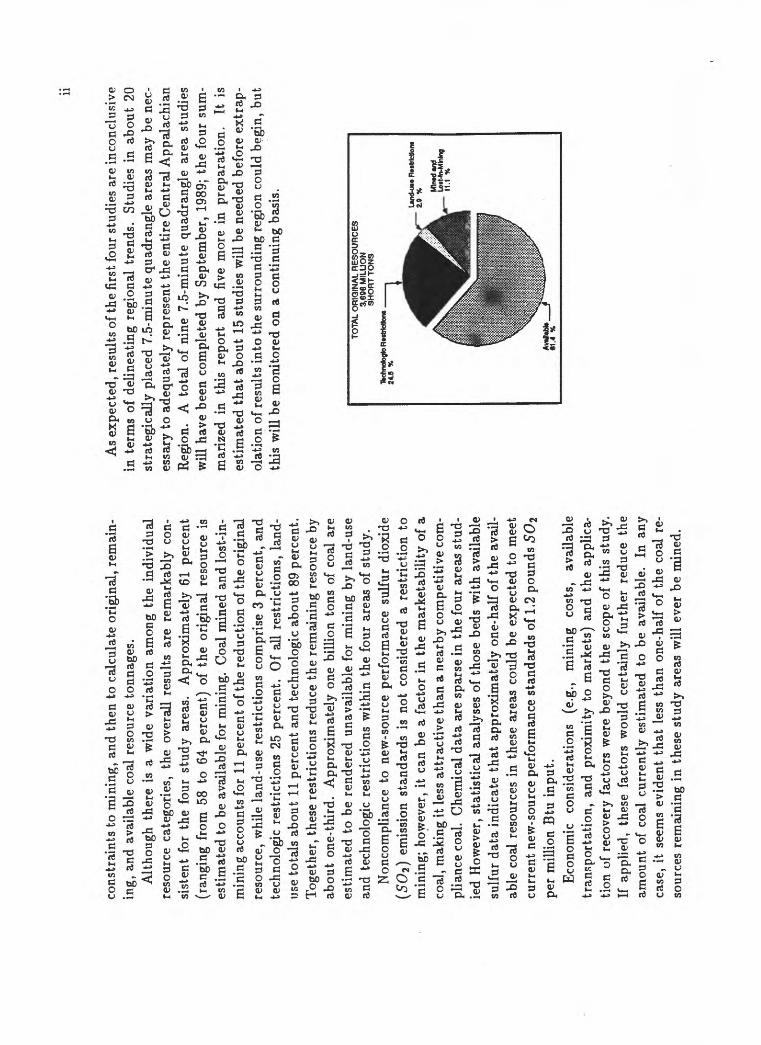
lthou
gh t
here
is
a w
ide
vari
atio
n am
ong
the
indi
vidu
al
reso
urce
cat
egor
ies,
the
ove
rall
resu
lts
are
rem
arka
bly
con
si
sten
t fo
r th
e fo
ur s
tudy
are
as.
App
roxi
mat
ely
61 p
erce
nt
(ran
ging
fro
m 5
8 to
64
perc
ent)
of
the
orig
inal
res
ourc
e is
esti
mat
ed t
o be
ava
ilabl
e fo
r m
inin
g. C
oal
min
ed a
nd l
ost-
in-
min
ing
acco
unts
for
11
perc
ent
of th
e re
duct
ion
of th
e or
igin
al
reso
urce
, w
hile
lan
d-us
e re
stri
ctio
ns c
ompr
ise
3 pe
rcen
t, an
d te
chno
logi
c re
stri
ctio
ns 2
5 pe
rcen
t. O
f al
l re
stri
ctio
ns,
land
- us
e to
tals
abo
ut 1
1 pe
rcen
t an
d te
chno
logi
c ab
out
89 p
erce
nt.
Tog
ethe
r, t
hese
res
tric
tion
s re
duce
the
rem
aini
ng r
esou
rce
by
abou
t on
e-th
ird.
A
ppro
xim
atel
y on
e bi
llion
ton
s of
coa
l ar
e es
tim
ated
to
be r
ende
red
unav
aila
ble
for
min
ing
by l
and-
use
and
tech
nolo
gic
rest
rict
ions
with
in t
he f
our
area
s of
stu
dy.
Non
com
plia
nce
to n
ew-s
ourc
e pe
rfor
man
ce s
ulfu
r di
oxid
e (5
02)
emis
sion
sta
ndar
ds i
s no
t co
nsid
ered
a r
estr
icti
on t
o m
inin
g; h
owev
er,
it ca
n be
a f
acto
r in
the
mar
keta
bili
ty o
f a
coal
, m
akin
g it
less
att
ract
ive
than
a n
earb
y co
mpe
titi
ve c
om
plia
nce
coal
. C
hem
ical
dat
a ar
e sp
arse
in t
he f
our
area
s st
ud
ied
How
ever
, st
atis
tica
l an
alys
es o
f th
ose
beds
with
ava
ilabl
e su
lfur
dat
a in
dica
te t
hat
appr
oxim
atel
y on
e-ha
lf o
f th
e av
ail
ab
le c
oal
reso
urce
s in
the
se a
reas
cou
ld b
e ex
pect
ed t
o m
eet
curr
ent
new
-sou
rce
perf
orm
ance
sta
ndar
ds o
f 1.
2 po
unds
SO
i pe
r m
illio
n B
tu i
nput
.E
cono
mic
co
nsid
erat
ions
(e
.g.,
min
ing
cost
s,
avai
labl
e tr
ansp
orta
tion
, an
d pr
oxim
ity t
o m
arke
ts)
and
the
appl
ica
tio
n of
rec
over
y fa
ctor
s w
ere
beyo
nd t
he s
cope
of
this
stu
dy.
If a
pplie
d, t
hese
fac
tors
wou
ld c
erta
inly
fur
ther
red
uce
the
amou
nt o
f co
al c
urre
ntly
est
imat
ed t
o be
ava
ilabl
e.
In a
ny
case
, it
seem
s ev
iden
t th
at l
ess
than
one
-hal
f of
the
coa
l re
so
urce
s re
mai
ning
in
thes
e st
udy
area
s w
ill e
ver
be m
ined
.
As
expe
cted
, re
sults
of t
he f
irst
fou
r st
udie
s ar
e in
conc
lusi
ve
in t
erm
s of
del
inea
ting
reg
iona
l tr
ends
. St
udie
s in
abo
ut 2
0 st
rate
gica
lly
plac
ed 7
.5-m
inut
e qu
adra
ngle
are
as m
ay b
e ne
c
essa
ry t
o ad
equa
tely
rep
rese
nt t
he e
ntir
e C
entr
al A
ppal
achi
an
Reg
ion.
A
tot
al o
f ni
ne 7
.5-m
inut
e qu
adra
ngle
are
a st
udie
s w
ill h
ave
been
com
plet
ed b
y Se
ptem
ber,
198
9; t
he f
our
sum
m
ariz
ed i
n th
is r
epor
t an
d fiv
e m
ore
in p
repa
rati
on.
It i
s es
tim
ated
tha
t ab
out
15 s
tudi
es w
ill b
e ne
eded
bef
ore
extr
ap
olat
ion
of re
sult
s in
to th
e su
rrou
ndin
g re
gion
cou
ld b
egin
, bu
t th
is w
ill b
e m
onit
ored
on
a co
ntin
uing
bas
is.
TOTA
L O
RIG
INA
L R
ES
OU
RC
ES
3,
606
MIL
LIO
N
SH
OR
TT
ON
S
Und
-u**
Rtd
rfctlo
rM
2.0
%
Conte
nts
1 IN
TR
OD
UC
TIO
N
11.
1 A
CK
NO
WL
ED
GE
ME
NT
S .................................................
4
2 M
ET
HO
DS
5
3 S
TU
DY
AR
EA
S
7
4 R
ES
TR
ICT
ION
S U
SE
D
94.
1 L
and-
use
Res
tric
tion
s ....................................................
94.
1.1
Lan
d-us
e R
estr
icti
ons
to S
urfa
ce M
inin
g ......................................
94.
1.2
Lan
d-us
e R
estr
icti
ons
to U
nder
grou
nd M
inin
g ...................................
114.
2 T
echn
olog
ic R
estr
icti
ons ...................................................
124.
2.1
Tec
hnol
ogic
Res
tric
tion
s to
Sur
face
Min
ing ....................................
124.
2.2
Tec
hnol
ogic
Res
tric
tion
s to
Und
ergr
ound
Min
ing .................................
13
5 R
ES
UL
TS
15
5.1
Lan
d-us
e R
estr
icti
on .....................................................
255.
2 T
echn
olog
ic R
estr
icti
ons ...................................................
295.
3 O
ther
Res
tric
tion
s ......................................................
325.
4 C
ompl
ianc
e C
oal .......................................................
32
6 S
UM
MA
RY
33
iii
CO
NT
EN
TS
iv
7 R
EF
ER
EN
CE
S C
ITE
D
34
8 G
LO
SS
AR
Y
36
A
AP
PE
ND
IX
40
Lis
t o
f F
igu
res
1.1
Fig
ure
1. I
ndex
map
of
the
Cen
tral
App
alac
hian
Reg
ion
show
ing
the
loca
tion
of
the
firs
t fo
ur 7
.5-m
inut
equ
adra
ngle
stu
dy a
reas
of
the
Coa
l R
esou
rces
Ava
ilab
le f
or D
evel
opm
ent
asse
ssm
ent. .............
2
3.1
Fig
ure
2. R
elat
ive
stra
tigr
aphi
c po
siti
ons
of t
he c
oal-
bear
ing
stra
ta u
nder
lyin
g th
e M
atew
an,
Nob
le,
Syl
vest
er,
and
Van
sant
7.5
-min
ute
quad
rang
les,
Ken
tuck
y, W
est
Vir
gini
a, a
nd V
irgi
nia.
.....................
8
5.1
Fig
ure
3. S
umm
ary
of t
he e
stim
ated
ori
gina
l, m
ined
and
los
t-in
-min
ing,
res
tric
ted,
and
ava
ilab
le c
oal
reso
urce
sin
the
Mat
ewan
, N
oble
, S
ylve
ster
, an
d V
ansa
nt 7
.5-m
inut
e qu
adra
ngle
are
as,
Ken
tuck
y, W
est
Vir
gini
a, a
nd V
irgi
nia.
17
5.2
Fig
ure
4. E
stim
ated
ori
gina
l, m
ined
and
los
t-in
-min
ing,
res
tric
ted,
and
ava
ilab
le c
oal
reso
urce
s in
eac
h of
the
Mat
ewan
, N
oble
, S
ylve
ster
, an
d V
ansa
nt 7
.5-m
inut
e qu
adra
ngle
are
as,
Ken
tuck
y, W
est
Vir
gini
a, a
nd V
irgi
nia.
...
18
5.3
Fig
ure
5. S
umm
ary,
by
surf
ace
and
deep
res
ourc
es,
of t
he e
stim
ated
ori
gina
l, m
ined
and
los
t-in
-min
ing,
re
st
rict
ed,
and
avai
labl
e co
al r
esou
rces
in
the
Mat
ewan
, N
oble
, S
ylve
ster
, an
d V
ansa
nt 7
.5-m
inut
e qu
adra
ngle
are
as,
Ken
tuck
y, W
est
Vir
gini
a, a
nd V
irgi
nia.
...........................................
19
5.4
Fig
ure
6. E
stim
ated
ori
gina
l, re
mai
ning
, an
d av
aila
ble
coal
res
ourc
es,
by c
oal
bed,
in
the
Mat
ewan
7.5
-min
ute
quad
rang
le,
Pik
e C
ount
y, K
entu
cky.
............................................
21
5.5
Fig
ure
7. E
stim
ated
ori
gina
l, re
mai
ning
, an
d av
aila
ble
coal
res
ourc
es,
by c
oal
bed,
in
the
Nob
le 7
.5-m
inut
equ
adra
ngle
, B
reat
hitt
, P
erry
, an
d K
nott
Cou
ntie
s, K
entu
cky.
..............................
22
5.6
Fig
ure
8. E
stim
ated
ori
gina
l, re
mai
ning
, an
d av
aila
ble
coal
res
ourc
es,
by c
oal
bed,
in
the
Syl
vest
er 7
.5-m
inut
equ
adra
ngle
, B
oone
and
Kan
awha
Cou
ntie
s, W
est
Vir
gini
a. ................................
23
5.7
Fig
ure
9. E
stim
ated
ori
gina
l, re
mai
ning
, an
d av
aila
ble
coal
res
ourc
es,
by c
oal
bed,
in
the
Van
sant
7.5
-min
ute
quad
rang
le,
Buc
hana
n C
ount
y, V
irgi
nia.
..........................................
24
LIS
T O
F F
IGU
RE
S vi
5.8
Figu
re 1
0. M
aps
show
ing
all
appl
icab
le la
nd-u
se r
estr
icti
ons
com
bine
d in
eac
h of
the
four
7.5
-min
ute
quad
rang
lest
udy
area
s. ..........................................................
265.
9 Fi
gure
11.
S
umm
ary
of t
he e
stim
ated
por
tion
of
each
of
the
land
-use
res
tric
tion
cat
egor
ies
in t
he M
atew
an,
Nob
le,
Sylv
este
r, a
nd V
ansa
nt 7
.5-m
inut
e qu
adra
ngle
are
as,
Ken
tuck
y, W
est
Vir
gini
a, a
nd V
irgi
nia.
.........
275.
10
Figu
re 1
2. E
stim
ated
por
tion
of
each
of
the
land
-use
res
tric
tion
cat
egor
ies
in e
ach
of t
he t
he M
atew
an,
Nob
le,
Sylv
este
r, a
nd V
ansa
nt 7
.5-m
inut
e qu
adra
ngle
are
as,
Ken
tuck
y, W
est
Vir
gini
a, a
nd V
irgi
nia.
.............
285.
11
Fig
ure
13. S
umm
ary
of th
e es
tim
ated
por
tion
of
each
of
the
tech
nolo
gic
rest
rict
ion
cate
gori
es i
n th
e M
atew
an,
Nob
le,
Sylv
este
r, a
nd V
ansa
nt 7
.5-m
inut
e qu
adra
ngle
are
as,
Ken
tuck
y, W
est
Vir
gini
a, a
nd V
irgi
nia.
.........
305.
12
Figu
re 1
4. E
stim
ated
por
tion
of e
ach
of th
e te
chno
logi
c re
stri
ctio
n ca
tego
ries
in
each
of t
he t
he M
atew
an,
Nob
le,
Sylv
este
r, a
nd V
ansa
nt 7
.5-m
inut
e qu
adra
ngle
are
as,
Ken
tuck
y, W
est
Vir
gini
a, a
nd V
irgi
nia.
.............
31
Lis
t of
Tab
les
0.1
CO
NV
ER
SIO
N F
AC
TO
RS
.................................................
ix
4.1
Tab
le 1
. R
estr
icti
ons
to c
oal
avai
labi
lity
and
app
lica
ble
crit
eria
as
used
in
the
Mat
ewan
, N
oble
, S
ylve
ster
, an
dV
ansa
nt 7
.5-m
inut
e qu
adra
ngle
are
as,
Ken
tuck
y, W
est
Vir
gini
a, a
nd V
irgi
nia.
.....................
10
5.1
Tab
le 2
. S
umm
ary
of t
he e
stim
ated
ori
gina
l, m
ined
and
los
t-in
-min
ing,
rem
aini
ng,
rest
rict
ed,
and
avai
labl
e co
al r
esou
rces
in
each
of
the
Mat
ewan
, N
oble
, S
ylve
ster
, an
d V
ansa
nt 7
.5-m
inut
e qu
adra
ngle
are
as,
Ken
tuck
y, W
est
Vir
gini
a, a
nd V
irgi
nia.
....................................................
16
A.I
T
able
A-l
. E
stim
ated
coa
l re
sour
ces
in t
he M
atew
an 7
.5-m
inut
e qu
adra
ngle
, P
ike
Cou
nty,
Ken
tuck
y. ......
41A
.2
Tab
le A
-2. E
stim
ated
coa
l re
sour
ces
unav
aila
ble
due
to L
AN
D-U
SE R
EST
RIC
TIO
NS i
n th
e M
atew
an 7
.5-
min
ute
quad
rang
le,
Pik
e C
ount
y, K
entu
cky.
........................................
42A
.3
Tab
le A
-3. E
stim
ated
coa
l re
sour
ces
unav
aila
ble
due
to
TE
CH
NO
LO
GIC
RE
ST
RIC
TIO
NS i
n th
e M
atew
an7.
5-m
inut
e qu
adra
ngle
, P
ike
Cou
nty,
Ken
tuck
y. ......................................
43A
.4
Tab
le A
-4. E
stim
ated
coa
l re
sour
ces
in t
he N
oble
7.5
-min
ute
quad
rang
le,
Bre
athi
tt,
Per
ry,
and
Kno
tt C
ount
ies,
Ken
tuck
y. ...........................................................
44A
.5
Tab
le A
-5. E
stim
ated
coa
l re
sour
ces
unav
aila
ble
due
to L
AN
D-U
SE R
EST
RIC
TIO
NS in
the
Nob
le 7
.5-m
inut
equ
adra
ngle
, B
reat
hitt
, P
erry
, an
d K
nott
Cou
ntie
s, K
entu
cky.
..............................
45A
.6
Tab
le A
-6. E
stim
ated
coa
l re
sour
ces
unav
aila
ble
due
to T
EC
HN
OL
OG
IC R
EST
RIC
TIO
NS i
n th
e N
oble
7.5
- m
inut
e qu
adra
ngle
, B
reat
hit
t, P
erry
, an
d K
nott
Cou
ntie
s, K
entu
cky.
..........................
46A
.7
Tab
le A
-7. E
stim
ated
coa
l re
sour
ces
in t
he S
ylve
ster
7.5
-min
ute
quad
rang
le,
Boo
ne a
nd K
anaw
ha C
ount
ies,
Wes
t V
irgi
nia.
........................................................
47
vii
LIS
T O
F T
AB
LE
S vi
ii
A.8
T
able
A-8
. E
stim
ated
coa
l re
sour
ces
unav
aila
ble
due
to L
AN
D-U
SE R
EST
RIC
TIO
NS i
n th
e S
ylve
ster
7.5
- m
inut
e qu
adra
ngle
, B
oone
and
Kan
awha
Cou
ntie
s, W
est
Vir
gini
a. ...........................
48A
.9
Tab
le A
-9. E
stim
ated
coa
l re
sour
ces
unav
aila
ble
due
to
TE
CH
NO
LO
GIC
RE
ST
RIC
TIO
NS i
n th
e S
ylve
ster
7.5-
min
ute
quad
rang
le,
Boo
ne a
nd K
anaw
ha C
ount
ies,
Wes
t V
irgi
nia.
.........................
49A
. 10
Tab
le A
-10.
E
stim
ated
coa
l re
sour
ces
in t
he V
ansa
nt 7
.5-m
inut
e qu
adra
ngle
, B
ucha
nan
Cou
nty,
Vir
gini
a. ....
50A
.11
Tab
le A
-ll.
E
stim
ated
coa
l re
sour
ces
unav
aila
ble
due
to L
AN
D-U
SE
RE
ST
RIC
TIO
NS i
n th
e V
ansa
nt 7
.5-
min
ute
quad
rang
le,
Buc
hana
n C
ount
y, V
irgi
nia.
......................................
51A
. 12
Tab
le A
-12.
E
stim
ated
coa
l re
sour
ces
unav
aila
ble
due
to T
EC
HN
OL
OG
IC R
EST
RIC
TIO
NS i
n th
e V
ansa
nt7.
5-m
inut
e qu
adra
ngle
, B
ucha
nan
Cou
nty,
Vir
gini
a. ....................................
52
IX
CO
NV
ER
SIO
N F
AC
TO
RS
[ T
o co
nver
t fr
om
__
__
| T
oM
ulti
ply
by
Inch
es (
in.)
F
oot,
feet
(ft
) M
iles
(mi)
T
ons,
sho
rt (
2000
Ibs
)
Cen
tim
eter
s M
eter
s K
ilom
eter
s T
ons,
met
ric
(2,2
04.6
Ibs
)
2.54
0.
3048
1.
6093
44
0.90
7184
74
Ch
apte
r 1
INT
RO
DU
CT
ION
Ass
essm
ents
of
the
coal
res
ourc
es o
f th
e U
nite
d S
tate
s ge
n
eral
ly r
epor
t th
e to
nnag
e es
tim
ates
onl
y in
ter
ms
of t
he l
o
cati
on,
bed
thic
knes
s, o
verb
urde
n de
pth,
and
an
esti
mat
e of
th
e re
liab
ilit
y of
the
mea
sure
men
ts u
sed.
Whi
le t
his
prov
ides
an
im
port
ant
basi
c fo
unda
tion
, cu
rren
t F
eder
al e
stim
ates
of
the
Nat
ion'
s co
al r
esou
rces
may
not
acc
ount
for
man
y fa
ctor
s th
at c
ould
inhi
bit
deve
lopm
ent
of th
e co
al,
and,
con
sequ
entl
y,
may
be
mis
take
nly
opti
mis
tic
for
long
-ter
m p
olic
y pl
anni
ng
purp
oses
.
Thi
s re
port
sum
mar
izes
the
res
ults
of
stud
ies
in t
he f
irst
fo
ur 7
.5-m
inut
e qu
adra
ngle
are
as o
f a
cont
inui
ng,
coop
erat
ive
asse
ssm
ent
of t
he c
oal
reso
urce
s ac
tual
ly a
vail
able
for
dev
el
opm
ent
in t
he c
oal
fiel
ds o
f th
e C
entr
al A
ppal
achi
an R
egio
n S
tate
s of
Ken
tuck
y, T
enne
ssee
, V
irgi
nia,
and
Wes
t V
irgi
nia
(fig
. 1)
. T
he s
ubje
ct s
tudi
es w
ill b
e re
ferr
ed t
o he
rein
afte
r as
coa
l-av
aila
bili
ty s
tudi
es,
or p
rogr
am,
and
the
over
all
stud
y ar
ea a
s th
e C
entr
al A
ppal
achi
an R
egio
n.
The
co
al-a
vail
abil
ity
prog
ram
w
as
star
ted
in
1987
w
ith
a pi
lot
stud
y in
the
Mat
ewan
7.5
-min
ute
quad
rang
le,
Pik
e C
ount
y, K
entu
cky
(fig
.l),
and
was
sub
sequ
entl
y ex
pand
ed i
n
fisc
al y
ears
(F
Y)
1988
and
198
9 to
inc
lude
eig
ht a
ddit
iona
l 7.
5-m
inut
e qu
adra
ngle
are
as i
n K
entu
cky,
Vir
gini
a, a
nd W
est
Vir
gini
a. A
sum
mar
y re
port
on
the
seco
nd g
roup
of f
ive
stud
ie
s w
ill b
e co
mpl
eted
soo
n af
ter
the
end
of F
Y 1
989.
All
nine
st
udie
s w
ill h
ave
been
con
duct
ed i
n co
oper
atio
n w
ith
the
ge
olog
ical
sur
veys
of
Ken
tuck
y, V
irgi
nia,
and
W
est
Vir
gini
a;
area
s in
Ten
ness
ee w
ill b
e in
clud
ed i
n fu
ture
stu
dies
.
The
coa
l-av
aila
bili
ty p
rogr
am w
as d
evel
oped
to i
mpr
ove
upon
th
e qu
alit
y an
d us
eful
ness
of
pre
viou
s co
al-r
esou
rce
asse
ssm
ents
(fo
r ex
ampl
e, A
veri
tt,
1975
) by
est
imat
ing
the
loca
tion
and
am
ount
of
the
rem
aini
ng r
esou
rce
that
mig
ht
actu
ally
be
avai
labl
e fo
r de
velo
pmen
t un
der
curr
ent
regu
la
tory
and
gen
eral
eco
nom
ic a
nd t
echn
olog
ic c
ondi
tion
s.
De
ve
lopm
ent
at t
his
tim
e m
eans
, fo
r al
l pr
acti
cal
purp
oses
, su
r
face
(st
rip,
aug
er)
or u
nder
grou
nd (
deep
) m
inin
g; h
owev
er,
if o
ther
tec
hnol
ogie
s fo
r re
cove
ring
coa
l or
coa
l en
ergy
are
ad
opte
d in
the
nea
r fu
ture
, th
e re
sult
s an
d m
etho
dolo
gy d
e
scri
bed
here
in w
ill b
e ap
plic
able
to
them
as
wel
l.
Coa
l-av
aila
bili
ty a
sses
smen
ts r
equi
re a
larg
e am
ount
of
de
tail
ed w
ork
at r
easo
nabl
y la
rge
map
sca
les
in o
rder
to
pro-
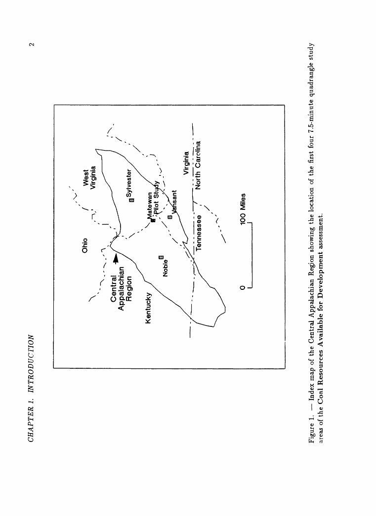
CH
AP
TE
R 1
. IN
TR
OD
UC
TIO
N
\N"
~\_
- -
Cen
tral
App
alac
hian
Reg
ion
Ohi
o/
Wes
t Vi
rgin
ia
Ken
tuck
y
Virg
inia
Nor
th C
arol
ina
0 I10
0 M
iles
Fig
ure
1. I
ndex
map
of
the
Cen
tral
App
alac
hian
Reg
ion
show
ing
the
loca
tion
of
the
firs
t fo
ur 7
.5-m
inut
e qu
adra
ngle
stu
dy
area
s of
the
Coa
l R
esou
rces
Ava
ilab
le f
or D
evel
opm
ent
asse
ssm
ent.
CH
AP
TE
R 1
. IN
TR
OD
UC
TIO
N
duce
mea
ning
ful
resu
lts.
T
he
7.5-
min
ute
quad
rang
le m
ap
(1:2
4,00
0 sc
ale)
are
a w
as s
elec
ted
for
a va
riet
y of
rea
sons
th
at
are
disc
usse
d in
det
ail
in t
he M
etho
ds s
ecti
on.
In t
he C
en
tral
App
alac
hian
Reg
ion,
eac
h 7.
5-m
inut
e qu
adra
ngle
cov
er
s an
are
a of
abo
ut 5
9 sq
uare
mile
s.
The
coa
l-av
aila
bili
ty
asse
ssm
ent
proc
ess
is
carr
ied
out
by a
ppli
cati
on o
f a
geo
gr
aphi
c in
form
atio
n sy
stem
(G
IS)
of t
he U
SG
S's
N
atio
nal
Coa
l R
esou
rces
Dat
a S
yste
m (
NC
RD
S)
to e
ach
of t
he 7
.5-
min
ute
quad
rang
le s
tudy
are
as.
Coa
l-av
aila
bili
ty a
sses
smen
ts
are
prod
uced
by
subt
ract
ing
actu
al a
reas
of
coal
bed
s th
at
have
bee
n m
ined
(an
d lo
st-i
n-m
inin
g) a
nd a
reas
aff
ecte
d by
sp
ecif
ied
cate
gori
es o
f re
gula
tory
and
tec
hnol
ogic
res
tric
tion
s to
min
ing
from
est
imat
ed a
mou
nts
and
area
s un
derl
ain
by
orig
inal
in-
plac
e co
al r
esou
rces
, on
a b
ed-b
y-be
d ba
sis.
T
he
resu
lt p
rovi
des
the
loca
tion
as
wel
l as
the
am
ount
of
the
es
tim
ated
ava
ilab
le c
oal
reso
urce
s in
eac
h st
udy
area
ins
ofar
as
regu
lato
ry p
rohi
biti
ons
and
tech
nolo
gic
rest
rict
ions
to
min
in
g ar
e, o
r ca
n be
, re
flec
ted
in:
1) s
peci
fic
loca
l la
ws
and
prac
tice
s; 2
) co
al-b
ed t
hick
ness
, co
ntin
uity
, de
pth,
and
coa
l qu
alit
y; 3
) pr
oxim
ity
of o
ne c
oal
bed
to a
noth
er;
and
4) r
eli
ab
ilit
y of
ori
gina
l re
sour
ce e
stim
ates
.A
s de
scri
bed,
the
coa
l-av
aila
bili
ty p
rogr
am w
ould
app
ear
to r
equi
re v
ery
larg
e re
sour
ces
of t
ime
and
fund
s in
ord
er t
o
achi
eve
the
deta
il n
eces
sary
to
reli
ably
pre
dict
coa
l av
aila
bil
it
y fo
r an
y gi
ven
regi
on.
How
ever
, be
caus
e of
the
met
hodo
l
ogy
and
proc
edur
es d
evel
oped
by
the
USG
S in
coo
pera
tion
w
ith
the
afor
emen
tion
ed S
tate
geo
logi
cal
surv
eys
(Egg
lest
on
and
othe
rs,
in p
repa
rati
on),
onl
y m
odes
t re
sour
ces
per
stud
y ar
ea a
re c
urre
ntly
req
uire
d fo
r th
is w
ork.
The
cur
rent
app
roac
h to
the
pro
blem
of t
he d
evel
opm
ent
of
adeq
uate
det
ail
in a
cos
t-ef
fect
ive
man
ner
is t
o st
udy
a re
pre
se
ntat
ive
sam
ple
of 7
.5-m
inut
e qu
adra
ngle
are
as w
ithi
n ea
ch
maj
or c
oal-
bear
ing
regi
on i
n th
e co
nter
min
ous
Uni
ted
Sta
tes.
T
he C
entr
al A
ppal
achi
an R
egio
n w
as c
hose
n as
the
fir
st r
e
gion
for
a t
est
of t
he p
rogr
am b
ecau
se i
t co
ntai
ns t
he l
arge
st
reso
urce
s of
low
-sul
fur
coal
in
the
east
ern
Uni
ted
Sta
tes,
the
ge
olog
y of
the
regi
on i
s re
ason
ably
wel
l kn
own,
and
the
Cen
tr
al A
ppal
achi
an R
egio
n S
tate
s of
Ken
tuck
y, V
irgi
nia,
and
W
est
Vir
gini
a ha
ve a
his
tory
of
prod
ucti
ve c
oope
rati
on w
ith
the
NC
RD
S.
Thr
ough
car
eful
sel
ecti
on,
it
is c
urre
ntly
es
ti
mat
ed t
hat
onl
y ab
out
20,
out
of a
bout
450
, 7.
5-m
inut
e qu
adra
ngle
are
as w
ill h
ave
to b
e st
udie
d in
the
Cen
tral
Ap
pa
lach
ian
Reg
ion
in o
rder
to
pred
ict
the
avai
labi
lity
of
coal
fo
r de
velo
pmen
t th
roug
hout
the
ent
ire
regi
on.
The
pro
blem
of
the
ext
rapo
lati
on o
f in
divi
dual
stu
dy-a
rea
resu
lts
is t
he
subj
ect
of c
onti
nuin
g re
sear
ch,
how
ever
, an
d th
e cu
rren
t pl
an
will
be
reev
alua
ted
afte
r th
e fi
rst
15,
or s
o, s
tudy
are
as h
ave
been
com
plet
ed.
The
met
hodo
logy
and
pra
ctic
es d
escr
ibed
do
not
iden
tify
"c
oal
rese
rves
" (i
.e.,
reco
vera
ble
coal
) in
the
str
ict
sens
e. T
he
coal
ava
ilab
ilit
y pr
ogra
m d
oes
not
yet
take
int
o ac
coun
t th
e de
tail
s of
land
and
res
ourc
e ow
ners
hip,
min
imum
min
e si
zes,
m
inin
g m
etho
ds,
coal
rec
over
abil
ity,
or
mar
kets
th
at w
ould
be
req
uire
d to
ide
ntif
y "r
eser
ves"
. H
owev
er,
rese
arch
is b
eing
co
nduc
ted
at t
he U
.S.
Bur
eau
of M
ines
(U
SB
oM)
in c
oope
r
atio
n w
ith
the
US
GS
, to
dev
elop
a m
etho
dolo
gy t
o in
cor
po
rate
som
e or
all
of t
hese
"re
serv
e id
enti
fyin
g" f
acto
rs i
nto
the
coal
-ava
ilab
ilit
y pr
ogra
m a
t so
me
futu
re t
ime.
One
maj
or
bene
fit
of th
e G
IS a
ppro
ach
to t
his
prog
ram
is
that
it
enab
les
any
stud
y to
be
revi
sed
and/o
r u
pd
ated
as
new
dat
a be
com
e av
aila
ble.
CH
APT
ER
1.
INT
RO
DU
CT
ION
1.1
AC
KN
OW
LE
DG
EM
EN
TS
Thi
s re
port
is
the
resu
lt o
f a
mul
ti-a
genc
y pr
ojec
t th
at h
as
incl
uded
sig
nifi
cant
con
trib
utio
ns b
y a
num
ber
of p
erso
ns i
n ad
diti
on t
o th
ose
cite
d in
the
tex
t an
d in
the
Ref
eren
ces
Cit
ed
sect
ion.
Man
y of
the
NC
RD
S st
aff
prov
ided
inv
alua
ble
dat
a en
try,
ed
itin
g, a
nd p
rogr
amm
ing
assi
stan
ce.
Nor
een
H.
Reg
a, P
aula
M
. W
ashi
ngto
n, a
nd S
ara
L. B
anks
ent
ered
the
str
atig
raph
ic
data
. A
ndre
D.
Bus
h pr
oces
sed
the
digi
tize
d bo
unda
ry f
iles.
K
athl
een
K.
Kro
hn
man
aged
the
dat
a ba
se a
spec
ts o
f th
e pr
ojec
t.
Mar
gare
t F.
Joh
nson
and
Men
g-C
hern
g Su
n ea
ch
mad
e si
gnif
ican
t m
odif
icat
ions
to
the
NC
RD
S gr
aphi
cs p
ro
gram
s th
at g
reat
ly e
nhan
ced
the
prof
icie
ncy
of t
he s
yste
m.
Wil
liam
G.
Mill
er,
man
ager
of
NC
RD
S,
orch
estr
ated
the
vi
tal
hard
war
e, s
oftw
are,
and
tel
ecom
mun
icat
ions
cha
nges
th
at
allo
wed
com
plet
ion
of t
his
init
ial
phas
e of
the
proj
ect
wit
hin
the
requ
ired
tim
e fr
ame
and
type
set
the
fina
l te
xt
of t
his
repo
rt.
Ger
ry L
ebin
g an
d S
haro
n A
. H
arri
s of
the
USG
S In
form
a
tion
Sys
tem
s D
ivis
ion
prov
ided
fre
quen
t as
sist
ance
in
gene
r
atin
g th
e gr
aphi
c il
lust
rati
ons
for
this
rep
ort.
Follo
win
g th
e M
atew
an q
uadr
angl
e pi
lot
stud
y (f
ig.
1), t
he
ensu
ing
thre
e st
udy
area
s (f
ig.
1) w
ere
acco
mpl
ishe
d th
roug
h U
SG
S-S
tate
coo
pera
tive
agr
eem
ents
. D
ulee
p L
Pan
dite
and
R
ober
t D
. A
shw
orth
of
the
USG
S A
dmin
istr
ativ
e D
ivis
ion
are
com
men
ded
for
so a
bly
empl
acin
g th
e co
oper
ativ
e ag
reem
ents
in
an
unus
uall
y sh
ort
amou
nt o
f ti
me
esse
ntia
l in
get
ting
the
19
88 a
rea
stud
ies
unde
rway
.U
nder
the
US
GS
-Sta
te c
oope
rati
ve a
gree
men
ts,
the
Pri
n
cipa
l In
vest
igat
ors
of t
he S
tate
geo
logi
c ag
enci
es,
Jam
es C
. C
obb
of th
e K
entu
cky
Geo
logi
cal
Surv
ey,
Sta
nley
S.
John
son
of t
he V
irgi
nia
Div
isio
n of
Min
eral
Res
ourc
es,
and
Tho
mas
R
. Ja
ke o
f th
e W
est
Vir
gini
a G
eolo
gica
l an
d E
cono
mic
Sur
ve
y pr
ovid
ed t
he e
ssen
tial
lin
k be
twee
n th
e U
SGS
and
Sta
te
proj
ect
geol
ogis
ts.
Und
er t
heir
lea
ders
hip,
the
coo
pera
tive
pr
ojec
ts r
an s
moo
thly
and
the
thr
ee n
ew s
tudi
es w
ere
com
pl
eted
on
sche
dule
. T
he h
ighl
y co
mpe
tent
an
d en
thus
ias
ti
c pr
ofes
sion
als
of t
hese
age
ncie
s en
sure
d th
e su
cces
s of
thi
s pr
ojec
t.S
peci
al t
hank
s go
to
Har
old
J. G
lusk
oter
and
Sta
nley
P.
Sch
wei
nfur
th,
USG
S B
ranc
h of
Coa
l G
eolo
gy,
for
supp
ort
thro
ugho
ut t
he p
roje
ct.
Ch
apte
r 2
ME
TH
OD
S
To
asse
ss t
he a
vail
able
coa
l re
sour
ces
of t
he e
ntir
e C
entr
al
App
alac
hian
Reg
ion
by s
tudy
ing
the
regi
on i
n th
e de
tail
nec
es
sary
to
prod
uce
mea
ning
ful
resu
lts
wou
ld b
e a
mon
umen
tal
task
. T
o do
thi
s in
a ti
mel
y an
d co
st-e
ffec
tive
man
ner
requ
ires
th
at a
reas
of m
anag
eabl
e si
ze a
nd s
igni
fica
nce
be i
dent
ifie
d to
se
rve
as m
odel
s to
ult
imat
ely
allo
w e
xtra
pola
tion
of
resu
lts
into
the
are
as b
etw
een
mod
els
and
to t
he r
egio
ns b
eyon
d.
The
7.5
-min
ute
quad
rang
le w
as s
elec
ted
as t
he i
deal
stu
dy
scal
e fo
r se
vera
l im
port
ant
reas
ons:
1)
a l
:24,
000-
scal
e m
ap
has
prov
en o
ptim
al f
or g
ener
al p
urpo
se g
eolo
gic
and
reso
urce
m
appi
ng i
n th
e U
nite
d S
tate
s; 2
) be
caus
e of
its
wid
espr
ead
util
ity,
bas
e m
aps,
geo
logi
c m
aps,
and
dig
ital
ele
vati
on m
od
els
(DE
M's
) co
mm
only
are
ava
ilab
le a
t th
is s
cale
; 3)
foc
us
ing
on a
sel
ecte
d gr
oup
of t
hese
rel
ativ
ely
smal
l ar
eas,
50
to
65
squa
re m
iles,
al
low
s co
nsid
erat
ion
of t
he e
ffec
ts o
f a
larg
e nu
mbe
r of
res
tric
tion
s th
at w
ould
be
diff
icul
t an
d pr
o
hibi
tive
ly e
xpen
sive
to
acco
mpl
ish
on a
n en
tire
coa
l re
gion
or
even
a c
oal
fiel
d ba
sis.
Com
pute
r te
chni
ques
wer
e a
crit
ical
com
pone
nt i
n ha
ndli
ng
the
mul
titu
de o
f pa
ram
eter
s co
nsid
ered
, ov
erla
in,
com
bine
d,
and
calc
ulat
ed.
The
USG
S pr
ovid
ed t
he N
CR
DS
wit
h it
s st
rati
grap
hic
and
geoc
hem
ical
dat
a ba
ses,
GIS
cap
abil
itie
s,
and
prog
ram
s to
man
ipul
ate
dat
a an
d ca
lcul
ate
avai
labl
e co
al
reso
urce
s ac
cord
ing
to t
he
clas
sifi
cati
on s
yste
m o
f th
e U
SGS
(Woo
d an
d ot
hers
, 19
83).
T
he c
ompu
ter
also
per
mit
ted
rel
at
ivel
y qu
ick
and
easy
upd
ates
as
rest
rict
ions
wer
e ad
ded
or
mod
ifie
d an
d ne
w e
stim
ates
gen
erat
ed.
Sta
te g
eolo
gica
l ag
ency
per
sonn
el m
et w
ith
loca
l co
al i
n
dust
ry e
ngin
eers
, ge
olog
ists
, an
d m
ine
oper
ator
s, a
s w
ell
as
Sta
te
and
Fed
eral
reg
ulat
ory
pers
onne
l, w
ho w
ere
fam
ilia
r w
ith
loca
l m
inin
g pr
acti
ces
and
wit
h re
gula
tion
s as
the
y ap
pl
ied
to t
hese
pra
ctic
es,
to d
eter
min
e th
e sp
ecif
ic c
onst
rain
ts
appl
icab
le w
ithi
n th
eir
spec
ific
stu
dy a
reas
. S
tate
per
sonn
el
wer
e re
spon
sibl
e fo
r al
l co
llec
tion
, ev
alua
tion
, an
d co
rrel
atio
n of
coa
l da
ta;
enco
ding
of
stra
tigr
aphi
c dat
a an
d di
giti
zing
of
line
dat
a; a
nd e
diti
ng a
nd v
alid
atio
n of
dat
a in
the
sys
tem
. S
tate
pe
rson
nel
also
per
form
ed
all
com
pute
r m
anip
ulat
ion
(gri
ddin
g, c
onto
urin
g, c
ombi
ning
, re
sour
ce c
alcu
lati
on,
and
tabu
lati
on)
in t
hree
of
the
four
stu
dy a
reas
. T
he U
SGS
pri
m
aril
y de
velo
ped
the
met
hodo
logy
and
coo
rdin
ated
the
pro
-
CH
AP
TE
R 2
. M
ETH
OD
S 6
gram
to
ensu
re t
he m
aint
enan
ce o
f st
anda
rds
and
cons
iste
ncy.
ta
blis
hed
in t
he p
ilot
stu
dy p
rovi
ded
the
fram
ewor
k fo
r th
e T
he U
SGS
also
pro
vide
d da
ta e
ntry
and
sto
rage
, as
wel
l as
ad
diti
onal
thr
ee s
tudy
are
as d
escr
ibed
her
ein,
in
tera
ctiv
e ac
cess
to
the
data
bas
es a
nd s
oftw
are
nece
ssar
y to
uti
lize
the
dat
a an
d ca
lcul
ate
avai
labl
e re
sour
ces.
T
he
USG
S fu
rthe
r pr
ovid
ed c
ompu
ter
trai
ning
and
ass
ista
nce
to
Sta
te p
erso
nnel
thr
ough
out
the
proj
ect.
R
esea
rch
is c
onti
n
uing
int
o th
e ap
prop
riat
e m
etho
dolo
gy f
or e
xtra
pola
ting
the
re
sult
s ob
tain
ed f
rom
eac
h st
udy
area
to
the
larg
er c
oal
area
it
rep
rese
nts
and
ulti
mat
ely
to t
he e
ntir
e re
gion
.B
uffe
r zo
nes
in w
hich
min
ing
is n
ot p
erm
itte
d w
ere
draw
n ar
ound
man
y of
the
surf
icia
l an
d un
derg
roun
d fe
atur
es t
o be
in
clud
ed a
s a
part
of
the
area
s re
stri
cted
fro
m m
inin
g. A
reas
ad
jace
nt t
o su
rfic
ial
feat
ures
that
are
res
tric
ted
from
min
ing,
e.
g.,
100-
ft
buff
er
zone
s ar
ound
pow
er l
ines
and
pip
elin
es,
wer
e di
giti
zed
by t
he
Sta
te a
genc
y pe
rson
nel.
Unm
inab
le
buff
er z
ones
su
rrou
ndin
g oi
l an
d ga
s w
ells
and
cem
eter
ies
wer
e ge
nera
ted
by N
CR
DS
GIS
gra
phic
s pr
ogra
ms.
NC
RD
S
pers
onne
l ac
cess
ed t
he U
SGS
Info
rmat
ion
Sys
tem
s D
ivis
ion'
s A
RC
/IN
FO
GIS
to
deli
neat
e un
min
able
buf
fer
zone
s ar
ound
ac
tive
or
aban
done
d un
derg
roun
d m
ines
, w
hich
wer
e th
en
retu
rned
to
NC
RD
S p
rogr
ams
for
furt
her
GIS
pro
cess
ing.
Pri
or t
o th
e in
itia
tion
of
the
coop
erat
ive
prog
ram
, a
pilo
t st
udy
(fig
. 1)
was
per
form
ed t
o de
velo
p th
e m
etho
dolo
gy a
nd
to t
est
the
appl
icab
ilit
y of
NC
RD
S so
ftw
are
to t
he p
rogr
am
requ
irem
ents
. In
fac
t, t
he m
etho
dolo
gies
wer
e m
odif
ied
and
NC
RD
S s
ubro
utin
es w
ere
enha
nced
as
the
proj
ect
prog
ress
ed.
For
the
pilo
t st
udy,
all
dat
a w
ere
prov
ided
by
the
Ken
tuck
y G
eolo
gica
l Su
rvey
, an
d al
l co
mpu
ter
dat
a m
anip
ulat
ion
and
reso
urce
cal
cula
tion
and
tab
ulat
ion
wer
e pe
rfor
med
by
the
USG
S. T
he m
etho
dolo
gy
deve
lope
d du
ring
the
pil
ot
stud
y an
d th
e su
mm
ary
resu
lts
of t
hat
stu
dy a
re d
ocum
ente
d in
E
ggle
ston
and
oth
ers
(in
prep
arat
ion)
. T
he m
etho
dolo
gy e
s-
Ch
apte
r 3
ST
UD
Y A
RE
AS
The
fou
r st
udy
area
s (f
ig.
1) w
ere
sele
cted
to
be r
epre
se
ntat
ive
of t
he
topo
grap
hy,
geol
ogy,
cu
ltur
e,
and
min
ing
prac
tice
s of
the
ir r
espe
ctiv
e lo
cali
ties
. A
ll ha
ve l
arge
coa
l re
sour
ces
and
maj
or a
ctiv
e m
inin
g op
erat
ions
. T
he M
ate-
w
an 7
.5-m
inut
e qu
adra
ngle
in
Pik
e C
ount
y, K
entu
cky,
was
th
e pi
lot-
stud
y ar
ea j
oint
ly s
tudi
ed b
y th
e K
entu
cky
Geo
log
ic
al S
urve
y an
d th
e U
SG
S;
deta
iled
res
ults
are
pre
sent
ed i
n C
arte
r an
d ot
hers
(in
pre
para
tion
).
App
roxi
mat
ely
10 p
er
cent
of
the
Mat
ewan
qua
dran
gle
lies
in W
est
Vir
gini
a, a
nd
that
par
t w
as e
xclu
ded
in t
he M
atew
an s
tudy
. T
he N
oble
qu
adra
ngle
, B
reat
hit
t, P
erry
, an
d K
nott
Cou
ntie
s, K
entu
cky,
w
as a
sses
sed
by t
he
Ken
tuck
y G
eolo
gica
l S
urve
y;
deta
iled
re
sult
s ar
e do
cum
ente
d in
Ser
gean
t an
d ot
hers
, 19
88.
The
S
ylve
ster
qua
dran
gle,
B
oone
and
Kan
awha
Cou
ntie
s, W
est
Vir
gini
a, w
as a
sses
sed
by t
he W
est
Vir
gini
a G
eolo
gica
l an
d E
cono
mic
Sur
vey;
det
aile
d re
sult
s ar
e re
port
ed i
n B
lake
and
F
edor
ko,
1988
. T
he V
ansa
nt q
uadr
angl
e, B
ucha
nan
Cou
nty,
V
irgi
nia,
was
stu
died
by
the
Vir
gini
a D
ivis
ion
of M
iner
al R
e
sour
ces;
det
aile
d re
sult
s ar
e in
Cam
pbel
l an
d S
ites
, 19
88.
diss
ecte
d te
rrai
n ch
arac
teri
stic
of
the
Cen
tral
App
alac
hian
R
egio
n.
Sur
face
-min
ing
prac
tice
s in
the
reg
ion
incl
ude
con
to
ur,
mou
ntai
ntop
rem
oval
, an
d an
geri
ng.
Dee
p-m
inin
g pr
ac
tice
s in
clud
e ro
om-a
nd-p
illa
r an
d lo
ng w
all.
All
of t
he c
oal
beds
occ
ur i
n ro
cks
of E
arly
and
Mid
dle
Pen
nsy
lvan
ia a
ge
(fig
. 2)
. T
he c
oal-
bear
ing
sect
ions
ran
ge f
rom
800
to
2,60
0 fe
et
in t
hick
ness
and
con
tain
10
to
21 p
oten
tial
ly m
inab
le
coal
bed
s.
Inte
rbur
den
thic
knes
ses
vary
fro
m 1
0 to
350
fee
t. M
ost
coal
bed
s oc
cur
high
er t
han
the
vall
ey b
otto
ms
so t
hat
su
rfac
e an
d un
derg
roun
d dr
ift
min
es p
redo
min
ate,
exc
ept
in
the
Van
sant
qu
adra
ngle
whe
re m
ost
of t
he m
inin
g is
fro
m
shaf
t m
ines
in
the
subs
urfa
ce P
ocah
onta
s N
o. 3
coa
l be
d.
All
four
qua
dran
gles
are
rur
al a
reas
wit
h ru
gged
, de
eply
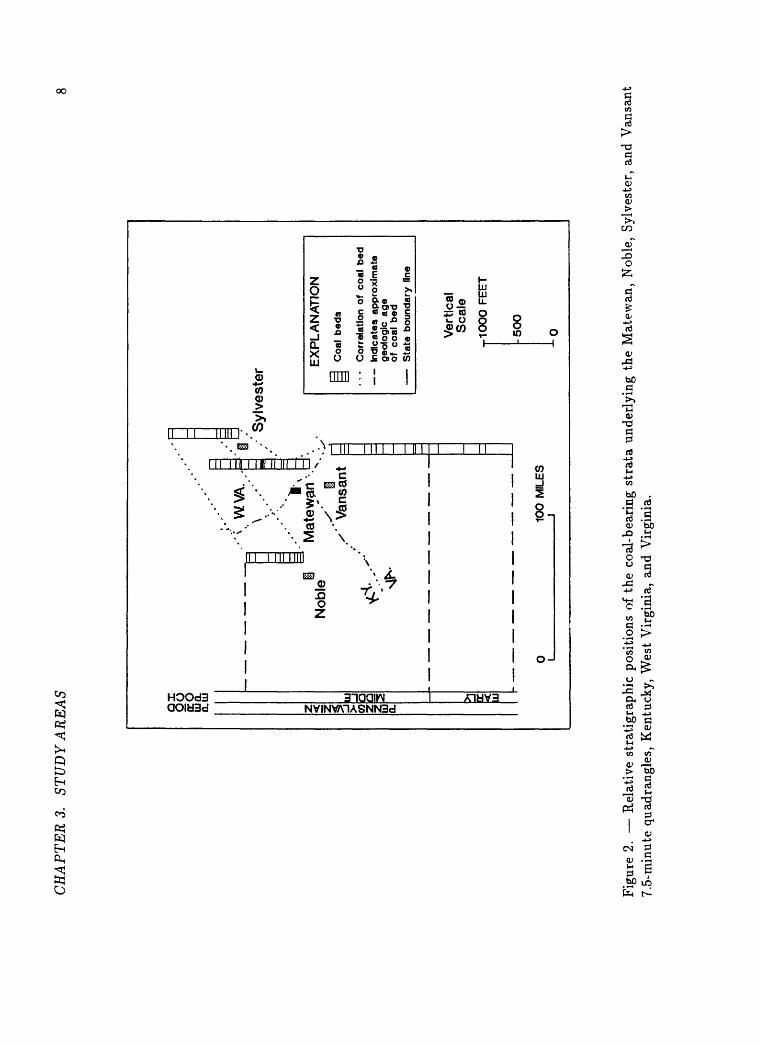
CH
AP
TE
RS.
ST
UD
Y A
RE
AS
ax
oo
E
O
mo.
a.
m 3C
OQ
Z
Q
WV
A.
Nob
leM
atew
an
/' V
ansa
nt
Syl
vest
er
EX
PL
AN
AT
ION
Coa
l be
ds
Cor
rela
tion
of c
oal
bed
In
dica
tes
appr
oxim
ate
geol
ogic
age
of
coa
l be
d
Sta
te b
ound
ary
line
10
0 M
ILE
S
Ver
tica
l S
cale
ylO
OO
FE
ET
-50
0
--0
Fig
ure
2. R
elat
ive
stra
tigr
aphi
c po
siti
ons
of t
he c
oal-
bear
ing
stra
ta u
nder
lyin
g th
e M
atew
an,
Nob
le,
Syl
vest
er,
and
Van
sant
7.
5-m
inut
e qu
adra
ngle
s, K
entu
cky,
Wes
t V
irgi
nia,
and
Vir
gini
a.
Ch
ap
ter
4
RE
ST
RIC
TIO
NS
US
ED
For
thi
s su
mm
ary
repo
rt,
the
rest
rict
ions
to
min
ing
wer
e su
bdiv
ided
int
o tw
o m
ajor
cat
egor
ies l
and-
use
and
tech
no
logi
c.
Lan
d-us
e re
stri
ctio
ns a
re p
lace
d up
on m
inin
g by
soc
ieta
l po
licie
s to
pre
serv
e th
ose
surf
ace
feat
ures
or
enti
ties
th
at
coul
d be
adv
erse
ly a
ffec
ted
by m
inin
g. L
and-
use
rest
rict
ions
, th
eref
ore,
may
cha
nge
if s
ocie
tal
inte
rest
s ch
ange
. L
and-
use
rest
rict
ions
lar
gely
app
ly t
o su
rfac
e m
inin
g, b
ut m
ay a
lso
af
fect
und
ergr
ound
min
ing.
Tec
hnol
ogic
res
tric
tion
s af
fect
the
ec
onom
ics
or s
afet
y of
min
ing
and
are
dete
rmin
ed b
y cu
rren
t le
vels
of
tech
nolo
gy;
thes
e ca
n on
ly c
hang
e w
ith
adva
nces
in
scie
nce
and
engi
neer
ing
or c
hang
es i
n ec
onom
ic c
ondi
tion
s.
Tec
hnol
ogic
res
tric
tion
s af
fect
both
sur
face
and
und
ergr
ound
m
inin
g, b
ut a
re g
ener
ally
mor
e pr
ohib
itiv
e to
und
ergr
ound
m
inin
g.
The
res
tric
tion
s to
coa
l m
inin
g an
d th
e cr
iter
ia a
ppli
ed i
n ea
ch o
f th
e fo
ur s
tudy
are
as a
re s
umm
ariz
ed i
n T
able
1 a
nd
desc
ribe
d br
iefl
y be
low
. D
etai
led
disc
ussi
on o
f th
e re
stri
c
tion
s an
d cr
iter
ia a
re i
nclu
ded
in t
he s
tudy
are
a re
port
s ci
ted
in t
he S
tudy
Are
as a
nd R
efer
ence
s C
ited
sec
tion
s.
The
ma
jor
land
-use
res
tric
tion
s to
min
ing
are
deli
neat
ed i
n th
e Su
r
face
Min
ing
Con
trol
and
Rec
lam
atio
n A
ct o
f 19
77 (
Off
ice
of
Sur
face
Min
ing
Rec
lam
atio
n an
d E
nfor
cem
ent,
198
8).
The
se
rest
rict
ions
, or
mor
e st
ring
ent
ones
, m
ust
be a
ppli
ed w
ithi
n ea
ch S
tate
u
nles
s w
aive
rs c
an b
e ob
tain
ed.
The
ind
ivid
ua
l st
udy
area
rep
orts
pre
sent
the
aut
hori
ty f
or t
he s
peci
fic
rest
rict
ions
an
d cr
iter
ia a
ppli
ed w
ithi
n ea
ch q
uadr
angl
e in
te
rms
of c
itab
le l
aws,
reg
ulat
ions
, or
loc
al p
ract
ices
.
4.1
Lan
d-u
se R
estr
icti
on
s
4.1.
1 L
and
-use
Res
tric
tio
ns
to S
urf
ace
Min
ing
Pow
er l
ines
and
pip
elin
es.
Pow
er l
ines
and
pip
elin
es a
re p
rese
nt i
n al
l fo
ur s
tudy
are
as,
but
wer
e no
t co
nsid
ered
to
be r
estr
icti
ve t
o su
rfac
e m
inin
g in
the
Van
sant
qua
dran
gle.
In
the
oth
er t
hree
stu
dy a
reas
, a
100-
ft
buff
er
zone
is
com
mon
ly l
eft
on e
ach
side
of
the
pow
er l
ine
or p
ipel
ine.
T
here
fore
, a
100-
ft
buff
er l
ine
was
di
giti
zed
arou
nd e
ach
pow
er l
ine
and
pipe
line
in
thes
e th
ree
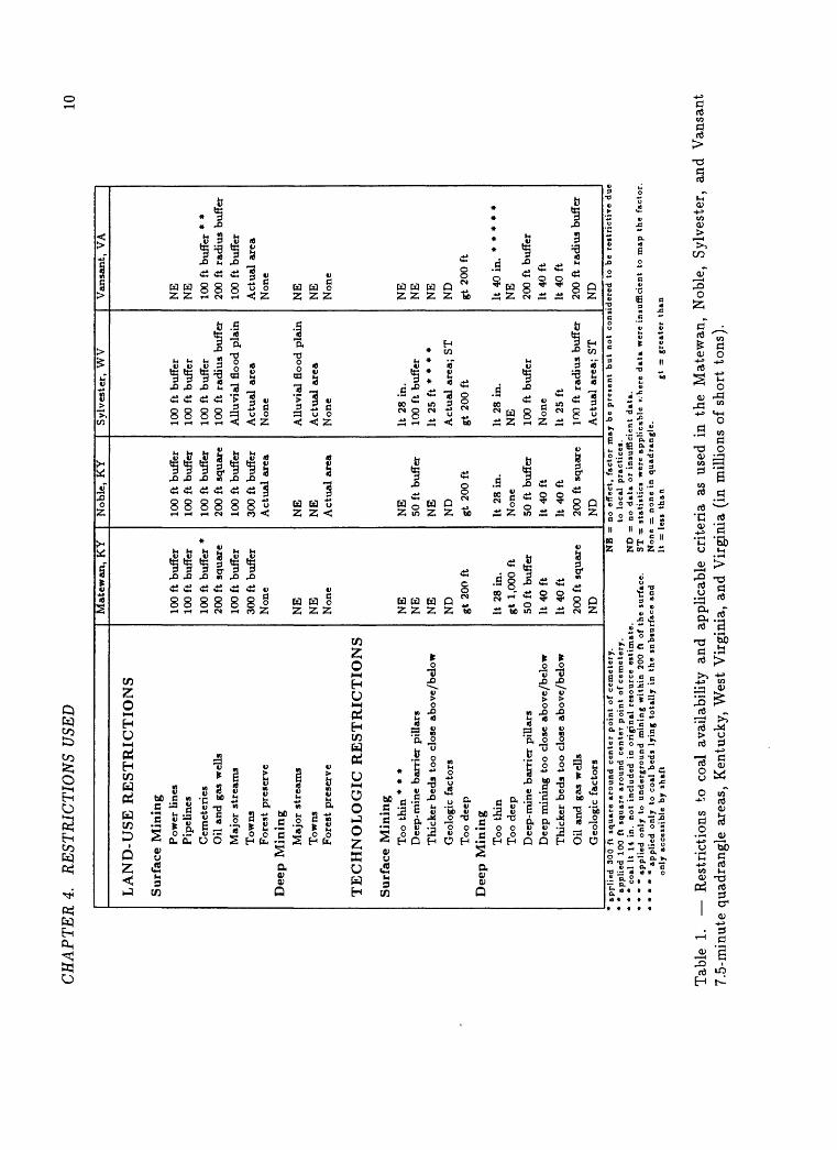
CH
AP
TE
R 4
. R
EST
RIC
TIO
NS
USE
D10
LA
ND
-US
E R
ES
TR
ICT
ION
S
Surf
ace
Min
ing
Pow
er l
ines
Pip
elin
es
Cem
eter
ies
Oil
an
d g
as w
ells
Maj
or s
trea
ms
Tow
nsF
ores
t pr
eser
ve
Dee
p M
inin
gM
ajor
str
eam
s
Tow
nsF
ores
t pr
eser
ve
TE
CH
NO
LO
GIC
RE
ST
RIC
TIO
NS
Su
rfac
e M
inin
gT
oo t
hin
* *
*D
eep-
min
e bar
rier
pil
lars
Thi
cker
bed
s to
o cl
ose
abo
ve/
bel
ow
Geo
logi
c fa
ctor
sT
oo d
eep
Dee
p M
inin
gT
oo t
hin
T
oo d
eep
Dee
p-m
ine
bar
rier
pil
lars
Dee
p m
inin
g to
o cl
ose
above/
bel
ow
Thi
cker
bed
s to
o c
lose
above/
bel
ow
Oil
and
gas
wel
lsG
eolo
gic
fact
ors
Mat
ewan
, K
Y
100
ft b
uffe
r10
0 ft
buf
fer
100
ft b
uffe
r *
200
ft s
qu
are
100
ft b
uffe
r30
0 ft
buf
fer
Non
e
NE
NB
Non
e
NE
NE
NE
ND
gt 2
00 f
t
It 2
8 in
. gt
1,00
0 ft
50 f
t bu
ffer
It 4
0 ft
It 4
0ft
200
ft s
qu
are
ND
NB
=
*
* co
al I
t 14
in
. not
incl
ud
ed
in o
rig
ins!
reto
urc
e est
imate
. N
D
= *
* *
* ap
pli
ed only
to
u
nd
erg
round m
inin
g w
ithin
2
00
ft
of
the
surf
ace.
S
T =
*
* *
* *
app
lied
o
nly
to
coal
bed
i ly
ing
tota
lly i
n th
e s
nbtu
rface a
nd
None
only
acc
essi
ble
by s
haft
It
=
Nob
le,
KY
100
ft b
uffe
r10
0 ft
buf
fer
100
ft b
uffe
r20
0 ft
squ
are
100
ft b
uffe
r
300
ft b
uffe
rA
ctu
al a
rea
NE
NE
Act
ual
are
a
NE
50 f
t bu
ffer
NE
ND
gt 2
00 f
t
It 2
8 in
.N
one
50 f
t bu
ffer
It 4
0 ft
It 4
0 ft
200
ft s
quar
eN
D
Syl
vest
er,
WV
100
ft b
uffe
r10
0 ft
buf
fer
100
ft b
uffe
r10
0 ft
rad
ius
buff
er
All
uvia
l fl
ood
pla
in
Act
ual
are
aN
one
All
uvia
l fl
ood
pla
in
Act
ual
are
aN
one
It 2
8 in
.10
0 ft
buf
fer
It 2
5 ft
* *
* *
Act
ual
are
a; S
Tgt
200
ft
It 2
8 in
.N
E10
0 ft
buf
fer
Non
e
It 2
5 ft
100
ft r
adiu
s bu
ffer
Act
ual
are
a; S
T
to lo
cal
pra
cti
ces.
Van
sant
, V
A
NE
NE
100
ft b
uffe
r *
*20
0 ft
rad
ius
buff
er10
0 ft
buf
fer
Act
ual
area
Non
e
NE
NE
Non
e
NE
NE
NE
ND
gt 2
00 f
t
NE
200
ft b
uffe
rIt
40
ft
It 4
0 ft
200
ft r
adiu
s bu
ffer
ND
stati
stic
s w
ere
appli
cable
v.
-her
e data
wer
e in
suff
icie
nt
to m
ap th
e f
acto
r =
none
in q
uad
ran
gle
. es
s th
an
gt
= g
reate
r th
an
Tab
le
1. R
estr
icti
ons
to c
oal
avai
labi
lity
and
app
lica
ble
crit
eria
as
used
in
the
Mat
ewan
, N
oble
, S
ylve
ster
, an
d V
ansa
nt
7.5-
min
ute
quad
rang
le a
reas
, K
entu
cky,
Wes
t V
irgi
nia,
and
Vir
gini
a (i
n m
illio
ns o
f sh
ort
tons
).
CH
APT
ER
4.
RE
STR
ICT
ION
S U
SED
11
quad
rang
les
and
ente
red
into
NC
RD
S a
s th
e ar
eas
rest
rict
ed
from
sur
face
min
ing
by p
ower
lin
es a
nd p
ipel
ines
.
Cem
eter
ies.
Surf
ace
min
ing
is n
ot p
erm
itte
d in
, or
nea
r, c
emet
erie
s in
m
ost
area
s.
In t
he S
ylve
ster
qua
dran
gle,
the
act
ual
area
of
each
cem
eter
y pl
us a
sur
roun
ding
100
-ft
buff
er z
one
was
dig
i
tize
d. I
n th
e M
atew
an a
nd V
ansa
nt q
uadr
angl
es, w
here
100
-ft
buff
er z
ones
are
als
o re
quir
ed,
the
cem
eter
ies
wer
e to
o sm
all
to d
igit
ize
from
the
l:
24,0
00-s
cale
map
s.
The
refo
re,
300-
ft
and
100-
ft s
quar
es,
resp
ecti
vely
, w
ere
draw
n ar
ound
the
cen
tr
al p
oint
of e
ach
cem
eter
y to
rep
rese
nt t
he a
rea
of u
nmin
able
co
al.
Oil
an
d g
as w
ells
.
Buf
fer
zone
s ar
e re
quir
ed a
nd w
ere
crea
ted
arou
nd t
he l
oca
ti
on p
oint
of e
ach
oil
and
gas
wel
l in
all
of t
he s
tudy
are
as:
in
Ken
tuck
y, 2
00-f
t sq
uare
s; i
n th
e S
ylve
ster
qua
dran
gle,
cir
cles
w
ith
100-
ft r
adii
; an
d in
the
Van
sant
qua
dran
gle,
cir
cles
wit
h 20
0-ft
rad
ii.
Maj
or s
trea
ms.
In K
entu
cky
and
Vir
gini
a, a
100
-ft
buff
er z
one
is r
equi
red,
an
d w
as d
igit
ized
, ar
ound
str
eam
s an
d ri
vers
wit
h m
ean
an
nual
flo
w g
reat
er t
han
5 cu
bic
feet
per
sec
ond.
In
Wes
t V
ir
gini
a, t
he v
alle
y fl
oors
of
the
Coa
l R
iver
and
its
maj
or t
rib
ut
arie
s co
nsti
tute
a r
estr
icti
on t
o bo
th s
urfa
ce a
nd s
hallo
w
unde
rgro
und
min
ing
and
wer
e so
dig
itiz
ed.
To
wn
s.
In
Ken
tuck
y,
a 30
0-ft
bu
ffer
is
requ
ired
an
d w
as
digi
tize
d ar
ound
re
side
ntia
l an
d pu
blic
bu
ildi
ngs.
In
V
irgi
nia
and
Wes
t V
irgi
nia,
whe
re a
reas
of
popu
lati
on c
once
ntra
tion
are
re
stri
cted
fro
m m
inin
g, t
he a
ctua
l po
pula
tion
con
cent
rati
on
area
s w
ere
digi
tize
d.
For
est
pre
serv
e.
In
the
earl
y 19
00's
, a
15,0
00-a
cre
trac
t w
as d
eede
d to
the
U
nive
rsit
y of
Ken
tuck
y w
ith
the
prov
isio
n th
at i
t ne
ver
be
min
ed.
The
por
tion
of
the
fore
st p
rese
rve
that
lie
s w
ithi
n th
e N
oble
qua
dran
gle
was
the
refo
re c
onsi
dere
d as
a r
estr
icti
on t
o m
inin
g an
d it
s bo
unda
ries
wer
e di
giti
zed.
Majo
r ro
ads
and
rai
lroa
ds.
The
se w
ere
dete
rmin
ed t
o be
res
tric
tion
s to
min
ing
only
in
the
Syl
vest
er q
uadr
angl
e, b
ut,
beca
use
they
wer
e al
l w
ithi
n th
e va
lley
floo
r bo
unda
ries
, th
ey d
id n
ot
pres
ent
an
addi
ti
onal
im
pact
on
avai
labl
e re
sour
ces
and
cons
eque
ntly
wer
e no
t as
sess
ed.
4.1.
2 L
and
-use
R
estr
icti
ons
Min
ing
Majo
r st
rea
ms.
to
Un
der
grou
nd
In t
he S
ylve
ster
qua
dran
gle,
the
val
ley
floo
rs o
f the
Coa
l R
iver
an
d it
s m
ajor
tri
buta
ries
wer
e co
nsid
ered
to
be r
estr
icti
ve t
o un
derg
roun
d m
inin
g of
pot
enti
ally
min
able
coa
l be
ds a
t re
la
tive
ly s
hallo
w d
epth
s be
low
. M
ajor
str
eam
s w
ere
not
cons
id
ered
a r
estr
icti
on t
o un
derg
roun
d m
inin
g in
the
tw
o K
entu
cky
CH
AP
TE
R 4
. R
EST
RIC
TIO
NS
USE
D12
stud
y ar
eas
beca
use
ther
e w
ere
no k
now
n m
inab
le c
oal
beds
be
low
maj
or-s
trea
m d
rain
age,
and
dee
p co
al m
inin
g w
as n
ot
rest
rict
ed b
elow
maj
or s
trea
ms
in t
he V
ansa
nt q
uadr
angl
e.
Tow
ns.
In
the
Syl
vest
er q
uadr
angl
e,
actu
al
popu
lati
on
conc
entr
a
tion
s w
ere
incl
uded
as
rest
rict
ions
and
wer
e di
giti
zed.
T
owns
w
ere
not
cons
ider
ed r
estr
icti
ons
to u
nder
grou
nd m
inin
g in
th
e K
entu
cky
and
Vir
gini
a st
udy
area
s.
For
est
pre
serv
e.
Tha
t po
rtio
n of
the
for
est
pres
erve
in
the
Nob
le q
uadr
angl
e de
scri
bed
abov
e as
res
tric
ted
for
surf
ace
min
ing
is a
lso
con
si
dere
d a
rest
rict
ion
for
unde
rgro
und
min
ing
and
the
sam
e di
giti
zed
boun
dari
es w
ere
appl
ied.
4.2
Tec
hn
olog
ic R
estr
icti
ons
4.2.
1 T
ech
nol
ogic
R
estr
icti
ons
to
Su
rfac
e M
in
ing
Too
th
in.
Acc
ordi
ng t
o th
e U
SGS
clas
sifi
cati
on s
yste
m,
beds
wit
h co
al
thic
knes
s le
ss t
han
14 i
nche
s ar
e no
t co
nsid
ered
to
be a
re
so
urce
(un
less
loc
al p
ract
ice
is t
o m
ine
the
thin
ner
coal
bed
s)
and,
the
refo
re,
wer
e no
t co
nsid
ered
in
thes
e st
udie
s.
In t
he
Syl
vest
er q
uadr
angl
e, l
ocal
sur
face
min
ing
prac
tice
s pr
eclu
de
min
ing
of b
eds
wit
h le
ss
than
28
inch
es o
f co
al;
thus
, an
y be
ds w
ith
less
tha
n 28
inc
hes
of c
oal
wer
e co
nsid
ered
as
re
stri
ctiv
e to
sur
face
min
ing
thro
ugho
ut t
he e
ntir
e qu
adra
ngle
.
Thi
s fa
ctor
was
not
con
side
red
a co
nstr
aint
to
surf
ace
min
ing
in t
he o
ther
thr
ee s
tudy
are
as.
Dee
p-m
ine
bar
rier
pil
lars
.
In
the
Mat
ewan
an
d V
ansa
nt
quad
rang
les,
un
derg
roun
d m
ines
in
shal
low
coa
l be
ds w
ere
not
cons
ider
ed r
estr
icti
ve
to s
urfa
ce m
inin
g.
How
ever
, in
the
Nob
le q
uadr
angl
e, 5
0-ft
bu
ffer
zon
es a
re c
usto
mar
ily
left
aro
und
unde
rgro
und
min
es
duri
ng s
urfa
ce m
inin
g op
erat
ions
, an
d, t
here
fore
, w
ere
digi
ti
zed
as r
estr
icti
ons
to s
urfa
ce m
inin
g. I
n th
e S
ylve
ster
qua
d
rang
le,
whe
re a
con
side
rabl
e am
ount
of
unde
rgro
und
min
ing
occu
rs w
ithi
n 20
0 fe
et o
f th
e su
rfac
e, 1
00-f
t bu
ffer
zon
es w
ere
digi
tize
d ar
ound
the
nea
r-su
rfac
e ac
tive
and
aba
ndon
ed u
n
derg
roun
d m
ines
; th
ese
buff
er z
ones
wer
e co
nsid
ered
to
be
rest
rict
ive
to u
nder
grou
nd m
inin
g bu
t no
t to
sur
face
min
ing.
Th
ick
er b
eds
too c
lose
ab
ove
or b
elow
a p
ote
nti
all
y
min
ab
le c
oal
bed
.
Thi
s w
as o
nly
cons
ider
ed a
res
tric
tion
to
unde
rgro
und
min
ing
in t
he s
hallo
w c
oal
beds
tha
t w
ere
pote
ntia
lly
surf
ace
min
able
in
Wes
t V
irgi
nia
whe
re t
he b
eds
wer
e w
ithi
n 25
fee
t of
one
an
othe
r.
Geo
log
ic f
act
ors
.
In t
he S
ylve
ster
qua
dran
gle,
are
as w
here
coa
l be
ds h
ad b
een
erod
ed a
way
bef
ore,
or
soon
af
ter,
bur
ial
(was
hout
s) w
ere
map
ped
and
excl
uded
fro
m r
esou
rce
calc
ulat
ions
. A
lso,
in
pr-
tini
te (
orga
nic
com
pone
nts)
in
coal
tha
t w
ould
pre
vent
com
pl
ete
and
rapi
d bu
rnin
g of
coa
l in
pow
er-g
ener
atio
n bo
ilers
de
sign
ed t
o bu
rn p
ulve
rize
d co
al w
ere
dete
cted
in
two
coal
CH
AP
TER
4.
RE
STR
ICTI
ON
S U
SED
13
beds
and
inc
lude
d as
res
tric
tion
s to
min
ing.
T
here
wer
e in
su
ffic
ient
dat
a to
inc
lude
the
se o
r ot
her
geol
ogic
fac
tors
as
rest
rict
ions
in
the
othe
r th
ree
quad
rang
le a
reas
stu
died
.
Too
dee
p.
Alt
houg
h su
rfac
e-m
inin
g de
pths
var
y w
ith
chan
ges
in t
hick
ne
ss a
nd c
hara
cter
of
coal
bed
s an
d w
ith
chan
ges
in t
he l
itho
l-
ogy
of t
he o
verb
urde
n, 2
00 f
eet
was
ass
umed
to
be t
he m
ax
imum
pos
sibl
e de
pth
for
surf
ace
min
ing
in e
ach
of t
he f
our
stud
y ar
eas.
A
200
-ft
over
burd
en t
hick
ness
lin
e w
as d
eriv
ed
by s
ubtr
acti
ng t
he e
leva
tion
s at
the
top
s of
the
coa
l be
ds
from
the
ele
vati
ons
at t
he g
roun
d su
rfac
e th
at a
re s
tore
d in
th
e U
SGS
digi
tal
elev
atio
n m
odel
s (D
EM
's)
for
each
stu
dyar
ea.
4.2.
2T
ech
nol
ogic
R
estr
icti
on
s to
U
nd
ergr
oun
d
Min
ing
Too
th
in.
In t
he K
entu
cky
and
Wes
t V
irgi
nia
quad
rang
les,
bed
s w
ith
less
tha
n 28
inc
hes
of c
oal
wer
e co
nsid
ered
too
thi
n fo
r un
der
gr
ound
min
ing.
In
the
Van
sant
qua
dran
gle,
onl
y th
ose
coal
be
ds t
hat
wer
e bo
th t
otal
ly s
ubsu
rfac
e (r
equi
ring
acc
ess
by
shaf
t) a
nd l
ess
than
40
inch
es t
hick
wou
ld n
ot b
e ex
pect
ed t
o be
min
ed a
nd,
ther
efor
e, w
ere
cons
ider
ed a
s re
stri
cted
.
Too
dee
p.
In e
aste
rn K
entu
cky,
1,
000
feet
is
gene
rall
y co
nsid
ered
the
m
axim
um d
epth
for
und
ergr
ound
min
ing.
T
his
was
app
lied
as
a r
estr
icti
on t
o m
inin
g in
the
Mat
ewan
qua
dran
gle.
In
the
Nob
le q
uadr
angl
e, n
one
of t
he c
oal
beds
lie
bel
ow 1
,000
fee
t. In
the
Van
sant
and
Syl
vest
er q
uadr
angl
es,
dept
h ha
s no
t be
en
proh
ibit
ive
to m
inin
g.
In f
act,
nea
rly
all
of t
he e
xten
sive
ly-
min
ed P
ocah
onta
s N
o.
3 co
al b
ed i
s be
neat
h m
ore
than
1,0
00
feet
of
over
burd
en.
Dee
p-m
ine
bar
rier
pil
lars
.
Bar
rier
pil
lars
ar
ound
und
ergr
ound
min
es a
re r
equi
red
for
min
e sa
fety
in
all
four
stu
dy a
reas
. In
Ken
tuck
y, 5
0 fe
et i
s re
quir
ed;
in W
est
Vir
gini
a, 1
00 f
eet;
and
Vir
gini
a, 2
00 f
eet.
The
refo
re,
buff
er z
ones
of
the
appr
opri
ate
wid
th w
ere
gene
r
ated
aro
und
each
act
ive
and
aban
done
d un
derg
roun
d m
ine.
Dee
p
min
ing t
oo c
lose
ab
ove
or b
elow
a p
ote
nti
all
y
min
ab
le c
oal
bed
.
Whe
re d
eep
min
ing
has
occu
rred
eit
her
abov
e or
bel
ow a
n
othe
r po
tent
iall
y m
inab
le
bed,
th
e ot
her
bed
will
no
t be
m
ined
if
the
beds
are
wit
hin
a m
inim
um d
ista
nce
abov
e or
be
low
one
ano
ther
. T
his
dist
ance
is
gene
rall
y 40
fee
t in
the
K
entu
cky
and
Vir
gini
a st
udy
area
s.
In W
est
Vir
gini
a, l
ocal
pr
acti
ce s
ets
min
imum
acc
epta
bly
safe
int
erbu
rden
thi
ckne
ss
at 2
5 fe
et, b
ut t
here
wer
e no
occ
urre
nces
of
unde
rgro
und
min
in
g ei
ther
25
feet
abo
ve o
r be
low
a p
oten
tial
ly m
inab
le c
oal
bed
wit
hin
the
Syl
vest
er q
uadr
angl
e.
Th
ick
er b
eds
too c
lose
ab
ove
or b
elow
a p
ote
nti
all
y
min
able
coa
l b
ed.
Whe
n tw
o po
tent
iall
y m
inab
le c
oal
beds
occ
ur w
ithi
n a
min
im
um d
ista
nce
from
one
ano
ther
, on
e or
the
oth
er w
ill n
ot
be m
ined
. A
ccor
ding
to
loca
l pr
acti
ce,
this
min
imum
ver
tica
l
CH
AP
TE
R 4
. R
EST
RIC
TIO
NS
USE
D
14
dist
ance
is
40 f
eet
in t
he K
entu
cky
and
Vir
gini
a qu
adra
ngle
s,
and
25 f
eet
in t
he S
ylve
ster
qua
dran
gle.
For
the
se f
our
stud
y ar
eas,
whe
re t
here
are
not
suf
fici
ent
qual
ity
dat
a to
ind
icat
e ot
herw
ise,
the
ass
umpt
ion
was
mad
e th
at t
he t
hick
er o
f th
e tw
o co
al b
eds
wou
ld b
e se
lect
ed f
or m
inin
g.
Oil
an
d g
as w
ells
.
For
safe
ty,
coal
mus
t re
mai
n un
min
ed n
ear
oil
and
gas
wel
ls
in u
nder
grou
nd m
ines
. T
he s
ame
crit
eria
are
app
lied
as
for
land
-use
res
tric
tion
s to
sur
face
min
ing
desc
ribe
d ab
ove.
Geo
logic
Fac
tors
.
The
sam
e ge
olog
ic f
acto
rs d
escr
ibed
abo
ve f
or s
urfa
ce m
inin
g ap
ply
also
to
deep
min
ing.
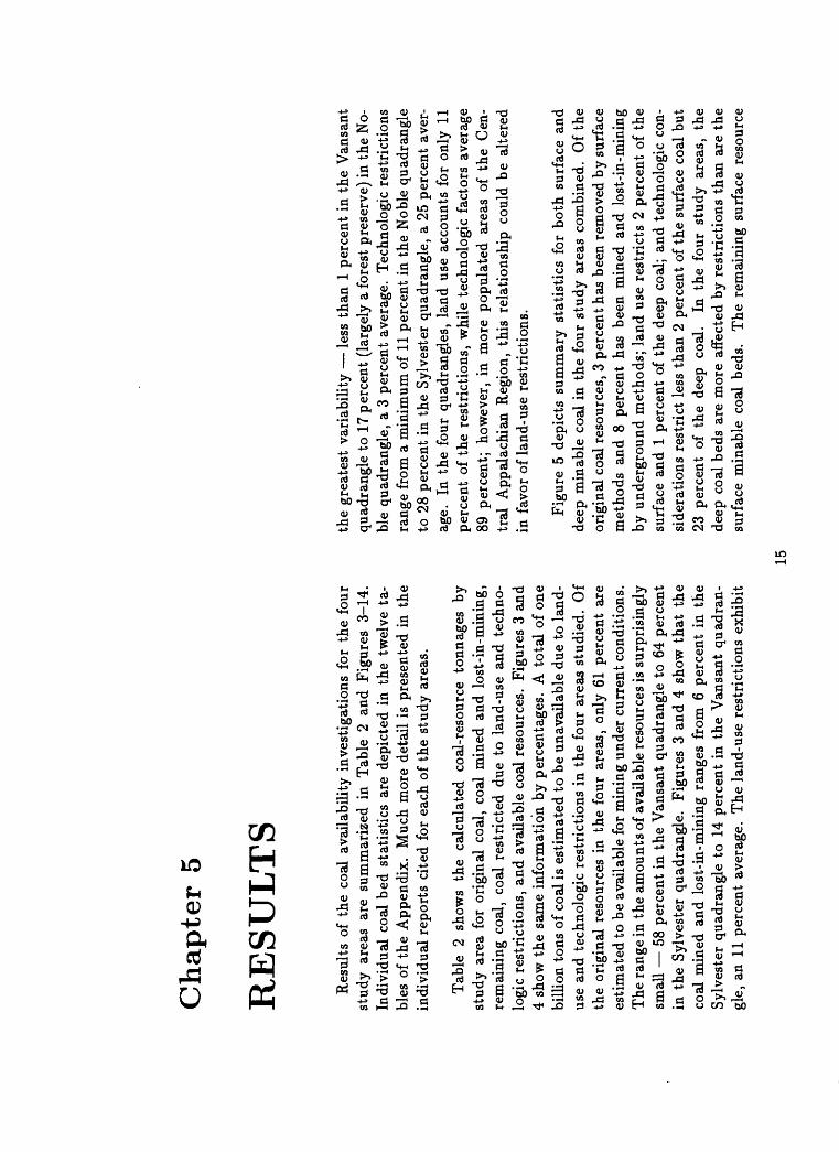
Ch
ap
ter
5
RE
SU
LT
S
Res
ults
of
the
coal
ava
ilab
ilit
y in
vest
igat
ions
for
the
fou
r st
udy
area
s ar
e su
mm
ariz
ed i
n T
able
2
and
Fig
ures
3-
14.
Indi
vidu
al c
oal
bed
stat
isti
cs a
re d
epic
ted
in t
he t
wel
ve t
a
bles
of
the
App
endi
x.
Muc
h m
ore
deta
il i
s pr
esen
ted
in t
he
indi
vidu
al r
epor
ts c
ited
for
eac
h of
the
stu
dy a
reas
.
Tab
le
2 sh
ows
the
calc
ulat
ed
coal
-res
ourc
e to
nnag
es
by
stud
y ar
ea f
or o
rigi
nal
coal
, co
al m
ined
and
los
t-in
-min
ing,
re
mai
ning
coa
l, co
al r
estr
icte
d du
e to
lan
d-us
e an
d te
chno
lo
gic
rest
rict
ions
, an
d av
aila
ble
coal
res
ourc
es.
Fig
ures
3 a
nd
4 sh
ow t
he s
ame
info
rmat
ion
by p
erce
ntag
es.
A t
ota
l of
one
bi
llio
n to
ns o
f co
al is
est
imat
ed t
o be
una
vail
able
due
to
land
- us
e an
d te
chno
logi
c re
stri
ctio
ns i
n th
e fo
ur a
reas
stu
died
. O
f th
e or
igin
al r
esou
rces
in
the
four
are
as,
only
61
perc
ent
are
esti
mat
ed t
o be
ava
ilab
le f
or m
inin
g un
der
curr
ent
cond
itio
ns.
The
ran
ge in
the
am
ount
s of
ava
ilab
le r
esou
rces
is s
urpr
isin
gly
smal
l 5
8 pe
rcen
t in
the
Van
sant
qua
dran
gle
to 6
4 pe
rcen
t in
the
Syl
vest
er q
uadr
angl
e.
Fig
ures
3 a
nd 4
sho
w t
hat
the
co
al m
ined
and
los
t-in
-min
ing
rang
es f
rom
6 p
erce
nt i
n th
e S
ylve
ster
qua
dran
gle
to 1
4 pe
rcen
t in
the
Van
sant
qua
dran
gl
e, a
n 11
per
cent
ave
rage
. T
he l
and-
use
rest
rict
ions
exh
ibit
the
grea
test
var
iabi
lity
l
ess
than
1 p
erce
nt i
n th
e V
ansa
nt
quad
rang
le t
o 17
per
cent
(la
rgel
y a
fore
st p
rese
rve)
in
the
No
bl
e qu
adra
ngle
, a
3 pe
rcen
t av
erag
e. T
echn
olog
ic r
estr
icti
ons
rang
e fr
om a
min
imum
of
11 p
erce
nt i
n th
e N
oble
qua
dran
gle
to 2
8 pe
rcen
t in
the
Syl
vest
er q
uadr
angl
e, a
25
perc
ent
aver
ag
e.
In t
he f
our
quad
rang
les,
lan
d us
e ac
coun
ts f
or o
nly
11
perc
ent
of t
he r
estr
icti
ons,
whi
le t
echn
olog
ic f
acto
rs a
vera
ge
89 p
erce
nt;
how
ever
, in
mor
e po
pula
ted
area
s of
the
Cen
tr
al A
ppal
achi
an R
egio
n, t
his
rela
tion
ship
cou
ld b
e al
tere
d in
fav
or o
f la
nd-u
se r
estr
icti
ons.
Fig
ure
5 de
pict
s su
mm
ary
stat
isti
cs f
or b
oth
surf
ace
and
deep
min
able
coa
l in
the
fou
r st
udy
area
s co
mbi
ned.
O
f th
e or
igin
al c
oal
reso
urce
s, 3
per
cent
has
bee
n re
mov
ed b
y su
rfac
e m
etho
ds a
nd 8
per
cent
has
bee
n m
ined
and
los
t-in
-min
ing
by u
nder
grou
nd m
etho
ds;
land
use
res
tric
ts 2
per
cent
of
the
surf
ace
and
1 pe
rcen
t of
the
dee
p co
al;
and
tech
nolo
gic
con
si
dera
tion
s re
stri
ct l
ess
than
2 p
erce
nt o
f th
e su
rfac
e co
al b
ut
23 p
erce
nt o
f th
e de
ep
coal
. In
the
fou
r st
udy
area
s, t
he
deep
coa
l be
ds a
re m
ore
affe
cted
by
rest
rict
ions
tha
n ar
e th
e su
rfac
e m
inab
le c
oal
beds
. T
he r
emai
ning
sur
face
res
ourc
e
15
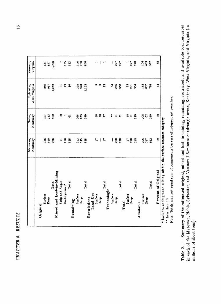
CH
AP
TE
RS.
R
ESU
LT
S16
Ori
gina
l Sur
face
Dee
p
To
tal
Min
ed a
nd L
ost-
in-M
inin
gS
trip
and A
uger
Und
ergr
ound
*
Tota
lR
emai
ning Sur
face
Dee
pT
ota
lR
estr
icti
on
sL
and
Use
Sur
face
Dee
p
Tota
lT
echn
olog
icS
urfa
ceD
eep
To
tal
To
tal
Sur
face
Dee
pT
ota
lA
vail
able S
urfa
ceD
eep
Tota
l
Per
cen
t of
Ori
gina
l
Mat
ewan
, K
entu
cky
336
650
986 11 118
128
313
545
858 17 17 228
228 17 228
245
296
317
613 62
Nob
le,
Ken
tuck
y
327
133
460 601
61 266
133
399 58 20 77 ** 51 51 58 71 129
208 62 270 59
Syl
vest
er,
Wes
t V
irgi
nia
286
957
1,24
2 31 49 80 235
928
1,16
2 9 5 13 64 286
350 73 291
364
162
637
798 64
Van
sant
, V
irgi
nia
131
877
1,00
8 713
514
2
106
760
866 1
1
277
277 1
277
278
104
483
587 58
* In
clud
es u
nder
grou
nd m
inin
g w
ithi
n th
e su
rfac
e re
sour
ce c
ateg
ory.
** L
ess
than
0.5
Not
e:
Tot
als
may
not
equ
al s
um o
f co
mpo
nent
s be
caus
e of
inde
pend
ent
roun
ding
.
Tab
le 2
. S
umm
ary
of t
he e
stim
ated
ori
gina
l, m
ined
and
los
t-in
-min
ing,
rem
aini
ng,
rest
rict
ed,
and
avai
labl
e co
al r
esou
rces
in
eac
h of
the
Mat
ewan
, N
oble
, S
ylve
ster
, an
d V
ansa
nt 7
.5-m
inut
e qu
adra
ngle
are
as,
Ken
tuck
y, W
est
Vir
gini
a, a
nd V
irgi
nia
(in
mill
ions
of
shor
t to
ns).
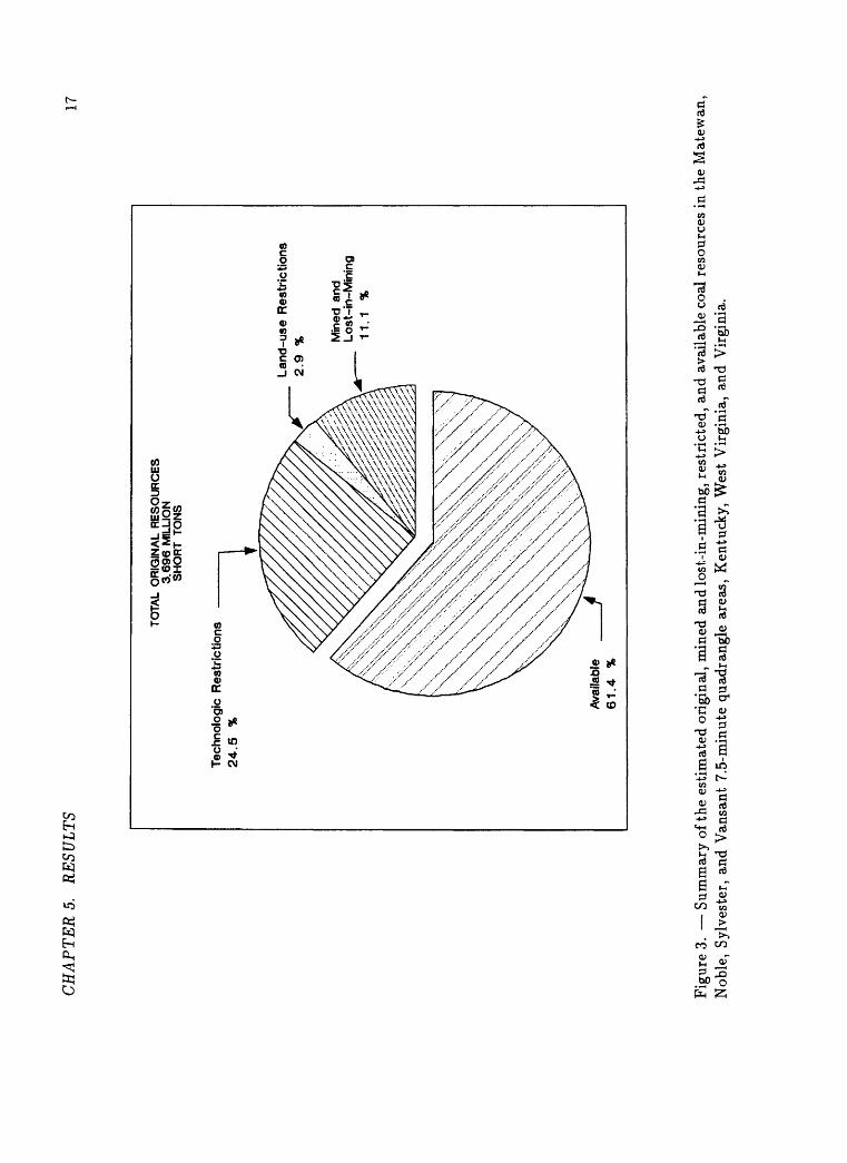
CH
AP
TER
5.
RE
SULT
S17
TOTA
L O
RIG
INA
L R
ES
OU
RC
ES
3.6
96 M
ILLI
ON
S
HO
RT
TO
NS
Tech
nolo
gic
Res
tric
tions
2
4.5
%
Lan
d-u
se R
estr
icti
on
s 2
.9
% Min
ed a
nd
Lo
st-i
n-M
inin
g11.1
%
Ava
ilabl
e 61.4
%
Figu
re 3
. S
umm
ary
of th
e es
tim
ated
ori
gina
l, m
ined
and
lost
-in-
min
ing,
res
tric
ted,
and
ava
ilabl
e co
al r
esou
rces
in t
he M
atew
an,
Nob
le,
Sylv
este
r, a
nd V
ansa
nt 7
.5-m
inut
e qu
adra
ngle
are
as,
Ken
tuck
y, W
est
Vir
gini
a, a
nd V
irgi
nia.
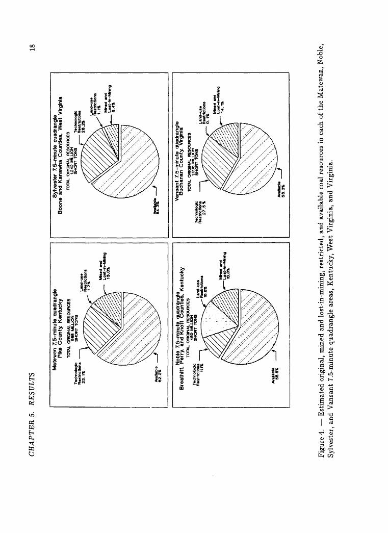
CH
AP
TE
RS.
R
ESU
LT
S18
Mat
ewan
7.5
-min
ute
quad
rang
le
Pik
e C
ount
y, K
entu
cky
TOTA
L O
RIG
INA
L R
ES
OU
RC
ES
988 M
LLJO
NTe
chno
logi
c S
HO
RT
TO
NS
R
estr
ictio
ns
23.1
%
Min
ed a
ndLo
st-ln
-Mln
Ing
13.0
%
Syl
vest
er 7
.5-m
inut
e qu
adra
ngle
B
oone
and
Kan
awh
a C
ount
ies.
W
est
Vir
gini
aTO
TAL
OR
K3N
AL
RE
SO
UR
CE
S
1242 M
LU
ON
SH
OR
T TO
NS
Te
chno
logi
c R
estr
ictio
ns
28.2
%
Lan
d-u
seR
estr
ictio
ns1.
1% Min
ed a
ndL
ost
-ln
-MW
ng
6.4%
iLlt
i N
oble
7.5
-min
ute
qua
dran
gte
Bre
athi
tt.
Per
ry,
and
Kn
ott
Cou
ntie
s. K
entu
cky
Tech
nolo
gic
Res
tric
tions
1tt%
TOTA
L O
RIG
INA
L R
ES
OU
RC
ES
46
O M
UJO
N
SH
OR
T TO
NS
Van
sant
7.5
-min
ute
quad
rang
le
Buc
hana
n C
ount
y.
Vir
gini
aTO
TAL
OR
KS
NA
L R
ES
OU
RC
ES
IO
O8
MIL
LIO
N
SH
OR
T TO
NS
MJn
ed a
ndL
oat
-4n
-MH
ng
13.3
%
Min
ed a
ndL
oat
-m-M
Nn
g14
.1%
Fig
ure
4. E
stim
ated
ori
gina
l, m
ined
and
los
t-in
-min
ing,
res
tric
ted,
and
ava
ilab
le c
oal
reso
urce
s in
eac
h of
the
Mat
ewan
, N
oble
, S
ylve
ster
, an
d V
ansa
nt 7
.5-m
inut
e qu
adra
ngle
are
as,
Ken
tuck
y, W
est
Vir
gini
a, a
nd V
irgi
nia.
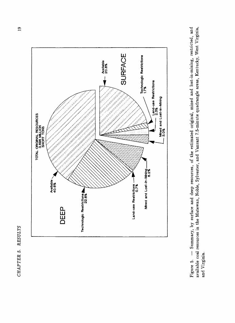
CH
AP
TE
RS.
R
ESU
LT
S19
TOTA
L O
RIG
INA
L R
ES
OU
RC
ES
3
.69
6 M
ILLI
ON
S
HO
RT
TO
NS
Ava
ilabl
e 4
0.6
%
DE
EP
Tec
hn
olo
gic
Res
tric
tio
ns
22.8
%
La
nd
-us
e R
estr
icti
on
s 0
.7%
Min
ed a
nd
Lo
st-i
n-M
inin
g
8.2
%
Ava
ilabl
e 2
0.8
%
SU
RF
AC
E
Tec
hn
olo
gic
Res
tric
tio
ns
1.7%
La
nd
-us
e R
estr
icti
on
s 2.
3%
L Min
ed a
nd L
ost
-in
-Min
ing
3.0
%
Figu
re 5
. S
umm
ary,
by
surf
ace
and
deep
res
ourc
es,
of t
he e
stim
ated
ori
gina
l, m
ined
and
los
t-in
-min
ing,
res
tric
ted,
and
av
aila
ble
coal
res
ourc
es i
n th
e M
atew
an,
Nob
le,
Sylv
este
r, a
nd V
ansa
nt 7
.5-m
inut
e qu
adra
ngle
are
as,
Ken
tuck
y, W
est
Vir
gini
a,
and
Vir
gini
a.
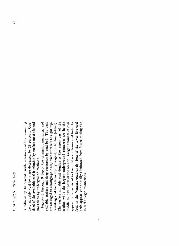
CH
AP
TE
RS.
R
ESU
LT
S 20
is r
educ
ed b
y 16
per
cent
, w
hile
res
ourc
es o
f th
e re
mai
ning
de
ep m
inab
le c
oal
beds
are
dec
reas
ed b
y 27
per
cent
. O
ne-
thir
d of
the
ava
ilab
le c
oal
is m
inab
le b
y su
rfac
e m
etho
ds a
nd
two-
thir
ds b
y un
derg
roun
d m
etho
ds.
Fig
ures
6
thro
ugh
9 de
pict
th
e or
igin
al,
rem
aini
ng,
and
avai
labl
e su
rfac
e an
d de
ep r
esou
rces
by
coal
bed
. T
he b
eds
are
arra
nged
in
stra
tigr
aphi
c se
quen
ce f
rom
lef
t to
rig
ht r
ep
rese
ntin
g co
al b
eds
from
top
(yo
unge
st)
to b
otto
m (
olde
st).
T
he s
urfa
ce m
inab
le c
oal
dom
inat
es t
he u
pper
par
t of
the
se
ctio
n w
hile
the
lar
gest
un
derg
roun
d re
sour
ces
are
in t
he
mid
dle
to l
ower
par
ts o
f th
e se
ctio
n.
Lar
ger
amou
nts
of c
oal
appe
ar t
o be
res
tric
ted
in t
he m
iddl
e an
d lo
wer
coa
l be
ds.
In
fact
, in
the
Van
sant
qua
dran
gle,
fou
r of
the
low
er f
ive
coal
be
ds a
ppea
r to
be
tota
lly
elim
inat
ed f
rom
fut
ure
min
ing
due
to t
echn
olog
ic r
estr
icti
ons.
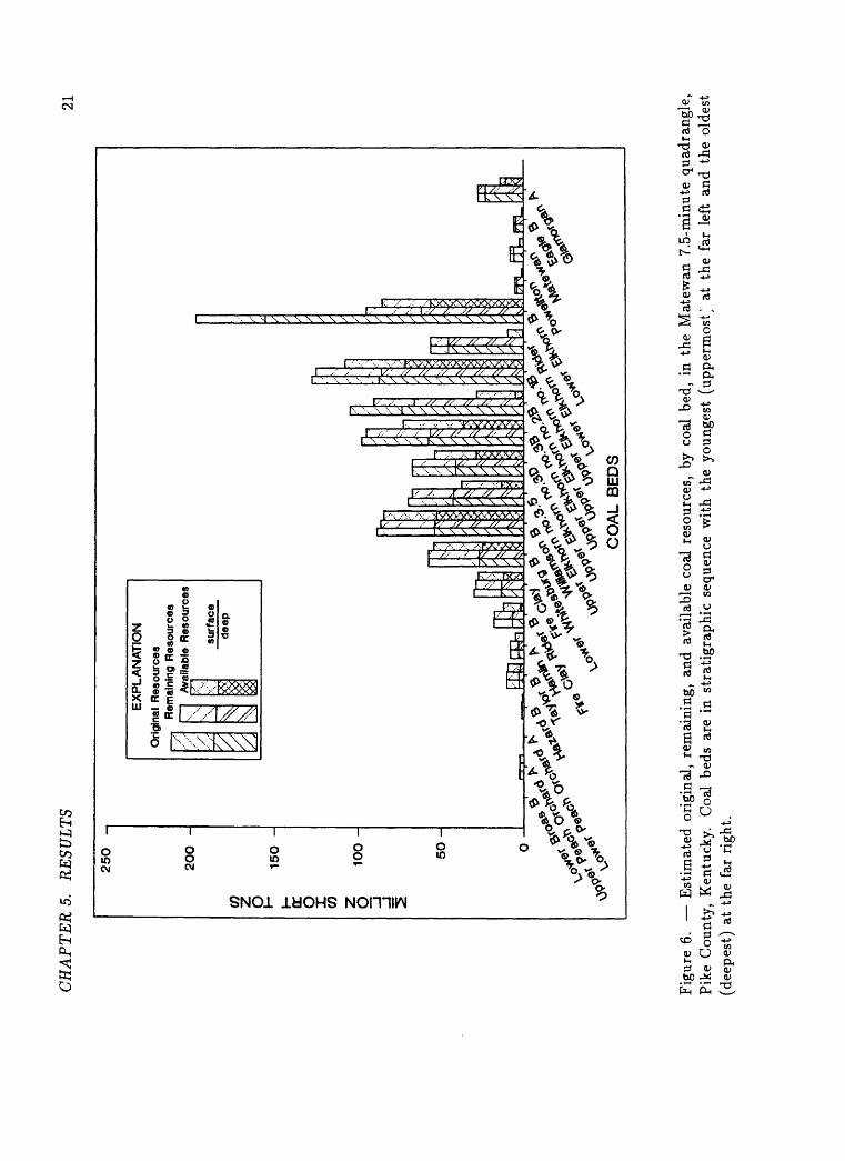
CH
AP
TE
RS.
R
ESU
LTS
21
250
-
200 -
CO DC
O CO
O
15
0 -
50
-
EX
PLA
NA
TIO
NO
r /
gtna
l R
e \. J
R mes
< ai
n Av
jurc
es
ng R
esou
rces
lia
ble
Res
ourc
es
surf
ace
deep
&P
\<
Fig
ure
6. E
stim
ated
ori
gina
l, re
mai
ning
, an
d av
aila
ble
coal
res
ourc
es,
by c
oal
bed,
in
the
Mat
ewan
7.5
-min
ute
quad
rang
le,
Pik
e C
ount
y, K
entu
cky.
C
oal
beds
are
in
stra
tigr
aphi
c se
quen
ce w
ith
the
youn
gest
(up
perm
ostyN
at
the
far
lef
t an
d th
e ol
dest
(d
eepe
st)
at t
he f
ar r
ight
.
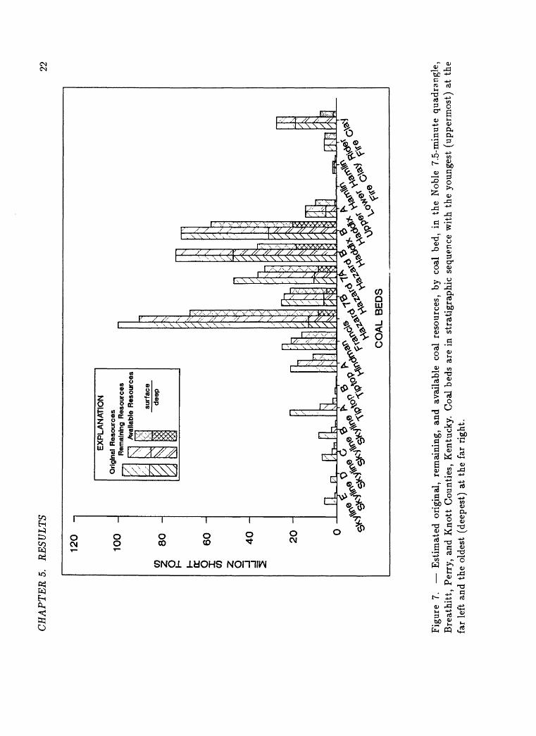
CH
AP
TE
RS.
R
ESU
LTS
22
120
-
100
-
80
p I- cr O
60CO
O -J4
0 -
20
-
EX
PLA
NA
TIO
N
Ori
,.- \gi
nal
Re
^
Res
ourc
es
mai
ning
Res
ourc
es
Ava
ilabl
e R
esou
rces
57
0<
*$
surf
ace
deep
nn
<*$
CO
AL
BE
DS
Fig
ure
7. E
stim
ated
ori
gina
l, re
mai
ning
, an
d av
aila
ble
coal
res
ourc
es,
by c
oal
bed,
in
the
Nob
le 7
.5-m
inut
e qu
adra
ngle
, B
reat
hit
t, P
erry
, an
d K
nott
Cou
ntie
s, K
entu
cky.
Coa
l be
ds a
re i
n st
rati
grap
hic
sequ
ence
wit
h th
e yo
unge
st (
uppe
rmos
t) a
t th
e fa
r le
ft a
nd t
he o
ldes
t (d
eepe
st)
at t
he f
ar r
ight
.
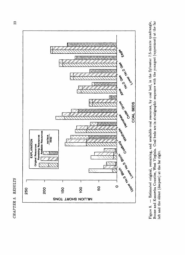
CH
AP
TE
RS.
R
ESU
LT
S23
CO i- QC
O CO
§
250
200
-
150
-
100
-
50
-
EX
PLA
NA
TIO
N
Orig
inal
Res
ourc
esy"
.
/ ;
/ z
Rem
aini
ng R
esou
rces
\ \ £
Ava
ilabl
e R
esou
rces
/:
$o< s^
surf
ace
deep
CO
AL
BE
DS
Fig
ure
8. E
stim
ated
ori
gina
l, re
mai
ning
, an
d av
aila
ble
coal
res
ourc
es,
by c
oal
bed,
in
the
Syl
vest
er 7
.5-m
inut
e qu
adra
ngle
, B
oone
and
Kan
awha
Cou
ntie
s, W
est
Vir
gini
a. C
oal
beds
are
in
stra
tigr
aphi
c se
quen
ce w
ith
the
youn
gest
(up
perm
ost)
at
the
far
left
and
the
old
est
(dee
pest
) at
the
far
rig
ht.
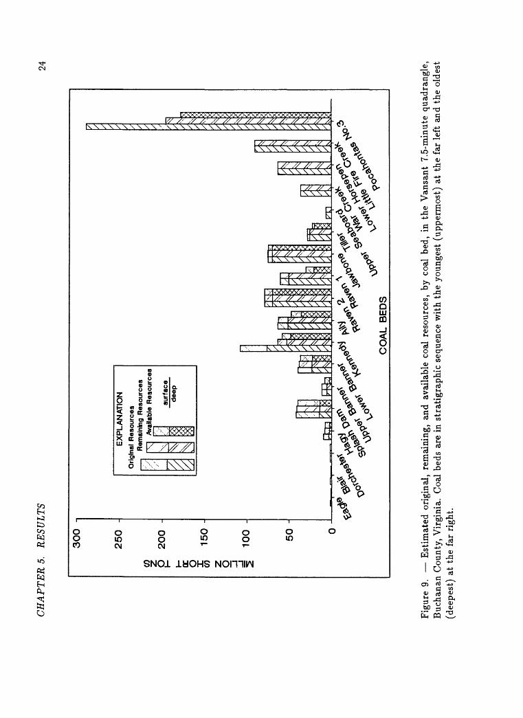
CH
AP
TE
RS.
R
ESU
LT
S24
CO I- QC
O O
300
250
200
-
150
-
100
-
50
-
EX
PLA
NA
TIO
N
Ori 1
gina
l R
e \'
;. \
Res
ourc
es
mai
ning
Res
ourc
es
Ava
ilabl
e R
esou
rces
1su
rfac
ede
ep
PI
^s & ^ *s X̂
CO
AL
BE
DS
?°v
Fig
ure
9. E
stim
ated
ori
gina
l, re
mai
ning
, an
d av
aila
ble
coal
res
ourc
es,
by c
oal
bed,
in
the
Van
sant
7.5
-min
ute
quad
rang
le,
Buc
hana
n C
ount
y, V
irgi
nia.
Coa
l be
ds a
re i
n st
rati
grap
hic
sequ
ence
wit
h th
e yo
unge
st (
uppe
rmos
t) a
t th
e fa
r le
ft a
nd t
he o
ldes
t (d
eepe
st)
at t
he f
ar r
ight
.
CH
AP
TE
RS.
R
ESU
LT
S25
5.1
Lan
d-u
se R
estr
icti
ons
Fig
ure
10
depi
cts
the
com
bine
d la
nd-u
se
rest
rict
ions
th
at
wer
e id
enti
fied
and
app
lied
to
the
rem
aini
ng c
oal
reso
urce
s of
ea
ch o
f th
e fo
ur q
uadr
angl
es.
The
var
iati
on i
s qu
ite
stri
king
, es
peci
ally
bet
wee
n th
e N
oble
qua
dran
gle
in K
entu
cky
and
the
Van
sant
qua
dran
gle
in V
irgi
nia.
The
lar
gest
res
tric
ted
area
s in
the
Nob
le q
uadr
angl
e ar
e po
rtio
ns o
f a
15,0
00-a
cre
fore
st
pres
erve
th
at w
as d
eede
d to
the
Uni
vers
ity
of K
entu
cky
in
the
earl
y pa
rt o
f th
e ce
ntur
y w
ith
prov
isio
n th
at t
he p
rese
rve
neve
r be
min
ed.
In t
he V
ansa
nt q
uadr
angl
e,
pow
er l
ines
, pi
peli
nes,
and
hig
hway
s w
ere
cons
ider
ed l
ocal
ly n
ot t
o ca
use
seri
ous
enou
gh c
onst
rain
ts t
o su
rfac
e or
dee
p m
inin
g to
be
appl
ied
wit
hin
this
stu
dy a
rea.
Fig
ures
11
and
12 i
llus
trat
e th
e in
divi
dual
lan
d-us
e re
stri
c
tion
s of
the
four
stu
dy a
reas
as
a w
hole
and
by
quad
rang
le.
To
keep
the
fol
low
ing
perc
enta
ges
in p
ersp
ecti
ve,
note
that
lan
d-
use
rest
rict
ions
rep
rese
nt o
nly
11 p
erce
nt o
f al
l re
stri
ctio
ns i
n th
e st
udy
area
s. T
he l
arge
st s
ingl
e la
nd-u
se r
estr
icti
on o
f th
e fo
ur a
reas
is
the
fore
st p
rese
rve
in t
he N
oble
qua
dran
gle,
ac
co
unti
ng f
or j
ust
over
tw
o-th
irds
of
the
land
-use
res
tric
tion
s (6
9 pe
rcen
t);
whi
le s
trea
ms
are
11 p
erce
nt;
tow
ns,
9 pe
rcen
t;
pow
er l
ines
and
pip
elin
es,
each
4 p
erce
nt;
oil
and
gas
wel
ls,
2 pe
rcen
t; a
nd c
emet
erie
s, 1
per
cent
. L
and-
use
rest
rict
ions
are
hi
ghly
var
iabl
e be
twee
n th
e st
udy
area
s: i
n th
e N
oble
qua
d
rang
le,
the
fore
st p
rese
rve
acco
unts
for
alm
ost
98 p
erce
nt o
f th
e to
tal;
in
the
Van
sant
qua
dran
gle,
tow
ns p
redo
min
ate
wit
h 88
per
cent
; in
the
Syl
vest
er q
uadr
angl
e, t
owns
and
str
eam
s ar
e ne
arly
equ
al w
ith
41
and
40
perc
ent,
re
spec
tive
ly;
in
the
Mat
ewan
qua
dran
gle,
the
lan
d-us
e re
stri
ctio
ns a
re f
airl
y ev
enly
div
ided
am
ongs
t st
ream
s at
38
perc
ent,
pow
er li
nes
25
perc
ent,
and
pip
elin
es 2
0 pe
rcen
t. O
il an
d ga
s w
ells
and
cem
e
teri
es c
onsi
sten
tly
com
pris
e a
smal
l fr
acti
on o
f th
e la
nd-u
se
rest
rict
ions
, ra
ngin
g fr
om 0
to
9 pe
rcen
t. B
ecau
se o
f the
ste
ep
slop
es o
f th
e fo
ur s
tudy
are
as i
n th
e C
entr
al A
ppal
achi
an R
e
gion
, m
ost
popu
lati
on c
ente
rs a
re c
once
ntra
ted
in t
he v
alle
ys
and,
con
sequ
entl
y, a
re b
elow
the
out
crop
s of
mos
t of
the
ma
jo
r m
inab
le c
oal
beds
. T
he f
ew c
oal
beds
aff
ecte
d by
tow
ns
are
thos
e lo
wer
in
the
stra
tigr
aphi
c se
quen
ce.
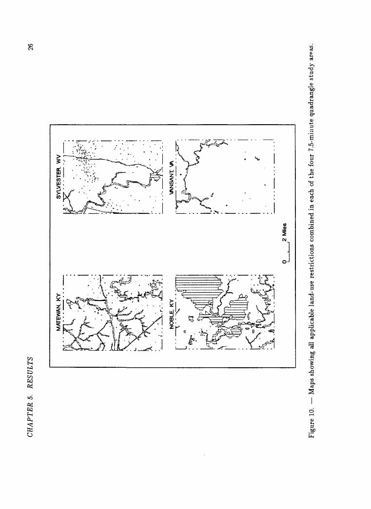
CH
AP
TE
R 5
. R
ESU
LT
S26
MA
TEW
AN
. K
YS
YL
VE
ST
ER
. W
V[.«
-V
"
P^ \A
NS
AN
I
2 M
iles
Fig
ure
10. M
aps
show
ing
all
appl
icab
le l
and-
use
rest
rict
ions
com
bine
d in
eac
h of
the
fou
r 7.
5-m
iim
te q
uadr
angl
e st
udy
area
s.
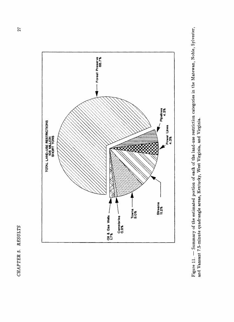
CH
AP
TE
RS
. R
ESU
LT
S27
Oil
& G
as W
ells
1.
7%
Cem
eter
ies
0.9%
Tow
ns
9.0% S
trea
ms
11.2
%
TO
TA
L L
AN
D-U
SE
RE
ST
RIC
TIO
NS
1
08
MIL
LIO
N
SH
OR
T T
ON
S
Pow
er L
ines
4.
3%
Pip
elin
es
4.3%
Fo
rest
Pre
serv
e 68.7
%
Fig
ure
11. S
umm
ary
of t
he e
stim
ated
por
tion
of
each
of
the
land
-use
res
tric
tion
cat
egor
ies
in t
he M
atew
an,
Nob
le,
Syl
vest
er,
and
Van
sant
7.5
-min
ute
quad
rang
le a
reas
, K
entu
cky,
Wes
t V
irgi
nia,
and
Vir
gini
a.
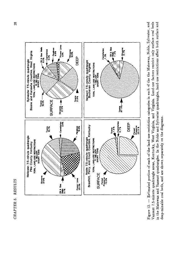
CH
AP
TE
RS.
R
ESU
LT
S28
Mat
ewan
75-
min
ute
qua
dran
gle
Pike
Cou
nty,
Ken
tuck
yTO
TAL
LA
ND
-US
E R
ES
TRIC
TIO
NS
17 M
LLJO
N
SH
OR
T T
ON
S
Pow
er L
ines
25
.3%
Pipe
Snes
19
.8%
Syl
vest
er 7
5-m
inu
te q
uadr
angl
e B
oone
and
Kan
awha
Cou
ntie
s, W
est
Virg
inia
TOTA
L L
AN
D-U
SE
RE
STR
ICTI
ON
S13
ML
UO
N
SH
OR
T T
ON
S
Str
eam
s 12
.6%
DE
EP
Nob
le 7
5-m
inu
te q
uadr
angl
e B
reat
hitt
, Pe
rry,
an
d K
nott
Cou
ntie
s, K
entu
cky
TOTA
L L
AN
D-U
SE
RE
STR
ICTI
ON
S
77 M
LU
ON
SU
RF
AC
E
SHOR
T
Van
sant
7.5
-min
ute
quad
rang
le
Buc
hana
n C
ount
y,
Virg
inia
TOTA
L L
AN
D-U
SE
RE
STR
ICTI
ON
S1
ML
UO
N
SH
OR
T T
ON
S
^C
em
ete
rie
s
0.7
%
DE
EP
Str
eam
s 3
.7%
Fig
ure
12. E
stim
ated
por
tion
of
each
of
the
land
-use
res
tric
tion
cat
egor
ies
in e
ach
of t
he t
he M
atew
an,
Nob
le,
Syl
vest
er,
and
Van
sant
7.5
-min
ute
quad
rang
le a
reas
, K
entu
cky,
Wes
t V
irgi
nia,
and
Vir
gini
a.
Lan
d-us
e fa
ctor
s re
stri
ct o
nly
surf
ace
coal
bed
s in
the
Mat
ewan
and
Van
sant
qua
dran
gles
. In
the
Nob
le a
nd S
ylve
ster
qua
dran
gles
, la
nd-u
se r
estr
icti
ons
affe
ct b
oth
surf
ace
and
deep
-min
able
coa
l be
ds,
and
are
show
n se
para
tely
on
the
diag
ram
s.
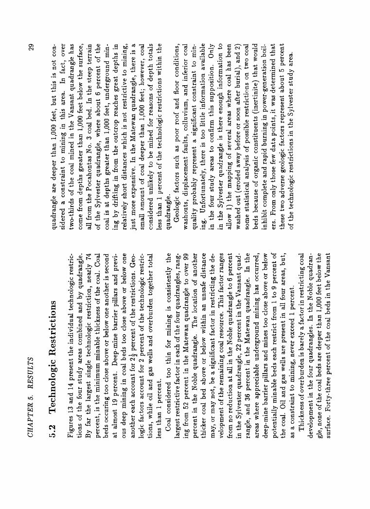
CH
AP
TE
RS.
R
ESU
LT
S29
5.2
Tec
hn
olog
ic R
estr
icti
ons
Fig
ures
13
and
14 p
rese
nt t
he i
ndiv
idua
l te
chno
logi
c re
stri
c
tion
s of
the
fou
r st
udy
area
s co
mbi
ned
and
by q
uadr
angl
e.
By
far
the
larg
est
sing
le t
echn
olog
ic r
estr
icti
on,
near
ly
74
perc
ent,
is t
he m
inim
um m
inab
le t
hick
ness
of
the
coal
. C
oal
beds
occ
urin
g to
o cl
ose
abov
e or
bel
ow o
ne a
noth
er i
s se
cond
at
alm
ost
19 p
erce
nt.
Dee
p-m
ine
barr
ier
pill
ars
and
prev
i
ous
deep
min
ing
in c
oal
beds
too
clo
se a
bove
or
belo
w o
ne
anot
her
each
acc
ount
for
2|
perc
ent
of t
he r
estr
icti
ons.
Geo
lo
gic
fact
ors
acco
unt
for
2 pe
rcen
t of
the
tec
hnol
ogic
res
tric
ti
ons,
whi
le o
il an
d ga
s w
ells
and
ove
rbur
den
toge
ther
tot
al
less
tha
n 1
perc
ent.
Coa
l co
nsid
ered
to
o th
in
for
min
ing
is
cons
iste
ntly
th
e la
rges
t re
stri
ctiv
e fa
ctor
in e
ach
of th
e fo
ur q
uadr
angl
es,
rang
in
g fr
om 5
2 pe
rcen
t in
the
Mat
ewan
qua
dran
gle
to o
ver
99
perc
ent
in t
he
Nob
le q
uadr
angl
e.
The
loc
atio
n of
ano
ther
th
icke
r co
al b
ed
abov
e or
bel
ow w
ithi
n an
uns
afe
dist
ance
m
ay,
or m
ay n
ot,
be a
sig
nifi
cant
fac
tor
in r
estr
icti
ng t
he d
e
velo
pmen
t of
the
rem
aini
ng c
oal
reso
urce
. T
his
fact
or r
ange
s fr
om n
o re
duct
ion
at a
ll in
the
Nob
le q
uadr
angl
e to
6 p
erce
nt
in t
he S
ylve
ster
qua
dran
gle,
22
perc
ent
in t
he V
ansa
nt q
uad
ra
ngle
, an
d 36
per
cent
in
the
Mat
ewan
qua
dran
gle.
In
the
ar
eas
whe
re a
ppre
ciab
le u
nder
grou
nd m
inin
g ha
s oc
curr
ed,
deep
-min
e ba
rrie
r pi
llar
s an
d m
ines
too
clo
se a
bove
or
belo
w
pote
ntia
lly
min
able
bed
s ea
ch r
estr
ict
from
1 t
o 9
perc
ent
of
the
coal
. O
il an
d ga
s w
ells
are
pre
sent
in
all
four
are
as,
but,
as
a c
onst
rain
t to
min
ing,
nev
er e
xcee
d 1
perc
ent.
Thi
ckne
ss o
f ove
rbur
den
is b
arel
y a
fact
or in
res
tric
ting
coa
l de
velo
pmen
t in
the
fou
r qu
adra
ngle
s. I
n th
e N
oble
qua
dran
gl
e, n
one
of th
e co
al b
eds
are
deep
er t
han
1,0
00 f
eet
belo
w t
he
surf
ace.
F
orty
-thr
ee p
erce
nt o
f th
e co
al b
eds
in t
he V
ansa
nt
quad
rang
le a
re d
eepe
r th
an 1
,000
fee
t, bu
t th
is i
s no
t co
n
side
red
a co
nstr
aint
to
min
ing
in
this
ar
ea.
In
fact
, ov
er
two-
thir
ds o
f th
e co
al m
ined
in
the
Van
sant
qua
dran
gle
has
com
e fr
om d
epth
s gr
eate
r th
an 1
,000
fee
t be
low
the
sur
face
, al
l fr
om t
he P
ocah
onta
s N
o. 3
coa
l be
d. I
n th
e st
eep
terr
ain
of t
he
Syl
vest
er q
uadr
angl
e,
whe
re a
bout
6
perc
ent
of t
he
coal
is
at d
epth
s gr
eate
r th
an 1
,000
fee
t, un
derg
roun
d m
in
ing
by d
rift
ing
in f
rom
the
out
crop
rea
ches
gre
at d
epth
s in
re
lati
vely
sho
rt d
ista
nces
whi
ch i
s no
t re
stri
ctiv
e to
min
ing,
ju
st m
ore
expe
nsiv
e.
In t
he M
atew
an q
uadr
angl
e, t
here
is
a sm
all
amou
nt o
f co
al d
eepe
r th
an 1
,000
fee
t; h
owev
er,
coal
co
nsid
ered
unl
ikel
y to
be
min
ed f
or r
easo
ns o
f de
pth
tota
ls
less
tha
n 1
perc
ent
of t
he t
echn
olog
ic r
estr
icti
ons
wit
hin
the
quad
rang
le.
Geo
logi
c fa
ctor
s su
ch a
s po
or r
oof
and
floo
r co
ndit
ions
, w
asho
uts,
dis
plac
emen
t fa
ults
, co
lluv
ium
, an
d in
feri
or c
oal
qual
ity
prob
ably
rep
rese
nt
a si
gnif
ican
t co
nstr
aint
to
min
in
g.
Unf
ortu
nate
ly,
ther
e is
too
lit
tle
info
rmat
ion
avai
labl
e in
th
e fo
ur s
tudy
ar
eas
to c
onfi
rm t
his
supp
osit
ion.
O
nly
in t
he S
ylve
ster
qua
dran
gle
is t
here
eno
ugh
info
rmat
ion
to
allo
w 1
) th
e m
appi
ng o
f se
vera
l ar
eas
whe
re c
oal
has
been
w
ashe
d ou
t (e
rode
d aw
ay b
efor
e or
soo
n af
ter
buri
al),
and
2)
som
e st
atis
tica
l an
alys
is o
f po
ssib
le r
estr
icti
ons
on t
wo
coal
be
ds b
ecau
se o
f or
gani
c co
nsti
tuen
ts (
iner
tini
te)
that
wou
ld
inhi
bit
com
plet
e an
d ra
pid
burn
ing
in p
ower
-gen
erat
ion
boil
er
s. F
rom
onl
y th
ose
few
dat
a po
ints
, it
was
det
erm
ined
that
th
ese
two
adve
rse
geol
ogic
fac
tors
rep
rese
nt a
bout
5 p
erce
nt
of t
he t
echn
olog
ic r
estr
icti
ons
in t
he S
ylve
ster
stu
dy a
rea.
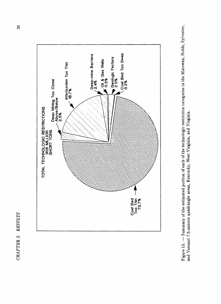
CH
AP
TE
RS.
R
ESU
LTS
30
TOTA
L T
EC
HN
OL
OG
IC R
ES
TR
ICT
ION
S
906 M
ILLI
ON
SH
OR
T T
ON
S
_,
...
. T
_.D
eep
Min
ing
Too
Clo
seA
bo
ve/B
elo
w2.
5%
X
Co
al B
edTo
o Th
in73
.7%
Inte
rbu
rden
Too
Thi
n 18
.7%
Dee
p-m
ine
Bar
rier
s 2.
4% Oil
& G
as W
ells
0.
5%
Geo
log
ic F
acto
rs
2.0%
Co
al B
ed T
oo D
eep
0.
2%
Fig
ure
13. S
umm
ary
of th
e es
tim
ated
por
tion
of
each
of
the
tech
nolo
gic
rest
rict
ion
cate
gori
es i
n th
e M
atew
an,
Nob
le,
Syl
vest
er,
and
Van
sant
7.5
-min
ute
quad
rang
le a
reas
, K
entu
cky,
Wes
t V
irgi
nia,
and
Vir
gini
a.
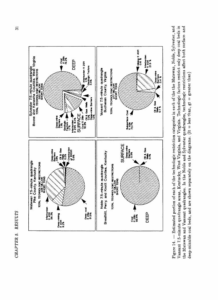
CH
AP
TE
RS.
R
ESU
LTS
31
Mat
ewan
75-
min
ute
quad
rang
le
Pike
Cou
nty,
Ken
tuck
yTO
TAL
TE
CH
NO
LO
GIC
RE
STR
ICTI
ON
S
228 M
LU
ON
S
HO
RT
TO
NS
Syl
vest
er 7
5-m
inu
te q
uadr
angl
e B
oone
and
Kan
awha
Cou
ntie
s, W
est
Virg
inia
TOTA
L T
EC
HN
OL
OG
IC R
ES
TRIC
TIO
NS
350 M
LU
ON
S
HO
RT
TO
NS
Dee
p-m
ine
Bar
rier
s 11
%G
eolo
gic
Fact
ors
Inte
rbur
den
It 2
5ft
6.0
%
SU
RFA
CE
DE
EP
Co
al I
t 2f
fln1°
'3%
01
& G
as W
ats
to*
Dee
p-m
ine
Bar
rier
s t2
%
Inte
rbur
den
It 25
ft1.
1%G
eolo
gic
Fact
ors
3.5%
Nob
le 7
5-m
inu
te q
uadr
angl
e B
reat
hitt
. Pe
rry,
and
Kno
tt C
ount
ies,
Ken
tuck
y
TOTA
L T
EC
HN
OL
OG
IC R
ES
TRIC
TIO
NS
51 M
ILLI
ON
S
HO
RT
TO
NS
Van
sant
75-
min
ute
qua
dran
gle
Buc
hana
n C
ount
y, V
irgin
ia
TOTA
L T
EC
HN
OL
OG
IC R
ES
TRIC
TIO
NS
27
7 M
UJO
N
SH
OR
T T
ON
S
SU
RFA
CE
Sub
surf
ace
Coa
l It
4Oin
73
.7%
DE
EP
MW
ng I
t 4O
M
O.6
%
Fig
ure
14. E
stim
ated
por
tion
of e
ach
of th
e te
chno
logi
c re
stri
ctio
n ca
tego
ries
in
each
of
the
the
Mat
ewan
, N
oble
, S
ylve
ster
, an
d V
ansa
nt 7
.5-m
inut
e qu
adra
ngle
are
as,
Ken
tuck
y, W
est
Vir
gini
a, a
nd V
irgi
nia.
Tec
hnol
ogic
fac
tors
res
tric
t on
ly d
eep
coal
bed
s in
th
e M
atew
an a
nd V
ansa
nt q
uadr
angl
es.
In t
he N
oble
and
Syl
vest
er q
uadr
angl
es,
tech
nolo
gic
rest
rict
ions
aff
ect
bo
th s
urfa
ce-
and
deep
-min
able
coa
l be
ds,
and
are
show
n se
para
tely
on
the
diag
ram
s.
(It
= l
ess
than
, gt
= g
reat
er t
han)
CH
AP
TE
RS.
R
ESU
LT
S32
5.3
Oth
er R
estr
icti
ons
Oth
er m
ajor
lan
d-us
e re
stri
ctio
ns l
ooke
d fo
r bu
t no
t fo
und
in
the
four
stu
dy a
reas
wer
e N
atio
nal
and
Sta
te f
ores
ts,
park
s,
and
mon
umen
ts,
as w
ell
as p
rote
cted
spe
cies
hab
itat
s. M
ajor
po
tent
ial
tech
nolo
gic
rest
rict
ions
that
do
not
occu
r in
the
four
st
udy
area
s ar
e co
al b
eds
that
dip
too
ste
eply
or
are
high
ly
faul
ted.
The
re a
re a
num
ber
of o
ther
pot
enti
al r
estr
icti
ons
to m
in
ing
that
wer
e no
t ap
plie
d in
the
se f
our
stud
ies.
The
se i
nclu
de
such
eco
nom
ic c
onsi
dera
tion
s as
the
cos
t of
min
ing,
ava
ilabi
l
ity
of t
rans
port
atio
n,
prox
imit
y to
mar
kets
, su
bdiv
isio
n of
su
rfac
e an
d m
iner
al o
wne
rshi
p, a
nd s
ize
of a
log
ical
min
ing
unit
. In
add
itio
n,
reco
very
fac
tors
wer
e no
t ap
plie
d.
The
im
pact
of
such
res
tric
tion
s w
as b
eyon
d th
e sc
ope
of t
hese
st
udie
s, b
ut t
hey
wou
ld c
erta
inly
fur
ther
red
uce
the
amou
nt
of c
oal
avai
labl
e fo
r de
velo
pmen
t.
was
per
form
ed o
n co
al b
eds
wit
h su
ffic
ient
dat
a in
the
oth
er
thre
e qu
adra
ngle
s.
In t
he S
ylve
ster
qua
dran
gle,
the
res
ults
, w
hile
qui
te v
aria
ble,
ind
icat
e th
at t
he m
ajor
ity
of th
e re
mai
n
ing
reso
urce
s co
uld
be e
xpec
ted
to m
eet
curr
ent
com
plia
nce
stan
dard
s. I
n th
e V
ansa
nt q
uadr
angl
e, w
ith
anal
yses
on
only
se
ven
coal
bed
s, 4
3 pe
rcen
t of
tho
se r
esou
rces
cou
ld b
e co
n
side
red
com
plia
nce.
For
the
Nob
le q
uadr
angl
e, t
here
are
not
en
ough
dat
a po
ints
to
indi
cate
mor
e th
an t
hat
the
coal
s va
ry
in q
uali
ty a
nd t
hat
bot
h co
mpl
ianc
e an
d no
ncom
plia
nce
coal
ex
ist
in t
he a
rea.
H
owev
er,
a re
port
by
Cbb
b an
d ot
hers
in
1982
rev
eale
d th
at i
n ea
ster
n K
entu
cky
appr
oxim
atel
y 43
per
ce
nt o
f th
e co
al b
eds
mee
t co
mpl
ianc
e st
anda
rds.
A
ltho
ugh
the
data
are
ins
uffi
cien
t, on
e co
uld
gene
raliz
e th
at a
ppro
xi
mat
ely
one-
half
of
the
avai
labl
e co
al i
n th
e fo
ur s
tudy
are
as
coul
d be
exp
ecte
d to
mee
t cu
rren
t ne
w-s
ourc
e SO
-} p
erfo
r
man
ce s
tand
ards
.
5.4
Com
pli
ance
Coa
l
Non
com
plia
nce
wit
h ne
w
sour
ce
perf
orm
ance
st
anda
rds
(NS
PS
) fo
r su
lfur
dio
xide
em
issi
on,
curr
entl
y no
t to
exc
eed
1.2
poun
ds o
f 50
2 pe
r m
illi
on b
tu i
nput
(O
ffic
e of
the
Fed
eral
R
egis
ter,
198
8), i
s no
t a
rest
rict
ion
to m
inin
g. H
owev
er,
com
pl
ianc
e is
cer
tain
ly a
fac
tor
in d
eter
min
ing
the
mar
keta
bili
ty
of c
oal
and,
con
sequ
entl
y, t
he a
vail
abil
ity
of c
ompl
ianc
e co
al
was
eva
luat
ed i
n al
l fo
ur s
tudy
are
as.
Mat
ewan
is
the
only
qu
adra
ngle
wit
h en
ough
con
trol
poi
nts
to m
ap t
he s
ulfu
r co
n
tent
in
term
s of
502
gen
erat
ion.
In
thi
s st
udy
area
, fo
r th
e 90
per
cent
of
the
coal
bed
s w
ith
avai
labl
e da
ta,
only
44
per
ce
nt o
f th
e re
sour
ce i
n th
ese
beds
mee
ts N
SP
S 5
02 c
ompl
i
ance
lev
els.
A s
tati
stic
al a
naly
sis
of p
oten
tial
502
gen
erat
ion
Chapte
r 6
SU
MM
AR
Y
The
fir
st f
our
stud
y ar
eas
have
bee
n co
mpl
eted
for
the
co
al a
vail
abil
ity
prog
ram
con
duct
ed c
oope
rati
vely
bet
wee
n th
e U
.S.
Geo
logi
cal
Sur
vey
and
the
Sta
te g
eolo
gica
l ag
enci
es
of K
entu
cky,
Vir
gini
a, a
nd W
est
Vir
gini
a to
dev
elop
met
hod
ol
ogie
s an
d m
odel
s fo
r pr
edic
tion
of
the
avai
labi
lity
of
coal
re
sour
ces
for
deve
lopm
ent
in t
he C
entr
al A
ppal
achi
an R
e
gion
.
Maj
or l
and-
use
and
tech
nolo
gic
cons
trai
nts
to t
he d
evel
op
men
t of
coa
l w
ere
iden
tifi
ed a
nd a
ppli
ed t
o th
e co
al r
esou
rces
in
the
stu
dy a
reas
. F
rom
the
se i
niti
al s
tudi
es i
t is
app
aren
t th
at i
n th
e ru
ral,
rug
ged
terr
ain
of t
he C
entr
al A
ppal
achi
an
Reg
ion
only
a s
mal
l pe
rcen
tage
of
the
coal
is
rest
rict
ed f
rom
de
velo
pmen
t by
land
-use
con
side
rati
ons
(3 p
erce
nt i
n th
e fo
ur
area
s) w
here
as q
uite
a la
rge
amou
nt (
25 p
erce
nt)
is r
estr
icte
d by
tec
hnol
ogic
fac
tors
. In
the
se a
reas
, an
ave
rage
of
61 p
er
cent
of
the
orig
inal
res
ourc
es a
re e
stim
ated
to
be a
ctua
lly
avai
labl
e fo
r th
e de
velo
pmen
t of
min
ing
unde
r cu
rren
t co
ndi
ti
ons.
Man
y ec
onom
ic c
onsi
dera
tion
s su
ch a
s co
st o
f m
inin
g,
avai
labi
lity
of
tran
spo
rtat
ion
, pr
oxim
ity
to m
arke
ts,
owne
r
ship
of
the
surf
ace
and
coal
rig
hts,
and
siz
e of
logi
cal
min
ing
unit
s w
ere
beyo
nd t
he s
cope
of
the
stud
y, a
s w
as t
he a
ppli
ca
tion
of
reco
very
fac
tors
. E
ven
so,
it a
ppea
rs e
vide
nt t
hat
on
ly a
fra
ctio
n of
the
rem
aini
ng c
oal
reso
urce
s of
the
se s
tudy
ar
eas
in t
he C
entr
al A
ppal
achi
an R
egio
n w
ill e
ver
be m
ined
, an
d on
ly o
ne-h
alf
of t
hat
fra
ctio
n m
ay m
eet
curr
ent
NS
PS
su
lfur
dio
xide
em
issi
on l
imit
s.A
s ex
pect
ed,
resu
lts
from
the
fir
st
four
stu
dy a
reas
ar
e in
conc
lusi
ve i
n te
rms
of d
elin
eati
ng r
egio
nal
tren
ds.
It i
s es
ti
mat
ed t
hat
it
will
be
nece
ssar
y to
stu
dy a
ppro
xim
atel
y 20
st
rate
gica
lly-
plac
ed 7
.5-m
inut
e qu
adra
ngle
are
as o
f th
e 45
0 in
th
e re
gion
in
orde
r to
ade
quat
ely
repr
esen
t th
e C
entr
al A
p
pala
chia
n R
egio
n.
Fou
r ar
eas
are
repo
rted
her
ein;
tw
o m
ore
have
bee
n co
mpl
eted
rec
entl
y an
d w
ill b
e re
port
ed s
oon;
and
th
ree
addi
tion
al s
tudi
es w
ill h
ave
been
fin
ishe
d by
Sep
tem
ber,
19
89,
brin
ging
the
tota
l to
nin
e. P
erha
ps a
fter
com
plet
ion
of
abou
t 15
stu
dies
, ex
trap
olat
ion
of r
esul
ts i
nto
surr
ound
ing
ar
eas
can
begi
n.
Add
itio
nal
rese
arch
is
ongo
ing
for
this
pha
se
of t
he o
vera
ll s
tudy
.
33
Ch
apte
r 7
RE
FE
RE
NC
ES
CIT
ED
Ave
ritt
, P
aul
, 19
75,
Coa
l re
sour
ces
of t
he U
nite
d S
tate
s, J
anua
ry 1
, 19
74:
U.S
. G
eolo
gica
l S
urve
y B
ulle
tin
1412
, 13
1 pa
ges.
Bla
ke,
B.
M.,
Jr., a
nd F
edor
ko,
Nic
k, 1
988,
The
coa
l av
aila
bili
ty s
tudy
in
Wes
t V
irgi
nia S
ylve
ster
7.5
-min
ute
quad
ran
gl
e: W
est
Vir
gini
a G
eolo
gica
l an
d E
cono
mic
Sur
vey,
Fin
al R
epor
t to
the
U.S
. G
eolo
gica
l S
urve
y fo
r C
oope
rati
ve
Agr
eem
ent
Num
ber
14-0
8-00
01-A
0553
, 67
pag
es.
Cam
pbel
l, E
. V
. M
., an
d S
ites
, R
. S.
, 19
88,
Syno
psis
of
the
avai
labl
e co
al r
esou
rces
stu
dy o
f V
ansa
nt 7
.5-m
inut
e qu
ad
rang
le,
Buc
hana
n C
ount
y, V
irgi
nia:
Vir
gini
a D
ivis
ion
of M
iner
al R
esou
rces
, F
inal
Rep
ort
to t
he U
.S.
Geo
logi
cal
Sur
vey
for
Coo
pera
tive
Agr
eem
ent
Num
ber
14-0
8-00
01-A
0100
, 60
pag
es,
appe
ndix
.
Car
ter,
M.
D.,
Cob
b, J
. C
., G
ardn
er,
N.
K.,
Ser
gean
t, R
. E
., T
ewal
t, S.
J.,
Che
snut
, D
. R
., Jr
., D
avid
son,
0.
B.,
and
Hie
tt,
J.K
., C
oal
reso
urce
s av
aila
ble
for
deve
lopm
ent
in t
he M
atew
an 7
.5-m
inut
e qu
adra
ngle
, P
ike
Cou
nty,
Ken
tuck
y:
U.S
. G
eolo
gica
l S
urve
y B
ulle
tin,
in
prep
arat
ion.
Cob
b, J
. C
., C
urre
ns,
J. C
., an
d E
noch
, H
. G
., 19
82,
Com
plia
nce
coal
res
ourc
es i
n K
entu
cky:
Ken
tuck
y G
eolo
gica
l S
urve
y In
form
atio
n C
ircu
lar
9, 5
2 pa
ges.
Egg
lest
on,
J. R
., C
arte
r, M
. D
., an
d C
obb,
J.
C.,
Coa
l av
aila
ble
for
deve
lopm
ent A
met
hodo
logy
and
pil
ot s
tudy
: U
.S.
Geo
logi
cal
Sur
vey
Cir
cula
r, i
n pr
epar
atio
n.
34
CH
APT
ER
7.
RE
FE
RE
NC
ES
CIT
ED
35
Off
ice
of t
he F
eder
al R
egis
ter,
198
8, P
rote
ctio
n of
Env
iron
men
t in
Cod
e of
Fed
eral
Reg
ulat
ions
: N
atio
nal
Arc
hive
s an
d R
ecor
ds A
dmin
istr
atio
n, v
olum
e 40
, pa
rts
53-6
0, p
ages
195
-293
.
Off
ice
of S
urfa
ce M
inin
g R
ecla
mat
ion
and
Enf
orce
men
t, 19
88,
Pub
lic
Law
95-
87,
Sur
face
Min
ing
Con
trol
and
Rec
lam
atio
n A
ct o
f 19
77 (
SM
CR
A):
U.S
. D
epar
tmen
t of
Int
erio
r, 1
75 p
ages
.
Ser
gean
t, R
. E
., C
obb,
J.
C.,
Dav
idso
n, 0
. B
., A
nder
son,
W.
H.,
Stic
kney
, J.
F.,
Che
snut
, D
. R
., Jr
., S
mat
h, R
. A
., H
iett
, J.
K.,
Per
ry,
D.
B.,
and
Gau
thie
r, M
. A
., 19
88,
Fin
al r
epor
t of
the
Nob
le q
uadr
angl
e co
al a
vail
abil
ity
stud
y [K
en
tuck
y]:
Ken
tuck
y G
eolo
gica
l Su
rvey
, F
inal
Rep
ort
to U
.S.
Geo
logi
cal
Sur
vey
for
Coo
pera
tive
Agr
eem
ent
Num
ber
14-0
8-00
01-A
0564
, 43
pag
es.
Woo
d, G
. H
., Jr
., K
ehn,
T.
M.,
Car
ter,
M.
D.,
and
Cul
bert
son,
W.
C.,
1983
, C
oal
reso
urce
cla
ssif
icat
ion
syst
em o
f th
e U
.S.
Geo
logi
cal
Sur
vey:
U.S
. G
eolo
gica
l S
urve
y C
ircu
lar
891,
65
page
s.
Ch
ap
ter
8
GL
OS
SA
RY
Ava
ilab
le c
oal
reso
urc
es:
Rem
aini
ng
coal
re
sour
ces
that
ar
e th
ick
and
shal
low
en
ough
to
be m
ined
by
eith
er s
urfa
ce o
r un
derg
roun
d m
eth
od
s an
d th
at a
re u
nenc
umbe
red
by l
and-
use,
env
iron
men
tal,
soci
etal
, re
gula
tory
, or
tec
hnol
ogic
res
tric
tion
s as
the
y m
ay
appl
y in
a g
iven
Sta
te o
r re
gion
. In
thi
s st
udy,
ava
ilab
le r
e
sour
ces
are
deri
ved
by t
he f
ollo
win
g fo
rmul
a:
OR
IGIN
AL
CO
AL
RE
SOU
RC
ES
- min
us-
CO
AL
MIN
ED
AN
D L
OST
-IN
-MIN
ING
-equ
als-
R
EM
AIN
ING
CO
AL
RE
SOU
RC
ES
-min
us-
CO
AL
RE
STR
ICT
ED
BY
LA
ND
-USE
CO
NSI
DE
RA
TIO
NS
-min
us-
CO
AL
RE
STR
ICT
ED
BY
TE
CH
NO
LO
GIC
CO
NSI
DE
RA
TIO
NS
-equ
als-
C
OA
L R
ESO
UR
CE
S A
VA
ILA
BL
E F
OR
DE
VE
LO
PME
NT
Loc
ally
app
lica
ble
aver
ages
for
min
ing
reco
very
fac
tors
may
be
app
lied
aft
er a
vail
able
coa
l re
sour
ces
are
calc
ulat
ed,
but
are
not
appl
ied
in t
his
stud
y.
Bu
ffer
zon
e:
Are
a su
rrou
ndin
g a
rest
rict
ive
feat
ure
(min
e, t
own,
cem
e
tery
, oi
l or
gas
wel
l) i
n w
hich
min
ing
is n
ot p
erm
itte
d, i
.e.,
barr
ier
pill
ar
arou
nd a
n ac
tive
or
aban
done
d un
derg
roun
d m
ine.
Coa
l re
sou
rces
:
Nat
ural
ly o
ccur
ring
con
cent
rati
ons
or d
epos
its
of c
oal
in
the
eart
h's
crus
t in
suc
h fo
rms
and
amou
nts
that
eco
nom
ic
extr
acti
on i
s cu
rren
tly
or p
oten
tial
ly f
easi
ble.
Col
luvi
um
:
Loo
se d
epos
its
of r
ock
debr
is u
sual
ly a
t th
e fo
ot o
f a
slop
e or
clif
f br
ough
t th
ere
chie
fly
by g
ravi
ty (
mos
tly
on a
slo
pe).
Com
pli
ance
coa
l:
Coa
l th
at
mee
ts
new
-sou
rce
perf
orm
ance
st
anda
rds
(NS
PS
) of
EP
A f
or s
ulfu
r di
oxid
e (5
O2)
em
issi
on w
itho
ut
36
CH
APT
ER
8.
GL
OSS
AR
Y37
use
of 5
02-r
educ
tion
pro
cess
es s
uch
as s
crub
bers
. C
urre
nt
max
imum
lim
it o
n su
lfur
dio
xide
em
issi
ons
from
new
-sou
rce
coal
-fir
ed p
ower
pla
nts
is 1
.2 p
ound
s of
SO
i pe
r m
illio
n bt
u of
hea
t in
put.
Dee
p c
oal
reso
urc
es:
Tho
se c
oal
reso
urce
s th
at w
ould
mos
t pr
obab
ly b
e m
ined
by
und
ergr
ound
min
ing
met
hods
.
Dee
p-m
ine
bar
rier
pil
lars
:
Coa
l le
ft u
nmin
ed a
roun
d th
e pe
riph
erie
s of
act
ive
or a
ban
do
ned
unde
rgro
und
min
es r
equi
red
for
min
e sa
fety
. A
lso
re
ferr
ed t
o as
dee
p-m
ine
barr
iers
in
this
rep
ort.
Dig
ital
ele
vati
on m
odel
(D
EM
):
Arr
ays
of t
opog
raph
ic e
leva
tion
s at
reg
ular
ly s
pace
d 30
- m
eter
(ap
prox
imat
ely
100
feet
) in
terv
als
that
cor
resp
ond
in
cove
rage
to
stan
dard
l:2
4,00
0-sc
ale
7.5-
min
ute
quad
rang
les;
pr
oduc
ed b
y th
e U
.S.
Geo
logi
cal
Surv
ey a
nd d
istr
ibut
ed i
n ta
pe f
orm
at.
Dis
pla
cem
ent
fau
lt:
A f
ract
ure
in t
he e
arth
whe
rein
the
roc
ks h
ave
mov
ed v
er
tica
lly
and
/or
hori
zont
ally
rel
ativ
e to
one
ano
ther
. T
he d
is
plac
emen
t m
ay r
ange
fro
m s
ever
al i
nche
s to
man
y m
iles,
and
m
ay b
e di
srup
tive
or
proh
ibit
ive
to t
he m
inin
g of
coa
l in
the
im
med
iate
vic
init
y of
the
fau
lt.
Flo
or r
ock:
Str
atig
raph
ical
ly,
the
rock
im
med
iate
ly u
nder
lyin
g a
coal
be
d.
Iner
tin
ite:
An
orga
nic
com
pone
nt o
f co
al t
hat
is
iner
t, o
r pa
rtia
lly
iner
t, d
urin
g co
king
pro
cess
es.
Iner
tini
te c
ould
pre
vent
com
pl
ete
and
rapi
d bu
rnin
g of
the
coa
l in
pow
er-g
ener
atio
n bo
il
ers
unle
ss t
he p
lant
was
spe
cial
ly d
esig
ned
to h
andl
e th
at
part
icul
ar c
oal.
Inte
rbu
rden
:
The
roc
k be
twee
n tw
o co
al b
eds.
W
hen
two
pote
ntia
lly
min
able
coa
l be
ds o
ccur
wit
hin
a m
inim
um a
ccep
tabl
e di
s
tanc
e ab
ove
or b
elow
one
ano
ther
, on
e w
ill n
ot b
e m
ined
ofte
n th
e th
inne
r of
the
tw
o.
Lan
d-u
se r
estr
icti
ons:
Con
stra
ints
pla
ced
upon
min
ing
by s
ocie
tal
polic
ies
to p
ro
tect
tho
se s
urfa
ce f
eatu
res
or e
ntit
ies
that
cou
ld b
e af
fect
ed
by m
inin
g. L
aws
and
regu
lati
ons
can
be m
odif
ied
or r
epea
led;
th
eref
ore,
the
res
tric
tion
s m
ay c
hang
e.
Los
t-in
- min
ing:
The
unr
ecov
erab
le c
oal
rem
aini
ng i
n th
e gr
ound
wit
hin
a m
ine
afte
r al
l fe
asib
le e
xtra
ctio
n is
com
plet
ed.
Incl
udes
coa
l th
at i
s
1) l
eft
to s
uppo
rt m
ine
roof
s,
2)
too
thin
or
impu
re t
o m
ine,
CH
AP
TE
RS
. G
LO
SSA
RY
38
3) u
nsaf
e fo
r m
inin
g, i
.e.,
bad
roof
s, f
ault
s, o
r
4) u
nmin
ed
arou
nd
oil,
gas,
w
ater
, an
d di
spos
al
wel
ls,
shaf
ts,
cond
uits
, ha
ulag
eway
s, t
unne
ls,
and
airw
ays.
Nat
ion
al C
oal
Res
ourc
es D
ata
Sys
tem
(N
CR
DS
):
The
U.S
. G
eolo
gica
l S
urve
y co
mpu
ter
syst
em f
or s
tora
ge,
retr
ieva
l, an
d m
anip
ulat
ion
of s
trat
igra
phic
, ge
oche
mic
al,
and
coal
res
ourc
e-re
late
d da
ta.
The
N
CR
DS
stra
tigr
aphi
c dat
a ba
se c
onta
ins
info
rmat
ion
on m
ore
than
15
0,00
0 co
al
dat
a po
ints
; th
e ge
oche
mic
al d
ata
base
inc
lude
s an
alys
es o
n ne
arly
13,
000
coal
sam
ples
. T
he N
CR
DS
gra
phic
s pr
ogra
ms
calc
ulat
e an
d ta
bula
te r
esou
rces
acc
ordi
ng t
o th
e sp
ecif
ica
ti
ons
of t
he U
SGS
coal
-res
ourc
es c
lass
ific
atio
n sy
stem
(W
ood
and
othe
rs,
1983
). A
nat
iona
l ne
twor
k of
use
rs a
nd S
tate
co-
op
erat
ors
is t
ied
into
NC
RD
S f
or i
nter
acti
ve d
ata
retr
ieva
l,
man
ipul
atio
n, a
nd c
oal
reso
urce
ass
essm
ent.
Ori
gin
al c
oal
reso
urc
es:
The
am
ount
of
coal
, co
ntai
ning
33
perc
ent
or l
ess
ash,
in
the
grou
nd p
rior
to
prod
ucti
on u
nder
les
s th
an 6
,000
fee
t of
ove
rbur
den
that
is
eith
er 1
4 or
mor
e in
ches
thi
ck f
or a
n
thra
cite
or
bitu
min
ous
coal
or
30 o
r m
ore
inch
es t
hick
for
su
bbit
umin
ous
coal
and
lig
nite
in
such
for
m a
nd a
mou
nt t
hat
ec
onom
ic e
xtra
ctio
n is
cur
rent
ly o
r po
tent
iall
y fe
asib
le.
Ou
tcro
p:
Tha
t pa
rt o
f a
coal
bed
or
rock
str
ata
that
app
ears
at
the
surf
ace
(cro
ps o
ut).
Ove
rbu
rden
:
Any
mat
eria
l, c
onso
lida
ted
or u
ncon
soli
date
d, t
hat
lie
s be
tw
een
a co
al d
epos
it a
nd t
he s
urfa
ce.
Pen
nsy
lvan
ian
:
A t
ime
peri
od i
n ge
olog
ic h
isto
ry b
etw
een
270
mill
ion
and
300
mil
lion
yea
rs a
go.
The
ter
m a
lso
appl
ies
to a
seq
uenc
e of
ro
cks
depo
site
d du
ring
the
Pen
nsyl
vani
an p
erio
d.
Rec
over
able
coa
l:
The
coa
l th
at i
s or
can
be
extr
acte
d fr
om a
coa
l be
d du
ring
m
inin
g.
Rec
over
y fa
ctor
:
The
per
cent
age
of t
otal
ton
s of
coa
l es
tim
ated
to
be r
ecov
er
able
fro
m a
giv
en a
rea
in r
elat
ion
to t
he t
ota
l to
nnag
e es
ti
mat
ed t
o be
in
the
grou
nd p
rior
to
min
ing.
The
est
imat
ed r
e
cove
ry f
acto
rs g
ener
ally
are
50
perc
ent
for
unde
rgro
und
min
in
g m
etho
ds a
nd 8
0 to
90
perc
ent
for
surf
ace
min
ing
met
hods
. M
ore
prec
ise
reco
very
fac
tors
can
be
calc
ulat
ed b
y de
term
in
ing
the
tota
l co
al i
n pl
ace
befo
re m
inin
g oc
curr
ed a
nd t
he
tota
l co
al m
ined
in
any
give
n ar
ea.
Rem
ain
ing
coal
res
ourc
es:
The
coa
l re
sour
ces
in t
he g
roun
d af
ter
coal
min
ed a
nd l
ost-
in
-min
ing
have
bee
n su
btra
cted
fro
m t
he o
rigi
nal
reso
urce
s.
Res
tric
ted
coa
l re
sou
rces
:
Tho
se r
emai
ning
coa
l re
sour
ces
that
are
det
erm
ined
to
be
unm
inab
le b
ecau
se o
f cu
rren
t la
nd-u
se o
r te
chno
logi
c re
stri
c
tion
s.
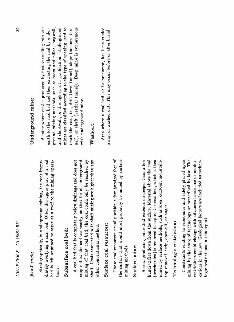
CH
AP
TE
RS
. G
LO
SSA
RY
39
Roo
f ro
ck:
Str
atig
raph
ical
ly,
in u
nder
grou
nd m
inin
g, t
he r
ock
imm
e
diat
ely
over
lyin
g a
coal
bed
. O
ften
the
upp
er p
art
of a
coa
l be
d is
lef
t un
min
ed t
o se
rve
as a
roo
f to
the
min
ing
oper
a
tion
s.
Su
bsu
rfac
e co
al b
ed:
A c
oal
bed
that
is
com
plet
ely
belo
w d
rain
age
and
does
not
cr
op o
ut a
t th
e su
rfac
e ne
arby
, so
th
at f
or a
ll un
derg
roun
d m
inin
g of
th
at c
oal
bed,
the
coa
l co
uld
only
be
reac
hed
by
shaf
t. C
osts
ass
ocia
ted
wit
h sh
aft
min
ing
are
high
er t
han
any
othe
r co
nven
tion
al m
etho
d.
Su
rfac
e co
al r
esou
rces
:
Tho
se c
oal
reso
urce
s us
uall
y w
ithi
n a
few
hun
dred
fee
t of
th
e su
rfac
e th
at w
ould
mos
t pr
obab
ly b
e m
ined
by
surf
ace
min
ing
met
hods
.
Su
rfac
e m
ine:
A c
oal-
prod
ucin
g m
ine
that
ext
ends
no
deep
er t
han
a fe
w
hund
red
feet
dow
n fr
om t
he s
urfa
ce.
Mat
eria
l ab
ove
the
coal
(o
verb
urde
n) is
rem
oved
to
expo
se t
he c
oal
bed,
whi
ch is
the
n m
ined
by
surf
ace
met
hods
, su
ch a
s ar
ea,
cont
our,
mou
ntai
n-
top
rem
oval
, st
rip,
ope
n-pi
t, o
r au
ger.
Tec
hn
olog
ic r
estr
icti
on:
Con
stra
ints
rel
atin
g to
eco
nom
ics
and
safe
ty p
lace
d up
on
min
ing
by t
he s
tate
of
tech
nolo
gy o
r pr
escr
ibed
by
law
. T
he
rest
rict
ions
cou
ld c
hang
e w
ith
adva
nces
in
scie
nce
or m
odif
i
cati
ons
in t
he l
aw.
Geo
logi
cal
fact
ors
are
incl
uded
as
tech
no
logi
c re
stri
ctio
ns i
n th
is r
epor
t.
Un
der
grou
nd
min
e:
A m
ine
whe
re c
oal
is p
rodu
ced
by f
irst
tun
nell
ing
into
the
ea
rth
to t
he c
oal
bed
and
then
ext
ract
ing
the
coal
by
unde
r
grou
nd m
inin
g m
etho
ds,
such
as
room
and
pil
lar,
lon
gwal
l, an
d sh
ortw
all,
or t
hrou
gh i
n si
tu g
asif
icat
ion.
U
nder
grou
nd
min
es a
re c
lass
ifie
d ac
cord
ing
to t
he t
ype
of o
peni
ng u
sed
to
reac
h th
e co
al,
i.e.,
drif
t (l
evel
tun
nel)
, sl
ope
(inc
line
d tu
n
nel)
, or
sha
ft (
vert
ical
tun
nel)
. D
eep
min
e is
syn
onym
ous
wit
h un
derg
roun
d m
ine.
Was
hou
t:
Are
a w
here
a c
oal
bed,
or
its
prec
urso
r, h
as b
een
erod
ed
away
, or
was
hed
out.
Thi
s m
ay o
ccur
bef
ore
or a
fter
bur
ial.
Ap
pen
dix
A
AP
PE
ND
IX
Tab
les
depi
ctin
g th
e or
igin
al,
min
ed a
nd l
ost
-in
-min
ing
, la
nd-u
se r
estr
icte
d,
tech
nolo
gic
rest
rict
ed,
and
avai
labl
e co
al r
esou
rces
, by
coa
l be
d an
d by
qua
dran
gle,
for
eac
h of
the
four
7.5
-min
ute
quad
rang
le s
tudy
are
as,
Cen
tral
App
alac
hian
Reg
ion,
Ken
tuck
y,
Vir
gini
a, a
nd W
est
Vir
gini
a.
40
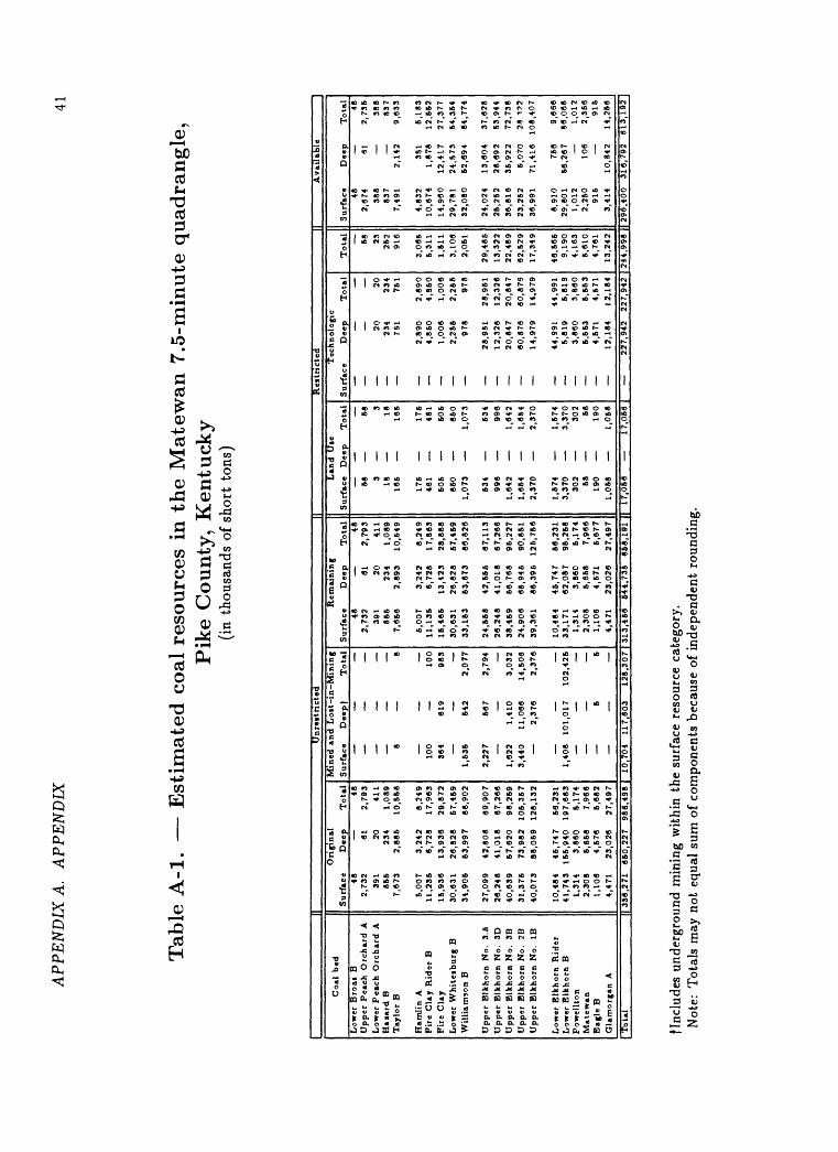
APP
EN
DIX
A.
APP
EN
DIX
41
Tab
le A
-l.
Est
imat
ed c
oal
res
ourc
es i
n t
he M
atew
an 7
.5-m
inute
quad
rangle
, P
ike
County
, K
entu
cky
(in
thou
sand
s of
sho
rt t
ons)
1C
oal
bed
Low
er B
roai
BU
pp
er
Pea
ch O
rch
ard
AL
ow
er P
each
O
rch
ard
A
Baia
rd B
Tay
lor
B
Ham
lin
AF
ire C
lay R
ider
BF
ire
Cla
yL
ow
er W
hit
eib
urg
BW
illi
amso
n B
Up
per
Blk
ho
n N
o.
3.6
Up
per
Blk
ho
n N
o.
3DU
pper
Blk
ho
n
No
. 3B
Upper
Blk
ho n
No.
2BU
pper
Blk
ho
n
No
. IB
Low
er B
lkh
orn
Rid
er
Low
er B
lkh
orn
BP
ow
ellt
on
Mate
wan
Bag
le B
Gla
mo
rgan
A
Tota
l |1
Ori
gin
al
Su
rfac
e D
eep
T
ota
l48
482,7
32
61
2,7
93
391
20
411
86
6
234
1,0
89
7,6
73
2,8
86
10,5
68
5,0
07
3,2
42
8
,24
91
1,2
36
6,7
28
17
,96
31
5,9
36
13,9
36
29,8
72
30
,63
1
26,8
28
67
,46
934,9
05
53
,99
7
88,9
02
27,0
99
42
,80
8
69
,90
726,2
48
41
,01
8
87,2
66
40,6
39
57
,62
0
98,2
59
31
,37
5
73
,98
2
10
5,3
57
40,0
73
88
,05
9
12
8,1
32
10
,48
4
45,7
47
66
,23
141,7
43
15
5,9
40
1
97
,68
31
,31
4
3,8
60
5,1
74
2,3
08
5,6
58
7,9
66
1,1
06
4,6
76
6,6
82
4,4
71
23
,02
6
27,4
97
33
6,2
71
6
60
,22
7
98
6,4
98
Un
rest
ricte
d
Min
ed a
nd
Lo
it-i
n M
inin
g
Surf
ace
Deep
) T
ota
l
8
8
_
_
_10
0
100
364
619
98
3_____
1,5
35
542
2,0
77
2,2
27
667
2,7
94
1,6
22
1,4
10
3
,03
23
,44
0
11,0
66
14
,50
6
2,3
76
2
,37
6
_
_
_1,4
08
101,0
17
102,4
26
5 5
10,7
04
11
7,6
03
128,3
07
1
Rem
ain
ing
Surf
ace
Dee
p
To
tal
48
482
,73
2
61
2,7
93
391
20
411
85
5
234
1,0
89
7,6
56
2
,89
3
10,5
49
6,0
07
3
,24
2
8,2
49
11,1
36
6,7
28
1
7,8
63
IB, 4
65
1
3,4
23
28,8
88
30
,63
1
26
,82
8
57,4
59
33,1
53
53,6
73
86,8
26
24
,65
8
42,5
55
67
,11
326,2
48
41,0
18
67,2
66
38,4
59
56
,76
8
95
,22
724,9
06
66
,94
5
90,8
51
39,3
61
86,3
95
125,7
56
10,4
84
45,7
47
56,2
31
33,1
71
62,0
87
96,2
68
1,3
14
3
,86
0
6,1
74
2,3
08
5
,65
8
7,9
66
1,1
06
4,6
71
6
,67
74
,47
1
23,0
26
27,4
97
31
3,4
56
544,7
35
858,1
91
1
Land U
te
Surf
ace
Dee
p
Tota
l
58
583
318
1816
6
165
176
17
646
1
461
505
50
5860
86
01
,07
3
1,0
73
534
53
4996
99
61,6
42
1,6
42
1,6
64
1,6
54
2,3
70
2,3
70
1,6
74
1,5
74
3,3
70
3,3
70
302
30
268
6819
0
190
1,0
68
1,0
68
| 17,0
66
17
,06
6
Rest
ricte
d
Tec
hnolo
gic
Surf
ace
Dee
p
Tota
l
20
20
234
234
751
761
2,8
90
2,8
90
4,8
50
4,8
50
1,0
06
1,0
06
2,2
56
2,2
66
978
978
28,9
51
28,9
61
12,3
26
12,3
26
20,8
47
20
,84
7
60,8
76
60
,87
6
14,9
79
14,9
79
44,9
91
44,9
91
5,8
19
6,8
19
3,8
60
3,8
60
5,5
63
6,5
53
4,6
71
4,5
71
12
,18
4
12,1
84
1T
ota
l 68 23
262
916
3,0
65
5,3
11
1,6
11
3,1
06
2,0
61
29
,48
613,3
22
22,4
89
62
,52
917,3
49
46
,56
69,1
90
4,1
63
5,6
10
4,7
61
13,2
42
24
4,9
98
L
Avail
able
Surf
ace
Dee
p
Tota
l48
482,6
74
91
2,7
36
388
388
837
837
7,4
91
2,1
42
9,6
33
4,8
32
351
6,1
83
10
,67
4
1,8
78
12,6
62
14,9
60
12
,41
7
27,3
77
29,7
81
24,5
73
54,3
64
32,0
80
62,6
94
84,7
74
24,0
24
13,6
04
37,6
28
26,2
52
28
,69
2
53,9
44
36,8
16
36
,92
2
72,7
38
23
,25
2
6,0
70
28,1
72
36
,99
1
71,4
16
108,4
07
8,9
10
766
9,6
66
29,8
01
56,2
67
86,0
68
1,0
12
1,0
12
2,2
50
106
2,3
66
916
916
3,4
14
10,8
42
14,2
66
flnc
lude
s un
derg
roun
d m
inin
g w
ithi
n th
e su
rfac
e re
sour
ce c
ateg
ory.
N
ote:
Tot
als
may
not
equ
al s
um o
f co
mpo
nent
s be
caus
e of
ind
epen
dent
rou
ndin
g.

AP
PE
ND
IX A
. A
PP
EN
DIX
42
Tab
le A
-2. E
stim
ate
d c
oal
res
ourc
es u
nav
aila
ble
du
e to
LA
ND
-USE
RE
ST
RIC
TIO
NS
in
the M
atew
an 7
.5-m
inute
qu
adra
ng
le,
Pik
e C
ounty
, K
entu
cky
(ail
less
tha
n 20
0-ft
ove
rbur
den i
n th
ousa
nds
of s
hort
ton
s)
Coa
l be
d
Low
er B
roas
BU
pper
Pea
ch O
rcha
rd A
Low
er P
each
Orc
hard
AH
azar
d B
Tay
lor
BH
amli
n A
Fir
e C
lay
Rid
er B
Fir
e C
lay
Low
er W
hite
sbur
g B
Wil
liam
son
BU
pper
Elk
horn
No.
3.
5U
pper
Elk
horn
No.
3D
Upp
er E
lkho
rn N
o.
3B
Upp
er E
lkho
rn N
o.
2B
Upp
er E
lkho
rn N
o.
IB
Low
er E
lkho
rn R
ider
Low
er E
lkho
rn B
Pow
ellt
onM
atew
anE
agle
B
Gla
mor
gan
A
Oil
and
Gas
_
T
. _.
_
Pow
er L
ines
P
ipel
ines
G
emW
ells
1 57
3
8
11
*
106
591
104
703
204
255
13
253
240
16
323
508
29
689
261
46
28
147
57
321
365
74
483
424
73
449
259
82
569
499
33
386
3716
1 38
4 32
89
52
g
__
__
8
29
4
eter
ies
Tow
ns
Str
eam
s
_
_
_
_
_
_
_
__
3
5
975 52
16
250
31
4 65
9
74
13
824
87
23
1,16
0
69
132
994
130
539
2,06
68
85
191
1 42
5
181
18
26
841
307
Tota
lf 58 3 18 165
175
461
505
850
1,07
353
499
6
1,64
2
1,65
4
2,37
0
1,57
43,
370
302 58 190
1,05
8
Tot
al65
54,
420
3,45
445
21,
861
6,62
6 17
,056
|
* L
ess
than
0.5
fNot
nec
essa
rily
sum
. C
alcu
late
d se
para
tely
to
avoi
d do
uble
cou
ntin
g of
ove
rlap
ping
res
tric
tion
s.N
ote: 1.
Tot
als
may
not
equ
al s
um o
f co
mpo
nent
s be
caus
e of
inde
pend
ent
roun
ding
.
2.
The
fig
ures
abo
ve a
re a
ll su
rfac
e co
al r
esou
rces
. N
o la
nd-u
se r
estr
icti
ons
wer
e ap
plic
able
to
deep
coa
l re
sour
ce
in t
he M
atew
an q
uadr
angl
e.
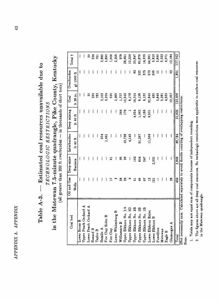
APP
EN
DIX
A.
AP
PE
ND
IX43
Tab
le A
-3. E
stim
ated
coal
res
ourc
es u
nav
aila
ble
du
e to
TE
CH
NO
LO
GIC
RE
ST
RIC
TIO
NS
in
the
Mat
ewan
7.5
-min
ute
qu
adra
ng
le,
Pik
e C
ounty
, K
entu
cky
(all
gre
ater
tha
n 20
0 ft
ove
rbur
den i
n th
ousa
nds
of s
hort
ton
s)
Coa
l be
d
Low
er B
roas
BU
pper
Pea
ch O
rcha
rd A
Low
er P
each
Orc
hard
AH
azar
d B
Tay
lor
B
Ham
lin
AF
ire
Cla
y R
ider
B
Fir
e C
lay
Low
er W
hite
sbur
g B
Wil
liam
son
BU
pper
Elk
horn
No.
3.
5
Upp
er E
lkho
rn N
o.
3D
Upp
er E
lkho
rn N
o.
3B
Upp
er E
lkho
rn N
o.
2B
Upp
er E
lkho
rn N
o.
IB
Low
er E
lkho
rn R
ider
Low
er E
lkho
rn B
Pow
ellt
onM
atew
anE
agle
B
Gla
mor
gan
A
Oil
and
Gas
D
eep-
min
e In
terb
urde
n D
eep
Wel
ls
Bar
rier
s It
40
ft
It
_
_
_
_
974
1,49
117
91
3
38
95
24
36
16
,738
9
4,14
5
31
162
69
804
51,2
67
97
347
13
11,5
6913
1 2,
331
_
_
_
_
_
28
min
ing
Coa
l O
verb
urde
n
40 f
t It
28
in.
gt 1
000
ft
20
234
782
2,10
2
3,32
4
930
2,26
5
266
1,72
7
176
12,5
43
1
8,17
8
4,63
4 16
,014
83
1,06
2 8,
128
322
6,18
5 8,
132
375
9,50
1 32
,840
57
3
430
395
3,84
9 11
5,28
1
4,56
9
12,0
57
92
Tot
al f 20 234
751
2,89
04,
850
1,00
6
2,25
597
828
,951
12,3
2620
,847
60,8
7614
,979
44,9
915,
819
3,86
05,
553
4,57
1
12,1
84
1,85
1 22
7,94
2 |
Tota
l______________[]
______459_____3,8
66_____86,1
84______21,8
25
123,
406
fNot
nec
essa
rily
sum
. C
alcu
late
d se
para
tely
to
avoi
d do
uble
cou
ntin
g of
ove
rlap
ping
res
tric
tion
s.
Not
e: 1.
Tot
als
may
not
equ
al s
um o
f co
mpo
nent
s be
caus
e of
inde
pend
ent
roun
ding
.
2.
The
fig
ures
abo
ve a
re a
ll de
ep c
oal
reso
urce
s. N
o te
chno
logi
c re
stri
ctio
ns w
ere
appl
icab
le t
o su
rfac
e co
al r
esou
rces
in
the
Mat
ewan
qua
dran
gle.
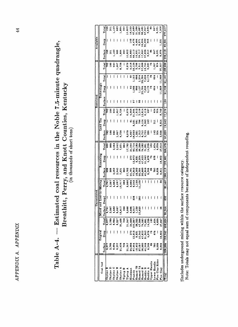
AP
PE
ND
IX A
. A
PP
EN
DIX
44
Tab
le A
-4.
Est
imat
ed c
oal
reso
urc
es i
n th
e N
oble
7.5
-min
ute
quad
rangle
, B
reat
hit
t, P
erry
, an
d K
no
tt C
ou
nti
es,
Ken
tuck
y(i
n th
ousa
nds
of s
hort
ton
s)
II
Un
rest
ricte
d
|| R
est
ricte
d
|| A
vai
lab
le
Co
al b
ed
Sk
yli
ne
BS
ky
lin
e D
Skyli
ne
CS
ky
lin
e B
Sk
yli
ne
AT
ipto
p B
Tip
top
AH
indm
an
Pra
ncii
Hazard
7B
Hazard
7A
Haia
rd
BH
»d
dix
B
Had
dix
A
Up
per
Ham
lin
Lo
wer
Ham
lin
Fir
e
Cla
y R
ider
Fir
e
Cla
y
Ori
gin
al
Su
rfac
e D
eep
Tota
l5,6
77
5,6
77
2,7
85
2,7
85
6,8
84
6,8
64
8,2
27
8,2
27
21,4
38
21
,438
709
709
21
,34
7
21,3
47
24
,66
6
270
24
,936
87
,44
4
12
,91
3
100,3
57
19,4
02
5,9
21
25
,322
37
,05
7
10
,34
2
47
,399
26
,56
0
47,5
22
74,0
82
40
,34
9
31,3
42
71,6
91
9,2
45
4,9
79
14
,225
85
75
160
750
87
5
1,6
24
5,6
35
5,6
35
8,8
45
18,8
02
27
,647
Min
ed an
d L
oit
-in-M
inin
g
Surf
ace
Deepf
Tota
l4,7
41
4,7
41
2,3
97
2,3
97
4,5
82
4,5
82
5,6
87
5,6
87
13
,81
7
13.H
1735
9
35
93
,56
6
3,5
66
3,8
85
3,8
85
9,3
17
326
9,6
43
1,1
39
1,1
39
10,8
20
280
11,1
00
35
35
Rem
ain
ing
Surf
ace
Dee
p
Tota
l936
936
388
388
2,0
83
2,0
83
2,5
40
2,5
40
7,62
1
7,6
21
350
35
017,7
82
17,7
82
20
,78
1
270
21,0
50
77
,84
2
12
,87
2
90,7
14
18,2
62
5,9
21
24,1
83
26,0
94
10,2
04
36
,29
92
6,5
60
47,5
22
74,0
82
40,3
49
31,3
42
71
,69
19
,24
5
4,9
79
14,2
25
85
75
160
750
875
1,6
24
5,6
35
5,6
35
8,8
11
18,8
02
27,6
13
Land
Use
Surf
ace
Dee
p
To
tal
782
782
186
186
930
930
1,9
57
1,9
57
5,7
28
5,7
28
_
_
_
6,9
79
6,9
79
4,8
97
61
4
,958
18
,63
3
3,3
31
21
,964
1,3
31
58
1 1
,912
1,3
12
79
6 2
,108
8,7
10
5
,10
4
13
,81
42
,72
3
3,3
92
6
,115
33
5
152
487
192
211
404
304
304
2,8
36
5
,91
4
8,7
49
Tec
hn
olo
gic
Su
rfac
e D
eep
T
ota
l
_
_
__
_
_
_
_
__
_
_
60
6097
1,0
65
1,1
62
886
886
66
1,1
37
1,2
04
23,7
84
23
,78
4
7,6
28
7,6
28
4,1
73
4,1
73
75
75
664
664
11,6
58
11,5
58
To
tal
782
186
930
1,9
57
5,7
28
6,9
79
5,0
18
23
,12
52,7
98
3,3
11
37,5
98
13
,74
44,6
60 75
1,0
67
304
20
,30
7
Surf
ace
Dee
p
To
tal
155
155
201
201
1,1
53
1,1
53
583
583
1,8
94
1,8
94
350
350
10
,80
2
10.8
02
15
,88
3
149
16,0
33
59,1
13
8,4
76
67
,58
916,9
31
4,4
54
21
,38
62
4,7
17
8,2
71
32,9
87
17,8
50
18
,63
4
36,4
84
37,6
25
20,3
22
57,9
47
8,9
10
6fi&
9,5
64
85
85557
557
5,3
31
5,3
31
5,9
75
1,3
31
7,3
06
[Tota
l[3
28,8
86
133,0
40
459,9
24
|
60
,34
46
0,9
60
| 2
66,1
13
13
2,8
61
398,9
76 |
| 57,8
35
19
,54
2
77,3
76
|
163
51,0
28
51
,19
1 |
12
8,5
68
||
208,1
16
62,2
91
270,4
07]
jlnc
lude
s un
derg
roun
d m
inin
g w
ithi
n th
e su
rfac
e re
sour
ce c
ateg
ory.
N
ote:
Tot
als
may
not
equ
al s
um o
f co
mpo
nent
s be
caus
e of
Ind
epen
dent
fou
ndin
g.
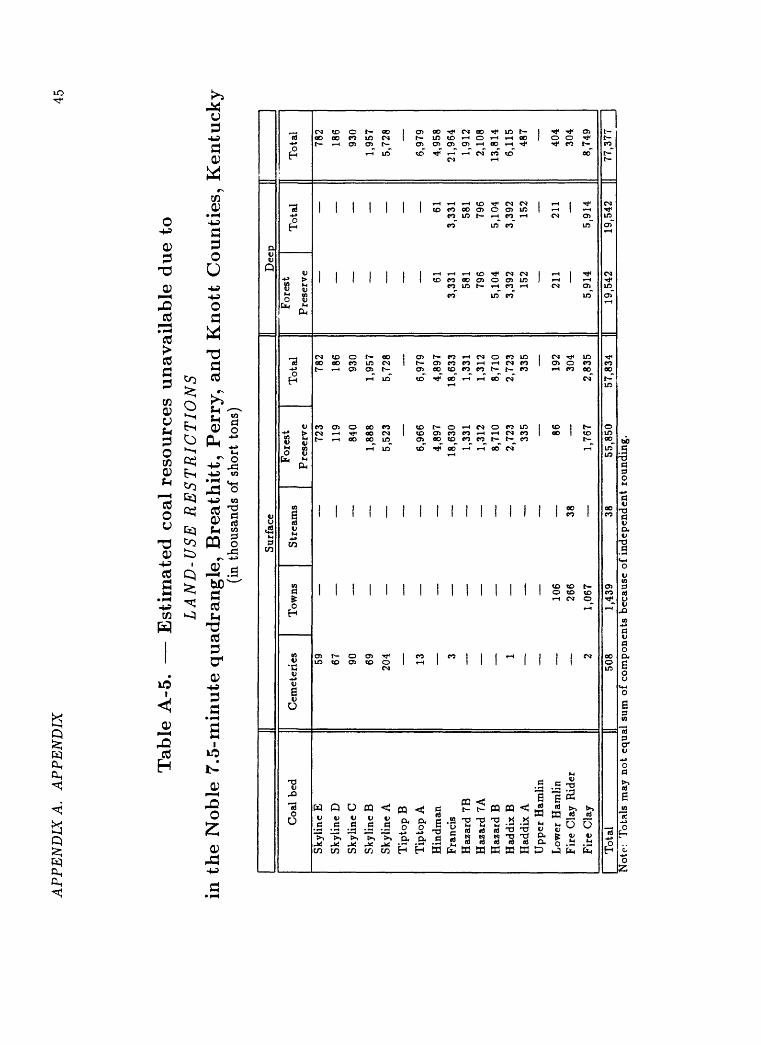
AP
PE
ND
IX A
. A
PP
EN
DIX
45
Tab
le A
-5. E
stim
ated
co
al r
eso
urc
es u
nav
aila
ble
due
toL
AN
D-U
SE R
EST
RIC
TIO
NS
in t
he N
ob
le 7
.5-m
inute
quad
rangle
, B
reath
itt,
Per
ry,
and K
nott
Counti
es,
Ken
tuck
y(i
n th
ousa
nds
of s
hort
ton
s)
Sur
face
Dee
p
Coa
l be
d
Sky
line
E
Sky
line
D
Sky
line
C
Sky
line
B
Sky
line
A
Tip
top B
Tip
top
A
Hin
dman
Fra
ncis
Haz
ard
7BH
azar
d 7A
Haz
ard
BH
addi
x B
Had
dix
AU
pper
Ham
lin
Low
er H
amli
nF
ire
Cla
y R
ider
Fir
e C
lay
Cem
eter
ies
Tow
ns
59
67
90
69
204
13
2
_
i
_
106
266
2 1,
067
.
For
est
Str
eam
s P
rese
rve
723
119
840
1,88
8
5,52
3
6,96
6
4,89
7
18,6
30
1,33
1
1,31
2
8,71
0
2,72
3
335
__
_
8638
1,76
7
Tot
al 782
186
930
1,95
75,
728
6,97
9
4,89
718
,633
1,33
11,
312
8,71
02,
723
335 192
304
2,83
5
For
est
Pre
serv
e 613,
331
581
796
5,10
43,
392
152 211
5,91
4
Tot
al 613,
331
581
796
5,10
43,
392
152 211
5,91
4
Tot
al 782
186
930
1,95
7
5,72
8
6,97
9
4,95
821
,964
1,91
22,
108
13,8
146,
115
487 404
304
8,74
9
Tot
al50
81,
439
3855
,850
57,8
3419
,542
19,5
42
|| 77
,377
__(
Not
e:
Tot
als
may
not
equ
al s
um o
f co
mpo
nent
s be
caus
e of
ind
epen
dent
rou
ndin
g.
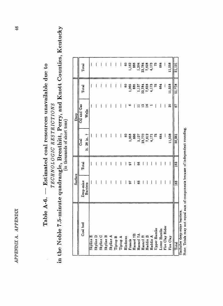
APP
EN
DIX
A.
AP
PE
ND
IX46
Tab
le A
-6. E
stim
ated
coal
res
ourc
es u
nav
aila
ble
du
e to
TE
CH
NO
LO
GIC
RE
ST
RIC
TIO
NS
in t
he
Noble
7.5
-min
ute
quad
rangle
, B
reath
itt,
Per
ry,
and K
nott
Counti
es,
Ken
tuck
y(i
n th
ousa
nds
of s
hort
ton
s)
Sur
face
Dee
p
Coa
l be
d
Sky
line
E
Sky
line
D
Sky
line
C
Sky
line
B
Sky
line
A
Tip
top
B
Tip
top
AH
indm
anF
ranc
isH
azar
d 7B
Haz
ard
7AH
azar
d B
Had
dix
BH
addi
x A
Upp
er H
amli
n
Low
er H
amli
nF
ire
Cla
y R
ider
Fir
e C
lay
Dee
p-m
ine
Tot
al
Bar
rier
s
97
97
66
66
_
Coa
l O
il a
nd G
as
It.
28 i
n.
f W
ells
_
_
60
1,
058
688
6
1,12
7 11
23,7
70
137,
612
164,
171
175
664
11
,538
20
Tot
al
Tot
al
60
601,
065
1,16
288
6 88
61,
137
1,20
423
,784
23
,784
7,62
8 7,
628
4,17
3 4,
173
75
75
664
664
11
,558
11
,558
Tot
al16
350
,961
flnc
lude
s de
ep-m
ine
barr
iers
.N
ote:
T
otal
s m
ay n
ot e
qual
sum
of
com
pone
nts
beca
use
of i
ndep
ende
nt r
ound
ing.
6751
.028
II
51,1
91
|
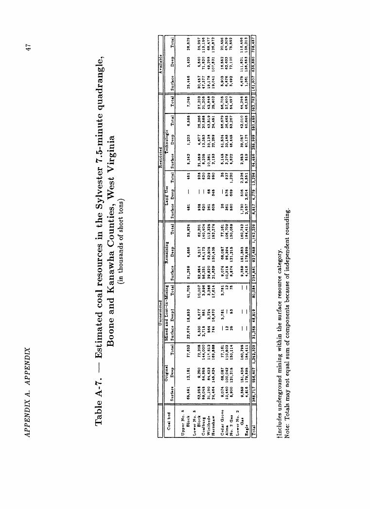
AP
PE
ND
IX A
. A
PP
EN
DIX
47
Tab
le A
-7. E
stim
ated
coa
l re
sourc
es i
n th
e S
ylv
este
r 7.5
-min
ute
quad
rangle
,B
oone
and K
anaw
ha
Counti
es,
Wes
t V
irg
inia
(in
thou
sand
s of
sho
rt t
ons)
|| U
nre
stri
cte
d
|| R
est
ricte
d
||
Avai
lable
Coal
b
ed
Up
per
No
. 5
Blo
ck
Lo
wer
No.
5 B
lock
C
oalb
urg
W
inif
rede
Hern
ihaw
Ced
ar G
rov
e A
lma
No.
2 O
ai
Lo
wer
No
. 2
Oai
Eag
le
Ori
gin
al
Surf
ace
Dee
p
To
tal
65,4
51
12,1
81
77,6
32
62
,96
8
9,2
60
72,2
08
59
,04
5
84
,96
5
14
4,0
00
3
1,1
90
84,4
23
11*.
612
2
4,4
64
145,4
24
16
9,8
88
9,0
74
68,0
87
77,1
61
10
,46
0
100,0
42
110,5
03
8,9
00
121,2
15
13
0,1
14
9,3
59
151,4
36
16
0,7
95
4,8
16
179,5
95
18
4,4
11
Min
ed a
nd L
ost
in-M
inin
g
Surf
ace
Deepf
Tota
l
22,8
74
18
,83
3
41,7
08
4,3
30
5
,67
7
10,0
07
2,7
15
88
1 3
,59
6
564
2,7
24
3
,28
8
744
16
,87
0
17,6
14
3,7
81
3
,78
1
12
12
25
53
78
-
-
-
Rem
ain
ing
Surf
ace
Dee
p
Tota
l
31,2
69
4,6
56
3
5,9
24
52,9
84
9,2
17
6
2,2
01
56,2
31
84,1
73
14
0,4
04
29,8
20
82,5
05
11
2,3
25
21,8
39
130,4
35
152,2
74
9,0
74
68,0
87
77,1
61
10,3
15
96,3
94
106,7
09
8,8
74
121,2
15
130,0
89
9,3
59
151,3
83
16
0,7
42
4
,81
6
179,5
95
18
4,4
11
Lan
d
Use
Surf
ace
Dee
p
To
tal
481
481
938
938
620
620
261
68
329
60
5
34
5
950
26
26
361
57
6
937
560
669
1,2
30
1,7
30
506
2,2
36
2,9
37
2
,61
4
5,5
51
Tec
hnolo
gic
Surf
ace
Dee
p
Tota
l
5,3
42
1,2
23
6,5
65
21,5
89
4,6
77
26,2
66
8,2
35
12
,35
3
20
,58
8
10,3
81
33,1
38
43
,51
9
2,1
93
22,2
59
24
,45
1
5,1
45
51,5
34
56,6
79
3,2
78
33,1
85
36,4
63
4,8
22
48
,44
5
53,2
67
2,9
53
39,0
57
42,0
10
519
40
,12
9
40,6
46
To
tal
7,0
46
27,2
03
21,2
08
43,8
48
25
,40
2
56,7
05
37
,40
0
54,4
97
44,2
46
46,1
98
Su
rfac
e D
eep
T
ota
l
25,4
46
3,4
33
28,8
79
30
,45
7
4,5
40
34,9
97
47,3
77
71,8
20
119,1
96
19
,17
8
49,2
98
68
,47
7
19,0
41
107,8
31
126,8
72
3,9
03
16,5
52
20
,45
6
6,8
76
62,6
33
6",
309
3,4
92
72,1
00
75,5
92
4,6
75
111,8
21
116,4
96
1,36
1 1
38
,85
3
138,2
13
Total
286.717
966,607
1,242,323
| 31
,266
48
,819
80,084 |
234,581 927,658
1,162,239
|| 8,517
4,77
9 13
,296
| 64,456 28
5,99
9 36
0,45
5 | 3
63,7
52 ]
| 161,607
636,880
798,487]
flnc
lude
s un
derg
roun
d m
inin
g w
ithi
n th
e su
rfac
e re
sour
ce c
ateg
ory.
Not
e: T
otal
s m
ay n
ot e
qual
sum
of
com
pone
nts
beca
use
of i
ndep
ende
nt r
ound
ing.
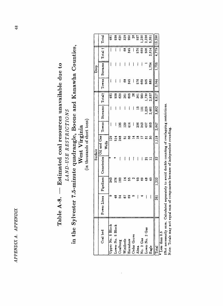
AP
PE
ND
IX A
. A
PP
EN
DIX
48
Tab
le A
-8. E
stim
ated
coa
l re
sou
rces
unav
aila
ble
due
toL
AN
D-U
SE
RE
ST
RIC
TIO
NS
in t
he
Sylv
este
r 7.5
-min
ute
quad
rangle
, B
oone
and K
anaw
ha
Co
un
ties
,W
est
Vir
gin
ia(i
n th
ousa
nds
of s
hort
ton
s)
Coa
l be
d
Upp
er N
o.
5 B
lock
Low
er N
o.
5 B
lock
Coa
lbur
g
Win
ifre
deH
erns
haw
Ced
ar G
rove
Alm
aN
o.
2 G
asL
ower
No.
2
Gas
Eag
le
Pow
er L
ines
P
ipel
ines
C
em<
9 34
3
48
376
54
183
67
1469
55
9 2
934
69
48
40
Sur
face
Oil
and
Gas
:t
enes
Wel
ls*
129
* 51
4
248
51
66
14
18
1721
31
11
30
Tow
ns 135
129
414 236
343
437
953
Str
eam
s
15 131
1,22
52,
461
Tota
lf
481
938
620
261
605 26 361
560
1,73
02,
937
Dee
p
Tow
ns
Str
ea
68 345 576
669
505
ms
Tot
al f
68
345
576
669
1 50
688
0 1,
754
2,61
4
Tot
al
481
938
620
329
950 26 937
1,23
02,
236
5,55
1
Tot
al26
11,
222
321,
118
2,64
7 3,
832
8,51
71|
3,04
4 1,
755
4,77
91| 1
3,29
61*
Les
s th
an 0
.5fN
ot n
eces
sari
ly s
um.
Cal
cula
ted
sepa
rate
ly t
o av
oid
doub
le c
ount
ing
of o
verl
appi
ng r
estr
icti
ons.
Not
e:
Tot
als
may
not
equ
al s
um o
f co
mpo
nent
s be
caus
e of
ind
epen
dent
rou
ndin
g.
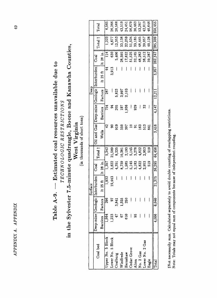
AP
PE
ND
IX A
. A
PP
EN
DIX
49
Tab
le A
-9. E
stim
ated
coa
l re
sou
rces
unav
aila
ble
due
toT
EC
HN
OL
OG
IC R
EST
RIC
TIO
NS
in t
he
Sylv
este
r 7
.5-m
inu
te q
uad
rangle
, B
oone
and
Kan
awha
Co
un
ties
,W
est
Vir
gin
ia(i
n th
ousa
nds
of s
hort
ton
s)
Coa
l be
d
Upp
er N
o. 5
Blo
ckL
ower
No.
5
Blo
ckC
oalb
urg
Win
ifre
deH
erns
haw
Ced
ar G
rove
Alm
aN
o. 2
Gas
Low
er N
o.
2 G
asE
agle
Sur
face
Dee
p- m
ine
Bar
rier
s1,
964
1,22
3 47 67 610 95
Geo
logi
c In
terb
Fac
tors
It
229
6
urde
n C
oal
5 ft
It
28
in.
1,93
2 1,
357
97
19,4
43
3,62
23,
841
1,55
525
0
4,35
1
8,75
9
1,58
5
5,14
5
3,18
3
4,82
2
2,95
3
519
Tot
al f
5,34
221
,589
8,23
510
,381
2,19
35,
145
3,27
84,
822
2,95
351
9
Oil
and
Gas
D
eep-
min
e
Wel
ls
Bar
rier
s42
75
490
94
919
205
350
197
397
1,93
610
91
929
163
51
3 32
841
Dee
pG
eolo
gic
Inte
rb
Fac
tors
It
228
7
5,82
3
3,99
72,
103
urde
n C
oal
5 ft
It
28
in.
44
114
3,91
3 63
0
5,40
6
28,5
95
17,8
32
51,5
25
32,1
65
48,2
82
38,5
12
39,2
87
Tot
al f
1,22
34,
677
12,3
5333
,138
22,2
5951
,534
33,1
8548
,445
39,0
5740
,128
Tot
al
6,56
526
,266
20,5
8843
,519
24,4
5156
,679
36,4
6353
,267
42,0
1040
,646
Tot
al4,
006
6,04
021
,375
36
,295
64
,456
3,41
64,
147
12,2
113,
957
262,
347
(I 28
5,99
9 [I
350,
455
fNot
nec
essa
rily
sum
. C
alcu
late
d se
para
tely
to
avoi
d do
uble
cou
ntin
g of
ove
rlap
ping
res
tric
tion
s.
Not
e: T
otal
s m
ay n
ot e
qual
sum
of
com
pone
nts
beca
use
of i
ndep
ende
nt r
ound
ing.
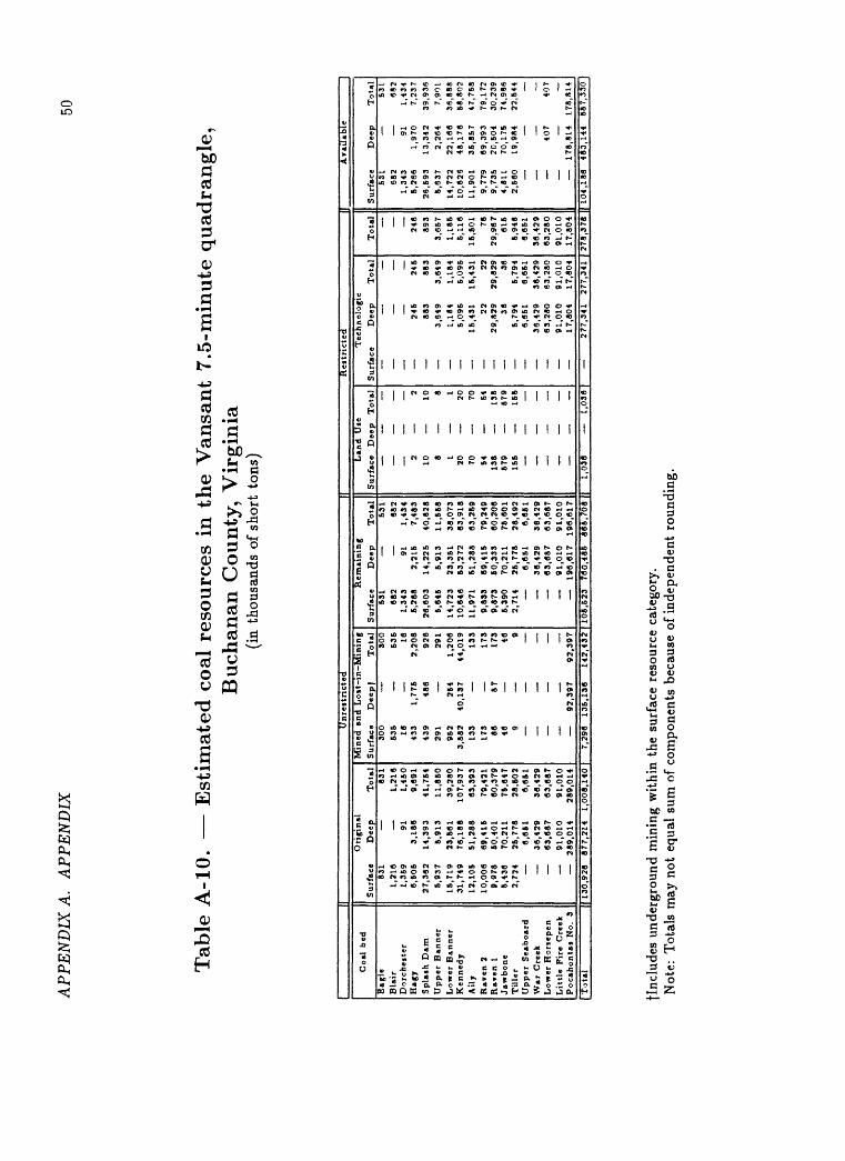
AP
PE
ND
IX A
. A
PP
EN
DIX
50
Tab
le A
-10.
E
stim
ated
coa
l re
sourc
es i
n th
e V
ansa
nt
7.5
-min
ute
quad
rangle
,B
uch
anan
County
, V
irgin
ia(i
n th
ousa
nds
of s
hort
ton
s)
|(
Un
rest
ricte
d
||
Rest
ricte
d
|| A
vail
able
Coal
b
ed
Eag
leB
lair
Do
rchest
er
Hag
yS
pla
sh D
amU
pp
er
Banner
Lo
wer
Banner
Ken
ned
yA
ily
Rav
en 2
Raven 1
Jaw
bon
eT
ille
rU
pp
er
Seab
oard
War
Cre
ekL
ow
er H
ori
epen
Lit
tle F
ire C
reek
Pocaho
nta
i N
o.
3
Ori
gin
al
Su
rfac
e D
eep
T
ota
l83
1
831
1,2
18
1,2
18
1,3
59
91
1,4
50
6,5
05
3,1
86
9,6
91
27
,36
2
14
,39
3
41
,754
5,9
37
5,9
13
11
,85
01
5,7
19
2
3,5
61
3
9,2
80
31
,74
9
76,1
88
10
7,9
37
12,1
05
51
,28
8
63
,393
10
,00
6
69,4
15
79,4
21
9,9
78
50
,40
1
60
,379
5,4
36
70,2
11
75,6
47
2,7
24
2
6,7
78
2
8,6
02
6,6
51
6,6
51
36
,42
9
36,4
29
63,6
87
63
,687
91
,01
0
91
,010
289,0
14
28
9,0
14
Tota
l ||
130,9
26
87
7.2
1*
1,0
08,1
*0
Min
ed a
nd L
o it
-in
-Min
ing
Surf
ace
Deep
f T
ota
l30
0
30
053
6
53
616
1643
3 1
,77
6
2,2
08
439
486
92
629
1
291
962
254
1,2
06
3,8
82
40,1
37
44,0
19
133
133
173
173
86
87
17
346
469
9
92,3
97
92,3
97
7,2
96
135,1
36
14
2,4
32
Rem
ain
ing
Surf
ace
Dee
p
Tota
l63
1
531
682
682
1,3
43
91
1
,43
46
,26
8
2,2
15
7
,48
326,6
03
14,2
25
40
,82
85
,64
5
5,9
13
11,5
58
14,7
23
23
,35
1
38,0
73
10,6
46
63,2
72
63
,91
811,9
71
51,2
88
63,2
59
9,8
33
69,4
15
79,2
49
9,8
73
50,3
33
60,2
06
6,3
90
70,2
11
76,6
01
2,7
14
2
6,7
78
2
8,4
92
6,6
51
6
,66
1
36,4
29
36
,42
9
63,6
87
63
,68
7
91,0
10
91
,01
0
196,6
17
196,6
17
Land U
se
Surf
ace
Dee
p
Tota
l
2
2
10
108
8
1 1
20
2070
7054
8413
8
138
679
579
155
155
106,6
23
760,4
86
86
5,7
08
||
1,0
36
1,0
36
Tec
hn
olo
gic
Su
rfac
e D
eep
T
ota
l
245
246
883
883
3,6
49
3,6
49
1,1
84
1,1
84
5,0
96
5,0
95
15,4
31
16,4
31
22
22
29,8
29
29,8
29
36
36
5,7
94
5,7
94
6,6
51
6,6
81
36,4
29
36,4
29
63
,28
0
63,2
80
91
,01
0
91,0
10
17
,80
4
17
,80
4
277,3
41
277,3
41
To
tal
246
893
3,6
57
1,1
86
6,1
16
16,5
01 76
29
,96
761
55,9
48
6,6
51
36,4
29
63
,28
091,0
10
17,8
04
Su
rfac
e D
eep
T
ota
l53
1
531
682
682
1,3
43
91
1,4
34
5,2
66
1,9
70
7,2
37
26,5
93
13,3
42
39
,93
65,6
37
2,2
64
7,90
114,7
22
22
,16
6
36,8
88
10,6
26
48,1
76
58,8
02
11
,90
1
36,8
57
47,7
88
9,7
79
69,3
93
79
,17
29,7
38
20,8
04
30
,23
94,8
11
70
,17
5
74
,98
62,5
60
19
,98
4
22,5
44
407
407
17
8,8
14
178,8
14
278,3
78 |
| 104,1
86
48
3,1
44
5
87
,33
0
flnc
lude
s un
derg
roun
d m
inin
g w
ithi
n th
e su
rfac
e re
sour
ce c
ateg
ory.
N
ote:
Tot
als
may
not
equ
al s
um o
f co
mpo
nent
s be
caus
e of
ind
epen
dent
fou
ndin
g.
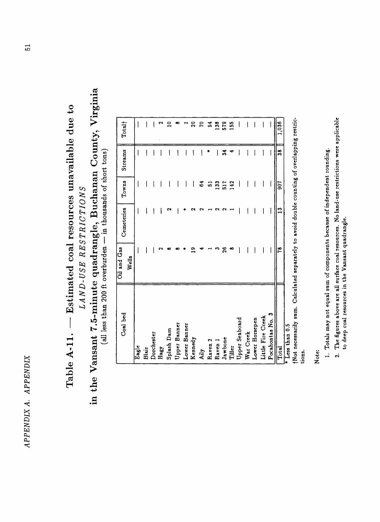
AP
PE
ND
IX A
. A
PP
EN
DIX
51
Tab
le A
-ll.
E
stim
ated
co
al r
eso
urc
es u
nav
aila
ble
due
toL
AN
D-U
SE R
EST
RIC
TIO
NS
in t
he
Van
sant
7.5
-min
ute
qu
adra
ng
le,
Buch
anan
County
, V
irg
inia
(all
les
s th
an 2
00 f
t ov
erbu
rden
i
n th
ousa
nds
of s
hort
ton
s)
Coa
l be
d
Eag
le
Bla
irD
orch
este
rH
agy
Spl
ash
Dam
Upp
er B
anne
r
Low
er B
anne
rK
enne
dy
Aily
Rav
en 2
Rav
en 1
Jaw
bone
Til
ler
Upp
er S
eabo
ard
War
Cre
ekL
ower
Hor
sepe
n
Lit
tle
Fir
e C
reek
Poc
ahon
tas
No.
3
Oil
and
Gas
_ C
emet
erie
sW
ells
2
_
8 2
8
* *
19
2
4 2
1 1
3 2
26
28
1
Tow
ns
Str
eam
s T
ota
lf
2
10
8
1
20
64
70
51
* 54
133
138
517
34
579
142
4 15
5_
_
_
_
_
_
_
_
Tot
al78
1390
738
||
1,03
6*
Les
s th
an 0
.5fN
ot n
eces
sari
ly s
um.
Cal
cula
ted
sepa
rate
ly t
o av
oid
doub
le c
ount
ing
of o
verl
appi
ng r
estr
ic
tion
s.
Not
e: 1.
Tot
als
may
not
equ
al s
um o
f co
mpo
nent
s be
caus
e of
inde
pend
ent
roun
ding
.
2.
The
fig
ures
abo
ve a
re a
ll su
rfac
e co
al r
esou
rces
. N
o la
nd-u
se r
estr
icti
ons
wer
e ap
plic
able
to
dee
p co
al r
esou
rces
in
the
Van
sant
qua
dran
gle.
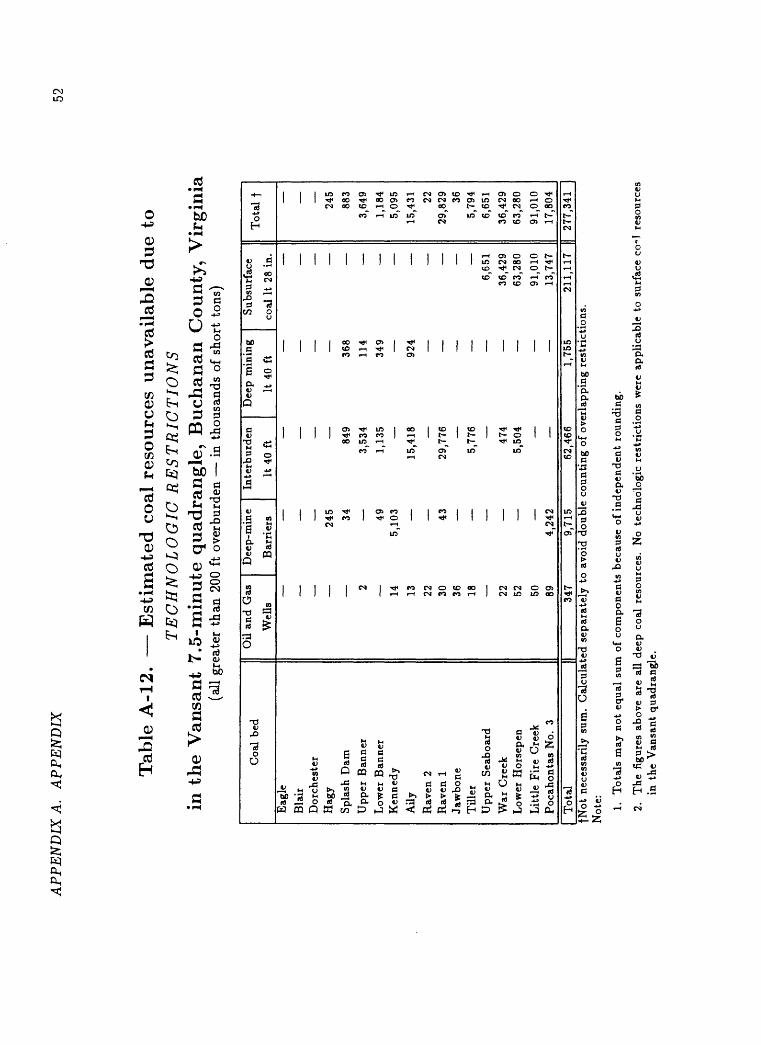
AP
PE
ND
IX A
. A
PP
EN
DIX
52
Tab
le A
-12.
E
stim
ated
co
al r
eso
urc
es u
nav
aila
ble
du
e to
TE
CH
NO
LO
GIC
RE
ST
RIC
TIO
NS
in
the V
ansa
nt
7.5
-min
ute
quad
rangle
, B
uch
anan
County
, V
irgin
ia(a
ll g
reat
er t
han
200
ft o
verb
urde
n i
n th
ousa
nds
of s
hort
ton
s)
Coa
l be
d
Eag
le
Bla
irD
orch
este
rH
agy
Spl
ash
Dam
Upp
er B
anne
r
Low
er B
anne
rK
enne
dy
Ally
Rav
en 2
Rav
en 1
Jaw
bone
Til
ler
Upp
er S
eabo
ard
War
Cre
ekL
ower
Hor
sepe
n
Lit
tle
Fir
e C
reek
Poc
ahon
tas
No.
3
Oil
and
Gas
D
eep-
min
e In
terb
urde
n
Wel
ls
Bar
rier
s It
40
ft
245
34
849
2
3,53
4
49
1,13
514
5,
103
13
15,4
18
22
30
43
29
,776
36
18
5,77
6
_
22
474
52
5,50
4
50
89
4,
242
Dee
p m
inin
g S
ubsu
rfac
e
It 4
0 ft
co
al I
t 28
in.
368
114
349
924
6,65
1
36,4
29
63,2
80
91,0
10
13,7
47
Tot
al t 245
883
3,64
9
1,18
45,
095
15,4
31 2229
,829 36
5,79
46,
651
36,4
2963
,280
91,0
1017
,804
Tot
al34
79,
715
62,4
661,
755
211,
117
I) 27
7,34
1 |
fNot
nec
essa
rily
sum
. C
alcu
late
d se
para
tely
to
avoi
d do
uble
cou
ntin
g of
ove
rlap
ping
res
tric
tion
s.
Not
e: 1.
Tot
als
may
not
equ
al s
um o
f co
mpo
nent
s be
caus
e of
ind
epen
dent
rou
ndin
g.
2.
The
fig
ures
abo
ve a
re a
ll de
ep c
oal
reso
urce
s.
No
tech
nolo
gic
rest
rict
ions
wer
e ap
plic
able
to
surf
ace
co^l
res
ourc
es
in t
he V
ansa
nt q
uadr
angl
e.