Embed Size (px)
Citation preview
An eco-narrative of Gascoyne Marine Park, North-west marine region
Alix Post1, Rachel Przeslawski1, Zhi Huang1, Deb Smith2, Lisa Kirkendale3, Nerida Wilson 3
1 Geoscience Australia, 2 Schmidt Ocean Institute, 3 Western Australian Museum
D8 – Canyon Mapping and Biodiversity in Gascoyne Marine Park
February 2021
Milestone 3 – Research Plan v6 (2020)
Preferred Citation
Post A, Przeslawski R, Huang Z, Smith D, Kirkendale L, Wilson N (2021). An Eco-Narrative of the Gascoyne Marine Park, North-West Marine Region. Report to the National Environmental Science Program, Marine Biodiversity Hub. Geoscience Australia.
Copyright
This report is licensed by the University of Tasmania and Geoscience Australia for use under a Creative Commons Attribution 4.0 Australia Licence. For licence conditions, see https://creativecommons.org/licenses/by/4.0/
Acknowledgement
This work was undertaken for the Marine Biodiversity Hub, a collaborative partnership supported through funding from the Australian Government’s National Environmental Science Program (NESP). NESP Marine Biodiversity Hub partners include the University of Tasmania; CSIRO, Geoscience Australia, Australian Institute of Marine Science, Museums Victoria, Charles Darwin University, the University of Western Australia, Integrated Marine Observing System, NSW Office of Environment and Heritage, NSW Department of Primary Industries. This report is published with the permission of the Chief Operating Officer of Geoscience Australia.
Important Disclaimer
The NESP Marine Biodiversity Hub advises that the information contained in this publication comprises general statements based on scientific research. The reader is advised and needs to be aware that such information may be incomplete or unable to be used in any specific situation. No reliance or actions must therefore be made on that information without seeking prior expert professional, scientific and technical advice. To the extent permitted by law, the NESP Marine Biodiversity Hub (including its host organisation, employees, partners and consultants) excludes all liability to any person for any consequences, including but not limited to all losses, damages, costs, expenses and any other compensation, arising directly or indirectly from using this publication (in part or in whole) and any information or material contained in it.
Contents
EXECUTIVE SUMMARY ................................................................................................................. 1
1. Introduction ............................................................................................................................. 2
2. Physical setting ........................................................................................................................ 4
3. Oceanography .......................................................................................................................... 6
4. Morphology and potential habitats .......................................................................................... 9
5. Ecological significance ............................................................................................................ 12
5.1 Benthic ............................................................................................................................. 12
5.2 Pelagic .............................................................................................................................. 15
REFERENCES .............................................................................................................................. 16
An Eco-narrative of the Gascoyne Marine Park, North-west marine region February 2021 Page | 1
EXECUTIVE SUMMARY
This report is one in a series of eco-narratives that synthesise our existing knowledge of Australian Marine Parks. Eco-narratives are intended to enable managers and practitioners to rapidly ascertain the ecological characteristics of each park, and to highlight knowledge gaps for future research focus. Gascoyne Marine Park is dominated by two submarine canyons that incise the continental slope of the western Australian margin and provide some degree of connectivity between the continental shelf and abyssal plain. The park is characterised by a range of benthic environments, including near-vertical cliffs of exposed bedrock in the canyons, and sediment covered slopes on the continental slope that grade to abyssal plains that occupy the greater proportion of the park.
Seabed mapping surveys have revealed that the canyons are dynamic systems, which continue to be shaped by sediment-laden currents and mass movement along canyon walls. Localised upwelling of nutrient-rich waters at the heads of the canyons and at the shelf break sustain the nutrient conditions that support the high diversity of Ningaloo Reef.
Sea surface temperatures within the park display a slight warming trend since 2002, at an annual rate of 0.036°C / year. The park is also affected by Marine Heat Waves, with the most extreme event occurring in 2010-2011. However, the severity of these events is not uniform across the park, with marine heat waves occurring more frequently in nearshore waters.
Gascoyne Marine Park has arguably some of the most representative and diverse biological communities of the northwest Australian margin due to its broad depth range and associated ecological niches. Most of the ecological knowledge of this region has so far been limited to the shelf, particularly the shallow waters of Ningaloo Reef. Despite localised deep-sea surveys, our understanding of deep-sea habitats and communities remain limited at the broader scale in the park. Benthic communities include rhodolith beds, coral bommies and sponge gardens common along the shelf, canyon habitats with localised dense communities of suspension feeders, and abyssal communities typical of cosmopolitan deep-sea plains (e.g. deep-sea infauna, detritivores, demersal fish).
The information in this eco-narrative forms an initial characterisation of Gascoyne Marine Park. The key gaps in our knowledge of the park are its specific oceanographic processes within canyons. In particular, targeted oceanographic surveys over both canyons are needed to develop a more informed overall assessment of the biological significance of the park ecosystem and identify potential anthropogenic threats to park health.
An Eco-narrative of the Gascoyne Marine Park, North-west marine region February 2021 Page | 2
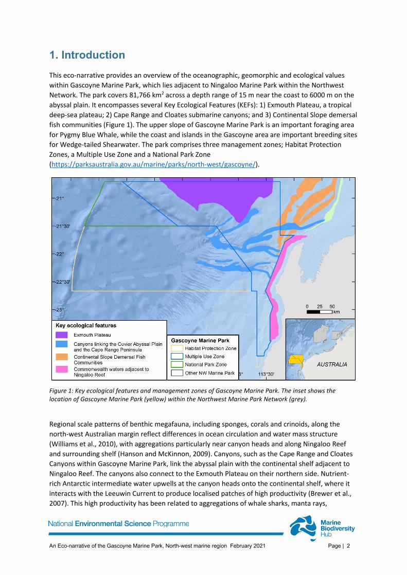
1. Introduction This eco-narrative provides an overview of the oceanographic, geomorphic and ecological values within Gascoyne Marine Park, which lies adjacent to Ningaloo Marine Park within the Northwest Network. The park covers 81,766 km2 across a depth range of 15 m near the coast to 6000 m on the abyssal plain. It encompasses several Key Ecological Features (KEFs): 1) Exmouth Plateau, a tropical deep-sea plateau; 2) Cape Range and Cloates submarine canyons; and 3) Continental Slope demersal fish communities (Figure 1). The upper slope of Gascoyne Marine Park is an important foraging area for Pygmy Blue Whale, while the coast and islands in the Gascoyne area are important breeding sites for Wedge-tailed Shearwater. The park comprises three management zones; Habitat Protection Zones, a Multiple Use Zone and a National Park Zone (https://parksaustralia.gov.au/marine/parks/north-west/gascoyne/).
Figure 1: Key ecological features and management zones of Gascoyne Marine Park. The inset shows the location of Gascoyne Marine Park (yellow) within the Northwest Marine Park Network (grey).
Regional scale patterns of benthic megafauna, including sponges, corals and crinoids, along the north-west Australian margin reflect differences in ocean circulation and water mass structure (Williams et al., 2010), with aggregations particularly near canyon heads and along Ningaloo Reef and surrounding shelf (Hanson and McKinnon, 2009). Canyons, such as the Cape Range and Cloates Canyons within Gascoyne Marine Park, link the abyssal plain with the continental shelf adjacent to Ningaloo Reef. The canyons also connect to the Exmouth Plateau on their northern side. Nutrient-rich Antarctic intermediate water upwells at the canyon heads onto the continental shelf, where it interacts with the Leeuwin Current to produce localised patches of high productivity (Brewer et al., 2007). This high productivity has been related to aggregations of whale sharks, manta rays,
An Eco-narrative of the Gascoyne Marine Park, North-west marine region February 2021 Page | 3
humpback whales, sea snakes, sharks, large predatory fish and seabirds in the area (Sleeman et al., 2007). The hard canyon walls have been shown to provide habitat for deepwater snapper (Brewer et al., 2007), as well as a range of sessile invertebrates, while soft sediments on the canyon floor support a range of mobile invertebrates (Daniell et al., 2010). The importance of hard seabeds in controlling habitat heterogeneity more broadly across the north-west region can influence the distribution of sponges, molluscs, echinoderms and decapods (Williams et al., 2010).
An Eco-narrative of the Gascoyne Marine Park, North-west marine region February 2021 Page | 4
2. Physical setting Gascoyne Marine Park encompasses shallow shelf to deep abyssal plain environments, connected in some areas by slope-confined canyons. The few seabed sediment samples that have been collected from the region indicate sandy to gravely sediments on the continental shelf, and typically muddy sediments on the Exmouth Plateau, continental slope and abyssal plain (Geoscience Australia, 2017). Sedimentary sequences on the north-west Australian margin largely accumulated in a shallow marine environment during Early Jurassic to Early Cretaceous rifting of the Australian plate from Greater India (Ali and Aitchison, 2005). The Exmouth Plateau, contained partly in the northern part of this marine park, has been a carbonate-dominated deep-marine basin since the Late Cretaceous (Exon et al., 1992), and is overlain by thick volcanic and volcaniclastic sequences, which are also extensive elsewhere on the western margin (Symonds et al., 1998; Sayers et al., 2002). The Exmouth Sub-basin comprises areas of the shelf and upper slope within the park and contains up to 15 km thick Triassic to Recent marine and non-marine siliciclastics (Daniell et al., 2010). This sub-basin supports prospective petroleum systems.
Gascoyne Marine Park includes three key ecological features (Figure 1):
• Canyons linking the Cuvier Abyssal Plain and the Cape Range Peninsula (valued for unique seafloor features with ecological properties of regional significance) (Post et al., 2020);
• Continental slope demersal fish communities (valued for high levels of endemism and diversity); and
• Exmouth Plateau (valued as a unique seafloor feature with ecological properties of regional significance) (Brewer et al., 2007).
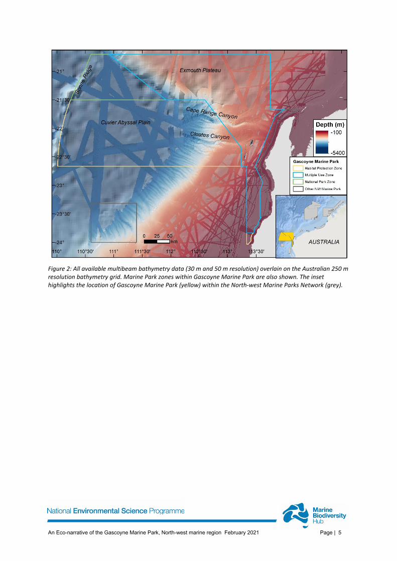
Several marine surveys have undertaken multibeam bathymetry mapping within Gascoyne Marine Park, with the 2009 survey of the southwest margin by Geoscience Australia providing the most complete coverage (Daniell et al., 2010). These data have been incorporated within a 50 m resolution bathymetry grid (Parums and Spinoccia, 2019). In addition, a 2020 survey on the RV Falkor (FK200308) re-mapped the Cape Range and Cloates Canyons at 30 m resolution and extended multibeam coverage on the adjacent continental slope (Post et al., 2020). Multibeam mapping is now quite comprehensive over the continental slope but is relatively sparse over deeper water areas of the Cuvier Abyssal Plain, Exmouth Plateau and the shallower waters on the continental shelf (Figure 2).
An Eco-narrative of the Gascoyne Marine Park, North-west marine region February 2021 Page | 5
Figure 2: All available multibeam bathymetry data (30 m and 50 m resolution) overlain on the Australian 250 m resolution bathymetry grid. Marine Park zones within Gascoyne Marine Park are also shown. The inset highlights the location of Gascoyne Marine Park (yellow) within the North-west Marine Parks Network (grey).
An Eco-narrative of the Gascoyne Marine Park, North-west marine region February 2021 Page | 6
3. Oceanography Waters offshore of north-west Australia are dominated by the northward flowing Western Australian Current (WAC) and the southward flowing Leeuwin Current (Wells and Wells, 1994). The WAC flows at depths of 300 – 2000 m (Tchernia, 1980) and is a cold, high salinity and nutrient-rich current (Spooner et al., 2011) formed from Antarctic Intermediate waters. The Leeuwin Current is a warm, nutrient-poor surface current, which in this region influences the nearshore area, forming a narrow strip (~50 km wide) centred over the shelf break (at ~200 m depth) (Brewer et al., 2007). Localised upwelling of nutrient-rich waters at the heads of large canyons and at the shelf break produces patches of high productivity within the euphotic zone (< 200 m water depth). Offshore winds associated with the south-west monsoon can also create localised upwelling of nutrient-rich waters in the region (Lyne et al., 2005).
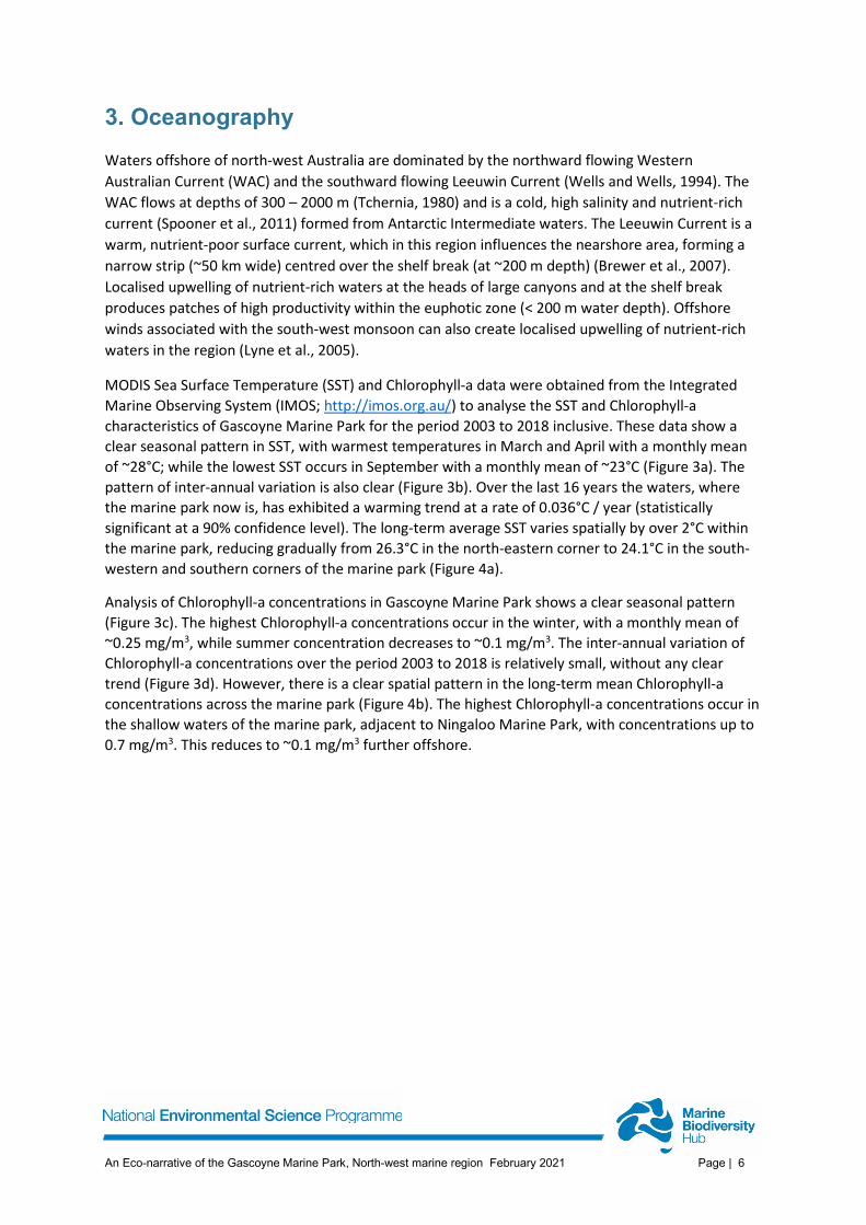
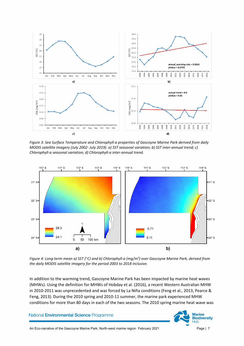
MODIS Sea Surface Temperature (SST) and Chlorophyll-a data were obtained from the Integrated Marine Observing System (IMOS; http://imos.org.au/) to analyse the SST and Chlorophyll-a characteristics of Gascoyne Marine Park for the period 2003 to 2018 inclusive. These data show a clear seasonal pattern in SST, with warmest temperatures in March and April with a monthly mean of ~28°C; while the lowest SST occurs in September with a monthly mean of ~23°C (Figure 3a). The pattern of inter-annual variation is also clear (Figure 3b). Over the last 16 years the waters, where the marine park now is, has exhibited a warming trend at a rate of 0.036°C / year (statistically significant at a 90% confidence level). The long-term average SST varies spatially by over 2°C within the marine park, reducing gradually from 26.3°C in the north-eastern corner to 24.1°C in the south-western and southern corners of the marine park (Figure 4a).
Analysis of Chlorophyll-a concentrations in Gascoyne Marine Park shows a clear seasonal pattern (Figure 3c). The highest Chlorophyll-a concentrations occur in the winter, with a monthly mean of ~0.25 mg/m3, while summer concentration decreases to ~0.1 mg/m3. The inter-annual variation of Chlorophyll-a concentrations over the period 2003 to 2018 is relatively small, without any clear trend (Figure 3d). However, there is a clear spatial pattern in the long-term mean Chlorophyll-a concentrations across the marine park (Figure 4b). The highest Chlorophyll-a concentrations occur in the shallow waters of the marine park, adjacent to Ningaloo Marine Park, with concentrations up to 0.7 mg/m3. This reduces to ~0.1 mg/m3 further offshore.
An Eco-narrative of the Gascoyne Marine Park, North-west marine region February 2021 Page | 7
Figure 3: Sea Surface Temperature and Chlorophyll-a properties of Gascoyne Marine Park derived from daily MODIS satellite imagery (July 2002- July 2019). a) SST seasonal variation; b) SST inter-annual trend; c) Chlorophyll-a seasonal variation; d) Chlorophyll-a inter-annual trend.
Figure 4: Long-term mean a) SST (°C) and b) Chlorophyll-a (mg/m3) over Gascoyne Marine Park, derived from the daily MODIS satellite imagery for the period 2003 to 2018 inclusive.
In addition to the warming trend, Gascoyne Marine Park has been impacted by marine heat waves (MHWs). Using the definition for MHWs of Hobday et al. (2016), a recent Western Australian MHW in 2010-2011 was unprecedented and was forced by La Niña conditions (Feng et al., 2013, Pearce & Feng, 2013). During the 2010 spring and 2010-11 summer, the marine park experienced MHW conditions for more than 80 days in each of the two seasons. The 2010 spring marine heat wave was
An Eco-narrative of the Gascoyne Marine Park, North-west marine region February 2021 Page | 8
spatially extensive, affecting 90% of the marine park over several days , with an intensity >1.5°C day-
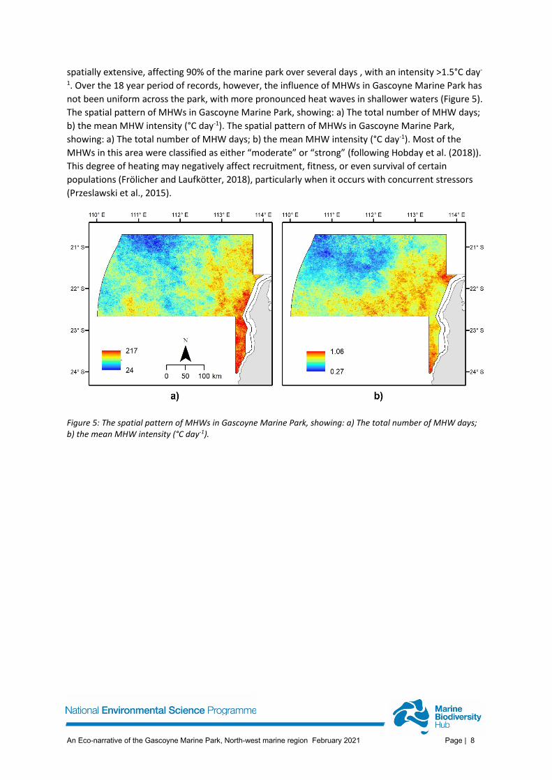
1. Over the 18 year period of records, however, the influence of MHWs in Gascoyne Marine Park has not been uniform across the park, with more pronounced heat waves in shallower waters (Figure 5). The spatial pattern of MHWs in Gascoyne Marine Park, showing: a) The total number of MHW days; b) the mean MHW intensity (°C day-1). The spatial pattern of MHWs in Gascoyne Marine Park, showing: a) The total number of MHW days; b) the mean MHW intensity (°C day-1). Most of the MHWs in this area were classified as either “moderate” or “strong” (following Hobday et al. (2018)). This degree of heating may negatively affect recruitment, fitness, or even survival of certain populations (Frölicher and Laufkötter, 2018), particularly when it occurs with concurrent stressors (Przeslawski et al., 2015).
Figure 5: The spatial pattern of MHWs in Gascoyne Marine Park, showing: a) The total number of MHW days; b) the mean MHW intensity (°C day-1).
An Eco-narrative of the Gascoyne Marine Park, North-west marine region February 2021 Page | 9
4. Morphology and potential habitats Gascoyne Marine Park includes continental shelf to abyssal environments, the extensive Exmouth Plateau and canyons and gullies on the continental slope (Figure 2). The broad seabed morphology of the park is classified here into three categories based on local gradient; Plane (0 – 2°), Slope (2 – 10°) and Escarpment (>10°, Figure 6). This shows that the marine park consists mostly of relatively flat seabed, with almost 70% of the area classified as Plane and located at abyssal depths (Cuvier Plain) (Table 1). Almost 30% of the park is classified as Slope, and associated with the continental slope, while only 3% is steeper than 10° and classified as Escarpment. The upper continental slope is relatively smooth, with some areas of narrow/shallow gullies in the north-eastern areas nominated as KEFs for Demersal Fish Communities. The upper continental slope tends to be steeper (>2°) than the mid slope (<2°; Figure 6a and b). The lower slope is steeper than the mid-slope (>2°; Figure 6). Areas of escarpment form the walls and heads of canyons and larger gullies and also occur along the eastern edge of the Sonne Ridge and parts of the southern slope of the Exmouth Plateau.
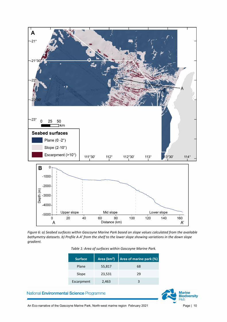
An Eco-narrative of the Gascoyne Marine Park, North-west marine region February 2021 Page | 10
Figure 6: a) Seabed surfaces within Gascoyne Marine Park based on slope values calculated from the available bathymetry datasets. b) Profile A-A’ from the shelf to the lower slope showing variations in the down slope gradient.
Table 1: Area of surfaces within Gascoyne Marine Park.
Surface Area (km2) Area of marine park (%)
Plane 55,817 68
Slope 23,531 29
Escarpment 2,463 3
An Eco-narrative of the Gascoyne Marine Park, North-west marine region February 2021 Page | 11
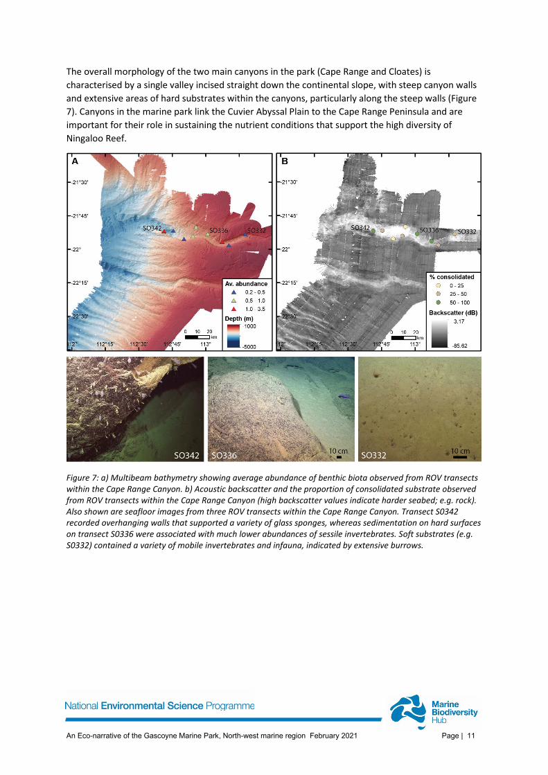
The overall morphology of the two main canyons in the park (Cape Range and Cloates) is characterised by a single valley incised straight down the continental slope, with steep canyon walls and extensive areas of hard substrates within the canyons, particularly along the steep walls (Figure 7). Canyons in the marine park link the Cuvier Abyssal Plain to the Cape Range Peninsula and are important for their role in sustaining the nutrient conditions that support the high diversity of Ningaloo Reef.
Figure 7: a) Multibeam bathymetry showing average abundance of benthic biota observed from ROV transects within the Cape Range Canyon. b) Acoustic backscatter and the proportion of consolidated substrate observed from ROV transects within the Cape Range Canyon (high backscatter values indicate harder seabed; e.g. rock). Also shown are seafloor images from three ROV transects within the Cape Range Canyon. Transect S0342 recorded overhanging walls that supported a variety of glass sponges, whereas sedimentation on hard surfaces on transect S0336 were associated with much lower abundances of sessile invertebrates. Soft substrates (e.g. S0332) contained a variety of mobile invertebrates and infauna, indicated by extensive burrows.
An Eco-narrative of the Gascoyne Marine Park, North-west marine region February 2021 Page | 12
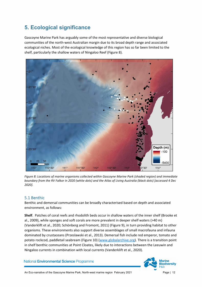
5. Ecological significance Gascoyne Marine Park has arguably some of the most representative and diverse biological communities of the north-west Australian margin due to its broad depth range and associated ecological niches. Most of the ecological knowledge of this region has so far been limited to the shelf, particularly the shallow waters of Ningaloo Reef (Figure 8).
Figure 8: Locations of marine organisms collected within Gascoyne Marine Park (shaded region) and immediate boundary from the RV Falkor in 2020 (white dots) and the Atlas of Living Australia (black dots) [accessed 4 Dec 2020].
5.1 Benthic Benthic and demersal communities can be broadly characterised based on depth and associated environment, as follows:
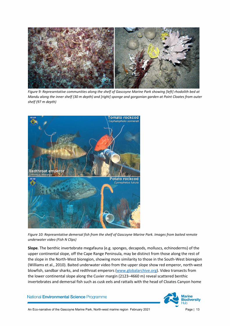
Shelf. Patches of coral reefs and rhodolith beds occur in shallow waters of the inner shelf (Brooke et al., 2009), while sponges and soft corals are more prevalent in deeper shelf waters (>40 m) (Vanderklift et al., 2020; Schönberg and Fromont, 2011) (Figure 9), in turn providing habitat to other organisms. These environments also support diverse assemblages of small macrofauna and infauna dominated by crustaceans (Przeslawski et al., 2013). Demersal fish include red emperor, tomato and potato rockcod, paddletail seabream (Figure 10) (www.globalarchive.org). There is a transition point in shelf benthic communities at Point Cloates, likely due to interactions between the Leeuwin and Ningaloo currents in combination with local currents (Vanderklift et al., 2020).
An Eco-narrative of the Gascoyne Marine Park, North-west marine region February 2021 Page | 13
Figure 9: Representative communities along the shelf of Gascoyne Marine Park showing [left] rhodolith bed at Mandu along the inner shelf (30 m depth) and [right] sponge and gorgonian garden at Point Cloates from outer shelf (97 m depth)
Figure 10: Representative demersal fish from the shelf of Gascoyne Marine Park. Images from baited remote underwater video (Fish N Clips)
Slope. The benthic invertebrate megafauna (e.g. sponges, decapods, molluscs, echinoderms) of the upper continental slope, off the Cape Range Peninsula, may be distinct from those along the rest of the slope in the North-West bioregion, showing more similarity to those in the South-West bioregion (Williams et al., 2010). Baited underwater video from the upper slope show red emperor, north-west blowfish, sandbar sharks, and redthroat emperors (www.globalarchive.org). Video transects from the lower continental slope along the Cuvier margin (2123–4660 m) reveal scattered benthic invertebrates and demersal fish such as cusk eels and rattails with the head of Cloates Canyon home
An Eco-narrative of the Gascoyne Marine Park, North-west marine region February 2021 Page | 14
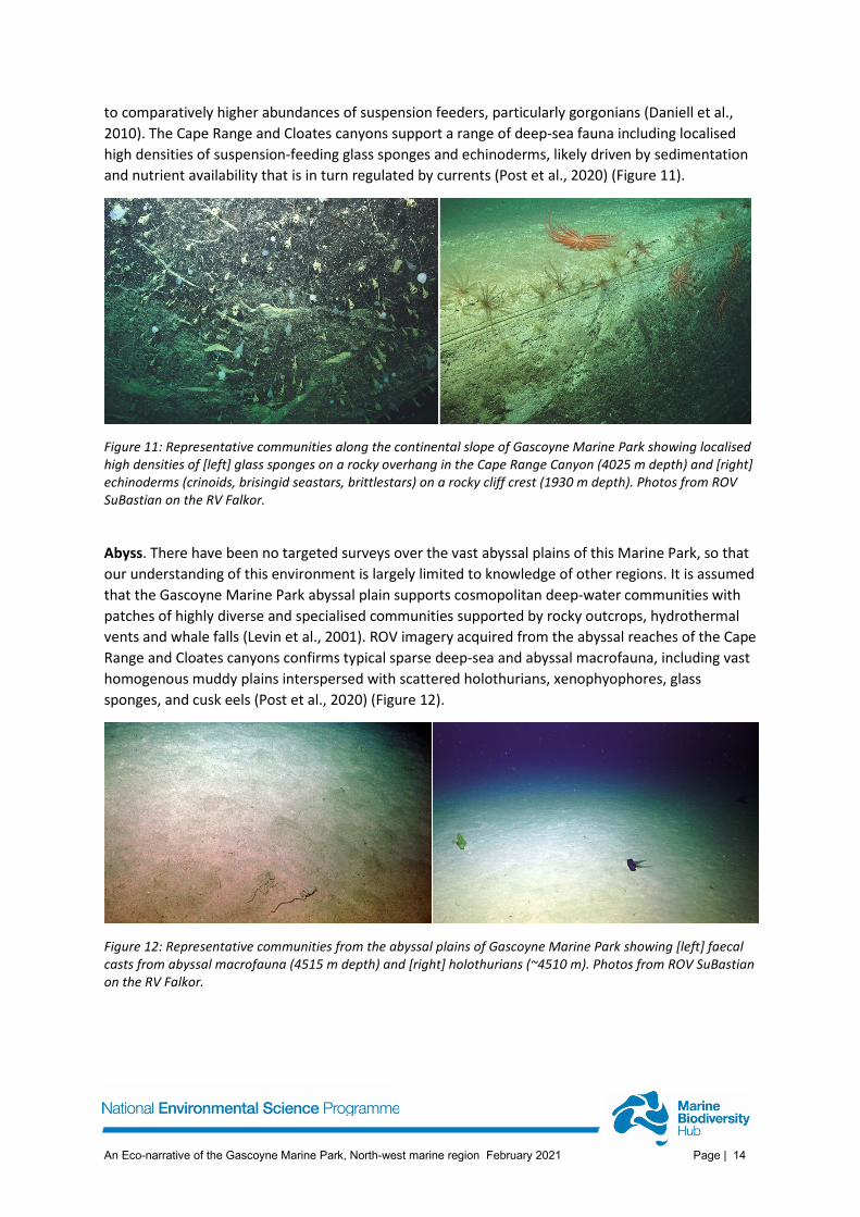
to comparatively higher abundances of suspension feeders, particularly gorgonians (Daniell et al., 2010). The Cape Range and Cloates canyons support a range of deep-sea fauna including localised high densities of suspension-feeding glass sponges and echinoderms, likely driven by sedimentation and nutrient availability that is in turn regulated by currents (Post et al., 2020) (Figure 11).
Figure 11: Representative communities along the continental slope of Gascoyne Marine Park showing localised high densities of [left] glass sponges on a rocky overhang in the Cape Range Canyon (4025 m depth) and [right] echinoderms (crinoids, brisingid seastars, brittlestars) on a rocky cliff crest (1930 m depth). Photos from ROV SuBastian on the RV Falkor.
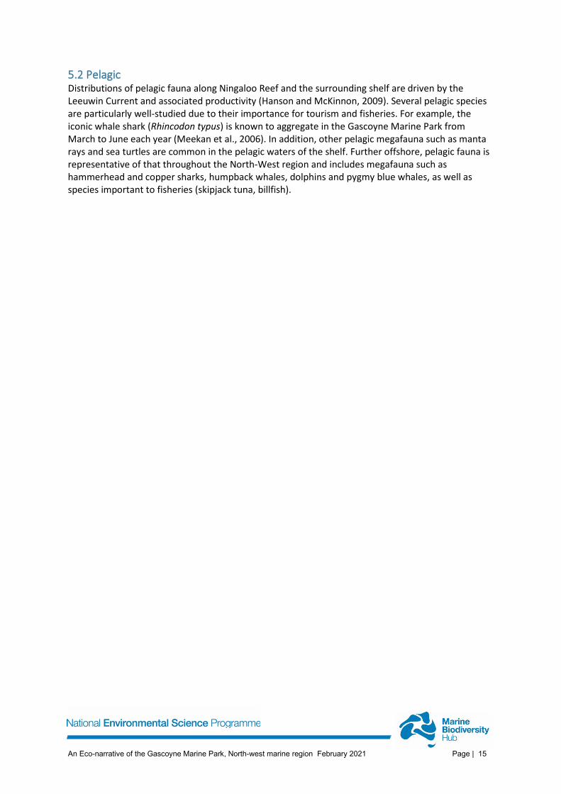
Abyss. There have been no targeted surveys over the vast abyssal plains of this Marine Park, so that our understanding of this environment is largely limited to knowledge of other regions. It is assumed that the Gascoyne Marine Park abyssal plain supports cosmopolitan deep-water communities with patches of highly diverse and specialised communities supported by rocky outcrops, hydrothermal vents and whale falls (Levin et al., 2001). ROV imagery acquired from the abyssal reaches of the Cape Range and Cloates canyons confirms typical sparse deep-sea and abyssal macrofauna, including vast homogenous muddy plains interspersed with scattered holothurians, xenophyophores, glass sponges, and cusk eels (Post et al., 2020) (Figure 12).
Figure 12: Representative communities from the abyssal plains of Gascoyne Marine Park showing [left] faecal casts from abyssal macrofauna (4515 m depth) and [right] holothurians (~4510 m). Photos from ROV SuBastian on the RV Falkor.
An Eco-narrative of the Gascoyne Marine Park, North-west marine region February 2021 Page | 15
5.2 Pelagic Distributions of pelagic fauna along Ningaloo Reef and the surrounding shelf are driven by the Leeuwin Current and associated productivity (Hanson and McKinnon, 2009). Several pelagic species are particularly well-studied due to their importance for tourism and fisheries. For example, the iconic whale shark (Rhincodon typus) is known to aggregate in the Gascoyne Marine Park from March to June each year (Meekan et al., 2006). In addition, other pelagic megafauna such as manta rays and sea turtles are common in the pelagic waters of the shelf. Further offshore, pelagic fauna is representative of that throughout the North-West region and includes megafauna such as hammerhead and copper sharks, humpback whales, dolphins and pygmy blue whales, as well as species important to fisheries (skipjack tuna, billfish).
An Eco-narrative of the Gascoyne Marine Park, North-west marine region February 2021 Page | 16
REFERENCES Ali, J.R., Aitchison, J.C., 2005. Greater India. Earth-Science Reviews, 72, 169-188. Brewer, D.T., Lyne, V., Skewes, T., Rothlisberg, P., Last, P., Ward, B., Meekan, M., Smith, L., &
Steinberg, C., 2007. Trophic systems of the North-west Marine Region. Department of the Environment, Water Heritage and the Arts, CSIRO Marine and Atmospheric Research, Cleveland.
Brooke, B., Nichol, S., Hughes, M., McArthur, M., Anderson, T., Przeslawski, R., Siwabessy, J., Heyward, A., Battershill, C., Colquhoun, J., & Doherty, P., 2009. Carnarvon Shelf Survey Post-cruise Report. Record 2009/02. Geoscience Australia, Canberra.
Daniell, J., Jorgensen, D.C., Anderson, T., Borissova, I., Burq, S., Heap, A.D., Hughes, M., Mantle, D., Nelson, G., Nichol, S., Nicholson, C., Payne, D., Przeslawski, R., Radke, L., Siwabessy, J., Smith, C., & Shipboard Party, 2010. Frontier Basins of the West Australian Continental Margin: Post-survey Report of Marine Reconnaissance and Geological Sampling Survey GA2476. Record 2009/38. Geoscience Australia, Canberra.
Exon, N., Haq, B., & Von Rad, U., 1992. Exmouth plateau revisited: Scientific drilling and geological framework. In: U. VonRad, B. U. Haq, R. B. Kidd, & S. B. O’Connell (eds.), Proceedings of the Ocean Drilling Program, Scientific Results, 122, 3–20. College Station, TX.
Feng, M., McPhaden, M.J., Xie, S., & Hafner, J., 2013. La Ninã forces unprecedented Leeuwin Current warming in 2011. Scientific Reports, 3, srep01277
Frölicher, T.L., Laufötter, C., 2018. Emerging risks from marine heat waves. Nature Communications, 9, 650.
Geoscience Australia, 2017. AusSeabed Marine Data Portal, Accessed 30 June 2020, https://portal.ga.gov.au/persona/marine
Hanson, C.E., McKinnon, A.D., 2009. Pelagic ecology of the Ningaloo region, Western Australia: influence of the Leeuwin Current. Journal of the Royal Society of Western Australia, 92, 129-137.
Hobday, A.J., Alexander, L.V., Perkins, S.E., Smale, D.A., Straub, S.C., Oliver, E.C.J., Benthuysen, J., Burrows, M.T., Donat, M.G., Feng, M., Holbrook, N.J., Moore, P.J., Scannell, H.A., Gupta, A.S., & Wernberg, T., 2016. A hierarchical approach to defining marine heatwaves. Progress in Oceanography, 141, 227-238
Hobday, A.J., Oliver, E.C.J., Sen Gupta, A., Benthuysen, J., Burrows, M.T., Donat, M.G., Holbrook, N.J., Moore, P.J., Thomsen, M.S., Wernberg, T., & Smale, D.A., 2018. Categorizing and naming marine heatwaves. Oceanography, 31, 162-173
Levin, L.A., Etter, R.J., Rex, M.A., Gooday, A.J., Smith, C.R., Pineda, J., Stuart, C.T., Hessler, R.R., & Pawson, D., 2001. Environmental influences on regional deep-sea species diversity. Annual Review of Ecology and Systematics, 32, 51-93.
Meekan, M.G., Bradshaw, C.J., Press, M., McLean, C., Richards, A., Quasnichka, S. & Taylor, J.G., 2006. Population size and structure of whale sharks Rhincodon typus at Ningaloo Reef, Western Australia. Marine Ecology Progress Series, 319, 275–285.
Parums, R., Spinoccia, M. 2019. 50m Multibeam Dataset of Australia 2018. Geoscience Australia, Canberra. http://dx.doi.org/10.26186/5c63832e3ed8e
Pearce, A., Feng, M., 2013. The rise and fall of the “marine heat wave” off Western Australia during the summer of 2010/2011. Journal of Marine Systems, 111-112, 139-156
Post, A. L., Przeslawski, R., Huang, Z., Smith, D., Kirkendale, L. A., & Wilson, N. G., 2020. Gascoyne Marine Park post-survey report, RV Falkor, FK200308 (GA4859). Record 2020/030. Geoscience Australia, Canberra.
An Eco-narrative of the Gascoyne Marine Park, North-west marine region February 2021 Page | 17
Przeslawski, R., McArthur, M.A., & Anderson, T.J., 2013. Infaunal biodiversity patterns from Carnarvon Shelf (Ningaloo Reef), Western Australia. Marine and Freshwater Research, 64, 573-583
Przeslawski, R., Byrne, M., & Mellin, C., 2015. A review and meta-analysis of the effects of multiple abiotic stressors on marine embryos and larvae. Global Change Biology, 6, 2122-2140.
Sayers, J., Borissova, I., Ramsay, D., & Symonds, P.A., 2002. Geological framework of the Cuvier Plateau and adjacent areas. Record 2002/21, Geoscience Australia, Canberra.
Schönberg, C.H.L., Fromont, J., 2011. Sponge gardens of Ningaloo Reef (Carnarvon Shelf, Western Australia) are biodiversity hotspots. Hydrobiologia, 687, 143-161
Sleeman, J.C., Meekan, M.G., Wilson, S.G., Jenner, C.K., Jenner, M.N., Boggs, G.S., Steinberg, C.C. & Bradshaw, C.J., 2007. Biophysical correlates of relative abundances of marine megafauna at Ningaloo Reef, Western Australia. Marine and Freshwater Research, 58(7), 608-623.
Symonds, P.A., Planke, S., Frey, O., & Skogseid, J., 1998. Volcanic evolution of the Western Australian continental margin and its implications for basin development. In: Purcell, P.G. & Purcell, R.R. (eds.), The Sedimentary Basins of Western Australia, Volume 2, p.33-54. Petroleum Exploration Society of Australia, Perth, Western Australia.
Tchernia, P., 1980. Descriptive regional oceanography. New York, Pergamon Press. Vanderklift, M.A., Babcock, R.C., Barnes, P.B., Cresswell, A.K., Feng, M., Holmes, T.H., Lavery, P.S.,
Pillans, R.D., Smallwood, C.B., Thomson, D.P., Tucker, A.D., Waples, K., & Wilson, S.K., 2020. The Oceanography and marine ecology of Ningaloo, a World Heritage Area. Oceanography and Marine Biology : An Annual Review, 58, 143-178
Williams, A., Althaus, F., Dunstan, P.K., Poore, G.C.B., Bax, N.J., Kloser, R.J., & McEnulty, F.R. 2010. Scales of habitat heterogeneity and megabenthos biodiversity on an extensive Australian continental margin (100-1100 m depths). Marine Ecology, 31, 222-236
www.nespmarine.edu.au
Contact: Name Rachel Przeslawski
Organisation Geoscience Australia
Address | GPO Box 378 |Canberra ACT 2601 email | [email protected]
tel | +61 2 6249 9101