Embed Size (px)
Citation preview
1
An Ecohydraulic Approach to the Modernization of Farmer Managed Irrigation Systems in Nepal B. Adhikari*, R. Verhoeven and P. Troch Department of Civil Engineering, Hydraulics Laboratory, Ghent University, Belgium. * Corresponding author, email: [email protected] Glossary of local terms used in this paper kulo canal kula pani choudhari The head of the farmers irrigation block
Abstract
This paper focuses on the optimization and expansion of farmer managed irrigation systems (FMIS) in
Nepal. The three systems under concern namely the Majhara kulo, the Budhan kulo and the Raj kulo, situated
at the left bank of the Babai river were constructed in the 1940s by the local community, using their
indigenous knowledge. Actually the 5400 hectares (ha) area covered by these FMISs forms the head reach of
the Babai Irrigation Project (BIP) which is aimed at providing irrigation water to an additional 8100 ha area
after the construction of a new headwork and a 28 km long main canal in 2000. The annual volume of water
to be claimed as “priority right” of the FMIS area is 86 million m3, whereas the total available water volume
is 682 million m3.
In this paper it is shown that by replacing the old, leaking diversion constructions by new diversion weirs and
control gates, a much better water distribution can be achieved during the low flow periods, while in periods
of flood the newly designed irrigation system is able to continue acting as a flood management and
protection system.
It is demonstrated that the approach of the FMIS modernization, besides being technically viable, is user as
well as environment friendly due to its capacity to preserve the existing water management tradition of the
farmers while at the same time, offering the opportunity to substantially extend the total irrigated area.
1 Introduction
Irrigation is vitally important in meeting the food and fibre needs for a rapidly expanding world population
that reached six billion in 1999 and is expected to reach about 8.10 billion by 2030. The growing population
will result in a considerable additional demand for food. Simultaneously, the water demand for the non
agricultural sectors will keep growing in both developed and developing countries. To meet the food
requirements of the growing population with growing water demand for the non agriculture sector there is a
need to achieve a significant increase in water productivity. In the Nepal’s context this challenge is expressed
in terms of increasing the year round water supply from 41% to 90% of the total irrigated area in the period
between 2002 and 2027 by means of enhancing the water use efficiency, ground water utilization and
making storage arrangements (Water Resource Strategy, 2002 & Irrigation Policy, 2003).
In Nepal thousands of farmer managed irrigation systems (FMIS) have been developed and exploited by the
local community over the centuries. It is estimated that there are about 15000 FMIS in the hills and nearly
832
2
1700 FMIS in the Terai (southern plain) of Nepal. More than 40 percent of the country’s present food
production is delivered by the FMIS which serve almost 70 percent of the irrigated area. Various studies
have shown that FMIS generally achieve a higher level of performance than the agency managed irrigation
systems (AMIS) with regard to the physical condition of the system, the water delivery effectiveness and the
agricultural productivity (Lam Y.F., 1996). The farmers do a much better job of governing and organizing
their own systems than government officials do on their systems (Ostrom E., 2002). The FMIS are the
symbols of democratic values in Nepal. The community owing the system manages the resources on their
own. They evolve the rules and regulations on their own and implement them with consensus within the
community (Pradhan P., 2000). The diversion and other structures in the FMIS made by the farmers using
local materials are normally of a temporary or semi permanent type with significant leakage occurring
through these structures. That is why the farmers in the FMIS are bound to run their canals with a much
higher discharge than actually required for crop growth. The proper rehabilitation and modernization of the
FMIS can be considered as one of the pertinent ways to increase the water productivity and subsequent
expansion of the irrigated area.
The goals of the rehabilitation project, discussed in this paper are to extend existing 5400 ha irrigation area
with an additional 8100 ha while preserving the “priority water right” of the farmers exploiting the 5400 ha
area. This will be realised by limiting the irrigation discharges during the low flow periods, by solving the
actual leakage problems. At the same time the damage to the ecosystem, caused by erosion will be resolved
by lowering the bottom slopes of the actual main irrigation channels. The quantity of water claimed by the
farmers of the FMIS area as their priority right is 86 million m3. In this paper we have carried out the
analysis of a cascade arrangement of concrete weirs and the change in bed slope after the rehabilitation of the
kulos. The US Army Corps of Engineers’ river analysis system HEC-RAS has been used to simulate the
performance of the kulos during high and low flow conditions before and after the rehabilitation of the
system in order to determine an optimum user friendly structural arrangement of the permanent diversions.
2 The study area and unsolved problems
The study area is the FMIS part of the Babai Irrigation Project (BIP) in the Bardiya district of Nepal, which
is located between 81°17’ and 81°27’ E longitude and 28°17’ and 28°25’ N Latitude. The East West
Highway running almost parallel to the eastern main canal forms the northern boundary and the Babai river
forms the southern and the western boundaries of the study area. The Vada river is located at the eastern
boarder of the study area. The Babai river is the source river having a catchment area of 3270 km2 and a high
flood discharge of 7500 cubic meter per second (m3/s). There are three FMIS in the study area, all located at
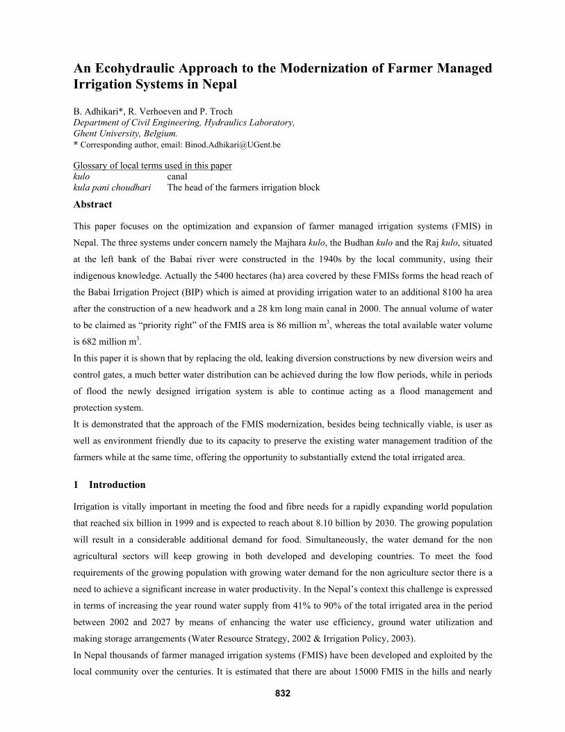
the left bank of the Babai river namely the Majhara kulo, the Budhan kulo and the Raj kulo. Figure 1 shows
the map of the study area with the headworks, the East West Highway, the main canal and the farmers’ kulos
with the names of the diversions.
833
3
Figure 1: The map of the study area showing the headwork, the main canal, the FMIS kulos with diversions.
In 1992 the government constructed a weir cum bridge across the Babai river and the first 5 km of the east
main canal as shown in Figure 1. As the bridge on the weir is a part of a national highway, the location of the
bridge forced the designers to construct 5 km of the main canal to supply the Raj kulo and the Budhan kulo.
In the period between 1995 and 2000 the BIP extended the east main canal from 5 km to 28 km bringing
8100 ha of dry area under irrigation. The government intervention and subsequent expansion of the irrigation
area raised several questions among the farmers of the FMIS regarding their priority water right and
modality of rehabilitation of their kulos. These questions are vitally important and need to be properly
addressed in order to enhance the irrigation efficiency and to achieve better water management in the FMIS
area as well as to guarantee sufficient supply of water to the extension area.
834
4
The BIP had designed a new canal system in 1982 for the whole eastern area including the FMIS part.
However, the farmers of the FMIS area rejected the construction of new canals through fields which were
already irrigated from another canal network. The rehabilitation of the existing kulos basically by replacing
temporary diversions through concrete weirs was the farmers’ main demand. In the nearby Rajapur area, the
largest FMIS in Nepal, the farmers had rejected the design of diversions making more use of semi permanent
gabion structures (Howarth S.E. et. al, 2002.) and the engineers were bound to change the design from crated
boulder to concrete diversions. The farmers of the FMIS area being aware of the history of the Rajapur area,
found that only permanent diversions were the appropriate solution to their problems.
The main concern of the farmers of the FMIS was to establish the “priority water right” of the existing FMIS
before making any water sharing arrangement with the extension area. However, due to the absence of
agreement on the modality of irrigation development at the FMIS part the BIP intensified the construction of
branch canals in the new area since 2002. Many branch and secondary canals at the new area were completed
by 2006 resulting into an increased water demand. The demand for water of both areas needs to be resolved
properly in order to avoid the possible water use conflicts between the FMIS and the extension parts.
3 Field study and data collection A field study was conducted by the first author in November, 2006. Participatory approaches were used to
identify the irrigation related problems of the farmers, which included focus group discussions with the
farmers of different kulos. Site visits accompanied by the head of the farmers’ institution called kula pani
choudhari were conducted along all three FMIS kulos during which the condition of existing temporary
diversion structures, flood dispersion patterns and the existing leakages through the diversion structures were
carefully observed. It was observed that the indigenous strategy of the local farmers in keeping completely
open all the outlets to field channels during the rainy season is very effective in dispersing flood flows from
the kulos. During the dry season the same kulo network is used for providing irrigation water to the fields.
The farmers wanted to preserve their indigenous knowledge and the tradition of dual function of their kulo
network.
The Environmental Impact Assessment study of the command area development works of the BIP conducted
in 2004 had the requirement of presenting the project development plan to public hearing in order to get the
farmers’ consent on the plan. The cascade arrangement of permanent concrete diversions capable of
preserving the flood dispersion tradition of the farmers and supplying water to the field channels effectively
without leakage during low flows was accepted as a suitable solution to FMIS kulo rehabilitation by both the
farmers and the BIP. The BIP provided the detailed longitudinal and cross section survey data of the Majhara
kulo, the Budhan kulo and the Raj kulo and other designs and drawings prepared so far for this study. Several
discussions were held with Water Users’ Association WUA representatives and BIP officials regarding the
FMIS rehabilitation and the increase of water use efficiency at the FMIS area. Previous study reports of the
BIP and meteorological data were collected from the BIP, the Department of Irrigation and the Department
of Hydrology and Meteorology.
835
5
4 Analyses and Results
4.1 Existing cropping pattern and its water requirement
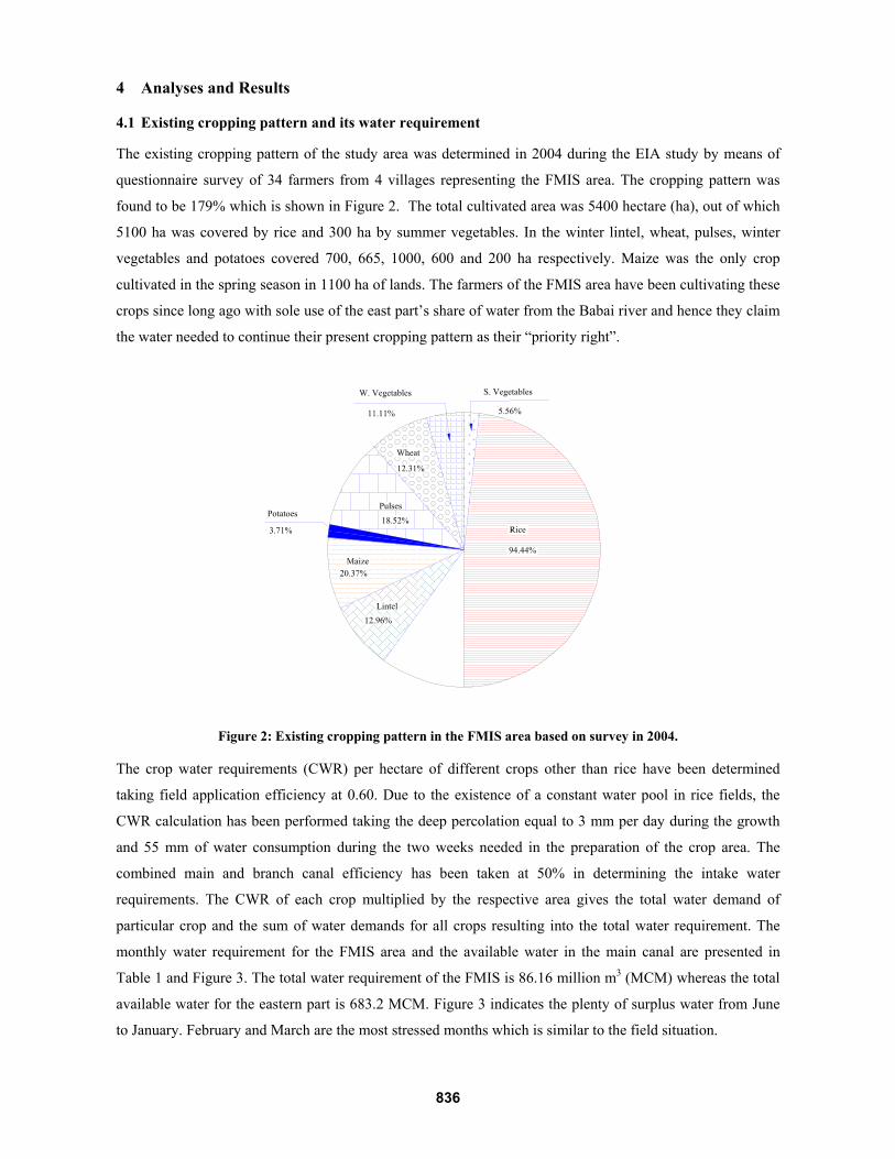
The existing cropping pattern of the study area was determined in 2004 during the EIA study by means of
questionnaire survey of 34 farmers from 4 villages representing the FMIS area. The cropping pattern was
found to be 179% which is shown in Figure 2. The total cultivated area was 5400 hectare (ha), out of which
5100 ha was covered by rice and 300 ha by summer vegetables. In the winter lintel, wheat, pulses, winter
vegetables and potatoes covered 700, 665, 1000, 600 and 200 ha respectively. Maize was the only crop
cultivated in the spring season in 1100 ha of lands. The farmers of the FMIS area have been cultivating these
crops since long ago with sole use of the east part’s share of water from the Babai river and hence they claim
the water needed to continue their present cropping pattern as their “priority right”.
Figure 2: Existing cropping pattern in the FMIS area based on survey in 2004.
The crop water requirements (CWR) per hectare of different crops other than rice have been determined
taking field application efficiency at 0.60. Due to the existence of a constant water pool in rice fields, the
CWR calculation has been performed taking the deep percolation equal to 3 mm per day during the growth
and 55 mm of water consumption during the two weeks needed in the preparation of the crop area. The
combined main and branch canal efficiency has been taken at 50% in determining the intake water
requirements. The CWR of each crop multiplied by the respective area gives the total water demand of
particular crop and the sum of water demands for all crops resulting into the total water requirement. The
monthly water requirement for the FMIS area and the available water in the main canal are presented in
Table 1 and Figure 3. The total water requirement of the FMIS is 86.16 million m3 (MCM) whereas the total
available water for the eastern part is 683.2 MCM. Figure 3 indicates the plenty of surplus water from June
to January. February and March are the most stressed months which is similar to the field situation.
836
6
Table 1: Water availability and requirement of the FMIS area, MCM
Months Jan Feb Mar Apr May Jun Jul Aug Sep Oct Nov Dec TotalAvailable 18.4 15.4 10.2 9.4 12.0 35.8 109.1 189.0 166.4 61.4 32.8 23.8 683.2 Required 5.11 9.84 10.41 2.64 3.63 1.27 21.15 5.29 9.33 15.09 0.16 2.24 86.16
0.020.040.060.080.0
100.0120.0140.0160.0180.0200.0
May Jun Jul Aug Sep Oct Nov Dec Jan Feb Mar AprMonths
Wat
er V
olum
e, M
CM
Available Water FMIS Requirement
Figure 3: Monthly water supply and demand scenario at the FMIS area.
4.2 Arrangement of fixed constructions
The cascades of concrete weirs as a replacement of the temporary diversions in the FMIS kulos have been
planned based on the longitudinal and cross section survey data of all kulos provided by the BIP. The
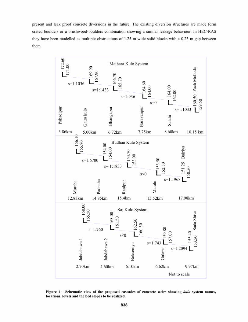
cascade arrangement of diversions showing the name of each diversion, distance from the main canal in km,
the drop height and the channel bed slope to be realized after the rehabilitation are presented in Figure 4. One
of the important aspects to be considered is the change in bed slope before and after construction of the
permanent diversions. In the Majhara kulo the steepest bed slope after the rehabilitation will be 0.00107 m/m
(1:936) at the section between Bhangapur and Narayanpur, where the present average bed slope is 0.00236
m/m (1:423). In the Budhan kulo the future steepest bed slope will be 0.0012 m/m (1:833) in the sector
between Padnaha and Ranipur instead of the present bed slope of 0.00175 m/m (1:570). Similarly in the Raj
kulo the section between Bokseniya and Gulara will get a steepest slope of 0.00135 m/m (1:743) replacing
the 0.00333 m/m (1:300) present situation. All these facts show that, after the rehabilitation, in addition to
solving the leakage problems, the stability of the channel bed will also be enhanced, by this contributing to
solving the erosion problem and to the overall ecological stability of the environment.
4.3 Simulations using HEC-RAS
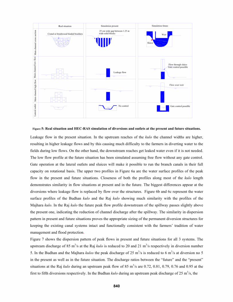
4.3.1 Approaches and assumptions The US Army Corps of Engineers’ river analysis system HEC-RAS, a computer programme that allows
performing one-dimensional steady and unsteady flow river hydraulic calculations, has been used for the
steady flow simulations of all three FMIS kulos. The present and future water level characteristics of the
kulos at different discharges have been studied through simulations of channels having leaky diversions at
837
7
present and leak proof concrete diversions in the future. The existing diversion structures are made form
crated boulders or a brushwood-boulders combination showing a similar leakage behaviour. In HEC-RAS
they have been modelled as multiple obstructions of 1.25 m wide solid blocks with a 0.25 m gap between
them.
Figure 4: Schematic view of the proposed cascades of concrete weirs showing kulo system names, locations, levels and the bed slopes to be realized.
838
8
The top level of the obstruction has been set equal to that of the existing temporary diversion at each site as
determined from the field survey. The lateral outlets have been modelled as free flow lateral weirs while the
split flow optimization command of HEC-RAS has been used to assess the flow distribution between the
lateral outlet and the kulo. The crest levels of weirs, scouring sluices and lateral outlets in the future situation
have been worked out from the discussion with the farmers in order to fit the operation of the new structures
to the farmers’ demands. Based on these levels the design will be optimized using multi-criteria analysis.
Figure 5 shows how the present situation and the future proposed situations of the diversion weirs have been
simulated in HEC-RAS. The farmers will continue their tradition of high flow dispersion during the rainy
season and providing the year round irrigation by their kulo network due to the long established social
settings. Hence the main focus of the simulation is to find the structural arrangement giving similarity in
flow dispersions at the present and future situations at all the diversion points, but while saving substantial
amount of water in the dry season.
The peak discharges in the Budhan kulo and the Raj kulo are governed by the runoff from their catchments.
The Majhara kulo is vulnerable to floods in the Babai river since it still draws water from its original intake
at the Babai river, in addition to the regulated flow from the main canal. The Budhan kulo carries run off
from the Budhi river and the Raj kulo carries the run off from the Theni and the Fradangwa rivers. The peak
flows in these rivers have been estimated applying the in Nepal widely used Medium Irrigation Project
(MIP) method (M3 Manual). The catchment areas of each river and the calculated peak discharges are
presented in Table 2. The peak flows taken for the analysis at the Budhan and the Raj kulos are 25 and 85
m3/s. For the case of the Majhara kulo the peak flow of 25 m3/s is assessed based on the maximum carrying
capacity of the upstream cross section. The peak and low discharges taken for the simulation are shown in
Table 3.
4.3.2 Simulation Results The water surface profiles obtained from the HEC-RAS analysis during the peak and low flows of the
Majhara kulo at the present and future situations are presented in Figure 6a. At present, the low flow profile
is almost parallel to the bottom without forming any pool at the diversion sites indicating the leakage through
the pores, whereas the low flow profile for the future situation shows a significant rise in water level near the
diversion sites indicating the presence of leak proof structures. The low flow profile at present downstream
of the Salahi diversion shifts from below to above the future situation profile indicating the significant
Table 2: Estimated peak flows and catchment area of the natural drains
River Budi river Theni river Fardangwa river Catchment Area, km2 6.5 5 16 Peak Discharge, m3/sec 25 25 60
Table 3: Peak and low discharges used in the HEC-RAS analysis of different kulos, m3/sec
Kulo Peak Discharge, m3/s Low Discharge, m3/s Majhara 25.0 1.0 Budhan 25.0 2.0 Raj 85.0 1.5
839
9
Figure 5: Real situation and HEC-RAS simulation of diversions and outlets at the present and future situations.
Leakage flow in the present situation. In the upstream reaches of the kulo the channel widths are higher,
resulting in higher leakage flows and by this causing much difficulty to the farmers in diverting water to the
fields during low flows. On the other hand, the downstream reaches get leaked water even if it is not needed.
The low flow profile at the future situation has been simulated assuming free flow without any gate control.
Gate operation at the lateral outlets and sluices will make it possible to run the branch canals in their full
capacity on rotational basis. The upper two profiles in Figure 6a are the water surface profiles of the peak
flow in the present and future situations. Closeness of both the profiles along most of the kulo length
demonstrates similarity in flow situations at present and in the future. The biggest differences appear at the
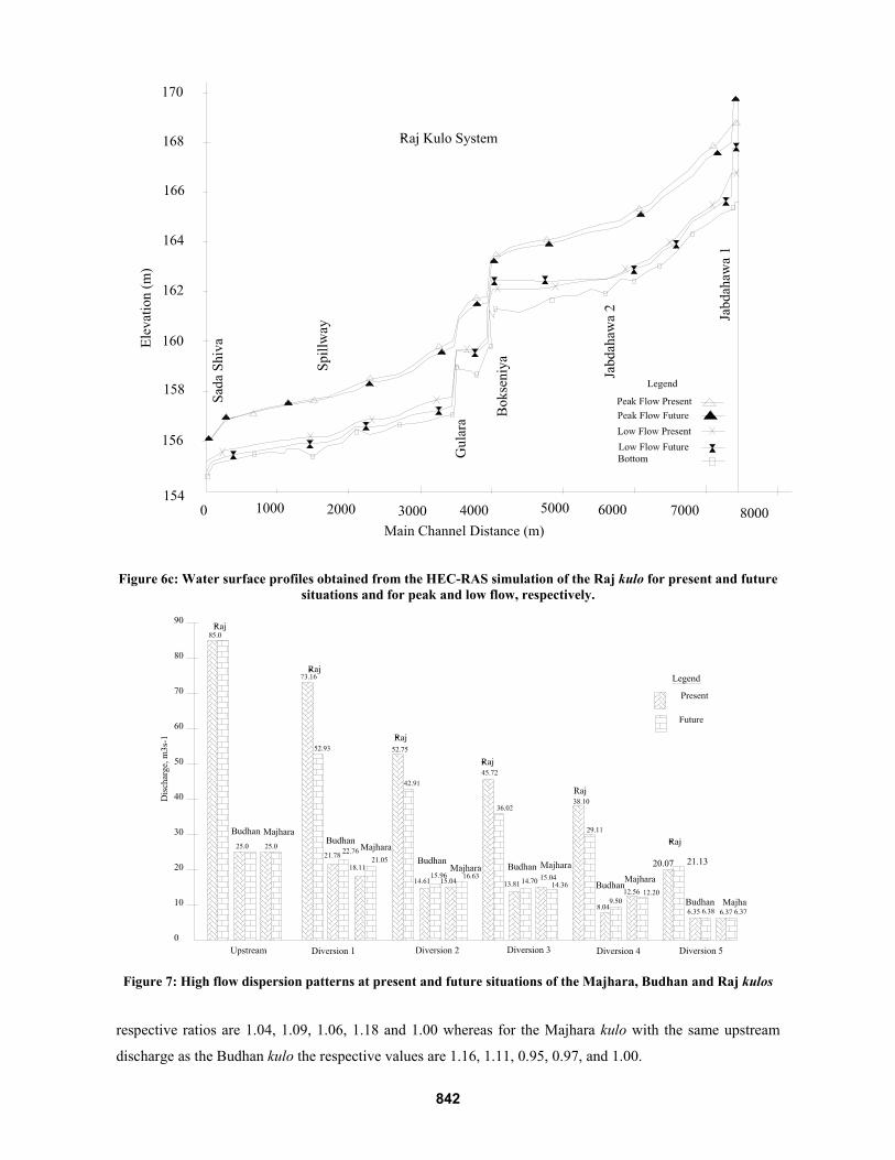
diversions where leakage flow is replaced by flow over the structures. Figure 6b and 6c represent the water
surface profiles of the Budhan kulo and the Raj kulo showing much similarity with the profiles of the
Majhara kulo. In the Raj kulo the future peak flow profile downstream of the spillway passes slightly above
the present one, indicating the reduction of channel discharge after the spillway. The similarity in dispersion
pattern in present and future situations proves the appropriate sizing of the permanent diversion structures for
keeping the existing canal systems intact and functionally consistent with the farmers’ tradition of water
management and flood protection.
Figure 7 shows the dispersion pattern of peak flows in present and future situations for all 3 systems. The
upstream discharge of 85 m3/s at the Raj kulo is reduced to 20 and 21 m3/s respectively in diversion number
5. In the Budhan and the Majhara kulos the peak discharge of 25 m3/s is reduced to 6 m3/s at diversion no 5
in the present as well as in the future situation. The discharge ratios between the “future” and the “present”
situations at the Raj kulo during an upstream peak flow of 85 m3/s are 0.72, 0.81, 0.79, 0.76 and 0.95 at the
first to fifth diversions respectively. In the Budhan kulo during an upstream peak discharge of 25 m3/s, the
840
10
Figure 6a: Water surface profiles obtained from the HEC-RAS simulation of the Majhara kulo for present and
future situations and for peak and low flow, respectively.
Figure 6b: Water surface profiles obtained from the HEC-RAS simulation of the Budhan kulo for present and future situations and for peak and low flow, respectively.
841
11
Figure 6c: Water surface profiles obtained from the HEC-RAS simulation of the Raj kulo for present and future situations and for peak and low flow, respectively.
Figure 7: High flow dispersion patterns at present and future situations of the Majhara, Budhan and Raj kulos
respective ratios are 1.04, 1.09, 1.06, 1.18 and 1.00 whereas for the Majhara kulo with the same upstream
discharge as the Budhan kulo the respective values are 1.16, 1.11, 0.95, 0.97, and 1.00.
842
12
5 Discussions and Conclusions
Our study has given an answer to the farmers’ question of preserving their priority water right which is
extremely important to determine the farming possibility at the new area using the remaining water. It has
cleared ways for further water sharing arrangements between the FMIS and the new areas. There is a great
possibility of saving water and increasing the production of winter and spring crops in the FMIS area even
without additional abstraction of water controlling leakage and using efficient water management practices.
The HEC-RAS analysis of the present and future situations of all the three kulos has proved the
appropriateness of the proposed arrangement of leak proof diversion structures while maintaining the
farmers’ tradition of flood dispersion practice. The solution of installing a cascade of diversion weirs similar
to the existing diversion strategy was proven to be the most viable alternative from both social and technical
considerations.
The similarity in dispersion pattern at the present and future situations proves the appropriate sizing of the
permanent diversion structures which is important for keeping the existing canal systems intact and
functional consistent with the farmers’ tradition of water management and flood protection.
References: 1. Design Manuals for Irrigation Projects in Nepal, M3 Hydrology and Agro-meteorology Manual (M3 Manual), The
Department of Irrigation, Nepal, 1990.
2. Environmental Impact Assessment Report of the Babai Irrigation Project. The Department of Irrigation, Nepal, 2004.
3. Howarth S.E. and Lal N.K., 2002. Irrigation and participation: rehabilitation of the Rajapur project in Nepal. Irrigation
and Drainage Systems 16, 111-138.
4. Irrigation policy 2003, The Department of Irrigation, Nepal, 2003.
5. Lam W.F., 1996. Improving the performance of small scale irrigation systems: The effects of technological investments and
governance structure on irrigation performance in Nepal. World Development 24, 1301-1315.
6. Master Plan Study for water resource development of upper Karnali river and Mahakali river basins. Nippon Koei Co.
Ltd. Tokyo, Japan, 1993.
7. Ostrom E. (2002) How farmer managed irrigation systems build social capital to outperform agency managed systems that
rely primarily on physical capital, Proceedings of the Second International Seminar held on 18-19 April, 2002,
Kathmandu. Farmer managed irrigation systems promotion trust, Nepal.
8. Pradhan .P, 2000. Farmers managed irrigation systems in Nepal at the crossroad. Proceedings of the 8th Biennial
Conference of the International Association for the Study of Common Property. May 30 4 July, 2000
9. Reconnaissance Study of the Babai Irrigation Project, Nepal. Tahal Consulting Engineers, Tel-Aviv, Israel, 1977.
10. Water Resource Strategy of Nepal. Water and Energy Commission Secretariat, Kathmandu, Nepal, 2002.
843