Embed Size (px)
Citation preview
AN EXPLORATION OF THE OPPORTUNITIES TO IMPROVE THE ECOLOGICAL FUNCTION OF THE SHORELINE AT NORTHEAST FALSE CREEK
by
GRANT ANDREW DIAMOND
B.Sc. University of Victoria, 2013
A PROJECT SUBMITTED IN PARTIAL FULFILMENT OF THE REQUIREMENTS FOR THE DEGREE OF
MASTER OF SCIENCE (PLANNING)
in
THE FACULTY OF APPLIED SCIENCE
School of Community and Regional Planning
We accept this project as conforming to the required standard
…………………………………………………
…………………………………………………
…………………………………………………
THE UNIVERSITY OF BRITISH COLUMBIAMarch 2016
© Grant Andrew Diamond, 2016

AN EXPLORATION OF THE OPPORTUNITIES TO IMPROVE THE ECOLOGICAL FUNCTION OF THE SHORELINE AT NORTHEAST FALSE CREEK
Grant Diamond, MSc Candidate (Planning)School of Community and Regional PlanningThe University of British Columbia
“One swallow does not make a summer, but one skein of geese, cleaving the murk of a March thaw, is the spring” - Aldo Leopold
ACKNOWLEDGEMENTS
I would like to thank my supervisor, Dr. Jordi Honey-Rosés, and my second reader, Nick Page of the Vancouver Board of
Parks and Recreation for their assistance and guidance during this project.
I would also like the thank the following individuals for lending their expertise and making valuable contributions to this
project:
• Jeffery Cordell, School of Aquatic and Fishery Sciences, University of Washington
• Lauren Elachi, SCAPE Landscape Architecture
• Emma Fineblit
• Marshall Foster, City of Seattle
• Catarina Gomes, Vancouver Board of Parks and Recreation
• Heidi Hughes, Friends of Waterfront Seattle
• Natalie Mackenzie
• Oren Mizrahi, Connect Landscape Architecture
• Chris Monaghan, Metabolic
• Kate Orff, SCAPE Landscape Architecture
CONTENTS
1 Executive Summary 2 Introduction 2.1 Study Area 2.2 Viaducts Removal and New Park 2.3 History 3 Research Design 3.1 Research Questions 3.2 Research Objectives 3.3 Methods 4 Theoretical Orientation 5 Key Policy Linkages 6 Precedents 6.1 Jericho Beach Park Restoration 6.2 Living Breakwaters, Staten Island 6.3 Waterfront Seattle Program 6.4 De Ceuvel, Amsterdam 6.5 Habitat Island and Hinge Park 7 Recommendations 8 Conclusions 8 References
123447777810131317222732363942
Executive Summary | Page 1
1 EXECUTIVE SUMMARYRecommendations
This report explores the opportunities to improve
the ecological function of the shoreline at Northeast
False Creek (NEFC) with an emphasis on habitat
restoration and human activity by reviewing local
and global precedents to inform the Park Board of
design options.
Vancouver’s policy framework provides a strong
justification to improve the ecological function of the
shoreline at NEFC. More importantly, the necessity
to mitigate climate change obligates policy mak-
ers to work in the interest of the planet and future
generations by seeking innovative and challenging
solutions. This report provides a review of urban
shoreline restoration projects in Vancouver, Seattle,
Staten Island, and Amsterdam and explores how
these cities employed creativity and innovation to
improve habitat, reintroduce species, reduce con-
tamination, and partake in placemaking for people.
Meetings and email correspondence with experts
provided valuable insights into the design process
and implementation of these projects.
The decision to remove the Georgia and Dunsmuir
Viaducts has presented the City of Vancouver with an
unprecedented opportunity to create a natural haven
for wildlife in the heart of downtown, restore species
that were lost during our industrial past, and create
a world-class space for people. Policy makers are
obliged to future generations to make our city more
livable for all living beings and the City must invest in
this new green space for its people and the planet.
• Construct one or more habitat compensation
islands and/or an inlet to increase the area of inter-
tidal and terrestrial habitat
• Target the keystone species Pacific Herring
(Clupea pallasii) for reintroduction through an educa-
tion and volunteer habitat restoration program
• Construct an environmentally-focused
fieldhouse on site or at nearby Science World to
contribute classroom and wetlab space for environ-
mental education, interpretation, storage space for
water-based recreation activities, and sustainable
wastewater capture and conversion
• Encourage human interactions with nature
through design; use light penetrating surfaces when
the Seawall passes over aquatic habitat and board-
walks in intertidal habitat
• Extend upland habitat to the Skytrain guide-
way and new Pacific Boulevard to maximize the area
of productive habitat and encourage commuters’
interactions with nature
• Ensure flexibility is incorporated into the de-
sign and implementation process to foster creativity
and anticipate new knowledge
• Work with Concord Pacific to build a model
sustainable community of the highest green stan-
dards adjacent to the park and encourage connec-
tions between park and neighbourhood systems
This project provides a theoretical orientation,
situates the project within City of Vancouver Policy,
outlines precedents from Vancouver, Seattle, Staten
Island, and Amsterdam, and describes the above
recommendations in detail.
123447777810131317222732363942
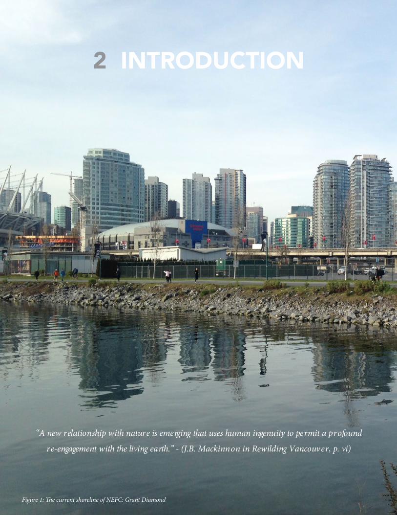
2 INTRODUCTION
“A new relationship with nature is emerging that uses human ingenuity to permit a profound
re-engagement with the living earth.” - (J.B. Mackinnon in Rewilding Vancouver, p. vi)
Figure 1: The current shoreline of NEFC: Grant Diamond
Introduction | Page 3
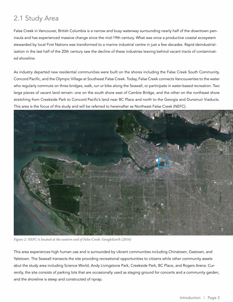
2.1 Study Area
False Creek in Vancouver, British Columbia is a narrow and busy waterway surrounding nearly half of the downtown pen-
insula and has experienced massive change since the mid-19th century. What was once a productive coastal ecosystem
stewarded by local First Nations was transformed to a marine industrial centre in just a few decades. Rapid deindustrial-
ization in the last half of the 20th century saw the decline of these industries leaving behind vacant tracts of contaminat-
ed shoreline.
As industry departed new residential communities were built on the shores including the False Creek South Community,
Concord Pacific, and the Olympic Village at Southeast False Creek. Today, False Creek connects Vancouverites to the water
who regularly commute on three bridges, walk, run or bike along the Seawall, or participate in water-based recreation. Two
large pieces of vacant land remain: one on the south shore east of Cambie Bridge, and the other on the northeast shore
stretching from Creekside Park to Concord Pacific’s land near BC Place and north to the Georgia and Dunsmuir Viaducts.
This area is the focus of this study and will be referred to hereinafter as Northeast False Creek (NEFC).
This area experiences high human use and is surrounded by vibrant communities including Chinatown, Gastown, and
Yaletown. The Seawall transects the site providing recreational opportunities to citizens while other community assets
abut the study area including Science World, Andy Livingstone Park, Creekside Park, BC Place, and Rogers Arena. Cur-
rently, the site consists of parking lots that are occasionally used as staging ground for concerts and a community garden,
and the shoreline is steep and constructed of riprap.
Figure 2: NEFC is located at the eastern end of False Creek: GoogleEarth (2016)
Page 4 | Improving the Ecological Function of the Shoreline at NEFC
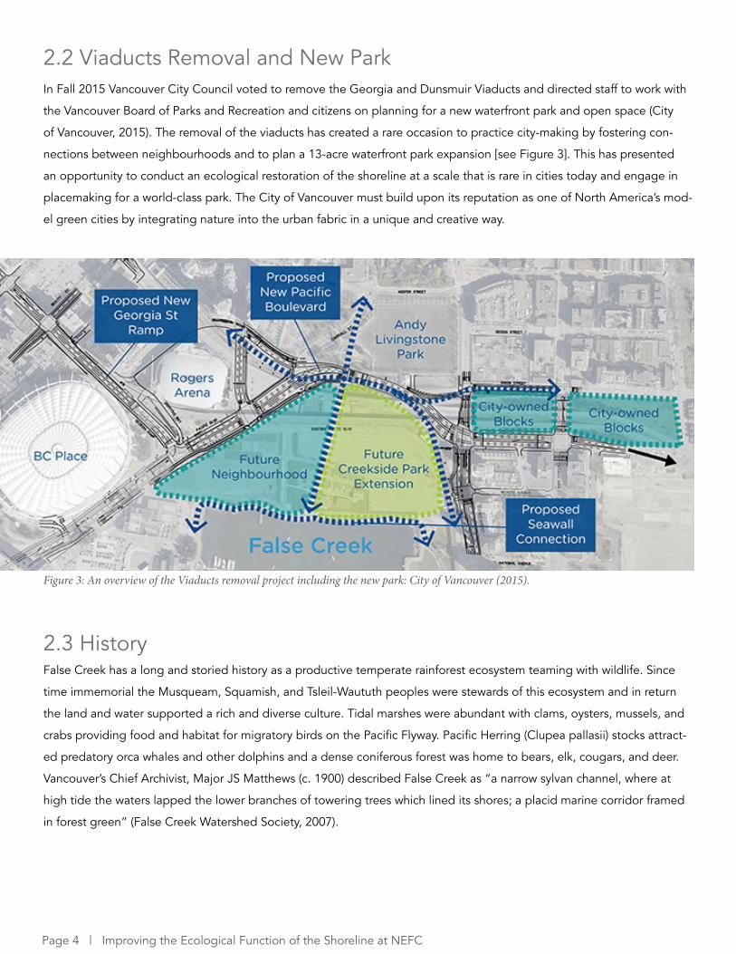
2.2 Viaducts Removal and New Park
2.3 History
In Fall 2015 Vancouver City Council voted to remove the Georgia and Dunsmuir Viaducts and directed staff to work with
the Vancouver Board of Parks and Recreation and citizens on planning for a new waterfront park and open space (City
of Vancouver, 2015). The removal of the viaducts has created a rare occasion to practice city-making by fostering con-
nections between neighbourhoods and to plan a 13-acre waterfront park expansion [see Figure 3]. This has presented
an opportunity to conduct an ecological restoration of the shoreline at a scale that is rare in cities today and engage in
placemaking for a world-class park. The City of Vancouver must build upon its reputation as one of North America’s mod-
el green cities by integrating nature into the urban fabric in a unique and creative way.
Figure 3: An overview of the Viaducts removal project including the new park: City of Vancouver (2015).
False Creek has a long and storied history as a productive temperate rainforest ecosystem teaming with wildlife. Since
time immemorial the Musqueam, Squamish, and Tsleil-Waututh peoples were stewards of this ecosystem and in return
the land and water supported a rich and diverse culture. Tidal marshes were abundant with clams, oysters, mussels, and
crabs providing food and habitat for migratory birds on the Pacific Flyway. Pacific Herring (Clupea pallasii) stocks attract-
ed predatory orca whales and other dolphins and a dense coniferous forest was home to bears, elk, cougars, and deer.
Vancouver’s Chief Archivist, Major JS Matthews (c. 1900) described False Creek as “a narrow sylvan channel, where at
high tide the waters lapped the lower branches of towering trees which lined its shores; a placid marine corridor framed
in forest green” (False Creek Watershed Society, 2007).
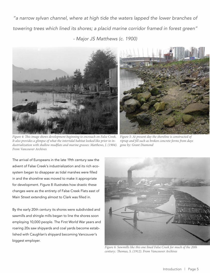
“a narrow sylvan channel, where at high tide the waters lapped the lower branches of
towering trees which lined its shores; a placid marine corridor framed in forest green”
- Major JS Matthews (c. 1900)
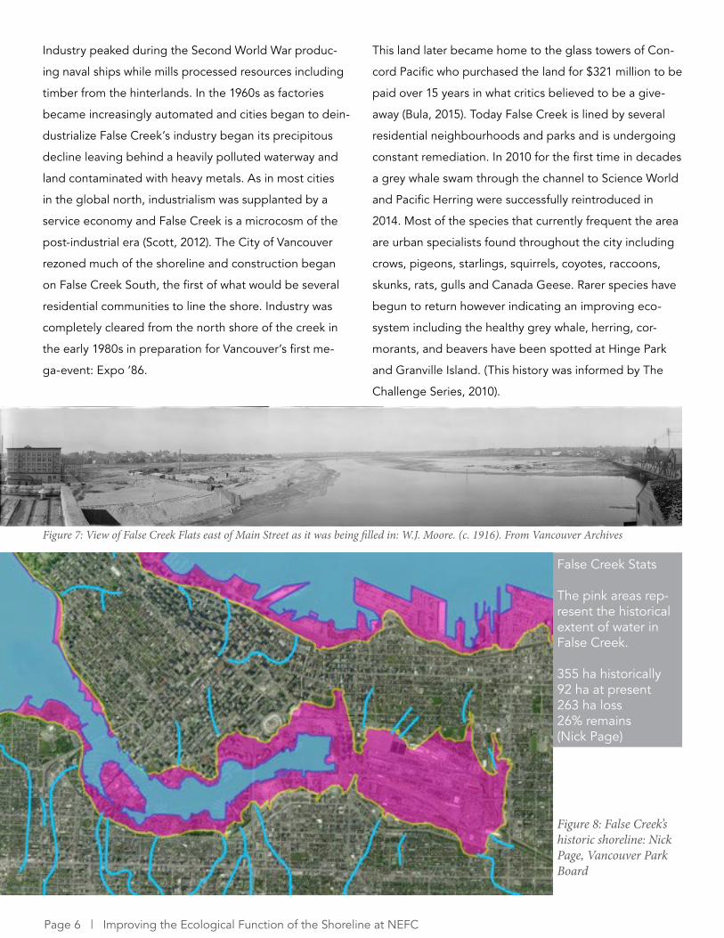
The arrival of Europeans in the late 19th century saw the
advent of False Creek’s industrialization and its rich eco-
system began to disappear as tidal marshes were filled
in and the shoreline was moved to make it appropriate
for development. Figure 8 illustrates how drastic these
changes were as the entirety of False Creek Flats east of
Main Street extending almost to Clark was filled in.
By the early 20th century its shores were subdivided and
sawmills and shingle mills began to line the shores soon
employing 10,000 people. The First World War years and
roaring 20s saw shipyards and coal yards become estab-
lished with Caughlan’s shipyard becoming Vancouver’s
biggest employer.
Figure 4: This image shows development beginning to encroach on False Creek. It also provides a glimpse of what the intertidal habitat looked like prior to in-dustrialization with shallow mudflats and marine grasses: Matthews, J. (1904). From Vancouver Archives
Figure 6: Sawmills like this one lined False Creek for much of the 20th century.: Thomas, S. (1912). From Vancouver Archives
Figure 5: At present day the shoreline is constructed of riprap and fill such as broken concrete forms from days gone by: Grant Diamond
Introduction | Page 5
Page 6 | Improving the Ecological Function of the Shoreline at NEFC
Industry peaked during the Second World War produc-
ing naval ships while mills processed resources including
timber from the hinterlands. In the 1960s as factories
became increasingly automated and cities began to dein-
dustrialize False Creek’s industry began its precipitous
decline leaving behind a heavily polluted waterway and
land contaminated with heavy metals. As in most cities
in the global north, industrialism was supplanted by a
service economy and False Creek is a microcosm of the
post-industrial era (Scott, 2012). The City of Vancouver
rezoned much of the shoreline and construction began
on False Creek South, the first of what would be several
residential communities to line the shore. Industry was
completely cleared from the north shore of the creek in
the early 1980s in preparation for Vancouver’s first me-
ga-event: Expo ’86.
This land later became home to the glass towers of Con-
cord Pacific who purchased the land for $321 million to be
paid over 15 years in what critics believed to be a give-
away (Bula, 2015). Today False Creek is lined by several
residential neighbourhoods and parks and is undergoing
constant remediation. In 2010 for the first time in decades
a grey whale swam through the channel to Science World
and Pacific Herring were successfully reintroduced in
2014. Most of the species that currently frequent the area
are urban specialists found throughout the city including
crows, pigeons, starlings, squirrels, coyotes, raccoons,
skunks, rats, gulls and Canada Geese. Rarer species have
begun to return however indicating an improving eco-
system including the healthy grey whale, herring, cor-
morants, and beavers have been spotted at Hinge Park
and Granville Island. (This history was informed by The
Challenge Series, 2010).
Figure 7: View of False Creek Flats east of Main Street as it was being filled in: W.J. Moore. (c. 1916). From Vancouver Archives
Figure 8: False Creek’s historic shoreline: Nick Page, Vancouver Park Board
False Creek Stats
The pink areas rep-resent the historical extent of water in False Creek.
355 ha historically92 ha at present263 ha loss26% remains(Nick Page)
3 RESEARCH DESIGN
3.1 Research Questions
3.2 Research Objectives
3.3 Methods
The Vancouver Board of Parks and Recreation has requested that I conduct research into the options for improving
the ecological function of the shoreline at NEFC by exploring local and global precedents. This project will provide a
theoretical orientation, situate the project within City of Vancouver Policy, outline precedents from Vancouver, Seattle,
Staten Island, and Amsterdam, and propose recommendations.
• What are the options to improve the eco-logical function of the shoreline at Northeast False Creek?
Subquestions
• How can the City blend ecological resto-ration with high human use?• Does a habitat restoration need to look natural to improve ecological function?• How have cities engaged in placemaking while improving habitat?
This project is intended to inform the Vancouver Board of
Parks and Recreation of how shoreline restoration proj-
ects in cities have successfully improved the ecological
function of urban shorelines while blending this with a
high level of human activity.
• Provide a theoretical orientation
• Identify key policy linkages from City of Vancou-
ver strategies
• Identify local and global precedents of successful
shoreline restoration in an urban context
• Identify natural and technological solutions em-
ployed by project designers
• Identify how humans were included in these de-
signs to allow people and nature to exist harmoniously at
NEFC
• Propose recommendations for the design of the
NEFC park
Interviews and email correspondence with experts
I consulted with individuals with experience working on
urban shoreline restoration projects to learn about their
insights and the challenges they have faced. This included
meetings and email correspondence with people who
worked on the precedent projects.
Theoretical orientation
I conducted an introductory theoretical orientation using
literature selected from the field of restoration ecology.
The purpose of this exercise is to justify decisions that
may be made around reference ecosystems and species
composition. Due to the urban context of the study area
and issues such as moving target syndrome it is possible
that some or many aspects of a restoration may not mirror
many peoples’ ideas of what a previous ecosystem may
have looked like.
Review of City of Vancouver policy to identify policy
justifications for such a project at NEFC
I reviewed The City of Vancouver and Park Board’s main
policy documents to determine how an ecological resto-
ration of the shoreline would address the City’s goals.
Review of local and global precedents
Through a process including discussions with Nick Page,
Dr. Jordi Honey-Rosés, experts in this field, and personal
experience, I identified five precedents to be reviewed.
These range from very urban examples to projects that
appear more natural, local to global, and all precedents
exist in similar temperate ecological contexts. Precedents
were also selected by their relevance to City of Vancouver
goals. For example, environmental education is a goal of
the Park Board and aspects of the Living Breakwaters and
de Ceuvel address this goal.
Research Design | Page 7

Page 8 | Improving the Ecological Function of the Shoreline at NEFC
4 THEORETICAL ORIENTATIONThe City of Vancouver will need to decide upon what they
are trying to model at the new NEFC park. Is it to create
a self-sustaining natural system that mirrors an ecosystem
that may have existed at some point in the past? Or can
technology and human intervention be used to create an
even more productive shoreline to make up for more defi-
cient areas in the city? The answers to these questions will
change depending on the goals and values of the parks
planners and community but the theory of restoration
ecology, an ever evolving field, can inform parks planners
of best practices in determining a reference ecosystem.
The goal of ecological restoration “ostensibly is to return
ecosystems to a state or condition from which they can
be self-sustaining thereafter” (Parker and Picket, 1997,
p. 17). Parker and Picket (1997) later challenge this goal
due to habitat fragmentation in human settlements but
this will be described later. A fundamental assumption of
ecological restoration is that since humans are responsi-
ble for degrading the natural environment, humans have
the responsibility to repair it (Egan et al., 2011). The idea
of returning land to an ecologically productive state is
laudable but is complicated by the fact that ecology and
reference ecosystems are influenced by multiple per-
spectives while human dimensions can and do greatly
influence the success of restoration projects (Parker and
Picket, 1997; Egan et al., 2011). The former of these com-
plications must be understood prior to the commence-
ment of planning of any ecological restoration to avoid
the pitfalls of the now widely discredited succession-cli-
max idea of ecology. Parker and Picket (1997) argue that
the contemporary paradigm of ecology and its principles
is the only valid approach for restoration. The latter can
be ameliorated through open and dialectic planning pro-
cesses that are flexible and emphasizes public education.
Restoration practice has often been based on the as-
sumption that, when undisturbed by humans, nature is
fixed and unchanging, existing in some climax state that
should be preserved forever (Parker and Pickett, 1997).
This idea stems from the tendency of humans to objectify
and idealize nature while ignoring the fact that natural
systems are very often affected by and responding to
disturbances (Parker and Pickett, 1997). This can thwart
successful restoration by assuming systems have a single
range of characteristics to be preserved or rectified such
as a static species composition, biogeochemical dynam-
ics, or productivity (Parker and Pickett, 1997).
In terms of NEFC, when looking into the past we may
have an image of a lush forested landscape surrounding
a marine channel and mudflats teaming with salmon, her-
ring, whales, and migratory birds. At many points in histo-
ry this may have been true, but disturbances likely altered
this ecosystem at other times so definite assumptions of
what this area looked like cannot be made. Invasive spe-
cies could have hitchhiked on migratory birds using the
Pacific Flyway, drought could have decreased the input
of freshwater to the system, or some disease could have
affected the salmon population like the recent starfish
blight in the Salish Sea. Viewing ecosystems in this way
and recognizing that there is no “ideal” or “climax” state
is part of the contemporary paradigm of ecology and
this paradigm will be used to inform this project and its
recommendations for NEFC.
The classic ecological paradigm assumes ecosystems
reach stable successional endpoints, after which process-
es are in dynamic equilibrium (Parker and Pickett, 1997).
This suggests that systems are closed and self-regulating,
controlling the flow of minerals and energy. Under this
view, ecosystems are seen as deterministic and process-
es that move the ecosystem away from equilibrium are
considered disturbances (Parker and Pickett, 1997). In
the contemporary paradigm, ecosystems are open and
regulated by external processes while disturbances are
viewed as natural and a regular occurrence (Parker and
Pickett, 1997). They can have multiple successions, equi-
libria, or may fail to reach these stages at all. Because this
view recognizes that systems are open to external regu-
lation, humans and their impacts must be incorporated in
ecological models for restoration ecology to be effective
(Parker and Pickett, 1997). For an urban project such as
NEFC in Vancouver, this view provides a greater degree
of freedom by ensuring human impacts are anticipated,
accounted for, and people are encouraged to use the
site. NEFC is located in downtown Vancouver with high
population density and is subject to a plethora of human
uses. This project strongly recommends that human use
is an essential part of the planning of any restoration that
takes place.
The growth of human populations and urbanization has
resulted in fragmentation of habitat and shifts in the in-
fluence of processes (Parker and Pickett, 1997). Historical
processes that operated over large scales are restricted
or erased and species interactions with their environment
are altered resulting in stark differences between past
and current composition (Parker and Pickett, 1997). There-
fore, restoration can only pretend to create self-sustaining
ecosystems in small sites such as NEFC and will require
human intervention throughout their lifespan. However, it
is important to determine a set of restoration goals using
reference states, target species, or indicator species, for
example, keeping in mind there is no ideal community or
ecosystem (Parker and Picket, 1997; van Andel and Groot-
jans, 2006). This will allow a certain degree of freedom in
how the new NEFC park will look and can be thought of
as a continuum ranging from natural, reflecting other eco-
systems in the region, to more urban but with the same or
higher level of ecological function. The precedents that
follow have been selected because they reflect the range
of this continuum.
Egan et al (2011) describe the human dimensions of
ecological restoration and how the practice is inherently
value laden, context driven, prone to be immersed in
disagreement and compromise, and experiential. The
authors outline various studies that highlighted how “de-
termining restoration goals and best practices are value
laden activities because they involve human perceptions,
beliefs, emotions, knowledge, and, ultimately, behaviors”
(as cited in Egan et al., 2011. p. 2). Restoration projects
are immersed in cultural, political, and economic contexts
that will strain the planning process (Egan et al., 2011).
Furthermore, Harris and van Diggelen (2006) state resto-
ration will not take place unless human society approves
of the goals and objectives of restoration. Restoration will
not persist unless society has sufficient esteem for the
restored ecosystem to protect its integrity (Harris and van
Diggelen, 2006).
In light of these insights, this project has evolved from
taking a more scientific approach, viewing ecological
function as free from humans, to an inclusive approach
that views humans as an asset in urban ecological resto-
ration. The selection of precedents reflects this approach.
In following with Egan et al’s (2011) ideas, this project will
recommend that any restoration at NEFC should be open
for educational possibilities, artistic interpretations, and
spiritual and physical renewal. “Ultimately, people are
innately part of restoration projects as experts, learned
amateurs, or volunteers, or as the general public affected
by the results of restoration projects” (Egan et al., 2011,
p. 2).
Theoretical Orientation | Page 9

Page 10 | Improving the Ecological Function of the Shoreline at NEFC
5 KEY POLICY LINKAGES
Park Board Strategic Framework
Objective 3: Green Operations • 3.1 Sustainable Operations: Design, measure, monitor and manage opera-tions, and implement new practices to minimize our environmental footprint • 3.2 Greener Spaces: Preserve, restore and expand green space. Use the Park Board’s horticultural expertise to support plant conservation, landscape restoration, garden design and local food production
Objective 4: Healthy Ecosystems • 4.1 Green Stewardship: Model and advocate for best practices in ecosystem enhancement and management • 4.2 Local Food Systems: Support community-based food production by contributing to the development of neighbourhood and city-wide food infrastructure programs and assets • 4.3 Green Education & Advocacy: Use Park Board expertise, programs, facili-ties and partnerships to increase awareness and knowledge of sustainable living
Objective 5: Partners • 5.1 Effective Partnerships: Partner to deliver programs and services and fur-ther strategic objectives • 5.2 Productive Collaborations: Build positive and open relationships • 5.3 Valued Volunteers & Advocates: Appreciate and acknowledge the efforts of volunteers and advocates
Objective 6: Community • 6.1 Active Community Participation: Encourage active participation in parks and recreation • 6.2 Improved Communication & Engagement: Maintain and enhance relation-ships with users and the community • 6.3 Open & Approachable Organization: Be accessible, transparent and ac-countable
Objective 9: Well Managed Infrastructure • 9.1 Strategic Asset Management: Manage assets with a long-term horizon – build the right things, build them to last, make them easy to take care of • 9.2 Flexible & Functional Facilities: Collaborate with community partners to co-locate and develop convertible, scalable, multi-use facilities • 9.3 Sustainable Design: Integrate feasible sustainability concepts into design, construction, maintenance and operations
An ecological restoration of the shoreline at NEFC that encourages human interactions with nature is consistent with the
City of Vancouver’s policy framework as identified by the following goals and objectives.
Key Policy Linkages | Page 11
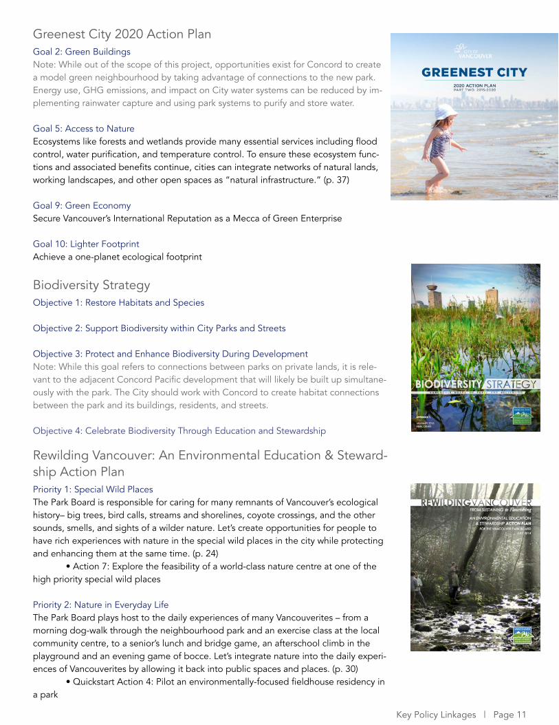
Greenest City 2020 Action PlanGoal 2: Green BuildingsNote: While out of the scope of this project, opportunities exist for Concord to create a model green neighbourhood by taking advantage of connections to the new park. Energy use, GHG emissions, and impact on City water systems can be reduced by im-plementing rainwater capture and using park systems to purify and store water.
Goal 5: Access to NatureEcosystems like forests and wetlands provide many essential services including flood control, water purification, and temperature control. To ensure these ecosystem func-tions and associated benefits continue, cities can integrate networks of natural lands, working landscapes, and other open spaces as “natural infrastructure.” (p. 37)
Goal 9: Green EconomySecure Vancouver’s International Reputation as a Mecca of Green Enterprise
Goal 10: Lighter FootprintAchieve a one-planet ecological footprint
Biodiversity StrategyObjective 1: Restore Habitats and Species
Objective 2: Support Biodiversity within City Parks and Streets
Objective 3: Protect and Enhance Biodiversity During DevelopmentNote: While this goal refers to connections between parks on private lands, it is rele-vant to the adjacent Concord Pacific development that will likely be built up simultane-ously with the park. The City should work with Concord to create habitat connections between the park and its buildings, residents, and streets.
Objective 4: Celebrate Biodiversity Through Education and Stewardship
Rewilding Vancouver: An Environmental Education & Steward-ship Action PlanPriority 1: Special Wild PlacesThe Park Board is responsible for caring for many remnants of Vancouver’s ecological history– big trees, bird calls, streams and shorelines, coyote crossings, and the other sounds, smells, and sights of a wilder nature. Let’s create opportunities for people to have rich experiences with nature in the special wild places in the city while protecting and enhancing them at the same time. (p. 24) • Action 7: Explore the feasibility of a world-class nature centre at one of the high priority special wild places
Priority 2: Nature in Everyday LifeThe Park Board plays host to the daily experiences of many Vancouverites – from a morning dog-walk through the neighbourhood park and an exercise class at the local community centre, to a senior’s lunch and bridge game, an afterschool climb in the playground and an evening game of bocce. Let’s integrate nature into the daily experi-ences of Vancouverites by allowing it back into public spaces and places. (p. 30) • Quickstart Action 4: Pilot an environmentally-focused fieldhouse residency in a park
Page 12 | Improving the Ecological Function of the Shoreline at NEFC
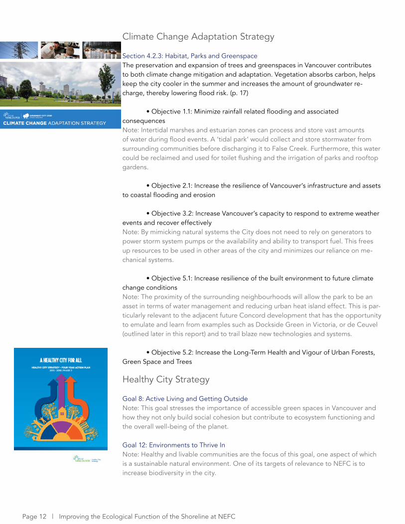
Climate Change Adaptation Strategy
Section 4.2.3: Habitat, Parks and GreenspaceThe preservation and expansion of trees and greenspaces in Vancouver contributes to both climate change mitigation and adaptation. Vegetation absorbs carbon, helps keep the city cooler in the summer and increases the amount of groundwater re-charge, thereby lowering flood risk. (p. 17)
• Objective 1.1: Minimize rainfall related flooding and associated consequencesNote: Intertidal marshes and estuarian zones can process and store vast amounts of water during flood events. A ‘tidal park’ would collect and store stormwater from surrounding communities before discharging it to False Creek. Furthermore, this water could be reclaimed and used for toilet flushing and the irrigation of parks and rooftop gardens.
• Objective 2.1: Increase the resilience of Vancouver’s infrastructure and assets to coastal flooding and erosion
• Objective 3.2: Increase Vancouver’s capacity to respond to extreme weather events and recover effectively Note: By mimicking natural systems the City does not need to rely on generators to power storm system pumps or the availability and ability to transport fuel. This frees up resources to be used in other areas of the city and minimizes our reliance on me-chanical systems.
• Objective 5.1: Increase resilience of the built environment to future climate change conditions Note: The proximity of the surrounding neighbourhoods will allow the park to be an asset in terms of water management and reducing urban heat island effect. This is par-ticularly relevant to the adjacent future Concord development that has the opportunity to emulate and learn from examples such as Dockside Green in Victoria, or de Ceuvel (outlined later in this report) and to trail blaze new technologies and systems.
• Objective 5.2: Increase the Long-Term Health and Vigour of Urban Forests, Green Space and Trees
Healthy City Strategy
Goal 8: Active Living and Getting Outside Note: This goal stresses the importance of accessible green spaces in Vancouver and how they not only build social cohesion but contribute to ecosystem functioning and the overall well-being of the planet.
Goal 12: Environments to Thrive InNote: Healthy and livable communities are the focus of this goal, one aspect of which is a sustainable natural environment. One of its targets of relevance to NEFC is to increase biodiversity in the city.
6 PRECEDENTS
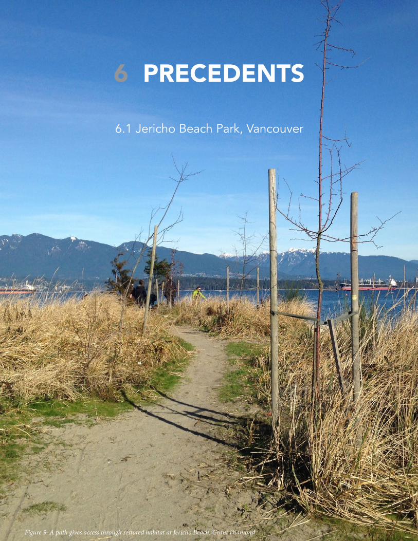
6.1 Jericho Beach Park, Vancouver
Figure 9: A path gives access through restored habitat at Jericho Beach: Grant Diamond
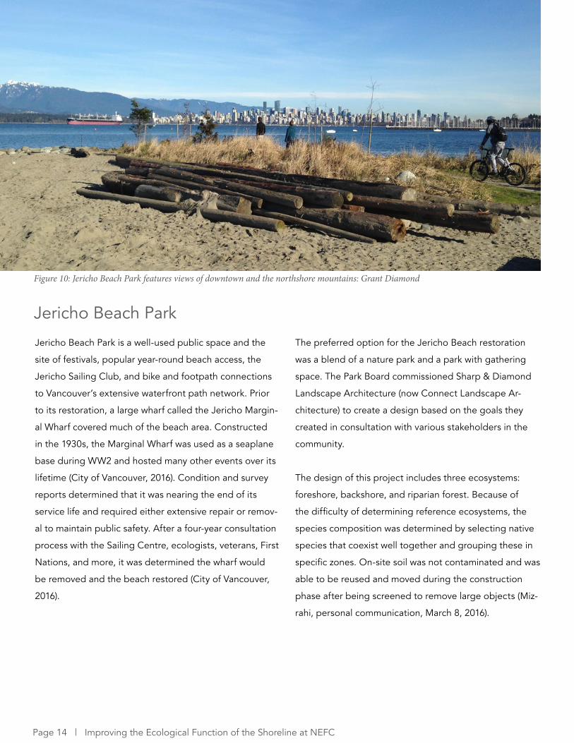
Jericho Beach Park is a well-used public space and the
site of festivals, popular year-round beach access, the
Jericho Sailing Club, and bike and footpath connections
to Vancouver’s extensive waterfront path network. Prior
to its restoration, a large wharf called the Jericho Margin-
al Wharf covered much of the beach area. Constructed
in the 1930s, the Marginal Wharf was used as a seaplane
base during WW2 and hosted many other events over its
lifetime (City of Vancouver, 2016). Condition and survey
reports determined that it was nearing the end of its
service life and required either extensive repair or remov-
al to maintain public safety. After a four-year consultation
process with the Sailing Centre, ecologists, veterans, First
Nations, and more, it was determined the wharf would
be removed and the beach restored (City of Vancouver,
2016).
Figure 10: Jericho Beach Park features views of downtown and the northshore mountains: Grant Diamond
The preferred option for the Jericho Beach restoration
was a blend of a nature park and a park with gathering
space. The Park Board commissioned Sharp & Diamond
Landscape Architecture (now Connect Landscape Ar-
chitecture) to create a design based on the goals they
created in consultation with various stakeholders in the
community.
The design of this project includes three ecosystems:
foreshore, backshore, and riparian forest. Because of
the difficulty of determining reference ecosystems, the
species composition was determined by selecting native
species that coexist well together and grouping these in
specific zones. On-site soil was not contaminated and was
able to be reused and moved during the construction
phase after being screened to remove large objects (Miz-
rahi, personal communication, March 8, 2016).
Jericho Beach Park
Page 14 | Improving the Ecological Function of the Shoreline at NEFC
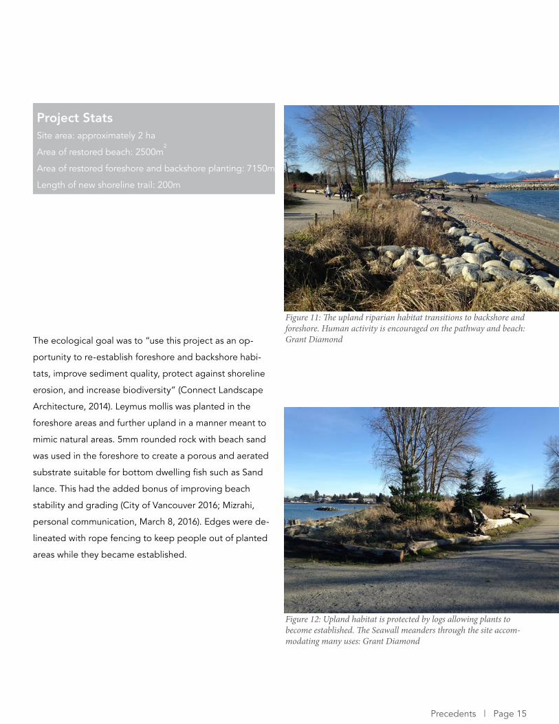
The ecological goal was to “use this project as an op-
portunity to re-establish foreshore and backshore habi-
tats, improve sediment quality, protect against shoreline
erosion, and increase biodiversity” (Connect Landscape
Architecture, 2014). Leymus mollis was planted in the
foreshore areas and further upland in a manner meant to
mimic natural areas. 5mm rounded rock with beach sand
was used in the foreshore to create a porous and aerated
substrate suitable for bottom dwelling fish such as Sand
lance. This had the added bonus of improving beach
stability and grading (City of Vancouver 2016; Mizrahi,
personal communication, March 8, 2016). Edges were de-
lineated with rope fencing to keep people out of planted
areas while they became established.
Project Stats Site area: approximately 2 ha
Area of restored beach: 2500m2
Area of restored foreshore and backshore planting: 7150m
Length of new shoreline trail: 200m
Figure 11: The upland riparian habitat transitions to backshore and foreshore. Human activity is encouraged on the pathway and beach: Grant Diamond
Figure 12: Upland habitat is protected by logs allowing plants to become established. The Seawall meanders through the site accom-modating many uses: Grant Diamond
Precedents | Page 15
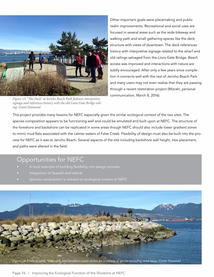
Figure 14 A mix of sand, 5mm rock, and boulders create niches for a variety of species including sand lance: Grant Diamond
Other important goals were placemaking and public
realm improvements. Recreational and social uses are
focused in several areas such as the wide bikeway and
walking path and small gathering spaces like the deck
structure with views of downtown. The deck references
history with interpretive signage related to the wharf and
old railings salvaged from the Lions Gate Bridge. Beach
access was improved and interactions with nature are
subtly encouraged. After only a few years since comple-
tion it connects well with the rest of Jericho Beach Park
and many users may not even realize that they are passing
through a recent restoration project (Mizrahi, personal
communication, March 8, 2016).
Opportunities for NEFC• A local example of building flexibility into design process
• Integration of Seawall and habitat
• Species composition is relevant to ecological context at NEFC
This project provides many lessons for NEFC especially given the similar ecological context of the two sites. The
species composition appears to be functioning well and could be emulated and built upon at NEFC. The structure of
the foreshore and backshore can be replicated in some areas though NEFC should also include lower gradient zones
to mimic mud flats associated with the calmer waters of False Creek. Flexibility of design must also be built into the pro-
cess for NEFC as it was at Jericho Beach. Several aspects of the site including backshore wall height, tree placement,
and paths were altered in the field.
Figure 13: “The Deck” at Jericho Beach Park features interpretive signage and references history with the old Lions Gate Bridge rail-ing: Grant Diamond
Page 16 | Improving the Ecological Function of the Shoreline at NEFC
6.2 Living Breakwaters, Staten Island
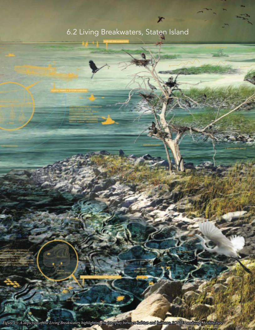
Figure 15: A depiction of the Living Breakwaters highlighting the interplay between habitat and humans: SCAPE Landscape Architecture
The Living Breakwaters is a project in Staten Island, New
York that “reduces risk, revives ecologies, and connects
educators to the shoreline, inspiring a new generation of
harbor stewards and a more resilient region over time”
(SCAPE, 2014, p. 3). This project was a winner of many
awards including the Rebuild by Design competition after
Hurricane Sandy and the Fuller Challenge by the Buck-
minster Fuller Institute. While this project is more focused
on risk reduction and community resiliency than ecolog-
ical restoration, it provides many lessons on the design
of sub-tidal infrastructure using biomimicry and on using
education to increase public knowledge of local ecology.
This project was developed in the aftermath of Hurricane
Sandy to build the resiliency of Staten Islanders to wave
action and erosion. During Sandy, storm surge and high
wave heights inundated the shore and caused massive
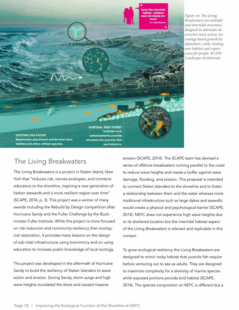
The Living Breakwaters erosion (SCAPE, 2014). The SCAPE team has devised a
series of offshore breakwaters running parallel to the coast
to reduce wave heights and create a buffer against wave
damage, flooding, and erosion. This proposal is intended
to connect Staten Islanders to the shoreline and to foster
a relationship between them and the water whereas more
traditional infrastructure such as large dykes and seawalls
would create a physical and psychological barrier (SCAPE,
2014). NEFC does not experience high wave heights due
to its sheltered location but the intertidal habitat aspect
of the Living Breakwaters is relevant and replicable in this
context.
To grow ecological resiliency the Living Breakwaters are
designed to mimic rocky habitat that juvenile fish require
before venturing out to see as adults. They are designed
to maximize complexity for a diversity of marine species
while exposed portions provide bird habitat (SCAPE,
2014). The species composition at NEFC is different but a
Figure 16: The Living Breakwaters are subtidal and intertidal structures designed to attenuate de-structive wave action, en-courage beach growth by deposition, while creating new habitat and experi-ences for people: SCAPE Landscape Architecture
Page 18 | Improving the Ecological Function of the Shoreline at NEFC
complex shoreline is required to provide spawning ground
and hiding places for juvenile fish such as Pacific Herring
or salmon fry that have begun to return to China Creek.
Increased bird habitat could provide a haven for migratory
birds on the Pacific Flyway. To construct the breakwaters,
Econcrete is being used. This is an innovative low PH
concrete that is ideal for maritime construction that can be
textured and placed to create crevices and holes for eco-
logical niches. Units of Econcrete are proven to increase
biological recruitment and shelter filter-feeding organisms
(SCAPE, 2014). Biogenic buildup will protect the struc-
tures, prolong their lifespan, and species native to Raritan
Bay like oysters will filter water (SCAPE, 2014). As biogenic
buildup occurs at NEFC, filter feeders would clean the
waterway providing a natural filtration system for storm
water potentially creating conditions suitable for sensitive
species such as eelgrass to eventually return.
Figure 17: Living Breakwaters’ guiding principles include people as equals with habitat: SCAPE Landscape Architecture
Figure 18: This rendering describes the construction of a breakwater: SCAPE Landscape Architecture
Precedents | Page 19
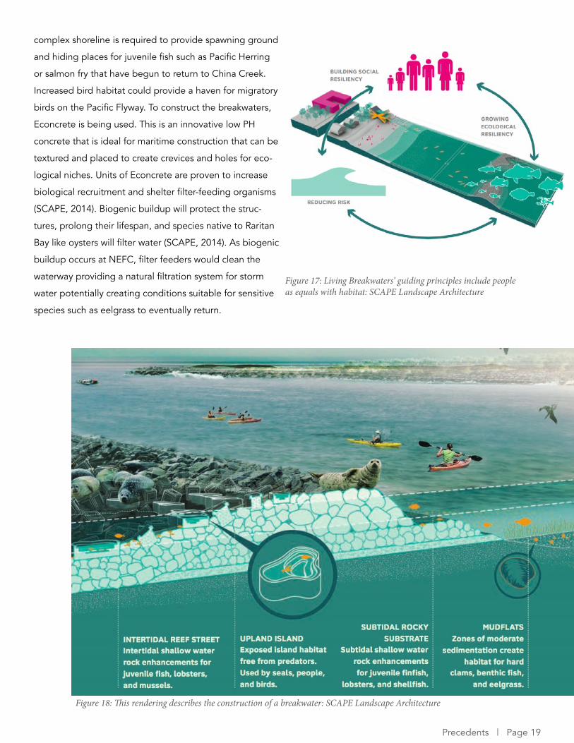
Social resiliency is a main goal of the Living Breakwaters
and a network of Waterhubs are planned to provide ori-
entation, information, storage space, and group gather-
ing spaces. Each one is programmed to be relevant to the
context of the area in which it is situated. For example,
one community group suggested kayak storage and wet-
labs will be used by local high schools (Elachi, personal
communication, March 2, 2016). The City of Vancouver’s
Environmental Education and Stewardship Action Plan
identifies the goal of creating an environmentally-focused
fieldhouse in a park and the Waterhubs are a model of
how to achieve this. Vancouver’s could include space
for many of the activities that take place on False Creek
including storage for kayaks and dragon boats. It should
also include flexible space for educational workshops and
classrooms or wetlabs for local schools. Environmental
interpretation should also be included for Seawall users
to educate citizens on the importance of fostering an
ecologically sensitive city. The needs of schools and the
community can be determined through the participation
“reduces risk, revives
ecologies, and connects
educators to the shoreline,
inspiring a new generation of
harbor stewards and a more
resilient region over time”
(SCAPE, p. 3)
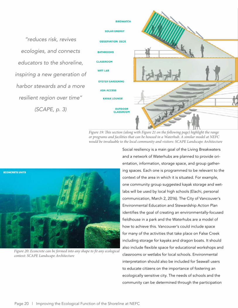
Figure 19: This section (along with Figure 21 on the following page) highlight the range or programs and facilities that can be housed in a Waterhub. A similar model at NEFC would be invaluable to the local community and visitors: SCAPE Landscape Architecture
Figure 20: Econcrete can be formed into any shape to fit any ecological context: SCAPE Landscape Architecture
Page 20 | Improving the Ecological Function of the Shoreline at NEFC

Opportunities for NEFC• The constructed breakwaters can be used as a model for intertidal habitat at NEFC, specifically their use of
Econcrete and creation of niches
• Creation of an environmentally-focused fieldhouse modeled off the Waterhubs
• Implementation of educational programs targeting Pacific Herring to spread knowledge of their importance
as a keystone species and allow citizens to participate in habitat restoration
of teachers in a community advisory committee. SCAPE
has done further school outreach through the Billion
Oyster Project which works to foster environmental stew-
ardship at schools via oyster gardening (Elachi, personal
communication, March 2, 2016). Oysters are a keystone
species in this ecosystem and provide an essential eco-
system service by filtering water. By targeting this species
water quality in Raritan Bay can be improved creating a
healthier ecosystem for other species. Pacific Herring are
a keystone species in our region and a similar program
targeting this species through educational programs
would greatly improve not only False Creek’s ecological
function but also that of the Salish Sea where Herring are
preyed upon by orcas and other large predators.
Figure 21: See description of Figure 15 on previous page
Figure 22: A Waterhub and how it fits into the coastal dune landscape: SCAPE Landscape Architecture
Precedents | Page 21
6.3 Waterfront Seattle Program
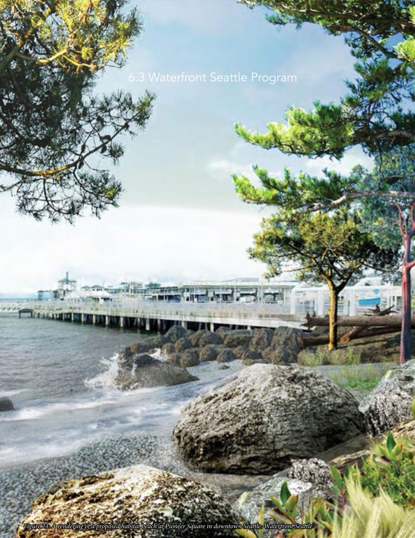
Figure 23: A rendering of a proposed habitat beach at Pioneer Square in downtown Seattle: Waterfront Seattle
The Waterfront Seattle Program is a large-scale project in
downtown Seattle along the Elliot Bay shoreline that was
spurred by the demolition of the Alaskan Way Viaduct
and the need to replace the aging seawall. It spans from
Pioneer Square to Belltown and includes a new seawall
with improved salmon and foreshore habitat, better con-
nections between downtown neighbourhoods, and new
at-grade streets for all modes of transit (Waterfront Se-
attle, 2016). This project has stark similarities to NEFC in
terms of both its urban and ecological context and being
just a few years ahead will provide many lessons on how
to improve ecological function. The project’s goals for the
waterfront are to “bring people to the water’s edge to
experience the water and ecology of Elliot Bay, to im-
prove shoreline ecology while preserving and enhancing
maritime activities, and to reflect Seattle’s commitment to
sustainability and innovation” (Waterfront Seattle, 2012,
p. 2:148). These ambitious goals should be matched and
built upon for the NEFC project.
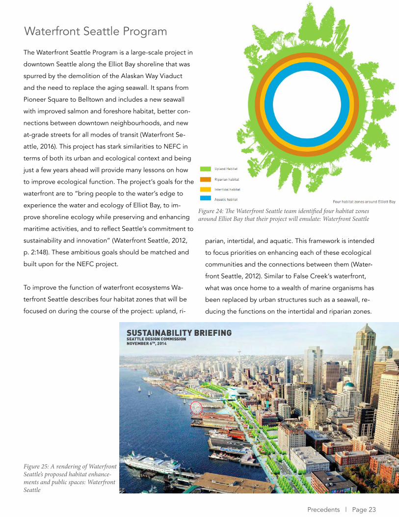
To improve the function of waterfront ecosystems Wa-
terfront Seattle describes four habitat zones that will be
focused on during the course of the project: upland, ri-
Waterfront Seattle Program
parian, intertidal, and aquatic. This framework is intended
to focus priorities on enhancing each of these ecological
communities and the connections between them (Water-
front Seattle, 2012). Similar to False Creek’s waterfront,
what was once home to a wealth of marine organisms has
been replaced by urban structures such as a seawall, re-
ducing the functions on the intertidal and riparian zones.
Figure 24: The Waterfront Seattle team identified four habitat zones around Elliot Bay that their project will emulate: Waterfront Seattle
Figure 25: A rendering of Waterfront Seattle’s proposed habitat enhance-ments and public spaces: Waterfront Seattle
Precedents | Page 23
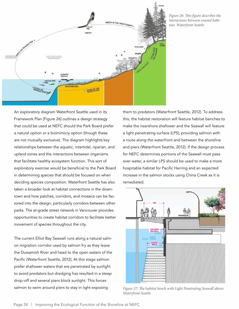
An exploratory diagram Waterfront Seattle used in its
Framework Plan [Figure 26] outlines a design strategy
that could be used at NEFC should the Park Board prefer
a natural option or a biomimicry option (though these
are not mutually exclusive). The diagram highlights key
relationships between the aquatic, intertidal, riparian, and
upland zones and the interactions between organisms
that facilitate healthy ecosystem function. This sort of
exploratory exercise would be beneficial to the Park Board
in determining species that should be focused on when
deciding species composition. Waterfront Seattle has also
taken a broader look at habitat connections in the down-
town and how patches, corridors, and mosaics can be fac-
tored into the design, particularly corridors between other
parks. The at-grade street network in Vancouver provides
opportunities to create habitat corridors to facilitate better
movement of species throughout the city.
The current Elliot Bay Seawall runs along a natural salm-
on migration corridor used by salmon fry as they leave
the Duwamish River and head to the open waters of the
Pacific (Waterfront Seattle, 2012). At this stage salmon
prefer shallower waters that are penetrated by sunlight
to avoid predators but dredging has resulted in a steep
drop-off and several piers block sunlight. This forces
salmon to swim around piers to stay in light exposing
them to predators (Waterfront Seattle, 2012). To address
this, the habitat restoration will feature habitat benches to
make the nearshore shallower and the Seawall will feature
a light penetrating surface (LPS), providing salmon with
a route along the waterfront and between the shoreline
and piers (Waterfront Seattle, 2012). If the design process
for NEFC determines portions of the Seawall must pass
over water, a similar LPS should be used to make a more
hospitable habitat for Pacific Herring and an expected
increase in the salmon stocks using China Creek as it is
remediated.
Figure 26: This figure describes the interactions between coastal habi-tats: Waterfront Seattle
Figure 27: The habitat bench with Light Penetrating Seawall above: Waterfront Seattle
Page 24 | Improving the Ecological Function of the Shoreline at NEFC
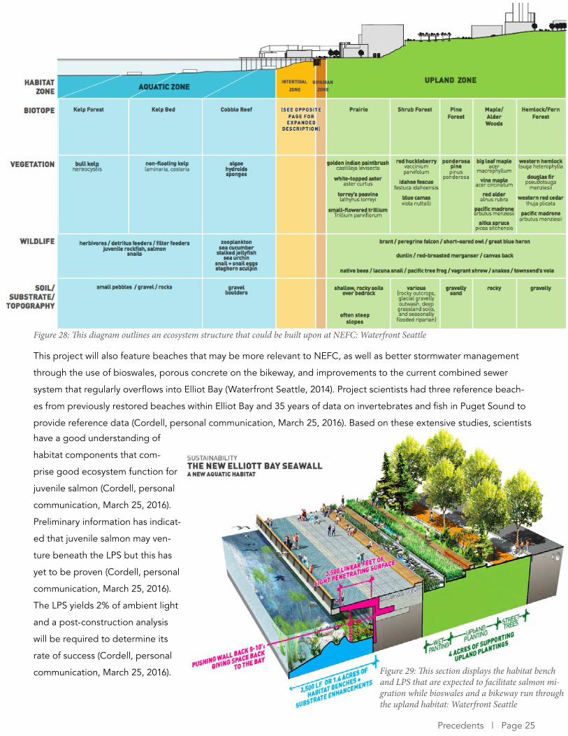
This project will also feature beaches that may be more relevant to NEFC, as well as better stormwater management
through the use of bioswales, porous concrete on the bikeway, and improvements to the current combined sewer
system that regularly overflows into Elliot Bay (Waterfront Seattle, 2014). Project scientists had three reference beach-
es from previously restored beaches within Elliot Bay and 35 years of data on invertebrates and fish in Puget Sound to
provide reference data (Cordell, personal communication, March 25, 2016). Based on these extensive studies, scientists
Figure 28: This diagram outlines an ecosystem structure that could be built upon at NEFC: Waterfront Seattle
Figure 29: This section displays the habitat bench and LPS that are expected to facilitate salmon mi-gration while bioswales and a bikeway run through the upland habitat: Waterfront Seattle
have a good understanding of
habitat components that com-
prise good ecosystem function for
juvenile salmon (Cordell, personal
communication, March 25, 2016).
Preliminary information has indicat-
ed that juvenile salmon may ven-
ture beneath the LPS but this has
yet to be proven (Cordell, personal
communication, March 25, 2016).
The LPS yields 2% of ambient light
and a post-construction analysis
will be required to determine its
rate of success (Cordell, personal
communication, March 25, 2016).
Precedents | Page 25
Opportunities for NEFC• Blending of public realm improvements with ecological function through design such as Light Penetrating
Surfaces in Seawall and stormwater capture
• Improving connections throughout the city by focusing on corridors between other green spaces
• Focus on coastal ecosystem structure and interactions between coastal biomes ranging from upland to
aquatic
• Seattle’s upland habitat will be constrained by the proximity of the new Alaskan Way to the waterfront but at
NEFC upland habitat could extend as far north as the Skytrain guideway
NEFC is not constrained by the proximity of the new at-grade
Alaskan Way and piers at Seattle’s waterfront resulting in more
land to work with and greater flexibility. Waterfront Seattle can
act as a test ground for many options of what could be im-
plemented at NEFC ranging from habitat and seawall design
to improving stormwater management. The similar urban and
ecological contexts make this project particularly worth learn-
ing from.
“The waterfront is separated from Elliott Bay by the Seawall. Due to a long history of industry and development, the environment in marine waters along the central waterfront has been degraded by
pollution, combined sewer discharge, dredging, dumping and large surfaces of over-water coverage. The quality of marine water environments along the central waterfront depends on many factors which are beyond the scope of this project, but every effort will be made to coordinate with and encourage initiatives to improve the quality of water in the marine environment” (Waterfront
Seattle, p. 160)
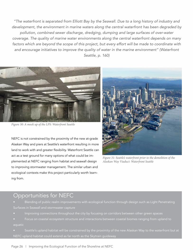
Figure 30: A mock up of the LPS: Waterfront Seattle
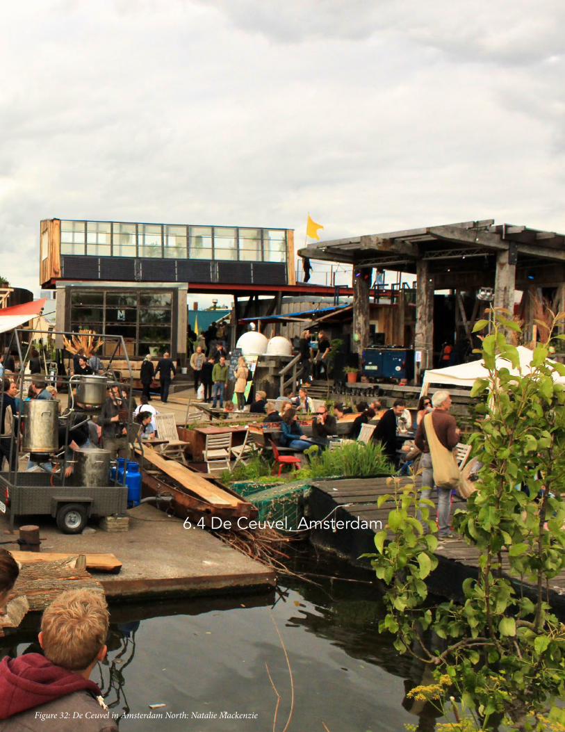
Figure 31: Seattle’s waterfront prior to the demolition of the Alaskan Way Viaduct: Waterfront Seattle
Page 26 | Improving the Ecological Function of the Shoreline at NEFC
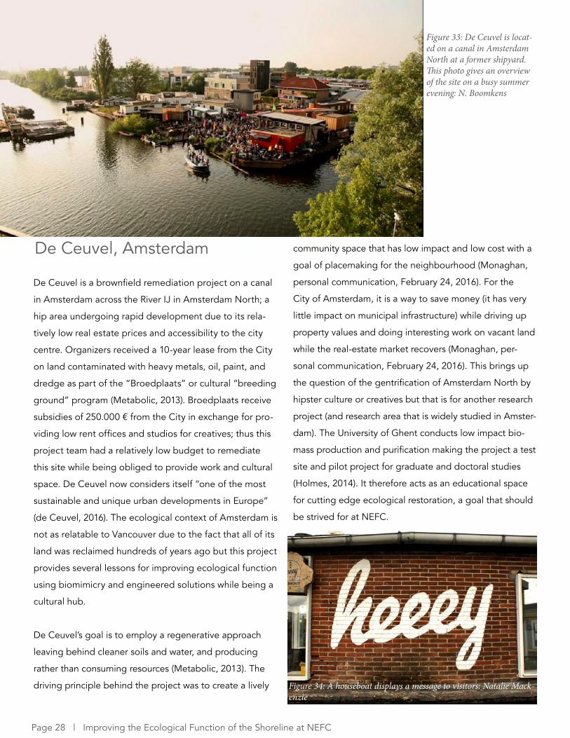
6.4 De Ceuvel, Amsterdam
Figure 32: De Ceuvel in Amsterdam North: Natalie Mackenzie
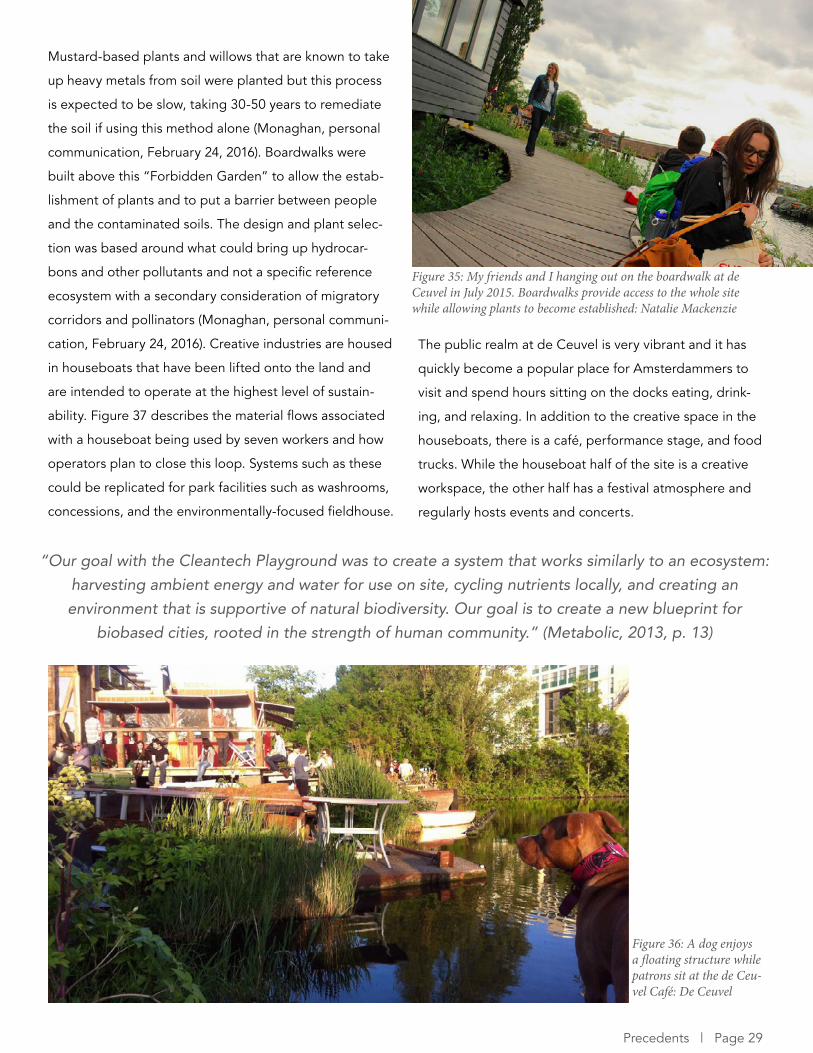
De Ceuvel is a brownfield remediation project on a canal
in Amsterdam across the River IJ in Amsterdam North; a
hip area undergoing rapid development due to its rela-
tively low real estate prices and accessibility to the city
centre. Organizers received a 10-year lease from the City
on land contaminated with heavy metals, oil, paint, and
dredge as part of the “Broedplaats” or cultural “breeding
ground” program (Metabolic, 2013). Broedplaats receive
subsidies of 250.000 € from the City in exchange for pro-
viding low rent offices and studios for creatives; thus this
project team had a relatively low budget to remediate
this site while being obliged to provide work and cultural
space. De Ceuvel now considers itself “one of the most
sustainable and unique urban developments in Europe”
(de Ceuvel, 2016). The ecological context of Amsterdam is
not as relatable to Vancouver due to the fact that all of its
land was reclaimed hundreds of years ago but this project
provides several lessons for improving ecological function
using biomimicry and engineered solutions while being a
cultural hub.
De Ceuvel’s goal is to employ a regenerative approach
leaving behind cleaner soils and water, and producing
rather than consuming resources (Metabolic, 2013). The
driving principle behind the project was to create a lively
De Ceuvel, Amsterdam community space that has low impact and low cost with a
goal of placemaking for the neighbourhood (Monaghan,
personal communication, February 24, 2016). For the
City of Amsterdam, it is a way to save money (it has very
little impact on municipal infrastructure) while driving up
property values and doing interesting work on vacant land
while the real-estate market recovers (Monaghan, per-
sonal communication, February 24, 2016). This brings up
the question of the gentrification of Amsterdam North by
hipster culture or creatives but that is for another research
project (and research area that is widely studied in Amster-
dam). The University of Ghent conducts low impact bio-
mass production and purification making the project a test
site and pilot project for graduate and doctoral studies
(Holmes, 2014). It therefore acts as an educational space
for cutting edge ecological restoration, a goal that should
be strived for at NEFC.
Figure 33: De Ceuvel is locat-ed on a canal in Amsterdam North at a former shipyard. This photo gives an overview of the site on a busy summer evening: N. Boomkens
Figure 34: A houseboat displays a message to visitors: Natalie Mack-enzie
Page 28 | Improving the Ecological Function of the Shoreline at NEFC
Mustard-based plants and willows that are known to take
up heavy metals from soil were planted but this process
is expected to be slow, taking 30-50 years to remediate
the soil if using this method alone (Monaghan, personal
communication, February 24, 2016). Boardwalks were
built above this “Forbidden Garden” to allow the estab-
lishment of plants and to put a barrier between people
and the contaminated soils. The design and plant selec-
tion was based around what could bring up hydrocar-
bons and other pollutants and not a specific reference
ecosystem with a secondary consideration of migratory
corridors and pollinators (Monaghan, personal communi-
cation, February 24, 2016). Creative industries are housed
in houseboats that have been lifted onto the land and
are intended to operate at the highest level of sustain-
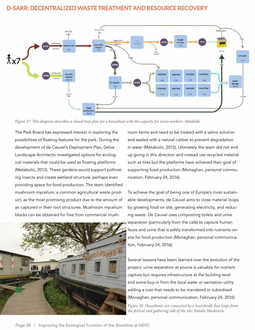
ability. Figure 37 describes the material flows associated
with a houseboat being used by seven workers and how
operators plan to close this loop. Systems such as these
could be replicated for park facilities such as washrooms,
concessions, and the environmentally-focused fieldhouse.
The public realm at de Ceuvel is very vibrant and it has
quickly become a popular place for Amsterdammers to
visit and spend hours sitting on the docks eating, drink-
ing, and relaxing. In addition to the creative space in the
houseboats, there is a café, performance stage, and food
trucks. While the houseboat half of the site is a creative
workspace, the other half has a festival atmosphere and
regularly hosts events and concerts.
“Our goal with the Cleantech Playground was to create a system that works similarly to an ecosystem: harvesting ambient energy and water for use on site, cycling nutrients locally, and creating an environment that is supportive of natural biodiversity. Our goal is to create a new blueprint for
biobased cities, rooted in the strength of human community.” (Metabolic, 2013, p. 13)
Figure 35: My friends and I hanging out on the boardwalk at de Ceuvel in July 2015. Boardwalks provide access to the whole site while allowing plants to become established: Natalie Mackenzie
Figure 36: A dog enjoys a floating structure while patrons sit at the de Ceu-vel Café: De Ceuvel
Precedents | Page 29
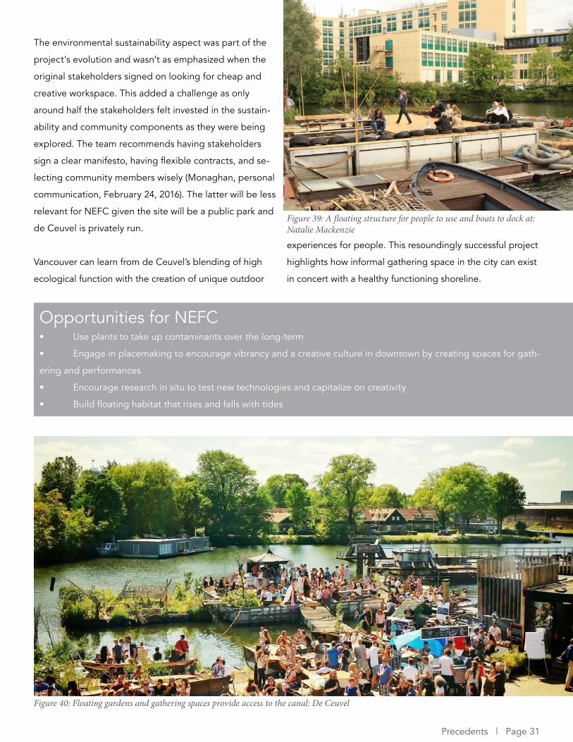
room farms and need to be treated with a saline solution
and sealed with a natural rubber to prevent degradation
in water (Metabolic, 2013). Ultimately the team did not end
up going in this direction and instead use recycled material
such as tires but the platforms have achieved their goal of
supporting food production (Monaghan, personal commu-
nication, February 24, 2016).
To achieve the goal of being one of Europe’s most sustain-
able developments, de Ceuvel aims to close material loops
by growing food on site, generating electricity, and reduc-
ing waste. De Ceuvel uses composting toilets and urine
separation (particularly from the café) to capture human
feces and urine that is safely transformed into nutrients on-
site for food production (Monaghan, personal communica-
tion, February 24, 2016).
Several lessons have been learned over the evolution of the
project: urine separation at source is valuable for nutrient
capture but requires infrastructure at the building level
and some buy-in from the local water or sanitation utility
adding a cost that needs to be mandated or subsidized
(Monaghan, personal communication, February 24, 2016).
The Park Board has expressed interest in exploring the
possibilities of floating features for the park. During the
development of de Ceuvel’s Deployment Plan, Delva
Landscape Architects investigated options for ecolog-
ical materials that could be used as floating platforms
(Metabolic, 2013). These gardens would support pollinat-
ing insects and create wetland structure, perhaps even
providing space for food production. The team identified
mushroom mycelium, a common agricultural waste prod-
uct, as the most promising product due to the amount of
air captured in their root structures. Mushroom mycelium
blocks can be obtained for free from commercial mush-
Figure 37: This diagram describes a closed-loop plan for a houseboat with the capacity for seven workers: Metabolic
Figure 38: Houseboats are connected by a boardwalk that loops from the festival and gathering side of the site: Natalie Mackenzie
Page 30 | Improving the Ecological Function of the Shoreline at NEFC
Opportunities for NEFC• Use plants to take up contaminants over the long-term
• Engage in placemaking to encourage vibrancy and a creative culture in downtown by creating spaces for gath-
ering and performances
• Encourage research in situ to test new technologies and capitalize on creativity
• Build floating habitat that rises and falls with tides
The environmental sustainability aspect was part of the
project’s evolution and wasn’t as emphasized when the
original stakeholders signed on looking for cheap and
creative workspace. This added a challenge as only
around half the stakeholders felt invested in the sustain-
ability and community components as they were being
explored. The team recommends having stakeholders
sign a clear manifesto, having flexible contracts, and se-
lecting community members wisely (Monaghan, personal
communication, February 24, 2016). The latter will be less
relevant for NEFC given the site will be a public park and
de Ceuvel is privately run.
Vancouver can learn from de Ceuvel’s blending of high
ecological function with the creation of unique outdoor
experiences for people. This resoundingly successful project
highlights how informal gathering space in the city can exist
in concert with a healthy functioning shoreline.
Figure 39: A floating structure for people to use and boats to dock at: Natalie Mackenzie
Figure 40: Floating gardens and gathering spaces provide access to the canal: De Ceuvel
Precedents | Page 31

6.5 Habitat Island and Hinge Park, Vancouver
Figure 41: Habitat Island in the middle of the city: Grant Diamond

Habitat Island and Hinge Park are located at Southeast
False Creek (SEFC) just across the water from NEFC and
are a recent and very relevant case study due to their
similar context and recent completion.
During the planning of SEFC the City determined that a
portion of the shoreline needed to be filled (The Chal-
lenge Series, 2010). The Department of Fisheries and
Oceans originally resisted the plan as the destruction of
fish habitat would violate the Fisheries Act (The Chal-
lenge Series, 2010). In the end, a team of environmental
consultants proposed building a small offshore island that
replaced lost shoreline and resulted in a net increase in
the area of intertidal fish habitat (The Challenge Series,
2010).
Habitat Island hosts aquatic, riparian, and upland habitats
including native vegetation and a natural shoreline that
has attracted a variety of waterfowl and herring spawn
(The Challenge Series, 2010). Public access is over a chain
of boulders on a narrow isthmus from the Seawall and a
network of trails meander through the upland habitat.
The City should emulate this practice by building one or
more habitat compensation islands and justify this habitat
compensation at a False Creek or city-wide scale rather
than just a park-scale. In other words, much of Vancou-
ver’s shoreline is developed and has lost its ecologi-
cal productivity. The City should maximize the area of
intertidal habitat it can create at NEFC to compensate for
these areas.
Habitat Island, Vancouver
Figure 42: Habitat Island in False Creek: Grant Diamond
Figure 43: An isthmus provides a bridge for people to experience nature in the heart of the city: Grant Diamond
Precedents | Page 33
Habitat Island’s unofficial moniker is Beer Island as it is a
popular place for people to meet and enjoy a drink on
the rocks while taking in views of downtown. It is clear
that there is a desire among citizens for informal gather-
ing space with the freedom to enjoy the outdoors in their
own way. De Ceuvel is a good example of an informal
space where people can gather, enjoy music, food, and
drink. This sort of place is lacking in Vancouver and an
opportunity exists to create a unique and flexible space
though the province’s archaic liquor laws may be a barrier.
De Ceuvel is an example of how social gathering spaces
can coexist with ecological function and Habitat Island
makes it clear this type of space is desired by citizens.
Hinge Park, Vancouver
Hinge Park is a slightly inland riparian park featuring
a constructed wetland to remediate and retain storm-
water that treats runoff from the west side of Olympic
Village (The Challenge Series, 2010). Bridges cross the
water, meandering paths wind through the habitat, and a
children’s play area combines the function of a play park
with rainwater remediation. Wildlife habitat, natural play,
and aesthetic values have been merged (The Challenge
Series, 2010). In a serendipitous moment in 2012 I had
a conversation with an architect who was leading a tour
through SEFC with a group of Skanska architects visiting
from Sweden and he described the site’s biggest success
being public access to the water. Building in features that
force interactions between people and aspects of their
environment (such as water), even if the features are sub-
tle, causes them to appreciate the environment and can
potentially change behavior.
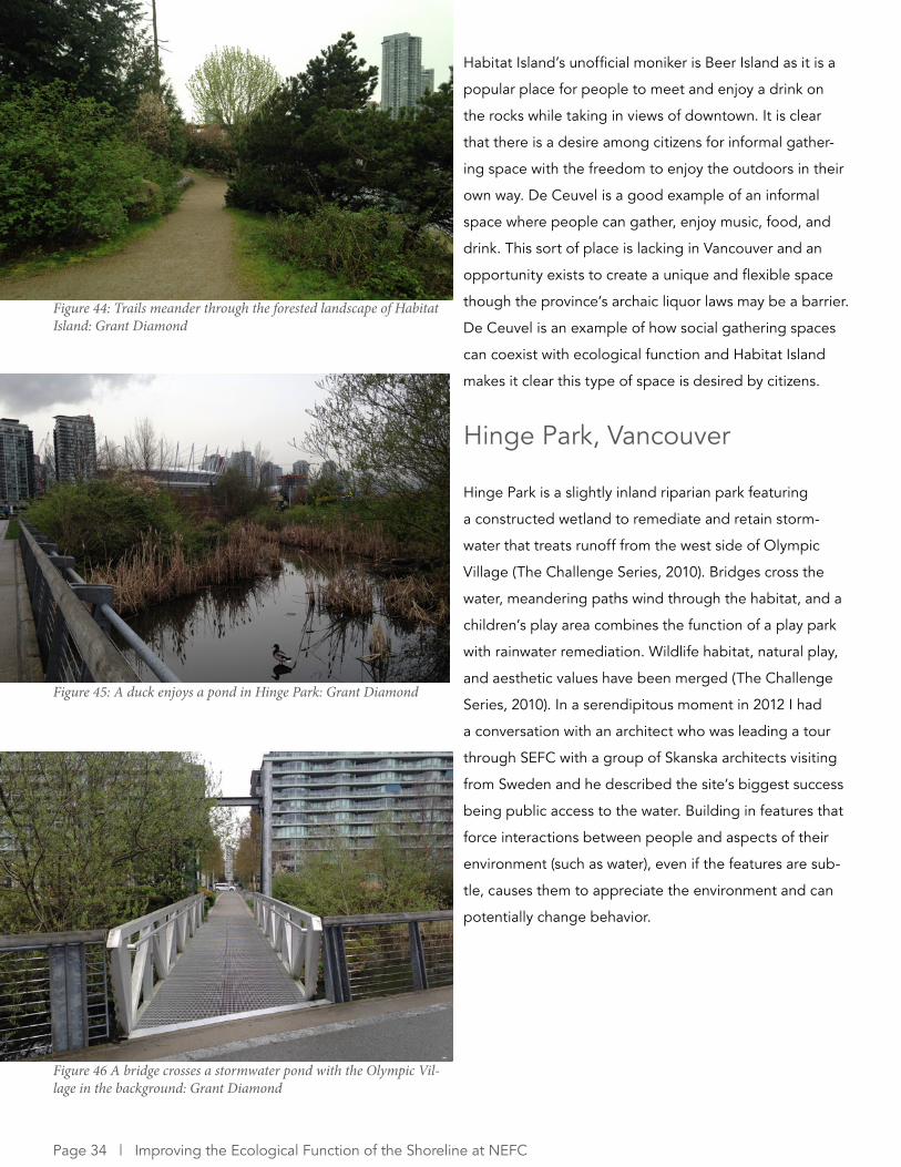
Figure 44: Trails meander through the forested landscape of Habitat Island: Grant Diamond
Figure 45: A duck enjoys a pond in Hinge Park: Grant Diamond
Figure 46 A bridge crosses a stormwater pond with the Olympic Vil-lage in the background: Grant Diamond
Page 34 | Improving the Ecological Function of the Shoreline at NEFC
Opportunities for NEFC• Construct one or multiple habitat compensation islands with varying degrees of access to ensure undisturbed
habitat can exist alongside humans
• Explore the mutual benefits that connections between Concord Pacific’s new neighbourhood and the NEFC
park can foster including but not limited to stormwater collection and purification
• Take advantage of the desire for informal and social gathering space by including this in the planning process
for NEFC
Habitat Island and Hinge Park are examples of how seem-
ingly wild spaces can exist in highly urbanized areas and
connect urbanites with nature. Connections were made
between the adjacent Olympic Village to treat stormwa-
ter, a practice that can be emulated and built upon for
Concord Pacific’s new neighbourhood west of the future
NEFC park. The Habitat Island model also highlights
the tradeoffs that occur when integrating human access
and nature. While the provision of public access is an
asset by encouraging interactions with nature, it is also
a hindrance for many terrestrial species due to habitat
disturbance (Page, personal communication, March 20,
2016). To address this, NEFC could feature areas that are
reserved for habitat or only have seasonal access to some
habitat. If multiple habitat compensation islands are con-
structed then one could have access while another does
not or access could be dependent on the tides.
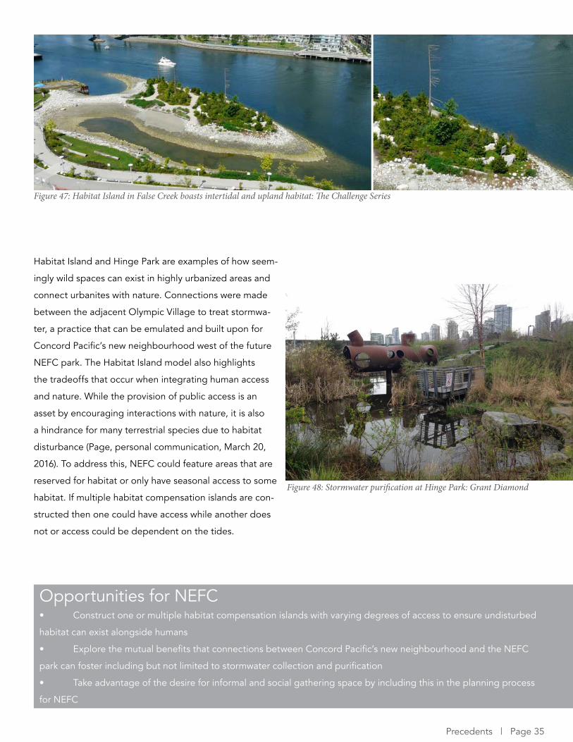
Figure 47: Habitat Island in False Creek boasts intertidal and upland habitat: The Challenge Series
Figure 48: Stormwater purification at Hinge Park: Grant Diamond
Precedents | Page 35
7 RECOMMENDATIONS Each of the above projects provides examples that can improve the ecological function of NEFC while including human
use and engaging in placemaking. By using these projects as models the City can achieve its green goals as identified
from its policy framework and create a park of unprecedented ecological quality. This would contribute to Vancouver’s
current status as a model green city while addressing climate change and restoring species that were lost during False
Creek’s industrialization. Furthermore, new outdoor spaces for people would create opportunities for education, gath-
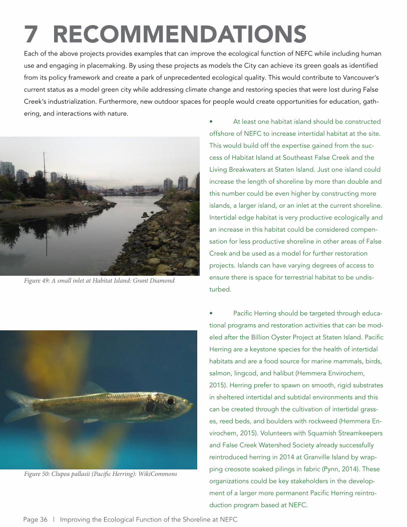
ering, and interactions with nature.• At least one habitat island should be constructed
offshore of NEFC to increase intertidal habitat at the site.
This would build off the expertise gained from the suc-
cess of Habitat Island at Southeast False Creek and the
Living Breakwaters at Staten Island. Just one island could
increase the length of shoreline by more than double and
this number could be even higher by constructing more
islands, a larger island, or an inlet at the current shoreline.
Intertidal edge habitat is very productive ecologically and
an increase in this habitat could be considered compen-
sation for less productive shoreline in other areas of False
Creek and be used as a model for further restoration
projects. Islands can have varying degrees of access to
ensure there is space for terrestrial habitat to be undis-
turbed.
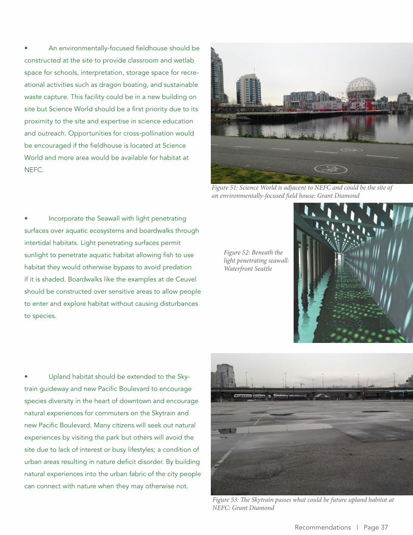
• Pacific Herring should be targeted through educa-
tional programs and restoration activities that can be mod-
eled after the Billion Oyster Project at Staten Island. Pacific
Herring are a keystone species for the health of intertidal
habitats and are a food source for marine mammals, birds,
salmon, lingcod, and halibut (Hemmera Envirochem,
2015). Herring prefer to spawn on smooth, rigid substrates
in sheltered intertidal and subtidal environments and this
can be created through the cultivation of intertidal grass-
es, reed beds, and boulders with rockweed (Hemmera En-
virochem, 2015). Volunteers with Squamish Streamkeepers
and False Creek Watershed Society already successfully
reintroduced herring in 2014 at Granville Island by wrap-
ping creosote soaked pilings in fabric (Pynn, 2014). These
organizations could be key stakeholders in the develop-
ment of a larger more permanent Pacific Herring reintro-
duction program based at NEFC.
Figure 49: A small inlet at Habitat Island: Grant Diamond
Figure 50: Clupea pallasii (Pacific Herring): WikiCommons
Page 36 | Improving the Ecological Function of the Shoreline at NEFC
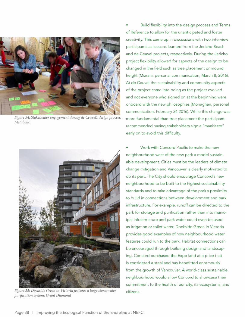
• An environmentally-focused fieldhouse should be
constructed at the site to provide classroom and wetlab
space for schools, interpretation, storage space for recre-
ational activities such as dragon boating, and sustainable
waste capture. This facility could be in a new building on
site but Science World should be a first priority due to its
proximity to the site and expertise in science education
and outreach. Opportunities for cross-pollination would
be encouraged if the fieldhouse is located at Science
World and more area would be available for habitat at
NEFC.
• Incorporate the Seawall with light penetrating
surfaces over aquatic ecosystems and boardwalks through
intertidal habitats. Light penetrating surfaces permit
sunlight to penetrate aquatic habitat allowing fish to use
habitat they would otherwise bypass to avoid predation
if it is shaded. Boardwalks like the examples at de Ceuvel
should be constructed over sensitive areas to allow people
to enter and explore habitat without causing disturbances
to species.
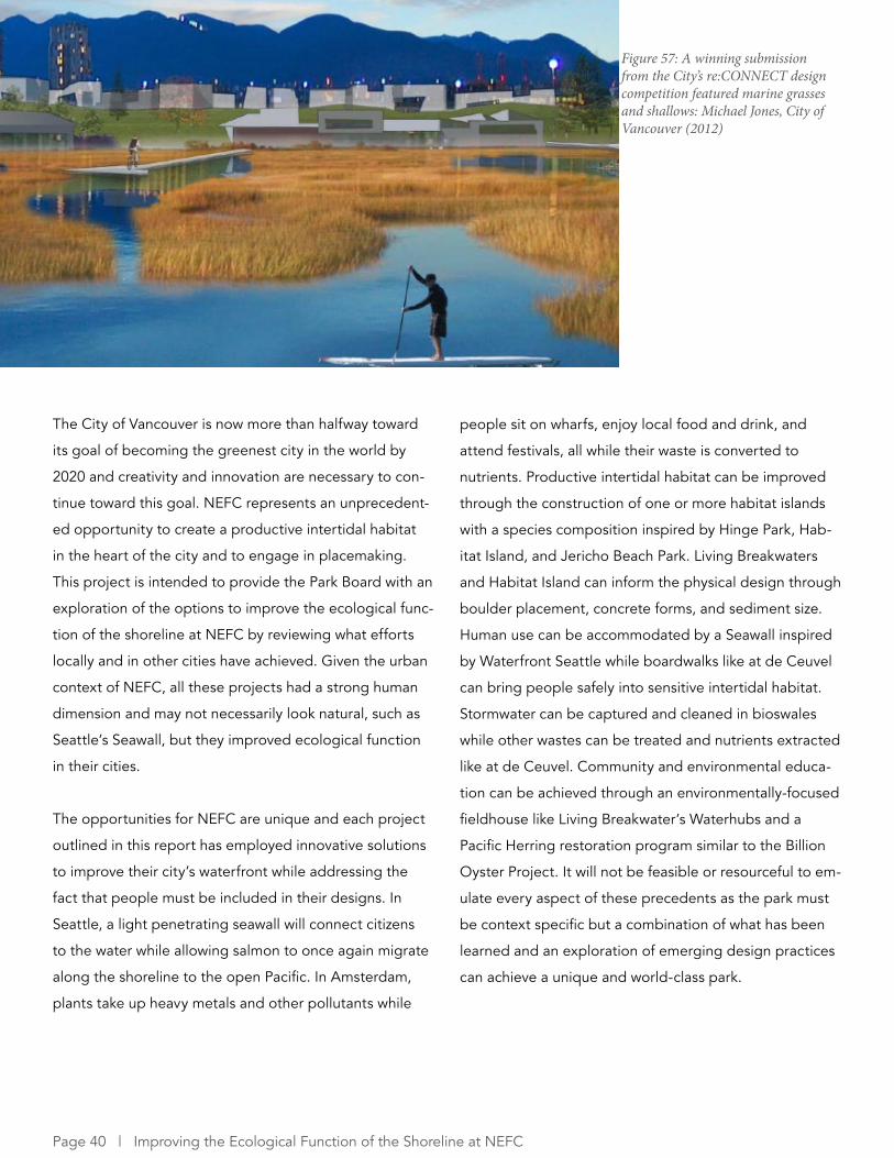
• Upland habitat should be extended to the Sky-
train guideway and new Pacific Boulevard to encourage
species diversity in the heart of downtown and encourage
natural experiences for commuters on the Skytrain and
new Pacific Boulevard. Many citizens will seek out natural
experiences by visiting the park but others will avoid the
site due to lack of interest or busy lifestyles; a condition of
urban areas resulting in nature deficit disorder. By building
natural experiences into the urban fabric of the city people
can connect with nature when they may otherwise not.
Figure 51: Science World is adjacent to NEFC and could be the site of an environmentally-focused field house: Grant Diamond
Figure 52: Beneath the light penetrating seawall: Waterfront Seattle
Figure 53: The Skytrain passes what could be future upland habitat at NEFC: Grant Diamond
Recommendations | Page 37
• Build flexibility into the design process and Terms
of Reference to allow for the unanticipated and foster
creativity. This came up in discussions with two interview
participants as lessons learned from the Jericho Beach
and de Ceuvel projects, respectively. During the Jericho
project flexibility allowed for aspects of the design to be
changed in the field such as tree placement or mound
height (Mizrahi, personal communication, March 8, 2016).
At de Ceuvel the sustainability and community aspects
of the project came into being as the project evolved
and not everyone who signed on at the beginning were
onboard with the new philosophies (Monaghan, personal
communication, February 24 2016). While this change was
more fundamental than tree placement the participant
recommended having stakeholders sign a “manifesto”
early on to avoid this difficulty.
• Work with Concord Pacific to make the new
neighbourhood west of the new park a model sustain-
able development. Cities must be the leaders of climate
change mitigation and Vancouver is clearly motivated to
do its part. The City should encourage Concord’s new
neighbourhood to be built to the highest sustainability
standards and to take advantage of the park’s proximity
to build in connections between development and park
infrastructure. For example, runoff can be directed to the
park for storage and purification rather than into munic-
ipal infrastructure and park water could even be used
as irrigation or toilet water. Dockside Green in Victoria
provides good examples of how neighbourhood water
features could run to the park. Habitat connections can
be encouraged through building design and landscap-
ing. Concord purchased the Expo land at a price that
is considered a steal and has benefitted enormously
from the growth of Vancouver. A world-class sustainable
neighbourhood would allow Concord to showcase their
commitment to the health of our city, its ecosystems, and
citizens.
Figure 54: Stakeholder engagement during de Ceuvel’s design process: Metabolic
Figure 55: Dockside Green in Victoria features a large stormwater purification system: Grant Diamond
Page 38 | Improving the Ecological Function of the Shoreline at NEFC

8 CONCLUSIONS
Figure 56: Access to Habitat Island: Grant Diamond
The City of Vancouver is now more than halfway toward
its goal of becoming the greenest city in the world by
2020 and creativity and innovation are necessary to con-
tinue toward this goal. NEFC represents an unprecedent-
ed opportunity to create a productive intertidal habitat
in the heart of the city and to engage in placemaking.
This project is intended to provide the Park Board with an
exploration of the options to improve the ecological func-
tion of the shoreline at NEFC by reviewing what efforts
locally and in other cities have achieved. Given the urban
context of NEFC, all these projects had a strong human
dimension and may not necessarily look natural, such as
Seattle’s Seawall, but they improved ecological function
in their cities.
The opportunities for NEFC are unique and each project
outlined in this report has employed innovative solutions
to improve their city’s waterfront while addressing the
fact that people must be included in their designs. In
Seattle, a light penetrating seawall will connect citizens
to the water while allowing salmon to once again migrate
along the shoreline to the open Pacific. In Amsterdam,
plants take up heavy metals and other pollutants while
people sit on wharfs, enjoy local food and drink, and
attend festivals, all while their waste is converted to
nutrients. Productive intertidal habitat can be improved
through the construction of one or more habitat islands
with a species composition inspired by Hinge Park, Hab-
itat Island, and Jericho Beach Park. Living Breakwaters
and Habitat Island can inform the physical design through
boulder placement, concrete forms, and sediment size.
Human use can be accommodated by a Seawall inspired
by Waterfront Seattle while boardwalks like at de Ceuvel
can bring people safely into sensitive intertidal habitat.
Stormwater can be captured and cleaned in bioswales
while other wastes can be treated and nutrients extracted
like at de Ceuvel. Community and environmental educa-
tion can be achieved through an environmentally-focused
fieldhouse like Living Breakwater’s Waterhubs and a
Pacific Herring restoration program similar to the Billion
Oyster Project. It will not be feasible or resourceful to em-
ulate every aspect of these precedents as the park must
be context specific but a combination of what has been
learned and an exploration of emerging design practices
can achieve a unique and world-class park.
Figure 57: A winning submission from the City’s re:CONNECT design competition featured marine grasses and shallows: Michael Jones, City of Vancouver (2012)
Page 40 | Improving the Ecological Function of the Shoreline at NEFC

The key opportunity presented by NEFC is its tabula rasa
status. The projects outlined in this report were con-
strained by their geography; in Seattle’s case a new bou-
levard restricts upland habitat and the small footprint of
de Ceuvel meant the site is compact (though the design
and use take advantage of this). The NEFC park can take
multiple forms due to its area that extends up to 220m to
the Skytrain guideway. The shoreline’s gradient can be
decreased or moved inland and upland habitat can be
expansive. This flexibility will allow Vancouver to create a
unique park providing citizens and visitors the opportuni-
ty to connect with and learn from nature while building on
the City’s progress toward its Greenest City goal.
• A design exercise using the above examples to
create a rendering could explore how the features de-
scribed in the precedents section could fit into NEFC.
• There are benefits that are harder to quantify and
outside the scope of this project but warrant being men-
tioned. Biophillic response in cities is an emerging field
of research that blends biopsychology and architecture
by exploring how the built form of a city can generate
responses akin to those we experience in nature . When
human brains perceive a natural scene certain centres
are activated resulting in lower stress levels. Imagine the
cumulative effect of hundreds of thousands of commuters
experiencing a biophillic response as they pass through
NEFC on the Skytrain. A commuter train passing through
a coastal ecosystem would be unprecedented in urban
areas, would be emblematic of Vancouver’s green goals,
and could potentially have a measurable effect on the
wellbeing of its citizens.
• Nature deficit disorder is an emerging area of
study among urban populations, particularly children. By
integrating nature with the city and encouraging children
to interact with their environment through programs run
out of the environmentally-focused fieldhouse, the City
can ameliorate the effects of nature deficit disorder.
Opportunities for further research
Figure 58: The site of future upland habitat, or perhaps a constructed inlet: Grant Diamond
Figure 59: This scenario exploration sketch highlights natural areas to the east, and Concord Pacific’s future neighbourhood to the west: Perkins + Will, City of Vancouver (2012)
Conclusions | Page 41
8 REFERENCESBoomkens, N. (2015). Opening de Ceuvel. Available online: http://www.nrpguldenfeniks.nl/hall-of fame/jaargangen/2015/gebiedstransformatie/de-ceuvel-3/
Bula, F. (2015, 15 October). Vancouver and BC split revenues from Expo Land. The Globe and Mail. Available online: http://www.theglobeandmail.com/news/british-columbia/vancouver-and-bc-split- on-revenues-from-expo-land/article26838689/
The Challenge Series. (2010). History & Policy. Available online: http://www.thechallengeseries.ca/get-the-challenge-series-booklet/chapter1/
The Challenge Series. (2010). Public Space and Infrastructure. Available online: http://www.thechal-lengeseries.ca/get-the-challenge-series-booklet/chapter3/
City of Vancouver. (2016). Jericho Beach. Available online: http://vancouver.ca/parks-recreation-cul-ture/restoring-jericho-beach.aspx
City of Vancouver. (2015). The Future of Vancouver’s Viaducts. Available online: http://vancouver.ca/home-property-development/viaducts-study.aspx
City of Vancouver. (2015). Healthy City Strategy. Available online: http://vancouver.ca/files/cov/Healthy-City-Strategy-Phase-2-Action-Plan-2015-2018.pdf
City of Vancouver. (2012). Climate Change Adaptation Strategy: Available online: http://vancouver.ca/files/cov/Vancouver-Climate-Change-Adaptation-Strategy-2012-11-07.pdf
City of Vancouver. (2012). Vancouver Viaducts Study. Available online: http://vancouver.ca/docs/east-ern-core/viaducts-june2012.pdf
Egan, D., E.E. Hjerepe, J., Abrams. (2011). Why People Matter in Ecological Restoration. n Egan, D., E.E. Hjerepe, J. Abrams. (eds). Human Dimensions of Ecological Resotration. Integrating Science, Nature and Culture. Island Press. Washington D.C. Pgs: 1-19.
False Creek Watershed Society. (2007). False Creek’s Watershed: Then and Now. Available online: http://www.falsecreekwatershed.org/uploads/2/0/5/0/20500086/falsecreek_swatershedfinal.pdf
Harris, J., van Diggelen, R. (2006). Ecological restoration as a project for global society. In Resto-ration Ecology (Eds) van Andel, J., Aronson, J. Blackwell Publishing. Malden, MA.
Hemmera Envirochem Inc. (2015). Granville Island Marine Structure Repairs Overview Aquatic Ef-fects Assessment. Available online: https://buyandsell.gc.ca/cds/public/2015/04/09/78880e699d-32b7e88949e40de1a72b8a/part_7_-_environmental_management_report.pdf
Holmes, D. (2014, 27 May). Purifying Park de Ceuvel | Amsterdam Netherlands | DELVA Landscape Architects. World Landscape Architecture. Avialble online: http://worldlandscapearchitect.com/puri-fying-park-de-ceuvel-amsterdam-netherlands-delva-landscape-architects/#.VuR6cRIrLMU
Page 42 | Improving the Ecological Function of the Shoreline at NEFC
Matthews, J. (1904). Shoreline area of False Creek Flats. Vancouver Archives. Available online: http://searcharchives.vancouver.ca/shoreline-area-of-false-creek-flats-2
Metabolic Lab. (2013). Cleantech Playground: A Cleantech Utility in Amsterdam North. Amsterdam: Innovatie Netwerk.
Moore, W.J. (c. 1916). View of False Creek Flats east of Main Street. Vancouver Archives. Available online: http://searcharchives.vancouver.ca/view-of-false-creek-flats-east-of-main-street
Parker, V. Thomas, and Pickett, Steward T.A. (1997). Restoration as an ecosystem process: implica-tions of the modern ecological paradigm. In Restoration Ecology and Sustainable Development (Eds) Urbanskca, Krystyna, M., Webb, N.R., Edwards, P.J. Cambridge University Press. London. Pgs 17-32.
Pynn, L. (2014, February 24). Ban on toxic creosote pilings sought after successful herring spawn in False Creek. The Vancouver Sun. Available online: http://www.vancouversun.com/toxic+cre-osote+pilings+sought+after+successful+herring+spawn+False+Creek/9526257/story.html?__lsa=bb80-f2a0
SCAPE Landscape Architecture. (2014). Living Breakwaters. New York.
Scott, A. J. (2012). A world in emergence: Cities and regions in the 21st century. Northampton, MA;Cheltenham, UK.
Thomas, S. (1912). Log Booms – False Creek. Vancouver Archives. Available online: http://searchar-chives.vancouver.ca/log-booms-false-creek
van Andel, J., Grootjans, A. (2006). Concepts in restoration ecology. In Restoration Ecology (Eds) van Andel, J., Aronson, J. Blackwell Publishing. Malden, MA.
Vancouver Board of Parks and Recreation. (2016). Biodiversity Strategy. Available online: http://for-mer.vancouver.ca/parks/board/2016/20160201/REPORT_BiodiversityStrategy20160201.pdf
Vancouver Board of Parks and Recreation. (2014). Rewilding Vancouver: An Environmental Educa-tion & Stewardship Action Plan: Available online: http://vancouver.ca/files/cov/enviromental-educa-tion-stewardship-action-plan.pdf
Vancouver Board of Parks and Recreation. (2012). Park Board Strategic Framework. Available online: http://vancouver.ca/files/cov/park-board-strategic-plan-presentation-20120627.pdf
Waterfront Seattle. (2014). Sustainability Briefing. Seattle Design Commission. Available online: http://waterfrontseattle.org/Media/Default/pdfs/2014_1106_Design_Commission_Sustainability_and_Wayfinding_web.pdf
Waterfront Seattle. (2012). Framework Plan. Available online: http://waterfrontseattle.org/Media/De-fault/pdfs/design/framework_plan_full.pdf
References | Page 43