Embed Size (px)
Citation preview

ABSTRACT
The integration of restored basin geome-try and internal features of syntectonic units (e.g., stratal architecture, thickness, sand-stone composition) with fl exural modeling of the lithosphere constrains the evolution of a basin and its fl exural history related to orogenic growth (spatial/temporal load-ing confi guration). Using this approach, we determined the Maastrichtian-Cenozoic polyphase growth of the Eastern Cordillera of Colombia, an inverted Mesozoic exten-sional basin. The record of this growth occurs in an Andean (post–middle Miocene) thrust belt (the Eastern Cordillera) and in adjacent foreland basins, such as the Llanos Basin to the east. This approach permitted the identifi -cation of fi ve tectono-stratigraphic sequences in the foreland basin and fi ve phases of short-ening for the Eastern Cordillera. Thermo-chronological and geochronological data support the spatial and temporal evolution of the orogen–foreland basin pair.
Tectono-stratigraphic sequences were
identifi ed in two restored cross sections, one located at a salient and the other in a recess on the eastern fl ank of the Eastern Cordil-lera. The lower two sequences correspond to late Maastrichtian–Paleocene fl exural events and record the eastward migration of both tectonic loading and depositional zero in the Llanos Basin. These sequences consist of amalgamated quartzarenites that abruptly grade upward to organic-rich fi ne-grained beds and, to the top, light-colored mud-stones interbedded with litharenites in iso-lated channels. Amalgamated conglomeratic quartzose sandstones of the third sequence record ~15 m.y. of slow subsidence in the Lla-nos Basin and Llanos foothills during early to middle Eocene time, while shortening was taking place farther west in the Magdalena Valley. The fourth sequence, of late Eocene–middle Miocene age, records a new episode of eastward migration of tectonic loads and depositional zero in the Llanos Basin. This sequence begins with deposition of thick fi ne-grained strata to the west, whereas to the east, in the Llanos basin, amalgamated quartzarenites unconformably overlie Cre-taceous and older rocks (former forebulge). Apatite fi ssion tracks in the axial zone of the Eastern Cordillera, growth strata in the
Llanos foothills, and synextensional strata on the forebulge of the Llanos Basin constrain deformation patterns for this time. The post–middle Miocene Andean event initiated with regional fl ooding of the foreland basin in response the widening of tectonic load-ing, after which the foredeep was fi lled with coarse-grained alluvial and fl uvial detritus derived from the Eastern Cordillera.
The geometry of tectonic loads, con-strained by fl exural models, reveals short-ening events of greater magnitude for the uppermost two sequences than for pre–mid-dle Eocene sequences. Tectonic loads for the late Maastrichtian–middle Eocene phases of shortening were less than 3 km high and 100 km wide. For the late Eocene–middle Miocene phase, tectonic loads changed south-ward from 6 km to less than 4 km, and loads were wider to the north. The strong Andean inversion formed today’s Eastern Cordillera structural confi guration and had equivalent tectonic loads of 10–11 km.
Integrated analysis is necessary in poly-phase orogenic belts to defi ne the spatial and temporal variation of tectonic load and fore-land basin confi gurations and to serve studies that seek to quantify exhumation and three-dimensional analyses of thrust belts. For the
For permission to copy, contact [email protected]© 2008 Geological Society of America
1171
An integrated analysis of an orogen–sedimentary basin pair: Latest Cretaceous–Cenozoic evolution of the linked Eastern Cordillera orogen
and the Llanos foreland basin of Colombia
German Bayona†
Smithsonian Tropical Research Institute, Unit 0948, APO AA 34002-0948, USA, and Corporación Geológica ARES, Calle 57 No. 24-11 of 202, Bogotá, Colombia
Martin CortésCorporacón Geológica ARES, Calle 57 No. 24-11 of 202, Bogotá, Colombia
Carlos JaramilloSmithsonian Tropical Research Institute, Unit 0948, APO AA 34002-0948, USA
German OjedaInstituto Colombiano del Petróleo, AA 41815, Km 7 to Piedecuesta, Bucaramanga, Colombia
John Jairo Aristizabal§
Ecopetrol S.A., Calle 37 No. 8-43, Bogotá, Colombia
Andres Reyes-HarkerInstituto Colombiano del Petróleo, AA 41815, Km 7 to Piedecuesta, Bucaramanga, Colombia
GSA Bulletin; September/October 2008; v. 120; no. 9/10; p. 1171–1197; doi: 10.1130/B26187.1; 15 fi gures; Data Repository item 2008078.
†E-mail: [email protected] §Present address: REPSOLYP, Calle 71A No. 5-38,
Bogotá, Colombia.

Bayona et al.
1172 Geological Society of America Bulletin, September/October 2008
Eastern Cordillera, thermochronological sampling must span the width of the Eastern Cordillera rather than be concentrated in a single range.
Keywords: foreland basin, Cenozoic stratigra-phy, basin inversion, orogenic belts, Cenozoic tectonics, Llanos Basin, Colombia.
INTRODUCTION
Integrative research on syntectonic sedimen-tary basins should include different types of data sets (sedimentology, stratal architecture, prove-nance, subsidence) and needs to consider kine-matic constraints from the adjacent mountain belts. Tectonic activity, weathering processes, and isostatic readjustment of the crust delimit uplifted blocks and so determine the nature of crustal loads adjacent to a basin. On the other hand, syntectonic sedimentary basins include the most complete record of the evolution of those uplifted blocks. Initiation of deformation in a formerly tectonically quiet (e.g., passive mar-gin) and nearly fl at (e.g., coastal plain) region affects depositional and paleoecological sys-tems, provenance, and paleocurrent indicators, as well as climate variables (e.g., precipitation). The rearrangement of these variables infl uences the tectonic evolution of both mountain ranges (e.g., climatic control of critical wedge in the central Andes; Horton, 1999) and adjacent sedi-mentary basins (e.g., change in fl uvial patterns of the Amazon Basin by uplift of the Andes; e.g., Hoorn et al., 1995).
The kinematic evolution of an orogen affects both the geometry and fi lling patterns of syntec-tonic sedimentary basins. In orogen and fore-land basin systems, estimates of spatial and tem-poral variations of crustal thickening commonly rely on studies of orogenic belt deformation in conjunction with proximal-to-distal synoro-genic stratigraphic and compositional analyses (e.g., Horton et al., 2001; Liu et al., 2005) of the foreland basin. Geodynamic models of fore-land basins have been essential in defi ning the spatial and temporal variation of tectonic load geometries, since there is a primary relationship among tectonic loading, strength of the litho-sphere, and basin geometry (e.g., Jordan, 1981; Cardozo and Jordan, 2001).
Integrated orogen and foreland basin analy-sis of the type presented here is an essential approach to understanding of polyphase thrust-belt systems and deciphering deformation phases. Investigations in the central (e.g., Horton et al., 2001) and northern Andes (e.g., Gómez et al., 2005a) indicate that pre-Neogene deforma-tion played an important role in the tectonic evo-lution of the Andes, which are believed to have
risen strongly in the late Neogene. Therefore, studies of shortening in the Eastern Cordillera of Colombia, a mountain range of the northern Andes, must consider temporal and spatial vari-ations of crustal shortening that resulted from pre-Neogene phases of deformation.
This paper presents a kinematic evolution and quantifi cation of tectonic loading of a polyphase-deformed orogenic belt (Eastern Cordillera) adjacent to a nonmarine foreland basin (Llanos Basin). We integrate provenance, sedimentol-ogy, stratal patterns, biostratigraphy, subsidence, structural, and geodynamic analyses with pub-lished thermochronological and geochronologi-cal data in order to (1) investigate how crustal thickening (i.e., tectonic loading) affected the latest Cretaceous–Paleogene evolution of the Llanos foreland basin, and (2) identify struc-tures in the Eastern Cordillera that might have been active at each phase of deformation. Our results suggest that the present topography of the Eastern Cordillera does not refl ect the com-plex earlier evolution of the northern Andes but rather provides a record only of the last phase of deformation. Therefore, integrated analysis of the adjacent Llanos foreland basin is necessary to investigate the previous deformation events, which are masked by the last phase.
TECTONIC FRAMEWORK OF THE COLOMBIAN ANDES AND EVIDENCES OF PRE-NEOGENE DEFORMATION
Regional Tectonic Setting of the Eastern Cordillera
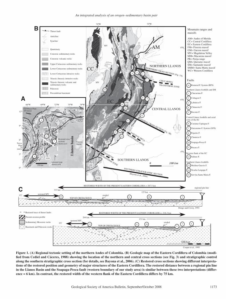
Three major orogenic belts are the result of the complex interaction of the Nazca, Carib-bean, and South America plates since the Late Cretaceous: the Western Cordillera, the Central Cordillera, and the Eastern Cordillera. The East-ern Cordillera bifurcates to the north into the Santander massif–Perija Range (MS-PR) and the Merida Andes (MA) (Fig. 1). The Eastern Cordillera is interpreted as a wide Cretaceous extensional basin that was formed during at least two stretching events (Sarmiento-Rojas et al., 2006) and that was tectonically inverted dur-ing the Cenozoic (Colleta et al., 1990; Dengo and Covey, 1993; Cooper et al., 1995; Mora et al., 2006). However, basement and sedimentary rocks exposed in the Eastern Cordillera and adjacent basins indicate that this complex region has been the scene of polyphase tectonics since Precambrian time (see Etayo-Serna et al. [1983] and Cediel et al. [2003] for details).
The eastern fl ank of the Eastern Cordillera of Colombia (Fig. 1) exposes contrasting structural styles between highly deformed rocks along an east-verging fold-and-thrust belt and the less-
deformed Llanos foreland basin. Reactivated Mesozoic normal faults, such as the Guaicar-amo fault system in the central Llanos foothills, have been considered to be the major boundary of those structural styles. Models of inversion tectonics have been created for the southern seg-ment of the Eastern Cordillera and Llanos foot-hills (Casero et al., 1997; Rowan and Linares, 2000; Branquet et al., 2002; Restrepo-Pace et al., 2004; Toro et al., 2004; Cortés et al., 2006a; Mora et al., 2006), in the central segment of the Eastern Cordillera and Llanos foothills (Colleta et al., 1990; Dengo and Covey, 1993; Cooper et al., 1995; Cazier et al., 1995; Roeder and Cham-berlain, 1995; Rathke and Coral, 1997; Fajardo-Peña, 1998; Taboada et al., 2000; Sarmiento-Rojas, 2001; Rochat et al., 2003; Toro et al., 2004; Martinez, 2006; Mora et al., 2006), and in the northern segment of the Eastern Cordillera and Llanos foothills (Chigne et al., 1997; Corre-dor, 2003; Villamil et al., 2004). Although struc-tural models differ both in the angle and depth of detachment of the Guaicaramo fault system and in fault involvement of crystalline base-ment to the east, structural restorations from the axial zone of the Eastern Cordillera and Llanos Basin are similar (Fig. 1C). Proposed structural models do not show a relationship between the amount of shortening and fl exural deformation in the adjacent basin, and they differ in (1) the amount of shortening of the Eastern Cordil-lera, mainly from the axial zone to the western boundary of the Eastern Cordillera (Fig. 1C), (2) the geometry of fold structures at depth, and (3) the position and confi guration of Mesozoic eastern and western rift shoulders.
As an alternative method to validate the short-ening estimated in our cross sections, we used the fl exural geometry of synorogenic Paleogene to Neogene foreland basins, growth-strata pat-terns, and crosscutting relationships of hanging-wall and footwall structures on the eastern fl ank of the Eastern Cordillera and Llanos foothills to better constrain the kinematic evolution of the eastern fl ank of the Eastern Cordillera.
Evidence of Pre-Neogene Deformation
Paleobotanical, thermochronological, and geochronological data indicate that surface and rock uplift, as well as rock deformation, have occurred at different times but primarily in the late Neogene. Paleobotanical data indi-cate a change in fl ora from lowland associa-tions to Andean-type forests (Helmens, 1990) in the last 5 m.y., but the timing of this change ranges between 3 and 6 Ma (Helmens and Van der Hammen, 1994; Hooghiemstra and Van der Hammen, 1998). Zircon fi ssion-track ages support earlier uplift in the Central Cordillera
An integrated analysis of an orogen–sedimentary basin pair
Geological Society of America Bulletin, September/October 2008 1173
711 10
100 km
6710119
Dengo and Covey, 1993
Cooper et al., 1995
TOP OF CRETACEOUS
TOP OF CRETACEOUS
regional pin lineC 333 km
264 km
125 km
131 km
12
12
eroded
eroded
Basement and Paleozoic rocks
Sedimentary Mesozoic rocks
Present erosion profile
RESTORED WIDTH OF THE PRESENT EASTERN CORDILLERA = 287.5 km
RESTORED WIDTH OF THE PRESENT EASTERN CORDILLERA = 218.2 km
CC restored MV
CCrestored MV
Restored trace of thrust faults
72ºW69ºW66ºW 75ºW 78ºW
0º
3º
6º
9º
12º
54mm/yr
20 mm/yr
RFS
NazcaPlate
Caribbean Plate
GuyanaShield
250 km
RFS
EC
CC
WC
Lla
nos
basi
n
SMM
PR
SMMV
AM
A
A
A
Restored crosssectionsshown in C
GM
7
12
enlarged mapshown in B
MM
AM= Andes of MeridaCC= Central CordilleraEC= Eastern CordilleraFM= Floresta massifGM= Garzon massifMV= Magdalena ValleyMM= Macarena massifPR= Perija rangeQM= Quetame massifSM= Santander massifSMM= Santa Marta massifWC= Western Cordillera
EC
MV
CC
MV8ºN
4ºN
6ºN
72ºW74ºW
1
2
3
4
5
6
7
8
9
10
11
13
14
234
Chucarima F.
Cobugon F.
Labateca F.
Chinacota F.
Bocono F.
5
AM
6
7
Cusiana-Cupiagua F.
Guicaramo F. System (GFS)
10
8
Chameza F.
Soapaga-Pesca F.
Boyaca F.
11
Servita-Santa Maria F.
9
13
Pajarito F.
Tesalia-Lengupa F.
NORTHERN LLANOSNORTHERN CROSS SECTION (Fig. 3A)
1
CENTRAL CROSS SECTION (Fig. 3B)
CENTRAL LLANOS
CHUCARIMATRANSVERSE ZONE
TRANSVERSE ZONE
SOUTHERN LLANOS
QM
QM
FM
SM
B
A Romeral F. System (RFS)
Mountain ranges andmassifs
Faults
Northern Llanos foothills and SM
Central Llanos foothills and axialzone of the EC
Southern Llanos foothills
MM
15
14
Medina-Guavio F.
SOUTHERN STRATIGRAPHIC SECTION
12
12 Salinas F.
15
Western flank of the EC
Cocuy
Bogota
TunjaB
ucaramanga Fault
TRANSVERSE ZONE
NAZARETH
(Bayona et al., 2006)
SABANALARGA
Thrust fault
Anticline
Syncline
Quaternary
Cenozoic sedimentary rocks
Cenozoic volcanic rocks
Upper Cretaceous sedimentary rocks
Lower Cretaceous sedimentary rocks
Lower Cretaceous intrusive rocks
Triassic-Jurassic intrusive rocks
Triassic-Jurassic volcanic andsedimentary rocks
Paleozoic
Precambrian basement
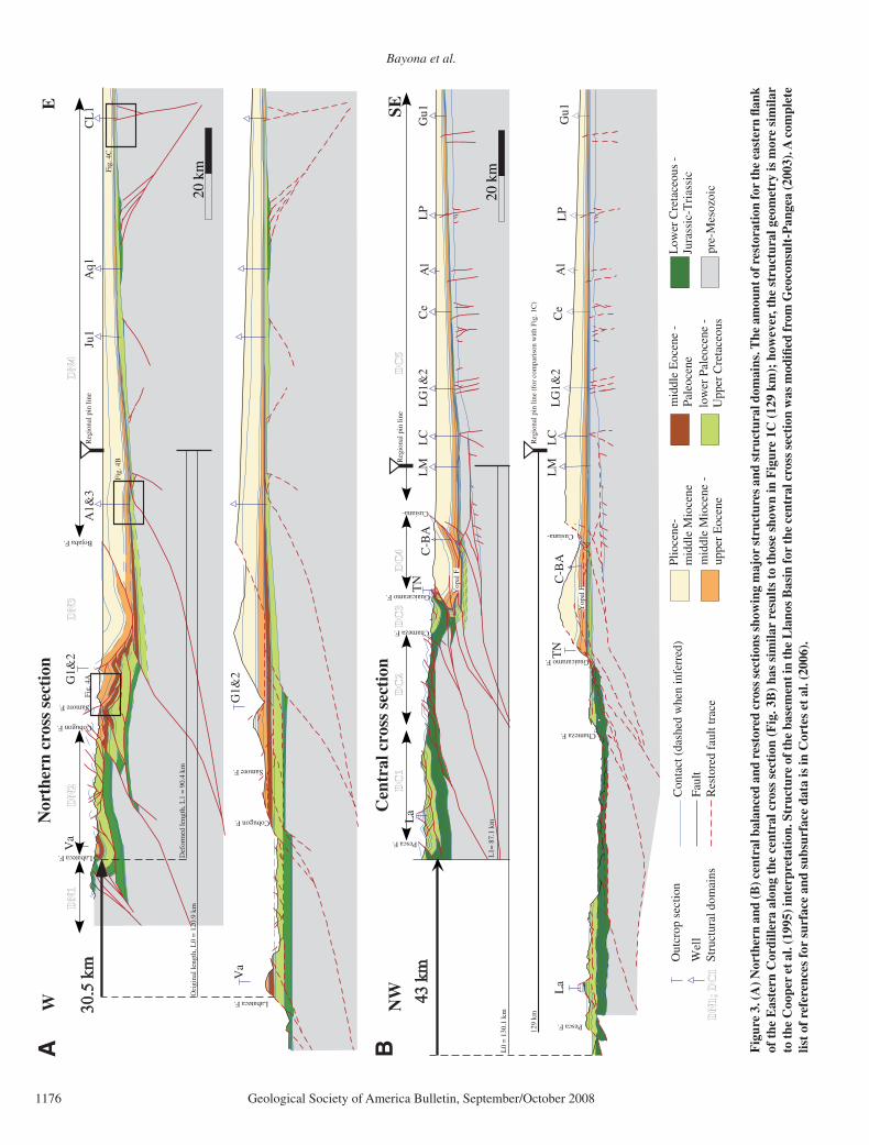
Figure 1. (A) Regional tectonic setting of the northern Andes of Colombia. (B) Geologic map of the Eastern Cordillera of Colombia (modi-fi ed from Cediel and Cáceres, 1988) showing the location of the northern and central cross sections (see Fig. 3) and stratigraphic control along the southern stratigraphic cross section (for details, see Bayona et al., 2006). (C) Restored cross sections showing different interpreta-tions of the restored position and geometry of major structures of the Eastern Cordillera. The restored distance between a regional pin line in the Llanos Basin and the Soapaga-Pesca fault (western boundary of our study area) is similar between these two interpretations (differ-ence = 6 km). In contrast, the restored width of the western fl ank of the Eastern Cordillera differs by 75 km.

Bayona et al.
1174 Geological Society of America Bulletin, September/October 2008
(around the Campanian-Maastrichtian bound-ary; Toro, 1999; Gómez et al., 2005a) than in the Santander massif–Perija Range and Merida Andes (near the Cretaceous-Tertiary [KT] boundary; Shagam et al., 1984; Kohn et al., 1984). Apatite fi ssion-track ages (AFTA) indicate a northward exhumation that began in the Oligocene in the Floresta (22.3 ± 4 Ma) and southern Santander (30.8 ± 5.8 Ma) mas-sifs (Toro, 1990), then moved to the central and northern Santander massif in the Miocene and Miocene-Pliocene, respectively (Shagam et al., 1984). AFTA ages on the western fl ank of the Eastern Cordillera (Gómez et al., 2003) support two phases of cooling, the fi rst between 65 and 30 Ma, which involved the removal of 3–4 km of overlying sedimentary cover, and the second between 10 and 5 Ma, which involved denuda-tion of 3 km of sedimentary cover. AFTA results on the eastern fl ank of the Eastern Cordillera (Hossack et al., 1999) require exhumation along the Chameza fault at 25 Ma and exhumation in the foothills between 3 and 15 Ma. AFTA data from the Garzon and Quetame massifs indicate younger phases of deformation, ranging from 12 to 3 Ma (Van der Wiel, 1991). The genera-tion of an orographic barrier at ca. 6–3 Ma trig-gered rapid denudation and shortening rates of the eastern fl ank of the Eastern Cordillera (Mora et al., 2005). Reported geochronological data from green muscovite crystallized on emerald-bearing vein wall rocks (Ar/Ar and K/Ar) indi-cate a fi rst extensional event at 65 ± 3 Ma on the eastern fl ank and a compressional event on the western fl ank between 32 and 38 Ma (Branquet et al., 1999).
A regional shift from marine to continental depositional environments at the end of the Cre-taceous was coeval with accretion of oceanic terranes west of the Romeral fault system (e.g., Etayo-Serna et al., 1983; McCourt et al., 1984). Mechanisms driving this shift have been inter-preted as eustasy and tectonism (Villamil, 1999) or increasing rate of sediment supply associated with exhumation and denudation of the Central Cordillera (Gómez et al., 2005a). Interpreted Paleocene basin geometry varies from a single and continuous foreland basin (Cooper et al., 1995; Villamil, 1999; Gómez et al., 2005a) to a continuous negative fl exural basin with appar-ent absence of bounding thrusts (Pindell et al., 2005) to a foreland basin disrupted by uplifts along the axial zone of the basin (Fabre 1981, 1987; Sarmiento-Rojas, 2001; Pardo, 2004), the western border of the basin (Bayona et al., 2003; Restrepo-Pace et al., 2004, Cortés et al., 2006a), or at both borders of the basin (Fajardo-Peña, 1998; Villamil, 1999). The integration of basin geometry, provenance, paleocurrent, sub-sidence, and geodynamics analyses allows us to
identify the location of loads that affected the geometry of the Paleocene foreland basin in the Llanos foothills and Llanos Basin.
Angular unconformities and growth-strata pat-terns of Paleogene beds place constraints on our ability to defi ne phases of deformation. A highly variable angular unconformity between lower-to-middle Eocene strata resting upon Paleocene or older units has been well documented in the subsurface of the Magdalena Valley (Vil-lamil et al., 1995; George et al., 1997; Pindell et al., 1998; Gómez et al., 2003, 2005b) and in outcrops (Restrepo-Pace et al., 2004). In the Magdalena Valley, structures beneath the uncon-formity have been interpreted as high-angle strike-slip faults (Pindell et al., 1998; Gómez et al., 2005b). Strata overlying this unconformity show a wedge of divergent growth strata of mid-dle Eocene–lower Miocene age in the southern middle Magdalena Valley (Gómez et al., 2003) and upper Oligocene–middle Miocene age in the northern Magdalena Valley (Gómez et al., 2005b). In the axial zone of the Eastern Cor-dillera, the structure of the eastern fl ank of the Usme syncline (south of Bogotá in Fig. 1B) has been interpreted as a progressive unconformity that has been growing since the late Paleocene (Julivert, 1963). In the northern Llanos foothills and Llanos Basin, Corredor (2003) and Cortés et al. (2006b) reported growth-strata patterns in Oligocene-Miocene strata. In the central Llanos foothills, Rathke and Coral (1997) and Martinez (2006) suggested the incipient development of broad fault-related anticlines and synorogenic deposition during the Oligocene. Adjacent to leading structures of the Llanos foothills (e.g., Cusiana fault in Fig. 1), however, seismic refl ec-tors of Oligocene and Miocene strata are paral-lel and generally isopachous (Toro et al., 2004). Parra et al. (2005) interpreted the westward coarsening and thickening of the Oligocene clastic wedge across a 20-km-wide syncline as the result of fl exural subsidence related to the uplift of the Quetame massif.
STRUCTURE OF THE EASTERN FLANK OF THE EASTERN CORDILLERA
In order to better understand the regional geometry and lateral variations along the eastern fold-and-thrust belt of the Eastern Cordillera, two regional balanced cross sections extending from the axial zone of the Eastern Cordillera to the Llanos Basin were constructed in areas where the geometry of the Guaicaramo fault sys-tem, the internal structural confi guration of the Eastern Cordillera, and the Cretaceous-Ceno-zoic stratigraphy differ (Figs. 1 and 2). Local cross sections were studied to the north and south of these regional cross sections in order to
confi rm and provide control on the lateral conti-nuity and consistency of the regional structural models. Surface mapping, seismic-refl ection profi les, gravity data, and well data constrain the construction of balanced cross sections. Strati-graphic thickness and units for each thrust sheet were provided from the tectono-stratigraphic analysis carried out along these regional cross sections (see next section).
Structure of the Northern Cross Section
This cross section (Fig. 3A) traverses a base-ment structural high, named the Pamplona indenter by Boinet et al. (1985), which is bor-dered by the northwest-striking Chucarima fault, north-striking Labateca and Chinacota reverse faults, and northeast-striking right-lat-eral Bocono fault. This cross section, located at the recess of the Guaicaramo fault system (the Guaicaramo fault system is displaced to the west to become the Cobugon fault), starts at the western fl ank of the Santander massif, passes through the northern Llanos foothills, and ends at the Caño Limon oil fi eld in the northern Lla-nos Basin (Figs. 1 and 3A). The trace of this cross section is far from the transverse bound-aries of the Pamplona indenter and at the place where deformation is mostly plane strain.
Structural domains in the Eastern Cordillera and Llanos foothills of the northern cross sec-tion involve basement rocks. These domains end southward at the northwest-striking Chu-carima fault system. The latter structure places a >3-km-thick succession of lower Cretaceous rocks (Fabre, 1987) in the upthrown block over NNW-striking folds involving upper Cretaceous and Paleogene strata in the downthrown block. In the latter block, the maximum thickness of the lower Cretaceous rocks is 1.2 km (Fig. 2). South of the Chucarima fault, structural domains are more similar to those described for the central cross section.
Structural balance of the northern cross sec-tion indicates a total shortening of 30.5 km (Fig. 3A). Major basement-involved faults form the boundaries between structural domains. The west-dipping basement-involved faults trans-lated displacement and strain eastward through an imbricated fold-and-thrust belt. The major displacements occurred along faults exposed toward the hinterland, where the Santander mas-sif is exposed (domains DN1&2, Fig. 3A). Out-of-sequence deformation along the Cobugon and Samore faults is inferred from the crosscut-ting relation between fault surfaces and footwall structures (domain DN3). A late Oligocene–early Miocene phase of east-verging deforma-tion is constrained by growth-strata patterns identifi ed in the syncline bounded by the Samore

An integrated analysis of an orogen–sedimentary basin pair
Geological Society of America Bulletin, September/October 2008 1175
Caq
ueza
Gr.
and
othe
r un
its >
1500
Junt
as50
0-70
0Fo
meq
ue70
0-90
0U
ne90
0-14
00
Chipaque400-620
Guada-lupe
500-530
Cuervos
180-480
Barco50-200
Guaduas0-50
Mirador 140-240
Car
bone
ra14
00-2
100
Leon
350-400G
uaya
bo>
1250
Albian
Paleo-
Maastrichtian
Turonian
Campanian
Upp
erL
Santonian
Cenomanian
Coniacian
Eocene
Olig
ocen
eM
ioce
neNE
OG
EN
EC
RE
TAC
EO
US
Low
erU
pper
Aptian
Plio
cene
PAL
EO
GE
NE
Valanginian
Berriasian
Hauterivian
Barremian
pre-Cretaceous ??
shale - mudstone
sandstone
conglomerate
limestone
chert
coal
low-grade metamorphic rocks
high-grade metamorphic rocks
detachment level
AGE
AGE UN
IT(t
hick
ness
in m
)
Le450
on
Gua
yabo
- 3
300
Car
bone
ra -
200
0
Mirador290
460
380
Cuervos
Barco 200
Luna50-200
Gacheta
Agu
ardi
ente
1300
Rio
Neg
ro0-
1330
Tibu-
300
Giron250
Val
angi
nian
-A
ptia
n
Floresta
Silgara
Bucara-
Alb
ian
Pale
ocen
e
Maastrichtian
Turonian
Campanian
Upp
erL
Santonian
Cenomanian
Coniacian
Eocene
Oligocene
Mio
cene
JURASSIC
Mercedes
NE
OG
EN
EC
RE
TAC
EO
US
Diamante
DEVONIAN
CAMBRIAN
PRECAMBRIAN
PERMIAN-
Low
erU
pper
Aptian
Plio
cene
F. E
l Aji
F. L
abat
eca
PAL
EO
GE
NE
Sant
ande
r m
assi
f
Lla
nos
foot
hill
s
Lla
nos
basi
n
Axi
al z
one
of th
e E
C
Lla
nos
foot
hills
Lla
nos
basi
nColon-
Mito Juan400
Mec
hani
cal u
nits
incr
oss
sect
ions
Mec
hani
cal u
nits
incr
oss
sect
ions
A
B Central cross section
Northern cross section
Figure 2. Generalized stratigraphic columns showing the lateral distribution of units along the (A) northern and (B) central cross sections. Regional detachment levels and mechanical units used for construction of cross sections are indicated.
Bayona et al.
1176 Geological Society of America Bulletin, September/October 2008
20 k
m
Low
er C
reta
ceou
s -
Jura
ssic
-Tri
assi
clo
wer
Pal
eoce
ne -
Upp
er C
reta
ceou
spr
e-M
esoz
oic
mid
dle
Eoc
ene
-Pa
leoc
ene
mid
dle
Mio
cene
-up
per
Eoc
ene
Plio
cene
-m
iddl
e M
ioce
neFa
ult
Con
tact
(da
shed
whe
n in
ferr
ed)
Res
tore
d fa
ult t
race
Wel
l
Out
crop
sec
tion
20 k
m
WE
NW
SE
Nor
ther
n cr
oss
sect
ion
Cen
tral
cro
ss s
ecti
on
La
Va
TN
C-B
AL
ML
CL
G1&
2C
eA
lL
PG
u1
La
TN
C-B
AL
ML
CL
G1&
2C
eA
lL
PG
u1
G1&
2
A1&
3Ju
1A
q1C
L1
Labateca F.
Cobugon F.
Samore F.
Fig.
4A
Fig.
4B
Labateca F.
Cobugon F.
Samore F.
Pesca F.
Chameza F.
Guaicaramo F.
Pesca F.
Chameza F.
Guaicaramo F.
Cusiana-
Cusiana-
Fig.
4C
129
kmR
egio
nal p
in li
ne (
for
com
pari
son
with
Fig
. 1C
)
Yop
al F
.
Yop
al F
.
Reg
iona
l pin
line
Reg
iona
l pin
line
Ori
gina
l len
gth,
L0
= 1
20.9
km
Def
orm
ed le
ngth
, L1
= 9
0.4
km
L0
= 1
30.1
km
L1=
87.
1 km
Bojaba F.
DN
1D
N2
DN
3D
N4
DC
1D
C2
DC
3D
C5
DC
4
DN
1; D
C1
Stru
ctur
al d
omai
ns
Va
G1&
2
A B Fig
ure
3. (A
) Nor
ther
n an
d (B
) cen
tral
bal
ance
d an
d re
stor
ed c
ross
sec
tion
s sh
owin
g m
ajor
str
uctu
res
and
stru
ctur
al d
omai
ns. T
he a
mou
nt o
f res
tora
tion
for
the
east
ern
fl ank
of
the
Eas
tern
Cor
dille
ra a
long
the
cen
tral
cro
ss s
ecti
on (
Fig
. 3B
) ha
s si
mila
r re
sult
s to
tho
se s
how
n in
Fig
ure
1C (
129
km);
how
ever
, the
str
uctu
ral g
eom
etry
is m
ore
sim
ilar
to th
e C
oope
r et
al.
(199
5) in
terp
reta
tion
. Str
uctu
re o
f the
bas
emen
t in
the
Lla
nos
Bas
in fo
r th
e ce
ntra
l cro
ss s
ecti
on w
as m
odifi
ed fr
om G
eoco
nsul
t-P
ange
a (2
003)
. A c
ompl
ete
list
of r
efer
ence
s fo
r su
rfac
e an
d su
bsur
face
dat
a is
in C
orte
s et
al.
(200
6).

An integrated analysis of an orogen–sedimentary basin pair
Geological Society of America Bulletin, September/October 2008 1177
fault (Cortés et al., 2006b) (Fig. 4A). Two con-trasting structural styles are well defi ned in both extremes of the northern Llanos Basin (domain DN4). In the western extreme, strata are folded in a compressive anticline structure (well A1&3 in Fig. 3A), and upper Oligocene–lower Mio-cene strata thin at the crest of the fold, suggest-ing a growth structure (Fig. 4B). At the eastern side (well CL1 in Fig. 3A), synfaulting upper Oligocene–lower Miocene strata document normal faulting (Fig. 4C). This is interpreted as fl exural deformation associated with a forebulge (Cortés et al., 2006b).
The recess geometry of the frontal thrust belt north of the transversal Chucarima fault sug-gests that: (1) the Chucarima fault, a transverse fault, was an E-W transfer fault system in a N-S system of normal faults during Mesozoic rifting phases; and (2) the recess and salient geometries of the frontal thrust belt across the Chucarima transverse fault are controlled by a lateral change
of thickness of lower Cretaceous strata. The lat-eral changes in structural and stratigraphic pat-terns across the Chucarima fault, as described here, defi ne the Chucarima transverse zone. Similar relationships between curved geometry of orogenic belts and basin geometry bounded by transverse structures have been documented in other regions (Macedo and Marshak, 1999).
Structure of the Central Cross Section
This section traverses the area where the Guaicaramo fault system has its easternmost advance into the foreland basin, defi ning a salient geometry of the thrust belt. At this lati-tude, the Eastern Cordillera reaches its maxi-mum width in a NW-SE direction. This cross section starts at the hanging-wall block of the east-verging Pesca fault, the southern equivalent to the basement-rooted Soapaga fault system to the north (Fig. 1). This cross section passes
through the Llanos foothills with no exposures of basement blocks and reaches the Llanos Basin (Fig. 3B). Farther south along the Llanos foothills, the Quetame massif plunges north-ward at the same latitude where other folds plunge, and the Guaicaramo fault system is dis-placed to the west to become the Servita fault. The alignment of these elements corresponds to the Sabanalarga transverse zone; structures that strike parallel to this transverse zone show evidence of reactivation (Mora et al., 2006). We interpret this transverse zone as a buried E-W transfer fault system composed of Mesozoic normal faults, as suggested by Sarmiento-Rojas et al. (2006) in this area and farther south in a system named the Nazareth transfer zone.
Although basement rocks are not exposed along the eastern fl ank of the Eastern Cordil-lera between the Chucarima and Sabanalarga transverse zones, we interpret basement-rooted faults as the boundaries of structural domains in
upper Oligocene-lower Miocenestrata (middle Carbonera Fm.)
2 km
1 s
5 km
Top Carbonera Fm.
Top CretaceousTop Paleocene
Top Carbonera Fm.
Top CretaceousTop Paleocene
Wel
l A1
1 s
Top Carbonera Fm.
NNE SSWNW SE
SWW NEE
Top Cretaceous
A
B
C
1 s
5 km
Samore F.
Figure 4. Evidence of faulting during deposition of upper Oligocene–lower Miocene Carbonera strata (thick black line) in the northern cross section (see Fig. 3A for location of seismic lines). From west to east: (A) Depth-migrated seismic line across the western fl ank of a hanging-wall syncline showing growth-strata patterns; arrows indicate the onlap relation of strata. (B) Left: time-migrated seismic line showing lateral thickness change across an anticline structure in the western Llanos Basin. Right: line fl attened to the top of the Carbonera Formation showing the thinning of strata at the axial zone of the anticline. (C) Time-migrated seismic line showing thickening of the Car-bonera Formation across extensional structures in the Llanos Basin.

Bayona et al.
1178 Geological Society of America Bulletin, September/October 2008
the Eastern Cordillera and Llanos foothills. Pre-Mesozoic metamorphic and sedimentary rocks exposed in the Floresta massif in the axial zone of the Eastern Cordillera and the Quetame mas-sif to the south of the Sabanalarga transverse zone support this assumption. These basement-rooted faults (domains DC1&2, Fig. 3B) are interpreted as reactivated normal faults because of the contrasting stratigraphic thickness variations of Paleozoic-Mesozoic successions between structural blocks (Mora et al., 2006; Kammer and Sanchez, 2006). The Llanos foot-hills area includes the east-verging Guaicaramo fault system, overturned Neogene beds in the adjacent syncline, and low-angle thrust faults at the leading edge of the deformation front. The Guaicaramo fault system includes a symmetri-cal syncline in the hanging wall and offsets an asymmetrical overturned anticline-syncline pair (domain DC3). To the east, Ordovician, upper Cretaceous, and Cenozoic strata are involved in east-verging low-angle thrust fault systems (domain DC4; Martinez, 2006). These faults deform the eastern fl ank of wide and laterally continuous synclines; both frontal faults and synclines form an en echelon array along the eastern boundary of the Llanos foothills. In the Llanos Basin (domain DC5), upper Creta-ceous and Cenozoic rocks dip gently westward and overlie Paleozoic and basement crystalline rocks. Basement structures locally offset the sedimentary wedge.
The total shortening estimated for this cross section is 43 km (Fig. 3B). Basement-involved structures transfer displacement at shallow depths into a dominantly east-verging fold-and-thrust belt with décollement surfaces at several levels within Cretaceous and Oligocene rocks (Figs. 2 and 3B). West-verging fault systems in the axial zone of the Eastern Cordillera are interpreted as back thrusts that deform the foot-wall block of the Pesca fault (domain DC1). The east-verging basement-cored anticline-syncline pair in the Llanos foothills is interpreted as an overturned and displaced fault-propagation fold because: (1) beds in the hanging wall and foot-wall blocks of the Guaicaramo fault system are overturned and have high-angle dip, and (2) the Guaicaramo fault system displaced overturned beds of the eastern fl ank of the anticline. Kine-matic modeling of similar structures (Narr and Suppe, 1994) indicates that basement-involved structures within the anticline forelimb contrib-ute to the formation of asymmetrical overturned synclines in the front. As the anticline devel-oped, deformation played a more important role in controlling the location and architecture of synorogenic Cenozoic deposition eastward of the Guaicaramo fault system. As shortening increased, the asymmetrical fault-propagation
fold broke along the major fault system, and the hanging wall overrode the overturned fl ank of the asymmetrical syncline. Seismic refl ec-tors of upper Oligocene and Miocene strata do not show growth-strata patterns above the uppermost detachment level (Toro et al., 2004); however, this detachment level cut off structures involving Paleogene strata, suggesting incipi-ent deformation beginning in the Oligocene in the Llanos foothills (Rathke and Coral, 1997; Martinez, 2006). In addition, out-of-sequence reactivation is inferred from offset of fold axes across the east-verging Chameza fault and from the irregular hanging-wall and footwall cutoff patterns of the Guaicaramo fault system.
Two other styles of deformation are inter-preted for the Llanos foothills (domain DC4, Fig. 3B). The fi rst style is observed on the west-ern segment, where fold geometry is related to a ramp-fl at geometry of the basement-rooted Yopal fault and where there is an upper décol-lement surface in upper Eocene rocks. The other style is interpreted on the eastern seg-ment, where fold geometry is associated with the propagation of the east-verging Cusiana fault system, which has a décollement surface in Ordovician sedimentary rocks and breaks to the surface along the frontal limb of the syncline. The latter style is complex at depth due to (1) an out-of-sequence west-verging fault system that offset the east-verging fold-and-thrust system (Martinez, 2006), and (2) the subsequent trun-cation of footwall structures by the east-verging Yopal fault.
MAASTRICHTIAN–PLIOCENE TECTONO-STRATIGRAPHIC SEQUENCES
A tectono-stratigraphic sequence in a foreland basin is a rock unit genetically related to one tec-tonic loading event, and it may be constrained by the internal architecture of foredeep strata (Flemings and Jordan, 1990) and lateral migra-tion of foreland basin depozones (DeCelles and Giles, 1996). In a nonmarine siliciclastic tropical foreland basin (i.e., the Llanos Basin), a tectono-stratigraphic sequence is bounded at the base by fi ne-grained strata in the axial fore-deep (high tectonic subsidence and low infl ux of detritus from the forebulge or orogen) and amalgamated sandstones in the distal foredeep (subsidence decreasing toward the forebulge). In the proximal and axial zone of the foredeep, the tectono-stratigraphic sequence consists of muddy sandstones, sandstones, and conglom-erates showing an upsection increase of lithic content supplied from the orogen coincident with decreasing accommodation space. If the forebulge is exposed, a correlative unconformity
is the equivalent record of foredeep strata. As the paired load (sedimentary and tectonic) and fl exural wave advance cratonward, dark-col-ored mudstones of the axial foredeep migrate cratonward, while deposition of amalgamated sandstones takes place on the former forebulge. If new tectonic loading breaks back within the hinterland or the tectonic loading confi gura-tion changes abruptly, the foreland geometry will change, and a new tectono-stratigraphic sequence will be formed.
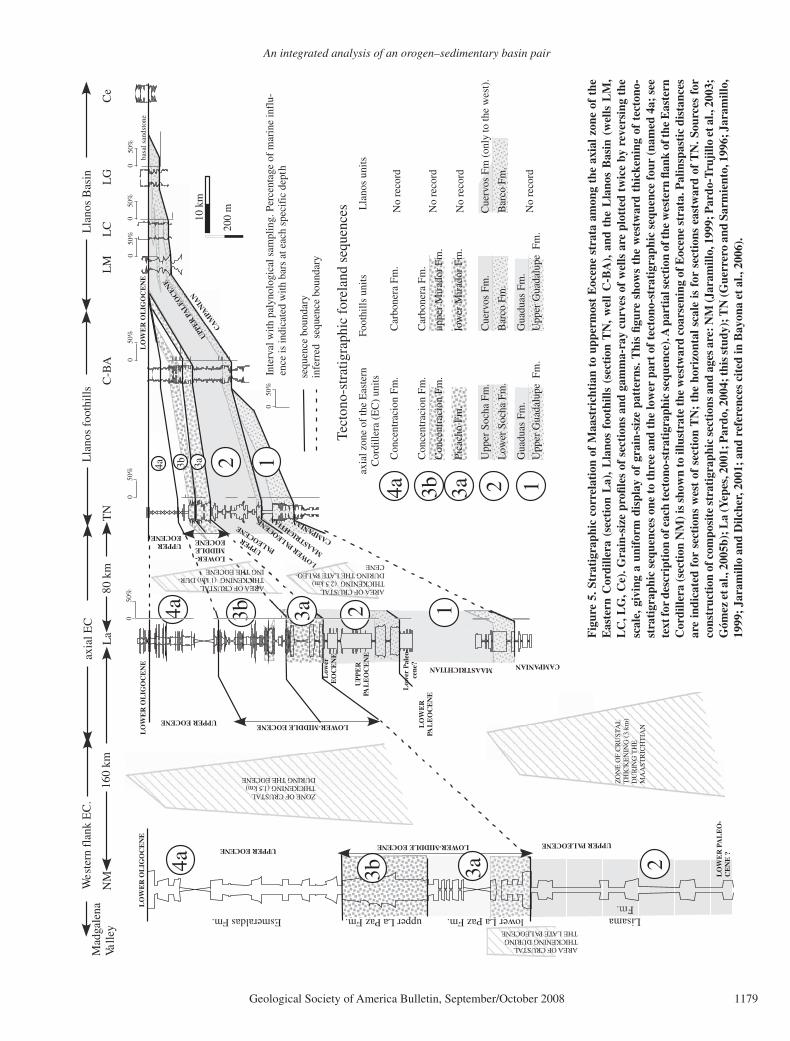
The Maastrichtian-Pliocene stratigraphic suc-cession can be divided into fi ve tectono-strati-graphic sequences (Figs. 5 and 6), the chrono-logical intervals of which are constrained by palynological data (see methods in Jaramillo et al., 2006a, 2006b). Palynological age determina-tions have the following resolution: 1–2 m.y. for the Maastrichtian-Paleocene, 5–10 m.y. for the Eocene, 3 m.y. for the Oligocene, and 1–2 m.y. for the early and middle Miocene. In this sec-tion, we focus on lateral and vertical changes of lithofacies associations and key sedimento-logical data for Maastrichtian–middle Miocene tectono-stratigraphic sequences, and we present a brief description of the middle Miocene–Plio-cene sequence. Lithostratigraphic units of the Llanos foothills area are indicated in the head-ers for each tectono-stratigraphic sequence, and equivalent lithostratigraphic units are indicated in Figures 5 and 6.
Tectono-Stratigraphic Sequence One (Upper Maastrichtian to Lower Lower Paleocene; Upper Guadalupe-Guaduas Formations and Equivalent Strata)
A regional shift from marginal to coastal fl uvial depositional environments is recorded in this sequence. A brief description of this shift is presented from east to west. In the cen-tral Llanos foothills, Guerrero and Sarmiento (1996) reported a 150-m-thick coarsening-upward succession from medium-grained to conglomeratic sandstones with cross-beds and reworked bivalves, oysters, and corals (Fig. 5). Bioturbation is observed both in sandstone and black mudstone beds. These Maastrichtian con-glomeratic sandstones have been reported up to 200 km farther north along the Llanos foothills (e.g., Colmenares, 1993; Arango, 1996), and fi ne-grained interbeds show recovery of pollen and dinofl agellate cysts that indicate a Maas-trichtian age (Bayona et al., 2006). In the north-ern Llanos foothills, fi ne-grained siliciclastic successions and thin carbonate interbeds domi-nate (Royero, 2001; Geoestratos-Dunia, 2003). A 30–40-m-thick succession of Maastrichtian carbonaceous mudstones overlies the conglom-eratic sandstones (Fig. 5, section TN).
An integrated analysis of an orogen–sedimentary basin pair
Geological Society of America Bulletin, September/October 2008 1179
10 k
m
200
m
UPP
ER P
ALEO
CEN
E
MAASTRICHTIA
N
50%
0In
terv
al w
ith p
alyn
olog
ical
sam
plin
g. P
erce
ntag
e of
mar
ine
infl
u-en
ce is
indi
cate
d w
ith b
ars
at e
ach
spec
ific
dep
th
50%
0
Tec
tono
-str
atig
raph
ic f
orel
and
sequ
ence
s
CA
MPA
NIA
N
UP
PE
RPA
LE
OC
EN
EMAASTRICHTIAN
Con
cent
raci
on F
m.
Con
cent
raci
on F
m.
Upp
er S
ocha
Fm
.
Low
er S
ocha
Fm
.
basa
l san
dsto
ne
lower La Paz Fm. LisamaFm.
upper La Paz Fm.Esmeraldas Fm.C
eL
GL
CL
MC
-BA
TN
La
NM
Lla
nos
foot
hills
Lla
nos
Bas
in
50%
050
%0
50%
00
50%
50%
0
axia
l EC
80 k
m16
0 km
LO
WE
RPA
LE
OC
EN
E
Wes
tern
fla
nk E
C.
CAMPANIAN
LOWER PA
LEOCENE
UPPER PALEOCENE
CAMPANIAN
LOWER-MIDDLEEOCENEUPPER
EOCENE
UPPER EOCENE
UPPER EOCENE
LO
WE
R O
LIG
OC
EN
E
UPPERPA
LEOCENE
LO
WE
R O
LIG
OC
EN
E
ZO
NE
OF
CR
UST
AL
TH
ICK
EN
ING
(3
km)
DU
RIN
G T
HE
MA
AST
RIC
HT
IAN
AREA OF CRUSTALTHICKENING (2.5 km)DURING THE LATE PALEO-CENE
3a 2
1
3b1
1
2
3a
3a
3b
3b
AREA OF CRUSTALTHICKENING DURINGTHE LATE PALEOCENE
Mad
gale
naVa
lley
ZONE OF CRUSTALTHICKENING (1.5 km)DURING THE EOCENE
Gua
duas
Fm
.
Upp
er G
uada
lupe
Fm
.
Low
erE
OC
EN
E
LOWER-MIDDLE EOCENE
LOWER-MIDDLE EOCENE
Pica
cho
Fm.
4aC
once
ntra
cion
Fm
.
axia
l zon
e of
the
Eas
tern
Cor
dille
ra (
EC
) un
itsFo
othi
lls u
nits
Car
bone
ra F
m.
uppe
r M
irad
or F
m.
Cue
rvos
Fm
.
Bar
co F
m.
Gua
duas
Fm
.U
pper
Gua
dalu
pe F
m.
low
er M
irad
or F
m.
Car
bone
ra F
m.
Low
er P
aleo
-ce
ne?
LO
WE
R P
AL
EO
-C
EN
E ?
3a 23b4a4a
LO
WE
R O
LIG
OC
EN
E
AREA OF CRUSTALTHICKENING (1 km) DUR-ING THE EOCENE
sequ
ence
bou
ndar
yin
ferr
ed s
eque
nce
boun
dary
24a
Lla
nos
units
Cue
rvos
Fm
(on
ly to
the
wes
t).
Bar
co F
m.
No
reco
rd
No
reco
rd
No
reco
rd
No
reco
rd
Fig
ure
5. S
trat
igra
phic
cor
rela
tion
of
Maa
stri
chti
an t
o up
perm
ost
Eoc
ene
stra
ta a
mon
g th
e ax
ial z
one
of t
he
Eas
tern
Cor
dille
ra (
sect
ion
La)
, L
lano
s fo
othi
lls (
sect
ion
TN
, w
ell
C-B
A),
and
the
Lla
nos
Bas
in (
wel
ls L
M,
LC
, LG
, Ce)
. Gra
in-s
ize
profi
les
of s
ecti
ons
and
gam
ma-
ray
curv
es o
f w
ells
are
plo
tted
tw
ice
by r
ever
sing
the
sc
ale,
giv
ing
a un
ifor
m d
ispl
ay o
f gr
ain-
size
pat
tern
s. T
his
fi gur
e sh
ows
the
wes
twar
d th
icke
ning
of
tect
ono-
stra
tigr
aphi
c se
quen
ces
one
to t
hree
and
the
low
er p
art
of t
ecto
no-s
trat
igra
phic
seq
uenc
e fo
ur (
nam
ed 4
a; s
ee
text
for
desc
ript
ion
of e
ach
tect
ono-
stra
tigr
aphi
c se
quen
ce).
A p
arti
al s
ecti
on o
f the
wes
tern
fl an
k of
the
Eas
tern
C
ordi
llera
(sec
tion
NM
) is
show
n to
illu
stra
te th
e w
estw
ard
coar
seni
ng o
f Eoc
ene
stra
ta. P
alin
spas
tic
dist
ance
s ar
e in
dica
ted
for
sect
ions
wes
t of
sec
tion
TN
; th
e ho
rizo
ntal
sca
le i
s fo
r se
ctio
ns e
astw
ard
of T
N. S
ourc
es f
or
cons
truc
tion
of c
ompo
site
str
atig
raph
ic s
ecti
ons
and
ages
are
: NM
(Jar
amill
o, 1
999;
Par
do-T
ruji
llo e
t al.,
200
3;
Góm
ez e
t al.,
200
5b);
La
(Yep
es, 2
001;
Par
do, 2
004;
this
stu
dy);
TN
(Gue
rrer
o an
d Sa
rmie
nto,
199
6; J
aram
illo,
19
99;
Jara
mill
o an
d D
ilche
r, 2
001;
and
ref
eren
ces
cite
d in
Bay
ona
et a
l., 2
006)
.

Bayona et al.
1180 Geological Society of America Bulletin, September/October 2008
10 k
m
200
m
LP
Ce
LG
LC
LM
C-B
AT
N
UP
PE
R O
LIG
OC
EN
EU
PP
ER
OL
IGO
CE
NE
CA
MPA
NIA
N
UPPER PALEOCENE
LO
WE
R M
IOC
EN
E
Lla
nos
foot
hills
Lla
nos
Bas
in
50%
0
50%
0
50%
050
%0
050
%
050
%0
50%
axia
l EC
50%
0
La no record of upper
Oligocene biozone
80 k
m
Car
bone
ra F
m.
UPP
ER
EO
CE
NE
Mid
-OL
IGO
CE
NE
LO
WE
R O
LIG
O
LO
WE
R M
IOC
EN
E
LO
WE
R O
LIG
OC
EN
E
CENE
UPP
ER
PA
LE
OC
EN
E
Car
bone
ra F
m. (
basa
l san
dsto
ne)
3a3b4a
UPPER EOCENE
LO
WE
RE
OC
EN
E
LOWER-MIDDLE EOCENE
4bLOWER-MIDDLEEOCENE
3a3b4a
ZONE OF CRUSTALTHICKENING (3 km)OLIGOCENE
ZONE OF CRUSTALTHICKENING (4 km)OLIGOCENE-LOWERMIOCENE
50%
0In
terv
al w
ith p
alyn
olog
ical
sam
plin
g. P
erce
ntag
e of
mar
ine
infl
u-en
ce is
indi
cate
d w
ith b
ars
at e
ach
spec
ific
dep
th
Con
cent
raci
on F
m.
Con
cent
raci
on F
m.
3a3bPi
cach
o Fm
.
4aC
once
ntra
cion
Fm
.
axia
l zon
e of
the
Eas
tern
Cor
dille
ra (
EC
) un
itsFo
othi
lls u
nits
Car
bone
ra F
m.
uppe
r M
irad
or F
m.
low
er M
irad
or F
m.
Car
bone
ra F
m.
sequ
ence
bou
ndar
yin
ferr
ed s
eque
nce
boun
dary
4b4c5
4c 4b
4b4c5
Lla
nos
units
part
ial r
ecor
d of
Con
cent
raci
on F
m.
Car
bone
ra F
m.
AREA OF CRUSTALTHICKENING (1 km) DUR-ING THE EOCENE
Car
bone
ra F
m.
Car
bone
ra F
m.
Leo
n Fm
.L
eon
Fm.
3735
m38
11 m
3110
m25
15 m
1997
m
Tec
tono
-str
atig
raph
ic f
orel
and
sequ
ence
s
MID
DL
E M
IOC
EN
E
MID
DL
E M
IOC
EN
E
5
No
reco
rd
No
reco
rdG
uaya
bo F
m.
Gua
yabo
Fm
.
No
reco
rd
No
reco
rd
No
reco
rd
2835
m14
00 m
ZO
NE
OF
CR
UST
AL
TH
ICK
EN
NIN
G (
10 k
m)-
pos
t MID
DL
EM
IOC
EN
E
tota
l thi
ckne
ss o
fse
quen
ce 5
(fr
omFa
jard
o et
al.,
2000
)
Fig
ure
6. S
trat
igra
phic
cor
rela
tion
of E
ocen
e to
mid
dle
Mio
cene
str
ata
amon
g th
e ax
ial z
one
of th
e E
aste
rn C
ordi
llera
(sec
tion
La)
, Lla
nos
foot
hills
(sec
tion
T
N, w
ell C
-BA
), an
d th
e L
lano
s ba
sin
(wel
ls L
M, L
C, L
G, C
e, L
P).
Gra
in-s
ize
profi
les
of s
ecti
ons
and
gam
ma-
ray
curv
es o
f wel
ls a
re p
lott
ed tw
ice
by r
ever
s-in
g th
e sc
ale,
giv
ing
a un
ifor
m d
ispl
ay o
f gr
ain-
size
pat
tern
s. T
his
fi gur
e ill
ustr
ates
tec
tono
-str
atig
raph
ic s
eque
nces
thr
ee a
nd f
our
and
the
low
er p
art
of
sequ
ence
fi ve
. The
abr
upt t
hick
enin
g of
thes
e se
quen
ces
mig
rate
s ea
stw
ard,
rea
chin
g th
e th
icke
st s
ucce
ssio
n of
seq
uenc
e fi v
e in
wel
l LC
(381
1 m
). P
alin
spas
tic
dist
ance
bet
wee
n se
ctio
ns L
a an
d T
N is
indi
cate
d; t
he h
oriz
onta
l sca
le is
for
sec
tion
s ea
stw
ard
of T
N. S
ourc
es f
or c
onst
ruct
ion
of c
ompo
site
str
atig
raph
ic
sect
ions
and
age
s ar
e: L
a (P
ardo
, 200
4; th
is s
tudy
); T
N (J
aram
illo,
199
9; J
aram
illo
and
Dilc
her,
200
1; a
nd r
efer
ence
s ci
ted
in B
ayon
a et
al.,
200
6).

An integrated analysis of an orogen–sedimentary basin pair
Geological Society of America Bulletin, September/October 2008 1181
Along the axial zone of the Eastern Cordil-lera, strata of this sequence are represented by fi ne- to medium-grained sandstones with cross-beds and abundant ichnofossils (Perez and Salazar, 1978; Fabre, 1981). These beds are overlain by a unit that consists in the lower half of fi ne-grained strata with abundant coal seams and in the upper half of laminated mud-stones and massive light-colored mudstones (Sarmiento, 1992). The thickness of this unit is variable; there is a 1100 m depocenter near Bogotá, and it thins eastward to less than 450 m and northward to less than 300 m near the Santander massif (Fabre, 1981; Royero, 2001). Maastrichtian–lower Paleocene units in the Magdalena Valley include conglomeratic units derived from the Central Cordillera to the south (Gómez et al., 2003), whereas to the north, carbonate silt and mudstones dominate (Gómez et al., 2005b). Maastrichtian strata are absent in the southern Llanos Basin (Bayona et al., 2006), in the frontal thrust sheets of the cen-tral Llanos foothills and Llanos Basin (Cooper et al., 1995), as well as along the frontal thrust sheets of the western fl ank of the Eastern Cor-dillera (Bayona et al., 2003).
Tectono-Stratigraphic Sequence Two (Upper Lower Paleocene to Upper Paleocene; Barco-Cuervos Formations and Equivalent Strata)
Biostratigraphic data indicate that fi ne-grained strata of this tectono-stratigraphic sequence in the axial zone of the Eastern Cordillera corre-late with aggradational, fi ne-to-coarse-grained quartzarenites in the Llanos Basin (Fig. 5). This succession changes upsection from: (1) cross-bedded, fi ne- to coarse-grained upward-fi ning quartzarenites (Fig. 7A), locally conglomeratic in Cocuy (Fabre, 1981) and section La (Pardo, 2004) (this unit pinches out west of Bogotá; Hoorn, 1988); to (2) interbeds of upward-fi n-ing sandstone and mudstone with bidirectional cross-bedded and bioturbated heterolithic lami-nated sandstone; (3) locally bioturbated dark-gray organic-rich claystone and mudstone with thin coal seams and excellent pollen recovery; and (4) at the top, massive light-colored sandy mudstone with very poor pollen recovery. This uppermost lithology contains isolated sand-stones with upward-fi ning and coarsening grain-size trends with cross-beds, wavy lamina-tion, and ripple cross-lamination (Figs. 7B and 7C). The thickness of this tectono-stratigraphic sequence decreases eastward and northward: in the Bogotá area, it varies from 0.9 to 1.2 km (Hoorn, 1988), in sections La-Cocuy-Va (west-ern end of cross sections in Fig. 1), it ranges from 0.4 to 0.8 km (Fabre, 1981; Pardo, 2004;
Geoestratos-Dunia, 2003), in the Llanos foot-hills, it ranges between 0.6 and 0.2 km, and in the Llanos Basin, it ranges from 0 to 0.2 km (Figs. 1 and 5).
The vertical arrangement of lithofacies and palynofacies has been interpreted as a product of deposition, from base to top, in fl uvial, fl u-vial-estuarine, and coastal-plain systems. Sand-stones indicate fl uvial infl uence in the axial zone of the Eastern Cordillera (Pardo, 2004), whereas they are more tidally infl uenced in the Llanos foothills (Cazier et al., 1995; Reyes, 1996). The fi ne-grained strata accumulated in fl oodplains with increasing estuarine infl uence toward the Llanos foothills. The change from excellent to poor pollen recovery in fi ne-grained units sug-gests that deposition of upper strata took place above the water table (Pardo, 2004). Equivalent strata in the Magdalena Valley consist of 1.2-km-thick organic-rich mudstone interbedded with ripple-laminated and cross-bedded lithic sand-stone that accumulated in fl uvial-deltaic plain environments (Gómez et al., 2005b; section NM in Fig. 5).
Tectono-Stratigraphic Sequence Three (Lower to Middle Eocene; Mirador–Basal Carbonera Formations and Equivalent Strata)
Lithological units of this age are reported only west of the Llanos foothills and consist of two intervals. The lower interval (named 3a in Fig. 5) rests in abrupt contact with strata of sequence two (Fig. 7D) and includes fi ne- to medium-grained and locally conglomeratic quartzarenites beds that internally are mas-sive, cross-bedded, and wavy-laminated to the top (Fig. 7E). The upper interval (named 3b in Fig. 5) has upward-fi ning successions and coal interbeds in the northern Llanos foothills (Reyes, 2004), whereas in the central Llanos foothills, sandstones show a diverse ichnofacies associa-tion (Ophiomorpha, Thalassinoides, Psilonich-nus, and Diplocraterion; Pulham et al., 1997), couplets in foreset laminations, and wavy and fl aser lamination in upper mudstone interbeds (Parra et al., 2005). Dark-colored mudstones with thin coal seams rest conformably on the bioturbated sandstones (Jaramillo, 1999; Jara-millo and Dilcher, 2001). These two intervals are separated by light-gray massive sandy mudstone and locally laminated, organic mudstone with plant remains (Fig. 5); this level is characterized by moderate abundance of marine indicators, including foraminiferal test lining and several dinofl agellate cysts, such as Polysphaeridium subtile, Achomos phaera sp., Spiniferites sp. Cordos phaeridium inodes, and Nematosphae-ropsis (Jaramillo and Dilcher, 2001).
The lower and upper intervals are also pres-ent in the axial zone of the Eastern Cordillera (section La in Fig. 5). The lower interval (3a in Fig. 5) includes cross-bedded, medium- to coarse-grained sandstone and conglomeratic sandstone, which changes upsection to inter-beds of tabular-bedded fi ne-grained sandstone and discontinuous mudstone interbeds (Cés-pedes and Peña, 1995; Pardo, 2004). The upper interval (3b in Fig. 5) includes laminated gray mudstone with some interbeds of sandstone and oolithic sandstone (Reyes and Valentino, 1976). The thickness of this sequence in section La is twice as thick as in the Llanos foothills (Fig. 5). Farther west in the Magdalena Valley, coeval lower and middle Eocene strata are as much as 1 km thick and consist of conglomeratic sand-stone, multistoried cross-bedded sandstone and mudstone (Restrepo-Pace et al., 2004; Pardo-Trujillo et al., 2003; Gómez et al., 2005b).
Sandstones of the lower interval have been interpreted as amalgamated fl uvial channels, whereas sandstones of the upper interval record a stronger infl uence of brackish and marine con-ditions. In the central Llanos foothills, these beds accumulated in mouth-bar and coastal-plain set-tings (Cazier et al., 1995; Fajardo, 1995; Warren and Pulham, 2001), whereas in the northern Lla-nos foothills and axial zone of the Eastern Cor-dillera, they accumulated in a more continental setting (Fajardo-Peña, 1998; Reyes, 2004).
Tectono-Stratigraphic Sequence Four (Upper Eocene to Middle Miocene; Carbonera Formation and Equivalent Strata)
Lowermost strata of tectono-stratigraphic sequence four vary laterally from fi ne-grained deposits in the axial zone of the Eastern Cordil-lera, Llanos foothills, and northern Llanos Basin to amalgamated sandstones in the central Llanos Basin (intervals 4a and 4b in Fig. 6). Fine-grained strata include laminated dark-gray mudstone with thin seams of coal and bioturbated fi ne-grained sandstone (Mora and Parra, 2004) in the Llanos foothills and dark-colored mudstone rest-ing upon the unconformity in the northern Lla-nos Basin. Amalgamated to upward-fi ning suc-cessions of fi ne- to coarse-grained sandstone and conglomeratic sandstone show an onlap relation with the unconformity in the central and south-ern Llanos Basin (Bayona et al., 2006).
Strata overlying these lowermost beds have a more uniform upward-coarsening grain-size trend in the axial Eastern Cordillera, Llanos foot-hills, and Llanos Basin (interval 4b in Fig. 6). An upward-coarsening succession includes laminated mudstone with mollusks (Parra et al., 2005) and marine- to brackish-water indicators at the base (Fig. 6), which grade to tabular

Bayona et al.
1182 Geological Society of America Bulletin, September/October 2008
Qpf
Qm
0.5 mm
Lm
Qm
Pgl
QpQc
0.25 mm
Qm— monocrystalline quartzQp— polycrystalline quartz
Qc— cryptocrystalline quartz (chert)
Lm— metamorphic lithic fragment
Pgl— plagioclase fragment
Qpf— foliated polycrystalline quartz
A
B
C
D
E
F
G
Figure 7. (A–B) Abrupt change in sandstone composition within tectono-stratigraphic sequence two in Cocuy area (northern area, Fig. 1). (A) Quartzarenite of the lower upper Paleocene Barco Formation. (B) Sublitharenite of the middle upper Paleocene Cuervos Formation. (C–G) Outcrops around section TN (central cross section). (C) Sets of planar cross-bedding in the upper Paleocene Cuervos Formation; lithic fragments are concentrated along the cross-beds. (D) Topographic contrast at the contact between Cuervos (valley) and Mirador Forma-tions (scarp). (E) Amalgamated channels of the Mirador Formation with thin mudstones interbeds (tectono-stratigraphic sequence three). (F) Coarsening-upward succession at the top of the Carbonera Formation (tectono-stratigraphic sequence four), which is coeval with depo-sition of shale of the Leon Formation in the Llanos Basin (Parra et al., 2005). (G) Mottled reddish mudstones (paleosols) interbedded with sandstones of the Guayabo Formation (tectono-stratigraphic sequence fi ve).

An integrated analysis of an orogen–sedimentary basin pair
Geological Society of America Bulletin, September/October 2008 1183
and wavy laminated, locally bioturbated, fi ne-grained sandstone. In the central Llanos foot-hills, these successions include coal seams, feld-spar-bearing fi ne-grained muddy sandstone, and locally conglomeratic cross-bedded sandstone (Parra et al., 2005). Upward-coarsening suc-cessions dominate in the Llanos foothills, with some incursions of brackish waters (Figs. 6 and 7F), whereas in the Llanos Basin, upward-fi ning trends are more common toward the top of this sequence (interval 4c in Fig. 6).
The northward and eastward lateral change of depositional patterns supports an interpreta-tion of an eastward-prograding fl uvial-deltaic plain developing into a coastal plain (or savan-nas) and a coeval lacustrine-lagoonal deposi-tional system to the east (Mora and Parra, 2004; Bayona et al., 2006). In the Llanos Basin, the abrupt change in lithological associations of the lowermost beds has been interpreted as a change from channel-fi ll processes in fl uvial systems to transgressive tidal fl ats and delta bays with minor brackish-water infl uence changing upsec-tion to a lacustrine environment (Fajardo et al., 2000). The lacustrine system interfi ngers on the east with a fl uvial system draining the Guyana craton and on the west with prograding del-taic systems. Strata at the top of this sequence record fl uvial systems across the Llanos Basin (interval 4c in Fig. 6).
Tectono-Stratigraphic Sequence Five (Middle Miocene to Pliocene; Leon and Guayabo Formations)
The uppermost tectono-stratigraphic sequence consists of two lithological units that are recorded partly in the Llanos foothills and occupy most of the Llanos Basin. The lower unit consists of dark-colored laminated mudstone and shale with an isolated record of mollusks and foraminifera (Bayona et al., 2006; Fig. 6). This unit is slightly younger westward, as shown in the southern Lla-nos Basin (Bayona et al., 2006), and sandstone interbeds increase northward and westward (Cooper et al., 1995; Fajardo et al., 2000). In the Llanos foothills, this unit consists of wavy laminated, bioturbated, and varicolored mud-stone interbedded with tabular-bedded, biotur-bated quartzarenite (Geoestratos-Dunia, 2003). The upper unit includes varicolored mudstone, lithic-bearing sandstone, and conglomerate, and the coarser lithologies dominate toward the top (Fig. 7G). The maximum recorded thickness is in the Llanos Basin (in well LC in Fig. 6), and not in the Llanos foothills, as in sequence four. The stratigraphic position of the upper unit indicates a post–middle Miocene age.
These units represent the onset of coarse-grained fl uvial systems covering the Llanos
foothills and Llanos Basin. The lower unit doc-uments westward fl ooding of a broad fl uvial-deltaic system followed by regional onset and establishment of lacustrine-lagoonal environ-ments (Hoorn, 1994), but with less brackish-water infl uence than that reported in Eocene strata. In contrast, the upper unit represents the eastward advance of a coarse clastic wedge accumulated in fl uvial and alluvial-fan systems.
PROVENANCE AND PALEOCURRENTS
Sandstone composition in a tropical nonma-rine foreland basin, such as the Llanos Basin and restored eastern fl ank of the Eastern Cor-dillera since the latest Cretaceous, is controlled mainly by chemical weathering and compo-sition of source areas. Late Paleocene paleo-climate conditions (mean annual temperature = 23.8 ± 2.1 ºC, mean annual precipitation = 3.4 m/yr; Herrera, 2004) and number of mor-phospecies (Jaramillo et al., 2006a) were simi-lar to the present tropical rain forest. Changes in composition of modern fl uvial sands in the Ven-ezuela Llanos Basin indicate that unstable lithic fragments are not preserved more than 200 km from the Andes of Merida (the source area), and sands with more than 25% of lithic fragments lie mostly within 100 km of the Andes (Johnsson et al., 1991). We consider these distances to be the maximum possible for source areas for the Paleocene basin, bearing in mind that tropical climatic conditions controlled chemical weath-ering processes in source and basin areas.
Integration of paleocurrent indicators and sandstone composition from Paleogene rocks in the axial zone of the Eastern Cordillera, Lla-nos foothills, and Llanos Basin indicates a shift in provenance since the Paleocene (Fig. 8; see Data Repository for a complete list of references and evaluation of data1). Maastrichtian to lower Paleocene sandstones of tectono-stratigraphic sequence one contain predominantly quartz fragments and minor feldspars (Fig. 8A) in the Llanos Basin, indicating sediment supply from the Guyana craton. Supply of detritus from the craton is additionally supported by the regional westward migration of the Maastrichtian clastic wedge (Diaz, 1994). In the Bogotá region, sand-stone of the upper Guaduas Formation (lower Paleocene) contains unstable siltstone, mud-stone (10%), and chert (7%) grains, along with phyllite and trace amounts of feldspar grains, suggesting uplift of nearby blocks (Sarmiento, 1992; Torres, 2003).
Sandstones of sublitharenite and litharenite composition in tectono-stratigraphic sequence two contain polycrystalline quartz and unstable lithic fragments (Fig. 7B), which constitute up to 33% of the framework grains, and some feld-spars. Reported lithic grain types include silt-stone, chert, gneiss, schist, phyllite and igneous rock fragments. In addition, paleocurrent data indicate a shift to northward directions and an increasing variability of paleocurrent directions at the end of the Paleocene (Figs. 8B and 8C). Provenance and paleocurrent data suggest expo-sure of basement rocks, such as the Floresta and Santander massifs (Vasquez, 1983; Mesa, 1997), that controlled drainage patterns within the axial zone of the Eastern Cordillera during deposition of tectono-stratigraphic sequence two.
The abrupt change from upper Paleocene litharenites (tectono-stratigraphic sequence two) to lower-middle Eocene quartzarenites and sublitharenites (tectono-stratigraphic sequence three) with feldspars in the clay fraction (Bena-vides, 2004) coincides with a change in stacking pattern of sandstone beds from isolated chan-nel beds within mudstone at the top of tectono-stratigraphic sequence two to multistoried chan-nel beds in tectono-stratigraphic sequence three (Fig. 5). Paleocurrent data indicate a high dis-persion pattern, as would be expected in mature (>10 m.y.) fl uvial systems located in areas of slow subsidence. Supply of detritus from nearby uplifted blocks is supported by the presence of Cretaceous foraminifera fragments in the matrix of conglomerates (Céspedes and Peña, 1995) and lithic clasts composed of chert, claystone, siltstone, gneiss, schist, and igneous rock frag-ments (Mesa, 1997, 2004).
The dominance of quartzose sandstones persists in tectono-stratigraphic sequence four. However, the presence of sublitharenite and subarkose, as well as conglomerate beds con-taining clasts of chert and Cretaceous fossilifer-ous limestones, documents the preservation of unstable lithic fragments supplied from uplifted blocks within the Eastern Cordillera.
The dominance of quartzose sandstone com-position in Paleogene sandstones in the Llanos Basin suggests that the continuing supply of detritus from the Guyana craton was mixed with chemically stable fragments derived from the Eastern Cordillera. However, this pre-Miocene pattern in the Llanos Basin contrasts with sub-litharenites and litharenites in tectono-strati-graphic sequence fi ve (Moreno and Velasquez, 1993), which were derived from the Eastern Cordillera. Palynological samples from fi ne-grained strata of tectono-stratigraphic sequence fi ve contain pollen, as well as dinofl agellate and foraminifera fragments, of Paleocene and older age (Milton Rueda and Vladimir Torres, 2006,
1GSA Data Repository item 2008078, references and evaluation of petrographic and provenance data, is available at www.geosociety.org/pubs/ft2008.htm. Requests may also be sent to [email protected].

Bayona et al.
1184 Geological Society of America Bulletin, September/October 2008
CE
NT
RA
LC
OR
DIL
LER
A
CE
NT
RAL
CO
RD
ILLE
RA
CE
NT
RAL
CO
RD
ILLE
RA
CE
NT
RA
LC
OR
DIL
LER
A
100 km
1000000
1100000
12000001100000 1300000
LMC-BA
900000
Cocuy
G1&2
Tunja
La
1200000
1300000
1000000
1100000
12000001100000 1300000
C-5
900000
1200000
1300000
1000000
1100000
12000001100000 1300000900000
Tu
1200000
1300000
1000000
1100000
12000001100000 1300000900000
1200000
1300000
Maastrichtian-early early Paleocene (upper Guadalupe Group -lower Guaduas Formation; Sequence One)
Late early Paleocene-early late Paleocene (upper Guaduas, Cacho,Lower Socha and Barco formations; lower Sequence Two)
Late late Paleocene (Bogota, Upper Socha and Cuervos formations; upper Sequence Two)
Early-middle Eocene (Regadera, Picacho and Mirador formations; Sequence Three)
1000000
1100000
12000001100000 1300000900000
1200000
1300000
Late Eocene-early Miocene (Usme, Concentracion and Carbonera formations; Sequence Four)
100 km
100 km
100 km100 km
Max
imum
ran
ge o
f res
tore
d
Min
imum
ran
ge o
f res
tore
d po
sitio
n of
the
CC
Bogota; Cocuy; La; Tunja; Reference localitiesReference wells A1&3; C-BA; LM; LP-1
trace of regional profiles (northern and central cross sections)restored trace of major thrust fault systems
A1&3
scatter paleocurrents
mean direction and range of directions
range of paleocurrent directions
Bogota
LP-1
UNDEFORMEDLLANOS BASIN
CE
NT
RA
LC
OR
DIL
LER
A
Ark
ose
Lith
ic a
rkos
e
Feldsp. litharenite
Qt
F L
Quartzarenite
Subarkose Sublitharenite
Litharenite
posi
tion
of th
e C
C
B
pres
ent e
aste
rn b
orde
r of
the
Cen
tral C
ordi
llera
pres
ent e
aste
rn b
orde
r of
the
Cen
tral C
ordi
llera
pres
ent e
aste
rn b
orde
r of
the
Cen
tral C
ordi
llera
pres
ent e
aste
rn b
orde
r of
the
Cen
tral C
ordi
llera
A
DC
E
Figure 8. Paleogene palinspastic maps of the inverted Eastern Cordillera (EC) and adjacent Llanos Basin (see details in Fig. 10) showing changes in sandstone composition and paleocurrents for tectono-stratigraphic sequences one to four (see Data Repository for complete list of references [see text footnote 1]). (A) Palinspastic distance between Central Cordillera (CC) and Llanos foothills ranges from 335 to 355 km (Colleta et al., 1990; Cooper et al., 1995; Taboada et al., 2000) to 440–460 km (Dengo and Covey, 1993; Roeder and Chamberlain, 1995); the shorter distance is shown for parts B to E. Source areas in the restored Eastern Cordillera need to be considered to explain the presence of litharenites. See discussion in the text about provenance and paleocurrent data for evidence that supports the interpretation of block uplifts within the Eastern Cordillera.

An integrated analysis of an orogen–sedimentary basin pair
Geological Society of America Bulletin, September/October 2008 1185
personal commun.) and document unroofi ng of the Eastern Cordillera.
ONE-DIMENSIONAL BACKSTRIPPING AND TWO-DIMENSIONAL FLEXURAL SUBSIDENCE ANALYSIS
A comparison of one-dimensional (1D) tec-tonic subsidence profi les from sections in the axial Eastern Cordillera, Llanos foothills, and Llanos Basin guided selection of time intervals of comparable tectonic subsidence signatures (Fig. 9). Additionally, 1D backstripping tech-niques were used to decompact the measured stratigraphic thickness of each section, follow-ing the methods and assumptions specifi ed in Watts and Ryan (1976) and Allen and Allen (1992). The Late Cretaceous–Cenozoic fi rst-order sea-level curve of Haq et al. (1987) was used for eustasy correction of 1D tectonic sub-sidence.
Two-dimensional (2D) backstripping of the two cross sections was carried out follow-ing the procedures detailed in Watts (2001) to better quantify the subsidence history of the Llanos foothills and Llanos Basin. In order to properly represent the original basin geometry, the positions of each section were plotted in the Paleogene palinspastic map of Sarmiento-Rojas (2001; Fig. 10), which depicts shortening esti-mates for the eastern fl ank of the Eastern Cor-dillera that agree with restorations of our two balanced cross sections. This palinspastic map constrains (1) the most probable position of tectonic loads (areas with no Cenozoic record), (2) areas with growth strata, and (3) areas with intra-Cenozoic angular unconformities. Next, the minimum and maximum 2D basin depths were defi ned for each time interval using the compacted and decompacted thickness, respec-tively, of each section or well. The effect of fl exural subsidence due to sediment loading was calculated after basin geometry was defi ned. The latter exercise permitted calculation of the “observed minimum” and “observed maxi-mum” tectonic fl exural subsidence of the basin for each time interval. In this study, the numeri-cal implementation of Bodine (1981), which allows plates of laterally variable elastic thick-ness to be considered, was applied to model the Llanos foreland basin.
Results of One-Dimensional Backstripping
Breaks between periods of constant sub-sidence rate allow the discrimination of three subsidence events in the Llanos foothills and Llanos foreland basin (Fig. 9); these closely follow the fi ve tectono-stratigraphic sequences defi ned previously. The fi rst subsidence event is
related to increasing subsidence rates in tectono-stratigraphic sequences one and two, the second corresponds to the time interval of tectono-stratigraphic sequence three, and the last regime shows an abrupt increase in subsidence rates in tectono-stratigraphic sequences four and fi ve. The ages of the breaks in the slope of the curve do not overlap for all sections, suggesting that the onset of each event that caused the increase of tectonic subsidence differed across sections in the study area. However, minor differences in the age of those breaks may be due to lack of resolution of biostratigraphic determinations (see bar error for different intervals in Fig. 9).
We interpret all the breaks in the slope of the tectonic subsidence curve as a result of fl exural subsidence related to tectonic and sedimentary loading. Signifi cant differences in the ages of the infl ection points between the northern and central cross sections may record diachronous along-strike tectonic loading. The age differ-ences of infl ection points on curves for the axial zone of the Eastern Cordillera and the Llanos Basin may represent a fl exural response of the lithosphere to foreland-directed migration of tectonic loads.
Results of Two-Dimensional Flexural Backstripping
In this study, we tested two hypotheses of foreland evolution for an 800-km-wide plate. Our fi rst model used a spatially continuous foreland basin with a laterally constant plate fl exural rigidity (Te) for late Maastrichtian, early Paleocene, and late Paleocene time. Our second model considered uplifts of blocks that separated the foreland basin into two main depocenters, the Magdalena and Llanos Basins, on a plate of laterally variable fl exural rigidity (Te). We used data from the Magdalena Valley presented in Pardo-Trujillo et al. (2003) and Gómez et al. (2005a) for section NM, and from Restrepo-Pace et al. (2004) for section RM. Geodynamic modeling of these profi les was extended to include the restored position of the axial Central Cordillera and wells in the distal Llanos Basin (Fig. 10). We focused on the area between the axial zone of the Eastern Cordil-lera and Llanos Basin because the uncertainty of palinspastic restoration increases as we move westward from the axial zone of the Eastern Cordillera to the Magdalena Valley and Central Cordillera (Figs. 1C and 8A).
Model 1: One Basin and Uniform Elastic Thickness
In this hypothesis, the Maastrichtian-Paleo-cene foreland basin was a fl exural response of the lithosphere to loading of the Central Cordil-
lera. The purpose of fl exural modeling was to test whether fl exure of the lithosphere resulting from the weight of the Central Cordillera could reproduce the geometry of the Maastrichtian-Paleocene foreland as far east as the Llanos Basin. Gómez et al. (2005a) were able to obtain a reasonable fi t between the observed and the calculated basin geometry for the Colombian foreland basin using an infi nite plate model, a discrete load confi guration, and a horizontal density contrast between tectonic loads and adjacent sediment fi ll. All model runs reported by Gómez et al. (2005a) were performed on a 35 km Te plate using a thermochronologically constrained history of uplift for the Central Cor-dillera and western fl ank of the Eastern Cordil-lera. We used a tectonic load confi guration simi-lar to the one proposed by Gómez et al. (2005a), but the width of our basin was 40 km narrower (see Figs. 1C and 8A). Our model only consid-ered sections/wells close to the cross sections in order to avoid important changes of thickness of Cenozoic synorogenic strata across these traverse structures, as reported by Parra et al. (2005) and this study.
Model runs using these confi gurations were not able to match the “observed” (i.e., recon-structed) fl exural tectonic subsidence profi le (Fig. 11). One cause of the discrepancy between our results and those of Gómez et al. (2005a) is the restored width of the Eastern Cordillera. Because the basin geometry of Gómez et al. (2005a) is 40 km wider than ours, the additional sedimentary load, 40 km wide and ~1.5 km thick to the west of the axial zone of the Eastern Cordillera, contributed to fl exural subsidence in the Llanos Basin. Because we used a narrower restored basin, both tectonic and sedimentary loading within the restored Eastern Cordillera were required to match the fl exural tectonic sub-sidence in the Llanos Basin (see next section).
Model 2: Interrupted Foreland Basin and Variable Elastic Thickness
The other hypothesis tested in this study was a foreland basin interrupted by tectonic loads in the middle of the basin, which developed on a lithosphere of laterally variable Te. The fl exural strength of the northern Andean lithosphere is known to vary laterally from low values near the axis of the east Andean topography to high val-ues over the Guyana craton, as supported by two-dimensional fl exural models (Ojeda, 2000; Sarm-iento-Rojas, 2001), gravity modeling (Stewart and Watts, 1997), and topography/gravity coher-ence studies (Ojeda and Whitman, 2002).
For each profi le, we applied an estimated Te confi guration that refl ected the lateral variabil-ity in fl exural strength of the lithosphere inher-ited from the complex Phanerozoic tectonics of

Bayona et al.
1186 Geological Society of America Bulletin, September/October 2008
80 70 60 50 40 30 20 10 00
1
2
3
4
Cocuy
G1&2
Va
A1&3
Ju1
CL1
80 70 60 50 40 30 20 10 00
1
2
3
TN
LA
C-BALM
LG
LP
Central cross section
Northern cross section
One
-dim
ensi
onal
tect
onic
sub
side
nce
(km
)
Age (Ma)
Age (Ma)
Llanos basin wells
Llanos foothills wells
sections in the axial zone of the Eastern Cordillera
Llanos basin wells
Llanos foothills wellssections in the axial zone of the Eastern Cordillera
Seq. 2 Sequence 3 Sequence 4 Sequence 5
poor palyrecord
record
nological
Sequence 3 Sequence 4 Sequence 5
poor palynological
resolution of palynological age determinations
resolution of palynological age determinations
Seq. 2
Sequence 1
Sequence 1
Figure 9. One-dimensional tectonic subsidence curves for selected sections and wells along the northern and central cross sections. Time inter-vals of the fi ve tectono-stratigraphic sequences are also shown. Cocuy section was modifi ed from Gómez et al. (2005a). Tectono-stratigraphic sequence three records a time interval of very low tectonic subsidence rates, in contrast to Maastrichtian-Paleocene and late Eocene–Pliocene breaks in the slope of the curve. The shape and diachronism of those breaks are interpreted as episodes of fl exural subsidence. See Figure 3 for locations of sections and wells.

An integrated analysis of an orogen–sedimentary basin pair
Geological Society of America Bulletin, September/October 2008 1187
1000
000
1100
000
1200
000
1100
000
1300
000
BROKEN PLATE
100
km
LP
CeL
G1&
2L
CLM
C-B
A
La
RM
Medina-Guavio F.
Tesalia-Lengupa F.
Soapaga F.
Cusiana-
Cupiagua F
.
TN
Restored boundary of the Central Cordillera
Prof
ile f
or 2
D g
eody
nam
ic a
naly
sis
poss
ible
loca
tion
of te
cton
ic lo
ads
(no
reco
rd o
f C
enoz
oic
stra
ta)
rest
ored
trac
e of
maj
or f
aults
(se
e Fi
g. 1
)
Labateca F.
NM
Coc
uy
Va
Ju1
Salinas F.
Guica
ramo F.
Nor
ther
n cr
oss
sect
ion
Saba
nala
rga
tran
sver
se z
one
Chinacota F.
1300
000
UN
DE
FOR
ME
D
LL
AN
OS
BA
SIN
Pesca F
.
Bucaramanga F.
Salinas F.
Cha
mez
a F.
Tun
ja
Bog
ota
CENTRAL CORDILLERA
MAGDALENA VALLEY
RE
STO
RE
D
LL
AN
OS
FOO
TH
ILS
RE
STO
RE
D E
AST
ER
N C
OR
DIL
LE
RA
Cen
tral
cro
ss se
ctio
n Cobugon F.
G1&
2
Chu
cari
ma
tran
sver
se
zone
A1&
3
pre-
Eoc
ene
angu
lar
unco
nfor
mity
and
E
ocen
e-M
ioce
ne g
row
th s
trat
a
Olig
ocen
e-lo
wer
Mio
cene
gro
wth
str
ata
CL
1
Romeral paleosuture
MAGDALENA VALLEY
UNDEFORMED
GU
A-1
S-1
Pl-
1
ST-1
5
STO
-2
PR
-1LT
-1
LT-1
wel
l in
the
dist
al L
lano
s ba
sin
proj
ecte
d to
th
e cr
oss
sect
ion
(onl
y fo
r O
ligoc
ene
and
youn
ger
stra
ta; m
odif
ied
from
Faj
ardo
et
al.,
2000
)
tran
sver
se z
one
Fig
ure
10. P
alin
spas
tic
posi
tion
of
sect
ions
and
wel
ls a
nd t
race
of
the
nort
hern
and
cen
tral
cro
ss s
ecti
ons
(ext
ende
d to
the
Cen
tral
Cor
dille
ra)
used
for
tw
o-di
men
sion
al (
2D)
geod
ynam
ic m
odel
ing,
plo
tted
on
the
palin
spas
tic
map
of S
arm
ient
o-R
ojas
(200
1).T
he w
idth
of t
he r
esto
red
Eas
tern
Cor
dille
ra h
ere
is s
imila
r to
the
rest
ored
wid
th p
ropo
sed
by
Col
leta
et a
l. (1
990)
, Coo
per
et a
l. (1
995)
, and
our
res
tore
d cr
oss
sect
ions
sho
wn
in F
igur
e 3.
Pre
sent
pos
itio
ns o
f sec
tion
s/w
ells
are
sho
wn
in F
igur
e 3,
and
pre
sent
trac
es o
f maj
or
faul
ts a
re in
Fig
ure
1. G
row
th s
trat
a, r
epor
ted
angu
lar
unco
nfor
mit
ies,
and
are
as w
ith
no r
ecor
d of
Cen
ozoi
c st
rata
are
als
o in
dica
ted.

Bayona et al.
1188 Geological Society of America Bulletin, September/October 2008
northern South America (Fig. 12A). The Guy-ana craton is relatively thick, thermally relaxed, and rigid (Te > 50 km; Stewart and Watts, 1997). We assigned a Te in the range of 15–25 km for the lithosphere that underlies the locus of Meso-zoic extension (Sarmiento-Rojas et al., 2006). We regarded the lithosphere under the Central Cordillera as tectonically stable and assigned a Te value of 55 km for the western end of our profi les. Paleosuture zones, such as the Romeral fault system, are zones of plate rupture (zero fl exural strength), or areas of very low fl exural rigidity. We considered the palinspastic position
of Romeral fault system to be the western edge of our broken plate. An older Paleozoic paleo-suture underlying the southern and central Lla-nos foothills (see Cediel et al., 2003) was rep-resented as a laterally variable Te confi guration under the central Llanos foothills.
Results of our second set of models were capable of reproducing the tectonic fl exural subsidence observed in the Llanos foothills and Llanos Basin, and they honor the paleogeogra-phy suggested by stratigraphic and provenance data of our tectono-stratigraphic analyses. Models for the latest Cretaceous–Paleocene are
consistent with early uplift of segments of the axial zone of the Eastern Cordillera. Equivalent tectonic loads (i.e., crustal thickening), rang-ing from 0.5 to 3 km, and synorogenic depo-sition explain the fl exural wavelength and the eastward migration of the fl exural wave, as suggested by the Llanos foreland stratigraphy (Figs. 5, 12B, 12C, and 12D). Tectonic loads on the Santander massif in the northern cross section and west of the Pesca fault on the cen-tral cross section (west of section La) resulted in development of three distinct depocenters, matching the observed tectonic subsidence. For the late Paleocene, a new foreland-breaking deformation front advanced eastward to create widening accommodation space in the Llanos Basin (Fig. 12D). As the basin stratigraphy and geometry indicate, tectonic loads in the north-ern cross section (Santander massif) were wider than in the central cross section.
In the early and middle Eocene, the tectonic load–fl exural wave pair migrated westward (Fig. 12E), explaining the very low subsidence regime in the study area for tectono-stratigraphic sequence three (Fig. 9). Equivalent tectonic loads on the western fl ank of the Eastern Cordil-lera and Magdalena Valley were less than 3 km high on the northern section and less than 2 km high on the central section, with minor loading (<1 km) along the axial zone of the Eastern Cor-dillera and Llanos foothills. In the late Eocene, loads remained largely unchanged except for minor increases in equivalent tectonic loading.
Nor
ther
n cr
oss
sect
ion
Equivalent tectonic load observed maximum computed
observed minimum
forebulge produced by tectonic loading
Tectonic subsidenceObserved decompacted thickness(maximum total subsidence)
200 400 600 800
0
2
4
-2(km)
(km)
CC MV EC Ft Llanos
0
La
LP
C-B
A
RM
Cen
tral
cro
ss s
ectio
n
200 400 600 800
0
2
4
-2(km)
(km)
CC MV EC Ft Llanos
0
NM
Coc
uyVa G
1&2
Ar1
&3
Ju1
CL
1
TN
DensitiesMantle = 3300 kg/m3
Tectonic loads = 2700 kg/m3
Sediments = 2400 kg/m3
Elastic thickness = 35 kmE = 70 GPa; v = 0.25;gravity = 9.78 m/s
Lower Paleocene (60-65 Ma)
Figure 11. Two-dimensional model for fl exural tectonic sub-sidence using a constant elastic thickness of the lithosphere (35 km), continuous basin geometry for lower Paleocene strata (60–65 Ma), and an 800-km-wide plate with a broken bound-ary at the restored position of the Romeral paleosuture (see Fig. 1A). Effects of fl exural subsidence by sediment loads have been removed to calculate observed fl exural tectonic subsidence. CC—Central Cordillera; MV—Magdalena Valley; EC—East-ern Cordillera; Ft—Llanos foothills. See Figures 3 and 10 for actual and restored positions of sections and wells, respectively. This model indicates that tectonic loading is required within the restored Eastern Cordillera in order to match the observed tec-tonic subsidence in the Llanos Basin as modeled in Figure 12.
Figure 12. Two-dimensional fl exural model using variable elastic thickness of the litho-sphere (A), interrupted basin geometry since Maastrichtian, and an 800-km-wide plate with a broken boundary at the restored position of the Romeral fault system (see Fig. 1A). Effects of fl exural subsidence by sediment loads have been removed to cal-culate observed fl exural tectonic subsidence in two regional cross sections with different geometry of the Guaicaramo fault system (GFS). CC—Central Cordillera; MV—Magdalena Valley; EC—Eastern Cordillera; Ft—Llanos foothills; SM—Santander massif. See Figures 3 and 10 for actual and restored positions of sections and wells, respectively. Note that tectonic loading in the Central Cor-dillera does not contribute to tectonic subsid-ence in the Llanos Basin (B and C, see also Fig. 11). For simplicity, we only show tectonic subsidence profi les from the axial zone of the Eastern Cordillera to the Llanos Basin. See text for discussion of models.
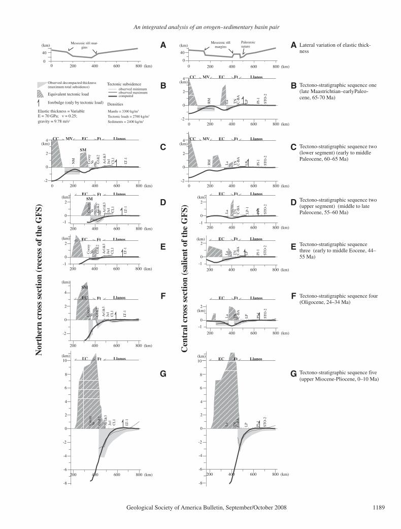
An integrated analysis of an orogen–sedimentary basin pair
Geological Society of America Bulletin, September/October 2008 1189
40
(km)
0 0
40
(km)Mesozoic rift
marginsPaleozoicsuture
Mesozoic rift mar-gins
Nor
ther
n cr
oss
sect
ion
(rec
ess
of t
he G
FS)
Cen
tral
cro
ss s
ecti
on (
salie
nt o
f th
e G
FS)
0 200 400 600 800 (km) 0 200 400 600 800 (km)
A
B
C
E
F
G
Equivalent tectonic load observed maximum computed
observed minimum
forebulge (only by tectonic load)
Tectonic subsidenceObserved decompacted thickness(maximum total subsidence) O(
Densities
Mantle = 3300 kg/m3
Tectonic loads = 2700 kg/m3
Sediments = 2400 kg/m3
Elastic thickness = VariableE = 70 GPa; v = 0.25;gravity = 9.78 m/s2
D
200 400 600 800
0
2
4
-2(km)
(km)CC MV EC Ft Llanos
La
LP
C-B
A
RM
TN
Pl-1
ST
O-2
200 400 600 800
0
2
4
-2(km)
(km)CC MV EC Ft Llanos
La
RM
LP
C-B
AT
N
Pl-1
ST
O-2
C-B
A
200 400 600 800
0
2
-1(km)
(km)EC Ft Llanos
La
LP
-1
TN
Pl-1
ST
O-2
200 400 600 800
0
2
-1
(km)
(km) EC Ft Llanos
La
LP
C-B
AT
N
Pl-1
ST
O-2
200 400 600 800
0
2
-1
(km)
(km)
EC Ft Llanos
La
LP
C-B
AT
N
Pl-1
ST
O-2
200 400 600 800 (km)
0
2
4
-2
(km)EC Ft Llanos
La
6
8
10
LP
C-B
AT
N
Pl-1
ST
O-2
-4
-6
-8
200 400 600 800
0
2
4
-2(km)
(km)CC MV EC Ft Llanos
LT-1
NM
Coc
uyVa G
1&2
Ar1
&3
Ju1
CL
1
0
2
-1
(km)
200 400 600 800 (km)
EC Ft Llanos
Coc
uyVa G
1&2
Ar1
&3
Ju1
CL
1
LT-1
200 400 600 800
0
2
-1(km)
(km) EC Ft Llanos
0
LT-1
Coc
uyVa G
1&2
Ar1
&3
Ju1
CL
1
0
0
0
2
4
-2
(km)
200 400 600 800 (km)
Ft Llanos
LT-1
Coc
uyVa G
1&2
Ar1
&3
Ju1
CL
1
400 600 800 (km)200
0
2
4
-2
(km)Llanos
6
8
10
-4
-6
LT-1
Coc
uyVa G
1&2
Ar1
&3
Ju1
CL
1
-8
A
B
C
E
F
G
D
SM
SM
SM
EC
Lateral variation of elastic thick-ness
Tectono-stratigraphic sequence one(late Maastrichtian–early Paleo-cene, 65-70 Ma)
Tectono-stratigraphic sequence two(lower segment) (early to middlePaleocene, 60–65 Ma)
Tectono-stratigraphic sequence two(upper segment) (middle to latePaleocene, 55–60 Ma)
Tectono-stratigraphic sequencethree (early to middle Eocene, 44–55 Ma)
Tectono-stratigraphic sequence four(Oligocene, 24–34 Ma)
Tectono-stratigraphic sequence five (upper Miocene-Pliocene, 0–10 Ma)
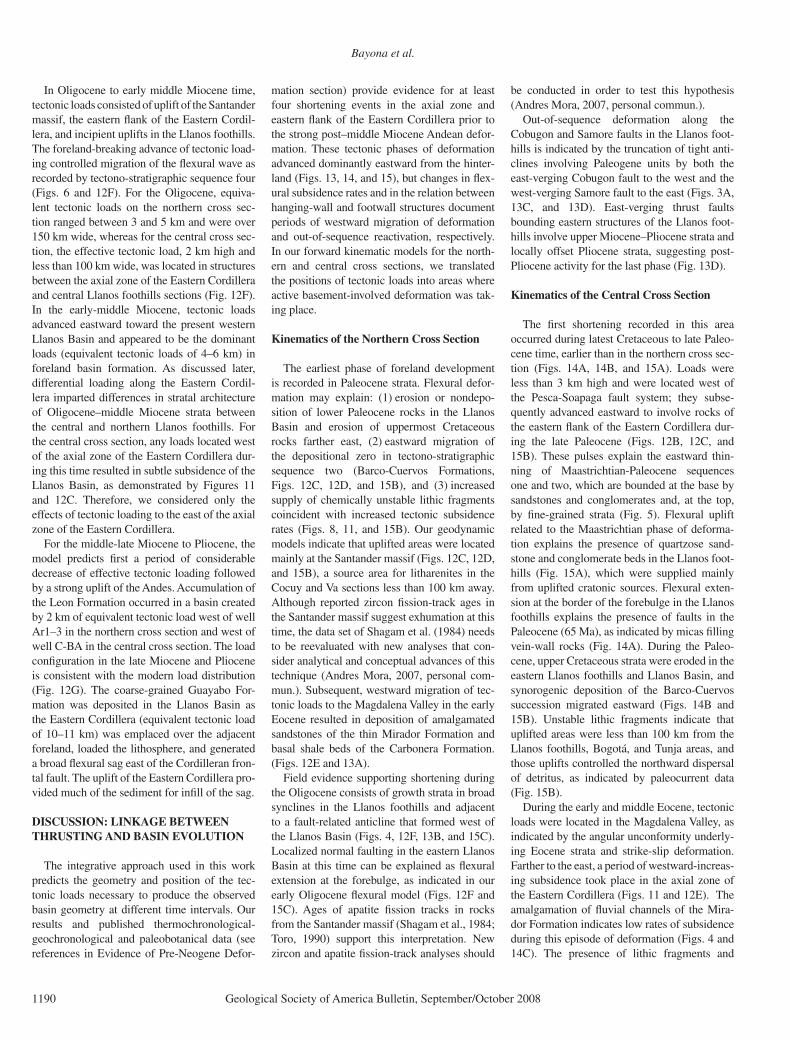
Bayona et al.
1190 Geological Society of America Bulletin, September/October 2008
In Oligocene to early middle Miocene time, tectonic loads consisted of uplift of the Santander massif, the eastern fl ank of the Eastern Cordil-lera, and incipient uplifts in the Llanos foothills. The foreland-breaking advance of tectonic load-ing controlled migration of the fl exural wave as recorded by tectono-stratigraphic sequence four (Figs. 6 and 12F). For the Oligocene, equiva-lent tectonic loads on the northern cross sec-tion ranged between 3 and 5 km and were over 150 km wide, whereas for the central cross sec-tion, the effective tectonic load, 2 km high and less than 100 km wide, was located in structures between the axial zone of the Eastern Cordillera and central Llanos foothills sections (Fig. 12F). In the early-middle Miocene, tectonic loads advanced eastward toward the present western Llanos Basin and appeared to be the dominant loads (equivalent tectonic loads of 4–6 km) in foreland basin formation. As discussed later, differential loading along the Eastern Cordil-lera imparted differences in stratal architecture of Oligocene–middle Miocene strata between the central and northern Llanos foothills. For the central cross section, any loads located west of the axial zone of the Eastern Cordillera dur-ing this time resulted in subtle subsidence of the Llanos Basin, as demonstrated by Figures 11 and 12C. Therefore, we considered only the effects of tectonic loading to the east of the axial zone of the Eastern Cordillera.
For the middle-late Miocene to Pliocene, the model predicts fi rst a period of considerable decrease of effective tectonic loading followed by a strong uplift of the Andes. Accumulation of the Leon Formation occurred in a basin created by 2 km of equivalent tectonic load west of well Ar1–3 in the northern cross section and west of well C-BA in the central cross section. The load confi guration in the late Miocene and Pliocene is consistent with the modern load distribution (Fig. 12G). The coarse-grained Guayabo For-mation was deposited in the Llanos Basin as the Eastern Cordillera (equivalent tectonic load of 10–11 km) was emplaced over the adjacent foreland, loaded the lithosphere, and generated a broad fl exural sag east of the Cordilleran fron-tal fault. The uplift of the Eastern Cordillera pro-vided much of the sediment for infi ll of the sag.
DISCUSSION: LINKAGE BETWEEN THRUSTING AND BASIN EVOLUTION
The integrative approach used in this work predicts the geometry and position of the tec-tonic loads necessary to produce the observed basin geometry at different time intervals. Our results and published thermochronological-geochronological and paleobotanical data (see references in Evidence of Pre-Neogene Defor-
mation section) provide evidence for at least four shortening events in the axial zone and eastern fl ank of the Eastern Cordillera prior to the strong post–middle Miocene Andean defor-mation. These tectonic phases of deformation advanced dominantly eastward from the hinter-land (Figs. 13, 14, and 15), but changes in fl ex-ural subsidence rates and in the relation between hanging-wall and footwall structures document periods of westward migration of deformation and out-of-sequence reactivation, respectively. In our forward kinematic models for the north-ern and central cross sections, we translated the positions of tectonic loads into areas where active basement-involved deformation was tak-ing place.
Kinematics of the Northern Cross Section
The earliest phase of foreland development is recorded in Paleocene strata. Flexural defor-mation may explain: (1) erosion or nondepo-sition of lower Paleocene rocks in the Llanos Basin and erosion of uppermost Cretaceous rocks farther east, (2) eastward migration of the depositional zero in tectono-stratigraphic sequence two (Barco-Cuervos Formations, Figs. 12C, 12D, and 15B), and (3) increased supply of chemically unstable lithic fragments coincident with increased tectonic subsidence rates (Figs. 8, 11, and 15B). Our geodynamic models indicate that uplifted areas were located mainly at the Santander massif (Figs. 12C, 12D, and 15B), a source area for litharenites in the Cocuy and Va sections less than 100 km away. Although reported zircon fi ssion-track ages in the Santander massif suggest exhumation at this time, the data set of Shagam et al. (1984) needs to be reevaluated with new analyses that con-sider analytical and conceptual advances of this technique (Andres Mora, 2007, personal com-mun.). Subsequent, westward migration of tec-tonic loads to the Magdalena Valley in the early Eocene resulted in deposition of amalgamated sandstones of the thin Mirador Formation and basal shale beds of the Carbonera Formation. (Figs. 12E and 13A).
Field evidence supporting shortening during the Oligocene consists of growth strata in broad synclines in the Llanos foothills and adjacent to a fault-related anticline that formed west of the Llanos Basin (Figs. 4, 12F, 13B, and 15C). Localized normal faulting in the eastern Llanos Basin at this time can be explained as fl exural extension at the forebulge, as indicated in our early Oligocene fl exural model (Figs. 12F and 15C). Ages of apatite fi ssion tracks in rocks from the Santander massif (Shagam et al., 1984; Toro, 1990) support this interpretation. New zircon and apatite fi ssion-track analyses should
be conducted in order to test this hypothesis (Andres Mora, 2007, personal commun.).
Out-of-sequence deformation along the Cobugon and Samore faults in the Llanos foot-hills is indicated by the truncation of tight anti-clines involving Paleogene units by both the east-verging Cobugon fault to the west and the west-verging Samore fault to the east (Figs. 3A, 13C, and 13D). East-verging thrust faults bounding eastern structures of the Llanos foot-hills involve upper Miocene–Pliocene strata and locally offset Pliocene strata, suggesting post-Pliocene activity for the last phase (Fig. 13D).
Kinematics of the Central Cross Section
The fi rst shortening recorded in this area occurred during latest Cretaceous to late Paleo-cene time, earlier than in the northern cross sec-tion (Figs. 14A, 14B, and 15A). Loads were less than 3 km high and were located west of the Pesca-Soapaga fault system; they subse-quently advanced eastward to involve rocks of the eastern fl ank of the Eastern Cordillera dur-ing the late Paleocene (Figs. 12B, 12C, and 15B). These pulses explain the eastward thin-ning of Maastrichtian-Paleocene sequences one and two, which are bounded at the base by sandstones and conglomerates and, at the top, by fi ne-grained strata (Fig. 5). Flexural uplift related to the Maastrichtian phase of deforma-tion explains the presence of quartzose sand-stone and conglomerate beds in the Llanos foot-hills (Fig. 15A), which were supplied mainly from uplifted cratonic sources. Flexural exten-sion at the border of the forebulge in the Llanos foothills explains the presence of faults in the Paleocene (65 Ma), as indicated by micas fi lling vein-wall rocks (Fig. 14A). During the Paleo-cene, upper Cretaceous strata were eroded in the eastern Llanos foothills and Llanos Basin, and synorogenic deposition of the Barco-Cuervos succession migrated eastward (Figs. 14B and 15B). Unstable lithic fragments indicate that uplifted areas were less than 100 km from the Llanos foothills, Bogotá, and Tunja areas, and those uplifts controlled the northward dispersal of detritus, as indicated by paleocurrent data (Fig. 15B).
During the early and middle Eocene, tectonic loads were located in the Magdalena Valley, as indicated by the angular unconformity underly-ing Eocene strata and strike-slip deformation. Farther to the east, a period of westward-increas-ing subsidence took place in the axial zone of the Eastern Cordillera (Figs. 11 and 12E). The amalgamation of fl uvial channels of the Mira-dor Formation indicates low rates of subsidence during this episode of deformation (Figs. 4 and 14C). The presence of lithic fragments and

An integrated analysis of an orogen–sedimentary basin pair
Geological Society of America Bulletin, September/October 2008 1191
Lower Cretaceous -Jurassic-Triassic
Lower Paleocene -Upper Cretaceous
pre-Mesozoic
Middle Eocene -Paleocene
Middle Miocene -Upper Eocene
Holocene-Middle Miocene
Fault
Contact
Restored fault trace
Well
Outcrop section
A. Late Eocene - Tectono-stratigraphic sequence 4(Deposition of lower Carbonera Fm., 36 Ma)
20 km
B. Middle Miocene - Tectono-stratigraphic sequence 4(Deposition of upper Carbonera Fm., 14 Ma)
D. Present day
C. Latest Miocene - Tectono-stratigraphic sequence 5(Deposition of Guayabo Fm., 5 Ma)
20 km
20 km
20 km
KiW E
nematics of the northern cross section
Va G1&2 A1&3
Lab
atec
a F.
Cob
ugon
F.
Sam
ore
F.
Oligocene growth strata
Va G1&2 A1&3
Lab
atec
a F.
Cob
ugon
F.
Sam
ore
F.
Fig. 4A Fig. 4B
Apatite FT ages (Toro, 1990)
Apatite FT ages (Shagamet al., 1984)
Figure 13. Kinematic forward model for the northern cross section since the middle Eocene. Basin geometry and position of structural activity are constrained by geodynamic modeling, thermochronology, growth structures, and provenance and paleocurrent data. FT—fi ssion track.

Bayona et al.
1192 Geological Society of America Bulletin, September/October 2008
C. M
iddl
e E
ocen
e -
Tec
tono
-str
atig
raph
ic s
eque
nce
3(D
epos
itio
n of
upp
er M
irad
or F
m.,
39 M
a)
B. L
ates
t P
aleo
cene
- T
ecto
no-s
trat
igra
phic
seq
uenc
e 2
(Dep
osit
ion
of u
pper
Cue
rvos
Fm
., 55
Ma)
D. M
iddl
e M
ioce
ne -
Tec
tono
-str
atig
raph
ic s
eque
nce
4(D
epos
itio
n of
upp
er C
arbo
nera
Fm
., 14
Ma)
20 k
mA
. Lat
est
Cre
tace
ous
- T
ecto
no-s
trat
igra
phic
seq
uenc
e 1
(Dep
osit
ion
of lo
wer
Gua
duas
Fm
., 65
Ma)
E. P
rese
nt d
ay -
Tec
tono
-str
atig
raph
ic s
eque
nce
5
20 k
m
20 k
m
20 k
m
20 k
m
NW
SEK
inem
atic
s of
the
cen
tral
cro
ss s
ecti
on
La
TN
C-B
AL
ML
CL
G1&
2C
eL
PG
u1
Pesca F.
Chameza F.
Guaicaramo F.
Cusiana-Cupiagua F.
Zir
con
FT a
ges
(Sha
gam
et a
l. ,
1984
)M
icas
fill
ing
norm
alfa
ults
(B
ranq
uet e
tal
., 19
99)
-Fo
rebu
lge
Lith
aren
ites;
sou
rce
area
s le
ss th
an 1
00 k
mPa
leor
elie
f co
ntro
lled
nort
hwar
d di
sper
sion
of
detr
itus
Am
alga
mat
ed s
ands
tone
s =
ver
y lo
w s
ubsi
denc
e
Flex
ural
sub
side
nce
caus
es a
brup
t cha
nge
of th
ickn
ess,
inci
pien
t dev
elop
men
t of
stru
ctur
es
Apa
tite
FT a
ges
(Tor
o, 1
990)
Apa
tite
FT a
ges
(Hos
sack
et a
l.,19
99)
Apa
tite
FT a
ges
(Mor
a et
al.,
2005
)
La
TN
C-B
A
Pesca F.
Chameza F.
GuaicaramoF.
LM
LC
LG
1&2
Ce
LP
Gu1
Cusiana-Cupiagua F.
And
ean-
type
pal
eofl
ora
Con
glom
erat
icsa
ndst
ones
Fig
ure
14. K
inem
atic
forw
ard
mod
el fo
r th
e ce
ntra
l cro
ss s
ecti
on s
ince
the
late
Maa
stri
chti
an. B
asin
geo
met
ry a
nd p
osit
ion
of s
truc
tura
l act
ivit
y ar
e co
nstr
aine
d by
geo
dyna
mic
m
odel
ing,
ther
moc
hron
olog
y an
d ge
ochr
onol
ogy
data
, gro
wth
str
uctu
res,
and
pro
vena
nce
and
pale
ocur
rent
dat
a. S
ee e
xpla
nati
on o
f sym
bols
in F
igur
e 13
. FT
—fi s
sion
trac
k.
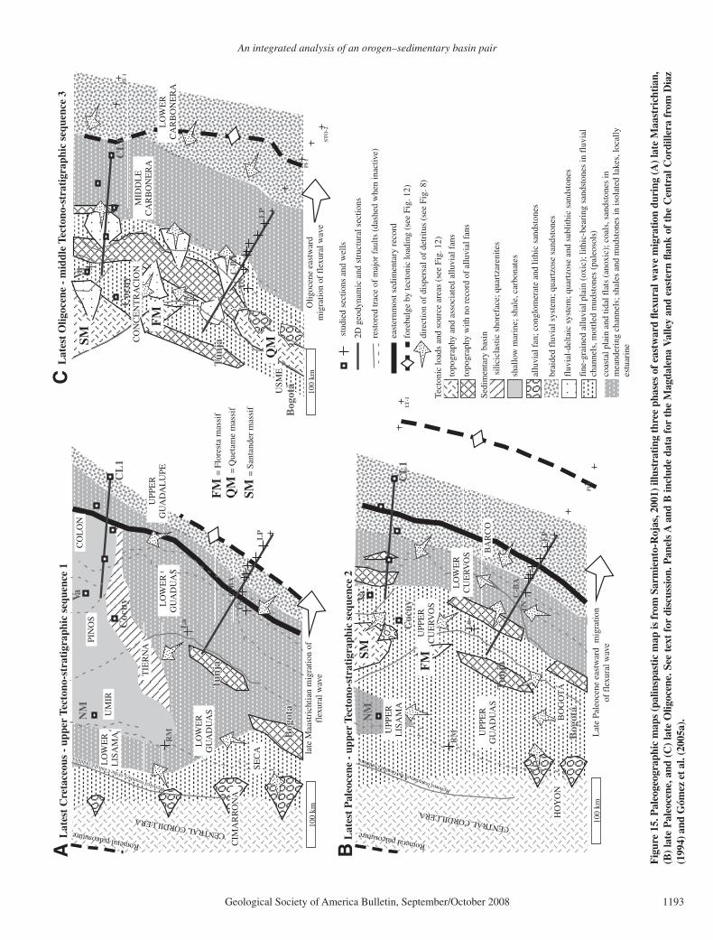
An integrated analysis of an orogen–sedimentary basin pair
Geological Society of America Bulletin, September/October 2008 1193
UM
IR
CO
LO
N
LO
WE
RL
ISA
MA
CIM
AR
RO
NA
TIE
RN
A PI
NO
S
LO
WE
RG
UA
DU
AS
LO
WE
RG
UA
DU
AS
late
Maa
stri
chtia
n m
igra
tion
offl
exur
al w
ave
LP
C-B
A
La
RM
TN
100
km
NM
Coc
uy
Va
CL
1
Tunj
aTu
nja
Tunj
a
Bog
otá
Bog
otá
Bog
otá
Restored boundary of the Central Cordillera
Restored boundary of the Central Cordillera
Restored boundary of the Central Cordillera
CENTRAL CORDILLERA
Romeral paleosuture
UPP
ER
GU
AD
AL
UPE
SEC
A
Lat
est
Cre
tace
ous
- up
per
Tect
ono-
stra
tigr
aphi
c se
quen
ce 1
BA
RC
O
HO
YO
N
UPP
ER
GU
AD
UA
S
Lat
e Pa
leoc
ene
east
war
d m
igra
tion
of f
lexu
ral w
ave
LP
C-B
A
La
RM
RM
RM
TN
Pl-
1
100
km
NM
Coc
uyC
ocuy
Coc
uy
Va
CL
1LT
-1
Tun
ja
Bog
otá
Bog
otá
Bog
otá
Restored boundary of the Central Cordillera
CENTRAL CORDILLERA
Romeral paleosuture
LO
WE
RC
UE
RV
OS
BO
GO
TÁ
UPP
ER
CU
ER
VO
S
UPP
ER
LIS
AM
A
Lat
est
Pal
eoce
ne -
upp
er T
ecto
no-s
trat
igra
phic
seq
uenc
e 2
Olig
ocen
e ea
stw
ard
mig
ratio
n of
fle
xura
l wav
e
LO
WE
RC
AR
BO
NE
RA
MID
DL
EC
AR
BO
NE
RA
USM
E
LP
C-B
A
La
TN
Pl-
1
STO
-2
100
km
Coc
uy
Va
CL
1LT
-1
Tunj
aTu
nja
Tunj
a
Bog
otá
topo
grap
hy w
ith n
o re
cord
of
allu
vial
fan
s
fine
-gra
ined
allu
vial
pla
in (
oxic
); li
thic
-bea
ring
san
dsto
nes
in f
luvi
alch
anne
ls, m
ottle
d m
udst
ones
(pa
leos
ols)
allu
vial
fan
; con
glom
erat
e an
d lit
hic
sand
ston
es
coas
tal p
lain
and
tida
l fla
ts (
anox
ic);
coa
ls, s
ands
tone
s in
mea
nder
ing
chan
nels
; sha
les
and
mud
ston
es in
isol
ated
lake
s, lo
cally
estu
arin
e
silic
icla
stic
sho
refa
ce; q
uart
zare
nite
s
shal
low
mar
ine;
sha
le, c
arbo
nate
s
brai
ded
fluv
ial s
yste
m; q
uart
zose
san
dsto
nes
east
ernm
ost s
edim
enta
ry r
ecor
d
topo
grap
hy a
nd a
ssoc
iate
d al
luvi
al f
ans
Tect
onic
load
s an
d so
urce
are
as (
see
Fig.
12)
Sedi
men
tary
bas
in
fore
bulg
e by
tect
onic
load
ing
(see
Fig
. 12)
dire
ctio
n of
dis
pers
al o
f de
tritu
s (s
ee F
ig. 8
)
fluv
ial-
delta
ic s
yste
m; q
uart
zose
and
sub
lithi
c sa
ndst
ones
2D g
eody
nam
ic a
nd s
truc
tura
l sec
tions
rest
ored
trac
e of
maj
or f
aults
(da
shed
whe
n in
activ
e)
stu
died
sec
tions
and
wel
ls
Lat
est
Olig
ocen
e -
mid
dle
Tect
ono-
stra
tigr
aphi
c se
quen
ce 3
CO
NC
EN
TR
AC
ION
SM F
M
SM
FM
QM
SM =
San
tand
er m
assi
f
FM
= F
lore
sta
mas
sif
QM
= Q
ueta
me
mas
sif
A B
C
Fig
ure
15. P
aleo
geog
raph
ic m
aps
(pal
insp
asti
c m
ap is
from
Sar
mie
nto-
Roj
as, 2
001)
illu
stra
ting
thre
e ph
ases
of e
astw
ard
fl exu
ral w
ave
mig
rati
on d
urin
g (A
) lat
e M
aast
rich
tian
, (B
) la
te P
aleo
cene
, and
(C
) la
te O
ligoc
ene.
See
tex
t fo
r di
scus
sion
. Pan
els
A a
nd B
incl
ude
data
for
the
Mag
dale
na V
alle
y an
d ea
ster
n fl a
nk o
f th
e C
entr
al C
ordi
llera
fro
m D
iaz
(199
4) a
nd G
ómez
et a
l. (2
005a
).

Bayona et al.
1194 Geological Society of America Bulletin, September/October 2008
fragments of Cretaceous foraminifera in the axial zone of the Eastern Cordillera indicates that minor uplifts continued to supply detritus to the adjacent basin.
Late Eocene to middle Miocene shortening emplaced loads less than 4 km high in the area between the axial zone of the Eastern Cordillera and the eastern Llanos foothills (Figs. 12F, 14D, and 15C). Exhumation of this area, bounded by the Chameza fault to the east, is supported by AFTA data. At this time, a fold-and-thrust belt advanced eastward to the present position of the western Llanos foothills (Fig. 15C), and the salient-recess geometry of the thrust belt began to form. Deposition in the eastern Lla-nos foothills was mostly accommodated by increasing fl exural subsidence toward the East-ern Cordillera (Fig. 12F), as indicated by the abrupt change in thickness of Oligocene and lower Miocene strata, and it was less affected by growth of incipient structures. The dominance of sublitharenite and subarkose supports the interpretation that nearby structures in the east-ern Llanos foothills were not exposed to supply detritus to the basin.
Strong basin inversion took place during middle Miocene to Pliocene time and gave rise to today’s Eastern Cordillera structural confi gu-ration (Figs. 12G and 14E). Equivalent tectonic loads along the eastern fl ank of the Eastern Cor-dillera were 10–11 km high, and they advanced eastward to the eastern boundary of the Llanos foothills. The onset of Andean-scale deforma-tion created a regional and nearly simultane-ous fl ooding event that is recorded in most of the sub-Andean foreland basins in the middle Miocene. The rapid uplift and consequent basin fi lling caused abrupt eastward migration of the forebulge and fl uvial-alluvial depositional sys-tems originating from the Eastern Cordillera.
The most active fault during this latter tec-tonic phase was the Guaicaramo fault system, which allowed exhumation of the Quetame massif and basal Cretaceous strata. It was only at this time that strong surface uplift took place between 6 and 3 Ma, as documented by the change of paleobotanical associations and the generation of an orographic barrier that accel-erated deformation on the eastern fl ank of the Eastern Cordillera. Out-of-sequence deforma-tion along the Guaicaramo fault system was coeval with the different phases of exhumation documented by AFTA data for the Garzon and Quetame massifs.
CONCLUSIONS
The integration of palinspastically restored basin geometry and internal features of syntec-tonic units (e.g., stratal architecture, sandstone
composition, etc.), fl exural modeling, and kine-matic constraints of the orogenic belt permits identifi cation of phases of deformation in an orogen–foreland basin system. The current con-fi guration of the Eastern Cordillera and adjacent Llanos Basin of Colombia is the result of the polyphase growth of basement-rooted structures and ensuing foreland basin development. There-fore, a comprehensive analysis of the adjacent foreland basin can be used to defi ne the spatial and temporal patterns of deformation of former events in the evolving Eastern Cordillera.
Five episodes of deformation have been documented from analysis of the sedimentary record in the axial zone and eastern fl ank of the Eastern Cordillera, Llanos foothills, and Llanos Basin. The fi rst three episodes of deformation include shortening during latest Cretaceous to middle Eocene time. During this period, the deformation front fi rst moved eastward from the axial zone to the eastern fl ank of the East-ern Cordillera (tectono-stratigraphic sequences one and two, Figs. 15A and 15B), and then it shifted to the western fl ank of the Eastern Cor-dillera and Magdalena Valley (tectono-strati-graphic sequence three). Flexural deformation induced: (1) erosion of Paleocene–upper Creta-ceous strata in the Llanos foothills and Llanos Basin, (2) westward thickening of unconfor-mity-bounded Maastrichtian- Paleocene syn-tectonic sequences, (3) increased input of lithic fragments in upper Paleocene strata and north-ward dispersal of detritus, (4) amalgamation of fl uvial-to-estuarine channel structures dur-ing the early and middle Eocene, (5) change of subsidence rates in the latest Cretaceous and late Paleocene, and (6) slow tectonic subsid-ence regimes during the early-middle Eocene in the axial Eastern Cordillera and Llanos foothills. These phases of deformation are con-strained in the hinterland by: (1) zircon fi ssion-track data from the Santander massif (Shagam et al., 1984); (2) geochronological data from micas fi lling normal faults associated with fl exural extension during the latest Cretaceous (Branquet et al., 1999); and (3) angular uncon-formities in the Magdalena Valley (Gómez et al., 2003, 2005b). Geodynamic analysis allows us to infer that equivalent tectonic loads for these phases were less that 3 km high, less than 100 km wide, and wider in the northern than in the central part of the study area.
Tectonic loads in the late Eocene–middle Miocene fl exural phase were higher than former episodes of deformation, and they were concen-trated in the axial zone of the Eastern Cordillera, eastern fl ank of the Eastern Cordillera, and to a lesser extent in the Llanos foothills. In the north-ern Llanos foothills, this phase is constrained by the presence of growth strata that bound
basement-rooted structures, whereas in the cen-tral Llanos foothills, it is mainly constrained by the increasing fl exural subsidence toward the Eastern Cordillera and subtle deformation of tectono-stratigraphic sequence four. The fourth tectonic phase was also characterized by east-ward reactivation of tectonic loads and genera-tion of the salient-recess geometry of the thrust belt (Fig. 15C). In the hinterland, this phase is identifi ed by published apatite fi ssion tracks (Shagam et al., 1984; Toro, 1990; Hossack et al., 1999). Geodynamic analyses indicate that tectonic loads were 3–6 km high, 50–100 km wide, and wider in the northern than in the cen-tral cross section.
The last tectonic episode identifi ed in this study encompassed the width of the entire East-ern Cordillera, involved reactivation of basement structures during middle Miocene to Pliocene time, and ultimately defi ned the current confi gu-ration of major structures that bound the Eastern Cordillera, as well as the fl exural geometry of the Llanos Basin. Tectonic loads advanced eastward during at least two periods of out-of-sequence reactivation, as inferred from relations between hanging-wall and footwall structures of the Cha-meza and Guaicaramo faults in the central cross section, and of the Cobugon and Samore faults in the northern cross section. These phases of deformation are further constrained by rock-exhumation (Van der Wiel, 1991; Mora et al., 2005) and surface-uplift (Hooghiemstra and Van der Hammen, 1998) evidence. However, the lack of biostratigraphic constraints in the associ-ated alluvial and fl uvial deposits precludes rec-ognition of individual phases of deformation, similar to those uncovered here for the upper Cretaceous–middle Miocene succession.
The integrative approach used for this research permits identifi cation of the timing of activity on the different structures within the Eastern Cordillera and their effect on the adjacent sedi-mentary basin. This two-dimensional approach should be considered prior to a three-dimen-sional analysis of a thrust belt system in order to constrain the effects of a particular phase of deformation on location of source areas, dis-persal of synorogenic detritus, distribution of depositional systems, and stratal architecture in the basin. In addition, future thermochronologi-cal studies designed to quantify the exhumation of the Eastern Cordillera must encompass the width of the Eastern Cordillera rather than sam-pling a single range.
ACKNOWLEDGMENTS
This research was supported by the Colombian Petroleum Institute, Ecopetrol S.A., the Smithso-nian Paleobiology Endowment Fund, and the Unre-stricted Endowments SI Grants. Thanks are due to

An integrated analysis of an orogen–sedimentary basin pair
Geological Society of America Bulletin, September/October 2008 1195
the Biostratigraphic Team at the Colombian Petro-leum Institute, Nestor Gamba, and Johana Pinilla for their collaboration at different stages of this project. We thank Timothy Lawton for a careful review of the manuscript, which, together with the comments of an anonymous reviewer and Associate Editor James Schmitt, improved the content of this paper. Natasha Atkins reviewed the last revised version of the sub-mitted manuscript to improve the fl ow of the English. Bayona acknowledges discussions with Elias Gómez concerning foreland evolution of the Magdalena Val-ley and Llanos Basin, Andres Mora concerning the use of fi ssion-track data and reactivation of Meso-zoic structures, and Cornelius Uba, Mauricio Parra, and Brian Horton concerning evolution of Andean foreland systems.
REFERENCES CITED
Allen, P., and Allen, J., 1992, Basin Analysis: Principles and Applications: London, Blackwell Scientifi c Publica-tions, 451 p.
Arango, F., 1996, Analisis estratigrafi co del limite Cretacico Superior-Paleoceno en el bloque colgante de la Falla de Guicaramo en alrededores de Tamara, Casanare: Bogotá, VII Congreso Colombiano de Geologia, Tomo II, p. 516–524.
Bayona, G., Cortés, M., Jaramillo, C., and Llinás, R.D., 2003, The Fusagasugá succession: A record of the complex Latest Cretaceous–pre-Miocene deformation between the Magdalena Valley and Sabana de Bogotá areas, in VIII Simposio Bolivariano de Exploración Petrolera en las Cuencas Subandinas: Cartagena, Colombia, Asocia-ción Colombiana de Geólogos y Geofísicos del Petróleo, p. 180–193.
Bayona, G., Reyes-Harker, A., Jaramillo, C., Rueda, M., Aristizabal, J.J., Cortés, M., and Gamba, N., 2006, Dis-tinguishing tectonic versus eustatic fl ooding surfaces in the Llanos Basin of Colombia, and implications for stratigraphic correlations, in IX Simposio Bolivariano de Exploracion Petrolera en las Cuencas Subandinas: Cart-agena, Colombia Asociación Colombiana de Geólogos y Geofísicos del Petróleo, 13 p.
Benavides, C., 2004, Estudio Mineralogico sobre Ripios secos Gibraltar 2: Informe fi nal para Ecopetrol-AEX: Bucaramanga, Instituto Colombiana del Petróleo ICP (internal report), 15 p.
Bodine, J.H., 1981, Numerical Computation of Plate Flexure in Marine Geophysics: Lamont-Doherty Geological Observatory of Columbia University Technical Report 1, 153 p.
Boinet, T., Bourgois, J., Mendoza, H., and Vargas, R., 1985, Le poinçon de pamplona (Colombie): Un jalon de la frontière meridionale de la plaque Caraïbe: Bulletin de la Société Géologique de France, v. 8, p. 403–413.
Branquet, Y., Laumonier, B., Cheilletz, A., and Giuliani, G., 1999, Emeralds in the Eastern Cordillera of Colombia: Two tectonic settings for one mineralization: Geology, v. 27, p. 597–600, doi: 10.1130/0091-7613(1999)027<0597:EITECO>2.3.CO;2.
Branquet, Y., Cheilletz, A., Cobbold, P., Baby, P., Laumonier, B., and Giuliani, G., 2002, Andean deformation and rift inversion, eastern edge of the Cordillera Oriental (Guateque-Medina area), Colombia: Journal of South American Earth Sciences, v. 15, p. 391–407, doi: 10.1016/S0895-9811(02)00063-9.
Cardozo, N., and Jordan, T., 2001, Causes of spatially variable tectonic subsidence in the Miocene Bermejo foreland basin, Argentina: Basin Research, v. 13, p. 335–357, doi: 10.1046/j.0950-091x.2001.00154.x.
Casero, P., Salel, J.F., and Rossato, A., 1997, Multidisciplinary correlative evidences for polyphase geological evolution of the foothills of the Cordillera Oriental (Colombia), in VI Simposio Bolivariano de Exploración Petrolera en las Cuencas Subandinas: Cartagena, Colombia, Asocia-ción Colombiana de Geólogos y Geofísicos del Petróleo, p. 100–118.
Cazier, E.C., Hayward, A.B., Espinosa, G., Velandia, J., Mugniot, J.F., and Leel, W.G., 1995, Petroleum geology of the Cusiana fi eld, Llanos Basin foothills, Colombia:
The American Association of Petroleum Geologists Bul-letin, v. 79, p. 1444–1463.
Cediel, F., and Cáceres, C., 1988, Geologic Map of Colombia: Bogotá, Geotec Ltd., scale 1:1,200,000.
Cediel, F., Shaw, R., and Cáceres, C., 2003, Tectonic assembly of the Northern Andean block, in Bartolini, C., Buffl er, R., and Blickwede, J., eds., The Circum-Gulf of Mexico and the Caribbean: Hydrocarbon Habitats, Basin Forma-tion and Plate Tectonics: American Association of Petro-leum Geologists Memoir 79, p. 815–848.
Céspedes, S., and Peña, L., 1995, Relaciones Estratigráfi cas y Ambientes de Depósito de las Formaciones del Tercia-rio Inferior Afl orante entre Tunja y Paz del Rio, Boyacá. [Undergraduate thesis]: Bogotá, Universidad Nacional de Colombia, 50 p.
Chigne, N., Loureiro, D., and Rojas, E., 1997, El piedemonte de la Cordillera Oriental de Colombia y de los Andes de Merida; estilos estructurales y consideraciones sobre la génesis y migración de hidrocarburos, in VI Simposio Bolivariano de Exploración Petrolera en las Cuencas Subandinas: Cartagena, Asociación Colombiana de Geólogos y Geofísicos del Petróleo, p. 457–477.
Colleta, B., Hébrard, F., Letouzey, J., Werner, P., and Rud-kiewikz, J.L., 1990, Tectonic style and crustal structure of the Eastern Cordillera (Colombia), from a balanced cross section, in Letouzey, J., ed., Petroleum and Tecton-ics in Mobile Belts: Paris, Editions Technip, p. 81–100.
Colmenares, F., 1993, Columnas estratigráfi cas en el Piede-monte Llanero para la BP-Colombia: Bogotá, Internal report, scale 1:100.
Cooper, M.A., Addison, F.T., Alvarez, R., Coral, M., Graham, R.H., Hayward, A.B., Howe, S., Martinez, J., Naar, J., Peñas, R., Pulham, A.J., and Taborda, A., 1995, Basin development and tectonic history of the Llanos Basin, Eastern Cordillera, and middle Magdalena Valley, Colombia: The American Association of Petroleum Geologists Bulletin, v. 79, p. 1421–1443.
Corredor, F., 2003, Eastward extent of the late Eocene–early Oligocene onset of deformation across the northern Andes: Constraints from the northern portion of the Eastern Cordillera fold belt, Colombia: Journal of South American Earth Sciences, v. 16, p. 445–457, doi: 10.1016/j.jsames.2003.06.002.
Cortés, M., Aristizabal, J.J., Bayona, G., Ojeda, G., Reyes, A., and Gamba, N., 2006a, Structure and kinematics of the Eastern foothills of the Eastern Cordillera of Colombia from balanced cross-sections and forward modelling, in IX Simposio Bolivariano de Exploracion Petrolera en las Cuencas Subandinas: Cartagena, Colombia, Asociación Colombiana de Geólogos y Geofísicos del Petróleo, 14 p.
Cortés, M., Colleta, B., and Angelier, J., 2006b, Structure and tectonics of the central segment of the Eastern Cordillera of Colombia: Journal of South American Earth Sciences, v. 21, p. 437–465, doi: 10.1016/j.jsames.2006.07.004.
DeCelles, P., and Giles, K., 1996, Foreland basin systems: Basin Research, v. 8, p. 105–123, doi: 10.1046/j.1365-2117.1996.01491.x.
Dengo, C.A., and Covey, M.C., 1993, Structure of the Eastern Cordillera of Colombia: Implications for trap styles and regional tectonics: The American Association of Petro-leum Geologists Bulletin, v. 77, p. 1315–1337.
Diaz, L., 1994, Reconstruccion de la cuenca del Valle superior del Magdalena, a fi nales del Cretacico, in Etayo-Serna, F., ed., Estudios Geológicos del Valle Superior del Magdalena: Bogotá, Universidad Nacional de Colom-bia, p. 13, Chapter XI.
Etayo-Serna, F., Barrero, D., Lozano, H., and 15 others, 1983, Mapa de Terrenos Geológicos de Colombia, Publicación Geológica Especial: Bogotá, Ingeominas, 235 p.
Fabre, A., 1981, Estratigrafía de la Sierra Nevada del Cocuy, Boyacá y Arauca, Cordillera Oriental (Colombia): Geología Norandina, v. 4, p. 3–12.
Fabre, A., 1987, Tectonique et géneration d’hydrocarbures: Un modèle de l’evolution de la Cordillère Orientale de Colombie et du Bassin de Llanos pendant le Crétacé et le Tertiaire: Archives des Sciences Genève, v. 40, p. 145–190.
Fajardo, A., 1995, 4-D Stratigraphic Architecture and 3-D Reservoir Fluid-Flow Model of the Mirador Formation, Cusiana Field, Foothills Area of the Cordillera Oriental, Colombia [Master’s thesis]: Golden, Colorado School of Mines, 171 p.
Fajardo, A., Rojas, E., Cristancho, J., and Consorcio G&G Going System, 2000, Defi nición del Modelo estratigra-fi co en el Intervalo Cretaceo Tardio a Mioceno Medio en la Cuenca Llanos Orientales y Piedemonte Llanero: Informe Final: Bucaramanga, Ecopetrol S.A. y Instituto Colombiano del Petroleo, 181 p.
Fajardo-Peña, G., 1998, Structural Analysis and Basin Inver-sion Evolutionary Model of the Arcabuco, Tunja and Sogamoso Regions, Eastern Cordillera, Colombia [M.Sc. thesis]: Boulder, University of Colorado, 114 p.
Flemings, P.B., and Jordan, T.E., 1990, Stratigraphic modelling of foreland basins: Interpreting thrust deformation and lithosphere rheology: Geology, v. 18, p. 430–434, doi: 10.1130/0091-7613(1990)018<0430:SMOFBI>2.3.CO;2.
Geoconsult-Pangea, 2003, Consultoria para el Desarrollo de Actividades que Conduzcan a Reducir el Riesgo Explor-atorio en el Piedemoente Llanero—Proyecto Flujo Regional de Fluidos: Bucaramanga, Reporte Interno Ecopetrol-ICP.
Geoestratos-Dunia, 2003, Control Geológico de Campo del Bloque Sirirí y Áreas Aledañas: Informe Final: Bucara-manga, Ecopetrol S.A. y Instituto Colombiano del Petroleo, 181 p.
George, R., Pindell, J., and Cristancho, J., 1997, Eocene paleostructure of Colombia and implications for his-tory of generation and migration of hydrocarbons, in VI Simposio Bolivariano de Exploración Petrolera en las Cuencas Subandinas: Cartagena, Colombia, Asociación Colombiana de Geólogos y Geofísicos del Petróleo, p. 133–140.
Gómez, E., Jordan, T., Allmendinger, R.W., Hegarty, K., Kel-ley, S., and Heizler, M., 2003, Controls on architecture of the Late Cretaceous to Cenozoic southern Middle Magdalena Valley Basin: Geological Society of America Bulletin, v. 115, p. 131–147, doi: 10.1130/0016-7606(2003)115<0131:COAOTL>2.0.CO;2.
Gómez, E., Jordan, T., Allmendinger, R.W., and Cardozo, N., 2005a, Development of the Colombian foreland-basin system as a consequence of diachronous exhumation of the northern Andes: Geological Society of America Bul-letin, v. 117, p. 1272–1292, doi: 10.1130/B25456.1
Gómez, E., Jordan, T., Allmendinger, R.W., Hegarty, K., and Kelley, S., 2005b, Syntectonic Cenozoic sedimenta-tion in the northern middle Magdalena Valley Basin of Colombia and implications for exhumation of the north-ern Andes: Geological Society of America Bulletin, v. 117, no. 5/6, p. 547–569, doi: 10.1130/B25454.1
Guerrero, J., and Sarmiento, G., 1996, Estratigrafía física, pal-inológica, sedimentológica y secuencial del Cretácico Superior y Paleoceno del Piedemonte Llanero: Implica-ciones en exploración petrolera: Geologia Colombiana, v. 20, p. 3–66.
Haq, B.U., Hardenbol, J., and Vail, P., 1987, Chronology of fl uctuating sea levels since the Triassic: Science, v. 235, p. 1156–1166, doi: 10.1126/science.235.4793.1156.
Helmens, K.F., 1990, Neogene–Quaternary geology of the high plain of Bogotá, Eastern Cordillera, Colombia (stratigraphy, paleoenvironments and landscape evolu-tion): Berlin, Gebruder Borntraeger Verlagsbuchhand-lung, Dissertationes Botanicae, 202 p.
Helmens, K.F., and Van der Hammen, T., 1994, The Pliocene and Quaternary of the high plain of Bogotá (Colombia): A history of tectonic uplift, basic development and cli-matic change: Quaternary International, v. 21, p. 41–61, doi: 10.1016/1040-6182(94)90020-5.
Herrera, F., 2004, Paleotemperatura y Paleoprecipitación del Paleoceno Superior en Zonas Tropicales usando Plantas Megafósiles de la Fm. Cerrejón [Undergraduate thesis]: Bucaramanga, Universidad Industrial de Santander, 44 p.
Hooghiemstra, H., and Van der Hammen, T., 1998, Neogene and Quaternary development of the neotropical rain for-est: The forest refugia hypothesis, and a literature over-view: Earth-Science Reviews, v. 44, p. 147–183, doi: 10.1016/S0012-8252(98)00027-0.
Hoorn, C., 1988, Quebrada del Mochuelo, Type Locality of the Bogotá Formation: A Sedimentological, Petrograph-ical and Palynological Study: Hugo de Vries Laboratory: Amsterdam, University of Amsterdam, 21 p.
Hoorn, C., 1994, Fluvial palaeoenvironments in the Ama-zonas Basin (early Miocene to early middle Mio-cene, Colombia): Palaeoclimatology, Palaeogeogra-phy, Palaeoecology, v. 109, p. 1–54, doi: 10.1016/0031-0182(94)90117-1.

Bayona et al.
1196 Geological Society of America Bulletin, September/October 2008
Hoorn, C., Guerrero, J., Sarmiento, G.A., and Lorente, M.A., 1995, Andean tectonics as a cause for changing drainage patterns in Miocene northern South America: Geology, v. 23, p. 237–240, doi: 10.1130/0091-7613(1995)023<0237:ATAACF>2.3.CO;2.
Horton, B.K., 1999, Erosional control on the geom-etry and kinematics of thrust belt development in the central Andes: Tectonics, v. 18, p. 1292–1304, doi: 10.1029/1999TC900051.
Horton, B.K., Hampton, B.A., and Waanders, G.L., 2001, Paleogene synorogenic sedimentation in the Altiplano plateau and implications for initial mountain building in the Central Andes: Geological Society of America Bulletin, v. 113, no. 11, p. 1387–1400, doi: 10.1130/0016-7606(2001)113<1387:PSSITA>2.0.CO;2.
Hossack, J., Martinez, J., Estrada, C., and Herbert, R., 1999, Structural evolution of the Llanos fold and thrust belt, Colombia, in McClay, K., ed., Thrust Tectonics 99 Meeting: London, Royal Halloway University of Lon-don, p. 110.
Jaramillo, C., 1999, Middle Paleogene Palynology of Colombia, South America: Biostratigraphic, Sequence Stratigraphic and Diversity Implications [Ph.D. thesis]: Gainsville, University of Florida, 416 p.
Jaramillo, C., and Dilcher, D.L., 2001, Middle Paleogene palynology of central Colombia, South America: A study of pollen and spores from tropical latitudes: Palaeontographica B, v. 258, p. 87–213.
Jaramillo, C., Rueda, M., and Mora, G., 2006a, Cenozoic plant diversity in the neotropics: Science, v. 311, p. 1893–1896, doi: 10.1126/science.1121380.
Jaramillo, C., Rueda, M., Torres, V., Parra, F., Rodriguez, G., Bedoya, G., Santos, C., Vargas, C., and Mora, G., 2006b, Palinología del Paleógeno del Norte de Suramérica: Un acercamiento a la cronoestratigrafía de las Cuencas del Piedemonte y Llanos de Colombia, in IX Simposio Boli-variano de Exploracion Petrolera en las Cuencas Sub-andinas: Cartagena, Colombia, Asociación Colombiana de Geólogos y Geofísicos del Petróleo, 8 p.
Johnsson, M.J., Stallard, R.F., and Lundberg, N., 1991, Con-trols on the composition of fl uvial sands from a tropical weathering environment: Sands of the Orinoco River drainage basin, Venezuela and Colombia: Geological Society of America Bulletin, v. 103, p. 1622–1647, doi: 10.1130/0016-7606(1991)103<1622:COTCOF>2.3.CO;2.
Jordan, T.E., 1981, Thrust loads and foreland basin evolu-tion, Cretaceous, western United States: The American Association of Petroleum Geologists Bulletin, v. 65, p. 2506–2520.
Julivert, M., 1963, Los rasgos tectónicos de la Sabana de Bogotá y los mecanísmos de formación de las estructu-ras: Boletin Geológico Universidad Industrial de San-tander, v. 13–14, p. 5–102.
Kammer, A., and Sanchez, J., 2006, Early Jurassic rift struc-tures associated with the Soapaga and Boyacá faults of the Eastern Cordillera, Colombia: Sedimentologi-cal inferences and regional implications: Journal of South American Earth Sciences, v. 21, p. 412–422, doi: 10.1016/j.jsames.2006.07.006.
Kohn, B.P., Shagam, R., Banks, P.O., and Burkley, E.A., 1984, Mesozoic-Pleistocene fi ssion track ages on rocks of the Venezuela Andes and their tectonic implications, in Bonini, W.E., Hargraves, R.B., and Shagam, R., eds., The Caribbean–South American Plate Boundary and Regional Tectonics: Geological Society of America Memoir 162, p. 365–384.
Liu, S., Nummedal, D., Yin, P., and Luo, H., 2005, Link-age of Sevier thrusting episodes and Late Cretaceous foreland basin megasequences across southern Wyo-ming (USA): Basin Research, v. 17, p. 487–506, doi: 10.1111/j.1365-2117.2005.00277.x.
Macedo, J., and Marshak, S., 1999, Controls on the geom-etry of fold-thrust belt salients: Geological Society of America Bulletin, v. 111, p. 1808–1822, doi: 10.1130/0016-7606(1999)111<1808:COTGOF>2.3.CO;2.
Martinez, J., 2006, Structural evolution of the Llanos foot-hills, Eastern Cordillera, Colombia: Journal of South American Earth Sciences, v. 21, p. 510–520, doi: 10.1016/j.jsames.2006.07.010.
McCourt, W.J., Feininger, T., and Brook, M., 1984, New geological and geochronological data from the Colom-bian Andes: Continental growth by multiple accretion:
Journal of the Geological Society of London, v. 141, p. 831–845, doi: 10.1144/gsjgs.141.5.0831.
Mesa, A., 1997, Diagenesis and Reservoir Quality of the Guadalupe, Barco and Mirador Formations (Campa-nian to Eocene), Llanos Basin, Colombia [Ph.D. the-sis]: Mainz, Johannes Gutenberg Universitat, 141 p.
Mesa, A., 2004, Descripcion Detallada Petrografi ca del Pozo Gibraltar 2: Informe Final: Bucaramanga, Ecopetrol S.A. y Instituto Colombiano del Petroleo, 28 p.
Mora, A., and Parra, M., 2004, Secciones Estratigrafi cas de las Formaciones Guadalupe, Barco y Carbonera, Anti-clinal del Guavio: Informe Final: Bucaramanga, Insti-tuto Colombiano del Petroleo, 28 p.
Mora, A., Parra, M., Strecker, M.R., and Sobel, E., 2005, Infl uences of tectonic inheritance and exhumation pat-terns in the timing and structural styles of the Eastern Cordillera of Colombia, in Sixth International Sympo-sium of Andean Geodynamics, Extended abstract: Bar-celona, Institut de Recherche pour le Developpement, p. 524–526.
Mora, A., Parra, M., Strecker, M.R., Kammer, A., Dimate, C., and Rodriguez, F., 2006, Cenozoic contractional reactivation of Mesozoic extensional structures in the Eastern Cordillera of Colombia: Tectonics, v. 25, p. TC2010, doi: 10.1029/2005TC001854
Moreno, J., and Velasquez, M., 1993, Estratigrafía y Tectónica en los Alrededores del Municipio de Nuchia Departamento de Casanare, Colombia [Undergraduate thesis]: Bogotá, Universidad Nacional de Colombia, 75 p.
Narr, W., and Suppe, J., 1994, Kinematics of basement-involved compressive structures: American Journal of Science, v. 294, p. 802–860.
Ojeda, G., 2000, Analysis of Flexural Isostasy of the North-ern Andes [PH.D. thesis]: Miami, Florida International University, 96 p.
Ojeda, G., and Whitman, D., 2002, Effect of windowing on lithosphere elastic thickness estimates obtained via the coherence method: Results from northern South Amer-ica: Journal of Geophysical Research, v. 107, no. B11, 2275, doi: 10.1029/2000jb000114.
Pardo-Trujillo, A., 2004, Paleocene-Eocene Palynology and Palynofacies from Northeastern Colombia and Western Venezuela [Ph.D. thesis]: Leige, Université de Liege, 103 p.
Pardo-Trujillo, A., Jaramillo, C., and Oboh-Ikuenobe, F., 2003, Paleogene Palynostratigraphy of the East-ern middle Magdalena Valley: Palynology, v. 27, p. 155–178, doi: 10.2113/27.1.155.
Parra, M., Mora, A., Jaramillo, C., Strecker, M.R., and Veloza, G., 2005, New stratigraphic data on the initiation of moun-tain building at the eastern front of the Colombian Eastern Cordillera, in 6th International Symposium on Andean Geodynamics, Extended Abstracts: Barcelona, Insitut de Recherche pour le Developpement, p. 567–571.
Perez, G., and Salazar, A., 1978, Estratigrafi a y facies del Grupo Guadalupe: Geologia Colombiana, v. 10, p. 7–85.
Pindell, J.L., Higgs, R., and Dewey, J., 1998, Cenozoic palinspastic reconstruction, paleogeographic evolu-tion and hydrocarbon setting of the northern margin of South America, in Pindell, J., and Drake, C., eds., Paleogeographic Evolution and Non-Glacial Eustasy, Northern South America: Society for Sedimentary Geology Special Publication 58, p. 45–84.
Pindell, J.L., Kennan, L., Maresch, W.V., Stanek, K.-P., Draper, G., and Higgs, R., 2005, Plate kinematics and crustal dynamics of circum-Caribbean arc-continent interactions: Tectonic controls on basin development in proto-Caribbean margins, in Avé-Lallemant, H.G., and Sisson, V.B., eds., Caribbean-South American Plate Interactions, Venezuela: Geological Society of America Special Paper 394, p. 7–52.
Pulham, A.J., Mitchell, A., MacDonald, D., and Daly, C., 1997, Reservoir modeling in the Cusiana fi eld, Lla-nos foothills, Eastern Cordillera: Characterization of a deeply-buried, low-porosity reservoir, in VI Simposio Bolivariano de Exploracion Petrolera en las Cuen-cas Subandinas: Cartagena, Colombia, Asociación Colombiana de Geólogos y Geofísicos del Petróleo, p. 198–216.
Rathke, W.W., and Coral, M., 1997, Cupiagua fi eld, Colom-bia: Interpretation case history of a large, complex thrust belt gas condensate fi eld, in VI Simposio Boli-
variano de Exploracion Petrolera en las Cuencas Sub-andinas: Cartagena, Colombia, Asociación Colombiana de Geólogos y Geofísicos del Petróleo, p. 119–128.
Restrepo-Pace, P., Colmenares, F., Higuera, C., and May-orga, M., 2004, A fold-and-thrust belt along the west-ern fl ank of the Eastern Cordillera of Colombia—Style, kinematics, and timing constraints derived from seismic data and detailed surface mapping, in McClay, K., ed., Thrust Tectonics and Hydrocarbon Systems: American Association of Petroleum Geologists Mem-oir 82, p. 598–613.
Reyes, A., 1996, Sedimentology and Stratigraphy and Its Control on Porosity and Permeability Barco Forma-tion, Cusiana Field, Colombia [Master’s thesis]: Read-ing, University of Reading, 70 p.
Reyes, A., 2004, Taller Corazon Gibraltar-2: Bucaramanga, Reporte Interno Ecopetrol, 12 p.
Reyes, I., and Valentino, M. T., 1976, Geologia del yacimiento y variabilidad de las caracteristicas geo-quimicas del mineral de hierro en la region de Paz Vieja (Municipio de Paz del Rıo, Departamento de Boyaca): Bogotá, Primer Congreso Colombiano de Geologia, Memorias: p. 267–324.
Rochat, P., Rosero, A., Gonzalez, R., Florez, I., Lozada, M., and Petton, R., 2003, Thrust kinematics of the Tangara/Mundonuevo area: New insight from apatite fi ssion track analysis, in VIII Simposio Bolivariano de Explo-ración Petrolera en las Cuencas Subandinas: Carta-gena, Colombia, Asociación Colombiana de Geólogos y Geofíscos del Petróleo, p. 147–154.
Roeder, D., and Chamberlain, R.L., 1995, Eastern Cordillera of Colombia: Jurassic Neogene crustal evolution, in Tankard, A.J., Suarez, R., and Welsink, H.J. eds., Petro-leum Basins of South America: American Association of Petroleum Geologists Memoir 62, p. 633–645.
Rowan, M., and Linares, R., 2000, Fold-evolution matrices and axial-surface analysis of fault-bend folds: Appli-cation to the Medina anticline, Eastern Cordillera, Colombia: The American Association of Petroleum Geologists Bulletin, v. 84, p. 741–764.
Royero, J. M., 2001, Geología y geoquímicas de la Plan-cha Toledo 111–Norte de Santander, Escala 1:100,000: Memoria Explicativa: Ingeominas, 53 p.
Sarmiento, G., 1992, Estratigrafía y Medio de Depósito de la Formación Guaduas: Boletín Geológico Ingeominas, v. 32, no. 1–3, p. 3–44.
Sarmiento-Rojas, L.F., 2001, Mesozoic Rifting and Ceno-zoic Basin Inversion History of the Eastern Cordillera, Colombian Andes; Inferences from Tectonic Models: Bogotá, Ecopetrol y Netherlands Research School of Sedimentary Geology, 295 p.
Sarmiento-Rojas, L.F., Van Wess, J.D., and Cloetingh, S., 2006, Mesozoic transtensional basin history of the East-ern Cordillera, Colombian Andes: Inferences from tec-tonic models: Journal of South American Earth Sciences, v. 21, p. 383–411, doi: 10.1016/j.jsames.2006.07.003.
Shagam, R., Kohn, B.P., Banks, P.O., Dasch, L.E., Vargas, R., Rodriguez, G.I., and Pimentel, N., 1984, Tectonic implications of Cretaceous-Pliocene fi ssion-track ages from rocks of the circum–Maracaibo Basin region of western Venezuela and eastern Colombia, in Bonini, W.E., Hargraves, R.B., and Shagam, R., eds., The Caribbean-South American Plate Boundary and Regional Tectonics: Geological Society of America Memoir 162, p. 385–412.
Stewart, J., and Watts, A.B., 1997, Gravity anomalies and spatial variations of fl exural rigidity at mountain ranges: Journal of Geophysical Research, v. 102, p. 5327–5352, doi: 10.1029/96JB03664.
Taboada, A., Rivera, L.A., Fuenzalida, A., Cisternas, A., Philip, H., Bijwaard, H., Olaya, J., and Rivera, C., 2000, Geodynamics of the northern Andes: Subductions and intracontinetal deformation (Colombia): Tectonics, v. 19, no. 5, p. 787–813, doi: 10.1029/2000TC900004.
Toro, G., 1999, Chronology of the volcanic activity and regional thermal events: A contribution from the teph-rochronology in the north of the Central Cordillera Colombia, in 4th International Symposium on Andean Geodynamics: Göttingen, Germany, Institut de Recher-che pour le Developpement, p. 761–763.
Toro, J., 1990, The Termination of the Bucaramanga Fault in the Cordillera Oriental, Colombia [M.Sc. thesis]: Tuc-son, University of Arizona, 60 p.

An integrated analysis of an orogen–sedimentary basin pair
Geological Society of America Bulletin, September/October 2008 1197
Toro, J., Roure, F., Bordas-Le Flonch, N., Le Cornec-Lance, S., and Sassi, W., 2004, Thermal and kinematic evo-lution of the Eastern Cordillera fold and thrust belt, Colombia, in Swennen, R., Roure, F., and Granath, J. W., eds., Deformation, Fluid Flow, and Reservoir Appraisal in Foreland Fold and Thrust Belts: American Association of Petroleum Geologists Hedberg Series, no. 1, p. 79– 115.
Torres, J., 2003, Caracterización Petrográfi ca de la Discor-dancia Pre-Eocénica en el Area de la Sabana de Bogotá [Undergraduate thesis]: Bogotá, Universidad Nacional de Colombia, 88 p.
Van der Wiel, A.M., 1991, Uplift and Volcanism of the SE Colombian Andes in Relation to Neogene Sedimen-tation of the Upper Magdalena Valley [Ph.D. thesis]: Wageningen, Free University, 208 p.
Vasquez, C., 1983, Geología del Paleoceno Superior en la Margen Occidental de la Cuenca de Los Llanos Ori-entales [Undergraduate thesis]: Bogotá, Universidad Nacional de Colombia, 162 p.
Villamil, T., 1999, Campanian-Miocene tectonostratigra-phy, depocenter evolution and basin development of Colombia and western Venezuela: Palaeogeography, Palaeoclimatology, Palaeoecology, v. 153, p. 239–275, doi: 10.1016/S0031-0182(99)00075-9.
Villamil, T., Arango, C., Suarez, M., Malagon, C., and Linares, R., 1995, Discordancia Paleoceno-Eoceno y depositios sobreyacentes en Colombia: Implicaciones tectonicas y de geologia del Petroleo, in VI Congreso Colombiano del Petroleo: Bogotá, Asociación Colombiana de Geólo-gos y Geofísicos del Petróleo, p. 11–16.
Villamil, T., Muñoz, J., Sanchez, J., Aristizabal, J.J., Velasco, J., Luna, P.E., Mantilla, A., Fajardo, A., Peña, L.E., Paz, M.G., Silva, O., Sanchez, E., and Meza, N., 2004, The Gibraltar discovery, northern Llanos foothills, Colombia: Case history of an exploration success in a frontier area: Journal of Petroleum Geology, v. 27, no. 4, p. 321–334, doi: 10.1111/j.1747-5457.2004.tb00061.x.
Warren, E.A., and Pulham, A.J., 2001, Anomalous porosity and permeability preservation in deeply buried Tertiary
and Mesozoic sandstones in the Cusiana fi eld, Llanos foothills, Colombia: Journal of Sedimentary Research, v. 71, p. 2–14, doi: 10.1306/081799710002.
Watts, A.B., 2001, Isostasy and Flexure of the Lithosphere: Cambridge, UK, Cambridge University Press, 458 p.
Watts, A.B., and Ryan, W.B., 1976, Flexure of the litho-sphere and continental margin basins: Tectonophysics, v. 36, p. 25–44, doi: 10.1016/0040-1951(76)90004-4.
Yepes, O., 2001, Maastrichtian-Danian dinofl agellate cyst biostratigraphy and biogeography from two equatorial sections in Colombia and Venezuela: Palynology, v. 25, p. 217–249, doi: 10.2113/0250217.
MANUSCRIPT RECEIVED 26 JANUARY 2007REVISED MANUSCRIPT RECEIVED 23 NOVEMBER 2007MANUSCRIPT ACCEPTED 27 DECEMBER 2007
Printed in the USA