Embed Size (px)
Citation preview

City of Grayson
Zoning Ordinance
Revised 10-21-13

Revised 10-21-13 Table of Contents:1
Grayson Zoning Ordinance of 2005
Table of Contents
Article 1 – Preamble page
Section 100: Enactment 1.1
Section 101: Short Title 1.1
Section 102: Jurisdiction 1.1
Article 2 - Administration
Section 200: Administration of Ordinance 2.1
Section 201: Pre-Application Meeting and Review 2.1
Section 202: Buildings Permits Required 2.1
Section 203: Certification of Occupancy Required 2.1
Section 204: Expiration of Building Permits 2.2
Section 205: Provisions of Ordinance to be Minimum Requirements 2.2
Section 206: Penalties for Violation 2.2
Section 207: Remedies 2.3
Section 208: Severability Clause 2.3
Section 209: Repeal of Conflicting Ordinances 2.3
Article 3 - Interpretation and Definitions
Section 300: Interpretations 3.1
Section 301: Definitions 3.1-3.13
Article 4 - Establishment of Districts
Section 400: Official Zoning Map 4.1
Section 401: Amendments to Maps 4.1
Section 402: Replacement of Official Zoning Map 4.1
Section 403: Rules for Interpretation of District Boundaries 4.2
Section 404: Districts Listed 4.2-4.4
R-100 Single-Family Residence District 4.2
R-100 Modified Single-Family Residence District 4.2
CS Conservation Subdivision Single-Family Residence District 4.3
RM Multifamily Residence District 4.3
OI Office - Institutional District 4.3
C-1 Neighborhood Business District 4.3
C-2 General Business District 4.3
C-3 Central Business District 4.3
PUD Planned Unit Development 4.3
M-1 Light Industry District 4.3
MH Manufactured Housing District 4.3
UG Uptown Grayson Overlay District 4.3
Section 405: Annexation 4.4
Article 5 - General Provisions
Section 500: Applicability to Land, Buildings and Open Space 5.1

Revised 10-21-13 Table of Contents:2
Section 501: ADA Compliance 5.1
Section 502: Height and Density 5.1
Section 503: Lot Reduction Prohibited 5.1
Section 504: Yard and Other Spaces 5.1
Section 505: Natural Vegetation 5.1
Section 506: One Principal Residential Building on a Lot 5.1
Section 507: Minimum Floor Area Requirements 5.2
Section 508: Street Frontage Requirements 5.2
Section 509: Classification of Streets 5.2
Section 510: Accessory Uses 5.2
Section 511: Approval for Development on County or State Highways 5.3
Section 512: City and County Approvals that are Required 5.3
Section 513: Sidewalks Required 5.3
Section 514: Buildings Under Construction 5.3
Section 515: Development Projects Under Construction 5.3
Section 516: Prohibited Uses 5.4
Article 6 - Exceptions
Section 600: Height Exceptions, General Rule 6.1
Section 601: Structures Excluded from Height Limitations 6.1
Section 602: Walls and Fences 6.1
Section 603: Yard Space, General Rule 6.1
Section 604: Substandard Lots of Record 6.1
Section 605: Fences and Hedges, Corner Visibility 6.2
Section 606: Fences and Hedges, Measurement Rule 6.2
Section 607: Fences and Hedges, Exception 6.2
Section 608: Permitted Encroachments Upon Required Setbacks 6.2
Section 609: Recreation Facilities 6.3
Article 7 - Miscellaneous Provisions
Section 700: Structures to have Access 7.1
Section 701: Requirements for Moving a Building 7.1
Section 702: Temporary Buildings 7.1
Section 703: Parking, Storage, or use of Major Recreational Equipment 7.1
Section 704: Parking in Single-Family Districts 7.1
Section 705: Parking and Storage of Certain Vehicles 7.2
Section 706: Multi-Wheeled Vehicles and Buses 7.2
Section 707: Inoperative Vehicles 7.2
Section 708: Keeping and Raising of Farm Animals 7.3
Section 709: Home Occupation 7.3-7.5
Section 710: Sight Obscuring Container Enclosures 7.5
Section 711: Waiver of Requirements 7.5
Article 8 - Nonconforming Uses
Section 800: General Rule 8.1
Section 801: Nonconforming Lots of Record 8.1
Section 802: Expansion, Modification, Remodeling or Reconstruction 8.1

Revised 10-21-13 Table of Contents:3
Article 9 - Site Design and Lighting
Section 901: General Application 9.1
Section 902: Minor Deviations 9.1
Section 903: Sidewalks, Landscape and Sidewalk Zones 9.1-9.2
Section 904: Street Type Dimensions 9.2-9.3
Section 905: Front Yard 9.3
Section 906: Relationship of Building to Street 9.3
Section 907: Site Design 9.4
Section 908: Lighting 9.4-9.5
Section 909: Uptown Grayson Overlay District Design Standards 9.5
Section 910: Grayson Highway/SR 20 Design Standards 9.6-9.12
Article 10 - Building Design
Section 1000: Intent and Purpose 10.1
Section 1001: Minor Deviations 10.1
Section 1002: Architectural Character 10.1
Section 1003: Non-Residential Application 10.2
Section 1003.1: Review and Approval 10.2
Section 1003.2: Proportion and Scale 10.2-10.3
Section 1003.3: Visual Patterns and Color 10.3
Section 1003.4: Architectural Details 10.3-10.5
Section 1004: Residential Application 10.5
Section 1004.1: Reserved 10.5
Section 1004.2: R-100 District Design Standards 10.5
Section 1004.3: R-100 Modified District Design Standards 10.5-10.6
Section 1004.4: Residential Portion of PUD Design Standards 10.6
Section 1005: Mixed Use and Multi-Family Application 10.6
Article 11 - District Regulations
Section 1100: General Use Regulations 11.1-11.9
Section 1101: Reserved 11.9
Section 1102: R-100 Single-Family Residence District 11.10
Section 1103: R-100 Modified Single-Family Residence District 11.10
Section 1103.1: CS Conservation Subdivision Single-Family Residence District 11.10
Section 1104: MH Manufactured Housing District 11.13
Section 1105: Multifamily Residence District 11.14
Section 1106: OI Office/Institutional District 11.14
Section 1107: C-1 Neighborhood Business District 11.14
Section 1108: C-2 General Business District 11.15
Section 1109: C-3 Central Business District 11.16
Section 1110: M-1 Light Industry District 11.16
Section 1111: UG Uptown Grayson Overlay District 11.16
Section 1112: PUD Planned Unit Development 11.16-11.25
Article 12 - Buffer and Screening Requirements
Section 1200: Buffer Required 12.1
Section 1201: General Requirements 12.1-12.2
Section 1202: Minimum Buffer Specifications 12.2

Revised 10-21-13 Table of Contents:4
Section 1203: Buffer and Landscaping 12.3
Section 1204: Maintenance 12.4
Section 1205: Other Screening Requirements 12.4
Article 13 - Parking and Loading Requirements
Section 1300: Off-Street Parking and Loading Required 13.1
Section 1301: Design Standards 13.1-13.3
Section 1302: Minimum Off-Street Parking Requirements 13.3-13.4
Section 1303: Minimum Off-Street Loading Requirements 13.4
Article 14 - Signs
Section 1400: Purpose and Intent 14.1
Section 1401: General Provisions 14.1
Section 1402: Permit Application 14.2-14.3
Section 1403: Expiration Date 14.3
Section 1404: Sign Permit Fees 14.3
Section 1405: Non-Conforming Sign 14.3
Section 1406: Signs and Sign Devices Prohibited 14.3-14.4
Section 1407: Specific Permit for Temporary Sign or Devices 14.4-14.5
Section 1408: Sign Exempt from Specified Provisions of this Ordinance 14.5
Section 1409: Subdivision Directional Signs 14.6
Section 1410: Maintenance and Appearance of Signs 14.6
Section 1411: Illumination of Signs 14.6-14.7
Section 1412: Window Signs 14.6-14.7
Section 1413: Drive-Through Window 14.7
Section 1414: Signs Permitted and Regulated in Zoning Districts 14.7-14.9
Section 1415: Setback Requirements & Number Allowances of Signs Permitted &
Regulated in the City 14.10
Section 1416: Variance 14.10
Section 1417: Administration, Enforcement, Interpretation & Severability 14.10-14.11
Article 15 - Tree Preservation and Landscape
Section 1500: Purpose 15.1
Section 1501: Applicability 15.1
Section 1502: Permit Procedure 15.1-15.2
Section 1503: Tree Density Requirements 15.2-15.4
Section 1504: Landscape Strips 15.4-15.5
Section 1505: Parking Areas 15.5-15.6
Section 1506: Installation and Maintenance 15.6
Article 16 - Telecommunications Antennas and Towers
Section 1600: Purpose 16.1
Section 1601: Definitions 16.1
Section 1602: Exclusions 16.1-16.2
Section 1603: Placement of Telecommunications Facilities by Zoning District 16.2
Section 1604: Preferred Location Sites 16.2-16.3
Section 1605: Requirements for Telecommunications Facilities 16.3-16.6
Section 1606: Application Procedures 16.6-16.7
Section 1607: Co-Location 16.7

Revised 10-21-13 Table of Contents:5
Section 1608: Appeals 16.8
Section 1609: Nuisances 16.8
Section 1610: Removal of Antennae and Towers 16.8
Section 1611: Abandoned Towers 16.8-16.9
Section 1612: Pre-Existing Towers/Non-Conforming Use 16.9
Section 1613: Coordination with Federal Law 16.9
Section 1614: Severability 16.9
Article 17 - Board of Appeals
Section 1700: Establishment, Membership and Appointment 17.1
Section 1701: Terms of Office 17.1
Section 1702: Officers 17.1
Section 1703: Procedure 17.1-17.2
Section 1704: Powers and Duties – Appeals 17.2
Section 1705: Powers and Duties – Variances 17.2-17.3
Section 1706: Duties - Administrative Officer, Board of Appeals, and Courts 17.4
Section 1707: Reapplication 17.4
Section 1708: Administrative Variances 17.4
Section 1709: Schedules of Fees, Charges and Expenses 17.4
Article 18 - Amendments
Section 1800: Zoning Amendment Procedures 18.1-18.2
Section 1801: Application for Amendments 18.2-18.4
Section 1802: City’s Study 18.4
Section 1803: Planning Commission Action 18.4
Section 1804: Mayor and Council Public Hearing 18.4-18.5
Section 1805: Conditions of Rezoning Alteration Hearing 18.5
Section 1806: Changes to Rezoning Applications 18.5
Section 1807: Special Use Permit Procedure 18.5
Section 1808: Actions if Plans Not Implemented Within Specified Time Limits 18.5-18.6
Section 1809: Policies and Procedures 18.6
Article 19 - Planning Commission
Section 1900: Grayson Planning Commission 19.1
Section 1901: Officers 19.1
Section 1902: Procedure 19.1
Section 1903: Powers and Duties 19.1
Section 1904: Zoning Proposal Review Standards 19.2

Revised 10-21-13 1:1
An ordinance establishing zoning regulations for the City of Grayson, Georgia, providing for the
districting of the City for various uses; defining certain terms used herein; regulating the
location, height, number of stories, size of buildings and other structures for residential,
commercial, industrial, recreational, public and other purposes; creating districts for said
purposes and establishing the boundaries thereof; providing for the administration, amendment,
and enforcement of said regulations; providing for a Zoning Board of Appeals and defining its
powers and duties; imposing penalties for violation of its provisions; and repealing all ordinances
in conflict therewith; and other matters.
ARTICLE I
PREAMBLE
SECTION 100: ENACTMENT
Pursuant to the authority conferred by Article 9, Section II, Paragraph IV of the Constitution of
the State of Georgia, 1983, and pursuant to Chapter 66 of the Official Code of Georgia
Annotated, "The Zoning Procedures Law" and for several purposes of promoting health, safety,
order, prosperity, aesthetics, and the general welfare of the present and future residents of the
City of Grayson; of improving the City's appearance; furthering traffic safety; protecting
property against blight and depreciation; encouraging the most appropriate use of land, buildings,
and other structures throughout the City; facilitating the adequate provision of transportation,
water, sewerage, schools, parks and other public requirements; and for other purposes, all in
accordance with a comprehensive plan for the development of the City, the Mayor and Council
of the City of Grayson do hereby ordain and enact into law the following Articles and Sections
of the Zoning Ordinance of Grayson, Georgia.
SECTION 101: SHORT TITLE
These regulations shall be known and cited as the "Grayson Zoning Ordinance of 2005."
SECTION 102: JURISDICTION
These regulations shall govern the use of all land and the developments thereof within the
incorporated areas of Grayson, Georgia.

Revised 10-21-13 2:1
ARTICLE II
ADMINISTRATION
SECTION 200: ADMINISTRATION OF ORDINANCE
An Administrative Officer designated by the Mayor and Council shall administer and enforce
this Ordinance and carry out the duties required. The Administrative Officer may be provided
with the assistance of such other persons as the Mayor and Council may direct.
The Administrative Officer shall order discontinuance of illegal use of land, buildings or
structures or of illegal additions, alterations or structural changes; discontinuance of any illegal
work being done; or shall take any other action authorized by this Ordinance to ensure
compliance with or to prevent violation of its provisions. If it is found that any of the provisions
of this Ordinance are being violated, the Administrative Officer shall notify in writing the person
responsible for such violation, indicating the nature of the violation and ordering the action
necessary to correct it. Such written notice shall not be a necessary condition precedent to
enforcement of the Ordinance.
SECTION 201: PRE-APPLICATION MEETING AND REVIEW
A pre-building permit application meeting with the City of Grayson Planning Department must
be held for all building plans prior to the submission for a building permit. The plans should
clearly indicate all of requirements of this Ordinance being met. The plans should clearly show
the location and calculations of all requirements of this Ordinance. All plans must be submitted
to the City of Grayson staff for review.
Groups of buildings on the same parcel of land may be reviewed and permitted as a single
project rather than individual buildings. Grouping of similar buildings is encouraged to minimize
the number of reviews required and to allow for originality and design flexibility.
SECTION 202: BUILDING PERMITS REQUIRED
No building or other structure shall be erected, moved, added to, or structurally altered without a
building permit being issued. No building permit shall be issued for work in the City except in
accordance with the provisions of this Ordinance.
All applications for building permits for uses other than one-family and duplex dwellings shall
be accompanied by plans in duplicate, drawn to scale, showing the actual dimensions of the lot to
be built upon, the sizes and locations on the lot of any existing buildings or structures, the shape,
size, height, use, and the location of the lot of the building or structure to be erected, moved,
added to or structurally altered and such other information as may be necessary to provide for the
enforcement of this Ordinance.
If compliance does not result, the building permit shall be refused by the Administrative Officer.
SECTION 203: CERTIFICATE OF OCCUPANCY REQUIRED
A Certificate of Occupancy issued by the City is required prior to the use or occupancy of:
A. Any lot or change in the use thereof.

Revised 10-21-13 2:2
B. A building hereafter erected or a change in the use or tenancy of an existing building.
C. A change in any lawful nonconforming use. The Certificate of Occupancy shall state
specifically wherein the nonconforming use fails to meet provisions of this Ordinance.
No Certificate of Occupancy shall be issued unless the lot or building or structure and use
comply with all provisions of this Ordinance, all Georgia and Gwinnett Department of
Transportation regulations and standards, all minimum standard building codes and State or
County Fire Marshall regulations.
A temporary Certificate of Occupancy may be issued by the administrative official for a period
not exceeding six months during alterations or partial occupancy of a building pending its
completion, provided that such temporary certificate may include such conditions and safeguards
as will protect the safety of the occupants and the public.
The Administrative Officer shall maintain a record of all Certificates of Occupancy, and a copy
shall be furnished upon request to any person having a proprietary or tenancy interest in the
building or land involved.
SECTION 204: EXPIRATION OF BUILDING PERMIT
If the work described in any building permit has not begun within ninety (90) days from the date
of issuance thereof, said permit shall expire.
If the work described in any building permit has not been substantially completed within two
years of the date of issuance thereof, said permit shall expire and be canceled by the
Administrative Officer. Written notice thereof shall be given to the persons affected, together
with notice that further work as described in the canceled permit shall not proceed unless and
until a new building permit has been obtained.
SECTION 205: PROVISIONS OF ORDINANCE TO BE MINIMUM REQUIREMENTS
In their interpretation and application, the provisions of this Ordinance shall be held to be
minimum requirements, adopted for the promotion of the public health, safety, morals or general
welfare. Whenever the provisions of any other statute or covenants require more restrictive
standards than those of this Ordinance, the provisions of such standards shall govern.
SECTION 206: PENALTIES FOR VIOLATION
Any person who violates this ordinance or fails to comply with any of its requirements shall,
upon conviction thereof, be fined not more than one thousand ($1,000.00) dollars and in addition
shall pay all costs and expenses involved in the case. Each day such violation continues shall be
considered a separate offense.
The owner or tenant of any building, structure, premises, or part thereof, and any architect,
builder, contractor, agent, or other person who commits, participates in, assists in, or maintains
such violation may each be found guilty of a separate offense and suffer the penalties herein
provided.

Revised 10-21-13 2:3
Nothing herein contained shall prevent the City from taking such, other lawful action as is
necessary to prevent or remedy any violation.
SECTION 207: REMEDIES
If any building or structure is erected, constructed, reconstructed, altered, repaired, converted or
maintained, or if any building, structure or land is used in violation of this Ordinance, the Mayor
and Council of Grayson, the Administrative Officer, the City Attorney or any adjacent or other
property owner or anyone else who would be damaged by such violation, in addition to other
remedies, may institute injunction, mandamus, or other appropriate action in proceeding to stop.
SECTION 208: SEVERABILITY CLAUSE
Should any section or provision of this Ordinance be declared by the courts to be
unconstitutional or invalid, such decision shall not affect the validity of the ordinance as a whole,
or any part thereof other than the part so declared to be unconstitutional or invalid. The Mayor
and City Council hereby declares that it would have adopted the remaining parts of the
Ordinance if it had known that such part or parts thereof would be declared or adjudged invalid
or unconstitutional.
SECTION 209: REPEAL OF CONFLICTING ORDINANCES
All Ordinances or parts of Ordinances in conflict with this Zoning Ordinance are hereby
repealed.

Revised 10-21-13 3:1
ARTICLE III [AMENDED 3-15-2010]
INTERPRETATION AND DEFINITIONS
SECTION 300: INTERPRETATIONS
For the purpose of this ordinance, the following interpretations shall apply:
All words used in the present tense include the future tense. All words in the plural number
include the singular number, and all words in the singular number, include the plural number,
unless the natural construction of the wording indicates otherwise. The word "shall" is
mandatory and not discretionary. The word "used" shall be deemed also to include "designed,
intended or arranged to be used." The word "person" includes the words "individuals",
"corporations", "partnerships", "firms", and "associations".
SECTION 301: DEFINITIONS
For the purpose of this Ordinance certain words and terms used herein shall be defined and
interpreted as follows:
ACCESSORY USE: A structure or use detached from a principal building on the same lot and
customarily incidental and subordinate to the principal building or use. Examples of accessory
uses include, but are not limited to free standing garages, storage buildings, tennis courts, and
satellite dish antennas.
ACRE: A measure of land containing 43,560 square feet.
ADMINISTRATIVE OFFICER: For the purposes of this ordinance, the Administrative Officer
shall be the City Administrator and the enforcement officer of this ordinance.
ADULT ENTERTAINMENT: Adult entertainment, as defined in the City's Adult Entertainment
Establishments Ordinance, as amended, by an employee(s) at a properly licensed adult
entertainment establishment.
ADULT ENTERTAINMENT ESTABLISHMENT: A commercial establishment licensed in
accordance with the City's Adult Entertainment Establishments Ordinance, as amended, where
adult entertainment, as defined in said ordinance, is sponsored, allowed, encouraged, condoned,
presented, sold, or offered to the public.
ALTERATION, BUILDING OR STRUCTURAL: Any change in the supporting members of a
building (such as bearing walls, columns, beams, or girders), except such changes as may be
required for its safety; any addition to a building; any change in use from that of one zoning
district to another; or of a building from one location to another.
ALTERNATIVE TOWER STRUCTURE: Man-made trees, clock towers, bell steeples, light
poles and similar alternative-design mounting structures that camouflage or conceal the presence
of antennas or towers.

Revised 10-21-13 3:2
ANIMATED SIGN: Any sign or portion thereof including sign faces involving motion,
flashing, blinking, rotation or varying light intensity.
ANTENNA: Any exterior apparatus designed for the sending and/or receiving of
electromagnetic waves for telephonic, radio, television, or personal wireless services. For the
purposes of this ordinance the term "antenna" does not include any tower and antenna under
seventy (70) feet in total height which is owned and operated by an amateur radio operator
licensed by the Federal Communications Commission, any satellite earth station antenna one
meter in diameter or less, or any satellite earth station antenna two meters or less in diameter
which is located in a commercial or industrial zoning district.
AUTOMOBILE SALES: The use of a building, land area, or other premise for the display and
sale of new or used automobiles, light trucks or vans, motorcycles, trailers, or recreational
vehicles, and including repair work as an accessory use.
AUTOMOBILE SERVICE STATION: Any building, land area, or other premises, or portion
thereof, used for the retail dispensing or sales of vehicular fuels; servicing and repair of
automobiles; and including as an accessory use the sale and installation of lubricants, tires,
batteries, mufflers, and similar accessories. Only minor services are rendered. An automobile
service station is not a repair garage nor a body shop.
BANNER: A piece of fabric or similar material that is attached to a pole, enclosed in a frame, or
mounted in any other manner as a temporary sign device.
BED AND BREAKFAST: Overnight accommodations and morning meal in a dwelling unit
provided to transients for compensation.
BILLBOARD: A free-standing sign with a sign area of more than 200 square feet.
BOARD: The Zoning Board of Appeals of the City of Grayson, Georgia.
BOARDING OR ROOMING HOUSE: A dwelling in which meals and lodging only are
furnished for compensation to not more than ten non-transient persons.
BUFFER: A portion of a lot or a land area used to visually separate one use from another
through the use of vegetation, screening, and distance; to shield or obstruct noise, light, glare, or
visual or other conditions. A buffer is measured from the common property line of the different
uses and is also known as a "buffer strip".
BUILDABLE AREA: The portion of the lot remaining after required yards (building setback
lines) have been provided.
BUILDING: Any structure attached to the ground which has a roof and which is designed for
the shelter, housing, or enclosure of persons, animals, or property of any kind.
BUILDING ELEVATION: The area of the face of a building (height multiplied by width).

Revised 10-21-13 3:3
BUILDING, PRINCIPAL: A building in which is conducted the principal use of the lot on
which said building is situated.
BUILDING HEIGHT: The vertical distance measured from the mean ground level at the front
of the building to the highest point of the roof or parapet.
BUILDING INSPECTOR: The official appointed by the City Council of the City of Grayson and
charged with the responsibility of permit and certificate of occupancy issuance.
BUILDING PERMIT: Permission of the City of Grayson for the construction, repair, alteration,
or addition to a structure.
BUILDING SETBACK LINE. A line which represents the required distance between the
nearest part of a building or structure, excluding steps, porches, and similar fixtures, from street
right-of-way lines and lot boundaries in which a structure may not be erected.
CALIPER: An American Association of Nurseryman standard for trunk measurement of nursery
stock. Caliper of the trunk shall be taken six (6) inches above the ground for up to and including
four (4) inch caliper size, and twelve (12) inches above the ground for larger sizes.
CERTIFICATE OF OCCUPANCY: A permit issued by the an official appointed by the City of
Grayson indicating that the use of the building and land in question is in conformity with this
ordinance and will be used in compliance with all applicable codes and ordinances.
CITY: The City of Grayson, Georgia.
CITY ARBORIST: The agent of the City of Grayson having primary enforcement
responsibilities under this ordinance and charged with the responsibility for approval of all
landscape plans for land development in Grayson required pursuant to this ordinance. The
Administrative Officer or his designee shall be charged with the duties of City Arborist.
COUNCIL: The City Council of the City of Grayson, Georgia.
COMMERCIAL ZONING DISTRICT: A zoning district that does not permit as a principal
permitted use any type of single family or multifamily use.
COMMISSION: The Planning Commission of the City of Grayson, Georgia.
COMPREHENSIVE PLAN: The most recent City of Grayson Comprehensive Plan as required
by the Department of Community Affairs.
CONDITIONAL ZONING: The attachment of special conditions to a rezoning which are not
spelled out in the text of this ordinance. Conditions can include restrictions as to use, size,
design and development timing and can be stipulated by the Mayor and Council as a means to

Revised 10-21-13 3:4
mitigate potential adverse impacts which could be expected to occur without imposing such
conditions.
CONDOMINIUM: A multifamily dwelling or row house in which each dwelling unit is owned
and financed by the occupant, but in which halls, entranceways and underlying lands are owned
jointly.
CURB CUT: A means of vehicular access between private property and an abutting public
street.
DIAMETER AT BREAST HEIGHT (DBH): A standard measure of tree size. The tree trunk
diameter is measured in inches at a height of four and one-half (4½) feet above the ground. If a
tree splits into multiple trunks below four and one-half (4½) feet, then the trunk is measured at
its most narrow point beneath the split.
DRIVE-IN RESTAURANT: Any place or premises used for sale, dispensing, or service of food,
refreshments, or beverages in automobiles, including those establishments where customers may
eat or drink the food, or beverages on the premises.
DWELLING, SINGLE FAMILY: A detached residential designed for and occupied by one
family only.
DOUBLE FACED SIGN: A sign which has two display areas against each other or where the
interior angle formed by the display areas is 60 degrees or less, where one face is designed to be
seen from one direction and the other face from another direction.
DWELLING, TWO FAMILY: A detached residential building containing two dwelling units,
designed for occupancy by not more than two families. Also known as a "duplex".
DWELLING, MULTIPLE FAMILY: A residential building designed for, or occupied by, three
or more families, with the number of families in residence not exceeding the number of dwelling
units provided.
DWELLING UNIT: One room, or rooms connected together, constituting a separate,
independent housekeeping establishment for owner occupancy, for rental or lease on a weekly,
monthly, or longer basis, and physically separated from any other rooms or dwelling units which
may be in the same structure, and containing independent cooking, sleeping and toilet facilities.
ENTRANCE SIGN: A permanent sign located on private property near a public street or private
driveway entrance to a residential development, residential subdivision development or non-
residential subdivision development.
FAA: The Federal Aviation Administration.
FCC: The Federal Communications Commission.

Revised 10-21-13 3:5
FARM ANIMALS: As used herein shall mean and include cattle, horses, goats, sheep, swine
and other hoofed animals; poultry, ducks, geese and other live fowl; and rabbits, mink, foxes and
other fur or hide-bearing animals customarily bred or raised in captivity for the harvesting of
their skins. The term farm animal shall not include the purebred Vietnamese potbellied pig.
FAMILY: One or more persons occupying a single dwelling unit, provided that unless all
members are related by blood or marriage, no such family shall contain over six persons, but
further provided that domestic servants employed on the premises may be housed on the
premises without being counted as a separate family of families. The term "family" does not
include any organization or institutional group.
FENCE: An artificially constructed barrier of any material or combination of materials erected
to enclose, screen, or demarcate areas of land.
FLAG: A sign consisting of any fabric containing distinctive colors, patterns, logos or symbols,
used as the symbol of a government or any other entity or organization.
FLASHING SIGN: See Animated Sign.
FLOOR AREA: The floor area a building is the gross horizontal area of the floors as measured
from the exterior face of exterior walls. Finished, heated floor area measurements exclude
carports, basements, attics, and open porches unless they are finished and heated.
FOOTCANDLE - A footcandle of light is a uniformly distributed flux of one (1) lumen on a
surface of one (1) square foot in area.
GOVERNING BODY: The City Council of the City of Grayson.
GROUND COVERAGE: The area of a zoning lot occupied by all buildings and impervious
surfaces expressed as a percentage of the gross area of the zoning lot.
GROUND COVER: A category of plants usually ranging from a few inches to a foot or more in
height. Some ground covers are excellent for preventing soil erosion; others are helpful in
carrying out design patterns.
GROUND SIGN: A permanently affixed sign that is wholly independent of a building for
support.
GROUP HOME: A residential dwelling composed of not more than six (6) nonrelated
individuals with one or more surrogate parents. The group home functions as a single
housekeeping unit.
HANGING SIGN: A sign that is wholly or partly dependent upon a building for support, and
which projects more than twelve (12) inches from such building.

Revised 10-21-13 3:6
HEIGHT: When referring to a tower or other structure, the distance measured from ground level
to the highest point on the tower or other structure, even if said highest point is an antenna.
HOME OCCUPATION: A lawful activity commonly carried on within a dwelling by a member
or members of the family who occupy the dwelling where the occupation is secondary to the use
of the dwelling for living purposes and the residential character of the dwelling is maintained.
IMPERVIOUS SURFACE: Any paved, hardened or structural surface, including but not limited
to, buildings, dams, decks, driveways, parking area, patios, streets, swimming pools, tennis
courts, walkways, and other structures.
IN PERPETUITY: The state or condition of lasting forever, continuing forever, or occurring
continually.
INDIRECTLY ILLUMINATED SIGN: A sign illuminated by an external light source directed
primarily toward such sign.
INOPERABLE VEHICLE: Any motorized vehicle incapable of immediately being legally
driven.
INTERIOR PROJECT DIRECTIONAL SIGN: A sign with the purpose of providing more
definitive directional information concerning the whereabouts of a specific building or project.
Interior project directional signs shall not exceed thirty-two (32) square feet in size or eight (8)
feet in height, and shall be located within the interior of the project but no closer than 100 feet
from the exterior public street entrance of a non-residential project, at a street intersection or
along a private driveway within the project. These signs shall be shown on the site or design
plans when the project is permitted and specifically approved by the City Administrator with the
approval of the plan.
INTERNALLY ILLUMINATED SIGN: A sign illuminated by an internal light source.
JUNK OR SALVAGE YARD: A place where waste, discarded or salvaged metals, building
materials, paper, textiles, used plumbing fixtures, used cars or trucks in inoperable condition are
bought, sold, exchanged, stored, baled, or cleaned.
KENNEL: Any place that regularly breeds, boards, trains, buys, sells, trades or lets for hire any
dog.
KENNEL, NONCOMMERCIAL: Any location where the boarding, caring for and keeping of
five (5) or fewer dogs or cats or other small animals or combinations thereof is carried on outside
a dwelling on a lot of less than one (1) acre in size, or, up to ten (10) dogs or cats or other small
animals or combinations thereof is carried on outside a dwelling on a lot of at least one (1) acre
in size, not for commercial purposes, but, for example, as a hobby such as the raising of show
and hunting dogs. Litters of animals less than twelve (12) months of age are excluded from total
number. Litters of animals shall be limited to one (1) per property at one time. All structures

Revised 10-21-13 3:7
excluding fences used as a noncommercial kennel shall be located at least fifty (50) feet from
any property line.
LAND USE PLAN: An element of the Comprehensive Plan of the City of Grayson.
LANDSCAPE PLAN: A plan that identifies areas of tree preservation and methods of tree
protection as well as all areas of replanting.
LOADING SPACE, OFF-STREET: Space logically and conveniently located for bulk pickups
and deliveries.
LOT: A zoning lot unless the context shall clearly indicate a contrary definition.
LOT FRONTAGE: The portion of a lot adjacent to a street.
LOT, CORNER: A lot situated at the intersection of two streets, or bounded on two or more
adjacent sides by street right-of-way lines.
LOT, INTERIOR: A lot other than a corner lot or a through lot.
LOT, THROUGH: A lot having frontage on two streets that are approximately parallel.
LOT LINE: A boundary of a lot. Lot line is synonymous with property line.
LOT WIDTH: The distance between side lot lines measured at the required front yard line on a
line parallel with a line tangent to the street right-of-way line.
LOT OF RECORD: Land designated as a separate and distinct parcel in a subdivision, the plat
of which has been recorded in the Office of the Clerk of the Superior Court of Gwinnett County,
or a parcel of land, the deed to which was recorded in said office prior to the adoption of this
Ordinance.
MOBILE HOME: A mobile home is a factory fabricated transportable building consisting of
units designed to be incorporated at a building site on a permanent foundation into a structure to
be used for residential purposes.
MONOPOLE TOWER: A telecommunications tower consisting of a single pole.
MONUMENT-TYPE SIGN: A freestanding sign with a solid, decorative base and/or frame.
The base shall be at least as wide as the sign and/or frame upon it. Decorative base materials
shall be stone, brick, stucco, or alternative like materials at City’s discretion. No support posts
shall be exposed.
MULTI-FACED SIGN: A sign structure with more than two sign faces situated so that each
sign face is facing a different direction.

Revised 10-21-13 3:8
NONCONFORMING SIGN: Any sign lawfully existing on the effective date of this ordinance,
or amendment thereto, that renders such sign nonconforming because it does not conform to all
the standards and regulations of the adopted or amended ordinance.
NONCONFORMING USE OR STRUCTURE: Any building, structure, or use of land lawful at
the time of passage or amendment of this Ordinance which does not conform, after the passage
or amendment of this Ordinance with the use regulations of the district in which it is located.
OPEN SPACE. Any portion of property designated and reserved which shall be used solely for
active or passive recreational uses or for landscaped, undisturbed and vegetated areas.
ORNAMENTAL TREES: Small growing trees, attaining a mature height of less than forty (40)
feet, grown primarily for aesthetic purposes. Common ornamental trees in this area include
Dogwood and Bradford Pear trees.
PARKING SPACE, OFF-STREET: An off-street parking space consisting of a space adequate
for parking an automobile with room for opening doors on both sides, together with properly
related access to a public street or alley and maneuvering room.
PERSONAL CARE HOME: A residence or building composed of related or nonrelated
individuals with one or more surrogate parents that function as a single housekeeping unit. All
personal care homes shall be approved and licensed by the Georgia Department of Human
Resources.
PET: An animal owned or kept for pleasure rather than for sale, which is an animal of a species
customarily bred and raised to live in the habitat of humans and is dependent upon them for food
and shelter; except that farm and wild animals shall not be deemed pets.
POINT OF SOURCE LIGHT ELEMENT: Any element portion or device of any sign which
emits any visible light. This includes, but is not limited to, bulbs or any light emitting element
which are incandescent, halide, pressurized elemental gaseous, halogen, fluorescent, LED and
gaseous tubing such as neon and like gasses.
PORTABLE SIGN: Signs which are mounted or attached to by vehicles, trailers, movable
structures, or attached to sign structures which are not securely anchored into the ground, or any
sign which may be transported or is designed to be transported. Such signs include, but are not
limited to, “A” and “T” type, sidewalk; sandwich; trailer signs; curb type signs; banners; signs
and/or devices which are held by or attached to individuals that display or represent services,
products, or businesses; searchlights; or other commercial advertisement attached to vehicles and
trailers which offer products or services. Exceptions: Signs, which are painted, bolted, screwed
or magnetically attached to the top, sides or rear of the vehicle stating only the name, address,
business logo and telephone number of a business, and which do not project beyond the extreme
edges of the vehicle.
PREEXISTING TOWERS AND ANTENNAS: Any tower or antenna for which a permit has
been properly issued prior to the adoption of this ordinance.

Revised 10-21-13 3:9
PRINCIPAL PERMITTED USE: That use of a lot which is among the uses allowed as a matter
of right under the zoning classifications.
PRIVATE DEED RESTRICTIONS OR COVENANTS: Private deed restrictions or covenants
are imposed on land by private landowners to bind and restrict the land owned by present owners
and subsequent purchasers. They are enforced only by the land owners involved and not by the
city or other public agency.
RECREATION FACILITY: A place designed and equipped for the conduct of sports, leisure
time activities and other customary and usual recreational activities.
REVEGETATION: The replacement of trees and landscape plant materials into the minimum
required landscape areas, as determined by this Ordinance, conditions of zoning approval, or the
Tree Preservation Ordinance.
ROAD FRONTAGE: The distance, measured in a straight line, from the two farthest property
corners located on the same public right-of-way.
ROOF SIGN: A sign projecting over the coping of a flat roof, or over the lowest edge of a gable,
hip or gambrel roof, and supported by or attached to said roof.
SETBACK, FRONT YARD: The distance between the minimum or maximum front building
line and the front lot line extending the full width of the lot.
SETBACK, REAR YARD: The distance between the minimum or maximum rear building line
and the rear lot line extending the full width of the lot.
SETBACK, SIDE YARD: The distance between the minimum or maximum side building line
and the side lot line.
SHOPPING CENTER: A group of commercial establishments having a building composition
that is an architectural unit and is not a miscellaneous assemblage of stores. It is typically
planned, developed, owned, and managed as a unit. Shopping centers are classified by type,
each distinctive in its own function:
Neighborhood Shopping Center - provides for the sale of convenience goods (foods,
drugs, etc.) and personal services (laundry, dry cleaning, barbering, etc.) for the day
to day living needs of the immediate neighborhood.
Community Shopping Center - in addition to the convenience goods and personal
services of the neighborhood center, provides a wider range for the sale of soft lines
(apparel, etc.) and hard lines (hardware and appliances) making more depth of
merchandise and services available.

Revised 10-21-13 3:10
Regional Shopping Center - provides for general merchandise, apparel, furniture and
home furnishings in full depth and variety. It is built with multiple full line
department stores as the focal point.
SIGN: An object, device, display, or structure, or part thereof including sign face, which is used
to advertise, identify, display, direct, or attract attention to an object, person, institution,
organization, business, product, service, event or location by any means, including words, letters,
figures, design, symbols, fixtures, colors, illumination, or projected images.
SIGN AREA: The entire area within a continuous perimeter, enclosing the extreme limits of
sign display, including any frame, post, border or base structure. The term “continuous
perimeter,” as used in this definition, shall be deemed to include the entire are of the sign from
the top of the structure to the ground level. Curved, spherical, or any other shaped sign face shall
be computed on the basis of actual surface area. The calculation for a double faced sign shall be
the area of one face only where the sign faces are parallel or where the interior angle formed by
the faces is sixty (60) degrees or less. The area of the larger side shall be computed in cases in
which the two sides do not coincide. For a multiple sided sign, the sign area of all sides shall not
exceed twice the maximum permitted sign area.
SIGN FACE: The area or display surface of a sign which is used for the message.
SIGN HEIGHT: The distance in vertical feet from the elevation of the adjacent dedicated public
street, edge of pavement, to the highest point of the sign structure. For property with an
elevation higher than the adjacent public street, the height shall be measured from ground level at
base of sign to the highest point of the sign structure. The ground shall not be altered for the sole
purpose of providing additional sign height.
SIGN STRUCTURE: Poles, beams, columns, posts, foundations, or other means providing
structural support for the sign surface area to which the sign is affixed.
SITE DEVELOPMENT PERMIT: A permit issued that authorizes the commencement of
development on a given tract of land in Grayson.
SPECIAL USE: A Special Use is a use that would not be appropriate generally without
restriction throughout the zoning district but which, if controlled as to number, area, location or
relation to the neighborhood, would promote the public health, safety, welfare, or general
welfare. Such uses may be permitted in such Zoning Districts as Special Uses, if specific
provisions for such Special Uses are made in this Ordinance.
SPECIMEN TREE: Any tree which has been determined by the City to be of high value because
of its type, size, age, and/or historical significance, or other professional criteria, and has been so
designated in administrative standards established by the City. This is usually a plant with
desirable form, foliage, fruit, or flower that can be emphasized although isolated.

Revised 10-21-13 3:11
STREAM, PERENNIAL: A watercourse having a source, terminus, banks, and channel through
which water flows on a continuous basis as depicted on the most recent United States Geological
Survey 7.5 - minute quadrangle map (scale 1:24,000).
STREAMER: Any long, narrow flag, banner, tubular device, tinsel or roping which is self-
supporting or attached from any structure.
STREET: A right-of-way for vehicular traffic that affords the principal means of access to
abutting properties. The various classifications of streets are defined as follows:
Arterial - A street used primarily for fast and heavy traffic flow; is of considerable
continuity; and is used as a traffic artery to interconnect areas and major activity centers.
Major Collector - A street carrying traffic from activity centers and minor collector
streets to arterial streets and streets of higher classification.
Minor Collector - Principal entrance streets to subdivisions and the main thoroughfares
providing circulation within a subdivision serving a network of four or more local streets.
Local - A street used primarily in residential subdivisions for access to abutting
properties as opposed to the collection and dispersion of traffic.
Cul-De-Sac - A local street with only one outlet, closed and terminated by a vehicular
turnaround.
STRUCTURE: A combination of materials to form a construction for use, occupancy, or
ornamentation whether installed on above, or below the surface of land or water.
SUBDIVISION DIRECTIONAL SIGN: A sign which provides directions to property for sale,
lease or rent.
SUBSTANTIAL BUILDING PERMIT: A nonresidential building permit issued by the City of
Grayson with a total value in excess of fifty (50%) percent of the Gwinnett County Tax
Assessor's one hundred (100%) percent appraised value of the existing improvements only. The
aggregate value of all building permits issued to the property over the previous twelve months
shall be included in this calculation. (Example: The 100 percent appraised value of the improvements of a 10,000 square foot shopping
center is assessed by Gwinnett County at $250,000. The owner decides to build phase two of the
shopping center, which includes an additional 6,000 square feet of space. The low bid on the job
is $200,000. Does this equate to a Substantial Building Permit? $200,000 / $250,000 = 80.00% >
50.00% Yes, this is a substantial building permit.)
TELECOMMUNICATIONS FACILITIES: Refers to antenna and towers, either individually or
together.
TEMPORARY SIGN: A sign of a non-permanent nature.

Revised 10-21-13 3:12
TOWER: A structure, such as a lattice tower, guy tower, or monopole tower, constructed as a
free- standing structure or in association with a building, other permanent structure or equipment,
on which is located one or more antenna intended for transmitting or receiving analog, digital,
microwave, cellular, telephone, personal wireless service or similar forms of electronic
communication. The term includes microwave towers, common carrier towers, and cellular
telephone towers.
TOWNHOUSE: A town house or row house is a semidetached, multiple-story house in which
each family occupies multiple stories.
TRAILER, CAMPER (MOTOR HOMES): A vehicle, including a motor home, designed and/or
maintained for use as a temporary dwelling or sleeping place for travel or recreation purposes
exclusively, having no foundation other than wheels or jacks.
TRAILER PARK (CAMPER): A parcel of land which is used solely for the rental or lease of
lots for transient campers, trailers, motor homes, or temporary parking of any other recreational
vehicle that is not a mobile home.
TREE: Any self supporting wood perennial plant which at maturity attains a trunk diameter of
four (4) inches or more measured at a point four and one half (4½) feet above the ground level
and which normally attains a height of at least twenty five (25) feet at maturity, usually with one
main stem or trunk and many branches.
TREE DENSITY UNIT: A unit of measure used to prescribe and calculate required tree
coverage on a site. Unit measurements are based upon tree size.
USE: The purpose or purposes for which land or building is designed, arranged, or intended, or
to which said land or building is occupied, maintained or leased.
VARIANCE: A variance is a relaxation of the terms of the Grayson Zoning Ordinance where
such variance will not be contrary to the public interest and where, owing to conditions peculiar
to the property and not the result of the actions of the applicant, a literal enforcement of the
ordinance would result in unnecessary and undue hardship. As used in this ordinance, a variance
is authorized only for height, area, location, and size of a structure or size of yards and open
spaces; establishment or expansion of a use otherwise prohibited shall not be allowed by
variance, nor shall a variance be granted because of the presence of nonconformities in the
zoning district or uses in an adjoining zoning district.
WALL SIGN: A sign applied to or mounted to the wall or surface of a building or structure, the
display surface which does not project more than twelve (12) inches from the outside wall of
such a building or structure. The total lettering on one side of a building shall constitute one wall
sign.
WATERSHED: A drainage area or basin in which all land and water areas drain or flow toward
a downstream collection area such as a stream, river, lake, or reservoir.

Revised 10-21-13 3:13
WINDOW: An opening made in the wall of a building to admit light and air, and/or to furnish a
view; provided, however, that as such term is used herein, the term “window” shall not include
the framework for such opening, but shall only include the glass or translucent portion of such
opening. Glass doors are to be considered windows for the purposes of administration of this
Article.
WINDOW SIGN: Any type of sign that is located in proximity of, or attached to, the interior or
exterior surfaces of a window, and is intended primarily to be viewed from the exterior of the
premises. Merchandise located within a window shall not be considered a window sign, as long
as there are no commercial messages attached to or associated with the display of merchandise.
WINE CENTER: An establishment that has been granted a license to sell beer for consumption
only on the premises, to sell wine for consumption on the premises, to sell wine by the package
for carryout purposes, and to operate a wine tasting room. Such an establishment shall meet the
stipulations as defined in ARTICLE XI of the Code of City of Grayson, Georgia.
YARD: A required open space located on the same lot as the principal building, unoccupied,
and unobstructed except for accessory uses and for shrubs and fences.
ZONING LOT: A single tract of land, located within a single block, which at the time of filing
for a building permit or a certificate of occupancy, is designated by the owner or developer as a
tract to be used, developed, or built upon as a unit, under single or unified ownership or control,
and assigned to the particular use, building or structure, for which the building permit or
certificate of occupancy is issued and including such area of land as may be required by the
provisions of this ordinance for such use, building or structure.

Revised 10-21-13 4:1
ARTICLE IV
PROVISION FOR OFFICIAL ZONING MAP
ESTABLISHMENT OF DISTRICTS
SECTION 400: OFFICIAL ZONING MAP
The City of Grayson is hereby divided into zoning districts, as shown on the Official Zoning
Map which, together with all explanatory matter thereon, is hereby adopted by reference and
declared to be a part of this Ordinance.
The Official Zoning Map shall be identified by the signature of the Mayor, attested by the City
Administrator, and bearing the seal of the City under the following words: "This is to certify that
this is the Official Zoning Map referred to in the Grayson Zoning Ordinance of 2005," together
with the date of adoption of this Ordinance.
SECTION 401: AMENDMENT TO MAPS
If, in accordance with the provisions of this Ordinance, changes are made in district boundaries
or other matter portrayed on the Official Zoning Map, such changes shall be entered on the
Official Zoning Map promptly after the amendment has been approved by the Mayor and
Council, with an entry in the minutes of such council meeting as follows: "On ______________
(month) ____ (day), _________ (year) by official action of the Mayor and City Council, the
following change (changes) was (were) made to the Official Zoning Map: (brief description of
nature of change or changes)", which entry shall be signed by the Mayor and attested by the City
Administrator. No amendment to this ordinance is official until such change and entry is made
on said map.
No changes of any nature shall be made in the Official Zoning Map or matter shown thereon
except in conformity with the procedures set forth in this ordinance.
Regardless of the existence of copies of the Official Zoning Map which may from time to time
be made or published, the Official Zoning Map which shall be located in the office of the City
Administrator shall be the final authority as to the current zoning status of the City.
SECTION 402: REPLACEMENT OF OFFICIAL ZONING MAP
In the event that the Official Zoning Map becomes damaged, destroyed, lost, difficult to interpret
because of the nature or number of changes and additions or the Mayor and Council deem an
updated Official Zoning Map to be necessary, the Mayor and City Council may by resolution
adopt a new Official Zoning Map which shall supersede the prior Official Zoning Map. The new
Official Zoning Map may correct drafting or other errors or omissions in the prior Official
Zoning Map. The new Official Zoning Map shall be identified by the signature of the Mayor
attested by the City Administrator and bearing the seal of the City under the following words:
"This is to certify that is the Official Zoning Map of the City of Grayson and this map supersedes
and replaces any previously adopted Zoning Map."

Revised 10-21-13 4:2
Unless the previous Official Zoning Map has been lost, or has been totally destroyed, the prior
map or any significant remaining parts thereof, shall be preserved, together with all available
records pertaining to its adoption or amendment.
SECTION 403: RULES FOR INTERPRETATION OF DISTRICT BOUNDARIES
Because of the scale of the Official Zoning Map, there may be uncertainty with respect to the
location of the boundaries of any Zoning District in Grayson, Georgia. In the event uncertainty
exists, the following rules shall apply:
A. Where possible, a rezoning file, which includes a correct legal description and minutes of the
Mayor and City Council public hearing shall be used for delineating zoning boundaries.
B. Where a Zoning District boundary line is shown as approximately following a corporate
limits line, a militia district line, a land lot line, a lot line or the center line of a street, a
county road, a state highway, an interstate highway, or a railroad right-of-way or such lines
extended, then such lines shall be construed to be the Zoning District boundary lines.
C. Where a Zoning District boundary line is shown as being set back from a street, a county
road, a state highway, an interstate highway, or a railroad right-of-way, and approximately
parallel thereto, then such Zoning District boundary line shall be construed as being at the
scaled distance from the center line of the street, county road, state highway, interstate
highway, or railroad right-of-way and as being parallel thereto.
D. Where a Zoning District boundary line divides a lot, the location of the line shall be the
scaled distance from the lot lines. In this situation, the requirements of the Zoning District in
which the greater portion of the lot lies shall apply to the balance of the lot except that such
extension shall not include any part of a lot that lies more than fifty feet beyond the Zoning
District boundary line.
E. In the case of a through lot fronting on two approximately parallel streets that is divided by a
Zoning District boundary line paralleling the streets, the restrictions of the Zoning District in
which each frontage of the through lot lies shall apply to that portion of the through lot.
F. Where Zoning District boundaries are in doubt, the Administrative Officer shall make such
interpretation using the appropriate scale from the Official Zoning Map.
SECTION 404: DISTRICTS LISTED
For the purposes of this Ordinance the incorporated area of Grayson, Georgia is divided into
Zoning Districts designated as follows:
R-100 Single-Family Residence District
This zoning district is intended primarily for one-family residences and related uses. This
district is designed to stabilize and protect the residential characteristics of the district and to
encourage a suitable family life on large size lots.
R-100 Modified Single-Family Residence District
The purpose of the Modified single family development is to permit a procedure for
development that will result in an improved living environment; that will promote more
economic subdivision layout; that will encourage ingenuity and originality in subdivision and
site design; and that can preserve open space to serve recreational, scenic, and public service
purposes, and other purposes related thereto.

Revised 10-21-13 4:3
CS Conservation Subdivision Single-Family Residence District
The purpose of this single-family residential district is to encourage development
designed to preserve and protect environmental resources, scenic vistas, and natural and
cultivated landscapes; to enhance land, water, air, and tree/vegetation resources by minimizing
the area of land disturbance, reducing impervious surface, optimizing stream buffers, preserving
vegetation cover and encouraging the provision of open space; to reduce infrastructure
maintenance costs as a result of efficient community design; to provide open space and
pedestrian linkages and wildlife corridors among residential communities; to encourage
recreation opportunities; to preserve significant historical and archeological features; and to
preserve and protect contiguous undeveloped areas within the development.
RM Multifamily Residence District
This district is intended primarily for two-family and multifamily dwellings. Because
these areas are served by public utilities and facilities, a moderate density of development can be
supported.
OI Office-Institutional District
The Office-Institutional district is intended to encourage the location of suitable business
and professional enterprises, medical and dental facilities and limited related retail and service
activities in buildings of high character and in attractive surroundings. The Office-Institutional
district may have direct access to State Highways or major arterial thoroughfares.
C-1 Neighborhood Business District
This district provides a location for convenient goods and services to satisfy the common
and frequent needs of the residents of nearby residential neighborhoods provided all activities
and display of goods are carried on within an enclosed building except as specified herein.
C-2 General Business District
This district provides for a wide range of retail and service establishments requiring a
location accessible to large sectors of the community population provided all activities and
display of goods are carried on within an enclosed building except as specified herein.
C-3 Central Business District
This district is designed to provide for the effective use of land situated in relationship to
major highways and highway interchanges so efficient grouping of activities can develop to
serve the traveling public. Front yard requirements are designed to provide for the safety of the
traveling public by provision for adequate off-highway maneuvering and parking space.
PUD Planned Unit Development
This district is designed to encourage and allow more creative and imaginative design of
development projects than is possible under certain zoning district regulations. Planned Unit
Developments are intended to allow substantial flexibility in planning and designing a proposal.
This flexibility often accrues in the form of relief from compliance with certain site and design
requirements contained within this Ordinance. PUDs allow higher density and non-traditional
site requirements and as such, require features not normally required of traditional developments.

Revised 10-21-13 4:4
Unlike “traditional developments,” PUDs require in-depth scrutiny and are often highly
conditioned. Hence, more information is demanded about the proposal than would be required if
development were being pursued under conventional zoning requirements. PUDs ensure the
development will be in harmony with the character of the neighborhood in which the
development is located. The PUD is not intended to circumvent the parameters of existing
zoning, but rather to encourage ingenuity and resourcefulness in land planning. Planned Unit
Development zoning is not intended to be used for speculative purposes to enhance the value of
property. As such, approval of a PUD will be as a conditional use, based upon a detailed Master
Development Plan submitted as part of the application. The Mayor and City Council may
approve different percentages of land use mixtures, different density units, and different open
space requirements based on the ingenuity and resourcefulness on the presented plan.
M-1 Light Industry District
This district provides for a wide range of heavy commercial and light industrial uses, all
of which shall be able to meet comparatively rigid specifications as to nuisance free
performance. This district is comprised of lands that are located on or have ready access to a
major street or State Highway and are well adapted to industrial development, but whose
proximity to residential or commercial districts makes it desirable to limit industrial operations
and processes to those that are not objectionable by reason of the emission of noise, vibration,
smoke, dust, gas, fumes, odors, or radiation, and that do not create fire or explosion hazards or
other objectionable conditions.
MH Manufactured Housing District
This district is intended exclusively for the placement of manufactured housing in an
environment that will provide pleasant and otherwise satisfactory living conditions and
additionally will not produce adverse effects upon neighboring properties.
UG Uptown Grayson Overlay District
This is an overlay district to maintain the character of Grayson and applies to properties
which are designated by the Grayson Comprehensive Plan. This area is established to preserve
the older homes and businesses within the City through reuse and commercial conversions.
These guidelines encourage the continuation of a trend to continue and maintain the
neighborhood character, increase marketability, and offer a variety of additional business choices
for existing and future residents and business operators of the City.
SECTION 405: ANNEXATION
Any land subsequently annexed to the City shall be annexed in accordance with the procedures
adopted by Mayor and Council that are based upon State law and are part of the Grayson City
Code. It shall, immediately upon annexation, be classified into a zoning category compatible
with adjacent zoning and land uses.

Revised 10-21-13 5:1
ARTICLE V
GENERAL PROVISIONS
The regulations set by this Ordinance within each district shall be minimum regulations and shall
apply uniformly to each class or kind of structure or land, except as hereinafter provided:
SECTION 500: APPLICABILITY TO LAND, BUILDINGS AND OPEN SPACE
No building, structure, land, or open space shall hereafter be used or occupied and no building or
structure or part thereof shall hereafter be erected, constructed, reconstructed, moved, or
structurally altered unless in conformity with all of the regulations herein specified for the
district in which it is located.
SECTION 501: ADA COMPLIANCE
In addition to the regulations of this Ordinance, the ADA (Americans with Disabilities Act)
Accessibility Guidelines for buildings and facilities shall also apply.
SECTION 502: HEIGHT AND DENSITY
No building or other structure shall hereafter be erected or altered to exceed the height or bulk
limits of this Ordinance; to accommodate or house a greater number of families; to occupy a
greater percentage of lot area; to have narrower or smaller rear yards, front yards, side yards, or
other open spaces than herein required; or in any other manner contrary to the provisions of this
Ordinance.
SECTION 503: LOT REDUCTION PROHIBITED
No yard or lot existing at the time of passage of this Ordinance shall be reduced in dimension or
area below the minimum requirements set forth herein except for a public purpose. Yards or lots
created after the effective date of this Ordinance shall meet at least the minimum requirements
established by this Ordinance.
SECTION 504: YARD AND OTHER SPACES
No part of a yard or other open space or off-street parking or loading spaces required about any
one building shall be included as a part of the yard or off-street parking or loading spaces
required for another building, except as specifically provided for herein.
SECTION 505: NATURAL VEGETATION
Natural vegetation shall remain on all properties until a development permit has been issued.
SECTION 506: ONE PRINCIPAL RESIDENTIAL BUILDING ON A LOT
Only one residential structure and permitted accessory building(s) may be erected on any one lot.
The number of multiple-family, commercial or industrial structures per zoning lot is limited by
the space limits, parking and density provisions of this ordinance.

Revised 10-21-13 5:2
SECTION 507: MINIMUM FLOOR AREA REQUIREMENTS
All single family residential structures in all zoning districts shall have a minimum finished,
heated floor area of one thousand eight hundred (1,800) square feet. In RM zoning districts, all
duplexes shall have a minimum finished, heated floor area of one thousand two hundred (1,200)
square feet per unit; one-bedroom apartments shall have a minimum finished, heated floor area
of nine hundred and fifty (950) square feet per unit; all two-bedroom apartments shall have a
minimum finished, heated floor area of one thousand one hundred and fifty (1,150) square feet
per unit; and all three-bedroom apartments shall have a minimum finished, heated floor area of
one thousand three hundred and fifty (1,350) square feet per unit.
SECTION 508: STREET FRONTAGE REQUIREMENT
No residential structure shall hereafter be erected on a lot that does not abut for at least a distance
of forty (40) feet as measured at the right-of-way upon an open street which shall be either a
public street, a publicly approved street or a publicly maintained street.
In the event there exists a lot of record having less than forty (40) feet of frontage upon a public
street, a publicly approved street or a publicly maintained street as of the effective date of this
Ordinance, the property owner shall be entitled to only one (1) building permit, provided;
A. No other principal building exists or is being constructed on said property;
B. No other valid building permit has been issued prior to the effective date of this Ordinance
and is currently valid;
C. The property was and continues to be under single ownership since the effective date of this
Ordinance;
D. The property owner has acquired a twenty (20) foot access easement to a publicly maintained
street, and said easement has been duly recorded and made part of the property deed; and
E. In the event said property is divided, no additional permits will be issued.
SECTION 509: CLASSIFICATION OF STREETS
For purposes of this ordinance, all of the streets, roads and highways in the City of Grayson
except where otherwise noted, are classified as Principal, Major and Minor Arterials, Major and
Minor Collectors, or local streets as shown on the Gwinnett County Long Range Road
Classification Map.
SECTION 510: ACCESSORY USES
Accessory uses shall be permitted only in rear yards, except as otherwise provided in this
Ordinance.
A. Residential
1. Permitted Front and Side Yard Accessory Uses. In residential districts
accessory uses such as driveways, sidewalks, flagpoles, basketball goals, and
decorative landscaping, stepping stones, fountains, birdbaths and houses, light
posts, and bridges shall be permitted in the front, side, or rear yards.

Revised 10-21-13 5:3
2. Restricted Accessory Uses. In residential districts, all other uses not permitted by
paragraph 1 of this section shall be located in the rear yard of the residence and shall
be further restricted as follows:
a. Square footage limitation:
i. On lots one (1) acre or less, buildings shall not exceed a total floor area of seven
hundred and fifty (750) square feet.
ii. On lots greater than one (1) acre, buildings shall not exceed a total floor area
equal to forty (40%) percent of the square footage of the primary use.
b. Constructed accessory uses (buildings, swimming pools, tennis courts, and like uses)
shall be set back not less than ten feet from any lot line.
c. Accessory uses shall meet all other building codes and regulations of Grayson,
Gwinnett County, and the State of Georgia.
B. Commercial. Accessory uses in commercial zoning districts shall adhere to the required
setbacks of the zoning district.
In all zoning districts, no accessory use shall be permitted in public rights-of-way except
mailboxes, sidewalks, driveways, light posts, and decorative landscaping.
SECTION 511: APPROVALS FOR DEVELOPMENT ON COUNTY OR STATE
HIGHWAYS
For all developments fronting on or having access to a County or State street or highway, no
building permit shall be issued until approval by the County or State Department of
Transportation has been obtained and documented by the applicant for said development.
SECTION 512: CITY AND COUNTY APPROVALS THAT ARE REQUIRED
All City and County approvals that are required for the use of land and structures and for the
location and operation of residences, businesses, and industries shall be obtained by the applicant
and transmitted by applicant with his request for a building permit or an occupancy permit.
SECTION 513: SIDEWALKS REQUIRED
In all zoning districts, new developments shall install sidewalks along all rights-of-way. The
sidewalks shall meet the dimensional requirements of each zoning district as specified herein.
Installation of the sidewalk is required before the issuance of a Certificate of Occupancy for any
building.
SECTION 514: BUILDINGS UNDER CONSTRUCTION
Nothing in this Ordinance shall require any change in the construction or intended use of a
building which is legally under construction or for which a building permit has been issued as of
the effective date of this Ordinance and the construction of which shall be diligently pursued
until completion.
SECTION 515: DEVELOPMENT PROJECTS UNDER CONSTRUCTION
Nothing in this Ordinance shall require any change in development or proposed use of properties
which are legally under construction or for which a development plan or preliminary plat has

Revised 10-21-13 5:4
been approved as of the effective date of this Ordinance provided that construction shall
commence within one (1) year from the effective date of this Ordinance.
SECTION 516: PROHIBITED USES
A. The following uses are prohibited in all zoning districts of the City of Grayson:
1. Meat packing, slaughtering, eviscerating and skinning;
2. Poultry killing, plucking and dressing;
3. Rendering of byproducts of slaughtering and killing animals or poultry;
4. Yards for the sale, transfer or temporary holding of livestock;
5. Use of equipment which causes off-site radio or television interference; and
6. Landfills and junkyards.
7. Outside storage on any property that is not customarily incidental and subordinate to the
principal building or is not otherwise permitted by Article XI.
B. Hours of Operation
1. No business operation is allowed in the Uptown Grayson Overlay District between the
hours of twelve (12) o’ clock midnight and five (5) o’ clock a.m. This time restriction
shall not apply to automated machinery (e.g., bank ATM’s, pay phones, vending
machines, etc.).
2. No business operation is allowed in any zoning district, other than the Uptown Grayson
Overlay District, between the hours of twelve (12) o’ clock midnight and five (5) o’ clock
a.m. without being granted a Special Use Permit. This time restriction shall not apply to
automated machinery (e.g., bank ATM’s, pay phones, vending machines, etc.).
The Board of Appeals does not have the authority to grant a variance or a special exception
to allow any of the uses listed above in paragraphs A or B.

Revised 10-21-13 6:1
ARTICLE VI
EXCEPTIONS
SECTION 600: HEIGHT EXCEPTIONS, GENERAL RULE
Any structure hereafter erected or altered shall comply with the height limitations of the district
in which it is located except as specified below.
SECTION 601: STRUCTURES EXCLUDED FROM HEIGHT LIMITATIONS
The height limitations of this Ordinance shall not apply to church spires, belfries, flag poles,
monuments, cupolas, domes, ornamental towers, nor to observation towers not intended for
human occupancy, or water towers. These exceptions shall not apply in the vicinity of airports.
Telecommunication antennas and towers are regulated by Article XVI.
SECTION 602: WALLS AND FENCES
The setback requirements of this ordinance shall not prohibit any necessary retaining wall or
fence except that in a residential district:
A. Front yard fences and walls shall not exceed four (4) feet in height and shall not extend into
public right-of-way.
B. Front yard fences shall not be made of wire, woven metal, or chain link unless located on
property of an agricultural or undeveloped use or of a lot size larger than three (3) acres.
C. Ornamental or decorative fences constructed of brick, stone, stucco, split rail, wood or
wrought iron and not constructed of exposed block, tires, junk or other discarded material
shall be permitted within the front yard setback.
D. No fence shall exceed six (6) feet in height within a rear or side yard.
Community and public recreation facilities, within a subdivision, shall be exempt from the
requirements of this section.
SECTION 603: YARD SPACE, GENERAL RULE
Any building, structure or use hereafter erected, altered or established shall comply with the yard
space requirements of the district in which it is located except as specified below. The required
yard space for any building, structure, or use shall be contained on the same zoning lot as the
building, structure or use and such required yard space shall fall entirely upon land in a district or
districts in which the principal use is permitted.
SECTION 604: SUBSTANDARD LOTS OF RECORD
Any lot of record existing at the time of adoption or amendment of this Ordinance, which has an
area or width which is less than required by this Ordinance, shall be subject to the following
exceptions and modifications.
A. Adjoining Lots. When two (2) or more adjoining and vacant lots within a non-approved
development with continuous frontage are in a single ownership at the time of application,
and such lots have a frontage or lot area less than is required by the district in which they are
located, such lots shall be re-platted so as to create one (1) or more lots which conform to the
minimum frontage requirements of the district.

Revised 10-21-13 6:2
B. Lots Not Meeting Minimum Lot Size Requirements. When a lot has an area or frontage
which does not conform to the requirements of the district in which it is located, but was a lot
of record at the effective date of this Ordinance, such lot may be used for any use allowed in
the zoning district in which it is located provided that all other requirements of this
Ordinance are met.
SECTION 605: FENCES AND HEDGES, CORNER VISIBILITY
On corner lots within all zoning districts, no fence, shrubbery, or other obstruction to traffic line
of sight vision shall exceed a height of two and one-half (2½) feet within the triangular area
formed by the intersection of right-of-way lines at two points measured twenty (20) feet along
the property line from the intersection. Within said triangle there shall be no sight obscuring
wall, fence or foliage higher than thirty (30) inches above grade or in the case of trees, foliage
lower than eight (8) feet. Vertical measurement shall be made at the top of the curb on the street
or alley adjacent to the nearest side of the triangle or if no curb exists, from the edge of the
nearest traveled way.
SECTION 606: FENCES AND HEDGES, MEASUREMENT RULE
Heights of fences, hedges, and other continuous foliage shall be measured from the adjacent top
of the street curb, surface of an alley, or the official established grade thereof, whichever is
higher. Along interior lot lines, the measurement shall be from the average grade of the lot line
of the parcel on which the fence is located.
SECTION 607: FENCES AND HEDGES, EXCEPTION
The Mayor and Council or Board of Appeals may approve, or may direct as a condition for
granting approval, that fences or plantings of a height in excess of these regulations be placed as
shielding between different uses, or between like uses upon agreement between the parties
affected thereby, provided that no such approval shall have the effect of reducing corner
visibility as provided for herein.
SECTION 608: PERMITTED ENCROACHMENTS UPON REQUIRED SETBACKS
The following setback encroachments are permitted as follows:
A. Cornices, eaves, chimneys, porches, bay windows, or other similar architectural features may
extend in to the required front, side and rear yard provided such extensions do not exceed
three (3) feet. Decks and patios may extend into the side or rear yard no closer than ten (10)
feet from any property line. Steps and landings may extend into the required setbacks
provided such extensions do not exceed ten (10) feet for the front yard, three (3) feet for the
side yard and no closer than ten (10) feet from the property line in the rear yard.
B. When a canopy is utilized in connection with a commercial or industrial use in districts
where such uses are permitted, such canopy may occupy a portion of the required yard
setback adjacent to streets, subject to the following provisions:
1. No portion of a canopy shall be closer than ten feet from any street right-of-way line
when measured vertically, nor closer than twenty (20) feet from the face of the curb of
the street.
2. No canopy shall occupy more than fifty (50%) percent of a required yard over which it
extends.

Revised 10-21-13 6:3
SECTION 609: RECREATION FACILITIES
Subdivision, commercial and public recreation facilities are subject to the following
requirements.
1. Parking:
a. Subdivision Recreation Facility - one (1) space per ten (10) dwelling units.
b. Commercial & Public Recreation Facility - A minimum of twenty (20) spaces,
except that golf courses shall require twenty (20) spaces per each nine (9) holes.
2. Fences:
c. Commercial and public recreation facilities, within a subdivision, shall be exempt
from requirements of Section 602.

Revised 10-21-13 7:1
ARTICLE VII
MISCELLANEOUS PROVISIONS
SECTION 700: STRUCTURES TO HAVE ACCESS
Every building hereafter erected or moved shall be on a lot adjacent to a public street, or with
access to an approved private street, and all structures shall be so located on lots as to provide
safe and convenient access for servicing, fire protection, and required off-street parking.
SECTION 701: REQUIREMENTS FOR MOVING A BUILDING
No dwelling unit or other permanent structure shall be relocated within the City unless, when
relocated, it meets all requirements of this Ordinance and other City code requirements. The
relocation must be approved by the City of Grayson prior to the transportation of the structure.
SECTION 702: TEMPORARY BUILDINGS
A temporary building or buildings for use in connection with a construction project or
subdivision development shall be permitted on the land on which the project is being constructed
during the duration of the construction period. Temporary buildings related to a subdivision
development shall be removed when one hundred (100%) percent of all lots are occupied. In the
event that no activity occurs at the construction site within a consecutive three (3) month period,
all buildings shall be removed.
A temporary building may also be used as a temporary office for a future user of the property on
which it is to be located. All such buildings shall secure an annual permit. The City shall hold
the Certificate of Occupancy for the last structure until all temporary buildings are removed.
SECTION 703: PARKING, STORAGE, OR USE OF MAJOR RECREATIONAL
EQUIPMENT
For the purpose of this section, major recreational equipment is defined as including boats and
boat trailers, travel trailers, pickup campers or coaches (designed to be mounted on automobile
vehicles), motorized dwellings tent trailers, and cases or boxes used for transporting recreational
equipment, whether occupied by such equipment or not. Such major recreational equipment may
be parked or stored in side or rear yards or in a carport or enclosed buildings, provided however,
that such equipment may be parked anywhere on residential premises for a period of not more
than twenty four (24) hours during loading or unloading. In the case of a corner lot, no such
equipment may be parked or stored in the side yard on the street side of the lot. No such
equipment shall be used for living, sleeping or housekeeping purposes when parked or stored on
a residential lot or in any location not approved for such use.
SECTION 704: PARKING IN SINGLE-FAMILY DISTRICTS [AMENDED 7-16-2007]]
This section shall apply to all single family residential zoning classifications, which include the
following classifications: R-100, R-100 Modified, MH, and the detached residential portion of
any PUD development. Parking any automobile, motorcycle, motor vehicle or trailer shall not
be allowed in the front yard, side yard or rear yard of a residence unless said automobile,
motorcycle, motor vehicle or trailer is parked on a concrete, asphalt or gravel driveway or
parking area. Therefore, it shall be unlawful to park any automobile, motorcycle, motor vehicle

Revised 10-21-13 7:2
or trailer on the grass, lawn or dirt areas in the yard of any residential structure located within the
corporate boundaries of the City of Grayson. No more than thirty-five (35%) percent of a
combination of the front, side and rear yards may consist of a concrete, asphalt or gravel
driveway or parking area and the remaining percentage shall be grass or landscaped areas.
SECTION 705: PARKING AND STORAGE OF CERTAIN VEHICLES
In all residential districts the parking of any vehicle larger than a pickup truck or van or any
vehicle in excess of two thousand (2,000) pounds load capacity as identified or defined by the
manufacturer (other than recreational vehicles) is prohibited except when the following
provisions apply:
A. Such vehicle may park within a fully enclosed structure that meets all other criteria of the
zoning district.
B. Such vehicle may park on the side or to the rear of the primary residential structure on the lot
provided that the lot is three (3) acres or larger, but in no case may be closer than one
hundred (100) feet from any property line.
This section shall not apply to vehicles that park or stand in residential districts for less than
eight (8) hours unless engaged in the loading or unloading of the vehicle.
SECTION 706: MULTI-WHEELED VEHICLES AND BUSES
Automotive vehicles having more than four wheels, major recreational equipment, school, and
other buses are prohibited from parking on residential streets or within public rights-of-way.
This section shall not apply to vehicles that park or stand in residential districts for less than
eight (8) hours unless engaged in the loading or unloading of the vehicle nor shall it apply to
franchised or regulated utility vehicles.
SECTION 707: INOPERATIVE VEHICLES
Any automobile, truck, vehicle or trailer of any kind or type, without a valid license plate
attached thereto, shall not be parked or stand on any private property or public roads and is
hereby found to create a condition tending to reduce the value of private property, to promote
blight and deterioration, and invite plundering and vandalism, to create fire hazards, to constitute
an attractive nuisance creating a hazard to the health and safety of minors, to create a harborage
for rodents and insects, and to be injurious to the health, safety and general welfare and, when
on city streets, to create a traffic hazard and endanger public safety.
This section shall not be the exclusive regulation of abandoned, wrecked, dismantled, or
inoperative vehicles or contrivances within the incorporated limits of the City of Grayson, but
shall be supplemental and in addition to the other regulations and regulatory codes, ordinances,
statutes, or provisions of law heretofore and hereinafter enacted by County, City, State, or other
legal entity or agency having jurisdiction.
A. An inoperative or junk condition shall include, but not be limited to any automobile, vehicle,
trailer of any kind or type, or contrivance or part thereof, the condition of which is one or
more of the following:
1. Wrecked.
2. Dismantled.

Revised 10-21-13 7:3
3. Partially dismantled.
4. Inoperative.
5. Abandoned.
6. Discarded.
7. One which does not have a valid license plate attached thereto.
B. The following conditions allow the parking or standing of an inoperative vehicle on any
property within the incorporated limits of the Grayson:
1. One or two junked vehicle(s) enclosed within a building on residentially zoned property
provided the occupant of the home is in the process of reconditioning the vehicle(s) for
his (her) personal use.
2. It shall be on the premises of a business enterprise operated in a lawful manner for the
purpose of repairing, reconditioning or remodeling of the vehicles in conformance with
the requirements of an automobile repair garage or other such similar use. Such vehicles
shall not be stored for the purpose of salvage or parts but shall be in continual process of
repair or reconditioning.
3. It shall be on the premises of a business enterprise operated in a lawful manner and
licensed as a junk yard under the provisions of this Ordinance.
SECTION 708: KEEPING AND RAISING OF FARM ANIMALS
The keeping and raising of all farm animals and fowl and use of private stables shall be limited
to property having a minimum lot area of three (3) acres which is not part of a platted
subdivision. Any structure, pen, corral or other building appurtenant to the keeping and raising
of farm animals must be located a minimum of one hundred (100) feet from any property line.
The keeping and raising of farm animals and fowl shall be subject to all regulations promulgated
by the Gwinnett County Health Department.
SECTION 709: HOME OCCUPATIONS
A. It is the intent and purpose of this section to provide for certain types of restricted
occupational uses within residential districts. Only such uses will be allowed which:
1. Are incidental to the use of the premises as a residence;
2. Are compatible with residential uses; and
3. Do not detract from the residential character of the neighborhood.
B. In any building used for residential occupancy, businesses may be conducted provided that:
1. The primary use of the unit is a dwelling;
2. The following standards are complied with in full at all times:
a. No person other than a resident of the dwelling unit is engaged or employed in the
home occupation, and the number of residents employed shall not exceed two (2);
b. No mechanical or electrical equipment is to be utilized except that which is
necessarily, customarily, or ordinarily used for household or leisure purposes;
c. No toxic, explosive, flammable, combustible, corrosive, radioactive, or other
restricted materials are used or stored on the premises;
d. There are no outside operations, storage, or display of materials or products;
e. No alteration of the residential appearance of the premises occurs, including the
creation of a separate entrance to the dwelling or utilization of an existing entrance
exclusively for the business;
f. No process is used which is hazardous to public health, safety, or welfare;

Revised 10-21-13 7:4
g. Visitors, customers, or deliveries shall not exceed that normally and reasonably
occurring for a residence including not more than two (2) business visitors an hour in
an eight (8) a day and not more than two (2) manufacturer or wholesaler direct
deliveries of products or materials a week;
h. No on-street parking associated with the business is permitted;
i. One business vehicle may be utilized in the business. Business vehicles larger than a
pickup truck or domestic van shall meet the requirements of Section 705;
j. The home occupation shall be restricted to fifteen (15%) percent of the dwelling and
shall not exceed one hundred and fifty (150) square feet of floor area. Said home
occupation use shall be clearly secondary to the use of the dwelling for dwelling
purposes.
C. The following uses shall be allowed as home occupations:
1. Architectural service
2. Art studio
3. Attorney
4. Business office (sending and receiving mail and telephone calls, no retail sales)
5. Catering
6. Consulting services
7. Data processing, typing, word-processing
8. Direct sale product distribution (Amway, Avon, Tupperware, etc.)
9. Dressmaking, sewing, tailoring
10. Engineering service
11. Financial planning, investments
12. Flower arranging
13. Gardening, landscape maintenance
14. Hobby breeders
15. Home crafts (including ceramics with kiln up to 6 cubic feet)
16. House cleaning service
17. Individual music and dance lessons
18. Insurance sales or broker
19. Interior design
20. Jewelry making or repair, jeweler
21. Mail order (not including retail sales from site)
22. Real estate sales or broker
23. Sales representative (office only)
24. Security service/systems
25. Video Recording
26. Wood working
27. Any other use in conformity with the standards set forth in paragraph B above.
D. The following uses shall be prohibited as home occupations:
1. Any uses not in conformity with the standards set forth in paragraph B above.
2. Ambulance service
3. Appliance repair (except when working at customers' homes)
4. Automotive detailing, washing services (except when working at customers' homes)
5. Automotive repair
6. Dance or aerobic exercise studios, massage studios or services.

Revised 10-21-13 7:5
7. Kennels
8. Medical or dental office
9. Palm reading, fortune telling
10. Tow truck services
11. Veterinary uses (including grooming or boarding)
SECTION 710: SIGHT OBSCURING CONTAINER ENCLOSURES
For office, commercial and industrial uses, trash and recycling dumpsters must be enclosed on
three sides by a decorative wall or fence. Chain link type fencing is not acceptable as an
enclosure.
SECTION 711: WAIVER OF REQUIREMENTS
The requirements of this ordinance may be waived by following the procedure for amending the
Official Zoning Map set forth in Article XVIII.

Revised 10-21-13 8:1
ARTICLE VIII
NONCONFORMING USES
SECTION 800: GENERAL RULE
Within the Zoning Districts established by this Ordinance or amendments that may later be
adopted there might exist land, structures, and uses of land and structures in combination which
were lawful before this Ordinance was passed or amended, but which would be prohibited,
regulated, or restricted under the terms of this Ordinance or future amendment. Nonconforming
uses are declared by this Ordinance to be incompatible with permitted uses in the districts
involved. It is the intent of this ordinance to permit these nonconformities to continue until they
are removed, but not to encourage their survival.
To avoid undue hardship, the lawful use of any building or land use at the time of enactment of
this Ordinance may be continued even though such use does not conform with the provisions of
this Ordinance except that the nonconforming building or land use shall not be:
A. Changed to another nonconforming use;
B. Reestablished after discontinuance of six (6) months or more;
C. Repaired, rebuilt, or altered after damage exceeding fifty (50%) percent of its replacement
cost at the time of destruction. Reconstruction to begin within six (6) months after damage is
incurred; or
D. Enlarged or altered in a way which increases its nonconformity, except that a nonconforming
use may be extended into an additional area of the building or structure that existed at the
time of passage or amendment of this Ordinance.
Also to avoid undue hardship, nothing in this Ordinance shall be deemed to require a change in
the plans, construction, or designated use of any building on which actual construction was
lawfully begun prior to the effective date of adoption or amendment of this Ordinance.
SECTION 801: NONCONFORMING LOTS OF RECORD
Nonconforming Lots of Record are also known as Substandard Lots of Record and their use is
regulated by Section 604 of this Ordinance.
SECTION 802: EXPANSION, MODIFICATION, REMODELING OR RECONSTRUCTION
Anyone desiring to expand, modify, enlarge, remodel, or reconstruct any nonconforming
building beyond the amount permissible by Section 800 may make application for a waiver of
requirements in accordance with Section 711.

Revised 10-21-13 9:1
ARTICLE IX
SITE DESIGN
SECTION 901: GENERAL APPLICATION
The following Site Design Standards shall apply to all zoning districts, except where indicated in
Section 910 (Grayson HWY/SR 20 Design Standards).
SECTION 902: MINOR DEVIATIONS
The elements mandated in this Article are intended to be followed as outlined below. In the event
the intent of this Ordinance can be achieved with minor deviations which do not substantially
impact the goals or intent of the mandates of these Sections, the City of Grayson Planning
Department has the authority to modify the specific provisions.
If substantial modifications or changes are necessary, any person, firm, group or organization
may apply for relief from these requirements to the City of Grayson Council. Any application for
an alternate architectural arrangement shall be accompanied with proposed elevations, building
materials, and/or renderings necessary for the Council to make a determination whether the
alternate proposal meets the intent of these requirements. The Council, as part of an approval,
may include conditions, modifications or requirements necessary to mitigate any part of their
decision. The City may establish filing requirements, fees and deadlines as needed.
SECTION 903: SIDEWALKS, LANDSCAPE AND SIDEWALK ZONES
A. Public sidewalks shall be located along both sides of all streets and shall have minimum
widths as specified in the Street Type Dimensions Table. Sidewalks shall consist of two
zones: a landscape zone and a sidewalk clear zone.
B. Landscape zone requirements.
1. Said zone shall be located immediately adjacent to the curb and shall be continuous.
2. This zone may be used for street trees, street lights, street furniture, pedestrian lights,
landscaping, grass or additional pavement or other similar elements. (For all
requirements for lighting, see Section 908).
3. Street furniture.
a. Sidewalks for all non-residential development shall be constructed with an additional
three (3) foot by eight (8) foot pad within the landscape zone approximately every
three hundred (300) linear feet to accommodate future pedestrian amenities such as
benches, planters, trash receptacles and bicycle parking racks. All such required
amenities shall be decorative, commercial-quality fixtures. Design and placement of
any of these amenities shall be reviewed and approved by the Gwinnett or Georgia
Department of Transportation.
b. Said decorative, commercial-quality benches and trash receptacles shall be required
to be placed within the specified pad for all retail and office developments.
C. Sidewalk clear zone requirements.
1. Said zone shall be located immediately contiguous to the landscape zone and shall
be continuous.
2. Said zone shall be hardscape, and shall be unobstructed for a minimum height of
eight (8) feet.

Revised 10-21-13 9:2
3. Utilities shall be placed underground or to the rear of structures to allow for
unobstructed use of sidewalks.
D. Street tree planting requirements:
1. Street trees are required and shall be planted in the ground a maximum of fifty (50) feet
on center or grouped one hundred and twenty (120) feet on-center within the landscape
zone and spaced equal distance between street lights.
2. All newly planted trees shall be a minimum of four (4) inches in caliper measured thirty-
six (36) inches above ground, shall be a minimum of twelve (12) feet in height, shall have
a minimum mature height of forty (40) feet, and shall be limbed up to a minimum height
of eight (8) feet.
3. Trees shall be planted six (6) feet from back-of-curb subject to review and approval of
the Georgia or Gwinnett Department of Transportation.
4. Trees shall have a minimum planting area of thirty-two (32) square feet. All plantings,
planting replacement and planting removal shall be approved by the City Planner.
5. The area between required plantings shall either be planted with ground cover or shall be
paved as approved by the City Planner.
6. Street tree species shall be consistent for an entire block length. Species shall be
permitted to change on separate block faces but not on individual block faces. The
following tree species shall be permitted:
a. Willow Oak
b. Overcup Oak
c. Nuttal Oak
d. Pin Oak
e. Shumard Oak
f. Lacebark Elm
g. Japanese Zelkova
7. All newly planted street trees shall be permitted to meet the tree density requirements of
Article XV.
SECTION 904: STREET TYPE DIMENSIONS
A. The dimensions of all landscape zones, sidewalks, minimum building heights and front yards
are governed by street designation and not by use or zoning district to ensure consistency of
the streetscape experience
B. The following table shall apply for all landscape zone, sidewalk, minimum building height
and front yard dimensions. For all lot area, maximum building height, side yard and rear
yard requirements, refer to Article XI.
STREET TYPE
DIMENSIONS TABLE
Grayson/
Highway 20
Uptown Grayson
Overlay District
streets
All other
streets
Landscape Zone See Sec. 910 Compatibility rule 3 ft min
Sidewalk Clear Zone See Sec. 910 Compatibility rule 5 ft min
Height of Building 18 ft min Compatibility rule 15 ft min
Front Yard 72 ft min Compatibility rule 20 ft min

Revised 10-21-13 9:3
C. Compatibility rule.
1. For the purposes of these regulations as they apply to the Uptown Grayson Overlay
District streets, “Compatibility rule” shall be defined as not exceeding both the greatest
degree of measurement nor the lesser degree of measurement for the specific block face
of the parcel when more than twenty five (25%) percent of the block contains existing
structures. In this case, all landscape zones, sidewalks, building heights and front yards
shall be no less than the lesser measurement on the block and no greater than the largest
measurement on the block. In this way, these elements of any given parcel shall always
be consistent with the established pattern of the existing block.
2. In such case that parcels in the Uptown Grayson Overlay District are located on blocks
with less than twenty five (25%) of the block containing existing structures, said parcel
shall meet the street type dimensional requirements of Grayson/Highway 20.
SECTION 905: FRONT YARD
A. Front yard general requirements.
1. The area between any building facade, parking garage, or parking lot and the required
sidewalk, when no intervening building exists, shall be defined as the front yard.
2. The square footage contained within the front yard, which meets all the following front
yard requirements, may be counted towards the open space requirements of Article XI.
3. All detention ponds or similar water detention facilities within front yards shall be
located in underground systems and structures such as concrete vaults, sixty (60) inch
pipe systems or similar facilities.
B. Non-residential front yards.
1. Shall be designed to permit and encourage pedestrians to walk on the surface of the front yard
excluding fountains, pedestrian furniture, public art and similar elements.
2. Automobile parking in front yards shall be prohibited except where permitted by Section
1301.
C. Residential front yards.
1. When sidewalk level residential units are provided, front yards shall be landscaped
with the exception of terraces, porches, stoops and walkways, which may occupy a
maximum of two-thirds (2/3) of the front yard area;
2. Terraces, porches and stoops shall have a maximum finished floor height of twenty-
four (24) inches above finished-grade, unless existing topographical considerations
render this requirement unreasonable;
3. Automobile parking shall be permitted only on the permitted accessory driveway.
Said accessory driveway cover a maximum of thirty-five (35%) percent of the total
lot area.
SECTION 906: RELATIONSHIP OF BUILDING TO STREET.
A. The primary pedestrian entrance for pedestrians to access all sidewalk level uses and
business establishments with public or private street frontage and shall have the following
characteristics:
1. Shall face and be visible from the public street when located adjacent to such street.
When located adjacent to a street that functions as an arterial street or a collector street,
said entrance shall face and be visible from such street.
2. Shall be directly accessible and visible from the sidewalk adjacent to such street.
3. Shall remain unlocked during business hours for non-residential uses.

Revised 10-21-13 9:4
SECTION 907: SITE DESIGN
A. Blocks and Street Infrastructure.
1. Non-residential developments with more than six hundred (600) feet of frontage along a
single street shall be divided by public or private streets into blocks having a maximum
length of six hundred (600) feet, as measured from street curb to street curb.
2. Public or private streets used to divide properties into blocks shall meet all of the street
and sidewalk designations of this Ordinance.
3. Inter-parcel vehicle access points shall be provided between all contiguous commercial
and office tracts. The Mayor and City Council may waive this requirement only if it is
demonstrated that an inter-parcel connection is not feasible due to traffic safety or
topographic concerns.
B. Automobile uses.
1. Drive-through service windows and drive-in facilities shall not be located between a
building and the street.
2. Gasoline fuel dispenser structures and associated vehicular services such as air pumps
and car washes shall not be located between a building and the street.
C. Screening.
1. Dumpsters and loading areas.
a. Screening for all non-residential developments shall consist of three solid walls of
brick construction, at least eight (8) feet in eight, with one hundred (100%) percent
solid metal or wooden gates.
b. Dumpsters shall be placed in the rear yard and may be located five (5) feet from the
property line if the adjoining property is zoned non-residential and five (5) feet from
all applicable buffers if the adjoining property is zoned residential.
c. Loading dock entrances for non-residential uses shall be screened so that loading
docks and related activity are not visible from the public right-of-way.
d. For loading and dumping activities located within one hundred and fifty (150) feet of
a single-family residential property shall only be permitted to undertake said activities
during normal business hours (7am-10pm).
SECTION 908: LIGHTING
A. All exterior lighting, except on individual residential lots of record, whether on public
or private property shall comply with these regulations.
1. All lighting installations shall comply with the Illumination Engineers Society
(IES) regulations and specifications.
2. All buildings, developments and projects of any kind, whether public or private,
and all streetscape lighting, shall have a lighting plan submitted to the City for
approval prior to any installation.
3. All luminaries, other than public-rights-of-way (ROW) luminaries shall be full
cut-off type. Period luminaries(e.g. carriage lamps) mounted on buildings may be
approved on a case-by-case basis by the City Planner.
4. Only the following outdoor lighting luminaries, as described in the following
table, are approved for installation on public rights-of-way and parking lots.
Other outdoor lighting (e.g., bollards, path lighting, under canopy lighting,

Revised 10-21-13 9:5
security lighting, sports field lighting, etc.) shall be approved on a case-by-case
basis by the City Planner.
LOCATION OF
LIGHTING
LIGHT
FIXTURE/COLOR
POLE
TYPE/COLOR
LIGHT
SOURCE
MAXIMUM
POLE
HEIGHT
Pedestrian
Lighting
Public ROW
Arterial/Major
Collector Streets
“Enhanced
Manchester”
(Cooper)
Black Trim
“Granville”
(Hapco)
Black
HPS 12 ft
Subdivision
Pedestrian
Lighting
Choice of either
(1), (2) or (3).
Entire
subdivision to be
identical
(1)
“Westminster”
(Cooper)
Black
(2)
“Acorn”
(Cooper)
Black
(3)
“Manchester”
(Cooper)
Black
“Granville”
(Hapco)
Black
HPS 12 ft
Parking Lot
Lighting
“Epic Collection”
(Cooper)
-Classical Top
-Slot Middle
-Bell Shade
Black
“Bishop Crook”
Mounting arm
with Seattle
pole
Black
HPS 20 ft
SECTION 909: UPTOWN GRAYSON OVERLAY DISTRICT DESIGN STANDARDS
A. Additional criteria. In addition to the requirements for all underlying zoning districts, the
following additional criteria shall be applied to new and renovated structures within Uptown
Grayson:
1. Parking surface: “Grasscrete” or “Grasspave” or other approved porous paving or grass
paving systems, shall be permitted to be used except where handicapped spaces shall
necessitate otherwise. Said approved porous paving or grass paving system shall be
permitted to be counted towards open space requirements subject to approval of the City.
2. Signs: Signs shall not be internally illuminated.
3. Street furniture: Decorative, commercial quality, bicycle racks, benches and trash
receptacles shall be required for all retail and office developments, subject to the approval
of the City prior to installation.

Revised 10-21-13 9:6
SECTION 910: GRAYSON HWY/SR 20 DESIGN STANDARDS
In addition to the requirements for all underlying zoning districts, certain additional design
criteria shall be applied to all parcels that directly abut/adjoin Grayson Hwy/SR 20. The design
standards will apply to the area from the edge of pavement or back of curb of SR 20 to the front
foundation wall of all buildings. This area shall be divided into certain zones: Sidewalk Clear
Zone, Bermed Landscaped Zone, Vehicular Access Zone and Pedestrian Zone. (Note: These
designations and standards, as described in this Section, are applicable only to the Grayson
Hwy/SR 20 corridor.) Figures 910.1 and 910.2 illustrate these zones. These zones are more
particularly described as follows:
A. General Applicability
As previously mentioned, these standards shall be applied to all parcels that
abut/adjoin and/or have frontage on Grayson Hwy/SR 20. In addition, these
standards shall be applied in manner prescribed below in the following situations:
1. Corner properties – when a parcel has frontage on Grayson Hwy/SR 20 and an
intersecting public street, the design standards shall apply to the Grayson Hwy/SR
20 frontage only. At the point of intersection, the design standards shall transition
to the standards applicable to the intersecting street.
2. Double frontage lots – when a parcel has frontage on Grayson Hwy/SR 20 and
another public street, the design standards shall apply to the Grayson Hwy/SR 20
frontage only. The design standards applicable to the other street(s) shall apply.
B. Sidewalk Clear Zone Requirements
1. The Sidewalk Clear Zone shall be located between the edge of pavement/back of
curb and shall extend to the right-of-way line (i.e., shoulder of the roadway). This
zone shall be continuous along Grayson Hwy/SR 20.
2. Said zone shall be used for sidewalks and street lighting per Georgia DOT
requirements.
3. Public sidewalks shall be located along both sides of Grayson Hwy/SR 20 and
shall have a minimum width of five (5) feet.
4. Said sidewalk shall be placed within the sidewalk clear zone and shall be located
within the right-of-way, two (2) feet from said line or per Georgia DOT
requirements.
5. These sidewalks shall be hardscape and shall interconnect with sidewalks of
intersecting streets. The sidewalks shall be unobstructed for a height of eight (8)
feet.
C. Bermed Landscape Zone Requirements
1. Said zone shall be located immediately adjacent to the right-of-way line of
Grayson Hwy/SR 20 and shall be continuous.

Revised 10-21-13 9:7
2. In addition to the earthen berm outlined in this Section, this zone may be used for
street trees, pedestrian lights, shrubs and ground cover, grass and/or other similar
elements. (For all requirements for lighting, see Section 908).
3. Pedestrian lights shall be two feet behind the right-of-way line within the Bermed
Landscape Zone. Each land parcel fronting on Georgia Highway 20, shall install
one (1) approved pedestrian light (see Section 908) every 120 feet (or portion
thereof) of road frontage along S.R. 20. Such lighting shall be depicted on all
plans and specifications submitted to the City for approval.
4. Said earthen berm shall be a minimum of fifteen (15) feet wide. The berm shall
be three (3) feet in height, a minimum of three (3) feet wide across the top and
shall have 2H:1V slopes on both sides of the berm.
5. Bermed Landscape Zone planting requirements:
a. Trees are required and shall be planted in the berm a maximum of fifty
(50) feet on center or grouped one hundred and twenty (120) feet on-
center within the landscape zone and spaced equal distance between street
lights.
b. All newly planted trees shall be a minimum of four (4) inches in caliper
measured thirty-six (36) inches above ground, shall be a minimum of
twelve (12) feet in height, shall have a minimum mature height of forty
(40) feet, and shall be limbed up to a minimum height of eight (8) feet.
c. Trees shall have a minimum planting area of thirty-two (32) square feet.
All plantings, planting replacement and planting removal shall be
approved by the City Planner.
d. The area between required plantings shall either be grassed or planted with
ground cover as approved by the City Planner.
e. Tree species shall be consistent for an entire block length. Species shall
be permitted to change on separate block faces but not on individual block
faces. The following tree species shall be permitted:
1. Willow Oak
2. Overcup Oak
3. Nuttal Oak
4. Pin Oak
5. Shumard Oak
6. Lacebark Elm
7. Japanese Zelkova
f. All newly planted street trees shall be permitted to meet the tree density
requirements of Article XV.
D. Vehicular Access Zone

Revised 10-21-13 9:8
1. The Vehicular Access Zone shall be located immediately adjacent to the Bermed
Landscaped Zone and shall be continuous.
2. Said zone shall be a minimum of forty-three (43) feet in width and a maximum of
fifty-three (53’) in width and shall consist of a minimum twenty-four (24) foot
wide, two-way, access drive and one row of nineteen (19) foot deep parking stalls.
The parking stalls shall be perpendicular to the access driveway (no angled
parking allowed).
3. Said zone shall also be used for sidewalks to provide a minimum four (4) foot
wide pedestrian access to buildings from the Sidewalk Clear Zone within the
right-of-way of Grayson Hwy/SR. 20. This sidewalk shall be located adjacent to
the curb cuts or driveway entrances and shall extend across the Vehicular Access
Zone. Where the pedestrian path crosses the access drive, striping, stamped
concrete or other decorative elements shall be used to warn motorists.
4. The Vehicular Access Zone may also include parking lot lighting as required by
Section 908 of this Ordinance.
5. The access drive and parking stalls shall meet the design standards for
construction, surfacing, drainage and materials of Section 1301 of this Ordinance.
The parking stalls contained within this zone may be counted towards the
minimum number of space required for the uses on the property and may be used
to satisfy the handicapped space requirements.
6. Said access drive shall provide access for the single row of parking stalls from
driveways and/or curb cuts, shall also interconnect with any drives that access the
rear or sides of the property and shall extend to the property boundaries providing
interparcel access.
7. The location of the single row of parking stalls shall stagger between buildings
along Grayson Hwy/SR. 20 (i.e., one row adjacent to the Pedestrian Zone and at
the next building the row shall be adjacent to the Bermed Landscape Zone - see
Figure 910.1 for an illustration) to slow down vehicular traffic and to promote
creative design.
8. Parking lot trees and other plantings as required by Article XV of this Ordinance
may be located within this zone.
9. Underground detention, where permitted, shall be placed within the Vehicular
Access Zone. Underground detention shall not be permitted within the Pedestrian
Zone or the Bermed Landscaped Zone.
E. Pedestrian Zone
1. This zone is located immediately adjacent to the Vehicular Access Zone and shall
be continuous.
2. Said zone shall be a minimum of fourteen (14) feet in width and shall consist of a
minimum four (4) foot wide Landscape Zone, a six (6) foot wide Sidewalk Zone
and a minimum four (4) foot wide Storefront Zone.

Revised 10-21-13 9:9
3. The pedestrian Landscape Zone shall be used for street furniture, pedestrian
lighting, trees, landscaping, groundcover and grass.
a. Lighting shall be in accordance with Section 908 of this Ordinance.
b. Trees, landscaping and groundcover shall be selected and planted
according to Article XV of this Ordinance. Tree grates are not required
where all sidewalk width requirements are met, unless determined by the
City Planner. Where tree grates are required or otherwise installed, they
shall be a minimum of four-feet (4’) by four-feet (4’). Where tree grates
are not required or otherwise installed, tree planting areas shall be planted
with an evergreen ground cover.
c. Street furniture.
1. Within the pedestrian Landscape Zone, four (4) foot by eight (8)
foot concrete pads shall be installed to accommodate pedestrian
amenities such as benches, newspaper vending boxes, planters,
trash receptacles and bicycle parking racks.
2. One pad shall be provided for every 10 parking spaces required
under Section 1302 of this Ordinance for buildings under 10,000
square feet in area. For buildings over 10,000 square feet, one pad
will be required for the first 10 spaces and then one pad for every
25 spaces thereafter.
3. When multiple pads are required, they may be combined or
strategically placed to allow unobstructed access to the building
entrance and to encourage gathering points.
4. All such required amenities shall be decorative, commercial-
quality fixtures. No Variance shall be considered regarding the
bench or bicycle rack fixtures. Design of these elements shall be
in accordance with the following table:
Street Furniture Element Make Model
Benches Keystone Ridge Designs Lamplighter Bench with back
(L24,L26 or L28) Black only
Trash Receptacles As approved by City Planner
Planters As approved by City Planner
Bicycle Racks Barco Products Wave(GR6802 ground mount)
Wave (GR6803 surface mount)
Black only
Tree Grates As approved by City Planner

Revised 10-21-13 9:10
5. Placement of any of these amenities shall be reviewed and
approved by the City Planner.
4. The Sidewalk Zone shall be hardscape and shall be unobstructed for a height of
eight (8) feet. The sidewalk shall run continuously along the frontage of the
building and shall interconnect with sidewalks of other buildings on the property
and adjacent properties.
a. The materials used for the sidewalk may be concrete, stamped concrete,
interlocking concrete pavers or a combination thereof and shall be
installed in accordance with the Development Regulations.
b. The sidewalk shall provide access to building entrances and shall connect
with sidewalks in the Vehicular Access Zone.
5. The Storefront Zone shall extend from the edge of the six (6) foot sidewalks to the
foundation wall of the building, but shall be no less than four (4) feet in width.
The Storefront Zone shall be continuous along the front wall of the building and
may extend along the sides of the building if desired.
a. The Storefront Zone may contain a combination of hardscape and
landscape elements. Hardscape elements shall be used at building
entrances, service entrances and where it is necessary to access the six (6)
foot sidewalk zone.
b. Awnings, porticos, arbors and other decorative elements may be used to
cover this zone.
c. The Storefront Zone may be used for displays, plantings within containers,
outdoor tables, sales racks or other uses, where permitted by this
Ordinance or other City of Grayson Ordinances.
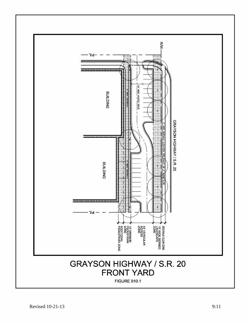
Revised 10-21-13 9:11

Revised 10-21-13 9:12

Revised 10-21-13 10:1
ARTICLE X
BUILDING DESIGN
SECTION 1000: INTENT AND PURPOSE
A. In an effort to maintain high quality, long-lasting and sustainable development within the
City of Grayson, the City hereby adopts the following design guidelines and standards for all
newly constructed and renovated buildings for the following purposes:
1. Maintain the historical look and feel of a turn of the century (1880-1930) Georgia
village.
2. Foster architectural diversity and interest yet achieve and maintain a consistent,
durable and pleasing aesthetic quality.
3. Protect and enhance the City’s attractions to tourists and visitors and thereby
strengthen the economy of the City.
4. Encourage civic pride and promote the use of buildings for education, pleasure, and
general welfare of the citizens of Grayson.
5. To establish a means of review for new development or redevelopment design plans
for the purpose of protecting the architectural and historic integrity of the City.
SECTION 1001: MINOR DEVIATIONS
The elements mandated in this Article are intended to be followed as outlined below. In the event
the intent of this Ordinance can be achieved with minor deviations which do not substantially
impact the goals or intent of the mandates of these Sections, the City of Grayson Planning
Department has the authority to modify the specific provisions.
If substantial modifications or changes are necessary, any person, firm, group or organization
may apply for relief from these requirements to the City of Grayson Council. Any application for
an alternate architectural arrangement shall be accompanied with proposed elevations, building
materials, and/or renderings necessary for the Council to make a determination whether the
alternate proposal meets the intent of these requirements. The Council, as part of an approval,
may include conditions, modifications or requirements necessary to mitigate any part of their
decision. The City may establish filing requirements, fees and deadlines as needed.
SECTION 1002: ARCHITECTURAL CHARACTER
A. The purpose of this section is to present an architectural vocabulary that will provide a
general guideline for the development of commercial and public buildings. In general,
Grayson requires turn-of-the-century (1880-1930) architectural styles, themes, massing and
details.
B. Any literal transplant of architectural styles not indigenous or compatible to this area is not
acceptable. Similarly, a structure, monumental in scale or unduly formal or modern in
character, and any corporate signature buildings or structures are not acceptable within the
City of Grayson.

Revised 10-21-13 10:2
SECTION 1003: NON-RESIDENTIAL APPLICATION
The following Building Design regulations shall apply to RM, C-1, C-2, C-3, OI, MH, and M-1,
zoning districts.
SECTION 1003.1: REVIEW AND APPROVAL
A. All building plans for non-residential zoning districts shall be submitted to The City
Architect for review and approval prior to being submitted for a building permit. The
submission is to include the following:
1. Completed application form and design review fees paid to the City.
2. Two sets of all floor plans to a minimum of 1/8”=1’-0” scale. The plans should show all
dimensions windows, doors, etc..
3. Two sets of all exterior building elevations to minimum of 1/8”=1’-0” scale. Drawings
should indicate and label all building materials, features and exterior finish legend.
4. Project site plan to a minimum of 1”=30’.
5. One color drawings showing each exterior side of the building with all materials rendered
correctly.
6. One material sample board with all exterior building materials used.
SECTION 1003.2: PROPORTION AND SCALE
A. Proportion: All development proposals shall indicate that the applicant has studied and
reconciled the scale and proportions of buildings in the following situations:
1. Site.
2. Adjacent and neighboring sites.
3. Major streets from which the project will be accessed or viewed.
B. Horizontal emphasis: Building proportions with horizontal emphasis shall be minimized.
Vertical proportions that exaggerate building height shall instead be utilized wherever
feasible.
C. Varied Facades: The spacing of elements in facades shall be varied rather than repetitive,
with a high priority placed on the three dimensional interplay of light and shadow.
D. Scale.
1. Human Scale: Building elements and facades, especially at the ground or pedestrian
level, shall be intimate and close to human size, so as to achieve a sense of human scale
and interest.
2. Overall Scale: A mixture of scales shall be permitted in less pedestrian areas, with some
elements scaled larger for appreciation from the street.
B. Building Massing: All new development proposals shall incorporate means of reducing the
apparent size and bulk of the building. The following methods for reducing the apparent size
and mass of larger buildings shall be required.
1. Continuous wall surfaces: Large or continuous wall surfaces shall be prohibited. Large
building surfaces shall be relieved with a change of wall plane that provides strong
shadow and visual interest. Pilasters and/or false windows shall be incorporated into the
design so that horizontal walls are broken up at least every twenty (20) feet.
2. Building Base: The building base shall be a shaded element that establishes a strong
connection to the ground and site. The base is often a different material and/or color as in
a water table or could be a larger element that incorporates individual awnings or
coverings. Continuous arcades shall be prohibited.

Revised 10-21-13 10:3
3. Breaking Up Building Mass: Every building shall reduce its perceived height and bulk by
dividing the building mass into smaller scale components. Building wall offsets,
including projections, recesses, and changes in floor level shall be used to add
architectural interest and variety, and to relieve the visual effect of a simple long wall.
4. Variation in Building Silhouettes: Variation in the roofline of buildings is desirable.
Offsets in pitched roofs and gables are encouraged. Parapets in building masses
exceeding fifty (50) continuous linear feet shall be varied in height and project and shall
use decorative elements such as crown moldings, dental, brick soldier courses, etc.
SECTION 1003.3: VISUAL PATTERNS AND COLOR.
A. Shade and shadow: Recesses and projections shall be utilized to divide horizontal surfaces of
buildings into smaller scale elements to produce strong shade and shadow.
B. Projections: Projections shall be permitted for use to emphasize important architectural
elements such as stairs, balconies, entrances, bays, etc.
C. Reduce unrelieved Building Mass: The use of individual awnings, partial loggias (not full
arcades), wide roof overhangs, etc., shall be permitted to be used to produce interesting
shadow effects and reduce unrelieved building mass.
D. Color: Building colors shall be carefully chosen so that each building compliments that of its
neighbor. An entire block of buildings should blend together even though each building will
posses its own identity.
1. Main building: The main building color shall be of historic earth tones. Loud, bright, or
contemporary colors shall be prohibited.
2. Trim: Historically, building trim was of a natural stone or in the case of painted elements
was painted in a decorative manner in a contrasting shade lighter or darker than the main
building. The palate of trim colors shall be historic in nature such as navy, sage, maroon,
slate gray, fawn, gold, etc.
SECTION 1003.4: ARCHITECTURAL DETAILS [AMENDED 7-16-2007]
A. Surface detail, ornament, windows and doors that enrich the architectural character shall be
required.
B. Integration of details: Details shall be carefully considered to add interest and human scale.
All visibly exposed sides of a building shall have and articulated base, course, and cornice.
C. Trim: The trim adds detail and character to the façade. Said trim shall include the eaves,
pediments, friezes, lintels, sills, belt courses, balustrades, quoins. Windows shall have
capitals, arches, jack arches with keystones, etc.
D. Windows and Glass:
1. Large Window units:
a. Historic window units of the size and character of the time period shall be required.
Said retail shop windows shall be limited to their glass size of approximately thirty
six (36) square feet.
b. Window units shall be raised off of the floor.
c. Adjacent window units shall have a minimum of four (4) inch jambs separating them
both horizontally and vertically.
2. Operable Window Units: Operable windows shall be double hung.

Revised 10-21-13 10:4
3. Mullions: If mullions are used then simulated divided lights (SDL) shall be required. The
window unit is made with the mullions permanently affixed to the exterior and interior of
the glass with a spacer bar placed between the two panes of glass.
4. Window Frames:
a. Head and jambs shall be of a historic color and profile.
b. Traditional storefront systems shall be prohibited unless they have a permanent
surface applied trim such as a snap on aluminum decorative trim, such as an Ogee
profile.
c. Aluminum clad wood windows with historic details shall be permitted.
d. Wide brick moldings around the windows shall be required.
5. Glass: Clear or slightly tinted glass shall be required. Mirrored, colored or highly
reflective shall be prohibited.
E. Exterior Doors: Wood doors, or have the appearance of wood, with wide stiles, decorative
hardware, raised panels, eight (8) feet or taller, shall be required.
F. Building Materials: Only the following building materials shall be used in combination so
that a consistent, attractive, and long lasting building design can be created.
1. Walls: The main wall material shall be used on all four sides.
a. Brick: Only full thickness modular brick in earth tones shall be permitted. Thin
veneer or painted brick shall be prohibited.
b. Stone: Natural stone veneer, Terra cotta or cast stone which simulates natural stone in
chiseled, ground face, hammered, or smooth shall be required.
c. Stucco: Masonry hard coat or building code approved synthetic stucco (EIFS) is
limited to three (3%) percent of the total wall area. Use is limited to decoration, trim,
or where brick or stone cannot feasibly be supported such as in a dormer or second
floor wall above a roof. Continuous EIFS banding around a building is prohibited.
d. CMU: Concrete masonry units shall be prohibited with the exception of colored split
face CMU limited to three (3%) percent of the total wall area.
e. Siding: Wood, cementitious, or shakes shall be limited to upper floors only and not to
exceed ten (10%) percent of total wall area. Metal siding either vertical or horizontal
shall be prohibited.
2. Trim.
a. Painted wood or synthetic (Fypon, polymers) painted shall be permitted.
b. Cast Stone or EIFS shall be permitted.
c. Aluminum clad wood.
d. EIFS shall be permitted in certain applications, but not as a continuous band around a
building.
3. Sloped Roof Materials: The following materials shall be permitted if visually seen from
the ground.
a. Architectural random cut, shadow line and fiberglass asphalt shingles shall be
permitted and shall have a minimum wind resistance of 110 mph.
b. Standing seam pre-finished metal roof in a historic color by this ordinance.
c. Copper standing seam metal roof.
d. Natural or artificial slate.
e. Wood shakes as permitted by this ordinance.
f. Cementitious or clay tile roof tiles.

Revised 10-21-13 10:5
G. Roof Requirements:
1. Flat Roofs: Flat roofs shall be of any material that meets the requirements of this
ordinance as long it is not seen from the ground. All flat roofs shall have parapets on all
four sides of sufficient height to hide to air handling equipment form the ground for a
distance of one hundred (100) feet.
2. Pitched Roofs: Pitched roofs shall have a minimum pitch of 6:12. Gables and or dormers
shall also be incorporated to add interest.
3. Mansard Roofs: Said roofs shall be prohibited.
4. Building mechanical and accessory features.
a. All ground mounted mechanical, HVAC and like systems shall be screened from the
public street view (within one hundred (100) feet) on all sides by an opaque wall or
fence made of brick, stucco or landscaping.
b. Back lit awnings, roof mounted lights, and/or roof mounted flag poles are not
permitted. Satellite dishes shall be located and painted to blend with the background
as much as practical.
c. For all commercial/retail buildings, roof mounted mechanical, HVAC and like
systems shall be screened from the public right-of-way within one hundred (100) feet
on all sides.
d. When building mechanical and accessory features are located on rooftops, they shall
be incorporated in the design of the building and screened with building materials
similar to the building.
SECTION 1004: RESIDENTIAL APPLICATION
The following Design Standards shall apply to the following zoning districts: R100, R100
Modified and the residential portions of any PUD.
SECTION 1004.1: Reserved.
SECTION 1004.2: R-100 DISTRICT DESIGN STANDARDS
The following regulations shall apply to the R-100 zoning districts:
A. Building Materials: The only materials to be permitted are brick, natural or
cultured stone, hard coat masonry stucco, building code approved synthetic
stucco (EIFS), board and batten wood siding, natural wood horizontal siding
or cementitious wood grain horizontal siding.
B. Roof Requirements: Minimum pitch shall be 6:12.
SECTION 1004.3: R-100 MODIFIED DISTRICT DESIGN STANDARDS
The following regulations shall apply to the R-100 Modified zoning districts.
A. Building Materials.
1. Brick, natural or cultured stone, hard coat masonry stucco or building code approved
synthetic stucco (EIFS), board and batten wood siding, natural wood horizontal siding
or cementitious wood grain horizontal siding shall be permitted. The same material
shall be used on at least the front and two sides.
2. The rear side shall be any of the above listed building materials.
3. Vinyl siding shall be prohibited.

Revised 10-21-13 10:6
B. Roof Requirements: Desired pitch shall be 10:12; however, pitch may be reduced if house
plans are in keeping with surrounding houses. Any roof pitches below 10:12 are to be reviewed
and may be approved / disapproved at the discretion of the Planning Director.
SECTION 1004.4: RESIDENTIAL PORTION OF PUD DESIGN STANDARDS
The regulations pertaining to any residential portion of a PUD are set forth in Section 1112.
SECTION 1005: MIXED USE AND MULTI-FAMILY APPLICATION
To be approved by special review and application of each individual development basis.

Revised 10-21-13 11:1
ARTICLE XI [AMENDED 03-15-2010]
DISTRICT REGULATIONS
SECTION 1100: GENERAL USE REGULATIONS
A. Permitted uses. The following table outlines the permitted uses for each zoning district.
1. Those uses marked with an asterisk (*) in the Permitted Uses Table shall not exceed two
thousand five hundred (2,500) square feet of floor area.
2. For all telecommunications antennas and towers requirements see Article XVI.
3. Other uses which may be determined by the Administrative Officer to be similar to the
below listed principal permitted uses and which are in harmony with the purpose of this
district may be permitted.
4. No outdoor storage is permitted except as specified herein.
5. Those uses marked with a double asterisk (**) in the Permitted Uses Table shall not be
allowed in the Uptown Grayson Overlay District.
PERMITTED USES TABLE R-
100
R-100 Mod
CS MH RM OI C-1 C-2 C-3 M-1
Accounting offices ■ ■ ■ ■ ■
Animal hospital or veterinary clinic ■ * ■ ■ ■ ■
Antique shops ■ * ■ ■ ■ ■
Architecture or engineering offices ■ ■ ■ ■ ■
Art and school supply stores ■ * ■ ■ ■ ■
Art galleries and studios ■ * ■ ■ ■ ■
Automotive body repair shops** ■ ■
Automotive car wash (full service or self service)**
■ ■ ■
Automotive parts store (with or without lubrication or tune up centers)**
■ ■ ■
Automotive rental establishments** ■ ■ ■
Automotive repair shops including major engine repair (transmission, radiator repair, and engine overhauls)**
■ ■
Automotive sales lots and associated service facilities (new or used)**
■ ■ ■

Revised 10-21-13 11:2
PERMITTED USES TABLE R-
100
R-100 Mod
CS MH RM OI C-1 C-2 C-3 M-1
Automotive service stations or tire stores, including minor services such as lubrication or tune-up centers, battery replacement and brake repair**
■ ■ ■
Bakeries ■ * ■ ■ ■ ■
Baking plants ■
Banks, savings and loan institutions
■ * ■ ■ ■ ■
Beauty and barber shops, including manicurists
■ ■ ■ ■ ■
Bed and breakfast inns ■ * ■ ■ ■ ■
Bicycle shops ■ * ■ ■ ■ ■
Blueprinting establishments ■ ■ ■ ■
Boarding and rooming houses ■ ■ ■
Building material and construction supply sales, with outdoor storage
■
Building supply centers with outdoor lumber yards or storage areas, provided these areas are screened with a six foot high, opaque fence
■ ■ ■
Bus terminals ■ ■ ■
Business college or business schools ■ ■ ■
Boarding and rooming houses ■
Boat sales establishments and associated service facilities
■ ■
Book or stationery stores ■ * ■ ■ ■ ■
Camera and photographic supply stores ■ * ■ ■ ■ ■
Camper and recreational vehicle sales and rental establishments and associated service facilities
■ ■
Cemeteries, provided that they shall front on a street having minimum classification of major collector for a distance of at least 125 feet
■ * ■ ■ ■ ■
Churches, synagogues, chapels and other places of religious worship and instruction
■ ■ ■ ■ ■
Clothing sales or rental stores ■ ■ ■
Clubs and lodges ■ * ■ ■ ■ ■

Revised 10-21-13 11:3
PERMITTED USES TABLE R-
100
R-100 Mod
CS MH RM OI C-1 C-2 C-3 M-1
Cold storage plants ■
Commercial recreation enterprises ■ ■ ■
Contractor's offices ■ ■ ■
Convenience food stores, without fuel pumps or automated car wash
■ ■ ■ ■
Convenience food stores, with fuel pumps or automated car wash, excluding all other automotive services**
■ ■ ■ ■
Custom dressmaking and sewing shops ■ * ■ ■ ■ ■
Dance studios ■ * ■ ■ ■ ■
Day care centers, provided that all state day care requirements and health regulations are met
■ ■ ■ ■
Dentist offices ■ ■ ■ ■ ■
Department stores ■ ■ ■
Doctor, dentist or chiropractic offices ■ ■ ■ ■ ■
Dormitories for nurses and interns when part of a medical facility
■ ■ ■
Drug stores ■ ■ ■ ■
Dry cleaning establishments not in excess of two thousand five hundred (2,500) square feet, including dry cleaning pick-up and delivery stations
■ ■ ■ ■
Electronic equipment manufacturing and assembly plants
■
Electronic sales and service establishments
■ ■ ■ ■
Equipment rental ■ ■ ■
Eye glass shops ■ ■ ■ ■
Fabric stores ■ ■ ■ ■
Feed and seed stores ■ ■ ■
Florist shops ■ ■ ■ ■
Food catering establishments ■ ■ ■ ■
Food stores or grocery stores ■ ■ ■ ■
Frame shops ■ ■ ■ ■ ■
Furniture rental & sales estab. ■ ■ ■
Funeral homes and mortuaries, but excluding crematoria
■ ■ ■

Revised 10-21-13 11:4
PERMITTED USES TABLE R-
100
R-100 Mod
CS MH RM OI C-1 C-2 C-3 M-1
Garden supply centers and greenhouses, provided plants, shrubs and landscaping supplies are not displayed within the front yard setback
■ ■ ■ ■
Gift and card shops ■ ■ ■ ■
Government offices ■ * ■ ■ ■ ■
Hardware stores with lawnmower repair as an accessory use
■ ■ ■ ■
Health clubs or spas and tanning salons ■ * ■ ■ ■
Hobby shops and craft shops ■ ■ ■ ■
Hospitals and medical clinics ■ ■
Ice cream shops ■ ■ ■ ■
Insurance offices ■ ■ ■ ■ ■
Interior decorating shops ■ * ■ ■ ■ ■
Jewelry stores ■ ■ ■ ■
Kennels ■ ■ ■ ■
Laundries and dry cleaning establishments, including self-service
■ ■ ■ ■
Law offices ■ ■ ■ ■ ■
Lawnmower sales and repair shops ■ ■ ■
Livestock and farm animals for keeping and raising
■
Local, State, and Federal government buildings
■ ■
Locksmith shops ■ ■ ■
Log splitting and storage lots ■ ■
Lounges ■ ■
Manufactured homes ■
Manufacturing plants and businesses ■
Meat markets, retail, but no killing, eviscerating, skinning, plucking or smoking of food products on the premises
■ * ■ ■ ■
Medical offices ■ ■ ■ ■ ■
Mini warehouse storage facilities ■ ■
Motels and hotels ■ ■ ■
Multifamily dwellings which may be duplexes, row houses, town houses, condominiums, or apartments
■
Museums and libraries ■ * ■ ■ ■ ■

Revised 10-21-13 11:5
PERMITTED USES TABLE R-
100
R-100 Mod
CS MH RM OI C-1 C-2 C-3 M-1
Music lessons and sales establishments ■ * ■ ■ ■ ■
News and tobacco stores ■ ■ ■ ■
Nursing homes ■ ■ ■
Offices or office parks, office/distribution and office/warehouse facilities
■
Offices: Public or professional ■ ■ ■ ■ ■
Office/showroom facilities (provided no equipment or materials are stored outdoors)
■ ■ ■
Office supply sales establishments ■ * ■ ■ ■
Parking lots ■ ■ ■ ■ ■
Personal care home ■ ■ ■ ■ ■
Pest control businesses ■ ■ ■ ■
Pet shops and grooming establishments ■ ■ ■ ■
Photocopying, printing and reproduction service
■ ■ ■ ■
Photography studios ■ ■ ■ ■ ■
Plant nursery sales facilities ■ ■ ■
Plumbing, electrical, pool and home building supply showrooms and sales centers
■ ■ ■
Professional and business offices, provided no retail sales occur on premises
■ ■ ■ ■ ■
Public buildings and offices ■ ■ ■ ■ ■
Public parks, playgrounds, and community buildings
■ ■ ■
■ ■ ■ ■ ■ ■
Radio and television repair shops ■ ■ ■ ■
Radio, recording and television studios and broadcasting stations
■ ■ ■
Real estate sales offices ■ ■ ■ ■ ■
Record/video sales and rental stores ■ * ■ ■ ■
Research, testing and laboratory facilities
■
Restaurants, drive through or sit down, including delivery services
■ ■ ■
Restaurants, maximum of 50 seats, and/or delivery only
■* ■ ■ ■ ■
Semi-public institutions such as churches and clubs or lodges
■ ■ ■ ■ ■
Shoe stores and shoe repair stores ■ ■ ■ ■

Revised 10-21-13 11:6
PERMITTED USES TABLE R-
100
R-100 Mod
CS MH RM OI C-1 C-2 C-3 M-1
Single-family dwellings ■ ■ ■ ■
Small appliance repair shops ■ * ■ ■ ■ ■
Sporting goods store ■ * ■ ■ ■
Tailor shops ■ * ■ ■ ■ ■
Taxicab or limousine services ■ ■
Taxidermists ■ ■ ■
Theaters ■ ■ ■
Travel agencies ■ ■ ■ ■ ■
Trophy shops ■ ■ ■ ■
Toy stores ■ * ■ ■ ■ ■
Upholstery shops ■ ■ ■
Watch and clock repair shops ■ * ■ ■ ■ ■
Wholesaling establishments ■ ■
Wholesaling, warehousing and distribution facilities
■
B. Accessory uses. The following table outlines the accessory uses for each zoning district.
1. Accessory uses. Accessory uses for commercial development shall include those
normally appurtenant to such development, as provided for in other sections of this
Ordinance.
2. Any accessory use normally appurtenant to a permitted use shall be allowed provided
such use shall conform with all performance standards set forth for this district.

Revised 10-21-13 11:7
ACCESSORY USES TABLE R-
100
R-100 Mod
CS MH RM OI C-1 C-2 C-3 M-1
Accessory buildings and structures ■ ■ ■ ■ ■ ■ ■ ■ ■
Commercial recreational facilities associated with a subdivision development
■ ■ ■
■
Home occupations ■ ■ ■ ■
Private swimming pools, tennis facilities and parking areas exclusively for the use of residents of the premises and their non-paying guests subject to any other regulations and Ordinances of the City
■ ■ ■
■
Parking lots ■ ■ ■ ■ ■
Parking of trucks over 6 wheels for more than loading/unloading purposes & longer than 12 hours at a time
■
Parking of recreational equipment ■ ■ ■ ■
Signs in accordance with Article XIV ■ ■ ■ ■ ■ ■ ■ ■ ■
C. Special uses. The following table outlines the special uses for each zoning district with the
exception of PUDs, which are set forth in Section 1112.
1. Public private and parochial schools, where permitted by special use permit, shall meet
the following additional regulations:
a. A minimum site of five (5) acres shall be provided.
b. The site shall front on a street having minimum classification of major collector, for a
distance of at least one hundred (100) feet.
c. A ten (10) foot natural buffer strip, planted where no trees exist, shall be installed
along side and rear property lines but not extending into the front yard setback.
Minimum height of trees at planting shall be six (6) feet.
2. Utility substations, where permitted by special use permit, shall meet the following
additional regulations:
a. Documentation is presented by the utility company depicting the need for such
substation in a residential locale.
b. Any substation shall conform with all setback and space limits of the zoning district
in which it is located.
c. Substations shall be enclosed by an opaque fence, other than a cyclone type, and shall
be appropriately landscaped.
d. A ten (10) foot natural buffer strip, planted where no trees exist, shall be installed
along side and rear property lines but not extending into the front yard setback.
Minimum height of trees at planting shall be six (6) feet.

Revised 10-21-13 11:8
SPECIAL USES TABLE R-100 R-100 Mod
CS MH RM OI C-1 C-2 C-3 M-1
Adult entertainment facilities ■ ■ ■
Cellular Telephone Towers ■
Pawn shops ■
Pest control businesses ■
Public, private and parochial schools ■ ■ ■ ■
Title loan businesses ■
Wine Center ■
Utility substations ■ ■ ■ ■
D. Space dimensions. The following table outlines the space dimensions for each zoning
district.
1. Open space.
a. Required yards and requirements for sidewalk zones and landscape zones which are
constructed on private property may be counted towards this requirement.
b. Open space may also include balconies, roof-top terraces, front yards, planted areas,
fountains, parks, plazas, hardscape elements related to sidewalks and plazas, and
similar features which are located on private property.
c. Open spaces containing floodplain, wetlands, required stream buffers, lakes utilized
for scenic value, recreation or conservation purposes shall be set aside and protected
by legal arrangements satisfactory to the Mayor and Council, and sufficient to assure
its maintenance and preservation for whatever purpose it is intended. Up to one-half
(½) of such open space shall be permitted to be located in a one hundred (100) year
floodplain, and up to one hundred (100%) percent shall be permitted to be located
within a permanent lake which does not function solely as a detention facility or
within delineated wetlands.
d. Open space shall not include areas devoted to public or private vehicular access or
any land which has been, or is to be, conveyed to a public agency, via a purchase
agreement for such uses as parks, schools, or other public facilities, or which lies
within any required recreation area, overhead power easement, or stormwater
detention facility.
e. Covenants or other legal arrangements shall specify ownership of the open space;
method of and responsibility for maintenance; taxes and insurance; compulsory
membership and assessment provisions; guarantees that any association formed to
own and maintain will not be dissolved without the consent of the Mayor and
Council; and any other specifications deemed necessary by the Mayor and Council.
2. The following table shall apply for all lot area, maximum building height, side yard and
rear yard requirements. For all landscape zone, sidewalk, minimum building height and
front yard dimensions, reference Article IX.

Revised 10-21-13 11:9
SPACE DIMENSIONS TABLE
R-100 R-100 Mod
CS MH RM OI C-1 C-2 C-3 M-1
Minimum Lot Area 32,000
sqft 10,500
sqft None Sec
1104 Sec 1105
None None None None 1 acre
Minimum Lot Width 100 ft 80 ft
60 ft avg.
Sec 1104
100 ft None None None None 100 ft
Maximum Height of Building
40 ft 40 ft 40 ft Sec 1104
40 ft 40 ft 40 ft 40 ft 40 ft 40 ft
Minimum Rear Yard 40 ft 30 ft 20 ft Sec 1104
40 ft 15 ft 15 ft 15 ft 15 ft 15 ft
Minimum Rear Yard, for non-residential districts adjacent to residential districts (per Buffer Specifications Table, Section 1202)
None None None Sec 1104
40 ft 40 ft 40 ft 40 ft 40 ft 40 ft
Minimum Side Yard 10 ft 10 ft 5 ft Sec 1104
10 ft 10 ft 10 ft 10 ft 10 ft 20 ft
Minimum Side Yard, for non-residential districts adjacent to residential districts
None None None Sec 1104
None 20 ft 40 ft 40 ft 40 ft 40 ft
Minimum Side Yard, Street Side Corner
40 ft 25 ft 20 ft Sec 1104
40 ft 35 ft 35 ft 35 ft 35 ft 35 ft
Maximum Ground Coverage
None None None Sec 1104
40% 70% 70% 90% 90% 75%
Minimum Open Space None 30% 40% Sec 1104
20% 20% 20% 20% 20% 10%
E. Remaining district regulations:
1. The permitted uses, accessory uses, special uses and space dimensions for all property
zoned to a Planned Unit Development (PUD) classification are set forth in Section 1112
and shall apply as if set forth in this Section.
2. All uses and dimensional requirements of the overlay districts that are not specified in the
individual sections are those that are applicable to the underlying zoning designation of
the particular property.
3. All remaining regulations established for each individual district are provided in the
following sections.
SECTION 1101: Reserved.

Revised 10-21-13 11:10
SECTION 1102: R-100 SINGLE-FAMILY RESIDENCE DISTRICT
A. Minimum floor area.
1. Single-family residential structures shall be a minimum heated floor area of one thousand
and eight hundred (1,800) square feet.
SECTION 1103: R-100 MODIFIED SINGLE-FAMILY RESIDENCE DISTRICT
A. Minimum floor area.
1. Single-story single-family residential structures shall be a minimum heated floor area of
two thousand two hundred (2,200) square feet.
2. Two-story single-family residential structures shall be a minimum heated floor area of
two thousand four hundred (2,400) square feet.
B. Space limits.
1. Maximum density – 2.3 units per acre.
2. Minimum density – sixteen (16) total units.
C. Sodding: All front and side yards shall be sodded, with the exception of planting beds.
SECTION 1103.1: CS CONSERVATION SUBDIVISION SINGLE-FAMILY RESIDENCE
DISTRICT
A. Applicability:
This stand-alone district is not applicable for individual on-site septic systems, and may only
be applicable for property that uses the public sanitary sewer system. For properties which
are submitted for rezoning to CS, the application shall be accompanied by a Concept Plan
and Existing Features Site Analysis Plan meeting the requirements of this section.
B. Permitted Uses:
See Permitted Uses Table, Accessory Uses Table, and Special Uses Table in SECTION
1100.
C. Existing Features Site Analysis Plan:
At the time of development, or if a zoning action is proposed, and prior to preparing the
Concept Plan, an Existing Features Site Analysis Plan, sealed by a registered design
professional, and an Environmental Site Assessment (Phase One) report, shall be prepared by
the applicant and submitted to the City Planner for review. The Existing Features Site
Analysis Plan, along with Environmental Site Assessment (Phase One), shall identify areas
worthy of permanent protection and areas suitable for development.
1. The Plan shall include at least the following information;
a. Delineation of streams, 100-year floodplains and wetlands including the source of this
information.
b. Topography contours at intervals no greater than 4 feet.
c. Identification of tree lines, woodlands, open fields or meadows.
d. Delineation of tree resource areas by type such as hardwood, pines or mixed; and old or
new growth.
e. Delineation of steep slope areas (i.e. greater than 25%).
f. Identification of historical or archeological features.
g. Identification of significant wildlife habitats and scenic vistas as identified by the Georgia
Department of Natural Resources.
h. Identification of existing structures and easements.

Revised 10-21-13 11:11
i. Identification of Conservation Space, Open Space, or Common Space in adjacent
developments.
D. Concept Plan:
At time of development or a zoning action, a Concept Plan shall be submitted by the
developer for review and approval in accordance with the requirements and procedures of the
Development Regulations and shall also include the following information:
1. Delineation and specifications of Conservation Space including calculations and
exclusions; and any “pocket parks,” “greens,” or trail system to be constructed.
2. A typical detail on the plan including dwelling size, lot width, building setback lines, off-
street parking, street trees, sidewalks, and street pavement and right-of-way width.
3. Lot width average, area and percent of floodplain specifications in tabular form; and
density calculations (gross and net).
E. Conservation Space Requirements:
In order to qualify for this district, Conservation Space shall meet the following
requirements:
1. Delineation: Priority shall be given in delineating Conservation Space areas as those
areas of significance identified in the Existing Features Site Analysis Plan, around which
the built areas are designed.
2. Undeveloped and Natural: Conservation Space shall remain undeveloped and natural
except for the provision of non-motorized passive recreation opportunities such as
running, walking, biking, and similar outdoor activities. Exceptions: “pocket parks,”
“greens,” “retention ponds”, and “underground storm water facility” in Conservation
Space. A “pocket park” or “green” is a landscaped area larger than 0.33 acres constructed
for community gathering or play or visual enhancement. “Pocket parks” or “greens” shall
not exceed 20% of the total Conservation Space. At least 75% of the Conservation Space
shall be in a contiguous tract. The Conservation Space should adjoin any neighboring
areas of open space, other protected areas, and non-protected natural areas that would be
candidates for inclusion as part of a future area of protected open space. Additionally, the
Conservation Space shall maintain a minimum width of 20 feet in all areas.
F. Exclusions:
Excluded from meeting the minimum amount of Conservation Space are the following:
1. Proposed permanent lakes, streams, ponds etc.: No more than 50% of land area located
within a proposed lake may be credited.
2. Recreation area improvements. Impervious surfaces in recreation areas shall not be
credited.
3. Easement. Land area within power, gas pipeline easements, sewer line easements, or
pump stations shall not be credited.
4. Other. Land area devoted to public or private streets or any land that has been, or is to be,
conveyed to a public agency via a purchase agreement for such uses as parks, schools, or
other public facilities shall not be credited.
G. Ownership:
Open space shall be owned in fee-simple by a mandatory property owner’s association; or
third party(s) approved in advance by the City Council prior to transfer of land ownership.
The developer shall record the deed to the Conservation Space prior to, or concurrent with,
the recording of the first final subdivision plat. An access easement following the alignment

Revised 10-21-13 11:12
of future public streets is acceptable. However, “pocket parks” or “greens” may be deeded
concurrent with the unit or phase of the final subdivision plat of which it is a part.
H. Property Owner’s Association:
The property owner’s association bylaws or covenants, at a minimum, shall contain the
following provisions:
1. Governance of the association by the Georgia Property Owner’s Association Act (OCGA
Section 44-3-220 et. seq.) or a successor to that Act that grants lien rights to the
association for maintenance expenses and tax obligations.
2. Responsibility for maintenance of the Conservation Space.
3. Responsibility for insurance and taxes.
4. Automatic compulsory membership of all lot purchasers and their successors; and
compulsory assessment.
5. Conditions and timing of transferring control of the association from the developer to the
lot owners.
6. Guarantee that the association will not be dissolved without the advance approval of the
City Council.
I. Maintenance:
The property owner’s association, or other entity approved in advance by the City Council,
shall be responsible for the continuous maintenance of buffers, Conservation Space,
recreation area, common areas, and detention ponds etc.
J. Conservation Surety:
Conservation Space shown on the approved Concept Plan and subsequently delineated on the
Final Plat shall be permanently protected by the developer’s conveyance of an undivided fee
simple interest in the Conservation Space to the mandatory property owner’s association. The
deed conveying the Conservation Space pursuant to this paragraph shall be recorded and
delivered to the property owner’s association prior to, or concurrent with, the approval of the
Final Plat for the first phase of the subdivision. In addition, the Final Plat for each phase of
the Subdivision shall contain the following statement:
“Conservation Space delineated on this plat is permanently protected and shall remain
undeveloped and natural subject to certain exceptions contained in Grayson’s
Conservation Subdivision District Ordinance.”
In addition, the deed conveying the Conservation Space shall contain the following language:
“The land conveyed herein shall remain permanently protected Conservation Space that
shall not be cleared or developed except in accordance with Section 1103.1.E.2 of the
City of Grayson Zoning Ordinance. The interest conveyed in the deed runs with the land
and benefits all future lot owners within the subdivision.”
K. Density:
Subdivisions in CS District shall not exceed a maximum net density of 2.3 units per acre with
40% Conservation Space; or, 3.0 units per acre with 50% Conservation Space.
L. Development Requirements:
Subdivisions in CS District shall meet the following requirements:
1. Minimum Subdivision Size: 10 contiguous acres.
2. Lot Area: No minimum.
3. Average Lot Width: The average width of all building lots shall be at least 60 feet. Any
lot located less than 50 feet from adjacent property lines zoned R-100, or R-100 Modified
shall meet the lot width and rear setback of that district.

Revised 10-21-13 11:13
4. Minimum Road Frontage per Lot: 40 feet and 20 feet for cul-de-sac lots.
5. Minimum Yard Area (Setback): Front setback is 20 feet. (The front yard setback may be
reduced to 5 feet if dwellings are provided side or rear entry garages. To qualify for the
reduced setback on a corner lot, side entry garages must be located to the side adjacent to
an abutting lot.) Rear setback is 20 feet. Side setback is 5 feet.
6. Exterior Project Street Frontage Open Space Strip: 50 feet in width (not part of any
building lot). Landscape entry features such as fences and walls may be allowed in the
open space strip.
7. Maximum Building Height: 40 feet.
8. Minimum Floor Area: Each dwelling unit shall have a minimum heated finished living
area, excluding a basement, attic, carport or garage, of 1,600 square feet for One Story
and 1,800 square feet for Two Story.
9. Sodded Yards: All grassed areas on dwelling lots shall be sodded.
10. Garages: Each dwelling unit shall have two-car garage.
11. Street Trees: Street trees, in accordance with the requirements of the Buffer, Landscape,
and Tree Ordinance, shall be provided.
12. Underground Utilities: Utilities shall be located underground.
SECTION 1104: MH MANUFACTURED HOUSING DISTRICT
ii. Location. A manufactured housing district development shall front for a sufficient distance
to provide safe access upon a state highway or a major thorough-fare, and shall have access
and egress only on such a road.
iii. Street Access Requirements. The entrance road to a manufactured housing district
development shall have a minimum right-of-way width of sixty (60) feet with a minimum
pavement width of twenty eight (28) feet. The entrance road shall have a turning radius from
the highway of at least three hundred (300) feet and the entrance road shall extent at least one
hundred (100) feet into the manufactured housing district development.
iv. Sidewalks. Sidewalks shall be constructed on both side of the streets within the
development, and shall extent the entire frontage of the property on which the entrance is
constructed. These shall provide access to recreation facilities within and outside the
development.
v. Size. A manufactured housing district development shall have a minimum buildable area of
at least fifteen (15) contiguous acres.
vi. Density. A manufactured housing development shall have a density of not more than six (6)
manufactured housing lots per building acre.
vii. Manufactured Home Lots. Each manufactured home shall be located on a separate fee
simple lot. Each home and lot shall be owned by the same person, and shall be taxed as real
property and the owner shall qualify for the homestead exemption. Each lot shall be a
minimum of five thousand (5,000) square feet and shall contain only one (1) living dwelling.
viii. Recreation and Other Community Facilities. Not less than ten (10%) percent of the gross
area of manufactured housing district development shall be devoted to recreation on any
other community use facilities. Each recreation space shall have a minimum area of ten
thousand (10,000) square feet. Recreation area(s) may not be located entirely within un-
developable land (i.e., floodplain, wetlands, etc.)
ix. Buffer Strip. A buffer strip at least forty (40) feet wide shall be provided along the side and
rear property lines but not extending into the required front yard of the development. The

Revised 10-21-13 11:14
buffer strip shall be planted with evergreen trees and shrubs that grow at least eight (8) feet
tall and provide an effective visual screen. Said buffer strip is to provide a softening between
the land uses.
x. Hurricane Anchorage. Acceptable provisions for “hurricane anchorage” for each
manufactured home shall be made in accordance with the Development regulations of the
City of Grayson.
xi. HUD Mobile Court Development Guide. The manufactured housing development shall meet
the standards of the “Mobile Home Court Development Guide,” as set forth in the HUD
Handbook #4545.1 dated October 1976, as revised.
xii. No Site Construction Until Preliminary Subdivision Plat Approved. No site construction
shall be undertaken and no permits shall be issued until a Preliminary Subdivision Plat that
meets the requirements of the Development Regulations of the Cit of Grayson and the
requirements of this ordinance have been given tentative approval.
xiii. Manufactured Homes. All manufactured homes must be constructed in compliance with the
National Manufactured Housing Construction and Safety Standards Act of 1974. Mobile
homes constructed prior to June 15, 1976, are considered to be constructed to pre-HUD
standards and are not permitted in the City of Grayson. All existing homes shall be
grandfathered under this Section. However, any mobile home that is removed with intent of
replacing with another shall comply with these regulations.
xiv. Minimum square footage. Each manufactured home shall be attached to a permanent
foundation and be a minimum of one thousand two hundred (1,200) square feet.
SECTION 1105: RM MULTIFAMILY RESIDENCE DISTRICT
A. Minimum lot area.
1. For two-family units the minimum lot area shall be fifteen thousand (15,000) square feet,
with seven thousand five hundred (7,500) square feet per dwelling unit.
2. For multiple-family units, the minimum lot area shall be twenty thousand (20,000) square
feet.
3. For multiple-family units a minimum of twelve thousand (12,000) square feet of lot area
shall be reserved for the first family and four thousand (4,000) square feet for each
additional family, but in no event shall the overall density exceed eight (8) dwelling units
per acre.
4. For single family uses, a minimum lot area of fifteen thousand (15,000) square feet is
required.
SECTION 1106: OI OFFICE/INSTITUTIONAL DISTRICT
The Office/Institutional District is intended to encourage the location of suitable business and
professional enterprises, medical and dental facilities and limited retail service activities in
buildings of high character and in attractive surroundings. The Office/Institutional District is
best located in areas having direct access to State Highways or major arterial thoroughfares.
SECTION 1107: C-1 NEIGHBORHOOD BUSINESS DISTRICT
A. Temporary uses.
The following uses are permitted for a period not to exceed thirty-five (35) days or otherwise
indicated:
1. The sale of fruits or vegetables, pumpkins and Christmas trees any time during the year.

Revised 10-21-13 11:15
2. Charitable and nonprofit events.
3. The sale of any items in association with an existing business located on the premises as a
principal use (i.e., parking lot or tent sale).
4. The sale of any items not associated with a business located on the premises provided
that no item, tent, trailer, or vehicle remains on the premises overnight.
5. A permit for any temporary use may be applied for up to four (4) times per year per
applicant.
B. Temporary uses are permitted provided the following items are provided and adhered to by
the user:
a. Written permission of the property owner is provided;
b. Excess parking, ingress and egress are provided on site or written permission is
obtained if provided on an adjoining property;
c. Provide trash receptacles and/or secure property owner's approval to dispose of refuse
properly (if applicable);
d. Sales, displays, and other structures shall not be located within thirty (30) feet of the
edge of any public roadway;
e. A non-illuminated sign may be erected on the property provided it does not exceed a
total of sixteen (16) square feet and not greater than ten (10) feet in height and is not
placed within twenty (20) feet of any public roadway;
f. No unreasonable noises shall be associated with the use;
g. The hours of operation shall be from 7 a.m. to 11 p.m.;
h. Restroom facilities must be provided or permission granted to use restroom facilities
elsewhere;
i. A temporary permit is applied for and approved by the Administrative Officer;
j. All other permits and regulations of Gwinnett County and the City of Grayson shall
be met.
SECTION 1108: C-2 GENERAL BUSINESS DISTRICT
A. Temporary uses. Any use permitted in the C-1, Neighborhood Business district.
B. Special uses. The following uses are allowed upon the approval of a Special Use Permit by
the Mayor and Council.
1. Any C-2 use requiring outdoor storage, provided:
a. The storage areas are screened with a six foot high, one hundred (100%) percent
opaque fence; and
b. A ten (10) foot minimum planted landscape strip is located outside the fence.
2. Adult Entertainment Facilities, provided no use shall be located:
a. Within one thousand (1,000) feet of any parcel of land zoned or used for residential
purposes;
b. Within one thousand (1,000) feet of any parcel of land upon which a church, school,
government building, library, civic center, public park or playground is located;
c. Within one thousand (1,000) feet of any parcel of land upon which another
establishment regulated or hereunder defined is located;
d. Within one thousand (1,000) feet of any parcel of land upon which any other
establishment selling alcoholic beverages is located; and
e. On less than three (3) acres of land containing at least one hundred (100) feet of road
frontage.

Revised 10-21-13 11:16
SECTION 1109: C-3 CENTRAL BUSINESS DISTRICT
A. Permitted uses.
1. Automotive body repair shops, provided inoperative, wrecked and dismantled vehicles
are screened within a six (6) foot high, opaque fence.
2. Automotive repair shops including major engine repair (transmission, radiator repair, and
engine overhauls), provided inoperative vehicles are screened within a six foot high, one
hundred (100%) percent opaque fence
3. Contractor's office with outdoor storage of equipment or materials, provided the storage
or equipment areas are screened with a six foot high, one hundred (100%) percent opaque
fence.
4. Equipment rental, sales or service establishments (including heavy machinery, forklifts,
cranes, bulldozers, farm equipment, moving vans and trailers, etc.).
5. Log splitting and storage lots, provided the lot is vacant and splitting and storage areas
are screened by a six (6) foot high opaque fence.
6. Plumbing, electrical, pool, and home-building supply showrooms and sales centers with
outdoor storage, provided storage areas are screened with a six foot high, one hundred
(100%) percent opaque fence.
7. Wholesaling establishments, provided outdoor storage areas are screened with a six (6)
foot high, one hundred (100%) percent opaque fence.
SECTION 1110: M-1 LIGHT INDUSTRY DISTRICT
A. Permitted Uses. Permitted uses are indicated in the Table in Section 1100.
SECTION 1111: UG UPTOWN GRAYSON OVERLAY DISTRICT
A. Permitted uses. Individual retail establishments shall not exceed three thousand five hundred
(3,500) square feet of floor area.
B. Special uses. The following uses are allowed upon the approval of a Special Use Permit by
the Mayor and Council.
1. Bed and breakfast inns, provided:
a. The house is owner occupied;
b. Adequate parking is provided;
c. A maximum of three (3) rooms may be rented; and
d. Breakfast is provided to guests only.
C. Open space. Each developer shall provide, at a minimum, twenty (20) Tree Density Units
per acre for all non-residential development. Type and size of plantings shall be in
compliance with the Grayson Zoning Ordinance of 2005. At least fifty (50%) percent of
plantings shall consist of trees three (3) inches in caliper (dbh) or greater.
SECTION 1112: PUD Planned Unit Development
A. Permitted Uses.
1. Accounting offices
2. Animal hospital or veterinary clinic
3. Antique shops
4. Architecture or engineering offices
5. Art and school supply stores

Revised 10-21-13 11:17
6. Art galleries and studios
7. Automotive body repair shops
8. Automotive car wash (full service or self service)
9. Automotive parts store (with or without lubrication or tune up centers)
10. Automotive rental establishments
11. Automotive repair shops including major engine repair (transmission, radiator repair,
and engine overhauls)
12. Automotive sales lots and associated service facilities (new or used)
13. Automotive service stations or tire stores, including minor services such as
lubrication or tune-up centers, battery replacement and brake repair
14. Bakeries
15. Baking plants
16. Banks, savings and loan institutions
17. Beauty and barber shops, including manicurists
18. Bed and breakfast inns
19. Bicycle shops
20. Blueprinting establishments
21. Boarding and rooming houses
22. Building supply centers with outdoor lumber yards or storage areas, provided these
areas are screened with a six foot high, opaque fence
23. Bus terminals
24. Business college or business schools
25. Boarding and rooming houses
26. Boat sales establishments and associated service facilities
27. Book or stationery stores
28. Camera and photographic supply stores
29. Camper and recreational vehicle sales and rental establishments and associated
service facilities
30. Cemeteries, provided that they shall front on a street having minimum classification
of major collector for a distance of at least 125 feet
31. Churches, synagogues, chapels and other places of religious worship and instruction
32. Clothing sales or rental stores
33. Cold storage plants
34. Commercial recreation enterprises
35. Contractor's offices
36. Convenience food stores, with or without fuel pumps or automated car wash,
excluding all other automotive services. Fuel pumps shall be permitted within the
front yard, but not closer than fifteen (15) feet to the right-of-way
37. Custom dressmaking and sewing shops
38. Dance studios
39. Day care centers, provided that all state day care requirements and health regulations
are met
40. Dentist offices
41. Department stores
42. Doctor, dentist or chiropractic offices
43. Dormitories for nurses and interns when part of a medical facility

Revised 10-21-13 11:18
44. Drug stores
45. Dry cleaning establishments not in excess of two thousand five hundred (2,500)
square feet, including dry cleaning pick-up and delivery stations
46. Electronic sales and service establishments
47. Equipment rental establishments
48. Eye glass shops
49. Fabric stores
50. Feed and seed stores
51. Florist shops
52. Food catering establishments
53. Food stores or grocery stores
54. Frame shops
55. Furniture rental and sales establishments
56. Funeral homes and mortuaries, but excluding crematoria
57. Garden supply centers and greenhouses, provided plants, shrubs and landscaping
supplies are not displayed within the front yard setback
58. Gift and card shops
59. Government offices
60. Hardware stores with lawnmower repair as an accessory use
61. Health clubs or spas and tanning salons
62. Hobby shops and craft shops
63. Hospitals and medical clinics
64. Ice cream shops
65. Insurance offices
66. Interior decorating shops
67. Jewelry stores
68. Kennels
69. Laundries and dry cleaning establishments, including self-service
70. Law offices
71. Lawnmower sales and repair shops
72. Local, State, and Federal government buildings
73. Locksmith shops
74. Log splitting and storage lots
75. Lounges
76. Meat markets, retail, but no killing, eviscerating, skinning, plucking or smoking of
food products on the premises
77. Medical offices
78. Mini warehouse storage facilities
79. Motels and hotels
80. Multifamily dwellings which may be duplexes, row houses, town houses,
condominiums, or apartments
81. Museums and libraries
82. Music lessons and sales establishments
83. News and tobacco stores
84. Nursing homes
85. Offices: Public or professional

Revised 10-21-13 11:19
86. Office/showroom facilities (provided no equipment or materials are stored outdoors)
87. Office supply sales establishments
88. Parking lots
89. Personal care home
90. Pest control businesses
91. Pet shops and grooming establishments
92. Photocopying, printing and reproduction service
93. Photography studios
94. Plant nursery sales facilities
95. Plumbing, electrical, pool and home building supply showrooms and sales centers
96. Professional and business offices, provided no retail sales occur on premises
97. Public buildings and offices
98. Public parks, playgrounds, and community buildings
99. Radio and television repair shops
100. Radio, recording and television studios and broadcasting stations
101. Real estate sales offices
102. Record/video sales and rental stores
103. Restaurants, drive through or sit down, including delivery services
104. Restaurants, maximum of 50 seats, and/or delivery only
105. Semi-public institutions such as churches and clubs or lodges
106. Shoe stores and shoe repair stores
107. Single-family dwellings
108. Small appliance repair shops
109. Sporting goods store
110. Tailor shops
111. Taxidermists
112. Theaters
113. Travel agencies
114. Trophy shops
115. Toy stores
116. Upholstery shops
117. Watch and clock repair shops
B. Accessory Uses.
1. Accessory buildings and structures
2. Commercial recreational facilities associated with a subdivision development
3. Home occupations
4. Private swimming pools, tennis facilities and parking areas exclusively for the use of
residents of the premises and their non-paying guests subject to any other regulations
and Ordinances of the City
5. Parking lots
6. Parking of recreational equipment
7. Signs in accordance with Article XIV
C. Special Uses.
1. Public, private and parochial schools

Revised 10-21-13 11:20
2. Utility substations
D. Space Dimensions.
1. Minimum Site Area
Ten (10) acres of contiguous land area.
2. Perimeter Development Requirements
No housing type, use, setback, height, and coverage requirements are established. The
“Development Proposal” submitted as a part of the PUD Application will outline proposed
setbacks, building separations, street widths, etc.
However, existing residential development along the perimeter of the Planned Unit Development
shall be adequately protected by setbacks, landscaped walls and/or other buffers to be established
as part of the Master Development Plan.
3. Internal Development Requirements
a. No minimum lot sizes or shapes shall be required, except as may be established as part of
the Master Development Plan and outlined in the “Development Proposal”. However, if
the proposed PUD lies within the areas encompassed by the Old Town Grayson Overlay
District and/or the Highway 20 Corridor Overlay District, then the portions of the PUD
residing within the Overlay District area(s) should conform to the dimensional
requirements of the district, as well as the site development standards, wherever possible.
b. No minimum distance between on-site structures shall be required, except as may be
established as part of the site development plan review. However, Fire Code requirements
shall be met.
c. No minimum yard setbacks shall be required, except as may be established as part of the
site development plan review.
4. Off-Street Parking and Loading
Adequate off-street parking and loading areas shall be provided and included in the
“Development Proposal” and shown on the Master Development Plan. However, reductions in
total parking requirements are strongly encouraged. The sharing of off-street parking areas
between uses is allowed and encouraged as well as parallel on-street where appropriate. The use
of porous alternative parking areas and innovative stormwater management practices is allowed
and encouraged where appropriate.
5. Landscaping
Landscaping shall meet or exceed all of the minimum requirements of the City’s Zoning
Ordinance. The preservation of mature trees and tree stands is strongly encouraged.
6. Underground Utilities
All on-site utilities shall be installed underground. Large transformers shall be placed on the
ground within pad mounts, enclosures or vaults. The developer shall provide adequate
landscaping to screen all above-ground facilities.
7. Accessibility

Revised 10-21-13 11:21
Every residential unit or permitted use shall have direct access to a public street via a private
road, common easement, or other area dedicated or reserved for public use.
8. Architectural Standards
Unless specifically exempted as part of the “Development Proposal” adopted by the City of
Grayson as a component of the PUD application, the Architectural Standards listed in Article X
of this Ordinance shall apply to all projects.
9. Environmental Considerations
Protections of wetlands, creeks and streams should be provided where appropriate. Areas
designated as historic or archaeological resources should be protected and placed inside common
open space wherever possible
E. Permitted Locations
This District is to be utilized as a "floating zone" which shall mean that areas will not be pre-
designated as planned development districts but rather each such designation shall result from a
specific and separate application for amendment. Planned Unit Development Districts are
separate zoning districts and shall follow the same amendment procedures as other districts.
Unless otherwise stated in this Section, the development standards and the land uses which are
presented with the application for amendment shall, if approved, become the standards for the
subject property and shall become a part of the zoning regulations.
F. PUD Configurations
To meet the goals and purposes listed in Section 404, PUDs must consist of more than one type
of land use to be considered a PUD project unless it is a Conservation Subdivision PUD or R4
PUD as outlined below.
1. Mixed Use PUD
a. A Mixed Use PUD shall only be located within the Uptown Grayson Overlay District
and/or the Grayson/SR 20 Overlay District.
b. A Mixed Use PUD shall be a mixture of single family residential uses, commercial
and/or office/institutional uses.
c. Single family residential uses may be detached, semi-attached or attached. Semi-
attached and/or attached residential uses may be in the form of townhouses,
rowhouses, stacked flats, senior housing or other arrangements as approved by Mayor
and City Council.
d. Commercial uses may be stand alone, or integrated with residential uses in the form
of live/work flex units, multi-story retail/loft combinations.
e. Office/institutional uses may be stand alone or integrated with commercial uses in the
form of multi-story retail/office combinations. Office uses may also be combined
with residential uses to form live/work flex units, office/commercial, residential units
or multi-story retail/office/residential loft combinations
f. Overall residential densities shall be limited to no more than 6 units per acre.
g. Each mixed use PUD shall provide 40% of common open space. Common open
space shall be land set aside for recreation, conservation or civic uses, and is not
contained on lots proposed for residential, commercial and/or office uses.
Revised 10-21-13 11:22
h. The “Development Proposal” submitted in conjunction with the Master Development
Plan shall list the breakdowns by acreage of the different uses within the PUD.
Generally, commercial uses should constitute no more then 30% of the total project
land or gross floor area. Office uses should constitute no more than 30% of project
land or gross floor area.
2. R4 PUD
a. An R4 PUD is a development that was zoned by the City as an R4 subdivision
prior to the adoption of this Planned Unit Development Ordinance.
b. All R4 subdivisions zoned prior to the adoption of this Planned Unit Development
Ordinance shall continue to exist and shall not be considered a non-conforming
use under the provisions of the Grayson Zoning Ordinance.
c. The preliminary or final plats that have been approved by the City for R4
subdivisions shall constitute the Master Development Plans for the R4 PUDs and
hereafter shall not be significantly altered except by approval of the City through
the normal zoning process.
d. R4 PUD is no longer an available zoning classification in the City and the City
shall not accept any applications for an R4 PUD or an R4 subdivision.
G. General Considerations for Land Use Mix and Design
1. Consistency with Comprehensive Plan.
All projects must be reasonably consistent with the goals and intents of the City of Grayson
Comprehensive Plan.
2. Variations to Development Standards.
As a part of the application for a Planned Unit Development, the applicant must include a
“Development Proposal” and a “Master Development Plan” which outline the proposed
arrangement of structures, proposed yards, separation of buildings, phasing of the development
and other considerations. Variations to Grayson’s development standards (i.e., Development
Regulations and Zoning Ordinance), including variations in lot sizes, widths, building setbacks,
densities, parking requirements, right-of-way widths, street widths, buffers, and other
components may be approved to improve said project.
The “Development Proposal” must be agreed to and accepted by Mayor and City Council for the
variations to Grayson’s development standards to be approved.
The City will not consider variations to standards or regulations of other regulating jurisdictions,
such as erosion control regulations, fire codes, floodplain control, stream buffers, or other similar
regulations, without the express written consent and approval of applicable jurisdiction.
Furthermore, said consent shall not guarantee nor require the City to waive any or all
requirements.
3. Interconnectivity.
Pedestrian access and interconnections shall also be required between the component units of the
proposed development. Pedestrian and vehicular interconnections to adjoining property, whether
developed or undeveloped, should be included and incorporated into the design where
appropriate.

Revised 10-21-13 11:23
4. Site and Ownership
All of the land in a PUD shall be owned or controlled by a single responsible entity. Individual
properties in a PUD may be sold after a plat has been recorded, with the properties subject to
private deed covenants that ensure the continuance of the PUD as originally approved and
developed.
5. Phasing
Where the PUD development contains mixed-use areas, the phasing of the construction of each
usage shall be defined in the Master Development Plan.
6. Compatibility
The proposed uses in a Planned Unit Development must be suitable in view of the use and
development of adjacent and nearby property. In addition, the Planned Unit Development shall
not endanger the public health, welfare, or safety, nor shall it substantially diminish or impair
property values for surrounding properties.
7. Need
The Planned Unit Development must be of a character and contain such uses that are needed in
the area of the proposed project as outlined in the Grayson Comprehensive Plan.
8. Site Design
The proposed Planned Unit Development shall utilize design and development features that
would not be possible by the application of lot-by-lot zoning district regulations. PUD’s are
encouraged to incorporate elements of traditional neighborhood design in the residential
components of the development and are also encouraged to incorporate residential uses in with
the commercial and office components to promote a more livable and walkable community, in
keeping with the Comprehensive Plan.
H. Application Requirements
1. Pre-Application Conference.
Prior to filing a formal application for a PUD, the applicant is required to confer with the City
Planner in order to review the general character of the plan and to obtain information on the
nature and extent of the proposed development.
An application for PUD shall include the typical application procedures required for all other
rezoning applications as presented elsewhere in the City’s Zoning Ordinance as well as contain
the following items:
2. Development Proposal. A Development Proposal is a written document that will provide a
basic understanding of the different elements of the project and how the elements and land uses
will be integrated to meet the purposes of a Planned Unit Development. The Development
Proposal should include, at a minimum:
a. A narrative statement:
Describing the character of and rationale for, the proposed PUD.

Revised 10-21-13 11:24
Addressing the proposed ownership and maintenance of streets, drainage
systems, common open space areas, parking areas, and other proposed
amenities and improvements;
Proposing phasing and time schedule;
A written statement identifying the relative benefits that will accrue to the
community as a result of the property being developed under PUD
provisions. Specific mention should be made of mix of uses included,
common open space provided, natural features retained and architectural
design to be provided. This statement is a developer’s opportunity to
define why the PUD proposal merits approval and how it will serve the
community better than a conventional development.
b. The proposed name of the development if there is one, as well as proposed names
of neighborhoods or other sub units of the development;
c. The application shall include a list of all land uses proposed to be included in the
PUD, the total land area devoted to each of the land uses proposed, and the
percentage of the total land area within the PUD devoted to each proposed land
use. The application shall also include a list of residential units by type, total
number, net and gross density, and the total square footage of buildings devoted
to non-residential uses.
d. Proposed internal site planning standards such as lot sizes, setbacks and buffers
aimed at addressing potential incompatibility between adjacent land uses and
activities; and
e. Proposed parking standards, street right-of-way widths and other pertinent data.
f. Applications shall include architectural sketches representative of all proposed
building types. These drawings shall indicate general architectural characteristics.
If the PUD is approved, architectural sketches submitted as part of the application
shall be considered binding unless specifically noted otherwise in the approval.
g. All private restrictions and covenants established shall be subject to the approval
of the City attorney.
3. Master Development Plan.
Applications shall include a Master Development Plan which, unless specifically stated
otherwise, shall be a condition of PUD approval and must be followed. The Master
Development Plan shall be a to-scale drawing showing the general layout of the proposed
development including among other features the following:
Existing manmade and natural features within and immediately adjacent to the property
including vegetation, tree preserve areas, state waters, land uses, structures, utilities,
easements, drainage ways, rights-of-way, and property lines;
Location, arrangement and dimensions of all proposed land uses and structures;
Location of all proposed buildings, parking areas, traffic circulation systems including
roadways, drives, walkways, bikeways, and load and unloading areas; and
All proposed common elements including common open space areas, recreational
facilities, and landscaping.
Other items outlined in the Development Proposal
I. Approval Process

Revised 10-21-13 11:25
1. Recommendation and Approval Authority.
All applications for PUD projects shall be processed and considered by the Planning
Commission and decided upon by the Mayor and City Council in accordance with the procedures
outlined in Article XVIII of this Ordinance for zoning map amendments.
2. Criteria for Approval.
In considering and acting upon applications for PUDs, the Planning Commission and the Mayor
and City Council shall consider and base their recommendation and decision, respectively, on the
following criteria (not all inclusive), and any other factors it may consider appropriate in
reaching such a decision:
Consistency with the City’s Comprehensive Plan;
The character, location, and appropriateness of the proposed mix of land uses;
The extent to which the proposed architectural features of buildings within the planned
unit development are harmonious and reflect the image that represents Grayson; and
The adequacy of common open space areas and recreation facilities that are provided for
the needs of the development occupants.
In the event the PUD is approved by the Mayor and Council, the Master Development Plan and
the Development Proposal shall be certified by the City and said certified copy shall be filed as a
permanent record. Without exception, the approved plan shall be binding upon all existing and
future owners and assigns.
3. Conformance to Approved Master Development Plan.
After rezoning to a PUD, no permits shall be issued and no development shall commence unless
in conformance with the approved Master Development Plan and the Development Proposal,
unless a change or deviation is approved by the City.
The City Planner may approve minor changes and deviations from the approved conceptual
development plan which are in compliance with the provisions and intent of this article, and
which do not depart from the principal concept of the approved conceptual development plan.
Should the City Planner determine that a requested change or deviation from the approved
conceptual development plan does not comply with the provisions and intent of this article, or
departs from the principles of the PUD, the applicant may apply for approval of such change or
deviation to the City Council as a Plan Amendment.
4. Failure to Begin Planned Unit Development.
If no construction plans have been submitted for permitting in the PUD within eighteen (18)
months from time of approval by Mayor and Council, the City shall maintain the right to
reconsider the proper zoning for the property and may, on its own accord, return the property to
its previous zoning or zone the property to another classification after following the necessary
and lawful zoning procedures.

Revised 10-21-13 12:1
ARTICLE XII
BUFFER AND SCREENING REQUIREMENTS
SECTION 1200: BUFFER REQUIRED
It is recognized that the location of non-residential land uses directly adjacent to single-family,
two-family, or multiple-family residential uses can create an incompatible situation.
Additionally, the location of two-family or multiple-family land uses directly to single-family
land uses can also be an incompatible situation. The land use plan as adopted depicts the future
limits of non-single family residential uses.
It is the intent of these buffer provisions to require that the periphery of these areas containing
non-single family uses contain a planted buffer consistent with provisions of this section along
its entire length in locations adjacent to single-family residentially zoned areas. Within those
areas containing commercial, industrial, two-family, or multiple-family residential uses, no
buffer will be required except where these uses directly abut two-family or multiple-family land
uses. Accordingly, when a non-single family use is constructed, expanded or modified and it is
located at the periphery of these areas, a natural buffer supplemented where necessary with
plantings shall be provided along all side and rear property lines which adjoin single-family
zoned uses.
Within the areas designated on the land use plan for non-single family uses, when a non-
residential structure is constructed, expanded, or modified in a location directly adjacent to two-
family or multiple-family zoned uses, a natural buffer, supplemented where necessary with
plantings shall also be provided along all side and rear property lines which adjoin two-family or
multiple-family zoned uses. The City Council may require that a similar buffer be installed in
other instances where adjacent land uses are deemed by them to be incompatible.
SECTION 1201: GENERAL REQUIREMENTS
A planted or natural buffer strip is required to protect single-family, two-family, and multiple-
family residential land uses from dust, wind, light spill, noise, unsightly views, and other
characteristics commonly associated with non-residential land uses and related vehicular and
pedestrian traffic which adversely impact the quality of residential life. The required buffer shall
provide necessary visual and acoustical privacy for the conduct of residential lifestyles in an
undisturbed environment and shall provide for the protection and preservation of property values
in residential districts.
Required buffer strips shall be established and maintained by the owner of the non-residential or
other incompatible land use. The required buffer strip must:
A. Be depicted in detail (the type and location of natural and planted vegetation are to be
illustrated) on each site plan or plat prior to final approval.
B. Not be disturbed by grading, property improvements or construction activities except where
necessary to prevent a nuisance, or to thin such natural growth where too dense to permit
normal growth, or to remove diseased, misshapen, or dangerous and decayed timbers, for
approved perpendicular utility easements, or for any City approved enhancement. Any

Revised 10-21-13 12:2
contemplated disturbance shall first be brought to the attention of the City and formal
approval secured prior to initiating activity within the required buffer areas.
C. Utilize existing vegetation where the City has determined that existing vegetation is
appropriate for inclusion within the buffer strip, or when required, be supplemented with
approved, additional plantings.
D. Shall be completely installed in accordance with the approved plan prior to issuance of a
Certificate of Occupancy.
E. Not be used for temporary or permanent parking or loading, other than for provision of
drainage improvements as mandated by the city or county or for a structure other than a
fence.
F. A bond may be required if the City has reason to believe that supplemental plantings
required to accomplish the intent of the buffer are inadequate or in danger of not
attaining the growth specifications contained herein. This bond shall be in an amount
sufficient to install completely plantings that will conform in every respect to the
growth specifications contained herein.
SECTION 1202: MINIMUM BUFFER SPECIFICATIONS
A. As different types of land uses generate varying degrees of incompatibility, it follows that the
rigid width for a buffer strip could, in some instances create undue hardship on the property
owner. Therefore, the amount and type of planting required to accomplish adequate screening
and insulation shall be variable, and in each instance be determined by the intensity and
extent of the use judged incompatible.
B. The fencing and landscaping buffer requirements of this Article shall be installed prior to the
construction of any buildings or structures.
C. The required buffer strip shall be permitted to be included in the minimum yard area as
specified in the appropriate zoning district.
D. The following Buffer Specifications Table for buffer strip widths shall be used by the
Planning Commission and Council to determine buffer width requirements for all zoning
districts:
BUFFER SPECIFICATIONS TABLE
R-100
R-100 Mod
CS MH RM OI C-1 C-2 C-3 M-1
Contiguous with a single-family district (minimum)
None None None 40 ft 40 ft 40 ft 40 ft 40 ft 40 ft 40 ft
Contiguous with a multi-family district (minimum)
None None None None None 30 ft 30 ft 30 ft 30 ft 30 ft
E. Existing residential development along the perimeter of a PUD shall be adequately protected
by landscape walls and/or other buffers established as a part of the approved PUD Master
Development Plan.

Revised 10-21-13 12:3
SECTION 1203: BUFFER AND LANDSCAPING
A. Existing conditions.
1. In those instances where the existing natural vegetation and topography are
insufficient to achieve the desired level of screening as determined by the City, a
planted buffer shall be provided and shall consist of plant material of such growth
characteristics as will provide an acoustical and visual screen attaining a height of
not less than six (6) feet at the time of planting.
2. In those instances where the existing natural vegetation and topography are
significant, a five (5) foot setback from the top or toe of a slope shall also be
required along the buffer.
B. Materials and ratios.
1. Plant materials. Buffers shall contain seventy five (75%) percent of evergreen plant
materials and twenty five (25%) percent of deciduous plant materials.
2. Planting ratios. One (1) tree shall be planted for every fifty (50) square feet of buffer area
and five (5) shrubs shall be planted for every fifty (50) square feet of buffer area.
C. Permitted trees. The following trees shall be permitted as part of the screening buffer.
1. Yaupon Holly
2. American Holly
3. Eastern Red Cedar
4. Cherry Laurel
5. Leyland Cypress
6. Loblolly Pine
7. Cryptomera
8. Virginia Pine
D. Permitted shrubs. The following shrubs shall be permitted as part of the screening buffer.
1. Cleyera
2. Euonymus
3. Ligustrum
4. Burford Holly
5. Savannah Holly
6. Southern Waxmyrtle
7. Foster Holly
E. Substitute materials. Other evergreen plant materials having the same growth characteristics
as the aforementioned may be substituted, subject to approval by the City prior to
installation.
F. Detention ponds.
1. Detention ponds shall be located as far away from exterior property lines as is possible.
2. Detention ponds shall be screened with two (2) rows if evergreen plantings such as
Leyland Cypress staggered an average of eight (8) feet on center. All said plantings shall
be a minimum of six (6) feet in height at the time of planting.

Revised 10-21-13 12:4
SECTION 1204: MAINTENANCE
The buffer planting shall be guaranteed for the life of the commercial, industrial, or residential
development. Necessary trimming and maintenance shall be performed to maintain the health of
the plant materials, to provide an aesthetically pleasing appearance, and to assure that the buffer
actually serves the purpose for which it is intended.
SECTION 1205: OTHER SCREENING REQUIREMENTS
Certain uses such as junk or salvage yard operations and other non-residential operations
requiring the storage of inoperative equipment or vehicles for prolonged periods of time could
present unsightly views or health hazards. To prevent this from occurring, the owners,
developers, and occupiers of such properties shall completely enclose such operations by a fence
which totally obscures views of the property from adjacent sidewalks and streets, built to a
height greater than that of the height of the highest piece of equipment or vehicle stored on the
property (but in no case less than six (6) feet in height). Such fences shall be constructed of solid
materials. Use of cyclone fencing which utilizes inserts as screening shall be prohibited.

Revised 10-21-13 13:1
ARTICLE XIII
PARKING AND LOADING REQUIREMENTS
SECTION 1300: OFF-STREET PARKING AND LOADING SPACES REQUIRED
It is the intent of this ordinance that all buildings, structures, and uses of land shall provide off-
street parking and loading space in an amount sufficient to meet the needs caused by the building
or use of land and that such parking and loading spaces be so oriented that they are in fact readily
useable for such purposes. Off street parking requirements are waived in the Uptown Grayson
District.
Each use of land and each building or structure hereafter constructed or established shall provide
off-street parking and loading according to the standards set forth herein. When an addition is
proposed to a building nonconforming as to parking or loading requirements, a conforming
amount of parking or loading shall be supplied based upon the size of the addition.
No addition to an existing building shall be constructed which reduces the number of spaces,
area, or usability of existing parking or loading space unless such building and its addition
conform with the regulations for parking and loading contained herein.
New uses providing off-street parking shall incorporate handicapped spaces into the design of
parking facilities.
SECTION 1301: DESIGN STANDARDS
The following are the design requirements for off-street parking spaces, driveways, and loading
spaces.
A. Parking Spaces.
1. Except where indicated in Section 910, off-street surface parking shall not be located
between a building and the street without an intervening building.
2. Off-street surface parking shall not be located between a building and the street
without an intervening building, except along Georgia Hwy 20, where one double
row of parking spaces is permitted.
3. Required Dimensions For Each Parking Space. Each automobile parking space shall
be not less than nine (9) feet wide and nineteen (19) feet deep. Parking spaces for
compact cars shall not be less than eight (8) feet wide and seventeen (17) feet deep.
Adequate interior driveways shall connect each parking space with a public right-of-
way.
4. Surfacing, Drainage and Lighting. All off-street parking spaces, access and interior
driveways shall be provided with a paved, dust free surface except as provided for in
Section 909. If the off-street parking facilities are used at night, they shall be
properly illuminated for the safety of pedestrians, vehicles and for security. The
lighting shall be designed so as not to reflect onto or cause glare in any adjacent
residential district and shall be in conformance with Section 908 of this Ordinance.
5. Sharing of Required Off-Street Parking Spaces.

Revised 10-21-13 13:2
a. A maximum of fifty (50%) percent of the off-street parking spaces
required by a use whose peak attendance will be at night or on Sundays may
be shared with a use that will be closed at night or on Sundays.
b. A maximum of twenty five (25%) percent of the required parking spaces
for any development may be reduced in total area, width or depth for
designated small vehicle parking. Each small vehicle parking space shall
not be less than eight (8) feet in width and seventeen (17) feet in depth.
6. Handicapped Spaces. Handicapped parking spaces shall be in accordance with the
regulations set forth by the Americans with Disabilities Act. All handicapped spaces
shall be identified by pavement markings and by appropriate signage. Handicapped
parking shall be required on all multi-family and non-residential sites. Handicapped
parking spaces shall be located in the closest proximity to major building entrances,
but in no event shall such spaces be located more than one hundred (100) feet from a
major building entrance.
B. Driveways and curb cuts.
1. Interior Driveway. Where ninety (90) degree parking is utilized, all interior
driveways shall be a minimum of twenty two (22) feet in width. If forty five (45) or
sixty (60) degree angle parking is used, then interior driveways shall be at least
twelve (12) feet in width for one-way traffic and twenty two (22) feet in width for
two-way traffic. In the instance where parallel parking is utilized or there is no
parking, interior driveways shall be a minimum of ten (10) feet in width for one-way
traffic and twenty (20) feet in width for two-way traffic.
2. All sidewalk paving materials shall be continued across any intervening driveway at
the same prevailing grade and cross slope as on the adjacent sidewalk clear zone3. Driveway curb cut widths shall be a maximum of twenty-eight (28) feet for two-way
entrances and sixteen (16) feet for one-way entrances, unless otherwise permitted by
the Gwinnett or Georgia Department of Transportation. For the purposes of this
section, two (2) curb cuts serving two one-way driveways shall only be counted as
one curb cut provided that each curb cut does not exceed one (1) lane in width.
3. Driveway curb cuts shall not be permitted on any street that functions as an arterial
street or collector street when access may be provided from a side or rear street
located immediately adjacent to a contiguous property, with the exception of hotel
patron drop-off drives.
4. Driveways, except for a driveway to reach the side yard or rear yard or an on-site
parking facility, are not permitted between the sidewalk and a building, and shall be
perpendicular to any adjacent street, except along Georgia Hwy. 20. 5. Each lot shall be allowed one (1) curb cut per street frontage. Lots containing more than 300
feet of frontage on a public street may have one (1) additional curb cut per road frontage.
6. Parking deck facades shall conceal automobiles from visibility from any public right-
of-way or private drive or street that are open to the general public, and shall have the
appearance of a horizontal storied building.
7. A common or joint driveway may be authorized by the City of Grayson.

Revised 10-21-13 13:3
8. All developments, including parking decks, shall have sidewalks a minimum width of
five (5) feet connecting ground level parking to the public sidewalks and to all
building entrances.
C. The following are the design requirements for off-street loading stalls:
1. Access. All off-street loading stalls shall have access from an alley, or if
there is no alley, from a public street.
2. Surfacing, Drainage and Lighting. All off-street loading stalls and access
shall be provided with a paved, dust free surface. If loading stalls are to be
used at night, they shall be properly illuminated for the safety of
pedestrians, vehicles and for security. Lighting shall be designed to
preclude light spill onto adjacent properties and shall be in conformance
with Section 908 of this Ordinance.
3. Location. The off-street loading and unloading spaces shall be located to
cause a minimum of interference with the free movement of vehicles and
pedestrians over a street, sidewalk or alley.
SECTION 1302: MINIMUM OFF-STREET PARKING REQUIREMENTS
The following are the minimum number of off-street parking spaces required by type of
permitted use. The square footage is the gross square footage unless otherwise indicated.
A. Twenty-five (25%) percent of the total required parking spaces may be set aside for
compact cars. All spaces provided which exceed the required number may be compact
sized.
B. For any use not listed, the Administrative Officer shall determine the proper requirements
by classifying the proposed use among the uses specified herein as to assure equal
treatment. In making any such determination, the Administrative Officer shall follow the
principles set forth in the statement of purpose at the beginning of this Article.
C. The total number of permitted parking spaces shall not exceed one hundred ten (110%)
percent of the minimum number of off-street parking spaces required by type of
permitted use, as specified herein.
1. Automotive/Machinery Sales and Service: One (1) per one hundred and fifty (150)
square feet.
2. Bank: One (1) per two hundred (200) square feet.
3. Beauty/Barber Shops: Two (2) for each operator.
4. Churches: One (1) for each three (3) seats in main auditorium.
5. Clubs and Lodges: One (1) per two hundred (200) square feet.
6. Dwellings - single and multifamily: Two (2) for each dwelling unit (no parking in
front setback on unpaved surface).
7. Funeral Homes: One (1) for each three (3) fixed seats and one (1) per twenty five
(25) square feet of public area in the largest assembly room.
8. Gasoline Service Stations/Automobile Repair Shops: Three (three) spaces for each
service bay - minimum of ten (10).
9. Hospitals, Nursing Homes, and Similar Institutions: One (1) per each two (2) beds.
10. Hotels and Motels: One and one-quarter (1.25) per unit.
11. Industrial Plants: One (1) per two thousand (2,000) square feet.
12. Manufacturing: One (1) per two thousand (2,000) square feet.

Revised 10-21-13 13:4
13. Medical Services: One (1) per two hundred and fifty (250) square feet.
14. Offices - Professional, and General: One (1) per three hundred (300) square feet.
15. Places of Public Assembly or Amusement without Fixed Seating: One (1) per two
hundred (200) square feet.
16. Places of Public Assembly With Fixed Seating: One (1) per each three (3) seats.
17. Restaurants, freestanding: One (1) per seventy five (75) square feet - minimum of ten
(10).
18. Retail Stores: One (1) per two hundred (200) square feet.
19. Rooming and Boarding Houses: One (1) per each two (2) bedrooms.
20. Schools, Public or Private, Grades 1-8: Two (2) per classroom.
21. Schools, Public or Private High: Five (5) per classroom.
22. Schools, College, Trade and Vocational: Ten (10) per classroom.
23. Shopping Centers (regardless of uses located within center): One (1) per two hundred
(200) square feet; ; however, if shopping center is less than 15,000 square feet then
the following provisions apply:
a. Retail/Office shall be one (1) per two hundred (200) square
b. Restaurants shall be one (1) per one hundred (100) square feet
c. Physical Fitness Center one (1) per one hundred fifty (150) square feet
D. Parking shall not be permitted on the public street in zoning districts MH, IO,C-1,C-2, C-
3, and M-1.
SECTION 1303: MINIMUM OFF-STREET LOADING REQUIREMENTS
The following are the minimum number of off-street parking spaces required by type of
permitted use. The square footage is the gross square footage unless otherwise indicated.
Square Feet Number of Spaces
25,001 - 99,999 2.00
100,000 - 159,999 3.00
160,000 - 239,999 4.00
240,000 - 350,000 5.00
For each additional one hundred thousand (100,000) square feet or fraction thereof, one (1)
additional space shall be required.

Revised 10-21-13 14:1
ARTICLE XIV SIGNS
SECTION 1400: PURPOSE AND INTENT
The City of Grayson finds that signs are a proper use of private property, are a means of personal
free expression and a necessary component of a commercial environment. As such, signs are
entitled to the protection of the law. In the absence of regulation, however, the number of signs
tends to proliferate, with property owners desiring ever increasing numbers and sizes of signs,
leading to cluttered and aesthetically blighted thoroughfares. In addition, the competition among
competing sign owners for visibility of their signs contributes to safety hazards for both vehicles
and pedestrians.
Regulation of the size, height, number and spacing of signs is necessary to protect the public
safety, to assure compatibility of signs with surrounding land uses, to enhance the business and
economy of the City, to protect the public investment in the streets and highways, to maintain the
tranquil environment of residential areas, to promote industry and commerce, to eliminate visual
clutter and blight, to provide an aesthetically appealing environment, and to provide for the
orderly and reasonable display of advertising for the benefit of all the City’s citizens.
The City finds that some signage has a single targeted function and that identification of such
signage by description is impossible without referring to its function. For instance, address
numerals are used for the sole purpose of locating addresses, which is of benefit to persons
looking for those addresses and is essential to public safety personnel responding to emergencies.
Signs at the entrances to subdivisions or major developments favor a similar purpose in enabling
both the traveling public and emergency personnel to quickly locate entrances for the purpose of
either visitation or responding to emergency calls. While such signage is referenced based upon
the function it serves within the context of this Ordinance, the provisions of this Ordinance are
unrelated to the content of the speech provided and allow maximum expressive potential to sign
owners.
The purposes of this Article are to encourage the effective use of signs as a means of
communication within the City; to maintain and enhance the aesthetic environment and the
City’s ability to attract sources of economic development and growth; to improve pedestrian and
traffic safety; to minimize the possible adverse effect of signs on nearby public and private
property; to enable the fair and consistent enforcement of this Article.
SECTION 1401: GENERAL PROVISIONS
Except as specifically excluded from the provisions of this Article, it shall be unlawful for any
person to post, display, substantially change, or erect a sign without a permit. A change in the
copy only of a sign shall not constitute a substantial change. Any sign which is moved,
substantially destroyed, repaired or rebuilt by more than (50%) percent shall thereafter conform
to the existing sign ordinance in effect.

Revised 10-21-13 14:2
SECTION 1402: PERMIT APPLICATION
Applications for sign permits required by this Article shall be filed by the sign owner or owner’s
agent with the City Administrator or designee.
Said application shall describe and set forth the following, upon forms furnished by the City.
The application shall comply with and be processed in accordance with the provisions of this
section.
A. The type and purpose of the sign as defined in this Article.
B. The cost of construction of the sign.
C. The street address of the property upon which subject sign is to be located and the proposed
location of subject sign on subject property. In the absence of a street address, a method of
location acceptable to the City Administrator which allows identification of the physical
location of the sign shall be used.
D. The square foot area per sign and the aggregate square foot area if there is more than one sign
face. Plans indicating the location of the sign on the property, the dimensions of the sign,
including height, the mounting details and the building elevation. Plans of the sign executed
to scale and a site plan to scale may be required by the City upon written notice to the
applicant.
E. The name(s) and address(es) of the owner(s) of the real property upon which the subject sign
is to be located.
F. Written consent of the property owner, or his agent, granting permission for the placement
and/or maintenance of subject sign.
G. The name, address and phone number of the sign contractor.
H. Proof of payment of occupation tax for the current year by the sign owner and contractor, if
appropriate.
Upon the receipt of a signed permit application containing all the information set forth above, the
City Administrator or designee shall promptly conduct an investigation and review of the
application, the proposed sign and the property described in the application. The City
Administrator or designated representative shall grant or deny the sign permit within thirty (30)
days from the date the completed application is submitted to the City of Grayson. Any
application which has not been either granted or denied within thirty (30) days from the date the
full completed application is submitted to the City of Grayson shall be deemed to have been
granted.
If after review and investigation as required herein, it is determined that the application meets the
requirements contained in this ordinance, the permit shall be issued. However, an inspection
permit must be applied for with respect to all monument signs, wall signs, hanging signs and any
sign being supplied with electricity.
If after review and investigation as required herein, it is determined that the application fails to
meet the requirements contained in this ordinance, the permit shall be denied and the City
Administrator, or designated representative shall provide the applicant with written notice of the
denial and reasons for the denial. The written notice of denial shall be sent by certified mail to
the designated address of the applicant on the application.

Revised 10-21-13 14:3
Any person denied a sign permit under the provisions of this section may file a written appeal of
the denial, except as noted in Section 1414 hereof, to the Zoning Board of Appeals in accordance
with the provisions of Article XVII of this Zoning Ordinance.
SECTION 1403: EXPIRATION DATE
A sign permit shall become null and void if the sign for which the permit was issued has not
been completed within six (6) months after the date of issuance, provided, however, that a six (6)
month extension of the permit shall be granted if an additional permit extension fee has been
paid prior to the expiration date of the initial permit.
SECTION 1404: SIGN PERMIT FEES
No permit shall be issued until the appropriate application has been filed with the City
Administrator or appropriate designee and fees have been paid as established by the City Council
from time to time.
SECTION 1405: NON-CONFORMING SIGN
A. Any sign which does not conform to the requirements of this Article shall either be removed
or shall be subject to Article VIII of the Zoning Ordinance.
B. No sign, whether conforming or non-conforming, shall be modified except in accordance
with the provisions of this Article.
SECTION 1406: SIGNS AND SIGN DEVICES PROHIBITED
A. For aesthetic and safety reasons, the following types of signs or advertising devices are
prohibited in all zoning districts of the City of Grayson.
1. Roof signs.
2. Streamers, air or gas-filled devices, or searchlights.
3. Portable, trailer, sidewalk, sandwich, curb, or “A”-type signs.
4. Multi-faced signs.
5. Animated signs, including but not limited to those involving motion, flashing, blinking,
rotation or varying light intensity.
6. Any sign in which the point of source light element is visible except for indirectly
illuminated ground signs.
7. Signs placed within public rights-of-way, except publicly owned, authorized or
maintained signs which serve an official public purpose.
8. Signs erected by nailing, fastening or affixing the sign in any manner to any tree, rock,
post, curb, utility pole, natural feature, official street sign or marker, traffic control sign
or device, or other structure except as may be set forth herein.
9. Any sign placed or erected on property without the permission of the owner.
10. Weekend directional signs.
11. Individual or aggregate window signs exceeding 20% of the window area per building
elevation.
12. Signs which contain words, pictures, or statements which are obscene, as defined by the
Official Code of Georgia Annotated § 16-12-80.
13. Signs which simulate an official traffic control device, warning sign, or regulatory sign or
which hide from view any traffic control device, signal or public service sign.

Revised 10-21-13 14:4
14. Signs which emit or utilize in any manner any sound capable of being detected on any
traveled road or highway by a person with normal hearing abilities.
15. Signs which interfere with road or highway visibility or obstruct or otherwise interfere
with the safe and orderly movement of traffic or which otherwise pose a hazard to traffic
due to structural deficiencies in the structure of such signs.
16. Signs which obstruct any fire escape, any means of egress or ventilation or shall prevent
free passage from one part of a roof to any other part thereof, as well as signs attached to
any fire escape.
17. Signs which do not conform to applicable building and electrical codes.
18. Signs which are in violation of the rules and regulations of any zoning overlay district
presently existing or as may later be enacted.
19. Signs located on any substandard lot created after the enactment of this ordinance, unless
the substandard lot is created as the result of governmental action.
20. Abandoned signs. Signs (including sign structures) shall be deemed abandoned if the
service or message to which it relates has been discontinued for ninety days.
21. Any sign that is structurally unsound, or is a hazard to traffic or pedestrians.
22. Dilapidated or neglected signs. A sign (including sign structure) will be deemed
dilapidated or neglected if it does not present a neat and orderly appearance, which may
be manifested by the following: rust or holes on or in the sign or sign structure, or
broken, missing, loose or bent parts, faded or flaking paint, non-operative or partially
non-operative illuminating or mechanical devices or missing letters in sign copy, or signs
made of non-durable materials.
B. The City of Grayson shall be empowered to remove or cause to be removed at the owner’s
expense all prohibited signs.
SECTION 1407: SPECIFIC PERMIT FOR TEMPORARY SIGNS OR DEVICES
A. Temporary signs, banners or similar devices shall be permitted only by issuance of a
temporary sign permit allowing use of these types of signs for a period of 21 consecutive
days. A temporary sign permit may not be issued to the same applicant/tenant more than
once per calendar quarter. A fee as established from time to time by the City Council shall
be charged for each such special permit. No more than one (1) such sign or device shall be
permitted per lot of record at any one time, except as mentioned in Paragraph B of this
Section. The permit may contain such restrictions as to size, height, and location as the City
Administrator or designee deems appropriate to keep said temporary signs in compliance
with the general restrictions and goals of this Article. Upon expiration of the temporary sign
permit, the permittee shall remove the sign or banner including any temporary supporting
structure.
B. Except as exempted under Section 1408, temporary signs shall be regulated as follows:
1. Each temporary sign shall not exceed 24 square feet.
2. Each temporary sign must be individually attached to a pole, mast, arm, or other
structure, except as may be regulated in B.6.
3. For any lot, temporary signs shall be limited to one (1) temporary sign per public area
frontage.
4. Temporary signs must be maintained in good condition.
5. In lots of record having only one (1) tenant and/or place of business, said tenant shall
have the privilege of having a temporary sign as specified in Paragraph A of this Section

Revised 10-21-13 14:5
and mounting said sign in permitted areas of the lot of record; however, any additional
permitted temporary signs that are located proximate to the building shall not extend
above the horizontal plane of the roof where the building wall and roof meet. No
temporary sign shall extend more than eight (8) feet above grade when mounted to the
ground. The term “proximate to the building” shall be deemed or closely adjacent to
mean affixed to the building in a suitable manner.
6. In lots of record having more than one (1) tenant and/or place of business, only one (1)
temporary sign at a time may be mounted in areas of said lot of record which are not
located proximate to the building, and any additional permitted temporary signs must be
located proximate to the building shall not extend above the horizontal plane of the roof
where the building wall and roof meet. No temporary sign shall extend more than eight
(8) feet above grade when mounted to the ground. The term “proximate to the building”
shall be deemed to mean affixed or closely adjacent to the building in a suitable manner.
SECTION 1408: SIGNS EXEMPT FROM SPECIFIED PROVISIONS OF THIS ORDINANCE
In all zoning classifications, the following signs may be erected without the requirement of a
permit:
A. Any sign not prohibited by Section 1406, provided that the sign shall not exceed thirty (30)
inches in height and six (6) square feet in size, and provided the sign has been erected with
the permission of the property owner. There shall not be erected on any property at the same
time a compilation of signs that total a sign surface area of more than twelve (12) square feet.
SECTION 1409: SUBDIVISION DIRECTIONAL SIGNS
Subdivision directional signs shall be permitted within any zoning district, provided they serve a
temporary purpose, are maintained in an attractive and sound manner, and are removed at the
owner’s expense. They are intended to encourage parties involved in subdivision development
projects in proximity to one another to work together and place directional information for
multiple projects on one sign or sign structure. Subdivision directional signs may be allowed for
a period of time from the beginning of the project until ten (10) days following the sale of the
final property, or two (2) years from the beginning of the project, whichever event first occurs.
Subdivision directional signs shall be subject to the following requirements:
A. Shall not be located within 10 feet of the pavement of any street and shall not be permitted on
any public right-of-way.
B. Shall not be illuminated.
C. Shall not be affixed in any manner to trees, street or light poles, utility poles, other signs or
sign structures.
D. Shall be made of wood.
E. Shall include the name, address and phone number of the owner or party responsible for the
removal and maintenance of the sign. This information must be written in weatherproof ink
or paint on at least one face of the sign in letters not less than one-half inch in height.
F. Shall be located no greater than 2 miles or 2 intersections as shown on the Gwinnett County
Long Range Road Classification Map, whichever is more, from the project or property to
which they refer, as measured along existing streets.
G. Signs prohibited under this ordinance shall not be used as a subdivision directional sign.
H. Subdivision directional signs shall not exceed 24 square feet in total sign are per face with no
one project allowed more than 4 total square feet per face (4 projects per face) and shall not

Revised 10-21-13 14:6
exceed 8 feet in height excluding embellishments which shall not exceed 2 feet above the
maximum height of the sign structure.
I. Subdivision directional signs shall be limited to 4 per intersection with no more than 1 per
corner.
J. Subdivision directional signs shall be located within 200 feet of an intersection but no closer
than 20 feet from the intersection.
K. These signs require a permit.
SECTION 1410: MAINTENANCE AND APPEARANCE OF SIGNS
All signs shall be maintained in good condition, so as to present a neat and orderly appearance.
The City Administrator may cause to be removed after due notice any sign which shows gross
neglect, becomes dilapidated, abandoned, or is subject to removal under any other provision of
this Article or any other provision of this Zoning Ordinance.
A. The City Administrator shall give the owner ten (10) days to correct the deficiencies or to
remove the sign or signs. This notice shall be in writing. This decision shall be subject to
appeal to the Zoning Board of Appeals in accordance with Article XVII of the Zoning
Ordinance. If the Owner refuses to correct the deficiencies or remove the sign following a
final decision on any appeal, the City Administrator shall have the sign removed at the
expense of the Owner.
B. Any sign located in the public right of way in violation of this Ordinance may be removed
immediately.
SECTION 1411: ILLUMINATION OF SIGNS
Only permanent signs, with the exception of window signs as specified in Section 1412, shall be
allowed to be illuminated provided they meet the following conditions:
A. Ground-mounted and monument sign lights must be of a full cut-off type and be focused,
directed and arranged so as to avoid the creation of a traffic or safety hazard, and to avoid
creating a nuisance for the occupants of adjacent property. Said lights shall only be high
pressured sodium, incandescent, quartz or metal halide.
B. All signs which are internally illuminated must not have any of the point source of light
element visible.
C. All lighting must be installed in accordance with all applicable building and electrical codes
adopted and enforced by the City.
D. No permanent sign in the Uptown Grayson Overlay District shall be internally illuminated
except for signs on parcels that also lie within the SR20/Grayson Highway Overlay District.
E. Signs located within any residential district may only be indirectly illuminated.
SECTION 1412: WINDOW SIGNS
Except as otherwise provided in this Article, window signs are allowed for each tenant within the
following districts PUD, OI, M-1, C-1, C-2, and C-3. Window signage applied directly to the
window shall be limited to painted, etched, posters, decal-type or direct adhesion graphics. No
panels, boxes or other items mounted directly against the face of the window shall be allowed.
There shall be no background for window signage which obstructs view through the glass.
Opaque signage shall be limited to letter and/or graphics only.

Revised 10-21-13 14:7
The total square footage of all window signs shall not exceed 20 percent of the individual
tenant’s total window area exposed to public view, subject to the following conditions:
A. No more than 6 windows shall be used to display window signs; and
B. If the business premise has 3 windows or less, no more than 2 windows shall be used to
display window signs.
C. No more than 25 percent of an area of a window shall be used to display window signs, and
no window sign shall extend from one window to another.
D. No more than 1 window sign per tenant public entrance may be internally illuminated, and
that illuminated sign may be no more than 4.5 square feet in area.
E. Writing or graphics applied to the glass or window, such as by marker, paint or shoe polish,
shall be treated as a temporary sign and shall follow the provisions as set forth in Section
1407.
F. No more than 1 illuminated sign per tenant public entrance shall be placed within 10 feet of
any window.
SECTION 1413: DRIVE-THROUGH WINDOWS
Any parcel containing a restaurant where food is delivered at a drive thru delivery point other
than the front side of the building is permitted one additional freestanding sign, subject to the
following restrictions:
A. Only one sign serving the drive thru delivery system shall be permitted.
B. The sign is restricted to the side or rear yard of the restaurant.
C. No such sign shall exceed thirty (30) square feet in area or six (6) feet in height.
D. The sign must be within eighty (80) feet of the drive thru lane entrance.
E. Lettering on the sign must not be legible from any distance outside the property.
SECTION 1414: SIGNS PERMITTED AND REGULATED IN ZONING DISTRICTS
Any sign not specifically permitted in a zoning district as provided under this Section, shall be
prohibited in that district, unless otherwise specifically provided for under this Article.
A. The following types of signs shall be permitted and regulated within the R-100, R-100
Modified, MH, RM, residential portion of a PUD or any other residential zoning district.
1. Only those signs as described in Section 1408(A).
B. Within the commercial zoning districts, signs shall be regulated as shown in Table 14.1

Revised 10-21-13 14:8
Table 14.1 – Signs within Commercial Districts: Contiguous
gross
square
footage of
buildings
on lot
Monument
Signs
Allowed
Maximum
Monument
Sign height
Maximum
Monument
Sign width
Monument
Sign Size
Number of wall
signs
Wall sign area per
storefront/tenant
15,000
square feet
and under
One per lot 10 feet 10 feet 75 s.f. for
one sign
One per
tenant/storefront
per building
elevation with
exposure to road
frontage, parking
lot, or public
space such as a
courtyard*
37.5 square feet or
10% of the
storefront/tenant
elevation square
footage, whichever
is less
15,001
square feet
to 50,000
square feet
One per
road
frontage
14 feet 14 feet 125 s.f. (one
sign); 187.5
s.f. total
area for all
ground
signs
One per
storefront/tenant
37.5 square feet or
10% of the
storefront/tenant
front elevation
square footage,
whichever is less
50,001
square feet
to 100,000
square feet
One per
road
frontage
14 feet 14 feet 150 s.f. (one
sign); 225
s.f. total
area for all
ground
signs
One per
storefront/tenant
37.5 square feet or
10% of the
storefront/tenant
front elevation
square footage,
whichever is less
100,001
square feet
or greater
One per
road
frontage
16 feet 16 feet 200 square
feet (one
sign); 300
s.f. total
area for all
ground
signs
One per
storefront/tenant
37.5 square feet or
10% of the
tenant/storefront
front elevation
square footage,
whichever is less
Note: Wall signs may not project more than twelve (12) inches beyond the face of the building
Note: See Section 1411.D. for commercial signs within the Uptown Grayson Overlay District.
Note: The signage provisions in the table above shall apply to commercially zoned properties that lie within the
Uptown Grayson Overlay District and within the Grayson Hwy./SR 20 Overlay District.
*One per tenant/storefront for freestanding buildings. One per tenant/storefront per building elevation with
exposure to road frontage, parking lot, or public space such as a courtyard FOR SHOPPING CENTERS ONLY.
C. The following signs shall be permitted and regulated in industrial zoning districts:
1. Any sign allowed in any other zoning districts.
2. Billboards:
a. The dimensions of the sign shall not exceed three hundred (300) square feet in size
(maximum sign face) and twenty (20) feet in height. Double sided signs are allowed but
the total of both sides shall not exceed the maximum square footage.
b. No billboard shall be located within one thousand five hundred (1,500) feet of another
billboard (as measured in a straight line from the closest point of each sign) or within five
hundred (500) feet of the property line of any property zoned R-100, R-100 Modified,
MH, RM, OI or any other residential zoning districts.

Revised 10-21-13 14:9
c. In order to construct a billboard under the standards of this provision, the applicant is
required to have a property interest in the site large enough for a Fall Zone. A Fall
Zone is defined as an area large enough and set back far enough from any buildings,
structures, or property lines equal to one hundred thirty-three (133%) percent of the
height of the entire structure in every direction. Within the Fall Zone, no buildings or
other structures may be constructed.
d. Trees may not be removed or trimmed for the purpose of construction, maintenance
or improvement to the visibility of a billboard.
e. Each billboard site shall have a designated driveway access point which is shown on
the site plan presented with the application. The applicant shall have a property
interest specifically providing for ingress and egress to the site. The ingress and
egress driveway shall be paved and two additional paved parking spaces shall be
provided for inspection, maintenance and supervision of the billboard.
f. All illuminated billboards must use base mounted fluorescent or mercury vapor lights,
must not have any of the point source of light element visible, and shall be activated
by photocells. Animated and LED technology billboards are specifically prohibited
by this Ordinance.
g. Any structure extending beyond the face of any billboard, excluding the aprons is
specifically prohibited.
h. No billboard shall be erected on any lot containing a ground sign or monument sign.
D. Only the following signs shall be permitted and regulated in the OI zoning district, a Planned
Unit Development (PUD) district, and in the Uptown Grayson Overlay District:
1. For properties containing one (1) or two (2) individual businesses on the same lot, one (1)
ground mounted or monument sign is permitted on the lot. The sign shall not exceed
eight (8) feet in height nor exceed thirty-two (32) square feet in size. One (1) wall sign
per building elevation having exposure to road frontage shall be allowed per lot. Wall
signs shall not exceed thirty-two (32) square feet or eight (8%) percent of the building
elevation square footage, whichever is less. These signs shall comply with all other
provisions of the zoning district.
2. For properties containing three (3) or more individual businesses on the same lot, one (1)
ground mounted or monument sign is permitted per street/road frontage. The sign shall
not exceed eight (8) feet in height nor exceed fifty (50) square feet in size. The sign may
be composed of individual signs or messages not to exceed the number of tenant spaces
located in the business center, or shopping center. One (1) wall sign per tenant shall be
permitted. Such wall signs shall not be permitted on the side(s) of the building that do
not have direct road frontage to a main road. Any wall sign on the storefront shall not
exceed fifteen (15) square feet.
3. Hanging signs not exceeding four (4) square feet in the area, securely affixed to the
associated building and not posing a pedestrian or vehicular hazard. Hanging signs and
wall signs may not be jointly used on the same lot or by a single tenant.
4. Illuminated wall and hanging signs shall be prohibited. Monument and Ground signs
may be lighted by ground mounted luminaries.
5. For commercially-zoned properties lying within the Grayson Hwy./SR 20 Overlay
District and within the Uptown Grayson Overlay District, the sign area and heights shall
be consistent with Table 14.1 of this Article.

Revised 10-21-13 14:10
SECTION 1415: SETBACK REQUIREMENTS AND NUMBER ALLOWANCES OF SIGNS
PERMITTED AND REGULATED IN THE CITY
A. All signs must be located out of the right of way or at least ten (10) feet from the back of the
curb or pavement of the adjacent street, whichever is greater. Signs located on a corner lot
within fifty (50) feet of the intersection of right of ways must be out of the right of way or at
least twenty (20) feet from the back of the curb or edge of the pavement of the adjacent
streets, whichever is greater.
B. Except as provided in subsection C below and/or Table 14.1, each lot may contain only one
authorized and permitted ground sign, monument sign or billboard. A lot containing a wall
sign or signs may also contain either a ground sign, a monument sign or a billboard, if any
such signs are authorized in that zoning district.
C. Lots with more than one road frontage may contain as many ground signs, monument signs,
or billboards as the lot has road frontages if such signs are otherwise authorized in the zoning
district. The total square footage of all signs shall not exceed one hundred and fifty percent
(150%) of the maximum square footage for the largest allowed sign which would be
authorized if only one road frontage existed on the lot. (For Uptown Grayson Overlay
District requirements, refer to Section 1414.D.)
SECTION 1416: VARIANCE
The Zoning Board of Appeals cannot grant a variance as to illumination of any sign, or to vary
the maximum size of a sign, or increase the size of a sign as stated in this Article.
SECTION 1417: ADMINISTRATION, ENFORCEMENT, INTERPRETATION AND
SEVERABILITY
The provisions of this article shall be administered and enforced by the City Administrator or his
or her designee. In interpreting the provisions of this article, nothing shall be construed to be
intended to regulate the content of the message displayed on any sign. Designation of types of
signs in any manner which may relate to the entity, organization, or person erecting the sign or to
the information contained on the sign are merely instructional to assist in categorizing signs for
size, height and location purposes and shall not be construed to prohibit any similar type of sign
or to in any way restrict the content of the sign. All signs may display a non-commercial
message in addition to or in lieu of any other message, and it is the intent of this article to
regulate only the size, height and location of signs to accomplish the purposes set forth in
Section 1400 of this article and in the preamble of this ordinance. In the event any section,
subsection, sentence, clause or phrase of this article shall be declared or adjudged invalid or
unconstitutional including, but not limited to, a declaration or adjudication that such section,
subsection, sentence, clause or phrase of the ordinance relates to the content of any sign or in any
way violates the constitutional provisions of free speech under the Georgia or United States
Constitution, such adjudication shall in no manner effect the other sections, subsections,
sentences, clauses or phrases of this article, which shall remain in full force and effect as if the
section, subsection, sentence, clause or phrase so declared or adjudged invalid or
unconstitutional were not originally a part thereof. The City Council hereby declares it would
have adopted the remaining parts of the ordinance if it had known that such part or parts thereof
would be declared or adjudged invalid or unconstitutional. The provisions of this article are
declared severable to the maximum extent allowed by law and under no circumstances shall any
sign regardless of content, purpose or location, be erected in the City of Grayson which exceeds

Revised 10-21-13 14:11
the greatest height or size allowed for the largest sign authorized under the provisions of this
article.

Revised 10-21-13 15:1
ARTICLE XV
TREE PRESERVATION AND LANDSCAPE REQUIREMENTS
SECTION 1500: PURPOSE
The purpose of this article is to facilitate the preservation and/or replacement of trees as part of
the land development process within Grayson and to provide minimum landscape standards for
commercial developments in the city so as to enhance architectural features, improve control of
soil erosion, aesthetics and scenic amenity within Grayson.
SECTION 1501: APPLICABILITY
The terms and provisions of this article shall apply to any activity on real property which
requires the issuance of a Site Development Permit or a Substantial Building Permit within
Grayson, but excluding the construction of individual single family detached and duplex
dwellings. No Site Development Permit or Substantial Building Permit shall be issued by the
City without it being determined that the proposed development is in conformance with the
provisions of these regulations.
SECTION 1502: PERMIT PROCEDURE
A. All applications for a Site Development Permit or a Substantial Building Permit shall include
the following:
1. Tree Protection and Landscape Plan: A tree protection plan stamped by a registered
Landscape Architect shall be submitted with other permit drawings. This plan may either
be a separate drawing, or part of the landscape plan, and shall include the following
information:
a. Definition of Spatial Limits, including:
i. Limits of land disturbance, clearing, grading, and trenching;
ii. Tree protection zones;
iii. Specimen trees or stands of trees;
iv. Areas of revegetation;
v. Tree density calculations; and
vi. Critical root zone.
b. Detail drawings of tree protection measures (where applicable), including:
i. Protective tree fencing;
ii. Erosion control fencing;
iii. Tree protection signs;
iv. Transplanting specifications;
v. Tree wells, and aeration systems;
vi. Staking specifications; and
vii. Other applicable drawings.
c. Procedures and schedules of the implementation, installation, and maintenance of tree
protection measures.
B. An on-site inspection will be made by the City Arborist.
C. All landscape plans and related documentation shall be reviewed by the City Arborist for
conformance to the provisions of these regulations and either approved, returned for
revisions, or denied within thirty (30) days of receipt. If denied, the reasons for denial shall
be annotated on the landscape plan or otherwise stated in writing.

Revised 10-21-13 15:2
D. Issuance of the Site Development Permit or a Substantial Building Permit is contingent upon
approval of the required Tree Protection and Landscape Plan.
SECTION 1503: TREE DENSITY REQUIREMENTS
A. Minimum standards. On each property for which a tree protection and landscape plan is
required, existing trees may be retained and new trees planted so that the property shall attain
or exceed a Tree Density Factor of twenty (20) tree density units per acre exclusive of all
acreage within a required buffer area or any trees needed to meet buffer planting
requirements. The terms unit and tree are not interchangeable. The trees, both existing and
new, where feasible, shall be reasonably distributed throughout the site, with emphasis on
groupings to achieve the best aesthetic results.
B. Tree density unit calculations. Use the following method to determine the required planting
on a site.
1. Determine the Tree Density Factor (TDF) of the site by multiplying the acreage (less the
area within a required buffer) by twenty (20).
2. Inventory trees to remain on the site and determine their Tree Density Unit value
according to their diameter at breast height (DBH). Add all numbers. This is the Trees
to Remain Factor (TRF). Paragraph C below lists the Trees to Remain Factor for trees of
varying DBH.
3. Calculate the Required Replacement Density (RRD) by subtracting TRF (step 2) from
TDF (Step 1).
4. If the TRF is greater than the TDF, no additional planting is required. If TRF is less than
TDF, replacement trees will have to be planted. Additional planting is based on the
caliper of the tree. The chart under paragraph D below indicates trees' replacement
values.
C. Existing trees to remain follow the chart below. The chart converts DBH to tree density units
for the Trees to Remain Factor.
DBH UNITS DBH UNITS DBH UNITS
1-4 0.10 22.00 2.60 37.00 7.50
5-7 0.30 23.00 2.90 38.00 7.90
8-9 0.50 24.00 3.10 39.00 8.30
10.00 0.60 25.00 3.40 40.00 8.70
11.00 0.70 26.00 3.70 41.00 9.20
12.00 0.80 27.00 4.00 42.00 9.60
13.00 0.90 28.00 4.30 43.00 10.10
14.00 1.10 29.00 4.60 44.00 10.60
15.00 1.20 3.00 4.90 45.00 11.00
16.00 1.40 31.00 5.20 46.00 11.50
17.00 1.60 32.00 5.60 47.00 12.00
18.00 1.80 33.00 5.90 48.00 12.60
19.00 2.00 34.00 6.30 49.00 13.10
20.00 2.20 35.00 6.70 50.00 13.60
21.00 2.40 36.00 7.10
D. Replacement trees and the conversion from caliper to tree density units to remain follow the
chart below. The chart converts DBH to a tree density units for the Trees to Remain Factor.

Revised 10-21-13 15:3
Caliper Units Caliper Units
1.00 0.40 8.00 1.30
2.00 0.50 9.00 1.50
3.00 0.60 10.00 1.70
4.00 0.70 11.00 1.90
5.00 0.90 12.00 2.10
6.00 1.00 13.00 2.30
7.00 1.20 14.00 2.50
1. Container grown pine trees are given replacement credit at the ratio of seven (7) Gallon
trees for every .2 units. No more than twenty (20%) percent of the replacement credit
shall be permitted to be in seven (7) gallon container pines.
2. Tree relocation: Replacement units will be granted to trees located on site. Tree
relocation is subject to City approval.
3. All trees planted shall be minimum of two (2) inches in caliper.
E. Tree preservation by zoning districts.
1. Properties zoned PUD, RM, O-I, C-1, C-2, C-3 and M-1 shall provide a minimum of one
hundred (100) inches in caliper per acre.
2. Properties zoned R-100, R-100 Modified, and MH shall provide a minimum of fifty (50)
inches in caliper per acre.
3. Residential subdivisions:
a. R-100 properties: A minimum of three (3) canopy trees and two (2) understory trees
shall be protected or planted per lot.
b. R-100 Modified and residential portion of PUD: A minimum of two (2) canopy trees
and two (2) understory trees shall be protected or planted per lot.
F. Trees generally acceptable for credit in Tree Density Calculation include:
1. Canopy trees.
a. American Beech
b. American Hornbeam
c. American Yellowwood
d. Bald Cypress
e. Black Locust
f. Blackgum, Black Tupelo
g. Chinese Elm
h. Dawn Redwood
i. Florida or Southern Sugar Maple
j. Ginkgo (Male)
k. Green Ash
l. Hackenberry
m. Hickories
n. Japanese Padogatree
o. Japanese Zelkova
p. Katsura Tree
q. Leyland Cypress
r. Loblolly Pine

Revised 10-21-13 15:4
s. Oaks, except Live Oak
t. Pecan
u. Red Maple
v. River Birch
w. Southern Magnolia
x. Shortleaf Pine
y. Sugar Maple
z. Sweetgum
aa. Sycamore
bb. Tulip Poplar
cc. Virginia Pine
dd. White Ash
2. Understory trees.
a. Dogwood
b. Sourwood
c. Red Bud
d. Trident Maple
e. Crape Myrtle
f. Wax Myrtle
g. Japanese Maple
h. Little Gem Magnolia
3. Other trees may be approved on a case by case basis. The general criteria for
replacement trees to be used in Tree Density Calculations are large growing (forty (40)
feet tall or greater), and ecologically compatible with the site. All planting and replanting
plans are subject to City Arborist's approval.
G. Specimen trees.
1. Specimen trees and stands of trees must be replaced by species with potentials for
comparable size and quality.
2. Trees greater than thirty (30) inches in caliper shall be defined as specimen trees.
3. No more than fifty (50%) percent of specimen trees shall be permitted to be removed.
4. Specimen tree replacement shall equal one and one half (1½) times the specimen tree
size.
5. Specimen tree recompense shall not be counted towards RRD.
H. Species selection and replacement densities are subject to approval by the City Arborist.
SECTION 1504: LANDSCAPE STRIPS
A. Minimum landscape strip dimensions for front yards and street side
corner yards along the street frontage for each lot in any zoning district
shall be ten (10) linear feet. A fifteen (15) foot Bermed Landscape
Zone, as indicated in Section 910 shall act as the landscape strip for
properties adjoining Grayson Hwy/SR 20. The landscape strip shall start
at the inner edge of the Sidewalk Clear Zone (See Section 903) and shall
continue for ten feet into the interior lot.
B. No permanent structures are permitted within landscape strips
(buildings, parking spaces, dumpsters, drainage structures, detention
facilities, etc.). Exceptions include driveways, sidewalks foot paths,

Revised 10-21-13 15:5
necessary retaining walls, signs, and the deposition of storm water
runoff or drainage swales through landscape strips perpendicular to the
strip.
4. Signs within landscape strips may only be located in areas of turf or ground cover and
must not conflict with the growth potential of trees and shrubs.
5. Design standards: All required landscape strips must be designed with at least sixty
(60%) percent coverage in trees and shrubs, and no more than forty (40%) percent coverage
in grass and ground cover. Landscape strip coverage will be calculated as follows:
1. Calculate the total spatial area of the landscape strip.
2. Count the number of trees within the landscape strip and multiply by fifty (50) square
feet for trees less than six (6) inch caliper and one hundred and fifty (150) square feet for
trees greater than six (6) caliper. (This will allow some credit for the spatial coverage of
the tree canopy).
3. Measure the spatial coverage of the proposed shrub beds and add to the tree coverage.
a. Twelve (12) square feet for each five (5) Gallon plant;
b. Nine (9) square feet for each three (3) Gallon plant;
c. Six (6) square feet for each two (2) Gallon plant; or
d. Three (3) square feet for each one (1) Gallon plant.
e. This total area shall be greater than or equal to sixty (60%) percent of the total area of
the strip.
4. The required trees within the front landscaping areas shall be a minimum of two (2) inch
caliper or six (6) feet to eight (8) feet tall at the time of planting.
5. Any exposed ground should be planted with a ground cover or an appropriate mulching
material.
6. All trees and landscape materials should be planted at the proper planting times,
preferably in the fall, winter or spring and maintained in perpetuity. The City may
require performance bonds be posted if planting is delayed due to seasonality.
7. Trees within required landscape strips shall be provided as follows:
a. Landscape strips shall have a minimum of one tree for every thirty (30) linear feet of
a landscape strip to the nearest whole number. Trees within landscape strips count
toward Tree Density Unit requirements of Section 1505.
b. Clumping is permitted provided that adequate spacing is allowed for future growth.
8. Where desirable, the landscape strip need not be a strip per se.
a. The minimum area (square feet) to be landscaped shall be calculated by multiplying
the width of the lot by the linear foot requirements provided in Section 1504(A).
b. Said landscape strip shall not be less than five (5) feet wide at any point.
SECTION 1505: PARKING AREAS
Parking lots designed with twenty (20) or more parking spaces shall be designed as follows:
A. Where parking bays exceed twenty (20) continuous spaces, a planter island meeting the
following criteria is required. The planting islands shall be located no farther apart than
every twenty (20) parking spaces and at the terminus of all rows of parking.
B. Each separated planter island shall contain a minimum of one hundred and fifty (150) square
feet.

Revised 10-21-13 15:6
C. The area shall include at least one (1) shade tree. The remaining area may be planted with
shrubs, ground cover not to exceed three (3) feet in height or pine straw, bark, wood chips,
turf grass, rocks and the like.
D. All planter islands must be curbed to prevent vehicular encroachment.
E. To promote better growth of trees and shrubs and to encourage flexibility in parking design,
the area of not more than four (4) planter island may be combined into one large island.
F. Shall provide a minimum ten (10) foot wide landscape strip between all road rights-of-way
and the back-of-curb of abutting off-street paved parking lots. Landscaped strips between
road rights-of-way and the edge of abutting off-street grassed parking areas shall be a
minimum of five (5) feet in width per Section 1504(D)(8)(b).
SECTION 1506: INSTALLATION AND MAINTENANCE
A. Installation. All landscaping shall be installed in a sound workmanlike manner and
according to accepted good planting procedures. The Administrative Officer shall inspect all
landscaping and no Certificate of Occupancy or similar authorization will be issued unless
the landscaping meets the requirements provided in this ordinance.
B. Maintenance. The owner, occupant, tenant and respective agent of each, if any, shall be
jointly and severally responsible for the maintenance and protection of all required
landscaping in perpetuity, in accordance with the following standards:
1. Keep landscaping reasonably free of visible signs of insects and disease and appropriately
irrigated to enable landscaping to exist in a healthy growing condition;
2. Mow or trim landscaping in a manner and at a frequency appropriate to the use made of
the material and species on the site so as not to detract from the appearance of the general
area. Growth of plant material at maturity shall be considered where future conflicts such
as view, signage, street lighting, utilities and circulation might arise;
3. Maintain all landscaping to minimize property damage and public safety hazards,
including removal of dead or decaying plant material, and removal of low hanging
branches next to sidewalks and walkways obstructing street lighting; and
4. Pruning is to be performed to maintaining healthy plant matter in accordance with the
specifications set forth by the American Forestry Association, the National Arborist
Association, or other professional arboricultural organizations.

Revised 10-21-13 16:1
ARTICLE XVI
STANDARDS FOR TELECOMMUNICATIONS ANTENNAE AND TOWERS
SECTION 1600. PURPOSES
This ordinance is designed and intended to balance the interests of the residents of the City of
Grayson, telecommunications providers, and telecommunications customers in the siting of
telecommunications facilities within the City of Grayson so as to protect the health, safety and
integrity of residential neighborhoods and foster, through appropriate zoning and land use
controls, a competitive environment for telecommunications carriers that does not unreasonably
discriminate among providers of functionally equivalent services and shall not prohibit or have
the effect of prohibiting the provision of personal wireless services, and so as to promote the City
of Grayson as a proactive city in the availability of wireless telecommunications service. To that
end, this ordinance shall:
A. Provide for the appropriate location and development of telecommunications facilities to
serve the residents and businesses of the City of Grayson;
B. Protect the City of Grayson’s built and natural environment by promoting compatible design
standards for telecommunications facilities;
C. Minimize adverse visual impacts of telecommunications facilities through careful design,
siting, landscape screening and innovative camouflaging techniques;
D. Avoid potential damage to adjacent properties from tower or antennae failure through
engineering and careful siting of telecommunications tower structures and antennae;
E. Maximize use of any new and existing telecommunications towers so as to minimize the
need to construct new towers and minimize the total number of towers throughout the City;
F. Maximize and encourage use of alternative telecommunication tower structures as a primary
option rather than construction of additional single-use towers; and
G. Encourage and promote the location of new telecommunications facilities in areas which are
not zoned for residential use.
SECTION 1601. DEFINITIONS
As used in this ordinance, terms shall have the meanings indicated in Article III of the City of
Grayson Zoning Ordinance.
SECTION 1602. EXCLUSIONS
The following shall be exempt from this ordinance:
A. Any tower and antenna under seventy (70) feet in total height and which is owned and
operated by an amateur radio operator licensed by the Federal Communications Commission;
B. Any device for over-the-air reception of television broadcast signals, multi-channel multi-
point distribution service or direct broadcast satellite service; or
C. Any telecommunications facilities located on property owned, leased or otherwise controlled
by the City of Grayson provided a license or lease authorizing telecommunications facility
has been approved by the Governing Body.
D. Any monopole tower and antenna up to seventy (70) feet in total height except as set forth in
Section 1603(D) of this Article.

Revised 10-21-13 16:2
E. Any antenna located on any existing structure. (i.e. existing towers, watertanks, buildings,
utility poles, street lights, etc.
F. Any antenna located on a new or existing utility pole to include poles used for lighting for
City owned recreation facilities (i.e. ball fields, tennis courts, etc.) or on new structures
properly permitted (i.e. bell towers, steeples, clock towers, street lights, etc.)
G. Any monopole tower and antenna one hundred (100) feet or less located in an electrical
substation.
H. Any telecommunications facilities operative on the effective date of this Article.
SECTION 1603. PLACEMENT OF TELECOMMUNICATIONS FACILITIES BY ZONING
DISTRICT
A. In the Light Industry (M-1) zoning district telecommunications facilities shall be allowed
as a use by right. Telecommunications towers are permitted as a use by right up to a
height of one hundred (100) feet following design review and approval by the City
Engineer. Telecommunications towers greater than one hundred (100) feet in height shall
require a Special Use Permit. An additional twenty (20) feet may be allowed by right for
towers, which provide proof of three (3) or more companies locating on the same tower.
B. In General Business (C-2) and Central Business (C-3) zoning districts antennas shall be
allowed as a use by right on existing structures. New towers and antennas greater than
seventy (70) feet in height shall be allowed if permitted by a Special Use Permit
approved by the Governing Body following design review by the City Engineer.
Monopole towers up to a height of seventy (70) feet shall be permitted.
C. In Neighborhood Business (C-1), Multifamily Residence (RM) and Office-Institutional
(OI) zoning districts, telecommunications facilities greater than fifty (50) feet shall be
allowed if permitted by a Special Use Permit approved by the Governing Body following
design review by the City Engineer. Telecommunications towers fifty (50) feet or less
are permitted.
D. Except as set forth in this section or listed as an “exclusion” in Section 1602 B, C, E, F
and G of this Article, telecommunication facilities shall not be permitted in Low Density
Single Family Residential (R-100, R-100 Modified), Manufactured Housing (MH),
Planned Unit Development (PUD) or Uptown Grayson Overlay (UG) zoning districts.
Telecommunications facilities shall be allowed only if the applicant provides evidence
that such placement is a technological necessity in order for the applicant to be in
compliance with federal law; upon such evidence, such use shall be allowed if approved
with a Special Use Permit by the City Council following design review by the City
Engineer.
E. Telecommunications facilities outside the guidelines listed above may only be built upon
approval of a Special Use Permit except for variances to the Zoning Ordinance setbacks
for a specific zoning district which shall be presented to the Zoning Board of Appeals
unless the request is part of a Special Use Permit application which is presented to the
City Council.
SECTION 1604. PREFERRED LOCATION SITES
A. Publicly used structures: Publicly used structures are preferred locations throughout the city
because they appear in virtually all neighborhoods, are dispersed throughout the city, and due
to their institutional or infrastructure uses are generally similar in appearance to or readily

Revised 10-21-13 16:3
adaptable for telecommunications facilities. Therefore, telecommunications facilities should
be less noticeable when placed on publicly used structures than when placed on commercial
or residential structures. Publicly used structures include facilities such as police or fire
stations, libraries, community centers, civic centers, courthouses, utility structures, water
towers, elevated roadways, bridges, flag poles, schools, hospitals, clock or bell towers, light
poles and churches.
B. Co-Location Sites: Any existing site on which a legal wireless telecommunications facility is
currently located shall be a Preferred Location Site regardless of the underlying zoning
designation of the site, provided, however, that locations which meet this criteria shall be
subject to the design and siting components of this Article and co-location sites shall not
become an “antenna farm” or otherwise be deemed by the Mayor or the governing authority
to be visually obtrusive.
C. Industrial and Commercial Structures: Wholly industrial and commercial structures such as
warehouses, factories, retail outlets, supermarkets, banks, garages, or service stations shall be
Preferred Locations particularly where existing visual obstructions or clutter on the roof or
along a roof line can and will be removed as part of the installation of the
telecommunications system.
D. Mixed Use Buildings in Planned Development Districts: Mixed use buildings (housing above
commercial or other non-residential space) are also Preferred Location sites.
SECTION 1605. REQUIREMENTS FOR TELECOMMUNICATIONS FACILITIES
A. General Requirements for All Telecommunications Facilities: The requirements set forth in
this Section shall govern the location and construction of all telecommunications facilities
governed by this Article.
1. Building Codes and Safety Standards: To ensure the structural integrity of
telecommunications facilities, the owner of a telecommunications facility shall ensure
that it is maintained in compliance with standards contained in applicable local building
codes and the applicable standards for such telecommunications facilities that are
published by the FCC as amended from time to time. Owners of telecommunications
facilities shall conduct periodic inspections of such facilities at least once every year to
ensure structural integrity. Inspections shall be conducted by a structural engineer
licensed to practice in Georgia. The results of such inspection shall be provided to the
City Administrator.
2. Regulatory Compliance: All telecommunications facilities must meet or exceed current
standards and regulations of the FAA, the FCC and any other agency of the state or
federal government with the authority to regulate telecommunications facilities. If such
standards and regulations are changed then the owners of the telecommunications
facilities governed by this Article shall bring such telecommunications facilities into
compliance with such revised standards and regulations within the date established by the
agency promulgating the standards or regulations.
3. Security: All telecommunications facilities shall be enclosed by decay-resistant security
fencing six (6) feet in height and shall be equipped with an appropriate anti-climbing
device. This requirement may be waived by the Governing Body if it is deemed that this
would produce negative visual clutter or obstruct a view corridor.
4. Lighting: No illumination is permitted on telecommunications facilities unless part of an
approved public lighting program or required by the FCC, FAA or other state or federal

Revised 10-21-13 16:4
agency of competent jurisdiction. If lighting is required or necessary, the Mayor may
review the available lighting alternatives and approve the design that would cause the
least disturbance to the surrounding uses and views.
5. Advertising: No advertising is permitted on telecommunications facilities.
6. Visual Impact:
a. Telecommunications facilities shall, subject to applicable standards of the FAA or
other federal or state agencies, be maintained with a galvanized metal finish, painted
a neutral color, or painted and/or textured to match the existing structure so as to
reduce visual obtrusiveness. Telecommunications facilities located in residentially
zoned areas shall be painted in a neutral color or textured to match the existing
environment to minimize visual obtrusiveness. If federal or state regulations require,
telecommunication facilities shall maintain a galvanized steel finish or other required
finish.
b. If an antenna is installed on a structure other than a tower and is generally visible to
the public, the antenna and supporting electrical and mechanical equipment must be
of a neutral color that is identical to, or closely compatible with, the color of the
supporting structure so as to make the antenna and related equipment as visually
unobtrusive as possible. Roof mounted antennas shall be made visually unobtrusive
by screening to match existing air conditioning units, stairs, elevator towers, or other
background.
c. Antennas mounted on architecturally significant structures or significant architectural
details of the building shall be covered by appropriate casings, which are
manufactured to match existing architectural features found on the building.
d. Where feasible, telecommunications facilities can be placed directly above, below or
incorporated with vertical design elements of a building to help in camouflaging.
e. Towers or roof mounted antennas shall not be placed in direct line with significant
view corridors, as designated by the City of Grayson or by any state or federal law or
agency. For purposes of this ordinance a significant view corridor shall be defined as
an area to be kept free of obstructions or structures which interfere with the view of
any scenic area, or historic building or area. A view corridor shall be established by
ordinance of the City of Grayson, by zoning restrictions adopted in accordance with
the ordinances of the City of Grayson, or by any state or federal law or agency in
accordance with provisions of federal laws or duly adopted regulations.
f. Any equipment shelter or cabinet must be concealed from public view or made
compatible with the architecture of the surrounding structures or placed underground.
Equipment shelters shall be screened from public view and may use landscaping or
materials and colors consistent with the surrounding structures. The shelter or cabinet
must be regularly maintained.
7. Landscaping:
a. Landscaping shall be used to effectively screen the view of the tower compound from
adjacent public ways, public property and residential property.
b. Native vegetation on the site shall be preserved to the greatest practical extent. The
applicant shall provide a site plan showing existing significant vegetation to be
removed, and vegetation to be replanted to replace that lost.
c. The Mayor may waive or modify the landscaping requirement where lesser
requirements are desirable for adequate visibility for security purposes or for

Revised 10-21-13 16:5
continued operation of existing bona fide agricultural or forest uses such as farms,
nurseries and tree farms. In certain locations where the visual impact of the tower
would be minimal, such as remote agricultural or rural locations or developed heavy
industrial areas, the landscaping requirement may be modified or waived by the
Mayor.
8. Maintenance Impacts. Equipment at a transmission facility shall be automated to the
greatest extent possible to reduce traffic and congestion. Where the site abuts or has
access to a collector and local street, access for maintenance vehicles shall be exclusively
by means of the collector street. Access drives and maintenance vehicle parking shall be
paved unless the requirement is waived by the Mayor.
9. Principal, Accessory and Joint Uses:
a. Accessory structures used in direct support of a telecommunications facility shall be
allowed but not be used for offices, vehicle storage or other outdoor storage. Mobile
or immobile equipment not used in direct support of a telecommunications facility
shall not be stored or parked on the site of the tower.
b. Telecommunications facilities may be located on sites containing another principal
use in the same buildable area. Joint use of a site is prohibited when a proposed or
existing principal use includes the storage, distribution or sale of volatile, flammable,
explosive or hazardous materials such as propane, gasoline, natural gas and
dangerous chemicals.
10. Lot Size and Setbacks:
a. The site shall be of a size and shape sufficient to provide an adequate setback from
the base of the tower to any property line abutting a residential district, public
property, or public street. Such setback shall be sufficient to:
i. Provide for an adequate vegetative, topographic or other buffer as required in
Section 1605(A)(7);
ii. Preserve the privacy of surrounding residential property; and
iii. Protect adjoining property from the potential impact of tower failure by being
large enough to accommodate such failure on the site, based on the engineer’s
analysis required in Section 1606(B)(1)(d)(iv).
B. Additional Requirements for Towers:
1. Site location and development shall preserve the preexisting character of the surrounding
buildings and land uses and the zone district as much as possible. Wireless
communication towers shall be integrated through location and design to blend in with
existing characteristics of the site to the extent practical (i.e. camouflaging through
integration with structures or appearance such as artificial trees, etc.).
2. Existing on-site vegetation shall be preserved or improved, and disturbance of the
existing topography shall be minimized, unless such disturbance would result in less
visual impact of the site to the surrounding area.
3. At a tower site the design of the buildings and related structures shall, to the extent
possible, use materials, colors, textures, screening, and landscaping that will blend the
tower facilities to the natural setting and built environment. (i.e. artificial tree
appearance, steeples, decorative fencing, etc.)
4. Towers greater than seventy (70) feet in height shall not be located any closer than one
thousand five hundred (1,500) feet from an existing tower unless technologically required

Revised 10-21-13 16:6
or visually preferable as determined by the Zoning Board of Appeals through a variance
request.
5. When a tower is adjacent to a residential use, it must be set back from the nearest
residential lot line a distance equal to one hundred and thirty-three (133%) percent its
total height.
6. Towers shall not be sited where they will create visual clutter or negatively affect specific
view corridors as designated by the City of Grayson or any state or federal law or agency.
7. Placement of more than one tower on a lot shall be permitted, provided requirement
number 4 above is met along with all setback, design and landscape requirements as to
each tower. Structures may be located as close to each other as technically feasible,
provided tower failure characteristics of the towers on the site will not lead to multiple
failures in the event that one fails.
SECTION 1606. APPLICATION PROCEDURES
A. Special Use Permits:
1. A request for a Special Use Permit shall be initiated by application to the City
Administrator and handled in accordance with the Special Use Permit provision of
Article XVIII of the City of Grayson Zoning Ordinance. The applicant may obtain a
Special Use Permit pursuant to the City of Grayson Zoning Ordinance provided that all of
the requirements of Section 1605 have been satisfied and further, that the benefits of and
need for the proposed tower are greater than any possible depreciating effects and
damage to the neighboring properties.
2. In granting a special use permit, the City Council may impose additional zoning
conditions to the extent determined necessary to buffer or otherwise minimize adverse
effects of the proposed tower or antenna on surrounding properties.
B. General Application Requirements for All Building and Special Use Permits. Application
for a building permit or special use permit for any telecommunications facility shall be made
to the City Administrator. An application will not be considered until it is complete. The
following information shall be submitted when applying for any Building Permit, Special
Use Permit or other permit or variance included in this ordinance:
1. Basic Information:
a. Site plan or plans to scale specifying the location of telecommunications facilities,
transmission building and/or other accessory uses, access, parking, fences, landscaped
areas; and adjacent land uses.
b. Landscape plan to scale indicating size, spacing and type of plantings required in
Section 1605(A)(7).
c. An Impact Statement fully describing the effects that the proposed
telecommunications facility will have on the environment and surrounding area
including the impacts on adjacent residential structures and districts, impacts on
structures and sites of historic significance and impacts on streetscapes and
significant view corridors. The Impact Statement shall include a description of
anticipated maintenance needs for the telecommunications facility, including
frequency of service, personnel needs, equipment needs, and traffic noise or safety
impacts of such maintenance.
d. Report from a professional structural engineer licensed in the State of Georgia,
documenting the following:

Revised 10-21-13 16:7
i. Telecommunications facility height and design, including technical, engineering,
economic, and other pertinent factors governing selection of the proposed design;
ii. Total anticipated capacity of the telecommunications facility, including number
and types of antennae which can be accommodated;
iii. Evidence of structural integrity of the tower structure (i.e. Engineers statement
that structure is built to meet or exceed Standard Building Code); and
iv. Structural failure characteristics of the telecommunications tower(s) over seventy
(70) feet and demonstration that site and setbacks are of adequate size to contain
debris.
v. Setbacks for telecommunication tower(s) seventy (70) feet and less shall not be
closer to a residential structure than one hundred and thirty three (133%) percent
of the height of the tower.
e. A definition of the area of service to be served by the antenna or tower and whether
such antenna or tower is needed for coverage or capacity.
f. Information showing the proposed facility would provide the needed coverage or
capacity.
g. The identity of a community liaison officer to resolve issues of concern to neighbors
and residents relating to the construction and operation of the facility. Include name,
address, telephone number, facsimile number and electronic mail address, if
applicable.
h. The existing towers and tall structures located within the geographic service area
should be identified on a map along with written justification at to the need for a new
tower in place of an existing structure.
2. A map indicating all existing tower and antennae sites located within the City and within
two (2) miles of the City boundaries.
3. The applicant must provide any other information which may be requested by the Mayor,
City Council, or Zoning Board of Appeals to fully evaluate and review the application
and the potential impact of a proposed telecommunications facility.
C. Grant or Denial of Permit:
1. The Mayor shall review the completed application for a Building Permit or Special Use
Permit and shall issue a grant or denial of a Building Permit or forward the application
for consideration for a Special Use Permit pursuant to Article XVIII of the Zoning
Ordinance of the City of Grayson within a reasonable time.
2. Any decision to deny a building permit or Special Use Permit pursuant to Article XVIII
of the Zoning Ordinance of the City of Grayson shall be supported by substantial
evidence in a written record.
SECTION 1607. CO-LOCATION
Application and owner shall allow other future wireless communications companies including
public and quasi-public agencies using similar technology to collocate antenna equipment and
facilities on the tower unless specific technical constraints prohibit said co-location. Applicant
may negotiate any type of agreement for co-location but shall not charge fees, which are so
unreasonable at to prohibit co-location.

Revised 10-21-13 16:8
SECTION 1608. APPEALS
Appeals from any decision of the Mayor shall be to the Zoning Board of Appeals pursuant to
Article XVII of the Zoning Ordinance of City of Grayson. Any decision on a request to build a
tower or for a Special Use Permit for a tower shall be in writing, and any denial of any such
request or Special Use Permit shall be supported by substantial evidence and a written record.
SECTION 1609. NUISANCES
Telecommunications facilities, including, without limitation, power source, ventilation and
cooling, shall be operated at all times within the limits of the City of Grayson Noise Ordinance,
shall not be operated so as to cause the generation of heat that adversely affects a building
occupant and shall not be maintained or operated in such a manner as to be a nuisance.
SECTION 1610. REMOVAL OF ANTENNAE AND TOWERS
All telecommunications facilities shall be maintained in compliance with standards contained in
applicable building and technical codes so as to ensure the structural integrity of such facilities.
If upon inspection by the Mayor or his/her designee any such telecommunications facility is
determined not to comply with the minimum Standard Building Code or to constitute a danger to
persons or property, then upon notice being provided to the owner of the facility and the owner
of the property if such owner is different, such owners shall have thirty (30) days to bring such
facility into compliance. In the event such telecommunications facility is not brought into
compliance within thirty (30) days, the City may provide notice to the owners requiring the
telecommunications facility to be removed. In the event such telecommunications facility is not
removed within thirty (30) days of receipt of such notice, the City may remove such facility and
place a lien upon the property for the costs of removal or seek costs incurred through court
action. Delay by the City in taking action shall not in any way waive the City’s right to take
action. The City may pursue all legal remedies available to it to insure that telecommunications
facilities not in compliance with the minimum Standard Building Code standards or which
constitute a danger to persons or property are brought into compliance or removed. The City
may seek to have the telecommunications facility removed regardless of the owners’ or
operator’s intent to operate the tower or antenna and regardless of any permits, federal, state or
otherwise, which may have been granted.
SECTION 1611. ABANDONED TOWERS
A. Any telecommunications facility that is not operated for a continuous period of twelve (12)
months shall be considered abandoned, whether or not the owner or operator intends to make
use of it or any part of it. The owner of a telecommunications facility and the owner of the
property where the facility is located shall be under a duty to remove the abandoned
telecommunications facility. If such antenna and/or tower is not removed within sixty (60)
days of receipt of notice from the City notifying the owner(s) of such abandonment, the City
may remove such tower and/or antenna and place a lien upon the property for the costs of
removal or seek costs incurred through court action. The City may pursue all legal remedies
available to it to insure that abandoned telecommunications facilities are removed. Delay by
the City in taking action shall not in any way waive the City’s right to take action. The City
may seek to have the telecommunications facility removed regardless of the owners’ or
operator’s intent to operate the tower or antenna and regardless of any permits, federal, state
or otherwise, which may have been granted.

Revised 10-21-13 16:9
B. If the owner of an abandoned tower or antenna wishes to use such abandoned tower or
antenna, the owner first must apply for and receive all applicable permits and meet all of the
conditions of this ordinance as if such tower or antenna were a new tower or antenna.
SECTION 1612. PRE-EXISTING TOWERS/NON-CONFORMING USE
A. All telecommunications facilities operative on the effective date of this Article shall be
allowed to continue their present usage as a non-conforming use and shall be treated as a
non-conforming use in accordance with Article VIII of the Zoning Ordinance of the City of
Grayson. Routine maintenance, including replacement with a new tower or antenna of like
construction and height, shall be permitted on such existing telecommunications facilities.
New construction other than routine maintenance shall comply with the requirements of this
ordinance. The Mayor may approve the addition of twenty (20) feet to any existing tower
whereby it can be shown that this would provide for co-location and eliminate the need for a
new tower and it is determined that adequate site area exists for the location of any
equipment buildings. Approval of an additional twenty (20) feet applies to all zoning
districts, however, additions greater than twenty (20) feet shall require a Special Use Permit.
B. A telecommunications facility that has received City approval in the form of either a building
permit or special use exception, but has not yet been constructed or placed in operation shall
be considered an existing telecommunications facility so long as such approval is current and
not expired.
C. Placement of an antenna on a non-conforming structure shall not be considered an expansion
of the non-conforming structure.
SECTION 1613. COORDINATION WITH FEDERAL LAW
Whenever the Governing Authority finds that the application of this ordinance would
unreasonably discriminate among providers of functionally equivalent services or prohibit or
have the effect of prohibiting the provision of personal wireless services, a Special Use Permit
waiving any or all of the provisions of this ordinance may be granted.
SECTION 1614. SEVERABILITY
If any section, subsection, sentence, clause, phrase or portion of this Article is for any reason
held invalid or unconstitutional by any court of competent jurisdiction, such portion shall be
deemed a separate, distinct and independent provision and such holding shall not affect the
validity of the remaining portions hereof.
Revised 10-21-13 17:1
ARTICLE XVII
BOARD OF APPEALS
SECTION 1700: ESTABLISHMENT, MEMBERSHIP AND APPOINTMENT
A Board of Appeals is hereby established. The Zoning Board of Appeals shall consist of five
members residing within the incorporated City of Grayson appointed by the City Council. One
member of the Zoning Board of Appeals shall be a member of the Planning Commission and
shall be selected by a majority vote of the members of the Board of Appeals. The selected
member shall serve for a term of two (2) years on the Planning and Zoning Commission. No
other member of the Zoning Board of Appeals shall hold any other public office in Grayson.
SECTION 1701: TERMS OF OFFICE
The term of office of each member of the Zoning Board of Appeals shall be for three years, to
begin on April 1 and end on March 31, or thereafter until his successor is appointed. However,
the terms of the original members of the Zoning Board of Appeals shall be as follows: two shall
serve for terms of three years, two for terms of two years, and one for a term of one year.
Thereafter, each member shall be appointed to serve a term of three years. Members may be
reappointed. Any vacancy in the membership shall be filled for the unexpired term in the same
manner as the initial appointment
Members shall be removable for cause by the City Council of Grayson upon written charges and
after a public hearing. Any member of the Zoning Board of Appeals shall be disqualified to act
upon a matter in which the member has an interest. Zoning Board of Appeals members shall
serve without compensation.
Any member of the Board of Appeals who is absent from three (3) consecutive Board of Appeals
meetings, either regular or called, shall automatically be removed from the Board of Appeals and
shall not be eligible for reappointment.
SECTION 1702: OFFICERS
The Board of Appeals shall elect one of its members, other than the member of the Planning
Commission, as Chairperson and a second one a Vice Chairperson. The Chairperson and Vice
Chairperson shall serve for one (1) year or until person is reelected or successors are elected.
The Board of Appeals shall appoint a secretary who may be an employee of the City or a
member of the Board of Appeals.
The Chairperson shall conduct the meetings. The vice-chairperson shall conduct the meetings in
the absence of the chairperson. When acting in the capacity as chairperson, the vice-chairperson
shall only vote in the case of a tie.
SECTION 1703: PROCEDURE
The Board of Appeals shall adopt rules of procedure. Meetings of the Board of Appeals shall be
at the call of the Chairperson and at such other times as the members of the Board may
determine. The Chairperson, or in his absence, the Vice Chairperson, may administer oaths and
compel the attendance of witnesses. All meetings shall be open to the public.

Revised 10-21-13 17:2
The Board of Appeals shall keep minutes of its proceedings, showing the vote of each member
upon each question, or if absent or failing to vote indicating such fact, and shall keep records to
its examinations and other official actions, all of which shall be a public record and be
immediately filed in the office of the Board.
SECTION 1704: POWERS AND DUTIES - APPEALS
The Board of Appeals shall have the following powers and duties:
A. Administrative Review. To hear and decide appeals where it is alleged there is error in any
order, requirement, decision, or determination made by the Administrative Officer in the
enforcement of this Ordinance.
B. Application. Appeals to the Board of Appeals concerning interpretation or administration of
this Ordinance may be taken by any person aggrieved or by any officer or bureau of the
governing body of the City affected by any decision of the Administrative Officer. Such
appeals shall be taken within a reasonable time, not to exceed thirty (30) days by filing with
the Administrative Officer and with the Board of Appeals a Notice of Appeal specifying the
grounds thereof. The Administrative Officer shall forthwith transmit to the Board all papers
constituting the record upon which the action appealed from was taken.
C. Notice and Hearing. The Board of Appeals shall fix a reasonable time for the hearing of
appeal, give public notice thereof as well as due notice to the parties in interest, and decide
the same within a reasonable time. At the hearing, any party may appear in person or by
agent or attorney.
D. Stay of Proceedings. An appeal stays all proceedings in furtherance of the action appealed
from, unless the Administrative Officer certifies to the Board of Appeals that by reason of
facts stated in the certificate, a stay would, in his opinion, cause imminent peril to life and
property. In such a case, proceedings shall not to be stayed other than by the Board or by a
restraining order which may be granted by the a court of record on application, on notice to
the Zoning Officer and on due cause shown.
E. Decision. The Board has powers of Administrative Officer. In exercising the above
mentioned powers, the Board of Appeals may, so long as such action is in conformity with
the terms of this Ordinance, reverse or affirm, wholly or partly, or may modify the order,
requirement, decision, or determination as ought to be made, and to that end shall have the
powers of the Administrative Officer from whom the appeal is taken.
The majority vote of three of the five member Board of Appeals shall be necessary to reverse
any order requirement, decision, or determination of the Administrative Officer, or to decide in
favor of the applicant on any matter upon which it is required to pass under this Ordinance, or to
effect any variation in the application of this Ordinance.
SECTION 1705: POWERS AND DUTIES - VARIANCES
The Board of Appeals shall have the following powers and duties:
A. Variances; Conditions Governing Applications; Procedures. To authorize upon appeal in
specific cases such variance from the terms of this Ordinance as will not be contrary to the
public interest where, owing to special conditions, a literal enforcement of the provisions of
this Ordinance would result in substantial and unnecessary hardship. A variance from the
terms of this Ordinance shall not be granted by the Zoning Board of Appeals unless:

Revised 10-21-13 17:3
1. A written application for a variance is submitted demonstrating:
a. That special conditions and circumstances exist which are peculiar to the land,
structure, or building involved and which are not applicable to other land, structures
or buildings in the same district;
b. That the application of the Ordinance to this particular piece of property would create
a substantial hardship;
c. That the literal interpretation of the provisions of this Ordinance would deprive the
applicant of rights commonly enjoyed by other properties within the same district
under the terms of this Ordinance;
d. That the special conditions and circumstances do not result from the actions of the
applicant;
e. That granting the variance requested will not confer on the applicant any special
privilege that is denied by this Ordinance to other lands, structures or buildings in the
same district;
f. That relief, if granted, would not cause substantial detriment to the public good nor
impair the purposes or intent of this Ordinance; and
g. That the variance is not granted for a use of land, building or structure that is
prohibited by this Ordinance or that is a nonconforming use in the district for which
the variance is requested.
2. No nonconforming use of neighboring lands, structures or buildings in the same district,
and no permitted or nonconforming use of lands, structures or buildings shall be
considered grounds for the issuance of a variance.
3. Notice of public hearing shall be given at least fifteen (15) days but not more than forty
five (45) days in advance of the public hearing. The owner of the property for which the
variance is sought or his agent shall be notified by certified mail. Notice of such hearings
shall be posted on the property for which the variance is sought and advertised in the
official legal organ of the City.
4. The public hearing shall be held. Any party may appear in person, or by agent or
attorney.
5. The Board of Appeals shall make a finding that the reasons set forth in the application
justify the granting of the variance is the minimum variance that will make possible the
reasonable use of the land, building or structure. The Board of Appeals shall further
make a finding that the granting of the variance will be in harmony with the general
purpose and intent of this Ordinance, and will not be injurious to the neighborhood, or
otherwise detrimental to the public welfare.
B. In granting any variance, the Board of Appeals may prescribe appropriate conditions and
safeguards in conformity with this Ordinance. Violation of such conditions and safeguards,
when made a part of the terms under which the variance is granted, shall be deemed a
violation of this ordinance and punishable under the penalties sections of this Ordinance.
C. Under no circumstances shall the Board of Appeals grant a variance to allow a use not
permissible under the terms of this Ordinance in the district involved, or any use expressly or
by implication prohibited by the terms of this Ordinance in said district.
D. As provided in Section 1413, the Board of Appeals cannot grant a variance as to illumination
of any sign, or to vary the maximum size of any sign, or increase the size of a sign.

Revised 10-21-13 17:4
SECTION 1706: DUTIES - ADMINISTRATIVE OFFICER, BOARD OF APPEALS, AND
COURTS
A. It is the intent of this Ordinance that all questions of interpretation and enforcement shall be
first presented to the Administrative Officer, and that such questions shall be presented to the
Board of Appeals only on appeal from the decision of the Administrative Officer, and that
recourse from the decisions of the Board of Appeals shall be to the courts as provided by law.
B. It is further the intent of this Ordinance that the duties of the City Council in connection with
this Ordinance shall not include hearing and deciding questions of interpretation and
enforcement that may arise. The procedure for deciding such questions shall be as stated in
this section and this Ordinance. Under this Ordinance, the City Council shall have only the
following duties:
1. Of considering and adopting or rejecting proposed amendments or the repeal of this
ordinance, as provided by law, and
2. Of establishing a schedule of fees and charges as stated in this ordinance.
SECTION 1707: REAPPLICATION
If an application for a variance is denied by the Board of Appeals, a reapplication for such
variance may not be made earlier than twelve (12) months from the date of the original
application.
SECTION 1708: ADMINISTRATIVE VARIANCES
The Administrative Officer shall have the power to grant variances from the development
standards of this Ordinance, where, in his opinion, the intent of the Ordinance can be achieved
and equal performance obtained by granting a variance. The authority to grant such variances
shall be limited, with one exception, to variance from the following requirements:
A. Front yard or yard adjacent to public street variance not to exceed ten (10) feet.
B. Side yard variance not to exceed four (4) feet.
C. Rear yard variance not to exceed ten (10) feet.
D. Height of building variance not to exceed ten (10) feet.
E. Side or rear yard - a variance for a zero (0) foot setback may be granted when part of a
commercial development and planned as a unit having a similar architectural composition
and not a miscellaneous assemblage of stores, provided however, that prior to any issuance of
the variance, the applicant shall obtain approval from the affected side and/or rear yard
property owner(s).
The one exception would cover structures that preceded the ordinance and do not conform to the
Ordinance as written. Consideration for a variance would be given when ownership was
changing and the mortgage company required conformity to the Ordinance.
SECTION 1709: SCHEDULE OF FEES, CHARGES AND EXPENSES
The City Council shall establish a schedule of fees, charges, and expenses and a collection
procedure for building permits, certificates of occupancy, appeals, and other matters pertaining
to this Ordinance. The schedule of fees shall be posted in the office of the City Administrator
and may be altered or amended only by the City Council.
Revised 10-21-13 18:1
ARTICLE XVIII
AMENDMENTS
SECTION 1800: ZONING AMENDMENT PROCEDURE
A. Applications to amend may be in the form of proposals to amend the text of this ordinance,
or proposals to amend the Land Use Plan or the Official Zoning Map. Amendments may be
proposed either by the City of Grayson or by a party other than the City.
The permitted order in which amendments may be made to the text of the Zoning Ordinance,
the Land Use Plan, and the Official Zoning Map, respectively, is as follows:
1. All zoning districts shall be authorized by the appropriate land use category as designated
by the Land Use Plan.
2. The text of the Zoning Ordinance may be amended without prior or subsequent
amendment to the Land Use Plan or the Official Zoning Map.
3. The Official Zoning Map may be amended without an amendment to the Land Use Plan
if the proposed amendment would permit a zoning district that is permitted by the Land
Use Plan.
4. If a proposed amendment to the Official Zoning Map would permit a use that is not
authorized within the land use category of the subject property as shown on the Land Use
Plan, then the applicant must obtain an appropriate amendment to the Land Use Plan and
at the same time apply for Zoning Map amendment.
5. The Land Use Plan may be amended regardless of the zoning districts that apply to the
subject property.
6. Where an application to amend the Land Use Plan and an application to amend the
Official Zoning Map each affect the same property and are scheduled to be heard at the
same hearing, the application to amend the Land Use Plan shall be heard first and action
authorized by this ordinance taken before the application to amend the Official Zoning
Map is heard and action taken with respect thereto.
7. A site development plan showing new development meeting the requirements of the
proposed zoning district shall be required to be submitted as part of any rezoning
application.
B. Notice of public hearings to consider proposed amendments shall be as follows:
1. Legal advertisement
a. To the zoning ordinance text, Land Use Plan Map or Official Zoning Map, notice of
the City Council public hearing shall be published in the official organ of the City by
advertising the application and date, time, place and purpose of the public hearing not
fewer than fifteen (15) days nor more than forty-five (45) days prior to the date of the
Mayor and Council hearing.
b. In addition to paragraph a. above, if the application is to amend the Land Use Plan,
the notice shall include location, current land use category and proposed land use
category.
c. In addition to paragraphs a. and b. above, if the application is for amendment to the
Official Zoning Map, then the notice shall also include the location of the property,
the present zoning district of the property, and the proposed zoning district of the
property.

Revised 10-21-13 18:2
2. Signs. On an application to amend the Land Use Plan or Official Zoning Map, the City
shall post a sign containing information which indicates that the application has been
filed and the date, time and place of both the Planning Commission meeting and Mayor
and Council public hearing at which the application will be considered. The sign shall be
posted at least fifteen (15) days prior to the Planning Commission meeting and shall be
posted in a conspicuous place on the property for which an application has been
submitted.
3. Letters to property owners. As to any application to amend the Official Zoning Map or
the Land Use Plan, or both, the City shall give notice of the proposed rezoning by regular
mail to all abutting property owners as shown by Gwinnett County tax records. The
applicant of any rezoning shall be required to provide the City with the name and address
of all abutting property owners as shown on the Gwinnett County tax records. Such
notice shall be mailed at least ten (10) days prior to Planning Commission meeting, and
fifteen (15) days prior to the City Council public hearing and shall include a description
of the application and the date, time and place of the public hearing. Notice deposited in
the mail with adequate postage thereon and addressed to the last known address of the
abutting property owners as shown on the Gwinnett County tax records shall be deemed
to be adequate compliance with the requirements of this Section. Notification of abutting
property owners is not required by State law and is being provided by the City as a
courtesy in addition to the other public notices required by state law and this ordinance.
If the City fails to notify abutting property owners the rezoning shall not be invalidated
by such failure.
SECTION 1801: APPLICATION FOR AMENDMENTS
Each application to amend this Ordinance, the Land Use Plan, or the Official Zoning Map shall
be filed with the City of Grayson. Applications shall be submitted in compliance with the
following:
A. Text amendment applications shall include the following:
1. Name and address of applicant.
2. Current provisions of text to be affected by amendment.
3. Proposed wording of text change.
4. Reason(s) for amendment request.
B. Land Use Plan amendment applications shall include the following:
1. Ten (10) boundary surveys of the geographic area in the City that is to have a revised
land use under the applicant's proposal. (The boundary survey may be a tax map,
subdivision plat, or any other document that clearly identifies the property in question.)
2. Existing land use designation for the area under the existing Land Use Plan.
3. Proposed land use designation.
4. All land uses immediately adjacent to the subject property under the existing Land Use
Plan.
5. All reasons for the amendment application.
6. Names and addresses of the owner(s) of the land or their agent(s), if any, authorized to
apply for an amendment.
7. A written, documented analysis of the impact of the proposed land use change that will
specifically address each of the following matters:

Revised 10-21-13 18:3
a. Whether the proposed land use change will permit uses that are suitable in view of the
uses and development of adjacent and nearby property.
b. Whether the proposed land use change will adversely affect the existing uses or
usability of adjacent or nearby property.
c. Whether the proposed land use change will result in uses which will or could cause
excessive or burdensome uses of existing streets, transportation facilities, utilities, or
schools.
d. Whether there are other existing or changing conditions affecting the use and
development of the affected land areas which support either approval or disapproval
of the proposed land use change.
8. An initiating party shall also file any other information or supporting materials that are
required by the City.
C. Zoning Map amendment applications shall include the following:
1. A legal description of the tract(s) to be rezoned.
2. Ten (10) copies of a plat, drawn to scale, showing north arrow, land lot and district, the
dimensions, acreage, location of the tract(s), the present zoning classification of all
adjacent parcels, the proposed location of structures, driveways, parking and loading
areas, and the location and extent of required buffer areas.
3. The present and proposed zoning district for the tract(s).
4. The names and addresses of the owners of the land and their agents, if any.
5. Each Zoning Map amendment application, whether submitted by local government or by
a party other than local government, shall include with it to be complete a written,
documented analysis of the impact of the proposed rezoning with respect to each of the
following matters:
a. Whether the zoning proposal will permit a use that is suitable in view of the use and
development of adjacent and nearby properties.
b. Whether the zoning proposal would adversely affect the existing use or usability of
adjacent or nearby property.
c. Whether the property to be affected by the zoning proposal has a reasonable
economic use as currently zoned.
d. Whether the zoning proposal will result in a use which will or could cause an
excessive or burdensome use of existing, streets, transportation facilities, utilities, or
schools.
e. Whether the zoning proposal is in conformity with the policy and intent of the Land
Use Plan.
f. Whether there are other existing or changing conditions affecting the use and
development of the property which give supporting grounds for either approval or
disapproval of the zoning proposal.
6. Additional information may be required to be submitted with the Zoning Map
amendment application. This additional information may include without limitation
traffic impact studies, utility studies, and drainage studies.
D. Applications shall be submitted at least twenty-one (21) days prior to the date on which it is
to be considered by the Planning Commission. Application fees for an application to amend
the Zoning Ordinance, the Official Zoning Map, the Land Use Plan, or any combination

Revised 10-21-13 18:4
thereof, shall be established by the City Council. A fee shall not be charged for applications
initiated by the Mayor and Council or Planning Commission.
E. Once an application for a Land Use Plan amendment and/or Official Zoning Map amendment
has been made, the applicant may withdraw such application without prejudice until such
time as the legal advertisement for Mayor and Council public hearing is placed in the city's
legal organ. No application shall be allowed to be withdrawn less than twenty-one (21) days
before the Mayor and Council public hearing unless the request for withdrawal is granted by
the City Council at the public hearing. Otherwise, all applications shall be considered by the
Mayor and Council.
There shall be no reimbursement for withdrawn applications. An applicant may request
reimbursement in writing to the Mayor and Council. Said request will be considered during a
regular meeting of the Mayor and Council.
F. If an application for a Land Use Plan amendment and/or an Official Zoning Map amendment
is denied by the Mayor and Council, no application affecting any portion of the same
property shall be submitted less than one year from the date of denial.
G. An application to alter conditions of rezoning may be submitted at any time.
SECTION 1802: CITY'S STUDY.
A. The City, upon receiving an application to amend the Zoning Ordinance, Land Use Plan, or
the Official Zoning Map, may do the following:
1. Consult with other departments of the City or County to fully evaluate the impact of any
land use category or zoning district change upon public facilities and services including,
but not limited to, schools, traffic and related facilities.
2. Conduct a site review of the property and surrounding area.
3. Submit a written record of its investigation and recommendations to the Planning
Commission and Mayor and Council, which report shall be a matter of public record. In
its written record, the provisions of Section 1801(C)(5) must be addressed.
B. The City's report may recommend amendments to the applicant's request which would reduce
the land area for which the application is made, change the land use category or zoning
district requested and recommend conditions of rezoning which may be deemed advisable so
that the purpose of this Ordinance will be served, health, public safety and general welfare
secured.
SECTION 1803: PLANNING COMMISSION ACTION
The Planning Commission shall, with respect to each such zoning proposal, investigate and make
a recommendation with respect to each of the matters enumerated in Section 1801(C)(5) above.
The Planning Commission shall make a written record of its investigation and recommendations,
and this record shall be public.
SECTION 1804: MAYOR AND COUNCIL PUBLIC HEARING
The Mayor and Council shall hold a public hearing on each zoning proposal. So that the purpose
of this Ordinance will be served, health, public safety and general welfare secured, the Mayor
and Council may approve the proposed amendment as presented; approve the amendment as
revised or supplemented by conditions of approval; rezone to any use less intense than the

Revised 10-21-13 18:5
proposed amendment with or without conditions; deny the proposed amendment in whole or
part; or table the proposal. An action by the Mayor and Council to defer the application shall
include a statement of the date and time of the next meeting at which the application will be
considered, which statement shall constitute public notice of the hearing on the application and
no further notice is required.
SECTION 1805: CONDITIONS OF REZONING ALTERATION HEARING
An application to alter conditions of rezoning shall be submitted through the City and Planning
Commission to the Mayor and Council for public hearing. The application shall be processed in
accordance with all provisions applicable to Official Zoning Map amendments.
SECTION 1806: CHANGES TO REZONING APPLICATIONS
Following the submittal of an application for a zoning proposal, any subsequent amendments to
said zoning proposal by the applicant shall be subject to deferment by the Mayor and Council.
An action by the Mayor and Council to defer the application shall include a statement of the date
and time of the next meeting at which the application will be considered, which statement shall
constitute public notice of the hearing on the application and no further notice is required.
SECTION 1807: SPECIAL USE PERMIT PROCEDURE
A special use permit is designed to be used when:
A. A Special Use listed under the zoning district is desired for development and a more
intensive zoning district which contains that use as a use by right would not be appropriate
for the property, or,
B. A Special Use listed under the zoning district is desired for development and no zoning
district contains that use as a use by right, or
C. A unique use not addressed in any zoning district is desired for development and is not likely
to be duplicated in Grayson, and
D. The Special Use would be consistent with the needs of the neighborhood or the community
as a whole, be compatible with the neighborhood, and would not be in conflict with the
overall objective of the Comprehensive Plan.
An applicant seeking a Special Use Permit shall submit such application in accordance with the
provisions of Section 1801 (C through F). The notice requirements, City's review, Planning
Commission action and Mayor and Council public hearing shall be in accordance with the
established procedures set forth in this Article.
If substantial progress is not made by the applicant within a period of twelve (12) months of the
date of approval of the Special Use Permit, the Mayor and Council may review the case and
determine whether it shall be continued or initiated for rezoning. If initiated for rezoning, the
Planning Commission shall review the case and forward their findings and recommendations to
the Mayor and Council.
SECTION 1808: ACTIONS IF PLANS NOT IMPLEMENTED WITHIN SPECIFIED TIME
LIMITS
If a site plan has not been submitted for a particular property within a period of twelve (12)
months of the date of approval of the rezoning, the Mayor and Council may review the case and

Revised 10-21-13 18:6
determine whether it shall be continued or initiated for rezoning. If initiated for rezoning, the
Planning Commission shall review the case and forward their findings and recommendations to
the Mayor and Council.
SECTION 1809: POLICIES AND PROCEDURES
For purposes of this section, the terms “zoning decision” shall have the meanings set forth in
O.C.G.A. §36-66-3. Prior to making any zoning decision, the City Council shall conduct a
public hearing. The public hearing shall be called and a public notice provided in accordance
with the provisions of Section 1800 and in accordance with the provisions of O.C.G.A. §36-66-4.
At any such public hearing, the following procedures shall apply:
A. A member of the planning staff will briefly summarize the requested zoning change; and
shall respond to any questions from the Mayor or member of the Council regarding the staff
recommendations related to the proposed zoning change.
B. The applicant shall be provided an opportunity to be heard, and may present any evidence,
information or materials which the applicant desires for the City council to consider tin
arriving at its determination.
C. Public comments will be accepted and individuals making public comments may present any
evidence, information and/or materials which the individual desires for the City Council to
consider in arriving at it determination.
D. The City Council may place reasonable time limitations on the presentation of the applicant
and on public comments by individuals in support or opposition to the zoning decision. An
equal time period be allowed for presentation of data, evidence and opinion by proponents of
the zoning decision and by opponents of the zoning decision, and in no event shall the
minimum time period allowed for presentation be less than ten minutes per side.
E. Persons speaking either in support or in opposition to a zoning decision shall be recognized
by the Mayor, shall state their name and address for the public record, and shall present any
written documents which they desire to be included in the record of the meeting to the City
Clerk.
F. All comments shall be directed to the Mayor and City Council and shall be made in an
orderly manner.
G. The applicant and any opponents to the zoning decision shall acquaint themselves with the
provisions of §36-67a-3 and shall comply with the provisions of that statute.

Revised 10-21-13 19:1
ARTICLE XIX
PLANNING COMMISSION
SECTION 1900: GRAYSON PLANNING COMMISSION
Creation, Membership, Appointment and Terms of Office. The Planning Commission is hereby
established, which shall consist of five (5) members, all of whom shall be residents of the City of
Grayson and shall be appointed by the City Council. The term of office for members shall be
two (2) years, to begin on April 1 and end on March 31, but the term of office of members first
appointed shall be consistent with the current staggered terms of the present commission, and
later appointments or re-appointments shall continue the staggered pattern. Members of the
Planning Commission serve at the pleasure of the City Council and may be removed by a
majority vote of the City Council at a regular meeting when a quorum is present. Vacancies
shall be filled by Resolution of the City Council for the unexpired term of the member affected.
No member of the Planning Commission shall hold public office in Grayson. One of the
Members of the Planning Commission shall be from the Board of Appeals as provided for in
Section 1700.
SECTION 1901: OFFICERS
The Planning Commission shall elect a chairperson and a chairperson pro-tem from its
membership. The chairperson shall have served on the Planning Commission for a period of at
least one (1) year immediately preceding election to the office of chairperson.
SECTION 1902: PROCEDURE
The Planning Commission shall adopt rules necessary to the conduct of its affairs and in keeping
with the provisions of this Ordinance. All meetings shall be open to the public.
The Planning Commission shall keep minutes of its proceedings, showing the vote of each
member upon each question, or if absent or failing to vote, indicating such fact, and shall keep a
record of its examination and other official actions, all of which shall be a public record and be
immediately filed with the City Administrator. Minutes of the meeting shall be kept by the City
Administrator, or by a designee of the City Administrator.
SECTION 1903: POWERS AND DUTIES
The Planning Commission shall have the following powers and duties:
A. To review applications, make findings and recommendations for zoning map or text
amendments as set forth in this Ordinance and in accordance with the standards established
in Section 1904 herein.
B. To initiate, direct and review, from time to time, a study of the provisions of this Ordinance
and to make reports of its findings and recommendations as to needed amendments to the
City Council.
C. To have final authority, at least three (3) members must concur to approve an application.
Each official action shall contain a statement of the grounds and findings forming the basis
for said decision, and the text of the motion and record of members’ votes shall be
incorporated in the minutes of the Planning Commission.

Revised 10-21-13 19:2
SECTION 1904: ZONING PROPOSAL REVIEW STANDARDS
With respect to the powers and duties outlined in Section 1903, The Planning Commission shall
adhere to the general lines of inquiry established for consideration of zoning proposals
enumerated in O.C.G.A. §36-67-3 as amended:
A. Whether the zoning proposal will permit a use that is suitable in view of the use and
development of adjacent and nearby property;
B. Whether the zoning proposal will adversely affect the existing use or usability of adjacent
or nearby property;
C. Whether the property to be affected by the zoning proposal has a reasonable economic use as
currently zoned;
D. Whether the zoning proposal will result in a use which will or could cause an excessive or
burdensome use of existing streets, transportation facilities, utilities, or schools;
E. Whether the zoning proposal is consistent with the Land Use Policy Plan, Comprehensive
Plan, transportation plans and other plans adopted for guiding development within the City of
Grayson; and
F. Whether there are other existing or changing conditions affecting the use and development of
property which give supporting grounds for either approval or disapproval of the zoning
proposal.

Revised 10-21-13 Amendments:1
2005 - 2006
AMENDMENTS TO THE 2005 CITY OF GRAYSON ZONING ORDINANCE
AMENDED SECTION DATE AMENDED
Section 503 June 20, 2005
Section 508 June 20, 2005
Section 510 (A) (1) and (2) June 20, 2005
Section 516 June 20, 2005
Section 602 June 20, 2005
Section 608 June 20, 2005
Section 609 June 20, 2005
Section 701 June 20, 2005
Section 709 June 20, 2005
Section 903 June 20, 2005
Section 904 (B) June 20, 2005
Section 905 June 20, 2005
Section 906 June 20, 2005
Section 1000 June 20, 2005
Section 1003.4 (F) (3) (a) June 20, 2005
Section 1003.4 (G) (4) (d) June 20, 2005
Section 1004.1 (A) (4) June 20, 2005
Section 1004.2 (A) (4) June 20, 2005
Section 1004.3 (A) June 20, 2005
Section 1100 (D) (c) June 20, 2005
Section 1100 (A) June 20, 2005
Section 1101 (A) June 20, 2005
Section 1102 (2) June 20, 2005
Section 1103 (A) June 20, 2005
Section 1108 (A) June 20, 2005
Section 1109 (C) June 20, 2005
Section 1200 June 20, 2005
Section 1201 (B) June 20, 2005
Section 1202 (A), (B), (C) and (D) June 20, 2005
Section 1203 (A) June 20, 2005
Section 1301 (A), (B) and (C) June 20, 2005
Section 1304 - Deleted June 20, 2005
Section 1406 (A) (2) June 20, 2005
Section 1504 (A) June 20, 2005
Section 1603 (A), (B), (C) and (D) June 20, 2005
Section 901 April 17, 2006
Section 910 April 17, 2006
Section 1100 April 17, 2006
Section 1700 April 17, 2006
Section 1701 April 17, 2006

Revised 10-21-13 Amendments:2
2005 - 2006
AMENDMENTS TO THE 2005 CITY OF GRAYSON ZONING ORDINANCE
AMENDED SECTION DATE AMENDED
Section 1900 April 17, 2006
Section 1106 April 17, 2006
Section 1107 April 17, 2006
Section 1108 April 17, 2006
Section 1109 April 17, 2006
Section 1110 April 17, 2006
Section 1111 April 17, 2006

Revised 10-21-13 Amendments:3
2007 - 2008
AMENDMENTS TO THE 2005 CITY OF GRAYSON ZONING ORDINANCE
AMENDED SECTION DATE AMENDED
Section 301 July 16, 2007
Section 404 July 16, 2007
Section 907 July 16, 2007
Section 908 July 16, 2007
Section 1003.4 July 16, 2007
Section 1004.1 July 16, 2007
Section 1004.4 July 16, 2007
Section 1100 July 16, 2007
Section 1101 July 16, 2007
Section 1112 July 16, 2007
Section 1202 July 16, 2007
Section 1410 July 16, 2007
Section 1411 July 16, 2007
Section 1412 July 16, 2007
Section 1503 July 16, 2007
Section 1603 July 16, 2007
Section 1801 April 16, 2007

Revised 10-21-13 Amendments:4
2009 - 2010
AMENDMENTS TO THE 2005 CITY OF GRAYSON ZONING ORDINANCE
AMENDED SECTION DATE AMENDED
Section 1100 (C) December 21, 2009
Article III - entirety March 15, 2010
Section 1100 (A) (5) - added March 15, 2010
Section 1100 (B) March 15, 2010
Section 1100 (C) March 15, 2010
Article XIV - entirety March 15, 2010
Section 301 May 17, 2010
Section 1100 (C) May 17, 2010

Revised 10-21-13 Amendments:5
2011 - 2013
AMENDMENTS TO THE 2005 CITY OF GRAYSON ZONING ORDINANCE
AMENDED SECTION DATE AMENDED
Section 301 June 20, 2011
Section 404 June 20, 2011
Section 1100 June 20, 2011
Section 1103.1 June 20, 2011
Section 1112 June 20, 2011
Section 1302 June 20, 2011
Section 1414 June 20, 2011
Section 1414 September 19, 2011
Section 1414 April 16, 2012
Section 1004.3 (B) October 21, 2013