Embed Size (px)
Citation preview

Anadromous Salmonid Protection Rules: Interpretive Questions and Answers
for RPFs and Landowners
California Department of Forestry and Fire Protection California Department of Fish and Game
January 22, 2010

ASP Rules Question and Answer Document
ii
Table of Contents
Topic Question No. Page No.
I. Introduction and Background Information -- 1-2 II. Application Rule Questions (Geographic 1-13 3-9 Scope, Existing Plans, etc.) III. Class I and II Watercourse Requirements 14-25 10-16 IV. Class I CMZ and Flood Prone Areas 26-36 16-21 V. Preferred Management Practices 37-38 22
VI. Class II Watercourse Classification 39-68 22-41
and Typing
VII. Miscellaneous Class II Watercourse 69-71 41-42 Questions
VIII. Class II Watercourses in the Southern 72-74 42-44 Subdistrict of the Coast District IX. Class III Watercourse Questions 75-82 44-46 X. Saturated Soil Conditions/ 83-85 46-47 Road Conditions/Water Drafting
XI. Site-specific Measures 86-88 47-49 XII. References -- 49-51

ASP Rules Question and Answer Document
iii
List of Abbreviations ASP Anadromous Salmonid Protection BOF/Board State Board of Forestry and Fire Protection CAL FIRE California Department of Forestry and Fire Protection CAZ Coastal Anadromy Zone CCR California Code of Regulations CGS California Geological Survey CMZ Channel Migration Zone DBH Diameter at Breast Height DFG California Department of Fish and Game DWR California Department of Water Resources ELZ Equipment Limitation Zone ESU Evolutionary Significant Unit FPA Flood Prone Area FPR California Forest Practice Rules FRAP Fire and Resource Assessment Program HCP Habitat Conservation Plan ITP Incidental Take Permit LIDAR Light Detection and Ranging LSAA Lake and Streambed Alteration Agreement LTO Licensed Timber Operator MOU Memorandum of Understanding NCCP Natural Community Conservation Planning Permit NOAA National Oceanic and Atmospheric Administration NTMP Nonindustrial Timber Management Plan NTO NTMP Notice of Timber Operations OAL Office of Administrative Law PHI Pre-Harvest Inspection PMP Preferred Management Practices PRC Public Resources Code QMD Quadratic Mean Diameter RPF Registered Professional Forester RWQCB Regional Water Quality Control Board TAC Technical Advisory Committee THP Timber Harvesting Plan T/I Rules Threatened or Impaired Watershed Rules TPA Trees per Acre SSD Southern Subdistrict of the Coast District SWC Sound Watershed Consulting USACE U.S. Army Corps of Engineers USEPA U.S. Environmental Protection Agency USGS U.S. Geological Survey WLPZ Watercourse and Lake Protection Zone WTL Watercourse Transition Line

ASP Rules Question and Answer Document
1
Introduction and Background Information The Anadromous Salmonid Protection (ASP) rules were approved by the State Board of Forestry and Fire Protection (Board) during their September 2009 meeting held in Sacramento. The final Office of Administrative Law (OAL) approved version of this rule package is now effective and posted on the Board’s website at: http://www.bof.fire.ca.gov/regulations/proposed_rule_packages/ANADROMOUS_SALMONID_PROTECTION_RULES_2009/final__plead_with_oal_edits_11_30_09.pdf The purpose of this document is to provide Registered Professional Foresters (RPFs) and forest landowners with answers to interpretive questions regarding these rules that were generated by both RPFs and agency personnel. This document will be used during four scheduled training workshops to be held throughout the state during January and February 2010. It is not intended to establish policies outside of those adopted by the Board. The ASP rules themselves are the standards; this document only attempts to provide insight into the application of these rules. As explained in the Final Statement of Reasons adopted by the Board, the ASP rules are intended to protect, maintain, and improve riparian habitats for state and federally listed anadromous salmonid species. These rules are permanent regulations and replace the interim Threatened or Impaired Watershed Rules (T/I rules) which were originally adopted in July 2000 and readopted six times. The current ASP rule development process began in 2006 with the Board’s appointment of a Technical Advisory Committee (TAC) to oversee a contract for reviewing the scientific literature of studies pertinent to riparian buffers and functions. All stakeholders previously had agreed that changes to the T/I rules must be based on science-based input. The TAC produced primers summarizing past studies related to the riparian functions of wood, heat/microclimate, sediment, nutrients, and water; allowing the contractor to focus on reviewing and synthesizing newer literature regarding these riparian functions. Sound Watershed Consulting (SWC) was awarded the contract in April 2008 and presented their findings to the Board in October 2008. A technical expert forum was also held later in October 2008 for the Board, allowing noted scientists to comment on SWC’s findings.1 The Board began its review of non-technical portions of the T/I rules in April 2008. It continued its review in November 2008, when a three-member California Department of Forestry and Fire Protection (CAL FIRE) staff team was charged by the Board to prepare an initial set of proposed changes to the T/I rules based on the SWC review and other scientific information. Draft concept papers for potential changes for Class I, II, and III watercourses were discussed at Board Forest Practice Committee meetings held in December 2008 through June 2009. Input received at these meetings and from the public resulted in draft rule language that was revised several times. At the April 2009 Board meeting, the full Board voted to circulate the ASP rules, with numerous 1 The websites for the SWC (2008) report and the BOF (2008) TAC primers are provided in the reference section.
ASP Rules Question and Answer Document
2
options for Class I, II, and III watercourses, under a 45-day notice to the public. The Board re-noticed the ASP rule package in July 2009 and voted to approve the package in September 2009. The Final Statement of Reasons was approved in October 2009. The Board’s primary objectives in adopting the ASP rules were: (1) to ensure rule adequacy in protecting listed anadromous salmonid species and their habitat, (2) to further opportunities for restoring the species’ habitat, (3) to ensure the rules are based on credible science, and (4) to meet Public Resources Code (PRC) § 4553 for review and periodic revisions to FPRs. The main goals of the Board for the rule revisions included having an update based on science; providing a high level of protection for listed species; having rules that contribute to anadromous salmonid habitat restoration; having consistency with partner agency mandates; and promoting landowner equity, flexibility and relief opportunities. In the approved ASP rule package, there is a new geographic scope element. For Class I and II watercourses, rule requirements differ based on whether a planning watershed is found within the coastal anadromy zone (CAZ) or outside this zone. More protective requirements are proposed for the CAZ, which is mainly found in the California Coast Ranges and the Klamath Province. Additional protection is also proposed for flood prone areas and channel migration zones, since the SWC literature review revealed that these are critical areas for listed fish species. Additionally, large Class II watercourses located near Class I confluences were noted as a “biological hotspot” in the scientific review of the literature and additional protection measures are now required for these areas. For the smallest headwater streams (standard Class II watercourses and Class III watercourses), additional protection is also required to ensure adequate bank stability and sources of wood to slow sediment transport down into fish bearing watercourses. One of the main points made in the SWC review of the scientific literature was that a site-specific (spatially-explicit) approach to riparian management that addresses site and regional variability, as well as disturbance processes in riparian areas, be developed for California. Therefore, in addition to a relatively conservative prescriptive approach for Class I, II, and III watercourse protection, the ASP rule package incorporates a site-specific plan section that: (1) recognizes the high degree of biological and physical variability throughout the state, and (2) provides for flexibility for landowners, while meeting or exceeding the results of the prescriptive standards.

ASP Rules Question and Answer Document
3
Anadromous Salmonid Protection Rules: Interpretive Questions and Answers
1. When do the Anadromous Salmonid Protection Rules become effective? January 1, 2010.
2. Is the geographic area covered in the previous Threatened or Impaired watersheds incorporated for coverage under the ASP rules?
Yes, those planning watersheds where the T/I rules applied are still covered by the ASP rules. Additionally, areas within planning watersheds immediately upstream of, and contiguous to, any watershed with listed anadromous salmonids are subject to specified provisions of the new rules, and projects in other watersheds further upstream that flow into watersheds with listed anadromous salmonids may be subject to the new provisions based on the results of the cumulative impacts assessment (also see the response to Question 11). Note that the existing definition under 14 CCR § 895.1 for planning watershed applies to the new ASP rules.
3. What sections of the California Forest Practice Rules (FPRs) pertain to the ASP Rules?
The following rule sections were modified by the Board in their adoption of the ASP rules. Additionally, plan preparers should note that the ASP rules apply “in addition to all other Forest Practice Rules” and should pay close attention to other sections of the rules pertaining to watercourse and lake protection, such as 14 CCR § 916.4 [936.4, 956.4].
§ 895.1 Definitions § 898 Feasibility Alternatives § 898.2 Special Conditions Requiring Disapproval of Plans § 914.8 [934.8, 954.8] Tractor Road Watercourse Crossing § 916 [936, 956] Intent of Watercourse and Lake Protection § 916.2 [936.2, 956.2] Protection of the Beneficial Uses of Water and Riparian Functions § 916.9 [936.9, 956.9] Protection and Restoration in Watersheds with Threatened or Impaired Values § 916.11 [936.11, 956.11] Effectiveness and Implementation Monitoring § 916.12 [936.12, 956.12] Section 303(d) Listed Watersheds § 923.3 [943.3, 963.3] Watercourse Crossings § 923.9 [943.9, 963.9] Roads and Landings in Watersheds with Threatened or Impaired Values

ASP Rules Question and Answer Document
4
4. Do plans submitted in 2009 that were accepted for filing and are currently under review need to be brought into conformance with the new ASP rules prior to approval in 2010?
Yes. Plans must be found in conformance with all current rules at the time the Director’s representative approves the plan (also ref. responses to Questions 5 and 84 regarding THPs that were approved prior to 2010).
5. How does one address the incursion of substantial liabilities in reliance upon
the threatened or impaired rules and the unreasonable expense caused by adherence to the ASP rules per PRC § 4583?
CAL FIRE expects that all timber operations under THPs approved prior to January 1, 2010 shall conform to the operational rules contained within the new ASP rules, unless “prior to the adoption of such changes or modifications, substantial liabilities for timber operations have been incurred in good faith and in reliance upon the standards in effect at the time the plan became effective and the adherence to such new rules or modifications would cause unreasonable additional expense to the owner or operator.” For THPs that were approved prior to January 1, 2010 where substantial liabilities have been incurred by the owner or operator and the RPF or plan submitter requests exemption from some or all of the new operational rules in areas of the THP yet to be completed, an amendment must be submitted to the Department pursuant to 14 CCR §§ 1039 or 1040 covering the portion of the plan subject to the amendment. The amendment should indicate each ASP operational rule(s) from which the submitter requests relief with a detailed explanation of the substantial liability incurred and the unreasonable expense caused by the ASP rule. If CAL FIRE is presented with substantial evidence that relief from the new rules may result in “take” of a listed species or timber operations may result in a significant adverse impact, a substantial deviation will be required in most cases.
6. Do the ASP rules apply to existing Nonindustrial Timber Management Plans
(NTMPs)? If so, do all or only part of the ASP rules apply? Do existing plans have to be amended to include the new ASP rule requirements? To ensure that the NTMP and Notice of Timber Operations (NTO) adequately address potential significant impacts to, and take of, listed anadromous salmonids, the following should be addressed:
When the RPF submits the NTO, he or she must include a statement that no
listed species has been discovered in the cumulative impacts assessment area since the approval of the NTMP (ref. 14 CCR § 1090.7(h)). If the NTMP falls within a watershed with listed anadromous salmonids and does not address this listed status, then the NTMP must be amended to address the current status of any listed anadromous salmonids. CAL FIRE will treat such an amendment as minor or substantial based on its content and the manner in which it changes timber operations, if at all.

ASP Rules Question and Answer Document
5
Upon NTO submittal, the RPF must certify that the notice will carry out either best management practices for the protection of the beneficial uses of water, soil stability, forest productivity, and wildlife, as required by the current rules of the Board, or the NTO is consistent with the NTMP and will not result in significant degradation of the beneficial uses of water, soil stability, forest productivity, or wildlife, or be in violation of applicable legal requirements (ref. 14 CCR § 1090.7(l)). To address this certification relative to potential impacts and take of listed anadromous salmonids, the RPF should consider the following:
o Has the NTMP already incorporated measures to mitigate significant impacts to, and avoid take of, listed anadromous salmonids? If the plan has, then it may not need to be amended to incorporate appropriate measures to mitigate significant impacts and to avoid take.
o Does an NTO submitted in conformance with the operations proposed in the
NTMP have the potential to result in significant impacts to, or take of, listed anadromous salmonids? If yes, then the plan should be amended to incorporate appropriate measures to mitigate significant impacts and to avoid take before submittal of the NTO. Pre-consultation with the California Department of Fish and Game (DFG) may help the timberland owner and RPF ascertain what measures may be needed to avoid significant impacts to, and avoid take of, listed anadromous salmonids.
7. Since 14 CCR §§ 916.9 [936.9, 956.9] and 916.9.1 [936.9.1, 956.9.1] reference
each other in specifying which standards are applicable in watersheds with coho salmon, what protection measures should be implemented?
The protection measures specified under 14 CCR § 916.9 [936.9, 956.9] (Protection and Restoration of the Beneficial Functions of the Riparian Zone in Watersheds with Listed Anadromous Salmonids) and the applicable definitions under 14 CCR § 895.1 apply in watersheds with coho salmon.
8. When should an RPF pre-consult with DFG regarding coho salmon protection
measures? Anytime an RPF is preparing a plan in a planning watershed with coho salmon, it is strongly recommended that DFG be contacted for pre-consultation. In regard to the development of a site-specific plan for a flood prone area, 14 CCR § 916.9 [936.9, 956.9](v)(5)(I) specifies that the site-specific plan must have pre-consultation with the Review Team agencies and receive concurrence from the Review Team agencies, including DFG. Also, see the answer to Question 6 regarding NTMPs and pre-consultation with DFG.
9. Under the new ASP rules, are RPFs still required to identify and provide
protection for watersheds listed as impaired under Section 303(d) of the Federal Clean Water Act (ref. 14 CCR § 916 [936, 956])?

ASP Rules Question and Answer Document
6
Yes. The new ASP rules still require identification and protection for watersheds listed as impaired under Section 303(d) of the Federal Clean Water Act as was required under the interim Watersheds with T/I rule package. RPFs must still comply with the standards mandated by the Basin Plans approved by the various Regional Water Quality Control Boards. Language in 14 CCR §§ 898 (Feasibility Alternatives) and 916.12 [936.12, 956.12] (Section 303(d) Listed Watersheds) was not changed with the passage of the ASP rule package, other than removing item (f), which was the requirement stating that this rule would expire on December 31, 2009.
10. Explain how the requirements for restoration of salmonid habitat will be
incorporated in plans approved under the ASP rules.
The ASP rules state that every timber operation shall be planned and conducted to contribute to restoration of properly functioning salmonid habitat. This is a “primary” or “significant” objective of the rules. The rules further state that contribution towards restoration of these values shall be achieved through a combination of the rules and plan-specific mitigation. When the protective measures in the rules are not adequate to contribute towards restoration, additional measures shall be developed by the RPF or proposed by the Director and incorporated in the plan. In passing the ASP rule package, it was the Board’s intent that implementation of the adopted regulations would contribute to restoration of anadromous salmonid habitat. This was based on the expected effects on the beneficial uses of water resulting from implementation of the rules. Therefore, plans submitted by RPFs following the ASP rules are considered to contribute to restoration of listed anadromous salmonid habitat. In site-specific cases, the rules allow an RPF or the Director to develop additional measures under the Alternative Watercourse and Lake Protection rules (ref. 14 CCR § 916.6 [936.6, 956.6]) to ensure implementation of the plan will meet the objective of the rules to contribute toward restoration. Furthermore, the rules allow an RPF to develop a site-specific plan that is more effective in achieving the goals and objectives of the ASP rules, including contributing to restoration of properly functioning salmonid habitat (ref. 14 CCR § 916.9 [936.9, 956.](v)).
11. Where do the ASP Rules apply? Provide a map of watersheds in the coastal
anadromy zone (CAZ) and watersheds with listed anadromous salmonids.
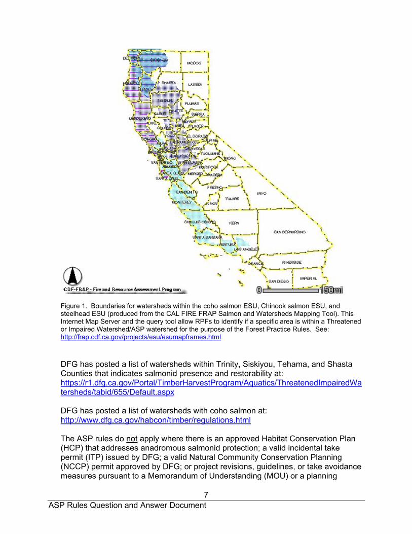
The ASP Rules apply in planning watersheds with state or federally listed anadromous salmonids, and those that are restorable (Figure 1).
ASP Rules Question and Answer Document
7
Figure 1. Boundaries for watersheds within the coho salmon ESU, Chinook salmon ESU, and steelhead ESU (produced from the CAL FIRE FRAP Salmon and Watersheds Mapping Tool). This Internet Map Server and the query tool allow RPFs to identify if a specific area is within a Threatened or Impaired Watershed/ASP watershed for the purpose of the Forest Practice Rules. See: http://frap.cdf.ca.gov/projects/esu/esumapframes.html DFG has posted a list of watersheds within Trinity, Siskiyou, Tehama, and Shasta Counties that indicates salmonid presence and restorability at: https://r1.dfg.ca.gov/Portal/TimberHarvestProgram/Aquatics/ThreatenedImpairedWatersheds/tabid/655/Default.aspx DFG has posted a list of watersheds with coho salmon at: http://www.dfg.ca.gov/habcon/timber/regulations.html
The ASP rules do not apply where there is an approved Habitat Conservation Plan (HCP) that addresses anadromous salmonid protection; a valid incidental take permit (ITP) issued by DFG; a valid Natural Community Conservation Planning (NCCP) permit approved by DFG; or project revisions, guidelines, or take avoidance measures pursuant to a Memorandum of Understanding (MOU) or a planning

ASP Rules Question and Answer Document
8
agreement between the plan submitter and DFG in preparation of obtaining a NCCP that addresses anadromous salmonid protection (ref. 14 CCR § 916.9 [936.9, 956.9](w) (1)-(5)).
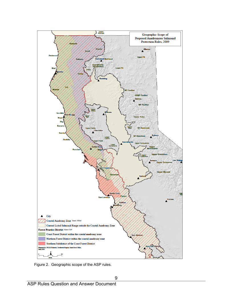
The ASP rules utilize specific sub-regions, including: (1) the CAZ, (2) the Coast District of the CAZ, (3) the Northern District of the CAZ, and (4) the southern subdistrict (SSD) of the Coast District, where certain rules apply (Figure 2).
Also, planning watersheds that do not have listed anadromous salmonids but are immediately upstream of and contiguous to watersheds with listed salmonids are subject to 14 CCR § 916.9 [936.9, 956.9], subsections (k) through (q) and 14 CCR §§ 923.3 [943.3, 963.3] and 923.9 [943.9, 963.9] to reduce impacts from transported fine sediment. Note that projects even further upstream could also be subject to these provisions based on the results of a cumulative impacts assessment.
These rules do not apply to upstream watersheds where permanent dams block anadromy and reduce the transport of fine sediment downstream, or watersheds that do not support anadromy and feed directly into the ocean (also see the answer to Question 12 below).
12. Regarding watersheds in the coastal anadromy zone (CAZ)—if a planning watershed flows directly into the ocean without any Class I watercourses (i.e., no listed salmonids are present and there have never been any), is it subject to the ASP rules?
The planning watershed in this situation would not be subject to the ASP rules since no listed salmonids have ever been present in the watershed. If, for example, there is a 100-foot waterfall where the watercourse enters the ocean, the channel would not be restorable and would not be subject to the ASP rules. It should be noted that a channel that could reasonably be restored to a Class I fish-bearing watercourse (as determined by a DFG biologist; ref. 14 CCR § 916.2 [936.2, 956.2](a)(2)) would be subject to the ASP rules.
13. If a THP has no Class I, II, III, or IV watercourses within the plan boundary, is it
still subject to the new ASP rules? Yes, if the planning watershed itself has listed anadromous salmonids present or is restorable, then the ASP rules apply.
ASP Rules Question and Answer Document
9
Figure 2. Geographic scope of the ASP rules.

ASP Rules Question and Answer Document
10
14. What kind of information will an RPF be expected to provide for Class I watercourses to meet the standard described in 14 CCR § 916.9 [936.9, 956.9] (f)(1)(E), which states: “Documentation of how proposed harvesting in the WLPZ contributes to the objectives of each zone stated in 14 CCR § 916.9 [936.9, 956.9], subsection (c) and other goals in 14 CCR § 916.9 [936.9, 956.9], subsection (a) (1)-(8). Documentation shall include the examinations, analysis, and other requirements listed in 14 CCR § 916.4 [936.4, 956.4], subsection (a)”?
The amount of information required will depend on the extent of the activities
proposed in the Class I watercourse and lake protection zone (WLPZ). In other words, disclosure and analysis requirements will increase with increased risk associated with the proposed level of activity. A considerable amount of the information required to be provided for most proposed activities is already mandated under the requirements of 14 CCR § 916.4 [936.4, 956.4](a), which will serve as the minimum amount of required information to meet this section.
The information provided should be included in Section III, Item #26 of a THP and describe how proposed timber operations will provide for riparian functions such as shade, large wood recruitment, sediment control, etc. that will ultimately improve or maintain salmonid habitat. The discussion should show how the proposed harvesting in the WLPZ will affect salmonid habitat in the near and long-term.
15. Provide greater detail on how to determine if there is a Class I confined
channel present. Does an RPF average the width of the valley floor and the bankfull channel width, and if so, over what distance? Provide a diagram to illustrate how this is done in the field.
The ASP rules define a confined channel as “a watercourse with an incised channel
that does not shift position on a floodplain, the channel has no contiguous flat, flood prone areas, and the width of the valley floor is less than 2 times the channel width at bankfull stage.” Valley floor width is the width of the area within the comparatively flat valley bottom, measured from the edges of significant changes in topography—typically the base of hills or mountains (WFPB 2004). In order to calculate an average value for the ratio between the valley floor and bankfull widths, it is appropriate to obtain data from several locations, generally within the plan boundary, if the widths vary considerably in the downstream direction. Data can be obtained every 200 feet. U.S. Geological Survey (USGS) 7.5 minute topographic maps may be useful in determining valley floor widths for river channels. Measure the average valley width between the contour lines that define the valley walls. The contour lines of the valley bottom will be broadly spaced, and those of the adjacent hillslopes will be more closely spaced (WFPB 2004) (see Figure 3). Estimate the average channel width from field knowledge or aerial photographs. Stream channel confinement estimated from topographic maps should be confirmed with aerial photographs and field observations (WFPB 2004).

ASP Rules Question and Answer Document
11
In Figure 4 below, the ratio of the valley floor width to the bankfull channel width is approximately 2.8, so the channel is classified as unconfined, and there is either a channel migration zone (CMZ) present and/or a flood prone area present. Also, see the answer to Question 42 regarding entrenchment ratio.
Figure 3. Determining valley floor width using a topographic map (Figure 3 in WFPB 2004).
Figure 4. Example of how to determine the valley floor width to bankfull channel width ratio.

ASP Rules Question and Answer Document
12
16. What constitutes a tree within a core zone? When determining the location of the edge of the core zone using slope distance, a
tree is to be considered “in” the core zone if a measuring tape touches any part of the bole at ground level when measured 30 feet from the watercourse transition line (WTL).
17. In the Class I Inner Zone, is harvesting limited to thinning from below with
both commercial thinning and single tree selection silviculture?
No, harvesting in the Class I Inner Zone is not limited to only thinning from below. However, as stated in 14 CCR § 916.9 [936.9, 956.9] (f)(2)(B), harvesting prescriptions should focus on practices that use “thinning from below.” Thinning from below is not a defined silvicultural system in 14 CCR § 913 [933, 953], so this rule section specifies that the silvicultural systems are limited to commercial thinning or single tree selection. In stands with a wide range of tree sizes present, single tree selection may be the most applicable silvicultural system. By definition, single tree selection specifies that trees are removed throughout the diameter classes present in a stand. In stands that were regenerated at one time and have a relatively even size distribution, commercial thinning is more applicable, and the smaller trees will generally have to be marked for removal to meet the increasing quadratic mean diameter (QMD) and standard FPR basal area requirements. Therefore, while thinning from below is the goal for the inner zone (removing suppressed, intermediate, and a few co-dominant trees), site-specific stand conditions will dictate to what degree this can be accomplished with these two silvicultural systems. The requirements for large tree retention and retention of relatively high overstory canopy cover (70-80%) will significantly limit removal of larger trees, unless a site-specific plan is developed and approved (ref. 14 CCR § 916.9 [936.9, 956.9](v)).
18. Since the ASP rules restrict silvicultural methods to commercial thinning and single tree selection, does the plan have to distinguish these silvicultural methods for harvesting in the WLPZ?
When the silvicultural method prescribed for the WLPZ differs from the silvicultural method proposed in the adjacent stand, the plan must differentiate the methods separately for both areas (ref. 14 CCR § 1034 (m) and (x)(2)).
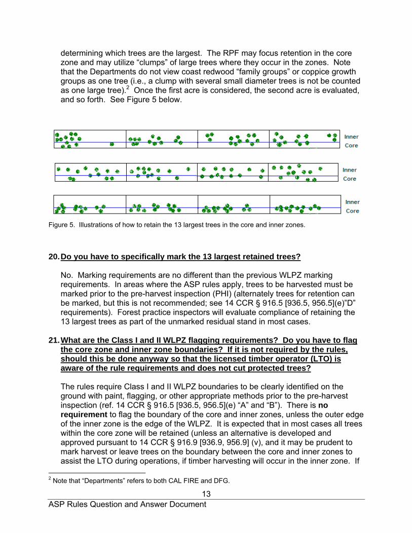
19. What does it mean to require retaining the 13 largest conifer trees per acre,
live or dead, on each acre that encompasses the core and inner zones, and how does an RPF do this on the ground? Illustrate how this will work in the field. An RPF is to accomplish this task by evaluating an acre of ground running parallel to the watercourse extending from the WTL and covering the core and inner zones (i.e., 100 ft x 435 ft). In this area, the RPF must ensure that the 13 largest trees are not marked for harvest. The RPF may consider both live and dead trees when
ASP Rules Question and Answer Document
13
determining which trees are the largest. The RPF may focus retention in the core zone and may utilize “clumps” of large trees where they occur in the zones. Note that the Departments do not view coast redwood “family groups” or coppice growth groups as one tree (i.e., a clump with several small diameter trees is not be counted as one large tree).2 Once the first acre is considered, the second acre is evaluated, and so forth. See Figure 5 below.
Figure 5. Illustrations of how to retain the 13 largest trees in the core and inner zones. 20. Do you have to specifically mark the 13 largest retained trees?
No. Marking requirements are no different than the previous WLPZ marking requirements. In areas where the ASP rules apply, trees to be harvested must be marked prior to the pre-harvest inspection (PHI) (alternately trees for retention can be marked, but this is not recommended; see 14 CCR § 916.5 [936.5, 956.5](e)”D” requirements). Forest practice inspectors will evaluate compliance of retaining the 13 largest trees as part of the unmarked residual stand in most cases.
21. What are the Class I and II WLPZ flagging requirements? Do you have to flag
the core zone and inner zone boundaries? If it is not required by the rules, should this be done anyway so that the licensed timber operator (LTO) is aware of the rule requirements and does not cut protected trees?
The rules require Class I and II WLPZ boundaries to be clearly identified on the ground with paint, flagging, or other appropriate methods prior to the pre-harvest inspection (ref. 14 CCR § 916.5 [936.5, 956.5](e) “A” and “B”). There is no requirement to flag the boundary of the core and inner zones, unless the outer edge of the inner zone is the edge of the WLPZ. It is expected that in most cases all trees within the core zone will be retained (unless an alternative is developed and approved pursuant to 14 CCR § 916.9 [936.9, 956.9] (v), and it may be prudent to mark harvest or leave trees on the boundary between the core and inner zones to assist the LTO during operations, if timber harvesting will occur in the inner zone. If
2 Note that “Departments” refers to both CAL FIRE and DFG.

ASP Rules Question and Answer Document
14
heavy equipment operations are proposed in the Class I inner or outer zones, delineation of the boundary limiting (i.e., “stopping”) equipment entry is recommended (ref. 14 CCR 916.4 [936.4, 956.4](e)).
The existing limitations on equipment operations within the WLPZ still apply and the
WLPZ boundary marking will be important to delineate for the LTO those areas where equipment is restricted. However, the ASP rules allow the RPF to propose site-specific practices in place of the stated rules, but encourage the use of “Preferred Management Practices.” In Class I watercourses with flood prone areas or CMZs, the “Preferred Management Practices” recommend delineation of all WLPZ zones and CMZs (ref. 14 CCR § 916.9 [936.9, 956.9](f)(3)(E)(6)).
22. Is a reduction in WLPZ width allowed for either Class I or Class II WLPZs for cable yarding?
No.
23. The ASP Rules under 14 CCR § 916.9 [936.9, 956.9] (c)(2) specify objectives for
the inner zone of the WLPZ for Class I and II watercourses. One of the objectives is to provide a variety of tree species in the WLPZ for nutrient input, including hardwoods. How should hardwoods be incorporated to meet this objective? Hardwood tree, shrub, and plant species diversity is good for the management of WLPZs for a variety of reasons, including: (1) reducing the potential for fire (the hardwoods have high water content), (2) maximizing both aquatic and terrestrial species biological diversity and suitable habitat, and (3) increasing the nutrient content for both aquatic and terrestrial species. Timber harvesting that incorporates species diversity is encouraged within the WLPZ as part of any overall hardwood retention strategy. Compliance with this section must be evaluated on a case-by-case basis with consideration given to pre-harvest species composition and opportunity to encourage species diversity through silvicultural applications. In determining the appropriate management for hardwoods within the WLPZ, the standard requirements for the chosen silvicultural prescription still apply and must be considered, including the resource conservation standards (ref. 14 CCR § 912.7 [932.7, 952.7](d)) and the protection of wildlife habitat (ref. 14 CCR § 939.15).
24. Provide a brief discussion of canopy measurement. How is overstory canopy
to be measured when the preferred instrument, the vertical sighting tube, often hits both overstory and understory vegetation?
Overstory canopy is defined in the current FPRs as the portion of the trees, in a forest of more than one story, forming the upper canopy layers. Understory is defined as generally trees and woody species growing under an overstory. Total canopy is the summation of canopy at each layer, with a total maximum of 100 percent; it is used where there are multilayered or multistoried canopies (Berbach et

ASP Rules Question and Answer Document
15
al. 1999). In actual field situations, defining overstory and understory can be difficult and vary depending on the observer (Robards et al. 2000, Nakamura 2000).
Total canopy and overstory canopy will be identical when there is only one canopy layer in a stand (i.e., an evenaged stand, as often occurs in a plantation). In contrast, total canopy and overstory canopy will be considerably different in stands with only a few dominant and co-dominant trees, but with an extensive layer of young conifers, shrubs, and suppressed trees (Figure 6). This situation is common in California due numerous past harvest entries into a given stand, the use of a variety of silvicultural systems, the presence of numerous conifer species with varying light tolerance levels, etc.
Figure 6. Diagram on the left illustrates a situation where overstory canopy and total canopy are identical. Diagram on the right illustrates a case where overstory canopy and total canopy are considerably different (drawings from Chan et al. 2006).
Several studies have compared different instruments for measuring overstory canopy (e.g., Robards et al. 2000, Nakamura 2000, Vales and Bunnell 1985, Fiala et al. 2006). These studies have found that the sighting tube/moosehorn is the most precise and unbiased instrument for measuring vertical canopy. Tools such as the spherical densiometer, while often used, produce low accuracy because they project a wide angle of view toward the canopy and consistently overestimate vertical canopy coverage (Nakamura 2000).
Measuring only overstory canopy, as well as differentiating between total canopy and overstory canopy, is often difficult.3 Robards (1999) and Nakamura (2000) state that the sighting tube can be used to differentiate between overstory and understory canopy. Fiala et al. (2006), however, report that with measurement using the moosehorn (similar to the sighting tube), it may be possible to glean limited information about cover by species or layer. They state that overlap among layers of cover and tree species, with shorter trees obstructing higher layered trees, can
3 In many of the published and grey literature papers, overstory canopy measured with the spherical densiometer, sighting tube, etc. is defined as anything above eye level. Similarly, understory canopy is measured as canopy located below eye level. While simple to use, these definitions of overstory and understory do not agree with California FPR definitions.

ASP Rules Question and Answer Document
16
impede the ability of the user to identify or differentiate among them. Field observations using a sighting tube in California confirm that this is a common problem. In most cases, once the location for canopy measurement is determined, the observer will have to determine if there is an overstory tree present when understory vegetation is blocking higher observation with the sighting tube. If there is, it must be assumed that the sighting tube would hit the overstory cover and the site is to be recorded as a “hit.”
In situations where compliance with the ASP overstory canopy retention levels are questionable, it may be necessary for the RPF to systematically sample the least stocked area to demonstrate compliance, and this area may need to be evaluated during the PHI.
25. In the case of requiring an additional protection zone adjacent to areas “where
evenaged regeneration methods, seed tree removal, shelterwood removal, alternative prescriptions declared under 14 CCR § 913.6 [933.6, 953.6], subsection (b)(3) as most related to any evenaged silvicultural system, variable retention or rehabilitation of understocked areas will be utilized contiguous to the watercourse and lake protection zone,” clarify if this means any even-aged silvicultural prescription.
Any even-aged silvicultural system listed under 14 CCR § 913.1 [933.1, 953.1] is to be included, as well as the other methods described above in this question. Note that this includes clearcutting, seed tree (including both seed tree seed step and seed tree removal step), and shelterwood (including shelterwood preparatory step, shelterwood seed step, and shelterwood removal step).
26. How is the CMZ to be determined in the field? Provide greater clarity on
factors to observe in the field to make this determination.
The CMZ is defined as “the area where the main channel of a watercourse can reasonably be expected to shift position on its floodplain laterally through avulsion or lateral erosion during the period of time required to grow forest trees from the surrounding area to a mature size, except as modified by a permanent levee or dike.” RPFs are encouraged to review the document titled Standard Methods for Identifying Bankfull Channel Features and Channel Migration Zones (WFPB 2004) for detailed information on how to determine if a CMZ is present. This document provides a flowchart for CMZ determination. RPFs may also refer to A Framework for Delineating Channel Migration Zones (Rapp et al. 2003). Both documents are available online (the websites are listed in the references section). Determination of a CMZ can be conducted by RPFs that have knowledge regarding riparian landforms and channel morphology.
It is most appropriate to determine if channel migration has historically occurred using a combination of office methods (e.g., a series of aerial photographs covering a wide time frame, topographic maps) and field inspection. CMZs are found in areas
ASP Rules Question and Answer Document
17
with unconfined channels (i.e., valley floor width is greater than 2 times the bankfull channel width). Field inspections will reveal past lateral movement of the channel, often age-progressive bands of trees (e.g., red alder) on the floodplain, and at least one side channel on the floodplain at or below bankfull elevation of the main channel (WFPB 2004).
27. For Class I watercourses with flood prone areas, is the WTL located at the
landward edge of the CMZ or at the beginning of the CMZ?
When a CMZ is present within a flood prone area, the WTL is located at the landward edge of the CMZ. See Figure 5 in the ASP rule package. As defined in the ASP rules, the CMZ’s WTL is located where the landward (outer) edge of the CMZ and the streamward edge of the Flood Prone Area (FPA) meet.
28. When does the CMZ supersede the FPA?
In many cases there will be a FPA when a CMZ is present. The ASP rules state “when both a channel migration zone and flood prone area are present, the boundaries established by the channel migration zone supersede the establishment of a flood prone area.” This means that the RPF is to establish the boundaries of the CMZ first, then the WTL, and then establish the flood prone area, if present. The establishment of the CMZ does not take the place of the establishment of any FPA, where it exists adjacent to the CMZ. The point is to establish the CMZ first, especially where it might overlap a FPA, then establish the remainder of the FPA beyond the CMZ.
29. Where is the WTL located for Class I watercourses with a FPA?
If there is a FPA but no CMZ present, then the WTL is located as described in 14 CCR § 895.1 for “Watercourse Transition Line.” Functionally, it is located at or near the “top of bank” as indicated in Figure 3A in the ASP rule package. “Top of bank” is the line that is defined by a break in slope from the channel bank to a flatter valley bottom, start of a floodplain, terrace, or bench.
30. How will the FPA be determined in the field?
RPFs should refer to indicators described in the ASP rule FPA definition, as well as the document titled Flood Prone Area Considerations in the Coast Redwood Zone (Cafferata et al. 2005). Other helpful tools for determining the extent of flood prone areas are USGS topographic maps; LIDAR (Light Detection and Ranging) data, which provides high resolution topography; and individual county 100-year flood hazard maps, which depict with reasonable accuracy the extent of relatively flat, floodplains adjacent to streams.
Evidence for a flood prone area includes, but is not limited to: (1) flotsam (i.e., material floating on water) hanging in the brush and log jams on top of the

ASP Rules Question and Answer Document
18
surface, (2) fine sediments found in the tree moss and bark, (3) silt, sand, or gravel found immediately under the leaf layer, (4) alluvial materials consisting of silt, sand and gravel that are uncompacted and unconsolidated, (5) a wetter understory plant community with facultative wet and/or wetland obligate species present, (6) disturbance species such as willow, cottonwood and alder present in the overstory canopy, (7) evidence of flowing water, such as scour features, flattened grass or secondary channels formed by scour action of the modern river channel, and (8) the elevation of the surface lies near the elevation of the highest channel features (e.g., log jams and gravel bar surfaces). If some period of time has lapsed since a large flood event, evidence that relates directly to flooding of a surface may be muted (WFPB 2004).
RPFs are encouraged to consult with DFG, CAL FIRE, the Regional Water Quality Control Boards (RWQCBs), and others prior to laying out a project in an area suspected to be prone to flooding. Agency staff can help foresters determine if flood prone areas are present and answer questions about the ASP rules and agency expectations.
31. If harvesting in a FPA is proposed and the RPF elects not to use the site-specific approach, what silvicultural systems are permitted? Which silvicultural method requires QMD to increase? Is “thinning from below” required?
Both single tree selection and commercial thinning are permitted within inner zones A and B in the FPA, provided that they meet the requirements specified in 14 CCR § 916.9 [936.9, 956.9]. For inner zone A, when commercial thinning is used, the QMD of conifer trees greater than 8 inches diameter at breast height (DBH) must increase in the post-harvest stand.
“Thinning from below” is not a defined silvicultural system in 14 CCR § 913 [933, 953], so this rule section specifies that the silvicultural systems are limited to commercial thinning or single tree selection. As stated in the ASP rules, harvesting prescriptions are to focus on practices that use thinning from below (removing suppressed, intermediate, and a few co-dominant trees), and tree marking reviewed by Review Team agency personnel will be evaluated with this concept in mind.4 See the response to Question 17 above.
4 Ligon et al. 1999 define “thinning from below” as follows: “A low thinning is to be used in conjunction with silvicultural treatments in Zone A of Class I WLPZs. This thinning involves the removal of the understory, mid-canopy, and very limited numbers of co-dominant trees. Co-dominant trees may be removed only to improve spacing and enhance growth. Dominant trees may not be removed, and average stand diameter must increase following harvest.” The Riparian Protection Committee Report stated that thinning from below involves harvesting intermediates and co-dominants only, and that quadratic mean diameter (QMD) of the stand must increase after harvest. Modeling showed that this silvicultural method did not significantly reduce the number of large trees following six decades (Cafferata et al. 2005).
ASP Rules Question and Answer Document
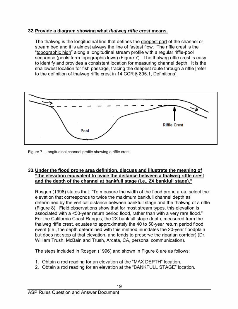
19
32. Provide a diagram showing what thalweg riffle crest means. The thalweg is the longitudinal line that defines the deepest part of the channel or stream bed and it is almost always the line of fastest flow. The riffle crest is the “topographic high” along a longitudinal stream profile with a regular riffle-pool sequence (pools form topographic lows) (Figure 7). The thalweg riffle crest is easy to identify and provides a consistent location for measuring channel depth. It is the shallowest location for fish passage, tracing the deepest route through a riffle [refer to the definition of thalweg riffle crest in 14 CCR § 895.1, Definitions].
Figure 7. Longitudinal channel profile showing a riffle crest. 33. Under the flood prone area definition, discuss and illustrate the meaning of
“the elevation equivalent to twice the distance between a thalweg riffle crest and the depth of the channel at bankfull stage (i.e., 2X bankfull stage).”
Rosgen (1996) states that: “To measure the width of the flood prone area, select the elevation that corresponds to twice the maximum bankfull channel depth as determined by the vertical distance between bankfull stage and the thalweg of a riffle (Figure 8). Field observations show that for most stream types, this elevation is associated with a <50-year return period flood, rather than with a very rare flood.” For the California Coast Ranges, the 2X bankfull stage depth, measured from the thalweg riffle crest, equates to approximately the 40 to 50-year return period flood event (i.e., the depth determined with this method inundates the 20-year floodplain but does not stop at that elevation, and tends to preserve the riparian corridor) (Dr. William Trush, McBain and Trush, Arcata, CA, personal communication).
The steps included in Rosgen (1996) and shown in Figure 8 are as follows:
1. Obtain a rod reading for an elevation at the “MAX DEPTH” location. 2. Obtain a rod reading for an elevation at the “BANKFULL STAGE” location.

ASP Rules Question and Answer Document
20
3. Subtract the “Step 2” reading from the “Step 1” reading to obtain a “MAX DEPTH” value; then multiply the Max. Depth Value times 2 for the “2X MAX. DEPTH” value.
4. Subtract the “2X Max. Depth” value from the “Step 1 Rod Reading” for the FLOOD PRONE AREA location rod reading. Move the rod upslope, online with the cross-section, until a rod reading for the Flood Prone Area location is obtained.
5. Mark the Flood Prone Area locations on each bank.
Figure 8. Illustration for determining a flood prone area using the two times bankfull stage method (Figure 5.11 from Rosgen 1996). 34. Inner zone A on FPAs: clarify how an RPF will determine the minimum and
maximum widths. It appears that if the 70 foot minimum width encompasses the entire extent of the flood prone area, then the zone does not have to be any larger. This is not explicit and needs clarification.
There was an error in the ASP rule package plead dated September 9, 2009. The correct wording for (C) inner zone A is: “The Inner Zone A generally encompasses the portion of the flood prone area from 30 feet beyond the WTL (Core Zone perimeter) up to 150 feet from the WTL. The minimum width of the Inner Zone A shall be the greater of the distance from the landward edge of Core Zone to the landward edge of the Inner Zone A or 70 feet. The maximum width is 120 feet.”
It is correct to state that if the 70 foot minimum width encompasses the entire extent of the FPA, then this zone is only 70 feet wide. If the entire FPA is 137 feet wide, then the inner zone A width would be 107 feet (30 feet for the core zone and 107 feet for inner zone A) [see Figure 9 below]. The landward edge of inner zone A will

ASP Rules Question and Answer Document
21
never extend up the base of the adjacent hillslope, outside of the flood prone area, to reach a total distance of 150 feet.
Figure 9. Example of an inner zone A with a width of less than 120 feet. 35. Inner zone B on flood prone areas: clarify that this zone may not be necessary
if the inner zone A encompasses all of the flood prone area. This appears to be the case, but is not completely clear. Use diagrams and illustrations.
Yes, inner zone B on FPAs is not necessary if inner zone A encompasses all of the flood prone area (see Figure 9 provided for Question 34 above).
36. What prescriptions apply to a flood prone area that is less than 100 feet wide
(the prescriptions for flood prone areas or for non-flood prone areas)? If the flood prone area is less than 100 feet wide, the channel might be confined and prescriptive measures for a Class I watercourse with confined channels might apply (i.e., a 30 foot wide core zone and a 70 foot wide inner zone). However, low gradient, confined channels often exhibit flood prone areas such as meander cut-offs and side channels; in some cases they might extend beyond 100 feet. Flood prone areas in confined channels should be evaluated for presence of short reaches of unconfined channels and protected where they occur. Also, flood prone areas in confined channel reaches should be evaluated pursuant to 14 CCR § 916.4 [936.4, 956.4](a)(1) and protected pursuant to 14 CCR § 916.4 [936.4, 956.4](b). It should be noted that the prescription for the inner zone of a confined channel is identical to the prescription for the inner zone A of a flood prone area. Therefore, in both instances, the same protective standards would apply.
Core Zone WTL
30 ft
Inner Zone A
107 ft

ASP Rules Question and Answer Document
22
37. How will RPFs know when Preferred Management Practices (PMPs) will be strongly encouraged for use—and are these “underground regulations?” How often will these practices be required to be incorporated in THPs? [Note that PMPs are provided for Class I confined channels in the CAZ, Class I watercourses with Flood Prone Areas or CMZs, and Class I confined channels outside the CAZ].
PMPs are practices that are intended to reduce the risk of timber operations adversely impacting water quality. They are not “underground regulations,” since the Board determined that they are not always required. RPFs are strongly encouraged to consider including these practices, particularly in highly sensitive parts of watersheds (such as flood prone areas), as well as when more intensive management is proposed. PMPs are considered by the Board to be the least likely practices to result in significant effects to riparian resources. Therefore, the use of PMPs is encouraged and may result in expedited plan review when employed. The more sensitive the landscape is to disturbance, the greater the chance that the Review Team agencies will ask if PMPs were considered in preparing the plan.
38. How do you apply the PMPs [ref. 14 CCR § 916.9 [936.9, 956.9](f)(2)(D)] in a Class I WLPZ (inner and outer zones) when the standard FPRs prohibit heavy equipment operations in WLPZs without RPF explanation, justification and approval from the Director (ref. 14 CCR § 916.3 [936.3, 956.3] (c)). To use heavy equipment in a WLPZ, the RPF would still have to propose an in lieu practice (ref. 14 CCR § 916.1 [936.1, 956.1]). Typically, PMP activities are intended to mitigate potential significant adverse impacts, and when these types of practices are specified and an in lieu practice justification is provided, it is expected that the review and approval of the practice should be expedited.
39. How many different types of Class II watercourses are there in the California Forest Practice Rules?
There are three types of Class II watercourses, two of which only apply to portions of California subject to the ASP rules (Class II-S and Class II-L). The Class II watercourse described in 14 CCR § 916.5 [936.5, 956.5], Table 1, still applies where there are watersheds with no listed anadromous salmonids.
40. What are the steps that an RPF will take to classify, type and assign protection
measures to a Class II watercourse in the areas of California where the ASP rules apply? As with the previous FPRs, the recently adopted ASP rules require an RPF to conduct a field examination of all lakes and watercourses to determine the classification of the watercourse and the appropriate WLPZ widths and protection measures. The primary rules that apply to this step in the classification and

ASP Rules Question and Answer Document
23
protection process are found under 14 CCR §§ 916.4 [936.4, 956.4] and 916.5 [936.5, 956.5].
In regard to Class II watercourses, once the appropriate watercourse classification has been determined (Class I, II, III, or IV), the ASP rules now require the RPF to determine the “type” of Class II watercourses found within the harvest area that will require protection, Class II-L (Large) or Class II-S (Standard). As specified in the ASP rule package (ref. 14 CCR § 916.9 [936.9, 956.9](g)(1)), Class II-L watercourses are to be identified based on one or more of three office methods (stream order, “blue-line” streams, and drainage area), and one or more of the field methods specified (direct observation/local knowledge of mid-summer flows, channel characteristics, and extrapolation of continuous streamflow monitoring data). Detailed information on these methods is provided in the answers to several of the questions below. Class II-S watercourses are those that have been classified as Class II watercourses, but do not meet the definition of a Class II-L watercourse. Once the determination has been made that a Class II watercourse is typed as a Class II-L, the first 1,000-foot reach of the Class II watercourse measured from the confluence with a Class I watercourse will be considered a Class II-L. Those reaches of a Class II watercourse beyond the first 1,000 feet of a Class II-L shall be typed as Class II-L or Class II-S based upon the criteria described above.
After the appropriate classification and type for the watercourse has been determined, the RPF must consider what protection measures are appropriate, either the minimum standards stated in the rules, or more protective or less restrictive standards based on the site-specific conditions identified during the field examination. Less restrictive site-specific practices must be proposed in conformance with 14 CCR § 916.1 [936.1, 956.1] regarding in lieu practices and 14 CCR § 916.9 [936.9, 956.9] (v).
For a Class II watercourse in a watershed where the ASP rules apply, the minimum standards are stated under 14 CCR § 916.9 [936.9, 956.9](g)(2). Class II watercourses that are equal to or greater than 1,000 feet in length and that have been typed as a Class II-L, shall have the Class II-L minimum standards applied to the first 1,000 feet. After the first 1,000 feet, the Class II-S protection standards shall be applied. Class II watercourses that have been typed as Class II-S shall have the standards stated under 14 CCR § 916.9 [936.9, 956.9](g)(2)(B)(1.) applied. This typing procedure and the corresponding minimum standards are not required in the Southern Subdistrict of the Coast Forest District where special protection measures apply (ref. 14 CCR § 916.9 [936.9, 956.9](g)(3)). In summary: 1. Determine the watercourse classification
a. If the watercourse is a Class II, determine the type (L or S) i. Based on office and field evaluation.

ASP Rules Question and Answer Document
24
ii. If the watercourse is a Class II-L, the first 1,000-foot reach from the confluence with a Class I watercourse is considered a Class II-L.
iii. The remaining reaches of the Class II watercourse should be typed as Class II-L or Class II-S upstream of the 1,000-foot point.
iv. This typing does not apply to Class II watercourses in the SSD of the Coast Forest District.
2. Determine the appropriate protection a. Based on field evaluation. b. If the watercourse is a Class II-L, determine the length of the Class II
watercourse: i. If > or = 1,000 feet, apply Class II-L standards to the first 1,000 feet
1. Apply Class II-S standards to the remainder of the length (standard Class II protection measures, but apply WLPZ widths from Table 4, and core zone protection measures).
ii. If < 1,000 feet, apply Class II-L standards to the entire length. c. If the watercourse is a Class II-S, apply Class II-S standards (standard
Class II protection measures, but apply WLPZ widths from Table 4, and core zone protection measures).
d. If the Class II watercourse is in the SSD of the Coast Forest District, special protection measures apply.
41. Do all three of the conditions (flow, sediment transport, and supply of
functioning wood to a Class I watercourse) listed for Class II-L watercourses have to be met for a watercourse to be typed as a Class II-L? Provide detailed information on how to type a Class II-L watercourse. No, all three conditions do not have to be met for a watercourse to be typed as a Class II-L. The first two conditions (supplying water and nutrients to a Class I during the month of July during an average hydrologic year, and supplying coarse and fine sediment to a Class I channel) must be met for a watercourse to be typed as a Class II-L. However, the ASP rules state that Class II-L watercourses may be able to supply wood of a size that would function as large wood for a Class I watercourse.
As specified in the ASP rule package, Class II-L watercourses are to be identified based on one or more of three office methods (stream order, “blue-line” streams, and drainage area), and one or more of the field methods specified (direct observation/local knowledge of mid-summer flows, channel characteristics, and extrapolation of continuous streamflow monitoring data). Detailed information on these methods is provided in the answers to several of the questions below. Detailed information on how to type a Class II-L watercourse is provided above in the answer to Question 40.
42. The Class II-L ASP rule section uses the following terms that need
clarification: “average hydrologic year,” “a year with at least average precipitation” and “mean entrenchment ratio.”

ASP Rules Question and Answer Document
25
The final adopted ASP rule language by the OAL in 14 CCR § 916.9 [936.9, 956.9](c)(4) includes the following language: “Class II-L type watercourses: (i) can supply water and nutrients to a Class I watercourse during the month of July during a year of average precipitation and runoff as derived from long-term average precipitation data sets available from CAL FIRE, U.S. Geological Survey, or National Oceanic and Atmospheric Administration (NOAA).” An average hydrologic year is a year of average precipitation and runoff, which can be derived from long-term data sets available from DWR Climate webpage, Western Regional Climate Center/NOAA Regional Climate Center, CAL FIRE FRAP, OSU PRISM, and the U.S. Geological Survey. Websites for precipitation and runoff data in California include:
The Western Regional Climate Center (one of several NOAA Regional Climate Centers):
http://www.wrcc.dri.edu/Climsum.html (climatological data summaries—including precipitation) http://www.calclim.dri.edu/ccda/data.html (California climate data archive)
The California Department of Water Resources (DWR) California Data Exchange Center (CDEC):
http://cdec.water.ca.gov/ (home page with main menu for real-time data for precipitation and runoff) http://www.water.ca.gov/floodmgmt/hafoo/csc/climate_data/# (California climate data, including average annual precipitation values) ftp://ftp.water.ca.gov/users/dfmhydro/Rainfall%20Dept-Duration-Frequency/ (rainfall-depth-duration-frequency data for California)
The CAL FIRE Fire and Resource Assessment Program (FRAP) webpage:
http://frap.cdf.ca.gov/projects/esu/esulookup.asp (interactive webtool that has mean planning watershed precipitation) http://frap.cdf.ca.gov/webdata/maps/statewide/rainmap.pdf (California isohyetal map)
The Oregon State University (OSU) PRISM website:
http://www.prism.oregonstate.edu/ (high quality spatial climate data sets)
The US Geological Survey website:
http://waterdata.usgs.gov/ca/nwis/current/?type=precip&group_key=county_cd (real time precipitation data for California--31 stations) http://waterdata.usgs.gov/ca/nwis/sw (USGS surface water data for California)
ASP Rules Question and Answer Document
26
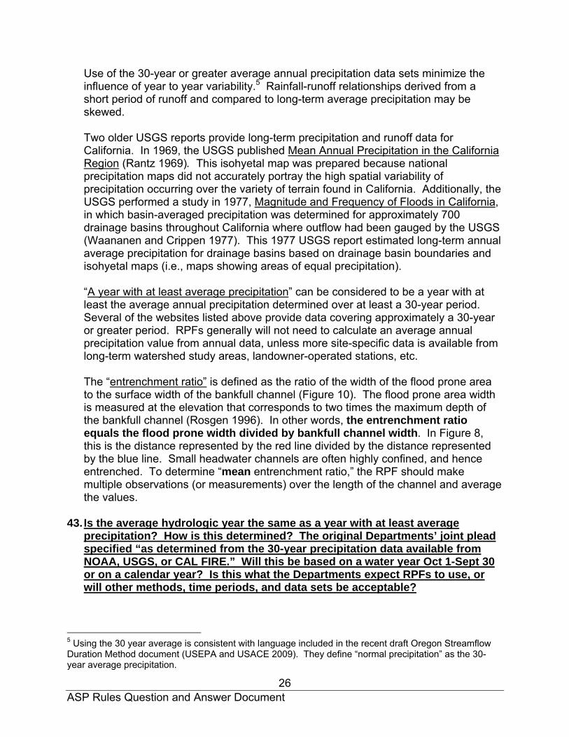
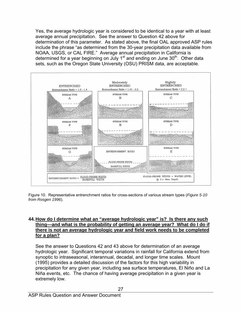
Use of the 30-year or greater average annual precipitation data sets minimize the influence of year to year variability.5 Rainfall-runoff relationships derived from a short period of runoff and compared to long-term average precipitation may be skewed. Two older USGS reports provide long-term precipitation and runoff data for California. In 1969, the USGS published Mean Annual Precipitation in the California Region (Rantz 1969). This isohyetal map was prepared because national precipitation maps did not accurately portray the high spatial variability of precipitation occurring over the variety of terrain found in California. Additionally, the USGS performed a study in 1977, Magnitude and Frequency of Floods in California, in which basin-averaged precipitation was determined for approximately 700 drainage basins throughout California where outflow had been gauged by the USGS (Waananen and Crippen 1977). This 1977 USGS report estimated long-term annual average precipitation for drainage basins based on drainage basin boundaries and isohyetal maps (i.e., maps showing areas of equal precipitation). “A year with at least average precipitation” can be considered to be a year with at least the average annual precipitation determined over at least a 30-year period. Several of the websites listed above provide data covering approximately a 30-year or greater period. RPFs generally will not need to calculate an average annual precipitation value from annual data, unless more site-specific data is available from long-term watershed study areas, landowner-operated stations, etc. The “entrenchment ratio” is defined as the ratio of the width of the flood prone area to the surface width of the bankfull channel (Figure 10). The flood prone area width is measured at the elevation that corresponds to two times the maximum depth of the bankfull channel (Rosgen 1996). In other words, the entrenchment ratio equals the flood prone width divided by bankfull channel width. In Figure 8, this is the distance represented by the red line divided by the distance represented by the blue line. Small headwater channels are often highly confined, and hence entrenched. To determine “mean entrenchment ratio,” the RPF should make multiple observations (or measurements) over the length of the channel and average the values.
43. Is the average hydrologic year the same as a year with at least average
precipitation? How is this determined? The original Departments’ joint plead specified “as determined from the 30-year precipitation data available from NOAA, USGS, or CAL FIRE.” Will this be based on a water year Oct 1-Sept 30 or on a calendar year? Is this what the Departments expect RPFs to use, or will other methods, time periods, and data sets be acceptable?
5 Using the 30 year average is consistent with language included in the recent draft Oregon Streamflow Duration Method document (USEPA and USACE 2009). They define “normal precipitation” as the 30-year average precipitation.
ASP Rules Question and Answer Document
27
Yes, the average hydrologic year is considered to be identical to a year with at least average annual precipitation. See the answer to Question 42 above for determination of this parameter. As stated above, the final OAL approved ASP rules include the phrase “as determined from the 30-year precipitation data available from NOAA, USGS, or CAL FIRE.” Average annual precipitation in California is determined for a year beginning on July 1st and ending on June 30th. Other data sets, such as the Oregon State University (OSU) PRISM data, are acceptable.
Figure 10. Representative entrenchment ratios for cross-sections of various stream types (Figure 5-10 from Rosgen 1996). 44. How do I determine what an “average hydrologic year” is? Is there any such
thing—and what is the probability of getting an average year? What do I do if there is not an average hydrologic year and field work needs to be completed for a plan? See the answer to Questions 42 and 43 above for determination of an average hydrologic year. Significant temporal variations in rainfall for California extend from synoptic to intraseasonal, interannual, decadal, and longer time scales. Mount (1995) provides a detailed discussion of the factors for this high variability in precipitation for any given year, including sea surface temperatures, El Niño and La Niña events, etc. The chance of having average precipitation in a given year is extremely low.

ASP Rules Question and Answer Document
28
If an overwintering period generates below normal precipitation and field work is to be completed in the spring and summer of the next year, options are available to RPFs. The ASP rule language states that either direct observation or local knowledge of mid-summer flow conditions is necessary for field-based approaches. Therefore, if an RPF has local knowledge of flow or that a given number of acres of drainage area is necessary to generate mid-summer streamflow in the plan area, this information could be substituted for a direct observation following a dry overwintering period (also see responses to questions 61, 62, 63 and 64 for further information). Channel characteristics can always be observed, regardless of the current precipitation situation (Also see the response to question 65). Streamflow monitoring data, provided it has been collected over years that have representative precipitation input, can be extrapolated even if the past winter has been dry. Also, following a year with at least average precipitation, an RPF can attempt to identify Class II-L watercourses across a large watershed or portion of an ownership.
45. How do the Departments view the acceptability of surveys in July? Are they
acceptable only after July 15th? Is any survey during July acceptable? Or is the timing of surveys in July dependent on whether you have an average hydrologic year? For instance, if the current water year flow was below the “average,” you survey through July 15th and if above the average you survey from July 15th to July 31st? Are surveys at other times of the year acceptable if they are tied to the field based approach 14 CCR § 916.9 [936.9, 956.9](g)(1)(B)(2) – observation of field characteristics and not (B)(1) – flow regime? It is highly unlikely that a given year’s precipitation will ever exactly match the long-term average. Field surveys for direct observation of streamflow are to be completed after July 15th following a year with at least average annual precipitation (based on at least 30 years of precipitation data). Surveys at other times of the year can be used, if there is local knowledge of mid-summer flow conditions, and the parameters needed to produce mid-summer streamflow.
46. In a dry year or period of dry years, is this method (mid-summer flow through
July 15th method) still valid if the Class II watercourse is not flowing, and therefore not contributing flow to a Class I watercourse?
No. As stated above, at least average annual precipitation must have fallen during the previous winter period for direct observation of streamflow to be used in mid-July. See the response to Question 44 above for discussion on alternate approaches to use during dry years.
47. How will the Departments handle the situation where an RPF types a channel
as a Class II-S following a survey in late July (i.e., no surface flow during a year of at least average precipitation), but the pre-harvest inspection does not

ASP Rules Question and Answer Document
29
occur until the following Spring, when the channel is flowing with a considerable amount of water?
In this case, the Review Team agencies will rely on information in the plan or their own local knowledge of drainage areas needed to produce surface flow in mid-July during an average precipitation year, as well as other office and field methods (e.g., stream order, blue-line designation, channel characteristics, etc.).
48. With respect to utilizing the field based approach under 14 CCR § 916.9 [936.9,
956.9] (g)(1)(B)(1), how do the Departments view “contribute flow”? Does this mean any flow, or significant flow? The Departments had initially proposed that if there was very limited flow, one could use Brown’s mixing formula to determine whether the flow was ecologically significant (e.g., low summer flow tributary draining into a large mainstem river). Is this acceptable to the Departments given the rule language adopted by the Board?
The language adopted by the Board describes a Class II-L as an order 2 or order 3 watercourse that can “supply water” or “contribute flow” to a Class I watercourse after July 15th in a year of average precipitation. The language does not provide a qualification that the amount of water or flow must be “significant.” There were two alternative approaches before the Board when the ASP Rules were adopted. The language that was not selected specified “surface flow.” The adopted rule language does not distinguish between surface or subsurface flow and also does not specify the amount of flow contribution in either absolute or relative terms. Further, the adopted rule language states in 14 CCR § 916.9 [936.9, 956.9] (g) that “The following are the minimum requirements…” [emphasis added]. CAL FIRE and DFG understand this to provide direction that the lead and responsible agencies are not to further restrict the application of the rule language. It should be noted, however, that once the determination has been made that a watercourse is a Class II-L, an RPF may, pursuant to 14 CCR § 916.9 [936.9, 956.9] (v), propose alternative protection measures that will achieve the goal of maintaining daily and seasonal water temperatures within the preferred range for anadromous salmonids.
49. Could any of the factors listed in the alternative not adopted by the Board for
determining Class II watercourse type be used, in addition to those required, to type a Class II-L watercourse (e.g., water temperature mixing equation calculation to determine tributary impact on the Class I watercourse)?
As indicated in the response to Question 48, the typing of a Class II watercourse as a Class II-L or Class II-S is partially based on whether there is mid-summer flow to a Class I watercourse or not, and does not include a subjective evaluation of the significance of the flow or impact of the flow on the Class I watercourse. There were two alternative approaches before the Board when they selected Option 102 as the adopted language. The Board could have, but did not modify Option 102 to include any of the alternative language. There is no basis in the rulemaking process to implement rule language not adopted by the Board. It should be noted, however,
ASP Rules Question and Answer Document
30
that once the determination has been made that a watercourse is a Class II-L, an RPF may propose alternative protection measures pursuant to 14 CCR § 916.9 [936.9, 956.9](v) that will achieve the goal of maintaining daily and seasonal water temperatures within the preferred range for anadromous salmonids and may use data and accepted methodologies, such as the water temperature mixing equation, as a basis for determining the appropriate level of protection necessary to achieve that goal.
50. If a Class II watercourse just supplies a trickle of water to a Class I
watercourse in mid-July during an average hydrologic year, must it still be considered a Class II-L (i.e., is there a critical volume of water that must be supplied, and a volume that could potentially impact the temperature in a Class I watercourse—and if not, why not?) In other words, how much surface water is considered indicative of a Class II-L?
The adopted ASP Rules provide only that any Class II watercourse meeting the criteria in 14 CCR § 916.9 [936.9, 956.9] (g) (A) (1) or (2) or (3) shall be verified using approaches in 14 CCR § 916.9 [936.9, 956.9] (g) (B). The adopted rule language does not provide an exception for very low flows. Also see the response to Questions 48 and 49 above.
51. Is it correct to assume that the extent of a Class II-L is based on the field
based approaches? Similarly, do the Departments agree that 14 CCR § 916.9 [936.9, 956.9]) (g)(1)(E) means that you could have, for example, Class II-L watercourse lengths of 300’, 732’ or 1,000’? Do the Departments agree that the phrase “whichever is less” refers to whatever length the Class II-L is determined in the field, and not established at a mandatory 1,000’ length because it was determined to be Class lI-L at the confluence?
A watercourse is typed using both office and field based approaches. In regard to the field based approach, a primary indicator of whether a watercourse is typed as a Class II-L is the determination that surface flow is expected to be the dominant flow source into a Class I watercourse in mid-July during a year with at least average precipitation. Once typed as a Class II-L based on an office approach and considering surface flow as well as the other factors, the watercourse remains a Class II-L for at least 1,000 feet from the confluence with a Class I watercourse, or until classification changes to a Class III watercourse. Only the first 1,000 feet of the Class II-L from the confluence with a Class I receives Class II-L protection measures; the remainder receives Class II-S protection measures, as illustrated in Figures 11, 12, 13, 14, 15, and 16. If classification changes to a Class III prior to 1,000 feet from the confluence with a Class I watercourse, the Class II watercourse up to the Class III is typed as a Class II-L. Figure 17 shows an example of a 500 foot Class II-L. If surface flow is not the dominant flow source for the last 1,000 feet of the Class II watercourse prior to entering the Class I watercourse in mid-July during a year with at least average precipitation, then the watercourse is typed as a Class II-S for the entire reach, until classification changes to a Class III (Figure 18).
ASP Rules Question and Answer Document
31
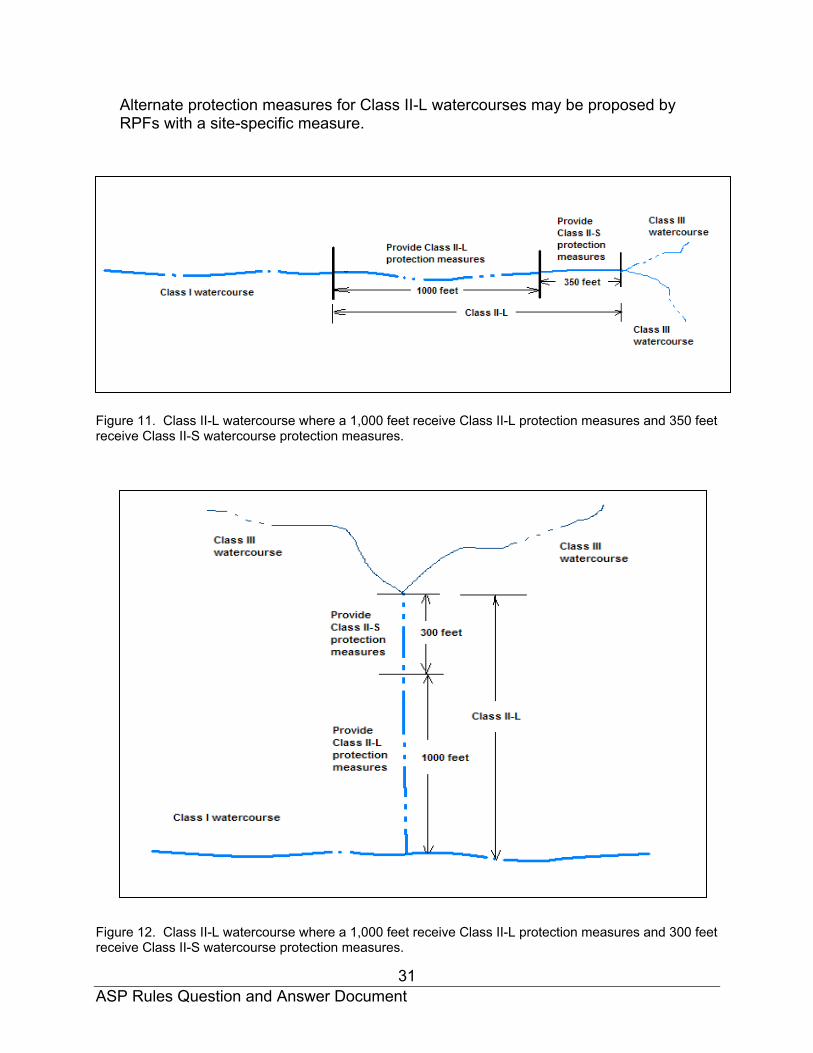
Alternate protection measures for Class II-L watercourses may be proposed by RPFs with a site-specific measure.
Figure 11. Class II-L watercourse where a 1,000 feet receive Class II-L protection measures and 350 feet receive Class II-S watercourse protection measures.
Figure 12. Class II-L watercourse where a 1,000 feet receive Class II-L protection measures and 300 feet receive Class II-S watercourse protection measures.

ASP Rules Question and Answer Document
32
Figure 13. Class II-L watercourse where a 1,000 feet receive Class II-L protection measures. The Class II-L continues to 1,500 feet, but Class II-S protection measures are applied for 500 feet. At this point, the Class II is typed as a Class II-S, and Class II-S protection measures continue until the watercourse is classified as a Class III watercourse.
Figure 14. Class II-L watercourse where a 1,000 feet receive Class II-L protection measures. The Class II-L type stops at 1,000 feet and changes to a Class II-S. At this point, Class II-S protection measures are applied until the watercourse is classified as a Class III watercourse

ASP Rules Question and Answer Document
33
Figure 15. Class II-L watercourse where a 1,000 feet receive Class II-L protection measures. The Class II-L continues to 1,500 feet, but Class II-S protection measures are applied for the next 500 feet. At this point, the Class II is typed as a Class II-S, and Class II-S protection measures continue until the watercourse is classified as a Class III watercourse. Additionally, a Class II tributary joins the main Class II-L and is typed as a Class II-S watercourse and receives Class II-S protection measures until it becomes a Class III watercourse.

ASP Rules Question and Answer Document
34
Figure 16. Class II-L watercourse where a 1,000 feet receive Class II-L protection and 500 feet receive Class II-S protection measures.

ASP Rules Question and Answer Document
35
Figure 17. Class II-L watercourse that extends less than 1,000 feet and Class II-L protection measures are applied to the whole length.

ASP Rules Question and Answer Document
36
Figure 18. Class II-S watercourse type, since there is no mid-July surface flow at the confluence with the Class I watercourse for a year with at least average precipitation. 52. If water just flows for the lower 250 feet before entering a Class I watercourse
in mid-July, do I still need to type the channel as a Class II-L the whole 1,000 feet, and if so, why? When can I have a distance of less than 1,000 ft (show diagram)?
Yes. See the response to Question 51 above (including Figure 17). The Board determined that Class II-L watercourses can significantly impact Class I watercourses, and have significant values themselves, such as providing for sediment storage and decreasing the rate of sediment transport into Class I watercourses. Therefore, unless an alternative is developed and approved pursuant to 14 CCR § 916.9 [936.9, 956.9](v), Class II-L watercourse protection measures will be assigned for at least 1,000 feet where the watercourse meets Class II-L criteria outlined in the rules, unless the watercourse changes to a Class III prior to 1,000 feet.

ASP Rules Question and Answer Document
37
. 53. When using direct observation or local knowledge of common mid-summer
flow conditions, does water supplied by a potential Class II-L to a Class I watercourse include both surface and subsurface flow? Some Class II watercourses flow through gravel prior to entering the Class I. Is observation or knowledge of subsurface flow conditions necessary? In most cases, water supplied to a Class I watercourse from a potential Class II-L watercourse will include both surface and subsurface flow (particularly where there are significant stream gravel deposits present). Knowledge of subsurface flow conditions, in terms of relative contribution, is not necessary. See the response for Question 54.
54. What distance from the Class I watercourse should surface water be visible? What if there is surface water several hundred feet from the Class I watercourse, but none at the confluence? Does this meet the definition for Class II-L watercourse?
Surface flow to the receiving Class I watercourse is expected to be the dominant flow source during a year with at least average precipitation, but surface flow may be interrupted by reaches with subsurface flow (i.e., surface flow is present but not spatially continuous). Limited intermittent dry portions of the channel at or above the confluence with the Class I do not disqualify the channel from Class II-L typing for at least 1,000 feet from the confluence with the Class I watercourse. As stated above, even with interrupted surface flow within a 1,000 feet of a Class I watercourse, the watercourse remains a Class II-L and will receive Class II-L protection measures for 1,000 feet (unless the watercourse classification changes to a Class III).6
55. According to 14 CCR § 916.9 [936.9, 956.9](g)(1)(E), the distance of 1,000 feet for application of the requirements for Class II-L protection is measured from the confluence with a Class I watercourse. At what point do the measurements begin and is it different for confined and unconfined channels? The 1,000 foot distance is to be measured from the edge of the active channel at bankfull stage. For watercourses without channel migration zones, that is confined channels and flood prone areas, this will be close to or the same as the WTL. For channels with CMZs, this will be inside the CMZ along the active channel.
56. How can the office stream order method be used to determine stream order
when there are no Class II watercourses upstream of the plan area? Or, when information about watercourses upstream of the plan area is not accessible to the plan submitter?
6 USEPA and USACE (2009) denotes “wet channels” as those with continuous surface flow, or surface flow present but not spatially continuous. “Dry channels” are characterized as those with water absent, or no surface flow but at least one pool present. Class II-L watercourses must be “wet channels.”

ASP Rules Question and Answer Document
38
The plan submitter can look at past plans adjacent to the plan area, USGS topographic maps, online Internet map resources, or ask for information from adjacent landowners.
57. When using the stream order method, how does an RPF determine a 1st order,
unbranched headwater channel—is it with a 7.5 minute USGS topographic map, or with field mapping?
Stream order should be determined with field mapping. The information obtained through the field mapping shall be transferred to 7.5 minute USGS topographic map. Lack of agreement among maps with different mapping resolution is common when identifying headwater streams and determining stream order (Fritz et al. 2006).
58. When determining the type of a Class II watercourse under the office based
approach presented in 14 CCR § 916.9 [936.9, 956.9](g)(1)(A)1 (Stream Order), the ASP rules state that second and third order Class II watercourses are potentially Class II-L watercourses. Does this mean that all first order Class II watercourses should be considered Class II–S types, or is it also possible to have a first order Class II-L watercourse, and if so, where would these be likely to occur?
The ASP rules require Class II typing to be determined using both office-based and field-based approaches. As an initial screening, it would be correct to assume that a first order Class II watercourse would not be typed as a Class II-L. However, it is possible to have a first order Class II-L watercourse. This would most likely occur in areas with volcanic terrain where springs produce significant water discharge with very minimal drainage area. The final determination of watercourse type would be made using one or more of the field based approaches and documented in the plan. Note that the watercourse must meet the definition specified under 14 CCR § 916.9 [936.9, 956.9](g)(1).
59. When using the office “blue line” stream method, will a black/blue watercourse line on the USGS topographic map be typed as a Class II-L?
The ASP rule states that watercourses mapped with a blue or a black line are tentatively inferred to be Class II-L watercourses (if they are not Class I watercourses), but that one or more field methods will also be used to confirm this preliminary office determination.
60. Do the “Blue Line” streams specified in 14 CCR § 916.9 [936.9, 956.9] subsection (g) (1) (A) include both solid and dashed lines on current 1:24,000 scale U.S. Geological Survey topographic maps?
Yes, either will qualify as “Blue Line” streams.

ASP Rules Question and Answer Document
39
61. If the relationship between drainage area size and summer surface water flow is not known for a given area, what can substitute for such data in order to use the drainage area method? No substitutions were provided in the adopted rule language. The RPF must use a different method from the suite of office-based approaches, as well as at least one of the field-based methods to type Class II-L watercourses.
62. What documentation should the RPF provide to support drainage area
extrapolation based on past plan experience or local knowledge?
The RPF should provide at minimum a description of how the relationship between watershed area and mid-summer surface flow was determined. The RPF should provide enough information about how the extrapolation was produced that Review Team agencies can understand and evaluate the basis for the delineation.
63. If the drainage area method indicates lack of late summer flow, but the
watercourse is mapped as a blue or black line on the USGS topographic map, which method will take precedence?
The drainage area and ‘blue line’ stream methods are both office methods found in 14 CCR § 916.9 [936.9, 956.9] (g)(1)(A). When conflicting identification results between office methods, RPFs are to use a field based method from 14 CCR § 916.9 [936.9, 956.9] (g)(1)(B) to resolve the difference. As required under 14 CCR § 916.9 [936.9, 956.9] (g)(1)(D), RPFs are to explain in the plan how the Class II-L determination was made.
64. If there is no local knowledge or prior plans with which to extrapolate a
calculated drainage area over the ownership or local area, can information from another geomorphic area be used to type Class II-L watercourses in the plan area (for the office portion of the typing process)?
No. Under such circumstances, the plan submitter should use another office method for which information is available. RPFs can use knowledge about this relationship developed from a local region within the same geomorphic province (e.g., western Mendocino County).7 The eleven geomorphic provinces (or regions) in California
7 The Mendocino Redwood Company draft aquatic HCP/NCCP (MRC 2009) acknowledges that watercourses with perennial surface water are important both for cold water inputs to larger watercourses and for habitat for cold water amphibians which require perennial water for larval development. They state that the size of a Class II watercourse influences the likelihood of surface water flow in summer. Therefore, the draft MRC document distinguishes between Large and Small Class II watercourses based on drainage area and not flow, with watershed areas of 100 acres or more qualifying as a Large Class II. Watersheds with larval coastal tailed frogs present are to be treated as Large Class II regardless of the size of the watershed area. They hypothesize that within the HCP/NCCP area, a watershed size less than 100 acres seldom has surface water flow year-round, and the draft HCP allows the area threshold to be adjusted based on adaptive management.
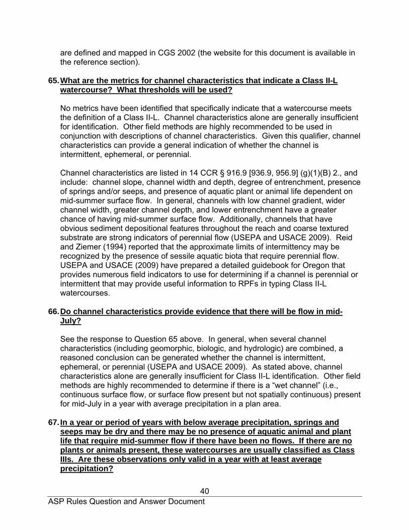
ASP Rules Question and Answer Document
40
are defined and mapped in CGS 2002 (the website for this document is available in the reference section).
65. What are the metrics for channel characteristics that indicate a Class II-L
watercourse? What thresholds will be used? No metrics have been identified that specifically indicate that a watercourse meets the definition of a Class II-L. Channel characteristics alone are generally insufficient for identification. Other field methods are highly recommended to be used in conjunction with descriptions of channel characteristics. Given this qualifier, channel characteristics can provide a general indication of whether the channel is intermittent, ephemeral, or perennial.
Channel characteristics are listed in 14 CCR § 916.9 [936.9, 956.9] (g)(1)(B) 2., and include: channel slope, channel width and depth, degree of entrenchment, presence of springs and/or seeps, and presence of aquatic plant or animal life dependent on mid-summer surface flow. In general, channels with low channel gradient, wider channel width, greater channel depth, and lower entrenchment have a greater chance of having mid-summer surface flow. Additionally, channels that have obvious sediment depositional features throughout the reach and coarse textured substrate are strong indicators of perennial flow (USEPA and USACE 2009). Reid and Ziemer (1994) reported that the approximate limits of intermittency may be recognized by the presence of sessile aquatic biota that require perennial flow. USEPA and USACE (2009) have prepared a detailed guidebook for Oregon that provides numerous field indicators to use for determining if a channel is perennial or intermittent that may provide useful information to RPFs in typing Class II-L watercourses.
66. Do channel characteristics provide evidence that there will be flow in mid-
July?
See the response to Question 65 above. In general, when several channel characteristics (including geomorphic, biologic, and hydrologic) are combined, a reasoned conclusion can be generated whether the channel is intermittent, ephemeral, or perennial (USEPA and USACE 2009). As stated above, channel characteristics alone are generally insufficient for Class II-L identification. Other field methods are highly recommended to determine if there is a “wet channel” (i.e., continuous surface flow, or surface flow present but not spatially continuous) present for mid-July in a year with average precipitation in a plan area.
67. In a year or period of years with below average precipitation, springs and
seeps may be dry and there may be no presence of aquatic animal and plant life that require mid-summer flow if there have been no flows. If there are no plants or animals present, these watercourses are usually classified as Class IIIs. Are these observations only valid in a year with at least average precipitation?

ASP Rules Question and Answer Document
41
Yes. These components of the “channel characteristics” field-based method require direct observation or use of local knowledge based on a year with at least average precipitation. In years with below average precipitation, other channel characteristics, as well as one or more office-based approaches, will need to be used to determine whether the watercourse is a Class II-L or not. Additionally, as stated in the answer to Question 66, additional field methods are highly recommended.
68. If an RPF does not have continuous streamflow monitoring data to use for Class II-L field method 14 CCR § 916.9 [936.9, 956.9] (g)(1)(B) 3., what other data would be an acceptable surrogate for streamflow? Without continuous streamflow data from headwater streams to determine the watershed drainage area necessary to initiate mid-summer streamflow, RPFs should use direct observation or local knowledge of mid-summer flow conditions (method described in 14 CCR § 916.9 [936.9, 956.9](g)(1)(B) 1.) and/or observation of channel conditions (method described in 14 CCR § 916.9 [936.9, 956.9](g)(1)(B) 2.), as well as one or more office-based approaches.
69. Why are the canopy standards for Class I watercourses in the non-CAZ areas
less than the standards for Class II-L watercourses in non-CAZ areas? Only two zones were established for Class II watercourses: a core zone and an inner zone (i.e., no outer zone delineation was established, as there are for Class I watercourses). For the non-CAZ area, the core zone requirements and inner zone canopy requirements for Class II-L and Class I requirements are designed to result in similar contributions to salmonid habitat by maintaining canopy for shade and a supply of large woody debris. Thus, there is a wider no-cut for Class I watercourses with slightly reduced outer zone canopy, and there is a narrower no-cut zone for Class II-L watercourses and slightly higher canopy cover for the outer part of the first 100 foot zone. For Class II-L watercourses in the CAZ, the core and inner zone requirements are identical.
70. Given that 14 CCR § 916.9(g)(2)(B)2.(i) only requires an increase in QMD if
commercial thinning is used, does the provision that prescriptions “should” focus on thinning from below still apply if single tree selection silviculture is used within the Class II-L WLPZ?
See the response to Question 17. For both the commercial thinning and single tree selection silvicultural methods, RPFs should attempt to complete a low thinning, or “thinning from below,” removing mainly suppressed and intermediate trees, with only very limited removal of co-dominants. The degree that this can be completed will depend on individual stand characteristics.
71. Where the plan submitter proposes to protect all Class II watercourses in the most restrictive manner (i.e., all Class II watercourses in the plan area are

ASP Rules Question and Answer Document
42
treated as a Class II-L), is differentiation between small and large Class IIs still required in the THP discussion and for THP maps?
If the plan submitter clearly states that all Class II watercourses, regardless of their attributes, are being provided Class II-L protection, then minimal discussion in the THP is necessary and mapping distinctions between the two types of watercourses are unnecessary. A landowner is afforded the option to spend less time in preparing a plan when providing greater protection measures on the ground.
72. In the Southern Subdistrict of the Coast Forest District, can you harvest a
stem from a coast redwood with multiple trunks that has some of its boles overlapping the edge of the channel, if you harvest the stem that does not have a bole overlapping the edge of the channel? Yes, however RPFs will still have to meet the other Class II watercourse requirements, which include: (1) maintaining 80% overstory canopy within the channel zone; (2) not harvesting more than 1/3 of the conifers 18 inches DBH or larger, (3) not harvesting 2/3 of the stems of redwoods with live roots permeating the bank, and (4) maintaining sufficient redwood trees ≥12 inches DBH so that they are not spaced more than 25 feet apart.
73. In the Southern Subdistrict of the Coast Forest District, can you harvest all stems from a coast redwood with multiple trunks that has live roots permeating the bank or providing channel grade control if you don’t exceed the harvesting limit of 1/3 of all redwood stems with this characteristic throughout the Class II WLPZ, or can you only harvest 1/3 of the trees within each multiple stemmed redwood that has live roots permeating the bank or providing channel grade control?
The ASP rules do not specifically restrict the number of stems allowed to be harvested from coast redwoods with multiple trunks. However, the ASP rules for the Southern Subdistrict of the Coast Forest District have been designed to provide a stable watercourse channel specifically through the retention of all trees within the channel zone, with boles extending into the channel zone, and with live roots permeating the bank of a watercourse. This is intended to better promote the retention and growth of the root biomass in the banks. Recognizing that coast redwood will retain much of its root biomass following harvest due to its capacity for coppice regeneration, the Board allowed harvesting of up to 1/3 of the redwood stems of any bank trees with live roots permeating the bank or providing channel grade control. However, there are several other requirements that must be met when considering how many stems can be removed adjacent to a Class II watercourse; especially from redwoods with multiple trunks (ref. 14 CCR § 916.9 (g)(3)) and the response to Question 72 above). The Departments prefer that RPFs retain trees dispersed evenly along the watercourse transition line where those conditions exist and maintain some stems when harvesting from redwoods with multiple trunks to minimize to the extent feasible the impacts to the existing root biomass providing bank stability along the channel. See Figure 19.

ASP Rules Question and Answer Document
43
Figure 19. Diagram illustrating how trees may be harvested along Class II watercourse channels in the SSD. 74. Show diagrams illustrating Class II watercourse requirements in the Southern
Subdistrict of the Coast Forest District—comparing and contrasting these requirements with those outside the SSD in the Coastal Anadromy Zone.
See Figures 20 and 21 below.
Figure 20. Large Class II diagram for the CAZ.

ASP Rules Question and Answer Document
44
Figure 21. Class II WLPZ protection measures for the SSD of the CAZ. 75. For Class III watercourses, what does it mean to retain hardwoods in the
Equipment Limitation Zone (ELZ) where feasible?
Retaining hardwoods where feasible means that the LTO must make a reasonable effort to produce a post-harvest stand with most of the hardwoods upright and in good condition. Hardwoods may be removed if they pose a safety hazard or otherwise impede other harvest activities.
76. Class III protections include: “Retain all countable trees needed to achieve
resource conservation standards in 14 CCR § 912.7 [932.7, 952.7] within the ELZ.” Clarification of what this means is necessary. Does this mean that large conifers must be retained in some locations?
RPFs are encouraged to review the Resource Conservation Standards under Article 5 in the Forest Practice Act, as well as 14 CCR § 912.7 [932.7, 952.7]. Immediately following harvest (not 5 years), the minimum stocking standards specified in the Act and the FPRs are to be met within the Class III ELZ. These standards should be easily met if unevenaged silvicultural systems are applied, and also where there is advanced regeneration when evenaged silviculture is prescribed. The intent of this rule section was to minimize disturbance to advanced regeneration when clearcutting is used to ensure functionality of the ELZ buffer immediately post harvest. If there is a wide diameter distribution present, ranging from large trees to seedlings, the countable tree requirement can be met with the smallest diameter trees and seedlings. If there is not advanced regeneration, RPFs will be required to leave larger trees to meet the Resource Conservation Standards, unless an “in lieu” practice is requested, with accompanying explanation and justification. Alternately, a considerably more detailed site-specific plan under 14 CCR § 916.9 [936.9, 956.9]

ASP Rules Question and Answer Document
45
(v) can be developed to harvest mature conifer trees in the Class III ELZ. Note that there are limited exceptions for these requirements for trees growing within the channel zone. See the response to Question 80.
77. 14 CCR § 916.9 [936.9, 956.9](h)(6) states that you must “retain all countable
trees needed to achieve resource conservation standards in 14 CCR § 912.7 [932.7, 952.7] within the ELZ.” It is unclear as to what is actually required to be retained and when, and then how compliance is to be determined. Multiple interpretations can be made. Depending on stand conditions this might require retention of numerous large conifer trees (e.g., where conifer regeneration is absent)—which is inconsistent with Board Forest Practice Committee discussions. Provide clarification for RPFs.
See the response to Question 76 above.
78. Does the language isolate Equipment Limitation Zones in terms of retaining
trees to meet the resource conservation standards of 14 CCR § 912.7 [932.7, 952.7]]? Does the language require that the resource conservation standards be achieved immediately upon completion of timber operations within ELZs? In other words, will one stocking survey have to be carried out for an ELZ and a separate survey for the adjacent harvest unit outside the ELZ? If yes, given the procedures in Article 5 have substantial issues with regard to use in Class III ELZs (i.e., plots wider than the ELZ), can other methods such as a 100% sample be used to determine compliance with the conditional retention standard? This Class III ELZ requirement only isolates the ELZ area for stocking standards in terms of time, since the resource conservation standards (i.e., stocking standards) must be met immediately upon completion of timber operations within the ELZ. Plots do not have to be installed within the ELZ to determine if the stocking standards have been met. CAL FIRE will not request stocking standard reports for ELZs unless there appears to be a violation of the FPRs. A 100% sample could be used to determine compliance with this rule for enforcement purposes. See Figure 22 below, where a 50 foot wide ELZ x 871 feet = 43,560 ft2 or 1 acre.
Figure 22. Illustration showing how Class III ELZ stocking is to be determined. 79. Can hardwoods retained in ELZs be counted towards meeting the conditional
retention standard? If hardwoods can be counted toward retention, is there a ceiling in terms of how many hardwoods can be counted?

ASP Rules Question and Answer Document
46
Yes, hardwoods can be counted towards meeting the conditions of the resource conservation standards, provided they follow the applicable requirements outlined in 14 CCR §§ 912.7 [932.7, 952.7] (d) and 913.11 [933.11, 953.11](c)(1)-(2).
80. For a Class III ELZ with large, non-sprouting Group A species (e.g. Douglas-fir)
and assorted hardwoods, if you cut all the conifers, you change the Group A to Group B species ratio. The rules under 14 CCR § 912.7 [932.7, 952.7] say that "the percentage of the stocking requirements met with Group A species shall be no less than the percentage of the stand basal area they comprised before harvesting." Is it correct to assume that since this standard must be met immediately after harvest, you have to leave the same ratio of conifer stocking to hardwood stocking as was present before harvesting? If Group A species will recapture the site after harvest, does one have to leave the same ratio of conifer to hardwood stocking? 14 CCR § 916.9 [936.9, 956.9](h) allows for an exception, where the RPF may choose to explain and justify why it would be acceptable to harvest the mature conifer trees in the ELZ. The Departments believe that an RPF can propose an exception to the 14 CCR § 912.7 [932.7, 952.7] standard. This should make dealing with this issue more straightforward, and it provides an avenue for proposing alternate management that does not involve 14 CCR § 916.9 [936.9, 956.9] (v), the site-specific plan approach, which would require considerably more detailed information.
81. Regarding Class III watercourses, is there a requirement to flag the ELZ boundary?
There is no requirement to flag the boundaries of the ELZ. The standard rules require that areas of equipment use within the ELZ be described in the plan or flagged or marked on the ground prior to the PHI. Under the ASP rules, with hardwood protection, stocking considerations, large, downed wood retention, etc., the RPF will have to determine on a case-by-case basis whether flagging the ELZ will be necessary to prevent an LTO from adversely impacting the ELZ.
82. Does the language in 14 CCR § 916.9 [936.9, 956.9] (h)(8) modify subsection
(h)(1) to allow for the construction of new tractor crossings of Class III watercourses?
Yes, construction of new tractor crossings of Class III watercourses is permitted.
83. 14 CCR § 916.9 [936.9, 956.9](l) uses the term “low antecedent soil moisture.”
Provide a useful definition of this term.
The term “low antecedent soil moisture” has been used in the Board’s rules for several years. It can be defined as low soil moisture levels prior to precipitation inputs.

ASP Rules Question and Answer Document
47
84. Does the definition of saturated soil conditions in an approved plan supersede the definition in the ASP rules effective January 1, 2010?
No. As specified in PRC § 4583, the new ASP rules adopted by the Board apply to any approved plan unless “prior to the adoption of such changes or modifications, substantial liabilities for timber operations have been incurred in good faith and in reliance upon the standards in effect at the time the plan became effective and the adherence to such new rules or modifications would cause unreasonable additional expense to the owner or operator.” The Department will consider each case made for not following the ASP rules on the evidence and explanation provided (also ref. the response to Question 5).
85. Explain how the new ASP water drafting rules differ from the old T/I rule
requirements.
The Board found that the existing water drafting rules created redundant documentation requirements with Fish and Game Code § 1600 et seq. Streambed Alteration Agreements. The amended language in 14 CCR § 916.9 [936.9, 956.9](r) provides a more streamlined permitting process than the old T/I rules. The new ASP rule makes clear FGC § 1600 authority and the use of the THP as notification. The new language clarifies the information necessary for disclosure and evaluation of water drafting projects in THPs; clarifies compliance with Fish and Game Code section 1600 et seq. for Lake and Streambed Alteration Agreement (LSAA) notification; and provides basic water drafting operational requirements, unless otherwise specified in a LSAA issued by DFG. Specific changes are described below. The most substantive change in the proposed amendment is the requirement contained in 14 CCR § 916.9 [936.9, 956.9](r)(1) that requires water drafting for timber operations to comply with Fish and Game Code § 1600 et seq. Prior rule language prohibited water drafting under certain circumstances unless the RPF provided a drafting plan and, if necessary, a DFG-issued LSAA. Other substantive changes that are included in subsection (r) include the following new information disclosure requirements:
(r)(2)(E) - Describe the estimated drainage area (acres) above the point of diversion; (r)(2)(I) - Describe the methods that will be used to measure source streamflow, and new requirements for conduct of water drafting; (r)(3)(C) - Barrier installation to prevent sediment transport; and (r)(3)(D) - Use of drip pans to capture motor oil or hydraulic fluid leaks.
86. Provide examples of subsection (v) approaches that meet the standard that
the prescription will result in effects “equal or more favorable” than those expected to result from the application of the standard rule requirements in 14 CCR § 916.9 [936.9, 956.9] (examples involving flood prone areas and the fuel hazard reduction provisions are appropriate).

ASP Rules Question and Answer Document
48
The following scenarios provide examples of site-specific measures that could potentially meet the standards specified in 14 CCR § 916.9 [936.9, 956.9] subsection (v):
Example A: Flood Prone Area Setting: A flood prone area exists along a significant river in the Coast Ranges of California that was previously in agricultural use. Twenty years ago this area was planted with conifer seedlings, which are now sapling and pole sized trees. The stand is extremely dense with close to 400 stems per acre, since no pre-commercial thinning activities were conducted within the plantation. Proposal: The RPF proposes to thin the stand, going from 400 trees per acre (TPA) to approximately 150 TPA. Thinning will occur throughout the stand (i.e., from the WTL to the edge of the flood prone area). Analysis: This proposal will not meet the no harvest requirement for the core zone and will not meet the overstory canopy requirements for the inner zone. This prescription appears reasonable, however, since it will allow the remaining trees to grow much larger in a considerably shorter time (reducing the time required for trees to provide critical riparian functions such as shading, large wood recruitment, etc.). This proposal will meet the objectives in 14 CCR § 916.9 (c)(5), creating favorable habitat in a more timely manner than would occur with the prescriptive standard. Example B: Fuel Hazard Reduction Setting: A Class I watercourse located in the Sierra Nevada was subjected to a catastrophic wildfire 50 years ago. The area naturally regenerated, producing an overly dense stand both in the riparian zone and on the adjacent hillslopes. Fire behavior models show that this area is once again highly prone to catastrophic wildfire (i.e., a rapidly moving crown fire). Listed anadromous fish use the Class I watercourse. Proposal: The RPF proposes a prescription to reduce surface fuels, intermediate fuels, and co-dominate fuels (i.e., “ladder fuels”) in the stand beyond the standards in the ASP rules. This treatment is to occur both in the Class I WLPZ core, inner, and outer zones, as well on the hillslopes beyond the WLPZ, creating a landscape-level fire hazard reduction project. Analysis: Since the area has an established fire history and fire behavior models document a significant problem, the RPF is able to make a valid case for removing trees and other vegetation beyond the standards in the ASP rules. In addition to describing how the stand will be improved for potential future timber production, the RPF should include a discussion of how the riparian functions necessary for salmonid life stages will be better secured and maintained by the fuel reduction treatment.
ASP Rules Question and Answer Document
49
87. Explain how section (v), site-specific plans, can be used in a practical manner, and how the equal to or more favorable standard will allow these types of practices to be used. Is there a time element involved, so that riparian conditions can be improved in 20-30 years, but not initially?
See the response for Question 86 above. The Board did not specify that riparian conditions could be improved several decades after treatment, but RPFs can discuss this approach with the reviewing agencies with pre-project development consultations. An example of this situation would be where a riparian stand is entirely composed of red alder and the Class I watercourse is devoid of functioning large wood. The proposal would be to rehabilitate the stand by removing patches of the red alder stand and replanting with coast redwood and Douglas-fir seedlings.
88. What is the simplest way to get a site-specific plan under 14 CCR § 916.9
[936.9, 956.9](v) approved by the Review Team agencies?
Under 14 CCR § 916.9 [936.9, 956.9](v)(2) for alternate measures limited to specific sites, all the RPF needs to do is pre-consult with DFG and obtain written concurrence prior to plan submittal (i.e., written concurrence negates the need for further documentation). Note however, that for a site-specific plan for a flood prone area, subsection (v)(5)(I) specifies that the site-specific plan must have pre-consultation with the Review Team agencies and receive concurrence from the Review Team agencies, including DFG.
References
Berbach, M., P. Cafferata, T. Robards, and B. Valentine. 1999. Forest canopy measurements in
watercourse and lake protection zones: a literature review. Final Report dated June, 1999. California Department of Forestry and Fire Protection. Sacramento, CA. 21 p. BOF (State Board of Forestry and Fire Protection). 2008. Staff report for the scientific literature review of forest management effects on riparian function for anadromous salmonids. Sacramento, CA. 12 p. plus Appendices (including Appendix 3--Primers). Primers are available online at:
http://www.bof.fire.ca.gov/board_committees/technical_advisory_committee_(tac)_/tac_documents/t_i_scopeofwork__final_approved5_11_07_.pdf
Brown, G.W. 1980. Forestry and water quality. Oregon State University Book Stores, Inc. School of Forestry. Oregon State University, Corvallis. 124 p. Cafferata, P., M. Berbach, J. Burke, J. Hendrix, R. Klamt, R. Macedo, T. Spittler, K. Vyverberg, and C. Wright-Shacklett. 2005. Flood prone area considerations in the coast redwood zone. Final Report of the Riparian Protection Committee. California Department of Forestry and Fire Protection. Sacramento, CA. 67 p. Available online at: http://www.fire.ca.gov/resource_mgt/downloads/RiparianProtComWhitePaperfinal.pdf CGS (California Geological Survey). 2002. California geomorphic provinces. Note No. 36. California Department of Conservation. Sacramento, CA. 4 p. Available online at: http://www.consrv.ca.gov/cgs/information/publications/cgs_notes/note_36/Documents/note_36.pdf Chan, S.S., D.J. Lason, K.G. Maas-Hebner, W.H. Emmingham, S.R. Johnston, and D.A. Mikowski. 2006. Overstory and understory development in thinned and underplanted Oregon Coast Range Douglas-

ASP Rules Question and Answer Document
50
fir stands. Can. J. For. Res. 36: 2696-2711. Available online at: http://www.fs.fed.us/pnw/pubs/journals/pnw_2006_chan001.pdf Fiala, A.C.S., S.L. Garman, and A.N. Gray. 2006. Comparison of five cover estimation techniques in the western Oregon Cascades. Forest Ecology and Management 232: 188-197. Available online at: http://www.fs.fed.us/pnw/pubs/journals/uncaptured/pnw_2006_fiala001.pdf Fritz, K.M., Johnson, B.R., and Walters, D.M. 2006. Field operations manual for assessing the hydrologic permanence and ecological condition of headwater streams. EPA/600/ R-06/126. U.S. Environmental Protection Agency, Office of Research and Development, Washington DC. Available online at: http://www.epa.gov/eerd/manual/headwater/HISSmanual-cover.pdf
Ligon, F., A. Rich, G. Rynearson, D. Thornburgh, and W. Trush. 1999. Report of the Scientific Review Panel on California Forest Practice Rules and salmonid habitat. Final Report prepared for the California Resources Agency and the National Marine Fisheries Service. Sacramento, CA. 181 p. Available online at: http://www.krisweb.com/biblio/cal_nmfs_ligonetal_1999_srprept.pdf
MRC (Mendocino Redwood Company). 2009. Habitat Conservation Plan/ Natural Community Conservation Plan. Draft 5. April 2009. Ukiah, CA. Mount, J.F. 1995. California rivers and streams. University of California Press. 359 p. Nakamura, G. 2000. Canopy measurement workshop summary. Workshop held at Millseat Creek near Shingletown, CA on June 1, 2000. University of California Cooperative Extension, Redding, CA. 6 p. Available online at: http://www.fire.ca.gov/CDFBOFDB/pdfs/CanopyMeasurementWorkshop.pdf Rapp, C.F. and T.B. Abbe. 2003. A framework for delineating channel migration zones. Ecology Publication #03-06-027. Department of Ecology. Olympia, WA. 139 p. Available online at: http://www.ecy.wa.gov/pubs/0306027.pdf Rantz, S.E. 1969. Mean annual precipitation in the California region: U.S. Geological Survey Open-File Map (reprinted 1972, 1975). Reid, L.M. and R.R. Ziemer. 1994. Evaluating the biological significance of intermittent streams. Summary of an interdisciplinary workshop held at the Humboldt Interagency Watershed Analysis Center, McKinleyville, CA on 4 May, 1994. USDA Forest Service, Pacific Southwest Research Station. 18 p. Available online at: http://www.fs.fed.us/psw/publications/reid/2IntermitStr.htm Robards, T.A. 1999. Instructions for WLPZ canopy/surface cover sampling. California Department of Forestry and Fire Protection. Sacramento, CA. 9 p. Robards, T.A, M.W. Berbach, P.H. Cafferata, and B.E. Valentine. 2000. A comparison of techniques for measuring canopy in watercourse and lake protection zones. California Forestry Note No. 115. California Department of Forestry and Fire Protection, Sacramento, CA. 15 p. Available online at: http://www.demoforests.net/Warehouse/Docs/ForestryNotes/Note115.pdf
Rosgen, D. 1996. Applied river morphology. Wildland Hydrology. Pagosa Springs, CO.
SWC (Sound Watershed Consulting). 2008. Scientific literature review of forest management effects on riparian functions for anadromous salmonids. Final Report prepared for the California State Board of Forestry and Fire Protection. Oakland, CA. 328 p. Available online at: http://www.soundwatershed.com/board-of-forestry.html

ASP Rules Question and Answer Document
51
USEPA (United States Environmental Protection Agency) and USACE (United States Army Corps of Engineers). 2009. Oregon streamflow duration assessment method--Interim Version. Brian J.D. Topping, Tracie-Lynn Nadeau, Michael R. Turaski. Public Notice release date, 6 March 2009. Portland, OR. 60 p. Available online at: http://pebb.das.state.or.us/DSL/PERMITS/docs/osdam_march_2009.pdf
Vales, D.J. and F.L. Bunnell. 1985. Comparison of methods for estimating forest overstory canopy. Research, Ministries of Environment and Forests. IWIFR-20. Victoria, B.C. 93 p. plus Appendix.
Waananen, A.O., and J.R. Crippen. 1977. Magnitude and frequency of floods in California: U.S. Geological Survey Water-Resources Investigations Report 77-21. 96 p. WFPB (Washington Forest Practices Board). 2004. Section 2. Standard methods for identifying bankfull channel features and channel migration zones. Forest Practices Board Manual. Washington Department of Natural Resources. Olympia, WA. 69 p. Available online at: http://www.dnr.wa.gov/Publications/fp_board_manual_section02.pdf