Embed Size (px)
Citation preview

Analytical and Computer Cartography Winter Quarter 2017
Lecture 15: Technical Issues for 3D rendering

Virtual Globes: Wikipedia • A 3D software model or representation of the Earth or
another world. • Provides the user with the ability to freely move around
in the virtual environment by changing the viewing angle and position.
• Can represent many different views on the surface of the Earth: geographical features, man-made, abstract representations of demographic quantities such as population.
• In 1998, Microsoft released a popular offline virtual globe in the form of Encarta Virtual Globe 98
• First widely publicized online virtual globes were NASA World Wind (released in mid-2004) and Google Earth (mid-2005)

Examples • NASA World Wind* • CitySurf Globe • Bing Maps • SkylineGlobe • Google Earth • Marble, part of the K Desktop Environment, with
OpenStreetMap* • ArcGIS Explorer • EarthBrowser • Software MacKiev's 3D Weather Globe & Atlas • Earth3D* • WorldView • Bhuvan

Virtual Geographic Reality
• Immersive Virtual reality • Personal virtual reality • Group immersion environments • Web-based virtual reality • Augmented reality

Google Cardboard ($15)


Some history • Mid 1950s, visionary cinematographer Morton H. Eilig built a
single user console called Sensorama – stereoscopic display – Fan emitters – stereo speakers – moving chair
• 1961, Philco Corporation developed the first HMD the “Headsight.” – helmet had a video screen and tracking system. – linked to a closed circuit camera system – used for helicopter pilots
• In 1965, Ivan Sutherland envisioned what he called the “Ultimate Display.” – During 1966, Sutherland built a tethered VR system

Sensorama and Headsight

Sutherland (1965) Flight Simulator

True VR: Immersive, interactive, multi-sense

How does it work?
• Synchronized sound and video
• Stereo separation by isolated lenses
• Head movement sensing
• Reduced frame and interaction lag

Some issues in 3D rendering
• Level of Detail and map generalization • Media and devices • Image cross registration: geometry • Interactivity • Tools • Realism: Differs in 2D, 3D, AR and VR • Virtual environment vs. reality • Models

Realism and human perception

Streetview vs. Openstreetmap

Modeling issues in a 3D World • Cartographic Generalization • Level of Detail • 3D measurement systems • 3D modeling and data structures • 3D standards for Geospatial data • Open Source Programming Libraries • 3D in Geobrowsers (Google Sketch-up,
Earth and Bing Maps)

Generalization in Cartography
• Selection • Simplification • Combination • Displacement • Exaggeration

GIS: Scale Range Viewing

Scalemaster (Buttenfield and Brewer)

Generalization in Computer Graphics: Level of Detail
• James H. Clark (1976) Hierarchical Geometric Models for Visible Surface Algorithms. Communications of the ACM, October 1976,19, 10. pp 547-554.

Generalization and LOD

LoD demonstration tools
• Meshlab • Simplygon • Vizup • Rational Reducer • Pro Optimizer • OpenSG

VRML 2.0 LOD Example #VRML V2.0 utf8 LOD { range [20,40] level [ #full detail 16 sided cone Shape{ appearance Appearance { material Material { diffuseColor 1.0 1.0 1.0 } } geometry Extrusion{ crossSection [ -1 0, 0 0, -1 -2 -1 0] spine [1 0 0 , 0.866 0 0.5, 0.5 0 0.866, 0 0 1 , -0.5 0 0.866, -0.866 0 0.5, -1 0 0, -
0.866 0 -0.5, -0.5 0 -0.866, 0 0 -1 , 0.5 0 -0.866, 0.866 0 -0.5, 1 0 0 ] } } #intermediate detail 8 sided cone Shape{ appearance Appearance { material Material { diffuseColor 1.0 1.0 1.0 } } geometry Extrusion{ crossSection [ -1 0, 0 0, -1 -2 -1 0] spine [1 0 0 , 0.707 0 0.707 , 0 0 1 , -0.707 0 0.707, -1 0 0,-0.707 0 -0.707, 0 0 -1 ,
0.707 0 -0.707, 1 0 0 ] } } #low detail 4 sided cone Shape{ appearance Appearance { material Material { diffuseColor 1.0 1.0 1.0 } } geometry Extrusion{ crossSection [ -1 0, 0 0, -1 -2 -1 0] spine [1 0 0 , 0 0 1, -1 0 0, 0 0 -1 , 1 0 0 ] } } ] }
•

3D measurement systems
• First generation DEMs, photogrammetry and contour conversion
• Second generation based on SAR and IFSAR • SRTM near global coverage, 30m/90m • NED completed at 30m, then 15m+ • LIDAR now taking over • New variants on LiDAR (Flash, Full waveform) • IR mapping e.g. Microsoft Kinect • Camera systems: image to 3D model

Software (See: wiki entry) • 3dsmax • AC3D • Ayam • AOI • Blender • Carrara • Cheetah 3D • Cinema 4D • CityEngine • Cobalt • Electric Image
Animation System • Form-Z
• Houdini • Hypershot • Hypermove • Lightwave3D • MASSIVE • Maya • Modo • plugin3D • POV-Ray • Pro/Engineer • Quest 3D creative • Quest 3D Power • Quest 3D VR
• Relux Professional • Rhinocerous 3D • Silo • SketchUp/Pro • Softtimage • Solid Edge • solidThinking • SolidWorks • Swift3D • trueSpace • ViewBuild3D • VR4MAX • Vue • ZBrush

3D standards for Geospatial data
• VRML and GeoVRML • X3D and OGC, Geospatial component and X3D
Earth (e.g. Planet9 London) • OGC CityGML • Web3D Service • LandXML.org • COLLADA /KML (SONY, Google) • National 3D-4D-BIM Program (USGSA) • 3DVIA (Bing Maps)

Open Source Programming Libraries
• VTK • Gorgon • G3D Engine • Cairo graphics • OGRE • OpenScene Graph • Expression 3D • libAfterimage • Libart • Interactive Visualization
Framework • Graphix • Dislin • MESA • LibXMl
• SciTech MGL • ImageMagick • LibWMF • Paintlib • PNG, TIFF, shape, JPEG • gdLib

3D in Geobrowsers
• Picture and panorama inclusion • Google streetview • GoogleEarth 3D Buildings • Bing Maps 3D and oblique views • Microsoft Photosynth • Most geobrowsers include topography

Visualization
• Volunteered 3D information and multimedia: participatory sensing
• Visual Analytics • Visualization of Uncertainty • Spatialization

Volunteered 3D information and multimedia
• Volunteered Geographic Information • Use Contributed Content • Examples: Google MyMaps, Flickr,
Panoramio, YouTube, 4Square, Geocaching
• Can be institutionalized: e.g. National Map Corps.
• Data can be mined for content

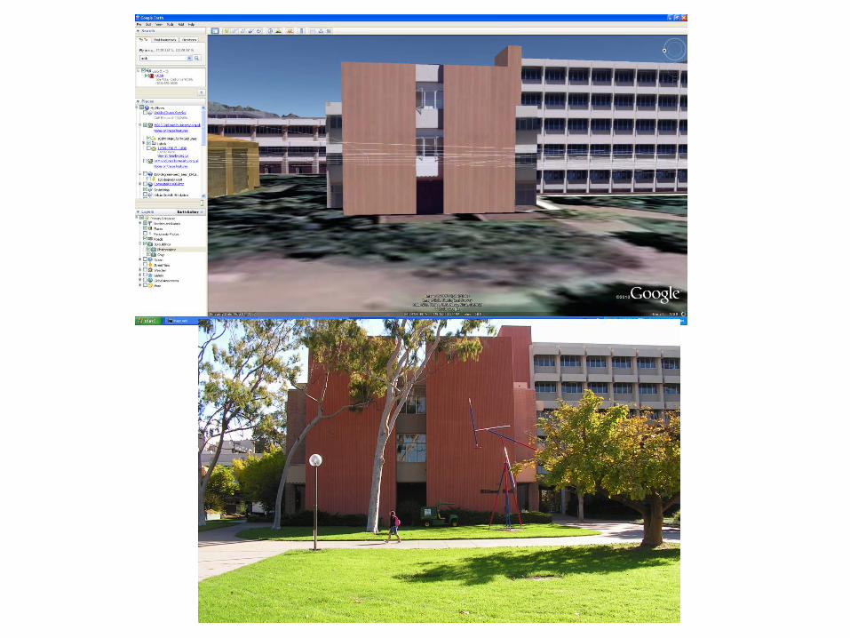
Microsoft Photosynth • Use of multiple volunteered images to
create camera viewing geometry • Create zoom/pan view in great detail • Others include PhotoFly (Autodesk) and bundler
Bundler • Structure-from-motion system for unordered
image collections (for instance, images from the Internet) written in C and C++. Opensource, UWash+Cornell
• Outdoor game: http://photocitygame.com/ • “Our ultimate goal is to reconstruct the entire
world, one photo at a time.”

Visualization of Uncertainty
Prof. Dr. Bernd Fröhlich Visualization of Uncertainty: Visualizing Errors and Uncertainties in Geo-Scientific Data http://www.uni-weimar.de/cms/medien/vr/research/visualization/scivis/uncvis.html

Uncertainty issues

Spatialization

DEMView
M. B. Gousie. Wheaton College. http://cs.wheatoncollege.edu/~mgousie/research.html#errorviz

Virtual Reality: The Allosphere

A globe inside a globe?

Mapping Interior Spaces
• Issue of coordinate systems • Different accuracy needs • GPS/GNSS does not work! • What is an interior space? • Can different methods be used in
combination? • NGA funded work under NURI: Jorge Chen

Indoor Standards Highlighted Standards ● Industry Foundation Classes (IFC) ● City Geography Markup Language (CityGML) ● Indoor Geography Markup Language (IndoorGML) Other CAD Standards ● CIMsteel Integration Standards (CIS/2) ● Drawing Exchange Format (DXF) Other GIS Standards ● Shapefile ● Geodatabase ● Building Information Spatial Data Model (BISDM) ● Keyhole Markup Language (KML) CGI Modeling Standards ● Extensible 3D (X3D) and GeoVRML (predecessor) ● COLLAborative Design Activity (COLLADA) ● 3D PDF ● Minecraft Chunk

CityGML Model of New York City by: DOITT Cadastre footprints + LiDAR
https://tinyurl.com/glgzn7z

How to generate 3d model?
• Need many images from different angles • Overlap creates stereo model • Agisoft Photoscan then extracts model
and assigns point cloud with color • Can process with Meshlab,
CloudCompare, other software • Match with LiDAR and imagery data • Our answer: LiDAR + Drone (Quadcopter)

Phantom 4 with collision avoidance
Scans height by IR sensor Position using GPS Fully gimballed camera Can be programmed to collect video or interval images 20 minutes of flight with rechargeable batteries Flight planning software, smartphone or tablet piloting

Space abstraction
Point Cloud
Triangulated Irregular Network
Voxels

Problem of coordinate systems

Proposed Methodology
• Step 1: Global alignment (coarse alignment) – Get a “close enough” alignment for ICP – Three common tie points, distributed along
the 3 axes • Step 2: Variation of ICP algorithm (fine
tuning) -- Minimize the overall error in model fit

Proposed Methodology
• Step 2: (Continued) – Constrain transformations to 2D rotations & translations – Iterate based on RMSE threshold or max. iterations
• Minimize residuals between model-to-LiDAR points • Pivot/translate about geometric center of matched points • Progressively prune outliers as model and LiDAR converge
1. Perform rotations until stable • x-axis => y-axis => z-axis, individually
2. Perform translation • Simultaneous translation along all three axes
3. Calculate RMSE • If RMSE > threshold (or) iterations < max. iterations, go to 1. • Or check for convergence

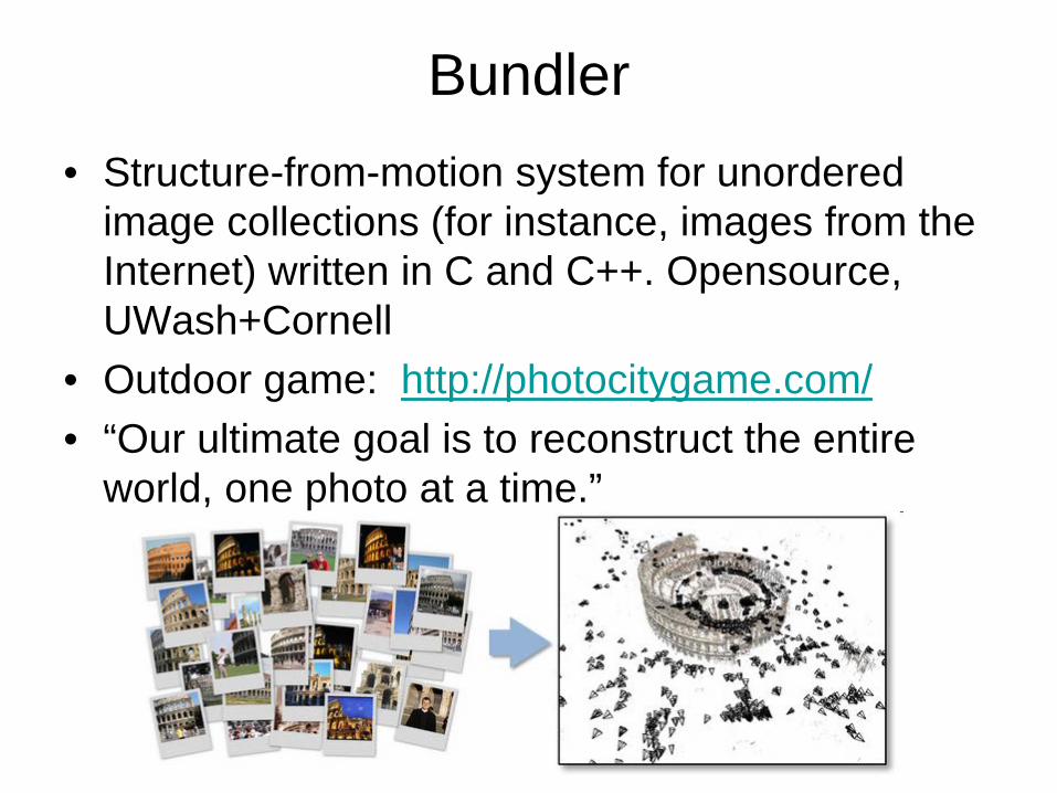
Art Museum Case Study: Single Building
Model local coordinates
Aerial LiDAR Point Cloud geodetic coordinates
(CA State Plane Zone 5)
Actual Data
Rough Global Alignment
Est. RMSE Overall: 1.007
m X: 0.640 m Y: 0.554 m Z: 0.544 m
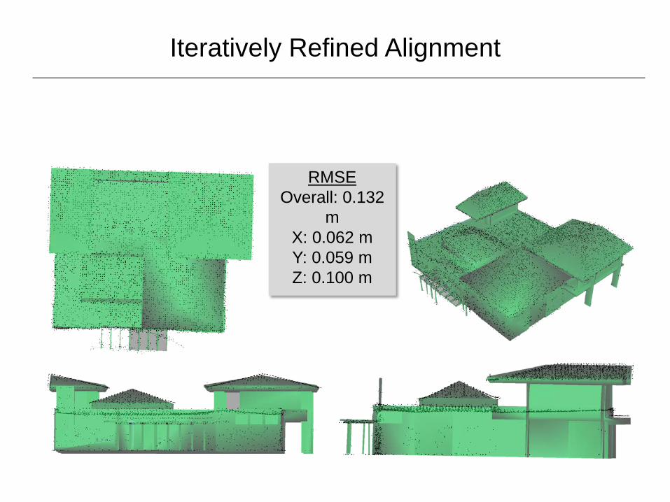
Iteratively Refined Alignment
RMSE Overall: 0.132
m X: 0.062 m Y: 0.059 m Z: 0.100 m

Indoor Model in Geodetic Coordinates
𝑀1 =
5.841𝐸 − 07 −9.998𝐸 − 04 −1.821𝐸 − 05 1.831𝐸 + 06 1.000𝐸 − 03 5.973𝐸 − 07 −7.194𝐸 − 07 6.022𝐸 + 05 7.302𝐸 − 07 −1.820𝐸 − 05 9.998𝐸 − 04 −7.865𝐸 + 01
0.0 0.0 0.0 1.0
𝑀2 =
9.995𝐸 − 01 3.193𝐸 − 02 1.163𝐸 − 03 −8.821𝐸 − 01 −3.193𝐸 − 02 9.995𝐸 − 01 2.607𝐸 − 03 1.466𝐸 + 00 −1.080𝐸 − 03 −2.643𝐸 − 03 1.000𝐸 + 00 5.922𝐸 − 01
0.0 0.0 0.0 1.0

Costa Concordia Case Study

Summary
• Virtual globes—coming of age, new devices • Exploits stereo vision • Spectrum from augmented to immersive
virtual • Some new issues: visualization methods,
LOD, uncertainty, etc • Modeling issues, software and standards • New mapping: interior spaces