Embed Size (px)
Citation preview

Uranium Mines and Deposits in the Grants district, Cibola and McKinley Counties, New Mexico
Virginia T. McLemore and
William L. Chenoweth
New Mexico Bureau of Mines and Mineral Resources Open-file Report 353
Revised December 1991
1

List of Maps
Map 1 - Location of uranium deposit maps of the Grants uranium district, New Mexico.
Map 2 - Uranium ore deposits and mines in the Jackpile-Paguate mine area, Laguna
subdistrict, Grants uranium district, Cibola County, New Mexico.
Map 3 - Uranium deposits and mines in the Ambrosia Lake subdistrict Grants uranirm
district, McKinley and Cibola Counties, New Mexico.
Map 4 - Uranium deposits in the Borrego Pass area, Ambrosia Lake subdistrict, Grants
uranium district, McKinley County, New Mexico.
Map 5 - Uranium deposits and mines in the Smith Lake subdistrict, Grants uranium district,
McKinley County, New Mexico.
Map 6 - Uranium mines and deposits in the Churchrock subdistrict, Grants uranium district,
McKinley County, New Mexico.
Map 7 - Uranium deposits in the Crownpoint area, Grants uranium district, McKinley
County, New Mexico.
Map 8 - Uranium deposits in the Nose Rock area, Grants uranium district, McKinle:?
County, New Mexico.
2

The purpose of this report is to present a series of maps showing the approximate
outlines of uranium deposits and areas of signiscant mineralization. Mines and prospects are
also shown on the maps. The data presented here are intended to supplement McLemore and
Chenoweth (1989) and to aid exploration and mining companies in locating and developing
these deposits. The data may also be useful for administrators in local, state, and federal
government agencies who require this information for environmental studies, land-use
decisions, and other planning actions. The data will be updated periodically and u1ti:nately
published by NMBMMR in the future and any updates and/or corrections will be greatly
appreciated.
The approximate outlines of the uranium deposits were obtained from a variety of
sources including published and unpublished reports. Most sources are referenced on each of
the maps. In addition to published reports, mine and uranium deposit maps and other data
were obtained from a number of mining Companies and the files of the U.S. Atomic Energy
Commission, Grand Junction (Colorado) Office. Several geologists from various conpanies
review portions of the maps, including M. H. Alief (Chevron Resources Co.), J. Greenslade
(retired, Phillips Petroleum Co.), D. C. Pitch and J. E. Motica @ala Mining Co.), J. H.
Jackson (Santa Fe Mining, Inc.), and H. E. Whitacre (Quivira Mining Co., now Rio Algom
Mining Corp.). George W. Hazlett (retired, United Nuclear Corp.) and Harlen K. Folen
(retired, U.S. Department of Energy) reviewed all of the maps and assisted in plottirg the
oxidation-reduction interface in the Morrison Formation. Warren I. Finch (U.S. Geological
Survey) and William Hatchell (New Mexico Department of Natural Resources) also reviewed
all of the maps. However, the authors assume full responsibility for the data presented.
3

Production data for each mine are presented in Table 1 up through 1970. T h e data
were obtained from the U.S. Atomic Energy Commission files. Production data for each
mine from 1971 to 1988 are confidential and summarized in Table 2. Additional production
data are presented in McLemore (1983a) and McLemore and Chenoweth (1989). Statistics
on reserves are from various cited references, however reserve data are not available. for
most deposits.
The geologic setting, host rocks, size, geometry, and mineralogy of uranium deposits
in the Grants district are summarized elsewhere and not repeated here. The reader is
referred to McLemore and Chenoweth (1989), Turner-Peterson and others (1986), Rautman
(1980), Hilpert (1969), and Kelley (1963) for more information.
4

References
Adam, S. S., and Saucier, A. E., 1981, Geology and recognition criteria for uraniferous
humate deposits, Grants uranium region, New Mexico-fhal report: U.S.
Department of Energy, Report GJBX-2-81, 226 pp. (Open-file Report)
Anderson, 0. J., 1980, Abandoned or inactive uranium mines in New Mexico: New Mexico
Bureau of Mines and Mineral Resources, Open-fie Report 148, 778 p., photcs, maps.
Baird, C. W., Martin, K. W., and Lowry, R. M., 1980, Comparison of braided-stream
depositional environment and uranium deposits at Saint Anthony underground mine;
h Rautman, C. A. (compiler), Geology and mineral technology of the Grants
uranium region 1979: New Mexico Bureau of Mines and Mineral Resources, Memoir
38, p. 292-298.
Beck, R. G., Cherrywell, C. H., Earnest, D. F., and Feirn, W. C., 1980, Jackpile-Paguate
deposit-a review; h Rautman, C. A. (compiler), Geology and mineral techmlogy of
the Grants uranium region 1979: New Mexico Bureau of Mines and Mineral
Resources, Memoir 38, pp. 269-275.
Chapman, Wood, and Griswold, Inc., 1979, Geologic map of Grants uranium region: New
Mexico Bureau of Mines and Mineral Resources, Geologic Map 31, scale 1:126,720.
Chenoweth, W. L., 1985, Ristorical review of uranium production from the Todilto
Limestone, Cibola and McKinley Counties, New Mexico: New Mexico Geol?gy, v.
7, no. 4, pp. 80-83.
Chenoweth, W. L., 1989, Geology and production history of uranium deposits in the Dakota
Sandstone, McKinley County, New Mexico: New Mexico Geology, v. 11, p 21-29.
5

Clark, D. S., 1980, Uranium ore rolls in Westwater Canyon Sandstone, San Juan Besin,
New Mexico; In Rautman, C. A. (compiler), Geology and mineral technology of the
Grants uranium region 1979: New Mexico Bureau of Mines and Mineral Resources,
Memoir 38, p. 195-201.
Clary, T. A., Mobley, C. M., and Moulton, G. F., Jr., 1963, Geological setting of an
anomalous ore deposit in the Section 30 mine, Ambrosia Iake aea; Kelley, V. C.
(compiler), Geology and mineral technology of the Grants uranium region: Few
Mexico Bureau of Mines and Mineral Resources, Memoir 15, p. 72-79, 6 figs.
Day, H. C., Spirakis, C. S., Ztxh, R. S., Kirk, A. R., 1983, Distribution of trace elements
in drilling chip samples around a roll-type uranium deposit, San Juan Basin, Phw
Mexico: U.S. Geological Survey, Open-file Report 83-56, 26 p., 1 table, 11 figs.
Fishman, N. S., and Reynolds, R. L., 1982, Origin of the Mariano Lake uranium deposit,
McKinley County, New Mexico: U.S. Geological Survey, Open-file Report 82-888,
52 PP-
Fishman, N. S., and Reynolds, R. L., 1986, Origin of the Mariano Lake uranium deposit,
McKinley County, New Mexico; Turner-Peterson, C. E., Santos, E. S., and
Fishman, N. S. (eds.), A basin analysis case study: The Momson Formation, Grants
uranium region, New Mexico: American Association of Petroleum Geologist.,
Studies in Geology 22, pp. 211-226.
Hazlett, G. W., and Kreek, J., 1963, Geology and ore deposits of the southeastern part of
the Ambrosia Lake area; Kelley, V. C. (compiler), Geology and mineral
technology of the Grants uranium region: New Mexico Bureau of Mines and Mineral
6

Resources, Memoir 15, pp. 82-89.
Hilpert, L. S., 1969, Uranium resources of northwestern New Mexico: U.S. Geological
Survey, Professional Paper 603, 166 pp.
Holen, H. K., and Hatchell, W. O., 1986, Geological characterization of New Mexim
uranium deposits for extraction by in situ leach recovery: New Mexico Bureau of
Mines and Mineral Resources, Open-file Report 251,93 pp.
Holmquist, R. J., 1970, The discovery and development of uranium in the Grants m'neral
belt, New Mexico: U.S. Atomic Energy Commission, Report RME-172, 122 p.
(Open-ae Report)
Hoppe, R., 1978, The jackpot at Jackpile is still paying off: Engineering and Mining
Journal, November, p. 86-90.
Hoskins, W. G., 1963, Geology of the Black Jack No. 2 mine, Smith Lake area; Kelley,
V. C. (compiler), Geology and technology of the Grants uranium region: New
Mexico Bureau of Mines and Mineral Resources, Memoir 15, pp. 49-52.
Jacobsen, L. C., 1980, Sedimentary controls on uranium ore at L-Bar deposits, Lagma
district, New Mexico; b Rautman, C. A. (compiler), Geology and mineral
technology of the Grants uranium region 1979: New Mexico Bureau of Mines and
Mineral Resources, Memoir 38, pp. 284-291.
Kelley, V. C. (compiler), 1963, Geology and technology of the Grants uranium region:
New Mexico Bureau of Mines and Mineral Resources, Memoir 15, 277 pp.
Kiffle, D. F., 1963, Geology of the Jackpile mine area; in Kelley, V. C. (compiler),
Geology and technology of the Grants uranium region: New Mexico Bureau of Mines
7

and Mineral Resources, Memoir 15, p. 167-176, 6 figs.
MacRae, M. E., 1963, Geology of the Black Jack No. 1 mine, Smith Lake area; in Kelley,
V. C. (compiler), Geology and mineral technology of the Grants uranium regon:
New Mexico Bureau of Mines and Mineral Resources, Memoir 15, pp. 45-48.
McCammon, R. B., Finch, W. I., Kork, J. O., and Bridges, N. J., 1986, Estimation of
uranium endowment in the Westwater Canyon Member, Morrison Formation, San
Juan Basin, using a data-duected numerical method; in Tumer-Peterson, C. E.,
Santos, E. S., and Rishman, N. S. (eds.), A basin analysis case study: The Morrison
Formation, Grants uranium region, New Mexico: American Association of Petroleum
Geologists, Studies in Geology 22, pp. 331-355.
McIaughlin, E. D., Jr., 1963, Uranium deposits in the Todilto Limestone in the Grtnts
district; in Kelley, V. C. (compiler), Geology and technology of the Grants uranium
region: New Mexico Bureau of Mines and Mineral Resources, Memoir 15, F. 136-
149, 6 figs.
Mckmore, V. T., 1983a, Uranium and thorium occurrences in New Mexico-distribution,
geology, production, and resources, with selected bibliography: New Mexico Bureau
of Mines and Mineral Resources, Open-file Report 183, 1,541 pp.
McLemore, V. T., and Chenoweth, W. L., 1989, Uranium resources in New Mexico: New
Mexico Bureau of Mines and Mineral Resources, Resource Map 18.
Moench, R. H., and Schlee, J. S., 1967, Geology and uranium deposits of the Laguna
district, New Mexico: U.S. Geological Survey, Professional Paper 519, 117 pp.
Perkins, B. L., 1979, An overview of the New Mexico uranium industry: New Me>-ico
8

Energy and Minerals Department, Report, 147 pp.
Peterson, R. J., 1980, Geology of pre-Dakota uranium geochemical cell, sec. 13, T16N,
R17W, Church Rock area, McKinley County; in Rautman, C. A. (compiler), Geology
and mineral technology of the Grants uranium region 1979: New Mexico Bu-eau of
Mines and Mineral Resources, Memoir 38, p. 131-138, 13 figs.
Rautman, C. A. (compiler), 1980, Geology and mineral technology of the Grants uranium
region 1979: New Mexico Bureau of Mines and Mineral Resources, Memoir 38, 400
PP.
Sayala, D., and Ward, D. L., 1983, Multidisciplinary studies of a uranium deposit in the
San Juan Basin, New Mexico: U.S. Department of Energy, Report GJBX-2(83), 236
p., 10 tables, 71 figs., 7 pls. (Open-file Report)
Schlee, J. S., and Moench, R. H., 1963a, Geologic map of the Moquino quadrangle. New
Mexico: U.S. Geological Survey, Geologic Quadrangle Map GQ-209.
Schlee, J. S., and Moench, R H., 1963b, Geologic map of the Mesita quadrangle, Few
Mexico: U.S. Geological Survey, Geological Quadrangle Map GQ-210 [abs.]: Am.
Geol. Inst. Geosci. Abs., v. 5, no. 5-4209, p. 5.
Squyres, J. B., 1963, Geology and ore deposits of the Ann Lee mine, Ambrosia Lake area;
in Kelley, V. C. (compiler), Geology and mineral technology of the Grants uxnium
region: New Mexico Bureau of Mines and Mineral Resources, Memoir 15, F. 90-
101, 3 figs., 1 pl.
Thaden, R. E., and Santos, E. S., 1963, Map showing the general structural features of the
Grants district and the aerial distribution of the known uranium orebodies in the
9

Morrison Formation; in Kelley, V. C. (compiler), Geology and technology of the
Grants uranium region: New Mexico Bureau of Mines and Mineral Resource.s,
Memoir 15, map between p. 20-21, or in pocket in later printings, scale 1:187,500.
Thompson, D. T., 1980, Geophysical experiments at Mariano Lake uranium orebody; in
Rauhnan, C. A. (compiler), Geology and mineral technology of the Grants uranium
region 1979: New Mexico Bureau of Mines and Mineral Resources, Memoir 38, p.
185-194, 15 figs.
Turner-Peterson, C. E., Santos, E. S., and Fishman, N. S. (eds.), 1986, A basin analysis
case study: the Morrison Formation, Grants uranium region, New Mexico:
American Association of Petroleum Geologists, Studies in Geology 22, 391 pp.
Vogt, T. C., Dixon, S. A., Strom, E. T., Johnson, W. F., and Venuto, P. B., 1982, In-situ
leaching of Crownpoint, New Mexico, ore, pt. VI-the section 9 pilot test: S?ciety
of Petroleum Engineers Paper 11047, 19 pp.
Wentworth, D. W., Porter, D. A., and Jensen, H. N., 1980, Geology of Crownpoint Sec.
29 uranium deposit, McKinley County; in Rautman, C. A. (compiler), Geology and
mineral technology of the Grants uranium region 1979: New Mexico Bureau of
Mines and Mineral Resources, Memoir 38, p. 139-144, 7 figs.
Wylie, E. T., 1963, Geology of the Woodrow breccia pipe; in Kelley, V. C. (compiler),
Geology and technology of the Grants uranium region: New Mexico Bureau of Mines
and Mineral Resources, Memoir 15, p. 177-181, 3 figs.
10

GRANTS URANIUM DISTRICT Cibola County (formerly Valmcia County)
12N.9W.4.414
llN.9W.ZO.414
lON.3W.22.400
8N.W.8.113 12N.9W.4.243
llN.5W.26.35 12N.9W.33.444
12N.9W.15.411
12N.9W.8.224
llN.9W.8.214
8N.6W.16.124 12N.9W.4 12N.9W.4.221 12N.9W.4.214 12N.9W.4.434
llN.4W.30.243
13N.8W.30.243
9N.W.27.211 12N.9W.9.120
Blackhnwk and 13,934 Bunney (Sec. 4)
Cedar (Yucca, Falcon) 3.199
chava Lea= Christmas Day Crackpot I F 3 3 (Sa . 33) lJackpilOWpuace La Jara (Zia)
Last Chance
Lone pine
W a n 0 Qed Bluf fay Eagle Red Bluff #2,4 Red Bluff #3,5,9 Red Bluff #7,8,10;
TOTAL G Y Eagle
'St. Anthonv ("6, Hanosh)
'Sari Malm Mine
Sandy Mine Scction 9
2,624 192
3,214 48,686
9,498,698 3,574
2,753
392
9
2,756 457
41,914 45,127
78,722
837,110
939 64,424
72,996
13,631
9,373 821
8,396
46,194,350 304,871
31277
9934
983
34
10,157 1,350
168,560 180,067
320,942
2,847,799
2,221 m , n 8
0.26
0.21
0.21 0.18 0.13 031 0.24 0.44
0.17
0.13
0.18
0.18 0.15
0.20 0.20
0.20
0.17
0.12 0.15
4,571
6,461
2,165
21,348 5,621
31,306 5,315,237
613
12,804
3,309
-
49,831
1MI
-
112,584 2,579
0.09 limestone
0.10 limestone
056 sandstone 0.10 limestone 0.33 limestone 0.12 limestone
0 5 2 limcs(one - sandstone
0.26 limestone
0.42 limestone
limestone limestone -
sandstone
0.14 limestone - limCSlone
Jt
Jt
JIUI Jt Jt Jt Jmbj JtJe
Jt
It
Jt It
J,lhj
JmP
J t , k Jt
1952 -John Dorsett; 1954-M.W. Laram; 1956Cheymne Contractinff, 19581960, 1962- Sutton and Sutton; 1960-1962Astro Entaprises;
1967-Bailey and Fife 1963Sutton and Moe; 1965-1966Mcsa Mining Co.;
1952 - Maddox and T a p ; 1953-Maddox and
Uranium and Oil Co.;1955-1956-Yucca Uranium CO, Tcague; 1954-195ELa Jara Mining Co.; 1955-Falcon
1956-1957-Florida Minerals; 1957-Uta Uranium
1955 - Calumcl and Heck 1954-1956 - Colamrr Corp. 1955 - Anawnda
1952-1970 - Anaconda 1954-1959 - Anaconda 1952 - J.M. Kcacy; 1954-La Jara Mirriog Co.;
19"chena Mining Co.
Skidmore; 1956-PJ. Bmddus 1951 - william Barlow; 1952-F.A. Sutlon; 1953-T.H.
Bash uranium Co. 1954-1955 - Lone Pine Mining Co.; 195EPamian
1957 - Good News Mining Lid. 1952-1959 - Uranium Development Co.; 1953,1955,
Marlin, 1954, 1956 - Amuranium C o r p ; 1954 - M.L. 1957,1964"oiseMirabe~ 1953,1955-1957- W.A.
h n ; 1954 -E and M Mining Co.; 1954 -william and Russen; 1954, 1956 - McElvuh Brolhas; 1958 1958 - Sutton and Sutton; 1958 - Chena Uranium Co.; 1959-1960 - L.O. Sutton; 1960 - Astro EntcrpEiscs;
Co. 1962-1953 - Homer Scriven; 1963, 1965-Mesa Mining
Uranium Co.; 19aAmaican MctalClimax Corp. 1951 - Ysoosh %iks; lQ57-1Q6J%%. hlhony
(now controlled by Uniled Nuclcar Cop.) 1959-1962 - Rare Metals Cop. of Anmi% 1962-
Nuclcar Corp. 1967 - El Paso Natural Gas Co.; 1967-1970-Uniled
1955 - Anawuda 1950 - Frcd Glover; 1953-1959-Anaconda; 1960-1962- Fanis Mines
arp.
1956-~10rida ~in~rals, 1957-19sazia &g a,.;
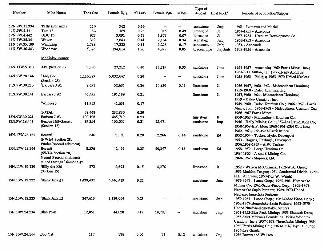
Number
12N.9W.11.334 llN.9W.4.411
llN.5W.35.341 12N.9W.4.442
llN.5W35.100 11N.5W36.443
14N.llW.5.313
14N.9W.28.144
13N.9W30.213
13N.9W.30.141
13N.9W.30.221 13N.9W.18.441
15N.17W.28.132
15N.17W.28344
14N.llW.19.220
15N.13W.12322
15N.13W.18.223
13N.lOW.24.234
13N.lOW.24.144
Mine Name TOM Ore. Pounds U,O, %U308 Pounds V& %V@s deposit Host Rock' Periods of Fmduciion/Shippr Type of
Becenti (NW114 Section 28, Eunice Beeenti allotment) BCCUlti 8,536
Naomi Bcccnti dlotment) (SW1/4 Section 28,
mind through Diamond #2 'Billy the Kid 872 ( W o n 19)
'Black Jack B1 1,439,432
110 32
927 319
2,788 5,326
3,330
1,116.729
8,691
46,495
11,953
58,448 102,128 39,354
846
'Black Jack #2 247,613
Blue Peak 12,051
Bob Cat 117
362 169
3,091 2,643
134,014 17,325
27,212
5,032,647
52,631
191,199
41,631
232,830 485,719 166,065
3,350
42,499
2,693
6,440,419
1,129,004
44,020
186
0.16
0.17 0.26
0.41 031 1.26
0.40
0.20
0.26
0.21
0.17
0.20 0.23 0.21
0.20
0.25
0.15
0.22
0.23
0.19
0.06
315
2,184 1,375
4,895 9,298
-
13,719
-
14,830
22,671
2,266
20,847
4,276
-
18,707
71
- 0.49 0.07 0.34 0.17 0.05
0.35
-
0.11
0.14
0.13
-
-
0.12
limestone Jt sandstone Jmp 1961 - Lummus and Murid
19541955 - Anaconda limestone Jt 19531954 -Uranium Development Co. sandstone Jmbj 1952-1953 -Anaconda
breccia pipe JmjJmb 1953-1956 - Anaconda sandstone Jmbj 1954 - Anaconda
sandstone
sandstone
limestone
limestone
hestone sandstone
sandstone
sandstone
limeatone
sandstone
8aZl'i?lClZl=
sandstone
sandstone
Jmw
Jmw
Jt
Jt
Jt JmP
Kd
Kd
Jt
Jmw
Jmh
Jmp
JmP
1951-1957 - Anaconda, 1960-Farris Mines, Inc.; 1961-L.O. Sutlon, Jr.; 1966HemyAndmm 1958-1963 - Phillips; 1963-1970-Umted Nuolear
19561957,1960-1962 - Midwntinmt Uranium;
1957,1960-1964 - Midmntinmt Uranium; 1959 - Dalm Uranium, Jnc. 1959-1960 - Dalm Uranium Co.; 19661967 - Farris Mines, Inc.; 1967-1963 - Midcontinat Uranium Co.; 19661961-FaniMinca 1959-1963 - Midcontinent Uranium Co. 1956 - Holly Mining Co.; 1957-Lca Exploration Cq 1958-1959-E.P. Mce; 1960-1%1-KSN Co., Jnc.; 1%2-1963,19661967-FarrisMincs 1952-1954 - Tucker, Hyde. Davenpoa 1953 - Hag-, Fazhugh, Davenprt 1956,1958-1959 - A.W. Tucker
1964-1966 - A and 8 hfiaing Co.
1959-1960 - w l c o uranium, Inc.
1958-1959 - Lug0 uranium Co.
1968-1969 - ShiproCkLtd.
1953-Maddox-Tcague; 1954-Continental Divide; 1958- 1952 - Wamn McChmi& 1952-W.A.
H.E. Andremy 196aDon W. Wright 1959-1961 - LanceCorp.; 1960-1961-Homcatake Mining C o ; 1961SabrePinon C o p ; 1962-1968- HomestakcSapin hem; 1969-1970-Unacd Nuclear-HomestakePartnenr 1959-1961 - ~ m c e C 0 7 . ; IQdl-SshPinon Corp.;
United Nuclcar-Hom~takeF'arlnm 1%2-1967-Homestak&pinParhcrs; 1968-1970-
1951-1952-BluePak Mining; 1953Sharmck D m ; 1955Saint Michaels Foundation; 1956-Colohoma Uranium, Inc.; 1957-1958-ThreeJacks Mining; 1954
19.54-Lze Garcia 1960-Farris Mining Co.; 1960-1961-Lloyd 0. Sutlon;
1956-Brown and Wallace

Number Mine Name TonsOre PoundsU,O, 9bU308 pOundsV,O, %V&, deposit HostRock' Pericds of PruduotiodShippr Type of
14N.lOW.14.414 'Buckey (Jeep) 161,635
16N.17W.35.411 C D and S 13N.9W.33.433 Charlotte (Section 33)
16
16N.16W.17212 Lchurch Rock 208
(Section 17) n,%s
14N.9W.35.332 'cliffside - 7.074
13N.9W.20.312 Davenport hcline 7,517
15N.17W.33214 Diamond #2 47.181
Section 36
&argo #2, Mike Smith h e )
13N.9W.20.411 'DOE. Flea. and BO Qrou0244.177 13N.9W.21.32.1 lDo&-S&on 21
14N.lOW.11312 Dyeart#l
14N.lOW.11.424 Dyeart #2
13N.9W.20.233 East Mal@ Lcasc 14N.12W.24.243 Elldns Group 14N.llW.9.214 'Evelyn
(Scdion 11)
13N.9W.29.141 FaithSedion 29
13N.9W30.442 Flat Top
15N.16W.4.111 Foutz #1
15N.16W.31.444 Foutz #2 16N.16W31.444 Foutz #3
14N.llW.8.213 Rancis (Yellow Jacket)
13N.llW.13.312 SWll4 sec. 13 13N.llW.13.444 Sec. 13 13N.lOW.19.110 Sec. 19
(Haystack No. 1) TOTAL
13N.9W.14.414 Hogan Mine (section 14)
'Haystack
. . 31,950
891.922
237,602
30,333 59
10,743
66,327
49,663
324
242 2,412
755
1,162
137,310 3.736
142,208 129.551
770,893
48 704
302,608
6,046,780
28,539
2@?-,4-?,o
906,235 118,052
3,795,495
894,642
139,818 151
49,584
758,615
216,486
1.8"
8,556 1,045
6,164
2,830 16,701
562,267
581,798 678,510
0.24
0.15 0.17 0.19
0.41
0.19
0.21
0.19 0.18
021
0.18
0.23 0.13 0.23
0.19
0.22
0.28
0.22 0.18
0.41
0.12 0.22 0.20
0.26 0.20
241
- - -
- -
65,450
- -
47,438
- -
23,539 231
-
66,126
2,676
2,877 12,466
12,578
-
165,454
165,494
-
-
sandstone
limestone sandstone
sandstone
sandstone
sandsbne
sandstone
sandstone sandstone
sandstone
sandstone
limeatone sandstone
sandstone
limestone
limestone
sandstone
sandstone sandstone
sandstone
limestone limestone. limestone
sandstone
Kd
Jmw
Jmp
Kd
Jmp
Jmp
Jmw
J m W
Jmp Jt Jmb
Jt
Jt
J m w
JmW Jmb
Jmb
Jt Jt Jt
JmP
J ~ W 1957-1958-~011~ ~ i n e r a l s ; 195at965*~= Mining Co.
Jmw 1957-C D and S Mining Co. Jt JmwJmb, 1960-1961-Phillips Petroleum Co.; 1%1-1962-Quinta
195awcshraco ~ ine ra l s
Corporation (now owned by Unitcd Nuclcar Carp.)
NuoIcaq 1970-Kcrr M c b 1960-1963-phiIIips Pwoleum Co.; 1963-1968-United
S a T a Mining Co.; 196Bailey and Fde 1957-1958E.P. Moc; 1959-Black Rook M i ; 1961-
1952-Albcrl Smith; 1953-Adee DodgcE!nkpks; 1953-1954-Gcncral Uranium Co.; 1954-1959-Largo Uranium Co.; 1964-1957- A and B Mining Co.; 1970- shipmck Ltd. 1957-1970-Four Comm Exploration 1958-1959-W*itvaw Minerals; 1959-1961-Phillips Petroleum Co.; 1961-KSN Co. 19561960-Eo de Om; 1959-196&Midco&d Exploration Co.; 1961-1962-Homeutd~eSupin
Co.; 1%1-1962-HomeakkeSapin 1959-1961-Rio de Om; 1959"idm&cntExploration
1959-1960-Four Comm Exploration Co. 1953-1954-JoscphincElkins 1953-1956 - Anamnda Ca.; 19661968-Fauk Mines, Inc.; 1969-197oSmith Wdopmcnt; 1970Minerals hcrgy 195at959 - W ~ C O ~ h d , 1 9 6 0 - m Pctrolcum Co.; 1960-1964-KSN Co.; 1963-United Nuclcar 1955-1957 -Holly Uranium Co.; 1957-1959-Flat Top Mining Co.; 1963-1966Bailcy and Fde 1953-1954-FolItz Mining Co.; 1953-Hanosh Mincs, InC. 1953-1954 - Foutz Mining Co. 1953-1955 - Foutz Mioing Co.
1953-1954 - F8.A Miics, Inc.
Haystack Mountain Development Corp. 1958,1961-HaystackDcvelopment Corp. 1956,1958-1961-ArtBibo (mind in trespass) 1951-A.T.S.F.RR; 1952-1957,1959-1961, 1963-1965-HaystackMountain Welopmmt Carp. 1959-1961 - Four Comas Exploration Co.; 1962-HomestakoSapin

1zo
51'0
61 '0
Pt'O OZ'O
ZI'O LI'O
8z'O
LSO
ZI'O LI'O
€1'0
€1'0
a'0
ZI'O
KO
11'0
92.0
PZ'O
P1 .o
PZ'O WO
51'0
61'0
Z81'51E'Z
W6'5Z9'E
zrc9 ELS'IIZ SE6'015
61€'591 P5
9E8'1
LE1'669'1
6Z8'W5'E
az'1 ME
ffiP
PLs'm'I
SP9'ZI
596'215
E90'P6L
LPO'PZL'E
26P'861
6M)'60I
5Z1'68Z P
090'LCZ
PEZ'PZ
EZE'LI'M6NPI
IW51'MOI'NPI
PEE'EI'M6'NEI
IIP'Zl'MOl'NPI ~Ol'MOI'N~I
PII'S'M6NEI PPl'SMOI'NEl
ZEE'E'M91'N51
OOZ'I'M6'NEI
PZP'PE"6'NPI VPI'OZ'MTI'NPI PE1'9I'MOI'NEl
EII'KMII'NPI
OZP'61'A6NEI
VPZP'MOI'NEI
IZt7OZM6NEI
ZIT'Il'MOI'NPl
En'a"6'NEl
WI'OZ'M6NEI
ZW81'MEI'NSl
EZP'ZI'MPI'NSl OZI'5E"II'NPI
IUL"6NEI
PPZ'ZI'M8I'NSI

I Type of
~~~
Number Mine Name Tons Ore Pounds U30, %U308 Pounds V@5 %V@5 deposit HoslRock' P a i d s of p r o d u d i o d s ~ p c r
13N.lOW.18.341
14N.9W.18.400
14N.9W.20.114
14N.lOW.22.223
14N.lOW.23.134
13N.lOW.23.444
13N.9W.24.121
13N.9W.24.300
13N.llW.24.222
14N.lOW.24.332
13N.lOW.25.411
14N.lOW.25.144
13N.lOW.26.221
14N.lOW.26.220
14N.9W.27.324
14N.9W.27.310
14N.9W.28.333
14N.9W.29.300
Section 18 (13N-1OW) 25,796 (Indian Allotment)
'Section 18 (14N-9W) 501,946 mined through SCO. 17 'Section 20 (14N.9w) 486,375 mined through Scc. 17 'Section 22 2,189,051 (14N-10- heap leach - 'Section 23 2,528,797
Section 23 (13N-low) 21,826 (14N-1OW)
Seclion 24 (13N-9- 9,261
W o n 24 (13N-9W) (SYZ, East Marquez)
10,120
Marque2 decline Section 24 (13N-llw) 24,638 (Nana-A-Bah Vandcvcr Allotment) 'Section 24 1,904,582
Heap leach (14N-1OW)
' W o n 25 (13N-low) 235,156
chill was, Rialto
mined through
-
'Section 25 1,791,048 (14N-lOW)
(Desidcro Allotment) 'Section 26 (13N-IOW) 11,110
'Section 26 (14N-1OW) 362,110
w o n 24 'Stdion 27 (14N-9W) 553,732
mined through
mined throu€$ AnnLee 285,057
Section 2 3 mined section total 838,789 23.648 through Sec. 30 Section 29 (14N-9W) 390,511
Sa. 32 shafl mined through
98.175
1,586,447
2,223,971
11,605,672
9,619,773 38,105
138,541
31,381
33,800
115,075
7,071,564
958,058 579
6,444,889
83,152
1,198,696
2,442,855
1,275,695 3,718,550
94,333
1,999,236
0.19
0.16
0.23
0.18
0.19
0.32
0.17
0.17
-
0.22
0.19
- 0.20
0.18
0.38
0.17
0.22
0.22 0.22 0.20
0.26
75,342
-
10,256
-
85,545
153,657
-
17,518
-
0.30
-
0.06
-
0.18
0.12
- 0.08
-
limestone
sandstone
sandstone
sandstone
sandstone
limestone
sandstone
s a n d S b U 8
limeatone
sandstone
limestone
sandstone
limestone
sandstone
sandstone
sandstone
sandstone
It
JUW
Jmw
J m w
Jmw
Jt
JmP
Jmp
It
Jmw
Jt
JrmR
Jt
Jmw
Jmw
Jmw
Jmw
Jmw
1952-F.A. Sitlon; 1952-Thompson and Wilbmq 1952-1953-Glen william; 1955-195€&mk Pe Uranium Co.; 19561959-FederalUraniumranium Corp.; 1963-1964"esa Mining Co.; 1966cihla Mining Cu. 1962-1964-KermacNuolcar, 1965-1970-Kcrr M&
1962-Kmac Nuclear
1 9 5 8 4 9 W K ~ N u c 1 c a r . 1965-1970-Kerr McGee
United Nuclear 1 9 5 9 - 1 9 6 a H o m ~ p j n ; 1969-1970-Homesinke-
1957-1965-HaystaokMounlain Development Corp.; 1965-1966Santa P C pacifc 196a1963-Febcc Mines, Ino.
1960-1962-calumet and Heela
Uranium Co.; 19561957-Faicral Uranium Corp. 1952-1954-Glen williams, 1955-1956Santa Fs
M& 1959-1964-Kcrr-McGeeNuclcar, 1965-1970-gerr
Development Corp.; 19621965santaFe Pacific; 1951-AT and SFRR; 1955-1961-HayatackMountaio
Mining Co.; 1969-1970-United Nuclear Corp. 1963,1965-1966-FarriaMines, bo.; 196gHomcstake
Uniled Nuclear 1959-1969-HomcstakeSapin; 1969-1970-Homestake
1952-1957-HmoshHines
1965-1970-Km-McGes
1961-1970-UNkd Nuclear
1958-Uniled Wcstem
1961-19WKermacNuclcar; 1965-1970-KcrrMcGm

Number Mine Name TonsOrc Pounds U& %U308 PoundsVzOJ %V&, deposit H o s t R d * Periods of RnductiodShippcr w of
14N.9W.29.100
14N.9W.29.400
13N.9W.30.333
14N.9W.30.232 14N.9W.30.141 14N.9W.31.200
13N.9W.31.120
13N.9W.32.144
14N.9W.32.122
13N.9W.32.144
15N.llW.33.242
14N.9W.33.213
13N.lOW.36.224
14N.lOW.36.222
14N.12W.10.243
14N.lOW.31.334
15N.16W.4.414
mined through Section 29 318,361
Sm. 30 shaft Stction 29 641,918 mined through sm. 33 Section 30 (13N-9W) Roundy Lease. 91,513
Rimrock n3 'Section 30 (14N-9W) 2,855,164
Section 31 (14N-9W) '?3eotion 30W (14N-9W) 68,895
W o n 31 (13N-9W) 15,736
Section 32 (13N-9W) Moe #4
2,407
Section 32 (14N-9W) 488,031
3,469 mined through sec. 32
Section 32 (15N-llW) 20,117
allobnent) mined W 4 , D. Begay
through Moc #5 decline Section 33 (15N-llw) 4,243 Moe #5, West Ranoh Mine 'Section 33 (14N-9W) 960,007 Branson hatD leach
1,401,003
1,936,819
464,810
15,064,056 282,714
17,999
n,w 9,746
1,927,388
89,091
21,149
3,222,939 26.149
0.22
0.15
0.25 76,565
0.26 - 0.21 0.26 - 0.25 21,628
0.25 21,628
0.20 -
0.22
0.25
0.16 -
0.27
0.27
-
NOTE: Ambrosia Jake Uranium Co. c ~ ~ i s t e d ofKm-M&, Andason Development Co., Pacific Uranium Co., Phillips Petroleum Co., and Branson Estate Section 36 (13N-10W) bok Section 36 (14N-1OW) 5,249 53,349 051 45,950 Lease 60-167
0.43
Silver Bil 1-18 293 3181 0.54 3,340 0 5 7
Silver Spur Group 5,938 29,454 0.25 19,202 0.25
1,435 3,770 0.13 2,698 0.19
U Mine 2,560 8,460 0.17 4,075 0.09 chrislulscn 1-20
sandstone
sandstone
limaione
sandstone sandstone sandstone
limaionc
limestone
sandstone
sandstone
sandstone
sandstone
limestone
sandstone
sandstone
sandstone
Jmw
Jmw
Jt
Jmw lmw Jmw
Jt
Jt
Jmw
Jmb
Imb
Jmw
It
Imb
1960-1970-Kerr-McGm
1 9 6 3 " M &
Co.; 1970-Bailey and Fife WZ-1956F.0. Manot; 19561966-Rimrock Mining
1959-1964-Kermac Nuclear; 1965-1970-Km M& 1970-Km-McGee 1970-Km-Mcb
1953-1954, 1958, 1961-HaystackMountain Development Corp.; 19624anta Fe Pacific 19634ulton and Moe
Homestake3apin; 1968-1970-Uniled Nuclcar- 1 9 5 8 - 1 9 6 1 - H o m ~ N c w M a i w ; 1961-1968-
Homestake
1968-1969-DeVilliers Nudear 1960-1963-KamaC Nuclear; 1964.1968-E.P. Moc;
19M),19621963-K~Nuclear 1964.E.P. Moe 1959-1961-Amb~siaJak~Uranium Co.; 1959-1963- Phillips Petroleum Co.; 19621964-KemmcNuclcar, 1964196EUniled Nuclear Corp.; 1965-1970; K m M& I
1952-1953-Moses Mirabcl; 1954-1955SlolIt-Mun; 1958-Chena Mining Co.; 1962-Homer Scriven 1957-1958-V.C.A.; 1959-Udcd Westun
JmwJmb 1955-1956-G.W. Relds; 1957-Monitor Exploration; 1957-Uniled Wcslun Mining
Kd 1952Chas Davis; 1952-1953siivex Spur Mining Co.; 1955-Holly Uranium Co.; 1956Holly Minerals; 1957-
Mines IQSQ-WCO 1~5?-v~n~ G~.; 1qsF-
cahonaceous Kd sandstone
1953-1954-Wfiams and Reynolds; 1955-Frontier Uranium; 1957-George Christcnscn; 1957-Rem Uranium Co.;l95&W.C.T. Engineering CO

Number Mine Name Tons Ore Pounds U30, %U308 Pounds V@s %V& deposit Host Rock' Periods of PmductionlShipper Type of
13N.9W.34.343 VaUqo Mine 6,458 21,?33 0.17 394 - limestone Jt 1957-1959-Vdqo Uranium Mines: 1959-1960Samson
lM.16W.2.442 w- #l 4,713 26,571 0.28 27,134 0.40 sandstone Jmw 1957-1960-WcshwterUranium Corp. Oil and Minag; 1962-1963-Pen& Mining Co.
Jmw 1963-1970-Kcrr MCGee, Homestakcsapin h e r s , Urrited Nuclear
NOTE: In November 1961, Homestakdapin hers acquired HomestakeNew Mexico Partners. In April 1962, United Nuclear Corp. merged with the Sabrc-Pinon Corp. and Unitcd Nuclear
Nuclear Fuels Corp. was dissolved. The operating company became KenMcGee Oil Industria, Inc. Later it wan the Km-McGec Corp. and the Km-Mc4iee Nuclear Corp. In Apnl1968, bccamethc surviving corporation and bccameUnacd Nuclear Corp. In February 1963, Umled Nuclear Corp. acquired the uranium mines and mill of the Phillips Pdrolcum Co. In 1965, Kcnmc
HomataksSapin partners bccame UNlcd Nuclear-Homestake PaNlers. See Chenoweth (1989) for a listing of Ambrosia Lake operations.

Table 2-Uraniwn mines in New Mexico that have produced from 1971 to 1991.
Occnrrence Production' Hostz
I
number Mine name ClW rock Periods of production/sllip~l
GRANTSURANIUMDISTRICT Cibola County (formerly Valencia County)
12N.9W.33.444 T-33 (Section 33)
11N.5W.13.300 13N.8W.24.433
JJ #I Mt. Taylor
12N.9W.4 llN.4W.19.300,
3Red Bhff-Gay Eagle
11N.4W.30.240, 11N.5W.24.411
1lN.Sw.26,33 3Jackpile-Paguate
"st. Anthony
13N.8W.30.243 3San Mateo Mine
McKidev County
14N.9W.28.144 'Arm Lee (Spider Rock)
13N.9W.30.221 %rbaraJ#3(whiteCap) 14N.llW.19.220 15N.13W.12.322
%illy the Kid %lack Jack #I
14N.lOW.14.414 'Buckey
14N.9W.36.332 16N.16W.17.212 3cburch Rock (Sec. 8,17)
13N.9W.20.411 Wiffside-Section 36 'Dog, Flea, and BG Group
13N.9W.21.324 14N.llW.9.214
3Doris-section 21 3Evelyn
13N.llW.13.314 3Haystack-Sectiou 13 13N.10W.19.110
17N.9W.19.727 Section 18 and 19
13N.9W.7.221 Hope [Section 19)
13N.8W.7,18 Johnny M (Sections 7, 18) 3 1 ~ b e u ~
C
e d
b d
b
d
d
C
a d
C
C
d C
b b
C
C
b
d C
Jt 1971-1977 - Homestake
Jmj 1976-1981 - SOhiO-ReServe Jmw 1980-1983 - Gnlf, 1985-1990 - Chevron Jt 1976 - Moises-Mirabel Jmj 1976-1980 -United Nuclear
Jmj 1971-1982 - Anaconda
JW 1971 - United Nuclear
J m w
Jt Jt
JmW J m w Jmw, Jmb, Kd Jmw JW
JmP Jmb
Jt
1971-1972, 1982 - United NUC~W, 1977-1982 - Spider Rock 1979-1980 - T d t o Exp. Dev. Co.
1971 - United Nuclear-Homestake 1976 - H ~ n r y AU~RWS
1972 - Hydro-Nuclear; 1978-1980,1982 - Cobb 1976-1977,1979-1982 - United Nuclear 1971-1985 - Kerr McGes 1971-1975 - Four Cornera Exp.; 1978-1980 - MBrM Mining 1978-1979 - Ranchers 1971 - Smith Dev.; 1971-1972 - Stevenson; 1972 - oral creek 1975-1981 - Todilto Exp. and Dev.
Jt 1977-1981 - Pachers
Jmw 1976-1982 - Ranchers JmP 1978-1980 - Koppk, 1980-UnitedNnclear

occurrence Production1 Hostz number Mine name class rock Periods of pmduction/Shipper
15N.14W.12.423 lSN.14W.12.134 17N.16W.35.200 17N.16W.35.200 17N.16W.36.100
13N.9W.30.143 13N.9W.19.420 15N.13W.21.142
1SN.13W.25.224 15N.13W.25.224
14N.9W.34.424 13N.9W.1.200
14N.10W.12.411 14N.lOW.10.244
14N.lOW.13.413
14N.10W.15.441
13N.9W.16.441
14N.9W.17.323 14N.9W.18.420
14N.9W.19.411 14N.9W.20.114
14N.lOW.22.223 14N.lOW.23.134
16N.17w.23.221 14N.lOW.24.332
1 7 ~ . 1 6 w . n . 2 ~
3Mac #I C
Mariano Lake (Section 12) d N.E. Church Rock (2 shafts) . d N.E. Church Rock #1 d N.E. Church Rock #I-E d N.E. Church Rock #2 d
3Poiston Canyon Piedra Trieste (Section 30) a
Ruby #I } mined through d Ruby #3 and #4 } m e decline Ruby #3 and #4 d ’Sandstone d “4S&ion 1 (13N-9W) d
3ktion 10 (14N-1OW) %section 12 (14N-low) Section 13 (14N-1OW)
’Section 15 (14N-low) d
Section 16 (13N-9W) b
’Section 17 (14N-9W) d i4Section 18 (14N-9W) d
Section 19 (14N-9W) d “%tion 20 (14N-9w) d
3Secti0n 22 (14N-1OW) d ’Ssection 23 (14N-1OW) d
Section 23 (16N-17W) ’Section 24 (14N-low) d
C
mined through Cliffside C
C
C
mined through Dog-Fh mina
mined through Section 17
mind through Section 17
a
Jmb Jmb JmW J m w Jmw Jrnw Jt
Jmb JmP
Jmb JmW J m w
Jmw Jrnw J U W
Jmw
JmP
Jrnw lmw
Jmw Jrnw
Jmw Jmw
Jmw Jmw
1976-1978,1980 -United Nuclear-Homestake 1977-1982 - Gnlf 1972-1982 - United Nuclear 1976-1985 - KRT M C G ~ 1979-1985 - Kerr McOee
1979-1981 - Todilto Exp. & Dev. 1976-1978 - Reserve
1980-1982 -Western Nuclear 1980-1982, 1984-1985 - Westem Nuclear
1978-1982 - Kerr M c G ~
1976-1979 -Westem Nuclear
1971-1982 - Kerr McG, 1974-1980 -United Nuclear
1980 - Cobb 1978-1982 - Cobb; 1980 -United Nuclear 1977-1981 - United Nuclear-Homestage; 1981 - Homestake
1981 - Homestake 1973 - United Nuclear-Homestake
1971-1985 - Kerr McGee
1971-1981 -United N~clear-HomeStake;
1971-1982 - Ken M d h
1978-1985 - Kerr McGee 1971-1979 - Kerr McGe
1971-1985 - Kerr McGee
1981-3353 - Homestake 1971-1982 -United Nuclear-Homestake;
1975 - G m Nuclear (ii situ pnoduction) 1971-1985 - Kerr McGea
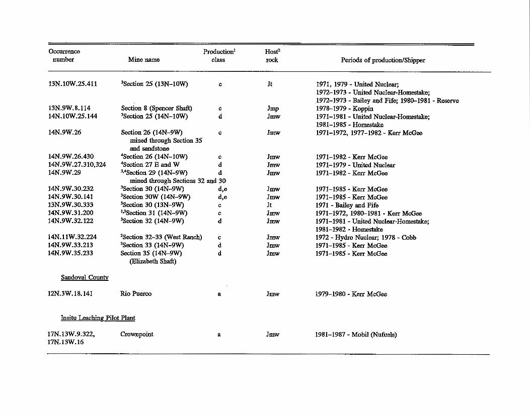
OCCllllWlCe I number Mine name
Production' HostZ class rock Periods of productiodShipper
13N.10W.25.411
13N.9W.8.114 14N.lOW.25.144
14N.9W.26
14N.9W.26.430 14N.9W.27.310,324 14N.9W.29
14N.9W.30.232 14N.9W.30.141 13N.9W.30.333 14N.9W.31.200 14N.9W.32.122
14N.lIW.32.224 14N.9W.33.213 14N.9W.35.233
Sandoval County
12N.3W.18.141
'Section 25 (13N-1OW)
Section 8 (Spencer Shaft) 3Secti0n 25 (14N-1OW)
Section 26 (14N-9W) mined through Section 35
'Section 26 (14N-1OW) and sandstone
?ktion 27 E and W %ection 29 (1 4N-9W)
'Section 30 (14N-9W) 3 S 4 0 n 30W (14N-9W) 'Section 30 (13N-9W) ' 3 S 4 0 n 31 (14N-9W) 'Section 32 (14N-9W)
mined through Sections 32 I
3Ssecti0n 32-33 (West Ranch) %&ion 33 (14N-9W) Sation 35 (14N-9W)
(Hlizabeth Shaft)
Rio Puerco
C Jt 1971,1979 -United Nuclear; 1912-1973 - United Nuclear-Homestake; 1972-1973 - Bailey and Fife; 1980-1981 -Reserve
C Jmp 1978-1979 -Koppin d Jmw 1971-1981 -United Nuclear-Homestake;
C Jmw 1971-1972, 197-1982 - K m Md;ee 1981-1985 - Homestake
C
d d
Jmw 1971-1982 -Ken McGee Jmw 1971-1979 - United Nuclear Jmw 1971-1982 - K m McG-
C
d d
a
Jmw Jmw Jt JmW JmW
J m w Jmw J m w
J m w
1971-1985 - K m McG- 1971-1985 - K e n McGee 1971 - Bailey and Fife 1971-1972, 1980-1981 - Ken McGee 1971-1981 -United Nuclear-Homestake; 1981-1982 - Homestake 1972 - Hydro N u c I ~ ; 1978 - Cobb 1971-1985 - K m McG- 1971-1985 - K m M c G e
1979-1980 - K m M&ee
Insit0 Leachinn Pilot Plant
17N.13W.9.322, 17N.13W.16
Crownpoint a Jmw 1981-1987 - Mobs (N~fuels)

'Production Class: a - 0-20,oOO Ibs U30g; b - 2O,ooO-1oO,ooO lbs U308: c - 200,000-2 million lbs U308; d - 2 million-20 million lbs U30,; e - greater than 20 million Ibs U30, (total production to dab).
?I& rock Jt - T d t o Limestone; Jmr - Recapture Member; Jmw - Westwater Canyon Member; Jmb - Brushy Basin Member: Jmp - Poison Canyon Sandstone; J m j - Jackpile Sandstone; Jmj - Jackpile Sandstone; Kd - Dakota Formation.
3Produced prior to 1970, included Table 1. Production classification based on total production. 4Properties mined through adjmt shafts.
NOTE: In 1981, the United Nuclear-Homestake Partnership was dissolved. Homestake Mining Co. h e the sole operator of the mill and the Sections 13, 15,23,25, and 32 mines. (AU but Section 23 closed in 1981-1982, but Homestake continued to recover &nm from ine water until June 1990.) In 1983, Kerr McGea reorganized the uranium operations in New Mexico into the Quivira Mining Co. Quivira closed its mines in March 1985 but continued to m v e r uranium from mine water. In 1988, K m McGw sold the Quivira Mining Co. to Rio Algom Ltd. Rio Algom Mining Corp. (US. mbsidiary) continues to recover uranium from mine water.

To Shiprock
Map 8
To Holbrook
0 10 20 30mi
0 10 20 30 40km
To Albuquerque
MAP 1 - LOCATION OF URANIUM ORE DEPOSIT MAPS OF THE GRANTS URANIUM DISTRICT, NEW MEXICO.

*8obcat-Blua Peak
*Poison c.nyonn- Beacon Hill- Davenport-Dog-Flea
*narquez
'Hogan
Sec. 13
*Set. 24
*Sen Hate0
Sec. 29.32
Sec. 19
Pat (Dakota)
+ ~ a J W ~ nesa
sec. 1
sac. 5.7.8
See. 17.18
24 113N RlOU
19.20.21 T13W UlW
23 T13N R9U
14 T13N R9U
13 T 1 3 N R9U
24 11311 ~ 9 u
3 0 T13H R9U
29.32 T13N R 5 U
19 T13H R9U
4 T13N RlOU
1.12 T l2N RW
1 T14N R l l U
5,7,8. T14N RlW
17.18 T14H RlW
?i"rfacs
s u r f a c e - 3 0 0
1800-1875
300-340
." 400-500
."
" _ 500
surfece
" _ 600-700
1160-1200
800-1000. 1400
Jmb primary
Jmb primsry
Jmb primary
Jmb primary
Jmb primary
Jmb primary
Jmb primary ,
Jmb primary
Jmb primery
Kd, Jm _ " Jmb primary
Jmb " _ Jmb primary
Jmb primary
44,206 lbs U308 produced
over 1.3 mill lbo U308 produced
3,757.847 tbs u308 produced
678,510 lbs U308 produced
"_ 37,693 lbs U308 produced
over 2.8 mill lbs U308 produced _ "
_.. 12,645 lbo produced
2.5 mill lbs U 0 reserves 'at 0.2-8.3X
aver 1 mill lbs reserves delineated.
over 100.000 lbs reserves delineated
Hilpert (1969), Rapaport (1965>, Tessendorf (1980)
Ueege (1963). Rapaport (1963)
Repaport (1963)
Rapaport (1963)
_ " "_
NnBHHR flles, Homestake ninlng co. files
Pathfinder files, 1981
Pathfindsr files, 1981
Pathflndcr files, 1981
.-D .- .A.abrosla.s~istrirt-Dstota orebodies (redistributed ore). Production data from ncLemore (1983a). """"""_"""""""~~""~-~~~"""~~~"."~..~~~."""""~"""".~~~~~~"-~.~""~~.""~~"""~~~"""~ .Prapsrty
Estimated Location
P;oductlon depth ift) lbs U308 grade X u308 c a m n t ? r
Average
Febco (Saatl S t a b ) 31 T14N RlW surf lee (included in Silver spur mine)
" _ __.
Silver Spur 31 T14N R1DU surface 29.454 0.25 __. Junlor 4 T13W RlOY surfaze (included in
Pat mine) _ _ _ _ "
See. 5 5 T13Y RlOU surfat e 54 0.12 "_ Also minor anomalies o r occurrences In 2 71311 R l l c ; 5 T13H RlOU: 34 11411 R11U
..

002E-001E
___ OOOE-00SZ
"_
OOBl
0002-0081
0021-00EI
OB81
0951
OOSL
OSL-001
008
009-007
008-009
ooz-osc
9S'SS'ZE'EE n6n HVII
nun nw 95 'n6n HSLI 62'LS'ZE'OE
SZ'~Z'SZ'ZZ'EL'f1 nolu H~II
". AJemlJd
c
.c

. . . .
i !
i . ..
I !
Jmb primary
*Hogan
Sec. 13
5 e c . 24
%an Hate0
Sec. 29.32
Sec. 19
Pet (Dakota)
+La Jara nesa
see. 1
Sec. 5.7.8
SK. 17.18
19,20,2l T13H UIW
23 T13H RQY
29,32 TUH RQU
19 11311 RQY
4 11311 R l O Y
1,12 112% R9Y
1 114% R l l V
5.7.8, T1LH RlW
17.18 114% RlW
surface-300
1800-1875
300-340
.._ 400-500
" _ 500
surface
" _ 600-700
1160-1200
800-1000.
Jmb primary
Jmb primary
Jrnb primary
Jmb primary
Jmb primary
Jmb primary .
Jmb primary
Jrnb primary
Kd, Jm " _ Jmb primary
Jmb
Jmb primary
" _
Jrnb primary
over 1.3 mill lbs u30a produced
Hilpert (1969). Rapapart (1963). Tensendorf (1980)
3.757.847 lbs U p 8 produced
678.510 lbs u308 produced _ _ _ 37,693 lbs U308 produced
U308 produced over 2.8 mill lbe.
_ _ _ " _
12,645 l b s produced
2 . 5 mill lbs U 0 mserves 'at 0.2-8.3X "_ over 1 mill lba reserves delineated
over 100.000 lbs reserves delineated
Ycege (15'63). Repaport (1963)
Repaport (1963)
Rapaport (1963)
". ". ".
WHBHHR files, Homestake Hining Co. files
Pathfinder files, 1981
Pathfinder files, 1981
Psthfinder files, 1981
Silver Spur 31 TIGII R1ou surface 29.454
Junior 4 T13N RlOY surfate (included in Pat mine)
0.25
_..

*Bobcat-Blus Peak 24 T 1 3 N RlOU s v r f a c e
*Poison Cmym- Bescam Hill- Davenport-Dog-Flee
19.20.21 T13W R?W surface-300
.Msrquez
*Hogan
SCC. 13
*Set. 24
%an Mate0
Sec. 29.32
Sec. 19
P a t (Dakota)
+ ~ a ~ a r a nesa
Sec. 1
sec. 5.7.8
.See. 17.18
23 T13N R 9 U
14 T13N R9Y
13 T13W R9Y
24 T13W R9U
3 0 T13N R9Y
29,32 T13N RW
19 T13W R9U
4 1138 RlOY
1.12 T l2H R9Y
1 11411 R l l Y
5.7.8. T14N RlW
17.18 T14N RlOU
1800-1875
300-340
.__ 400-500
600-700
1160-1200
800-1000, I r o n
Jmb
Jmb
Jmb
Jmb
J m b
J m b
J m b
Jmb
Kd. Jm
Jmb
Jmb
Job
Jmb
primary
primary
primary
primary
primary
primary
primary
primsry
_ _ _ primary
_ _ _ primary
primary
over 1.3 mill lbs U308 produced
3.757.847 Ibs U308 produced
678,510 lbs U308 produced
". 37,693 lbs U308 produced
over 2.8 mill lbs u308 produced
-.- ".
12,645 Ibs produced
2.5 mil[ lbe U 0 reserves 'at 0.1-B.32
". over 1 mill Ibs reserves delineated
over 100.000 Ibs reserves delineated
Hi lper t (19691, Rapaport (19631, Tessendorf (1980)
Ueege (1963). Rapaport (1963)
Rapaport (1963)
_ _ _ " _
Rapeport (1963)
_ _ _ " _
* _ " WMBMHR f i l es , Homestake nining Co. files
pathfinder f i les, 1981
pathfinder files, 1981
Pathfinder flles, 1981
JImfor 4 T1SW RlOY surface (included i n P a t mine)
- _ _ _ _ - see. 5 5 T13W RlLW our fa , e 54 0.12 -.-

.( -. - 0 ,
JI &-" 4. "-
[:, *" .". L ' L,aguna subdistrict
*'.. ___""""_____________________________"""""""""""""""""""""""""""""""""""""""""""""-~-~--------- -~~~~~------- , . ""A
,. Property
, J J - 1 ( L Bar)
1 Estimated Dominant type Location depfh (ft) Host of deposit Estimated size References
23, 24 TllN R5W . 650-700 , Jmbj primary 2.1 mill Lbs U 0 produced, Sohio files (1981) , "________"_,..._______________________""""""""""""""~~.""""""""""""""""""""""""""""""--"---"---"--------"- 2
13;9 mlll lbs a388 reserves Jacobsen (1980) at 0.lbx U308
'* ..
St. Anthony 24 TllN R5W surface Jmbj primary, possibly Over 2,500,000 lbs U308 Balrd and others (3980).
Bi.bo rim cuts 29 TlON R4W s d f a c e Jmbj primary
open pit & shaft 19.30 TlON R9W some remnant produced Sohio files (1981) i " _ " _ 1 Windwhip rim cuts, 34.35 TllN R5W surface-250 Jmbj prlmary included with Jackpile- Holen and Hatchell (1986) ~". il in-situ Paguate
. .. - ' I Walter rim cut 35 TllN R5W surface Jmbj primary included with Jackpile-
, ., j . . . .;.@$up - _ -
> l i ,
I p.
Jackpile-Paguate Tl0,llN R5W open plts & declines
surface-300 Jmbj primary 26.6 mill tons of ore yielding 100 mill lbs
Kittel (1963), Hoppe Hoppe (19781.;
I
o f U308 Beck and others (1980)
i Oak Creek rim cut 1 1 TlON R5W surface Jmbj primary included in Jackpile-Paguate
Woodrow 36 TllN R5W 360 Jm breccia pipe 134,014 lbs U 0 produced, Wylie (1963) average grade30? 1.26%
" _ 1 TlON R5W
______________________________________._"""""""""."""""""""""""""""""""""""""""""-"-""""""-~------------""- U308
Q SHAFT 1 A L L mines have produced, mnerallzed zones may still be present. Sohlo files (1981) avallablei for inspection at l"MAC&otechnical Information Center. x
+ ADIT O R DECLINE
OPEN PIT BOUNDARIES, DASHED WHERE EXPECTED TO MINE
fl RIM CUT OR TRENCH I
. ~ ..
X OUTCROP ANOMALY
. , ST. ANTHONY ST. ANTHONY 0 APPROXIMATE OXIDATION- REDUCTtON
INTERFACE IN THE JACKPILE SANDSTONE 20 x
"
"
"
45
ST. ANTHONY -OPEN PIT I 3 (NEAR SURFACE OXIDATION FROM WEATHERING)
N
4 MN SCALE a I n d i a n R e s e r v a t i o n -. - ~ L
2 6 - . - . - . -
29 BIB0
E RIM CUTS KM
! LEACH P
R
32 31 32 ' ILE MINE 36
c
CIRCULAI FAULT
Y
NOODROW MINE
T I IN T ION
IGNEOUS Dl KE
HOUSING , 0 ORE BODY .. 8 ..
2
A H-I
6 I 5
t R5W ,, AND LAGUNA 7- 1/2 M I N TOPOGRAPHIC 34W EASE MAP FROM MOQUINO, MESl QUADRANGLE MAPS.
;IN THE JACKPILE-PAGUATE MINE AREA, RIM CUT II 8 IO
1 LAGUNA SUBDISTRICT,,/ GRANTS URANIUM DISTRICT, :' CIBOLA COUNTY; NEW MEXICO.
~
r.
I
i . . Compiled by V.T. McLemore and-W.L:- Chenoweth from field reconnaissance,' ~ . . . , . ~. .~ ~
.,.-
I
~ "~
~ U.S. Atomic Energy Commision maps, Anaconda maps, Sohio maps,
Beck and others (19801, Jacobsen (19801, Baird and others (1980),'
Moench and Schlee (1 9671, Schlee and Moench (1 963 a,b), Adams and Saucier (1 9811,
G.W. Hazlett (written communi,cation, 19871, and NMBMMR files.
Note: Reserves remain at Sohio, St. Anthony and South.Paquate.
- ~ ~ .. " . r ~ *
1 '~ . ., .. . .-
~ " _ "~ ~~ ,
~~~ .~ ~
-~ . ~ . .~ -1 ~ I~
! 1 - ~~
. - . ,
" " ~~ ~~ ~- . ~ .. ,~~ - .~ ~ - .~ -~ .
X
17 15 14 16
io7 12'30'' ~ 279 ~
T O LAGUNA "" _ _ _ ~
Q , r a f t e d b y V.T. M c l e m o c e & K . C a p p b e l l *
, " R e v i s e d D e c e m - b e r 199 1 I
~
i l


MAP 1, 4- URANIUM DEPOSITS IN THE BORREGO PASS AREA,iAMBROSIA LAKE L. CUBDISTRICT, GRANTS URANIUM, CU DISTRICT ; CKINLEY COUNTY, NEW MEXICO I
Compiled by V. T. McLemore and W. L. Chensweth from Chapman, Wood, and Griswald, Inc. (19791, Quviria Mining Co. files, NMBMMR
files, Holen and Hatchell (19861, Adams and Saucier (19811, Sayala and Ward (1983) ,Pathfinder Mines CorPl files ~. ~ . ~~~~ - ~.
! VISESD 199 1 I
RI I \ RlOW I
I
I
I
I I
I
I I '
4 6 5 I
9 7 8 12
I I I I
I
I I I I
I I I
I
I I I I I
I I I
i I I I I I I I I
I
I
17 16
I I I I I I I 1 I I I I
I I
-1
I
"" - I I I I I I I I
I
I To Hospah and Whitehorse
~ ~ ~~~ .
I I I I I
I """ "-
I I I I
- 1
URANIUM .MINERALIZED DEPOSITS IN'I I I I
1 APPROXIMATE OXIDATION- REDUCTION INTERFACE
0 ,MORRISON FORMATION, APPROXI~IATE BOUNDA-RIES
19 20 24
. "" . -
I
I
5 I MI I I
5000 FT I I
28 25 30
-Id- I KM
HAS BEEN NO PRODUCTION " " . I . ~
. ~
'THESE DEPOSITS.
THERE
FROM . .
NOTE:
33 32
T16N
r 1 5 N
To Prewitt
I 6 5 4
I
I / I
I
' 1 I 8 9 7 12
I I ! 1 I
13
by V.T. McLemore- Dra f ted
Revised - ~.
~~
December 198 1
B~~~~~~ pass 7,18, TIGN, mow 2000-2200 Jmw redistributed (roll-type), prnnary
15 millloll pounds Sayala and Ward (1983);
13, TIGN, Rl lW up, a t average Holen and Hatchell (1986); grade of 0.15 % McCalnmon and others (1986)
Borrego Pass 16,17,20,21,27,28, 1800-;ZOO(?) Jmw redistributed (West Largo) 29, TISN, RlOW (roll-type)
8 million pounds McCamrnon and others (1986), U,O, at average Pathfinder Mines Corp. files grade of 0.35%

PEN FIL MAP-5
'Mac 1 12 T15N R14W 518 115 , priniary(?) About 0 4 null Ibe of McLemorc (1YS3:t) U30, producd
VISED 199 1 'Blnck Jack 2 i 8 TI4N R13W 303 Jmh-lower sxnd red~st~tbuted 1,129,004 Ibs of 0.239: U,O, produced Arrderson (1980)
Hoskins (1963),
'Mac 2 18 T15N R13W 288 Jnib-lower sand rcdist!ibuted 109,009 1bs U,O, Wcstcstcrn Nuclcar fila data prodrrced (19RI), McLemoro
(1983a)
?House Lnke 20 T18N R13W 240-300 Jmb-lower snnd redistributed 285,000 Ibs ot 0.18% P'nilhps file data (1977)" orebody U,O, reported
'Ruby 1 21 T18N Rt3W 3UO Jmb-lower snnd ' redlsfributed 2 mill Ibs U,O, Wcstcln Nucl~m file data or ptimary produced 1976-1965 Fishman et ai. (198;)
IRuby 2 27 T18N R13W 300 Jrnlr-lower sand rcdistnbuted production mchldcd Western Nuclear file data , ' m Ruby 2 Ristorcelli (1980) E
. . 1
1 3 V Y w i 'Ruby 4 26 T15N R13W 300 3mb-lower sand prirrary prodoelm lnclutlerl Westcln Nuclcar lik d a b in Ruby 1
i I ! U,08 prodrrccd, in-
cludmg SoutI1 Pod
'Ruby 3 25 T15iN R13W 300 Jnb-lower sa1;d primary 20,000-200,000 Ib.; $Jestern h'uclear file d:~ta
'South Pod 25 T15N R13W 300 Jmb-lower s ~ I rcmnnnt "__ ycitern Nucicnr tile data 2 I t
D r a f t e d b y V.T: McLcmore -& K. Campbel l
Rdvised December 169 1 ~.
. . . ..
GED
TO STATE ROAD 57
8 IO . 15 14 13 14 13 16
R
I b c \: 9 * L
NERALIZATION'
M I N E D THROUGH
.Western Nuclear maps, Thompson( 19801, Hoskins( 1963),Fishman and Reynolds( 1'982, 19861, MacRae(l9631,
'and Phillips uraniutq Corp. files (5977).
I.
" " 2 ~ '
, 1 N.S. 'Fishman (U.S.G.S. written commvn~ication, 1989), G.W. Hazlett (writ+en ,communicatidn, 19871, ..
, . ~ I
r - ~I . .
There is some' controversy between the USGS' (McCammon 'et al., 1986).and industry (Place et ai., 1980)
reguarding th,$ stratigraphie'position of the ore in the Mariano La-ke\trenld. Some industry' geologists call.
the ore bearing sandstone Poison Canyon . The USGS then places it, in the Westwater Canyon
~~
~~ ~
1 ~. .r #
N MN
1 4 PI SHAFT (PRODUCTION IN APPENDIX I )
I /131/20 + DECLINE (PRODUCTION IN APPENDIX I)
22 2!3 24 URANIUM MINERALIZATION OF ANY STRATIGRAPHIC H~ORIZON, APPROX. BOUNDARIES,. PRODUCTION IN APPENDIX 1 , SEE TABLE FOR TYPE OF DEP6SlT . & STRATIGRAPHIC HORIZON.
) !APPROXI F;~ATE'&"EXTENT O'F.%XXDATION FRONT IN LOWER 7 *ORE"SAND.'OF BRUS,HW BASIN MEMBER (FISHMAN AND A P P R O X l M A t E E X T E N T OF OXIDATION FRONT IN /
REYNOLDS, 1982,1986, WESTERN 'NUCLEAR F ILES, 1981; PHILLIPS PETROLEUM DATA, 1977) (WESTERN NUCLEAR F ILES, 1981)
UPPER"ORE"SAND OF BRUSHY BASIN MEMBER
b ?
B
T15N
- .
Member. Other geologists (Fishman and Reynolds,' 1986) and the: authors reguard the ore bearing sandstone
is gn . unnamed sandstone in the Iqwer Brushy Basin Member. McLemorei and Chenoweth '(,I989 Table 3) G'" I . . placed the deposits in the Westwater Cinyon, Member to be consistent with McCammon e t ai., . . 1986).

116W 108' 30' I I I I I
R16 R 1 7 \
I "" - +
I I I I
" " - - " "" 4 "" "- - -
.
- I
I * I I I
- - - - - - - I
I
I "" -
I I I
; I
I I
I
I
I ,I*
I " _ " - - " " " "_
KERR McGEE
" _
I
I
I
I .-.-
31 \ \ \
\ \ W
T I 7 N \ \
2 6 5 I 6
IO 12 7 7
MANCOS ORE BODY (UNITED NUCLEAR)
14 13 14
. - 0 TETON
I NSlTU LEACH
@ PUSH-PULL ..
17 18 16 16 15
Q
2 3
INSITU LEACH
23 2 0 2 4 19 21 20 21 22
I 15W
26 25 29 28 27 26
~~ . . ."
@proximate oxidat ion-reduct ion interface . . ~ ~ -
X OPEN P I T
B SHAFT
N r * ADIT
&7 URANIUM MlNERALlZATiON IN MORRISON FM.
URANIUM MINERALIZATION IN DAKOTA FM.
,, URANIUM MINERALIZATION IN MORRISON FM.' fl , W H I C H H A S BE-EN PARTIALLY MINED RESERVES .. -
M A Y BE PRESENT.
00 FT
35
pCDS
31 3 2 33 3 4 35
FOUTZJ 3
Q (YFLLOW JACKET)
. - ! FOUTZ 2:
I I
I
i i
I
T16N
TO CH t RCHROCK T l5N
~~. ~ :j=OUTZ I
0 .5 I KM
6 5 4 - *q . I
GljRIS?.ENSEN
;r 4 .( . - ~
W I LLIAMS S.ANTA FE AND REYNOLDS (U MINE) "(RATS NEST MINE, U
I. :CHRISTENSEN IWESTWATE R
3 -. .
' BASE MAP CHURCHROCK'PINEDALE, OAK SPRING,AND HARDGROUND 7-1,2 M,N. TOPOGRAPH,C QUADRANGLE MAPS
BOTH WILLIAMS AND REYNOLDS AND CHRISTENSEN
,PRODUCED UNDER U MINE
R 1 7 W R 1 6 W
4 i
i
1 I i ~.
-I -""
Churchrock subdistrict-Dakota orebodies (redistributed ore). Productron data from chdnoueth (1989). 'ore shipped from both Williams and Reynolds and Christensen mines are identified in the AEC ore rrcelpts as the U mine. ______________________________________._"""""~"~"""""""""""""""""""""--"--~-"------""----
Estimated Production Average Property Location depth (ft) lbs U308 grade % U308 Comments
Old Churchrock 8,9,16,17 T16N Rl6W 800-900 188,686 0.21 mine produced ore ______________"_________________._.____"""""""""""""""""""""""""""""-------"--"---------
from Kd from both Kd and Jm; plans under- way for in situ leach project
Navajo Lases reserves
(united Nuclear)
*Section 3 3 T16N R 1 6 W section 9, 16 9,16 T16N RldW 320-480
surface
surface-20
Reserves- 150,000
0.19 " _
none " - "-
3,954 0.15 " _ Del ter 36 TlbN R17W
Williams and Reynolds (U mine)
Christensen (U mine)
1 4 T15N R16W
1 4 T15N Rl6W
Santa Fe Christensen 3 T15N R16U (Rats Nest mlne)
Hogback 3-5 12 T15N R18U
Diamond No. 2 33 T15N R17U (includes Mike Smith
and N. Becenti lease) lease, Largo claims,
Sec. 28-E. Becenti 28 T15N R17W
M o k m o r e (19834
McLemore (1983~) 7, T16N R16W 100
100
4,506
, *,,,-
1,836
0.18 -" Section 7
0.28 -" (Mancos)
*Teton-Sec. 13 13 T16N R17W (insitu leach)
I
1300 Jmw primad, reserves of 41.9 Peterson (1980),
ut average grade of &istibuted million Ibs of U308 Holen and HatcheU (1986)
I I
' * I 0.12% including surface
surface-300
24,234
244,939
0.19
0.22 mineralized zones extends into sec. 34
- "
I adjacent sections
.. about produced 200 Ibs Us08 Holen and HatcheU (1986) I *Grac&ite I 23 T16N R17W 500 Jmw
McLemore (1983a)
McLemore (1983a) surface
I-~
Section 19 3,350 0.20 " _
A l s o mlnor anomalies or occurrences i n 33, '34 T15N R17U; 36 T16N R18U (Black Rainbow); 15 T15N R16U . """""""""_""""""""""""""""""""""""""""""""""""""""~."--""""""--- , .. I
L ' *
I
Section 21 21 T1 6 N R 1 5 W
*Foutz 1, 2, 3 4,s T15N R16W small (1000 lbs U308) Hilpen (1969)s
31 Tl6N R16W orebodies McCammon et 01. (1986)
*Westwater 2T15N R16W Jmw remnant 26,571 lbs at 0 28% U308 produced MbCamnlon et at. (1986)
- Jmw(1) remnant(?) - -
surface Jmw remnant
1 64 H d s r t (1969).
/

MAP 7 wised 1
,
T o C o y o t e C a n y o n T o C h a c o C a n y o n R14W 'R13W
35O 15' I b I
I
I
I I
~
I I
R13W R I 2W 1
31 35 36 j I 35 34 36 32 33 I I
I ~
I I
6 2 I 6 5 4
\
\
8 IO 12 7 12 9
I
\
\ \ \ \
\
\ f \
\
\
MOB1 L SOUTH
TREND
\
\ \
17 16
\
\
\ T -
CROWNPOINT
\ \ 1
\
\ I 1 '
\ \
I
\
\ \
\
\
\ %\
\ \
\ ' \
\23 \ \ \ J
\ \ \ \ \
. \ , . .
T O W N 23
19 20 21 21 22
\ \ 9
\
. \
\
\ \ \
\
' 27
4 MOBIL MQNUMENT
29 28 26 25 25 26 I . . CHACO,
I CANYON ' - . ' NATIONAL 1 M O N U M E N T
\
. .
I 35 36
31 36 31 32 32 33 35 I NAVAJO INDIAN RESERVATION I i _ . __.-.-.-. ~ "."".-.-~"--"--~-~-- ~
Cr,o!Jnpoint s u b d i s t r i c t I - I
Estimated $ 8 Dominant tyye I """"-".~..""- """_ """" """" - - - - - ~ " " - """"_"" 1 " " _ _ _ _ _ _ ~ _ _ _ _ _ _ _ _ _ _ _ _ _ _ _ _ _ Proper ty Locat ion depth ( f t ) Host of depos i t Es t imated s ize
1
Nay:row Capyon 2,3 T17N R14W 2450 Jmb, Jmw . pi-imary (Sta-riding Rock) U308 reserves
Da l ton Pass
Sec t ion 30
13,14,23,24 T17N R14W 2200-2800 Jmw "I -
,
30 T17N R I W 2200-2800 J mu
. I r e d i s t r i b u t e d , some pr imary
20 mill l b s o f 0.1% Perkins (19~79), Adams and ' U308 reserves Saucier (1980), 'D,ay e t a t .
r e d i s t r i b u t e d 5 mill l b s o f 0.12% 'Perkins (1979)
(1983) ~
U308 reserves
BASE MAP FROM DALTON PASS, CROWNPOINT, AND HEARTROCK 7-1/2 MINUTE TOPOGRAPHIC QUADRANGLE MAPS. T o T h o r e a u
,Draf ted-by- V.P. McLemore & K . Campbell Revised FDecember I99 1 ~~
0 2000 4000 FP
0 .5 1 KM -
S,ect idn '32 32 T17N R13U Jmw(?) r e d i s t r i b u t e d
"
APPROXIMATE OUTLINE OF MINERAErZAXEONCSO'OI % U 3 0 WESTWATER CANYON MEMBER, MORRISON FORMATIPN,~ D ~ S H E D WHERE e '?APPROXIMATE OUTLINE OF MINERALIZATION ~ O O I , % U '0
INFERRED
BRUSHY BASIN MEMBER, MORRISON FORMATION 3, 8
SHAFT
APPROXIMATE OXIDATION- REDUCTION INTERFACE
" _ Holen and H~atchel l (1986)
Canyon 34 T17N 'Ri3W 3 Tl6N R13W
, 2200-2800 Jmw r e d i s t r i b u t e d 5 mill l bs of 0.12% Perk ins (19179), Adam and
U308 reserves Saucier (1980). McCammon e t a t . (198:6)
Mobil North Trend 4,s T17N R13W 1900-2000 Jmw primary, red ' i s t r lbu ted
" _ Vogt e t a1.i (1982)
' 'Mobil Sauth Trend 6,?3,9,15,16 T17N R13W
1900-2000 J mu prlmary, 10 mill Lbs U308 r e d i s t r i b u t e d reserves (1982) ,
Perkins (1979), Vogt e t a t .
~orioco Crownpoint 19.29 T17N Rl2W I:,
2000 Jmw r e d i s t r i b u t e d , 10 mill Lbs U308 Wentworth e t a t . k1980) pr imary reserves
.'.i., x.: L Monument 18 T17N R12W 1900-2000 J mu r e d i s t r i b u t e d - " Holen and Hatchel l (1986)
, 1 1.3 ~ ~
Some p r o d u c t i o n f r o m i n - s i t u p l l o t p l a n t i n sec. 9; o ther depos i ts have, not been developed. MtCa~mon et 'a l . (1986) l i s t N a r r o w Canyon as pr imary and o thers as r e d i s t r i b u t e d .
~
' 3 ~
I i L
1

AP 8 IO
REVISED 19
Nose Rock area ' . ~ .Estimted Dominant type
Property Locatiou depth (ft) Host of deposit Bstimhted size Referrences' _ , ~~
~~
Miue Unit #I 31 T19N RllW, 3 100 Jmw primary, 36.2 mill Ibs U,O, Philliips files (1981), 1 T18N RlPN, redistributed Clark (1980) *
36 TlSN R12N
Miue Unit #2 10, 15 T19N RllW 2750-2850 Jmw primary 9.7 mill Ibs U,08.at Philliips files (1981) 0.167%: an nddlttonal e 18
B
0 17 16
0.061% 1 d i i lis u,o, at
Mine Unit #3 30 T19NR11W - 3000-3150 Jmw primary 12.4 mill Ibi U,O, at- Phillli& files (1981) 0.1%: m additional Q
1.4 211 Ibs U,08 at 0.06 %
Sec. 18, 19 18, 19 T19N RllW 3100 Jmw primary - Philllips files (1981) . :I Sec.\l6 16 Ti8N R12W 2600-2700 Jmw primary
proposed in-situ leach project
- Pldllips files (1981)
I
32 32 T19N Rl2W 3000-3200 Jmw primary 10-15 mill Ibs U,08 Phillips files (1976), proposed in-situ Holeri and Hatchell (1986) "
leach project L~ ~
not shown on map due to lack of data Phillips files are available foor public inspection at the NMBMMR GeotecGcaI Information Ceuter.
~
20 21
..
, . L -I
0
BASE MAP FROM EECENTI LAKE, NOSE ROCK, AND SEVEN LAKES NW 7 1/2" TOPOGRAPHIC QUADRANGLE MAPS
.~
GRANTS URANIUM DISTI~ICT, M~KINLEY COUNTY, -'- ~ ~
NEW MEXICO. SHAFT.
URANIUM MINERALIZATION 'DEP.O.S.IT ~ . . ~ .
O F ANY -STRATiGRAPHIC, 'HORIZON ; IN THE WE,STWATER
C A N Y O N M E M ~ E R . _. ~. ~.
. - -1.
Q& 30
"
Compiled by V.T. McLemore f r o m f i e l d reconnaissance, Clark (19801, G.W. Hazlett (written,
communication, 1987), J. Greenslade (wri t ten c-ommunication, 19871,. , '& Phillips Uranium C'orp. files ( 1 978-1 981).
, . .,,, ~~
"
_ - - "
" 34 33
T19N
\ \ \
6 3 5
N
1 7 1 3 u 5 0
1 2000 4 Q O O f t -
""-l
Q 1 h m +.
9 IO 12 7
16 15 14 13 18
@ TO CHACO CANYON T c
D r a f t e d by V.T. McLemore & 14. Campbell TO CROWNPOINT
Rev ised December 199 1 .~