Embed Size (px)
Citation preview
Public-data F i l e 86-75
COAL GEOLOGY AND RESOURCES OF THE SUSITNA LOWLAND, ALASKA
Roy D. M e r r i t t
Alaska Div is ion of Geological and Geophysical Surveys
August 1986
THIS REPORT HAS NOT BEEN REVIEWED FOR TECHNICAL CONTENT (EXCEPT AS NOTED I N
TEXT) OR FOR CONFORMITY TO THE EDITORIAL STANDARDS OF DGGS.
794 Univers i ty Avenue, Basement Fairbanks, Alaska 99709

COAL GEOLOGY AND RESOURCES OF THE SUSITNA LOWLAND, ALASKA
by Roy D. Merritt Alaska Division of Geological and Geophysical Surveys
Fairbanks, Alaska
ABSTRACT
The Susitna lowland of south-central Alaska contains major
reserves of subbituminous and lignite coals within the Kenai
Group of Tertiary age, predominantly within the Tyonek Formation.
The region encompasses the second largest coal-resource base in
Alaska, and is surpassed only by the deposits of the North Slope.
Measured coal resources of the Susitna lowland (including the
Beluga and Yentna basins) are at least 3 billion short tons,
identified resources are 10 billion short tons, and hypotheti- *
cal resources are estimated at 30 billion short tons. Most of the
known resources occur in a crescent-shaped belt along the western
and southern margin of the Susitna lowland.
Coals of the Kenai Group formed in paleoenvironments associa-
ted with continental fluvial depositional systems. Rapid lateral
and vertical changes in lithology often make the correlation of
coal beds difficult over distances of even a thousand meters. Coal
petrologic studies indicate that most Susitna lowland coals ori-
ginated in forest-moor-swamp environments during a relatively tem-
perate (warm and moist) climatic period. Peat-forming episodes,
which occurred during lulls in regional tectonism (quiescent times),
were interrupted by the rejuvenation of adjacent uplands of low
to moderate relief and the shedding of clastics into backswamps.
The coals of the Susitna lowland are comparable in overall
quality to those of the Powder River Basin of the western United
States. The sulfur content in the Susitna lowland coals is ex-
tremely low---nominally 0.3 percent---and ash content is variable
but averages about 15 percent; mean heating values are about 8200
~ t u per pound (all on as-receivec! basis). Most of the trace ele-
ments that could become volatilized during combustion are relative-
ly low.
Coal overburdens of the region are also low in pyrite and
sulfur (less 0.5 percent); the sulfur occurs mainly in the orga-
nic species, as it does in the coals. Minor quantities of fram-
boidal pyrite, present as pyritic sulfur, were documented in
certain overburden samples. The overburdens in some cases also
show relatively high trace-element contents of boron, lead, zinc,
molybdenum, nickel, cobalt, and cadmium. However, the serious acid
conditions commonly associated with eastern and midwestern U.S.
coal mines and the high levels of soluble salts and adsorbed so-
dium found in the western U.S. coal fields are unlikely to be
significant problems.
Large-scale surface mining in the Susitna lowland will pro-
bably begin within the next five to ten years. At that time,
material textures in mine spoils, particularly with regard to
clays and weathered gleys, may become a significant problem
(for proper drainage and revegetation) on certain tracts. In ad-:
dition, siltation of streams may be problematic locally, and in '
areas of perched groundwater or springs, dewatering of trenches
and pits will be necessary.
ACKNOWLEDGMENTS
The following individuals reviewed portions of the original
manuscript and have made many helpful suggestions to improve its
content: James E. Callahan, Deputy Minerals Manager (Onshore Re-
source Evaluation) of the Minerals Management Office of the U.S.
Bureau of Land Management, Anchorage; Dr. David R. Maneval of
the University of Alaska School of Mineral Industry, Fairbanks;
and Dr. Richard D. Reger of the Alaska Division of Geological
and Geophysical Surveys, Fairbanks.
INTRODUCTION
The Susitna lowland occupies a broad region of south-central
Alaska that is drained by the Susitna River and its tributaries
(Figure 1). Subbituminous coal beds exposed along the major drain-

Figure 1---NEAR HERE
ages of the lowland and along the southern foothills of the Alaska
Range indicate there are abundant, relatively shallow, subsurface
coal deposits. Exploratory drilling by leaseholders in the south-
western and west-central Susitna lowland has already proven major
coal reserves suitable for surface mining.
The strategic location near tidewater, the thickness, extent,
and quality of the numerous coal seams, and overburden characteris-
tics combine to make the deposits of the Susitna lowland---particu-
larly the southern area---the most economically attractive for near
term new mine development in Alaska.
LOCATION AND SETTLEMENTS
The entire Cook Inlet-Susitna lowland Tertiary province is a-
bout 515 km long by 130 km wide (Figure 1). The Susitna lowland 2 encompasses about 13,000 km and is covered by the Anchorage, Tal-
keetna, Talkeetna Mountains, and Tyonek 1:250,000-scale topogra-
phic maps. The lowland is bounded by the arcuate Alaska Range on
the north and west, the Talkeetna Mountains on the east, and Cook
Inlet on the south. Surface elevations of the lowlands increase
from sea level at Cook Inlet northward to about 300 m. Isolated
uplands of intrusive and pre-Tertiary rocks rise to 1,200 m above
the surrounding lowlands.
The Susitna lowland includes northern Cook Inlet. Some wor-
kers (Miller-and others, 1959, p. 47) consider the Susitna lowland
the northwestern extension of the Cook Inlet Tertiary basin. Barnes
(1966) terms the area the Beluga-Yentna region. The Castle Mountain
fault, a major northeast-trending discontinuity separates upper
Cook Inlet (on the south) and the Susitna lowland (on the north;
Figure 2). Most stratigraphic studies in the Cook Inlet petroleum
province terminate at the fault; however, important coal leases
in the Beluga area lie on both sides of the fault zone.
Figure 2---NEAR HERE
The upper Cook Inlet region, site of metropolitan Anchorage
and nearby settlements in Matanuska Valley and on the Kenai Penin-
sula, is the most densely populated region in Alaska. The State's
principal agricultural region is located in the lower Matanuska
Valley and the State has made additional lands available for agri-
cultural development near Mackenzie Point, across Knik Arm from
Anchorage. Except for small settlements along the,Parks Highway
and the Alaska Railroad, the Susitna lowland is essentially unin-
habited. Activity in the summer months includes placer mining in
the Petersville-Cache Creek area in the northern part of the low-
land and continuing exploration and pre-mine investigations in
the southwestern lowland.
ACCESS
The Parks Highway and the Alaska Railroad transect the Susit-
na lowland in a north-south direction, roughly paralleling the
Susitna River, connecting ports at Seward and Anchorage with Fair-
banks in the Interior, and passing through the Susitna, Matanuska,
and Broad Pass coal fields. Because of its accessibility to rail
and ocean transportation, the Susitna lowland has been the chief
coal exploration target in the state by industry. Most of the low-
land is accessible only by aircraft or river boats; helicopters
are generally used for geological field investigations. Surface
conditions and environmental concerns limit the use of off-road
vehicles.
PHYSIOGRAPHY
The central Susitna lowland is a broad, relatively flat to
slightly irregular terrain that increases in relief toward the
foothills of the Alaska Range. Schmoll and Yehle (1978) classify
the physiographic and geologic features of the Beluga area into
1) high mountains and foothills of Mesozoic and lower Tertiary
metamorphic and igneous rocks; 2) an adjacent plateau underlain

primarily by Tertiary coal-bearing rocks with a generally thin
and discontinuous cover of Quaternary-Tertiary(?) glacial de-
posits; and 3) lowlands underlain by thick Quaternary deposits---
principally of estuarine and fluvial origin---that are separated
from the plateau by major escarpments.
Large glaciers nearly reach the margins of the Susitna low-
land. During Pleistocene time, at least five glaciations affected
the lowland (Karlstrom, 1964; Nelson and Reed, 1978) and evidence
indicates that ice filled upper Cook Inlet to present elevations
of over 1,200 m (Karlstrom, 1965, p. 115). Retreat of glaciers
from the Susitna lowland left a landscape dominated by glacial
and glaciofluvial landforms including fluted moraines, drumlins,
kettle lakes, ponds, marshes, bogs, and scoured bedrock (Karlstrom,
1965). Valley features created by periglacial activity and mass
movement include talus slopes, landslides, avalanche chutes, and-
rock glaciers. Fluvial processes continue to modify the floor of *
the lowland.
PREVIOUS WORK
Geologic investigations and reports of coal in the Susitna
lowland were made by the U.S. Geological Survey as early as 1900
(Barnes, 1966). The 1957 discovery of oil and gas in the Cook In-
let basin at Swanson River and the increasing interest thereafter
in the coal and agricultural potential of the region have result-
ed in a number of reports on the environment and resources of the
region. Although now somewhat outdated, the report of Barnes (1966)
is still the-most thorough work on coal in the region.
STRUCTURAL GEOLOGY AND REGIONAL TECTONISM
The Susitna lowland is an embayment or extension of the Cook
Inlet back-arc basin or intermontane half-graben. Kelly (1963) con-
cluded it is separated from the Cook Inlet basin by a partially
buried ridge of granitic rocks. The major synclinal axis of the
Cook Inlet basin bifurcates northward with one arm extending in-

to the Yentna region and the other extending northeastward into
the Matanuska Valley. These pull-apart extensional basins or
rift valleys are typically filled with continental deposits and
are characterized by a large number of discontinuous coal seams.
Payne (1955) recognized five arcuate Mesozoic tectonic ele-
ments in south-central Alaska (Figure 2): 1) Chugach Mountains
geosyncline; 2) the Seldovia geanticline; 3) the Matanuska geo-
syncline; 4) the Talkeetna geanticline; and 5) the Alaska Range
geosyncline. The Shelikof Trough, which includes the Susitna low-
land, is a Cenozoic structure superimposed on these Mesozoic ge-
anticlines and geosynclines. During widespread orogeny at the end
of the Cretaceous period, the Talkeetna Mountains restricted part
of the Matanuska geosyncline and became the eastern boundary of
Shelikof Trough (Gates and Gryc, 1963).
According to Hackett (1976a), the Tertiary basins of the up-
per Cook Inlet region represent a system of tilted horsts and gra-
bens produced by extensional fragmentation of a pre-Tertiary base-
ment (Figure 3). He postulated (p. 13) substantial translational
and rotational block movements in south-central Alaska during Late
Cretaceous and Early Tertiary times, caused by a change from nor-
mal to oblique subduction between major plate boundaries. Contin-
ued oblique rifting during the Middle and Late Tertiary further
accentuated these coal-bearing basins. Hackett recognized several
subbasins within the region and interpreted the Cook Inlet, Belu-
ga and Yentna basins as rhombochasms, parallel-sided gaps in the
crust caused by dilation (in dextral rhombochasms the crustal
blocks are moved apart with a right-hand lateral component). He
interpreted the Susitna basin and Matanuska Valley as sphenochasms,
or triangular gaps separating two crustal blocks with fault margins
converging to a point. Carey (1958) concluded that this structure
originates by rotation of one of the blocks.
Figure 3---NEAR HERE
Hackett (1977) also produced a simple Bouguer gravity map of
the Cook Inlet region that includes the southern Susitna lowland

(Figure 4). On this map, gravity highs correlate with exposures
of pre-Tertiary basement rocks, whereas gravity lows indicate
areas underlain by Tertiary sediments. The Beluga, Susitna, and
Yentna basins are characterized by steep gravity gradients and
low Bouguer anomalies indicating the presence of large basement
discontinuities forming deep tectonic basins. The regional gra-
vity gradient over the upper Cook Inlet region infers a gradual
westward thickening of the earth's crust (Barnes, 1976; Hackett,
1977). Relief on the pre-Tertiary basement surface generates the
larger anomalies over the region (Hackett, 1977).
Figure 4---NEAR HERE
A major structural discontinuity consisting of the Bruin Bay
fault, the Moquawkie magnetic contact, and that part of the castle
Mountain fault east of the Theodore River divides the Susitna low?
land into a deeper southeastern segment and a shallower northwes-
tern segment. The southeastern portion subsided more rapidly than
the northwestern part during the accumulation of the Kenai Group
strata. North of the Castle Mountain fault, the Kenai Group is
typically less than 600 m thick, whereas in the southern Susitna
lowland it is commonly less than 3,000 m (Grantz and others, 1963;
Wolfe and others, 1966; Calderwood and Fackler, 1972; Hartman and
others, 1972) . The Castle Mountain fault bends or splays into the Bruin Bay
fault to the south of the Lake Clark fault (Figure 2). The Beluga
Mountain fault trends northwest along the Beluga Mountain-Mount
Susitna front and Susitna lowland boundary; it has been interpret-
ed as a high angle reverse fault dipping 60°-75O, upthrown on the
southwest, and with a vertical displacement over 3,000 m (Hackett,
1977). In some areas the Castle Mountain fault shows evidence sug-
gesting dextral-strike-slip movement or right-lateral drag. This
is supported by the direction of offset of stream drainages such
as the Susitna River. The fault is clearly visible as a surface
lineament crossing the Susitna Flats (Kirschner and Lyon, 1973).
Kelly (1963) inferred a minimum lateral displacement of 450 to
600 m along the fault as lt transects the Susitna lowland.
These major high-angle reverse faults and small-scale high-
angle block faults within the Susitna lowland have definitely
offset the coal deposits. The ultimate effect of these on future
coal exploration and development has not been fully ascertained.
Downthrown blocks commonly localize channeling and result in the
erosion of coal seams. However, the faulting in this case has
localized certain blocks favorable for coal mining, as in the
Chuitna River area, which occurs near the surface in an upthrown
block of the Tyonek Formation.
The major faults of the Cook Inlet region have acted to con-
trol the development and general configuration of basinal depo-
centers. In addition to coal, these thick sedimentary rock se-
quences may hold some potential for oil and gas resources as
well (Hackett, 1976b) . The Susitna lowland contains several subbasins within the -
main basin, all of which have a similar tectonic and sedimento-
logic history. However, each contains a variable number and thick-
ness of coal beds.
TERTIARY LITHOSTRATIGRAPHY
The current stratigraphic nomenclature for the Tertiary coal-
bearing strata of the Susitna lowland was first proposed by Cal-
derwood and Fackler (1972) for the Cook Inlet basin (Figure 5).
Because of the thickness and complexity of the Tertiary sedimen-
tary succession, they changed the 'Kenai Formation' originally
adopted by Dall and Harris (1892) to the Kenai Group, and recog-
nized that it contains five distinct formations: West Foreland,
Hemlock Conglomerate, Tyonek, Beluga and Sterling Formations
(Figure 5). Their divisions were based in part on five lithologic
zones distinguished by Kelly (1963) from subsurface well data in
the central part of the Cook Inlet basin (from top to bottom):
.Zone 1---Massive sand beds (5,000 ft; 1525 m thick)
-Zone 2---Sandstone, shale, and lignite (several thou-
sand feet thick)
.Zone 3---Siltstone, shale, and low rank coal (several
thousand feet thick)
'Zone 4---Sandstone and conglomerate ('Hemlock producing
a
zone,' 700 ft; 215 m thick)
*Zone 5---Siltstone and shale (several hundred feet
thick).
~ o s t of the major oil fields of the Cook Inlet region produce
from the Hemlock Conglomerate (Magoon and Claypool, 1981), and
past petroleum exploration in the region has yielded valuable
stratigraphic information. Oil or gas has been produced from all
the formations of the Kenai Group (Calderwood and Fackler, 1972).
Figure 5---NEAR HERE
Magoon and others (1976) and Boss and others (1978) have
separated the West Foreland Formation from the Kenai Group be-
cause of the major unconformity separating it from the overly-
ing Hemlock Conglomerate (Figure 6). They regard the Hemlock
Conglomerate as the basal formation of the Kenai Group. Boss t
and others (1978) considered the Hemlock Conglomerate to be a
member of the Tyonek Formation, and Magoon and others (1976)
included it with the Tyonek Formation in their regional compila-
tion.
Figure 6---NEAR HERE
The Kenai Group represents clastic deposits of both early
and late Cenozoic tectonic cycles (Fisher and Magoon, 1978;
Schmoll and others, 1981). The rocks display many characteris-
tics of a continental (nonmarine) fluvial system. They are non-
deltaic except for local lacustrine deltas, and appear---parti-
cularly the Tyonek Formation---to be products of a sinuously
meandering fluvial regime. Lateral migration typically produced
fining-upward sequences. Rapid lateral and vertical changes in
lithology are common. Channel deposits are characteristically
coarse-grained sediments; fine-grained rooted siltstones, shales,
and thin coals represent interfluve sediments. Levees flanking

channels are typically fine-grained sandstone and siltstone. Sedi-
mentary structures, other than cross-stratification in coarser-
grained units are rare on natural exposures.
Nonmarine coal-bearing rocks of the Kenai Group possess many
dissimilar characteristics from marine and brackish water systems.
The chief characteristics common to coal-bearing strata of the
Kenai Group of the Susitna lowland include:
*Highly variable ash contents in coals. The ash mainly re-
presents influxes of terrigenous silts and typically
has abundant silica (quartz) and kaolinite.
*Locally thick coals but discontinuous laterally.
*Low sulfur content of both coals and overburdens.
-Lack of diagnostic marine fossils. Absence of faunal ele-
ments and burrowing (biogenic structures; bioturbation).
=High sand:mud ratios in overburdens.
*Abundant organic matter and plant detritus. Common coalified
roots and in-place stumps.
*Rare dark-gray to grayish-black claystones.
-Coals often have rooted, slickensided, refractory underclays.
~Illitic-kaolinitic clay associations.
*Siderite nodules and bands present in some coals and associa-
ted strata but not common or diagnostic. Their presence
is simply a reflection of poor drainage conditions.
Sediments of the Kenai Group of the Susitna lowland were shed
mostly from plutonic and metamorphic sources in the then tectonic-
ally active Alaska Range and Talkeetna Mountains. The model of
Kirschner and Lyon (1973) consists of a broad intermontane trough
confined by borderlands of low to moderate relief in warm to tem-
perate climatic conditions. They divide the deposition of the
Kenai Group of the Cook Inlet basin into three phases based on
the lithologic and mineralogic character of the sediments: 1)
an Oligocene-Miocene transgressive phase; 2) a brief late Mio-
cene culmination (stillstand); and 3) a Pliocene regressive phase.
The West Foreland Formation, Hemlock Conglomerate, and the lower
part of the Tyonek Formation were deposited during the transgres-
sive phase. The late Miocene culmination was characterized by a

transitional period of low-energy sedimentation during which the
siltstones, carbonaceous shales, and coals in the upper part of
the Tyonek Formation and the lower part of the Beluga Formation
were deposited. All of the factors related to coal formation---
plant growth, basin subsidence, sediment supply, compaction, and
interaction of the ground-water table---must have been favorable
at that time. The upper part of the Beluga Formation and the
Sterling Formation were deposited during the Pliocene regressive
phase.
WEST FORELAND FORMATION
The West Foreland Formation crops out in the southern foot-
hills of the Alaska Range. In the Beluga area, exposures occur
northwest of the Lake Clark and Castle Mountain faults. In the -
Capps field area, Adkison and others (1975) measured 630 m of !
the West Foreland Formation strata in exposed sections. The type.
section for the West Foreland Formation is a drill hole 60 km
to the south of the Capps Glacier area; at the type locality, the
unit is 270 m thick. The formation is composed of interbedded
siltstones, tuffaceous claystones, graywackes, and poorly sorted
polymictic conglomerates with a few thin lignitic coal beds
(Schmoll and others, 1981) . The West Foreland Formation was formerly regarded as early
Eocene, characteristic of the Franklinian biostratigraphic (flo-
ral) stage of Wolfe (1966), but was later refined (Wolfe and
others, 1980) and is now thought to be latest Paleocene as well.
The West Foreland Formation is the lone representative of the
early Cenozoic tectonic cycle. It was deposited on an erosional
surface of Mesozoic and Early Tertiary rocks (Schmoll and others,
1981). The West Foreland Formation contains no significant coal
deposits.
HEMLOCK CONGLOMERATE
The Hemlock Conglomerate has been mapped to the northwest of
the Castle Mountain fault (Detterman and others, 19761, but Magoon

and others (1976) restricted it to the southeast side of the Bruin
Bay fault. Calderwood and Fackler (1972) found it in the subsur-
face in the Beluga area. The unit is predominantly pebbly sand-
stone and conglomerate with minor siltstone. The conglomerates
contain white quartz and black chert clasts (conwell and others,
1982). The Hemlock Conglomerate is thought to be early Oligocene
and has been assigned to the Angoonian stage (Wolfe, 1977). It
forms the basal unit of the late Cenozoic tectonic cycle in the
refined classification of the Kenai Group (Boss and others, 1978;
Schmoll and others, 1981). The Hemlock Conglomerate contains no
significant coal deposits.
TYONEK FORMATION
The type section of the Tyonek Formation is in a well south-
of the village of Tyonek (Figure 7); this section includes numer-' ?
ous significant coal bed sequences and penetrates 2,333 m of the .
Tyonek Formation. The well (Pan American Petroleum State 2) inter-
sected 42 significantly thick coal beds in this interval (Sanders,
1981). Adkison and others (1975) described exposures of the lower
Tyonek Formation south of Capps Glacier, including the Capps and Waterfall coal beds (Figure 8). They assigned the coal-bearing
exposures along the Chuitna River to the upper part of the Tyonek
Formation. The formation underlies most of the Beluga area south-
east of the Lake Clark and Castle Mountain faults. Outcrops around
Capps Glacier and along the Chuitna River serve as the type section
for the Seldovian stage (Wolfe and others, 1966; Wolfe, 1977).
Figures 7 and 8---NEAR HERE
The Tyonek Formation is finer-grained overall than the West
Foreland Formation and Hemlock Conglomerate. The Tyonek Formation
contains the thickest coal beds of the Kenai Group. Other litholo-
gies present include massively bedded sandstones, siltstones, clay-
stones, and conglomerates. Adkison and others (1975) divide the
Tyonek Formation in the Chuitna River field into a basal conglo-
merate (the Middle Ground Shoals Member) and a finer-grained upper
coal-bearing unit, the Chuitna Member, which corresponds to the
upper part of the lower 'Kenai Formation' of Barnes (1966). The
stratigraphically highest coal bed in the type section well proba-
bly corresponds to the Chuitna bed of Barnes (1966; Figure 9).
This bed, now known as the Brown Seam (Ramsey, 1981) is under-
lain by five other beds, which are, from highest to lowest, the
Yellow, Green, Blue, Red, and Purple Seams (Figure 10).
Figures 9 and 10---NEAR HERE
Reed and Nelson (1980) divided the Tyonek Formation in the -
Talkeetna Quadrangle, which includes the Yentna basin, into sand-. L
stone and conglomerate members. The sandstone member is either .
conformable with the underlying conglomerate member or interfin-
gers with it. The Tyonek Formation is separated from Mesozoic
rocks by an angular unconformity. The Sterling Formation, strati-
graphically the highest unit of the Kenai Group, unconformably
overlies the Tyonek Formation as suggested by the presence within
the Sterling Formation of coal fragments derived from the Tyonek
Formation. The beds of both the sandstone and conglomerate members
consistently dip either gently or moderately to the southeast.
The Tyonek Formation is late Oligocene to middle Miocene in
age. Triplehorn and others (1977) and Turner and others (1980) ob-
tained a 15.8-m.y. date from a volcanic ash parting in a coal bed
of the upper Seldovian section along the Chuitna River. The rocks
of the Tyonek Formation are products of channel and flood-plain
sedimentation for the most part. Certain of the coarse-grained
components indicate a near-source lithotype. Lacustrine deposits
are also in evidence locally.
The Tyonek Formation is by magnitudes the most important coal-
bearing unit of the Kenai Group; it contains the bulk of the coal
resources of the Susitna lowland. The formation is widely distri-
buted over the region, and its coals in general are thicker, later-

ally more continuous, and of better quality (for example, lower
ash and higher heating values) than those of the Beluga and Ster-
ling Formations of the Susitna lowland.
BELUGA FORMATION
The Beluga Formation crops out along the lower Beluga and
Chuitna Rivers and along Beshta Bay east of Granite Point. The
total thickness cannot be determined from outcrops but it is over
1,200 m thick in the type section, a well near Beluga (Schmoll
and others, 1981). The coal-bearing strata of the Beluga Forma-
tion dip synclinally eastward beneath Cook Inlet and extend in-
to the subsurface of the Kenai Peninsula (Sanders, 1981). The
formation consists of thin-bedded sandstones, claystones, and
lignitic coals locally with bentonitic claystone interbeds; near-
basin margins it grades to predominantly sandy siltstones, clay- : stones, and bony coals. The unit is late Miocene and is assigned : to the Homerian stage and lower part of the Clamgulchian stage
(Wolfe, 1966) . The large percentage of graywacke and greenstone lithic frag-
ments in pebbly sandstones and conglomerates of the Beluga Forma-
tion suggest that these sediments may have been shed from the
south and east during uplift of the Chugach Range, although a
secondary source area could be from the Alaska Range to the north.
The sediments were probably deposited as coalescing alluvial fans
on fluvial plains (Clardy, 1978) from source areas of moderate to
low relief.
The coals of the Beluga Formation are significantly less im-
portant than those of the Tyonek Formation. In the Susitna lowland,
the unit covers much less area and contains magnitudes less coal
resources of lower quality.
STERLING FORMATION
Sterling Formation strata were mapped by Reed and Nelson
(1980) in the northern Yentna basin. At Fairview Mountain it is

770 m thick. In the Beluga well, the unit overlies the Beluga For-
mation and together with Quaternary deposits makes up the upper
1,100 m of the hole. The Sterling Formation is predomiantly a sandy, loosely con-
solidated unit with minor claystones and a few relatively thin
(less 2 m) lignitic coals. Reed and Nelson (1980) describe it as
orange to light-gray massive coarse-grained clastics, predomi-
nantly conglomerate. Clasts range in diameter up to 30 cm but
average 5-10 cm. Induration is typically poor to moderate with
a clay or iron oxide (ferruginous) matrix. Proportions of clast
lithologies differ from those in the Tyonek Formation, but gene-
rally contain the same types---quartz, chert, shale, graywacke,
and igneous rocks.
The Sterling Formation is late Miocene and Pliocene in age,
and falls within the Clamgulchian stage of Wolfe (1966). Triple-.
horn and others (1977) obtained K-Ar dates of 11 and 6 m.y. from' ?
volcanic ash partings within coal beds of the Sterling Formation'
on the Kenai Peninsula. The Sterling Formation deposits are pro-
bably characteristic of braided streams that drained a tectoni-
cally active area (Clardy, 1978). Near basin margins it becomes
conglomeratic indicating a high energy, near-source environment.
Epidote dominates the heavy-mineral suite (Kirschner and Lyon,
1973). An indication of provenance is the easterly to southeast-
erly current directions displayed in cross-bedded sandstone len-
ses.
The coal deposits of the Sterling Formation are of minor
significance compared to those of the Tyonek Formation. In the
Susitna lowland, the coals of the Sterling Formation of the
northern Yentna basin are discontinuous laterally and of general
low quality. However, one coal at Sunflower Creek is about 17-m
thick but clearly of local extent and structurally disturbed
(Reed and Nelson, 1980).
PETROGRAPHY OF TYONEK FORMATION ROCKS
SANDSTONE COMPOSITION AND CLASSIFICATION
Sandstones of the Tyonek Formation examined during this study
are fine- to coarse-grained, but predominantly medium-grained. Col-

ors vary through shades of gray, yellow, tan, and brown, and local-
ly may be slightly tinted by green or blue. Gradded bedding is corn-
mon in the sandstones, and fining-upward sequences grade from
coarse-grained sandstone at the base into fine-grained sandstone
and siltstone. The sandstones consist predominantly of quartz
and rock fragments. Feldspars, mica, and heavy minerals are gene-
rally minor accessory components. The sandstones typically have
an argillaceous matrix or silica cement.
Quartz
Quartz grains grade from silt to pebble size entities in the
sandstones. Plutonic quartz (with vacuoles and exhibiting strain
shadows) and vein quartz (exhibiting slight to strong undulose
extinction) types are most abundant. A minor subcomponent proba-
bly originated from metamorphic rocks; a few of the polycrystal- *
line or mosaic type grains were also observed.
Lithic Components
Rock fragments are usually of low abundance (less 5 percent)
but occasionally range to 25 percent, and one coarse-grained
sandstone sample examined had over 50 percent. Most of the frag-
ments are of sedimentary origin with secondary metamorphic types.
Shale fragments (carbonaceous or bituminous) are a usual sedimen-
tary component with disseminated and finely divided coal detritus;
others are chert and cherty sandstone, argillaceous sandstone,
and argillite (sometimes silicified). Metamorphic fragments in-
clude quartzite, slate, chlorite, and muscovite.
Feldspars
Feldspar (predominantly plagioclase and typically less than
3 percent) occurs in twinned (albite and Carlsbad) and untwinned
varieties. Microcline (with diagnostic crosshatched twinning)
was observed in a few samples. Almost all of the feldspar grains
are highly altered---to sericite, chlorite, and other clays, and
some have limonite rims. Relatively fresh grains of possible py-
roclastic origin were not observed in the sandstones.
Micaceous Minerals
~iotite is the most abundant mica (to 7 percent), usually de-
formed by compaction and often swollen and altering to clay---kao-
linized. Sericite, intimately intermixed with chlorite, prochlor-
ite, and clay, typically composes less than 2 percent, and musco-
vite makes up less 1 percent.
Opaque and Heavy Minerals
These minerals are almost always estimated at less than 5 per-
cent in modal analyses, but in an occasional sample range up to 15
percent. Usually the heavy minerals occur as isolated grains, but
in some samples are concentrated in defined laminae. Among the
heavy minerals identified are tourmaline, apatite, rutile, zircon,
garnet, epidote (to 1 percent), clinozoisite (to 5 percent), and
hornblende. In general, anywhere from 10 to 50 percent of the
heavy mineral fraction is opaque. t
Matrix and Cement
The matrix of most Tyonek Formation sandstones examined is
either siliceous or argillaceous. Often silica and clay occur in
a mixture. Cryptocrystalline silica is common as a matrix material
(including void-filling chalcedony) and cementing agent in most
samples, as is ferruginous and sometimes silty clay. Illite and
kaolinite are most abundant, and these are usually stained by
iron oxides and hydroxides, and intimately intermixed with seri-
cite, chlorite, and chloromphacite. A small proportion of the
clay minerals have formed authigenically. In finer-grained sand-
stones, clay composes up to 20 to 30 percent of the matrix.
Classification of the Sandstones
The sandstones are predominantly lithic or sublithic rocks---
arenites or graywackes. Protoquartzites or orthoquartzites were
not examined in the Tyonek Formation rocks studied.
Roundness, Sorting, and Textural Maturity
Most quartz grains are subangular to subrounded in shape with
rarer angular and rounded grains. A few well-rounded grains are
undoubtedly recycled, and some show abraded overgrowths. Some
clay-coated grains are also present, either recycled or with the
coat formed authigenically by alteration. Chert clasts are typi-
cally more angular than quartz, easily observable in the coarser-
grained sandstones. Sorting is generally poor to moderate, and
most sandstones would be classified as submature to immature.
CLAYSTONES
Claystones are common in Tyonek Formation coal-bearing strata
of the Susitna lowland. They may be silty or sandy locally, and
often are carbonaceous (with shreds of organic matter, coaly
streaks, and carbonized plant fragments), ferruginous (iron oxide
and hydroxide mottles, irregular patches, encrustations, rims,
and fracture coats), and with highly altered slate, quartzite, -
and graphitic or phyllitic schist rock fragments. They are crypt<-
crystalline with included flakes typically oriented parallel to
bedding and they they may have discontinuous very fine laminations.
They are sometimes banded with light and dark lenses of finer- and
coarser-grained material (the lighter lamellae siltier, containing
significantly more quartz than the darker lamellae of clay). Seat-
rocks that are underclays are commonly rooted, and sometimes con-
tain regular black, cryptogranular spheres which could be pollen
grains. Colors of the claystones range through shades of gray and
brown, sometimes with tints of red, yellow, and green. Root casts
are sometimes observed, and syneresis or shrinkage cracks are al-
so present in some samples.
X-ray diffraction analysis reveals that illite-kaolinite as-
sociations are most common in claystone samples from this region,
with secondary abundances of mixed-layer minerals (as chlorite)
and montmorillonite. Mixed-layer mineral and illite compete for
the same sites, and resultantly the illite peaks appear relative-
ly broad and asymmetric on diffractograms. The illite may also be
poorly ordered because of surficial weathering. Chlorite (and clino-
chlore) and sericite occur as alteration products of hornblende or

other ferromagnesian silicates and are intimately intermixed with
other clays. Kaolinite in the samples exhibited a general lower
birefringence than illite and sericite.
cryptocrystalline quartz occurs in most claystone thin sec-
tions as scattered minute fragments, as small and irregular sili-
cic veins and veinlets, and as cavity fillings. Both chalcedony
and opal (isotropic and amorphous) are common. Quartz typically
composes less than 10 percent in most modal analyses but is usual-
ly the second main constituent.
Minor or accessory minerals are present in the claystones in
numerous forms. Carbonaceous (organic) matter is less than 7 per-
cent on a modal basis. Opaque minerals are usually less than 5 per-
cent. Biotite is the predominant mica (less 5 percent) with little
muscovite (less 1 percent), both highly altered. Clinozoisite (of-
ten from 2 to 7 percent) is more abundant than epidote (usually
less 1 percent). Other occurrences include anatase (Ti02, diagnosc
tic deep blue color and high relief), garnet, spinel, tourmaline,.
laumontite (zeolite in slate and schist rock fragments), and anti-
gorite (brownish-green, platy serpentine mineral). Calcite, dolo-
mite, siderite, and pyrite are extremely rare in these fine-tex-
tured sediments.
CARBONACEOUS SHALES
These rocks are relatively rare in Tyonek Formation coal-
bearing strata of the Susitna lowland. They are typically very
thin (less 0.5 m) and occur adjacent to coal seams.They are red-
dish to dark brown or black. Irregular, silicic veinlets and
cavity fillings of cryptocrystalline quartz transect carbona-
ceous fragments. Minor accessory minerals include iron oxides
and hydroxides, clinozoisite, epidote, sericite (in minute
shreds), muscovite, cryptogranular chlorite, feldspar (altering
to clinozoisite), anatase, and tourmaline.
CARBONATE AND CONCRETIONS
The carbonate content of the Tyonek Formation rocks studied
was generally very low. Differentially calcium-carbonate cemented
sandstone lenses and siderite concretions were found locally in
the coal-bearing sections. Microscopically, the rocks include a
mixture of very fine-grained calcite and siderite with argilla-
ceous matter and silt- to fine sand-sized quartz. Differentially-
cemented lenses are most abundant in sandstones, while siderite
concretions are found mainly in silty shales. Some of the concre-
tions have weathering rinds of limonite or hematite.
TONSTEINS
Several tonsteins have been identified as thin claystone part-
ings in coal seams of the Tyonek Formation. Ovoids of relatively
clear kaolinite are definitive of so-called graupen tonsteins. Ma-
jor oxide geochemistry for two of these tonsteins is presented
in Table 1, and in general is consistent with their interpreted
origin as air-fall tuffs. X-ray diffraction of the samples show
that the chief constituent i.s kaolinite (Figure 11); they contaid
little quartz. The high phosphate content of sample CnC7-12 has
tentatively been identified by X-ray diffraction as goyazite
[SrAlj (PO4) (OH) .HZO1 or gorceixite [BaA15 (PO4) (OH) 11 1 , members of an isostructural group of rhombohedra1 phosphates of
the plumbogurnmite family (Price and Duff, 1969). Definitive iden-
tification of a specific hydrated aluminum phosphate was not pos-
sible because of interference with other minerals of the series
with similar 28 and peak intensity. Relatively high titanium
(particularly in sample CG4-6) is probably present as anatase,
which was identified petrographically.
Table 1 and Figure 11---NEAR HERE
The tonsteins (CG4-6 and CnC7-12) exhibit the textures and
general features of a paiagonite tuff or recrystallized baked
clay. Angular fragments (sometimes as shards) of red and black
devitrified (to various stages) volcanic glass are present. The
kaolinite is often intimately intermixed with iron oxides and
hydroxides (goethite, limonite, and hematite), and shows parallel

orientation with aggregate polarization. Chlorite and chlorom-
phacite are scattered throughout the matrix, and occur as crypto-
granular alteration products concentrated along silicic (chalce-
donic) veinlets; clinozoisite, epidote, and sericite are also pre-
sent as alterations.
BAKED ROCKS
Several thermally altered rocks that were baked or burned by
the natural combustion of adjacent coal beds were also examined
petrographically. The degree of alteration present is directly
proportional to its distance from the burning seam. A localized
contact aureole is formed surrounding the burned zone caused by
metamorphism.
A suite of baked rocks (samples CnC3-1 through CnC3-5) were
sampled at an upper Canyon Creek locality of the west-central
Susitna lowland (Figure 12). It is probable that the baking was r
produced by the burning of the adjacent coal seam underground.
Table 2 shows certain gradational geochemical trends that occur
from relatively unaltered rocks to highly altered rocks: 1) an
increase in total iron as Fe20j; 2) an increase in Na20 and K20;
and 3) an expected decrease in H20* and LO1 (loss on ignition).
No additional trends were noted in the other major oxides.
- - ---
Figure 12 and Table 2---NEAR HERE
The baked claystones have a very fine-grained matrix that
extinguishes in two principal directions. Vesicles (pores and
voids) and veinlets are commonly filled with cryptocrystalline
quartz. Identification of individual minerals becomes more dif-
ficult with increased alteration. The minerals, of course, have
been recrystallized and show indefinite boundaries with flow
banding and glass sometimes observable in thin section.
SUMMARY OF PETROGRAPHY
The petrographic characteristics of the Tyonek Formation
rocks examined during this study are consistent with the hypo-

thesized origin of these continental coal-bearing sequences as
alluvial plain deposits, that is, the sandstones as channel or
near-channel sediments and the finer-grained claystones and
shales in interfluvial and lacustrine areas. The results of
this petrographic analysis show that these rocks are in gene-
ral poorly sorted, submature to immature, and suggest a multi-
source provenance.
PALEOBOTANY AND PALEOCLIMATES
The ages of Tertiary coal-bearing stratigraphic units in
south-central Alaska were essentially established by the paleo-
botanical and palynological work of Wolfe and others (1966),
who proposed three new provincial time-stratigraphic units---
the Seldovian, Homerian, and Clamgulchian stages. Plant mega- . fossils and microfossils (spores and pollens) were used as cri-
teria for age assignments. No megafossil or microfossil plants i
of the Clamgulchain stage were found in the Susitna lowland.
Adkison and others (1975) measured numerous sections on the
south side of Capps Glacier and at two localities along the
Chuitna River and reported detailed lithologic descriptions and
lists of palynomorph assemblages identified.
From his study of leaf floras of southwestern British Colum-
bia and other parts of northwestern North America, Wolfe (1978)
concluded that middle Eocene time was characterized by widespread,
equitable climates. The warm and temperate broad-leaved forest
trees lose their dominance after mid-Miocene, and cool temperate
families (as-Betulaceae or birch) proliferate (Wolfe, 1972, 1977;
Wolfe and others, 1980). Williams and Ross (1979), based on their
studies of Eocene coal-bearing strata in the Tulameen coal field
of south-central British Columbia, also postulate a period of
widespread equitable climates. This type of climate is inferred
by most Tertiary models (Kirschner and Lyon, 1973) and probably
was characteristic of the period of deposition of the coal-bear-
ing Tyonek Formation of the Kenai Group. Relatively lush plant
plant growth in a lowland plain paleoenvironment is envisioned

to account for the abundant vegetation needed to form the thick
peats and ultimately the thick coals of the Tyonek Formation.
DEPOSITIONAL ENVIRONMENTS OF KENAI GROUP COALS
Source areas adjacent to the basins of the Susitna lowland
were rejuvenated during Late Cretaceous and Early Tertiary. perio-
dic or gradual uplift converted areas of the basinal flood plains
into widespread coal-forming environments by late Oligocene to
middle Miocene time when the Tyonek Formation was deposited. Vege-
tal and woody materials accumulated and thick peats formed in
stagnant depositional areas.
The depositional environments proposed by Dickinson and
Campbell (1978) for Tyonek Formation sedimentary rocks in the
Peters Hills and Fairview Mountain areas of the northern Susitna -
lowland are generally representative of those envisioned for
other parts of the region. They conclude that some of the con-
glomerates and sandstones of the area indicate near-source de-
position in mudflows and proximal braided-stream systems on al-
luvial fans, whereas other conglomerates and sandstones are
characteristic of distal-braided-channel and flood-plain deposits.
Carbonaceous mudstones, claystones, and coal formed in interchan-
nel lacustrine and paludal areas. A generalized model represent-
ing typical paleoenvironments for the Tyonek Formation, Cook In-
let basin has been developed by Hite (1976; Figure 13).
Figure 13---NEAR HERE . .
A small synclinal basin with a thick coal seam east of Belu-
ga Lake in the Susitna lowland may represent a lacustrine coal
(Figure 14). A similar model is the basin-center coal and fring-
ing marginal-shale-facies lacustrine model proposed by Hacque-
bard and Donaldson (1969) for basins in Nova Scotia.
Figure 14---NEAR HERE

Most of the stratigraphic sequences within the Tyonek Forma-
tion of the Kenai Group display a fining-upward texture. ~lthough
some locales display cyclic characteristics, they are not cyclo-
thems in the classic sense. A typical full cyclic sequence includes
(from bottom to top) conglomerate, often an immature petromict;
pebbly, very coarse-grained sandstone; medium to coarse-grained
sandstone; fine-grained sandstone; fine-grained sandstone inter-
bedded with shale and siltstone; underclay, carbonaceous shale, or
siltstone; and coal. As expected, a complete cycle is extremely
rare because of erosion and truncation. Full sequences are predic-
ted to occur nearer the depositing channel (Duff and others, 1967).
These cycles result from shifts of channels and sediment de-
position across an alluvial plain as indicated by lithologic re-
lationships. The coarser basal units represent lateral-accretion
deposits that commonly are cross-bedded. The upper finer-grained
units represent overbank and lake or swamp deposits. As proposed,
the flow-regime intensity progressively decreases upward through !
the section.
Cyclicity in the Susitna lowland was best observed at Fair-
view Mountain. A statistical Markov-chain analysis was applied
to the section at that site (Figure 15) based on the repetition
of the five major rock types (conglomerate, sandstone, shale,
claystone, and coal). The analysis followed the stepwise proce-
dure outlined by Gingerich (1969) for Paleocene fluvial sedimen-
tary rocks in the northern Bighorn Basin of Wyoming.
Figure 15---NEAR HERE
The general frequency of occurrence of the five rock types
is:
Shale (SH)
Coal (CO)
Claystone (CL)
Sandstone (SS)
Conglomerate (CG)
beds
total = 36
2 4
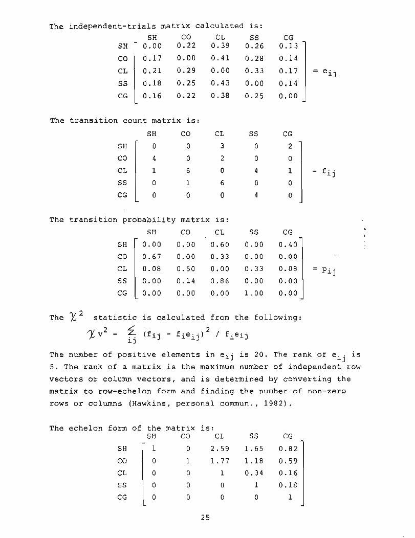
The independent-trials matrix calculated is:
The transition count matrix is:
The x 2 statistic is calculated from the following:
The transition probability matrix is:
SH CO C L SS CG
The number of positive elements in eij is 20 . The rank of eij is
5. The rank of a matrix is the maximum number of independent row
vectors or column vectors, and is determined by converting the
matrix to row-echelon form and finding the number of non-zero
rows or columns (Hawkins, personal comrnun., 1 9 8 2 ) .
SH
CO
C L
SS
CG
The echelon form of the matrix is: SH CO CL SS CG
0 2.59 1.65 0.82
1 1 . 7 7 1 . 1 8 0.59
CL 0 0 1 0.34 0 .16
r 0.00 0 .00 0 .60 0 .00 0 .40
0.67 0 .00 0 .33 0 .00 0.00
0 .08 0 .50 0.00 0 .33 0.08
0 . 0 0 0.14 0.86 0 .00 0.00
0 .00 0 .00 0 .00 1 . 0 0 0 .00 -
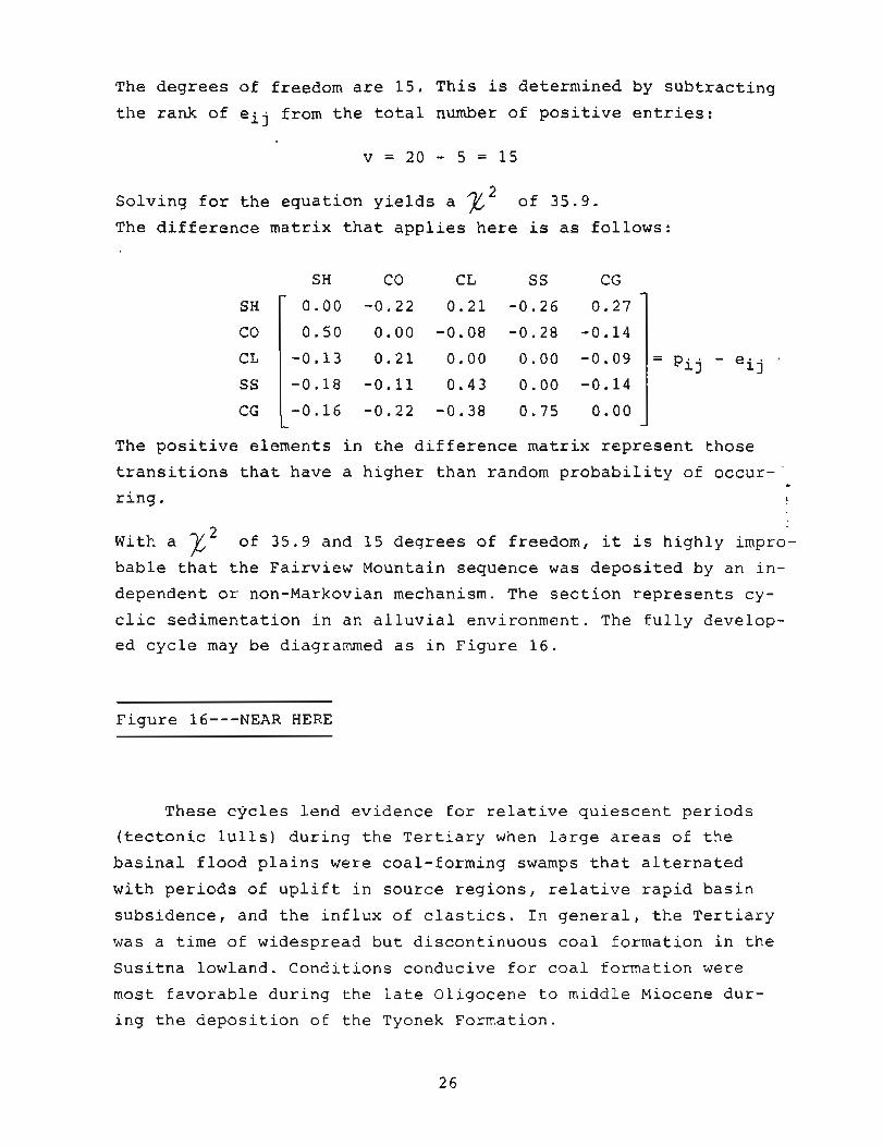
The degrees of freedom are 15. This is determined by subtracting
the rank of eij from the total number of positive entries:
Solving for the equation yields a z2 of 35.9 .
The difference matrix that applies here is as follows:
The positive elements in the difference matrix represent those
transitions that have a higher than random probability of occur-- - ring.
With a ? \o f 35 .9 and 15 degrees of freedom, it is highly impro-
bable that the Fairview Mountain sequence was deposited by an in-
dependent or non-Markovian mechanism. The section represents cy-
clic sedimentation in an alluvial environment. The fully develop-
ed cycle may be diagrammed as in Figure 16.
Figure 16---NEAR HERE
These cycles lend evidence for relative quiescent periods
(tectonic lulls) during the Tertiary when large areas of the
basinal flood plains were coal-forming swamps that alternated
with periods of uplift in source regions, relative rapid basin
subsidence, and the influx of elastics. In general, the Tertiary
was a time of widespread but discontinuous coal formation in the
Susitna lowland. Conditions conducive for coal formation were
most favorable during the late Oligocene to middle Miocene dur-
ing the deposition of the Tyonek Formation.

PALEOSALINITY
Various workers (Couch, 1971; Bohor and Gluskoter, 1973;
Spears, 1973, 1974; and Berner and others, 1979) have related
the paleosalinity of strata to paleoenvironmental interpreta-
tion, for example, to decipher marine transgressions and regres-
sions. Couch (1971) calculated paleosalinities from boron and
clay mineral data. Bohor and Gluskoter (1973) used boron in il-
lite as an indicator of paleosalinity in Illinois coals. Spears
(1973, 1974) used exchangeable cations and water-soluble cations,
and Berner and others (1979) used authigenic iron sulfides as
paleosalinity indicators.
Spears (1973) found that the concentration of exchangeable
magnesium is higher in marine shales, whereas the concentrations
of exchangeable calcium, sodium, and potassium are lower than in
nonrnarine and brackish shales. He correlated the changes in ex-
changeable cations (p. 79, 81) to paleosalinity throughout the ,
sequence, and postulated that these changes more likely occurred
during halmyrolysis (submarine weathering) than diagenesis.
Spears (1974) proposed that high concentrations of water-soluble
calcium and magnesium cations reflect marine-influenced environ-
ments, whereas low concentrations are diagnostic of fresh and
brackish water paleoenvironments; sodium and potassium have re-
verse trends.
E'igure 17 shows considerable variation of ammonium acetate
extractable cations and total cation-exchange capacity (CEC), expressed as milliequivalents per 100 g, for a Tyonek Formation
coal-bearing section near Peters Hills. Increases in extractable
M ~ + + , caf+, and K+ are mirrored by an increase in total CEC.
Spears (1973) found a corresponding decrease in total CEC with
increasing exchangeable magnesium. Changes in CEC are also direct-
ly related to changes in mineralogy; as in this example, a reduc-
tion in CEC simply reflects a decrease in the amount of clay, and
is most likely related to provenance. The Peters Hills section is
believed to have been deposited entirely in continental fluvial environments, and hence the variations are not related to transi-
tions with marine environments.
Figure 17---NEAR HERE
COAL PETROLOGY
MACERAL COMPOSITION
Maceral composition for Susitna lowland coal samples analyzed
during this study is suinmarized in Table 3 and Figure 18. The pet-
rology of the raw coals is commonly similar based on maceral group
proportions. However, the relative contents of individual macerals
and maceral types vary considerably both within a seam and among
different seams. Representative photomicrographs of coals from the
region show the variety, morphology, and associations of various
macerals (Figure 19) .
Table 3, Figures 18 and 19---NEAR HERE
The huminite group of macerals is by far the most abundant in
coals of the Susitna lowland; typically, this group contains over
90 percent of all macerals, and is always over 75 percent (Table 3).
Ulminite, the main huminite maceral present, usually appears fairly
uniform in structure and reflectance, and is medium to light gray,
and sometimes has desiccation cracks or microfractures. Texto-ulmi-
nite is partially gelified, whereas eu-ulminite is completely geli-
fied. The corpohuminites occur as both phlobaphinite (primary cell
infillings) and pseudophlobaphinite (secondary cell infillings).
Pseudovitrinite is extremely rare.
Mean-maximum reflectance values for all Susitna lowland coals
as measured -from ulminite macerals are summarized in Figure 20. Re-
flectance values range from 0.23 to 0.45 percent, and confirm that
most of the coals are subbituminous to lignitic. Little variation
occurs in the reflectance values of ulminite within a seam or among
all the seam samples analyzed.
Figure 20---NEAR HERE
~nertinites commonly occur as minor constituents in the
coals of the Susitna lowland; however, several seams, parti-
cularly those of the northern Yentna field at Fairview Mountain
and in the Peters Hills area, have inertinite contents ranging
up to over 18 percent by volume on a mineral-matter-free basis.
The inertinites are typically white or very light gray and
bright in normal incident light; they exhibit the highest re-
flectance~ of all macerals. The most predominant inertinite
macerals are macrinite, fusinite, and semifusinite. Inertode-
trinite (dispersed clastic fragments of inertinite) and sclero-
tinite (hard fungal remains found mainly in younger coals such
as those of the Tertiary period) were also observed. The sclero-
tia may be rounded or elliptical; its lumens or cavities may
contain resinite, pyrite, or other mineral matter. Micrinite
(fine granular debris) was not identified in the coals of the
region.
The liptinites occur as minor constituents in the coals of : the Susitna lowland; liptinites range up to about 12 percent by
volume on a mineral-matter-free basis. The most abundant lipti-
nites are resinite and suberinite. The liptinites have the low-
est reflectances of all macerals. They are black to dark gray in
normal incident (reflected) light but are fluorescent under blue-
light irradiation. Resinite occurs as cell fillings (of lumens)
or secretions and may be found as isolated, elongate or spheri-
cal bodies; it typically displays an orange fluorescence. Exsuda-
tinite was not counted separately but was included with resinite.
Exsudatinite commonly fills cracks in vitrinite, the cell lumina
of fusinite, or the chambers of sclerotinite (Spackman and others,
1976). Suberinite is commonly found in Tertiary coals; it origi-
nates from cork cell walls mainly in barks and root tissues. Spori-
nite occurs as squashed elongate bodies with slitted centers. Yel-
low stringers (in fluorescent light) of cutinite typically are
crenulated or toothed on one side, may be thin-walled or thick-
walled, and sometimes are folded. Alginites---preserved algal re-
mains---are rare in the coals of the Susitna lowland; they fluor-
esce yellow under blue-light irradiation.
PALEOENVIRONMENTAL INTERPRETATION FROM
MACERAL COMPOSITIONS AND ASSOCIATIONS
Coal petrology provides evidence for the depositional environ-
ments of coals..Maceral composition establishes the predominant
types of vegetation and indicates conditions of the ancient peat
swamp. The depositional system is integrative in that everything
in this regime is interdependent and related. For example, tecto-
nic factors determine relative subsidence rates, which influence
coalification, peat diagenesis, coal categenesis, and ultimately
coal petrology.
Cohen (1973), in relating precursor peat types to eventual
coal composition, differentiated two major groups of peats: a)
herbaceous peats, which produce a massive (unlaminated) dull coal,
and b) tree-vegetation peats, which result in a brighter, laminated
coal. He found that the herbaceous peats were low in preresinites
(cell fillings and secretions), presclerotinites (fungal remains),
and fusinite (charcoal) but higher in premicrinites (fine granular i
debris). However, tree-vegetation peats have a higher percentage.
of preresinites, presclerotinites, and fusinite but a low amount
of premicrinitic materials. Based on this subdivision, most Susit-
na lowland coals formed from tree-vegetation peats.
Paleoenvironmental interpretation from coal petrology begins
with an understanding of the concept of microlithotypes, which
are associations of macerals of the same group or with those from
other maceral groups. They can be monomaceralic (microlithotypes
containing macerals of only one group), bimaceralic (with macerals
of two groups), or trimaceralic (all three groups). Microlithotypes
compose the macroscopic lithotypes---vitrain, clarain, durain and
fusain.
The coal samples from the Susitna lowland were not collected
close enough---either vertically or laterally---to permit detailed
interpretation of facies changes from the petrographic variations
within the coal seams. However, the main microlithotypes present
can very generally be determined by selectively counting the mace-
ral associations on the polished pellets and from the extensive
maceral composition data collected. The different groups of micro-
lithotypes can be subdivided into individual microlithotypes by

taking account of these maceral associations (Stach and others,
1982). Vitrite is the dominant microlithotype, with clarite con-
taining minor interbands of vitrinertite and trimacerite (duro-
clarite). Williams and Ross (1979) found similar maceral composi-
tions and microlithotypes in Tertiary (Eocene) bituminous coals
in the Tulameen coal field of south-central British Columbia.
They also found vitrite to be the dominant microlithotype, with
clarite containing minor interbands of trimacerite (clarodurite)
and durite. From their maceral determinations, they proposed that
the coal-forming peats there developed in a forest-moor-swamp en-
vironment in a poorly drained low-lying basin that was adjacent
to an eroding upland during a warm, moist climatic period.
The determination of the paleoenvironment in which a coal-
forming peat developed extends back to a classic paper by Hac-
quebard and Donaldson (1969), who described how flood-plain and _
limnic environments in Nova Scotia could be related to Carboni- ?
ferous coal deposition. They emphasized that coal-forming materia:ls
can either essentially form in situ and be indigenous (autochthonous
coals) or can be transported to another region where these materials
accumulate (allochthonous coals). Hypautochthonous coals refer to
those that originated mainly from plant debris transported within
the general area of its growth, whereas allochthonous coal seams
form from peats that were deposited as drifted vegetation---more
specifically, plant accumulations that drifted or were rafted into
regions that do not correspond to those in which the plants origin-
ally grew.
Evidence indicates that most Susitna lowland coals undoubtedly
formed essentially in situ, but some coals exhibit characteristics
of each group. Upright and rooted fossil trees occur locally. Most
leaf impressions are complete and intact, which indicate no trans-
port. Some coals have classic underclays while others do not.
Hacquebard and Donaldson (1969) subdivided the seam profile
at each sample location into petrographic intervals that they con-
sidered represented time-rock units. Each interval is bounded on
top and bottom by clastic partings or distinctive dull layers,
which have both a relative widespread continuity and a character-
istic microscopic composition. They expressed the aggregate thick-
ness of individual microlithotypes as a percentage of the total
thickness of an interval and plotted these percentages in a four-
component 'facies' diagram (Figure 21). The vertices of the tri-
angles represent those microlithotypes (or combinations of micro-
lithotypes) that are characteristic of specific environments in
the peat bog:
*Spore-clarite + duroclarite---characterized by a high con- tent of spore exines
*Fusito-clarite---has distinct lenses of fusite in a matrix
of clarite
~Vitro-clarite + cuticle clarite---has high vitrinite con- tent, is low in sporinite
*Clarodurite + durite + carbargilite
Figure 21---NEAR HERE
Hacquebard and Donaldson (1969) recognized four diagnostic
vegetation zones that characterize the different types of swamp
environments, following the procedure of von Karmasin (1952; Fig-
ure 21). They recognized the forest-moor as the environment for
the deposition of vitrite and vitro-clarite, and the open-moor
for the deposition of largely subaquatic coals as cannel and
boghead and for certain types of spore-rich clarite. They con-
cluded that fusito-clarite formation occurs in a forested moor
(designated FtM) of the terrestrial zone where relatively dry
conditions prevail. The forest-moor and reed-moor facies of the
bright-coal upper triangle formed in the telmatic zone between
high and low water levels (Osvald, 1937). The subaquatic depo-
sits of the lowermost sector of the dull-coal triangle (Figure
21) formed in the limnic zone whereas the two remaining sectors
of this lower triangle represent limnotelmatic deposits.
The microlithotypes that are most clearly related to coals
of the Susitna lowland are those of the lower-left sector ( C ) of
the upper bright-coal triangle, which has a high content of vitri-
nite (or huminite) and is low in sporinite. However, there are
differences in the microlithotypes present in the two regions.
The forest-moor-swamp environment, where predominantly vitrite
and vitro-clarite are deposited, is typical of most Susitna low-
land (particularly Tyonek Formation) coals, as it is for coals
of the Tulameen field. The types of vegetation and conditions
of preservation of the plant materials in this environment indi-
cate that most of the coals of this region formed in the telma-
tic zone.
PYRITES IN SUSITNA LOWLAND COALS
Four major morphological species of sedimentary pyrite or
marcasite occur in coals and their associated sediments: 1) fram-
boidal pyrite; 2) euhedral grains; 3) coarse-grained masses (over
25 micron diameter) that replace original plant material; and 4)
coarse-grained platy masses or cleats that occupy joints. Dis-
seminated euhedral grains (usually 1-10 microns in diameter) and c
framboids (less 25 microns in diameter) are primary pyrite varie2
ties, and the coarse-grained, massive, and replacement forms are
secondary. 'Framboidal' refers to a unique 'raspberry-like' micro-
texture that forms clusters of spherical agglomerates; the dia-
meter of each microsphere varies from 0.25 to 1 micron. Groups of
framboidal spheres are termed polyframboids (Caruccio and others,
1977).
Framboidal pyrite occurs in the continental-fluvial low-sul-
fur coals of the Kenai Group. It has been documented petrographi-
cally in coal samples from several areas in the Susitna lowland
(Figure 22). Until recently, the origin of framboidal pyrite seemed
to involve sulfur-reducing marine or brackish-water microbial or-
ganisms, particularly bacteria. However, fine-grained pyrites have
recently been identified in till (Stene, 1979), unconsolidated mud
and ancient shale (Czurda and others, 1973), and freshwater sedi-
ments (Dell, 1975). Organic matter and a reducing environment are
prerequisites for framboidal-pyrite formation. Contrary to pre-
vious theory, sulfur-reducing bacteria such as Desulfovibrio de-
sulfuricans (Berner, 1969; Sweeney and Kaplan, 1973), which are
restricted to marine and brackish waters, are probably not required.

Williams and Keith (1963) found that roof rock of marine or brack-
ish-water origin contains more sulfur than that of freshwater ori-
gin. ~ndeed, pyrite morphology and grain size are controlled to
some degree by the geochemical regime in ancient peat-swamp en-
vironments. However, because of the recent discovery of framboidal
pyrite in a variety of sediments, paleoenvironmental interpreta-
tions should not be based on their presence; new theories as to
their origin must incorporate the diverse physical and geochemi-
cal conditions of these paleoenvironments.
Figure 22---NEAR HERE
Most Susitna lowland coals contain less than 0.4 percent sul-
fur (Table 4 ) , and all contain less than 0.75 percent sulfur. Thus,
coal cleaning (washing for sulfur) is generally not required. he+ organically-combined variety of sulfur most abundant in these codls
is difficult to remove or reduce substantially. A high sulfate-sul-
fur content in a coal commonly indicates a weathered sample (for
example, WC1-3 of Table 4).
Table 4---NEAR HERE
Primary sedimentary sulfides rapidly oxidize to iron oxides
and to ferrous and ferric sulfates when exposed to air, but secon-
dary pyrite (Figure 23) is stable and leaches very slowly (Caruc-
cio and others, 1977). Although framboidal pyrite is responsible
for most acid-mine drainage in coal-mining regions (Caruccio,
1970), problems are not expected in the Susitna lowland because
of the minor amount of pyritic sulfur and disseminated reactive
framboidal pyrite. In addition, the contamination of surface
waters and ground water by the solution and release of chemically
bound trace elements in the primary sulfide fraction should not
occur because of the small quantity of this disseminated pyrite
in the coals of south-central Alaska.
Figure 23---NEAR HERE
COAL QUALITY
The major coal deposits of the Susitna lowland are predomi-
nantly subbituminous B, subbituminous C, or lignite. Other seams
locally show apparent ranks of high-volatile B bituminous and
subbituminous A.
Almost all coal-quality data published to date for the Su-
sitna lowland (except for summaries developed by industry from
core samples) have been derived from analyses of weathered out-
crop samples. Readers are alerted to view coal quality data dur-
ing the present study as measurements of 'apparent rank.'
The chief attraction of most Alaskan coals is their extreme-
ly low sulfur content. Coals of the Susitna lowland nominally
have only 0.3 percent total sulfur (Figure 24). Ash content is
quite variable, but is low to moderate in some of the higher
quality coals of the Tyonek Formation.
Figure 24---NEAR HERE
The range of trace element contents in coal ash of Susitna
lowland samples are compared with the general contents found in
coal ashes from other regions in Figure 25. Elements that might
tend to become volatilized during combustion are generally low.
In almost all cases, the contents of elements in the Susitna
lowland samples fall within the ranges commonly found in other
coals. However, barium, manganese, and chromium were higher in
certain samples, while the contents of arsenic, zinc, boron, lead,
and molybdenum were lower in the ashes of certain samples.
Figure 25---NEAR HERE
During the present investigation, 66 coal samples from the
Susitna lowland were analyzed (Table 5; Figures 26 through 28).
A factor analysis based on proximate coal quality data and heat-
ing values derived two significant factors. Factor 1 is explained
by fixed carbon, heating value, and ash; it shows that the coals
with high fixed carbon have accompanying high heating values and

relatively low ash (and vice versa). Factor 2 is explained by
volatile matter and ash, and shows that coals with high vola-
tile matter contents are accompanied by low ash (and vice versa).
Moisture and sulfur contents were insignificant as factors ex-
plaining the variance.
--
Table 5; Figures 26-28---NEAR HERE
Scatter plots of paired proximate variables and heating values
reveal similar trends as in the factor analysis (Figure 27). The
high positive correlation in Figure 27A supports a direct rela-
tionship between heating value and fixed carbon content; that is,
as the fixed carbon content increases, so does the rank (as re-
flected in heating value) of the coal. The high positive correla-
tion in Figure 27B shows that the heating values also vary direct- . ly with the volatile-matter content of the coals. The high nega- ?
tive correlation in Figure 27C illustrates the inverse relation-
ship of the ash content and fixed carbon; that is, coals with a
higher fixed carbon content (higher rank) tend to have lower ash.
The trend displayed by the high negative correlation in Figure
27D is that coals with higher volatile matter contents show lower
ash (as in factor 2 explained above). These relationships are
expected for a group of coal samples exhibiting a narrow range
in rank variance, that is, most Susitna lowland coals being of
subbituminous rank.
A cluster analysis based on proximate data, total sulfur, and
heating value of the Susitna lowland coals analyzed is depicted in
Figure 28. Dlstinct clusters represent those coals with similar
characteristics. Often many coals from a given locality form a
fairly close cluster, while in other instances they appear to vary
significantly in quality.
Ultimate analysis results of selected coals from scattered
localities of the Susitna lowland are presented in Table 6, and
in general are typical for subbituminous and lignite coals. The
carbon contents are relatively low, while the oxygen contents are

relatively high but indicative of low-rank coals. Lignites, sub-
bituminous, and low-rank bituminous coals generally have hydrogen
contents around 5 or 6 percent; in high-rank bituminous and an-
thracite coals, it decreases to 3 or 4 percent. Sulfur and nitro-
gen contents are usually highest in bituminous coals and decrease
both in lower- and higher-rank coals.
Table 6---NEAR HERE
Considering the broad spectrum of coal rank, ash contents are
typically independent of the various rank indicators, and reflect
variations in the quantity of mineral matter initially deposited
in a peat swamp. Most of the inorganic matter in Susitna lowland
coals is accounted for by silica, alumina, and calcium oxides
with lesser abundances of iron and magnesium oxides (Figure 291.-
Silica is highest in Fairview Mountain coal ash and lowest in
some Chuitna River coal ashes. Alumina oxide is higher in certain
Canyon Creek coal ashes, and Chuitna River and Saturday creek coal
ashes tend to have higher calcium oxides. Saturday Creek coals
also exhibit higher SO3 contents. The other major oxides are fair-
ly consistent at all sites.
In summary, coals of the Tyonek Formation are generally of
higher quality than those of the younger Beluga and Sterling for-
mations in the Susitna lowland. This conclusion is supported by
the results of coal characterization research to date. However,
coals from all the formations are primarily subbituminous, with
moderate to high moisture, extremely low sulfur, and variable
ash contents.
-
Figure 29---NEAR HERE
COAL RESOURCES AND RESERVES
The Cook Inlet-Susitna lowland province represents the second
largest coal-resource base in Alaska, surpassed only by the depo-
sits on the North Slope. Large areas of the Susitna lowland hold

relatively shallow, surface-minable coal deposits. Many areas jud-
ged to have a high potential for future coal development have al-
ready been leased. There are other large tracts on which the coal
resources have been poorly defined.
The total identified coal resources of the Susitna lowland
are 10 billion short tons. Hypothetical resources are estimated
to be 30 billion short tons. Measured resources are at least 3
billion short tons. The latter estimate includes 1.5 billion
tons on Diamond Alaska Coal Company leases, 1.0 billion tons on
Beluga Coal Company leases, and 0.5 billion tons on leases of
Mobil Resources. Minor additional measured resources have been
defined on other leases in the region.
The coal deposits of the Susitna lowland have been delinea-
ted by private drilling programs since 1967, but most of the data
are still proprietary. The three deposits with the highest poten-
tial for minability in the immediate future are in the Beluga coad
field; these are Chuitna River, Capps basin, and Threemile Creek. k
The Capps deposits, which occupy a localized coal basin 11 to 13 2 km in area has two major minable coal beds, the Capps and Water-
fall seams. These beds have maximum thicknesses of 17 and 7.6 m,
respectively. The stripping ratio is estimated at 4:l to 5:l
(Patsch, 1976). Six seams constitute most of the minable resources
of the Chuitna River area (Figure 10). Cumulative stripping ratios
over the estimated mine life in this area are about 4.5:l (Ram-
sey, 1981).
The most favorable mining prospects within the Susitna lowland
occur where thick beds of the Tyonek Formation are within 100 m of
the surface. Most of the coals of the region over 6-m thick are re-
stricted to the Tyonek Formation, where over 100 separate beds have
been distinguished in a single well log. The West Foreland, Hemlock
Conglomerate, and Beluga Formations have several thick coal beds at
depth as indicated in oil well logs. Coal beds of the Sterling For-
mation, which crops out to the northern part of the Yentna basin,
are generally less than 2.5-m thick.
Although individual estimates of resources and reserves vary
significantly, the coal deposits of the Susitna lowland are enor-
mous by all accounts. Total minable reserves, as currently defined,
amount to several billion tons.

OVERBURDEN CHARACTER
The character of overburden strata of Kenai Group coals in
the Susitna lowland has received very little attention, mainly
because of the lack of active coal-mining operations. However,
surface mining in the region cannot be conducted without detail-
ed studies of both consolidated and unconsolidated overburden
materials.
A broad spectrum of overburden characterization analyses
were performed on Susitna lowland samples during the present
study (Table 7). Some of the most important characteristics of
overburden materials relate to their texture, acidity and saline-
sodic conditions, cation exchange capacity, organic matter, trace
element, macronutrient and micronutrient contents. Although guide-
line criteria used in evaluating the character and quality of
overburden materials have been developed in several other states,
including Wyoming and Montana, none have been established yet f in Alaska.
Table 7---NEAR HERE
TEXTURE
A plot of particle sizes and resultant textures for Susitna
lowland overburden samples show that several fall in poor texture
zones (Figure 30). In general, these poor-texture zones relate to
a regraded spoil medium being derived from high sand (greater 70
percent) or high clay (greater 40 percent) content overburden.
--
' Figure 30---NEAR HERE
Based on unconfined compressive strength tests of Capps coal
field core samples, Chleborad and others (1982) conclude that the
materials range from soft soil to soft rock.
ACIDITY
The overburden strata at Fairview Mountain, northwest Yentna
basin, exhibit both low pH values (to 4.1; Figure 31) and, in at
39
least two samples, deficiencies of ameliorating capacity over 5
tons CaC03 equivalent per 1000 tons of material. However, the
pyritic sulfur content of the roof and floor beds of coal seams
C-F was less than 0.1 percent and the total sulfur content was
less than 0.48 percent in all cases. The acidity here is believed
to have resulted from the biochemical breakdown of organic matter,
which ranged from 1.27 to 11.89 percent in those samples analyzed
from the site.
Figure 31---NEAR HERE
Because of the near-normal pHs and very low sulfur contents
in overburden materials (Figure 3 2 ) , acidity should not be a sig-
nificant problem in most areas of south-central ~laska.
Figure 32---NEAR HERE
SALINE-SODIC SPOIL
Results of analyses during the present study support the con-
clusion that saline and sodic spoil should not be a major problem
in the Susitna lowland. No zones of salt accumulation or sodium
adsorption levels that would be detrimental to the establishment
of plant growth were found in the overburden materials analyzed.
Electrical conductivities range from 0.1 to 0.9 mrnhos/cm at 25OC,
and the mean sodium adsorption ratio is less than 1.0. Although
a few samples exhibit anomalously high exchangeable sodium per-
centages, the mean value is 16.5 percent.
CATION-EXCHANGE CAPACITY
The range in 54 overburden samples analyzed from the Susitna
lowland (three sites) is 1.3 to 88.4 meq/100 g with a mean of
20.0 meq/100 g. Generally, shales and mudstones have relatively
high cation-exchange capacities (CEC). The CEC in sandstones
rarely exceeds 5 meq/100 g unless they are argillaceous.
TRACE ELEMENTS
Little baseline data exist for acceptable trace-element con-
tents for overburden materials, particularly in Alaska. Hinckley
and others (1982) concluded that considerable variation occurs
in rock chemistry and depositional environments over short dis-
tances in the Beluga area, and that fine-grained rocks (claystones)
typically contained higher abundances (by a factor of two or more)
of most trace elements than coarse-grained rocks (sandstones;
Table 8). Certain trace elements (for example, lead, zinc, nickel,
cobalt, and cadmium) in samples of overburden materials at several
localities in the Susitna lowland---Beluga River, Capps Glacier,
Fairview Mountain, Peters Hills area, Saturday Creek, and Wolverine
Creek---appear to be at levels significantly higher than recommend-
ed for substitution of these materials as prime topsoil or subsoil
media (Figure 33).
~ - --
Table 8, Figure 33---NEAR HERE b
?
The maximum content of selenium (Table 7) found in the 20
samples analyzed (two sites) from the Susitna lowland was 0.05
ppm, well below the probable toxicity threshold level of 2 ppm.
The total boron content of the 20 samples analyzed ranged up to
100 pprn with a mean value of about 34 ppm, indicating that excess
boron concentrations (greater than 5 ppm) in mine spoil material
could be a problem. Molybdenum was less than 15 pprn in all Susit-
na lowland overburden samples analyzed; at this level, molybdenum
could concentrate in plant tissues consumed by grazing ruminants
and result in the condition known as molybdenosis. Lead contents
in the overburden samples ranged up to about 50 ppm; in general,
materials with lead levels higher than 10 pprn should be selec-
tively handled.
MACRONUTRIENTS AND MICRONUTRIENTS
Extractable nutrient levels were analyzed in 43 overburden
samples from six sites across the Susitna lowland (Table 7). The
range and mean values for nitrate nitrogen are 2.1-13.8 and 4.0
ppm, respectively; for phosphorous 6.85-38.54 and 15.44 ppm; and
for potassium 47.6-280.4 and 136.4. These results indicate that
the samples are deficient in the major plant nutrients nitrogen
and phosphorous and sometimes potassium, and that amendments with
these compounds should aid revegetation if the materials are used
as a subsoil medium. Of the common micronutrients (iron, manga-
nese, zinc, boron, molybdenum, and copper), none appear to be de-
ficient. Zinc, boron, molybdenum, and manganese levels in some
samples may indicate a potential problem with metal phytotoxicity.
Iron and copper appear to be at levels sufficient for normal plant
growth.
SUMMARY OF OVERBURDEN CHARACTER
In summary, evaluations of coal overburden character from
Susitna lowland samples indicate that 1) poor texture zones could
result in regraded soil materials causing problems for proper
drainage and revegetation; 2) acidity problems should be minor
and localized; 3) there is little potential for the development
of saline-sodic conditions; 4) toxic levels of certain trace t
elements, including boron, molybdenum, and lead in spoil materiais
could result locally; 5) positive growth response can be expected
with additions of the macronutrients nitrogen and phosphorous; and
6 ) certain micronutrients, including zinc, boron, molybdenum, and
manganese are not deficient but could actually cause problems of
metal phytotoxicity locally.
CONCLUSIONS
The Tertiary Kenai Group of the Susitna lowland of south-
central Alaska contains substantial reserves of subbituminous
and lignite coals suitable for surface mining. Most of the coal
resources occupy a crescent-shaped belt along the western and
southern margin of the Susitna lowland. Although individual
estimates of resources and reserves vary significantly in the
region, total minable reserves undoubtedly amount to several
billion tons. The chief attractions of these coals are their
extremely low sulfur content and favorable location relative
to prospective Pacific-rim markets.
The coals are generally comparable in quality with those
of the Powder River Basin of the western United States. Calori-
fic and mean-maximum reflectance values indicate that most coals
are of subbituminous rank. Although the coals are laterally dis-
continuous and sometimes high in ash, the large number of seams---
particularly within the Tyonek Formation---and the geochemical
and physical character of the enclosing strata result in economi-
cally attractive deposits within several fields. However, sub-
surface information is scant and the true extent of these deposits
is unknown.
Petrologic studies indicate that most Susitna lowland coals
probably originated in forest-moor-swamp environments within the
telmatic zone. A drier paleoenvironment (perhaps in the terres-
trial zone) and an origin from tree-vegetation peats is interpre-
ted for coal seams of the northern Yentna basin (upper Tyonek
and Sterling Formations). Most of the coals formed on alluvial
flood plains within poorly drained low-lying basins adjacent to
eroding uplands during a warm, moist climatic period.
Coal overburdens are low in sulfur (less 0.5 percent), which'
mainly occurs in the organic form as it does in the coals. Serious
acid conditions and high levels of soluble salts and adsorbed so-
dium should not be a significant problem in the Susitna lowland.
However, isolated acid conditions could develop, and the levels
of certain trace elements in overburden materials, regraded
spoils, and in surface and ground waters should be monitored.
Material textures in the regraded spoil profile could pose
challenging problems for proper drainage and revegetation.

REFERENCES CITED
Adkison, W.L., Kelley, J.S., and Newman, K.R., 1975, Lithology
and palynology of Tertiary rocks exposed near Capps Glacier
and along Chuitna River, Tyonek Quadrangle, southern Alaska:
U.S. Geological Survey Open-file Report 75-21, 58 p.
Barnes, D.F., 1976, Bouguer gravity map of Alaska: U.S. Geolo-
gical Survey Open-file Report 76-70, scale 1:2,500,000.
Barnes, F.F., 1966, Geology and coal resources of the Beluga-
Yentna region, Alaska: U.S. Geological Survey Bulletin
1202-C, 54 p.
Berner, R.A., 1969, The synthesis of framboidal pyrite: Economic
Geology, v. 64, no. 4, p. 383-384.
Berner, R.A., Baldwin, Timothy, and Holdren, G.R., Jr., 1979,
Authigenic iron sulfides as paleosalinity indicators:
Journal of Sedimentary Petrology, v. 49, no. 4, p. 1345-
1350.
Bohor, B.F., and Gluskoter, H.J., 1973, Boron in illite as an
indicator of paleosalinity of Illinois coals: Journal of
Sedimentary Petrology, v. 43, no. 4, p. 946-956.
Boss, R.F., Lennon, R.B., and Wilson, B.W., 1978, Middle Ground
Shoal oil field, Alaska, in Braunstein, Jules, ed., North - America-oil and gas fields: American Association of Petro-
leum Geologists Memoir 24, p. 1-22.
Calderwood, K.W., and Fackler, W.C., 1972, Proposed stratigra-
phic nomenclature, Kenai Group, Cook Inlet basin, Alaska:
American Association of Petroleum Geologists ~ulletin, v.
56, no. 4, p. 739-754.
Carey, S.W., 1958, The tectonic approach to continental drift---
A symposium: Hobart, university of Tasmania, Geology de-
partment, p. 177-355.
44

caruccio, F.T., Ferm, J.C., Horne, John, Geidel, Gwendelyn, and
~aganz, Bruce, 1977, Paleoenvir~~ent of coal and its rela-
tionship to drainage quality: Environmental Protection Agen-
cy Interagency Energy-Environment Research and Development
Program Report EPA-66/7-77-067, 108 p.
Chleborad, A.F., Yehle, L.A., Schrnoll, H.R., Gardner, C.A., and
Dearborn, L.L., 1982, Preliminary geotechnical and geophy-
sical logs from drill hole 2C-80 in the Capps coal field,
Cook Inlet region, Alaska: U.S. Geological Survey Open-
file Report 82-884, 9 p., 2 plates.
Clardy, B . I . , 1978, Stratigraphy of the Matanuska-Susitna area,
northeastern Cook Inlet basin, Alaska: Louisiana Land and
Exploration Company, Western Division, Denver, unpublished
report, 15 p.
Cohen, A.D., 1973, Petrology of some Holocene peat sediments fromc ? the Okefenokee swamp-marsh complex of southern Georgia: Geo-.
logical Society of America Bulletin, v. 84, no. 12, p. 3867-
3878.
Conwell, C.N., 1977, Cook Inlet-Susitna coal fields: Alaska Divi-
sion of Geological and Geophysical Surveys unpublished inter-
nal reuort,. 32 p.
Conwell, C.N., Triplehorn, D.M., and Ferrell, V.M. , 1982, Coals of the Anchorage Quadrangle, Alaska: Alaska ~ivision of
Geological and Geophysical Surveys Special Report 17, 8 P O I
scale 1:250,000, 4 plates.
Couch, E.L., 1971, Calculation of paleosalinities from boron and
clay mineral data: American Association of Petroleum Geolo-
gists Bulletin, v. 55, no. 10, p. 1829-1837.
Czurda, K., Winder, C.G., and Quigley, R.M., 1973, Sedimentology,
mineral facies and petrofabric of the Meaford-Dundas Forma-
tion (Upper Ordovician) in southern Ontario: Canadian Jour-
nal of Earth Sciences, v. 10, no. 12, p. 1790-1804.
Dall, W.H., and Harris, G.D., 1892, correlation papers, Neocene:
U.S. Geological Survey Bulletin 84, p. 232-268.

Dell, C., 1975, Pyrite concretions in sediment from South Bay,
Lake Huron: Canadian Journal of Earth Science, v. 15, no.
3, p. 464-465.
Detterrnan, R.L., Plafker, George, Tysdal, R.G., and Hudson,
Travis, 1976, Geology and surface features along part
of the Talkeetna segment of the Castle ~ountain-Caribou
fault system, Alaska: U.S. Geological Survey Miscella-
neous Field Studies Map MF-738, 1 sheet, scale 1:63,360.
Dickinson, K.A., and Campbell, J.A., 1978, pi genetic minerali-
zation and areas favorable for uranium exploration in Ter-
tiary continental sedimentary rock in south-central Alaska,
a preliminary report: U.S. Geological Survey Open-file
Report 78-757, 13 p.
6
Duff, P. McL. D., Hallam, A., and Walton, E.K., 1967, Cyclic I
sedimentation: Amsterdam, Elsevier publishing Co., 280 p.
Fisher, M.A., and Magoon, L.B., 1978, Geologic framework of lower
Cook Inlet, Alaska: American Association of Petroleum Geo-
logists Bulletin, v. 62, no. 3, p. 373-402.
Gates, G.O., and Gryc, G., 1963, Structure and tectonic history
of Alaska, in Childs, O.E., and Beebe, B.W., eds., Back- - bone of the Americas: American Association of Petroleum
Geologists Memoir 2, p. 264-277.
Gingerich, P.D., 1969, Markov analysis of cyclic alluvial sedi-
ments: Journal of Sedimentary Petrology, v. 39, no. 1, p.
330-332.
Grantz, Arthur, Zietz, Isidore, and Andreasen, G.E., 1963, An
aeromagnetic reconnaissance of the Cook Inlet area, Alas-
ka: U.S. Geological Survey Professional Paper 316-G, p.
117-134.
Hackett, S.W., 1976a, Speculative tectonic evolution of the Ceno-
zoic Shelikof trough, south-central Alaska, in Short notes - on Alaskan geology---1976: Alaska Division of Geological
and Geophysical Surveys Geologic Report 51, p. 13-17.
, 1976b, Regional gravity survey of Beluga basin and adjacent area, Cook Inlet region, south-central Alaska: Alas-
ka Division of Geological and Geophysical Surveys Open-file
Report 100, 38 p.
, 1977, Gravity survey of Beluga basin and adjacent area, Cook Inlet region, south-central Alaska: Alaska Divi-
sion of Geological and Geophysical Surveys Geologic Report
49, 26 p.
Hacquebard, P.A., and Donaldson, J.R., 1969, Carboniferous coal - . deposition associated with flood-plain and limnic environ- r
ments in Nova Scotia, in Dapples, E.C., and ~opkins, N.E., - eds., Environments of coal deposition: Geological society
of America Special Paper 114, p. 143-191.
Hartman, D.C., Pessel, G.H., and McGee, D.L., 1972, Preliminary
report on the stratigraphy of the Kenai Group, upper Cook
Inlet, Alaska: Alaska Division of Geological and Geophysi-
cal Surveys Special Report 5, 11 plates.
Hinckley, T.K., Smith, K.S., Peard, J.L., and Tompkins, M.L.,
1982, Whole-rock chemical composition of some samples from
two drill hole cores in the Capps coal field, Beluga coal
area, south-central Alaska: U.S. Geological Survey Open-
file Report 82-672, 50 p.
Hite, D.M., 1976, Some sedimentary aspects of the Kenai Group,
Cook Inlet, Alaska, in Miller, T.P., ed., Recent and an- - cient sedimentary environments in Alaska: Alaska Geologi-
cal Society Symposium, Anchorage, 1976, Proceedings, p.
11-123.
4 7

Karlstrom, T.N.V., 1964, Quaternary geology of the Kenai lowland
and glacial history of the Cook Inlet region, Alaska: U.S.
Geological Survey Professional Paper 443, 69 p.
, 1965, ~esum& of the Quaternary geology of the upper Cook Inlet area and Matanuska River valley, in P&W&, - T.L., ed., Guidebook to the Quaternary geology, central and
south-central Alaska (VII INQUA Congress): Alaska Division
of Geological and Geophysical Surveys, p. 114-141.
Kelly, T.E., 1963, Geology and hydrocarbons in Cook Inlet basin,
Alaska, - in Childs, O.E., and Beebe, B.W., eds., Backbone of
the Americas---A symposium: American Association of Petro-
leum Geologists Memoir 2, p. 278-296.
Kirschner) C.E., and Lyon, C.A., 1973, Stratigraphic and tectonic
development of Cook Inlet petroleum province, in Pitcher, M.: - G., ed., Arctic geology: American Association of Petroleum
Geologists Memoir 19, p. 396-407.
Magoon, L.B., Adkison, W.L., and Egbert, R.M., 1976, Map showing
geology, wildcat wells, Tertiary plant fossil localities,
K-Ar dates, and petroleum operations, Cook Inlet area, Alas-
ka: U.S. Geological Survey Geologic Investigations Map I-
1019, scale 1:250,000.
Magoon, L.B., and Claypool, G.E., 1981, Petroleum geology of
Cook Inlet basin---an exploration model: American Associa-
tion of Petroleum Geologists Bulletin, v. 65, no. 6, p.
1043-1061.
Mason, Brian, 1966, Principles of geochemistry: Wiley and Sons,
New York, p. 241-243.
Merritt, R.D., Eakins, G.R., and Clough, J.G., 1982, Coal inves-
tigation of the Susitna lowland, Alaska: Alaska Division
of Geological and Geophysical Surveys Open-file Report 142,
42 p., 2 appendixes, 4 plates, scale 1:250,000.
Miller, R.D., and Dobrovolny, Ernest, 1959, Surficial geology of
Anchorage and vicinity, Alaska: U.S. Geological Survey Bul-
letin 1093, 128 p.
Nelson, S.W., and Reed, B.L., 1978, Surficial deposits, Talkeetna
Quadrangle, Alaska: U.S. Geological Survey Miscellaneous
Field Studies Map MF-870J, scale 1:250,000.
Osvald, H., 1937, Myrar och myrodling (Peatlands and their culti-
vation): Stockholm, Kooperativa Forbundels Bokforlag, 407 p.
Patsch, B.J.G., 1976, Exploration and development of the Beluga
coal field, in Rao, P.D., and Wolff, E.N., eds., Focus on - Alaska's Coal '75: Alaska Coal Conference, lst, Fairbanks,
1975, Proceedings, University of Alaska Mineral Industry
Research Laboratory Report 37, p. 72-83.
Payne, T.G., 1955, Mesozoic and Cenozoic tectonic elements of
Alaska: U.S. Geological Survey Miscellaneous Geologic In-
vestigations Map 1-84, scale 1:5,000,000.
Price, N.B., and Duff, P. McL. D., 1969, Mineralogy and chemistry
of tonsteins from Carboniferous sequences in Great Britain:
Sedimentology, v. 13, p. 45-69.
Ramsey, J.P., 1981, Geology, coal resources, and mining plan for
the Chuitna River field, Alaska, in Rao, P.D., and Wolff, - E.N., eds., Focus on Alaska's Coal '80: Alaska Coal Con-
ference, 2nd, Fairbanks, 1980, Proceedings, University of
Alaska Mineral Industry Research Laboratory Report 50,
p. 111-121.
Reed, B.L., and Nelson, S.W., 1980, Geologic map of the Talkeetna
Quadrangle, Alaska: U.S. Geological Survey Geologic Investi-
gations Map 1-1174, scale 1:250,000.
Sanders, R.B., 1981, Coal resources of Alaska, in Rao, P.D., and - Wolff, E.N., eds., Focus on Alaska's Coal '80: Alaska Coal

Conference, 2nd, Fairbanks, 1980, Proceedings, University
of Alaska Mineral Industry Research Laboratory Report 50,
p. 11-31.
Schmoll, H.R., and Yehle, L.A., 1978, Generalized physiography
and geology of the Beluga coal field and vicinity, south-
central Alaska, - in Johnson, K.M., ed., The U.S. Geological
Survey in Alaska---Accomplishments during 1977: U.S. Geo-
logical Survey Circular 772-B, p. B73-B76.
Schmoll, H.R., Chleborad, A.F., Yehle, L.A., Gardner, C.A., and
Pasch, A.D., 1981, Reconnaissance engineering geology of
the Beluga coal resource area, south-central Alaska, - in
Rao, P.D., and Wolff, E.N., eds., Focus on Alaska's Coal
'80: Alaska Coal Conference, 2nd, Fairbanks, 1980, Pro-
ceedings, University of Alaska Mineral Industry Research * !
Laboratory Report 50, p. 92-110.
Spackman, William, Davis, Alan, and Mitchell, G.D., 1976, The
fluorescence of liptinite macerals: Provo, Brigham Young
University Geological Study 22, part 3 , p. 59-75.
Spears, D.A., 1973, Relationship between exchangeable cations
and paleosalinity: Geochemica et Cosmochimica Acta, v .
38, no. 4, p. 567-575.
Stene, L.P., 1979, Polyframboidal pyrite in the tills of south-
western Alberta: Canadian Journal of Earth Sciences, v.
16, no. 10, p. 2053-2057.
Sweeney, R.E., and Kaplan, I.R., 1973, Pyrite framboid formation;
laboratory synthesis and marine sediments: Economic Geology,
v. 68, no. 5, p. 618-634.
Triplehorn, D.M., Turner, D.L., and Naeser, C.W., 1977, K-Ar and
fission-track dating of ash partings in Tertiary coals from
the Kenai Peninsula, Alaska; a radiometric age for the
Homerian-Clamgulchian stage boundary: Geological Society of

America Bulletin, v. 88, no. 8, p. 1156-1160.
Turner, D.L., Triplehorn, D.M., Naeser, C.W., and Wolfe, J.A.,
1980, Radiometric age dating of ash partings in Alaska
coal beds and upper Tertiary paleobotanical stages:
Geology, v. 8, no. 2, p. 92-96.
Von Karmasin, K., 1952, Deutung des Frazieswechsel in den Flozen
Erda und Agir auf Grund mikropetrographischer Schlitz pro-
benunter suchunges: Bergbau Archiv 13, Heft 1-3, p. 74-100.
Warfield, R.S., 1962, Investigation of a subbituminous coal de-
posit suitable for open cut mining, Beluga River coal
field, Alaska: U.S. Bureau of Mines Report of Investi-
gations 6238, 100 p.
Williams, E.G., and Keith, M.L., 1963, Relationship between sul-:
fides in coals and the occurrence of marine roof beds:
~conomic Geology, v. 58, no. 5, p. 720-729.
Williams, V.E., and Ross, C.A., 1979, Depositional setting and
coal petrology of Tulameen coalfield, south-central Bri-
tish Columbia: American Association of Petroleum Geolo-
gists Bulletin, v. 63, no. 11, p. 2058-2069.
Wolfe, J.A., 1966, Tertiary plants from the Cook Inlet region,
Alaska: U.S. Geological Survey Professional Paper 398-B,
p. B1-B32.
, 1972, An interpretation of Alaskan Tertiary floras, in Graham, Alan, ed., Floristics and paleofloristics of - Asia and western North America: Elsevier Publishing Co.,
Amsterdam, p. 201-233.
, 1977, Paleogene floras from the Gulf of Alaska re- gion: U.S. Geological Survey Professional Paper 997, 108 p.
, 1978, Paleobotanical interpretations of the Tertiary climates of the northern hemisphere: American Scientist, v.
66, no. 6; p. 694-703.
Wolfe, J.A., Hopkins, D.M., Leopold, E.B., 1966, Tertiary strati-
graphy and paleobotany of the Cook Inlet region, Alaska:
U.S. Geological Survey Professional Paper 398-A, 29 p.
Wolfe, J.A., and Tanai, Toshimasa, 1980, The Miocene Seldovia
Point flora from the Kenai Group, Alaska: U.S. Geological
Survey Professional Paper 1105, 52 p.

FIGURE CAPTIONS
Figure l...General location and physiographic setting for the
Susitna lowland of south-central Alaska. Modified
from Miller and Dobrovolny, 1959. vertical exaggera-
tion about 4X.
2...Mesozoic and Cenozoic tectonic elements, major faults,
basins, and highland exposures of pre-Tertiary base-
ment rocks (shaded) in the Cook Inlet region of south-
central Alaska. Modified from Payne, 1955 and Hackett,
1977.
3...Structural sections based on geophysical profiles
across the Beluga basin and adjacent areas, southern
Susitna lowland. Modified slightly from Hackett, 1977.a L
4...Simple Bouguer gravity map of the Beluga basin and ad-
jacent areas of the Cook Inlet region, south-central
Alaska. Modified from Hackett, 1977.
5...General stratigraphic nomenclature for the Tertiary
Kenai Group of southcentral Alaska. After Calderwood
and Fackler, 1972.
6...Surface and subsurface Tertiary stratigraphic correla-
tion chart. (a) from Wolfe and others, 1966; (b) from
Magoon and others, 1976.
7...Lithologic column for the Tyonek Formation at the type
section in the Pan American Petroleum Corporation Tyo-
nek State 17587 No. 2 well. From Calderwood and Fack-
ler, 1972.
8...Typical cross section of the Capps area of the Beluga
coal field showing the thickness of the Capps and
Waterfall seams, and of overburden and interburden
zones. Adapted from Conwell, 1977.

Figure 9...Outcrop of the Chuitna Bed (Brown Seam), Tyonek For-
mation, Beluga coal field, Susitna lowland.
lO...Generalized stratigraphic column showing the princi-
pal coal beds of the Chuitna River area of the Beluga
coal field, southern Susitna lowland.
11 ... X-ray diffractogram of a coal tonstein (sample CG4-6) from the Capps Seam showing that the chief constituent
is kaolinite.
12...Gradational zones of burn material at an upper Canyon
Creek coal-bearing section, Tyonek Formation, south-
west Yentna basin.
13.'..Idealized depositional model for the Tyonek orm mat ion; Kenai Group, Cook Inlet, Alaska. After Hite, 1976.
14 ... Geologic cross section of an area in the Beluga coal field thought to be a lacustrine deposit. Lower inset
maps show the location of the deposit. Inset maps only
modified from Warfield, 1962.
15 ... Fairview Mountain, Yentna basin, geologic section to which a statistical Markov chain analysis was applied.
Refer to text for discussion.
16...Probabilities of various transitions in lithologies
within the Fairview Mountain section of the Tyonek
Formation. Refer to text for discussion.
17...Variation in the ammonium acetate extractable cations
and total cation exchange capacity for a Peters Hills
area (east Yentna basin, Tyonek Formation) coal-bear-
ing section.
18 ... Ternary diagram for maceral group composition of Susitna lowland coal samples.

Figure 19 ...( A-F) Photomicrographs of various macerals from
Susitna lowland coal samples, oil immersion.
A. Pseudophlobaphinites and ulminite, 400X.
B. Fusinite, 3 1 5 X .
C. Semifusinite, ulminite, and sclerotinite, 3 1 5 X .
D. Phlobaphinite and porigelinite, 400X.
E. Phlobaphinite and suberinite, 400X.
F. Sclerotinite, ulminite, and porigelinite, 315X.
20...Vitrinite reflectance frequency histogram for coal
samples from the Susitna lowland. Number in brackets
indicates the total number of vitrinites measured
at the given reflectance interval.
21 ... Four-component 'facies' diagram used to express the -
aggregate thickness of individual microlithotypes as ' L
a percentage of the total thickness of a coal inter-.
val. The vertices of the diamond-shaped diagram are
occupied by those microlithotypes or combinations of
raicrolithotypes representing specific environments
in a peat bog. Adapted from Hacquebard and Donaldson,
1969.
22 ... Photomicrograph of framboidal pyrite in a Susitna lowland coal seam (Tertiary, Tyonek Formation).
23 . . . Photomicrograph of coarse-grained, striated, massive, secondary pyrite in a Susitna lowland coal seam (Ter-
tiary, Tyonek Formation).
24 ... Histogram showing the maximum and arithmetic mean values for the percent total sulfur and sulfur spe-
cies of analyzed Susitna lowland coal samples (as
received basis) . [ 1 = number of samples.
25 ... Range of trace element contents in raw coal ashes com- monly found in other coals compared with abundances in

Susitna lowland coals. Range in other coals from
Mason, 1966, fig. 9.5, p. 242.
Figure 26 ... Histograms of various coal-quality parameters for Su- sitna lowland coal samples. The frequency expresses
the nuinber of samples exhibiting a particular value.
27...Scatter plots with regression lines of paired-proxi-
mate variables for Susitna lowland analyzed coal Sam-
ples. Note the correlation coefficients in each case.
Refer to text for discussion.
28...Cluster analysis based on proximate data, total sul-
fur, and heating values for Susitna lowland analyzed
coal samples. Coals of similar quality form close
clusters. i
29 ... Range in concentration of major oxides in raw coal ash of samples from eight localities in the Susitna
lowland. l=Beluga River; 2=Canyon Creek; 3=Capps
Glacier; 4=Chuitna River; 5=Fairview Mountain; 6=
Peters Hills; 7=Saturday Creek; and 8=Wolverine
Creek.
30. ..Particle sizes and textures for Susitna lowland over-
burden samples showing those rock materials that would
tend to form poor texture zones in spoil material. Poor
texture zones (greater 40 percent clay and greater than
70 percent sand) are indicated by unshaded pattern.
31 ... Overburden/interburden characteristics for a Fairview Mountain coal-bearing section (Tyonek Formation, north-
west Yentna basin).
32 ... Histograms for pH and total sulfur content for Susitna lowland overburden samples. The frequency expresses
the number of samples exhibiting a particular value.

Figure 33 ... Comparison of the range for certain trace element con- tents in overburden materials at six localities in
the Susitna lowland. BR=Beluga River; CG=Capps Glacier;
FM=Fairview Mountain; PA=Peters Hills area; SC=Satur-
day Creek; and WC=Wolverine Creek.


F i g u r e 2

Switnr basin
- +5000'
C
- W
-10,000'-
0 I S - pra-Tutiary basement complar
10 km - .15,000'
vertical exagguation SX
LOCATION OF STRUCTURE SECTIONS 162O 150'
c
V r t i u l exagQuation SX
Bdup b i n
we-Tarthry b w m o n t complex
Vertical ex.ggu8tion SX BEND IN SECTION 152'
Figure 3

- / O + 2 0 0 2 0 40 6 0 8 0 A L A S K A 100 I 2 0 1 1 0
I Grav~ty contours dot dashed where approx~mately located supplementary contours dashed Lows (L ) and highs (H) querled where less certaln Contour Interval 10 rn~ll~gals
MAP LOCATION
Figure 4
F i g u r e 5
: L
8
Cretaceous and Jurasslc rocks
I n ,
> ~ a m m u
a >
a z
g > f a
E Z ~ o k - z
FORMATION
Alluv~umand glacial d e p o s ~ t s
Sterl~ng Format~on
Beluga Format~on
DESCRIPTION
Masslve sandstone a n d conglomarate beds with occas~ona l t h ~ n l ~ g n l t a beds
Clavstone r ~ l t s t o n e , and t h ~ n sandstone beds, t h ~ n s u b b ~ t u m ~ n o u s coals beds
& Tyonek Formaf~on
Hemlock Conglomerate
Sandstone. c laystone and stltstone ~ n t a r b e d s and massive r u b b ~ t u m ~ n o u s coal beds
Sandstone and conglomerate
West Foreland Format~on
Tuffaceous s ~ l t s t o n e and claystone, scatterad sand stone and conglomerate
Rests uncontormab ly o n older T e r r ~ a r y
0 > - - 3 a
? m
ii
SE 0'; c m ,-
z~ :(LO
C : .a P 8 4 - 4
C g 1 P C " < .g " O E c m 5 2 2-0 0
0 (I
B E
- C - Y
8 U
g ,-
E 0 m a f g 6 8
dnOU9
-J
2 s 2; u
fn LU a LU V)
5
h z > UJ m I- -
c " % E ",?,B " = : 2 a E Z n 5 - E - 0 2
L- 0 LC i 9 % ~ c < ~ 2 . 2
In (0
.- 0 z z Y 0
C
a 'E ; E m z u
C
Y O al 'Z c m
B E I- 0
(I
!euay
C I ' I I
I c m
c I C I m 1 C
- a I .m I .- I m > 0
ea I g 1 - I S I $ l u
5 - 1 x 1 4 I < 0 I I
.g p, a P ~ E
u.
'
C .-
i! S Y
I I I c I : 5 1 . 5 1 .- c I C I .- 1 2 1 3 1 7 1 : 2 , , I ; I I
3 5 C 3
3
W 8 . 2;
3 3
$LU
a 0 <5 -
A 3
0)
w
.- 8 b
A
m c
'i .- - 0
I m 0)
8 LU
2 J
w
8 1
3 2 A
w -c
H - 2
AUVI l k I31
J
C) d m 2 g P i : 0 LD 0 In 0 In 0 cD 2 N m (? d d In In
B e l w Formation
Conglomerate
F i g u r e 7

West East Elevation
2 100' Elevation . 2100'
0 50 m 1300'
(Vertical exaggeration 500x1 1300'
Figure 8
F i g u r e 9


1
COAL SEAM GENERAL LITHOLOGY
Surface occasionally covered by peat. Outwash zone consisting of sand, clay and gravel occa- sionally occurs, especially in
Brown Seams the eastern portion of the area. Outwash has removed significant amounts of coal in some areas.
Yellow Seams
Sand and clay with occasional coal seams.
Green Seam
Clay and s l l t with abundant sand beds and lenses and occasional coal seams.
Blue Seam
Red 3 Seam
Clay and s ~ l t with occasional coal seams. Scattered occur- rences of thick to thin sand beds and lenses. Thick sand bodies become more common to west as entire untt thickens.
Red 2 Seam Red 1 Top Seam Red 1 S a m
Sand, coarse to very fine grained with occasional clay and gravel.
Clay and s ~ l t with clayey Purple Seams coal ~n zone of carbonaceous
clay and gravel.
Sand, coarse to f ~ n e gra~ned.
-
F i g u r e 10


F i g u r e 1 2
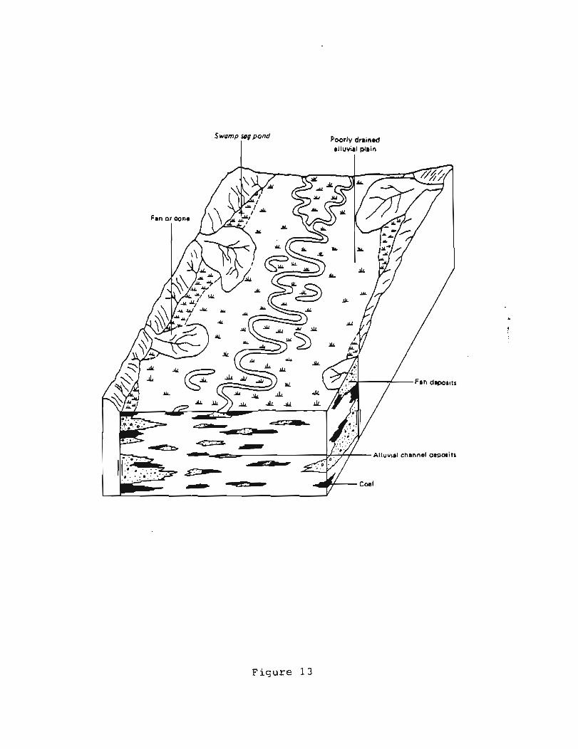
Swamp sog pond
I Poorly drained alluvial plain
F i g u r e 13
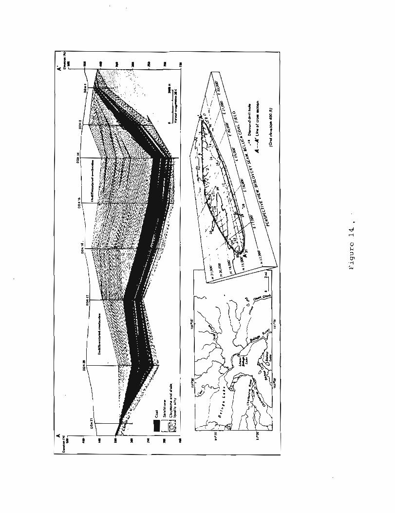

Depth (f t)(m)
F i g u r e 1 5

0 2 1 0 2 1 I L SHALL C L A Y I T O N E - COAL a
F i g u r e 16
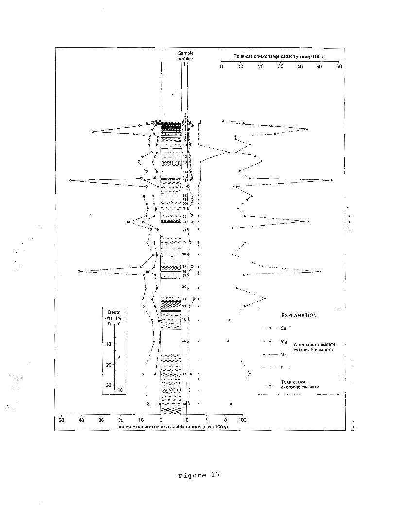
Sample number Total-cation-exchange capacity (meq/100 g)
I -A\---
-~---===A --A--
I 4- i 1
I 1 I
'A---- - --------A
I
I I
A - I
1 i
I
- ~ EXPLANATION
- - +- Ca -
Mg Amrnon~um acetate ex tractable catlons
- . -- - .. N a
.F. -- K 1 I I
Total-cat~on- , ,
, , - t
- - - - . - - - - - exchange capaclty - - - - . . _ _ _ - / I L--- . - -
F i g u r e 1 7
t
Ammonium acetate extractable catlons (meqi100 g) 1, -
- - - - - - - - - - - - - - - br>::f - - - - - - - - _ - - - - - - - - - - -
I , ; -- --
3 a i A I A
I
I - - - - i
f
~ 4 0 3 0 2 0 10 0 0 1 10 100 I I

Huminite
F i g u r e 18

F i g u r e 1 9

B+C
< 20% dull in upper
D
A - Sporeclarite + duroclarite
B - Fusitoclarite C - Vitroclarite +cuticle clarite
I D - Clarodurite + dur~te + carbargilite I F t M - Forest terrestrial moor F M - Forest moor
R M - Reed moor
I OM - Ooen moor I
F i g u r e 2 1
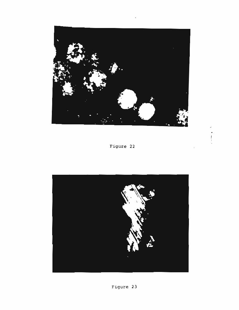
Figure 22
F i g u r e 2 3

--- Arithmetic mean value - Maximum observed value
F i g u r e 2 4


- 0 - > 0
-", s P u
Q P F I , , n 0
V) 8 - - - ( n i a ) anlen ~ ! J I J O I Q

1 I 6 24 32 40
Fixad crrbon (%I NUMBER OF SAMPLES: I S CORRELATION COEFFICIENT: .M61
MEAN STANOARO OEVIATION REGRESSION LINE X 3 2 . m 5.0584 X . 00431 *Y-2.M68 Y 8133.7 1015.4 Y - 113.68 X*IUO.@
3 . l W l / , 1 24 30 36 42 48
Volatile mmer (96) NUMBER OF SAMPLES: 16 COII IELATION COEFFICIENT: .US4
MEAN STANDARD OEVIATION REORESSION LINE x 37.228 4 . 4 ~ 3 x = .WN~*V+IZ.B~B Y 8133.7 1015.4 Y - 167.24*X+lZW.O
A h (%I Volntile manor (%) NUMBER OF SAMPLES: 86 N U M I E I OF SAMPLES. 66 CORRELATION COEFFICIENT: -.W I CORRELATION COEFFICIENT - .7 l71
MEAN STANOAIO DEVIATION R E O l E t l l O N LINE MEAN STANOAIIO OEVIATION REORE11011 LINE X 16.D73 8.1081 X = -I.SOU.YJ3.768 X 37.231 4 3128 X = -.37#!3l.Y+42.11 Y 31.328 6.1912 Y -,47241*Xi3l.UQ 8.1601 Y - -1.8538.X+l6.a3
F i g u r e 27

F i g u r e 2 8
891 -1 CnC2-1 FrC1-1 DC1-2
r WCZ.10 CR10.1 CR3-1 CC3.2 CR6-3
1 CR6-1 CR9-3 - S C 4 4 - SC4-2 g; CnC4-1 B R l % FM2-1 BR1-12 BR1-15
L B R 1 4 FM1-7 c
CG4-5 ! CG4-4 W C 1 4 SC3.1 SC4.12
I F M 1 4 F M 1 - 1 0 CG4-2 WC2 -1 4 CG4.1
I .
CC3-3 F M 2 4
FM1.13
PA2.1 JC3-1 JC3-5
- CR5-1 P A 1 4
i__=_ CG4-3 C C 3 1 CC3-1 C G I 1
PA3-1 SR 1 -2 WCZ 4
PA3-3
'-I- TR1.1
SC4.7 I CPc1.1
WC 1.3 1 Jc2.2
L WC2 4
FM1.2 P A 1 -34 CG3-10

(Verttcat scale Oxide content (%I expanded lox I 0 7 ;
m
m
N-
2 :: o m -
m w - m - - - N - W -
C A -
- I -
w I D
P I - -
w - w-
5 : O or- -: 0
t w -
8:: ::
-- m
4 D
3 1 ' = * - -
O :' I- - m -4 - ;]I-
Z : A-¤ O
u - l
m-* -- N-
w- 71 a-
m- 0 ,- u- m- -- ,+- W-
>+- O m
: : 01-
- N-
wJ- ;:= - - I - I 'I - b -
7 9 - + v 1 - -
No*-
o w - - VI or-
:: d4
- I - 8 = I
Percent sand
F i g u r e 30

O W N n o 0 0 0 0 -. . O N - ?? q 00 0

Frequency
1 I 1 I I I I
0 5 10 15 I 1
20 2 5 30 35 40 Frequency
F i g u r e 3 2
PARTS PER MILLION
I CG3 I I p d FMl
h l 01
PA1 1 I -- SC4 I

Table 1. Major oxide geochemistry of two
coal tonsteins from the Susitna lowland.
Oxide CnC7-12 CG4-6
Si02 26.37
A1203 24.02
Fe203 1.22
MnO 0.00
MgO
CaO
Na20
K2°
Ti02
'2'5
LO1
H20*

Table 2. Major oxide geochemistry of a gradational series of
baked rocks from an upper Canyon Creek locality.
MAJOR OXIDE
Fe203
MnO
CaO
SUM
a-Shale, carbonaceous, relatively unaltered
b-Light gray baked claystone with abundant plant fossils
c-Cream-colored (beige) baked claystone
d-Pink to light red scoriaceous clinker, abundant hematite
e-Dark red to maroon burn, high hematite

Table 3. Maceral composition summary for 180 coal samples from
the Susitna lowland reported on a volume percent, moisture- and
ash-free basis.
MACERAL MACERAL/ GROUP MACERAL TYPE
MEAN RANGE IN CONTENTS CONTENT
HUMINITE
Ulminite 15.8 - 99.0 65.0
Porigelinite
Phlobaphinite
Pseudophlobaphinite 0.0 - 21.6 3.9
Humodetrinite 0.2 - 63.2 15.7
Total 76.6 -100.0 .................................................................... !
Fusinite 0.0 - 9.6 0.6
Semifusinite 0.0 - 5.2 0.3
INERTINITE Sclerotinite 0.0 - 1.4 0.1
Macrinite 0.0 - 2.0 0.9
Inertodetrinite 0.0 - 5.2 0.2
Total O.'O - 18.6 ................................................................... Cutinite 0.0 - 3.4 0.4
Sporinite 0.0 - 5.6 0.4
LIPTINITE Resinite
Suberinite 0.0 - 3.8 0.5
Alginite 0.0 - 2.0 0.05
Total 0.0 - 11.8
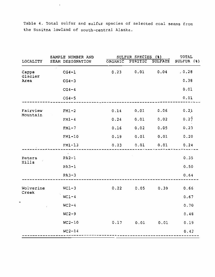
Table 4. Total sulfur and sulfur species of selected coal seams from
the Susitna lowland of south-central Alaska.
SAMPLE NUMBER AND SULFUR SPECIES ( % ) TOTAL LOCALITY SEAM DESIGNATION ORGANIC PYRITIC SULFATE SULFUR ( % )
CaPPs CG4-1 Glacier A r e a CG4-3
Fairview Mountain
Peters PA2-1 Hills
'
PA3-1
Wolverine WC1-3 Creek
WC1-4

Table 5. Range and mean values for coal quality parameters in 66 raw coal samples
from the Susitna lowland.
VOLATILE FIXED BASIS* MOISTURE MATTER CARBON HEATING SULFUR ASH VALUE
1 7.3-21.9 25.9-46.1 15.1-43.7 0.01-0.73 2.4-51.7 4570-10960
RANGE 2 ---- 27.9-55.1 16.4-50.9 0.01-0.91 2.8-55.7 - 4930-13400
3 ---- 45.6-63.2 36.8-54.4 0.01-1.03 ---- 10480-15540
1 15.4 37.2 32.3 0.26 15.1 8163
MEAN 2 ---- 44.1 38.3 0.31 17.7 9680
3 ---- 53.7 46.3 0.39 ---- 11766
*l-As received; 2-Moisture-free; and 3-Moisture- and ash-free.
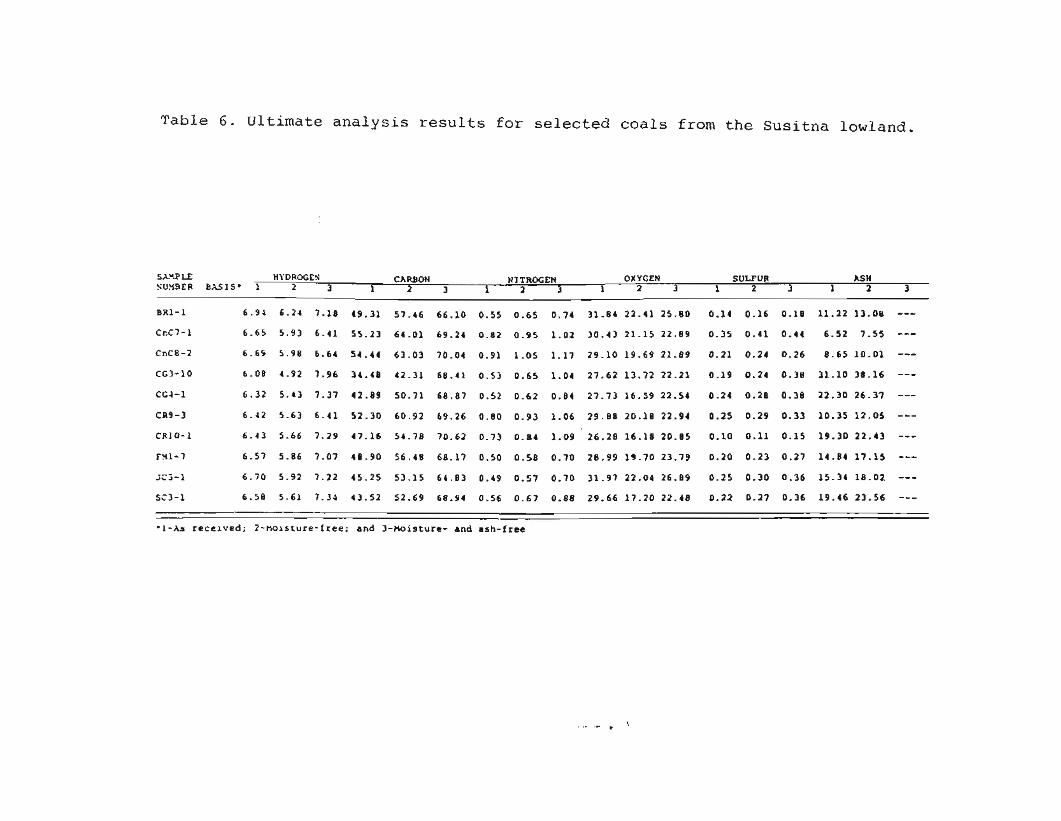
Table 6. Ultimate analysis results for selected coals from the Susitna lowland.
SXYPLE HY DROGES CARBON NITROGEN OXYGEN SULFUR ASH SU%ER BASIS* 1 2 3 1 2 3 1 2 3 1 2 3 1 2 3 1 2 3
BR1-1 6-94 6-21 7.18 49.31 57.46 66.10 0.55 0.65 0.74 31.84 22.41 25.80 0.14 0.16 0.18 11-22 13.08 --- CcC7-1 6.65 5-93 6.41 55.23 64.01 69.24 0.82 0.95 1.02 30.43 21.15 22.89 0.35 0.41 0.44 6.52 7.55 --- CnC8-2 6.65 5.98 6.64 54.44 63.03 70.04 0.91 1-05 1-37 29.10 19.69 21.89 0.21 0.24 0.26 8.65 10.01 --- CG3-10 6.08 4.92 7.96 34.48 42.31 68-41 0.5) 0.65 1.04 27.62 13.72 22.21 0.19 0.24 0.38 31.10 38.16 --- CG4-1 6.32 5.43 7.37 42.89 50.71 68.87 0.52 0.62 0.84 27.73 16.59 22.54 0.24 0.28 0.38 22.30 26.37 --- CR9-3 6.12 5.63 6.41 52.30 60.92 69.26 0.00 0.93 1.06 29.88 20.18 22.94 0.25 0.29 0.33 10.35 12.05 --- CR10-1 6-43 5.66 7.29 47.16 54.78 70.62 0.73 0.84 1-09 26.28 16.18 20.85 0.10 0.11 0.15 19.30 22.43 --- FY1-7 6.57 5.86 7.07 48.90 56.48 68.17 0.50 0.58 0.70 28.99 19.70 23.79 0.20 0.23 0.27 14.84 17.15 --- iCj-1 6.70 5.92 7.22 45.25 53.15 64.83 0.49 0.57 0.70 31.97 22.04 26.89 0.25 0.30 0.36 15.34 18-02 --- SC3-1 6.58 5.61 7.35 43.52 52.69 68.94 0.56 0.67 0.88 29.66 17.20 22.48 0.22 0.27 0.36 19.46 23.56 ---
-1-hs received; 2-Holsture-free; and 3-Moisture- and ash-free

� able 7. Summary results of coal overburden characterization analyses of Susitna lowland samples.
N U W E R OF NUMBER OF PARkYfTER SA'lPLES LOCALES N G E IN COIiTENTS MEAN CONTENT UNITS
paste pn 8 8 8 4.1 - 7.8 6.4 PH ----------------------------------------------------------------------------------------------------------------------- Electrical conductivity 8 8 8 0.1 - 0.9 0.3 nnnhos/cm @ 25.C ....................................................................................................................... Saturation p.rcentage 88 8 24.2 -94.1 52.8 8 ....................................................................................................................... Saturation Ca 28 extract
Sodium 28 3 0.3 - 2.2 0.6 ratio adsorption ratio ----------------------------------------------------------------------------------------------------------------------- Exchangeable 5 4 sodius percentage ----------------------------------------------------------------------------------------------------------------------- Particle 5 4 3 --- --- Variable size ----------------------------------------------------------------------------------------------------------------------- Texture 54 3 Variable --- --- -----------------------------------------------------------------------------------------------------------------------
C
Organic 36 4 0.82-11.89 4.7 \ ratter f --------------------------------------------------------------------------------------------------------------:--------
Lime 36 4 7.7.- 10.1 9.9 8 percentage ----------------------------------------------------------------------------------------------------------------------- Boron 2 0 2 1.3 -100.0 33.8 PPm (total 1 ----------------------------------------------------------------------------------------------------------------------- Selenium 20 (total J
Extractable NO3-N 43 nutrients
P
X39onium Ca 5 4 acetate extractable Mg cations
Na
Cadon 51 3 1.3 - 88.4 20.0 mhq/lOO q -change capacity --------------------------------------------------------------------------------------------------------------------- Base 5 1 3 16.7 -100.0 83.4 \ saturation ....................................................................................................................... Sulfur Sulfate 28 3 c0.1 --- \
Pyritic 40.01 -0.09 --- Total 0.00 -0.48 0.07 -----------------------------------------------------------------------------------------------------------------------
Acid potential 88 8 0.0 - 30.0 4.1 meq H+/100 9 la;;;h*;;hE;Gn--------------------------------------------------------------------------------------------------------- potenti.1 8 8 8 3.85 - +213.84 +24.2 tons CaC03 equivalent/
.................... - - - - - - - - - - - - - - - - - - - - - - - , , , , , , , , - , , , l o l l - t o ~ ~ ---------- Potential 88 8 -5.55 - +212.89 +22.3 tons CaCO3 equivalent/ acidity* 1000 tons ----------------------------------------------------------------------------------------------------------------------- a Posltrve values rndrcate excess CaCO? or basic overburden nuterlal.
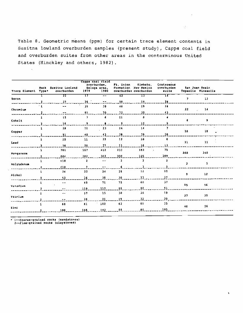
Table 8. Geometric means (ppm) for certain trace element contents in
Susitna lowland overburden samples (present study), Capps coal field
and overburden suites from other areas in the conterminous United
States (Hinckley and others, 1982).
Cappr coa f e overbu:dek,ld Ft. Union Klmbcto, ~ r e t a c e o u r
Rock Suritna Lowland Beluga area, Pormation New Mexico overburden San Juan Barin Trace Element Type' overburden 1979 1900 overburden overburden suite Toprollr Hineroilr
1 2 2 17 - - 4 2 1 3 14 Boron 7 13
- . . - - . - -. 2 - - 6 1 70 7 2 3 0 4 3 ------------------------------------------,--------------------------------------------------------------------------------
1 12 7 6 11 8 4 Coba 1 t 6 9
- - -
copper 10 18 . 40 4 3 3 0 39 3 0 ---------------- 2 ----------- 51 ---1111-1-------------------------------------------------------------------------p---------
1 Lead
26 20 13 --------,,,----, 3-,,- ------------------------------ 12 ------- 1: ---------- 15 ................................................. I 761 167 4 12 233 183 75
Manganese 260 340 2 804 303 300 209 ,-,-,-,,-,-,--,--,,-------------------- 2 E ............................ 122 .................................... ------------ 1 < 10 2 2 2 2 - -
Molybdenum 2 3 <10 2 - - 6 -,,,,~,,,,,,,,,, 1 ,,----------------------------------------------------- 2 ------------ 2 ....................................
1 2 6 2 3 24 2 6 12 10 Nickel 9 12
2 5 2 36 30 30 2 3 2 7 ---------,,----,-------__-_,----------------------------------------------------------------------------T----------------------
1 - - 60 7 1 7 5 60 3 7 Vanadium I S 56 - - 119 117 8 6 --------------,- 3 ...................................................... !g ----------- 2A
1 - - I7 15 30 2 6 19 Yttrlum 2 7 3 2 -- 2 8 2 I 19 3 3 30 , , , , , , , , , , , , , , , -3 ,- - - -- - - -- - - - -- -- - - -- -- - - - - - - - - - - - -- -- - - - -- - - - - - - - - - - - - - - - - - - - - - - - - - - - - - - - - -- -- - - - -- -- - - - -- - - - - - - - - - - - - - -
1 6 0 6 1 102 6 2 6 1 3 5 Zinc 48 5 6
14 3 59 ,,,,,,,,,,,,,,,, 1 ,,-------- 109 9-------- 1!! ............................. !! ---------- 122 .................................... * ' l--Coarse-grained rockr Irandrtoner)
2--fine-grained rockr (claystones)