Embed Size (px)
Citation preview

Labrador‐Island Transmission Link Environmental Impact Statement Chapter 15 Existing Socioeconomic Environment
April 2012 Page 15‐83
Regionally, the economic picture is varied. Much of the recent economic growth has been experienced on the Avalon Peninsula region and particularly in the St. John’s Census Metropolitan Area in Economic Zone 19. In contrast, the closure of the paper mill in Grand Falls‐Windsor represented a significant economic setback for the Central and Eastern Newfoundland region. Based on the GNL’s Major Project Inventory (NLDF 2010g, internet site), economic prospects for the short‐ to medium‐term suggest that many of the Study Area regions could see 5 significant new economic activity, including for example, the Lower Churchill Project, mining activity in the Baie Verte area, and construction of mineral processing and offshore petroleum production facilities at Bull Arm.
15.5 Land and Resource Use
In this section, land and resource use refers to the use of land and resources by and for communities and transportation systems, natural resource‐based industries (e.g., forestry, mining and agriculture), commercial 10 activities (e.g., hunting, trapping and outfitting), recreational activities (e.g., boating, snowmobiling, cross‐country and downhill skiing, kayaking, canoeing, hiking, bicycling, bird watching and riding motorized recreational vehicles) and subsistence activities (e.g., fishing, hunting and other harvesting). Recreation areas such as cottage developments, campgrounds, ski areas, trails, lakes, and golf courses are also discussed as are parks and protected areas. 15
Given the number and diversity of land and resource uses and the rather extensive geographic scale of the Project, it was not practical to map all of these in any detail in the EIS. Regional maps are included for general illustration, but the reader is referred to the socioeconomic component studies (AMEC 2011; Nalcor et al. 2011; AMEC 2010b) for further information and detailed mapping.
Several land and resource use related aspects are addressed in other sections of this EIS. Vehicular traffic is 20 discussed in Sections 15.4 and 16.4; communities are discussed in 15.3 and 16.3; tourism in 15.7 and 16.7; economy, in 15.4 and 16.4; and visual aesthetics is addressed in Sections 15.8 and 16.8. Resource use related to the marine environment is also discussed in Section 15.6 and assessed in 16.6.
15.5.1 Study Areas
The land and resource uses within or adjacent to the transmission corridor (2 km wide) as well as considering 25 the location of other Project‐related components and activities (e.g., access, electrode sites, electrode line, temporary camps) are the focus of this existing environment section. To provide an appropriate "regional context", a larger geographic area, such as a 15 km wide buffer on either side of the transmission corridor centreline was selected for resource harvesting activities that are more wide‐ranging and less geographically defined. For other socioeconomic components that are "stationary" such as communities and transportation, a 30 very broad and general description of the "Study Region" is provided. The larger study area for each land and resource use component or activity is described within each subsection.
Given the extensive geographic area involved, land and resource uses are also generally described by "Study Region". The "Study Region" description provides a regional context by generally describing land and resource use activities within the relevant regions of the province as shown in Figure 15.5.1‐1. 35
15.5.2 Information Sources and Data Collection
Data and information for land and resource use components were gathered mainly from secondary sources as no field work was conducted. Sources include reports, documents, web sites and press releases from government departments. Relevant unpublished data and information were obtained from government departments through direct contact with agency representatives. Nalcor gathered information through 40 communications with NL Department of Natural Resources’ Conservation Officers whose extensive knowledge has been gained through personal and professional experience and observation. Information related to land and resource use was also gathered from media reports, private companies, user groups, not‐for‐profit organizations and consulting reports prepared for Nalcor. Additional information was collected from Nalcor and other authors contributing to this EIS, as appropriate. Sources are documented in the references section of 45 this report.

QUEBEC
LakeMelville
Grand Lake
Trinit
y Bay
Placentia Bay
BonavistaBay
Bay ofExploits
LABRADOR
Trans Labrador Highway
Central and Southeastern Labrador
Northern Peninsula
Central and EasternNewfoundland
AvalonPeninsula
Trans Labrador Highway
SheshatshiuNorth West River
Happy Valley-Goose Bay
Red Bay
Forteau
L'Anse au Clair
Flower's CoveSt. Anthony
Port au Choix
Rocky Harbour
Corner BrookGrand Falls-Windsor
Port Blandford
St. John's
Holyrood
Arnold's Cove
Channel-Port aux Basques
Cartwright
Mud Lake
0 50 100
Kilometres
FIGURE 15.5.1-1
Land and Resource Use Study Regions in Newfoundland and Labrador
Converter Station
Transmission Corridor
Submarine Cable Crossing Corridor
Select Communities
Existing Roads
Study RegionsCentral and Southeastern Labrador
Northern Peninsula
Central and Eastern Newfoundland
Avalon Peninsula
S t r a i t o f B e l l e I s l e
A t l a n t i cO c e a n
G u l fo f
S t . L a w r e n c e
Source: Department of Finance, Economics and Statistics Branch 2010

Labrador‐Island Transmission Link Environmental Impact Statement Chapter 15 Existing Socioeconomic Environment
April 2012 Page 15‐85
More detail is provided in the Component Study, “Socioeconomic Environment: Communities, Land and Resource Use, Tourism and Recreation” (AMEC 2010b), “Socioeconomic Environment: Communities, Land and Resource Use, Tourism and Recreation, Supplementary Report” (AMEC 2011), “Socieoeconomic Environment: Communities, Land and Resource Use, Tourism and Recreation – Revised Component Study” (AMEC 2012), as well as “Socioeconomic Environment: Aboriginal Communities and Land Use Component Study” (Nalcor et al. 5 2011). These documents identify and describe key aspects of the socioeconomic environment in regions crossed by or near the transmission corridor. The Component Studies provide details on land and resource use activities including communities, transportation, commercial activities, recreational pursuits and subsistence activities. The Component Studies were developed using data and information from numerous sources, all of which are listed in those reports. 10
For the Aboriginal contemporary traditional land use component of this section, several information sources were identified, compiled and reviewed. These include published and unpublished literature, information and data provided to Nalcor by Aboriginal groups and the results of recent consultation activities and socioeconomic data collection initiatives completed for the EA by Aboriginal groups in cooperation with, and through funding and resources provided by Nalcor. Chapter 7 of this EIS presents additional details on Nalcor`s 15 Aboriginal consultation for the Project.
In certain cases, though substantive communication attempts and consultation offers were made by the Proponent to particular Aboriginal communities, some groups declined to participate or provide information. In those cases, the information provided in this EIS is based on existing and available secondary sources.
In some instances, Nalcor was successful in concluding community engagement agreements with Aboriginal 20 communities. These agreements provided mechanisms for sharing information and resources. Where an agreement was reached between Nalcor and an Aboriginal group, primary information was collected and incorporated into this EIS as available. Since December 2009, four agreements have been signed between Nalcor and the following Aboriginal groups: Innu Nation, NCC, Conseil des Innus de Pakua Shipi and Conseil des Innus de Unamen Shipu. Subsequent to the initial agreements, additional Phase II agreements were signed with NCC and 25 Conseil des Innus de Pakua Shipi. The objectives of the community engagement agreements were / are to:
familiarize the group with the Project and its potential environmental effects;
identify any issues of concern with respect to potential environmental effects of the Project on the interests of the group;
collect and document Aboriginal Ecological Knowledge (AEK) and information respecting contemporary 30 land use and harvesting activities; and
identify potential ways to address the issues identified.
The specific workplan and data collection methodology for each of these agreements were developed collaboratively by Nalcor and a project coordinator or researcher, who was hired by the Band or its Executive Council. The workplan and research methodology were subsequently approved by the Band or Executive Council 35 and implemented by the project coordinator or researcher, in cooperation with a Nalcor representative.
The agreement with Innu Nation was signed in July 2010 and completed in November 2010. The initial agreement with NCC, signed in December 2009, expired at the end of March 2011 and set the groundwork for data collection in the subsequent agreement. A Phase II agreement was signed with NCC in January 2011 and is still ongoing. A Phase I agreement was signed with the Conseil des Innus de Pakua Shipi in April 2010 and was 40 scheduled to last four months. However, due to unforeseen circumstances, completion of the agreement was delayed to June 2011. A Phase II agreement was signed in February 2011 and is currently ongoing. The Conseil des Innus de Unamen Shipu and Nalcor entered into an agreement in July 2011. Data collected under the completed agreements have been incorporated into this EIS. The agreement with NCC has not been finalized, however data obtained by Nalcor as a result of land use interviews with members of NCC (an aspect of the 45 community engagement agreement) has been incorporated into this EIS. Any information and data obtained by Nalcor will be considered and incorporated, where relevant, including the potential for mitigation and adaptive management during detailed design and routing. Additionally, mapping pertaining to data and community reports under the Phase II agreement with Pakua Shipu is ongoing and will be considered if and when the information becomes available. 50

Labrador‐Island Transmission Link Environmental Impact Statement Chapter 15 Existing Socioeconomic Environment
April 2012 Page 15‐86
15.5.3 Communities and Public Water Supply Areas
The following subsections discuss communities by region from Central and Southeastern Labrador to the Avalon Peninsula. Additional information is included in the Component Study (AMEC 2010b) and Supplementary Report (AMEC 2011). This section generally describes communities in the region, and then focuses on identifying communities (including unorganized communities) as well as municipal water supply areas through which the 5 2 km wide corridor may pass. Communities are discussed more broadly in Section 15.3.
15.5.3.1 Central and Southeastern Labrador
Central and Southeastern Labrador communities are located in the Upper Lake Melville area (Happy Valley‐Goose Bay, Northwest River, Sheshatshiu and Mud Lake), along the south‐eastern coast and along the Strait of Belle Isle. The south‐eastern coast has 11 communities: Cartwright, Paradise River, Charlottetown, Port Hope 10 Simpson, St. Lewis, Mary’s Harbour, Lodge Bay, Black Tickle‐Domino, Pinsent’s Arm, William’s Harbour and Norman Bay. The Straits area currently includes the eight communities of Red Bay, Pinware, West St. Modeste, Capstan Island, L'Anse au Loup, L’Anse Amour, Forteau and L'Anse au Clair (NLDMA 2009).
The transmission corridor does not interact directly with any Central Labrador communities. It crosses the community boundary (municipal boundary, municipal planning area, infilling limits or protected road 15 boundary) of two communities in the Labrador Straits: Forteau L’Anse and au Loup (Figure 15.5.3‐1). The transmission corridor passes through the following public water supply areas: L'Anse au Loup River Unprotected Water Supply Area (WS‐S‐0402) and the Trout Brook Protected Water Supply Area (WS‐S‐0252) which services the community of Forteau (Table 15.5.3‐1).
Table 15.5.3‐1 Communities and Water Supply Areas Overlapping the Transmission Corridor: Central 20 and Southeastern Labrador
Community Water Supplies
L’Anse au Loup Yes
Forteau Yes
The transmission corridor also crosses portions of L’Anse Amour’s drinking water supply, but the community is not overlapped by the transmission corridor.
15.5.3.2 Northern Peninsula 25
The Northern Peninsula region includes nearly 100 small to medium sized communities from the northern points of Cook’s Harbour and Straitsview to Corner Brook in the south‐west and Hampden in the south‐east (NLDMA 2009). Communities in the north focus on the fishery and forestry industries and to some extent on tourism (NEDC 2009, internet site). The northern and central areas of the Northern Peninsula have experienced population decline of 8 to 12% between 2000 and 2006 (NLDF‐ES 2010, internet site). 30
The Strait of Belle Isle submarine cable crossing will make landfall at Shoal Cove on the Northern Peninsula. South of the landing location, the transmission corridor overlaps the boundaries of four communities (Table 15.5.3‐2) (Figure 15.5.3‐2).
Table 15.5.3‐2 Communities and Water Supply Areas Overlapping the Transmission Corridor: Northern Peninsula Communities 35
Community Water Supplies
Shoal Cove East Yes
Savage Cove‐Sandy Cove Yes
Nameless Cove Yes
Flower’s Cove Yes

Trans Labrador Highway
430
QUEBECLABRADOR
LakeMelville
SheshatshiuNorth West River
Happy Valley-Goose Bay
Mud Lake
Red Bay
Forteau
L'Anse au Clair
Trans Labrador Highway
Cartwright
L'Anse au Loup
St. AnthonyFlower's Cove
0 30 60
Kilometres
FIGURE 15.5.3-1
Land and Resource Use - Communities Along the Transmission Corridor in Labrador
Converter Station
Transmission Corridor
Submarine Cable Crossing Corridor
S t r a i t o f B e l l e I s l e
Communities Crossed by theTransmission Corridor
1
2
Forteau
L'Anse au Loup
L'Anse au Clair
Flower's Cove
ID Name1 Forteau2 L'Anse au Loup
Source: Department of Municipal Affairs 2009
Select Communities
I-1
I-1
Community Boundaries Crossed by the Transmission Corridor
Existing Roads
RegionCentral and Southeastern Labrador
Northern Peninsula

Flower's CoveSt. Anthony
Port au Choix
Rocky Harbour
Corner Brook
Port Blandford
St. John's
Holyrood
Channel-Port aux Basques
Red Bay
A t l a n t i cO c e a n
G u l fo f
S t . L a w r e n c e
Grand Falls-Windsor
15
Arnold's Cove
Forteau
L'Anse au Clair
L'Anse au Loup
0 40 80
Kilometres
FIGURE 15.5.3-2
Land and Resource Use - Communities Along the Transmission Corridor in Newfoundland
34
56
Forteau
L'Anse au Loup
L'Anse au Clair
7
8
9
10
11
13
14
15
1617
18 19
21
22
12
19
20
Existing Roads
RegionCentral and Southeastern Labrador
Northern Peninsula
Central and Eastern Newfoundland
Avalon Peninsula
Converter Station
Transmission Corridor
Submarine Cable Crossing Corridor
Communities Crossed by the Transmission
ID Name3 Shoal Cove East4 Savage Cove-Sandy Cove5 Nameless Cove6 Flower's Cove7 Grand Falls - Windsor8 Port Blandford9 Clarenville
10 Goobies11 Sunnyside12 Come by Chance13 Arnold's Cove14 Southern Harbour15 Norman's Cove - Long Cove16 Chapel Arm17 Blaketown18 Brigus Junction19 Whitbourne20 Avondale21 Harbour Main - Chapel's Cove22 Holyrood
I-1
I-1
I-2
I-2
I-3
I-3
Source: Department of Municipal Affairs 2009
Select Communities
Community Boundaries Crossed by the
Transmission Corridor
Corridor

Labrador‐Island Transmission Link Environmental Impact Statement Chapter 15 Existing Socioeconomic Environment
April 2012 Page 15‐89
Portions of the drinking water supply of Hawke’s Bay are also within the transmission corridor but the community is not within the transmission corridor.
15.5.3.3 Central and Eastern Newfoundland
The Central and Eastern Newfoundland region includes approximately 275 communities from the east side of White Bay to the west side of Trinity Bay encompassing the Baie Verte Peninsula, Notre Dame Bay, Bonavista 5 Bay and the Bonavista Peninsula. Central and Eastern Newfoundland includes the larger towns of Grand Falls ‐ Windsor, Gander and Clarenville which are located along the TCH.
The transmission corridor overlaps the boundaries of nine communities in Central and Eastern Newfoundland (Table 15.5.3‐3) (Figure 15.5.3‐2).
Table 15.5.3‐3 Communities and Water Supply Areas Overlapping the Transmission Corridor: Central 10 and Eastern Newfoundland
Community Water Supplies
Grand Falls‐Windsor No
Port Blandford Yes
Clarenville Yes
Goobies No
Sunnyside No
Arnold’s Cove Yes
Southern Harbour Yes
Norman’s Cove‐Long Cove Yes
Chapel Arm Yes
Come By Chance No
Source: NLDMA 2009.
Portions of the drinking water supply of the communities of Gander, Glenwood and Appleton are also within the transmission corridor (Gander Lake Protected Water Supply (WS‐S‐0268)).
15.5.3.4 Avalon Peninsula 15
The Avalon Peninsula region includes nearly 90 communities on the north‐west and north‐east tips of the Avalon Peninsula, and includes the provincial capital of St. John’s. The Avalon is the most populated area of the province and has many communities varying in size from St. John’s at over 100,000 people to small unincorporated communities. The transmission corridor overlaps the boundaries of five communities (Table 15.5.3‐4) (Figure 15.5.3‐2). Also, the shoreline electrode for the Project is located within the town of 20 Conception Bay South.
Table 15.5.3‐4 Communities and Water Supply Areas Overlapping the Transmission Corridor: Avalon Peninsula
Community Name Water Supplies
Whitbourne Yes
Blaketown No
Avondale Yes
Harbour Main‐Chapel’s Cove‐Lakeview Yes
Holyrood No
Brigus Junction No
Conception Bay South No
Source: NLDMA 2009.
25
Labrador‐Island Transmission Link Environmental Impact Statement Chapter 15 Existing Socioeconomic Environment
April 2012 Page 15‐90
15.5.4 Transportation
This discussion of land use, as it relates to transportation, includes roads, air facilities, a military flight training area and marine traffic in the Strait of Belle Isle between southern Labrador and northern Newfoundland. These are discussed in detail and illustrated in the component study (AMEC 2010b, 2011) which also includes a map atlas of forestry access roads in the province. Transportation is discussed primarily from a land use 5 perspective below; a community infrastructure perspective is provided in Section 15.3.5.
15.5.4.1 Road System
The province of Newfoundland and Labrador has an extensive highway and road network. In Labrador, Route 500 (the TLH) from Labrador West to Happy Valley‐Goose Bay is currently being paved with an estimated completion date of 2014 (NLDTW 2011a). The final section of the TLH is designated as Route 510 10 (Happy Valley‐Goose Bay to Cartwright) which connects central and southern Labrador and was completed in December 2009. This road is paved from L’Anse au Clair to Red Bay and maintenance grade gravel surfaced from Red Bay to Happy Valley‐Goose Bay.
In Newfoundland, Route 1 (TCH) runs approximately 900 km from Port aux Basques to St. John’s. The TCH has two lanes except for the following sections where it has four: through Corner Brook, Grand Falls‐Windsor and 15 Glovertown and for approximately 100 km from Whitbourne to St. John’s. Route 1 and all other highways in Newfoundland are paved. Local roads are mostly paved but some short gravel roads exist in rural communities.
Forestry access roads, which are made of sub‐base material grade, are generally 4 to 9 m wide and typically have a grade of between 10% and 6% (DFO and CFS 1985). These exist throughout the province but are most 20 extensive on the Northern Peninsula and in Central Newfoundland where the economies have been based on forestry, lumber and paper industries. Forest access roads are also used for mineral exploration and other non‐industrial activities such as hunting, fishing, domestic woodcutting, berry picking, other harvesting and operating motorized recreational vehicles such as all‐terrain vehicles (ATVs) and snowmobiles. Forestry access roads are shown in Appendix C of the Component Study (AMEC 2010b). 25
15.5.4.2 Airport System
The province has eight airports. Gander and St. John’s are included in TC’s NAS meaning that they are nationally significant. Churchill Falls, Deer Lake, Goose Bay, Stephenville, St. Anthony and Wabush are classified as Regional / Local airports meaning that they serve local areas and provide connections to larger airports and systems. Residents of the Labrador Straits are also served by an airport in Blanc‐Sablon, Québec 30 (Wikipedia 2011, internet site; NLDTW 2009b; TC 1994, internet site).
The province maintains a series of 13 air strips that provide commercial landings in coastal Labrador communities. Eight landing strips, with no scheduled services, are also maintained by the provincial government in Newfoundland. In addition, the province has five heliports and seven aerodromes (NLDTW 2009b). Several private operators also own landing strips, heliports and float plane bases in the province 35 (Belbin 2011, pers. comm.; Wikipedia 2011, internet site; Letto 2009, pers. comm.).
15.5.4.3 Ferry System
Coastal communities and islands off the Newfoundland and Labrador coast are served by a provincial ferry system. The NLDTW provides ferry services between Labrador and Newfoundland through a private operator. As a result of the new highway connection in Labrador, government is proposing to discontinue a seasonal 40 vehicle and freight ferry, which currently runs between Happy Valley‐Goose Bay and Lewisporte from spring to fall (NLDTW 2010a). The Strait of Belle Isle ferry operates between from Blanc‐Sablon, Québec and St. Barbe on the Northern Peninsula in summer and from Blanc‐Sablon to Corner Brook in winter (NLDTW 2010a).

Labrador‐Island Transmission Link Environmental Impact Statement Chapter 15 Existing Socioeconomic Environment
April 2012 Page 15‐91
15.5.4.4 Regional Transportation in the Study Area
Central and Southeastern Labrador
Route 510 (TLH) begins at Happy Valley‐Goose Bay and ends at the Québec border in the Labrador Straits. The Cartwright to Happy Valley‐Goose Bay portion was completed in December 2009 and most communities in the region are now connected by road (Natural Resources Canada (NRCan) 2005) (Figure 15.5.4‐1). 5
A regional airport and a water aerodrome are located in Happy Valley‐Goose Bay. Landing strips are also located in the coastal communities of Cartwright, Black Tickle, Charlottetown, Port Hope Simpson, William’s Harbour, St. Lewis and Mary’s Harbour (NLDTW 2009b). Scheduled commercial flights currently offer passenger service to these communities (Air Labrador 2010, internet site; Provincial Airlines (PAL) 2010, internet site). However, with the connection of Route 510, services may be reduced in the region (NLDTW 10 2010a). Strait Air, owned by a private operator, has an air strip at Crow Head near L’Anse Amour. A float plane base is also operated on Long Pond near Forteau Point (Belbin 2011, pers. comm.; Letto 2009, pers. comm.).
A Designated Flight Training Area (DFTA) begins at 5‐Wing Goose Bay and covers an area extending south, west and north and into the province of Québec. DND Flying Orders include minimum altitudes of between 100 feet, 250 feet and 500 feet for this area (DND 2010). A map is provided in the Component Study (AMEC 2010b). 15
The transmission corridor parallels and crosses Route 510 a number of times along the recently completed section (TLH3) and near Forteau (Figure 15.5.4‐1) and the DFTA (Table 15.5.4‐1).
Table 15.5.4‐1 Central and Southeastern Labrador Transportation Infrastructure Crossed by the Transmission Corridor
Infrastructure Name Location
Road Route 510 TLH3 and Forteau
Designated Flight Training Area DFTA 5‐Wing Goose Bay Central Labrador
Source: DND 2010; NRCan 2005. 20
Strait of Belle Isle
Marine traffic through the Strait of Belle Isle is limited to ice free periods – usually between April and January. Several types of vessels travel across and through the Strait when the channel is open. The Labrador Straits ferry crosses between Blanc‐Sablon and St. Barbe two to three times daily in each direction during ice free periods (Figure 15.5.4‐2). During winter 2010 and 2011 the ferry service was maintained year‐round by 25 operating between Blanc‐Sablon and Corner Brook (NLDTW 2010a).
Demand on the Labrador Straits Ferry has increased since the TLH opened in December 2009 and since the ferry service to Corner Brook became available in the winter of 2009‐10. A significant increase in vehicles using the ferry in the summer of 2010 (between 24% and 175% per month between April and July) resulted in an additional ferry run (in each direction) on Fridays and Mondays in August and September (NLDTW 2010b). 30
Through its Small Craft Harbours program, Fisheries and Oceans Canada (DFO) and 208 volunteer harbour authorities operate approximately 227 harbours in Newfoundland and Labrador. Ten are located on either side of the Strait of Belle Isle (Figure 15.5.4‐2). Fishing vessels from both sides and recreational craft (motor and sail) from within and outside of the province also use the Strait (DFO 2010a, internet site).
Shipping vessels (i.e., bulk carriers, container ships and tankers) travel through the Strait of Belle Isle to and from 35 the Atlantic Ocean and the St. Lawrence River and Seaway. The Canadian Coast Guard (CCG) has established a regulated Vessel Traffic Service (VTS) zone (Figure 15.5.4‐2). Marine traffic in the Controlled Vessel Traffic Lanes is monitored by CCG’s St. Anthony Marine Communications and Traffic Services (MCTS). Vessel operators in the Strait of Belle Isle are not required to report to St. Anthony MCTS but may do so voluntarily. Therefore, existing MCTS data are incomplete and only partially represent the activity. Most activity is from June to December 40 (CCG 2010a, internet site; CCG 2010b; Warren 2010, pers. comm.; CHS 2009).

Trans Labrador Highway
430
QUEBEC
LABRADOR
LakeMelville
Sheshatshiu
North West River
Happy Valley-Goose BayMud Lake
Red Bay
Forteau
L'Anse au Clair
Trans Labrador Highway
Cartwright
500
510
510
4300 30 60
Kilometres
FIGURE 15.5.4-1
Land and Resource Use - Labrador Transportation Infrastructure
Converter Station
Transmission Corridor
Submarine Cable Crossing Corridor
Air Facilities
Harbour Authorities
Existing Roads
Select Communities
RegionCentral and Southeastern Labrador
Northern Peninsula
S t r a i t o f B e l l e I s l e
ForteauL'Anse Amour
L'Anse au Loup
L'Anse au Clair
Source: Wikipedia 2011; Belbin, Wilson 2011; Fisheries andOceans Canada, Small Craft Harbours 2010; Department ofTransportation and Works 2009; Department of Environment andConservation, Lands Branch 2009; Letto, Ron 2009
I-1
I-1

510
430
430
Red Bay
St. Anthony
Shoal Cove
Forteau
Eddies Cove
Anchor Point
Flower's Cove
L'Anse au Loup
L'Anse Au Clair
Forresters Point
Green Island Cove
Green Island Brook
Savage Cove-Sandy Cove
FIGURE 15.5.4-2
Land and Resource Use - Strait of Belle Isle Transportation Infrastructure
0 230 460 690
Kilometers
Navigational Buoy
Transmission Corridor
Submarine Cable Crossing Corridor
Harbour Authorities
Ferry Route
Existing Roads
Boundary of Vessel Traffic Service Zone
Traffic Separation Lane
Source: Canadian Coast Guard, 2010; Fisheries and OceansCanada, Small Craft Harbours 2010; Canadian HydrographicServices 2009
Select Communities
RegionCentral and Southeastern Labrador
Northern Peninsula

Labrador‐Island Transmission Link Environmental Impact Statement Chapter 15 Existing Socioeconomic Environment
April 2012 Page 15‐94
The location of the submarine cable crossing corridor in the Strait of Belle Isle, between Forteau Point and Shoal Cove, is shown in Figure 15.5.4‐2.
Northern Peninsula
Route 430 is the main highway between St. Anthony / Goose Cove and Deer Lake. Route 432 runs east to west across the Peninsula from Plum Point to Main Brook and connects to St. Anthony, Roddickton and Englee. On 5 the eastern side and base of the Northern Peninsula, Routes 420 and 421 connect White Bay communities to the TCH (NRCan 2005).
Regional airports are located at St. Anthony and Deer Lake. A private landing strip, owned by Strait Air, is located near the community of Sandy Cove. Government landing strips are located at Port au Choix and St. Andrew’s (Codroy Valley) (NLDTW 2009b; Letto 2009, pers. comm.). 10
The transmission corridor crosses four highways on the Northern Peninsula (Figure 15.5.4‐3). These roads are shown in Table 15.5.4‐2.
Table 15‐5.4‐2 Northern Peninsula Transportation Infrastructure Crossed by the Transmission Corridor
Infrastructure Type Name Location Crossed
Roads
Route 430 Shoal Cove to Savage Cove‐Sandy Cove
Route 432 Inland
Route 420 White Bay South
Route 421 Hampden
Source: NRCan 2005.
Central and Eastern Newfoundland 15
The TCH is the main highway through Central and Eastern Newfoundland. From the TCH other highways branch off to the Baie Verte Peninsula, Notre Dame Bay, the Connaigre Peninsula, Bay of Exploits, Twillingate Islands, Bonavista Bay, Eastport Peninsula, Bonavista Peninsula, Burin Peninsula, Trinity Bay and Placentia Bay (NRCan 2005). The proposed transmission corridor crosses five highways in Central and Eastern Newfoundland including the TCH (Table 15.5.4‐3; Figure 15.5.4‐3). 20
Landing strips are located in Exploits Valley, Springdale, Bishop’s Falls and Clarenville. The Grand Falls‐Windsor Heliport is located in that town. Gander International Airport and a hospital heliport are located in Gander (NLDTW 2009b). A private aerodrome, owned by Clarenville Aviation Limited, is located on Thorburn Lake (Wikipedia 2011, internet site).
The transmission corridor crosses five highways in Central and Eastern Newfoundland and slightly overlaps the 25 edge of Thorburn Lake, the location of an aerodrome.
Table 15.5.4‐3 Central and Eastern Newfoundland Transportation Infrastructure Crossed by the Transmission Corridor
Infrastructure Type Name Location Crossed
Roads
Route 1‐TCH Various locations
Route 370 Buchans
Route 360 Bay d’Espoir
Route 201 Chapel Arm‐Bellevue
Route 203 Fair Haven
Aerodrome Clarenville Aviation Limited Thornburn Lake (near Clarenville)
Source: Wikipedia 2011, internet site; NLDTW 2009b; NRCan 2005.
30

Flower's CoveSt. Anthony
Port au Choix
Rocky Harbour
Corner Brook
Port Blandford
St. John's
Holyrood
Channel-Port aux Basques
Red Bay
A t l a n t i cO c e a n
G u l fo f
S t . L a w r e n c e
Grand Falls-Windsor
430
Conception Bay SouthArnold's Cove
Chapel Arm0 40 80
Kilometres
FIGURE 15.5.4-3
Land and Resource Use - Newfoundland Transportation Infrastructure
Converter Station
Transmission Corridor
Submarine Cable Crossing Corridor
Harbour Authorities
Air Facilities
Existing Roads
Select Communities
RegionCentral and Southeastern Labrador
Northern Peninsula
Central and Eastern Newfoundland
Avalon Peninsula
11
I-1I-1
Source: Wikipedia 2011; Fisheries and Oceans Canada, Small Craft Harbours 2010; Letto, Ron 2009; Department of Transportation and Works 2009; Department of Environment andConservation, Lands Branch 2009

Labrador‐Island Transmission Link Environmental Impact Statement Chapter 15 Existing Socioeconomic Environment
April 2012 Page 15‐96
Avalon Peninsula
The main highway on the Avalon Peninsula is the TCH. A number of other highways branch off to communities in Trinity Bay, Placentia Bay, St. Mary’s Bay, Conception Bay and the greater St. John’s area (NRCan 2005).
Air facilities on the Avalon Peninsula are located in Conception Bay and Northeast Avalon areas (Figure 15.5.4‐3). St. John’s International Airport is located on the north side of the city. Landing strips are 5 located at Harbour Grace and on Bell Island. Private heliports are located in Foxtrap and at the St. John’s airport (NLDTW 2009a, internet site). A water aerodrome is located on Paddy’s Pond (Wikipedia 2011, internet site).
No air facilities on the Avalon Peninsula are located within the transmission corridor.
The transmission corridor crosses and / or parallels the TCH and a number of paved two‐lane highways that 10 connect to communities from Chapel Arm to Conception Bay South (Figure 15.5.4‐3). Table 15.5.4‐4 shows these Avalon Peninsula roads.
Table 15.5.4‐4 Avalon Peninsula Transportation Infrastructure Crossed by the Transmission Corridor
Infrastructure Type Name Location Crossed
Roads
Route 1‐TCH Various locations
Route 13 Witless Bay Line
Route 63 Avondale
Route 80 Trinity Bay South
Route 81 Markland
Route 90 Salmonier Line
Route 100 Argentia Access Road
Source: NRCan 2005.
15.5.5 Hunting and Trapping 15
Current Newfoundland and Labrador lifestyles are influenced by a history of commercial, recreational and subsistence hunting, trapping and fishing. Trapping is primarily a commercial activity and hunting is mainly a recreational and subsistence pursuit. However, restaurants and food producers may obtain commercial licences to purchase wild game (Dicks 2010, pers. comm.). Greater detail of the information summaries provided below are available in AMEC (2010b). 20
The Department of Environment and Conservation, Wildlife Division manages hunting and trapping in the province through annual management plans for big game, small game and furbearers. These plans are informed by the results of wildlife population surveys, trend data from hunting and trapping licence returns, data from returned moose jawbones and input from hunters, Conservation Officers, Department staff, non‐government organizations and the general public. Collectively, this information is used to set quotas and 25 establish seasons depending on the health and abundance of populations (NLDEC‐W 2010a).
Black bear hunting licences are available to all residents of Newfoundland and Labrador and each licence holder may harvest two bears annually in open hunting areas. All black bear management areas (BBMA) on the Avalon Peninsula, and one Eastern Newfoundland management area, are closed to hunting (NLDEC‐W 2010a). However, the availability of black bear licenses province‐wide exceeds demand. 30
Moose and caribou licence demand exceeds quotas. A draw for the 2010‐11 moose and caribou hunting seasons received a combined total of approximately 73,000 applications for 28,505 moose licences and 740 caribou licences. Approximately 40% of applicants received licences (The Telegram 2010b, internet site).

Labrador‐Island Transmission Link Environmental Impact Statement Chapter 15 Existing Socioeconomic Environment
April 2012 Page 15‐97
In the 2011‐2012 hunting season, moose quotas were increased on the island in 41 moose management areas (MMA) including parts of the Northern Peninsula, Central and Eastern Newfoundland and the Avalon Peninsula. Labrador quotas increased in six MMAs (NLDEC‐W 2011, internet site). Moose populations are generally abundant.
The province of Newfoundland and Labrador has prepared a recovery strategy for three Labrador woodland 5 caribou herds, and Southern Labrador is closed to caribou hunting. Conservation measures are in effect in Labrador which has 18 caribou management areas (CMA). Upon confirmation of the presence of the protected woodland caribou – boreal population, the Department of Environment and Conservation may immediately close areas that have fixed season dates (NLDEC‐W 2010b, internet site).
During the 2009‐2010 hunting season, the Department of Environment and Conservation reduced the number 10 of woodland caribou licences in Newfoundland by 355, or 40% (NLDEC‐W 2009a). Quotas were also reduced by 85 animals in the 2010‐2011 season (NLDEC‐W 2010b, internet site). Quotas remained the same in the 2011‐2012 season (NLDEC‐W 2011, internet site). Caribou Management Areas that are closed or had quota reductions are located in Central and Southeastern Labrador, on the Northern Peninsula, in Central and Eastern Newfoundland and on the Avalon Peninsula (NLDEC‐W 2010b, internet site). There were no closed 15 zones in Labrador for the 2011‐2012 season. However, the hunting season for 15 CMAs are to be determined (NLDEC‐W 2011, internet site).
There is no quota cap on barren‐ground caribou for Labrador residents. Several areas with undetermined dates are opened once NLDEC confirms the presence of sufficient numbers of the migrating George River Caribou herd. This herd was estimated to have a population of 785,000 in 1993 and 385,000 in 2001. A population and 20 health census, conducted in 2010, confirmed population declines and has resulted in further conservation measures (NLDEC‐W2011; NLDEC and NLDNR 2010, internet site).
The Island of Newfoundland has four main small game management areas (SGMAs) (Remainder of Island, The Topsails, Burin and Avalon / Swift Current). Seasons and bag limits are area and / or species specific. Grouse may be hunted anywhere in season. Ptarmigan may be hunted in all areas except Bell Island. Snowshoe hare 25 may be hunted anywhere except Bell Island, with special conditions at Great Island ‐ Ramea and Little Bay Islands. Arctic hare hunting is closed for all of Newfoundland (NLDEC‐W 2011, internet site).
There are two trapping fur zones in Labrador and 13 in Newfoundland that apply to most species. However, there are special cases. Lynx trapping is managed in two zones in Newfoundland.
The following sections discuss hunting (including big game, small game and migratory game birds) and trapping 30 on a regional basis from west to east.
15.5.5.1 Central and Southeastern Labrador
Big Game Hunting
This region includes portions of 12 MMAs: 49, 50, 52, 53, 54, 57, 58, 59, 60, 84, 86 and 87. In the 2010‐2011 season, moose hunting was not permitted in an area of Central and Southeastern Labrador that extends from 35 Lake Melville south to the Québec border, but limited hunting was allowed for the 2011‐2012 season (NLDEC‐W 2011, internet site). The entire region is covered by “Labrador South” black bear management area (BBMA). While caribou hunting is permitted in some areas of Labrador, no caribou hunting is currently permitted south of Lake Melville and the Churchill River (NLDEC‐W 2011, internet site).
The transmission corridor crosses several big game management areas as shown in Figure 15.5.5‐1, 40 Figure 15.5.5‐2 and Figure 15.5.5‐3. These management areas and their seasons and quotas are presented in Table 15.5.5‐1.

QUEBEC
LakeMelville
Grand Lake
Trinit
y Bay
Placentia Bay
BonavistaBay
Bay ofExploits
LABRADOR
Trans Labrador Highway
Trans Labrador Highway
SheshatshiuNorth West River
Happy Valley-Goose Bay
Red Bay
Forteau
L'Anse au Clair
Flower's CoveSt. Anthony
Port au Choix
Rocky Harbour
Corner Brook
Grand Falls-Windsor
Port Blandford
St. John's
Holyrood
Arnold's Cove
Channel-Port aux Basques
Cartwright
Mud Lake
59
84
58
45
40
39
3
2
4
13
41
15
1621
2442
27
28
29
44
31
31
34
35
3633
86
87
53
0 50 100
Kilometres
FIGURE 15.5.5-1
Land and Resource Use - Moose Management Areas
Converter Station
Transmission Corridor
Submarine Cable Crossing Corridor
S t r a i t o f B e l l e I s l e
A t l a n t i cO c e a n
G u l fo f
S t . L a w r e n c e
Existing Roads
Select Communities
Study RegionsCentral and Southeastern Labrador
Northern Peninsula
Central and Eastern Newfoundland
Avalon Peninsula
Moose Management AreasCrossed by the Transmission Corridor
Source: Department of Environment and Conservation, Wildlife Branch 2011

QUEBEC
LakeMelville
Grand Lake
Trinit
y Bay
Placentia Bay
BonavistaBay
Bay ofExploits
LABRADOR
Trans Labrador Highway
Trans Labrador Highway
SheshatshiuNorth West River
Happy Valley-Goose Bay
Red Bay
Forteau
L'Anse au Clair
Flower's CoveSt. Anthony
Port au Choix
Rocky Harbour
Corner Brook
Grand Falls-Windsor
Port Blandford
St. John's
Holyrood
Arnold's Cove
Channel-Port aux Basques
Cartwright
Mud Lake
45
40
39
3
2
4
13
41
15
1621
2442
27
28
29
44
31
31
34
35
3633
Labrador South
0 50 100
Kilometres
FIGURE 15.5.5-2
Land and Resource Use - Black Bear Management Areas
Converter Station
Transmission Corridor
Submarine Cable Crossing Corridor
S t r a i t o f B e l l e I s l e
A t l a n t i cO c e a n
G u l fo f
S t . L a w r e n c e
Select Communities
Existing Roads
RegionCentral and Southeastern Labrador
Northern Peninsula
Central and Eastern Newfoundland
Avalon Peninsula
Black Bear Management AreasCrossed by the Transmission Corridor
Source: Department of Environment and Conservation, Wildlife Branch 2011

QUEBEC
LakeMelville
Grand Lake
Trinit
y Bay
Placentia Bay
BonavistaBay
Bay ofExploits
LABRADOR
Trans Labrador Highway
Trans Labrador Highway
SheshatshiuNorth West River
Happy Valley-Goose Bay
Red Bay
Forteau
L'Anse au Clair
Flower's CoveSt. Anthony
Port au Choix
Rocky Harbour
Corner Brook
Grand Falls-Windsor
Port Blandford
St. John's
Holyrood
Arnold's Cove
Channel-Port aux Basques
Cartwright
Mud Lake
76
69
7978
66
63
68
64
65
67
0 50 100
Kilometres
FIGURE 15.5.5-3
Land and Resource Use - Caribou Management Areas
Converter Station
Transmission Corridor
Submarine Cable Crossing Corridor
S t r a i t o f B e l l e I s l e
A t l a n t i cO c e a n
G u l fo f
S t . L a w r e n c e
Existing Roads
Select Communities
Study RegionsCentral and Southeastern Labrador
Northern Peninsula
Central and Eastern Newfoundland
Avalon Peninsula
Caribou Management Areas Crossedby the Transmission Corridor
Source: Department of Environment and Conservation, Wildlife Branch 2011

Labrador‐Island Transmission Link Environmental Impact Statement Chapter 15 Existing Socioeconomic Environment
April 2012 Page 15‐101
Table 15.5.5‐1 Moose and Black Bear Management Areas Crossed by the Transmission Corridor in Central and Southeastern Labrador
Species Management Area Spring / Summer Season Fall / Winter Season Quota
Moose
Area 53‐Muskrat Falls No season September 10, 2011 – March 11, 2012
25
Area 58‐Alexis River No season September 10, 2011 – March 11, 2012
5
Area 59‐Upper Kenamu
No season September 10, 2010 – March 11, 2012
15
Area 86‐St. Augustin No season September 10, 2011 – March 11, 2012
5
Area 87‐Eagle Plateau No season September 10, 2011 – March 11, 2012
5
Area 84 – Traverspine No season September 10, 2011 – March 11, 2012
5
Black bear
Labrador South April 1 – July 13, 2011 and April 1 – July 13, 2012
September 1 – November 30, 2011
2 (either sex) per year per resident / non‐resident
Source: NLDEC‐W 2011, internet site.
Small Game Hunting
The Southern Zone SGMA covers the entire Central and Southeastern Labrador region. Hunting in this area is 5 regulated for ptarmigan, snowshoe hare, Arctic hare, porcupine, spruce grouse and ruffed grouse (NLDEC‐W 2010a).
The transmission corridor crosses portions of the Southern Zone. SGMAs for particular species along with their hunting seasons and bag / possession limits are shown in Table 15.5.5‐2.
Table 15.5.5‐2 Small Game Management Areas Crossed by the Transmission Corridor in Central and 10 Southeastern Labrador
Management Area Species Shooting Season Snaring Season Bag Limit (Daily /
Possession)
All of Labrador (Northern and Southern Zones)
Ptarmigan October 1, 2011 – April 20, 2012
October 1, 2011 – March 31, 2012
25 / 50
Snowshoe hare October 1, 2011 – April 20, 2012
October 1, 2011 – March 31, 2012
No limit
Arctic hare October 1, 2011 – April 20, 2012
October 1, 2011 – March 31, 2012
No limit
Porcupine October 1, 2011 – March 31, 2012
No Season 1 / 1
Southern Zone Grouse (Spruce and Ruffed)
October 1, 2011 – April 20, 2012
October 1, 2011 – March 31, 2012
25 / 50 (combined)
Source: NLDEC‐W 2011, internet site.

Labrador‐Island Transmission Link Environmental Impact Statement Chapter 15 Existing Socioeconomic Environment
April 2012 Page 15‐102
Migratory Game Bird and Murre Hunting
Central and Southeastern Labrador has two migratory game bird (e.g., ducks, geese, snipe, eiders, Long‐tailed Ducks, mergansers and scoters) hunting zones. The province does not have an open season for Harlequin Ducks in Labrador or Newfoundland. The Central Labrador Zone covers most of the region and Southern Labrador Zone includes the south‐eastern coastal area from Batteau (north of Norman Bay) to L’Anse au Clair. 5 The Labrador Straits is covered by murre (Turr) Hunting Zone 1.
The transmission corridor crosses portions of both migratory game bird hunting zones and the murre hunting zone in the Strait of Belle Isle. Table 15.5.5‐3 provides details on the hunting seasons and bag limits of these zones.
Table 15.5.5‐3 Bird Hunting Zones Crossed by the Transmission Corridor in Central and Southeastern 10 Labrador
Hunting Zone Species Hunting Season Bag Limit (Daily / Possession)
Central Labrador
Ducks, geese and snipe
First Saturday in September to second Saturday in December 2011
6(a) / 12(b) (ducks except mergansers, Harlequin Ducks, eiders and scoters)
6 / 12 (mergansers, scoters and eiders)
5 / 10 (geese)
10 / 20 (snipe)
Eiders
Last Saturday in October to last Saturday in November 2011 and first Saturday in January to last day of February 2012
6 / 12
Southern Labrador (Straits)
Ducks, geese and snipe
Second Saturday in September to third Saturday in December 2011
6(a) / 12(b) (ducks)
5 / 10 (geese)
10 / 20 (snipe)
Eiders Fourth Saturday in November 2011 to last day of February 2012
6 / 12
Murre Hunting Zone 1 Murre (turr) September 1 to December 16, 2011 20 / 40
Source: NLDEC‐W 2011, internet site. (a) Not more than one Barrow’s Goldeneye. (b) Not more than two Barrow’s Goldeneye.
Trapping 15
The Labrador South fur zone includes most of the Central and Southeastern Labrador region (Figure 15.5.5‐4). Trapping is available for a number of species including beaver, muskrat, otter, mink, coyote, coloured fox, white fox, lynx, wolf, ermine (weasel), squirrel and marten. Currently, Labrador does not have an open season for fisher and wolverine (NLDEC‐W 2010a).
The transmission corridor crosses portions of the fur zone (Figure 15.5.5‐4). Seasons, species and average 20 annual harvest for trapping seasons from 1990‐01 to 2007‐08 are provided in Table 15.5.5‐4.

QUEBEC
LakeMelville
Grand Lake
Trinit
y Bay
Placentia Bay
BonavistaBay
Bay ofExploits
LABRADOR
Trans Labrador Highway
Trans Labrador Highway
SheshatshiuNorth West River
Happy Valley-Goose Bay
Red Bay
Forteau
L'Anse au Clair
Flower's CoveSt. Anthony
Port au Choix
Rocky Harbour
Corner Brook
Grand Falls-Windsor
Port Blandford
St. John's
Holyrood
Arnold's Cove
Channel-Port aux Basques
Cartwright
Mud Lake
11
31
10
7
8
6
5
3
2
Southern Zone
0 50 100
Kilometres
FIGURE 15.5.5-4
Land and Resource Use - Fur Zones
Converter Station
Transmission Corridor
Submarine Cable Crossing Corridor
Fur Zones Crossed by the Transmission Corridor
Existing Roads
Select Communities
RegionCentral and Eastern Newfoundland
S t r a i t o f B e l l e I s l e
A t l a n t i cO c e a n
G u l fo f
S t . L a w r e n c e
Source: Department of Environment and Conservation, Wildlife Branch 2011

Labrador‐Island Transmission Link Environmental Impact Statement Chapter 15 Existing Socioeconomic Environment
April 2012 Page 15‐104
Table 15.5.5‐4 Fur Trapping Zones Crossed by the Transmission Corridor in Central and Southeastern Labrador
Fur Trapping Zone
Season Species Average Annual Harvest for All of Labrador (1990 – 2008)
Labrador South
October 15, 2011 – May 31, 2012 Beaver 73
Muskrat 326
October 15, 2011 – March 31, 2012 Otter 101
November 1, 2011 – March 1, 2012 Mink 314
October 15, 2011 – March 31, 2012
Coyote 1
Coloured Fox 558
White Fox 6
Lynx 41
Ermine (Weasel) 499
Marten 1,881
October 15, 2011 – March 1, 2012 Squirrel 105
October 15, 2011 to April 30, 2012 Wolf 26
All Species 3,932
Source: NLDEC‐W 2011, internet site; NLDEC‐W 2009a.
15.5.5.2 Northern Peninsula
Big Game Hunting 5
The Northern Peninsula region as previously defined in this section includes portions of 13 MMAs (1, 2, 3, 4, 5, 6, 7, 12, 13, 39, 39A, 40 and 45). Three small moose hunting enclaves (2A, 2B and 5A) are located in Gros Morne National Park. BBMAs are the same as the MMAs in Newfoundland. The Northern Peninsula has three open CMAs (69, 76 and 79) (NLDEC‐W 2011, internet site).
The transmission corridor crosses portions of six MMAs and BBMAs (2, 3, 4, 39, 40 and 45) (Figure 15.5.5‐1, 10 Figure 15.5.5‐2) and CMAs 69, 76 and 79 (Figure 15.5.5‐3). These management areas and their seasons and quotas are outlined in Table 15.5.5‐5.

Labrador‐Island Transmission Link Environmental Impact Statement Chapter 15 Existing Socioeconomic Environment
April 2012 Page 15‐105
Table 15.5.5‐5 Big Game Management Areas Crossed by the Transmission Corridor on the Northern Peninsula
Species Management Area Season Quota
Moose
2‐Portland Creek
September 10, 2011 – January 8, 2012
1,450
3‐Harbour Deep 1,250
4‐Taylor’s Brook 1000
39‐Cloud River 500
40‐Conche 1,350
45‐Ten Mile Brook 1,300
Black bear
2‐Portland Creek
September 10 – November 6, 2011
2 (either sex) per licence
3‐Harbour Deep
4‐Taylor’s Brook
39‐Cloud River
40‐Conche
45‐Ten Mile Brook
Woodland caribou
69‐Northern Peninsula September 10 – December 11, 2011
140
76‐St. Anthony 60
79‐Adies Lake 10
Source: NLDEC‐W 2011, internet site.
Small Game Hunting
The Northern Peninsula region is included in the Remainder of Island SGMA. Hunting is available for ptarmigan, 5 spruce and ruffed grouse and snowshoe hare. Gros Morne National Park and the Main River Study Area are closed to snaring to prevent accidental mortality of pine marten (NLDEC‐W 2010a).
The proposed transmission corridor crosses portions of Remainder of Island SGMA. Table 15.5.5‐6 outlines the shooting and snaring seasons and bag limits for the Remainder of Island SGMA.
Table 15.5.5‐6 Small Game Management Areas Crossed by the Transmission Corridor on the Northern 10 Peninsula
Management Area Species Shooting Season Snaring Season Bag Limit (Daily /
Possession)
Remainder of Island
Ptarmigan (Willow and Rock)
September 17 – December 11, 2011
October 8, 2011 – February 26, 2012
12 / 24 (combined)
Snowshoe hare October 8, 2011 – February 26, 2012
40 (possession)
Grouse (Spruce and Ruffed)
September 17 – December 25, 2011
20 / 40 (combined)
Source: NLDEC‐W 2011, internet site.

Labrador‐Island Transmission Link Environmental Impact Statement Chapter 15 Existing Socioeconomic Environment
April 2012 Page 15‐106
Migratory Game Bird and Murre Hunting
Migratory game bird hunting zones include Northern Inland, Western Coastal and Northern Coastal. Hunting is not permitted (no open season) for Long‐tailed Ducks, eiders or scoters in Newfoundland inland zones. The Murre Hunting Zone 2 incorporates the coastal areas around the Northern Peninsula (NLDEC‐W 2010a).
The transmission corridor crosses a portion of the Northern Coastal, Northern Inland and Murre Hunting 5 Zone 2. Table 15.5.5‐7 outlines the hunting zones, species, seasons and bag limits.
Table 15.5.5‐7 Bird Hunting Areas Crossed by the Transmission Corridor on the Northern Peninsula
Hunting Area Species Season Bag Limit (Daily / Possession)
Northern Coastal
Ducks (except Long‐tailed Duck, Harlequin Ducks, eiders and scoters), geese and snipe
Third Saturday in September to last Sat. in December 2011
6(a) / 12(b) (ducks)
6 / 12 (mergansers)
5 / 10 (geese)
10 / 20 (snipe)
Long‐tailed Ducks, eiders, and scoters
Fourth Saturday in November, 2011 to last day in February 2012
6 / 12
Northern Inland
Ducks (except Long‐tailed Duck, Harlequin Ducks, eiders and scoters), geese and snipe
Third Saturday in September to last Saturday in December 2011
6(a) / 12(b) (ducks)
6 / 12 (mergansers)
5 / 10 (geese)
10 / 20 (snipe)
Murre Hunting Zone 2 Murre (turr) October 6, 2011 to January 20, 2012
20 / 40
Source: NLDEC‐W 2011, internet site. (a) Not more than one may be Barrow’s Goldeneye. (b) Not more than two may be Barrow’s Goldeneye. 10
Trapping
The Northern Peninsula has two Fur Zones (Figure 15.5.5‐4). Zone 11 is on the northern part of the Peninsula from the Straits area to Rocky Harbour. Zone 10 is located from White Bay to the Port au Port Peninsula (NLDEC‐W 2010a). The Northern Peninsula falls within Zone A of the Lynx Management Zone (NLDEC‐W 2011, internet site). 15
The transmission corridor crosses portions of both Fur Zones 10 and 11 (Figure 15.5.5‐4) as well as Lynx Management Zone A. Table 15.5.5‐8 provides information on the fur zones, seasons and harvest data by species for the period between 1990‐91 and 2007‐08. Only those species for which trapping is currently permitted are included.
20

Labrador‐Island Transmission Link Environmental Impact Statement Chapter 15 Existing Socioeconomic Environment
April 2012 Page 15‐107
Table 15.5.5‐8 Fur Trapping Zones Crossed by the Transmission Corridor on the Northern Peninsula
Fur Trapping Zone Season Species Average Annual
Harvest (1990 – 2008)
10, 11
October 20, 2011 – March 15, 2012
Beaver (traplines) 431
Muskrat 269
Otter 132
November 1, 2011 – February 28, 2012 Mink 496
October 20, 2011 – February 1, 2012
Coyote 14
Coloured Fox 693
White Fox 1
October 20, 2011 – February 28, 2012 Ermine (Weasel) 532
Squirrel 372
Zone A (Lynx) November 5, 2011 – December 4, 2011 All Species 2,940
Lynx No data
Source: NLDEC‐W 2011, internet site; NLDEC‐W 2009a.
15.5.5.3 Central and Eastern Newfoundland
Big Game Hunting
Central and Eastern Newfoundland region includes parts of 12 MMAs (Figure 15.5.5‐1) and BBMAs 5 (Figure 15.5.5‐2) and six CMAs (Figure 15.5.5‐3). All of these areas are open to hunting except BBMA 44 and CMA 63. Table 15.5.5‐9 shows the open big game areas and their relative seasons and quotas.
Small Game Hunting
In Central and Eastern Newfoundland (as on the Northern Peninsula), small game hunting is allowed for grouse, ptarmigan and snowshoe hare. Management areas include Remainder of Island, The Topsails, Burin 10 and Avalon / Swift Current. A portion of the latter is closed to ptarmigan hunting (NLDEC‐W 2010a).
The proposed transmission corridor crosses Remainder of Island, The Topsails and Avalon / Swift Current SGMAs. Table 15.5.5‐10 outlines the relevant small game hunting areas, the seasons and the bag limits.
Migratory Game Bird and Murre Hunting
Migratory game bird hunting zones include Southern Inland, Northeastern Coastal and Avalon‐Burin Inland and 15 Avalon‐Burin Coastal. Murre Hunting Zone 2 is located on the north coast of Central Newfoundland and Zone 4 surrounds the Bonavista Peninsula (NLDEC‐W 2010a).
The proposed transmission corridor crosses the Southern Inland zone through Central and Eastern Newfoundland. Table 15.5.5‐11 outlines the hunting zones, species, seasons and bag limits.
20

Labrador‐Island Transmission Link Environmental Impact Statement Chapter 15 Existing Socioeconomic Environment
April 2012 Page 15‐108
Table 15.5.5‐9 Big Game Management Areas Crossed by the Transmission Corridor in Central and Eastern Newfoundland
Species Management Area Fall / Winter Season Quota
Moose
4‐Taylor’s Brook
September 10, 2011 – January 8, 2012
1,000
13‐Gaff Topsails 550
15‐Twin Lakes 1,100
16‐Sandy Badger 350
21‐Rattling Brook 500
24‐North West Gander 250
27‐Terra Nova 300
41‐Sheffield Lake 400
42‐Gambo 200
28‐Black River
October 1, 2011 – January 29, 2012
550
29‐Bonavista Peninsula 1,200
44‐Bellevue 450
Black bear 4, 13, 15, 16, 21, 24, 27, 28, 29, 41, 42, 44
September 10 – November 6, 2011 2 (either sex) per licence
Woodland caribou
64‐Middle Ridge
September 10 – December 11, 2011
140
66‐Gaff Topsails 40
67‐Pot Hill 50
68‐Mount Peyton 15
78‐Hampden Downs 5
Source: NLDEC‐W 2011, internet site.
Table 15.5.5‐10 Small Game Management Areas Crossed by the Transmission Corridor in Central and Eastern Newfoundland 5
Management Area Species Shooting Season Snaring Season Bag Limit
(Daily / Possession)
Remainder of Island
Ptarmigan (Willow and Rock)
September 17 – December 11, 2011
October 8, 2011 – February 26, 2012
12 / 24 (combined)
Snowshoe hare October 8, 2011 – February 26, 2012
40 (possession)
Grouse (Spruce and Ruffed)
September 17 – December 25, 2011
20 / 40 (combined)
The Topsails
Ptarmigan (Willow and Rock)
September 17 – November 27, 2011
6 / 12 (combined)
Grouse (Spruce and Ruffed)
September 17 – December 25, 2011
20 / 40 (combined)
Avalon / Swift Current (except for Fairhaven)
Ptarmigan (Willow and Rock)
September 17 – November 13, 2011
6 / 12 (combined)
Grouse (Spruce and Ruffed)
September 17 – December 25, 2011
20 / 40 (combined)
Source: NLDEC‐W 2011, internet site.

Labrador‐Island Transmission Link Environmental Impact Statement Chapter 15 Existing Socioeconomic Environment
April 2012 Page 15‐109
Table 15.5.5‐11 Bird Hunting Areas Crossed by the Transmission Corridor in Central and Eastern Newfoundland
Hunting Area Species Season Bag Limit
(Daily / Possession)
Southern Inland Ducks (except Long‐tailed Ducks, eiders and scoters), geese and snipe
Third Saturday in September to last Sat. in December 2011
6(a) / 12(b) (Ducks)
5 / 10 (geese)
10 / 20 (snipe)
Source: NLDEC‐W 2011, internet site. (a) Not more than four may be American Black Ducks; not more than one may be Barrow’s Goldeneye. (b) Not more than 8 may be American Black Ducks; not more than two may be Barrow’s Goldeneye. 5
Trapping
The Central and Eastern Newfoundland region includes portions of Fur Zones 3, 4, 5, 6, 7 and 8, and a small portion of Zone 2 which is discussed in the next section, as well as Lynx Zone A. Trapping is available for a number of species (NLDEC‐W 2010a). The transmission corridor crosses portions of all of these zones except for Zone 4 (Figure 15.5.5‐4). Table 15.5.5‐12 outlines the fur zones, the seasons and average annual harvests 10 by species (for those that are currently permitted for trapping).
Table 15.5.5‐12 Fur Trapping Zones Crossed by the Transmission Corridor in Central and Eastern Newfoundland
Fur Trapping Zone
Season Species Average Annual Harvest
(1990 – 2008)
3, 5, 6, 7, 8
October 20, 2011 – March 15, 2012
Beaver 993
Muskrat 379
Otter 384
November 1, 2011– February 28, 2012 Mink 1,289
October 20, 2011 – February 1, 2012
Coyote 47
Coloured Fox 1,290
White Fox 4
October 20, 2011 – February 28, 2012
Ermine (Weasel) 466
Squirrel 674
All Species 5,527
Lynx Zone A November 5, 2011 – December 4, 2011 Lynx No data
Source: NLDEC‐W 2011, internet site; NLDEC‐W 2009a.
15.5.5.4 Avalon Peninsula 15
Big Game Hunting
The Avalon Peninsula region includes MMAs and BBMAs 31, 32, 33, 34, 35 and 36. However, all BBMAs on the Avalon are closed to hunting. The Avalon includes CMA 65 (closed to hunting) and 77 (NLDEC‐W 2011, internet site).

Labrador‐Island Transmission Link Environmental Impact Statement Chapter 15 Existing Socioeconomic Environment
April 2012 Page 15‐110
The transmission corridor crosses portions of MMAs 31, 33, 34, 35 and 36 (Figures 15.5.5‐1) and CMA 65 (Figure 15.5.5‐3). Table 15.5.5‐13 presents these MMAs and the seasons and quotas.
Table 15.5.5‐13 Big Game Management Areas Crossed by the Proposed Transmission Corridor on the Avalon Peninsula
Species Management Area Season Quota
Moose
31‐Placentia
October 1, 2011 – January 29, 2012
700
33‐Salmonier 550
34‐Bay de Verde 650
35‐St. John's 575
36‐Southern Shore 1,400
Source: NLDEC‐W 2011, internet site. 5
Small Game Hunting
The Avalon / Swift Current SGMA covers the Avalon Peninsula. Hunting is available for ptarmigan and grouse (NLDEC‐W 2010a). The transmission corridor crosses this SGMA. Seasons and bag limits are shown in Table 15.5.5‐14.
Table 15.5.5‐14 Small Game Management Areas Crossed by the Transmission Corridor on the Avalon 10 Peninsula
Management Area Species Shooting Season Snaring Season Bag Limit
(Daily / Possession)
Avalon / Swift Current
Ptarmigan (Willow and Rock)
September 17 – November 13, 2011
October 8, 2011 – February 26, 2012
6 / 12 (combined)
Grouse (Spruce and Ruffed)
September 17 – December 25, 2011
October 8, 2011 – February 26, 2012
20 / 40 (combined)
Source: NLDEC‐W 2011, internet site.
Migratory Game Bird and Murre Hunting
The Avalon Peninsula has two migratory game bird hunting zones: Avalon‐Burin Coastal and Avalon‐Burin Inland. Murre Hunting Zones 3 and 4 are also located on the Avalon (NLDEC‐W 2010a). 15
The transmission corridor crosses the Avalon‐Burin Inland migratory game bird hunting zone. Table 15.5.5‐15 provides details on the hunting season and bag limits by species of this zone.
Table 15.5.5‐15 Bird Hunting Areas Crossed by the Transmission Corridor on the Avalon Peninsula
Hunting Area Species Season Bag Limit
(Daily / Possession)
Avalon‐Burin Inland Ducks (except Long‐tailed Ducks, eiders and scoters), geese and snipe
Third Sat. in Sept. to last Sat. in Dec. 2011
6(a) / 12(b) (ducks)
5 / 10 (geese)
10 / 20 (snipe)
Source: NLDEC‐W 2011, internet site. (a) Not more than four may be American Black Ducks; not more than one may be Barrow’s Goldeneye. 20 (b) Not more than 8 may be American Black Ducks; not more than two may be Barrow’s Goldeneye.

Labrador‐Island Transmission Link Environmental Impact Statement Chapter 15 Existing Socioeconomic Environment
April 2012 Page 15‐111
Trapping
The Avalon Peninsula has two fur zones: Zone 1 and Zone 2 (NLDEC‐W 2010a). The transmission corridor crosses Fur Zone 2 (Figure 15.5.5‐3). Table 15.5.5‐16 provides details on the seasons for species harvested in Zone 2 and the average annual harvest from 1990‐91 to 2007‐08.
Table 15.5.5‐16 Fur Trapping Zones Crossed by the Transmission Corridor on the Avalon Peninsula 5
Fur Trapping Zone
Season Species Average Annual Harvest
(1990 to 2008)
2
October 20, 2011 – March 15, 2012
Beaver 207
Muskrat 135
Otter 82
November 1, 2011 – February 28, 2012 Mink 348
October 20, 2011 – February 1, 2012
Coyote 6
Coloured Fox 267
White Fox 1
October 20, 2011 – February 28, 2012 Ermine (Weasel) 87
Squirrel 48
All Species 1,180
Source: NLDEC‐W 2011, internet site; NLDEC‐W 2009a.
15.5.6 Recreational Fishing
Recreational sport and subsistence fishing includes both freshwater and marine species. Atlantic salmon are fished in 186 scheduled salmon rivers in Labrador and Newfoundland. Ouananiche (land locked Atlantic salmon), brook trout, rainbow trout, brown trout, sea‐run trout and smelt are fished for throughout the 10 province. Arctic char are fished primarily in Labrador and in a limited number of locations in Newfoundland (e.g., Northern Peninsula). Northern pike and lake trout are fished in Labrador but not in Newfoundland. Whitefish (both lake and round) are primarily fished for in Labrador. With the exception of northern pike, the species discussed above can occupy both freshwater and marine waters and all are fished in both. Although Atlantic salmon can be fished for in marine waters, retention is not permitted. In marine environments, 15 Atlantic cod, squid, halibut, mackerel, and capelin, are fished recreationally. Details of the information summaries provided are available in AMEC 2010b. Marine fisheries are further discussed in Section 15.6.
Ice fishing occurs mostly on stream fed ponds and lakes throughout the province and brook trout is the most sought after species. Due to additional access resulting from the 2009 extension of Route 510 in south‐eastern Labrador, ice fishing increased on ponds and lakes in the winter of 2009‐10. Avalon Peninsula ponds and lakes 20 experience a high level of use due to a higher population concentration and convenient access (Conservation Officers 2010, pers. comm.).
DFO’s current Multi‐Year Salmon Management Plan (2007‐2012) (DFO 2011b) sets annual season dates and retention limits for salmon angling. Seasons are shown in Table 15.5.6‐1.
25

Labrador‐Island Transmission Link Environmental Impact Statement Chapter 15 Existing Socioeconomic Environment
April 2012 Page 15‐112
Table 15.5.6‐1 Salmon Angling Seasons in Newfoundland and Labrador, 2011‐2012
Zones Area Open Close
1 and 2 Labrador North and East June 15 September 15
14B L'Anse au Clair to Cape Charles
3‐8 Cape Bauld to Cape Race
June 1 September 7 9‐12 Cape Race to Cape Ray
13 Cape Ray to Cape St. Gregory
14A Cape St. Gregory to Cape Bauld
Fall Angling(a) Gander River, Exploits River, Humber River September 8 October 7
Source: DFO 2011b. (a) Some individual rivers have different opening and closing dates depending on individual watershed management plans.
Salmon stream classifications and daily bag limits are described in Table 15.5.6‐2.
Table 15.5.6‐2 Salmon Retention Limits in Newfoundland and Labrador, 2011‐2012 5
River Class Seasonal Limit Daily Retention Possession Limit Catch‐and‐Release
Class I Rivers 6 fish 2 fish 4 fish 4 per day
Class II Rivers 4 fish 2 fish 4 fish 4 per day
Class III Rivers 2 fish 2 fish 2 fish 4 per day
Class IV Rivers Catch‐and‐Release n/a n/a 2 per day
Unclassified Rivers (Zones 1 and 2) 4 fish 2 fish 4 fish 4 per day
Non‐Scheduled Rivers (Class III) 2 fish 2 fish 2 fish 4 per day
Source: DFO 2011b.
n/a Not applicable.
The DFO collects data from salmon anglers and uses it to describe fishing activity and catch rate. Catch per unit effort (CPUE) is calculated by dividing the catch by the effort (effort in rod days). Thus, a higher CPUE indicates more successful fishing effort (DFO 2010b). A CPUE of over 1.0 is rare and anglers consider streams with a 10 CPUE of 0.25 (one fish per four days of angling) to be desirable fishing areas (McCarthy 2010, pers. com.).
The DFO prepares an annual trout management plan to maintain sustainable fishing. Season dates may be adjusted for any species in any geographic area (DFO 2010b). Trout angling zones and seasons are provided in Table 15.5.6‐3.
Table 15.5.6‐3 Trout Angling Zones and Seasons in Newfoundland and Labrador, 2011‐2012 15
Zone Winter Open Winter Close Summer Open Summer Close
1 – Insular Newfoundland February 1 April 15 May 15
September 7
2 – Labrador, Strait of Belle Isle area (Québec‐Labrador border to Cape Charles)
March 1
n/a n/a
3 – Southeastern Labrador, north of latitude to 52o to Groswater Bay and bounded inland by west longitude 58 o
5 – Central Labrador February 1 September 15
6 – Northern Labrador
Source: DFO 2011b.
n/a Not applicable.
Labrador‐Island Transmission Link Environmental Impact Statement Chapter 15 Existing Socioeconomic Environment
April 2012 Page 15‐113
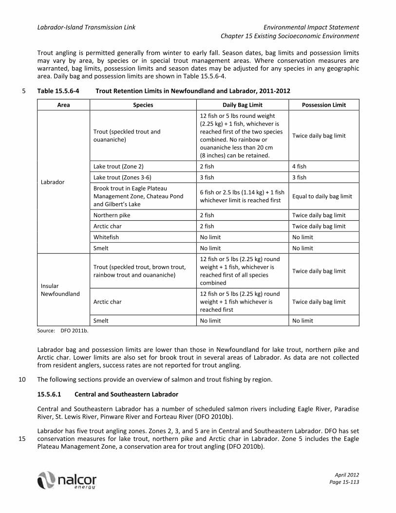
Trout angling is permitted generally from winter to early fall. Season dates, bag limits and possession limits may vary by area, by species or in special trout management areas. Where conservation measures are warranted, bag limits, possession limits and season dates may be adjusted for any species in any geographic area. Daily bag and possession limits are shown in Table 15.5.6‐4.
Table 15.5.6‐4 Trout Retention Limits in Newfoundland and Labrador, 2011‐2012 5
Area Species Daily Bag Limit Possession Limit
Labrador
Trout (speckled trout and ouananiche)
12 fish or 5 lbs round weight (2.25 kg) + 1 fish, whichever is reached first of the two species combined. No rainbow or ouananiche less than 20 cm (8 inches) can be retained.
Twice daily bag limit
Lake trout (Zone 2) 2 fish 4 fish
Lake trout (Zones 3‐6) 3 fish 3 fish
Brook trout in Eagle Plateau Management Zone, Chateau Pond and Gilbert’s Lake
6 fish or 2.5 lbs (1.14 kg) + 1 fish whichever limit is reached first
Equal to daily bag limit
Northern pike 2 fish Twice daily bag limit
Arctic char 2 fish Twice daily bag limit
Whitefish No limit No limit
Smelt No limit No limit
Insular Newfoundland
Trout (speckled trout, brown trout, rainbow trout and ouananiche)
12 fish or 5 lbs (2.25 kg) round weight + 1 fish, whichever is reached first of all species combined
Twice daily bag limit
Arctic char 12 fish or 5 lbs (2.25 kg) round weight + 1 fish whichever is reached first
Twice daily bag limit
Smelt No limit No limit
Source: DFO 2011b.
Labrador bag and possession limits are lower than those in Newfoundland for lake trout, northern pike and Arctic char. Lower limits are also set for brook trout in several areas of Labrador. As data are not collected from resident anglers, success rates are not reported for trout angling.
The following sections provide an overview of salmon and trout fishing by region. 10
15.5.6.1 Central and Southeastern Labrador
Central and Southeastern Labrador has a number of scheduled salmon rivers including Eagle River, Paradise River, St. Lewis River, Pinware River and Forteau River (DFO 2010b).
Labrador has five trout angling zones. Zones 2, 3, and 5 are in Central and Southeastern Labrador. DFO has set conservation measures for lake trout, northern pike and Arctic char in Labrador. Zone 5 includes the Eagle 15 Plateau Management Zone, a conservation area for trout angling (DFO 2010b).

Labrador‐Island Transmission Link Environmental Impact Statement Chapter 15 Existing Socioeconomic Environment
April 2012 Page 15‐114
The transmission corridor crosses the Forteau River (Figure 15.5.6‐1). Angling zone, class, total catch and CPUE are shown in Table 15.5.6‐5.
Table 15.5.6‐5 Scheduled Salmon Rivers Crossed by the Transmission Corridor in Central and Southeastern Labrador 2011‐2012
Scheduled Salmon River Angling Zone
Class 2010 Catch Data
Rods Catch CPUE
175 ‐ Forteau River including First, Second and Third Lakes
14B III 610 249 0.41
Source: DFO 2011b. 5
Salmon anglers enjoy high success rates in south‐eastern Labrador scheduled salmon rivers. This is possibly related to a fairly low population density and limited road access.
The transmission corridor crosses the Eagle Plateau Management Zone, a special trout management area (Figure 15.5.6‐1). Season and daily bag limit are shown in Table 15.5.6‐6.
Table 15.5.6‐6 Trout Retention Limits in the Eagle Plateau Management Zone, 2011‐2012 10
Summer Season Bag Limit
February 1 to September 15, 2011 Bag limit for brook trout is 6 fish or 2.5 lbs (1.14 kg) + 1 fish, whichever is reached first. Possession limit is equal to bag limit.
Source: DFO 2011b.
15.5.6.2 Northern Peninsula
Of the 186 scheduled salmon rivers in Newfoundland and Labrador, approximately half are located on the Northern Peninsula. These include rivers around St. Anthony, Hare Bay, Main Brook, St. Barbe, Canada Bay, St. John Bay, Hawke’s Bay, River of Ponds, Portland Creek, Harbour Deep, Main River and Humber River 15 (Figure 15.5.6‐1) (DFO 2010b).
Three scheduled salmon rivers are crossed by the transmission corridor on the Northern Peninsula (Figure 15.5.6‐1). Portions of the East River are currently closed to salmon fishing (DFO 2010b). Angling zone, river class, total catch and CPUE for Northern Peninsula scheduled salmon rivers crossed by the transmission corridor are shown in Table 15.5.6‐7. 20
Table 15.5.6‐7 Scheduled Salmon Rivers Crossed by the Transmission Corridor in the Northern Peninsula, 2011‐2012
Scheduled Salmon River Angling Zone
Class 2010 Catch Data
Rods Catch CPUE
159 ‐ Portland Creek feeder and tributary streams 14A II n/a n/a n/a
163 ‐ East River(a), Hawke’s Bay 14A III 1,276 909 0.71
164 ‐ Castor River including south‐west feeder 14A II 1,912 1,604 0.84
Source: DFO 2011b.
n/a Not applicable. (a) All or portions of closed to salmon angling. 25

QUEBEC
LakeMelville
Grand Lake
Trinit
y Bay
Placentia Bay
BonavistaBay
Bay ofExploits
LABRADOR
Trans Labrador Highway
Trans Labrador Highway
SheshatshiuNorth West River
Happy Valley-Goose Bay
Red Bay
Forteau
L'Anse au Clair
Flower's CoveSt. Anthony
Port au Choix
Rocky Harbour
Corner BrookGrand Falls-Windsor
Port Blandford
St. John's
Holyrood
Arnold's Cove
Channel-Port aux Basques
Cartwright
Mud Lake
177
175
176
62
50
150
46
36
60
63
23
37
47
44
18
38
168
45
163
21
83
b
81
157
164
94
71
93
74
28
27
90
161
75
70
65
165
159
167
50
22
82
69
91
73
c64
166
92
158
162
160
0 50 100
Kilometres
FIGURE 15.5.6-1
Land and Resource Use: Scheduled Salmon Streams and Special Management Areas
Eagle Plateau Management Zone (Trout)
Existing Roads
Select Communities
RegionCentral and Southeastern Labrador
Northern Peninsula
Central and Eastern Newfoundland
Avalon Peninsula
S t r a i t o f B e l l e I s l e
A t l a n t i cO c e a n
G u l fo f
S t . L a w r e n c e
Source: Fisheries and Oceans Canada 2010
ID Scheduled Salmon Streams Crossed by the Corridor
175 Forteau River
164Castor River including Southwest Feeder
163 East River, Hawke's Bay
159Portland Creek Feeder & Tributary Streams
36 Indian River, Hall's Bay37 West River, Hall's Bay
46 Exploits River, Bay of Exploits
50Gander River & Tributary Streams
60Gambo River & Tributary Streams
62Terra Nova River & Tributary Streams
63Northwest Brook, Port Blandford
65Southwest Brook & Tributary Streams
69 Shoal Harbour River71 Bellevue River75 North Arm River, Holyrood90 Northeast River, Placentia91 Come by Chance RiverConverter Station
Transmission Corridor
Submarine Cable Crossing Corridor
Scheduled Salmon Streams Crossed by
the Transmission Corridor

Labrador‐Island Transmission Link Environmental Impact Statement Chapter 15 Existing Socioeconomic Environment
April 2012 Page 15‐116
Success rates for salmon are high in most scheduled salmon streams in this region but not in all. Some streams are wholly or partially closed to salmon angling for conservation reasons.
A special trout management area includes Ten Mile Lake, Round Lake and all waters running in and out of both of these lakes and the St. Genevieve River System. No winter angling is permitted. Season and daily bag limits for trout in these lakes are shown in Table 15.5.6‐8. 5
Table 15.5.6‐8 Trout Retention Limits in Ten Mile Lake and Round Lake, 2011‐2012
Summer Season Daily Bag Limit
July 1 to July 15, 2011 2 trout or 5 lbs (2.27 kg) whichever is reached first. Trout greater than 58 cm must be released.
Source: DFO 2011b.
15.5.6.3 Central and Eastern Newfoundland
Central and Eastern Newfoundland has a number of scheduled salmon rivers including those flowing into White Bay, Hall's Bay, Notre Dame Bay, Bay of Exploits, Gander Bay, Bonavista Bay, Trinity Bay and Placentia 10 Bay. Important salmon fishing rivers in this area include the Exploits River and the Gander River (DFO 2010b).
Ten scheduled salmon rivers are crossed by the proposed transmission corridor in this region (Figure 15.5.6‐1). Five of these are partially closed to salmon angling (DFO 2010b). Table 15.5.6‐9 shows angling zone, class, catch and CPUE for scheduled salmon rivers crossed by the proposed transmission corridor. Non‐scheduled rivers in insular Newfoundland and Labrador are Class III, with a retention limit of two fish (DFO 2010b). 15
Table 15.5.6‐9 Scheduled Salmon Rivers Crossed by the Transmission Corridor in Central and Eastern Newfoundland, 2011‐2012
Scheduled Salmon Rivers Angling Zone
Class 2010 Catch Data
Rods Catch CPUE
36 ‐ Indian River, Hall’s Bay including Burnt Berry Brook below falls
4 II 2,385 869 0.36
37 ‐ West River, Hall’s Bay including Rowsell’s Brook and Barney’s Brook
4 III 604 192 0.32
46 ‐ Exploits River and tributary streams(a) 4 I, II, III, or IV
depending on area 17,061 7,657 0.45
60 ‐ Gambo Brook and tributary streams including Mint Brook, Narrows, Triton Brook, Riverhead Brook and Parsons Brook
5 II 3,269 914 0.28
62 ‐ Terra Nova River and tributaries including Maccles Brook, Georges Brook and Butts Brook(a)
5 III 2,017 779 0.39
63 ‐ Northwest Brook, Port Blandford and tributary streams(a)
5 NSR‐III 193 82 0.42
65 ‐ Southwest Brook, Port Blandford and tributary streams
5 III 218 105 0.48
69 ‐ Shoal Harbour River, Trinity Bay and tributaries(a)
6 III 249 37 0.15
71 ‐ Bellevue River, Trinity Bay(a) 6 III 81 9 0.11
91 ‐ Come By Chance River 10 III 280 55 0.20
Source: DFO 2011b. (a) All or portions of closed to salmon angling.

Labrador‐Island Transmission Link Environmental Impact Statement Chapter 15 Existing Socioeconomic Environment
April 2012 Page 15‐117
Anglers enjoy successful fishing in several Central and Eastern Newfoundland rivers but some areas are closed to fishing.
15.5.6.4 Avalon Peninsula
On the Avalon Peninsula, scheduled salmon rivers empty into Placentia Bay, St. Mary’s Bay, Conception Bay, Trepassey Bay and the Atlantic Ocean (DFO 2010b). 5
The transmission corridor crosses two scheduled salmon rivers: North Arm River and Northeast River (Figure 15.5.6‐1) (DFO 2010b). Table 15.5.6‐10 shows the angling zone, river class, catch and CPUE for the North Arm River and the Northeast River.
Table 15.5.6‐10 Scheduled Salmon Rivers Crossed by the Transmission Corridor in the Avalon Peninsula, 2011‐2012 10
Scheduled Salmon Rivers Angling Zone
Class 2010 Preliminary Catch Data
Rods Catch CPUE
75 ‐ North Arm River, Holyrood 7 IV 68 10 0.15
90 ‐ Northeast River, Placentia(a) 10 III 1,457 428 0.29
Source: DFO 2011b . (a) All or portions of closed to salmon angling.
The CPUE for the rivers in the Northern Peninsula region is lower than rivers in Central and Southeastern Labrador and the Northern Peninsula and similar to those found Central and Eastern Newfoundland.
15.5.7 Aboriginal Contemporary Traditional Land Use 15
Nalcor conducted an assessment of contemporary traditional land use for a number of Aboriginal groups who reside in, and/or claim Aboriginal rights and/or title to the area within or near the Project (e.g., the transmission corridor). The following subsections provide baseline information on contemporary traditional land use activities of the following Aboriginal groups and organizations:
Labrador Innu (Sheshatshiu and Natuashish, as represented by Innu Nation); 20
Labrador Inuit (Nunatsiavut Government);
NunatuKavut Community Council (formerly Labrador Metis Nation);
Innu and Naskapi of Québec:
Pakua Shipi;
Unamen Shipu; 25
Nutashkuan;
Ekuanitshit;
Uashat mak Mani‐Utenam, Matimekush‐Lac John; and
Naskapi Nation of Kawawachikamach.
More detailed information on contemporary traditional land use by these groups and organizations is available 30 in the Socioeconomic Environment: Aboriginal Communities and Land Use Component Study (Nalcor et al. 2011).

Labrador‐Island Transmission Link Environmental Impact Statement Chapter 15 Existing Socioeconomic Environment
April 2012 Page 15‐118
15.5.7.1 Labrador Innu
The Innu residing in Labrador, first organized under the Naskapi‐Montagnais Indian Association, are indigenous inhabitants of an area they refer to as Nitassinan, which comprises the eastern portion of the Québec‐Labrador peninsula. They were traditionally a nomadic people, whose movements responded to the seasons and the migration of the animals they relied upon. The Labrador Innu continue to attach great importance to time 5 spent in Nutshimit (the country), which for many is seen as an opportunity for cultural and physical renewal.
Today, most Labrador Innu reside in the communities of Sheshatshiu and Natuashish, although some reside in Happy Valley‐Goose Bay (Happy Valley‐Goose Bay) and elsewhere. Sheshatshiu, which is approximately 40 km north‐east of Happy Valley‐Goose Bay, is the largest Innu community in Labrador. Natuashish is a smaller community on the north‐eastern coast of Labrador, 300 km north of Happy Valley‐Goose Bay and 80 km south‐10 east of Nain. Labrador Innu living in Davis Inlet resettled to Natuashish in 2002 and 2003. The Labrador Innu continue to practice traditional land use and harvesting activities within their traditional territory, where they have camps and cabins, travel, hunt, fish and gather.
Based on available information, there is little contemporary traditional land use within the transmission corridor or within the Study Area (Figure 15.5.7‐1). Figure 15.5.7‐1 presents a portion of the original “Map 16 – 15 Hodgepodge – All categories” from Armitage (2010). The land use data associated with Map 16 have not been altered in the reproduction of this figure. The figure does include the currently proposed transmission corridor superimposed on the original figure. Rather, contemporary traditional land use activities are practiced mainly along the Churchill River, near Happy Valley‐Goose Bay, in the Mealy Mountains area and in parts of south‐west Labrador. In the last 20 years, there has been a trend toward a community based harvest which relies on 20 expanded use of the Labrador road network for land use and harvesting by Sheshatshiu Innu, and this trend is likely to continue (Armitage 2010). Since the 1960s, activities have become more and more focused on road corridors such as the TLH1, between Happy Valley‐Goose Bay and Churchill Falls, and Esker Road. Families who have a long‐time association with the Mealy Mountains and the Eagle River plateau will likely spend more time there now that the TLH3 is complete. It is unlikely that there will be increased land use and harvesting by 25 Labrador Innu in the areas south and west of the plateau toward the Strait of Belle Isle due to the current scarcity of caribou and other resources. However, use of the Salmon River / Little Drunken River for caribou hunting and use of the area at the south end of Minipi Lake for the harvesting of small game have also been documented (Armitage 2010; Armitage and Stopp 2003).
Travel Routes and Camp Sites 30
Community living and access to funding for cultural activities have had notable effects on traditional activities, including how people travel to and from seasonal hunting, trapping and fishing areas. Whereas in the past, hunters and their families would have walked and travelled by canoe, preferred modes of contemporary transportation have become vehicles, snowmobiles and motorized boats. Funding for cultural activities has enabled the chartering of aircraft to transport people from their communities to interior harvesting areas 35 (Stopp 2002).
The Sheshatshiu Innu First Nation (SIFN) began facilitating an Outpost Programme in the 1970s. This program still finances, although since the early 2000s to a lesser degree, a country‐based harvest, referred to as Kakushpinanut, whereby Innu families travel to and from camps in the interior of Labrador to spend time hunting caribou and engaging in other traditional activities (Armitage and Stopp 2003). 40
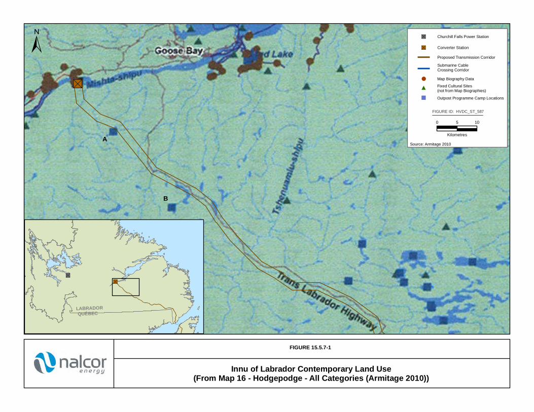
"S
FIGURE 15.5.7-1
Innu of Labrador Contemporary Land Use(From Map 16 - Hodgepodge - All Categories (Armitage 2010))
"S
"S
LABRADORQUÉBEC
Source: Armitage 2010
±
0 5 10
Kilometres
FIGURE ID: HVDC_ST_587
"S Churchill Falls Power Station
"S Converter Station
Proposed Transmission Corridor
Submarine CableCrossing Corridor
A
B
Map Biography Data
Outpost Programme Camp Locations
Fixed Cultural Sites (not from Map Biographies)

Labrador‐Island Transmission Link Environmental Impact Statement Chapter 15 Existing Socioeconomic Environment
April 2012 Page 15‐120
While the data provided are approximate and the location would need to be confirmed, Armitage (2010) reports that the Innu Nation cabin database identifies camp locations within the Study Area, and some which are potentially within the transmission corridor. Outpost Programme data indicate a camp is located 25 km south of Muskrat Falls, which is within or near the transmission corridor (see “A” on Figure 15.5.7‐1) (Armitage 2010). Armitage (2010) also indicates this camp has not been occupied since 1993. Another camp, identified as 5 “B” on Figure 15.5.7‐1, is located close to the TLH, and also within or near the transmission corridor, and was last occupied in 1984 (Armitage 2010). A third camp which was last occupied in 1985, is located approximately 25 km from the transmission corridor (Armitage 2010). According to Outpost Programme data, there are seven other camps located within the larger Study Area, and these are in an area around Crooks Lake where the transmission corridor follows the TLH south. One of the cabins located in this area is approximately 5 km east 10 of the transmission corridor and TLH, while the remaining six are more than 10 km east of the transmission corridor and TLH. Outpost Programme data indicates these camps were established post‐1990; however, data on further land use in this area has not been recorded (Armitage 2010).
Other Labrador Innu camp locations have been recorded at and around Parke Lake, to the south of Lake Melville and east of the proposed transmission corridor (Armitage 2010). Armitage (2010) found that in 15 comparison to data collected earlier (Armitage and Stopp 2003), which looked at land use from the mid‐1990s, many Sheshatshiu Innu no longer depend on the Outpost Programme for access to their cabins and harvesting activities. Rather, Armitage (2010) indicated that road accessible harvesting, camping and cabin occupancy are now the most important components of contemporary traditional Sheshatshiu Innu land use. Consequently, traditional Innu travel corridors and temporary camp locations are used less frequently (Armitage 2010; 20 Armitage and Stopp 2003; Stopp 2002).
Armitage (2010) recorded travel routes, which included road, snowmobile, walking, canoe and motorboat. Labrador Innu use the Churchill River and TLH as travel routes. At Muskrat Falls, a portion of the Churchill River overlaps with the transmission corridor. Where the transmission corridor follows the TLH, this travel route overlaps with the transmission corridor. Other routes documented in Armitage (2010) include those in the 25 Happy Valley‐Goose Bay area, as well as in an area approximately 100 km north of where the TLH branches away from Gull Island and heads towards Churchill Falls. Canoe, snowmobile and walking routes were recorded near Gull Island, Dominion Lake and Minipi Lake. Canoe and walking routes, lying between Dominion Lake and the transmission corridor, were also identified. Other canoe, motorboat, walking and snowmobile routes were recorded in an area approximately 65 km east of the transmission corridor, extending south from 30 Happy Valley‐Goose Bay (Armitage 2010).
Hunting, Trapping and Gathering
Land use and harvesting by Sheshatshiu Innu are still centred on a series of lakes situated at the headwaters of the Eagle River to the east of the transmission corridor. Up until the early 2000s, roughly half of the male population of the community who participated in the country‐based harvest in that area practiced harvesting 35 activities on the Eagle River plateau (Degnen 2001). Several sources have identified harvesting locations distributed across Central and Southeastern Labrador, with notable concentrations north and west of the Churchill River, in the Mealy Mountains where caribou are hunted, and on the Eagle River plateau where waterfowl and other species are harvested (Armitage and Stopp 2003; Armitage 1990). Armitage and Stopp (2003) indicated that due to reductions in caribou populations and other resources found in this area, it was 40 unlikely that land use and harvesting activities in the area south and west of the Eagle River plateau toward the Strait of Belle Isle, where the transmission corridor crosses, would increase.
Land use also occurs near Dominion Lake and Minipi Lake (Armitage 2010), around an area bounded by Winokapau Lake in the south, Smallwood Reservoir in the west, Seal Lake in the north and Nipishish Lake in the east, and in an area centred on Shipiskan Lake (Ashuapamatikuan), Snegamook Lake and Shapio Lake 45 (Armitage and Stopp 2003).
Armitage (2010) indicated that large mammals hunted by the Labrador Innu include caribou, moose and black bear, although harvesting of moose and black bear is uncommon and has not occurred in proximity of the

Labrador‐Island Transmission Link Environmental Impact Statement Chapter 15 Existing Socioeconomic Environment
April 2012 Page 15‐121
transmission corridor. Between 1979 and 1987, caribou and black bear were harvested in areas along the south shore of Lake Melville and in the Mealy Mountains, at Disappointment Lake and Hope Lake, and in the Metchin River system (MacLaren Plansearch 1994). Armitage (2010) identified a caribou hunting area between Gull Lake and Churchill Falls and another one in the Salmon River / Little Drunken River area. However, this caribou hunting area does not overlap with the Project. 5
Hunting of small game was reported in the area around Grand Lake and the Red Wine River as well as at a number of locations along and north of the TLH 1 between Happy Valley‐Goose Bay and Churchill Falls. Partridge and porcupine kill sites were reported within the transmission corridor near Muskrat Falls (Armitage 2010). Approximately 10 km north‐west of Muskrat Falls, beaver, duck and geese kill sites were reported, along with one boil‐up and one drinking water location (Armitage 2010). Other hunting areas included a large 10 tract of land south of Lake Melville on the Eagle River plateau, in the Mealy Mountains at Disappointment and Hope lakes, in the Metchin River system, and in an area to the south of Muskrat Falls along the Churchill River.
Furbearer trapping areas roughly correspond to those described above for small game, with concentrations in the area along the TLH 1 and north to just above the Red Wine River (MacLaren Plansearch 1994). Armitage (2010) also recorded harvesting near Dominion Lake and at Minipi Lake. Small game harvesting areas were all 15 located outside the Study Area.
Migratory waterfowl were hunted around Crooks Lake and Parke Lake east of the transmission corridor along the TLH 1, at various locations along the shoreline of Lake Melville, along several roads between Happy Valley‐Goose Bay and Sheshatshiu and on the south side of the Churchill River at Gull Island (MacLaren Plansearch 1994). Two key hunting areas were recorded on the Eagle River plateau. Waterfowl were also harvested in the 20 Mud Lake / Upper Lake Melville area, and near Sheshatshiu and North West River (Armitage 2010; Armitage and Stopp 2003).
Berry picking is widespread throughout Labrador along access routes and in river valleys. Berries commonly gathered by Labrador Innu include blueberries, partridgeberries and bakeapples (Armitage 1989). The harvesting of blueberries occurs in dry open areas and burnovers, with other berries harvested in marshy areas 25 (Goudie 1991; Tanner 1978). Wild fruits were gathered at a number of locations east and north of the transmission corridor, including the area around Sheshatshiu, at the north end of Grand Lake and near the Red Wine River (MacLaren Plansearch 1994). Medicinal plants are also harvested by the Labrador Innu (Armitage 2010). Based on available information there is no record of berry picking or medicinal plant harvesting in the transmission corridor or within the Study Area. 30
Fishing
Between 1979 and 1987, fish were harvested from areas along the south shore of Lake Melville, in the Mealy Mountains, at Disappointment Lake and Hope Lake, in the Metchin River system, and at the Naskaupi River including, the watersheds of Wachusk Lake, Seal Lake, Pocket Knife Lake, Salmon Lake, Portage Lake, Namaycush Lake and North Pole Lake (MacLaren Plansearch 1994). Fishing was also recorded to occur in the 35 area around Grand Lake and Red Wine River, as well as at a number of locations along and north of the TLH1 between Happy Valley‐Goose Bay and Churchill Falls. Other fishing areas were identified south of Lake Melville on the Eagle River plateau, south of Muskrat Falls along the Churchill River, on the south side of the Churchill River at Gull Island, and on the north side of the Churchill River between Gull Island and Happy Valley‐Goose Bay. Between 1979 and 1987, it was reported that the Labrador Innu harvested trout and smelt from North 40 West Point, on Rabbit Island, near the mouth of Kenamu River, on Carter Basin, in Mulligan Bay and at the west end of Double Mer (MacLaren Plansearch 1994).
More recently, Armitage (2010) identified the location of fishing sites utilized by the Labrador Innu. Fishing locations include sections of the Churchill River, the Mud Lake area, approximately 15 km from Sheshatshiu along the TLH towards Churchill Falls, and in and around the Dominion Lake area. Fish harvesting was also 45 reported within the Study Area, less than 10 km north‐west of Muskrat Falls (Armitage 2010).

Labrador‐Island Transmission Link Environmental Impact Statement Chapter 15 Existing Socioeconomic Environment
April 2012 Page 15‐122
Places of Cultural Significance
Armitage (2010) described places of cultural significance, including birth, burial, death and gathering places, places of religious significance, one place of historical significance, shaking tent ceremony locations and the location of the Land‐based Family Treatment Programme camp.
Three features fall within the Study Area. Manitu‐utshu, or the rock knoll, located on the north side of Muskrat 5 Falls is considered by Innu Elders to be the home of giant otter‐like beings known as Uenitshikumishiteu. One birth place was recorded within approximately 10 km of Muskrat Falls. The location of a former shaking tent ceremony was at Muskrat Falls. The last shaking tent ceremony took place in 1969. Each of these features is discussed in detail in Armitage (2010).
Birth and gathering places, shaking tent locations and one place of religious significance were recorded along 10 the Churchill River between Gull Island and Muskrat Falls. In the Happy Valley‐Goose Bay and Mud Lake areas, death and gathering places, burial grounds as well as one place of religious significance and one shaking tent location were noted. Approximately 65 km east of the transmission corridor, near Carter Basin and Gibeon Point in Happy Valley‐Goose Bay, Armitage (2010) recorded birth and death places, burial grounds, places of religious significance and a shaking tent location. East and south of this area many birth places and burial 15 grounds were recorded, as well as one death location, one shaking tent location and three places of religious significance. Another place of religious significance was noted further south and east (Armitage 2010), approximately 30 km from the transmission corridor.
Other places of religious significance, gathering places, birth places and shaking tent locations were recorded between Sheshatshiu and Happy Valley‐Goose Bay, along the TLH1 toward Churchill Falls, and near Muskrat 20 Falls (Armitage 2010; Armitage 2008).
Place names are an important part of the use, occupation, history and meaning of a landscape, as they act as links between physical landforms and cultural events passed down in oral traditions including myths, cultural histories and personal biographies (Armitage 2010). The Labrador Innu have many place names for topographic features located throughout their traditional territory (Armitage 2010; INSIFN 2008). As observed 25 on Map 15 of Armitage (2010), the following place names, and their associated English translation, are located within, or overlap with the Study Area:
Mush‐nipi (Moose lake);
Tshiashku‐nipi (Gull Lake);
Tshiashku‐shipiss (Gull River); 30
Utshashukemu‐shipiss (Salmon River);
Tshishkuepeu‐shipiss (Crazy Drunken River);
Kakussanut (Where People Fish With a Hook and Line);
Uapanatsheu‐shipiss (Sneaking Creature River);
Shinipesht‐paushtiku (Sylvester Rapids); 35
Pishiu‐nipi (Lynx Lake); and
Aissimeu‐nipi (Inuit Lake).
Summary: Innu Nation
The Labrador Innu continue to practice traditional land use and harvesting activities within their traditional territory, where they have camps and cabins, travel, hunt, fish and gather. Based on available information, 40 contemporary traditional land use activities are mainly practiced along the Churchill River, Goose Bay, the

Labrador‐Island Transmission Link Environmental Impact Statement Chapter 15 Existing Socioeconomic Environment
April 2012 Page 15‐123
Mealy Mountains and in some locations in south‐western Labrador. The trend toward expanded use of the existing Labrador road network for land use and harvesting by Sheshatshiu Innu is likely to continue. Since the 1960s, activities have become more and more focused on road corridors such as the TLH1 and Esker Road, and as Armitage and Stopp (2003) point out, families who have a long‐time association with the Mealy Mountains and the Eagle River plateau, will likely spend more time there (possibly as part of the community‐based 5 harvest) now that the TLH3 has been connected. Moreover, it seems unlikely, due to the current lack of caribou and other resources, that the area to the south and west of the plateau toward the Strait of Belle Isle where the transmission corridor crosses, will see any increased land use and harvesting by Sheshatshiu Innu. However, Armitage (2010) indicated that the Salmon River / Little Drunken River area has been used for caribou hunting, and the area at the south end of Minipi Lake was also used for the harvest of beaver, otter 10 and muskrat.
15.5.7.2 Labrador Inuit
Labrador Inuit are now primarily resident in the north Labrador Inuit communities of Nain, Hopedale, Makkovik, Postville and Rigolet, and in the Central Labrador communities of North West River and Hope Valley‐Goose Bay. The Labrador Inuits Land Claim Agreement (LILCA), signed by the Labrador Inuit, the 15 Government of Canada and the province of Newfoundland and Labrador in January 2005, came into effect on December 1, 2001. The LILCA is a modern comprehensive treaty, and sets out the details of land ownership, resource sharing and self‐government in the area covered by the LILCA in Northern Labrador. It also resulted in the establishment of the Nunatsiavut Government, which represents the over 6,000 beneficiaries of the LILCA.
Based on available information, there is no evidence of Labrador Inuit contemporary traditional land use 20 activities in the Study Area. Rather, Labrador Inuit contemporary traditional land use activities are focused on lands within the LISA. These activities include hunting for seals, birds, rabbits, caribou and moose, as well as fishing and trapping. Outside the LISA, the general Lake Melville area has been used and continues to be used extensively by Labrador Inuit for a broad range of traditional activities, including hunting, fishing, trapping, wood cutting and snowmobile travel. The Project does not overlap with lands covered by the LILCA 25 (Figure 15.5.7‐2).
Travel Routes and Camp Sites
To access land use areas, Labrador Inuit use vehicles, boats, snowmobiles, snowshoes, planes and helicopters, or go by foot (Sikumiut 2009). The main modes of travel used by Labrador Inuit to and from Mud Lake and Happy Valley‐Goose Bay are boats in the summer and snowmobiles in the winter. 30
Within many cultures, the naming of places is a link to understanding the use, occupation, history and meaning of a landscape (Armitage 2010; Collignon 1996). A Land Use and Occupancy Study completed in the 1970s (Brice‐Bennett 1977) identifies Inuit place names recorded for Central and Southeastern Labrador for specific landforms on Lake Melville, including points, hills, ridges, lakes and rivers. The record of place names created at that time does not extend into the transmission corridor. Documented habitation sites in Central and 35 Southeastern Labrador are located on the shoreline of Lake Melville (Brice‐Bennett 1977).
Information from available sources, consultation efforts and materials submitted by the Nunatsiavut Government to the Lower Churchill Hydroelectric Generation Project as part of the EA process does not identify any trails, travelways or current habitation sites within or near the transmission corridor or Study Area.
Hunting, Trapping and Gathering 40
Labrador Inuit primarily hunt caribou, black bear, moose, and occasionally small game (Brice‐Bennett 1977). Brice‐Bennett (1977) also indicated that Labrador Inuit harvested birds, including geese and freshwater ducks, as well as seals within Hamilton Inlet and Lake Melville. Information available to date has not identified any Labrador Inuit marine mammal harvesting areas within transmission corridor or within the Study Area.
45

"S
"S!
!
!
!
!
!
!
!
!
!
!
!
!
!
!
!
!
!
!
!
!
!
!
!!!
!
!
LakeMelville
Smallwood Reservoir
St. LewisMary's Harbour
Nain
Forteau
Red Bay
Rigolet
Mud Lake
Makkovik
Hopedale
Postville
Cartwright
Charlottetown
Mary's Harbour
Churchill Falls North West River
Port Hope Simpson
Labrador City / Wabush
Happy Valley-Goose Bay
Pinware
Lodge Bay
St. Lewis
Norman Bay
Black TickleParadise River
L'Anse au Clair
West St. Modeste
Williams Harbour
Capstan Island
Pinsent'sArm
Natuashish
FIGURE 15.5.7-2
Labrador Inuit Land Claims Agreement
±
ATLANTIC
OCEAN
UNGAVABAY
"S Churchill Falls Power Station
"S Converter Station
Proposed Transmission Corridor
Submarine CableCrossing Corridor
Roads
Labrador Inuit Lands
Labrador Inuit Settlement Area
Schedule 12-E
Torngat Mountains National Park
QUÉBECLABRADOR
0 60 120
Kilometres
FIGURE ID: HVDC_ST_590

Labrador‐Island Transmission Link Environmental Impact Statement Chapter 15 Existing Socioeconomic Environment
April 2012 Page 15‐125
Currently, Inuit harvesting interests extend beyond the LISA. An Overlap Agreement was concluded with Nunavik Inuit to allow harvesting by Labrador Inuit for food, social or ceremonial purposes beyond the borders of the LISA. In addition, LILCA allows Inuit who ordinarily reside outside the LISA to harvest wildlife and migratory birds in the area described as Schedule 12‐E of the Overlap Agreement. Contemporary traditional land use and harvesting by Beneficiaries in Schedule 12‐E lands include the hunting of black bear, small game, 5 migratory birds, moose and caribou. However, lands within Schedule 12‐E are not designated for exclusive use by Beneficiaries. None of the lands described in Schedule 12‐E are within the transmission corridor or the Study Area. The portion of Schedule 12‐E lands which has the closest proximity to the Study Area is located around the mouth of Lake Melville, approximately 30 km east of Muskrat Falls (Figure 15.5.7‐2).
Fishing 10
Information from the 2009 Nunatsiavut Government survey of Inuit Traditioanl Ecological Knowledge revealed that activities carried out by survey participants included fishing for Atlantic salmon and ice fishing (Sikumiut 2009). Labrador Inuit harvest of fish and seal within Hamilton Inlet and Lake Melville has been documented (Brice‐Bennett 1977). Section 13.13.1 of the LILCA provides for the issuance of communal fishing licenses in Lake Melville to Inuit residing outside the LISA pursuant to an agreement between Canada and the Nunatsiavut 15 Government. Contemporary traditional land use and harvesting by Beneficiaries in Schedule 12‐E lands includes a communal fish harvest. Available information does not show any fishing activities by the Labrador Inuit in or near the transmission corridor or within the Study Area. Communal fish harvest that would occur in Schedule 12‐E lands would not extend beyond the mouth of Lake Melville, which is located approximately 30 km from the Project at Muskrat Falls and therefore does not overlap with the Project (Figure 15.5.7‐2). 20
Summary: Labrador Inuit
Contemporary traditional land use by the Labrador Inuit is focused on Inuit traditional lands both inside and in proximity to the LISA. Contemporary traditional land use activities include hunting for seals, birds, rabbits, caribou and moose, as well as fishing and trapping. The general Lake Melville area has been used, and continues to be used, extensively by Labrador Inuit for a broad range of traditional activities, including hunting, 25 fishing, trapping, wood cutting and snowmobile travel. The transmission corridor does not overlap with land covered by the LILCA.
15.5.7.3 NunatuKavut Community Council
The more than 6,000 persons who form the membership of the NCC live throughout Labrador and elsewhere. Many live in the Upper Lake Melville area, Western Labrador, and along the south coast from Cartwright to 30 L’Anse au Clair. Happy Valley‐Goose Bay supports a large NCC population, as do the smaller communities of Mud Lake, North West River, Cartwright, Paradise River, Black Tickle, Norman Bay, Charlottetown, Pinsent's Arm, Williams Harbour, Port Hope Simpson, St. Lewis, Mary's Harbour and Lodge Bay.
Nalcor has been engaged with NCC in gathering additional regional contemporary traditional land and resource use information. The information collected as a result of a Phase II Community Engagement Agreement which 35 includes data on contemporary traditional land and sea uses by member of NCC have been incorporated into this EIS. As previously stated, contemporary traditional sea uses are also discussed in Section 15.6 and assessed in Section 16.6.
The majority of NCC member land use occurs along the coast of south‐east and southern Labrador, in the Lake Melville area and along the TLH (NCC 2010a, b, internet sites). The TLH is currently the main mode of travel for 40 land use, however, NCC members use many routes, in particular snowmobile and boat routes along the south‐eastern and southern coasts of Labrador, and Lake Melville. Members of the NCC fish, trap, hunt birds, and hunt both big and small game in central, south‐eastern and southern Labrador. As shown in Figure 15.5.7‐3a, b, c, members of NCC practice contemporary traditional land use within the transmission corridor and in the Study Area. Specifically, resource harvesting (e.g., hunting, fishing, wood harvesting) are known to occur in the 45 transmission corridor and the Study Area.

#0
#0
#0
#0
#0#0
#0#0
#0
#0
#0
#*
#*
#*#*
#* #0
#*
#*
#*#*
#0
#0
#0
#*#*
#*
#*
#*
#*
#0
#*
#0#0
#*#*
#0
#0
#*#0
#0
#*
#*
#*
#0
#0
#0#0
#0#*
#*
#0#*
#0
#*
#0
#0
#0
#* #*
#*#*
#*
#*
#*
#*#*
#*#*#0
#0
#*
#0
#*
#*
#*#0
#0#0
#0#0
#*
#*
#*#0
#0
#*
#0
#*
#*
#0
#*
#*
#*
#*#0#*
#0#0
#*
#*#0#*
#0
#0 #*#0
#*
#*
#0
#0
#0
#0
#0#0
#0
#0#0
#0
#0
#0
#0
#0
#0#0
#0
#0
#0
#*
#0
#0
#0
#0
#0#0
#0#0#*
#*
#0
#*
#0
#* #*
#0
#0
#*
#*#0
#0
#0
#0
#*
#0
#*
#*
#*#0
#*
#*
#* #*
#0
#*#*#*#*
#*
#*
#*
#0
#*
#*
#*
#*#* #0 #*#*
#*
#*#* #*
#*
#*#0
#*#*#*
#*
#*#*
#*
#*
#0
#*
#0
#*#0
#*#*
#*
#0
#0
#*
#*#*#*#*#*#*
#* #*#*
#*#*#* #*
#*
#*
#* #*#*
#*
#*
#*
#*
#*
#0
#0#0
#0#0
#*
#*
#*
#0#0#0
#0
#0
#*
#*
#0 #0
#* #*
#0
#0
#0
#*
#*#*
#*#*#*
#*
#*
#*
#*
#*#*
#*
#*
#0
#*
#*#*
#*
#*
#*#0
#0
#* #*
#0
#0
#0#0
#0
#0
#0#0
#*
#0
#0
#0
#0
#0
#*
#*
#*#0
E
E
EEE
E
E
EE_E
E
E
EE
_EE
EE
EEEEE
EE
E
E
EE
EE
EEEE
E
E
EEEE
EE
E
E
_
E
_
E__
_E
_
E
E
EEE
E_
E
E
_E
_
_E_
E
EEEE
E
E
_E
"S
"S
!
!
!
!
!
!
!
!
!
!
!
!
!
!
!
!
!
!
!
!
!
!
!
!
Pinware
Red Bay
Mud Lake
Cartwright
Sheshatshiu
Black Tickle
Pinsent's Arm
Charlottetown
Mary's Harbour
L'Anse au Clair
North West River
Port Hope Simpson
Happy Valley - Goose Bay
Forteau
St. Anthony
Flower's Cove
0 25 50
Kilometres
FIGURE 15.5.7-3a
Members of NunatuKavut Community Council Contemporary Land Use (Based on 2011 Interviews) Travel Routes, Camp Sites and Cultural Sites
FIGURE ID: HVDC_ST_601
±
"S Converter Station
Proposed Transmission Corridor
Proposed Submarine CableCrossing Corridor
Trans-Labrador Highway
Cultural SitesE Burial Site
_ Birth Place
Camp Site#0 Cabin-Type
#* Tent-Type
#* Camp-Type Undefined
Travel Route
LABRADOR
QUÉBEC

!(
!(
!(
!(
!(
!(
!(
!(
!(
!(
!(!(
!(!(!(
!(
!(
!(!(!(
!(
!(!(
!(
!(
!(
!(
!(
!(
!(!(
!(
!(
!(!(!(!(
!(
!(
!(
!(
!(
!(
!(
!(
!(
!(
!(
!(!(
!(
!(
!(
!(
!(
!(
!(!(!(!(!(
!(
!(
!(
!(
!( !(!(
!(!(
!(
!(
!(
!(
!(!(
!(
!(
!(
!(!(
!(
!(
!(!(
!(!(!(
!(
!(
!(
!(
!(!(!(!(!(
!(!(
!(!(!(
!(!(
!(
!(
!(
!(
!(
"S
"S
!
!
!
!
!
!
!
!
!
!
!
!
!
!
!
!
!
!
!
!
!
!
!
!
Pinware
Red Bay
Mud Lake
Cartwright
Sheshatshiu
Black Tickle
Pinsent's Arm
Charlottetown
Mary's Harbour
L'Anse au Clair
North West River
Port Hope Simpson
Happy Valley - Goose Bay
Forteau
St. Anthony
Flower's Cove
0 25 50
Kilometres
FIGURE 15.5.7-3b
Members of NunatuKavut Community Council Contemporary Land Use (Based on 2011 Interviews)Resource Harvesting: Fishing and Bird Hunting
FIGURE ID: HVDC_ST_600
±
"S Converter Station
Proposed Transmission Corridor
Proposed Submarine CableCrossing Corridor
Trans-Labrador Highway
Resource Harvesting !( Fishing
!( Hunting Birds
Fishing
Hunting Birds
Fishing
Hunting Birds
LABRADOR
QUÉBEC

!(
!(
!(
!(
!(
!(
!(
!(
!(
!(
!(!(!(
!(!(
!(!(
!(
!(
!(
!(!(
!(!(
!(
!(
!(
!(
!(
!(
!(!(
!(
!(
!( !(!(
!(
!(
!(!(
!(
!(!(
!(!(!(
!(!(
!(
!(
!(
!(!(
!(
!(
!(!(
!(
!(
!(
!(!(
!(
!(
!(
!(
!(
!(
!(!(
!(
!(
!( !(
!(
!(
!(
!(
!( !(
!(
!(
!(
!(!(
!(
!(
!(
!(
!(
!(
!(
!(
!(
!(
!(
!(
!(
!(
!(
!(
!( !(
!
!
!
!
!
!
!
!
!
!
!
!
!
!
!
!
!
!
!
!
!
!
!
!
"S
"S
Pinware
Red Bay
Mud Lake
Cartwright
Sheshatshiu
Black Tickle
Pinsent's Arm
Charlottetown
Mary's Harbour
L'Anse au Clair
North West River
Port Hope Simpson
Happy Valley - Goose Bay
Forteau
St. Anthony
0 25 50
Kilometres
FIGURE 15.5.7-3c
Members of NunatuKavut Community Council Contemporary Land Use (Based on 2011 Interviews)Resource Harvesting: Hunting, Trapping and Gathering
FIGURE ID: HVDC_ST_599
±
"S Converter Station
Proposed Transmission Corridor
Proposed Submarine CableCrossing Corridor
Trans-Labrador Highway
Resource Harvesting
!( Hunting Large Animals
!( Food Plants and Berries
!( Other Resources
Hunting Large Animals
Trapping Areas
Other Resources
Food Plants and Berries
Hunting Large Animals
LABRADOR
QUÉBEC