Embed Size (px)
Citation preview

Anderson Station Park and Ride Plan
1. Introduction
In response to Report TT2016-0319, Council directed Administration to "Report back to the SPC on Transportation and Transit with a park and ride plan for Anderson Station no later than 2016 September." In order to support transit-oriented development (TOD) at Anderson Station park and ride lot, Real Estate and Development Services (RE&DS) and Calgary Transit are developing a plan to balance park and ride supply with land redevelopment opportunities. This is necessary to balance the customer demand for park and ride stalls during redevelopment of the station area.
2. Previous Council Direction/Policy At the 2016 June 20 Regular Meeting of Council, Council amended and accepted the recommendations outlined in TT2016-0319 – A Review of Calgary Transit Park and Ride, and directed Administration to:
1. Develop a general park and ride strategy for current and future CTrain stations with the goal of optimizing park and ride and Transit Oriented Development (TOD) opportunities to achieve an overall target to serve approximately 15 percent of weekday peak period CTrain trips based on the park and ride planning criteria outlined in Attachment 1.
2. Enable shared use parking in the vicinity of CTrain stations and major bus use terminals through Land Use and Policy provisions.
3. Explore additional funding for park and ride development and management using surplus revenues from other parking.
4. Transition towards a system of 100 percent monthly reserved parking with differential pricing based on demand and offer a system of daily reserved parking that utilizes vacant monthly reserved spaces.
A. Daily parking provisions for occasional riders that do not utilize vacant monthly spaces.
B. A system whereby monthly parkers could place their reservations on “hold” when they are not using them without forfeiting the right to purchase a monthly pass when they return.
C. Altering the time when the spots become free in order to stretch out the peak period on transit.
D. Working with adjacent landowners on shared parking solutions (in addition to the land use changes in Recommendation 2).
E. The feasibility of differential paid/free parking rations at the different locations; and to return to Council no later than Q1 2018.
5. Report back to the SPC on Transportation and Transit regarding progress on Recommendations 1, 2, and 3 no later than 2017 June.
6. Develop detailed parking plans to include timelines, phasing and cost estimates that reflect TOD planning for all current and future CTrain stations.
7. Identify how Calgary Transit could charge a higher fee for reserve parking to customers who live outside Calgary and report back in conjunction with Recommendation 5.
8. Report back to the SPC on Transportation and Transit with a park and ride plan for Anderson Station no later than 2016 September.
TT2016-0719 ATTACHMENT 1

3. Process for Park and Ride Location and Supply
To determine the ideal parking supply required, a number of criteria were suggested in TT2016-0319 – A Review of Calgary Transit Park and Ride. These criteria include projected ridership, station service area population, distance from downtown, potential TOD opportunities, quality of connecting bus service, availability of land, cost of parking, availability of shared parking opportunities, character of the adjacent area and road network capacities.
As part of report TT2016-0319 – A Review of Calgary Transit Park and Ride, Council adopted a system-wide target of providing park and ride for approximately 15% of weekday peak period CTrain trips (Recommendation 1) as well as direction to “Develop detailed parking plans to include timelines, phasing and cost estimates that reflect TOD planning for all current and future CTrain stations (Recommendation 6).
Four additional elements will be used to direct the supply and location of park and ride in Calgary:
1 Strive for minimal net loss of park and ride stalls; 2 Optimize viability of TOD; 3 Replace lost park and ride stalls at other suitable locations along the line; 4 Limit park and ride supply within 5km of downtown Calgary.
Using Council direction and elements identified above, Administration has developed a three part analysis process to implement policy and determine the supply and location of park and ride along the Train line:
Part 1 – Group parking supply in logical combinations along the CTrain Line using transportation network access, customer origin data and bus service coverage.
o Stations have overlapping catchment areas and inherent similarities and differences in characteristics that can be complimentary toward TOD or park and ride.
o Station grouping criteria includes: Transportation network access Customer location information from reserved parking data Bus service coverage
Part 2 – Determine the current and future park and ride supply based on market of the area.
o 2024 (Green Line opening day) and 2039 population horizons are used to determine park and ride allotment for station groupings.
Part 3 – Develop a supply strategy to meet the market needs and determine any costs.
Anderson Station Park and Ride Plan
TT2016-0719 Anderson Station Park and Ride Plan – Att 1.pdf ISC: UNRESTRICTED
Page 2 of 18
4. Part 1 - Grouping Parking Supply
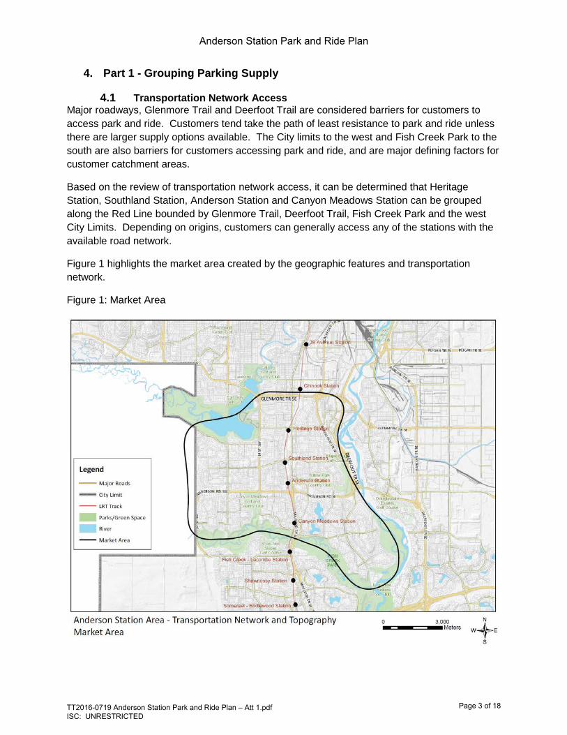
4.1 Transportation Network Access Major roadways, Glenmore Trail and Deerfoot Trail are considered barriers for customers to access park and ride. Customers tend take the path of least resistance to park and ride unless there are larger supply options available. The City limits to the west and Fish Creek Park to the south are also barriers for customers accessing park and ride, and are major defining factors for customer catchment areas.
Based on the review of transportation network access, it can be determined that Heritage Station, Southland Station, Anderson Station and Canyon Meadows Station can be grouped along the Red Line bounded by Glenmore Trail, Deerfoot Trail, Fish Creek Park and the west City Limits. Depending on origins, customers can generally access any of the stations with the available road network.
Figure 1 highlights the market area created by the geographic features and transportation network.
Figure 1: Market Area
Anderson Station Park and Ride Plan
TT2016-0719 Anderson Station Park and Ride Plan – Att 1.pdf ISC: UNRESTRICTED
Page 3 of 18

4.2 Customer Origins Appendices 1 and 2 contain reserved parking customer origin data and Anderson Station license plate customer origin data respectively. Analysis of reserved parking data in Appendix 1 provides the following observations:
• Reserved parking customers accessing Heritage Station, Southland Station and Canyon Meadows Station are primarily located within the market area identified in Section 4.1 - Transportation Network Access.
• Anderson Station customer locations are primarily located within the defined Transportation Network Access in Section 4.1 as well as areas east of Deerfoot Trail and south of Fish Creek Park.
• In general, it is observed that roadways create boundaries and defined catchment areas for customers accessing park and ride.
• As of August 2016, 85% of the reserved parking area at Anderson Station is available for reservation. In contrast, Somerset-Bridlewood Station and Shawnessy Station park and ride reservations are full with significant waitlists. This indicates higher demand for parking at terminal stations. This makes sense now that Anderson is no longer the terminus station it once was.
Based on analysis of license plate parking lot data in Appendix 2 for customer origins specific to Anderson Station, the observations below can be made. It should be noted that origin information for all park and ride users is not available for all lots due to restrictions on license plate data.
• 29% (487) of customers originate within the market area identified in Section 4.1. • 21% (343) of customers originate south of Fish Creek Park and west of Bow River. • 35% (584) of customers originate east of Deerfoot Trail and the Bow River.
o This area overlaps with the future Green Line service area. • 10% (170) of customers originate south (outside) of Calgary.
4.3 Bus Service Coverage
Park and ride is a means of attracting customers to transit who may need their vehicle for a portion of their inbound and/or outbound trip. As designed the majority of riders access the LRT stations on a bus. Currently 85% of CTrain customers use bus, walking or cycling to access CTrain stations. A robust network of 19 bus routes provides service in the subject market area that enables customers to access CTrain stations. As described below, the bus network can provide an alternative to park and ride customers who want to access the station. Appendix 3 identifies feeder bus routes that provide service to Heritage Station, Southland Station, Anderson Station and Canyon Meadows Station. The following observations can be made:
• Sixteen of the 19 routes serving the four stations provide direct feeder bus service to the communities identified within the market area in Section 4.1.
• Three of the 19 routes serving the four stations provide service east of Deerfoot Trail and connect with Anderson Station. Calgary Transit will be implementing a new service plan for that area as part of the Green Line. It is anticipated that the new plan will focus service in those communities to access Green Line stations, while also providing cross-town type routes with connections to major destinations.
• It should be noted that there are other destinations along the routes identified including junior high schools, high schools and commercial destinations and not all customers end their trips at the CTrain stations.
Anderson Station Park and Ride Plan
TT2016-0719 Anderson Station Park and Ride Plan – Att 1.pdf ISC: UNRESTRICTED
Page 4 of 18

• Opportunity exists for displaced park and ride users currently using Heritage Station, Southland Station, Anderson Station and Canyon Meadows Station to transition to the bus service provided. Available capacity exists on the bus routes serving these stations.
4.4 Green Line Consideration
From reviewing the customer origin data above, a large number, 35% observed, of park and ride customers accessing Anderson Station originate east of Deerfoot Trail and Bow River and are adjacent to the future Green Line. Park and ride along the future Green Line has been identified and in some cases land has been purchased or acquired as part of the land use planning for new communities. Current timelines indicate that Green Line will be operational in approximately 2025-2026. Based on the Transportation Network Access, Customer Origins Data and Bus Service Coverage, there is opportunity to phase TOD at Anderson Station in two parts to allow for park and ride customers who originate east of Deerfoot Trail and Bow River to transition to Green Line park and ride facilities when the new line is operational.
4.5 Red Line South Extension Consideration From reviewing the customer origin data above, a large number of park and ride customers accessing Anderson Station originate south of Fish Creek Park adjacent to existing and future Red Line. Traditionally, terminal stations have large demand for park and ride including a regional draw. The extension of the Red Line south of Somerset-Bridlewood Station into the West Macleod Area Structure Plan sector will provide an opportunity for a large park and ride facility at the terminal station. Land has been acquired for a future park and ride at the 212 Ave S Station. Based on the Customer Origins Data, Calgary Transit anticipates customers would transition from Anderson Station park and ride to future park and ride on the future Red Line South extension. Increased park and ride stalls at the new terminal station will also allow future TOD projects on the south line to move forward through the new supply of stalls which would act as ‘replacement stalls’ for the TOD in question.
4.6 Regional Transit Service A south regional bus service pilot (On-It) will begin service serving High River, Turner Valley, Black Diamond and Okotoks connecting to Somerset-Bridlewood Station in October. Each municipality will locate a park and ride lot in their municipality.
4.7 Part 1 Summary
The geographic features and transportation network (Glenmore Trail to the north, City Limits to the west, Fish Creek Park to the south and Deerfoot Trail/Bow River to the east) create a market area around Anderson Station as well as Heritage Station, Southland Station and Canyon Meadows Station to form a logical grouping and market area. The market area is also reflected in the feeder bus service. It is fair to consider all stations within the market area would be equally accessible by driving and using transit. The customer origin data highlights a unique case for Anderson Station where a substantial amount of customers originate outside of the market area defined above. The service area will be used to determine total park and ride supply for the group of stations.
Anderson Station Park and Ride Plan
TT2016-0719 Anderson Station Park and Ride Plan – Att 1.pdf ISC: UNRESTRICTED
Page 5 of 18

5. Part 2 – Determine Current and Future Parking Supply Through TT2016-0319, accommodation of 15% of weekday peak period CTrain trips in park and ride was approved and has been used to identify the number of required park and ride stalls within the market area identified in Part 1.
The calculation of the park and ride supply considers the population of the station service area, the number of transit trips external to the service area, auto occupancy and turnover of the parking lots.
Within the market area, parking supply requirements identified:
• Current required supply (2024) - 1,938 stalls • Future required supply (2039) - 2,146 stalls
The future increase in supply is attributed to the population and development increase projections highlighted in the Municipal Development Plan. The current number of stalls in the subject area is 3,125 (Heritage Station – 550, Southland Station – 650, Anderson Station – 1,665, Canyon Meadows Station – 260). The current number of park and ride stalls exceeds the requirement by 979 in the 2039 scenario. Currently, there is more parking than would be required under a strict application of the 15% policy. “No net loss provisions” provides guidance to seek to protect the current supply to ensure we support current customers. Other park and ride opportunities outside of the grouping will be evaluated that align with the transportation network access, bus service and customer origins Taking into consideration that there is an oversupply of parking within the area, a modest net loss of parking will be explored through the plan in order to optimize TOD opportunities around Anderson Station.
6. Part 3 – Develop a Supply Strategy To facilitate TOD at Anderson Station, parking replacement must be realized. Leaving too much surface parking adjacent to Anderson Station effectively precludes TOD, however, replacing all the existing parking stalls on site in a structure make the TOD unaffordable to build assuming the structure cost is recovered by the sale of land.
A review of existing conditions and strategic alignment is undertaken to identify additional supply and location of park and ride stalls at segments along the Red Line. Table 1 provides an overview of Heritage Station, Southland Station, Anderson Station and Canyon Meadows Station.
Anderson Station Park and Ride Plan
TT2016-0719 Anderson Station Park and Ride Plan – Att 1.pdf ISC: UNRESTRICTED
Page 6 of 18

Table 1: Existing Conditions and Strategic Alignment Overview
Heritage Station
Southland Station
Anderson Station
Canyon Meadows
Parking
Current # of Stalls 550 650 1665 260
Existing Conditions Current passenger activity (boarding’s + alighting) 13,240 9,280 12,460 7,160
Current Bus Terminal? (with bus loop) yes yes yes yes
Bus Service in Catchment Area (number of routes) 10 7 9 4 Bus capacity (yes/no) (can bus routes handle demand if reduced parking?) yes yes yes yes
Is the station within 5km of downtown? no no no no
Is there a passenger drop off area yes yes yes yes
Is this a terminal station - short and long term no no previous no
Strategic Alignment Station Area a MAC/CAC/Hub? hub hub MAC no
RE&DS TOD Priority no no yes no
Regional Service Demand (Originating Outside Calgary) 4% 3% 10% 7%
The following observations can be made:
Existing Conditions • Outside of the downtown, Heritage Station and Anderson Station are among the busiest
stations in terms of average weekday boarding’s at CTrain stations. • A high number of bus routes (7-10) serve Heritage Station, Southland Station and
Anderson Station indicating high customer access from adjacent communities. • There is available bus capacity serving the four stations to accommodate some parking
displacement at Anderson Station. • None of the stations are terminal stations. Terminal stations generally have higher
demand for park and ride. • Anderson Station should be the focus of TOD with minimal surface park and ride
adjacent to the area due to availability of high quality transit service. Strategic Alignment
• Anderson Station is a Major Activity Centre (MAC) identified in the Municipal Development Plan (MDP) and is a high priority for TOD identified by RE&DS.
• Primary Transit Network (PTN) Routes indicated in the CTP will provide service to the stations except for Canyon Meadows
Based on the observations in Table 1, it can be concluded:
• Optimizing TOD should be the focus at Anderson Station where a MAC is identified as well as high quality transit service and future PTN routes exist.
• Park and ride should be maintained at Canyon Meadows Station where a MAC and PTN routes are not identified.
Anderson Station Park and Ride Plan
TT2016-0719 Anderson Station Park and Ride Plan – Att 1.pdf ISC: UNRESTRICTED
Page 7 of 18

• Future parking opportunities at Southland Station and Heritage Station should be strategically located as not to de-incentivise TOD.
• Due to low TOD priority identified by RE&DS, surface park and ride stalls should be maintained at this time at Heritage, Southland and Canyon Meadows Stations. This should not preclude future development opportunities. The park and ride plan should be updated in the event development opportunity arises.
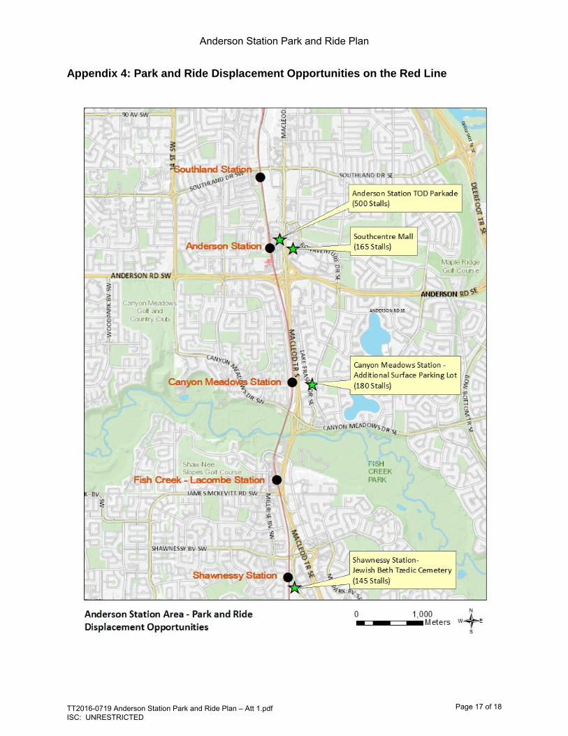
Table 2 and Appendix 4 identify displacement opportunities at station locations as well as other suitable locations along the Red Line. Based on the customer origins data, the opening of the Green Line will provide park and ride to customers who originate east of Deerfoot Trail and Bow River. Opportunities south of Fish Creek Park are also being reviewed due to customers originating in the area. The proposed displacement opportunities should be within 400 metres or a five to ten minute walk from the CTrain station to continue attractiveness of park and ride to customers.
Table 2: Parking Displacement Opportunity
Heritage Station
Southland Station
Anderson Station
Canyon Meadows
Availability of land located within a 5 min walk of station/stop yes yes yes yes
Public land availability for park and ride no yes no yes Opportunity for leased parking no yes yes no
Anderson TOD Replacement Parking Options
Site # of Stalls Address Land
Use Ownership Planning
Requirements Needed
Next Steps
Canyon Meadows
Station 180 13006 Lake Fraser Dr SE DC City of Calgary Development
Liaison T&T, PFC approval
South Centre Mall 165 100 Anderson Rd SE C-R2
Oxford Properties (City of Calgary to
lease lands)
Development Permit
T&T, PFC approval
Jewish Beth Tzedic Cemetery 145 122 Shalom Way SE S-CRI
Jewish Beth Tzedic
Association (City of Calgary to
lease lands and construct stalls)
Development Permit
T&T, PFC approval
Anderson Station TOD
Parkade 500 11015 Anderson Station
Wy SW S-CRI City of Calgary Land Use and Development
Permit
Council Approval
Green Line Stations (Phase 2 of Anderson Station TOD)
700 Lynnwood Station,
Shepard Station, Douglas Glen Station
varies City of Calgary varies Council Approval
Note: Green Line Station park and ride numbers do not reflect the total amount of parking located at that site. The number reflects how many customers would transition over to Green Line park and ride opportunity. The Green Line park and ride plan is ongoing.
Anderson Station Park and Ride Plan
TT2016-0719 Anderson Station Park and Ride Plan – Att 1.pdf ISC: UNRESTRICTED
Page 8 of 18
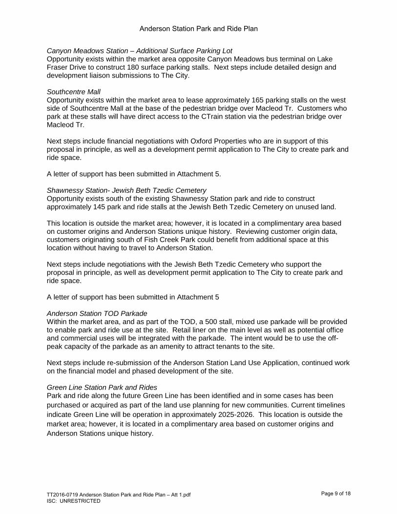
Canyon Meadows Station – Additional Surface Parking Lot Opportunity exists within the market area opposite Canyon Meadows bus terminal on Lake Fraser Drive to construct 180 surface parking stalls. Next steps include detailed design and development liaison submissions to The City. Southcentre Mall Opportunity exists within the market area to lease approximately 165 parking stalls on the west side of Southcentre Mall at the base of the pedestrian bridge over Macleod Tr. Customers who park at these stalls will have direct access to the CTrain station via the pedestrian bridge over Macleod Tr. Next steps include financial negotiations with Oxford Properties who are in support of this proposal in principle, as well as a development permit application to The City to create park and ride space. A letter of support has been submitted in Attachment 5. Shawnessy Station- Jewish Beth Tzedic Cemetery Opportunity exists south of the existing Shawnessy Station park and ride to construct approximately 145 park and ride stalls at the Jewish Beth Tzedic Cemetery on unused land. This location is outside the market area; however, it is located in a complimentary area based on customer origins and Anderson Stations unique history. Reviewing customer origin data, customers originating south of Fish Creek Park could benefit from additional space at this location without having to travel to Anderson Station. Next steps include negotiations with the Jewish Beth Tzedic Cemetery who support the proposal in principle, as well as development permit application to The City to create park and ride space. A letter of support has been submitted in Attachment 5 Anderson Station TOD Parkade Within the market area, and as part of the TOD, a 500 stall, mixed use parkade will be provided to enable park and ride use at the site. Retail liner on the main level as well as potential office and commercial uses will be integrated with the parkade. The intent would be to use the off-peak capacity of the parkade as an amenity to attract tenants to the site. Next steps include re-submission of the Anderson Station Land Use Application, continued work on the financial model and phased development of the site. Green Line Station Park and Rides Park and ride along the future Green Line has been identified and in some cases has been purchased or acquired as part of the land use planning for new communities. Current timelines indicate Green Line will be operation in approximately 2025-2026. This location is outside the market area; however, it is located in a complimentary area based on customer origins and Anderson Stations unique history.
Anderson Station Park and Ride Plan
TT2016-0719 Anderson Station Park and Ride Plan – Att 1.pdf ISC: UNRESTRICTED
Page 9 of 18

Opportunity for Joint Use and Shared Parking
Transportation is currently working on developing policy that will facilitate shared parking with adjacent landowners. A proposed process will be brought to the 2016 December SPC on T&T meeting. The main benefit is to reduce the overall total parking provision by better using existing stalls. This offers potential significant capital savings (from constructing new parking) and creates new opportunities for adjacent landowners.
Calgary Transit has experience in shared parking in various capacities. Two examples of shared parking include:
• The 900 stall North Pointe park and ride lot serves Route 301 BRT customers on weekdays; however, is also used by theatre and shopping centre customers on evenings and weekends. The Theatre paid for the construction of the lot in return for use by their customers.
• Some parking stalls are provided by Harvest Hills Alliance Church and Huntington Hills Community Centre for Route 301 BRT.
Public land opportunities, private lease opportunities and shared parking from private land owners to replace park and ride stalls and see TOD move forward is going to vary per station and per line. In the case of the Anderson Station Park and Ride Plan, public land and lease opportunity exist, however, moving forward, similar opportunities to expand future supply will vary and parking plans may differ on a case by case basis.
Anderson Station Park and Ride Plan
TT2016-0719 Anderson Station Park and Ride Plan – Att 1.pdf ISC: UNRESTRICTED
Page 10 of 18

7. Anderson TOD Phasing
To strive for no net loss of park and ride stalls, a phasing strategy has been created that enables phasing of park and ride. Appendix 5 provides a detailed phasing plan of the TOD with a summary below in Table 3. Anderson Station TOD is being recommended to occur in two phases to reflect customer origins in Section 4.2 and to allow customers who live adjacent to the Green Line to utilize the new stalls when they become operational. Suggested park and ride locations for customers to transition to include Lynwood, Shepard and Douglas Glen Stations. Table 3 – Anderson Station Park and Ride Plan and TOD Phasing Summary
Stations Current
Anderson Phase 1
Servicing Complete
Green Line Opening/Anderson Phase 2 Servicing
Begins Red Line Stations Park and Ride Heritage Station 550 550 550 Southland Station 650 650 650 Anderson Station (surface) 1665 695 Anderson Station TOD Parkade 500 500 Canyon Meadows 260 260 260 Displacement Locations Southcentre Mall Parking Stall Lease 165 165 Southland Park and Ride Extension (Lease) 125 125 Shawnessy Park and Ride Extension (Lease) 200 200 Green Line Stations Lynwood Station 120 Shepard Station 175 Douglas Glen Station 405 Total Park and Ride Stalls 3125 3145 3150 Note: Green Line Station park and ride numbers do not reflect the total amount of parking located at that site. The number reflects how many customers would transition over to Green Line park and ride opportunity. The Green Line park and ride plan is ongoing.
Highlights of phasing plan include:
• Phase 1 can begin pending land use and funding model approvals and agreements with land owners for displacement parking opportunity
• Phase 2 could coincide with the opening of Green Line as new park and ride opportunity would accommodate displacement of parking at Anderson Station for customers originating east of Deerfoot Trail and the Bow River.
• The displacement opportunities will be phased in with service phasing to minimize costs and allow for transition from Anderson Park and Ride to the other locations.
Anderson Station Park and Ride Plan
TT2016-0719 Anderson Station Park and Ride Plan – Att 1.pdf ISC: UNRESTRICTED
Page 11 of 18

8. Conclusion
The Anderson Park and Ride Plan identifies parking supply that balances park and ride supply with redevelopment opportunities.
Using the four elements to direct the supply and location of park and ride and the three part process, Heritage Station, Southland Station, Anderson Station and Canyon Meadows Station have formed a logical grouping supply (market area) with the current parking requirement of 1,938 stalls, and future parking supply of 2,146 stalls. The supply was determined using approximately 15% of weekday peak period CTrain trips.
The existing supply of parking stalls, 3,125, exceeds the future requirement by 979 stalls. Although the existing parking supply exceeds the requirement, minimal net loss of parking has been identified.
Anderson Station is a special consideration given until 2001, Anderson Station was the terminal station for the Red Line and included 1,665 parking stalls. As park and ride was deemed to be an important tool in attracting customers to transit, park and ride facilities were located at Chinook Station (320), Heritage Station (550), Southland Station (650) and Anderson Station (1,665).The large park and ride component at Anderson Station was created to attract trips from south Calgary including developing communities in southeast Calgary.
As reflected in the customer origin data in Attachment 2, Appendix 1 and 2, customers originate from outside the defined market area. This creates an opportunity to evaluate and identify parking supply opportunities along the Red Line outside of the defined market area as well as adjacent to the future Green Line.
Part 3 identifies five locations for displacement of park and ride stalls at Anderson Station while maintaining existing levels of parking at Heritage Station (550), Southland Station (650) and Canyon Meadows Station (260):
• Canyon Meadows Station – Additional Surface Parking Lot – Construct 180 surface parking stalls within the market area.
• Southcentre Mall – Lease 165 parking stalls on the west side of Southcentre Mall at the base of the pedestrian bridge over Macleod Tr from Anderson Station within the market area.
• Shawnessy Station- Jewish Beth Tzedic Cemetery - Construct approximately 145 park and ride stalls at the Jewish Beth Tzedic Cemetery on unused land. This location is outside the market area; however, it is located in a complimentary area based on customer origins and Anderson Stations unique history.
• Anderson Station TOD Parkade – Within the market area and as part of the TOD, a 500 stall mixed use parkade will be provided to enable park and ride use at the site.
• Green Line Station Park and Rides - Park and ride along the future Green Line has been identified and current timelines indicate Green Line will be operation in approximately 2025-2026. This location is outside the market area; however, it is located in a complimentary area based on customer origins and Anderson Stations unique history.
Anderson Station Park and Ride Plan
TT2016-0719 Anderson Station Park and Ride Plan – Att 1.pdf ISC: UNRESTRICTED
Page 12 of 18

Phasing for Anderson Station TOD is being recommended to occur in two phases to reflect customer origins and to allow customers who live adjacent to the Green Line to utilize the new stalls when they become operational. Highlights of phasing plan include:
• Phase 1 can begin pending land use and funding model approvals and agreements with land owners for displacement parking opportunity
• Phase 2 can begin with the opening of Green Line as new park and ride opportunity would accommodate displacement of parking at Anderson Station for customers originating east of Deerfoot Trail and the Bow River.
• The displacement opportunities will be phased in with service phasing to minimize costs and allow for transition from Anderson Park and Ride to the other locations.
Anderson Station Park and Ride Plan
TT2016-0719 Anderson Station Park and Ride Plan – Att 1.pdf ISC: UNRESTRICTED
Page 13 of 18

Appendix 1: Reserved Parking Customer Origins (2016 January)
Anderson Station Park and Ride Plan
TT2016-0719 Anderson Station Park and Ride Plan – Att 1.pdf ISC: UNRESTRICTED
Page 14 of 18

Appendix 2: License Plate Customer Origins
Anderson Station Park and Ride Plan
TT2016-0719 Anderson Station Park and Ride Plan – Att 1.pdf ISC: UNRESTRICTED
Page 15 of 18

Appendix 3: Bus Service Coverage in Anderson Station Area
Anderson Station Park and Ride Plan
TT2016-0719 Anderson Station Park and Ride Plan – Att 1.pdf ISC: UNRESTRICTED
Page 16 of 18
Appendix 4: Park and Ride Displacement Opportunities on the Red Line
Anderson Station Park and Ride Plan
TT2016-0719 Anderson Station Park and Ride Plan – Att 1.pdf ISC: UNRESTRICTED
Page 17 of 18

Appendix 5: Anderson Station TOD – Detailed Phasing Plan
Anderson Station Park and Ride Plan
TT2016-0719 Anderson Station Park and Ride Plan – Att 1.pdf ISC: UNRESTRICTED
Page 18 of 18