Embed Size (px)
Citation preview
1
ANNEXURE -1
Alternatives Evaluation of Bypasses through EIA Decision Support System
2
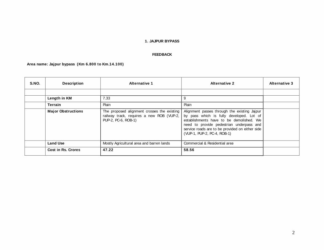
1. JAJPUR BYPASS
FEEDBACK
Area name: Jajpur bypass (Km 6.800 to Km.14.100)
S.NO. Description Alternative 1 Alternative 2 Alternative 3
Length in KM 7.33 9 Terrain Plain Plain
Major Obstructions The proposed alignment crosses the existing railway track, requires a new ROB (VUP-2, PUP-2, PC-6, ROB-1)
Alignment passes through the existing Jajpur by pass which is fully developed. Lot of establishments have to be demolished. We need to provide pedestrian underpass and service roads are to be provided on either side (VUP-1, PUP-2, PC-4, ROB-1)
Land Use Mostly Agricultural area and barren lands Commercial & Residential area
Cost in Rs. Crores 47.22 58.56
3
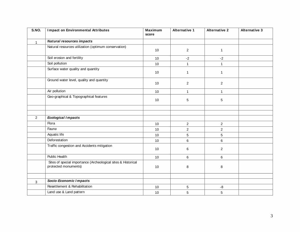
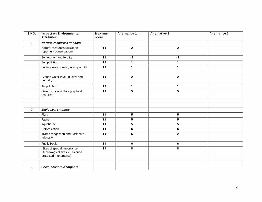
S.NO. Impact on Environmental Attributes Maximum
score Alternative 1 Alternative 2 Alternative 3
1 Natural resources impacts Natural resources utilization (optimum conservation)
10 2 1
Soil erosion and fertility 10 -2 -2 Soil pollution 10 1 1 Surface water quality and quantity
10 1 1
Ground water level, quality and quantity 10 2 2
Air pollution 10 1 1 Geo-graphical & Topographical features
10 5 5
2 Ecological Impacts Flora 10 2 2 Fauna 10 2 2 Aquatic life 10 5 5 Deforestation 10 6 6 Traffic congestion and Accidents mitigation
10 6 2
Public Health 10 6 6 Sites of special importance (Archeological sites & Historical
protected monuments) 10 8 8
3 Socio-Economic Impacts
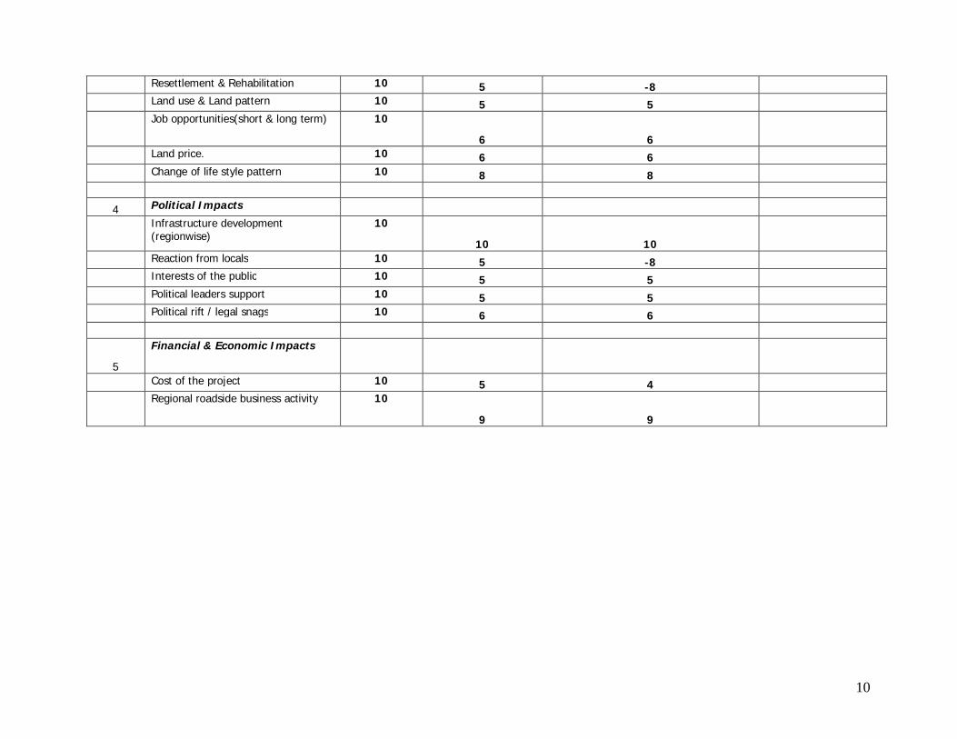
Resettlement & Rehabilitation 10 5 -8
Land use & Land pattern 10 5 5
4
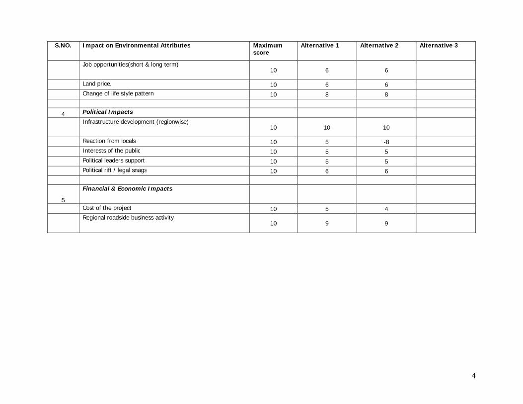
S.NO. Impact on Environmental Attributes Maximum score
Alternative 1 Alternative 2 Alternative 3
Job opportunities(short & long term) 10 6 6
Land price. 10 6 6
Change of life style pattern 10 8 8
4 Political Impacts
Infrastructure development (regionwise) 10 10 10
Reaction from locals 10 5 -8
Interests of the public 10 5 5
Political leaders support 10 5 5
Political rift / legal snags 10 6 6
5
Financial & Economic Impacts
Cost of the project 10 5 4
Regional roadside business activity 10 9 9
5
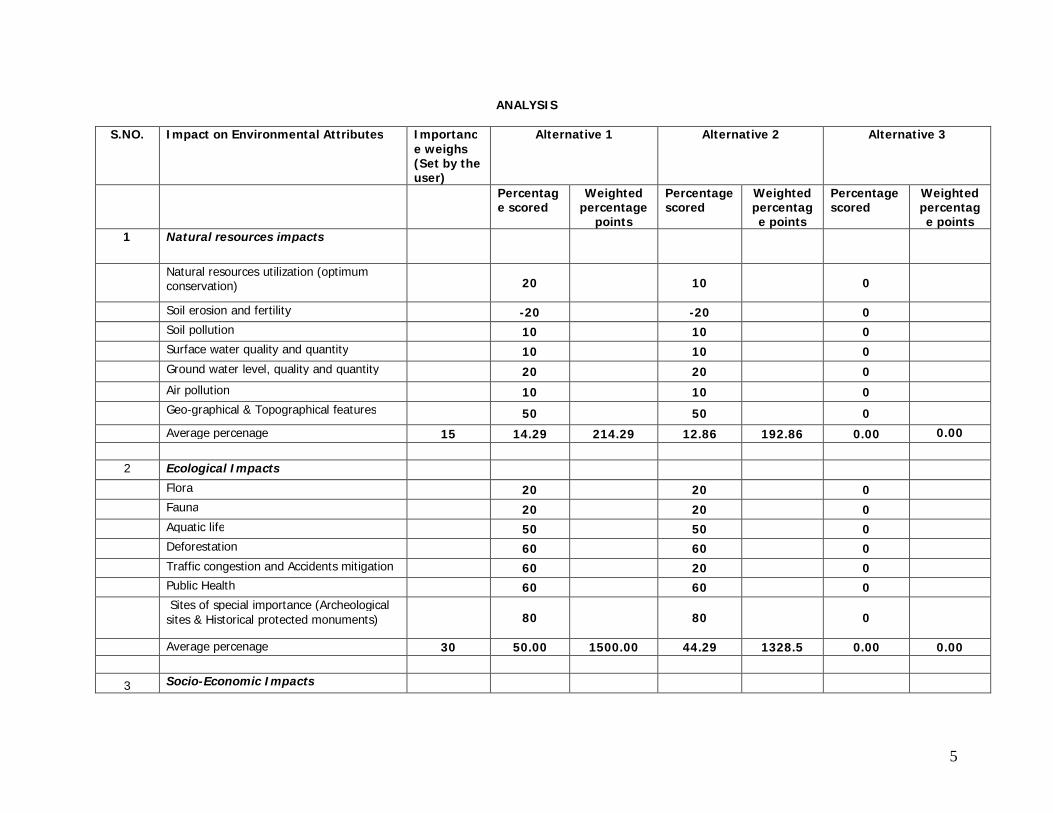
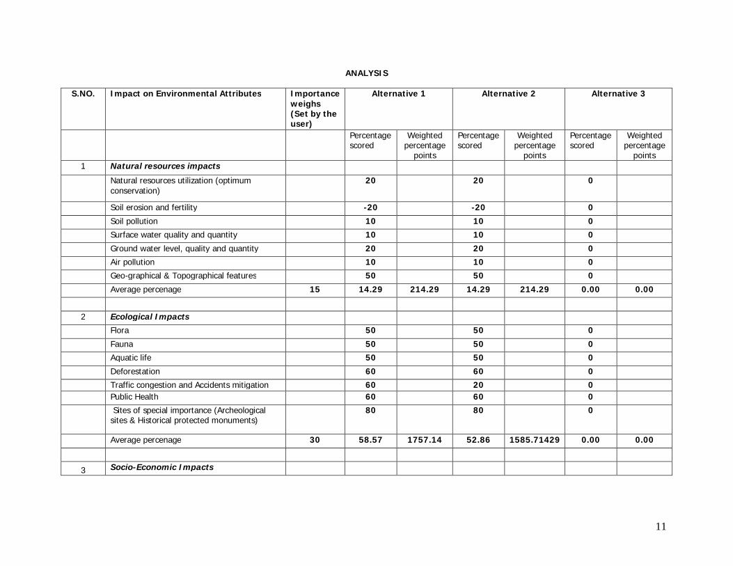
ANALYSIS
S.NO. Impact on Environmental Attributes Importanc
e weighs (Set by the user)
Alternative 1 Alternative 2 Alternative 3
Percentage scored
Weighted percentage
points
Percentage scored
Weighted percentage points
Percentage scored
Weighted percentage points
1 Natural resources impacts
Natural resources utilization (optimum conservation) 20 10 0
Soil erosion and fertility -20 -20 0
Soil pollution 10 10 0
Surface water quality and quantity 10 10 0
Ground water level, quality and quantity 20 20 0
Air pollution 10 10 0
Geo-graphical & Topographical features 50 50 0
Average percenage 15 14.29 214.29 12.86 192.86 0.00 0.00 2 Ecological Impacts
Flora 20 20 0
Fauna 20 20 0
Aquatic life 50 50 0
Deforestation 60 60 0
Traffic congestion and Accidents mitigation 60 20 0 Public Health 60 60 0
Sites of special importance (Archeological sites & Historical protected monuments) 80 80 0
Average percenage 30 50.00 1500.00 44.29 1328.5 0.00 0.00
3 Socio-Economic Impacts
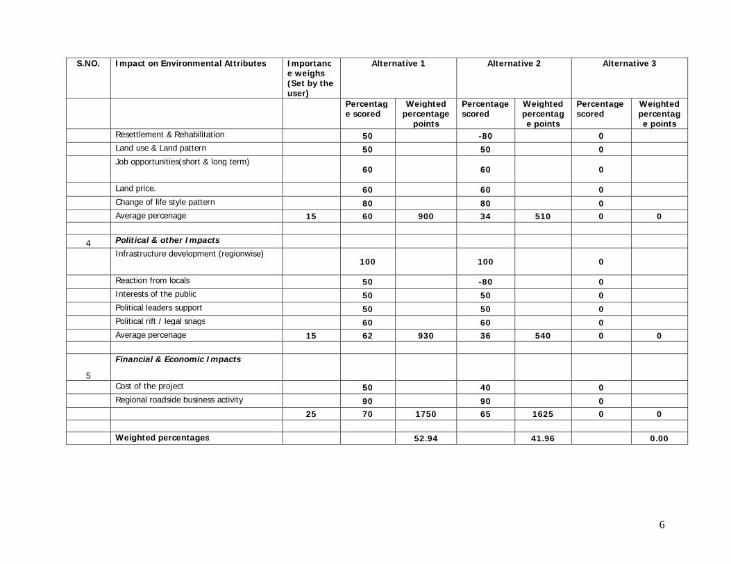
6
S.NO. Impact on Environmental Attributes Importance weighs (Set by the user)
Alternative 1 Alternative 2 Alternative 3
Percentage scored
Weighted percentage
points
Percentage scored
Weighted percentage points
Percentage scored
Weighted percentage points
Resettlement & Rehabilitation 50 -80 0
Land use & Land pattern 50 50 0
Job opportunities(short & long term) 60 60 0
Land price. 60 60 0
Change of life style pattern 80 80 0
Average percenage 15 60 900 34 510 0 0
4 Political & other Impacts
Infrastructure development (regionwise) 100 100 0
Reaction from locals 50 -80 0
Interests of the public 50 50 0
Political leaders support 50 50 0
Political rift / legal snags 60 60 0
Average percenage 15 62 930 36 540 0 0
5
Financial & Economic Impacts
Cost of the project 50 40 0
Regional roadside business activity 90 90 0
25 70 1750 65 1625 0 0 Weighted percentages 52.94 41.96 0.00
7
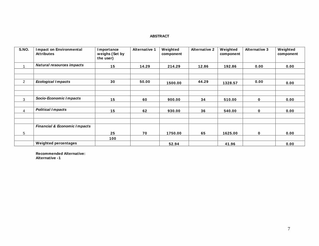
ABSTRACT
S.NO. Impact on Environmental Attributes
Importance weighs (Set by the user)
Alternative 1 Weighted component
Alternative 2 Weighted component
Alternative 3 Weighted component
1 Natural resources impacts 15 14.29 214.29 12.86 192.86 0.00 0.00 2 Ecological Impacts 30 50.00 1500.00 44.29 1328.57 0.00 0.00
3 Socio-Economic Impacts 15 60 900.00 34 510.00 0 0.00
4 Political Impacts 15 62 930.00 36 540.00 0 0.00
5
Financial & Economic Impacts
25 70 1750.00 65 1625.00 0 0.00 100 Weighted percentages 52.94 41.96 0.00
Recommended Alternative: Alternative -1
8
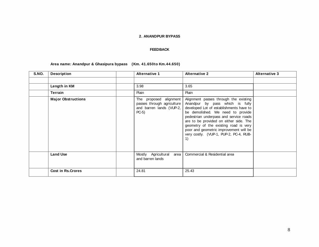
2. ANANDPUR BYPASS
FEEDBACK
Area name: Anandpur & Ghasipura bypass (Km. 41.650to Km.44.650)
S.NO. Description Alternative 1 Alternative 2 Alternative 3
Length in KM 3.98 3.65 Terrain Plain Plain
Major Obstructions The proposed alignment passes through agriculture and barren lands (VUP-2, PC-5)
Alignment passes through the existing Anandpur by pass which is fully developed Lot of establishments have to be demolished. We need to provide pedestrian underpass and service roads are to be provided on either side. The geometry of the existing road is very poor and geometric improvement will be very costly. (VUP-1, PUP-2, PC-4, RUB-1)
Land Use Mostly Agricultural area and barren lands
Commercial & Residential area
Cost in Rs.Crores 24.81 25.43
9
S.NO. Impact on Environmental Attributes
Maximum score
Alternative 1 Alternative 2 Alternative 3
1 Natural resources impacts Natural resources utilization
(optimum conservation) 10 2 2
Soil erosion and fertility 10 -2 -2
Soil pollution 10 1 1
Surface water quality and quantity 10 1 1
Ground water level, quality and quantity
10 2 2
Air pollution 10 1 1
Geo-graphical & Topographical features
10 5 5
2 Ecological Impacts
Flora 10 5 5
Fauna 10 5 5
Aquatic life 10 5 5
Deforestation 10 6 6
Traffic congestion and Accidents mitigation
10 6 2
Public Health 10 6 6
Sites of special importance (Archeological sites & Historical protected monuments)
10 8 8
3 Socio-Economic Impacts
10
Resettlement & Rehabilitation 10 5 -8
Land use & Land pattern 10 5 5
Job opportunities(short & long term) 10
6 6
Land price. 10 6 6
Change of life style pattern 10 8 8
4 Political Impacts
Infrastructure development (regionwise)
10
10 10
Reaction from locals 10 5 -8
Interests of the public 10 5 5
Political leaders support 10 5 5
Political rift / legal snags 10 6 6
5
Financial & Economic Impacts
Cost of the project 10 5 4
Regional roadside business activity 10
9 9
11
ANALYSIS
S.NO. Impact on Environmental Attributes Importance
weighs (Set by the user)
Alternative 1 Alternative 2 Alternative 3
Percentage scored
Weighted percentage
points
Percentage scored
Weighted percentage
points
Percentage scored
Weighted percentage
points 1 Natural resources impacts
Natural resources utilization (optimum conservation)
20 20 0
Soil erosion and fertility -20 -20 0
Soil pollution 10 10 0
Surface water quality and quantity 10 10 0
Ground water level, quality and quantity 20 20 0
Air pollution 10 10 0
Geo-graphical & Topographical features 50 50 0
Average percenage 15 14.29 214.29 14.29 214.29 0.00 0.00
2 Ecological Impacts
Flora 50 50 0
Fauna 50 50 0
Aquatic life 50 50 0
Deforestation 60 60 0
Traffic congestion and Accidents mitigation 60 20 0 Public Health 60 60 0
Sites of special importance (Archeological sites & Historical protected monuments)
80 80 0
Average percenage 30 58.57 1757.14 52.86 1585.71429 0.00 0.00
3 Socio-Economic Impacts
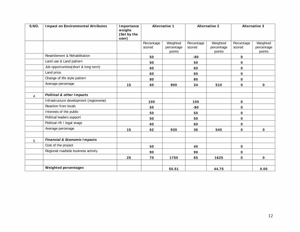
12
S.NO. Impact on Environmental Attributes Importance weighs (Set by the user)
Alternative 1 Alternative 2 Alternative 3
Percentage scored
Weighted percentage
points
Percentage scored
Weighted percentage
points
Percentage scored
Weighted percentage
points
Resettlement & Rehabilitation 50 -80 0
Land use & Land pattern 50 50 0
Job opportunities(short & long term) 60 60 0
Land price. 60 60 0
Change of life style pattern 80 80 0
Average percenage 15 60 900 34 510 0 0
4 Political & other Impacts
Infrastructure development (regionwise) 100 100 0
Reaction from locals 50 -80 0
Interests of the public 50 50 0
Political leaders support 50 50 0
Political rift / legal snags 60 60 0
Average percenage 15 62 930 36 540 0 0
5 Financial & Economic Impacts
Cost of the project 50 40 0
Regional roadside business activity 90 90 0
25 70 1750 65 1625 0 0
Weighted percentages 55.51 44.75 0.00
13
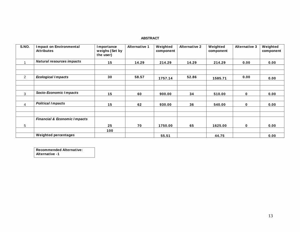
ABSTRACT
S.NO. Impact on Environmental Attributes
Importance weighs (Set by the user)
Alternative 1 Weighted component
Alternative 2 Weighted component
Alternative 3 Weighted component
1 Natural resources impacts 15 14.29 214.29 14.29 214.29 0.00 0.00 2 Ecological Impacts 30 58.57 1757.14 52.86 1585.71 0.00 0.00
3 Socio-Economic Impacts 15 60 900.00 34 510.00 0 0.00
4 Political Impacts 15 62 930.00 36 540.00 0 0.00
5
Financial & Economic Impacts
25 70 1750.00 65 1625.00 0 0.00 100 Weighted percentages 55.51 44.75 0.00
Recommended Alternative: Alternative -1
14
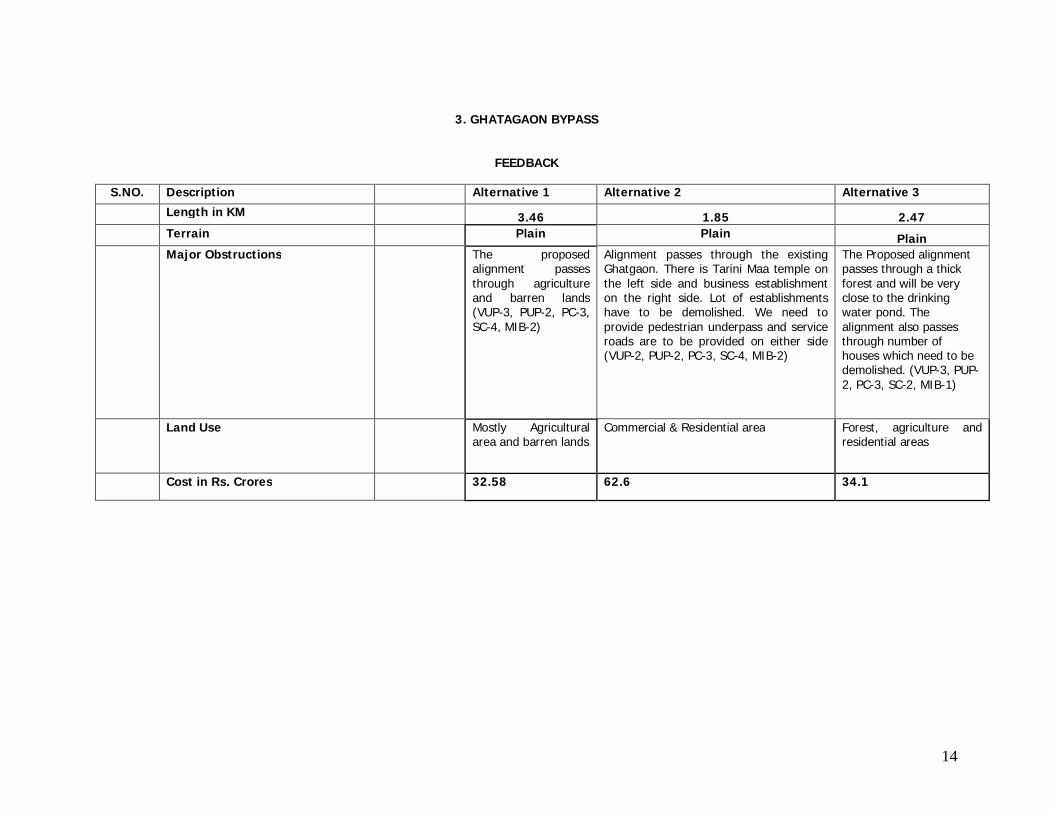
3. GHATAGAON BYPASS
FEEDBACK
S.NO. Description Alternative 1 Alternative 2 Alternative 3
Length in KM 3.46 1.85 2.47 Terrain Plain Plain Plain Major Obstructions The proposed
alignment passes through agriculture and barren lands (VUP-3, PUP-2, PC-3, SC-4, MIB-2)
Alignment passes through the existing Ghatgaon. There is Tarini Maa temple on the left side and business establishment on the right side. Lot of establishments have to be demolished. We need to provide pedestrian underpass and service roads are to be provided on either side (VUP-2, PUP-2, PC-3, SC-4, MIB-2)
The Proposed alignment passes through a thick forest and will be very close to the drinking water pond. The alignment also passes through number of houses which need to be demolished. (VUP-3, PUP-2, PC-3, SC-2, MIB-1)
Land Use Mostly Agricultural area and barren lands
Commercial & Residential area Forest, agriculture and residential areas
Cost in Rs. Crores 32.58 62.6 34.1
15
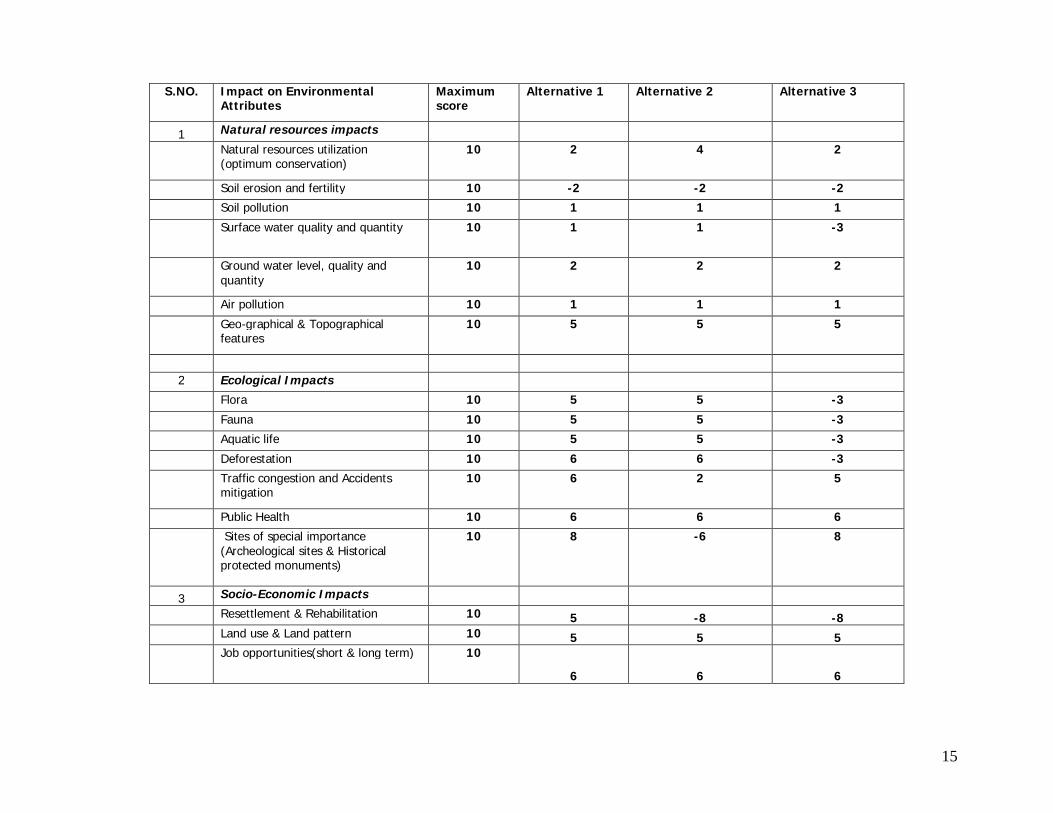
S.NO. Impact on Environmental Attributes
Maximum score
Alternative 1 Alternative 2 Alternative 3
1 Natural resources impacts Natural resources utilization
(optimum conservation) 10 2 4 2
Soil erosion and fertility 10 -2 -2 -2
Soil pollution 10 1 1 1
Surface water quality and quantity 10 1 1 -3
Ground water level, quality and quantity
10 2 2 2
Air pollution 10 1 1 1
Geo-graphical & Topographical features
10 5 5 5
2 Ecological Impacts
Flora 10 5 5 -3
Fauna 10 5 5 -3
Aquatic life 10 5 5 -3
Deforestation 10 6 6 -3
Traffic congestion and Accidents mitigation
10 6 2 5
Public Health 10 6 6 6
Sites of special importance (Archeological sites & Historical protected monuments)
10 8 -6 8
3 Socio-Economic Impacts
Resettlement & Rehabilitation 10 5 -8 -8
Land use & Land pattern 10 5 5 5
Job opportunities(short & long term) 10
6 6 6
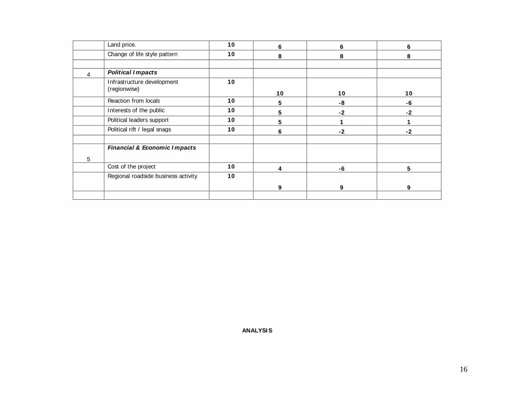
16
Land price. 10 6 6 6
Change of life style pattern 10 8 8 8
4 Political Impacts
Infrastructure development (regionwise)
10
10 10 10
Reaction from locals 10 5 -8 -6
Interests of the public 10 5 -2 -2
Political leaders support 10 5 1 1
Political rift / legal snags 10 6 -2 -2
5
Financial & Economic Impacts
Cost of the project 10 4 -6 5
Regional roadside business activity 10
9 9 9
ANALYSIS
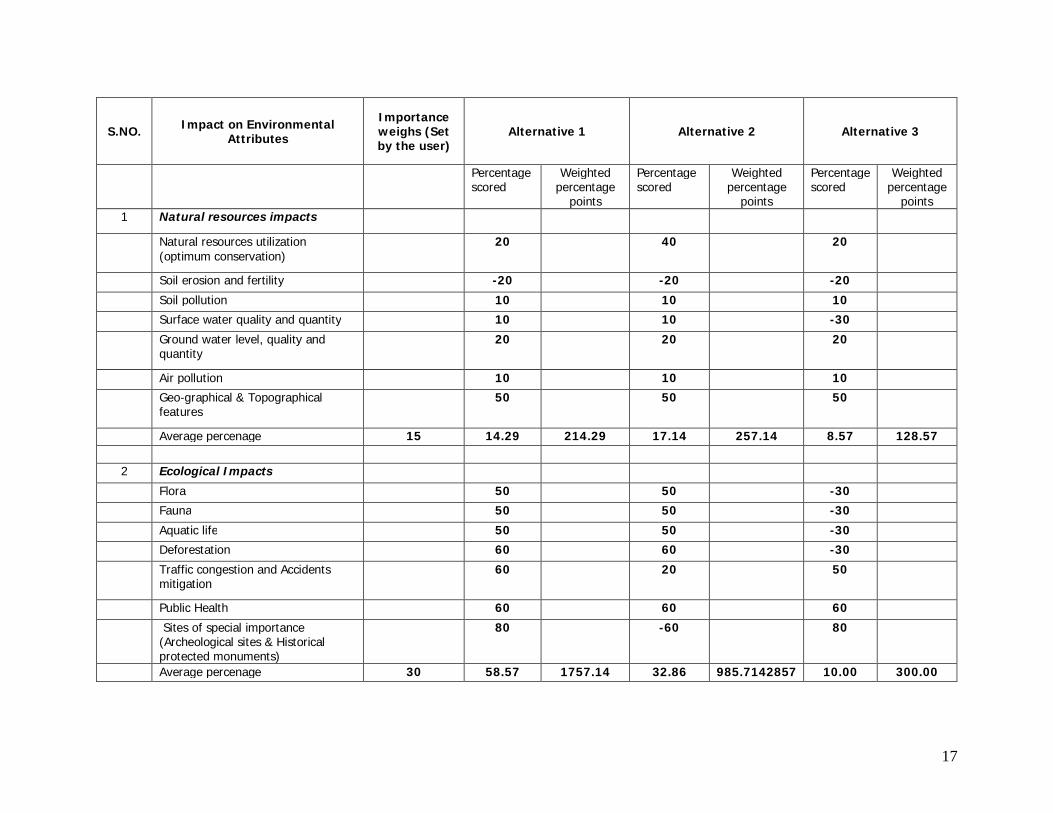
17
S.NO. Impact on Environmental Attributes
Importance weighs (Set by the user)
Alternative 1 Alternative 2 Alternative 3
Percentage scored
Weighted percentage
points
Percentage scored
Weighted percentage
points
Percentage scored
Weighted percentage
points 1 Natural resources impacts
Natural resources utilization (optimum conservation)
20 40 20
Soil erosion and fertility -20 -20 -20
Soil pollution 10 10 10
Surface water quality and quantity 10 10 -30
Ground water level, quality and quantity
20 20 20
Air pollution 10 10 10
Geo-graphical & Topographical features
50 50 50
Average percenage 15 14.29 214.29 17.14 257.14 8.57 128.57 2 Ecological Impacts
Flora 50 50 -30
Fauna 50 50 -30
Aquatic life 50 50 -30
Deforestation 60 60 -30
Traffic congestion and Accidents mitigation
60 20 50
Public Health 60 60 60
Sites of special importance (Archeological sites & Historical protected monuments)
80 -60 80
Average percenage 30 58.57 1757.14 32.86 985.7142857 10.00 300.00
18
S.NO. Impact on Environmental Attributes
Importance weighs (Set by the user)
Alternative 1 Alternative 2 Alternative 3
Percentage scored
Weighted percentage
points
Percentage scored
Weighted percentage
points
Percentage scored
Weighted percentage
points
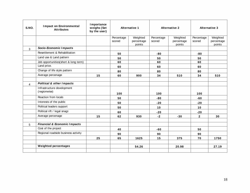
3 Socio-Economic Impacts
Resettlement & Rehabilitation 50 -80 -80
Land use & Land pattern 50 50 50 Job opportunities(short & long term) 60 60 60
Land price. 60 60 60
Change of life style pattern 80 80 80 Average percenage 15 60 900 34 510 34 510
4 Political & other Impacts
Infrastructure development (regionwise)
100 100 100
Reaction from locals 50 -80 -60
Interests of the public 50 -20 -20
Political leaders support 50 10 10
Political rift / legal snags 60 -20 -20 Average percenage 15 62 930 -2 -30 2 30 5 Financial & Economic Impacts
Cost of the project 40 -60 50
Regional roadside business activity 90 90 90 25 65 1625 15 375 70 1750 Weighted percentages 54.26 20.98 27.19
19
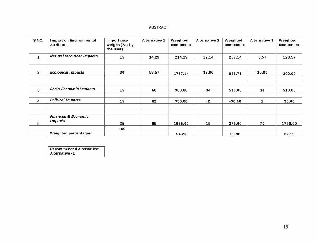
ABSTRACT
S.NO. Impact on Environmental
Attributes Importance weighs (Set by the user)
Alternative 1 Weighted component
Alternative 2 Weighted component
Alternative 3 Weighted component
1 Natural resources impacts 15 14.29 214.29 17.14 257.14 8.57 128.57 2 Ecological Impacts 30 58.57 1757.14 32.86 985.71 10.00 300.00
3 Socio-Economic Impacts 15 60 900.00 34 510.00 34 510.00
4 Political Impacts 15 62 930.00 -2 -30.00 2 30.00
5
Financial & Economic Impacts
25 65 1625.00 15 375.00 70 1750.00 100 Weighted percentages 54.26 20.98 27.19
Recommended Alternative: Alternative -1
20
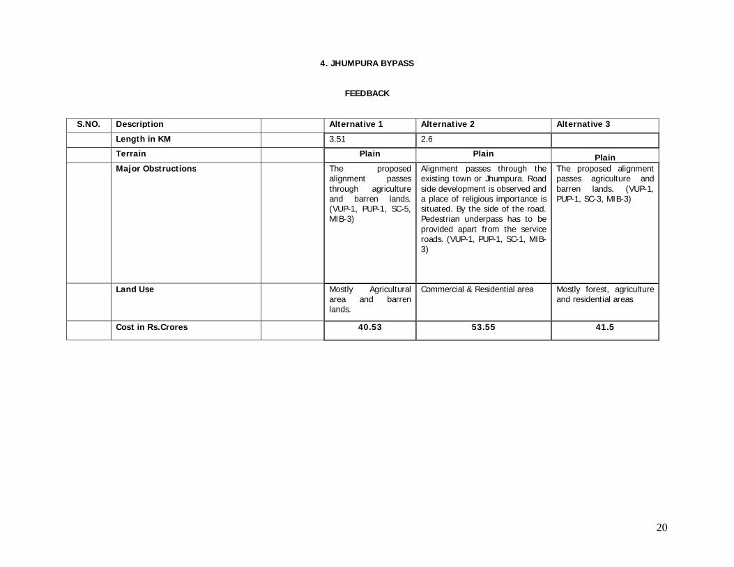
4. JHUMPURA BYPASS
FEEDBACK
S.NO. Description Alternative 1 Alternative 2 Alternative 3
Length in KM 3.51 2.6
Terrain Plain Plain Plain Major Obstructions The proposed
alignment passes through agriculture and barren lands. (VUP-1, PUP-1, SC-5, MIB-3)
Alignment passes through the existing town or Jhumpura. Road side development is observed and a place of religious importance is situated. By the side of the road. Pedestrian underpass has to be provided apart from the service roads. (VUP-1, PUP-1, SC-1, MIB-3)
The proposed alignment passes agriculture and barren lands. (VUP-1, PUP-1, SC-3, MIB-3)
Land Use Mostly Agricultural area and barren lands.
Commercial & Residential area Mostly forest, agriculture and residential areas
Cost in Rs.Crores 40.53 53.55 41.5
21
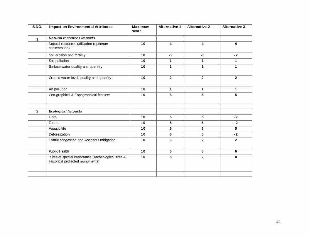
S.NO. Impact on Environmental Attributes Maximum score
Alternative 1 Alternative 2 Alternative 3
1 Natural resources impacts Natural resources utilization (optimum
conservation) 10 4 4 4
Soil erosion and fertility 10 -2 -2 -2
Soil pollution 10 1 1 1
Surface water quality and quantity 10 1 1 1
Ground water level, quality and quantity 10 2 2 2
Air pollution 10 1 1 1
Geo-graphical & Topographical features 10 5 5 5
2 Ecological Impacts
Flora 10 5 5 -2
Fauna 10 5 5 -2
Aquatic life 10 5 5 5
Deforestation 10 6 6 -2
Traffic congestion and Accidents mitigation 10 6 2 2
Public Health 10 6 6 6
Sites of special importance (Archeological sites & Historical protected monuments)
10 8 2 8
22
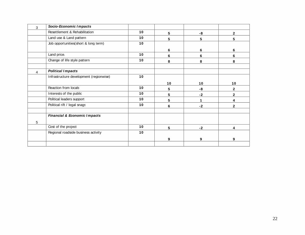
3 Socio-Economic Impacts
Resettlement & Rehabilitation 10 5 -8 2
Land use & Land pattern 10 5 5 5
Job opportunities(short & long term) 10
6 6 6
Land price. 10 6 6 6
Change of life style pattern 10 8 8 8
4 Political Impacts
Infrastructure development (regionwise) 10
10 10 10
Reaction from locals 10 5 -8 2
Interests of the public 10 5 -2 2
Political leaders support 10 5 1 4
Political rift / legal snags 10 6 -2 2
5
Financial & Economic Impacts
Cost of the project 10 5 -2 4
Regional roadside business activity 10
9 9 9
23
ANALYSIS
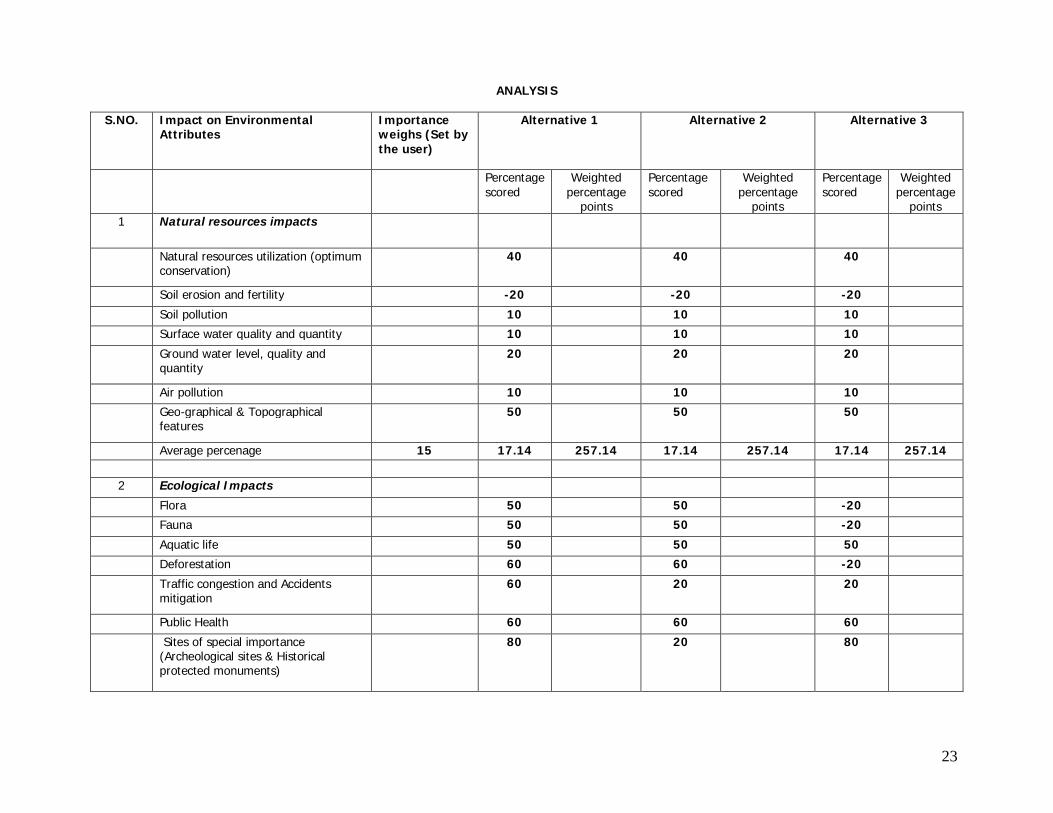
S.NO. Impact on Environmental Attributes
Importance weighs (Set by the user)
Alternative 1 Alternative 2 Alternative 3
Percentage scored
Weighted percentage
points
Percentage scored
Weighted percentage
points
Percentage scored
Weighted percentage
points 1 Natural resources impacts
Natural resources utilization (optimum conservation)
40 40 40
Soil erosion and fertility -20 -20 -20
Soil pollution 10 10 10
Surface water quality and quantity 10 10 10
Ground water level, quality and quantity
20 20 20
Air pollution 10 10 10
Geo-graphical & Topographical features
50 50 50
Average percenage 15 17.14 257.14 17.14 257.14 17.14 257.14 2 Ecological Impacts
Flora 50 50 -20
Fauna 50 50 -20
Aquatic life 50 50 50
Deforestation 60 60 -20
Traffic congestion and Accidents mitigation
60 20 20
Public Health 60 60 60
Sites of special importance (Archeological sites & Historical protected monuments)
80 20 80
24
S.NO. Impact on Environmental Attributes
Importance weighs (Set by the user)
Alternative 1 Alternative 2 Alternative 3
Percentage scored
Weighted percentage
points
Percentage scored
Weighted percentage
points
Percentage scored
Weighted percentage
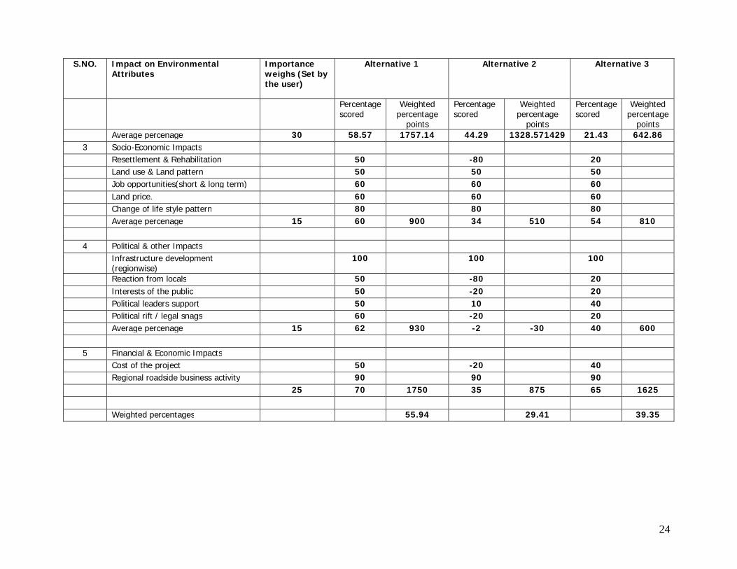
points Average percenage 30 58.57 1757.14 44.29 1328.571429 21.43 642.86 3 Socio-Economic Impacts Resettlement & Rehabilitation 50 -80 20 Land use & Land pattern 50 50 50 Job opportunities(short & long term) 60 60 60 Land price. 60 60 60 Change of life style pattern 80 80 80 Average percenage 15 60 900 34 510 54 810 4 Political & other Impacts Infrastructure development
(regionwise) 100 100 100
Reaction from locals 50 -80 20 Interests of the public 50 -20 20 Political leaders support 50 10 40 Political rift / legal snags 60 -20 20 Average percenage 15 62 930 -2 -30 40 600 5 Financial & Economic Impacts Cost of the project 50 -20 40 Regional roadside business activity 90 90 90 25 70 1750 35 875 65 1625 Weighted percentages 55.94 29.41 39.35
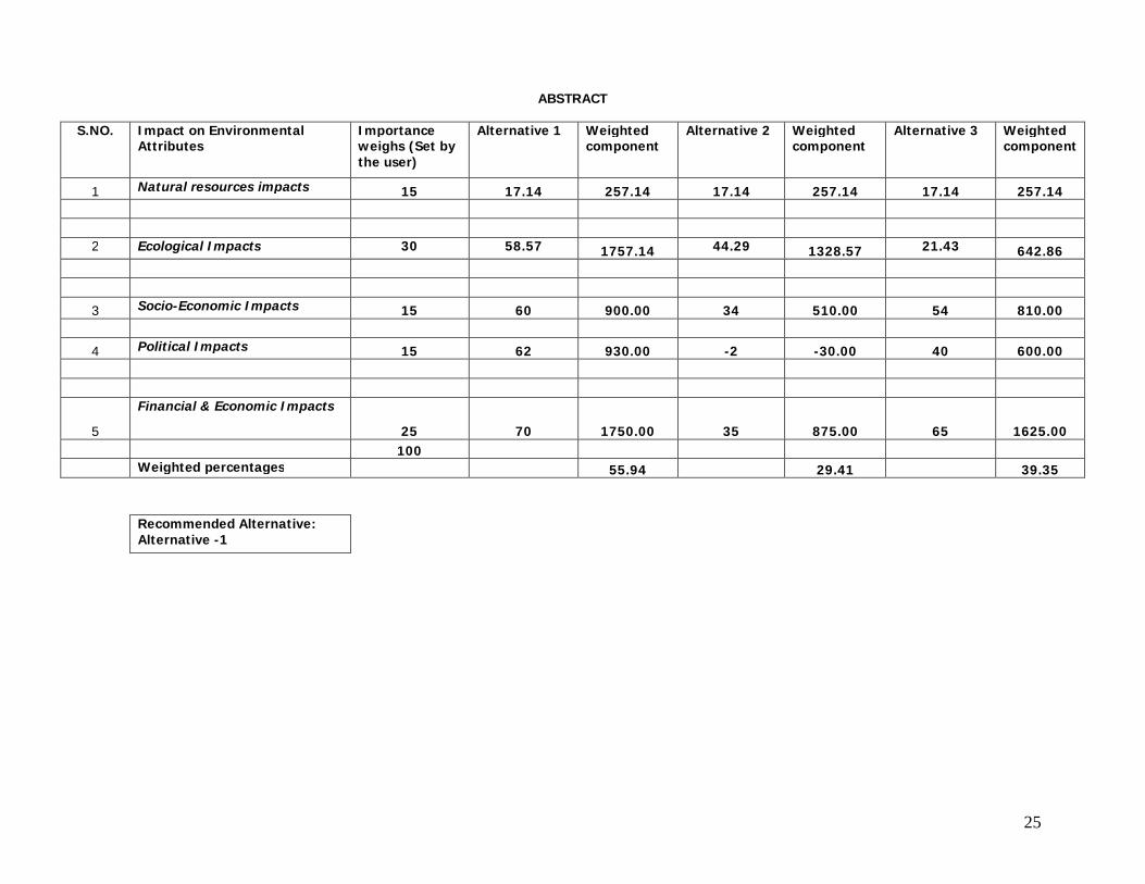
25
ABSTRACT
S.NO. Impact on Environmental Attributes
Importance weighs (Set by the user)
Alternative 1 Weighted component
Alternative 2 Weighted component
Alternative 3 Weighted component
1 Natural resources impacts 15 17.14 257.14 17.14 257.14 17.14 257.14 2 Ecological Impacts 30 58.57 1757.14 44.29 1328.57 21.43 642.86
3 Socio-Economic Impacts 15 60 900.00 34 510.00 54 810.00
4 Political Impacts 15 62 930.00 -2 -30.00 40 600.00
5
Financial & Economic Impacts
25 70 1750.00 35 875.00 65 1625.00 100 Weighted percentages 55.94 29.41 39.35
Recommended Alternative: Alternative -1
26
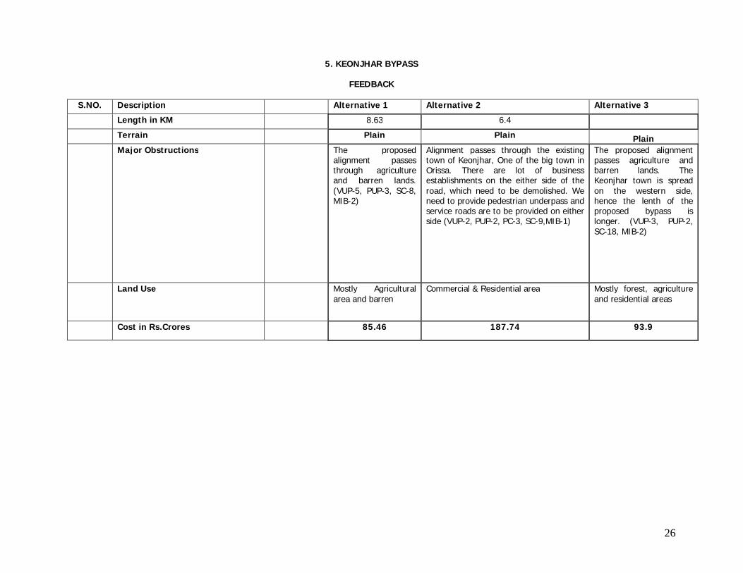
5. KEONJHAR BYPASS
FEEDBACK
S.NO. Description Alternative 1 Alternative 2 Alternative 3
Length in KM 8.63 6.4
Terrain Plain Plain Plain Major Obstructions The proposed
alignment passes through agriculture and barren lands. (VUP-5, PUP-3, SC-8, MIB-2)
Alignment passes through the existing town of Keonjhar, One of the big town in Orissa. There are lot of business establishments on the either side of the road, which need to be demolished. We need to provide pedestrian underpass and service roads are to be provided on either side (VUP-2, PUP-2, PC-3, SC-9,MIB-1)
The proposed alignment passes agriculture and barren lands. The Keonjhar town is spread on the western side, hence the lenth of the proposed bypass is longer. (VUP-3, PUP-2, SC-18, MIB-2)
Land Use Mostly Agricultural area and barren
Commercial & Residential area Mostly forest, agriculture and residential areas
Cost in Rs.Crores 85.46 187.74 93.9

27
S.NO. Impact on Environmental Attributes Maximum score
Alternative 1 Alternative 2 Alternative 3
1 Natural resources impacts Natural resources utilization (optimum
conservation) 10 2 4 4
Soil erosion and fertility 10 -2 -2 -2
Soil pollution 10 1 1 1
Surface water quality and quantity 10 1 1 -3
Ground water level, quality and quantity 10 2 2 2
Air pollution 10 1 1 1
Geo-graphical & Topographical features 10 5 5 5
2 Ecological Impacts
Flora 10 5 5 5
Fauna 10 5 5 5
Aquatic life 10 5 5 5
Deforestation 10 6 6 6
Traffic congestion and Accidents mitigation 10 6 2 5
Public Health 10 6 6 6
Sites of special importance (Archeological sites & Historical protected monuments)
10 8 8 8
28
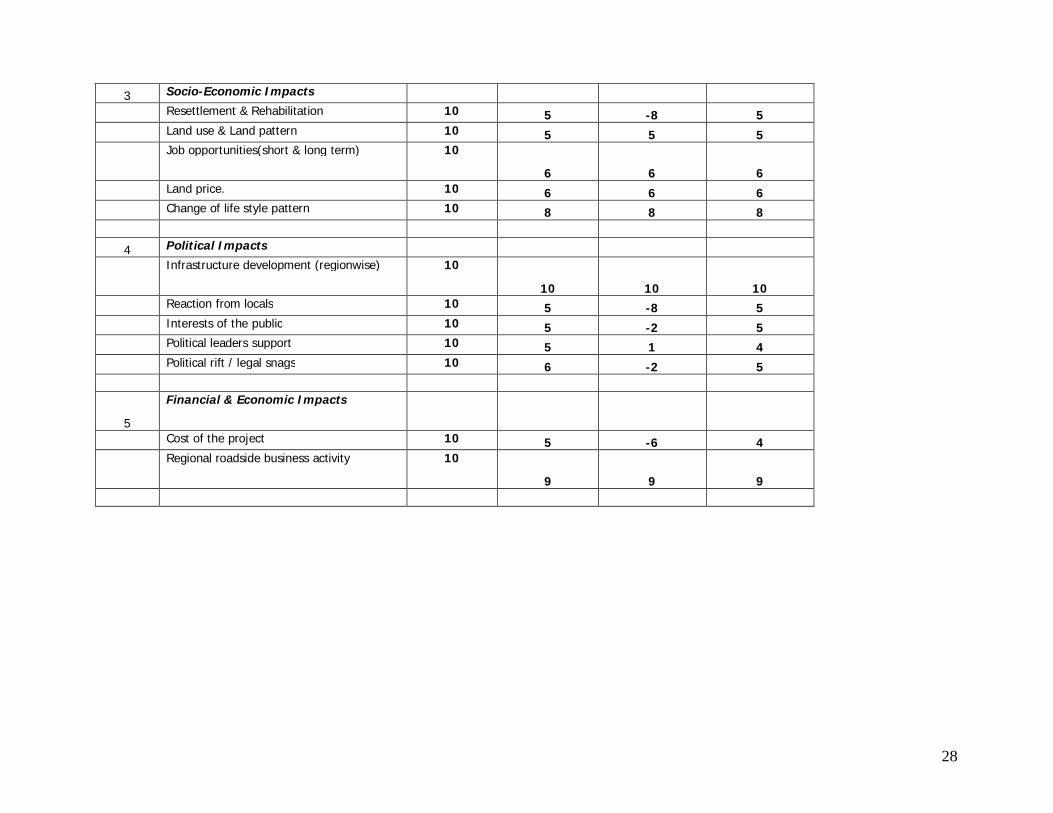
3 Socio-Economic Impacts
Resettlement & Rehabilitation 10 5 -8 5
Land use & Land pattern 10 5 5 5
Job opportunities(short & long term) 10
6 6 6
Land price. 10 6 6 6
Change of life style pattern 10 8 8 8
4 Political Impacts
Infrastructure development (regionwise) 10
10 10 10
Reaction from locals 10 5 -8 5
Interests of the public 10 5 -2 5
Political leaders support 10 5 1 4
Political rift / legal snags 10 6 -2 5
5
Financial & Economic Impacts
Cost of the project 10 5 -6 4
Regional roadside business activity 10
9 9 9

29
ANALYSIS
S.NO. Impact on Environmental Attributes
Importance weighs (Set by the user)
Alternative 1 Alternative 2 Alternative 3
Percentage scored
Weighted percentage
points
Percentage scored
Weighted percentage
points
Percentage scored
Weighted percentage
points 1 Natural resources impacts
Natural resources utilization (optimum conservation)
20 40 40
Soil erosion and fertility -20 -20 -20
Soil pollution 10 10 10
Surface water quality and quantity 10 10 -30
Ground water level, quality and quantity
20 20 20
Air pollution 10 10 10
Geo-graphical & Topographical features
50 50 50
Average percenage 15 14.29 214.29 17.14 257.14 11.43 171.43 2 Ecological Impacts
Flora 50 50 50
Fauna 50 50 50
Aquatic life 50 50 50
Deforestation 60 60 60
Traffic congestion and Accidents mitigation
60 20 50
Public Health 60 60 60
Sites of special importance (Archeological sites & Historical protected monuments)
80 80 80
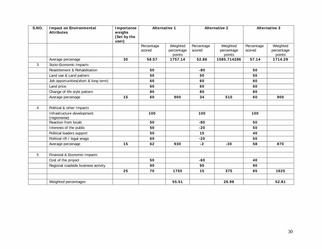
30
S.NO. Impact on Environmental Attributes
Importance weighs (Set by the user)
Alternative 1 Alternative 2 Alternative 3
Percentage scored
Weighted percentage
points
Percentage scored
Weighted percentage
points
Percentage scored
Weighted percentage
points Average percenage 30 58.57 1757.14 52.86 1585.714286 57.14 1714.29 3 Socio-Economic Impacts Resettlement & Rehabilitation 50 -80 50 Land use & Land pattern 50 50 50 Job opportunities(short & long term) 60 60 60 Land price. 60 60 60 Change of life style pattern 80 80 80 Average percenage 15 60 900 34 510 60 900 4 Political & other Impacts Infrastructure development
(regionwise) 100 100 100
Reaction from locals 50 -80 50 Interests of the public 50 -20 50 Political leaders support 50 10 40 Political rift / legal snags 60 -20 50 Average percenage 15 62 930 -2 -30 58 870 5 Financial & Economic Impacts Cost of the project 50 -60 40 Regional roadside business activity 90 90 90 25 70 1750 15 375 65 1625 Weighted percentages 55.51 26.98 52.81
31
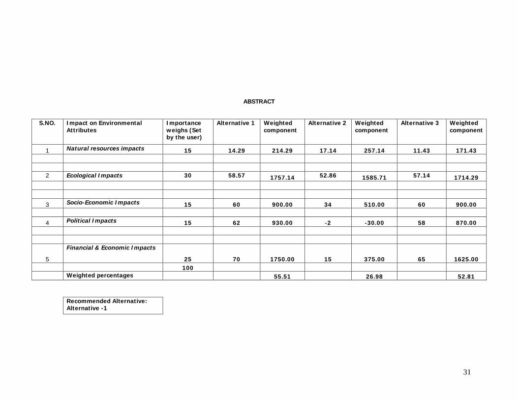
ABSTRACT
S.NO. Impact on Environmental Attributes
Importance weighs (Set by the user)
Alternative 1 Weighted component
Alternative 2 Weighted component
Alternative 3 Weighted component
1 Natural resources impacts 15 14.29 214.29 17.14 257.14 11.43 171.43 2 Ecological Impacts 30 58.57 1757.14 52.86 1585.71 57.14 1714.29
3 Socio-Economic Impacts 15 60 900.00 34 510.00 60 900.00
4 Political Impacts 15 62 930.00 -2 -30.00 58 870.00
5
Financial & Economic Impacts
25 70 1750.00 15 375.00 65 1625.00 100 Weighted percentages 55.51 26.98 52.81
Recommended Alternative: Alternative -1
32
ANNEXURE -2
Maps Showing the Quarry Locations along the Project Area
33
ANNEXURE -3
Detail Socio-economic Analysis of the Project Area
34
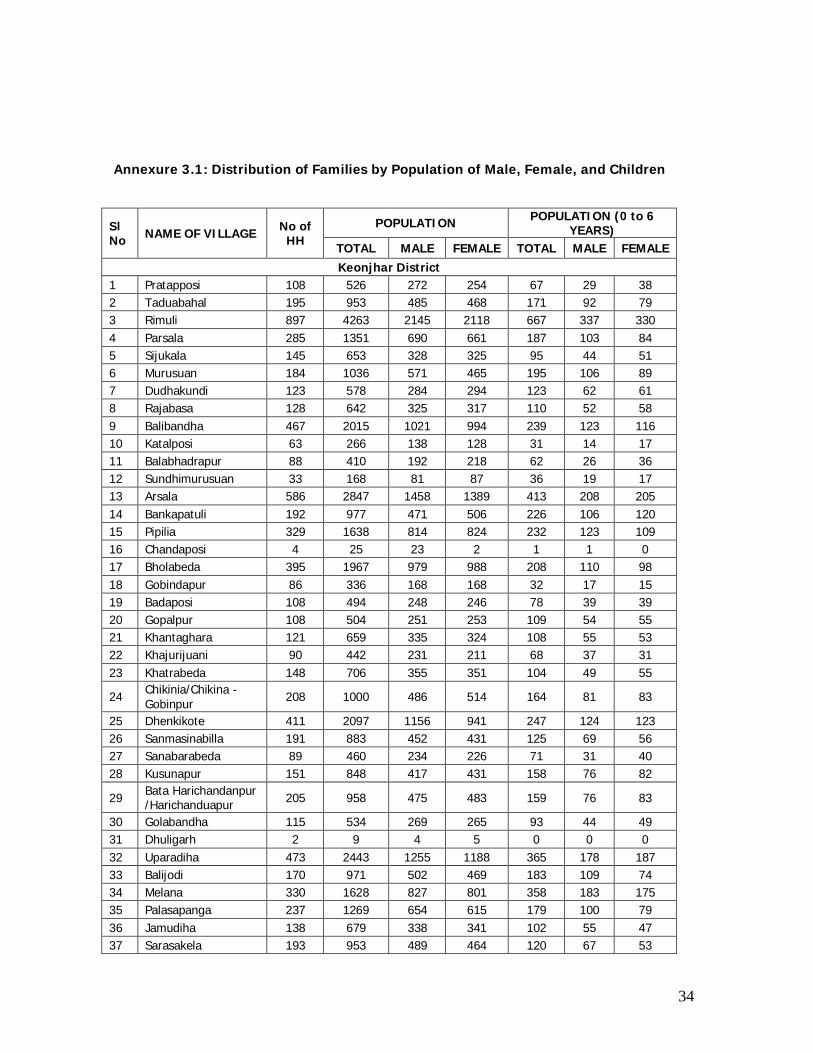
Annexure 3.1: Distribution of Families by Population of Male, Female, and Children
Sl No NAME OF VILLAGE No of
HH POPULATION POPULATION (0 to 6
YEARS) TOTAL MALE FEMALE TOTAL MALE FEMALE Keonjhar District
1 Pratapposi 108 526 272 254 67 29 38 2 Taduabahal 195 953 485 468 171 92 79 3 Rimuli 897 4263 2145 2118 667 337 330 4 Parsala 285 1351 690 661 187 103 84 5 Sijukala 145 653 328 325 95 44 51 6 Murusuan 184 1036 571 465 195 106 89 7 Dudhakundi 123 578 284 294 123 62 61 8 Rajabasa 128 642 325 317 110 52 58 9 Balibandha 467 2015 1021 994 239 123 116 10 Katalposi 63 266 138 128 31 14 17 11 Balabhadrapur 88 410 192 218 62 26 36 12 Sundhimurusuan 33 168 81 87 36 19 17 13 Arsala 586 2847 1458 1389 413 208 205 14 Bankapatuli 192 977 471 506 226 106 120 15 Pipilia 329 1638 814 824 232 123 109 16 Chandaposi 4 25 23 2 1 1 0 17 Bholabeda 395 1967 979 988 208 110 98 18 Gobindapur 86 336 168 168 32 17 15 19 Badaposi 108 494 248 246 78 39 39 20 Gopalpur 108 504 251 253 109 54 55 21 Khantaghara 121 659 335 324 108 55 53 22 Khajurijuani 90 442 231 211 68 37 31 23 Khatrabeda 148 706 355 351 104 49 55
24 Chikinia/Chikina - Gobinpur 208 1000 486 514 164 81 83
25 Dhenkikote 411 2097 1156 941 247 124 123 26 Sanmasinabilla 191 883 452 431 125 69 56 27 Sanabarabeda 89 460 234 226 71 31 40 28 Kusunapur 151 848 417 431 158 76 82
29 Bata Harichandanpur /Harichanduapur 205 958 475 483 159 76 83
30 Golabandha 115 534 269 265 93 44 49 31 Dhuligarh 2 9 4 5 0 0 0 32 Uparadiha 473 2443 1255 1188 365 178 187 33 Balijodi 170 971 502 469 183 109 74 34 Melana 330 1628 827 801 358 183 175 35 Palasapanga 237 1269 654 615 179 100 79 36 Jamudiha 138 679 338 341 102 55 47 37 Sarasakela 193 953 489 464 120 67 53
35
38 Murusuan 193 862 432 430 116 61 55 39 Jadichatar 75 365 188 177 56 31 25 40 Kesapanka 14 61 27 34 5 0 5
Sl No NAME OF VILLAGE No of
HH POPULATION POPULATION (0 to 6
YEARS) TOTAL MALE FEMALE TOTAL MALE FEMALE
41 Putulia 163 803 454 349 105 63 42 42 Bankamaruni 47 216 108 108 39 20 19 43 Padmapur 392 1903 1026 877 254 139 115 44 Banajodi 232 1018 535 483 159 82 77 45 Silisuan 224 1140 575 565 202 96 106 46 Poipani 19 117 65 52 26 15 11 47 Tangarani 121 521 262 259 73 37 36 48 Raisuan 791 3852 1962 1890 489 251 238 49 Khuntapada(KHA) 35 141 71 70 22 10 12 50 Gopinathapur 245 1100 542 558 153 69 84 51 Jamunalia 53 278 133 145 50 29 21 52 Baliaguda 166 833 443 390 120 64 56 53 Mandua 115 553 285 268 92 43 49 54 Tangarpalasa 113 538 291 247 76 43 33 55 Naranapur 305 1518 836 682 183 97 86 56 Haladiatangiri 94 473 252 221 67 36 31 57 Kanto 224 1027 518 509 181 97 84 58 Kolimati 342 1713 915 798 257 133 124 59 Amarnga 226 990 487 503 107 54 53 60 Bandha 95 459 232 227 85 48 37 61 Dhakotha 187 935 486 449 113 54 59 62 Bhalukhuma 180 924 494 430 122 70 52 63 Biragobindapur 406 2079 1057 1022 334 172 162 64 Talagaon 343 1757 996 761 250 128 122 65 Indupura 90 404 212 192 63 31 32 66 Gohira 317 1665 835 830 304 162 142 67 Belabhali 828 4004 2100 1904 546 287 259 68 Barigaon 261 1331 681 650 187 94 93 69 Bailo 242 1240 647 593 147 80 67 70 Hasanpur 85 434 235 199 49 26 23 71 Siapada 107 419 217 202 42 18 24 72 Naukana 47 203 99 104 18 11 7 73 Machhalo 412 1870 898 972 227 109 118 74 Rudranarayanpur 114 445 217 228 61 27 34 75 Bamphidi 245 1003 500 503 147 61 86 76 Sainkul 847 3985 1956 2029 444 226 218 77 Khalana 632 3029 1518 1511 412 209 203 78 Gainthagodi 4 25 11 14 6 3 3 79 Nuagaon 427 2041 1003 1038 298 143 155 80 Suanpada 116 548 289 259 79 43 36 81 Ramachandrapur 126 598 314 284 77 43 34 82 Jarda 129 509 261 248 68 41 27 83 Badapadana 508 2239 1114 1125 305 151 154
36
84 Sanapadana 68 282 126 156 45 21 24 Total 18801 90638 46328 44310 13147 6727 6420
Sl No NAME OF VILLAGE No of
HH POPULATION POPULATION (0 to 6
YEARS) TOTAL MALE FEMALE TOTAL MALE FEMALE
Janpur District 1 Andhari 185 888 449 439 121 68 53 2 Godarapal 74 364 186 178 49 27 22 3 Ragadi 183 976 495 481 122 68 54 4 Mangarajpur 71 339 165 174 39 18 21 5 Manjuri 27 149 65 84 13 5 8 6 Talagarh 373 1980 1029 951 278 148 130 7 Uparagarh 56 262 134 128 37 21 16 8 Itapur 9 39 20 19 5 2 3 9 Nayagarh 74 381 203 178 36 21 15
10 Naguan 83 438 237 201 42 20 22 11 Kuanrada 81 506 248 258 68 33 35 12 Talugan 80 475 246 229 49 25 24 13 Benapur 40 191 102 89 41 23 18 14 Nuapada 67 369 192 177 43 21 22 15 Alia 73 394 213 181 54 32 22 16 Dhanapur 126 790 410 380 133 75 58 17 Oupada 33 167 86 81 23 12 11 18 Mohammed Jamalpur 91 431 214 217 59 31 28 19 Pathara Pada 202 1224 639 585 186 93 93 20 Alatiri 358 2118 1095 1023 283 153 130
Total 2286 12481 6428 6053 1681 896 785 Grand Total 21087 103119 52756 50363 14828 7623 7205
37
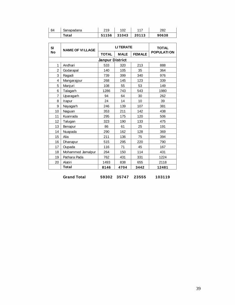
Annexure 3.2: Distribution of Literate Population by Male, Female, and total Population
Sl No NAME OF VILLAGE
LITERATE TOTAL POPULATION TOTAL MALE FEMALE
Keonjhar District 1 Pratapposi 384 235 149 526 2 Taduabahal 423 277 146 953 3 Rimuli 2231 1300 931 4263 4 Parsala 952 564 388 1351 5 Sijukala 324 194 130 653 6 Murusuan 532 370 162 1036 7 Dudhakundi 191 138 53 578 8 Rajabasa 364 228 136 642 9 Balibandha 980 584 396 2015 10 Katalposi 149 85 64 266 11 Balabhadrapur 196 118 78 410 12 Sundhimurusuan 43 30 13 168 13 Arsala 1698 1047 651 2847 14 Bankapatuli 330 212 118 977 15 Pipilia 947 560 387 1638 16 Chandaposi 19 18 1 25 17 Bholabeda 862 527 335 1967 18 Gobindapur 184 122 62 336 19 Badaposi 248 175 73 494 20 Gopalpur 215 136 79 504 21 Khantaghara 380 232 148 659 22 Khajurijuani 268 171 97 442 23 Khatrabeda 434 271 163 706
24 Chikinia/Chikina - Gobinpur 409 266 143 1000
25 Dhenkikote 1506 916 590 2097 26 Sanmasinabilla 433 273 160 883 27 Sanabarabeda 238 157 81 460 28 Kusunapur 381 230 151 848
29 Bata Harichandanpur /Harichanduapur 486 287 199 958
30 Golabandha 258 168 90 534 31 Dhuligarh 6 3 3 9 32 Uparadiha 1483 854 629 2443 33 Balijodi 503 316 187 971 34 Melana 503 360 143 1628 35 Palasapanga 799 455 344 1269 36 Jamudiha 407 234 173 679 37 Sarasakela 554 356 198 953
38
38 Murusuan 511 296 215 862 39 Jadichatar 153 113 40 365 40 Kesapanka 23 18 5 61
Sl No NAME OF VILLAGE
LITERATE TOTAL POPULATION TOTAL MALE FEMALE
41 Putulia 486 313 173 803 42 Bankamaruni 85 50 35 216 43 Padmapur 1209 745 464 1903 44 Banajodi 591 379 212 1018 45 Silisuan 372 238 134 1140 46 Poipani 51 39 12 117 47 Tangarani 276 175 101 521 48 Raisuan 2316 1384 932 3852 49 Khuntapada(KHA) 35 29 6 141 50 Gopinathapur 476 270 206 1100 51 Jamunalia 93 56 37 278 52 Baliaguda 434 282 152 833 53 Mandua 304 200 104 553 54 Tangarpalasa 357 226 131 538 55 Naranapur 1116 683 433 1518 56 Haladiatangiri 303 196 107 473 57 Kanto 478 308 170 1027 58 Kolimati 771 535 236 1713 59 Amarnga 501 313 188 990 60 Bandha 223 137 86 459 61 Dhakotha 566 341 225 935 62 Bhalukhuma 498 316 182 924 63 Biragobindapur 1004 653 351 2079 64 Talagaon 947 679 268 1757 65 Indupura 180 108 72 404 66 Gohira 632 429 203 1665 67 Belabhali 2757 1636 1121 4004 68 Barigaon 786 475 311 1331 69 Bailo 884 508 376 1240 70 Hasanpur 339 197 142 434 71 Siapada 328 186 142 419 72 Naukana 157 80 77 203 73 Machhalo 1348 715 633 1870 74 Rudranarayanpur 234 119 115 445 75 Bamphidi 504 282 222 1003 76 Sainkul 2767 1470 1297 3985 77 Khalana 1554 980 574 3029 78 Gainthagodi 17 8 9 25 79 Nuagaon 1238 756 482 2041 80 Suanpada 372 222 150 548 81 Ramachandrapur 408 237 171 598 82 Jarda 408 215 193 509 83 Badapadana 1525 875 650 2239
39
84 Sanapadana 219 102 117 282 Total 51156 31043 20113 90638
Sl No NAME OF VILLAGE
LITERATE TOTAL POPULATION TOTAL MALE FEMALE
Janpur District 1 Andhari 533 320 213 888 2 Godarapal 140 105 35 364 3 Ragadi 739 399 340 976 4 Mangarajpur 268 145 123 339 5 Manjuri 108 55 53 149 6 Talagarh 1286 743 543 1980 7 Uparagarh 94 64 30 262 8 Itapur 24 14 10 39 9 Nayagarh 246 139 107 381
10 Naguan 353 211 142 438 11 Kuanrada 295 175 120 506 12 Talugan 323 190 133 475 13 Benapur 86 61 25 191 14 Nuapada 290 162 128 369 15 Alia 211 136 75 394 16 Dhanapur 515 295 220 790 17 Oupada 116 71 45 167 18 Mohammed Jamalpur 264 150 114 431 19 Pathara Pada 762 431 331 1224 20 Alatiri 1493 838 655 2118
Total 8146 4704 3442 12481 Grand Total 59302 35747 23555 103119
40
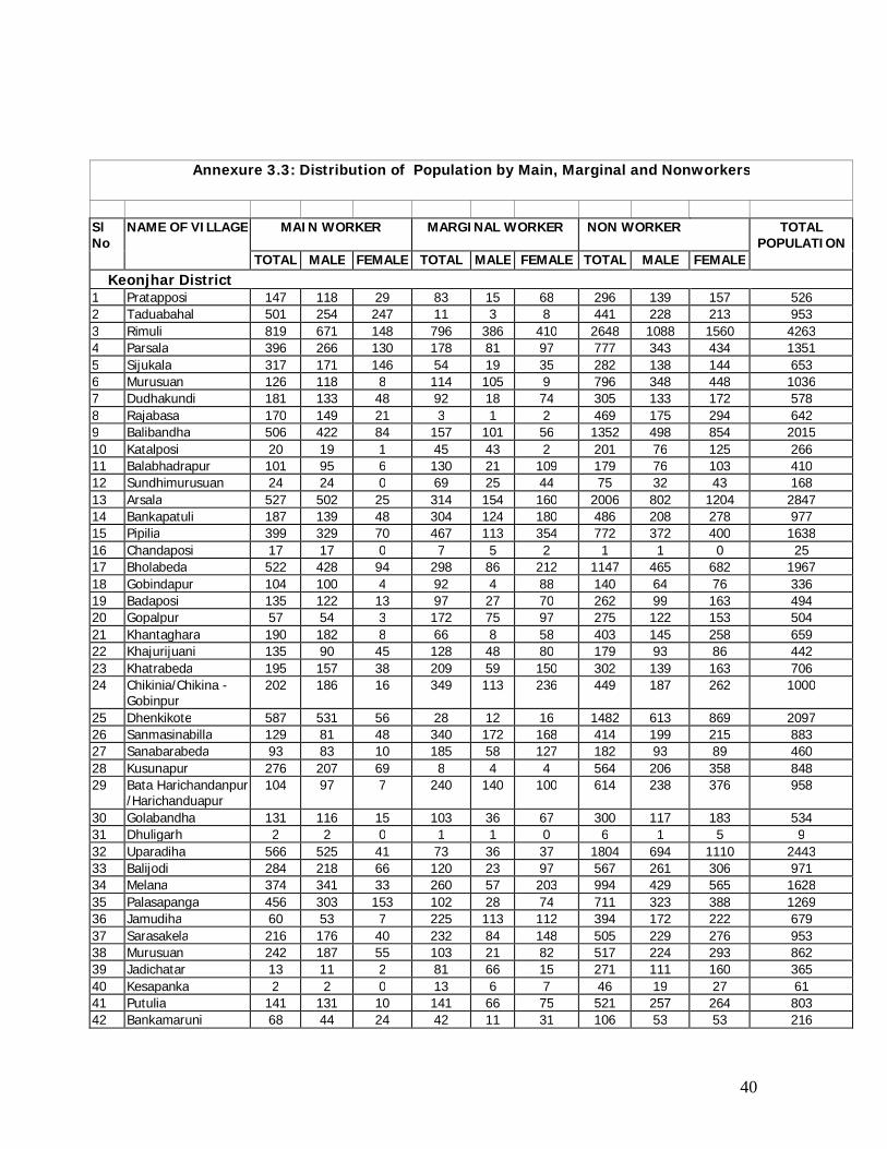
Annexure 3.3: Distribution of Population by Main, Marginal and Nonworkers
Sl No
NAME OF VILLAGE MAIN WORKER MARGINAL WORKER NON WORKER TOTAL POPULATION
TOTAL MALE FEMALE TOTAL MALE FEMALE TOTAL MALE FEMALE Keonjhar District
1 Pratapposi 147 118 29 83 15 68 296 139 157 526 2 Taduabahal 501 254 247 11 3 8 441 228 213 953 3 Rimuli 819 671 148 796 386 410 2648 1088 1560 4263 4 Parsala 396 266 130 178 81 97 777 343 434 1351 5 Sijukala 317 171 146 54 19 35 282 138 144 653 6 Murusuan 126 118 8 114 105 9 796 348 448 1036 7 Dudhakundi 181 133 48 92 18 74 305 133 172 578 8 Rajabasa 170 149 21 3 1 2 469 175 294 642 9 Balibandha 506 422 84 157 101 56 1352 498 854 2015 10 Katalposi 20 19 1 45 43 2 201 76 125 266 11 Balabhadrapur 101 95 6 130 21 109 179 76 103 410 12 Sundhimurusuan 24 24 0 69 25 44 75 32 43 168 13 Arsala 527 502 25 314 154 160 2006 802 1204 2847 14 Bankapatuli 187 139 48 304 124 180 486 208 278 977 15 Pipilia 399 329 70 467 113 354 772 372 400 1638 16 Chandaposi 17 17 0 7 5 2 1 1 0 25 17 Bholabeda 522 428 94 298 86 212 1147 465 682 1967 18 Gobindapur 104 100 4 92 4 88 140 64 76 336 19 Badaposi 135 122 13 97 27 70 262 99 163 494 20 Gopalpur 57 54 3 172 75 97 275 122 153 504 21 Khantaghara 190 182 8 66 8 58 403 145 258 659 22 Khajurijuani 135 90 45 128 48 80 179 93 86 442 23 Khatrabeda 195 157 38 209 59 150 302 139 163 706 24 Chikinia/Chikina -
Gobinpur 202 186 16 349 113 236 449 187 262 1000
25 Dhenkikote 587 531 56 28 12 16 1482 613 869 2097 26 Sanmasinabilla 129 81 48 340 172 168 414 199 215 883 27 Sanabarabeda 93 83 10 185 58 127 182 93 89 460 28 Kusunapur 276 207 69 8 4 4 564 206 358 848 29 Bata Harichandanpur
/Harichanduapur 104 97 7 240 140 100 614 238 376 958
30 Golabandha 131 116 15 103 36 67 300 117 183 534 31 Dhuligarh 2 2 0 1 1 0 6 1 5 9 32 Uparadiha 566 525 41 73 36 37 1804 694 1110 2443 33 Balijodi 284 218 66 120 23 97 567 261 306 971 34 Melana 374 341 33 260 57 203 994 429 565 1628 35 Palasapanga 456 303 153 102 28 74 711 323 388 1269 36 Jamudiha 60 53 7 225 113 112 394 172 222 679 37 Sarasakela 216 176 40 232 84 148 505 229 276 953 38 Murusuan 242 187 55 103 21 82 517 224 293 862 39 Jadichatar 13 11 2 81 66 15 271 111 160 365 40 Kesapanka 2 2 0 13 6 7 46 19 27 61 41 Putulia 141 131 10 141 66 75 521 257 264 803 42 Bankamaruni 68 44 24 42 11 31 106 53 53 216
41
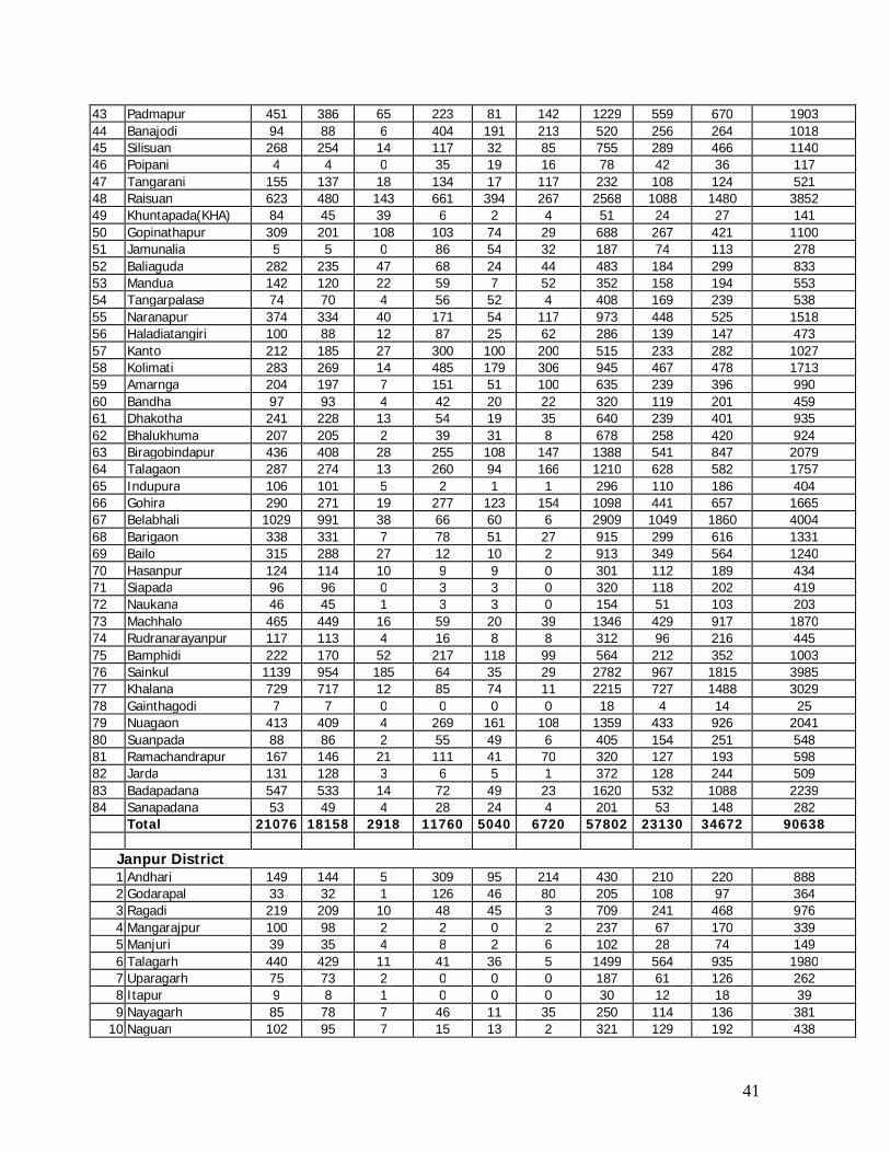
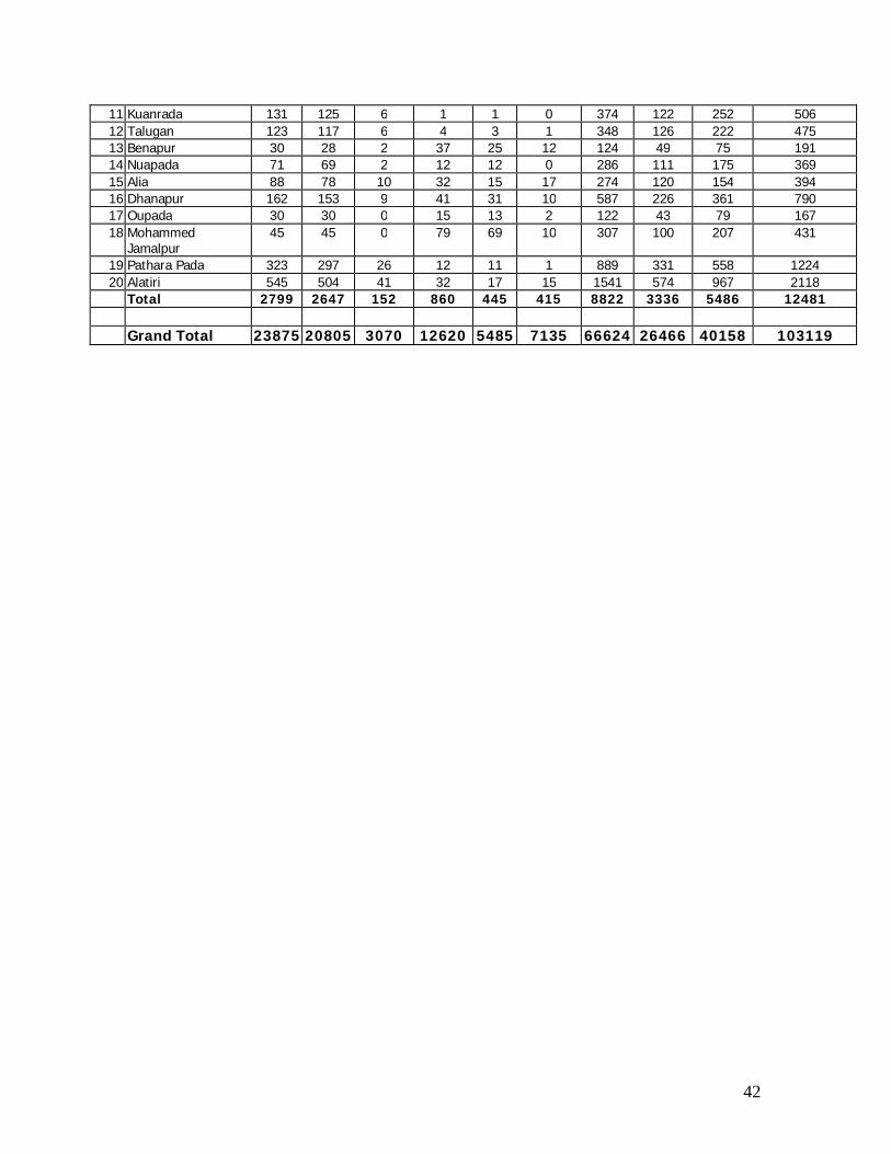
43 Padmapur 451 386 65 223 81 142 1229 559 670 1903 44 Banajodi 94 88 6 404 191 213 520 256 264 1018 45 Silisuan 268 254 14 117 32 85 755 289 466 1140 46 Poipani 4 4 0 35 19 16 78 42 36 117 47 Tangarani 155 137 18 134 17 117 232 108 124 521 48 Raisuan 623 480 143 661 394 267 2568 1088 1480 3852 49 Khuntapada(KHA) 84 45 39 6 2 4 51 24 27 141 50 Gopinathapur 309 201 108 103 74 29 688 267 421 1100 51 Jamunalia 5 5 0 86 54 32 187 74 113 278 52 Baliaguda 282 235 47 68 24 44 483 184 299 833 53 Mandua 142 120 22 59 7 52 352 158 194 553 54 Tangarpalasa 74 70 4 56 52 4 408 169 239 538 55 Naranapur 374 334 40 171 54 117 973 448 525 1518 56 Haladiatangiri 100 88 12 87 25 62 286 139 147 473 57 Kanto 212 185 27 300 100 200 515 233 282 1027 58 Kolimati 283 269 14 485 179 306 945 467 478 1713 59 Amarnga 204 197 7 151 51 100 635 239 396 990 60 Bandha 97 93 4 42 20 22 320 119 201 459 61 Dhakotha 241 228 13 54 19 35 640 239 401 935 62 Bhalukhuma 207 205 2 39 31 8 678 258 420 924 63 Biragobindapur 436 408 28 255 108 147 1388 541 847 2079 64 Talagaon 287 274 13 260 94 166 1210 628 582 1757 65 Indupura 106 101 5 2 1 1 296 110 186 404 66 Gohira 290 271 19 277 123 154 1098 441 657 1665 67 Belabhali 1029 991 38 66 60 6 2909 1049 1860 4004 68 Barigaon 338 331 7 78 51 27 915 299 616 1331 69 Bailo 315 288 27 12 10 2 913 349 564 1240 70 Hasanpur 124 114 10 9 9 0 301 112 189 434 71 Siapada 96 96 0 3 3 0 320 118 202 419 72 Naukana 46 45 1 3 3 0 154 51 103 203 73 Machhalo 465 449 16 59 20 39 1346 429 917 1870 74 Rudranarayanpur 117 113 4 16 8 8 312 96 216 445 75 Bamphidi 222 170 52 217 118 99 564 212 352 1003 76 Sainkul 1139 954 185 64 35 29 2782 967 1815 3985 77 Khalana 729 717 12 85 74 11 2215 727 1488 3029 78 Gainthagodi 7 7 0 0 0 0 18 4 14 25 79 Nuagaon 413 409 4 269 161 108 1359 433 926 2041 80 Suanpada 88 86 2 55 49 6 405 154 251 548 81 Ramachandrapur 167 146 21 111 41 70 320 127 193 598 82 Jarda 131 128 3 6 5 1 372 128 244 509 83 Badapadana 547 533 14 72 49 23 1620 532 1088 2239 84 Sanapadana 53 49 4 28 24 4 201 53 148 282 Total 21076 18158 2918 11760 5040 6720 57802 23130 34672 90638
Janpur District 1 Andhari 149 144 5 309 95 214 430 210 220 888 2 Godarapal 33 32 1 126 46 80 205 108 97 364 3 Ragadi 219 209 10 48 45 3 709 241 468 976 4 Mangarajpur 100 98 2 2 0 2 237 67 170 339 5 Manjuri 39 35 4 8 2 6 102 28 74 149 6 Talagarh 440 429 11 41 36 5 1499 564 935 1980 7 Uparagarh 75 73 2 0 0 0 187 61 126 262 8 Itapur 9 8 1 0 0 0 30 12 18 39 9 Nayagarh 85 78 7 46 11 35 250 114 136 381
10 Naguan 102 95 7 15 13 2 321 129 192 438
42
11 Kuanrada 131 125 6 1 1 0 374 122 252 506 12 Talugan 123 117 6 4 3 1 348 126 222 475 13 Benapur 30 28 2 37 25 12 124 49 75 191 14 Nuapada 71 69 2 12 12 0 286 111 175 369 15 Alia 88 78 10 32 15 17 274 120 154 394 16 Dhanapur 162 153 9 41 31 10 587 226 361 790 17 Oupada 30 30 0 15 13 2 122 43 79 167 18 Mohammed
Jamalpur 45 45 0 79 69 10 307 100 207 431
19 Pathara Pada 323 297 26 12 11 1 889 331 558 1224 20 Alatiri 545 504 41 32 17 15 1541 574 967 2118
Total 2799 2647 152 860 445 415 8822 3336 5486 12481 Grand Total 23875 20805 3070 12620 5485 7135 66624 26466 40158 103119
43
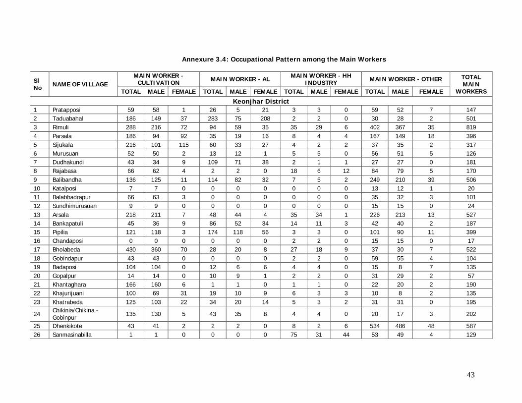
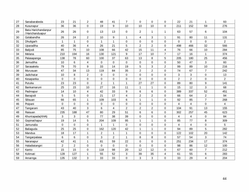
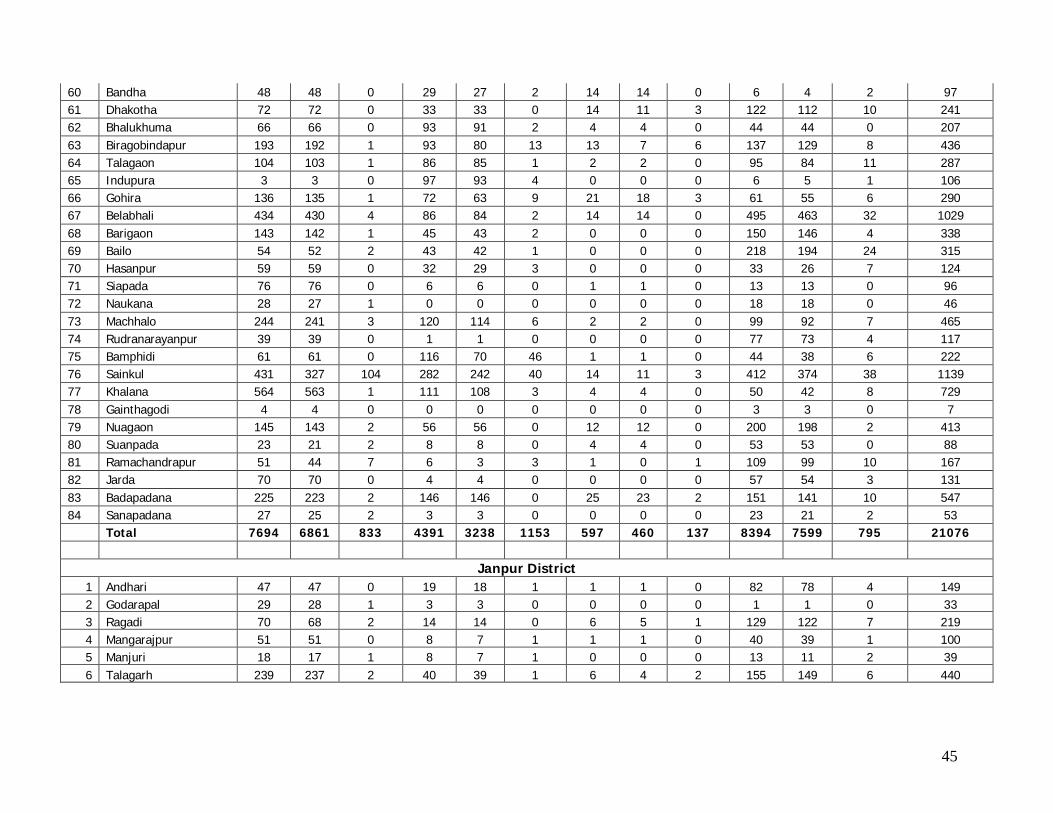
Annexure 3.4: Occupational Pattern among the Main Workers
Sl No NAME OF VILLAGE
MAIN WORKER - CULTIVATION MAIN WORKER - AL MAIN WORKER - HH
INDUSTRY MAIN WORKER - OTHER TOTAL MAIN
WORKERS TOTAL MALE FEMALE TOTAL MALE FEMALE TOTAL MALE FEMALE TOTAL MALE FEMALE
Keonjhar District 1 Pratapposi 59 58 1 26 5 21 3 3 0 59 52 7 147 2 Taduabahal 186 149 37 283 75 208 2 2 0 30 28 2 501 3 Rimuli 288 216 72 94 59 35 35 29 6 402 367 35 819 4 Parsala 186 94 92 35 19 16 8 4 4 167 149 18 396 5 Sijukala 216 101 115 60 33 27 4 2 2 37 35 2 317 6 Murusuan 52 50 2 13 12 1 5 5 0 56 51 5 126 7 Dudhakundi 43 34 9 109 71 38 2 1 1 27 27 0 181 8 Rajabasa 66 62 4 2 2 0 18 6 12 84 79 5 170 9 Balibandha 136 125 11 114 82 32 7 5 2 249 210 39 506 10 Katalposi 7 7 0 0 0 0 0 0 0 13 12 1 20 11 Balabhadrapur 66 63 3 0 0 0 0 0 0 35 32 3 101 12 Sundhimurusuan 9 9 0 0 0 0 0 0 0 15 15 0 24 13 Arsala 218 211 7 48 44 4 35 34 1 226 213 13 527 14 Bankapatuli 45 36 9 86 52 34 14 11 3 42 40 2 187 15 Pipilia 121 118 3 174 118 56 3 3 0 101 90 11 399 16 Chandaposi 0 0 0 0 0 0 2 2 0 15 15 0 17 17 Bholabeda 430 360 70 28 20 8 27 18 9 37 30 7 522 18 Gobindapur 43 43 0 0 0 0 2 2 0 59 55 4 104 19 Badaposi 104 104 0 12 6 6 4 4 0 15 8 7 135 20 Gopalpur 14 14 0 10 9 1 2 2 0 31 29 2 57 21 Khantaghara 166 160 6 1 1 0 1 1 0 22 20 2 190 22 Khajurijuani 100 69 31 19 10 9 6 3 3 10 8 2 135 23 Khatrabeda 125 103 22 34 20 14 5 3 2 31 31 0 195
24 Chikinia/Chikina - Gobinpur 135 130 5 43 35 8 4 4 0 20 17 3 202
25 Dhenkikote 43 41 2 2 2 0 8 2 6 534 486 48 587 26 Sanmasinabilla 1 1 0 0 0 0 75 31 44 53 49 4 129
44
27 Sanabarabeda 23 21 2 48 41 7 0 0 0 22 21 1 93 28 Kusunapur 36 36 0 19 9 10 10 10 0 211 152 59 276
29 Bata Harichandanpur /Harichanduapur 26 26 0 13 13 0 2 1 1 63 57 6 104
30 Golabandha 26 24 2 10 9 1 4 3 1 91 80 11 131 31 Dhuligarh 1 1 0 1 1 0 0 0 0 0 0 0 2 32 Uparadiha 40 36 4 26 21 5 2 2 0 498 466 32 566 33 Balijodi 85 75 10 108 66 42 15 11 4 76 66 10 284 34 Melana 210 194 16 130 121 9 17 10 7 17 16 1 374 35 Palasapanga 138 78 60 100 37 63 13 8 5 205 180 25 456 36 Jamudiha 10 6 4 0 0 0 0 0 0 50 47 3 60 37 Sarasakela 79 70 9 33 14 19 5 3 2 99 89 10 216 38 Murusuan 47 34 13 119 84 35 2 2 0 74 67 7 242 39 Jadichatar 10 8 2 0 0 0 0 0 0 3 3 0 13 40 Kesapanka 0 0 0 0 0 0 0 0 0 2 2 0 2 41 Putulia 23 23 0 2 1 1 27 27 0 89 80 9 141 42 Bankamaruni 25 15 10 27 16 11 1 1 0 15 12 3 68 43 Padmapur 14 10 4 42 33 9 6 6 0 389 337 52 451 44 Banajodi 5 5 0 21 17 4 2 2 0 66 64 2 94 45 Silisuan 66 65 1 109 103 6 1 1 0 92 85 7 268 46 Poipani 0 0 0 0 0 0 0 0 0 4 4 0 4 47 Tangarani 43 40 3 6 4 2 2 2 0 104 91 13 155 48 Raisuan 235 188 47 80 29 51 6 6 0 302 257 45 623 49 Khuntapada(KHA) 3 3 0 77 38 39 0 0 0 4 4 0 84 50 Gopinathapur 19 14 5 204 109 95 1 1 0 85 77 8 309 51 Jamunalia 0 0 0 1 1 0 0 0 0 4 4 0 5 52 Baliaguda 25 25 0 162 120 42 1 1 0 94 89 5 282 53 Mandua 18 17 1 2 1 1 0 0 0 122 102 20 142 54 Tangarpalasa 6 6 0 3 2 1 8 8 0 57 54 3 74 55 Naranapur 42 41 1 81 59 22 0 0 0 251 234 17 374 56 Haladiatangiri 2 2 0 0 0 0 0 0 0 98 86 12 100 57 Kanto 15 15 0 118 98 20 12 12 0 67 60 7 212 58 Kolimati 128 127 1 55 52 3 39 35 4 61 55 6 283 59 Amarnga 135 132 3 33 33 0 3 3 0 33 29 4 204
45
60 Bandha 48 48 0 29 27 2 14 14 0 6 4 2 97 61 Dhakotha 72 72 0 33 33 0 14 11 3 122 112 10 241 62 Bhalukhuma 66 66 0 93 91 2 4 4 0 44 44 0 207 63 Biragobindapur 193 192 1 93 80 13 13 7 6 137 129 8 436 64 Talagaon 104 103 1 86 85 1 2 2 0 95 84 11 287 65 Indupura 3 3 0 97 93 4 0 0 0 6 5 1 106 66 Gohira 136 135 1 72 63 9 21 18 3 61 55 6 290 67 Belabhali 434 430 4 86 84 2 14 14 0 495 463 32 1029 68 Barigaon 143 142 1 45 43 2 0 0 0 150 146 4 338 69 Bailo 54 52 2 43 42 1 0 0 0 218 194 24 315 70 Hasanpur 59 59 0 32 29 3 0 0 0 33 26 7 124 71 Siapada 76 76 0 6 6 0 1 1 0 13 13 0 96 72 Naukana 28 27 1 0 0 0 0 0 0 18 18 0 46 73 Machhalo 244 241 3 120 114 6 2 2 0 99 92 7 465 74 Rudranarayanpur 39 39 0 1 1 0 0 0 0 77 73 4 117 75 Bamphidi 61 61 0 116 70 46 1 1 0 44 38 6 222 76 Sainkul 431 327 104 282 242 40 14 11 3 412 374 38 1139 77 Khalana 564 563 1 111 108 3 4 4 0 50 42 8 729 78 Gainthagodi 4 4 0 0 0 0 0 0 0 3 3 0 7 79 Nuagaon 145 143 2 56 56 0 12 12 0 200 198 2 413 80 Suanpada 23 21 2 8 8 0 4 4 0 53 53 0 88 81 Ramachandrapur 51 44 7 6 3 3 1 0 1 109 99 10 167 82 Jarda 70 70 0 4 4 0 0 0 0 57 54 3 131 83 Badapadana 225 223 2 146 146 0 25 23 2 151 141 10 547 84 Sanapadana 27 25 2 3 3 0 0 0 0 23 21 2 53 Total 7694 6861 833 4391 3238 1153 597 460 137 8394 7599 795 21076
Janpur District 1 Andhari 47 47 0 19 18 1 1 1 0 82 78 4 149 2 Godarapal 29 28 1 3 3 0 0 0 0 1 1 0 33 3 Ragadi 70 68 2 14 14 0 6 5 1 129 122 7 219 4 Mangarajpur 51 51 0 8 7 1 1 1 0 40 39 1 100 5 Manjuri 18 17 1 8 7 1 0 0 0 13 11 2 39 6 Talagarh 239 237 2 40 39 1 6 4 2 155 149 6 440
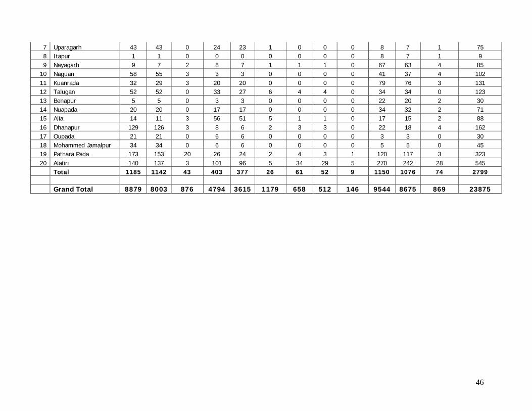
46
7 Uparagarh 43 43 0 24 23 1 0 0 0 8 7 1 75 8 Itapur 1 1 0 0 0 0 0 0 0 8 7 1 9 9 Nayagarh 9 7 2 8 7 1 1 1 0 67 63 4 85
10 Naguan 58 55 3 3 3 0 0 0 0 41 37 4 102 11 Kuanrada 32 29 3 20 20 0 0 0 0 79 76 3 131 12 Talugan 52 52 0 33 27 6 4 4 0 34 34 0 123 13 Benapur 5 5 0 3 3 0 0 0 0 22 20 2 30 14 Nuapada 20 20 0 17 17 0 0 0 0 34 32 2 71 15 Alia 14 11 3 56 51 5 1 1 0 17 15 2 88 16 Dhanapur 129 126 3 8 6 2 3 3 0 22 18 4 162 17 Oupada 21 21 0 6 6 0 0 0 0 3 3 0 30 18 Mohammed Jamalpur 34 34 0 6 6 0 0 0 0 5 5 0 45 19 Pathara Pada 173 153 20 26 24 2 4 3 1 120 117 3 323 20 Alatiri 140 137 3 101 96 5 34 29 5 270 242 28 545
Total 1185 1142 43 403 377 26 61 52 9 1150 1076 74 2799 Grand Total 8879 8003 876 4794 3615 1179 658 512 146 9544 8675 869 23875
FS/DPR for 4/6 Laning from Panicoili to Remuli (Km 00) to (Km163.0 In NH-215 of Orissa
EIA/ EMP Report
Page 14
Annexure 3.5: Distribution of Population by SC & ST
Sl No NAME OF VILLAGE
SC POPULATION ST POPULATION POPULATION
TOTAL MALE FEMALE TOTAL MALE FEMALE TOTAL MALE FEMALE Keonjhar District
1 Pratapposi 35 15 20 11 8 3 526 272 254 2 Taduabahal 0 0 0 736 380 356 953 485 468 3 Rimuli 951 498 453 1428 701 727 4263 2145 2118 4 Parsala 308 160 148 114 57 57 1351 690 661 5 Sijukala 0 0 0 227 116 111 653 328 325 6 Murusuan 43 24 19 775 432 343 1036 571 465 7 Dudhakundi 10 4 6 505 246 259 578 284 294 8 Rajabasa 0 0 0 184 96 88 642 325 317 9 Balibandha 190 89 101 934 470 464 2015 1021 994 10 Katalposi 0 0 0 65 33 32 266 138 128 11 Balabhadrapur 0 0 0 113 57 56 410 192 218 12 Sundhimurusuan 0 0 0 139 62 77 168 81 87 13 Arsala 248 117 131 281 154 127 2847 1458 1389 14 Bankapatuli 26 11 15 770 356 414 977 471 506 15 Pipilia 78 39 39 1089 539 550 1638 814 824 16 Chandaposi 1 1 0 6 4 2 25 23 2 17 Bholabeda 147 72 75 1549 775 774 1967 979 988 18 Gobindapur 0 0 0 24 13 11 336 168 168 19 Badaposi 0 0 0 416 211 205 494 248 246 20 Gopalpur 10 6 4 275 135 140 504 251 253 21 Khantaghara 70 37 33 547 276 271 659 335 324 22 Khajurijuani 12 6 6 372 195 177 442 231 211 23 Khatrabeda 41 19 22 416 207 209 706 355 351
24 Chikinia/Chikina - Gobinpur 34 20 14 786 380 406 1000 486 514
25 Dhenkikote 169 84 85 563 302 261 2097 1156 941 26 Sanmasinabilla 3 1 2 384 202 182 883 452 431 27 Sanabarabeda 34 14 20 356 186 170 460 234 226 28 Kusunapur 0 0 0 298 151 147 848 417 431
29 Bata Harichandanpur /Harichanduapur 0 0 0 310 147 163 958 475 483
30 Golabandha 196 98 98 254 128 126 534 269 265 31 Dhuligarh 0 0 0 6 3 3 9 4 5 32 Uparadiha 118 62 56 968 476 492 2443 1255 1188 33 Balijodi 21 12 9 848 445 403 971 502 469 34 Melana 30 15 15 1401 704 697 1628 827 801 35 Palasapanga 83 38 45 285 153 132 1269 654 615 36 Jamudiha 99 51 48 286 143 143 679 338 341 37 Sarasakela 109 54 55 312 155 157 953 489 464 38 Murusuan 79 36 43 416 208 208 862 432 430 39 Jadichatar 0 0 0 324 165 159 365 188 177 40 Kesapanka 0 0 0 61 27 34 61 27 34 41 Putulia 64 42 22 205 110 95 803 454 349 42 Bankamaruni 0 0 0 89 47 42 216 108 108 43 Padmapur 189 95 94 639 336 303 1903 1026 877 44 Banajodi 30 12 18 705 368 337 1018 535 483 45 Silisuan 71 39 32 1024 514 510 1140 575 565 46 Poipani 0 0 0 117 65 52 117 65 52 47 Tangarani 81 37 44 94 48 46 521 262 259
FS/DPR for 4/6 Laning from Panicoili to Remuli (Km 00) to (Km163.0 In NH-215 of Orissa
EIA/ EMP Report
Page 15
48 Raisuan 346 185 161 1368 669 699 3852 1962 1890 49 Khuntapada(KHA) 0 0 0 135 67 68 141 71 70 50 Gopinathapur 12 6 6 663 322 341 1100 542 558 51 Jamunalia 0 0 0 234 114 120 278 133 145 52 Baliaguda 439 235 204 286 150 136 833 443 390 53 Mandua 3 0 3 412 206 206 553 285 268 54 Tangarpalasa 199 104 95 261 148 113 538 291 247 55 Naranapur 288 152 136 411 245 166 1518 836 682 56 Haladiatangiri 48 28 20 368 190 178 473 252 221 57 Kanto 64 32 32 451 230 221 1027 518 509 58 Kolimati 36 21 15 1430 770 660 1713 915 798 59 Amarnga 64 29 35 643 324 319 990 487 503 60 Bandha 455 230 225 4 2 2 459 232 227 61 Dhakotha 118 62 56 6 4 2 935 486 449 62 Bhalukhuma 248 131 117 18 10 8 924 494 430 63 Biragobindapur 361 189 172 1057 537 520 2079 1057 1022 64 Talagaon 330 187 143 958 545 413 1757 996 761 65 Indupura 112 67 45 9 5 4 404 212 192 66 Gohira 0 0 0 1511 760 751 1665 835 830 67 Belabhali 221 110 111 366 188 178 4004 2100 1904 68 Barigaon 48 27 21 0 0 0 1331 681 650 69 Bailo 689 350 339 0 0 0 1240 647 593 70 Hasanpur 0 0 0 0 0 0 434 235 199 71 Siapada 0 0 0 3 3 0 419 217 202 72 Naukana 0 0 0 0 0 0 203 99 104 73 Machhalo 338 163 175 85 41 44 1870 898 972 74 Rudranarayanpur 0 0 0 136 70 66 445 217 228 75 Bamphidi 153 75 78 287 139 148 1003 500 503 76 Sainkul 513 253 260 740 373 367 3985 1956 2029 77 Khalana 212 105 107 41 22 19 3029 1518 1511 78 Gainthagodi 0 0 0 0 0 0 25 11 14 79 Nuagaon 310 150 160 0 0 0 2041 1003 1038 80 Suanpada 241 121 120 30 15 15 548 289 259 81 Ramachandrapur 85 43 42 19 12 7 598 314 284 82 Jarda 22 12 10 0 0 0 509 261 248 83 Badapadana 367 175 192 68 32 36 2239 1114 1125 84 Sanapadana 0 0 0 0 0 0 282 126 156 Total 9902 5050 4852 33707 17179 16528 90638 46328 44310 Percentage 10.9 10.9 11.0 37.2 37.1 37.3 * * *
Janpur District 1 Andhari 250 134 116 118 57 61 888 449 439 2 Godarapal 30 13 17 191 95 96 364 186 178 3 Ragadi 184 92 92 0 0 0 976 495 481 4 Mangarajpur 0 0 0 0 0 0 339 165 174 5 Manjuri 134 56 78 0 0 0 149 65 84 6 Talagarh 570 285 285 0 0 0 1980 1029 951 7 Uparagarh 31 15 16 181 97 84 262 134 128 8 Itapur 0 0 0 0 0 0 39 20 19 9 Nayagarh 184 99 85 8 4 4 381 203 178 10 Naguan 68 34 34 0 0 0 438 237 201 11 Kuanrada 6 2 4 258 126 132 506 248 258 12 Talugan 131 68 63 1 1 0 475 246 229 13 Benapur 69 39 30 79 41 38 191 102 89 14 Nuapada 17 9 8 0 0 0 369 192 177 15 Alia 72 43 29 123 65 58 394 213 181 16 Dhanapur 132 72 60 0 0 0 790 410 380
FS/DPR for 4/6 Laning from Panicoili to Remuli (Km 00) to (Km163.0 In NH-215 of Orissa
EIA/ EMP Report
Page 16
17 Oupada 22 10 12 0 0 0 167 86 81
18 Mohammed Jamalpur 190 97 93 25 10 15 431 214 217
19 Pathara Pada 11 6 5 227 125 102 1224 639 585 20 Alatiri 461 241 220 7 3 4 2118 1095 1023 Total 2562 1315 1247 1218 624 594 12481 6428 6053 Percentage 20.5 20.5 20.6 9.8 9.7 9.8 * * * Grand Total 12464 6365 6099 34925 17803 17122 103119 52756 50363 Percentage 12.1 12.1 12.1 33.9 33.7 34.0 * * *
FS/DPR for 4/6 Laning from Panicoili to Remuli (Km 00) to (Km163.0 In NH-215 of Orissa
EIA/ EMP Report
Page 17
1.1 Background
India has one of the largest road networks in the world, aggregating to about 3.3
million kilometers. Out of the total road length, National and State Highways,
accounting for 1,72,000 km in length, occupy an important position as nearly 60
percent of the freight and 87 percent of the passenger traffic move on them. The
total length of National Highways in the country is 58,112 km, accounting for only
2% of the total road length and carryover about 40% of the total traffic. During the
ninth plan and current tenth plan lot of emphasis was laid on coordinated and
balanced development of road network in the country. Road development is
considered an integral part of the total transport system of the country with
emphasis on strengthening three functional groups, the primary system (National
Highways and Expressways), Secondary System (State Highways and Major District
Roads) and Rural roads.
The Central Government is responsible for the National Highways system and a
massive programme for 4/6 laning of about 13000 km of National Highways has
been taken up since 1999 under the National Highways Development Programme
(NHDP). National Highways Authority of India (NHAI) is implementing the
programme at an estimated cost of rupees 54 thousand crores. In addition to Golden
Quadrilateral and North-South-East-West Corridor Project, other components which
have been included under NHDP are:
Improvement, maintenance and augmentation of the existing National
Highways network.
Providing road connectivity to major ports.
Involving the private sector in financing the construction, maintenance and
operation of National Highways and wayside amenities
Implementation of road safety measures and environmental management.
Introducing Information Technology in Construction, maintenance and all
operation of NHAI.
FS/DPR for 4/6 Laning from Panicoili to Remuli (Km 00) to (Km163.0 In NH-215 of Orissa
EIA/ EMP Report
Page 18
National Highways Authority of India (NHAI) at the direction of Ministry of Road
Transport and Highways (MoRTH), Government of India has proposed to improve
and strengthen the corridor of National Highway-215 in Panikoili – Keonjhar – Rimuli,
between the chain age Km 0+000 to Km 163+000 of NH-215. The project road runs
through the districts of Jajpur and Keonjhar in the State of Orissa. The corridor
passes through several congested areas, sharp curves and has inadequate road
width to cater the present traffic volumes. These deficiencies result in lesser vehicle
speeds, more wear and tear on vehicles, more vehicular pollution and more vehicle
operating costs. The environment impact study is a part of the feasibility studies and
preparation of detailed project report and is also a statutory requirement for
obtaining environmental clearance from Ministry of Environment & Forests (MoEF),
New Delhi.
1.2 Existing Facilities and Proposed Upgradation Work
The existing NH-215 comprise of 163 km having 2 lane road, connecting NH–5 at
Panikoili of Jajpur district to Remuli of Keonjhar district. Keeping in view of the traffic
load as well as scope of expansion of existing road , five (5) bypasses have been
proposed in two districts namely Jajpur (from 0 to 24 kms) and Keonjhar (24 to 163
kms) of Orissa State. NHAI at the direction of the MoRTH has proposed for
upgrading from 2 lane to 4/6 laning of the existing road.
1.3 Need for the proposal
Highways play a significant role in National and Regional economies particularly in
the development of trade, tourism and investment. Increasingly, Highways will
become vital as freight increases in importance as a major part of the export
economy and as regional markets grow. Strengthening and widening of highways
and its operation are of national significance, because the highways are expected to
generate a wide range of economic activities which should help national
development, and also because a wide communication network is generally felt to
FS/DPR for 4/6 Laning from Panicoili to Remuli (Km 00) to (Km163.0 In NH-215 of Orissa
EIA/ EMP Report
Page 19
represent its country. The proposed project is being developed as a major transit
hub between different parts of the country.
1.4 Scope of Environmental Impact Assessment (EIA) Study
The NHAI has entrusted M/s. Aarvee Associates, Hyderabad to carry out preparation
of Feasibility Study Report (FSR) and Detailed Project Report (DPR) for rehabilitation
and upgradation of existing 2 lane to 4/6 lane Divided Carriageway Configuration. As
part of the above studies aarvee associates, Hyderabad has undertaken
Environmental Impact Assessment in view of the statutory requirement of
environmental clearance for highway projects.
The report contains the findings of the study to identify, predict and evaluate the
likely impacts due to the proposed activity and has suggested suitable mitigative
measures to minimise the adverse impacts and ameliorate environmental quality in
the surrounding region. The environmental / safety concerns which can be
internalised in the project planning stage have been identified and suitable measures
needed are elicited as Environmental Management Plan (EMP).
Detailed baseline data prior to project implementation had been generated for air,
noise, water, land, biological and socio-economic environment within 7 km study area.
The baseline data for pre-project environmental status is also presented along with
identification, prediction and evaluation of impacts due to project activities.
1.5 Objectives of the Study
The objectives of the study are:
To obtain clearances from Orissa State Pollution Control Board and Ministry of
Environment and Forests and to facilitate the proposed developmental works based
on detailed studies of various environmental attributes viz., air, water, noise, land,
biological and socio-economic environment etc. likely to be affected and measures for
redressing the impacts:
FS/DPR for 4/6 Laning from Panicoili to Remuli (Km 00) to (Km163.0 In NH-215 of Orissa
EIA/ EMP Report
Page 20
To study the existing situation of the project in terms of its road condition,
road system, road transport and the improvements with analysis of
alternatives.
To identify and quantify the significance of impacts of various activities at
proposed widening of the road on environmental attributes.
To evaluate the impacts on an environmental quality scale.
To evaluate the proposed pollution and control measures and prepare
Environmental Management Plan (EMP) outlining additional control measures
to be adopted for mitigation of adverse impacts.
To prepare a post-project monitoring programme for checking and regulating
the environmental quality within the limits stipulated by State Pollution Control
Board and Ministry of Environment & Forests, Government of India.
1.6 Approach and methodology
The approach for the preparation of EIA involves the following steps:
Reconnaissance survey is undertaken in order to identify the environmental
attributes in and around the project site. The environmental base line data in the
project impact area was generated from both primary and secondary sources. During
the site visits, due importance is given to identifying the impacts of the project taking
in to consideration of the project location and climatic conditions. Prediction and
evaluation of the impacts are done based on mathematical models, empirical
assessment and past experience. Environmental Management Plan is being prepared
in order to reduce the impacts of the project to the barest minimum.
Conclusively, quantification of the financial cost of mitigation measures and
preparation of monitoring plan for the implementation of mitigation measures is
undertaken.
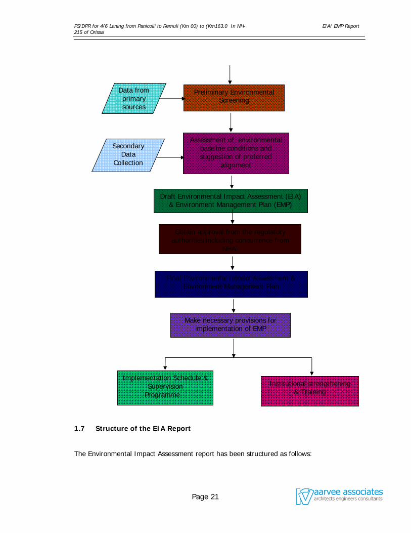
The methodology adopted is presented in form of a flow chart given in figure 1.6.1.
Figure 1.6.1 Flow Chart
Preliminary Field Visit
FS/DPR for 4/6 Laning from Panicoili to Remuli (Km 00) to (Km163.0 In NH-215 of Orissa
EIA/ EMP Report
Page 21
1.7 Structure of the EIA Report
The Environmental Impact Assessment report has been structured as follows:
Data from primary sources
Preliminary Environmental Screening
Secondary Data
Collection
Assessment of environmental baseline conditions and suggestion of preferred
alignment
Draft Environmental Impact Assessment (EIA) & Environment Management Plan (EMP)
Obtain approval from the regulatory authorities including concurrence from
NHAI
Final Environmental Impact Assessment & Environment Management Plan
Make necessary provisions for implementation of EMP
Implementation Schedule & Supervision
Programme
Institutional strengthening & Training
FS/DPR for 4/6 Laning from Panicoili to Remuli (Km 00) to (Km163.0 In NH-215 of Orissa
EIA/ EMP Report
Page 22
Chapter-1: It contains project background, existing facilities & proposed
upgradation work, need for the proposal, EIA study and major objectives of the
study.
Chapter-2: This chapter presents the rules and regulations applicable for carrying
out environmental assessments and laws applicable to the project in general. The
institutions responsible for providing the clearances and the interfaces to be
established by the project proponent and related pro-actions are also covered.
Chapter –3: The chapter depicts the existing situation of the project in terms of its
road condition, road system, road transport and the improvements with analysis of
alternatives.
Chapter-4: This chapter reveals the Baseline Environmental Status of the project
area in terms of its physical, biological, chemical, cultural and meteorological
description.
Chapter –5: This chapter presents the positive and negative impacts likely to result
from the proposed project and the suggested mitigation measures.
Chapter –6: It presents Environmental Management Plan (EMP) and suggests the
identification of agency for monitoring and the institutional strengthening. In addition
it also suggests the cost of EMP including training.
FS/DPR for 4/6 Laning from Panicoili to Remuli (Km 00) to (Km163.0 In NH-215 of Orissa
EIA/ EMP Report
Page 23
2.1 Institutional Setting for Project
Considering the growing need of better road transportation, Government of India
through Ministry of Road Transport and Highways (MoRTH) has decided to undertake
widening of 2 lane road to 4/6 laning of National Highways -215 between Panikoili –
Keonjhar – Rimuli, between the chainage Km 0+000 to Km 163+000,of section of
NH-215. The project road runs through the districts of Jajpur and Keonjhar in the
state of Orissa. Since the planning, development and management of National
Highways are controlled by the National Highways Authority of India (NHAI), New
Delhi, operating under the MoRTH, the present project is under the direct control of
NHAI.
2.2 The Legal Framework
The Government of India has laid out various policy guidelines, acts and regulations
pertaining to the sustenance of environment and some of the important have been
listed below.
The Ancient Monuments and Archaeological Sites and Remains Act,
1958
Wildlife (Protection Act), 1972, Amendment 1991.
The Water and Air ( Prevention And Control Of Pollution ) Acts ( 1974,
1981 And 1987)
The Wildlife (Protection) Act, 1972, Amendment 1991.
The Forest (Conservation) Act, 1980.
The Environment (Protection) Act, 1986
The Motor Vehicles Act, 1988
The Environmental Impact Assessment Notification, 1994 and
subsequent amendments till 2004.
The guidelines of Pollution Control Board; Government of Orissa.
FS/DPR for 4/6 Laning from Panicoili to Remuli (Km 00) to (Km163.0 In NH-215 of Orissa
EIA/ EMP Report
Page 24
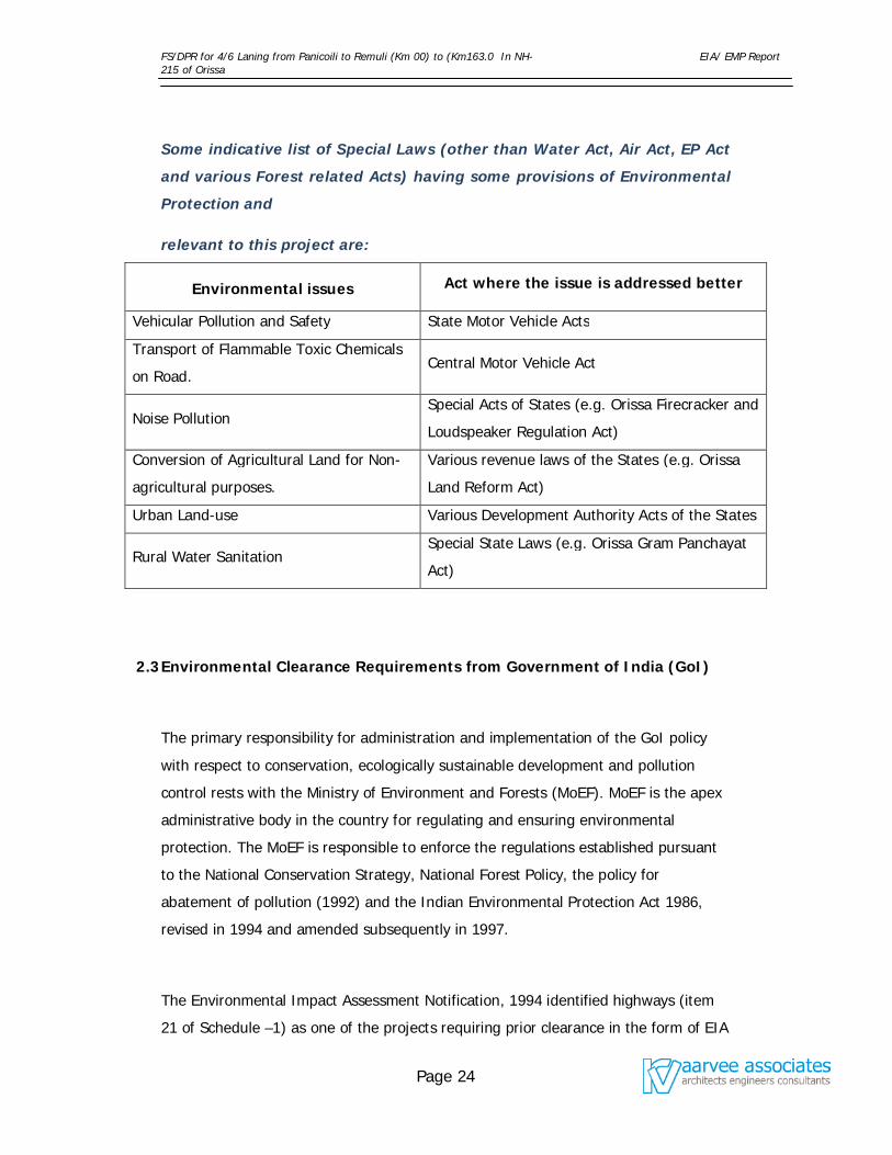
Some indicative list of Special Laws (other than Water Act, Air Act, EP Act
and various Forest related Acts) having some provisions of Environmental
Protection and
relevant to this project are:
Environmental issues Act where the issue is addressed better
Vehicular Pollution and Safety State Motor Vehicle Acts
Transport of Flammable Toxic Chemicals
on Road. Central Motor Vehicle Act
Noise Pollution Special Acts of States (e.g. Orissa Firecracker and
Loudspeaker Regulation Act)
Conversion of Agricultural Land for Non-
agricultural purposes.
Various revenue laws of the States (e.g. Orissa
Land Reform Act)
Urban Land-use Various Development Authority Acts of the States
Rural Water Sanitation Special State Laws (e.g. Orissa Gram Panchayat
Act)
2.3 Environmental Clearance Requirements from Government of India (GoI)
The primary responsibility for administration and implementation of the GoI policy
with respect to conservation, ecologically sustainable development and pollution
control rests with the Ministry of Environment and Forests (MoEF). MoEF is the apex
administrative body in the country for regulating and ensuring environmental
protection. The MoEF is responsible to enforce the regulations established pursuant
to the National Conservation Strategy, National Forest Policy, the policy for
abatement of pollution (1992) and the Indian Environmental Protection Act 1986,
revised in 1994 and amended subsequently in 1997.
The Environmental Impact Assessment Notification, 1994 identified highways (item
21 of Schedule –1) as one of the projects requiring prior clearance in the form of EIA
FS/DPR for 4/6 Laning from Panicoili to Remuli (Km 00) to (Km163.0 In NH-215 of Orissa
EIA/ EMP Report
Page 25
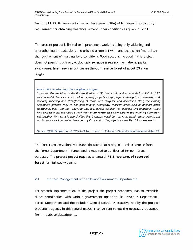
Box 1: EIA requirement for a Highway Project “….As per the provisions of the EIA Notification of 27th January 94 and as amended on 10th April 97, environmental clearance is required for highway projects except projects relating to improvement work including widening and strengthening of roads with marginal land acquisition along the existing alignments provided they do not pass through ecologically sensitive areas such as national parks, sanctuaries, tiger reserves, reserve forests. It is hereby clarified that marginal land acquisition means land acquisition not exceeding a total width of 20 metre on either side of the existing alignment put together. Further, it is also clarified that bypasses would be treated as stand –alone projects and would require environmental clearance only if the cost of the projects exceed Rs.100 crores each”.
Source: MOEF Circular No. 21012/26-99-1A-III dated 15 October 1999 and vide amendment dated 13th
from the MoEF. Environmental Impact Assessment (EIA) of highways is a statutory
requirement for obtaining clearance, except under conditions as given in Box 1.
The present project is limited to improvement work including only widening and
strengthening of roads along the existing alignment with land acquisition (more than
the requirement of marginal land condition). Road sections included in this project
does not pass through any ecologically sensitive areas such as national parks,
sanctuaries, tiger reserves but passes through reserve forest of about 23.7 km
length.
The Forest (conservation) Act 1980 stipulates that a project needs clearance from
the Forest Department if forest land is required to be diverted for non forest
purposes. The present project requires an area of 71.1 hectares of reserved
forest for highway widening.
2.4 Interface Management with Relevant Government Departments
For smooth implementation of the project the project proponent has to establish
direct coordination with various government agencies like Revenue Department,
Forest Department and the Pollution Control Board. A proactive role by the project
proponent agency in this regard makes it convenient to get the necessary clearance
from the above departments.
FS/DPR for 4/6 Laning from Panicoili to Remuli (Km 00) to (Km163.0 In NH-215 of Orissa
EIA/ EMP Report
Page 26
Department of Environment and Forests (DoEF)
DoEF perform the functions similar to the MoEF and co-ordinates the activities of the
MoEF at the state level. This department is responsible to have an integrated
approach to deal with, prevention and control of air and water pollution, preservation
and development of forest wealth and natural resources in the state.
State Pollution Control Board (SPCB)
The SPCBs are state level environmental management agencies with the following
activities:
Advising state Governments on air, water and industrial issues;
Planning and executing state-level air and water initiatives;
Establishing standards based on National Minimum Standards;
Enforcing and monitoring of all activities within state under the Air Act, the
Water Act and the Cess Act, etc,;
Conducting and organizing public hearings for projects as defined by the
various Acts and as stipulated by the Amendment (April 1997) to the EIA Act;
and
Issuing No-objection Certificates (NOC) for industrial development defined in
such a way as to include road projects.
The project also requires obtaining NOC from SPCBs in pursuant to the Water
(Prevention and Control of Pollution) Act of 1974, the Cess Act of 1977 and the Air
(Prevention and Control of Pollution) Act of 1981 and amendment in 1987.
As per the procedure laid down by Ministry of Environment and Forests, obtaining No
Objection Certificate (NOC) from the State Pollution Control Board is mandatory
before seeking environmental clearance of the project. Accordingly, applications will
be made to the Orissa State Pollution Control Board for obtaining ‘No Objection
Certificate (NOC)’ and ‘Consent for Establishment (CFE) ’, duly paying the required
FS/DPR for 4/6 Laning from Panicoili to Remuli (Km 00) to (Km163.0 In NH-215 of Orissa
EIA/ EMP Report
Page 27
fees as demanded by the Orissa State Pollution Control Board. Necessary application
seeking environmental clearance of the Project from the Ministry of Environment and
Forest will be made after receipt of the No Objection Certificate from the Orissa State
Pollution Control Board.
Public Hearings
In order to obtain a No Objection Certificate (NOC) from the State Pollution Control
Board, or environmental clearance from the MoEF, “Public Hearing” has been made
mandatory. The requirement was introduced in the MoEF notification, which came
into effect on 10th April 1997. But subsequently MoEF has issued a draft notification
on 3rd January, 2001 stating the following: "However, public hearing is not required
in respect of Small Scale Industrial Units (as defined in the Industrial Policy from
time to time), widening and strengthening of highways, mining projects (major
minerals) with lease area up to twenty-five hectares and modernization of existing
irrigation projects". Hence, this project does not require public hearing.
State Revenue Department
An interface has to be established with Revenue Department to facilitate land
acquisition for the project. This task becomes much easier if the project proponent
furnishes the land acquisition plan to the department. However marginal may be the
land required for its acquisition the project proponent has to proceed by the laid
procedures. All costs in this regard are to be borne by the project promoter. Public
grievances in matters of land acquisition complicate the schedule of project
implementation. It is recommended that construction work should start only after
completion of land acquisition and disbursal of compensation and / or rehabilitation.
State Forest Department
FS/DPR for 4/6 Laning from Panicoili to Remuli (Km 00) to (Km163.0 In NH-215 of Orissa
EIA/ EMP Report
Page 28
Box 2: Applicability of the Forest (Conservation) Act, 1980
Roadside Strip Plantation In 1986, when MoEF enacted the Environment Protection Act, the entire linear stretches of roadside plantations along the highways were declared as protected forest in certain states. Although the land is under the control of the highways department. Due to its protected status, clearance is required to cut roadside trees. Applicability of the provisions of the Forest (Conservation) Act, 1980 to the linear (road or canal side) plantations was modified by a notification from the GoI, MoEF. Dated 18th February 1998. The new notification recognizes that the sprit behind the Forest (Conservation) Act was conservation of natural forests, and not strips plantations. In the case of the notified to be protected roadside plantations, the clearance now may be given by the concerned Regional Offices of the MoEF, irrespective of the area of plantation lost. While issuing the approval, in place of normal provision for compensatory afforestation the Regional Offices will stipulate a condition that for every tree cut at least two trees should be planted. If the concerned Regional Office does not accord the decision within 30 days of the receipt of fully completed application, the proponent agency may proceed with the widening/ expansion under intimation to
The project corridor has a lot of linear stretches of roadside plantation, which require
cutting. The present status of this land is defined under the provisions of Forest
(Conservation) Act, 1980 applicable to the linear (roadside) plantations. As per the
modified notification (18th Feb 1998) of MoEF on roadside plantation the clearance is
required from Regional Office of MoEF for cutting the roadside plantations (See Box
2).
Department of Mines
The project promoter would obtain construction material like stone aggregates etc.,
from existing licensed quarries. If new quarries have to be opened up, the
permission of State Department of Mines would be required.
2.5 Institution Strengthening and Arrangement
FS/DPR for 4/6 Laning from Panicoili to Remuli (Km 00) to (Km163.0 In NH-215 of Orissa
EIA/ EMP Report
Page 29
Though rich in legal and regulatory instruments, the implementing agencies are
unable to regulate and monitor a sound environmental management plan due to lack
of enforcement capacity. Therefore, violations or missed mitigation commitments
often go unreported. The gaps and deficiencies pointed out can be removed by
proper arrangements. Institutional strengthening component has accordingly been
identified. As such, the over all arrangement is as follows:-
Organisational arrangements
An environmental unit will be established in each construction packages with a
manager to address the environmental issues. The environmental unit will have
proper staff to ensure the implementation of EMP and related measures. The
manager (Environment) will be familiar with the Indian environmental legislations,
will have proper training of the environment of the region, and will be able to
coordinate with NGO’s, community groups and Government department.
Environmental Training
Training of staff will be done at a number of levels. Some short term training is
required for the Environmental Manager, other staff members of the Environmental
Unit and contractor staff to raise their levels of environmental awareness. The
Environmental and Natural resource division and State Pollution Control Boards
conduct the training programmes, and their help will be sought in this regard. In
long term training, specialized training or special environmental issues will be
examined and provided to the Environment Unit.
Environmental Monitoring
In order to ensure that the prescribed environmental norms are maintained during
the constructional and the operational phases, the regular monitoring is one of the
most important components of the institutional arrangements. The monitoring of Air
quality, Water quality, Noise quality and green belt development will be done at
regular intervals. The field reports of various environmental components will be done
FS/DPR for 4/6 Laning from Panicoili to Remuli (Km 00) to (Km163.0 In NH-215 of Orissa
EIA/ EMP Report
Page 30
at regular intervals. The field reports of various environmental components will be
received at quarterly basis and any lapse has to be taken care of.
Some awareness training will be provided to the contractors and their personnel to
ensure that the EMP is implemented effectively. The project coordinator will assess
the contractor practices and if high pollution levels are suspected, will government or
private sector laboratories check them.
FS/DPR for 4/6 Laning from Panicoili to Remuli (Km 00) to (Km163.0 In NH-215 of Orissa
EIA/ EMP Report
Page 31
This chapter depicts the existing situation of the project corridor. The present project
corridor ‘Panikoili – Keonjhar – Rimuli’ situated between chainage from Km. 0+000
to 163+000 section of NH-215 in the State of Orissa and to be upgraded to 4/6 lane
divided carriage way. The present traffic at different stretches of the road varies
from 10,000 PCUs to 23,000 PCUs /day. The traffic is projected for a period of 30
years and the pavement is designed for a period of 15 years. The existing carriage
way of the present stretch is around 7.0 m with two lane road. The embankment of
the road varies from 1.0 to 1.5 m in general without any cut sections but its height is
greater than 2m at bridge locations. The physical condition of the road is not good
with a formation width of 12 m. The project corridor passes through mostly
agricultural and forest lands on either side of the road.
Information pertaining to the existing quarry and other sources of potential road
construction materials was collected from the local departments throughout the
project area. Information from field observations and other sources was also
collected. Unlike a new road development project, the present project is limited to
widening and upgradation of existing alignment from 2 lane to 4/6 lane with
bypasses. Environmental Impact Assessment Decision Support System
(EIADSS) is done for all the bypasses with different alignments. The alternatives
considered relate to modification in geometric design, horizontal alignment to
minimize land acquisition and tree felling. Design changes were also suggested
where encroachment and congestion related problems were encountered. Details of
widening and design options are indicated in the detailed report
3.1 Project Location
The project road (NH 215) is passing through Jajpur and Keonjhar districts, having 163 km length and connecting
NH-5, NH-6 and NH 23 in Orissa state. The project reach from Km. 0.00 to Km.25.00 is in Jajpur District and the
major portion from Km. 25.00 to Km. 163.00 is in Keonjhar District. The project lies between 200 54’ N to 21 57’ N
and 86 13’ E to 85 36’ E. An average altitude of the stretch varies from 160.1 to 423.6 m. It is situated more than 65
Km from seacoast and the climate is tropical. The location map showing the project area is shown in figure 3.1.
FS/DPR for 4/6 Laning from Panicoili to Remuli (Km 00) to (Km163.0 In NH-215 of Orissa
EIA/ EMP Report
Page 32
3.2 Land Use along the Project Road
3.2.1 Reserve forest
The details of project road passing through reserve forest area in Keonjhar and
Jajpur district constitute 23.7 Km and it is worked out to 71.1 hectares of the total
geographical area. In Keonjhar district, road passes through forest at majority of the
locations. The details of forests located in road corridor are presented in table 3.2.1.
Table 3.2.1: Details about Project Road through Reserve Forest in
Jajpur and Keonjhar districts
S.NO. District Chainage
Length (Km) From To
1 Jajpur 19.000 21.000 2.000 2 Keonjhar 39.000 40.000 1.000 3 50.000 50.500 0.500 4 58.00 66.400 8.400 5 74.000 77.00 3.00 6 84.00 85.000 1.000 7 102.500 103.00 0.500 8 107.000 109.000 2.000 9 111.000 113.000 2.000 10 129.500 130.200 0.700 11 139.00 141.200 1.800 Total 23.700
3.2.2 Industries along the Project Road
The project area is surrounded with various Industries. The Kalinga Nagar
Industrial Complex of Jajpur district is a distance of 9 kms from road corridor. All
major Steel industries like MESCO, Nilachal Ispat Nigam Limitel, VISA
Industries and Jindal Industries are located within this Industrial Complex. In
Keonjhar district, Sponge Iron Industries are located close to road corridor.
FS/DPR for 4/6 Laning from Panicoili to Remuli (Km 00) to (Km163.0 In NH-215 of Orissa
EIA/ EMP Report
Page 33
Figure 3.1: Location Map Showing the Project Area
FS/DPR for 4/6 Laning from Panicoili to Remuli (Km 00) to (Km163.0 In NH-215 of Orissa
EIA/ EMP Report
Page 34
3.2.3 Land use Pattern
Agricultural, No use (barren), rural, semi urban, Urban and Urban commercial are
other land usage found along the project road. The distributions of land usage along
the project road are as given in Figure 3.2 & 3.3.
Figure 3.2: Land Use Pattern of Jajpur District
Figure 3.3: Land Use Pattern of the Keonjhar District
Agricultural, No use (barren), rural, semi urban, Urban and Urban commercial are
other land usage found along the project road. The distribution of land usage along
the project road are as follows: Agricultural 55%, Forest 17%, Semi Urban 12%,
Urban 1.0% , Urban commercial 7% and Barren is of 8%.
LANDUSEPATTERN OF JAJPUR
Agriculture 52%
Non Agriculture
7%
Culturable fallow
5%
Current fallow
6%
Barren Unculturable fallow2%
Forest Area
25%
CulturableWaste 1%
Pemanent pastuture1%
Miscellaneous trees 1%
LAND USE PATTERN OF KEONJHAR
Forest Area 37%
Agricultural 36%
Non Agriculture 7%
Barren unculturable fallow 9%
Current fallow 1%
Culturablefallow 1%
Culturablewaste 4.8%
Permanent pasture4%
MiscellaneousTrees 0.7%
FS/DPR for 4/6 Laning from Panicoili to Remuli (Km 00) to (Km163.0 In NH-215 of Orissa
EIA/ EMP Report
Page 35
3.2.4 Cross Drainage Structures
There are two major rivers, namely Baitarani and Ardai located in the project area.
There are many other minor rivers and channels such as Kukurkatta ,Mushal ,Kusai,
Sita River, Ardei & Kalinijhan River crossing the project stretch. The channels and
canals flow either from East to West or from West to East depending on the terrain.
Out of total six major Bridges only one is to be retained, rest five are to be
reconstructed (River Bridge on Kusai, Mushal and Ardei rivers were affected during
cyclone of 1999). The list of bridges in the project area is given in the table 3.2.4.1.
Table 3.2.4.1: List of bridges along the project road
Sl. No.
Chainage Name of Crossing/Bridge
Length of Bridge
Span Arrangement
Nearest Village/Town
1 10.046 Rly. Line 55.62 (2x15.120) + (1x25.380) Jajpur Road
2 18.064 Bandi Bridge 6.00 2 x 3.00 x 2.50 Jarda 3 22.980 Andhari Bridge 12.00 2 x 6.00 Jarda
4 25.776 Ghagia Nallah 25.270
(1x8.50) + (1x8.45) +
(1x8.32) Ramchandrapur
5 26.000 Kaliapal Jore 24.900 3 x 8.30 Ramchandrapur
6 32.940 Sasan Bridge Hasanpur Village
7 34.690 Dhanaghara Nallah 9.70 1 x 9.70 Hasanpur Village
8 35.803 Kusai 211.950 Belabahai Village
9 37.790 Local Nallah 5.50 2 x 2.75 Barigaon Village
10 38.230 Khandiapata 11.350 2 x 5.675 Barigaon Village
11 41.550 Baitarani River 9.750 1 x 9.75 Ghasipura
12 45.750 Jhadeswar Bridge 22.00 4 x 5.50 Anandpur 13
50.550 Local Nallah 5.50 2 x 2.75 Birgovindapur Market Area
14 50.784 Muhan Bridge 42.920 4 x 10.73 Birgovindapur Market Area
15 58.185 Mushal Bridge 105.660
(1x19.35) + (2x22.35) + (1x22.15) +
Kanto Village

FS/DPR for 4/6 Laning from Panicoili to Remuli (Km 00) to (Km163.0 In NH-215 of Orissa
EIA/ EMP Report
Page 36
Sl. No.
Chainage Name of Crossing/Bridge
Length of Bridge
Span Arrangement
Nearest Village/Town
(1x19.46)
16 58.766 Local Nallah 8.00 2 x 4.00x4.30 Kanto Village 17 68.926 Local Nallah 6.00 2x3.00 x 1.150 Melan Village 18
83.702 Sagadia Nallah 7.00 2 x 3.50 Batahari
Chandanpur village
19 84.653 Kukurkata bridge 53.40 6 x 8.90 Gadadharpur Village
20 96.405 Sita River Bridge 35.40 3 x 11.80 Sitaban Village
21 98.965 Anladhar Bridge 14.40 4 x 3.60 Chikiria Village
22 104.268 Local Nallah 6.00 2 x 3.00 x 2.850 Gopalpur Village
23 107.944 Local Nallah 13.00 1x13.00 Gopalpur Village 24 108.019 Local Nallah 22.00 1x22.00 Gopalpur Village 25 109.072 Khalijore Bridge 78.00 13 x 6.00 Keonjhar 26 112.574 Khalighat Bridge 18.00 3 x 6.00 Keonjhar
27 115.095 Local Nallah 6.80 2 x 3.40 Keonjhar
28 118.300 R.O.B. 35.00 1x35.00 Keonjhar
29 119.303 Ardei River Bridge 40.68 6 x 7.78 Keonjhar 30 123.867 15.20 4 x 3.80 Keonjhar 31 129.880 Raisuan Level
Crossing Raisuan
32 136.080 Ardei River Bridge 50.40 8 x 6.30 Jhumpura Town 33 138.105 Local Nallah 5.00 2 x 2.50 x 1.10 Jhumpura Town
34 139.985 Local Nallah 13.50 3 x 4.50 x 2.35 Jhumpura Town
35 144.197 Bandha river Bridge 7.30 2 x 3.65 Jhumpura Town
36 145.150 Local Nallah 6.76 1 x 6.760 x 5.250 Jhumpura Town
37 145.700 Local Nallah 13.50 3 x 4.50 x 3.85 Jhumpura Town
38 147.646 Ardei River Bridge 346.70
(18 x 9.10) + (1x58) + (8x
9.20) Jhumpura Town
39 148.605 Local Nallah 14.30 2 x 7.150 x 4.4.75 Jhumpura Town
40 149.436 Local Nallah 3.30 2 x 1.150 x 1.20 Jhumpura Town
41 150.433 Local Nallah 12.90 3 x 4.30 x 4.00 Jhumpura Town 42 152.130 Local Nallah 9.50 2 x 4.75x4.25 Jhumpura Town 43 153.320 Local Nallah 8.80 2 x 4.40 Rimuli
FS/DPR for 4/6 Laning from Panicoili to Remuli (Km 00) to (Km163.0 In NH-215 of Orissa
EIA/ EMP Report
Page 37
Sl. No.
Chainage Name of Crossing/Bridge
Length of Bridge
Span Arrangement
Nearest Village/Town
44 154.848 Kasia River 42.00 3 x 14.00 Rimuli
45 159.632 Local Nallah 11.64 3 x 3.88 Rimuli
3.2.5 Road Over Bridges (ROBs) Level Crossings
Two Road Over Bridges are existing at Jajpur-Road bypass level crossing at Km
10.046 and Naranpur Skew PSC girder bridge (U/C) at chain age 118.300.
3.2.6 Terrain
The alignment is generally passing through plain, rolling, and mountainous terrain.
3.2.7 Water Tanks and Hills along the Project Length
Water tanks, canals and tube wells are the major sources for supply of water for
drinking and irrigation purposes along the project area. The water tanks help in
keeping the water table reasonably high. Tube wells are generally used for drinking
water whereas tanks irrigation canals are used foe irrigation purposes . Due to the
presence of water tanks and hills along the project length, the alignment takes many
twists and turns.
3.2.8 Villages and Towns
The list of towns and villages and their location along the project road are given in
the following Table:
Table 3.2.8.1 List of Villages and Towns on NH-215 from
Km 0.00 to Km 163.0
Sl No Village/Town Block District 1 panikoili Korai Jajpur 2 Mahamad Jamalpur Korai Jajpur 3 aliya Korai Jajpur
FS/DPR for 4/6 Laning from Panicoili to Remuli (Km 00) to (Km163.0 In NH-215 of Orissa
EIA/ EMP Report
Page 38
Sl No Village/Town Block District 4 dhaneshwar Korai Jajpur 5 janha Korai Jajpur 6 Sanpatoli Korai Jajpur 7 Santara Korai Jajpur 8 Jajpur Road Korai Jajpur 9 Chorda Korai Jajpur 10 Kanhepur Korai Jajpur 11 Chandma Korai Jajpur 12 Nuagadh Korai Jajpur 13 Nuagaon Korai Jajpur 14 Itapur Korai Jajpur 15 Thodagara Korai Jajpur 16 Kantajahri Korai Jajpur 17 Manjuri Korai Jajpur 18 Ragadi Korai Jajpur 19 Andhari Korai Jajpur 20 Jarada Ghasipura Keonjhar 21 Ramachandrapur Ghasipura Keonjhar 22 Suanpada Ghasipura Keonjhar 23 Nuagaon Ghasipura Keonjhar 24 Khalana Ghasipura Keonjhar 25 Badapada Ghasipura Keonjhar 26 Machala Ghasipura Keonjhar 27 Rudranarayan Pur Ghasipura Keonjhar 28 Bamdi Ghasipura Keonjhar 29 Hasanpura Ghasipura Keonjhar 30 Belabahali Ghasipura Keonjhar 31 Bharigaon Ghasipura Keonjhar 32 Bailo Ghasipura Keonjhar 33 Salpada Ghasipura Keonjhar 34 Khapana Khai Ghasipura Keonjhar 35 Gasipura Ghasipura Keonjhar 36 Sailang Ghasipura Keonjhar 37 Gohira Ghasipura Keonjhar 38 Talagaon Ghasipura Keonjhar 39 Biragobindapur Ghasipura Keonjhar 40 Bhalukumar Ghasipura Keonjhar 41 Dakhota Ghasipura Keonjhar 42 Bandha Ghasipura Keonjhar 43 Kanto Ghasipura Keonjhar 44 Kolimat Ghasipura Keonjhar 45 Kumuda Ghasipura Keonjhar 46 Darkhota Ghasipura Keonjhar 47 Bhojiamoda Ghatgaon Keonjhar 48 Melana Ghatgaon Keonjhar 49 Baljodi Ghatgaon Keonjhar 50 Ghatagoan Ghatgaon Keonjhar
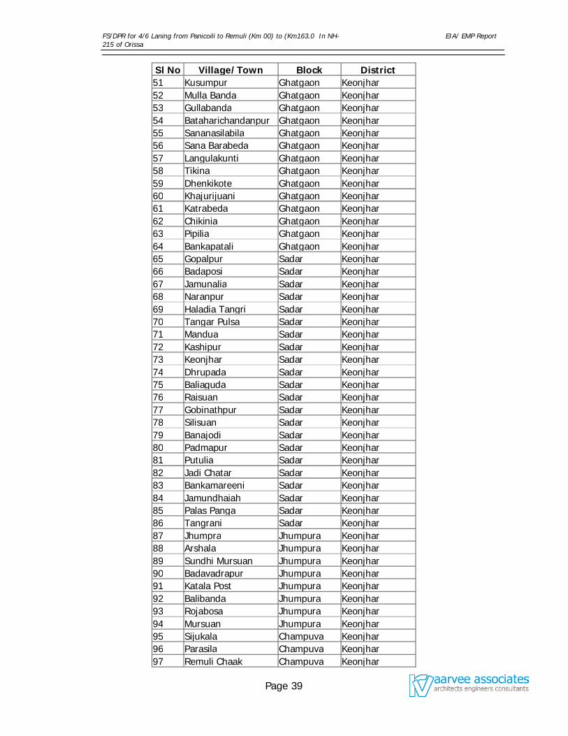
FS/DPR for 4/6 Laning from Panicoili to Remuli (Km 00) to (Km163.0 In NH-215 of Orissa
EIA/ EMP Report
Page 39
Sl No Village/Town Block District 51 Kusumpur Ghatgaon Keonjhar 52 Mulla Banda Ghatgaon Keonjhar 53 Gullabanda Ghatgaon Keonjhar 54 Bataharichandanpur Ghatgaon Keonjhar 55 Sananasilabila Ghatgaon Keonjhar 56 Sana Barabeda Ghatgaon Keonjhar 57 Langulakunti Ghatgaon Keonjhar 58 Tikina Ghatgaon Keonjhar 59 Dhenkikote Ghatgaon Keonjhar 60 Khajurijuani Ghatgaon Keonjhar 61 Katrabeda Ghatgaon Keonjhar 62 Chikinia Ghatgaon Keonjhar 63 Pipilia Ghatgaon Keonjhar 64 Bankapatali Ghatgaon Keonjhar 65 Gopalpur Sadar Keonjhar 66 Badaposi Sadar Keonjhar 67 Jamunalia Sadar Keonjhar 68 Naranpur Sadar Keonjhar 69 Haladia Tangri Sadar Keonjhar 70 Tangar Pulsa Sadar Keonjhar 71 Mandua Sadar Keonjhar 72 Kashipur Sadar Keonjhar 73 Keonjhar Sadar Keonjhar 74 Dhrupada Sadar Keonjhar 75 Baliaguda Sadar Keonjhar 76 Raisuan Sadar Keonjhar 77 Gobinathpur Sadar Keonjhar 78 Silisuan Sadar Keonjhar 79 Banajodi Sadar Keonjhar 80 Padmapur Sadar Keonjhar 81 Putulia Sadar Keonjhar 82 Jadi Chatar Sadar Keonjhar 83 Bankamareeni Sadar Keonjhar 84 Jamundhaiah Sadar Keonjhar 85 Palas Panga Sadar Keonjhar 86 Tangrani Sadar Keonjhar 87 Jhumpra Jhumpura Keonjhar 88 Arshala Jhumpura Keonjhar 89 Sundhi Mursuan Jhumpura Keonjhar 90 Badavadrapur Jhumpura Keonjhar 91 Katala Post Jhumpura Keonjhar 92 Balibanda Jhumpura Keonjhar 93 Rojabosa Jhumpura Keonjhar 94 Mursuan Jhumpura Keonjhar 95 Sijukala Champuva Keonjhar 96 Parasila Champuva Keonjhar 97 Remuli Chaak Champuva Keonjhar
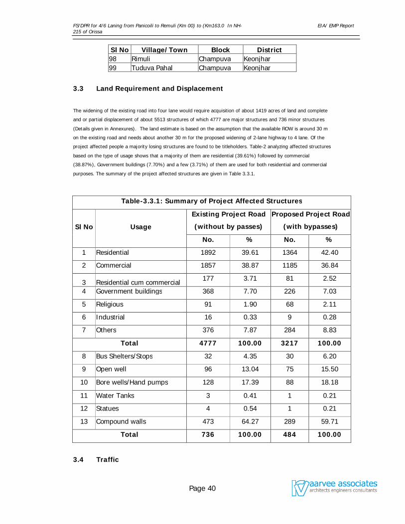
FS/DPR for 4/6 Laning from Panicoili to Remuli (Km 00) to (Km163.0 In NH-215 of Orissa
EIA/ EMP Report
Page 40
Sl No Village/Town Block District 98 Rimuli Champuva Keonjhar 99 Tuduva Pahal Champuva Keonjhar
3.3 Land Requirement and Displacement
The widening of the existing road into four lane would require acquisition of about 1419 acres of land and complete
and or partial displacement of about 5513 structures of which 4777 are major structures and 736 minor structures
(Details given in Annexures). The land estimate is based on the assumption that the available ROW is around 30 m
on the existing road and needs about another 30 m for the proposed widening of 2-lane highway to 4 lane. Of the
project affected people a majority losing structures are found to be titleholders. Table-2 analyzing affected structures
based on the type of usage shows that a majority of them are residential (39.61%) followed by commercial
(38.87%), Government buildings (7.70%) and a few (3.71%) of them are used for both residential and commercial
purposes. The summary of the project affected structures are given in Table 3.3.1.
Table-3.3.1: Summary of Project Affected Structures
Sl No Usage
Existing Project Road
(without by passes)
Proposed Project Road
(with bypasses)
No. % No. %
1 Residential 1892 39.61 1364 42.40
2 Commercial 1857 38.87 1185 36.84
3 Residential cum commercial 177 3.71 81 2.52
4 Government buildings 368 7.70 226 7.03
5 Religious 91 1.90 68 2.11
6 Industrial 16 0.33 9 0.28
7 Others 376 7.87 284 8.83
Total 4777 100.00 3217 100.00
8 Bus Shelters/Stops 32 4.35 30 6.20
9 Open well 96 13.04 75 15.50
10 Bore wells/Hand pumps 128 17.39 88 18.18
11 Water Tanks 3 0.41 1 0.21
12 Statues 4 0.54 1 0.21
13 Compound walls 473 64.27 289 59.71
Total 736 100.00 484 100.00
3.4 Traffic
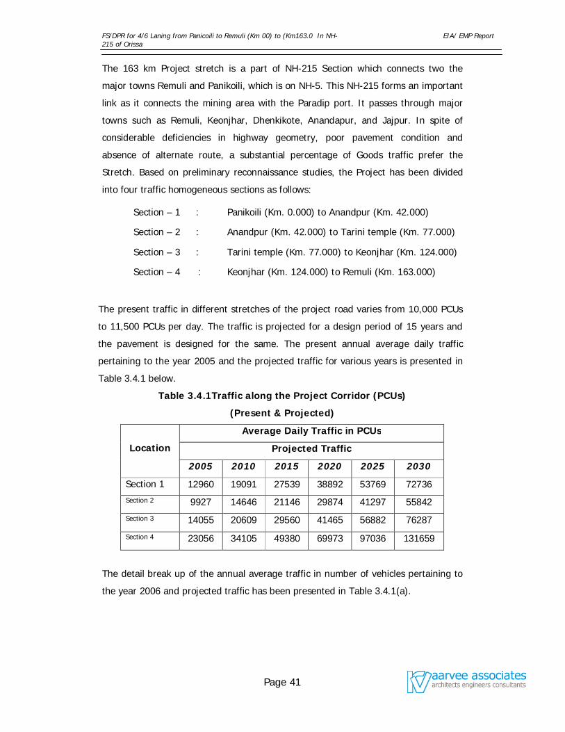
FS/DPR for 4/6 Laning from Panicoili to Remuli (Km 00) to (Km163.0 In NH-215 of Orissa
EIA/ EMP Report
Page 41
The 163 km Project stretch is a part of NH-215 Section which connects two the
major towns Remuli and Panikoili, which is on NH-5. This NH-215 forms an important
link as it connects the mining area with the Paradip port. It passes through major
towns such as Remuli, Keonjhar, Dhenkikote, Anandapur, and Jajpur. In spite of
considerable deficiencies in highway geometry, poor pavement condition and
absence of alternate route, a substantial percentage of Goods traffic prefer the
Stretch. Based on preliminary reconnaissance studies, the Project has been divided
into four traffic homogeneous sections as follows:
Section – 1 : Panikoili (Km. 0.000) to Anandpur (Km. 42.000)
Section – 2 : Anandpur (Km. 42.000) to Tarini temple (Km. 77.000)
Section – 3 : Tarini temple (Km. 77.000) to Keonjhar (Km. 124.000)
Section – 4 : Keonjhar (Km. 124.000) to Remuli (Km. 163.000)
The present traffic in different stretches of the project road varies from 10,000 PCUs
to 11,500 PCUs per day. The traffic is projected for a design period of 15 years and
the pavement is designed for the same. The present annual average daily traffic
pertaining to the year 2005 and the projected traffic for various years is presented in
Table 3.4.1 below.
Table 3.4.1Traffic along the Project Corridor (PCUs)
(Present & Projected)
Location
Average Daily Traffic in PCUs
Projected Traffic
2005 2010 2015 2020 2025 2030
Section 1 12960 19091 27539 38892 53769 72736
Section 2 9927 14646 21146 29874 41297 55842
Section 3 14055 20609 29560 41465 56882 76287
Section 4 23056 34105 49380 69973 97036 131659
The detail break up of the annual average traffic in number of vehicles pertaining to
the year 2006 and projected traffic has been presented in Table 3.4.1(a).
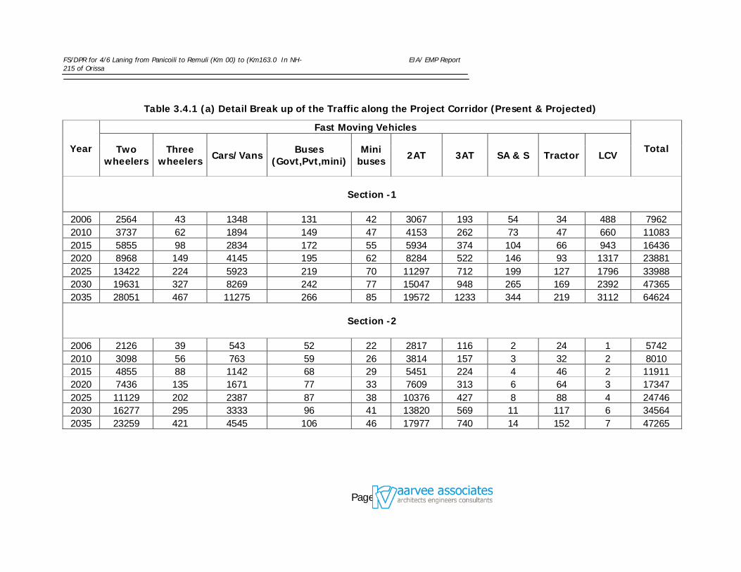
FS/DPR for 4/6 Laning from Panicoili to Remuli (Km 00) to (Km163.0 In NH-215 of Orissa
EIA/ EMP Report
Page 42
Table 3.4.1 (a) Detail Break up of the Traffic along the Project Corridor (Present & Projected)
Year
Fast Moving Vehicles
Total Two wheelers
Three wheelers Cars/Vans Buses
(Govt,Pvt,mini) Mini
buses 2AT 3AT SA & S Tractor LCV
Section -1
2006 2564 43 1348 131 42 3067 193 54 34 488 7962 2010 3737 62 1894 149 47 4153 262 73 47 660 11083 2015 5855 98 2834 172 55 5934 374 104 66 943 16436 2020 8968 149 4145 195 62 8284 522 146 93 1317 23881 2025 13422 224 5923 219 70 11297 712 199 127 1796 33988 2030 19631 327 8269 242 77 15047 948 265 169 2392 47365 2035 28051 467 11275 266 85 19572 1233 344 219 3112 64624
Section -2
2006 2126 39 543 52 22 2817 116 2 24 1 5742 2010 3098 56 763 59 26 3814 157 3 32 2 8010 2015 4855 88 1142 68 29 5451 224 4 46 2 11911 2020 7436 135 1671 77 33 7609 313 6 64 3 17347 2025 11129 202 2387 87 38 10376 427 8 88 4 24746 2030 16277 295 3333 96 41 13820 569 11 117 6 34564 2035 23259 421 4545 106 46 17977 740 14 152 7 47265
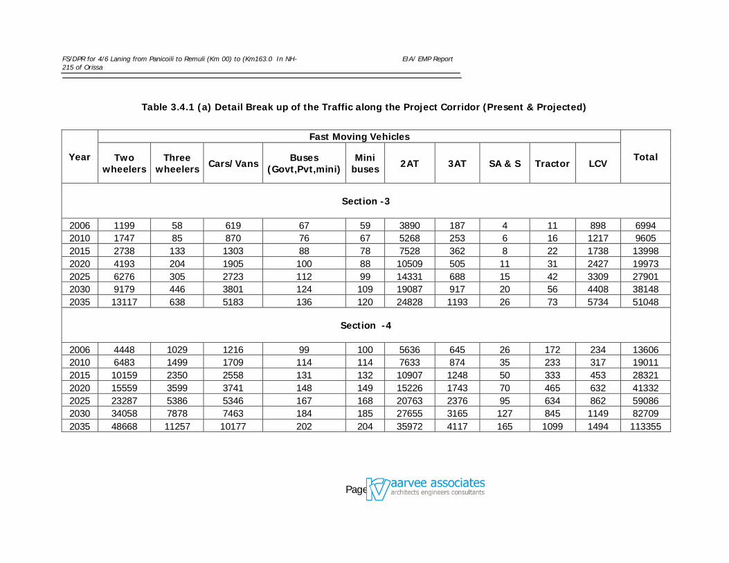
FS/DPR for 4/6 Laning from Panicoili to Remuli (Km 00) to (Km163.0 In NH-215 of Orissa
EIA/ EMP Report
Page 43
Table 3.4.1 (a) Detail Break up of the Traffic along the Project Corridor (Present & Projected)
Year
Fast Moving Vehicles
Total Two wheelers
Three wheelers Cars/Vans Buses
(Govt,Pvt,mini) Mini
buses 2AT 3AT SA & S Tractor LCV
Section -3
2006 1199 58 619 67 59 3890 187 4 11 898 6994 2010 1747 85 870 76 67 5268 253 6 16 1217 9605 2015 2738 133 1303 88 78 7528 362 8 22 1738 13998 2020 4193 204 1905 100 88 10509 505 11 31 2427 19973 2025 6276 305 2723 112 99 14331 688 15 42 3309 27901 2030 9179 446 3801 124 109 19087 917 20 56 4408 38148 2035 13117 638 5183 136 120 24828 1193 26 73 5734 51048
Section -4
2006 4448 1029 1216 99 100 5636 645 26 172 234 13606 2010 6483 1499 1709 114 114 7633 874 35 233 317 19011 2015 10159 2350 2558 131 132 10907 1248 50 333 453 28321 2020 15559 3599 3741 148 149 15226 1743 70 465 632 41332 2025 23287 5386 5346 167 168 20763 2376 95 634 862 59086 2030 34058 7878 7463 184 185 27655 3165 127 845 1149 82709 2035 48668 11257 10177 202 204 35972 4117 165 1099 1494 113355
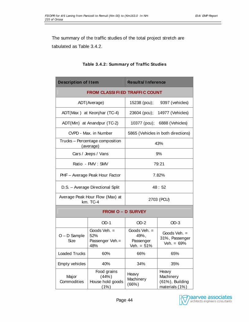
FS/DPR for 4/6 Laning from Panicoili to Remuli (Km 00) to (Km163.0 In NH-215 of Orissa
EIA/ EMP Report
Page 44
The summary of the traffic studies of the total project stretch are
tabulated as Table 3.4.2.
Table 3.4.2: Summary of Traffic Studies
Description of Item Results/Inference
FROM CLASSIFIED TRAFFIC COUNT
ADT(Average) 15238 (pcu); 9397 (vehicles)
ADT(Max ) at Keonjhar (TC-4) 23604 (pcu); 14977 (Vehicles)
ADT(Min) at Anandpur (TC-2) 10377 (pcu); 6888 (Vehicles)
CVPD - Max. in Number 5865 (Vehicles in both directions)
Trucks – Percentage composition (average)
43%
Cars / Jeeps / Vans 9%
Ratio - FMV : SMV 79:21
PHF – Average Peak Hour Factor 7.82%
D.S. – Average Directional Split 48 : 52
Average Peak Hour Flow (Max) at km. TC-4 2703 (PCU)
FROM O – D SURVEY
OD-1 OD-2 OD-3
O – D Sample Size
Goods Veh. = 52% Passenger Veh.= 48%
Goods Veh. = 49%,
Passenger Veh. = 51%
Goods Veh. = 31%, Passenger
Veh. = 69%
Loaded Trucks 60% 66% 65%
Empty vehicles 40% 34% 35%
Major Commodities
Food grains (44%)
House hold goods (1%)
Heavy Machinery (66%)
Heavy Machinery (61%), Building materials (1%)
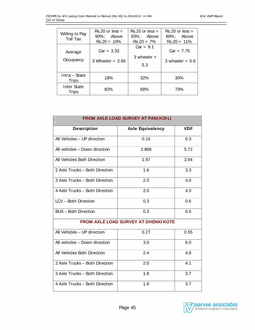
FS/DPR for 4/6 Laning from Panicoili to Remuli (Km 00) to (Km163.0 In NH-215 of Orissa
EIA/ EMP Report
Page 45
Willing to Pay Toll Tax
Rs.20 or less = 90%; Above Rs.20 = 10%
Rs.20 or less = 93%; Above Rs.20 = 7%
Rs.20 or less = 89%; Above Rs.20 = 11%
Average
Occupancy
Car = 3.33
3 Wheeler = 2.66
Car = 9.1
3 wheeler =
5.3
Car = 7.75
3 wheeler = 5.6
Intra – State Trips 18% 32% 30%
Inter State Trips 82% 68% 70%
FROM AXLE LOAD SURVEY AT PANIKOILI
Description Axle Equivalency VDF
All Vehicles – UP direction 0.15 0.3
All vehicles – Down direction 2.868 5.72
All Vehicles Both Direction 1.97 3.94
2 Axle Trucks – Both Direction 1.6 3.3
3 Axle Trucks – Both Direction 2.0 4.0
4 Axle Trucks – Both Direction 2.0 4.0
LCV – Both Direction 0.3 0.6
BUS – Both Direction 0.3 0.6
FROM AXLE LOAD SURVEY AT DHENKIKOTE
All Vehicles – UP direction 0.27 0.55
All vehicles – Down direction 3.0 6.0
All Vehicles Both Direction 2.4 4.8
2 Axle Trucks – Both Direction 2.0 4.1
3 Axle Trucks – Both Direction 1.8 3.7
4 Axle Trucks – Both Direction 1.8 3.7
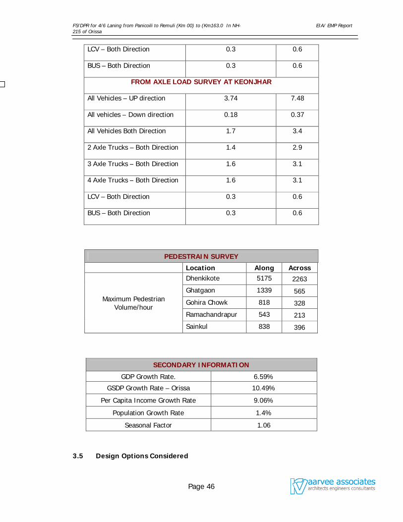
FS/DPR for 4/6 Laning from Panicoili to Remuli (Km 00) to (Km163.0 In NH-215 of Orissa
EIA/ EMP Report
Page 46
LCV – Both Direction 0.3 0.6
BUS – Both Direction 0.3 0.6
FROM AXLE LOAD SURVEY AT KEONJHAR
All Vehicles – UP direction 3.74 7.48
All vehicles – Down direction 0.18 0.37
All Vehicles Both Direction 1.7 3.4
2 Axle Trucks – Both Direction 1.4 2.9
3 Axle Trucks – Both Direction 1.6 3.1
4 Axle Trucks – Both Direction 1.6 3.1
LCV – Both Direction 0.3 0.6
BUS – Both Direction 0.3 0.6
PEDESTRAIN SURVEY
Location Along Across
Maximum Pedestrian Volume/hour
Dhenkikote 5175 2263
Ghatgaon 1339 565
Gohira Chowk 818 328
Ramachandrapur 543 213
Sainkul 838 396
SECONDARY INFORMATION
GDP Growth Rate. 6.59%
GSDP Growth Rate – Orissa 10.49%
Per Capita Income Growth Rate 9.06%
Population Growth Rate 1.4%
Seasonal Factor 1.06
3.5 Design Options Considered
FS/DPR for 4/6 Laning from Panicoili to Remuli (Km 00) to (Km163.0 In NH-215 of Orissa
EIA/ EMP Report
Page 47
The Design options considered are as follows:
Pavement Design standards are according to the current Indian Roads
Congress guidelines and ASHTO method.
For all improvement options and alternatives, a design life of 15 years has
been considered.
Upgradation options have been prepared with the aim to improve both
the structural and functional performance of the existing road.
Paved shoulders (1.5 m wide on either side) and hard shoulders (1.0 m
wide on either side) are also proposed for the upgradation options as per
IRC guidelines.
The roads are designed for a speed of 100 kmph maximum and an
absolute minimum of 80 kmph.
Minimum radius of horizontal curves for a speed of 100 kmph is 360 m.
However, efforts are made to provide a minimum radius of 400m.
Four Lane Configuration
Total formation width for the 4 lane carriageway is 25 m. Wherever land is not
available median is reduced. The configuration of four lanes consists the following:
7.25 m carriage way on either side
1.5 m wide paved shoulders on either side
1.0 m wide hard shoulders in either side
4.5 m wide median / central verge.
Side slopes adopted are 2:1 for all embankments and excavations
3.6 Environmental Impacts Assessment Decision Support System
(EIADSS) for Alternative Locations
The Environmental Impact Assessment Decision Support System assists decision-
makers to opt for alternative site locations in Highway project. The criteria used for
comparing project alternatives are not limited to the impacts of the project on the
physical environment such as natural resources and biological life, but also include
the impacts on socio-economics, political affairs as well as financial and economics.
FS/DPR for 4/6 Laning from Panicoili to Remuli (Km 00) to (Km163.0 In NH-215 of Orissa
EIA/ EMP Report
Page 48
Meanwhile, the method is flexible enough to account for the user’s preferences in
weighing the main categories of impacts criteria.
The EIADSS is developed in MS Excel using Environmental Audit Weightage
Percentage (EAWP) techniques for the comparison between project alternatives
based on all relevant aspects of the surrounding environment of a Highway project.
The first step behind the conceptual basis of the EIADSS was to identify the
environmental criteria that are susceptible to change due to Highway projects
construction or operation, and then categorize these criteria under main headings.
The Physical factors that were known to be responsible for changing the criteria
conditions were then identified. All the possible conditions of these factors were
determined and compiled in a questionnaire. The Impact criteria are mainly
categorized in to five (5) groups (viz. Natural Resource Impacts, Ecological impacts,
Socio-Economic Impacts, Political Impacts, Financial, and Economic Impacts). The
weightage percentage could be finalized using Data Capturing Instrument (DCI) and
for Highway project of this nature, the weightage percentages are as follows.
Sl No. Environmental category/ group Weighted
Percentage
1 Natural Resource Impacts 15
2. Ecological impacts 30
3. Socio-Economic Impacts 15
4. Political Impacts 15
5. Financial & Economic Impacts 25
Total 100
Each group again sub-divided into different environmental aspects, which will be
evaluated by using ‘Environment Impact Score’ instrument, which is given in Table
3.6.1.
Table 3.6.1: Environmental Impact Score instrument
Sl No. Description Points
FS/DPR for 4/6 Laning from Panicoili to Remuli (Km 00) to (Km163.0 In NH-215 of Orissa
EIA/ EMP Report
Page 49
1 No Occurrence 10
2 No adverse impacts 9-6
3 Negligible impact (low impact & low probability of occurrence) 5-2
4 Minor Impact (abnormal conditions which causes breach to
statutory regulations, effect and probability of occurrence are
low) (+)1 to (-)2
5 Significant Impact (the activity has an effect under normal
operating conditions and leading to breach of the statutory
regulations. Effects and probability of occurrence are moderate) (-)3 to (-)6
6 Major Impact (the activity has an major effect under regular
operating conditions and leading to major breach of the
statutory regulations. Effects and probability of occurrence are
extensive) (-)7 to (-)10
The score of environmental aspects of each group will be evaluated by using the
‘Environment Impact Score Instrument’. The expected positive and negative impacts
to be relatively associated with the different factors and conditions were integrated
in the EIADSS worksheets and the overall impact for the project alternatives will be
calculated. Based on the highest marks scored, the project alternative will be
finalized.
Basically this project is widening and strengthening of existing 2 lane to 4/6 lane
Project. Not much required to analyze on existing alignment as it is using same
alignment with minor modifications, except for bypasses. By considering the financial
aspects, socio-economic conditions, traffic load and environmental considerations
five bypasses have been proposed under this project namely Jajpur Bypass,
Ananadpur Bypass, Ghatagaon Bypass, Keonjhar Bypass, and Jhumpura Bypass.
The various alternatives of bypasses are evaluated by using EIADSS model and are
given Table no. 3.6.2 to 3.6.6 respectively. The detailed analyses of EIADSS are
enclosed as Annexure -1.
FS/DPR for 4/6 Laning from Panicoili to Remuli (Km 00) to (Km163.0 In NH-215 of Orissa
EIA/ EMP Report
Page 50
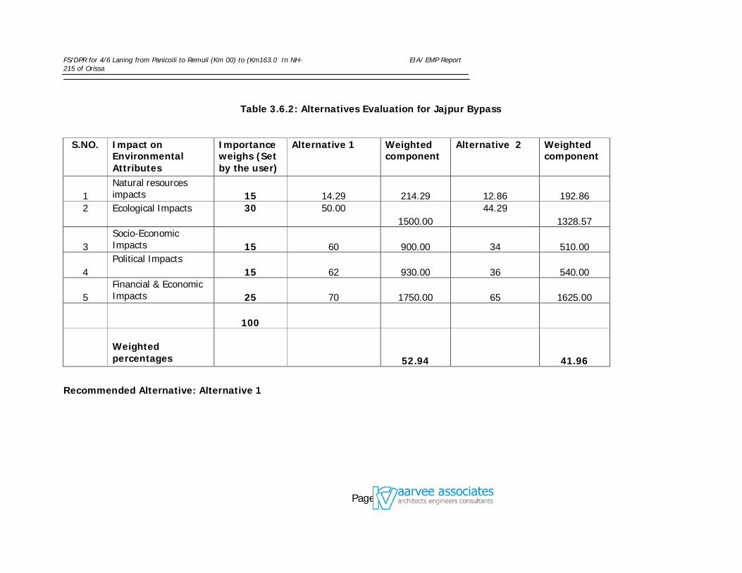
FS/DPR for 4/6 Laning from Panicoili to Remuli (Km 00) to (Km163.0 In NH-215 of Orissa
EIA/ EMP Report
Page 51
Table 3.6.2: Alternatives Evaluation for Jajpur Bypass
S.NO. Impact on Environmental Attributes
Importance weighs (Set by the user)
Alternative 1 Weighted component
Alternative 2 Weighted component
1 Natural resources impacts 15 14.29 214.29 12.86 192.86
2 Ecological Impacts 30 50.00 1500.00
44.29 1328.57
3 Socio-Economic Impacts 15 60 900.00 34 510.00
4 Political Impacts
15 62 930.00 36 540.00
5 Financial & Economic Impacts 25 70 1750.00 65 1625.00
100
Weighted percentages 52.94 41.96
Recommended Alternative: Alternative 1
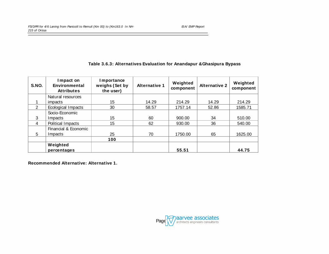
FS/DPR for 4/6 Laning from Panicoili to Remuli (Km 00) to (Km163.0 In NH-215 of Orissa
EIA/ EMP Report
Page 52
Table 3.6.3: Alternatives Evaluation for Anandapur &Ghasipura Bypass
S.NO. Impact on
Environmental Attributes
Importance weighs (Set by
the user) Alternative 1 Weighted
component Alternative 2 Weighted component
1 Natural resources impacts 15 14.29 214.29 14.29 214.29
2 Ecological Impacts 30 58.57 1757.14 52.86 1585.71
3 Socio-Economic Impacts 15 60 900.00 34 510.00
4 Political Impacts 15 62 930.00 36 540.00
5 Financial & Economic Impacts 25 70 1750.00 65 1625.00
100
Weighted percentages 55.51 44.75
Recommended Alternative: Alternative 1.
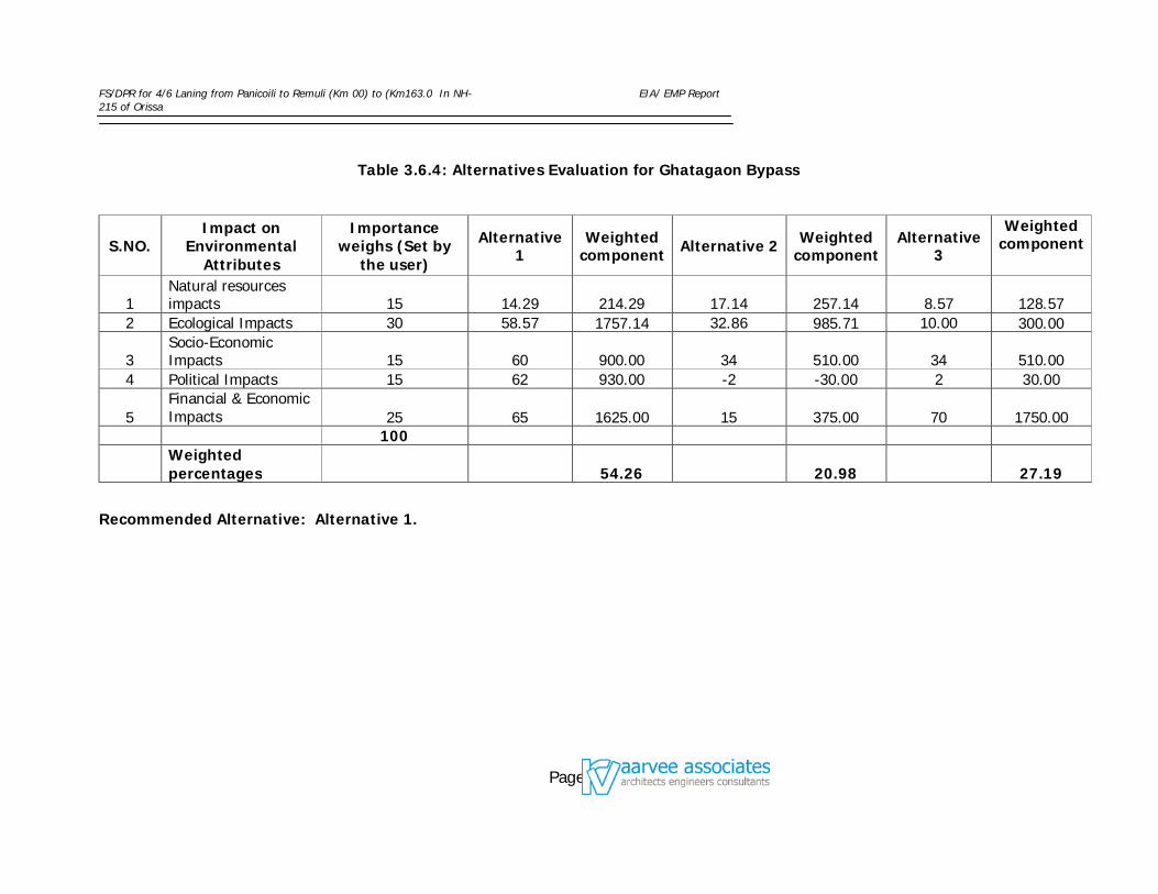
FS/DPR for 4/6 Laning from Panicoili to Remuli (Km 00) to (Km163.0 In NH-215 of Orissa
EIA/ EMP Report
Page 53
Table 3.6.4: Alternatives Evaluation for Ghatagaon Bypass
S.NO. Impact on
Environmental Attributes
Importance weighs (Set by
the user)
Alternative 1
Weighted component Alternative 2 Weighted
component Alternative
3
Weighted component
1 Natural resources impacts 15 14.29 214.29 17.14 257.14 8.57 128.57
2 Ecological Impacts 30 58.57 1757.14 32.86 985.71 10.00 300.00
3 Socio-Economic Impacts 15 60 900.00 34 510.00 34 510.00
4 Political Impacts 15 62 930.00 -2 -30.00 2 30.00
5 Financial & Economic Impacts 25 65 1625.00 15 375.00 70 1750.00
100
Weighted percentages 54.26 20.98 27.19
Recommended Alternative: Alternative 1.
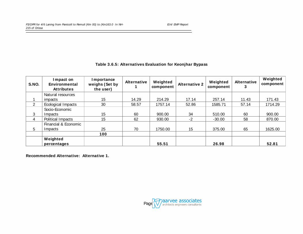
FS/DPR for 4/6 Laning from Panicoili to Remuli (Km 00) to (Km163.0 In NH-215 of Orissa
EIA/ EMP Report
Page 54
Table 3.6.5: Alternatives Evaluation for Keonjhar Bypass
S.NO. Impact on
Environmental Attributes
Importance weighs (Set by
the user)
Alternative 1
Weighted component Alternative 2 Weighted
component Alternative
3
Weighted component
1 Natural resources impacts 15 14.29 214.29 17.14 257.14 11.43 171.43
2 Ecological Impacts 30 58.57 1757.14 52.86 1585.71 57.14 1714.29
3 Socio-Economic Impacts 15 60 900.00 34 510.00 60 900.00
4 Political Impacts 15 62 930.00 -2 -30.00 58 870.00
5 Financial & Economic Impacts 25 70 1750.00 15 375.00 65 1625.00
100
Weighted percentages 55.51 26.98 52.81
Recommended Alternative: Alternative 1.
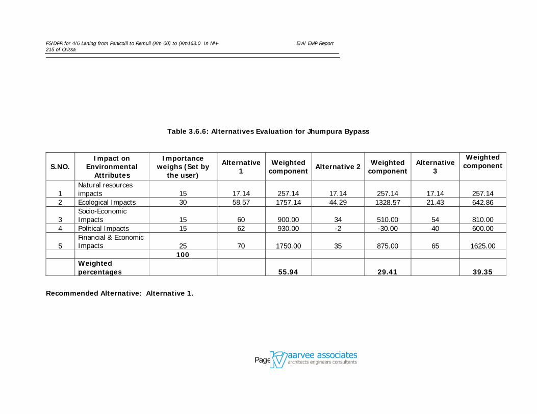
FS/DPR for 4/6 Laning from Panicoili to Remuli (Km 00) to (Km163.0 In NH-215 of Orissa
EIA/ EMP Report
Page 55
Table 3.6.6: Alternatives Evaluation for Jhumpura Bypass
S.NO. Impact on
Environmental Attributes
Importance weighs (Set by
the user)
Alternative 1
Weighted component Alternative 2 Weighted
component Alternative
3
Weighted component
1 Natural resources impacts 15 17.14 257.14 17.14 257.14 17.14 257.14
2 Ecological Impacts 30 58.57 1757.14 44.29 1328.57 21.43 642.86
3 Socio-Economic Impacts 15 60 900.00 34 510.00 54 810.00
4 Political Impacts 15 62 930.00 -2 -30.00 40 600.00
5 Financial & Economic Impacts 25 70 1750.00 35 875.00 65 1625.00
100
Weighted percentages 55.94 29.41 39.35
Recommended Alternative: Alternative 1.
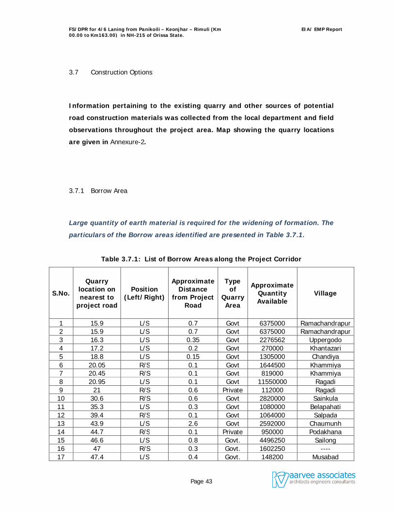
FS/DPR for 4/6 Laning from Panikoili – Keonjhar – Rimuli (Km 00.00 to Km163.00) in NH-215 of Orissa State.
EIA/ EMP Report
Page 43
3.7 Construction Options
Information pertaining to the existing quarry and other sources of potential
road construction materials was collected from the local department and field
observations throughout the project area. Map showing the quarry locations
are given in Annexure-2.
3.7.1 Borrow Area
Large quantity of earth material is required for the widening of formation. The
particulars of the Borrow areas identified are presented in Table 3.7.1.
Table 3.7.1: List of Borrow Areas along the Project Corridor
S.No.
Quarry location on nearest to
project road
Position (Left/Right)
Approximate Distance
from Project Road
Type of
Quarry Area
Approximate Quantity Available
Village
1 15.9 L/S 0.7 Govt 6375000 Ramachandrapur 2 15.9 L/S 0.7 Govt 6375000 Ramachandrapur 3 16.3 L/S 0.35 Govt 2276562 Uppergodo 4 17.2 L/S 0.2 Govt 270000 Khantazari 5 18.8 L/S 0.15 Govt 1305000 Chandiya 6 20.05 R/S 0.1 Govt 1644500 Khammiya 7 20.45 R/S 0.1 Govt 819000 Khammiya 8 20.95 L/S 0.1 Govt 11550000 Ragadi 9 21 R/S 0.6 Private 112000 Ragadi 10 30.6 R/S 0.6 Govt 2820000 Sainkula 11 35.3 L/S 0.3 Govt 1080000 Belapahati 12 39.4 R/S 0.1 Govt 1064000 Salpada 13 43.9 L/S 2.6 Govt 2592000 Chaumunh 14 44.7 R/S 0.1 Private 950000 Podakhana 15 46.6 L/S 0.8 Govt. 4496250 Sailong 16 47 R/S 0.3 Govt. 1602250 ---- 17 47.4 L/S 0.4 Govt. 148200 Musabad
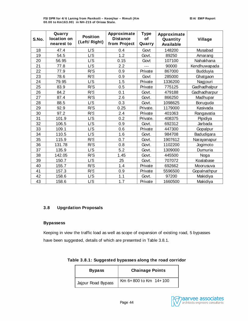
FS/DPR for 4/6 Laning from Panikoili – Keonjhar – Rimuli (Km 00.00 to Km163.00) in NH-215 of Orissa State.
EIA/ EMP Report
Page 44
S.No. Quarry
location on nearest to
project road
Position (Left/Right)
Approximate Distance
from Project Road
Type of
Quarry Area
Approximate Quantity Available
Village
18 47.4 L/S 0.4 Govt 148200 Musabad 19 54.5 L/S 1.2 Govt. 89250 Amarang 20 56.95 L/S 0.15 Govt 107100 Nahakhana 21 77.8 L/S 2.2 --- 90000 Kendhuwapada 22 77.9 R/S 0.9 Private 867000 Budduyia 23 78.6 R/S 0.9 Govt 285000 Ghatgaon 24 79.95 L/S 1.5 Private 1336200 Nagjouri 25 83.9 R/S 0.5 Private 775125 Gadhadhalpur 26 84.2 R/S 0.1 Govt. 479188 Gadhadharpur 27 87.4 R/S 2.6 Govt. 866250 Madhupar 28 88.5 L/S 0.3 Govt. 1098625 Boruguda 29 92.9 R/S 0.25 Private. 1179000 Kasivada 30 97.2 R/S 2.4 Private 401063 Rangavatia 31 101.9 L/S 0.2 Private. 408375 Pipidiya 32 106.5 L/S 0.9 Govt. 692312 Jarbada 33 109.1 L/S 0.6 Private 447300 Gopalpur 34 110.5 L/S 1.6 Govt. 984708 Badudigara 35 115.9 R/S 0.7 Govt. 1907612 Narayanapur 36 131.78 R/S 0.8 Govt. 1102200 Jogimoto 37 135.9 L/S 5.2 Govt. 1309000 Dumuria 38 142.05 R/S 1.45 Govt. 445500 Noga 39 150.7 L/S 25 Govt. 707072 Koalabase 40 155.7 R/S 1.4 Private 692662 Moorusuva 41 157.3 R/S 0.9 Private 5596500 Gopalnathpur 42 158.6 L/S 1.1 Govt. 97200 Makidiya 43 158.6 L/S 1.7 Private 1660500 Makidiya
3.8 Upgrdation Proposals
Bypassess
Keeping in view the traffic load as well as scope of expansion of existing road, 5 bypasses
have been suggested, details of which are presented in Table 3.8.1.
Table 3.8.1: Suggested bypasses along the road corridor
Bypass Chainage Points
Jajpur Road Bypass Km 6+800 to Km 14+100
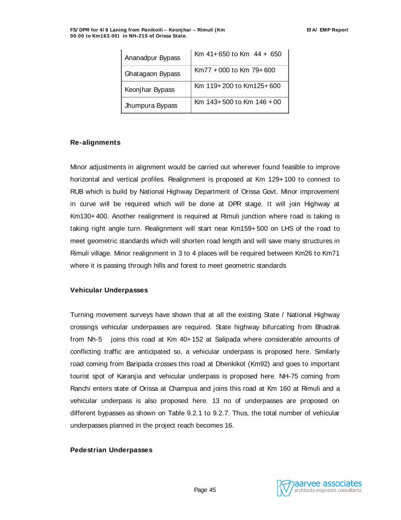
FS/DPR for 4/6 Laning from Panikoili – Keonjhar – Rimuli (Km 00.00 to Km163.00) in NH-215 of Orissa State.
EIA/ EMP Report
Page 45
Ananadpur Bypass Km 41+650 to Km 44 + 650
Ghatagaon Bypass Km77 +000 to Km 79+600
Keonjhar Bypass Km 119+200 to Km125+600
Jhumpura Bypass Km 143+500 to Km 146 +00
Re-alignments
Minor adjustments in alignment would be carried out wherever found feasible to improve
horizontal and vertical profiles. Realignment is proposed at Km 129+100 to connect to
RUB which is build by National Highway Department of Orissa Govt. Minor improvement
in curve will be required which will be done at DPR stage. It will join Highway at
Km130+400. Another realignment is required at Rimuli junction where road is taking is
taking right angle turn. Realignment will start near Km159+500 on LHS of the road to
meet geometric standards which will shorten road length and will save many structures in
Rimuli village. Minor realignment in 3 to 4 places will be required between Km26 to Km71
where it is passing through hills and forest to meet geometric standards
Vehicular Underpasses
Turning movement surveys have shown that at all the existing State / National Highway
crossings vehicular underpasses are required. State highway bifurcating from Bhadrak
from Nh-5 joins this road at Km 40+152 at Salipada where considerable amounts of
conflicting traffic are anticipated so, a vehicular underpass is proposed here. Similarly
road coming from Baripada crosses this road at Dhenkikot (Km92) and goes to important
tourist spot of Karanjia and vehicular underpass is proposed here. NH-75 coming from
Ranchi enters state of Orissa at Champua and joins this road at Km 160 at Rimuli and a
vehicular underpass is also proposed here. 13 no of underpasses are proposed on
different bypasses as shown on Table 9.2.1 to 9.2.7. Thus, the total number of vehicular
underpasses planned in the project reach becomes 16.
Pedestrian Underpasses
FS/DPR for 4/6 Laning from Panikoili – Keonjhar – Rimuli (Km 00.00 to Km163.00) in NH-215 of Orissa State.
EIA/ EMP Report
Page 46
It is proposed to prevent direct access from cross roads to the project road, through a
judicious combination of service roads and pedestrian underpasses with 3.0 m vertical
clearance and 8.5 m horizontal clearance. The extra cost on account of such
underpasses will be more than justified by way of decrease in the number of accidents
that would have otherwise occurred in the event of direct access to the Highway. The
number of such underpasses is estimated tentatively as 38.
Cattle / Animal Underpasses
It is proposed to provide animal underpasses in forest areas and cattle underpasses for
animals to cross to the other side of the village for fodder / water. The number of such
underpasses is estimated as 15. This type of underpasses will also be utilized by humans
and slow moving vehicles. In view of this, the underpass dimensions are kept as the
same as that for pedestrian underpass viz 8.5 m X 3.0 m.
ROBs
One ROB is proposed in Jajpur bypass no other ROB is required as one is recently built
by local NH department at Km 118. One RUB has been completed at Km 129+500.
Way Side Amenities
In accordance with NHAI guidelines and international practice, wayside amenities are
proposed at Km. 55 (LHS), Km 115 (LHS) and Km 131 (LHS).
Bus Lay byes
Bus Lay-Byes and Passenger Shelters will be provided at the locations of existing Bus
shelters that are dismantled in the process of road widening and also at anticipated
request stops. The number of such Bus Bays / Bus shelters is tentatively estimated as 40.
Toll Gates
FS/DPR for 4/6 Laning from Panikoili – Keonjhar – Rimuli (Km 00.00 to Km163.00) in NH-215 of Orissa State.
EIA/ EMP Report
Page 47
Toll collection gates are tentatively proposed at Km. 40 before Anandpur bypass starts
and at Km. 128 after end of Keonjhar bypass.
3.9 Project Cost
The project costs (financial) of the proposed road have been converted into economic
cost by using a standard conversion factor of 0.9, as suggested by the World Bank for
highway projects in India. The conversion factor of 0.9 has been applied to all cost items
except land acquisition cost and R&R cost. The economic cost excludes the cost of toll
plazas and the proportionate design & supervision cost for the same. A salvage value of
20% of capital cost has been considered in the terminal year for flexible pavements. The
project costs in financial and economic terms for different schemes are presented in
Table 3.9.1.
Table 3.9.1: Summary of Section-wise Capital Cost
Sl No
Without Bypasses With Bypasses
Length
Construction
cost Cost/ Km Length
Construction
cost Cost/ Km
1 163 10,202,344,986.60 62,591,073.54 168.11 11,288,649,096.10 69,255,515.44
Costs considered in the Economic Analysis
Section
Without Bypasses With Bypasses
Length Cost/ Km Length Cost/ Km
1 163 59,567,269.86 168.11 63,716,374.82
This chapter provides an overall description of the existing environmental status in the study region. Studies were undertaken to generate baseline data within a 7 km radius study region around the proposed project site on micro - meteorology, air quality, noise levels, ground and surface water quality, land environment including soil quality, geomorphology, land-use pattern, forest cover, biological environment, socio-economic and health status of the population, etc.
FS/DPR for 4/6 Laning from Panikoili – Keonjhar – Rimuli (Km 00.00 to Km163.00) in NH-215 of Orissa State.
EIA/ EMP Report
Page 48
4.1 Site and its Environs 4.1.1 Geographical features
This section contains a detailed description on existing environment of the proposed project area including physical and biological environment in the study districts and more particularly in the area of study. The project area is located in Orissa state covering two districts namely Jajpur (from 0 to 24 kms) and Keonjhar (24 to 163 kms).
Keonjhar is an importance district from geological and anthropological point of
view. Its mineral contents are varied and rich. Its iron ore, manganese ore and
chrome ore are rich as well as extensive. Two main-tribes from anthropological
point of view, the Juangs and the Bhuyans inhabit the district. The district lies
between 21o1’N and 22o10’N latitude and 85o11’E and 86o22’E longitude. The
whole of the district of Keonjhar was a princely state before its merger with Orissa
on the 1st of January 1948.
Similarly, the district of Jajpur lies within geographical coordinates of 20o34’57” to 21o8’52” North Latitude and 85o41’22” to 86o37’26” East Longitudes. As like Keonjhar district, Chrome and Iron deposits are extensive and the district is full of Industries. The district was carved out of Cuttack district and declared as a separate district on 2nd October 1992.
4.1.2 Topography
The district consists of a compact area and its extreme length from north to south is nearly 145 km and the average breadth from east to west is about 65 km. It is divided into two widely dissimilar tracts – the lower Keonjhar and the upper Keonjhar. The former is a region of valleys and low lands, while the latter includes mountainous highlands with a general slope from north to south. The mountainous tops appear from the low lands to be sharply ridged or peaked, but in reality they have extensive tablelands on their summits, fit both for pasture and for tillage. The average elevation in its central part is about 500m. At places, isolated hills rise abruptly from the plains. But most of the areas have a general elevation of over 600m, which form the watershed of some rivers. The River Baitarani takes its rise in the hilly northwestern division of the district.
The principal peaks are Gandhamardhan (1060m) about 10km from district headquarter, Mankadnacha (1117m) on the Bonai border, Gonasika (978m), Thakurani (915m), Tomka (785m), Bolat (554m), Khajara (918m), Ranga (897m), Mahaparbat (716m), Khandadhar Parbat (915m) and Sitabinji (670m).
FS/DPR for 4/6 Laning from Panikoili – Keonjhar – Rimuli (Km 00.00 to Km163.00) in NH-215 of Orissa State.
EIA/ EMP Report
Page 49
The rivers of the district emerge out of the hilly tracts into the plain country with great velocity and are charged with large volumes of water during monsoon. In summer they became almost dry. Their beds are usually rocky which render them unfit for navigation.
Jajpur district can be broadly subdivided into five distinct geomorphologic units,
namely, Structural hills, Residual and denudation hills, very deep buried pediment,
shallow to moderate (at places deep) buried pediment and alluvial plains. The
road section passes through the alluvial plains of the district. The alluvial deposits
are formed by the river systems of the Brahmani and Baitarani. The slope of the
tract is towards southeast and the altitude of the plain varies from 4 m to 25m
above mean sea level.
4.1.3 Geology
The geology of the project area is a part of the northern extension of the Deccan Plateau and is mostly underlain by Precambrian rocks. A very small percentage of the total area of the Keonjhar district is constituted of the quaternary to recent formations. These latter formations are chiefly confined to the wide river valleys. The oldest rock units exposed in this district comprise mica, sillimanite, hornblende, chlorite and quartz schist with some calc-magnesian gneisses and metavolcanic rocks grouped together in the older metamorphics. These rocks are exposed around Champua. Characterized by high metamorphism these rocks are intensely magnetized.
The study area under which road stretch is located are alluvial site, where in two
types of alluvium are found, the older alluvium and the new alluvium. The older
alluvium of Pleistocene age occurs in the areas fringing the Precambrian
crystallines and the younger alluvium. Older alluvial formations are overlying the
tertiary formations at places. The sediments are grey to brown in colour,
unfossiliferous but possess plenty of calcareous concentrations. Late rites are
commonly occurring as a thick capping over the obliterated ultramafics or as a
capping over the impure quartziteschistose rocks.
4.1.4 Soil
The project area falls under North Central Plateau Agro Climatic Zone of the Orissa State. The soils under this zone are laterite, red and
FS/DPR for 4/6 Laning from Panikoili – Keonjhar – Rimuli (Km 00.00 to Km163.00) in NH-215 of Orissa State.
EIA/ EMP Report
Page 50
yellow or mixed red and black. The elevation is medium with high to medium rainfall.
4.1.5 Minerals
The districts of Keonjhar and Jajpur are bestowed with extensive deposits of iron, manganese, chromites and a few other minor mineral
ores. Keonjhar district plays a major role in contributing sizeable production of iron ore. Similarly, more than 90% of the Orissa’s manganese ore production comes from the Keonjhar-Bonai area.
Important manganese ore deposits in the Keonjhar district are located in the areas of Gurda, Raida, Bhadrasahi, Sidhamatha, Nalda, Belkundi,
Barbil, Kora, Joda, Kalimati, Dhubana etc. Similarly, Jajpur district, more particularly Sukinda area possess about 90% of the total chromite
reserves of the country. Lot of mining activity is taking place in these two districts and NH – 215 is the only road used for transportation of ores to different industries located inside the Country as well export
through Paradeep port. 4.1.6 Industries
The project area is full of Industries. The Kalinga Nagar Industrial Complex of
Jajpur district is a distance of 9 kms from road corridor. All major Steel industries
like MESCO, Nilachal Ispat Nigam Limitel, VISA Industries and Jindal Industries
are located within this Industrial Complex. In Keonjhar district, Sponge Iron
Industries are located close to road corridor. The details of Industries, Brick kilns
located within a radius of 10 kms from Project road are presented in Table
4.1.6.1.
Table 4.1.6.1: Industries/Brick kilns located within the RoI of the road
stretch
Chainage LHS Distance from
RHS Distance from 0Km - 1Km Brick kiln 0km
FS/DPR for 4/6 Laning from Panikoili – Keonjhar – Rimuli (Km 00.00 to Km163.00) in NH-215 of Orissa State.
EIA/ EMP Report
Page 51
Chainage LHS Distance from
RHS Distance from
3Km - 4Km Chromites Ore Washing Plant at Alia
0km
Nobil Oxygen Factory 0km
24KM- 25Km MESCO, Nilachal, VISA & Jindal Factory
9km
26Km -27km Poultry Feed Company 4km
27KM - 28Km Barar Industry 2 km
35Km - 36Km Brick Kiln 250mts
38Km - 39Km Brick Kiln at Purunia 8km
40Km - 41Km Nilachal Industry at Tukuna
3km
Brick Kiln 7km
44Km - 45Km Brick Kiln 7km Brick Kiln 2km
45Km - 46Km Brick Kiln 5km
46Km - 47Km Brick Kiln 1km Brick kiln 1km
47Km - 48Km Brick Kiln 2km
51Km - 52Km Brick Kiln 0km Brick Kiln 7km
52Km - 53Km Brick Kiln 2km Brick Kiln 3nos 8km
63Km - 64Km Brick Kiln 0km
108Km - 109Km
Belati Orissa Ltd 2km
110Km - 111Km
Brick Kiln 1km
114Km - 115Km
OREAN Ispat Factory 3km Industry 5km
Brick Kiln 0km
115Km - 116Km
Brick Kiln 2km Brick Kiln 0km
116Km - 117Km
Brick Kiln 2km Electric Pole Factory 0km
126Km - 127Km
Sponge Iron Factory 8km
127Km - 128Km
Tile Factory at Raisuan
0km
128Km - 129Km
Brick Kiln 2km
129Km - 130Km
Brick Kiln 0km Brick Klin-4nos 0km
130Km - 131Km
Brick Kiln - 7nos 2km
138Km - 139Km
Brick Kiln 2km Jagannath Sponge Iron Factory
1km
Brand Alloys Industry 1km
139Km - 140Km
Brick Kiln - 3 nos 4km Jagannath Sponge Iron Factory
2km
FS/DPR for 4/6 Laning from Panikoili – Keonjhar – Rimuli (Km 00.00 to Km163.00) in NH-215 of Orissa State.
EIA/ EMP Report
Page 52
Chainage LHS Distance from
RHS Distance from
Brick Kiln - 2 nos 3km
140Km - 141Km
Brick Kiln 0km Bricks Kiln 1km
Jagannath Sponge Iron Factory
1km
141Km - 142Km
Orissa Sponge Iron Factory
0km
142Km - 143Km
Brick Kiln 0km Factory 4km
146Km - 147Km
Sponge Iron Factory 3km
147Km - 148Km
Iron factory 2km
150Km - 151Km
Sponge Iron factory 2km Brick Kiln 1km
151Km - 152Km
Blade factory 2km
Sponge Iron factory 10km
152Km - 153Km
Brick Kiln 0km Tile factory 0km
Brick Kiln - 1nos 1km
153Km - 154Km
Brick Kiln 1km Brick Kiln 1km
Kusum & Ganesh Factory
8km
156Km - 157Km
Brick Kiln 0km
157Km - 158Km
Brick Kiln .5km Brick Kiln 1km
158Km - 159Km
Brick Kiln 0km Brick Kiln 0km
161Km - 162Km
Brick Kiln 0km Brick Kiln 0km
4.1.7 Regional demography
The immediate surrounding within 2 km region of the proposed project site are thickly populated in major towns (i.e., Panikoili, Jajpur, Anandpur, Ghatagaon, Keonjhar, Champua , and Rimuli) and thinly populated in villages. The total population in the core zone is about 1, 03,119 with about 104 small and large villages. The main occupation of the villagers is agriculture, other services like mining, industrial workers, construction, trade and Transport, etc. 4.1.8 Infrastructure
The study region has well-developed and extensive infrastructural facilities in place. The power supply position is good and almost all the villages in Keonjhar and Jajpur districts are electrified. The district head quarters Keonjhar and Jajpur have facilities like housing, hospital, drinking water facility, school and technical
FS/DPR for 4/6 Laning from Panikoili – Keonjhar – Rimuli (Km 00.00 to Km163.00) in NH-215 of Orissa State.
EIA/ EMP Report
Page 53
education, medical college, etc. Emergency medical care and fire fighting facilities are also available at Panikoili, Jajpur, Anandpur, Keonjhar, and Champua along the proposed project corridor. 4.1.9 Archeological Sites/Places of Tourist Interest No archeological sites were present with in the region of influence. Some of the tourist interest places present are Laba Kusa Temple & Chikinia Park, Sitabijhini village, Maatarani Temple, Ghatagaon and Ghagra water fall near Keonjhar. 4.1.10 Seismocity of the area:
The project area falls under Zone-II (based on seismic zones - Map of India).
4.2 Meteorology of the Region Regional Meteorological and climatological data was compiled for Angul, Orissa , which is believed to be the nearest meteorological station from the project site, for a period of 1 year (May 2005 – April 2006).
4.2.1 Climate
The climate of the region is characterised as tropical. The climate, wind and wave pattern are governed by the annually changing monsoons and transition periods between them dividing the year into four seasons as given in Table 4.2.1.
Table 4.2.1 Seasons of the Region Season Months Characteristics Summer March-May Hottest part of the year, occurrence of dust
storms South-West monsoon
June-Sep Characterised by predominantly SW winds. Generally a strong and persistent wind prevails.
North-East monsoon
Oct-Nov Characterised by predominantly NE winds. Fair weather with the variable winds.
Winter Dec-Feb Cool season of the year
The climate is characterized by an oppressive hot summer, high humidity and well-distributed rainfall during the monsoon season. The year may be chiefly divided into four seasons, the hot season lasts from
March to May, the period from June to September is the south west monsoon season, October and November constitute the post monsoon
season and the cold season is from December to February.
FS/DPR for 4/6 Laning from Panikoili – Keonjhar – Rimuli (Km 00.00 to Km163.00) in NH-215 of Orissa State.
EIA/ EMP Report
Page 54
4.2.2 Temperature, Rainfall and Relative humidity
December and January are the coolest months of the year, while June to mid October is the rainy months. Nearly 90% of the annual rainfall is received during the SW monsoon. May and partly June are the hottest months of the year. The maximum and minimum temperatures range 36.6o - 46.6o C and 12.2o - 25.4o C respectively. The average relative humidity is in the range of 26.6 to 96.6 % during the rainy season. The average rainfall in the region is about 1254.9 mm. The climtological data obtained from the Angul, Orissa is shown in Tables 4.2.2. 4.2.3 Winds The winds in the study region are light to moderate and are strong during the monsoon season. During the summer season i.e., from March to May winds blow from Westerly & Northwesterly. In monsoon season i.e., from June to mid October winds blow from Westerly, Northwesterly & partially Easterly. During Post monsoon season (October to November) winds blow from Easterly & South Southeasterly. When it comes to winter season (December to February) winds blow from Northeasterly & Southeasterly. The average annual wind speed was found to be in the range of 0.0 to 7.3 m/s. The wind roses for a period of 1 year (May 2005 to April 2006) obtained from Anugul station is shown in figures 4.2.1 and 4.2.2.
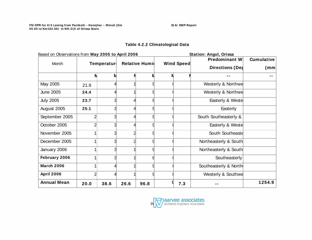
FS/DPR for 4/6 Laning from Panikoili – Keonjhar – Rimuli (Km 00.00 to Km163.00) in NH-215 of Orissa State.
EIA/ EMP Report
Page 55
Table 4.2.2 Climatological Data Based on Observations from May 2005 to April 2006 Station: Angul, Orissa
Month Temperature (Relative Humidity (%)Wind Speed (m/s)Predominant Wind
Directions (Deg.)
Cumulative Rainfall
(mm)
Min Max Min Max Min Max -- --
May 2005 21.9 46.0 13. 98.9 0. Westerly & Northwesterly
June 2005 24.4 46.6 16.0 99.0 0.0 Westerly & Northwesterly
July 2005 23.7 36.8 48.5 96.3 0.0 Easterly & Westerly
August 2005 25.1 38.7 45.4 99.0 0. Easterly
September 2005 25.4 38.1 46.3 99.0 0.0 South Southeasterly & Westerly
October 2005 24.2 36.2 41.6 99.0 0.0 Easterly & Westerly
November 2005 16.4 33.7 20.8 99.0 0.0 South Southeasterly
December 2005 12.3 30.6 23.2 94.3 0.0 Northeasterly & Southeasterly
January 2006 12.2 33.2 19.2 96.9 0.0 Northeasterly & Southeasterly
February 2006 14.3 39.3 12.3 87.4 0.0 Southeasterly
March 2006 19.1 41.3 13.0 93.3 0.0 Southeasterly & Northwesterly
April 2006 21.5 42.5 18.6 9 0.0 Westerly & Southwesterly
Annual Mean 20.0 38.6 26.6 96.8 0.07.3 -- 1254.9
FS/DPR for 4/6 Laning from Panikoili – Keonjhar – Rimuli (Km 00.00 to Km163.00) in NH-215 of Orissa State.
EIA/ EMP Report
Page 56
Figure 4.2.1: Wind rose diagram Figure 4.2.2: Wind rose diagram
FS/DPR for 4/6 Laning from Panikoili – Keonjhar – Rimuli (Km 00.00 to Km163.00) in NH-215 of Orissa State.
EIA/ EMP Report
Page 57
4.2.4 Onsite Meteorological Conditions At station Jajpur the predominant wind directions observed during winter season were mostly blowing from easterly. The wind speeds recorded during this period were in the range of 0.0 – 4.6 m/sec. The calm conditions during study period were found to be around 14.1%. Temperature and relative humidity were found to be in the range of 12.4 0C to 34.50C and 24.0 to 99% respectively. The onsite meteorological conditions are summarized as given in Table 4.2.4.
Table 4.2.4: Onsite meteorological conditions at Jajpur (M 1)
Parameter January 06 February 06 Minimum Maximum Minimum Maximum Temperature (0C) 12.4 32.6 13.3 34.5 Relative Humidity (%) 24.0 99.0 24.0 98.0 Wind Speed (m/sec) 0.0 4.5 0.0 4.6 Predominant wind Direction
Easterly Easterly
Rain fall (mm) 0.0 0.0
At station Keonjhar the predominant wind directions observed during winter season were mostly blowing from Southeast easterly. The wind speeds recorded during this period were in the range of 0.0 – 4.8 m/sec. The calm conditions during study period were found to be around 15.2%. Temperature and relative humidity were found to be in the range of 12.3 0C to 34.60C and 26 to 99% respectively. The onsite meteorological conditions are summarized as given in Table 4.2.5.
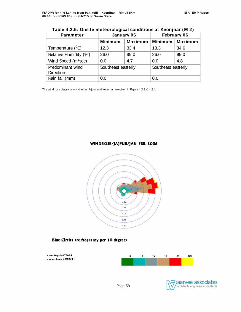
FS/DPR for 4/6 Laning from Panikoili – Keonjhar – Rimuli (Km 00.00 to Km163.00) in NH-215 of Orissa State.
EIA/ EMP Report
Page 58
Table 4.2.5: Onsite meteorological conditions at Keonjhar (M 2) Parameter January 06 February 06
Minimum Maximum Minimum Maximum Temperature (0C) 12.3 33.4 13.3 34.6 Relative Humidity (%) 26.0 99.0 26.0 99.0 Wind Speed (m/sec) 0.0 4.7 0.0 4.8 Predominant wind Direction
Southeast easterly Southeast easterly
Rain fall (mm) 0.0 0.0
The wind rose diagrams obtained at Jajpur and Keonjhar are given in Figure 4.2.3 & 4.2.4.
FS/DPR for 4/6 Laning from Panikoili – Keonjhar – Rimuli (Km 00.00 to Km163.00) in NH-215 of Orissa State.
EIA/ EMP Report
Page 59
Figure 4.2.3: Wind Rose Diagram Obtained at Jajpur for the Study Period
Fig. 4.2.3 Windrose Obtained at Adilabad During the Study Period Fig. 4.2.4 Windrose Obtained at Nirmal During the Study Period
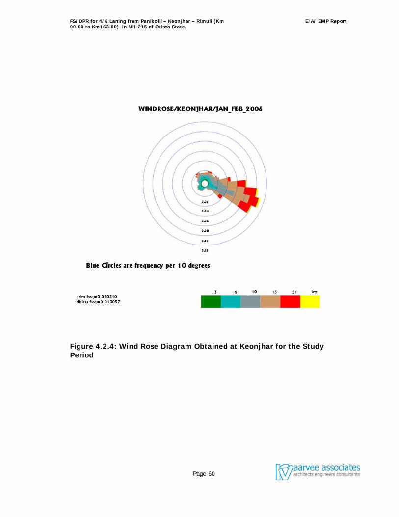
FS/DPR for 4/6 Laning from Panikoili – Keonjhar – Rimuli (Km 00.00 to Km163.00) in NH-215 of Orissa State.
EIA/ EMP Report
Page 60
Figure 4.2.4: Wind Rose Diagram Obtained at Keonjhar for the Study Period
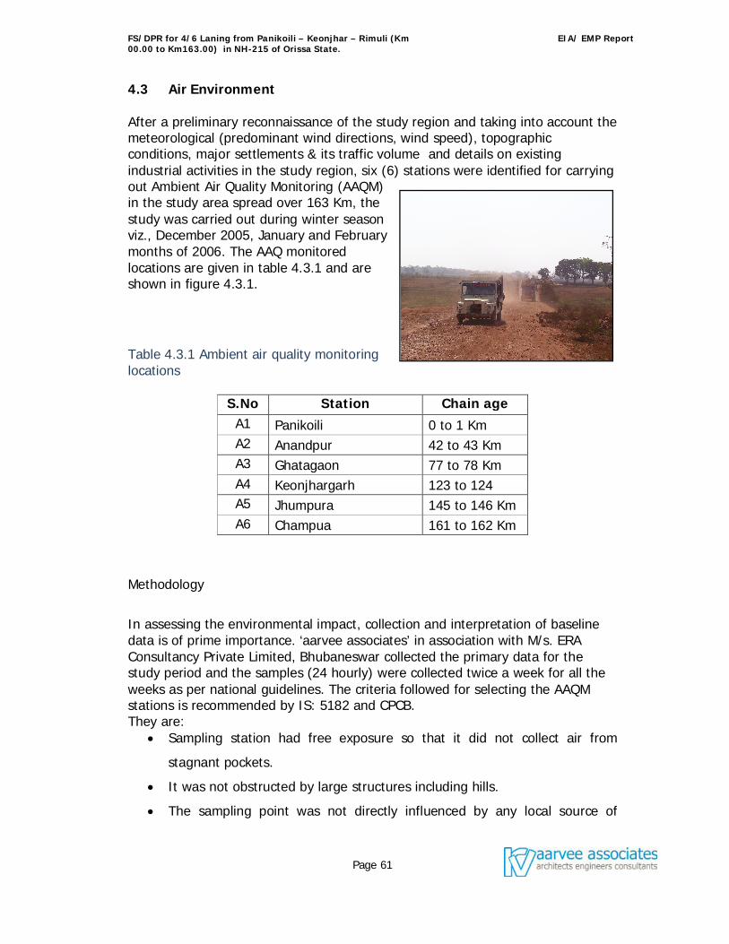
FS/DPR for 4/6 Laning from Panikoili – Keonjhar – Rimuli (Km 00.00 to Km163.00) in NH-215 of Orissa State.
EIA/ EMP Report
Page 61
4.3 Air Environment After a preliminary reconnaissance of the study region and taking into account the meteorological (predominant wind directions, wind speed), topographic conditions, major settlements & its traffic volume and details on existing industrial activities in the study region, six (6) stations were identified for carrying out Ambient Air Quality Monitoring (AAQM) in the study area spread over 163 Km, the study was carried out during winter season viz., December 2005, January and February months of 2006. The AAQ monitored locations are given in table 4.3.1 and are shown in figure 4.3.1.
Table 4.3.1 Ambient air quality monitoring locations
S.No Station Chain age A1 Panikoili 0 to 1 Km A2 Anandpur 42 to 43 Km A3 Ghatagaon 77 to 78 Km A4 Keonjhargarh 123 to 124 A5 Jhumpura 145 to 146 Km A6 Champua 161 to 162 Km
Methodology
In assessing the environmental impact, collection and interpretation of baseline data is of prime importance. ‘aarvee associates’ in association with M/s. ERA Consultancy Private Limited, Bhubaneswar collected the primary data for the study period and the samples (24 hourly) were collected twice a week for all the weeks as per national guidelines. The criteria followed for selecting the AAQM stations is recommended by IS: 5182 and CPCB. They are:
Sampling station had free exposure so that it did not collect air from
stagnant pockets.
It was not obstructed by large structures including hills.
The sampling point was not directly influenced by any local source of
FS/DPR for 4/6 Laning from Panikoili – Keonjhar – Rimuli (Km 00.00 to Km163.00) in NH-215 of Orissa State.
EIA/ EMP Report
Page 62
emission.
It was located at a minimum height of 1.5 m from the ground level.
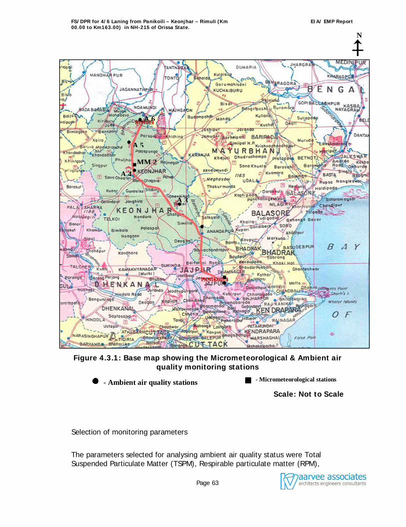
FS/DPR for 4/6 Laning from Panikoili – Keonjhar – Rimuli (Km 00.00 to Km163.00) in NH-215 of Orissa State.
EIA/ EMP Report
Page 63
Figure 4.3.1: Base map showing the Micrometeorological & Ambient air quality monitoring stations
Scale: Not to Scale
Selection of monitoring parameters
The parameters selected for analysing ambient air quality status were Total Suspended Particulate Matter (TSPM), Respirable particulate matter (RPM),
N
- Ambient air quality stations
MM 2
A 3
A 4
A 5
A 6
- Micrometeorological stations
FS/DPR for 4/6 Laning from Panikoili – Keonjhar – Rimuli (Km 00.00 to Km163.00) in NH-215 of Orissa State.
EIA/ EMP Report
Page 64
Nitrogen Oxides (NOx), Sulphur dioxide (SO2), and Carbon Monoxide (CO). Monitoring and analytical procedure
Ambient air quality was monitored for the presence of contaminants existing in the air. In order to evaluate and quantify the air pollution problem, measurements were carried out for various air pollutants mentioned above. This data was used not only to evaluate the air quality in the study region but also as the basis to develop programs aiming at preventing the spread of pollutants leading to a risk for human health and general environment. Respirable Dust Samplers (RDS) were used for ambient air sampling of selected parameters. The method for the selected parameters are based on the methods recommended by IS: 5182.
Data analysis
The observed concentrations of various pollutants at all the sampling stations were processed for different statistical parameters like arithmetic mean, minimum concentration, and maximum concentration and percentile values (75th & 98th). The existing baseline levels obtained during the study period at Panikoili, Anandpur, Ghatagaon, Keonjhar, Jhumpura, and Champua are presented in Table 4.3.2.
All the stations, where AAQM was carried out falls under Residential
category. The recorded concentrations are compared with the National
Ambient Air Quality Standards as notified on 11.04.1994 by CPCB. As
can be seen from table 4.3.2 the ambient air quality levels for all the
parameters monitored are well within the CPCB standards except TSPM,
the TSPM values at all monitored locations with respect to Maximum,
and 98 percentile are found to be exceeding its stipulated limit of 200
g/m3 except, at Ghatagaon. However, mean and 75 percentile values
of Panikoili, Ghatagaon, Jhumpura, and Champua are well within the
stipulated limit. The values of TSPM are in the range of 121 - 322
g/m3, minimum has been observed at Ghatgaon and maximum has
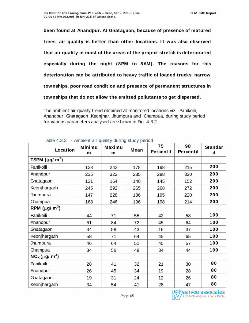
FS/DPR for 4/6 Laning from Panikoili – Keonjhar – Rimuli (Km 00.00 to Km163.00) in NH-215 of Orissa State.
EIA/ EMP Report
Page 65
been found at Anandpur. At Ghatagaon, because of presence of matured
trees, air quality is better than other locations. It was also observed
that air quality in most of the areas of the project stretch is deteriorated
especially during the night (8PM to 8AM). The reasons for this
deterioration can be attributed to heavy traffic of loaded trucks, narrow
townships, poor road condition and presence of permanent structures in
townships that do not allow the emitted pollutants to get dispersed.
The ambient air quality trend obtained at monitored locations viz., Panikoili, Anandpur, Ghatagaon ,Keonjhar, Jhumpura and ,Champua, during study period for various parameters analysed are shown in Fig. 4.3.2.
Table 4.3.2 - Ambient air quality during study period
Location Minimum
Maximum Mean
75 Percentil
e
98 Percentil
e
Standard
TSPM (g/m3)
Panikoili 128 242 178 198 215 200
Anandpur 235 322 285 298 320 200 Ghatagaon 121 164 140 145 152 200 Keonjhargarh 245 292 265 268 272 200 Jhumpura 147 228 186 195 220 200 Champua 168 246 196 198 214 200 RPM (g/m3)
Panikoili 44 71 55 42 58 100
Anandpur 61 84 72 45 64 100 Ghatagaon 34 58 43 16 37 100 Keonjhargarh 58 71 64 45 65 100 Jhumpura 46 64 51 45 57 100 Champua 34 56 48 34 44 100 NOX (g/m3)
Panikoili 28 41 32 21 30 80
Anandpur 26 45 34 19 28 80
Ghatagaon 19 31 24 12 26 80
Keonjhargarh 34 54 41 28 47 80
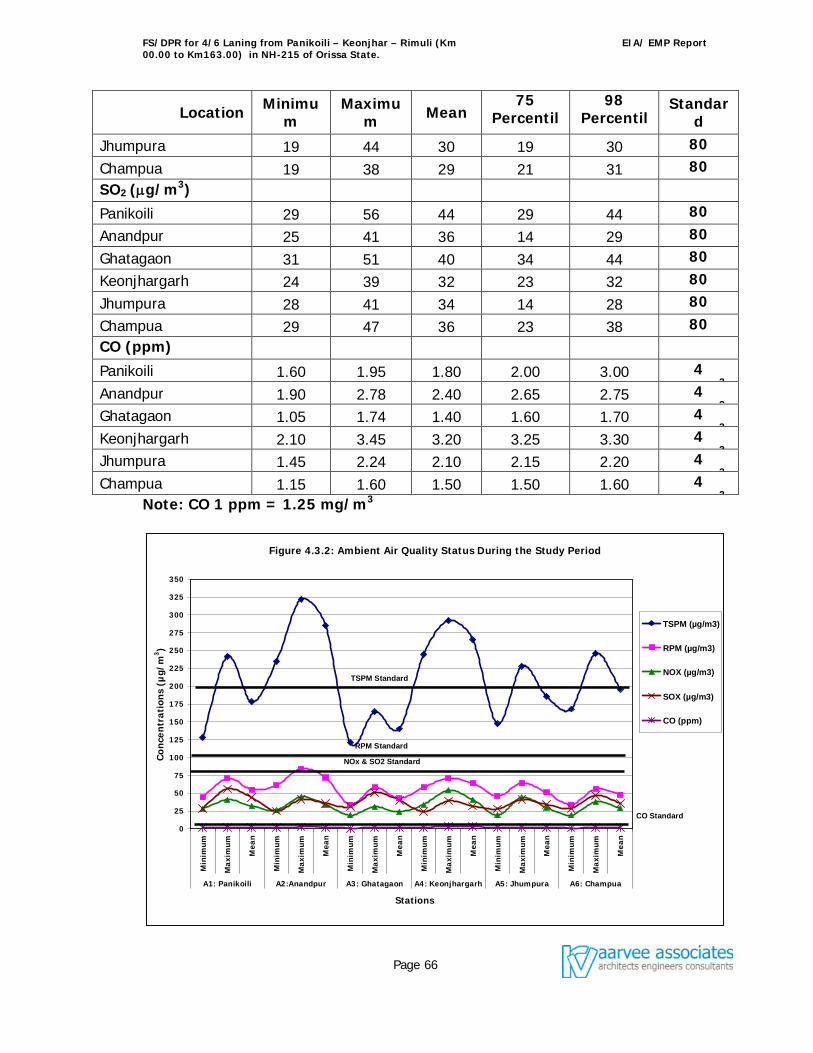
FS/DPR for 4/6 Laning from Panikoili – Keonjhar – Rimuli (Km 00.00 to Km163.00) in NH-215 of Orissa State.
EIA/ EMP Report
Page 66
Location Minimum
Maximum Mean
75 Percentil
e
98 Percentil
e
Standard
Jhumpura 19 44 30 19 30 80
Champua 19 38 29 21 31 80 SO2 (g/m3)
Panikoili 29 56 44 29 44 80
Anandpur 25 41 36 14 29 80
Ghatagaon 31 51 40 34 44 80
Keonjhargarh 24 39 32 23 32 80
Jhumpura 28 41 34 14 28 80
Champua 29 47 36 23 38 80 CO (ppm)
Panikoili 1.60 1.95 1.80 2.00 3.00 4 mg/m3 Anandpur 1.90 2.78 2.40 2.65 2.75 4 mg/m3 Ghatagaon 1.05 1.74 1.40 1.60 1.70 4 mg/m3 Keonjhargarh 2.10 3.45 3.20 3.25 3.30 4 mg/m3 Jhumpura 1.45 2.24 2.10 2.15 2.20 4 mg/m3 Champua 1.15 1.60 1.50 1.50 1.60 4 mg/m3 Note: CO 1 ppm = 1.25 mg/m3
Figure 4.3.2: Ambient Air Quality Status During the Study Period
0
25
50
75
100
125
150
175
200
225
250
275
300
325
350
Min
imum
Max
imum
Mea
n
Min
imum
Max
imum
Mea
n
Min
imum
Max
imum
Mea
n
Min
imum
Max
imum
Mea
n
Min
imum
Max
imum
Mea
n
Min
imum
Max
imum
Mea
n
A1: Panikoili A2:Anandpur A3: Ghatagaon A4: Keonjhargarh A5: Jhumpura A6: Champua
Stations
Co
nce
ntr
atio
ns
(µg/
m3)
TSPM (µg/m3)
RPM (µg/m3)
NOX (µg/m3)
SOX (µg/m3)
CO (ppm)
TSPM Standard
RPM Standard
NOx & SO2 Standard
CO Standard
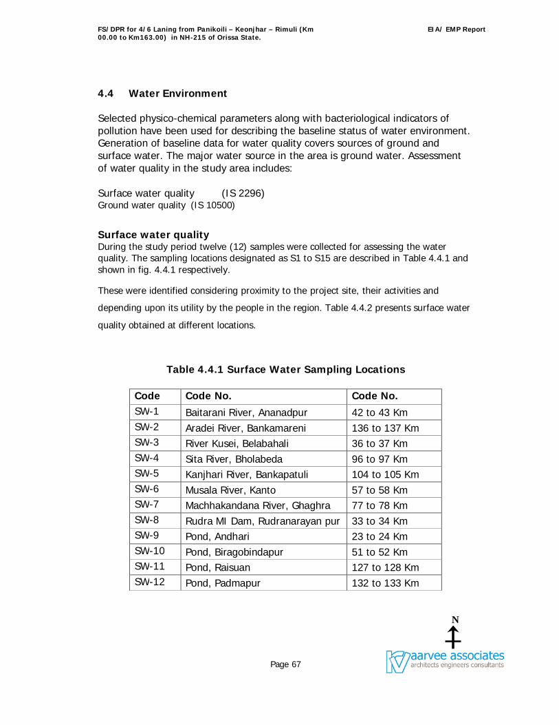
FS/DPR for 4/6 Laning from Panikoili – Keonjhar – Rimuli (Km 00.00 to Km163.00) in NH-215 of Orissa State.
EIA/ EMP Report
Page 67
4.4 Water Environment Selected physico-chemical parameters along with bacteriological indicators of pollution have been used for describing the baseline status of water environment. Generation of baseline data for water quality covers sources of ground and surface water. The major water source in the area is ground water. Assessment of water quality in the study area includes: Surface water quality (IS 2296) Ground water quality (IS 10500)
Surface water quality During the study period twelve (12) samples were collected for assessing the water quality. The sampling locations designated as S1 to S15 are described in Table 4.4.1 and shown in fig. 4.4.1 respectively.
These were identified considering proximity to the project site, their activities and
depending upon its utility by the people in the region. Table 4.4.2 presents surface water
quality obtained at different locations.
Table 4.4.1 Surface Water Sampling Locations
Code No.
Code No. Code No. SW-1 Baitarani River, Ananadpur 42 to 43 Km SW-2 Aradei River, Bankamareni 136 to 137 Km SW-3 River Kusei, Belabahali 36 to 37 Km SW-4 Sita River, Bholabeda 96 to 97 Km SW-5 Kanjhari River, Bankapatuli 104 to 105 Km SW-6 Musala River, Kanto 57 to 58 Km SW-7 Machhakandana River, Ghaghra 77 to 78 Km SW-8 Rudra MI Dam, Rudranarayan pur 33 to 34 Km SW-9 Pond, Andhari 23 to 24 Km SW-10 Pond, Biragobindapur 51 to 52 Km SW-11 Pond, Raisuan 127 to 128 Km SW-12 Pond, Padmapur 132 to 133 Km
N
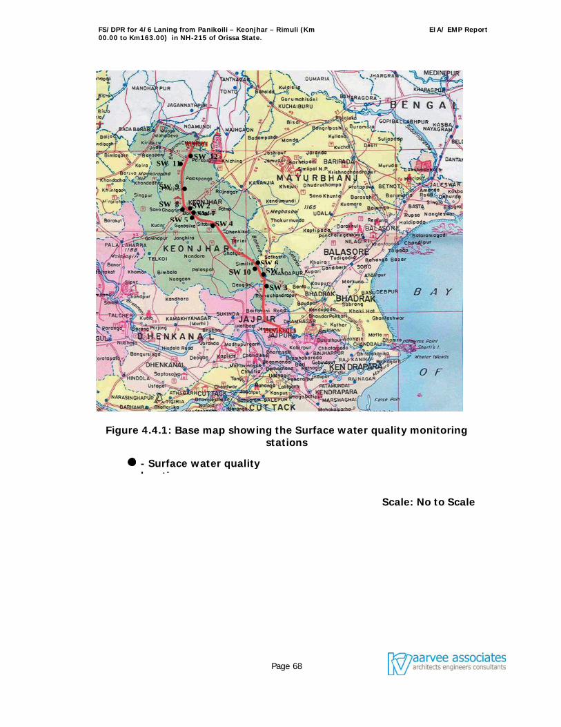
FS/DPR for 4/6 Laning from Panikoili – Keonjhar – Rimuli (Km 00.00 to Km163.00) in NH-215 of Orissa State.
EIA/ EMP Report
Page 68
Figure 4.4.1: Base map showing the Surface water quality monitoring stations
Scale: No to Scale
- Surface water quality locations
SW 1
SW 3
SW 6
SW 4 SW 7
SW 5
SW 8
SW 12 SW 11
SW 10
SW 2
SW 9
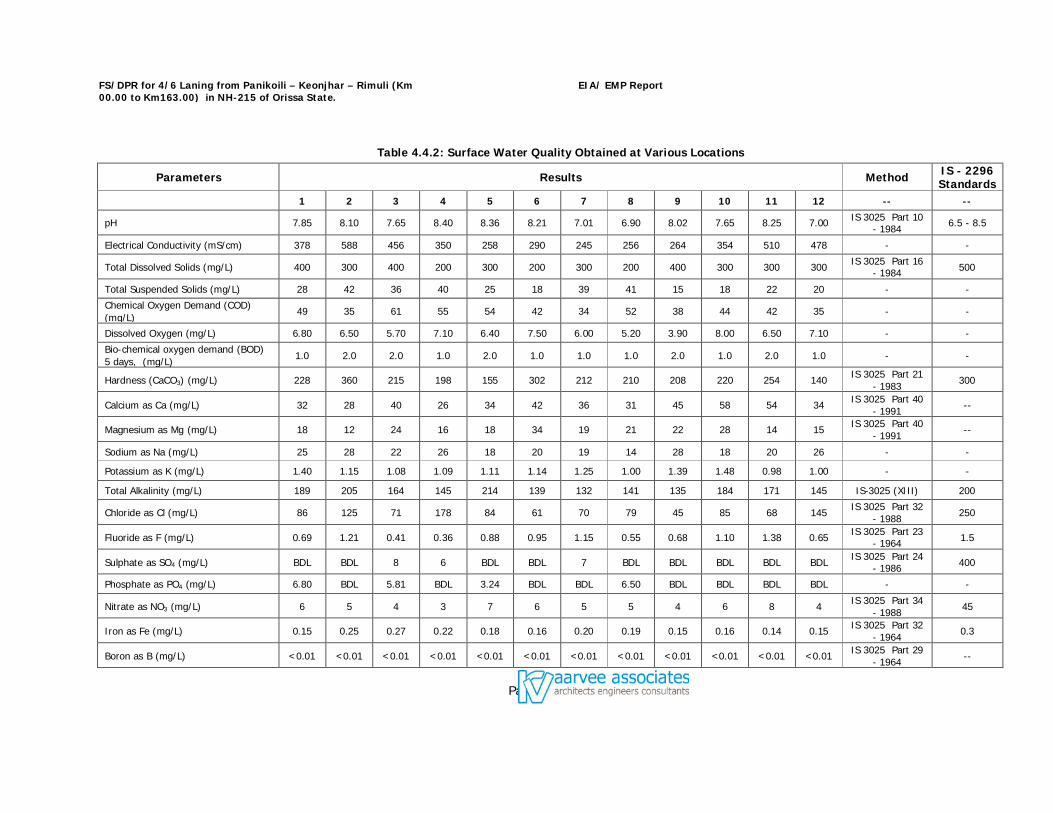
FS/DPR for 4/6 Laning from Panikoili – Keonjhar – Rimuli (Km 00.00 to Km163.00) in NH-215 of Orissa State.
EIA/ EMP Report
Page 69
Table 4.4.2: Surface Water Quality Obtained at Various Locations
Parameters Results Method IS - 2296 Standards
1 2 3 4 5 6 7 8 9 10 11 12 -- --
pH 7.85 8.10 7.65 8.40 8.36 8.21 7.01 6.90 8.02 7.65 8.25 7.00 IS 3025 Part 10 - 1984 6.5 - 8.5
Electrical Conductivity (mS/cm) 378 588 456 350 258 290 245 256 264 354 510 478 - -
Total Dissolved Solids (mg/L) 400 300 400 200 300 200 300 200 400 300 300 300 IS 3025 Part 16 - 1984 500
Total Suspended Solids (mg/L) 28 42 36 40 25 18 39 41 15 18 22 20 - -
Chemical Oxygen Demand (COD) (mg/L)
49 35 61 55 54 42 34 52 38 44 42 35 - -
Dissolved Oxygen (mg/L) 6.80 6.50 5.70 7.10 6.40 7.50 6.00 5.20 3.90 8.00 6.50 7.10 - -
Bio-chemical oxygen demand (BOD) 5 days, (mg/L) 1.0 2.0 2.0 1.0 2.0 1.0 1.0 1.0 2.0 1.0 2.0 1.0 - -
Hardness (CaCO3) (mg/L) 228 360 215 198 155 302 212 210 208 220 254 140 IS 3025 Part 21 - 1983 300
Calcium as Ca (mg/L) 32 28 40 26 34 42 36 31 45 58 54 34 IS 3025 Part 40 - 1991 --
Magnesium as Mg (mg/L) 18 12 24 16 18 34 19 21 22 28 14 15 IS 3025 Part 40 - 1991 --
Sodium as Na (mg/L) 25 28 22 26 18 20 19 14 28 18 20 26 - -
Potassium as K (mg/L) 1.40 1.15 1.08 1.09 1.11 1.14 1.25 1.00 1.39 1.48 0.98 1.00 - -
Total Alkalinity (mg/L) 189 205 164 145 214 139 132 141 135 184 171 145 IS-3025 (XIII) 200
Chloride as Cl (mg/L) 86 125 71 178 84 61 70 79 45 85 68 145 IS 3025 Part 32 - 1988 250
Fluoride as F (mg/L) 0.69 1.21 0.41 0.36 0.88 0.95 1.15 0.55 0.68 1.10 1.38 0.65 IS 3025 Part 23 - 1964 1.5
Sulphate as SO4 (mg/L) BDL BDL 8 6 BDL BDL 7 BDL BDL BDL BDL BDL IS 3025 Part 24 - 1986 400
Phosphate as PO4 (mg/L) 6.80 BDL 5.81 BDL 3.24 BDL BDL 6.50 BDL BDL BDL BDL - -
Nitrate as NO3 (mg/L) 6 5 4 3 7 6 5 5 4 6 8 4 IS 3025 Part 34 - 1988 45
Iron as Fe (mg/L) 0.15 0.25 0.27 0.22 0.18 0.16 0.20 0.19 0.15 0.16 0.14 0.15 IS 3025 Part 32 - 1964 0.3
Boron as B (mg/L) <0.01 <0.01 <0.01 <0.01 <0.01 <0.01 <0.01 <0.01 <0.01 <0.01 <0.01 <0.01 IS 3025 Part 29 - 1964 --
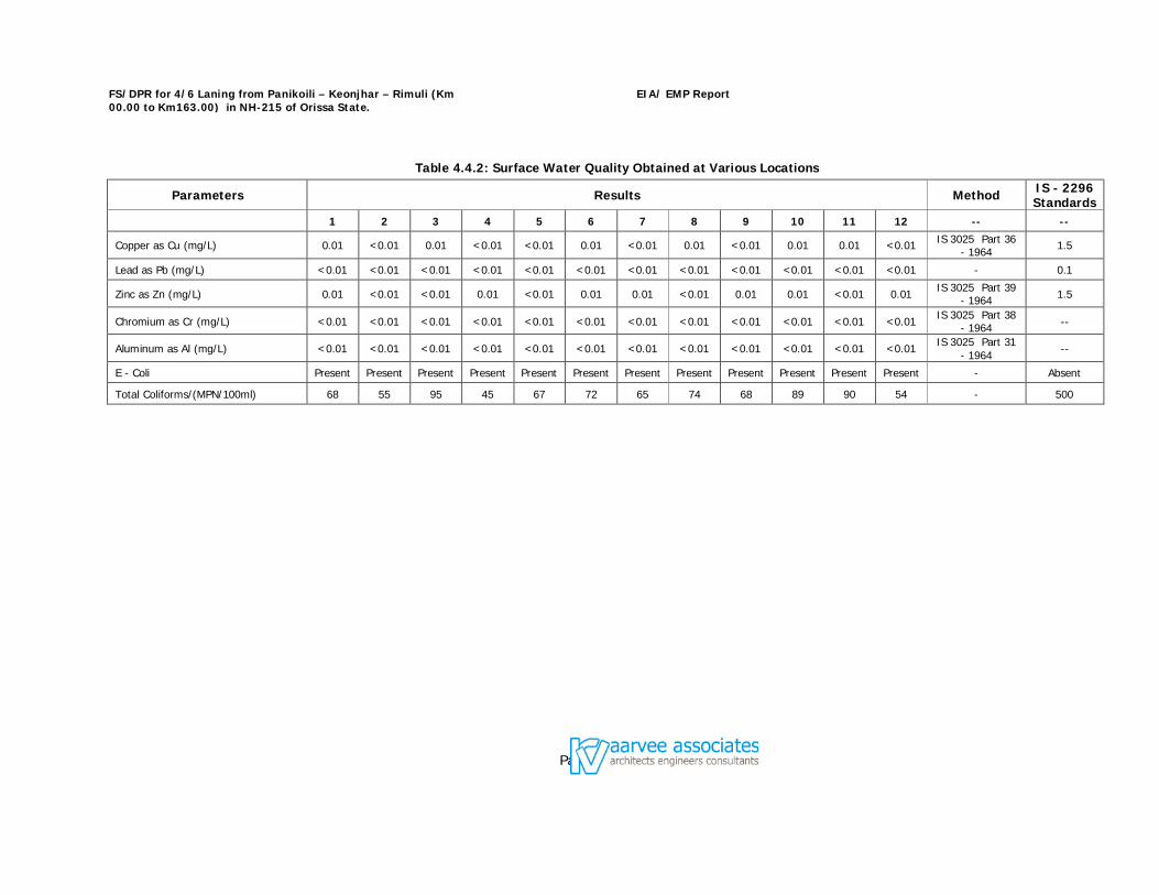
FS/DPR for 4/6 Laning from Panikoili – Keonjhar – Rimuli (Km 00.00 to Km163.00) in NH-215 of Orissa State.
EIA/ EMP Report
Page 70
Table 4.4.2: Surface Water Quality Obtained at Various Locations
Parameters Results Method IS - 2296 Standards
1 2 3 4 5 6 7 8 9 10 11 12 -- --
Copper as Cu (mg/L) 0.01 <0.01 0.01 <0.01 <0.01 0.01 <0.01 0.01 <0.01 0.01 0.01 <0.01 IS 3025 Part 36 - 1964 1.5
Lead as Pb (mg/L) <0.01 <0.01 <0.01 <0.01 <0.01 <0.01 <0.01 <0.01 <0.01 <0.01 <0.01 <0.01 - 0.1
Zinc as Zn (mg/L) 0.01 <0.01 <0.01 0.01 <0.01 0.01 0.01 <0.01 0.01 0.01 <0.01 0.01 IS 3025 Part 39 - 1964 1.5
Chromium as Cr (mg/L) <0.01 <0.01 <0.01 <0.01 <0.01 <0.01 <0.01 <0.01 <0.01 <0.01 <0.01 <0.01 IS 3025 Part 38 - 1964 --
Aluminum as Al (mg/L) <0.01 <0.01 <0.01 <0.01 <0.01 <0.01 <0.01 <0.01 <0.01 <0.01 <0.01 <0.01 IS 3025 Part 31 - 1964 --
E - Coli Present Present Present Present Present Present Present Present Present Present Present Present - Absent
Total Coliforms/(MPN/100ml) 68 55 95 45 67 72 65 74 68 89 90 54 - 500
FS/DPR for 4/6 Laning from Panikoili – Keonjhar – Rimuli (Km 00.00 to Km163.00) in NH-215 of Orissa State.
EIA/ EMP Report
Page 71
Data analysis The surface water samples collected from the various sources showed pH value ranging in between 6.9 to 8.4, this has reflected in alkalinity and hardness values. Electrical conductivity values were ranged between 245 to 588 S/cm. Water quality shows that the alkalinity and hardness values are consistent. The alkalinity values are in the range of 132 to 214 mg/l and hardness values are in the range of 155 to 360 mg/l both of them slightly exceeding its limit 200 & 300 mg/L respectively at least two locations. The contribution of calcium is more than magnesium to the total hardness, which is reflected clearly from calcium and magnesium values. The dissolved oxygen in the sources is ranging between 3.9 to 8.0 mg/l, which implies sustainability of aquatic life. Fluoride values are in the range of 0.410 to 1.15 mg/l. However, all the values of physico-chemical parameters were found to be well within the prescribed limits. The nutrient values in the samples are found to be very low which indicates that agricultural runoff is minimal or very less. Trace metals concentrations found to be negligible.
Bacteriological analysis Bacteriological samples were analyzed for all the surface water sampling locations, the total coli form values are observed in the range of 45 to 90 MPN/100 ml, indicates the values are far less than stipulated standard of 500 MPN/100 ml (Standards were given for Class ‘B’ category of water) The surface water samples collected in the study area can be used for agriculture and other domestic purposes.
Ground water quality
Ground Water is one of the main sources of water in the project corridor for domestic, irrigation and other commercial use, and hence the rate of extraction of ground water is at a massive scale. For assessing the ground water quality around the proposed project site, ten (10) locations were collected during the study period spread over the entire stretch. Ground water samples were collected from the identified bore wells. Selection has been considered as per the utilisation pattern of the villagers for domestic and drinking purposes. The villages identified for ground water sampling during study period are listed in Table 4.4.3 and shown in Fig 4.4.3.
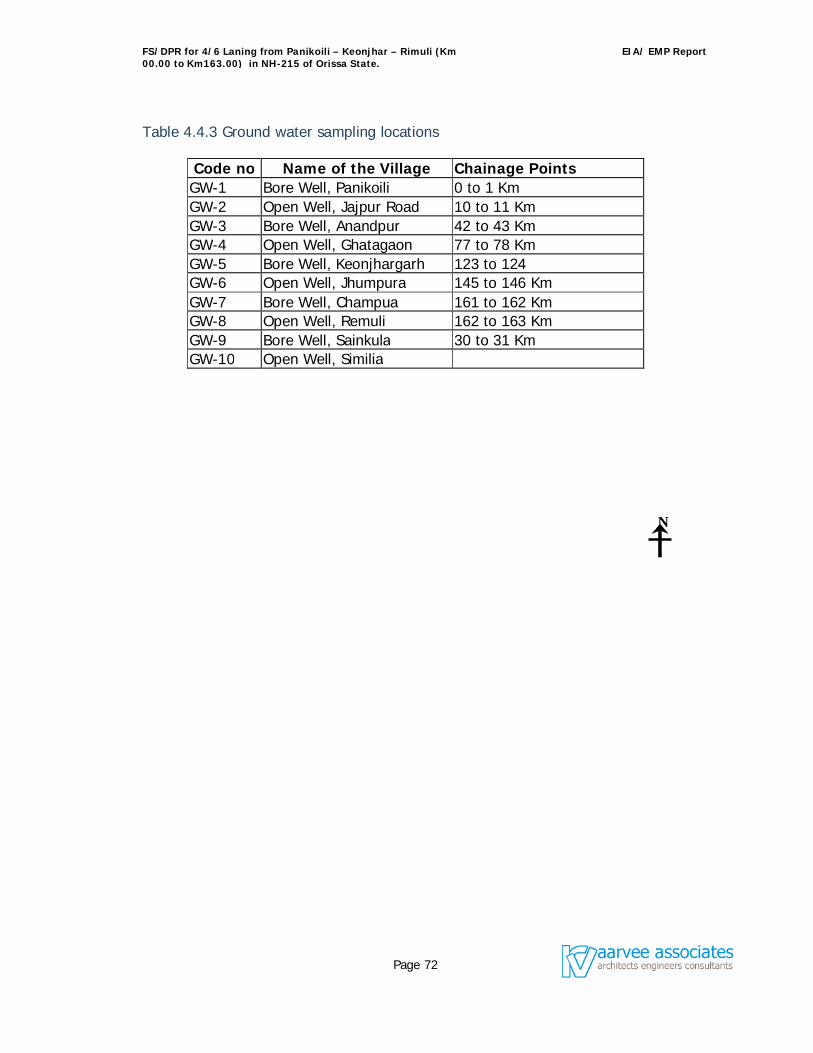
FS/DPR for 4/6 Laning from Panikoili – Keonjhar – Rimuli (Km 00.00 to Km163.00) in NH-215 of Orissa State.
EIA/ EMP Report
Page 72
Table 4.4.3 Ground water sampling locations
Code no Name of the Village Chainage Points GW-1 Bore Well, Panikoili 0 to 1 Km GW-2 Open Well, Jajpur Road 10 to 11 Km GW-3 Bore Well, Anandpur 42 to 43 Km GW-4 Open Well, Ghatagaon 77 to 78 Km GW-5 Bore Well, Keonjhargarh 123 to 124 GW-6 Open Well, Jhumpura 145 to 146 Km GW-7 Bore Well, Champua 161 to 162 Km GW-8 Open Well, Remuli 162 to 163 Km GW-9 Bore Well, Sainkula 30 to 31 Km GW-10 Open Well, Similia
N
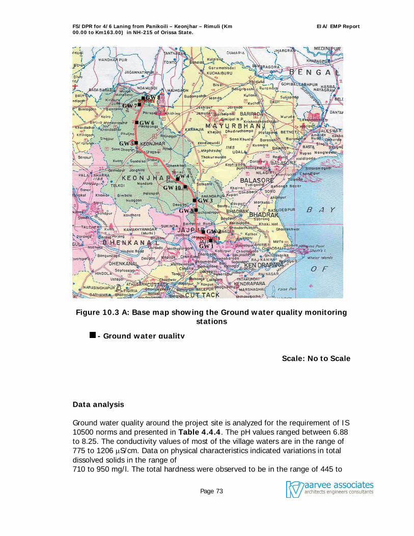
FS/DPR for 4/6 Laning from Panikoili – Keonjhar – Rimuli (Km 00.00 to Km163.00) in NH-215 of Orissa State.
EIA/ EMP Report
Page 73
Figure 10.3 A: Base map showing the Ground water quality monitoring stations
Scale: No to Scale
Data analysis Ground water quality around the project site is analyzed for the requirement of IS 10500 norms and presented in Table 4.4.4. The pH values ranged between 6.88 to 8.25. The conductivity values of most of the village waters are in the range of 775 to 1206 S/cm. Data on physical characteristics indicated variations in total dissolved solids in the range of 710 to 950 mg/l. The total hardness were observed to be in the range of 445 to
- Ground water quality
GW 1
GW 2
GW 3
GW 4
GW 5
GW 6
GW 7
GW 8
GW 10
GW 9
FS/DPR for 4/6 Laning from Panikoili – Keonjhar – Rimuli (Km 00.00 to Km163.00) in NH-215 of Orissa State.
EIA/ EMP Report
Page 74
642 mg/l. Chloride and fluoride values of the samples are study period are in the range of 113 to 210 mg/l and 1.05 to 1.65 mg/l respectively. Chlorides found to be exceeding its limit in some of the villages, at the same time Fluoride values found to be consistent. Trace metals concentrations in ground water found to be negligible. The ground water samples collected in the study area can be used for agriculture and other domestic purposes. It can also be used for drinking after pre-treatment.
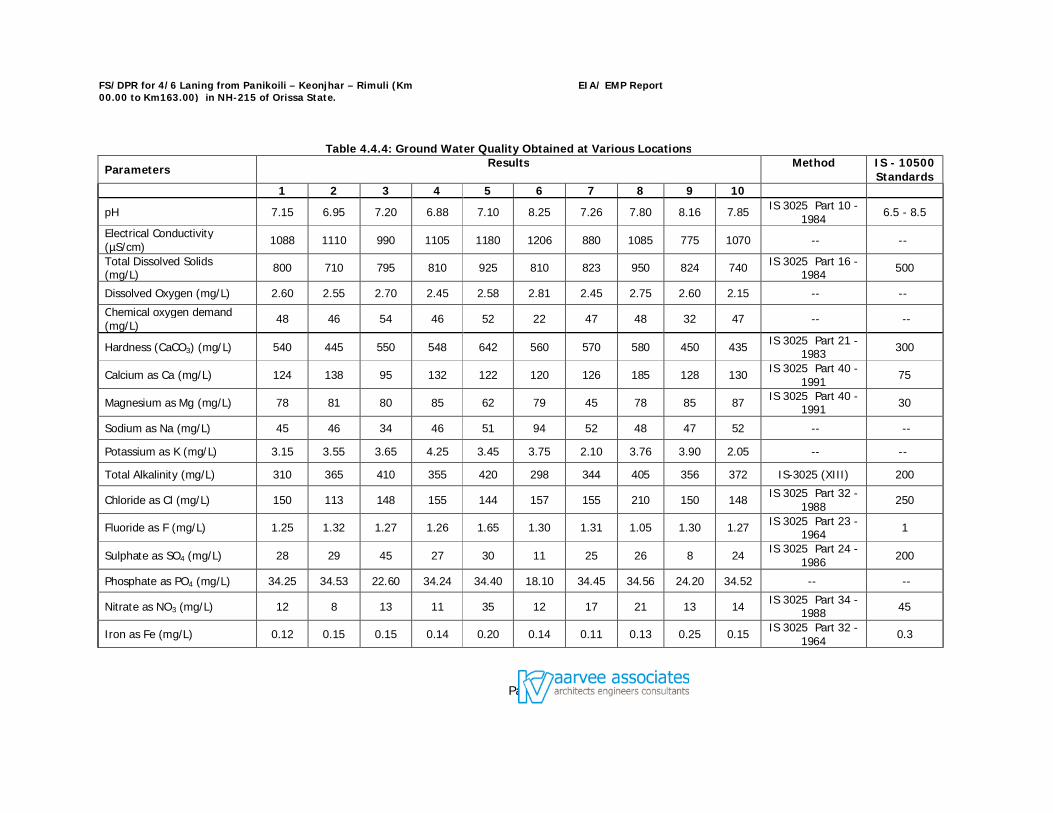
FS/DPR for 4/6 Laning from Panikoili – Keonjhar – Rimuli (Km 00.00 to Km163.00) in NH-215 of Orissa State.
EIA/ EMP Report
Page 75
Table 4.4.4: Ground Water Quality Obtained at Various Locations
Parameters Results
Method
IS - 10500 Standards
1 2 3 4 5 6 7 8 9 10
pH 7.15 6.95 7.20 6.88 7.10 8.25 7.26 7.80 8.16 7.85 IS 3025 Part 10 - 1984 6.5 - 8.5
Electrical Conductivity (µS/cm) 1088 1110 990 1105 1180 1206 880 1085 775 1070 -- --
Total Dissolved Solids (mg/L) 800 710 795 810 925 810 823 950 824 740 IS 3025 Part 16 -
1984 500
Dissolved Oxygen (mg/L) 2.60 2.55 2.70 2.45 2.58 2.81 2.45 2.75 2.60 2.15 -- --
Chemical oxygen demand (mg/L) 48 46 54 46 52 22 47 48 32 47 -- --
Hardness (CaCO3) (mg/L) 540 445 550 548 642 560 570 580 450 435 IS 3025 Part 21 - 1983 300
Calcium as Ca (mg/L) 124 138 95 132 122 120 126 185 128 130 IS 3025 Part 40 - 1991 75
Magnesium as Mg (mg/L) 78 81 80 85 62 79 45 78 85 87 IS 3025 Part 40 - 1991 30
Sodium as Na (mg/L) 45 46 34 46 51 94 52 48 47 52 -- --
Potassium as K (mg/L) 3.15 3.55 3.65 4.25 3.45 3.75 2.10 3.76 3.90 2.05 -- --
Total Alkalinity (mg/L) 310 365 410 355 420 298 344 405 356 372 IS-3025 (XIII) 200
Chloride as Cl (mg/L) 150 113 148 155 144 157 155 210 150 148 IS 3025 Part 32 - 1988 250
Fluoride as F (mg/L) 1.25 1.32 1.27 1.26 1.65 1.30 1.31 1.05 1.30 1.27 IS 3025 Part 23 - 1964 1
Sulphate as SO4 (mg/L) 28 29 45 27 30 11 25 26 8 24 IS 3025 Part 24 - 1986 200
Phosphate as PO4 (mg/L) 34.25 34.53 22.60 34.24 34.40 18.10 34.45 34.56 24.20 34.52 -- --
Nitrate as NO3 (mg/L) 12 8 13 11 35 12 17 21 13 14 IS 3025 Part 34 - 1988 45
Iron as Fe (mg/L) 0.12 0.15 0.15 0.14 0.20 0.14 0.11 0.13 0.25 0.15 IS 3025 Part 32 - 1964 0.3
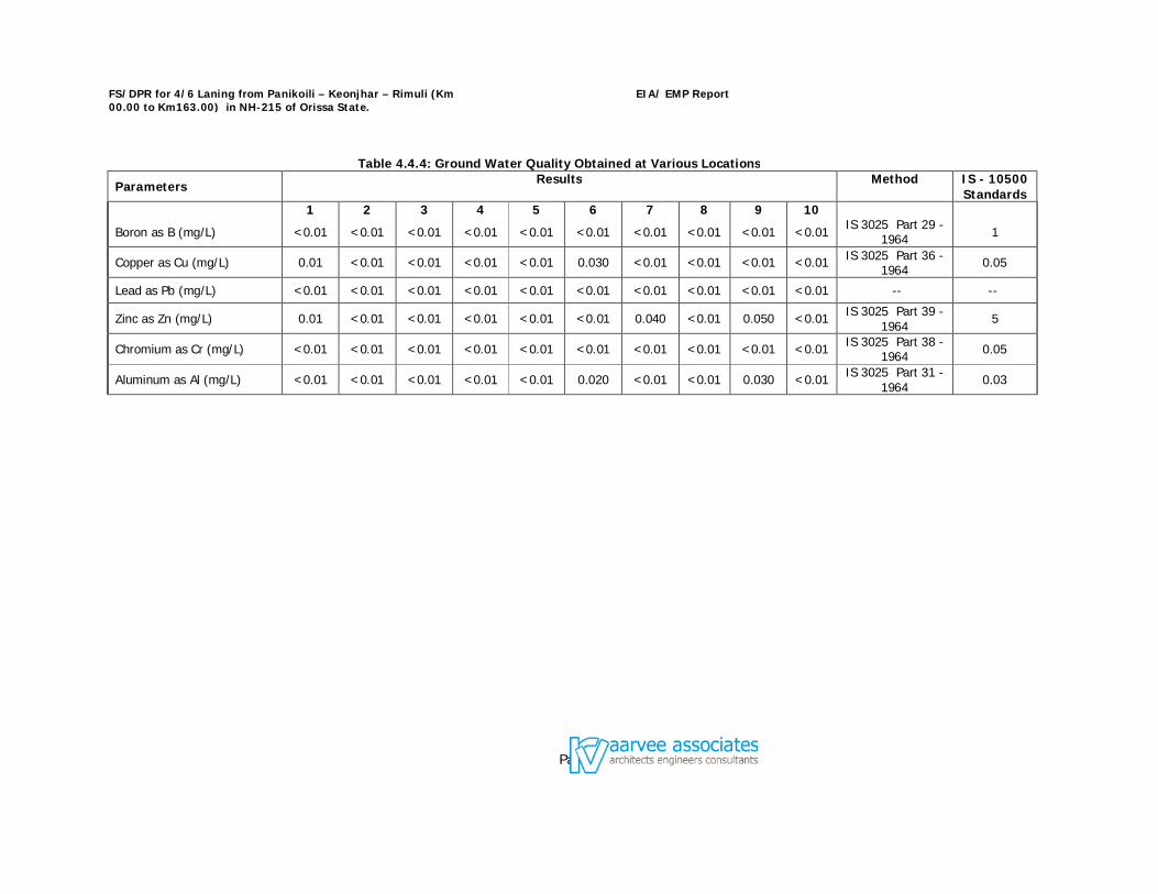
FS/DPR for 4/6 Laning from Panikoili – Keonjhar – Rimuli (Km 00.00 to Km163.00) in NH-215 of Orissa State.
EIA/ EMP Report
Page 76
Table 4.4.4: Ground Water Quality Obtained at Various Locations
Parameters Results
Method
IS - 10500 Standards
1 2 3 4 5 6 7 8 9 10
Boron as B (mg/L) <0.01 <0.01 <0.01 <0.01 <0.01 <0.01 <0.01 <0.01 <0.01 <0.01 IS 3025 Part 29 - 1964 1
Copper as Cu (mg/L) 0.01 <0.01 <0.01 <0.01 <0.01 0.030 <0.01 <0.01 <0.01 <0.01 IS 3025 Part 36 - 1964 0.05
Lead as Pb (mg/L) <0.01 <0.01 <0.01 <0.01 <0.01 <0.01 <0.01 <0.01 <0.01 <0.01 -- --
Zinc as Zn (mg/L) 0.01 <0.01 <0.01 <0.01 <0.01 <0.01 0.040 <0.01 0.050 <0.01 IS 3025 Part 39 - 1964 5
Chromium as Cr (mg/L) <0.01 <0.01 <0.01 <0.01 <0.01 <0.01 <0.01 <0.01 <0.01 <0.01 IS 3025 Part 38 - 1964 0.05
Aluminum as Al (mg/L) <0.01 <0.01 <0.01 <0.01 <0.01 0.020 <0.01 <0.01 0.030 <0.01 IS 3025 Part 31 - 1964 0.03
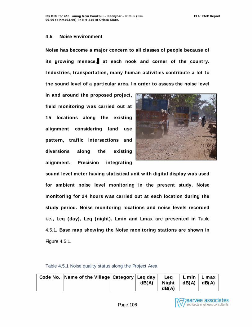
FS/DPR for 4/6 Laning from Panikoili – Keonjhar – Rimuli (Km 00.00 to Km163.00) in NH-215 of Orissa State.
EIA/ EMP Report
Page 106
4.5 Noise Environment
Noise has become a major concern to all classes of people because of
its growing menace, at each nook and corner of the country.
Industries, transportation, many human activities contribute a lot to
the sound level of a particular area. In order to assess the noise level
in and around the proposed project,
field monitoring was carried out at
15 locations along the existing
alignment considering land use
pattern, traffic intersections and
diversions along the existing
alignment. Precision integrating
sound level meter having statistical unit with digital display was used
for ambient noise level monitoring in the present study. Noise
monitoring for 24 hours was carried out at each location during the
study period. Noise monitoring locations and noise levels recorded
i.e., Leq (day), Leq (night), Lmin and Lmax are presented in Table
4.5.1. Base map showing the Noise monitoring stations are shown in
Figure 4.5.1.
Table 4.5.1 Noise quality status along the Project Area
Code No. Name of the Village Category Leq day dB(A)
Leq Night dB(A)
L min dB(A)
L max dB(A)
FS/DPR for 4/6 Laning from Panikoili – Keonjhar – Rimuli (Km 00.00 to Km163.00) in NH-215 of Orissa State.
EIA/ EMP Report
Page 107
Code No. Name of the Village Category Leq day dB(A)
Leq Night dB(A)
L min dB(A)
L max dB(A)
N1 Panikoili Commerci
al 56.5 67.2 54.2 69.5
N2 Jajpur Road Commerci
al 57.2 66.8 55.2 68.2
N3 Anandpur Commerci
al 56.2 68.4 53.5 70.2
N4 Ghatagaon Commerci
al 57.2 69.2 54.5 71.2
N5 Keonjhargarh Commerci
al 57.5 66.1 55.4 68.2
N6 Jhumpura Commerci
al 56.5 67.0 52.2 69.4
N7 Champua Commerci
al 56.2 68.4 54.2 71.1
N8 Remuli Residential 54.8 66.5 53.8 68.5 N9 Sainkula Residential 55.2 67.8 56.4 68.2 N10 Similia Residential 54.2 64.5 52.8 66.5
N11 Dhinkikote Commerci
al 56.5 66.5 54.5 68.2
N12 Padmapur Residential 55.4 63.9 53.5 66.4
N13 Palasapanga Industrial 80.8 74.5 78.5 82.4 N14 Hatibadi Industrial 81.5 64.9 61.8 82.4 N15 Korei Residential 55.5 63.6 54.1 65.6 Note: Leq day starts from 06.00 AM to 09.00 PM and Leq Night starts from 09.00 PM to 06.00 AM From the table 4.5.1, it is seen that five stations are fall under residential category, eight falls under commercial category and rest of two falls under industrial category. For residential category, the observed noise levels at Remuli, Sainkula, Similia Padmapur and Korei are slightly exceeding its day limit of 55 dB(A) and in all the locations during night time noise levels are observed to be higher side when compare with its limit of 45 dB(A). For commercial category all the day time values are well with in the stipulated
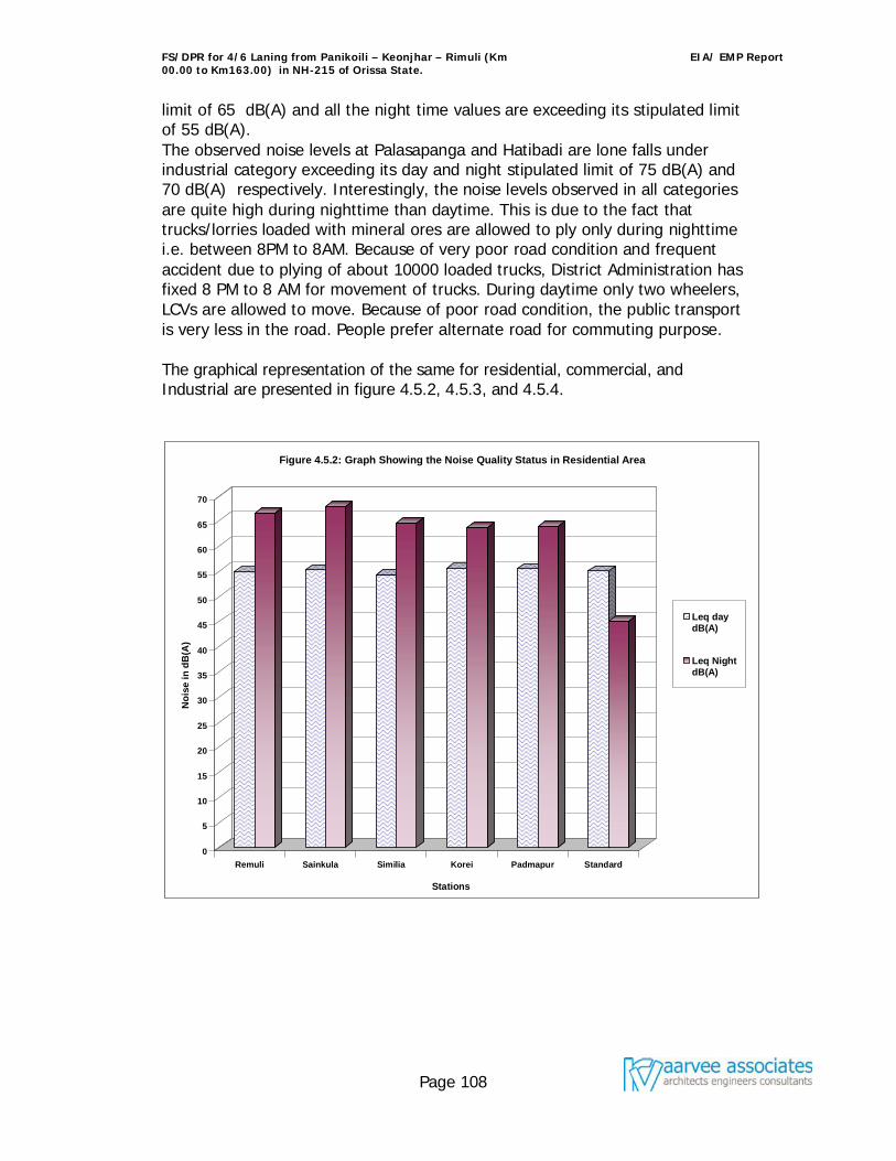
FS/DPR for 4/6 Laning from Panikoili – Keonjhar – Rimuli (Km 00.00 to Km163.00) in NH-215 of Orissa State.
EIA/ EMP Report
Page 108
limit of 65 dB(A) and all the night time values are exceeding its stipulated limit of 55 dB(A). The observed noise levels at Palasapanga and Hatibadi are lone falls under industrial category exceeding its day and night stipulated limit of 75 dB(A) and 70 dB(A) respectively. Interestingly, the noise levels observed in all categories are quite high during nighttime than daytime. This is due to the fact that trucks/lorries loaded with mineral ores are allowed to ply only during nighttime i.e. between 8PM to 8AM. Because of very poor road condition and frequent accident due to plying of about 10000 loaded trucks, District Administration has fixed 8 PM to 8 AM for movement of trucks. During daytime only two wheelers, LCVs are allowed to move. Because of poor road condition, the public transport is very less in the road. People prefer alternate road for commuting purpose. The graphical representation of the same for residential, commercial, and Industrial are presented in figure 4.5.2, 4.5.3, and 4.5.4.
0
5
10
15
20
25
30
35
40
45
50
55
60
65
70
Noi
se in
dB
(A)
Remuli Sainkula Similia Korei Padmapur Standard
Stations
Figure 4.5.2: Graph Showing the Noise Quality Status in Residential Area
Leq day dB(A)
Leq NightdB(A)
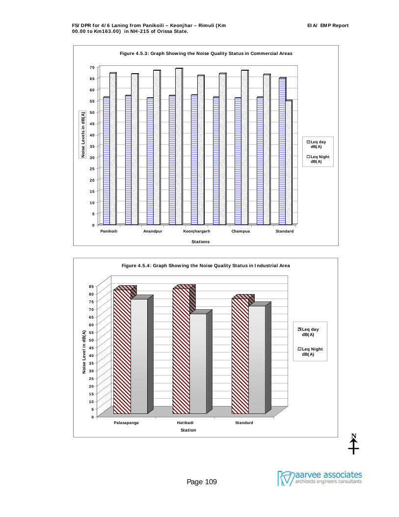
FS/DPR for 4/6 Laning from Panikoili – Keonjhar – Rimuli (Km 00.00 to Km163.00) in NH-215 of Orissa State.
EIA/ EMP Report
Page 109
0
5
10
15
20
25
30
35
40
45
50
55
60
65
70
Noi
se L
evel
s in
dB
(A)
Panikoili Anandpur Keonjhargarh Champua Standard
Stations
Figure 4.5.3: Graph Showing the Noise Quality Status in Commercial Areas
Leq day dB(A)
Leq NightdB(A)
0
5
10
15
20
25
30
35
40
45
50
55
60
65
70
75
80
85
Noi
se L
evel
in d
B(A
)
Palasapanga Hatibadi Standard
Station
Figure 4.5.4: Graph Showing the Noise Quality Status in Industrial Area
Leq day dB(A)
Leq NightdB(A)
N
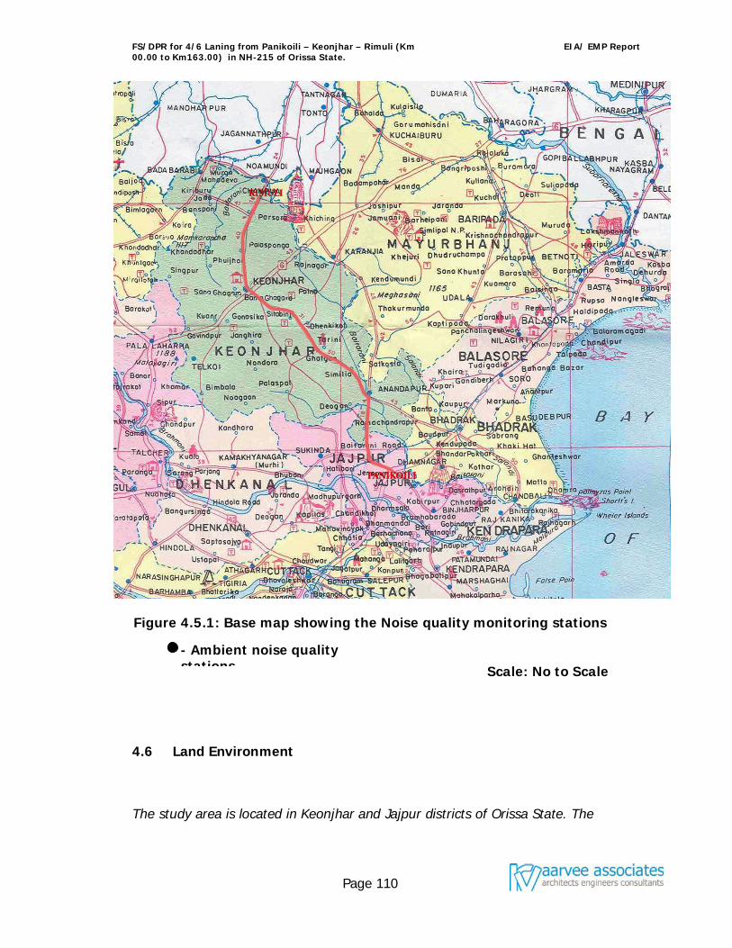
FS/DPR for 4/6 Laning from Panikoili – Keonjhar – Rimuli (Km 00.00 to Km163.00) in NH-215 of Orissa State.
EIA/ EMP Report
Page 110
Figure 4.5.1: Base map showing the Noise quality monitoring stations
Scale: No to Scale
4.6 Land Environment
The study area is located in Keonjhar and Jajpur districts of Orissa State. The
- Ambient noise quality stations
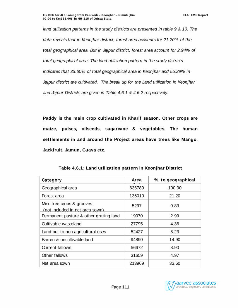
FS/DPR for 4/6 Laning from Panikoili – Keonjhar – Rimuli (Km 00.00 to Km163.00) in NH-215 of Orissa State.
EIA/ EMP Report
Page 111
land utilization patterns in the study districts are presented in table 9 & 10. The
data reveals that in Keonjhar district, forest area accounts for 21.20% of the
total geographical area. But in Jajpur district, forest area account for 2.94% of
total geographical area. The land utilization pattern in the study districts
indicates that 33.60% of total geographical area in Keonjhar and 55.29% in
Jajpur district are cultivated. The break up for the Land utilization in Keonjhar
and Jajpur Districts are given in Table 4.6.1 & 4.6.2 respectively.
Paddy is the main crop cultivated in Kharif season. Other crops are
maize, pulses, oilseeds, sugarcane & vegetables. The human
settlements in and around the Project areas have trees like Mango,
Jackfruit, Jamun, Guava etc.
Table 4.6.1: Land utilization pattern in Keonjhar District
Category Area
(ha) % to geographical
area Geographical area 636789 100.00
Forest area 135010 21.20
Misc tree crops & grooves (not included in net area sown)
5297 0.83
Permanent pasture & other grazing land 19070 2.99
Cultivable wasteland 27795 4.36
Land put to non agricultural uses 52427 8.23
Barren & uncultivable land 94890 14.90
Current fallows 56672 8.90
Other fallows 31659 4.97
Net area sown 213969 33.60
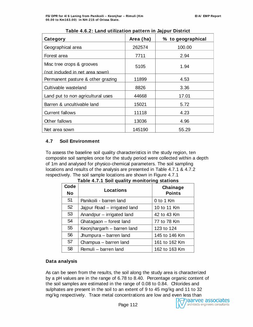
FS/DPR for 4/6 Laning from Panikoili – Keonjhar – Rimuli (Km 00.00 to Km163.00) in NH-215 of Orissa State.
EIA/ EMP Report
Page 112
Table 4.6.2: Land utilization pattern in Jajpur District
Category Area (ha) % to geographical area Geographical area 262574 100.00
Forest area 7711 2.94
Misc tree crops & grooves
(not included in net area sown) 5105 1.94
Permanent pasture & other grazing land
11899 4.53
Cultivable wasteland 8826 3.36
Land put to non agricultural uses 44668 17.01
Barren & uncultivable land 15021 5.72
Current fallows 11118 4.23
Other fallows 13036 4.96
Net area sown 145190 55.29 4.7 Soil Environment To assess the baseline soil quality characteristics in the study region, ten composite soil samples once for the study period were collected within a depth of 1m and analysed for physico-chemical parameters. The soil sampling locations and results of the analysis are presented in Table 4.7.1 & 4.7.2 respectively. The soil sample locations are shown in Figure 4.7.1
Table 4.7.1 Soil quality monitoring stations Code No
Locations Chainage Points
S1 Panikoili - barren land 0 to 1 Km S2 Jajpur Road – irrigated land 10 to 11 Km S3 Anandpur – irrigated land 42 to 43 Km S4 Ghatagaon – forest land 77 to 78 Km S5 Keonjhargarh – barren land 123 to 124 S6 Jhumpura – barren land 145 to 146 Km S7 Champua – barren land 161 to 162 Km S8 Remuli – barren land 162 to 163 Km
Data analysis As can be seen from the results, the soil along the study area is characterized by a pH values are in the range of 6.78 to 8.40. Percentage organic content of the soil samples are estimated in the range of 0.08 to 0.84. Chlorides and sulphates are present in the soil to an extent of 9 to 45 mg/kg and 11 to 32 mg/kg respectively. Trace metal concentrations are low and even less than
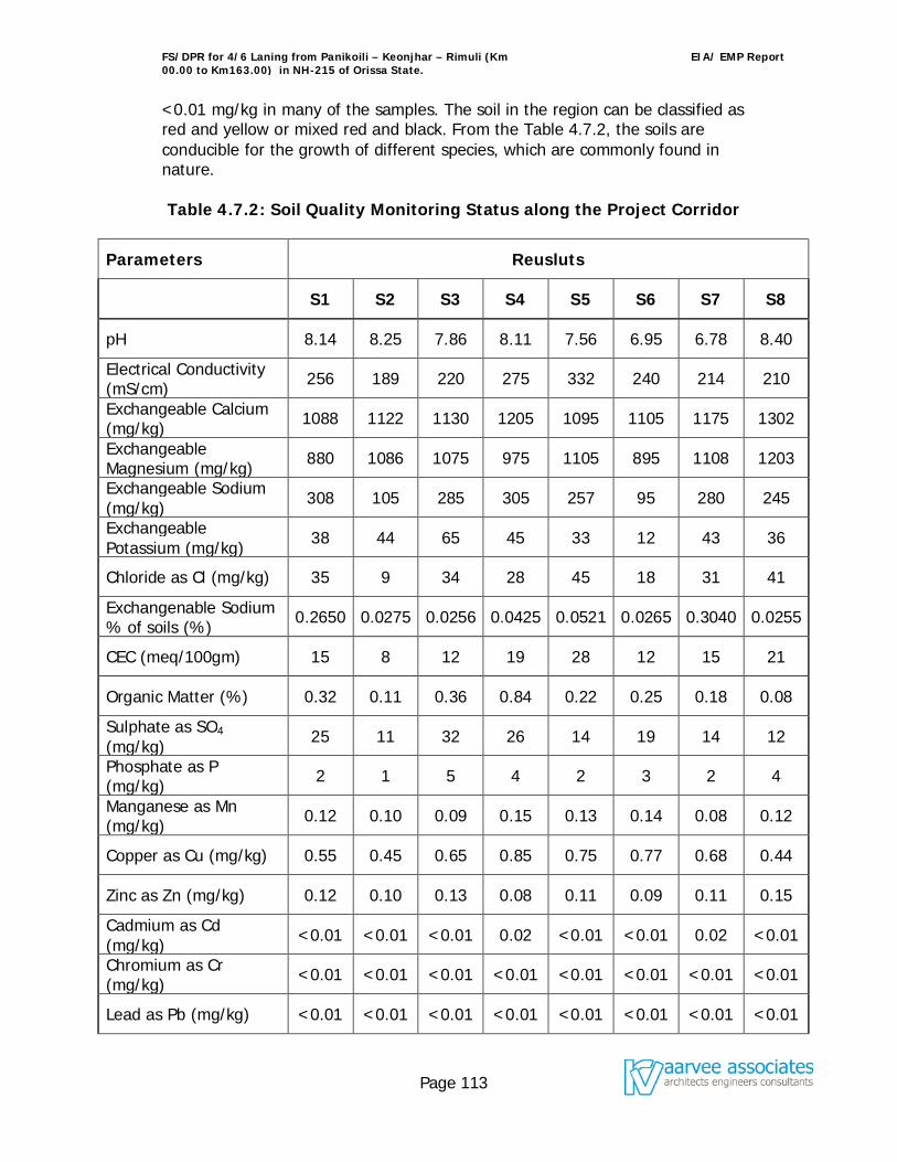
FS/DPR for 4/6 Laning from Panikoili – Keonjhar – Rimuli (Km 00.00 to Km163.00) in NH-215 of Orissa State.
EIA/ EMP Report
Page 113
<0.01 mg/kg in many of the samples. The soil in the region can be classified as red and yellow or mixed red and black. From the Table 4.7.2, the soils are conducible for the growth of different species, which are commonly found in nature. Table 4.7.2: Soil Quality Monitoring Status along the Project Corridor
Parameters Reusluts
S1 S2 S3 S4 S5 S6 S7 S8
pH 8.14 8.25 7.86 8.11 7.56 6.95 6.78 8.40
Electrical Conductivity (mS/cm) 256 189 220 275 332 240 214 210
Exchangeable Calcium (mg/kg) 1088 1122 1130 1205 1095 1105 1175 1302
Exchangeable Magnesium (mg/kg) 880 1086 1075 975 1105 895 1108 1203
Exchangeable Sodium (mg/kg) 308 105 285 305 257 95 280 245
Exchangeable Potassium (mg/kg) 38 44 65 45 33 12 43 36
Chloride as Cl (mg/kg) 35 9 34 28 45 18 31 41
Exchangenable Sodium % of soils (%) 0.2650 0.0275 0.0256 0.0425 0.0521 0.0265 0.3040 0.0255
CEC (meq/100gm) 15 8 12 19 28 12 15 21
Organic Matter (%) 0.32 0.11 0.36 0.84 0.22 0.25 0.18 0.08
Sulphate as SO4 (mg/kg) 25 11 32 26 14 19 14 12
Phosphate as P (mg/kg) 2 1 5 4 2 3 2 4
Manganese as Mn (mg/kg) 0.12 0.10 0.09 0.15 0.13 0.14 0.08 0.12
Copper as Cu (mg/kg) 0.55 0.45 0.65 0.85 0.75 0.77 0.68 0.44
Zinc as Zn (mg/kg) 0.12 0.10 0.13 0.08 0.11 0.09 0.11 0.15
Cadmium as Cd (mg/kg) <0.01 <0.01 <0.01 0.02 <0.01 <0.01 0.02 <0.01
Chromium as Cr (mg/kg) <0.01 <0.01 <0.01 <0.01 <0.01 <0.01 <0.01 <0.01
Lead as Pb (mg/kg) <0.01 <0.01 <0.01 <0.01 <0.01 <0.01 <0.01 <0.01
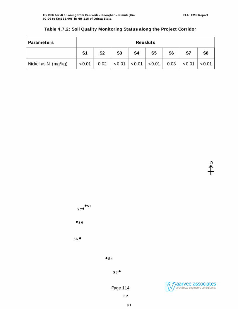
FS/DPR for 4/6 Laning from Panikoili – Keonjhar – Rimuli (Km 00.00 to Km163.00) in NH-215 of Orissa State.
EIA/ EMP Report
Page 114
Table 4.7.2: Soil Quality Monitoring Status along the Project Corridor
Parameters Reusluts
S1 S2 S3 S4 S5 S6 S7 S8
Nickel as Ni (mg/kg) <0.01 0.02 <0.01 <0.01 <0.01 0.03 <0.01 <0.01
N
S 1
S 3
S 4
S 5
S 6
S 7
S 2
S 8
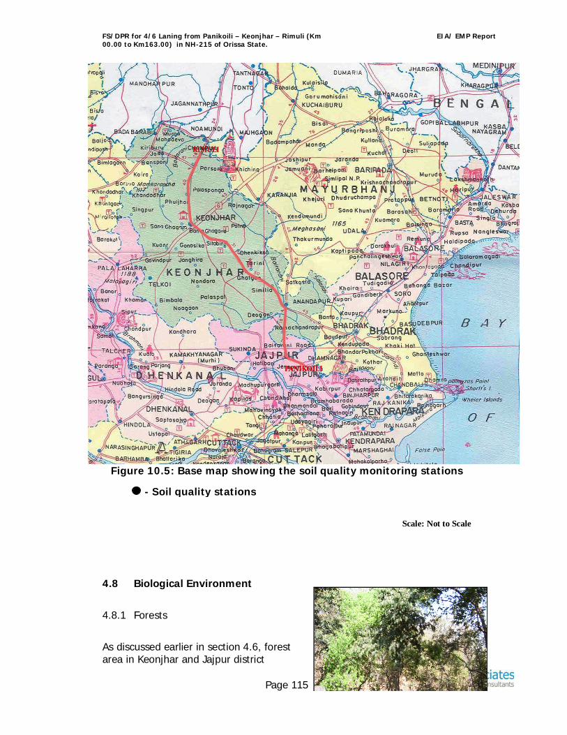
FS/DPR for 4/6 Laning from Panikoili – Keonjhar – Rimuli (Km 00.00 to Km163.00) in NH-215 of Orissa State.
EIA/ EMP Report
Page 115
Figure 10.5: Base map showing the soil quality monitoring stations
Scale: Not to Scale
4.8 Biological Environment
4.8.1 Forests
As discussed earlier in section 4.6, forest area in Keonjhar and Jajpur district
- Soil quality stations
FS/DPR for 4/6 Laning from Panikoili – Keonjhar – Rimuli (Km 00.00 to Km163.00) in NH-215 of Orissa State.
EIA/ EMP Report
Page 116
constitute 21.20 and 2.94% of the total geographical area. The Right of Way (ROW) passes through forests are i.e., Derakhola R.F, Poijman R.F, Atai R.F, Ghatagaon R.F, Sanamasinabila R.F, Pippilia R.F, Badaposi R.F, The ecological experts had visited the site to assess the flora and fauna components in the expanded zone of national highway to assess the Flora, Fauna species present in the forests and Wetland components in around the project to analyse the impact due to the proposed activity and also suggested the type of conservation measures to be adopted. The land pattern is ecologically divided into cliffs, gorges, undulating slopes, Thick forests, patches of woodland and lowland plateau. The forest is diversified and contains semi- broad leaved trees with variable species of shrubs and climbers which are a typical feature of the habitat. Some of the dominant floral species present in the forests are Mahul, Neem, Peepal, Sal, Sirish, Tamarind, Acacia, Asan, Bamboo, Mango, Jackfruit, Banyan, Black Berry, Chakunda, Chara, Eucalyptus, and Gambhari. All along the streams green patch of vegetation exists. The fauna is also diversified by population numbers may be few due to number of valid reasons. The chainage of ROW passes through the forest is given below.
S.NO. District Chainage Length (Km)
From To
1 Jajpur 19.000 21.000 2.000 2 Keonjhar 39.000 40.000 1.000 3 50.000 50.500 0.500 4 58.00 66.400 8.400 5 74.000 77.00 3.00 6 84.00 85.000 1.000 7 102.500 103.00 0.500 8 107.000 109.000 2.000 9 111.000 113.000 2.000 10 129.500 130.200 0.700 11 139.00 141.200 1.800 Total 23.700
Flora found in the study area:
FS/DPR for 4/6 Laning from Panikoili – Keonjhar – Rimuli (Km 00.00 to Km163.00) in NH-215 of Orissa State.
EIA/ EMP Report
Page 117
The list of the dominant tree species in the study forest area is given in table no.4.8.1 Table 4.8.1 : List of the dominant floral species in study area forests
Scientific Name Scientific Name
Trees
Ficus benghalensis Anthocephalus cadamba
Mangifera indica Terminalia arjun
Cassia siamea Cassia fistula linn
Azadirachta indica Dilonix regia ral
Tectona grandis Shorea robusta
Albizzia procera Pithecellobium dulce benth
Ficus religiosa Citrus limon burm F.
Tamarindus indicus Phoenix sylvestris roxb
Cedrus deodar Moringa oleifera lam
Gmelina arborea Eucalyptus citiodra hock
Acacia nilotica Saraca asoca de wild
Pongamia pinnata Ziziphus mauritiana lam
Aegle marmelos Sterculia foetida linn
Ricinus communis linn Mimusops elengi linn
Rosa centifolia linn Trewia nudiflora linn.
Bambusa vulgaris schrad Ougeinik oojeinaensis H ochr Shrubs
Veronia roxburghii Webera corymbosa
Capparis zeylanica Moghania chhappar
Eupatorium odoratum Rauwolfia serpentina
Emblica robusta Cassia tora
Flacourtia indica Fhretia buxiafolia
Atylosia cajanifolia Murry koeniagii
Pavetta indica Vitex negundo
Diospyros chloroxylan Flacounito indica
Mimosa pudica Engenia bracteata
Lantana camara Randia uliginosa
FS/DPR for 4/6 Laning from Panikoili – Keonjhar – Rimuli (Km 00.00 to Km163.00) in NH-215 of Orissa State.
EIA/ EMP Report
Page 118
Scientific Name Scientific Name
Flueggia microcarpa Andropogon paniculata
Erycibe paniculata Euphorbia royaleana
Ageratum conyzoides Phyllochlamye spino sa
Clerodendron viscosum Wendnanda tinctoria
Opilia amentacea Ichnocarpus frutescens
Helicteres isora Glycosmis pentaphylla
Anona squamosa Hollarrhena antidusenteria
Phyllanthus reticulates Memecylonn edules
Canthium parvibolium Antidesma diandrum
Zizyphus ocnoplia Jasminum arborescens
Jatropha glanduliferra Croton candatus
Allophylus cobbe Maba buxifolia
Flueggia microcarpa Climbers Toddalia assiatica Milletia auriculata Uvaria lurida Tylophora indica Pisonia senleota Combretum ovalium Vitis carnosa Milletia racemosa Bauhinia vahlii Ficus parasitica Combretum decandrum Vitis tatifolia Hygonia nystex Gloriosa superba Vitis tomentosa Heptaplenrun venulossum Anamirta cocculus Nimosa himalyana Grasses Cynodon dactylon Panicum indicum Chloris incompleta Imperate cylindrical Aristida setacea Heteropogon contortus Apluda mutica Themeda arundinacea Chrysopogon mentanus Eulaliopsis binata Dicanthium annulatum
Fauna Found in the Study Area:
Decades before, the project area had rich diversity of mammals, birds, reptiles
and fishes. Now these animals are sparsely seen due to poaching and loss of
FS/DPR for 4/6 Laning from Panikoili – Keonjhar – Rimuli (Km 00.00 to Km163.00) in NH-215 of Orissa State.
EIA/ EMP Report
Page 119
habitat. The advance of cultivation along with growth of population and
communication network has driven the wild animals back to the reserve forests
in and around the project area.
The detailed lists of mammals, birds, reptiles and fishes are mentioned in Table
4.8.2.
Table 4.8.2: List of Animals in the Project Area
English Name Scientific Name A. MAMMALS:
Jackal Canis aurens
Squirrel Funumbulus pennanti
Fox Vulpes tengalensis
Monkey Semnpitoecus entellus
Rat Rattus ratus
Mongoose Herpestes edwardai
Hare Lepus nigricollis ruficandarus
Wild pig Sis cristatus
B. BIRDS Jungle crow Corvus macrorhynches
House crow Corvus splenders
Bul-Bul Pycnonotus cafen
Myna Strunus tristis
Nilkanta Coracias benghalensis
Green bee-eader Meropsarientalis
Blue-Tailed bee-eater Merops phillipinus
Brown dove Streptopelia senegallensis
Peewit Venellus venellus
Papila Cuculus varius
White-bellied Pericrocatus erthropygeus
Black drongo Dicrurus macrocercus
FS/DPR for 4/6 Laning from Panikoili – Keonjhar – Rimuli (Km 00.00 to Km163.00) in NH-215 of Orissa State.
EIA/ EMP Report
Page 120
English Name Scientific Name
Babbler Turdoides coudata
Treepie Crypsirina vagabounda
Grass owl Tyto capensis
Black bittern Dupeper flavicollis
Jack snipe Lymnocryptes minima
Black winged stilt Himantous himantopus
White-tailed lapwing Chettusia leucura
Grey plover Souatarola squatarala
Sooty tern Sterna fuscata
Indian swallow plover Glareola maldivarum
Great stone plover Esacus recurvirostris
Indian water-rail Rallus aquaticus
Indian grackle Gracula religosa
Indian swallow plover Glareola maldivarum
C. REPTILES: Krait Bungarus faciatus/caemuleus
Garden lizard Calotes versicolor
Chameleon Chameleon zeylanicus
Fresh water turtle Geomyda trijuga
Common wall lizard Hemidactylus flavirdis
King cobra Ophiophagus Hannah
Cobra Naja naja Conclusion There are no rare or endangered species in the study area except Indian Wild Dog and Indian Wolf, Elephant, Heta Baga and Bear, which are present in interior forest. Since this is road widening project the impacts anticipated on flora and fauna are minimal. By adopting the following management practices, the impacts can be minimized.
(i) Compensatory afforestation with native species for the forest
land acquired.
(ii) Avenue plantation along the road.
(iii) To preserve the forest, earth borrowing, pilling, and building
temporary camps are prohibited in the forest lands.
(iv) Construction workers should be informed to protect natural
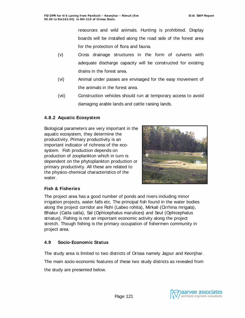
FS/DPR for 4/6 Laning from Panikoili – Keonjhar – Rimuli (Km 00.00 to Km163.00) in NH-215 of Orissa State.
EIA/ EMP Report
Page 121
resources and wild animals. Hunting is prohibited. Display
boards will be installed along the road side of the forest area
for the protection of flora and fauna.
(v) Cross drainage structures in the form of culverts with
adequate discharge capacity will be constructed for existing
drains in the forest area.
(vi) Animal under passes are envisaged for the easy movement of
the animals in the forest area.
(vii) Construction vehicles should run at temporary access to avoid
damaging arable lands and cattle raising lands.
4.8.2 Aquatic Ecosystem Biological parameters are very important in the aquatic ecosystem, they determine the productivity. Primary productivity is an important indicator of richness of the eco-system. Fish production depends on production of zooplankton which in turn is dependent on the phytoplankton production or primary productivity. All these are related to the physico-chemical characteristics of the water. Fish & Fisheries
The project area has a good number of ponds and rivers including minor irrigation projects, water falls etc. The principal fish found in the water bodies along the project corridor are Rohi (Labeo rohita), Mirkali (Cirrhina mrigala), Bhakur (Catla catla), Sal (Ophicephalus marulices) and Seul (Ophicephalus striatus). Fishing is not an important economic activity along the project stretch. Though fishing is the primary occupation of fishermen community in project area.
4.9 Socio-Economic Status The study area is limited to two districts of Orissa namely Jajpur and Keonjhar.
The main socio-economic features of these two study districts as revealed from
the study are presented below.
FS/DPR for 4/6 Laning from Panikoili – Keonjhar – Rimuli (Km 00.00 to Km163.00) in NH-215 of Orissa State.
EIA/ EMP Report
Page 122
The study districts are located in northern part of Orissa,
Keonjhar, a princely State was created in 12th century A.D. at the
time of Bhanja rulers. This time the king shifted his capital to a more
centralized place and built his fort near a perennial spring (Jhara)
which originated from the root of a Kendu tree. The new capital
town was thus named as Kendujhar (Kendu+Jhar) and then it was
corrupted into Keonjhar.
Jajpur district was created in 1992, by carving out from Cuttack
district. The name Jajpur is either a derivative of the name Jajnapur
or Jajatipur as Jajati Keshari, the first Soumavamsi king of Orissa.
The famous Chinese traveler Hiuen Tsang speaks of “Jajnapur”
(Jajpur) as a great centre of religious.
The Demographic details of the study districts are compiled using
Census 2001 and presented in Table 4.9.1. Jajpur district (560) is
more densely populated than Keonjhar district (188). Sex ratio in
Keonjhar district is 977 as compared to the sex ratio of Jajpur
district, which is 972.
Literacy rate of Keonjhar district is 59.75% as compared to 72.19%
in Jajpur district. The male and female literacy rates are 72.53%
and 46.71% in Keonjhar district. Similarly, the male and female
literacy rates are 82.69% and 61.45% for Jajpur district.
The Population of scheduled tribes is 44.50% in Keonjhar district
and only 7.76% in Jajpur district. The percentage of scheduled caste
is 11.62% and 22.99% in Keonjhar and Jajpur district, respectively.
Table 4.9.1: Socio-economic feature of study Districts
Parameters Keonjhar Jajpur
Population (2001 Census) 1561990 1624341
Male Population (2001 Census) 790036 823747
Female Population (2001 Census) 771954 800594
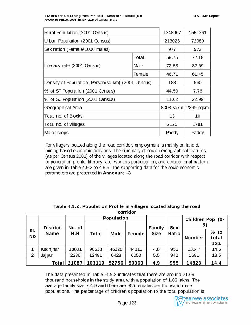
FS/DPR for 4/6 Laning from Panikoili – Keonjhar – Rimuli (Km 00.00 to Km163.00) in NH-215 of Orissa State.
EIA/ EMP Report
Page 123
Rural Population (2001 Census) 1348967 1551361
Urban Population (2001 Census) 213023 72980
Sex ration (Female/1000 males) 977 972
Literacy rate (2001 Census)
Total 59.75 72.19
Male 72.53 82.69
Female 46.71 61.45
Density of Population (Person/sq km) (2001 Census) 188 560
% of ST Population (2001 Census) 44.50 7.76
% of SC Population (2001 Census) 11.62 22.99
Geographical Area 8303 sqkm 2899 sqkm
Total no. of Blocks 13 10
Total no. of villages 2125 1781
Major crops Paddy Paddy For villagers located along the road corridor, employment is mainly on land & mining based economic activities. The summary of socio-demographical features (as per Census 2001) of the villages located along the road corridor with respect to population profile, literacy rate, workers participation, and occupational pattern are given in Table 4.9.2 to 4.9.5. The supporting data for the socio-economic parameters are presented in Annexure -3.
Table 4.9.2: Population Profile in villages located along the road corridor
Sl. No
District Name
No. of H.H
Population
Family Size
Sex Ratio
Children Pop (0-6)
Total Male Female Number
% to total pop.
1 Keonjhar 18801 90638 46328 44310 4.8 956 13147 14.5 2 Jajpur 2286 12481 6428 6053 5.5 942 1681 13.5
Total 21087 103119 52756 50363 4.9 955 14828 14.4 The data presented in Table -4.9.2 indicates that there are around 21.09 thousand households in the study area with a population of 1.03 lakhs. The average family size is 4.9 and there are 955 females per thousand male populations. The percentage of children’s population to the total population is
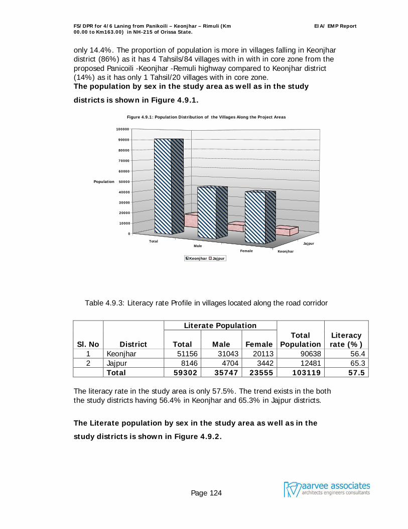
FS/DPR for 4/6 Laning from Panikoili – Keonjhar – Rimuli (Km 00.00 to Km163.00) in NH-215 of Orissa State.
EIA/ EMP Report
Page 124
only 14.4%. The proportion of population is more in villages falling in Keonjhar district (86%) as it has 4 Tahsils/84 villages with in with in core zone from the proposed Panicoili -Keonjhar -Remuli highway compared to Keonjhar district (14%) as it has only 1 Tahsil/20 villages with in core zone. The population by sex in the study area as well as in the study
districts is shown in Figure 4.9.1.
Table 4.9.3: Literacy rate Profile in villages located along the road corridor
Sl. No District
Literate Population Total
Population Literacy rate (%) Total Male Female
1 Keonjhar 51156 31043 20113 90638 56.4 2 Jajpur 8146 4704 3442 12481 65.3
Total 59302 35747 23555 103119 57.5 The literacy rate in the study area is only 57.5%. The trend exists in the both the study districts having 56.4% in Keonjhar and 65.3% in Jajpur districts.
The Literate population by sex in the study area as well as in the
study districts is shown in Figure 4.9.2.
TotalMale
Female Keonjhar
Jajpur
0
10000
20000
30000
40000
50000
60000
70000
80000
90000
100000
Population
Figure 4.9.1: Population Distribution of the Villages Along the Project Areas
Keonjhar Jajpur
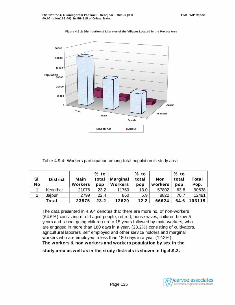
FS/DPR for 4/6 Laning from Panikoili – Keonjhar – Rimuli (Km 00.00 to Km163.00) in NH-215 of Orissa State.
EIA/ EMP Report
Page 125
Table 4.9.4: Workers participation among total population in study area
Sl. No
District
Main Workers
% to total pop
Marginal Workers
% to total pop
Non workers
% to total pop
Total Pop.
1 Keonjhar 21076 23.2 11760 13.0 57802 63.8 90638 2 Jajpur 2799 22.4 860 6.9 8822 70.7 12481
Total 23875 23.2 12620 12.2 66624 64.6 103119 The data presented in 4.9.4 denotes that there are more no. of non-workers (64.6%) consisting of old aged people, retired, house wives, children below 5 years and school going children up to 15 years followed by main workers, who are engaged in more than 180 days in a year, (23.2%) consisting of cultivators, agricultural laborers, self employed and other service holders and marginal workers who are employed in less than 180 days in a year (12.2%). The workers & non workers and workers population by sex in the
study area as well as in the study districts is shown in fig.4.9.3.
Total
Male
Female
Keonjhar
Jajpur0
10000
20000
30000
40000
50000
60000
Population
Figure 4.9.2: Distribution of Literates of the Villages Located in the Project Area
Keonjhar Jajpur
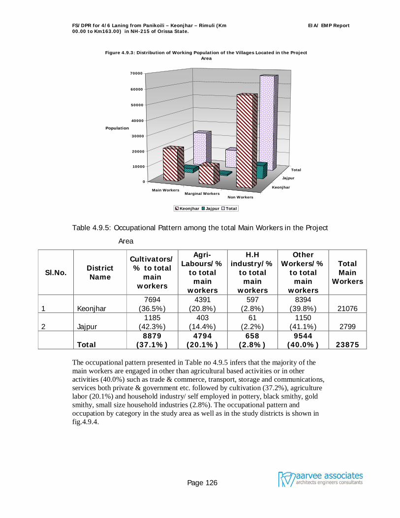
FS/DPR for 4/6 Laning from Panikoili – Keonjhar – Rimuli (Km 00.00 to Km163.00) in NH-215 of Orissa State.
EIA/ EMP Report
Page 126
Table 4.9.5: Occupational Pattern among the total Main Workers in the Project
Area
Sl.No. District Name
Cultivators/ % to total
main workers
Agri-Labours/%
to total main
workers
H.H industry/%
to total main
workers
Other Workers/%
to total main
workers
Total Main
Workers
1 Keonjhar 7694
(36.5%) 4391
(20.8%) 597
(2.8%) 8394
(39.8%) 21076
2 Jajpur 1185
(42.3%) 403
(14.4%) 61
(2.2%) 1150
(41.1%) 2799
Total 8879
(37.1%) 4794
(20.1%) 658
(2.8%) 9544
(40.0%) 23875 The occupational pattern presented in Table no 4.9.5 infers that the majority of the main workers are engaged in other than agricultural based activities or in other activities (40.0%) such as trade & commerce, transport, storage and communications, services both private & government etc. followed by cultivation (37.2%), agriculture labor (20.1%) and household industry/ self employed in pottery, black smithy, gold smithy, small size household industries (2.8%). The occupational pattern and occupation by category in the study area as well as in the study districts is shown in fig.4.9.4.
Main WorkersMarginal Workers
Non Workers
Keonjhar
Jajpur
Total
0
10000
20000
30000
40000
50000
60000
70000
Population
Figure 4.9.3: Distribution of Working Population of the Villages Located in the Project Area
Keonjhar Jajpur Total
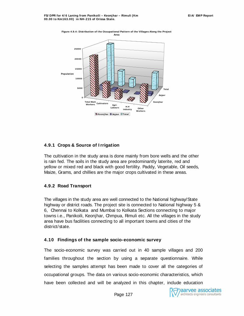
FS/DPR for 4/6 Laning from Panikoili – Keonjhar – Rimuli (Km 00.00 to Km163.00) in NH-215 of Orissa State.
EIA/ EMP Report
Page 127
4.9.1 Crops & Source of Irrigation The cultivation in the study area is done mainly from bore wells and the other is rain fed. The soils in the study area are predominantly laterite, red and yellow or mixed red and black with good fertility. Paddy, Vegetable, Oil seeds, Maize, Grams, and chillies are the major crops cultivated in these areas.
4.9.2 Road Transport
The villages in the study area are well connected to the National highway/State highway or district roads. The project site is connected to National highway 5 & 6, Chennai to Kolkata and Mumbai to Kolkata Sections connecting to major towns i.e., Panikoili, Keonjhar, Chmpua, Rimuli etc. All the villages in the study area have bus facilities connecting to all important towns and cities of the district/state.
4.10 Findings of the sample socio-economic survey
The socio-economic survey was carried out in 40 sample villages and 200
families throughout the section by using a separate questionnaire. While
selecting the samples attempt has been made to cover all the categories of
occupational groups. The data on various socio-economic characteristics, which
have been collected and will be analyzed in this chapter, include education
Total MainWorkers Cultivators
Agri-Labours H.H
industry OtherWorkers
Keonjhar
Jajpur
Total
0
5000
10000
15000
20000
25000
Population
Figure 4.9.4: Distribution of the Occupational Pattern of the Villages Along the Project Area
Keonjhar Jajpur Total
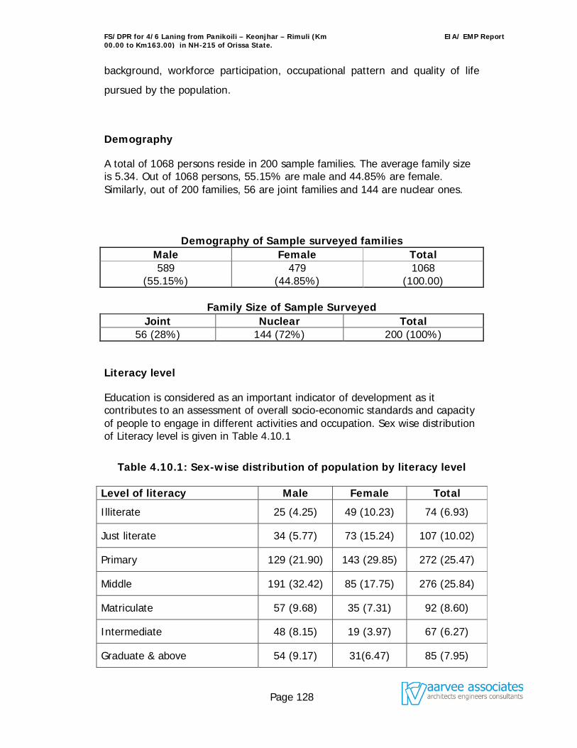
FS/DPR for 4/6 Laning from Panikoili – Keonjhar – Rimuli (Km 00.00 to Km163.00) in NH-215 of Orissa State.
EIA/ EMP Report
Page 128
background, workforce participation, occupational pattern and quality of life
pursued by the population.
Demography
A total of 1068 persons reside in 200 sample families. The average family size is 5.34. Out of 1068 persons, 55.15% are male and 44.85% are female. Similarly, out of 200 families, 56 are joint families and 144 are nuclear ones.
Demography of Sample surveyed families Male Female Total 589
(55.15%) 479
(44.85%) 1068
(100.00)
Family Size of Sample Surveyed Joint Nuclear Total
56 (28%) 144 (72%) 200 (100%)
Literacy level
Education is considered as an important indicator of development as it contributes to an assessment of overall socio-economic standards and capacity of people to engage in different activities and occupation. Sex wise distribution of Literacy level is given in Table 4.10.1
Table 4.10.1: Sex-wise distribution of population by literacy level
Level of literacy Male Female Total
Illiterate 25 (4.25) 49 (10.23) 74 (6.93)
Just literate 34 (5.77) 73 (15.24) 107 (10.02)
Primary 129 (21.90) 143 (29.85) 272 (25.47)
Middle 191 (32.42) 85 (17.75) 276 (25.84)
Matriculate 57 (9.68) 35 (7.31) 92 (8.60)
Intermediate 48 (8.15) 19 (3.97) 67 (6.27)
Graduate & above 54 (9.17) 31(6.47) 85 (7.95)
FS/DPR for 4/6 Laning from Panikoili – Keonjhar – Rimuli (Km 00.00 to Km163.00) in NH-215 of Orissa State.
EIA/ EMP Report
Page 129
Level of literacy Male Female Total
Technical 10 (1.70) - 10 (0.96)
Non-school age children 41 (6.96) 44 (9.18) 85 (7.96)
Total 589 (100.00) 479 (100.00) 1068 (100.00)
Literacy Percentage excluding age (0-6 yrs) 88.79 80.59 85.11
As may be seen from the above table, the literacy level of the population in the
project area is better. As shown in the table, 88.79 percentages of the male
population and 80.59% of female population aggregating an average of
85.11% are found to be literate. But when the educational level is analyzed, it
is found that 6.93% of the total population are illiterate, 10.02% are literate
without formal education, 25.47% are educated up to primary level, 25.84%
up to middle class level, 8.60% up to secondary level, whereas 6.27%, 7.95%,
0.96% are educated up to intermediate, graduate and having technical
qualification respectively. Besides 7.96% of the total population constitute the
non-school age children.
Participation in economic activities
A. Usual activity:
Adopting the procedure “Usual Activity Status” of the population in the area 30.62 percent of the total population are classified as workers and are pursuing some occupation for economic gains. Unemployment in the area is moderate with 7.59 percent people reportedly unemployed. This however is an indication of lack of economic opportunities in the area especially of the educated person. This low level of employment is also an indicator of the economic hardship and low labour productivity. The reason is that in rural areas, people always perform some kind of manual work. It is altogether different that such employment may not be adequate in terms of days of employment and wage earnings. The usual activity of the population in project area is given in Table 4.10.2.
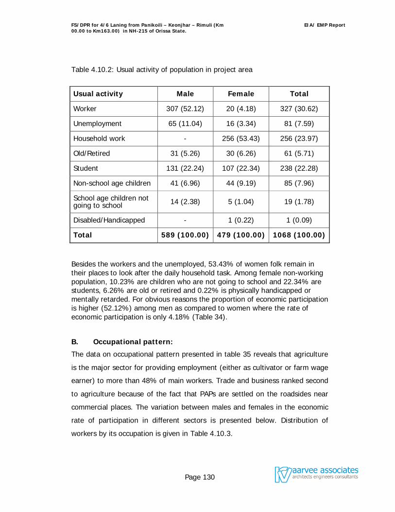
FS/DPR for 4/6 Laning from Panikoili – Keonjhar – Rimuli (Km 00.00 to Km163.00) in NH-215 of Orissa State.
EIA/ EMP Report
Page 130
Table 4.10.2: Usual activity of population in project area
Usual activity Male Female Total
Worker 307 (52.12) 20 (4.18) 327 (30.62)
Unemployment 65 (11.04) 16 (3.34) 81 (7.59)
Household work - 256 (53.43) 256 (23.97)
Old/Retired 31 (5.26) 30 (6.26) 61 (5.71)
Student 131 (22.24) 107 (22.34) 238 (22.28)
Non-school age children 41 (6.96) 44 (9.19) 85 (7.96)
School age children not going to school 14 (2.38) 5 (1.04) 19 (1.78)
Disabled/Handicapped - 1 (0.22) 1 (0.09)
Total 589 (100.00) 479 (100.00) 1068 (100.00)
Besides the workers and the unemployed, 53.43% of women folk remain in their places to look after the daily household task. Among female non-working population, 10.23% are children who are not going to school and 22.34% are students, 6.26% are old or retired and 0.22% is physically handicapped or mentally retarded. For obvious reasons the proportion of economic participation is higher (52.12%) among men as compared to women where the rate of economic participation is only 4.18% (Table 34).
B. Occupational pattern:
The data on occupational pattern presented in table 35 reveals that agriculture
is the major sector for providing employment (either as cultivator or farm wage
earner) to more than 48% of main workers. Trade and business ranked second
to agriculture because of the fact that PAPs are settled on the roadsides near
commercial places. The variation between males and females in the economic
rate of participation in different sectors is presented below. Distribution of
workers by its occupation is given in Table 4.10.3.
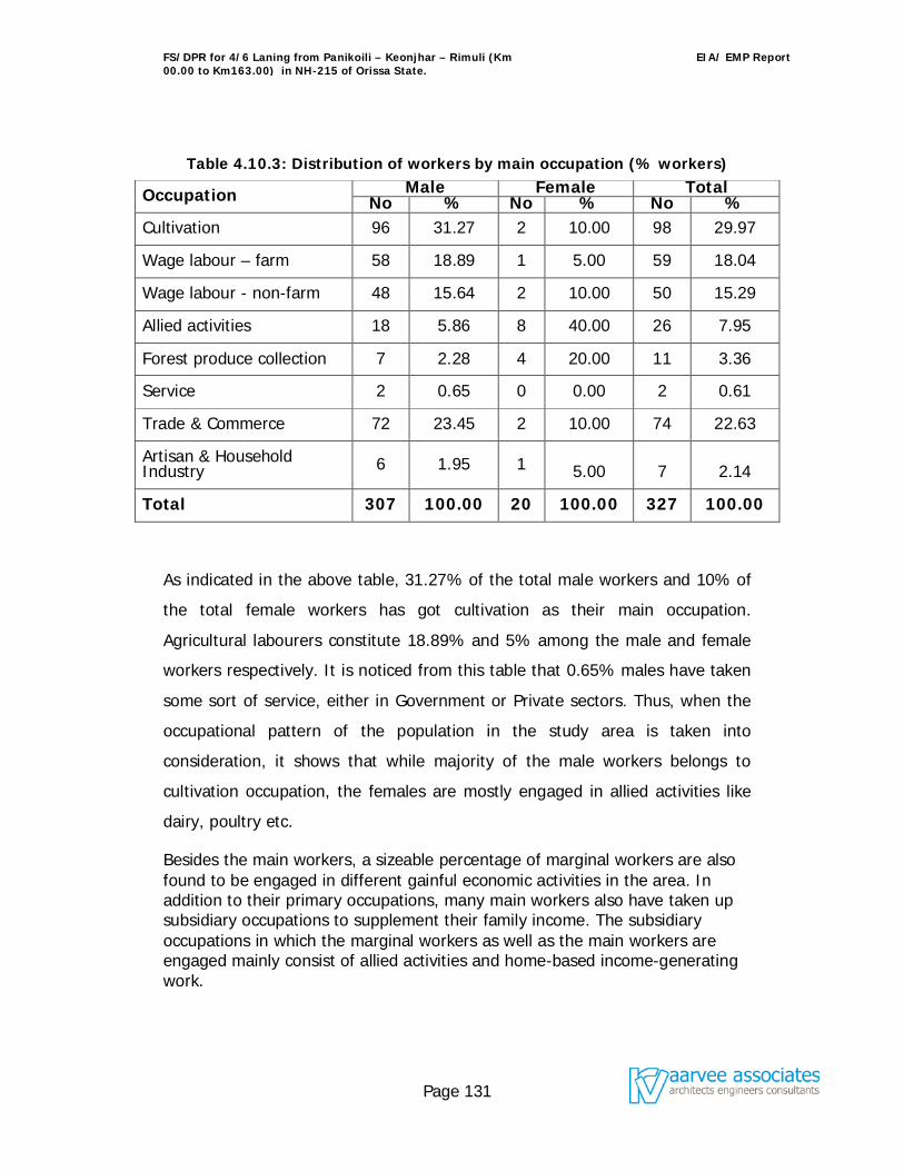
FS/DPR for 4/6 Laning from Panikoili – Keonjhar – Rimuli (Km 00.00 to Km163.00) in NH-215 of Orissa State.
EIA/ EMP Report
Page 131
Table 4.10.3: Distribution of workers by main occupation (% workers)
Occupation Male Female Total No % No % No %
Cultivation 96 31.27 2 10.00 98 29.97
Wage labour – farm 58 18.89 1 5.00 59 18.04
Wage labour - non-farm 48 15.64 2 10.00 50 15.29
Allied activities 18 5.86 8 40.00 26 7.95
Forest produce collection 7 2.28 4 20.00 11 3.36
Service 2 0.65 0 0.00 2 0.61
Trade & Commerce 72 23.45 2 10.00 74 22.63
Artisan & Household Industry 6 1.95 1 5.00 7 2.14
Total 307 100.00 20 100.00 327 100.00
As indicated in the above table, 31.27% of the total male workers and 10% of
the total female workers has got cultivation as their main occupation.
Agricultural labourers constitute 18.89% and 5% among the male and female
workers respectively. It is noticed from this table that 0.65% males have taken
some sort of service, either in Government or Private sectors. Thus, when the
occupational pattern of the population in the study area is taken into
consideration, it shows that while majority of the male workers belongs to
cultivation occupation, the females are mostly engaged in allied activities like
dairy, poultry etc.
Besides the main workers, a sizeable percentage of marginal workers are also found to be engaged in different gainful economic activities in the area. In addition to their primary occupations, many main workers also have taken up subsidiary occupations to supplement their family income. The subsidiary occupations in which the marginal workers as well as the main workers are engaged mainly consist of allied activities and home-based income-generating work.

FS/DPR for 4/6 Laning from Panikoili – Keonjhar – Rimuli (Km 00.00 to Km163.00) in NH-215 of Orissa State.
EIA/ EMP Report
Page 132
C. Income level:
Analysis of the level of income enjoyed by various sections of the population and the main source of income also give an idea regarding the people and the level of income derived from such activities. Such an analysis, at the same-time, brings into focus the relative importance of individual economic activity in terms of the proportional contribution to the total income.
In the present study, analysis of the level of income of the sample families has been put in a tabular form in table 36. The data presented in the table reveals that when all sources of household income are considered the average annual income of the families is Rs. 39,527/- per family.
Annual household income of sample families Annual income range No of families % <Rs 15000 39 19.50 Rs 15000 to Rs 50000 121 60.50
>Rs 50000 40 20.00 Total 200 100.00 Average annual household income Rs. 39,527.00
When the proportional contribution of various sources of income is analyzed it
is revealed that highest contribution is from trade and business (45.65%)
activity followed by cultivation (24.25%) activity. Wage earning as a source of
income contributes 9.14% to the annual household income.
Contribution of various sources of income to the annual household income
Sources of income Contribution (%)
Cultivation 24.25
Leased out of agricultural land 1.11
Forest produce collection 0.92
Allied activities 2.98
Wage earning 9.14
Service 11.18
Trade/business 45.65
Household industry & profession 3.19
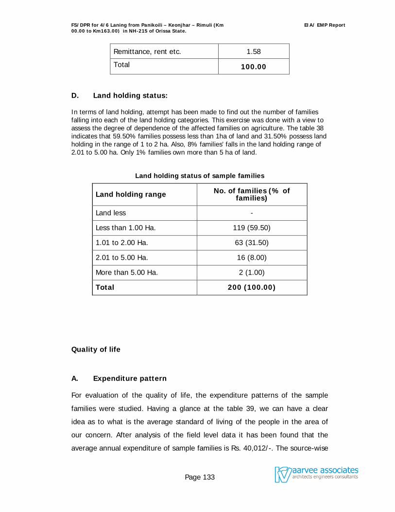
FS/DPR for 4/6 Laning from Panikoili – Keonjhar – Rimuli (Km 00.00 to Km163.00) in NH-215 of Orissa State.
EIA/ EMP Report
Page 133
Remittance, rent etc. 1.58
Total 100.00
D. Land holding status:
In terms of land holding, attempt has been made to find out the number of families falling into each of the land holding categories. This exercise was done with a view to assess the degree of dependence of the affected families on agriculture. The table 38 indicates that 59.50% families possess less than 1ha of land and 31.50% possess land holding in the range of 1 to 2 ha. Also, 8% families’ falls in the land holding range of 2.01 to 5.00 ha. Only 1% families own more than 5 ha of land.
Land holding status of sample families
Land holding range No. of families (% of families)
Land less -
Less than 1.00 Ha. 119 (59.50)
1.01 to 2.00 Ha. 63 (31.50)
2.01 to 5.00 Ha. 16 (8.00)
More than 5.00 Ha. 2 (1.00)
Total 200 (100.00)
Quality of life
A. Expenditure pattern
For evaluation of the quality of life, the expenditure patterns of the sample
families were studied. Having a glance at the table 39, we can have a clear
idea as to what is the average standard of living of the people in the area of
our concern. After analysis of the field level data it has been found that the
average annual expenditure of sample families is Rs. 40,012/-. The source-wise
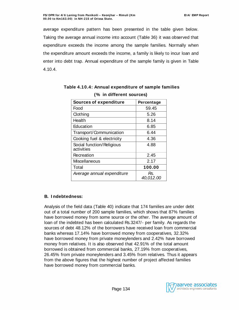
FS/DPR for 4/6 Laning from Panikoili – Keonjhar – Rimuli (Km 00.00 to Km163.00) in NH-215 of Orissa State.
EIA/ EMP Report
Page 134
average expenditure pattern has been presented in the table given below.
Taking the average annual income into account (Table 36) it was observed that
expenditure exceeds the income among the sample families. Normally when
the expenditure amount exceeds the income, a family is likely to incur loan and
enter into debt trap. Annual expenditure of the sample family is given in Table
4.10.4.
Table 4.10.4: Annual expenditure of sample families
(% in different sources)
Sources of expenditure Percentage Food 59.45 Clothing 5.26 Health 8.14 Education 6.85 Transport/Communication 6.44 Cooking fuel & electricity 4.36 Social function/Religious activities
4.88
Recreation 2.45 Miscellaneous 2.17 Total 100.00 Average annual expenditure Rs.
40,012.00
B. Indebtedness:
Analysis of the field data (Table 40) indicate that 174 families are under debt out of a total number of 200 sample families, which shows that 87% families have borrowed money from some source or the other. The average amount of loan of the indebted has been calculated Rs.3247/- per family. As regards the sources of debt 48.12% of the borrowers have received loan from commercial banks whereas 17.14% have borrowed money from cooperatives, 32.32% have borrowed money from private moneylenders and 2.42% have borrowed money from relatives. It is also observed that 42.91% of the total amount borrowed is obtained from commercial banks, 27.19% from cooperatives, 26.45% from private moneylenders and 3.45% from relatives. Thus it appears from the above figures that the highest number of project affected families have borrowed money from commercial banks.
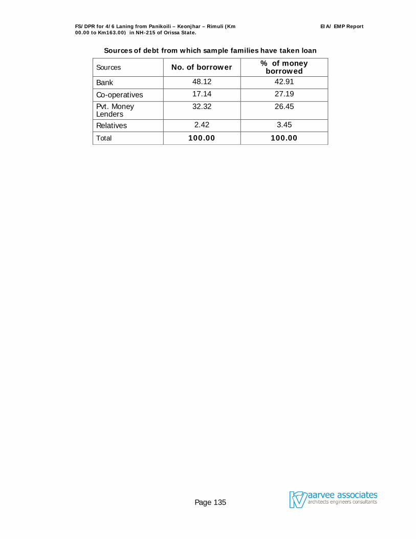
FS/DPR for 4/6 Laning from Panikoili – Keonjhar – Rimuli (Km 00.00 to Km163.00) in NH-215 of Orissa State.
EIA/ EMP Report
Page 135
Sources of debt from which sample families have taken loan
Sources No. of borrower % of money borrowed
Bank 48.12 42.91
Co-operatives 17.14 27.19
Pvt. Money Lenders
32.32 26.45
Relatives 2.42 3.45
Total 100.00 100.00
FS/DPR for 4/6 Laning from Panikoili – Keonjhar – Rimuli (Km 00.00 to Km163.00) in NH-215 of Orissa State.
EIA/ EMP Report
Page 136
The road development projects exhibit a symbiotic relationship between the
environment and development with both positive and negative and reversible and
irreversible impacts. The present chapter gives the analysis of the impacts in the
present project corridor and suggested mitigative measures. Matrix method was
adopted as methodology for assessment of impacts. Based on the scoping of the areas
and the work being proposed the following key issues were assessed for this project.
Preservation of aesthetic and landscape of the area to the possible extent
Effective restoration of borrow area and quarries
Noise and air quality
Tree removal and tree plantation
Sanitation and waste disposal
Road safety
Protection of flora and fauna
Road development projects can have impacts or cause impacts in four specific
situations as follows:
Impacts of Location
Impacts of Project Design
Impacts during Construction, and
Impacts when the Road become Operational.
5.1 Impacts of Location
The road stretch has no specific impacts from the location. Presently the roads lack of
side drains and this often leads to accumulation of water by the road side which in
turn damage the road shoulders. Proper care has been taken in the designs to
build in drainage system.
FS/DPR for 4/6 Laning from Panikoili – Keonjhar – Rimuli (Km 00.00 to Km163.00) in NH-215 of Orissa State.
EIA/ EMP Report
Page 137
5.2 Impacts Due to Project Design
The engineering design of the road has been prepared incorporating all environmental
safeguards. The design criteria have been covered in Chapter –3. To prevent the
damages to shoulders appropriate designs are prepared which include regular dressing
of the earthen shoulders to establish a gentle slope away from the carriageway.
5.3 Impacts During Construction
Since the construction is dependent on the quality and properties of the available
material, the choice of material, particularly the management of borrow pits, assumes
importance during construction.
5.3.1 Borrow Area
Large quantity of earth / gravel material is required for widening of formation and
embankment, necessitating earth / gravel from borrow pits.
5.3.2 Borrow Pit Restoration
Arrangements for opening and using material from borrow pits shall contain
enforceable provisions for the extraction and restoration of the borrow area, and their
surroundings, in an environmentally sound manner to the satisfaction of the Engineer.
Areas shall be graded to ensure drainage and visual uniformity, and arrangements
shall be made to collect and preserve top soil for use in the excavated borrow pit sides
and bottom to make it green area alternatively, these borrow areas would be sited as
far as possible on high grounds or hillocks. Topsoil shall be replaced and the area re-
vegetated to the satisfaction of the Engineer. The topsoil can also be used for side
slope, median covering for the growth of shrubs and grass. Additional borrow pits will
not be opened without restoration of those areas no longer in use.
FS/DPR for 4/6 Laning from Panikoili – Keonjhar – Rimuli (Km 00.00 to Km163.00) in NH-215 of Orissa State.
EIA/ EMP Report
Page 138
5.3.3 Soil Quality
The problems of soil erosion exist in the stretch due to varying topography, erratic
rainfall and swift velocities of water in the drains during monsoon.
Top Soil Loss: The loss of fertile topsoil / humus may occur because of the extension
of carriageway, hence care and precaution need to be taken to preserve the layer and
reuse the soil as it contains the humus.
Soil Erosion: It may occur due to the uneven topography and intensity of rainfall. A
major problem of erosion may occur due to the removal of age-old trees along the
roadside within ROW. The removal will result in the instability of soil binding and soil
structure, as uprooting will make the soil loose. Erosion may occur due to the swift
velocities of drains in monsoon.
Mitigation measures include periodic maintenance of drains to check scouring of soil
and limiting construction activities of culverts and bridges to dry seasons. Measures
should be taken to prevent contamination of soil by bituminous material and other
chemicals utilized during construction. No agricultural land would be used for borrow
areas. The excavated top soil will be properly stored for reuse.
In addition to the engineering design the corridor will be planted with trees to support
and the strengthen the soil binding capacity.
5.3.4 Impact on Water Resources and Water Quality
To prevent accumulation of water by the road side, adequate cross drainage (CD)
structures in the form of culverts with adequate discharge capacity will be constructed.
During reconstruction of old cross drainage structures and construction of new ones,
diversion is required to aid uninterrupted movement of traffic. Material will not be put
in the drainage to avoid blockage and prevent the erosion. This will help in protecting
the aquatic ecology.
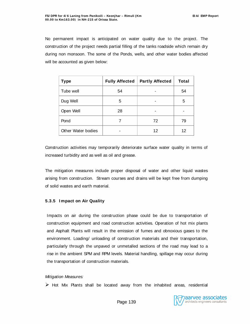
FS/DPR for 4/6 Laning from Panikoili – Keonjhar – Rimuli (Km 00.00 to Km163.00) in NH-215 of Orissa State.
EIA/ EMP Report
Page 139
No permanent impact is anticipated on water quality due to the project. The
construction of the project needs partial filling of the tanks roadside which remain dry
during non monsoon. The some of the Ponds, wells, and other water bodies affected
will be accounted as given below:
Type Fully Affected Partly Affected Total
Tube well 54 - 54
Dug Well 5 - 5
Open Well 28 - -
Pond 7 72 79
Other Water bodies - 12 12
Construction activities may temporarily deteriorate surface water quality in terms of
increased turbidity and as well as oil and grease.
The mitigation measures include proper disposal of water and other liquid wastes
arising from construction. Stream courses and drains will be kept free from dumping
of solid wastes and earth material.
5.3.5 Impact on Air Quality
Impacts on air during the construction phase could be due to transportation of
construction equipment and road construction activities. Operation of hot mix plants
and Asphalt Plants will result in the emission of fumes and obnoxious gases to the
environment. Loading/ unloading of construction materials and their transportation,
particularly through the unpaved or unmetalled sections of the road may lead to a
rise in the ambient SPM and RPM levels. Material handling, spillage may occur during
the transportation of construction materials.
Mitigation Measures:
Hot Mix Plants shall be located away from the inhabited areas, residential
FS/DPR for 4/6 Laning from Panikoili – Keonjhar – Rimuli (Km 00.00 to Km163.00) in NH-215 of Orissa State.
EIA/ EMP Report
Page 140
settlements and water bodies.
Trucks and Tippers carrying earth for filling, sand, gravel or stone will be duly
covered with Tarpaulin sheets to avoid spilling.
Dust level at the construction sites shall be controlled by sprinkling water.
Construction material, machinery and equipment will be maintained in a good
working condition and shall be handled with due precaution and only by trained
professionals.
5.3.6 Impact on Noise
The impact of noise levels from the project on the neighboring communities would be
anticipated with the increase in vehicles and vary with vehicles speed. The increased
noise level is attenuated by vegetative noise barriers. (Rows of trees planted). The
major sources for noise pollution during construction will be movement of vehicles
transporting the construction material to the construction yard and the noise
generating activities at the yard itself. The construction equipment with high noise
levels, loading and transportation of material near the borrow areas will affect the
construction personnel and other humans in the area.
The required mitigation materials include location of construction equipment will be at
least 250 m away from inhabited areas. In addition construction workers will have to
be provided with protection devices like earplugs. Other ancillary measures include
maintenance of equipment in good condition, proper design of engine enclosures.
Project activities shall be coincide with periods when people would be least affected.
Construction activities shall be strictly prohibited between 10 P.M and 6 A.M in
residential areas.
Acoustic Barriers: There are no flyovers and only pedestrian underpasses are
envisaged in inhabited areas with 2.5 to 3.5 m vertical clearance and the gradients are
very flat and do not require sudden acceleration. Moreover, the main carriageway is
separated from the building line with the help of service roads, thereby minimising the
noise pollution for the residents. In view of this, acoustic barriers are not proposed in
the project.
FS/DPR for 4/6 Laning from Panikoili – Keonjhar – Rimuli (Km 00.00 to Km163.00) in NH-215 of Orissa State.
EIA/ EMP Report
Page 141
5.3.7 Impact on Biological Environment
The widening of the existing 2-lane road might require felling of trees from the
roadside plantation areas. The predominant tree species going to be felled include
Palm, Siris, Gulmohur, Tamarind, and Eucalyptus. These are all ubiquitous species.
The short-term impact due to felling of trees will be more than compensated in long
term through the proposed avenue plantation programme.
Mitigation Measures:
An avenue plantation programme shall be promptly adopted to restore and further
enrich the loss of vegetation along the following lines:
Plantation with an appropriate mix of indigenous and specially suited species shall be
carried out along the corridor. The number of plants proposed to be planted are:
In the compensatory afforestation area of 71.1 hectares, trees will be raised by forest
department at the rate of 3000 trees per hectare.
Trees proposed to be planted in compensatory aforestation area= 2,13,300
Trees proposed to be planted in Jajpur Road bypass = 6,400
Trees proposed to be planted in Anandpur bypass = 2,400
Trees proposed to be planted in Ghatagaon bypass = 800
Trees proposed to be planted in Keonjhar bypass = 4000
Trees proposed to be planted in Jhumpura bypass = 2,400
Trees proposed to be planted from Km 0.00 to Km 163.00 = 1,30,400
Total number of plants proposed to be planted = 3,59,700
Flowering plants and shrubs of the height of about 2m shall be planted at the median.
The plantation in the median will serve, as a barrier against glaring headlights of the
FS/DPR for 4/6 Laning from Panikoili – Keonjhar – Rimuli (Km 00.00 to Km163.00) in NH-215 of Orissa State.
EIA/ EMP Report
Page 142
vehicular traffic plying in the opposite direction. Further, this will improve the
aesthetics of the alignment.
Along the extreme edge of road boundary, tall growing trees such as Silver Oak
(Grewellia robusta) shall be planted. At a distance of 5 m from the outer row, shade
bearing and flowering trees of the following species will be taken up.
Jacaranda (Jacaranda mimusifolia)
Gulmohar (Delonix regia)
Moduga (Butea monosperma)
Rain tree (Samanea saman)
Tabebuia (Tabebuia avalandia /Tabebuia sp.)
Neem (Azadirachta indica)
Sisoo (Dalbergia sisoo)
Devil’s tree/ Saptaparni (Alstonia scholaris)
Fauna
Terrestrial Fauna
During the construction, no impact on the wildlife is anticipated.
Aquatic Fauna
The proposed project would require partial filling up of some ponds. Most of these
ponds remain dry during the non-monsoon months. Most of the rivers/ streams
crossing the corridor remain dry during non-monsoon months.
Increasing sediment load to the recipient water bodies i.e. ponds and rivers will
restrict the penetration of solar energy in the water body. This will affect
photosynthesis of the aquatic flora, which in turn will have adverse impacts on the
aquatic fauna. Since, most of the water bodies remain dry during the non-monsoon
months, this impact will be negligible. But, the implementation of the following
measures will help to avoid soil erosion and further minimize the impacts of the
aquatic fauna.
FS/DPR for 4/6 Laning from Panikoili – Keonjhar – Rimuli (Km 00.00 to Km163.00) in NH-215 of Orissa State.
EIA/ EMP Report
Page 143
Mitigation Measures:
Filling up of ponds will be resorted only after exhausting all other options.
Filling up of ponds wherever required shall be done during the non-monsoon
months.
Construction of bridges and culverts shall be accomplished during the non-
monsoon periods.
The requirement of filling up of ponds shall be minimised by constructing retaining
structures where the height of filling is more.
The direct discharge of oil and chemical spills to the water bodies shall be avoided.
5.3.8 Impacts on Human Use Values
Land Use
Widening of the existing 2-lane road will lead to a change in the land use pattern of
areas adjacent to the road. The existing land adjacent to the road at present is mostly
of agricultural use, which needs to be acquired for widening of the road. The proposed
bypasses at Jajpur, Anandpur, Ghatagaon, Keonjhar and Jhumpura pass through
mostly agriculture area and partly barren fields. Hence, acquisition of the fertile land
and gardens will have direct bearing on the floral resources and also on the local
economy.
The project corridor lies in a plain terrain and thus, no disfiguration of land is
envisaged due to construction activities except for the opening up of borrow pits. The
borrow pit locations have already been identified and will be restricted to those areas
only. The locations of borrow pits are already given in chapter 3.
Mitigation Measures:
Construction activities shall be limited to the corridor only.
Care shall be taken to ensure that the construction workers camp does not disturb
the surrounding land use.
FS/DPR for 4/6 Laning from Panikoili – Keonjhar – Rimuli (Km 00.00 to Km163.00) in NH-215 of Orissa State.
EIA/ EMP Report
Page 144
Existing access/ entrances to the highway shall be duly maintained.
While finalising bypass alignments, options that are best from Engineering,
Environmental and Social aspects are selected.
Flood Characteristics
The flood characteristics of the project area are given. In the proposed improvement
scheme, embankments will be constructed for forming bypasses, construction of ROBs
and vehicular underpasses. These may lead to flooding of the project area in the even
of unprecedented rains.
Mitigation Measures:
Raising of the embankment height above the submergence depth.
Widening and strengthening of the existing cross-drainage structures particularly
at the specified locations of submergence.
Providing drain on both sides of the widened road and extending the drains to a
proper outfall.
Proper supervision during construction to avoid blocking of micro-drainage across
the road.
Maintain existing drainage outlets.
Replace inadequate or distressed drainage structures.
Adequate number of cross drainage structures will be provided along the bypasses.
5.3.9 Impacts on Quality of Life
Socio-economics, Land Acquisitions and Resettlements
Impacts and mitigation measures associated with social environment in the project
influence area (PIA), land acquisition and resettlement of project-affected persons
(PAP) have been dealt in separate Chapter.
FS/DPR for 4/6 Laning from Panikoili – Keonjhar – Rimuli (Km 00.00 to Km163.00) in NH-215 of Orissa State.
EIA/ EMP Report
Page 145
Accident, Health and Safety
Construction activities will cause hindrance to the existing traffic flow. Thus, short-
term impact in terms of accident is anticipated during construction phase of the
widening project.
Mitigation Measures
Reduce speed through construction zones.
Construction of bridges/ culverts shall be carried out prior to construction of new
corridor at the first stage.
Strengthening or raising of the existing 2-lane shall be done only after the
completion of the new pavement.
Proper cautionary signs shall be displayed at construction sites.
Diversion roads will be provided wherever needed.
Aesthetics and Landscape
The proposed widening of the existing 2-lane road will require partial removal of
roadside plantation, which will deteriorate the corridor’s aesthetic values temporarily.
But the proposed plantation all along in long run will improve the aesthetics and
landscaping of the corridor. Disfiguration of the landscape is also anticipated due to
opening of borrow pits.
Mitigation Measures
Mixed plantation shall be carried out at roadside and flowering shrubs in the
median
Borrow pits shall be resurfaced with conserved topsoil (borrow pit opening shall be
as per IRC-10-1961).
Plan for controlled development shall be evolved by land planning agencies.
There shall be proper vigilance to avoid squatter development all along the
corridor.
FS/DPR for 4/6 Laning from Panikoili – Keonjhar – Rimuli (Km 00.00 to Km163.00) in NH-215 of Orissa State.
EIA/ EMP Report
Page 146
5.3.10 Impacts from Construction Workers’ Camp
Local labourers shall be employed for the construction activities to the maximum
possible number to minimise the production of domestic waste generation.
Mitigation Measures:
Labourers residing in the camps shall be provided with safe drinking water, adequate
sanitation facilities, kerosene and all other amenities as per the prevailing Labour laws.
Domestic waste generated will be treated as per IS-2470.
Sanitation and Waste Disposal
Sewage and domestic solid waste generated at the construction workers camp will be
properly disposed of to prevent health and hygiene related problems. Adequate
sanitary facilities will be made available at the construction camp. Periodical health
check up of construction workers will be undertaken.
5.4 Impacts During Operation Phase
5.4.1 Impact on Land use
Road development may lead to establishment of petty shops and other commercial
pursuits by the local populace. Local statutory bodies will strictly enforce land use. In
addition the project proponent should prevent development of squatters settlements
and encroachments on the vacant portions of the RoW of the road.
5.4.2 Impact on Air Quality
The impact on ambient air quality due to vehicular movement was predicted using the
California Line Source Emission 4 (CALINE4) model developed by Caltrans in 1989.
CALINE4 is a simple line source “Gaussian plume dispersion model”, primarily predicts
Carbon Monoxide (CO) impacts near roadways. Its purpose is to help planners protect
public health from the adverse effects of excessive CO exposure. The user must also
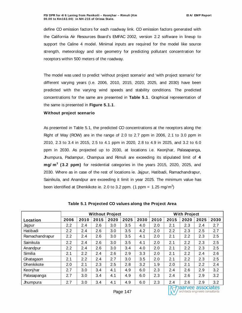
FS/DPR for 4/6 Laning from Panikoili – Keonjhar – Rimuli (Km 00.00 to Km163.00) in NH-215 of Orissa State.
EIA/ EMP Report
Page 147
define CO emission factors for each roadway link. CO emission factors generated with
the California Air Resources Board’s EMFAC 2002, version 2.2 software in lineup to
support the Caline 4 model. Minimal inputs are required for the model like source
strength, meteorology and site geometry for predicting pollutant concentration for
receptors within 500 meters of the roadway.
The model was used to predict ‘without project scenario’ and ‘with project scenario’ for
different varying years (i.e. 2006, 2010, 2015, 2020, 2025, and 2030) have been
predicted with the varying wind speeds and stability conditions. The predicted
concentrations for the same are presented in Table 5.1. Graphical representation of
the same is presented in Figure 5.1.1.
Without project scenario
As presented in Table 5.1, the predicted CO concentrations at the receptors along the
Right of Way (ROW) are in the range of 2.0 to 2.7 ppm in 2006, 2.1 to 3.0 ppm in
2010, 2.3 to 3.4 in 2015, 2.5 to 4.1 ppm in 2020, 2.8 to 4.9 in 2025, and 3.2 to 6.0
ppm in 2030. As projected up to 2030, at locations i.e. Keonjhar, Palasapanga,
Jhumpura, Padampur, Champua and Rimuli are exceeding its stipulated limit of 4
mg/m3 (3.2 ppm) for residential categories in the years 2015, 2020, 2025, and
2030. Where as in case of the rest of locations ie. Jajpur, Hatibadi, Ramachandrapur,
Sainikula, and Anandpur are exceeding it limit in year 2025. The minimum value has
been identified at Dhenkikote ie. 2.0 to 3.2 ppm. (1 ppm = 1.25 mg/m3)
Table 5.1 Projected CO values along the Project Area
Location Without Project With Project
2006 2010 2015 2020 2025 2030 2010 2015 2020 2025 2030 Jajpur 2.2 2.4 2.6 3.0 3.5 4.0 2.0 2.1 2.3 2.4 2.7 Hatibadi 2.2 2.4 2.6 3.0 3.5 4.2 2.0 2.2 2.3 2.5 2.7 Ramachandrapur 2.2 2.4 2.6 3.0 3.5 4.1 2.0 2.1 2.2 2.3 2.5 Sainikula 2.2 2.4 2.6 3.0 3.5 4.1 2.0 2.1 2.2 2.3 2.5 Anandpur 2.2 2.4 2.6 3.0 3.4 4.0 2.0 2.1 2.2 2.3 2.5 Similia 2.1 2.2 2.4 2.6 2.9 3.3 2.0 2.1 2.2 2.4 2.6 Ghatagaon 2.1 2.2 2.4 2.7 3.0 3.5 2.0 2.1 2.2 2.3 2.5 Dhenkikote 2.0 2.1 2.3 2.5 2.8 3.2 1.9 2.0 2.1 2.2 2.4 Keonjhar 2.7 3.0 3.4 4.1 4.9 6.0 2.3 2.4 2.6 2.9 3.2 Palasapanga 2.7 3.0 3.4 4.1 4.9 6.0 2.3 2.4 2.6 2.9 3.2
Jhumpura 2.7 3.0 3.4 4.1 4.9 6.0 2.3 2.4 2.6 2.9 3.2
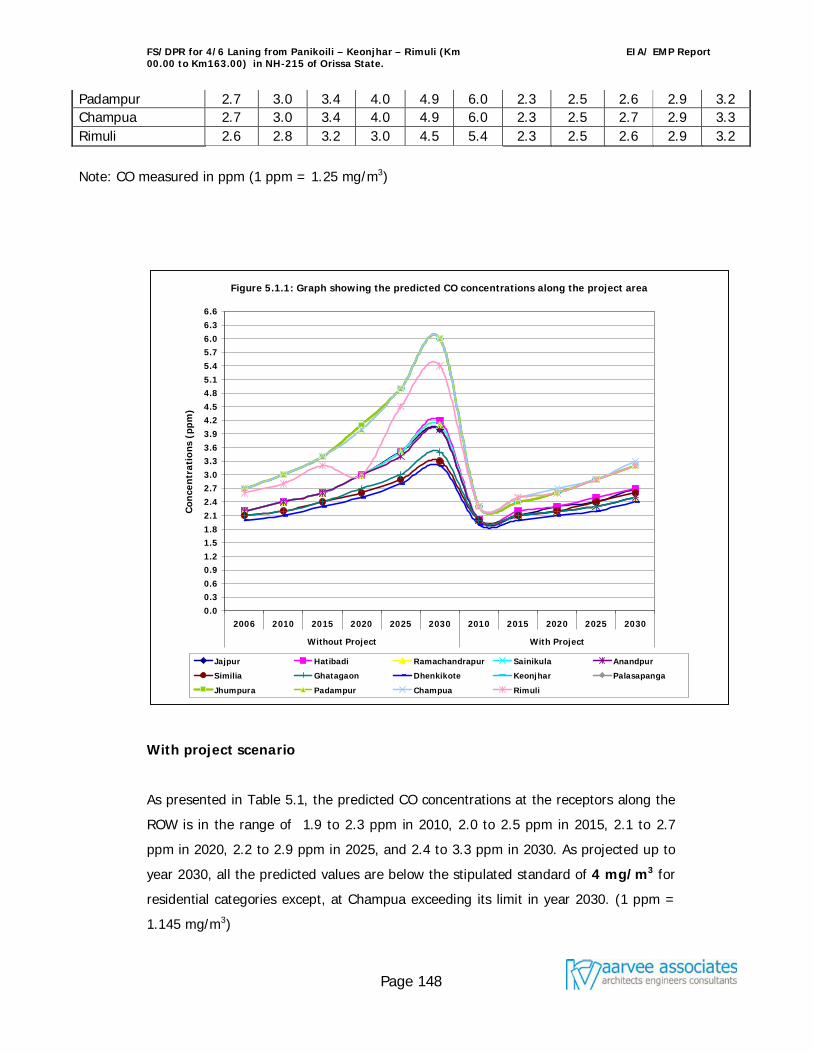
FS/DPR for 4/6 Laning from Panikoili – Keonjhar – Rimuli (Km 00.00 to Km163.00) in NH-215 of Orissa State.
EIA/ EMP Report
Page 148
Padampur 2.7 3.0 3.4 4.0 4.9 6.0 2.3 2.5 2.6 2.9 3.2 Champua 2.7 3.0 3.4 4.0 4.9 6.0 2.3 2.5 2.7 2.9 3.3 Rimuli 2.6 2.8 3.2 3.0 4.5 5.4 2.3 2.5 2.6 2.9 3.2
Note: CO measured in ppm (1 ppm = 1.25 mg/m3)
With project scenario
As presented in Table 5.1, the predicted CO concentrations at the receptors along the
ROW is in the range of 1.9 to 2.3 ppm in 2010, 2.0 to 2.5 ppm in 2015, 2.1 to 2.7
ppm in 2020, 2.2 to 2.9 ppm in 2025, and 2.4 to 3.3 ppm in 2030. As projected up to
year 2030, all the predicted values are below the stipulated standard of 4 mg/m3 for
residential categories except, at Champua exceeding its limit in year 2030. (1 ppm =
1.145 mg/m3)
Figure 5.1.1: Graph showing the predicted CO concentrations along the project area
0.00.30.60.91.21.51.82.12.42.73.03.33.63.94.24.54.85.15.45.76.06.36.6
2006 2010 2015 2020 2025 2030 2010 2015 2020 2025 2030
Without Project With Project
Con
cen
trat
ions
(pp
m)
Jajpur Hatibadi Ramachandrapur Sainikula Anandpur
Similia Ghatagaon Dhenkikote Keonjhar Palasapanga
Jhumpura Padampur Champua Rimuli
FS/DPR for 4/6 Laning from Panikoili – Keonjhar – Rimuli (Km 00.00 to Km163.00) in NH-215 of Orissa State.
EIA/ EMP Report
Page 149
On comparison of both ‘without’ and ‘with’ project scenario, concentrations are
exceeding its limit in 2015 ‘wihtout’ project scenario, where as in the case of ‘with’
project scenario all locations observed to be well with in the stipulated standard,
except at one location that too in year 2030. When compare with each other it is
clearly indicates that considerable reduction in concentrations observed ‘with project
scenario’.
The present Total Suspended Solids (TSPM) levels are slightly exceeding its limit, as
described in 4.3 of Chapter 4. Heavy traffic of loaded trucks, narrow townships, and
poor road conditions leads to increase the pollutant concentrations in the region. Five
bypasses have been proposed to overcome the problem in the proposed widening and
strengthening of the road.
Since the present baseline levels of other criteria pollutants RPM, NOx & SO2 are much
below the stipulated standards, ‘with project scenario’ the incremental emission levels
for the years 2010, 2015, 2020, 2025, and 2030 will be marginal and within the
standards. However, mitigation’s suggested to further improve the corridors air quality
are:
Phasing out of old technology vehicles, regular emission checks, use of fuel-
efficient engines, use of catalytic converter and land use control are the
measures that are to be implemented by central and state governments to
reduce pollution levels.
Enforcing the existing emission norms.
Plantation on either side of the road with selected plant species capable of
absorbing pollutants
Provision of road, improvements at intersections and separate truck parking
facilities to ensure smooth and uninterrupted traffic flow. All these facilities
shall result in minimizing stopping and idling of vehicles and thus
improving air quality
5.4.3 Impact on Noise Quality
FS/DPR for 4/6 Laning from Panikoili – Keonjhar – Rimuli (Km 00.00 to Km163.00) in NH-215 of Orissa State.
EIA/ EMP Report
Page 150
The major source of noise pollution in the project region is due to vehicular
movements on the highway and noise in the junctions. The noise impact due to the
transportation activity depends on the ultimate traffic volume and the type of the
vehicles in operation. The typical base noise levels generated in the corridor is
presented in the Chapter –4. To predict the cumulative noise impacts due to the
traffic movement, Federal Highways Administration (FHWA) model was used. In this
model, traffic characteristics used in predicting future noise levels could make a
substantial difference in the results. "Worst hourly traffic noise impact" occurs at a
time when truck volumes and vehicle speeds are the greatest have been considered.
FHWA model calculates day (Ld) and night (Ln) noise equivalent for each category of
vehicle and also the total day night (Ldn) due to all kinds of transportation.
The present total Ldn for different locations due to the vehicular movements is more in
Night time than day time. The noise levels get diluted as we move away from the
centre line of the road. The predicted noise levels at various locations for different
varying years (i.e., 2005, 2010, 2015, 2020, 2025, and 2030) ‘without project scenario’
and ‘with project scenario’ has been presented in Table 5.2.
‘Without project scenario’
From Table 5.2, it is clearly indicates that the predicted noise levels based on model is
almost compatible and observed to be slightly higher side when compare with base
noise levels (observed at study area). All the predicted stations are fall under
residential category and exceeding the stipulated day limit of 55 dB (A) in the year
2006 itself. The predicted maximum concentrations at Palasapanga, Champua, and
Rimuli are in the range of 62.1 to 68.9 dB (A) till 2030. The minimum predicted
concentration found to be at Anandpur are in the range of 55.2 to 62.1 dB (A) till
2030.
‘With project scenario‘
From Table 5.2, it is clearly indicates that the predicted noise levels for the years
2010, 2015, 2020, 2025, and 2030 are well with in the stipulated standard. Except, in
FS/DPR for 4/6 Laning from Panikoili – Keonjhar – Rimuli (Km 00.00 to Km163.00) in NH-215 of Orissa State.
EIA/ EMP Report
Page 151
2030, at stations Keonjhar, Palasapanga, Jhumpura, Padampur, Champua, and Rimuli
are slightly exceeding its day time stipulated limit of 55 dB (A). Obviously, in the year
2030 the noise levels are more as compared with rest of the years and are slightly
below the stipulated standard for rest of the stations.
The graphical representation of noise levels pertaining to predictions without project
scenario and predictions with project scenario are given in 5.2.1.
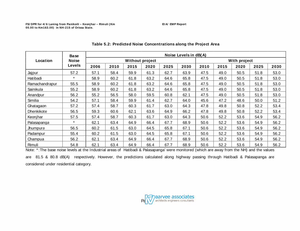
FS/DPR for 4/6 Laning from Panikoili – Keonjhar – Rimuli (Km 00.00 to Km163.00) in NH-215 of Orissa State.
EIA/ EMP Report
Page 152
Table 5.2: Predicted Noise Concentrations along the Project Area
Location Base Noise Levels
Noise Levels in dB(A) Without project With project
2006 2010 2015 2020 2025 2030 2010 2015 2020 2025 2030 Jajpur 57.2 57.1 58.4 59.9 61.3 62.7 63.9 47.5 49.0 50.5 51.8 53.0 Hatibadi * 58.9 60.2 61.8 63.2 64.6 65.8 47.5 49.0 50.5 51.8 53.0 Ramachandrapur 55.5 58.9 60.2 61.8 63.2 64.6 65.8 47.5 49.0 50.5 51.8 53.0 Sainikula 55.2 58.9 60.2 61.8 63.2 64.6 65.8 47.5 49.0 50.5 51.8 53.0 Anandpur 56.2 55.2 56.5 58.0 59.5 60.8 62.1 47.5 49.0 50.5 51.8 53.0 Similia 54.2 57.1 58.4 59.9 61.4 62.7 64.0 45.6 47.2 48.6 50.0 51.2 Ghatagaon 57.2 57.4 58.7 60.3 61.7 63.0 64.3 47.8 49.8 50.8 52.2 53.4 Dhenkikote 56.5 59.3 60.6 62.1 63.6 64.9 66.2 47.8 49.8 50.8 52.2 53.4 Keonjhar 57.5 57.4 58.7 60.3 61.7 63.0 64.3 50.6 52.2 53.6 54.9 56.2 Palasapanga * 62.1 63.4 64.9 66.4 67.7 68.9 50.6 52.2 53.6 54.9 56.2 Jhumpura 56.5 60.2 61.5 63.0 64.5 65.8 67.1 50.6 52.2 53.6 54.9 56.2 Padampur 55.4 60.2 61.5 63.0 64.5 65.8 67.1 50.6 52.2 53.6 54.9 56.2 Champua 56.2 62.1 63.4 64.9 66.4 67.7 68.9 50.6 52.2 53.6 54.9 56.2 Rimuli 54.8 62.1 63.4 64.9 66.4 67.7 68.9 50.6 52.2 53.6 54.9 56.2
Note: *:The base noise levels at the Industrial areas of Hatibadi & Palasapanga’ were monitored (which are away from the NH) and the values
are 81.5 & 80.8 dB(A) respectively. However, the predictions calculated along highway passing through Hatibadi & Palasapanga are
considered under residential category.
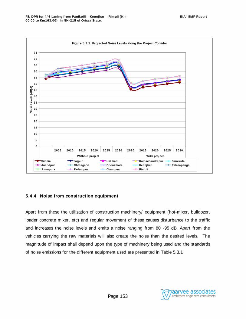
FS/DPR for 4/6 Laning from Panikoili – Keonjhar – Rimuli (Km 00.00 to Km163.00) in NH-215 of Orissa State.
EIA/ EMP Report
Page 153
5.4.4 Noise from construction equipment
Apart from these the utilization of construction machinery/ equipment (hot-mixer, bulldozer,
loader concrete mixer, etc) and regular movement of these causes disturbance to the traffic
and increases the noise levels and emits a noise ranging from 80 -95 dB. Apart from the
vehicles carrying the raw materials will also create the noise than the desired levels. The
magnitude of impact shall depend upon the type of machinery being used and the standards
of noise emissions for the different equipment used are presented in Table 5.3.1
Figure 5.2.1: Projected Noise Levels along the Project Corridor
0
5
10
15
20
25
30
35
40
45
50
55
60
65
70
75
2006 2010 2015 2020 2025 2030 2010 2015 2020 2025 2030
Without project With project
Noi
se L
evel
s (d
B(A
)
Similia Jajpur Hatibadi Ramachandrapur SainikulaAnandpur Ghatagaon Dhenkikote Keonjhar PalasapangaJhumpura Padampur Champua Rimuli
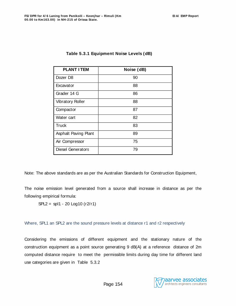
FS/DPR for 4/6 Laning from Panikoili – Keonjhar – Rimuli (Km 00.00 to Km163.00) in NH-215 of Orissa State.
EIA/ EMP Report
Page 154
Table 5.3.1 Equipment Noise Levels (dB)
PLANT ITEM Noise (dB)
Dozer D8 90
Excavator 88
Grader 14 G 86
Vibratory Roller 88
Compactor 87
Water cart 82
Truck 83
Asphalt Paving Plant 89
Air Compressor 75
Diesel Generators 79
Note: The above standards are as per the Australian Standards for Construction Equipment,
The noise emission level generated from a source shall increase in distance as per the
following empirical formula:
SPL2 = spl1 - 20 Log10 (r2/r1)
Where, SPL1 an SPL2 are the sound pressure levels at distance r1 and r2 respectively
Considering the emissions of different equipment and the stationary nature of the
construction equipment as a point source generating 9 dB(A) at a reference distance of 2m
computed distance require to meet the permissible limits during day time for different land
use categories are given in Table 5.3.2
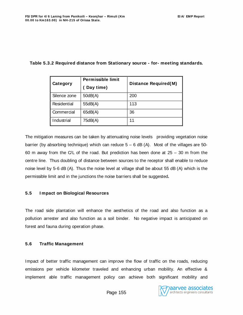
FS/DPR for 4/6 Laning from Panikoili – Keonjhar – Rimuli (Km 00.00 to Km163.00) in NH-215 of Orissa State.
EIA/ EMP Report
Page 155
Table 5.3.2 Required distance from Stationary source - for- meeting standards.
Category Permissible limit
( Day time) Distance Required(M)
Silence zone 50dB(A) 200
Residential 55dB(A) 113
Commercial 65dB(A) 36
Industrial 75dB(A) 11
The mitigation measures can be taken by attenuating noise levels providing vegetation noise
barrier (by absorbing technique) which can reduce 5 – 6 dB (A). Most of the villages are 50-
60 m away from the C/L of the road. But prediction has been done at 25 – 30 m from the
centre line. Thus doubling of distance between sources to the receptor shall enable to reduce
noise level by 5-6 dB (A). Thus the noise level at village shall be about 55 dB (A) which is the
permissible limit and in the junctions the noise barriers shall be suggested.
5.5 Impact on Biological Resources
The road side plantation will enhance the aesthetics of the road and also function as a
pollution arrester and also function as a soil binder. No negative impact is anticipated on
forest and fauna during operation phase.
5.6 Traffic Management
Impact of better traffic management can improve the flow of traffic on the roads, reducing
emissions per vehicle kilometer traveled and enhancing urban mobility. An effective &
implement able traffic management policy can achieve both significant mobility and
FS/DPR for 4/6 Laning from Panikoili – Keonjhar – Rimuli (Km 00.00 to Km163.00) in NH-215 of Orissa State.
EIA/ EMP Report
Page 156
environmental benefits. Some of the important conclusions about the environmental impact of
traffic management policies in developing countries are:
Traffic management measures have been shown to improve traffic conditions and
reduce emissions significantly by reducing the number and duration of stops and
permitting higher travel speeds.
Traffic management measures are relatively cheap and quick acting.
A combination of traffic engineering measures, demand management measures, and
measures giving priority to public transport vehicles has been shown to be the best
approach, especially in medium to large cities with high volume travel demand
corridors.
It induces additional travel that may have to be restrained by introducing traffic
demand management measures to ensure the sustainability of the traffic pollution
benefits.
The establishment of traffic management units with appropriate authority and ability
to plan and implement traffic management measures is essential.
5.7 Accident Hazards and Safety
Accident hazards would be greatly reduced because of the up-gradation and will ensure
smooth and fast flow of traffic. In the event of spillage of hazardous chemicals a spillage
containment mechanism will be developed along with the participation of police and the fire
department. In addition to this an emergency response mechanism should be evolved to
tackle accidents and spillage of substances.
5.8 Aesthetics
Roadside rest areas/ bays/ public amenities and parking place for long distance travelers have
been provided for in the project design. The roadside plantation will also add to the visual
appearance of the area.
FS/DPR for 4/6 Laning from Panikoili – Keonjhar – Rimuli (Km 00.00 to Km163.00) in NH-215 of Orissa State.
EIA/ EMP Report
Page 157
5.9 Evaluation of Impacts
The environmental impact of a project depends both on the project activities and on the
background environmental setting. The environmental impact assessment process involves
four basic steps
Identification
Evaluation
Interpretation
Communication
For the present project, the matrix method is used for assessment of impacts. In the present
case the impact, a scale of –4 to +4 is taken. This method is selected because it identifies the
impact of each project activity on each of the environmental attributes. Evaluation and
interpretation of impacts is mostly subjective and convey a holistic view of the environmental
impact of the project.
Matrix Method
The matrix used for EIA consists of project activities on the x-axis and the environmental
attributes likely to be affected by these activities on the y-axis. Each cell of the matrix
represents a subjective evaluation of the impacts of a particular activity on a particular
attribute in terms of magnitude and importance. A blank cell indicates no impact of the
activity on the component. The magnitude (M) is represented by a number from 1 to 4 where
1 = minimal 2 = appreciable
3 = significant 4 = severe
Positive sign (or no sign) indicates beneficial impact and negative sign indicates adverse
impact. The importance (I) of the impact is given on a scale of 1 to 4 in each cell. This
number indicates relative importance of the impact of the activity on the concerned attribute
for this project. The magnitude and importance are multiplied to get a score of each cell. The
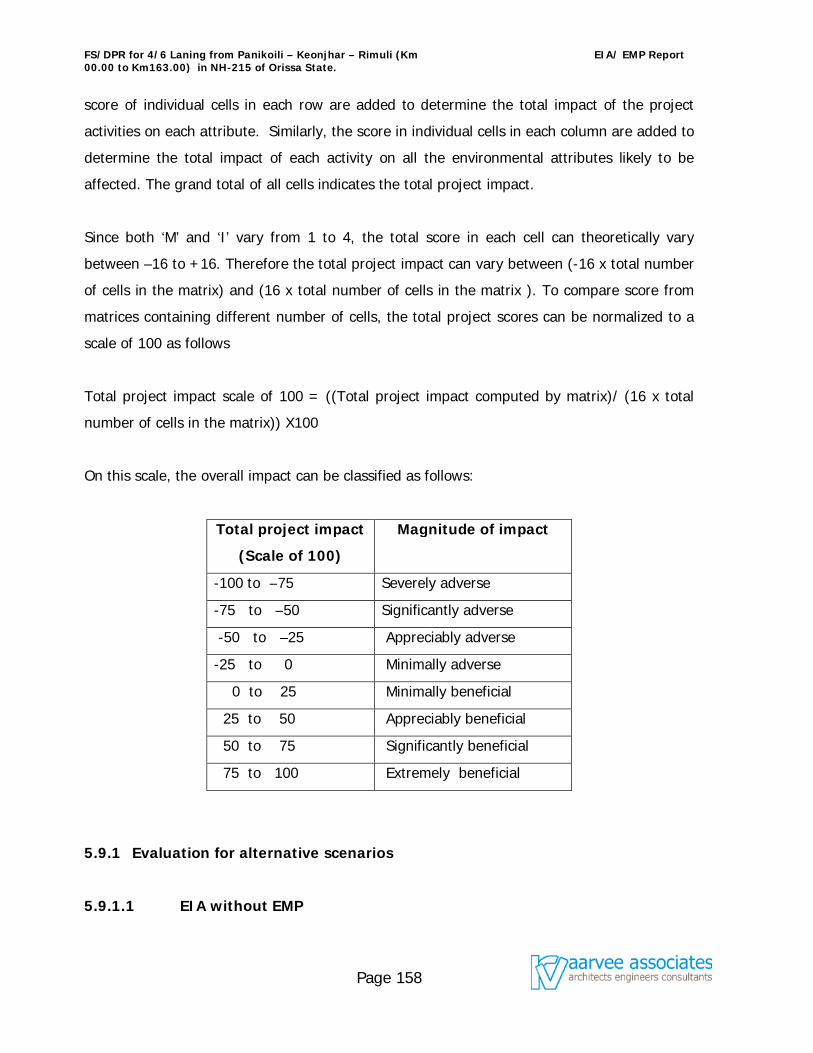
FS/DPR for 4/6 Laning from Panikoili – Keonjhar – Rimuli (Km 00.00 to Km163.00) in NH-215 of Orissa State.
EIA/ EMP Report
Page 158
score of individual cells in each row are added to determine the total impact of the project
activities on each attribute. Similarly, the score in individual cells in each column are added to
determine the total impact of each activity on all the environmental attributes likely to be
affected. The grand total of all cells indicates the total project impact.
Since both ‘M’ and ‘I’ vary from 1 to 4, the total score in each cell can theoretically vary
between –16 to +16. Therefore the total project impact can vary between (-16 x total number
of cells in the matrix) and (16 x total number of cells in the matrix ). To compare score from
matrices containing different number of cells, the total project scores can be normalized to a
scale of 100 as follows
Total project impact scale of 100 = ((Total project impact computed by matrix)/ (16 x total
number of cells in the matrix)) X100
On this scale, the overall impact can be classified as follows:
Total project impact
(Scale of 100)
Magnitude of impact
-100 to –75 Severely adverse
-75 to –50 Significantly adverse
-50 to –25 Appreciably adverse
-25 to 0 Minimally adverse
0 to 25 Minimally beneficial
25 to 50 Appreciably beneficial
50 to 75 Significantly beneficial
75 to 100 Extremely beneficial
5.9.1 Evaluation for alternative scenarios
5.9.1.1 EIA without EMP
FS/DPR for 4/6 Laning from Panikoili – Keonjhar – Rimuli (Km 00.00 to Km163.00) in NH-215 of Orissa State.
EIA/ EMP Report
Page 159
This scenario was based upon the assumption that the proposed development would go
ahead without any environmental management options being implemented. The total project
impact for the scenario, as can be seen in Table 5.9.1.1, was found to be –68 on a scale of
(+/-) 2688. The score on a scale of (+/-) 100 for this scenario was found to be –2.53, which
is on the minimally adverse side. This shows that if the project goes ahead without an
EMP, the adverse impact on the existing environment would be several times that of the
impact without the project. Thus, the EMP described in chapter 6 will have to be implemented
to minimise the potential negative impact due to the proposed activity.
5.9.1.2 EIA with EMP
If the environmental management strategies discussed in Chapter 6 is fully implemented, the
adverse impact of the project would be reduced, and there will be an overall improvement in
physical, chemical, biological and socio-economic environment of the region. This is reflected
in the total project impact score of +33 on scale of (+/-) 3072, as shown in the Table 5.9.1.2
below, for this scenario. The score on a scale of (+/-) 100 for this scenario was found to be
1.07, which is on the beneficial side. Therefore, the proposed activity will be beneficial for
the environment of the area, provided the EMP is in place.
5.10 Conclusions
It is clear from the above, that the proposed 4/6 Laning from Panikoili - Keonjhar - Rimuli (Km
0.00 to 163.0) in NH 215 of Orissa State would have negative affect with out implementing
certain environmental management strategies. If EMP, as discussed in the next chapter, is
strictly adopted and implemented, the adverse impacts will be reduced and the overall
environmental quality of the area would be improved.
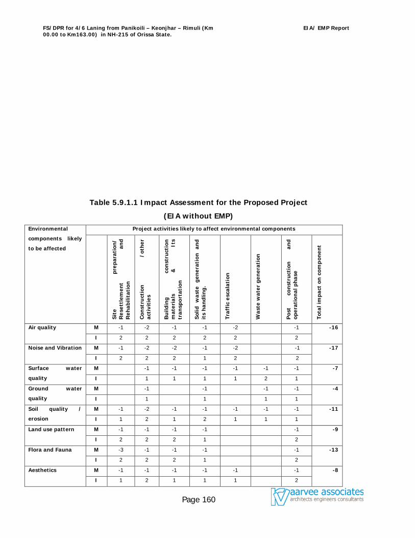
FS/DPR for 4/6 Laning from Panikoili – Keonjhar – Rimuli (Km 00.00 to Km163.00) in NH-215 of Orissa State.
EIA/ EMP Report
Page 160
Table 5.9.1.1 Impact Assessment for the Proposed Project
(EIA without EMP)
Environmental
components likely
to be affected
Project activities likely to affect environmental components
Site
pr
epar
atio
n/
Res
ettl
emen
t an
d R
ehab
ilita
tion
Con
stru
ctio
n
/oth
er
acti
viti
es
Bu
ildin
g co
nst
ruct
ion
m
ater
ials
&
It
s tr
ansp
orta
tion
Solid
w
aste
ge
ner
atio
n
and
it
s h
andl
ing.
Traf
fic
esca
lati
on
Was
te w
ater
gen
erat
ion
Pos
t co
nst
ruct
ion
an
d
oper
atio
nal
ph
ase
Tota
l im
pact
on
com
pon
ent
Air quality M -1 -2 -1 -1 -2 -1 -16
I 2 2 2 2 2 2
Noise and Vibration M -1 -2 -2 -1 -2 -1 -17
I 2 2 2 1 2 2
Surface water
quality
M -1 -1 -1 -1 -1 -1 -7
I 1 1 1 1 2 1
Ground water
quality
M -1 -1 -1 -1 -4
I 1 1 1 1
Soil quality /
erosion
M -1 -2 -1 -1 -1 -1 -1 -11
I 1 2 1 2 1 1 1
Land use pattern M -1 -1 -1 -1 -1 -9
I 2 2 2 1 2
Flora and Fauna M -3 -1 -1 -1 -1 -13
I 2 2 2 1 2
Aesthetics M -1 -1 -1 -1 -1 -1 -8
I 1 2 1 1 1 2
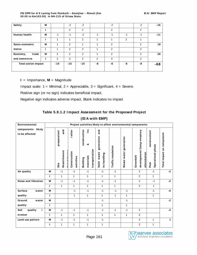
FS/DPR for 4/6 Laning from Panikoili – Keonjhar – Rimuli (Km 00.00 to Km163.00) in NH-215 of Orissa State.
EIA/ EMP Report
Page 161
Safety M -2 -2 -2 -2 -16
I 2 2 2 2
Human health M -1 -1 -2 -1 -1 -1 -1 -11
I 1 1 2 1 1 2 1
Socio-economic
status
M 1 2 1 1 2 2 18
I 1 2 2 1 2 3
Economy, trade
and commerce
M 2 2 2 1 2 2 26
I 2 3 2 2 3 2
Total action impact
-10 -15 -15 -8 -6 -6 -8 -68
I = Importance, M = Magnitude
Impact scale: 1 = Minimal, 2 = Appreciable, 3 = Significant, 4 = Severe.
Positive sign (or no sign) indicates beneficial impact,
Negative sign indicates adverse impact, Blank indicates no impact
Table 5.9.1.2 Impact Assessment for the Proposed Project
(EIA with EMP)
Environmental
components likely
to be affected
Project activities likely to affect environmental components
Site
pr
epar
atio
n/
Res
ettl
emen
t an
d
Reh
abili
tati
on
Con
stru
ctio
n
/oth
er
acti
viti
es
Bu
ildin
g co
nst
ruct
ion
mat
eria
ls
&
Its
tran
spor
tati
on
Solid
w
aste
ge
ner
atio
n
and
its
han
dlin
g
Traf
fic
esca
lati
on
Was
te w
ater
gen
erat
ion
Gre
enbe
lt
deve
lopm
ent/
Com
p-e
nsa
tory
afor
esta
tion
Pos
t co
nst
ruct
ion
/
Ope
rati
onal
ph
ase
Tota
l im
pact
on
com
pon
ent
Air quality M -1 -1 -1 -1 -1 2 -1 -2
I 1 1 1 1 1 2 1
Noise and Vibration M -1 -1 -1 -1 -1 2 -1 -2
I 1 1 1 1 1 2 1
Surface water
quality
M -1 -1 -1 -1 -1 -1 -6
I 1 1 1 1 1 1
Ground water
quality
M -1 -1 -2
I 1 1
Soil quality /
erosion
M -1 -1 -1 -1 -1 -1 2 -2
I 1 1 1 1 1 1 2
Land use pattern M -1 -1 -1 -1 2 1 1
I 1 1 1 1 2 1
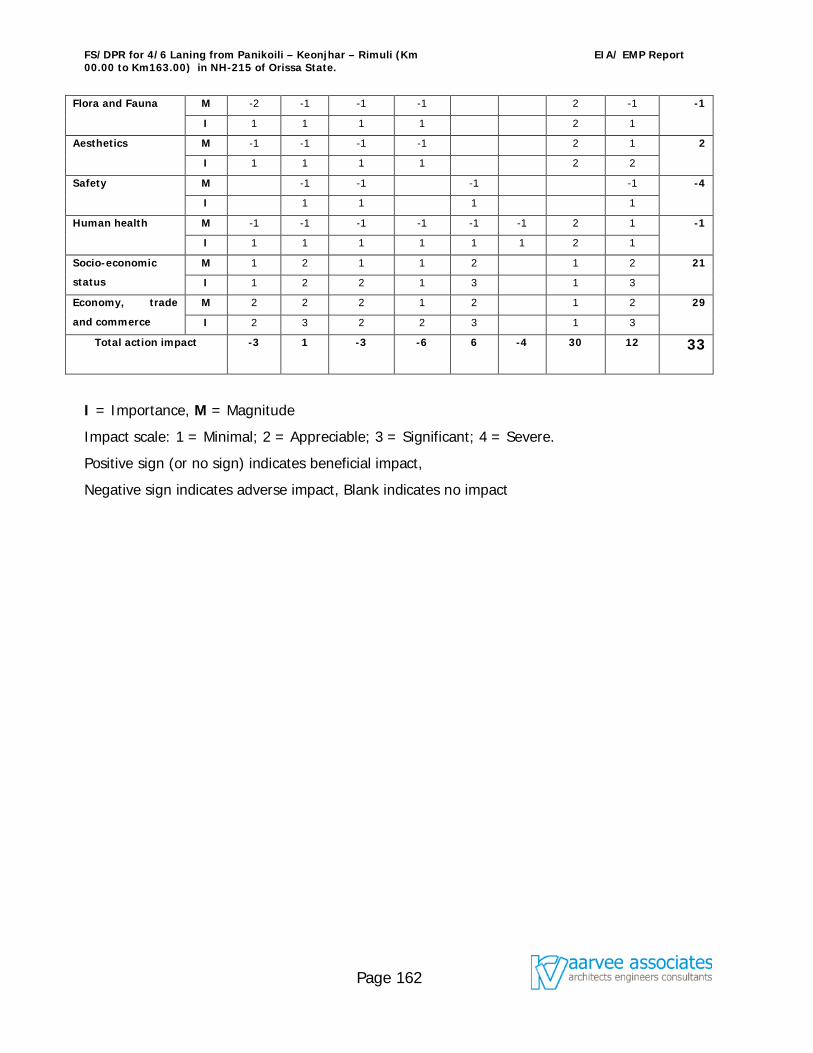
FS/DPR for 4/6 Laning from Panikoili – Keonjhar – Rimuli (Km 00.00 to Km163.00) in NH-215 of Orissa State.
EIA/ EMP Report
Page 162
Flora and Fauna M -2 -1 -1 -1 2 -1 -1
I 1 1 1 1 2 1
Aesthetics M -1 -1 -1 -1 2 1 2
I 1 1 1 1 2 2
Safety M -1 -1 -1 -1 -4
I 1 1 1 1
Human health M -1 -1 -1 -1 -1 -1 2 1 -1
I 1 1 1 1 1 1 2 1
Socio-economic
status
M 1 2 1 1 2 1 2 21
I 1 2 2 1 3 1 3
Economy, trade
and commerce
M 2 2 2 1 2 1 2 29
I 2 3 2 2 3 1 3
Total action impact
-3 1 -3 -6 6 -4 30 12 33
I = Importance, M = Magnitude
Impact scale: 1 = Minimal; 2 = Appreciable; 3 = Significant; 4 = Severe.
Positive sign (or no sign) indicates beneficial impact,
Negative sign indicates adverse impact, Blank indicates no impact
FS/DPR for 4/6 Laning from Panikoili – Keonjhar – Rimuli (Km 00.00 to Km163.00) in NH-215 of Orissa State.
EIA/ EMP Report
Page 163
The Environmental Management Plan (EMP) states the procedure in which the project
proponent would carryout the implementation of the mitigation measures and ensures
compliance with environmental regulations that are binding on the project. This plan also
specifies the organizational requirements and institutional strengthening necessary for sound
environmental management of the project. The major components of the EMP are:
1. EMP Implementing Agency
2. Monitoring of the EMP implementation
3. Training on Environmental management
4. Budget for EMP implementation.
6.1 EMP Implementing Agency
The project executor in the present case the Contracting Company will establish an
Environmental Management Cell (EMC) to supervise and implement the mitigation measures
as documented in the EMP. This EMC must also be adequately empowered to discharge the
responsibilities as outlined in the EMP. To ensure smooth implementation of EMP the
Contracting Company will have to collaborate with various government agencies like State
Forest Department, Public Health Engineering Department, Revenue Department, State
Pollution Control Board, Police Department and other allied departments.
The details of EMP implementation and implementation responsibilities are given in Table
6.1. This table comprehensively lists out the tasks to be performed and completed by the
Contracting Company and also lists out the agencies that are involved and responsible for
ensuring the timely completion of the tasks outlined under EMP. The contractors
responsibilities in matters related to protection of environment shall be the part of the tender
document. Table 6.3 gives the provisions that are built in the bid document to protect and
FS/DPR for 4/6 Laning from Panikoili – Keonjhar – Rimuli (Km 00.00 to Km163.00) in NH-215 of Orissa State.
EIA/ EMP Report
Page 164
safeguard the environment by the Contractor.
Table 6.1 Implementation Schedule with Responsible/ Supervising Organization/
Authority
Construction Phase
SNo Project related
Issues
Action to be taken Responsible/ Supervising
Organization/ Authority
1 Preparation of
feasible land
acquisition plan
Initiate and complete the
process for land
acquisition
Prepare and administer
landuse control measures
DPR Consultant / NHAI,
revenue department in
consultation with the affected
people
2 Roadside tree
cutting and
plantation
Prepare action plan for
tree felling
Intimate forest dept.
before starting
Prepare action plan for
replantation
Budget allocation
Implementation
Contractor / NHAI in
consultation with the Forest
dept.
3 Borrow pits and
Quarry sites.
Firm up contract with
mining department for
obtaining the quarry
material
Resurfacing and
landscaping of the pits
Contractor or Concessionaire /
Mining Department
4 Site for storage and
construction camp
Select and finalize the
sites for storage and
construction workers
camp
Contractor or Concessionaire/
Local bodies / Labour
department for ensuring
compliance with labour laws
for amenities.
FS/DPR for 4/6 Laning from Panikoili – Keonjhar – Rimuli (Km 00.00 to Km163.00) in NH-215 of Orissa State.
EIA/ EMP Report
Page 165
Construction Phase
SNo Project related
Issues
Action to be taken Responsible/ Supervising
Organization/ Authority
5 Sewerage and solid
waste disposal
Proper sanitation facilities
at the construction
workers camp
Collection of domestic
refuse and its suitable
disposal
Contractor or Concessionaire/
Labour department / Health
department
6 Traffic
management.
Secure assistance from
local police for traffic
control during the
construction
Safety measures shall also
be undertaken by
installing road signs and
markings for safe and
smooth movement of
traffic
Contractor or Concessionaire /
NHAI
FS/DPR for 4/6 Laning from Panikoili – Keonjhar – Rimuli (Km 00.00 to Km163.00) in NH-215 of Orissa State.
EIA/ EMP Report
Page 166
Construction Phase
SNo Project related
Issues
Action to be taken Responsible/ Supervising
Organization/ Authority
7 Noise level Stationary equipment shall
be placed as far as
possible from residential
areas to minimise noise
impacts
Construction activities
strictly prohibiting
between 10.00 P.M to
6.00 A.M near habitation
Provision of ear plugs to
workers exposed to high
noise levels
Contractor or Concessionaire /
State Pollution Control Board
FS/DPR for 4/6 Laning from Panikoili – Keonjhar – Rimuli (Km 00.00 to Km163.00) in NH-215 of Orissa State.
EIA/ EMP Report
Page 167
Construction Phase
SNo Project related
Issues
Action to be taken Responsible/ Supervising
Organization/ Authority
8. Air Quality Vehicles carrying
construction material shall
be covered to avoid
spilling
Hot mixing plant shall be
over 500m away from
residential neighbourhood
and 300m away from the
road
Mixing equipment shall be
seated and equipped with
dust removal device
Water sprinkling in
morning and evening
hours at the construction
yard and the unpaved
sections of the road
Contractor or Concessionaire /
State Pollution Control Board
9 Water Quality Prior permission of the
concerned engineer and
regulatory authorities shall
be taken regarding the
discharge or disposing of
any material arising from
the execution of the
works
Contractor or Concessionaire /
concerned local authority
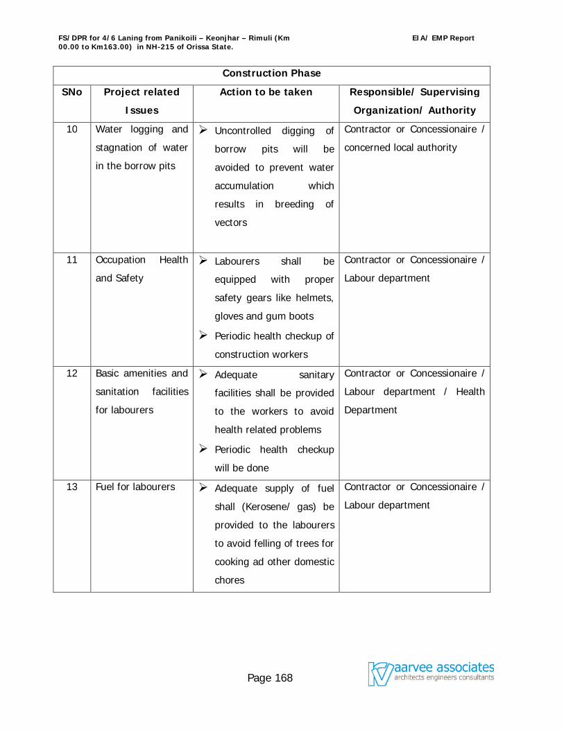
FS/DPR for 4/6 Laning from Panikoili – Keonjhar – Rimuli (Km 00.00 to Km163.00) in NH-215 of Orissa State.
EIA/ EMP Report
Page 168
Construction Phase
SNo Project related
Issues
Action to be taken Responsible/ Supervising
Organization/ Authority
10 Water logging and
stagnation of water
in the borrow pits
Uncontrolled digging of
borrow pits will be
avoided to prevent water
accumulation which
results in breeding of
vectors
Contractor or Concessionaire /
concerned local authority
11 Occupation Health
and Safety
Labourers shall be
equipped with proper
safety gears like helmets,
gloves and gum boots
Periodic health checkup of
construction workers
Contractor or Concessionaire /
Labour department
12 Basic amenities and
sanitation facilities
for labourers
Adequate sanitary
facilities shall be provided
to the workers to avoid
health related problems
Periodic health checkup
will be done
Contractor or Concessionaire /
Labour department / Health
Department
13 Fuel for labourers Adequate supply of fuel
shall (Kerosene/ gas) be
provided to the labourers
to avoid felling of trees for
cooking ad other domestic
chores
Contractor or Concessionaire /
Labour department
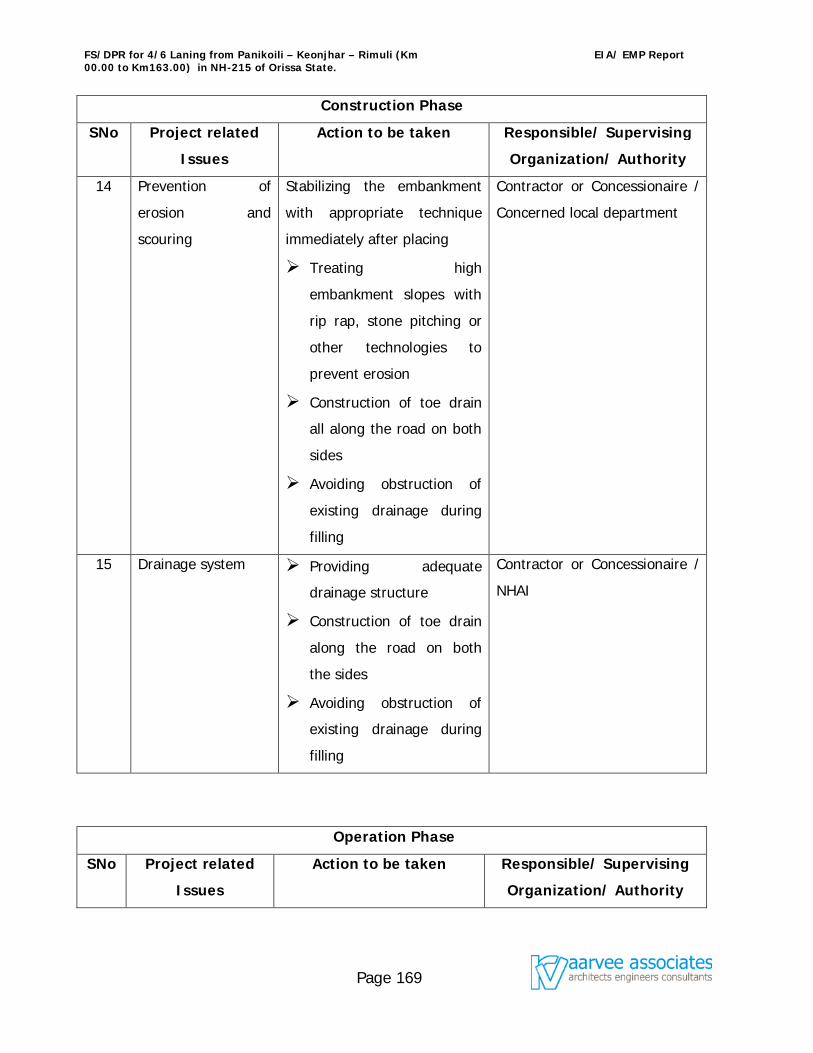
FS/DPR for 4/6 Laning from Panikoili – Keonjhar – Rimuli (Km 00.00 to Km163.00) in NH-215 of Orissa State.
EIA/ EMP Report
Page 169
Construction Phase
SNo Project related
Issues
Action to be taken Responsible/ Supervising
Organization/ Authority
14 Prevention of
erosion and
scouring
Stabilizing the embankment
with appropriate technique
immediately after placing
Treating high
embankment slopes with
rip rap, stone pitching or
other technologies to
prevent erosion
Construction of toe drain
all along the road on both
sides
Avoiding obstruction of
existing drainage during
filling
Contractor or Concessionaire /
Concerned local department
15 Drainage system Providing adequate
drainage structure
Construction of toe drain
along the road on both
the sides
Avoiding obstruction of
existing drainage during
filling
Contractor or Concessionaire /
NHAI
Operation Phase
SNo Project related
Issues
Action to be taken Responsible/ Supervising
Organization/ Authority
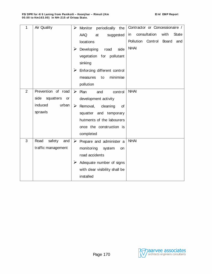
FS/DPR for 4/6 Laning from Panikoili – Keonjhar – Rimuli (Km 00.00 to Km163.00) in NH-215 of Orissa State.
EIA/ EMP Report
Page 170
1 Air Quality Monitor periodically the
AAQ at suggested
locations
Developing road side
vegetation for pollutant
sinking
Enforcing different control
measures to minimise
pollution
Contractor or Concessionaire /
in consultation with State
Pollution Control Board and
NHAI
2 Prevention of road
side squatters or
induced urban
sprawls
Plan and control
development activity
Removal, cleaning of
squatter and temporary
hutments of the labourers
once the construction is
completed
NHAI
3 Road safety and
traffic management
Prepare and administer a
monitoring system on
road accidents
Adequate number of signs
with clear visibility shall be
installed
NHAI
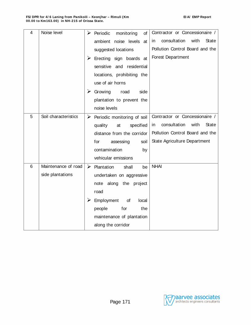
FS/DPR for 4/6 Laning from Panikoili – Keonjhar – Rimuli (Km 00.00 to Km163.00) in NH-215 of Orissa State.
EIA/ EMP Report
Page 171
4 Noise level Periodic monitoring of
ambient noise levels at
suggested locations
Erecting sign boards at
sensitive and residential
locations, prohibiting the
use of air horns
Growing road side
plantation to prevent the
noise levels
Contractor or Concessionaire /
in consultation with State
Pollution Control Board and the
Forest Department
5 Soil characteristics Periodic monitoring of soil
quality at specified
distance from the corridor
for assessing soil
contamination by
vehicular emissions
Contractor or Concessionaire /
in consultation with State
Pollution Control Board and the
State Agriculture Department
6 Maintenance of road
side plantations
Plantation shall be
undertaken on aggressive
note along the project
road
Employment of local
people for the
maintenance of plantation
along the corridor
NHAI
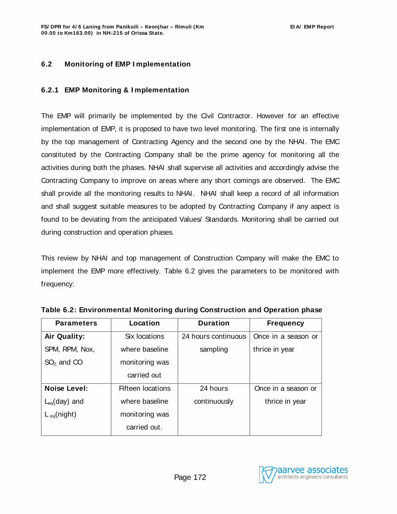
FS/DPR for 4/6 Laning from Panikoili – Keonjhar – Rimuli (Km 00.00 to Km163.00) in NH-215 of Orissa State.
EIA/ EMP Report
Page 172
6.2 Monitoring of EMP Implementation
6.2.1 EMP Monitoring & Implementation
The EMP will primarily be implemented by the Civil Contractor. However for an effective
implementation of EMP, it is proposed to have two level monitoring. The first one is internally
by the top management of Contracting Agency and the second one by the NHAI. The EMC
constituted by the Contracting Company shall be the prime agency for monitoring all the
activities during both the phases. NHAI shall supervise all activities and accordingly advise the
Contracting Company to improve on areas where any short comings are observed. The EMC
shall provide all the monitoring results to NHAI. NHAI shall keep a record of all information
and shall suggest suitable measures to be adopted by Contracting Company if any aspect is
found to be deviating from the anticipated Values/ Standards. Monitoring shall be carried out
during construction and operation phases.
This review by NHAI and top management of Construction Company will make the EMC to
implement the EMP more effectively. Table 6.2 gives the parameters to be monitored with
frequency:
Table 6.2: Environmental Monitoring during Construction and Operation phase
Parameters Location Duration Frequency
Air Quality:
SPM, RPM, Nox,
SO2, and CO
Six locations
where baseline
monitoring was
carried out
24 hours continuous
sampling
Once in a season or
thrice in year
Noise Level:
Leq(day) and
L eq(night)
Fifteen locations
where baseline
monitoring was
carried out.
24 hours
continuously
Once in a season or
thrice in year
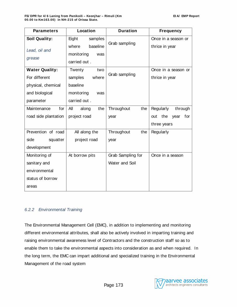
FS/DPR for 4/6 Laning from Panikoili – Keonjhar – Rimuli (Km 00.00 to Km163.00) in NH-215 of Orissa State.
EIA/ EMP Report
Page 173
Parameters Location Duration Frequency
Soil Quality:
Lead, oil and
grease
Eight samples
where baseline
monitoring was
carried out .
Grab sampling Once in a season or
thrice in year
Water Quality:
For different
physical, chemical
and biological
parameter
Twenty two
samples where
baseline
monitoring was
carried out .
Grab sampling Once in a season or
thrice in year
Maintenance for
road side plantation
All along the
project road
Throughout the
year
Regularly through
out the year for
three years
Prevention of road
side squatter
development
All along the
project road
Throughout the
year
Regularly
Monitoring of
sanitary and
environmental
status of borrow
areas
At borrow pits Grab Sampling for
Water and Soil
Once in a season
6.2.2 Environmental Training
The Environmental Management Cell (EMC), in addition to implementing and monitoring
different environmental attributes, shall also be actively involved in imparting training and
raising environmental awareness level of Contractors and the construction staff so as to
enable them to take the environmental aspects into consideration as and when required. In
the long term, the EMC can impart additional and specialized training in the Environmental
Management of the road system
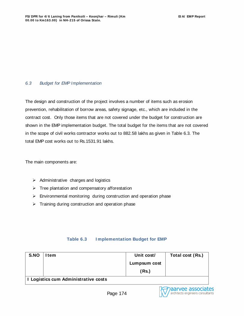
FS/DPR for 4/6 Laning from Panikoili – Keonjhar – Rimuli (Km 00.00 to Km163.00) in NH-215 of Orissa State.
EIA/ EMP Report
Page 174
6.3 Budget for EMP Implementation
The design and construction of the project involves a number of items such as erosion
prevention, rehabilitation of borrow areas, safety signage, etc., which are included in the
contract cost. Only those items that are not covered under the budget for construction are
shown in the EMP implementation budget. The total budget for the items that are not covered
in the scope of civil works contractor works out to 882.58 lakhs as given in Table 6.3. The
total EMP cost works out to Rs.1531.91 lakhs.
The main components are:
Administrative charges and logistics
Tree plantation and compensatory afforestation
Environmental monitoring during construction and operation phase
Training during construction and operation phase
Table 6.3 Implementation Budget for EMP
S.NO Item Unit cost/
Lumpsum cost
(Rs.)
Total cost (Rs.)
I Logistics cum Administrative costs
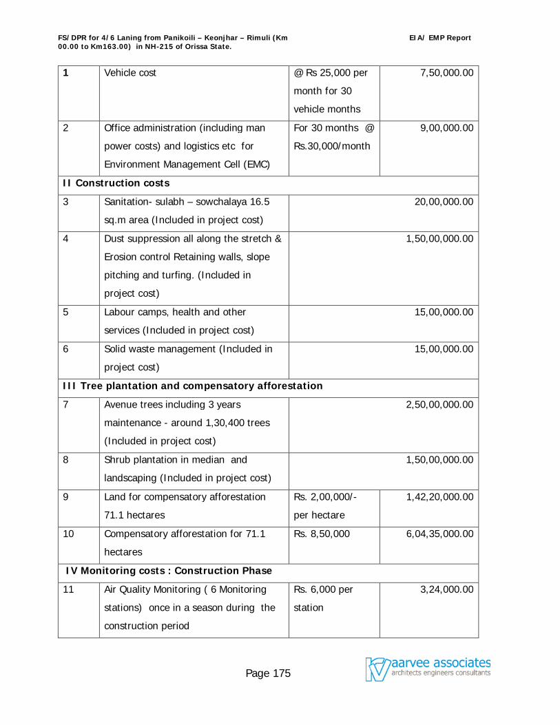
FS/DPR for 4/6 Laning from Panikoili – Keonjhar – Rimuli (Km 00.00 to Km163.00) in NH-215 of Orissa State.
EIA/ EMP Report
Page 175
1 Vehicle cost @ Rs 25,000 per
month for 30
vehicle months
7,50,000.00
2 Office administration (including man
power costs) and logistics etc for
Environment Management Cell (EMC)
For 30 months @
Rs.30,000/month
9,00,000.00
II Construction costs
3 Sanitation- sulabh – sowchalaya 16.5
sq.m area (Included in project cost)
20,00,000.00
4 Dust suppression all along the stretch &
Erosion control Retaining walls, slope
pitching and turfing. (Included in
project cost)
1,50,00,000.00
5 Labour camps, health and other
services (Included in project cost)
15,00,000.00
6 Solid waste management (Included in
project cost)
15,00,000.00
III Tree plantation and compensatory afforestation
7 Avenue trees including 3 years
maintenance - around 1,30,400 trees
(Included in project cost)
2,50,00,000.00
8 Shrub plantation in median and
landscaping (Included in project cost)
1,50,00,000.00
9 Land for compensatory afforestation
71.1 hectares
Rs. 2,00,000/-
per hectare
1,42,20,000.00
10 Compensatory afforestation for 71.1
hectares
Rs. 8,50,000 6,04,35,000.00
IV Monitoring costs : Construction Phase
11 Air Quality Monitoring ( 6 Monitoring
stations) once in a season during the
construction period
Rs. 6,000 per
station
3,24,000.00
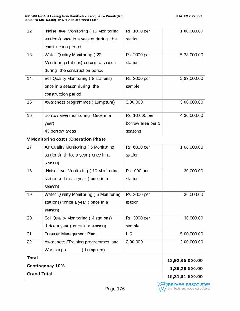
FS/DPR for 4/6 Laning from Panikoili – Keonjhar – Rimuli (Km 00.00 to Km163.00) in NH-215 of Orissa State.
EIA/ EMP Report
Page 176
12 Noise level Monitoring ( 15 Monitoring
stations) once in a season during the
construction period
Rs. 1000 per
station
1,80,000.00
13 Water Quality Monitoring ( 22
Monitoring stations) once in a season
during the construction period
Rs. 2000 per
station
5,28,000.00
14 Soil Quality Monitoring ( 8 stations)
once in a season during the
construction period
Rs. 3000 per
sample
2,88,000.00
15 Awareness programmes ( Lumpsum) 3,00,000 3,00,000.00
16 Borrow area monitoring (Once in a
year)
43 borrow areas
Rs. 10,000 per
borrow area per 3
seasons
4,30,000.00
V Monitoring costs :Operation Phase
17 Air Quality Monitoring ( 6 Monitoring
stations) thrice a year ( once in a
season)
Rs. 6000 per
station
1,08,000.00
18 Noise level Monitoring ( 10 Monitoring
stations) thrice a year ( once in a
season)
Rs.1000 per
station
30,000.00
19 Water Quality Monitoring ( 6 Monitoring
stations) thrice a year ( once in a
season)
Rs. 2000 per
station
36,000.00
20 Soil Quality Monitoring ( 4 stations)
thrice a year ( once in a season)
Rs. 3000 per
sample
36,000.00
21 Disaster Management Plan L.S 5,00,000.00
22 Awareness /Training programmes and
Workshops ( Lumpsum)
2,00,000 2,00,000.00
Total 13,92,65,000.00 Contingency 10% 1,39,26,500.00 Grand Total 15,31,91,500.00
FS/DPR for 4/6 Laning from Panikoili – Keonjhar – Rimuli (Km 00.00 to Km163.00) in NH-215 of Orissa State.
EIA/ EMP Report
Page 177
6.4 Risk Assessment and Disaster Management Plan
6.4.1 Risk Assessment & Mitigation measures
Risk assessment is a process that seeks to estimate the likelihood of occurrence of adverse
effects as a result of major road mishaps, gas tanker explosions, fire hazards, floods ,
cyclones, earth quakes etc at Highway projects. Fatality rate on Indian highways is very high
mainly due to road accidents. The other adverse impacts due to gas tanker explosions, fire
hazards, floods , cyclones, earth quakes etc are nominal. Elimination of the risk (avoidance of
accidents) is given prime importance and National Highway Authority of India (NHAI) has
introduced many safety provisions in the design of highway. Some of these are listed below:
Safety barriers/delineators hard shoulders on main roads
Traffic signs and pavement markings
Underpasses and other grade separators at congested junctions
Removal of junctions and direct access points on main roads
Improved median openings with stacking lanes
Separate provisions and direct access point
Service roads in towns and villages for segregating local and through traffic.
6.4.1.1 Mitigation measures considered during design stage
6.4.1.1.1 Construction of Bypasses
Along the project site five bypasses have been found technically, economically and
ecologically viable. The technical viability of these bypasses was verified on ground. It is
proposed to provide access control along the bypasses through the provision of barbed wire
fencing. Tall growing trees at the outer edges of the right of way and shade bearing trees 5
m towards inside of the bypass are proposed. The space between the two rows will be ear
marked for utilities.
FS/DPR for 4/6 Laning from Panikoili – Keonjhar – Rimuli (Km 00.00 to Km163.00) in NH-215 of Orissa State.
EIA/ EMP Report
Page 178
6.4.1.1.2 Realignments of accident prone location
Based on the data collected from local police (traffic) on accident prone locations, realignment
has been proposed.
6.4.1.1.3 Construction of Vehicular Underpasses
Turning movement surveys have shown that at all the existing State / National Highway crossings vehicular underpasses are required and few vehicle Underpasses are also required in village portions catering bus traffic. The details of vehicular underpasses are discussed in earlier chapters.
6.4.1.1.4 Construction of Pedestrian Underpasses
It is proposed to prevent direct access from cross roads to the project road, through a judicious combination of service roads and pedestrian underpasses with 3m vertical clearance and 5 m horizontal clearance. The extra cost on account of such underpasses will be more than justified by way of decrease in the number of accidents that would have otherwise occurred in the event of direct access to the Highway. The details of pedestrian underpasses are discussed in earlier chapters.
6.4.1.1.5 Construction of Cattle/Animal Underpasses
It is proposed to provide animal underpasses in forest areas and cattle underpasses for cattle to cross to the other side of the village for fodder / water.
6.4.1.1.6 Sight Distances
To avoid unwarranted accident, it is necessary to provide adequate sight distance to permit
the drivers enough time and distance to control their vehicles.
The safe stopping sight distance, intermediate sight distance and overtaking sight distance
are shown below in Table no. 6.4.1.1
Table 6.4.1.1 : Sight Distance Standards
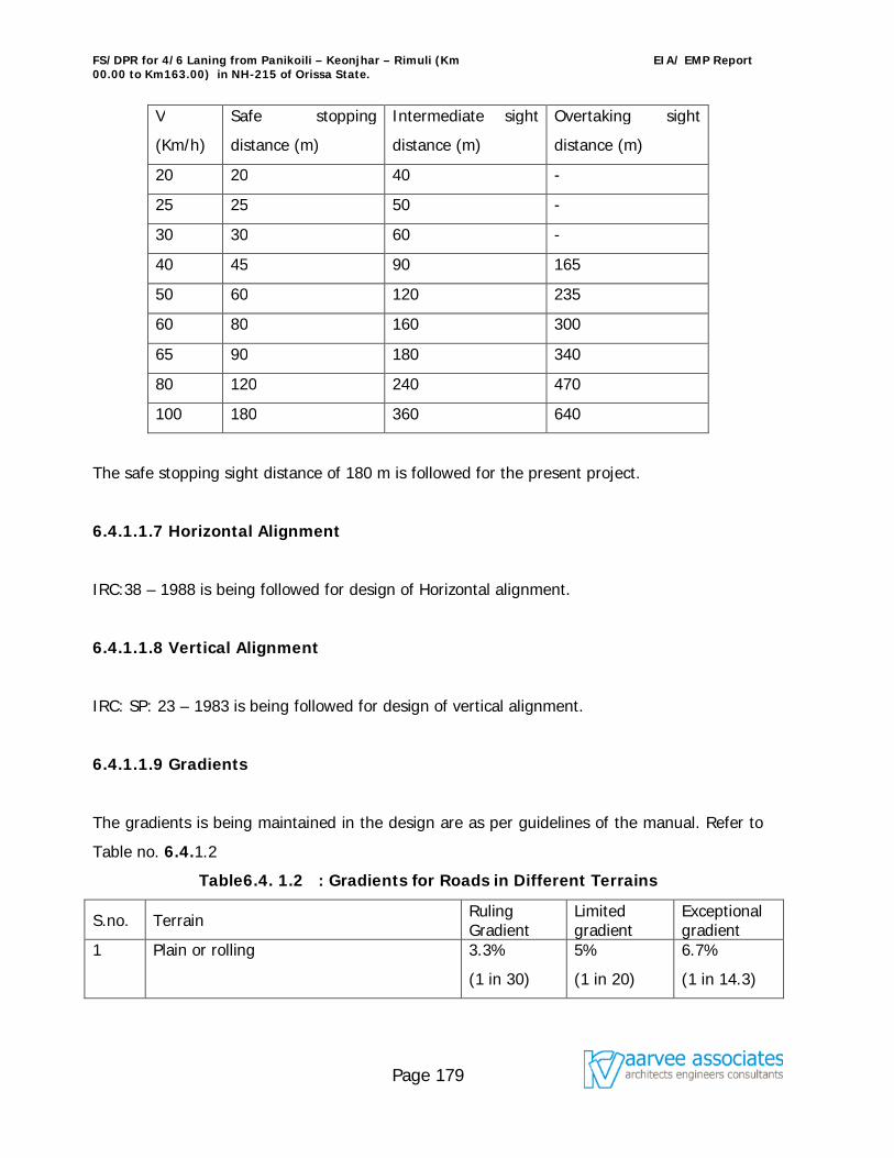
FS/DPR for 4/6 Laning from Panikoili – Keonjhar – Rimuli (Km 00.00 to Km163.00) in NH-215 of Orissa State.
EIA/ EMP Report
Page 179
V
(Km/h)
Safe stopping
distance (m)
Intermediate sight
distance (m)
Overtaking sight
distance (m)
20 20 40 -
25 25 50 -
30 30 60 -
40 45 90 165
50 60 120 235
60 80 160 300
65 90 180 340
80 120 240 470
100 180 360 640
The safe stopping sight distance of 180 m is followed for the present project.
6.4.1.1.7 Horizontal Alignment
IRC:38 – 1988 is being followed for design of Horizontal alignment.
6.4.1.1.8 Vertical Alignment
IRC: SP: 23 – 1983 is being followed for design of vertical alignment.
6.4.1.1.9 Gradients
The gradients is being maintained in the design are as per guidelines of the manual. Refer to
Table no. 6.4.1.2
Table6.4. 1.2 : Gradients for Roads in Different Terrains
S.no. Terrain Ruling Gradient
Limited gradient
Exceptional gradient
1 Plain or rolling 3.3%
(1 in 30)
5%
(1 in 20)
6.7%
(1 in 14.3)
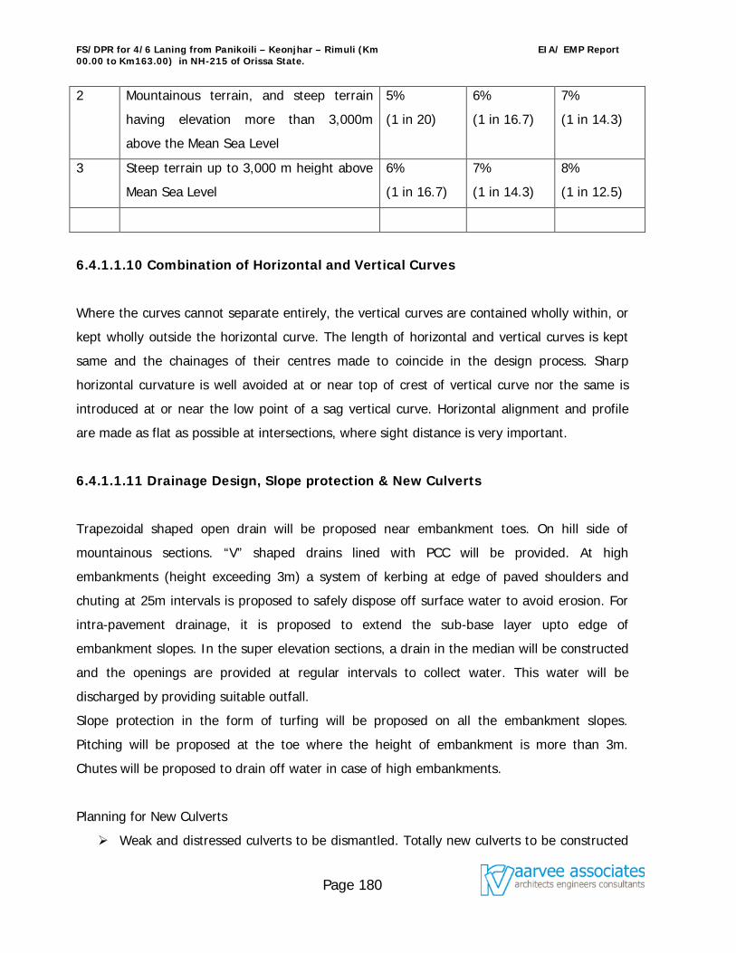
FS/DPR for 4/6 Laning from Panikoili – Keonjhar – Rimuli (Km 00.00 to Km163.00) in NH-215 of Orissa State.
EIA/ EMP Report
Page 180
2 Mountainous terrain, and steep terrain
having elevation more than 3,000m
above the Mean Sea Level
5%
(1 in 20)
6%
(1 in 16.7)
7%
(1 in 14.3)
3 Steep terrain up to 3,000 m height above
Mean Sea Level
6%
(1 in 16.7)
7%
(1 in 14.3)
8%
(1 in 12.5)
6.4.1.1.10 Combination of Horizontal and Vertical Curves
Where the curves cannot separate entirely, the vertical curves are contained wholly within, or
kept wholly outside the horizontal curve. The length of horizontal and vertical curves is kept
same and the chainages of their centres made to coincide in the design process. Sharp
horizontal curvature is well avoided at or near top of crest of vertical curve nor the same is
introduced at or near the low point of a sag vertical curve. Horizontal alignment and profile
are made as flat as possible at intersections, where sight distance is very important.
6.4.1.1.11 Drainage Design, Slope protection & New Culverts
Trapezoidal shaped open drain will be proposed near embankment toes. On hill side of
mountainous sections. “V” shaped drains lined with PCC will be provided. At high
embankments (height exceeding 3m) a system of kerbing at edge of paved shoulders and
chuting at 25m intervals is proposed to safely dispose off surface water to avoid erosion. For
intra-pavement drainage, it is proposed to extend the sub-base layer upto edge of
embankment slopes. In the super elevation sections, a drain in the median will be constructed
and the openings are provided at regular intervals to collect water. This water will be
discharged by providing suitable outfall.
Slope protection in the form of turfing will be proposed on all the embankment slopes.
Pitching will be proposed at the toe where the height of embankment is more than 3m.
Chutes will be proposed to drain off water in case of high embankments.
Planning for New Culverts
Weak and distressed culverts to be dismantled. Totally new culverts to be constructed
FS/DPR for 4/6 Laning from Panikoili – Keonjhar – Rimuli (Km 00.00 to Km163.00) in NH-215 of Orissa State.
EIA/ EMP Report
Page 181
with carriageway and median matching with highway plan and profile drawing.
Culverts in service road locations to be extended up to the road side longitudinal drain.
The design invert levels of the existing culvert after widening would be compared with
that of the prevailing invert level on the ground. If the design invert level falls below
the existing invert level then the existing culvert would be proposed to be replaced
with another.
6.4.1.1.12 Road Furniture
6.4.1.1.12.1 Road Signs (Danger boards/ Speed limits/ other hazardous
indicators)
All signs shall be placed on the left hand side of the road. Where extra emphasis is warranted,
they may be duplicated on the right hand side as well. On non-kerbed , the extreme edge of
the sign shall be 1.5m-2.0m from the edge of the carriageway. On kerbed portion, it shall not
be less than 60cm from the edge of the kerb. Arrangement for proper surveillance by NHAI
authority personnel after the expiry of the maintenance period by the construction agency.
6.4.1.1.12.2 Road Marking
Provisions have been made for centre and edge road marking with thermo-plastic paint as
per MOST specification in preference to ordinary paint as a way of better caution to the
driving motorist. This would help reduce road accidents. Border/Edge lines shall also be
marked on both sides of the carriageway along with the centre line. Road studs shall also be
provided with pavement marking.
6.4.1.1.12.3 Road Delineators
Provision of road delineators has been made in the design that shall comprse roadway
indicators, hazard makers and objects makers. The design shall conform to the
recommendation made in IRC-79. Reflective Chevron signs at bends shall also be provided
for.
6.4.1.2 Conducting of Awareness Programmes
FS/DPR for 4/6 Laning from Panikoili – Keonjhar – Rimuli (Km 00.00 to Km163.00) in NH-215 of Orissa State.
EIA/ EMP Report
Page 182
NHAI will conduct the awareness programmes to the nearby community, transportation
associations, NGOs and other interested parties about road safety, and precautionary
measures to be taken in event of major disaster. The details about the warning system,
precautionary measures to be taken, rehabilitation station etc shall be intimated in the public
awareness programmes.
6.4.1.3 Vigilance by Highway Patrolling Unit
The highway patrolling unit under the control of local police will conduct route checks and
maintain the safety surveillance.
6.4.2 Disaster Management Plan
Disaster Management Plan (DMP) should be prepared on the basis of risk analysis considering
worst case disaster scenario with respect to specific cases, major road mishaps, gas tanker
explosions, fire hazards, floods, cyclones, earth quakes etc. An emergency response system
should be developed in co-ordination with local fire, police and Medical service. Frequent
exercise should be carried out to test the preparedness of the system by mock drills.
The disaster management plan is given in fig no. 6.4. The role and responsibility of the
concerned officers are well defined and the details are as follows.
A. Emergency plan in the event of road mishaps
On receiving the information of emergency due to road mishaps, Manager (Technical), NHAI
and Traffic wing will co-ordinate for rescuing the persons, arrangement of ambulance & first
aid, Hospital/Dispensary, information passed on to Police/Fire brigade/Security, engagement
of Rescue team with equipment (crane, mobile van and other tools).
B. Emergency plan in the event of emergency (major in nature due to major road
FS/DPR for 4/6 Laning from Panikoili – Keonjhar – Rimuli (Km 00.00 to Km163.00) in NH-215 of Orissa State.
EIA/ EMP Report
Page 183
accidents, gas tanker explosions etc.)
On receiving the information of emergency (due to major in nature like major road accidents,
gas tanker explosions etc., Manager (Technical), NHAI and Traffic wing will co-ordinate for
rescuing the persons, arrangement of ambulance & first aid, Hospital/Dispensary, information
passed on to Police/Fire brigade/Security, engagement of Rescue team with equipment
(crane and other tools).
After receiving the intimation from Manager (Technical)/Safety /Traffic wing, Director, Project
Implementation Unit (PIU) will form a Committee to deal with the emergency with the
following:
(i) Medical facilities
(ii) Set of Control room
(iii) Preparation of action plan
(iv) Welfare activities and
(v) Repairing and Rehabilitation works.
For the said arrangements, Manager (Technical) in co-ordination with project implementing
unit will guide and monitor the work in rendering effective services to the affected people
with the help of Supervisory Consultant & Contractor. The action taken and final report will be
sent to top Management.
C. Emergency plan in the event of emergency (major in nature due to Natural
disasters.)
On receiving the information of emergency (major in nature due to natural disasters like earth
quakes, floods etc) Manager (Technical), NHAI and Traffic wing will co-ordinate the following;
(i) for rescuing the persons,
(ii) arrangement of ambulance & first aid,
(iii) Hospital/Dispensary,
(iv) information passed on to Police/Fire brigade/Security,
(v) engagement of Rescue team with equipment (crane and other tools) in co-
ordination with District administration.
FS/DPR for 4/6 Laning from Panikoili – Keonjhar – Rimuli (Km 00.00 to Km163.00) in NH-215 of Orissa State.
EIA/ EMP Report
Page 184
DMP team will be formed under District Administration control with the following officials /
representatives:
(i) District Collector or District Magistrate and or his nominated officer
(ii) Manager (Technical), NHAI
(iii) Superintendent of Police (S.P) and or his nominee
(iv) District Medical and Health officer
(v) Representative from Fire department
(vi) Representative from R&B department
(vii) Divisional Engineer, Electricity department
(viii) Executive engineer, Public health engineering department
(ix) Representatives from NGOs etc.
6.4.2.1 Role and Responsibility of Important Agencies
District Administration : District administration will take active roll and they will co-
ordinate with all the state government agencies for successful implementation of DMP. All the
relief operations and rehabilitations will be supervised by them.
Fire Services: The Fire services department during disaster has to evacuate the people who
are trapped in highway, top on the trees etc. People can be shifted to safer places
(rehabilitation centers). In some cases they also take up supply of drinking water to relief
camps.
Police Department: The law and order situation of the project site will be maintained by the
Police Department and they will also help Fire services when ever required. The monetary
relief released for disbursement to the victims will be escorted by them. The communications
(VHF sets) will be established by them.
Medical & Health department: The medical and health department has to play vital role
during the disaster. During emergency, the department shall ensure that all ambulances and
other vehicles are available at site along with medical teams. Mobile medical teams shall
move to spot to render medical aid to the victims. Preventive measures to be taken against
FS/DPR for 4/6 Laning from Panikoili – Keonjhar – Rimuli (Km 00.00 to Km163.00) in NH-215 of Orissa State.
EIA/ EMP Report
Page 185
Gastro-enteritis, Diarrhea and fever cases . Medical and health department also distribute the
medicines to the victims with proper treatment.
Role of Press & electronic media: The role of Press & Electronic media is particularly
important as it helps to communicate the latest information to the public as they have close
accessibility with the administration department. Flash news, news items , headlines etc helps
the public to move into safer places. The T.V & news papers are also educates the people
about the possible hazards, steps to mitigate the distress etc.
Role of NGOs: NGOs plays a vital role for successful implementation of relief works. Many
NGO organizations are also helps to collect the donations and disburse them directly to the
victims.
6.4.2.3 Implementation of DMP
In the event of disaster, Manager (Technical), NHAI and Traffic wing will co-ordinate for
rescuing the persons, arrangement of ambulance & first aid, Hospital/Dispensary, information
passed on to Police/Fire brigade/Security, engagement of Rescue team with equipment
(crane and other tools) in co-ordination with District administration. The following rescue
operations are to be made on emergency basis:
1. Implementation of DMP in the event of emergency (major in nature due to
major road accidents, gas tanker explosions, hazardous material spillage
etc.)
a. In case of disaster event, alarm the people and other persons using the Outer Ring
Road and other connected roads.
b. The ambulance, fire tender and ‘hazardous material removal vehicle’ need to be
informed to be ready.
c. Only concerned persons will be present in the affected area and all other personnel
and guests need to be moved to the nearest assembly points.
d. Source of leakage to be traced and isolated from all the other areas.
e. Electrical department need to be informed to shut the power supply (in case of fuel or
FS/DPR for 4/6 Laning from Panikoili – Keonjhar – Rimuli (Km 00.00 to Km163.00) in NH-215 of Orissa State.
EIA/ EMP Report
Page 186
other fire hazard substance leakage).
f. In case of a fire the instructions listed against fire hazards needs to be followed.
g. If the fire is small engage in extinguishing the fire using nearest fire extinguisher. In
case of big fire, fire tender shall be mobilized along with quick response team and take
all the necessary steps to stop the fire.
2. Emergency plan in the event of emergency (major in nature due to Natural
disasters.)
a. Siren blowing & communication arrangements : In case of disaster event, the
siren will be blown to alarm the drivers, local people and other persons using the
highway . The news about the alarming situation will be telecasted and published in
news paper along with Radio advertisement.
(Agencies responsible: NHAI, District Administration, Electronic Media)
b. Evacuation of victims and food arrangements: The arrangements shall be made
to evacuate the victims with the help of Fire brigade and local Police to rehabilitation
places. Necessary arrangement shall be made for accommodation and provisions. In
case of problem to evacuate through road, Air Lifting shall be done by using
helicopters. Air dropping of food packets, medicines and other needful items shall be
done in case of non approach through roadways.
(Agencies responsible: NHAI, District Administration, Fire brigade, police
dept.)
c. Monitoring Relief operations: It was the practice that senior officers from State
level were sent by the government to over-see and monitor the arrangements and
effective implementation of the relief operations. The necessary staff , services and
goods shall be deployed for successful implementation of relief operations. Adequate
arrangements are also to be made in advance for supply of drinking water. (Agencies
responsible: State Government, District Administration, Municipalities,
NHAI, police dept.)
d. Welfare activities: The Social welfare/ Tribal Welfare Departments have to reserve
FS/DPR for 4/6 Laning from Panikoili – Keonjhar – Rimuli (Km 00.00 to Km163.00) in NH-215 of Orissa State.
EIA/ EMP Report
Page 187
in advance stocks of essential commodities in their hostels functioning in the
vulnerable areas. During the disaster, they are responsible for preparation of food and
water packets and to load them in to the Helicopters for air dropping.
(Agencies responsible: The Social welfare/ Tribal Welfare Departments,
NHAI, District Administration )
e. Medical and health services : Medical aid to be provided to the victims by the
Mobile medical teams immediately. Post disaster relief measures including surveillance
of Gastro-enteritis, Diarrhea, Dysentery and other water borne diseases and spraying
of disinfectant to prevent epidemics. Proper sanitation arrangement should be
provided in the flood areas.
(Agencies responsible: DM&HO, District Administration, Municipalities,
NHAI)
f. Post Disaster Management: During post disaster the district administration shall
convene a meeting of all NGOs and role of NGO’s is quite crucial also in terms of
smooth running of relief camps.
One of the major tasks after disaster will be restoration of normal life and repair of the
damaged structures. After governments approval the Restoration and Rehabilitation
works will be executed by the concerned departments. The final Disaster Management
report will be submitted to the NHAI’s top management and State Government.
(Agencies responsible: District Administration, NHAI, Roads & Building
department, Municipalities)
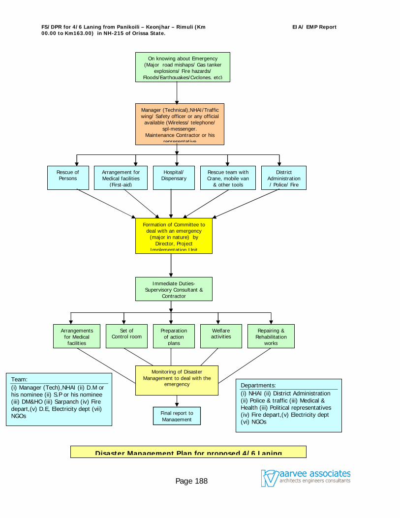
FS/DPR for 4/6 Laning from Panikoili – Keonjhar – Rimuli (Km 00.00 to Km163.00) in NH-215 of Orissa State.
EIA/ EMP Report
Page 188
On knowing about Emergency (Major road mishaps/ Gas tanker
explosions/ Fire hazards/ Floods/Earthquakes/Cyclones, etc)
Manager (Technical),NHAI/Traffic wing/ Safety officer or any official
available (Wireless/ telephone/ spl-messenger.
Maintenance Contractor or his representative
Rescue of Persons
Arrangement for Medical facilities
(First-aid)
Hospital/ Dispensary
District Administration/ Police/ Fire
Formation of Committee to deal with an emergency
(major in nature) by Director, Project
Implementation Unit
Immediate Duties- Supervisory Consultant &
Contractor
Rescue team with Crane, mobile van
& other tools
Arrangements for Medical
facilities
Set of Control room
Preparation of action
plans
Welfare activities
Monitoring of Disaster Management to deal with the
emergency
Repairing & Rehabilitation
works
Final report to Management
Disaster Management Plan for proposed 4/6 Laning
Team: (i) Manager (Tech),NHAI (ii) D.M or his nominee (ii) S.P or his nominee (iii) DM&HO (iii) Sarpanch (iv) Fire depart,(v) D.E, Electricity dept (vii) NGOs
Departments: (i) NHAI (ii) District Administration (ii) Police & traffic (iii) Medical & Health (iii) Political representatives (iv) Fire depart,(v) Electricity dept (vi) NGOs
FS/DPR for 4/6 Laning from Panikoili – Keonjhar – Rimuli (Km 00.00 to Km163.00) in NH-215 of Orissa State.
EIA/ EMP Report
Page 189
EXECUTIVE SUMMARY
1.0 Introduction
National Highways Authority of India (NHAI) at the direction of Ministry of Road Transport
and Highways (MoRTH), Government of India has proposed to improve and strengthen the
corridor of National Highway-215 in Panikoili – Keonjhar – Rimuli, between the chainage Km
0+000 to Km 163+000 of NH-215. The project road runs through the districts of Jajpur and
Keonjhar in the State of Orissa. The corridor passes through several congested areas, sharp
curves and has inadequate road width to cater the present traffic volumes. These deficiencies
result in lesser vehicle speeds, more wear and tear on vehicles, more vehicular pollution and
more vehicle operating costs. The environment impact study is a part of the feasibility studies
and preparation of detailed project report and is also a statutory requirement for obtaining
environmental clearance from Ministry of Environment & Forests (MoEF), New Delhi.
NHAI has assigned M/s ‘aarvee associates’ to carry out Environmental Impact Assessment (EIA) study for the proposed project as an integral part of Detailed Project Report. Accordingly, an aarvee associate has taken up the assignment in accordance with Environmental Impact Assessment (EIA) notification of the Ministry of Environment and Forests (MoEF) - Government of India.
2.0 Project Description
2.1 Location
The project road (NH 215) is passing through Jajpur and Keonjhar districts, having 163 km length and connecting NH-5, NH-6 and NH 23 in Orissa state. The project reach from Km. 0.00 to Km. 25.00 is in Jajpur District and the major portion from Km. 25.00 to Km. 163.00 is in Keonjhar District. The project lies between 200 54’ N to 21 57’ N and 86 13’ E to 85 36’ E. An average altitude of the stretch varies from 160.1 to 423.6 m. It is situated more than 65 Km away from seacoast and the climate is tropical.
2.2 Project Features
The existing National Highway –215 Project is having 2 lane road, as part of the development of the arterial National Highway- a project intended to improve the road connectivity to NH 5 & NH 6, which leads to very good communication facility to the existing Iron, Manganese, and Chromite ore mines along the corridor to Paradeep Port. NHAI at the direction of the MoRTH has proposed for upgrading from 2 lane to 4/6 laning of the existing road.
The present project is limited to widening and upgradation of existing alignment from 2 lane to 4/6 lane with bypasses.
FS/DPR for 4/6 Laning from Panikoili – Keonjhar – Rimuli (Km 00.00 to Km163.00) in NH-215 of Orissa State.
EIA/ EMP Report
Page 190
2.2.1 Need of the project
Highways play a significant part in national and regional economies particularly in the
development of trade, tourism and investment. Increasingly, Highways will become vital as
freight increases in importance as a major part of the export economy and as regional
markets grow. Strengthening and widening of highways and its operation are of national
significance, because the highways are expected to generate a wide range of economic
activities which should help national development, and also because a wide communication
network is generally felt to represent its country. The proposed project is being developed
as a major transit hub between different parts of the country.
2.2.2 Cost
The estimated cost of the project including direct and indirect charges is about Rs.
1129 crores.
2.2.3 Indirect Benefits:
Road widening project can harmonize with the surrounding environment and serve multiple
users with the following benefits.
To improve the economic and social welfare of nearby people.
Good connectivity to the highly minerals rich area, sub-urbans and link roads.
The Increased road capacity and improved pavements can reduce travel times and
lower the costs of vehicle operation,
Increasing access to markets, jobs, education, and health services.
Reducing transport costs for both freight and passengers.
3.0 Base Line Status of Project Site
FS/DPR for 4/6 Laning from Panikoili – Keonjhar – Rimuli (Km 00.00 to Km163.00) in NH-215 of Orissa State.
EIA/ EMP Report
Page 191
Base line studies were undertaken to generate baseline data in and around the project site
(for winter season i.e. from December 2005 to February 2006), M/s. Aarvee associates
conducted Environmental studies in association with M/s. ERA Consultancy Private Limited,
Bhubaneshwar. Environmental attributes namely air, noise, water, land, biological and socio-
economic environment have been identified and the study conducted generally conforms to
the requirements of the EIA Notification, 1994 and subsequent amendments.
4.0 Identification and Prediction of Impacts
This section summarizes the pollution potential of the proposed road widening project and its
possible impact on the surrounding environment during construction and operational phases.
4.1 Air Environment
The ambient air quality status collected at 6representative location of urban, semi urban and
rural areas reflect the ambient air quality status, which are well within the CPCB standards
except TSPM, the TSPM values at all monitored locations with respect to Maximum, and 98
percentile are found to be exceeding its stipulated limit of 200 g/m3 except, at Ghatagaon.
However, mean and 75 percentile values of Panikoili, Ghatagaon, Jhumpura, and Champua
are well within the stipulated limit.
The total mean suspended particulate matter values observed range between 140 - 285
g/m3 against the CPCB standard of 200 g/m3. Mean Respirable particulate matter values
were found to range between 43 - 72 g/m3 against the CPCB standard of 100 g/m3. Mean
NOx values were observed to range between 24 - 41 g/m3 against the CPCB standard of 80
g/m3 while the Sulphur dioxide mean values were observed to range between 32 - 44 g/m3
against the CPCB standard of 80 g/m3. The carbon monoxide levels observed are in between
1.4 – 3.2 ppm (4.0 mg/ m3) against the CPCB standard of 4 mg/ m3.
FS/DPR for 4/6 Laning from Panikoili – Keonjhar – Rimuli (Km 00.00 to Km163.00) in NH-215 of Orissa State.
EIA/ EMP Report
Page 192
Road construction will involve earth excavation, backfilling and concreting. Impacts on air
during the construction phase could be due to earth excavation, backfilling and transportation
of construction materials, D.G sets which may lead to rise in air pollution. However, the impact
on ambient air quality will not be significant, since the dust generated is confined to the
proposed area and as it will be taken care of by adopting suitable control measures as
described in EMP. However, this impact is localized. The impacts during operation phase were
predicted using California Line Source Emissions -4 (CALINE-4) model and the predicted values
are observed to be within the prescribed limits of Central Pollution Control Board (CPCB), New
Delhi.
4.2 Noise Environment
The noise monitoring has been done at fifteen stations. Under residential category, the day and
night noise levels observed are exceeding its stipulated limit of 55 dB (A) & 45 dB (A)
respectively. The maximum noise level observed under residential category is 67.8 dB (A). The
day & night noise levels monitored in the Commercial areas are found to be well below the
stipulated day limit of 65 dB (A) and exceeding its night limit of 55 dB (A). The maximum noise
level observed under commercial category is 69.2 dB (A). Two stations fall under Industrial
category exceeding its day and night stipulated limit of 75 dB (A) and 70 dB (A) respectively.
The maximum level observed under this category is 81.5 dB (A). Interestingly, the noise levels
observed in all categories are quite high during nighttime than daytime. This is due to the fact
that trucks/lorries loaded with mineral ores are allowed to ply only during nighttime i.e.
between 8PM to 8AM. Because of very poor road condition and frequent accident due to
plying of about 10000 loaded trucks, Districts Administration has fixed 8 PM to 8 AM for
movement of trucks.
The impact of noise levels from the project on the neighboring communities would be
FS/DPR for 4/6 Laning from Panikoili – Keonjhar – Rimuli (Km 00.00 to Km163.00) in NH-215 of Orissa State.
EIA/ EMP Report
Page 193
anticipated with the increase in vehicles and will vary with speed of vehicles. During
construction, the major sources for noise pollution will be movement of vehicles transporting
the construction materials to the road and the noise generating activities at the construction
yard itself. However, the predicted noise levels during NH operation phase are drastically come
down when compare with the existing levels. The impacts during operation phase have been
predicted using Federal Highways Administration (FHWA) noise model and the predicted values
are observed to be within the CPCB limits after proposing noise barriers and other mitigation
measures, wherever required.
4.3 Water Environment
As road projects may cross various water bodies, the impacts during construction stage would
lead to sediment load, disturbance of aquatic ecology etc. The water requirement for the
construction activities will be met from ground / surface water sources. The abstraction of
water from these resources will be temporary and will have marginal impact. Due to
construction activity, the run-off water and drains from construction area will contaminate the
surface water bodies and the turbidity/sediment load in water bodies will increase due to run-
off. There will be temporary disturbance in water flow/drainage pattern due to construction
activities, which may have adverse affect on nearby water bodies. These impacts are
temporary in nature and have no permanent effect on surface water.
The Wetlands under the influence of project alignment will be restored by the following
managements.
1. Enhancing the capacity of Wetlands by dredging / raising its bunds or augmenting the
area of lake by widening the water spread area/ deepening the lake area by de-silting.
2. Beautification of Wetlands with floral treatment and landscaping will attract the
Naturalist to the maximum.
3. The natural drain system will be augmented with proper treatment facilities.
4.4 Flora and Fauna
Due to road construction some trees (Mahul, Neem, Sal, Sirish, Tamarind, Acacia, Bamboo,
FS/DPR for 4/6 Laning from Panikoili – Keonjhar – Rimuli (Km 00.00 to Km163.00) in NH-215 of Orissa State.
EIA/ EMP Report
Page 194
Banyan, Chakunda, Eucalyptus, and Gambhari etc) will be removed along ROW alignment and
these can be compensated by proposed avenue plantations. Around 71.1 ha of forest land is
required for the project and compensatory afforestation is proposed under the supervision &
guidance of forest department.
4.5 Socio-Economic Environment
The following positive impacts are anticipated on the socio-economic environment during the
project construction and operation phases:
1) A number of marginal activities and jobs would be available to the locals in the project.
The project provides livelihood opportunities during construction phase at a rate of 35
jobs for the investment (Civil works) of each crore of rupees.
2) The project will provide improvements in road network leading to improved socio
economic status of the region. The land prices are anticipated to rise.
3) Increasing access to markets, investments, jobs, education, and health services.
4.6 Solid Waste
During the construction considerable quantity of muck will be generated. The generated muck
to some extent will be useful for embankments, filling up the low-lying areas and some part
will be useful for construction of roads, etc. The top soil shall be kept separately and shall be
used for plantation purpose, and also for soil conditioning by the local farmers.
4.7 Costs towards Environment and Ecology
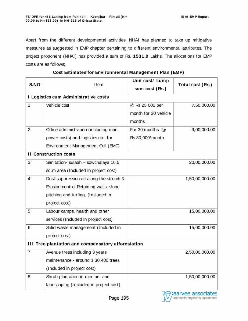
FS/DPR for 4/6 Laning from Panikoili – Keonjhar – Rimuli (Km 00.00 to Km163.00) in NH-215 of Orissa State.
EIA/ EMP Report
Page 195
Apart from the different developmental activities, NHAI has planned to take up mitigative
measures as suggested in EMP chapter pertaining to different environmental attributes. The
project proponent (NHAI) has provided a sum of Rs. 1531.9 Lakhs. The allocations for EMP
costs are as follows;
Cost Estimates for Environmental Management Plan (EMP)
S.NO Item Unit cost/ Lump
sum cost (Rs.) Total cost (Rs.)
I Logistics cum Administrative costs
1 Vehicle cost @ Rs 25,000 per
month for 30 vehicle
months
7,50,000.00
2 Office administration (including man
power costs) and logistics etc for
Environment Management Cell (EMC)
For 30 months @
Rs.30,000/month
9,00,000.00
II Construction costs
3 Sanitation- sulabh – sowchalaya 16.5
sq.m area (Included in project cost)
20,00,000.00
4 Dust suppression all along the stretch &
Erosion control Retaining walls, slope
pitching and turfing. (Included in
project cost)
1,50,00,000.00
5 Labour camps, health and other
services (Included in project cost)
15,00,000.00
6 Solid waste management (Included in
project cost)
15,00,000.00
III Tree plantation and compensatory afforestation
7 Avenue trees including 3 years
maintenance - around 1,30,400 trees
(Included in project cost)
2,50,00,000.00
8 Shrub plantation in median and
landscaping (Included in project cost)
1,50,00,000.00
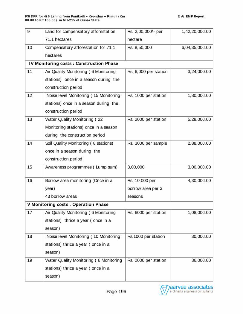
FS/DPR for 4/6 Laning from Panikoili – Keonjhar – Rimuli (Km 00.00 to Km163.00) in NH-215 of Orissa State.
EIA/ EMP Report
Page 196
9 Land for compensatory afforestation
71.1 hectares
Rs. 2,00,000/- per
hectare
1,42,20,000.00
10 Compensatory afforestation for 71.1
hectares
Rs. 8,50,000 6,04,35,000.00
IV Monitoring costs : Construction Phase
11 Air Quality Monitoring ( 6 Monitoring
stations) once in a season during the
construction period
Rs. 6,000 per station 3,24,000.00
12 Noise level Monitoring ( 15 Monitoring
stations) once in a season during the
construction period
Rs. 1000 per station 1,80,000.00
13 Water Quality Monitoring ( 22
Monitoring stations) once in a season
during the construction period
Rs. 2000 per station 5,28,000.00
14 Soil Quality Monitoring ( 8 stations)
once in a season during the
construction period
Rs. 3000 per sample 2,88,000.00
15 Awareness programmes ( Lump sum) 3,00,000 3,00,000.00
16 Borrow area monitoring (Once in a
year)
43 borrow areas
Rs. 10,000 per
borrow area per 3
seasons
4,30,000.00
V Monitoring costs : Operation Phase
17 Air Quality Monitoring ( 6 Monitoring
stations) thrice a year ( once in a
season)
Rs. 6000 per station 1,08,000.00
18 Noise level Monitoring ( 10 Monitoring
stations) thrice a year ( once in a
season)
Rs.1000 per station 30,000.00
19 Water Quality Monitoring ( 6 Monitoring
stations) thrice a year ( once in a
season)
Rs. 2000 per station 36,000.00
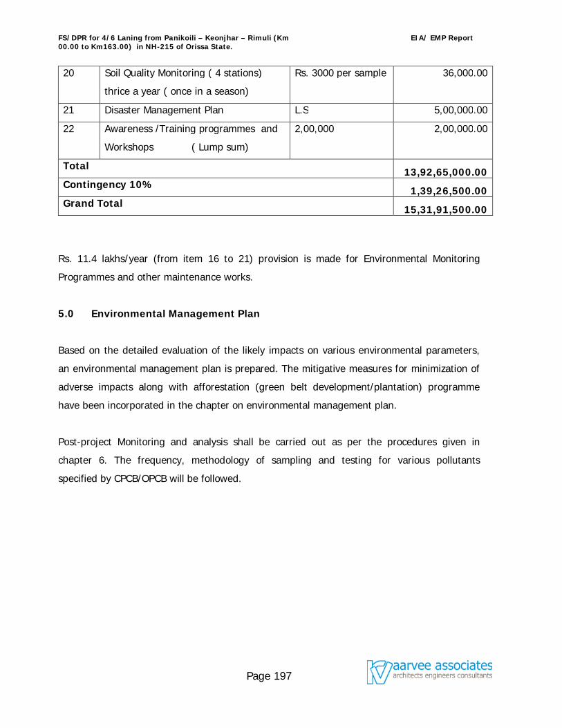
FS/DPR for 4/6 Laning from Panikoili – Keonjhar – Rimuli (Km 00.00 to Km163.00) in NH-215 of Orissa State.
EIA/ EMP Report
Page 197
20 Soil Quality Monitoring ( 4 stations)
thrice a year ( once in a season)
Rs. 3000 per sample 36,000.00
21 Disaster Management Plan L.S 5,00,000.00
22 Awareness /Training programmes and
Workshops ( Lump sum)
2,00,000 2,00,000.00
Total 13,92,65,000.00 Contingency 10% 1,39,26,500.00 Grand Total 15,31,91,500.00
Rs. 11.4 lakhs/year (from item 16 to 21) provision is made for Environmental Monitoring
Programmes and other maintenance works.
5.0 Environmental Management Plan
Based on the detailed evaluation of the likely impacts on various environmental parameters,
an environmental management plan is prepared. The mitigative measures for minimization of
adverse impacts along with afforestation (green belt development/plantation) programme
have been incorporated in the chapter on environmental management plan.
Post-project Monitoring and analysis shall be carried out as per the procedures given in
chapter 6. The frequency, methodology of sampling and testing for various pollutants
specified by CPCB/OPCB will be followed.
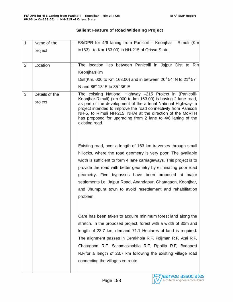
FS/DPR for 4/6 Laning from Panikoili – Keonjhar – Rimuli (Km 00.00 to Km163.00) in NH-215 of Orissa State.
EIA/ EMP Report
Page 198
Salient Feature of Road Widening Project
1 Name of the
project
: FS/DPR for 4/6 laning from Panicoili - Keonjhar - Rimuli (Km00.00.
to163) to Km 163.00) in NH-215 of Orissa State.
2 Location : The location lies between Panicoili in Jajpur Dist to Rimuli in
Keonjhar(Km
Dist(Km. 000 to Km 163.00) and in between 20o 54’ N to 21o 57’
N and 86o 13’ E to 85o 36’ E
3 Details of the
project
: The existing National Highway –215 Project in (Panicoili-Keonjhar-Rimuli) (km 000 to km 163.00) is having 2 lane road, as part of the development of the arterial National Highway- a project intended to improve the road connectivity from Panicoili NH-5, to Rimuli NH-215. NHAI at the direction of the MoRTH has proposed for upgrading from 2 lane to 4/6 laning of the existing road.
Existing road, over a length of 163 km traverses through small
hillocks, where the road geometry is very poor. The available
width is sufficient to form 4 lane carriageways. This project is to
provide the road with better geometry by eliminating poor road
geometry. Five bypasses have been proposed at major
settlements i.e. Jajpur Road, Anandapur, Ghatagaon, Keonjhar,
and Jhumpura town to avoid resettlement and rehabilitation
problem.
Care has been taken to acquire minimum forest land along the
stretch. In the proposed project, forest with a width of 30m and
length of 23.7 km, demand 71.1 Hectares of land is required.
The alignment passes in Derakhola R.F, Poijman R.F, Atai R.F,
Ghatagaon R.F, Sanamasinabila R.F, Pippilia R.F, Badaposi
R.F,for a length of 23.7 km following the existing village road
connecting the villages en route.
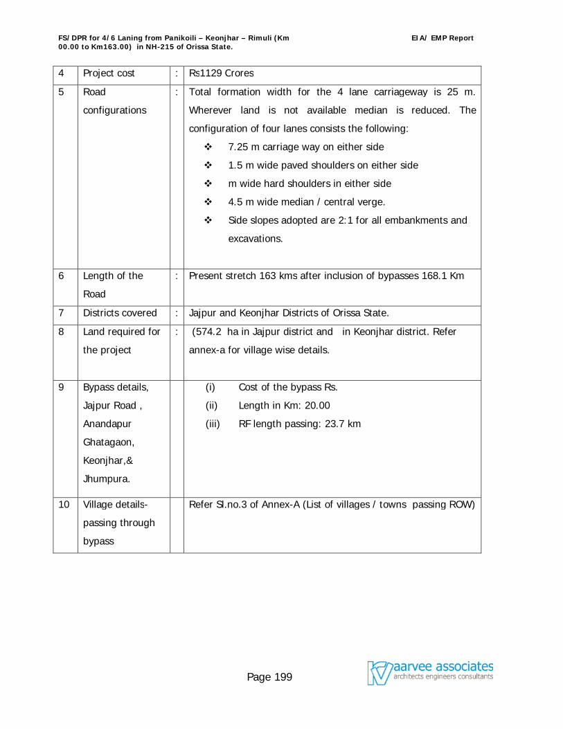
FS/DPR for 4/6 Laning from Panikoili – Keonjhar – Rimuli (Km 00.00 to Km163.00) in NH-215 of Orissa State.
EIA/ EMP Report
Page 199
4 Project cost : Rs1129 Crores
5 Road
configurations
: Total formation width for the 4 lane carriageway is 25 m.
Wherever land is not available median is reduced. The
configuration of four lanes consists the following:
7.25 m carriage way on either side
1.5 m wide paved shoulders on either side
m wide hard shoulders in either side
4.5 m wide median / central verge.
Side slopes adopted are 2:1 for all embankments and
excavations.
6 Length of the
Road
: Present stretch 163 kms after inclusion of bypasses 168.1 Km
7 Districts covered : Jajpur and Keonjhar Districts of Orissa State.
8 Land required for
the project
: (574.2 ha in Jajpur district and in Keonjhar district. Refer
annex-a for village wise details.
9 Bypass details,
Jajpur Road ,
Anandapur
Ghatagaon,
Keonjhar,&
Jhumpura.
(i) Cost of the bypass Rs.
(ii) Length in Km: 20.00
(iii) RF length passing: 23.7 km
10 Village details-
passing through
bypass
Refer Sl.no.3 of Annex-A (List of villages / towns passing ROW)
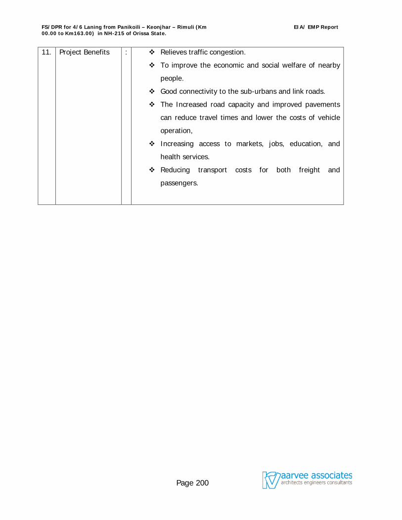
FS/DPR for 4/6 Laning from Panikoili – Keonjhar – Rimuli (Km 00.00 to Km163.00) in NH-215 of Orissa State.
EIA/ EMP Report
Page 200
11. Project Benefits : Relieves traffic congestion.
To improve the economic and social welfare of nearby
people.
Good connectivity to the sub-urbans and link roads.
The Increased road capacity and improved pavements
can reduce travel times and lower the costs of vehicle
operation,
Increasing access to markets, jobs, education, and
health services.
Reducing transport costs for both freight and
passengers.
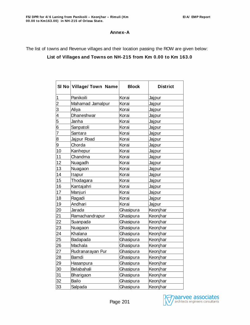
FS/DPR for 4/6 Laning from Panikoili – Keonjhar – Rimuli (Km 00.00 to Km163.00) in NH-215 of Orissa State.
EIA/ EMP Report
Page 201
Annex-A
The list of towns and Revenue villages and their location passing the ROW are given below:
List of Villages and Towns on NH-215 from Km 0.00 to Km 163.0
Sl No Village/Town Name Block District
1 Panikoili Korai Jajpur 2 Mahamad Jamalpur Korai Jajpur 3 Aliya Korai Jajpur 4 Dhaneshwar Korai Jajpur 5 Janha Korai Jajpur 6 Sanpatoli Korai Jajpur 7 Santara Korai Jajpur 8 Jajpur Road Korai Jajpur 9 Chorda Korai Jajpur 10 Kanhepur Korai Jajpur 11 Chandma Korai Jajpur 12 Nuagadh Korai Jajpur 13 Nuagaon Korai Jajpur 14 Itapur Korai Jajpur 15 Thodagara Korai Jajpur 16 Kantajahri Korai Jajpur 17 Manjuri Korai Jajpur 18 Ragadi Korai Jajpur 19 Andhari Korai Jajpur 20 Jarada Ghasipura Keonjhar 21 Ramachandrapur Ghasipura Keonjhar 22 Suanpada Ghasipura Keonjhar 23 Nuagaon Ghasipura Keonjhar 24 Khalana Ghasipura Keonjhar 25 Badapada Ghasipura Keonjhar 26 Machala Ghasipura Keonjhar 27 Rudranarayan Pur Ghasipura Keonjhar 28 Bamdi Ghasipura Keonjhar 29 Hasanpura Ghasipura Keonjhar 30 Belabahali Ghasipura Keonjhar 31 Bharigaon Ghasipura Keonjhar 32 Bailo Ghasipura Keonjhar 33 Salpada Ghasipura Keonjhar
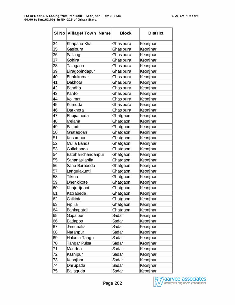
FS/DPR for 4/6 Laning from Panikoili – Keonjhar – Rimuli (Km 00.00 to Km163.00) in NH-215 of Orissa State.
EIA/ EMP Report
Page 202
Sl No Village/Town Name Block District
34 Khapana Khai Ghasipura Keonjhar 35 Gasipura Ghasipura Keonjhar 36 Sailang Ghasipura Keonjhar 37 Gohira Ghasipura Keonjhar 38 Talagaon Ghasipura Keonjhar 39 Biragobindapur Ghasipura Keonjhar 40 Bhalukumar Ghasipura Keonjhar 41 Dakhota Ghasipura Keonjhar 42 Bandha Ghasipura Keonjhar 43 Kanto Ghasipura Keonjhar 44 Kolimat Ghasipura Keonjhar 45 Kumuda Ghasipura Keonjhar 46 Darkhota Ghasipura Keonjhar 47 Bhojiamoda Ghatgaon Keonjhar 48 Melana Ghatgaon Keonjhar 49 Baljodi Ghatgaon Keonjhar 50 Ghatagoan Ghatgaon Keonjhar 51 Kusumpur Ghatgaon Keonjhar 52 Mulla Banda Ghatgaon Keonjhar 53 Gullabanda Ghatgaon Keonjhar 54 Bataharichandanpur Ghatgaon Keonjhar 55 Sananasilabila Ghatgaon Keonjhar 56 Sana Barabeda Ghatgaon Keonjhar 57 Langulakunti Ghatgaon Keonjhar 58 Tikina Ghatgaon Keonjhar 59 Dhenkikote Ghatgaon Keonjhar 60 Khajurijuani Ghatgaon Keonjhar 61 Katrabeda Ghatgaon Keonjhar 62 Chikinia Ghatgaon Keonjhar 63 Pipilia Ghatgaon Keonjhar 64 Bankapatali Ghatgaon Keonjhar 65 Gopalpur Sadar Keonjhar 66 Badaposi Sadar Keonjhar 67 Jamunalia Sadar Keonjhar 68 Naranpur Sadar Keonjhar 69 Haladia Tangri Sadar Keonjhar 70 Tangar Pulsa Sadar Keonjhar 71 Mandua Sadar Keonjhar 72 Kashipur Sadar Keonjhar 73 Keonjhar Sadar Keonjhar 74 Dhrupada Sadar Keonjhar 75 Baliaguda Sadar Keonjhar
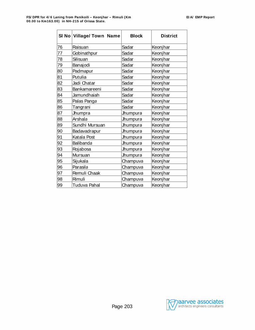
FS/DPR for 4/6 Laning from Panikoili – Keonjhar – Rimuli (Km 00.00 to Km163.00) in NH-215 of Orissa State.
EIA/ EMP Report
Page 203
Sl No Village/Town Name Block District
76 Raisuan Sadar Keonjhar 77 Gobinathpur Sadar Keonjhar 78 Silisuan Sadar Keonjhar 79 Banajodi Sadar Keonjhar 80 Padmapur Sadar Keonjhar 81 Putulia Sadar Keonjhar 82 Jadi Chatar Sadar Keonjhar 83 Bankamareeni Sadar Keonjhar 84 Jamundhaiah Sadar Keonjhar 85 Palas Panga Sadar Keonjhar 86 Tangrani Sadar Keonjhar 87 Jhumpra Jhumpura Keonjhar 88 Arshala Jhumpura Keonjhar 89 Sundhi Mursuan Jhumpura Keonjhar 90 Badavadrapur Jhumpura Keonjhar 91 Katala Post Jhumpura Keonjhar 92 Balibanda Jhumpura Keonjhar 93 Rojabosa Jhumpura Keonjhar 94 Mursuan Jhumpura Keonjhar 95 Sijukala Champuva Keonjhar 96 Parasila Champuva Keonjhar 97 Remuli Chaak Champuva Keonjhar 98 Rimuli Champuva Keonjhar 99 Tuduva Pahal Champuva Keonjhar
FS/DPR for 4/6 Laning from Panikoili – Keonjhar – Rimuli (Km 00.00 to Km163.00) in NH-215 of Orissa State.
EIA/ EMP Report
Page 204
10. 0 ENVIRONMENTAL IMPACT ASSESSMENT 10.1 Introduction
The National Highways Authority of India (NHAI) has been entrusted with the development, maintenance and management of National Highways under NHDP Phase-
III Programme of 4/6- laning of 10,000 km on BOT basis which includes the High Density Corridors/Sections of National Highways in the country. Under this present
programme, NHAI has decided to take up the development of various National Highway Corridors where the traffic intensity has increased significantly thereby necessitating capacity augmentation for safe and efficient movement of traffic. One such corridor taken up under phase-III is Panikoili – Keonjhar – Rimuli, between the chainage Km
0+000 to Km 163+000, section of NH-215. The project road runs through the districts of Jajpur and Keonjhar in the state of Orissa. The corridor passes through several
congested areas, sharp curves and has inadequate road width to cater the present traffic volumes. These deficiencies result in lesser vehicle speeds, more wear and tear
on vehicles, more vehicular pollution and more vehicle operating costs. The environment impact study is a part of the feasibility studies and preparation of detailed
project report and is also a statutory requirement for obtaining environmental clearance from Ministry of Environment & Forests (MoEF), New Delhi.
10.1.1 Approach and Methodology To determine the magnitude of significant potential impacts and to ensure that the environmental considerations are given adequate weightage in the selection of alignment and subsequent design of the proposed highway expansion, preliminary environmental screening was carried out. The environmental screening was done based on the information obtained from the alignment map and strip map along with the available secondary data supplemented by regular field visits. During screening, significant environmental issues were examined for all the alternatives. Primary and secondary data were collected to describe the existing environmental set-up. The methodology adopted is presented in the form of a flow chart given in Figure 10.1 in Appendix F. 10.1.2 Data Collection 10.1.2.1 Secondary Data Collection Secondary data on different environmental attributes were collected from the concerned institutions/departments viz, Survey of India, Census of India, Indian Meteorological Department, Irrigation and Command Area Development, Divisional Forest Offices, Directorate of Economics and Statistics, PWD Department and Government of Orissa.
FS/DPR for 4/6 Laning from Panikoili – Keonjhar – Rimuli (Km 00.00 to Km163.00) in NH-215 of Orissa State.
EIA/ EMP Report
Page 205
10.1.3 Primary Data Collection Field investigation was carried out to fill the data gaps identified during the reconnaissance survey and examination of the available secondary information. Environmental Baseline data collection is generated effective from 1st week of December 2005 and lasted till the end of February 2006 (winter season) to satisfy the needs for the preparation of EIA/EMP report as per guidelines of MoEF. The monitoring locations of Ambient Air Quality, Noise Level, Water Quality (both Surface water and Ground Water) and Soil Quality were identified along the project road as per CPCB / MoEF guidelines and relevant BIS Standards. The secondary information on flora and fauna within the study area and the study corridor was supplemented by the field survey. In addition, data on water bodies, forest area, schools, hospitals, wildlife, religious/cultural sites, cattle crossing, dug wells, tube wells, drainage and other environmental features were collected during the field studies. 10.1.4 Assessment of Baseline Environmental Conditions In accordance with the requirement of the Ministry of Environment & Forests (MoEF), a study corridor of total width of 7 km has to be established along the project alignment for the present study of the project. The baseline environmental condition of the study corridor will be assessed through compilation of data collected from secondary and field monitoring/investigation. 10.1.5 Assessment of Impact and Mitigation Measures Probable environmental impacts arising during the construction and operational phases have been determined. Suitable mitigation measures have been suggested to avoid/ minimize the negative impacts and enhance the positive impacts. 10.1.6 Environmental Management Plan (EMP) An environmental management plan has been suggested for implementation of recommended mitigation measures. It includes identification of implementing authorities, implementation schedules and supervision programme, post project monitoring plan, institutional strengthening & training and working out the cost of the Environmental Management Plan. 10.1.7 Policy and Legal Framework The Government of India through specific legislation regulates the Environmental Management system in India. The Ministries/statutory bodies responsible for ensuring
FS/DPR for 4/6 Laning from Panikoili – Keonjhar – Rimuli (Km 00.00 to Km163.00) in NH-215 of Orissa State.
EIA/ EMP Report
Page 206
environmental compliance by project promoters and general public include: The Ministry of Environment and Forests (MoEF), Govt. of India Central pollution Control Board (CPCB) State Pollution Control Boards Ministry/ Department of Environment and Forests in the States The major elements and an apparatus of the Indian Legal framework for environmental management include: The Indian Constitution The Ancient Monuments and Archaeological Sites and Remains Act, 1958 The Forest (Conservation) Act, 1980. Environmental (protection) Act, 1986 Water (Prevention and Control of pollution) Act of 1974 and Cess Act Air (Prevention and Control of Pollution) Act of 1981 The Noise Pollution (Regulation and Control) Rules 2000 under Environment (Protection)
Act 1998. Wildlife (Protection) Act, 1972 The Motor Vehicles Act, 1988
MoEF Notification of 27th January 1994 on Environmental Impact Assessment (EIA) of Development Projects and subsequent amendments till 2004.
The EIA notification issued in January 1994 and amended in 2004 makes EIA‘s statutory requirements for 32 identified activities including highway projects. All development projects, under schedule-1 of the notification are required to obtain clearance from the MoEF. According to the amendments made in April 1997 clearance from the MoEF, Government of India is not required for highway improvement projects including widening and strengthening of roads involving marginal land acquisition along the existing alignments provided it does not pass through ecologically sensitive areas such as National Parks, Sanctuaries, Tiger Reserves, Reserve Forests etc. The MoEF clarified marginal land acquisition as that not exceeding a total width of 20m on either side of the existing alignment put together. Further, it also clarified that bypasses would be treated as stand alone projects and would require environmental clearance only if the cost of the projects exceeds Rs.100 Crores each. The administrative and legal requirements discussed above shall be applicable to road projects depending upon the environmental set-up of the specific locations. The relative importance of various environmental parameters will vary from location to location.
FS/DPR for 4/6 Laning from Panikoili – Keonjhar – Rimuli (Km 00.00 to Km163.00) in NH-215 of Orissa State.
EIA/ EMP Report
Page 207
Schedule IV of the MoEF notification of 10th April 1997 indicates procedure for a public hearing. Under this, the State Pollution Control Board should cause a notice for environmental public hearing which shall be published in atleast two newspapers, widely circulated in the region around the project, one of which shall be in the local language of the study area. The State Pollution Control Board shall mention the date, time and place of hearing. Suggestions, views, comments and objections of the public shall be invited within thirty days from the date of publication of the notification. However, widening and strengthening of highway project is exempted from public hearing vide amendment dt.07.07.2004. The proposed project passes through stretch in the Reserve Forests of 22.7 Km and involves land acquisition (68.1 ha) of more than 20m on either side of the alignment put together in some stretches, shall require clearance from the State Forest department as per the MoEF circular dated 15th October 1999. The statutory requirement for the proposed project is to obtain No-Objection-Certificate (NOC) & Consent for Establishment (CFE) under Air and Water Act from the Orissa State Pollution Control Board (OSPCB) and Environmental Clearance from the MoEF, New Delhi. 10.2 Project Location The present project, Panikoili-Keonjhar-Rimuli National Highway NH-215 put up for Environmental clearance is from the chainage Km 0+000 to Km 163+000 passes through Jajpur and Keonjhar districts of Orissa State. 10.2.1 Description of Existing Alignment
The length of the project road is about 163 Km, passes through a number of villages and towns, agricultural lands, reserve forests etc. Ribbon development occurred on either sides of the road causing congestion at major towns like Jajpur (Where the existing bypass is over loaded and new bypass is proposed under this project), Ghasipura town including Anandpur, Ghatgaon, Keonjhar, Jhumpura and Balibandha. The present project corridor starts from Panikoili of NH-5, chainage Km 0+000, and crosses NH-6 at Km 122+000. The corridor ends at Rimuli, at Km 163+000 near Orissa-Jharkhand Border.
The list of towns and villages along the project corridor is given in Table 10.1.
There are six major bridges in the project corridor constructed across River Kusai (at Km 35.75), River Mushal (at Km 58.40) River Kukurkatta (at Km 84.65) River Kalinjhan (at Km 112.57) and River Ardei crosses at least thrice in the corridor among them two are major (at
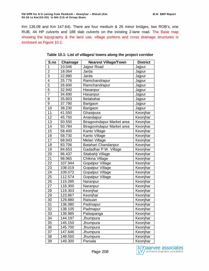
FS/DPR for 4/6 Laning from Panikoili – Keonjhar – Rimuli (Km 00.00 to Km163.00) in NH-215 of Orissa State.
EIA/ EMP Report
Page 208
Km 136.08 and Km 147.64). There are four medium & 26 minor bridges, two ROB’s, one RUB, 44 HP culverts and 188 slab culverts on the existing 2-lane road. The Base map showing the topography & the land use, village portions and cross drainage structures is enclosed as Figure 10.2.
Table 10.1: List of villages/ towns along the project corridor
S.no Chainage Nearest Village/Town District 1 10.046 Jajpur Road Jajpur 2 18.064 Jarda Jajpur 3 22,980 Jarda Jajpur 4 25.776 Ramchandrapur Jajpur 5 26.600 Ramchandrapur Jajpur 6 32.940 Hasanpur Jajpur 7 34.690 Hasanpur Jajpur 8 35.803 Belabahai Jajpur 9 37.790 Barigaon Jajpur 10 38.230 Barigaon Jajpur 11 41.550 Ghasipura Keonjhar 12 45.750 Anandapur Keonjhar 13 50.550 Biragovindapur Market area Keonjhar 14 50.784 Biragovindapur Market area Keonjhar 15 58.400 Kanto Village Keonjhar 16 58.730 Kanto Village Keonjhar 17 68.943 Melan Village Keonjhar 18 83.706 Batahari Chandanpur Keonjhar 19 84.653 Gadadhar P.W. Village Keonjhar 20 96.437 Sitabahji Village Keonjhar 21 98.965 Chikiria Village Keonjhar 22 107.944 Gopalpur Village Keonjhar 23 108.019 Gopalpur Village Keonjhar 24 109.072 Gopalpur Village Keonjhar 25 112.574 Gopalpur Village Keonjhar 26 115.095 Naranpur Keonjhar 27 118.300 Naranpur Keonjhar 28 119.303 Keonjhar Keonjhar 29 123.867 Keonjhar Keonjhar 30 129.880 Raisuan Keonjhar 31 136.080 Padmapur Keonjhar 32 138.105 Padmapur Keonjhar 33 139.985 Palaspanga Keonjhar 34 144.197 Jhumpura Keonjhar 35 145.150 Jhumpura Keonjhar 36 145.700 Jhumpura Keonjhar 37 147.646 Jhumpura Keonjhar 38 148.550 Jhumpura Keonjhar 39 149.300 Parsala Keonjhar
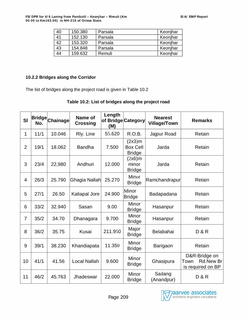
FS/DPR for 4/6 Laning from Panikoili – Keonjhar – Rimuli (Km 00.00 to Km163.00) in NH-215 of Orissa State.
EIA/ EMP Report
Page 209
40 150.380 Parsala Keonjhar 41 152.130 Parsala Keonjhar 42 153.320 Parsala Keonjhar 43 154.848 Parsala Keonjhar 44 159.632 Remuli Keonjhar
10.2.2 Bridges along the Corridor The list of bridges along the project road is given in Table 10.2
Table 10.2: List of bridges along the project road
Sl Bridge No. Chainage Name of
Crossing Length
of Bridge (M)
Category Nearest Village/Town Remarks
1 11/1 10.046 Rly. Line 55.620 R.O.B. Jajpur Road Retain
2 19/1 18.062 Bandha 7.500 (2x3)m
Box Cell Bridge
Jarda Retain
3 23/4 22,980 Andhuri 12.000 (2x6)m minor Bridge
Jarda Retain
4 26/3 25.790 Ghagia Nallah 25.270 Minor Bridge Ramchandrapur Retain
5 27/1 26.50 Kaliapal Jore 24.900 Minor Bridge Badapadana Retain
6 33/2 32.940 Sasan 9.00 Minor Bridge Hasanpur Retain
7 35/2 34.70 Dhanagara 9.700 Minor Bridge Hasanpur Retain
8 36/2 35.75 Kusai 211.950 Major Bridge Belabahai D & R
9 39/1 38.230 Khandiapata 11.350 Minor Bridge Barigaon Retain
10 41/1 41.56 Local Nallah 9.600 Minor Bridge Ghasipura
D&R-Bridge on Town Rd.New Br is required on BP
11 46/2 45.763 Jhadeswar 22.000 Minor Bridge
Sailang (Anandpur) D & R
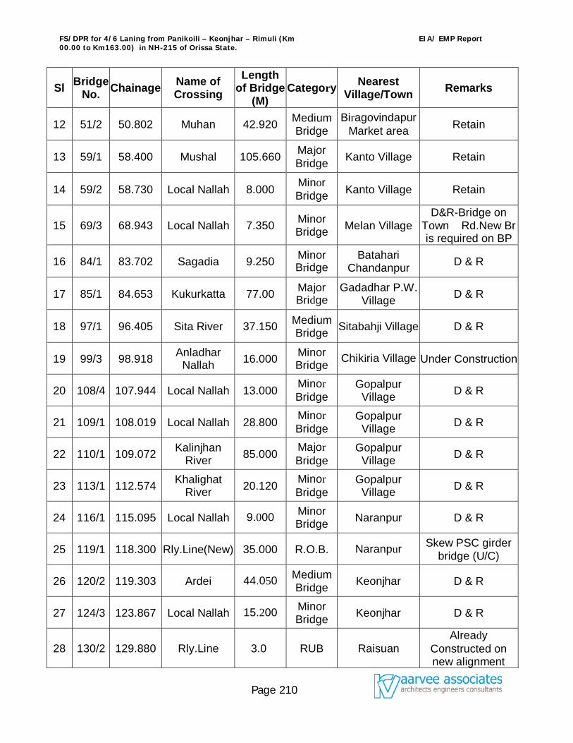
FS/DPR for 4/6 Laning from Panikoili – Keonjhar – Rimuli (Km 00.00 to Km163.00) in NH-215 of Orissa State.
EIA/ EMP Report
Page 210
Sl Bridge No. Chainage Name of
Crossing Length
of Bridge (M)
Category Nearest Village/Town Remarks
12 51/2 50.802 Muhan 42.920 Medium Bridge
Biragovindapur Market area Retain
13 59/1 58.400 Mushal 105.660 Major Bridge Kanto Village Retain
14 59/2 58.730 Local Nallah 8.000 Minor Bridge Kanto Village Retain
15 69/3 68.943 Local Nallah 7.350 Minor Bridge Melan Village
D&R-Bridge on Town Rd.New Br is required on BP
16 84/1 83.702 Sagadia 9.250 Minor Bridge
Batahari Chandanpur D & R
17 85/1 84.653 Kukurkatta 77.00 Major Bridge
Gadadhar P.W. Village D & R
18 97/1 96.405 Sita River 37.150 Medium Bridge Sitabahji Village D & R
19 99/3 98.918 Anladhar Nallah 16.000 Minor
Bridge Chikiria Village Under Construction
20 108/4 107.944 Local Nallah 13.000 Minor Bridge
Gopalpur Village D & R
21 109/1 108.019 Local Nallah 28.800 Minor Bridge
Gopalpur Village D & R
22 110/1 109.072 Kalinjhan River 85.000 Major
Bridge Gopalpur
Village D & R
23 113/1 112.574 Khalighat River 20.120 Minor
Bridge Gopalpur
Village D & R
24 116/1 115.095 Local Nallah 9.000 Minor Bridge Naranpur D & R
25 119/1 118.300 Rly.Line(New) 35.000 R.O.B. Naranpur Skew PSC girder bridge (U/C)
26 120/2 119.303 Ardei 44.050 Medium Bridge Keonjhar D & R
27 124/3 123.867 Local Nallah 15.200 Minor Bridge Keonjhar D & R
28 130/2 129.880 Rly.Line 3.0 RUB Raisuan Already
Constructed on new alignment
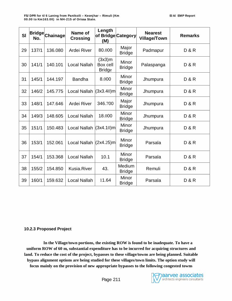
FS/DPR for 4/6 Laning from Panikoili – Keonjhar – Rimuli (Km 00.00 to Km163.00) in NH-215 of Orissa State.
EIA/ EMP Report
Page 211
Sl Bridge No. Chainage Name of
Crossing Length
of Bridge (M)
Category Nearest Village/Town Remarks
29 137/1 136.080 Ardei River 80.000 Major Bridge Padmapur D & R
30 141/1 140.101 Local Nallah (3x3)m Box cell Bridge
Minor Bridge Palaspanga D & R
31 145/1 144.197 Bandha 8.000 Minor Bridge Jhumpura D & R
32 146/2 145.775 Local Nallah (3x3.40)m Minor Bridge Jhumpura D & R
33 148/1 147.646 Ardei River 346.700 Major Bridge Jhumpura D & R
34 149/3 148.605 Local Nallah 18.000 Minor Bridge Jhumpura D & R
35 151/1 150.483 Local Nallah (3x4.10)m Minor Bridge Jhumpura D & R
36 153/1 152.061 Local Nallah (2x4.25)m Minor Bridge Parsala D & R
37 154/1 153.368 Local Nallah 10.1 Minor Bridge Parsala D & R
38 155/2 154.850 Kusia.River 43. Medium Bridge Remuli D & R
39 160/1 159.632 Local Nallah 11.64 Minor Bridge Parsala D & R
10.2.3 Proposed Project
In the Village/town portions, the existing ROW is found to be inadequate. To have a uniform ROW of 60 m, substantial expenditure has to be incurred for acquiring structures and
land. To reduce the cost of the project, bypasses to these village/towns are being planned. Suitable bypass alignment options are being studied for these villages/town limits. The option study will
focus mainly on the provision of new appropriate bypasses to the following congested towns
FS/DPR for 4/6 Laning from Panikoili – Keonjhar – Rimuli (Km 00.00 to Km163.00) in NH-215 of Orissa State.
EIA/ EMP Report
Page 212
where bypass is likely to be the viable option compared to acquiring additional land and structures in the town / village portions. The list of villages/Towns where bypass option studies
will be carried out are given below:
10.2.3.1 Bypasses
Jajpur Road (Km 6.000 to Km 14.100), there is an existing bypass to Jajpur town. Another new bypass is being planned under the present project.
Ghasipura (Km 41.000 to Km 44.400)including Anadpur Town,
Ghatgaon (Km 77.250 to km 78.600)
Keonjhar (Km 122.000 to Km 125.000
Jhumpura (Km 143.600 to Km 146.000)
Using satellite imageries, aerial photographs, topographical maps and preliminary reconnaissance surveys, alternative alignments for bypasses are proposed for these towns.
Different alternatives were studied for each town keeping in view the length of bypass, causing least disturbance to the existing villages and avoiding existing tanks and water bodies.
10.2.3.2 Bridges All the bridges are being widened to 4 lane standards as mentioned in Chapter 6.
Minor Bridges: Out of the 26 minor bridges, 2 are Arch bridges with Brick masonry, 1 is Stone Slab Bridge and 1 is Box Bridge. It is recommended to abandon both these bridges and construct new bridges with 4-lane configuration in their place. 14 out of 19 minor bridges are slab bridges and I with pipes. It is feasible to widen all these bridges including the substructure to the required width with repairs. The final recommendation for repair / replacement will be given at the time of feasibility report taking into account the extent of repair work involved.
Major Bridges: 6 out of 3 major bridges are of RCC Slab type. The final recommendation for repair / replacement will be given at the time of feasibility report taking into account the extent of repair work involved. 1 bridge has stone slab as super structure. It is recommended to abandon this bridge and construct new bridges with 4-lane configuration in its place.
New Bridges: 10.2.3.3 Pedestrian Facilities
FS/DPR for 4/6 Laning from Panikoili – Keonjhar – Rimuli (Km 00.00 to Km163.00) in NH-215 of Orissa State.
EIA/ EMP Report
Page 213
Foot paths / raised kerbs will be provided on bridges in residential areas. Pedestrian underpasses near habitated areas such as villages. Pedestrian road crossing markings where underpasses are not provided. Lowering of median kerb at the location of pedestrian crossings for the convenience of
physically challenged.
10.2.3.3.1 Land use
Major portion of land along the alignment is barren. Some parts are used for agriculture in which food grains and oil crops like mustard/ teal are being cultivated. There are other semi-arid crops as well. Irrigation tanks are found along the alignment. The crops found along the alignment are either rain fed or dependant on water from the irrigation tanks.
The alignment passes through reserve forest at the following locations:
from Km. 19.000 to Km. 21.000 from Km. 39.000 to Km. 40.000 from Km. 50.000 to Km. 50.500 from Km. 58.000 to Km. 66.400 from Km. 74.000 to Km. 77.000 from Km. 84.000 to Km. 85.800 from Km. 102.500 to Km. 103.000 from Km. 107.000 to Km. 109.000 from Km. 111.000 to Km. 113.000 from Km. 129.500 to Km. 130.200 from Km. 139.400 to Km. 141.200
The information like, vicinity of forest area along the alignment, forest cover (crown density), species types, presence of wildlife and their migratory route across the road, etc. are being collected from the concerned Forest Department, Botanical Survey of India, Zoological Survey of India WWF centre and field verification. The information on wetland, grassland and other ecologically important areas were collected. As per the preliminary study in core and buffer zone, the type of forests, flora and fauna present in this region are described as follows:
10.2.4.1 Forest The forests of the project area are of monsoon type locally classified as:
FS/DPR for 4/6 Laning from Panikoili – Keonjhar – Rimuli (Km 00.00 to Km163.00) in NH-215 of Orissa State.
EIA/ EMP Report
Page 214
a) Tropical moist deciduous forest b) Tropical semi evergreen forest
Tropical moist deciduous forest is chiefly characterized by Shorea, Terminalia, Diospyros and
Schleichera. The species largely comprise Shorea robusta, Terminalia tomentosa, Diospyros
melanoxylon, Schleichora oleosa, Anogeissus latifolia, Ougeinia cojenensis, Adinia cordifolia
and Protium serratum.
Tropical semi evergreen forest is confined to hilly area and characterized by Diospyros
macaranga, Dillenia mesua and Strychnos. The reserved forest of this district consists mostly
of steep hills and narrow winding valleys. But most of the wide valleys that offered optimum
conditions for the growth of fine sal (Shorea robusta) forests were alienated from the reserved
forests at the time of demarcation and brought under regular cultivation.
However, the Forest land along the project corridor was found to be in a stretch of 22.7 Km on either side of the road and the forest land acquired to be accounted for 68.1 ha. 10.2.4.2 Cropped Area Major portion of land along the alignment is barren. Some parts are used for agriculture in which Paddy, Wheat, Maize, Ground nut, Sugarcane, Red gram, Green gram, Black gram, Vegetables, Teal and Mustard are being cultivated. Irrigation tanks, streams and rivers are found along the alignment. The crops found along the alignment are either rain fed or dependant on water from the irrigation tanks, minor irrigation project (Rudra) and open wells/bore wells.
10.2.5 Existing Road Standards The existing road is having a roadway width of 12m and paved width of 7 to 10 m. It is designed for 60 to 80KMPH design speed and is deficient in design standards (Horizontal and Vertical Geometrics) at a number of locations. It is passing through congested towns and there is no provision at present for segregating through and local traffic in towns and villages. The service levels for vehicles passing through towns and villages are grossly inadequate and vehicles travel at 30 to 40 Kmph speed in these villages. Keeping in view the future growth of vehicular traffics, there is need to four lane the existing road and improve the geometric design standards for 100 Kmph speed and incorporate adequate safety measures to ensure smooth and safe travel for vehicular and passenger traffic and also for the people residing in towns and villages adjoining the highway.
FS/DPR for 4/6 Laning from Panikoili – Keonjhar – Rimuli (Km 00.00 to Km163.00) in NH-215 of Orissa State.
EIA/ EMP Report
Page 215
10.2.6 Road Over Bridges (ROBs) Two Road Over Bridges are existing at Jajpur-Road bypass level crossing at Km 10.046 and Naranpur Skew PSC girder bridge (U/C) at chain age 118.300 10.2.7 Road Underpasses Vehicular underpasses at Raisuan already constructed on new alignment 10.2.8 Land Acquisition The present right of way is varying from 25m to 35m. For widening the road to four lanes with all the required improvements, the average minimum land width needed is 60m. It means that additional land width of about 30m is needed for accommodating four lanes. Thus, there is need to acquire approximately 3 hectares of land per Km of project. For bypasses, the land extent required is about 7.5 hectares per Km of road. The total requirement of land is tentatively assessed as given in Table 10.3.
Table 10.3: Land Acquisition Requirements
S.No. Description Length (Km)
Land to be Acquired (ha)
1 Existing alignment excluding bypasses and stretches passing through forest areas
122.15 366.45
2 Highway passing through forest lands
22.7 68.1
3 Bypasses 18.15 108.9 Total 163.0 543.5
10.2.9 Flood Characteristics
FS/DPR for 4/6 Laning from Panikoili – Keonjhar – Rimuli (Km 00.00 to Km163.00) in NH-215 of Orissa State.
EIA/ EMP Report
Page 216
There are five rivers in the project corridor namely River Ardei, River Mushal, River
Kukurkatta, River Kusai and River Sita among them first two are prime rivers and the
remaining are minor in nature. River Ardei crosses at least thrice in project corridor chain age
at Km 119.3, 136.08 and 147.65 respectively. However, the River Baitarani a major one
draining in the buffer zone of the project corridor. The rivers emerge out of the hilly tracts into
the plain terrain with great velocity and are charged with large volumes of water during
monsoon. In summer they became almost dry. Their beds are usually rocky which render
them unfit for navigation. There are many water tanks observed along the project corridor.
There are few instances of flooding along the project road length where the terrain is mostly
hilly, rolling & plain in nature. Due to the construction of reservoirs, check dams, water
conservation techniques by the State Government, Forest Department and other agencies,
the chances of occurrence of floods are remote. Even if a flood occurs, the floodwaters are
likely to recede faster in view of the hilly, rolling and partly plain terrain.
10.3 Baseline Environmental Setup 10.3.1 Introduction The study corridor covers 7 km on both sides of the project road all along the alignment. The primary and secondary data are being collected to assess the existing environmental set up within the study corridor for Environmental parameters include physical resources, ecological resources, human settlements (human use values) and quality of life indices. 10.3.2 Physical Resources 10.3.2.1 Physiography The project stretch passes through hilly and rolling topography, which is comprised of plains, scattered hill ranges and narrow river valleys plain.
10.3.2.2 Geology and Soil
The geology of the study area is a part of the northern extension of the Deccan Plateau and is
mostly underlain by Precambrian rocks. A very small percentage of the total area of the
project corridor is constituted of the quaternary to recent formations. These latter formations
are chiefly confined to the wide river valleys. The oldest rock units exposed in this area
FS/DPR for 4/6 Laning from Panikoili – Keonjhar – Rimuli (Km 00.00 to Km163.00) in NH-215 of Orissa State.
EIA/ EMP Report
Page 217
comprise mica, sillimanite, hornblende, chlorite and quartz schist with some calc-magnesian
gneisses and metavolcanic rocks grouped together in the older metamorphics. These rocks
are exposed around Champua. Characterized by high metamorphism these rocks are
intensely magnetized.
The study area is bestowed with extensive deposits of iron ores and manganese ores with chromite and a few other minor mineral occurrences. Keonjhar district plays a major role in contributing sizeable production of iron ore. Similarly, more than 90% of
the Orissa’s manganese ore production comes from the Keonjhar-Bonai area. Important manganese ore deposits in the Keonjhar district are located in the areas of Gurda, Raida, Bhadrasahi, Sidhamatha, Nalda, Belkundi, Barbil, Kora, Joda, Kalimati, Dhubana etc. The chromite deposits of this district are associated with the ultramagic
rocks of Nuasahi, Boula and Phulinjharhuli area.
The soils present in the study area are mostly Sandy clay loam, Sandy loam, Black cotton and partially red soils.
10.3.2.3 Climate & Meteorology Climate
The climate of the region is characterized by an oppressive hot summer, high humidity and well-distributed rainfall during the monsoon season. The year may be
chiefly divided into four seasons, the hot season is from March to May, the period from June to September is the south west monsoon season, October and November constitute the post monsoon season and the cold season is from December to
February. The rainfall in this region, in general increases from the south-west. The maximum annual rainfall is shared by South west monsoon season. The cold weather commences towards the start of December when the temperature falls rapidly.
The relative humidity is generally high i.e. about 75% during the southwest monsoon and post
monsoon months. In the other months, the afternoons are comparatively drier. In the summer
afternoons the relative humidity varies between 35 to 40%. Annual mean relative humidity is
58 – 67%.
Meteorology of the region: Meteorological data for five years (1999 – 2001) will be collected from Indian Meteorological Department’s nearest observatory from the project site (at Keonjhar). The existing mean meteorological conditions of the region are:
FS/DPR for 4/6 Laning from Panikoili – Keonjhar – Rimuli (Km 00.00 to Km163.00) in NH-215 of Orissa State.
EIA/ EMP Report
Page 218
Temperature: The summer season is usually dry with average minimum temperature ranging between 12.5 0C to 19.3 0C and maximum temperature ranging between 38.50C to 42.8 0C January is generally the coldest month and April is generally the hottest month in the study area. Wind Speed Winds are generally light to moderate with some increase in force in the summer and
monsoon seasons. The morning winds are generally from south to south west during summer
and monsoon season and from northwest, north, northeast during other seasons. In the
afternoons winter winds are mainly calm and they blow from directions southeast or south.
During monsoon season the winds blow predominantly from the directions of southeast, south
and southwest. The annual mean wind speed is observed as 5.5 Km/hr
Clouds
During the southwest monsoon season, skies are generally heavily clouded to overcast. In the
summer and post monsoon months, there prevails moderate cloud, the afternoons being
cloudier than the mornings. In other months, the skies chiefly remain clear or lightly clouded.
Rainfall The annual average rainfall is 1390.0 mm. The project area mostly receives rainfall from southwest monsoon that works out to be around 77.4%. The total rainfall is received during the monsoon season during June to end of September. Onsite meteorological conditions: Two micrometeorological stations (at Jajpur, and Keonjhar) have been selected and are monitored for meteorological parameters such as Wind speed, Wind direction, Temperature, Relative humidity and Rainfall. Monitoring is being carried out continuously for 24 hours (hourly recordalble) from the 1st week of December 2005 to last week of February 2006, for one season (winter). Comprehensive data will be presented in EIA/EMP Report. 10.3.2.4 Air Quality Monitoring
FS/DPR for 4/6 Laning from Panikoili – Keonjhar – Rimuli (Km 00.00 to Km163.00) in NH-215 of Orissa State.
EIA/ EMP Report
Page 219
Air Quality monitoring are being carried out across the project site. a) Selection of Monitoring Stations Six monitoring stations were selected considering the spatial relationship of various land uses along the project corridor, traffic characteristics and wind direction in accordance with the BIS Guidelines (IS: 5182 (part-14)-1985). The sampling locations are given in Table -10.4 and Base map showing Micrometeorological and Air quality monitoring locations in Figure 10.2 in Appendix F
Table 10.4: Air Quality Monitoring Stations
S.No Station A1 JajpurRoad A2 Anandpur A3 Ghatagaon A4 Keonjhargarh A5 Jhumpura A6 Champua
b) Monitoring Methodology Monitoring of ambient air quality is being carried out as per CPCB guidelines. Monitoring is being carried out continuously for 24 hours (2 days in a week) from the 1st week of December 2005 to last week of February 2006, for one season (winter). Monitored parameters are Total Suspended Particulate Matter (TSPM), Respirable Particulate Matter (RPM), Sulphur Dioxide (SO2), Oxides of Nitrogen (NOx) and Carbon Monoxide (CO). The monitored results will be discussed in EIA/EMP report in detail
10.3.2.5 Surface Water quality monitoring The drainage in the study is controlled by ephemeral/permanent streams or rivers. The major perennial river in the study area drained by River Baitarani and ephemeral rivers viz. River Aradei, River Kusei, River Mushal, River Kukurkatta and River Kalinjhan. The Rivers are flowing from west to east direction and several small surface drainage tributaries, streams that flow according to the terrain and join the nearest water tank/ reservoir. All these rivers and streams are carrying swift flow during monsoon only and join ultimately in Bay of Bengal. Two Major bridges exist on River Aradei and two on River Kusei along the existing highway,
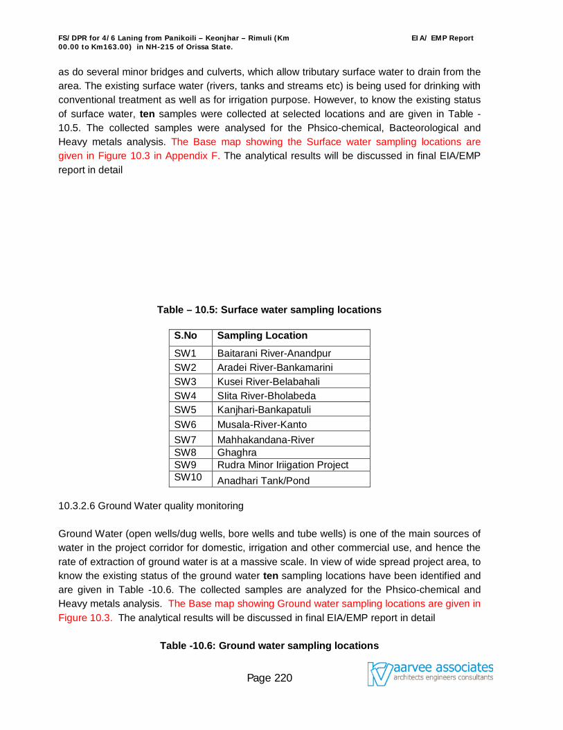
FS/DPR for 4/6 Laning from Panikoili – Keonjhar – Rimuli (Km 00.00 to Km163.00) in NH-215 of Orissa State.
EIA/ EMP Report
Page 220
as do several minor bridges and culverts, which allow tributary surface water to drain from the area. The existing surface water (rivers, tanks and streams etc) is being used for drinking with conventional treatment as well as for irrigation purpose. However, to know the existing status of surface water, ten samples were collected at selected locations and are given in Table -10.5. The collected samples were analysed for the Phsico-chemical, Bacteorological and Heavy metals analysis. The Base map showing the Surface water sampling locations are given in Figure 10.3 in Appendix F. The analytical results will be discussed in final EIA/EMP report in detail
Table – 10.5: Surface water sampling locations 10.3.2.6 Ground Water quality monitoring Ground Water (open wells/dug wells, bore wells and tube wells) is one of the main sources of water in the project corridor for domestic, irrigation and other commercial use, and hence the rate of extraction of ground water is at a massive scale. In view of wide spread project area, to know the existing status of the ground water ten sampling locations have been identified and are given in Table -10.6. The collected samples are analyzed for the Phsico-chemical and Heavy metals analysis. The Base map showing Ground water sampling locations are given in Figure 10.3. The analytical results will be discussed in final EIA/EMP report in detail
Table -10.6: Ground water sampling locations
S.No Sampling Location
SW1 Baitarani River-Anandpur SW2 Aradei River-Bankamarini SW3 Kusei River-Belabahali SW4 SIita River-Bholabeda SW5 Kanjhari-Bankapatuli SW6 Musala-River-Kanto SW7 Mahhakandana-River SW8 Ghaghra SW9 Rudra Minor Iriigation Project SW10 Anadhari Tank/Pond

FS/DPR for 4/6 Laning from Panikoili – Keonjhar – Rimuli (Km 00.00 to Km163.00) in NH-215 of Orissa State.
EIA/ EMP Report
Page 221
Code no Name of the Village GW-1 Panikoili GW-2 JajpurRoad GW-3 Anandpur GW-4 Ghatagaon GW-5 Keonjhargarh GW-6 Jhumpura GW-7 Champua GW-8 Remuli GW-9 Sainkula GW-10 Similia
Irrigation: In the study corridor, the main source of irrigation is from open/dug wells, tanks, tube wells and bore wells etc. In project area, water from canals, streams, water tanks, bore wells and dug wells are being used for irrigation purpose. 10.3.2.7 Noise Level monitoring In order to assess the noise impacts due to the proposed widening project on surrounding areas, baseline noise levels were monitored once in a season at fifteen (15) selected locations. Field monitoring is carried out covering sensitive receptors, major junctions along the existing alignment of the road with integrating sound level meter as per IS: 3029-1980 and in consultation with OSPCB and local people. Selection of Sampling Points Fifteen sampling locations are selected considering the land use pattern, traffic intersections and diversions along the existing road. The list of locations is given in Table 10.7 and the Base map showing the monitoring locations in figure 10.4 is attached in Appendix F. The monitored results will be discussed in final EIA/EMP report in detail.
Table 10.7: Noise monitoring stations
SlNo Name of the Village N1 Panikoili N2 JajpurRoad
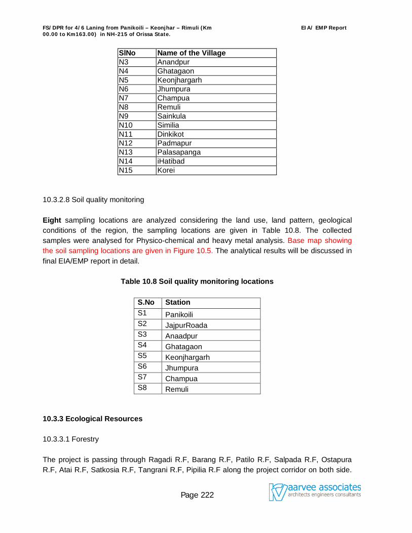
FS/DPR for 4/6 Laning from Panikoili – Keonjhar – Rimuli (Km 00.00 to Km163.00) in NH-215 of Orissa State.
EIA/ EMP Report
Page 222
SlNo Name of the Village N3 Anandpur N4 Ghatagaon N5 Keonjhargarh N6 Jhumpura N7 Champua N8 Remuli N9 Sainkula N10 Similia N11 Dinkikot N12 Padmapur N13 Palasapanga N14 iHatibad N15 Korei
10.3.2.8 Soil quality monitoring Eight sampling locations are analyzed considering the land use, land pattern, geological conditions of the region, the sampling locations are given in Table 10.8. The collected samples were analysed for Physico-chemical and heavy metal analysis. Base map showing the soil sampling locations are given in Figure 10.5. The analytical results will be discussed in final EIA/EMP report in detail.
Table 10.8 Soil quality monitoring locations
S.No Station S1 Panikoili S2 JajpurRoada S3 Anaadpur S4 Ghatagaon S5 Keonjhargarh S6 Jhumpura S7 Champua S8 Remuli
10.3.3 Ecological Resources 10.3.3.1 Forestry The project is passing through Ragadi R.F, Barang R.F, Patilo R.F, Salpada R.F, Ostapura R.F, Atai R.F, Satkosia R.F, Tangrani R.F, Pipilia R.F along the project corridor on both side.
FS/DPR for 4/6 Laning from Panikoili – Keonjhar – Rimuli (Km 00.00 to Km163.00) in NH-215 of Orissa State.
EIA/ EMP Report
Page 223
The forest land is accounted for 68.1 ha. Most of the forests are tropical dry deciduous and semi-ever green in nature. The flora and fauna species present in the forests are described as below: Flora:
The common species found along the road corridor are Mango, Kendu, Jackfruit, Karanjia,
Blackberry, Pipal, Baniyan, Gambhari, Nim, Eucalyptus, Acasia, Bamboo, Tamarind, Teak,
Sal, Piasal, Asan, Harida, Bahada, Mahua, Arjun, Kusuma and Sirish.
Fauna: The common mammals are the Heta Bagha (Hyaena hyaena), Bilua (Canis aureus), Bana
Biradi (Felis chaus), Salia Patni (Viverricula indica), Katasa (Paradoxurus hermaphoroditus),
Kuji Neula (Herpestes auropunctatus), Odha (Lutra perspicillata), Bhalu (Melursus ursinus),
Elephant (Elephas maximus), Sambar (Cervus unicolor niger).
Regarding birds, common peafowl (Pavo cristatus) are numerous. Red jungle fowl (Gallus
gallus) and common red spur fowl (Galloerdix spadicoa) are also numerous.
The principal fish found in the water bodies along the project corridor are rohi (Labeo rohita),
Mirkali (Cirrhina mrigala), Bhakur (Catla catla), Sal (Ophicephalus marulices) and Seul
(Ophicephalus striatus). The principal poisonous snakes along the corridor are Cobra, Vipers
and Kraits.
It is found that there are no endangered and rare species in the core area of the project. The forest areas within the study area are shown in Figure 10.3 in Appendix F. 10.3.4 Human Use Values 10.3.4.1 Land Use The proposed project alignment passes through agricultural and residential lands all through. The land use within the study corridor consists of arable land, reserved forest area, scrub forests and plantations besides the presence of large patches of uncultivated or wasteland. The arable land is mainly unirrigated. The land use adjacent to the project corridor is mostly
FS/DPR for 4/6 Laning from Panikoili – Keonjhar – Rimuli (Km 00.00 to Km163.00) in NH-215 of Orissa State.
EIA/ EMP Report
Page 224
agricultural, barren, semi-urban and urban in nature as given in the Table 10.10 in Appendix F. Roadside plantation developed along the existing road is given in the Table 10.11 of Appendix F. The land use along the proposed bypasses is partly agriculture and mostly barren lands.
10.3.5 Quality of Life Values 10.3.5.1 Social impact screening report The socio-economic status in the area has been discussed separately under the chapter Social Impact Screening Report. The extent of land acquisition involved and demolition of structures has been discussed in that part. 10.3.5.2 Aesthetics The project involves widening of the existing road to 4 lane standards. Hence, disfiguration of land by filling or cutting is very minimal. The widening of existing 2-lane road required the removal of existing roadside plantation on one side. However, all efforts would be made to save as many trees as possible during the design as well as project execution stages. 10.3.5.3 Archaeological/ Places of Historical Importance Except, Maa-Tarini-Temple at Ghatagaon, no other archaeological or places of historical importance exist along the project study area. 10.4. Potential Impacts and Mitigation Measures 10.4.1 Introduction This chapter assesses the probable environmental impacts likely to occur from the activities involved in the up-gradation of the existing 2-lane road both during the construction as well as operation phases of the project. Identification of the potential impacts is followed by suggestions and recommendations made for cost-effective management and proper mitigation measures. The opportunity for Environmental management has also been incorporated. During Construction phase 10.4.2 Impacts on Physical Resources 10.4.2.1 Air Quality
FS/DPR for 4/6 Laning from Panikoili – Keonjhar – Rimuli (Km 00.00 to Km163.00) in NH-215 of Orissa State.
EIA/ EMP Report
Page 225
Impacts on air during the construction phase could be due to transportation of construction equipment and road construction activities. Operation of hot mix plants and Asphalt Plants will result in the emission of fumes and obnoxious gases to the environment. Loading/ unloading of construction materials and their transportation, particularly through the unpaved or unmetalled sections of the road may lead to a rise in the ambient SPM and RSPM levels. Material handling, spillage may occur during the transportation of construction materials. 10.4.2.2 Mitigation Measures Hot Mix Plants shall be located away from the inhabited areas, residential settlements and
water bodies. Trucks and Tippers carrying building materials (earth for filling, sand, gravel or stone) will
be covered with Tarpaulin sheets to avoid spilling. Dust level at the construction sites shall be controlled by water sprinkling arrangements. Construction material, machinery and equipment will be maintained in a good working
condition and shall be handled with due precaution and only by trained professionals. 10.4.2.3 Noise Levels Operation of construction machinery viz, Hot mix plants, Bull dozers, Excavators, Tippers, Paving Machines, Rollers, Concrete mixers etc may lead to a rise in the noise level to a range between 80-95 dB(A). Vehicles -carrying construction material may also add to the increase in the noise levels. The magnitude of the impact depends on the types of equipment used, construction methods and also on the work scheduling. The noise levels generated from a source will decrease with increase in distance as per the formula given below (Inverse Square Law). SPL2 = SPL1- 20 LOG10(r2/r1) Where, SPL1 and SPL2 are the sound pressure levels at distances r1 and r2 respectively. Considering the stationary equipment as a point source generating 90dB(A) at a reference distance of 2m, computed distance required to meet the permissible limits during day time for different land use categories are in Table 10.10.
Table 10.10: Maximum Distance of Operation from Stationary Source Required for Meeting Standards
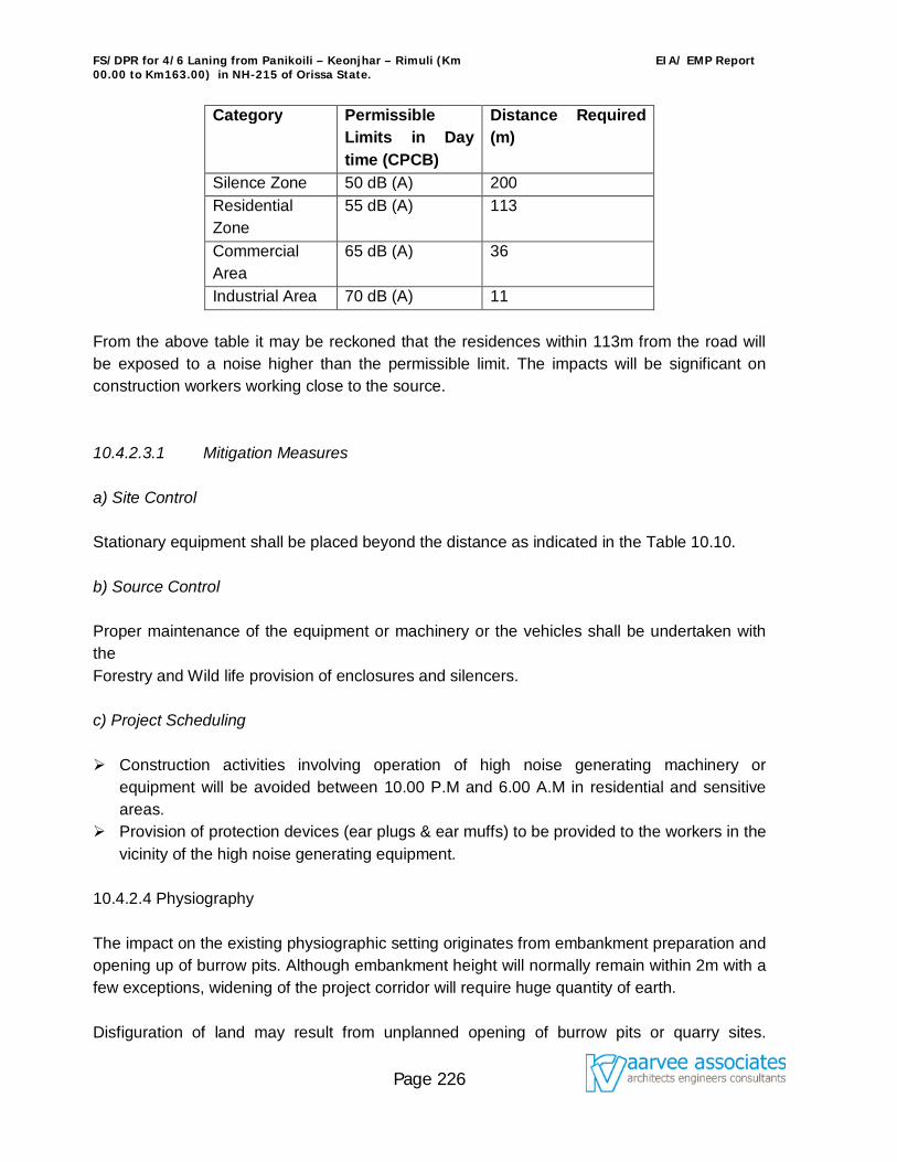
FS/DPR for 4/6 Laning from Panikoili – Keonjhar – Rimuli (Km 00.00 to Km163.00) in NH-215 of Orissa State.
EIA/ EMP Report
Page 226
Category Permissible Limits in Day time (CPCB)
Distance Required (m)
Silence Zone 50 dB (A) 200 Residential Zone
55 dB (A) 113
Commercial Area
65 dB (A) 36
Industrial Area 70 dB (A) 11 From the above table it may be reckoned that the residences within 113m from the road will be exposed to a noise higher than the permissible limit. The impacts will be significant on construction workers working close to the source. 10.4.2.3.1 Mitigation Measures a) Site Control Stationary equipment shall be placed beyond the distance as indicated in the Table 10.10. b) Source Control Proper maintenance of the equipment or machinery or the vehicles shall be undertaken with the Forestry and Wild life provision of enclosures and silencers. c) Project Scheduling
Construction activities involving operation of high noise generating machinery or
equipment will be avoided between 10.00 P.M and 6.00 A.M in residential and sensitive areas.
Provision of protection devices (ear plugs & ear muffs) to be provided to the workers in the vicinity of the high noise generating equipment.
10.4.2.4 Physiography The impact on the existing physiographic setting originates from embankment preparation and opening up of burrow pits. Although embankment height will normally remain within 2m with a few exceptions, widening of the project corridor will require huge quantity of earth. Disfiguration of land may result from unplanned opening of burrow pits or quarry sites.
FS/DPR for 4/6 Laning from Panikoili – Keonjhar – Rimuli (Km 00.00 to Km163.00) in NH-215 of Orissa State.
EIA/ EMP Report
Page 227
Change in the physiographic setting will also occur to a limited extent due to complete or partial filling up of the existing ponds along the corridor. Since the alignment passes through plain terrain, there would not be any significant impact on the overall relief of the region. To avoid any disfiguration of the physiography, only identified burrow pits and quarry sites will be used as shown in Figure 10.6 to Figure 10.9 in Appendix F. 10.4.2.4.1 Mitigation Measures The opening of new burrow pits shall be in accordance with the IRC: 10-1961 specifications as follows:
Top soil (upto 150 mm) to be preserved for resurfacing the exposed pits. Depth of the burrow pits shall not exceed 1m. No burrow pit shall be located within 0.8 Km from any town or village (any major
residential settlement). 10.4.2.5 Soil The surface formation along the alignment characterized by sandy loam, sandy clay loam and mixed black cotton soils, which are more susceptible to erosion. Nevertheless, placing of loose soil for embankment would result in significant soil erosion in case appropriate stabilization measures are not adopted promptly. But, the stretch near major bridges, where the embankment would exceed 3m, requires special stabilization measures to avoid problems related to soil erosion. The erosion at construction stretches will result in increased sediment load in the recipient streams. Moreover, leakage of lubricants in the equipment yard and spills at the Asphalt plant sites will cause oil contamination. A new bituminous coating shall overlay the existing bituminous surface. Thus, there would not be any removal of the top bituminous surface. 10.4.2.5.1 Mitigation Measures
Fill material shall be compacted immediately after placing. At locations where embankment height is upto 3m, vegetative turfing will be provided
to stabilize the side slopes. The types of vegetation recommended for use in soil slopes are: Cynodon dactrylon(DoobGrass), Cynodon plectostycvum, Chlorisgyma, Sacharum spontaneum, Sacharum munja, Ipomoea gornea, Lantana Species etc.
Embankment slopes at bridges shall be stabilized by placing stone pitching / drainage chutes / retaining walls.
Accidental spills of lubricants/ oils and molten asphalt shall be avoided by adhering to good practices.
Removed Asphalt shall be used in side slope at high embankment and low-lying areas
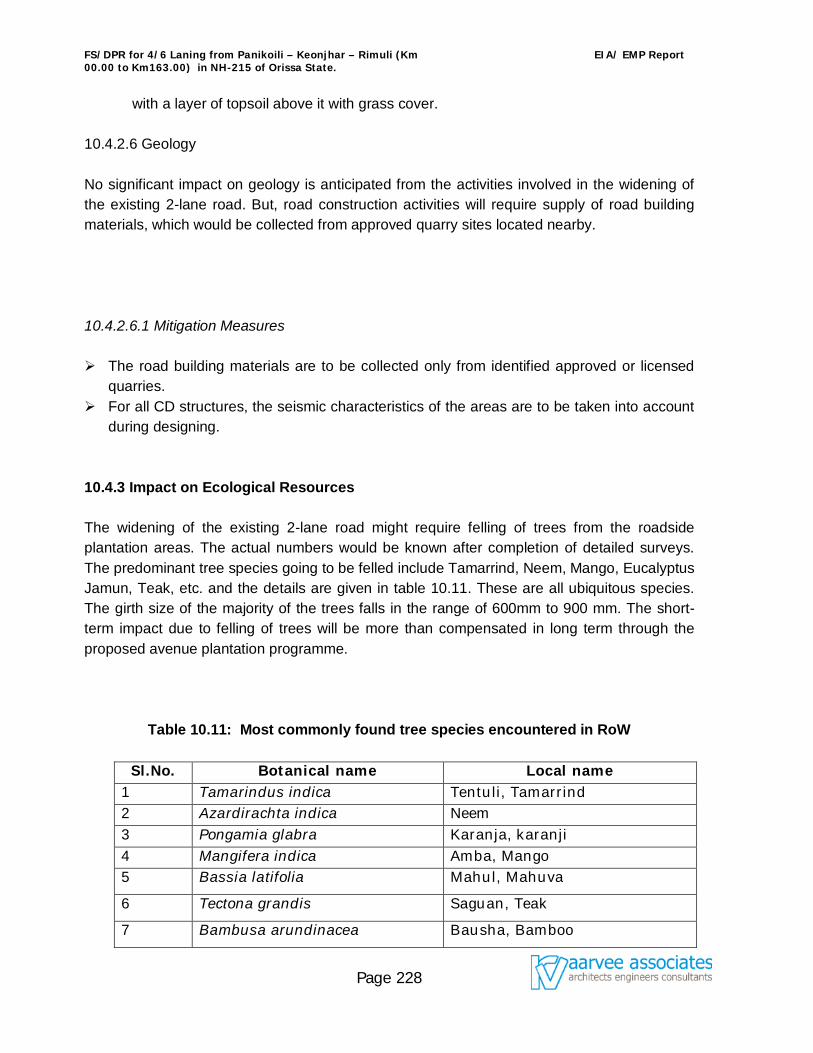
FS/DPR for 4/6 Laning from Panikoili – Keonjhar – Rimuli (Km 00.00 to Km163.00) in NH-215 of Orissa State.
EIA/ EMP Report
Page 228
with a layer of topsoil above it with grass cover. 10.4.2.6 Geology No significant impact on geology is anticipated from the activities involved in the widening of the existing 2-lane road. But, road construction activities will require supply of road building materials, which would be collected from approved quarry sites located nearby. 10.4.2.6.1 Mitigation Measures The road building materials are to be collected only from identified approved or licensed
quarries. For all CD structures, the seismic characteristics of the areas are to be taken into account
during designing. 10.4.3 Impact on Ecological Resources The widening of the existing 2-lane road might require felling of trees from the roadside plantation areas. The actual numbers would be known after completion of detailed surveys. The predominant tree species going to be felled include Tamarrind, Neem, Mango, Eucalyptus Jamun, Teak, etc. and the details are given in table 10.11. These are all ubiquitous species. The girth size of the majority of the trees falls in the range of 600mm to 900 mm. The short-term impact due to felling of trees will be more than compensated in long term through the proposed avenue plantation programme.
Table 10.11: Most commonly found tree species encountered in RoW
Sl.No. Botanical name Local name
1 Tamarindus indica Tentuli, Tamarrind 2 Azardirachta indica Neem 3 Pongamia glabra Karanja, karanji 4 Mangifera indica Amba, Mango 5 Bassia latifolia Mahul, Mahuva
6 Tectona grandis Saguan, Teak
7 Bambusa arundinacea Bausha, Bamboo
FS/DPR for 4/6 Laning from Panikoili – Keonjhar – Rimuli (Km 00.00 to Km163.00) in NH-215 of Orissa State.
EIA/ EMP Report
Page 229
8 Schleichera trijuga Kushuma, Kusum
9 Pterocarpus marsupiam Piasal, Bijasal, Sal 10 E.radiata, E. australiana,
E. globulus, E. citriodora, E. dives
Eucalyptus,
10.4.3.1 Mitigation Measures An avenue plantation programme shall be promptly adopted to restore and further enrich the loss of vegetation along the following lines: Plantation with an appropriate mix of indigenous and specially suited species shall be carried out along the corridor. Flowering plants and shrubs of the height of about 2m shall be planted at the median. The plantation in the median will serve, as a barrier against glaring headlights of the vehicular traffic plying in the opposite direction. Further, this will improve the aesthetics of the alignment. Along the extreme edge of road boundary, tall growing trees such as Silver Oak (Grewellia robusta) shall be planted. At a distance of 5 m from the outer row, shade bearing and flowering trees of the following species will be taken up. Jacaranda (Jacaranda mimusifolia) Gulmohar (Delonix regia) Moduga (Butea monosperma) Rain tree (Samanea saman) Tentuli, Tamarrind (Tamarindus indica) Karanja (Pongamia glabra) Neem (Azadirachta indica) Tabebuia (Tabebuia avalandia /Tabebuia sp.) Sisoo (Dalbergia sisoo) Devil’s tree/ Saptaparni (Alstonia scholaris) Drawing showing the scheme of plantation is presented in Figure 10.11 in Appendix F. 10.4.3.2 Fauna a) Terrestrial Fauna As the Forest area is crossing at many places along the project corridor, thorough measures
FS/DPR for 4/6 Laning from Panikoili – Keonjhar – Rimuli (Km 00.00 to Km163.00) in NH-215 of Orissa State.
EIA/ EMP Report
Page 230
to be taken to avert/ mitigate any sort of damage to wild life. The detail measure will be given in EIA/EMP Report. b) Aquatic Fauna The proposed project would require partial filling up of some ponds. Most of these ponds remain dry during the non-monsoon months. Most of the rivers/ streams crossing the corridor remain dry during non-monsoon months. Increasing sediment load to the recipient water bodies i.e. ponds and rivers will restrict the penetration of solar energy in the water body. This will affect photosynthesis of the aquatic flora which in turn will have adverse impacts on the aquatic fauna. Since, most of the water bodies remain dry during the non-monsoon months, this impact will be negligible. But, the implementation of the following measures will help to avoid soil erosion and further minimize the impacts of the aquatic fauna. 10.4.3.2.1 Mitigation Measures Filling up of ponds will be resorted only after exhausting all other options. Filling up of ponds wherever required shall be done during the non-monsoon months. Construction of bridges and culverts shall be accomplished during the non-monsoon
periods. The requirement of filling up of ponds shall be minimized by constructing retaining
structures where the height of filling is more. The direct discharge of oil and chemical spills to the water bodies shall be avoided. 10.4.4 Impacts on Human Use Values 10.4.4.1 Land Use Widening of the existing 2-lane road will lead to a change in the land use pattern of areas adjacent to the road. The existing land adjacent to the road at present is mostly of barren & agricultural which needs to be acquired for widening of the road. The proposed bypasses at Chennai pass through commercial lands and acquisition of these lands may have impact on the local economy. The project corridor lies in a plain terrain and thus, no disfiguration of land is envisaged due to construction activities except for the opening up of burrow pits. The burrow pit locations have already been identified and will be restricted to those areas only. The locations of burrow pits are in Figure 10.7 to Figure 10.10 in Appendix F.
FS/DPR for 4/6 Laning from Panikoili – Keonjhar – Rimuli (Km 00.00 to Km163.00) in NH-215 of Orissa State.
EIA/ EMP Report
Page 231
10.4.4.1.1 Mitigation Measures Construction activities shall be limited to the corridor only. Care shall be taken to ensure that the construction workers camp does not disturb the
surrounding land use. Existing access/ entrances to the highway shall be duly maintained. While finalising bypass alignments, options that are best from Engineering, Environmental
and Social aspects are selected. 10.4.4.2 Flood Characteristics The flood characteristics of the project area are given in 10.2.9 above. In the proposed improvement scheme, embankments will be constructed for forming bypasses, construction of ROBs and vehicular underpasses. These may lead to flooding of the project area in the event of unprecedented rains. 10.4.4.2.1 Mitigation Measures Rising of the embankment height above the submergence depth. Widening and strengthening of the existing cross-drainage structures particularly at the
specified locations of submergence. Providing drain on both sides of the widened road and extending the trains to a proper
outfall. Proper supervision during construction to avoid blocking of micro-drainage across the
road. Maintain existing drainage outlets. Replace inadequate or distressed drainage structures. Adequate number of cross drainage structures will be provided along the bypasses. 10.4.5 Impacts on Quality of Life 10.4.5.1 Socio-economics, Land Acquisitions and Resettlements Impacts and mitigation measures associated with social environment in the Project Influence area (PIA), land acquisition and resettlement of project-affected persons (PAP) have been dealt in Chapter 4. 10.4.5.2 Accident, Health and Safety
FS/DPR for 4/6 Laning from Panikoili – Keonjhar – Rimuli (Km 00.00 to Km163.00) in NH-215 of Orissa State.
EIA/ EMP Report
Page 232
Construction activities will cause hindrance to the existing traffic flow. Thus, short-term impact in terms of accident is anticipated during construction phase of the widening project. 10.4.5.2.1 Mitigation Measures Reduce speed through construction zones. Construction of bridges/ culverts shall be carried out prior to construction of new corridor
at the first stage. Strengthening or raising of the existing 2-lane shall be done only after the completion of
the new pavement. Proper cautionary signs shall be displayed at construction sites. Diversion roads will be provided wherever needed. ‘Guidelines on Safety in Road Construction Zones (IRC: SP: 55-2001)’ will be followed. 10.4.5.3 Aesthetics and Landscape The proposed widening of the existing 2-lane road will require partial removal of roadside plantation, which will deteriorate the corridor’s aesthetic values temporarily. But the proposed plantation all along in long run will improve the aesthetics and landscaping of the corridor. Disfiguration of the landscape is also anticipated due to opening of burrow pits. 10.4.5.3.1 Mitigation Measures Mixed plantation shall be carried out at roadside and flowering shrubs in the median . Burrow pits shall be resurfaced with conserved topsoil (burrow pit opening shall be as per
IRC-10-1961). Plan for controlled development shall be evolved by land planning agencies. There shall be proper vigilance to avoid squatter development all along the corridor. 10.4.6 Impacts from Construction Workers’ Camp Local labourers shall be employed for the construction activities to the maximum extent possible to minimize the generation of domestic waste in Construction Worker’s Camps. 10.4.6.1 Mitigation Measures Labourers residing in the camps shall be provided with safe drinking water, adequate sanitation facilities, kerosene or LPG and all other amenities as per the prevailing Labour
FS/DPR for 4/6 Laning from Panikoili – Keonjhar – Rimuli (Km 00.00 to Km163.00) in NH-215 of Orissa State.
EIA/ EMP Report
Page 233
laws. Domestic waste generated will be treated as per IS-2470. Summary statement of Impacts during Construction Phase A summary of Environmental impacts along the project corridor along with the recommendations/ suggestions or mitigation measures will be worked out in the form of a matrix and presented in Table 10.14 in Appendix F. Impacts during Operation Phase The summary of Environmental impacts and the mitigation measures will be worked out in the form of a matrix and presented in Table 10.15 in Appendix F. 10.4.7 Physical Resources 10.4.7.1 Air Quality Detailed analysis will be carried out for predicting the concentration of different pollutants contributed by the projected traffic. a) Model The ambient air quality prediction at different receptor locations will be carried out using air quality model CALINE-4 or other MoEF’s approved models. The model is based on Gaussian diffusion equation and uses mixing zone concept to characterize pollutant dispersion over the roadway. Given the site geometry and site characteristics, average time, source strength and meteorology, the model predicts concentrations of conservative pollutants viz, CO and SO2. b) Model Input Traffic Data
The project corridor has been divided into three sections for traffic projections.
Each of these sections has been considered as a single link. The section wise Average Daily Traffic (ADT) has been given in the Table 10.13. Hourly ADT values have been calculated from the ADT values assuming hourly distribution of traffic as observed
during baseline studies.
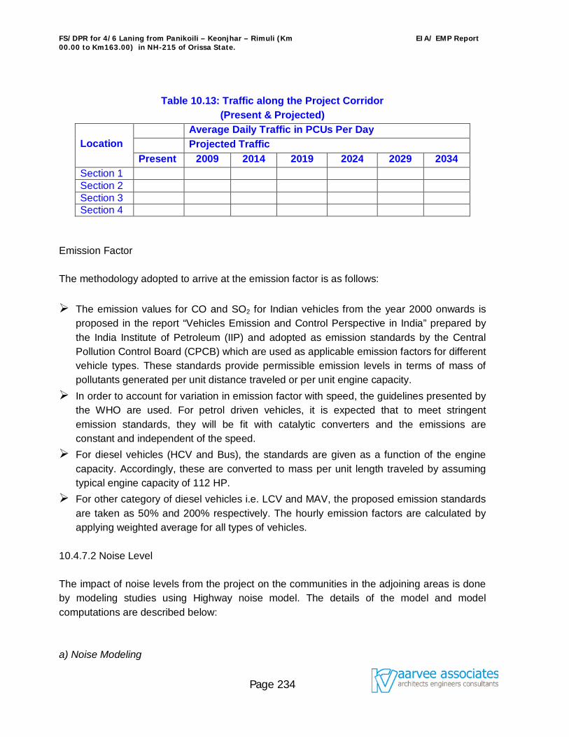
FS/DPR for 4/6 Laning from Panikoili – Keonjhar – Rimuli (Km 00.00 to Km163.00) in NH-215 of Orissa State.
EIA/ EMP Report
Page 234
Table 10.13: Traffic along the Project Corridor (Present & Projected)
Location
Average Daily Traffic in PCUs Per Day Projected Traffic Present 2009 2014 2019 2024 2029 2034
Section 1 Section 2 Section 3 Section 4
Emission Factor The methodology adopted to arrive at the emission factor is as follows: The emission values for CO and SO2 for Indian vehicles from the year 2000 onwards is
proposed in the report “Vehicles Emission and Control Perspective in India” prepared by the India Institute of Petroleum (IIP) and adopted as emission standards by the Central Pollution Control Board (CPCB) which are used as applicable emission factors for different vehicle types. These standards provide permissible emission levels in terms of mass of pollutants generated per unit distance traveled or per unit engine capacity.
In order to account for variation in emission factor with speed, the guidelines presented by the WHO are used. For petrol driven vehicles, it is expected that to meet stringent emission standards, they will be fit with catalytic converters and the emissions are constant and independent of the speed.
For diesel vehicles (HCV and Bus), the standards are given as a function of the engine capacity. Accordingly, these are converted to mass per unit length traveled by assuming typical engine capacity of 112 HP.
For other category of diesel vehicles i.e. LCV and MAV, the proposed emission standards are taken as 50% and 200% respectively. The hourly emission factors are calculated by applying weighted average for all types of vehicles.
10.4.7.2 Noise Level The impact of noise levels from the project on the communities in the adjoining areas is done by modeling studies using Highway noise model. The details of the model and model computations are described below: a) Noise Modeling
FS/DPR for 4/6 Laning from Panikoili – Keonjhar – Rimuli (Km 00.00 to Km163.00) in NH-215 of Orissa State.
EIA/ EMP Report
Page 235
The sound pressure level (SPL) generated by noise sources decreases with increasing distance from the source due to wave divergence. An additional decrease in the SPL with distance from the source is expected due to atmospheric effect on its interaction with the objects in the transmission path. The highway noise model presented below is based on calculating the hourly Leq for all categories of vehicles separately and then adding these logarithmically to obtain overall hourly Leq as follows: Leq (hi) = Loei + 10Log (Ni/SiT) + 10 Log (15/d)(1+ά) – 13+δ Where, Leq (hi) = equivalent noise level at the hour (h) for vehicle type I Loei = reference mean energy level for ith vehicle type Ni = number of vehicles of ith class passing in time T Si = Average speed of vehicles of ith class (Kmph) T = Time duration corresponding to Ni d = perpendicular distance (m) from centerline of the traffic lane to the observer α = Factor relating to absorption characteristics of ground cover between road way and the observer δ = Shielding factor The combined effect of all the vehicle categories at the receptor has been determined by adding the individual values using the following equation: Leq (h total) = 10 Log Σ 10** (Leq (hi)/10) The above highway noise model will used in this study. In order to compare the predicted results with Indian Standards, the equivalent daytime noise level Leq (day) (0600 Hours to 2100 Hours) and equivalent nighttime noise levels Leq (night) (period 2100 hours to 0600 hours) will be estimated. b) Input to the Model Traffic Volume and Speed The FHWA model requires hourly ADT values. To arrive at the hourly distribution of the category wise traffic over a day for the future years, the ratio of category-wise hourly traffic to the daily traffic based on the survey data is used. The operative speed of different category of vehicles will used to calculate the noise level.
FS/DPR for 4/6 Laning from Panikoili – Keonjhar – Rimuli (Km 00.00 to Km163.00) in NH-215 of Orissa State.
EIA/ EMP Report
Page 236
C) Mitigation Measures The noise level can be mitigated by three ways viz, providing solid barrier in the form of noise barrier (by path difference technique), providing vegetative noise barrier (by absorbing technique), and by acoustic design of the receptors. 10.4.8 Impact on Ecological Resources During operation phase the impact of the proposed project on ecology will be in terms of the following: The movement of cattle across the road will be affected. The aquatic fauna will be affected if the runoff from spillage of oil and chemical caused
due to accident directly get discharged into the water bodies. 10.4.8.1 Mitigation Measures To provide for safe cattle/ animal movement across, cattle crossings will be provided
across the bypass locations and across forest areas. The direct discharge of spillage of oil and chemicals to the water bodies will be avoided. Animal underpasses will be provided wherever wild life movement across project road is
reported. 10.4.9 Impact on Human Use values 10.4.9.1 Land Use The existing 2-lane road passes through mainly agricultural fields and residential or commercial areas. The quicker accessibility would result in increased scope of commercial, industrial and residential development along the project corridor especially along the proposed bypasses. Squatter settlements and encroachments along the project corridor are very likely to take place unless proper controlled measures are adopted. 10.4.9.2 Mitigation Measures Squatter development along the project would be strictly avoided by proper vigilance by the Corridor Management Units of National Highways Authority of India. Land use planning agencies would be involved for controlled development. Occurrence of induced development would be avoided as far as possible. 10.4.10 Impacts on Quality of Life
FS/DPR for 4/6 Laning from Panikoili – Keonjhar – Rimuli (Km 00.00 to Km163.00) in NH-215 of Orissa State.
EIA/ EMP Report
Page 237
10.4.10.1 Socio-economics Socio-economic issues have been separately dealt in the Chapter 3.
10.4.10.2 Accident Hazard and Safety Although, after the implementation of the project, traffic speed will increase, the chances of accidents would be reduced considerably due to the divided carriageway and other safety aspects being adopted in the project design. Due to the widening of the existing 2-lane road and the consequent increase in the traffic speed, the impact on pedestrian crossing, cattle crossing and cross traffic will be significant. To avoid this problem, all the measures have been considered with utmost care as discussed below: 10.4.10.3 Mitigation Measures All the road intersections will be improved as per standard guidelines. Solar powered warning lights (Caution lights) will be provided near such junctions. Service roads will be provided to accommodate local traffic and pedestrians. Various types of pedestrian facilities such as underpasses, service roads, Zebra crossings
etc will be provided. Stacking lanes for the safety of “U” turn traffic. Underpasses for pedestrians and cross traffic. Wayside amenities consisting of passenger rest areas with restaurants, parking areas,
repair facilities, Trauma care centre and telephone facilities. Highway traffic management system comprising:
1. Emergency communication system, 2. Towing away of break down vehicles, 3. Ambulance service.
10.4.10.4 Aesthetics & Landscape The suggested plantation along the median and flowering shrubs and ornamental and shade bearing trees along both the sides of the road will enhance the aesthetics of the area. Landscaping will also be done at service stations, rest areas and parking areas with plants, shrubs and grasses. 10.4.11 Positive Attributes of the Proposed Project While it is the purpose of environmental assessment study to identify potential adverse
FS/DPR for 4/6 Laning from Panikoili – Keonjhar – Rimuli (Km 00.00 to Km163.00) in NH-215 of Orissa State.
EIA/ EMP Report
Page 238
impacts, some of the several beneficial impacts on human and natural environment due to the proposed project include: Provides faster accessibility, Reduces air pollution, Reduces the number of accidents, Reduces the vehicle operating cost, Reduces fuel consumption, wear and tear, Gives better facilities to road users e.g., Bus bays, truck lay byes, rest areas etc. 10.5. Environmental Management Plan 10.5.1 Introduction The Environmental Management Plan (EMP) and impact mitigation measures are identified and implementation of various mitigation measures suggested for the environmental impacts envisaged in 10.4. The EMP also includes the cost of implementing mitigation measures and identifies the implementing authority. 10.5.2 Identification of Implementing Authority It is suggested that NHAI may appoint an independent consultant, which shall include an Environmental Management Cell (EMC). To mobilize appropriate expertise to design for diverse types of mitigation measures, the proponent shall need to collaborate with other institutions in the public and private sector viz, the State Forest Department, State Irrigation Department, State Roads and Buildings Department and the Revenue department. The EMC shall ensure timely implementation of various mitigation measures at different stages of the project i.e. during construction, operation and completion stage of the project within scheduled time frame. 10.5.3 Monitoring Plan All the activities envisaged during the construction and operation stages projected in the Table 10.16 in Appendix F shall be monitored to produce satisfactory results. The Environmental monitoring plan during construction and operation phase has been given in Tables 10.17 to 10.18 of Appendix F respectively. Environmental Management Cell (EMC) shall be the main agency for monitoring all the activities during both phases. NHAI shall supervise all activities and accordingly advise the EMC to improvise on areas where any misgivings are noticed. The EMC shall provide all the
FS/DPR for 4/6 Laning from Panikoili – Keonjhar – Rimuli (Km 00.00 to Km163.00) in NH-215 of Orissa State.
EIA/ EMP Report
Page 239
monitoring results to the NHAI, which shall keep a record of all the information and extend necessary support to EMC for mitigating any unforeseen impacts observed during the project implementation and thereafter. 10.5.4 Budget for Environmental Management Plan Most of the mitigation measures suggested in the preceding chapters shall include all costs related to measures incorporated in the design, project scheduling, site planning and preparation of the tender document. The cost on this account should be covered within the construction budget and should not be seen as items of cost for implementing Environmental Management Plan. The estimated environmental cost considered here shall include: 10.5.4.1 During Construction Phase Tree Plantation Provision for sanitation at the workers camp Provision for fuel to the workers Erosion control measures along high embankment stretches Dust suppression`
10.5.4.2 During Operation Phase Monitoring of environmental parameters like air, water, soil and noise Maintenance of roadside plantation
The cost of Environmental Management Plan is given table no.10.5.4.
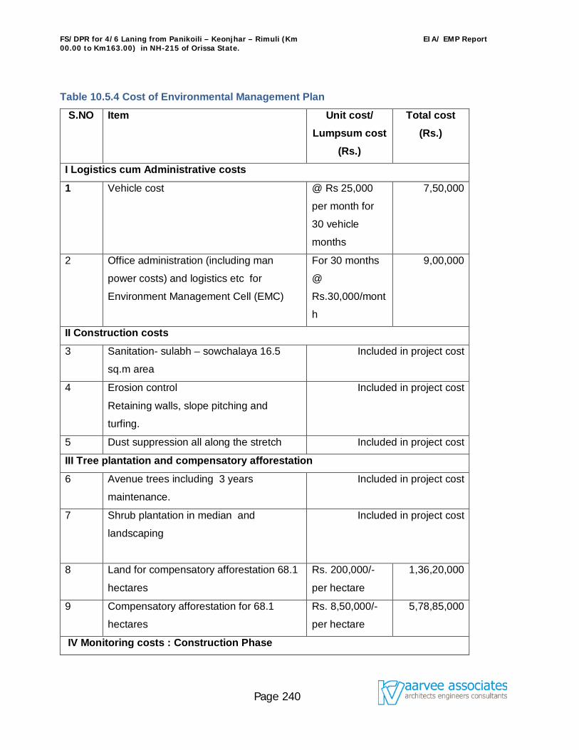
FS/DPR for 4/6 Laning from Panikoili – Keonjhar – Rimuli (Km 00.00 to Km163.00) in NH-215 of Orissa State.
EIA/ EMP Report
Page 240
Table 10.5.4 Cost of Environmental Management Plan
S.NO Item Unit cost/ Lumpsum cost
(Rs.)
Total cost (Rs.)
I Logistics cum Administrative costs
1 Vehicle cost @ Rs 25,000
per month for
30 vehicle
months
7,50,000
2 Office administration (including man
power costs) and logistics etc for
Environment Management Cell (EMC)
For 30 months
@
Rs.30,000/mont
h
9,00,000
II Construction costs
3 Sanitation- sulabh – sowchalaya 16.5
sq.m area
Included in project cost
4 Erosion control
Retaining walls, slope pitching and
turfing.
Included in project cost
5 Dust suppression all along the stretch Included in project cost
III Tree plantation and compensatory afforestation
6 Avenue trees including 3 years
maintenance.
Included in project cost
7 Shrub plantation in median and
landscaping
Included in project cost
8 Land for compensatory afforestation 68.1
hectares
Rs. 200,000/-
per hectare
1,36,20,000
9 Compensatory afforestation for 68.1
hectares
Rs. 8,50,000/-
per hectare
5,78,85,000
IV Monitoring costs : Construction Phase
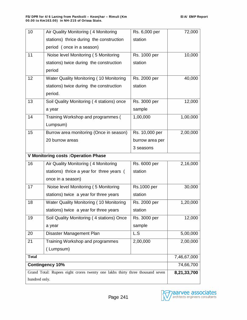
FS/DPR for 4/6 Laning from Panikoili – Keonjhar – Rimuli (Km 00.00 to Km163.00) in NH-215 of Orissa State.
EIA/ EMP Report
Page 241
10 Air Quality Monitoring ( 4 Monitoring
stations) thrice during the construction
period ( once in a season)
Rs. 6,000 per
station
72,000
11 Noise level Monitoring ( 5 Monitoring
stations) twice during the construction
period
Rs. 1000 per
station
10,000
12 Water Quality Monitoring ( 10 Monitoring
stations) twice during the construction
period.
Rs. 2000 per
station
40,000
13 Soil Quality Monitoring ( 4 stations) once
a year
Rs. 3000 per
sample
12,000
14 Training Workshop and programmes (
Lumpsum)
1,00,000 1,00,000
15 Burrow area monitoring (Once in season)
20 burrow areas
Rs. 10,000 per
burrow area per
3 seasons
2,00,000
V Monitoring costs :Operation Phase
16 Air Quality Monitoring ( 4 Monitoring
stations) thrice a year for three years (
once in a season)
Rs. 6000 per
station
2,16,000
17 Noise level Monitoring ( 5 Monitoring
stations) twice a year for three years
Rs.1000 per
station
30,000
18 Water Quality Monitoring ( 10 Monitoring
stations) twice a year for three years
Rs. 2000 per
station
1,20,000
19 Soil Quality Monitoring ( 4 stations) Once
a year
Rs. 3000 per
sample
12,000
20 Disaster Management Plan L.S 5,00,000
21 Training Workshop and programmes
( Lumpsum)
2,00,000 2,00,000
Total 7,46,67,000
Contingency 10% 74,66,700 Grand Total: Rupees eight crores twenty one lakhs thirty three thousand seven
hundred only. 8,21,33,700
FS/DPR for 4/6 Laning from Panikoili – Keonjhar – Rimuli (Km 00.00 to Km163.00) in NH-215 of Orissa State.
EIA/ EMP Report
Page 242
10.5.5 Environmental Training In addition to the implementation and the monitoring of different environmental attributes, the environmental management cell shall also be actively involved in imparting training about environmental awareness to the staff members so as to enable them to take environmental aspects into consideration as and when required. In long term, the EMC can incorporate additional and specialized training in the environmental management of the road system.
FS/DPR for 4/6 Laning from Panikoili – Keonjhar – Rimuli (Km 00.00 to Km163.00) in NH-215 of Orissa State.
EIA/ EMP Report
Page 243
References
1. CPCB’s EIA Manual.
2. Environmental Impact Analysis Handbook- John G.Rau and David C.Wooten,
University of California.
3. A Hand Book on Roads and Environment Extracted from World Bank Technical
Paper No.376 and Edited by Mr. Koji Tsunukawa, 1997.
4. Environmental Impact Assessment- Available Techniques, emerging trends-
S.A.Abbasi & D.S.Arya.
5. A Handbook of EIA-V.S.Kulkarni, S.N.Kaul and R.K.Trivedy.
6. Conducting EIA in Developing Countries- Prasad Modak and Asit K.Biswas.
7. Assessment of Environmental Impacts for Irrigation Projects, a Decission Support
System- Abu-Zeid, Khalem M, Bayoumi, Mohammed N & Wahdy and EAWP
method by Dr.K.S.S.V.V.Prasad
8. District Hand books Keonjhar & Jajpur districts, and Census 2001, etc.
9. Environmental Impact Assessment by Larry W. Canter.
10. A Users Friendly Interface for the CALINE 4 Model for Transportation Project
Impact Assessment by Dana L. Coe Douglas S. Eisinger Jeffrey D. Prouty Sonoma
Technology, Inc. Petaluma, CA. Tom Kear , Caltrans - U.C. Davis Air Quality Project
Sacramento, CA (Prepared for Caltrans -U.C. Davis Air Quality Project Sacramento,
CA, June 20, 1998.
11. Feasibility Report/ Detailed Project Report on Upgradation of 2 lane to 4/6 lane
from Panikoili – Keonjhar – Rimuli between chainage from Km. 0+000 to 163+000
section of NH-215 in the State of Orissa.
12. The World Bank Note on Urban Air Pollution – Impact of better Traffic
Management (South Asia Urban Air Quality Management Briefing Note No.5), April
2002.
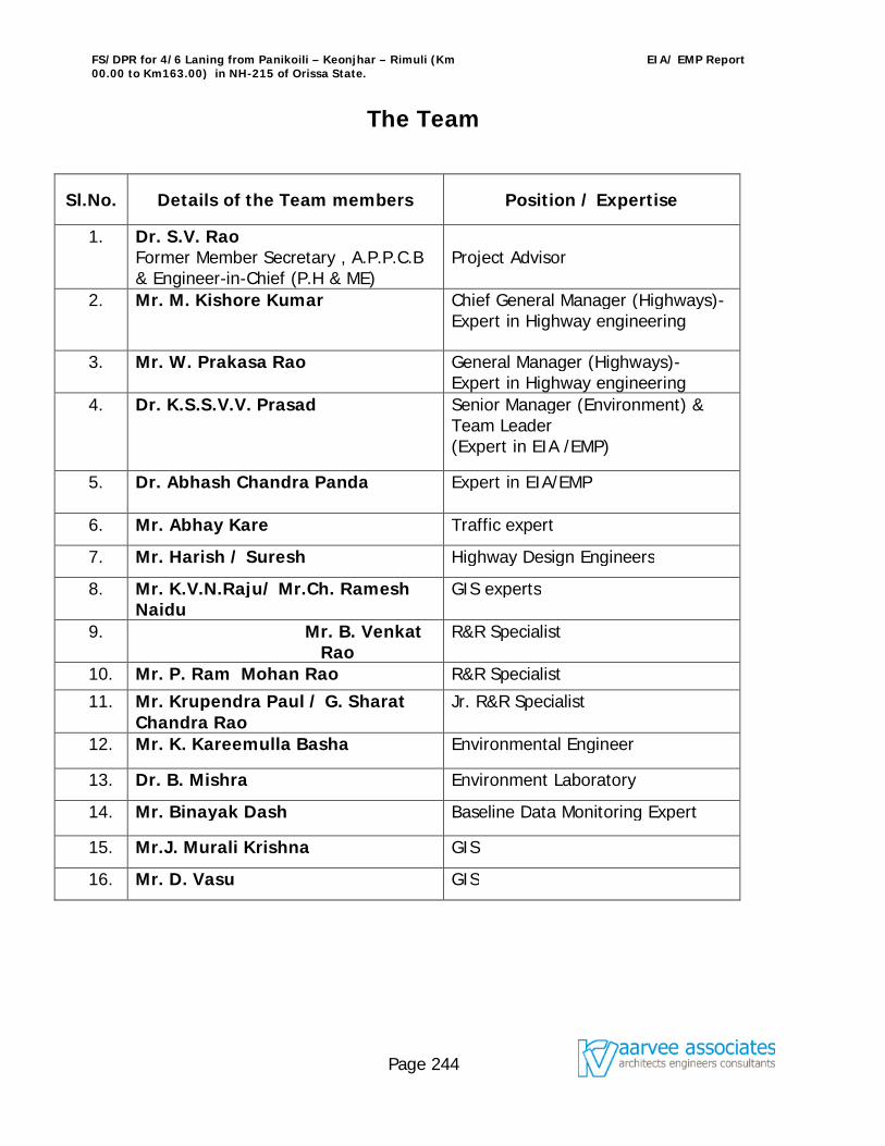
FS/DPR for 4/6 Laning from Panikoili – Keonjhar – Rimuli (Km 00.00 to Km163.00) in NH-215 of Orissa State.
EIA/ EMP Report
Page 244
The Team
Sl.No. Details of the Team members Position / Expertise
1. Dr. S.V. Rao Former Member Secretary , A.P.P.C.B & Engineer-in-Chief (P.H & ME)
Project Advisor
2. Mr. M. Kishore Kumar
Chief General Manager (Highways)- Expert in Highway engineering
3. Mr. W. Prakasa Rao General Manager (Highways)- Expert in Highway engineering
4. Dr. K.S.S.V.V. Prasad
Senior Manager (Environment) & Team Leader (Expert in EIA /EMP)
5. Dr. Abhash Chandra Panda
Expert in EIA/EMP
6. Mr. Abhay Kare Traffic expert
7. Mr. Harish / Suresh Highway Design Engineers
8. Mr. K.V.N.Raju/ Mr.Ch. Ramesh Naidu
GIS experts
9. Mr. B. Venkat Rao
R&R Specialist
10. Mr. P. Ram Mohan Rao R&R Specialist
11. Mr. Krupendra Paul / G. Sharat Chandra Rao
Jr. R&R Specialist
12. Mr. K. Kareemulla Basha Environmental Engineer
13. Dr. B. Mishra Environment Laboratory
14. Mr. Binayak Dash Baseline Data Monitoring Expert
15. Mr.J. Murali Krishna GIS
16. Mr. D. Vasu GIS