Embed Size (px)
Citation preview

Announcement of October 2013 high-resolution 3D seismic acquisition using P-Cable technology
In October 2013, the Texas Bureau of Economic Geology’s Dr. Tip Meckel led a crew of 27, including
three scientists from the Jackson School of Geosciences at The University of Texas at Austin, on a 10-
day 3D seismic data collection cruise off the Texas coast in the Gulf of Mexico. This activity was funded
through DOE-NETL’s carbon sequestration research program and the Texas General Land Office (GLO)
as part of the Gulf Coast Carbon Center’s multi-year geologic characterization effort to identify potential
CO2 storage sites beneath the Texas portion of the Gulf of Mexico within 10 miles offshore. The seismic
data were collected using the new P-Cable system manufactured by Geometrics, which is designed to
provide extremely high resolution 3D data for relatively shallow stratigraphic depths (<1500 m). These
depths have previously been of secondary interest to the hydrocarbon industry, but are increasing in
interest in relation to shallow geohazard identification and understanding subsurface fluid migration
processes related to seafloor fluid seeps. The tool provides important data for linking the deepest and
shallowest portions of marine stratigraphy. Research interests include structurally-controlled fluid
migration, 3D stratigraphic architecture, reservoir morphology analogs, and Cenozoic/Quaternary
stratigraphic evolution.
In addition to Dr. Meckel, science staff from the University of Texas at Austin included Dr. Nathan Bangs
(Institute for Geophysics), Dallas Dunlap (Bureau of Economic Geology), as well as SMU graduate
student Ben Phrampus. Logistical coordination and project management from shore was led by BEG’s
Ramon Trevino. Vessel services were provided by TDI-Brooks International using the R/V Brooks-McCall
vessel based out of Freeport, TX. Technical participation included Finn Michelsen of GeoSurvey Systems,
assisted by Rick Hubneur of Seismic Equipment Solutions. Paravane expertise contracted with Glen
Barker of GB Consulting. NCS SubSea, Inc. provided array geometry solutions and navigation for real-
time coverage mapping. Portable air compression units were provided by Alpha Seismic Compressors.
The Bureau of Economic Geology at the Jackson School of Geosciences is the only research institution in
the United States (and among a handful globally) that currently operates such high resolution 3D (HR3D)
seismic acquisition technology, which was deployed for the first time ever in the Gulf of Mexico in 2012
by Meckel and his team. The 2013 seismic array consisted of one GI-airgun source (90 cu. in.) and twelve
25-m-long, 8-channel streamers (total 96 channels). Over 400 line-km (> 250 miles) were shot in an area
offshore southern Galveston Island, adjacent to and including portions of the San Luis Pass shallow salt
dome. The goals of the survey were to image subsurface stratigraphy and fault structure above a
reservoir interval for a Miocene-age CO2 storage prospect at ~2,000 m depth. Of particular interest is the
ability to identify (or not) the occurrence of any shallow faults or indications of prior historic
hydrocarbon fluid migration to the seafloor, which may inform interpretations of sealing conditions in
the deeper stratigraphy above the prospective reservoir CO2 storage interval. Such determinations
advise our understanding of potential long-term risks of CO2 storage by providing information relevant
to storage on the performance of specific geologic settings for retaining naturally sourced hydrocarbons.
Initial results indicate that the seismic system will be an extremely valuable tool for imaging subsurface
volumes in high resolution and identifying, understanding, and reducing risks of offshore storage
projects by proving up regional sealing characteristics over large continuous areas. Interest from
industry has been building and acquiring datasets such as these are an important part of developing a
variety of anticipated commercial applications of HR3D technologies. Data processing from the October
cruise is ongoing and one more Gulf of Mexico cruise for the current study is planned for 2014.
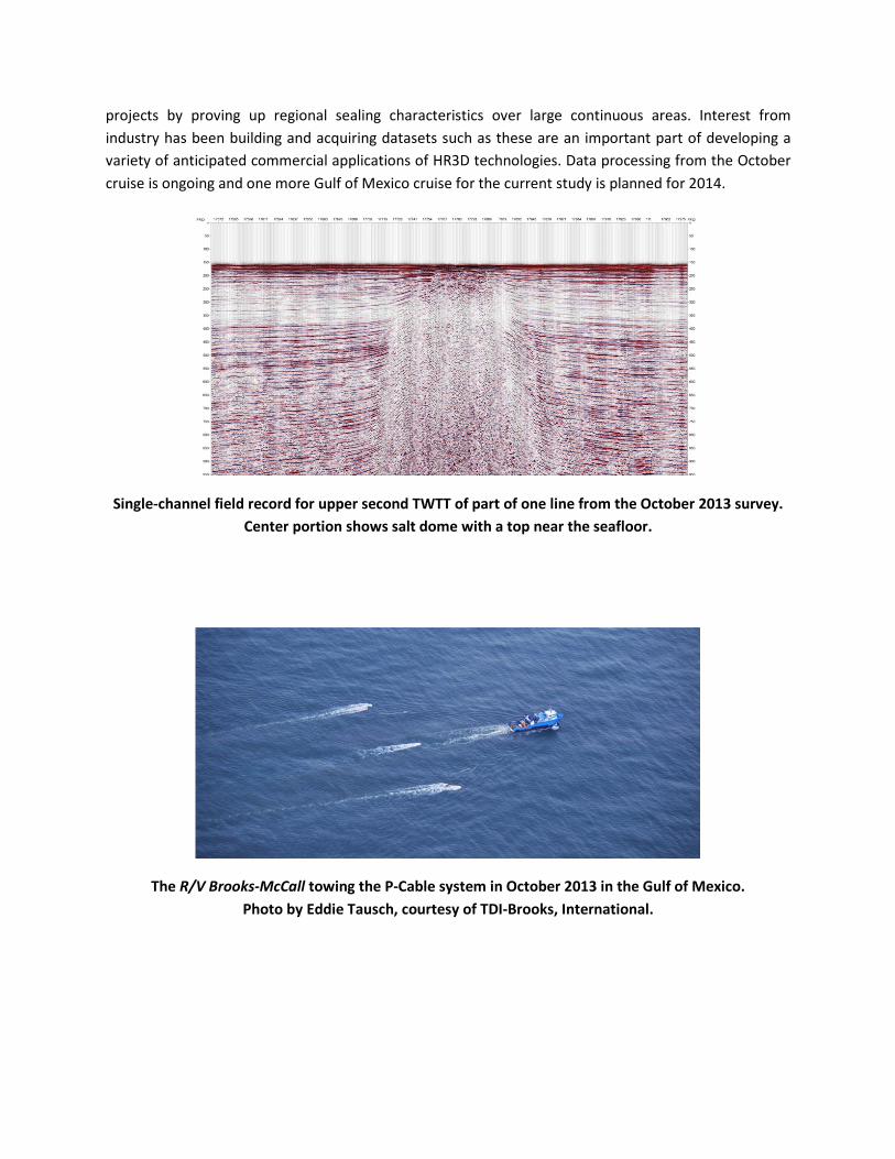
Single-channel field record for upper second TWTT of part of one line from the October 2013 survey.
Center portion shows salt dome with a top near the seafloor.
The R/V Brooks-McCall towing the P-Cable system in October 2013 in the Gulf of Mexico.
Photo by Eddie Tausch, courtesy of TDI-Brooks, International.

Paravane deployment off the vessel stern. The paravanes pull the cross cable perpendicular (P-Cable)
to ship direction (see aerial photo), allowing a dozen closely spaced multi-channel streamers to be
attached for high resolution three dimensional seismic mapping.

BEG’s Dallas Dunlap (left) attaching one of the twelve 25-meter long 8-channel streamers during
deployment, assisted by SMU graduate student Ben Phrampus.