Embed Size (px)
Citation preview

MA Water Resources Research Center
Annual Report 2014-2015
March 1, 2014 – June 30, 2015
Marie-Françoise Hatte Associate Director

WRRC Annual Report 2014-2015
1
Massachusetts Water Resources Research Center Blaisdell House - 113 Grinnell Way University of Massachusetts Amherst MA, 01003 Tel: 413-545-5531 E-Mail: [email protected] wrrc.umass.edu Director: Dr. Paula Rees [email protected] Associate Director: Marie-Françoise Hatte [email protected] Outreach and Education Director: Jerome Schoen [email protected] Water Projects Coordinator/EAL Laboratory Manager: Elizabeth Scotten Finn [email protected]
This report is available on line: http://wrrc.umass.edu/about/annual-reports
Singing Dam, Sutton, MA. Photo by ES Finn
WRRC Annual Report 2014-2015
2
Table of Contents Executive Summary ............................................................................................................... 3
Introduction .......................................................................................................................... 5
Research Program ................................................................................................................. 6 1. Linking groundwater heatflow to fish habitat in stream catchments with till-mantled bedrock (2013MA409B) ...............................................................................................................................6 2. Investigating effects of annual winter lake drawdowns on fish and macroinvertebrate assemblages and diet (2014MA421B) ..............................................................................................8 3. Fate, transport, and remediation of PFOS, PFOA, perchlorate, and 1,4-dioxane at the Eastham MA landfill (2014MA422B) ....................................................................................................................9 4. Going With or Against the Flow: Choices for Flood Mitigation Response in Massachusetts (2014MA426B) ............................................................................................................................. 11 5. Assessing the effectiveness of a biofiltration facility and associated groundwater flow in protecting water quality of a water supply reservoir (2014MA427B) .............................................. 12 6. Developing Tools for Climate eRisk Assessment and Adaptation in Water Resources Systems (2014MA432S) ............................................................................................................................. 15 7. RiverSmart Communities and Federal Collaborators: Attuning Federal Agencies and Programs with the State, Regional, and local Efforts to Support Ecologically Restorative Flood Prevention and Remediation in New England (2014MA433S) ................................................................................. 16 8. Acid Rain Monitoring Project .................................................................................................... 20 9. Blackstone River Water Quality Monitoring Study ..................................................................... 27 10. Flood Vulnerability Assessment for Roadway Stream Crossing Structures, Deerfield River Watershed, Massachusetts ........................................................................................................... 29
Information Transfer and Outreach ..................................................................................... 32 11. Continuous Stream Temperature and Flow Monitoring ............................................................ 32 12. New England Graduate Student Water Symposium ................................................................. 33 13. The Stream Continuity Project ................................................................................................. 34 14. RiverSmart Communities ........................................................................................................ 34
Environmental Analysis Laboratory ...................................................................................... 35
Financial Overview .............................................................................................................. 36

WRRC Annual Report 2014-2015
3
Executive Summary
During the Fiscal Year 2016, the Massachusetts Water Resources Research Center, with its staff of 3 FTE, managed a $466,380 budget covering 11 projects. The USGS 104b program funded two faculty research grants and two graduate student research projects. These four projects cover timely issues in water resources research as follows: "Going with or against the flow: Choices for flood mitigation response in Massachusetts” was
led by Dr. Anita Milman of UMass Amherst. Milman’s research project investigates the decision-process by which flood management strategies are adopted and implemented in western Massachusetts.
“Assessing the effectiveness of a biofiltration facility and associated groundwater flow in protecting water quality of a water supply reservoir” was headed by Dr. Paul Mathisen at Worcester Polytechnic Institute. Mathisen’s project aims to characterize transport and transformations of contaminants within and adjacent to biofiltration systems, with specific consideration to the role of subsurface processes in mitigating discharge of pollutants into water supplies.
Dr. Allison Roy at UMass Amherst led a project entitled “Investigating effects of annual winter lake drawdowns on fish and macroinvertebrate assemblages and diet.” Roy’s research investigates the effects of winter drawdowns on fish and macroinvertebrates assemblages for multiple lakes in western Massachusetts.
Finally, Dr. Chad Vecitis at Harvard University led the project “Fate, transport, and remediation of PFOS, PFOA, perchlorate, and 1,4-dioxane at the Eastham MA landfill.” Vecitis’ research project characterizes groundwater contaminants and examine their fate and transport, then evaluate novel remediation methods in Cape Cod’s sole drinking water source aquifer.
The 104b program also supported a workshop and a student symposium in our technology transfer program: Working with Dr. Allison Roy of UMass Amherst Environmental Conservation, we organized a
workshop on Continuous Monitoring of Temperature and Flow in Wadeable Streams to help facilitate more uniform and effective collection of continuous temperature and water depth data.
The Northeast Water Engineering and Science Symposium was organized with Dr. David Reckhow of UMass Amherst Civil and Environmental Engineering and his team of graduate students. It was tailored to graduate and undergraduate students in the water resources fields.
The USGS Supplemental Program supported another year for the research project “Developing Tools for Climate eRisk Assessment and Adaptation in Water Resources Systems” led by Casey Brown of UMass Amherst.
The IWR – funded project “RiverSmart Communities and Federal Collaborators: Attuning Federal Agencies and Programs with the State, Regional, and local Efforts to Support Ecologically Restorative Flood Prevention and Remediation in New England” started in January 2014 under PI Eve Vogel of UMass Amherst. The Acid Rain Monitoring project, led by WRRC Associate Director Marie-Françoise Hatte, was continued for another year in order to document trends in surface water acidification in Massachusetts.

WRRC Annual Report 2014-2015
4
Other projects conducted at WRRC include the continued collaboration with UMass Extension on the Stream Continuity Project.
The Blackstone River Water Quality Modeling project, led by WRRC Director Paula Rees, continued to track river quality in the Blackstone River and study the impacts of the City of Worcester’s wastewater treatment plant on the river.
WRRC staff also participate actively in two projects on campus: The Stream Continuity Project, headed by Scott Jackson of Environmental Conservation to inventory fish and wildlife barriers caused by road crossings; and the RiverSmart Communities Project headed by Dr. Christine Hatch and Dr. Eve Vogel of Geosciences, to help New England communities manage rivers and riverside landscapes, as well as our own actions and expectations, so people and communities become more resilient to river floods.
This year’s projects supported 14 students: three students pursued a PhD degree, four were working toward a Master of Science, and seven were undergraduate students.

WRRC Annual Report 2014-2015
5
Introduction
This report covers the period March 1, 2014 to June 30, 20151, the 50th year of the Massachusetts Water Resources Research Center (WRRC). The Center is under the direction of Dr. Paula Rees, who holds a joint appointment as Director of the WRRC within the College of Natural Sciences and as Director of Diversity Programs within the College of Engineering at the University of Massachusetts Amherst. The USGS 104B Program Water Resources Institutes supported 4 research projects: "Going with or against the flow: Choices for flood mitigation response in Massachusetts” led by Dr. Anita Milman of UMass Amherst; “Assessing the effectiveness of a biofiltration facility and associated groundwater flow in protecting water quality of a water supply reservoir” headed by Dr. Paul Mathisen at Worcester Polytechnic Institute; Dr. Allison Roy at UMass Amherst led a project entitled “Investigating effects of annual winter lake drawdowns on fish and macroinvertebrate assemblages and diet,” and Dr. Chad Vecitis at Harvard University led the project “Fate, transport, and remediation of PFOS, PFOA, perchlorate, and 1,4-dioxane at the Eastham MA landfill.” The 104B Program also supported two Technology Transfer project: a workshop on Continuous Monitoring of Temperature and Flow in Wadeable Streams to help facilitate more uniform and effective collection of continuous temperature and water depth data, and the Northeast Water Engineering and Science Symposium, a three-day meeting for students studying water resources. The USGS Supplemental Program continued to support the research project “Developing Tools for Climate eRisk Assessment and Adaptation in Water Resources Systems” led by Casey Brown of UMass Amherst. The Institutes for Water Resources funded another year of the project “RiverSmart Communities and Federal Collaborators: Attuning Federal Agencies and Programs with the State, Regional, and local Efforts to Support Ecologically Restorative Flood Prevention and Remediation in New England” led by Eve Vogel of UMass Amherst. The Acid Rain Monitoring Project, led by WRRC Associate Director Marie-Françoise Hatte, was continued for another year in order to document trends in surface water acidification. The Blackstone River Water Quality Modeling project also continued. Other projects WRRC contributes to include the continued collaboration with UMass Extension on the Stream Continuity Project, led by Scott Jackson of Environmental Conservation, RiverSmart Communities and Farms, Floods, and Fluvial Geomorphology led by Christine Hatch of Geosciences. Progress results for each project are summarized for the reporting year in the following sections.
1 The USGS reporting year covers March 1 to February 28, while the University of Massachusetts and the Commonwealth of Massachusetts fiscal years run from July 1 to June 30. Projects funded by the State are reported for the period July 1 2013 - June 30, 2014.

WRRC Annual Report 2014-2015
6
Research Program
This year's research program includes nine projects, focusing on climate change effects on water quantity; wastewater treatment and emerging pollutants as well as nutrients; and water quality problems such as eutrophication, salt intrusion in groundwater, and stormwater. Individual reports for each project is detailed in the following pages. Four new projects were funded through the 104B program and were completed this year. 1. Linking groundwater heatflow to fish habitat in stream catchments with till-mantled bedrock (2013MA409B) Primary Principal Investigator: David Boutt, UMass Amherst Other PIs: Start Date: 4/1/2013 End Date: 3/28/2014 Reporting Period: March 1, 2014 – June 30, 2015 Funding Source: USGS (104G) Research Category: Climate and Hydrologic Processes Focus Categories: Hydrology, Groundwater, Water Quality Problem and Research Objectives: Stream temperature models based on air temperature alone cannot be uniformly applied to regions of differing geologic stratigraphy without accompanying physical models to incorporate subsurface heat flow. By coupling stream temperature distributions with subsurface heat flow dynamics we can better understand the resilience of thermal microhabitats in streams in the Northeast to climate changes. Our study focuses on a critical gap in our understanding of how temperature dynamics within subsurface flow paths relate to stream temperature distributions and the prevalence of thermal refugia for fish habitat. Methodology: We used fiber-optic distributed temperature sensing (DTS) to characterize stream temperature distributions with high spatial and temporal resolution. In conjunction with physical groundwater heat flow models, we use detailed stream temperature distribution profiles to provide new insight into the temperature variability and thermal buffering capacity of streams in till-mantled fracture bedrock catchments. Principal Findings and Significance: Our findings show that mean annual groundwater temperatures range consistently between 9-10 deg C in fractured bedrock at depths greater than 40’ below ground surface. Till aquifer temperatures show greater seasonal variation, ranging from 6 – 13 deg C which fall along a damped phase lag of 3.5 months from air temperature. Shallow soil aquifer temperatures at depths of 1 m below ground surface surprisingly show a similar phase lag of 1-3 months ranging from 0 -15 deg C. Main channel stream temperature ranged between 1 – 20 deg C with a phase lag of <1 month. Most interestingly, localized groundwater input in the stream channel provided temperature offsets of up to 3 deg C, where 2 deg C temperature difference where common, despite a relatively well mixed channel area. The timing and

WRRC Annual Report 2014-2015
7
magnitude of these localized groundwater inputs supports the hypothesis that groundwater is responsible for providing relatively cooler microhabitats during the cold or frozen winter months and warm summer months where stream temperatures can reach the extreme tolerance for salmonid survival. We observed that in-stream temperature variability was less present in stream reaches with extensive sand and gravel, rather the highest concentration of localized groundwater inputs coincided with bedrock outcrops and high near-stream hydraulic heads. Ongoing work will investigate the temperature variability of the streambed sediments and their relationship to site selection for egg-laying female brook char during the autumn redd.
Figure 1: Red and black lines indicate the temperature differences between localized in-stream groundwater seeps and the main stream channel. Notice a step increase in dT around October 20th, 2013.
Figure 2: Hydraulic head changes in the surficial till (red) and saturation state of overlying soils (1m depth). A similar response to increased saturation can be seen as hillslope aquifers discharge to localized seeps in upstream reaches of Jimmy Nolan Brook.
WRRC Annual Report 2014-2015
8
2. Investigating effects of annual winter lake drawdowns on fish and macroinvertebrate assemblages and diet (2014MA421B) Principal Investigators: Allison Hunt Roy and Stephen DeStefano, UMass Amherst Start Date: 3/1/2014 End Date: 2/28/2015 Funding Source: 104B Reporting Period: March 1, 2014 – February 29, 2015 Research Category: Biological Sciences Problem and Research Objectives: Annual wintertime water level drawdowns are a common management practice in lakes, ponds, and reservoirs in the Northeastern US. In Massachusetts, at least 100 waterbodies undergo or have used annual winter drawdowns for a variety of purposes, including: control of nuisance aquatic vegetation, maintenance and protection of structures (e.g., docks, retaining walls, impoundments), hydroelectric power, and spring flood storage. Despite the widespread use of annual winter drawdowns, waterbody water levels are rarely monitored. Furthermore, our understanding of the effects of winter drawdowns on littoral and benthic zone ecology is limited especially in Massachusetts where drawdown amplitudes are relatively mild (<3m) compared to other locations (e.g., Canada, Scandinavia) where amplitudes can exceed 10m and have attracted more scientific investigation. Our objectives are to: (1) quantify the intraannual water level fluctuations of winter drawdown and non-drawdown waterbodies along a gradient of historical drawdown amplitude, (2) quantify littoral zone habitat structure, (3) determine the benthic invertebrate assemblage composition in multiple habitats in these waterbodies, (4) and quantify diet niche breadth of common fish species using stable isotopes and gut content analysis. Methodology: In July and August of 2014 we sampled physical habitat (objective 2) in 16 waterbodies that encompassed a gradient of drawdown amplitude (0–2.5 m). Of these 16 waterbodies, three served as reference conditions with no history of annual winter drawdowns. Within each waterbody, we established two, 20-m sites with 50-m buffers of similar land cover representing a developed and forested shoreline condition. At each site we sampled large wood (density, branching complexity, diameter), macrophytes (e.g., cover, biovolume, complexity, stem abundance, biomass), and substrate texture (substrate heterogeneity, leaf litter cover) using a quadrat-transect method at three fixed depths (0.5m, 1m, 2m). In September and October of 2014 we installed Onset HOBO water level data loggers in the 16 waterbodies. The data logger and staff gauge were installed adjacent to the waterbody impoundment either by either attaching it directly to an abutting structure or by fixing it to a galvanized metal pole driven into the lakebed. Each submerged water level logger was coupled with an identical logger on land to account for atmospheric pressure and calculate water level. Data loggers were set to continuously record pressure every two hours. Additional water level loggers will be installed in summer 2015 in waterbodies with no annual winter drawdown history to bolster our design and analysis. Sampling will be conducted for objectives 3 and 4 in the summer of 2015 in a subset of 10 waterbodies sampled in 2014. We will collect macroinvertebrates in July to determine the taxonomic and functional diversity in three habitats: stony bottom, macrophyte bed, and soft bottom (i.e., predominantly silt and detritus). Littoral zone food web sampling will be conducted in August 2015. At least four species of fish representing different levels of the food chain will be collected for stable isotope analysis (δ13C and δ15N) and gut content analysis. Additionally we will collect macroinvertebrates from habitats sampled in the prior month and sort them based on functional feeding groups for stable isotope analysis. We will also collect long-lived primary consumers (e.g., mussels and snails) to serve as the algal baselines in each lake. Principal Findings and Significance:

WRRC Annual Report 2014-2015
9
Winter drawdowns and localized shoreline development significantly alter littoral zone habitat particularly at 0.5m and 1m depths, which are closer to shore and exposed during winter drawdowns. Our preliminary results indicate that macrophyte biomass and biovolume decreased and substrate heterogeneity increased with drawdown amplitude, with an additive negative effect of localized shoreline development. However, macrophyte structural complexity, small and large wood density, and leaf litter cover showed no discernible trend with drawdowns. Generally, waterbodies with drawdowns less than 1.5 m varied widely in habitat structure and complexity, suggesting that low-amplitude drawdowns may not consistently alter littoral habitat. These results will allow future waterbody management to make more informed decisions concerning changes in winter drawdown regimes. Currently, we are conducting bathymetry surveys for each waterbody sampled in 2014. By coupling this depth data with the water level data, we will be able to determine the extent and duration of lakebed exposure during the winter drawdown. This will allow us to develop more accurate representation of winter drawdown stress and disturbance exerted on elements of physical habitat (e.g., macrophytes, sediment) and biotic assemblages, particularly benthic invertebrates. 3. Fate, transport, and remediation of PFOS, PFOA, perchlorate, and 1,4-dioxane at the Eastham MA landfill (2014MA422B) Primary Principal Investigator: Chad David Vecitis Start Date: 3/1/2014 End Date: 2/29/2016 Reporting Period: March 1, 2014 – February 29, 2015 Funding Source: USGS (104B) Research Category: Water Quality Focus Categories: Toxic Substances, None, Toxic Substances Problem and Research Objectives: The Cape Cod groundwater aquifer is the peninsula’s residents’ sole source of drinking water. Thus it is vitally important to preserve the groundwater quality. Located just a few miles north of East Falmouth, MA, the Joint Base Cape Cod (JBCC) is the location of the well-documented Ashumet Valley Plume, which has groundwater contamination from both wastewater effluent disposal and fire training area activities. In addition to the known contaminants on the site, including trichloroethylene and tetrachloroethylene, we also suspected there would be a widespread contaminant plume of poly- and perfluoroalkyl compounds (PFASs) as a result of the aqueous film-forming foams (AFFFs) used in the fire training area. AFFFs were used to fight hydro- and chloro- carbon fires during regular training exercises from 1958 – 1985 and are a complex mixture of chemicals including large quantities of PFASs. PFASs are thermally stable synthetic organic contaminants, are likely carcinogenic, and have been shown to correlate with thyroid disease and immune deficiencies. PFASs also have high water solubility (mobility) and low biodegradation (persistence), indicating there is concern for the region surrounding the Joint Base Cape Cod. Our research objectives were to determine the extent of PFAS contamination at the JBCC, investigate the transport properties of PFASs and develop an effective remediation technology. The results from this study will be widely applicable to air force bases, airport hangars, and other municipal point sources across the country with similar AFFF contamination issues. The funding from WRRC allowed us to start this project and obtain follow-up funding from the 2015 Milton Fund at Harvard. This progress report outlines the current state of the project, and the remaining funds will be

WRRC Annual Report 2014-2015
10
used for field sampling this summer and to send the primary PhD student working on the project to a conference in July 2015 focused on fluorinated compounds. Methodology: In the summer of 2014 we conducted an initial field sampling effort at the JBCC in collaboration with the USGS. Based on prior knowledge of the field site, a selection of 9 wells was sampled with HDPE bottles both at and downgradient the fire training area where large quantities of AFFF may have been spilled. A vertical profile was also sampled in December 2014 at one well downgradient of the fire training area in what is known as the wastewater infiltration beds. This allowed us to obtain a more detailed subsurface understanding of PFAS concentrations. After groundwater sampling, samples were kept at 4 ˚C until analysis, at which point they were shaken and sub-sampled between 5-10 cm below the surface to ensure a representative sample. 750 μL of water sample was added to 720 μL of methanol and 30 μL of internal standard in polypropylene centrifuge vials and centrifuged at 13,000 rpm for 20 minutes. After centrifugation, 0.5 ml of supernatant was extracted and transferred to polypropylene autosampler vials and analyzed within 24 hours with an Agilent 6460 LC-MS/MS with online SPE. In addition to groundwater analysis, initial sorption experiments were designed to understand PFAS transport at the site. A core from the JBCC was obtained through our USGS collaboration and dried and sieved to 2 mm. 40 ml of groundwater from a background well with no detectable PFAS concentrations was added to 15 g of the homogenized core section and spiked with PFAS concentrations between 0.5 and 5 μg/L. These batch reactors were then placed on a shaker table for an equilibration period of 10 days after which both the aqueous and solid phases of these batch reactors were sampled. The resulting data was fitted with a Freundlich isotherm. Future work will use the above outlined methodology to conduct more detailed experiments to understand specific sorption mechanisms. Additional cores will be 2 drilled specifically for this study in the summer of 2015 in addition to an extensive field sampling effort to collect more than 200 groundwater samples. Principal Findings and Significance: Initial results indicate that groundwater PFAS concentrations exceed 10 ppb in the fire training area and that significant PFAS contamination is also located in the wastewater infiltration beds directly downgradient of the fire training area. Low levels of PFAS (above the detection limit) were found up to approximately 8 km downstream. The vertical profile taken within the wastewater infiltration bed area displayed a large increase in PFASs in a zone that also had low dissolved oxygen (DO). In this low DO zone, we found that generally PFASs that are cited in the literature to have higher sediment organic carbon – water partition coefficient (koc) values had the highest concentrations, and PFASs with lower literature-cited koc values had lower concentrations. This may indicate that PFASs were sorbed onto solid surfaces and were subsequently desorbed under redox conditions. The initial isotherm experiments conducted indicated that sediment-water distribution coefficient (Kd) values are significantly lower, while Koc estimates are significantly higher, than reported literature values. Further work is needed to determine the source of this discrepancy. An additional complication to PFAS transport is the degradation of AFFF into perfluoroalkyl acids. In order to investigate how perfluoroalkyl acid concentrations could change over time, we implemented a precursor oxidation method that degraded any precursors within the groundwater to determine the oxidation products in contaminated samples. Results indicate that there is an increase in short-chained perfluoroalkyl acids, including perfluorobutanoate (PFBA), perfluoropentanoate (PFPeA) and

WRRC Annual Report 2014-2015
11
perfluorohexanoate (PFHxA), after oxidation. An increase in these short-chained perfluoroalkyl acids just below the water table beneath the infiltration beds may indicate that precursors in the vadose zone are acting as a slow-release source of PFBA, PFPeA and PFHxA to the aquifer. Future work is needed to gain a thorough understanding of PFAS transport. Specifically, it is not well understood which aquifer constituents increase sorption or whether hydrophobic or electrostatic interactions control PFAS sorption. We plan to investigate these questions by testing PFAS sorption to specific iron oxides (goethite, hematite), organics, and AFFF itself. While it is necessary to understand PFAS transport in aquifers, it is also essential to design more effective remediation methods. As PFASs are resistant to degradation due to the strong electronegativity of fluorine, treatment is difficult. We propose to improve upon an existing electrochemical carbon nanotube (CNT) filter by coating the CNTs with tin oxide doped with antimony and bismuth for stability. Initial experiments without this coating were unsuccessful. This coating has been shown to be effective at degrading certain PFASs using a titanium plate in a batch set-up. The CNT filter should be far more effective due to the high surface area, which will enhance PFAS sorption to the surface. PFASs will then potentially be degraded through direct electron transfer followed by decarboxylation and defluorination. In summary, a better understanding of both the hydrological transport of PFASs and remediation methods may help improve the quality of groundwater and allow for sustainable future use. The remaining funding available from the WRRC will be used for field sampling, housing and transportation for the summer of 2015 and for Andrea Weber, the PhD student working on this project, to attend a conference in Golden, Colorado focusing on fluorinated organic compounds in July 2015 (Fluoros 2015). 4. Going With or Against the Flow: Choices for Flood Mitigation Response in Massachusetts (2014MA426B) Principal Investigator: Anita Milman, UMass Amherst Start Date: 3/01/2014 End Date: 2/29/2016 Reporting Period: March 1, 2014 – February 28, 2015 Funding Source: USGS (104B) Research Category: Social Sciences Focus Categories: Floods, Management and Planning, Law, Institutions, and Policy Problem and Research Objectives: While research has highlighted the importance of motivation (Blennow and Persson 2009) and identified barriers to flood management (Burch, Sheppard et al. 2010),we still lack basic understandings of how adaptation decisions are made. Yet these decisions will be a key determinant of future impacts. Better understandings of the criteria used by decision-makers and the situational factors influencing those priorities are important for informing scientific analyses of projected impacts, for developing decision support tools, and for estimating future action. Thus this research project aims to delineate processes by which flood management decisions are made at the local level. It includes three objectives:
Objective #1: Develop a catalog of flood protection measures undertaken at the town and regional level in the Connecticut and Deerfield River Basins. Objective #2: Identify the criteria used by decision-makers in selection of the flood mitigation measures to implement.

WRRC Annual Report 2014-2015
12
Objective #3: Assess situational factors influencing the choice of decision-criteria Methodology: To delineate the processes for flood management at the local level, we interviewed representatives from 32 municipalities across western Massachusetts including 6 town administrators, 10 select board members, 9 conservation or planning directors, 3 public works officials and 5 emergency management officials. Interviews included both a structured and a semi-structured methodology. Semi-structured approaches were used to collect information on the institutional features of town government as it relates to flood mitigation and comparisons on local perspectives and approaches to structural and nonstructural flood mitigation measures, including opinions on what would work best in their communities. Structured card sorting and talk-out loud methods were used to elicit a ranking of criteria used in decision-making. Interviews have been transcribed and we are in the process of using Nvivo to code and analyze the data. Principal Findings and Significance: Research on this project is on-going (we have requested a no-cost extension) and thus we are unable to report principal findings at this moment. 5. Assessing the effectiveness of a biofiltration facility and associated groundwater flow in protecting water quality of a water supply reservoir (2014MA427B) Principal Investigator: Paul Mathisen Start Date: 3/01/2014 End Date: 2/28/2015 Reporting Period: March 1, 2014 – June 30, 2015 Funding Source: USGS (104B) Research Category: Water Quality Focus Categories: Water Quality, Hydrogeochemistry, Hydrology Problem and Research Objectives: Problem: Stormwater runoff contributes significant loads of nutrients, bacteria, metals and other contaminants to surface water supplies throughout the US. A wide variety of Best Management Practices (BMPs) have been developed to control the volume and quality of the runoff discharging to these surface water bodies. Biofiltration basins have commonly implemented as an effective approach for controlling nutrients, bacteria, and other constituents. Common designs make use of a forebay for sediment control, a larger biofiltration basin with vegetation and a sand layer to provide treatment, and a subdrain that discharges to surface water. Basins may be lined or unlined. For lined basins, the effluent from the sand layer flows into a drain that discharges directly to the surface water body. For unlined basins, a portion of the discharge will seep into groundwater which may provide additional treatment. For all of these cases, the transformations that govern the effluent quality are complex and not well characterized. The extent of additional treatment provided by the passage through groundwater depends on site conditions and is not well characterized. Overall goal and research objectives: The overall goal of this research is to determine the contribution of infiltration and subsurface transport in mitigating the impacts of stormwater discharges on groundwater and surface water supplies. The specific objectives are to:

WRRC Annual Report 2014-2015
13
(1) determine the effectiveness of biofiltration basin design in reducing contaminant discharges to surface water bodies, (2) develop an understanding of the effects of groundwater flow and transport on discharges from these basins, and (3) develop recommendations for improved design procedures for these basins.
Specific considerations include the impacts of recharge and infiltration on groundwater quality, and the associated role of subsurface transport and transformation in reducing contaminant loadings to surface water bodies. Methodology: This research involved an investigation of the processes associated with a biofiltration Best Management Practice (BMP) located in West Boylston, MA, adjacent to the Wachusett Reservoir. The basin treats runoff from an 8-acre watershed with two roadways (Routes 12 and 110) and surrounding residential and commercial land uses. Water exits the basin by either seepage directly to groundwater or by seepage through a two-foot filtration bed to an outfall pipe on one side of the basin. The methodology has included a combination of site preparation, field monitoring, analysis and modeling. Jackie Tupper, a graduate student at WPI, is working on the project. The field site selected for this project is located adjacent to the Wachusett Reservoir in West Boylston, MA. Specific requirements for these components of the research are included the following paragraphs. Site preparation (installation of monitoring wells) – A set of monitoring wells was installed to provide information on groundwater flow and quality. The well locations are shown in Figure 1. At Location 1, a well is included to provide geochemical background information. At locations 2, 3, and 4, well nests were installed, each with 2 monitoring wells (one shallow and one deep). The well nests at Locations 2 and 3 provide information on water quality downstream of the basins, and Location 4 provided information further downstream, adjacent to the reservoir. Field monitoring and sampling: Field monitoring has included monitoring for flow and water quality parameters. Monitoring included quantification of the flow and water quality in the basin inflow, the ponded area within the basin, the discharge drain, and groundwater leaving the basin. Monitoring of water level and water quality in the installed groundwater wells provided information on the quality and response time associated with the transport to groundwater. By quantifying the water budget (relating change in storage to the difference between inflow and outflow), we have been able to estimate the basin outflow to groundwater. Monitoring has included the installation of boxes with v-notch weirs, the hydrolab units, ISCO samplers, and an In Situ temperature, specific conductance, depth probe. The pressure sensors provided real-time information on depth (which is related to flowrate). The hydrolab units provide real-time estimates of dissolved oxygen, conductivity, pH, turbidity, and temperature. Samples were collected periodically in the inflow, outflow, and ponds of the basin (including the biofiltration pond). The samples were analyzed for dissolved oxygen, suspended solids, pH, alkalinity, DOC, anions (PO4-, NO3-, SO4-, Cl-) and cations (Fe2+, Mg2+, Ca2+, Na2+) , bacteria (total coliform and e-coli), and selected heavy metals.

WRRC Annual Report 2014-2015
14
Figure 1 – Monitoring well locations
Monitoring in 2014 and 2015 included 5 storms. The dates of the storms were on May 16th -17th, July 15th- 16th, August 13th, October 16th, and October 22nd -24th. Partial data sets were obtained for the May and July storms. More detailed data sets for the inflows and outflows were obtained for the August and October storms. As such, the latter two storms were analyzed in more detail. Preliminary Findings and Significance: The field program has provided quantitative data on the flows and transformations that occur within and in the groundwater downstream of the biofiltration basin. The results demonstrated that stormwater infiltration to groundwater is an important component to consider for BMP design. The flow path through the outfall was effective in removing sediments, but was found to have limited capacity for water quality treatment, since only small changes in stormwater quality occurred between the culvert inflow, basin, and outfall samples. However, analysis of the flow data showed that infiltration to groundwater was comparable to discharge through the outfall. Furthermore, the signatures of stormwater infiltration could still be seen in the wells, indicating that the infiltration from the stormwater basin can impact groundwater quality. The groundwater pathway was found to impact the chemistry of the constituents, and was particularly effective in removing bacteria and phosphorus. The analysis is of the geochemistry data is still being completed. However, the results to date demonstrate the value of groundwater recharge as a component of BMP design, and provide a basis for a number of specific design recommendations related to biofiltration basins.

WRRC Annual Report 2014-2015
15
Figure 2 – Surface water sample locations: (a) inflow, (b) outflow, (c) basin, and (d) Wachusett Reservoir
Figure 3 – Graduate student working at the Gate 27 field site: (a) preparing to monitor the inflow (b) groundwater sampling 6. Developing Tools for Climate eRisk Assessment and Adaptation in Water Resources Systems (2014MA432S) Principal Investigator: Casey Brown, UMass Amherst Start Date: 11/25/2013 End Date: 11/31/2014 Reporting Period: March 1, 2013– June 30, 2014 Funding Source: 104S Research Category: Climate and Hydrologic Processes Focus Categories: Climatological Processes, Management and Planning
WRRC Annual Report 2014-2015
16
Problem and Research Objectives: The effects of climate change and potential non-stationarity in hydrologic variables undermine assumptions upon which water resources infrastructure has been historically managed and designed. The impact and severity of hydroclimatic change on water system performance is difficult to assess due to uncertainty in future climate projections, complicating decision-making and risk management. This study describes the development and introduction of a web-based decision support tool for small-scale water utilities in the Northeast US that may lack the resources to investigate climate change risk. The purpose of this tool is to provide stakeholders and water managers with a user-friendly decision system model that enables the exploration of problematic future climate conditions using a stress test, in which the performance of local reservoir systems are tested over a wide range of potential climate changes. With a map-based interface, a generic water resource system simulator models the behavior of reservoir operations over changes in temperature, precipitation, and water supply demand. Probabilities of those conditions developed from climate projections help inform utility operators of impending risk. The application and utility of the web-based tool to water supply systems in the Northeast United States is vetted with water managers and stakeholders. The UMass Hydrosystems Research Group will develop a new tool broadly applicable for conducting climate risk assessments for USACE projects using the Decision Scaling methodology. Objective 1 - A stochastic climate/weather generator will be developed to produce time-series of daily weather variables that are appropriate for conducting decision scaling and the climate stress test with USACE water resources planning and hydrologic models at any location within the CONUS or internationally. Objective 2 - Application of the decision scaling methodology to a prototypical flood risk reduction and a water supply adaptation decision using the tools developed in steps 1 and/or 2. Objective 3 - The insights developed through this effort will be documented in a best practices guide that formalizes the decision scaling methodology for USACE application and describes the appropriate uses and limitations. A challenge that remains is the trade-off between a tool that can be easily understood by any users, and the general applicability of the tool. The current version of the tool is straightforward to apply but may be restrictive in terms of kinds of water supply systems it can be applied to. Evaluating the degree to which the tool can be generally applied is the next step in the analysis. Principal Findings and Significance: No report was filed by the principal investigator this year. 7. RiverSmart Communities and Federal Collaborators: Attuning Federal Agencies and Programs with the State, Regional, and local Efforts to Support Ecologically Restorative Flood Prevention and Remediation in New England (2014MA433S) Principal Investigator: Eve Vogel, UMass Amherst Start Date: 1/27/2014 End Date: 8/7/2015 Reporting Period: March 1, 2013– June 30, 2014

WRRC Annual Report 2014-2015
17
Funding Source: 104S Research Category: Climate and Hydrologic Processes Focus Categories: Floods, Law, Institutions, and Policy
Problem and Research Objectives: The Problem: Damaging River Floods, and Three Fundamental Challenges. New England residents, landowners, infrastructure and businesses located along the region’s often-narrow river valleys are frequently impacted by damaging floods that accompany heavy rains. Tropical Storm Irene was but one recent, drastic event; in 2011 in Vermont alone it affected 500 miles of state highways, 200 bridges, 960 culverts, and caused more than $175 million of damage. Damaging floods are likely to become more common and costly, as climate scientists predict more intense storms and increased annual precipitation in the Northeast. Unfortunately, three fundamental challenges make managing floods and addressing flood damage particularly challenging in New England. First, common structural approaches to flood mitigation and post-flood restoration in the region can increase flood hazards downstream, and re-create infrastructure vulnerable to future flood events. These approaches also often are environmentally damaging and require increased expenditures for environmental mitigation and restoration. Second, jurisdictional authority is particularly fragmented in New England, because of the history of early small town settlement and incorporation, and the "home rule" traditions of several of the states. There are over 1500 towns and cities in the six New England states, each of which has at least some independent authorities over land and water use and regulation. Many of these have only a few hundred residents, and operate with volunteer governing bodies and only skeletal staff. Jurisdictional fragmentation is also more challenging because the federal government, which often plays a unifying role in river management in other parts of the country, has historically played a relatively small and distant role here, partly because the region was developed before the rise of many major federal land and water agencies, and partly because of frequent political insistence on state and local independence. The third fundamental challenge is that governmental agencies at all levels as well as nonprofit agencies are facing a funding squeeze from reduced federal and state government budgets. Objective: Ecologically restorative flood prevention and remediation, based on fluvial geomorphological science, met through collaborations that stretch from local municipalities to federal agencies and programs The following are three strategies, which address each of the challenges listed above: a. Advance ecologically restorative flood prevention and remediation by orienting policy and practice to work with natural dynamic river processes; Flood mitigation and protection can work with, rather than against, natural fluvial and geomorphological processes. The approach is to allow much-increased water and sediment sufficient room to flow, by building large-enough culverts and bridge spans; and to allow rivers to spread out and move laterally during major flood events wherever possible, by protecting river “corridors” or “meander belts.” This approach is founded on the science of fluvial geomorphology. It can provide longer-term flood protection and concurrently support environmental, fish, and wildlife goals.

WRRC Annual Report 2014-2015
18
b. Collaborate with and across a wide array of jurisdictions and agencies in ways that are effective and accessible, from small remote New England municipalities to federal agencies. In New England, in order to achieve ecologically restorative flood hazard management, collaborations must be accessible even to small remote and rural municipalities, which often bear the worst flood damage. Though these communities have both the need and the jurisdictional authority to manage land and water resources, they often lack needed institutional capacity, and technical and financial resources. Federal agencies, in contrast, often have capacity and some resources, but may not be able to provide individualized support and response for every community. Systems of nested and interconnected inter-agency relationships are needed to link these. c. Build institutions and approaches that can achieve better ecologically restorative and flood prevention results with limited budgets. Both of the above strategies must be accomplished with limited budgets, and fortunately, can also be resource-efficient. Inter-agency collaborations can use resources in complementary rather than repetitive ways, and target resources where they can provide the greatest benefit. Flood risk assessment, remediation and prevention that are shaped to predict and adapt to natural dynamic river processes can last long-term without the need for costly structural repairs or the risk of amplified downstream damage. The importance of federal agencies and programs – including FEMA, USACE, NRCS, USFWS and others – is clear. However, research has suggested that several of these agencies and programs are perceived or experienced by people working in small, often remote New England towns as cumbersome, ineffective and difficult to access. A project objective is to advance improved coordination and mutual assistance between federal agencies and federal programs, on the one hand, and local, state and regional ones on the other. Federal programs have a great deal to offer; with multi-level coordination, education and attention to the needs of specific localities, these resources can be made accessible to and effective for small communities.
Methodology: A. RiverSmart Communities and Federal Collaborators: Model Case Studies. Researchers are preparing a report of three case studies analyzing collaborations in which federal agencies and programs have worked successfully with state, regional, local and/or nonprofit efforts in New England to promote ecologically restorative flood prevention and remediation. In each of the case studies, federal agencies and programs meet one or more of the three fundamental challenges listed at the start of this section. Our research is oriented toward understanding specifically how they achieve these results – with what institutional structures, programs, funding mechanisms, etc. specifically, they: a) Advance ecologically restorative flood prevention and remediation by orienting policy and practice
to work with natural dynamic river processes; b) Collaborate with and across a wide array of jurisdictions and agencies in ways that are effective and
accessible, from small remote New England municipalities to federal agencies; c) Employ approaches that can achieve better results with limited budgets. Case Study 1. US Army Corps of Engineers New England District / The Nature Conservancy (TNC-USACE) Connecticut River Partnership – barrier-crossing collaborations with demonstrated analytical and policy success

WRRC Annual Report 2014-2015
19
Project summary: Under two partnerships, the USACE New England District and TNC are working together to provide more natural river flows, functions, connectivity and habitat. There have been two key efforts thus far: developing a basin-wide hydrologic flow model, and rewriting road-stream crossings standards for ACOE permits across New England. The flow model and its analyses may help develop new flow strategies for management of the ACOE’s flood control dams, as well as other major dams in the basin. The model is also being applied in the current FERC relicensing process of five privately owned mainstem hydropower projects. The road-stream crossings standards are now in use by ACOE permitting in all six New England states. Our investigations: We are investigating how and with what institutional, programmatic and on-the-ground effects TNC and USACE have been able to work with each other as well as across an array of stakeholders and jurisdictions. Case Study 2. USACE Silver Jackets Program: Federal collaborators helping to manage flood hazard risk. Project summary: The USACE’s Silver Jackets (SJ) program brings together federal agencies, including USACE and FEMA, with state and sometimes regional and local agencies, into a unified forum to address a state's flood hazard risk management priorities. Teams are state-based and led. SJ provides a formal and consistent structure and support for interagency collaboration. Significantly for our purposes, the Silver Jackets approach emphasizes addressing “life-cycle flood risk.” Our investigations: We are investigating possible benefits and approaches for SJ in New England. Among New England’s six states, New Hampshire has the most active team, which uses the name Post Incident Response and Recovery Team, or PIRRT. We are examining the process by which PIRRT was established, its early activities, and results thus far. We are also investigating how further development of SJ teams in New England might improve inter-jurisdictional coordination and river flood prevention and remediation. Case Study 3. NRCS: Providing communities with Easy-to-Access Technical and Financial Support Project summary: The Natural Resource Conservation Service (NRCS) works directly with towns, conservation districts or other political subdivisions, when neither the state nor the local community is able to repair a damaged watershed by itself. Our interviews in the Deerfield River suggest that among federal agencies, the NRCS is perceived as particularly accessible, responsive, efficient and cost-effective by community leaders. Our investigations: We are investigating the factors contributing to NRCS success in serving local communities and how replicable these factors might be. What institutional structures and relationships, policies and programs make the NRCS so readily accessible and responsive to community leaders in the Deerfield watershed, and so efficient and low-cost? Do NRCS projects also meet the goal of making post-flood recovery attuned to natural river processes? B. RiverSmart Communities and Federal Collaborators: Applied Flood Prevention, Mitigation and Remediation Conversations with Communities. Researchers are participating in a series of community meetings and interviews. From these we are distilling first community needs and ideas related to flood prevention, mitigation and remediation in an applied setting, the Deerfield River watershed (VT and MA), then federal agency and legislative opportunities, constraints, and possible solutions to better meet these needs or follow these ideas. Community Conversations about Irene: voices from the watershed.

WRRC Annual Report 2014-2015
20
Researchers are conducting interviews with and/or attending meetings of town select boards, regional agencies, and state and federal agencies and NGOs already working closely within the Deerfield river watershed, particularly those who have been involved with Tropical Storm Irene issues. Discussions focus on local experiences, perspectives and lessons learned on the three fundamental challenges and solutions to advancing ecologically restorative flood prevention and remediation. Community representatives discuss their assessments and experience, emphasizing data and assessments of on-the-ground needs, their technical and funding needs, experience with federal agency assistance, and their thoughts about how federal agencies could more readily meet the three fundamental challenges identified by this project. Using examples from the Deerfield River, community members distill recommendations for federal agencies to meet the three challenges to ecologically restorative flood prevention and remediation. C. RiverSmart Communities & Federal Collaborators: Recommendations. Researchers are developing a series of white papers and a glossy report based on the model case studies, community meetings, and workshop discussions. These papers and report will describe specific ways federal agencies, personnel and programs should and can be structured and targeted to work more effectively, economically and sustainably with state, regional and local agencies and programs in New England to effect ecologically restorative flood prevention and remediation. Recommendations will include specific measures for policy or regulatory change, as well as improved implementation of existing policies and programs. D. RiverSmart Communities & Federal Collaborators: Information Tools. Researchers have or will produce six to ten conference and one-on-one presentations, a website, a social media site, and several easy-to-understand factsheets which will disseminate analyses and recommendations to target audiences, including federal and state agencies and legislators, and municipal leaders and employees in New England communities.
Principal Findings and Significance: Findings are in progress. Many states and federal agencies are considering how to deal better with flooding. Our recommendations and case studies planned for completion and release in summer 2015 will provide positive guidance and models for practical, feasible improvements. 8. Acid Rain Monitoring Project Principal Investigator: Marie-Françoise Hatte, MA Water Resources Research Center, UMass Amherst Start Date: January 1, 2015 End Date: June 30, 2015 Reporting Period: January 1, 2015– June 30, 2015 Funding Source: MassDEP Descriptors: Acid Deposition; Surface Water Quality; Volunteer Monitoring
Introduction This report covers the period January 1, 2015 to June 30, 2015, the fourteenth year of Phase IV of the Acid Rain Monitoring Project. Phase I began in 1983 when about one thousand citizen volunteers were recruited to collect and help analyze samples from nearly half the state’s surface waters. In 1985, Phase

WRRC Annual Report 2014-2015
21
II aimed to do the same for the rest of the streams and ponds2 in Massachusetts. The third phase spanned the years 1986-1993 and concentrated on a subsample of streams and ponds to document the effects of acid deposition to surface waters in the state. Over 800 sites were monitored in Phase III, with 300 citizen volunteers collecting samples and doing pH and ANC analyses. In 2001, the project was resumed on a smaller scale: about 60 volunteers are now involved to collect samples from approximately 150 sites, 26 of which are long-term sites with ion and color data dating back to Phase I. In the first years of Phase IV (2001-2003), 161 ponds were monitored for 3 years. Between Fall 2003 and Spring 2010, the project monitored 151 sites twice a year, mostly streams, except for the 26 long-terms sites that are predominantly ponds. Since 2011, reduced funding eliminated our October sampling and monitoring now occurs in April only. In 2011, we also stopped monitoring some of the streams in order to add and revisit ponds that were monitored in 2001-2003. This year is the fifth year of monitoring for those added ponds.
Goals The goals of this project are to determine the overall trend of sensitivity to acidification in Massachusetts surface waters and whether the 1990 Clean Air Act Amendment has resulted in improved water quality. Methods The sampling design was changed in 2011 to monitor both streams and ponds, and that design continues to date. In 2001-2003 mostly ponds were monitored. In Fall 2003 the sampling scheme switched to streams to evaluate their response to air pollution reductions. In 2011 the site list was modified to include both ponds and streams. Half of the streams monitored since 2003 were kept, and half of the ponds monitored in 2001-2003 were added back. The streams that were removed were chosen randomly within each county. Ponds that were reinstated on the sampling list were chosen at random within those counties and by ease of accessibility to replace the removed streams. Because those sites were chosen without a preconceived plan, they can be considered picked at random. One collection took place this year, on April 12, 2015. Methods were unchanged from previous years: Volunteer collectors were contacted six weeks before the collection to confirm participation. Clean sample bottles were sent to them in the mail, along with sampling directions, a field sheet/chain of custody form, and directions including latitude and longitude coordinates along with maps to the sampling sites. Volunteers collected a surface water sample at their sampling sites either from the bank or wading a short distance into the water body. They collected water one foot below the surface, upstream of their body, after rinsing their sample bottle three times with pond or stream water. If collecting by a bridge, they collected upstream of the bridge unless safety and access did not allow it. They filled in their field data sheet with date, time, and site code information, placed their samples on ice in a cooler and delivered the samples to their local laboratory right away. They were instructed to collect their samples as close to the lab analysis time as possible. In a few cases, samples were collected the day prior to analysis because the lab is not open on traditional “ARM Sunday.” Previous studies by our research team have established that pH does not change significantly in 24 hours when the samples are refrigerated and stored in the dark. Volunteer labs were sent any needed supplies (sulfuric acid titrating cartridge, electrode, buffers), two quality control (QC) samples, aliquot containers for long-term site samples, and a lab sheet one week to 2 Note: The term stream in this report refers to lotic waters (from creeks to rivers) and the term ponds refers to lentic waters (lakes and ponds, but not marshes)

WRRC Annual Report 2014-2015
22
ten days before the collection. They analyzed the first QC sample (an unknown) in the week prior to the collection and called in their results to the Statewide Coordinator. If QC results were not acceptable, the volunteer analyst discussed possible reasons with the Statewide Coordinator and made modifications until the QC sample analysis gave acceptable results. On collection day or the day after, volunteer labs analyzed the second QC sample before and after the regular samples, and reported the results on their lab sheet along with the regular samples. Analyses were done on their pH-meters with KCl-filled combination pH electrodes. Acid neutralizing capacity (ANC) was measured with a double end-point titration to pH 4.5 and 4.2. Most labs used a Hach digital titrator for the ANC determination, but some used traditional pipette titration equipment. Aliquots were taken from 26 long-term sites to fill two 50mL bottles and one 50mL tube per site for later analysis of ions and color. These aliquots were kept refrigerated until retrieved by UMass staff. Aliquots, empty bottles, and results were collected by the ARM Statewide Coordinator between one and three days after the collection. The Cape Cod National Seashore lab mailed those in, with aliquot samples refrigerated in a cooler with dry ice. The Statewide Coordinator reviewed the QC results for all labs and flagged data for any lab results that did not pass Data Quality Objectives (within 0.3 units for pH and within 3mg/L for ANC). pH and ANC data were entered by one ARM staff and proofread by another. Data were entered in a MS excel spreadsheet and uploaded into the web-based database at http://63.135.115.71/acidrainmonitoring/. Data were also posted on the ARM web page at http://wrrc.umass.edu/research/acid-rain-monitoring-project. Note that ARM data is also available on the national CUAHSI database, via Hydro Desktop (http://cuahsi.org/HIS.aspx). Water Resources Research Center’s Elizabeth Finn managed the Environmental Analysis Lab (EAL) and provided the QC samples for pH and ANC to all of the volunteer labs. EAL also provided analysis for pH and ANC for samples from Hampshire and Franklin Counties, and color analysis for the long-term site samples. The UMass Extension Soils Laboratory analyzied the samples from the long-term sites for cations, and University of New Hampshire’s Water Quality Analysis Laboratory, under the direction of Jody Potter, analyzed the samples from the long-term sites for anions. Aliquots for 26 long-term sites were analyzed for color on a spectrophotometer within one day; anions within two months on an Ion Chromatograph; and cations within three months on an ICP at the UMass Extension Soils Laboratory on the UMass Amherst campus. The available data was sent via MS Excel spreadsheet to the Statewide Coordinator who uploaded it into the web-based database. The Statewide Coordinator and the Project Principal Investigator plotted the data to check for data inconsistencies and gaps. They then analyzed the available April data from 1983 through 2015, using the statistical software JMP (http://www.jmp.com/software/) to run bivariate analyses of pH, ANC, ions, and color against date. This yielded trends analyses with a fitted X Y line, using a 95% confidence interval. The same analysis was then run again but only for Phase IV data (2001-2015) in order to document any recent trends. Results 1. There were 150 sites to be monitored, 77 ponds and 73 streams. Of those, 19 ponds and 7 streams
are “long-term” sites that are sampled every year and analyzed for color and a suite of ions in addition to pH and ANC.
WRRC Annual Report 2014-2015
23
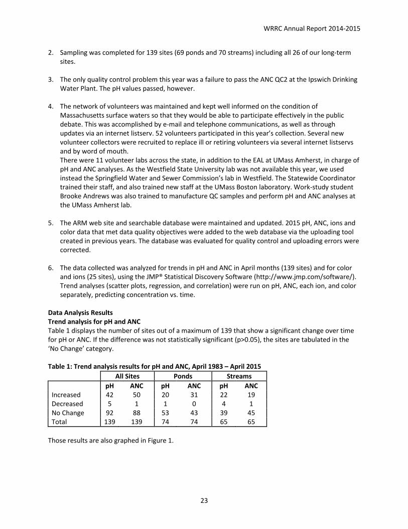
2. Sampling was completed for 139 sites (69 ponds and 70 streams) including all 26 of our long-term sites.
3. The only quality control problem this year was a failure to pass the ANC QC2 at the Ipswich Drinking
Water Plant. The pH values passed, however. 4. The network of volunteers was maintained and kept well informed on the condition of
Massachusetts surface waters so that they would be able to participate effectively in the public debate. This was accomplished by e-mail and telephone communications, as well as through updates via an internet listserv. 52 volunteers participated in this year’s collection. Several new volunteer collectors were recruited to replace ill or retiring volunteers via several internet listservs and by word of mouth. There were 11 volunteer labs across the state, in addition to the EAL at UMass Amherst, in charge of pH and ANC analyses. As the Westfield State University lab was not available this year, we used instead the Springfield Water and Sewer Commission’s lab in Westfield. The Statewide Coordinator trained their staff, and also trained new staff at the UMass Boston laboratory. Work-study student Brooke Andrews was also trained to manufacture QC samples and perform pH and ANC analyses at the UMass Amherst lab.
5. The ARM web site and searchable database were maintained and updated. 2015 pH, ANC, ions and
color data that met data quality objectives were added to the web database via the uploading tool created in previous years. The database was evaluated for quality control and uploading errors were corrected.
6. The data collected was analyzed for trends in pH and ANC in April months (139 sites) and for color and ions (25 sites), using the JMP® Statistical Discovery Software (http://www.jmp.com/software/). Trend analyses (scatter plots, regression, and correlation) were run on pH, ANC, each ion, and color separately, predicting concentration vs. time.
Data Analysis Results Trend analysis for pH and ANC Table 1 displays the number of sites out of a maximum of 139 that show a significant change over time for pH or ANC. If the difference was not statistically significant (p>0.05), the sites are tabulated in the ‘No Change’ category. Table 1: Trend analysis results for pH and ANC, April 1983 – April 2015
All Sites Ponds Streams pH ANC pH ANC pH ANC Increased 42 50 20 31 22 19 Decreased 5 1 1 0 4 1 No Change 92 88 53 43 39 45 Total 139 139 74 74 65 65
Those results are also graphed in Figure 1.

WRRC Annual Report 2014-2015
24
Figure 1. Percentage of site changes in pH and ANC, from trend analysis, April 1983-2015 This trend analysis indicates that for most sites, neither pH nor ANC changed significantly over time. However, for those sites that show a significant change, many more show an increase than a decrease in value: 30% of the sites saw an increase in pH and 36% had an increase in ANC. We again note a difference between ponds and streams. More streams (34%) than ponds (27%) saw an increase in pH, while for ANC, more ponds (42%) than streams (29%) saw an increase. Very few sites showed a decrease in ANC: none for ponds and only 1.5% of streams. Now in our fifth year of monitoring both ponds and streams, we continue to see a positive trend in ponds, which seem to be improving a little more each year. Streams show a lesser improvement, particularly for ANC, and this year, 4 streams out of 65 (6%) even showed a decrease in pH. For three years in a row now, we had a lingering snowpack and our sampling date of April 12 likely caught the snowmelt acid pulse that we try to document by sampling in early spring. It is possible that the acid pulse is more noticeable in streams than ponds due to the more rapid reaction of moving water to precipitation in streams than in ponds. Similar to last year, this year there was also a large snowpack that lasted later in the year (see photo below).
0.0%
10.0%
20.0%
30.0%
40.0%
50.0%
60.0%
70.0%
80.0%
pH ANC pH ANC pH ANC
All Sites Ponds Streams
Increased
Decreased
No Change

WRRC Annual Report 2014-2015
25
Moores Pond, Warwick MA – April 12, 2015
Table 2: Comparison of percent of sites showing changes in pH and ANC, 2001-2015
All Sites Ponds Streams pH ANC pH ANC pH ANC Increased 7.3% 10.9% 8.3% 12.5% 6.2% 9.2% Decreased 3.6% 3.6% 1.4% 1.4% 6.2% 6.2% No Change 89.1% 85.4% 90.3% 86.1% 87.7% 84.6%
Figure 2. Percentage of site changes in pH and ANC, from trend analysis, April 2001-2015 Ions and Color Trend analyses were run for the 25 long-term sites that were analyzed for thirteen ions and color.
0.0%
10.0%
20.0%
30.0%
40.0%
50.0%
60.0%
70.0%
80.0%
90.0%
100.0%
pH ANC pH ANC pH ANC
All Sites Ponds Streams
Increased
Decreased
No Change

WRRC Annual Report 2014-2015
26
Table 3 and Figure 3 show the results of the trend analysis for all parameters.
Table 3: Trend analysis results for ions and color April 1983 – April 2015 Increase Decrease No Change Mg 3 0 23 Mn 0 4 22 Fe 0 2 24 Cu 0 0 26 Al 0 4 22 Ca 4 5 17 Na 9 0 17 K 5 0 21 Cl 14 1 11 NO3 2 0 24 SO4 0 22 4 Color 23 0 3
Figure 2: Results of trend analysis for ions and color for 25 long-term sites, April 1983-2015
Results are similar to previous years, with most cations showing no significant change over the years, or if they do, the change is a decrease more often than an increase, except for Sodium where half the sites show an increase. This is probably tied to the increase of Chloride, due to road salting practices in Massachusetts. We continue to see a very significant downward trend in Sulfate. We will need several more years of data to confirm or disprove an increase in nitrates in our surface waters. Color continues to show a significant increase, a sign perhaps that natural alkalinity is recovering. Discussion This was our third year with new laboratories for the analysis of ions, and trends seem to be confirmed except in the case of nitrate. The continued trend in decreasing sulfate confirms that the Clean Air Amendment of 1990 is having a positive effect in the quality of the Commonwealth’s surface water

WRRC Annual Report 2014-2015
27
quality. Road salting in the winter continues to affect the concentration of sodium and calcium in the water bodies. Continued monitoring will help tease out whether nitrate pollution is countering the beneficial effect of decreased sulfates.
9. Blackstone River Water Quality Monitoring Study
Principal Investigator: Dr. Paula Rees, MA Water Resources Research Center, UMass Amherst Start Date: 2/26/2004 End Date: On-going Reporting Period: July 1, 2014 – June 30, 2015 Funding Source: Upper Blackstone Water Pollution Abatement District Descriptors: Blackstone River; Water Quality Monitoring; Water Quality Modeling; Watershed Management Focus Categories: Nonpoint Pollution; Hydrology; Water Quality; Management & Planning Research Objectives The Upper Blackstone Water Pollution Abatement District (UBWPAD, the District) sponsors a water-quality monitoring program to track river quality in the Blackstone River and to study the impacts of the wastewater treatment plant on the river. In 2014, UMass again conducted a water quality-monitoring program along the main stem of the Blackstone River. The objective of the program was to collect data to continue to assess the response of the river to reduced nutrient concentrations in the District wastewater treatment plant effluent. CDM Smith helps with program oversight, management, and implementation. The District provides wastewater treatment to the City of Worcester and surrounding communities including Auburn, Cherry Valley Sewer District, Holden, Millbury, Rutland, and West Boylston. The District’s advanced biological nutrient removal (BNR) process, constructed as part of a $180 million facility upgrade, produces a high quality effluent that has helped to improve the water quality of the Blackstone River. The BNR process at the facility reduces the amount of phosphorus in the District’s discharge; excess phosphorus can contribute to excessive growth of algae in the river. The treatment process also provides nitrogen removal. Too much nitrogen can stimulate excessive algae growth in Narragansett Bay, the water body into which the Blackstone River ultimately flows.
The study includes monthly water quality sampling for nutrients and chlorophyll-a. Three Rhode Island sites are co-sampled with the Narragansett Bay Commission (NBC). Sampling was conducted from April through November. In addition, four synoptic periphyton-sampling surveys were conducted in coordination with Normandeau Associates to capture a more in-depth “snapshot” of river biological response to improved water quality during critical hydrologic conditions. The periphyton sampling occurred roughly monthly from June through September, targeting summer low flows in the River when periphyton biomass levels are expected to be high relative to other periods of the year. Periphyton sampling was performed at four sampling locations over a short period (1 day) of relatively steady hydrologic conditions. YSI vented 600XLM sondes were deployed at two locations along the river to continuously monitor depth, pH, temperature, specific conductivity and dissolved oxygen (DO) during the periphyton surveys. These data were recorded at ten-minute intervals covering a short window around the synoptic periphyton sampling surveys. Normandeau Associates also conducted a macroinvertebrate survey at five locations in the watershed during low flows in August.

WRRC Annual Report 2014-2015
28
The 2014 water quality-monitoring program was designed to:
Build upon earlier work conducted by the Massachusetts Department of Environmental Protection (MassDEP) and the U.S. Geological Survey (USGS);
Evaluate periphyton growth in the Blackstone River in terms of biomass (mg m-2 chl a); Collect data to assess changes in riverine nutrient and chlorophyll-a concentrations and fluxes
through comparison against historical data; and, Collect data to assess changes in riverine periphyton growth through comparison against
historical data.
Summary
The District has been proactive about maintaining a water quality-monitoring program to track the impacts of the plant upgrades on river quality. The 2014 sampling program was designed to provide additional data to help assess response of the river to reduced nutrient concentrations in the UBWPAD effluent since Fall 2009, when plant upgrades designed to meet the 2001 permit limits went online. Review of the 2014 sampling results indicates:
The 2014 plant effluent data indicate that nutrient loads to the river are significantly lower than 2006-2008 pre-upgrade levels. Phosphorus loads in 2014 were reduced by 84% compared to pre-upgrade levels and nitrogen loads were reduced by 63%.
In 2014, the District conducted several pilot studies as part of interim measures to optimize nutrient removal. During pilot testing two upsets were observed in the plant’s biological nutrient removal (BNR) process impacting treatment plant performance. The District made immediate operational adjustments to stabilize the treatment process. The plant upsets resulted in higher than typical phosphorus loading to the river during portions of the 2014 summer growing season.
River flow during the 2014 summer was the lowest observed in the past 4 years, since the post-upgrade river-monitoring program started. The 2014 river sampling results were compared with historical data collected during low river flow conditions prior to 2009, as well as to data collected in 2012 and 2013 under low flow conditions.
Reductions in the nutrient loads leaving the UBWPAD facility are reflected in lower phosphorus and nitrogen concentrations and loads in the river. The average total phosphorus and nitrogen loads in the river in 2014 were, respectively, about 65% and 55% lower than the historical average for low river flow conditions.
Maximum chlorophyll-a concentrations reported in 2014 were generally lower than historical values, but higher than measured values in 2012 and 2013. Several factors influence chlorophyll-a concentrations – which is a measure of algal growth in the river – including sunlight, river flow conditions, residence times in slow moving river reaches, and availability of nutrients. The low river flow conditions in 2014 are believed to have played a role in the elevated river chlorophyll-a concentrations in 2014.
The 2014 periphyton concentrations were higher than those reported in previous years, in come cases exceeding the nuisance threshold identified by MassDEP. The periphyton sampling in 2014 was preceded by the longest stretch of dry weather and the lowest river flow conditions since the District started the monitoring program in 2012. The timing of

WRRC Annual Report 2014-2015
29
sampling, low river flow conditions, and availability of nutrients in the river may have all contributed to the periphyton growth observed in 2014.
Based on the 2014 macroinvertebrate survey results, all the sites – both upstream and downstream of the District’s effluent channel – were classified as “moderately impaired”. The 2014 survey results indicated noticeable improvement at the site downstream of the UBWPAD discharge, compared to 2008 Massachusetts Department of Environmental Protection sampling results.
Next Steps The District plans to continue water quality monitoring in the Blackstone River in 2015 to track the impacts of reduced nutrient concentrations in UBWPAD plant effluent. Blackstone River data collected in 2014 was added to the Consortium of Universities for the Advancement of Hydrologic Science, Inc. (CUAHSI) database, which is sponsored by the National Science Foundation (www.cuahsi.org). The data are publicly available for download through the CUAHSI Hydrologic Information System (HIS) databases and servers (his.cuahsi.org). See http://www.ubwpad.org for the detailed results of sampling program.
Student Support: 1 Undergraduate, College of Natural Sciences 10. Flood Vulnerability Assessment for Roadway Stream Crossing Structures, Deerfield River Watershed, Massachusetts Principal Investigator: Dr. Paula Rees, MA Water Resources Research Center, UMass Amherst Start Date: 7/1/2014 End Date: 12/31/2016 Reporting Period: July 1, 2014 – June 30, 2015
UMass Amherst, on behalf of MassDOT, is developing risk-based and data driven protocols for assessing the present and future extreme flood vulnerability of roadway crossing structures within the Deerfield River Watershed. These protocols will incorporate consideration of a gamut of potential climatic change built and natural system stressors and risk factors- including present and future flood hydrologic conditions, geomorphic stability, ecological system accommodation, structural flood resilience, and transportation/emergency response service disruption impact. It is UMass Amherst and MassDOT’s intent that the proposed protocols will serve to augment and improve MassDOT’s current inspection/maintenance, system planning and project development processes, and thereby help assure the present and future safety and resilience of the state’s inventory of bridges and culverts.
GOALS OF STUDY
The goal of the project is to develop a systems-based approach to improve the assessment, prioritization, planning, protection and maintenance of roads and road-stream crossings that:
Complements existing MassDOT project development and bridge design business processes; Provides a decision-making tool that can be used during project planning and development
phases; and

WRRC Annual Report 2014-2015
30
Familiarizes and engages other agencies, such as the Massachusetts Department of Environmental Protection (MassDEP), the Army Corps of Engineers (ACOE), and the Federal Emergency Management Agency (FEMA), with this approach.
A proactive approach for upgrading structures to account for climate change may be more cost effective than responding to road and crossing failures, which may occur due to inaction. An integrated approach - accounting for culvert condition, geomorphic and climate change impacts, future development, river stream continuity (aquatic and wildlife organism passage), and potential disruption of local services in the decision making process - will reduce uncertainties and improve prioritization schemes compared to vulnerability assessments that focus solely on climate change.
MassDOT already has an effective statewide Bridge Inspection program that provides rigorous hands-on bridge structural and site safety inspection coverage for over 11,100 bridges and culverts. The intent of this project is not to replace the existing statewide inspection program, but rather to complement this program by collecting additional data, in particular for closed bottomed structures less than 10 feet in length. If MassDOT has already inspected a culvert, their report will be reviewed and the project team will defer to DOT’s overall categorization of poor, critical, or not at risk.
OBJECTIVES
The project team is exploring a variety of methods for conducting a climate change vulnerability assessment of culverts throughout the Deerfield River watershed. Our project includes:
1. Vulnerability assessment for roads and road-stream crossings under present climate conditions affecting streamflow,
2. Vulnerability assessment for roads and road-stream crossings under future climate conditions affecting streamflow,
3. Integration of vulnerability factors due to future hydrologic and hydraulic conditions, geomorphic response, and aquatic stream continuity and fragmentation into a decision support tool that complements, supports, and augments present MassDOT system planning, project development, and bridge/culvert inspection processes.
In assessing climate change vulnerability of the transportation system, the Federal Highway Administration (FHWA) considers three factors (FHWA, 2012): exposure (whether the asset is in an area experiencing direct impacts of climate change), sensitivity (expected response of the asset to this impact), and adaptive capacity (ability of the transportation system to cope with the impacts). Our assessment explicitly accounts for exposure and sensitivity by considering system response to changes in precipitation predicted by various future climatic conditions. Sensitivity of both hydraulic risk and geomorphic risk to predicted climate change is being evaluated. While the project team will is laying the foundation for assessing adaptive capacity, additional work will be needed to take this to a higher level.
Beyond providing a vulnerability assessment specific to the Deerfield, our aim is to identify the strengths, weaknesses and sensitivities of the various methodologies utilized to analyze each objective. Based on this information, the project team will provide recommendations for a transportation vulnerability assessment framework that could systematically and cost-effectively be applied to the rest of the Commonwealth.
WRRC Annual Report 2014-2015
31
LINKED CONSIDERATIONS
Procedurally, UMass Amherst proposes to advance this project through the progressive development of four linked components:
• Culvert condition. As a complement to the state’s bridge inspection program, apply a rapid condition assessment of culverts to identify those that are most at risk of failure due to structure or stream degradation and lateral or vertical movement of stream channels.
• Climate Change and Associated Geomorphic Impacts. Develop a process for identifying elements of transportation infrastructure that are vulnerable to failure during storm events due to changes in precipitation patterns as the result of climate change. This will include direct vulnerability due to resulting extreme flows as well as indirect vulnerability due to geomorphic responses to changes in climate such as erosion and landslides, or system-wide adjustments in river morphology.
• Potential disruption of local services or emergency response routes. Incorporate vulnerability assessment with an assessment of the associated potential of a failure to disrupt local services or infrastructure (fire and police protection, access to hospitals, water supply, utilities, etc.).
• River and stream continuity. Implement a process for assessing transportation related barriers to aquatic and wildlife continuity and identify those sites where mitigation of those barriers would do the most good for fish, other aquatic organism, and wildlife population persistence.
While not a major focus of the proposed work, local future development is another factor impacting vulnerability that is being considered.
The work builds upon field-based and landscape-scale assessments of roads, road-stream crossings, streams and watersheds that have been developed at UMass Amherst over that past ten years. The significant and unique aspect of this work is that it will insert climate change uncertainty, stream continuity issues and geomorphic condition into the decision-making process for road and stream crossing planning and vulnerability assessment.
DELIVERABLES
This effort will yield the following deliverables:
• Electronic maps (GIS) rating potential vulnerabilities for roads and road-stream crossings under current climate conditions,
• Electronic maps (GIS) rating potential vulnerabilities for roads and road-stream crossings under future climate conditions,
• Electronic maps (GIS) showing high threat sites based on vulnerability (three maps total, one each based on current, mid- and late-century climate conditions) and the potential to disrupt local services or emergency response routes (one map, as this ranking will not change based on climate conditions),
• Electronic maps (GIS) ranking road-stream crossings based on potential to restore river and stream connectivity via road-stream crossing replacement or upgrade based on current climate conditions,

WRRC Annual Report 2014-2015
32
• A decision support matrix - ranking each road-stream crossing based on condition, exposure, sensitivity, ecological passage, and transportation/emergency service disruption potential – to facilitate prioritization of MassDOT management actions that address significant threats to regional ecosystem continuity and/or the safety of the state transportation network imposed by adverse climatic changes. UMass will work with MassDOT to ensure the ranking system complements their existing management systems.
• There is some precedence for the Federal Emergency Management Agency (FEMA) to approve reimbursements for upgrades (versus replace in kind) when such plans are in place prior to a structure failure. Because FEMA is actively working to develop these guidelines, a summary of the FEMA policies under development will be a project deliverable.
• A suggested methodology for future implementation in other basins, which is optimized to minimize implementation costs and estimation uncertainties.
PARTNERS
Partners in the project include the Massachusetts Water Resources Research Center, the UMass Amherst College of Natural Sciences (departments of Geosciences and Environmental Conservation), the College of Engineering (civil engineering), and the College of Computer and Information Science; UMass Extension; the MA Office of the State Geologist, the Northeast Climate Science Center climatologist; the USGS Conte Lab; Trout Unlimited; and Milone and MacBroom Consultants.
Information Transfer and Outreach
As part of the WRRC Outreach and Education program, we worked with several faculty on the UMass Amherst campus as well as off campus experts to organize two training/educational gatherings. One was a training workshop on monitoring temperature and flow in wadeable streams, and the other was a student-oriented symposium on water resources research. 11. Continuous Stream Temperature and Flow Monitoring Description: Dr. Allison Roy of the University of Massachusetts Amherst Environmental Conservation, with the help of seven lead organizers (see below), organized a one and a half day invitation-only workshop in Amherst on November 5 and 6, 2014, on the topic of continuous stream temperature and flow monitoring in wadeable streams. Climate change is altering temperatures and flows in stream ecosystems, which can affect the distribution, diversity, and abundance of biotic communities that are used as a basis for resource management. The lack of continuous temperature and flow data for minimally disturbed, unregulated freshwater wadeable streams is an impediment to analyses of long-term trends in biological, thermal, and hydrologic data. USEPA has been collaborating with east coast states to develop regional reference/climate change monitoring networks that can detect small, progressive changes in stream communities. States in the northeast (CT, ME, MA, NH, NY, RI, and VT) have begun monitoring macroinvertebrates and water temperature at 20-30 references sites, with air and flow data collected at a limited number of sites.

WRRC Annual Report 2014-2015
33
To help facilitate more uniform and effective collection of continuous temperature and water depth data, the USEPA and collaborators (many of whom are leads in this workshop) have developed a guidance document for sampling ungaged sites in wadeable streams (Available at: http://cfpub.epa.gov/ncea/global/recordisplay.cfm?deid=280013). This document addresses equipment needs, installation, maintenance, stream discharge measurements, data retrieval, and data processing. The workshop used the EPA document as a basis for describing temperature and hydrology monitoring. The first day included brief presentations describing the reference monitoring network, importance of continuous monitoring, monitoring protocols, and data management. These presentations were shared in real time via webinar with some participants. In the afternoon, participants visited streams in the Amherst area with existing gages to describe installation procedures and demonstrate sampling techniques. The second day was restricted to state participants in the reference network, and they discussed data management and analysis, logistics of field effort, and efforts to seek additional funding to support the network. 12. New England Graduate Student Water Symposium Lead organizers: David Reckhow, UMass Amherst Civil & Environmental Engineering, Marie-Françoise Hatte, MA WRRC Description: A committee of four Civil and Environmental Engineering students at UMass Amherst (Sarah Whately, Leslie Decristofaro, Camilla Kuo-Dahab, Joe Goodwill), advised by Dr. David Reckhow and helped by Marie-Françoise Hatte, organized a symposium September 12, 13, and 14, 2014 on the campus of the University of Massachusetts Amherst. The symposium’s theme was “all areas of water engineering and science” and was targeted to graduate students in New England and nearby. All technical presentations and posters were given by students. This provided theses young water researchers an opportunity to present their research and network with each other, faculty, and other water specialists. The event, the first of its kind in our region, was extremely well attended, and gave all students more experience in presenting their work as well as more community-building, awareness of other areas of research, and networking. It also gave the four UMass Student Conference Chairs valuable experience in organizing and running a conference. These four students were in charge of the Call for Abstracts, abstracts review and acceptance, program development, fundraising, logistics, and all-around organization. Certainly a big draw for this event was the low cost. Students were responsible only for their travel to UMass. We provided lodging, sponsors covered refreshments, and we made use of free classrooms and an auditorium during the weekend, thus allowing us to not charge a registration fee. Participants 140 people registered for the event, and 128 checked in on the first day of presentations. Twenty-six universities were represented, as well as 8 companies and one Federal agency. Participants came from six US states and two Canadian Provinces. Program: 52 oral presentations in ten sessions and 59 posters were presented over one and a half days. Networking: Eight companies, several being sponsors of the event, attended and exhibited at the Symposium. Students were able to converse one-on-one with company representatives to explain their research and discuss potential future employment opportunities.

WRRC Annual Report 2014-2015
34
13. The Stream Continuity Project
WRRC staff Marie-Françoise Hatte works in a team led by Professor Scott Jackson at UMass Amherst Environmental Conservation on a project focused on improving aquatic connectivity across a thirteen-state region, from Maine to West Virginia. In this fiscal year, major funding from the North Atlantic Landscape Conservation Cooperative and DOI Hurricane Sandy Mitigation funds, the University of Massachusetts Amherst, The Nature Conservancy, and expert partners have banded together to form the North Atlantic Aquatic Connectivity Collaborative (NAACC). The NAACC is a participatory network of practitioners united in their efforts to enhance aquatic connectivity. Thus far the NAACC:
1. has developed unified protocols for road-stream crossing assessments that can help identify bridges and culverts that are problematic from an aquatic connectivity perspective,
2. has launched an online assessment training program, 3. has created an online database that serves as a common repository for crossing assessment
data, 4. has created a website at streamcontinuity.org to provide guidance for stream crossing
assessments as well as tools and information on where restoration projects are likely to have the greatest aquatic connectivity benefits and resiliency benefits,
5. has developed a tool to identify high priority watersheds and crossings for assessment, and 6. is supporting efforts to conduct assessments throughout the region.
14. RiverSmart Communities
WRRC staff Jerry Schoen and Marie-Françoise Hatte work in a team led by Dr. Christine Hatch and Eve Vogel at UMass Amherst Geosciences on RiverSmart Communities, an integrated research (both river science and social science) and extension project sponsored by the University of Massachusetts Center for Agriculture, Food and the Environment to address pressing needs in the Commonwealth. In the aftermath of Hurricane Irene, it was recognized that a greater understanding of challenges surrounding ecologically supportive and community resilient management of rivers and the lands surrounding them would help address flooding more effectively. As the initial research progressed, collaborations with other research and community groups developed, additional grants were obtained for related and complementary work. The projects we worked on this year are:
• RiverSmart (the original project) A project for New England Communities combining river science with institutional insights for resilient river management.
• Farms, Floods and Fluvial Geomorphology What is the role of farms in floodplains? What resources help farmers before and after floods? The goal of this project is to promote knowledge about the role of farms in the flood plain, natural fluvial and geomorphological processes, and apply that knowledge to a whole watershed to promote coordinated watershed management.
• RiverSmart and Federal Collaborators This project recognizes the significant role of federal agencies and programs in flood response and recovery, and undertakes specific workshops and research activities to optimize the partnership between federal agencies and state or local counterparts for the best possible resilient river management in New England.

WRRC Annual Report 2014-2015
35
Environmental Analysis Laboratory
Reporting Period: July 1, 2014 – June 30, 2015
The Environmental Analysis Laboratory (EAL) was created in 1984 by WRRC to assist the Acid Rain Monitoring Project (ARM) by analyzing more than 40,000 samples for a suite of 21 parameters. Since 1988, the Lab has provided services to a wide range of off-campus and on-campus researchers. EAL provided chemical analysis of water, soils, tissue, and other environmental media for University researchers, public agencies, and other publicly supported clients. The EAL currently conducts analysis of pH, alkalinity, dissolved oxygen, total phosphorus and chlorophyll a to support environmental research, management, and monitoring activities.
In this past year, EAL continued to provide laboratory support for the Acid Rain Monitoring Project, including a quality-control program for pH and alkalinity. The quality-control program for volunteer-monitoring groups continued for pH, alkalinity and dissolved oxygen. EAL also continued to provide Total Phosphorus and Chlorophyll a analyses to watershed groups through the MA DEP funded “Water Quality Analyses Support for Massachusetts Volunteer Monitors”. With residual funding from DEP’s 319 Program, the Water Resources Research Center continued to provide TP and Chlorophyll a analyses for watershed groups. In this reporting period, we performed 35 analyses for 3 volunteer groups, (5 chlorophyll and 30 TP analyses) (see Table 1). Table 1: Volunteer Group Samples Analyzed
Volunteer Group Samples Analyzed under DEP 310 Grant Date Group TP Chlorophyll Total
8/19/14 FOLQ 1 1 9/22/14 FOLQ 1 1
10/10/14 FOLQ 1 1 8/28/13 LW 4 4 6/15/15 FOLQ 2 2
9/8/14 NRWA 9 9 8/10/14 LWA 9 9
Total 18 9 27 FOLQ = Friends of Lake Quannapowitt, Wakefield, MA LWA = Lake Wyola Association, Shutesbury, MA LSWA = Lake Singletary Association, Sutton, MA EAL also continued to provide Chlorophyll a analysis for the Upper Blackstone Pollution Abatement District (UBWPAD). Student Support 1 Undergraduate, Natural Resource Conservation.

WRRC Annual Report 2014-2015
36
Financial Overview
Center revenues come strictly from grants and contracts. The University of Massachusetts contributes 20% of the salary for a half-time Director and also provides physical facilities for the WRRC. Total revenues amounted to $836,231 USGS 104B: $ 92,335 broken down as follows: $16,947 Workshops $16,837 Administration $23,677 Milman research Project $24,873 Mathisen research project $5,000 Roy research project $5,000 Vecitis research project USGS Other $50,000 Brown research project MA DOT $369,851 Blackstone River $101,750 USDA $81,322 NIFA conference USGS IWR $77,000 Vogel research project UMass (Director) $27,404 ARM Project $27,995 EAL $8,575
Private3%
UMass3%
Fed36%
State48%
Regional Gvt12%
Awards by Sponsor Type

WRRC Annual Report 2014-2015
37
Education31%
Research49%
Information Transfer16%
Administration2%
Prog Dvt & Coordination
2%
Awards by Category
DEP 6%
USGS 47%
UMass 6%Private 2%
UBWPPAD22%
USDA 17%
Awards by Funding Source