Embed Size (px)
Citation preview
INSTITUTE OF WATER MODELLING
ANNUALREPORT
Water
Environment
and
Climate
2016
Editorial BoardCredits
Published by Institute of Water ModellingHouse # 496, Road # 32, New DOHSMohakhali, Dhaka, BangladeshCopyright@2017 IWM all rights reserved
Editorial BoardChief Editor : Prof. Dr. M. Monowar HossainEditors : Abu Saleh Khan, PEng. Dr. A.F.M. Afzal Hossain, PEng.
Co-EditorM. Samiun Nabi
CompilationMohammad Saiful Alam Khan
Printed by Tahsan Design
This publication is available in eletronic form atwww.iwmbd.org/publications/annual report 2016
S M Mahbubur Rahman, Zahirul Haque Khan, S M Shah-N ewaz, Mir Mostafa Kamal, PEng., Md. Sohel Masud, Md. Amirul Islam, Dr. Mollah
Magumdar, Md. Yousuf Mamun, Goutam Chandra Mridha, Ashraf Ali Khan, M. Samiun Nabi, Mohammad Ziaur Rahman, Tanmay Chak i.
This publication may be reproduced in whole or in part in any from for educational and non-profit purposes without written permission from the copyright holder, provided acknowledgement of the source is made. IWM would appreciate receiving a copy of any publication that uses this publication as a source. This publication may not be used partly or wholly for any commercial purpose without prior written permission from the competent authority of IWM.
Md. Awlad Hossain, Sarwat Jahan, Tarun Kanti
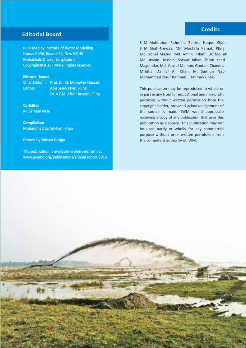
Areas of IWM Services
About IWM
Institute of Water Modelling (IWM) is a Trust established by the Government of Bangladesh in December 1996 to function as a Centre of Excellence and learning in the field of Computational Hydraulics, Water Modelling and Allied Sciences. IWM owes its genesis to the three phases UNDP-DANIDA aided Surface water Simulation Modelling Programme (SWSMP) carried out during 1986-1996. Since then IWM has developed numerical models of rivers, estuaries and bays covering entire Bangladesh and applied in national important projects.
IWM offers a wide range of specialist services in the fields of water resources planning and management as well as hydrometric measurements, hydrographic and topographic surveys and monitoring.
UNDP Aided
Integrated Water Resource ManagementClimate Change ModellingWetland and Lakes ManagementIrrigation ManagementGroundwater ManagementUrban Water ManagementWater Quality and EcologyFluvial HydraulicsRiver EngineeringFlood ManagementIntegrated Coastal Zone ManagementCoastal Hydraulics and MorphologyPort and Coastal Structure ManagementEstuary and Marine System ManagementOffshore Structure and Pipelines DesignWater Quality InvestigationSoftware Development and It SolutionsGeographic Information ServicesHydrogeological InvestigationsTopographic and Hydrographic Survey, Sediment Transport, Water Quality And Hydrological, Meteorological Field Measurements, Necessary Laboratory analysis, Data Management and Mapping;Any other field or area which may be conveniently and beneficially done through the facilities of IWM.
Historical Development of IWM
SWSMP-I1986 - 1989
UNDP Aided
1D River Model
Developed For 2
Regions: SERM,
General Model
IWM TRUST2002-To Date
Regional TrainingHydroinformatics
Climate Change ImpactAssessment
Flood Forecasting &Disaster Management
Environmental & SocialImpact Assessment
Urban Water ResourceAssessment & WSNetwork Modelling
GW & SW ResourcesIntegrated AssessmentRiver Erosion Forecasting
TQM
SWSMP TRUST1997 - 2001
Institutionalization -- self sustaining non-profit organisationunder Trust Act
Command AreaDevelopment
Coastal ZoneManagement
Quasi 2-D Morphology,Waves
2-D Curvilinear
SWSMP-III1994 - 1996
DANIDA Aided
Morph.,WQ, GW, UDand 2-D Modelling2-D Hydrodynamic
CommercialApplication
GIS Integration
SWSMP-II1990 - 1993
DANIDA Aided
1-D Morphological and Salinity Modelling
4 More Regional ModelsDeveloped: NWRMNCRM,, NERM, SWRM
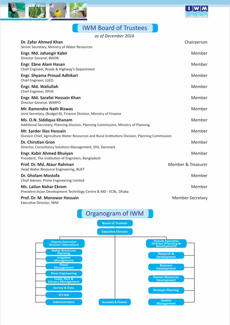
IWM Board of Trustees
Dr. Zafar Ahmed Khan ChairpersonSenior Secretary, Ministry of Water Resources
Engr. Md. Jahangir Kabir MemberDirector General, BWDB
Engr. Ebne Alam Hasan MemberChief Engineer, Roads & Highway’s Department
Engr. Shyama Prosad Adhikari MemberChief Engineer, LGED
Engr. Md. Waliullah MemberChief Engineer, DPHE
Engr. Md. Sarafat Hossain Khan MemberDirector General, WARPO
Mr. Ramendra Nath Biswas MemberJoint Secretary, (Budget-8), Finance Division, Ministry of Finance
Ms. O.N. Siddiqua Khanam Member
Mr. Sarder Ilias Hossain Member
Member
Engr. Kabir Ahmed Bhuiyan Member
Prof. Dr. Md. Ataur Rahman Member & TreasurerHead Water Resource Engineering, BUET
Dr. Gholam Mostofa MemberChief Adviser, Prime Engineering Limited
Ms. Lailun Nahar Ekram MemberPresident-Asian Development Technilogy Centre & MD - ECBL, Dhaka
Prof. Dr. M. Monowar Hossain Member-Secretary
Organogram of IWMBoard of Trustees
Director (Planning &Development)
Water ResourcesPlanning Research &
Development
BusinessDevelopment
Human ResourcesDevelopment
Strategic Planning
QualityManagementAccounts & Finance
ManagementFlood
Management
River Engineering
Coast, Port &Estuary Management
Survey & Data
ICT-GIS
as of December 2016
Contents
IWM Success : 2016 06
Coast, Port and Estuary Management 07
Flood Management 11
Irrigation Management 16
River Engineering 19
Survey & Data Management 23
Water Resources Planning 26
ICT-GIS 29
Human Resource Development 32
Important Events 34
IWM Major Contract Signing & Seminars 37
IWM Cultural 39
Acronyms 40
MESSAGEFROM CHAIRPERSON
Dr. Zafar Ahmed KhanSenior Secretary
Ministry of Water ResourcesGovenment of the People’s Republic of Bangladesh
(Dr. Zafar Ahmed Khan)Senior Secretary
Ministry of Water Resources&
ChairpersonIWM Board of Trustees
It gives me immense pleasure to convey my best wishes to Institute of Water Modelling (IWM) on publication of its Annual Report 2016. I am delighted to observe that IWM has come a long way in establishing its accomplishment as a Reference Centre in Aisa and a leader in the field of water management and modelling.
The centre is contributing to the prosperous journey of emerging Bangladesh by delivering world class solutions in water resources & environmental management with its excellent skillset on state-of-the-art technology of mathematical modelling, computational hydraulics and allied sciences. It is addressing numerous water-related problems of the country and abroad. I am very happy to learn that in the year 2016 IWM has continued its on-going research projects and completed two (02) R&D projects as well as venturing into new opportunities with foreign Institutes and Universities. Some of the mentionable Researches are: Study on Effect of Oblique Flow & Char Movement in Rivers & Bank Protection Works and Determination of Hydrogeological Parameter for SW and SE Regions of Bangladesh etc.
I am indeed very happy and glad to know that IWM revised and updated its strategic business plan (SBP) to cope with the present business prospects of the day as the Institute has expanded significantly in terms of human resources and annual turnovers. Furthermore, it is widely acknowledged that IWM’s linkage with other educational and research institutions in the country and abroad has expanded in an exponential rate opening new frontiers of collaboration in North America, Europe, South Asia and elsewhere. These famed institutions include BUET (Bangladesh), MIST (Bangladesh), Tufts University (USA), Boston (USA), Tohoku University (Japan), Washington University (USA), Ohio State University (USA), Tennessee - Technological University (USA), University Technology Malaysia, University KEBANGSAAN MALAYSIA, University Technology Mara (UiTM), Selangor Darul Ehsan (Malaysia), Yunnan University (China), Universidad de San Buenaventura Seccional Medellin, Columbia Lancaster University (UK), ICIMOD (Nepal), IWMI (Sri Lanka), SaciWATERS (India), Lanka Hydraulics Institute (Sri Lanka), NAHRIM (Malaysia) and UNESCO-IHE (Netherlands) etc.
IWM has successfully witnessed another year of success in attaining great heights of accomplishments through dynamic business strategies and better organizational strength and structured training of its own staff as well as that of its clients both at home and abroad.
Finally, I would like to extend my heartfelt appreciation to the members of the Board of Trustees of IWM for their whole-hearted contributions and continuous support over the years. They provided continued support for the development of the Institute as s successful entity in addressing the challenging needs of the country. I also wish to extend my best wishes to the staff of IWM for their tireless efforts in strengthening the Institute for their commitment and dedications, in enhancing the image of the country.
I wish IWM a prosperous and bright future.
MESSAGEFROM Executive Director
Prof. Dr. M. Monowar HossainExecutive Director
The Annual Report 2016 portrays an overall picture of IWM activities in 2016 to our valued clients, well-wishers, stakeholders and fellow professionals in a systematic manner. The year 2016 has been yet another year of continued success in the milestone of our accomplishments, depicting the completion of number of significant projects. This year we have provided our services to around 47 different clients and number of projects were around 87. It reflects IWM’s activities in a credible manner for its services to its valuable clients and development partners. Our emphasis was on new areas of knowledge generation through research and studies. We remain grateful to our valued clients for their generous feedback on IWM services through short interactive seminars & consultations that we arranged during the period.
CPE Division has been involved in many diversified projects in 2016. Some of them are Formulation of Bangladesh Delta Plan 2100, Assessment of potential effect of surface water withdrawal in the Delta region on water flow and salinity level considering various climate change scenarios, Environmental and Social Impact Assessment study for the Dhaka-Chittagong- Ashuganj Regional IWT Corridor Project (Bangladesh Regional Waterway Transport Project 1), Hydrological and Morphological Study for Installation of 33KV Submarine Cable from Chittagong to Sandwip, Feasibility Study of Capital Dredging in Pussur River from Mongla Port to Rampal Power Plant, Study to prioritize the proposed inland waterways routes for dredging financing and to undertake detailed feasibility study bid packages, Cox’s bazaar airport extension project, feasibility study of LNG terminals etc.
WRP Division has been involved quite extensively in various urban water management and drainage related study projects in Bangladesh. Mentionable are those of Dhaka, Chittagong and Sylhet city development of drainage and sanitation, master plan of Chittagong City. Other project includes feasibility study and detail design of a water treatment plant of 50 million litre per day capacity for Sylhet city. The division was involved in the supervision of implementation of two large water supply projects for Dhaka city: namely Padma (Jashaldia) water treatment plant and Tetuljhora – Bhakurta Well field construction project. These two plants is expected to supply about 600 million liters per day treated water to Dhaka city. In addition, the division has been involved with rural piped water supply projects in various districts of Bangladesh.
FMG Division has been involved in few projects, namely Improvement of FFWC Flood Forecasting Model to enable the existing Flood Model to take input from the Mobile SMS, Flood Hydrology Study of the Eastern Part of Dhaka Metropolitan Area, EU-Global Earth Observation for Integrated Water Resources Assessment (EartH2Observe), Mathematical Modelling and Topographic Survey for Haor Flood Management and Livelihood Improvement Project (BWDB Part), Flash Flood Early Warning System for North East Region for FFWC, etc.
IRM Division has been involved in the projects for national as well as international interests such as Study for Upgrading and Rehabilitation of Karnafuli and other Irrigation Projects with ESIA in Hathazari, Rauzan, Boalkhali and Fatikchari Upazillas in Chittagong District, Detailed Feasibility Study with ESIA for Restoration of Water Resources around Baral River Basin, Cropping System Intensification in the salt affected Coastal Zones of Bangladesh & West Bengal and Study for Investigation of Groundwater and Surface-water Irrigation in Habiganj, Maulvibazar, Sylhet, Sunamganj, Netrokona and Kishoregonj Districts, National Water Balance Management (NAWABS) Study, Sungai Muda Basin, Malaysia etc.
REN Division with its expertise and experience was involved in many projects during 2016, notable ones are: Hydro-morphological Mathematical Modelling Study for Re-excavation of the Bhairab River flowing over Meherpur and Chuadanga Districts, Feasibility Study for Dredging along the Gumti River, Hydraulic and Morphological Study of the Ghorautra River around Mithamain Area for establishing Cantonment, Study for the Protection of Guide Bund at the Barisal End of the Bir Shrestho Captain Mohiuddin Jahangir Bridge (Doarika Bridge) on the Sugandha River.
SDT Division has carried out survey works for numerous on-going projects. These include Surma Baulai River, Pilot Capital Dredging: Protective Work of Crossbars, Gorai Dredging and BWDB Hydraulic Structure Inventory, etc. This division provides support in survey activities for all other divisions of IWM.
ICT-GIS Division of IWM carried out several projects such as BWDB’s Scheme Information Management System (SiMS-Web), Development of HAOR MIS, Development of ICT Connectivity DSS through Interactive GIS Map for A2I, Digital Mouza Maps for Elevated Expressway for BBA and Pumpkin against Poverty through Identification of Char lands.
BD & HRD units of IWM organized several workshops, seminars, training programs both at home and abroad for IWM staffs as well as its valued clients. Trainings for professionals of NAHRIM (Malaysia). They also arranged trainings for involving WRE-BUET, BWP, WARPO, BIWTA, LGED, and DWASA, RWASA, SSC & BWDB. International trainings were arranged in Malaysia, Thailand, Germany & USA. BD unit successfully organized IWM Cultural Night 2016. All these workshops and seminars help a lot to disseminate the knowledge of IWM to different stakeholders of national and international arena.
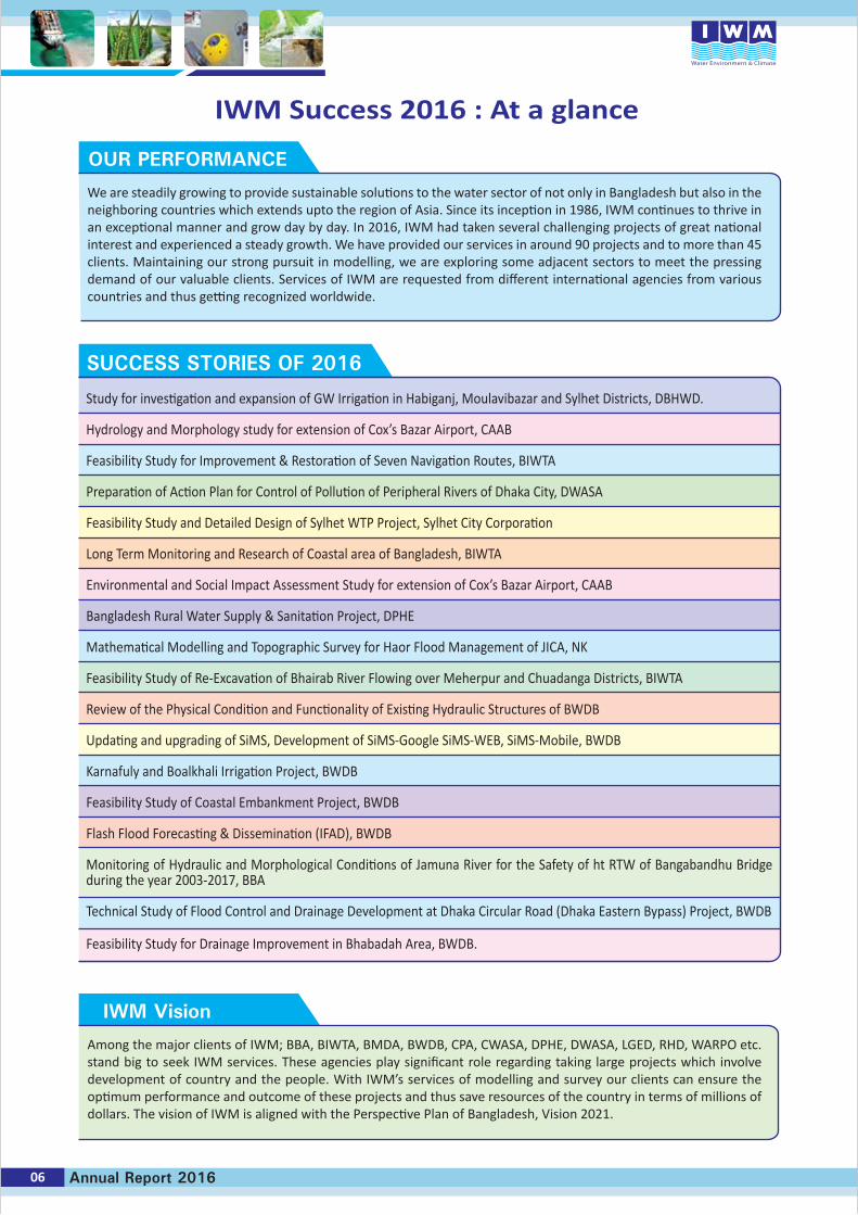
IWM Success 2016 : At a glance
06 Annual Report 2016
OUR PERFORMANCE
We are steadily growing to provide sustainable solutions to the water sector of not only in Bangladesh but also in the neighboring countries which extends upto the region of Asia. Since its inception in 1986, IWM continues to thrive in an exceptional manner and grow day by day. In 2016, IWM had taken several challenging projects of great national interest and experienced a steady growth. We have provided our services in around 90 projects and to more than 45 clients. Maintaining our strong pursuit in modelling, we are exploring some adjacent sectors to meet the pressing demand of our valuable clients. Services of IWM are requested from different international agencies from various countries and thus getting recognized worldwide.
Study for investigation and expansion of GW Irrigation in Habiganj, Moulavibazar and Sylhet Districts, DBHWD.
Hydrology and Morphology study for extension of Cox’s Bazar Airport, CAAB
Feasibility Study for Improvement & Restoration of Seven Navigation Routes, BIWTA
Preparation of Action Plan for Control of Pollution of Peripheral Rivers of Dhaka City, DWASA
Feasibility Study and Detailed Design of Sylhet WTP Project, Sylhet City Corporation
Long Term Monitoring and Research of Coastal area of Bangladesh, BIWTA
Environmental and Social Impact Assessment Study for extension of Cox’s Bazar Airport, CAAB Bangladesh Rural Water Supply & Sanitation Project, DPHE
Mathematical Modelling and Topographic Survey for Haor Flood Management of JICA, NK
Feasibility Study of Re-Excavation of Bhairab River Flowing over Meherpur and Chuadanga Districts, BIWTA
Review of the Physical Condition and Functionality of Existing Hydraulic Structures of BWDB
Updating and upgrading of SiMS, Development of SiMS-Google SiMS-WEB, SiMS-Mobile, BWDB
Karnafuly and Boalkhali Irrigation Project, BWDB
Feasibility Study of Coastal Embankment Project, BWDB
Flash Flood Forecasting & Dissemination (IFAD), BWDB
Monitoring of Hydraulic and Morphological Conditions of Jamuna River for the Safety of ht RTW of Bangabandhu Bridge during the year 2003-2017, BBA
Technical Study of Flood Control and Drainage Development at Dhaka Circular Road (Dhaka Eastern Bypass) Project, BWDB
Feasibility Study for Drainage Improvement in Bhabadah Area, BWDB.
SUCCESS STORIES OF 2016
IWM Vision
Among the major clients of IWM; BBA, BIWTA, BMDA, BWDB, CPA, CWASA, DPHE, DWASA, LGED, RHD, WARPO etc. stand big to seek IWM services. These agencies play significant role regarding taking large projects which involve development of country and the people. With IWM’s services of modelling and survey our clients can ensure the optimum performance and outcome of these projects and thus save resources of the country in terms of millions of dollars. The vision of IWM is aligned with the Perspective Plan of Bangladesh, Vision 2021.
Coast, Port andEstuary Management
Bangladesh Government has a strategic plan to become a middle-income country by 2021. Energy supply thus increases rapidly in order to sustain the country’s economic growth. The study focuses on selection of location of LNG terminal site, establishing formation level and protection measures considering cyclonic storm surge & wave action and coastal erosion. Analysis shows that Formation Level of 50 years return period is 10mMSL considering 1:7 side slope. On the basis of existing topog-raphy/land level, area and required Formation Level, the volume of sand needed to fill the area is about 21.43 million m3 for Site- 2 (450 acre) and 51.54 million m3 for Site-1 (700 acre). Considering the filling height and volume, costing and navigational depth Site-2 is better compared to Site-1. Considering sediment charac-teristics, distance, costing of dredging and transport of
d r e d g i n g material to t h e p r o p o s e d site, the chars at and around the Moheshkhali C h a n n e l Estuary is the best suitable s e d i m e n t source for dredging and
filling the low-lying area. A suitable cutter suction dredger may be useful for dredging the selected chars and a hopper barge can be used for carrying the dredged materi-al from the dredging location into the filling site. The effect of the Project on the national economy is indicated by the
Economic Internal Rate of Return (EIRR). The benefits of the project interventions have been identified and quanti-fied as far as possible for economic analysis. The EIRR is 21.52%, which is above 12%, i.e. the opportunity cost of capital investment.
Coast, Port and Estuary Management (CPE) Division provides services for natural resource management, disaster risk assessment and management, vulnerability and risk assessment of ecosystem services in the changing climate to deliver effective solutions for infrastructure development, food security and environmental protection, planning & design of port and harbour. CPE has gained experience to work in the disciplines of Adaptive Delta Management, Integrated coastal zone management, salinity intrusion and zoning map, integrated management of coastal polders and tidal rivers, land reclamation, coastal morphology, erosion management, planning and design of dredging of Inland Water Way, river and port harbour for navigability improve-ment, planning and design of port and jetty. Assessment of water availability and productivity in the changing climate also falls under its arena of activities of CPE division. CPE also works on multi hazard vulnerability and risk assessment, exposure analysis and assessment of element at risk and damage for present and in times of climate change. This division also provides services in Planning and Design of coastal polders/embankment and coastal erosion protection, Tidal River Management and sediment management, island and char development involving active participation of local communities. The division is actively working on environ-mental and social impact assessment, environmental
management and monitoring plan. CPE has also vast experi-ence on environmental modelling such as water quality, salinity, sediment plume, temperature plume dispersion modelling in environmental assessment. It has recently started to work on noise and air pollution modelling.
CPE division uses state-of-the-art mathematical modelling tools for finding the solutions of coastal zone management issues for present and future. The modelling tools are used MIKE21 Classic, MIKE21 FM and Delft3D are used for tidal hydraulics, storm surges, cohesive and non-cohesive sediment transport, river and harbor dredging and back filling rate, erosion and deposition pattern and morphological changes in the coast, estuary and tidal rivers. Tools MIK21AD, MIKE11AD are for salinity intrusion in the estuary and tidal rivers, temperature dispersion for inlet and outlet location of power plant and water quality in the coast and estuary, MIKE21 SW is used for wave climate and wave statistics for planning and design of polder embankments, river and sea port and navigation channels, shore line protection meas-ures. In continuation of the past, CPE carried out a good number of research projects in collaboration with Ohio State University, USA, IRD France, Deltares, the Netherland. Provid-ed training to professionals of Design Circles BWDB on drainage and storm surge modelling of polders and methods of selection of design parameters.
Techno-Economical Feasibility Study for Land BasedL.N.G Terminal at Moheshkhali Island
Coast, Port & Estuary Management Division
Disposal by Hopper Dredger at the area of interest
Moheskhali Island
Hopper Barge
685000
4030
00
690000 695000 700000 705000
3960
0038
9000
3820
0037
5000
685000 690000 695000 700000 705000
3750
0038
2000
3890
0039
6000
4030
00
LegendProposed Site
Union HQ
Upzilla HQ
Road
Polder
Site-1Area: 694.5 Acre
Bay of Bengal
Bangladesh
Study Area
Site-2Area: 432 Acre
Moheshkhali
08 Annual Report 2016
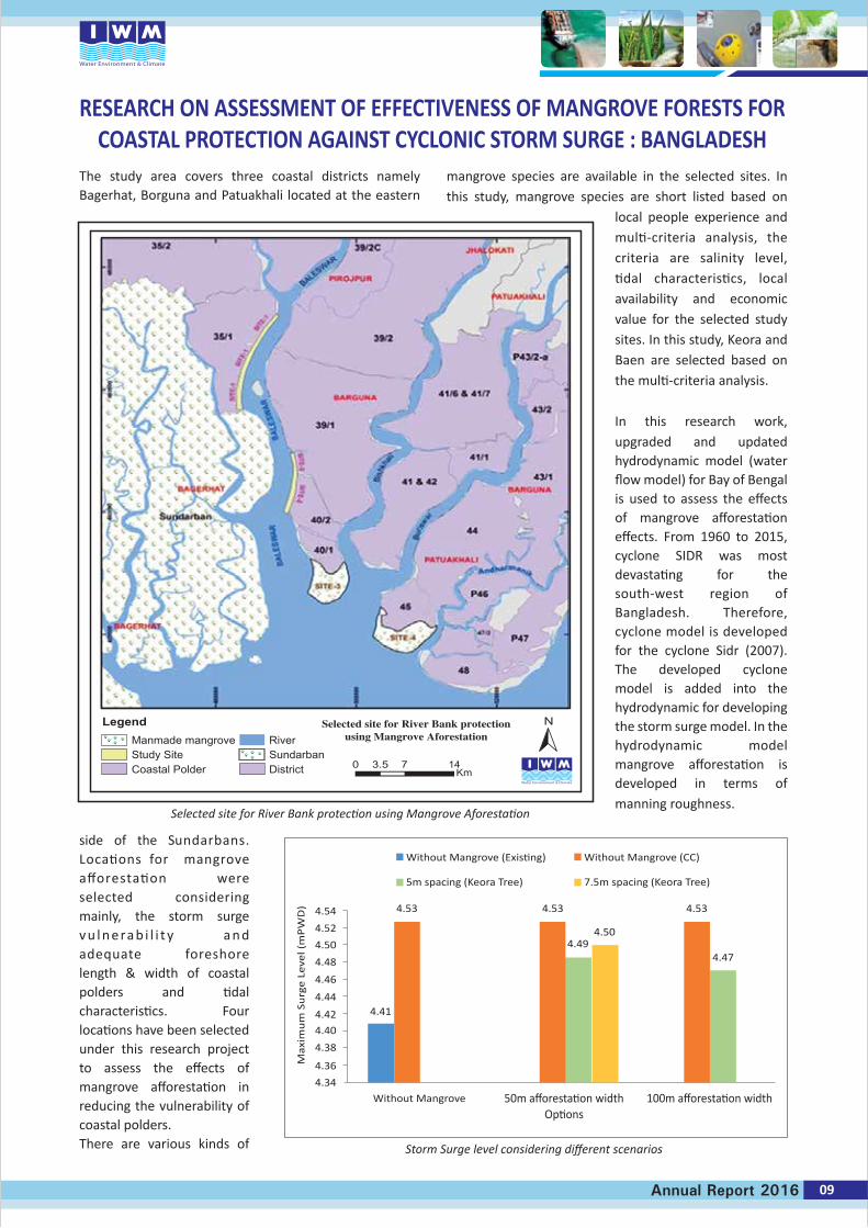
The study area covers three coastal districts namely Bagerhat, Borguna and Patuakhali located at the eastern
side of the Sundarbans. Locations for mangrove afforestation were selected considering mainly, the storm surge v u l n e ra b i l i t y a n d adequate foreshore length & width of coastal polders and tidal characteristics. Four locations have been selected under this research project to assess the effects of mangrove afforestation in reducing the vulnerability of coastal polders.There are various kinds of
mangrove species are available in the selected sites. In this study, mangrove species are short listed based on
local people experience and multi-criteria analysis, the criteria are salinity level, tidal characteristics, local availability and economic value for the selected study sites. In this study, Keora and Baen are selected based on the multi-criteria analysis.
In this research work, upgraded and updated hydrodynamic model (water flow model) for Bay of Bengal is used to assess the effects of mangrove afforestation effects. From 1960 to 2015, cyclone SIDR was most devastating for the south-west region of Bangladesh. Therefore, cyclone model is developed for the cyclone Sidr (2007). The developed cyclone model is added into the hydrodynamic for developing the storm surge model. In the hydrodynamic model mangrove afforestation is developed in terms of manning roughness.
RESEARCH ON ASSESSMENT OF EFFECTIVENESS OF MANGROVE FORESTS FORCOASTAL PROTECTION AGAINST CYCLONIC STORM SURGE : BANGLADESH
Without Mangrove (Existing)
Without Mangrove
Max
imu
m S
urg
e L
eve
l (m
PW
D)
50m afforestation widthOptions
100m afforestation width
5m spacing (Keora Tree)
Without Mangrove (CC)
7.5m spacing (Keora Tree)
4.41
4.34
4.36
4.38
4.40
4.42
4.44
4.46
4.48
4.50
4.52
4.54 4.53 4.53
4.494.47
4.50
4.53
Legend Selected site for River Bank protectionusing Mangrove AforestationManmade mangrove
Study SiteCoastal Polder
RiverSundarbanDistrict 0 3.5 7 14
Km
N
09Annual Report 2016
Selected site for River Bank protection using Mangrove Aforestation
Storm Surge level considering different scenarios
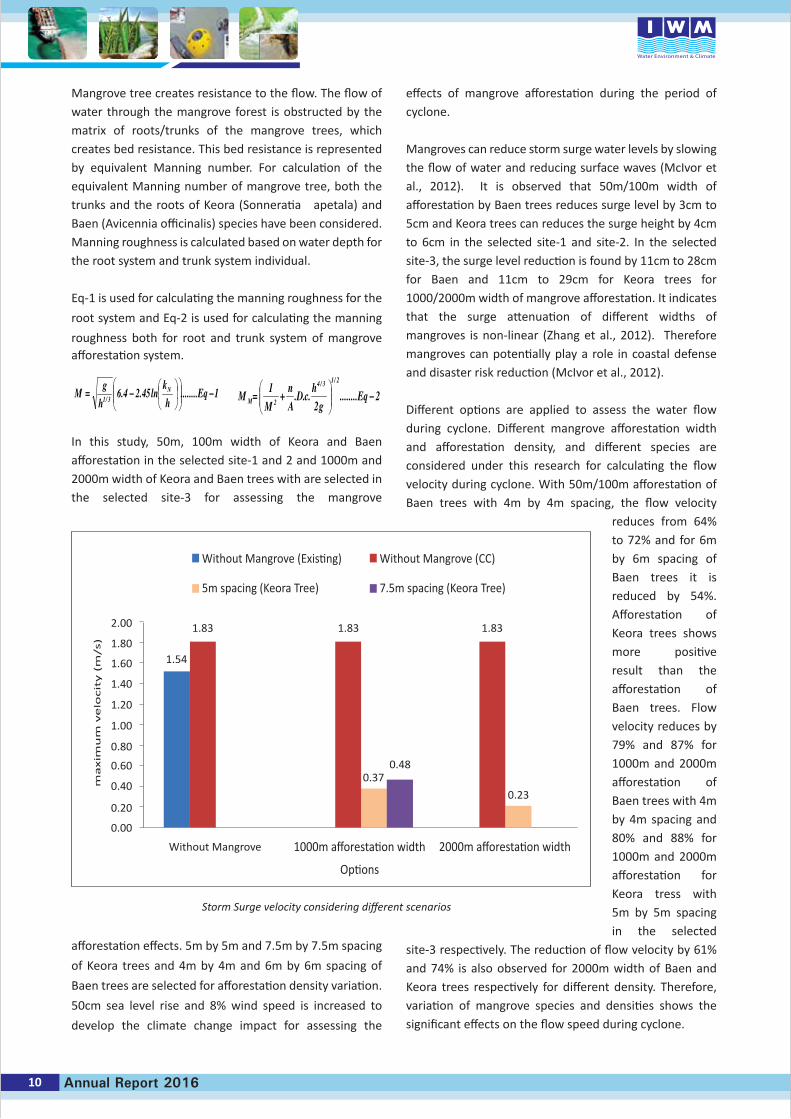
Mangrove tree creates resistance to the flow. The flow of water through the mangrove forest is obstructed by the matrix of roots/trunks of the mangrove trees, which creates bed resistance. This bed resistance is represented by equivalent Manning number. For calculation of the equivalent Manning number of mangrove tree, both the trunks and the roots of Keora (Sonneratia apetala) and Baen (Avicennia officinalis) species have been considered. Manning roughness is calculated based on water depth for the root system and trunk system individual.
Eq-1 is used for calculating the manning roughness for the
root system and Eq-2 is used for calculating the manning
roughness both for root and trunk system of mangrove afforestation system.
In this study, 50m, 100m width of Keora and Baen afforestation in the selected site-1 and 2 and 1000m and 2000m width of Keora and Baen trees with are selected in the selected site-3 for assessing the mangrove
afforestation effects. 5m by 5m and 7.5m by 7.5m spacing
of Keora trees and 4m by 4m and 6m by 6m spacing of
Baen trees are selected for afforestation density variation.
50cm sea level rise and 8% wind speed is increased to
develop the climate change impact for assessing the
effects of mangrove afforestation during the period of cyclone.
Mangroves can reduce storm surge water levels by slowing the flow of water and reducing surface waves (McIvor et al., 2012). It is observed that 50m/100m width of afforestation by Baen trees reduces surge level by 3cm to 5cm and Keora trees can reduces the surge height by 4cm to 6cm in the selected site-1 and site-2. In the selected site-3, the surge level reduction is found by 11cm to 28cm for Baen and 11cm to 29cm for Keora trees for 1000/2000m width of mangrove afforestation. It indicates that the surge attenuation of different widths of mangroves is non-linear (Zhang et al., 2012). Therefore mangroves can potentially play a role in coastal defense and disaster risk reduction (McIvor et al., 2012).
Different options are applied to assess the water flow during cyclone. Different mangrove afforestation width and afforestation density, and different species are considered under this research for calculating the flow velocity during cyclone. With 50m/100m afforestation of Baen trees with 4m by 4m spacing, the flow velocity
reduces from 64% to 72% and for 6m by 6m spacing of Baen trees it is reduced by 54%. Afforestation of Keora trees shows more positive result than the afforestation of Baen trees. Flow velocity reduces by 79% and 87% for 1000m and 2000m afforestation of Baen trees with 4m by 4m spacing and 80% and 88% for 1000m and 2000m afforestation for Keora tress with 5m by 5m spacing in the selected
site-3 respectively. The reduction of flow velocity by 61% and 74% is also observed for 2000m width of Baen and Keora trees respectively for different density. Therefore, variation of mangrove species and densities shows the significant effects on the flow speed during cyclone.
2........2
...1
2/13/4
2 −
+= Eq
gh
cDAn
MM M
1........ln45.24.63/1 −
−= Eq
hk
hg
M N
Without Mangrove (Existing)
Without Mangrove
ma
xim
um
ve
locit
y (
m/s)
1000m afforestation width
Options
2000m afforestation width
5m spacing (Keora Tree)
Without Mangrove (CC)
7.5m spacing (Keora Tree)
1.54
0.00
0.20
0.40
0.60
0.80
1.00
1.20
1.40
1.60
1.80
2.00 1.83 1.83
0.37
0.23
0.48
1.83
10 Annual Report 2016
Storm Surge velocity considering different scenarios
Flood Management
12 Annual Report 2016
Flood Management (FMG) Division provides support in basin wise hydrological assessments, flood risk and damage assessment, flood insurance, real-time flood forecasting and operational water management systems, land use and climate change studies and flood and drainage planning including design and operations of hydraulic structures. The division possesses cutting edge technology, modelling tools on flood management, flood forecasting and climate change issues.
The main strength of FMG is its sound experience in maintaining and updating of 6 Regional Models including the General Model & Super Model developed earlier in different phases of Surface Water Simulation Modelling Programme and later on. The division has been continuing to providing technical backstopping support to Flood Forecasting and Warning Centre (FFWC) of BWDB in its routine flood forecasts in the past decades. Utilization of satellite based data for more efficient flood forecasting system is the example of recent development in this sector. The Division developed and continuously updating the Ganges Brahmaputra Meghna (GBM) basin model which is capable of increasing the lead time of flood forecasts as well as a tool to assess climate change impacts, make water resources assessments and identify impacts of interventions on a regional context.
Worldwide accepted modelling tools such as MIKE 11 (MIKE Hydro River), MIKE GIS, MIKE FLOOD, MIKE HYDRO Basin, FLOOD WATCH (MIKE Operation) are being used in the division to address a wide range of water management issues. Other modeling tools such as SWAT and WRF are also being used for developing and assisting hydrological activities carried out by the division.
Important projects carried out by FMG during 2016 include, but not limited to continuation of Implementation Improvement of FFWC Flood Forecasting Model to enable the existing Flood Model to take input from the Mobile SMS, Flood Hydrology Study of the Eastern Part of Dhaka Metropolitan Area, Index based flood insurance Project, EU-Global Earth Observation for Integrated Water Resources Assessment (EartH2Observe), Mathematical Modelling and Topographic Survey for Haor Flood Management and Livelihood Improvement Project (BWDB Part), Flash Flood Early Warning System for North East Region for FFWC, Regional Training Program for scaling up of Satellite assisted FF systems in South and Southeast Asian Nations etc. In addition, the division contributed to train IWM professionals and clients in the field of weather research and forecast model, disaster risk reduction and use of satellite data for water resources assessment and flood forecasting applications at home and abroad.
Flood Management Division
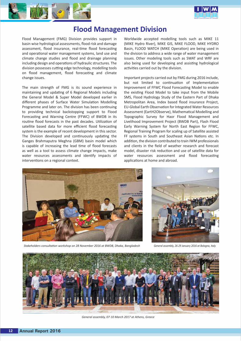
Stakeholders consultation workshop on 28 November 2016 at BWDB, Dhaka, Bangladesh
General assembly, 07-10 March 2017 at Athens, Greece
General assembly, 26-29 January 2016 at Bologna, Italy
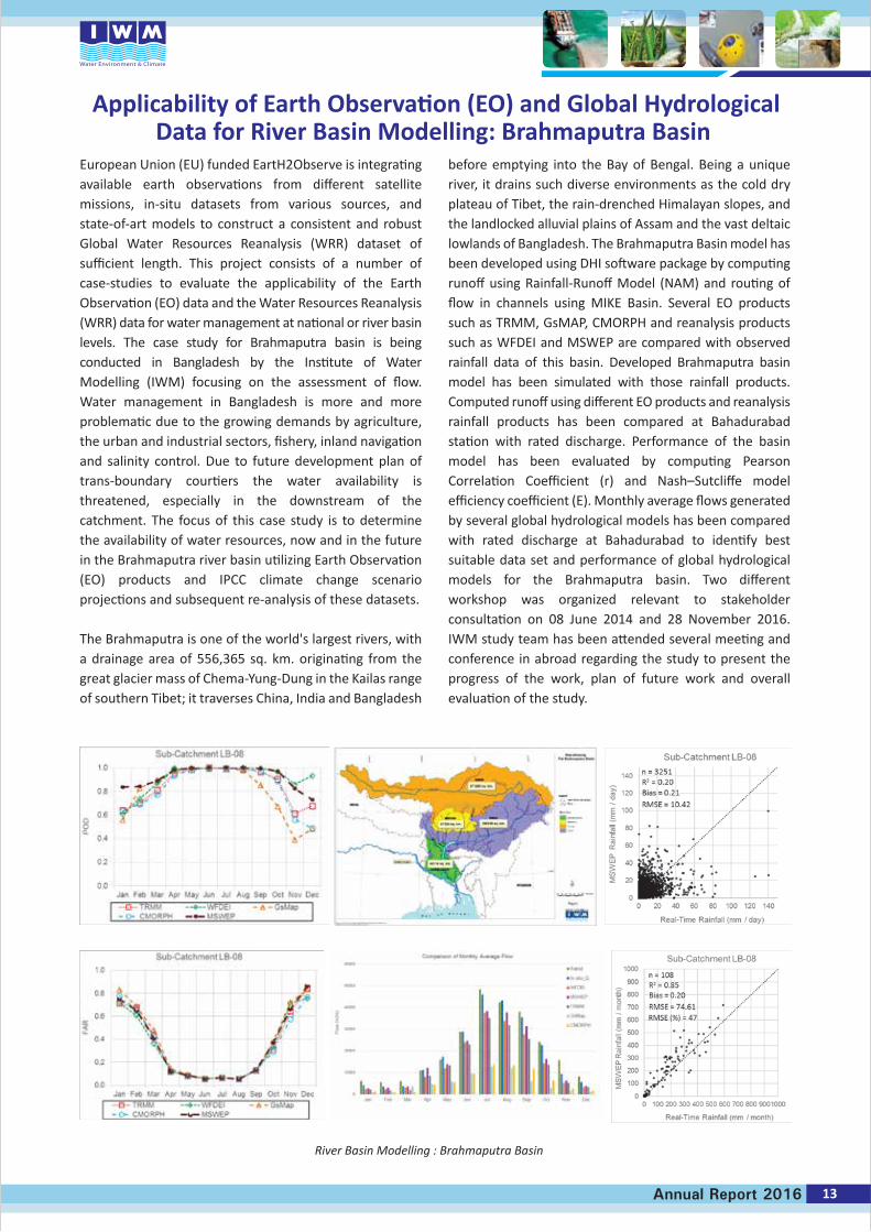
European Union (EU) funded EartH2Observe is integrating available earth observations from different satellite missions, in-situ datasets from various sources, and state-of-art models to construct a consistent and robust Global Water Resources Reanalysis (WRR) dataset of sufficient length. This project consists of a number of case-studies to evaluate the applicability of the Earth Observation (EO) data and the Water Resources Reanalysis (WRR) data for water management at national or river basin levels. The case study for Brahmaputra basin is being conducted in Bangladesh by the Institute of Water Modelling (IWM) focusing on the assessment of flow. Water management in Bangladesh is more and more problematic due to the growing demands by agriculture, the urban and industrial sectors, fishery, inland navigation and salinity control. Due to future development plan of trans-boundary courtiers the water availability is threatened, especially in the downstream of the catchment. The focus of this case study is to determine the availability of water resources, now and in the future in the Brahmaputra river basin utilizing Earth Observation (EO) products and IPCC climate change scenario projections and subsequent re-analysis of these datasets.
The Brahmaputra is one of the world's largest rivers, with a drainage area of 556,365 sq. km. originating from the great glacier mass of Chema-Yung-Dung in the Kailas range of southern Tibet; it traverses China, India and Bangladesh
before emptying into the Bay of Bengal. Being a unique river, it drains such diverse environments as the cold dry plateau of Tibet, the rain-drenched Himalayan slopes, and the landlocked alluvial plains of Assam and the vast deltaic lowlands of Bangladesh. The Brahmaputra Basin model has been developed using DHI software package by computing runoff using Rainfall-Runoff Model (NAM) and routing of flow in channels using MIKE Basin. Several EO products such as TRMM, GsMAP, CMORPH and reanalysis products such as WFDEI and MSWEP are compared with observed rainfall data of this basin. Developed Brahmaputra basin model has been simulated with those rainfall products. Computed runoff using different EO products and reanalysis rainfall products has been compared at Bahadurabad station with rated discharge. Performance of the basin model has been evaluated by computing Pearson Correlation Coefficient (r) and Nash–Sutcliffe model efficiency coefficient (E). Monthly average flows generated by several global hydrological models has been compared with rated discharge at Bahadurabad to identify best suitable data set and performance of global hydrological models for the Brahmaputra basin. Two different workshop was organized relevant to stakeholder consultation on 08 June 2014 and 28 November 2016. IWM study team has been attended several meeting and conference in abroad regarding the study to present the progress of the work, plan of future work and overall evaluation of the study.
Applicability of Earth Observation (EO) and Global HydrologicalData for River Basin Modelling: Brahmaputra Basin
13Annual Report 2016
River Basin Modelling : Brahmaputra Basin
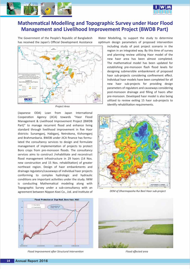
The Government of the People’s Republic of Bangladesh has received the Japan’s Official Development Assistance
(Japanese ODA) Loan from Japan International Cooperation Agency (JICA) towards “Haor Flood Management & Livelihood Improvement Project (BWDB Part)” to manage recurrent flood and enhance living standard through livelihood improvement in five Haor districts: Sunamganj, Habiganj, Netrokona, Kishoreganj and Brahmanbaria. BWDB under JICA finance has formu-lated the consultancy services to design and formulate management of implementation of projects to protect Boro crops from pre-monsoon floods. The consultancy services aims to construct /rehabilitate and reconstruct flood management infrastructure in 29 haors (14 Nos. new construction and 15 Nos. rehabilitation) of greater northeast region. Design of haor embankments and drainage regulators/causeways of individual haor projects conforming to complex hydrologic and hydraulic conditions are important activities under the study. IWM is conducting Mathematical modeling along with Topographic Survey under a sub-consultancy with an agreement between Nippon Koei Co., Ltd. and Institute of
Water Modelling, to support the study to determine optimum design parameters of proposed intervention
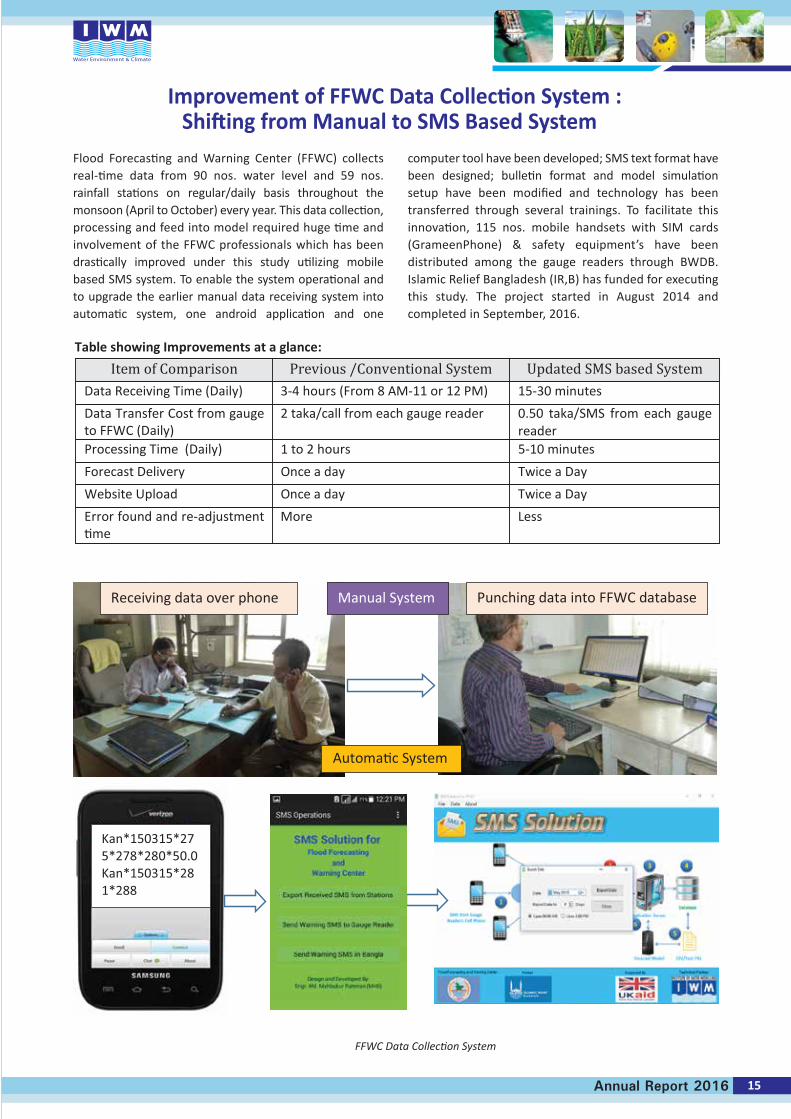
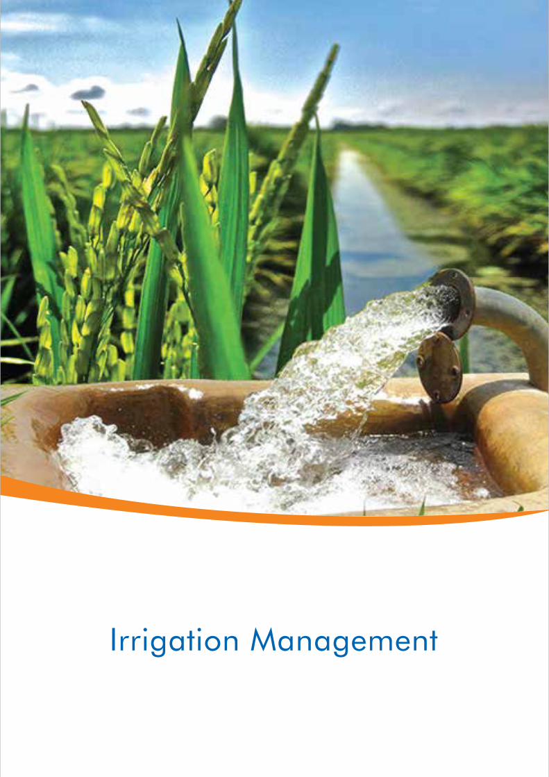
including study of post project scenario in the region in an integrated way. By this time of survey and planning review utilizing Haor model of the new haor area has been almost completed. The mathematical model has been updated for establishing pre-monsoon flash flood levels for designing submersible embankment of proposed haor sub-projects considering confinement effect. Individual haor models have been completed for all new haor sub-projects for providing design parameters of regulators and causeways considering post-monsoon drainage and filling of haors after pre-monsoon. Developed haor model is also being utilized to review exiting 15 haor sub-projects to identify rehabilitation requirements.
Mathematical Modelling and Topographic Survey under Haor FloodManagement and Livelihood Improvement Project (BWDB Part)
Flood Improvement after Structural Intervention Flood effected area
DEM of Dharmapasha Rui Beel Haor sub-project
Project Area
14 Annual Report 2016
Mathematical Modelling and Topographic SurveyUnder Consultancy Services for
Management, Design, Supervision and otherRelated Services of Haor Flood Management and
Livelihood improvemnet Project (BWDB Part)
Int’l Boundary
SchematizedRiver / Khal
District H/Q New Haor Project
Location ofNew & Rehabilitation Haor Projects
Figure : 1.1Legend :
RehabilitationHaor Project
5 5 10 15 20 25 Kilometers
Projection : Bangladesh Transverse Mercator (BTM)
0
INDIA(Meghalaya)
INDIA(Tripura)
SHERPUR
JAMALPUR
MYMENSINGH
KISHORGANJ
Terapasha
MOULVIBAZARHABIGANJ
GAZIPUR NARSINGDIBRAHMANBARIA
DHAKA
NARAYANGANJ
MUNSHIGANJ
NETRAKONA
SUNAMGANJ
N pur
SYLHET
FFWC Data Collection System
Flood Forecasting and Warning Center (FFWC) collects real-time data from 90 nos. water level and 59 nos. rainfall stations on regular/daily basis throughout the monsoon (April to October) every year. This data collection, processing and feed into model required huge time and involvement of the FFWC professionals which has been drastically improved under this study utilizing mobile based SMS system. To enable the system operational and to upgrade the earlier manual data receiving system into automatic system, one android application and one
computer tool have been developed; SMS text format have been designed; bulletin format and model simulation setup have been modified and technology has been transferred through several trainings. To facilitate this innovation, 115 nos. mobile handsets with SIM cards (GrameenPhone) & safety equipment’s have been distributed among the gauge readers through BWDB. Islamic Relief Bangladesh (IR,B) has funded for executing this study. The project started in August 2014 and completed in September, 2016.
Improvement of FFWC Data Collection System :Shifting from Manual to SMS Based System
15Annual Report 2016
Receiving data over phone Punching data into FFWC database Manual System
Automatic System
Table showing Improvements at a glance:
Item of Comparison Previous /Conventional System Updated SMS based SystemData Receiving Time (Daily) 3-4 hours (From 8 AM-11 or 12 PM) 15-30 minutes
Data Transfer Cost from gaugeto FFWC (Daily)
2 taka/call from each gauge reader 0.50 taka/SMS from each gauge reader
Processing Time (Daily) 1 to 2 hours 5-10 minutes
Forecast Delivery Once a day Twice a Day
Website Upload Once a day Twice a Day
Error found and re-adjustmenttime
More Less
Irrigation Management
Irrigation Management (IRM) division has achieved a leading position in the field of integrated management of land and water resources through mathematical modeling studies and detailed hydrological and hydrogeological investigations for Bangladesh and abroad. IRM plays an important role in agricultural productivity through improved irrigation by adopting sustainable water
resources management. IRM also provide services in groundwater resources management, planning and monitoring of groundwater system. Using mathematical modeling technique, IRM supports water managers at home and abroad in structuring complex decision-making processes andprovide technical know-how for effective evaluation of planning alternatives. Information management systems, decision support systems and simulation models are important tools in this respect. The highly qualified and trained professionals of IRM division uses state-of-art mathematical modelling tools and modern technique for irrigation management, irrigation scheduling, hydrogeological investigation, groundwater management, groundwater monitoring, aquifer vulnerability and groundwater quality assessment. Professionals are well versed inusing software like (i) MIKE SHE and MIKE 11 for groundwater management, calculation of surface water groundwater interaction, river basin planning; (ii) MODFLOW for groundwater resources assessments (iii) MIKE11 for irrigation and drainage management, (iv) FEFLOW to assess salinity intrusion in groundwater (v) HYMOS for statistical analysis (vi) CROPWAT to estimate irrigation water requirement and (vii) ROCK-WORKS for preparation of hydro-stratigraphic cross-sections.
Several projects that have been conducted by IRM division
during 2016 include:
Study for Investigation of Groundwater and Surface Water Irrigation in Habiganj, Maulavibazar, Sylhet, Sunamganj, Netrokona and Kishoreganj DistrictsThe Department of Bangladesh Haor & Wetlands Development (DBHWD) has initiated to explore the availability of both surface water as well as groundwater resources for irrigation expansion plan for proper
management of water resources in an integrated manner. In this regards, a contract agreement between DBHWD and IWM was signed on November 10, 2016. The study area covers Habiganj, Maulavibazar, Sylhet, Kishoreganj, Netrokona and Sunamganj districts. The major activities to accomplish the study objectives are hydrogeological investigations, assessment of water resources using mathematical modelling and development of an Interactive Information System (IIS). Groundwater elevation contour map for dry season of 2015 reveals that ground-water is flowing mainly towards the central part (haor area) of the study area from neighboring area.
National Water Balance Management (NAWABS) for Sungai Muda, Kedah, Malaysia
The Sungai Muda Basin in Malaysia is part of an area more popularly known as the Rice Bowl of Malaysia has an area of 4,150 km2. Increasing water demand mainly for agriculture and potable water supply has caused water stress in the area which becomes more pronounced especially during dry seasons. Conflicts in water allocation are more apparent between these different water use sectors and users from different states relying on the same water source. The issue becomes more complex as the management of dams and river infrastructures are developed and managed by several different agencies from the state and federal levels.As an effort to resolve the water issues, which are antici-pated to get more acute, Jabatan Pengairandan Saliran (JPS), Malaysia has initiated the development of tools which will help stakeholders make informed decisions.
Irrigation Management Division
Contract Signing Ceremony between DBHWD and IWM (left) and Groundwater Elevation
Contour and Flow Direction Map (Dry Season, 2015) of the Study Area (right)
Groundwater LevelContour Map
LegendProject Area
UpazilaBoundary
GWL Contour(mPWD)
Map Location
Flow Direction
17Annual Report 2016
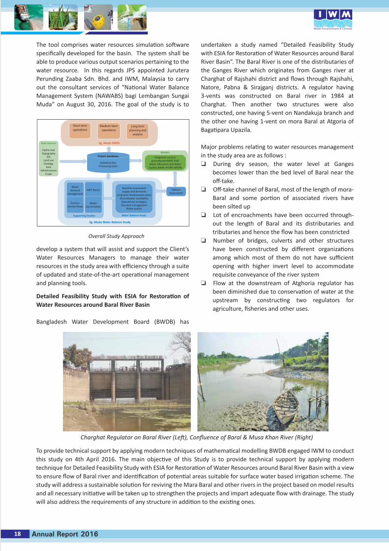
The tool comprises water resources simulation software specifically developed for the basin. The system shall be able to produce various output scenarios pertaining to the water resource. In this regards JPS appointed Jurutera Perunding Zaaba Sdn. Bhd. and IWM, Malaysia to carry out the consultant services of “National Water Balance Management System (NAWABS) bagi Lembangan Sungai Muda” on August 30, 2016. The goal of the study is to
develop a system that will assist and support the Client’s Water Resources Managers to manage their water resources in the study area with efficiency through a suite of updated and state-of-the-art operational management and planning tools.
Detailed Feasibility Study with ESIA for Restoration of Water Resources around Baral River Basin
Bangladesh Water Development Board (BWDB) has
undertaken a study named “Detailed Feasibility Study with ESIA for Restoration of Water Resources around Baral River Basin”. The Baral River is one of the distributaries of the Ganges River which originates from Ganges river at Charghat of Rajshahi district and flows through Rajshahi, Natore, Pabna & Sirajganj districts. A regulator having 3-vents was constructed on Baral river in 1984 at Charghat. Then another two structures were also constructed, one having 5-vent on Nandakuja branch and the other one having 1-vent on mora Baral at Atgoria of Bagatipara Upazila.
Major problems relating to water resources management in the study area are as follows : During dry season, the water level at Ganges
becomes lower than the bed level of Baral near the off-take.
Off-take channel of Baral, most of the length of mora-Baral and some portion of associated rivers have been silted up
Lot of encroachments have been occurred through-out the length of Baral and its distributaries and tributaries and hence the flow has been constricted
Number of bridges, culverts and other structures have been constructed by different organizations among which most of them do not have sufficient opening with higher invert level to accommodate requisite conveyance of the river system
Flow at the downstream of Atghoria regulator has been diminished due to conservation of water at the upstream by constructing two regulators for agriculture, fisheries and other uses.
Charghat Regulator on Baral River (Left), Confluence of Baral & Musa Khan River (Right)
To provide technical support by applying modern techniques of mathematical modelling BWDB engaged IWM to conduct this study on 4th April 2016. The main objective of this Study is to provide technical support by applying modern technique for Detailed Feasibility Study with ESIA for Restoration of Water Resources around Baral River Basin with a view to ensure flow of Baral river and identification of potential areas suitable for surface water based irrigation scheme. The study will address a sustainable solution for reviving the Mara Baral and other rivers in the project based on model results and all necessary initiative will be taken up to strengthen the projects and impart adequate flow with drainage. The study will also address the requirements of any structure in addition to the existing ones.
18 Annual Report 2016
Short termoperations
Medium termoperations
Long termplanning and
analysis
Sg. Muda DMSSData Sources
Hydro-metTopography
GISLand useGeology
SoilsInfrastructure
Crops
Project databases
Validated dataProcessing tools
Models
Integrated surface-groundwater(MIKE SHE)
Water Allocation and WaterQuality (MIKE HYDRO BASIN)
Waterdemand
management
Environ-mental Flows
WaterConservation
WEF Nexus
Supporting Studies Water Balance Study
Sg. Muda Water Balance Study
Baseline assessmentSupply and demands
Long term development plansGroundwater availability
Operational strategiesDemand management
Water quality
OptionsAssessment
Overall Study Approach
River Engineering
River Engineering Division (REN) endeavors in the field of river engineering and management, and uses state-of-the-art mathematical modelling technology in the following disciplines :
• Fluvial hydraulics and river morphology• Erosion management (river training and bank
protection works)• River dredging management• Offtake management• Sediment management for hydraulic structures
(dam, barrage, regulator, etc.)• Road/bridge infrastructure management• Hot water dispersion and cooling water intake
in rivers for Power Plants
The division inherits its strength in the field of hydro-morphological mathematical modelling of large, meandering and braided rivers, for over two decades, through persistent involvement with the very complex river system of Bangladesh including three major rivers: the Ganges-Padma, the Brahmaputra-Jamuna and the Meghna.
REN Division offers technical assistance to the relevant professionals of several organizations, with the aid of state-of-the-art mathematical modelling, to harness most of the beneficial uses of rivers ensuring minimum adverse impacts.
REN with its expertise and experience was involved in many projects during 2016, notable ones are :• Hydro-morphological Mathematical Modelling Study
for Re-excavation of the Bhairab River flowing over Meherpur and Chuadanga Districts
• Feasibility Study for Dredging along the Gumti River for Smooth Drainage and Ensuring Dry Season Irrigation Facilities at Daudkandi and Adjacent Areas in Comilla District Using Mathematical Modelling including Environmental and Social Impact Assessment (ESIA)
• Hydraulic and Morphological Study of the Ghorautra River around Mithamain Area for establishing Cantonment
• Study for the Protection of Guide Bund at the Barisal End of the Bir Shrestho Captain Mohiuddin Jahangir Bridge (Doarika Bridge) on the Sugandha River.
REN continued its involvement, as of previous few years, during 2016 in the following projects, which are considered nationally important ones. These are :
• Gorai River Restoration Project Phase-II• Monitoring of Hydraulic & Morphological Conditions
of the Jamuna River for the Safety of the River Training Works of Bangabandhu Bridge during the Period 2013 to 2017
Besides the projects mentioned above, REN carried out hydrological and morphological studies, using mathematical models, for a few important bridge projects (of Roads and Highways Department-RHD, and Local Government Engineering Department-LGED).
A set of highly skilled professionals are engaged in accom-plishing sophisticated numerical modelling at REN; their expertise and knowledge are being updated and upgraded through on-the-job training, and attending seminars and workshops at home and abroad. Moreover, basic and applied research programs are conducted in order to maintain a high level of technical competence. One such research project titled Assessment of Suitability of Sediment Predictor of the Major Rivers of Bangladesh was taken up in 2016, Phase-I of which has already been completed.
20 Annual Report 2016
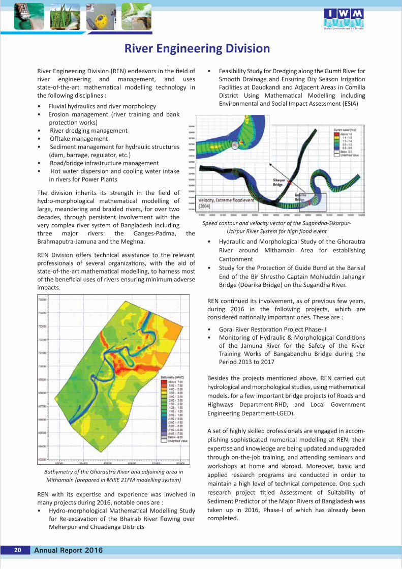
Speed contour and velocity vector of the Sugandha-Sikarpur-Uzirpur River System for high flood event
Bathymetry of the Ghorautra River and adjoining area in Mithamain (prepared in MIKE 21FM modelling system)
River Engineering Division

21Annual Report 2016
The Bhairab River originates from the right bank of the Ganges River, about 30km upstream from India- Bangladesh border, at Nasirpur (Jalangi) of Murshidabad district of West Bengal, India. The river enters into
Bangladesh near Kathuli in Meherpur district, then flows along east-south direction – over Meherpur Sadar and Mujib Nagar upazillas of Meherpur district, and Damurhuda and Jibon Nagar upazillas of Chuadanga district, then finally meets the Mathabhanga River near Subalpur. From Kathuli to Subalpur, the length of the Bhairab River is about 86km.
In the past, the Bhairab was a high-flowing perennial river – one of the main distributaries of the Ganges River. The river used to serve for navigation, irrigation and drainage purposes. About a decade or so, a regulator was constructed by the Indian Government at her own jurisdiction over the Bhairab River – at about 5km upstream from the India-Bangladesh border. Owing to controlling the river flow by the regulator, the Bhairab started to lose its flow inside Bangladesh. The trans-boundary river suffers severely from scarcity of water for irrigation and farming in the dry season for quite some time. With the prolonged adverse situation, the socio-economic and environmental conditions have deteriorated gradually.
As a result, it had been the demand of local people for quite some time to make suitable arrangement so that the river water would be available for dry season irrigation and domestic purposes. Addressing a large rally in Mujib Nagar in 2011, the honorable Prime Minister of Government of Bangladesh promised to the local people for re-excavation of the Bhairab River.
Re-excavation of the Bhairab, for a length of 29km – from Kathuli to Rashikpur – started on 23 April 2015. However, local people demanded for re-excavation of the rest 57km
of the Bhairab River. In fact, for optimum utilization of the Bhairab River water, it is necessary to re-excavate the whole 86km of the river – from Kathuli to Subalpur.
Development of Bhairab River would be technically and socially complex intervention that needs comprehensive analysis of the hydro-morphological scenarios of the river system. IWM was contracted by Bangladesh Water Development Board (BWDB) on the 7th of August 2016 to carry out hydro-morphological mathematical modelling for the Bhairab River.
The main objective of the mathematical modelling study is to assess the feasibility of the envisaged re-excavation of 57km reach of the Bhairab River (from Rashikpur to Subalpur) from technical point of view, and find out feasible options for water resources development and management including flood control and drainage improvement as well as improvement of navigability in the study area.
The model results will be utilized in finalizing the hydraulic design variables such as velocity, discharge, water depths, water levels, etc. on the basis of the different flow events. These design variables will be of great help for safe and economic design of the re-excavated section of the river and other hydraulic structures (if required) to assess its feasibility, and to assess water retention as well as irrigation potential.
Hydro-Morphological Mathematical Modelling Study for Re-excavation of the Bhairab River flowing over
Meherpur and Chuadanga Districts
The Bhairab River at Karpashdanga (in Chuadanga District)
Map : Bhairab River
KM 0.00 Kathuli
Rashikpur WCSat KM 29.00
Subalpurat KM 86.00
Map Showing the Bhairab RiverDistrict HQ
Re-excavation WorkOn goingProposed
Upazila HQInternational BoundaryNational HighwayRegional HighwayFeeder Road ARailwayMajor RiverMinor River
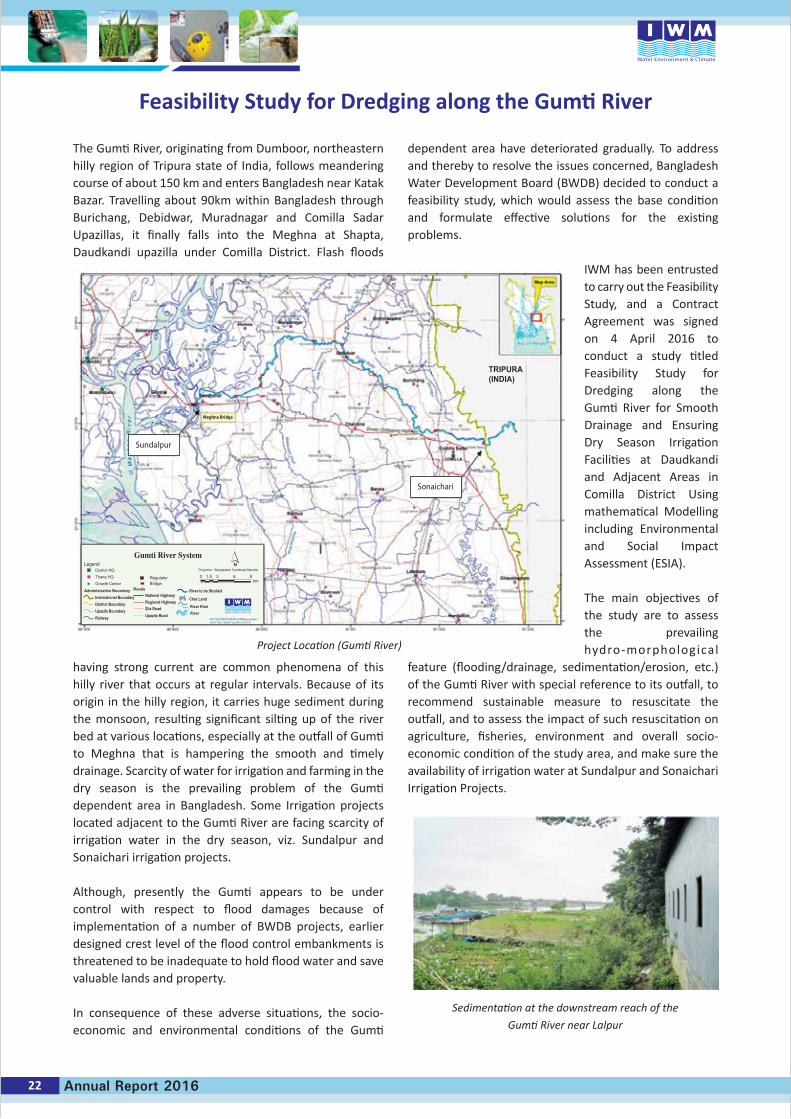
The Gumti River, originating from Dumboor, northeastern hilly region of Tripura state of India, follows meandering course of about 150 km and enters Bangladesh near Katak Bazar. Travelling about 90km within Bangladesh through Burichang, Debidwar, Muradnagar and Comilla Sadar Upazillas, it finally falls into the Meghna at Shapta, Daudkandi upazilla under Comilla District. Flash floods
having strong current are common phenomena of this hilly river that occurs at regular intervals. Because of its origin in the hilly region, it carries huge sediment during the monsoon, resulting significant silting up of the river bed at various locations, especially at the outfall of Gumti to Meghna that is hampering the smooth and timely drainage. Scarcity of water for irrigation and farming in the dry season is the prevailing problem of the Gumti dependent area in Bangladesh. Some Irrigation projects located adjacent to the Gumti River are facing scarcity of irrigation water in the dry season, viz. Sundalpur and Sonaichari irrigation projects.
Although, presently the Gumti appears to be under control with respect to flood damages because of implementation of a number of BWDB projects, earlier designed crest level of the flood control embankments is threatened to be inadequate to hold flood water and save valuable lands and property.
In consequence of these adverse situations, the socio- economic and environmental conditions of the Gumti
dependent area have deteriorated gradually. To address and thereby to resolve the issues concerned, Bangladesh Water Development Board (BWDB) decided to conduct a feasibility study, which would assess the base condition and formulate effective solutions for the existing problems.
IWM has been entrusted to carry out the Feasibility Study, and a Contract Agreement was signed on 4 April 2016 to conduct a study titled Feasibility Study for Dredging along the Gumti River for Smooth Drainage and Ensuring Dry Season Irrigation Facilities at Daudkandi and Adjacent Areas in Comilla District Using mathematical Modelling including Environmental and Social Impact Assessment (ESIA).
The main objectives of the study are to assess the prevailing hydro-morphological
feature (flooding/drainage, sedimentation/erosion, etc.) of the Gumti River with special reference to its outfall, to recommend sustainable measure to resuscitate the outfall, and to assess the impact of such resuscitation on agriculture, fisheries, environment and overall socio- economic condition of the study area, and make sure the availability of irrigation water at Sundalpur and Sonaichari Irrigation Projects.
Sedimentation at the downstream reach of the
Gumti River near Lalpur
Feasibility Study for Dredging along the Gumti River
Project Location (Gumti River)
Gumti River SystemLegend
Administrative BoundaryInternational Boundary National Highway
Roads
District HQThana HQ Regulator
km0 1.5 3 6 9
Projection : Bangladesh Transferee Member
BridgeGrowth Center
District Boundary
River to be Studied
Char Land
River KhalRiverUpazila Boundary
Railway
Regional HighwayZila RoadUpazila Road
N
TRIPURA(INDIA)
Meghna Bridge
Sundalpur
Sonaichari
22 Annual Report 2016
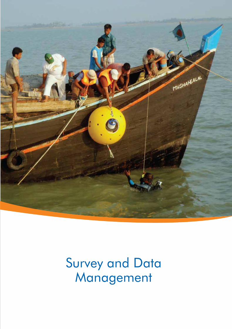
Survey and DataManagement
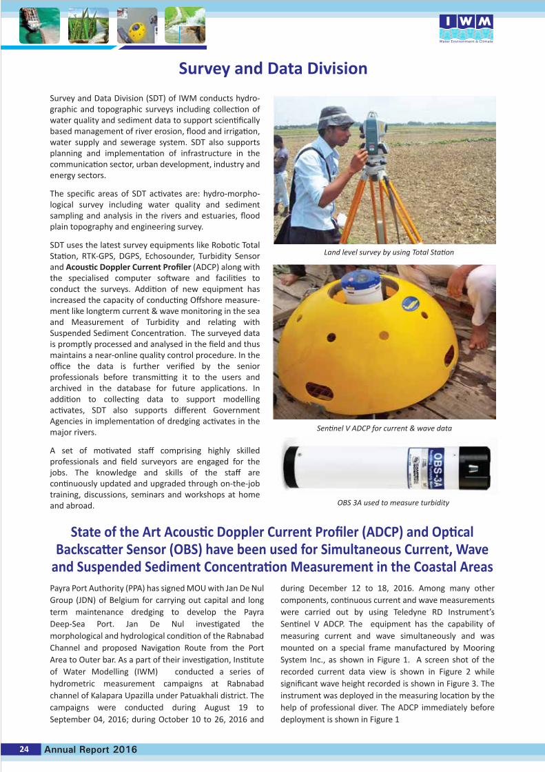
Survey and Data Division (SDT) of IWM conducts hydro-graphic and topographic surveys including collection of water quality and sediment data to support scientifically based management of river erosion, flood and irrigation, water supply and sewerage system. SDT also supports planning and implementation of infrastructure in the communication sector, urban development, industry and energy sectors.
The specific areas of SDT activates are: hydro-morpho-logical survey including water quality and sediment sampling and analysis in the rivers and estuaries, flood plain topography and engineering survey.
SDT uses the latest survey equipments like Robotic Total Station, RTK-GPS, DGPS, Echosounder, Turbidity Sensor and Acoustic Doppler Current Profiler (ADCP) along with the specialised computer software and facilities to conduct the surveys. Addition of new equipment has increased the capacity of conducting Offshore measure-ment like longterm current & wave monitoring in the sea and Measurement of Turbidity and relating with Suspended Sediment Concentration. The surveyed data is promptly processed and analysed in the field and thus maintains a near-online quality control procedure. In the office the data is further verified by the senior professionals before transmitting it to the users and archived in the database for future applications. In addition to collecting data to support modelling activates, SDT also supports different Government Agencies in implementation of dredging activates in the major rivers.
A set of motivated staff comprising highly skilled professionals and field surveyors are engaged for the jobs. The knowledge and skills of the staff are continuously updated and upgraded through on-the-job training, discussions, seminars and workshops at home and abroad.
Payra Port Authority (PPA) has signed MOU with Jan De Nul Group (JDN) of Belgium for carrying out capital and long term maintenance dredging to develop the Payra Deep-Sea Port. Jan De Nul investigated the morphological and hydrological condition of the Rabnabad Channel and proposed Navigation Route from the Port Area to Outer bar. As a part of their investigation, Institute of Water Modelling (IWM) conducted a series of hydrometric measurement campaigns at Rabnabad channel of Kalapara Upazilla under Patuakhali district. The campaigns were conducted during August 19 to September 04, 2016; during October 10 to 26, 2016 and
during December 12 to 18, 2016. Among many other components, continuous current and wave measurements were carried out by using Teledyne RD Instrument’s Sentinel V ADCP. The equipment has the capability of measuring current and wave simultaneously and was mounted on a special frame manufactured by Mooring System Inc., as shown in Figure 1. A screen shot of the recorded current data view is shown in Figure 2 while significant wave height recorded is shown in Figure 3. The instrument was deployed in the measuring location by the help of professional diver. The ADCP immediately before deployment is shown in Figure 1
Survey and Data Division
Land level survey by using Total Station
Sentinel V ADCP for current & wave data
OBS 3A used to measure turbidity
State of the Art Acoustic Doppler Current Profiler (ADCP) and Optical Backscatter Sensor (OBS) have been used for Simultaneous Current, Wave
and Suspended Sediment Concentration Measurement in the Coastal Areas
24 Annual Report 2016
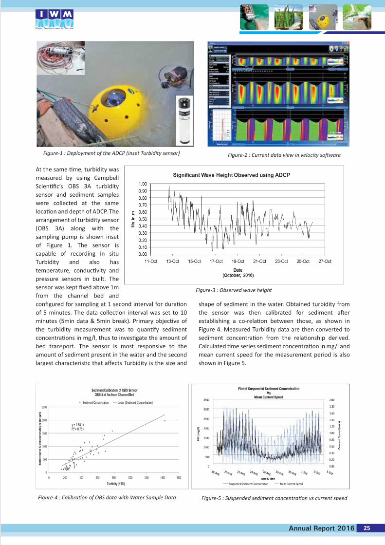
At the same time, turbidity was measured by using Campbell Scientific’s OBS 3A turbidity sensor and sediment samples were collected at the same location and depth of ADCP. The arrangement of turbidity sensor (OBS 3A) along with the sampling pump is shown inset of Figure 1. The sensor is capable of recording in situ Turbidity and also has temperature, conductivity and pressure sensors in built. The sensor was kept fixed above 1m from the channel bed and configured for sampling at 1 second interval for duration of 5 minutes. The data collection interval was set to 10 minutes (5min data & 5min break). Primary objective of the turbidity measurement was to quantify sediment concentrations in mg/l, thus to investigate the amount of bed transport. The sensor is most responsive to the amount of sediment present in the water and the second largest characteristic that affects Turbidity is the size and
shape of sediment in the water. Obtained turbidity from the sensor was then calibrated for sediment after establishing a co-relation between those, as shown in Figure 4. Measured Turbidity data are then converted to sediment concentration from the relationship derived. Calculated time series sediment concentration in mg/l and mean current speed for the measurement period is also shown in Figure 5.
Water speed (m/s)
0.007 0.608 1.209 1.81
Water speed (m/s)
0.007 0.608 1.209 1.81
EastNorthUpError
25Annual Report 2016
Figure-1 : Deployment of the ADCP (inset Turbidity sensor)
Figure-3 : Observed wave height
Figure-4 : Calibration of OBS data with Water Sample Data Figure-5 : Suspended sediment concentration vs current speed
Figure-2 : Current data view in velocity software
Water ResourcesPlanning
Proposed Intakeat Charmura Kandi
Proposed Raw WaterTransmission Main
W
Osman Int. Airport
ProposedImpounding Reservior
Towards Shunamgonj
Towards Airport
Towards Dhaka
Towards Ja�ong
Towards Zakigonj
Proposed WTPat Lakhaura
Proposed Treated WaterTransmission Main
BarshalaMalel Chhara
Tea Estate
LakatureTea Estate
Trimukh Point
Sylhet City Area
DPHE WTPIntake
N1 0.5 0 1 2
km
Proposed Components of Sylhet WTP Project
WRP division has been involved quite extensively in various urban water management and drainage related study projects in Bangladesh. Mentionable are those of Dhaka, Chittagong and Sylhet city development of drainage and sanitation, master plan of Chittagong City. Other project includes feasibility study and detail design of a water treatment plant of 50 million litre per day capacity for Sylhet city. The division was involved in the
supervision of implementation of two large water supply projects for Dhaka city: namely Padma (Jashaldia) water treatment plant and Tetuljhora – Bhakurta Well field construction project. These two plants is expected to supply about 600 million liters per day treated water to Dhaka city. In addition, the division has been involved with rural piped water supply projects in various districts of Bangladesh.
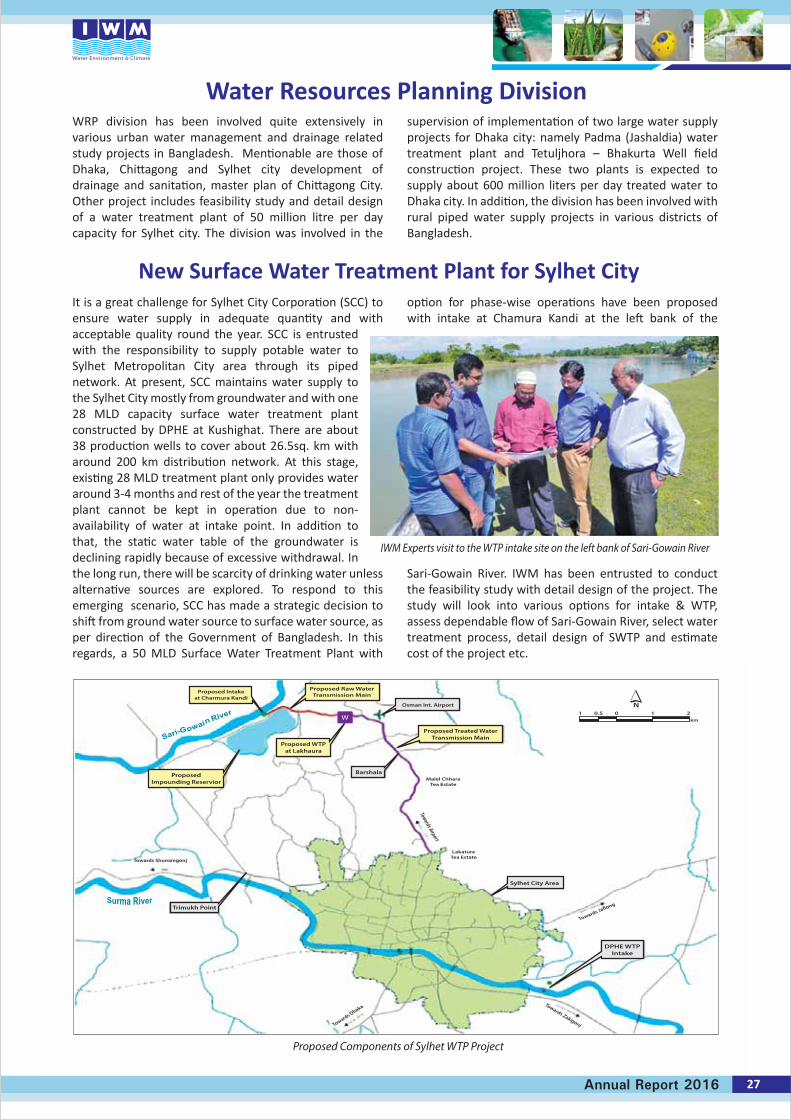
It is a great challenge for Sylhet City Corporation (SCC) to ensure water supply in adequate quantity and with acceptable quality round the year. SCC is entrusted with the responsibility to supply potable water to Sylhet Metropolitan City area through its piped network. At present, SCC maintains water supply to the Sylhet City mostly from groundwater and with one 28 MLD capacity surface water treatment plant constructed by DPHE at Kushighat. There are about 38 production wells to cover about 26.5sq. km with around 200 km distribution network. At this stage, existing 28 MLD treatment plant only provides water around 3-4 months and rest of the year the treatment plant cannot be kept in operation due to non- availability of water at intake point. In addition to that, the static water table of the groundwater is declining rapidly because of excessive withdrawal. In the long run, there will be scarcity of drinking water unless alternative sources are explored. To respond to this emerging scenario, SCC has made a strategic decision to shift from ground water source to surface water source, as per direction of the Government of Bangladesh. In this regards, a 50 MLD Surface Water Treatment Plant with
option for phase-wise operations have been proposed with intake at Chamura Kandi at the left bank of the
Sari-Gowain River. IWM has been entrusted to conduct the feasibility study with detail design of the project. The study will look into various options for intake & WTP, assess dependable flow of Sari-Gowain River, select water treatment process, detail design of SWTP and estimate cost of the project etc.
New Surface Water Treatment Plant for Sylhet City
IWM Experts visit to the WTP intake site on the left bank of Sari-Gowain River
27Annual Report 2016
Water Resources Planning Division
28 Annual Report 2016
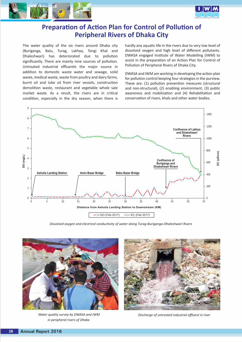
The water quality of the six rivers around Dhaka city (Buriganga, Balu, Turag, Lakhya, Tongi Khal and Dhaleshwari) has deteriorated due to pollution significantly. There are mainly nine sources of pollution. Untreated industrial effluentis the major source in addition to domestic waste water and sewage, solid waste, medical waste, waste from poultry and dairy farms, burnt oil and lube oil from river vessels, construction demolition waste, restaurant and vegetable whole sale market waste. As a result, the rivers are in critical condition, especially in the dry season, when there is
hardly any aquatic life in the rivers due to very low level of dissolved oxygen and high level of different pollutants. DWASA engaged Institute of Water Modelling (IWM) to assist in the preparation of an Action Plan for Control of Pollution of Peripheral Rivers of Dhaka City.
DWASA and IWM are working in developing the action plan for pollution control keeping four strategies in the purview. These are: (1) pollution prevention measures (structural and non-structural), (2) enabling environment, (3) public awareness and mobilization and (4) Rehabilitation and conservation of rivers, khals and other water bodies.
Preparation of Action Plan for Control of Pollution of Peripheral Rivers of Dhaka City
Discharge of untreated industrial effluent in river
Dissolved oxygen and electrical conductivity of water along Turag-Buriganga-Dhaleshwari Rivers
Water quality survey by DWASA and IWM
in peripheral rivers of Dhaka
9
8
7
6
5
4
3
2
1
0 0
200
400
600
800
1000
1200
1400
0 5 10 15 20 25 30 35 40 45 50 55
DO
(mg/
L)
EC (u
S/cm
)
Confluence of Lakhyaand Dhaleshwari
Rivers
Confluence ofBuriganga and
Dhaleshwari Rivers
Babu Bazar BridgeAmin Bazar BridgeAshulia Landing Station
Distance from Ashulia Landing Station to Downstream (KM)
DO (Feb 2017) EC (Feb 2017)
SiMS - Scheme Information Management System of BWDB
UserName
Password
Admin
Log In
Forget Password?
Login as Guest User
Authorized user log in
About SiMS-webSiMS-web (Scheme Information Management System) has been developed for managing and maintaining the BWDB Schemes and projects of Bangladesh Water DevelopmentBoard (BWDB) spread out all over the country. The Sims-Web is able to visualize the Scheme Information, O&M activities, Create Budget, Allocation tables, Work Packages,Procurement Plan and online Monitoring of the works under different Contracts. Furthermore, it has the mdules to evaluate the performance of the schemes consideringAgriculture, Socio-econimic, Water Resources etc. SiMS-Web has facilities to generate reports and store document Information in organised datebase. SiMS-Web is integrated
Web Mobile Application to collect data from fields.
SiMS-Web: Dashboard
SiMS Application
O&M Module Document Archive Metadata Water ManagementOrganization (WMO)
Progress Monitoring BWDB Asset Land Information
IWM has a long history of implementing Information and Communication Technology (ICT) and Geographic Information System (GIS) along with mathematical modelling tools and techniques for providing professional services in the field of Integrated Water Resources Management. The division started its journey as a unit back in 1994, at the beginning of Surface Water Simulation Modelling Project Phase-III. Since then it has been successfully providing its service to the other divisions of IWM as well as to external clients in the field of water sectors. Over the years it has gained experience on providing ICT-GIS solutions to different Public and Private Organizations. As time goes on the demand of this unit had been increasing from both in-house and to the external clients. The unit gained experiences with good reputation in the fields of development of Detail Topographic Maps, Digital Elevation Models, Flood/Inundation Maps, Information Management System and different types of ICT and GIS solutions using the state of the art tools & technologies. It also contributed in the national development projects by developing national databases, Interactive Information Systems, Decision Support System (DSS) for different public organizations.
Currently, there are huge demands of GIS based ICT solutions in national decision making for achieving Governments Vision 2021. Considering the present and future demands and business evolving both at home and
abroad—IWM Management decided to convert the unit as a complete division. Accordingly, the ICT-GIS division headed by a Director has been approved by the Board of Trustees (BOT) in April 2016. Recently, Dr. Mollah Md Awlad Hossain has joined as the Director of this Division. Dr. Hossain has a long experience and reputation in application of ICT and GIS in the fields of Water, Land, Environment and Smart Technologies.
ICT-GIS Division is now comprised of a very strong, experienced and devoted professionals capable of providing solutions in the following area at the level of international standards.• Complete solutions for Geographic Information
Systems and Remote Sensing• Development of GIS Based Interactive
Information System, Decision Support Systems, Management Information Systems
• Detail Topographic Surveys for Irrigation, Drainage, Urban & Regional Water Planning & Management
• Development of GIS based interactive and Smart- Systems
ICT-GIS Division consists of the following field of expertise with highly experienced professionals :• GIS and RS Solutions• Database and Software Development• Computer System Management and Networking
ICT-GIS : The New Division of IWM
29Annual Report 2016
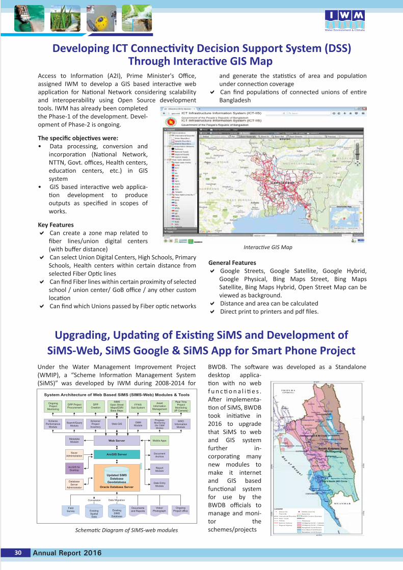
Developing ICT Connectivity Decision Support System (DSS)Through Interactive GIS Map
ICT Infrastructure Information System (ICT-IIS)Government of the People’s Republic of Bangladesh
Under the Water Management Improvement Project (WMIP), a “Scheme Information Management System (SiMS)” was developed by IWM during 2008-2014 for
BWDB. The software was developed as a Standalone desktop applica-tion with no web f u n c ti o n a l i ti e s . After implementa-tion of SiMS, BWDB took initiative in 2016 to upgrade that SiMS to web and GIS system further in-corporating many new modules to make it internet and GIS based functional system for use by the BWDB officials to manage and moni-tor the schemes/projects
Upgrading, Updating of Existing SiMS and Development ofSiMS-Web, SiMS Google & SiMS App for Smart Phone Project
T R I P U R A( I N D I A )
M Y A N M A R
LEGENDDistrict HQ BWDB’s Zone HQ
RBP
Waterbody
BWDB’s Division Boundary
Study AreaThana HQ
International Boundary
River / Canal
National Highway
Regional Highway
Railway
Chittagong O & M - 1 Division
Chittagong O & M - 2 Division
Rangamati O & M Division
Cox’s Bazar O & M Division
Bandarban O & M Division
B a y o f B e n g a l
30 Annual Report 2016
Access to Information (A2I), Prime Minister's Office, assigned IWM to develop a GIS based interactive web application for National Network considering scalability and interoperability using Open Source development tools. IWM has already been completed the Phase-1 of the development. Devel-opment of Phase-2 is ongoing.
The specific objectives were:• Data processing, conversion and
incorporation (National Network, NTTN, Govt. offices, Health centers, education centers, etc.) in GIS system
• GIS based interactive web applica-tion development to produce outputs as specified in scopes of works.
Key Features Can create a zone map related to
fiber lines/union digital centers (with buffer distance)
Can select Union Digital Centers, High Schools, Primary Schools, Health centers within certain distance from selected Fiber Optic lines
Can find Fiber lines within certain proximity of selected school / union center/ GoB office / any other custom location
Can find which Unions passed by Fiber optic networks
and generate the statistics of area and population under connection coverage
Can find populations of connected unions of entire Bangladesh
General Features Google Streets, Google Satellite, Google Hybrid,
Google Physical, Bing Maps Street, Bing Maps Satellite, Bing Maps Hybrid, Open Street Map can be viewed as background.
Distance and area can be calculated Direct print to printers and pdf files.
Interactive GIS Map
Schematic Diagram of SIMS-web modules
System Architecture of Web Based SIMS (SIMS-Web) Modules & Tools
OngoingProject
Monitoring
DPP ProjectProcurement
DPPCreation
SIMSOpen StreetMaps/ESRIBase Maps
FFWSSub-System
AssetInformation
Management
Real TimeProject
Monitoring(IP Camara)
SchemePerformance
Module
Search/QueryModule
Scheme/Project
InventoryWeb-GIS O&M
Module
WHOInformation
Module
ProgressMonitoring(for O&MWorks)
MetadateModule
SeverAdministration
ArcGIS forDesktop
DatabaseServer
Administrator
Conversion Date Migration
Mobile Apps
DocumentArchive
ReportModule
Date EntryModule
Web Server
ArcGIS Server
Updated SiMSDatebase
GeodatabaseOracle Database Server
ExistingSpatialData
ExistingSIMS
Database
Documentsand Reports
Video/Photograph
OngoingProject office
FieldSurvey
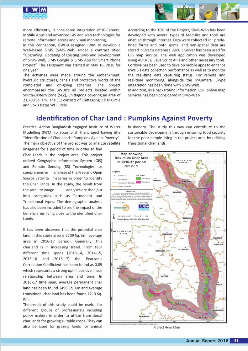
Identification of Char Land : Pumpkins Against Poverty
Map showingMaximum Char Area
in 2016-17 period
Legend
Disclaimer
Prepared For Prepared By
Char TypesDistrict HQ
Permanent
(April, 2017)
Upazila HQ
This map is produced by Institute of Water Modelling (IWM) forPractical Action Bangladesh uner the project named “Indentification ofChar Land; Pumkins Against Poverty”. This map is the sole property of
Practical Action Bangladesh and shall not be reproduced by any agencyor individual without written permission from Practical Action Bangladesh.
International Boundary
District Boundary
Transitional
M E G H A L A Y A( I N D I A )
W E S T B E N G A L( I N D I A )
Practical Action Bangladesh engaged Institute of Water Modelling (IWM) to accomplish the project having title “Identification of Char Lands: Pumpkins Against Poverty”. The main objective of the project was to analyze satellite imageries for a period of time in order to find Char Lands in the project area. This project utilized Geographic Information System (GIS) and Remote Sensing (RS) Technologies for comprehensive analyses of the Free and Open Source Satellite imageries in order to identify the Char Lands. In the study, the result from the satellite image analyses are then put into categories such as Permanent and Transitional types. The demographic analysis has also been included to see the impact of the beneficiaries living close to the identified Char Lands. It has been observed that the potential char land in this study area is 2709 Sq. km (average area in 2016-17 period). Generally, this charland is in increasing trend. From four different time spans (2013-14, 2014-15, 2015-16 and 2016-17) the Pearson’s Correlation Coefficient has been found as 0.89 which represents a strong uphill positive linear relationship between area and time. In 2016-17 time span, average permanent char land has been found 1496 Sq. Km and average transitional char land has been found 1213 Sq. Km.The result of this study could be useful for different groups of professionals including policy makers in order to utilize transitional char lands for growing suitable crops. They can also be used for grazing lands for animal
husbandry. The study this way can contribute to the sustainable development through ensuring food security for the poor people living in the project area by utilizing transitional char lands.
more efficiently. It considered integration of IP-Camera, Mobile Apps and advanced GIS and web technologies for remote information access and visual monitoring.In this connection, BWDB assigned IWM to develop a Web-based SiMS (SiMS-Web) under a contract titled “Upgrading, Updating of Existing SiMS and Development of SiMS-Web, SiMS Google & SiMS App for Smart Phone Project”. The assigment was started in May 16, 2016 for one year.The activities were made around the embankment, hydraulic structures, canals and protective works of the completed and on-going schemes. The project encompasses the BWDB’s all projects located within South-Eastern Zone (SEZ), Chittagong covering an area of 21,700 Sq. Km. The SEZ consists of Chittagong O&M Circle and Cox’s Bazar WD Circle.
According to the TOR of the Project, SiMS-Web has been developed with several types of Modules and tools are enabled through Internet. Data were collected in prede-fined forms and both spatial and non-spatial data are stored in Oracle database. ArcGIS Server has been used for GIS map service. The web application was developed using ASP.NET, Java Script APIs and other necessary tools. Cordova has been used to develop mobile apps to enhance BWDB's data collection performance as well as to monitor the real-time data capturing status. For remote and real-time monitoring, alongside the IP-Camera, Skype integration has been done with SiMS-Web.In addition, as a background information, ESRI online map services has been considered in SiMS-Web
Project Area Map
31Annual Report 2016
32 Annual Report 2016
Human Resource DevelopmentTraining and Technology Transfer Programmes in 2016
Training and Technology Transfer is a regular activity of IWM aims at updating its resources with the new knowledge and technology and to cope with the new challenges in water sector. Following is the brief on the HRD programmes conducted in 2016
Training & National Consultation Workshop on CTCN
Training on Remote Sensing at SPARRSO
Training onStorm Surgeand Drainage Modelling
Training on Ground Water Modelling using MIKE SHE & FEFLOW
Training courseon Oceanography: Principles and ApplicationsTraining on Oceanography and Applications at NOAMI
Junior Engineer Orientation 2016
Training on Building Capacity on Climate ChangeAdaptation
Workshop on IWRM lesson transfer from other countries
National Workshop on Integrated Urban Flood Managementin IWRM
Geospatial Information Technology for DRR: From Preparedness to Emergency Response (Application and Case Studies) 2nd session
Training on STARS Geospatial Tools
Workshop on "Effective Writing and Review of Research Proposal, Research Paper and Thesis"
Training for IWM Staff
Training for Clients
Jan Feb Mar Apr May Jun
Training Workshop on Scaling up of Satellite–assisted Flood Forecasting Systems in South and Southeast Asian Nations
Training on “Videography and Editing”
Changes of VAT Acts, Rules, SRO, Rate of duty in this FY- (16-17)
Training program on Integrated River and Harbor Management
Internship programme for students from WRE, BUET
Training on MIKE 11
Training program on GIS Application and Drainage Modelling Tools under DWASA Project
Training Courses on Bathymetric and Hydrographic Survey
Training on Groundwater Modelling using MIKE SHE software
Training on Basic ARC-GIS
Short courseon Water Quality for Sustainable Development
Training on SBIS Training on Heat Dispersion
Trainingprogram on"River and Delta Morphology: Evolution, Dynamics and Prediction"
Jul Aug Sep Oct Nov Dec
Training at IWM for Staff Development
33Annual Report 2016
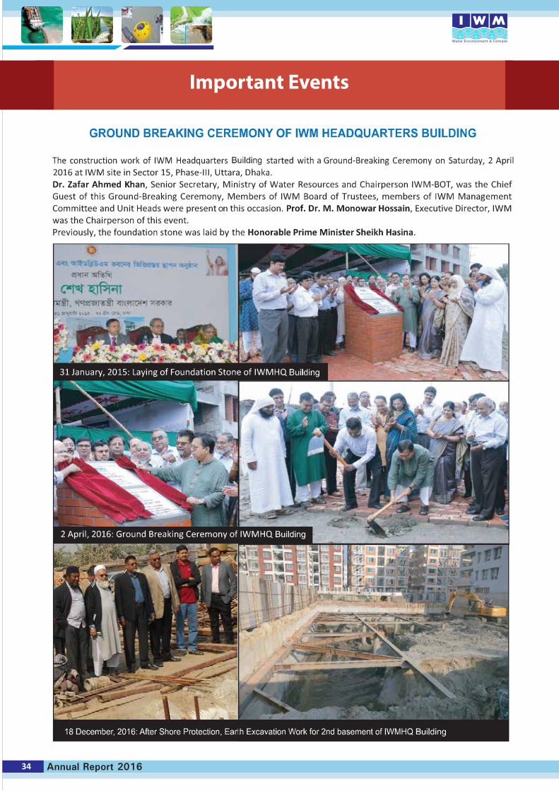
34 Annual Report 2016
Important Events
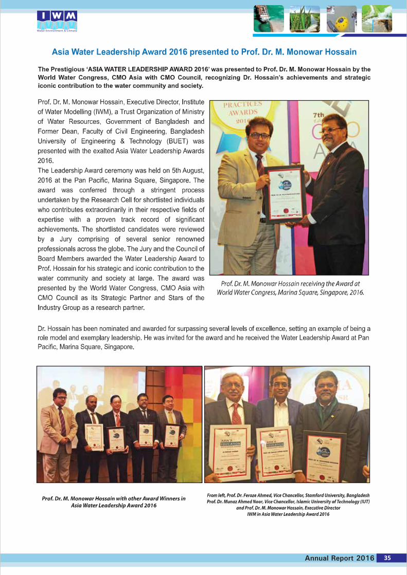
35Annual Report 2016
IWM has a long history of implementing Information and Communication Technology (ICT) and Geographic Information System (GIS) along with mathematical modelling tools and techniques for providing professional services in the field of Integrated Water Resources Management. The division started its journey as a unit back in 1994, at the beginning of Surface Water Simulation Modelling Project Phase-III. Since then it has been successfully providing its service to the other divisions of IWM as well as to external clients in the field of water sectors. Over the years it has gained experience on providing ICT-GIS solutions to different Public and Private Organizations. As time goes on the demand of this unit had been increasing from both in-house and to the external clients. The unit gained experiences with good reputation in the fields of development of Detail Topographic Maps, Digital Elevation Models, Flood/Inundation Maps, Information Management System and different types of ICT and GIS solutions using the state of the art tools & technologies. It also contributed in the national development projects by developing national databases, Interactive Information Systems, Decision Support System (DSS) for different public organizations.
Currently, there are huge demands of GIS based ICT solutions in national decision making for achieving Governments Vision 2021. Considering the present and future demands and business evolving both at home and
abroad—IWM Management decided to convert the unit as a complete division. Accordingly, the ICT-GIS division headed by a Director has been approved by the Board of Trustees (BOT) in April 2016. Recently, Dr. Mollah Md Awlad Hossain has joined as the Director of this Division. Dr. Hossain has a long experience and reputation in application of ICT and GIS in the fields of Water, Land, Environment and Smart Technologies.
ICT-GIS Division is now comprised of a very strong, experienced and devoted professionals capable of providing solutions in the following area at the level of international standards.• Complete solutions for Geographic Information
Systems and Remote Sensing• Development of GIS Based Interactive
Information System, Decision Support Systems, Management Information Systems
• Detail Topographic Surveys for Irrigation, Drainage, Urban & Regional Water Planning & Management
• Development of GIS based interactive and Smart- Systems
ICT-GIS Division consists of the following field of expertise with highly experienced professionals :• GIS and RS Solutions• Database and Software Development• Computer System Management and Networking
36 Annual Report 2016
Seminar on ‘Flood and River Erosion 2016’ held at Dhaka
Executive Director attends Climate Conference in the Netherlands
A Seminar on Flood and River Erosion of Bangladesh-2016 was organized by IWM at the Conference Hall of WARPO, 72 Green Road, Dhaka 1215 on 24th September 2016. Hon’ble Minister Barrister Anisul Islam Mahmud, MP, Ministry of Water Resources graced the seminar as Chief Guest. Dr. Zafar Ahmed Khan, Senior Secretary, Ministry of Water Resources graced the seminar as Special Guest.
Prof. Dr. M. Monowar Hossain, Executive Director, Institute of Water Modelling (IWM) presided over the event. Mr. Md. Sarafat Hossain Khan, Director General, WARPO delivered welcome speech. Mr. Sohel Masud, Director, Flood Management Division, presented technical issues on Flood 2016 followed by a presentation on River Erosion and Its Management by Mr. Mir Mostafa Kamal, PEng, Director, River Engineering Division, IWM. The presentations by IWM professionals emphasized importance on how to use mathematical modelling technique and relevant tools to address resolve and manage flood and river erosion issues. The distinguished designated discussant namely: Commodore Mohammad Mozammel Haque, Chairman, BIWTA, Mr. Md. Mahfuzur Rahman, Additional Director General (Planning), BWDB and Prof. Dr. M Ataur Rahman, Head, DWRE, BUET delivered their valuable speech. Then open discussion was held where participants shared their views and ideas which were of immense value to management of two crucial issues of Bangladesh: Flood & Erosion.
The Chief Guest in his speech highlighted IWM’s longtime involvement and effort in resolving national disasters like flood and river erosion by using Mathematical modelling technique. He stressed continuation of such services of IWM for national interest.
The Special Guest in his address emphasized that professionals who are involved with water management in Bangladesh such as Ministry of Water Resources, Ministry of Agriculture, Ministry of Fisheries, Bangladesh Haor and Wetland Development Board, FFWC-BWDB, WARPO, DAE, DMD and other related organization would be benefited in some way or other from the study and research findings of IWM.
The Chairperson of the event in his closing speeches thanked to the Chief guest, Special guest, paper presenters, designated discussant, participants, media personnel for their cooperation and kind presence in the event.
Prof. Dr. M. Monowar Hossain, Executive Director, IWM attended the 4th International Climate Change Adaptation Conference on Adaptation Futures (AF-2016) held at Rotterdam during 10-13 May 2016 at Rotterdam, the Netherlands. The Conference aimed at deliberating on practices and solutions on Climate Change Adaptation and related issues. About 1600 participants from more than 100 countries participated in the Conference. In total there were 160 Sessions, where Plenaries, Technical Sessions and Panels discussions took place on various thematic areas and topics related to Climate Change issues.
The Executive Director participated in the Session organized by Delta Alliance International and presented the case of Delta Alliance Bangladesh Wing (DABW) as its Coordinator on 10 May 2016. He also presented reflections from Delta Alliance Bangladesh Wings in a Special Session on Design and Assessment of Delta Strategies focused on Delta Approaches: Adaptive Delta Management on 12 May 2016.
Hon’ble Minister Barrister Anisul Islam Mahmud, Dr. Zafar Ahmed Khan- Senior Secretary, Prof. Dr. M. Monowar Hossain, Executive Director-IWM, Mr. Md. Sarafat Hossain Khan, Director General, WARPO, Mr. Sohel Masud, Director- FMG, Commodore Mohammad Mozammel Haque, Chairman, BIWTA, Mr. Md.Mahfuzur Rahman, Additional Director General (Planning), BWDB and Prof. Dr. M Ataur Rahman, Head, WRE, BUET. A discussion was going on Flood and River Erosion of Bangladesh-2016 was organized by IWM.
From Left Prof. Dr. Shamsul Alam, Member (GED), Planning Commission, Prof. Dr. Jamilur R Chowdhury, Vice-Chancellor, UAP, Dr. Zafar Ahmed Khan, Senior Secretary, MOWR & Chairperson IWM-BOT and Prof. Dr. M. Monowar Hossain, Executive Director, IWM in front of the WTC, Rotterdam
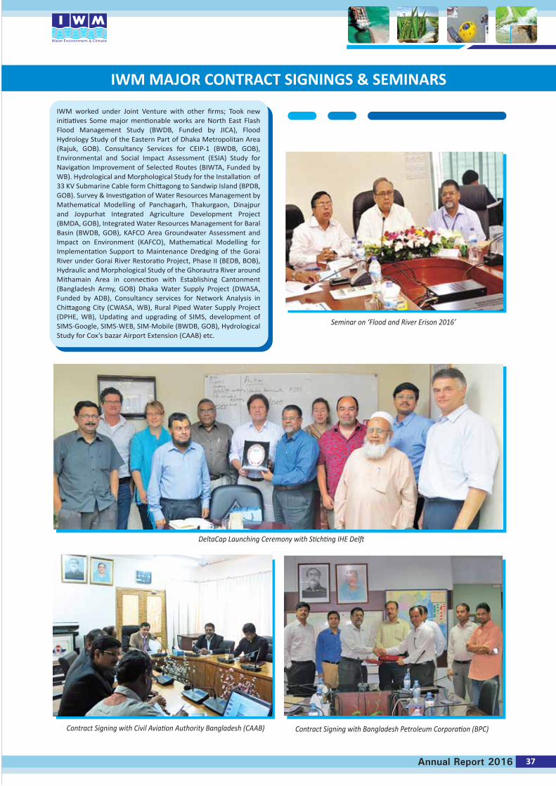
IWM worked under Joint Venture with other firms; Took new initiatives Some major mentionable works are North East Flash Flood Management Study (BWDB, Funded by JICA), Flood Hydrology Study of the Eastern Part of Dhaka Metropolitan Area (Rajuk, GOB). Consultancy Services for CEIP-1 (BWDB, GOB), Environmental and Social Impact Assessment (ESIA) Study for Navigation Improvement of Selected Routes (BIWTA, Funded by WB). Hydrological and Morphological Study for the Installation of 33 KV Submarine Cable form Chittagong to Sandwip Island (BPDB, GOB). Survey & Investigation of Water Resources Management by Mathematical Modelling of Panchagarh, Thakurgaon, Dinajpur and Joypurhat Integrated Agriculture Development Project (BMDA, GOB), Integrated Water Resources Management for Baral Basin (BWDB, GOB), KAFCO Area Groundwater Assessment and Impact on Environment (KAFCO), Mathematical Modelling for Implementation Support to Maintenance Dredging of the Gorai River under Gorai River Restoratio Project, Phase II (BEDB, BOB), Hydraulic and Morphological Study of the Ghorautra River around Mithamain Area in connection with Establishing Cantonment (Bangladesh Army, GOB) Dhaka Water Supply Project (DWASA, Funded by ADB), Consultancy services for Network Analysis in Chittagong City (CWASA, WB), Rural Piped Water Supply Project (DPHE, WB), Updating and upgrading of SIMS, development of SIMS-Google, SIMS-WEB, SIM-Mobile (BWDB, GOB), Hydrological Study for Cox’s bazar Airport Extension (CAAB) etc.
37Annual Report 2016
Contract Signing with Civil Aviation Authority Bangladesh (CAAB)
IWM MAJOR CONTRACT SIGNINGS & SEMINARS
Seminar on ‘Flood and River Erison 2016’
DeltaCap Launching Ceremony with Stichting IHE Delft
Contract Signing with Bangladesh Petroleum Corporation (BPC)
IWM MAJOR CONTRACT SIGNINGS & SEMINARS
Lets Talk Water “Gender Issue on National Water Resources Planning”IWM Presentation to CAAB Chairman and Senior Officials
Contract Signing with Petrobangla
UNESCO-IHE team visit IWM Contract Signing with Sylhet City Corporation (SCC)
Contract Signing with Payra Port Authority
38 Annual Report 2016
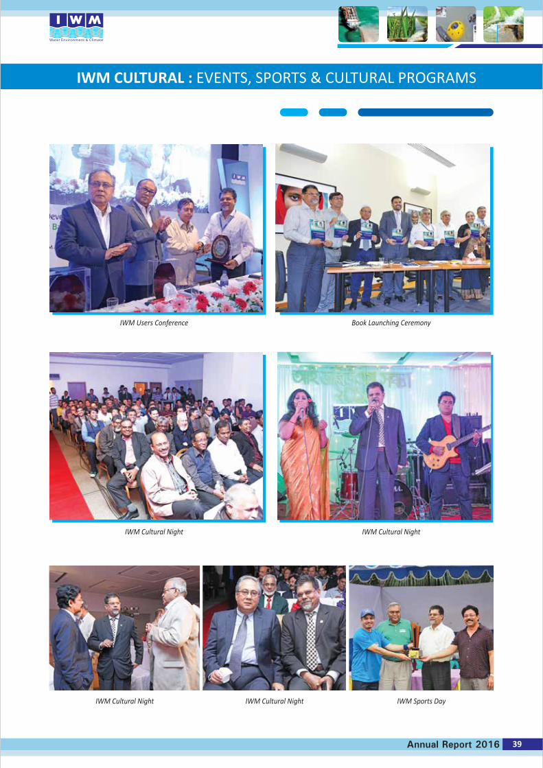
39Annual Report 2016
IWM CULTURAL : EVENTS, SPORTS & CULTURAL PROGRAMS
IWM Users Conference Book Launching Ceremony
IWM Cultural Night
IWM Cultural Night IWM Cultural Night IWM Sports Day
IWM Cultural Night
40 Annual Report 2016
Acronyms
ADCP Acoustic Doppler Current Profiler
BAEC Bangladesh Atomic Energy Commission
BUET Bangladesh University of Engineering and Technology
BIWRA Bangladesh Integrated Water Resources Assessment
BIWTA Bangladesh Inland Water Transport Authority
BMDA Barind Multipurpose Development Authority
BWDB Bangladesh Water Development Board
CEGIS Center for Environmental and Geographic Information Services
CEIP Coastal Embankment Improvement Project
CSIRO Commonwealth Scientific and Industrial Research Organization
CWASA Chittagong Water Supply and Sewerage Authority
DeVcon Dev Consultants Limited
DHI Danish Hydraulic Institute
DWASA Dhaka Water Supply and Sewerage Authority
DPHE Department of Public Health Engineering
FCDI Flood Control, Drainage and Irrigation
FFWC Flood Forecasting and Warning Centre
IWRM Integrated Water Resource Management
JICA Japan International Cooperation Agency
KJDRP Khulna-Jessore Drainage Rehabilitation Project
LGRD Local Government and Rural Development
MIST Military Institute of Science & Technology
NWMP National Water Master Plan
RHD Roads and Highways Department
RWASA Rajshahi Water Supply and Sewerage Authority
SoB Survey of Bangladesh
SIMS Scheme Information and Management System
SCC Sylhet City Corporation
SWTP Surface Water Treatment Plant
WARPO Water Resources Planning Organization
WMO Water Management Organization
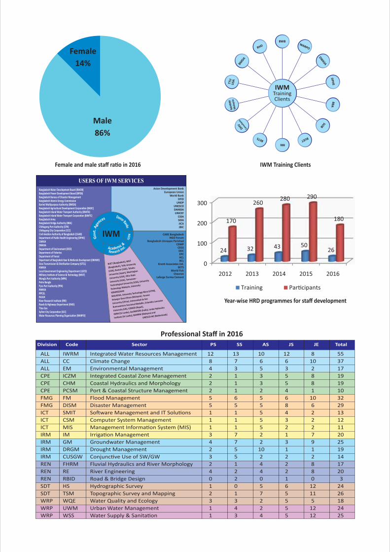
USERS OF IWM SERVICES
IWM
Asian Development BankEuropean Union
World BankDFID
UNDPUNESCODANIDAUNICEF
CIDASIDAJICAJBIC
CARE BangladeshNGO Forum
Bangladesh Unnayan ParishadCDMP
CEGSDDCEPCHCLBCL
Kranti Associates Ltd.BETS
World FishChevron
Lafarge Surma Cement
Bangladesh Water Development Board (BWDB)Bangladesh Power Development Board (BPDB)Bangladesh Bureau of Disaster Management Bangladesh Atomic Energy CommissionBarind Multipurpose Authority (BMDA)Bangladesh Agricultural Development Corporation (BADC)Bangladesh Inland Water Transport Authority (BIWTA)Bangladesh Inland Water Transport Corporation (BIWTC)Bangladesh Army Bangladesh Bridge Authority (BBA)Chittagong Port Authority (CPA)Chittagong City Corporation (CCC)Civil Aviation Authority of Bangladesh (CAAB)Department of Public Health Engineering (DPHE)CWASADWASADepartment of Environment (DEO)Department of Fisheries Department of Forest Department of Bangladesh Haor & Wetlands Development (DBHWD)Gras Transmission & Distribution Company (GTCL)KWASALocal Government Engineering Department (LGED)Military Institute of Science & Technology (MIST)Mongla Port Authority (MPA)Petro Bangla Pyra Port Authority (PPA)RWASARPCGLRAJUKRiver Research Institute (RRI)Roads & Highways Department (RHD)Titas GasSylhet City Corporation (SCC)Water Resources Planning Organisation (WARPO)
BUET (Bangladesh), MIST
(Bangladesh), Tufts University
(USA), Boston (USA), Tohoku
University (Japan), Washington
University (USA), Ohio State
University (USA), Tennessee -
Technological University (USA), University
Technology Malaysia, University
KEBANGSAAN
MALAYSIA, University Technology Mara (UiTM),
Selangor Darul Ehsan (Malaysia), Yunnan
University (China), Universidad de San
Buenaventure Seccional Medellin, Columbia Lancaster
University (UK), ICIMOD (Nepal),
IWMI (Sri Lanka), SaciWATERS (India), Lanka Hydraulics
Institute (Sri Lanka), NAHRIM (Malaysia) and
UNESCO-IHE (Netherlands)
Female14%
Male86%
Female and male staff ratio in 2016
BWB
RHD
BMDA
TTU
USA
NAH
RIM
Mal
aysia
DHV
Cons
ultan
ts
BETS
RRI
BUET
SOB
BBAD
PHE
DWASA
WARPO
IWMTrainingClients
IWM Training Clients
Year-wise HRD programmes for staff development
ALL IWRM Integrated Water Resources Management 12 13 10 12 8 55ALL CC Climate Change 8 7 6 6 10 37ALL EM Environmental Management 4 3 5 3 2 17CPE ICZM Integrated Coastal Zone Management 2 1 3 5 8 19CPE CHM Coastal Hydraulics and Morphology 2 1 3 5 8 19CPE PCSM Port & Coastal Structure Management 2 1 2 4 1 10FMG FM Flood Management 5 6 5 6 10 32FMG DISM Disaster Management 5 5 5 8 6 29ICT SMIT Software Management and IT Solutions 1 1 5 4 2 13ICT CSM Computer System Management 1 1 5 3 2 12ICT MIS Management Information System (MIS) 1 1 5 2 2 11IRM IM Irrigation Management 3 7 2 1 7 20IRM GM Groundwater Management 4 7 2 3 9 25IRM DRGM Drought Management 2 5 10 1 1 19IRM CUSGW Conjunctive Use of SW/GW 3 5 2 2 2 14REN FHRM Fluvial Hydraulics and River Morphology 2 1 4 2 8 17REN RE River Engineering 4 2 4 2 8 20REN RBID Road & Bridge Design 0 2 0 1 0 3SDT HS Hydrographic Survey 1 0 5 6 12 24SDT TSM Topographic Survey and Mapping 2 1 7 5 11 26WRP WQE Water Quality and Ecology 3 3 2 5 5 18WRP UWM Urban Water Management 1 4 2 5 12 24WRP WSS Water Supply & Sanitation 1 3 4 5 12 25
Division Code Sector PS SS AS JS JE Total
Professional Staff in 2016

INSTITUTE OF WATER MODELLINGHouse # 496, Road # 32, Mohakhali DOHS, Dhaka-1206, BangladeshTel : +88 02 9847902, 9842105-6, 9844590-1, Fax : +88-02-9847901e-mail : [email protected], website : www.iwmbd.org
ANNUALREPORT
2016