Embed Size (px)
Citation preview
ANSP Guidelines forImplementing ATS Surveillance Services Using Space-Based ADS-B
civil air navigation services organisation

Acknowledgements
This publication was produced by the Surveillance Task Force of CANSO’s Operations Standing Committee. CANSO would like to thank Monica Alcabin, Boeing; Diego Torres Gallardo, ENAIRE; Eduardo Garcia, CANSO; Benoît Gosset, DGAC/DSNA; Kuo Guohsin, Air Navigation & Weather Services, Civil Aeronautics Administration, Ministry of Transport and Communication; Daniel Hanlon, Raytheon; Richard Heinrich, Rockwell Collins; Robert Nichols, FAA; Sibusis Nkabinde, ATNS; Peter Nørbjerg, NAVIAIR; József Orbán, Hungarocontrol; Sean Patrick, Irish Aviation Authority; Christian Scheiflinger, Austro Control; Vilmos Somosi, HungaroControl; Carole Stewart-Green, NAV CANADA; Rob Thurgur, NAV CANADA; Gunter Tree, Austro Control; Madison Walton, FAA; Werner Wohlfhrter, FREQUENTIS.
© Copyright CANSO 2016
All rights reserved. No part of this publication may be reproduced, or transmitted in any form, without the prior permission of CANSO. This paper is for information purposes only. While every effort has been made to ensure the quality and accuracy of information in this publication, it is made available without any warranty of any kind.
canso.org
3
Foreword
CANSO provides the ANSP Guidelines for Implementing ATS Surveillance Services Using Space-Based ADS-B to support Member ANSPs as they consider whether to incorporate space-based automatic dependent surveillance - broadcast (ADS-B) into their air traffic management (ATM) infrastructure. Space-based ADS-B is expected to become available by 2018.
While acknowledging that ATS surveillance systems have been available for decades, and ANSPs have already considered the potential benefits of incorporating ground-based surveillance systems into their infrastructure, the availability of a global ATS surveillance coverage solution was not a possibility until recently. Space-based reception of ADS-B signals (space-based ADS-B) will use existing technologies (satellites, ADS-B transponders and ADS-B receivers) to leverage current capabilities and knowledge to provide global coverage.
A group of CANSO Member experts was formed to develop this practical guidance for ANSPs on how to re-evaluate their ATM infrastructure planning to account for being able to obtain uninterrupted ATS surveillance coverage for the airspace in which they provide services. This document provides background information on ATS surveillance systems and related services, along with pragmatic implementation considerations. Finally, business case guidelines are provided based on the work being undertaken by ANSPs currently analysing the introduction of space-based ADS-B.
4 ANSP Guidelines for Implementing ATS Surveillance Services Using Space-Based ADS-B
5Contents
Acknowledgements_______________________________________________________________________
Foreword________________________________________________________________________________
Executive Summary______________________________________________________________________
Introduction______________________________________________________________________________
1 ATS Surveillance Systems______________________________________________________________
1.1 Introduction ________________________________________________________________________
1.2 Primary Radar ______________________________________________________________________
1.3 Secondary Radar ____________________________________________________________________
Mode S ____________________________________________________________________________
1.4 Multilateration (MLAT) _______________________________________________________________
1.5 Ground-Based ADS-B _________________________________________________________________
1.6 Space-Based ADS-B __________________________________________________________________
1.7 Summary ___________________________________________________________________________
2 Communication Capability _______________________________________________________________
3 ATM Systems _________________________________________________________________________
4 ATS Surveillance Services_______________________________________________________________
4.1 ATS Surveillance Services ____________________________________________________________
4.2 Space-Based ADS-B Applications _____________________________________________________
5 Linkages to ICAO _____________________________________________________________________
5.1 ASBU Framework ___________________________________________________________________
5.2 Global Flight Tracking _______________________________________________________________
6 Regulatory Aspects ___________________________________________________________________
6.1 Safety Cases ________________________________________________________________________
6.2 ANSP Requirements _________________________________________________________________
6.3 Regulatory Guidance on Aircraft Equipage _____________________________________________
7 Business Case Guidelines ______________________________________________________________
7.1 Introduction ________________________________________________________________________
7.2 Implementation Scenarios ____________________________________________________________
7.3 Benefits and Costs __________________________________________________________________
ANSP Benefits _____________________________________________________________________
Aircraft Operator Benefits ___________________________________________________________
8 Conclusions ___________________________________________________________________________
Acronyms ________________________________________________________________________________
References________________________________________________________________________________
Published April 2016
page 3
page 4
page 6
page 7
page 8
page 8
page 9
page 10
page 10
page 12
page 13
page 14
page 15
page 16
page 17
page 19
page 19
page 19
page 21
page 21
page 24
page 25
page 25
page 25
page 25
page 28
page 28
page 28
page 29
page 29
page 30
page 31
page 32
page 34
Executive Summary
Air traffic continues to grow, challenging the industry to continuously improve safety and efficiency. Aircraft operators expect improved ATM that provides benefits commensurate with aircraft equipage, certification and training investments. Increased efficiency normally equates to reduced fuel burn and lower greenhouse gas (GHG) emissions. As a result, improving efficiency contributes to international commitments to reduce the environmental impact of the aviation industry.
Space-based ADS-B has the potential to revolutionise air traffic services (ATS) surveillance in the aviation industry. It will enable global ATS surveillance, which provides opportunities to improve safety, efficiency and interoperability between air navigation services providers (ANSP) at the State, regional and global level. At the time of publication, space-based ADS-B systems are not yet operational. Such systems are, however, composed of well-understood technologies (satellites and ADS-B) whose performance can be modelled. It is understood, however, that the demonstrated performance of operational space-based ADS-B systems will determine the specific ATS applications they will support, particularly the aircraft to aircraft separation that can be applied.
This document provides ANSPs with an overview of the technical capabilities and requirements associated with providing ATS surveillance services. It also provides guidance for linking space-based ADS-B implementation to enabling or facilitating the implementation of some of the advances detailed in the International Civil Aviation Organization’s (ICAO) Aviation System Block Upgrades (ASBU) framework This document also outlines how space-based ADS-B will support the requirements for ICAO’s performance-based standard on global flight tracking (GFT).
ANSPs are provided with business case development guidance, including lists of potential benefits for both ANSPs and aircraft operators from the implementation of space- based ADS-B. The document concludes with a summary of how global ATS surveillance could potentially benefit aviation.
6 ANSP Guidelines for Implementing ATS Surveillance
Services Using Space-Based ADS-B
7
Introduction
ICAO’s Global Air Traffic Management Operational Concept (Doc 9854) highlights the challenge facing ANSPs and aircraft operators:
Because of the continued growth in civil aviation, in many places, demand often exceeds the available capacity of the air navigation system to accommodate air traffic, resulting in significant negative consequences not only to the aviation industry, but also to general economic health. One of the keys to maintaining the vitality of civil aviation is to ensure that a safe, secure, efficient and environmentally sustainable air navigation system is available at the global, regional and national levels. This requires the implementation of an air traffic management system that allows maximum use to be made of enhanced capabilities provided by technical advances.
ANSPs are therefore expected to develop ATM systems and the air navigation system (ANS) to meet the needs of aircraft operators. Aircraft operators increasingly require more fuel- efficient flight profiles (route, altitude and speed) that will reduce operating costs and show a return on operator investment in aircraft avionics. Where fuel burn is reduced, there are commensurate environmental benefits from reduced aircraft emissions. As highlighted in CANSO’s ATM Environmental Efficiency Goals for 2050, “ATM’s contribution to reducing climate change can best be achieved by increasing fuel efficiency for aircraft using the ATM system”. ANSPs must develop and implement ATM systems with a strong focus on cost efficiency and flight safety. They must also determine how to integrate emerging technologies so as to maximise safety, efficiency and cost effectiveness.
Where ATS surveillance services are not provided, maintaining a safe, orderly and expeditious flow of air traffic requires the use of the largest air traffic control separation standards. To ensure that the required spacing will be maintained between aircraft, flights must often operate at less than
optimum flight levels, at fixed speeds and on fixed routes. The availability of ATS surveillance enables ANSPs to introduce more fuel and cost-efficient profiles than is possible without ATS surveillance, including free route operations and more user preferred routes (UPR).
Until recently, the potential coverage area of ATS surveillance was limited by where it was feasible to install and maintain ground-based infrastructure. Even where ground-based ATS surveillance systems have been installed, line of sight issues and range limitations mean that the effective coverage area for a ground-based ADS-B system is often less than 250 nautical miles (NM). Radar coverage is usually less. Likewise, redundancy using current ATS surveillance systems does not always ensure a complete back-up in case of failure. Space-based ADS-B could support contingency and redundancy capabilities and be entirely separate from ground- based infrastructure.
In the coming years, there will be a significant change, with the availability of systems that will be able to provide ATS surveillance coverage via satellite-reception of ADS-B signals from aircraft. Space-based reception of ADS-B signals will enable global ATS surveillance coverage. The specific operational improvements that can be achieved through the use of expanded ATS surveillance coverage will depend on the user requirements in the airspace concerned, taking account of available communications capabilities. Space-based ADS-B will provide:
— Real-time, global ATS surveillance coverage
— Improved situational awareness for air traffic controllers (ATCO)
— Improved conflict detection — More flexibility for ATCOs to approve
routes, speeds and altitudes — Significant fuel and emissions savings — Global aircraft tracking.
ANSP Guidelines for Implementing ATS Surveillance
Services Using Space-Based ADS-B
1
ATS Surveillance Systems
1.1 IntroductionThe provision of services to aircraft in flight,
particularly air traffic control separation services, is mainly dependent upon the ability of the ANSP to determine the position of the aircraft and communicate with it. Over the majority of the globe, ATCOs rely upon position reports from flights to periodically update their estimate of aircraft locations. The separation services provided on the basis of position reporting from the aircraft are often referred to as “procedural control”. The frequency and reliability of the position updates and the ease and frequency of communications between flights and ATCOs, determine how large the procedural separation standards need to be.
A significant factor in determining the appropriate separation standard is the communications capability in the airspace concerned. The more reliably and quickly an ATCO can contact a flight, the smaller the separation standard can safely be. The largest separation standards apply in oceanic and remote areas where communications, if available at all, are via High Frequency (HF). Often, HF voice communications are provided by third party services, increasing the potential delay for an ATCO to contact a flight. Smaller procedural separation standards have been developed for areas where very high frequency (VHF) direct controller- pilot communication (DCPC) is available.
In the late 1990s, data link communications began to be incorporated into the aviation infrastructure. The new systems allowed for equipped aircraft to communicate with equipped ANSPs using defined message structures to make requests, exchange information and provide clearances and instructions. This system is controller-pilot data link communications (CPDLC). These new data link capabilities also enabled ANSPs to define the frequency and content of automatic position reporting from the aircraft via automatic dependent
surveillance - contract (ADS-C). CPDLC and ADS-C services introduced into oceanic and other remote environments have reduced the reliance on HF voice for routine ATS communications. The ability to tailor the reporting rate and set-up parameters to monitor conformance to clearances using ADS-C resulted in new procedural separation standards being developed by ICAO. These standards are smaller than those that apply in HF voice only environments, but still larger than the standards that can be applied where VHF DCPC is available.
Until 2007, separation applications were either procedural as described above, or based on radar. Radar allows for the real-time determination of aircraft position, negating the requirement to obtain position reports from the aircraft whether by voice or automated means. The availability of VHF DCPC within radar coverage enables the application of the smallest possible separation minima. Radar technologies have continued to be enhanced but coverage continues to be limited by range and line of sight.
In 2007, ICAO formally acknowledged that radar-like systems had been developed and the 15th Edition of the Procedures for Air Navigation Services - Air Traffic Management (PANS- ATM; ICAO Doc 4444) incorporated updated references to “ATS surveillance” rather than “radar”. The PANS-ATM provides the following definition for an ATS surveillance system:
A generic term meaning variously, ADS-B, PSR, SSR or any comparable ground-based system that enables the identification of aircraft. Note.— A comparable ground-based system is one that has been demonstrated, by comparative assessment or other methodology, to have a level of safety and performance equal to or better than monopulse SSR.
8
9
ICAO published Circular 326 - Assessment of ADS-B and Multilateration Surveillance to Support Air Traffic Services and Guidelines for Implementation to provide guidance and examples as to how ADS-B and multilateration (MLAT) systems were determined to meet the definition of “ATS surveillance system”.
The introduction or expansion of ATS surveillance coverage enables safety and efficiency improvements. In the safety realm, ATCOs are provided with increased situational awareness. This allows them to quickly detect aircraft deviations from clearances and unsafe proximity between aircraft and between aircraft and terrain or restricted or danger areas. The better the communication capability, the more quickly and efficiently the ATCO can intervene to correct unsafe situations. The availability of ATS surveillance also allows ATCOs to provide more options and support to aircraft in contingency situations, such as encountering severe weather or experiencing mechanical difficulties.
In the efficiency realm, the application of ATS surveillance separation standards, rather than procedural standards, enables ATCOs to permit aircraft to operate at, or more closely to, their optimum flight profiles. Aircraft operators can plan for this increased flexibility, adding to the potential fuel savings. Less fuel burned equates to lower GHG emissions, a goal of the entire aviation community. Additionally, ATS surveillance provides the necessary information to support better inter-unit and flow management coordination, allowing for fewer or less extensive flight delays; these improvements also support reduced fuel burn and GHG emissions.
1.2 Primary RadarPrimary surveillance radar (PSR) systems
calculate how far away an aircraft is by measuring the delay between when a signal is sent and when its echo returns to the transmitting site. The aircraft position calculation is based on the position of the radar antenna and the return time of the pulse. Primary radar is classified as a ‘non-cooperative’
ATS surveillance system, because no signals from the aircraft are required to provide the aircraft’s position. The primary echo gives no information about the aircraft detected, but PSR systems detect most objects within their range, including terrain and aircraft.
The typical maximum detection range of dedicated terminal PSR systems is 111 kilometres (km) (60 NM); these systems rely on a higher data refresh rate when using higher pulse repetition frequency (PRF) and higher antenna revolutions per minute (rpm). For most en-route PSR systems, the maximum detection range is 185 km (100 NM) to 463 km (250 NM); en-route PSR systems typically have lower PRF and slower rpm. For all PSR systems, the range and detection capability is subject to reflections and obstacles. Typical PSR systems designed for civilian purposes are not capable of providing information concerning the height of a detected aircraft. System enhancements are available, but the low resolution is not acceptable for separation purposes. Therefore, even such enhanced PSR systems are not yet capable of calculating height information that is sufficiently accurate to support air traffic control (ATC) requirements.
Primary surveillance radar systems are the only radar systems that will provide position information on most flying airborne vehicles within range. Smaller objects, such as small remotely piloted aircraft systems (RPAS), or military aircraft equipped with stealth technology will not be reliably detected. The capability to provide a reliable radar cross section satisfies system performance requirements within terminal management areas (TMA); accordingly, it is foreseen that these non-cooperative systems will be maintained as part of the ATS surveillance infrastructure in TMAs for the foreseeable future. Because no data from the aircraft is received by PSR systems, automatic correlation of a PSR echo to a specific flight plan is not possible.
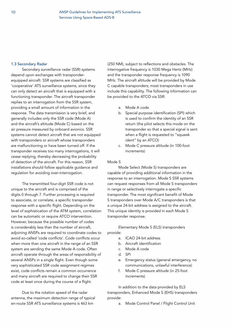
1.3 Secondary RadarSecondary surveillance radar (SSR) systems
depend upon exchanges with transponder- equipped aircraft. SSR systems are classified as ‘cooperative’ ATS surveillance systems, since they can only detect an aircraft that is equipped with a functioning transponder. The aircraft transponder replies to an interrogation from the SSR system, providing a small amount of information in the response. The data transmission is very brief, and generally includes only the SSR code (Mode A) and the aircraft’s altitude (Mode C) based on the air pressure measured by onboard avionics. SSR systems cannot detect aircraft that are not equipped with transponders or aircraft whose transponders are malfunctioning or have been turned off. If the transponder receives too many interrogations, it will cease replying, thereby decreasing the probability of detection of the aircraft. For this reason, SSR installations should follow applicable guidance and regulation for avoiding over-interrogation.
The transmitted four-digit SSR code is not unique to the aircraft and is comprised of the digits 0 through 7. Further processing is required to associate, or correlate, a specific transponder response with a specific flight. Depending on the level of sophistication of the ATM system, correlation can be automatic or require ATCO intervention. However, because the possible number of codes is considerably less than the number of aircraft, adjoining ANSPs are required to coordinate codes to avoid so-called ‘code conflicts’. Code conflicts occur when more than one aircraft in the range of an SSR system are sending the same Mode A code. Often aircraft operate through the areas of responsibility of several ANSPs in a single flight. Even though some very sophisticated SSR code assignment regimes exist, code conflicts remain a common occurrence and many aircraft are required to change their SSR code at least once during the course of a flight.
Due to the rotation speed of the radar antenna, the maximum detection range of typical en-route SSR ATS surveillance systems is 463 km
(250 NM), subject to reflections and obstacles. The interrogative frequency is 1030 Mega Hertz (MHz) and the transponder response frequency is 1090 MHz. The aircraft altitude will be provided by Mode C capable transponders; most transponders in use include this capability. The following information can be provided to the ATCO via SSR:
a. Mode A codeb. Special purpose identification (SPI) which
is used to confirm the identity of an SSR return (the pilot selects this mode on the transponder so that a special signal is sent when a flight is requested to “squawk ident” by an ATCO)
c. Mode C pressure altitude (in 100-foot increments)
Mode SMode Select (Mode S) transponders are
capable of providing additional information in the response to an interrogation. Mode S SSR systems can request responses from all Mode S transponders in range or selectively interrogate a specific transponder. The most significant benefit of Mode S transponders over Mode A/C transponders is that a unique 24-bit address is assigned to the aircraft. This unique identity is provided in each Mode S transponder response.
Elementary Mode S (ELS) transponders provide:
a. ICAO 24-bit addressb. Aircraft identificationc. Mode A coded. SPIe. Emergency status (general emergency, no
communications, unlawful interference)f. Mode C pressure altitude (in 25-foot
increments)
In addition to the data provided by ELS transponders, Enhanced Mode S (EHS) transponders provide:
a. Mode Control Panel / Flight Control Unit
10 ANSP Guidelines for Implementing ATS Surveillance
Services Using Space-Based ADS-B
11
(MCP/FCU) selected altitudeb. Roll anglec. True track angled. Ground speede. Magnetic headingf. Indicated airspeed or Mach numberg. Vertical rate (Barometric or Baro-inertial)h. Barometric pressure setting (minus 800
hectoPascals)i. Track angle rate or true airspeed if track
angle rate is not available
Mode S SSR systems have the same range characteristics as other SSR systems. The additional
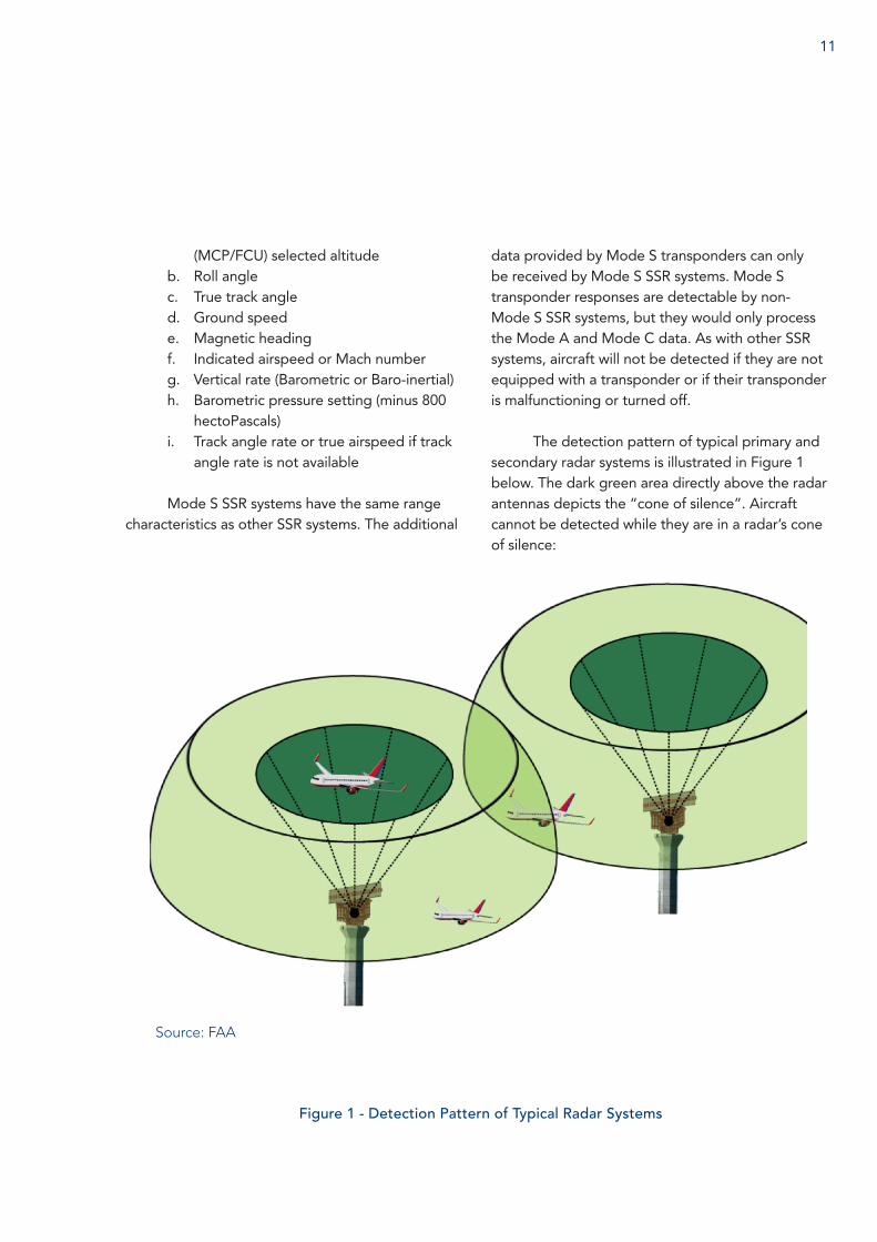
Figure 1 - Detection Pattern of Typical Radar Systems
data provided by Mode S transponders can only be received by Mode S SSR systems. Mode S transponder responses are detectable by non-Mode S SSR systems, but they would only process the Mode A and Mode C data. As with other SSR systems, aircraft will not be detected if they are not equipped with a transponder or if their transponder is malfunctioning or turned off.
The detection pattern of typical primary and secondary radar systems is illustrated in Figure 1 below. The dark green area directly above the radar antennas depicts the “cone of silence”. Aircraft cannot be detected while they are in a radar’s cone of silence:
Source: FAA
1.4 MLATMLAT is a cooperative ATS surveillance
system, which uses Mode S (including ADS-B) and Mode A/C transmissions on 1090 MHz to determine the positions of aircraft (or vehicles). MLAT systems calculate the position by measuring the time difference between when signals are received by a minimum of three stations.
MLAT systems can be purely passive, but are more often a mixture of passive and active systems. Passive MLAT systems will only receive Mode S data, which is transmitted from aircraft (or from vehicles) without an initiating interrogation, but will receive Mode A and C data if a nearby radar system is sending initiating interrogations. Active MLAT systems will include one or more stations capable of sending initiating interrogations.
MLAT systems, employing receivers placed at aerodromes, support ground movement management, with similar small-scale implementations being used to provide ATS surveillance in smaller local areas. The performance of the MLAT system is dependent of the number of stations within the area of interest and the geometry of the position of the stations. Coverage can be
extended beyond the area where the stations are installed but the position accuracy range is more limited than systems that rely on line of sight. An enhanced implementation of MLAT, wide area multilateration (WAM), can cover larger airspaces.
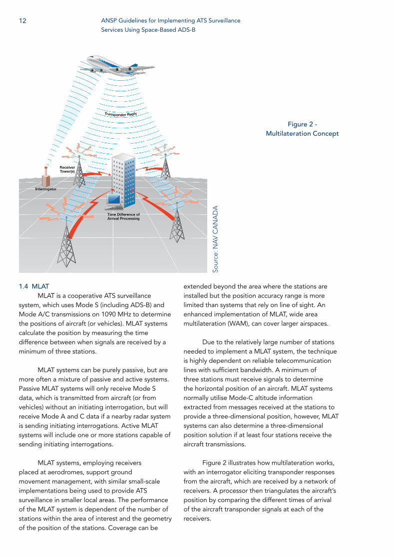
Due to the relatively large number of stations needed to implement a MLAT system, the technique is highly dependent on reliable telecommunication lines with sufficient bandwidth. A minimum of three stations must receive signals to determine the horizontal position of an aircraft. MLAT systems normally utilise Mode-C altitude information extracted from messages received at the stations to provide a three-dimensional position, however, MLAT systems can also determine a three-dimensional position solution if at least four stations receive the aircraft transmissions.
Figure 2 illustrates how multilateration works, with an interrogator eliciting transponder responses from the aircraft, which are received by a network of receivers. A processor then triangulates the aircraft’s position by comparing the different times of arrival of the aircraft transponder signals at each of the receivers.
Figure 2 - Multilateration Concept
12 ANSP Guidelines for Implementing ATS Surveillance
Services Using Space-Based ADS-B
Sour
ce: N
AV
CA
NA
DA
13
1.5 Ground-Based ADS-BADS-B is a cooperative ATS surveillance
system that relies on DO-260 series transponders compliant with RTCA’s Minimum Operational Performance Standards (MOPS) for 1090 MHz Automatic Dependent Surveillance- Broadcast ADS-B (all DO-260 series transponders). It is considered a passive system because ADS-B transponders broadcast signals without an initiating interrogation. Usually, ADS-B receivers are part of an ATM system, but they can also be installed on aircraft or maintained by other stakeholders with a requirement to know aircraft locations.
ADS-B transponder systems are sometimes referred to as “ADS-B OUT”, to differentiate from aircraft systems that receive ADS-B signals from other aircraft, known as “ADS-B IN”. Ground-based ADS-B is the generic term for ATM systems that use ground-based ADS-B receivers to detect ADS-B signals from aircraft.
ADS-B transponders broadcast aircraft parameters, such as identification (24 bit address and flight identification as per the flight plan), position (latitude, longitude and pressure altitude), three-dimensional velocity and position integrity, via a broadcast-mode data link on 1090 MHz. Aircraft identification information is broadcast every five seconds while aircraft position and velocity data is typically broadcast twice per second. Aircraft position is derived from global navigation satellite system (GNSS) data; however, if aircraft are not configured correctly, there can be errors in the position data that is broadcast. Erroneous position data reveals itself in a number of ways, including unexpected “jumps” between position updates and mismatches between the expected and reported positions. It is important, for any ADS-B implementation, to ensure that such anomalies will be detected and addressed appropriately.
Different generations of ADS-B transponders transmit different data. The potential data that can be transmitted include:
a. ICAO 24-bit address b. Aircraft identification c. Mode A coded. SPIe. Emergency status (general emergency, no
communications, unlawful interference)f. ADS-B version numberg. ADS-B emitter categoryh. Geodetic horizontal position (World
Geodetic System revision 1984 (WGS-84) latitude and longitude), both while airborne or on the ground
i. Geodetic horizontal position quality indicators (Navigation Integrity Category (NIC), 95% Navigation Accuracy Category (NAC), Source Integrity Level (SIL) and System Design Assurance level)
j. Pressure altitudek. Geometric altitude in accordance with
WGS-84 (provided in addition and encoded as a difference to pressure altitude)
l. Geometric vertical accuracy (GVA)m. Velocity over ground, both while airborne
(east/west and north/south airborne velocity over ground) or on the ground (surface heading/ground track and movement)
n. Velocity quality indicator (corresponding to NAC for velocity)
o. Coded aircraft length and widthp. Global positioning system (GPS) antenna
offsetq. Vertical rate: barometric vertical rate
when the aircraft is required and capable to transmit this data item via the Mode S protocol, or GNSS vertical rate
r. MCP/FCU selected altitude using the same source as for the same parameter specified in the Mode S EHS aircraft derived data (ADD) elements when the aircraft is required and capable to transmit this data item via the Mode S protocol
s. Barometric pressure setting (minus 800 hectoPascals) using the same source as for the same parameter specified in the Mode S EHS ADDs when the aircraft is required
and capable to transmit this data item via the Mode S protocol
Ground-based ADS-B systems have similar range characteristics to SSR systems. As with other cooperative ATS surveillance systems, aircraft will not be detected if they are not equipped with a transponder or if their transponder is malfunctioning or turned off.
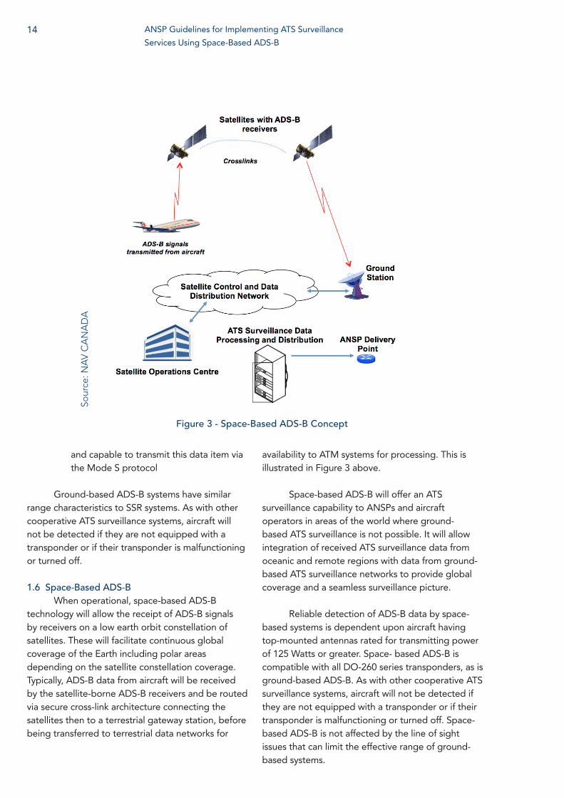
1.6 Space-Based ADS-BWhen operational, space-based ADS-B
technology will allow the receipt of ADS-B signals by receivers on a low earth orbit constellation of satellites. These will facilitate continuous global coverage of the Earth including polar areas depending on the satellite constellation coverage. Typically, ADS-B data from aircraft will be received by the satellite-borne ADS-B receivers and be routed via secure cross-link architecture connecting the satellites then to a terrestrial gateway station, before being transferred to terrestrial data networks for
availability to ATM systems for processing. This is illustrated in Figure 3 above.
Space-based ADS-B will offer an ATS surveillance capability to ANSPs and aircraft operators in areas of the world where ground-based ATS surveillance is not possible. It will allow integration of received ATS surveillance data from oceanic and remote regions with data from ground-based ATS surveillance networks to provide global coverage and a seamless surveillance picture.
Reliable detection of ADS-B data by space-based systems is dependent upon aircraft having top-mounted antennas rated for transmitting power of 125 Watts or greater. Space- based ADS-B is compatible with all DO-260 series transponders, as is ground-based ADS-B. As with other cooperative ATS surveillance systems, aircraft will not be detected if they are not equipped with a transponder or if their transponder is malfunctioning or turned off. Space- based ADS-B is not affected by the line of sight issues that can limit the effective range of ground-based systems.
Figure 3 - Space-Based ADS-B Concept
14 ANSP Guidelines for Implementing ATS Surveillance
Services Using Space-Based ADS-B
Sour
ce: N
AV
CA
NA
DA
15
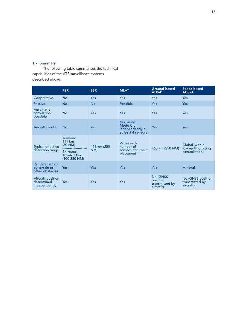
1.7 SummaryThe following table summarises the technical
capabilities of the ATS surveillance systems described above:
PSR SSR MLAT Ground-basedADS-B
Space-basedADS-B
Cooperative No Yes Yes Yes Yes
Passive No No Possible Yes Yes
Automatic correlation possible
No Yes Yes Yes Yes
Aircraft height No YesYes, using Mode C or independently if at least 4 sensors
Yes Yes
Typical effective detection range
Terminal111 km(60 NM)----------------------En-route185-463 km(100-250 NM)
463 km (250 NM)
Varies with number of sensors and their placement
463 km (250 NM)Global (with a low earth orbiting constellation)
Range affected by terrain or other obstacles
Yes Yes Yes Yes Minimal
Aircraft position determined independently
Yes Yes YesNo (GNSS position transmitted by aircraft)
No (GNSS position transmitted by aircraft)
2
Communication Capability
Communication capability is a crucial element, which must be considered when determining the appropriate ATS surveillance service to provide, including separation minima, within a specific airspace or between certain aircraft. Outside VHF DCPC range, ATCOs must revert to procedural methods of separation where the minima to be applied are directly related to the navigational accuracy of the aircraft and the frequency and accuracy of the position updates provided to ATC. Where the aircraft position is determined using ATS surveillance, navigational capability is not required for the separation standard.
The communication capabilities within the current global fleet vary widely, with individual aircraft having one, some or all of the following systems:
— VHF voice — VHF data link — HF voice — HF data link — SATCOM (data link via satellite) — SATVOICE (voice communication via
satellite)
In the late 1990s the Future Air Navigation System (FANS-1/A) capabilities were introduced into fleets operating in oceanic/remote regions. FANS-1/A provided an integrated communications, navigation, and surveillance capability; and was the first operational use of CPDLC and ADS-C to support the application of reduced procedural separations. FANS 1/A applications operate over the Aircraft Communication, Addressing and Reporting System (ACARS) network, providing for integrated operations between ATC, the flight crew and aircraft operations.
ADS-C includes a position reporting capability, where the content and frequency of the position reports is specified by the ATM system and also
event reporting, whereby ADS-C reports are sent if certain specified events occur. ADS-C event reporting is mainly used to support conformance monitoring, because the ATM system can set up a contract specifying that an ADS-C report be sent if the aircraft is operating or goes outside a specified vertical or lateral range or changes its route.
The capability for the ATM system to specify the frequency of ADS-C reports has enabled the development of procedural separation minima that are smaller than those that were previously required in oceanic and remote areas. These minima may be applied between aircraft with specified performance- based navigation (PBN) capabilities and have provided significant benefits where they have been implemented.
FANS 1/A CPDLC supports two main benefits: reducing communication errors and integrating communications functions with the aircraft flight management system (FMS). One specific procedure, which is supported by CPDLC, allows for aircraft operations to optimise the flight profile post-departure. Under this procedure, the dynamic airborne reroute procedure (DARP), the flight crew uses ACARS data link to send updated aircraft parameters to aircraft operations; aircraft operations then determines whether a different route from the flight planned route would be more fuel optimal. If a different route is more optimal, flight operations sends the new route to the flight crew via ACARS data link. The flight crew then uses CPDLC to transmit this new route in a request to ATC. If the requested route can be accommodated, ATC uses CPDLC to approve the requested route, which can then be transferred directly to the aircraft’s FMS. Since data link is used for all parts of the transaction, the possibility of transcription errors or FMS input errors is eliminated.
16 ANSP Guidelines for Implementing ATS Surveillance
Services Using Space-Based ADS-B
17
3
ATM Systems
In general, areas with a greater density of operations require higher levels of performance from the communication, navigation and surveillance (CNS)/ATM systems used to support those services. The highest levels of performance are required to support terminal operations with parallel approaches. Lower levels of performance are appropriate in more remote airspace. Typical en-route operations, where aircraft are spaced further apart than in a terminal environment, can be safely supported using CNS/ATM systems with less stringent levels of performance.
The separation minima applied in different areas take account of aircraft and ATM system performance and capabilities. In the past, performance criteria were not specifically cited for separation minima, although they were implied. For example, current ATS surveillance separation minima can only be applied where DCPC is via VHF. New separation standards now include specified navigation performance, usually expressed as a required navigation performance (RNP) or area navigation (RNAV) requirement for aircraft to qualify for the application. These so-called “PBN separations” are usually subject to regionally imposed communications performance criteria; it is expected that required communication performance (RCP) will soon become globally applicable to PBN separations.
Likewise, a required surveillance performance is implied for the application of certain ATS surveillance separation minima. ICAO documentation specifies accuracy and latency requirements to apply 5 NM or 3 NM ATS surveillance separation minima. In general, however, more detailed surveillance performance requirements are specified at the regional or national level, such as the following documents that detail ATM system and performance requirements for the application of ATS surveillance separation and services:
EUROCONTROL Standard Document for Radar Surveillance in En-Route Airspace and Major Terminal Areas.
— This sets out the prescriptive requirement for ANSPs to maintain duplicate SSR radar coverage in en-route airspace (supporting application of 5 NM separation) and to maintain duplicate SSR coverage and single PSR coverage in major terminal areas (supporting application 3 NM separation).
EUROCONTROL Specification for ATM Surveillance System Performance (ESASSP)
— This document, consisting of two volumes, provides performance requirements for ATM surveillance systems when supporting 3 NM and 5 NM separation applications. It was developed in parallel with the Surveillance Performance and Interoperability Implementing Rule (EU Regulation No 1207/2011 (SPI IR)). Note: EUROCAE is developing further guidance, which is expected to be incorporated into an updated version of ESASSP.
— ESASSP: — can be used by air navigation service
providers to define, the minimum performance to be met by their surveillance system
— defines how the associated conformity assessment must be performed.
— is generic and independent of technology
— is written to be compatible with recently published EUROCAE standards for specific surveillance sensor technologies and applications (ADS-B Radar and non-radar airspace and WAM).
EU Regulation No 1207/2011 Surveillance Performance and Interoperability Implementing (SPI IR)
— This Regulation lays down requirements
on the systems contributing to the provision of surveillance data, their constituents and associated procedures in order to ensure the harmonisation of performance, the interoperability and the efficiency of these systems within the European Air Traffic Management Network and for the purpose of civil- military coordination
— The key objective of EU Regulation No 1207/2011 is to establish performance requirements for surveillance.
When considering the performance of ADS-B systems, positional accuracy depends on the ability of the aircraft avionics to supply high integrity position information to the ADS-B transponder. Different
classes of ADS-B transponder specify how the position information is provided to the transponder. For certain environments where reduced separation is desired, it may be necessary to specify a higher performance on the ADS-B avionics; for example, some jurisdictions require DO-260B series transponders to support terminal operations where a 3 NM separation is applied.
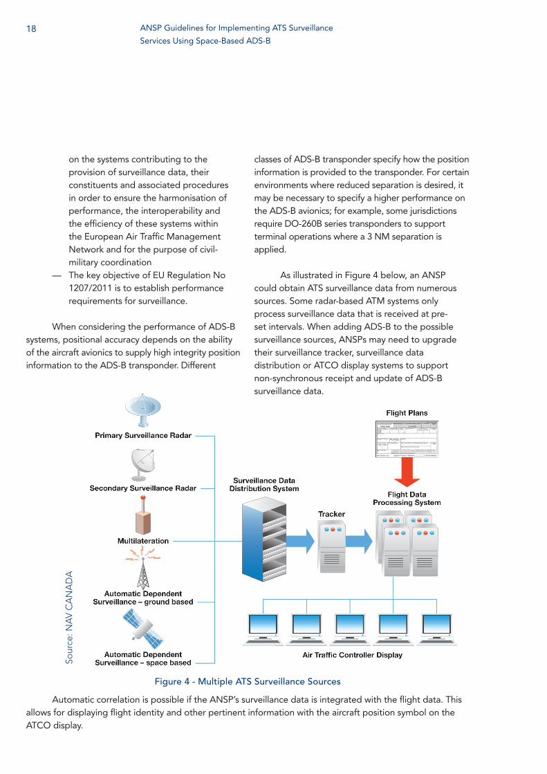
As illustrated in Figure 4 below, an ANSP could obtain ATS surveillance data from numerous sources. Some radar-based ATM systems only process surveillance data that is received at pre-set intervals. When adding ADS-B to the possible surveillance sources, ANSPs may need to upgrade their surveillance tracker, surveillance data distribution or ATCO display systems to support non-synchronous receipt and update of ADS-B surveillance data.
Figure 4 - Multiple ATS Surveillance Sources
Automatic correlation is possible if the ANSP’s surveillance data is integrated with the flight data. This allows for displaying flight identity and other pertinent information with the aircraft position symbol on the ATCO display.
18 ANSP Guidelines for Implementing ATS Surveillance
Services Using Space-Based ADS-B
Sour
ce: N
AV
CA
NA
DA
19
4
ATS Surveillance Services
4.1 ATS Surveillance ServicesAs defined by ICAO, ATS surveillance services
are services provided directly by means of an ATS surveillance system. These services include:
— Flight information service — Alerting service — Air traffic advisory service — ATC services:
— area control service — approach control service — aerodrome control service
The PANS-ATM lists the following ATC services that may be provided using an ATS surveillance system:
— Services as necessary in order to improve airspace utilisation, reduce delays, provide for direct routings and more optimum flight profiles, as well as to enhance safety
— Vectoring to departing aircraft for the purpose of facilitating an expeditious and efficient departure flow and expediting climb to cruising level
— Vectoring to aircraft for the purpose of resolving potential conflicts
— Vectoring to arriving aircraft for the purpose of establishing an expeditious and efficient approach sequence
— Vectoring to assist pilots in their navigation, e.g. to or from a radio navigation aid, away from or around areas of adverse weather
— Applying separation and maintaining normal traffic flow when an aircraft experiences communication failure within the area of coverage
— Flight path monitoring of air traffic — Maintaining a watch on the progress of
air traffic, in order to provide a procedural controller with:
— Improved position information regarding aircraft under control
— Supplementary information regarding other traffic
— Information regarding any significant deviations by aircraft from the terms of their respective air traffic control clearances, including their cleared routes as well as levels, when appropriate
4.2 Space-Based ADS-B ApplicationsIn continental en-route and terminal airspace
where VHF DCPC is available, the expected performance of space-based ADS-B will support the application of 5 NM ATS surveillance separation. Some regulatory regimes permit the application of 5 NM ATS surveillance separation using a single source, but others may require dual source coverage.
In terminal airspace where the application of 3 NM or time-based separation is currently permitted, space-based ADS-B may support the same applications, subject to the same performance-based considerations as for ground-based ATS surveillance systems.
Coincident with the development of a space-based ADS-B service is the development of appropriate global standards to support the provision of ATS surveillance services outside areas of VHF DCPC coverage. The Separation and Airspace Safety Panel (SASP) has been tasked by the ICAO Air Navigation Commission to develop provisions to support the use of space-based ADS-B.
SASP is initially focused on validating whether reduced longitudinal and lateral procedural separation standards of 15 NM or less can be applied using space-based ADS-B with the current communication performance exhibited by CPDLC (with HF as back-up). ICAO plans to publish these provisions in the PANS-ATM in 2018.
In remote/oceanic airspace outside VHF DCPC coverage and where CPDLC is not available, space-based ADS-B can provide complete situational awareness to support the provision of flight information and alerting services.
SASP is developing additional ATS surveillance separation minima for different levels of communication performance. This will allow ANSPs to provide ATS surveillance separation using whatever communications media are available in their airspace. This will also enhance interoperability between continental and remote/oceanic airspaces, allowing transitions to be managed similarly to how they are managed between continental en-route and terminal airspaces. These new separation standards are expected to be available in the PANS-ATM in the 2020-2022 timeframe.
Space-based ADS-B, like any other ATS surveillance system, should be capable of supporting the provision of ATS surveillance services to aircraft operating in the vicinity of an aerodrome. Space-based ADS-B might also be used to support or augment the provision of surface movement guidance and control system (SMGCS) services.
20 ANSP Guidelines for Implementing ATS Surveillance
Services Using Space-Based ADS-B
21
5
Linkages to ICAO
5.1 ASBU FrameworkICAO has provided industry with a capabilities
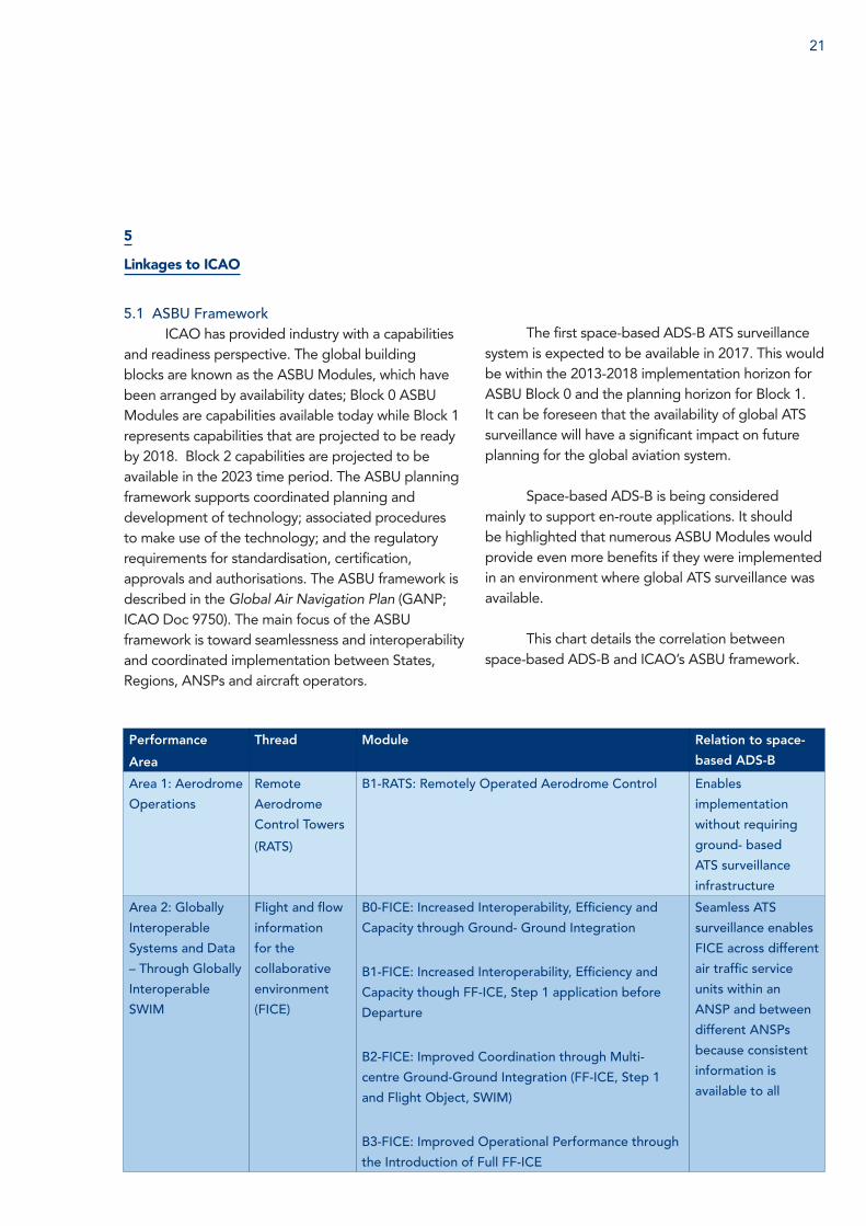
and readiness perspective. The global building blocks are known as the ASBU Modules, which have been arranged by availability dates; Block 0 ASBU Modules are capabilities available today while Block 1 represents capabilities that are projected to be ready by 2018. Block 2 capabilities are projected to be available in the 2023 time period. The ASBU planning framework supports coordinated planning and development of technology; associated procedures to make use of the technology; and the regulatory requirements for standardisation, certification, approvals and authorisations. The ASBU framework is described in the Global Air Navigation Plan (GANP; ICAO Doc 9750). The main focus of the ASBU framework is toward seamlessness and interoperability and coordinated implementation between States, Regions, ANSPs and aircraft operators.
Performance
Area
Thread Module Relation to space-
based ADS-B
Area 1: Aerodrome
Operations
Remote
Aerodrome
Control Towers
(RATS)
B1-RATS: Remotely Operated Aerodrome Control Enables
implementation
without requiring
ground- based
ATS surveillance
infrastructure
Area 2: Globally
Interoperable
Systems and Data
– Through Globally
Interoperable
SWIM
Flight and flow
information
for the
collaborative
environment
(FICE)
B0-FICE: Increased Interoperability, Efficiency and
Capacity through Ground- Ground Integration
B1-FICE: Increased Interoperability, Efficiency and
Capacity though FF-ICE, Step 1 application before
Departure
B2-FICE: Improved Coordination through Multi-
centre Ground-Ground Integration (FF-ICE, Step 1
and Flight Object, SWIM)
B3-FICE: Improved Operational Performance through
the Introduction of Full FF-ICE
Seamless ATS
surveillance enables
FICE across different
air traffic service
units within an
ANSP and between
different ANSPs
because consistent
information is
available to all
The first space-based ADS-B ATS surveillance system is expected to be available in 2017. This would be within the 2013-2018 implementation horizon for ASBU Block 0 and the planning horizon for Block 1. It can be foreseen that the availability of global ATS surveillance will have a significant impact on future planning for the global aviation system.
Space-based ADS-B is being considered mainly to support en-route applications. It should be highlighted that numerous ASBU Modules would provide even more benefits if they were implemented in an environment where global ATS surveillance was available.
This chart details the correlation between space-based ADS-B and ICAO’s ASBU framework.
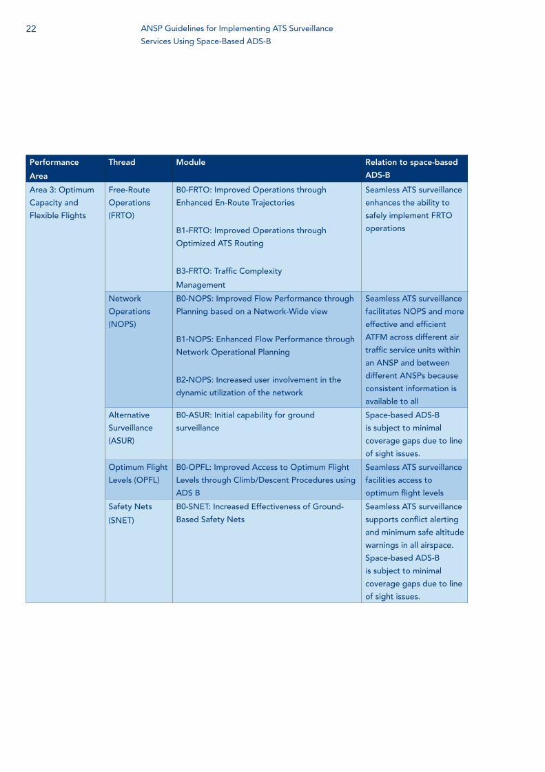
Performance
Area
Thread Module Relation to space-based
ADS-B
Area 3: Optimum
Capacity and
Flexible Flights
Free-Route
Operations
(FRTO)
B0-FRTO: Improved Operations through
Enhanced En-Route Trajectories
B1-FRTO: Improved Operations through
Optimized ATS Routing
B3-FRTO: Traffic Complexity
Management
Seamless ATS surveillance
enhances the ability to
safely implement FRTO
operations
Network
Operations
(NOPS)
B0-NOPS: Improved Flow Performance through
Planning based on a Network-Wide view
B1-NOPS: Enhanced Flow Performance through
Network Operational Planning
B2-NOPS: Increased user involvement in the
dynamic utilization of the network
Seamless ATS surveillance
facilitates NOPS and more
effective and efficient
ATFM across different air
traffic service units within
an ANSP and between
different ANSPs because
consistent information is
available to all
Alternative
Surveillance
(ASUR)
B0-ASUR: Initial capability for ground
surveillance
Space-based ADS-B
is subject to minimal
coverage gaps due to line
of sight issues.
Optimum Flight
Levels (OPFL)
B0-OPFL: Improved Access to Optimum Flight
Levels through Climb/Descent Procedures using
ADS‐B
Seamless ATS surveillance
facilities access to
optimum flight levels
Safety Nets
(SNET)
B0-SNET: Increased Effectiveness of Ground-
Based Safety Nets
Seamless ATS surveillance
supports conflict alerting
and minimum safe altitude
warnings in all airspace.
Space-based ADS-B
is subject to minimal
coverage gaps due to line
of sight issues.
22 ANSP Guidelines for Implementing ATS Surveillance
Services Using Space-Based ADS-B
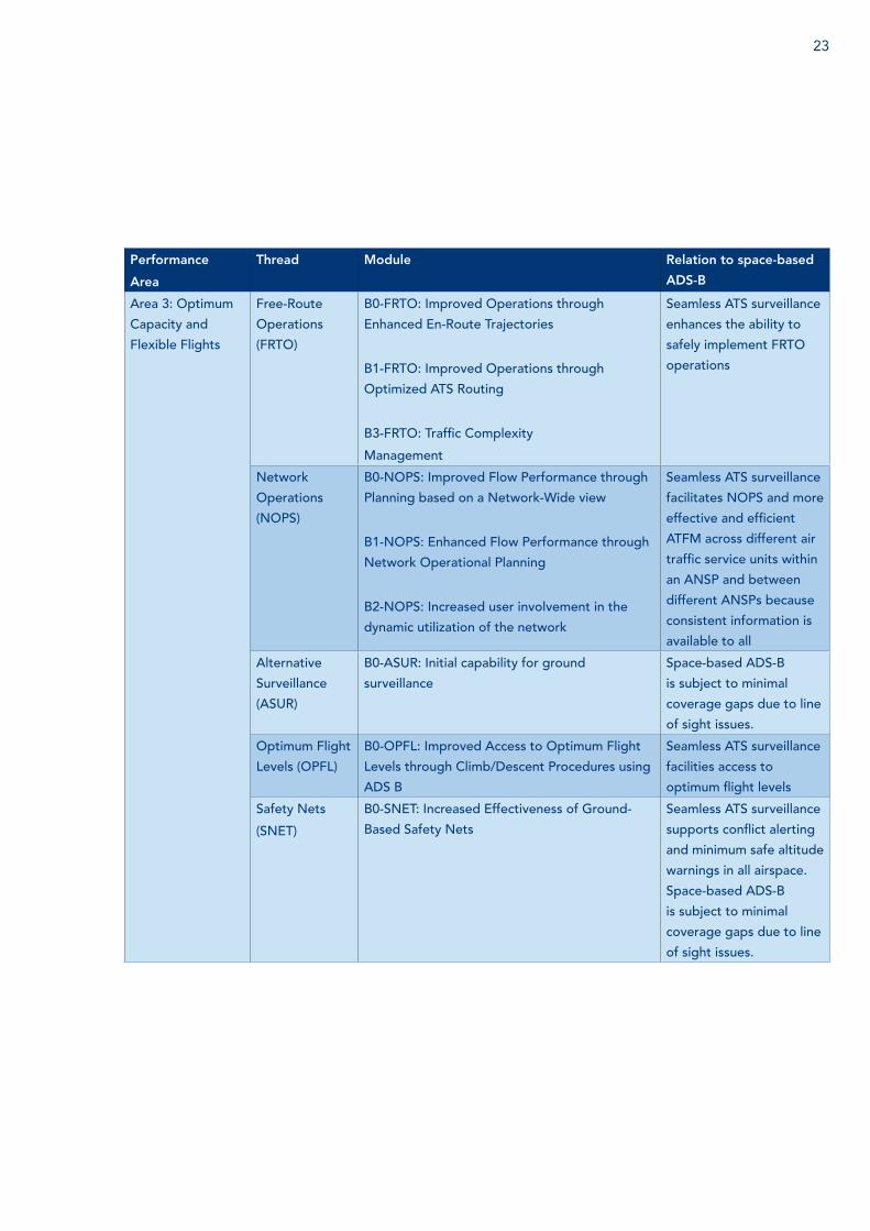
23
Performance
Area
Thread Module Relation to space-based
ADS-B
Area 3: Optimum
Capacity and
Flexible Flights
Free-Route
Operations
(FRTO)
B0-FRTO: Improved Operations through
Enhanced En-Route Trajectories
B1-FRTO: Improved Operations through
Optimized ATS Routing
B3-FRTO: Traffic Complexity
Management
Seamless ATS surveillance
enhances the ability to
safely implement FRTO
operations
Network
Operations
(NOPS)
B0-NOPS: Improved Flow Performance through
Planning based on a Network-Wide view
B1-NOPS: Enhanced Flow Performance through
Network Operational Planning
B2-NOPS: Increased user involvement in the
dynamic utilization of the network
Seamless ATS surveillance
facilitates NOPS and more
effective and efficient
ATFM across different air
traffic service units within
an ANSP and between
different ANSPs because
consistent information is
available to all
Alternative
Surveillance
(ASUR)
B0-ASUR: Initial capability for ground
surveillance
Space-based ADS-B
is subject to minimal
coverage gaps due to line
of sight issues.
Optimum Flight
Levels (OPFL)
B0-OPFL: Improved Access to Optimum Flight
Levels through Climb/Descent Procedures using
ADS‐B
Seamless ATS surveillance
facilities access to
optimum flight levels
Safety Nets
(SNET)
B0-SNET: Increased Effectiveness of Ground-
Based Safety Nets
Seamless ATS surveillance
supports conflict alerting
and minimum safe altitude
warnings in all airspace.
Space-based ADS-B
is subject to minimal
coverage gaps due to line
of sight issues.
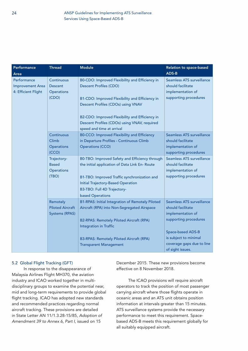
Performance
Area
Thread Module Relation to space-based
ADS-B
Performance
Improvement Area
4: Efficient Flight
Continuous
Descent
Operations
(CDO)
B0-CDO: Improved Flexibility and Efficiency in
Descent Profiles (CDO)
B1-CDO: Improved Flexibility and Efficiency in
Descent Profiles (CDOs) using VNAV
B2-CDO: Improved Flexibility and Efficiency in
Descent Profiles (CDOs) using VNAV, required
speed and time at arrival
Seamless ATS surveillance
should facilitate
implementation of
supporting procedures
Continuous
Climb
Operations
(CCO)
B0-CCO: Improved Flexibility and Efficiency
in Departure Profiles - Continuous Climb
Operations (CCO)
Seamless ATS surveillance
should facilitate
implementation of
supporting procedures
Trajectory-
Based
Operations
(TBO)
B0-TBO: Improved Safety and Efficiency through
the initial application of Data Link En- Route
B1-TBO: Improved Traffic synchronization and
Initial Trajectory-Based Operation
B3-TBO: Full 4D Trajectory-
based Operations
Seamless ATS surveillance
should facilitate
implementation of
supporting procedures
Remotely
Piloted Aircraft
Systems (RPAS)
B1-RPAS: Initial Integration of Remotely Piloted
Aircraft (RPA) into Non-Segregated Airspace
B2-RPAS: Remotely Piloted Aircraft (RPA)
Integration in Traffic
B3-RPAS: Remotely Piloted Aircraft (RPA)
Transparent Management
Seamless ATS surveillance
should facilitate
implementation of
supporting procedures
Space-based ADS-B
is subject to minimal
coverage gaps due to line
of sight issues.
5.2 Global Flight Tracking (GFT)In response to the disappearance of
Malaysia Airlines Flight MH370, the aviation industry and ICAO worked together in multi-disciplinary groups to examine the potential near, mid and long-term requirements to provide global flight tracking. ICAO has adopted new standards and recommended practices regarding normal aircraft tracking. These provisions are detailed in State Letter AN 11/1.3.28-15/85, Adoption of Amendment 39 to Annex 6, Part I, issued on 15
December 2015. These new provisions become effective on 8 November 2018.
The ICAO provisions will require aircraft operators to track the position of most passenger carrying aircraft where those flights operate in oceanic areas and an ATS unit obtains position information at intervals greater than 15 minutes. ATS surveillance systems provide the necessary performance to meet this requirement. Space-based ADS-B meets this requirement globally for all suitably equipped aircraft.
24 ANSP Guidelines for Implementing ATS Surveillance
Services Using Space-Based ADS-B
25
6
Regulatory Aspects
6.1 Safety CasesAnnex 11 to the International Convention
on Civil Aviation - Air Traffic Services specifies that any significant safety-related change to the ATS system, including the implementation of a reduced separation minimum or a new procedure, shall only be effected after a safety assessment has demonstrated that an acceptable level of safety will be met. Under most regulatory regimes, ANSPs will be required to complete appropriate safety assessments before implementing a change as significant as introducing a new ATS surveillance source and associated services into the ANS. Similarly, ANSPs should complete safety assessments prior to expanding current ATS surveillance coverage or replacing one ATS surveillance source with another.
CANSO provides guidance for ANSPs conducting such assessments in the CANSO Standard: Common Safety Methods on Risk Evaluation and Assessment for ANSPs. ICAO also provides guidance relevant to collecting safety data and assessing risk in the Safety Management Manual (SMM) (Doc 9859).
6.2 ANSP RequirementsIn some areas, ADS-B services are
differentiated between those provided where radar coverage exists and those provided where no radar coverage is available. Although the global standards promulgated in ICAO documents make no such distinction, each ANSP will need to account for their regulatory requirements.
6.3 Regulatory Guidance on Aircraft EquipageReliable detection of ADS-B data by
space-based systems depends on aircraft having top-mounted antennas; a top-mounted antenna is one component of an airborne collision
avoidance system (ACAS). Part 1 of Annex 6 to the International Convention on Civil Aviation - Operation of Aircraft specifies the following with respect to international commercial aircraft (similar provisions apply to international general aviation aircraft):
6.18.1 All turbine-engine aeroplanes of a maximum certificated take-off mass in excess of 5 700 kg or authorised to carry more than 19 passengers shall be equipped with an airborne collision avoidance system (ACAS II).
6.18.2 Recommendation. — All aeroplanes should be equipped with an airborne collision avoidance system (ACAS II).
Volume IV of Annex 10 to the International Convention on Civil Aviation - Aeronautical Telecommunications requires aircraft with gross mass in excess of 5700 kg or a maximum cruising true airspeed capability in excess of 463 km/h (250 kt) to operate with antenna diversity (i.e. top and bottom mounted antennas). Annex 10 further specifies that Mode S transponders used in conjunction with ACAS must have antenna diversity.
Although it is expected that the ACAS requirement for top-mounted antennae will make most ACAS-compliant aircraft visible to space-based ADS-B systems, the analysis of operational data will have to validate this assumption.
Testing has shown that space-based ADS-B
receivers will be compatible with all DO-260 series transponders. Some States and Regions have mandated ADS-B equipage on aircraft and/or issued guidance and requirements associated with aircraft ADS-B equipage.
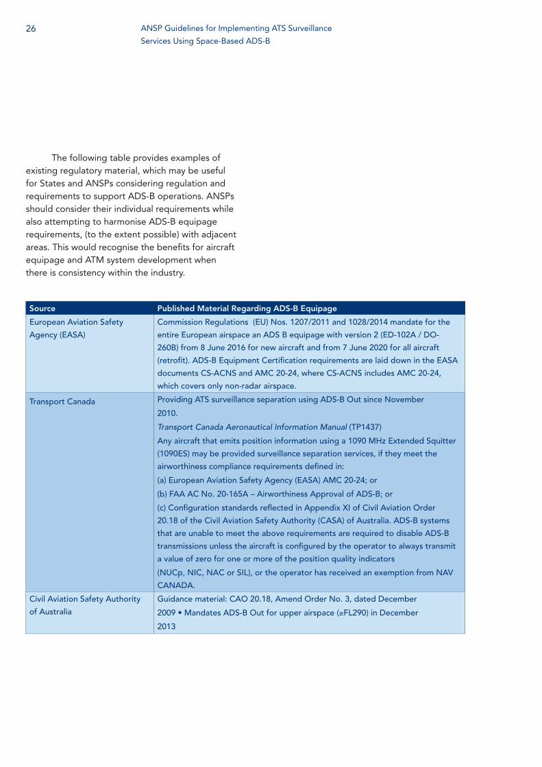
The following table provides examples of existing regulatory material, which may be useful for States and ANSPs considering regulation and requirements to support ADS-B operations. ANSPs should consider their individual requirements while also attempting to harmonise ADS-B equipage requirements, (to the extent possible) with adjacent areas. This would recognise the benefits for aircraft equipage and ATM system development when there is consistency within the industry.
Source Published Material Regarding ADS-B Equipage
European Aviation Safety
Agency (EASA)
Commission Regulations (EU) Nos. 1207/2011 and 1028/2014 mandate for the
entire European airspace an ADS B equipage with version 2 (ED-102A / DO-
260B) from 8 June 2016 for new aircraft and from 7 June 2020 for all aircraft
(retrofit). ADS-B Equipment Certification requirements are laid down in the EASA
documents CS-ACNS and AMC 20-24, where CS-ACNS includes AMC 20-24,
which covers only non-radar airspace.
Transport Canada Providing ATS surveillance separation using ADS-B Out since November
2010.
Transport Canada Aeronautical Information Manual (TP1437)
Any aircraft that emits position information using a 1090 MHz Extended Squitter
(1090ES) may be provided surveillance separation services, if they meet the
airworthiness compliance requirements defined in:
(a) European Aviation Safety Agency (EASA) AMC 20-24; or
(b) FAA AC No. 20-165A – Airworthiness Approval of ADS-B; or
(c) Configuration standards reflected in Appendix XI of Civil Aviation Order
20.18 of the Civil Aviation Safety Authority (CASA) of Australia. ADS-B systems
that are unable to meet the above requirements are required to disable ADS-B
transmissions unless the aircraft is configured by the operator to always transmit
a value of zero for one or more of the position quality indicators
(NUCp, NIC, NAC or SIL), or the operator has received an exemption from NAV
CANADA.
Civil Aviation Safety Authority
of Australia
Guidance material: CAO 20.18, Amend Order No. 3, dated December
2009 • Mandates ADS-B Out for upper airspace (≥FL290) in December
2013
26 ANSP Guidelines for Implementing ATS Surveillance
Services Using Space-Based ADS-B
27
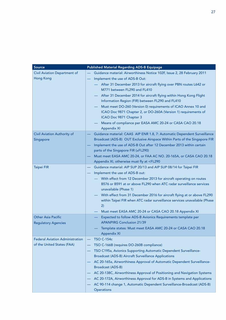
Source Published Material Regarding ADS-B Equipage
Civil Aviation Department of
Hong Kong
— Guidance material: Airworthiness Notice 102F, Issue 2, 28 February 2011
— Implement the use of ADS-B Out:
— After 31 December 2013 for aircraft flying over PBN routes L642 or
M771 between FL290 and FL410
— After 31 December 2014 for aircraft flying within Hong Kong Flight
Information Region (FIR) between FL290 and FL410
— Must meet DO-260 (Version 0) requirements of ICAO Annex 10 and
ICAO Doc 9871 Chapter 2, or DO-260A (Version 1) requirements of
ICAO Doc 9871 Chapter 3
— Means of compliance per EASA AMC 20-24 or CASA CAO 20.18
Appendix XI
Civil Aviation Authority of
Singapore
— Guidance material: CAAS AIP ENR 1.8, 7: Automatic Dependent Surveillance
Broadcast (ADS-B) OUT Exclusive Airspace Within Parts of the Singapore FIR
— Implement the use of ADS-B Out after 12 December 2013 within certain
parts of the Singapore FIR (≥FL290)
— Must meet EASA AMC 20-24, or FAA AC NO. 20-165A, or CASA CAO 20.18
Appendix XI, otherwise must fly at <FL290
Taipei FIR — Guidance material: AIP SUP 20/13 and AIP SUP 08/14 for Taipei FIR
— Implement the use of ADS-B out:
— With effect from 12 December 2013 for aircraft operating on routes
B576 or B591 at or above FL290 when ATC radar surveillance services
unavailable (Phase 1)
— With effect from 31 December 2016 for aircraft flying at or above FL290
within Taipei FIR when ATC radar surveillance services unavailable (Phase
2)
— Must meet EASA AMC 20-24 or CASA CAO 20.18 Appendix XI
Other Asia Pacific
Regulatory Agencies
— Expected to follow ADS-B Avionics Requirements template per
APANPIRG Conclusion 21/39
— Template states: Must meet EASA AMC 20-24 or CASA CAO 20.18
Appendix XI
Federal Aviation Administration
of the United States (FAA)
— TSO C-154c
— TSO C-166B (requires DO-260B compliance)
— TSO C195a, Avionics Supporting Automatic Dependent Surveillance-
Broadcast (ADS-B) Aircraft Surveillance Applications
— AC 20-165a, Airworthiness Approval of Automatic Dependent Surveillance-
Broadcast (ADS-B)
— AC 20-138C, Airworthiness Approval of Positioning and Navigation Systems
— AC 20-172A, Airworthiness Approval for ADS-B in Systems and Applications
— AC 90-114 change 1, Automatic Dependent Surveillance-Broadcast (ADS-B)
Operations
7
Business Case Guidelines
7.1 IntroductionThe ability to support certain ATS
applications is highly dependent upon aircraft capabilities. ANSPs should plan their investments in improved ATM systems and procedures based on their knowledge of what capabilities exist or are planned in the fleets operating in their areas of responsibility. In general, shorter term ATM improvements should be based upon current fleet capabilities and efforts should be made to coordinate with aircraft operators to determine their medium and longer term fleet plans so as to match the ATM improvements to aircraft capabilities.
The transition to equipage-based operations involves matching the level of service to the cost of equipage and services. When the services to be provided are based on aircraft equipage, ANSPs must consider the ability to support so called ‘mixed mode’ operations, where aircraft of differing capabilities operate in the same airspace. ATCO decision support tools are required to ensure that the appropriate separation minima are being applied between each aircraft pair. These tools may be as simple as indications on a flight progress strip or aircraft target or as complex as automated conflict prediction with resolution options. Mixed mode operations introduce, by their very nature, more complexity into the ATM environment. ANSPs should consider the potential costs of supporting a mixed mode environment when planning service improvements based on increased aircraft capabilities. ANSPs should coordinate with aircraft operators and regulators to develop options for avoiding mixed mode operations where the safety, efficiency and implementation costs could significantly impact the ability to deliver benefits from the new or improved services.
7.2 Implementation ScenariosThe potential business case depends on the
implementation scenario for introducing space-based ADS-B into the ATM infrastructure.
As sole ATS surveillance sourceIn areas where there is currently no ATS
surveillance coverage, introducing space-based ADS-B could enable significant safety, operational and infrastructure efficiency gains. This scenario would be relevant for ANSPs without any ATS surveillance coverage, or with limited coverage, that wish to reduce separation standards, increase route flexibility or move to tactical air traffic control. This scenario would also pertain to ANSPs that wished to limit or avoid major infrastructure investment to implement seamless ATS surveillance coverage.
To fill gaps in existing ATS surveillance coverage or augment ATS surveillance signals
In areas where ATS surveillance already exists, the introduction of space-based ADS-B could provide value by removing coverage gaps. The ANSPs under this scenario would be those without 100 percent ATS surveillance coverage and those which are planning to replace ground- based ATS surveillance infrastructure.
As additional ATS surveillance sourceSpace-based ADS-B service will be
provided to ANSPs over a separate network than communications or other surveillance data. Some regulators require ANSPs to apply larger separation minima unless there are multiple ATS surveillance layers.
As contingency ATS surveillance sourceUnder this scenario, ANSPs would determine
the potential benefits from using space- based ADS-B to support area control centre (ACC) backup and/or contingency services.
28 ANSP Guidelines for Implementing ATS Surveillance
Services Using Space-Based ADS-B
29
Space-based ADS-B could be available as a back-up in case of the failure of the primary ATS surveillance system. Equally, space-based ADS-B could be used in lieu of ATS surveillance data from a neighboring ANSP to provide contingency services or be used by a neighbouring ANSP to provide contingency services or for cross-centre utilisation within one ANSP with multiple ACCs.
7.3 Benefits and CostsEach ANSP’s situation will be unique when
developing their business case; however there are a number of benefits and costs that should be considered for applicability to the analysis, based on whether the ANSP would use space-based ADS-B to implement, or to expand, ATS surveillance coverage.
Implementation Scenario 1: Benefits from implementing ATS surveillance
The application of procedural control techniques usually requires flights to operate at fixed and/or less than optimum speeds, routes and altitudes. Decreased fuel burn and GHG emissions should be calculated based on the increased percentage of flight hours during which flights would operate on fuel optimum flight profiles. The increased likelihood of, and time at, optimum profiles should result in operators carrying less fuel.
If adjacent airspace operates under ATS surveillance, there will be increased interoperability across the airspace boundary. This should result in increased efficiencies in both airspaces, which should be accounted for when calculating fuel burn and GHG reductions.
The availability of ATS surveillance would enhance the support possible for Search and Rescue (SAR) operations.
Reducing or removing transitions between separation standards (i.e. between ATS surveillance and procedural separations) may help to reduce
the number of operational errors associated with such transitions. This may improve the overall safety level from the timely detection of operational errors and the ability for ANSPs to implement ATS surveillance-based safety nets.
Introducing ATS surveillance separation minima could facilitate more timely and efficient service to aircraft experiencing in-flight contingencies or seeking to avoid turbulence or other adverse meteorological conditions.
Implementing ATS surveillance coverage could enable an ANSP to introduce or expand controlled airspace.
The efficiency and effectiveness of air traffic flow management (ATFM) and collaborative decision making (CDM) could be improved through the availability of real-time information. The improvements would be enhanced if multiple stakeholders had access to the same ATS surveillance data, for a shared situational awareness.
Implementation Scenario 2: Benefits from expanding or supplementing existing ATS surveillance
If the implementation involves introducing smaller ATS surveillance separation standards, this may increase in the number of flight hours during which flights will operate on fuel optimum flight profiles. This should also facilitate more efficient service to aircraft experiencing in-flight contingencies or seeking to avoid turbulence or other adverse meteorological conditions.
Eliminating gaps in ATS surveillance coverage will eliminate areas where flights must be transitioned between procedural and ATS surveillance separations. This will reduce operational errors associated with such transitions along with supporting the seamlessness of efficient operations for the flights concerned. Eliminating
such gaps may also increase interoperability between adjacent ANSPs, which often translates into increased flight efficiency and fewer opportunities for operational errors.
Reducing or eliminating a requirement to rely on ground-based ATS surveillance would allow an ANSP to reduce or avoid the costs to replace and maintain the associated infrastructure. There would also be reduced environmental impacts due to the elimination or reduction of emissions to provide power to infrastructure sites and for personnel to travel to and from these sites.
Including space-based ADS-B as an additional ATS surveillance source would increase redundancy, because this service will use a separate transport network. It would also increase the ability for any ANSP to provide contingency services on behalf of another.
The implementation of ATS surveillance services would not be affected by where it is possible or economically feasible to install or maintain ground-based infrastructure.
Benefits For Aircraft OperatorsThe introduction or expansion of ATS
services will increase operational flexibility and predictability for operators. Where operators are confident of being able to operate at or near their optimum flight profiles, it may be possible to reduce the amount of fuel carried, which will also reduce the amount of fuel burned by that flight. Any reduction in fuel burn will result in lower GHG emissions, which may lead to economic as well as environmental benefits for the operator.
Aircraft that will operate within ATS surveillance coverage will not be subject to mandatory tracking by the operator. The global coverage afforded by space-based ADS-B could lead to significant cost avoidance for operators
who would otherwise be required to implement or expand their own flight tracking capability.
Space-based ADS-B reception does not require additional aircraft equipment. The system will be compatible with all DO-260 series transponders and the global ACAS standards require most aircraft to have antenna diversity.
Operators would benefit from any increase in airspace safety levels.
CostsANSPs will have a subscription cost to
receive the space-based ADS-B service and implementation costs to add this service as an ATS surveillance source. For ANSPs without existing ATS surveillance, there will be additional implementations costs to prepare personnel and ATM systems to provide entirely new services. It should also be noted that different ANSPs have different approaches to how they pass on their operating costs to aircraft operators.
Due to the existing global standards for
ACAS equipage (ICAO Annex 6, Volumes I,II and II and ICAO Annex 10, Volume IV),there should be no additional costs for most transport category aircraft to equip for space-based ADS-B provided appropriately equipped aircraft are providing usable ADS-B signals from their top-mounted antennas.
30 ANSP Guidelines for Implementing ATS Surveillance
Services Using Space-Based ADS-B
31
8
Conclusions
Space-based ADS-B will support seamless ATS surveillance, which would enable more seamless and interoperable operations between continental and oceanic regions, increasing safety, efficiency and predictability for aircraft operators and ANSPs.
Space-based ADS-B will support a common view of the ATM system by all stakeholders that would enable more effective collaborative decision-making and more efficient ATFM.
There are environments (oceans, deserts, polar and mountainous areas) where it can be uneconomic or difficult to install and maintain ground-based infrastructure.
Reliance on space-based infrastructure would avoid installation and maintenance costs for ground-based infrastructure, including the environmental costs associated with travelling to and from sites and supplying power to those sites.
ATS surveillance meets GFT requirements; space-based ADS-B can support GFT globally.
Space-based ADS-B would support seamless application of ATS surveillance separation between ACAS-capable aircraft equipped with DO-260 series transponders, independent of aircraft PBN capability.
The potential for improved flight efficiency and safety benefits increases with the expansion of ATS surveillance coverage and improvements to communications capabilities. This includes reducing communication delays for existing technologies and expanding VHF DCPC coverage. These improvements would also enable a more seamless application of separation standards between ANSPs.
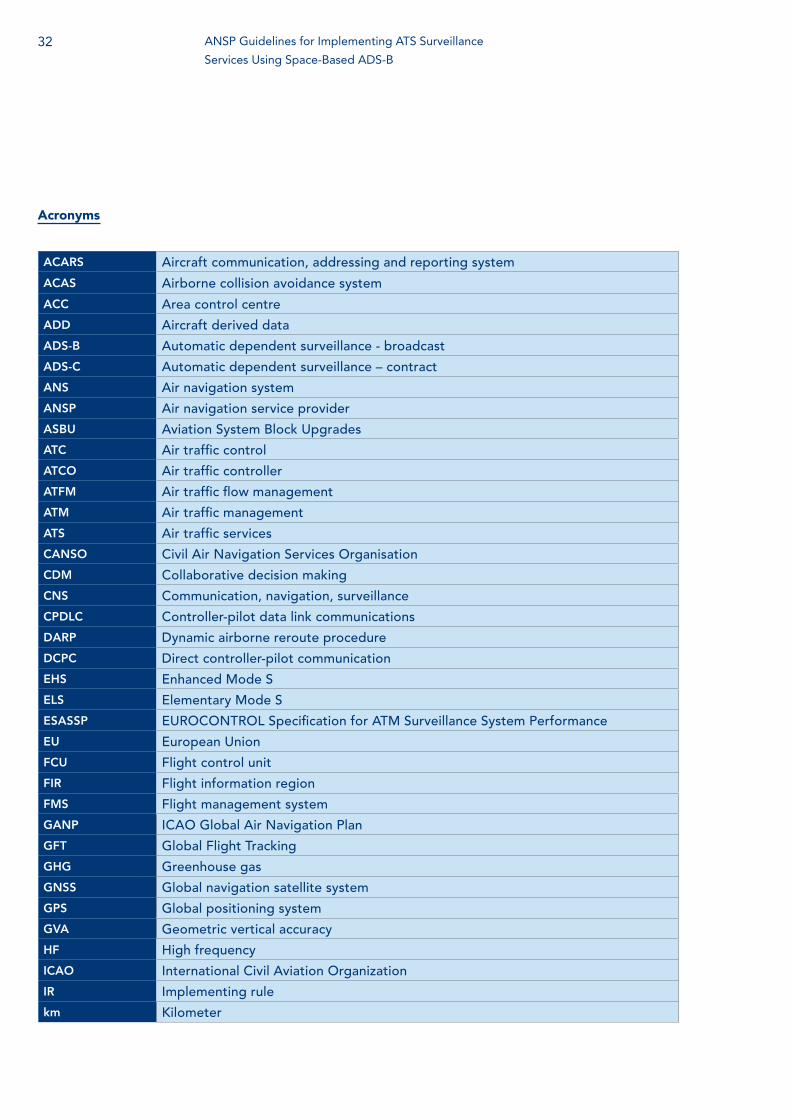
Acronyms
ACARS Aircraft communication, addressing and reporting system
ACAS Airborne collision avoidance system
ACC Area control centre
ADD Aircraft derived data
ADS-B Automatic dependent surveillance - broadcast
ADS-C Automatic dependent surveillance – contract
ANS Air navigation system
ANSP Air navigation service provider
ASBU Aviation System Block Upgrades
ATC Air traffic control
ATCO Air traffic controller
ATFM Air traffic flow management
ATM Air traffic management
ATS Air traffic services
CANSO Civil Air Navigation Services Organisation
CDM Collaborative decision making
CNS Communication, navigation, surveillance
CPDLC Controller-pilot data link communications
DARP Dynamic airborne reroute procedure
DCPC Direct controller-pilot communication
EHS Enhanced Mode S
ELS Elementary Mode S
ESASSP EUROCONTROL Specification for ATM Surveillance System Performance
EU European Union
FCU Flight control unit
FIR Flight information region
FMS Flight management system
GANP ICAO Global Air Navigation Plan
GFT Global Flight Tracking
GHG Greenhouse gas
GNSS Global navigation satellite system
GPS Global positioning system
GVA Geometric vertical accuracy
HF High frequency
ICAO International Civil Aviation Organization
IR Implementing rule
km Kilometer
32 ANSP Guidelines for Implementing ATS Surveillance
Services Using Space-Based ADS-B
33
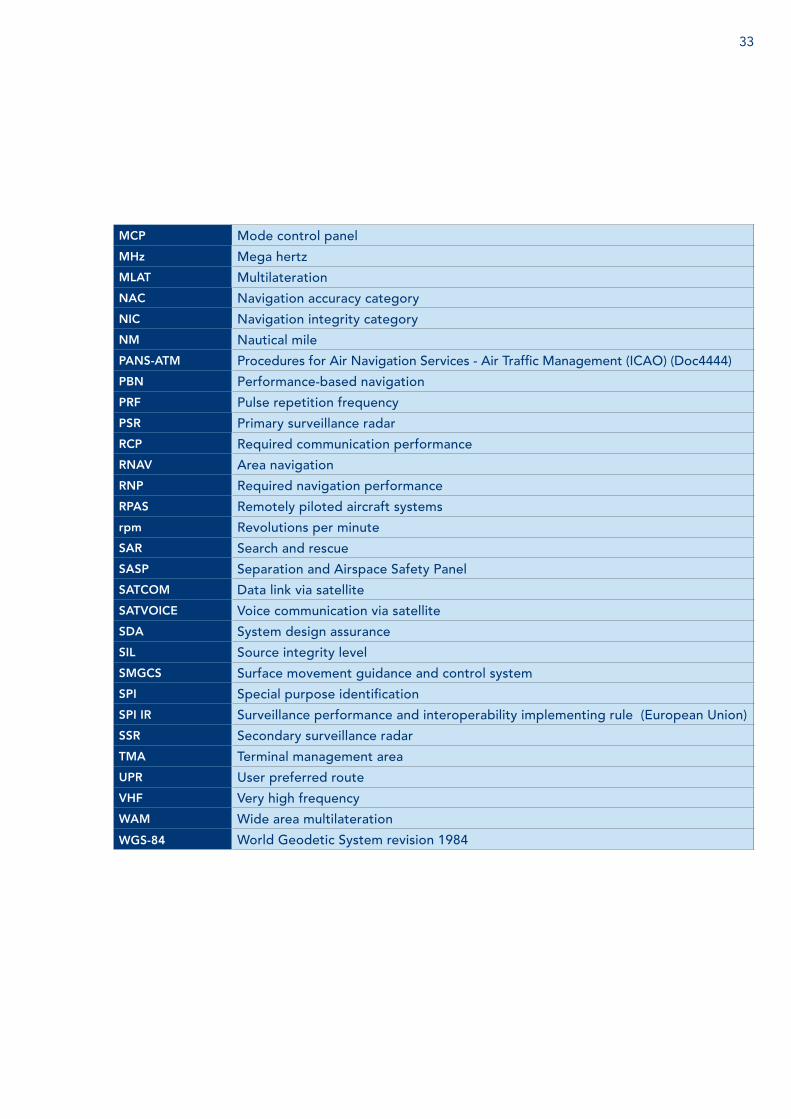
MCP Mode control panel
MHz Mega hertz
MLAT Multilateration
NAC Navigation accuracy category
NIC Navigation integrity category
NM Nautical mile
PANS-ATM Procedures for Air Navigation Services - Air Traffic Management (ICAO) (Doc4444)
PBN Performance-based navigation
PRF Pulse repetition frequency
PSR Primary surveillance radar
RCP Required communication performance
RNAV Area navigation
RNP Required navigation performance
RPAS Remotely piloted aircraft systems
rpm Revolutions per minute
SAR Search and rescue
SASP Separation and Airspace Safety Panel
SATCOM Data link via satellite
SATVOICE Voice communication via satellite
SDA System design assurance
SIL Source integrity level
SMGCS Surface movement guidance and control system
SPI Special purpose identification
SPI IR Surveillance performance and interoperability implementing rule (European Union)
SSR Secondary surveillance radar
TMA Terminal management area
UPR User preferred route
VHF Very high frequency
WAM Wide area multilateration
WGS-84 World Geodetic System revision 1984

References
CANSO; Standard: Common Safety Methods on Risk Evaluation and Assessment for ANSPs
International Civil Aviation Organization (ICAO); Annex 6 to the International Convention onCivil Aviation - Operation of Aircraft
ICAO; Annex 10 to the Convention on International Civil Aviation - Aeronautical Telecommunications, Volume IV - Surveillance and Collision Avoidance Systems
ICAO; Annex 11 to the Convention on International Civil Aviation - Air Traffic Services
ICAO; Procedures for Air Navigation Services - Air Traffic Management (PANS-ATM, Doc 4444), Fifteenth Edition - 2007
ICAO; Global Air Traffic Management Operational Concept (Doc 9854)
ICAO; Global Air Navigation Plan (GANP, Doc 9750)
ICAO; Safety Management Manual (SMM) (Doc 9859)
ICAO; Assessment of ADS-B and Multilateration Surveillance to Support Air Traffic Services andGuidelines for Implementation (Circular 326)
ICAO; Aeronautical Surveillance Manual; (Doc 9924)
ICAO; Asia and Pacific Regional Office; Guidance Material on Comparison of SurveillanceTechnologies (GMST) Edition 1.0 - September 2007Available at:http://www.icao.int/NACC/Documents/Meetings/2014/ADSBIMP/ADSBIMPP12.pdf
EUROCAE/RTCA; ED-102 / DO-260, Minimum Operational Performance Standards for 1090 MHz Automatic Dependent Surveillance – Broadcast (ADS-B) and Change 1
EUROCAE/RTCA; ED-102A / DO-260B with Corrigendum 1, Minimum Operational Performance Standards for 1090 MHz Extended Squitter Automatic Dependent Surveillance – Broadcast (ADS-B) and Traffic Information Services – Broadcast (TIS-B)
EUROCAE/RTCA; ED-126 / DO-303, Safety, Performance and Interoperability Requirements Document for the ADS- B Non-Radar-Airspace (NRA) Application
34 ANSP Guidelines for Implementing ATS Surveillance
Services Using Space-Based ADS-B
Full Members - 87 — Aeronautical Radio of Thailand (AEROTHAI) — Aeroportos de Moçambique — Air Navigation and Weather Services,
CAA (ANWS) — Air Navigation Services of the Czech Republic
(ANS Czech Republic) — AirNav Indonesia — Air Traffic & Navigation Services (ATNS) — Airports and Aviation Services Limited (AASL) — Airports Authority of India (AAI) — Airports Fiji Limited — Airservices Australia — Airways New Zealand — Albcontrol — Austro Control — Avinor AS — AZANS Azerbaijan — Belgocontrol — Bulgarian Air Traffic Services Authority
(BULATSA) — CAA Uganda — Cambodia Air Traffic Services Co., Ltd. (CATS) — Civil Aviation Authority of Bangladesh (CAAB) — Civil Aviation Authority of Botswana — Civil Aviation Authority of Mongolia — Civil Aviation Authority of Nepal (CAAN) — Civil Aviation Authority of Singapore (CAAS) — Civil Aviation Authority of the Philippines — Civil Aviation Regulatory Commission (CARC) — COCESNA — Croatia Control Ltd — DCA Myanmar — Department of Airspace Control (DECEA) — Department of Civil Aviation, Republic of Cyprus — DFS Deutsche Flugsicherung GmbH (DFS) — Dirección General de Control de Tránsito Aéreo
(DGCTA) — DSNA France — Dubai Air Navigation Services (DANS) — Dutch Caribbean Air Navigation Service Provider
(DC-ANSP) — ENAV S.p.A: Società Nazionale per l’Assistenza
al Volo — ENAIRE — Estonian Air Navigation Services (EANS) — Federal Aviation Administration (FAA) — Finavia Corporation — General Authority of Civil Aviation (GACA) — Ghana Civil Aviation Authority (GCAA) — HungaroControl Pte. Ltd. Co. — Instituto Dominicano de Aviacion Civil (IDAC) — Israel Airports Authority (IAA) — Irish Aviation Authority (IAA) — ISAVIA Ltd — Japan Air Navigation Service (JANS) — Kazaeronavigatsia — Kenya Civil Aviation Authority (KCAA) — Latvijas Gaisa Satiksme (LGS)
CANSO Members
Membership list correct as of 14 April 2016. For the most up-to-date list and organisation profiles go to canso.org/canso-members
— Letové prevádzkové Služby Slovenskej Republiky, Štátny Podnik
— Luchtverkeersleiding Nederland (LVNL) — Luxembourg ANA — Maldives Airports Company Limited (MACL) — Malta Air Traffic Services (MATS) — National Airports Corporation Ltd. — National Air Navigation Services Company
(NANSC) — NATS UK — NAV CANADA — NAV Portugal — Naviair — Nigerian Airspace Management Agency (NAMA) — Office National de LÁviation Civile (OFNAC) — Office National Des Aéroports (ONDA) — ORO NAVIGACIJA, Lithuania — PIA “Adem Jashari” - Air Control J.S.C. — PNG Air Services Limited (PNGASL) — Polish Air Navigation Services Agency (PANSA) — Public Authority for Civil Aviation - Oman (PACA) — ROMATSA — Sakaeronavigatsia Ltd — SENEAM — Serbia and Montenegro Air Traffic Services
Agency (SMATSA) — Serco — skyguide — Slovenia Control — State Airports Authority & ANSP (DHMI) — Sudan Air Navigation Services Department — Swaziland Civil Aviation Authority — Tanzania Civil Aviation Authority — Trinidad and Tobago CAA — The LFV Group — Ukrainian Air Traffic Service Enterprise (UkSATSE) — U.S. DoD Policy Board on Federal Aviation — Viet Nam Air Traffic Management Corporation
(VATM)
Gold Associate Members - 11 — Airbus ProSky — Anhui Sun Create Electronics Co., Ltd. — Boeing — FREQUENTIS AG — GroupEAD Europe S.L. — Harris Corporation — Inmarsat Plc — Lockheed Martin — Raytheon — Finmeccanica — Thales
Silver Associate Members - 65 — 42 Solutions B.V. — Adacel Inc. — Aeronav Inc. — Aireon
— Air Traffic Control Association (ATCA) — ALES a.s. — Association Group of Industrial Companies
“TIRA” Corporation — ATAC — ATCA – Japan — ATECH Negócios em Tecnologia S/A — Aveillant — Aviation Advocacy Sarl — Aviation Data Communication Corp (ADCC) — Avibit Data Processing GmbH — Avitech GmbH — Bayanat Engineering Group — Brüel & Kjaer EMS — CGH Technologies, Inc. — Comsoft GmbH — CSSI, Inc. — Airbus Defence and Space — EIZO Technologies GmbH — European Satellite Services Provider (ESSP SAS) — Emirates — ENAC — Entry Point North — Era Corporation — Esterline — Etihad Airways — Guntermann & Drunck GmbH — Helios — Honeywell International Inc. / Aerospace — IDS – Ingegneria Dei Sistemi S.p.A. — Indra Navia AS — Indra Sistemas — INECO — Integra A/S — Intelcan Technosystems Inc. — International Aero Navigation Systems Concern,
JSC — Jeppesen — JMA Solutions — Jotron AS — Kongsberg Defence & Aerospace AS — LAIC Aktiengesellschaft — LEMZ R&P Corporation — MDA Systems Ltd. — Metron Aviation — Micro Nav Ltd — The MITRE Corporation – CAASD — MovingDot — NEC Corporation — NLR — Northrop Grumman — NTT Data Corporation — Rockwell Collins, Inc. — Rohde & Schwarz GmbH & Co. KG — Saab AB — Saab Sensis Corporation — Saudi Arabian Airlines — SENASA — SITA — Snowflake Software Ltd — STR-SpeechTech Ltd. — Tetra Tech AMT — Think Research Limited
CANSO – the Civil Air Navigation Services Organisation – is the global voice of air traffic management (ATM) worldwide. CANSO Members support over 85% of world air traffic. Members share information and develop new policies, with the ultimate aim of improving air navigation services (ANS) on the ground and in the air.
CANSO represents its Members’ views to a wide range of aviation stakeholders, including the International Civil Aviation Organization, where it has official Observer status. CANSO has an extensive network of Associate Members drawn from across the aviation industry. For more information on joining CANSO, visit canso.org/join-canso civil air navigation services organisation