Embed Size (px)
Citation preview
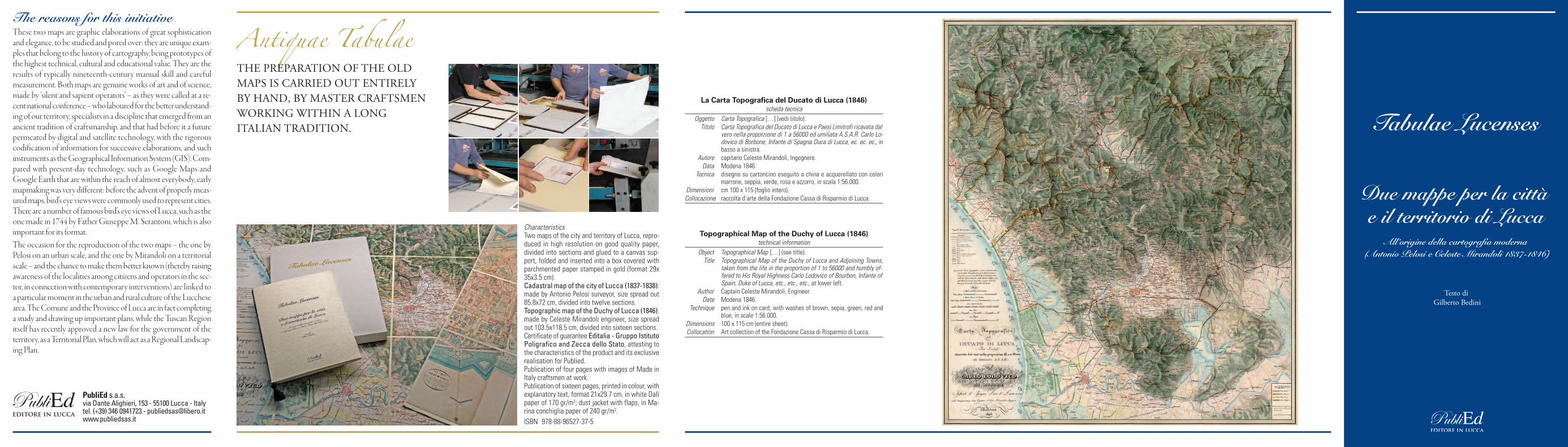
The reasons for this initiativeThese two maps are graphic elaborations of great sophisticationand elegance, to be studied and pored over: they are unique exam-ples that belong to the history of cartography, being prototypes ofthe highest technical, cultural and educational value. They are theresults of typically nineteenth-century manual skill and carefulmeasurement. Both maps are genuine works of art and of science,made by ‘silent and sapient operators’ – as they were called at a re-cent national conference – who laboured for the better understand-ing of our territory, specialists in a discipline that emerged from anancient tradition of craftsmanship, and that had before it a futurepermeated by digital and satellite technology, with the rigorouscodification of information for successive elaborations, and suchinstruments as the Geographical Information System (GIS). Com-pared with present-day technology, such as Google Maps andGoogle Earth that are within the reach of almost everybody, earlymapmaking was very different: before the advent of properly meas-ured maps, bird’s eye views were commonly used to represent cities.There are a number of famous bird’s eye views of Lucca, such as theone made in 1744 by Father Giuseppe M. Serantoni, which is alsoimportant for its format.The occasion for the reproduction of the two maps – the one byPelosi on an urban scale, and the one by Mirandoli on a territorialscale – and the chance to make them better known (thereby raisingawareness of the localities among citizens and operators in the sec-tor, in connection with contemporary interventions) are linked toa particular moment in the urban and rural culture of the Lucchesearea. The Comune and the Province of Lucca are in fact completinga study and drawing up important plans, while the Tuscan Regionitself has recently approved a new law for the government of theterritory, as a Territorial Plan, which will act as a Regional Landscap-ing Plan.
La Carta Topografica del Ducato di Lucca (1846)scheda tecnica
Oggetto Carta Topografica […] (vedi titolo). Titolo Carta Topografica del Ducato di Lucca e Paesi Limitrofi ricavata dal
vero nella proporzione di 1 a 56000 ed umiliata A.S.A.R. Carlo Lo-dovico di Borbone, Infante di Spagna Duca di Lucca, ec. ec. ec., inbasso a sinistra.
Autore capitano Celeste Mirandoli, Ingegnere. Data Modena 1846. Tecnica disegno su cartoncino eseguito a china e acquerellato con colori
marrone, seppia, verde, rosa e azzurro, in scala 1:56.000.Dimensioni cm 100 x 115 (foglio intero).Collocazione raccolta d’arte della Fondazione Cassa di Risparmio di Lucca.
Topographical Map of the Duchy of Lucca (1846)technical information
Object Topographical Map […] (see title). Title Topographical Map of the Duchy of Lucca and Adjoining Towns,
taken from the life in the proportion of 1 to 56000 and humbly of-fered to His Royal Highness Carlo Lodovico of Bourbon, Infante ofSpain, Duke of Lucca, etc., etc., etc., at lower left.
Author Captain Celeste Mirandoli, Engineer. Date Modena 1846. Technique pen and ink on card, with washes of brown, sepia, green, red and
blue, in scale 1:56.000.Dimensions 100 x 115 cm (entire sheet). Collocation Art collection of the Fondazione Cassa di Risparmio di Lucca.
PubliEd s.a.s.via Dante Alighieri, 153 - 55100 Lucca - Italytel. (+39) 346 0941723 - [email protected]
CharacteristicsTwo maps of the city and territory of Lucca, repro-duced in high resolution on good quality paper, divided into sections and glued to a canvas sup-port, folded and inserted into a box covered withparchmented paper stamped in gold (format 29x35x3.5 cm).Cadastral map of the city of Lucca (1837-1838):made by Antonio Pelosi surveyor, size spread out85.8x72 cm, divided into twelve sections.Topographic map of the Duchy of Lucca (1846):made by Celeste Mirandoli engineer, size spreadout 103.5x118.5 cm, divided into sixteen sections.Certificate of guarantee Editalia - Gruppo IstitutoPoligrafico and Zecca dello Stato, attesting tothe characteristics of the product and its exclusiverealisation for Publied.Publication of four pages with images of Made inItaly craftsmen at work.Publication of sixteen pages, printed in colour, withexplanatory text, format 21x29.7 cm, in white Dalìpaper of 170 gr/m2; dust jacket with flaps, in Ma-rina conchiglia paper of 240 gr/m2. ISBN 978-88-96527-37-5
Antiquae TabulaeTHE PREPARATION OF THE OLDMAPS IS CARRIED OUT ENTIRELY BY HAND, BY MASTER CRAFTSMENWORKING WITHIN A LONG ITALIAN TRADITION.
Caratteristiche dell’operaDue mappe per la città e il territorio di Lucca, ri-prodotte ad alta risoluzione su carta pregiata, sud-divise in sezioni applicate su supporto di telagrezza, piegate e inserite in una scatola rivestitacon carta pergamenata e impressioni a oro (for-mato cm 29x35x3,5).Mappe catastali della città di Lucca (1837-1838): autore Antonio Pelosi geometra, dimen-sione estesa cm 85,8x72, divisa in dodici sezioni.Carta topografica del Ducato di Lucca (1846):autore Celeste Mirandoli ingegnere, dimensioneestesa cm 103,5x118,5, divisa in sedici sezioni.Certificato di garanzia Editalia - Gruppo IstitutoPoligrafico e Zecca dello Stato, attestante lecaratteristiche del prodotto e la realizzazione esclu-siva per Publied.Pubblicazione di quattro pagine con immagini dellalavorazione artigianale Made in Italy.Pubblicazione di sedici pagine, stampate a colori,con testo esplicativo, formato cm 21x29,7; cartaDalì bianca gr 170/mq; copertina con bandelle incarta Marina conchiglia gr 240/mq. ISBN 978-88-96527-36-8
Le ragioni dell’iniziativaLe due “carte” sono elaborazioni grafiche di grande raffinata realiz-zazione, da osservare e da studiare; sono esemplari unici che appar-tengono alla storia della cartografia costituendo prototipi dirilevantissimo valore tecnico e culturale, utili anche per finalità di-dattiche. Sono il frutto di operazioni manuali di rilevamento ese-guite da preziosi artefici della misurazione e della rappresentazionedel territorio, specifiche della cultura dell’Ottocento. Si tratta divere e proprie opere d’arte e di scienza eseguite da operatori silentie sapienti – come sono stati definiti in un recente convegno nazio-nale – che hanno lavorato per la migliore conoscenza dei nostri luo-ghi; specialisti di una disciplina che emerge da un’antica dimensioneartigianale che è oggi indirizzata verso un futuro permeato dalletecnologie digitali e satellitari, con il ricorso a una rigorosa codifi-cazione delle informazioni per le successive elaborazioni, con stru-menti quali il GIS (Geographical Information System). Rispetto aimodi di rappresentazione attuali, quasi alla portata di tutti, qualiGoogle Maps e Google Earth, si ricordi che prima delle mappe misu-rate si ricorreva alla rappresentazione del territorio della città convedute “a volo d’uccello” delle quali proprio Lucca possiede esem-plari di rilievo, basti citare la carta di Padre Giuseppe M. Serantonidel 1744, importante anche per il suo formato.L’occasione della riproduzione delle due carte – quella del Miran-doli e quella del Pelosi –, una a scala territoriale, l’altra a scala urbana,e la possibilità della loro diffusione, oltre ad alimentare la cono-scenza dei luoghi e quindi a sviluppare la coscienza dei cittadini edegli operatori in rapporto agli interventi contemporanei, si collocain un momento particolare della cultura paesaggistica e urbanisticadell’area lucchese. Il Comune capoluogo e la Provincia, infatti,stanno completando gli studi e la redazione di importanti docu-menti di pianificazione territoriale e la stessa Regione Toscana hada pochi mesi approvato una nuova legge per il governo del terri-torio, nonché il Piano di Indirizzo Territoriale, con valenza di PianoPaesaggistico Regionale.
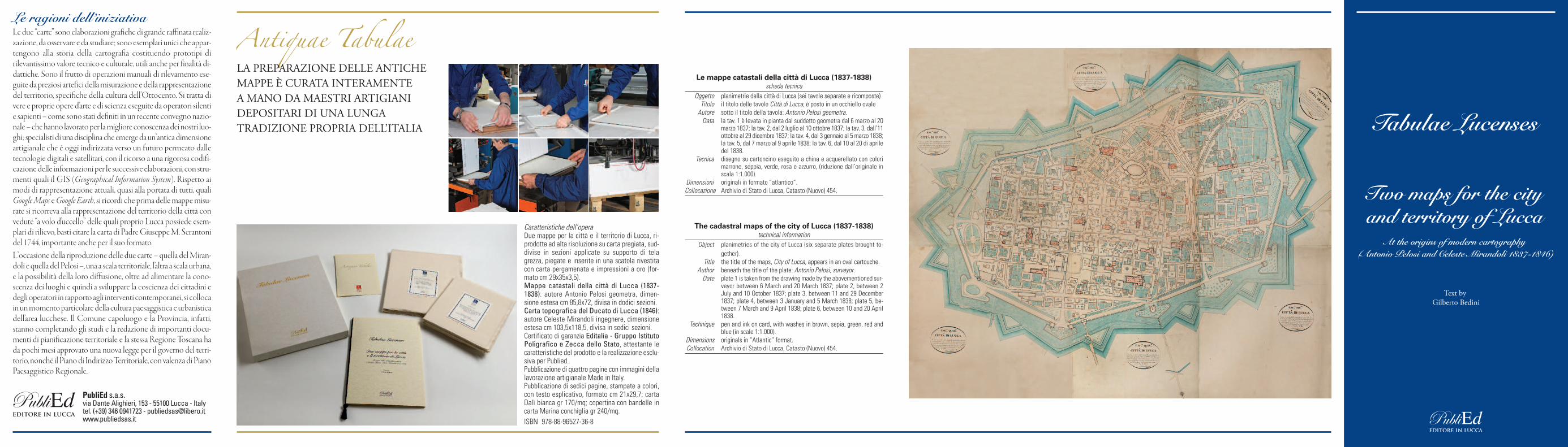
Le mappe catastali della città di Lucca (1837-1838)scheda tecnica
Oggetto planimetrie della città di Lucca (sei tavole separate e ricomposte) Titolo il titolo delle tavole Città di Lucca, è posto in un occhiello ovale Autore sotto il titolo della tavola: Antonio Pelosi geometra. Data la tav. 1 è levata in pianta dal suddetto geometra dal 6 marzo al 20
marzo 1837; la tav. 2, dal 2 luglio al 10 ottobre 1837; la tav. 3, dall’11ottobre al 29 dicembre 1837; la tav. 4, dal 3 gennaio al 5 marzo 1838;la tav. 5, dal 7 marzo al 9 aprile 1838; la tav. 6, dal 10 al 20 di apriledel 1838.
Tecnica disegno su cartoncino eseguito a china e acquerellato con colorimarrone, seppia, verde, rosa e azzurro, (riduzione dall’originale inscala 1:1.000).
Dimensioni originali in formato “atlantico”.Collocazione Archivio di Stato di Lucca, Catasto (Nuovo) 454.
The cadastral maps of the city of Lucca (1837-1838)technical information
Object planimetries of the city of Lucca (six separate plates brought to-gether).
Title the title of the maps, City of Lucca, appears in an oval cartouche. Author beneath the title of the plate: Antonio Pelosi, surveyor. Date plate 1 is taken from the drawing made by the abovementioned sur-
veyor between 6 March and 20 March 1837; plate 2, between 2July and 10 October 1837; plate 3, between 11 and 29 December1837; plate 4, between 3 January and 5 March 1838; plate 5, be-tween 7 March and 9 April 1838; plate 6, between 10 and 20 April1838.
Technique pen and ink on card, with washes in brown, sepia, green, red andblue (in scale 1:1.000).
Dimensions originals in “Atlantic” format. Collocation Archivio di Stato di Lucca, Catasto (Nuovo) 454.
PubliEd s.a.s.via Dante Alighieri, 153 - 55100 Lucca - Italytel. (+39) 346 0941723 - [email protected]
Antiquae TabulaeLA PREPARAZIONE DELLE ANTICHEMAPPE È CURATA INTERAMENTE A MANO DA MAESTRI ARTIGIANIDEPOSITARI DI UNA LUNGATRADIZIONE PROPRIA DELL’ITALIA


![ABACO DELLE MURATURE - Netfarm · 2008 Sub Task 3b.3 “Indagini diagnostiche su tipologie murarie” [1]. Ai fini della comprensione delle descrizioni e specifiche delle prove sperimentali,](https://img.pdfslide.net/doc/110x75/5fc3b3fe199f32581a09659b/abaco-delle-murature-2008-sub-task-3b3-aoeindagini-diagnostiche-su-tipologie.jpg)