Embed Size (px)
Citation preview

“Separating Romans and Barbarians”:Rural Settlement and Romano-British Material Culture
in North Britain
By Nigel Richard Reginald Wright,
Bachelor of Arts (Honours), UWA
This thesis is presented for the degree of Master of Arts of the University
of Western Australia
School of Humanities (Discipline of Classics and Ancient History), Faculty of Arts,
Humanities and Social Sciences
Year of Submission: 2007

2
Abstract
This thesis investigates the role which Roman artefacts played within rural settlements
in North Britain during the Romano-British period. The possibility that Roman
artefacts were used by native Britons as markers of prestige is explored through the
presence or absence of Roman artefact types. The more prestigious the occupants of the
rural settlements were, the more likely they were to have access to a variety of exotic
trade items. The methodology employed in this study has been adapted from previous
studies on pottery types and settlement remains from Scotland.
This thesis examines an area that centres on Hadrian’s Wall, which at various times in
its history acted as the frontier for the Roman Empire, as well as being a staging post for
troops and a means of controlling the local population’s movement. The study region
includes land up to 50 kilometres either side of Hadrian’s Wall, and examines rural
settlements located within one or two days travel from the Wall. The excavation reports
of rural settlements were examined, and include settlement types such as homesteads,
hillforts and villas. From these sites, Roman artefact types were quantified and used to
generate data for analysis. The results agree with the hypothesis that social hierarchy
can be detected through the comparative presence or absence of Roman artefact types.
It is also apparent that the settlements on either side of Hadrian’s Wall, and either side
of the Pennines mountain chain, were not part of a simple, homogenous culture.
This thesis begins with an outline of the geographic and environmental nature of the
region (Chapter 2), and an examination of settlement and society in North Britain during
the preceding Bronze and Iron Ages (Chapter 3). An essay on Romano-British society
and settlement is included (Chapter 4), and is followed by a brief discussion of post-
Roman Britain (Chapter 5). Following an outline of the methodology used (Chapter 6),
the results of analysis are presented in detail (Chapter 7). The Discussion chapter
explores how the results of analysis meet existing theories of rural settlement and
society, and compares North Britain with continental data from Germany and North
Gaul (Chapter 8).

3
TABLE OF CONTENTS
Acknowledgements 4
1 Introduction 5
2 The Physical Environment: 11
Geology, Geography and Climate
3 The Prehistoric period 19
4 The Roman period 41
5 The Sub and Post Roman periods 68
6 Methodology 74
7 Analysis 102
8 Discussion 128
9 Summary and Conclusion 149
Bibliography 152
Appendices
1. A Note on Glass Bracelets 162
2. A Note on Burnswark, Dumfriesshire 164
3. Catalogue of Sites Surveyed 168
4. Bibliography of Sites Surveyed 172

4
Acknowledgements
A postgraduate thesis is not an easy thing to complete. There are many people who
helped me throughout the years of study, and there is always a danger of neglecting
them. At the risk of alienating many, I would like to take the opportunity to thank a few
people whose help throughout the years has been invaluable.
I would like to thank my supervisor, David Kennedy, for providing guidance and
assistance throughout the years. He has been an enthusiastic and encouraging
supervisor, and has always been good-natured about my various academic wanderings.
I would like to thank my examiners for their comments and recommendations, which I
have incorporated into this final edition.
My thanks to the staff from Classics and Ancient History, the School of Humanities and
the Arts Faculty for their assistance; and gratitude to my fellow postgraduate students in
Classics for sharing the pain. Similarly, I would like to recognise those students from
the Scholars Centre whose company I so enjoyed, and with whom Megan and I were
able to stylishly digress on a Friday night.
My friends and family were an essential part of keeping my sanity, and keeping my
study on track. If it were not for their love, I would have resigned myself to failure
many years before. To my mother and father, my sisters, my stepmother and my
grandfather – many thanks to you all. My humblest thanks to my dearest friends,
including but not only: Sam, Lisa, Stuart, Adam, and Andrew. I am lucky to know you
all.
Thanks to my work colleagues over the years, for being patient and understanding, and
for allowing me the occasional moment to grab some study. Thanks to my colleagues in
the Department of Defence, Fremantle Hospital, WA Cardiology and the UWA Medical
Library.
Finally, it would not be exaggeration to say that without one particular person, this
thesis would not have been written. Without her love and affection, I would not have
had the will to finish what I had begun. My humblest and deepest thanks to Megan
Ashford, and to her wonderful family, for helping to make this happen.

5
CHAPTER ONE
Introduction
“…and so, having reformed the army in the manner of a king, Hadrian set out for
Britain. There he corrected many faults and was the first to build a wall, 80 miles long,
to separate the Romans and barbarians”
Scriptores Historia Augustae, Hadrian, 11.2
The above quote, written during the later fourth century AD, is the only ancient
reference we have for the timing and motivation for construction of the linear feature
that has become known as Hadrian’s Wall. The passage has been examined, and
debated over, repeatedly. The role that Hadrian’s Wall is believed to have played in the
social and economic development of North Britain during the years of Roman rule has
been changed many times. It is to archaeology that we turn for evidence of this change,
through the material remains of native Britons and the Roman invaders.
To address the question of socio-economic change in North Britain, it is necessary to
first identify and study the culture of Britons and the various “Roman” groups. The
landscape along the length of Hadrian’s Wall is greatly varied, with coastal and
estuarine plains, rocky highlands and river valleys. There is evidence that native
societies on either side of the dividing Pennines mountain chain reacted differently to
the Roman conquest (Breeze and Dobson 2000: 212).
Collingwood, summing up his excavations in Cumbria, believed that “the Bronze Age
in our district lasted down to the Roman conquest, and that there never was hereabouts
either a Hallstatt period or a La Tène period. If the settlements … are pre-Roman, their
builders enjoyed Bronze Age civilisation, and there is nothing in chronology to prevent
their using the skyline barrows” (Collingwood 1933: 222). This sentiment was echoed
a decade later by Hogg, who believed that similarities between rectilinear earthworks
and German settlements indicated a transfer of population during the second century
AD (Hogg 1943).
This belief no longer has much currency in modern archaeology. This change in
attitude is primarily the result of the work of George Jobey, affectionately known as the

6
“one man Royal Commission” (Jones and Walker 1983), who had a profound impact on
the study of Iron Age and Romano-British settlement in North Britain. Others who
have extended our knowledge of the region include Barri Jones, Nick Higham, David
Harding, Mike McCarthy, Fraser Hunter, the Birley family, and Robert Bewley.
MacGregor, in her work on metalwork in North Britain, described the years between
AD 50 and 250 as “the duel between Roman and Native – on the one side, the erratic
progression of an invading force, almost accidentally lured into a policy of conquest,
and, on the other, the resentments, submissions and political machinations of a tribal
society whose loose-knit structure tightened only under external threat, and almost
invariably too late at that” (MacGregor 1976: 17).
In recent years, the focus has shifted from Roman military sites to native settlements,
and to the mechanisms of exchange and social interaction that existed between the two
groups. With the arrival of Roman troops came Roman material goods, such as pottery,
glass vessels and metalworks. Gradually, local peoples began to adopt Roman ways
and adapt their ways of life to something more familiar to southern Europe. This
process, dubbed Romanisation, is one of the main themes of this thesis. Romanisation
has been variously seen as a process of forceful imposition, of active emulation, or of
incidental acculturation. It may be more helpful to see Romanisation being, as Slofstra
put it, a “process of integration, ie as the socio-political, economic and ideological
integration of original tribal societies in the Roman state system” (Slofstra 1991: 134).
Within our study region (Figure 1.1) there were forts, thousand of troops from all sorts
of backgrounds (mostly provincial and as time went on they became increasingly local),
substantial vici (civilian settlements outside fort walls), and substantial towns at Carlisle
and Corbridge. The Roman presence in North Britain was not only along Hadrian’s
Wall, but in front and behind the Wall, and was not uniform along the length of the
Wall. This disposition impacted differently on the local settlements in the region.

7
Figure .1. North Britain and the four regions of study (after McCarthy 2002).

8
The local British population has been described variously as Natives, Celts, British, or
even Romano-Natives (Wilson 2003). McCarthy has even used the word peasant to
describe local farmers (McCarthy 2005: 47). These local peoples were clearly different
from the Roman population, including the military forces, those living in the vici, and
the various traders, craftsmen and officials. This thesis will use the word Native to
describe the local British population. Although admittedly a loaded term, it is a
convenient one, and helps to clearly differentiate the two main cultural groups present.
The use of the term “Roman” has itself come under scrutiny, with authors such as
Freeman (1993) and Allison (1999) questioning the validity of using such a
homogenous term for what was in effect a pan-Mediterranean material culture, that was
in constant flux. “Roman culture” would have been very multicultural, spanning three
continents and over half a millennium (Allison 1999: 57).
The study of Native and Roman in North Britain is not without its problems. The sparse
record of excavation for rural settlements is the most apparent, with the past obsession
for Roman militaria neglecting the more mundane remains of the rural population. This
is in spite of the fact that the majority of the population would have lived in rural
settlements, and that archaeologists have now identified over 100,000 rural sites in
Britain (Mattingly 2006: 356). The settlement record shows evidence for continuity in
settlement and society stretching back to the Bronze Age, where settlement morphology
remained unchanged for centuries, making it impossible to date such sites without
excavation. The strong cultural continuity that is evident in the archaeology of North
Britain led Harding to state that the Iron Age spanned a period from the latter half of the
first millennium BC to the Norse settlements of the late first millennium AD (Harding
2004: 3). There has often been an arbitrary division imposed on study for the areas that
were incorporated into the Empire and those areas that were believed to lie beyond the
frontier (Fulford 1985: 93). Even the phrase “Rural settlement” requires some
definition. Hingley defined rural settlement as settlements that did not have an urban or
military character, or a specialised industrial function, but was primarily an agricultural
base (2004: 328). North of Hadrian’s Wall, all settlement was effectively rural (Hingley
2004: 329). A settlement itself is an area of domestic occupation that was substantial
enough to leave surviving physical traces (Hingley 2004: 329).

9
The use of prestige goods by the Native population is problematic. Before and after the
Roman period, the material culture is near invisible. Clearly, the local population used
organic or disposable objects for feasting and ornamentation, such as bone, wood, or
leather. Metal items, if used at all, would probably have been recycled, or disposed of
in votive deposits within watery places, like bogs and lakes. What exotic items remain
for the archaeologists to discover may have been passed down through families for
generations, making attempts to chart trade patterns, or plot economic data, fraught with
danger.
The mechanisms whereby these exotic items found their way onto the tables and the
bodies of the native population is of interest to this thesis. These exchange mechanisms
will always remain near-invisible to us, and we can only theorise and extrapolate on
their details by examining the material remains we possess.
By examining the material remains, we may see the impact that Rome had on North
Britain, and attempt to determine what means were employed in the use and distribution
of Roman items.
This thesis therefore examines the means by which Roman artefacts were distributed
amongst the rural population in the hinterland to the north and south of Hadrian’s Wall.
That Roman artefacts played an important role in the display of wealth and prestige
amongst the local population, and that this is detectable in the material remains of rural
settlement sites, is the argument that this thesis sets out to prove. By examining these
artefacts we might hope to address such questions as who occupied these settlements –
local Britons or Roman veterans, and if there was a mix, how these different
communities interacted with each other and with the Roman administration.
This thesis begins with an outline of the geographic and environmental nature of the
region (Chapter 2), followed by an examination of settlement and society in North
Britain during the preceding Bronze and Iron Ages (Chapter 3). An essay on Romano-
British society and settlement is included (Chapter 4), and is followed by a brief
discussion of post-Roman Britain (Chapter 5). Following an outline of the methodology
used (Chapter 6), the results of analysis are presented in detail (Chapter 7). The
Discussion chapter explores how the results of analysis meet existing theories of rural
settlement and society, and compares North Britain with continental data from Germany

10
and North Gaul (Chapter 8). Where possible, references from the study region have
been used to illustrate examples.

11
CHAPTER TWO
The Physical Environment: Climate, Geology and Geography
“It is a notoriously dangerous task for anyone who is not a palynologist and geologist to
attempt to reconstruct a prehistoric environment” (Challis and Harding 1975: 8).
Any study of a regional or chronological nature needs to outline its limits, even if these
parameters are established for the sake of convenience. The next few chapters will be
concerned with these issues, beginning with the physical landscape of northern England
and southern Scotland.
An examination of climate in North Britain from about 2500 BC (or the start of the
Bronze Age) is included in this chapter, for it is important to understand the numerous
climatic changes that impacted Iron Age and Romano-British societies.
The simplistic but widely used term “Highland zone”, is insufficient to describe the
diverse micro-regions apparent in North Britain, with its highlands, lowlands, mosses,
pastures, river valleys and flat plains. In Dumfriesshire, for example, modern forestry
has removed much of the archaeological landscape from investigation, where “the
continuity of the landscape itself has been broken, and the surviving archaeology has
been reduced to disarticulated fragments” (RCAHMS 1997: 75). In Durham and Tyne-
upon-Wear, industrial and urban development have affected the survival of
archaeological deposits.
Geography, Soils and Drainage
The geology of northern England and southern Scotland allow us to divide the region
into three unequal parts. The largest of these is the eastern coastal plain, stretching
north from Yorkshire into Scotland (my Regions 2 and 4, below, ch. 6). A smaller
coastal lowland exists on the Solway plain (Bewley 1994: 10) (Region 3). Thirdly, the
landscape in Dumfriesshire, north of the Solway Firth, is “one of smooth rounded hills,
often exhibiting broad flat summits and inter-connected ridges” (RCAHMS 1997: 13)
(Region 1). East and West are separated by the north-south chain of the Pennine Mts.
(Figure 2.1).

12
Figure 2.1. Solid geology of Britain (from Jones and Mattingly 1990).
The majority of water in the Pennines drains eastwards towards the North Sea. The
lowlands of the Solway are drained by wide valleys served by the rivers Caldew,
Petterill, Eden and Lyne (Bewley 1994: 10). In Dumfriesshire (Region 1), rivers flow
southwards down valleys towards the sea (RCAHMS 1997: 11). The Lake District
radiates away from the centre, with a noticeable east-west preference (Higham 1986: 8).

13
The upland areas attract more rainfall than the lower lands, and more rain falls on the
west side of the Pennines, as the mountains provide a rain-shadow effect. This contrast
is perhaps most prominently seen in southern Scotland, where the lowlands around
Jedburgh are amongst the driest in Scotland, but on the other side of the Pennines in
Dumfriesshire it is wet and cool (RCAHMS 1997: 13).
The climatic conditions affect the possible economies of our regions. For example, the
low rolling hills and good soils of Dumfriesshire would be ideal for regular cultivation
if they were east of the Pennines, but by contrast the wetter and cooler conditions
present favour livestock and pasture instead (RCAHMS 1997: 51).
One of the most important effects of increased rainfall in the uplands, and to some
extent the western lowlands, is the growth of peat, bog and moss (Bewley 1994: 11) (the
three terms are interchangeable, but here will be referred to as bogs, unless they are site
names, such as Burnfoothill Moss). Bog formation is directly affected by factors such
as rainfall, deforestation and erosion, and their spread was a major factor affecting the
amount of land available for human settlement (Harding 2004: 10). Bogs were a major
source of fuel for the population, especially in the deforested landscape of the lowlands,
and remained so in places like Dumfriesshire until coal was made more readily
available in the 19th century (RCAHMS 1997: 51).
Bogs and lakes have also been used as deposits for votive offerings, providing clues into
past ritual, society and metalworking. Deposits in bogs and lakes accumulate in layers,
revealing changes through time. Of more direct importance to archaeological
investigations, bogs and lake deposits are valuable sources of environmental
information, and can be used to recreate past climatic conditions. The presence of
cereal pollen in bogs can provide information about prehistoric agrarian practices;
where such evidence would normally be trapped within approximately 100 metres of
where the plants grew (RCAHMS 1997: 14).
Important bog sites in our region include Bolton Fell Moss, near Carlisle, where the
record extends back 6000 years; and Burnfoothill Moss, near Kirkpatrick-Fleming,
Scotland, which boasts a complete record for vegetation during the Holocene period
(since 10000 BP) (RCAHMS 1997: 14).

14
Climate
Bronze Age (c. 2500 to c. 1000 BC)
The Sub-Boreal period, from 3000 to 1000 BC (Lamb 1977: 373), saw oak, alder and
birch occupying a larger portion of the woodlands than before, and temperatures
beginning to rise. Following a comparative regression in the late third millennium BC,
widespread clearances have been detected early in the second millennium, indicative of
vigorous deforestation. For the first time, parts of lowland Co. Durham experienced
intense deforestation, on the magnesian limestone between Hartlepool and Durham in
the first half of the second millennium. This was evidenced by a sharp drop in lime and
other trees (except birch), and accompanied by a steep rise in grass and herb species
(Higham 1986: 79). Pollen samples from Neasham Fens on the lower Tees suggest that
clearances were never widespread, but were intermittent episodes intended to create
pastoral land (Higham 1986: 80). The upland areas remained relatively uninhabited,
with only intermittent and short-lived settlement until the Late Iron Age.
In Cumbria, the site of Ehenside Tarn showed evidence of clearance around 1600 BC,
with high cereal pollen counts suggestive of mixed agriculture (Higham 1986: 80). At
Bowness Common, grass replaced forest species and shrubs during a long lived
clearance episode throughout the second millennium, and from 1700 BC included
cereals and weeds of cultivation (Higham 1986: 80). The north Cumbrian lowlands saw
initial clearance activity around 2000 BC, after which cereal pollen was found dating to
the middle of the millennium (Higham 1986: 81).
Across the Pennines, pollen studies from Upper Teesdale show no evidence of human
activity before 1000 BC. But after this time the resultant activity led to the permanent
degradation of the wooded uplands towards open moorland (Higham 1986: 81).
Radiocarbon dates from bog deposits can provide more localised indications of
environmental change. At Fellend Moss, Northumberland, the early Bronze Age saw a
small amount of forest clearance; and although no cereal evidence was recorded, some
“weeds of cultivation” were present in small quantities. This activity peaked around
1738 BC, and lasted for two centuries (Davies and Turner 1979: 789). From 1644 BC
15
at Steng Moss, a slight opening of the forest cover may indicate human or pastoral
activity (Davies and Turner 1979: 793). Elsewhere, Graminae remains from Camp Hill
Moss indicate continuous use of land from around 1500 to 1150 BC (Davies and Turner
1979: 800).
At several Northumberland sites, the first evidence of human manipulation of
woodlands appear between 1750 and approximately 650 BC. These took the form of
small clearings, possibly providing pasture for domesticated animals, but there would
have been little cultivation (Davies and Turner 1979: 801).
Bronze Age/Iron Age Transition (c. 1000 – c. 600 BC)
A deteriorating climate between 1250 and 800 BC had a deleterious effect on the
northern highlands. This “sub-Atlantic” period saw a change in the composition of
forests and a significant cooling in global climate (Lamb 1977: 373). In Europe, most
of the changes appear to have taken place between 1200 and 700 BC. By 700 to 500
BC, temperatures were about 2 degrees lower than they had been 500 years previously,
and rainfall was higher everywhere north of the Alps (Lamb 1977: 373).
In upper Teesdale, large-scale clearances increased erosion, leading to the spread of
moorland across a wide area, along with increasingly waterlogged and acidic soils.
These depleted soils were incapable of sustaining forest regeneration (Higham 1986:
81-2). From around 1150 to 700 BC, Camp Hill Moss saw less clearance activity, but
after circa 700 BC renewed clearance began, with cereal pollens recorded (Davies and
Turner 1979: 800). In Upper Teesdale, most of the present levels of peat were in place
by 500 BC, and in the Pennine uplands, most of the blanket peat had been established
by 1000 BC (Higham 1986: 78-9).
Iron Age (c. 600 BC – AD 70)
The period from approximately 600 BC to AD 400 is known as the secondary Climatic
(or “Little”) Optimum (Lamb 1977: 374). Wet climatic conditions were present
between 350 and 100 BC (Lamb 1977: 425). The climate became warmer after 100 BC,
and continued to improve until temperatures had reached present levels around the time
of the Claudian invasion (RCAHMS 1997: 17). The climate became drier too, best seen
16
from data at Burnfoothill Moss, where deposits were dated to AD 50 (RCAHMS 1997:
17). Forest clearance increased in the middle of the first millennium BC, and reached a
peak in the final centuries BC and on into the beginning of the first millennium AD.
Palynological evidence suggests Late Iron Age (c.150 BC to AD 70) woodland
clearance in northern England and southern Scotland was very different from what
preceded it, in terms of scale, intensity, rapidity, mechanisms and geomorphological
effects. That after 300 BC a phase of widespread woodland clearance occurred
throughout the region suggests a fundamentally different approach to deforestation and
the practice of agriculture (Tipping 1997: 245). In the central Pennine zone, and around
Hadrian’s Wall, the earliest Iron Age clearances occurred around 350 BC (Tipping
1997: 242). A large scale increase in pastoral herbs accompanied an expansion in grass
species.
Clearances appear in Cleveland and the Durham lowlands in the first century BC, at
Steng Moss and Fellend Moss (Higham 1986: 184). At Steng Moss between around
550 and 20 BC, amounts of graminae and other grass species were found, indicating an
increase in settlement and farming (Davies and Turner 1979: 793). In the eastern Lake
District, at Blelham Tarn near Windermere, the earliest extensive clearance also dated to
approximately 500 BC (Tipping 1997: 243).
At Burnfoothill Moss, Dumfriesshire, large-scale clearances were recorded in the Late
Pre-Roman Iron Age, and at this time cereals made an increased presence in the record.
Simultaneously, plant species indicating arable and pastoral activity is found
(RCAHMS 1997: 163). Evidence from Long Knowe suggests a near tree-less landscape
in the closing centuries of the first millennium BC (RCAHMS 1997: 20).
The dramatic clearance of woodland implies an increase in the density of human
settlement (RCAHMS 1997: 163). The scale suggests that these clearances were not
piecemeal, but part of a planned effort to establish arable and pastoral land. Despite the
increased amount of cereals present in pollen samples (notably oats and wheat),
pastoralism still seems to have been the dominant form of subsistence (RCAHMS 1997:
21).
Romano-British (c. AD 70 – 410)

17
The “Little Optimum” continued until about AD 400. The period of Roman occupation
in North Britain, therefore, experienced a fairly constant climate. The temperature in
North Britain became gradually warmer, peaking at around AD 400, and was
accompanied by an apparent increase in sea level (Lamb 1977: 374).
The Romano-British period saw the first written accounts of Britain and its climate.
Lamb refers to several primary sources and, although he neglected to name them, noted
that severe frosts were recorded during AD 134, 173, 207, 221, and 231 (Lamb 1977:
425).
At Steng Moss, there was a rise in herbaceous pollen from around 20 BC to AD 460
(Davies and Turner 1979: 793). North of Hadrian’s Wall, the late Roman Period saw a
rise in both pastoral and arable farming (Davies and Turner 1979: 794). There were
clearances in Cumbria during the third and fourth century AD (Higham 1986: 184).
The area around Fozy Moss was cleared extensively during the Roman period, with
radiocarbon dates between approximately AD 80 and 350 (DuMayne-Peaty 1998: 319).
The majority of moss sites near Hadrian’s Wall show cereal cultivation was “re-
introduced” into the central zone of Hadrian’s Wall in the second century AD (Tipping
1997: 245). There was a near total clearance of woodland in northern England and
southern Scotland after 350 BC (Tipping 1997: 245).
Post Roman (c. AD 410 – c. 800)
A warm, dry period was experienced across Europe from c. AD 300 to 400, followed by
a change to wetter conditions (Lamb 1977: 425). After AD 400 temperatures began to
deteriorate, and colder and wetter climates persisted for the next three to four centuries,
with a sharp renewal about AD 800 (Lamb 1977: 374). The regeneration of woodland
appears to be widespread throughout all of Europe in the centuries after AD 400. It has
been suggested by one source that climatic decline or possibly even plague could be the
cause of this phenomenon (RCAHMS 1997: 22).
At around AD 300, records from Burnfoothill Moss suggest partial regeneration of the
nearby woodland (RCAHMS 1997: 22), and around 750 there was an increase in peat

18
growth (RCAHMS 1997: 17). Evidence from upland sites could suggest a renewed
effort on behalf of the local populations towards agricultural activity (RCAHMS 1997:
22).
In Northumberland, this was a period of major agricultural decline (RCAHMS 1997:
22). A large amount of cleared land remained at Fellend Moss until around AD 620,
suggesting a period of stability (Davies and Turner 1979: 789). At Steng Moss, a rise in
tree pollen occurs in the sixth century (Davies and Tuner 1979: 794), and increased peat
growth was recorded around AD 550 at Rotten Bottom, Bolton Fell Moss, and Rusland
Moss in the Lake District. Regeneration of forests took place during the Anglo-Saxon
period, and it was not until the ninth century that agriculture began in any significant
way (Davies and Turner 1979: 794).
Summary
The changing climates would have had a very real impact on local populations in North
Britain. Increased rainfall or decreasing temperatures may not have had any immediate
effect upon the populations, but subsequent generations may have been forced to
abandon marginal lands, or conversely been presented with opportunities to expand into
the hills and previously forested landscapes. The decision to put effort into arable land,
or focus on pastoral subsistence would have been determined by climatic conditions,
and local geology and soil conditions. Increased forest clearance would lead some
settlements towards stone for construction of their dwellings, or the use of earthen banks
to enclose their houses, and increased soil erosion would have had a very real impact on
their economic output. The development of settlement in North Britain is the subject
we shall now turn to, beginning with the Bronze Age in chapter 3.

19
CHAPTER THREE
The Prehistoric Period
“Most of those inhabiting the interior do not grow corn, but live instead on milk and
meat and clothe themselves in skins. All the Britons dye themselves with woad, which
produces a blue colour, and as a result their appearance in battle is all the more
daunting. They wear their hair long, and shave all their bodies with the exception of
their heads and upper lip. Wives are shared between groups of ten or twelve men,
especially between brothers and between fathers and sons. The offspring on the other
hand are considered the children of the man with whom the woman first lived”
Caesar, Gallic Wars, V, 14
The following three chapters have been written to provide a summary of the
archaeological and historical background of the study area. It is the author’s desire that
providing such background information will help the reader to appreciate the cultural
development of the region, and the variety evident in the archaeological record.
The mid Bronze Age (c. 1500 – c. 1000 BC)
“It is becoming increasingly clear that any discussion of Iron Age
settlement and society should start in the late Bronze Age, which is the
period in northern Britain as in the south and Atlantic Europe more
generally, when the social, economic and technological dynamic was in a
state of flux” (Harding 2006: 79).
The beginning of the Bronze Age is marked by general evidence for an increasing
population, as communities expanded into previously unused zones between 1800 and
1200 BC (Higham 1986: 82). The population appears to have been highly selective in
locating their settlements, and favoured the well-drained lowlands, particularly in the
Milfield Basin, the Penrith area and the Cumbrian coast (Higham 1986: 82). Large
tracts of land were ignored by the local populace, despite heavy use in the Neolithic.
These lands included the region between the lower Aln and lower Coquet, and the
coastal plain between the Coquet and the Wansbeck (Burgess 1984: 155).

20
In Northumberland, from around 1900 to 1700 BC, there was an intensive phase of
upland settlement taking place (Burgess 1984: 143), with a strong association between
sites and river systems (Higham 1986: 82). The evidence in Durham and Cleveland is
“a near total void” (Higham 1986: 82), which may be more because of modern
development than prehistoric exclusion. Davies and Turner believe that, based on
evidence from pollen cores, the southwest corner of Northumberland was less densely
populated than the rest of the county during the Bronze Age (Davies and Turner 1979:
801).
Settlement
Bronze Age settlements were founded on terraced or levelled foundations, with
permanent domestic buildings. Hand-made pottery was used, perhaps being produced
locally, and saddle querns indicate grain processing (Higham 1986: 89).
The identification of Bronze Age settlements in our region is difficult, with only a small
amount of material discovered, and a lack of characteristic monuments like those from
the Neolithic. However, features that can be confidently dated to the early Bronze Age
are the clearance cairnfields (or extended settlements), which have been found
extensively on marginal upland regions (Challis and Harding 1975: 125). Cairnfields
are commonly found in association with hut platforms (Higham 1986: 89), but not all
cairnfields can be associated with a settlement (Burgess 1984: 150).
In Upper Teesdale, at Bracken Rigg, stone-founded round hut circles seem to belong to
a Bronze Age settlement phase (Burgess 1984: 144). Similar sites, such as Standrop
Rigg and Houseledge, have unfaced ring walls composed of field-cleared stones, with
huts typically over 7 metres in diameter. Some Bronze Age ring circles are not from
domestic huts, but the remains of ring or mounded cairns (Burgess 1984: 149).
Unenclosed settlement sites appear at the start of the second millennium BC, and persist
until the Iron Age (Higham 1986: 87). Physically, the settlements consist of circular or
oval-shaped platforms cut into the side of a slope, with rear scarps and occasionally
frontal aprons (Jobey 1978c: 12; RCAHMS 1997: 118). Individual platforms were on
average between 10 and 18 metres wide (Jobey 1978c: 13).

21
Material Culture
Pottery was coarse and hand made, with “a relative lack of skill in manufacture”
(Challis and Harding 1975: 11). The pots were thick with a heavy grit, and some
examples show marks of hand-working (Challis and Harding 1975: 33). In stylistic
terms, the early Bronze Age saw the “urn sequence” of pottery, followed by the “bucket
and barrel forms” of the middle Bronze Age. The most prevalent ceramic type in the
late Bronze Age appears to have been the medium or small sized jar (Challis and
Harding 1975: 37). Traditionally, pottery styles were seen as part of three traditions: the
“beaker-folk”; “food vessel folk”; and the “urn folk”, all resulting from migrations
(Higham 1986: 105).
Pottery is principally found in graves, containing cremated remains or as grave goods
alongside inhumations (Higham 1986: 105). The appearance, with hand modelling and
ring coiling (Challis and Harding 1975: 12-3), alongside variation between different
sites, suggest coarse wares were made locally (Higham 1986: 106-7). Challis and
Harding go so far as to ascribe the manufacture of pottery to women (Challis and
Harding 1975: 11).
The earliest metal items were made of copper and appear around 2500 BC, possibly
being used for socially-based exchange (Higham 1986: 100). By about 1500 BC, the
most common metal finds were flanged axes, found in lowland and riverine locations
(Higham 1986: 101). In the second half of the millennium, metal smiths developed clay
moulds for pouring, leading to a wider range of available items, particularly weapons
such as spears, rapiers, and daggers (Higham 1986: 101).
The spread of metal goods in North Britain was small in scale, and findspots favour the
east coast (Higham 1986: 102). Higham believed an increasing difference between
metal finds in North and South Britain saw a breakdown in trade and technology
exchange by 1200 BC (Higham 1986: 102). In Cumbria and southwest Scotland, the
lack of metalworks suggest local populations developed a stone alternative to the bronze
axe (Higham 1986: 104).
Economy, Trade and Society

22
By the middle of the second millennium BC, trade in the famous Neolithic Langdale
stone axes had ceased, and new flint and metal artefacts had appeared (Higham 1986:
97). Trade existed between North Britain, Ireland, South Britain and northern Europe,
bringing direct social and technological influences to our region. Cultural change can
be seen as the result of trade and social interaction, and removes the need to explain
such innovations as resultant on (improbable) mass migrations (Harding 2006: 65).
Stock-raising and pastoralism would have been the dominant form of subsistence in
North Britain. Cattle were kept for meat and hides and bone products; sheep likewise
but with the addition of valuable wool (Higham 1986: 99). However there is evidence,
too, for arable farming. Quern finds are evidence that cereals were being processed on
site, and the cultivation of cereals in Cumbria is evidenced from pollen cores (Bewley
1994: 73) and carbonised grain was found in a pit at Ewanrigg, Cumbria, where a
nearby cremation cemetery was dated 1410 to 1000 BC (Bewley 1992: 12). Scatters of
pottery and flints around upland sites implies manuring from household middens
(Higham 1986: 95).
The principal evidence for British culture between 1200 and 700 BC is from burials.
Burials utilised both inhumation and cremation techniques, both using mounds for
disposal, and these practices continued until about 1200 BC (Higham 1986: 110-11).
Differences in grave goods may point to social and chronological distinctions. At
Chatton Sandyford, Northumberland, an inhumation burial dated to c. 1670 BC was
found associated with a beaker vessel and two jet buttons (Higham 1986: 111-2).
Beakers may be associated with high status burials, and food vessels are commonly
associated with inhumations (Higham 1986: 113).
Artistically, the Bronze Age sees the appearance of cup and ring marks, created by
pecking stones, and represents a time-consuming display of spirituality or secular
display (Higham 1986: 114). It remains unclear what meaning these markings had for
the local population.
The Bronze Age – Iron Age Transition (c. 1000 – c. 600 BC)
“One is faced with the major problem of finding out where people were
in the centuries after 1000 BC” (Burgess 1984: 153).

23
The period from 1200 to 1000 BC may have seen a widespread collapse of political,
social and economic networks (Burgess 1984: 153; Higham 1986: 85). A worsening
climate between 1250 and 800 BC (see chapter 2) may have led to widespread
abandonment of marginal land (Higham 1986: 95). Population pressures in the central
areas of settlement may have reached a tipping point, with social stresses so strong as to
destroy the influence of any ruling classes (Higham 1986: 116).
The period from 1000 to 600 BC saw the introduction of iron, the collapse of Bronze
Age social structures, and the emergence of the settlement pattern that was to dominate
North Britain for the next thousand years. Harding believed this was a “time of
dynamic change in which a great diversity and complexity of regional liaisons were
evidently in operation” (Harding 2006: 62).
Burgess described this period as “one of the most shadowy periods in British
prehistory” (Burgess 1984: 155). A reduced population established settlements on the
lowlands and river valleys, with uplands given over to grazing and hunting. The
Wilburton/Wallington and Ewart Park phases of weapon manufacture imply troubled
times. Hill top settlements began to flourish, eventually becoming the hill forts of the
Iron Age (Burgess 1984: 160). By the seventh century BC, increasing population in
these small zones again created social strain, and climatic deterioration intensified
problems. In the seventh and sixth centuries BC, settlers begin to once again move into
upland areas (Burgess 1984: 160).
Climatic deterioration probably reached a peak around 800 BC (see chapter 2). Areas
of naturally high rainfall, such as the upland areas, would have been hardest hit. This
resulted in the large scale expansion of moor and peat (Higham 1986: 117). This would
have had a massive impact on the local population, who would have seen such land
rendered unworkable, and any marginal land became unusable. The loss of viable land
was greatest in western Cumbria. In Higham’s words, this would have contributed to
“pauperization, mutual aggression and population loss” for the local populace (Higham
1986: 117). In the areas east of the Pennines, the fell sandstones and foothills were
probably abandoned around this time (Higham 1986: 117).

24
Records from Burnfoothill Moss in southwest Scotland reveal large clearances
suggesting major settlement expansion (RCAHMS 1997: 55). Settlements appear to
have been expanding to hillside pastures, where farmers attempted limited cultivation
(RCAHMS 1997: 162).
A sharp decline in metal finds occur from 1200 to 1000 BC, and at Steng Moss and
Camp Hill, Northumberland, pollen records suggest major regeneration between 1000
and 600 BC. Pollen records from Dumfriesshire suggest small scale mixed farming
practices (RCAHMS 1997: 162). All this suggested to Burgess evidence for population
loss as great as medieval plague, possibly in the order of 30-50 % (Burgess 1984: 153).
Conservative pottery forms dominate the period from 1100 to 800 BC, and bucket and
barrel types continued in a simplified range of forms (Cunliffe 2005: 64). It was
perhaps during this period that sites in the north and west became aceramic.
Iron began to replace bronze in North Britain during the seventh century BC (Burgess
1984: 152). By about 600 BC, iron or traces of rust appear in hoards of predominantly
bronze artefacts (Challis and Harding 1975: 40). In Durham, this period has been
named after the discovery of a hoard at Heathery Burn in 1912. North of the Tyne,
contemporary metalworking is said to belong to the Traprain-Hownam tradition.
Cunliffe sees introduction of iron on the continent around 750 BC (2005: 32). The date
of the latest bronze metalworks, during the latter part of the sixth century, may indicate
the period when iron began to replace bronze on a wide scale (MacKie 1971: 65).
Bronze was still used widely for manufacture of tools and weapons during the eighth to
fifth centuries (Cunliffe 2005: 75). There is not much evidence for the date and manner
of iron’s introduction into Scotland (MacKie 1971: 64). In terms of remains from
domestic sites, bronze and iron are unlikely to be found. Bronze would have been
collected for scrap when broken, and iron would have quickly rusted away (MacKie
1971: 65).
Heathery Burn, Co. Durham, may be representative of the range of artefacts in use at the
time. Typified by the Yorkshire-type of three-ribbed socketed axe, the distribution
centred upon Yorkshire, Northumberland and Durham. Non-metallic finds from
Heathery Burn cave included jet armlets, stone spindle whorls, bone tools and fittings,

25
and five sherds of pottery from coarse shouldered vessels with internally flattened rims
(Cunliffe 2005: 80).
The henges and barrows of the Bronze Age were, for the most part, abandoned.
Deposits of weapons appear to have replaced sepulchral monuments as resources were
channelled into manufacture and defence (Higham 1986: 117). Higham believed that
by 800 BC, cattle reeving may have become endemic, as the gap between producer or
protector and predator widened (Higham 1986: 117). The increase in defence and
weaponry would have consumed large portions of the bronze-smiths time.
Cremations associated with or without urns, placed under barrows and in flat graves,
continued in parts of Scotland through this period, in some areas up to 700 or 600 BC
(MacKie 1971: 59).
The Iron Age (c. 600 BC – AD 70)
“One of the major questions of the archaeology of the north is ‘where
and what is the Iron Age?’ We have to assume either a long continuation
of the Bronze Age, or a hiatus before the arrival of the Romans, or an
aceramic ‘native’ Iron Age population whose settlement pattern was
enlarged and covered up by the Romano-British pattern” (Bewley 1994:
73).
As we have seen, the “beginning” of the Iron Age was in fact an evolution of Bronze
Age traditions, with new technological innovations introduced into a society at a time
when it was facing social and economic pressures. Extant cropmarks of settlements can
be divided into two main groups, those circular or oval in shape, and those with straight
sides and “well-defined corners” (RCAHMS 1997: 55). Unenclosed settlements, from
the small number of radiocarbon dates available, ranged from mid-second to mid-first
millennium BC (Cunliffe 2005: 312).
In Cumbria, pollen records (Pennington 1970) show clearance and arable farming in the
Cumbrian lowlands throughout the first millennium BC. From the eighth century BC
onwards, the most common settlement in the Tees-Forth area became the palisaded
enclosure – circular, oval or rectangular enclosures surrounded by a continuous palisade
26
trench, with close-spaced vertical timbers (Cunliffe 2005: 312-3). The small number of
Iron Age sites in Cumbria, lead some researchers to take Romano-British sites and
“extrapolat(e) backwards” (Jones and Walker 1983: 186). There are two large clusters
of sites near Holme Abbey and between Kirkbride and Wigton, where morphological
analysis found that 71% of sites were circular, 18% were rectangular, 1.17% bivallate,
and 6.6% have fields associated with them (Jones and Walker 1983: 187-8). The
overall density of sites was one site per 3.77 km square. There is a general lack of
hillforts in the region, which may be because of low population density and a lack of
social organisation (Challis and Harding 1975: 122). There are only two known hill
forts of Iron Age date in Cumbria, being Swarthy Hill and Carrock Fell. Carrock Fell
(over 2 ha) is the only site to possibly qualify as a regional oppidum (Harding 2004:
50).
In Dumfriesshire, open (unenclosed) settlements date to the last centuries of the first
millennium BC (RCAHMC 1997: 184), and typically contain large ring-ditch houses.
These sites have mostly been found on the crests of spurs and the ridges of valleys
throughout the Borders region. The main evidence for Iron Age sites in eastern
Dumfriesshire rests upon small enclosures found along the sides of hill valleys
(RCAHMS 1997: 141). In eastern Dumfriesshire, most of the enclosed settlements are
curvilinear, and are between 0.1 and 0.15 ha in internal area (RCAHMS 1997: 122).
Jones and Walker found that 3.6% of sites were rectangular, 19.5% were bivallate or
multivallate, and 1.8% associated with field systems (Jones and Walker 1983: 187-8).
The majority of rectilinear sites in eastern Dumfriesshire rest in the lowlands, although
these sites are very thinly scattered (RCAHMS 1997: 142). The large hillfort of
Burnswark, over six hectares in area and excavated several times, may have been the
regional focal point (Harding 2004: 59). Patterns of settlement suggest a re-occupation
of southwest Scotland during the late Iron Age, after a period of abandonment during
the mid-first millennium BC (RCAHMS 1997: 66).
In Northumberland, the coastal plains were subjected to widespread forest clearance.
The first settlements may have been open, but were soon replaced by enclosed
rectilinear settlements that came to typify the Tyne-Forth region in the Iron Age and
Roman periods. The timber palisades that enclosed these settlements required a
considerable quantity of timber, along with two to four timber round huts on average
within. The timber walls were eventually replaced with earthen banks and ditches, or in
27
some cases with stone walls. A single entrance allowed entry into the enclosure, and a
raised causeway led between sunken yards to the elevated rear of the settlement, where
round buildings were constructed (Burgess 1984: 164). The site of Tower Knowe,
Northumberland, was excavated by Jobey in the early 1970’s, and this site shows
several phases of occupation, from timber palisade to stone walled enclosure (Jobey
1973b). The rectilinear enclosure was at first enclosed by a timber palisade trench,
approximately 30-40 cm wide and 30 cm deep, and contained an area of 0.13 hectares
(Jobey 1973b: 58-60). The presence of packing stones suggests the presence of timber
uprights. Inside the enclosure, timber built houses were constructed using ring-groove
or trench construction techniques, where a “solid timber house-wall of closely set posts
or split timbers was set into a trench cut into rock or sub-soil” (Jobey 1973b: 61).
Around the mid-second century AD, this timber settlement was replaced in stone, with
slabs of undressed natural rock replacing the timber uprights along the same lines, and
enclosing the same internal area (Jobey 1973b: 65). The timber houses were replaced in
stone, and the foundations show stone slabs for the door threshold, paved flooring, or
levelled bedrock (Jobey 1973b: 66-8).
Settlement
Enclosed settlement sites have dominated the study of the lowland Iron Age, perhaps
because enclosures are better suited to survive later development, and are easier to
locate through aerial survey. Round houses constructed with stone in the Tyne-Forth
province have traditionally been regarded as synonymous with Romano-British
settlement. As Burgess states, “it has for long been an article of faith in border
archaeology that round timber houses are pre-Roman, and round stone houses are
Romano-British” (Burgess 1984: 145). Typically, settlements are one of two principal
categories: “homesteads” with fewer than three huts inside the enclosures; and
“settlements” with three or more huts (Higham 1986: 121).
Enclosures in the Tyne-Tees region typically contain a single round house, located in
the centre of the enclosure, presumably for a nuclear family (Harding 2004: 41). North
of the Tyne, there are a large number of hillforts present in the landscape, but this
pattern is not continued south of the river (Challis and Harding 1975: 122). Some
scholars believe areas like north Tynedale was abandoned during the late Bronze Age,
only to be resettled during the Iron Age (Burgess 1984: 165).

28
Hill forts, while characteristic of the Iron Age in general, are rare in Cumbria and the
Tyne-Tees region. Harding argues this absence cannot have been due solely to
topography, nor to sparse population (Harding 2004: 61). The identification of a fort is
quite ambiguous, and requires subjective decisions about defensive posture, the
perimeter and the natural features they sit upon, not to mention its function (RCAHMS
1997: 126). ‘Typical hillforts’ in eastern Dumfriesshire are small circular or oval
enclosures, with no more than twin ramparts and a medial ditch, and are generally
between 0.15 and 0.3 ha in extent. Forts occupy the crests and shoulders of rounded
hills, though they are occasionally found on slopes and terraces (RCAHMS 1997: 129).
The best known fort in Dumfriesshire is the large hillfort of Burnswark, where
radiocarbon samples from charcoal at base of rampart and the central gateway returned
dates from the fifth century BC (Jobey 1978a: 67) (see Appendix 2, below).
For long the development of enclosed settlements was dominated by the Hownam
sequence, named after the site where it was first discovered. This structural
progression, from palisaded to univallate enclosure to multivallate defences, was seen as
the typical stages through which simple nuclear farmsteads transformed into large
hillforts (Burgess 1984: 162). The final stage, during the Roman period, was seen as an
open settlement of stone houses on foundations overlying derelict defences, benefactors
of the pax Romana (Harding 2004: 54; RCAHMS 1997: 153). In the 1960’s, with the
excavation of unenclosed platform settlements in Peebles, a new phase of settlement
was added to the beginning of the Hownam sequence (RCAHMS 1997: 151).
Scholars such as Harding argue that palisading is nothing more than a constructional
technique, and cannot be culturally or chronologically indicative. It would have been
less time-consuming than stone walls or ditches, and can be seen as a renovation of
depleted earthworks (Harding 2004: 55). Challis and Harding suggest that the
‘stockaded camp’ was a pre-fifth century type and preceded the more substantial
ramparts (Challis and Harding 1975: 103). The shape of an enclosure is not indicative
of function, since it is only through an excavation of its interiors that it can be
determined if a site was used for domestic habitation, ritual function, or simply as a
stock enclosure (Challis and Harding 1975: 131).

29
Radiocarbon dates demonstrate that palisades were being constructed in the Border
regions throughout the first millennium BC, and into the first millennium AD
(RCAHMS 1997: 121). The palisades found through excavation may (and occasionally
do), represent several phases of construction, and there may be periods of unenclosed
settlement present (RCAHMS 1997: 123). Most palisaded sites consisted of a perimeter
fence of closely spaced timber uprights, set into a trench, and broken only by a gate or
entryway, usually defined by post holes. The size of the interiors could vary from 50 to
17 metres in diameter (Higham 1986: 120).
Timber palisades span a considerable length of time, from the beginning of the first
millennium BC into the Roman period. The decline of the rectangular palisade in
favour of banks and ditches, can be seen at Bishop Rigg, near Corbridge,
Northumberland. Here, sherds of pre-Hadrianic pottery were found in the gravel
packing of a palisade ditch, suggesting that rectilinear palisaded enclosures were
possibly extant in Northumberland until the mid-second century AD (Jobey 1979).
North of the frontier, stone built houses have been labelled ‘Votadinian’, and were
thought to represent the importation of Roman building techniques to a client tribe.
These houses did not appear in the pre-Roman Iron Age west of the Pennines,
suggesting timber continued to be the dominant material for construction (Harding
2004: 71). The excavation of the Iron Age hillfort at Broxmouth in southwest Scotland
challenged the idea of stone houses being exclusively Romano-British (Harding 2004:
59).
In southeast and southwest Scotland, enclosed sites are typically found in close
proximity to each other, in a manner would seem to negate the effective defences of
both sites (Harding 2004: 63). It would appear that defence was not a greatly important
factor in choosing a site, but matters of status, identity, and access to resources played
crucial roles. The fact that enclosed settlement lasted in our region for a thousand years
means that enclosures need not have meant the same thing to their occupants throughout
that period (Harding 2004: 64).
Scooped settlements have been found in Southern Scotland, and consist of sites set on
sloping ground with a hollowed out yard on two levels, and a rubble-cored perimeter
wall (Cunliffe 2005: 217). Timber roundhouses were set on platforms at the rear of the

30
enclosures (RCAHMS 1997: 144). Scooped enclosures date to the same periods as
other types of enclosed settlement, and range in date from the Bronze Age to the
Romano-British period, and appear to have been a local adaptation to sloping contours
(RCAHMS 1997: 144).
In lowland northeast England, rectilinear settlements are roughly contemporary with the
circular forts and settlements of the uplands. It would appear that this was due to
topographical factors, as it would be easier to make rectangular shapes with flat ground,
and circular defences are easier where contours are uneven (Burgess 1984: 163; Higham
1986: 133). Several examples of enclosure can be seen in Figure 3.1.
There would appear to be a long period of occupation, or re-occupation of settlement
sites. Virtually all sites excavated in the north of England and southern Scotland show
evidence of earlier timber built phases (RCAHMS 1997: 155). There is very little
evidence for expansion of settlements, however, and it appears that when a settlement
reached its population threshold, new units were created instead (RCAHMS 1997: 149).
By the end of the Iron Age, most of the hillforts or defended promontory sites in north
Britain had been abandoned, or in some cases reoccupied as open settlements, and the
RCAHMS suggests a recurring pattern of abandonment in eastern Dumfriesshire
(RCAHMS 1997: 158). It would seem that forts had been abandoned at some point
between the late first millennium BC and the second or third century AD (RCAHMS
1997: 160).
There is widespread evidence for a large scale population expansion during the late Iron
Age and early Roman periods. Perhaps, their defences no longer needed, forts were
being abandoned for lowland settlements. But at some later point, settlers re-occupied
the sites, and built open settlements across the slighted defences.

31
Figure 3.1. Examples of Iron Age settlements (from Jobey 1970; Jobey 1973a; Jobey 1977; and Kilbride-Jones 1938). .

32
Settlement huts were most commonly made with a form of ring groove, such as that
seen at West Brandon (Challis and Harding 1975: 146). There cannot be any
chronological or cultural indications drawn from the presence or absence of ring-
grooves or ring-ditches with structures, since the local topography and drainage
situations would mandate the need for a drainage ditch (Challis and Harding 1975: 148).
The huts would typically contain a central post hole for supporting the roof. Internal
floor space would be between 50 and 120 metres square (Higham 1986: 122). Cunliffe
lists a range for hut diameters between 6 and 15 metres (Cunliffe 2005: 318).
The transition from Bronze Age open settlement to palisaded settlements requires some
attention. Higham saw this as the fundamental re-appraisal of the needs of society, and
the sharpening of competition for resources. The provision of basic security would be
an obvious factor, but such timber fences that existed would not have stopped a
determined attacker for long. However, the well-wooded environment would have
provided ready resources, and palisades could have been erected relatively easily using
mostly local resources (Higham 1986: 121). It is possible these palisades served as
protection for livestock, or alternatively served to exclude livestock from areas set aside
for residence (Higham 1986: 122). The eventual change from timber palisade to earthen
bank and ditch may be due to the heavy deforestation present in the late Iron Age
(Higham 1986: 123). Cunliffe sees the difference between enclosure types as possibly
reflective of the owners status in society, but also possibly indicative of an increasing
population and competition for resources (Cunliffe 2005: 318).
Material Culture
The material culture of North Britain during the Iron Age can be characterised by its
relative poverty, and by the “absence of clearly diagnostic types” (Harding 2004: 81).
Pottery is small in quantity and poor in quality, and generally little material evidence
from the Pennines and the northeast can be attributed to the period before the first
century AD (Challis and Harding 1976: 99).
Pottery from the two centuries after 750 BC is very different from previous stylistic
traditions. Pots are generally thinner walled and have smoother finishes, the shapes are
distinctive and more varied, decoration is more prevalent, and rims are often everted but
not bevelled (Challis and Harding 1975: 46). The scarcity of native pottery - which

33
would survive just as well as Roman types, may be due to “an excessive predilection for
tidiness and systematic disposal by the inhabitants or a comparative lack of pottery
vessels amongst such communities. It has always seemed that the latter is more likely”
(Jobey 1973a: 34). At Thorpe Thewles, Cleveland, the largest group of late Iron Age
pottery in northeast England was found. The use of simple forms and rim types had a
long tradition at the site, and may be evidence for the local production and use of native
pottery. The site may date from between the fifth or sixth century BC to the second or
third century AD (Heslop 1987: 112)
How extensively iron was used in the seventh to fifth centuries BC is impossible to
determine. Cunliffe believes that metals may not have come into widespread use until
the fourth or third centuries BC (Cunliffe 2005: 493). Amongst metal objects that were
being developed and distributed during the Iron Age were swords. Piggott’s Group IV
swords, distinctively North English, have become known as “Brigantian swords” (S
Piggott 1950). A first century AD date has been suggested for all of the Group IV
swords, and they appear to have a “Brigantian” distribution (Harding 2002: 191).
Common features include an exaggeration of lipped chapes into bifid mouldings, with
the use of a single, broad strap-loop placed centrally on the scabbard. The scabbard was
square cut and belonged to La Tène Type D, and may have been inlaid with polychrome
enamel (Challis and Harding 1976: 86).
A rarity of artefacts from southwest Scotland may relate to the size of excavations
(Banks 2002: 31). This disparity has created the impression that southwest Scotland
possessed a poorly-developed material culture, although the inhabitants would have
interacted with the cultures of southeast Scotland and north England. A significant
factor may have been artefacts made of bone or other organic materials, as local soil
conditions would have destroyed them after deposition (Banks 2002: 31-2). Baskets
and mats, the production of fishing nets, all would have been carried out on a large scale
in North Britain, but apart from a few needles and weights would not survive after
deposition (Cunliffe 2005: 488).
Leather goods would have been important to a pastoral lifestyle, and when driving
livestock to pastures, leather would have been more durable than pottery (Cunliffe
2005: 489). The absence of pottery may be simply a matter of it being less “culturally
significant” for northern communities (Cunliffe 2005: 118).

34
Luxury goods such as brooches, weapons, bowls, tankards, and horse-trappings were
being traded, and these items were used as part of a cultural desire to express status
through displays of ornamentation and feasting.
Incidental items associated with trade and feasting, such as salt containers, were found
at Melsonby, North Yorkshire (Fitts et al. 1994: 23-6). Glass beads and bangles were
produced at a few native production centres, and may have been traded as a prestige
item. The rarity of evidence for production may suggest that glass was held in high
esteem, and that glass workers were people of high status (Cunliffe 2005: 504). Jet was
produced and presumably traded from the seventh century BC (Cunliffe 2005: 508).
Metalworks from the Iron Age and Romano-British periods are commonly found as
stray finds, frequently from rivers, and not from hoards or as grave goods (Harding
2002: 192). Southwest Scotland is largely devoid of hoards, reflecting possible cultural
differences between the populations of southwest and southeast Scotland. In northern
England, hoards have been found in west Yorkshire and the western Pennines, but
hoards are absent from eastern Yorkshire and much of Northumberland (Hunter 1997:
111).
Economy, Trade and Social Structure
The economy of the Late Pre-Roman Iron Age (c. 150 BC – c. AD 70) would have been
predominately pastoral, although the communities would have relied on a wide range of
food resources (Bewley 1994: 74). Cereals would not have figured heavily in the
economy, and little evidence has so far been found to suggest otherwise. At the time of
the transition from bronze to iron, communities appear to have been expanding onto hill
pastures, where farmers established new farms and attempted a limited amount of
cultivation (RCAHMS 1997: 162). Population densities would be limited by the
environmental constraints on food producing capacity (Challis and Harding 1975: 159).
Cunliffe sees this system as part of a “sufficer” economy, with settlements that were
self-contained, able to satisfy their own food requirements but unable or unwilling to
produce a surplus for organised exchange (Cunliffe 2005: 443).

35
In the western regions of Cumbria, there is a far greater proportion of upland to lowland
areas, and so the climate would have been wetter, and pastoralism dominant (Hartley
1988: 11). Stock movement between higher and lower pastures takes place even today
in northern England. In Northumberland and the eastern coastal regions, a mixed
agricultural economy would have been more practical, and evidence for this exists from
the Vale of York to the Tyne valley. The different external contacts these two regions
received would have had an effect on the economies as well (Harding 2004: 26).
Iron Age economies were more than capable of exercising economic management to
rise above bare subsistence levels (Harding 2004: 74). Only in the Pennines and the
northwest does there appear to be an absence of cereal cultivation during the first
millennium BC, and the reasons for this absence are primarily environmental ones
(Challis and Harding 1975: 158-9). Evidence from the end of the first millennium BC
would suggest that a process of agricultural intensification had begun (Harding 2004:
79).
There is evidence of continued arable farming in the Cumbria lowlands through the first
millennium BC. However, in the immediately pre-Roman period, there seems to have
been a reduction in agriculture and some regeneration of forest (Challis and Harding
1975: 180). Forests were being cleared for pasture, and some cultivation was being
practiced. Ehenside Tarn saw forest regeneration during the Roman period, and
deforestation was delayed until after AD 400 (Higham 1986: 185). Across the Solway
in Dumfriesshire, southwest Scotland appears to have been a mixed economy of arable
and pastoral farming focusing on cattle (Banks 2002: 30). At Albie Hill, Applegarth, an
iron sickle was found in context suggestive of the fourth century BC, although such
finds are more common in Roman contexts (Strachan 1999: 12-3). The largest group of
artefacts associated with arable farming, however, were stone querns (Challis and
Harding 1975: 156).
In the lowlands of southeast Co. Durham, cereal cultivation was more widespread than
elsewhere, and may have been extensive and important to the local communities. Cereal
pollen has been recorded at Camp Hill Moss and Steng Moss in Northumberland and in
the south Tyne valley, but this region favoured open pasture.

36
Upper Teesdale was pre-dominantly moorland with widespread blanket bog. The Tees
lowland, however, saw spelt dominate during the second and first centuries BC. Emmer
was more popular in Northumberland and southern Scotland, although barley was also
important (Cunliffe 2005: 322).
With the apparent lack of ceramic artefact types from many of the excavated settlements
in North Britain during the Iron Age, it seems likely that foodstuffs would have been
transported in wood, leather or textile containers. Likewise, meals would have been
prepared by spit-roasting or boiling in communal cauldrons, and such organic items
would have either decayed or have been too valuable to lose to the archaeological
record, unless they were purposely and ritually removed from use as votive deposits
(Harding 2004: 305). This trend towards organic artefacts continued into the Romano-
British period, and beyond.
Bronze Age trade with Ireland, North Britain and northern Europe would have brought
North British communities into contact with external influences, through direct
maritime trade (Harding 2006: 62). Evidence shows a complex network of
intercommunication between southern Britain, northern Britain, Ireland and north-
western Atlantic Europe. Within this system there were local concentrations in the
distribution of pottery or beads, for example; indicative of economic or political liaisons
(Harding 2006: 78). Luxury products such as metalworks, ornaments and tablewares
were scarce before the second century BC, perhaps because the social mechanisms
connected with their display had yet to develop (Cunliffe 2005: 513).
By the Roman period trade is very hard to define. The introduction of iron working into
the region during the last centuries BC had major implications for the working farmer,
who could now access stronger and more efficient equipment. These tools are difficult
to detect though, and the very existence of a pre-Roman “Iron” Age in Cumbria is in
doubt (Higham 1986: 140-1). Despite the presence of some activity east of the
Pennines, iron working seems to have been carried out on a very small scale, and there
is no evidence for local manufacturing of iron products at any level of society (Higham
1986: 143).
The salt industry was connected with trade and economy, being an essential part of the
local diet, a valued preservative, and needed for the process of curing hides and skins

37
(Cunliffe 2005: 509). There is evidence for salt making in the later Iron Age from sites
in Lincolnshire, the Fenland, and the east Anglian coast (Challis and Harding 1975:
165). Products of iron would have been valued by their owners, if not regarded as
prestige items, but are less visible archaeologically (Harding 2006: 62). Iron working
would have been done away from habitation areas, due to the toxic nature of the task.
Evidence of wool production is implied from finds of spindle whorls and weaving
combs, although the extent to which wool was a trade commodity remains unknown
(Cunliffe 2005: 485).
The small amounts of pottery in northern England, southern Scotland and Ireland stands
in direct contrast to ceramic traditions to the south or in Atlantic Scotland, where
pottery finds are plentiful and the types of pottery were more stylistically and
functionally diverse (Harding 2006: 75). An examination of pottery finds from three
Iron Age sites in Cleveland led Harbord and Spratt to conclude that the pottery was
made at the homesteads where it was used (1971: 174-5). The poor quality of Iron Age
pottery in North Britain does not suggest the work of master potters, and implies a
highly functional use, with little stylistic variations.
Important sites for pre-Roman trade in exotic items are at Stanwick and Catcote, both of
which received Roman pottery before the conquest (Wheeler 1954; Long 1988).
Catcote produced samian forms of Dressel 29, dated from AD 60 to 80, suggesting it
was owned by wealthy and well-connected inhabitants (Long 1988: 34). At Stanwick,
imports of the AD 40’s to 70’s were found, including a sword from the early first
century AD, and Claudian (or at least pre-Flavian) fine wares (Haselgrove et al. 1990).
Residuality may have been a factor here, but there is no reason to not assume that such
prominent settlements were in contact with trading centres further south.
It is often assumed that Iron Age religion was static, and is the same as that which we
see in the Classical sources. The variety present in the archaeological record for
settlement and society would suggest this assumption is no longer valid (Hunter 1997:
120). Water played an important role in Iron Age spirituality, as did other natural
features such as large rocks, very old trees or groves of trees (Henig 1984: 18). Hoards
recovered from springs, bogs or rivers suggest a large amount of wealth was being
ritually deposited and removed from society. Most of the objects deposited as votive
offerings would probably not have survived, and included items related to fertility and

38
life, such as animals and foodstuffs (Henig 1984: 22-4). The gods present in
inscriptions from the Roman period, possibly Roman formalisations of pre-Roman
deities, show an immense number of local or tribal gods. It is possible that each tribe or
sub-tribe (sept) had its own godhead and sacred places of worship. No henges or
mounds were in use during this period, possibly a reflection of different religious ideals
and cultural values, and it seems status was displayed in a different manner.
With so many settlements excavated, why do we have no trace of burial from any of
them? It has been suggested that there may have been several mortuary practices in the
Iron Age, many of which may have been archaeologically invisible (Harding 2004: 80).
The Bronze Age preference for cremation came to an end during the eighth to sixth
centuries, and from the fifth to first centuries BC, a variety of practices was used
(Cunliffe 2005: 543). There are very few burials that may with certainty be ascribed to
the late first century BC, and the pre-Flavian first century AD (Challis and Harding
1975: 170). Cremation or scattering of the remains may have been practised, which has
left no permanent archaeological trace (Harding 2004: 80). Bodies may even have been
deposited in watery places, like bogs or rivers, or excarnated and left to scavengers.
Grave goods are not common finds during the Iron Age, although some exist, and
example of items such as spoons hint at ritual deposition (Cunliffe 2005: 559).
A cemetery was discovered at Broxmouth, East Lothian, dated to the second half of the
first millennium BC. With just nine graves from the group, it points to a highly
selective practice for burial. The cemetery showed considerable diversity in the
structure of the graves, which included circular or oval pits, with and without capstones
or lining stones, and rectangular or polygonal graves with cist-like slabs and capstones.
The bodies were flexed inhumations, with a predominately NNE-SSW or “diametrically
reciprocal” orientation. There were no grave goods (Harding 2004: 79).
Despite the small amounts of evidence available, it seems that the normal rite for
northern England during the Iron Age appears to have been inhumation in cist graves,
with cairns sometimes recorded. Multiple inhumations have been recorded at sites like
Beadnell, Northumberland, though the remains from this site probably belong to the
Roman period (Tait and Jobey 1971).

39
Tribal organisation may be implied by the presence of hillforts, and their subsequent
abandonment may be signs of internal feuding and external pressures that did not see
any further requirement in such fortifications (Hartley 1988: 7). Banks sees southwest
Scotland as part of a ranked society, with a hierarchy of settlements (Banks 2002: 33).
Finds show a divide between the coin-using societies of southern England and the non
coin-using peoples of the north, which might support a provisional boundary
somewhere along the Trent, looping around the southern Pennines towards the Wirral
peninsula (Harding 2004: 5).
The period from about 450 BC saw the foundation of completely new cultural units in
the Trent-Tyne area. The possibility of two relatively substantial immigrations into the
east Midlands and East Riding of Yorkshire is real. Cunliffe believed these immigrants
originated from France, and became the Parisi of the Roman period (Cunliffe 2005:
484), although this Stead dismissed this after examining the cemetery record (Stead
1991). The changes may have been to some extent gradual, being assimilated into pre-
existing settlements as suggested by the pottery of eastern Yorkshire. A series of new
metalwork types was introduced which, along with the pottery, provided a repertory
upon which British development took place in succeeding centuries, into the first
century BC in most areas (Challis and Harding 1975: 66).
Further north, it is clear that the third century BC was an unsettled period for the Tyne-
Forth region, as it was in other parts of Britain, manifesting itself in the widespread
reconstruction of defences and the building of new defensive sites (Burgess 1984: 162).
In Cumbria, it is unlikely the population density was high enough to allow the
development of tribal unity until the late Roman period. The pattern there seems to
have been one of scattered farms and settlements, without any major defensive
structures. By around 150 BC, McGregor sees a “gradual emergence of social unease, a
‘frisson’ of land shortage and an aristocratic domination which bodes ill for the peace of
future generations” (McGregor 1976: 14).
The eve of conquest
The picture that emerges at the beginning of the Roman period (mid-1st c. AD) suggests
that wholesale deforestation had occurred in the southwest of the Border counties,
40
spreading north and east. Clearance continued during the Roman period to the point
where woodlands were nearly totally felled. The high uplands had been stripped of
their forest cover, and clearance and land use was unprecedented in the “extent and
degree of permanence” (Higham 1986: 185).
Hillforts had been abandoned for other forms of settlement at some stage during the Iron
Age. Many forts were slighted, overbuilt or abandoned by the early Roman period; yet
slighting and abandonment may have been part of a Roman policy following the
conquest (Burgess 1984: 162). Excavation at Burnswark revealed a scatter of first and
second century AD Roman material in proximity to a group of roundhouses at the
southwest end of the hill. It is not known when or if there were occupants on the hill in
the immediate pre-Roman period. Based on slender evidence, it could be supposed that
a series of forts in North Britain were abandoned between the late first millennium BC
and the second or third century AD. The occurrence of settlements overlying forts may
represent continuous occupation, from defended to open settlement, but could just as
likely represent re-occupation of sites that had been abandoned some time previously
(RCAHMS 1997: 160).
The situation at the arrival of the Romano-British period may be summed up thus: The
typical pre-Roman Briton lived within an isolated settlement with his extended or
nuclear family, and this settlement was enclosed by one of a variety of construction
techniques, dictated by local resources and soil conditions. He lived within the same
sort of round-house as his grandfathers, and may have kept livestock in a corralled yard.
This family may have practised a degree of arable farming, but relied more on herds for
a living. The family was connected to nearby settlements through ties of religion and
social obligation. When called upon by his patron, he may have lent his strength to a
warband, or provided a small surplus of food in exchange for some social recognition
(Higham 1986: 133-4).
Finally, we must note that we have no names till now for any of the peoples in the
region. It is only with the coming of Rome and the thrusting of these populations into
the literary record of the conquerors that we get some names and sometimes locations
mentioned. This is more fully examined in Chapter 4, below.
41
CHAPTER FOUR
The Roman Period
“Britain under Roman rule comprised a series of predominantly rural societies whose
history was largely unwritten and in consequence has been poorly integrated into
conventional accounts of the province” (Mattingly 2006: 356)
In his paper on Cumbrian settlement sites, published in 1933, Collingwood stated that
“the Roman conquest did not make much difference to our valley”. He went on to say
that “in their train came pottery and perhaps the revolving quern, and our tribe rose a
point or two in the scale of comfort and material civilisation” (1933: 225).
The Roman conquest brought many changes to North Britain, and yet many things
stayed as they had for centuries. The most important change was the arrival of the
Roman army, which remained in the region in force for three centuries. The fragmented
tribes were now united under a single political and administrative control with new
orientations, which brought new and powerful influences. For those within the empire,
there were new markets for trade, and new masters to pay tribute to. Life was also
altered dramatically for Britons outside the immediate reach of the empire, if only by
the arrival of new consumer goods, or as an external focus for tribal hostilities. It is
unlikely that the native tribes had ever encountered such a well-organised and
disciplined foe as the Roman army.
For northern England “the impact in terms of material culture may be minimal, [but] the
social and political effects of Roman occupation must have been profound” (Harding
2006: 78-9). But for Scotland, the Roman period meant little, and “the Roman interlude
for most of Scotland at any rate hardly ranks as a significant watershed” (Harding 2006:
78-9). This is not necessarily true, as the Romans would have had a great impact on the
political affairs of the southern Scottish tribes, with tributes and bribes being exchanged
in both directions (RCAHMS 1997: 184).
Tribal Structure

42
In the first century AD, distinctive groupings can be recognised in the landscape, both
by their mention within Classical sources, and in the material evidence of archaeology.
To what extent these can be applied to the preceding Late Iron Age is uncertain,
especially since many tribal names such as the Carvetii were first mentioned as late as
the third century AD. The extent that these groups were anything more than a loose
confederation of peoples is doubtful, and cooperation between these groups may have
only come about during times of great social stress or ritual significance (Hingley 1992:
34). During the Roman period, we get a Roman form of the tribal name, which may
reflect more a misunderstanding by Rome of British social groupings than any pre-
Roman tribal identity. For a general discussion of the evidence of names see Rivet and
Smith 1979.
Traditionally, the whole north of England is held to be the tribal territory of the
Brigantes, a tribe that may have occupied the area from the Peak District to the Tyne-
Solway (Cunliffe 2005: 210; Higham 1986). The Brigantes are often regarded as a
‘tribal confederacy’, that had been joined together during the late stages of the Iron Age
(Hartley 1988: 1). In recent years, however, the idea of a “Greater Brigantia” has been
re-examined, and some scholars believe that there was no direct evidence of a
confederacy (Birley 2001: 17). The name Brigantes is derived from the word brig or
briga, which may mean hill. This has been taken to mean that Brigantes stands for
“high ones”, “overlords”, or “upland peoples” (Rivet and Smith 1979: 278-280). This
name may denote their status in northern society, where they acted as overlords or chief
decision makers, where their power may have derived from military, political or
religious dominance. Frere suggests that the picture which emerges of the Brigantes is
of a “primitive and pastoral, though numerous population with scattered centres of more
settled agriculture, ruled by chieftains some of whose families may have themselves
been recent arrivals, and of political centralization only in process of achievements by
AD 43” (Frere 1987: 42). The actual boundary of the Brigantes territory is debatable,
and in reality may only have centred on the eastern Pennines and the vale of York,
around the tribal ‘capital’ of Aldborough. The Brigantes probably occupied the central
Pennines and their flanks, controlling vital access routes to the north and south, and
across the Pennines east to west. This control was the basis of their power (Cunliffe
2005: 211). The southern boundary on the east may have been the River Don, and the
Mersey in the west (Hartley 1988: 5). East Yorkshire was inhabited by the Parisi, a
separate tribe, who may or may not have belonged to the Brigantian confederacy. The

43
northeast limit may have been the Tyne, while the northwest of the tribe extended
across the Solway into the Lyne, Esk and Annan valleys (Frere 1987: 41). A statuette
from Birrens, Dumfriesshire (RIB 2091) has been cited as evidence that parts of the
north Solway lay within the sphere of the Brigantian tribe, and there is much in common
between the regions north and south of the Solway. However, it can be seen that since
the statue was dedicated by a legionary from York in the third century, there is no
concrete evidence to suggest such a connection (Higham 1986: 145). The Romans
created a civitas capital for the Brigantes at Aldborough, north-west of York (Mattingly
2006: 419), and we may suppose that this area was a Brigantian heartland.
The Carvetii lived in Cumbria, and may have been focused within the Eden valley,
centred around Carlisle (Harding 2004: 23). They are known to us only through
inscriptions from Old Penrith and Brougham. Although there is no obvious choice for a
pre-Roman tribal centre for the Carvetii, there are two feasible candidates at Carrock
Fell, above the Eden and Petteril valleys; and Clifton Dykes, south of Brougham
(Higham and Jones 1985: 4-7). In the third century they were made a civitas, based at a
new cantonal “capital” at Carlisle. The Carvetii are believed to have been based
primarily in the Eden valley, and the southern boundary may lie in the Lune Valley
(Higham and Jones 1985: 9). The name means ‘stag’ or ‘deer’ people (Rivet and Smith
1979: 301-2); tribes along the Scottish west coast were also based on totemic names,
such as the Epidii (horse folk), the Caereni (sheep folk) and the Lugi (raven folk)
(McCarthy 2002: 62).
There may have been several small tribes or septs of larger ones in the central Tyne-
Solway gap, where three names have survived, all from the area of the south Tyne
valley between Bardon Mill and Corbridge (McCarthy 2002: 62; Hartley 1988: 1).
These are the Textoverdi (or Tectoverdi) from near Chesterholm (RIB 1695), the
Lopocares from the region around Corbridge, and the Corionototae from Hexham (RIB
1142).
Within the study region, we know of four tribes from Scotland, the smallest being the
Anavionenses, who were surveyed as part of a census in the early second century (CIL
5213). The region of Anava has been connected with the river Annan in Dumfriesshire
(Rivet 1982: 321). Wilson and Birley believed that Burnswark may have been the tribal

44
capital of the Anavionenses, a claim which seems doubtful (Wilson 2003: 107; Birley
2001: 17).
The names of the remaining three tribes of southern Scotland are supplied by the
geographer Ptolemy of Alexandria. The Votadini of south-eastern Scotland occupied the
coastal region and the surrounding lowlands, with their western boundary
approximating Dere Street between Corbridge and Newstead. The Votadini occupied
areas of rich agricultural land between the Tyne and Forth, including the Lothian
lowlands, the Milfield Basin and the river valleys of northern Northumberland (Higham
1986: 148). The hillfort of Traprain Law has long been identified as the ‘capital’ of the
Votadini. The Votadini appear to have been treated generously by the Romans,
especially in contrast to their neighbours the Selgovae, and this can be seen through the
lack of garrisons in East Lothian (Mattingly 2006: 424).
The Selgovae, or “the hunters” (Rivet and Smith 1979: 455), lay between the Novantae
and the Votadini, perhaps centred on upper Tweeddale and the central Pennines region
(Frere 1987: 42; RCAHMS 1997: 169). The capital of the Selgovae has generally been
identified as Eildon Hill, and if correct the tribal frontier must have run east down the
valley of the Tweed towards the sea (Mattingly 2006: 424). The Roman fortress of
Newstead, situated at the foot of Eildon Hill, would have served to police the
neighbouring areas.
The Novantae lived in Galloway and Dumfriesshire, probably centred around the
Wigtown region, although the exact borders remain unclear (Mattingly 2006: 425).
Roman garrisons in this region appear to have been focused on the Annandale area.
The Historical Record
We hear of the Brigantes in AD 51, where they were ruled by a queen, Cartimandua,
and it is reasonable to assume that she was already in power by the Claudian conquest
of 43. Hartley argued that a strong ruler may have brought a loose tribal confederacy
together a short time before, and sees Cartimandua’s immediate male ancestors as the
main figures responsible for this union (Hartley 1988: 2). The presence of a female
ruler is one of the more striking features of northern society, and contrasts with tribes
further south. The name Cartimandua means “sleek pony”, or “well-groomed colt”,

45
perhaps hinting at the importance of horses and chariots to Brigantian society or their
economy (Richmond 1954: 43).
In 51, the British chieftain Caratacus fled into Brigantia, seeking refuge from the
Roman forces. The appearance of Caratacus presented a problem to Cartimandua. If
allowed to stay, Caratacus may have raised anti-Roman support from the Brigantes and
drawn Rome into war, which Cartimandua could not allow (Richmond 1954: 47). No
doubt to Caratacus’ great surprise, Cartimandua subsequently decided to hand him over
to the Romans. This decision alienated her consort Venutius, and the two began to
quarrel. The confederate nature of the Brigantian system made direct control by
Cartimandua difficult, and Venutius may have been in command of a separate section of
the Brigantes tribe, perhaps in northwest Cumbria (Richmond 1954: 50; Salway 1981:
108). This discord was at first internal and Cartimandua, perhaps somewhat foolishly,
held Venutius’ family hostage to check his behaviour. Things rapidly began to progress
beyond Cartimandua’s control, and the Roman governor A. Didius Gallus was soon
forced to send troops to help Cartimandua restore the situation, and these troubles seem
to have lasted for most of Didius’ time as governor (AD 52-7) (Frere 1987: 67). The
presence of Roman troops in Brigantia at this time emphasised the desire of Rome for
peace, and above all to keep their northern borders secure.
In the late 60’s, Cartimandua divorced Venutius, and provocatively took his squire
Vellocatus as her new consort. This marriage was designed to deprive Venutius of a
trusted client, and if it was intended to intimidate him, it only served to inflame his
rebellious tendencies (Richmond 1954: 52). Following the death of Nero in AD 68,
Rome itself plunged into civil war, and shortly afterwards matters in North Britain
deteriorated beyond recovery. The anti-Roman faction had chosen their moment, after
observing a quarter century of Roman attitudes, reactions, and diplomatic blunders
(Higham 1986: 150).
In 69 Venutius declared war on Cartimandua, attacking her with forces from possibly
northwest England (Richmond 1954: 50). Cartimandua was forced to appeal once again
for Roman aid, and again was rescued from her ex-husband by auxiliary troops. In AD
71 the new governor, Petillius Cerealis, began his term with a hostile enemy on his
northern flank. Things had gone beyond the hopes of diplomats. As Frere says:

46
“The character of the hillmen, strengthened and embittered by
contingents of refugees from farther south filled with the spirit of
resistance, proved in the end too unrelentingly hostile, and the military
effort beyond what Rome could conveniently afford” (Frere 1987: 83).
Frere sees the Roman decision to conquer Brigantia as a turning point in the history of
Britannia, for from this point on the governing of Britain required a large number of
troops, and the possible subjugation of the entire island (Frere 1987: 83). It is believed
that Venutius may have been based at Stanwick, North Yorkshire, or west of the
Pennines in Cumbria. Stanwick controlled the eastern approach to the Stainmore pass,
the natural corridor to the Eden valley (Higham and Jones 1985: 11). Roman marching
camps are seen in a sequence from Yorkshire through the Stainmore Pass and into the
Eden Valley towards Carlisle (Salway 1981: 136). The importance of the Eden Valley
as a strategic corridor is emphasized by the later close spacing of Roman fortifications
in the region.
There was, it seems, no decisive battle, rather a series of skirmishes and small-scale
encounters, some not without loss to the Roman side. Signs are that the resistance was
intense, and support for Venutius was widespread. Cerealis’ period of governorship
saw Legio IX move into York, and the apparent foundation of Carlisle on the Solway
Plain around AD 72 or 73 – based on a tree ring date from the fort gateway (McCarthy
2002: 71). This was to become an important regional and administrative centre. By the
mid-second century, Carlisle had expanded to around 32 hectares in area (McCarthy
2005: 54).
It is impossible to tell what fate met Venutius. Higham believes he may have retreated
to his allies in the north, possibly evident in the place name Venutio from the Ravenna
Cosmography, and probably located in the Borders region (Higham 1986: 151).
In AD 78, Gnaeus Julius Agricola became governor of Britannia. Agricola’s aim was to
subdue the Brigantes, and perhaps the Novantae and Selgovae, as punishment for their
alliance with Venutius. His campaign began in 79, with roads being established on the
eastern and western flanks of the Pennines, and passes through the central mountains.
In 80 Agricola reached the Tay, and forts were established on the Forth-Clyde isthmus.
The land to the south was further consolidated, with forts and roads being constructed,

47
including the vital Dere Street from Corbridge, through the lands of the Selgovae and
Votadini, into the Lothian region.
It can be seen that the impact of the campaigns of Cerealis, and the very real threat of
destruction through Agricola brought about the collapse of resistance south of the Tyne-
Solway, and probably south of the Forth-Clyde. However, as Higham pointed out:
“The extent to which this amounted to a genuine change of heart
among the northern tribes must remain highly dubious, but the
apparent ease and scale of victory enabled Tacitus to point out that no
fresh acquisition in Britain had ever come off with so little challenge
as this. A reasonable conclusion must be that the decimated
Brigantian aristocracy had neither the will nor the means to resist
Agricola and the professional Roman army. They submitted rather
than face either the annihilation suffered by the Ordovici or the
economic collapse that would be the logical result of further guerrilla
resistance. They were unlikely to recover their strength within a
generation” (Higham 1986: 153).
Agricola established two main roads during his progress north. One of these ran north
from Carlisle up through Annandale, and the second from Corbridge over the Cheviots
to the fort of Newstead. Both roads were heavily garrisoned, perhaps to separate the
Selgovae from their neighbours (Frere 1987: 91). By contrast, the Votadini to the east
suffered few garrisons, and the site of Traprain Law in East Lothian has produced
pottery of Flavian date. Agricolan forts are few in number away from the main arterial
roads, and do not form a dense network in the north Pennines. The aim of Agricola was
conquest. Consolidation could come later.
In 81 Agricola campaigned against the Selgovae, and against the Novantae in 82. In 83,
Agricola campaigned against the Caledonians north of the Forth-Clyde isthmus,
culminating in the battle of Mons Graupius in 84. Shortly afterwards, Agricola’s
unusually long term as governor ended, and his northern gains were slowly
relinquished. In AD 86-7, the troops were withdrawn from the furthest north. However,
Rome retained control of the lands of the Selgovae and Novantae through forts at
Newstead and Birrens.
48
The inscription that mentions the census of the Anavionenses was originally thought to
have been taken around AD 112, but has been revised to somewhere between 98 and
104 (Birley 2001: 16). In 105 we hear of troubles along the frontier, and this has been
associated with broadly contemporary burnt layers in the forts at High Rochester,
Newstead and possibly even Corbridge. A tombstone belonging to a tribune who took
part in a ‘British war’ has been dated to some time between AD 89 to 128 (Frere 1987:
109). In short, there is evidence for unsettled conditions, perhaps upheavals, in the two
decades after Agricola.
The later Trajanic period sees the emergence of a frontier on the Tyne-Solway line,
along the Stanegate road, running from Carlisle to Corbridge, and on through the Tyne-
Solway gap. The Stanegate has many similarities with a limes, such as was constructed
in Germany, with regularly spaced forts, turrets and watch towers (Frere 1987: 108).
On the accession of Hadrian in 117 we hear again of warring in Britain (SHA, Had.
5.2), by forces from beyond the frontier (Salway 1981: 173). Attempts to tie this in with
burnt layers from several military sites have been countered by claims they are in fact
Roman demolition layers (Hartley 1988: 24). The fighting was suppressed in 118 and,
following a visit by the emperor himself in 122, the decision was made to build
Hadrian’s Wall. Hadrian’s decision to consolidate the British frontier was made to help
alleviate military manpower shortages, and perhaps partly to keep a check on the
military reputations of senatorial generals (Salway 1981: 172). This chapter can only
provide a brief detail of the Wall and its functions, but for a more detailed study of the
construction and garrison of Hadrian’s Wall, see Breeze and Dobson (2000).
Hadrian’s Wall was not merely designed to separate rebellious Britons, nor to prevent
raiding parties (Frere 1987: 114). The Wall was initially designed to strengthen the
Stanegate, and to tighten control over the movement of the local population (Higham
1986: 161). After the Wall was built, all traffic would pass under the supervision of
border guards manning milecastles and turrets. The Wall would have also been a
convenient and safe forward base for operations across the frontier.
In the western part at least, the Wall was originally designed as a lightly held line in
advance of the seven main forts on the Stanegate Road, whilst east of the River Irthing
49
the Wall would be built of stone. Local timber resources in the east and centre may not
have been considered adequate to construct a limes similar to that in Germany, but
plentiful supplies were available west of the Pennines (Higham 1986: 162).
Constructing the Wall would have required a considerable amount of land, and this
would have had a real and direct impact on the local population and the economy.
In addition to the seven forts along the Stanegate, 12 forts were constructed along
Hadrian’s Wall, later expanded to 16 forts. The nominal garrison of the new frontier
was about 10,000 men (Frere 1987: 119; Higham 1986: 167). The disposition of forts
in the west, along with a line of coastal defences, and a large garrison in and around
Carlisle, lead to assumptions that the western zone was the most dangerous (Frere 1987:
122; Higham 1986: 167). Three outpost forts north of the Wall in the west garrisoned a
part of Brigantia that lay beyond the most convenient line for the Wall (Salway 1981:
176). No Hadrianic forts exist beyond the Wall in Northumberland, and only Dere
Street was garrisoned to the south (Higham 1986: 167). To keep the garrisons behind
the Wall on alert, signalling stations were established on high ground, at sites such as
Barcombe Hill (Woolliscroft, et al. 1992).
The vallum was constructed around the same time as the Wall, being a long continuous
ditch twenty feet wide and ten feet deep, with earthen banks on either side. The purpose
of the vallum is much debated. Some see it as a taxation barrier, some as further
defence against rebellious Britons behind the Wall, others as a means to impress and
overawe the local populace (Frere 1987: 119; Higham 1986: 163; Salway 1981: 181). It
is indeed representative of the insecurity of the frontier, and is more likely to have been
designed to further restrict and control traffic, and perhaps serving as an unintentional
sign of the local rejection of Romanisation (Harding 2004: 171-2).
The seeming permanence of the Wall and the vallum, representing the decision to
impose order on an apparently disorderly region, all suggest that the building of the
Wall was greatly resented. It will have interfered with traditional movement between
pastures, and the intention of the Wall was probably more political than military (Frere
1987:120). In the fourth century AD, it was believed that the Wall was intended to
separate the barbarians from the Romans, but this would not have been a contemporary
perspective (Salway 1981: 175). The constant readjusting, the decision to move forts to
the Wall itself, and the abandonment and subsequent re-occupation of the Wall all

50
suggest that the Romans themselves did not know what was the best course of action to
take along the northern frontier (Salway 1981: 183).
We hear of further frontier troubles upon the accession of Hadrian's successor,
Antoninus Pius, in AD 138 (SHA Ant. 5.4). These troubles were quelled by his
governor, Q. Lollius Urbicus, and this war may have lasted from 139 until 142-3. This
war saw the re-conquest and consolidation of the lowland tribes of Scotland, and the
extension of the imperial frontier north to the newly built Antonine Wall, on the Clyde-
Forth isthmus. This war may have been sparked by disturbances amongst the Selgovae,
who may have attacked the Votadini. With Roman control under threat, a military
intervention would have been required to settle affairs conclusively (Frere 1987: 133).
During this campaign, Hadrian’s Wall was breached and the vallum slighted in many
places, as the garrisons moved north.
Further war in 154/5 was put down, but at the expense of legionary casualties, and the
reoccupation of many Pennine forts, leading Frere to suggest that revolt had occurred
south of the frontier (Frere 1987: 135-6). In the 160’s, after a brief second occupation
of the Antonine Wall, a decision was made to relocate the frontier to the Hadrianic line.
Hadrian’s Wall was reoccupied and the vallum recut, gateways were closed on Wall
forts, and forts and fortlets were remanned.
At this time Frere has estimated that the total number of troops in North Britain was
approximately 26,410 men, with 15,350 of them on the frontier (Frere 1987: 143)
(Figure 4.1). In the Antonine period, the region south of Hadrian’s Wall was held by 13
forts, containing 6,800 men. In the Scottish lowlands north of the Wall, were 19 forts
(12,000 men) and 17 fortlets (850 men). This situation changed during the reign of
Marcus Aurelius, whereby 33 forts lay south of Hadrian’s Wall (18,500 men), 7 forts to
the north of the Wall as outposts (4,250 men) and 10,000 men on the 16 forts of
Hadrian’s Wall. “The grip on the Brigantes was strong, and the pressure was felt to
lie…in the north west and more mountainous areas of the civitas” (Frere 1987: 145).
During the reign of Marcus’ son, Commodus, we hear of great troubles in North Britain.
It is told that the ‘greatest war’ of his reign was waged here, where tribes crossed the
Wall and slew a general (possibly a legionary legate or the governor). This war
possibly lasted from 181 until 184-5 (Frere 1987: 147).

51
Figure 4.1. Hadrian’s Wall and Roman fortifications in North Britain (from de la Bedoyere 2001:
9).
Commodus was assassinated on 31 December 192, and the empire was once again
plunged into civil war. The governor of Britain, Clodius Albinus, with the support of
the British legions, crossed to Gaul to stake his claim to empire but was crushed with
enormous loss by Septimius Severus at Lyon in 197.

52
Albinus seems to have stripped Britain of troops for his gamble. Their absence, the
immense losses amongst the British troops at Lyon and Severus’ pre-occupations
elsewhere after his victory, must have impacted severely on the northern front in
particular. The first governor appointed by Septimius Severus in 197, Virius Lupus, felt
it necessary to buy peace from a group we now hear of for the first time (Dio, LXXV,
5,4) (Higham 1986: 171). The Maeatae seem to be a confederation and lie south of the
Caledonians in the Highlands.
It was probably Albinus’ decision to take the legions to Gaul, and his subsequent defeat,
that prompted warfare. There are signs of rebellion all over the province, in Wales,
Brigantia, and amongst the Caledonians and the Maeatae of central and southern
Scotland. Severus himself only came to Britain in 208, and began campaigns against the
Maeatae and Caledonians. The Maeatae broke out into revolt again in 210, requiring
Severus to consolidate his southern flank. The campaigns were brought to a premature
close with Severus’s death in 211 at York. His sons, Caracalla and Geta returned to
Rome shortly afterwards, Caracalla hastily arranging terms of peace (Frere 1987: 159).
The Severan campaigns pushed up Dere Street and along the east coast of Scotland as
far as Aberdeen. A permanent fort was established at Carpow on the Tay but it is not
clear there was any intent to take direct control north of Hadrian’s Wall. In fact, the
evidence points to major work on the Wall itself and consolidation there. The northern
frontier remained calm for nearly a century, and the frontier and troops were withdrawn
to Hadrian’s Wall, with trouble only breaking out in AD 296. Clearly, the legions were
able to achieve peace on such terms that the Maeatae and Caledonians were unable or
unwilling to wage war for years to come (Frere 1987: 162). Higham believes Severus
may have ‘severely mauled’ the tribes north of the Forth (Higham 1986: 171). North of
Hadrian’s Wall existed a heavily defended zone, beyond which the exploratores
surveyed for signs of disturbance. Probably about this time, Britannia was split into two
provinces with Britannia Inferior in the north and its capital at York.
In either AD 212 or 214, Severus’ son Caracalla issued an edict declaring all free
peoples within the empire were entitled to Roman citizenship. This included many of
the peoples under investigation in this study, although the effect this declaration would
have had on the local population is unclear, as it is likely to have had a greater impact

53
on those who enjoyed higher social status (ie. the nobles and urban population) (Salway
1981: 272).
During the third century AD - first attested in the reign of the Gallic Empire usurper,
Postumus (AD 259-68) (RIB 933) - the civitas of the Carvetii emerged. It was during
this century that an economic crisis hit the empire, peaking around 275. There was
growing unrest in Britain and Gaul, based on the monetary policy of Aurelian and his
successors, who attempted to reform the coinage by replacing debased issues of the
Gallic Empire with heavier coins at an unfavourable rate (Frere 1987: 176). It was
during these decades that the military vici began their decline, with the population either
moving within the forts or disappearing from the archaeological record (Sommer 1984:
50-2). The loss of military support removed the economic and political backing of the
inhabitants, and most vici were abandoned within a generation of the soldiers’
departure.
In the northwest, a Roman admiral, Carausius, was declared emperor around AD 286,
and formed a regional “empire” of northwest Gaul and Britannia. He was murdered by
his financial minister Allectus, in 293 (Frere 1987: 326-30). In late 296, the western
Caesar Constantius launched an invasion of Britain, and Allectus was killed in fighting
around Silchester. Britain was brought back within a unified empire.
Constantius remained in Britain to secure the northern frontier and restore order to the
province. There is evidence for broadly contemporary damage to the northern forts and
vici, and almost all of the Wall forts were repaired at this time (Frere 1987: 332-4).
Also now, the two provinces of Britain were again subdivided, with the northern
(militarised) half of Britannia Inferior now becoming Britannia Secunda. Its forces were
put under a new purely military officer, the Dux Britanniarum.
In 306, Constantius and his son Constantine campaigned north of Hadrian’s Wall.
Details are unknown; a panegyrist suggests that they may have penetrated as far as north
Scotland but it is unlikely they went further than Severus much less Agricola. Victory
was achieved before mid-summer, and the two returned to York where, on July 25
Constantius died and Constantine was hailed emperor. Pictish raids appear to have died
down in Constantine’s reign; a result, perhaps, of Constantius’ campaigns in 305-6.

54
In AD 342, there are hints of possible attacks in the north, involving Picts, Scots, and
the areani. The areani (or arcani) were Roman scouts, or spies, deployed north of the
Wall to collect intelligence on possible unrest. They were either local recruits or men
from continental Europe. There is contemporary recorded damage to High Rochester,
Risingham and Bewcastle north of the Wall, all of which seem to have been heavily
affected by enemy action (Frere 1987: 337). The emperor Constans was forced to visit
the province in person at the beginning of 343, when he managed to restore order along
the frontier (Salway 1981: 349).
In 350, Constans’ throne was seized by Magnentius, who in turn was defeated by
Constantius II at the battle of Mursa in 351. Magnentius died in 353, and reprisals were
taken against his supporters in Britain (Frere 1987: 338-9). Early in 360, the Scots and
Picts began to raid the northern frontier, but this offensive was halted by the Caesar
Julian’s magister militum, Lupicinus after several months of campaigning. Meanwhile,
Julian had declared himself Augustus in the intervening months, and the nervous new
emperor had Lupicinus arrested upon his return to Gaul (Frere 1987: 339). That the
Picts and the Scots were subject to treaties with Rome is evident from the account of
their incursion in 360 (Ammianus XXI, 1). In 365 there were further attacks on the
frontier, and as Frere suggests, “the recurrent and successful raids of this decade support
the suggestion that the army in Britain was below strength due to the losses suffered by
Magnentius at Mursa” (Frere 1987: 339).
The year AD 367 saw the infamous attacks by the Picts, Scots and Attacotti in the
“barbarian conspiracy”. Nectaridus, the count of the Saxon Shore, was killed; and
Fullofaudes, the Dux Britanniarum, was besieged or captured. The emperor Valentinian
sent Theodosius to Britain in 368, and it was nearly two years before the government
was able to regain control of the province (Frere 1987: 340). The frontier was restored,
the outposts abandoned, and now the Romans depended on lowland tribes such as the
Votadini to help hold back the Picts (Frere 1987: 341). Clearly with too few soldiers in
the frontier region to allow forces to be spread so thin, Theodosius preferred to focus his
strength on the Wall.
The Picts and the Scots were becoming adept at sea-borne raiding, and began to pillage
southern Britain. A land barrier was useless against such mobile enemies, and coastal
and urban defences were stepped up (Frere 1987: 342). Signal towers were built along
55
the coast of Cumberland and the Tyne mouth at this period, to warn sentries of
approaching raiders.
In 383, Magnus Maximus in Britain rebelled against the Emperor Gratian. Maximus
was popular in Britain and many British volunteers followed him to Gaul, and this may
have seen a large scale evacuation of the already dwindling garrison of Hadrian’s Wall.
Maximus was forced to return to Britain in 384, as the Picts and Scots were raiding yet
again, and he won a significant victory. The threat to the frontier must have been grave
indeed for him to have put his imperial bid on hold. Maximus held the west until his
death at the hands of Theodosius I in 388. Again, however, troops had departed for an
imperial adventure and the frontiers been denuded.
After the death of Maximus, the western provinces came under the rule of the boy
emperor Valentinian II. It seems the Picts and Scots raided the provinces at will from
the sea, completely bypassing the allied tribes of southern Scotland, striking at the heart
of Britannia. It was not until 396-8 that the central government was able to turn its
attentions to Britain. Stilicho, the Vandal general who was the power behind the throne
of Valentinian, arranged an expedition against the raiders. It is unclear if Stilicho
himself took part in this campaign, but by 399 security in Britain had again been
achieved (Frere 1987: 355).
In 401, with Italy itself under threat, troops were withdrawn from the frontier for the
war with Alaric. The next decade saw not one usurper rise in Britain, but three, while
the troops became unhappy with their lot. They were too few to successfully fulfil their
duties, and there was a clear conflict between the governments desire to withdraw
troops to defend the centre of the empire, and the troops desire to protect the frontier;
many of these men having forged tight bonds with their garrison and surrounds.
In 406, the first usurper Marcus, was elevated by his troops. We know only that he was
a soldier, and he was killed shortly after by his own men for displeasing them. In late
December 406, the Vandals, Alans and Sueves crossed the frozen Rhine River, and
poured into Gaul, heading for Bologne. In early 407, the next usurper rose in the figure
of Gratian, a native born Briton who was a member of an urban aristocracy. The
situation in Gaul was becoming more serious, and the British army decided it was in its
best interests to halt the barbarians. Gratian lasted only four months, cut down because

56
he would not move to aid the continent. The third usurper was Constantine III, a
common soldier but apparently an able general. He crossed at once to Gaul,
successfully restoring the situation. By the beginning of 409, the emperor Honorius
accepted and extended recognition to Constantine as “Caesar”. However, like his
predecessors, he became over-ambitious and invaded Italy. Constantine was forced to
surrender to Honorius and was executed in the summer of 411. This latest in a series of
overly ambitious expeditions left Britain with virtually no forces to defend her, and
Gaul was in the midst of invasion and revolt (Frere 1987: 357).
The Romans were never able to regain control of Britain. In 408-9, after a disastrous
Saxon raid, the people of Britain expelled the Roman officials from the province. In
AD 410, the emperor Honorius is quoted by the historian Zosimus (VI, 10, 2) as
advising the cities of Britain to look to their own defence. This is generally interpreted
as the final step in the relinquishment of central Roman control over Britain.
The archaeology of rural settlement
The sequence of events just outlined for Rome’s northern frontier was the background
to changes in settlement in the region. The abandonment of hillforts implies changes in
the settlement pattern, and defended settlements were possibly abandoned for stone built
enclosures. These changes may have been caused by, or helped to herald in new social
patterns. Whether this was a deliberate Roman policy or a natural outcome of the
Roman occupation is debated (Burgess 1984: 169-70). At the time of the Roman
arrival, the majority of the population seems to have been living in lightly enclosed
homesteads scattered throughout the landscape. A number of fortified centres may have
existed, but most had been abandoned some time before. The pattern of land use
correlates with pollen evidence for clearances (RCAHMS 1997: 184).
The impact of the Roman invasion was no doubt profoundly felt by the tribes of North
Britain. Metalworking styles that emerge during the early centuries of Roman
occupation, the creation and display of conspicuous and portable symbols of individual
and cultural identity, could very well be related and even encouraged by the presence of
foreigners and the upheaval they brought with them (Harding 2004: 82).
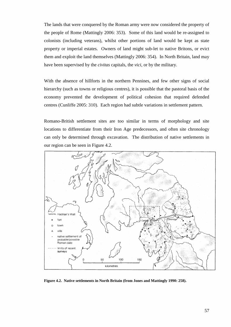
57
The lands that were conquered by the Roman army were now considered the property of
the people of Rome (Mattingly 2006: 353). Some of this land would be re-assigned to
colonists (including veterans), whilst other portions of land would be kept as state
property or imperial estates. Owners of land might sub-let to native Britons, or evict
them and exploit the land themselves (Mattingly 2006: 354). In North Britain, land may
have been supervised by the civitas capitals, the vici, or by the military.
With the absence of hillforts in the northern Pennines, and few other signs of social
hierarchy (such as towns or religious centres), it is possible that the pastoral basis of the
economy prevented the development of political cohesion that required defended
centres (Cunliffe 2005: 310). Each region had subtle variations in settlement pattern.
Romano-British settlement sites are too similar in terms of morphology and site
locations to differentiate from their Iron Age predecessors, and often site chronology
can only be determined through excavation. The distribution of native settlements in
our region can be seen in Figure 4.2.
Figure 4.2. Native settlements in North Britain (from Jones and Mattingly 1990: 258).
58
In southern Scotland for example, the evidence seems to suggest that the Iron Age
pattern was sustained until at least the end of the second century AD, if not beyond
(RCAHMS 1997: 94).
Enclosed sites appear to be the most common form of settlement in southern Scotland,
and much of northern England. The shape and type of boundary may be in several
different forms (Hingley 2004: 340). Three types of native settlement dominate during
the Roman period, curvilinear, rectilinear, and unenclosed forecourt settlements (Clack
1982: 378). Scooped settlements appear to be a result of slopes, and from surface
inspection appear to be for timber buildings (Burgess 1984: 169). Most settlements
have between three and four houses in contrast to the two or three houses of the pre-
Roman settlements (Clack 1982: 380). Evidence from excavation shows a high
proportion of sites with continuity of settlement from the Iron Age into the Roman
period (Clack 1982: 381). Smaller sites, with single round houses within enclosures,
such as seen at High Knowes A, may be thought as housing single nuclear families.
Crannogs are lake dwellings, and found throughout lowland Scotland, with a
concentration of sites in the southwest. Sites such as Milton Loch, where a round-hut
was built upon piles driven into the lake, and resting upon a wooden platform, show the
importance of security to the local population (C Piggott 1953). It is also possible that
security was not the sole purpose for such isolation, and there may have been a liminal
element involved, especially considering the importance of watery places to Celtic
Britons. The majority of crannogs in Scotland have been dated to between 850 BC and
AD 200, and there was a second period of crannog-building from the fourth to seventh
centuries AD (Crone 1993: 246).
Major enclosed sites, like hillforts, were not as abundant in our region as they were in
southern Britain. Sites such as Stanwick appear to approach the southern model of
oppida. Smaller sites, like High Knowes B, may be thought of as protected villages. In
such situations groups of households, perhaps extended families, may be inferred as
typical social groups (Harding 2004: 289). In southeast Northumberland, we see a
contraction from large pre-Roman enclosures with numerous timber buildings to small
‘squares’ with fewer huts, and sometimes only one house (Burgess 1984: 171).

59
In Cumbria, the Penrith area may have been a major centre for native settlement, along
with the Holme Abbey ridge (Higham and Jones 1975: 27-9). At Tarraby Lane near
Carlisle, evidence was found beneath Hadrian’s Wall for pre-Roman cultivation
(McCarthy 2002: 43). The round houses of the first and second century are
indistinguishable from the range of huts found anywhere in Britain during the Iron Age
(Higham and Jones 1985: 8). By the late Roman period, rectilinear buildings appear at
several sites, at Old Brampton, Risehow, Wolsty and Penrith Farm (Higham and Jones
1985: 97). It is unclear if this change is due to Roman influence or something else.
Stanwick, the great hillfort in North Yorkshire, is a unique site in North Britain
(Haselgrove et al. 1990). Evidence for pre-conquest trade in Roman imports can be
found in Spanish amphorae used for importing olive oil and Rhodian wine amphorae,
samian ware and flagons of the Neronian and early Flavian periods (Harding 2004:
162). Wheeler’s original belief of an anti-Roman headquarters has now given way to a
settlement engaged in “positive trading activities with the Romanised south in the
decades before military annexation, possibly through a treaty relationship” (Harding
2004: 163). The abandonment of Stanwick at the end of the first century, however,
presents a puzzle. Harding sees the arrival in the region of villas such as Holme House
as evidence for a progression by the local elites to a more Romanised estate living
(Harding 2004: 163). The region around Stanwick has several villas present. Evidence
suggests the region had ready access to Roman goods during the early to mid first
century AD (Hingley 2004: 334). Nearby villas include Old Durham, Holme House and
Apperley Dene (Clack 1982: 381-5). The nearby site of Forcegarth Pasture North has
evidence for trade during or immediately after the conquest period (Fairless and
Coggins 1980: 36)
Holme House, located 5 miles from Stanwick, is one of the earliest and most northerly
villas in North Britain. The close proximity of the military base at Piercebridge may
have provided security and market access that allowed a context for the expansion of
what appears to have been a conventional Iron Age settlement (Harding 2004: 166).
The site boasted many of the trappings of “Roman” culture, including a bath, painted
wall plaster, and red, white and blue tesserae suggestive of mosaics (Harding 1984: 10-
14). The presence of a traditional round-house within the complex may be, as Webster
speculates, evidence of slave quarters (2005:171), or simply a legacy of the pre-Roman
Iron Age. If so, then this may suggest that local elites did not reside in centres of

60
power, such as oppida or hillforts, but within the same mode of dwelling as the rest of
the population. They may have found other methods of displaying their status in
society, through feasting, ornamentation, or participation in religious activity.
In southern Scotland, the number of small farmsteads increased greatly during the early
centuries AD (RCAHMS 1997: 161). Sites from the third and fourth centuries however,
are difficult to locate (Hunter 2005: 237). The evidence from south-western Scotland
shows a diversity of settlement continuing from the Iron Age, with some regional
differences in construction. Major hillforts are not in evidence, with the possible
exception of Burnswark or Castle O’er, which may have played a role as a pre-eminent
centre. Dumfriesshire was an important gateway into the lowlands of Scotland, and the
Romans would have known this well (RCAHMS 1997: 168). In the 180’s AD, eastern
Dumfriesshire would have most likely been policed by patrols from Netherby
(RCAHMS 1997: 174).
Field monuments in North Britain suggest evidence for a fragmented and less
hierarchical social structure than was present elsewhere (Harding 2004: 186). A
decrease in the distribution of Roman goods may be a reflection of increasing restriction
on their use (Hunter 2005: 237-8). In the north, within the Pictish heartlands, there
appears to have been a major social or political change, with a disrupted settlement
pattern and changes in material culture suggesting the presence of new power brokers
(Hunter 2005: 238).
Castle O’er in upper Eskdale, is located 10 miles from Birrens and the Annandale route
into Scotland. The site is likely to have been an important centre for the predominately
pastoral community, and the landscape was divided up with a system of linear
earthworks (Harding 2004: 183). The surrounding landscape may be interpreted as a
massive cattle ranch, with a series of enclosed parks. The site has been dated by
radiocarbon assays between AD 75 to 428 (annexe ditch) and 55 BC to 134 AD
(secondary silts of ditch) (RCAHMS 1997: 79). The interior of the site is 0.36 hectares,
and the earliest defences enclose a space of 0.57 hectares. The final phase of
construction saw the erection of timber buildings on top of derelict ramparts (RCAHMS
1997: 82).

61
The site of Over Rig in Dumfriesshire is unusual. The site conforms to no known
template of settlement or ritual monument, but the excavators ruled in favour of Over
Rig being a site for ceremonial assembly (Harding 2004: 185). The enclosure consists
of triple-ditched C-shaped earthworks, with a timber palisade. A setting of stones
within the interior of the palisade lies on the southwest side. Excavation of the ditches
revealed a handled scoop, two small dirks, and minute fragments of broken bone
(RCAHMS 1997: 84). Whole or broken whetstones and some slag suggest an amount
of industrial activity took place on site. Fragments of glass bangles provide a terminus
post quem for the construction in the middle of the first century AD. Radiocarbon dates
for Over Rig fall within the range of 391 BC to AD 332, while the artefacts suggest the
site was being used in the first century AD (RCAHMS 1997: 86). Pollen from the
ditches of the earthworks suggest that a predominately pastoral economy existed until
after AD 500 (RCAHMS 1997: 77).
Woodend Farm is a settlement that has been dated conclusively to the Roman period,
where several different radiocarbon dates from different sections returned dates ranging
from the first century BC to the third or fourth century AD, but most belonged to the
first or second century AD (Banks 2002: 230-6). The material assemblage consisted of
coarse stones tools and quernstones (Banks 2002: 228). Woodend lies near a Roman
road and a concentration of military sites in the Lowther Hills, and thus would be almost
expected to produce Roman artefacts. The complete absence of Roman finds suggests
that either the Romans felt no need to trade with the occupants as they were of no
particular social importance, or that the inhabitants made a conscious decision not to
acquire Roman goods.
Artefact Types
The material evidence from North Britain and southern Scotland is characterised by its
poor quality and small quantity. Pottery is relatively sparse, although many sites in the
region produced locally made coarse wares. Querns are found on many sites, indicating
food processing, and perhaps present evidence of agriculture. Items of wood and bone
may survive if the conditions are favourable, but often the acidic soils destroy any such
evidence (Harding 2004: 81-2).

62
Metalworking in the first and second centuries AD included several forms exclusive to
North Britain (Harding 2004: 176). Metalworks from the Roman period include bridle
bits, terrets, swords and scabbards, torcs, armlets, brooches, rings, pins, combs,
tweezers, and spoons (MacGregor 1976). As we have seen, the quantity and style of
metalwork in the Roman period would lead some to suggest, if we were faced with little
other evidence, that “some disturbing and momentous event had taken place during the
mid-first century AD” (MacGregor 1976: 177-8).
Artefacts such as looped studs, button and loop fasteners, and brooches were the
“Romano-British minutiae” (MacGregor 1976: 180), although several types were
present during the preceding Iron Age. Brooches, popular amongst native and Roman
alike, show a fusion of Celtic and Roman provincial styles. The Dragonesque brooch
takes an S-motif and embellishes it to represent a sea-horse, with polychrome enamel
inlay for the central portion. Dragonesque brooches are found south of the Forth
(MacGregor 1976: 129). Trumpet brooches are widespread in the military zone, and
probably derived from continental Iron Age forms. Trumpet brooches reached a peak in
the first half of the first century AD, but continued into the second century with
polychrome enamelling present on some (Harding 2004: 177-8). Plate brooches,
thought to be purely continental in origin, appear between the mid-first and second
century AD (Snape 1993: 1). Button and loop fasteners, dating from the late Iron Age
to the fourth century AD, had an overall distribution in southern Scotland and northern
England, with a few south in Yorkshire and the Welsh Marches (MacGregor 1976:
130).
Economy
The Romano-British community relied on a diverse range of food resources, although
the predominant method focused on livestock (Bewley 1994: 74). Pollen evidence
suggests that agricultural activity intensified rather than changed during the Roman
period, at least in eastern Dumfriesshire (RCAHMS 1997: 167). Querns are found on a
small number of sites indicating arable farming (Clack 1982: 386), and the “beehive”
quern was in circulation during the first and second centuries AD (Challis and Harding
1975: 157).

63
The impact of the Romans can be seen at local levels, with the forts operating as
“economic magnets” for surrounding farmsteads and vici. Bewley sees the effect only
in terms of a quantitative change, which was spread over three centuries (Bewley 1994:
85). Land would have been surveyed and possibly re-allocated, and although evidence
of centuriation is limited, territorial limits may have been outlined using stone, timber,
pottery or natural features (trees, rivers, ditches) (Mattingly 2006: 360).
The yards at the front of enclosed settlements may have been cattle-folds. The acidic
soils of the region hinder the recovery of bone, but when preserved, cattle, sheep or goat
are common along with pig, horse, red deer, dog and occasionally fowl (Clack 1982:
386).
Bewley argues that Cumbria had a greater settlement density than north of the Solway,
thus broadly providing evidence for the development of a “stable agronomy created by a
frontier” (Bewley 1994: 80). For the Solway plain, there was no evidence to suggest
that the economy was anything other than animal-based, and today the main agricultural
produce is still grassland (Bewley 1994: 85).
Arable farming seems to have been the dominant form of economy in southeast
Durham. This area contains the few villa estates found in north England, and we may
use this data to compare the difference between intensive farming for profit with
subsistence farming that produces only a small surplus. The Romans may have seized
whatever surplus the locals could produce, effectively freezing the economy and social
hierarchy for most of the population. This would have had a real effect on the social
aspirations of native Britons.
Settlements could have used what surplus they had to trade and acquire luxury goods.
There is no evidence to suggest a form of currency in the region before the introduction
of Roman coinage. It is likely that native wealth rested on commodities, or the
provision of services to patrons (Hartley 1988: 5).
Social Structure
Hingley sees a total population for North Britain as high as one million people (Hingley
2004: 330). Habitats would have been spread across the landscape but concentrated in

64
the more fertile river valleys and coastal plains. Parts of northwest England would have
been marginal, but this may be due to archaeological bias (Hingley 2004: 330). The
sheer density of native settlements in the frontier region and beyond doesn’t suggest any
major depopulation took place during the Roman period, and in fact would appear to
suggest the opposite (Harding 2004: 180). Stone built settlements in Northumberland
appear to contain extended families or groups, and some show evidence of expansion
outside the enclosure, possibly as the family grew over generations.
The presence of high status individuals is a difficult question to answer. Apart from
hillforts and similar sites, which were mostly abandoned by this period, the settlement
record is remarkably quiet. It has been thought that villas represent the residences of
high status families, and if the owners of the lesser villas came from the upper levels of
native society, then the villas with underlying native farmsteads may reflect earlier sites
owned by these individuals, or their families (Clack 1982: 396). This remains to be
proven, and for the moment it would appear that those in the upper echelons of society
chose to express their status in less-obvious ways, either through personal display or
behaviour. Perhaps status was measured through holding stock or land, or through debt
and obligation (Harding 2004: 292), which would be difficult to detect in the
archaeological record.
The basic unit of society was the household, and there seems to have been little social
differentiation within the household, although this may be more a reflection of
archaeological survival.
Belief and Burial
As far as the personal beliefs of our region can be determined, the two pan-European
practices that accord reasonably with ritual activity, watery deposits and shafts into the
ground, are both present in North Britain. Communal ritual may have been one of the
functions of the major hillforts in the regions where such centres existed. Promontory
and headland forts seem far too dangerous for normal domestic occupation, and could
be ritual in function (Harding 2004: 298). Gods are seen from shrines in the Roman
period, with names such as Belatucadrus and Brigantia (Hartley 1988; Higham and
Jones 1985: 11). If inscriptions are anything to go by, Belatucadrus was popular in the
lands of the Carvetii (Henig 1984: 63); while the worship of Brigantia was encouraged

65
by imperial authorities, and may have been the personification of Britannia Inferior
(Henig 1984: 83). The affect that Roman deities and Roman religious practices had on
the local rural population is unclear, but unlikely to have been on the same scale as that
seen further south (Henig 1984: 36).
Ritual deposition occurred on settlement sites, such as the wooden ard laid into the
foundations of Milton Loch (C Piggott 1953). The proportionately large amount of
material from bogs and peat in Scotland suggest that these were the main locations of
artefact deposition (see Hunter 1997).
Evidence for burial is very sparse, and this is believed to have added to the assumption
that north British societies were materially poor (Hunter 2002: 43). Areas dominated by
settlement remains, rather than by graves (such as Scandinavia), will seem poorer by
comparison (Hunter 2002: 45). This result is purely due to the different nature of
artefact deposition between settlements and graves. The best evidence for burial during
this period is at Beadnell, Northumberland. This site contained two cairns, one 12 by 2
feet, the other 19 by 4 feet. Cairn 1 was walled with sea-rolled cobbles, and Cairn 2
was a two-phase cist with up to 19 individuals interred within, including 3 children.
The later burials contained penannular brooches dated to the first to third centuries AD.
The cairns are of two phases, the first being from the Bronze Age, with a single
inhumation in each cairn. The second phase was for later Iron Age or Romano-British
multiple burials, with successive burials on top. The evidence from Beadnell provides a
strong case for stone-lined cist burials, especially in the northeast coastal region (Tait
and Jobey 1971). The evidence from Scotland, however, would suggest that disposal of
the dead was by some other means, such as cremation or excarnation, which would be
difficult to detect (Harding 2004: 80).
Development during the Roman occupation
As we have discussed, establishing the frontier would have meant the confiscation of
native lands, the displacement of local communities, and considerable restrictions on
native mobility to pastures or traditional sources of supply. Hadrian’s Wall would have
doubtless cut across traditional tribal territories, dividing families and imposing
restrictions on movement that would have been deeply resented. “This, together with
the burden of taxation, together with the risk of enslavement or conscription, would

66
have generated a degree of hostility to the Roman military presence which, even when
not actively expressed in resistance, would have inhibited the process of Romanisation”
(Harding 2004: 171).
It is difficult to find evidence for the occupation of rectilinear settlements beyond the
end of the second century AD. Part of this is due to the insensitivity of the artefacts
found, and partly due to lack of archaeological investigation. Architectural forms may
have changed into something less tangible as well (Burgess 1984: 165). At Milton, a
supposed fortlet in the southwest corner of the main fort’s interior is apparently a
rounded enclosure, most likely the remains of a native settlement. This example of
abandonment and re-use highlights the shared appreciation between Roman and Briton
for site location (RCAHMS 1997: 175).
We can define three broad zones of organization. First, in the northeast of England
some members of the native elite were able to gather sufficient wealth for the
construction of villas, although it is possible that these villas were owned by veteran
soldiers or other immigrants (Mattingly 2006: 420). Roman towns, such as they were in
the north, existed within the area; and the wealth of the elite was probably based on the
production of surplus agricultural goods and their position in local government. A
complementary way of achieving high rank may have been to join the Roman auxiliary
forces (Hingley 2004: 342).
The majority of the population however, continued to live in settlements that resembled
those of their pre-Roman ancestors, although we have very little understanding of their
ways of life. In a second zone further north there was a fairly dense distribution of
Roman forts, some associated with vici, and the native settlements that occurred in large
numbers did not usually include elaborate houses. In this area, the Roman military may
have taxed the population directly and in kind, and this could have prevented the
development of surplus wealth by any local elite. Nevertheless native settlements
across this area do not fit into a standardised pattern, as might be expected in a non-
hierarchical society. Some settlements may have been the homes of individuals that
demonstrated their power through the creation of elaborate enclosures, or through some
other means. In addition, so little excavation work has been conducted on native
settlements in this area that it may emerge in due course that some people had access to
quantities of Roman objects (Hingley 2004: 343).

67
The civil settlements must have acted as centres for the receipt of produce from both
villas and native farmsteads on estates, as well as the source of the Roman material
found in small quantities on native farmsteads, and in larger quantities in villas and the
houses of the wealthy (Clack 1982: 397).
In the third zone, further north in lowland Scotland, Roman pottery, glass vessels and
metalwork occur, but any significant quantity of finds is usually restricted to a relatively
small number of settlements. On some of these settlements, substantial structures
included brochs, duns, hillforts and souterrains. These may suggest the presence of
households that had significant contact with the Roman administrators and traders
(Hingley 2004: 343).
The end of the Roman period
In Cumbria, Bewley believed the region experienced great prosperity in the late Roman
period, where the investment of resources saw the colonisation of the region’s heavy
clay soils (Bewley 1994: 80). Other regions have little or no evidence for the late
Roman period, leaving one to wonder where the evidence for this period lies.
The RCAHMS assessed that, in the absence of evidence to the contrary, the end of the
second century saw an upsurge of unrest along the northern frontier, causing major
settlement disruptions in the east. Southeast Scotland saw widespread abandonment
during the late Roman periods, although this unrest may not have affected the western
areas of North Britain (RCAHMS 1997: 167). After AD 300, Burnfoothill Moss shows
evidence of partial woodland regeneration, which may be indirect evidence for the
abandonment of settlement (RCAHMS 1997: 185).
After AD 200, its clear there was major disruptions to the social, economic and
settlement systems of the Tyne-Forth province. In any attempt to identify late Roman
settlements, there are several possibilities, including rectangular structures of timber or
stone, or settlements inside or overlying hillforts (Burgess 1984: 172). There may have
been a shift towards unenclosed settlement, or a move towards low-lying coastal lands.
These would be much harder to detect archaeologically, and may have been destroyed
by later developments.

68
CHAPTER FIVE
The Sub and Post Roman Periods
“The notion that when the legions withdrew the natives heaved a collective sigh of
relief and reverted once more to traditionally Celtic customs is simply naïve. It is
impossible to believe that anyone was not immeasurably affected by three and a half
centuries of Roman imperial presence in Britain, not excluding the Romans themselves.
The most critical impact of Roman occupation must have been upon the structure and
fabric of native society… the traditional bonds of obligation between rulers and
dependents would inevitably have been eroded or completely destroyed” (Harding
2004: 301).
The centuries after AD 200 are among the most murky periods in the archaeological
record of the Border counties. Where the majority of the population lived has yet to be
determined, and clear evidence for settlement does not re-emerge until the twelfth
century.
Some argue the evidence is there, but that we have not learned to recognise it, or lay
blame on the lack of diagnostic items like Roman pottery. But this argument could be
projected back to the pre-Roman period, where there is evidence for settlement and
society, albeit less than in the early Romano-British centuries. This suggests that some
other factor must have played an important role. The withdrawal of Roman forces from
Scotland in the third century must have removed some of the markets for Roman
imports, and eliminating the easiest method of dating settlements. Theories abound of
social and economic collapse, although the climate during the third and fourth centuries
was not overly harsh, and there was likely a period of peace and stability in the third
century (Burgess 1984: 171-2) (above, chapter 2). Harding believed that subsequent
episodes of famine, plague, and raiding may have forced the local population into a
transient settlement pattern, which would be much harder to detect archaeologically
(Harding 2004: 206).
Some, like Hogg, believe that the Borders were deliberately emptied of their population,
with wholesale deportations to Germany in the Antonine and succeeding periods (Hogg
1943: 143-5). Burgess relates this theory to the alleged settlements of Severus and
69
Caracalla in the early third century (Burgess 1984: 171-2). There is no evidence for
these deportations, either in Britain or in Germany.
Any legacy the Romans bestowed on the North Britons was largely immaterial, except
perhaps for a vulnerable and poorly-manned frontier. There was no lasting impression
of literacy or artistic output amongst the rural population of North Britain, no great
legacy of urbanisation or a monetary-based economy, and a very small number of
Christian worshippers (Harding 2004: 301).
The Fifth Century
With the withdrawal of Roman authority from Britain came several consequences.
Imperial officials and soldiers were no longer appointed from the continent, and no new
coins were imported into the province. This would have impacted on the local
economies, and the lack of coinage makes dating sites from the fifth or sixth centuries
difficult (Henig 2002). Rival warlords began to emerge and compete with each other
for authority, and offered safety to a rural populace who may have been plagued by
raiding for decades (Higham 1993: 87-8). Town life clearly continued in Carlisle,
although the scale of activity remains in doubt (McCarthy 2002). On the other hand,
there is no evidence for continued administration in the old Roman capital of York, and
the size and varied landscape of the region would prove difficult to govern effectively
from remote urban centres (Hartley 1988: 115). The rise of the people who became the
Picts in Scotland may represent an internal power shift at a time of stress and change
(Hunter 2005: 239). The Picts seem to be a fusion of two earlier tribal confederations,
the Caledonians and the Maeatae (Salway 1981: 318). The emergence of the Picts
should be seen in the context of great social and economic change that was endemic
throughout North Britain in the post-Roman period. Parallels can be seen in Germany,
where the frontier led to the creation of large tribal confederacies in response to the
Roman military threat (Mattingly 2006: 432).
The identification of sites from the fifth century is difficult, and the number of known
sites is very small indeed. In Cumbria, some see this as related to the difficulty of
identifying settlements from earlier periods, such as the late Iron Age (Harding 2004:
205). Pollen samples from Northumberland show environmental stability during the

70
fifth and sixth centuries, and agricultural activity remained constant in south and east
Durham (Higham 1986: 243).
We may have to assume that for the majority of the region, earlier Iron Age sites were
re-occupied, and the population returned to their old pre-Roman traditions (Hartley
1988: 115). There is some pollen evidence for woodland regeneration in the mid-first
millennium AD, but the pattern does not suggest a drop in agricultural output, and
pastoralism no doubt remained the dominant factor in the local economy (Harding 2004:
206). Steng Moss shows tree pollen rising around AD 500, and on the west side of the
Pennines, clearance started at Burnmoor Tarn in AD 390, and at Devoke Water from
AD 200 (Higham 1986: 244). This rise in tree pollen would suggest a decline in arable
farming, and a return to the predominantly pastoral economies of the pre-Roman period.
During the late Roman period, some settlements may have begun to make a change
towards rectangular structures, but it appears that circular buildings persisted in most
communities (Harding 2004: 205). At Huckhoe, Northumberland, rectangular buildings
are present during the last phase of occupation, and appear to succeed stone-built
roundhouses. Wheel-thrown pottery from the fifth to sixth centuries was found on the
site, and may be evidence for an uninterrupted occupation from the Roman to post-
Roman period (Harding 2004: 205). The site of Thirlings, Northumberland, has been
dated from the late fifth to seventh centuries (Harding 2004: 222).
As the troops were withdrawn, so too did the most reliable mechanism for introducing
monetary currency into North Britain. The level to which coinage was actually used in
North Britain is debateable, but by around AD 430 Roman coins had finally ceased to
be used (Hartley 1988: 115). This loss of currency would have had a subsequent impact
on the economy and levels of trade in the military centres, but it remains to be seen how
coins were used in rural settlements.
The reduction in long-distance trade would have meant an ever decreasing number of
imports, such as pottery, made their way into settlements and major power centres.
During this period, pottery began to disappear from the archaeological record, and this
coinless, aceramic culture would have become exceedingly difficult to detect
archaeologically (Harley 1988: 115).

71
Imports would have been controlled by local chiefs (and possibly monastic
communities), and their households would have stood out as centres of consumption,
manufacture and trade (Higham 1993: 97). These imports appear in the form of pottery
or glass from western France or the Rhineland. Continental imports appear in
considerable quantities in this area, although absolute numbers are still minimal
(Harding 2004: 213). What was being exported in exchange for these goods is difficult
to determine, but it is easy to turn again to Strabo’s well-used passage from centuries
before, and infer the traditional export of hides, furs, and slaves (IV, 5, 2).
It is doubtful that Latin was ever really picked up by the local population, who probably
continued to speak in their local Celtic dialects. The establishment of Ninian of Carlisle
as bishop at Whithorn is perhaps the best evidence for early Christianity in North
Britain. The inscribed stone from Whithorn, dating to the mid-fifth century AD, was
dedicated either to the construction of a church or as a memorial (Harding 2004: 215).
That Whithorn became an important centre is evident from the presence of imported
pottery and glass, dating to the early sixth century (Hill 1997). The nearby cemetery
consisted of lined cist graves.
The Sixth Century
Higham argues that based on existing evidence, it is not possible to argue for a large-
scale population decline before the late sixth century AD. After this time there was a
notable decline in pollen cores for detectable human activity. Woodland regeneration
peaked at Fellend Moss around AD 620, at Bolton Fell by AD 780, and by AD 580 at
Devoke Water (Higham 1986: 244-5).
In the late sixth century AD, the areas either side of the Solway are believed to have
belonged to the kingdom of Rheged, ruled by Urien and his sons until the region
became part of the Anglian settlements of Cumbria and Dumfriesshire during the
seventh century (Harding 2004: 206; Higham 1993: 90). The Gododdin occupied the
heartlands of the Votadini, and may have emerged during the fifth century (McCarthy
2002: 133). The area of northeast England, probably centred around Catterick, became
the land of the Deira (Higham 1993: 90).

72
After the Battle at Catraeth (usually taken to be Catterick), the Anglian invaders, who
had long been present in eastern Yorkshire, took control of large areas of North Britain
(Hartley 1988: 116). In the southeast of Scotland and northeast England, the Anglian
expansion is largely based on observations of documented history and place names
(Harding 2004: 302). Anglo-Saxon settlements consisted of peoples from a mixture of
regions along the North Sea, and these immigrants intermingled with the local
populations (Henig 2002). The Anglian control of the region was complete by the
Battle of Chester, around AD 615 (Hartley 1988: 116).
Sites are more difficult to find in this century than the one before. At Huckhoe,
Northumberland, there is possibly evidence for occupation in the late fifth or early sixth
century AD (Jobey 1959: 246). Crannog sites such as Milton Loch III and possibly
Barean Loch might be assigned to this period, on the basis of radiocarbon dates. The
hillfort of Tynron Doon, originally occupied in the Iron Age, has occupation levels
dated from the sixth to seventh centuries AD. Amongst the artefacts found on the site
were gold filigree and beads of cobalt-blue glass dated to the sixth or seventh century
AD (Williams 1971: 110-12). The gold filigree was from a panel for a divided circular
bracteate-pendant, that can “hardly have been deposited before c 675 AD” (Williams
1971: 111). This site was clearly an important centre, and the inhabitants had access to
exotic and wealthy goods.
Religious practice is still difficult to detect. Hoddom in Dumfriesshire had a semi-
sunken rectangular building built with Roman stone, which included fragments of two
inscribed slabs, and may have come from Birrens. The site was dated by radiocarbon
samples to around AD 600 (Harding 2004: 219). Extensive Anglo-Saxon cemeteries
are known at Yeavering and at Norton in Teesside. Weapons and brooches were found
in graves at Greenbank, Darlington, and an extended inhumation was discovered at
Castle Eden in Co. Durham. Possible Anglo-Saxon burials may lie in the north Tyne
and upper Eden valleys (Harding 2004: 226). At Camp Hill, several inhumation burials
were found, presumed to be early Christian due to their orientation. The extent to which
the local population used similar burial methods to the Anglo-Saxons is debateable.
The Seventh Century and Beyond

73
In the centuries after the Anglian conquest, evidence of settlement in North Britain
declines further still. Carlisle continued to be inhabited in some form (McCarthy 2002:
134-40), though the evidence is slim, but it is known to have been an Anglian settlement
during the seventh to ninth centuries AD (McCarthy 2002: 138).
A good case study of post-Roman rural settlement is the site of Simy Folds, Co.
Durham (Coggins, Fairless and Batey 1983). The site was variously occupied during
the Neolithic, the Iron Age, and the Anglo-Saxon period. The seventh century phase at
Simy Folds 3 is an almost square structure with thick walls and an entrance in the corner
of the east wall. Post settings along the floors suggest the building was partitioned
(Coggins, Fairless and Batey 1983: 20). Unfortunately, no radiocarbon dates are
available.
The site of Yeavering, Northumberland, has been associated with the seventh century
royal centre ad gefrin, and is named in Bede’s history. Yeavering seems to have played
an important role in the local society (Harding 2004: 220). The Mote of Mark,
Kirkudbrightshire, was evidently a site for brooch production in the sixth-seventh
centuries, with Anglo-Saxon type moulds discovered on site, along with some evidence
for occupation during the Roman period. The Mote of Mark, and Dunadd in Argyll,
appear to represent sites that exercised a high status amongst the local population.
In southwest Scotland, the appearance of Anglian crosses, sculptures, and monastic
settlements, is seen by Harding as evidence of Northumbrian political interference in the
region. By the eighth century AD, Northumbrian Christianity had spread far, and
helped to unite the region (Harding 2004: 228).

74
CHAPTER SIX
Methodology
The Study Area
As the location of the frontier for most of the province’s history, the line of Hadrian’s
Wall was placed as the middle point for this study region. This approximately
corresponds with the line of the Tyne-Solway waterways, which may have been a
cultural or tribal boundary in the Iron Age (see Chapters Three and Four). Following on
from the analysis conducted by Willis on samian types (1996; 1997; 1998), and
Hunter’s work on settlements in Scotland (2001), this thesis tests the impact of the
Roman occupation upon native populations in North Britain, using the same approaches
as Willis and Hunter.
Due to the research limitations imposed by the nature and scale of a Master of Arts
degree, it was decided that the study area would encompass the region up to c.50
kilometres either side of Hadrian’s Wall. This arbitrary distance was chosen partly
because the average distance a Roman military unit could be expected to march in a
single day was 20 Roman miles (around 30 kilometres) (Watson 1969: 54). Thus, all
the sites within our chosen region would be accessible within a day or two’s march from
Hadrian’s Wall.
In addition, it was decided to base the exact limits for study upon Ordnance Survey grid
lines, to create a more linear study region, in the hope that this would aid data collection
from the National Monuments Record (NMR) and the National Monuments Record of
Scotland (NMRS). The top left grid reference was NS 800 100, the bottom right was
NZ 600 100, and the line of Hadrian’s Wall snakes its way through the middle of the
area (see Figure 6.1).
As previously discussed in the Background chapter, the exact function of Hadrian’s
Wall remains in dispute. Whether it was ever intended to “separate Roman from
Barbarian” (SHA, Had. 11.2), or even Barbarian from Barbarian, it was an inescapable
fact for the local population.

75
Figure 6.1. North Britain and the four regions of study (after McCarthy 2002: 14).

76
In addition to the seven existing forts of the Stanegate Road, another 12 forts were soon
constructed along the Wall itself a little to the north. The nominal garrison of the new
frontier is estimated to have been about 10,000 men. In addition to the Wall, the legions
cut a broad and shallow ditch, called the Vallum along the entire length behind the Wall;
which demarcated the military zone and restricted traffic through the frontier. Some
theorise that the Wall would have split the southern Brigantes tribe from their allies to
the north, the Selgovae and Novantae, and aimed to control the movement of a hostile
population (Frere 1987: 119). Others have seen the Wall as cutting through the territory
of the Brigantes themselves.
As we have seen, the Wall would have had an economic and political impact on the
local population - interference with stock movements, and the seizure of large amounts
of farming land. An example of this can be seen from excavations at Tarraby Lane,
Stanwix, which showed traces of ploughed fields under the line of Hadrian’s Wall
(Smith 1978). Rather than being a deliberate Roman policy of frontier permanency, the
construction of the Wall in stone may be largely due to the deforested nature of the
landscape, as settlement patterns indicated a change from timber palisades to earth
banks and stone walls during the preceding Late Iron Age, as local supplies of standing
timber declined (Higham 1986: 162).
Evidence from the Iron and Bronze Ages show that regional diversity was clearly
evident. There are convenient geological and geographical features for sub-dividing this
region further, such as the River Tyne, the Solway Firth and the Pennine Mountain
chain. This is not to suggest that exchange and interaction did not take place between
these regions, indeed evidence suggests the reverse. There is good reason to believe
that rivers and waterways acted to encourage trade and interaction, rather than hinder it.
The three main geographic regions that can be observed in this part of North Britain are
the Solway Plain of Cumbria, Dumfriesshire and southwest Scotland north of the
Solway, and the coastal plains of the east Pennines. Each region is not quite equal in
size, although great care was taken to avoid overly large discrepancies when sub-
dividing. In recognition of these regional differences, it was decided to sub-divide the
study area into four zones of study (see Figure 6.1).

77
Region 1: Northwest. This region includes Dumfries and Galloway and parts of the
Scottish Borders. This region lies to the north of both Hadrian’s Wall and the
Solway estuary.
Region 2: Northeast. Includes Northumberland, parts of Tyne-and-Wear and the
Eastern part of the Pennines. Region 2 lies to the north of the mouth of the River
Tyne and north of Hadrian’s Wall.
Region 3: Southwest. Includes Cumbria, and the Western Pennines south of Hadrian’s
Wall and the Solway estuary.
Region 4: Southeast. This area includes the southern part of Northumberland, Durham,
parts of North Yorkshire, Tyne-and-Wear, and Cleveland. The region extends
from the mouth of the River Tyne southwards to the mouth of the River Tees.
This area is located to the East of the Pennines, and lies south of Hadrian’s Wall.
These four zones were tested for inter-regional variation, to determine if the imperial
frontier had any impact on the uptake of Roman goods or patterns of settlement. The
area of land to the north and south of Hadrian’s Wall was tested using these methods, to
detect any social changes brought about by the presence of the Wall. Similarly, the
regions that comprise the areas to the east and west of the Pennines were examined to
see if any variation exists between them.
Previous Work
Antiquarians had examined rural settlements in North Britain, although they were more
concerned with finding links to historical events, such as Venutius’ rebellion, or the
Roman invasion. Henry MacLauchlan’s work on Roman roads in Northumberland was
an important contribution to the region, and his “Notes” on rural settlements along the
roads provide physical descriptions of many earthworks that have since disappeared
(1867). In Scotland, work on forts and camps were carried out by Christison, Coles and
Barbour, with limited excavation (Christison 1891; Christison et al. 1899; Coles 1893).
The study of Roman material on Romano-British sites in North Britain first received
special attention from James Curle, who attempted to explain the extent of Roman
material ‘drift’ into lands beyond the frontier (Curle 1919; 1932). In Scotland, this
tradition continued, and Curle’s work was carried on by Robertson (1970), who
published an updated and extensive list of Roman finds on Scottish sites discovered in

78
the years since Curle’s paper. Most recently, this work was extended further by Hunter
(2001).
More specifically, studies have been made into the settlement pattern of Dumfriesshire
(Jobey 1971); and in recent years the Eastern Dumfriesshire region has been surveyed
by the Royal Commission of Ancient and Historical Monuments of Scotland
(RCAHMS) (1980; 1981; 1997). Work on Roman or British rural settlement sites in
Dumfriesshire has been explored by Wilson (2003), although Wilson seems somewhat
confused on exactly what is ‘Roman’, classifying material as either ‘Roman’ or
‘Romano-Native’, if associations are common between Roman and native site contexts.
However, some of the artefact types classified by Wilson as Romano-Native are clearly
Roman (such as stonework or inscriptions), Iron Age/Native British (such as Penannular
brooches) or simply indeterminate (such as an iron sickle from the site of Albie Hill,
Applegarth). The study of British and Roman interactions is made more difficult in
southern Scotland by the fact that Romano-British settlements are difficult, indeed near
impossible, to distinguish from those of the Late Iron Age on sight alone (RCAHMS
1997: 184). This problem is not exclusive to south Scotland, for the whole of north
England can be included, from the Humber to the Forth, and probably beyond.
In England, work along the same vein was conducted primarily in Northumberland by
George Jobey, and he published extensively on the nature of settlement in the Tyne-
Forth region (for example, Jobey 1966), and excavated numerous sites throughout the
area, including Kennel Hall Knowe (Jobey 1978b), Huckhoe (Jobey 1959), and
Tynemouth Priory (Jobey 1967).
Cumbria was first examined by the Collingwoods, with their excavation at Ewe Close,
and the extended complexes of Crosby Ravensworth (Collingwood R 1933;
Collingwood W 1909). In recent decades, Cumbria has seen a renewed focus, primarily
under the aegis of Barri Jones, Nick Higham and Robert Bewley. Large amounts of
information have been collected from aerial survey (Higham and Jones 1975), field
survey (Bewley 1986), excavation and synthesis works (Jones and Walker 1983;
Higham and Jones 1985; Bewley 1994).
The areas of Durham, Cleveland and North Yorkshire have been surveyed by aerial
reconnaissance, notably through the work of McCord (McCord and Jobey 1968). This

79
area was subjected to antiquarian interest from an early age, particularly in Yorkshire.
Some of the most extensively excavated settlements in North England belong to this
region, where sites such as Thorpe Thewles (Heslop 1987), Holme House (Harding
1984) and Stanwick (Haselgrove et al. 1990) have greatly contributed to the study of
rural settlement in the north. Stanwick was first excavated by Sir Mortimer Wheeler in
1951-2 (Wheeler 1954), who interpreted the great earthworks as the last refuge of
Brigantian rebels. The investigation of past settlement patterns in this region is made
more difficult than in counties to the north, because of the heavier legacy of industrial
and urban development in the modern period.
In the last few years, English Heritage has begun to re-map and re-examine old air
photos of Hadrian’s Wall, in order to identify all archaeological features present within
5 km of the Wall (P Horne, pers. comm). This survey has discovered many new
features, and several well-established sites have been examined in greater detail than
had previously been possible. The results of this survey have been incorporated into the
National Monuments Record, and some were examined as part of this study.
Household Archaeology and Rural Settlements
Archaeological deposits from the floors of settlement sites represent the life history of a
domestic structure. These archaeological remains are the remnants of the whole cycle
of construction, occupation, abandonment and post-abandonment disturbance (LaMotta
and Schiffer 1999:19). In North Britain, the occupational surface for rural sites is likely
to be on or near to bedrock. As a result, primary deposits are likely to have been
obliterated by generations of secondary occupation (Harding 2004: 14).
Willis recognised the problems inherent with thin occupation deposits in his study of
samian – the material will often have been lying on or near the activity layer for some
time before deposition, resulting in small, abraded fragments of material (1998: 117).
Such residuality can cause havoc with attempts at dating, such as an over-reliance on
scraps of samian from secondary contexts (Harding 2004: 13). Regardless, these
artefacts are still a record of exchange, and their composition and typology can be
measured and compared (Willis 1998: 117). The stratigraphy that survives on many
upland sites in North Britain is, unfortunately, minimal. The same can not necessarily
be said for the material assemblages that lie therein (Harding 2004: 13). The

80
interpretation of the evidence from occupational deposits must depend upon a rigorous
evaluation of the site, its remains and its context. Anything less would be “creative
fiction, an exercise divorced from the archaeological data-base” (Harding 2004: 12).
Rural Settlements
Rural settlements in North Britain are those sites which are not associated with the
Roman army (forts, fortlets, etc), or with urban centres, which in the north are quite
limited, and included Corbridge and Carlisle. The category ‘urban’ includes the vici
that surrounded Roman fortifications, as these operated as small urban centres. Rural
sites differ from urban sites further in that they can be regarded as extensive
archaeological complexes, where any archaeology present may be spread thinly over a
wide area. This can include not just the dwellings, but internal enclosures and adjacent
field systems (Willis 1998: 116). It is quite reasonable to assume that many of these
rural sites had middens where material would have been disposed of, and perhaps later
spread over nearby fields as fertiliser for manuring. This process would spread the
archaeology even further (Willis 1998: 116). An example of this can be seen in the
excavation of the field system associated with the settlement of Yanwath Wood,
Cumbria, where excavators found samian and glass fragments associated with the
settlement’s enclosure and not the settlement itself (Higham 1983).
The Nature of Artefact Deposition
The process whereby an artefact finds its way from daily use into the archaeological
record is called taphonomy. Factors affecting deposition and taphonomy include (but
are not limited to) the chronology of the site, the geography, geology, status, and gender
of the occupants (Cool and Baxter 1999:72). Much of the material we find from
settlements may reflect precise events in the site’s history, such as its abandonment
(Hunter, forthcoming). Humans play a dual role in the deposition of artefacts,
disturbing deposits at the same time that they are being laid down (Matthews 1965:
295).
The very nature of the deposited object affected its survival in the archaeological record.
There is little doubt the rural population used wooden items (such as the wooden bowl
from Stanwick), and to this we can add items of bone, leather and horn. These types of

81
artefacts are seen as the remains of mobile pastoralists, the image of which dominated
the paradigm of North Britain in post-war archaeology (Harding 2004: 24). Items made
of metal or glass may have been recycled, affecting their survival as archaeological
deposits. The robust nature and functions of pottery make it perhaps the most likely
object to survive. The discard of objects and the pattern by which they are removed
from use are what Hunter called ‘unconscious records of activity’ (Hunter,
forthcoming).
Settlement finds are in essence rubbish deposits, but there may still be some element of
ritual involved in the process. Due to the nature of waste disposal, artefacts from
households will often be highly fragmentary. It may be possible that the patterns
emerging on settlement sites reflect different methods of rubbish disposal rather than
different methods of use (Cool and Baxter 1999:74). How, where and at what stage an
individual disposes of an object is just as important as what that object was used for
before it was discarded. The activities include not only the accumulation of food from
cooking, tool-making and the like but also the use of the shelter as a living floor. It is
worth bearing in mind the health needs of the occupants, or as phrased by Harding:
“Are we really to imagine that the occupants wallowed ankle deep in
malodorous domestic refuse, or is it not more likely that this represents
accumulated midden material introduced when the building was still
upstanding, but as a roofless ruin? What actually constitutes a floor
level in such settlements?” (Harding 2004: 13)
The occupation of the settlement, the activities that were carried out within, and all the
other possible activities lead to disturbance of the underlying archaeological deposits.
As one Australian archaeologist summed up:
“The unceasing movement of people, the inevitable scavenging of
children and sometimes dogs, the hollowing of hearths and resting
places and so forth can only lead to considerable disturbance of the
deposit” (Matthews 1965: 295).
This has been called “differential vertical displacement” by Australian archaeologists,
who commonly encountered disturbance within the rock shelters they were excavating.

82
This was most prominent on loose sandy floors. Although many North British sites are
found on or near bedrock, or on clay subsoils, the stratigraphy is still shallow and
susceptible to disturbance. Trampling (or treadage) of the soil has a sorting effect,
“such that large objects are more likely to be the subject of uplift, and smaller to down
press” (Stockton 1973: 115). Stockton conducted an experiment with glass fragments at
a site, burying fragments over a level sandy surface and covering them with 5 cm of
sand. This was subjected to regular trampling at indiscriminate periods over a single
day, and it was then excavated. The glass was distributed from the surface level to 16
cm below (Stockton 1973: 116). Other investigations found that occupational
disturbance can affect the top foot of a habitation deposit, moving upwards as the
deposit grows (Matthews 1965: 295; Hughes and Lampert 1977: 135).
The living floor of a shelter can be seen as a “fluid body”, in which components tend to
be displaced according to weight, shape and size (Stockton 1977: 49). The shape of the
artefact may affect the amount of displacement (Stockton 1977: 50). It is also apparent
that drip-lines can act as a mixing agent on occupation floor levels.
The processes that create floor assemblages during occupation have been divided into
two categories by LaMotta and Schiffer (1999:20): the deposition of objects within a
domestic structure, or accretion; and depletion, where objects are removed from their
locations of use or from within the structure.
There is not necessarily a cause and effect relationship between objects found in a
structure and the activities that took place within, “all objects used in a house are not
likely to be deposited where they were used, nor were all objects deposited in a structure
necessarily used there”. The archaeological record found on the floors of domestic
structures may represent a palimpsest of deposits relating to different phases of activity
(LaMotta and Schiffer 1999:20).
The habitation phase consists of three stages or processes (LaMotta and Schiffer
1999:21-2). Habitation activities include food processing, preparation and
consumption, sleeping, manufacture and maintenance. The first stage is the primary
deposition, where artefacts enter the archaeological record directly through discard and
loss. The second stage is secondary deposition, which involves the removal of refuse
from an activity area, and its deposition in an external location such as a midden or

83
field. The third phase is called “provisional discard”, where artefacts are stored or
cached, due to sentimental attachment, dubbed the ‘nostalgia effect’. This third phase
shows the prominence of residuality. Very little cultural deposition occurs during the
habitation phase, due to the occupants cleaning the floors, and picking up dropped or
discarded objects.
The abandonment phase of a settlement is dictated by two main types of behaviour
(LaMotta and Schiffer 1999:22-4). ‘De facto’ refuse deposition is an accretion process,
and involves the abandonment of still usable objects within a structure, because they are
difficult to transport, easy to replace or have little residual utility. ‘Curate behaviour’ is
defined as the transfer of objects from the old to the new activity location, and is a form
of depletion. Objects likely to be curated are portable, have a high replacement value
and are still fairly useable. It is assumed that when a settlement is abandoned, the
inhabitants will transport as much of their household assemblage as is economical,
given the factors of replaceability, transport costs, and conditions of abandonment
(LaMotta and Schiffer 1999:22). The more portable and valuable objects present, the
more rapid the abandonment. There are also ritual formation processes and
abandonment rituals, such as intentional burning of structures, or placing broken objects
within deposits.
The post-abandonment processes highlight the fact that the life of a site does not end
after its occupants leave. Abandoned sites are often used as rubbish dumps, or
structural collapse can mix deposits. Additionally, scavengers, collectors, plants and
animals can affect the archaeological record of a site (LaMotta and Schiffer 1999:24-5).
Excavation is in itself part of this post-abandonment process.
Theory
Quantifying the Data
Pottery figures prominently in Roman Archaeology, mostly due to the large number of
ceramics that are recovered in Roman period excavations, and their durability. Among
the various types of pottery, red-gloss samian wares are generally perceived to have
been a high status item, in the province of Britannia at least, where it was widely valued
across society, and was very widespread in the province of Britain. The status in which

84
it was held would have varied according to cultural context, practicalities of use, and in
the social interpretations of this use (Willis 1998: 86, 113). This is perhaps true of all
‘Roman’ goods that are found on ‘Non-Roman’ sites.
A study by Willis investigated aspects of site identity and status, by examining the
number of samian vessel types present per site (Willis 1996: 181). Willis’ data was
influenced by two variables – the scale of archaeological output, and the size of the
recovered sample (Willis 1997). Simply put, for a quantification study to be
meaningful, samples needed to be of a certain size, to “engender confidence in
comparison” (Willis 1996: 182). Willis suggests that samples in the order of 50 sherds
are adequate, within a data set of 75 sites. Comparisons were made based upon the
frequency of samian within stratified and dated pottery assemblages by weight and
estimated vessel equivalents (Willis 1998: 88). Willis’ main hypothesis was that the
status and cultural identity of a site might be reflected in the composition of its pottery
assemblage (Willis 1996: 185).
Willis regarded samian as an ‘index of Romanisation’, when the small number of forms
present in small and/or rural sites may be less a reflection of economic barriers, but
rather that the inhabitants may not have been inclined to obtain and use them in large
numbers (Willis 1998: 94). However, there are examples of Roman items being
transported considerable distances beyond the boundaries of the Roman Empire
(Hedeager 1978; Hunter 2001). This leads one to consider that distance from market
was less likely to have been a significant factor in determining distribution than the
control of access to such imports (Willis 1996: 191).
Willis’ conclusions accord with pre-existing paradigms in several key respects, such as
the decline of Late Pre-Roman Iron Age (LPRIA) pottery, its replacement by Roman
forms, and a noticeable difference in the supply of pottery to military, civil centres or
rural sites (Willis 1996: 214; Willis 1998: 121). Evidently, this was not merely a
reaction to the proximity of market centres. For example, military sites have Lyon ware
and amphorae dominated by olive oil containers, whilst most native sites were found to
have Gallo-Belgic pottery, and amphorae used for storing wine (Willis 1996: 218).
There is further evidence to suggest that the vici surrounding forts were not centres for
the redistribution of goods to the surrounding countryside, as there was a vast difference

85
in the quantity and quality of pottery between the vici and the rural settlements (Evans
1995: 54).
In his study of “Roman finds from Non-Roman sites in Scotland”, Hunter (2001)
adapted Willis’ method for quantitative analysis; and attempted to identify the function
of Roman artefacts within Iron Age societies. Hunter’s study included “c.165” sites,
divided into four zones, and he used this data to identify regional trends in the use and
distribution of Roman material. Hunter’s method incorporated not only samian, but a
wide range of Roman artefacts (Hunter 2001: 293) to determine if the patterns observed
from samian studies could be replicated with other types of artefact.
Hunter’s method used a simple tally system, rather than the relative frequency technique
employed by Willis, primarily because of the fragmentary nature of the evidence. Each
of these sites was examined for the presence or absence of artefact types, and Hunter
produced a tally by site with the number of categories present. The occurrence of each
type was counted as one, regardless of the actual number of artefacts present within this
type. The categories used by Hunter (2001: fig 6) are listed below (Table 6.1).
Samian Brooch Gold Coin
Fine Ware Toilet Instrument Silver Coin
Amphora Gaming Piece Bronze Coin
Mortarium Other ornament Bead
Coarse Ware Weapon Glass Bottle
Iron Object Metal Vessel Glass Other
Other
Table 6.1. Artefact categories, from Hunter (2001: 308-9).
For example, the site of Boonies in Dumfriesshire was excavated by George Jobey in
1973-4 (Jobey 1974). Excavations found three sherds of coarse Roman pottery from the
first-second centuries AD. These sherds represented two vessels - a small bowl and a
flagon. From this data, Hunter created a type tally for Boonies of one, as there was only
a single type of Roman artefact present: coarse pottery.
Hunter found that the material in his study could be divided into two categories: items
associated with eating and drinking (pottery, glass vessels); and items associated with
ornamentation (brooches, beads, etc) (Hunter 2001: 299). This seemed to match a

86
pattern observed on continental Europe and Ireland, although in Europe the largest
deposits of Roman goods are found in lavish burials, which do not appear in Scotland or
England north of Yorkshire (Fulford 1985; Hedeager 1978).
Hunter concluded his study by stating that the Roman material on non-Roman sites was
used as a means of displaying social status, and that those sites with large numbers of
artefact types present had been previously identified as ‘tribal centres’. Lower-status
settlement assemblages would have only one or two types present. Roman artefacts, it
appeared, fitted readily into the habit for social display pre-eminent in the Iron Age
(Hunter 2001: 303).
Hunter then used this data to identify regional differences in the ‘uptake’ of Roman
material (Hunter 2001: 294-8). By dividing Scotland into four zones, he examined each
in turn. Perhaps predictably, the regions closest to the Roman frontier displayed the
highest variety of form types, and several sites showed possible evidence for being high
status centres and possible distribution points. Those regions to the north of the
Antonine Wall suggested the possibility of more restricted access to Roman material,
since most of the sites Hunter examined show only one type of find (Hunter 2001: 297).
Of particular interest to this study are his findings in the Southeast and Southwest zones
(Hunter 2001: 294-6). The Southeast (the Tyne-Forth region) showed a strongly
hierarchical society, with large sites (such as Traprain Law, East Lothian) acting as
distribution points for Roman material. The centres had several types present, whilst
the majority of sites had only a single type. Conversely, the southwest region (Solway-
Clyde) showed a more even spread of material, and the richer sites of the region
displayed a smaller range of types in comparison to high-status sites in the southeast.
This indicated to Hunter that a less hierarchical social structure existed in the southwest,
or that it represented a more socially fragmented region, perhaps ruled by several small
chiefs, rather than a few large ones.
Trade and Mechanisms of Exchange
The mechanisms by which material moved around society, changing hands and
eventually left circulation is something which requires discussion. Roman goods were
mainly absent from the region before the conquest, with the exception of Stanwick, but
other items were being manufactured and exchanged during the Iron Age. With the

87
arrival of the Romans, and their mass-produced objects, these exchanges became easier
to detect in the archaeological record. These exchanges have in the past been assigned
variously to commerce, raiding, diplomatic gifts, the return of auxiliaries and so forth
(Fulford 1985: 91). All of these would be practically invisible to archaeology.
The presence or absence of Roman artefacts on rural settlement sites from the Romano-
British period should be put into context. The absence of Roman pottery from a rural
enclosed settlement should not be seen as “social failure” for the inhabitants (Mattingly
2006: 83), as other methods of displaying status must have been available to the local
populations. Roman items were predominately manufactured items, and such things as
cattle or organic produce would not have survived archaeologically. Feasting, personal
ornamentation, the ownership of livestock, religious participation or the elaboration of
architecture would have existed to provide social stratification within local society
(Hingley 2004: 328). The lack of long-distance trade in the Iron Age may imply that
such exchanges were not as important as maintaining local contacts and ensuring one’s
place in the local hierarchy.
Roman goods would have presented the local population with new, cheap, and
technologically superior items, which may have been circulating in greater numbers
(Freeman 1993: 444). The remarkable absence of coins in North Britain, however, may
imply that barter and gifts were not entirely replaced as a mechanism for exchange
(McCarthy 2005: 60).
Methods and Research Aims
Rural settlement data collected from my outlined study region will be used to test the
following hypotheses:
i) That the material remains of Romano-British rural settlements
reflected a hierarchical distribution system, which operated
within the Native population during the Roman Period, similar to
those previously found in Scotland (Hunter 2001);
ii) That sites of different social status displayed different levels of
‘uptake’ in Roman material goods, as access to such material was
controlled by those in the upper echelons of society; and
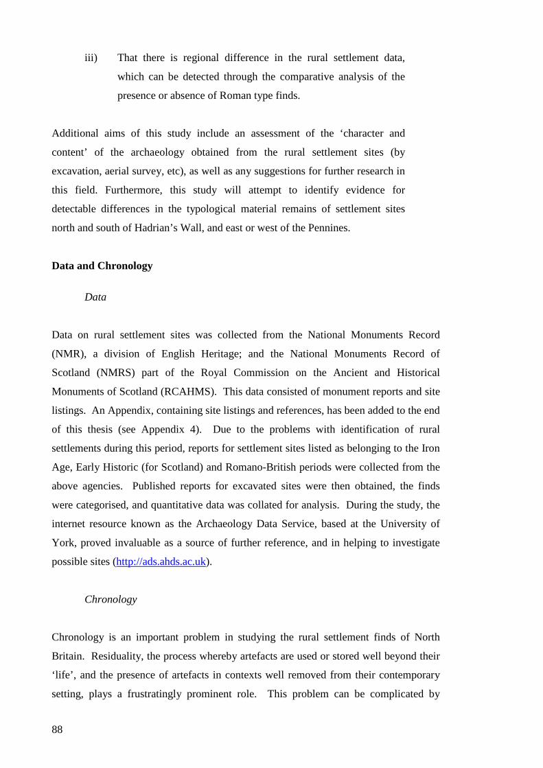
88
iii) That there is regional difference in the rural settlement data,
which can be detected through the comparative analysis of the
presence or absence of Roman type finds.
Additional aims of this study include an assessment of the ‘character and
content’ of the archaeology obtained from the rural settlement sites (by
excavation, aerial survey, etc), as well as any suggestions for further research in
this field. Furthermore, this study will attempt to identify evidence for
detectable differences in the typological material remains of settlement sites
north and south of Hadrian’s Wall, and east or west of the Pennines.
Data and Chronology
Data
Data on rural settlement sites was collected from the National Monuments Record
(NMR), a division of English Heritage; and the National Monuments Record of
Scotland (NMRS) part of the Royal Commission on the Ancient and Historical
Monuments of Scotland (RCAHMS). This data consisted of monument reports and site
listings. An Appendix, containing site listings and references, has been added to the end
of this thesis (see Appendix 4). Due to the problems with identification of rural
settlements during this period, reports for settlement sites listed as belonging to the Iron
Age, Early Historic (for Scotland) and Romano-British periods were collected from the
above agencies. Published reports for excavated sites were then obtained, the finds
were categorised, and quantitative data was collated for analysis. During the study, the
internet resource known as the Archaeology Data Service, based at the University of
York, proved invaluable as a source of further reference, and in helping to investigate
possible sites (http://ads.ahds.ac.uk).
Chronology
Chronology is an important problem in studying the rural settlement finds of North
Britain. Residuality, the process whereby artefacts are used or stored well beyond their
‘life’, and the presence of artefacts in contexts well removed from their contemporary
setting, plays a frustratingly prominent role. This problem can be complicated by

89
variations of supply, the value of objects amongst their British owners (such as repairing
damaged samian), and the possible use of Roman artefacts as votive deposits on native
sites (used as offerings in foundation trenches, ditches, etc). Taphonomic factors also
play havoc, such as the fact that dateable artefacts from stratified horizons may have
been tampered with or simply obliterated by later agricultural activity (Harding 2004:
72).
Apart from these concerns, there is also the very real problem of being unable to
differentiate the age of settlements based on site morphology alone. The enclosed
rectilinear and curvilinear settlements of the type most often seen in the Roman period
have an ancestry that stretches far into the first millennium BC, and continues well
beyond the Roman period (in some cases almost into the Late Medieval period).
Excavation is the only way to determine the chronology of a settlement, and even then,
the site can only be dated if recognizable finds such as pottery, coins or glass bangles
are found. Even these items will only allow a broad statement to be made, and this is in
itself determined by (perhaps even dependant on) the extent of the site’s excavation.
Even then, there is a real paucity of adequately dated sites. This is partly due to the fact
that many of the settlements in our region were aceramic, and presumably they were so
by choice. The problem of undiagnostic local pottery, stone and bone artefacts further
hinders the establishment of a chronological framework (Harding 2004: 24).
Bearing all these caveats in mind, it is still possible to detect recognisable changes over
time for most of the sites published. These site phases were noted and, when tabulated
for analysis, each site phase was sorted into four broad chronological ranges. “Iron
Age” for the period before the Roman conquest (before c. AD 70); “Early” for the
period from the Conquest until the Severan period, so the first and second centuries AD;
“Late” for the post-Severan third and fourth centuries; and finally “Romano-British” for
sites with no firm chronological data, yet which still produced Roman type finds. Most
“Romano-British” sites were excavated by antiquarians, or before the Second World
War, and there is no way to properly determine age based purely upon published
descriptions. These sites will be referred to in the Analysis chapter as ‘stratified’
(except Romano-British) sites, and the general corpus of sites that have not been sub-
divided in this way will be referred to as ‘unstratified’. This division is an arbitrary one
imposed by the author to aid comparison, and in no way refers to the actual conditions
of the archaeological deposit.

90
Artefact Typologies
Published excavation reports were collected for all known excavated sites in the area, as
recorded by the NMR and NMRS. As well as tally finds on an overall basis, as Hunter
(2001) did, each site was also broken into its respective chronological phases, and
artefact tallies were assigned to each of these periods. In this way, it was hoped to show
the evolution of trade in Roman artefacts, or luxury goods, in the regions examined.
A worksheet was created, to help quantification, and contained fields on both artefact
and morphological attributes (Table 6.2). It was decided to note morphological
attributes in the thought that if there was time, a morphological analysis would be
conducted. In the event, however, time considerations made this impossible.
The artefact typologies used in this study have been broken into six main groups:
pottery; coinage; personal items (ornamentation); metalwork; glass; and miscellaneous
‘other’. Those artefacts that comprise the “Romano-British minutiae” (MacGregor
1976: 180), being looped studs, button and loop fasteners, and brooches were included
within these categories.
Stone artefacts (such as quern stones and flints) were not recorded. Neither was locally
made pottery, as these had been produced by the local British population since the
Bronze Age (see Chapter 3), and was not imported on the same scale. Some items were
manufactured locally and imported, such as querns, but this thesis is concerned with
purely Roman trade items. Similarly, items that are purely Celtic or from the Iron Age,
such as cauldrons, torcs, horn terminals and terrets (MacGregor 1976: 38-50,146-52),
were not included. Combs of bone or wood were not included, nor was weaving
equipment.

91
EXCAVATED SETTLEMENT SITE - SUMMARY
SITE: NMR/NMRS:
PHASE:
GRID REF:
REGION: YEAR EXCAVATED: REF:
NEED RE-SET????
NUMBER OF TYPES PRESENT: SITE MORPHOLOGY:
Samian Rectangular
Fine Ware Sub-Rectangular
Amphora Circular
Mortarium Sub-Circular
Coarse Ware Unenclosed
Scooped
Gold Coin Hillfort
Silver Coin No. of Ditches?
Bronze Coin
Diameter of Enclosure
Brooch Area of Enclosure
Other Ornament Fence? Bank? Palisade?
Number of Yards
Weapon Entrance Faces?
Iron Object Evidence of Expansion?
Metal Vessel
Fixture/Fitting No. Internal Huts
No. External Huts
Bead Max. No. Contemporary
Glass Vessel No. Timber Built
Bracelet No. Stone Built
Glass Other
Internal Diameter
Other Door Facing
Date?
(All measurements are in metres, unless otherwise specified)
ADDITIONAL NOTES:
Table 6.2. Worksheet used to record artefact and morphological data from rural settlement sites.

92
Samian Readily identified by the red-slip coating, this pottery type is perhaps the
most common artefact found on Roman military and urban sites during the first and
second centuries AD. In continental Europe, samian is sometimes referred to as terra
sigillata.
Intended for use on the table, items include cups, plates, and bowls, some with
decorations moulded or stamped onto the pot (see Figure 6.2). Samian is an important
part of this study because its trade was a significant factor in the economy of the British
province, it may be seen as an indicator of Romanisation, and it is highly useful for the
purposes of dating (Collingwood and Richmond 1969: 235).
Samian wares were first classified into types by Dragendorff, and this was extended by
Dechelette, Knorr and Walter, with separate classifications by Curle, Ludowici and
Ritterling (Collingwood and Richmond 1969: 241). For example, forms such as 18/31
and 18/31R are characteristic types from sites dating to the first half of the second
century (Collingwood and Richmond 1969: 245).
In his study of samian typologies, Willis found that rural sites had the lowest proportion
of samian types, and that samian was most frequent amongst military installations and
major civil centres (Willis 1998: 89-91). Samian is found widely on rural sites, but
usually only in small numbers. MacGregor has noted a “faint reflection of samian-ware
motifs” in native metalwork in North Britain during the first century AD (MacGregor
1976: 186).

93
Figure 6.2. Forms of decorated samian ware commonly found in Britain (after Collingwood and
Richmond 1969: 242).
Fine Ware Like samian, fine wares were vessels primarily used as table wares, such
as plates, bowls, jugs, etc. Early fine wares, such as terra nigra, terra rubra and other
Gallo-Belgic types (including Lyon Ware) were present alongside samian forms. These
ceramic vessels began to replace samian forms after AD 140-50, when samian trade
from the continent began to decline. Fine wares are similar to samian in that they were
finished with a smooth, glossy surface. These wares include ceramics from the

94
Castor/Nene Valley, Colchester, and ‘Rhenish’ wares. In the third and fourth centuries,
fine wares such as Crambeck and New Forest types are seen in pottery assemblages.
Castor Ware began production on the valley of the River Nene in the later second
century and continued until the fourth century. Types included beakers and flagons,
with a colour coating of whitish-grey (Collingwood and Richmond 1969: 279-80).
Derbyshire Ware was later second century pottery (from Holbrook, near Duffield), and
was later produced at Hazelwood in the later third and early fourth centuries
(Collingwood and Richmond 1969: 282). New Forest Wares have been dated to the late
third and fourth centuries (Collingwood and Richmond 1969: 280).
Amphorae An amphora is a large capacity transport vessel, with a handle on either
side of the neck, and a pointed base for stacking. These vessels were typically
cylindrical, or globular. They were used to transport such items as wine, oil, olives, and
fish sauce. Amphorae are not as important in themselves, more as representatives of the
commodity being stored within. Many amphorae bear a stamp, and some may contain
information written upon their sides in ink or incised with a stylus. Most amphorae
imported into Britain were manufactured in southern Spain as oil-carriers. Wooden
barrels probably played a large role in the northern parts of the empire, possibly
resulting in smaller numbers of amphorae on northern sites (Collingwood and
Richmond 1969: 265-71).
Mortaria These pots were robust, thick-walled vessels with a heavy flange suitable
for gripping, and a wide flat base for stability (Figure 6.3). The bottom of the inner
surface was scored with grooves or grits, often made with hard quartzose grit, that
allowed food to be ground more effectively. Mortaria allowed the user to mix and crush
foodstuffs, and liquids could be poured out by a spout on the rim. The mortarium
represented a ‘Roman’ way of preparing one’s food, and may be seen as a possible sign
of Romanizing influences. The fabric of mortaria can vary widely, in accordance with
local clays at the production centres. In the late second century, Midland manufacturers
entered the northern military market. Manufacturers included individuals such as
Serrius of Hartshill and Mancetter (Warwicks), whose workshops distributed mortaria
to the Midlands and the north, including the forts on the Antonine Wall (Collingwood
and Richmond 1969: 256).

95
Figure 6.3. Mortaria forms of the first and second century AD (from Collingwood and Richmond
1969: 253).
Coarse Ware Sometimes known as ‘parchment ware’, or grey ware. These vessels
were mainly used for food preparation and storage. Most pots were plain, undecorated
earthenwares (although some surfaces were treated through oxidisation), and included
items such as jugs, beakers, pots, large bowls, platters and flagons (see Figure 6.4).
Typically, coarse wares were used for cooking, storage, serving and preparing
foodstuffs. In North England, coarse wares were extensively examined and catalogued
by Gillam (1970), and coarse ware types are often referred to by their ‘Gillam type’.
Plain jars last in the northern military area from the Flavian period until about AD 140,
cooking pots in grey being common in the second quarter of the second century and
again in the third century. Black Burnished Wares began in the Hadrianic period, and
Black Burnished type 1 (BB1) gives way in the last quarter of the second century to
BB2, which lasted until the middle of the third century, where slight changes were
implemented again, which lasted until the close of the fourth century (Collingwood and
Richmond 1969: 265). East Yorkshire kilns dominated the northern pottery market for
both military and civilian, in the last forty years of the fourth century, with Crambeck
Wares (Collingwood and Richmond 1969: 262). The Crambeck cooking pots are
known as Huntcliff ware. After the Pictish war of AD 368-9, this type replaces all other
wares in the north of England, and lasts until the early fifth century (Collingwood and
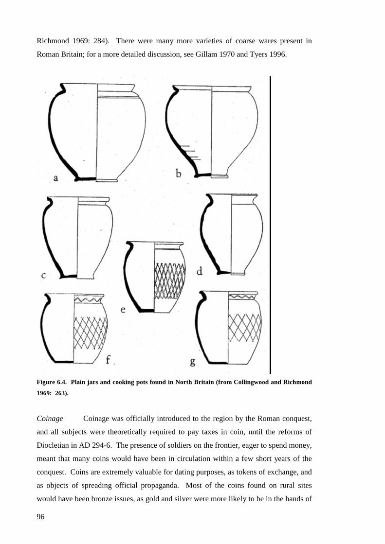
96
Richmond 1969: 284). There were many more varieties of coarse wares present in
Roman Britain; for a more detailed discussion, see Gillam 1970 and Tyers 1996.
Figure 6.4. Plain jars and cooking pots found in North Britain (from Collingwood and Richmond
1969: 263).
Coinage Coinage was officially introduced to the region by the Roman conquest,
and all subjects were theoretically required to pay taxes in coin, until the reforms of
Diocletian in AD 294-6. The presence of soldiers on the frontier, eager to spend money,
meant that many coins would have been in circulation within a few short years of the
conquest. Coins are extremely valuable for dating purposes, as tokens of exchange, and
as objects of spreading official propaganda. Most of the coins found on rural sites
would have been bronze issues, as gold and silver were more likely to be in the hands of

97
Roman soldiers and businessmen - as found in the comparisons of Fort and Extramural
coin finds at Newstead (Clarke 1994). But there are also differences between the vici
and rural sites in terms of exposure to Roman coinage. Coins can remain in circulation
for a long time after their initial issue, which can confuse attempts to establish site
chronologies.
Brooches Whether produced by Roman, continental or native metal smiths,
brooches were definitely imported onto rural sites, and used as a means of personal
display. Brooches were worn by both men and women, used to pin garments together,
and as decoration (Snape 1993: 5). As MacGregor states, the “paucity of La Tène
brooches in North Britain [during the Iron Age] is in open contrast to the positive flood
of early Romano-British times” (MacGregor 1976: 119). Simple one-piece brooches
were used in Britain during the Iron Age, and such types as penannular brooches were
not included in this analysis of Roman goods, being present in the region from at least
the Iron Age onwards (Fowler 1960). Certain types, like Fowler’s A4, were popular in
the late part of the first century AD, when their discoveries “range from villa to fort”
(MacGregor 1976: 126).
It is uncertain who was producing these brooches, although they appear to represent a
fusion of British and Roman styles. By design they are Celtic, following La Tène
stylings with swirls and animal motifs, and were produced at special centres. Brooch
types, like the Dragonesque or Trumpet, can be found during the Roman period on
military, urban and rural sites.
Dragonesque brooches take on the basic S-shape, or broken-back scroll, and embellish it
by detailing one side as the head of a seahorse, with polychrome enamel inlay
(MacGregor 1976: 129). The distribution of this type lies primarily north of the
Humber, and south of the Clyde (MacGregor 1976: 127). The form is quite widespread
in Europe north of the Alps, from France to Hungary (Harding 2004: 177-8).
Dragonesque brooches began production perhaps in the middle of the first century, and
were manufactured in northern England or southern Scotland, though no production
centre has yet been found. The type ceased to be produced at some point in the second
half of the second century (Collingwood and Richmond 1969: 295; MacGregor 1976:
127).

98
Trumpet brooches may be derived from late Iron Age types in continental Europe, and
have a wide distribution in North Britain, continuing into the second century AD
through a variety of forms, some with polychrome enamelling (Harding 2004: 177-8).
Trumpet brooches appear to have been produced at Traprain Law, Brough-under-
Stainmore and Kirkby Thore (Cumbria) (Collingwood and Richmond 1969: 297). The
peak of Trumpet brooch production was during the first half of the second century AD
(MacGregor 1976: 123-4).
Plate brooches were probably manufactured on the continent, and although difficult to
date, appear in South Britain from the second half of the first century AD (Snape 1993:
1). Enamelled types were present during the second century AD, and by the mid-third
century types were present with gilding and gemstones (Snape 1993: 6).
Other forms of brooch include bow and fan-tail brooches, the most famous example
being the silver gilt Aesica brooch from Great Chesters, manufactured in the late first
century (perhaps in southern England), but found in a hoard from the third or fourth
century AD (Harding 2004: 177-8; MacGregor 1976: 119-23). Disc brooches are
another form, and their origin dates back to the Iron Age (MacGregor 1976: 124-6).
Other Ornament This is a very arbitrary category, and a low count is expected.
Torcs, although generally not included in this study, are Romano-British in context.
Beaded-torcs have been found on sites dated to the first-second century AD (MacGregor
1976: 97-8). Other objects in this category include armlets (MacGregor 1976: 102-
110); and pins, where some types (projecting-ring-headed pins and zoomorphic-headed
pins) have been dated between the second-fourth centuries AD (MacGregor 1976: 138-
9). British Mirrors, unless clearly from a Roman context, are not included (MacGregor
1976: 140-3).
Weapon There is a very great difficulty in determining if a weapon recovered
from a rural site was Roman or British, unless of course they are characteristically
Roman army items (such as the gladius or pilum). Swords and spear butts are native in
manufacture, and are found on sites up to the first century AD (MacGregor 1976: 77-86;
S Piggott 1950). It is probable that these artefact types, operating within the warrior-
oriented Celtic society of North Britain, were regarded as prestige goods. One of the
problems with this category – illustrative of much else - are the weapon finds from

99
Burnswark hillfort (Jobey 1978a), including a pilum, many arrowheads, and ballista
balls (see Appendix 2 for a discussion of the problem of Burnswark).
Metal Object Unless clearly imported, metal objects are not included in this analysis.
The manufacture and provenance of such items as nails and hooks cannot be positively
assigned as either ‘Roman’ or ‘Native’. If such a provenance proved to be in doubt, the
artefacts were left out, for fear of distorting the results.
Button and loop fasteners have a date range from the Late Iron Age to the fourth century
AD. Their distribution covers lowland Scotland and northern England, with a large
number in Yorkshire and the Welsh Marches (MacGregor 1976: 129-33). Tweezers,
frequent finds on Gallo-Roman sites, are items for enhancing personal display, and are
included in this study (MacGregor 1976: 143). Finally, spoons and scoops are included
in this category, as they may have been used for feasting, or involved in ritual functions
(MacGregor 1976: 145-6)
Metal Vessel This type includes bronze and silver vessels. It is expected that the total
number of metal vessels found on rural sites in the region will be very low, perhaps
even negligible. Metal vessels were seen as expensive items, and had a long life,
possibly undergoing many repairs, before finally being discarded or melted down for re-
casting. This is primarily due to the extreme expense of metal vessels, seen in the
production of faux-metallic ceramic fine-slip wares. Metal wares dominate rich burials
on the Continent, and are found on high-status social centres, at sites such as Traprain
Law, and scattered throughout North Britain as hoards.
Fixture, Fitting Like the Iron Objects, if artefacts belonging to this category are
difficult to provenance, they will not be included. However, some fittings are clearly
Roman, or influenced by the Roman style. This can be seen by the example of T-
shaped iron ‘holdfasts’, found at Old Durham, which were used to support hollow box-
tiles in the villa’s bath-house (Richmond, Romans & Wright 1944:10).
Bead Some of the beads found on rural settlement sites are of British
manufacture, produced at manufacture centres, possibly alongside glass bangles. These
beads that are of arbitrary, or definitely Native nature, will not be included in this study.
Melon Beads, however, are not present in Britain before the Roman period, and are

100
found on both Roman and Native sites. These beads were popular with Roman soldiers,
who wore them as amulets for protection to ward off the ‘evil eye’ (Wilson 2003: 113).
Whilst not necessarily Roman, they have a long history in Germany, and were imported
into Britain during the first and second centuries AD (Guido 1978: 100). As such, they
may take part in the process of trade and exchange which we are trying to identify.
Glass Vessel Glass vessels were unknown in North Britain before the Roman
conquest. In the first to third centuries AD, glass vessels of blue/green or colourless
glass were the most commonly produced. In the fourth century, a form of ‘bubbly’
glass in shades of green was made. Glass vessels were used as drinking vessels, table
wares, containers for storing food and drink, and for storing perfumes and medicines.
Vessel forms included drinking vessels, bowls, jars, flasks, jugs and bottles (Cool and
Baxter 1999).
Glass Other Types belonging to this category includes intaglios and window glass.
Intaglios were used for signet rings, pendants, etc, and they can be considered a form of
ornamentation (although some were made of semi-precious stone). Window glass
represents a very Romanised form of architecture, but the prevalence of square bottles
in the first and second century AD, and the highly fragmentary nature of occupation
debris, has the potential to confuse investigators. Like metal items, broken glass was
probably recycled into new forms.
Other Roman military forces, especially legionary units, operated tileries for
their own use, and produced many roof tiles for their buildings. There may have been a
legionary tilery operating at Scalesceugh, south of Carlisle; as well as one near York
(Collingwood and Richmond 1969: 278). Auxiliary regiments operated tileries as well,
and there are some from Muncaster, serving Ravenglass and Hardknott (Cumbria), and
one from Old Church, Brampton (Cumbria). This category also includes any other
miscellaneous items that occur during the study that defy categorisation.
Quantification, Analysis and Statistics
Excavation reports were critically assessed, and artefact contexts were scrutinised.
Based on the number of Roman artefact types present on a site, a tally was made based
on the method outlined above.

101
After this was completed, a spreadsheet was created with Microsoft Excel, listing the
site, artefacts found, and the final type tally. This data was used to generate statistical
information, such as mean and standard deviation. It was generally assumed that sites
with only one or two Roman types present were low status sites, whilst settlements
possessing four or more enjoyed a higher rank in society. Sites with three types present
could be regarded as intermediate – that is, they were neither high-status sites, nor were
they dwelling in relative social poverty.
Chronological data was recorded carefully from the excavation reports, and if there was
any doubt about the context of an artefact, or a stratigraphic horizon, the site was not
allocated as Early and/or Late Roman in date. This division was primarily to determine
if there was any evidence of increased or decreased trade during the four centuries of
the Roman occupation.
The results of this analysis are presented in detail within the following chapter.

102
CHAPTER SEVEN
Analysis
“Virtually nothing has been said or can be said about the people living in the immediate area of the
Wall but outside the civil settlements” (Breeze and Dobson 2000: 212).
A total of 115 Iron Age and Romano-British settlement sites were examined for
analysis, and of these, 80 sites had levels belonging to the Roman period. Of these,
there were 72 sites containing Roman artefact types. The distribution of Roman types
by site and by region, as was established in the Methodology chapter, can be seen in
Table 7.1.
1 2 3 4 Total
Sites 9 22 22 19 72
Table 7.1. Distribution of sites examined per region, which have Roman type
finds present.
All sites with Roman goods were analysed, and a tally of exotic and Roman artefacts
was recorded for each site. The results of this investigation can be seen in Table 7.2.
Region
1 2 3 4 Total
1 3 8 10 2 23
2 4 9 8 5 26
No. of Types 3 1 1 2 4
Present 4 3 3 1 7
5 1 3 4
6 4 4
7 2 2 4
Total 9 22 22 19 72
Table 7.2. Distribution of Roman artefacts on rural settlement sites by region and
number of types present.

103
Calculating the presence of Roman artefact types from these sites, the sample had a
mean of 2.597, and a standard deviation of 1.797. It can be clearly seen that most sites
(68%) have 2 or less types present in their assemblages. However, there are some with
greater access to Roman goods (16.6%), as the number of sites with 4 or more types
show. These statistics, in conjunction with Table 7.2, allow us to see that most of the
sites have a type-count of at most 2, with some sites (and some regions) showing a
greater spread of distribution.
Although the sites are not equally distributed across the four regions, the data is
sufficient to allow some broad conclusions to be made about the distribution of Roman
and exotic trade goods. Because the conclusions are so broad, and the sample size
much smaller than anticipated, multivariate statistical analysis will not be employed.
The data displayed in Table 7.2 can be visualised as a histogram, which can be seen in
Figure 7.1.
Distribution of Sites, n = 72
0
5
10
15
20
25
30
1 2 3 4 5 6 7
Categories
No
of
sit
es
Figure 7.1. Histogram of the categories of Roman objects found on rural
settlement sites.
These findings appear to fit a model of differential access to Roman and exotic goods.
In comparison to the model shown by Hunter (2001), whereby sites in Scotland are
more likely to have only one type of object, sites in this study seem to contain either one
or two. Indeed, two types (36.1%) of Roman artefact are more commonplace on
settlement sites than single ones (31.9%). It must also be noted that there were several
sites recording zero type counts, despite being positively dated to the Roman period,

104
most notably Woodend Farm, Dumfriesshire (Banks 2000) which recorded no finds but
was assigned an Early Roman date through radiocarbon assays. This will be discussed
in more depth later in the chapter.
Regional Variation
Region 1: the North West
There were 26 sites examined in the North West region, 12 of which could be assigned
to the Romano-British period, and 14 that either belonged to the preceding Iron Age, or
whose occupation date was unknown. Of the Romano-British sites, 9 were included in
this study, and the distributions of categories are displayed in Figure 7.2. Three sites
belonging to the Romano-British period were not included in this study because they
had a type count of zero, despite being positively dated to the Roman period.
Settlement sites that produced absolute dates for the Roman period, yet were absent of
finds, include Woodend Farm, Dumfriesshire, which was located adjacent to a Roman
road.
Region 1, n = 9
01
12
23
34
45
1 2 3 4 5 6 7
Categories
No
of
sit
es
Figure 7.2. Categories of Roman objects from rural settlement sites in Region 1.
The results from Region 1 had a mean score of 2.77 and a standard deviation of 2.44.
The standard deviation for this region is quite high, indeed the highest in the study, and
is skewed by the two large “elite” sites, and the small sample size. The number of sites
with 2 types and less consisted of 77.7% of the sample, and those with 4 or more made

105
up 22.3%. The two sites with 7 types present were Burnswark and Buittle Bailey, both
important sites in the region. Both sites are controversial, Burnswark has a confusing
archaeological record, and it has been suggested that Buittle Bailey is a Romano-Celtic
shrine. In regards to chronological divisions, the sample included 7 sites from the Early
period, 1 from the Late, and 2 from the miscellaneous Romano-British category.
Although the number of sites in this region was comparatively low, it is still possible to
detect a hierarchical distribution system, with two important distribution centres, and
the majority of sites receiving only two or less types, including those with none.
Clearly, Roman goods were not as important in Region 1 as they seem to be in the other
regions of this study, or access was very tightly controlled. The elite sites are clearly
defined by the variety of goods present, seeming to contradict the results of Hunter
(2001:296), where he suggests a much less hierarchical society for South West
Scotland. However, this discrepancy could be the result of the small sample size in this
investigation. Hunter did not use Burnswark or Buittle Bailey in his analysis, and
without these two sites, Figure 7.2 would appear to be less hierarchical.
Region 2: the North East
There were 29 sites examined in the North East region, 24 belonging to the Romano-
British period, and 5 sites being either unknown or Iron Age in date. Two sites from the
Roman period resulted in a zero type count, leaving 22 sites for analysis. The type
count of this region can be visualised in Figure 7.3, below.
The sites from Region 2 have a mean of 2.09, and a standard deviation of 1.19. The
numbers of sites with 2 and less types make up 77.3% of sites, and those with 4 or more
comprise 18.2%. The region had 14 sites with settlement deposits datable to the Early
period, 4 to the Late period, and 6 to the miscellaneous Romano-British category.
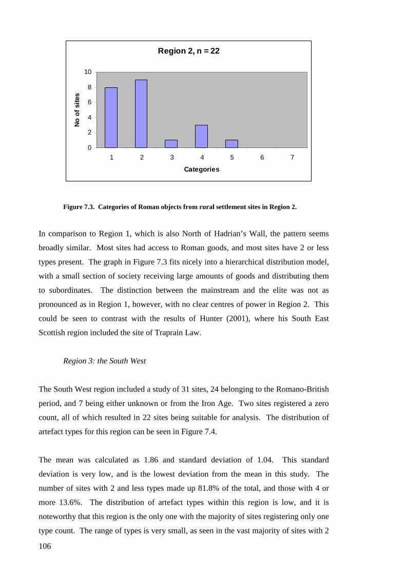
106
Region 2, n = 22
0
2
4
6
8
10
1 2 3 4 5 6 7
Categories
No
of
sit
es
Figure 7.3. Categories of Roman objects from rural settlement sites in Region 2.
In comparison to Region 1, which is also North of Hadrian’s Wall, the pattern seems
broadly similar. Most sites had access to Roman goods, and most sites have 2 or less
types present. The graph in Figure 7.3 fits nicely into a hierarchical distribution model,
with a small section of society receiving large amounts of goods and distributing them
to subordinates. The distinction between the mainstream and the elite was not as
pronounced as in Region 1, however, with no clear centres of power in Region 2. This
could be seen to contrast with the results of Hunter (2001), where his South East
Scottish region included the site of Traprain Law.
Region 3: the South West
The South West region included a study of 31 sites, 24 belonging to the Romano-British
period, and 7 being either unknown or from the Iron Age. Two sites registered a zero
count, all of which resulted in 22 sites being suitable for analysis. The distribution of
artefact types for this region can be seen in Figure 7.4.
The mean was calculated as 1.86 and standard deviation of 1.04. This standard
deviation is very low, and is the lowest deviation from the mean in this study. The
number of sites with 2 and less types made up 81.8% of the total, and those with 4 or
more 13.6%. The distribution of artefact types within this region is low, and it is
noteworthy that this region is the only one with the majority of sites registering only one
type count. The range of types is very small, as seen in the vast majority of sites with 2

107
or less types present, and the small standard deviation. There are six sites from the
Early Roman period, 11 sites from the Late period, and 7 Romano-British sites.
The results are similar to those from Region 2, and show another nice fit to a
hierarchical model of distribution. However, in Region 3 there are more sites likely to
have only a single type present, suggesting that typical settlements had very limited
access to Roman types, and that trade in such commodities was very tightly controlled.
Even then, it appears that trade in these items was not as important as in other regions,
especially when compared with the data from Region 4 across the Pennines.
Region 3, n = 22
0
2
4
6
8
10
12
1 2 3 4 5 6 7
Categories
No
of
sit
es
Figure 7.4. Categories of Roman objects from rural settlement sites in Region 3.
It is interesting to note that this region, Cumbria, was a heavily fortified part of the
frontier, as evidenced by the concentration of Roman fortifications, and was seen as one
of the more unstable, violent places in North Britain. It is interesting to consider the
results from this analysis with this fact in mind.
Region 4: the South East
The South East region included a study of 29 sites, 20 belonging to the Romano-British
period, and 9 being either unknown or from the Iron Age. One site belonging to the
Roman period returned a zero type count, resulting in 19 sites for analysis. The
distribution of artefact types from this region is displayed in Figure 7.5. Sites from
Region 4 have a mean count of 3.94, a median of 4, and a standard deviation of 2.07.

108
This region has a very high mean number of types per site, which coupled with a large
standard deviation, suggests a very wide range of goods amongst settlement sites. The
number of sites with 2 and less types is 36.8% of the total, and those with 4 or more
comprise 52.6%, the opposite of the other regions in this study. There are 14 sites with
occupation levels datable to the Early period, 8 to the Late period, and 3 from the
Romano-British category.
Region 4, n = 19
0
1
2
3
4
5
6
1 2 3 4 5 6 7
Categories
No
of
sit
es
Figure 7.5. Categories of Roman objects from rural settlement sites in Region 4.
Region 4 shows a very uneven pattern of distribution. A large number of sites returned
tallies of over 4 types. Unlike other regions, Region 4 does not seem to fit a model for
hierarchical distribution. By examining Figure 7.5, and noting two distinct curves in the
distribution, it is perhaps possible to detect two distinct trading groups. This region
showed a much less hierarchical distribution system, possibly as a result of the
proximity of sites to the more Romanised southern province. A settlement in this region
would be much more likely to use, or have access to, Roman artefact types. This seems
to be a very ‘Roman’ region, with resultant sites displaying a wide range of goods, from
pottery and fine tablewares, to roof tiles. The sites vary too, from rural homesteads, to
hillforts and villas (such as Holme House).
Hadrian’s Wall
By grouping regions 1 and 2 (31 Romano-British sites), and 3 and 4 (41 Romano-
British sites), broad differences north and south of Hadrian’s Wall can be observed.

109
Figures 7.6 and 7.7 show the distribution of artefact types for the regions north and
south of the Wall.
North of Hadrian’s Wall, the sites had a mean of 2.29 types and a standard deviation of
1.63. The number of sites north of the Wall with 2 or less types present was 24
(77.4%), whilst only 6 sites had four or more types (19.3%). Of those sites with datable
deposits from the Early period there were 21 sites, 5 from the Late period, and 8 from
the Romano-British category. The graph in Figure 7.6 shows a hierarchical distribution
system, with controlled access to Roman trade goods.
North of Hadrian's Wall, n = 31
0
2
4
6
8
10
12
14
1 2 3 4 5 6 7
Categories
No
of
sit
es
Figure 7.6. Histogram of the categories of Roman objects from settlement sites
North of Hadrian’s Wall.
South of the Wall, the number of sites with 4 or more types present is larger, at 31.7%.
The number of southern sites with 2 or less types present was 25 (60.9%). The mean
was 2.83 types, and the standard deviation was 1.89. The southern regions had 20 sites
from the Early Roman period, 19 sites from the Late period, and 10 Romano-British
sites. By glancing at the graph in Figure 7.7, it is clear that both regions North and
South of Hadrian’s Wall show a majority of sites with 2 or less artefact types, and the
presence of several elite distribution centres. The two graphs are surprisingly similar
(superficially at least), showing the negligible impact that Hadrian’s Wall had on trade
and cultural preferences. The evidence does seem to suggest that there was similarly
controlled access to Roman goods on both sides of the Wall, but that sites to the south

110
had wider access to these items. Is it that there are more elite centres in the South, or
possibly that there was a more even distribution of goods amongst the nobility?
South of Hadrian's Wall, n = 41
0
2
4
6
8
10
12
14
1 2 3 4 5 6 7
Categories
No
of
sit
es
Figure 7.7. Histogram of the categories of Roman objects from settlement sites
South of Hadrian’s Wall.
Does this mean the south is less hierarchical, or more, and is this caused by cultural,
economic or political differences? Is this due to the fact that the south is within the
imperial border, or that it is closer to the more Romanized south? The graph above
(Fig 7.7) would, however, be skewed by the uneven data from Regions 3 and 4. For
example, the rich data from Region 4 would be ‘holding up’ the results from the highly
controlled distribution of trade goods in Region 3 (see above).
The Pennines
As a second regional study, we can attempt to identify differences between communities
west and east of the Pennines. The west of the Pennines was subjected to a larger
garrison force during the Roman period, and was generally considered the more unruly
sector of the frontier. By grouping Regions 1 and 3 (31 sites) for the west, and Regions
2 and 4 (41 sites) for the east, we can then visualise the findings in Figures 7.8 and 7.9.

111
West of the Pennines, n = 31
0
2
4
6
8
10
12
14
1 2 3 4 5 6 7
Categories
No
of
sit
es
Figure 7.8. Histogram of the categories of Roman objects from settlement sites to
the West of the Pennines.
West of the Pennines, sites with 2 or less types present made up 80.6% of the total
number of sites examined. Only 16.1% of sites west of the Pennines were found to have
4 or more types present. The mean was 2.13 types and the standard deviation was 1.58,
which is relatively low. There were 13 sites from the Early period, 12 from the Late,
and 9 from the Romano-British category. From examining the graph in Figure 7.8, it
can be seen that the distribution of Roman goods was tightly controlled, with several
important elite centres. The nearly equal number of sites from both Early and Late
periods may be indicative of a constant level of trade. There are a large majority of sites
with 2 or less types present, which suggests very controlled access to Roman and exotic
goods.
In contrast, to the East of the Pennines, only 58.5% of sites have 2 or less types.
Interestingly, 34.1% of sites in the east show 4 or more types present, a substantial
portion. The mean was 2.97, and the standard deviation was 1.90, both of which are
rather high. The majority of sites from the eastern regions have been dated to the Early
period, there being 28 sites in this category. There were also 12 sites from the Late
period and 9 from the miscellaneous Romano-British. The results, illustrated in Figure
7.9, outline a much less hierarchical distribution pattern in the Eastern regions, where
the numbers of types tend to flatten out in the upper strata of society. This region has
some materially rich sites, with regionally high means and a large deviation from the
average.

112
East of the Pennines, n = 41
0
2
4
6
8
10
12
14
16
1 2 3 4 5 6 7
Categories
No
of
sit
es
Figure 7.9. Histogram of the categories of Roman objects from settlement sites to
the East of the Pennines.
It appears that the area to the East of the Pennines had greater access to Roman goods.
Does this imply that Roman goods played a greater part in status display in the east, or
merely that they were more readily available to the entire population, via a less
hierarchical society? It is prudent to note the probable sample bias resultant from the
data in Region 4, since Region 2 shows a much more “classic” hierarchical distribution
scheme (Figure 7.3).
Chronological Variation
In the Methodology chapter, the decision was made to sub-divide sites (where
appropriate) into broad chronological categories; these being Early (1-2c AD), Late (3-
4c), Romano-British (unknown date, but 1-4c), and Iron Age (which in this region,
contain no finds, and/or have not been adequately dated, and thus are not included for
study). These sub-divided sites are referred to in this investigation as ‘stratified’ sites
for convenience only, and in this study a total of 83 sites was included for analysis.
There are 41 sites belonging to the Early period, 24 to the Late, and 18 to the Romano-
British category. The information from analysis has been tabulated below, in Tables
7.3, 7.4, and 7.5.
The Early Period

113
Early sites had a relatively high mean of 3 types, and a standard deviation of 1.936. The
percentage of early sites with two or less types present is 56.1%; with 29.2% of sites
having 4 or more types present.
Region
1 2 3 4 Total
1 2 3 3 1 9
2 3 7 1 3 14
No. of Types 3 1 2 3 6
Present 4 2 2
5 1 3 4
6 2 2
7 2 2 4
Total 7 14 6 14 41
Table 7.3. Distribution of Roman artefacts on rural settlement sites by region and
number of types present on each site (Early).
The information from Table 7.3 is shown in Figure 7.10. The standard deviation of
early sites shows that the sites from this period were more dispersed in terms of type
count. Interestingly, there are more Early sites in the regions east of the Pennines,
which also display more variety in the range of types available. The distribution of sites
is about equal North and South of Hadrian’s Wall, and is similar to the broad pattern
seen in Figures 7.6 and 7.7.
Early Roman Period, n = 41
0
2
4
6
8
10
12
14
16
1 2 3 4 5 6 7
Categories
No
of
sit
es
Figure 7.10. Categories of Roman objects from settlement sites during the Early Roman
Period.

114
The overall impression of the graph in Figure 7.10 is that of a less hierarchical system
of distribution. There are many sites with several types (3 or more) present, but whether
this indicates prosperity, security, or merely archaeological bias remains unclear.
It would appear the north of Britain was very prosperous in terms of trade in Roman
goods immediately after the conquest and into the second century. There are many
‘elite’ sites dating to this early period.
The Late Period
During the Late period, the picture changes dramatically from that seen in the first and
second centuries AD (see Table 7.4). Late sites had a mean of 1.916 types and a
standard deviation of 1.059. The deviation from the mean is quite low, suggesting a
very small range of goods. 20 sites from this period had 2 or fewer types present
(83.3%), and only 4 sites had type counts of 4 or more (16.6%).
During the Late period, there are more sites located to the south of Hadrian’s Wall
(Regions 3 and 4). This is possibly due to security concerns, market recession or
cultural changes to the north. The regions east and west of the Pennines show an equal
distribution of Late sites, both North and South of the Wall.
Region
1 2 3 4 Total
1 1 3 4 2 10
2 1 6 3 10
No. of Types 3
Present 4 1 3 4
5
6
7
Total 1 4 11 8 24
Table 7.4. Distribution of Roman artefacts on rural settlement sites by region and
number of types present on each site (Late).
Figure 7.11 shows a much more controlled distribution system in place, with tightly
controlled access to Roman goods, and a small majority with a wide range of artefacts.
Late sites show much less distribution from the mean, and a very low standard
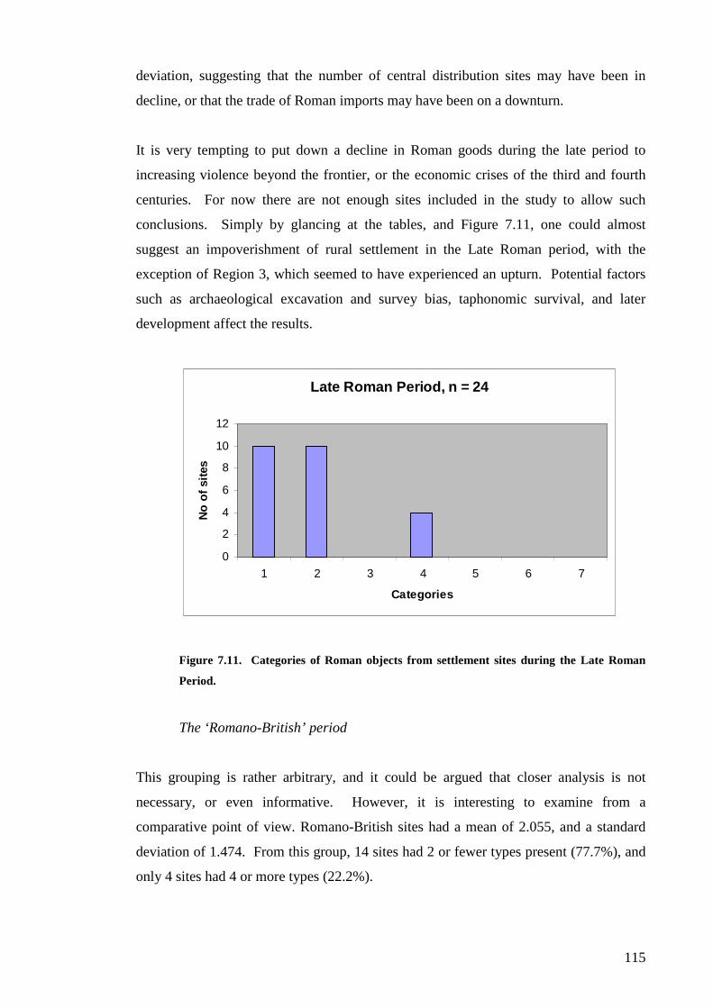
115
deviation, suggesting that the number of central distribution sites may have been in
decline, or that the trade of Roman imports may have been on a downturn.
It is very tempting to put down a decline in Roman goods during the late period to
increasing violence beyond the frontier, or the economic crises of the third and fourth
centuries. For now there are not enough sites included in the study to allow such
conclusions. Simply by glancing at the tables, and Figure 7.11, one could almost
suggest an impoverishment of rural settlement in the Late Roman period, with the
exception of Region 3, which seemed to have experienced an upturn. Potential factors
such as archaeological excavation and survey bias, taphonomic survival, and later
development affect the results.
Late Roman Period, n = 24
0
2
4
6
8
10
12
1 2 3 4 5 6 7
Categories
No
of
sit
es
Figure 7.11. Categories of Roman objects from settlement sites during the Late Roman
Period.
The ‘Romano-British’ period
This grouping is rather arbitrary, and it could be argued that closer analysis is not
necessary, or even informative. However, it is interesting to examine from a
comparative point of view. Romano-British sites had a mean of 2.055, and a standard
deviation of 1.474. From this group, 14 sites had 2 or fewer types present (77.7%), and
only 4 sites had 4 or more types (22.2%).

116
Region
1 2 3 4 Total
1 1 4 4 9
2 1 1 2 1 5
No. of Types 3
Present 4 1 1 1 3
5
6 1 1
7
Total 2 6 7 3 18
Table 7.5. Distribution of Roman artefacts on rural settlement sites by region and
number of types present on each site (unknown – “Romano-British”).
The distribution of sites appears to be roughly equal to the north and south of Hadrian’s
Wall, and similarly for sites to the east and west of the Pennines (see Table 7.5). Figure
7.12 fits into the previously discussed models for controlled, hierarchical, access to
Roman and exotic goods.
"Romano-British", n = 18
0
2
4
6
8
10
1 2 3 4 5 6 7
Categories
No
of
sit
es
Figure 7.12. Categories of Roman objects from rural settlement sites from the Romano-
British, or unknown, period.
We can make some broad statements about the distribution of Roman types between
regions during the periods in question. Region 1 seems to have only one site dating to
the Late period. This may be due to survey bias or reflect a cultural preference after the
Severan period. Conversely, Region 3 has more sites in the Late period with Roman
artefacts, and it is tempting to suggest that the reason is due to the benefits of peace in

117
Cumbria after several generations of strife. Region 2 seems to reflect the pattern seen in
Region 1, in that during the Late period, the numbers of sites drop sharply (from 14 sites
to 4). Region 4 seems to have a large number of sites in both periods, perhaps reflecting
a settlement pattern more in line with regions further south, in Yorkshire and the lands
of the Parisi. However, it is still apparent that there was a decline across the board in
the Late period. This may be due to the archaeology; the rural population may have
lived in different settlements, or may have moved into the towns and vici.
Artefact Typology
The proportion of each artefact category found on settlement sites can be seen in Table
7.6, where it can be seen that Roman coarse wares were the most common type find.
Coarse ware is clearly the most dominant type of Roman object found on rural
settlement sites in the region. It remains unclear whether or not this is due to the
availability of supply, or to the preferences of local populations. Second and third most
common are, perhaps surprisingly, the very Roman samian and mortaria pottery types;
fourth most common is amphorae. There is a clear preference for implements
associated with food, and items associated with ornamentation are half way down the
list. Whether these types represent traditional feasting, or changing patterns of
consumption, cannot be determined with the evidence at hand. Amphorae imply the
consumption of the traded goods that they contained, such as olives, oil and wine.
Mortaria represent a very Roman way of preparing foods, in sharp contrast to the
predominance of jugs and jars amongst Iron Age cooking wares. These findings are in
contrast to evidence from Scotland (Hunter 2001), where a strong preference for fine
table wares can be interpreted as socially-motivated interest in ostentatious display. The
dominance of coarse wares in this study makes such behaviour less clear, and may be
indicative of changed patterns of consumption. Alternatively, it may also reflect a
diminished ability on behalf of the local population to acquire such fine goods.
Interestingly, coinage is very far down the list, suggesting that Roman coins were either
not very common on rural settlement sites, that they were not a desirable item type, or
that they were not the sort of object one would casually discard.

118
Type% of sites
(unstratified)% of sites(stratified)
Samian 45.8 39.7
Fine Wares 15.3 14.4
Coarse Wares 81.9 81.9
Amphorae 16.6 15.6
Mortaria 34.7 36.1
Glass Vessel 12.5 12.0
Bead 15.3 13.2
Brooch 12.5 10.8
Coin 8.3 9.6
Other 11? ?
Total 72 83
Table 7.6. Artefact type finds per site, based on the percent of site with type
present.
The distribution of artefact types can be seen on a regional basis in Table 7.7. It is
apparent that there are regional differences in terms of what artefact types were found
on settlement sites. Region 1 shows a strong preference for ornamentation, with beads
and brooches being two of the most prevalent types, with coarse pottery and samian
following. It must be remembered that this is a small sample, but it is interesting,
nonetheless.
% of sites per region
TypeRegion
1Region
2Region
3Region
4
Samian 33.3 31.8 40.1 73.7
Fine Wares 11.1 9.1 4.5 36.8
Coarse Wares 44.4 81.8 81.8 100
Amphorae 11.1 18.2 18.2 15.8
Mortaria 22.2 18.2 36.4 57.9
Glass Vessel 13.6 4.5 36.8
Bead 55.5 9.1 21
Brooch 44.4 4.5 26.3
Coin 22.2 9.1 10.5
Other 33.3 9.1 31.6
Total 9 22 22 19
Table 7.7. Artefact type finds per site, based on the percent of site with type present per
region.
Region 2, also north of Hadrian’s Wall, but on the east side of the Pennines, shows a
contrasting picture. Coarse pottery is the most prevalent by a large majority, followed

119
by samian, then amphorae and mortaria. Artefacts associated with ornamentation are at
the lower end of the scale.
In Region 3, coarse pottery is again dominant, with samian being the second most
common type, followed by mortaria then amphorae. There were no ornamental artefact
types found in this Region, which is interesting to contrast with Region 1, which lies
across the Solway, north of Hadrian’s Wall.
In Region 4, coarse pottery is the most dominant type, being present at every Roman
site surveyed. Samian is present on nearly three-quarters of sites, followed by mortaria.
Interestingly, fine wares and glass vessels tie for fourth place. Again, the data from this
region suggests a population with access to a wide range of imported goods.
Additionally, the regional distribution of types per site can be divided into chronological
categories. The Early phase is displayed in Table 7.8, and the Late period in Table 7.9.
% of sites per region
TypeRegion
1Region
2Region
3Region
4
Samian 28.6 42.8 66.6 85.7
Fine Wares 14.3 7.1 16.6 28.5
Coarse Wares 57.1 92.8 66.6 100
Amphorae 14.3 21.4 16.6 21.4
Mortaria 14.3 21.4 16.6 57.1
Glass Vessel 14.3 50
Bead 57.1 7.1 21.4
Brooch 57.1 7.1 28.5
Coin 28.6 14.3
Other 42.8 14.3 16.6 28.5
Total 7 14 6 14
Table 7.8. Artefact type finds per site, based on the percent of site with type present per
region (Early).
In the Early Roman period, there was a wide range of goods being traded to rural
settlement sites. In Region 1, the three most prevalent type finds were coarse pottery,
beads and brooches. Like the general overview discussed above, this region showed
preferences for ornamentation, and Roman coarse pottery was being used as a trade
commodity. In Region 2, coarse wares are present on a large majority of sites, followed
by samian, then mortaria and amphorae. This region sees a preference for Roman table
wares of all types. Region 3 shows coarse wares and samian as the equally most

120
prevalent types, followed by the other pottery types. There were no ornamental artefact
types included in this region, suggesting a complete lack of trade in these decorative
goods.
In Region 4, coarse pottery was found on all the sites surveyed, with samian being very
prevalent on sites (85.7%). Mortaria and glass vessels were the next most common
types. Like the general suggestion above, the first and second centuries saw a large
amount of Roman tablewares, including fine pottery and glass vessels, finding their way
into the homes of the rural population.
% of sites per region
TypeRegion
1Region
2Region
3Region
4
Samian 27.3
Fine Wares 37.5
Coarse Wares 75 100 87.5
Amphorae 25 9.1 12.5
Mortaria 45.4 75
Glass Vessel 25 12.5
Bead
Brooch
Coin 100 12.5
Other 37.5
Total 1 4 11 8
Table 7.9. Artefact type finds per site, based on the percent of site with type present per
region (Late).
The Late Roman period saw a drastic reduction in the trade of Roman artefact types.
This can be seen in Table 7.9. In Region 1, there was only a single find, being a coin.
In Region 2, coarse ware continued to dominate, with amphorae and glass vessels also
being traded. In Region 3, coarse wares are present on all the sites in this category,
followed by mortaria, then samian. It is interesting that samian appears on these late
sites, as samian was not being produced into the third and fourth centuries. It is possible
these are residuals from the preceding centuries, so these results should be treated with
caution. The presence of mortaria suggests perhaps the belated ‘Romanisation’ of the
local populace? In Region 4, coarse wares are the dominant type find, followed by
mortaria, then fine wares. The finds from Region 4 once again suggest a very open
trade in Roman goods.
Samian

121
Samian pottery was a very important trade item, being a common find on many of the
sites in this study. It is most prevalent on sites in Region 4, where it was found on
73.7% of all settlement sites from the Roman period. In Region 3, also south of
Hadrian’s Wall, samian also plays a prominent role in the type finds amongst
settlements. North of the Wall, occurrences of samian drops, but is still found on about
one-third of sites surveyed. It is not possible to make observations about the number of
samian types present on sites in this survey, as the archaeology is too fragmentary to
make any kind of meaningful statement.
Coarse Ware
Coarse wares are extremely prominent in the archaeological record of the settlement
sites surveyed. Roman coarse wares are almost the type-fossil of Roman-period rural
settlements, and their presence is almost assured. Coarse wares were seamlessly
adopted by the local population, and can be seen to have been assimilated into pre-
existing practices for food storage and preparation, lingering on from the Iron Age.
As previously mentioned, coarse wares were present on all Roman sites surveyed in
Region 4, and were present in a large majority of sites from Regions 2 and 3 (81.8%).
However the picture differs in Region 1, where coarse wares, although prominent, are
not as common as ornamental artefact types.
Mortaria
Mortaria, as previously discussed, represent a very Roman way of food preparation,
which was unlike that seen in the Late Iron Age. Mortaria are most common on sites
south of Hadrian’s Wall, especially in Region 4 (57.9%). North of the Wall, mortaria
are present on about one-fifth of the sites surveyed. During the Late Roman period,
mortaria disappear completely from sites north of the Wall, whilst on sites to the south,
the percentage actually increases. Does this suggest the population south of the Wall
became more ‘Romanised’ than those to the north? It may be possible to argue that
whilst coarse ware and samian are both common north of the Wall, they were
incorporated into pre-existing trade and consumption practices from the Late Iron Age.

122
Amphorae
Amphorae are less important for the forms and styles they bear, than the goods they
were used to store. Amphorae were used to transport a wide range of trade goods; most
notably wine, olive oil, fish sauce and olives. Amphorae, while present in this study,
were not an important type on rural settlement sites. Surprisingly, in Region 4, with its
wide range of Roman goods, there are very few amphorae present. Regionally,
amphorae are most common in Regions 2 and 3, where they are represented on 18.2%
of sites. There were more amphorae on sites from the Early Roman period, and the
numbers declined slightly into the later period. There exists the possibility that goods
were transported north in containers other than amphorae, such as wooden barrels.
Evidence from Germany would seem to confirm this possibility.
Fine Wares
Roman fine pottery vessels were not common on sites in this survey, with the exception
of Region 4 (36.8%). It is possible that Fine Wares were seen as superfluous to samian
pottery, which was widely traded, perhaps in place of other Fine Wares. During the
Later Roman period, Fine Wares were absent from all regions except Region 4.
Glass Vessels
The distribution of glass vessels is high to the east of the Pennines, in Regions 2 and 4.
There were none found in Region 1 during this survey, and a single vessel in Region 3
which was undated. Trade in glass vessels was strong during the Early period, and
continued to a lesser extent into the Late period, with trade west of the Pennines
dropping completely.
Some of the notable glass vessels from sites in this survey include:
Gubeon Cottage, Northumberland (R2). Two tall cylindrical cups with domed
footstands, probably imported from Alexandria, dated to the first century AD
(Jobey 1957: 169);
West Whelpington, Northumberland (R2). Fragment from a blue pillar-moulded
bowl (Jarrett and Evans 1989: 132);

123
Witchy Neuk, Northumberland (R2). Fragment from rim and neck of small one-
handled globular jug with short neck and ‘beaky’ spout. Manufactured in the
Seine-Rhine, third century AD (Wake 1939: 137);
Ewe Close, Cumbria (R3). Fragment of a small dish (Collingwood 1908: 362);
Park House, Cumbria (R3). Two vessels of green-blue glass, one part of
shoulder with part of the fluted handle attached; the other the bottom edge of a
square bottle (Bellhouse 1955: 14);
Ingleby Barwick, Cleveland (R4). Fragment from straight-sided thick-walled
vessel, probably a square or hexagonal bottle. Common in first and second
centuries AD. Fragment was subjected to great heat, and may have been used
for activities such as bead-making (Heslop 1984: 33);
Thorpe Thewles, Cleveland (R4). Fragment of blue-green vessel, representing
handle and shoulder of bottle. Dated to first or second century, part of a
cylindrical or square body (Heslop 1987: 84);
Melsonby, North Yorkshire (R4). Two or three vessels of fine blue-green
tablewares of good quality; one with narrow cylindrical form, being the neck of
a jug or flask. Datable from Neronian to Flavian period (Fitts et al. 1999: 26);
Stanwick, North Yorkshire (R4). Fragment of the body of a thick-walled vessel
with flat sides, possibly a square bottle. Common in the second century AD
(Haselgrove et al. 1990: M1/3); and
Apperley Dene, Northumberland (R4). Four vessels, two dated to the first and
second centuries, one from the first to third centuries, and one from the fourth
century AD. One of the Early Roman vessels was probably part of a base with a
hollow tubular foot ring, from a flask or beaker (Greene 1978: 56).
Glass Other
Among the miscellaneous finds from this survey are several glass objects that are not
from vessels. Intaglios are small pieces of glass (or in some cases semi-precious stone)
with an image etched into them, and were commonly used to decorate rings. Three
examples were found in this survey, and surprisingly, all of them were found north of
Hadrian’s Wall. At Burnswark, Dumfriesshire, the inscription bore “a standing figure,
surrounded by the remains of an inscription, much defaced” (Christison et al.
1899:247). At Gowanburn River Camp, Northumberland, a cornelian intaglio depicted
a lion pursuing a red deer, and a hound pursuing another unidentified animal (I and G

124
Jobey 1988:21). The intaglio from Hartburn, Northumberland, is a more complicated
scene. The intaglio depicts:
“Achilles in a two-horse chariot dragging Hector around the Walls of
Troy, and is in low relief on the Wall itself. A gateway is also shown in
the Wall and behind appear towers and buildings. It is just possible that
a head is represented in one of the arches or windows above the Wall,
which would be in keeping with the legend. In the imperial period
representations of Greek mythology became popular, amongst them
legends connected with the Trojan War. Achilles was one of the
favourites to be depicted amongst the Greek heroes” (Jobey 1973a:44).
Window glass was introduced to the region during the Roman period, and was found on
three sites in this survey. All of the sites were from Region 4, and these were
Darlington, Co. Durham; Old Durham, Co. Durham; and Melsonby, North Yorkshire.
Brooches
Eight brooches (other than Penannular brooches) have been identified in the sites
surveyed. They are represented below in Table 7.10.
Table 7.10. Brooches by type, and number of sites in the study.
Clearly, the Trumpet style of brooch is the most popular, or the type with the widest
distribution. Brooches are not a common find on sites in this region. No brooches date
to the Later Roman Period. Perhaps such ornate brooches as the Dragonesque types
were not the sort of artefact that people would allow to become lost, or swept away.
Regionally, brooches are most prevalent in Region 4, where 5 of the brooches were
found. Regions 1 and 2, North of Hadrian’s Wall, have 2 and 1 finds respectively.
Site Date Types Region
Darlington R-B Dragonesque Co Durham
Milking Gap 2c AD Dragonesque Northumb
Catcote 1-2c Trumpet Cleveland
Thorpe Thewles 1-2c Trumpet Cleveland
Burnswark 1-2c Trumpet Dumfries
Carronbridge A to 2c Trumpet Dumfries
Stanwick 1-2c AD Trumpet N Yorks
Gunnar Peak 2c AD Trumpet Northumb

125
There were no brooches found in Region 3. However, when the proportion of brooches
is compared to other finds from these sites, it seems that brooches are very important in
Region 1, where they are the second most common type. Most of the brooches were
dated to the Early Roman period, and there were no brooches found on sites from the
Late Roman period.
Coins
Thirteen coins have been recorded during this study, from six sites. The details of these
coins are presented in Table 7.11, below.
Table 7.11. Coin finds by site, and by coin details.
In terms of the regional distribution of coinage, Region 4 produced the greatest number
of coins, although one of these sites, Catcote, produced 7 coins, skewing the average.
Region 1 produced three coins, and Region 2 had two sites with one coin each. Region
3 had no coin finds. A hoard discovered at Hawk Hirst, Cumbria (Region 3) did not
include descriptive details: the excavator simply mentioning that they had discovered “a
hoard of third century coins” (Haverfield 1899:359). The coins from this site are quite
probably not associated with the settlement, and represent a later deposit, so were not
included for analysis. It is also interesting to note the number of coins found north of
Hadrian’s Wall, and that the coin finds from Region 1 are from the two sites with 7 type
counts each, clearly important elite distribution centres. Is this possibly evidence of
Roman trade?
It is interesting to note the small number of coin finds in this survey. It is widely
claimed that the Romans brought a monetised economy to the region after the conquest.
The lands north of Hadrian’s Wall were again brought under direct Roman control for a
small period in both the Antonine and Severan periods. The outpost forts built beyond
the Wall in the Hadrianic period are usually thought to reflect the fact that Hadrian’s
Site Date Type/Detail Region
Botel Bailey 3-4c Coins (x2) Dumfries
Burnswark 1-2c Denarius of Domitian (x1) Dumfries
Carry House R-B Victorinus (x1) Northumb
Bridge House R-B As of Faustina (x1) Northumb
Holme House 1-2c Denarius of Nero (x1) Co Durham
Catcote 1-2c Sestertius, Ant Pius (138-61) (x1) Cleveland
Catcote 3-4c Silver Denarius of Elagabalus (x1); Bronze Radiates of Victorinus (x1), Tetricus (x4) Cleveland

126
Wall did not delimit the boundary of the Brigantes tribe, but was simply built where it
was most convenient. The populations (south of the Wall at least) would have to pay
taxes each year, and the Roman army, dominant in the post-conquest landscape, paid its
soldiers and its suppliers in coin. The small number of finds may be evidence in
absentia for payment in kind, or suggest a minor role for coinage in the region. Perhaps
most coins traded with the local populations stayed within the market or tax centres,
traded or sold away again as soon as it was obtained. There was only one silver coin
found in this study, and the remainder were bronze issues, which would have been the
most used type. Silver and gold would have been almost exclusively used by the
military or in towns, and as such would have been very rare in rural settlements.
Household deposits are more likely to be affected by the fact that people would have
picked up dropped coins, rather than leave them to be disposed of with the other refuse.
Coins could have been taken with the owners, melted down or restamped. Most of the
finds are singular, suggesting casual losses, with the obvious exception of Catcote in the
Later Roman period.
In terms of chronology, coinage seems more prominent in the Later Roman period, with
eight coins from two sites. Three sites are from the Early period, and two sites are from
undated Roman sites.
Metal Other
Four sites had metal objects that were neither brooches, nor coins, and were imported
Roman goods. Three toiletry instruments were found from two sites, Buittle Bailey,
Dumfriesshire, and Darlington, Co. Durham. From Buittle Bailey came two ‘probe like
surgical instruments’ (DES 1997:24), including a damaged bronze ligulae (Penman
1998:475). The find from Darlington was a pair of tweezers. It is interesting to note
that both sites can be considered sites of considerable wealth, as Buittle Bailey was an
important elite centre, whilst Darlington was a villa to the south east of the study region.
One of the more curious finds from this survey was that of a Roman key from Old
Durham, Co. Durham, made of iron and measuring 6.5 inches long (Richmond,
Romans and Wright 1944:13). From Milking Gap, Northumberland was found a lead
plumb-bob, with an iron loop (Kilbride-Jones 1938:344).

127
Other
There were several finds from sites in this survey that defied categorisation for use in
this study. These items are mentioned with the intention of providing a more complete
picture of the archaeology of rural settlement sites in this region, and have not been used
for type-counts and subsequent calculations.
Roman roofing tile was found on four sites in Region 4, on sites which were most likely
villas. These sites included Darlington, Co. Durham; Old Durham, Co. Durham;
Melsonby, North Yorkshire; and Apperley Dene, Northumberland. From Melsonby,
excavators found fragments of tegulae and imbrex (Fitts et al. 1999:28).
More miscellaneous finds include artefacts related to salt trade in the region. Several
salt containers were found at Melsonby, North Yorkshire (Fitts et al. 1999:23). A stone
lamp was found at The Dod, Borders, in imitation of a Roman pottery lamp, even
imitating the colour of terracotta (Smith 1982:134).

128
CHAPTER EIGHT
Discussion
“Commerce should be considered vulgar if it is a rather small affair. If it is extensiveand well-financed, importing many products from all over the world and distributingthem to many customers honestly, one should not criticise it severely”
Cicero, de Officiis, 1.42.151
Results of Analysis
It is unfortunate that the sample was smaller than expected. Breaking down such a
small sample size creates the potential for unreliable and meaningless results. However,
as Hunter states, “it seems worth pushing the data to provide initial models for debate”
(Hunter 2005: 235). Having “pushed” the data in the previous chapter, we shall now
examine the findings in its wider context.
Overall, the findings of this study appear to fit a model of differential access to Roman
or exotic goods within a hierarchical society. Interestingly, in Hunter (2001) most of
the sites examined had a single Roman type present, whereas in the current study, most
sites contained either one or two types – indeed sites with two types were more common
(36.1%) than single-type sites (31.9%). There were a few sites where despite absolute
dating to the Roman period, no Roman types were found in the excavated assemblages,
most notably the site of Woodend Farm, Dumfriesshire.
Change was detected between our four sub-divisions. The possibility exists that access
to Roman goods in Region 3 (Cumbria) was very limited. In Region 4, a wide range of
goods was present, making it seem a very ‘Roman’ region, especially as this was the
only region in the study with villas. In regards to detectable change north and south of
Hadrian’s Wall, the results suggest access to Roman goods was tightly controlled north
of the Wall, with limited access to imports (although this evidence possibly suggests an
even less hierarchical society). There is a similar pattern south of the Wall, but the
population had access to a wider range of Roman goods. One can also see evidence of
variation west and east of the Pennines. West of the Pennines, 80.6% of sites recorded
two or less types, hinting at tightly controlled or limited access to goods. East of the
Pennines showed a greater spread of types, with 58.5% of sites recording two or less

129
types. Region 4 is clearly very different from the others, and the increase of late Roman
material in Region 3 may be indicative of changing economic conditions. The possible
differences may have depended on cultural or social factors, or the economic situation
of individual settlements.
Chronological change is apparent in the results, with a decline in Roman goods during
the late Roman period. Early sites recorded 56.1% of sites with two or less types
present, suggesting widespread access to Roman goods, or perhaps a less hierarchical
social structure. Later Roman sites have two or less types on 83.3% of sites, most sites
being south of the Wall. This could suggest tightly controlled access to Roman goods,
possibly due to a declining elite, less trade, a change in goods towards less
archaeologically visible types, disrupted trade systems, or the economic crises of the
third and fourth centuries AD.
Coarse wares dominate the artefact types found, with samian and mortaria second and
third most prevalent, indicating a preference for items associated with food
consumption. Coins are notably rare; 13 coins were found from 6 sites, suggesting that
monetary exchange mattered little to the rural economy. On a more local level, Region
1 had a preference for ornamentation; Region 2 favoured consumption then ornamental
types; and consumption types were predominant in Regions 3 and 4.
Coarse pottery was effectively the “type-fossil” for our region, and was probably
adapted into pre-existing patterns of use. Coarse pottery was found on 81.8% of sites.
Samian was found on 73.7% of sites, but much less in the region north of Hadrian’s
Wall. Metal was only found in small numbers, and it is interesting that no torcs, shields
or similar types were found in this study. These items would probably be more likely to
have been deposited in hoards or as votive offerings, rather than become casual discards
on settlement sites.
Revisiting the Hypothesis
In the Methodology chapter, it was established that the results of the analysis would be
used to test three hypotheses.

130
The first hypothesis, “That the material remains of Romano-British rural settlements
reflected a hierarchical distribution system, which operated within the Native
population during the Roman Period, similar to those previously found in Scotland
(Hunter 2001)” would be proved if the majority of sites displayed a small number of
Roman or exotic artefact types, with a smaller number of sites in the elite, or upper
strata of North British society. Based on the analysis conducted, it would appear that
this hypothesis was proved. Although there was a deal of regional variation, even
within such a seemingly small geographic area, the general trend was towards
settlements with only one or two types of Roman artefact. Several seemingly important
sites, such as Burnswark or Stanwick, displayed higher numbers of artefact types,
highlighting their importance amongst the local populations. It should be said that the
regrettably small number of sites may have negatively biased the results, and perhaps a
larger study area would have helped create a more robust sample set.
The second hypothesis was an extension of the first - “That sites of different social
status displayed different levels of ‘uptake’ in Roman material goods, as access to such
material was controlled by those in the upper echelons of society”, and is concerned
with the details of the artefacts found on rural sites. Besides the number of types
present on the sites examined, which for the majority consisted of one or two types, the
quality of the types discovered indicated (in some cases) a higher social status for the
occupants. The majority of sites in our study region contained one or two artefact types,
the most common type being Roman coarse pottery, followed by samian ware. It could
be posited that the higher status sites kept such finery for themselves, or that they alone
could afford to buy these items from the Romans or itinerant traders. It could even be
that they were gifted these items by their clients and fellow tribesmen, as payment for
protection and fealty.
The third hypothesis, “That there is regional difference in the rural settlement data,
which can be detected through the comparative analysis of the presence or absence of
Roman type finds”, could be evidenced in many ways. The quantity of sites with
Roman artefacts is most obvious, as is the preference of regional inhabitants for items
associated with feasting or ornamentation, the number of early or late Roman period
items, and of course the spread of Roman artefact types within each of the four regions.
Each region displayed unique distributions of artefact types, suggesting a complex of
communities existed in North Britain, and not a single, homogenous group of ‘Celtic

131
cowboys’. Differences were detected North and South of Hadrian’s Wall, albeit not in
any great quantity, that suggests the Wall did not hinder trade or the movement of
peoples, but rather controlled it. Differences are obvious east and west of the Pennines,
but whether these are the result of cultural differences or sample bias is difficult to
determine.
Different Settlements, Different People?
Based on the settlement evidence, it could be argued that the population between the
northern extremity of the villa landscape in England, and the southern extent of the
brochs and souterrains of Scotland, did not possess a hierarchical pattern of settlement.
The towns and vici that occur in this middle area were fully dependent on the Roman
army. This absence of hierarchy may have been a result of the role of the Roman army
in this area (Higham 1986: 168). Direct taxation may have had a stifling effect on the
hierarchical structure of local society (Hingley 2004: 339). The evidence would suggest
there was little centralisation of power or social unity in North Britain, beyond what
kinship ties would have existed (Harding 2004: 294).
The absence of hierarchy may have been because of the presence of the Roman garrison
(Hingley 2004: 338). The arrival of the Romans and the establishment of military rule
was the first step in a “process of detribalisation”, where decision-making was taken
away from local leaders, which diminished their role in society (McCarthy 2002: 64-5).
The great concentration of military sites in Cumbria meant that the Carvetii had a
“permanent and daily reminder of the Roman military machine” (McCarthy 2002: 66).
The basic unit of society in the Iron Age and Romano-British periods was the
household, and there seems to be little evidence within households for social
differentiation. The assumption that the chief or headman would have the largest or
most elaborate house appears untrue. Celtic society may have relied more on debt and
obligation, some relationships lasting for generations (Harding 2004: 292). The Roman
period saw a move from large round houses to several smaller ones within an enclosure,
possibly indicating divisions of inheritance (Harding 2004: 296), or expansion of the
settlement’s family unit. The most obvious reason for enclosing settlements would be
to exclude thieves or predators, or to defend against raiders and aggressive neighbouring

132
communities. Just as likely is the use of private enclosures in defining individual or
communal space (Harding 2004: 290).
This hierarchical system will have been subject to change over time, as inheritance,
kinship alliances, marriages, repayment of social debts, competition and feuds all played
their part. The Irish law codes and tales from Dark Age Wales suggest that those at the
bottom of society were provided with cattle and equipment by the nobility (Harding
2004: 297). Each level of society interacted with those above and below by providing
tribute, labour, food, military service and strengthening kinship ties (McCarthy 2002:
116).
The belief taken from south England that hillforts acted as regional capitals, does not
apply to North Britain. In some areas of North Britain hillforts are hardly present, yet
are thickly distributed in others. The material assemblages are insufficient for
determining the status of their past owners, and it is more likely that status was
measured by holding stock or land, which would be difficult if not impossible to detect
archaeologically (Harding 2004: 295).
The conclusion that a villa was a Romanised dwelling, for a Romanised Briton, cannot
be based on any specific set of material artefacts, although the building or acquisition of
a villa may have been a Roman way of expressing wealth or status (Mattingly 2006:
373). Conversely, the absence of such things is hardly evidence of resistance to Roman
ways or poverty (Harding 2004: 156). Excavated examples of villas, such as Holme
House or Old Durham, usually show some level of continuity, and Brigantian villas
never show the same level of complexity that existed elsewhere in Britain (Hartley
1988: 85).
Holme House is located 5 miles from Stanwick, and lay near the early Roman fort of
Piercebridge. Piercebridge’s expansion in the second century AD to something akin to
a small town may have provided social and economic stimulus to constructing such a
wealthy abode (Harding 2004: 166). The timber round hut may have been the villa’s
precursor, rather than a quarter for estate workers. Old Durham was an important site
during the fourth century, with a bathhouse dating to that time. Two stone circular huts
found on the site may be pre-villa antecedents (Harding 2004: 169). These two sites
may be seen as examples of local elites displaying their personal wealth and communal

133
status through Roman means, and at both sites may be seen the transition from Iron Age
settlement to Roman villas.
One of the big questions of the Roman period is where did the elite go? As hillforts
were abandoned during the Late Iron Age, and villas are only present in Region 3, there
is a void in our knowledge. Did they exist in the enclosed settlements we see in the
countryside, possibly displaying their wealth and status in less tangible ways? Or did
they see the newly arrived vicus as a new home, where they could engage directly with
the new power brokers, access the widening range of trade goods and enhance their
social and economic status on a greater scale than before (McCarthy 2002: 119)?
Higham has suggested that comparative artefact discard rates between Roman forts or
vici on the one hand, and the nearby rural settlements on the other, were as different as
those of a modern western city and a third world community. Vici may have served as
markets for the wider distribution of Roman objects to rural settlements. The quality of
goods from rural settlements however, is low in comparison to what was circulating in
the forts and vici. The near total absence of coins on rural settlements is a great contrast
to the vici and forts (Harding 2004: 172-4).
It is possible to detect differences in society without looking at settlement data, such as
votive deposition (Hunter 1997: 121). An example of the differences between
populations north and south of the Wall can be seen in Van der Veen’s study of
carbonised seed assemblages from native settlements. Van der Veen’s Group A, north
of the Wall, was characterised by emmer wheat, barley, and small amounts of spelt.
Group B, south of Hadrian’s Wall in the Tees valley, contained mostly spelt wheat and
barley (Van der Veen 1989: 447). Weed finds suggest Group A’s fields were smaller,
but deeply cultivated and manured; whilst Group B’s fields were larger, without the
manpower or manure to keep the fields maintained at the same level of intensity (Van
der Veen 1989: 447). The farmers in Group B would have been in a better position to
respond to Roman demands for grain (Van der Veen 1989: 447).
Hingley states that it is reasonable to assume the impact of the Roman occupation on
non-Roman Britain was “slight and short-lived” (Hingley 2004: 328). McCarthy
believes the local elite lived in the towns or vici; and their “social dependents” lived in
the rural settlements (McCarthy 2005: 66).

134
Roman and Native in Germany
The north British populations were not the only frontier peoples in the western
provinces, and parallels can be seen in the lands of Germania. To provide a context for
the findings of this study, a brief examination of Roman Germany shall be included.
Movements of the Germans were also controlled by a frontier system, the limes, and
while conditions were not identical, the impact of Rome on Germany provides valuable
information.
History
Between the conquests of Caesar and the campaigns of Augustus, the tribes of Gaul and
Germany were severely affected by their contacts with Rome. Mass migration and
forced population transfers irrevocably changed the regional settlement pattern, and it is
extremely difficult to recognise any characteristic tribal remains during the late Iron
Age or early Roman period (Carroll 2001: 31). By the end of the first half of the first
century BC, many undefended settlements, cemeteries and most oppida ceased to be
occupied (Wigg 1999: 38).
A period of peace and prosperity followed the Batavian revolt in AD 69-70, and helped
usher in favourable conditions for Romanisation (Slofstra 1991: 157). Germanic pottery
was found in several Roman military camps in the Wetterau and the Lahn Valley, which
was not attributed to Germanic auxiliaries, but to the local inhabitants (Wigg 1999: 39).
During the Augustan period, entire tribes were relocated from their homelands, such as
the Ubii, who were resettled in the lands of the Eboroneans in the late first century BC
(Carroll 2001: 29). After the massacre of the Teutoburg Forest, the Roman army
withdrew east of the Rhine, and in AD 17 the river was recognised as the frontier of the
empire. After these events, evidence for native settlement seems to disappear from the
right (German) side of the river (Wigg 1999: 41).
During the Flavian period, Rome advanced across the middle and upper Rhine, and
from the 80’s AD, the Wetterau was integrated into the empire as part of the province of
Upper Germany. It was around this time that the limes was established as a permanent
frontier (Wigg 1999: 42).

135
The limes were a system of interconnected outposts controlling a military road and the
rivers along the frontier. Along with Hadrian’s Wall, the limes was more a line of
demarcation than a barrier, and was never intended to withstand a serious frontal
assault. It was designed to control movement beyond the frontier through military
checkpoints, and had important repercussions for trade and exchange. That trade and
exchange continued with Germans outside the limes is seen in the appearance of Roman
imports from the second and third centuries AD at sites north and east of the limes.
“The maintenance of a zone of peaceful contact and exchange beyond the limes was
almost certainly part of the Roman frontier policy” (Carroll 2001: 39).
From AD 100, there appeared an intense settlement pattern based on villas, perhaps due
to an organised mass colonisation (Wigg 1999: 42). After the limes were built, the
native population appears again in the archaeological record, existing side by side with
the Roman settlers in the Wetterau. Roman imports find their way to sites north of the
limes in the Lahn valley, but in small quantities (Wigg 1999: 45).
The land between the Rhine and the Danube, known as the Agri Decumates, was
annexed and settled with Gauls (Carroll 2001: 39). Tacitus had few kind words for
them, describing them as composed of “the most disreputable characters in Gaul, all the
penniless adventurers” (Tacitus, Germania, 29).
Sites and Geographical Distribution
Rural settlements in Germany were particularly dense in river valleys, such as the
Neckar, where high concentrations of settlements can be found on either side of the
river valley (Carroll 2001: 62-3). In the upland and wooded areas, cattle, sheep and
horse breeding dominated, and vines were grown where the culture was suitable, such
as the Moselle or Neckar regions (Carroll 2001: 63).
There were three main types of settlement in Roman Germany, although the methods of
construction differed between regions, and between social classes. Farmsteads, or non-
Roman farmhouses with associated agricultural buildings; agrarian hamlets, consisting
of clusters of farmhouses, occasionally within an enclosure or in possession of
communal stores; and villas, most built of stone and comprising a dwelling and

136
associated estate houses (Carroll 2001: 64). By the second century, most villas had
stone foundations, with plastered and painted walls, window glass and tiled roofs
(Carroll 2001: 69).
German houses were rectangular and predominantly built of timber, divided internally
into aisles (Hallenhaus); or partitioned to create a living section and a byre
(Wohnstallhaus). In southern Germany and the upper Rhine, along the Neckar and
Danube, were square or rectangular settlements called Viereckschanzen. These
settlements were enclosed within a V-shaped ditch, and often had wells and timber
structures within them. They have been variously interpreted as religious structures, but
may be nucleated villages (Carroll 2001: 22-3).
The territory of the Menapi and Eborones was characterised by scattered unfortified
agrarian settlements, usually with aisled houses and granaries. Eboronean houses were
similar in size and appearance, suggesting architecture was not a form of social display
(Carroll 2001: 21). Parallels with this may be seen in North Britain, where the
settlements do not vary greatly in size or layout.
A small number of settlements excavated in Gallia Belgica, just south of the limes, and
was examined by Slofstra (1991). Only a few have been dated to the first century AD,
and like North Britain there were no “striking” Roman finds, possibly an indication of
the lower social status of their inhabitants (Slofstra 1991: 147). However there is one
site at Hoogeloon, where six to seven houses were dated to the first century AD, and
one house was larger than the others. This house was surrounded by Roman imports,
and has been interpreted by Slofstra as that of the local chief. In the second century,
this house was replaced by a Roman villa type building (Slofstra 1991: 149).
At Naunheim, 600 metres from the Augustan fort of Waldgirmes east of the Rhine a
settlement was excavated dating from the first to second century AD. Material
recovered from this site include Germanic pottery, animal bones, metal slag, and iron
rivets. Roman finds from the site include terra sigillata, terra nigra and black colour-
coated ware, Roman coarse wares, and the base of a Roman glass vessel, dated to the
first century AD (Wigg 1999: 44). A “pelta-shaped” bronze Roman Scheibenfibel
(fibula) was also found, dated to the late second century AD (Wigg 1999: 47).

137
Material Culture
Unlike North Britain, where cemetery data is very small, the most prestigious artefacts
in Germany were found in graves or hoards, deposited in bogs, or as unassociated finds.
Objects from the “buffer trade” are usually found in settlements and associated
cemeteries (Fulford 1985: 100).
Tacitus comments on the German love of silver and gold, especially their love of coins
(Tacitus Germ. 5). Silver coins are the most prevalent, and bronze coins are not found
in any great quantity until the third century AD (Brogan 1936: 206). Early Roman
metalworks, mostly fibulae, have been found on a number of sites near the fort of
Waldgirmes (Wigg 1999: 40). Brooches, whether as indicators or by-products of trade,
were certainly present alongside imported commodities (Hedeager 1978: 204). Roman
glass items, such as vessels and beads, appear to have been widely imported (Brogan
1936: 217-8).
Evidence from burial finds indicated that Roman drinking customs were adopted by the
Germans, and mortaria are common finds from Germanic settlements (Wigg 1999: 48).
There are few amphorae finds in Germany, but since the regular wine-vessel of northern
Europe would have been the barrel, it should not come as much of a surprise (Brogan
1936: 218). The adoption of Roman tablewares may be similar to conditions in North
Britain, especially the use of mortaria, which can be seen south of Hadrian’s Wall
during the late Roman period. Perhaps this is evidence of a gradual acceptance and
adoption of Roman patterns of food preparation and consumption.
Economy
The economy of German settlements was varied, and depended upon local conditions,
such as soil quality, climate, and topography. Granaries from settlement sites indicate
that arable farming was being practised, and livestock (such as cattle or horses) was
very important to the local economy (Carroll 2001: 65). The guiding hand of the
Roman administrators may be seen in the loess zone west of Cologne, where farms were
spaced at regular intervals and had an overall size of 50 hectares, corresponding to a
Roman unit measuring 200 iugera (Carroll 2001: 64).

138
Villas appear to have been geared towards supplying agricultural surplus to the urban
market, and as Slofstra argues, the urban market would have been a necessary condition
for the rise of the villa system (Slofstra 1991: 179).
For the average farmer, however, economic interaction would have been limited to the
sale of a small surplus, and perhaps the purchase of some pottery or tools. These
transactions were probably conducted in kind, so little money would have changed
hands, leaving little evidence of coinage in the record (Slofstra 1991: 186). Carroll
suggests that cattle may have been used as an exchange commodity (Carroll 2001: 99).
There are many similarities here with the conditions present amongst the local
population of North Britain, who would have interacted with each other and the Romans
in a similar manner. Pottery was made in Cologne, and in military sites such as Xanten
and Neuss. This may have been traded to the local population (Carroll 2001: 85). Apart
from pottery and metalwork, Carroll suggests that building supplies such as silver fir
and pine from the Netherlands, roof and box tiles, and tufa stone were also traded, citing
the foundations from the settlement at Houten as an example (Carroll 2001: 65-7).
Trade existed beyond the limes as well, such as at Gaukonigshofen in Franconia and
Sulzdorf in Thuringia, where Roman fibulae and pottery (including samian) from the
late second to third centuries AD were found (Carroll 2001: 99). The range of imports
on settlement sites seems to have been the same throughout Gaul, Noricum and Dacia.
Like findings from Scotland, there was an emphasis on wine, tablewares, luxury
metalwork and glass, although ceramic evidence was the most abundant (Fulford 1985:
97). In Frisia, samian, oil lamps and coins were found in several sites from the first
century (Carroll 2001: 99).
In her study of Germanic trade, Hedeager looked at six types of artefact: bronzes, glass,
silver cups, weapons, brooches and pottery (Hedeager 1978: 199). The general picture
she drew was that bronzes, silver weapons and to some degree glass finds cluster
together, whilst brooches and pottery often display different distribution patterns
(Hedeager 1978: 202). Hedeager saw a 200 km buffer zone between the Roman empire
and free Germany, characterised by everyday use of simple Roman objects like
brooches and pottery. The lack of goods in graves led Hedeager to conclude that local
populations had little active political leadership (Hedeager 1978: 207). Hedeager also
suggests that goods were redistributed by local middlemen, and regions with little coin
139
evidence would have been dominated by commodity exchange (Hedeager 1978: 192).
For Hedeager, the primary impetus behind the import of Roman goods into northern
Europe was commercial enterprise alternating with war, and through political gifts and
tributes for peace (Hedeager 1978: 198).
Hedeager, however, makes no allowance for sea voyages from the mouth of the Rhine
to the Jutland peninsula and into the Baltic (Fulford 1985: 101). Other possible
explanations for Roman goods beyond the frontier were raids, bribes to tribal leaders, or
discharge settlements to mercenaries and retired auxiliaries (Carroll 2001: 99-100).
Return trade from Germany into the empire would have been mostly in perishable
goods. Amber from the Baltic, furs from Russia, cattle, grain, pottery, German fibulae,
and hordes of slaves may have passed through the checkpoints of the limes (Brogan
1936: 219-221). Roman goods may have been exchanged within German society itself,
“contributing to social differentiation and reproduction of status within that society”,
and became a means in which status could be constructed and exhibited (Carroll 2001:
100). The evidence from North Britain would suggest that similar patterns of behaviour
were in use.
Conclusion
The impact of Rome differed from region to region (Fulford 1985: 96). Like North
Britain, the advantages that local elites gained in areas like Gallia Belgica was perhaps
initially limited to access to prestige goods (Slofstra 1991: 173). Roman imports were
probably mostly investments by the local elite in social competition, given away as gifts
to seal alliances, consumed during feasts, used as personal display during religious
ceremonies, or adorning their bodies during burial rites (Slofstra 1991: 176).
Unlike North Britain, where settlements simply disappear from the archaeological
record, the evidence from Germany seems to suggest an economic decline, or a sudden
shift in the patterns of settlement. By the late second or early third century, some
settlements within areas of Roman Germany were being abandoned. This was possibly
the result of a change towards a cooler, wetter climate, compounded by the depletion of
overly used soils. In the rich loess zone of Germania Inferior, 30-50% of sites from the
second century remained occupied in the third and fourth century AD. Various
explanations for this loss have been offered, including political and economic

140
instability, or Frankish raiding parties (Carroll 2001: 63). After the Romans withdrew
in the fourth century, the settlements around Waldgirmes disappear from the
archaeological record, perhaps using “invisible” or organic materials, or embracing a
more nomadic economy (Wigg 1999: 41).
Models of Romanisation
The dynamic creation of new cultural identities is the most frequent outcome of the
interaction between Roman and native cultures (Terrenato 1998: 23). The process
where this interaction occurs has variously been associated with identity, discrepant
experience, elite negotiation and emulation strategies, resistance, integration,
creolization, power discourse, culture change, acculturation, and cultural bricolage
(Mattingly 2002: 537-8).
In his study on Roman culture in Britain, Haverfield called this process of change
“Romanisation”, and saw it as administrative policy, for “civilised men … are always
more easily ruled than savages” (Haverfield 1912: 13). Haverfield took care to separate
the province into the northern military and southern civilian regions. In the north,
Haverfield said, “we shall not seek for traces of Romanisation in the military area.
There neither towns existed nor villas” (Haverfield 1912: 20). Outside of the southern,
civilised zone, “the population cannot have acquired much Roman character, nor can it
have been numerous enough to form more than a subsidiary factor in our problem”
(Haverfield 1912: 22).
One of the most influential studies of Roman and native interaction in Britain is the
work of Martin Millett, The Romanisation of Britain (1990). In this study, Millett saw
the adoption of Roman imports and cultural values as part of a conscious effort by local
elites, who used the Roman lifestyle to consolidate their hold on power. Elites built and
resided in villas, or lived within the newly developed urban centres, emulating the ways
of the invaders as a way to gain power in the local community, through magistracies,
public building programmes and perhaps through military service. Millett’s central
argument was built on the belief that the elite adopted Roman ways because their
traditional methods of displaying and using arms was removed from them (Freeman
1993: 441). Millett’s argument could not be extended to the North of Britain, where

141
villas and urban centres are rare, and in many respects it reflects the earlier findings of
Haverfield.
One of the most critical reviews of Millett’s work, by Philip Freeman, argued that the
adoption of Roman goods was not implicit proof of the British desire to become Roman,
but more to do with the arrival of new, cheap and technologically advanced methods
and items (Freeman 1993: 444). Freeman argued against the use of the term “Roman”
to describe what was in effect an ever-changing material culture. Indeed, as Woolf
identified, the “Roman” style that was spread throughout the empire was itself
undergoing continual transformation (Woolf 1997: 346).
Since Millett’s work, several other scholars have presented different views on the
process. Woolf sees the process of Romanisation in its simplest form as “the spread of
what was Roman at the expense of what was not” (Woolf 1997: 339). In Woolf’s
opinion, the Roman conquest of Gaul saw “Romans” being more differentiated from
one another than the Gauls who lived for the most part within local societies ruled by
warrior and religious elites (Woolf 1997: 344-5). Roman power created new
expressions for social differentiation. The Gauls were not assimilated into a pre-
existing social order, but helped create a new one (Woolf 1997: 347).
Webster examined the process of acculturation using the slave experiences of the
eighteenth century AD, describing it as “a mix of fear and desire, resistance and
adaptation” (Webster 1997: 327). Romanisation was not a two-way exchange of ideas,
rather it was a transfer of ideas from the centre to the provinces, in the course of which
provincial society gradually became more Roman (Webster 2001: 210). Whether this
was correct or not remains to be seen, although evidence would suggest not, and that it
was rather a process of cultural negotiation.
Hingley believed that Roman goods may have been used to create social distinction
between dominant members of the household and others within their immediate
communities. Personal ornaments are also common finds, and may have been used in a
similar manner (Hingley 2004: 337). The use of Roman imports within a settlement
would be difficult to determine archaeologically, and would require thoroughly
recorded excavation records. Extant reports to date may not provide enough
information for such a detailed argument.
142
Hedeager used her study of trade in free Germany (1978) to envisage two main types of
exchange, Inter-regional and Intra-regional methods. Interregional exchange sees high
value goods being traded over long distances by chiefs or kings, and quantities may
increase with distance from the source. Further distribution and exchange could occur
by people occupied with the transportation of these goods (1978: 213). Intra-regional,
or local exchange, saw prestige goods traded amongst neighbours and kin. The local
distribution of goods by chiefs to their subordinates may correspond to a social
hierarchical distribution, normally within a small region. Small scale reciprocal
exchanges of items such as pottery may have occurred between low-ranking members
of society (1978: 213).
The site of Woodend presents something of a conundrum to the study of Romanisation.
Radiocarbon dates clearly place the settlement within the Roman period, and the site is
located within close distance of a Roman road, yet there were no Roman artefacts found
at the site (Banks 2000). As Harding surmises, if the absence of Roman goods from a
site in close proximity to a Roman fort and road that were from a contemporary period,
then they must “indicate positive rejection of accord between native and Roman” (2004:
64).
Use of Roman Imports
“The building of the Wall of Hadrian, and the establishment of its
garrison must have meant the arrival of a trading population. Doubtless
the pack-horses would follow in the wake of the troops, and the ships
would push out from the Tyne or the Cumberland harbours, adventuring
on voyages to the north” (Curle 1919: 74-5).
The predominance of settlement evidence in our region may have an impact on the
picture we have formed of Romano-British society. Unlike burials, which often contain
rich grave goods, settlement finds are often fragmentary and incomplete. Thus, areas
dominated by settlement evidence appears “poorer” than regions dominated by burials
(Hunter 2002: 45). The aceramic nature of local society makes this impression all the
more apparent (McCarthy 2005: 64).

143
The import and use of Roman material would have been different throughout our
region, as each community adapted the imported goods to meet local conditions (Hunter
2002: 46).
In northern England and Wales, domestic pottery items such as coarse wares and
mortaria dominate sites, while Scottish sites contain mostly samian (Hunter 2002: 46).
Most of the evidence from southern Scotland suggests that the local population, whilst
taking part in limited exchange, relied upon locally produced pottery, querns and
metalwork (Hingley 1992: 35). What goods were traded and exchanged, may have been
used as prestige items, but also as diplomatic gifts to create and solidify alliances
(Hunter 1997: 121).
The analysis of settlement sites in our region show that coarse pottery vessels were very
popular, while items such as Roman coins did not appear to have made much of an
impact in North Britain. This goes against some assumptions that coinage would have
had a massive impact on the north, transforming the economy and allowing small
farming communities to sell their surplus and accumulate wealth. We should consider
what possible value coins could have had to communities with no previous experience
of monetary exchange. As we have seen, it is probable that several mechanisms for
exchange were in operation in North Britain, and for the majority of the population
barter or provision of service must have remained the norm (McCarthy 2005: 60).
The material differences between the archaeological assemblages of rural settlements
and the vici suggest the presence of an “invisible frontier”, operating around or very
close to towns and vici (McCarthy 2002: 100). The differences between settlements and
vici, seen not only in the quantity but the variety of artefact types, must reflect a very
real difference between the two categories. This suggests that the vici surrounding forts
were not centres for the redistribution of goods to the surrounding countryside (Evans
1995: 54).
It is possible that several mechanisms for exchange existed in North Britain. On a local
level, trade in subsistence goods, such as native pottery, iron tools, livestock, and querns
may have operated within local communities and family groups. Long distance trade in
exotic or newly developed items would have operated above this localised exchange
system. The distance and cost involved in transporting these items, as well as the

144
investment required to produce them and the techniques employed in manufacture,
would transform such objects into prestige consumer items.
Impact on Local Society?
Most accounts of North Britain agree that the impact of Rome on civil society was
minimal. Villas and urban settlements are exceedingly rare, tribal centres are difficult
to distinguish, and rural settlements are only differentiated from their Iron Age
precursors by mere scraps of Roman pottery (Harding 2004: 155).
Evidence from excavated settlements suggest that the western Pennines region (3) was
the least “Romanised”. The concentration of Roman forts may have hampered the local
economy, or the absence of villas may indicate a less hierarchical social structure.
Jones and Walker believe the settlement pattern shows a lack of hierarchical settlement,
which complements the lack of coins in the rural landscape (Jones and Walker 1983:
192). Alternatively, the Cumbrian region could have been hostile to Roman material
culture (Harding 2004: 169). This may have also been the case in Dumfriesshire
(Wilson 2003: 113).
In Scotland, control of access to goods was an important way for local elites to maintain
and display their power and status, through ostentatious feasting and personal display
(Hunter 2005: 235). From his analysis of Roman artefacts on Scottish settlement sites,
Hunter found the southeast (Tyne-Forth) region appears to be a strongly hierarchical
society, with large sites (Traprain Law, East Lothian) acting as distribution points for
Roman material. Conversely, the southwest region (Solway-Clyde) showed a more
even spread of material, and the richer sites of the region displayed a smaller range of
types in comparison to high-status sites in the southeast. This indicated to Hunter that a
less hierarchical social structure existed in the southwest, or that it represented a more
socially fragmented region, perhaps ruled by several small chiefs, rather than a few
large ones.
The analysis conducted during this study showed regional variation throughout the
hinterland of Hadrian’s Wall. Region 1 (Dumfriesshire) shows a strong preference for
ornamentation; Region 2 (Northumberland), also north of Hadrian’s Wall, but on the
east side of the Pennines, shows a contrasting picture. Coarse pottery, samian and

145
amphorae dominate, suggesting a preference for food consumption. In Region 3
(Cumbria), feasting implements are again dominant. There were no ornamental artefact
types found in this Region, providing an interesting contrast to Region 1, across the
Solway and north of Hadrian’s Wall. Within Region 4 (Northumberland, Durham, parts
of North Yorkshire, Tyne-and-Wear, and Cleveland), coarse pottery is the most
dominant type, being present at every Roman site surveyed. Samian is present on
nearly three-quarters of sites, followed by mortaria. Interestingly, fine wares and glass
vessels tie for fourth place. Artefacts associated with feasting were clearly important in
this region, or else provide evidence for the development of a new form of food
preparation.
It should not be assumed that Roman imports were held in high esteem by the native
population because they were “less advanced” than the invaders (Harding 2004: 192).
The presence of samian on rural sites does not tell us whether the occupants acquired
the pottery for tablewares or as a treasured possession. As Harding said, the ordinary
person on the streets of Rome would have hardly regarded such mass-produced pottery
as anything special (Harding 2004: 301).
The small quantity of coin finds from this survey is significant. Millett suggested that
bronze coinage was not usually removed from circulation by the state, and would have
been used in exchange transactions, although coinage was primarily in circulation for
administrative purposes (1990: 179-180). This model fits well into southern Britain,
where the tribesmen were using locally made coins during the Iron Age, but North
Britain did not have a monetary system in place. It is hard to imagine that coinage made
a significant impact on the population of North Britain, and it seems likely they would
have paid their taxes to the Roman administrators in kind, with cattle, leather or grain.
The presence of a tannery at Catterick, and the discovery of leather clothing at sites such
as Vindolanda, would suggest that leather-working was an important part of the
northern economy. On a more personal level, the native population would have
interacted with their neighbours as they had during the Iron Age, through the provision
of service, barter or through the giving of gifts. Farmers may have sold their surplus at
the local markets, in exchange for money with which to pay taxes, and they may have
been forced to choose between having less for themselves, or producing a greater
surplus (Hopkins 1980). This excess surplus could have been sold or traded for Roman
material goods, removing the tribal hierarchy system altogether.

146
The apparently small scale of trade, reflected by the small quantity of exotic artefacts
from rural sites, suggest that perhaps the main form of social interaction was localised
to family groups, and neighbouring settlements (Hingley 1992: 41). Ethnicity and
identity were not defined by the purchase of red-slip tablewares, and it is likely that the
depth of individual feeling towards Rome would have differed between and even within
settlement communities (Harding 2004: 155).
The creation of the Roman frontier would have seen the confiscation of land, the
displacement of communities and unprecedented restrictions on movement. On the
west side of Hadrian’s Wall, where the feature may have bisected part of the Brigantes
tribal area, family groups may have been separated. “This, together with the burden of
taxation, together with the risk of enslavement or conscription, would have generated a
degree of hostility to the Roman military presence which, even when not actively
expressed in resistance, would have inhibited the process of Romanisation” (Harding
2004: 171). This may be evident in the small number of Roman goods found on
Cumbrian settlement sites.
The isolated nature of the landscape may have presented an administrative problem for
the Romans, and as Mattingly stated, “the res publica to which they were answerable
was the state, represented by its governors, financial officers and military commanders
and regional administrators” (Mattingly 2006: 422). The more densely settled
landscapes of the eastern coastal plain would have been easier to manage than the lands
of Cumbria and Dumfriesshire. On the eastern flanks of the Pennines, chiefs could have
been bought or coerced, and well established communities would have noted the
appearance of strangers. Regular patrols by Roman troops would have reminded all of
the presence of authority (Breeze 1985: 227). In Cumbria, the Romans would have
taxed the local settlements for timber, cattle and agricultural surplus. It is difficult to
see what possible benefit the Romans could bring to Cumbria, apart from military order
and the possibility of a static, non-surplus producing economy (Harding 2004: 170).
In Dumfriesshire, the withdrawal of Roman forces would have seen the availability of
Roman goods decrease considerably (Wilson 2003: 120). Hunter sees Roman wealth
having a destabilising effect on Scottish society, which caused internal unrest and social
transformation (Hunter 2005: 238).

147
We can see the way that Rome dealt with external tribes in some of the Classical
sources. Cassius Dio makes mention of dealings by Marcus Aurelius with the
Marcomanni people, where the tribesmen presented “many horses and cattle and
promised to surrender all the deserters and the captives” (Dio 71.11). In return, Marcus
presented the Marcomanni with a gift of money. Later, when the Marcomanni had kept
the peace, they were granted the right to settle within the neutral zone of the frontier,
and places and days for trading with Rome were established (Dio 71.15). Markets had
to be officially sanctioned and were generally granted in accordance with religious
festivals, which may have brought more customers to the regional centres (Mattingly
2006: 497-8). Later, when the Marcomanni sent an envoy to Marcus’ son, Commodus,
he demanded “that they furnish annually a stipulated amount of grain…he further
commanded that they should not assemble often nor in many parts of the country, but
only once each month and in one place, and in the presence of a Roman centurion; and,
furthermore, that they should not make war upon the Iazyges, the Buri, or the Vandili”
(Dio 72.2-4).
That tribal elites controlled the trade and distribution of prestige goods beyond the
frontier seems a reasonable assumption. The Romans may have offered such items as
gifts or bribes to buy a peace from the unruly Britons. In return, the Britons may have
offered to keep the peace, or provide a stipend of grain, auxiliary troops, or natural
resources. But the Romans did not need to deal with such affairs within their empire,
and other mechanisms of exchange must have been in place (Harding 2004: 171).
Within the regions of direct Roman control, the conquest must have heralded the
disruption of the traditional social order. These forces may have culminated in the
emergence of the civitas territories of the later Roman period, with the Carvetii at
Carlisle, or the Brigantes in Aldborough (Harding 2004: 307). It would appear that
societies beyond the frontier were not subjected to these forces, and probably more was
at work here than the importation of exotic pottery types (Fulford 1985: 104).
The Romans deliberately targeted Scottish nobles with gifts and bribes as a matter of
policy, which Hunter believes created a dependency culture, and when this supply of
exotic goods was withdrawn in the late Roman period, the economy collapsed and
social change in the form of the Picts may have been the result (Hunter 2005: 238).

148
The egalitarian nature of rural settlements in North Britain probably made it more
difficult for the Roman authorities to impose order, as unlike southern England, there
were no clear elite groups to negotiate with (Hingley 2004: 343). McCarthy sees the
northwest of England as a “fairly flat hierarchy of food producers whose primary aim
was subsistence” (2005: 58), but across the Solway specialised metalworks suggest the
presence of social hierarchy. In regions of northeast England, such as Durham and the
Tees valley, the variety of settlement types may be reflective of a more developed social
hierarchy (McCarthy 2005: 58-9).
For the majority of the rural population, those peoples who occupied the lower strata of
society, the question remains of who these people were. Were they serfs, serving their
patrons with service and whatever surplus they were able to produce? The majority of
land in North Britain would probably have been under state control, with people
allowed to use the land in return for tribute or taxation (Mattingly 2006: 523). Or
perhaps they were extended family groups, who recognised the authority of a religious
or elder community member? The lack of high status sites may have meant that
decisions were made by kin groups, who managed the agrarian cycle and religious
observances, and dealt with personal conflicts and relationships (McCarthy 2005: 63).

149
CHAPTER NINE
Summary and Conclusion
“Any legacy was largely negative. There was no significant legacy of literacy or
artistic tradition, no legacy of urbanisation, monetary economy or diocesan
administration, and only a limited legacy of Roman Christianity. The fact that the
question is asked at all, indeed, tells us more about the presumptions of archaeologists
and historians that it does about Romans and natives in Iron Age Britain” (Harding
2004: 301).
In the first chapter, the aim of this thesis was introduced as an examination of the means
by which Roman artefacts were distributed amongst the rural population of Roman
Britain, both north and south of Hadrian’s Wall. That Roman artefacts played an
important role in the display of wealth and prestige amongst the local population, and
that this is detectable in the material remains of rural settlement sites, is the argument
that this thesis set out to prove.
On the balance of evidence, it would appear that the Romans did not affect any major
changes on the population of North Britain, other than perhaps providing a market for
produce. The wealth of goods in Region 4 may be a continuation of local contacts with
markets further south in Yorkshire and beyond. Roman goods were bought and traded
within and between rural settlements, and may have been integrated into pre-existing
social mechanisms for social displays of status. There would seem to be little difference
between communities north and south of the Wall, although as the Roman period wore
on, subtle increases in artefact types appear to separate these regions from each other,
with Region 4 having a clearly different system of exchange. Cultural differences do
exist, such as between communities to the east and west of the Pennines, but these
appear to be a continuation of Iron Age cultural differences. Pottery, while an important
trade item, was never a vital artefact for settlement sites during the Iron Age and
Romano-British periods. In the early fifth century AD, ceramic vessels disappear from
the archaeological record, and do not appear again until the Norman period (McCarthy
2002: 122).
The hypotheses outlined in Chapter 6 were proved, and differences in the material
remains of settlements north and south of Hadrian’s Wall, and east and west of the

150
Pennines were detected through analysis. Region 1 (Dumfriesshire) shows a strong
preference for ornamentation; Region 2 (Northumberland), north of Hadrian’s Wall but
east of the Pennines, displayed a contrasting picture. Coarse pottery, samian and
amphorae dominate, suggesting a preference for feasting (or food preparation). In
Region 3 (Cumbria), feasting implements are again dominant. There were no
ornamental artefact types found in this Region, providing an interesting contrast to
Region 1, across the Solway and north of Hadrian’s Wall. Within Region 4 (southern
Northumberland, Durham, parts of North Yorkshire, Tyne-and-Wear, and Cleveland),
coarse pottery is the most dominant type, being present at every Roman site surveyed.
Samian is present on nearly three-quarters of sites, as is mortaria. Interestingly, fine
wares and glass vessels tie for fourth place. Artefacts associated with feasting were
clearly important in this region.
Sadly, the most crucial elements of Romanisation may be those that are the most
difficult, if not impossible, to detect archaeologically (Harding 2004: 156). Further
work is needed in this area, to assess the frequency and distribution of Roman objects
and the regional characteristics of rural settlement (Hingley 2004: 341). Sudden
changes in trade and society are impossible to predict at present, as the archaeological
record does not support such focused investigations, providing only evidence for broad
trends over time. The ability to observe change over even two generations or half a
century is doubtful (Fulford 1985: 95). The great difference in chronological
refinement between rural settlements and Roman military sites makes it difficult to
detect community reactions to Roman policy (Harding 2004: 180).
Rome was bound to make an impact on North Britain, with the presence of the military,
an immigrant population, new roads and the construction of Hadrian’s Wall. The impact
of Roman taxation would have been impressive in this region, where farmers were
forced to produce and sell any surplus to the Roman administration (Hopkins 1980:
101). The exchange of Roman objects should be seen in a wider context, that goods
were exchanged alongside raw materials like timber and stone, marriage offers of kin,
and slaves (Hingley 1992: 11). Political alliances changed to meet the new situation,
with tribal confederacies forming in Scotland, or dissolving into civitas and localised
expressions of power within the province itself.

151
As discussed in the Methodology chapter, the absence of Roman pottery from a rural
enclosed settlement should not be seen as “social failure” for the inhabitants (Mattingly
2006: 83), as other methods of displaying status must have been available to the local
populations. Feasting, personal ornamentation, the ownership of livestock, religious
participation or the elaboration of architecture may have existed to provide social
stratification within local society (Hingley 2004: 328). However, given the results of
the analysis, it would appear that differential access to goods did exist. The extent that
these determined the social standing of their owners, however, cannot be determined.
It should be noted that a samian dish does not equate with Romanisation, and occasional
finds from rural sites may be little more than exotic curios or even trophies (Harding
2004: 192). The presence of mortaria on rural sites is interesting as it can be taken to
represent a different method for food preparation (Mattingly 2006: 472). Evidence from
across the Empire shows that there was no single, universal concept of what it meant to
be Roman, and the decision by North Britons to acquire Roman artefacts may have been
purely aesthetic, or adopted into pre-existing traditions of personal prestige.
The results of this study make it clear that Roman goods were being used as indicators
of social status. How these goods affected their owners remains to be seen, and
typological studies such as this cannot be used to determine the extent of
“Romanisation” present, or the local attitude to the Roman occupation. Such findings
require further investigation, although the current settlement record would make this a
difficult task.
Future studies should investigate possible links between social hierarchy and site
morphology, linking access to high status goods with the location of the settlement, its
proximity to Roman sites (or markets), and access to water and rich soils. A more
holistic approach to native settlements is needed, as is an examination of locally
produced artefact types, and the possibility of trade in stone artefacts, wood and so
forth. Needless to say, a larger sample set may help to iron out any doubts about the
findings, perhaps extending down towards York, and north to the Forth of Firth.

152
BIBLIOGRAPHY
Abbreviations Used
AA Archaeologia Aeliana
AJ Archaeological Journal
DAJ Durham Archaeological Journal
DES Discovery and Excavation, Scotland
JRA Journal of Roman Archaeology
JRS Journal of Roman Studies
OJA Oxford Journal of Archaeology
PSAS Proceedings of the Society of Antiquaries of Scotland
RCAHMS Royal Commission of Ancient and Historical Monuments of Scotland
RIB Roman Inscriptions in Britain
SAF Scottish Archaeological Forum
TCWAAS Transactions of the Cumberland and Westmoreland Antiquarian and Archaeological
Society
TDGNHAS Transactions of the Dumfries and Galloway Natural History and Antiquarian Society
YJA Yorkshire Journal of Archaeology
References Used
Allison, P. M. (1999) “Labels for Ladles: Interpreting the material culture of Roman
households”, in The Archaeology of Household Activities, ed. P. Allison,
Routledge, London, 57-77.
Banks, I. (2000) “Excavation of an Iron Age and Romano-British enclosure at
Woodend Farm, Johnstonebridge, Annandale, 1994 & 1997”, PSAS, 130, 223-
281.
Banks, I. B. J. (2002) “Always the bridesmaid: the Iron Age of south-west Scotland”,
in In the shadow of the Brochs: The Iron Age in Scotland, eds. B. B. Smith and
I. Banks, Tempus, London, 27-34.
Bellhouse, R. L. (1955) “A newly-discovered Roman fort at Park House, near
Carlisle”, TCWAAS, 54, 9-16.
Bewley, R. H. (1986) “Survey and Excavation in the Solway Plain, Cumbria (1982-
4)”, TCWAAS, 86, 19-38.

153
Bewley, R. H. (1992) “Excavations on Two Crop-Mark Sites in the Solway Plain,
Cumbria. Ewanrigg Settlement and Swarthy Hill 1986-1988”, TCWAAS, 92, 23-
47.
Bewley, R. H. (1994) Prehistoric and Romano-British Settlement in the Solway Plain,
Cumbria, Oxbow Monograph 36, Oxford.
Birley, A. (2001) “The Anavionenses”, in Archaeology of the Roman Empire, ed. N. J.
Higham, BAR International Series 940, Oxford, 15-24.
Breeze, D. J. (1985) “Roman Forces and Native Populations”, PSAS, 115, 223-228.
Breeze, D. J and B. Dobson. (2000) Hadrian’s Wall, Fourth Edition, Penguin, London.
Brogan, O. (1936) “Trade Between the Roman empire and the Free Germans”, JRS,
26(2), 195-222.
Burgess, C. (1984) “The Prehistoric Settlement of Northumberland: A Speculative
Survey”, in Between and Beyond the Walls, eds. R. Miket and C. Burgess, John
Donald Publishers Ltd, Edinburgh, 126-175.
Campbell, D. B. (2003) “The Roman siege of Burnswark”, Britannia, 34, 19-33.
Carroll, M. (2001) Romans, Celts & Germans, Tempus, Stroud.
Challis A. J. and D. W. Harding. (1975) Later Prehistory from the Trent to the Tyne,
BAR British Series 20, Oxford.
Christison, D. (1891) “A General View of the Forts, Camps, and Motes of
Dumfriesshire, with a detailed description of those in Upper Annandale, and an
introduction to the study of Scottish Motes”, PSAS, 25, 198-256.
Christison, D, J. Barbour and J. Anderson (1899) “Account of the excavation of the
camps and earthworks at Birrenswark Hill, in Annandale, Undertaken by the
society in 1898”, PSAS, 33, 198-249.
Clack, P. A. G. (1982) “The Northern Frontier: Farmers in the Military Zone”, in The
Romano-British Countryside: Studies in Rural Settlement and Economy, ed. D.
Miles, BAR 103, Oxford, 377-402.
Clarke, S. (1994) “A Quantitative analysis of the Finds from the Roman Fort of
Newstead – some preliminary findings” in S. Cottam, D. Dungworth, S. Scott
and J. Taylor (eds.) TRAC 94: Proceedings of the Fourth Annual Theoretical
Roman Archaeology Conference, Oxford (Oxbow Books), 72-82.
Coggins, D, K. J. Fairless and C. E. Batey. (1983) “Simy Folds: An Early Medieval
Settlement Site in Upper Teesdale, Co Durham”, Medieval Archaeology, 27, 1-
26.

154
Coles, F. R. (1893) “The Motes, Forts, and Doons in the East and West Divisions of
the Stewartry of Kirkcudbright”, PSAS, 27, 92-182.
Collingwood, R. G. (1933) “Prehistoric Settlements near Crosby Ravensworth”,
TCWAAS, 33, 201-226.
Collingwood, R. G. and I. Richmond. (1969) The Archaeology of Roman Britain,
Methuen, London.
Collingwood, W. G. (1908) “Report on an Exploration of the Romano-British
Settlement at Ewe Close, Crosby Ravensworth”, TCWAAS, 8, 355-68.
Collingwood, W. G. (1909) “Report on a further exploration of the Romano-British
Settlement at Ewe Close, Crosby Ravensworth”, TCWAAS, 9, 295-309.
Cool, H. E. M, and M. J. Baxter. (1999) “Peeling the onion: an approach to comparing
vessel glass assemblages”, JRA, 12, 72-100.
Crone, B. A. (1993) “Crannogs and chronologies”, PSAS, 123, 245-54.
Cunliffe, B. (2005) Iron Age Communities in Britain, Fourth Edition, Routledge,
London.
Curle, A. O. (1914) “Report on the Excavation, in September 1913, of a Vitrified Fort
at Rockcliffe, Dalbeattie, Known as the Mote of Mark”, PSAS, 48, 125-68.
Curle, J. (1919) “Roman Drift in Caledonia”, JRS, 3, 73-77.
Curle, J. (1932) “Roman and Native Remains in Caledonia”, JRS, 22, 99-115.
Davies, G. and J. Turner (1979) “Pollen Diagrams from Northumberland”, New
Phytologist, 82, 783-804.
De la Bedoyere, G. (2001) Eagles over Britannia, Tempus, Stroud.
DuMayne-Peaty, L. (1998) “Forest Clearance in Northern Britain during Romano-
British Times: Re-addressing the Palynological Evidence”, Britannia, 29, 315-
22.
Evans, J. (1995) “Roman Finds Assemblages, Towards an Integrated Approach?”,
TRAC 2, 33-58.
Fairless, K. J. and D. Coggins. (1980) “Excavations at the Early Settlement Site of
Forcegarth Pasture North 1972-74”, Transactions of the Architectural and
Archaeological Society of Durham and Northumberland, 5, 31-8.
Fitts, R. L; C. C. Haselgrove, P. C. Lowther and S. H. Willis. (1999) “Melsonby
Revisited: Survey and excavation 1992-95 at the site of the discovery of the
‘Stanwick’, North Yorkshire, Hoard of 1843”, DAJ, 14-15, 1-52.
Fowler, E. (1960) “The Origins and Development of the Penannular Brooch in
Europe”, Proceedings of the Prehistoric Society, 26, 149-177.
155
Freeman, P. W. M. (1993) “’Romanisation’ and Roman material culture”, JRA, 6, 438-
445.
Frere, S. (1987) Britannia: A History of Roman Britain, Third Edition, Pimlico,
London.
Fulford, M. G. (1985) “Roman material in barbarian society c.200 BC – c.AD 400”, in
Settlement and Society: aspects of West European prehistory in the first
millennium BC, eds. T. C. Champion & J. V. S. Megaw, Leicester University
Press, Leicester, 91-108.
Gillam, J. P. (1970) Types of Roman coarse pottery vessels in Northern Britain, Third
edition, Oriel Press, Newcastle Upon Tyne.
Greene, K. (1978) “Apperley Dene ‘Roman Fortlet’: A Re-examination, 1974-5”, AA,
5th series, 6, 29-59.
Guido, M. (1978) The glass beads of the prehistoric and Roman periods in Britain and
Ireland, Society of Antiquaries of London, London.
Harbord, N. H. and D. A. Spratt. (1971) “Petrological Examination of Iron Age Pottery
from Cleveland”, YJA, 43, 174-5.
Harding, D. W. (1984) Holme House, Piercebridge: Excavations, 1969-70. A
Summary Report, University of Edinburgh, Department of Archaeology,
Edinburgh.
Harding, D. W. (2002) “Torrs and the early La Tène Ornamental Style in Britain and
Ireland”, in In the shadow of the Brochs: The Iron Age in Scotland, eds. B. B.
Smith and I. Banks, Tempus, London, 191-204.
Harding, D. W. (2004) The Iron Age in Northern Britain, Routledge, London.
Harding, D. W. (2006) “Redefining the Northern British Iron Age”, OJA, 25(1), 61-82.
Hartley, B. (1988) The Brigantes, Alan Sutton, Gloucester.
Haselgrove, C. C, P. Turnbull and R. L. Fitts. (1990) “Stanwick, North Yorkshire”,
Archaeology Journal, 147, 1-90.
Haverfield, F. (1899) “Hawkhirst”, TCWAAS, 15, 358-60.
Haverfield, F. (1912) The Romanisation of Roman Britain, Clarendon Press, Oxford.
Hedeager, L. (1978) “A Quantitative Analysis of Roman Imports in Europe North of
the Limes (0 – 400 AD), and the Question of Roman-Germanic Exchange”, in
New Directions in Scandinavian Archaeology, ed. K. Kristiansen & C. Paludan-
Muller, National Museum of Denmark, Copenhagen, 191-216.
Henig, M. (1984) Religion in Roman Britain, B T Batsford, London.
Henig, M. (2002) “Roman Britons after 410”, British Archaeology, 68 (December).

156
Heslop, D. H. (1984) “Initial Excavations at Ingleby Barwick, Cleveland”, DAJ, 1, 23-
34.
Heslop, D. H. (1987) The Excavation of Iron Age Settlement at Thorpe Thewles,
Cleveland, 1980-1982, CBA Research Report 65, London.
Higham, N. (1983) “A Romano-British Farm Site and Field System at Yanwath Wood,
near Penrith”, TCWAAS, 83, 49-58.
Higham, N. (1986) The Northern Counties to AD 1000, Longman, London.
Higham, N. (1993) Rome, Britain and the Anglo-Saxons, Seaby, London.
Higham, N and G. D. B. Jones. (1975) “Frontiers, Forts and Farmers: Cumbrian Aerial
Survey”, AJ, 132, 16-53.
Higham, N. and B. Jones. (1985) The Carvetii, Alan Sutton, Gloucester.
Hill, P. (1997) Whithorn and St Ninian: The Excavation of a Monastic Town, 1984-91,
Whithorn Trust, Stroud.
Hingley, R. (1992) “Society in Scotland from 700 BC to AD 200”, PSAS, 122, 7-53.
Hingley, R. (2004) “Rural Settlement in Northern Britain”, in A Companion to Roman
Britain, ed. M. Todd, Blackwell Publishing, Malden, 327-348.
Hogg, A. H. A. (1943) “Native Settlements of Northumberland”, Antiquity, 17, 136-
47.
Hopkins, K. (1980) “Taxes and Trade in the Roman empire (200 BC – AD 400)”, JRS,
70, 101-25.
Hughes, P. J. and R. J. Lampert. (1977) “Occupational Disturbance and Types of
Archaeological Deposit”, Journal of Archaeological Science, 4, 135-40.
Hunter, F. (1997) “Iron Age hoarding in Scotland and northern England”, in
Reconstructing Iron Age Societies, ed. A. Gwilt & C. Haselgrove, Oxbow
Monograph 71, Oxford, 108-33.
Hunter, F. (2001) “Roman and Native in Scotland: New Approaches”, JRS, 14, 289-
309.
Hunter, F. (2002) “Problems in the study of Roman and native”, in Limes XVIII:
Proceedings of the XVIIIth International Congress of Roman Frontier Studies
held in Amman, Jordan (September 2000), eds. P. Freeman et al., BAR
International Series 1084, Oxford, 821-824.
Hunter, F. (2005) “Rome and the Creation of the Picts”, in Limes XIX: Proceedings of
the XIXth International Congress of Roman Frontier Studies held in Pecs,
Hungary, September 2003, ed. Z. Visy, University of Pecs, Pecs, 235-44.

157
Hunter, F. (forthcoming) “Approaches to artefacts from houses: theories, factoids and
methodologies”.
Jarrett, M. G. and D. H. Evans. (1989) “Excavation of two Palisaded Enclosures at
West Whelpington, Northumberland”, AA, 5th series, 17, 117-39.
Jobey, G. (1957) “Excavations at the Native Settlement, Gubeon Cottage,
Northumberland”, AA, 4th series, 35, 163-79.
Jobey, G. (1959) “Excavations at the Native Settlement at Huckhoe, Northumberland”,
AA, 4th series, 37, 217-78.
Jobey, G. (1966) “Homesteads and settlements of the frontier area”, in Rural
Settlement in Roman Britain, ed. C. Thomas, CBA Research Report 7, London,
1-14.
Jobey, G. (1967) “Excavation at Tynemouth Priory and Castle”, AA, 4th series, 45, 33-
104.
Jobey, G. (1971) “Early Settlements in Eastern Dumfriesshire”, TDGNHAS, 48, 78-
105.
Jobey, G. (1973a) “A Native Settlement at Hartburn and the Devil’s Causeway,
Northumberland”, AA, 5th series, 1, 11-53.
Jobey, G. (1973b) “A Romano-British Settlement at Tower Knowe, Wellhaugh,
Northumberland”, AA, 5th series, 1, 55-79.
Jobey, G. (1974) “Excavations at Boonies, Westerkirk, and the nature of Romano-
British settlement in eastern Dumfriesshire”, PSAS, 105, 119-40.
Jobey, G. (1978a) “Burnswark Hill, Dumfriesshire”, TDGNHAS, 53, 57-104.
Jobey, G. (1978b) “Iron Age and Romano-British Settlements on Kennel Hall Knowe,
North Tynedale, Northumberland”, AA, 5th series, 6, 1-28.
Jobey, G. (1978c) “Unenclosed Platforms and Settlements of the Later Second
Millennium BC in Northern Britain”, SAF, 10, 12-26.
Jobey, G. (1979) “Palisaded Enclosures, A Roman Temporary Camp and Roman
Gravel Quarries on Bishop Rigg, Corbridge”, AA, 5th series, 7, 99-113.
Jobey, G. and I. Jobey (1988) “Gowanburn River Camp: An Iron Age, Romano-British
and more recent settlement in North Tynedale, Northumberland”, AA, 5th series,
16, 11-28.
Johnston, D. A. (1994) “Carronbridge, Dumfries and Galloway: the excavation of
Bronze Age cremations, Iron Age settlements and a Roman camp”, PSAS, 124,
233-91.
Jones, B. and D. Mattingly. (1990) An Atlas of Roman Britain, Blackwell, Oxford.

158
Jones, G. D. B. and J. Walker. (1983) “Either Side of Solway”, in Settlement in North
Britain: 1000 BC – AD 1000, eds. J. Chapman & H. Mytum, BAR 118, Oxford,
185-204.
Kilbride-Jones, H. E. (1937-8) “Glass Armlets in Britain”, PSAS, 72, 366-395.
Kilbride-Jones, H. E. (1938) “The Excavation of a Native Settlement at Milking Gap,
High Shield, Northumberland”, AA, 4th series, 15, 303-50.
LaMotta, V. M. and M. B. Schiffer. (1999) “Formation processes of house floor
assemblages”, in The Archaeology of Household Activities, ed. P. Allison,
Routledge, London, 19-29.
Lamb, H. H. (1977) Climate: Present, Past and Future, Methuen, London.
Long, C. D. (1988) “The Iron Age and Romano-British Settlement at Catcote,
Hartlepool, Cleveland”, DAJ, 4, 13-35.
MacGregor, M. (1976) Early Celtic Art in North Britain, Leicester University Press,
London.
MacKie, E. (1971) “Some Aspects of the Transition from the Bronze- to Iron-Using
Periods in Scotland”, SAF, 3, 55-72.
MacLauchlan, H. (1867) Notes not included in the Memoirs already published on
Roman roads in Northumberland, Bradbury and Evans, London.
McCarthy, M. (2002) Roman Carlisle & the Lands of the Solway, Tempus, Stroud.
McCarthy, M. (2005) “Social Dynamics on the Northern Frontier of Roman Britain”,
OJA, 24(1), 47-71.
McCord, N. and G. Jobey. (1968) “Notes on Air Reconnaissance in Northumberland
and Durham”, AA, 4th series, 46, 51-67.
Matthews, J. M. (1965) “Stratigraphic Disturbance: the Human Element”, Antiquity,
39, 295-298.
Mattingly, D. (2002) “Vulgar and weak ‘Romanisation’, or time for a paradigm
shift?”, JRA, 15, 536-540.
Mattingly, D. (2006) An Imperial Possession: Britain in the Roman Empire, 54 BC –
AD 409, Penguin, London.
Millett, M. (1990) The Romanisation of Britain, Cambridge University Press,
Cambridge.
Penman, A. (1998) “Botel Bailey”, Current Archaeology, 13 (156), 473-5.
Pennington, W. (1970) “Vegetation History in the north-west of England: a regional
synthesis”, in Studies in the Vegetational History of the British Isles, eds. D.
Walker and R. West, Cambridge University Press, London, 41-79.

159
Piggott, C. M. (1953) “Milton Loch Crannog I. A Native House of the 2nd Century
A.D. in Kirkcudbrightshire”, PSAS, 87, 134-52.
Piggott, S. (1950) “Swords and Scabbards of the British Early Iron Age”, Proceedings
of Prehistoric Society, 16, 1-28.
Pocock, M. and H. Wheeler. (1971) “Excavations at Escomb Church, County Durham
1968”, Journal of the British Archaeological Association, 34, 11-29.
Price, J. (1988) “Romano-British Glass Bangles from East Yorkshire”, in Recent
Research in Roman Yorkshire, BAR British Series 193, Oxford, 339-366.
RCAHMS. (1980) The Archaeological sites and monuments of Upper Eskdale,
Annandale and Eskdale District Dumfries and Galloway Region, Royal
Commission on the Ancient and Historical Monuments of Scotland, Edinburgh.
RCAHMS. (1981) The Archaeological sites and monuments of Ewesdale and Lower
Eskdale, Annandale and Eskdale District, Dumfries and Galloway Region,
Royal Commission on the Ancient and Historical Monuments of Scotland,
Edinburgh.
RCAHMS. (1997) Eastern Dumfriesshire: an archaeological landscape, The
Stationary Office, Edinburgh.
Richmond, I. A. (1954) “Queen Cartimandua”, JRS, 44, 43-52.
Richmond, I. A; Rev T. Romans and R. P. Wright. (1944) “A Civilian Bath-house of
the Roman Period at Old Durham”, AA, 4th series, 22, 1-21.
Rivet, A. L. F. (1982) “The Brittones Anavionenses”, Britannia, 13, 321-2.
Rivet, A. L. F. and C. Smith. (1979) The Place-Names of Roman Britain, B T
Batsford, London.
Robertson, A. (1970) “Roman Finds from non-Roman Sites in Scotland”, Britannia, 1,
198-226.
Salway, P. (1981) Roman Britain, Clarendon Press, Oxford.
Slofstra, J. (1991) “Changing settlement systems in the Meuse-Demer-Scheldt area
during the early Roman period”, in Images of the Past: Studies on Ancient
Societies in Northwestern Europe, eds. N. Roymans and F. Theuws, Instituut
voor Pre- en Protohistorische Archeologie Albert Egges van Giffen, Amsterdam,
131-199.
Smith, G. (1978) “Excavations near Hadrian’s Wall at Tarraby Lane 1976”, Britannia,
9, 19-56.

160
Smith, I. (1982) “Excavations at the Dod, 1979-1981”, in Later Prehistoric Settlement
in South-East Scotland, ed. D. W. Harding, University of Edinburgh, Edinburgh,
129-35.
Sommer, C. S. (1984) The Military Vici in Roman Britain, BAR British Series 129,
Oxford.
Stead, I. M. (1991) Iron Age cemeteries in East Yorkshire, English Heritage
Archaeological Report 22, London.
Stevenson, R. B. K. (1953-5) “Native Bangles and Roman Glass”, PSAS, 88, 208-221.
Stockton, E. D. (1973) “Shaw’s Creek Shelter: Human Displacement of Artefacts and
its Significance”, Mankind, 9, 112-117.
Stockton, E. D. (1977) “Review of Early Bondaian Dates”, Mankind, 11, 48-51.
Strachan, R. J. (1999) “Excavation at Albie Hill, Applegarthtown, Annandale,
Dumfries and Galloway”, TDGNHAS, 73, 9-15.
Tait, J. and G. Jobey. (1971) “Romano-British Burials at Beadnell, Northumberland”,
AA, 49, 53-65.
Terrenato, N. (1998) “The Romanisation of Italy: Global Acculturation or Cultural
bricolage?”, in TRAC 97: Proceedings of the Seventh Annual Theoretical Roman
Archaeology Conference, eds. C. Forcey, J. Hawthorne and R. Witcher, Oxbow,
Oxford, 20-7.
Tipping, R. (1997) “Pollen analysis and the impact of Rome on native agriculture
around Hadrian’s Wall”, in Reconstructing Iron Age Societies, ed. A. Gwilt & C.
Haselgrove, Oxbow Monograph 71, Oxford, 239-247.
Tyers, P. (1996) Roman Pottery in Britain, B T Batsford, London.
Van der Veen, M. (1991) “Native Communities in the Frontier Zone – Uniformity or
Diversity?”, in Roman Frontier Studies 1989: Proceedings of the XVth
International Congress of Roman Frontier Studies, eds. V. A. Maxfield and M.
J. Dobson, University of Exeter, Exeter, 446-50
Wake, T. (1939) “Excavations at Witchy Neuk, Hepple”, AA, 4th series, 16, 129-39.
Watson, R. (1969) The Roman Soldier, Thames & Hudson, London.
Webster, J. (1997) “Necessary comparisons: a post-colonial approach to religious
syncretism in the Roman provinces”, World Archaeology, 28(3), 324-338.
Webster, J. (2001) “Creolizing the Roman Provinces”, American Journal of
Archaeology, 105, 209-225.
Webster, J. (2005) “Archaeologies of slavery and servitude: bringing ‘New World’
perspectives to Roman Britain”, JRA, 18, 161-79.

161
Wheeler, M. (1954) The Stanwick Fortifications: North Riding of Yorkshire, Society of
Antiquaries, London.
Wigg, A. (1999) “Confrontation and Interaction: Celts, Germans and Romans in the
Central German Highlands”, in Roman Germany: Studies in Cultural
Interaction, eds. J. D. Creighton and R. J. A. Wilson, JRA Supplementary Series
Number 32, Portsmouth, 35-53.
Williams, J. (1971) “Tynron Doon, Dumfriesshire: A History of the site with notes of
the finds 1924-67”, TDGNHAS, 48, 106-20.
Willis, S. (1996) “The Romanisation of Pottery Assemblages in the East and North-
East pf England during the First Century AD”, Britannia, 27, 179-221.
Willis, S. (1997) “Samian: Beyond Pottery”, in TRAC 96: Proceedings of the Sixth
Annual Theoretical Roman Archaeology Conference, eds. Meadows et al.,
Oxbow, Oxford, 38-54.
Willis, S. (1998) “Samian Pottery in Britain: Exploring its Distribution and
Archaeological Potential”, Archaeological Journal, 155, 82-133.
Wilson, A. (2003) “Roman and Native in Dumfriesshire”, TDGNHAS, 77, 103-160.
Woolf, G. (1997) “Beyond Romans and natives”, World Archaeology, 28(3), 339-50.
Woolliscroft, D. J, S. A. M. Swan and N. J. Lockett. (1992) “Barcombe B, a Second
Roman ‘Signal’ Tower on Barcombe Hill”, AA, 5th series, 20, 57-62.

162
APPENDICES
Appendix One:
A Note on Glass Bracelets
Bracelet Glass bracelets are found widely on both Roman and Native sites
throughout the period. There is no firm evidence for the manufacture of glass bracelets
before the first century AD (Price 1988). There was controlled access and production,
so it would seem to have been used as an exotic luxury good. Work on this artefact type
has been conducted by Kilbride-Jones (1937-8), and Stevenson (1953-5). Bangles are
still catalogued according to the types arranged by Kilbride-Jones, and presented in
Table A.1.
Site Date Types Region
Burnswark West ? KJ 3A Dumfries
Burnswark 1-2c AD KJ 3A Dumfries
Carronbridge A to 2c AD KJ 3A Dumfries
Upercleuch 1-2c AD KJ 2 Dumfries
Boonies 1-2c AD KJ 3A Dumfries
The Dod 1-2c AD KJ 3A Borders
Woolaw ? KJ 3A Northumb
Hartburn 1-2c AD "opaque w/ yellow trails" Northumb
Middle Gunnar
Peak 1-2c AD KJ 2, 3a, 3f/g? Northumb
West Whelpington 1-2c AD KJ 3b Northumb
Bridge House ? KJ 2, 3a Northumb
West Longlee 1-2c AD KJ 3a Northumb
West Whelpington
W 1-2c AD KJ 3b Northumb
Catcote 1-2c AD KJ 3A Cleveland
Thorpe Thewles 1-2c AD KJ 2, 3A Cleveland
Milking Gap 2c check report Northumb
Corbridge Bypass ? KJ 3A, 3B Northumb
Bishop Rigg 1c AD KJ 2/3 Northumb
Belling Law 3-4c AD KJ 3A Northumb
Gowanburn River 1-2c AD KJ 3A Northumb
Stanwick 1-2c AD KJ 3A N Yorks
Table A.1. Brooches found on rural settlement sites, by date and bracelet type.

163
Bracelet type Kilbride-Jones 3A was the most prevalent, and exists alongside other
Romano-British/exotic goods. Similar to other artefact types, Region 3 is not
represented.

164
Appendix Two:
A Note on Burnswark, Dumfriesshire
The hillfort of Burnswark, some 7 ha in area, dominates the archaeology of
Dumfriesshire (See Figure A.1). It is the largest hillfort in southwest Scotland, and the
sixth largest fort in the Tyne-Forth region. In her survey of Roman finds, Robertson
(1970: 200) chose to omit Burnswark from her survey due to her belief that the
relationship between Roman and native at the site reflected more “impact” than contact.
Likewise, in his study of Scottish sites, Hunter (2001) chose not to include the site for
analysis. It has long been the subject of speculation and confusion, and its inclusion in
this study requires some explanation.
Figure A.1. Burnswark, Dumfriesshire, showing the two Roman camps, and other earthworks
around the hillfort (after Campbell 2003: 20).

165
The site itself is an archaeological palimpsest; and consists of the hillfort; two Roman
military camps - one to the north and one on the southern side, two smaller ‘fortlets’ to
the east and west, and a small fortlet within the corner of the southern camp. The
southern camp is the one that has attracted the most attention, due to the nature of its
three north-facing gateways, which are embanked in a manner that suggests they were
mountings for siege engines, as well as the Antonine fortlet located in its corner. The
north and south camps were believed to be linked with each other via a series of
earthworks, or a circumvallation, with intermediate fortlets situated halfway along the
east and western faces of the hill. This was seen as reminiscent of the siege works from
Alesia in France, constructed by Caesar in 52 BC (Christison, Barbour and Anderson
1898-9). The siege of Burnswark has been linked with the destruction of the nearby fort
of Birrens, in AD 158, and the fall of Burnswark was associated with this war.
Burnswark was first excavated in the late nineteenth century by James Barbour
(Christison, Barbour and Anderson 1898-9). This focused primarily on the Roman
camps to the north and south of the fort, and the evidence for ‘circumvallation’ round
the hill. In the late 1960’s, George Jobey excavated the site again, with the intention of
defining the nature and context of the defensive works of the hillfort (Jobey 1978a).
Jobey discovered that the defences of the fort were denuded by the Roman period, but
found evidence for native settlement on the hilltop in the first and second centuries AD
(Jobey 1978a: 76-8). This evidence took the form of timber round houses, Roman
pottery, glass bangles and quern stones. Thus, by the mid second century AD at the
latest, the hilltop of Burnswark was the site of an open-plan, unenclosed, native
settlement. Jobey was forced to concede that the evidence from the hill top “smacks of
native rather than Roman military occupation in the late first to second century AD”
(Jobey 1978a: 98). In its previous incarnations, the hilltop was believed to have been
able to accommodate some 100-150 huts at maximum capacity in the Mid Iron Age
(Jobey 1971: 82; Jobey 1978a: 98). In the 1990’s, the Royal Commission for the
Ancient and Historical Monuments of Scotland conducted a field survey of the site, and
concluded that the two east and west fortlets were in fact native settlements, firmly
debunking the theory for circumvallation (RCAHMS 1997: 130). Christison, Anderson
and Barbour found bangles (1898-9: 234-5) in the West fortlet, supporting this
conclusion.

166
An alternative suggestion is that the fort was not the site of an actual siege at all, but
that of a siege-training school for the Roman military. This would explain the rather un-
orthodox location of the Roman forts, the denuded nature of the hillfort’s defences, and
the three ballista platforms in the southern military camp.
Thus, it would appear that the hillfort of Burnswark was occupied at least until the mid-
second century AD, but in a manner of open settlement, overlying the previously
defended settlement of the fifth century BC. Wilson sees Burnswark as the capital of
the Anavionenses tribe, a sept of the Brigantes (Wilson 2003: 107). Whilst the
possibility exists that the site was a centre of power in the early Roman period
(RCAHMS 1997: 165), the Antonine fortlet still raises issues.
The Antonine fortlet could be seen as having been constructed to watch over the
friendly dwellings, or perhaps the hilltop was unoccupied by the Antonine period
(Campbell 2003: 25). Perhaps the fortlet was built after the apparent siege (Jobey
1978a: 98). The relatively small fortlet would not have stood well under the shadow of
a hostile fortification. Perhaps it stood to ensure such a superbly strategic site as
Burnswark did not get resurrected at a later date? Following the final Roman
withdrawal from Scotland in the third century, there are signs of native reoccupation of
the site, perhaps an indication of its importance. Wilson (2003: 120) speculates that the
hillfort may even have been the base for a unit of exploratores (scouts) in the third
century.
On balance, there is accumulating evidence to suggest that the siege at Burnswark was
real enough (Campbell 2003; Wilson 2003: 119). As well as this, the later Roman forts
cannot be denied. In their survey of the site, the Royal Commission raised the
possibility of there having been both a siege and a later siege-training school at the site
(RCAHMS 1997: 182). Perhaps the siege was in the Antonine period, and the siege-
school in the third century?
The settlement evidence from Burnswark, although somewhat confused, is apparent.
The discovery of timber houses and domestic debris from the interior of the site, datable
to the second century AD, support the suggestion that the site was occupied in the early
Roman period, until at least the mid second century.

167
Thus in this particular study, the domestic debris from the first and second centuries
AD, associated with the interior of the fort, have been included. However, the mass of
Roman weaponry and ammunition is not included.

168
Appendix Three:
Catalogue of Sites
Presented below is a table of Roman finds from rural settlement sites in North Britain.
The finds from these sites were used to generate the results discussed in Chapter 7.
Included are all Romano-British settlements within the study region, including those
without finds. The sites were identified from extant records with the NMR and NMRS,
and excavation reports were obtained where published.
References are to the Sites Surveyed bibliography, which is presented in Appendix Four.

169
Pot Glass Metal
Site County Type ReferencePeriod
Sam
ian
Fin
eW
are
Co
ars
e
Am
ph
ora
Mo
rtari
um
Vessel
Bead
Bro
och
Co
in
Iro
n
Milit
ary
Oth
er
Tall
y
The Dod Borders Circ Smith 1980, 1982 Early xtoilet instrument?, imitation
lamp? 1
Bonny Grove Farm Cleveland Circ Annis 1996 R-B x x x x 4
Catcote Cleveland Long 1988 Early x x x x x 1 1 7
Catcote Cleveland Long 1988 Late x x x 6 4
Dixon's Bank Cleveland Annis 1996 R-B x 1 2
Ingleby Barwick Cleveland Heslop 1984 Early 2 x x x 5
Ingleby Barwick Cleveland Heslop 1984 Late x 1 2
Larchfield Farm Cleveland Frere et al. 1987 Late x 1
Thorpe Thewles Cleveland Open Heslop 1987 Early x x x x x x x 7
Darlington Co Durham Villa Burnham 2005 R-B x x x x window, roof, tweezers 6
Escomb Church Co Durham Pocock & Wheeler 1971 0Forcegarth PastureSouth Co Durham Circ Fairless & Coggins 1986 Early x x x 3
Holme House Co Durham Villa Harding 1989 Early 2 x x tesserae 3
Holme House Co Durham Villa Harding 1989 Late x broken tile 1
Old Durham Co DurhamWright & Gillam 1951;Richmond et al. 1944 Early x x x roof tile? 3
Old Durham Co Durham VillaWright & Gillam 1953;Richmond et al. 1944 Late x x x key window glass, roof tile 4
Barrock Fell Cumbria Rect Collingwood 1930 Late x 1
Boustead Hill Cumbria Rect Bewley 1986 R-B x 1
Castle Crag Cumbria Fort Collingwood 1924 R-B x x 2
Croftlands Cumbria Circ Higham 1982 Early x 1
Crooklands Cumbria Burnham 1996 Early x 1Crosshill/PenrithFarm Cumbria Rect Higham & Jones 1983 Early 3 1 1 3Crosshill/PenrithFarm Cumbria Rect Higham & Jones 1983 Late 1 1 2
Dobcross Hall Cumbria Rect Higham 1981 Early 2 1 1 3
Edderside Cumbria Circ Bewley 1998 Late x x 2
Ewe Close Cumbria Rect Collingwood 1908, 1909 R-B 1 x 1 xbronze button?, yellowish
green 4

170
Fingland Cumbria Circ Richardson 1977 Late 2 1 5 2 fine wares? 4
Hawk Hirst Cumbria Rect Haverfield 1899 Late x coins? 1
Jacob's Gill Cumbria Rect Blake 1960 R-B x 1
Moresby/Parton Cumbria Grew et al. 1981 R-B 0
Old Brampton Cumbria Circ Blake 1960 Late 3 x 2
Oughterby Cumbria Rect Bewley 1986 R-B x 1 2
Papcastle Bypass Cumbria Turnbull 1991 Late x x 2
Park House Cumbria Rect Bellhouse 1955 R-B 2 1
Pow Rigg Cumbria Circ Robinson 1881 R-B 1 1
Powburgh Beck Cumbria Grew et al. 1981 R-B 0
Risehow/Ewanrigg Cumbria Circ Blake 1960, Bewley 1992 Late x x 2
Silloth Farm Cumbria Rect Higham & Jones 1983 Late x 1 2
Spedding Head Cumbria Brittan & Jones 1986 Late x 1
Wolsty Hall Cumbria Circ Blake 1960 Early 1 1 2
Wolsty Hall Cumbria Rect Blake 1960 Late 1 1
Yanwath Wood Cumbria Rect Higham 1983 Early x "blue-green glass" 1
Blacketlees Dumfriessh. Truckell 1957, 1958 Late 0
Boonies Dumfriessh. Circ Jobey 1974 Early x x 2
Botel Bailey Dumfriessh. Early x x x x x x Probes? cavalry stud 7
Botel Bailey Dumfriessh.Penman 1995;1996;1998;1999;2000; 2001; Late x 1
Broomholm Dumfriessh. Truckell 1956 Late 0
Burnswark Dumfriessh. Fort Jobey 1978, Barbour 1898 Early 1 x 1 4 1 1 intaglio, terrets, etc 7
Carronbridge A Dumfriessh. Rect Johnston 1994 Early 3 1 2
Castle O'er Dumfriessh. Fort RCAHMS 1997, Mercer 1985 R-B x 1
McCulloch's Castle Dumfriessh. Circ Scott-Elliot 1964 Early 1 x 2
Mote of Mark Dumfriessh. Fort Curle 1919 R-B x x "glass other" 2
Uppercleuch Dumfriessh. Circ Terry 1993 Early gaming piece? 1?
Woodend Farm Dumfriessh. Circ Banks 2000 R-B 0
Melsonby N Yorks Fitts et al. 1999 Early x x x 4 x 2 salt cont, window glass, tile 6
Melsonby N Yorks Fitts et al. 1999 Late 2 1 2
Stanwick N Yorks FortWheeler 1959, Haselgrove al1990 Early x x x 1 x 5
"British Graves" Northumb R-B x 1
Apperley Dene Northumb Rect Greene 1978, Hildyard 1952 Early x x x 4 4 5
Apperley Dene Northumb Rect Greene 1978, Hildyard 1952 Late x x x 1 4
Belling Law Northumb Rect Jobey 1977 Early 2 1

171
Belling Law Northumb Rect Jobey 1977 Late 2 1 2
Bishop Rigg A Northumb Rect Jobey 1974 Early x 1
Bishop Rigg C Northumb Rect Jobey 1974 Early 1 1 2
Bridge House Northumb RectJobey 1960, Charlton & Day1974 R-B x x
leaddisc? gaming piece? 2
Carry House Northumb Rect Rome-Hall 1880 R-B x x x x Buckle? 4
Corbridge Bypass Northumb Rect Casey & Hoffman 1995 Early x x 2Gowanburn RiverCamp Northumb Rect Jobey & Jobey 1988 Early 1 Intaglio 2
Gubeon Cottage Northumb Rect Jobey 1957 Early x x x glass vessel 4
Gunnar Peak Northumb Rect Hogg 1942 Early x x x x 4
Hartburn Northumb Rect Jobey 1973a Early 1 intaglio 2
Huckhoe Northumb Circ Jobey 1959 Early 3 x 1 3
Huckhoe Northumb Circ Jobey 1959 Late x 1
Kennel Hall Knowe Northumb Rect Jobey 1978 Late x 1
Knag Burn Northumb Dornier 1968-9 R-B x 1Limestone CornerCamp Northumb Newbold 1913 Late x x 2
Manside Cross Northumb Rect Jobey 1965 Early x 1
Marden Northumb Rect Jobey 1963 Early 1 1Middle GunnarPeak Northumb Jobey 1981 Early 1 3 x 3 2 5
Milking Gap Northumb Rect Kilbride-Jones 1938 Early 4 1 x 1 2 1 lead weight, glass bottle 6
Quarry House Northumb Rect Hedley 1887 R-B 0
Riding Wood Northumb Rect Jobey 1960 R-B x 1
Stannington Northumb Rect Jobey 1963 R-B x 1
Thornborough Scar Northumb Rect PPS 1984, Clack 1984 Early x x 2
Tower Knowe Northumb Rect Jobey 1973b Early 2 2 gaming piece? 2
Tynemouth Priory Northumb Rect Jobey 1967 Early 3 12 spoon 2
West Longlee Northumb Rect Jobey 1960 Early x x bottle 2
West Whelpington Northumb Rect Jarrett & Evans 1989 Early x glass bowl? 2
Witchy Neuk Northumb Rect Wake 1939 Late x bottle 1
Woolaw Northumb Rect Charlton & Day 1978 R-B 0
BurradonTyne &Wear Rect Jobey 1970 Early 2 x 2

Appendix Four:
Bibliography of Sites Surveyed
Annis, R. (1996) “Bonny Grove Farm and Dixon’s Bank: Two Romano-British
Settlement Sites in Cleveland”, DAJ, 12, 41-60.
Anon. (1926) “Excavations at Ferney Chesters Camp, 1925”, Proceedings of the
Society of Antiquaries of Newcastle-upon-Tyne, 4th series, 2, 104-6.
Banks, I. (2000) “Excavation of an Iron Age and Romano-British enclosure at
Woodend Farm, Johnstonebridge, Annandale, 1994 & 1997”, PSAS, 130, 223-
281.
Bell, R. (1900) “Forts and their connecting trenches in Eskdalemuir”, TDGNHAS, 17,
76-85.
Bellhouse, R. L. (1955) “A newly-discovered Roman fort at Park House, near
Carlisle”, TCWAAS, 54, 9-16.
Bewley, R. H. (1986) “Survey and Excavation in the Solway Plain, Cumbria (1982-
4)”, TCWAAS, 86, 19-38.
Bewley, R. H. (1992) “Excavations on Two Crop-Mark Sites in the Solway Plain,
Cumbria. Ewanrigg Settlement and Swarthy Hill 1986-1988”, TCWAAS, 92, 23-
47.
Bewley, R. H. (1998) “Survey and excavations of a cropmark enclosure at Edderside,
Cumbria 1989-1990”, TCWAAS, 98, 107-17.
Blake, B. (1960) “Excavations of Native (Iron Age) Sites in Cumberland, 1956-58”,
TCWAAS, 59, 1-14.
Brittan, D. and G. D. B. Jones. (1986) “Rescue excavation at Spedding Head, October
1982”, TCWAAS, 86, 95-100.
Burnham, B. C. et al. (1996) “Roman Britain in 1995”, Britannia, 27, 389-457
Burnham, B. C. et al. (1997) “Roman Britain in 1996”, Britannia, 28, 410.
Burnham, B. C. (2005) “Roman Britain in 2004” (Darlington), Britannia, 36, 409-10.
Casey, P. J. and B. Hoffman. (1995) “Excavations on the Corbridge Bypass, 1974”,
AA, 5th series, 23, 17-45.
Charlton D. B. and J. C. Day. (1974) “Bridge House Re-Examined”, AA, 5th series, 2,
33-40.

173
Christison, D, J. Barbour and J. Anderson (1899) “Account of the excavation of the
camps and earthworks at Birrenswark Hill, in Annandale, Undertaken by the
society in 1898”, PSAS, 33, 198-249.
Clack, P. A. G. (1984) “Thornborough Scar, Northumberland”, Proceedings of the
Prehistoric Society, 50, 398-9.
Clarke, J, J. M. Davidson, A. S. Robertson, and J. K. St Joseph (1952) The Roman
Occupation of South-Western Scotland, Robert Maclehose and Co, Glasgow.
Collingwood, R. G. (1924) “Castle How, Peel Wyke”, TCWAAS, 24, 78-87.
Collingwood, R. G. (1930) “A newly-discovered Roman site in Cumberland”,
Antiquity, 4, 472-7.
Collingwood, W. G. (1908) “Report on an Exploration of the Romano-British
Settlement at Ewe Close, Crosby Ravensworth”, TCWAAS, 8, 355-68.
Collingwood, W. G. (1909) “Report on a further exploration of the Romano-British
Settlement at Ewe Close, Crosby Ravensworth”, TCWAAS, 9, 295-309.
Cormack, W. F. (1963) “Palisaded Enclosure at Harthill, Lockerbie”, TDGNHAS, 41,
116-7.
Cressey, M. (1996) “Tamshiel Rig (Southdean parish)”, DES, 90-1.
Curle, A. O. (1914) “Report on the Excavation, in September 1913, of a Vitrified Fort
at Rockcliffe, Dalbeattie, Known as the Mote of Mark”, PSAS, 48, 125-68.
Dornier, A. (1968) “Knag Burn, Housesteads, Northumberland”, CBA Archaeological
Newsbulletin for Northumberland, Cumberland and Westmorland, no 1 January
1968, 2-4.
Fairless, K. J. and D. Coggins. (1986) “Excavations at the Early Settlement site of
Forcegarth Pasture South, 1974-75”, DAJ, 2, 25-40.
Feacham, R. (1951) “A Roman Fort at Broomholm”, TDGNHAS, 28, 188-9.
Feacham, R. (1963) A Guide to Prehistoric Scotland, Batsford, London.
Fitts, R. L; C. C. Haselgrove, P. C. Lowther and S. H. Willis. (1999) “Melsonby
Revisited: Survey and excavation 1992-95 at the site of the discovery of the
‘Stanwick’, North Yorkshire, Hoard of 1843”, DAJ, 14-15, 1-52.
Frere S. et al. (1987) “Roman Britain in 1986”, Britannia, 18, 301-77
Greene, K. (1978) “Apperley Dene ‘Roman Fortlet’: A Re-examination, 1974-5”, AA,
5th series, 6, 29-59.
Grew, F. et al. (1981) “Roman Britain in 1980”, Britannia, 12, 313-396.
Guido, M. (1974) “A Scottish Crannog re-dated”, Antiquity, 48, 54-6.

174
Harding, D. W. (1984) Holme House, Piercebridge: Excavations, 1969-70. A
Summary Report, University of Edinburgh, Department of Archaeology,
Edinburgh.
Haselgrove, C. C; P. Turnbull and R. L. Fitts. (1990) “Stanwick, North Yorkshire”,
Archaeology Journal, 147, 1-90.
Haverfield, F. (1899) “Hawkhirst”, TCWAAS, 15, 358-60.
Hedley, C. (1887) “Notes on a Pre-Historic Camp and Avenue of Stones on
Thockrington Quarry House Farm”, AA, 2nd series, 12, 155-58.
Heslop, D. H. (1984) “Initial Excavations at Ingleby Barwick, Cleveland”, DAJ, 1, 23-
34.
Heslop, D. H. (1987) The Excavation of Iron Age Settlement at Thorpe Thewles,
Cleveland, 1980-1982, CBA Research Report 65, London.
Higham, N. J. (1981) “Two Enclosures at Dobcross Hall, Dalston”, TCWAAS, 81, 1-6.
Higham, N. J. (1982) “’Native’ Settlements on the North Slopes of the Lake District”,
TCWAAS, 82, 29-33.
Higham, N. J. (1983) “A Romano-British Farm Site and Field System at Yanwath
Wood, near Penrith”, TCWAAS, 83, 49-58.
Higham, N. J and G. D. B. Jones. (1983) “The Excavation of two Romano-British
Farm Sites in North Cumbria”, Britannia, 14, 45-72.
Hildyard, E. J. W. (1952) “A Roman Site on Dere Street”, AA, 4th series, 30, 223-38.
Hogg, A. H. A. (1942) “The Native Settlement at Gunnar Peak”, AA, 4th series, 20,
155-73.
Jarrett, M. G. and D. H. Evans. (1989) “Excavation of two Palisaded Enclosure at
West Whelpington, Northumberland”, AA, 5th series, 17, 117-39.
Jobey, G. (1957) “Excavations at the Native Settlement, Gubeon Cottage,
Northumberland”, AA, 4th series, 35, 163-79.
Jobey, G. (1959) “Excavations at the Native Settlement at Huckhoe, Northumberland”,
AA, 4th series, 37, 217-78.
Jobey, G. (1960) “Some Rectilinear Settlements of the Roman Period in
Northumberland”, AA, 4th series, 38, 1-38.
Jobey, G. (1963) “Excavation of a Native Settlement at Marden, Tynemouth”, AA, 4th
series, 41, 19-36.
Jobey, G. (1967) “Excavation at Tynemouth Priory and Castle”, AA, 4th series, 45, 33-
104.

175
Jobey, G. (1970) “An Iron Age Settlement and Homestead at Burradon,
Northumberland”, AA, 4th series, 48, 51-96.
Jobey, G. (1973a) “A Native Settlement at Hartburn and the Devil’s Causeway,
Northumberland”, AA, 5th series, 1, 11-53.
Jobey, G. (1973b) “A Romano-British Settlement at Tower Knowe, Wellhaugh,
Northumberland”, AA, 5th series, 1, 55-79.
Jobey, G. (1974) “Excavations at Boonies, Westerkirk, and the nature of Romano-
British settlement in eastern Dumfriesshire”, PSAS, 105, 119-40.
Jobey, G. (1977) “Iron Age and Later Farmsteads on Belling Law, Northumberland”,
AA, 5th series, 5, 1-38.
Jobey, G. (1978a) “Burnswark Hill, Dumfriesshire”, TDGNHAS, 53, 57-104.
Jobey, G. (1978b) “Iron Age and Romano-British Settlements on Kennel Hall Knowe,
North Tynedale, Northumberland”, AA, 5th series, 6, 1-28.
Jobey, G. (1979) “Palisaded Enclosures, A Roman Temporary Camp and Roman
Gravel Quarries on Bishop Rigg, Corbridge”, AA, 5th series, 7, 99-113.
Jobey, G. and I. Jobey (1988) “Gowanburn River Camp: An Iron Age, Romano-British
and more recent settlement in North Tynedale, Northumberland”, AA, 5th series,
16, 11-28.
Jobey, I. (1981) “Excavations on the Romano-British settlement at Middle Gunnar
Peak, Barrasford, Northumberland”, AA, series 5, 9, 51-74.
Johnston, D. A. (1994) “Carronbridge, Dumfries and Galloway: the excavation of
Bronze Age cremations, Iron Age settlements and a Roman camp”, PSAS, 124,
233-91.
Keppie, L. et al. (2001) “Roman Britain in 2000”, Britannia, 322.
Kilbride-Jones, H. E. (1938) “The Excavation of a Native Settlement at Milking Gap,
High Shield, Northumberland”, AA, 4th series, 15, 303-50.
Long, C. D. (1988) “The Iron Age and Romano-British Settlement at Catcote,
Hartlepool, Cleveland”, DAJ, 4, 13-35.
Mercer, R. (1981) “The excavation of an earthwork enclosure at Long Knowe,
Eskdale, Dumfriesshire, 1976”, TDGNHAS, 56, 38-72.
Mercer, R. (1985) “Over Rig Excavation and Field Survey, Eskdalemuir,
Dumfriesshire, South West Scotland”, Edinburgh University, Department of
Archaeology, Annual Report, Edinburgh, 19-22.
Newbold, P. (1913) “Excavations on the Roman Wall at Limestone Bank”, AA, 4th
series, 9, 54-74.

176
Penman, A. (1995) “Buittle Castle Bailey (Buittle parish)”, DES, 21.
Penman, A. (1996) “Botel Castle bailey( Buittle Castle)”, DES, 28-9.
Penman, A. (1998) “Botel Bailey”, Current Archaeology, 13(156), 473-5.
Penman, A. (1999) “Botel Castle bailey (Buittle parish)”, DES, 21-3.
Penman, A. (2000) “Botel Bailey (Buittle parish)”, DES, 19-20.
Penman, A. (2001) “Botel Bailey and Fosse (Buittle parish)”, DES, 26.
Piggott, C. M. (1953) “Milton Loch Crannog I. A Native House of the 2nd Century
A.D. in Kirkcudbrightshire”, PSAS, 87, 134-52.
Pocock, M. and H. Wheeler. (1971) “Excavations at Escomb Church, County Durham
1968”, Journal of the British Archaeological Association, 34, 11-29.
Richardson, G. G. S. (1977) “A Romano-British Farmstead at Fingland”, TCWAAS,
77, 53-9.
Richmond, I. A; Rev T. Romans and R. P. Wright. (1944) “A Civilian Bath-house of
the Roman Period at Old Durham”, AA, 4th series, 22, 1-21.
Rideout, J. S. (1984) “An Excavation at Allan Water Earthworks, Roxburgh District,
Borders Region”, TDGNHAS, 64, 1-6.
Robinson, J. (1881) “The Batteries, Aigle Gill, Aspatria”, TCWAAS, 5, 121-3.
Rome-Hall, Rev G. (1880) “An Account of Researches in Ancient Circular Dwellings
near Birtley, Northumberland”, Archaeologia, 45, 355-74.
Scott-Elliott, J. (1964) “McCulloch’s Castle, Arbigland”, TDGNHAS, 41, 118-24.
Simpson, D. D. A. and J. Scott-Elliott (1963) “Excavations at Camp Hill,
Trohoughton, Dumfries”, TDGNHAS, 41, 125-34.
Smith, I. (1980a) “The Dod (Teviothead p)”, DES, 2.
Smith, I. (1980b) “Excavations at The Dod, Roxburghshire, 1980”, Transactions of the
Hawick Archaeological Society, 9-20.
Smith, I. (1981) “The Dod (Teviothead p)”, DES, 2-3.
Smith, I. (1982) “Excavations at the Dod, 1979-1981”, in Later Prehistoric Settlement
in South-East Scotland, ed. D W Harding, University of Edinburgh, Edinburgh,
129-35.
Spence, J. E. (1933) “Preliminary Report on the Petteril Green Camp”, TCWAAS, 33,
227-32.
Strachan, R. J. (1999) “Excavation at Albie Hill, Applegarthtown, Annandale,
Dumfries and Galloway”, TDGNHAS, 73, 9-15.
Terry, J. (1993) “Excavation of a Farmstead Enclosure, Uppercleuch, in Annandale,
Dumfries and Galloway”, TDGNHAS, 68, 53-63.

177
Truckell, A. E. (1956) “Broomholm Knowe”, DES, 13-4.
Truckell, A. E. (1957) “Blacketlees, Annan”, DES, 14-5.
Truckell, A. E. (1958) “An excavation at Blacketlees”, TDGNHAS, 35, 138-9.
Turnbull, P. (1991) “Archaeological work on the Papcastle Bypass”, TCWAAS, 91,
268.
Vyner, B. E. and R. Daniels. (1989) “Further Investigation of the Iron Age and
Romano-British Settlement at Catcote, Hartlepool, Cleveland, 1987”, DAJ, 5,
11-34.
Wake, T. (1939) “Excavations at Witchy Neuk, Hepple”, AA, 4th series, 16, 129-39.
Wheeler, R. E. M. (1952) “The Stanwick Excavations, 1951: Interim Report”, The
Antiquaries Journal, 32, 1-13.
Wheeler, M. (1954) The Stanwick Fortifications: North Riding of Yorkshire, Society of
Antiquaries, London.
Williams, J. (1971) “A Crannog at Loch Arthur, New Abbey”, TDGNHAS, 48, 121-4.
Wright, R. P. and J. P. Gillam. (1951) “Second Report on Roman Buildings at Old
Durham”, AA, 4th series, 29, 203-12.
Wright, R. P. and J. P. Gillam. (1953) “Third Report on the Roman Site at Old
Durham”, AA, 4th series, 31, 116-23.


![Patrons and Barbarians[1]](https://img.pdfslide.net/doc/110x75/62863c16d2f70e7d1c352926/patrons-and-barbarians1.jpg)