Embed Size (px)
Citation preview
Appendix 1
Cost Estimates
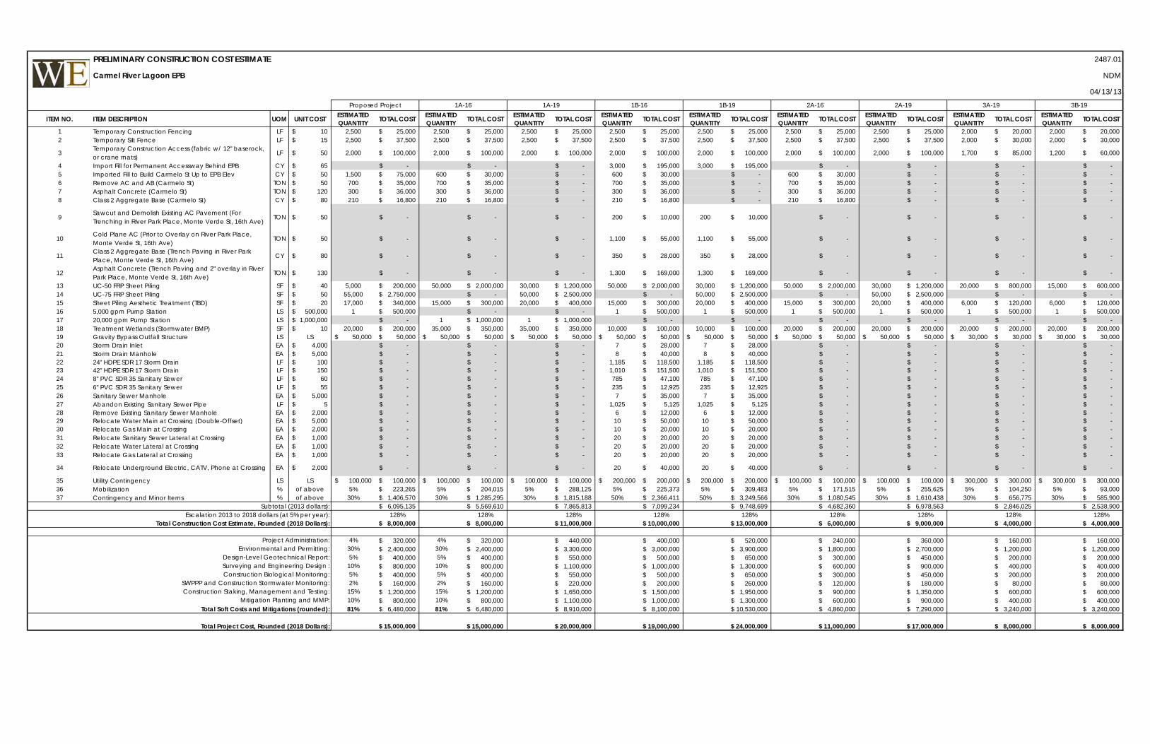
ITEM NO. ITEM DESCRIPTION UOM UNIT COST ESTIMATED QUANTITY TOTAL COST ESTIMATED
QUANTITY TOTAL COST ESTIMATED QUANTITY TOTAL COST ESTIMATED
QUANTITY TOTAL COST ESTIMATED QUANTITY TOTAL COST ESTIMATED
QUANTITY TOTAL COST ESTIMATED QUANTITY TOTAL COST ESTIMATED
QUANTITY TOTAL COST ESTIMATED QUANTITY TOTAL COST
1 Temporary Construction Fencing LF 10$ 2,500 25,000$ 2,500 25,000$ 2,500 25,000$ 2,500 25,000$ 2,500 25,000$ 2,500 25,000$ 2,500 25,000$ 2,000 20,000$ 2,000 20,000$ 2 Temporary Silt Fence LF 15$ 2,500 37,500$ 2,500 37,500$ 2,500 37,500$ 2,500 37,500$ 2,500 37,500$ 2,500 37,500$ 2,500 37,500$ 2,000 30,000$ 2,000 30,000$
3 Temporary Construction Access (fabric w/ 12" baserock, or crane mats)
LF 50$ 2,000 100,000$ 2,000 100,000$ 2,000 100,000$ 2,000 100,000$ 2,000 100,000$ 2,000 100,000$ 2,000 100,000$ 1,700 85,000$ 1,200 60,000$
4 Import Fill for Permanent Accessway Behind EPB CY 65$ -$ -$ -$ 3,000 195,000$ 3,000 195,000$ -$ -$ -$ -$ 5 Imported Fill to Build Carmelo St Up to EPB Elev CY 50$ 1,500 75,000$ 600 30,000$ -$ 600 30,000$ -$ 600 30,000$ -$ -$ -$ 6 Remove AC and AB (Carmelo St) TON 50$ 700 35,000$ 700 35,000$ -$ 700 35,000$ -$ 700 35,000$ -$ -$ -$ 7 Asphalt Concrete (Carmelo St) TON 120$ 300 36,000$ 300 36,000$ -$ 300 36,000$ -$ 300 36,000$ -$ -$ -$ 8 Class 2 Aggregate Base (Carmelo St) CY 80$ 210 16,800$ 210 16,800$ -$ 210 16,800$ -$ 210 16,800$ -$ -$ -$
9 Sawcut and Demolish Existing AC Pavement (For Trenching in River Park Place, Monte Verde St, 16th Ave)
TON 50$ -$ -$ -$ 200 10,000$ 200 10,000$ -$ -$ -$ -$
10 Cold Plane AC (Prior to Overlay on River Park Place, Monte Verde St, 16th Ave)
TON 50$ -$ -$ -$ 1,100 55,000$ 1,100 55,000$ -$ -$ -$ -$
11 Class 2 Aggregate Base (Trench Paving in River Park Place, Monte Verde St, 16th Ave)
CY 80$ -$ -$ -$ 350 28,000$ 350 28,000$ -$ -$ -$ -$
12 Asphalt Concrete (Trench Paving and 2" overlay in River Park Place, Monte Verde St, 16th Ave)
TON 130$ -$ -$ -$ 1,300 169,000$ 1,300 169,000$ -$ -$ -$ -$
13 UC-50 FRP Sheet Piling SF 40$ 5,000 200,000$ 50,000 2,000,000$ 30,000 1,200,000$ 50,000 2,000,000$ 30,000 1,200,000$ 50,000 2,000,000$ 30,000 1,200,000$ 20,000 800,000$ 15,000 600,000$ 14 UC-75 FRP Sheet Piling SF 50$ 55,000 2,750,000$ -$ 50,000 2,500,000$ -$ 50,000 2,500,000$ -$ 50,000 2,500,000$ -$ -$ 15 Sheet Piling Aesthetic Treatment (TBD) SF 20$ 17,000 340,000$ 15,000 300,000$ 20,000 400,000$ 15,000 300,000$ 20,000 400,000$ 15,000 300,000$ 20,000 400,000$ 6,000 120,000$ 6,000 120,000$ 16 5,000 gpm Pump Station LS 500,000$ 1 500,000$ -$ -$ 1 500,000$ 1 500,000$ 1 500,000$ 1 500,000$ 1 500,000$ 1 500,000$ 17 20,000 gpm Pump Station LS 1,000,000$ -$ 1 1,000,000$ 1 1,000,000$ -$ -$ -$ -$ -$ -$ 18 Treatment Wetlands (Stormwater BMP) SF 10$ 20,000 200,000$ 35,000 350,000$ 35,000 350,000$ 10,000 100,000$ 10,000 100,000$ 20,000 200,000$ 20,000 200,000$ 20,000 200,000$ 20,000 200,000$ 19 Gravity Bypass Outfall Structure LS LS 50,000$ 50,000$ 50,000$ 50,000$ 50,000$ 50,000$ 50,000$ 50,000$ 50,000$ 50,000$ 50,000$ 50,000$ 50,000$ 50,000$ 30,000$ 30,000$ 30,000$ 30,000$ 20 Storm Drain Inlet EA 4,000$ -$ -$ -$ 7 28,000$ 7 28,000$ -$ -$ -$ -$ 21 Storm Drain Manhole EA 5,000$ -$ -$ -$ 8 40,000$ 8 40,000$ -$ -$ -$ -$ 22 24" HDPE SDR 17 Storm Drain LF 100$ -$ -$ -$ 1,185 118,500$ 1,185 118,500$ -$ -$ -$ -$ 23 42" HDPE SDR 17 Storm Drain LF 150$ -$ -$ -$ 1,010 151,500$ 1,010 151,500$ -$ -$ -$ -$ 24 8" PVC SDR 35 Sanitary Sewer LF 60$ -$ -$ -$ 785 47,100$ 785 47,100$ -$ -$ -$ -$ 25 6" PVC SDR 35 Sanitary Sewer LF 55$ -$ -$ -$ 235 12,925$ 235 12,925$ -$ -$ -$ -$ 26 Sanitary Sewer Manhole EA 5,000$ -$ -$ -$ 7 35,000$ 7 35,000$ -$ -$ -$ -$ 27 Abandon Existing Sanitary Sewer Pipe LF 5$ -$ -$ -$ 1,025 5,125$ 1,025 5,125$ -$ -$ -$ -$ 28 Remove Existing Sanitary Sewer Manhole EA 2,000$ -$ -$ -$ 6 12,000$ 6 12,000$ -$ -$ -$ -$ 29 Relocate Water Main at Crossing (Double-Offset) EA 5,000$ -$ -$ -$ 10 50,000$ 10 50,000$ -$ -$ -$ -$ 30 Relocate Gas Main at Crossing EA 2,000$ -$ -$ -$ 10 20,000$ 10 20,000$ -$ -$ -$ -$ 31 Relocate Sanitary Sewer Lateral at Crossing EA 1,000$ -$ -$ -$ 20 20,000$ 20 20,000$ -$ -$ -$ -$ 32 Relocate Water Lateral at Crossing EA 1,000$ -$ -$ -$ 20 20,000$ 20 20,000$ -$ -$ -$ -$ 33 Relocate Gas Lateral at Crossing EA 1,000$ -$ -$ -$ 20 20,000$ 20 20,000$ -$ -$ -$ -$
34 Relocate Underground Electric, CATV, Phone at Crossing EA 2,000$ -$ -$ -$ 20 40,000$ 20 40,000$ -$ -$ -$ -$
35 Utility Contingency LS LS 100,000$ 100,000$ 100,000$ 100,000$ 100,000$ 100,000$ 200,000$ 200,000$ 200,000$ 200,000$ 100,000$ 100,000$ 100,000$ 100,000$ 300,000$ 300,000$ 300,000$ 300,000$ 36 Mobilization % of above 5% 223,265$ 5% 204,015$ 5% 288,125$ 5% 225,373$ 5% 309,483$ 5% 171,515$ 5% 255,625$ 5% 104,250$ 5% 93,000$ 37 Contingency and Minor Items % of above 30% 1,406,570$ 30% 1,285,295$ 30% 1,815,188$ 50% 2,366,411$ 50% 3,249,566$ 30% 1,080,545$ 30% 1,610,438$ 30% 656,775$ 30% 585,900$
Subtotal (2013 dollars): 6,095,135$ 5,569,610$ 7,865,813$ 7,099,234$ 9,748,699$ 4,682,360$ 6,978,563$ 2,846,025$ 2,538,900$ Escalation 2013 to 2018 dollars (at 5% per year): 128% 128% 128% 128% 128% 128% 128% 128% 128%
Total Construction Cost Estimate, Rounded (2018 Dollars): 8,000,000$ 8,000,000$ 11,000,000$ 10,000,000$ 13,000,000$ 6,000,000$ 9,000,000$ 4,000,000$ 4,000,000$
Project Administration: 4% 320,000$ 4% 320,000$ 440,000$ 400,000$ 520,000$ 240,000$ 360,000$ 160,000$ 160,000$ Environmental and Permitting: 30% 2,400,000$ 30% 2,400,000$ 3,300,000$ 3,000,000$ 3,900,000$ 1,800,000$ 2,700,000$ 1,200,000$ 1,200,000$
Design-Level Geotechnical Report: 5% 400,000$ 5% 400,000$ 550,000$ 500,000$ 650,000$ 300,000$ 450,000$ 200,000$ 200,000$ Surveying and Engineering Design : 10% 800,000$ 10% 800,000$ 1,100,000$ 1,000,000$ 1,300,000$ 600,000$ 900,000$ 400,000$ 400,000$ Construction Biological Monitoring: 5% 400,000$ 5% 400,000$ 550,000$ 500,000$ 650,000$ 300,000$ 450,000$ 200,000$ 200,000$
SWPPP and Construction Stormwater Monitoring: 2% 160,000$ 2% 160,000$ 220,000$ 200,000$ 260,000$ 120,000$ 180,000$ 80,000$ 80,000$ Construction Staking, Management and Testing: 15% 1,200,000$ 15% 1,200,000$ 1,650,000$ 1,500,000$ 1,950,000$ 900,000$ 1,350,000$ 600,000$ 600,000$
Mitigation Planting and MMP: 10% 800,000$ 10% 800,000$ 1,100,000$ 1,000,000$ 1,300,000$ 600,000$ 900,000$ 400,000$ 400,000$ Total Soft Costs and Mitigations (rounded): 81% 6,480,000$ 81% 6,480,000$ 8,910,000$ 8,100,000$ 10,530,000$ 4,860,000$ 7,290,000$ 3,240,000$ 3,240,000$
Total Project Cost, Rounded (2018 Dollars): 15,000,000$ 15,000,000$ 20,000,000$ 19,000,000$ 24,000,000$ 11,000,000$ 17,000,000$ 8,000,000$ 8,000,000$
2487.01
NDM
04/13/13
1B-16 1B-19 2A-16 2A-19 3A-19 3B-19Proposed Project 1A-191A-16
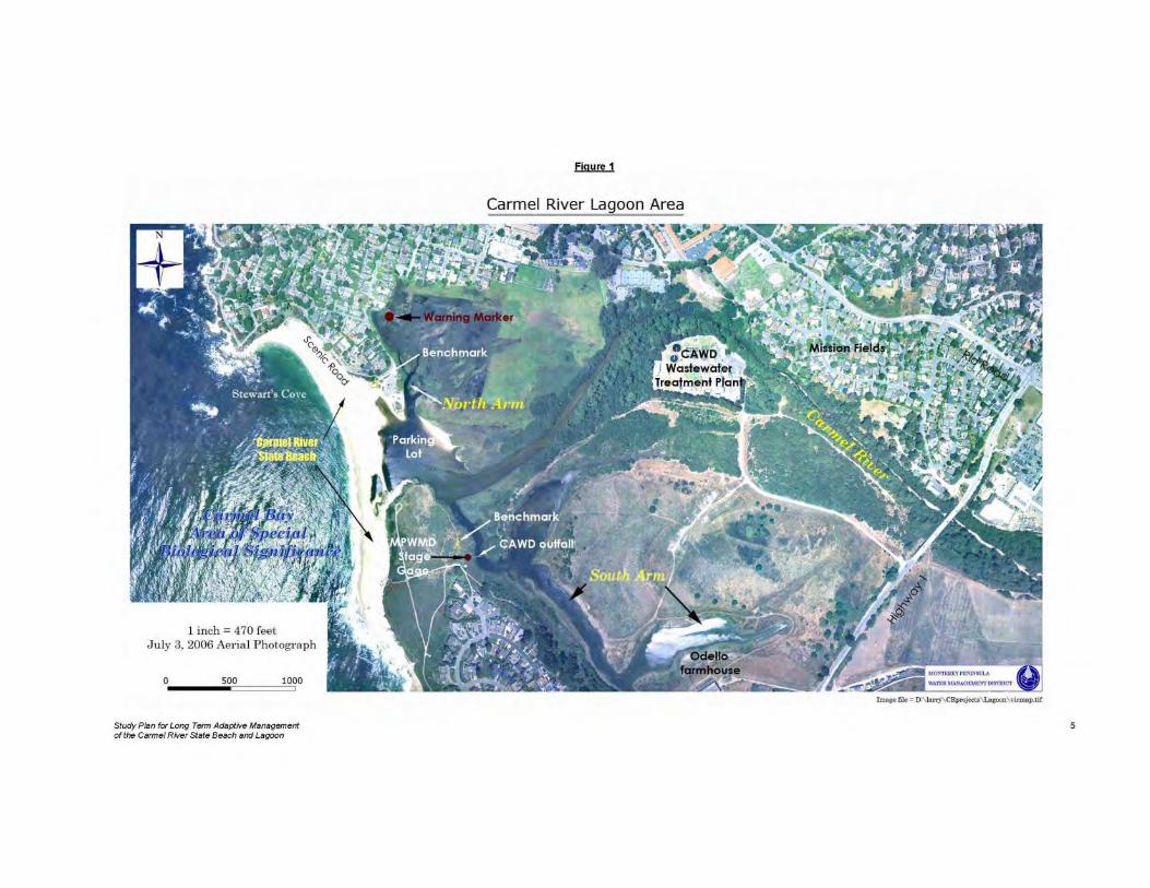
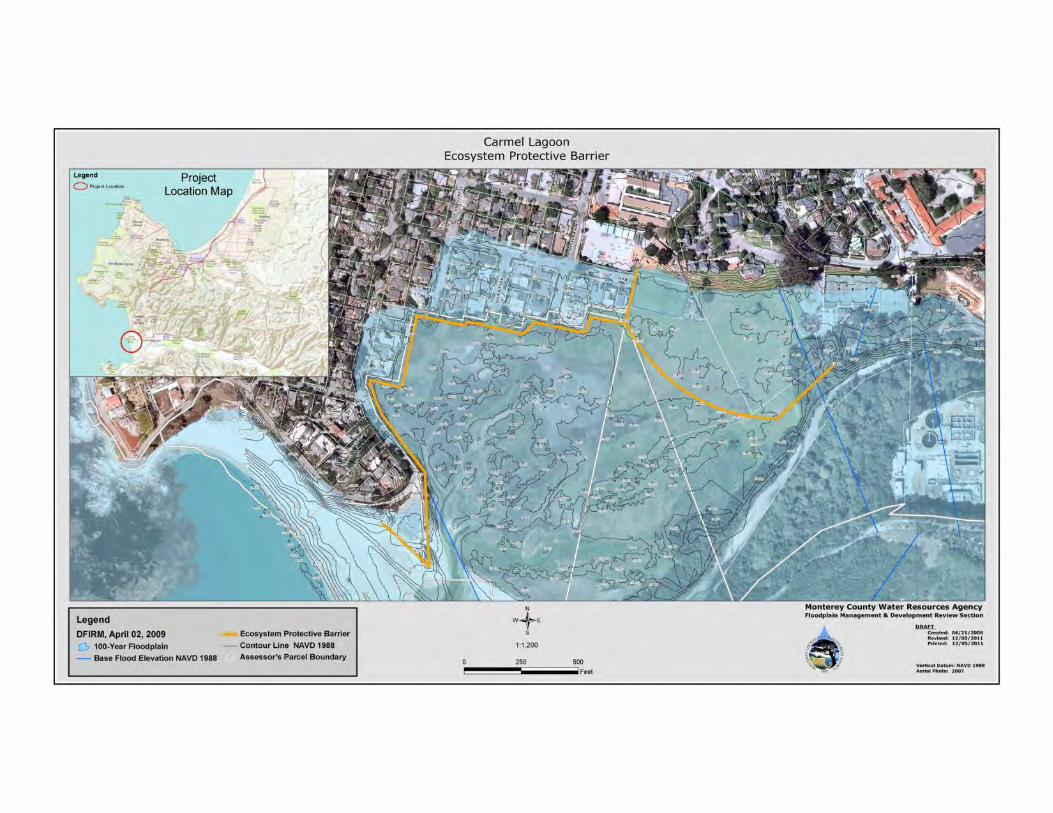
Carmel River Lagoon EPB
PRELIMINARY CONSTRUCTION COST ESTIMATE
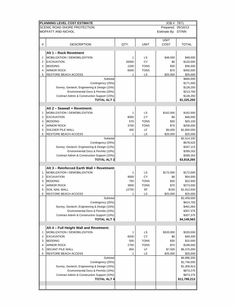
PLANNING LEVEL COST ESTIMATE JOB # 7871SCENIC ROAD SHORE PROTECTION Prepared: 05/16/13MOFFATT AND NICHOL Estimate By: DT/NN
UNIT# DESCRIPTION QTY. UNIT COST TOTAL
Alt 1 – Rock Revetment1 MOBILIZATION / DEMOBILIZATION 1 LS $48,000 $48,000
2 EXCAVATION 20000 CY $6 $120,000
3 BEDDING 1200 TONS $30 $36,000
4 ARMOR ROCK 6500 TONS $70 $455,000
5 RESTORE BEACH ACCESS 1 LS $25,000 $25,000
Subtotal $684,000
Contingency (25%) $171,000
Survey, Geotech, Engineering & Design (15%) $128,250
Environmental Docs & Permits (25%) $213,750
Contract Admin & Construction Support (15%) $128,250
TOTAL ALT 1 $1,325,250
Alt 2 – Seawall + Revetment:1 MOBILIZATION / DEMOBILIZATION 1 LS $162,000 $162,000
2 EXCAVATION 8000 CY $6 $48,000
3 BEDDING 670 TONS $30 $20,100
4 ARMOR ROCK 3700 TONS $70 $259,000
5 SOLDIER PILE WALL 450 LF $4,000 $1,800,000
6 RESTORE BEACH ACCESS 1 LS $25,000 $25,000
Subtotal $2,314,100
Contingency (25%) $578,525
Survey, Geotech, Engineering & Design (12%) $347,115
Environmental Docs & Permits (10%) $289,263
Contract Admin & Construction Support (10%) $289,263
TOTAL ALT 2 $3,818,265
Alt 3 – Reinforced Earth Wall + Revetment:1 MOBILIZATION / DEMOBILIZATION 1 LS $172,000 $172,000
2 EXCAVATION 9000 CY $6 $54,000
3 BEDDING 750 TONS $30 $22,500
4 ARMOR ROCK 3900 TONS $70 $273,000
5 SOIL NAIL WALL 12750 SF $150 $1,912,500
6 RESTORE BEACH ACCESS 1 LS $25,000 $25,000
Subtotal $2,459,000
Contingency (25%) $614,750
Survey, Geotech, Engineering & Design (15%) $461,063
Environmental Docs & Permits (10%) $307,375
Contract Admin & Construction Support (10%) $307,375
TOTAL ALT 3 $4,149,563
Alt 4 – Full Height Wall and Revetment:1 MOBILIZATION / DEMOBILIZATION 1 LS $333,000 $333,000
2 EXCAVATION 8200 CY $6 $49,200
3 BEDDING 500 TONS $30 $15,000
4 ARMOR ROCK 2700 TONS $70 $189,000
5 SECANT PILE WALL 850 LF $7,500 $6,375,000
6 RESTORE BEACH ACCESS 1 LS $25,000 $25,000
Subtotal $6,986,200
Contingency (25%) $1,746,550
Survey, Geotech, Engineering & Design (15%) $1,309,913
Environmental Docs & Permits (10%) $873,275
Contract Admin & Construction Support (10%) $873,275
TOTAL ALT 4 $11,789,213
Appendix 2
Public Comment Letters
1
Nathaniel Milam
From: Holm, Carl P. x5103 <[email protected]>Sent: Friday, April 12, 2013 9:26 AMTo: Nathaniel Milam; Richard WeberCc: Moss, Tom Ext.4968; Pascua, Jonathan L x8963; Young, Benny x5862; Murdoch, Robert
K. x4831; Greenway, Paul H. x4807; Lee, Kathleen M. 647-7755Subject: Fwd: Scenic Armoring Project CSA1
FYI. Sent from Carl Holm Begin forwarded message:
From: Brown Fred <[email protected]> Date: April 11, 2013, 14:24:12 PDT To: "Holm, Carl P. x5103" <[email protected]>, "Medema, Dirk x5647" <[email protected]> Subject: Scenic Armoring Project CSA1
To: Monterey County Resource Management Agency Carl P Holm, AICP Deputy Director Dirk Medema, Environmental Services Manager From: CSA1 Citizens Advisory Committee member Fred Brown Recommendations regarding the Scenic Road Armoring Project and the Ecosystem Protective Barrier April 11, 2013 Dear Mr. Medema and Mr. Holm: At the special CAC meeting for CSA1 held March 26, the committee members were given an overview of the alternative proposals put forth by Whitson Engineering for the Scenic Road Protection and Ecosystem Protective Barrier projects (Carmel River / Lagoon Community Meeting - Project Alternatives, March 25, 2013). Committee members were requested to review these proposals and each member was offered an opportunity to provide a recommendation for the one proposal that would provide the best solution. First, allow me to address the problem and why a solution is necessary, as I do not believe any of these proposals have fully embraced the daunting task of envisioning the full extent of the eventual dynamics that will unfold.
2
It is my understanding, although only by inference, that the federal agencies who have responsibility for directing the Carmel River's egress into Carmel Bay have determined that the Carmel River will be mechanically diverted to the north end at the mouth of the river and that no other outlet, either by natural breaching or otherwise will be allowed. This is a very important point to consider, as this has never occurred at any time in the past. Additionally, soon the Carmel River is almost certain to have greater water flow than anytime in recent history with the impending removal of the San Clemente Dam and the reduced take by CalAm. Many have suggested that the average level of the ocean will increase incrementally over the next decades as well. Assuming these convergent predictions come to pass, the management of the river water flowing solely in a northerly breach and the unknown dynamics of interacting with the ocean's wave action, fluctuating tides and storm surges presents a scenario that the proposals have not fully taken into consideration. My concern for the underdeveloped analysis of the proposals is that I have witnessed the Carmel River when it has been breached to the north on two separate recent occasions. In my opinion, none of the proposals would have prevented the erosion of the parking lot, restroom facilities or the bluffs below Scenic Road. The water flow would have been too swift and the ocean wave action too strong for any of these solutions to offer the protection they suggest. Any of the solutions offered would appear to work under normal conditions. That is not sufficient. It is exactly the abnormal conditions that must be taken into consideration. When we have El Niño conditions and strong winter storms, the ocean flows over the top of the parking lot and down Carmelo Street. I have stood on Scenic Road where the sand ramp is currently and watched the waves flow up the beach and the bluffs and onto Scenic Road. Either of these conditions would allow the water from the ocean and the river to get in behind the armoring devices that are suggested. They would be crippled and soon washed away with the outgoing tide and wave backwash. When the river has breached to the north, it has travelled along the base of the Scenic Road bluffs, removing all the sand on the beach. The river extended along the entire bluffs and exited past the cement steps leading down to the beach at Ocean View Avenue. There once was a large hill of dirt and sand that lay between the Ocean View Ave steps and the Valley View steps. The northern breach of the river created a large depression that collects rainwater and ocean water during high tides. None of these
3
proposals address the bluff scouring that will take place from the Valley View steps and beyond (which now are merely steps to a bench). The small curvature at the termination of the "rip-rap" in alternative proposal #1 and #1A would not stop the flow from going where it has gone before. The river will proceed further along pushed by waves and flowing into the bluff, as this area under Isabella Avenue now is lowest part of the beach. The rip-rap is not high enough to withstand ocean wave surges, and it is probably not deep enough to avoid being undermined and destroyed. Therefore, I cannot support alternative #1. It is apparent to me that with a continuous flow of water exiting the river that there will not be any sand covering the armoring, regardless of which alternative proposal is used, for most of the year. Therefore, these armoring devices will be exposed. The entire CRSB from the parking lot to the point would have very little sand after the river was opened and flowing, allowing the wave action to further cause havoc with the bluffs when the river flow subsided. Alternatives #2, #3 and #4 would leave the area looking like the Los Angeles River and are not feasible or worthy of consideration. None of the armoring devices are natural or aesthetically acceptable for this location. A location near Carpenteria was given as an example of armoring and is unfortunately extremely undesirable. An additional problem is that the armoring using rip-rap tied together with cable will impede the access to the beach from the beach parking lot. The visiting public will be required to climb over the rock barrier to get to the beach. This is dangerous and may be in violation of coastal access laws. The Ecosystem Protective Barrier does not seem necessary. The lagoon filled to approximately 10 feet 7 inches the other day and breached. The sandbags provided some protection, however, none of the properties experience any flooding. If the river is breached to the north, the lagoon level should never get any higher, and if it does the county could open the mouth as it has done in past. There is no need to spend millions of dollars on a wall that is not "eco-friendly" and would be an artificial impediment in the Carmel River Lagoon and Wetlands Natural Preserve. Also, note that a California State Preserve cannot have any roads in it and I'm quite sure that large cranes and heavy equipment in the Preserve would be highly detrimental to the wildlife that make their homes there - some of which actually have federal protection. My conclusion is that the study performed by the engineering firm is woefully inadequate and does not come close to providing a feasible solution due in part to their misunderstanding of the extreme conditions that occur along Carmel River State Beach. The proposals, if implemented would, in the event

4
of a major storm, be washed away like toothpicks stuck in the sand and the bluffs beyond the armoring would be unprotected and severely compromised as in the past. Therefore, I cannot recommend any of the proposals and would like to make it clear that I oppose all of them as being inadequate and uninspired. My recommendation is that they go back to the drawing board, obtain more and better information, and design a solution that will actually provide the level of protection required. The proposed solutions will not work on any level. Sincerely, Fred R Brown CSA1 Citizens Advisory Committee Member PS: I would appreciate you forwarding this to all those involved in the proposals.
Lisa M. HarrisResources Management AgencyCounty of [email protected]
Thank you for the invitation to the two meetings this week on the Lagoon and Scenic Drive. I’ve reviewed the documents on the County web site and would like to propose an alternative to the La-goon barrier that might be best considered during the environmental analysis in that it could be classified as a “no-build” option - but I’d prefer it be referred to as a Multi-Species Management Op-tion.
MULTI-SPECIES MANAGEMENT OPTION - WITHOUT A BARRIER
As a landscape architect, life-long environmentalist, surfer, and homeowner living on the Carmel River Lagoon, I’ve been bothered that, while we are dismantling an old dam on the Carmel River, we are, at the same time, considering building one at the other end. I submit that a similar long-term outcome will befall the new one - mostly because like the first, neither is natural or self-sustaining. San Clemente Dam is less than 100 years old and was clearly non-functional decades ago. The proposed vinyl Lagoon wall will create a dead-zone behind it, disconnected from the La-goon’s ecosystem and has a manufacturer’s projected life span of 50 years. What then?
1. A Multi-Species Management Plan benefits more than just Steelhead. Frogs, Foxes, Bobcats, Hawks, Voles, Rabbit, Deer, Egrets and other native species depend on the Lagoon and it’s littoral zone. A Multi-Species plan can use infrequent manual breaching instead of a vinyl wall for flood control - breaching would be inexpensive if allowed through weather/tide/wave pre-diction rather than emergency declaration (as it was done by the artichoke farmers decades ago). The trade-off is infrequent breaching in exchange for a Lagoon with a full littoral zone.
2. A vinyl barrier of either 16’ or 19’ will still require bulldozers on the beach - for summer closure and for breaching in the event of conditions that will over-top the barrier.
3. Instead of spending millions on a vinyl barrier, stormwater undergrounding and pumps, estab-lish a fund for: beach management (enhancement and flood control), water quality facilities at the current surface run-off points, educational observation decks at the dead-ends of Camino Real, River Park, Monte Verde and somewhere along the open edge of Carmelo near the Carmel River State Park parking lot.
4. Long term management that values the whole ecosystem would not include a dead back-water behind vinyl sheet-pile. Instead, through education, the Lagoon’s littoral zone can be improved over the years by the cooperative efforts of adjacent land-owners. My own lot line is
page 1 of 2
26395 Carmelo StreetCarmel, CA 93923
www.deeringdesign.com
about 20’ out in the lagoon - beyond our landscaped use-area. Other lots vary, but all can im-prove the littoral zone. We all care about the Lagoon and it’s ecological health.
I am asking that the environmental analysis include a genuine effort to compare what is lost ecol-ogically with what is gained between a vinyl barrier proposal and a multi-species management pro-posal with no barrier.
Paul Deering
Page 2
1
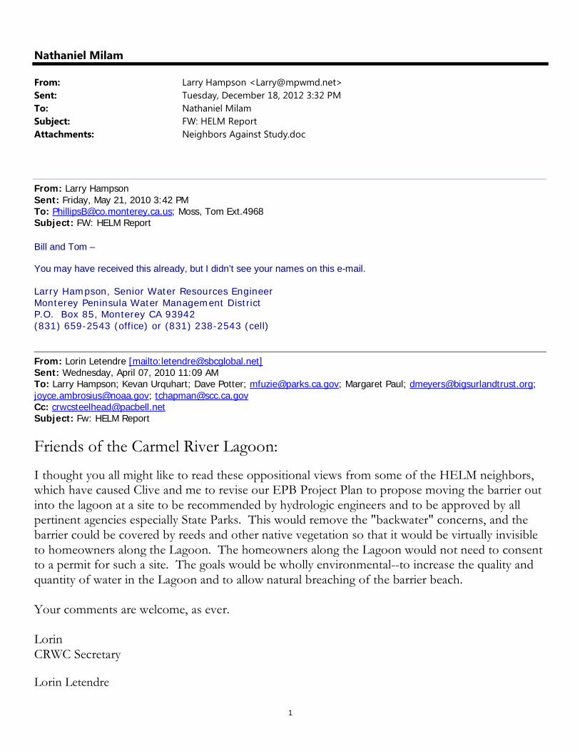
Nathaniel Milam
From: Larry Hampson <[email protected]>Sent: Tuesday, December 18, 2012 3:32 PMTo: Nathaniel MilamSubject: FW: HELM ReportAttachments: Neighbors Against Study.doc
From: Larry Hampson Sent: Friday, May 21, 2010 3:42 PM To: [email protected]; Moss, Tom Ext.4968 Subject: FW: HELM Report Bill and Tom – You may have received this already, but I didn’t see your names on this e-mail. Larry Hampson, Senior Water Resources Engineer Monterey Peninsula Water Management District P.O. Box 85, Monterey CA 93942 (831) 659-2543 (office) or (831) 238-2543 (cell)
From: Lorin Letendre [mailto:[email protected]] Sent: Wednesday, April 07, 2010 11:09 AM To: Larry Hampson; Kevan Urquhart; Dave Potter; [email protected]; Margaret Paul; [email protected]; [email protected]; [email protected] Cc: [email protected] Subject: Fw: HELM Report
Friends of the Carmel River Lagoon:
I thought you all might like to read these oppositional views from some of the HELM neighbors, which have caused Clive and me to revise our EPB Project Plan to propose moving the barrier out into the lagoon at a site to be recommended by hydrologic engineers and to be approved by all pertinent agencies especially State Parks. This would remove the "backwater" concerns, and the barrier could be covered by reeds and other native vegetation so that it would be virtually invisible to homeowners along the Lagoon. The homeowners along the Lagoon would not need to consent to a permit for such a site. The goals would be wholly environmental--to increase the quality and quantity of water in the Lagoon and to allow natural breaching of the barrier beach. Your comments are welcome, as ever. Lorin CRWC Secretary
Lorin Letendre
2
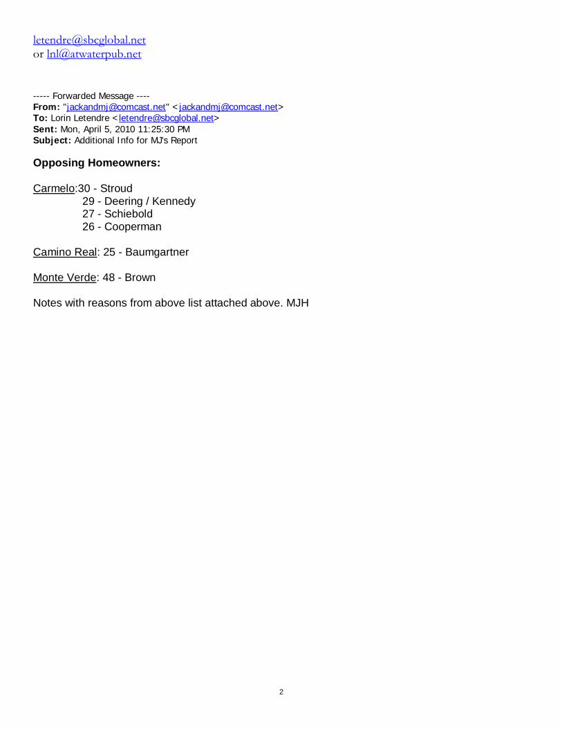
[email protected] or [email protected] ----- Forwarded Message ---- From: "[email protected]" <[email protected]> To: Lorin Letendre <[email protected]> Sent: Mon, April 5, 2010 11:25:30 PM Subject: Additional Info for MJ's Report
Opposing Homeowners: Carmelo:30 - Stroud 29 - Deering / Kennedy 27 - Schiebold 26 - Cooperman Camino Real: 25 - Baumgartner Monte Verde: 48 - Brown Notes with reasons from above list attached above. MJH
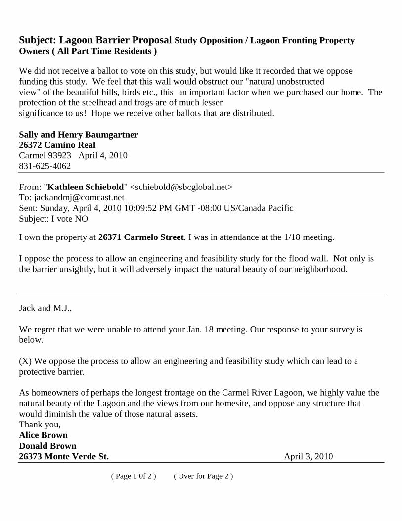
Subject: Lagoon Barrier Proposal Study Opposition / Lagoon Fronting Property Owners ( All Part Time Residents ) We did not receive a ballot to vote on this study, but would like it recorded that we oppose funding this study. We feel that this wall would obstruct our "natural unobstructed view" of the beautiful hills, birds etc., this an important factor when we purchased our home. The protection of the steelhead and frogs are of much lesser significance to us! Hope we receive other ballots that are distributed. Sally and Henry Baumgartner 26372 Camino Real Carmel 93923 April 4, 2010 831-625-4062 From: "Kathleen Schiebold" <[email protected]> To: [email protected] Sent: Sunday, April 4, 2010 10:09:52 PM GMT -08:00 US/Canada Pacific Subject: I vote NO
I own the property at 26371 Carmelo Street. I was in attendance at the 1/18 meeting. I oppose the process to allow an engineering and feasibility study for the flood wall. Not only is the barrier unsightly, but it will adversely impact the natural beauty of our neighborhood. Jack and M.J., We regret that we were unable to attend your Jan. 18 meeting. Our response to your survey is below. (X) We oppose the process to allow an engineering and feasibility study which can lead to a protective barrier. As homeowners of perhaps the longest frontage on the Carmel River Lagoon, we highly value the natural beauty of the Lagoon and the views from our homesite, and oppose any structure that would diminish the value of those natural assets. Thank you, Alice Brown Donald Brown 26373 Monte Verde St. April 3, 2010 ( Page 1 0f 2 ) ( Over for Page 2 )
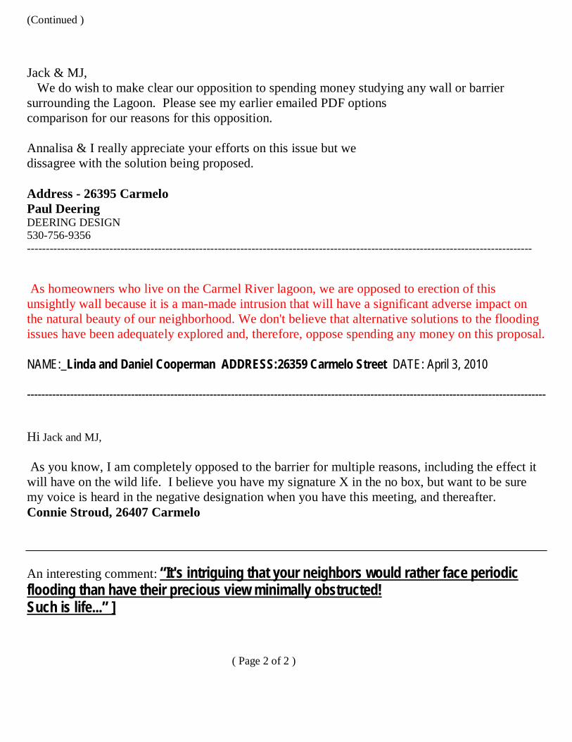
(Continued ) Jack & MJ, We do wish to make clear our opposition to spending money studying any wall or barrier surrounding the Lagoon. Please see my earlier emailed PDF options comparison for our reasons for this opposition. Annalisa & I really appreciate your efforts on this issue but we dissagree with the solution being proposed. Address - 26395 Carmelo Paul Deering DEERING DESIGN 530-756-9356 ---------------------------------------------------------------------------------------------------------------------------------------
As homeowners who live on the Carmel River lagoon, we are opposed to erection of this unsightly wall because it is a man-made intrusion that will have a significant adverse impact on the natural beauty of our neighborhood. We don't believe that alternative solutions to the flooding issues have been adequately explored and, therefore, oppose spending any money on this proposal. NAME:_Linda and Daniel Cooperman ADDRESS:26359 Carmelo Street DATE: April 3, 2010 -------------------------------------------------------------------------------------------------------------------------------------------------
Hi Jack and MJ, As you know, I am completely opposed to the barrier for multiple reasons, including the effect it will have on the wild life. I believe you have my signature X in the no box, but want to be sure my voice is heard in the negative designation when you have this meeting, and thereafter. Connie Stroud, 26407 Carmelo
An interesting comment: “It's intriguing that your neighbors would rather face periodic flooding than have their precious view minimally obstructed! Such is life...” ] ( Page 2 of 2 )
Comments on the Draft Technical Report for the EPB and Scenic Road Projects By Lorin Letendre, Chair, CSA-1 Citizens Advisory Committee
Note: These comments and questions are based mostly on previous suggestions and input into earlier versions of these two projects by Larry Hampson and Kevan Urquhart of MPWMD, Jeff Haltiner of ESA/PWA, Tom Moss of the MPWRA, and Ed Ballman of Balance Hydrologics. In addition, I have asked Brian Cluer, fluvial geomorphologist at NOAA, to comment on the draft technical report (he volunteered to do so), but have not yet received his response.
EPB Project: 1. The Design Options are well-documented and adequate to achieve the goals of flood-protecting the homes along the north side of the lagoon, improving the lagoon habitat for threatened species, and providing for natural breaching of the barrier beach at the lagoon. In addition, many of the analyses recommended by the Lagoon Technical Advisory Committee were completed as part of this analysis and feasibility study.
2. For a variety of reasons, I favor Alternative 1A; Alignment #1 (15” off property lines); EPB wall height of 16 ft NAVD 88; No Bypass System (this may not be feasible though); and Limited Access. Some of the reasons are: --This allows for mostly natural drainage of storm water runoff rather than having to install expensive pumping systems --It moves the floodwall farther away from the houses, where it can be mostly covered with natural vegetation and thereby not adversely impact the view shed --It allows for natural breaching of the barrier beach but the lower wall height limits the impact on the view shed --It is less costly that the other alternatives --The construction impacts are less than with other alternatives --However I recognize that it will not remove the homes along the north side from the 100-year flood zone so they will still need flood insurance and the barrier beach may still need to be opened with bulldozers should the 16-foot level be insufficient to cause natural breaching.
3. There is a question as to whether the Options address the upstream flooding risks on Mission Ranch and Mission Fields or on the levees that protect these properties. These may have been considered but there is no indication in the report as to whether there are no risks for these areas as a result of the installation of the EPB wall.
4. Is it allowable under current state storm water regulations to pump untreated storm water directly into the lagoon (a wetlands preserve) during or after a storm event?
5. More mention needs to be made in the final version of this report of the ecological benefits of higher lagoon levels once the EPB is installed. The MPWMD staff and the CSUMB Watershed Institute staff have considerable knowledge in this area and should be consulted on this question. As Larry Hampson stated in his October 21, 2009 memo, “A higher level in spring before the onset of the dry season could result in improved aquatic habitat conditions for a longer period for steelhead and California red-legged frogs (CRLF).”
6. Is the projected completion date of 2018 really feasible? What is the detailed schedule that supports this completion date?
7. Are there issues with the CA State Department of parks and Recreation with regard to incursion of such an unnatural structure into their protected wetlands? Or will the CDPR cede that land to the County and let the County deal with the wetlands issue? Will there be a need to mitigate for loss of wetlands?
8. Who will pay for the on-going maintenance of the floodwall and pump system? Will there be a need to establish a new County Service Area to cover these costs?
9. What will be the process to ensure adjacent property owner buy-in to this project? This includes the property owners in Mission Fields, who have expressed concern over the possible impact on their levees and of flooding caused by a higher lagoon level.
10. What provisions are being made for terrestrial access to and from the lagoon once the floodwall is installed?
11. What are the provisions for ensuring that the CAWD facility is not flooded by the EPB wall?
12. Which governmental agencies will need to review and approve the EPB project?
13. What is the tie-in with the Big Sur Land Trust Lower Carmel River causeway project?
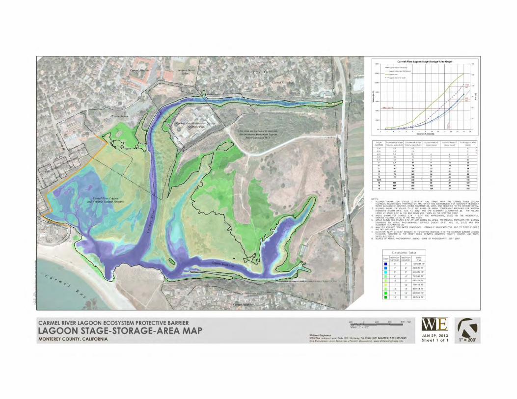
14. What is the likely percolation rate from the lagoon into the ocean when lagoon levels are higher than the current maximum height of 15 ft. NAVD88?
15. What are the likely effects on the lagoon levels once Cal-Am has ceased its over-umping of the River?
16. When will the Biological Analysis be completed for review?
17. How will we confirm that a natural breach of the barrier beach will occur at the present estimate of approx. 15 ft. NAVD88?
Scenic Road Project:
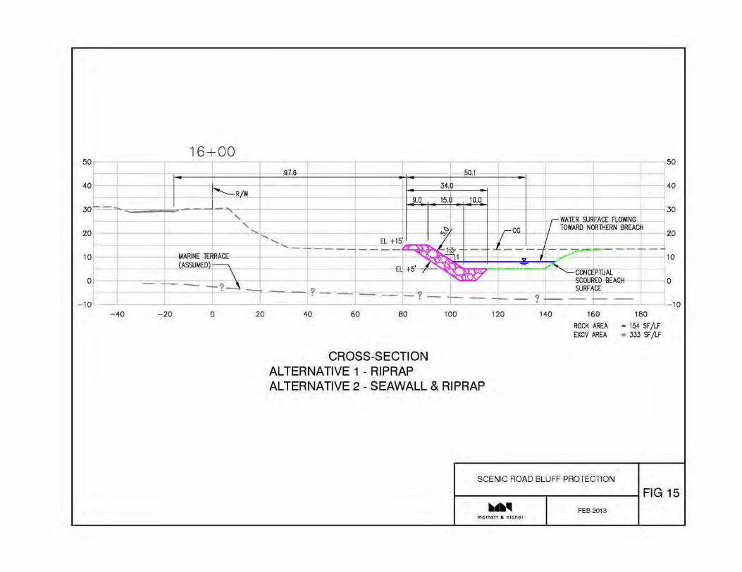
1. Thank you again for a well-considered and well-documented set of alternatives and a thorough analysis of the conditions at Carmel River Beach and the Scenic Road bluffs.
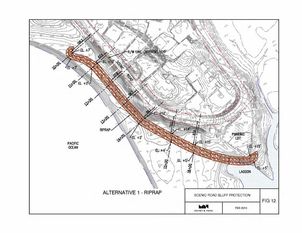
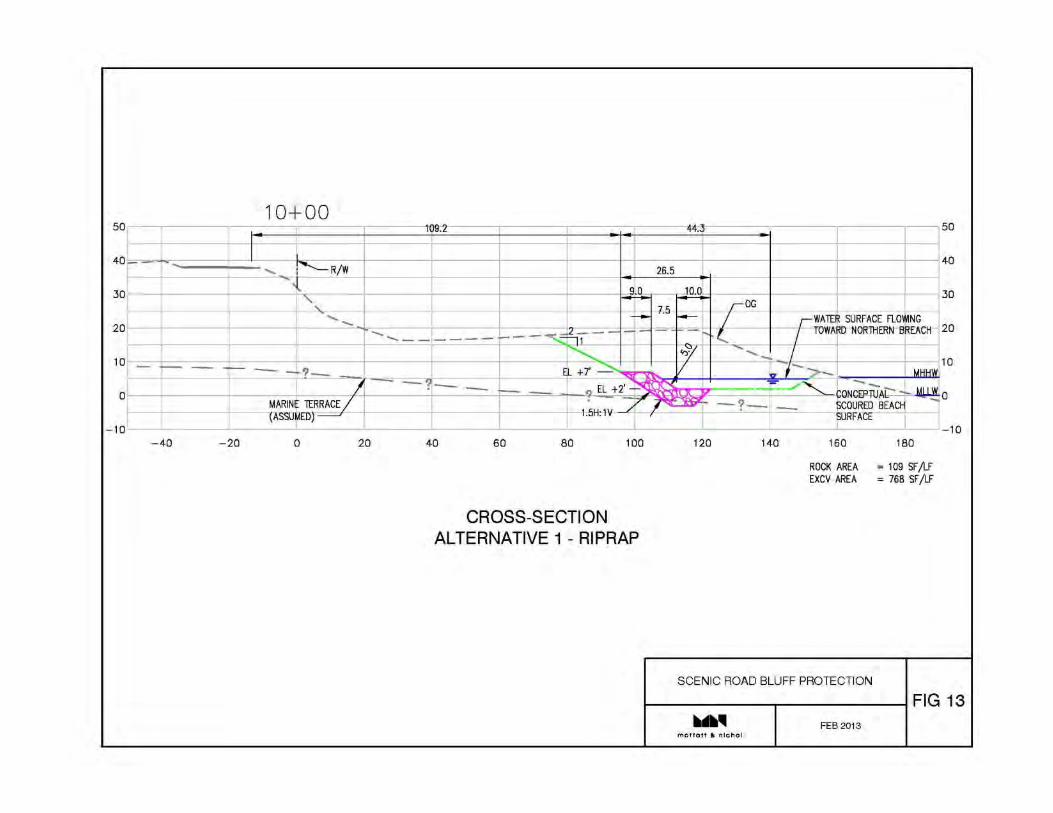
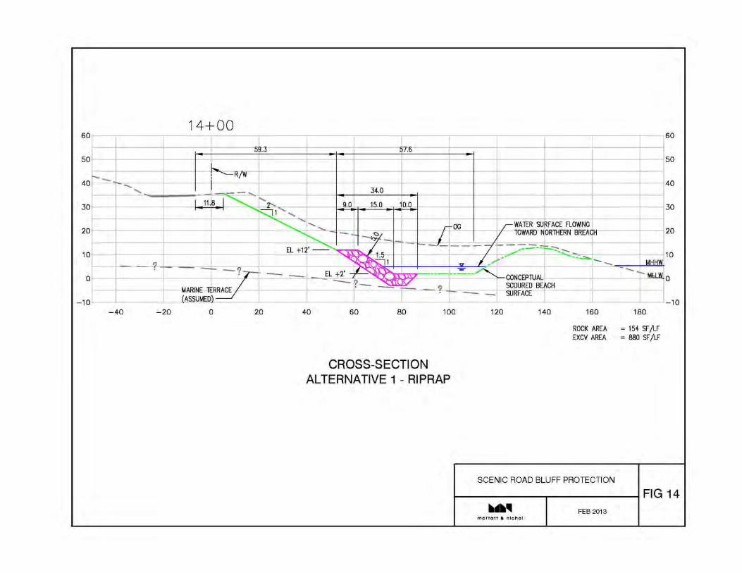
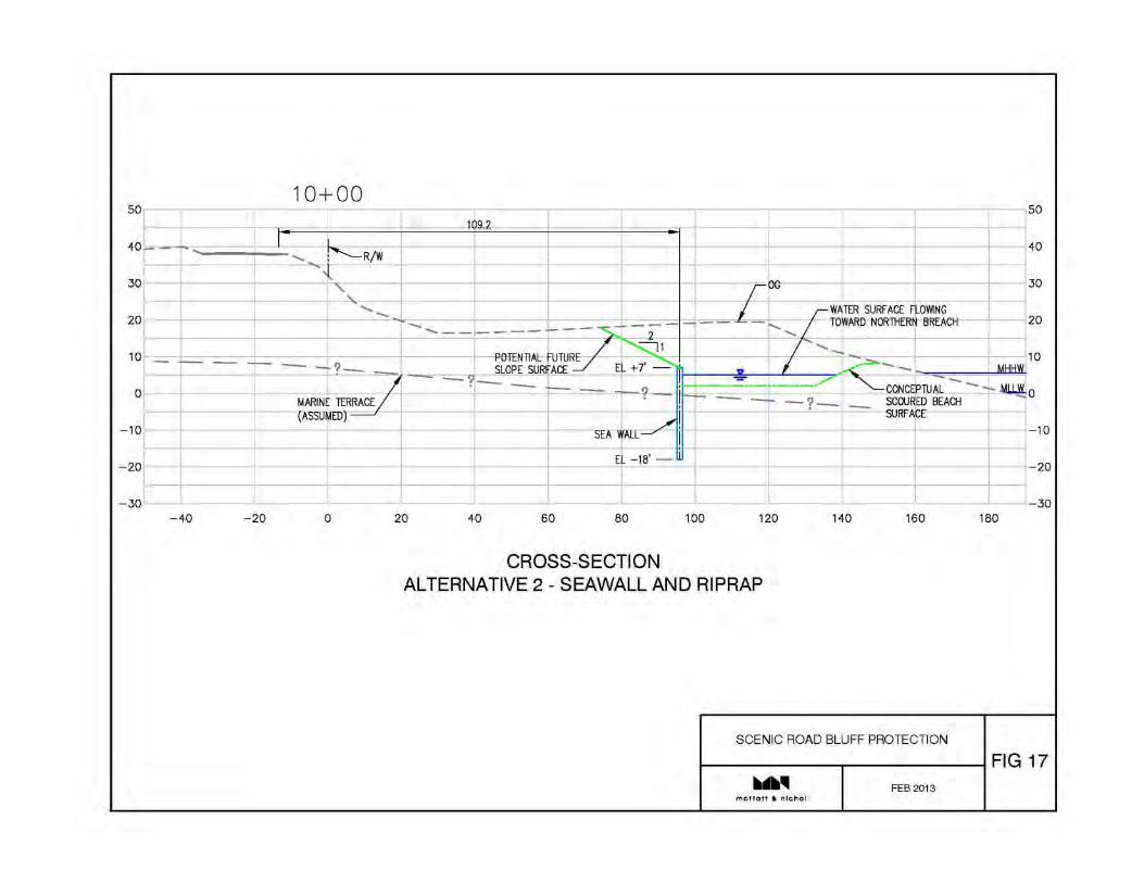
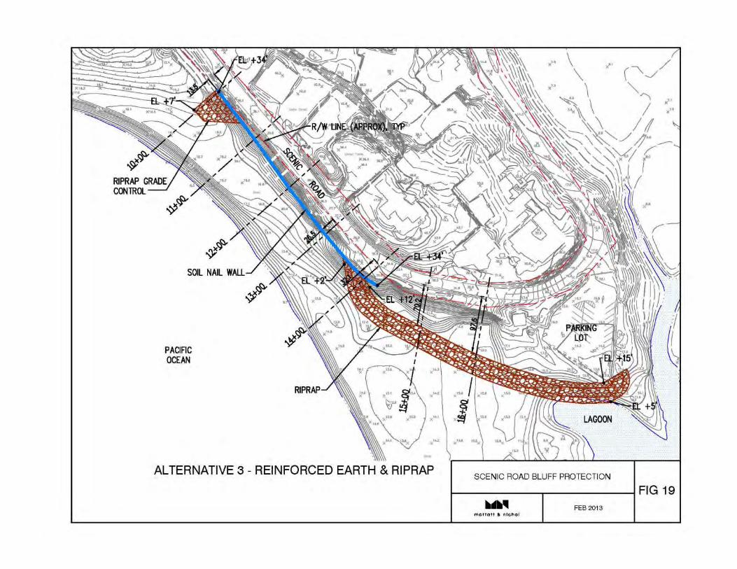
2. For a variety of reasons, I favor Alternative 1-Rip Rap for this project. Reasons are: --It is likely to be the least costly alternative --It requires the least amount of disruption to driving and walking traffic on Scenic Road --It protects the bluffs and parking lot both against River erosion from a natural, northerly breach as well as high wave erosion --It is more natural-appearing and will be covered by sand or vegetation most of the year --It can divert the River during a northerly breach away from the bluffs near Valley View --It avoids the disadvantages of a seawall that can affect beach access and even remove much of the sand from the beach through scour
--As your report states, it has several significant benefits: minimized costs, flexibility, energy dissipation, reparability, and visual appearance—more benefits than accrue from the other three alternatives.
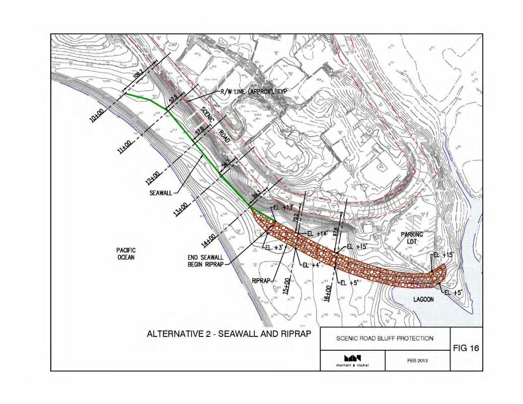
3. Is it still possible that the River or high waves can divert around the “toe” or westerly end of the rip-rap and erode the bluffs near Valley View and west of that area?
4. Will public access to the beach be restored at the Valley View steps?
5. Will there be any changes to the size and height of the State Parks parking lot, e.g. will some of the spaces that were eroded by river action in recent years be restored?
6. How will the maintenance costs of whichever alternative is selected be covered?
7. Were there enough soil samples taken along Scenic Road and its bluffs to support the analysis?
I recognize that some of these questions may be addressed and answered at the upcoming Community Meeting and CSA-1 public meeting, and I look forward to hearing your presentations.
1
Nathaniel Milam
From: Holm, Carl P. x5103 <[email protected]>Sent: Tuesday, April 09, 2013 5:03 PMTo: Nathaniel Milam; Richard WeberCc: Pascua, Jonathan L x8963; Moss, Tom Ext.4968Subject: EPB Question
Had a call from a neighbor on Carmello that asked a couple good questions relative to pump; On average, how many events would trigger use of pump Approx duration pump would run. Wants to get sense of noise impact… Thanks Carl
1
Nathaniel Milam
From: Holm, Carl P. x5103 <[email protected]>Sent: Friday, March 22, 2013 4:09 PMTo: Moss, Tom Ext.4968; Richard Weber; Nathaniel Milam; Pascua, Jonathan L x8963Subject: Fwd: [MALWARE FREE]Concern with EPB alignment
FYI Sent from Carl Holm Begin forwarded message:
From: "Michael L. Waxer, A.I.A." <[email protected]> Date: March 22, 2013, 16:05:20 PDT To: "Holm, Carl P. x5103" <[email protected]> Cc: "Michael L. Waxer, A.I.A." <[email protected]>, Sue Carota <[email protected]> Subject: [MALWARE FREE]Concern with EPB alignment
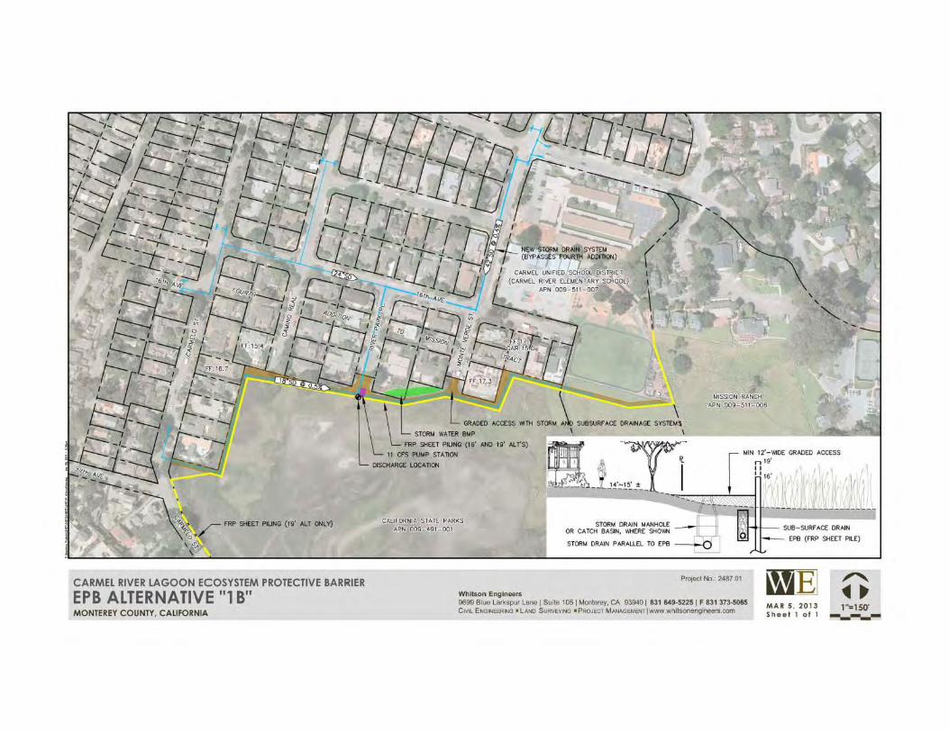
Carl, good afternoon, Can’t believe how quickly this week came and went. I’d been meaning to call you to let you know of a large concern I have as regards the draft EPB alignment. By terminating at the school, the lower Mission Ranch areas will be inundated with water for weeks at a time, potentially, if this were to be built and if it worked properly. Even though the buildings in the lower are of MR are both 1 foot above the 100 year floodplain level (old datum) so their floor levels will not be adversely affected, the Lagoon would back up between the Bunkhouse and the Quadplex, completely inundating the lower parking lots, and all of the tennis courts, and separating the upper MR area from the lower area by a mass of water. It would mean that a hotel guest would need to take a boat out to the quadplex unit. From the very beginning of the EPB conversation it was ALWAYS identified that MR would not be negatively affected, and it was just a matter of selecting the best alignment for the EPB. We had suggested the old fenceline that one sees if they look carefully out to the pasture, and this would have the benefit of maintaining the historic sheep pasture as it is, and letting the lagoon expand to that fenceline. I understand from reading the draft report that the alignments shown look like they have more to do with analyzing how the stormwater will collect from the developed area to be able to drain properly, which I understand. Nonetheless, we are concerned when any alignment starts to get shown which would have a deleterious effect on Mission Ranch. I had shared this information early on with the County, with Rich Weber of Whitson, and with others. What is the best way to get this corrected? Obviously we hope to attend the meeting coming up Monday. Can you please clarify the time of that meeting? Monday is the first night of Passover, so that may affect the ability of some folks, like myself, to attend. - - Michael
Appendix 3
Materials from Public, CSA 1, and CSA 50 Meetings
Carmel River/LagoonCommunity Meeting
Project Alternatives
March 25, 2013

PROJECT(S)
• Alternatives– Ecosystem Protective Barrier
• 3 Alternatives• Height Range
– Scenic Road Protection• 4 Alternatives
• Objectives– Avoid Beach Management to the
maximum extent feasible– Protect public infrastructure
(e.g.; Scenic Road) from flood damage
– Protect private homes from flood damage
• Issues– River Flow– Ocean Tide– Urban Runoff– Regulatory Requirements
• US Army Corp• US Fish & Wildlife• National Marine Fisheries
Service• CA Water Board• CA Fish & Wildlife• CA Coastal Commission
• Elevation Reference– 1929 Datum (13.0’)– 1988 Datum (15.7’)– Sand Bag Barrier (16.0’)

Ecosystem Protective Barrier


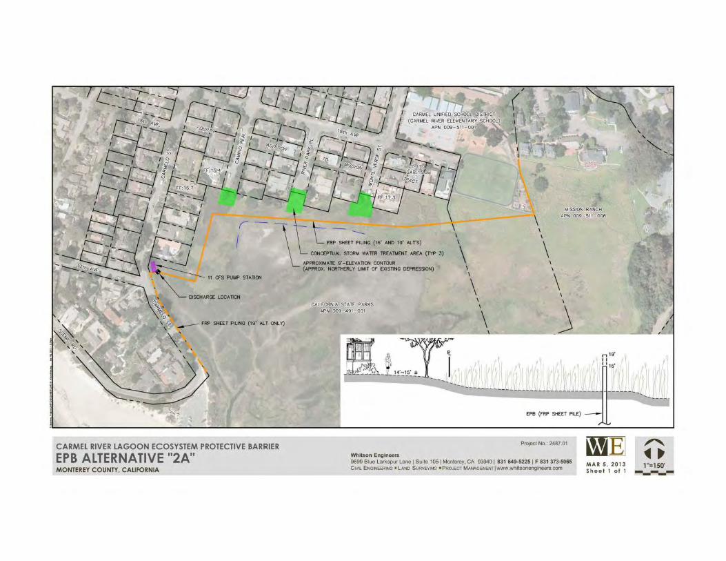

Sand Bag Barrier
Monte Verde Camino Real
River Park
Sand Bag Barrier Approximate Height of 16’ EPB
SCENIC ROAD
Protective Barrier


RECOGNITION
• EPB Feasibility Study (MCWRA)– Wildlife Conservation Board
– California Department of Fish & Wildlife
• Scenic Road Feasibility Study (RMA)– Monterey Peninsula Water Management District
– California Department of Water Resources• Integrated Regional Water Management (IWRM)

Appendix 4
Project Site Photographs
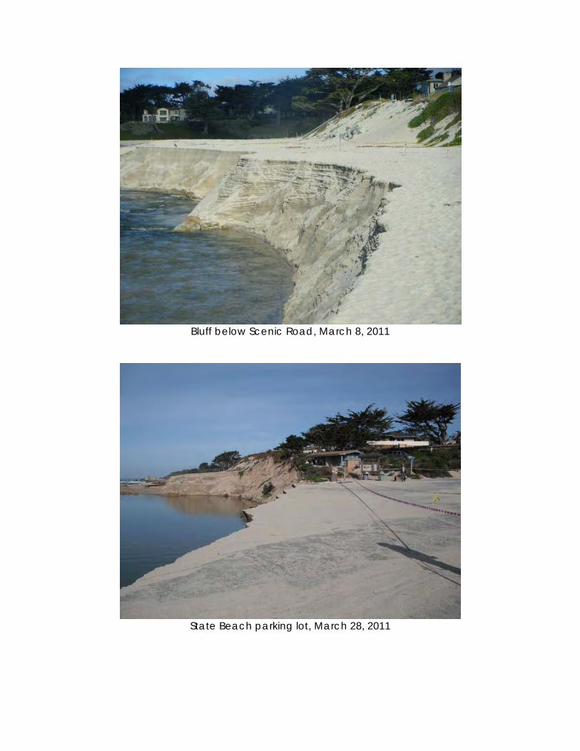
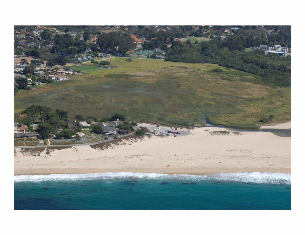
Bluff below Scenic Road, March 8, 2011
State Beach parking lot, March 28, 2011
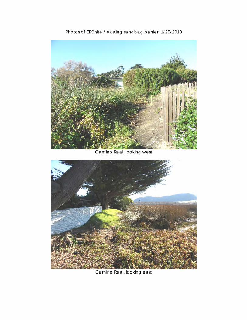
Photos of EPB site / existing sandbag barrier, 1/25/2013
Camino Real, looking west
Camino Real, looking east
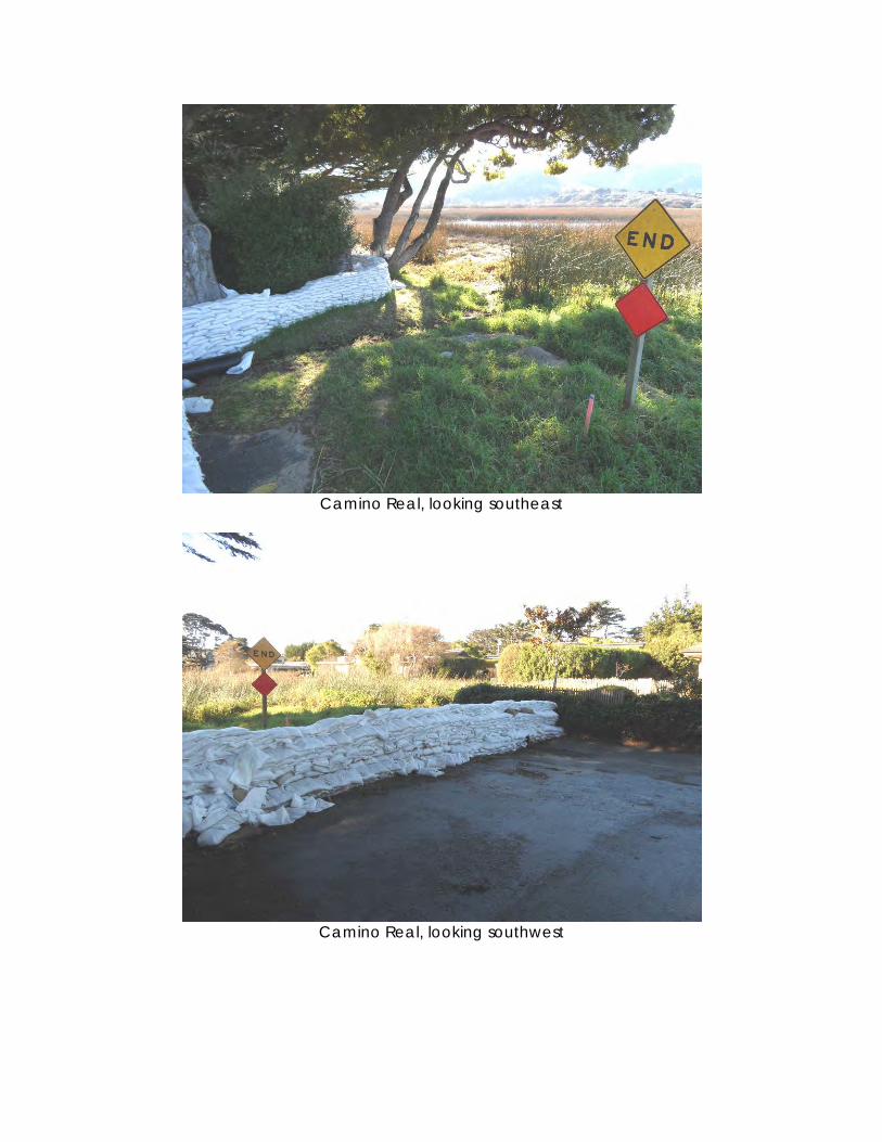
Camino Real, looking southeast
Camino Real, looking southwest
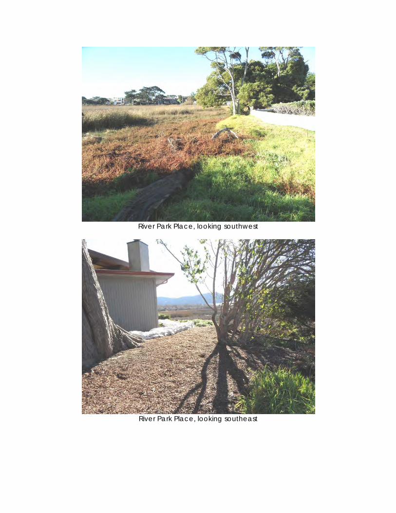
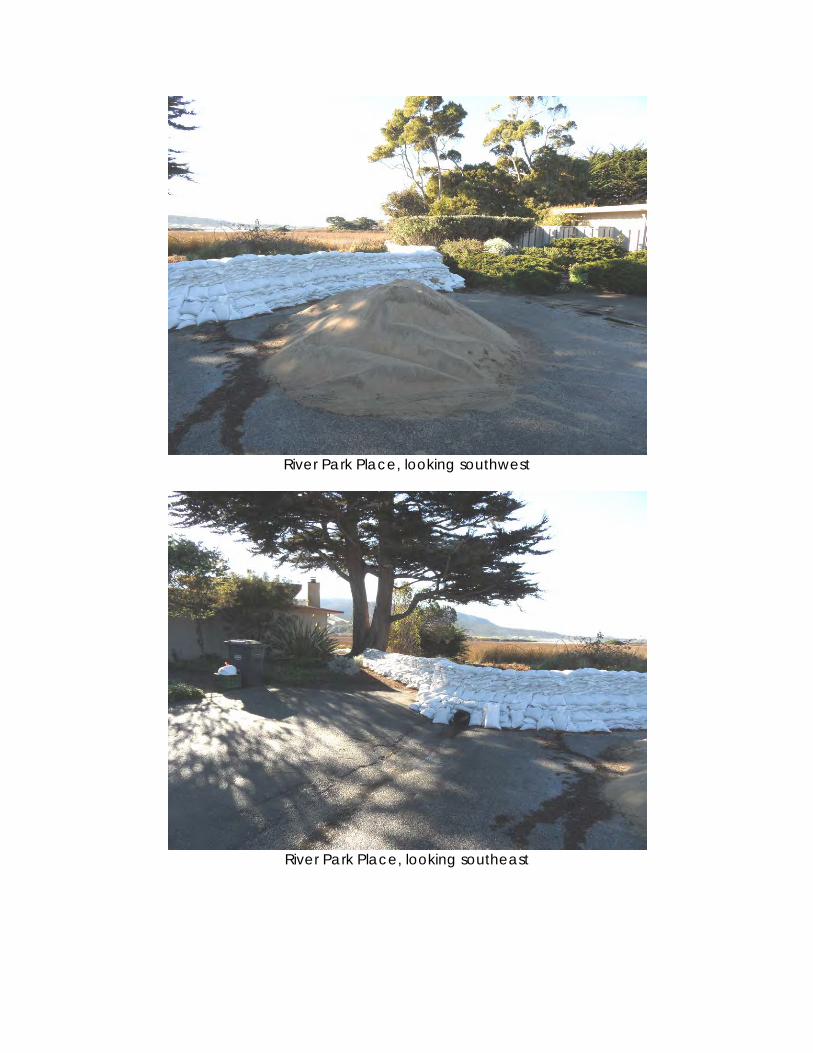
River Park Place, looking southwest
River Park Place, looking southeast
River Park Place, looking southwest
River Park Place, looking southeast
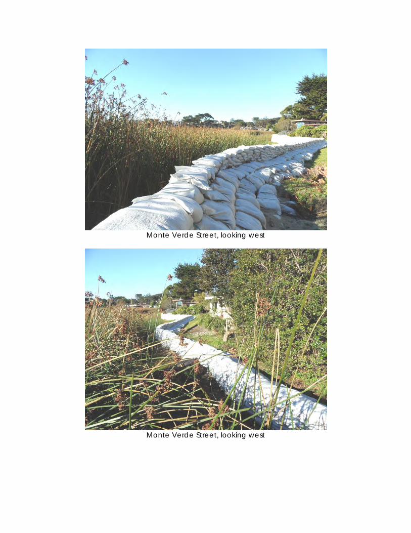
Monte Verde Street, looking west
Monte Verde Street, looking west
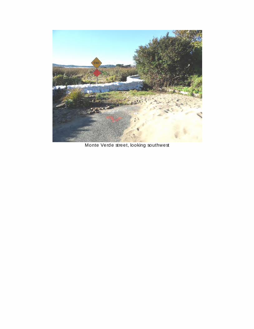
Monte Verde street, looking southwest
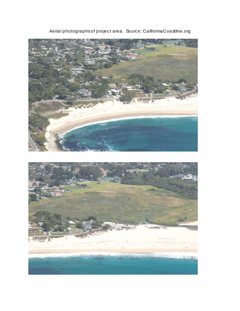
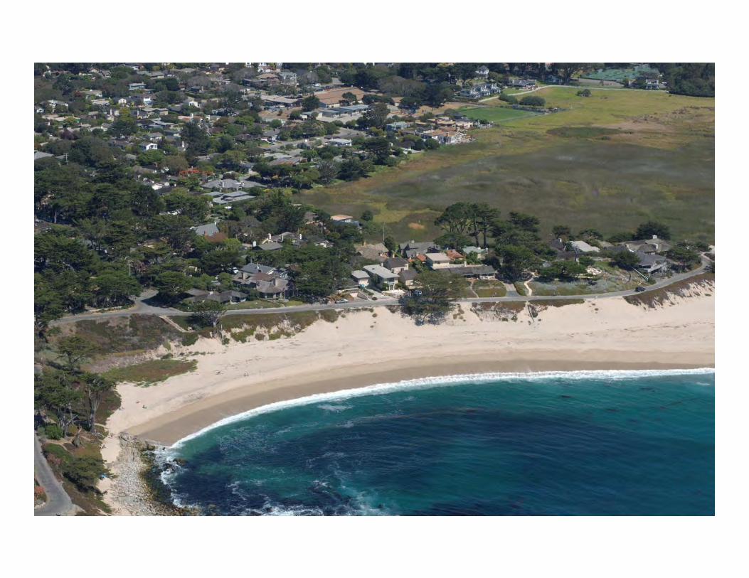
Aerial photographs of project area. Source: CaliforniaCoastline.org
Appendix 5
Photographs of April 10, 2013 EPB Mock-Up And Mock-Up Location Map
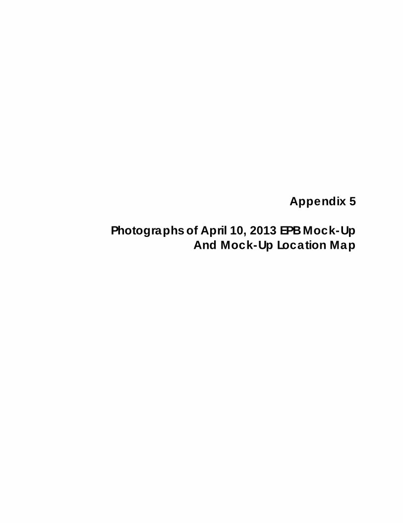
View of EPB mock-ups from an eye height of approximately 19’ elevation.
View of EPB mock-ups from an eye height of approximately 16’ elevation.
1A-19’ 1B-19’
2A-19’
1A-16’ 1B-16’ 2A-16’
1A-19’ 1B-19’
2A-19’ 1A-16’ 1B-16’
2A-16’
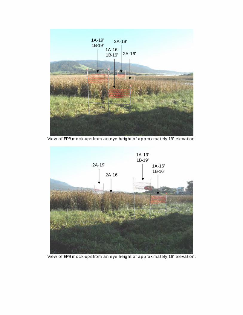
View of mock-ups and sandbag barrier at River Park Place.
View of mock-ups from Carmel River State Beach.
2A-19’ 1A-19’ 1B-19’
2A-19’ 1A-19’ 1B-19’
1A-16’ 1B-16’
2A-16’
16’± top of sandbag elevation
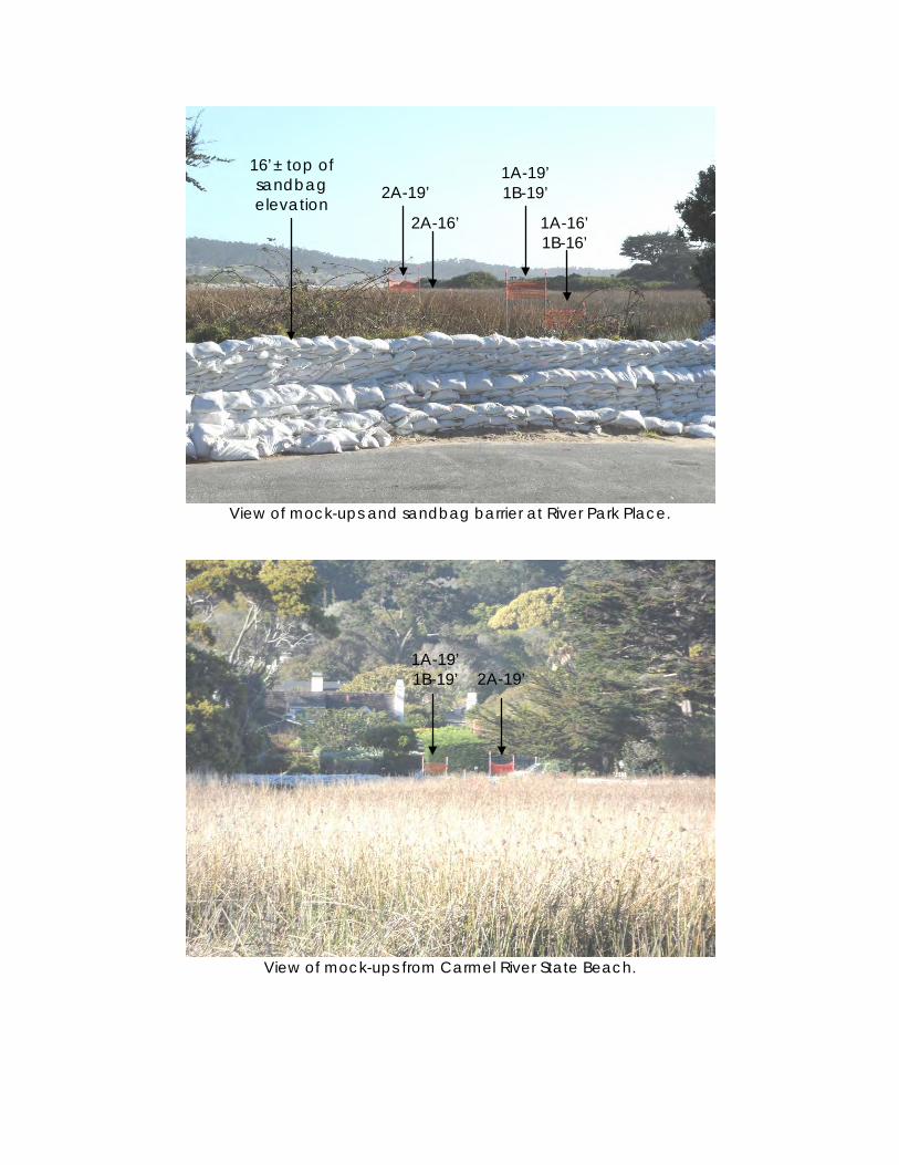
Close-up of EPB mock-ups for Alternatives 1A-19’/1B-19’ (left) and 1A-16’/1B-16’ (right).
EPB Alternative 2A seen in background.
Close-up of EPB mock-ups for Alternatives 2A-19’ (left) and 2A-16’ (right, obscured)
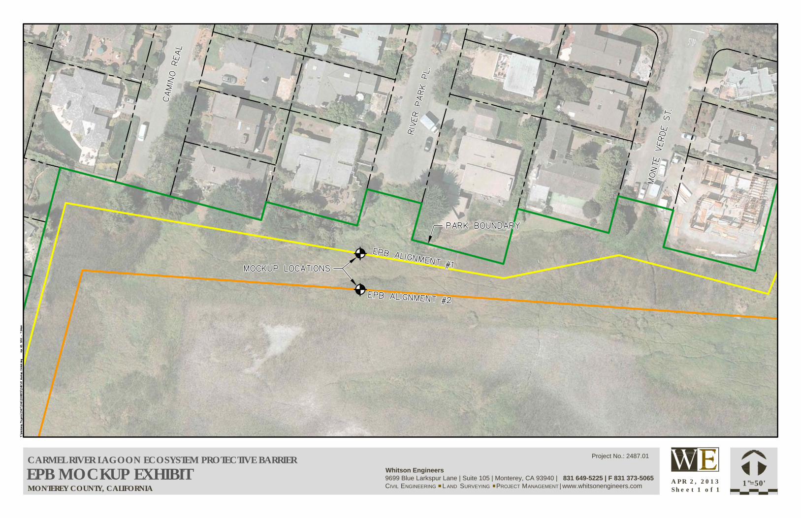
MONTEREY COUNTY, CALIFORNIA
CARMEL RIVER LAGOON ECOSYSTEM PROTECTIVE BARRIEREPB MOCKUP EXHIBIT
1"=50'A P R 2 , 2 0 1 3S h e e t 1 o f 1
Project No.: 2487.01
Whitson Engineers
9699 Blue Larkspur Lane | Suite 105 | Monterey, CA 93940 | 831 649-5225 | F 831 373-5065
CIVIL ENGINEERING L AND SURVEYING PROJECT MANAGEMENT | www.whitsonengineers.com

Appendix 6
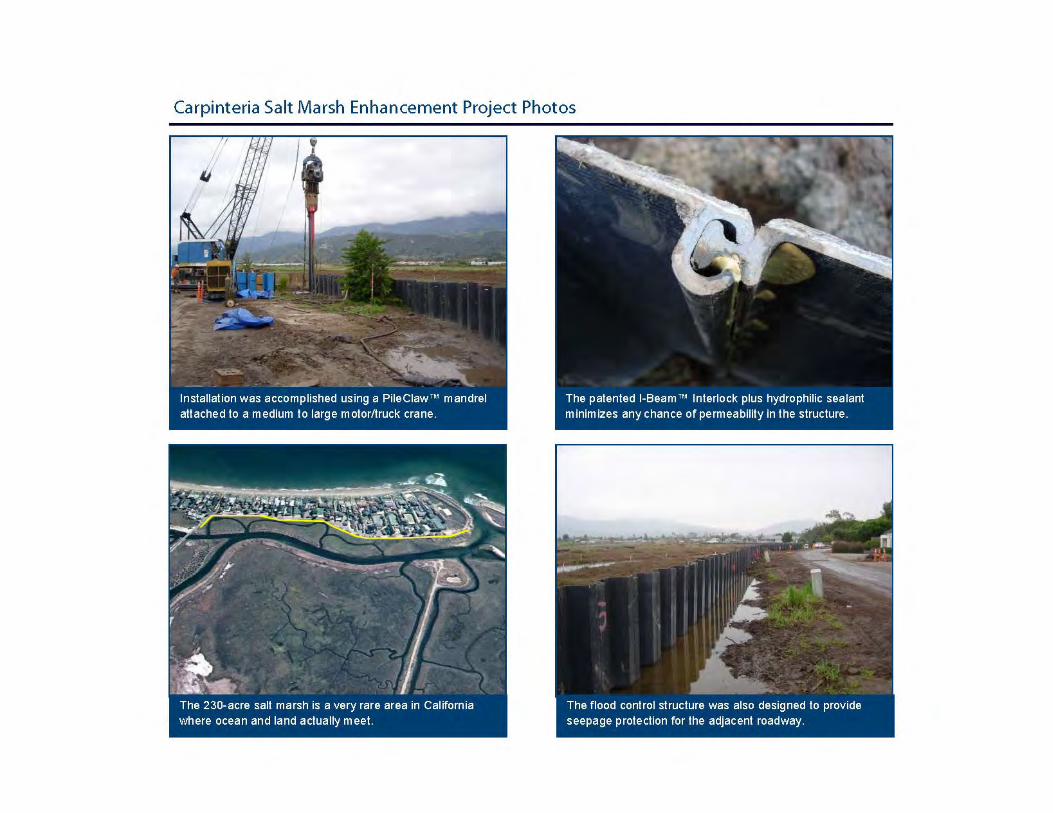
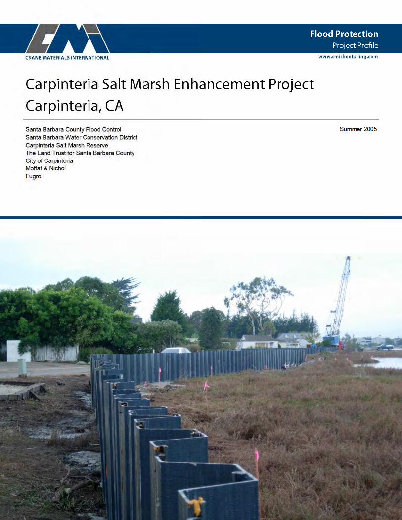
Brochures and Photographs: Carpinteria Salt Marsh Enhancement Project
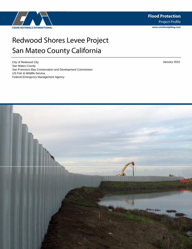
Martinez Marina Redwood Shores Levee Project
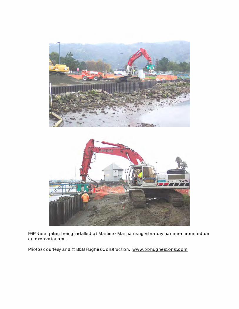
FRP sheet piling being installed at Martinez Marina using vibratory hammer mounted on an excavator arm. Photos courtesy and © B&B Hughes Construction. www.bbhughesconst.com
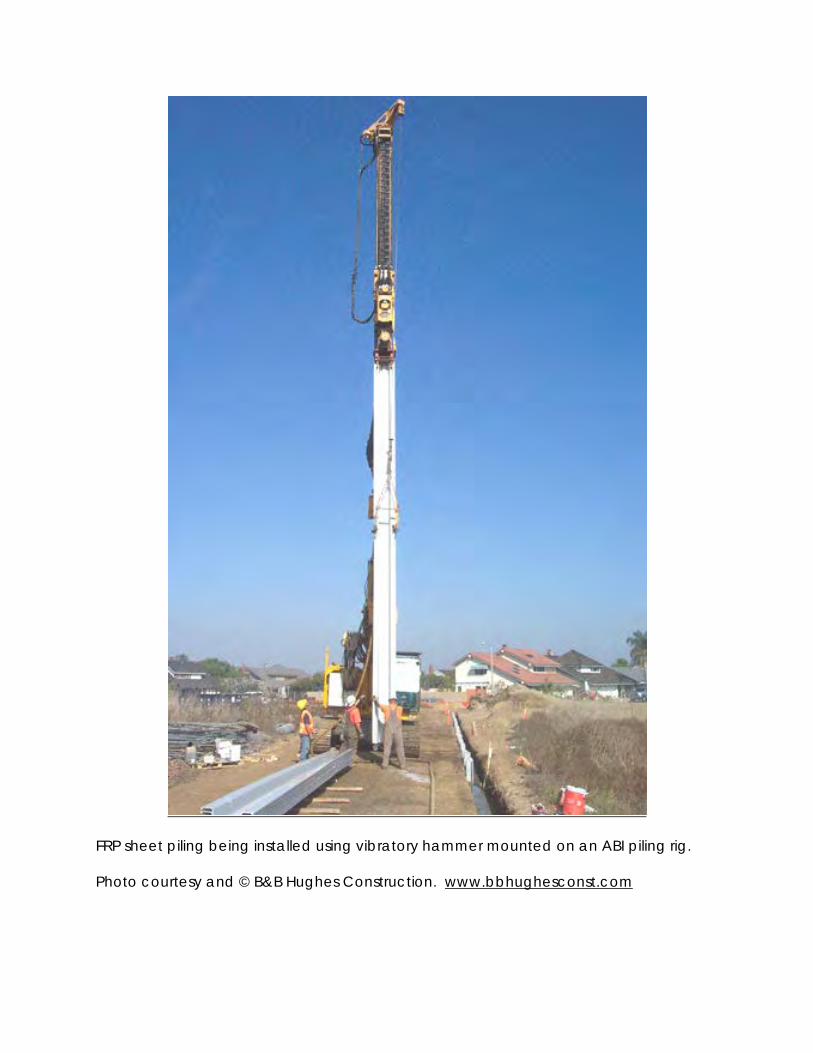
FRP sheet piling being installed using vibratory hammer mounted on an ABI piling rig. Photo courtesy and © B&B Hughes Construction. www.bbhughesconst.com
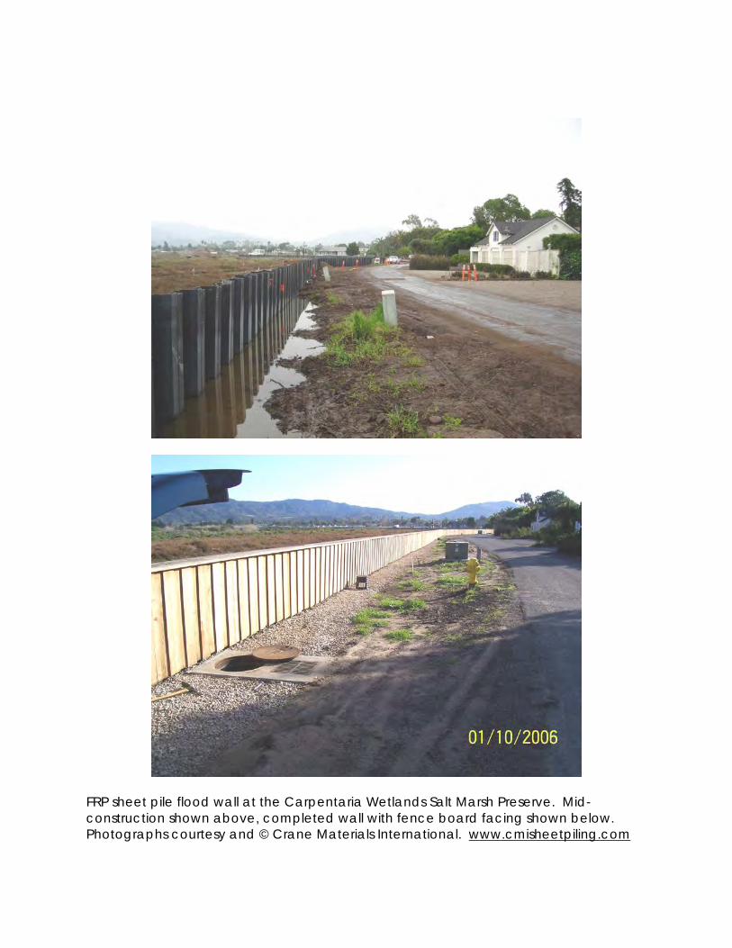
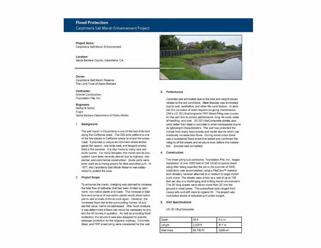
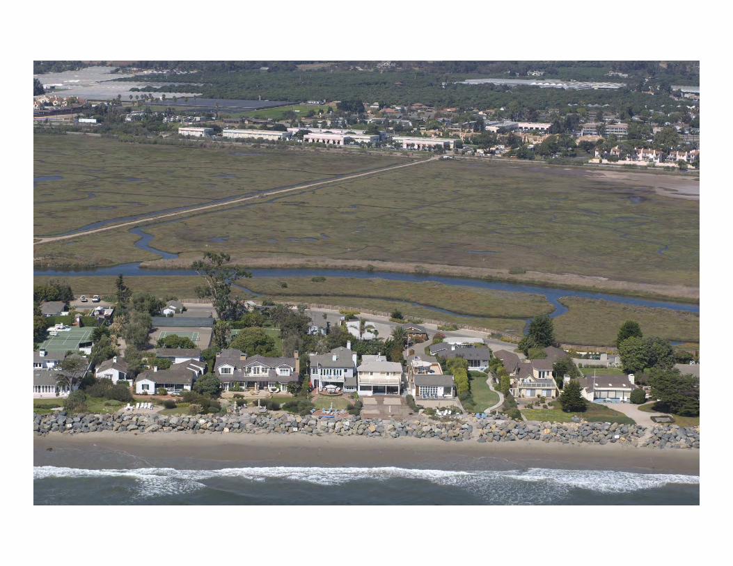
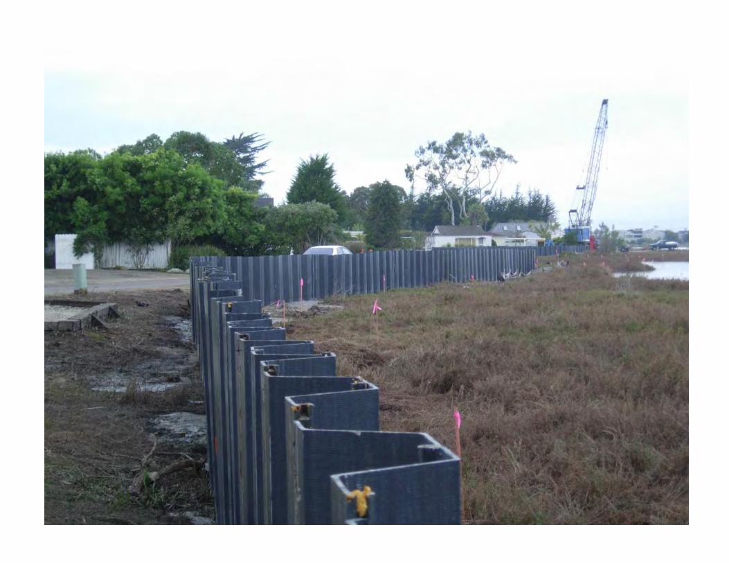
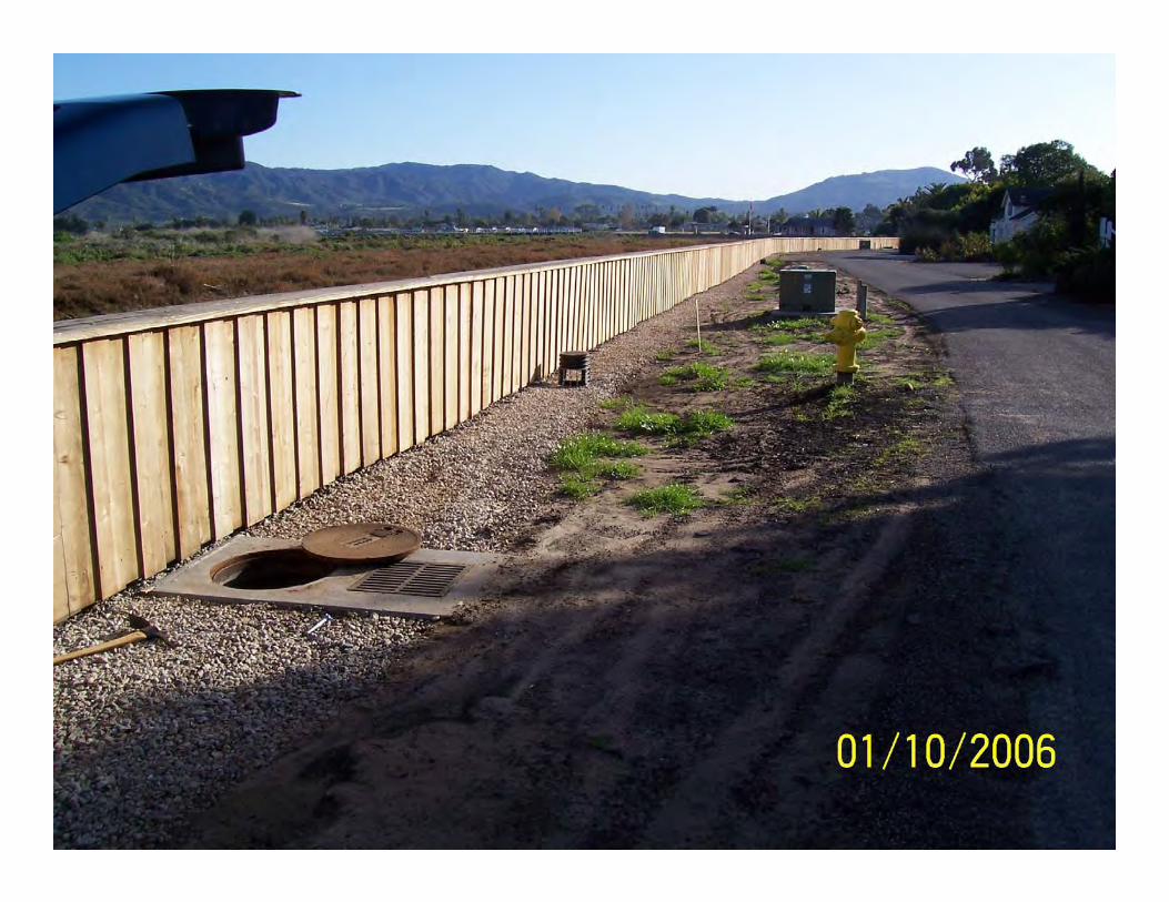
FRP sheet pile flood wall at the Carpentaria Wetlands Salt Marsh Preserve. Mid-construction shown above, completed wall with fence board facing shown below. Photographs courtesy and © Crane Materials International. www.cmisheetpiling.com
Flood Protection Project Profile
CRANE MATERIALS INTERNATIONAL
Redwood Shores Levee Project San Mateo County California City of Redwood City San Mateo County San Francisco Bay Conservation and Development Commission US Fish & Wildlife Service Federal Emergency Management Agency
January 2010
www.cmisheetpiling.com
2
Flood Protection Redwood Shores Levee Project
CRANE MATERIALS INTERNATIONAL
Project Name: Redwood Shores Levee Project
Location: Redwood Shores, San Mateo County, San Francisco Bay
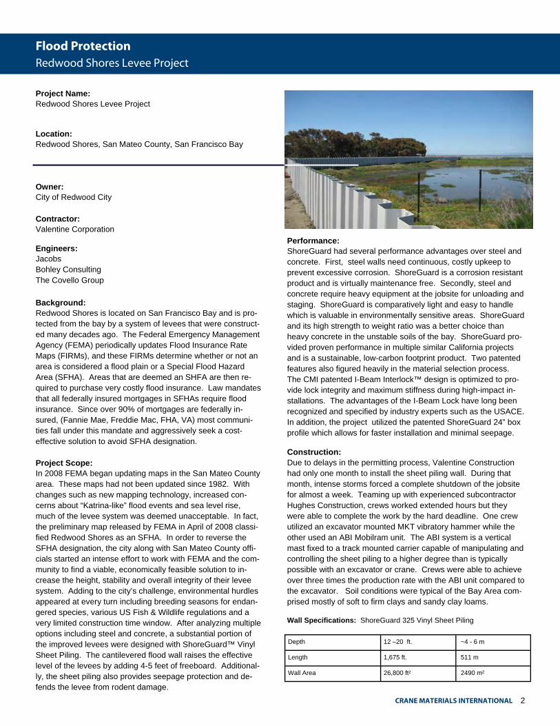
Background: Redwood Shores is located on San Francisco Bay and is pro-tected from the bay by a system of levees that were construct-ed many decades ago. The Federal Emergency Management Agency (FEMA) periodically updates Flood Insurance Rate Maps (FIRMs), and these FIRMs determine whether or not an area is considered a flood plain or a Special Flood Hazard Area (SFHA). Areas that are deemed an SHFA are then re-quired to purchase very costly flood insurance. Law mandates that all federally insured mortgages in SFHAs require flood insurance. Since over 90% of mortgages are federally in-sured, (Fannie Mae, Freddie Mac, FHA, VA) most communi-ties fall under this mandate and aggressively seek a cost-effective solution to avoid SFHA designation. Project Scope: In 2008 FEMA began updating maps in the San Mateo County area. These maps had not been updated since 1982. With changes such as new mapping technology, increased con-cerns about “Katrina-like” flood events and sea level rise, much of the levee system was deemed unacceptable. In fact, the preliminary map released by FEMA in April of 2008 classi-fied Redwood Shores as an SFHA. In order to reverse the SFHA designation, the city along with San Mateo County offi-cials started an intense effort to work with FEMA and the com-munity to find a viable, economically feasible solution to in-crease the height, stability and overall integrity of their levee system. Adding to the city’s challenge, environmental hurdles appeared at every turn including breeding seasons for endan-gered species, various US Fish & Wildlife regulations and a very limited construction time window. After analyzing multiple options including steel and concrete, a substantial portion of the improved levees were designed with ShoreGuard™ Vinyl Sheet Piling. The cantilevered flood wall raises the effective level of the levees by adding 4-5 feet of freeboard. Additional-ly, the sheet piling also provides seepage protection and de-fends the levee from rodent damage.
Owner: City of Redwood City Contractor: Valentine Corporation
Engineers: Jacobs Bohley Consulting The Covello Group
Performance: ShoreGuard had several performance advantages over steel and concrete. First, steel walls need continuous, costly upkeep to prevent excessive corrosion. ShoreGuard is a corrosion resistant product and is virtually maintenance free. Secondly, steel and concrete require heavy equipment at the jobsite for unloading and staging. ShoreGuard is comparatively light and easy to handle which is valuable in environmentally sensitive areas. ShoreGuard and its high strength to weight ratio was a better choice than heavy concrete in the unstable soils of the bay. ShoreGuard pro-vided proven performance in multiple similar California projects and is a sustainable, low-carbon footprint product. Two patented features also figured heavily in the material selection process. The CMI patented I-Beam Interlock™ design is optimized to pro-vide lock integrity and maximum stiffness during high-impact in-stallations. The advantages of the I-Beam Lock have long been recognized and specified by industry experts such as the USACE. In addition, the project utilized the patented ShoreGuard 24” box profile which allows for faster installation and minimal seepage.
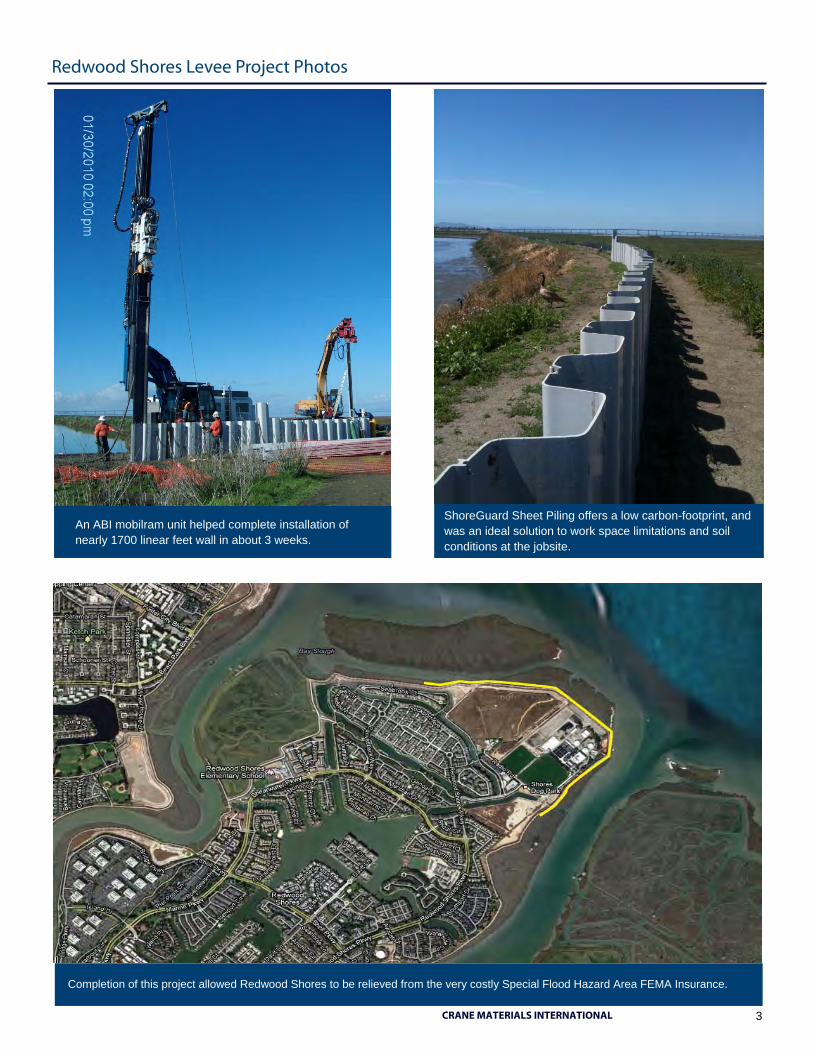
Construction: Due to delays in the permitting process, Valentine Construction had only one month to install the sheet piling wall. During that month, intense storms forced a complete shutdown of the jobsite for almost a week. Teaming up with experienced subcontractor Hughes Construction, crews worked extended hours but they were able to complete the work by the hard deadline. One crew utilized an excavator mounted MKT vibratory hammer while the other used an ABI Mobilram unit. The ABI system is a vertical mast fixed to a track mounted carrier capable of manipulating and controlling the sheet piling to a higher degree than is typically possible with an excavator or crane. Crews were able to achieve over three times the production rate with the ABI unit compared to the excavator. Soil conditions were typical of the Bay Area com-prised mostly of soft to firm clays and sandy clay loams.
Wall Specifications: ShoreGuard 325 Vinyl Sheet Piling
Depth 12 –20 ft. ~4 - 6 m
Length 1,675 ft. 511 m
Wall Area 26,800 ft² 2490 m²
3
Redwood Shores Levee Project Photos
CRANE MATERIALS INTERNATIONAL
An ABI mobilram unit helped complete installation of nearly 1700 linear feet wall in about 3 weeks.
Completion of this project allowed Redwood Shores to be relieved from the very costly Special Flood Hazard Area FEMA Insurance.
ShoreGuard Sheet Piling offers a low carbon-footprint, and was an ideal solution to work space limitations and soil conditions at the jobsite.