Embed Size (px)
Citation preview

Appendix 11.0
Double Ring Infiltration Testing Report
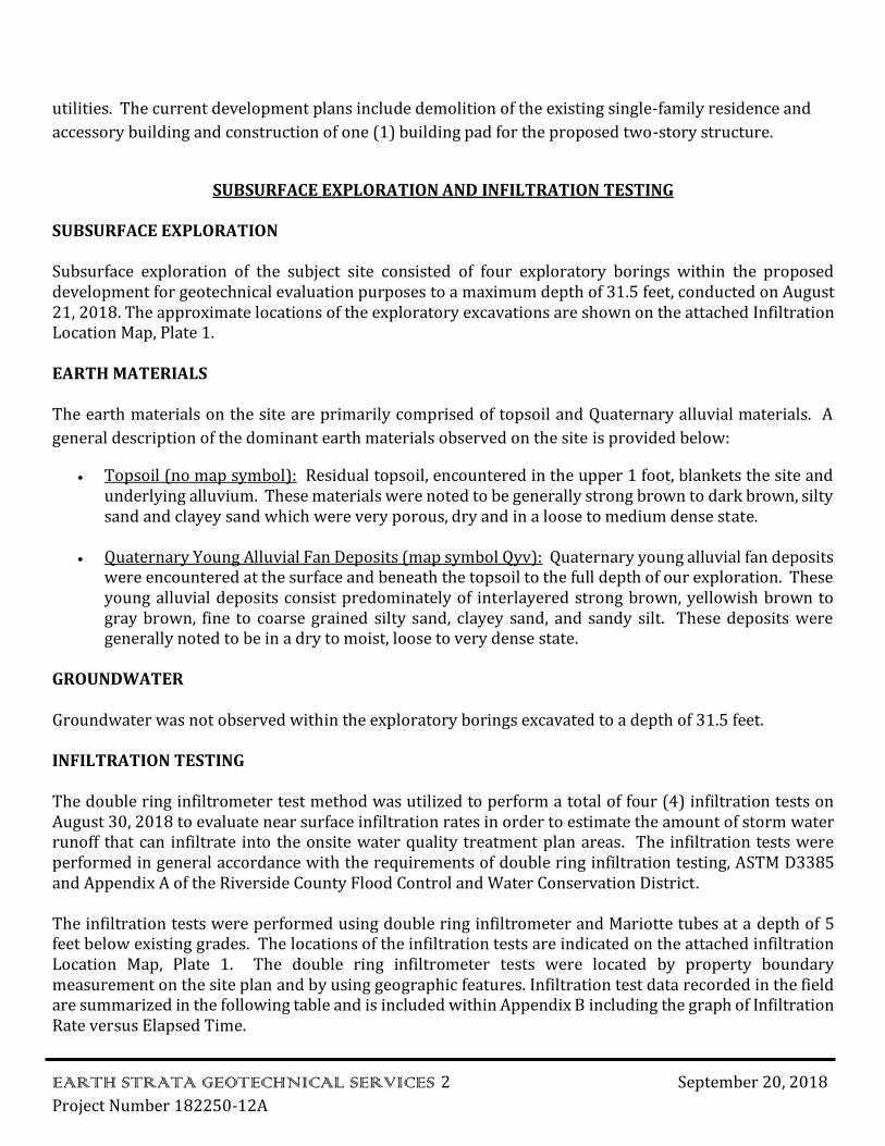
September 20, 2018
Project No. 182250-12A MDMG Project 1585 KCG BLU, LLC
Mr. Don Maclean KCG BLUE, LLC
3961 Citrus Drive
Fallbrook, CA 92028
Subject: Double Ring Infiltration Testing Report, Proposed Gun Shooting Range and Tactical
Training Facility, Assessor Parcel Number 367-020-038, Lot Number 115 of Sedco
Tract 1 Subdivision, Located at 34020 Mission Trail, City of Wildomar, Riverside
County, California
Earth Strata Geotechnical Services is pleased to present this infiltration feasibility report for the proposed commercial development, Assessor Parcel Number 367-020-038, located at 34020 Mission Trail in the City of Wildomar of Riverside County, California. The purpose of our study was to determine the infiltration rates and physical characteristics of the subsurface earth materials at the approximate depth of the proposed WQMP area within the proposed development. This feasibility report provides the infiltration rates to be used for the design and the development of the water quality management plan, where applicable.
PROPERTY DESCRIPTION
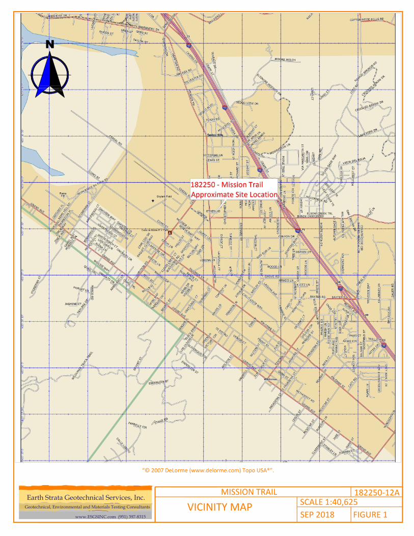
The subject property is located at 34020 Mission Trail in the City of Wildomar, Riverside County, California.
The approximate location of the site is shown on the Vicinity Map, Figure 1.
The subject property is comprised of approximately 2.33 acres of developed land with an existing single-
family residence and accessory building to be removed. Topographic relief at the subject property is
relatively low with the terrain being generally flat. Elevations at the site is approximately 1,305 feet above
mean sea level (msl). Drainage within the subject property generally flows to the northwest.
The site is currently bordered by residential development to the east, commercial development to the
north, and vacant property to the west and south. Most of the vegetation on the site consists of moderate
amounts of annual weeds/grasses.
PROPOSED CONSTRUCTION
The proposed commercial development is expected to consist of concrete, wood or steel framed two-
story structure utilizing slab on grade construction with associated streets, parking, landscape areas, and
42184 Remington Avenue, TEMECULA, CA 92590 951-397-8315, ESGSINC.COM
EARTH STRATA GEOTECHNICAL SERVICES 2 September 20, 2018
Project Number 182250-12A
utilities. The current development plans include demolition of the existing single-family residence and
accessory building and construction of one (1) building pad for the proposed two-story structure.
SUBSURFACE EXPLORATION AND INFILTRATION TESTING
SUBSURFACE EXPLORATION
Subsurface exploration of the subject site consisted of four exploratory borings within the proposed development for geotechnical evaluation purposes to a maximum depth of 31.5 feet, conducted on August 21, 2018. The approximate locations of the exploratory excavations are shown on the attached Infiltration Location Map, Plate 1.
EARTH MATERIALS
The earth materials on the site are primarily comprised of topsoil and Quaternary alluvial materials. A
general description of the dominant earth materials observed on the site is provided below:
• Topsoil (no map symbol): Residual topsoil, encountered in the upper 1 foot, blankets the site andunderlying alluvium. These materials were noted to be generally strong brown to dark brown, siltysand and clayey sand which were very porous, dry and in a loose to medium dense state.
• Quaternary Young Alluvial Fan Deposits (map symbol Qyv): Quaternary young alluvial fan depositswere encountered at the surface and beneath the topsoil to the full depth of our exploration. Theseyoung alluvial deposits consist predominately of interlayered strong brown, yellowish brown togray brown, fine to coarse grained silty sand, clayey sand, and sandy silt. These deposits weregenerally noted to be in a dry to moist, loose to very dense state.
GROUNDWATER
Groundwater was not observed within the exploratory borings excavated to a depth of 31.5 feet.
INFILTRATION TESTING
The double ring infiltrometer test method was utilized to perform a total of four (4) infiltration tests on August 30, 2018 to evaluate near surface infiltration rates in order to estimate the amount of storm water runoff that can infiltrate into the onsite water quality treatment plan areas. The infiltration tests were performed in general accordance with the requirements of double ring infiltration testing, ASTM D3385 and Appendix A of the Riverside County Flood Control and Water Conservation District.
The infiltration tests were performed using double ring infiltrometer and Mariotte tubes at a depth of 5 feet below existing grades. The locations of the infiltration tests are indicated on the attached infiltration Location Map, Plate 1. The double ring infiltrometer tests were located by property boundary measurement on the site plan and by using geographic features. Infiltration test data recorded in the field are summarized in the following table and is included within Appendix B including the graph of Infiltration Rate versus Elapsed Time.
EARTH STRATA GEOTECHNICAL SERVICES 3 September 20, 2018
Project Number 182250-12A
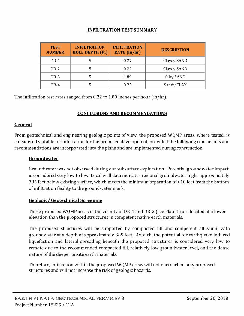
INFILTRATION TEST SUMMARY
TEST NUMBER
INFILTRATION HOLE DEPTH (ft.)
INFILTRATION RATE (in/hr)
DESCRIPTION
DR-1 5 0.27 Clayey SAND
DR-2 5 0.22 Clayey SAND
DR-3 5 1.89 Silty SAND
DR-4 5 0.25 Sandy CLAY
The infiltration test rates ranged from 0.22 to 1.89 inches per hour (in/hr).
CONCLUSIONS AND RECOMMENDATIONS
General
From geotechnical and engineering geologic points of view, the proposed WQMP areas, where tested, is
considered suitable for infiltration for the proposed development, provided the following conclusions and
recommendations are incorporated into the plans and are implemented during construction.
Groundwater
Groundwater was not observed during our subsurface exploration. Potential groundwater impact
is considered very low to low. Local well data indicates regional groundwater highs approximately
385 feet below existing surface, which meets the minimum separation of >10 feet from the bottom
of infiltration facility to the groundwater mark.
Geologic/ Geotechnical Screening
These proposed WQMP areas in the vicinity of DR-1 and DR-2 (see Plate 1) are located at a lower elevation than the proposed structures in competent native earth materials.
The proposed structures will be supported by compacted fill and competent alluvium, with
groundwater at a depth of approximately 385 feet. As such, the potential for earthquake induced
liquefaction and lateral spreading beneath the proposed structures is considered very low to
remote due to the recommended compacted fill, relatively low groundwater level, and the dense
nature of the deeper onsite earth materials.
Therefore, infiltration within the proposed WQMP areas will not encroach on any proposed structures and will not increase the risk of geologic hazards.
EARTH STRATA GEOTECHNICAL SERVICES 4 September 20, 2018
Project Number 182250-12A
Preliminary laboratory test results indicate onsite earth materials exhibit an expansion potential of LOW as classified in accordance with 2016 CBC Section 1803.5.3 and ASTM D4829.
Recommended Factor of Safety
The recommended factor of safety for the infiltration design is 3.
Based on the data presented in this report and the recommendations set forth herein, it is the opinion of Earth Strata Geotechnical Services that the WQMP area can be designed for an infiltration rate of 0.26 inches per hour.
GRADING PLAN REVIEW AND CONSTRUCTION SERVICES
This report has been prepared for the exclusive use of Mr. Don McClean and their authorized representative. It likely does not contain sufficient information for other parties or other uses. Earth Strata Geotechnical Services should be engaged to review the final design plans and specifications prior to construction. This is to verify that the recommendations contained in this report have been properly incorporated into the project plans and specifications. Should Earth Strata Geotechnical Services not be accorded the opportunity to review the project plans and specifications, we are not responsibility for misinterpretation of our recommendations.
Earth Strata should be retained to provide observations during construction to validate this report. In
order to allow for design changes in the event that the subsurface conditions differ from those
anticipated prior to construction.
Earth Strata should review any changes in the project and modify and approve in writing the conclusions
and recommendations of this report. This report and the drawings contained within are intended for
design input purposes only and are not intended to act as construction drawings or specifications. In the
event that conditions encountered during grading or construction operations appear to be different than
those indicated in this report, this office should be notified immediately, as revisions may be required.
N
“© 2007 DeLorme (www.delorme.com) Topo USA®”.
MISSION TRAIL 182250-12A
VICINITY MAPSEP 2018 FIGURE 1SCALE 1:40,625
Geotechnical, Environmental and Materials Testing Consultants
www.ESGSINC.com (951) 397-8315
Earth Strata Geotechnical Services, Inc.
APPENDIX A
EXPLORATORY LOGS
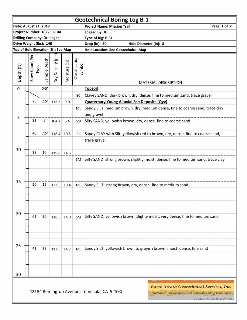
Project Name: Mission TrailLogged By: JFType of Rig: B-61Drop (in): 30 Hole Diameter (in): 8Hole Location: See Geotechnical Map
25
Silty SAND; strong brown, slightly moist, dense, fine to medium sand, trace clay
Sandy SILT; yellowish brown to grayish brown, moist, dense, fine sand
Silty SAND; yellowish brown, slighty mosit, very dense, fine to medium sand
Sandy SILT; strong brown, dry, dense, fine to medium sand
Topsoil
trace gravelSandy CLAY with Silt; yellowish red to brown, dry, dense, fine to coarse sand,
Silty SAND; yellowish brown, dry, dense, fine to coarse sand
MATERIAL DESCRIPTION
and gravelSandy SILT; medium brown, dry, medium dense, fine to coarse sand, trace clayQuaternary Young Alluvial Fan Deposits (Qyv)Clayey SAND; dark brown, dry, dense, fine to medium sand, trace gravel
30
14.7 ML25
25' 117.5
14.0 SM6120
20' 118.5
10.4 ML15
15' 123.5
SM
14.63310
10' 119.8
7.5' 118.4 10.5 CL
6.4 SM
ML
55' 104.7
SC2.5' 115.3 9.0
Page: 1 of 2Project Number: 182250-10ADrilling Company: Drilling ItDrive Weight (lbs): 140Top of Hole Elevation (ft): See Map
Dep
th (f
t)
Blo
w C
ount
Per
Fo
ot
Sam
ple
Dept
h
Dry
Den
sity
(pcf
)
Geotechnical Boring Log B-1Date: August 21, 2018
Moi
stur
e (%
)
Cla
ssifi
catio
n Sy
mbo
l
0 0-5'
21
41
42184 Remington Avenue, Temecula, CA 92590
40
50
Project Name: Mission TrailLogged By: JFType of Rig: B-61Drop (in): 30 Hole Diameter (in): 8Hole Location: See Geotechnical Map
Geotechnical Boring Log B-1Date: August 21, 2018 Page: 2 of 2Project Number: 182250-10ADrilling Company: Drilling ItDrive Weight (lbs): 140Top of Hole Elevation (ft): See Map
Dep
th (f
t)
Blo
w C
ount
Per
Fo
ot
Sam
ple
Dept
h
Dry
Den
sity
(pcf
)
Moi
stur
e (%
)
Cla
ssifi
catio
n Sy
mbo
lMATERIAL DESCRIPTION
30 30' 112.4 15.1 Yellowish gray to strong brown, very dense below 30 feet
Total Depth: 31.5 feetNo Groundwater
35
40
45
50
55
42184 Remington Avenue, Temecula, CA 92590
53
60
Project Name: Mission TrailLogged By: JFType of Rig: B-61Drop (in): 30 Hole Diameter (in): 8Hole Location: See Geotechnical Map
Geotechnical Boring Log B-2Date: August 21, 2018 Page: * of *Project Number: 182250-10ADrilling Company: Drilling ItDrive Weight (lbs): 140Top of Hole Elevation (ft): See Map
Dep
th (f
t)
Blo
w C
ount
Per
Fo
ot
Sam
ple
Dept
h
Dry
Den
sity
(pcf
)
Moi
stur
e (%
)
Cla
ssifi
catio
n Sy
mbo
lMATERIAL DESCRIPTION
0 Quaternary Young Alluvial Fan Deposits (Qyv)
48 2.5' 118.5 6.5 SM Silty SAND; brown, dry, dense, fine to coarse sand, trace clay and gravel
Strong brown below 4 feet5
5' 118.2 10.8 SC Clayey SAND; dark reddish brown, dry, dense, fine to coarse sand
36 7.5' 115.4 11.5 SM Silty SAND; yellowish brown, dry, dense, fine to coarse sand, trace clay
1090/9" 10' 128.8 7.1 Light yellowish brown, very dense below 10 feet
1574 15' 132.5 8.6 Light reddish brown to strong brown, with clay
Total Depth: 16.5 feetNo Groundwater
20
25
42184 Remington Avenue, Temecula, CA 92590
34
30
Project Name: Mission TrailLogged By: JFType of Rig: B-61Drop (in): 30 Hole Diameter (in): 8Hole Location: See Geotechnical Map
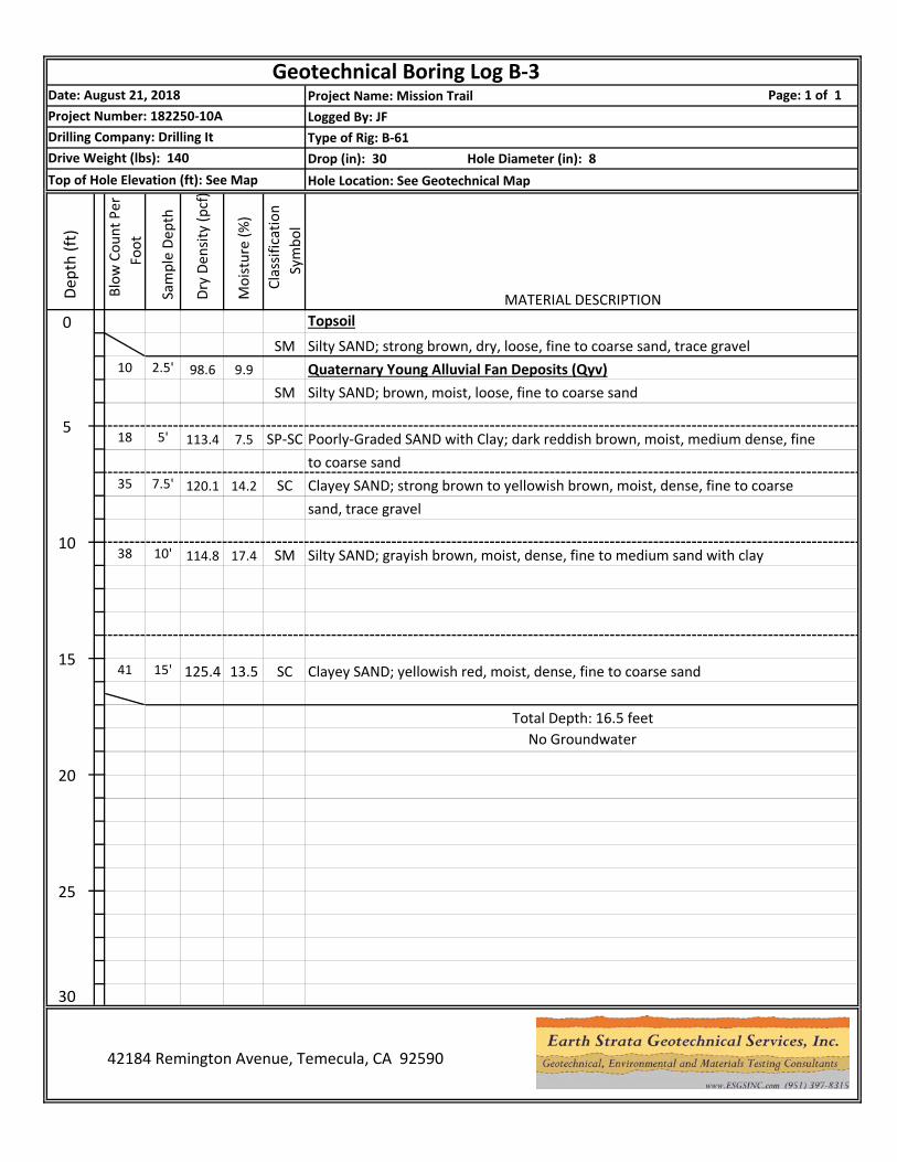
Geotechnical Boring Log B-3Date: August 21, 2018 Page: 1 of 1Project Number: 182250-10ADrilling Company: Drilling ItDrive Weight (lbs): 140Top of Hole Elevation (ft): See Map
Dep
th (f
t)
Blo
w C
ount
Per
Fo
ot
Sam
ple
Dept
h
Dry
Den
sity
(pcf
)
Moi
stur
e (%
)
Cla
ssifi
catio
n Sy
mbo
l
0SM Silty SAND; strong brown, dry, loose, fine to coarse sand, trace gravel
MATERIAL DESCRIPTIONTopsoil
10 2.5' 98.6 9.9 Quaternary Young Alluvial Fan Deposits (Qyv)SM Silty SAND; brown, moist, loose, fine to coarse sand
55' 113.4 7.5 SP-SC Poorly-Graded SAND with Clay; dark reddish brown, moist, medium dense, fine
to coarse sand35 7.5' 120.1 14.2 SC Clayey SAND; strong brown to yellowish brown, moist, dense, fine to coarse
sand, trace gravel
1038 10' 114.8 17.4 SM Silty SAND; grayish brown, moist, dense, fine to medium sand with clay
1541 15' 125.4 13.5 SC Clayey SAND; yellowish red, moist, dense, fine to coarse sand
Total Depth: 16.5 feetNo Groundwater
20
25
42184 Remington Avenue, Temecula, CA 92590
18
30
Project Name: Mission TrailLogged By: JFType of Rig: B-61Drop (in): 30 Hole Diameter (in): 8Hole Location: See Geotechnical Map
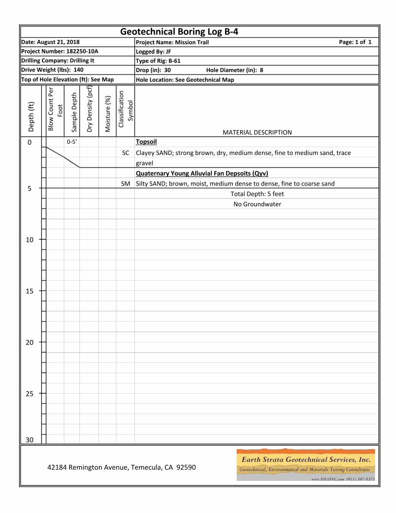
Geotechnical Boring Log B-4Date: August 21, 2018 Page: 1 of 1Project Number: 182250-10ADrilling Company: Drilling ItDrive Weight (lbs): 140Top of Hole Elevation (ft): See Map
Dep
th (f
t)
Blo
w C
ount
Per
Fo
ot
Sam
ple
Dept
h
Dry
Den
sity
(pcf
)
Moi
stur
e (%
)
Cla
ssifi
catio
n Sy
mbo
l
0 0-5'
SC Clayey SAND; strong brown, dry, medium dense, fine to medium sand, trace
MATERIAL DESCRIPTIONTopsoil
gravelQuaternary Young Alluvial Fan Depsoits (Qyv)
SM Silty SAND; brown, moist, medium dense to dense, fine to coarse sand5
Total Depth: 5 feetNo Groundwater
10
15
20
25
42184 Remington Avenue, Temecula, CA 92590
30
APPENDIX B
INFILTRATION TEST SHEETS
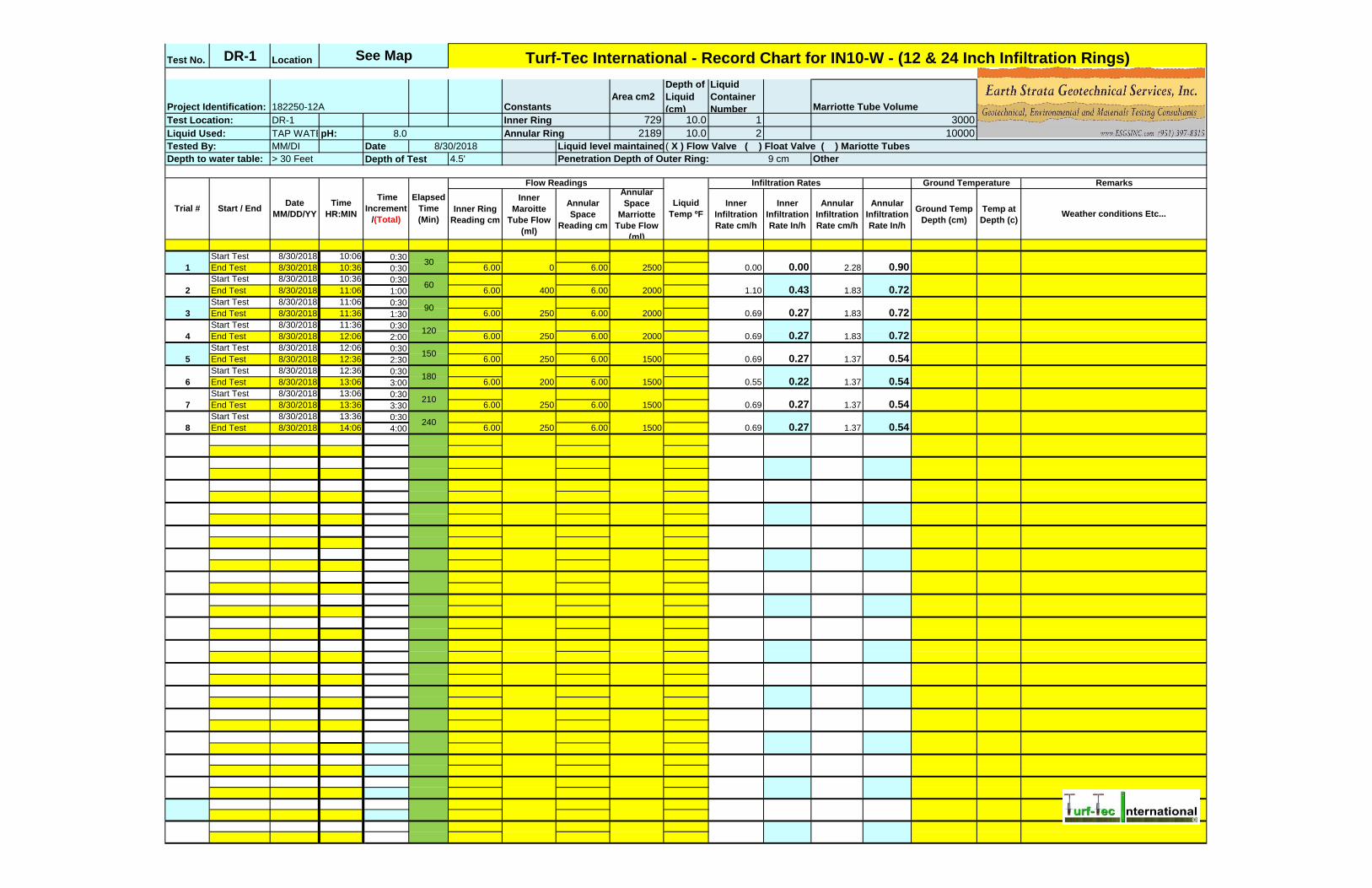
Test No. DR-1 Location
Area cm2
Depth of
Liquid
(cm)
Liquid
Container
NumberDR-1 729 10.0 1
TAP WATERpH: 8.0 2189 10.0 2
MM/DI Date
4.5' 9 cm
Inner Ring
Reading cm
Inner
Maroitte
Tube Flow
(ml)
Annular
Space
Reading cm
Annular
Space
Marriotte
Tube Flow
(ml)
Inner
Infiltration
Rate cm/h
Inner
Infiltration
Rate In/h
Annular
Infiltration
Rate cm/h
Annular
Infiltration
Rate In/h
Ground Temp
Depth (cm)
Temp at
Depth (c)
Start Test 8/30/2018 10:06 0:30
End Test 8/30/2018 10:36 0:30 6.00 6.00
Start Test 8/30/2018 10:36 0:30
End Test 8/30/2018 11:06 1:00 6.00 6.00
Start Test 8/30/2018 11:06 0:30
End Test 8/30/2018 11:36 1:30 6.00 6.00
Start Test 8/30/2018 11:36 0:30
End Test 8/30/2018 12:06 2:00 6.00 6.00
Start Test 8/30/2018 12:06 0:30
End Test 8/30/2018 12:36 2:30 6.00 6.00
Start Test 8/30/2018 12:36 0:30
End Test 8/30/2018 13:06 3:00 6.00 6.00
Start Test 8/30/2018 13:06 0:30
End Test 8/30/2018 13:36 3:30 6.00 6.00
Start Test 8/30/2018 13:36 0:30
End Test 8/30/2018 14:06 4:00 6.00 6.00
2000
150
1.83
1.83
1.37
0.54
Marriotte Tube Volume
3000
10000
Project Identification:
Liquid
Temp ºF
Flow Readings Infiltration Rates Ground Temperature
2.28
Remarks
Weather conditions Etc...
0 2500 0.00 0.00 0.90
60
90
Test Location:
Liquid Used:
See Map Turf-Tec International - Record Chart for IN10-W - (12 & 24 Inch Infiltration Rings)
Tested By:
Penetration Depth of Outer Ring:Depth to water table:
Liquid level maintained using:8/30/2018
> 30 Feet Depth of Test
( X ) Flow Valve ( ) Float Valve ( ) Mariotte Tubes
Inner Ring
Annular Ring
182250-12A Constants
Other
Start / End
1.37
2000 1.10 0.43 0.72
0.69
1500 0.69
0.27 0.72
0.72
0.54
2000 0.69 1.83
7 250 1500 0.69 1.37
6 200 1500 0.55 0.22
0.27
0.54
0.54
180
210
8 250 1500 0.69240
Date
MM/DD/YY
Time
HR:MIN
Time
Increment
/(Total)
400
Trial #
Elapsed
Time
(Min)
30
3 250
2
1
5 250
4 250120
0.27
0.27
0.27 1.37

TAP WATERpH:
Project
Identification: 182250-12A
Test Location: DR-1
Liquid Used: 8.0
Tested By: MM/DI
Depth to water table: > 30 Feet
0.00
0.43
0.27 0.27 0.27
0.22
0.27 0.27
0.00
0.05
0.10
0.15
0.20
0.25
0.30
0.35
0.40
0.45
0.50
30 60 90 120 150 180 210 240
INFI
LTR
ATI
ON
RA
TE (
IN/H
R)
ELAPSED TIME (MINS)
ELAPSED TIME VS. INFILTRATION RATE

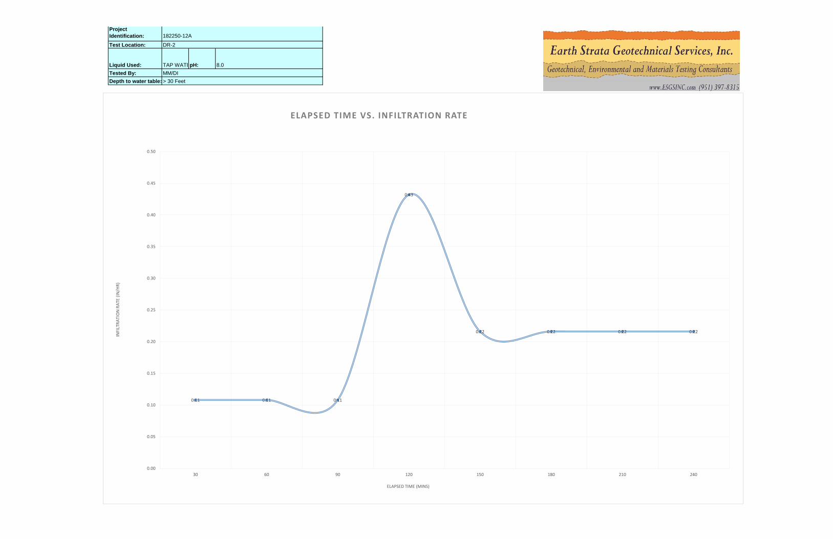
Test No. DR-2 Location
Area cm2
Depth of
Liquid
(cm)
Liquid
Container
NumberDR-2 729 10.0 1
TAP WATERpH: 8.0 2189 10.0 2
MM/DI Date
4.5' 9 cm
Inner Ring
Reading cm
Inner
Maroitte
Tube Flow
(ml)
Annular
Space
Reading cm
Annular
Space
Marriotte
Tube Flow
(ml)
Inner
Infiltration
Rate cm/h
Inner
Infiltration
Rate In/h
Annular
Infiltration
Rate cm/h
Annular
Infiltration
Rate In/h
Ground Temp
Depth (cm)
Temp at
Depth (c)
Start Test 8/30/2018 10:52 0:30
End Test 8/30/2018 11:22 0:30 6.00 6.00
Start Test 8/30/2018 11:22 0:30
End Test 8/30/2018 11:52 1:00 6.00 6.00
Start Test 8/30/2018 12:08 0:30
End Test 8/30/2018 12:38 1:30 6.00 6.00
Start Test 8/30/2018 12:38 0:30
End Test 8/30/2018 13:08 2:00 6.00 6.00
Start Test 8/30/2018 13:08 0:30
End Test 8/30/2018 13:38 2:30 6.00 6.00
Start Test 8/30/2018 13:38 0:30
End Test 8/30/2018 14:08 3:00 6.00 6.00
Start Test 8/30/2018 14:08 0:30
End Test 8/30/2018 14:38 3:30 6.00 6.00
Start Test 8/30/2018 14:38 0:30
End Test 8/30/2018 15:08 4:00 6.00 6.00
See Map Turf-Tec International - Record Chart for IN10-W - (12 & 24 Inch Infiltration Rings)
Test Location: Inner Ring 3000
Project Identification: 182250-12A Constants Marriotte Tube Volume
Liquid Used: Annular Ring 10000
Tested By: 8/30/2018 Liquid level maintained using:( X ) Flow Valve ( ) Float Valve ( ) Mariotte Tubes
Depth to water table: > 30 Feet Depth of Test Penetration Depth of Outer Ring: Other
Flow Readings
Liquid
Temp ºF
Infiltration Rates Ground Temperature Remarks
Weather conditions Etc...Trial # Start / End
Date
MM/DD/YY
Time
HR:MIN
Time
Increment
/(Total)
Elapsed
Time
(Min)
130
100 8500 0.27 0.11 7.77 3.06
260
100 7000 0.27 0.11 6.40 2.52
390
100 4500 0.27 0.11 4.11
5150
200 4500 0.55
1.62
4120
400 3000 1.10 0.43
0.22 4.11 1.62
2.74 1.08
7210
200 2500 0.55
6180
200 2500 0.55
0.22 2.28 0.90
2.28 0.900.22
8240
200 2500 0.55 2.28 0.900.22
TAP WATERpH:
Project
Identification: 182250-12A
Test Location: DR-2
8.0
Tested By: MM/DI
Liquid Used:
Depth to water table: > 30 Feet
0.11 0.11 0.11
0.43
0.22 0.22 0.22 0.22
0.00
0.05
0.10
0.15
0.20
0.25
0.30
0.35
0.40
0.45
0.50
30 60 90 120 150 180 210 240
INFI
LTR
ATI
ON
RA
TE (
IN/H
R)
ELAPSED TIME (MINS)
ELAPSED TIME VS. INFILTRATION RATE

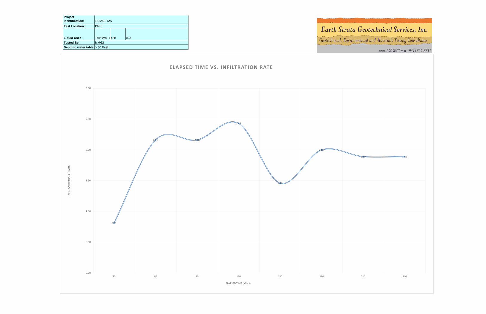
Test No. DR-3 Location
Area cm2
Depth of
Liquid
(cm)
Liquid
Container
NumberDR-3 729 10.0 1
TAP WATERpH: 8.0 2189 10.0 2
MM/DI Date
4.5' 9 cm
Inner Ring
Reading cm
Inner
Maroitte
Tube Flow
(ml)
Annular
Space
Reading cm
Annular
Space
Marriotte
Tube Flow
(ml)
Inner
Infiltration
Rate cm/h
Inner
Infiltration
Rate In/h
Annular
Infiltration
Rate cm/h
Annular
Infiltration
Rate In/h
Ground Temp
Depth (cm)
Temp at
Depth (c)
Start Test 8/30/2018 15:16 0:30
End Test 8/30/2018 15:46 0:30 6.00 6.00
Start Test 8/30/2018 15:46 0:30
End Test 8/30/2018 16:16 1:00 6.00 6.00
Start Test 8/30/2018 16:16 0:30
End Test 8/30/2018 16:46 1:30 6.00 6.00
Start Test 8/30/2018 16:46 0:30
End Test 8/30/2018 17:16 2:00 6.00 6.00
Start Test 8/30/2018 17:16 0:30
End Test 8/30/2018 17:46 2:30 6.00 6.00
Start Test 8/30/2018 17:46 0:30
End Test 8/30/2018 18:16 3:00 6.00 6.00
Start Test 8/30/2018 18:16 0:30
End Test 8/30/2018 18:46 3:30 6.00 6.00
Start Test 8/30/2018 18:46 0:30
End Test 8/30/2018 19:16 4:00 6.00 6.00
See Map Turf-Tec International - Record Chart for IN10-W - (12 & 24 Inch Infiltration Rings)
Test Location: Inner Ring 3000
Project Identification: 182250-12A Constants Marriotte Tube Volume
Liquid Used: Annular Ring 10000
Tested By: 8/30/2018 Liquid level maintained using:( X ) Flow Valve ( ) Float Valve ( ) Mariotte Tubes
Depth to water table: > 30 Feet Depth of Test Penetration Depth of Outer Ring: Other
Flow Readings
Liquid
Temp ºF
Infiltration Rates Ground Temperature Remarks
Weather conditions Etc...Trial # Start / End
Date
MM/DD/YY
Time
HR:MIN
Time
Increment
/(Total)
Elapsed
Time
(Min)
130
750 3000 2.06 0.81 2.74 1.08
260
2000 4000 5.49 2.16 3.65 1.44
390
2000 4000 5.49 2.16 3.65
5150
1350 4500 3.70
1.44
4120
2250 4500 6.17 2.43
1.46 4.11 1.62
4.11 1.62
7210
1750 4500 4.80
6180
1850 6000 5.08
1.89 4.11 1.62
5.48 2.162.00
8240
1750 4500 4.80 4.11 1.621.89
TAP WATERpH:
Project
Identification: 182250-12A
Test Location: DR-3
8.0
Tested By: MM/DI
Liquid Used:
Depth to water table: > 30 Feet
0.81
2.16 2.16
2.43
1.46
2.00
1.89 1.89
0.00
0.50
1.00
1.50
2.00
2.50
3.00
30 60 90 120 150 180 210 240
INFI
LTR
ATI
ON
RA
TE (
IN/H
R)
ELAPSED TIME (MINS)
ELAPSED TIME VS. INFILTRATION RATE

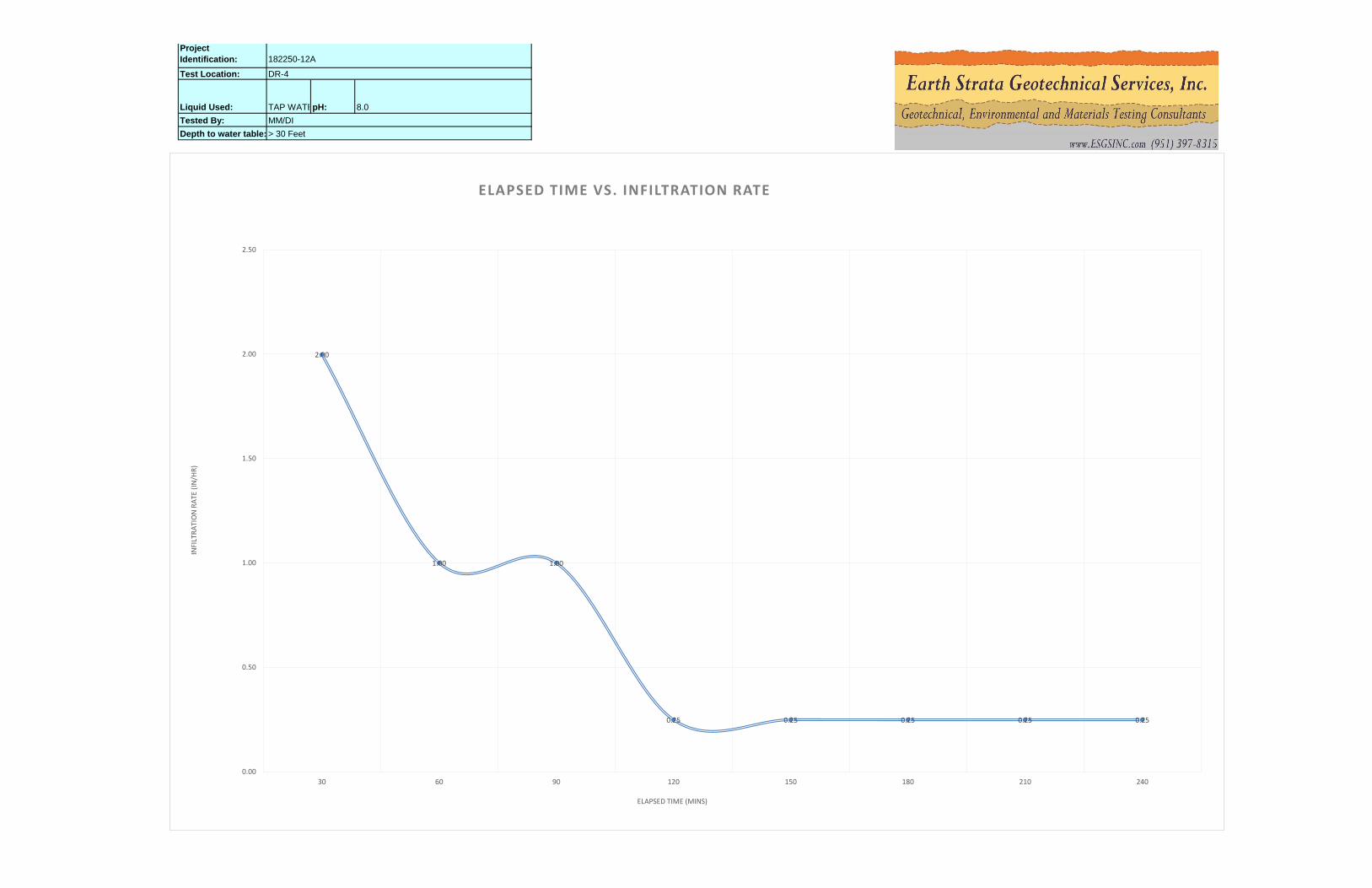
Test No. DR-4 Location
Area cm2
Depth of
Liquid
(cm)
Liquid
Container
NumberDR-4 729 10.0 1
TAP WATERpH: 8.0 2189 10.0 2
MM/DI Date
4.5' 9 cm
Inner Ring
Reading in
Inner
Maroitte
Tube Flow
(ml)
Annular
Space
Reading in
Annular
Space
Marriotte
Tube Flow
(ml)
Inner
Infiltration
Rate cm/h
Inner
Infiltration
Rate In/h
Annular
Infiltration
Rate cm/h
Annular
Infiltration
Rate In/h
Ground Temp
Depth (cm)
Temp at
Depth (c)
Start Test 8/30/2018 15:39 0:30 4.00 2.00
End Test 8/30/2018 16:09 0:30 3.00 0.50
Start Test 8/30/2018 16:09 0:30 4.50 2.00
End Test 8/30/2018 16:39 1:00 4.00 1.00
Start Test 8/30/2018 16:39 0:30 4.00 2.00
End Test 8/30/2018 17:09 1:30 3.50 1.50
Start Test 8/30/2018 17:09 0:30 3.50 1.50
End Test 8/30/2018 17:39 2:00 3.38 1.25
Start Test 8/30/2018 17:39 0:30 4.00 2.00
End Test 8/30/2018 18:09 2:30 3.88 1.75
Start Test 8/30/2018 18:09 0:30 3.88 1.75
End Test 8/30/2018 18:39 3:00 3.75 1.50
Start Test 8/30/2018 18:39 0:30 3.75 1.50
End Test 8/30/2018 19:09 3:30 3.63 1.25
Start Test 8/30/2018 19:09 0:30 4.50 1.25
End Test 8/30/2018 19:39 4:00 4.38 1.00
See Map Turf-Tec International - Record Chart for IN10-W - (12 & 24 Inch Infiltration Rings)
Test Location: Inner Ring 3000
Project Identification: 182250-12A Constants Marriotte Tube Volume
Liquid Used: Annular Ring 10000
Tested By: 8/30/2018 Liquid level maintained using:( X ) Flow Valve ( ) Float Valve ( ) Mariotte Tubes
Depth to water table: > 30 Feet Depth of Test Penetration Depth of Outer Ring: Other
Flow Readings
Liquid
Temp ºF
Infiltration Rates Ground Temperature Remarks
Weather conditions Etc...Trial # Start / End
Date
MM/DD/YY
Time
HR:MIN
Time
Increment
/(Total)
Elapsed
Time
(Min)
130
1850 8340 5.08 2.00 7.62 3.00
260
925.83 5560 2.54 1.00 5.08 2.00
390
925 2780 2.54 1.00 2.54
5150
230 1390 0.63
1.00
4120
230 1390 0.63 0.25
0.25 1.27 0.50
1.27 0.50
7210
230 1390 0.63
6180
230 1390 0.63
0.25 1.27 0.50
1.27 0.500.25
8240
230 1390 0.63 1.27 0.500.25
TAP WATERpH:
Project
Identification: 182250-12A
Test Location: DR-4
8.0
Tested By: MM/DI
Liquid Used:
Depth to water table: > 30 Feet
2.00
1.00 1.00
0.25 0.25 0.25 0.25 0.25
0.00
0.50
1.00
1.50
2.00
2.50
30 60 90 120 150 180 210 240
INFI
LTR
ATI
ON
RA
TE (
IN/H
R)
ELAPSED TIME (MINS)
ELAPSED TIME VS. INFILTRATION RATE
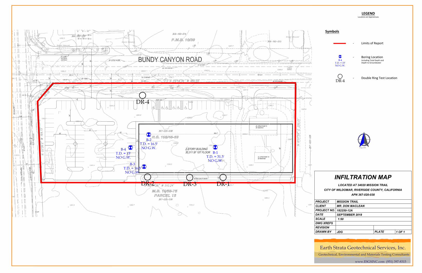
B-1T.D. = 31.5'NO G.W.
B-3T.D. = 16.5'NO G.W.
B-2T.D. = 16.5'NO G.W.B-4
T.D. = 15'NO G.W.
DR-4
DR-1DR-3DR-2
LEGENDLocations are Approximate
Symbols
- Boring LocationIncluding Total Depth andDepth to Groundwater
B-4T.D. = 15'NO G.W.
- Limits of Report
North
- Double Ring Test LocationDR-4
PROJECT
CLIENT
PROJECT NO.
SCALE
DATE
DRAWN BY
DWG XREFS
REVISION
PLATE
MISSION TRAIL
MR. DON MACLEAN
182250-12A
SEPTEMBER 2018
1:50
1 OF 1
INFILTRATION MAP
LOCATED AT 34020 MISSION TRAIL
CITY OF WILDOMAR, RIVERSIDE COUNTY, CALIFORNIA
APN 367-020-038
JDG
Geotechnical, Environmental and Materials Testing Consultants
www.ESGSINC.com (951) 397-8315
Earth Strata Geotechnical Services, Inc.