Embed Size (px)
Citation preview

Appendix A
Landmark Envirocheck Report Datasheets


Order Number: 31544761_1_1 Date: 14-Jun-2010 rpr_ec_datasheet v47.0 A Landmark Information Group Service
Datasheet
Order Details:Order Number:
Customer Reference:
National Grid Reference:
Slice:
Site Area (Ha):
Search Buffer (m):
Site Details:
Client Details:
31544761_1_1
UA001881
455870, 223500
A
395.55
500
Site atBicesterOxfordshire
Mr D ThomasHyder Consulting LtdHCL HouseSt. Mellons Business ParkSt MellonsCardiffCF3 0EY
Report:®Envirocheck

Order Number: 31544761_1_1 Date: 14-Jun-2010 rpr_ec_datasheet v47.0 A Landmark Information Group Service
Summary
Agency & Hydrological
Waste
Hazardous Substances
Geological
Industrial Land Use
Sensitive Land Use
Data Currency
Data Suppliers
Useful Contacts
Introduction
Copyright Notice
Natural England Copyright Notice
Ove Arup Copyright Notice
Peter Brett Associates Copyright Notice
Radon Potential dataset Copyright Notice
The Environment Act 1995 has made site sensitivity a key issue, as the legislation pays as much attention to the pathways by whichcontamination could spread, and to the vulnerable targets of contamination, as it does the potential sources of contamination. For this reason, Landmark's Site Sensitivity maps and Datasheet(s) place great emphasis on statutory data provided by the EnvironmentAgency and the Scottish Environment Protection Agency; it also incorporates data from Natural England (and the Scottish and Welshequivalents) and Local Authorities; and highlights hydrogeological features required by environmental and geotechnical consultants. It does notinclude any information concerning past uses of land. The datasheet is produced by querying the Landmark database to a distance defined bythe client from a site boundary provided by the client.
In the attached datasheet the National Grid References (NGRs) are rounded to the nearest 10m in accordance with Landmark's agreementswith a number of Data Suppliers.
© Landmark Information Group Limited 2010. The Copyright on the information and data and its format as contained in this Envirocheck®Report ("Report") is the property of Landmark Information Group Limited ("Landmark") and several other Data Providers, including (but notlimited to) Ordnance Survey, British Geological Survey, the Environment Agency and Natural England, and must not be reproduced in whole orin part by photocopying or any other method. The Report is supplied under Landmark's Terms and Conditions accepted by the Customer. A copy of Landmark's Terms and Conditions can be found with the Index Map for this report. Additional copies of the Report may be obtainedfrom Landmark, subject to Landmark's charges in force from time to time. The Copyright, design rights and any other intellectual rights shallremain the exclusive property of Landmark and /or other Data providers, whose Copyright material has been included in this Report.
Site of Special Scientific Interest, National Nature Reserve, Ramsar, Special Protection Area, Special Conservation Area, Marine NatureReserve data (derived from Ordnance Survey 1:10000 raster) is provided by, and used with the permission of, Natural England who retain thecopyright and Intellectual Property Rights for the data.
The Data provided in this report was obtained on Licence from Ove Arup & Partners Limited (for further information, [email protected]). No reproduction or further use of such Data is to be made without the prior written consent of Ove Arup & PartnersLimited. The information and data supplied in the product are derived from publicly available records and other third party sources and neitherOve Arup & Partners nor Landmark warrant the accuracy or completeness of such information or data.
The cavity data presented has been extracted from the PBA enhanced version of the original DEFRA national cavity databases. PBA/DEFRAretain the copyright & intellectual property rights in the data. Whilst all reasonable efforts are made to check that the information contained inthe cavity databases is accurate we do not warrant that the data is complete or error free. The information is based upon our own researchesand those collated from a number of external sources and is continually being augmented and updated by PBA. In no event shall PBA/DEFRAor Landmark be liable for any loss or damage including, without limitation, indirect or consequential loss or damage arising from the use of thisdata.
Information supplied from a joint dataset compiled by The British Geological Survey and the Health Protection Agency.
Report Section Page Number
Contents
Report Version v47.0
-
1
3
-
4
7
8
9
13
14

Order Number: 31544761_1_1 Date: 14-Jun-2010 rpr_ec_datasheet v47.0 A Landmark Information Group Service
Summary
Data Type PageNumber On Site 0 to 250m
Agency & Hydrological
Waste
251 to 500m
Contaminated Land Register Entries and Notices
Discharge Consents
Enforcement and Prohibition Notices
Integrated Pollution Controls
Integrated Pollution Prevention And Control
Local Authority Integrated Pollution Prevention And Control
Local Authority Pollution Prevention and Controls
Local Authority Pollution Prevention and Control Enforcements
Nearest Surface Water Feature
Pollution Incidents to Controlled Waters
Prosecutions Relating to Authorised Processes
Prosecutions Relating to Controlled Waters
Registered Radioactive Substances
River Quality
River Quality Biology Sampling Points
River Quality Chemistry Sampling Points
Substantiated Pollution Incident Register
Water Abstractions
Water Industry Act Referrals
Groundwater Vulnerability
Source Protection Zones
Extreme Flooding from Rivers or Sea without Defences
Flooding from Rivers or Sea without Defences
Areas Benefiting from Flood Defences
Flood Water Storage Areas
Flood Defences
BGS Recorded Landfill Sites
Historical Landfill Sites
Integrated Pollution Control Registered Waste Sites
Licensed Waste Management Facilities (Landfill Boundaries)
Licensed Waste Management Facilities (Locations)
Local Authority Recorded Landfill Sites
Registered Landfill Sites
Registered Waste Transfer Sites
Registered Waste Treatment or Disposal Sites
1
Yes
1
Yes
Yes
Yes
1
1
n/a n/a
n/a
n/a
n/a
n/a
n/a
(*1)
(*up to 1000m)
pg 1
pg 1
pg 1
pg 1
pg 2
pg 2
pg 3
pg 3

Order Number: 31544761_1_1 Date: 14-Jun-2010 rpr_ec_datasheet v47.0 A Landmark Information Group Service
Summary
Data Type PageNumber On Site 0 to 250m
Hazardous Substances
Geological
Industrial Land Use
251 to 500m
Control of Major Accident Hazards Sites (COMAH)
Explosive Sites
Notification of Installations Handling Hazardous Substances (NIHHS)
Planning Hazardous Substance Consents
Planning Hazardous Substance Enforcements
BGS Recorded Mineral Sites
BGS 1:625,000 Solid Geology
Brine Compensation Area
Coal Mining Affected Areas
Mining Instability
Natural and Mining Cavities
Potential for Collapsible Ground Stability Hazards
Potential for Compressible Ground Stability Hazards
Potential for Ground Dissolution Stability Hazards
Potential for Landslide Ground Stability Hazards
Potential for Running Sand Ground Stability Hazards
Potential for Shrinking or Swelling Clay Ground Stability Hazards
Radon Potential - Radon Affected Areas
Radon Potential - Radon Protection Measures
Shallow Mining Hazards
Contemporary Trade Directory Entries (50m)
Fuel Station Entries
Yes
Yes
Yes
Yes
Yes
Yes
Yes
Yes
1
1
n/a
n/a
n/a
n/a
Yes
Yes
Yes
Yes
Yes
n/a
n/a
n/a
n/a
n/a
n/a
n/a
n/a
n/a
n/a
n/a
n/a
n/a
n/a
n/a
n/a
(*up to 1000m)
pg 4
pg 4
pg 4
pg 4
pg 4
pg 5
pg 5
pg 6
pg 6
pg 7

Order Number: 31544761_1_1 Date: 14-Jun-2010 rpr_ec_datasheet v47.0 A Landmark Information Group Service
Summary
Data Type PageNumber On Site 0 to 250m
Sensitive Land Use
251 to 500m
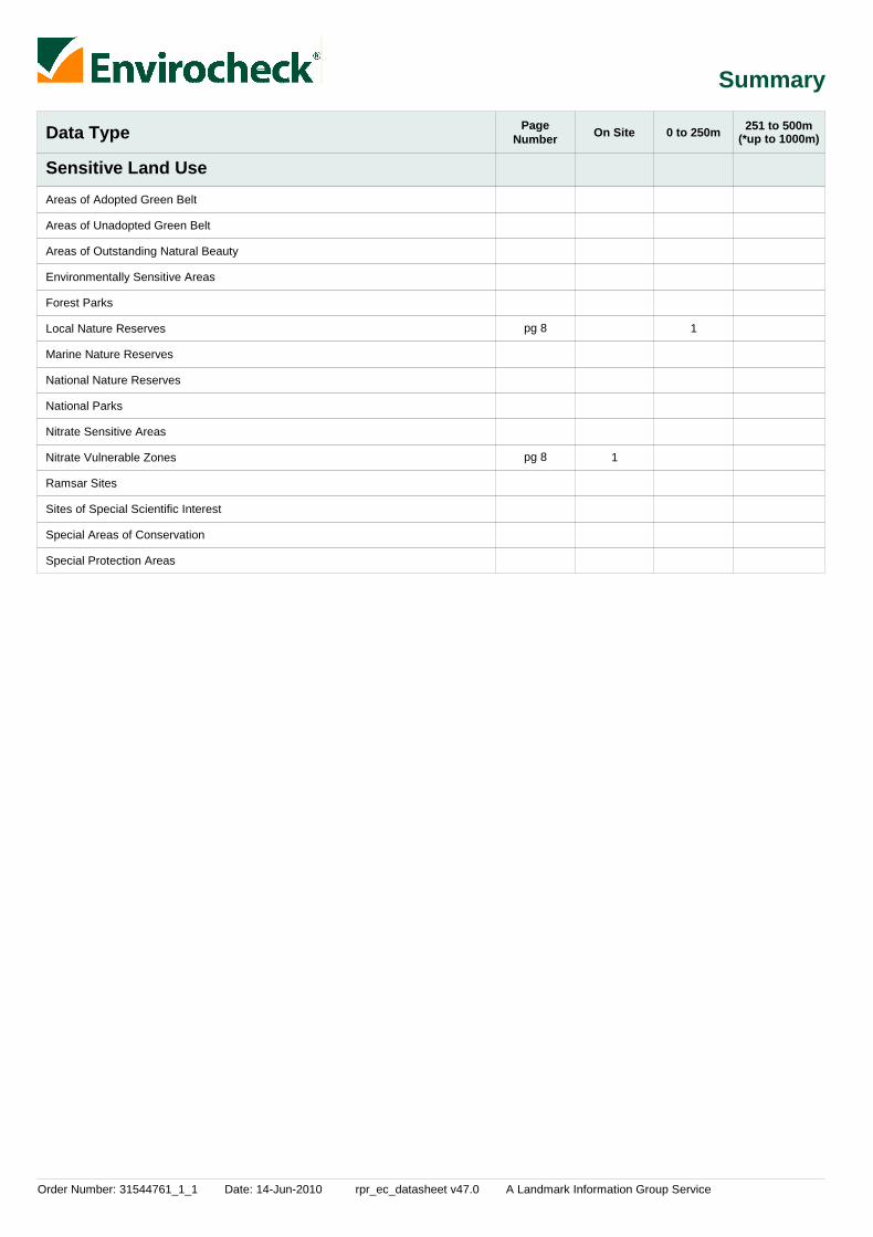
Areas of Adopted Green Belt
Areas of Unadopted Green Belt
Areas of Outstanding Natural Beauty
Environmentally Sensitive Areas
Forest Parks
Local Nature Reserves
Marine Nature Reserves
National Nature Reserves
National Parks
Nitrate Sensitive Areas
Nitrate Vulnerable Zones
Ramsar Sites
Sites of Special Scientific Interest
Special Areas of Conservation
Special Protection Areas
1
1
1
(*up to 1000m)
pg 8
pg 8
pg 8

Order Number: 31544761_1_1 Date: 14-Jun-2010 rpr_ec_datasheet v47.0 A Landmark Information Group Service Page 1 of 14
Agency & Hydrological
MapID Details
QuadrantReference(CompassDirection)
EstimatedDistanceFrom Site
Contact NGR
1
2
Discharge Consents
Nearest Surface Water Feature
Water Abstractions
Water Abstractions
Groundwater Vulnerability
Groundwater Vulnerability
A11SE(E)
A12NE(E)
A16NE(NE)
A4SE(SE)
A12SE(E)
A12SE(E)
0
0
0
754
0
0
1
-
1
1
1
1
Operator:Property Type:Location:
Authority:Catchment Area:Reference:Permit Version:Effective Date:Issued Date:Revocation Date:Discharge Type:DischargeEnvironment:Receiving Water:Status:
Positional Accuracy:
Operator:Licence Number:Permit Version:Location:Authority:Abstraction:Abstraction Type:Source:Daily Rate (m3):Yearly Rate (m3):Details:Authorised Start:Authorised End:Permit Start Date:Permit End Date:Positional Accuracy:
Operator:Licence Number:Permit Version:Location:Authority:Abstraction:Abstraction Type:Source:Daily Rate (m3):Yearly Rate (m3):Details:Authorised Start:Authorised End:Permit Start Date:Permit End Date:Positional Accuracy:
GeologicalClassification:
Soil Classification:
Map Sheet:Scale:
GeologicalClassification:
Soil Classification:
Map Sheet:Scale:
Catharine MurfittDomestic Property (Single)Himley Barns Middleton Stoney Road Chesterton Bicester Oxfordshire Ox261rtEnvironment Agency, Thames RegionCherwell and Ray (Oxon)Npswqd005893116th December 200815th December 2008Not SuppliedSewage Discharges - Final/Treated Effluent - Not Water CompanyFreshwater Stream/River
Tributary Of Pingle StreamNew Consent (Water Resources Act 1991, Section 88 & Schedule 10 asamended by Environment Act 1995)Located by supplier to within 10m
W & W Malins28/39/14/0214100Lords Farm, Bicester (A)Environment Agency, Thames RegionGeneral Farming And DomesticWater may be abstracted from a single pointGroundwater101763Great Oolite01 January31 December8th May 1967Not SuppliedLocated by supplier to within 100m
A D Woodley Ltd28/39/14/0123100Whitelands, Bicester (A)Environment Agency, Thames RegionGeneral Farming And DomesticWater may be abstracted from a single pointGroundwater201818Great & Inferior Oolite01 January31 December9th January 1967Not SuppliedLocated by supplier to within 100m
Minor Aquifer (Variably permeable) - These can be fractured or potentiallyfractured rocks, which do not have a high primary permeability, or otherformations of variable permeability including unconsolidated deposits.Although not producing large quantities of water for abstraction, they areimportant for local supplies and in supplying base flow to riversSoils of High Leaching Potential (H3)- Coarse textured or moderately shallowsoils which readily transmit non-absorbed pollutants and liquid discharges butwhich have some ability to attenuate absorbed pollutants because of theirlarge clay or organic matter contentsSheet 30 Northern Cotswolds1:100,000
Minor Aquifer (Variably permeable) - These can be fractured or potentiallyfractured rocks, which do not have a high primary permeability, or otherformations of variable permeability including unconsolidated deposits.Although not producing large quantities of water for abstraction, they areimportant for local supplies and in supplying base flow to riversSoils of High Leaching Potential (U) - Soil information for restored mineralworkings and urban areas is based on fewer observations than elsewhere. Aworst case vulnerability classification (H) assumed, until proved otherwiseSheet 30 Northern Cotswolds1:100,000
456035223498
456908223635
456900224500
456700222100
456817223520
456817223520
Order Number: 31544761_1_1 Date: 14-Jun-2010 rpr_ec_datasheet v47.0 A Landmark Information Group Service Page 2 of 14
Agency & Hydrological
MapID Details
QuadrantReference(CompassDirection)
EstimatedDistanceFrom Site
Contact NGR
Drift Deposits
Extreme Flooding from Rivers or Sea without Defences
Flooding from Rivers or Sea without Defences
Areas Benefiting from Flood Defences
Flood Water Storage Areas
Flood Defences
A6SW(SW)
A6SW(SW)
0
0
1
1
Flood Plain Type:Boundary Accuracy:
Flood Plain Type:Boundary Accuracy:
FluvialAs Supplied
FluvialAs Supplied
None
None
None
None
455215222840
455220222835

Order Number: 31544761_1_1 Date: 14-Jun-2010 rpr_ec_datasheet v47.0 A Landmark Information Group Service Page 3 of 14
Waste
MapID Details
QuadrantReference(CompassDirection)
EstimatedDistanceFrom Site
Contact NGR
3
4
Historical Landfill Sites
Local Authority Landfill Coverage
Local Authority Landfill Coverage
Local Authority Recorded Landfill Sites
A12NE(E)
A12NE(E)
0
0
0
0
1
2
6
2
Licence Holder:Location:Name:Operator Location:Boundary Accuracy:Provider Reference:First Input Date:Last Input Date:Specified WasteType:EA Waste Ref:Regis Ref:WRC Ref:BGS Ref:Other Ref:
Name:
Name:
Location:Reference:Authority:Last ReportedStatus:Types of Waste:Date of Closure:Positional Accuracy:Boundary Quality:
Not SuppliedBicester, OxfordshireGowell FarmNot SuppliedAs SuppliedEAHLD13573Not SuppliedNot SuppliedDeposited Waste included Inert, Industrial, Commercial and Household Waste
-9999Not Supplied3100/0027Not Supplied13.6.5723, TP0230
Cherwell District Council - Has supplied landfill data
Oxfordshire County Council - Has supplied landfill data
Gowell Farm, Bicester14Cherwell District Council, Environmental Health DepartmentUnknown
Ash, Glass, Brick, PotteryNot SuppliedPositioned by the supplierGood
456880223813
462471222097
462471222097
456879223829

Order Number: 31544761_1_1 Date: 14-Jun-2010 rpr_ec_datasheet v47.0 A Landmark Information Group Service Page 4 of 14
Geological
MapID Details
QuadrantReference(CompassDirection)
EstimatedDistanceFrom Site
Contact NGR
5BGS Recorded Mineral Sites
BGS 1:625,000 Solid Geology
Coal Mining Affected Areas
Potential for Collapsible Ground Stability Hazards
Potential for Compressible Ground Stability Hazards
Potential for Compressible Ground Stability Hazards
Potential for Compressible Ground Stability Hazards
Potential for Compressible Ground Stability Hazards
Potential for Compressible Ground Stability Hazards
Potential for Compressible Ground Stability Hazards
Potential for Compressible Ground Stability Hazards
Potential for Ground Dissolution Stability Hazards
Potential for Ground Dissolution Stability Hazards
Potential for Ground Dissolution Stability Hazards
Potential for Ground Dissolution Stability Hazards
Potential for Ground Dissolution Stability Hazards
Potential for Ground Dissolution Stability Hazards
Potential for Ground Dissolution Stability Hazards
Potential for Landslide Ground Stability Hazards
A8SW(SE)
A2NW(SW)
A10SW(W)
A15NE(N)
A15NE(N)
A16NE(NE)
A15NE(N)
A10SW(W)
A6NW(SW)
A10NE(W)
A10NE(W)
A15SW(N)
A10SW(W)
A10SW(W)
A8NE(E)
A6NW(SW)
A16NW(NE)
68
0
0
0
0
0
0
69
249
0
0
0
69
69
193
228
0
3
3
3
3
3
3
3
3
3
3
3
3
3
3
3
3
3
Site Name:Location:Source:Reference:Type:Status:Operator:Operator Location:Periodic Type:Geology:Commodity:Positional Accuracy:
Description:
Hazard Potential:Source:
Hazard Potential:Source:
Hazard Potential:Source:
Hazard Potential:Source:
Hazard Potential:Source:
Hazard Potential:Source:
Hazard Potential:Source:
Hazard Potential:Source:
Hazard Potential:Source:
Hazard Potential:Source:
Hazard Potential:Source:
Hazard Potential:Source:
Hazard Potential:Source:
Hazard Potential:Source:
Hazard Potential:Source:
King'S End FarmChesterton, Oxford, OxfordshireBritish Geological Survey, National Geoscience Information Service57408OpencastCeasedUnknown OperatorNot SuppliedJurassicCornbrash FormationLimestoneLocated by supplier to within 10m
Cornbrash
No HazardBritish Geological Survey, National Geoscience Information Service
ModerateBritish Geological Survey, National Geoscience Information Service
ModerateBritish Geological Survey, National Geoscience Information Service
ModerateBritish Geological Survey, National Geoscience Information Service
ModerateBritish Geological Survey, National Geoscience Information Service
No HazardBritish Geological Survey, National Geoscience Information Service
ModerateBritish Geological Survey, National Geoscience Information Service
No HazardBritish Geological Survey, National Geoscience Information Service
Very LowBritish Geological Survey, National Geoscience Information Service
No HazardBritish Geological Survey, National Geoscience Information Service
No HazardBritish Geological Survey, National Geoscience Information Service
Very LowBritish Geological Survey, National Geoscience Information Service
No HazardBritish Geological Survey, National Geoscience Information Service
Very LowBritish Geological Survey, National Geoscience Information Service
LowBritish Geological Survey, National Geoscience Information Service
In an area which may not be affected by coal mining
No Hazard
456381222717
454963222531
455000223499
455975224475
456000224450
456900224350
456050224475
455000223499
455000222975
455275223600
455275223600
455650224225
455000223225
455000223499
456850223175
454975223025
456475224425

Order Number: 31544761_1_1 Date: 14-Jun-2010 rpr_ec_datasheet v47.0 A Landmark Information Group Service Page 5 of 14
Geological
MapID Details
QuadrantReference(CompassDirection)
EstimatedDistanceFrom Site
Contact NGR
Potential for Landslide Ground Stability Hazards
Potential for Landslide Ground Stability Hazards
Potential for Landslide Ground Stability Hazards
Potential for Landslide Ground Stability Hazards
Potential for Landslide Ground Stability Hazards
Potential for Landslide Ground Stability Hazards
Potential for Running Sand Ground Stability Hazards
Potential for Running Sand Ground Stability Hazards
Potential for Running Sand Ground Stability Hazards
Potential for Running Sand Ground Stability Hazards
Potential for Running Sand Ground Stability Hazards
Potential for Running Sand Ground Stability Hazards
Potential for Running Sand Ground Stability Hazards
Potential for Shrinking or Swelling Clay Ground Stability Hazards
Potential for Shrinking or Swelling Clay Ground Stability Hazards
Potential for Shrinking or Swelling Clay Ground Stability Hazards
Potential for Shrinking or Swelling Clay Ground Stability Hazards
Potential for Shrinking or Swelling Clay Ground Stability Hazards
Potential for Shrinking or Swelling Clay Ground Stability Hazards
Potential for Shrinking or Swelling Clay Ground Stability Hazards
A16NW(NE)
A16NW(NE)
A16NW(NE)
A16NE(NE)
A10SW(W)
A10SW(W)
A10SW(W)
A15NE(N)
A15NE(N)
A16NE(NE)
A15NE(N)
A10SW(W)
A6NW(SW)
A10SW(W)
A15NE(N)
A15NE(N)
A15NE(N)
A16NE(NE)
A10SW(W)
A6NW(SW)
0
0
0
0
0
69
0
0
0
0
0
69
249
0
0
0
0
0
69
249
3
3
3
3
3
3
3
3
3
3
3
3
3
3
3
3
3
3
3
3
Hazard Potential:Source:
Hazard Potential:Source:
Hazard Potential:Source:
Hazard Potential:Source:
Hazard Potential:Source:
Hazard Potential:Source:
Hazard Potential:Source:
Hazard Potential:Source:
Hazard Potential:Source:
Hazard Potential:Source:
Hazard Potential:Source:
Hazard Potential:Source:
Hazard Potential:Source:
Hazard Potential:Source:
Hazard Potential:Source:
Hazard Potential:Source:
Hazard Potential:Source:
Hazard Potential:Source:
Hazard Potential:Source:
Hazard Potential:Source:
LowBritish Geological Survey, National Geoscience Information Service
LowBritish Geological Survey, National Geoscience Information Service
LowBritish Geological Survey, National Geoscience Information Service
LowBritish Geological Survey, National Geoscience Information Service
Very LowBritish Geological Survey, National Geoscience Information Service
Very LowBritish Geological Survey, National Geoscience Information Service
No HazardBritish Geological Survey, National Geoscience Information Service
LowBritish Geological Survey, National Geoscience Information Service
LowBritish Geological Survey, National Geoscience Information Service
LowBritish Geological Survey, National Geoscience Information Service
LowBritish Geological Survey, National Geoscience Information Service
No HazardBritish Geological Survey, National Geoscience Information Service
LowBritish Geological Survey, National Geoscience Information Service
No HazardBritish Geological Survey, National Geoscience Information Service
Very LowBritish Geological Survey, National Geoscience Information Service
Very LowBritish Geological Survey, National Geoscience Information Service
Very LowBritish Geological Survey, National Geoscience Information Service
Very LowBritish Geological Survey, National Geoscience Information Service
No HazardBritish Geological Survey, National Geoscience Information Service
Very LowBritish Geological Survey, National Geoscience Information Service
456500224400
456525224375
456550224350
456675224300
455000223499
455000223499
455000223499
455975224475
456000224450
456900224350
456050224475
455000223499
455000222975
455000223499
455975224475
456000224450
456050224475
456900224350
455000223499
455000222975

Order Number: 31544761_1_1 Date: 14-Jun-2010 rpr_ec_datasheet v47.0 A Landmark Information Group Service Page 6 of 14
Geological
MapID Details
QuadrantReference(CompassDirection)
EstimatedDistanceFrom Site
Contact NGR
Radon Potential - Radon Affected Areas
Radon Potential - Radon Affected Areas
Radon Potential - Radon Affected Areas
Radon Potential - Radon Affected Areas
Radon Potential - Radon Affected Areas
Radon Potential - Radon Protection Measures
Radon Potential - Radon Protection Measures
Radon Potential - Radon Protection Measures
Radon Potential - Radon Protection Measures
Radon Potential - Radon Protection Measures
Shallow Mining Hazards
A15NE(N)
A15NW(N)
A15SW(N)
A10NE(W)
A10NE(W)
A15NE(N)
A15NW(N)
A15SW(N)
A10NE(W)
A10NE(W)
0
0
0
0
0
0
0
0
0
0
3
3
3
3
3
3
3
3
3
3
Affected Area:
Source:
Affected Area:
Source:
Affected Area:
Source:
Affected Area:
Source:
Affected Area:
Source:
Protection Measure:
Source:
Protection Measure:
Source:
Protection Measure:
Source:
Protection Measure:
Source:
Protection Measure:
Source:
The property is in a radon affected area, as between 3 and 5% of homes areabove the action levelBritish Geological Survey, National Geoscience Information Service
The property is not in a radon affected area, as less than 1% of homes areabove the action levelBritish Geological Survey, National Geoscience Information Service
The property is in a radon affected area, as between 1 and 3% of homes areabove the action levelBritish Geological Survey, National Geoscience Information Service
The property is in a radon affected area, as between 1 and 3% of homes areabove the action levelBritish Geological Survey, National Geoscience Information Service
The property is not in a radon affected area, as less than 1% of homes areabove the action levelBritish Geological Survey, National Geoscience Information Service
Basic radon protective measures are necessary in the construction of newdwellings or extensionsBritish Geological Survey, National Geoscience Information Service
No radon protective measures are necessary in the construction of newdwellings or extensionsBritish Geological Survey, National Geoscience Information Service
No radon protective measures are necessary in the construction of newdwellings or extensionsBritish Geological Survey, National Geoscience Information Service
No radon protective measures are necessary in the construction of newdwellings or extensionsBritish Geological Survey, National Geoscience Information Service
No radon protective measures are necessary in the construction of newdwellings or extensionsBritish Geological Survey, National Geoscience Information Service
No Hazard
456000224375
455725224550
455675224150
455350223600
455350223600
456000224375
455725224550
455675224150
455350223600
455350223600

Order Number: 31544761_1_1 Date: 14-Jun-2010 rpr_ec_datasheet v47.0 A Landmark Information Group Service Page 7 of 14
Industrial Land Use
MapID Details
QuadrantReference(CompassDirection)
EstimatedDistanceFrom Site
Contact NGR
6Contemporary Trade Directory Entries
A16SW(NE)
0 -Name:Location:Classification:Status:Positional Accuracy:
D RickettsHowes Lane, Bicester, Oxfordshire, OX26 2UACommercial Vehicle DealersInactiveAutomatically positioned to the address
456562224139
Order Number: 31544761_1_1 Date: 14-Jun-2010 rpr_ec_datasheet v47.0 A Landmark Information Group Service Page 8 of 14
Sensitive Land Use
MapID Details
QuadrantReference(CompassDirection)
EstimatedDistanceFrom Site
Contact NGR
7
8
9
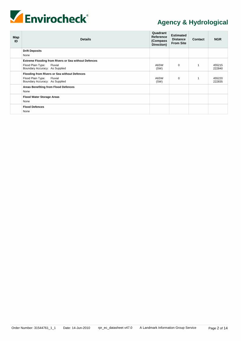
Local Nature Reserves
Nitrate Vulnerable Zones
Sites of Special Scientific Interest
(E)
(W)
(N)
53
0
407
4
5
4
Name:Multiple Area:Area (m2):Source:Designation Date:
Name:Description:Source:
Name:Multiple Areas:Total Area (m2):Source:Reference:Designation Details:Designation Date:Date Type:Designation Details:Designation Date:Date Type:
Bure ParkN83957.83Natural England5th December 2005
Not SuppliedSurface Water - Designated 2006Department for Environment, Food and Rural Affairs (DEFRA - formerlyFRCA)
Ardley Cutting & QuarryN401251.72Natural England1000903Geological Conservation Review12th May 1988NotifiedLocal Wildlife Trust Reserve12th May 1988Notified
457486223771
453163223499
455898224997

Order Number: 31544761_1_1 Date: 14-Jun-2010 rpr_ec_datasheet v47.0 A Landmark Information Group Service Page 9 of 14
Data Currency
Agency & Hydrological Version Update CycleContaminated Land Register Entries and Notices
Discharge Consents
Enforcement and Prohibition Notices
Integrated Pollution Controls
Integrated Pollution Prevention And Control
Local Authority Integrated Pollution Prevention And Control
Local Authority Pollution Prevention and Controls
Local Authority Pollution Prevention and Control Enforcements
Nearest Surface Water Feature
Pollution Incidents to Controlled Waters
Prosecutions Relating to Authorised Processes
Prosecutions Relating to Controlled Waters
Registered Radioactive Substances
River Quality
River Quality Biology Sampling Points
River Quality Chemistry Sampling Points
Substantiated Pollution Incident Register
Water Abstractions
Water Industry Act Referrals
Groundwater Vulnerability
Drift Deposits
Source Protection Zones
Extreme Flooding from Rivers or Sea without Defences
Flooding from Rivers or Sea without Defences
Areas Benefiting from Flood Defences
February 2010
April 2010
May 2010
October 2008
April 2010
April 2009
April 2009
April 2009
February 2010
September 1999
March 2010
May 2010
April 2010
November 2001
January 2010
January 2010
April 2010
April 2010
January 2010
January 1999
January 1999
April 2010
March 2010
March 2010
March 2010
Annual Rolling Update
Quarterly
Quarterly
Not Applicable
Quarterly
Annual Rolling Update
Annual Rolling Update
Annual Rolling Update
Quarterly
Not Applicable
Monthly
Monthly
Quarterly
Not Applicable
Annually
Annually
Quarterly
Quarterly
Quarterly
Not Applicable
Not Applicable
Quarterly
Quarterly
Quarterly
Quarterly
Cherwell District Council - Environmental Health Department
Environment Agency - Thames Region
Environment Agency - Thames Region
Environment Agency - Thames Region
Environment Agency - Thames Region
Cherwell District Council - Environmental Health Department
Cherwell District Council - Environmental Health Department
Cherwell District Council - Environmental Health Department
Ordnance Survey
Environment Agency - Thames Region
Environment Agency - Thames Region
Environment Agency - Thames Region
Environment Agency - Thames Region
Environment Agency - Head Office
Environment Agency - Head Office
Environment Agency - Head Office
Environment Agency - Thames Region - West Area
Environment Agency - Thames Region
Environment Agency - Thames Region
Environment Agency - Head Office
Environment Agency - Head Office
Environment Agency - Head Office
Environment Agency - Head Office
Environment Agency - Head Office
Environment Agency - Head Office

Order Number: 31544761_1_1 Date: 14-Jun-2010 rpr_ec_datasheet v47.0 A Landmark Information Group Service Page 10 of 14
Data Currency
Agency & Hydrological
Waste
Hazardous Substances
Version
Version
Version
Update Cycle
Update Cycle
Update Cycle
Flood Water Storage Areas
Flood Defences
BGS Recorded Landfill Sites
Historical Landfill Sites
Integrated Pollution Control Registered Waste Sites
Licensed Waste Management Facilities (Landfill Boundaries)
Licensed Waste Management Facilities (Locations)
Local Authority Landfill Coverage
Local Authority Recorded Landfill Sites
Registered Landfill Sites
Registered Waste Transfer Sites
Registered Waste Treatment or Disposal Sites
Control of Major Accident Hazards Sites (COMAH)
Explosive Sites
Notification of Installations Handling Hazardous Substances (NIHHS)
Planning Hazardous Substance Enforcements
Planning Hazardous Substance Consents
March 2010
March 2010
June 1996
April 2010
October 2008
April 2010
April 2010
May 2000May 2000
May 2000May 2000
March 2003
March 2003
March 2003
May 2010
January 2009
November 2000
July 2009October 2009
July 2009October 2009
Quarterly
Quarterly
Not Applicable
Quarterly
Not Applicable
Quarterly
Quarterly
Not ApplicableNot Applicable
Not ApplicableNot Applicable
Not Applicable
Not Applicable
Not Applicable
Bi-Annually
Bi-Annually
Not Applicable
Annual Rolling UpdateAnnual Rolling Update
Annual Rolling UpdateAnnual Rolling Update
Environment Agency - Head Office
Environment Agency - Head Office
British Geological Survey - National Geoscience Information Service
Environment Agency - Thames Region - West Area
Environment Agency - Thames Region
Environment Agency - Thames Region - West Area
Environment Agency - Thames Region - West Area
Cherwell District Council - Environmental Health DepartmentOxfordshire County Council
Cherwell District Council - Environmental Health DepartmentOxfordshire County Council
Environment Agency - Thames Region - West Area
Environment Agency - Thames Region - West Area
Environment Agency - Thames Region - West Area
Health and Safety Executive
Health and Safety Executive
Health and Safety Executive
Cherwell District CouncilOxfordshire County Council
Cherwell District CouncilOxfordshire County Council
Order Number: 31544761_1_1 Date: 14-Jun-2010 rpr_ec_datasheet v47.0 A Landmark Information Group Service Page 11 of 14
Data Currency
Geological
Industrial Land Use
Version
Version
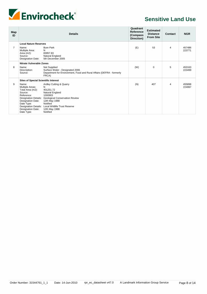
Update Cycle
Update Cycle
BGS Recorded Mineral Sites
BGS 1:625,000 Solid Geology
Brine Compensation Area
Coal Mining Affected Areas
Mining Instability
Natural and Mining Cavities
Potential for Collapsible Ground Stability Hazards
Potential for Compressible Ground Stability Hazards
Potential for Ground Dissolution Stability Hazards
Potential for Landslide Ground Stability Hazards
Potential for Running Sand Ground Stability Hazards
Potential for Shrinking or Swelling Clay Ground Stability Hazards
Radon Potential - Radon Affected Areas
Radon Potential - Radon Protection Measures
Shallow Mining Hazards
Contemporary Trade Directory Entries
Fuel Station Entries
April 2010
August 1996
November 2002
January 2006
October 2000
November 2009
January 2009
January 2009
January 2009
January 2009
January 2009
January 2009
May 2007
May 2007
August 2002
March 2010
February 2010
Bi-Annually
Not Applicable
Not Applicable
As notified
Not Applicable
Bi-Annually
Annually
Annually
Annually
Annually
Annually
Annually
As notified
As notified
Not Applicable
Quarterly
Quarterly
British Geological Survey - National Geoscience Information Service
British Geological Survey - National Geoscience Information Service
Cheshire Brine Subsidence Compensation Board
The Coal Authority - Mining Report Service
Ove Arup & Partners
Peter Brett Associates
British Geological Survey - National Geoscience Information Service
British Geological Survey - National Geoscience Information Service
British Geological Survey - National Geoscience Information Service
British Geological Survey - National Geoscience Information Service
British Geological Survey - National Geoscience Information Service
British Geological Survey - National Geoscience Information Service
British Geological Survey - National Geoscience Information Service
British Geological Survey - National Geoscience Information Service
British Geological Survey - National Geoscience Information Service
Thomson Directories
Catalist Ltd - Experian Catalist

Order Number: 31544761_1_1 Date: 14-Jun-2010 rpr_ec_datasheet v47.0 A Landmark Information Group Service Page 12 of 14
Data Currency
Sensitive Land Use Version Update CycleAreas of Adopted Green Belt
Areas of Unadopted Green Belt
Areas of Outstanding Natural Beauty
Environmentally Sensitive Areas
Forest Parks
Local Nature Reserves
Marine Nature Reserves
National Nature Reserves
National Parks
Nitrate Sensitive Areas
Nitrate Vulnerable Zones
Ramsar Sites
Sites of Special Scientific Interest
Special Areas of Conservation
Special Protection Areas
March 2010
March 2010
December 2009
December 2009
April 1997
December 2009
September 2009
December 2009
December 2009
December 2009
February 2009
December 2009
December 2009
December 2009
December 2009
As notified
As notified
Bi-Annually
Annually
Not Applicable
Bi-Annually
Bi-Annually
Bi-Annually
Bi-Annually
Not Applicable
Annually
Bi-Annually
Bi-Annually
Bi-Annually
Bi-Annually
Cherwell District Council
Cherwell District Council
Natural England
Natural England
Forestry Commission
Natural England
Natural England
Natural England
Natural England
Department for Environment, Food and Rural Affairs (DEFRA - formerly FRCA)
Department for Environment, Food and Rural Affairs (DEFRA - formerly FRCA)
Natural England
Natural England
Natural England
Natural England

Order Number: 31544761_1_1 Date: 14-Jun-2010 rpr_ec_datasheet v47.0 A Landmark Information Group Service Page 13 of 14
Data Suppliers
Ordnance Survey
Environment Agency
Scottish Environment Protection Agency
The Coal Authority
British Geological Survey
Centre for Ecology and Hydrology
Countryside Council for Wales
Scottish Natural Heritage
Natural England
Health Protection Agency
Ove Arup
Peter Brett Associates
Data Supplier Data Supplier Logo
A selection of organisations who provide data within this report

Order Number: 31544761_1_1 Date: 14-Jun-2010 rpr_ec_datasheet v47.0 A Landmark Information Group Service Page 14 of 14
Useful Contacts
Contact Name and Address Contact Details
1
2
3
4
5
6
-
-
Environment Agency - National Customer ContactCentre (NCCC)
Cherwell District Council - Environmental HealthDepartment
British Geological Survey - Enquiry Service
Natural England
Department for Environment, Food and Rural Affairs(DEFRA - formerly FRCA)
Oxfordshire County Council
Health Protection Agency - Radon Survey, Centre forRadiation, Chemical and Environmental Hazards
Landmark Information Group Limited
PO Box 544, Templeborough, Rotherham, S60 1BY
Bodicote House, Bodicote, Banbury, Oxfordshire, OX15 4AA
British Geological Survey, Kingsley Dunham Centre, Keyworth,Nottingham, Nottinghamshire, NG12 5GG
Northminster House, Northminster Road, Peterborough, Cambridgeshire,PE1 1UA
Government Buildings, Otley Road, Lawnswood, Leeds, West Yorkshire,LS16 5QT
County Hall, New Road, Oxford, Oxfordshire, OX1 1ND
Chilton, Didcot, Oxfordshire, OX11 0RQ
The Smith Centre, Henley On Thames, Oxfordshire, RG9 6AB
Telephone: 08708 506 506Email: [email protected]
Telephone: 01295 252535 extn 4511Fax: 01295 270028Website: www.cherwell-dc.gov.uk
Telephone: 0115 936 3143Fax: 0115 936 3276Email: [email protected]: www.bgs.ac.uk
Telephone: 0845 600 3078Fax: 01733 455103Email: [email protected]: www.naturalengland.org.uk
Telephone: 0113 2613333Fax: 0113 230 0879
Telephone: 01865 792422Fax: 01865 810106Email: [email protected]: www.oxfordshire.gov.uk
Telephone: 01235 822622Fax: 01235 833891Email: [email protected]: www.hpa.org.uk
Telephone: 0844 844 9952Fax: 0844 844 9951Email: [email protected]: www.landmarkinfo.co.uk
Please note that the Environment Agency / SEPA have a charging policy in place for enquiries.
Order Number: 31544761_1_1 Date: 14-Jun-2010 rpr_ec_datasheet v47.0 A Landmark Information Group Service
Datasheet
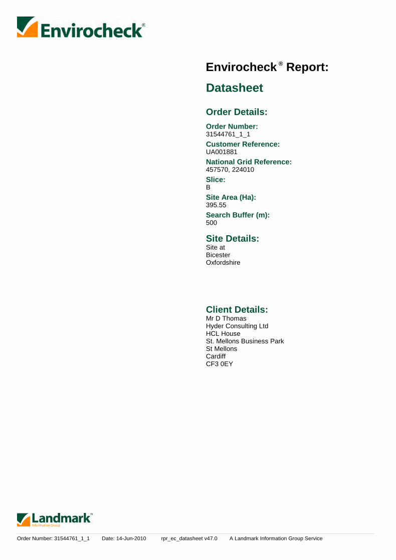
Order Details:Order Number:
Customer Reference:
National Grid Reference:
Slice:
Site Area (Ha):
Search Buffer (m):
Site Details:
Client Details:
31544761_1_1
UA001881
457570, 224010
B
395.55
500
Site atBicesterOxfordshire
Mr D ThomasHyder Consulting LtdHCL HouseSt. Mellons Business ParkSt MellonsCardiffCF3 0EY
Report:®Envirocheck

Order Number: 31544761_1_1 Date: 14-Jun-2010 rpr_ec_datasheet v47.0 A Landmark Information Group Service
Summary
Agency & Hydrological
Waste
Hazardous Substances
Geological
Industrial Land Use
Sensitive Land Use
Data Currency
Data Suppliers
Useful Contacts
Introduction
Copyright Notice
Natural England Copyright Notice
Ove Arup Copyright Notice
Peter Brett Associates Copyright Notice
Radon Potential dataset Copyright Notice
The Environment Act 1995 has made site sensitivity a key issue, as the legislation pays as much attention to the pathways by whichcontamination could spread, and to the vulnerable targets of contamination, as it does the potential sources of contamination. For this reason, Landmark's Site Sensitivity maps and Datasheet(s) place great emphasis on statutory data provided by the EnvironmentAgency and the Scottish Environment Protection Agency; it also incorporates data from Natural England (and the Scottish and Welshequivalents) and Local Authorities; and highlights hydrogeological features required by environmental and geotechnical consultants. It does notinclude any information concerning past uses of land. The datasheet is produced by querying the Landmark database to a distance defined bythe client from a site boundary provided by the client.
In the attached datasheet the National Grid References (NGRs) are rounded to the nearest 10m in accordance with Landmark's agreementswith a number of Data Suppliers.
© Landmark Information Group Limited 2010. The Copyright on the information and data and its format as contained in this Envirocheck®Report ("Report") is the property of Landmark Information Group Limited ("Landmark") and several other Data Providers, including (but notlimited to) Ordnance Survey, British Geological Survey, the Environment Agency and Natural England, and must not be reproduced in whole orin part by photocopying or any other method. The Report is supplied under Landmark's Terms and Conditions accepted by the Customer. A copy of Landmark's Terms and Conditions can be found with the Index Map for this report. Additional copies of the Report may be obtainedfrom Landmark, subject to Landmark's charges in force from time to time. The Copyright, design rights and any other intellectual rights shallremain the exclusive property of Landmark and /or other Data providers, whose Copyright material has been included in this Report.
Site of Special Scientific Interest, National Nature Reserve, Ramsar, Special Protection Area, Special Conservation Area, Marine NatureReserve data (derived from Ordnance Survey 1:10000 raster) is provided by, and used with the permission of, Natural England who retain thecopyright and Intellectual Property Rights for the data.
The Data provided in this report was obtained on Licence from Ove Arup & Partners Limited (for further information, [email protected]). No reproduction or further use of such Data is to be made without the prior written consent of Ove Arup & PartnersLimited. The information and data supplied in the product are derived from publicly available records and other third party sources and neitherOve Arup & Partners nor Landmark warrant the accuracy or completeness of such information or data.
The cavity data presented has been extracted from the PBA enhanced version of the original DEFRA national cavity databases. PBA/DEFRAretain the copyright & intellectual property rights in the data. Whilst all reasonable efforts are made to check that the information contained inthe cavity databases is accurate we do not warrant that the data is complete or error free. The information is based upon our own researchesand those collated from a number of external sources and is continually being augmented and updated by PBA. In no event shall PBA/DEFRAor Landmark be liable for any loss or damage including, without limitation, indirect or consequential loss or damage arising from the use of thisdata.
Information supplied from a joint dataset compiled by The British Geological Survey and the Health Protection Agency.
Report Section Page Number
Contents
Report Version v47.0
-
1
3
-
4
7
8
9
13
14

Order Number: 31544761_1_1 Date: 14-Jun-2010 rpr_ec_datasheet v47.0 A Landmark Information Group Service
Summary
Data Type PageNumber On Site 0 to 250m
Agency & Hydrological
Waste
251 to 500m
Contaminated Land Register Entries and Notices
Discharge Consents
Enforcement and Prohibition Notices
Integrated Pollution Controls
Integrated Pollution Prevention And Control
Local Authority Integrated Pollution Prevention And Control
Local Authority Pollution Prevention and Controls
Local Authority Pollution Prevention and Control Enforcements
Nearest Surface Water Feature
Pollution Incidents to Controlled Waters
Prosecutions Relating to Authorised Processes
Prosecutions Relating to Controlled Waters
Registered Radioactive Substances
River Quality
River Quality Biology Sampling Points
River Quality Chemistry Sampling Points
Substantiated Pollution Incident Register
Water Abstractions
Water Industry Act Referrals
Groundwater Vulnerability
Source Protection Zones
Extreme Flooding from Rivers or Sea without Defences
Flooding from Rivers or Sea without Defences
Areas Benefiting from Flood Defences
Flood Water Storage Areas
Flood Defences
BGS Recorded Landfill Sites
Historical Landfill Sites
Integrated Pollution Control Registered Waste Sites
Licensed Waste Management Facilities (Landfill Boundaries)
Licensed Waste Management Facilities (Locations)
Local Authority Recorded Landfill Sites
Registered Landfill Sites
Registered Waste Transfer Sites
Registered Waste Treatment or Disposal Sites
2
Yes
1
Yes
Yes
Yes
1
1
n/a
1
n/a
n/a
n/a
n/a
n/a
n/a
(*up to 1000m)
pg 1
pg 1
pg 1
pg 1
pg 2
pg 2
pg 2
pg 3
pg 3

Order Number: 31544761_1_1 Date: 14-Jun-2010 rpr_ec_datasheet v47.0 A Landmark Information Group Service
Summary
Data Type PageNumber On Site 0 to 250m
Hazardous Substances
Geological
Industrial Land Use
251 to 500m
Control of Major Accident Hazards Sites (COMAH)
Explosive Sites
Notification of Installations Handling Hazardous Substances (NIHHS)
Planning Hazardous Substance Consents
Planning Hazardous Substance Enforcements
BGS Recorded Mineral Sites
BGS 1:625,000 Solid Geology
Brine Compensation Area
Coal Mining Affected Areas
Mining Instability
Natural and Mining Cavities
Potential for Collapsible Ground Stability Hazards
Potential for Compressible Ground Stability Hazards
Potential for Ground Dissolution Stability Hazards
Potential for Landslide Ground Stability Hazards
Potential for Running Sand Ground Stability Hazards
Potential for Shrinking or Swelling Clay Ground Stability Hazards
Radon Potential - Radon Affected Areas
Radon Potential - Radon Protection Measures
Shallow Mining Hazards
Contemporary Trade Directory Entries (50m)
Fuel Station Entries
1
Yes
Yes
Yes
Yes
Yes
Yes
Yes
Yes
3
n/a
n/a
n/a
n/a
n/a
n/a
1
n/a
n/a
n/a
n/a
n/a
n/a
n/a
n/a
n/a
n/a
n/a
n/a
n/a
n/a
(*up to 1000m)
pg 4
pg 4
pg 4
pg 4
pg 4
pg 4
pg 5
pg 5
pg 5
pg 7
Order Number: 31544761_1_1 Date: 14-Jun-2010 rpr_ec_datasheet v47.0 A Landmark Information Group Service
Summary
Data Type PageNumber On Site 0 to 250m
Sensitive Land Use
251 to 500m
Areas of Adopted Green Belt
Areas of Unadopted Green Belt
Areas of Outstanding Natural Beauty
Environmentally Sensitive Areas
Forest Parks
Local Nature Reserves
Marine Nature Reserves
National Nature Reserves
National Parks
Nitrate Sensitive Areas
Nitrate Vulnerable Zones
Ramsar Sites
Sites of Special Scientific Interest
Special Areas of Conservation
Special Protection Areas
1
1
(*up to 1000m)
pg 8
pg 8

Order Number: 31544761_1_1 Date: 14-Jun-2010 rpr_ec_datasheet v47.0 A Landmark Information Group Service Page 1 of 14
Agency & Hydrological
MapID Details
QuadrantReference(CompassDirection)
EstimatedDistanceFrom Site
Contact NGR
1
1
2
3
Discharge Consents
Discharge Consents
Nearest Surface Water Feature
Pollution Incidents to Controlled Waters
Water Abstractions
B13SE(N)
B13SE(N)
B13SE(N)
B10NW(SE)
B13SE(NW)
0
0
0
405
0
1
1
-
1
1
Operator:Property Type:Location:Authority:Catchment Area:Reference:Permit Version:Effective Date:Issued Date:Revocation Date:Discharge Type:DischargeEnvironment:Receiving Water:Status:
Positional Accuracy:
Operator:Property Type:Location:Authority:Catchment Area:Reference:Permit Version:Effective Date:Issued Date:Revocation Date:Discharge Type:DischargeEnvironment:Receiving Water:Status:
Positional Accuracy:
Property Type:Location:Authority:Pollutant:Note:Incident Date:Incident Reference:Catchment Area:Receiving Water:Cause of Incident:Incident Severity:Positional Accuracy:
Operator:Licence Number:Permit Version:Location:Authority:Abstraction:Abstraction Type:Source:Daily Rate (m3):Yearly Rate (m3):Details:Authorised Start:Authorised End:Permit Start Date:Permit End Date:Positional Accuracy:
Messrs Wej & Tmf MalinsDomestic Property (Single)Lords Farm Lords Lane Bicester Oxfordshire Ox27 7hlEnvironment Agency, Thames RegionNot SuppliedCawm.0876116th September 200416th November 2004Not SuppliedTrade Effluent Discharge-Site DrainageFreshwater Stream/River
Trib Of The Town BrookNew Consent (Water Resources Act 1991, Section 88 & Schedule 10 asamended by Environment Act 1995)Located by supplier to within 10m
Messrs Wej & Tmf MalinsDomestic Property (Single)Lords Farm Lords Lane Bicester Oxfordshire Ox27 7hlEnvironment Agency, Thames RegionNot SuppliedCawm.0877116th September 200416th November 2004Not SuppliedSewage Discharges - Final/Treated Effluent - Not Water CompanyFreshwater Stream/River
Trib Of The Town BrookNew Consent (Water Resources Act 1991, Section 88 & Schedule 10 asamended by Environment Act 1995)Located by supplier to within 10m
Not GivenBICESTEREnvironment Agency, Thames RegionGeneralNot Supplied16th December 199737374Not GivenNot GivenNot GivenCategory 3 - Minor IncidentLocated by supplier to within 100m
W V Malins & Son28/39/14/03481Lords Farm - BoreholeEnvironment Agency, Thames RegionGeneral Farming And DomesticWater may be abstracted from a single pointGroundwaterNot SuppliedNot SuppliedUnderground Strata At Lords Farm, Bicester.01 January31 December1st April 2008Not SuppliedLocated by supplier to within 100m
457510224170
457520224180
457583224208
457700223800
457400224200

Order Number: 31544761_1_1 Date: 14-Jun-2010 rpr_ec_datasheet v47.0 A Landmark Information Group Service Page 2 of 14
Agency & Hydrological
MapID Details
QuadrantReference(CompassDirection)
EstimatedDistanceFrom Site
Contact NGR
Groundwater Vulnerability
Groundwater Vulnerability
Drift Deposits
Extreme Flooding from Rivers or Sea without Defences
Flooding from Rivers or Sea without Defences
Areas Benefiting from Flood Defences
Flood Water Storage Areas
Flood Defences
B9NE(SW)
B9NE(SW)
B14SW(E)
B14SW(NE)
0
0
0
0
1
1
1
1
GeologicalClassification:
Soil Classification:
Map Sheet:Scale:
GeologicalClassification:
Soil Classification:
Map Sheet:Scale:
Flood Plain Type:Boundary Accuracy:
Flood Plain Type:Boundary Accuracy:
Minor Aquifer (Variably permeable) - These can be fractured or potentiallyfractured rocks, which do not have a high primary permeability, or otherformations of variable permeability including unconsolidated deposits.Although not producing large quantities of water for abstraction, they areimportant for local supplies and in supplying base flow to riversSoils of High Leaching Potential (H3)- Coarse textured or moderately shallowsoils which readily transmit non-absorbed pollutants and liquid discharges butwhich have some ability to attenuate absorbed pollutants because of theirlarge clay or organic matter contentsSheet 30 Northern Cotswolds1:100,000
Minor Aquifer (Variably permeable) - These can be fractured or potentiallyfractured rocks, which do not have a high primary permeability, or otherformations of variable permeability including unconsolidated deposits.Although not producing large quantities of water for abstraction, they areimportant for local supplies and in supplying base flow to riversSoils of High Leaching Potential (U) - Soil information for restored mineralworkings and urban areas is based on fewer observations than elsewhere. Aworst case vulnerability classification (H) assumed, until proved otherwiseSheet 30 Northern Cotswolds1:100,000
FluvialAs Supplied
FluvialAs Supplied
None
None
None
None
457432223751
457432223751
457625224025
457625224035

Order Number: 31544761_1_1 Date: 14-Jun-2010 rpr_ec_datasheet v47.0 A Landmark Information Group Service Page 3 of 14
Waste
MapID Details
QuadrantReference(CompassDirection)
EstimatedDistanceFrom Site
Contact NGR
4
5
Historical Landfill Sites
Local Authority Landfill Coverage
Local Authority Landfill Coverage
Local Authority Recorded Landfill Sites
B9NW(W)
B9NW(W)
0
0
0
0
1
2
6
2
Licence Holder:Location:Name:Operator Location:Boundary Accuracy:Provider Reference:First Input Date:Last Input Date:Specified WasteType:EA Waste Ref:Regis Ref:WRC Ref:BGS Ref:Other Ref:
Name:
Name:
Location:Reference:Authority:Last ReportedStatus:Types of Waste:Date of Closure:Positional Accuracy:Boundary Quality:
Not SuppliedBicester, OxfordshireGowell FarmNot SuppliedAs SuppliedEAHLD13573Not SuppliedNot SuppliedDeposited Waste included Inert, Industrial, Commercial and Household Waste
-9999Not Supplied3100/0027Not Supplied13.6.5723, TP0230
Cherwell District Council - Has supplied landfill data
Oxfordshire County Council - Has supplied landfill data
Gowell Farm, Bicester14Cherwell District Council, Environmental Health DepartmentUnknown
Ash, Glass, Brick, PotteryNot SuppliedPositioned by the supplierGood
457155223885
462510222289
462510222289
457154223881

Order Number: 31544761_1_1 Date: 14-Jun-2010 rpr_ec_datasheet v47.0 A Landmark Information Group Service Page 4 of 14
Geological
MapID Details
QuadrantReference(CompassDirection)
EstimatedDistanceFrom Site
Contact NGR
6BGS Recorded Mineral Sites
BGS 1:625,000 Solid Geology
Coal Mining Affected Areas
Potential for Collapsible Ground Stability Hazards
Potential for Compressible Ground Stability Hazards
Potential for Compressible Ground Stability Hazards
Potential for Compressible Ground Stability Hazards
Potential for Compressible Ground Stability Hazards
Potential for Compressible Ground Stability Hazards
Potential for Compressible Ground Stability Hazards
Potential for Ground Dissolution Stability Hazards
Potential for Ground Dissolution Stability Hazards
Potential for Ground Dissolution Stability Hazards
Potential for Ground Dissolution Stability Hazards
Potential for Landslide Ground Stability Hazards
Potential for Running Sand Ground Stability Hazards
Potential for Running Sand Ground Stability Hazards
Potential for Running Sand Ground Stability Hazards
Potential for Running Sand Ground Stability Hazards
B9NW(W)
(NW)
B14SW(E)
B14NW(N)
B13NW(NW)
B13NE(NW)
B14SW(E)
B14NW(N)
B13SE(N)
B13SE(N)
B14SW(E)
(SW)
(W)
B14SW(E)
B14NW(N)
B14NW(N)
B13NW(NW)
0
0
0
0
0
0
0
0
0
0
0
193
0
0
0
0
0
3
3
3
3
3
3
3
3
3
3
3
3
3
3
3
3
3
Site Name:Location:Source:Reference:Type:Status:Operator:Operator Location:Periodic Type:Geology:Commodity:Positional Accuracy:
Description:
Hazard Potential:Source:
Hazard Potential:Source:
Hazard Potential:Source:
Hazard Potential:Source:
Hazard Potential:Source:
Hazard Potential:Source:
Hazard Potential:Source:
Hazard Potential:Source:
Hazard Potential:Source:
Hazard Potential:Source:
Hazard Potential:Source:
Hazard Potential:Source:
Hazard Potential:Source:
Hazard Potential:Source:
Hazard Potential:Source:
Gowell FarmBicester, Oxford, OxfordshireBritish Geological Survey, National Geoscience Information Service57413OpencastCeasedUnknown OperatorNot SuppliedJurassicCornbrash FormationLimestoneLocated by supplier to within 10m
Cornbrash
No HazardBritish Geological Survey, National Geoscience Information Service
ModerateBritish Geological Survey, National Geoscience Information Service
ModerateBritish Geological Survey, National Geoscience Information Service
ModerateBritish Geological Survey, National Geoscience Information Service
ModerateBritish Geological Survey, National Geoscience Information Service
ModerateBritish Geological Survey, National Geoscience Information Service
Very LowBritish Geological Survey, National Geoscience Information Service
No HazardBritish Geological Survey, National Geoscience Information Service
Very LowBritish Geological Survey, National Geoscience Information Service
No HazardBritish Geological Survey, National Geoscience Information Service
Very LowBritish Geological Survey, National Geoscience Information Service
No HazardBritish Geological Survey, National Geoscience Information Service
LowBritish Geological Survey, National Geoscience Information Service
LowBritish Geological Survey, National Geoscience Information Service
LowBritish Geological Survey, National Geoscience Information Service
In an area which may not be affected by coal mining
No Hazard
456996223880
456217225693
457625224012
457650224425
457275224350
457325224325
457625224012
457675224550
457575224025
457575224025
457700224012
456900223175
456700224300
457625224012
457675224550
457650224425
457275224350

Order Number: 31544761_1_1 Date: 14-Jun-2010 rpr_ec_datasheet v47.0 A Landmark Information Group Service Page 5 of 14
Geological
MapID Details
QuadrantReference(CompassDirection)
EstimatedDistanceFrom Site
Contact NGR
Potential for Running Sand Ground Stability Hazards
Potential for Running Sand Ground Stability Hazards
Potential for Shrinking or Swelling Clay Ground Stability Hazards
Potential for Shrinking or Swelling Clay Ground Stability Hazards
Potential for Shrinking or Swelling Clay Ground Stability Hazards
Potential for Shrinking or Swelling Clay Ground Stability Hazards
Potential for Shrinking or Swelling Clay Ground Stability Hazards
Potential for Shrinking or Swelling Clay Ground Stability Hazards
Radon Potential - Radon Affected Areas
Radon Potential - Radon Affected Areas
Radon Potential - Radon Affected Areas
Radon Potential - Radon Affected Areas
Radon Potential - Radon Affected Areas
Radon Potential - Radon Affected Areas
Radon Potential - Radon Affected Areas
Radon Potential - Radon Protection Measures
Radon Potential - Radon Protection Measures
Radon Potential - Radon Protection Measures
B13NE(NW)
B14SW(E)
B14SW(E)
B14NW(N)
B14NW(N)
B13NE(NW)
B14SW(E)
B13NW(NW)
B13SE(W)
B14SW(E)
B13NE(N)
B13NE(N)
B13SE(W)
B13NE(N)
B13SE(W)
B13SE(W)
B14SW(E)
B13NE(N)
0
0
0
0
0
0
0
0
0
0
0
0
0
0
0
0
0
0
3
3
3
3
3
3
3
3
3
3
3
3
3
3
3
3
3
3
Hazard Potential:Source:
Hazard Potential:Source:
Hazard Potential:Source:
Hazard Potential:Source:
Hazard Potential:Source:
Hazard Potential:Source:
Hazard Potential:Source:
Hazard Potential:Source:
Affected Area:
Source:
Affected Area:
Source:
Affected Area:
Source:
Affected Area:
Source:
Affected Area:
Source:
Affected Area:
Source:
Affected Area:
Source:
Protection Measure:
Source:
Protection Measure:
Source:
Protection Measure:
Source:
LowBritish Geological Survey, National Geoscience Information Service
LowBritish Geological Survey, National Geoscience Information Service
No HazardBritish Geological Survey, National Geoscience Information Service
Very LowBritish Geological Survey, National Geoscience Information Service
Very LowBritish Geological Survey, National Geoscience Information Service
Very LowBritish Geological Survey, National Geoscience Information Service
Very LowBritish Geological Survey, National Geoscience Information Service
Very LowBritish Geological Survey, National Geoscience Information Service
The property is in a radon affected area, as between 3 and 5% of homes areabove the action levelBritish Geological Survey, National Geoscience Information Service
The property is in a radon affected area, as between 1 and 3% of homes areabove the action levelBritish Geological Survey, National Geoscience Information Service
The property is not in a radon affected area, as less than 1% of homes areabove the action levelBritish Geological Survey, National Geoscience Information Service
The property is in a radon affected area, as between 1 and 3% of homes areabove the action levelBritish Geological Survey, National Geoscience Information Service
The property is in a radon affected area, as between 1 and 3% of homes areabove the action levelBritish Geological Survey, National Geoscience Information Service
The property is in a radon affected area, as between 1 and 3% of homes areabove the action levelBritish Geological Survey, National Geoscience Information Service
The property is not in a radon affected area, as less than 1% of homes areabove the action levelBritish Geological Survey, National Geoscience Information Service
Basic radon protective measures are necessary in the construction of newdwellings or extensionsBritish Geological Survey, National Geoscience Information Service
No radon protective measures are necessary in the construction of newdwellings or extensionsBritish Geological Survey, National Geoscience Information Service
No radon protective measures are necessary in the construction of newdwellings or extensionsBritish Geological Survey, National Geoscience Information Service
457325224325
457625224012
457625224012
457675224550
457650224425
457325224325
457625224012
457275224350
457550224012
457725224075
457500224375
457550224350
457550224012
457475224375
457525224000
457550224012
457725224075
457500224375
Order Number: 31544761_1_1 Date: 14-Jun-2010 rpr_ec_datasheet v47.0 A Landmark Information Group Service Page 6 of 14
Geological
MapID Details
QuadrantReference(CompassDirection)
EstimatedDistanceFrom Site
Contact NGR
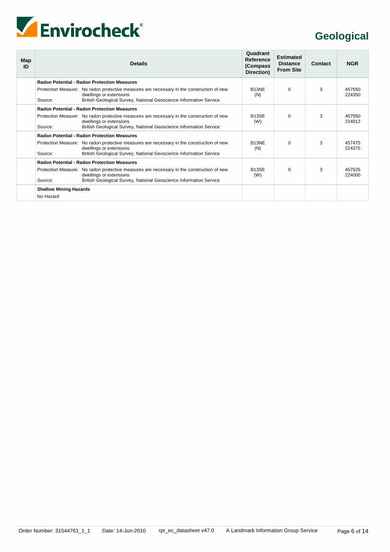
Radon Potential - Radon Protection Measures
Radon Potential - Radon Protection Measures
Radon Potential - Radon Protection Measures
Radon Potential - Radon Protection Measures
Shallow Mining Hazards
B13NE(N)
B13SE(W)
B13NE(N)
B13SE(W)
0
0
0
0
3
3
3
3
Protection Measure:
Source:
Protection Measure:
Source:
Protection Measure:
Source:
Protection Measure:
Source:
No radon protective measures are necessary in the construction of newdwellings or extensionsBritish Geological Survey, National Geoscience Information Service
No radon protective measures are necessary in the construction of newdwellings or extensionsBritish Geological Survey, National Geoscience Information Service
No radon protective measures are necessary in the construction of newdwellings or extensionsBritish Geological Survey, National Geoscience Information Service
No radon protective measures are necessary in the construction of newdwellings or extensionsBritish Geological Survey, National Geoscience Information Service
No Hazard
457550224350
457550224012
457475224375
457525224000
Order Number: 31544761_1_1 Date: 14-Jun-2010 rpr_ec_datasheet v47.0 A Landmark Information Group Service Page 7 of 14
Industrial Land Use
MapID Details
QuadrantReference(CompassDirection)
EstimatedDistanceFrom Site
Contact NGR
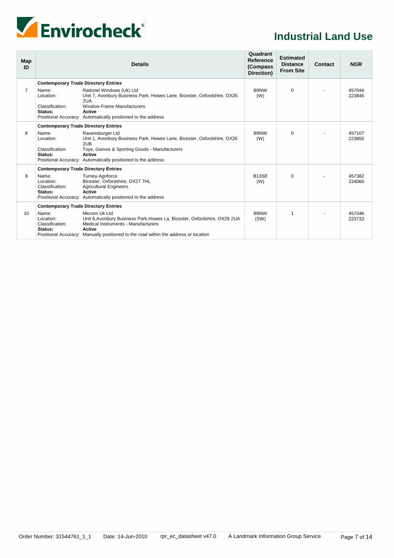
7
8
9
10
Contemporary Trade Directory Entries
Contemporary Trade Directory Entries
Contemporary Trade Directory Entries
Contemporary Trade Directory Entries
B9NW(W)
B9NW(W)
B13SE(W)
B9NW(SW)
0
0
0
1
-
-
-
-
Name:Location:
Classification:Status:Positional Accuracy:
Name:Location:
Classification:Status:Positional Accuracy:
Name:Location:Classification:Status:Positional Accuracy:
Name:Location:Classification:Status:Positional Accuracy:
Rationel Windows (Uk) LtdUnit 7, Avonbury Business Park, Howes Lane, Bicester, Oxfordshire, OX262UAWindow Frame ManufacturersActiveAutomatically positioned to the address
Ravensburger LtdUnit 1, Avonbury Business Park, Howes Lane, Bicester, Oxfordshire, OX262UBToys, Games & Sporting Goods - ManufacturersActiveAutomatically positioned to the address
Turney-AgriforceBicester, Oxfordshire, OX27 7HLAgricultural EngineersActiveAutomatically positioned to the address
Microm Uk LtdUnit 6,Avonbury Business Park,Howes La, Bicester, Oxfordshire, OX26 2UAMedical Instruments - ManufacturersActiveManually positioned to the road within the address or location
457044223845
457107223855
457382224060
457046223733
Order Number: 31544761_1_1 Date: 14-Jun-2010 rpr_ec_datasheet v47.0 A Landmark Information Group Service Page 8 of 14
Sensitive Land Use
MapID Details
QuadrantReference(CompassDirection)
EstimatedDistanceFrom Site
Contact NGR
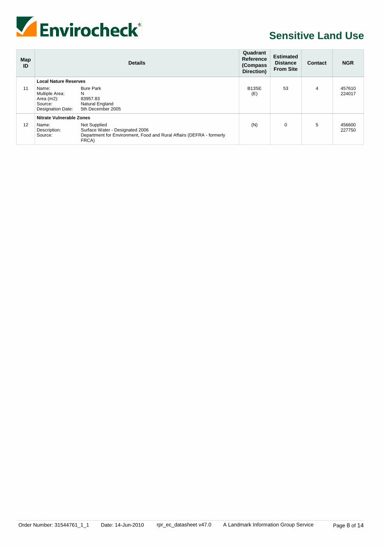
11
12
Local Nature Reserves
Nitrate Vulnerable Zones
B13SE(E)
(N)
53
0
4
5
Name:Multiple Area:Area (m2):Source:Designation Date:
Name:Description:Source:
Bure ParkN83957.83Natural England5th December 2005
Not SuppliedSurface Water - Designated 2006Department for Environment, Food and Rural Affairs (DEFRA - formerlyFRCA)
457610224017
456600227750

Order Number: 31544761_1_1 Date: 14-Jun-2010 rpr_ec_datasheet v47.0 A Landmark Information Group Service Page 9 of 14
Data Currency
Agency & Hydrological Version Update CycleContaminated Land Register Entries and Notices
Discharge Consents
Enforcement and Prohibition Notices
Integrated Pollution Controls
Integrated Pollution Prevention And Control
Local Authority Integrated Pollution Prevention And Control
Local Authority Pollution Prevention and Controls
Local Authority Pollution Prevention and Control Enforcements
Nearest Surface Water Feature
Pollution Incidents to Controlled Waters
Prosecutions Relating to Authorised Processes
Prosecutions Relating to Controlled Waters
Registered Radioactive Substances
River Quality
River Quality Biology Sampling Points
River Quality Chemistry Sampling Points
Substantiated Pollution Incident Register
Water Abstractions
Water Industry Act Referrals
Groundwater Vulnerability
Drift Deposits
Source Protection Zones
Extreme Flooding from Rivers or Sea without Defences
Flooding from Rivers or Sea without Defences
Areas Benefiting from Flood Defences
February 2010
April 2010
May 2010
October 2008
April 2010
April 2009
April 2009
April 2009
February 2010
September 1999
March 2010
May 2010
April 2010
November 2001
January 2010
January 2010
April 2010
April 2010
January 2010
January 1999
January 1999
April 2010
March 2010
March 2010
March 2010
Annual Rolling Update
Quarterly
Quarterly
Not Applicable
Quarterly
Annual Rolling Update
Annual Rolling Update
Annual Rolling Update
Quarterly
Not Applicable
Monthly
Monthly
Quarterly
Not Applicable
Annually
Annually
Quarterly
Quarterly
Quarterly
Not Applicable
Not Applicable
Quarterly
Quarterly
Quarterly
Quarterly
Cherwell District Council - Environmental Health Department
Environment Agency - Thames Region
Environment Agency - Thames Region
Environment Agency - Thames Region
Environment Agency - Thames Region
Cherwell District Council - Environmental Health Department
Cherwell District Council - Environmental Health Department
Cherwell District Council - Environmental Health Department
Ordnance Survey
Environment Agency - Thames Region
Environment Agency - Thames Region
Environment Agency - Thames Region
Environment Agency - Thames Region
Environment Agency - Head Office
Environment Agency - Head Office
Environment Agency - Head Office
Environment Agency - Thames Region - West Area
Environment Agency - Thames Region
Environment Agency - Thames Region
Environment Agency - Head Office
Environment Agency - Head Office
Environment Agency - Head Office
Environment Agency - Head Office
Environment Agency - Head Office
Environment Agency - Head Office

Order Number: 31544761_1_1 Date: 14-Jun-2010 rpr_ec_datasheet v47.0 A Landmark Information Group Service Page 10 of 14
Data Currency
Agency & Hydrological
Waste
Hazardous Substances
Version
Version
Version
Update Cycle
Update Cycle
Update Cycle
Flood Water Storage Areas
Flood Defences
BGS Recorded Landfill Sites
Historical Landfill Sites
Integrated Pollution Control Registered Waste Sites
Licensed Waste Management Facilities (Landfill Boundaries)
Licensed Waste Management Facilities (Locations)
Local Authority Landfill Coverage
Local Authority Recorded Landfill Sites
Registered Landfill Sites
Registered Waste Transfer Sites
Registered Waste Treatment or Disposal Sites
Control of Major Accident Hazards Sites (COMAH)
Explosive Sites
Notification of Installations Handling Hazardous Substances (NIHHS)
Planning Hazardous Substance Enforcements
Planning Hazardous Substance Consents
March 2010
March 2010
June 1996
April 2010
October 2008
April 2010
April 2010
May 2000May 2000
May 2000May 2000
March 2003
March 2003
March 2003
May 2010
January 2009
November 2000
July 2009October 2009
July 2009October 2009
Quarterly
Quarterly
Not Applicable
Quarterly
Not Applicable
Quarterly
Quarterly
Not ApplicableNot Applicable
Not ApplicableNot Applicable
Not Applicable
Not Applicable
Not Applicable
Bi-Annually
Bi-Annually
Not Applicable
Annual Rolling UpdateAnnual Rolling Update
Annual Rolling UpdateAnnual Rolling Update
Environment Agency - Head Office
Environment Agency - Head Office
British Geological Survey - National Geoscience Information Service
Environment Agency - Thames Region - West Area
Environment Agency - Thames Region
Environment Agency - Thames Region - West Area
Environment Agency - Thames Region - West Area
Cherwell District Council - Environmental Health DepartmentOxfordshire County Council
Cherwell District Council - Environmental Health DepartmentOxfordshire County Council
Environment Agency - Thames Region - West Area
Environment Agency - Thames Region - West Area
Environment Agency - Thames Region - West Area
Health and Safety Executive
Health and Safety Executive
Health and Safety Executive
Cherwell District CouncilOxfordshire County Council
Cherwell District CouncilOxfordshire County Council

Order Number: 31544761_1_1 Date: 14-Jun-2010 rpr_ec_datasheet v47.0 A Landmark Information Group Service Page 11 of 14
Data Currency
Geological
Industrial Land Use
Version
Version
Update Cycle
Update Cycle
BGS Recorded Mineral Sites
BGS 1:625,000 Solid Geology
Brine Compensation Area
Coal Mining Affected Areas
Mining Instability
Natural and Mining Cavities
Potential for Collapsible Ground Stability Hazards
Potential for Compressible Ground Stability Hazards
Potential for Ground Dissolution Stability Hazards
Potential for Landslide Ground Stability Hazards
Potential for Running Sand Ground Stability Hazards
Potential for Shrinking or Swelling Clay Ground Stability Hazards
Radon Potential - Radon Affected Areas
Radon Potential - Radon Protection Measures
Shallow Mining Hazards
Contemporary Trade Directory Entries
Fuel Station Entries
April 2010
August 1996
November 2002
January 2006
October 2000
November 2009
January 2009
January 2009
January 2009
January 2009
January 2009
January 2009
May 2007
May 2007
August 2002
March 2010
February 2010
Bi-Annually
Not Applicable
Not Applicable
As notified
Not Applicable
Bi-Annually
Annually
Annually
Annually
Annually
Annually
Annually
As notified
As notified
Not Applicable
Quarterly
Quarterly
British Geological Survey - National Geoscience Information Service
British Geological Survey - National Geoscience Information Service
Cheshire Brine Subsidence Compensation Board
The Coal Authority - Mining Report Service
Ove Arup & Partners
Peter Brett Associates
British Geological Survey - National Geoscience Information Service
British Geological Survey - National Geoscience Information Service
British Geological Survey - National Geoscience Information Service
British Geological Survey - National Geoscience Information Service
British Geological Survey - National Geoscience Information Service
British Geological Survey - National Geoscience Information Service
British Geological Survey - National Geoscience Information Service
British Geological Survey - National Geoscience Information Service
British Geological Survey - National Geoscience Information Service
Thomson Directories
Catalist Ltd - Experian Catalist

Order Number: 31544761_1_1 Date: 14-Jun-2010 rpr_ec_datasheet v47.0 A Landmark Information Group Service Page 12 of 14
Data Currency
Sensitive Land Use Version Update CycleAreas of Adopted Green Belt
Areas of Unadopted Green Belt
Areas of Outstanding Natural Beauty
Environmentally Sensitive Areas
Forest Parks
Local Nature Reserves
Marine Nature Reserves
National Nature Reserves
National Parks
Nitrate Sensitive Areas
Nitrate Vulnerable Zones
Ramsar Sites
Sites of Special Scientific Interest
Special Areas of Conservation
Special Protection Areas
March 2010
March 2010
December 2009
December 2009
April 1997
December 2009
September 2009
December 2009
December 2009
December 2009
February 2009
December 2009
December 2009
December 2009
December 2009
As notified
As notified
Bi-Annually
Annually
Not Applicable
Bi-Annually
Bi-Annually
Bi-Annually
Bi-Annually
Not Applicable
Annually
Bi-Annually
Bi-Annually
Bi-Annually
Bi-Annually
Cherwell District Council
Cherwell District Council
Natural England
Natural England
Forestry Commission
Natural England
Natural England
Natural England
Natural England
Department for Environment, Food and Rural Affairs (DEFRA - formerly FRCA)
Department for Environment, Food and Rural Affairs (DEFRA - formerly FRCA)
Natural England
Natural England
Natural England
Natural England

Order Number: 31544761_1_1 Date: 14-Jun-2010 rpr_ec_datasheet v47.0 A Landmark Information Group Service Page 13 of 14
Data Suppliers
Ordnance Survey
Environment Agency
Scottish Environment Protection Agency
The Coal Authority
British Geological Survey
Centre for Ecology and Hydrology
Countryside Council for Wales
Scottish Natural Heritage
Natural England
Health Protection Agency
Ove Arup
Peter Brett Associates
Data Supplier Data Supplier Logo
A selection of organisations who provide data within this report
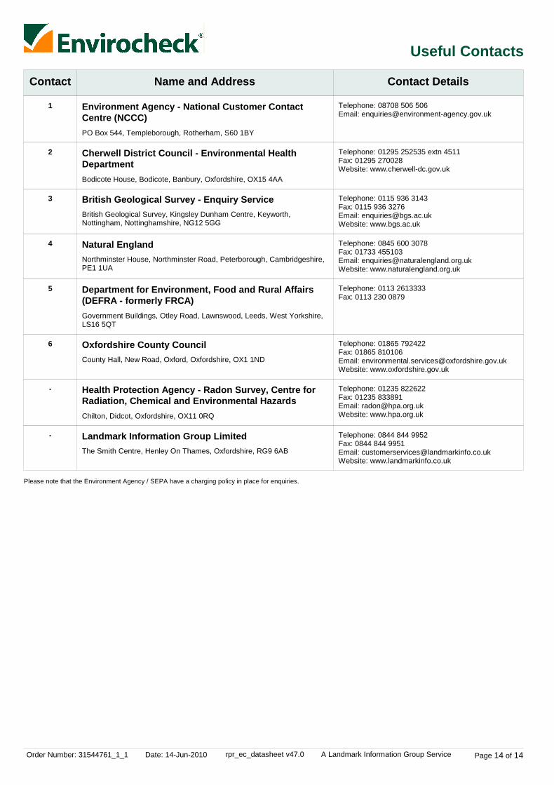
Order Number: 31544761_1_1 Date: 14-Jun-2010 rpr_ec_datasheet v47.0 A Landmark Information Group Service Page 14 of 14
Useful Contacts
Contact Name and Address Contact Details
1
2
3
4
5
6
-
-
Environment Agency - National Customer ContactCentre (NCCC)
Cherwell District Council - Environmental HealthDepartment
British Geological Survey - Enquiry Service
Natural England
Department for Environment, Food and Rural Affairs(DEFRA - formerly FRCA)
Oxfordshire County Council
Health Protection Agency - Radon Survey, Centre forRadiation, Chemical and Environmental Hazards
Landmark Information Group Limited
PO Box 544, Templeborough, Rotherham, S60 1BY
Bodicote House, Bodicote, Banbury, Oxfordshire, OX15 4AA
British Geological Survey, Kingsley Dunham Centre, Keyworth,Nottingham, Nottinghamshire, NG12 5GG
Northminster House, Northminster Road, Peterborough, Cambridgeshire,PE1 1UA
Government Buildings, Otley Road, Lawnswood, Leeds, West Yorkshire,LS16 5QT
County Hall, New Road, Oxford, Oxfordshire, OX1 1ND
Chilton, Didcot, Oxfordshire, OX11 0RQ
The Smith Centre, Henley On Thames, Oxfordshire, RG9 6AB
Telephone: 08708 506 506Email: [email protected]
Telephone: 01295 252535 extn 4511Fax: 01295 270028Website: www.cherwell-dc.gov.uk
Telephone: 0115 936 3143Fax: 0115 936 3276Email: [email protected]: www.bgs.ac.uk
Telephone: 0845 600 3078Fax: 01733 455103Email: [email protected]: www.naturalengland.org.uk
Telephone: 0113 2613333Fax: 0113 230 0879
Telephone: 01865 792422Fax: 01865 810106Email: [email protected]: www.oxfordshire.gov.uk
Telephone: 01235 822622Fax: 01235 833891Email: [email protected]: www.hpa.org.uk
Telephone: 0844 844 9952Fax: 0844 844 9951Email: [email protected]: www.landmarkinfo.co.uk
Please note that the Environment Agency / SEPA have a charging policy in place for enquiries.

Order Number: 31544761_1_1 Date: 14-Jun-2010 rpr_ec_datasheet v47.0 A Landmark Information Group Service
Datasheet
Order Details:Order Number:
Customer Reference:
National Grid Reference:
Slice:
Site Area (Ha):
Search Buffer (m):
Site Details:
Client Details:
31544761_1_1
UA001881
456330, 224990
C
395.55
500
Site atBicesterOxfordshire
Mr D ThomasHyder Consulting LtdHCL HouseSt. Mellons Business ParkSt MellonsCardiffCF3 0EY
Report:®Envirocheck

Order Number: 31544761_1_1 Date: 14-Jun-2010 rpr_ec_datasheet v47.0 A Landmark Information Group Service
Summary
Agency & Hydrological
Waste
Hazardous Substances
Geological
Industrial Land Use
Sensitive Land Use
Data Currency
Data Suppliers
Useful Contacts
Introduction
Copyright Notice
Natural England Copyright Notice
Ove Arup Copyright Notice
Peter Brett Associates Copyright Notice
Radon Potential dataset Copyright Notice
The Environment Act 1995 has made site sensitivity a key issue, as the legislation pays as much attention to the pathways by whichcontamination could spread, and to the vulnerable targets of contamination, as it does the potential sources of contamination. For this reason, Landmark's Site Sensitivity maps and Datasheet(s) place great emphasis on statutory data provided by the EnvironmentAgency and the Scottish Environment Protection Agency; it also incorporates data from Natural England (and the Scottish and Welshequivalents) and Local Authorities; and highlights hydrogeological features required by environmental and geotechnical consultants. It does notinclude any information concerning past uses of land. The datasheet is produced by querying the Landmark database to a distance defined bythe client from a site boundary provided by the client.
In the attached datasheet the National Grid References (NGRs) are rounded to the nearest 10m in accordance with Landmark's agreementswith a number of Data Suppliers.
© Landmark Information Group Limited 2010. The Copyright on the information and data and its format as contained in this Envirocheck®Report ("Report") is the property of Landmark Information Group Limited ("Landmark") and several other Data Providers, including (but notlimited to) Ordnance Survey, British Geological Survey, the Environment Agency and Natural England, and must not be reproduced in whole orin part by photocopying or any other method. The Report is supplied under Landmark's Terms and Conditions accepted by the Customer. A copy of Landmark's Terms and Conditions can be found with the Index Map for this report. Additional copies of the Report may be obtainedfrom Landmark, subject to Landmark's charges in force from time to time. The Copyright, design rights and any other intellectual rights shallremain the exclusive property of Landmark and /or other Data providers, whose Copyright material has been included in this Report.
Site of Special Scientific Interest, National Nature Reserve, Ramsar, Special Protection Area, Special Conservation Area, Marine NatureReserve data (derived from Ordnance Survey 1:10000 raster) is provided by, and used with the permission of, Natural England who retain thecopyright and Intellectual Property Rights for the data.
The Data provided in this report was obtained on Licence from Ove Arup & Partners Limited (for further information, [email protected]). No reproduction or further use of such Data is to be made without the prior written consent of Ove Arup & PartnersLimited. The information and data supplied in the product are derived from publicly available records and other third party sources and neitherOve Arup & Partners nor Landmark warrant the accuracy or completeness of such information or data.
The cavity data presented has been extracted from the PBA enhanced version of the original DEFRA national cavity databases. PBA/DEFRAretain the copyright & intellectual property rights in the data. Whilst all reasonable efforts are made to check that the information contained inthe cavity databases is accurate we do not warrant that the data is complete or error free. The information is based upon our own researchesand those collated from a number of external sources and is continually being augmented and updated by PBA. In no event shall PBA/DEFRAor Landmark be liable for any loss or damage including, without limitation, indirect or consequential loss or damage arising from the use of thisdata.
Information supplied from a joint dataset compiled by The British Geological Survey and the Health Protection Agency.
Report Section Page Number
Contents
Report Version v47.0
-
1
2
-
3
-
5
6
10
11

Order Number: 31544761_1_1 Date: 14-Jun-2010 rpr_ec_datasheet v47.0 A Landmark Information Group Service
Summary
Data Type PageNumber On Site 0 to 250m
Agency & Hydrological
Waste
251 to 500m
Contaminated Land Register Entries and Notices
Discharge Consents
Enforcement and Prohibition Notices
Integrated Pollution Controls
Integrated Pollution Prevention And Control
Local Authority Integrated Pollution Prevention And Control
Local Authority Pollution Prevention and Controls
Local Authority Pollution Prevention and Control Enforcements
Nearest Surface Water Feature
Pollution Incidents to Controlled Waters
Prosecutions Relating to Authorised Processes
Prosecutions Relating to Controlled Waters
Registered Radioactive Substances
River Quality
River Quality Biology Sampling Points
River Quality Chemistry Sampling Points
Substantiated Pollution Incident Register
Water Abstractions
Water Industry Act Referrals
Groundwater Vulnerability
Source Protection Zones
Extreme Flooding from Rivers or Sea without Defences
Flooding from Rivers or Sea without Defences
Areas Benefiting from Flood Defences
Flood Water Storage Areas
Flood Defences
BGS Recorded Landfill Sites
Historical Landfill Sites
Integrated Pollution Control Registered Waste Sites
Licensed Waste Management Facilities (Landfill Boundaries)
Licensed Waste Management Facilities (Locations)
Local Authority Recorded Landfill Sites
Registered Landfill Sites
Registered Waste Transfer Sites
Registered Waste Treatment or Disposal Sites
Yes
Yes n/a n/a
n/a
n/a
n/a
n/a
n/a
(*up to 1000m)
pg 1
pg 1

Order Number: 31544761_1_1 Date: 14-Jun-2010 rpr_ec_datasheet v47.0 A Landmark Information Group Service
Summary
Data Type PageNumber On Site 0 to 250m
Hazardous Substances
Geological
Industrial Land Use
251 to 500m
Control of Major Accident Hazards Sites (COMAH)
Explosive Sites
Notification of Installations Handling Hazardous Substances (NIHHS)
Planning Hazardous Substance Consents
Planning Hazardous Substance Enforcements
BGS Recorded Mineral Sites
BGS 1:625,000 Solid Geology
Brine Compensation Area
Coal Mining Affected Areas
Mining Instability
Natural and Mining Cavities
Potential for Collapsible Ground Stability Hazards
Potential for Compressible Ground Stability Hazards
Potential for Ground Dissolution Stability Hazards
Potential for Landslide Ground Stability Hazards
Potential for Running Sand Ground Stability Hazards
Potential for Shrinking or Swelling Clay Ground Stability Hazards
Radon Potential - Radon Affected Areas
Radon Potential - Radon Protection Measures
Shallow Mining Hazards
Contemporary Trade Directory Entries (50m)
Fuel Station Entries
Yes
Yes
Yes
Yes
Yes
n/a
n/a
n/a
n/a
n/a
n/a
n/a
n/a
n/a
n/a
n/a
n/a
n/a
n/a
n/a
n/a
n/a
n/a
n/a
n/a
(*up to 1000m)
pg 3
pg 3
pg 3
pg 4
pg 4

Order Number: 31544761_1_1 Date: 14-Jun-2010 rpr_ec_datasheet v47.0 A Landmark Information Group Service
Summary
Data Type PageNumber On Site 0 to 250m
Sensitive Land Use
251 to 500m
Areas of Adopted Green Belt
Areas of Unadopted Green Belt
Areas of Outstanding Natural Beauty
Environmentally Sensitive Areas
Forest Parks
Local Nature Reserves
Marine Nature Reserves
National Nature Reserves
National Parks
Nitrate Sensitive Areas
Nitrate Vulnerable Zones
Ramsar Sites
Sites of Special Scientific Interest
Special Areas of Conservation
Special Protection Areas
1
1
1
(*up to 1000m)
pg 5
pg 5
pg 5

Order Number: 31544761_1_1 Date: 14-Jun-2010 rpr_ec_datasheet v47.0 A Landmark Information Group Service Page 1 of 11
Agency & Hydrological
MapID Details
QuadrantReference(CompassDirection)
EstimatedDistanceFrom Site
Contact NGR
Nearest Surface Water Feature
Groundwater Vulnerability
Groundwater Vulnerability
Drift Deposits
Extreme Flooding from Rivers or Sea without Defences
Flooding from Rivers or Sea without Defences
Areas Benefiting from Flood Defences
Flood Water Storage Areas
Flood Defences
C4SE(SE)
C7NE(NW)
(SE)
0
0
0
-
1
1
GeologicalClassification:
Soil Classification:
Map Sheet:Scale:
GeologicalClassification:
Soil Classification:
Map Sheet:Scale:
Minor Aquifer (Variably permeable) - These can be fractured or potentiallyfractured rocks, which do not have a high primary permeability, or otherformations of variable permeability including unconsolidated deposits.Although not producing large quantities of water for abstraction, they areimportant for local supplies and in supplying base flow to riversSoils of High Leaching Potential (H3)- Coarse textured or moderately shallowsoils which readily transmit non-absorbed pollutants and liquid discharges butwhich have some ability to attenuate absorbed pollutants because of theirlarge clay or organic matter contentsSheet 30 Northern Cotswolds1:100,000
Minor Aquifer (Variably permeable) - These can be fractured or potentiallyfractured rocks, which do not have a high primary permeability, or otherformations of variable permeability including unconsolidated deposits.Although not producing large quantities of water for abstraction, they areimportant for local supplies and in supplying base flow to riversSoils of High Leaching Potential (U) - Soil information for restored mineralworkings and urban areas is based on fewer observations than elsewhere. Aworst case vulnerability classification (H) assumed, until proved otherwiseSheet 30 Northern Cotswolds1:100,000
None
None
None
None
None
None
456801224793
455986225635
457083223950

Order Number: 31544761_1_1 Date: 14-Jun-2010 rpr_ec_datasheet v47.0 A Landmark Information Group Service Page 2 of 11
Waste
MapID Details
QuadrantReference(CompassDirection)
EstimatedDistanceFrom Site
Contact NGR
Local Authority Landfill Coverage
Local Authority Landfill Coverage
0
0
6
5
Name:
Name:
Cherwell District Council - Has supplied landfill data
Oxfordshire County Council - Has supplied landfill data
455303231299
455303231299

Order Number: 31544761_1_1 Date: 14-Jun-2010 rpr_ec_datasheet v47.0 A Landmark Information Group Service Page 3 of 11
Geological
MapID Details
QuadrantReference(CompassDirection)
EstimatedDistanceFrom Site
Contact NGR
BGS 1:625,000 Solid Geology
Coal Mining Affected Areas
Potential for Collapsible Ground Stability Hazards
Potential for Compressible Ground Stability Hazards
Potential for Compressible Ground Stability Hazards
Potential for Ground Dissolution Stability Hazards
Potential for Ground Dissolution Stability Hazards
Potential for Ground Dissolution Stability Hazards
Potential for Ground Dissolution Stability Hazards
Potential for Ground Dissolution Stability Hazards
Potential for Landslide Ground Stability Hazards
Potential for Landslide Ground Stability Hazards
Potential for Running Sand Ground Stability Hazards
Potential for Running Sand Ground Stability Hazards
Potential for Shrinking or Swelling Clay Ground Stability Hazards
Potential for Shrinking or Swelling Clay Ground Stability Hazards
Radon Potential - Radon Affected Areas
Radon Potential - Radon Affected Areas
Radon Potential - Radon Affected Areas
Radon Potential - Radon Affected Areas
C7SE(NW)
C4NW(N)
C4NW(N)
C4NW(N)
C4NW(N)
C3NW(W)
(NE)
C3SE(S)
C4NW(N)
C4NW(N)
C4NW(N)
C4NW(N)
C4NW(N)
C4NW(N)
C4SW(S)
C4NW(N)
C3SE(S)
C8SE(NE)
0
0
0
0
0
0
0
0
0
0
0
0
0
0
0
0
0
0
2
2
2
2
2
2
2
2
2
2
2
2
2
2
2
2
2
2
Description:
Hazard Potential:Source:
Hazard Potential:Source:
Hazard Potential:Source:
Hazard Potential:Source:
Hazard Potential:Source:
Hazard Potential:Source:
Hazard Potential:Source:
Hazard Potential:Source:
Hazard Potential:Source:
Hazard Potential:Source:
Hazard Potential:Source:
Hazard Potential:Source:
Hazard Potential:Source:
Affected Area:
Source:
Affected Area:
Source:
Affected Area:
Source:
Affected Area:
Source:
Cornbrash
No HazardBritish Geological Survey, National Geoscience Information Service
No HazardBritish Geological Survey, National Geoscience Information Service
Very LowBritish Geological Survey, National Geoscience Information Service
Very LowBritish Geological Survey, National Geoscience Information Service
No HazardBritish Geological Survey, National Geoscience Information Service
No HazardBritish Geological Survey, National Geoscience Information Service
No HazardBritish Geological Survey, National Geoscience Information Service
Very LowBritish Geological Survey, National Geoscience Information Service
Very LowBritish Geological Survey, National Geoscience Information Service
No HazardBritish Geological Survey, National Geoscience Information Service
No HazardBritish Geological Survey, National Geoscience Information Service
No HazardBritish Geological Survey, National Geoscience Information Service
No HazardBritish Geological Survey, National Geoscience Information Service
The property is in a radon affected area, as between 3 and 5% of homes areabove the action levelBritish Geological Survey, National Geoscience Information Service
The property is not in a radon affected area, as less than 1% of homes areabove the action levelBritish Geological Survey, National Geoscience Information Service
The property is in a radon affected area, as between 1 and 3% of homes areabove the action levelBritish Geological Survey, National Geoscience Information Service
The property is in a radon affected area, as between 1 and 3% of homes areabove the action levelBritish Geological Survey, National Geoscience Information Service
In an area which may not be affected by coal mining
No Hazard
455965225521
456328225000
456328225000
456328225000
456328225000
455900225000
456950225300
456200224625
456328225000
456328225000
456328225000
456328225000
456328225000
456328225000
456328224575
456328225000
456225224700
456875225275

Order Number: 31544761_1_1 Date: 14-Jun-2010 rpr_ec_datasheet v47.0 A Landmark Information Group Service Page 4 of 11
Geological
MapID Details
QuadrantReference(CompassDirection)
EstimatedDistanceFrom Site
Contact NGR
Radon Potential - Radon Affected Areas
Radon Potential - Radon Protection Measures
Radon Potential - Radon Protection Measures
Radon Potential - Radon Protection Measures
Radon Potential - Radon Protection Measures
Radon Potential - Radon Protection Measures
Shallow Mining Hazards
C4NW(N)
C4SW(S)
C4NW(N)
C3SE(S)
C8SE(NE)
C4NW(N)
0
0
0
0
0
0
2
2
2
2
2
2
Affected Area:
Source:
Protection Measure:
Source:
Protection Measure:
Source:
Protection Measure:
Source:
Protection Measure:
Source:
Protection Measure:
Source:
The property is not in a radon affected area, as less than 1% of homes areabove the action levelBritish Geological Survey, National Geoscience Information Service
Basic radon protective measures are necessary in the construction of newdwellings or extensionsBritish Geological Survey, National Geoscience Information Service
No radon protective measures are necessary in the construction of newdwellings or extensionsBritish Geological Survey, National Geoscience Information Service
No radon protective measures are necessary in the construction of newdwellings or extensionsBritish Geological Survey, National Geoscience Information Service
No radon protective measures are necessary in the construction of newdwellings or extensionsBritish Geological Survey, National Geoscience Information Service
No radon protective measures are necessary in the construction of newdwellings or extensionsBritish Geological Survey, National Geoscience Information Service
No Hazard
456328225000
456328224575
456328225000
456225224700
456875225275
456328225000

Order Number: 31544761_1_1 Date: 14-Jun-2010 rpr_ec_datasheet v47.0 A Landmark Information Group Service Page 5 of 11
Sensitive Land Use
MapID Details
QuadrantReference(CompassDirection)
EstimatedDistanceFrom Site
Contact NGR
1
2
3
Local Nature Reserves
Nitrate Vulnerable Zones
Sites of Special Scientific Interest
(SE)
(N)
C3NE(W)
53
0
407
3
4
3
Name:Multiple Area:Area (m2):Source:Designation Date:
Name:Description:Source:
Name:Multiple Areas:Total Area (m2):Source:Reference:Designation Details:Designation Date:Date Type:Designation Details:Designation Date:Date Type:
Bure ParkN83957.83Natural England5th December 2005
Not SuppliedSurface Water - Designated 2006Department for Environment, Food and Rural Affairs (DEFRA - formerlyFRCA)
Ardley Cutting & QuarryN401251.72Natural England1000903Geological Conservation Review12th May 1988NotifiedLocal Wildlife Trust Reserve12th May 1988Notified
457592224148
455900227700
455933224998

Order Number: 31544761_1_1 Date: 14-Jun-2010 rpr_ec_datasheet v47.0 A Landmark Information Group Service Page 6 of 11
Data Currency
Agency & Hydrological Version Update CycleContaminated Land Register Entries and Notices
Discharge Consents
Enforcement and Prohibition Notices
Integrated Pollution Controls
Integrated Pollution Prevention And Control
Local Authority Integrated Pollution Prevention And Control
Local Authority Pollution Prevention and Controls
Local Authority Pollution Prevention and Control Enforcements
Nearest Surface Water Feature
Pollution Incidents to Controlled Waters
Prosecutions Relating to Authorised Processes
Prosecutions Relating to Controlled Waters
Registered Radioactive Substances
River Quality
River Quality Biology Sampling Points
River Quality Chemistry Sampling Points
Substantiated Pollution Incident Register
Water Abstractions
Water Industry Act Referrals
Groundwater Vulnerability
Drift Deposits
Source Protection Zones
Extreme Flooding from Rivers or Sea without Defences
Flooding from Rivers or Sea without Defences
February 2010
April 2010April 2010
May 2010
October 2008
April 2010
April 2009
April 2009
April 2009
February 2010
September 1999September 1999
March 2010
May 2010
April 2010
November 2001
January 2010
January 2010
April 2010
April 2010April 2010
January 2010
January 1999
January 1999
April 2010
March 2010
March 2010
Annual Rolling Update
QuarterlyQuarterly
Quarterly
Not Applicable
Quarterly
Annual Rolling Update
Annual Rolling Update
Annual Rolling Update
Quarterly
Not ApplicableNot Applicable
Monthly
Monthly
Quarterly
Not Applicable
Annually
Annually
Quarterly
QuarterlyQuarterly
Quarterly
Not Applicable
Not Applicable
Quarterly
Quarterly
Quarterly
Cherwell District Council - Environmental Health Department
Environment Agency - Anglian RegionEnvironment Agency - Thames Region
Environment Agency - Thames Region
Environment Agency - Thames Region
Environment Agency - Thames Region
Cherwell District Council - Environmental Health Department
Cherwell District Council - Environmental Health Department
Cherwell District Council - Environmental Health Department
Ordnance Survey
Environment Agency - Anglian RegionEnvironment Agency - Thames Region
Environment Agency - Thames Region
Environment Agency - Thames Region
Environment Agency - Thames Region
Environment Agency - Head Office
Environment Agency - Head Office
Environment Agency - Head Office
Environment Agency - Thames Region - West Area
Environment Agency - Anglian RegionEnvironment Agency - Thames Region
Environment Agency - Thames Region
Environment Agency - Head Office
Environment Agency - Head Office
Environment Agency - Head Office
Environment Agency - Head Office
Environment Agency - Head Office

Order Number: 31544761_1_1 Date: 14-Jun-2010 rpr_ec_datasheet v47.0 A Landmark Information Group Service Page 7 of 11
Data Currency
Agency & Hydrological
Waste
Hazardous Substances
Version
Version
Version
Update Cycle
Update Cycle
Update Cycle
Areas Benefiting from Flood Defences
Flood Water Storage Areas
Flood Defences
BGS Recorded Landfill Sites
Historical Landfill Sites
Integrated Pollution Control Registered Waste Sites
Licensed Waste Management Facilities (Landfill Boundaries)
Licensed Waste Management Facilities (Locations)
Local Authority Landfill Coverage
Local Authority Recorded Landfill Sites
Registered Landfill Sites
Registered Waste Transfer Sites
Registered Waste Treatment or Disposal Sites
Control of Major Accident Hazards Sites (COMAH)
Explosive Sites
Notification of Installations Handling Hazardous Substances (NIHHS)
Planning Hazardous Substance Enforcements
Planning Hazardous Substance Consents
March 2010
March 2010
March 2010
June 1996
April 2010
October 2008
April 2010
April 2010
May 2000May 2000
May 2000May 2000
March 2003
March 2003
March 2003
May 2010
January 2009
November 2000
July 2009October 2009
July 2009October 2009
Quarterly
Quarterly
Quarterly
Not Applicable
Quarterly
Not Applicable
Quarterly
Quarterly
Not ApplicableNot Applicable
Not ApplicableNot Applicable
Not Applicable
Not Applicable
Not Applicable
Bi-Annually
Bi-Annually
Not Applicable
Annual Rolling UpdateAnnual Rolling Update
Annual Rolling UpdateAnnual Rolling Update
Environment Agency - Head Office
Environment Agency - Head Office
Environment Agency - Head Office
British Geological Survey - National Geoscience Information Service
Environment Agency - Thames Region - West Area
Environment Agency - Thames Region
Environment Agency - Thames Region - West Area
Environment Agency - Thames Region - West Area
Cherwell District Council - Environmental Health DepartmentOxfordshire County Council
Cherwell District Council - Environmental Health DepartmentOxfordshire County Council
Environment Agency - Thames Region - West Area
Environment Agency - Thames Region - West Area
Environment Agency - Thames Region - West Area
Health and Safety Executive
Health and Safety Executive
Health and Safety Executive
Cherwell District CouncilOxfordshire County Council
Cherwell District CouncilOxfordshire County Council

Order Number: 31544761_1_1 Date: 14-Jun-2010 rpr_ec_datasheet v47.0 A Landmark Information Group Service Page 8 of 11
Data Currency
Geological
Industrial Land Use
Version
Version
Update Cycle
Update Cycle
BGS Recorded Mineral Sites
BGS 1:625,000 Solid Geology
Brine Compensation Area
Coal Mining Affected Areas
Mining Instability
Natural and Mining Cavities
Potential for Collapsible Ground Stability Hazards
Potential for Compressible Ground Stability Hazards
Potential for Ground Dissolution Stability Hazards
Potential for Landslide Ground Stability Hazards
Potential for Running Sand Ground Stability Hazards
Potential for Shrinking or Swelling Clay Ground Stability Hazards
Radon Potential - Radon Affected Areas
Radon Potential - Radon Protection Measures
Shallow Mining Hazards
Contemporary Trade Directory Entries
Fuel Station Entries
April 2010
August 1996
November 2002
January 2006
October 2000
November 2009
January 2009
January 2009
January 2009
January 2009
January 2009
January 2009
May 2007
May 2007
August 2002
March 2010
February 2010
Bi-Annually
Not Applicable
Not Applicable
As notified
Not Applicable
Bi-Annually
Annually
Annually
Annually
Annually
Annually
Annually
As notified
As notified
Not Applicable
Quarterly
Quarterly
British Geological Survey - National Geoscience Information Service
British Geological Survey - National Geoscience Information Service
Cheshire Brine Subsidence Compensation Board
The Coal Authority - Mining Report Service
Ove Arup & Partners
Peter Brett Associates
British Geological Survey - National Geoscience Information Service
British Geological Survey - National Geoscience Information Service
British Geological Survey - National Geoscience Information Service
British Geological Survey - National Geoscience Information Service
British Geological Survey - National Geoscience Information Service
British Geological Survey - National Geoscience Information Service
British Geological Survey - National Geoscience Information Service
British Geological Survey - National Geoscience Information Service
British Geological Survey - National Geoscience Information Service
Thomson Directories
Catalist Ltd - Experian Catalist

Order Number: 31544761_1_1 Date: 14-Jun-2010 rpr_ec_datasheet v47.0 A Landmark Information Group Service Page 9 of 11
Data Currency
Sensitive Land Use Version Update CycleAreas of Adopted Green Belt
Areas of Unadopted Green Belt
Areas of Outstanding Natural Beauty
Environmentally Sensitive Areas
Forest Parks
Local Nature Reserves
Marine Nature Reserves
National Nature Reserves
National Parks
Nitrate Sensitive Areas
Nitrate Vulnerable Zones
Ramsar Sites
Sites of Special Scientific Interest
Special Areas of Conservation
Special Protection Areas
March 2010
March 2010
December 2009
December 2009
April 1997
December 2009
September 2009
December 2009
December 2009
December 2009
February 2009
December 2009
December 2009
December 2009
December 2009
As notified
As notified
Bi-Annually
Annually
Not Applicable
Bi-Annually
Bi-Annually
Bi-Annually
Bi-Annually
Not Applicable
Annually
Bi-Annually
Bi-Annually
Bi-Annually
Bi-Annually
Cherwell District Council
Cherwell District Council
Natural England
Natural England
Forestry Commission
Natural England
Natural England
Natural England
Natural England
Department for Environment, Food and Rural Affairs (DEFRA - formerly FRCA)
Department for Environment, Food and Rural Affairs (DEFRA - formerly FRCA)
Natural England
Natural England
Natural England
Natural England

Order Number: 31544761_1_1 Date: 14-Jun-2010 rpr_ec_datasheet v47.0 A Landmark Information Group Service Page 10 of 11
Data Suppliers
Ordnance Survey
Environment Agency
Scottish Environment Protection Agency
The Coal Authority
British Geological Survey
Centre for Ecology and Hydrology
Countryside Council for Wales
Scottish Natural Heritage
Natural England
Health Protection Agency
Ove Arup
Peter Brett Associates
Data Supplier Data Supplier Logo
A selection of organisations who provide data within this report

Order Number: 31544761_1_1 Date: 14-Jun-2010 rpr_ec_datasheet v47.0 A Landmark Information Group Service Page 11 of 11
Useful Contacts
Contact Name and Address Contact Details
1
2
3
4
5
6
-
-
Environment Agency - National Customer ContactCentre (NCCC)
British Geological Survey - Enquiry Service
Natural England
Department for Environment, Food and Rural Affairs(DEFRA - formerly FRCA)
Oxfordshire County Council
Cherwell District Council - Environmental HealthDepartment
Health Protection Agency - Radon Survey, Centre forRadiation, Chemical and Environmental Hazards
Landmark Information Group Limited
PO Box 544, Templeborough, Rotherham, S60 1BY
British Geological Survey, Kingsley Dunham Centre, Keyworth,Nottingham, Nottinghamshire, NG12 5GG
Northminster House, Northminster Road, Peterborough, Cambridgeshire,PE1 1UA
Government Buildings, Otley Road, Lawnswood, Leeds, West Yorkshire,LS16 5QT
County Hall, New Road, Oxford, Oxfordshire, OX1 1ND
Bodicote House, Bodicote, Banbury, Oxfordshire, OX15 4AA
Chilton, Didcot, Oxfordshire, OX11 0RQ
The Smith Centre, Henley On Thames, Oxfordshire, RG9 6AB
Telephone: 08708 506 506Email: [email protected]
Telephone: 0115 936 3143Fax: 0115 936 3276Email: [email protected]: www.bgs.ac.uk
Telephone: 0845 600 3078Fax: 01733 455103Email: [email protected]: www.naturalengland.org.uk
Telephone: 0113 2613333Fax: 0113 230 0879
Telephone: 01865 792422Fax: 01865 810106Email: [email protected]: www.oxfordshire.gov.uk
Telephone: 01295 252535 extn 4511Fax: 01295 270028Website: www.cherwell-dc.gov.uk
Telephone: 01235 822622Fax: 01235 833891Email: [email protected]: www.hpa.org.uk
Telephone: 0844 844 9952Fax: 0844 844 9951Email: [email protected]: www.landmarkinfo.co.uk
Please note that the Environment Agency / SEPA have a charging policy in place for enquiries.

Order Number: 31544761_1_1 Date: 14-Jun-2010 rpr_ec_datasheet v47.0 A Landmark Information Group Service
Datasheet
Order Details:Order Number:
Customer Reference:
National Grid Reference:
Slice:
Site Area (Ha):
Search Buffer (m):
Site Details:
Client Details:
31544761_1_1
UA001881
457720, 225250
D
395.55
500
Site atBicesterOxfordshire
Mr D ThomasHyder Consulting LtdHCL HouseSt. Mellons Business ParkSt MellonsCardiffCF3 0EY
Report:®Envirocheck

Order Number: 31544761_1_1 Date: 14-Jun-2010 rpr_ec_datasheet v47.0 A Landmark Information Group Service
Summary
Agency & Hydrological
Waste
Hazardous Substances
Geological
Industrial Land Use
Sensitive Land Use
Data Currency
Data Suppliers
Useful Contacts
Introduction
Copyright Notice
Natural England Copyright Notice
Ove Arup Copyright Notice
Peter Brett Associates Copyright Notice
Radon Potential dataset Copyright Notice
The Environment Act 1995 has made site sensitivity a key issue, as the legislation pays as much attention to the pathways by whichcontamination could spread, and to the vulnerable targets of contamination, as it does the potential sources of contamination. For this reason, Landmark's Site Sensitivity maps and Datasheet(s) place great emphasis on statutory data provided by the EnvironmentAgency and the Scottish Environment Protection Agency; it also incorporates data from Natural England (and the Scottish and Welshequivalents) and Local Authorities; and highlights hydrogeological features required by environmental and geotechnical consultants. It does notinclude any information concerning past uses of land. The datasheet is produced by querying the Landmark database to a distance defined bythe client from a site boundary provided by the client.
In the attached datasheet the National Grid References (NGRs) are rounded to the nearest 10m in accordance with Landmark's agreementswith a number of Data Suppliers.
© Landmark Information Group Limited 2010. The Copyright on the information and data and its format as contained in this Envirocheck®Report ("Report") is the property of Landmark Information Group Limited ("Landmark") and several other Data Providers, including (but notlimited to) Ordnance Survey, British Geological Survey, the Environment Agency and Natural England, and must not be reproduced in whole orin part by photocopying or any other method. The Report is supplied under Landmark's Terms and Conditions accepted by the Customer. A copy of Landmark's Terms and Conditions can be found with the Index Map for this report. Additional copies of the Report may be obtainedfrom Landmark, subject to Landmark's charges in force from time to time. The Copyright, design rights and any other intellectual rights shallremain the exclusive property of Landmark and /or other Data providers, whose Copyright material has been included in this Report.
Site of Special Scientific Interest, National Nature Reserve, Ramsar, Special Protection Area, Special Conservation Area, Marine NatureReserve data (derived from Ordnance Survey 1:10000 raster) is provided by, and used with the permission of, Natural England who retain thecopyright and Intellectual Property Rights for the data.
The Data provided in this report was obtained on Licence from Ove Arup & Partners Limited (for further information, [email protected]). No reproduction or further use of such Data is to be made without the prior written consent of Ove Arup & PartnersLimited. The information and data supplied in the product are derived from publicly available records and other third party sources and neitherOve Arup & Partners nor Landmark warrant the accuracy or completeness of such information or data.
The cavity data presented has been extracted from the PBA enhanced version of the original DEFRA national cavity databases. PBA/DEFRAretain the copyright & intellectual property rights in the data. Whilst all reasonable efforts are made to check that the information contained inthe cavity databases is accurate we do not warrant that the data is complete or error free. The information is based upon our own researchesand those collated from a number of external sources and is continually being augmented and updated by PBA. In no event shall PBA/DEFRAor Landmark be liable for any loss or damage including, without limitation, indirect or consequential loss or damage arising from the use of thisdata.
Information supplied from a joint dataset compiled by The British Geological Survey and the Health Protection Agency.
Report Section Page Number
Contents
Report Version v47.0
-
1
3
-
4
-
9
10
14
15

Order Number: 31544761_1_1 Date: 14-Jun-2010 rpr_ec_datasheet v47.0 A Landmark Information Group Service
Summary
Data Type PageNumber On Site 0 to 250m
Agency & Hydrological
Waste
251 to 500m
Contaminated Land Register Entries and Notices
Discharge Consents
Enforcement and Prohibition Notices
Integrated Pollution Controls
Integrated Pollution Prevention And Control
Local Authority Integrated Pollution Prevention And Control
Local Authority Pollution Prevention and Controls
Local Authority Pollution Prevention and Control Enforcements
Nearest Surface Water Feature
Pollution Incidents to Controlled Waters
Prosecutions Relating to Authorised Processes
Prosecutions Relating to Controlled Waters
Registered Radioactive Substances
River Quality
River Quality Biology Sampling Points
River Quality Chemistry Sampling Points
Substantiated Pollution Incident Register
Water Abstractions
Water Industry Act Referrals
Groundwater Vulnerability
Source Protection Zones
Extreme Flooding from Rivers or Sea without Defences
Flooding from Rivers or Sea without Defences
Areas Benefiting from Flood Defences
Flood Water Storage Areas
Flood Defences
BGS Recorded Landfill Sites
Historical Landfill Sites
Integrated Pollution Control Registered Waste Sites
Licensed Waste Management Facilities (Landfill Boundaries)
Licensed Waste Management Facilities (Locations)
Local Authority Recorded Landfill Sites
Registered Landfill Sites
Registered Waste Transfer Sites
Registered Waste Treatment or Disposal Sites
1
1
Yes
1
Yes
Yes
Yes
n/a
2
n/a
n/a
n/a
n/a
n/a
n/a
(*up to 1000m)
pg 1
pg 1
pg 1
pg 2
pg 2
pg 2
pg 2
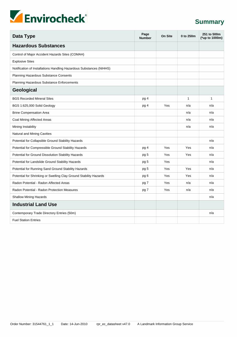
Order Number: 31544761_1_1 Date: 14-Jun-2010 rpr_ec_datasheet v47.0 A Landmark Information Group Service
Summary
Data Type PageNumber On Site 0 to 250m
Hazardous Substances
Geological
Industrial Land Use
251 to 500m
Control of Major Accident Hazards Sites (COMAH)
Explosive Sites
Notification of Installations Handling Hazardous Substances (NIHHS)
Planning Hazardous Substance Consents
Planning Hazardous Substance Enforcements
BGS Recorded Mineral Sites
BGS 1:625,000 Solid Geology
Brine Compensation Area
Coal Mining Affected Areas
Mining Instability
Natural and Mining Cavities
Potential for Collapsible Ground Stability Hazards
Potential for Compressible Ground Stability Hazards
Potential for Ground Dissolution Stability Hazards
Potential for Landslide Ground Stability Hazards
Potential for Running Sand Ground Stability Hazards
Potential for Shrinking or Swelling Clay Ground Stability Hazards
Radon Potential - Radon Affected Areas
Radon Potential - Radon Protection Measures
Shallow Mining Hazards
Contemporary Trade Directory Entries (50m)
Fuel Station Entries
Yes
Yes
Yes
Yes
Yes
Yes
Yes
Yes
1
n/a
n/a
n/a
n/a
Yes
Yes
Yes
Yes
n/a
n/a
1
n/a
n/a
n/a
n/a
n/a
n/a
n/a
n/a
n/a
n/a
n/a
n/a
n/a
n/a
(*up to 1000m)
pg 4
pg 4
pg 4
pg 5
pg 5
pg 5
pg 6
pg 7
pg 7

Order Number: 31544761_1_1 Date: 14-Jun-2010 rpr_ec_datasheet v47.0 A Landmark Information Group Service
Summary
Data Type PageNumber On Site 0 to 250m
Sensitive Land Use
251 to 500m
Areas of Adopted Green Belt
Areas of Unadopted Green Belt
Areas of Outstanding Natural Beauty
Environmentally Sensitive Areas
Forest Parks
Local Nature Reserves
Marine Nature Reserves
National Nature Reserves
National Parks
Nitrate Sensitive Areas
Nitrate Vulnerable Zones
Ramsar Sites
Sites of Special Scientific Interest
Special Areas of Conservation
Special Protection Areas
1
1
(*up to 1000m)
pg 9
pg 9

Order Number: 31544761_1_1 Date: 14-Jun-2010 rpr_ec_datasheet v47.0 A Landmark Information Group Service Page 1 of 15
Agency & Hydrological
MapID Details
QuadrantReference(CompassDirection)
EstimatedDistanceFrom Site
Contact NGR
1
2
2
3
Discharge Consents
Discharge Consents
Discharge Consents
Local Authority Pollution Prevention and Controls
Nearest Surface Water Feature
D2NE(SE)
D3SW(SE)
D3SW(SE)
D2NE(SE)
D1NE(W)
0
389
389
0
0
1
1
1
2
-
Operator:Property Type:Location:
Authority:Catchment Area:Reference:Permit Version:Effective Date:Issued Date:Revocation Date:Discharge Type:DischargeEnvironment:Receiving Water:Status:
Positional Accuracy:
Operator:Property Type:Location:Authority:Catchment Area:Reference:Permit Version:Effective Date:Issued Date:Revocation Date:Discharge Type:DischargeEnvironment:Receiving Water:Status:
Positional Accuracy:
Operator:Property Type:Location:Authority:Catchment Area:Reference:Permit Version:Effective Date:Issued Date:Revocation Date:Discharge Type:DischargeEnvironment:Receiving Water:Status:Positional Accuracy:
Name:Location:Authority:Permit Reference:Dated:Process Type:Description:Status:Positional Accuracy:
A G Phipps, Esq.Domestic Property (Multiple)Home Farm Complex Home Farm Banbury Road Caversfield, BicesterOxfordshire Ox27 0tgEnvironment Agency, Thames RegionNot SuppliedCawm.0566119th November 200216th January 2003Not SuppliedSewage Discharges - Final/Treated Effluent - Not Water CompanyFreshwater Stream/River
The Town BrookNew Consent (Water Resources Act 1991, Section 88 & Schedule 10 asamended by Environment Act 1995)Located by supplier to within 10m
Mr. M.S. PurewalDomestic Property (Single)The Old Vicarage, Caversfield, Near Bicester, OxonEnvironment Agency, Thames RegionNot SuppliedCtwc.1546230th January 200730th January 200731st March 2019Sewage Discharges - Final/Treated Effluent - Not Water CompanyIrrigation Area
CornbrashModified (Water Resources Act 1991, Schedule 10 as amended byEnvironment Act 1995)Located by supplier to within 10m
Mr. M.S. PurewalDomestic Property (Single)The Old Vicarage, Caversfield, Near Bicester, OxonEnvironment Agency, Thames RegionNot GivenCTWC.1546127th March 198727th March 198730th January 2007Sewage Discharges - Final/Treated Effluent - Not Water CompanyIrrigation Area
CornbrashTransferred from COPA 1974Located by supplier to within 100m
Teslayne EngineeringUnit 4 The Courtyard, Caversfield, Bicester, Ox27 8tgCherwell District Council, Environmental Health DepartmentCDC P/WOB/011Not SuppliedLocal Authority Air Pollution ControlPG1/1Waste oil burners, less than 0.4MW net rated thermal inputApplication Not Yet AuthorisedManually positioned to the address or location
458020225040
458500224750
458500224750
458065225047
457282225207

Order Number: 31544761_1_1 Date: 14-Jun-2010 rpr_ec_datasheet v47.0 A Landmark Information Group Service Page 2 of 15
Agency & Hydrological
MapID Details
QuadrantReference(CompassDirection)
EstimatedDistanceFrom Site
Contact NGR
4Water Abstractions
Groundwater Vulnerability
Groundwater Vulnerability
Drift Deposits
Extreme Flooding from Rivers or Sea without Defences
Flooding from Rivers or Sea without Defences
Areas Benefiting from Flood Defences
Flood Water Storage Areas
Flood Defences
D1SW(SW)
D9SW(NW)
(SW)
D2NW(S)
D2NW(S)
0
0
0
0
0
1
1
1
1
1
Operator:Licence Number:Permit Version:Location:Authority:Abstraction:Abstraction Type:Source:Daily Rate (m3):Yearly Rate (m3):Details:Authorised Start:Authorised End:Permit Start Date:Permit End Date:Positional Accuracy:
GeologicalClassification:
Soil Classification:
Map Sheet:Scale:
GeologicalClassification:
Soil Classification:
Map Sheet:Scale:
Flood Plain Type:Boundary Accuracy:
Flood Plain Type:Boundary Accuracy:
W & W Malins28/39/14/0214100Lords Farm, Bicester (B)Environment Agency, Thames RegionGeneral Farming And DomesticWater may be abstracted from a single pointGroundwaterNot SuppliedNot SuppliedNot Supplied01 January31 December8th May 1967Not SuppliedLocated by supplier to within 10m
Minor Aquifer (Variably permeable) - These can be fractured or potentiallyfractured rocks, which do not have a high primary permeability, or otherformations of variable permeability including unconsolidated deposits.Although not producing large quantities of water for abstraction, they areimportant for local supplies and in supplying base flow to riversSoils of High Leaching Potential (H3)- Coarse textured or moderately shallowsoils which readily transmit non-absorbed pollutants and liquid discharges butwhich have some ability to attenuate absorbed pollutants because of theirlarge clay or organic matter contentsSheet 30 Northern Cotswolds1:100,000
Minor Aquifer (Variably permeable) - These can be fractured or potentiallyfractured rocks, which do not have a high primary permeability, or otherformations of variable permeability including unconsolidated deposits.Although not producing large quantities of water for abstraction, they areimportant for local supplies and in supplying base flow to riversSoils of High Leaching Potential (U) - Soil information for restored mineralworkings and urban areas is based on fewer observations than elsewhere. Aworst case vulnerability classification (H) assumed, until proved otherwiseSheet 30 Northern Cotswolds1:100,000
FluvialAs Supplied
FluvialAs Supplied
None
None
None
None
457000224600
457095225971
457122223946
457755224970
457765224965

Order Number: 31544761_1_1 Date: 14-Jun-2010 rpr_ec_datasheet v47.0 A Landmark Information Group Service Page 3 of 15
Waste
MapID Details
QuadrantReference(CompassDirection)
EstimatedDistanceFrom Site
Contact NGR
Local Authority Landfill Coverage
Local Authority Landfill Coverage
0
0
2
6
Name:
Name:
Cherwell District Council - Has supplied landfill data
Oxfordshire County Council - Has supplied landfill data
462905225299
462905225299

Order Number: 31544761_1_1 Date: 14-Jun-2010 rpr_ec_datasheet v47.0 A Landmark Information Group Service Page 4 of 15
Geological
MapID Details
QuadrantReference(CompassDirection)
EstimatedDistanceFrom Site
Contact NGR
5
6
BGS Recorded Mineral Sites
BGS Recorded Mineral Sites
BGS 1:625,000 Solid Geology
Coal Mining Affected Areas
Potential for Collapsible Ground Stability Hazards
Potential for Compressible Ground Stability Hazards
Potential for Compressible Ground Stability Hazards
Potential for Compressible Ground Stability Hazards
Potential for Compressible Ground Stability Hazards
Potential for Compressible Ground Stability Hazards
Potential for Compressible Ground Stability Hazards
Potential for Compressible Ground Stability Hazards
Potential for Compressible Ground Stability Hazards
Potential for Compressible Ground Stability Hazards
Potential for Compressible Ground Stability Hazards
Potential for Compressible Ground Stability Hazards
D2NE(SE)
D3NW(E)
D10NW(N)
D2NW(S)
D2NW(S)
D2NW(SE)
D2NW(SE)
D2NW(SE)
D2NW(S)
D2SW(S)
D2SW(S)
D2SW(S)
D2SW(S)
D2SW(S)
78
489
0
0
0
0
0
0
0
0
0
0
0
0
3
3
3
3
3
3
3
3
3
3
3
3
3
3
Site Name:Location:Source:Reference:Type:Status:Operator:Operator Location:Periodic Type:Geology:Commodity:Positional Accuracy:
Site Name:Location:Source:Reference:Type:Status:Operator:Operator Location:Periodic Type:Geology:Commodity:Positional Accuracy:
Description:
Hazard Potential:Source:
Hazard Potential:Source:
Hazard Potential:Source:
Hazard Potential:Source:
Hazard Potential:Source:
Hazard Potential:Source:
Hazard Potential:Source:
Hazard Potential:Source:
Hazard Potential:Source:
Hazard Potential:Source:
Hazard Potential:Source:
Home FarmCaversfield, Oxford, OxfordshireBritish Geological Survey, National Geoscience Information Service57403OpencastCeasedUnknown OperatorNot SuppliedJurassicCornbrash FormationLimestoneLocated by supplier to within 10m
Vicarage HouseCaversfield, Oxford, OxfordshireBritish Geological Survey, National Geoscience Information Service57411OpencastCeasedUnknown OperatorNot SuppliedJurassicCornbrash FormationLimestoneLocated by supplier to within 10m
Cornbrash
No HazardBritish Geological Survey, National Geoscience Information Service
No HazardBritish Geological Survey, National Geoscience Information Service
ModerateBritish Geological Survey, National Geoscience Information Service
ModerateBritish Geological Survey, National Geoscience Information Service
ModerateBritish Geological Survey, National Geoscience Information Service
ModerateBritish Geological Survey, National Geoscience Information Service
ModerateBritish Geological Survey, National Geoscience Information Service
ModerateBritish Geological Survey, National Geoscience Information Service
ModerateBritish Geological Survey, National Geoscience Information Service
ModerateBritish Geological Survey, National Geoscience Information Service
ModerateBritish Geological Survey, National Geoscience Information Service
In an area which may not be affected by coal mining
No Hazard
458187225056
458589225144
457764226276
457719225000
457719225000
457950225025
457925225000
457900224975
457825224950
457775224825
457750224775
457725224725
457719224675
457700224625

Order Number: 31544761_1_1 Date: 14-Jun-2010 rpr_ec_datasheet v47.0 A Landmark Information Group Service Page 5 of 15
Geological
MapID Details
QuadrantReference(CompassDirection)
EstimatedDistanceFrom Site
Contact NGR
Potential for Compressible Ground Stability Hazards
Potential for Compressible Ground Stability Hazards
Potential for Ground Dissolution Stability Hazards
Potential for Ground Dissolution Stability Hazards
Potential for Ground Dissolution Stability Hazards
Potential for Ground Dissolution Stability Hazards
Potential for Ground Dissolution Stability Hazards
Potential for Ground Dissolution Stability Hazards
Potential for Ground Dissolution Stability Hazards
Potential for Ground Dissolution Stability Hazards
Potential for Ground Dissolution Stability Hazards
Potential for Landslide Ground Stability Hazards
Potential for Landslide Ground Stability Hazards
Potential for Running Sand Ground Stability Hazards
Potential for Running Sand Ground Stability Hazards
Potential for Running Sand Ground Stability Hazards
Potential for Running Sand Ground Stability Hazards
Potential for Running Sand Ground Stability Hazards
Potential for Running Sand Ground Stability Hazards
Potential for Running Sand Ground Stability Hazards
Potential for Running Sand Ground Stability Hazards
D6NW(N)
D6NW(NE)
D2NW(S)
D1NE(SW)
D2NW(SE)
D2NW(S)
D2NW(S)
D2NE(SE)
D2NE(SE)
D6NW(N)
D6SE(NE)
D2NW(S)
D2NW(S)
D2NW(S)
D2NW(S)
D2NW(SE)
D2NW(SE)
D2NW(SE)
D2NW(S)
D2SW(S)
D2SW(S)
158
247
0
0
0
0
0
0
0
189
214
0
0
0
0
0
0
0
0
0
0
3
3
3
3
3
3
3
3
3
3
3
3
3
3
3
3
3
3
3
3
3
Hazard Potential:Source:
Hazard Potential:Source:
Hazard Potential:Source:
Hazard Potential:Source:
Hazard Potential:Source:
Hazard Potential:Source:
Hazard Potential:Source:
Hazard Potential:Source:
Hazard Potential:Source:
Hazard Potential:Source:
Hazard Potential:Source:
Hazard Potential:Source:
Hazard Potential:Source:
Hazard Potential:Source:
Hazard Potential:Source:
Hazard Potential:Source:
Hazard Potential:Source:
Hazard Potential:Source:
Hazard Potential:Source:
Hazard Potential:Source:
Hazard Potential:Source:
ModerateBritish Geological Survey, National Geoscience Information Service
ModerateBritish Geological Survey, National Geoscience Information Service
Very LowBritish Geological Survey, National Geoscience Information Service
Very LowBritish Geological Survey, National Geoscience Information Service
No HazardBritish Geological Survey, National Geoscience Information Service
No HazardBritish Geological Survey, National Geoscience Information Service
No HazardBritish Geological Survey, National Geoscience Information Service
Very LowBritish Geological Survey, National Geoscience Information Service
Very LowBritish Geological Survey, National Geoscience Information Service
LowBritish Geological Survey, National Geoscience Information Service
LowBritish Geological Survey, National Geoscience Information Service
Very LowBritish Geological Survey, National Geoscience Information Service
Very LowBritish Geological Survey, National Geoscience Information Service
No HazardBritish Geological Survey, National Geoscience Information Service
No HazardBritish Geological Survey, National Geoscience Information Service
LowBritish Geological Survey, National Geoscience Information Service
LowBritish Geological Survey, National Geoscience Information Service
LowBritish Geological Survey, National Geoscience Information Service
LowBritish Geological Survey, National Geoscience Information Service
LowBritish Geological Survey, National Geoscience Information Service
LowBritish Geological Survey, National Geoscience Information Service
457750225750
457950225650
457650225075
457600224975
457950225100
457650225075
457719225000
458100225025
458025224950
457750225800
457975225575
457719225000
457719225000
457719225000
457719225000
457950225025
457925225000
457900224975
457825224950
457775224825
457750224775

Order Number: 31544761_1_1 Date: 14-Jun-2010 rpr_ec_datasheet v47.0 A Landmark Information Group Service Page 6 of 15
Geological
MapID Details
QuadrantReference(CompassDirection)
EstimatedDistanceFrom Site
Contact NGR
Potential for Running Sand Ground Stability Hazards
Potential for Running Sand Ground Stability Hazards
Potential for Running Sand Ground Stability Hazards
Potential for Running Sand Ground Stability Hazards
Potential for Running Sand Ground Stability Hazards
Potential for Shrinking or Swelling Clay Ground Stability Hazards
Potential for Shrinking or Swelling Clay Ground Stability Hazards
Potential for Shrinking or Swelling Clay Ground Stability Hazards
Potential for Shrinking or Swelling Clay Ground Stability Hazards
Potential for Shrinking or Swelling Clay Ground Stability Hazards
Potential for Shrinking or Swelling Clay Ground Stability Hazards
Potential for Shrinking or Swelling Clay Ground Stability Hazards
Potential for Shrinking or Swelling Clay Ground Stability Hazards
Potential for Shrinking or Swelling Clay Ground Stability Hazards
Potential for Shrinking or Swelling Clay Ground Stability Hazards
Potential for Shrinking or Swelling Clay Ground Stability Hazards
Potential for Shrinking or Swelling Clay Ground Stability Hazards
Potential for Shrinking or Swelling Clay Ground Stability Hazards
Potential for Shrinking or Swelling Clay Ground Stability Hazards
Radon Potential - Radon Affected Areas
D2SW(S)
D2SW(S)
D2SW(S)
D6NW(N)
D6NW(NE)
D2NE(SE)
D2NW(S)
D2NW(S)
D2NW(SE)
D2NW(SE)
D2NW(SE)
D2NW(S)
D2SW(S)
D2SW(S)
D2SW(S)
D2SW(S)
D2SW(S)
D6NW(N)
D6NW(NE)
D2NW(S)
0
0
0
158
247
0
0
0
0
0
0
0
0
0
0
0
0
158
247
0
3
3
3
3
3
3
3
3
3
3
3
3
3
3
3
3
3
3
3
3
Hazard Potential:Source:
Hazard Potential:Source:
Hazard Potential:Source:
Hazard Potential:Source:
Hazard Potential:Source:
Hazard Potential:Source:
Hazard Potential:Source:
Hazard Potential:Source:
Hazard Potential:Source:
Hazard Potential:Source:
Hazard Potential:Source:
Hazard Potential:Source:
Hazard Potential:Source:
Hazard Potential:Source:
Hazard Potential:Source:
Hazard Potential:Source:
Hazard Potential:Source:
Hazard Potential:Source:
Hazard Potential:Source:
Affected Area:
Source:
LowBritish Geological Survey, National Geoscience Information Service
LowBritish Geological Survey, National Geoscience Information Service
LowBritish Geological Survey, National Geoscience Information Service
LowBritish Geological Survey, National Geoscience Information Service
LowBritish Geological Survey, National Geoscience Information Service
No HazardBritish Geological Survey, National Geoscience Information Service
No HazardBritish Geological Survey, National Geoscience Information Service
No HazardBritish Geological Survey, National Geoscience Information Service
Very LowBritish Geological Survey, National Geoscience Information Service
Very LowBritish Geological Survey, National Geoscience Information Service
Very LowBritish Geological Survey, National Geoscience Information Service
Very LowBritish Geological Survey, National Geoscience Information Service
Very LowBritish Geological Survey, National Geoscience Information Service
Very LowBritish Geological Survey, National Geoscience Information Service
Very LowBritish Geological Survey, National Geoscience Information Service
Very LowBritish Geological Survey, National Geoscience Information Service
Very LowBritish Geological Survey, National Geoscience Information Service
Very LowBritish Geological Survey, National Geoscience Information Service
Very LowBritish Geological Survey, National Geoscience Information Service
The property is in a radon affected area, as between 3 and 5% of homes areabove the action levelBritish Geological Survey, National Geoscience Information Service
457725224725
457700224625
457719224675
457750225750
457950225650
458000225025
457719225000
457719225000
457950225025
457925225000
457900224975
457825224950
457775224825
457750224775
457725224725
457700224625
457719224675
457750225750
457950225650
457775225025

Order Number: 31544761_1_1 Date: 14-Jun-2010 rpr_ec_datasheet v47.0 A Landmark Information Group Service Page 7 of 15
Geological
MapID Details
QuadrantReference(CompassDirection)
EstimatedDistanceFrom Site
Contact NGR
Radon Potential - Radon Affected Areas
Radon Potential - Radon Affected Areas
Radon Potential - Radon Affected Areas
Radon Potential - Radon Affected Areas
Radon Potential - Radon Affected Areas
Radon Potential - Radon Affected Areas
Radon Potential - Radon Affected Areas
Radon Potential - Radon Affected Areas
Radon Potential - Radon Affected Areas
Radon Potential - Radon Affected Areas
Radon Potential - Radon Protection Measures
Radon Potential - Radon Protection Measures
Radon Potential - Radon Protection Measures
Radon Potential - Radon Protection Measures
Radon Potential - Radon Protection Measures
Radon Potential - Radon Protection Measures
D2NW(S)
D2SW(SE)
D1SE(S)
D2SW(S)
(SW)
D2NW(SW)
D2NW(S)
D2SW(S)
D2NW(SW)
D2NE(SE)
D2NW(S)
D2NW(S)
D2SW(SE)
D1SE(S)
D2SW(S)
(SW)
0
0
0
0
0
0
0
0
0
0
0
0
0
0
0
0
3
3
3
3
3
3
3
3
3
3
3
3
3
3
3
3
Affected Area:
Source:
Affected Area:
Source:
Affected Area:
Source:
Affected Area:
Source:
Affected Area:
Source:
Affected Area:
Source:
Affected Area:
Source:
Affected Area:
Source:
Affected Area:
Source:
Affected Area:
Source:
Protection Measure:
Source:
Protection Measure:
Source:
Protection Measure:
Source:
Protection Measure:
Source:
Protection Measure:
Source:
Protection Measure:
Source:
The property is in a radon affected area, as between 3 and 5% of homes areabove the action levelBritish Geological Survey, National Geoscience Information Service
The property is in a radon affected area, as between 1 and 3% of homes areabove the action levelBritish Geological Survey, National Geoscience Information Service
The property is not in a radon affected area, as less than 1% of homes areabove the action levelBritish Geological Survey, National Geoscience Information Service
The property is in a radon affected area, as between 1 and 3% of homes areabove the action levelBritish Geological Survey, National Geoscience Information Service
The property is in a radon affected area, as between 1 and 3% of homes areabove the action levelBritish Geological Survey, National Geoscience Information Service
The property is in a radon affected area, as between 1 and 3% of homes areabove the action levelBritish Geological Survey, National Geoscience Information Service
The property is in a radon affected area, as between 1 and 3% of homes areabove the action levelBritish Geological Survey, National Geoscience Information Service
The property is in a radon affected area, as between 1 and 3% of homes areabove the action levelBritish Geological Survey, National Geoscience Information Service
The property is not in a radon affected area, as less than 1% of homes areabove the action levelBritish Geological Survey, National Geoscience Information Service
The property is not in a radon affected area, as less than 1% of homes areabove the action levelBritish Geological Survey, National Geoscience Information Service
Basic radon protective measures are necessary in the construction of newdwellings or extensionsBritish Geological Survey, National Geoscience Information Service
Basic radon protective measures are necessary in the construction of newdwellings or extensionsBritish Geological Survey, National Geoscience Information Service
No radon protective measures are necessary in the construction of newdwellings or extensionsBritish Geological Survey, National Geoscience Information Service
No radon protective measures are necessary in the construction of newdwellings or extensionsBritish Geological Survey, National Geoscience Information Service
No radon protective measures are necessary in the construction of newdwellings or extensionsBritish Geological Survey, National Geoscience Information Service
No radon protective measures are necessary in the construction of newdwellings or extensionsBritish Geological Survey, National Geoscience Information Service
457750225000
457950224900
457575224900
457675224800
457325224475
457675225150
457719225000
457700224825
457675225150
458100224925
457775225025
457750225000
457950224900
457575224900
457675224800
457325224475
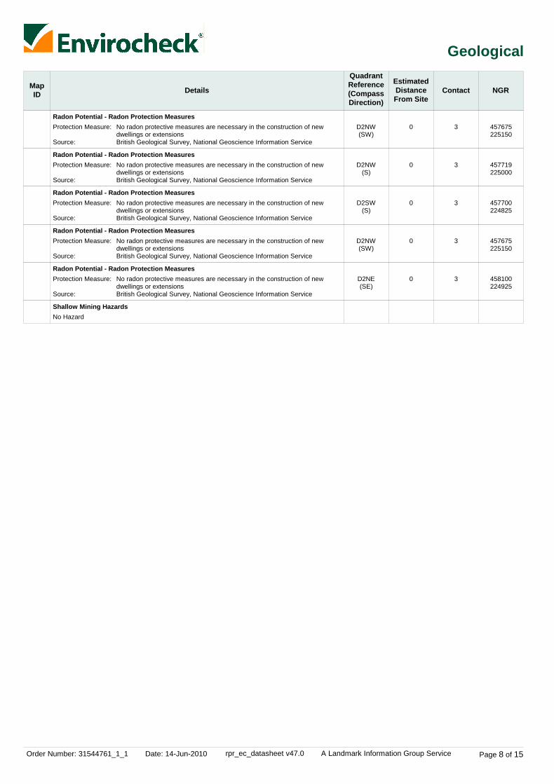
Order Number: 31544761_1_1 Date: 14-Jun-2010 rpr_ec_datasheet v47.0 A Landmark Information Group Service Page 8 of 15
Geological
MapID Details
QuadrantReference(CompassDirection)
EstimatedDistanceFrom Site
Contact NGR
Radon Potential - Radon Protection Measures
Radon Potential - Radon Protection Measures
Radon Potential - Radon Protection Measures
Radon Potential - Radon Protection Measures
Radon Potential - Radon Protection Measures
Shallow Mining Hazards
D2NW(SW)
D2NW(S)
D2SW(S)
D2NW(SW)
D2NE(SE)
0
0
0
0
0
3
3
3
3
3
Protection Measure:
Source:
Protection Measure:
Source:
Protection Measure:
Source:
Protection Measure:
Source:
Protection Measure:
Source:
No radon protective measures are necessary in the construction of newdwellings or extensionsBritish Geological Survey, National Geoscience Information Service
No radon protective measures are necessary in the construction of newdwellings or extensionsBritish Geological Survey, National Geoscience Information Service
No radon protective measures are necessary in the construction of newdwellings or extensionsBritish Geological Survey, National Geoscience Information Service
No radon protective measures are necessary in the construction of newdwellings or extensionsBritish Geological Survey, National Geoscience Information Service
No radon protective measures are necessary in the construction of newdwellings or extensionsBritish Geological Survey, National Geoscience Information Service
No Hazard
457675225150
457719225000
457700224825
457675225150
458100224925

Order Number: 31544761_1_1 Date: 14-Jun-2010 rpr_ec_datasheet v47.0 A Landmark Information Group Service Page 9 of 15
Sensitive Land Use
MapID Details
QuadrantReference(CompassDirection)
EstimatedDistanceFrom Site
Contact NGR
7
8
Local Nature Reserves
Nitrate Vulnerable Zones
(S)
(N)
53
0
4
5
Name:Multiple Area:Area (m2):Source:Designation Date:
Name:Description:Source:
Bure ParkN83957.83Natural England5th December 2005
Not SuppliedSurface Water - Designated 2006Department for Environment, Food and Rural Affairs (DEFRA - formerlyFRCA)
457632224175
458282227852

Order Number: 31544761_1_1 Date: 14-Jun-2010 rpr_ec_datasheet v47.0 A Landmark Information Group Service Page 10 of 15
Data Currency
Agency & Hydrological Version Update CycleContaminated Land Register Entries and Notices
Discharge Consents
Enforcement and Prohibition Notices
Integrated Pollution Controls
Integrated Pollution Prevention And Control
Local Authority Integrated Pollution Prevention And Control
Local Authority Pollution Prevention and Controls
Local Authority Pollution Prevention and Control Enforcements
Nearest Surface Water Feature
Pollution Incidents to Controlled Waters
Prosecutions Relating to Authorised Processes
Prosecutions Relating to Controlled Waters
Registered Radioactive Substances
River Quality
River Quality Biology Sampling Points
River Quality Chemistry Sampling Points
Substantiated Pollution Incident Register
Water Abstractions
Water Industry Act Referrals
Groundwater Vulnerability
Drift Deposits
Source Protection Zones
Extreme Flooding from Rivers or Sea without Defences
Flooding from Rivers or Sea without Defences
February 2010
April 2010April 2010
May 2010
October 2008
April 2010
April 2009
April 2009
April 2009
February 2010
September 1999September 1999
March 2010
May 2010
April 2010
November 2001
January 2010
January 2010
April 2010
April 2010April 2010
January 2010
January 1999
January 1999
April 2010
March 2010
March 2010
Annual Rolling Update
QuarterlyQuarterly
Quarterly
Not Applicable
Quarterly
Annual Rolling Update
Annual Rolling Update
Annual Rolling Update
Quarterly
Not ApplicableNot Applicable
Monthly
Monthly
Quarterly
Not Applicable
Annually
Annually
Quarterly
QuarterlyQuarterly
Quarterly
Not Applicable
Not Applicable
Quarterly
Quarterly
Quarterly
Cherwell District Council - Environmental Health Department
Environment Agency - Anglian RegionEnvironment Agency - Thames Region
Environment Agency - Thames Region
Environment Agency - Thames Region
Environment Agency - Thames Region
Cherwell District Council - Environmental Health Department
Cherwell District Council - Environmental Health Department
Cherwell District Council - Environmental Health Department
Ordnance Survey
Environment Agency - Anglian RegionEnvironment Agency - Thames Region
Environment Agency - Thames Region
Environment Agency - Thames Region
Environment Agency - Thames Region
Environment Agency - Head Office
Environment Agency - Head Office
Environment Agency - Head Office
Environment Agency - Thames Region - West Area
Environment Agency - Anglian RegionEnvironment Agency - Thames Region
Environment Agency - Thames Region
Environment Agency - Head Office
Environment Agency - Head Office
Environment Agency - Head Office
Environment Agency - Head Office
Environment Agency - Head Office

Order Number: 31544761_1_1 Date: 14-Jun-2010 rpr_ec_datasheet v47.0 A Landmark Information Group Service Page 11 of 15
Data Currency
Agency & Hydrological
Waste
Hazardous Substances
Version
Version
Version
Update Cycle
Update Cycle
Update Cycle
Areas Benefiting from Flood Defences
Flood Water Storage Areas
Flood Defences
BGS Recorded Landfill Sites
Historical Landfill Sites
Integrated Pollution Control Registered Waste Sites
Licensed Waste Management Facilities (Landfill Boundaries)
Licensed Waste Management Facilities (Locations)
Local Authority Landfill Coverage
Local Authority Recorded Landfill Sites
Registered Landfill Sites
Registered Waste Transfer Sites
Registered Waste Treatment or Disposal Sites
Control of Major Accident Hazards Sites (COMAH)
Explosive Sites
Notification of Installations Handling Hazardous Substances (NIHHS)
Planning Hazardous Substance Enforcements
Planning Hazardous Substance Consents
March 2010
March 2010
March 2010
June 1996
April 2010
October 2008
April 2010
April 2010
May 2000May 2000
May 2000May 2000
March 2003
March 2003
March 2003
May 2010
January 2009
November 2000
July 2009October 2009
July 2009October 2009
Quarterly
Quarterly
Quarterly
Not Applicable
Quarterly
Not Applicable
Quarterly
Quarterly
Not ApplicableNot Applicable
Not ApplicableNot Applicable
Not Applicable
Not Applicable
Not Applicable
Bi-Annually
Bi-Annually
Not Applicable
Annual Rolling UpdateAnnual Rolling Update
Annual Rolling UpdateAnnual Rolling Update
Environment Agency - Head Office
Environment Agency - Head Office
Environment Agency - Head Office
British Geological Survey - National Geoscience Information Service
Environment Agency - Thames Region - West Area
Environment Agency - Thames Region
Environment Agency - Thames Region - West Area
Environment Agency - Thames Region - West Area
Cherwell District Council - Environmental Health DepartmentOxfordshire County Council
Cherwell District Council - Environmental Health DepartmentOxfordshire County Council
Environment Agency - Thames Region - West Area
Environment Agency - Thames Region - West Area
Environment Agency - Thames Region - West Area
Health and Safety Executive
Health and Safety Executive
Health and Safety Executive
Cherwell District CouncilOxfordshire County Council
Cherwell District CouncilOxfordshire County Council

Order Number: 31544761_1_1 Date: 14-Jun-2010 rpr_ec_datasheet v47.0 A Landmark Information Group Service Page 12 of 15
Data Currency
Geological
Industrial Land Use
Version
Version
Update Cycle
Update Cycle
BGS Recorded Mineral Sites
BGS 1:625,000 Solid Geology
Brine Compensation Area
Coal Mining Affected Areas
Mining Instability
Natural and Mining Cavities
Potential for Collapsible Ground Stability Hazards
Potential for Compressible Ground Stability Hazards
Potential for Ground Dissolution Stability Hazards
Potential for Landslide Ground Stability Hazards
Potential for Running Sand Ground Stability Hazards
Potential for Shrinking or Swelling Clay Ground Stability Hazards
Radon Potential - Radon Affected Areas
Radon Potential - Radon Protection Measures
Shallow Mining Hazards
Contemporary Trade Directory Entries
Fuel Station Entries
April 2010
August 1996
November 2002
January 2006
October 2000
November 2009
January 2009
January 2009
January 2009
January 2009
January 2009
January 2009
May 2007
May 2007
August 2002
March 2010
February 2010
Bi-Annually
Not Applicable
Not Applicable
As notified
Not Applicable
Bi-Annually
Annually
Annually
Annually
Annually
Annually
Annually
As notified
As notified
Not Applicable
Quarterly
Quarterly
British Geological Survey - National Geoscience Information Service
British Geological Survey - National Geoscience Information Service
Cheshire Brine Subsidence Compensation Board
The Coal Authority - Mining Report Service
Ove Arup & Partners
Peter Brett Associates
British Geological Survey - National Geoscience Information Service
British Geological Survey - National Geoscience Information Service
British Geological Survey - National Geoscience Information Service
British Geological Survey - National Geoscience Information Service
British Geological Survey - National Geoscience Information Service
British Geological Survey - National Geoscience Information Service
British Geological Survey - National Geoscience Information Service
British Geological Survey - National Geoscience Information Service
British Geological Survey - National Geoscience Information Service
Thomson Directories
Catalist Ltd - Experian Catalist

Order Number: 31544761_1_1 Date: 14-Jun-2010 rpr_ec_datasheet v47.0 A Landmark Information Group Service Page 13 of 15
Data Currency
Sensitive Land Use Version Update CycleAreas of Adopted Green Belt
Areas of Unadopted Green Belt
Areas of Outstanding Natural Beauty
Environmentally Sensitive Areas
Forest Parks
Local Nature Reserves
Marine Nature Reserves
National Nature Reserves
National Parks
Nitrate Sensitive Areas
Nitrate Vulnerable Zones
Ramsar Sites
Sites of Special Scientific Interest
Special Areas of Conservation
Special Protection Areas
March 2010
March 2010
December 2009
December 2009
April 1997
December 2009
September 2009
December 2009
December 2009
December 2009
February 2009
December 2009
December 2009
December 2009
December 2009
As notified
As notified
Bi-Annually
Annually
Not Applicable
Bi-Annually
Bi-Annually
Bi-Annually
Bi-Annually
Not Applicable
Annually
Bi-Annually
Bi-Annually
Bi-Annually
Bi-Annually
Cherwell District Council
Cherwell District Council
Natural England
Natural England
Forestry Commission
Natural England
Natural England
Natural England
Natural England
Department for Environment, Food and Rural Affairs (DEFRA - formerly FRCA)
Department for Environment, Food and Rural Affairs (DEFRA - formerly FRCA)
Natural England
Natural England
Natural England
Natural England

Order Number: 31544761_1_1 Date: 14-Jun-2010 rpr_ec_datasheet v47.0 A Landmark Information Group Service Page 14 of 15
Data Suppliers
Ordnance Survey
Environment Agency
Scottish Environment Protection Agency
The Coal Authority
British Geological Survey
Centre for Ecology and Hydrology
Countryside Council for Wales
Scottish Natural Heritage
Natural England
Health Protection Agency
Ove Arup
Peter Brett Associates
Data Supplier Data Supplier Logo
A selection of organisations who provide data within this report

Order Number: 31544761_1_1 Date: 14-Jun-2010 rpr_ec_datasheet v47.0 A Landmark Information Group Service Page 15 of 15
Useful Contacts
Contact Name and Address Contact Details
1
2
3
4
5
6
-
-
Environment Agency - National Customer ContactCentre (NCCC)
Cherwell District Council - Environmental HealthDepartment
British Geological Survey - Enquiry Service
Natural England
Department for Environment, Food and Rural Affairs(DEFRA - formerly FRCA)
Oxfordshire County Council
Health Protection Agency - Radon Survey, Centre forRadiation, Chemical and Environmental Hazards
Landmark Information Group Limited
PO Box 544, Templeborough, Rotherham, S60 1BY
Bodicote House, Bodicote, Banbury, Oxfordshire, OX15 4AA
British Geological Survey, Kingsley Dunham Centre, Keyworth,Nottingham, Nottinghamshire, NG12 5GG
Northminster House, Northminster Road, Peterborough, Cambridgeshire,PE1 1UA
Government Buildings, Otley Road, Lawnswood, Leeds, West Yorkshire,LS16 5QT
County Hall, New Road, Oxford, Oxfordshire, OX1 1ND
Chilton, Didcot, Oxfordshire, OX11 0RQ
The Smith Centre, Henley On Thames, Oxfordshire, RG9 6AB
Telephone: 08708 506 506Email: [email protected]
Telephone: 01295 252535 extn 4511Fax: 01295 270028Website: www.cherwell-dc.gov.uk
Telephone: 0115 936 3143Fax: 0115 936 3276Email: [email protected]: www.bgs.ac.uk
Telephone: 0845 600 3078Fax: 01733 455103Email: [email protected]: www.naturalengland.org.uk
Telephone: 0113 2613333Fax: 0113 230 0879
Telephone: 01865 792422Fax: 01865 810106Email: [email protected]: www.oxfordshire.gov.uk
Telephone: 01235 822622Fax: 01235 833891Email: [email protected]: www.hpa.org.uk
Telephone: 0844 844 9952Fax: 0844 844 9951Email: [email protected]: www.landmarkinfo.co.uk
Please note that the Environment Agency / SEPA have a charging policy in place for enquiries.

Order Details
Site DetailsSite at, Bicester, Oxfordshire
Order Number:Customer Ref:National Grid Reference:Slice:Site Area (Ha):Search Buffer (m):
31544761_1_1UA001881455870, 223500A395.55500
Tel:Fax:Web:
0844 844 99520844 844 9951www.envirocheck.co.uk
Page 1 of 3A Landmark Information Group Service v12.0 14-Jun-2010
Site Sensitivity Context Map - Slice A
Groundwater Vulnerability

Order Details
Site DetailsSite at, Bicester, Oxfordshire
Order Number:Customer Ref:National Grid Reference:Slice:Site Area (Ha):Search Buffer (m):
31544761_1_1UA001881455870, 223500A395.55500
Tel:Fax:Web:
0844 844 99520844 844 9951www.envirocheck.co.uk
Page 2 of 3A Landmark Information Group Service v12.0 14-Jun-2010
Site Sensitivity Context Map - Slice A
Source Protection Zones

Order Details
Site DetailsSite at, Bicester, Oxfordshire
Order Number:Customer Ref:National Grid Reference:Slice:Site Area (Ha):Search Buffer (m):
31544761_1_1UA001881455870, 223500A395.55500
Tel:Fax:Web:
0844 844 99520844 844 9951www.envirocheck.co.uk
Page 3 of 3A Landmark Information Group Service v12.0 14-Jun-2010
Site Sensitivity Context Map - Slice A
Sensitive Land Uses

Order Details
Site DetailsSite at, Bicester, Oxfordshire
Order Number:Customer Ref:National Grid Reference:Slice:Site Area (Ha):Search Buffer (m):
31544761_1_1UA001881457570, 224010B395.55500
Tel:Fax:Web:
0844 844 99520844 844 9951www.envirocheck.co.uk
Page 1 of 3A Landmark Information Group Service v12.0 14-Jun-2010
Site Sensitivity Context Map - Slice B
Groundwater Vulnerability

Order Details
Site DetailsSite at, Bicester, Oxfordshire
Order Number:Customer Ref:National Grid Reference:Slice:Site Area (Ha):Search Buffer (m):
31544761_1_1UA001881457570, 224010B395.55500
Tel:Fax:Web:
0844 844 99520844 844 9951www.envirocheck.co.uk
Page 2 of 3A Landmark Information Group Service v12.0 14-Jun-2010
Site Sensitivity Context Map - Slice B
Source Protection Zones
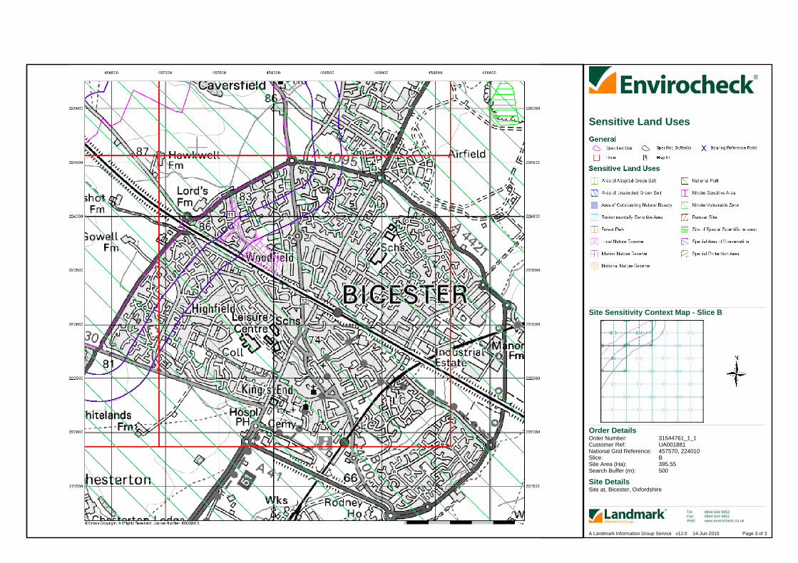
Order Details
Site DetailsSite at, Bicester, Oxfordshire
Order Number:Customer Ref:National Grid Reference:Slice:Site Area (Ha):Search Buffer (m):
31544761_1_1UA001881457570, 224010B395.55500
Tel:Fax:Web:
0844 844 99520844 844 9951www.envirocheck.co.uk
Page 3 of 3A Landmark Information Group Service v12.0 14-Jun-2010
Site Sensitivity Context Map - Slice B
Sensitive Land Uses

Order Details
Site DetailsSite at, Bicester, Oxfordshire
Order Number:Customer Ref:National Grid Reference:Slice:Site Area (Ha):Search Buffer (m):
31544761_1_1UA001881456330, 224990C395.55500
Tel:Fax:Web:
0844 844 99520844 844 9951www.envirocheck.co.uk
Page 1 of 3A Landmark Information Group Service v12.0 14-Jun-2010
Site Sensitivity Context Map - Slice C
Groundwater Vulnerability

Order Details
Site DetailsSite at, Bicester, Oxfordshire
Order Number:Customer Ref:National Grid Reference:Slice:Site Area (Ha):Search Buffer (m):
31544761_1_1UA001881456330, 224990C395.55500
Tel:Fax:Web:
0844 844 99520844 844 9951www.envirocheck.co.uk
Page 2 of 3A Landmark Information Group Service v12.0 14-Jun-2010
Site Sensitivity Context Map - Slice C
Source Protection Zones
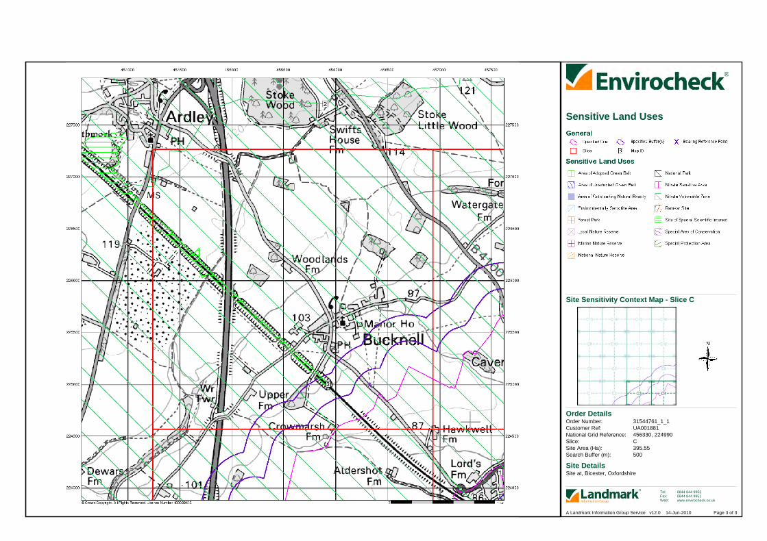
Order Details
Site DetailsSite at, Bicester, Oxfordshire
Order Number:Customer Ref:National Grid Reference:Slice:Site Area (Ha):Search Buffer (m):
31544761_1_1UA001881456330, 224990C395.55500
Tel:Fax:Web:
0844 844 99520844 844 9951www.envirocheck.co.uk
Page 3 of 3A Landmark Information Group Service v12.0 14-Jun-2010
Site Sensitivity Context Map - Slice C
Sensitive Land Uses