Embed Size (px)
Citation preview
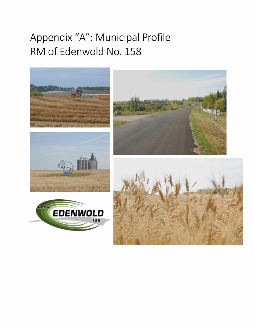
Appendix “A”: Municipal Profile RM of Edenwold No. 158
1
TABLE OF CONTENTS
Section 1: Purpose ……………………………………………………………………………………………………………………………….2
Section 2: Location, History, and Area Overview…………………………………………………………………………………..2
Section 3: Population …………………………………………………………………………………………………………………………..3
Section 4: Economy ……………………………………………………………………………………………………………………………..4
Section 5: Infrastructure and Services ………………………………………………………………………………………………….5
Section 6: Recreation and Community …………………………………………………………………………………………………6
Section 7: Community Development …………………………………………………………………………………………………...6
2
Section 1: Purpose
Understanding the social, economic, environmental and cultural characteristics is vital in the planning
process to not only inform decision making, but also to serve as baseline data to track changes within a
region. Projected trends can help municipal leaders anticipate future needs of the community so that
they may be accounted for in the long-term planning process. Furthermore, understanding the demands
and constraints placed on municipal services can help leaders to prioritize and plan effectively. It is
important to recognize that an OCP is not a static document and can be amended to respond to
unanticipated changes.
Section 2: Location, History and Area Overview
Location
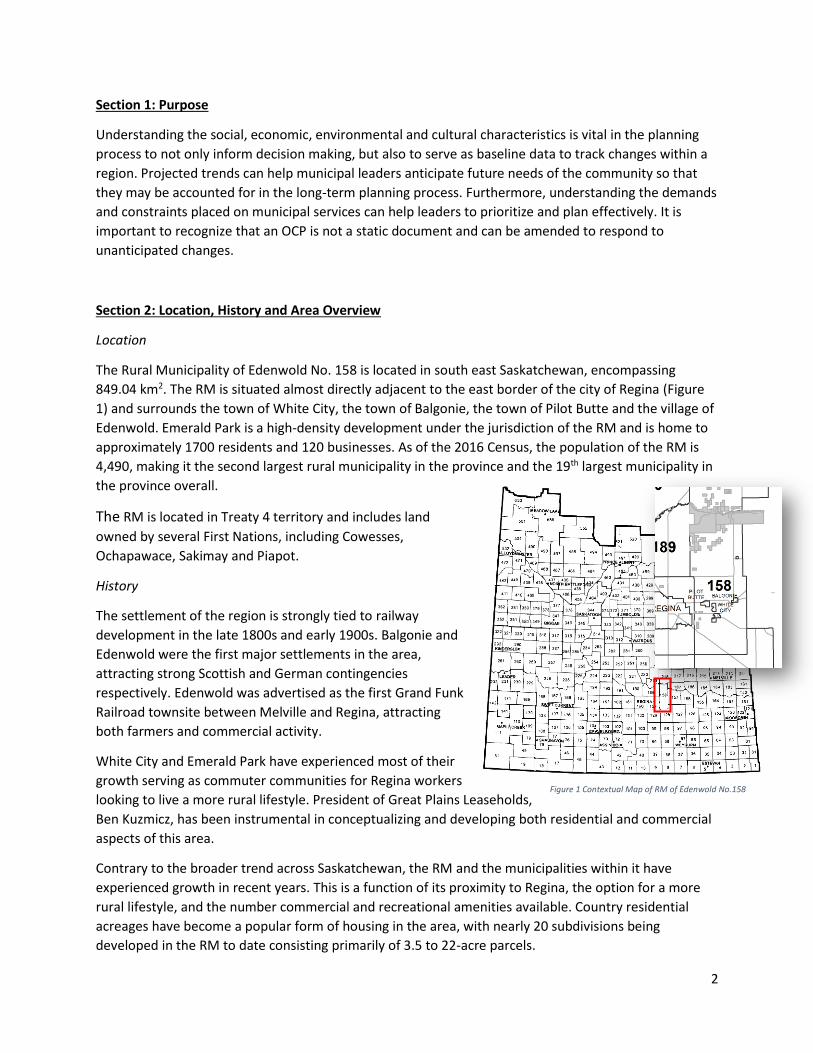
The Rural Municipality of Edenwold No. 158 is located in south east Saskatchewan, encompassing
849.04 km2. The RM is situated almost directly adjacent to the east border of the city of Regina (Figure
1) and surrounds the town of White City, the town of Balgonie, the town of Pilot Butte and the village of
Edenwold. Emerald Park is a high-density development under the jurisdiction of the RM and is home to
approximately 1700 residents and 120 businesses. As of the 2016 Census, the population of the RM is
4,490, making it the second largest rural municipality in the province and the 19th largest municipality in
the province overall.
The RM is located in Treaty 4 territory and includes land
owned by several First Nations, including Cowesses,
Ochapawace, Sakimay and Piapot.
History
The settlement of the region is strongly tied to railway
development in the late 1800s and early 1900s. Balgonie and
Edenwold were the first major settlements in the area,
attracting strong Scottish and German contingencies
respectively. Edenwold was advertised as the first Grand Funk
Railroad townsite between Melville and Regina, attracting
both farmers and commercial activity.
White City and Emerald Park have experienced most of their
growth serving as commuter communities for Regina workers
looking to live a more rural lifestyle. President of Great Plains Leaseholds,
Ben Kuzmicz, has been instrumental in conceptualizing and developing both residential and commercial
aspects of this area.
Contrary to the broader trend across Saskatchewan, the RM and the municipalities within it have
experienced growth in recent years. This is a function of its proximity to Regina, the option for a more
rural lifestyle, and the number commercial and recreational amenities available. Country residential
acreages have become a popular form of housing in the area, with nearly 20 subdivisions being
developed in the RM to date consisting primarily of 3.5 to 22-acre parcels.
Figure 1 Contextual Map of RM of Edenwold No.158
3
Environment
The RM is situated on the transitional border between the Moist Mixed Grassland ecoregion and the
Aspen Parkland ecoregion. Both ecoregions are characterized by intermittent sloughs and ponds,
productive agricultural soils, fescue grasslands, and nonarable pasture land. An extensive and variable
system of wetlands and run-off networks flows through the region. The RM is situated in the Qu’Appelle
River Basin. Drainage has been an issue over recent years of above average precipitation, and in some
cases, the problem has been exacerbated by alteration of natural drainage patterns by landowners.
The RM also includes the White Butte Trails Recreation Site, a naturalized area featuring 12.7km of all-
season hiking and cross-
country ski trails.
Section 3: Population
Demographic changes
are important to note to
ensure planning
decisions address the
changing needs of
residents.
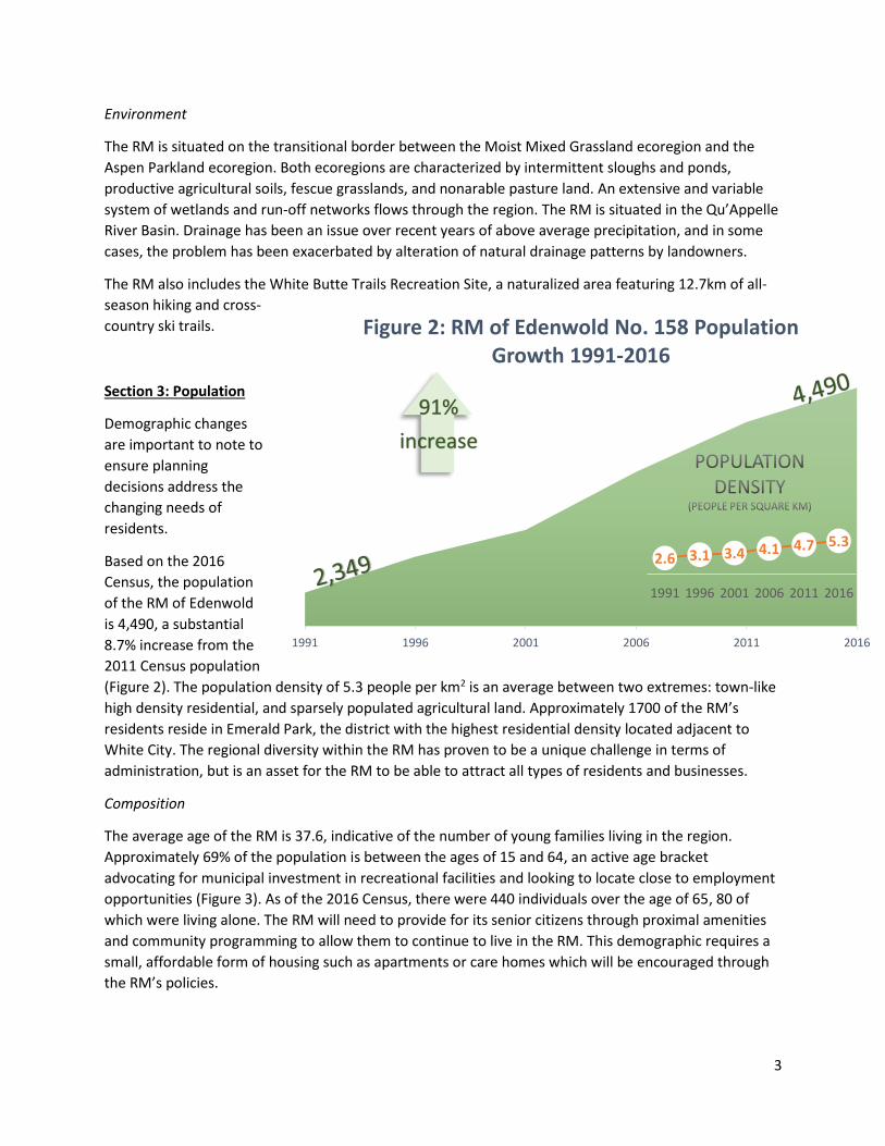
Based on the 2016
Census, the population
of the RM of Edenwold
is 4,490, a substantial
8.7% increase from the
2011 Census population
(Figure 2). The population density of 5.3 people per km2 is an average between two extremes: town-like
high density residential, and sparsely populated agricultural land. Approximately 1700 of the RM’s
residents reside in Emerald Park, the district with the highest residential density located adjacent to
White City. The regional diversity within the RM has proven to be a unique challenge in terms of
administration, but is an asset for the RM to be able to attract all types of residents and businesses.
Composition
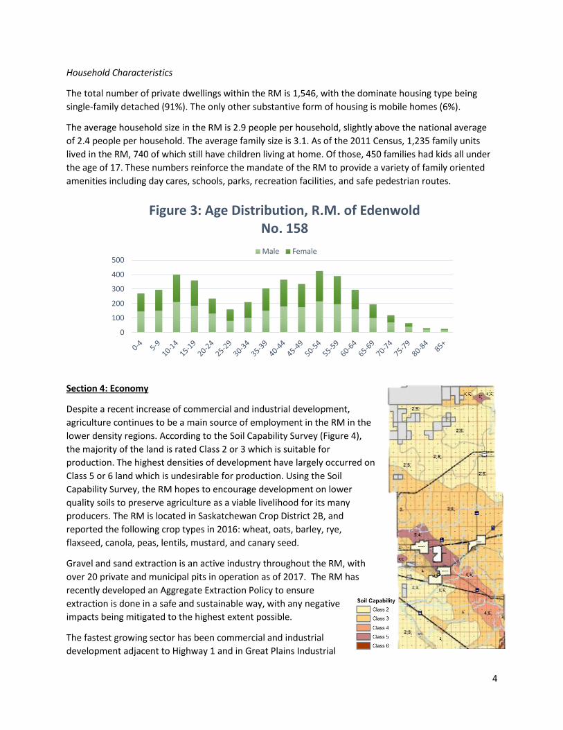
The average age of the RM is 37.6, indicative of the number of young families living in the region.
Approximately 69% of the population is between the ages of 15 and 64, an active age bracket
advocating for municipal investment in recreational facilities and looking to locate close to employment
opportunities (Figure 3). As of the 2016 Census, there were 440 individuals over the age of 65, 80 of
which were living alone. The RM will need to provide for its senior citizens through proximal amenities
and community programming to allow them to continue to live in the RM. This demographic requires a
small, affordable form of housing such as apartments or care homes which will be encouraged through
the RM’s policies.
1991 1996 2001 2006 2011 2016
Figure 2: RM of Edenwold No. 158 Population Growth 1991-2016
2.6 3.1 3.4 4.1 4.7 5.3
1991 1996 2001 2006 2011 2016
91%
increase
4
Household Characteristics
The total number of private dwellings within the RM is 1,546, with the dominate housing type being
single-family detached (91%). The only other substantive form of housing is mobile homes (6%).
The average household size in the RM is 2.9 people per household, slightly above the national average
of 2.4 people per household. The average family size is 3.1. As of the 2011 Census, 1,235 family units
lived in the RM, 740 of which still have children living at home. Of those, 450 families had kids all under
the age of 17. These numbers reinforce the mandate of the RM to provide a variety of family oriented
amenities including day cares, schools, parks, recreation facilities, and safe pedestrian routes.
Section 4: Economy
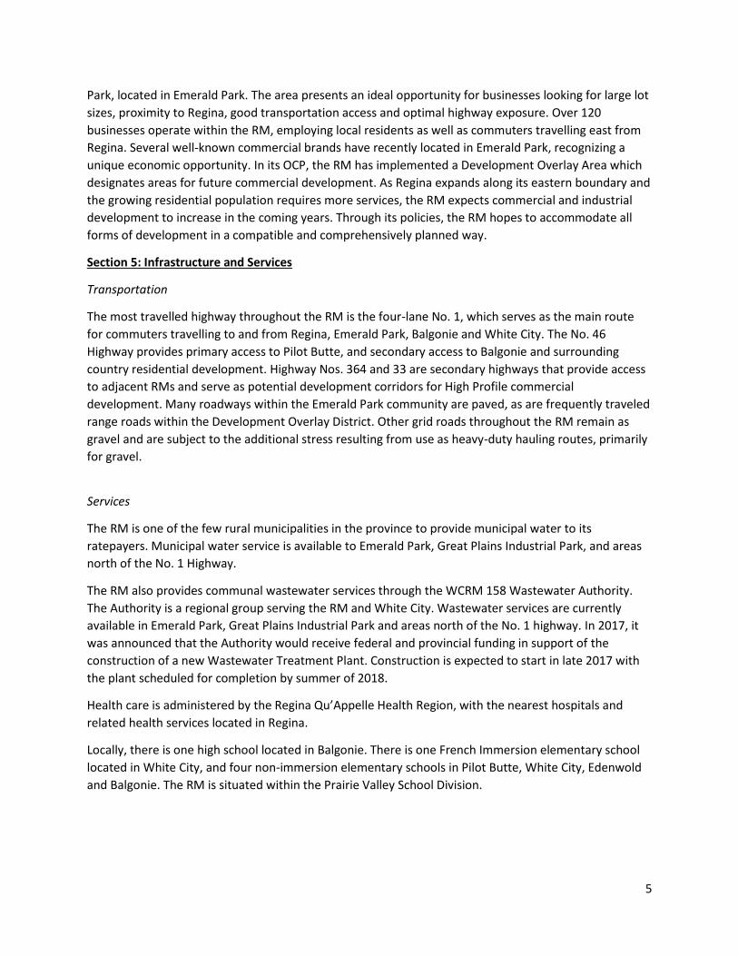
Despite a recent increase of commercial and industrial development,
agriculture continues to be a main source of employment in the RM in the
lower density regions. According to the Soil Capability Survey (Figure 4),
the majority of the land is rated Class 2 or 3 which is suitable for
production. The highest densities of development have largely occurred on
Class 5 or 6 land which is undesirable for production. Using the Soil
Capability Survey, the RM hopes to encourage development on lower
quality soils to preserve agriculture as a viable livelihood for its many
producers. The RM is located in Saskatchewan Crop District 2B, and
reported the following crop types in 2016: wheat, oats, barley, rye,
flaxseed, canola, peas, lentils, mustard, and canary seed.
Gravel and sand extraction is an active industry throughout the RM, with
over 20 private and municipal pits in operation as of 2017. The RM has
recently developed an Aggregate Extraction Policy to ensure
extraction is done in a safe and sustainable way, with any negative
impacts being mitigated to the highest extent possible.
The fastest growing sector has been commercial and industrial
development adjacent to Highway 1 and in Great Plains Industrial
0
100
200
300
400
500
Figure 3: Age Distribution, R.M. of Edenwold No. 158
Male Female
5
Park, located in Emerald Park. The area presents an ideal opportunity for businesses looking for large lot
sizes, proximity to Regina, good transportation access and optimal highway exposure. Over 120
businesses operate within the RM, employing local residents as well as commuters travelling east from
Regina. Several well-known commercial brands have recently located in Emerald Park, recognizing a
unique economic opportunity. In its OCP, the RM has implemented a Development Overlay Area which
designates areas for future commercial development. As Regina expands along its eastern boundary and
the growing residential population requires more services, the RM expects commercial and industrial
development to increase in the coming years. Through its policies, the RM hopes to accommodate all
forms of development in a compatible and comprehensively planned way.
Section 5: Infrastructure and Services
Transportation
The most travelled highway throughout the RM is the four-lane No. 1, which serves as the main route
for commuters travelling to and from Regina, Emerald Park, Balgonie and White City. The No. 46
Highway provides primary access to Pilot Butte, and secondary access to Balgonie and surrounding
country residential development. Highway Nos. 364 and 33 are secondary highways that provide access
to adjacent RMs and serve as potential development corridors for High Profile commercial
development. Many roadways within the Emerald Park community are paved, as are frequently traveled
range roads within the Development Overlay District. Other grid roads throughout the RM remain as
gravel and are subject to the additional stress resulting from use as heavy-duty hauling routes, primarily
for gravel.
Services
The RM is one of the few rural municipalities in the province to provide municipal water to its
ratepayers. Municipal water service is available to Emerald Park, Great Plains Industrial Park, and areas
north of the No. 1 Highway.
The RM also provides communal wastewater services through the WCRM 158 Wastewater Authority.
The Authority is a regional group serving the RM and White City. Wastewater services are currently
available in Emerald Park, Great Plains Industrial Park and areas north of the No. 1 highway. In 2017, it
was announced that the Authority would receive federal and provincial funding in support of the
construction of a new Wastewater Treatment Plant. Construction is expected to start in late 2017 with
the plant scheduled for completion by summer of 2018.
Health care is administered by the Regina Qu’Appelle Health Region, with the nearest hospitals and
related health services located in Regina.
Locally, there is one high school located in Balgonie. There is one French Immersion elementary school
located in White City, and four non-immersion elementary schools in Pilot Butte, White City, Edenwold
and Balgonie. The RM is situated within the Prairie Valley School Division.
6
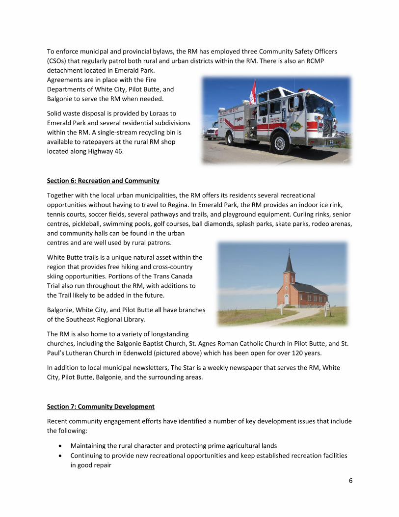
To enforce municipal and provincial bylaws, the RM has employed three Community Safety Officers
(CSOs) that regularly patrol both rural and urban districts within the RM. There is also an RCMP
detachment located in Emerald Park.
Agreements are in place with the Fire
Departments of White City, Pilot Butte, and
Balgonie to serve the RM when needed.
Solid waste disposal is provided by Loraas to
Emerald Park and several residential subdivisions
within the RM. A single-stream recycling bin is
available to ratepayers at the rural RM shop
located along Highway 46.
Section 6: Recreation and Community
Together with the local urban municipalities, the RM offers its residents several recreational
opportunities without having to travel to Regina. In Emerald Park, the RM provides an indoor ice rink,
tennis courts, soccer fields, several pathways and trails, and playground equipment. Curling rinks, senior
centres, pickleball, swimming pools, golf courses, ball diamonds, splash parks, skate parks, rodeo arenas,
and community halls can be found in the urban
centres and are well used by rural patrons.
White Butte trails is a unique natural asset within the
region that provides free hiking and cross-country
skiing opportunities. Portions of the Trans Canada
Trial also run throughout the RM, with additions to
the Trail likely to be added in the future.
Balgonie, White City, and Pilot Butte all have branches
of the Southeast Regional Library.
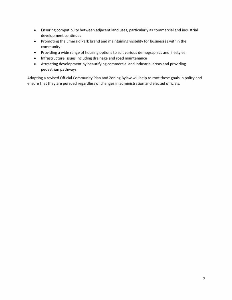
The RM is also home to a variety of longstanding
churches, including the Balgonie Baptist Church, St. Agnes Roman Catholic Church in Pilot Butte, and St.
Paul’s Lutheran Church in Edenwold (pictured above) which has been open for over 120 years.
In addition to local municipal newsletters, The Star is a weekly newspaper that serves the RM, White
City, Pilot Butte, Balgonie, and the surrounding areas.
Section 7: Community Development
Recent community engagement efforts have identified a number of key development issues that include
the following:
• Maintaining the rural character and protecting prime agricultural lands
• Continuing to provide new recreational opportunities and keep established recreation facilities
in good repair
7
• Ensuring compatibility between adjacent land uses, particularly as commercial and industrial
development continues
• Promoting the Emerald Park brand and maintaining visibility for businesses within the
community
• Providing a wide range of housing options to suit various demographics and lifestyles
• Infrastructure issues including drainage and road maintenance
• Attracting development by beautifying commercial and industrial areas and providing
pedestrian pathways
Adopting a revised Official Community Plan and Zoning Bylaw will help to root these goals in policy and
ensure that they are pursued regardless of changes in administration and elected officials.