Embed Size (px)
Citation preview

Appendix A
Project Mapping
NY
NJ
PA
CT
MA
NH
RI
VT
NY
DE
Glenbrook Substation
South EndSubstation
Figure 1
Path
: Y:\P
roje
cts\
Nor
thE
ast_
Util
ities
\Sta
mfo
rd_R
elia
bilit
y_C
able
_Pro
ject
\MX
D\C
SC_M
appi
ng\2
013_
01\F
ig_1
_Sta
mfo
rd_S
ite_L
ocat
ion_
Map
.mxd
Map LocationStamford Reliability Cable Project
Stamford, CT
Site Location
0 2,0001,000Feet
Scale: 1:24,000(1 inch = 2,000 ft)
Map Projection: State Plane CT, NAD83, US Feet.Image Source: ESRI ArcGIS Online Imagery Server.
PREFERRED ROUTEPREFERRED ROUTEWITH VARIATION
ALTERNATE ROUTE
Legend
January 10 2013
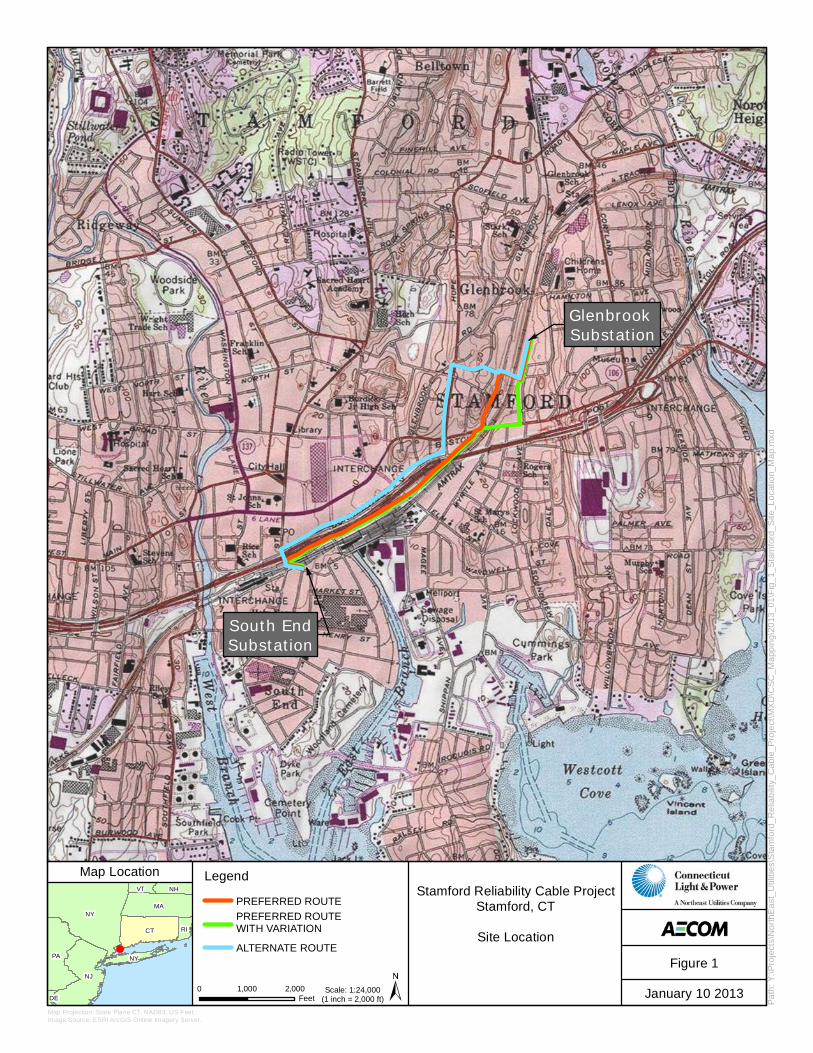
Glenbrook Substation
South End Substation
SUT I
SUT II
METRO-NORTH RAILROAD
NEW YORK, NEW H
AVEN, A
ND
HARTFORD RAILR
OAD CATENARY S
YSTEM
951
N State St
St MarysChurch
E Main St
95N State St
Daskam Park
Cemetery(Hill Avenue)(Cemetery)
Burdick JuniorHigh School
(School)
CloonanMiddle School
(School)
Stamford High School(School)
Hart School(School)
Town Hall Park(Existing Preserved
Open Space)
Edward HuntRecreation Area
(Existing PreservedOpen Space)
Tresser BoulevardPlaygrounds
(Existing PreservedOpen Space)
Rotary Park(Existing Preserved
Open Space)
Cemetery(North Street)(Cemetery)
Mill River Park(Existing Preserved
Open Space)
Rogers School(Elementary
Magnet School)
Roger Smith Park(Existing Preserved
Open Space)
Columbus Park(Existing Preserved
Open Space)
Kiwanis Park(Existing Preserved
Open Space)
Cemetery(Franklin Street)
(Cemetery)
DashamPark
( )
MARK OFEXCELLENCE
UBS CHILDDEVELOPMENTCENTER
LEADACADEMY
BRIGHTMINDS
Orange St
N State St
Rid
ge P
l
Soundview Ave
Woodrow St
Gay St C
randall St
Sheridan St
Cla
rk S
t
West St
Rel
ay P
l
Canal St
Stanley Ct
Green St
Dock St
Judy Ln
Stafford RdWhittaker Pl
Linden Pl
Smith St
Plea
sant
St
Frank St
Federal St
Daly St
W
i nth
r op
Pl
Washington Ct
W Park Pl
Richmond Hill Ave
Gregory StLuther St
Bank St
Shippan Ave
Saint Marys St
Court St
Scott Pl
Beehler St
Ranson
St
Hund ley
Ct
Daycroft R
d
Spring St
Lillian St
Ray
mon
d St
Revere Dr
W M
ain
St
Hanrahan St
Givens Ave
William St
Vernon Pl
Clarks H
ill Ave
Cherry
St
Courtland Cir
Bell St
Main St
Fenw
ay S
t
Gue
rnse
y Av
e
W W
a shin gton A ve
Gle
ason
Ave
Arlington Rd
Caldwell Ave
Leed
s St
Valle
y Rd
Division St
Van B
uskirk Ave
Hillcrest Ave
Manhattan St
Highland Rd
Qui
ntar
d Te
r
Maher R
dStandish Rd
Stamford Plz
Hal
low
een
Blv
d
W Broad St
Hoyt St
Hillan
dale
AveM
ill R
iver
St
Warren St
Clin
ton
Ave
L ock
woo
d Av
e
Prospec
t St
Bed
ford
St
Cul
lode
n R
d
Dal
e St
Forest St
Jefferson St
Myrtle
Ave
Frederick St Cove Rd
Gle
nbro
ok Rd
Elm St
Broad St
S State St
John St
Atla
ntic
St
Pever
il Rd
Hearthstone C
t
Wardwell St
Underhill St
Dolsen Pl
Duffy St
Meadow St
Landm a rk Sq
Su bur ban Ave
Mag
ee A
ve
Grant Ave
Custer St
Lind
a le
St
Gr eenw
ich Ave
Crystal St
Lafa
yette
St
Linc
oln
Ave
Ursula Pl
C love
lly R
d
Seat
on
Rd
Lawn
Ave
Franklin St
Grove
S t Blachley Rd
Sum
mer
St
Gre
yroc
k Pl
Index Map Stamford Reliability Cable Project115-kV Route Options
Glenbrook to South End SubstationSurvey Aerial Map
0 600 1,200Feet Date: January 10 2013
Path
: Y:\P
roje
cts\
Nor
thE
ast_
Util
ities
\Sta
mfo
rd_R
elia
bilit
y_C
able
_Pro
ject
\MX
D\C
SC_M
appi
ng\2
013_
01\F
ig2_
Sta
mfo
rd_A
ll_R
oute
s_E
xist
ing_
Con
ditio
ns.m
xd
NYMA
CT
NHVT
RI
NJ
ME
Map Location
Data Souce: ESRI Bing ImageryAECOM Survey: May 20121:7,200 1" = 600’
ALL ROUTES MAPEXISTING CONDITIONS
LegendPREFERRED ROUTEPREFERRED ROUTE WITH VARIATION
ALTERNATE ROUTE
Daycare Facility
SUT Phase I (Construction Complete)SUT Phase II (Construction to Commence Fall 2012)Municipal/Private Park or Open Space
Business
Industrial
Park
Redevelopment Area
Residential
Coastal Boundary
100-Year Floodzone
Area Subject to Jurisdiction of the CT Tidal Wetlands Act
Zoning TypeStamford Urban Transitway(SUT) Road Improvements
Figure 2
Glenbrook Substation
South End Substation
SUT I
SUT II
METRO-NORTH RAILROAD
NEW YORK, NEW H
AVEN, A
ND
HARTFORD RAILR
OAD CATENARY S
YSTEM
951
E Main St
95N State St
Orange St
N State St
Rid
ge P
l
Soundview Ave
Woodrow St
Gay St C
randall St
Sheridan St
Cla
rk S
t
West St
Rel
ay P
l
Canal St
Stanley Ct
Green St
Dock St
Judy Ln
Stafford RdWhittaker Pl
Linden Pl
Smith St
Plea
sant
St
Frank St
Federal St
Daly St
W
i nth
r op
Pl
Washington Ct
Richmond Hill Ave
Gregory StLuther St
Bank St
Shippan Ave
Saint Marys St
W Park Pl
Court St
Scott Pl
Beehler St
Ranson
St
Hund ley
Ct
Daycroft R
d
Spring St
Lillian St
Ray
mon
d St
Revere Dr
W M
ain
St
Hanrahan St
Givens Ave
William St
Vernon Pl
Clarks H
ill Ave
Cherry
St
Courtland Cir
Bell St
Main St
Fenw
ay S
t
Gue
rnse
y Av
e
W W
a shin gton A ve
Gle
ason
Ave
Arlington Rd
Caldwell Ave
Leed
s St
Valle
y Rd
Division St
Van B
uskirk Ave
Hillcrest Ave
Manhattan St
Highland Rd
Qui
ntar
d Te
r
Maher R
dStandish Rd
Stamford Plz
Hal
low
een
Blv
d
W Broad St
Hoyt St
Hillan
dale
AveM
ill R
iver
St
Warren St
Clin
ton
Ave
L ock
woo
d Av
e
Prospec
t St
Bed
ford
St
Cul
lode
n R
d
Dal
e St
Forest St
Map
le Av
e
Jefferson St
Myrtle
Ave
Frederick St Cove Rd
Glenbrook Rd
Elm St
North St
Broad St
S State St
Atla
ntic
St
Pever
il Rd
Hearthstone C
t
Wardwell St
Underhill St
Dolsen Pl
Duffy St
Meadow St
Landm a rk Sq
Su bur ban Ave
Mag
ee A
ve
Grant Ave
Custer St
Lind
a le
St
Gr eenw
ich Ave
Crystal St
Lafa
yette
St
Linc
oln
Ave
Ursula Pl
C love
lly R
d
Seat
on
Rd
Lawn
Ave
Franklin St
Grove
S t Blachley Rd
Sum
mer
St
Gre
yroc
k Pl
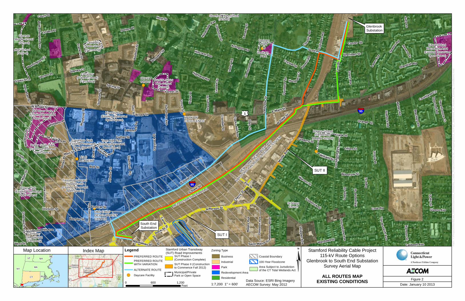
Index Map Stamford Reliability Cable Project115-kV Route Options
Glenbrook to South End SubstationSurvey Aerial Map
0 600 1,200Feet Date: January 10 2013
Path
: Y:\P
roje
cts\
Nor
thE
ast_
Util
ities
\Sta
mfo
rd_R
elia
bilit
y_C
able
_Pro
ject
\MX
D\C
SC_M
appi
ng\2
013_
01\F
ig3_
Sta
mfo
rd_A
ll_R
oute
s_M
ap.m
xd
NYMA
CT
NHVT
RI
NJ
ME
Map Location
Data Souce: ESRI Bing ImageryAECOM Survey: May 20121:7,200 1" = 600’
ALL ROUTES MAP
LegendPREFERRED ROUTE
PREFERRED ROUTE WITH VARIATION
ALTERNATE ROUTE
Stamford Urban Transitway (SUT) Road ImprovementsSUT Phase I (Construction Complete)
SUT Phase II (Construction to Commence Q1 2013)
Figure 3
Glenbrook Substation
South End Substation
I-95 Overpass
CDOT RAILS Underpass Lowering
Railroad Crossing
SUT I
SUT II
METRO-NORTH RAILROAD
NEW YORK, NEW H
AVEN, A
ND
HARTFORD RAILR
OAD CATENARY S
YSTEM
South State Street
951
N State St
Third Party Property
E Main St
95N State St
1
2
3
Scott Pl
45
6
7
Orange St
N State St
Rid
ge P
l
Soundview Ave
Woodrow St
Gay St C
randall St
Sheridan St
Cla
rk S
t
West St
Rel
ay P
l
Canal St
Stanley Ct
Green St
Dock St
Judy Ln
Stafford RdWhittaker Pl
Linden Pl
Smith St
Plea
sant
St
Frank St
Federal St
Daly St
W
i nth
r op
Pl
Washington Ct
Richmond Hill Ave
Gregory StLuther St
Bank St
Shippan Ave
Saint Marys St
W Park Pl
Court St
Ranson
St
Hund ley
Ct
Daycroft R
d
Spring St
Lillian St
Ray
mon
d St
Revere Dr
W M
ain
St
Hanrahan St
Givens Ave
William St
Vernon Pl
Clarks H
ill Ave
Cherry
St
Daskam Pl
Courtland Cir
Bell St
Main St
Fenw
ay S
t
W W
a shin gton A ve
Gle
ason
Ave
Arlington Rd
Caldwell Ave
Leed
s St
Valle
y Rd
Division St
Van B
uskirk Ave
Hillcrest Ave
Manhattan St
Highland Rd
Qui
ntar
d Te
r
Maher R
dStandish Rd
Stamford Plz
Hal
low
een
Blv
d
W Broad St
Hoyt St
Hillan
dale
AveM
ill R
iver
St
Warren St
Clin
ton
Ave
Lock
woo
d Av
e
Prospec
t St
Bed
ford
St
Dal
e St
Forest St
Map
le Av
e
Jefferson St
Myrtle
Ave
Frederick St Cove Rd
Gle
nbro
ok
Rd
Elm St
North St
Broad St
S State St
Atla
ntic
St
Hearthstone C
t
Wardwell St
Underhill St
Dolsen Pl
Duffy St
Meadow St
Landm a rk Sq
Su bur ban Ave
Mag
ee A
ve
Grant Ave
Custer St
Lind
a le
St
Gr eenw
ich Ave
Crystal St
Lafa
yette
St
L incol n Ave
Ursula Pl
Clovelly Rd
Seat
on
Rd
Lawn
Ave
Franklin St
Grove
S t Blachley Rd
Sum
mer
St
Gre
yroc
k Pl
Index Map Stamford Reliability Cable Project115-kV Route Options
Glenbrook to South End SubstationSurvey Aerial Map
0 600 1,200Feet Date: January 10 2013
Path
: Y:\P
roje
cts\
Nor
thE
ast_
Util
ities
\Sta
mfo
rd_R
elia
bilit
y_C
able
_Pro
ject
\MX
D\C
SC_M
appi
ng\2
013_
01\F
ig4_
Sta
mfo
rd_P
refe
rred_
Rou
te.m
xd
NYMA
CT
NHVT
RI
NJ
ME
Map Location
Data Souce: ESRI Bing ImageryAECOM Survey: May 20121:7,200 1" = 600’
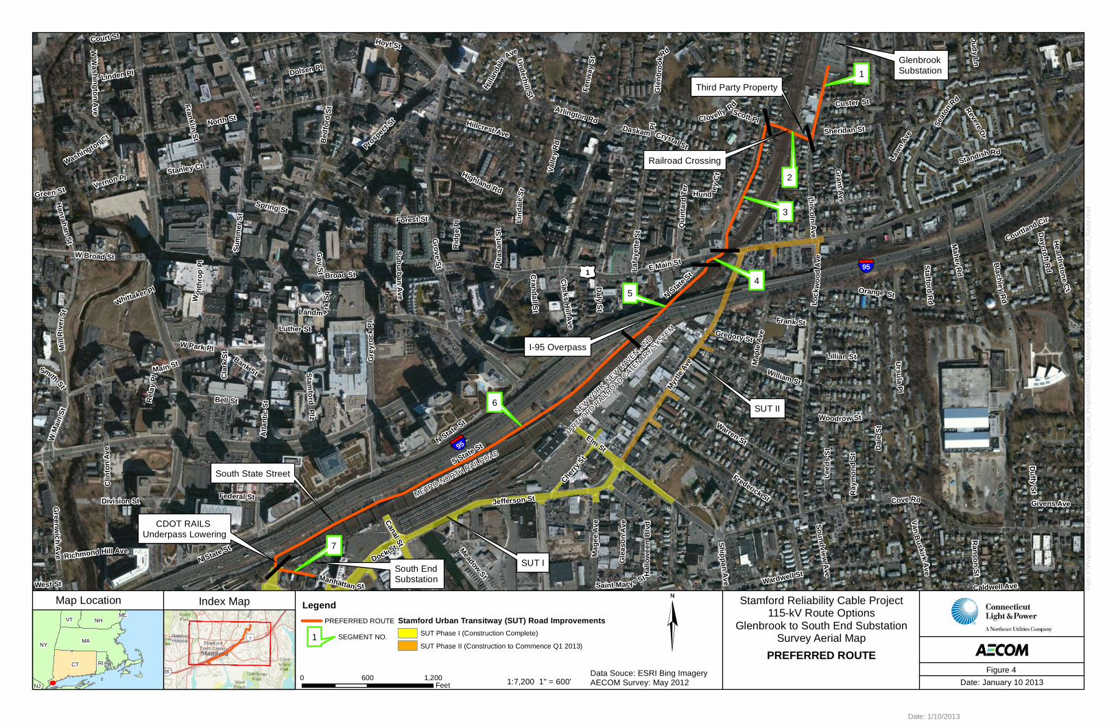
PREFERRED ROUTE
LegendPREFERRED ROUTE Stamford Urban Transitway (SUT) Road Improvements
SUT Phase I (Construction Complete)
SUT Phase II (Construction to Commence Q1 2013)
Date: 1/10/2013
Figure 4
1 SEGMENT NO.
Glenbrook Substation
South End Substation
SUT I
SUT II
METRO-NORTH RAILROAD
NEW YORK, NEW H
AVEN, A
ND
HARTFORD RAILR
OAD CATENARY S
YSTEM
951
N State St
I-95 Overpass
CDOT RAILS Underpass Lowering
CDOT RAILS Underpass Lowering
Lincoln Avenue
South State Street
E Main St
95
1
2
3
4
5
Orange St
N State St
Rid
ge P
l
Soundview Ave
Woodrow St
Gay St C
randall St
Sheridan St
Cla
rk S
t
West St
Rel
ay P
l
Canal St
Stanley Ct
Green St
Dock St
Judy Ln
Stafford RdWhittaker Pl
Linden Pl
Smith St
Plea
sant
St
Frank St
Federal St
Daly St
W
i nth
r op
Pl
Washington Ct
Richmond Hill Ave
Gregory StLuther St
Bank St
Shippan Ave
Saint Marys St
W Park Pl
Court St
Beehler St
Ranson
St
Hund ley
Ct
Daycroft R
d
Spring St
Lillian St
Ray
mon
d St
Revere Dr
W M
ain
St
Hanrahan St
Givens Ave
William St
Vernon Pl
Clarks H
ill Ave
Cherry
St
Courtland Cir
Bell St
Main St
Fenw
ay S
t
Gue
rnse
y Av
e
W W
a shin gton A ve
Gle
ason
Ave
Arlington Rd
Caldwell Ave
Leed
s St
Valle
y Rd
Division St
Van B
uskirk Ave
Hillcrest Ave
Manhattan St
Highland Rd
Qui
ntar
d Te
r
Maher R
dStandish Rd
Stamford Plz
Hal
low
een
Blv
d
W Broad St
Hoyt St
Hillan
dale
AveM
ill R
iver
St
Warren St
Clin
ton
Ave
L ock
woo
d Av
e
Prospec
t St
Bed
ford
St
Cul
lode
n R
d
Dal
e St
Forest St
Map
le Av
e
Jefferson St
Myrtle
Ave
Frederick St Cove Rd
Glenbrook Rd
Elm St
North St
Broad St
S State St
Atla
ntic
St
Pever
il Rd
Hearthstone C
t
Wardwell St
Underhill St
Dolsen Pl
Duffy St
Meadow St
Landm a rk Sq
Su bur ban Ave
Mag
ee A
ve
Grant Ave
Custer St
Lind
a le
St
Gr eenw
ich Ave
Crystal St
Lafa
yette
St
Linc
oln
Ave
Ursula Pl
Clovelly Rd
Seat
on
Rd
Lawn
Ave
Franklin St
Grove
S t Blachley Rd
Sum
mer
St
Gre
yroc
k Pl
Index Map Stamford Reliability Cable Project115-kV Route Options
Glenbrook to South End SubstationSurvey Aerial Map
0 600 1,200Feet Date: January 16 2013
Path
: Y:\P
roje
cts\
Nor
thE
ast_
Util
ities
\Sta
mfo
rd_R
elia
bilit
y_C
able
_Pro
ject
\MX
D\C
SC_M
appi
ng\2
013_
01\F
ig5_
Sta
mfo
rd_P
refe
rred_
Rou
te_V
aria
tion.
mxd
NYMA
CT
NHVT
RI
NJ
ME
Map Location
Data Souce: ESRI Bing ImageryAECOM Survey: May 20121:7,200 1" = 600’
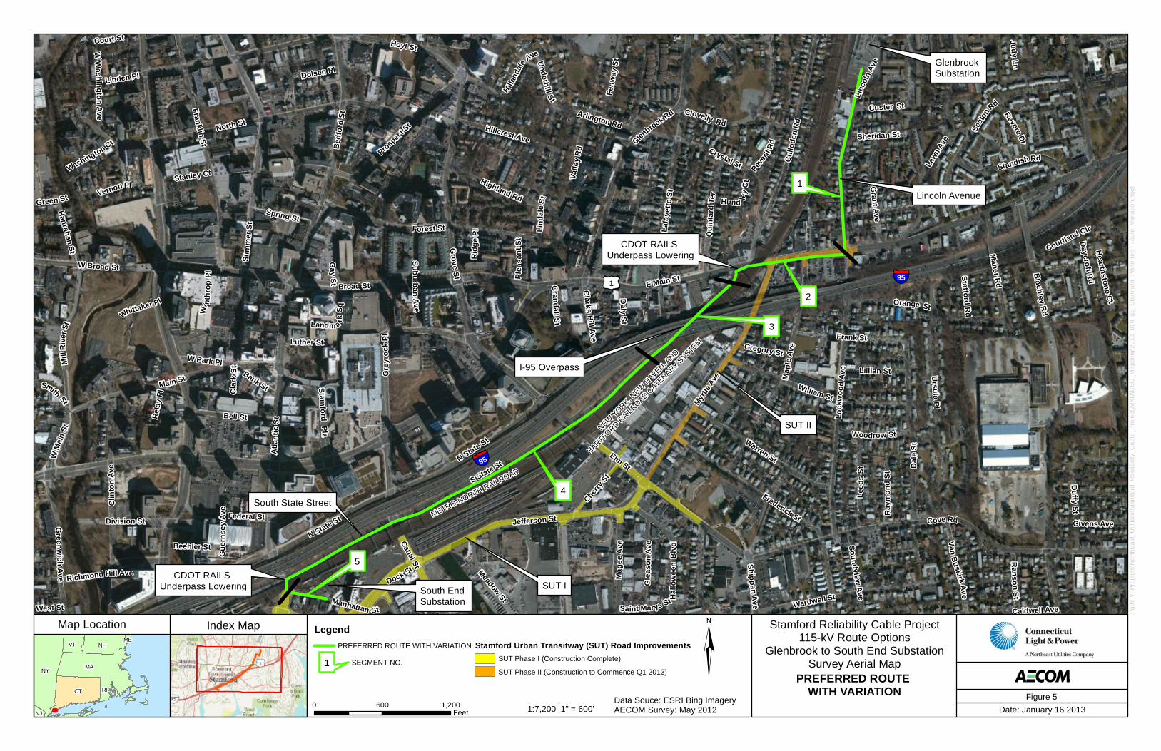
PREFERRED ROUTE WITH VARIATION
LegendPREFERRED ROUTE WITH VARIATION Stamford Urban Transitway (SUT) Road Improvements
SUT Phase I (Construction Complete)
SUT Phase II (Construction to Commence Q1 2013)
Figure 5
1 SEGMENT NO.
Glenbrook Substation
South End Substation
SUT I
SUT II
METRO-NORTH RAILROAD
NEW YORK, NEW H
AVEN, A
ND
HARTFORD RAILR
OAD CATENARY S
YSTEM
951
N State St
CDOT RAILS Underpass Lowering
Third Party Property
Railroad Crossing
North State Street
Third Party Property
E Main St
95
I-95 Overpass
Clovelley Rd 1
23
4
5
67
Orange St
N State St
Rid
ge P
l
Soundview Ave
Woodrow St
Gay St C
randall St
Sheridan St
Cla
rk S
t
West St
Rel
ay P
l
Canal St
Stanley Ct
Green St
Dock St
Judy Ln
Stafford RdWhittaker Pl
Linden Pl
Smith St
Plea
sant
St
Frank St
Federal St
Daly St
W
i nth
r op
Pl
Washington Ct
Richmond Hill Ave
Gregory StLuther St
Bank St
Shippan Ave
Saint Marys St
W Park Pl
Court St
Scott Pl
Beehler St
Ranson
St
Daycroft R
d
Spring St
Lillian St
Ray
mon
d St
Revere Dr
W M
ain
St
Hanrahan St
Givens Ave
William St
Vernon Pl
Clarks H
ill Ave
Cherry
St
Daskam Pl
Courtland Cir
Bell St
Main St
Fenw
ay S
t
W W
a shin gton A ve
Gle
ason
Ave
Arlington Rd
Caldwell Ave
Leed
s St
Valle
y Rd
Division St
Van B
uskirk Ave
Hillcrest Ave
Manhattan St
Highland Rd
Qui
ntar
d Te
r
Maher R
dStandish Rd
Stamford Plz
Hal
low
een
Blv
d
W Broad St
Hoyt St
Hillan
dale
AveM
ill R
iver
St
Warren St
Clin
ton
Ave
L ock
woo
d Av
e
Prospec
t St
Bed
ford
St
Cul
lode
n R
d
Dal
e St
Forest St
Map
le Av
e
Jefferson St
Myrtle
Ave
Frederick St Cove Rd
Gle
nbro
ok
Rd
Elm St
North St
Broad St
S State St
Atla
ntic
St
Hearthstone C
t
Wardwell St
Underhill St
Dolsen Pl
Duffy St
Meadow St
Landm a rk Sq
Su bur ban Ave
Mag
ee A
ve
Grant Ave
Custer St
Lind
a le
St
Gr eenw
ich Ave
Cry
stal
S t
Lafa
yette
St
Linc
oln
Ave
Ursula Pl
Seat
on
Rd
Lawn
Ave
Franklin St
Grove
S t Blachley Rd
Sum
mer
St
Gre
yroc
k Pl
Index Map Stamford Reliability Cable Project115-kV Route Options
Glenbrook to South End SubstationSurvey Aerial Map
0 600 1,200Feet Date: January 16 2013
Path
: Y:\P
roje
cts\
Nor
thE
ast_
Util
ities
\Sta
mfo
rd_R
elia
bilit
y_C
able
_Pro
ject
\MX
D\C
SC_M
appi
ng\2
013_
01\F
ig6_
Sta
mfo
rd_A
ltern
ate
Rou
te.m
xd
NYMA
CT
NHVT
RI
NJ
ME
Map Location
Data Souce: ESRI Bing ImageryAECOM Survey: May 20121:7,200 1" = 600’
ALTERNATE ROUTE
LegendALTERNATE ROUTE Stamford Urban Transitway (SUT) Road Improvements
SUT Phase I (Construction Complete)
SUT Phase II (Construction to Commence Q1 2013)
Date: 1/16/2013
Figure 6
1 SEGMENT NO.
NYMA
CT
NHVT
RI
NJ
ME
Glenbrook Substation
South End Substation
METRO-NORTH RAILROAD95
1
95
1
Mill RiverPark
Michael F.Lione Park
Hubbard HeightsGolf Couse
John H. Scalzi Park
North Street Cemetery
Franklin Street Cemetery
Gerli Park
Purdy LaneCemetery
Darien YMCA
Gus Edson Park
Cove IslandPark
CummingsPark
Czecsik Park
Southfield Neighborhood
Center
Hatch Field
Glenbrook Neighborhood
Center
WoodlandPark
Innis ArdenGolf Club
SouthfieldPark
East Branch of the Rippowam River
StarkSchool
StamfordHigh School
RogersElementarySchool
BurdickJuniorHigh School
Noah’s ArkNurserySchool
Mark OfExcellence
Villa DivinoAmore Nursery
School
Bright HorizonsChildren’s
Center- Stamford
Ubs ChildDevelopmentCenter
William Pitt ChildDevelopment Center
Cte AfterSchool
Academy
Lead Academy
StarkcoActivitiesProgram
Bright Minds
Clc MapleAvenue Child
Development Center
RosccoActivitiesProgram
Rising StarLearningCenter
St MarysChurch
Woodland Cemetery
South EndNeighborhood
Center
Hill AvenueCemetery
Rotary Park
RogerSmith
Park
ColumbusPark
KiwanisPark
Edward HuntRecreationArea
Northrop Field
DashamPark
TresslerBoulevard
Playgrounds
TownHallPark
StamfordHospital
Index MapStamford Reliability Cable Project
115-kV Route OptionsGlenbrook to South End Substation
0 1,200 2,400Feet Date: January 16 2013
Path
: Y:\P
roje
cts\
Nor
thE
ast_
Util
ities
\Sta
mfo
rd_R
elia
bilit
y_C
able
_Pro
ject
\MX
D\C
SC_M
appi
ng\2
013_
01\F
ig7_
Sta
mfo
rd_P
ropo
sed_
Rou
te_S
tatu
tory
_Fac
iiliti
es_M
ap.m
xd
Map Location
Data Souce: ESRI Bing ImageryAECOM Survey: May 20121:14,400 1" = 1200’
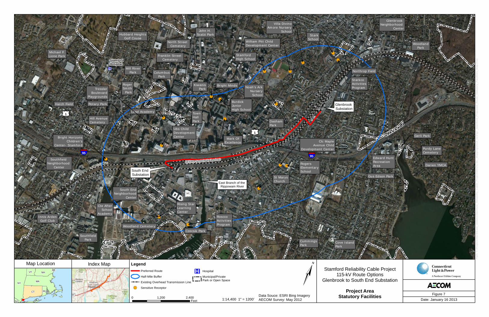
Project AreaStatutory Facilities
LegendPreferred Route
Half-Mile Buffer
Existing Overhead Transmission Line
Sensitive Receptor
Hospital
Municipal/Private Park or Open Space
Figure 7
NYMA
CT
NHVT
RI
NJ
ME
South End Substation
Railroad Crossing
95
Coastal Zone Boundary
Coa
stal
Zone
Bou
ndar
yA
tlant
ic S t
Gre
yroc
k Pl
Jefferson St
Garde
n St
Dock St
Pacif
ic St
Manhattan St
N State St
S State St
John St
Can
al S
t
NDDBArea
20
20
20
10
20
4030
20
10
30
10
30
10
30
10
30
10
30
100-YearFlood Zone
Index Map Stamford Reliability Cable ProjectNUS 115-kV Proposed Route
Glenbrook to South End Substation
0 100 200Feet Date: January 16 2013
Path
: Y:\P
roje
cts\
Nor
thE
ast_
Util
ities
\Sta
mfo
rd_R
elia
bilit
y_C
able
_Pro
ject
\MX
D\C
SC_M
appi
ng\2
013_
01\F
ig8_
Sta
mfo
rd_P
ropo
sed_
Rou
te_1
00ft_
Map
.mxd
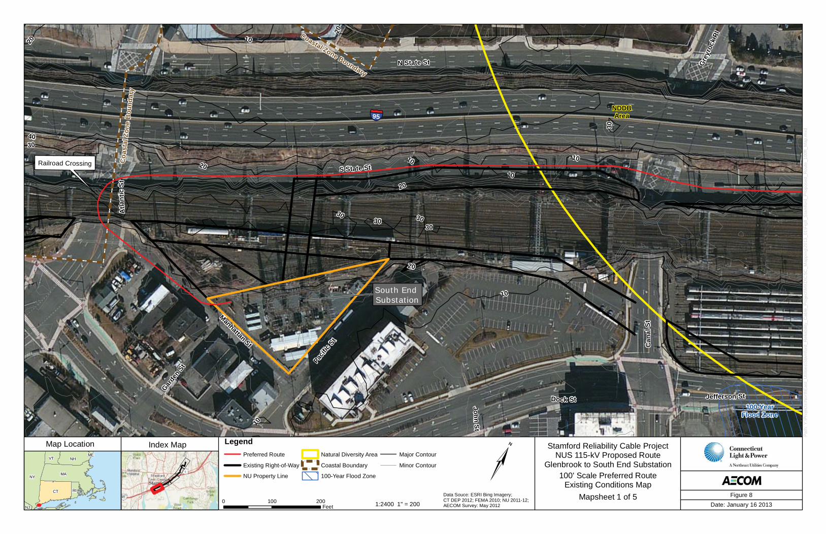
Map Location
Figure 8Data Souce: ESRI Bing Imagery; CT DEP 2012; FEMA 2010; NU 2011-12;AECOM Survey: May 20121:2400 1" = 200
100' Scale Preferred RouteExisting Conditions Map
Mapsheet 1 of 5
LegendPreferred Route
Existing Right-of-Way
NU Property Line
Natural Diversity Area
Coastal Boundary
100-Year Flood Zone
Major Contour
Minor Contour
NYMA
CT
NHVT
RI
NJ
ME
95
Coastal Zone BoundaryElm
St
Jefferson St
N State St
S State St
NDDBArea
20
10
10 10
20
30
10
10
20
20
20
10
10
10
100-YearFlood Zone
Index Map Stamford Reliability Cable ProjectNUS 115-kV Proposed Route
Glenbrook to South End Substation
0 100 200Feet Date: January 16 2013
Path
: Y:\P
roje
cts\
Nor
thE
ast_
Util
ities
\Sta
mfo
rd_R
elia
bilit
y_C
able
_Pro
ject
\MX
D\C
SC_M
appi
ng\2
013_
01\F
ig8_
Sta
mfo
rd_P
ropo
sed_
Rou
te_1
00ft_
Map
.mxd
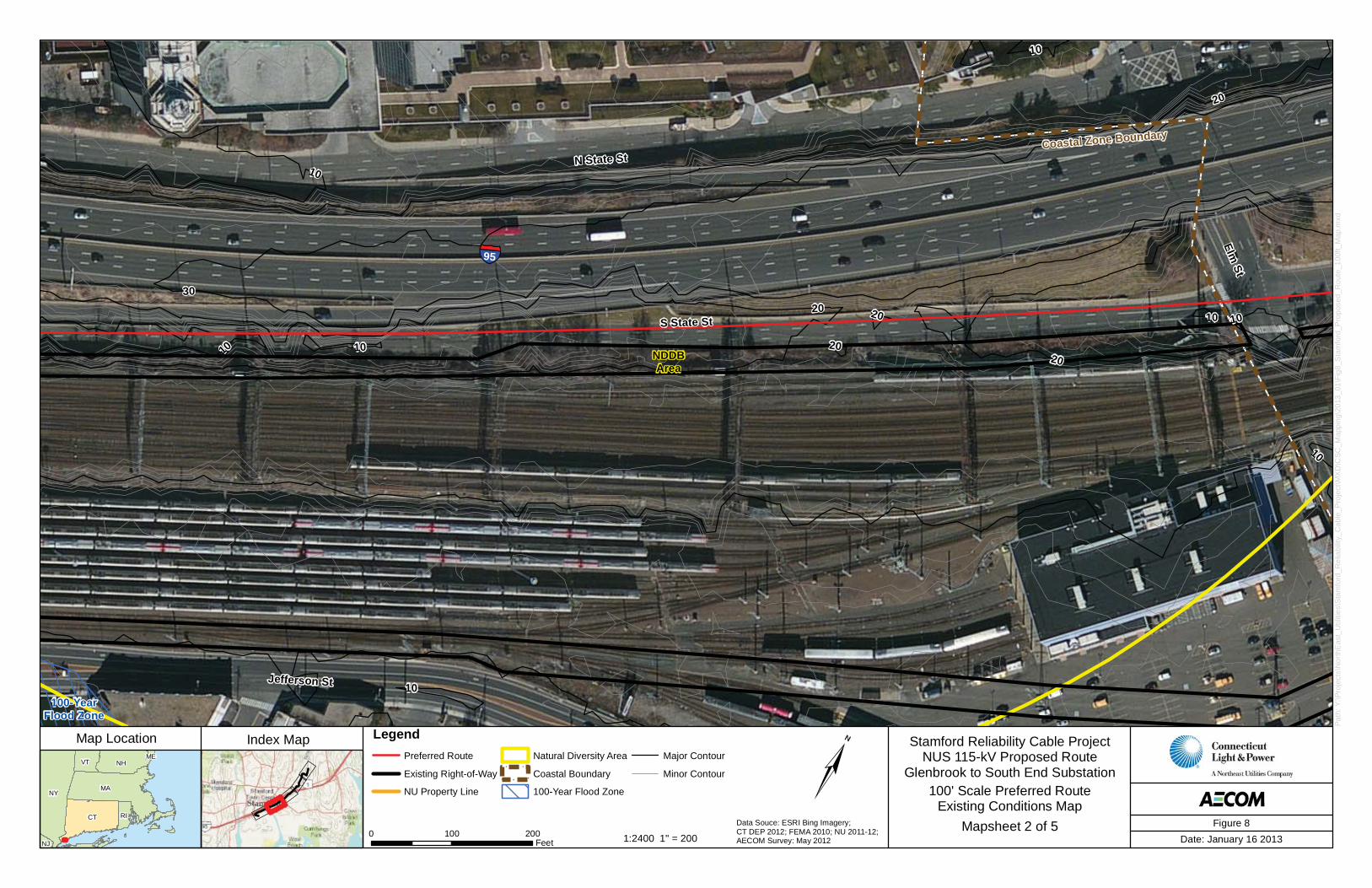
Map Location
Figure 8Data Souce: ESRI Bing Imagery; CT DEP 2012; FEMA 2010; NU 2011-12;AECOM Survey: May 20121:2400 1" = 200
100' Scale Preferred RouteExisting Conditions Map
Mapsheet 2 of 5
LegendPreferred Route
Existing Right-of-Way
NU Property Line
Natural Diversity Area
Coastal Boundary
100-Year Flood Zone
Major Contour
Minor Contour
NYMA
CT
NHVT
RI
NJ
ME
I-95 Overpass
95
Coastal Zone Boundary
Daly
St
Lafa
yette
St
Elm St
Myrtle Ave
N State St
S State St
NDDBArea
10
20
50
40
20
30
30
60
50
10
20
20
20
20
20
20
20
30
10
Index Map Stamford Reliability Cable ProjectNUS 115-kV Proposed Route
Glenbrook to South End Substation
0 100 200Feet Date: January 16 2013
Path
: Y:\P
roje
cts\
Nor
thE
ast_
Util
ities
\Sta
mfo
rd_R
elia
bilit
y_C
able
_Pro
ject
\MX
D\C
SC_M
appi
ng\2
013_
01\F
ig8_
Sta
mfo
rd_P
ropo
sed_
Rou
te_1
00ft_
Map
.mxd
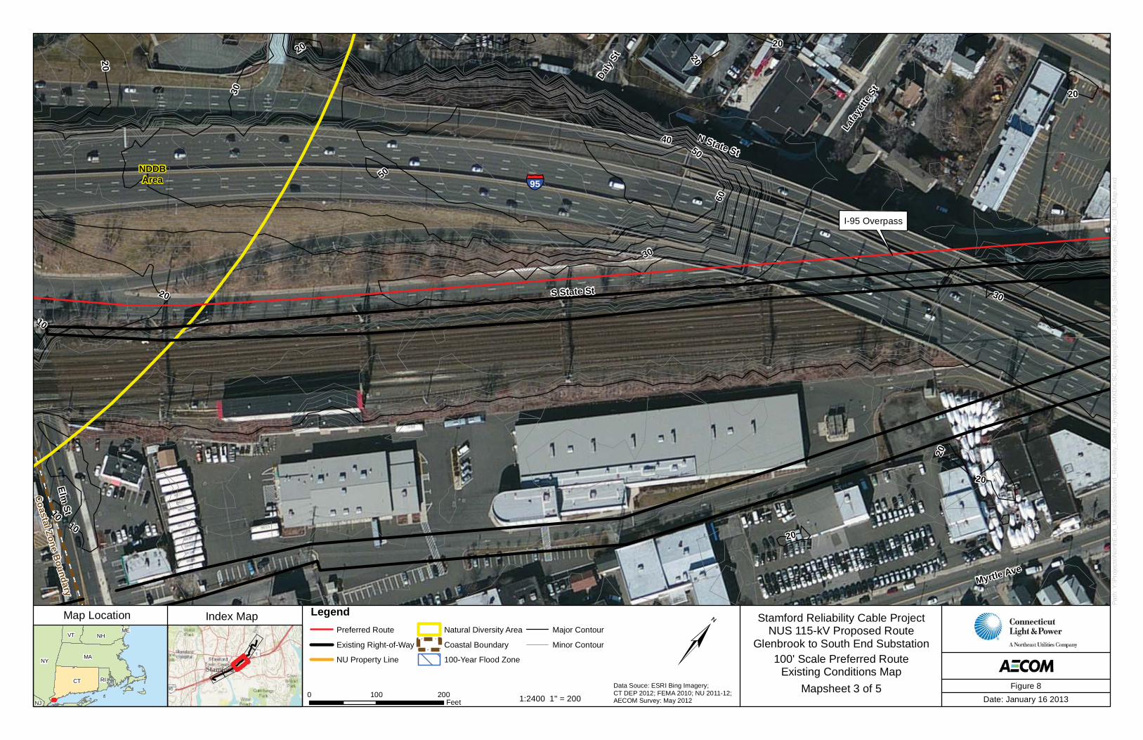
Map Location
Figure 8Data Souce: ESRI Bing Imagery; CT DEP 2012; FEMA 2010; NU 2011-12;AECOM Survey: May 20121:2400 1" = 200
100' Scale Preferred RouteExisting Conditions Map
Mapsheet 3 of 5
LegendPreferred Route
Existing Right-of-Way
NU Property Line
Natural Diversity Area
Coastal Boundary
100-Year Flood Zone
Major Contour
Minor Contour
NYMA
CT
NHVT
RI
NJ
ME
95
Sherman St
Peveril Rd
Hundley Ct
Quintard Ter
S State St
Myrtle Ave
Culloden Rd
Crystal St
60
5040
40
30
20
30
20
30
50
20
30
7020
20
20
40
2020
20
20
50
30
70
Index Map Stamford Reliability Cable ProjectNUS 115-kV Proposed Route
Glenbrook to South End Substation
0 100 200Feet Date: January 16 2013
Path
: Y:\P
roje
cts\
Nor
thE
ast_
Util
ities
\Sta
mfo
rd_R
elia
bilit
y_C
able
_Pro
ject
\MX
D\C
SC_M
appi
ng\2
013_
01\F
ig8_
Sta
mfo
rd_P
ropo
sed_
Rou
te_1
00ft_
Map
.mxd
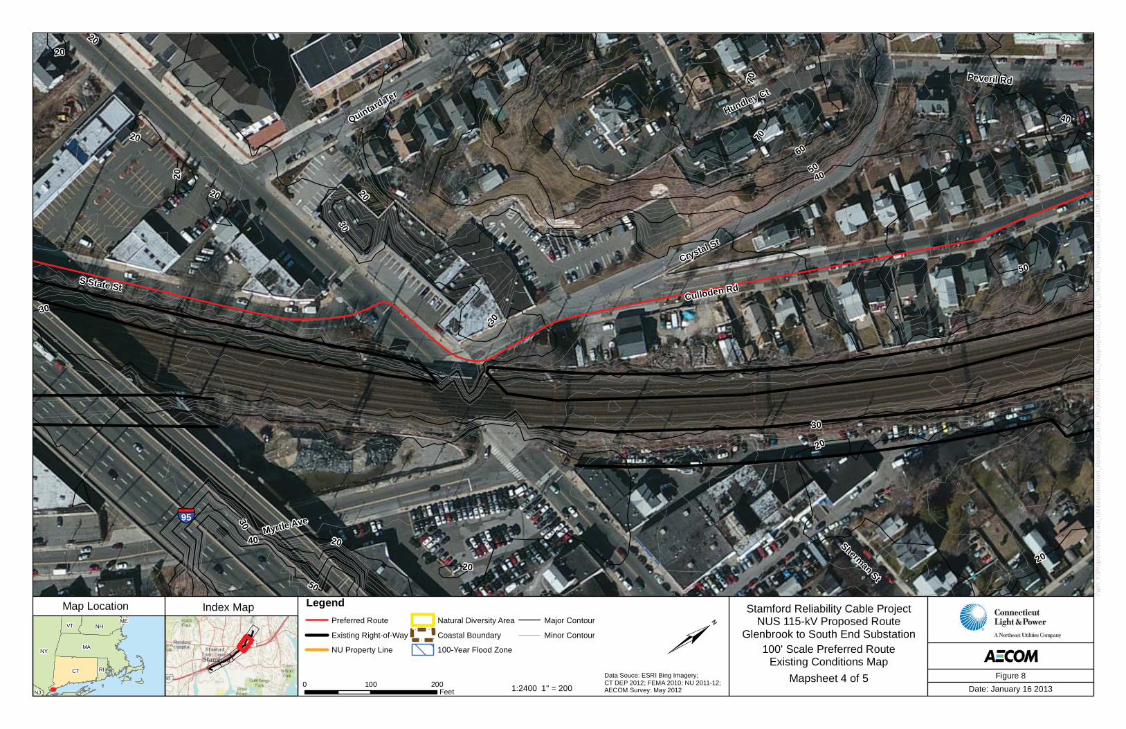
Map Location
Figure 8Data Souce: ESRI Bing Imagery; CT DEP 2012; FEMA 2010; NU 2011-12;AECOM Survey: May 20121:2400 1" = 200
100' Scale Preferred RouteExisting Conditions Map
Mapsheet 4 of 5
LegendPreferred Route
Existing Right-of-Way
NU Property Line
Natural Diversity Area
Coastal Boundary
100-Year Flood Zone
Major Contour
Minor Contour
NYMA
CT
NHVT
RI
NJ
ME
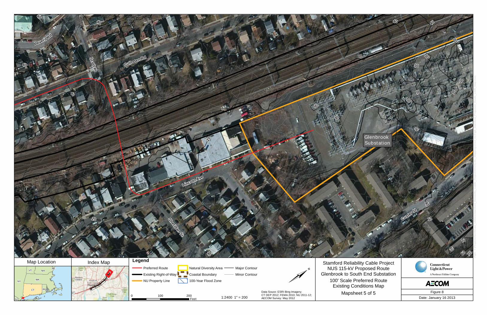
Glenbrook Substation
Sheridan St
Peveril Rd
Scott Pl
Custer St
Culloden Rd
Lincoln Ave
7060
50
40
30
60
40
20
30
40
30
30
30
30
30
40
40
60
30
4040
30
30
20
40
30
Index Map Stamford Reliability Cable ProjectNUS 115-kV Proposed Route
Glenbrook to South End Substation
0 100 200Feet Date: January 16 2013
Path
: Y:\P
roje
cts\
Nor
thE
ast_
Util
ities
\Sta
mfo
rd_R
elia
bilit
y_C
able
_Pro
ject
\MX
D\C
SC_M
appi
ng\2
013_
01\F
ig8_
Sta
mfo
rd_P
ropo
sed_
Rou
te_1
00ft_
Map
.mxd
Map Location
Figure 8Data Souce: ESRI Bing Imagery; CT DEP 2012; FEMA 2010; NU 2011-12;AECOM Survey: May 20121:2400 1" = 200
100' Scale Preferred RouteExisting Conditions Map
Mapsheet 5 of 5
LegendPreferred Route
Existing Right-of-Way
NU Property Line
Natural Diversity Area
Coastal Boundary
100-Year Flood Zone
Major Contour
Minor Contour