Embed Size (px)
Citation preview

Appendix A-1
APPENDIX A: Resources The following information is intended to supplement the general information sources listed in the text and bibliography of this document:
Chapter 1 Wetland Inventory: Department of Ecology Wetland Inventory Coordinator (206) 459-6836 U.S. Fish and Wildlife Service NationalWetlands Inventory Coordinator (503) 231\6154
Information on the status of wetland inventory efforts in Washington State
Chapter 2 Aerial photography sources: Department of Natural Resources (206) 753-5338 Department of Transportation (206) 753-2162 US Army Corps of Engineers (206) 764-3742 Local Jurisdictions Walker and Associates, Inc. (206) 244-2300
University of Washington Library Cartography Section: extensive index and collection of both
current and historical aerial photos Sources of resource maps: Department of Ecology and (206) 459-6202 US Fish and Wildlife Service (503) 231-6154
United States Fish and Wildlife Service National Wetland Inventory maps
United States Department of Agriculture, Soil Conservation Service (Contact individual County offices)
Soil Survey Reports County Hydric Soils Lists
Department of Natural Resources (206) 753-5338
Appendix A-2
Chapter 2 (continued) State Soil Survey Maps
United States Geological Survey (USGS) Topographic Quadrangle Maps Orthophoto Maps Water Type Classification Maps
Sources of resource maps (continued) Federal Emergency Management Agency (206) 487-4685
Flood Plain Study Area and Flood Insurance Rate Maps Assessors Tax Maps and Property Ownership Maps King County Sensitive Areas Map Folio
Local County Planning, Public Works, or Cartography Departments University of Washington Library Cartography Section: extensive index and collection of both
current and historical maps including USGS topographic maps (superseded versions) and early surveying reports.
Wetland Functions and Values Assessment Puget Sound Wetlands Preservation Program: Wetlands Assessment Methodology for Site
Selection (Washington State Department of Ecology, December 1990) Washington State Wetlands Rating System (for Western Washington) (Washington State
Department of Ecology, Publication #91-57) Wetland Evaluation Technique (WET), Volume II: Methodology, Prepared for the US Army Corp
of Engineers, Waterways Experiment Station, Vicksburg, Mississippi, October 1987. Washington Department of Ecology Wetland Inventories, April 1992 (In House Report) Sources of hydrologic information: USGS Water Supply Bulletins USGS Technical Reports Reservoir gauging data - Bureau of Reclamation Soil Conservation Districts: Snow Survey Data National Weather Service: Precipitation Data Irrigation Districts and Soil and Water Conservation Districts Federal Emergency Management Act (FEMA) United States Army Corps of Engineers United States Forest Service: Streamflow Data United States Bureau of Land Management Local Public Works Departments: drinking water and stormwater

Appendix A-3
Chapter 3 Plans for bird, bat, and flying squirrel nest boxes: Bat Conservation International (512) 327-9721
PO Box 162603 Austin, Texas 78716
Natural Landscaping by John Diekelmann and Robert Schuster (1982; McGraw-Hill Book Company, New York).
Bat Conservation International (512) 327-9721 PO Box 162603 Austin, Texas 78716
Diekelmann, John, and Robert Schuster. 1982. Natural Landscaping. McGraw-Hill Book Company. New York, New York.
Marcy, Larry E. 1986. Waterfowl nest baskets: Section 5.1.3, US Army Corps of Engineers Wildlife Resources Management Manual. Technical Report EL-86-15, US Army Engineer Waterways Experiment Station. Vicksburg, Mississippi.
Martin, Chester O., Wilma A. Mitchell, and Donald A. Hammer. 1986. Osprey nest platforms: Section 5.1.6, US Army Corps of Engineers Wildlife Resources Management Manual. Technical Report EL-86-21, US Army Engineer Waterways Experiment Station. Vicksburg, Mississippi.
Maser, Chris, R. G. Anderson, K, Cromack, Jr., J. T. Williams, and R. E. Martin. 1979. Dead and down woody material. in Wildlife Habitats in Managed Forests. Jack Ward Thomas, technical editor. Agriculture Handbook No. 553. US Department of Agriculture Forest Service. Washington, DC.
Ridlehuber, Kenneth T., and J. W. Teaford. 1986. Wood duck nest boxes: Section 5.1.2, US Army Corps of Engineers Wildlife Resources Management Manual. Technical Report EL-86-12, US Army Engineer Waterways Experiment Station. Vicksburg, Mississippi.
Stokes, Donald, and L. Stokes. 1990. The Complete Birdhouse Book. Little, Brown and Company. Boston, Massachusetts.
Thomas, Jack Ward, R. G. Anderson, C. Maser, and E. L. Bull. 1979. Snags. in Wildlife Habitats in Managed Forests. Jack Ward Thomas, technical editor. Agriculture Handbook No. 553. US Department of Agriculture Forest Service. Washington, DC.
Washington Department of Wildlife. 1988. Nest boxes for birds. Washington Department of Bioengineering: (This section is supplemental and not referenced in text) Dobbs Creek Model Farm. A Guide to Stream Corridor Revegetation in Western Washington.
Thurston Conservation District. 2407 Pacific Ave., Olympia, WA 98501. (206) 754-3588 Environmental Laboratory. 1986. Field Guide for Low-maintenance Vegetation Establishment and
Management. Waterways Experiment Station, US Army Corps of Engineers, Vicksburg, Mississippi.
Juelson, T. C. 1980. Suggestions for Streambank Revegetation in Western Washington. Washington Department of Game, Applied Research Informational Report #13. Olympia: WDG.
Soil Conservation Service Engineering Field Manual (Chapters 13 and 18) Scheictl, Hugo. 1980. Bioengineering for Land Reclamation and Conservation. The University of
Alberta Press. Edmonton, Alberta.
Appendix A-4
Chapter 4 Some sources of native seed mixes:
Note: The buyer should be aware that many seed mixes may contain some non-native species.
Pacific Agro (800) 722-2476 PO Box 326 Renton, Washington 98057
Hobbs & Hopkins Ltd. 800) 345-3295 1712 SE Ankeny Portland, Oregon 97214
American Ornamental Perennials (503) 661-4836 PO Box 385 Gresham, Oregon
Pacific Open-Space Inc. (707) 769-1213 PO Box 744 Petaluma, California 94953
Northplan Inc. (208) 882-8040 PO Box 9107 Moscow, Idaho 83843
Willamette Prairie Seed 434 NW Sixth Street, Suite 304 Portland, Oregon 97209
Chapter 5 Pond Construction: Soil Conservation Service. Ponds: Planning, Design and Construction. US Department of Agriculture. Thurston County Conservation District (206) 754-3588
Four videotapes on pond construction.
Monitoring: Reinelt, L.E. and R. Horner, 1990. Characterization of Hydrology and Water Quality of Palustrine
Wetlands Affected by Urban Stormwater. Puget Sound Wetlands and Stormwater Management Research Program, King County Resource Planning, Seattle, WA.
Horner, R. and K. Raedeke, Guide for Wetland Mitigation Project Monitoring, Washington State Transportation Center (TRAC), University of Washington, JE-10, Seattle, WA, 1989.
Puget Sound Estuaries Program, Recommended Protocols for Measuring Conventional Water Quality Variables and Metals in Fresh Water of the Puget Sound Region.

Appendix A-5
Chapter 6 Sources for aquatic weed control supplies: Aquatics Unlimited (206) 872-5703
Kent, Washington Ben Meadows Company 1-800-241-6401
3589 Broad Street Atlanta, Georgia 30341
Forestry Suppliers, Inc 1-800-647-5368 PO Box 8397 Jackson, Mississippi 39284-8397
World Environmental Services (904) 637-5775 9400 Mistwood Drive Inverness, Florida 32650
Appendix B-1
APPENDIX B: Estuarine Wetland Rehabilitation
A Practical guide to designing, constructing, planting, monitoring and managing emergent wetlands in Washington State estuaries
September 1991
Adopt A Beach P.O. Box 21486
Seattle, WA 98111-2386
Grant # G-0091021 The preparation of this document was financially aided through a grant from the Washington State Department of Ecology with funds obtained from the National Oceanic and Atmospheric Administration and appropriated for Section 306 of the Coastal Zone Management Act of 1972.

Appendix B-2
Rarely is it acknowledged that restoration is a hope, not a guarantee.
--Joy. B. Zedler

Appendix B-3
A. Introduction 1. Background Estuarine wetland revegetation in the Puget Sound region is progressing mostly by trial and error. Gains in knowledge rely heavily on observing existing mitigation and restoration projects. Few of these have built-in experimental designs that can yield useful information in a standard way (e.g., planting a given species at a variety of tidal elevations). Neither research funding nor regulatory mandates have adequately guided mitigation and restoration into a scientific process. Even in instances where experiments were conducted, there have been problems. It is difficult to build adequate controls in the field. Unknown variables may have a far greater impact on the outcome of an experiment than the manipulated variables. Sites for experiments are limited and often subject to debilitating stresses. For instance, shifting sediments (a common occurance affecting estuarine wetlands) may destroy some plots, leaving too few replicates for valid statistical analysis. Estuarine wetland restoration is furthermore faced with challenges that are less likely to occur in freshwater environments. Estuarine areas that require the most restoration are those where wetland losses have been the greatest (up to 99% in some Puget Sound basins) The more obvious challenges are: • Paucity of good candidate sites in protected embayments; • Limited space for projects; • Poor quality of sites (e.g. rubble fills, toxic sediments, wake from boat traffic, etc.)
often requiring extensive site preparation; • Lack of reference areas in the same system that can serve as adequate templates for the
project; • Lack of diversity and altered conditions of remaining wetlands in the same system; • Lack of information on the wetlands that have been lost to development.
There is a growing body of literature on estuarine wetland rehabilitation though most of it is based on projects along the East Coast and in California. While much can be learned from these projects, they are affected by conditions that are fundamentally different from those found in the Pacific Northwest. The most obvious limitation is the use of species not native to Washington State. Furthermore, factors such as hyperhaline conditions in California or tide regimes in the Atlantic influence the design of created wetlands in those regions Information for this chapter is largely based on projects in Puget Sound, with additional reference to findings from Oregon, California and the East Coast. The chapter is limited to projects which involve the planting of emergent vascular estuarine species and the conditions that affect their successful establishment. The approach is horticultural. Additional information was obtained from a review of the literature, the results of a

Appendix B-4
questionnaire sent to wetland rehabilitators in the Pacific Northwest, conversations with several wetland rehabilitators and the results of several Adopt a Beach rehabilitation projects (described below). The work on most of these projects was funded by three Coastal Zone Management grants awarded by the Department of Ecology in 1988, 1989, and 1990. 2. Format The format for this chapter somewhat follows the format of Ecology's restoration guidebook. Care has been taken not to duplicate content since many of the steps from design and execution are identical for constructed wetlands in fresh and saltwater. However, key points made in the applicable chapters are summarized for purposes of reference. Included in this chapter are the following topics: • Projects That Have Served As Source Information • Planning Considerations • Initial Site Assessment • Site Preparation • Monitoring • Management The Appendix to this chapter includes: • Location of Adopt a Beach projects • Estuarine Wetland Plant Growth Requirements and Landscaping Specifications • Estuarine Wetland Plant Characteristics • Bibliography
B. Projects That Have Served As Source Information 1. Role of Adopt a Beach Adopt a Beach is a non-profit volunteer stewardship organization that develops monitoring, education, and rehabilitation projects to restore and preserve the coastal waters and associated watersheds of Washington. Working with university researchers, consulting firms, and state and federal agencies, Adopt a Beach has been involved in a number of estuarine rehabilitation and mitigation projects. In addition, it has conducted several revegetation experiments. Adopt a Beach, as a volunteer organization, is particularly well-suited to undertake the labor-intensive tasks of planting, maintenance and monitoring. Much of the information in this chapter is derived from four years of experience with estuarine revegetation. The following projects have served as the main source of field information for this chapter: 2. Adopt a Beach projects a. Jetty Island, Everett. The Jetty Island project involves the transplanting of saltgrass
Appendix B-5
(Distichlis spicata) plugs of assorted sizes from a donor site and replanting them in various densities. The goal of this project is to study the colonization by saltgrass of newly-created sites that duplicate the tidal elevations and soil salinity levels tolerated by this species. Specifically, the project consists of a number of plots planted in different densities and with different sizes of transplants. The colonization rate of each plot was recorded and compared over several seasons to determine which transplanting treatments were most successful. b. Quilceda Creek, Marysville. This project is located on a former fill along Quilceda Creek in Marysville, Washington. A series of interconnected channels and basins that flood at high tide were dug in order to observe how they aid in transporting detritus and seeds into the project plot. The goal of this project is to manipulate a recently created intertidal zone in order to observe how channels affect natural colonization. If successful and replicable, this project will help design marshes that have predictable patterns of colonization. c. Terminal 108, Duwamish Waterway, Seattle. This is a 10,000-square-foot (919 m2) intertidal and subtidal fish mitigation project developed by the Port of Seattle. In April 1987, over 200 plugs of hardstem bulrush (Scirpus validus) were transplanted from an adjacent marsh. They were planted in a crescent strip at a median elevation of 10 feet above Mean Lower Low Water (MLLW). The goal of this project is to establish a fringe marsh of intertidal species that are compatible with the area and to observe it over several growing seasons. Success is being measured by comparing plant charactaristics at the project plot with those at the donor site during that period. The results will help determine the effectiveness of transplanting plugs of hardstem bulrush from an adjacent area as a means of propagating this species. After two years with little growth, the hardstem bulrush began thriving in 1989. In the spring of 1990, it reached 6.5 feet (2m) in only two and a half months after the first budding shoots were observed. This is toward the upper range in the height of this species in the wild in the Pacific Northwest. As of the fall of 1991, there was vigorous growth on the downslope side of the project. This was an unanticipated development as available field information indicates that this species is confined to a narrow tidal range. Early in the project, the plants suffered somewhat from the effects of crushing debris and boat wake, especially at the edges of the plot. However, a flexible boom was placed at the mouth of the embayment, and the plants are now protected from these stresses. An experiment to study the effect of goose browsing on the growth of young shoots by fencing in one area has been inconclusive. Plants in the reference site have suffered considerable stress, probably caused by shore slumping. As a result, the reference plot can no longer be used. d. Route 509 Marsh, Duwamish Waterway, Seattle. This is one of the last significant remnants of Duwamish intertidal marsh (along with the west shore of the Turning Basin and
Appendix B-6
Kellog Island). The marsh is connected to the river by a long culvert. Department of Transportation site: The project is on the site of an illegal fill that was removed at the request of the U.S. Army Corps of Engineers and the U.S. EPA. Site manipulation included digging drainage channels and removing of some of the surface rubble. An experimental strip of maritime bulrush (Scirpus maritimus) was planted in April 1987 from the low northern end (better substrate conditions) to the high southern end (worst substrate conditions); the strip serves as a permanent transect. The goals of the project are to: 1) observe the voluntary colonization of marsh vegetation in an area where substrate conditions vary from high compaction/low organic content to low compaction/moderate organic content (relative to the reference area of undisturbed marsh adjacent to the site); 2) observe the effect of improved drainage on marsh establishment. Recolonization occured more rapidly and with higher densities in areas where the substrates were least compacted and where drainage was good. Highly compacted but well-drained substrates have shown a higher rate of recolonization than those which are softer but are poorly drained.. Channelization seems to have improved recolonization in the higher marsh by introducing seeds to those areas. Municipality of Metropolitan Seattle site: the Municipality of Metropolitan Seatle (Metro) temporarily filled part of the east side of the marsh during construction of the Renton Effluent Transfer System in the fall of 1986. After the fill was removed, the site was available for experimentation. Three experimental plots were planted in February, March, and April 1987 in between two unplanted control plots. The goal of this project is to revegetate plots in a damaged area having no vegetative cover with maritime bulrush, the species indigenous to this marsh, and to compare the experimentally vegetated plots with adjacent control plots that are allowed to colonize naturally. Plant loss has been significant and colonization by the surviving plugs has been poor except for one plot. By June 1990, there was no improvement in the situation, though transplants appeared more robust and larger than in June 1989. Poor drainage and possibly extremely anoxic soil conditions are the likeliest culprits. Aggressive colonization by volunteer maritime bulrush has occurred and is expanding along the toe of the slope to merge with the planted specimens. In fact, the corner of one plot which was once bare mud is now retaining sediments and plant detritus. e. Other projects. Two other projects have also served as sources for field information, these are:
The Haub Marina and the Dorotich Marina in Gig Harbor: Both were mitigation projects involving the transplanting of plugs of pickleweed (Salicornia virginica). The Jetty Island Berm project: This project involves the creative use of dredge
Appendix B-7
materials. Adopt a Beach planted experimental plots of seedlings to compare their establishment to that of transplanted plugs of the same species from donor sites. Preliminary findings indicate that first year seedlings did not succeed while older nursery plants performed better than plugs transplanted from the wild.
Finally, the author has experimented with several estuarine emergent species, growing them from seeds in a variety of conditions.
C. Restoration Planning Several conditions challenge this process and limit available options, especially in Puget Sound urban estuaries, namely: • Lack of available space, especially in urban estuaries; • Considerable loss of habitat in areas where only broad scale or system restoration or
creation restoration makes sense; • Lack of suitable reference areas; • Lack of information on soils and considerable alteration of exisiting soils as a result of fills
or dredging; • Critical role of hydrology especially near large rivers where even minor salinity fluctuations
or slightly incorrect readings of tidal elevations (a very common error), can destroy a project;
• Lack of information on species composition in estuaries where up to 99% of the wetlands have been obliterated;
• Lack of availability of native species available from the same regional gene pool; • Lack of donor sites, making their use an ethical issue; • Critical planning decisions (e.g., creating a wetland community that is much needed but that
cannot exist without intensive management); • How to measure success.
D. Initial Site Assessment Special consideration should be given in assessing the suitability of an estuarine site and the conditions affecting it. The following information should be gathered when planning the project: • Hydrology: Tides, drainage, salinity and energy • Soils: Texture and compaction • On-site and off-site disturbances.
Appendix B-8
It shall be noted that this chapter does not include the following types of restorations: Dike breaching • Restoration of damaged emergent vegetation communities • Self-colonizing wetlands • Eelgrass beds.
1. Hydrology Period of flooding: Establish MHHW: For areas that will be filled or excavated, note the MHHW at an adjacent location that will allow easy readings from the site. Note that surface run-off may considerably affect tidal elevation in estuaries in winter and spring. Establish highest/lowest elevations at which specimens will be planted. Lewis, quoting several researchers, claims that most intertidal vascular emergent species have their optimal range along the Pacific Coast between Mean Lower High Water and Mean Higher High Water. (Lewis) In the Appendix to this chapter, known optimal range will be indicated for many species. Note, however, that tufted hairgrass (Deschampsia caespitosa) , which is facultative both as a halophyte and a hydrophyte, ranges optimally between MHHW and extreme high tides. Drainage. Note current grades: This will determine the width of the strip of vegetation that can be planted and also whether or not the site will be prone to sloughing (see SITE PREPARATION below). Note current drainage patterns and surface conditions and what improvements will be necessary: While the area to be planted may be at the right tidal elevation, water may remain at that location longer than expected due to constrictions (e.g., culverts) or to surface run-off near or at the site. If the duration of inundation is prolonged, many species will suffer (Zedler in Cairns). Likewise, the impoundment of freshwater may bring forth competition from freshwater species. Other areas that retain surface and subsurface water so as to inhibit plant growth are saturated zones (sheet flows), tidepools and drainage channels. Note depth of saturation: Extremely shallow saturation will show as sheet flow. This is an indication that the site currently drains poorly, a condition that will affect the successful establishment of many species. Salinity. Note surface water salinity: See Characterizing the reference site for suggested field method. Note groundwater salinity at anticipated root depth: Extremely low salinities will provide favorable growing conditions for certain freshwater species. (Zedler, 1984). Energy (waves/wakes). Note wave/wake induced sloughing and scouring: Strong tidal action and currents can erode a site (Lewis), particularly if the grade is steeper than one-to-twelve (8%
Appendix B-9
grade). For instance, a semicircular embayment open to a navigation channel or to wave exposure will create one or more wave foci resulting in erosion at the edges of the arc and deposition at its center.
2. Soils Texture. Note current conditions: ratio of gravel/sand/silt/clay and organic matter at various depths. Establish texture for the following elevations: on the surface, 6 inches (15 cm) below the surface and 12 to 18 inches (30 to 45 cm) below the surface (see Characterizing the reference site). Level of soil compaction/softness. Highly compacted soils are characteristic of several intertidal estuarine areas in Puget Sound. Some shorelines are starved of sediment where extensive bulkheading interferes with sediment transport and deposition. Exposure of hardened glacial till often ensues. Improperly removed fill may also leave an overburden of hardened substrates. Fills that have compacted the original substrates below their former surface level, once removed, will leave poorly drained depressions with saturated substrates. On the other hand, recent excavations or dredge piles of dewatered sand tend to liquefy under the stress of equipment and foot traffic. Texture is a good indicator of levels of compaction. The higher the silt or silt/organic content, the greater the chances of soil liquafaction in saturated conditions. Sand that has accreted artificially (e.g., as a result of depositing dredge spoils in an intertidal area) tends to be unsettled even if the gradient is low. Planted vegetation will risk being smothered by redeposition of sediments or uprooted by scouring. Substrates quality. Research the history of the site: Street ends or vacant lots in industrial areas are likely toxic waste dumps. Excavating a fill at a project site may reveal a toxics problem. This was the case at the Lincoln Street project in Tacoma (Thom, personal conversation). If soil quality is unacceptable, it will be necessary to clean up the site -- probably at considerable expense--or select a cleaner one.
3. Potential on-site and off-site disturbances Browsing. Note presence of Canada geese in vicinity of project: Geese are a particular problem in urban estuaries in that they have adopted year-round residency and have a preference for the scarce patches of emergent vegetation. Their impact will be more significant if there are potential nesting sites nearby. Browsing after June is less of a problem in estuaries as geese and goslings tend to forage inland and along freshwater ponds and lakes.. Competition. Note nearby presence of exotic invasive species: Even if these species are not growing in areas adjacent to the project, they serve as a nearby seed bank, and viable root or stem parts carried by tides may settle at the project site and reproduce vegetatively. If cordgrass (Spartina alterniflora) or phragmites (Phragmites communis) have invaded nearby areas, chances are they will invade the project site since it is a de-facto disturbed site that lends itself to the colonization of agressive pioneer species. In areas of low salinity (below 5 PPM), competion from cattails (Typha latifolia) and reed canary grass (Phalaris arundinacea) may

Appendix B-10
occur. This will mostly be the case above MHHW where soil salinities may sometimes drop to 0 PPM in winter and early spring. Brass button (Cotula coronopifolia) and fat hen (Atriplex patula) are also invasive pioneers but do not seem to interfere with the establishment of desired species. Upland influences. Note slope stability and how it may be disturbed by the project: While the area to be vegetated with emergent plants has been designed at a minimal grade, it often adjoins a steep slope formed by fill over former tidelands. The slope, if unarmed, may become scoured by waves at the toe during extreme tides, erode during heavy rains, or slough due to instability. This slumping will deposit sediments on the vegetated area. Note presence/extent/quality of buffer: Buffers serve three purposes; to screen wildlife using the marsh from disturbances, to protect the marsh vegetation from damage (foot, vehicular traffic, vandalism and littering) and to protect the marsh from potentially harmful upland run-off (e.g. a parking lot). Evaluate vegetation screens in terms of width and density, note the presence of impenetrable cover, note the presence of water buffers between the project site and upland areas and note whether water is present at low tide. Potential sources of water pollution. Pollution in the form of excess nutrients, toxicants or anoxic water may affect the health of the project as an ecosystem. The larger the project, the greater the potential impact of pollution. Also desired functions and values may be incompatible with water quality: If the created wetland is going to be a magnet for wildlife, it may become a major pathway of toxicants into the food chain. Local ambient data from monitoring agencies will yield information on the relative health of the controlling body of water (local tributaries and the estuary itself). Visible nearby discharges may also be specifically assessed for pollution. Since large wetlands act as sediment traps and since plants absorb suspended toxicants in their tissues, it should be assumed that the wetland will retain pollutants.
4. Reference site Estuarine emergent wetlands in Puget Sound and particularly in urban estuaries only represent a fraction of their pre-development cover. This situation poses particular problems to wetland scientists in trying to reconstruct the types of wetlands that once existed. The Nisqually Delta, though extensively diked, shows enough of a pristine character to reveal a very complex mosaic of assemblages (Burg). Tidal elevations and salinity probably play an important role in determining species distribution. What communities composed the Puyallup, Duwamish and Snohomish estuaries prior to development is anyone's guess. Marsh remnants, often influenced by altered conditions, and new vegetative footholds occuring along dredge spoil banks provide incomplete templates. The alternative to choosing a single site is to obtain a composite picture by visiting several estuarine marshes or marsh remnants in the system. This composite picture provides information regarding plant associations, elevation, substrates, sloping, drainage, exposure to waves and salinity. Looking at several sites can also serve as insurance against inadvertently
Appendix B-11
focussing on those attributes of a marsh that are the result of unknown and irreplicable evolutionary factors. For example, a small marsh may be a recessional remnant of a vast monotypic marsh, itself the product of a long succession that cannot be telescoped into a few years, thereby bypassing some critical steps or conditions that allowed this vast marsh to flourish. Even if the project will attempt to create conditions that are not found in the wild or that no longer exist locally, it is still important to gather field information on characteristics common to both natural and created wetlands. Factors in selecting an estuarine reference site. Proximity to the project site: The closer the reference marsh is to the project site, the more likely it is subject to the same conditions. Apparently similar marshes from different estuaries tend to experience significantly different seasonal variations in freshwater output and salinity. This is of consequence to the selection of plant species. Compatibility with the project site: To be a useful source of information a reference site(s) must be as much like the project site as possible. Existing and/or planned characteristics should be compatible. These characteristics are: plant associations, elevation, substrates, sloping, drainage, exposure to waves, and salinity. Furthermore, several of these characteristics are interdependent. For instance, a broad intertidal marsh cut off from a main channel will not serve as a good example for a project that attempts to create a fringe marsh along a slough with heavy boat traffic. Such a reference site may experience less tidal flushing and lower salt concentrations; its species composition may be well-suited to a low energy site but extremely vulnerable in a relatively high energy situation. Characterizing the reference site. Gathering as much information on as many observable or measurable factors as possible is the best way to make a good template with which to create an estuarine emergent wetland. Estuarine emergent wetlands are defined by the upper and lower limit of salt-tolerant hydrophitic plants. Delineate and map the reference wetland to include that portion to be used as a reference site. It should encompass a longitudinal area extending from the upland area to Mean Lower Low Water (MLLW) and should be broad enough to accommodate several longitudinal transects. The easiest information to gather from reference sites is information on hydrology, substrates, plant associations and visible stresses. What follows is a sample of relatively easy and inexpensive methods for collecting various kinds of field data. It is not meant to be a prescription of essential parameters. Hydrology. The period of flooding of a site needs to be referenced to the Mean Higher High Water (MHHW) level. A simple way to measure the MHHW mark is as follows: • Use a PVC pipe perforated near the top and near the bottom above the point to which it will
sink in the sand. • Plant the pipe where it will be reached by high tide; add cork dust in the pipe and cap it. • Return after the higher of the next two high tides and mark the level in the pipe reached by
floating cork dust.
Appendix B-12
• Look up the tide elevation for the higher of the two high tides for that day. • Find out what the MHHW level is for the nearest tide station (e.g. 11.5 ft. above Mean
Lower Low Water [MLLW] in Seattle). If the tidal elevation for that day exceeds MHHW by, for instance, six inches, subtract six inches from the level reached by the cork dust and mark the MHHW mark on the pipe. Do the opposite if the tide for that day is lower than MHHW. Note: Tidal elevations vary from place to place. Consult a tide table to adjust for MHHW at the reference location nearest the project site. Another method suggested by Robert Coats and Philip Williams is to use a National Geodetic Vertical Datum benchmark to determine the mean sea level at the site (Coats in Berger).
• Do not read tidal elevations after heavy rains or in periods of very low atmospheric pressure. In areas susceptible to heavy run-off, especially where the embayment is somewhat constricted, tidal readings should be conducted both in the summer and during periods of heavy rain in fall and winter.
• Another method is simply to witness and mark the reach of the tide at the time of maximum high. Compensate for MHHW and use a level to stake the MHHW mark along the shore.
Plant communities. Vertical distribution of plants: Note elevation of highest/lowest saltwater marsh plants: Use the MHHW line as a reference point and note the vertical range of vascular emergent species. Vegetation Transects: Run transects as per established methods and note species and record for each: shoot height, density, inflorescence, rate of dieback. Grade. Establish the grade of the marsh: 1) Mark the location on the tideflat that is two feet below MHHW. Measure the distance between that location and the MHHW marker (see above) and establish grade in ratio (x vertical feet for y longitudinal feet) or in percent (e.g. 4% grade). 2) Mark the location that is two feet above MHHW and proceed in the same manner. Drainage. Note surface conditions: Identify well-drained areas, saturated areas (sheet flows), ponding areas and drainage channels on a site plan. Mark the distribution of plants in relation to drainage conditions. Note depth of soil saturation (see transects for locations): Dig a hole until it fills with water and measure the distance between the water in the hole and the surface of the ground. Salinity. Note surface water salinity: Use a refractometer as a convenient field tool. Measure salinity when water covers the site and note whether the tide is flooding or ebbing (Higher salinities occur at flood tide, lower salinities at the ebb.) Note groundwater salinity at root zone: If water does not flow in the test hole, use a large syringe (100 cc is best), insert filter paper in cylinder, scoop soil and squeeze moisture through the filter paper onto the refractometer glass. Energy. Note the length of fetches in all directions and note the direction of the prevailing winds. Note boat traffic and observe the effect of wakes on the shore especially as water
Appendix B-13
reaches emergent stands. Evidence of high energy is indicated by the presence of wave/wake-induced sloughing and scouring. Soils. Soil nutrients, or the absence thereof, is less of a factor in determining plant productivity in an estuarine wetland. Estuarine species are usually well-adapted to mineral substrates, some being capable of colonizing sand flats. Texture. Establish ratio of gravel/sand/silt/clay and organic matter for surface, root zone and below the root zone. A simple method to measure texture is to take a sample and thoroughly mix it. Fill a graduated test tube to the half mark with half material and half water. Shake the test tube vigorously for a few seconds ; let it decant. Coarser material will settle first, and finer material will settle last. Establish the ratio for each grade of coarseness. Note: It will take 24 hours for clay to settle. Examining texture at various elevations will indicate whether or not the substrates are stratified. Stratification may indicate a number of growing conditions: 1) whether the reference site is subject to rapid deposition; 2) the nature of the growing medium; 3) whether or not the growing medium is underlain by hard or soft substrates which affect drainage and or soil saturation. A test hole of 12 to 18 inches (30-45 cm) should suffice. Collect a sample at the surface, at the root zone and below the root zone. Disturbances. Browsing: Note the presence of geese and the amount of foraging (indicated by stubbles) by plant species. Note which species prefer and which ones they ignore. Presence of non-native species: Note the presence and distribution of exotic invasive species: As mentioned earlier, at least four non-native species are commonly found in Puget Sound and in Washington's coastal estuaries: brass button (Cotula coronopifolia), fat hen (Atriplex patula), phragmites (Phragmites communis) and cordgrass (Spartina alterniflora.). Phragmites and cordgrass are very agressive colonizers and form monotypic stands. Phragmites occurs in brackish marshes usually above MHHW while cordgrass tolerates a wide range of salinity and elevation. Cordgrass is a noxious species in Willapa Bay and Port Susan. Phragmites occurs occasionally in the Duwamish and in Quilceda Creek near Marysville. Both species occur elsewhere but less invasively. Note their presence and whether or not they are crowding out natural stands of native species.
E. Site Preparation Most estuarine wetland revegetation projects in Washington State have involved the removal of fill or the addition of substrates to a desired tidal elevation. Because of their location, these projects need to factor in wave/wake stress, sloping and drainage in their design. While these concerns also affect constructed freshwater wetlands, their treatment needs special attention in this chapter. As with freshwater wetlands, not only the experience of the project designers will be crucial, but the ability of the construction crew, especially those handling heavy machinery.

Appendix B-14
1. Contours and elevations Establish vertical range for planned species. Note that the maximum vertical range for successful plant establishment at the site: It can exceed the optimal range by at least one foot at the high end and less than one foot at the low end. The limiting factors at the high end will be the absence of sufficient moisture at the root zone and the presence of upland competitors. The limiting factors at the low end will be, for some species, the presence of sheet flow and highly anerobic substrates (See the Appendix to this chapter for current information on growing conditions for typical species). Establish proper grade. A 1 to 2% slope is ideal (Zedler, 1984) though it can be argued that such slopes are hard to design and therefore it is better to have a slighly steeper slope that will ensure proper drainage of the site. Slopes greater than 10% are not recommended for the following reasons: 1) the steeper the slope the narrower the strip of vegetation that can be planted within accepted elevations; 2) steeper slopes result in higher wave energy. If waves are expected, the planting strip should be no less than 20 feet (6 m.) wide (Knutson in Lewis); 3) the steeper the slope, the more it will be prone to sloughing or erosion. Minimize deposition and erosion shoreward and from adjacent upland areas. Shoreward erosion and sloughing: This can be minimized by designing a low gradient for the adjacent upland area. Upland erosion and sloughing: Sloughing occurs at the toe of unconsolidated slopes, especially if spring tides reach the embankement of a recently excavated site. This sloughing can smother transplants. One solution is to shore up the slope with biodegradable sandbags with dune species (dune wildrye, Elymus ssp.) and salt resistant species such as gumweed (Grindelia integrifolia) or the transitional tufted hairgrass (Deschampsia caespitosa) planted in slits in the bags.
2. Substrates Determine growing medium improvements. Generally, there is no need to bank organic soils with a high peat content. Though soil amendments that have included loam have proven successful (see Gig Harbor project above). Texture. Loose sand, especially from dredge spoils, will shift, even with proper contours. This is a poor growing medium for small plants. Large plugs are better suited for this type of substrate since little can be done to improve it. Few species do well in gravelly substrates; pickleweed seems to tolerate them. Firmness. Most saltwater marsh species grow poorly in soil that is too compacted or that is too soft. Compaction may be due to stresses (running heavy equipment or adding fill) or to native conditions (hardpan). Soft substrates can be the result of hydraulic dredging or poor irrigation that causes soil saturation.
Appendix B-15
Compacted substrate improvements: Compaction can be broken down mechanically with a rototiller provided that the substrate does not consist of glacial till or other material with a high cobble/rubble/gravel content. If the cobble/gravel/rubble content is too high, add a stratum of sand and/or silt containing some organic soil (+/- 25%) to a thickness of no less than 8 inches (20 cm). In areas where slope does not exceed 4% and where there is no wave or wake energy, no protection is necessary. In areas of greater slope or where wave energy may occur, this stratum will need to be placed in a rock or sandbag cradle. The growing surface should remain within the vertical range of the planted species. Digging trenches or holes and backfilling them with improved substrates will limit growth to the immediate vicinity of the trenches or holes. Soft substrate improvements: Substrates with a high silt content in areas of poor drainage will tend to liquefy. The preferred approach is to improve the drainage (see Hydrology below). Adding a layer of more porous material may provide a dryer growing medium, but proper drainage should also be established. Nutrients. Fertilizing has been recommended by several restorers. Sandy substrates seem to benefit from fertilizer applications (Lewis). Fertilizer must be buried. Recommended applications are 88 pounds per acre (100 kg per hectare) for nitrogen and phosphate each. Slow release fertilizer can be applied at the rate of 0.5 ounces (15 g) per plant (either under the root bowl or next to it, making sure the fertilizer does not touch the roots) (Lewis). Determine sedimentation/erosion rates. Deposition tends to be a problem in created wetlands adjoining rivers (Thom) . The rate of sedimentation from sloughing or from wave deposition can be measured by placing graduated stakes at various intervals (Thom).
3. Hydrology Design proper drainage. Estuarine species will not grow well in ponding conditions. The Cowardin system water regime modifiers for estuarine emergent wetlands are limited to regularly flooded (surface is exposed daily and flooded daily) and irregularly flooded (surface is exposed for longer periods). Ponding: This condition is often found in excavated sites where the surface tends to be scalloped. At elevations infrequently flooded by tidewater, salt pannes develop and soil salinities often exceed 100 parts per thousand. In areas flooded daily, rich diatomaceous ooze develops as well as luxuriant mats of Enteromorpha. While these conditions build up the substrates over time, ponded areas impede the growth of vascular salt marsh plants. Check areas likely to pond. Note: while the design may require excavation and proper grading, the use of equipment is likely to leave a slightly scalloped surface which will become most apparent after the first tide. Provide for a network of drainage channels in the design. These need not be more than a 4 to 8 inches (10-20cm) deep. In areas flooded infrequently, these channels serve as conduits for seeds and become lined with volunteer plants which may or may not be desirable species. Grade: To improve drainage, establish a grade of no less than 2% if this can be achieved with
Appendix B-16
fill or by excavating. Steep grades (those over 8%) have been discussed earlier. Waves and wake protection. Determine impact of waves/wakes on substrates and on plants at various site locations and means to protect from wave/wake exposure: The project should be designed to minimize its exposure to waves and wakes. Protect site from waves during first growing season if it is exposed to a fetch of greater than 3 miles (5 km) by using tires or sandbags as temporary protection (Lewis). Seeds are most vulnerable to waves, sprigs somewhat less so while plugs are the most resilient. There is no agreement in the rehabilitation literature on the maximum fetch a site should be exposed to. It was noted earlier that semi-circular embayments focus wave energy. Some protection from waves and wakes can be achieved by placing double wooden booms anchored well away from the planted area. An added benefit is that booms will keep debris, floating algal mats and crushing logs away from the site. As we have seen earlier, the slighter the grade the more wave energy is dissipated.
4. Miscellaneous off-site influences Protect from exotic invasive species. The best strategy against monotypic invaders is to: 1) vegetate artificially rather than let a site colonize naturally; 2) plant at greater densities; 3) plant species that have a faster rate of colonization. Protect plants from browsing. To Canada geese, a project planted with sprigs of tender bulrush and tasty sedge is an invitation to dinner. Constant browsing of transplants or seedlings weakens the plants. Sprigs and seedlings are often pulled out whole. There are two approaches to protect plants from browsing: protective and preventive. Protective measure: Mylar bird tape streched over the plots deters browsing, but the tape frequently breaks and with tidal action ensnarls the plants. Light wire or string fencing is effective as geese avoid areas where their flight may be impeded It becomes a maintenance problem, however, because the fences break under the weight of floating logs. Fencing also traps debris within the plot. Individual plants can be protected with wire mesh. Preventive measure: If the vegetation prescription allows it, plant more resilient species as plugs rather than as seedlings or sprigs. An experiment with fenced plugs of hardstem bulrush (Scirpus acutus ) showed only a negligible difference in shoot height, density and cover when compared with the control plot which had suffered browsing early during the growing season (Adopt a Beach Terminal 108 Project). Lingby's sedge (Carex Lyngbyei), on the other hand, is extremely vulnerable to browsing (Adopt a Beach Jetty Island Project). Plant a field of desirable food plants (Mary Landin, personal communication). Provide adequate buffer between project site and nearby influences. California State Coastal Conservancy suggests the following buffer for protection of created wetlands: a combination of dense vegetation, fencing and berms (Zedler, 1984). Protect project site from debris deposition. While intertidal marshes are subject to considerable deposition of floating vegetative debris, mature plants are resilient to them.
Appendix B-17
Transplants in their first two or three years are quite vulnerable. Heavy woody debris may roll over plots at high tide and crush plant stems. Algal mats and other organic detritus may smother young plants, especially in late summer and fall. The result is stunted growth and possible die-back. Placing a log boom as a deflector to protect the site may be costly and will require periodic maintenance. Placing a flexible oil boom will also be expensive and can only be regarded as a temporary solution. Fencing or netting will topple under the weight of trapped debris and will require intensive maintenance. Unfortunately, it is difficult to design a project that is self-cleaning. Ironically, a self-cleaning site is prone to scouring which is incompatible with the establishment of plants. Some species are more resilient to crushing than others; grasses such as saltgrass (Distichlis spicata) can withstand heavy debris. Conversely, plants that have stout shoots, such as hardstem bulrush (Scirpus acutus), are most vulnerable to crushing by heavy debris and least vulnerable to smothering. Protect project site from sedimentation. If sedimentation is likely to occur, the rate of deposition should be roughly equal to the rate of erosion. A rule of thumb is to design a project where the factors that affect the sediment budget (slope, texture, wave energy and tides) act minimally upon each other, thus resulting in a low rate of deposition that keeps up with a low rate of erosion. Erosion rates that exceed deposition rates will result in the scouring of tranplants. The reverse will result in their smothering. Deposited sediments are brought by currents and accumulate on sites that are designed to accrete such as constricted embayments or places that focus wave/wake energy. If sedimentation will be excessive, one solution is to plant Lyngby's Sedge (Carex lingbeyi) : its rate of growth seems to keep up with rapid rates of sedimentation. Unconsolidated upland areas, if steep enough, will erode, especially if reached by extreme tides. It is important to arm or vegetate upland slopes and, better yet, to provide as gentle a contour as possible. Several transitional species, such as tufted hairgrass (Deschampsia Caespitosa) and American dunegrass (Elymus mollis) are good stabilizers. Protect project from polluted discharges off nearby uplands. Create drainage away from the project. Build berms to deflect run-off and swales to channel it off-site, preferably down-current (if the project is along a tidal channel). If possible, run all piped storm water away from the project.
5. Vegetation Prescription If the reference site(s) cannot provide a template or should not be used as such, test plots should be established during the growing season prior to implementing the project. This is a good policy whether or not there is a reference site. • Emergent species can be planted as seeds, culms, sprigs, plugs and pots. • Plants may be obtained from donor sites, commercial nurseries or project nurseries. • Donor sites: Donor sites are discouraged because of the scarcity and fragility of emergent
wetlands. Trans-regional importing of plant materials (seeds and transplants): This is discouraged by several restorers. The gene pools of plants of the same species but taken from locations that are
Appendix B-18
separated by long distances are probably different.(Simenstad, pers communication). Comingling the two gene pools will diminish the diversity and adaptability of the species. It is also possible that transplanted plugs may contain organisms and plant species that are undesirable in the region of their destination. Pickleweed (Salicornia virginica) plugs, transplanted from areas infested with noxious and highly adaptable species (e.g., Spartina alterniflora in Willapa Bay), may harbor viable root fragments or seeds from these species. Commercial nurseries: Commercial nurseries growing native estuarine species are scarce, usually out-of -state and more likely than not, their stock will be limited. Refer to the APPENDIX for a list of native plant nurseries. Project nurseries: If a project is to be planted a year or two in the future, it makes sense to establish a project nursery. A planting schedule using nursery stock would be as follows: Late Summer/Fall: Collect and cold-stratify seeds in a refrigerator
unless they will be kept in a dry area at ambient exterior temperature.
Late Winter: Germinate seeds Summer: Transplant to bigger pots Fall: Protect from frost Late Winter/Early Spring: Tnsplant at project site. Seeds are readily available in the fall and are easy to store, though they should be kept at exterior ambient temperature. With a few exceptions, such as pickleweed (Salicornia virginica), estuarine wetland species grow readily in freshwater since they are freshwater species that have adapted to saltwater conditions. Therefore, the nursery does not need to be placed near salt water. Species-specific information on seedlings is discussed in the Appendix to this chaper. Greenhouses: Seeds can be grown in greenhouse conditions in February or March; however, for best results, temperature should not be allowed to drop below 50 degrees F. Early planting of seeds is not recommended. As noted earlier, first year seedlings make poor transplants. Greenhouse germination is also a double-edged sword. It results in higher rates than outside germination., but a prolonged greenhouse stay (12 weeks) produces plants weaker than those germinated outdoors . A short stay (2 weeks) in the greenhouse followed by a regimen of increasing exposure to the sun outdoors yields the best results (Zedler, 1984) . On-site nurseries: This is the recommended mode of propagation (Zedler, 1984). Seeds: It is difficult to prevent seeds from floating away or being stranded at too high
an elevation. Find a sheltered area and sow seeds in winter (Zedler, 1984). Transplant seedlings when they are large enough.
Acclimatization of transplants: Transplant non-potted individual species far enough apart to allow easy replanting and ensure proper tidal irrigation. On- site nurseries can

Appendix B-19
also help acclimate potted plants that have grown in a freshwater environment prior to transplanting them in salt water (Mary Landin, personal communication). Potted plants should not be stored above daily tidal reach or hand watered with salt water because harmful amounts of salt will accumulate as a result of evaporation. They can be stored temporarily (not more than a month) at an elevation that is subject to daily to near-daily tidal flooding.
Where to plant. Areas of the project site that are very near or slightly below Mean Lower High Water (MLHW) are difficult to (re)vegetate. Typically, they drain more poorly and should be planted with species such as seaside arrowgrass (Triglochin maritimum) that tolerate lower elevations. Plants in the higher intertidal zone are subject to regular intervals of exposure, and it is important to know each species' range of tolerance to periods of dryness. Young plants whose root masses are small and lie just below the surface of the marsh are particularly vulnerable to dessication. Planting Techniques. Planting techniques for estuarine emergent species do not vary from those for freshwater emergent species. Recommendations for specific species appear in the Appendix to this chapter. Some general recommendations have been made in the literature; these are: Seeds: Broadcast and cover with 1 to 3 inches (2.5 - 7.5 cm) of tillage (Lewis). Only use seeds in sheltered settings. This depth may be excessive for grass seeds. Seeds that are allowed to float will be redeposited along spring tide tidelines where they may grow as volunteer plants. The seed rate is not well established (Lewis). Sprigs, plugs and pots: Place 3 to 5 culms or sprigs per hole, no more than three inches (7.5 cm) deep. Plant plugs and pots individually. It is advisable to bury all plants 1 to 2 inches (3 to 5 cm) and deeper if erosion is expected. This precaution is unecessary if sediment deposition is likely (Lewis). Plant on 3 foot (1 m) centers in low energy areas (Ternick and also Clairain in Lewis). Plant on 1.5 foot (0.5 m) centers in higher energy areas (Woodhouse and also Knutson in Lewis). When to plant. Plants should be planted as early as possible during the growing season in order to ensure good root development prior to their dormancy. If geese predation is anticipated and deterence may not work, plants can be planted as late as early July when predation is less of a problem. Planting in late fall is discouraged since the plants will only develop weak root sytems or none at all, leaving them susceptible to disturbance by tides, wakes and currents.
F. Monitoring It should be emphasized that evaluating the success of the project requires the establishment of benchmarks (annual or biennal) for at least 5 years in order to determine to what extent the project trends toward or strays from its intended objectives. Frenkel (Puget Sound Water Quality Authority, 1991) and Weinmann (personal communication) agree that the minimum
Appendix B-20
period required to assess success or failure is ten years. Natural changes will continue to occur well beyond that. Monitoring protocols for freshwater and saltwater wetlands should be standardized.
1. Special monitoring considerations Special consideration should be given when establishing a monitoring plan for estuarine wetlands. These considerations are explained below. Destructive monitoring. Estuarine wetlands tend to be particularly vulnerable in their first years. Some critical tests should not be regularly conducted on newly created wetlands (e.g. primary productivity) because they are highly destructive (Zedler in Cairns). Use indirect methods such as vertical photography in fall and spring when color differences between species is greatest (Zedler in Cairns). Sediment transport. Fringe marshes along waterways are especially vulnerable to slumping or sediment import. Establish elevation transects and check elevations no less than biennially. Salinity. Subsurface hydrology of newly created wetlands (especially if excavation occured) may undergo change. Fresh water may become more or less prominant over time. This will affect the intake of salt by roots. Measure soil salinities at least twice a year. Soil toxicity. Since many created estuarine marshes occur in urban embayments, monitor for soil toxicity and toxic uptake by the plants if the site has a history of pollution.
2. Measuring plot dynamics In estuarine marshes, newly colonized areas (natural or planted) tend to migrate upslope, downslope or laterally in one direction more than another. It is important to track the migration of vegetation in order to predict patterns of colonization and how revegetation will succeed relative to intended objectives. Plan for unvegetated plots in order to evaluate natural colonization by plants and other organisms (Thom). Comparing vegetated plots to unvegetated plots helps assess the relative success of planting vs. allowing the same area to colonize itself. A method for evaluating plot dynamics consists of tracking the growth pattern of the planted area(s). This pattern can help predict which parts of the projects will likely thrive and which ones will not. This requires the gridding of the whole plot, preferably with 2 m. grids; however, the grid must extend several meters beyond the plot in order to track migration outside its original boundaries. The lines of the grid serve as transects which should be checked during the growing season. The plot boundary is dynamic and is established wherever cover along the transect meets a pre-established criterion (e.g., 3 shoots per 0.25 m2). Shoot length at the edge of the plot should be recorded at the same time. It can be determined by measuring the tallest of

Appendix B-21
the shoots occuring within the same 0.25 m2. Seasonal variations in advances and/or retreats of the vegetation cover can then be plotted as well as the shoot length profile of the vegetation. G. Project Management
1. Short-term management Review whether or not exisiting protective/preventive measures are working or not. Consider placing new protective measures to meet observed conditions as follows: Erosion/deposition. Upslope: Arm or vegetate the slope with upland species such as dune wildrye (Elymus spp.). Plot erosion: Minimize wake/wave action by placing a double boom betweeen the project and open water; plant larger plants, preferably from plugs or large 1-gallon pots. Anchor plants (this method has not been tried with emergent species but works well with eelgrass (Zostera marina) which can be held down with sections of rebar or twisted pieces of coathangers). Drainage. Improve channelization after observing the natural drainage pattern of the project site. Predation. Mylar tape, fencing, and wire mesh over individual plants can all be used but are not as effective as preventive measures (see Design and Implementation). Debris. New plants are susceptible to destruction by debris. Place a temporary boom off shore such as an oil boom. Undesirable species. As we have seen earlier, pioneer species, such as brass button (Cotula coronopifolia) or fat hen (Atriplex patula) may vigorously invade a site but do not pose a problem for the establishment of planted species. However, the presence of phragmites (Phragmites communis) or cordgrass (Spartina alterniflora),-- or of cattail (Typha latifolia) in areas of very low salinity-- cause greater problems since they may very well outcompete the planted species. There are no clearcut remedies for their eradication except to establish a vigorous community of desired species. Generally, this means instituting an intensive long-term maintenance program. If cordgrass or phragmites occurs on the site, eradicate the plants at once taking care not to spread seeds, root fragments or viable stalks. Replanting checklist. Unless the causes of failure are understood, it may be futile to replant the project. Here are some typical prescriptions:
Erosion: address cause (e.g., protect the shore with booms) and/or plant larger plants of the same species or of another species and bury plant deeper. Deposition: address cause (e.g., prevent upslope sloughing) and/or plant larger plants such as bulrush (Scirpus spp.) that are less susceptible to being buried.

Appendix B-22
Poor drainage: address cause (e.g., dig channels) and/or plant species more tolerant of wetter conditions (e.g., seaside arrowgrass (Triglochin maritimus). Predation: address cause (e.g., erect fencing) and/or plant more resilient species (e.g. hardstem bulrush (Scirpus acutus) or maritime bulrush (Scirpus maritimus). Dessication and/or high salinity: Replant with species that are both Facultative Wet (plants that prefer yet do not require frequent emergence) and strongly halophitic such as saltgrass (Distichlis spicata).
2. Long-term management Long-term management can be intensive or minimal. Intensive management will require closer monitoring and commitment of more resources. These are trade-offs that need to be fully debated during the planning process. Intensive management. The project can only succeed if properly maintained (e.g., the project requires a protective boom or a tidegate or other features requiring periodic maintenance). This option should only be considered if the project goal(s) address a compelling need such as the re-introduction of a rare ecosystem. Minimal management. The project only requires periodic maintenance, such as the removal of unwanted species until the desired species can successfully outcompete them. It may require structural repairs such as drainage improvements. Eventually, all maintenance should become unnecessary.
3. Monitoring potentially harmful activity Both forms of management described above actively involve physical manipulation of the project site. Just as important to the success of the project, whatever the level of maintenance, is monitoring activities that may adversely affect the project such as construction on or near the project, dredging, dumping, etc... The purpose of such monitoring is to be able to intervene in time to prevent or minimize damage to the project.
G. Experimentation Wetland experimentation entails manipulating factors that affect plant growth and plant establishment (e.g., salinities, planting densities) in order to observe or infer ranges of tolerance and optimal growing conditions. Since wetland restorers have a stake in improving the quality of information regarding wetland creation, it is to their advantage to build some experimentation into a design. Zedler points out that: "It is necessary to move salt marsh restoration away from its trial-and-error approach and into the realm of ecotechnology --the careful manipulation of ecosystems to achieve desired management goals...based on hypothesis
Appendix B-23
testing through field experimentation" (Zedler in Cairns). The most important time for experimentation is at the beginning of the project before planting of the site is carried out. The author cannot stress strongly enough the advisibility of using the first growing season of the project to test planting techniques and growing conditions. Here are areas where information is badly needed in Northwest wetland restoration: Critical mass (i.e. how large an area at what planting density) of various species at
various tidal ranges to ensure successful colonization; Rate at which cover is established for various planting densities; Success of establishment for various substrates; Success of establishment for various transplanting treatments (bare root sprigs, small
and large plugs, first year seedlings and second year seedlings); Experimentation with various planting configurations (e.g., clusters, rows, etc...) and
experimentation with species mix; Optimal tidal range for various species from failure to failure (planted too high to
planted too low) and expressed in duration of inundation; Optimal salinity range for various species, from ambient ocean water to freshwater.
Appendix B-24
Estuarine Wetland Plant Characteristics Species: Carex lyngbyei Common Name: Lyngby's Sedge Mature Size and Habits: Stems arise singly or in small clumps from rhizomes. Leaves are light green and average 0.75 m (30") tall. C. lingbyei is the most adaptable carex species across a wide variety of growing conditions (Hutchinson). It does not grow in standing water (Thom). C. Lyngbyei grows best when planted in fine-grained sand to silt (Thom) though vigorous plants have been found growing in a gravel and silt mix. Can tolerate 0 ppm salinity (Thom also Ternick in Lewis) as well as salinity up to 20 ppm (Woodhouse in Lewis). It appears to keep up with rapid deposition 1 to 7 cm (0.4-3") (Thom). Optimum elevation for this species is MLHW to MHHW (Woodhouse in Lewis). Shoot density remains constant in response to elevation and salinity though germination time varies with salinity (Smythe). Wildlife Value: Food for waterfowl, cover for small mammals and fish, food chain support. Propagation: Donor site/plant bank: Do not attempt to transplant plants in soils with higher salinity than that of donor site (Lewis). Young plants are the best transplanting candidates (Ternick in Lewis). Plugs are removed by shovel from the leading edge of the marsh and stored in 30 gal. plastic bags. Plants growing in loose sediments can be subdivided into individual shoots (Thom, 1987). Since species exhibits abundant growth and since transplanting is successful, this may be the most practical method (Lewis). Plant during overcast days to minimize dessication. Create wedge by pushing shovel sideways and drop plants in wedge shaped hole (ibid). Use sprigs with no less than 3 stems (Ternick in Lewis). A large-scale revegetation project in Tacoma provided the following information regarding the successful establishment of C. lyngbyei: 100% survival after one month for densities of 3 culms per hole on 0.5 m. (20") centers and for 2 culms per hole on 0.75 m. (30") centers. Plants planted in April and May showed greater shoot production than those planted in June and July (shoot density increased by a factor of 4 between April and May). Shoot length shows no variation between +8 ft. and +9 ft. above MLLW in Puget Sound but cover is higher near +8 (Thom, 1987). C. lyngbyei responds well to fertilizer (Ternick in Lewis). Starting from seeds: C. Lyngbyei can easily be grown from seeds. The plant grows rapidly as long as it is constently irrigated. As a seedling, it is more resilient than other species transplanted in their second season. There is no information on the success of transplanting first year seedlings. Resilience To Predation: This species has a low resilience to predation, being a favorite
Appendix B-25
food item of Canada geese. Large plugs may be better able to survive than transplanted sprigs which can be entirely removed by geese. Best Uses: C. Lyngbyei is a successful colonizer of the lower intertidal marsh and does well in a low salinity environment. It should be planted as a monotipic species in areas that are not subjected to high energy. It is moderately resistent to sedimentation. Species: Deschampsia caespitosa Common Name: Tufted hairgrass Wildlife Value: In Willapa Bay, browsed by elks Mature Size and Habits: A strongly tufted perennial with a vigorous root system and numerous stems averaging 1m. (3.3 ') and thin, usually curled, stiff blades. The flower head consists of slender, loosely spreading branches. Can tolerate salinity up to 20 ppm but can grow in fresh water (Lewis). It is a transitional upland species which grows well in sandy as well as highly organic soils and persists in areas that are infrequently flooded. Propagation: Donor site/plant bank: Subdividing plugs into sprigs is effective and transplants are easy to plant (Lewis). Sprigs or subdivisions from donor plugs must be planted early in the growing season or they will not succeed (Ternick [personal communication]). Starting from seeds: This plant germinates readily in fresh water and does not need a water- saturated regime. Second and third season plants from seedlings establish themselves well in irrigated areas but poorly in saturated soils. First year seedlings are too fragile for transplanting and may suffer dessication, smothering by sand and wave damage. Direct seeding at the project site has not been successful (Clairain in Lewis) Resilience To Predation: This species is resilient to browsing. Best Uses: It is a good stabilizer of sediments (Lewis). In areas that are in the process of stabilizing (e.g. dredge disposal fills), colonization in the extreme high tide zone may help prevent wind erosion and provide a foothold for the introduction of other species. Species: Distichlis spicata Common Name: Saltgrass Mature Size and Habits: A grass with extensive rhizomes and occasional stolons. Alternate blades grow on erect or creeping stalks that grow up to 0.4 m. (16"). Its optimal range has been reported to be between MLHW to MHHW (Woodhouse in Lewis). However, it is well-established in transitional upland areas. D. spicata tolerates salinity up to 50 ppm
Appendix B-26
(Woodhouse in Lewis). It grows successfully in sand and tolerates gravelly conditions well. Wildlife Value: Food source for waterfowl and shorebirds (roots, young plants, seed heads), nest cover for grebe. Propagation: Donor site/plant bank: Transplant from sprigs are not as successful as seedlings (Hardisky in Lewis). However, plugs can be successfully transplanted. In one Adopt a Beach experiment, it has been planted at 1.5 m. (5') centers , 1 m. (3.3') centers and 0.75 m. (30") centers. Plugs planted on 1.5 m. centers reached approximately the same rate of cover as plugs planted on 1 m. centers. However, plugs planted on .75m centers colonized at significantly greater rate. D. spicata is difficult to plant successfully (Woodhouse in Lewis). This is probably due to the fact that this species needs to be planted in high densities. It should be noted that while rhizomes extend rapidly, they tend to lack resilience. This results in a cover that is patchy and of low density. Starting from seeds: S. spicata has been established sucessfully if grown from seeds (Woodhouse in Lewis). However, seeds are tiny and difficult to handle and this often results in germination failure. Resilience To Predation: It is a favorite food of Canada geese and young plants are severely stressed by predation. Best Uses: Woodhouse (in Lewis) reports that D. spicata is seldom the dominant species and is not recommended as a transplant since it is a successful natural invader. In Puget Sound, however, dominant stands are found well into transitional upland areas where they mix with upland grasses. D. spicata is not recommended for areas that are prone to rapid sedimentation. Species: Salicornia virginica Common Name: Pickleweed Mature Size And Habit: A matted, fleshy perennial with many branching stems and no visible leaves. Flowering stems are usually .20m (8") and flowers appear as inconspicuous brown, purplish or reddish buds. Its optimal vertical range is from MLHW to above MHHW (Woodhouse in Lewis). S. virginica can tolerate salinity up to 80 ppm (Mall in Lewis). Wildlife Value: Geese have been observed browsing on S. virginica, refuge for shorebirds. Propagation: Donor site/plant bank: Grows successfully from plugs and in soft substrates. This species is a rapid colonizer. S. virginica should be supplemented with other species (Knutson in Lewis). Urea increased growth sevenfold when applied at the rate of 10g/m2 (Zedler).
Appendix B-27
Starting from seeds: Collect seeds in November; dry them; then treat them in salt water Vegetative reproduction is unsuccessful. Plant seeds in sand, vermiculite and clay and irrigate with salt water( U.S. Corps of Engineers, San Fransisco District ). Plants irrigated with fresh water tend to be anemic and do not transplant well. Resilience To Predation: This species is browsed by geese. Best Uses: It is a rapid colonizer at its optimal elevation (Woodhouse in Lewis). S. virginica seems to tolerate relatively poor substrates, such as gravel, but will not tolerate compacted substrates. It is a good candidate for gravelly areas where salinity can be high, especially where salt panne conditions may persist in the summer (e.g., areas above MHHW that pool water. Species: Scirpus acutus Common Name: Hardstem bulrush Mature Size And Habits: Stout rhizomatous perennial averaging 2. (6.5') tall. The stem is round, dark green stems. Spikelets are brownish gray and form a tight single cluster or clusters on branches. This species is typically a deepwater freshwater marsh plant (over 1 ft. of standing water). In intertidal areas, it grows wellfrom MLHW to MHHW. In Puget Sound it is not normally found outside slightly brackish well-protected areas. Wildlife Value: Refuge (including nesting site) and food (young shoots, roots [eaten by muskrat] and seeds). Propagation: Donor site/plant bank: Transplants from plugs are very successful in sandy substrates. Root mass is very dense and tuberous; plugs need to be large. Starting from seeds: Seeds germinate in a water-saturated planting mix (organic soil & sand) in approximately three to four weeks. Germination rate is not as high as with S. maritimus (see below). For maximum growth, this plant needs to be transplanted into one-gallon containers in the fall of its first season. No information was found on transplanting seedlings to brackish marshes. Resilience To Predation: Geese browse young shoots in early spring. However, an Adopt a Beach experiment comparing cover and shoot density in fenced and unfenced areas failed to reveal a difference in density and shoot height between both treatments as a result of predation. Best Uses: The size of this plant and its very large root mass should make it a good candidate for areas with unstable substrates. However, it is never found in areas of higher wave/wake energy. A reference site revealed that protected plants grew taller and produced shoots sooner than plants subjected to wake. The plant is stunted if grown in gravel.
Appendix B-28
Species: Scirpus maritimus Common Name: Maritime Bulrush Mature Size And Habit: Stout, rhizomatous perennial averaging 1 m. (3.3') tall with sharply triangular stalks bearing 3 -20 reddish brown spikelets. This species grows well at various tidal elevations provided that drainage is adequate. It can grow in moderately brackish water (15 ppm) or less (M Landon [personal conversation]). Since it is a stout plant, it is moderately resilient to wave action. Wildlife Value: Refuge and food (young shoots) Propagation: Donor sites/plant banks: Transplants from plugs have a moderate rate of establishment in sandy and silty substrates. Root mass is somewhat dense and plugs need to be large. Sprigs can be planted if their roots include bulbs. Starting from seeds: Seeds germinate in a water-saturated planting mix (organic soil & sand in approximately two to three weeks. Germination rate is high . For maximum growth, this plant needs to be transplanted into one-gallon containers in the fall of its first season. Second year seedlings are successful transplants. Resilience To Predation: Geese browse young shoots in early spring. However, this plant is resilient to predation. Best Uses: The size of this plant and its large root mass should make it a good candidate for areas with unstable substrates. However, it is never found in areas of higher energy. Species: Triglochin maritimum Common Name: Seaside Arrowgrass Mature Size And Habit: t. maritimum is a fleshy plant with long, narrow leaves that are sheathed often up to one-third of their length (Seaside plantain, which it resembles, does not have such sheathes). Seeds are clustered along a single stem that often reaches 0.75 m. (2.5') in height. This species is found at the leading edge of marshes as well as throughout the marsh; therefore, it seems to be resilient to high energy areas. It is not usually dominant but may be found in patches. It seems to prefer muddy substrates. Wildlife Value: No information found Propagation: Donor site/plant bank: Plugs are likely to be effective (Lewis).

Appendix B-29
Starting from seeds: Triglochin seeds germinate prolifically within ten days in a variety of substrates and need only to be kept moist with fresh water. Seeds are viable at least for two years. Second year seedlings have successfully established themselves in sandy substrates. First year seedlings are not successful in areas of high energy or where they may be smothered by algal mats. Resilience To Predation: This species is browsed by geese. Best Uses: T. maritimum should not be used for monotypic planting. It can be used as a supplemental species, especially at lower elevations.
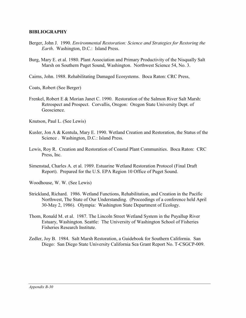
Appendix B-30
BIBLIOGRAPHY
Berger, John J. 1990. Environmental Restoration: Science and Strategies for Restoring the Earth. Washington, D.C.: Island Press.
Burg, Mary E. et al. 1980. Plant Association and Primary Productivity of the Nisqually Salt
Marsh on Southern Puget Sound, Washington. Northwest Science 54, No. 3. Cairns, John. 1988. Rehabilitating Damaged Ecosystems. Boca Raton: CRC Press, Coats, Robert (See Berger) Frenkel, Robert E & Morian Janet C. 1990. Restoration of the Salmon River Salt Marsh:
Retrospect and Prospect. Corvallis, Oregon: Oregon State University Dept. of Geoscience.
Knutson, Paul L. (See Lewis) Kusler, Jon A & Kentula, Mary E. 1990. Wetland Creation and Restoration, the Status of the
Science . Washington, D.C.: Island Press. Lewis, Roy R. Creation and Restoration of Coastal Plant Communities. Boca Raton: CRC
Press, Inc. Simenstad, Charles A. et al. 1989. Estuarine Wetland Restoration Protocol (Final Draft
Report). Prepared for the U.S. EPA Region 10 Office of Puget Sound. Woodhouse, W. W. (See Lewis) Strickland, Richard. 1986. Wetland Functions, Rehabilitation, and Creation in the Pacific
Northwest, The State of Our Understanding. (Proceedings of a conference held April 30-May 2, 1986). Olympia: Washington State Department of Ecology.
Thom, Ronald M. et al. 1987. The Lincoln Street Wetland System in the Puyallup River
Estuary, Washington. Seattle: The University of Washington School of Fisheries Fisheries Research Institute.
Zedler, Joy B. 1984. Salt Marsh Restoration, a Guidebook for Southern California. San
Diego: San Diego State University California Sea Grant Report No. T-CSGCP-009.
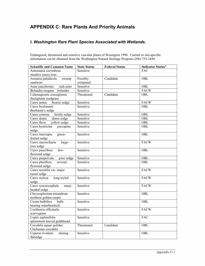
Appendix C-1
APPENDIX C: Rare Plants And Priority Animals
I. Washington Rare Plant Species Associated with Wetlands. Endangered, threatened and sensitive vascular plants of Wasington 1990. Current or site-specific information can be obtained from the Washington Natural Heritage Program (206) 753-2449. Scientific and Common Name State Status Federal Status Indicator Status* Antennaria corymbosa� meadow pussy-toes
Sensitive FAC
Arenaria paludicola� swamp sandwort
Possibly extirpated
Candidate OBL
Aster junciformis� rush aster Sensitive OBL Bolandra oregana� bolandra Sensitive FACW Calamagrostis crassiglumis� thickglume reedgrass
Threatened Candidate OBL
Carex aenea� bronze sedge Sensitive FACW Carex buxbaumii� Buxbaum’s sedge
Sensitive OBL
Carex comosa� bristly sedge Sensitive OBL Carex densa� dense sedge Sensitive OBL Carex flava� yellow sedge Sensitive OBL Carex hystricina� porcupine sedge
Sensitive OBL
Carex interrupta� green-fruited sedge
Sensitive OBL
Carex macrochaeta� large-awn sedge
Sensitive FACW
Carex pauciflora� few-flowered sedge
Sensitive OBL
Carex paupercula� poor sedge Sensitive OBL Carex pluriflora� several-flowered sedge
Sensitive OBL
Carex saxatilis var. major� russet sedge
Sensitive FACW
Carex stylosa� long-styled sedge
Sensitive FACW
Carex syncnocephala� many-headed sedge
Sensitive FACW
Chrysosplenium tetrandrum� northern golden-carpet
Sensitive OBL
Cicuta bulbifera� bulb-bearing waterhemlock
Sensitive OBL
Cochlearia officinalis� scurvygrass
Sensitive FACW
Coptis asplenifolia� spleenwort-leaved goldthread
Sensitive FAC
Corydalis aquae-gelidae � Clackamas corydalis
Threatened Candidate OBL
Cyperus rivularis� shining flatsedge
Sensitive OBL
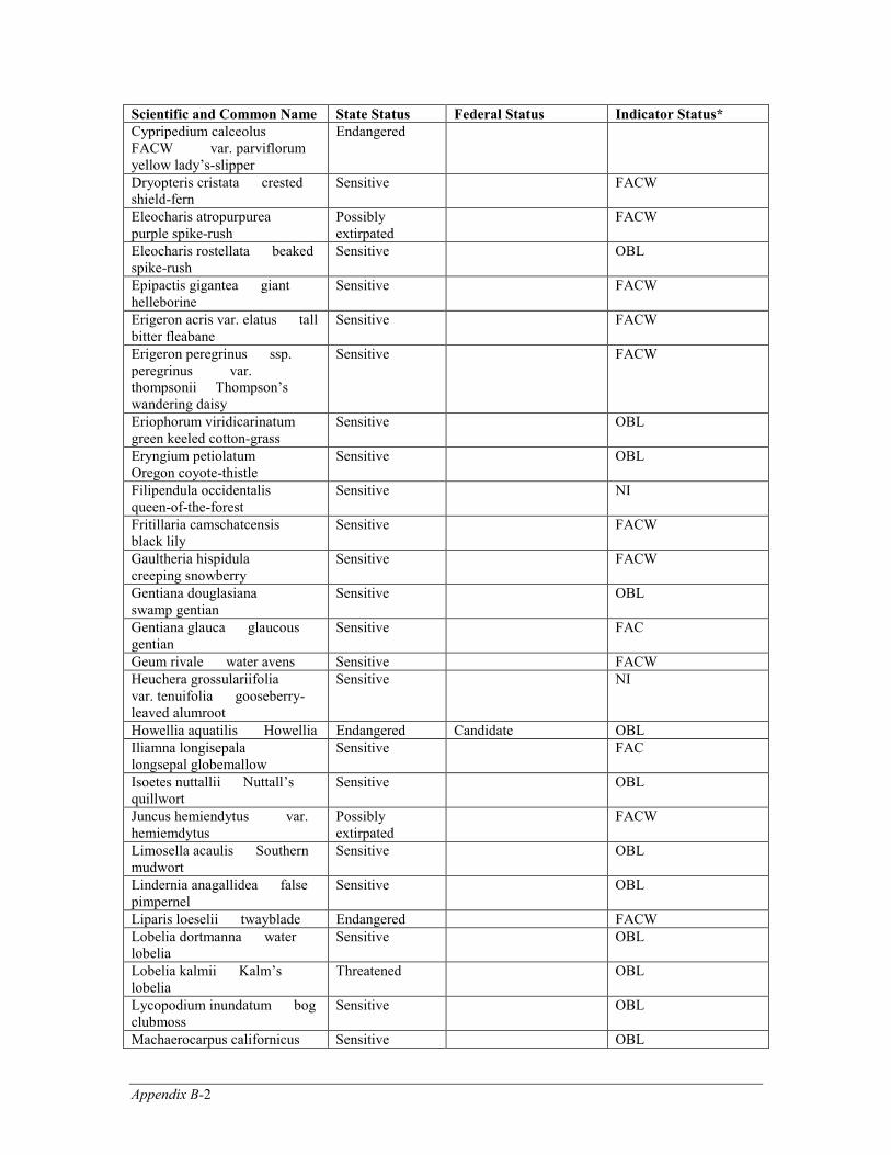
Appendix B-2
Scientific and Common Name State Status Federal Status Indicator Status* Cypripedium calceolus FACW� var. parviflorum� yellow lady’s-slipper
Endangered
Dryopteris cristata� crested shield-fern
Sensitive FACW
Eleocharis atropurpurea� purple spike-rush
Possibly extirpated
FACW
Eleocharis rostellata� beaked spike-rush
Sensitive OBL
Epipactis gigantea� giant helleborine
Sensitive FACW
Erigeron acris var. elatus� tall bitter fleabane
Sensitive FACW
Erigeron peregrinus� ssp. peregrinus� var. thompsonii� Thompson’s wandering daisy
Sensitive FACW
Eriophorum viridicarinatum� green keeled cotton-grass
Sensitive OBL
Eryngium petiolatum� Oregon coyote-thistle
Sensitive OBL
Filipendula occidentalis� queen-of-the-forest
Sensitive NI
Fritillaria camschatcensis� black lily
Sensitive FACW
Gaultheria hispidula� creeping snowberry
Sensitive FACW
Gentiana douglasiana� swamp gentian
Sensitive OBL
Gentiana glauca� glaucous gentian
Sensitive FAC
Geum rivale� water avens Sensitive FACW Heuchera grossulariifolia� var. tenuifolia� gooseberry-leaved alumroot
Sensitive NI
Howellia aquatilis � Howellia Endangered Candidate OBL Iliamna longisepala� longsepal globemallow
Sensitive FAC
Isoetes nuttallii� Nuttall’s quillwort
Sensitive OBL
Juncus hemiendytus� var. hemiemdytus
Possibly extirpated
FACW
Limosella acaulis� Southern mudwort
Sensitive OBL
Lindernia anagallidea� false pimpernel
Sensitive OBL
Liparis loeselii� twayblade Endangered FACW Lobelia dortmanna� water lobelia
Sensitive OBL
Lobelia kalmii� Kalm’s lobelia
Threatened OBL
Lycopodium inundatum� bog clubmoss
Sensitive OBL
Machaerocarpus californicus� Sensitive OBL
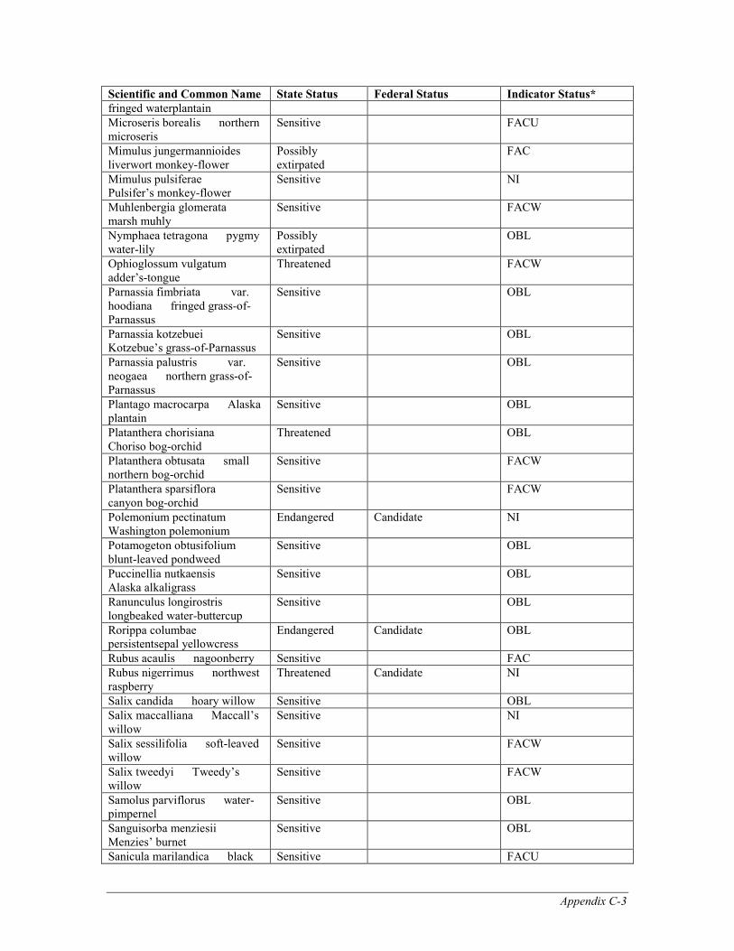
Appendix C-3
Scientific and Common Name State Status Federal Status Indicator Status* fringed waterplantain Microseris borealis� northern microseris
Sensitive FACU
Mimulus jungermannioides� liverwort monkey-flower
Possibly extirpated
FAC
Mimulus pulsiferae� Pulsifer’s monkey-flower
Sensitive NI
Muhlenbergia glomerata� marsh muhly
Sensitive FACW
Nymphaea tetragona� pygmy water-lily
Possibly extirpated
OBL
Ophioglossum vulgatum� adder’s-tongue
Threatened FACW
Parnassia fimbriata� var. hoodiana� fringed grass-of-Parnassus
Sensitive OBL
Parnassia kotzebuei� Kotzebue’s grass-of-Parnassus
Sensitive OBL
Parnassia palustris� var. neogaea� northern grass-of-Parnassus
Sensitive OBL
Plantago macrocarpa� Alaska plantain
Sensitive OBL
Platanthera chorisiana� Choriso bog-orchid
Threatened OBL
Platanthera obtusata� small northern bog-orchid
Sensitive FACW
Platanthera sparsiflora� canyon bog-orchid
Sensitive FACW
Polemonium pectinatum� Washington polemonium
Endangered Candidate NI
Potamogeton obtusifolium� blunt-leaved pondweed
Sensitive OBL
Puccinellia nutkaensis� Alaska alkaligrass
Sensitive OBL
Ranunculus longirostris� longbeaked water-buttercup
Sensitive OBL
Rorippa columbae� persistentsepal yellowcress
Endangered Candidate OBL
Rubus acaulis� nagoonberry Sensitive FAC Rubus nigerrimus� northwest raspberry
Threatened Candidate NI
Salix candida� hoary willow Sensitive OBL Salix maccalliana� Maccall’s willow
Sensitive NI
Salix sessilifolia� soft-leaved willow
Sensitive FACW
Salix tweedyi� Tweedy’s willow
Sensitive FACW
Samolus parviflorus� water-pimpernel
Sensitive OBL
Sanguisorba menziesii� Menzies’ burnet
Sensitive OBL
Sanicula marilandica� black Sensitive FACU
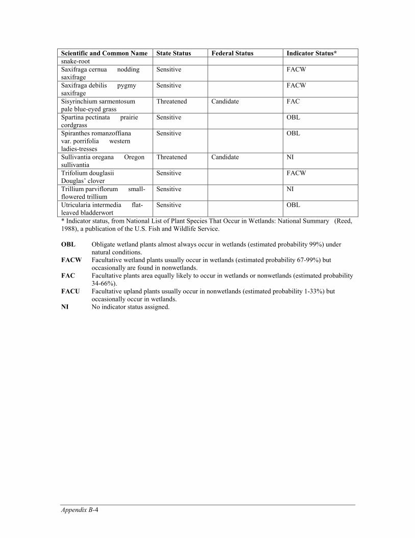
Appendix B-4
Scientific and Common Name State Status Federal Status Indicator Status* snake-root Saxifraga cernua� nodding saxifrage
Sensitive FACW
Saxifraga debilis� pygmy saxifrage
Sensitive FACW
Sisyrinchium sarmentosum� pale blue-eyed grass
Threatened Candidate FAC
Spartina pectinata� prairie cordgrass
Sensitive OBL
Spiranthes romanzoffiana� var. porrifolia� western ladies-tresses
Sensitive OBL
Sullivantia oregana� Oregon sullivantia
Threatened Candidate NI
Trifolium douglasii� Douglas’ clover
Sensitive FACW
Trillium parviflorum� small-flowered trillium
Sensitive NI
Utricularia intermedia� flat-leaved bladderwort
Sensitive OBL
* Indicator status, from National List of Plant Species That Occur in Wetlands: National Summary (Reed, 1988), a publication of the U.S. Fish and Wildlife Service. OBL Obligate wetland plants almost always occur in wetlands (estimated probability 99%) under
natural conditions. FACW Facultative wetland plants usually occur in wetlands (estimated probability 67-99%) but
occasionally are found in nonwetlands. FAC Facultative plants area equally likely to occur in wetlands or nonwetlands (estimated probability
34-66%). FACU Facultative upland plants usually occur in nonwetlands (estimated probability 1-33%) but
occasionally occur in wetlands. NI No indicator status assigned.
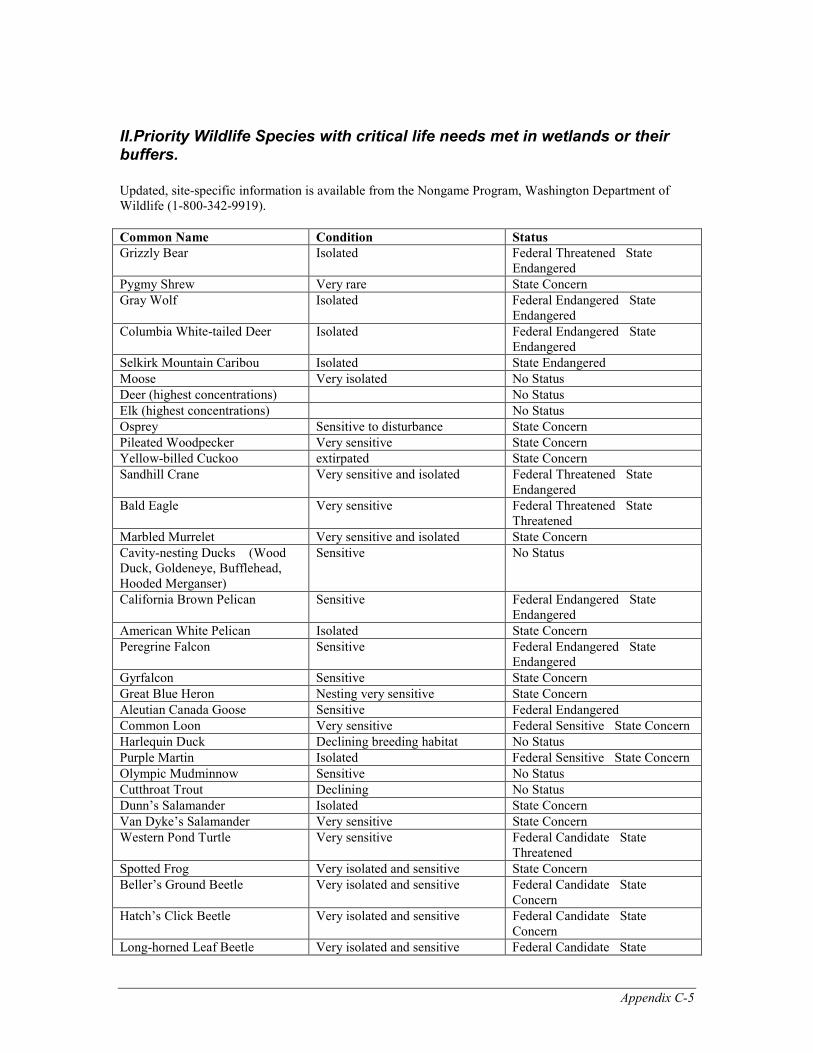
Appendix C-5
II.Priority Wildlife Species with critical life needs met in wetlands or their buffers. Updated, site-specific information is available from the Nongame Program, Washington Department of Wildlife (1-800-342-9919). Common Name Condition Status Grizzly Bear Isolated Federal Threatened�State
Endangered Pygmy Shrew Very rare State Concern Gray Wolf Isolated Federal Endangered�State
Endangered Columbia White-tailed Deer Isolated Federal Endangered�State
Endangered Selkirk Mountain Caribou Isolated State Endangered Moose Very isolated No Status Deer (highest concentrations) No Status Elk (highest concentrations) No Status Osprey Sensitive to disturbance State Concern Pileated Woodpecker Very sensitive State Concern Yellow-billed Cuckoo extirpated State Concern Sandhill Crane Very sensitive and isolated Federal Threatened�State
Endangered Bald Eagle Very sensitive Federal Threatened�State
Threatened Marbled Murrelet Very sensitive and isolated State Concern Cavity-nesting Ducks �(Wood Duck, Goldeneye, Bufflehead, Hooded Merganser)
Sensitive No Status
California Brown Pelican Sensitive Federal Endangered�State Endangered
American White Pelican Isolated State Concern Peregrine Falcon Sensitive Federal Endangered�State
Endangered Gyrfalcon Sensitive State Concern Great Blue Heron Nesting very sensitive State Concern Aleutian Canada Goose Sensitive Federal Endangered Common Loon Very sensitive Federal Sensitive�State Concern Harlequin Duck Declining breeding habitat No Status Purple Martin Isolated Federal Sensitive�State Concern Olympic Mudminnow Sensitive No Status Cutthroat Trout Declining No Status Dunn’s Salamander Isolated State Concern Van Dyke’s Salamander Very sensitive State Concern Western Pond Turtle Very sensitive Federal Candidate�State
Threatened Spotted Frog Very isolated and sensitive State Concern Beller’s Ground Beetle Very isolated and sensitive Federal Candidate�State
Concern Hatch’s Click Beetle Very isolated and sensitive Federal Candidate�State
Concern Long-horned Leaf Beetle Very isolated and sensitive Federal Candidate�State

Appendix B-6
Common Name Condition Status Concern
Columbia Tiger Beetle Very isolated and sensitive Federal Endangered�State Endangered
Oregon Silverspot Butterfly Very isolated and sensitive Federal Threatened�State Threatened
Appendix D-1
APPENDIX D: Technical Assistance And Funding Options Funding and technical assistance are available to local governments and private landowners for wetland restoration. The U.S. Fish and Wildlife Service (USFWS), Washington Department of Wildlife, and U.S. Department of Agriculture (USDA) Soil Conservation Service provide technical assistance and cost-share projects for wetland restoration on private lands. Federal, state, and local agencies have combined funding efforts to initiate three large-scale demonstration projects on the west side; these include proposed estuarine wetland restoration on the Skokomish River, the Snohomish River, and the Duwamish River. Compensatory mitigation projects implemented by regulatory agencies such as the U.S. Army Corps of Engineers (COE), U.S. Environmental Protection Agency (EPA), and Washington Department of Ecology (Ecology) are used as guidance for future mitigation and restoration successes.
U.S. Environmental Protection Agency The objectives of the Clean Water Act are to restore and maintain the chemical, physical and biological integrity of the nations waters, including wetlands. The National Wetland Policy Forum recommended establishment of a cooperative public-private National Wetlands Restoration Initiative. A national goal of no overall net loss of wetland values and functions was established through this process. EPA has prepared a wetland action plan that adopts the goal of the National Wetlands Policy Forum to "achieve no overall net loss and a longterm gain of the nation's remaining wetland base, as defined by acreage and function; and to restore and create wetlands, where feasible, to increase the quality and quantity of the nation's wetlands resource base". That policy translated into action plan language states that "EPA will identify opportunities and initiate projects to restore and create wetlands to increase the quantity and quality of wetlands and to meet other national environmental goals including those of the Clean Water Act. EPA will also identify areas appropriate for wetland restoration based upon advance planning processes and consideration of cumulative impacts such as point or nonpoint source problems within watershed areas" and; In a memorandum of agreement on mitigation, EPA and COE have jointly declared a goal of no net loss of wetland values and functions in implementing the Clean Water Act Section 404 program. Within Region 10, EPA has completed the following: 1) two-phased assessment of opportunities for restoring diked tidal wetlands, 2) supported wetland/riparian restoration research, and 3) participated in development of technically sound protocols for assessing estuarine wetland restoration projects. Protocols are currently being tested during dike removal at a coastal estuarine site in Grays Harbor, Washington.

Appendix D-2
At a number of Superfund sites (notably Commencement Bay), sediment management activities will provide opportunity for habitat restoration in cooperation with cleanup activities. This may involve replacement and contouring of sediment to provide an appropriate substrate or simply monitoring restored sites to determine best management approaches to maximize resource values. As a result of a recent permit elevation by EPA Region 10, the Alaska District of COE will be completing a wetland mitigation plan. Integral to this is the opportunity for accelerated rehabilitation of wetlands impacted by oil related activities. In addition, several advanced identification projects are being funded throughout the region. The Green River SAMP is an example of such projects in Washington. EPA restoration priorities include: restoring diked tidelands, restoration of estuarine wetlands that have been degraded through urbanization, restoration of wetlands at superfund sites, creation of multifunctional wetlands in association with stormwater and wastewater management, restoration of riverine and riparian habitats impacted by placer mining, urbanization and agriculture, control of nuisance non-native wetland plants, and restoration of abandoned industrial sites. Funding is being provided to states, local governments, universities, Ports, and other federal agencies to pursue multiple aspects of wetland restoration including research, planning, design, and construction activities.
1. Funding is available for local governments to prepare comprehensive wetland management plans. Adoption of a wetland restoration element that includes regional goals and identifies specific restoration projects is a required component of these plans.
2. Funding and technical assistance is available for tribes, ports, states, or local
governments to plan, design, and construct specific restoration projects. Funding is limited and normally will be for a portion of a cooperative project that includes participation by other agencies and the private sector. Examples include: planning for a 600-acre estuarine restoration project in the Skokomish estuary in cooperation with the Skokomish Tribe and USFWS; planning and design of a habitat restoration project in the Duwamish estuary in cooperation with the Port of Seattle; and planning and design of a surge plain/estuarine wetland complex on the Snohomish River with local, state, and federal agency involvement.
3. The Puget Sound Comprehensive Conservation Management Plan signed by EPA
contains strong emphasis on wetland restoration. Limited implementation funding is also provided. Specifically, an interagency proposal (COE, Washington State, Snohomish County, EPA, and USFWS) for wetland restoration in the Snohomish Delta has been selected for funding.
Appendix D-3
4. Research funding is being provided to develop ecologically sound techniques for
cost effective restoration of riparian zones impacted by placer mining operation s and for developing protocols for monitoring estuarine restoration projects.
5. Funding has been provided to assist COE in coordinating a regional workshop on
wetland restoration. Participation by agencies and the private sector is anticipated. For further information, contact:
Fred Weinmann, Wetlands Office (206) 553-1414 or Mike Rylko, Office of Coastal Waters (206) 553-4014 U.S. Environmental Protection Agency, Region 10 1200 Sixth Avenue Seattle, Washington 98101 (206) 553-1414
Skokomish Tribe The Skokomish Tribe, in concert with the national and regional no-net-loss goal, is developing an estuary management plan for the Skokomish River Delta. The goal of the Skokomish Estuary Management Plan is the acquisition, restoration, and protection of the Skokomish River Delta in its natural state. The Skokomish River estuary is the largest on Hood Canal and one of the largest in the Puget Sound. The area has been recognized under the North American Waterfowl Management Plan and is designated an Estuary of National Significance under the National Estuary Program (Section 320) of the Clean Water Act. The Skokomish River estuary was a traditional site for many cultural and religious activities of the Twana people, who lived throughout the Hood Canal Region. The Delta property, which is entirely within the Skokomish Reservation, includes approximately 600 acres of upland delta and 400 acres of adjacent tidelands. Seven miles of dikes and an expansive drainage system were build for agricultural purposes. These areas are not presently in agricultural use. This property is composed of alienated fee lands within the Skokomish Reservation. For further information on the Skokomish River Delta Project, contact: Philip Jordi Skokomish Natural Resource Planner Skokomish Tribal Center N. 80 Tribal Center Rd. Shelton, Washington 98584 (206) 426-4232
Appendix D-4
U.S. Army Corps Of Engineers The Seattle District COE's involvement in wetland restoration is part of a continually evolving program. The program is being fostered by administrative emphasis on the environment and the establishment through recent Water Resources Development Acts of a COE environmental mission, and programs such as the Wetlands Restoration Demonstration Program and Wetland Research Program. Section 1135 gives COE authority to review past projects with a view toward identifying fish and wildlife opportunities. The emphasis on the restoration plays a role in all COE programs, including the civil works program, military program, operations and maintenance (dredging) program, and regulatory program. For authorized planning studies and projects, the COE is looking for opportunities to restore wetlands and other fish and wildlife habitats. Seattle District is especially interested in exploring alternatives to achieve other mission goals (e.g. flood control) through wetland restoration projects. Such restoration opportunities must be accomplished under an existing study/project authority. Funding is through specific project funds, which, depending on authority, may include local cost-share requirements. In its military program, COE continues to work with various installations in pursuit of opportunities to restore and maintain wetlands on Army-owned lands. As part of COE's dredging program, opportunities for beneficial uses are explored as alternatives for dredged material disposal. Such opportunities may include habitat/wetland restoration. Recently, COE entered into a Memorandum of Agreement (MOA) with the National Oceanic and Atmospheric Administration (NOAA) to explore opportunities for fish and wildlife improvements associated with COE projects. In the regulatory program, emphasis on restoration as a means of mitigation is placed for wetland fill projects requiring Section 404 (Clean Water Act) permits. Also, under the program category "Work For Others," COE is exploring partnerships with other agencies (such as EPA, USFWS, National Marine Fisheries Service, and the State of Washington) to accomplish habitat restoration projects as well as other environmental activities. Under this program, COE provides technical assistance in a variety of disciplines to the agency partners and works with that partner or partners toward achievement of mutual goals. COE may fund some of its initial involvement for a particular activity; however, for any major or continuing involvement, funds are transferred to COE by other agencies for specifically defined tasks. One example is the restoration planning work COE has done for NOAA in Commencement Bay, Washington. A new initiative, Coastal America, was recently established by President Bush to protect

Appendix D-5
America's coastal resources. This program sets forth an innovative approach of work in partnership with other Federal programs and integrate Federal actions with state, local, and nongovernmental agencies. Key federal agencies involved include COE, Department of Interior, EPA, and NOAA. Funding for Coastal America is limited at present. However, the program offers an excellent opportunity for agencies to work together to develop projects that address major coastal problems: loss and degradation of habitat, pollution from nonpoint sources, and contaminated sediments. For Puget Sound, COE is involved with the state and other federal agencies in implementation of the Puget Sound Water Quality Management Plan, which also serves as the management plan for the Puget Sound National Estuary Program. A variety of the programs already described could be used to work toward achievement of the Puget Sound Plan's goals. Throughout COE programs and projects, particularly when dealing with the environmental issues, emphasis is placed on commitment, partnership, and innovation. Contact: Karen Northrup U.S. Army Corps of Engineers Environmental Review Branch 4735 E. Marginal Way S. Seattle, Washington 98124-2255 (206) 764-3624
U.S. Fish And Wildlife Service Under a new program, USFWS has initiated a statewide restoration program titled the Washington State Ecosystems Conservation Program. The goal of this Program is to achieve no net loss of wetland acreage or value in Washington by facilitating the protection, enhancement, restoration, and creation of wetlands. Under one component of the initiative, USFWS is providing technical and financial assistance to property owners who want to restore, enhance, or create wetland or riparian habitats on their property. Financial assistance is provided on a cost-sharing basis with USFWS providing a portion of the project costs and the landowner and other potential project partners contributing the remainder. Wetland restoration may be accomplished by simply plugging a ditch or building a small dike. Shallow excavations can also create valuable wetlands. Other potential projects include creating islands, installing fencing along streams, or planting vegetation. In exchange for federal assistance landowners must agree, through a Wildlife Extension Agreement, to leave the project in place for a specified time period (usually 10 years).

Appendix D-6
The term of the Wildlife Extension Agreement affects the level of federal assistance for the project. For more information about the program, contact: U.S. Fish and Wildlife Service 3704 Griffin Lane S.E., Suite 102 Olympia, Washington 98501-2191 Phone: (206) 753-9440 U.S. Fish and Wildlife Service P.O. Box 1157 Moses Lake, Washington 98837 Phone: (509)765-6125
Washington Department Of Wildlife The Washington Department of Wildlife (WDW) is a partner with USFWS on the Washington State Ecosystems Conservation Program. WDW acquires critical wetland buffers and other important upland habitat to enhance wildlife value. A major component of this program is WDW's Pheasant and Farmland Wildlife Habitat Recovery Plan. This plan envisions the acquisition of strategically-located, permanent habitat plots throughout eastern Washington agricultural areas. Additional upland species restoration plans to be completed include those for grouse, sharp-tailed grouse, forest grouse, quail, partridge, turkey, dove, pigeon and other upland wildlife. Coordination will occur with other upland acquisition and enhancement efforts achieved through the Columbia River Mitigation Project, Columbia Basin Irrigation Project-Phase II (East High), Snake River Mitigation Project, and Statewide Farmer Cooperative Habitat Development and Access Program. Landowner compensation payments, roadway habitat management, technical assistance to landowners, and incentives for habitat enhancements on private lands would be used to complement the land acquisition phase. For information on this program, contact Dan Blatt, (206) 753-5733. WDW can provide grants to non-profit organizations or individuals for waterfowl production projects, through the Migratory Waterfowl Artwork Program. Examples of projects funded through this program include construction of nesting floats, wood duck nest boxes, and goose tubs; fencing of overgrazed habitats; and creation of freshwater marsh impoundments. Application forms are available from:

Appendix D-7
Waterfowl Program Washington Department of Wildlife 600 N. Capital Way Olympia, Washington, 98504. WDW is also working with Ducks Unlimited, Inc. to implement cooperatively funded projects on WDW lands. Ducks Unlimited is initiating a new private lands enhancement program and often can provide technical assistance on wetland restoration projects. At its property near Westport in Grays Harbor, WDW breached a dike to restore 40 acres of reed canary grass wet pasture to salt marsh. WDW's Volunteer Cooperative Fish and Wildlife Enhancement Program is a funding source for volunteers to enhance fish and wildlife habitat. Enhancement can include wetland and riparian area restorations. Monies can be used for materials and expenses but not salaries. For information and application forms, contact: Dave Gadwa Washington Department of Wildlife 600 N. Capitol Way Olympia, Washington 98501-1091 (206) 586-5511 U.S. Department Of Agriculture - Soil Conservation ServiCE Both technical and financial assistance are available from two agencies within the USDA Soil Conservation Service (SCS) and the Agricultural Stabilization and Conservation Service (ASCS). Cost-sharing is available in most counties under the Agricultural Conservation Program (ACP) for earth-moving to construct dams, levees, dikes, and shallow dugouts to develop or restore shallow water areas; eligible planting for food and nesting cover; and permanent fences to protect developed areas from livestock grazing. Cost-sharing is also available in most counties for developing upland wildlife habitat and streambank stabilization. Applications for cost-sharing are completed at the ASCS office. Technical assistance for planning and installation of best management practices is provided by SCS. SCS personnel will visit homeowners' lands, free of charge, and offer technical advice on building or restoring wetlands. Assistance is also available to help locate suitable wetland sites. SCS personnel in each county can also schedule specialists in soils, biology, plant materials, and engineering to provide assistance. In addition, SCS offers a wide variety of written technical materials on wildlife, plant materials, pond construction, and soils. Under the 1985 Food Security Act, highly erodible croplands can be voluntarily retired
Appendix D-8
from crop production for ten years in exchange for an annual rental payment from USDA. Land enrolled in this program must be seeded with grasses and legumes to control erosion. The seedlings can be tailored to meet the needs of wildlife (e.g., upland nesting cover for waterfowl. In addition, shallow water areas for wetland wildlife and food plots may be established through this program. Under the 1990 Food, Agriculture, Conservation, and Trade Act (FACTA), a new program was authorized by Congress to provide landowners with an annual rental payment for converting croplands back into wetlands. Funds from this program will probably be available in 1992. SCS and ASCS are jointly sponsoring a pilot program to develop constructed wetlands for agricultural wastewater treatment. This technology is already being used with success in several parts of the country. These projects will be designed with a primary emphasis on water quality improvement. Because of the pollutants that are being processed in these systems, some of the traditional functions of wetlands (for example, providing fish and wildlife habitat) may be inappropriate. For further information on restoration information, contact: Ivan Lines USDA Soil Conservation Service Washington State Office Rock Pointe Tower II, Suite 450 316 W. Boone Avenue Spokane, Washington 98201-2348 (509) 353-2335 The SCS Plant Materials Program is a nationwide network of 26 Plant Materials Centers. Located in Corvalis, Oregon and Pullman, Washington, these centers test, evaluate and release plant materials for commercial production. These plants are used for conservation uses, including wetland and riparian plants. The SCS also provides technical assistance in plant materials establishment and maintenance. Contact: Scott Lambert U.S.DA, Soil Conservation Service Rock Pointe Tower II, Suite 450 316 W. Boone Avenue Spokane, Washington 98201-2348 (509) 353-2335
Appendix D-9
U.S. Bureau Of Land Management The U.S. Bureau of Land Management is participating in a strong national initiative to restore riparian and wetland areas. The Riparian Wetland Initiative for the 1990's has a goal of restoring 75% of all wetland-riparian areas to a functioning condition by 1997. In Washington, over $100,000 per year has been devoted to inventory, monitoring, and restoring wetland riparian areas. A broadbased inventory of wetland and riparian areas on BLM lands was initiated in 1985. Several management and restoration projects have been initiated in the Columbia Basin since 1986. Restoration projects have included management of intensive grazing, weed control, planting of woody vegetation, and the creation of small impoundments. Contact: Lou Jurs Bureau of Land Management Spokane District Office East 4217 Main Spokane, Washington 99202 ((503) 280-7045
Washington Department Of Ecology Ecology provides technical assistance on issues of wetlands restoration in conjunction with other aspects of wetlands protection through preservation and policy. In addition, staff are involved in review and monitoring of compensatory mitigation projects through regulatory activities. Under the Puget Sound Water Quality Management Plan, Ecology is working with EPA, USFWS, and COE to develop a Sound-wide restoration strategy and pilot restoration program. Implementation of this pilot effort is currently funded by a federal Puget Sound Estuary Demonstration Project grant. For additional information, contact: Jane Frost Washington Department of Ecology Mail Stop PV-11 Olympia, Washington 98501 (206) 438-7429 The State Water Pollution Control Revolving Fund (SRF) provides low-interest loans (at or below market interest rates) for projects that improve and protect the state's water quality. Administered by Ecology's Water Quality Financial Assistance Program, these loans are available to any public body in Washington.

Appendix D-10
Under the Comprehensive Estuary Conservation and Management Program, SRF provides low-cost financing (up to $4 million was available during state fiscal year 93) to restore and preserve fish and shellfish habitats and conduct research activities for estuary protection. Eligible projects under the Nonpoint Source Pollution Control Category include acquiring wetland habitat and wetlands management and lake restoration programs. Applications are typically accepted during June; for current information, contact: Dan Filip Washington Department of Ecology Water Quality Financial Assistance Program P.O. Box 47600 Olympia, Washington 98504-7600 (206) 459-6061
Appendix E-1
APPENDIX E: Wetland Regulatory Programs
Wetland Regulations A variety of federal, state, and local regulations affect activities that occur in wetlands. The types, sizes, and locations of wetlands included in regulations may vary from one law to the next. As a result, case-by-case review is needed, and applicants are advised to contact the appropriate agencies prior to project development. Contacting the U.S. Army Corps of Engineers, state Departments of Ecology, Wildlife or Fisheries, and the appropriate local planning department is a good start. Greater detail on regulatory programs is contained in Wetland Regulations Guidebook, a free document prepared by Ecology. Regulatory programs provide guidelines and technical review of restoration projects with the objective of achieving beneficial restoration activities. If projects are proposed that degrade wetland functions, permit conditions usually provide guidance for improved restoration techniques to be implemented. Attempts are currently underway to streamline the regulatory process for restoration projects. It is important that the appropriate permits and project approvals be obtained as early as possible in the project design process. The permit process, particularly if a permit is required for placement of fill under Section 404 of the federal Clean Water Act, is likely to cause significant project delays and potential modification of project design.
Historic Perspective The federal Clean Water Act was passed in 1972 and, although it only regulates the discharge of dredged or fill material into wetlands, it is still the primary tool with which the federal government regulates activities in wetlands. The 1985 Food Securities Act contains a "Swampbuster" provision to prevent abetting wetland drainage through reduction or elimination of subsidies for commodity crops. The Shoreline Management Act was passed by the Washington Legislature in 1971. Although 75 percent of the state's wetlands are left out of the Act's definition of shoreline "associated wetlands," this remains the only state law that specifically addresses the regulation of activities in wetlands. Work in wetlands below ordinary high water in waters of the state may also be regulated under the state's Hydraulics Code. Many local governments in Washington have passed local ordinances restricting or regulating adverse impacts to wetland areas. Governor Booth Gardner was Vice-Chairman of the National Wetlands Policy Forum. In Executive Order 89-10, he issued a directive to state agencies to develop action plans to use existing state regulatory authority to achieve no overall net loss of wetland acreage

Appendix E-2
and function. Restoration and use of compensatory mitigation through existing regulatory authority are keys to achieving no-net-loss goals at state and federal levels.
Federal Regulations The principal federal laws that regulate activities in wetlands are Sections 404 and 401 of the Clean Water Act and Section 10 of the River and Harbor Act. Other federal laws include the National Environmental Policy Act, the Coastal Zone Management Act, and the "Swampbuster" provision of the 1985 and 1990 Food Security Act. Clean Water Act. The primary goal of the Clean Water Act (CWA) is to "restore and maintain the chemical, physical and biological integrity of the Nation's waters." Section 404 is specifically directed towards regulating the discharge of dredged or fill material into waters of the United States, including wetlands. Restoration projects often involve dredging ponds, restructuring dikes or levees, re-contouring sites, and general earth-moving activities. These will sometimes require a 404 permit; the U.S. Army Corps of Engineers (COE) should be contacted to determine if a permit is required. COE has the authority to issue general permits that provide blanket authorization on nationwide, state, or regional levels for actions that have minimal adverse impacts on the environment. Such actions do not require individual permits if the project complies with the conditions in the general permit. The State of Washington has Section 401 water quality certification responsibilities for permits issued under Section 404 of the Clean Water Act. The purpose of Section 401 provisions is to ensure that federally permitted activities comply with the federal Clean Water Act, state water quality laws, and any other appropriate state laws (e.g., the Water Resources Act, Hydraulics Act, and Coastal Zone Consistency). Section 401 is implemented through a certification process. With respect to wetland restoration, the state certification process is most typically triggered through a Section 404 Public Notice and permit application. The following activities would not be certified under existing water quality standards: detrimental impacts to high quality wetlands; degradation of designated characteristic uses such as recreation, aesthetics, water supply, and fish, shellfish and wildlife habitat; and deleterious impacts to water quality (including degrading stormwater attenuation, biofiltration, groundwater exchange, and water quality purification functions of existing wetlands). Coastal Zone Management Act of 1972. The federal Coastal Zone Management Act (CZMA) of 1972 and subsequent amendments established a voluntary program through which states could receive financial and technical assistance to formulate a plan for the efficient use of coastal zone areas within their boundaries. Fifteen counties in Washington are affected by the plan. If a proposed action does not comply with the
Appendix E-3
CZMA, any applicant for a federal license or permit within the coastal zone must certify consistency with the state's approved program. Ecology's Shorelands Program confirms or denies that the proposed action complies with the Washington Coastal Zone Management Program. 1985 Food Security Act and 1990 Food, Agricultural, Conservation, and Trade Act. The 1985 and 1990 Food Security Act's "Swampbuster" provision prevents any farmers who convert wetlands to croplands, hay, or pasture land from being eligibility for all United States Department of Agriculture farm programs. This provision applies to all commodity crops produced by those farmers, not just those produced on converted wetlands.
State Regulations The primary state regulations that affect development activities in and near wetlands include the Shoreline Management Act, the State Hydraulics Code, State Water Quality Standards, the State Environmental Policy Act, and the Floodplain Management Act. Shoreline Management Act. The state's Shoreline Management Act (SMA) of 1971 (Chapter 90.58 RCW) was passed to manage appropriate uses of the shorelines of the state, with the exception of Tribal lands. Under the SMA, development of the state's shorelines is intended to be done in a manner that promotes and enhances the public interest and that protects against adverse effects to public health, the lands and its vegetation and wildlife, and the waters of the state and their aquatic life. The SMA is implemented through a permit program for activities in and on the shorelines of the state. Local governments have prepared shoreline master programs (land use plans) for all shorelines within their jurisdictions. For most activities in and on shorelines, permits for substantial development, conditional uses, and variances are issued by the local government. Ecology has primary responsibility to review issued permits for conformance with the SMA. However, some activities are exempted. Local government should be contacted to determine if specific restoration activities require permits. Hydraulic Code. The Hydraulic Code is implemented through a permit called the Hydraulic Project Approval (HPA), obtained from the state Departments of Fisheries or Wildlife. The HPA is required for any work within the ordinary high water mark, which often include wetlands. Prior to construction or other work that will use, divert, obstruct, or change the natural flow or bed of any state waters, approval is required from either Fisheries or Wildlife. State Environmental Policy Act. The Washington State Environmental Policy Act (SEPA) was passed by the Legislature to provide a process to analyze the environmental
Appendix E-4
impacts of development. Information provided during the SEPA process helps agency decision-makers and the general public understand how a project would affect the environment. SEPA is implemented by local government and reviewed by state and federal agencies. SEPA is not a permit. It is a process geared to mesh with existing permits, approvals and/or licenses. Agencies or local governmental units review, condition, or potentially deny permits or other approvals under SEPA if the proposal would likely result in significant adverse environmental impacts and if mitigative measures would be insufficient to mitigate the identified impact. Completion of the SEPA process is necessary before agency decisions are made on the Hydraulic Project Approval, shoreline substantial development permit, short-term water quality modification permit, and many other local and state permits and approvals. Short Term Modification, State Water Quality Standards. Activities in wetlands that would temporarily lower water quality may require a Water Quality Standards Modification (short-term modification). Ecology issues short term modifications for activities such as construction projects, pesticide and herbicide applications, irrigation system maintenance, and restoration activities that alter wetlands or other waters of the state. The Short Term Modification process is usually initiated at the local level, through the SEPA review process if a potential water quality impact has been identified. If an Ecology permit writer determines that the significance of a project's impact to the ecosystem is substantial, the project can be denied. In most instances, however, short-term modifications are conditioned to reduce the impacts of such activities to acceptable levels by reducing the scope of the project, limiting the time of day, month or year it can take place, or spreading out the impacts of an activity, reducing the intensity of a single event. The Pollution Control Hearings Board reviews these conditions on appeal. Decisions are based on policies set forth in water quality standards.
Local Regulations Many local jurisdictions in Washington also have provisions of ordinances and other regulations that affect projects proposed in or adjacent to wetlands. Because there is considerable variation in the provisions of these local regulations, it is necessary to contact local planning departments to determine if these provisions will affect a particular wetland. In many instances, local regulations may address wetlands not covered by federal and state regulations and may be more restrictive than those of federal and state governments. It may also be necessary to comply with Tribal environmental codes and ordinances.

Appendix E-1
APPENDIX E: Wetland Regulatory Programs
Wetland Regulations A variety of federal, state, and local regulations affect activities that occur in wetlands. The types, sizes, and locations of wetlands included in regulations may vary from one law to the next. As a result, case-by-case review is needed, and applicants are advised to contact the appropriate agencies prior to project development. Contacting the U.S. Army Corps of Engineers, state Departments of Ecology, Wildlife or Fisheries, and the appropriate local planning department is a good start. Greater detail on regulatory programs is contained in Wetland Regulations Guidebook, a free document prepared by Ecology. Regulatory programs provide guidelines and technical review of restoration projects with the objective of achieving beneficial restoration activities. If projects are proposed that degrade wetland functions, permit conditions usually provide guidance for improved restoration techniques to be implemented. Attempts are currently underway to streamline the regulatory process for restoration projects. It is important that the appropriate permits and project approvals be obtained as early as possible in the project design process. The permit process, particularly if a permit is required for placement of fill under Section 404 of the federal Clean Water Act, is likely to cause significant project delays and potential modification of project design.
Historic Perspective The federal Clean Water Act was passed in 1972 and, although it only regulates the discharge of dredged or fill material into wetlands, it is still the primary tool with which the federal government regulates activities in wetlands. The 1985 Food Securities Act contains a "Swampbuster" provision to prevent abetting wetland drainage through reduction or elimination of subsidies for commodity crops. The Shoreline Management Act was passed by the Washington Legislature in 1971. Although 75 percent of the state's wetlands are left out of the Act's definition of shoreline "associated wetlands," this remains the only state law that specifically addresses the regulation of activities in wetlands. Work in wetlands below ordinary high water in waters of the state may also be regulated under the state's Hydraulics Code. Many local governments in Washington have passed local ordinances restricting or regulating adverse impacts to wetland areas. Governor Booth Gardner was Vice-Chairman of the National Wetlands Policy Forum. In Executive Order 89-10, he issued a directive to state agencies to develop action plans to use existing state regulatory authority to achieve no overall net loss of wetland acreage
Appendix E-2
and function. Restoration and use of compensatory mitigation through existing regulatory authority are keys to achieving no-net-loss goals at state and federal levels.
Federal Regulations The principal federal laws that regulate activities in wetlands are Sections 404 and 401 of the Clean Water Act and Section 10 of the River and Harbor Act. Other federal laws include the National Environmental Policy Act, the Coastal Zone Management Act, and the "Swampbuster" provision of the 1985 and 1990 Food Security Act. Clean Water Act. The primary goal of the Clean Water Act (CWA) is to "restore and maintain the chemical, physical and biological integrity of the Nation's waters." Section 404 is specifically directed towards regulating the discharge of dredged or fill material into waters of the United States, including wetlands. Restoration projects often involve dredging ponds, restructuring dikes or levees, re-contouring sites, and general earth-moving activities. These will sometimes require a 404 permit; the U.S. Army Corps of Engineers (COE) should be contacted to determine if a permit is required. COE has the authority to issue general permits that provide blanket authorization on nationwide, state, or regional levels for actions that have minimal adverse impacts on the environment. Such actions do not require individual permits if the project complies with the conditions in the general permit. The State of Washington has Section 401 water quality certification responsibilities for permits issued under Section 404 of the Clean Water Act. The purpose of Section 401 provisions is to ensure that federally permitted activities comply with the federal Clean Water Act, state water quality laws, and any other appropriate state laws (e.g., the Water Resources Act, Hydraulics Act, and Coastal Zone Consistency). Section 401 is implemented through a certification process. With respect to wetland restoration, the state certification process is most typically triggered through a Section 404 Public Notice and permit application. The following activities would not be certified under existing water quality standards: detrimental impacts to high quality wetlands; degradation of designated characteristic uses such as recreation, aesthetics, water supply, and fish, shellfish and wildlife habitat; and deleterious impacts to water quality (including degrading stormwater attenuation, biofiltration, groundwater exchange, and water quality purification functions of existing wetlands). Coastal Zone Management Act of 1972. The federal Coastal Zone Management Act (CZMA) of 1972 and subsequent amendments established a voluntary program through which states could receive financial and technical assistance to formulate a plan for the efficient use of coastal zone areas within their boundaries. Fifteen counties in Washington are affected by the plan. If a proposed action does not comply with the

Appendix E-3
CZMA, any applicant for a federal license or permit within the coastal zone must certify consistency with the state's approved program. Ecology's Shorelands Program confirms or denies that the proposed action complies with the Washington Coastal Zone Management Program. 1985 Food Security Act and 1990 Food, Agricultural, Conservation, and Trade Act. The 1985 and 1990 Food Security Act's "Swampbuster" provision prevents any farmers who convert wetlands to croplands, hay, or pasture land from being eligibility for all United States Department of Agriculture farm programs. This provision applies to all commodity crops produced by those farmers, not just those produced on converted wetlands.
State Regulations The primary state regulations that affect development activities in and near wetlands include the Shoreline Management Act, the State Hydraulics Code, State Water Quality Standards, the State Environmental Policy Act, and the Floodplain Management Act. Shoreline Management Act. The state's Shoreline Management Act (SMA) of 1971 (Chapter 90.58 RCW) was passed to manage appropriate uses of the shorelines of the state, with the exception of Tribal lands. Under the SMA, development of the state's shorelines is intended to be done in a manner that promotes and enhances the public interest and that protects against adverse effects to public health, the lands and its vegetation and wildlife, and the waters of the state and their aquatic life. The SMA is implemented through a permit program for activities in and on the shorelines of the state. Local governments have prepared shoreline master programs (land use plans) for all shorelines within their jurisdictions. For most activities in and on shorelines, permits for substantial development, conditional uses, and variances are issued by the local government. Ecology has primary responsibility to review issued permits for conformance with the SMA. However, some activities are exempted. Local government should be contacted to determine if specific restoration activities require permits. Hydraulic Code. The Hydraulic Code is implemented through a permit called the Hydraulic Project Approval (HPA), obtained from the state Departments of Fisheries or Wildlife. The HPA is required for any work within the ordinary high water mark, which often include wetlands. Prior to construction or other work that will use, divert, obstruct, or change the natural flow or bed of any state waters, approval is required from either Fisheries or Wildlife. State Environmental Policy Act. The Washington State Environmental Policy Act (SEPA) was passed by the Legislature to provide a process to analyze the environmental

Appendix E-4
impacts of development. Information provided during the SEPA process helps agency decision-makers and the general public understand how a project would affect the environment. SEPA is implemented by local government and reviewed by state and federal agencies. SEPA is not a permit. It is a process geared to mesh with existing permits, approvals and/or licenses. Agencies or local governmental units review, condition, or potentially deny permits or other approvals under SEPA if the proposal would likely result in significant adverse environmental impacts and if mitigative measures would be insufficient to mitigate the identified impact. Completion of the SEPA process is necessary before agency decisions are made on the Hydraulic Project Approval, shoreline substantial development permit, short-term water quality modification permit, and many other local and state permits and approvals. Short Term Modification, State Water Quality Standards. Activities in wetlands that would temporarily lower water quality may require a Water Quality Standards Modification (short-term modification). Ecology issues short term modifications for activities such as construction projects, pesticide and herbicide applications, irrigation system maintenance, and restoration activities that alter wetlands or other waters of the state. The Short Term Modification process is usually initiated at the local level, through the SEPA review process if a potential water quality impact has been identified. If an Ecology permit writer determines that the significance of a project's impact to the ecosystem is substantial, the project can be denied. In most instances, however, short-term modifications are conditioned to reduce the impacts of such activities to acceptable levels by reducing the scope of the project, limiting the time of day, month or year it can take place, or spreading out the impacts of an activity, reducing the intensity of a single event. The Pollution Control Hearings Board reviews these conditions on appeal. Decisions are based on policies set forth in water quality standards.
Local Regulations Many local jurisdictions in Washington also have provisions of ordinances and other regulations that affect projects proposed in or adjacent to wetlands. Because there is considerable variation in the provisions of these local regulations, it is necessary to contact local planning departments to determine if these provisions will affect a particular wetland. In many instances, local regulations may address wetlands not covered by federal and state regulations and may be more restrictive than those of federal and state governments. It may also be necessary to comply with Tribal environmental codes and ordinances.
Appendix F-1
APPENDIX F: Wetland Plant Characteristics The information contained in this Appendix is presented in the following manner (also see Table VI-1 for additional ecological and horticultural information on the species described below): SPECIES*: Botanical name according to Reed (1988), followed by commonly used synonyms from Hitchcock and Cronquist (1976), and USFWS wetland indicator status. Collection from natural wetlands is strongly discouraged for species marked with an asterisk (*). OBL Obligate wetland plants almost always occur in wetlands under natural conditions. FACW Facultative wetland plants usually occur in wetlands but occasionally are found in
nonwetlands. FAC Facultative plants area equally likely to occur in wetlands or nonwetlands. FACU Facultative upland plants usually occur in nonwetlands but occasionally occur in
wetlands. NI No indicator status assigned. Common Name: According to Reed (1988) and Hitchcock and Cronquist (1976). Mature Size and Habit: The typical size and ecological characteristics for the species as it grows in Washington, based on literature and field observations by wetland biologists. Wildlife Values: Reported physical and biological functions and values of the species for wildlife. Information sources include American Wildlife and Plants - A Guide to Wildlife Food Habits (Martin, Zim, and Nelson, 1951), and Washington Department of Wildlife Biologists. Propagation: The information presented here is based on experience reported by the nurseries listed in Appendix B. A highly recommended reference, Practical Woody Plant Propagation for Nursery Growers by Macdonald (1986) provides detailed information on all aspects of growing and propagating woody plants, including information for several species native to Washington. Additional information sources are listed in the bibliography. SPECIES: Allium geyeri* FACU Common Name: Geyer's onion Mature Size and Habit: Pink-flowered perennial herb to 12 inches tall; shade intolerant.
Appendix F-2
Grows along streams and in seasonally to perennially wet meadows. Wildlife Values: Food for Columbian ground squirrel. Propagation: No information reported. SPECIES: Alnus incana FACW Common Name: speckled alder, mountain alder Mature Size and Habit: Multiple-stemmed deciduous tree to about 30 ft tall; in our area
restricted to eastern Washington where it typically grows along streams in association with willows, red osier dogwood, and black cottonwood.
Wildlife Values: Food for grouse, pine siskin, black-capped chickadee, kinglet, and
beaver; provides cover and large organic debris for fishes. Propagation: Unreported, but may be similar to methods described for red alder (Alnus
rubra). SPECIES: Alnus rubra FAC Common Name: red alder Mature Size and Habit: Fast-growing 60 to 100 ft tall deciduous tree, usually single-
stemmed; forms pure stands or intermixes with western red cedar and western hemlock; shade intolerant. Will grow in nitrogen-deficient soils due to its ability to fix atmospheric nitrogen; often seeds prolifically on bare soil areas.
Wildlife Values: Food for grouse, pine siskin, black-capped chickadee, kinglet, and
beaver; common nest tree for great blue heron Propagation: Easily grown from fresh seed (which falls during fall and winter) following
30 day cold stratification; can be transplanted from donor sites as pull-ups collected in late winter or early spring before buds break (uproot 2-4 ft tall plants, transport them to the restoration site with their roots covered and moist, and plant immediately).
SPECIES: Alnus sinuata FACW Common Name: Sitka alder Mature Size and Habit: 15 to 25 ft tall deciduous shrub, multi-stemmed; forms pure
stands on wet talus slopes or grows individually along streams and around pond margins; often intermixed with vine maple; shade intolerant. Will grow in nitrogen-deficient soils due to its ability to fix atmospheric nitrogen.
Appendix F-3
Wildlife Values: Provides food for grouse, pine siskin, and beaver; cover for fishes. Propagation: From seed; requires 30 day cold stratification. SPECIES: Athyrium felix-femina FAC Common Name: lady fern Mature Size and Habit: Deciduous perennial fern to 4 ft tall; rhizome slowly branches
and spreads to form clusters of individual plants; common component of forested swamp understories. Associated species include western red cedar, red alder, salmonberry, skunk cabbage, and water parsley.
Wildlife Values: None reported. Propagation: From spore collected and sown in the summer, and by division. Lady fern
transplants well; plants collected during September in western Washington, heeled in and planted out in mid-October usually have 100% survival.
SPECIES: Betula occidentalis FACW Common Name: water birch Mature Size and Habit: Shrub or small tree generally to about 30 ft tall; grows only in
eastern Washington in our area, usually in moist but well-drained soils along streams in association with speckled alder (Alnus incana), red osier dogwood, and willows.
Wildlife Values: Provides important cover for fish, birds, small mammals, and deer.
Provides food for grouse, beaver, deer, and moose. Propagation: Seed collected and planted during late summer or fall germinates the
following spring. SPECIES: Carex aperta FACW Common Name: Columbia sedge Mature Size and Habit: Deciduous perennial to 18 inches tall; rhizome spreads to form
monotypic stands along lakeshores and floodplains; tolerates daily water level fluctuations and may therefore be useful for planting reservoir drawdown zones.
Wildlife Values: Similar to slough sedge.
Appendix F-4
Propagation: By division, and from seed after removing the perigynia, which contain a germination-inhibiting chemical; the USDA Soil Conservation Service Corvallis Plant Materials Center is working with this species and may release a selected clone in 2 to 5 years.
SPECIES: Carex nebrascensis OBL Common Name: Nebraska sedge Mature Size and Habit: 1 to 3 ft tall, spreads by rhizomes to form monotypic stands in
disturbed perennially saturated, often alkaline soils. Not usually a dominant in undisturbed communities.
Wildlife Values: Similar to slough sedge. Propagation: No information reported, but probably by division. SPECIES: Carex obnupta OBL Common Name: slough sedge Mature Size and Habit: Evergreen, 1 to 3 ft tall, spreads by rhizomes to form monotypic
stands. Limited to western Washington. Tolerates deep shade or full sun and commonly grows in red alder-dominated swamps in association with skunk cabbage, water parsley, and salmonberry. Tolerates Ph of 5.5 to 8.0.
Wildlife Values: Seeds provide food for waterfowl (especially pintail, mallard, teal,
shoveler and wigeon) and for sora, snipe, dowitcher, grouse, junco, and sparrows. Propagation: By division, then usually sold as sprigs (1 cluster of leaves with roots
attached); also by seed sown as it ripens and germinating the following spring. SPECIES: Carex rostrata (C. utriculata) OBL Common Name: beaked sedge Mature Size and Habit: 2 to 4 ft tall, spreads by rhizomes to form monotypic stands. One
of our most common sedges, growing along streams, in marshes, and in open areas within swamps.
Wildlife Values: Similar to slough sedge. Propagation: By division; usually sold as sprigs (1 cluster of leaves with roots attached). SPECIES: Carex sitchensis OBL
Appendix F-5
Common Name: Sitka sedge Mature Size and Habit: 3 to 6 ft tall hummock-forming species, spreads by rhizomes and
often forms monotypic communities in perennially flooded marshes. Occurs mainly in relatively undisturbed wetlands in and west of the Cascades, and also in northern Idaho.
Wildlife Values: Seeds provide food for waterfowl (especially pintail, mallard, teal,
shoveler and wigeon) and for sora, snipe, dowitcher, grouse, junco, and sparrows. Propagation: By division; seed germination requirements unreported. SPECIES: Carex stipata FACW Common Name: sawbeak sedge Mature Size and Habit: Deciduous perennial forming dense clusters of leaves 2 to 3 ft
tall. Very common in western Washington marshes, particularly in recently disturbed sites; requires full sun; usually grows as scattered individuals on saturated soils.
Wildlife Values: Similar to slough sedge. Propagation: By division; usually sold as sprigs (1 cluster of leaves with roots attached);
also from seed sown in the fall and germinating the following spring. SPECIES: Cornus stolonifera (C. sericea) FACW Common Name: red osier dogwood Mature Size and Habit: Deciduous shrub to 20 ft tall. Often forms thickets along streams
and in openings in forested swamps. Also grows as an understory shrub in coniferous and coniferous/deciduous swamps. Widely planted due to its easy availability, wildlife value, erosion control value, aesthetic value, and suitability in many several wetland communities.
Wildlife Values: Buds and fruit provide food for band-tailed pigeon, grouse, wood duck,
crow, chat, grosbeak, robin, thrush, vireo, cedar waxwing, and black bear. Leaves and twigs provide food for deer and elk.
Propagation: From seed collected when ripe, some of which germinates soon after sowing,
and some of which germinates the following spring; also by hardwood and softwood cuttings. The USDA Soil Conservation Service Corvallis Plant Materials Center has released a cultivar based on cuttings collected in Mason County. The cultivar, Cornus stolonifera 'Mason', was selected due to its superior branching, rapid growth, plant vigor, and disease resistance. Plants should be available from commercial nurseries in 1992.
Appendix F-6
Red osier dogwood can also be propagated in the field by direct sticking (cuttings of 1 year old wood collected and planted before buds start to open; cuttings should be about 18 inches long and at least 3/8 inches in diameter at the small end). Competing vegetation should be controlled until the cuttings become well established.
SPECIES: Crataegus douglasii FAC Common Name: black hawthorne Mature Size and Habit: Small tree up to about 30 ft tall; generally grows as scattered
individuals in moist but well-drained soils; associated species include black cottonwood, quaking aspen, and red osier dogwood.
Wildlife Values: Provides food for band-tailed pigeon, wood duck, grouse, cedar
waxwing, Lewis woodpecker, and black bear. Propagation: Seed requires treatment in a moist medium at low temperatures before
germination will occur. Seed collected and planted during the early fall may germinate the following spring, or may lie dormant until the second spring.
SPECIES: Deschampsia caespitosa FACW Common Name: tufted hairgrass Mature Size and Habit: Perennial tussock-forming grass to about 3 ft tall; grows in
wetland meadows from the coast well into the mountains. Common associates in coastal salt meadows include redtop (Agrostis alba) and Pacific silverweed (Potentilla pacifica); east of the Cascades, tufted hairgrass often grows in association with other grasses such as Glyceria spp. and Alopecurus spp., as well as sedges, rushes, and spikerush.
Wildlife Values: Provides food for dunlin and sandpiper, and probably also food and cover
for a variety of songbirds and small mammals. Propagation: By seed, either grown in containers or seeded directly at the restoration site,
or transplanting sprigs from established populations. SPECIES: Dulichium arundinaceum* OBL Common Name: dulichium Mature Size and Habit: 1 to 2 ft tall deciduous perennial herb, spreads by rhizomes to
form monotypic stands or grow in association with sedges and rushes on organic soils. A frequent component of Sphagnum bogs or fens and other marsh communities growing on organic soils in western Washington.
Appendix F-7
Wildlife Values: No information reported. Propagation: By division, but not commonly propagated or available from nurseries in the
Pacific Northwest. SPECIES: Eleocharis palustris OBL Common Name: common spikerush Mature Size and Habit: 1 to 3 ft tall deciduous perennial herb; stems arise singly or in
small clusters along the spreading rhizomes. Grows in areas with seasonal standing water and perennially moist to saturated soil, as well as areas that dry during the summer. Often occurs in disturbed wetlands with compacted mineral soils such as pastures, drainage ditches, and abandoned farm fields. Associated species include soft rush, sedges, and hardstem bulrush.
Wildlife Values: Food for coot, mallard, pintail,shoveler, goose, redhead, widgeon, black
duck, tundra swan, and sora. Propagation: By division. SPECIES: Equisetum hyemale FACW Common Name: common scouring-rush Mature Size and Habit: 3 to 5 ft tall perennial evergreen herb. Can spread (invasively) by
rhizomes to form dense monotypic stands in forest understories on sandy or clay soils. Wildlife Values: No information reported. Propagation: By division. SPECIES: Fraxinus latifolia FACW Common Name: Oregon ash Mature Size and Habit: 30 to 60 ft tall deciduous tree, limited to western Washington and
most common in the southern portion of the Puget Trough. Forms monotypic stands or grows in association with balsam poplar (black cottonwood) and red alder in streamside locations; tolerates standing water early in the growing season. Common associates include red osier dogwood and slough sedge.
Wildlife Values: Provides cover and nesting for birds, cover for deer and fishes, and food
for beaver and grosbeak.
Appendix F-8
Propagation: By seed collected and sown in late summer; can be transplanted from donor sites as pull-ups collected in late winter or early spring before buds break (uproot 3-4 ft tall plants, transport them to the restoration site with their roots covered and moist, and plant immediately).
SPECIES: Heracleum lanatum FAC Common Name: cow parsnip Mature Size and Habit: 3 to 10 ft tall perennial deciduous herb; grows in moist to wet
meadows, along streambanks, and occasionally in openings in deciduous forest understories.
Wildlife Values: Unreported. Propagation: Seed sown when fresh germinates the following spring. SPECIES: Juncus balticus OBL Common Name: Baltic rush Mature Size and Habit: 1 to 2 ft tall deciduous perennial herb; stems arise singly or in
small clusters along the spreading rhizomes. In western Washington Baltic rush commonly grows along lake margins, or in brackish tidal marshes where it forms monotypic stands or intermixes with Pacific silverweed, saltgrass, and other high marsh species; in eastern Washington Juncus balticus typically grows in moist or saturated soils in open meadows, and tends to increase with grazing.
Wildlife Values: Unreported. Propagation: By division, but generally unavailable. SPECIES: Juncus effusus FACW Common Name: soft rush NOTE: This is a non-native species and is not recommended for use in restoration
work. Other emergent species are available from growers. Mature Size and Habit: 1 to 3 ft tall evergreen perennial herb; common in seasonally wet
areas with compacted mineral soils such as pastures. Can form large, dense stands where grazing minimizes competition with grasses and other forbs. Soft rush typically grows in association with wetland weed species such as creeping buttercup and reed canary grass. Research has shown that soft rush has the ability to destroy pathogenic bacteria in soil or water near the root zone.
Appendix F-9
Wildlife Values: Unreported, but generally believed to have low value for wildlife. Propagation: By division during winter and spring. SPECIES: Juncus ensifolius FACW Common Name: dagger-leaf rush Mature Size and Habit: 1 ft tall deciduous perennial herb; forms slowly expanding clumps
and seeds prolifically on bare soil in seasonally wet pastures or other wet areas suffering from chronic disturbance.
Wildlife Values: Unreported. Propagation: By seed and division. Dagger rush is described in books on ornamental
water gardening and is available from nurseries outside the Pacific Northwest. SPECIES: Kalmia occidentalis* OBL Common Name: western swamp laurel Mature Size and Habit: 3 to 15 ft tall evergreen shrub; forms dense thickets by layering
and short rhizomes in western Washington Sphagnum bogs. Wildlife Values: No information reported. Propagation: Hardwood cuttings, no details reported. SPECIES: Ledum glandulosum* FACW Common Name: mountain labrador-tea Mature Size and Habit: 3 to 6 ft tall evergreen shrub; forms dense thickets by layering
and short rhizomes in eastern Washington Sphagnum bogs. Wildlife Values: Provides food for white-tailed deer and moose. Propagation: Softwood cuttings treated with rooting hormone, and hardwood cuttings. SPECIES: Ledum groenlandicum* OBL Common Name: bog labrador-tea Mature Size and Habit: 3 to 6 ft tall evergreen shrub; forms dense thickets by layering

Appendix F-10
and short rhizomes in western Washington Sphagnum bogs. Wildlife Values: Unreported. Propagation: Seeds, softwood and hardwood cuttings, but generally unavailable. SPECIES: Lemna minor OBL Common Name: duckweed Mature Size and Habit: Minute free-floating aquatic plant growing in large numbers to
form mats on the surface of ponds and backwater areas sheltered from wind and waves. Duckweed efficiently removes organic pollutants and heavy metals from the water in which it grows, and has been use in stormwater treatment systems. Common associates include hardstem bulrush, common cattail, and yellow pond lily.
Wildlife Value: Provides food for ducks. Propagation: No nursery information reported; introducing plants harvested from donor
wetlands has successfully established new populations. SPECIES: Lomatium grayi* NI Common Name: Gray's desert-parsley Mature Size and Habit: 6 to 18-inch tall deciduous perennial herb; grows as scattered
individuals in eastern Washington vernal pools. Wildlife Values: No information reported. Propagation: No information reported. SPECIES: Lonicera involucrata FAC Common Name: black twinberry Mature Size and Habit: 4 to 8 ft tall deciduous shrub; common along streams and in
shrub swamps where soils are perennially moist; tolerates shallow flooding early in the growing season. Common associates include salmonberry, red osier dogwood, and red elderberry.
Wildlife Values: Fruits are eaten by songbirds. Propagation: By seed following 60 day cold stratification; softwood cuttings treated with
rooting hormone; hardwood cuttings taken during January and February.
Appendix F-11
SPECIES: Lysichitum americanum OBL Common Name: skunk cabbage Mature Size and Habit: 1 to 4 ft tall deciduous perennial herb; forms slowly expanding
clumps by producing offshoots and can form monotypic stands in muck soils. A common component of forested swamps in western Washington, less common in east of the Cascade crest; typical associates include red alder, western red cedar, salmonberry, water parsley, and slough sedge.
Wildlife Values: Food for black bears. Propagation: By seed and division; transplants and grows well in containers and thus is a
good candidate for salvage from wetlands being altered by permitted activities. SPECIES: Malus fusca (Pyrus fusca) FAC Common Name: Oregon crabapple (western crabapple) Mature Size and Habit: 10 to 25 ft tall deciduous tree, usually single-stemmed; grows as a
common but minor component in western Washington swamps, generally in open areas with moist soil adjacent to saturated areas, or on hummocks or berms. Common associates include red alder, Nootka rose, and Sitka willow.
Wildlife Values: Unreported, but fruits eaten by Steller's jay, cedar waxwing, American
robin, and squirrels. Propagation: From seed sown outdoors in the fall. SPECIES: Montia linearis* NI Common Name: narrow-leaved montia Mature Size and Habit: 6 to 12-inch tall deciduous perennial herb; grows as scattered
individuals in moist sandy soils in foothills and valleys on both side of the Cascades. Wildlife Values: Seeds provide food for songbirds, mourning dove, and quail. Propagation: Seed sown outside in fall. SPECIES: Nuphar polysepalum OBL Common Names: yellow pond-lily, spatterdock

Appendix F-12
Mature Size and Habit: Deciduous perennial herb growing in lakes and ponds at water depths of 2 to 6 ft, and spreading by rhizomes to form monotypic stands; leaves and flowers held at or up to 18 inches above the water surface. Research with N. variegatum (a species native to British Columbia and ne Idaho) suggests yellow pond-lily may remove heavy metals from the water in which it grows. Associated species include duckweed, white pond lily, and cattails.
Wildlife Values: Provides cover for fish. The rhizomes are eaten by beaver and muskrats. Propagation: Unreported, but probably by division of the rhizome. SPECIES: Oenanthe sarmentosa OBL Common Name: water parsley Mature Size and Habit: 6 to 24-inch tall perennial deciduous herb; grows in shallow
standing or gently flowing water to about 6 inches deep. Common in westside forested swamp understories and along and in small streams. Stems recline and root at the nodes, often forming small monotypic stands. Associated species include red alder, salmonberry, small-fruited bulrush, skunk cabbage, lady fern, and slough sedge.
Wildlife Values: Unreported. Propagation: Division of the rooted stems. SPECIES: Physocarpus capitatus FAC Common Name: ninebark Mature Size and Habit: Deciduous shrub to about 15 ft tall. Limited to western
Washington and northern Idaho with no occurrences in between. Typically grows in moist but well-drained soils along streams, in full sun to part shade.
Wildlife Values: Ninebark plants provide cover and nesting sites for songbirds; the seeds
also provide food for songbirds. When growing along streams, shrubs such as vine maple, red osier dogwood, salmonberry, and ninebark provide cover for fish, and leaves dropping into the stream during the fall provide organic debris and contribute to a stream's food base.
Propagation: Seed collected and planted during the fall germinates the following spring
with nearly 100% germination. Plants grown from seed form well-branched shrubs and reach about 24 inches tall by the end of the first growing season. Hardwood cuttings taken in early spring while the plants are dormant root poorly and tend to produce poorly-branched plants.
Appendix F-13
SPECIES: Picea sitchensis FAC Common Name: Sitka spruce Mature Size and Habit: Evergreen tree 100 to 200 ft tall often growing in perennially
saturated soils and tolerates shallow standing water once established. Typically codominates swamps adjacent to salt marshes along Washington's marine shoreline; occasionally codominates swamps on peat soils elsewhere in the Puget Sound Basin. Common associates include western red cedar, red alder, salmonberry, red osier dogwood, red elderberry, lady fern, water parsley, and skunk cabbage.
Wildlife Values: Provides nesting, roosting, and winter cover for birds; food for grouse,
song birds, squirrel, and deer. Propagation: By seed collected and sown in the fall. Seed may also be spring sown
following a 30 day stratification. Seed dried to 7-8% moisture content and freezer stored (-17°C to -12°C) will remain viable for many years. Forestry nurseries provide Sitka spruce seedlings; large plants (4 ft or more) have been generally unavailable.
SPECIES: Polygonum spp. FACW - OBL Common Name: smartweed Mature Size and Habit: Deciduous perennial herbs growing in lakes and ponds at water
depths of 0 to 4 ft, stems recline and root at the nodes to form monotypic stands; plant fragments become stranded and root to form new colonies. Leaves and flowers held at or just above the water surface. Common associates include pondweed, yellow pond lily, and broad-fruited burreed.
Wildlife Values: Provides food for at least 32 western Washington bird species, including
tundra swan, Canada goose, 14 duck species, coot, rails, red-winged blackbird, dark-eyed junco, sparrows, western meadowlark, and cowbird.
Propagation: Stem and root cuttings during the growing season, planted directly in the
field. SPECIES: Populus balsamifera (P. trichocarpa) FAC Common Name: balsam poplar (black cottonwood) Mature Size and Habit: 80 to 120 ft tall deciduous tree; fast-growing and 4 to 5 ft a year
in rich, moist, mineral soil is not uncommon. Tolerates seasonal flooding and typically grows along rivers and streams and in floodplain areas. Common associates include western red cedar, western hemlock, red alder, salmonberry, red osier dogwood, and lady fern.
Appendix F-14
Wildlife Values: Important nest tree for great blue heron, nest and roost tree for bald eagle,
osprey, other raptors, and cavity-nesting birds. Poplars and willows typically have relatively short lifespans and are susceptible to various heart rots. After these trees die, woodpeckers often excavate nest cavities in the soft interior; chickadees old woodpecker holes as nest sites.
Provides food for beaver, mountain beaver, deer, and elk; insects attracted to balsam poplar
and other deciduous tree species such as red alder, quaking aspen, and Sitka, Hooker's, and Pacific willow are consumed by insectivorous birds, including several species of flycatchers, kinglets, wrens, vireos, and warblers.
Propagation: By hardwood cuttings either rooted in beds or containers, or planted in the
field as 4 ft long whips. Soaking the cuttings or whips in water for 48 hours prior to planting enhances rooting.
SPECIES: Populus tremula (P. tremuloides) FAC Common Name: quaking aspen Mature Size and Habit: 20 to 60 ft tall deciduous tree with a straight trunk and short,
irregularly bent limbs. Aspen develops a widespread root system that produces root suckers which form new trees. As a result, aspen often spreads to form a monotypic stand. Quaking aspen swamps are relatively uncommon in western Washington; aspen grows abundantly in floodplains and along streams in eastern Washington. Common associates include balsam poplar (black cottonwood) and red osier dogwood.
Wildlife Values: Provides winter and spring food for grouse, rabbit, deer, beaver, moose,
and porcupine; insects attracted to aspen are consumed by insectivorous birds. Propagation: By seed sown in the spring, or division of root suckers. Widely available. SPECIES: Potamogeton spp. OBL Common Name: pondweeds Mature Size and Habit: Deciduous perennial aquatic herbs with submersed and floating
leaves; grows in lakes and ponds to a depth of about 6 ft and can grow to nuisance proportions in shallow ponds. Grows in organic and mineral soils. Research has shown that some pondweeds have remove heavy metals from the water or soil in which they grow. Common associates include yellow pond lily and white pond lily.
Wildlife Values: Provides food for at least 26 bird species, including ducks, swans, coot,
rails, dowitcher, and snipe; also an important food source for beaver. According to a study conducted in the Pacific Coast region of the US, pondweeds provided a greater volumetric
Appendix F-15
percentage of food for ducks than all other plant species (Martin and Uhler, 1959). Propagation: No nursery information reported; introducing plants harvested from donor
wetlands have successfully established new populations. Plants can be collected during the growing season with a garden rake.
SPECIES: Rhamnus purshiana FAC Common Name: cascara Mature Size and Habit: 10 to 30 ft tall deciduous tree; occasionally grows in hydric soils
but more commonly occurs in upland areas. Wildlife Values: Unreported, but fruits eaten by Steller's jay and other songbirds, flowers
pollinated by yellow jackets. Propagation: From seed sown outside in the fall. SPECIES: Rubus spectabilis FAC Common Name: salmonberry Mature Size and Habit: 4 to 8 ft tall perennial deciduous shrub; spreads by rhizomes to
form thickets along streams and in forested swamps dominated by deciduous trees. Typical associates include red alder, balsam poplar (black cottonwood), skunk cabbage, slough sedge, and piggyback plant.
Wildlife Values: Berries eaten by many bird and mammal species. Flowers are an
important nectar source for hummingbirds. Propagation: From seed sown in the spring following acid scarification and 60 day cold
stratification; from fresh seed sown in the fall; softwood and semi-ripe wood cuttings under mist root readily; hardwood cuttings taken in January root well.
SPECIES: Sagittaria latifolia OBL Common NameS: wapato, arrowhead, duck potato Mature Size and Habit: Deciduous perennial herb growing in lakes and ponds at water
depths of 0 to 2 ft, and spreading by tuber-bearing rhizomes to form monotypic stands; leaves and flowers held at or up to 2 ft above the water surface. Tolerates Ph of 5.9 to 8.8, turbidity, and moderate pollution.
Although Hitchcock and Cronquist (1973) describe this species as common in western
Washington and Oregon, an informal survey of wetland biologists working in western
Appendix F-16
Washington suggests native populations are uncommon in the Puget Trough. Wildlife Values: Mallard, pintail, wigeon, shoveler, teal, canvasback, lesser scaup, ruddy
duck, and swans feed on the tubers. Also provides summer food for beaver. Propagation: From seed and tubers; arrowhead is abundantly available from nurseries in
the midwest and east coast, and essentially all the restoration plantings in Washington come from these sources. To plant, dig tubers 4 to 6 inches into saturated or inundated soil, firming soil over the tuber. Since the tubers float, it is best to plant wapato before an area is inundated. Tubers will not survive extended drying, so inundating the planted area soon after planting is critical. Waterfowl may have to be excluded from planted areas until the plants are established.
SPECIES: Salix amygdaloides FACW Common Name: peachleaf willow Mature Size and Habit: Multiple-stemmed deciduous tree to about 35 ft tall; grows along
streams in eastern Washington. Common associates include water birch, red osier dogwood, speckled alder, and other willows.
Wildlife Values: See discussion under Salix hookeriana. Propagation: Unreported, but probably similar to other willows. See discussion under
Salix lasiandra. SPECIES: Salix exigua OBL Common Name: sandbar willow Mature Size and Habit: Deciduous shrub or small tree to about 25 ft tall; typically
produces sprouts from a spreading root system and forms thickets; restricted to eastern Washington in our area, where it grows along streams in association with red osier dogwood and other willows.
Wildlife Values: See discussion under Salix hookeriana. Propagation: By hardwood cuttings taken in January and February and planted in beds or
containers, or by cuttings or whips planted directly in the field (see details given under Salix lasiandra).
SPECIES: Salix hookeriana FACW Common Name: Hooker willow
Appendix F-17
Mature Size and Habit: 10 to 20 ft tall deciduous shrub or tree; grows in coastal dune wetland communities along the outer coast and coastal freshwater swamps around Puget Sound. Common associates include black twinberry, Douglas' spiraea, slough sedge, and Pacific silverweed.
Wildlife Values: Willows provide important food, cover, or nesting habitat for many fish,
mammal, insect, and bird species. Willow buds provide food for grouse and grosbeak. Beaver feed on the bark, buds, and stems. Cavities in willow snags provide nesting sites for black-capped chickadees and other small cavity-nesting birds (see balsam poplar's "Wildlife Values" discussion for additional species). Willow flowers produce nectar and provide an important early spring food source for honeybees.
Propagation: By hardwood cuttings taken in January and February and direct stuck in beds
or containers, or by cuttings or whips planted directly in the field (see details given under Salix lasiandra). The USDA Soil Conservation Service Corvallis Plant Materials Center has released a cultivar developed from cuttings collected near Astoria, Oregon. The cultivar, Salix hookeriana 'Clatsop', was selected due to its stout branching, rapid growth, attractive foliage, and disease resistance. Plants should be available from commercial nurseries in 1991.
SPECIES: Salix lasiandra FACW Common Name: Pacific willow Mature Size and Habit: 20 to 40 ft tall deciduous shrub or tree; generally occurs in
saturated soils and tolerates seasonal flooding; usually grows as isolated individuals in association with other willows and red alder, but occasionally forms nearly monotypic stands. Common understory associates include red osier dogwood, salmonberry, black twinberry, lady fern, skunk cabbage, and water parsley.
Wildlife Values: See remarks under Salix hookeriana. Common bushtits seem to favor
Pacific willow as a nest tree. Propagation: 6 to 8-inch long cuttings, 3/8 to 3/4 inches in diameter will root readily in
containers. 12 to 18-inch long cuttings planted directly in the field will grow with adequate moisture and proper site preparation and planting techniques. Where water tables are low or receding, 3 to 5 ft whips, 1 inch or more in diameter can be used to improve survival.
The USDA Soil Conservation Service Corvallis Plant Materials Center has released a
cultivar developed from cuttings collected in Columbia County, Oregon. The cultivar, Salix lasiandra 'Nehalem', was selected due to its high basal stem density, attractive foliage, and disease resistance. Plants should be available from commercial nurseries in 1991.
SPECIES: Salix sitchensis FAC
Appendix F-18
Common Name: Sitka willow Mature Size and Habit: 15 to 25 ft tall deciduous, multi-stemmed, round-topped tree;
grows along streambanks in moist soil (generally in slightly drier sites than Pacific willow) and is a common component of willow swamps in western Washington. Common associates include red alder, Douglas' spiraea, ninebark, and red osier dogwood.
Wildlife Values: See remarks under Salix hookeriana. Propagation: Propagation same as described for Pacific willow. The USDA Soil
Conservation Service Corvallis Plant Materials Center has released a cultivar developed from cuttings collected in Lassen County, California. The cultivar, Salix sitchensis 'Plumas', was selected due to its high basal stem density, rapid initial growth rate, attractive foliage, and freedom from serious diseases and pests. Plants should be available from commercial nurseries in 1991.
SPECIES: Sambucus cerulea FAC Common Name: blue elderberry Mature Size and Habit: 6 to 15 ft tall deciduous shrub; grows as scattered individuals in
moist to dry soils; occasionally in forested swamp understories. Wildlife Values: Provides highly favored food for band-tailed pigeon, bluebird, cedar
waxwing, common flicker, black-headed and evening grosbeak, Steller's jay, western tanager, Lewis and pileated woodpecker, deer, and elk.
Propagation: Seed collected and planted during the fall germinates the following spring;
also from hardwood cuttings taken soon after leaf drop in the fall. SPECIES: Sambucus racemosa FACU Common Name: red elderberry in western Washington (S. racemosa var. arborescens);
black elderberry in eastern Washington (S. racemosa var. melanocarpa) Mature Size and Habit: 3 to 6 ft (black elderberry) or 6 to 15 ft (red elderberry) deciduous
shrub; grows as scattered individuals in moist to dry soils; occasionally in forested swamp understories.
Wildlife Values: Provides highly favored food for band-tailed pigeon, bluebird, cedar
waxwing, common flicker, black-headed and evening grosbeak, Steller's jay, western tanager, Lewis and pileated woodpecker, deer, and elk.
Propagation: By seed following 6 months cold stratification, also from hardwood cuttings
taken soon after leaf drop in the fall, and softwood cuttings; sporadically available.

Appendix F-19
SPECIES: Scirpus acutus OBL Common Name: hardstem bulrush Mature Size and Habit: a very common deciduous perennial herb typically growing in
saturated soil around lakes and ponds and at water depths of 0 to 2 ft; spreads vigorously by rhizomes to form monotypic stands. Stems rise 2 to 6 ft above the water surface and help reduce shoreline erosion from wave action. Research has shown that hardstem bulrush has the ability to destroy pathogenic bacteria in soil or water near the root zone (Kulzer, 1990). Frequent associates include common cattail and white water lily.
Wildlife Values: Muskrat feed on rhizomes and use stems to construct dens; provides
cover for game fishes and waterfowl, nesting habitat for western grebe. Seeds are an important food source for pheasant, rails, dowitcher, snipe, song sparrow, and 21 species of waterfowl.
Propagation: By division during winter and spring. To plant, dig pieces of rhizome 4 to 6
inches into saturated or shallowly inundated soil, firming soil around the rhizome (if planted during the growing season, the aerial stem should project above the water surface to provide for oxygen transport to the roots). Each piece of rhizome should contain 2 to 3 growth points to optimize chances for growth. Bulrush rhizomes float, so it is best to plant them before inundating an area. The rhizomes should not be allowed to dry out, so flooding or saturating the planted area soon after planting is critical.
SPECIES: Scirpus americanus OBL Common Names: Olney's bulrush (American bulrush, three-square bulrush) Mature Size and Habit: 1 to 4 ft tall perennial deciduous herb; spreads by rhizomes to
form monotypic stands or grow in association with other herbs that tolerate brackish conditions. In western Washington, American bulrush grows in brackish marshes along the outer coast and around Puget Sound; common associates area Lyngby's sedge, seaside arrowgrass, and saltgrass. In eastern Washington, American bulrush grows in alkaline marshes.
Wildlife Values: American bulrush rhizomes are the primary food source for Snow Geese
overwintering in the Skagit River Delta. Propagation: By division during winter and spring. SPECIES: Scirpus cyperinus* OBL Common Name: wool grass
Appendix F-20
Mature Size and Habit: 3 to 5 ft tall perennial deciduous herb; lacks rhizomes, so forms individual tufts of stems and occurs as individual plants scattered throughout marsh communities dominated by other species. Associated species include Columbia sedge and other short, sod-forming sedges.
Wildlife Values: Unreported. Propagation: By division. Seed sown outdoors when fresh germinates the following
spring. SPECIES: Scirpus microcarpus OBL Common Name: small-fruited bulrush Mature Size and Habit: 2 to 4 ft tall deciduous perennial herb; spreads by rhizomes to
form monotypic stands in saturated soils and shallow seasonal standing water. Common along streams and in freshwater marshes. Common associates include slough sedge, skunk cabbage, and salmonberry.
Wildlife Values: Cover for birds and small mammals: food for ducks. Propagation: By division. SPECIES: Scirpus validus OBL Common Name: softstem bulrush Mature Size and Habit: Similar to hardstem bulrush (Scirpus acutus), but occurring less
commonly in our area. Wildlife Values: Similar to hardstem bulrush. Propagation: Similar to hardstem bulrush. SPECIES: Sparganium eurycarpum OBL Common Name: broad-fruited burreed Mature Size and Habit: 3 to 6 ft tall deciduous perennial herb; typically grows in water
less than 2 ft deep at the edges of ponds, lakes, and sluggish streams; spreads by rhizomes, but generally does not form monotypic stands. Research has shown that broad-fruited burreed can remove heavy metals from the water or soil in which it grows. Common associates include hardstem bulrush, common cattail, pondweed, and smartweed.
Wildlife Values: Provides cover and food for tundra swan, mallard, black duck, wigeon,
Appendix F-21
teal, wood duck, redhead, canvasback, ring-necked duck, bufflehead, rails, and coot. Propagation: By division. SPECIES: Spiraea douglasii FACW Common Name: Douglas' spiraea, hardhack Mature Size and Habit: 4 to 7 ft tall deciduous shrub; spreads by rhizomes and typically
forms a shrub border around emergent marsh communities but may form dense monotypic stands in disturbed wetlands. Associated species include Pacific and Sitka willow, red alder, red osier dogwood, skunk cabbage, and water parsley.
Wildlife Values: Unreported, but generally believed to have low value for wildlife. Propagation: By seed, hardwood cutting, and softwood cutting. Propagation in the field
by direct sticking the same as described for Pacific willow. The USDA Soil Conservation Service Corvallis Plant Materials Center has released a
cultivar developed from cuttings collected in Snohomish County, Washington. The cultivar, Spiraea douglasii 'Bashaw', was selected due to its dense branching, extensive suckering, plant vigor, and deep green foliage. Plants should be available from commercial nurseries in 1992.
SPECIES: Thuja plicata FAC Common Name: western red cedar Mature Size and Habit: 100 to 180 ft tall evergreen tree; common in association with red
alder, western hemlock, and Sitka spruce in forested swamps; tolerates seasonal flooding and perennially saturated soils. Common understory associates include salmonberry, vine maple, slough sedge and lady fern.
Wildlife Values: Provides protective and nesting cover for grosbeak and cedar waxwing,
forage sites for kinglets, brown creepers, red-breasted nuthatch, chickadees, and dark-eyed juncos. Mature stands of trees provide protective cover for large mammals.
Propagation: By seed collected and sown in the fall. Seed may also be spring sown
following a 30 day stratification. Seed dried to 7-8% moisture content and freezer stored (-17°C to -12°C) will remain viable for many years. Forestry nurseries provide western red cedar seedlings; large balled and burlapped plants are also readily available.
SPECIES: Tsuga heterophylla FACU Common Name: western hemlock
Appendix F-22
Mature Size and Habit: 150 to 200 ft tall evergreen tree; common in association with red
alder, western hemlock, and Sitka spruce in forested swamps. Common understory associates include salmonberry, vine maple, slough sedge and
Wildlife Values: Provides winter cover for grouse, wild turkey, and deer; food for grouse,
crossbill, squirrels. Propagation: By seed collected and sown in the fall. Seed may also be spring sown
following a 30 day stratification. Seed dried to 7-8% moisture content and freezer stored (-17°C to -12°C) will remain viable for many years. Forestry nurseries provide western hemlock seedlings; large balled and burlapped plants are also available.
SPECIES: Typha latifolia OBL Common Name: common cattail Mature Size and Habit: 6 to 8 ft tall deciduous perennial herb; grows along pond and lake
margins in perennially moist soils and in water up to about 2 ft deep; spreads vigorously by rhizomes and seed and can form vast monotypic stands. Adapted to a wide range of soils from clay to sand; tolerates salinities up to 8,000 ppm; tolerates a wide range of water Ph (4.7-10.0). Common associates include hardstem bulrush, yellow pond lily, red osier dogwood, and hardhack.
Cattails can improve water quality by lowering Ph and removing metals and large amounts
of nitrogen, phosphorous, and potassium (Kulzer, 1990). Wildlife Values: Choice food of muskrat and some food value for beaver and geese;
provides nesting habitat for diving ducks, coots, grebes, rails, red-winged blackbird, yellow-headed blackbird, yellowthroat, and marsh wren. Hummingbirds sometimes use the fluffy hair collected from mature cattail inflorescences to line their nests. Muskrats use the leaves to construct "houses," which are used as nesting sites by ducks, geese, and terns.
Propagation: By division during winter and spring. To plant, push pieces of rhizome
containing 2 to 3 growth points 4 to 6 inches into saturated or inundated soil, firming soil around the rhizome. Since the rhizomes float it is best to plant common cattail before an area is inundated. The rhizomes should not dry out, so flooding or saturating the planted area soon after planting is critical.
SPECIES: Vaccinium oxycoccus* OBL Common Name: bog cranberry Mature Size and Habit: 6 to 12-inch tall evergreen shrub; the creeping stems form loose
mats over the surface of Sphagnum bogs. Common associates include sundew, bogbean,

Appendix F-23
bog labrador-tea, and swamp laurel. Wildlife Values: Unreported, but probably provides food for birds and small mammals. Propagation: From seed and hardwood cuttings with bottom heat.
Appendix G-1
APPENDIX G: Sources Of Plants And Materials Acquiring plants and materials for restoration projects raises several issues, including the ethical considerations of using undisturbed systems as donor sites and maintaining genetic integrity within regions. This chapter discusses issues associated with various ways of obtaining wetland plants and plant materials.
Collecting In some instances, collecting from existing wetlands to supply a specific project may be appropriate. For example, when restoring portions of pristine or rare wetland communities, maintaining site-specific genotypes may be required. In these situations, collecting from existing populations must be monitored by a biologist to prevent unnecessary disturbance to the donor community and overcollection. To avoid disrupting single large areas, collecting should be conducted in a checkerboard pattern from large stands. Although collecting from wetlands may occasionally be necessary to meet the demand for specific wetland species, some restorationists consider this practice contrary to mandates for wetland preservation and to the concept of mitigation. The assurance that genotypes and specimens will be suited for the design parameters are both advantages of collecting. However, disadvantages include the adverse impacts on donor sites and the extensive effort required to identify appropriate donor sites and, then, conduct the collection effort cautiously. Because the degree of collecting pressure that a wetland can withstand is dependent on site-specific conditions, decisions about collecting should be made on a project-by-project basis. In addition to plant removal, impacts of collecting may include creating opportunities for invasive species to gain entrance, trails, physical trampling and soil compaction of the existing community, and disturbing wildlife. These impacts must be minimized by limiting the number of trips into the donor wetland, creating as few trails as possible, and timing collection to avoid wildlife breeding seasons. Temporary trails made of planks overlaying the surface of saturated soils may also help minimize impacts. The following guidelines of the Washington Native Plant Society should be observed when collecting plants unavailable from commercial nurseries: Know which taxa are locally or nationally rare. Obtain a copy of the most recent edition
of Endangered, Threatened and Sensitive Vascular plants of Washington from the Washington Natural Heritage Program. These plants or parts thereof should only be collected for scientific research or to salvage them from sites in imminent danger of destruction.
The use of whole plants collected from the wild for landscaping purposes is discouraged.
Rather, plants should be obtained through collection of seed or the taking of cuttings or
Appendix G-2
other plant parts. Native plants should be obtained from commercial enterprises that only collect seeds or cuttings, instead of whole plants.
Obtain needed permits for any collecting on public lands. Obtain the permission of
landowners before collecting on private land. Collect discriminately and discreetly, even in large populations. Collect only the amount
of material you will actually use. Care properly for any material you collect-- do not let it go to waste. Collect discreetly, so as not to encourage others to collect indiscriminately. Be prepared to explain what you are doing and why. Avoid unnecessary damage to sites and their aesthetic values. Avoid frequent visits to the same sites.
If you encounter an unfamiliar plant, assume it is rare and refrain from collecting until
you have determined it is not.
Salvaging If wetland vegetation will be destroyed by a permitted action, salvaged plants can be used to supplement plants available from nurseries. With proper planning, plants can sometimes be salvaged and relocated directly to restoration sites. If plants must be removed from a salvage site before they are needed at another site, they can be maintained in a nursery, in which they can be propagated and grown to supply other projects. Regardless of their ultimate use, native plants should always be salvaged to help supply restoration projects. Salvaging plants increases the chances that adequate numbers and varieties of plant species may be available and that indigenous genotypes will be preserved. Washington Native Plant Society salvage guidelines are as follows: Collecting whole plants is legitimate if a site is scheduled for imminent destruction. To
ensure that all avenues to protect the site have been pursued, conduct salvage operations only in conjunction with appropriate agencies or conservation organizations. Obtain permits or permission and collect only from those portions of the site that will not remain natural. Use salvaged plants only for relocation or as propagation stock-- not for sale to the public.
If a rare plant occurs within an area facing destruction, contact the Washington Natural
Heritage Program. Rare plants should be relocated only under the guidance of a plan that has been reviewed and approved by appropriate agencies and individuals.
One disadvantage of salvaging may be the element of timing. If a donor site is likely to be impacted before a restoration site can be prepared to receive the plant material, options for maintaining the materials must be made. In addition, to ensure the highest rate of survival for
Appendix G-3
salvaged plants, salvaging operations may require additional labor and care. Nonetheless, the labor involved in salvaging is likely be far less than for plant collection.
Purchasing As wetland restoration efforts have increased in this region, the commercial plant nurseries have begun to make native wetland plant species available for purchase. However as of this writing, limitations on availability and quantity of wetland plants are common. Partly in response to this deficiency, the USDA Soil Conservation Service is developing supplies of native cultivars at their plant materials laboratories. Selected varieties of willow and Douglas' spiraea have been released and are available from commercial nurseries. Tufted hairgrass, Columbia sedge, red osier dogwood, and Sitka alder are scheduled for release within the next 5 years. To assure appropriate plant materials are available, it may be necessary to place special orders for species one or more years in advance of planting. Contracts should be negotiated with growers at the time of the project proposal, so that plant materials will be available by the time permits have been received. Soon after determining preliminary estimates of plant quantities and sizes, suppliers should be contacted to negotiate agreements specifying the quantity, condition, and time when plants will be needed. Providing adequate lead time will allow nurseries to collect and grow seeds and plant materials from appropriate areas and propagate the needed quantities. Care must be taken to assure that nurseries are providing native materials (e.g., that their original source stock must come from this region and not from a commercial source in the Midwest). Without adequate lead time, restorationists may need to obtain plants from outside the local area or to make last-minute substitutions, taking whatever is available and will grow under the conditions of the site. Occasionally, exotic upland species have been substituted to fulfill landscape contract obligations when native wetland plants were not available. This is not appropriate in a regulatory context. Should such substitutions occur, a project may not meet its goals for plant community composition or cover. For small restoration projects, this may not be a vital issue. However it is important to identity potential commercial sources of plant materials and to determine the relative availability of a variety of species.
Appendix G-4
Nurseries supplying wetland plants This section lists nurseries in Washington, Oregon, Idaho, Montana, and British Columbia that supply wetland plants. This list has not been updated since 1993, so it is out-of-date. Updated information on where to get wetland plants can be obtained from: Hortus Northwest (503) 266-7968 PO Box 955 Canby, Oregon 97013 PlantSource/PlantFaxts Corporation (206) 454-7733 Suite 301, 606 110th Avenue Northeast Bellevue, Washington 98004 Abundant Life Seed Foundation P.O. Box 772 Port Townsend, Washington 98368 (206) 385-5660 Aldrich Berry Farm & Nursery 190 Aldrich Road Mossyrock, Washington 98564 (206) 983-3138 American Ornamental Perennials P.O. Box 385 Gresham, Oregon 97030-0054 (503) 661-4836 Balance Restoration Nursery 27995 Chambers Mill Road Lorane, Oregon 97451 (503) 942-1371 Barber Nursery 24561 Vaughn Road Veneta, Oregon 97487 (503) 935-7701 Bitterroot Native Growers, Inc. 445 Quast Lane Corvallis, Montana 59828 (406) 961-3041
Burnt Ridge Nursery 431 Burnt Ridge Road Onalaska, Washington 98570 (202) 985-2873 Columbia Gorge Center Nursery 2940 Thomsen Road Hood River, Oregon 97031 (503) 386-3520 Colvos Creek Farm 1931 2nd Avenue, #215 Seattle, Washington 98101 (206) 441-1509 Ferris Landscaping P.O. Box 258 Newport, Oregon 97365 (503) 867-4100 Forestfarm 990 Tetherow Road Williams, Oregon 97544 (503) 846-6963 Fourth Corner Nurseries 3057 East Bakerview Road Bellingham, Washington 98226 (206) 734-0079
Appendix G-2
Frosty Hollow Nursery P.O. Box 53 Langley, Washington 98260 (206) 221-2332 Robert Glenn Box 228 Matsqui, British Columbia, Canada VOX 1S0 (604) 826-6766 Heritage Seedlings, Inc. 4199 75th Avenue SE Salem, Oregon 97301-9242 (503) 371-9688 IFA Nurseries, Inc. 463 Eadon Road Toledo, Washington (206) 864-2828 Kline Nursery Company P.O. Box 23161 Tigard, Oregon 97223-0021 (503) 244-3910 Lawyer Nursery, Inc. 950 Highway 200 West Plains, Montana 59859-9706 (406) 826-3881 Harold M. Miller Landscape Nursery P.O. Box 379 Hubbard, Oregon 97032 (503) 651-2835 Newell Wholesale Nursery P.O. Box 372 Ethel, Washington 98542 (206) 985-2460 Northplan Seed Producers P.O. Box 9107 Moscow, Idaho 83843-1607 (208) 882-7446
Oregon Department of Forestry D.L. Phipps State Forest Nursery 2424 Wells Road Elkton, Oregon 97436 (503) 584-2214 Pacific Wetland Nursery, Inc. 7035 Crawford Drive Kingston, Washington 98346 (206) 297-7575 Pipe Dreams Unlimited P.O. Box 2150 Lake Oswego, Oregon 97035 (503) 635-5486 Plants of the Wild P.O. Box 866 Tekoa, Washington 99033 (509) 284-2848 Quail Ridge Nursery 33689 South Ball Road Molalla, Oregon 97038 (503) 829-6326 Reid, Collins Nurseries, Ltd. Box 430 Aldergrove, British Columbia, Canada VOX 1A0 (604) 533-2212 Sevenoaks Native Nursery 3530 NW Roosevelt Drive Corvallis, Oregon 97330 (503) 745-5540 Siskiyou Rare Plant Nursery 2825 Cummings Road Medford, Oregon 97501 (503) 772-6846
Appendix G-3
Storm Lake Growers 21809 89th SE Snohomish, Washington 98290 (206) 794-4842 Sound Native Plants P.O. Box 10155 Olympia, Washington 98502 (206) 866-1046 Sweetbriar Nursery P.O. Box 25 Woodinville, Washington 98072 (206) 821-2222 Thimble Farms 175 Arbutus Road Ganges, British Columbia, Canada VOS 1E0 (604) 5375788 Watershed Garden Works 10671 Olalla Valley Road SE Olalla, Washington 98359 Wave Beach Grass Nursery P.O. Box 1190 Florence, Oregon 97439 (503) 997-2401 Wetlands Northwest 8414 280th Street E Graham, Washington 98338 (206) 846-2774 Weyerhauser Rochester Greenhouse 79355 Highway 12 SW Rochester, Washington 98579 (206) 273-5527
Appendix G-2
Nurseries Located Outside The Pacific Northwest The names and addresses of nurseries outside of the Northwest were compiled from several sources, including Gardening by Mail; A Source Book (1990; Houghton Mifflin Company, Boston, Massachusetts) and Nursery Sources for California Native Plants (DMG Open-File Report 90-04), a publication of the California Department of Conservation, Division of Mines and Geology in Sacramento. Although readers are generally encouraged to use indigenous plant materials, the following nurseries may supply species native to Washington, however, they may not be Washington specific ecotype or sub-species. Buddies Nursery P.O. Box 14 Birdsboro, Pennsylvania 19508 (215) 582-2410 California Flora Nursery P.O. Box 3 Fulton, California 95439 (707) 528-8813 Coastal Gardens & Nursery 4611 Socastee Boulevard Myrtle Beach, South Carolina (803) 293-2000 Country Wetlands Nursery, Ltd. Box 126 Muskego, Wisconsin 53150 (414) 679-1268 Dawn 1442 A Walnut Street, Box 101 Berkeley, California 94709 (415) 527-5659 Design Associates Working with Nature 1442a Walnut Street Berkeley, California 94709 (415) 644-1315 Eco-Gardens P.O. Box 1227 Decatur, Georgia 30031 (404) 294-6468
Environmental Concern, Inc. P.O. Box P 21o West Chew Ave. St. Michaels, Maryland 21663 Environmental Consultants, Inc. P.O. Box 3198 Suffolk, Virginia 23434 (804) 539-4833 Horticultural Systems, Inc. P.O. Box 70 Parrish, Florida 34219 (813) 776-1760 Kester's Wild Game Food Nurseries, Inc. P.O. Box 516 Omro, Wisconsin 54963 Kurt Bluemel, Inc. 2740 Greene Lane Baldwin, Maryland 21023-9523 (301) 557-7229 Lilypons Water Gardens P.O. Box 10 6800 Lilypons Road Lilypons, Maryland 21717-0010 (301) 874-5133 LSA Associates Environmental Restoration 157 Park Place Pt. Richmond, California 94801 (415) 236-6810

Appendix G-2
Maryland Aquatic Nurseries 3427 N. Furnace Road Jarrettsville, Maryland 21084 (301) 557-7615 Moore Water Gardens P.O. Box 340 Highway 4 Port Stanley, Ontario, Canada N0L 2A0 (519) 782-4052 Natives Gardens Rt. 1, Box 464 Greenback, Tennessee 37742 (615) 856-3350 Natural Gardens 113 Jasper Lane Oak Ridge, Tennessee 37830 North Creek Nurseries R.R. #2, Box 33 Landenberg, Pennsylvania 19350 (215) 255-0100 Pacific Open-Space, Inc. P.O. Box 744 Petaluma, California 94953-0744 Pinelands Nursery RR 1, Box 12 Island Road Columbus, New Jersey Prairie Nursery P.O. Box 306 Westfield, Wisconsin 53964 (608) 296-3679 Prairie Ridge Nursery/CRM Ecosystems,Inc. R.R. 2 9738 Overland Road Mt. Horeb, Wisconsin 53572 (608) 437-5245
Princeton Nurseries P.O. Box 191 Princeton, New Jersey 08542 (609) 924-1776 Ripley's Believe It or Not Seed Catalog 10 Bay Street Westport, Connecticut 06880-4800 (203) 454-1919 S&S Seeds P.O. Box 4093 San Marcos, California 92069 (619) 756-1347 Santa Barbara Water Gardens P.O. Box 4353 160 E. Mountain Drive Santa Barbara, California 93140 (805) 969-5129 Skylark Wholesale Nursery 6735 Sonoma Highway Santa Rosa, California 95409 (707) 539-0731 Slocum Water Gardens 1101 Cypress Gardens Blvd. Winter Haven, Florida 33880-6099 (813) 293-7151 The Liner Farm P.O. Box 701369 St. Cloud, Florida 34770-1369 (407) 892-1369 The Salt and the Earth P.O. Box 51 Deltaville, Virginia 23043 (840) 776-6324 Tilley's Nursery/The Waterworks 111 E. Fairmont Street Coopersburg, Pennsylvania 18036 (215) 282-4784
Appendix G-3
Tree of Life P.O. Box 736 San Juan Capistrano, California (714) 728-0685 Van Ness Water Gardens 2460 North Euclid Upland, California 91786 (714) 982-2425 Villager Nursery P.O. Box 1273 Truckee, California 95734 (916) 587-0771 Warren County Nursery Route 2, Box 204 McMinnville, Tennessee 37110 (615) 668-8941 Waterford Gardens 74 East Allendale Road Saddle River, New Jersey 07458 (201) 327-0721 Wicklein's Water Gardens 1820 Cromwell Bridge Road Baltimore, Maryland 21234 (301) 823-1335 Wildlife Nurseries P.O. Box 2724 Oshkosh, Wisconsin 54903-2724 (414) 231-3780 William Tricker, Inc. P.O. Box 31267 7125 Tanglewood Drive Independence, Ohio 44131 (216) 524-3491 Woodlanders, Inc. 1128 Colleton Avenue Aiken, South Carolina 29801 (803) 648-7552
Ya-Ka-Ama Native Plants 6215 Eastside Road Healdsburg, California 95448 (707) 887-1541 Yerba Buena Nursery 19500 Skyline Blvd. Woodside, California 94062 (415) 851-1668
Appendix H-1
APPENDIX H: Recommended Sampling Methods for Water Quality
Dissolved Oxygen (DO) Dissolved oxygen readings vary from 0 mg/l to 8.5 mg/l (Mitsch and Gosselink, 1989). In the 1990 King County Report on Hydrology and Water Quality, DO varied from 1.6 to 8.3 mg/l. Many seasonal wetlands would not meet dissolved oxygen criteria during dry portions of the season. The mean DO was 5.3, with a standard deviation of 2.0. DO (and temperature) is an important measure in fish and shellfish habitat. Protection of aquatic organisms that use open water habitats (such as streams, rivers, and lakes) is included under existing water quality standards for surface water. Further research may yield numeric standards for DO in certain types of wetlands. However, use of specific numeric standards for DO or temperature is currently not recommended for wetlands.
pH Wetlands vary considerably in their pH measurements. Variability occurs temporally (on a daily and on a seasonal basis) and spatially. Differences in pH occur between wetlands and with depth from the surface in the substrate (Bacchus, pers. comm.). To maximize accuracy, interstitial pH should be measured onsite. While pH can be fairly inexpensively and easily measured, sampling must take place in a representative and accurate manner. Representative sampling protocols for pH will apply to subsequent pollutants discussed in this appendix (with the possible exception of fecal coliform bacteria and Zinc). Hydrologic procedures of the Wetlands and Stormwater Management Research Project included sampling at least twice during the early growing season, three times during the dry season, and three times for the wet season (Horner, 1990). Mean values were then taken for each season and for the total annual period. Exact dates of future sampling may vary, depending on location, elevation, and irrigation practices at a site. The driest portion of the year for seasonal wetlands in the Puget lowlands is generally from March to July. It would be very difficult to produce a generalized standard for pH levels that would be biologically meaningful for all wetlands. An individual standard for pH based on variance from background conditions is more representative of both temporal and spatial variability within and between wetlands. For example, peat systems can vary from poor fens with pH as low as 3.5, to rich fens or marl fens with pH as high as 8.2 (Mitsch and Gosselink, 1986). The pH of playas and vernal pools (such as those found in the Columbia Basin and Spokane area) would be expected to have relatively high pH. Measurements of pH from stormwater research in the Puget lowlands vary from 5.4 to 7.3, with a mean of 6.4 and standard deviation of 0.5. The mean of pH
Appendix H-2
readings should not vary by more than 10 percent of background during any sampling season or year.
Turbidity, Suspended Solids, and Sediment Accretion, Suspended Solids, and Sediment Accretion Protocols for measurement of sediment accretion have been established in Guide for Wetland Mitigation Project Monitoring, a 1990 publication of the Washington Department of Transportation (WDOT), and through the Puget Sound Stormwater and Wetlands Management Research. Sediment accretion is a more reliable measure of the impacts of sedimentation on wetland ecology than turbidity or suspended solids. The WDOT guide gives national averages for sediment accretion rates of: Wetland Type Accretion Rate Reference (Inches/Year) Marine shoreline 0.002 2 Estuarine shoreline 0.008-0.16 1 Riverine, palustrine 0.3-1.1 4,5,6 Bog 0.04 3 1-Shepard and Moore, 1960; 2-Rusnak, 1967; 3-Walker, 1970; 4-Eckblad et al, 1977; 5-Nanson, 1980; 6-Cooper et al., 1986 These numbers are very ambiguous, and, according to Horner (personal communication), using mean and standard deviation for sediment accretion rather than national averages would be more appropriate. Use of undisturbed reference sites for background information may also be appropriate. For turbidity,it would also be appropriate to look at standard deviations from background levels. The suggested range of 200 - 50 NTU is less preferred because of the high variability in background levels but provides a good maximum. Natural wetland conditions could easily exceed this standard, particularly if they are seasonally influenced. It is recommended that the same standard be used for Turbidity and Total Suspended Solids, with an acceptable mean of no more than 60 percent of the annual record or 100 percent of the winter record (ibid).
Phosphorus Phosphorus should be measured as Total P (ibid). Variability from the Puget Sound research ranged from a maximum of 335 ug/l to a minimum of 21 ug/l, with a mean of 92 and a standard deviation of 5. The mean should be no more than 100 percent of the annual record. Soluble reactive phosphorus was not used because high uptake during the peak of the growing season reduces levels below measurable limits.

Appendix H-3
Nitrogen Nitrogen is best measured in wetlands as nitrate (NO3) plus nitrite (NO2). Recorded as NO3 in the Puget Sound research report (ibid), this nutrient varied from 1506 to 50 (ug/l), with a mean of 474 and standard deviation of 398. The mean should be no more than 85 percent of the annual record, early season or high water season levels. Use of summer conditions is unreasonable: the nitrogen can be depleted and then bounce back, resulting in unrepresentative measurements. Ammonia should not be used, as NH4 is produced in reducing conditions.
Fecal coliform bacteria Levels of fecal coliform bacteria can best be assessed with existing state water quality standards. These standards state that fecal coliform organisms shall not exceed a geometric mean of 14 organisms per 100 ml, with not more than 10 percent of samples exceeding 43 organisms per 100 ml (Determan, personal communication). Data from the stormwater research in the Puget lowlands indicates a maximum of 328 (#/100 ml) and a minimum of 1, with a mean of 15 and standard deviation of 5. The mean should be no more than 60 percent of the annual mean. Seasonal sampling is too variable for meaningful C.V. estimates. Analysis of the data suggest the mean for natural variation is higher than the water quality standard. Horner (1989) recommends sampling background data and using the C.V. for a standard, as natural variability may be higher than existing water quality standards. Existing standards still apply to surface waters if drinking water and primary contact recreation are a concern.
Heavy Metals Zinc can be used as an indicator of pollution (Horner, personal communication). It is ubiquitous in the environment, easy to measure and detect. Copper and lead, among the most frequently sampled metals, are often undetectable. Standard sampling procedures and quantity limits developed by the U.S. Environmental Protection Agency for water quality should be used. The standard (or maximum) chronic level for Zinc is 59 ug/l for a total hardness of 50. One consideration in evaluation of water quality standards is the sensitivity of the systems to water quality changes. The "miner's canaries" of wetlands are poor fens (often referred to as bogs), which are adapted to very low pH and nutrient conditions. These systems can be altered by minor levels of water quality or quantity changes. At King County's Queens Bog, one of the oldest peat systems in Washington, the sphagnum peat is decomposing under an influx of stormwater. Peat forms very slowly under nutrient poor conditions, and the influx of nitrogen exponentially increases decomposition. Wastewater discharge into peat systems promoted a shift to nearly pure stands of cattail, peat disappeared, and phosphorus removal no longer occurred (Kadlec and Bevis, 1990; Richardson and Marshall, 1986). These fen systems require specialized protection under water quality standards.

Appendix H-4
The effluent standards for the State of Florida for discharge of stormwater and wastewater into wetlands were evaluated for possible use. Since the effluent standards were several orders of magnitude higher than background data available for Puget Sound wetlands, they appeared excessive and unusable for Washington.
References and Bibliography 1
I. Restoration References and Bibliography Adamus, P.R. & L.T. Stockwell. 1983. A method for wetland functional
assessment, Vol. 1. Federal Highway Administration Report No. FHWA-IP-82-23. U.S. Department of Transportation. Washington, D.C.
Adamus, P.R., E.J. Clairain, Jr., R.D. Smith and R.E. Young. 1987. Wetland
evaluation technique (WET); Vol. II; Methodology. Tech. Rep. Y-87. Waterways Experimental Station, Corps of Engineers. Vicksburg, Miss.
Aitchison, Stewart W., Steven W. Carothers and R. Roy Johnson. 1977. Some
ecological considerations associated with river recreation management. In: Proc. Symposium on river recreation management and research, p. 222-223. USDA For. Serv. Gen. Tech. Report NC-28, North Cent. For. Exp. Stn., St. Paul Minn.
Akada, Randy. Personal communication. Pacific Agro. Renton, Washington. Alexander, R.R. 1985. Major habitat types, community types, and plant
communities in the Rocky Mountains. U.S. For. Serv., Gen. Tech. Rep. RM-123. 105 pp.
Alexander, R.R. 1988. Forest vegetation on national forests in the Rocky
Mountains and intermountain regions; habitat types and community types. U.S. For. Serv., Gen. Tech. Rep. RM 123, 47 p.
Allen, E.B. and M.F. Allen. 1980. Natural re-establishment of vesicular-
arbuscular mycorrhizae following stripmine reclamation in Wyoming. J. App. Ecol. 17:139-147.
Ames, C.R. 1977. Wildlife conflicts in riparian management: Grazing. In:
Importance, Preservation and Management of Riparian Habitat. USDA For. Serv. Gen. Tech. Rep. RM-43.
Antibus, R.K. and A.E. Linkins. 1978. Ectomycorrhizal fungi of Salix rotundifolia
Trauty. I. Impact of surface applied prudhoe bay crude oil on mycorrhizal structure and composition. Artic 31(3):367-380.
Antibus, R.K., J.M. Trappe, and A.E. Linkins. 1980. Cyanide resistant
respiration in Salix nigra endomycorrhizae. Can. J. Bot. 58(1):14-20. Apfelbaum, Stephen I. 1987. Ecology and control of reed canary grass
(Phalaris arundinacea L.). Natural Areas Journal 7:2(69-74).
2 Restoring Wetlands in Washington
Apple, Larry L. 1985. Riparian Habitat Restoration and Beavers. P. 489-490. In: Proc. First North American Riparian Conference. USDA For. Serv. Gen. Tech. Rep. RM-120.
Ashkenas, Linda. 1993. Personal communication. Oregon State University,
Department of Fisheries, Corvallis, Oregon. Azous, Amanda. 1991. An analysis of Urbanization Effects on Wetland Biological
Communities. The Puget Sound Wetlands and Stormwater Research Program. 130 p.
Bacchus, S.T. 1991. Importance of Ecological Factors in Successful
Restoration and Creation of Wetlands. In: Webb, F.J., Jr. (ed.), Proceedings of the Eighteenth Annual Conference on Wetlands Restoration and Creation, May 1991.
Bailey, R.G. 1976. Ecoregions of the United States (map). USDA For. Serv.,
Int. Reg., Ogden, Utah. Baird, Kathryn. 1989. High quality restoration of riparian ecosystems.
Restoration & Management Notes. 7(2):60-64. Baune, Donald. Grasslands West. Clarkston, Washington. Beebee, T.J.C. 1987. Eutrophication of heathland ponds at a site in southern
England: Causes and effects with particular reference to the amphibia. Biol. Conserv. 42: 39-52
Belsky, J. and R. DelMoral. 1980. Ecology of an alpine-subalpine meadow
complex in the Olympic Mountains, Washington. Can. J. Bot. (60): 779-788.
Bennett, Matt and Bob Ziegler. 1991. Vegetation Establishment at Elk River
Restoration Site: an indicator of successful restoration. Paper for Wetlands Ecology, Management and Restoration class for TESC MES Program.
Beschta, R.L. and W.S. Platts. 1987. Morphological Features of Small Streams:
Significance and Function. Water Resources Bull. 22 No. 3 pp. 369-379. Beschta, R.L. 1978. Inventorying small streams and channels on wildland
watersheds. P. 104-113. In: Proc. National Workshop on Integrated Inventories of Renewable Natural Resources. USDA For. Serv. Gen. Tech. Rep. RM-55.
Best, G.R., L.N. Schwartz, and C.P. Wolfe. 1989. Low-Energy Wastewater
References and Bibliography 3
Recycling Through Wetland Ecosystems: Apalachicola Study - Experimental Use of a Freshwater Shrub Swamp. Third and Final Summary Progress Report Covering the Period from 1985 to 1987. Center for Wetlands. Gainesville, FL. 210 pp.
Beule, John D. 1979. Control and management of cattails in southeastern
Wisconsin wetlands. Tech. Bull. No. 112. Department of Natural Resources. Madison, Wisconsin.
Bierly, K.F. 1972. Meadow and fen vegetation in Big Meadows, Rocky Mountain
National Park. M.S. Thesis, Colorado State University, Fort Collins. 102 p. Binkley, D and P. Vitousek. 1989. Soil nutrient availability. Pp. 75-96 in R.W.
Pearcy, J. Ehleringer, H.A. Mooney and P.W. Rundel, eds. Chapman Hall. New York. 475 p.
Birch, Peter B. and Helen E. Pressley. 1991. Stormwater Management Manual
for the Puget Sound Basin. Washington Department of Ecology Publication #90-73
Bisson, Peter A., Robert E. Bilby, Mason D. Bryant, C. Andrew Dolloff, Glen B.
Grette, Robert E. House, Michael L. Murphy, K. Victor Koski and James R. Sedell. 1987. Large Woody Debris in Forested Streams in the Pacific Northwest: Past, Present and Future. In: Ernest O. Salo and Terrance W. Cundy (eds.) Streamside Management: Forestry and Fishery Interactions, p. 143-190. Institute of Forest Resources, College of Forest Resources, Contribution No. 57 University of Washington, Seattle.
Blakesley, Jennifer A. 1986. Avian Habitat Relations In Riparian Zones of
Northern Utah. M.S. Thesis Washington State University, Pullman, Washington.
Bohn, C.C. and J. C. Buckhouse. 1985. Some Responses of Riparian Soils to
Grazing Management in Northeastern Oregon. J. Range. Manage. 38 (4): 378-381.
Boland, J. 1988. The ecology of North American shorebirds: Latitudinal
distributions, community structure, foraging behaviors, and interspecific competition. Ph.D. Dissertation. University of California. Los Angeles. 256 p.
Boone, Jim, Elaine Furbish, Kent Turner, and Susan Bratton. Clear plastic. A
non-chemical herbicide. Restoration and Management Notes 6(2):94-95. Bortleson, G.C., M.F. Chrzastowski and A.K. Helgerson. 1980. Historical
4 Restoring Wetlands in Washington
Changes of Shoreline and Wetlands at Eleven Major Deltas in the Puget Sound Region, Washington. Hydrological Investigations Atlas HA-617. U.S. Geological Survey. Denver, CO. 12 sheets
Boul, S.W., F.D. Hole, and R.J. McCracken. 1980. Soil genesis and
classification. 2nd ed. Iowa State University Press. Ames. 406 p. Boule, M.E. and M.F. Dybdahl. 1981. Baseline Studies and Evaluations for
Commencement Bay Study/ Environmental Impact Statement. Vol. III, Wetlands. Seattle District, U.S. Army Corps of Engineers. 55p.
Boule, Marc E., Nancy Olmsted, Tina Miller. 1983. Inventory of Wetland
Resources and Evaluation of Wetland Management in Western Washington.
Boule', Marc E. 1981. Tidal Wetlands of the Puget Sound Region, Washington.
Wetlands Vol. 1, p. 47-60. Brennan, K.M. 1985. Effects of wastewater on wetland animal communities. p.
199-223 In: P.J. Godfrey, E.R. Kaynor, S. Brinson, M.M., B.L. Swift, R.C. Plantico and J.S. Barday. 1981. Riparian
ecosystems: their ecology and status. OBS, USFWS, Eastern Energy and Land Use Team. 155 p.
Brode, John M. and R. Bruce Bury. 1981. The Importance of Riparian Systems
To Amphibians and Reptiles. p. 30-36. In: Proc. California Riparian Systems Conference. Univ. of Calif, Davis. Davis, Calif.
Broome, S.W., C.B. Craft, and E.D. Seneca. 1987. Creation and development of
brackish-water marsh habitat. Pp. 197-205 in J. Zelazny and J.S. Feierabend, eds. Increasing our wetland resources, Corporate Conservation Council Proceedings. National Wildlife Federation. Washington, D.C.
Brown, D.E., N.B. Carmony and R.M. Turner. 1977. p. 10-13. Inventory of
Riparian Habitats. In: Importance, Preservation and Management of Riparian Habitat. USDA For. Serv. Gen. Tech. Rep. RM-43
Brown, E. Reade, ed. 1985. Management of Wildlife and Fish Habitats in the
Forests of Western Oregon and Washington. Part 1 - Chapter Narratives. Pacific Northwest Region: U.S. Department of Agriculture, Forest Service, U.S. Department of the Interior, Bureau of Land Management
Brunner, Kenneth. Personal communication. US Army Corps of Engineers,
References and Bibliography 5
Regulatory Branch. Seattle, Washington. Brunsfeld, S.J. and F.D. Johnson. 1985. Field Guide to the Willows of East-
Central Idaho. University of Idaho For., Wildlife and Range Exp. Sta. Bull. No. 39. 95 p.
Brunsfeld, S.J. and F.D. Johnson. 1985. Field guide to the willows of east-
central Idaho. Univ. Idaho Forest, Wildlife, and Range Exp. Stn., Moscow, ID. Bull. #39.
Buech, Richard R. 1985. Beaver in water impoundments: understanding a
problem of water-level management. In: Water Impoundments for Wildlife: A Habitat Management Workshop. North Central Forest Experiment Station. General Technical Report NC-100. Forest Service. US Department of Agriculture. St. Paul, Minnesota.
Burg, Mary E., Donald R. Tripp and Eric S. Rosenberg. 1980. Plant
Associations and Primary Productivity of the Nisqually Salt Marsh on Southern Puget Sound, Washington. Northwest Science Vol. 54, No. 3, p. 222-236.
Burg, M.E., E.S. Rosenburg, and D. R. Tripp, 1975. Vegetation associations and
primary productivity of the Nisqually Salt Marsh on Southern Puget Sound, Washington. Northwest Sci. 54(3): 222-236.
Burton, Michael Lee. 1991. Relationships between Geomorphology and
Riparian Complex Types in Southern Idaho. Masters Thesis. Washington State University. 78 pp.
Caicco, S. 1988. Idaho Natural Heritage Program plant association
classification. Idaho Natural Heritage Program, Boise, ID. Call, M.W. 1966. Beaver pond ecology and beaver trout relationships in
southeastern Wyoming. Wyoming Game and Fish Dept., Final Rep. Pittman-Robertson Project: FW-14-R. 296 p.
Canfield, R., Application of the Line Interception Method in Sampling Range
Vegetation, J. of Forestry 39:338-394, 1941. Christy, John. Personal communication. The Nature Conservancy. Portland,
Oregon. Civille, Janie. Personal communication. Washington Department of Natural
Resources, Division of Aquatic Lands. Olympia, Washington.
6 Restoring Wetlands in Washington
Clymo, R.S. 1983. Peat. Pages 159-224 in A.J.P. Gore, ed. Mires: swamp, bog, fen and moor. Ecosystems of the world. 4A. Elsevier Science Publishers, B.V. Amsterdam.
Cole, Gene F. 1972. Valley types, an extension of the Land Systems Inventory
to valleys. Boise N.F., Boise, Idaho. Collotzi, Albert W. 1974. A systematic approach to the stratification of the valley
bottom and the relationship to land use planning. Bridger-Teton N.F., Jackson, Wyoming.
Cook, C.W. 1976. Surface-mine rehabilitation in the American West. Environ.
Conservation 3(3):179-184. Cooke, S.S., K.O. Richter and R.R. Horner. 1989c. Puget Sound Wetlands and
Stormwater Management Research Program: Second Year of Comprehensive Research. Report to Washington State Department of Ecology, Olympia, WA.
Cooke, S.S., R.R. Horner, C. Conolly, O. Edwards, M. Wilkinson, and M. Emers.
1989b. Effects of urban stormwater runoff on palustrine wetland vegetation communities - baseline investigation (1988). Report to the Environmental Protection Agency, Region 19. King County Resource Planning Section, Seattle, WA.
Cooke, Sarah and Catherine Conolly. 1990. Effects of Urban Stormwater Runoff
on Palustrine Wetland Vegetation, 1989 investigation. U.S. Environmental Protection Agency, Region 10 (in process)
Cooke, S.S., Klaus Richter, and Richard R. Horner. 1989a. Puget Sound
Wetlands and Stormwater Management Research Program: Second Year of Comprehensive Research. Resource Planning Section of King County Parks, Planning and Resources Department
Cooper, D.J. and L.C. Lee. 1987. Rocky Mountain wetlands; ecosystems in
transition. National Wetlands Newsletter 9(3): 2-6. Cooper, David J. 1991. Additions to the Peatland Flora of the Southern Rocky
Mountain Habitat Descriptions and Water Chemistry. Madrono 38(2): 139-143
Cooper, J.W. 1987. An Overview of Estuarine Habitat Projects in Washington
State. Northwest Environmental Journal 3:112-127.
References and Bibliography 7
Cooper, D.J. 1986. Community structure and classifications of Rocky Mountain wetland ecosystem. Pages 66-147 in J.T. Windell et al. An ecological characterization of Rocky Mountain montane and subalpine wetlands. U.S. Fish Wild. Serv., Biol. Rep. 86(1)
Cooper, David J. 1991. The Habitats of Three Boreal Fen Mosses New to the
Southern Rocky Mountains of Colorado. The Bryologist 94(1): 49-50 Cooper, David. J. 1991. Ecology of Wetlands in Big Meadows, Rocky Mountain
National Park, Colorado. U.S. Fish and Wildlife Service Biological Report 90(15). 45p.
Correa, Gina and Bob Ziegler. 1990. Restoration of a Salt Marsh - Elk River
restoration project. Class project for Wetlands Ecology, Management and Restoration class in The Evergreen State College MES Program
Course, M.R. and R.R. Kindschy. 1984. A method of predicting riparian
vegetation potential. Proc. 1984. PNW Range. Manage. Short Course, OSU sponsor, Pendleton. p. 18-24.
Cowardin, Lewis M., V. Carter, F. C. Golet, and E. T. LaRoe. 1979.
Classification of Wetlands and Deepwater Habitats of the United States. FWS/OBS-79/31. Office of Biological Services, Fish and Wildlife Service, US Department of the Interior. Washington, DC.
Cummins, K.G. 1974. Structure and function of stream ecosystems.
Bioscience. 24: 631-641. Curtis, John T. 1959. Vegetation of Wisconsin. The University of Wisconsin
Press. 657 p. Daft, M.J., E. Hacskaylo, and T.H. Nicolson. 1975. Arbuscular mycorrhizas in
plants colonizing coal spoils in Scotland and Pennsylvania. In F.E Sanders, B. Mosse, and P.B. Tinker (eds.) Endomycorrhizas. Academic Press, London.
Damman, A.W.H. 1986. Hydrology, development and biogeochemistry of
ombrogenous peat bogs with special reference to nutrient relocation in a western Newfoundland bog. Can.J.Bot. 64: 384-394
Damman, A.W.H. 1979. Geographical patterns in peatland development in
eastern North America. Pages 42-57 in E. Kivinen, L. Heikurainen, and P. Pakarinen, eds. Classification of peat and peatlands. Proceedings of the International Peat Society symposium. Hyytiala, Finland.
8 Restoring Wetlands in Washington
Daubenmire, R., 1959. A Canopy-Coverage Method of Vegetational Analysis, Northwest Science 33:43-64.
Daubenmire, R., Plant Communities, A Textbook of Plant Synecology, Harper
and Row, New York, NY, 1968. Daubenmire, R. 1970. Steppe vegetation of Washington. WA Agricultural Exp.
Stn., College of Agriculture, WA State Univ., Pullman. Technical Bull. 62. 131 p.
Daubenmire, R. 1975. Survey of potential natural landmarks, biotic themes, on
the Columbia Plateau. Prepared for the U.S. Dept. Interior, National Park Service
Dick-Peddie, William A. and John P. Hubbard. 1977. Classifications of Riparian
Vegetation. p. 85-90. In: Importance, Preservation and Management of Riparian Habitat. USDA For. Serv. Gen. Tech. Rep. RM-43.
Dobberteen, Ross A., Ethan Perry, and Norton H. Nickerson. Clear plastic
retards purple loosestrife growth (Massachusetts). Restoration and Management Notes 7(2):100-101.
Dolstad, Diane. Personal communication State of Washington Department of
Agriculture, Plant Services Division. Olympia, Washington. Doren, R.F., L.D. Whiteaker, G. Molnar and D. Sylvia. 1990. Douglas, David C. 1986. Avian-Habitat Associations in Riparian Zones,
Centennial Mountains, Idaho. M.S. Thesis, Washington State University, Pullman, Washington.
Douglas, G.W. and L.C. Bliss. 1977. Alpine and high subalpine plant
communities of the North Cascades Range, Washington and British Columbia. Ecological Monographs (47): 113-150.
Easterbrook, D.J., and D.A. Rahm. 1970. Landforms of Washington. Union
Printing Company, Bellingham, WA. 156 pp. Eilers, H.P. 1975. Plants, Plant Communities, Net Production and Tide Levels:
The Ecological Biogeography of the Nehalem Salt Marshes, Tillamook County, Oregon. Oregon State University, Corvallis, Ph.D. thesis. 368 pp.
Eliot, Wendy. 1985. Implementing Mitigation Policies in San Francisco Bay: A
Critique. State Coastal Conservancy, Oakland, CA
References and Bibliography 9
Elmore, W., and R.L. Beschta. 1987. Riparian areas: perceptions in management. Rangelands. 9(6): 260-265.
Evans, Shelley. 1989. Provisional Riparian and Aquatic Wetland Plant
Communities on the Columbia Plateau. Washington State Department of Ecology Contract Number C0089098. 52 pp.
Ewing, K. 1982. Plant response to environmental variation in the Skagit Marsh.
PhD Thesis. Univ. of Wash., Dept of Botany. 203 p. Ewing, Kern. 1986. Plant Growth and Productivity Along Complex Gradients in a
Pacific Northwest Brackish Intertidal Marsh. Estuaries Vol. 9, No. 1, p. 49-62.
Fisher, Gregory. Personal communication. US Department of Agriculture, Soil
Conservation Service. Olympia, Washington. Fonda, R.W. 1974. Forest Succession in Relation to River Terrace
Development in Olympic National Park, Washington. Ecology 55:927-942 Forman, R.T.T. and M. Gordon. 1986. Landscape Ecology. John Wiley and
Sons, New York. 619 p. Foster, D.R., H.E. Wright, Jr., and G.A. King. 198. Bog development and
landform dynamics in central Sweden and south-eastern Labrador, Canada. J.Ecol. 76: 1164-1185.
Foster, D.R. and S.C. Fritz. 1987. Mire development, pool formation and
landscape processes on patterned fens in Dalarna, central Sweden. J.Ecol. 75: 409-437.
Foster, D. and G. King. 1984. Landscape features, vegetation and
developmental history of a patterned fen in south-eastern Labrador, Canada J. Ecol. 72: 115-143.
Francis, John. 1987. Sierra products and rates recommended for aquatic plant
fertilization. Unpublished memo. Sierra Chemical Company. Milpitas, California.
Franklin, J.F. and C.T. Dyrness. 1973. Natural Vegetation of Oregon and
Washington. U.S. Dept. Agriculture, Forest Service, Pacific Northwest Forest and Range Exp. Stn. General Technical Report. PNW-S. 417 pp.
Franklin, J.F., F.C. Hall, C.T. Dryness, and C. Maser. 1972. Federal research

10 Restoring Wetlands in Washington
natural areas in Oregon and Washington: a guidebook for scientists and educators. Pacific Northwest Forest and Range Experiment Station, Forest Service, U.S. Dept. of Agriculture, Portland, Oregon.
Franklin, K. and R. Frenkel, Monitoring A Wetland Wastewater Treatment
System, prepared for U.S. EPA, Region 10, Oregon State University, Dept. of Geography, Corvallis, OR 1987.
Frenkel, Robert E. 1977. Pacific Northwest Coastal Marsh Systems:
Characteristics, Use and Abuse. Paper presented at a Northwest Science Symposium. Unpublished mimeo. 20 pp.
Frenkel, Robert E. and Janet C. Morlan. 1990. Restoration of the Salmon River
Salt Marshes: Retrospect and Prospect. Department of Geosciences, Oregon State University, Corvallis, Oregon.
Fromuth, Christian. Personal Communication. Washington Department of
Ecology. Olympia, Washington. Garbisch, Edgar W. 1986. Highways and wetlands: compensating wetland
losses. Report No. FHWA-IP-86-22. US Department of Transportation. Federal Highway Administration. McLean, Virginia.
Gaugh, H.G. 1982. Multivariate analysis in community ecology. Cambridge
University Press. Cambridge, England. 298 pp. Gebhardt. 1987. An approach to classification of riparian ecosystems. In:
Stream/Riparian Management Short Course. Don Chapman Consultants, Inc., Boise, ID. 64 p.
Gee, G.W., and J.W. Bauder. 1986. Particle-size analysis. Pp. 399-409 in
Methods of soils analysis, Part I: Physical and mineralogical methods (2nd edition). Am. Soc. of Agronomy-Soil Sci. Soc. of America. Madison, Wisconsin.
Glaser, P.H. 1990. The response of vegetation to chemical and hydrological
gradients in the lost river peatland, northern Minnesota. Journal of Ecology 78: 1021-1048
Glaser, P.H. 1983. Vegetation patterns in the North Black River peatlands,
northern Minnesota. Can. J. Bot. 61: 2085-2104. Glaser, P.H. 1987. The ecology of patterned boreal peatlands of northern
Minnesota: a community profile. U.S. Fish and Wild. Serv., Biol. Rep. 85(7): 98 pp.
References and Bibliography 11
Glass, Steve 1989. The role of soil seed banks in restoration and management.
Restoration and Management Notes 7(1):24-29. Society for Ecological Restoration, Madison, Wisconsin.
Golet, F.C. 1986. Critical Issues in wetland mitigation: A scientific perspective.
National Wetlands Newsletter 8:3-6 Good, J.W. 1987. Mitigation estuarine development impacts in the Pacific
Northwest: From concept to practice. The Northwest Environmental Journal 3:93-112
Gosselink, J.G. and R.E. Turner. 1978. The Role of Hydrology in Freshwater
Wetlands. Ecological Processes and Management Potential. Ed. D.F. Whigham, R.E. Good, R.L. Simpson. New York: Academic Press.
Groeneveld, David P. and Thomas E. Griepentrog. 1985. Interdependence of
Groundwater, Riparian Vegetation, and Streambank Stability: A Case Study. p. 44-48. In: Proc. First North American Riparian Conference. USDA For. Serv. Gen. Tech. Rep. RM-120.
Grubb, P.J. 1977. The maintenance of species richness in plant communities:
The importance of regeneration niche. Biological Review 52: 107-145. Gwin, S.E. and M.E. Kentula. 1990. Evaluating design and verifying compliance
of wetlands created under Section 404 of the Clean Water Act in Oregon. EPA/600/3-90/061. Environmental Research Laboratory. Corvallis, Oregon.
Gwin, Stephanie. 1990. Evaluating Design of Created Wetlands and Verifying
Compliance: An Example from Oregon. MS Thesis, Corvallis, Oregon. Hammer, Donald A. 1991. Creating Freshwater Wetlands. Lewis Publishers,
Inc. 208 pp. Hansen, P.L., S.W. Chadde, R.D. Pfister, J. Joy, D. Svoboda, J. Pierce, and L.
Myers. 1988B. Riparian site types, habitat types, and community types of southwestern Montana. Draft Version 1. Montana Riparian Association, School of Forestry, Univ. MT, Missoula, MT. 140 pp.
Hansen, P.L., S. W. Chadde, and R.D. Pfister. 1988a. Riparian dominance
types of Montana. MT Riparian Association, School of Forestry, Univ. MT, Missoula, MT. Misc. Publ. #49. 411 pp.
Harenda, Mary. 1988. A Field Methodology for the Evaluation of Freshwater
12 Restoring Wetlands in Washington
Mitigation Projects. Oregon Division of State Lands. Portland, Oregon. Harms, W.R., H.T. Schreuder, D.D. Hook, C.L. Brown and F.W. Shropshire.
1980. The effects of flooding on the swamp forest in Lake Ocklawaha, Florida. Ecology 61:1421-1421.
Harris, S.W. and William H. Marshall. 1963. Ecology of Water-level
Manipulations on a Northern Marsh. Ecology 44(2): 331-342. Harris, W.R., A.T. Leiser and R.E. Fissel. 1975. Plant Tolerance to Flooding:
Summary Report 1971-1975. Dept. Env. Hort. Univ. of Cal. Davis Harris, R.R. 1985. Relationships between fluvial geomorphology and vegetation
on Cottonwood Creek, Jehama and Shasta Counties, California. In: Harris, R.R. 1988. Associations Between Stream Valley Geomorphology and Riparian Vegetation as a Basis for Landscape Analysis in the Eastern Sierra Nevada, California, USA. Environmental Management. Vol. 12. No. 2. p. 219-228.
Harris, S.W. 1954. An ecological study of the waterfowl of the Potholes Area,
Grant County, Washington. Amer. Midland Naturalist. 52(2):403-432 Harris, M.M. and M.F. Jurgensen. 1977. Development of Salix and Populus
mycorrhizae in metallic mine tailings. Plant and Soil 47:509-517. Harris, R.R. 1988. Associations Between Stream Valley Geomorphology and
Riparian Vegetation as a Basis for Landscape Analysis in the Eastern Sierra Nevada, California, USA. Environ. Manage. Vol. 12:2. pp. 219-228.
Hashisaki, Sono. Personal communication. Springwood Associates, Seattle,
Washington. Hearne, J.W. And Howard-Williams, C. 1988. Modelling nitrate removal by
riparian vegetation in a springfed stream: The Influence of land use practices. Ecol. Modelling. 42: 179-198.
Heede, Burchard H. 1985. Interactions Between Streamside Vegetation and
Stream Dynamics. p. 54-58. In: Proc. First North American Riparian Conference. USDA For. Serv. Gen. Tech. Rep. RM-120.
Heinselman, M.L. 1963. Forest sites, bog processes, and peatland types in the
glacial Lake Agassiz region, Minnesota. Ecol. Monogr. 33: 327-374. Heinselman, M.L. 1970. Landscape evolution and peatland types, and the
environment in the Lake Agassiz Peatlands Natural Area, Minnesota. Ecol.
References and Bibliography 13
Monogr. 40: 235-261. Henderson, Richard. 1987. Research Management Findings, No. 4. Wisconsin
Department of Natural Resources, Bureau of Research. Madison, Wisconsin.
Hitchcock, C.L. A. Conquist, M. Ownbey, and J.W. Thompson. 1969. Vascular
Plants of the Pacific Northwest, Parts 1 - 5. Univ. Washington Press, Seattle
Horner, R. and K. Raedeke, Guide for Wetland Mitigation Project Monitoring,
Washington State Transportation Center (TRAC), University of Washington, JE-10, Seattle, WA, 1989.
Horton, R.E. 1945. Erosional development of streams and their drainage
basins: hydro-physical approach to qualitative morphology. Bull. Geol. Soc. Am., Vol 56. pp. 275-370.
Howard-Williams, C.S., S. Pickmere and J. Davies. 1986. Nutrient retention and
processing in New Zealand streams: the influence of riparian vegetation. In: Hearne and Howard-Williams, 1988. Modelling nitrate removal by vegetation in a springfed stream: the influence of land use practices. Ecol. Modelling. 42: 179-198.
Hughs, R.M., D.P. Larsen and J.M. Omernik. 1986. Regional Reference Sites:
A Method for Assessing Stream Potentials. Environmental Management. Vol. 19, No. 5, p. 629-635.
Hull, S.W. and J.S. MacIvor. 1987. State Environmental Policy Act Wetlands
Evaluation Project. Washington Department of Ecology. Olympia, WA. Huschle, G. 1975. Analysis of the vegetation along the middle and lower Snake
River. M.S. These, Range Management, Univ. ID, Moscow. 270 pp. Jarman, Nancy. Lelito Environmental Consultants. Sagamore Beach, Maine Jefferson, C.A., 1975. Plant communities and succession in Oregon coastal salt
marshes. Ph.D. Thesis, Oregon State University, Corvallis, Oregon. Jefferson, C.A. 1974. Plant Communities and Succession of the Oregon Coastal
Marshes. Oregon State University, Corvallis, Ph.D. thesis. 200 pp. John, T., D. Tart, and R. Clausnitzer. 1988. Forested plant associations of the
Yakima Indian Reservation. Draft Field Guide. Yakima Indian Nation Soil and Vegetation Survey.

14 Restoring Wetlands in Washington
Johnson, R.R., S.W. Carothers, and J.M. Simpson. 1984a. A riparian
classification system. p. 375-382. In: R.E. Warner and K.M. Hendrix (Ed>),
California riparian systems. University of California Press Berkeley, Calif. 1035 p.
Johnson, Roy R., and Charles H. Lowe. 1985. On the Development of Riparian
Ecology. p. 112-116. In: Proc. First North American Riparian Conference. USDA For. Serv. Gen. Tech. Rep. RM-120.
Josselyn, M. Zedler, J., and T. Griswold. 1989. Wetland mitigation along the
Pacific Coast of the United States. Pp. 1-35 in J. Kusler and M.E. Kentula, eds. Wetland creation and restoration: The status of the science. Vol. I: Regional Reviews. EPA/600/3-89/038a, Environmental Research Laboratory. Corvallis, Oregon.
Jurs, Lou. Personal communication. US Department of the Interior, Bureau of
Land Management. Spokane, Washington. Kadlec, R.H. ed. 1979. Wetland Tertiary treatment at Houghton Lake, Michigan.
Washington, D.C.: U.S. Environmental Protection Agency, EPA 430/9-80-006
Kauffman, J.B., W.C. Krueger and M. Vavra. 1983b. Impacts of Cattle on
Streambanks in Northeastern Oregon. J. Range Manage. 36(6): 683-685.
Kauffman, J. Boone, and W.E. Krueger. 1984. Livestock Impacts on Riparian
Ecosystems and Streamside Management Implications...A Review. J. Range. Manage. 37S(5): 430-438.
Klaus O. Richter. 1990. Effects of Stormwater Runoff on Wetland Zoology.
Puget Sound Wetlands and Stormwater Management Research Program; Third Year of Comprehensive Research
Knight, A.W., and R.L. Bottorff. 1981. The Importance of Riparian Vegetation to
Stream Ecosystems. pp. 160-166. In: Johnson, R.R. And D.A. Jones (technical coordinators), Importance, Preservation and Management of Riparian Habitat. USDA For. Serv. Gen. Tech. Rep. RM-43.
Knopf, F.L. and T.E. Olson. 1984. Naturalization of Russian-olive: implications
to Rocky Mountain wildlife. Wildlife Society Bulletin. 12(3): 289-298. Knopf, Fritz L. 1986. Changing Landscapes and the Cosmopolitism of the
References and Bibliography 15
Eastern Colorado Avifauna. Wildlife Society Bulletin 14: 132-142 Knopf, F.L., R. Roy Johnson, Terrell Rich, Fred B. Samson, and Robert C.
Szaro. 1988. Conservation of Riparian Ecosystems in the United States. The Wilson Bulletin 100(2): 272-284
Knoph, F.L. and R.W. Cannon. 1982. Structural resilience of a willow riparian
community to changes in grazing practices. J.M. Peek and P.D. Dalke, (ed.) p. 198-209. In: Wildlife-Livestock Relationships Symposium. Univ. of Idaho Forest, Wildlife and Range Exp. Sta. Moscow.
Korpela, E.J. and W.C. Krueger. 1987. Community Utilization and Preference
by Livestock Grazing a Northeastern Oregon Riparian Zone. In: Proc. 40th Annual Society for Range Management Meeting, Boise, Idaho.
Kovalchik, B.L. 1987. Riparian zone associations; Deschutes, Ochoco, Fremont,
and Winema National Forests. Kozlowski, T.T., ed. 1984. Flooding and Plant Growth. San Diego: Academic
Press Kraus, Mark. Personal communication. Environmental Concern, Inc. St.
Michaels, Maryland. Krebs, C.J. 1989. Ecological Methodology. Harper and Row. New York. Kunz, Cindy. Personal communication. Consulting Wildlife Biologist. Port
Townsend, Washington. Kunz, Kathleen, Michael Rylko and Elaine Somers. 1988. An Assessment of
Wetland Mitigation Practices in Washington State. National Wetlands Newsletter.
Kusler, J.A. and M.E. Kentula, eds. 1989. Wetland creation and restoration: The
status of the science. Volume I: Regional Reviews. Volume II: Perspectives. EPA/600/3-89a,b. Environmental Research Laboratory. Corvallis, Oregon.
U.S. Dept. Agriculture, Forest Service, Pacific Northwest Region, R6, ECOL TP-297-87.
Lambert, Scott M., D.J Robinson, and I.L. Lines. 1990. Streambank
rehabilitation in Washington using willow species and hybrid cottonwood. Technical Note No. 21. USDA Soil Conservation Service, Spokane, Washington.
16 Restoring Wetlands in Washington
Lambert, Scott. Personal Communication. USDA Soil Conservation Service. Spokane, Washington.
Lee, Kai N. 1989. The Columbia River Basin: Experimenting With Sustainability.
Environment 31(6): 7-11 and 30-33 Lee, Kai N. and Jody Lawrence. 1986. Restoration under the Northwest Power
Act. Adaptive Management: Learning from the Columbia River Basin Fish and Wildlife Program.
Leopold, Aldo. 1977. A Sand County Almanac. Tamarack Press, Madison,
Wisconsin Leopold, Nina. 1977. In A Sand County Almanac by Aldo Leopold, p 149-151 Lillybridge, T.R. and C.K. Williams. 1984. Forestry Plant Associations of the
Colville National Forest. 153 pp. Lindau, C.W., and L.R. Hossner, 1981. Substrate characterization of an
experimental marsh and three natural marshes. Soil Science Society of America Journal 45: 1171-1176.
Lines, Ivan. Personal Communication. U.S. Dept. of Agriculture, Soil
Conservation Service. Spokane, Washington. Lloyd, F.T. and W.H. McKee, Jr. 1983. Replication and subsamples needed to
show treatment responses on forest soils of the coastal plain. Soil. Science Society of America Journal: 47: 587-590.
MacArthur and MacArthur. 1961. On Bird Species Diversity. Ecology 42: 594-
598. Macdonald, K.B., and M.G. Barbour, 1974. Beach and salt marsh vegetation of
the North American Pacific Coast. Pp. 175-233 in R.J. Reimold and W.H. Queen, eds. Ecology of Halophytes. Academic Press. New York
MacDonald, K.B. and M.G. Barbour. 1974. Beach and Salt Marsh Vegetation of
the North American Pacific Coast, pp 175-234 in R.J. Reimold and W.H. Queen (eds.), Ecology of Halophytes. Academic Press, New York. 605 pp.
Malmer, Nils. 1986. Vegetation gradients in relation to environmental conditions
in northwestern European mires. Can.J.Bot. 64:375-383. Manning, M.E. and W.G. Padgett. 1989. Preliminary riparian community type

References and Bibliography 17
classification for Nevada. U.S. Dept. Agriculture, Forest Service, Intermountain Region, Ecology and Classification Program.
Marx, D.H. 1977. The role of mycorrhizae in forest production. TAPP I
Conference Papers, Annual Meeting, Atlanta, Georgia. pp. 151-161. Marx, D.H. 1976. Use of specific mycorrhizal fungi on tree roots for forestation
of disturbed lands. pp. 47-65 In Proceedings, Conference on Forestation of Disturbed Surface Areas. Birmingham, Alabama.
Marx, D.H. 1975. Mycorrhizae and establishment of trees on stripmined land.
Ohio J. Sci. 75(6):288-297. Maynard, Christopher. Personal communication. Washington Department of
Ecology. Olympia, Washington. McAdoo, J. Kent, Gary N. Black, Mack R. Barrington, and Donald A. Klebenow.
1985. Wildlife Use of Lowland Meadows in the Great Basin. p. 311-319. In: Trans. 51st N.A. Wildlife and Nat. Res. Conf. Univ. of Nev. Reno, Nevada.
Meehan, W.R., F.J. Swanson, and J.R. Sedell. 1977. Influences of riparian
vegetation on aquatic ecosystems with particular reference to salmonid fishes and their food supply. p. 137-145. In: Importance, Preservation and Management of Riparian Habitat. USDA For. Serv. Gen. Tech. Rep. RM-120.
Meinig, D.W. 1968. The Great Columbia Plain: a historical geography. Univ.
Washington Press, Seattle. 567 pp. Millar, Constance I. and William J. Libby. 1989. Disneyland or native
ecosystem: genetics and the restorationist. Restoration and Management Notes. 7(1):18-24.
Miller, T.B. 1976. Ecology of riparian communities dominated by white alder in
western Idaho. M.S. Thesis, Forest Ecology (Silviculture), Univ. Idaho, Moscow. Published by Univ. Idaho; College of Forestry, Wildlife and Range Sciences; Forest, Wildlife, and Range Experiment Stn.
Mitsch, W.J. and J.G. Gosselink. 1986. Wetlands. Van Nostrand Reinhold Co.,
New York. 539 p. Mitchell, D.L. 1981. Salt marsh reestablishment following dike breaching in the
Salmon River estuary, Oregon. PhD thesis, Oregon State University, Corvallis, 171 p.T
18 Restoring Wetlands in Washington
Moore, P.D. and D.J. Bellamy. 1974. Peatlands. Springer-Verlag, Inc., New York.
221 pp. Mueller-Dombois, D., and H. Ellenberg, Aims and Method of Vegetation Ecology,
John Wiley and Sons, New York, NY, 1974. Mueller-Dombois, D., and H. Ellenberg. 1974. Peatlands. Springer-Verlag, Inc.,
New York. 547 pp. Mulroy, Thomas W. 1989. Facilitating the use of indigenous genotypes in
natural area revegetation projects. In: Society for Ecological Restoration, Proceedings of the First Annual Conference. Society for Ecological Restoration. Madison, Wisconsin.
Munro, John. W. Wetland Restoration in the Mitigation Context. in restoration
and Management Notes, Vol 9 #2, Winter 1991, Univ. of Wisconsin Arboretum.
Naghan, Gary Paul and Kat Anderson. 1991. Gardeners in Eden. Wilderness,
Volume 55, Number 194. pp. 27-30. Nilsson, C., G. Grelsson, M. Johnansson and U. Sperens. 1989. Patterns of
Plant Species Richness along Riverbanks. Ecology 70(1): 77-84. Odum, E.P. 1978. Opening Address: Ecological importance of the riparian
zone. p. 2-4. In: Strategies for Protection and Management of Floodplain Wetlands and Other Riparian Ecosystems. USDA For. Serv. Gen. Tech. Rep. WO-12.
Ohmart, Robert D. and Bertin W. Anderson. 1986. Riparian Habitat in Monitoring
Wildlife Habitat, Bureau of Land Management, pp169-199 Oldham, Jonathon A. and B. E. Valentine. 1989. Phase II of the Crescent
Bypass riparian vegetation project. in SER '89 proceedings Olson, T.E., and F.L. Knopf. 1986. Naturalization of Russian-olive in the
western United States. West. J. Appl. For. 1(3): 65-69. Pacific Estuarine Research Laboratory (PERL). 1990. A Manual For Assessing
Restored and Natural Coastal Wetlands. Padgett, W. 1981. Ecology of riparian plant communities in southern Malheur
National Forest. M.S. Thesis, Rangeland Resources, Oregon St. Univ.
References and Bibliography 19
Parker, Michael, Fred J. Wood Jr., Bruce H. Smith, and Robert G. Elder. 1985. Erosional downcutting in lower order riparian ecosystems: Have historical changes been caused by removal of beaver? p. 35-38. In: Proc. First North American Riparian Conference. USDA For. Serv. Gen. Tech. Rep. RM-120.
Pearsall, W.H. and C.H. Mortimer. 1939. Oxidation-reduction potentials in
waterlogged soils, natural waters and muds. J. Ecol. 27: 483-489. Perry, Charles. Personal communication. Washington Department of Wildlife.
Moses Lake, Washington. Peterson, R.M. 1983. Riparian Management on the National Forest system.
Fisheries. 8: 22-25. Phillips, E.A., Methods of Vegetation Study, Holt, Rinehart and Winston, Inc.,
New York, NY, 1959. Platts, W. Editor. Methods for Evaluating Riparian Habitats with Applications to
Management, USDA Forest Service Intermountain Research Station General Tech. Rep. INT-221, 1987.
Platts, W.S. 1979. Livestock grazing and riparian/stream ecosystems. p. 39-45.
In: Proc. Forum-Grazing and Riparian/Stream Ecosystems. Trout Unlimited, Inc.
Playfair, John. 1802. In: Stream reach inventory and channel stability
evaluation. A watershed management procedure. 1975. USDA For. Serv. RI-75-002. 26 p.
Ptankuch, Dale J. 1975. Stream reach inventory and channel stability
evaluation. USDA For. Serv., Northern Reg., Missoula. 25 p. Rapp, P.E. 1981. Moxee Bog Preserve, Yakima County, Washington:
vegetation assessment and management recommendations. Unpubl. Rpt. Compiled for The Nature Conservancy. On file at Washington Field Office, The Nature Conservancy, Seattle, WA.
Read, D.J., H.K. Koucheki and T. Hodgeson. 1976. Vesicular-arbuscular
mycorrhizae in natural vegetation ecosystems. New Phytol. 77:641-53. Reeves, R.B., D. Wagner, T. Moorman and J. Kiel. 1979. The role of
endomycorrhizae in revegetation practices in the semiarid West. I. A comparison of incidence of mycorrhizae in severely disturbed vs. natural environments. Amer. J. Bot. 66(1):6-13.
20 Restoring Wetlands in Washington
Reinelt, L.E. and R. Horner, 1990. Characterization of Hydrology and Water
Quality of Palustrine Wetlands Affected by Urban Stormwater. Puget Sound Wetlands and Stormwater Management Research Program, King County Resource Planning, Seattle, WA.
Rigg, George B. 1958. Peat Resources of Washington. Division of Mines and
Geology. 272 p. Rosgen, David L. 1985. A stream classification system. p. 91-95. In: Riparian
ecosystems and their management: Reconciling conflicting uses, Tucson, Arizona.
Rylko, M. and Ron Thom. 1989. Another Look at Wetland Mitigation. Puget
Sound Notes pp.2-6. Scheictl, Hugo. 1980. Bioengineering for land reclamation and conservation.
The University of Alberta Press. Edmonton, Alberta. Schaefer, Ruth. Personal communication. King County Surface Water
Management. Seattle, Washington. Scummy, S.A., editor. 1977. Drainage basin morphology. Dowden Hutchinson
and Ross, Inc., Stroudsburg, PA. 352 p. Sedell, J.R. and J.L. Froggatt. 1984. Importance of streamside forests to large
rivers: the isolation of the Willamette River, Oregon, USA from its floodplain. In: Methods for Evaluating Riparian Habitats with Applications to Management. USDA For. Serv. Gen. Tech. Rep. INT-221.
Settergren, Carl D. 1977. Impacts of river recreation use on streambank soils
and vegetation: State-of-the-Knowledge. p. 55-59. In: Proceedings: Symposium on river recreation management and research. USDA For. Serv. Gen. Tech. Rep. NC-28, North Cent. For. Exp. Stn., St. Paul, Minn.
Sheldon, Dyanne - Jones and Stokes. 1988. Restoration Potential of Diked
Estuarine Wetlands in Washington and Oregon. U.S. EPA 910/9-88-242. Shreffler, D.K. 1989. Temporary Residence and Foraging by Juvenile Salmon in
a Restored Estuarine Wetland. M.S. Thesis, University of Washington. Shreffler, D.K., C. Simenstad, R. Thom, J. Cordell, and E. Salo. 1988. Juvenile
Salmon Foraging in a Restored Wetland. Proceedings First Annual Meeting on Puget Sound Research.

References and Bibliography 21
Shuter, K.A. 1988. Surface and subsurface hydrologic processes in Big Meadows, Rocky Mountain National Park, Colorado. M.S. thesis, Department of Environmental Sciences and Engineering Ecology, Colorado School of Mines, Golden, 136 pp.
Siegel, D.I. and P.H. Glaser. 1987. Groundwater flow in a bog-fen complex, Lost
River peatland, northern Minnesota. J.Ecol. 75: 743-754. Simonstad, C.A. and R.C. Wissmar. 1985. Evidence of the Origins and Fates of
Organic Carbon in Estuarine and Nearshore Food Webs. Marine Ecology Progress Series 22: 141-152
Siegel, D.I. 1983. Ground water and the evolution of patterned mires, glacial
Lake Agassiz peatlands, northern Minnesota. J. Ecol. 71:913-921 Simenstad, C., C. Tanner, and R. Thom, Estuarine Wetland Restoration
Monitoring Protocol, Prepared for U.S. EPA, Region 10, Office of Puget Sound, December, 1989.
Stephenson, Jim. Personal communication. U.S. Dept. of the Army. Fort Lewis,
Washington. Stevens, M. 1990., Letter to Jaime Kooser. Stevens, M.L. and Cindy Johnson. In progress. Riparian restoration in southern
Idaho. Journal of Restoration and Management Notes. Stevens, Michelle. Personal communication. Washington Department of
Ecology. Olympia, Washington. Stockdale, E.C. 1986a. The Use of Wetlands for Stormwater Management and
Nonpoint Pollution Control: A Review of the Literature. Washington State Department of Ecology, Olympia, WA
Stockdale, E.C. 1986b. Viability of Freshwater Wetlands for Urban Surface
Water Management and Nonpoint Pollution Control: An Annotated Bibliography. Washington State Department of Ecology, Olympia, WA
Stoltzfus, D.L. and J.W. Munro. 1990. Comparison of substrate types and
transplant methods in constructed Sphagnum wetland models. p. 157-170. In: F.J. Webb, Jr. (ed.) Proceedings of the Seventeenth Annual Conference on Wetlands Restoration and Creation. Hillsborough Community College, Tampa, Florida.
Strahler, A.N. 1957. Quantitative analysis of watershed geomorphology. In:
22 Restoring Wetlands in Washington
Methods for Evaluating Riparian Habitats with Application to Management. USDA For. Serv. Gen. Tech. Rep. INT 221. 177 p.
Strickland, R. ed. 1986. Wetland functions, rehabilitation, and creation in the
Pacific Northwest. Washington State Department of Ecology. Olympia, Washington
Swift, K. 1988. Saltmarsh restoration: Assessing a southern California example.
M.S. Thesis. San Diego State University. San Diego. 84 p. Swihart, Robert K., and Michael R. Conover. 1990. Reducing damage to yews
and apple trees: testing Big Game Repellent, Ropel, and soap as repellents. Wildl. Soc. Bull. 18:156-162.
Tart, D., P. Kelley, and P. Schafly. 1987. Rangeland vegetation of the Yakima
Indian Reservation. Review Draft. Yakima Indian Nation Soil and Vegetation Survey.
Teskey, R.O., and T.M. Hinckley 1977b. Impact of Water Level Changes on
Woody Riparian and Wetland Communities. Vol I Plant and Soil Responses. Office of Biological Science, U.S. Fish and Wildlife Service.
Thom, R.M., C.A. Simenstad, J.R. Cordell and E.O. Salo. 1989. Fish and their
Epibenthic Prey in a Marina and Adjacent Mudflats and Eelgrass Meadow in a Small Estuarine Bay. Fisheries Research Institute, University of Washington, Seattle, FRI-UW-8901.
Thom, R.M. 1991. Society of Wetland Scientists Meeting, Newport Beach - oral
presentation on success of the Lincoln Street Mitigation Project. Thomas, J.W., Chris Maser and Jon E. Rodiek. 1979. Riparian Zones in
Managed Forests of the Blue Mountains of Oregon and Washington. pp 40-47.
Thompson, G.B. 1977. A natural history and inventory of a saltwater, freshwater,
upland association on the Kitsap Peninsula in the State of Washington. M.S. Thesis. Univ. of Puget Sound. 86 p.
Tucker, T. L. and W.C. Leininger. 1987. Livestock Grazing Effects Fish Habitat
and Nongame Wildlife Populations in a Mountainous Riparian Area. In: Proc. 40th Annual Society for Range Management Meeting. Boise, ID.
U.S. Fish & Wildlife Service. 1980. Habitat Evaluation Procedures. ESM 100.
Division of Ecological Services. U.S. Fish & Wildlife Service. Washington, D.C.
References and Bibliography 23
Urquahart, C. and A.J.P. Gore. 1973. The redox characteristics of four peat
profiles. Soil Biochem. 5:659-672. Vander Valk, A.G. and C.B. Davis. 1978. The role of seed banks in the
vegetation dynamics of prairie glacial marshes. Ecology 59(2): 322-335. Warne, Elizabeth. 1990. Donor seedbank tested in a wetland creation project
(Wisconsin). In: Restorationn and Management Notes 8(2):11. Society for Ecological Restoration, Madison, Wisconsin.
Warner, R.E. and K.M. Hendrix. 1984. California riparian systems: ecology,
conservation, and productive management. Univ. of California Press, Berkeley. 1035 pp.
Washington Native Plant Society. 1991. Washington Native Plant Society policy
on collection and sale of native plants. Douglasia XV(3):15-16. Washington Native Plant Society, Seattle, Washington.
Washington Department of Ecology. 1991. Stormwater Management Manual
for the Puget Sound Basin (public review draft). Publication # 90-73. Washington Department of Ecology, Olympia, Washington.
Washington Department of Ecology. 1991. Washington State Wetlands Rating
System for Eastern Washington. Pub. 91-58. Washington State Department of Ecology, Olympia, Washington.
Washington Department of Ecology. 1991. Washington State Wetlands Rating
System for Western Washington. Pub. 91-57. Washington State Department of Ecology, Olympia, Washington.
Washington State Rangeland Committee. 1983. The Washington Interagency
Guide for conservation and forage plantings. Miscellaneous Publication 0058. Washington State University Cooperative Extension. Pullman, Washington.
Weinmann, Fred et al. 1984. Wetland Plants of the Pacific Northwest. Seattle:
U.S. Army Corps of Engineers. Weinmann, Fred. Personal communication. U.S. Environmental Protection
Agency. Seattle, WA. Weller, Milton W. 1987. Freshwater Wetlands: Ecology and Wildlife
Management. Wildlife Habitats. Ed. Milton W. Weller. Minneapolis, U. of Minn. Press.
24 Restoring Wetlands in Washington
Weller, M.W. 1989. Waterfowl management techniques for wetland
enhancement, restoration and creation useful in mitigation procedures. Pp. 105-116 in J. Kusler and M. Kentula, eds. Wetland creation and restoration: the status of the science. Vol. II: Perspectives. WPA/600/3-89/038a.
Wilcox, Douglas. US Fish and Wildlife Service. National Fisheries Resource
Center - Great Lakes. Ann Arbor, Michigan. Winward, A.H. and W.G. Padgett. 1987. Special Considerations When
Classifying Riparian Areas. pp. 176-179. In: Proc. - Land Classification Based on Vegetation: Applications for Resource Management. USDA For. Serv. Gen. Tech. Rep. INT-257.
Woods, Barbara. Personal communication. P & G Landscaping. Snohomish,
Washington. Wright, Joanne. Personal communication. Jones and Stokes Inc., Seattle. Youngblood, A.P., W.G. Padgett and A.H. Winward. 1985b. Riparian
community type classification of northern Utah and adjacent Idaho. U.S. Dept Agriculture, Forest Service, Intermountain Region, Ecology and Classification Program, Preliminary Draft.
Youngblood, A.P., W.G. Padgett, and A.H. Winward. 1985a. Riparian
community type classification of eastern Idaho-western Wyoming. U.S. Dept. Agriculture, Forest Service, Intermountain Region, R4-ECOL-85-01.
Youngblood, A.P., W.G. Padgett and A.H. Winward. 1985a. Riparian
Community Type Classification of Eastern Idaho - Western Wyoming. USDA For. Serv. Int. For. and Range Exp. Sta., R4-Ecol-85-01, 77 p.
Youngblood, A.P., W.G. Padgett and A.H. Winward. 1985b. Riparian
Community Type Classification of Northern Utah and Adjacent Idaho. Unpubl. 103 p.
Zedler, J.B., R. Langis, J. Cantilli, M. Zalejko, and S. Rutherford. 1990.
Assessing the successful functioning of constructed salt marshes. Pp. 311-318 in H.G. Hughes and T.M. Bonnicksen, eds. Proceedings of the 1st Annual Conference 1989. Society of Ecological Restoration and Management. Madison, Wisconsin.
Zedler, J.B. 1983. Freshwater impacts in normally hypersaline marshes.
Estuaries 6: 346-355.
References and Bibliography 25
Zedler, J.B. 1984. Salt Marsh Restoration: a Guidebook for Southern California.
T-CSGCP-009. Calif. Sea Grant College Program, Institute of Marine Resources. La Jolla, California. 46 p.
Zedler, J.B., R. Langis, J. Cantilli, M. Zalejko, K. Swift, and S. Rutherford. 1988.
Assessing the functions of mitigation marshes in southern California. Pp. 323-330 in J.A. Kusler, S. Dalky, and G. Brooks, eds. Proceedings of the National Wetland Symposium: Urban Wetlands. Association of State Wetland Managers. Byrne, N.Y.
Zedler, Joy et. al. 1990. A Manual for Assessing Restored and Natural Coastal
Wetlands with Examples from Southern California. Pacific Estuarine Research Laboratory. San Diego, Calif.
Zedler, J.B. and C.S. Nordby, 1986. The Ecology of Tijuana Estuary, California:
An Estuarine Profile. U.S. Fish and Wildlife Service Biological Report 85(7.5) 104p.
Zedler, J.B. 1988b. Salt Marsh Restoration: Lessons from California. Pp. 123-
138 in J. Cairns, Jr., ed. Rehabilitating Damaged Ecosystems. CRC Press. Boca Raton, Florida.
Zedler, J.B. 1988a. Restoring diversity in salt marshes: Can we do it? Pp. 317-
325 in E.O. Wilson, ed. Biodiversity. National Academy Press. Washington, D.C.
Zedler, J.B., and P. Beare. 1986. Temporal variability of salt marsh vegetation:
the role of low-salinity gaps and environmental stress. Pp. 295-306 in D. Wolfe, ed. Estuarine variability. Academic Press. New York.
Zedler, J.B., J.D. Covin, C. Nordby, P. Williams, and J. Boland. 1986.
Catastrophic events reveal the dynamic nature of salt marsh vegetation in southern California. Estuaries 9: 75-80.
Zedler, J.B. 1982b. The ecology of southern California coastal salt marshes; a
community profile. U.S. Fish and Wildlife Service, Biological Services Program. Washington, D.C. FWS/OBS-31/54. 110 p.
Zeigler, Bob. Personal communication. Washington Department of Wildlife.
Olympia, WA. Zim, Herbert S., Martin, Alexander C. and Nelson, Arnold L. 1961 American
Wildlife & Plants, A Guide to Wildlife Food Habits. Dover Publications, Inc. New York, NY.