Embed Size (px)
Citation preview
Rhode Island Stormwater Design and Installation Standards Manual (RISDISM)
APPENDIX A: STORMWATER MANAGEMENT CHECKLIST updated 1/11/17 A-1
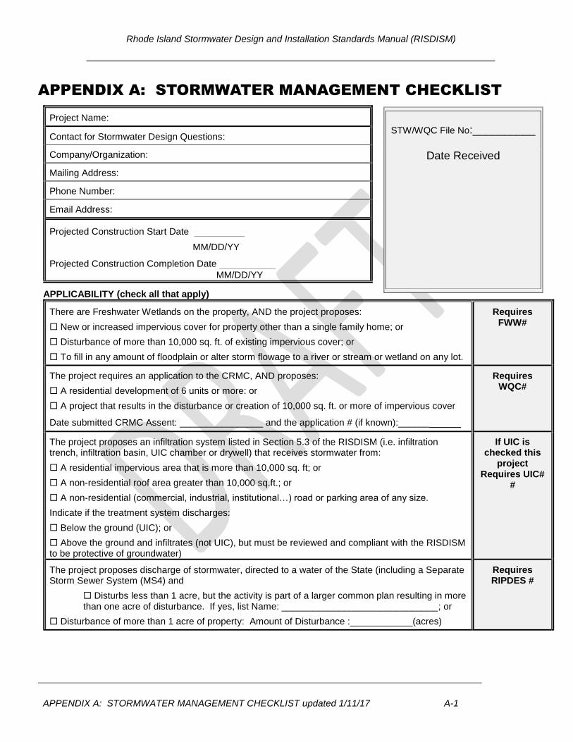
APPENDIX A: STORMWATER MANAGEMENT CHECKLIST
Project Name:
Contact for Stormwater Design Questions:
Company/Organization:
Mailing Address:
Phone Number:
Email Address:
Projected Construction Start Date ________
MM/DD/YY
Projected Construction Completion Date _________
MM/DD/YY
APPLICABILITY (check all that apply)
There are Freshwater Wetlands on the property, AND the project proposes:
New or increased impervious cover for property other than a single family home; or
Disturbance of more than 10,000 sq. ft. of existing impervious cover; or
To fill in any amount of floodplain or alter storm flowage to a river or stream or wetland on any lot.
Requires FWW#
The project requires an application to the CRMC, AND proposes:
A residential development of 6 units or more: or
A project that results in the disturbance or creation of 10,000 sq. ft. or more of impervious cover
Date submitted CRMC Assent: ________________ and the application # (if known):___________
Requires WQC#
The project proposes an infiltration system listed in Section 5.3 of the RISDISM (i.e. infiltration trench, infiltration basin, UIC chamber or drywell) that receives stormwater from:
A residential impervious area that is more than 10,000 sq. ft; or
A non-residential roof area greater than 10,000 sq.ft.; or
A non-residential (commercial, industrial, institutional…) road or parking area of any size.
Indicate if the treatment system discharges:
Below the ground (UIC); or
Above the ground and infiltrates (not UIC), but must be reviewed and compliant with the RISDISM to be protective of groundwater)
If UIC is checked this
project Requires UIC#
#
The project proposes discharge of stormwater, directed to a water of the State (including a Separate Storm Sewer System (MS4) and
Disturbs less than 1 acre, but the activity is part of a larger common plan resulting in more than one acre of disturbance. If yes, list Name: ______________________________; or
Disturbance of more than 1 acre of property: Amount of Disturbance :____________(acres)
Requires RIPDES #
STW/WQC File No:__________
Date Received
Rhode Island Stormwater Design and Installation Standards Manual (RISDISM)
APPENDIX A: STORMWATER MANAGEMENT CHECKLIST updated 1/11/17 A-2
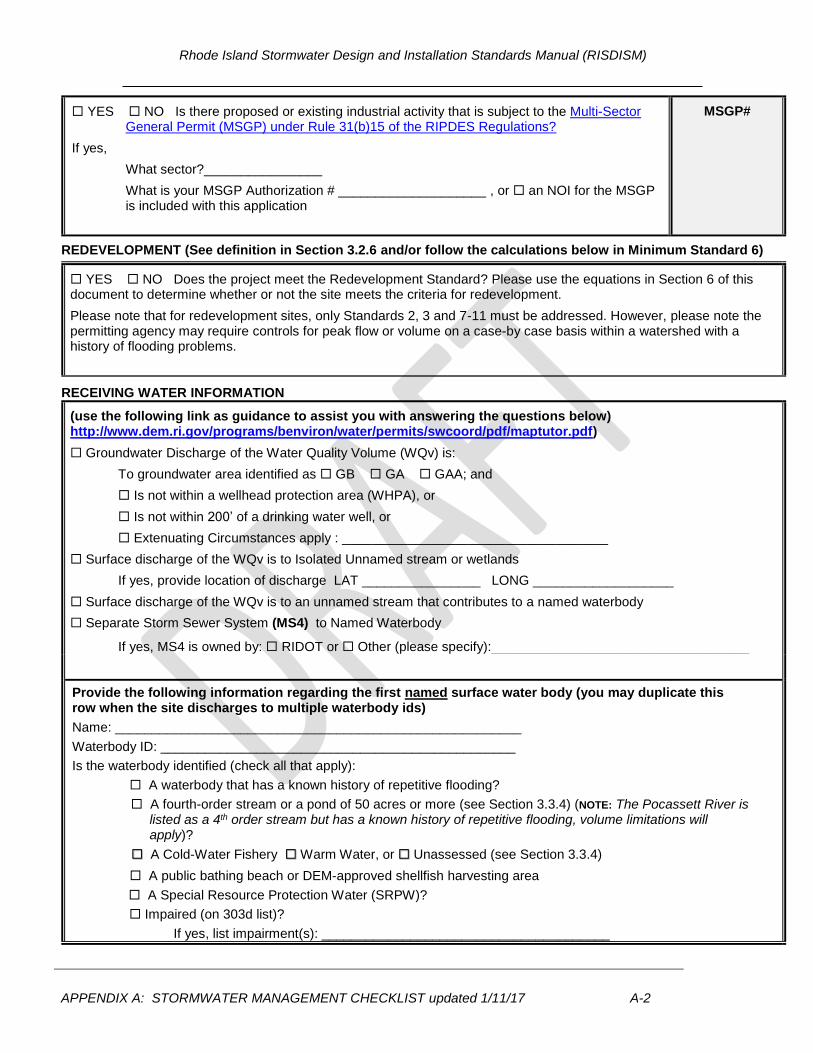
YES NO Is there proposed or existing industrial activity that is subject to the Multi-Sector General Permit (MSGP) under Rule 31(b)15 of the RIPDES Regulations?
If yes,
What sector?________________
What is your MSGP Authorization # ____________________ , or an NOI for the MSGP is included with this application
MSGP#
REDEVELOPMENT (See definition in Section 3.2.6 and/or follow the calculations below in Minimum Standard 6)
YES NO Does the project meet the Redevelopment Standard? Please use the equations in Section 6 of this document to determine whether or not the site meets the criteria for redevelopment.
Please note that for redevelopment sites, only Standards 2, 3 and 7-11 must be addressed. However, please note the permitting agency may require controls for peak flow or volume on a case-by case basis within a watershed with a history of flooding problems.
RECEIVING WATER INFORMATION
(use the following link as guidance to assist you with answering the questions below) http://www.dem.ri.gov/programs/benviron/water/permits/swcoord/pdf/maptutor.pdf)
Groundwater Discharge of the Water Quality Volume (WQv) is:
To groundwater area identified as GB GA GAA; and
Is not within a wellhead protection area (WHPA), or
Is not within 200’ of a drinking water well, or
Extenuating Circumstances apply : ____________________________________
Surface discharge of the WQv is to Isolated Unnamed stream or wetlands
If yes, provide location of discharge LAT ________________ LONG ___________________
Surface discharge of the WQv is to an unnamed stream that contributes to a named waterbody
Separate Storm Sewer System (MS4) to Named Waterbody
If yes, MS4 is owned by: RIDOT or Other (please specify):_____________________________
Provide the following information regarding the first named surface water body (you may duplicate this row when the site discharges to multiple waterbody ids)
Name: _______________________________________________________
Waterbody ID: ________________________________________________
Is the waterbody identified (check all that apply):
A waterbody that has a known history of repetitive flooding?
A fourth-order stream or a pond of 50 acres or more (see Section 3.3.4) (NOTE: The Pocassett River is listed as a 4th order stream but has a known history of repetitive flooding, volume limitations will apply)?
A Cold-Water Fishery Warm Water, or Unassessed (see Section 3.3.4)
A public bathing beach or DEM-approved shellfish harvesting area
A Special Resource Protection Water (SRPW)?
Impaired (on 303d list)?
If yes, list impairment(s): _______________________________________

Rhode Island Stormwater Design and Installation Standards Manual (RISDISM)
APPENDIX A: STORMWATER MANAGEMENT CHECKLIST updated 1/11/17 A-3
______________________________________________________________________________
Has a completed Total Maximum Daily Load (TMDL) ?
TMDL completed for; _____________________________________________________________
If yes – does your site discharge to a priority outfall identified in the TMDL? YES NO
HISTORIC, EXISTING AND PROPOSED ACTIVITY
YES NO Pre-application meeting for this project? If yes, pre-application meeting notes have been provided
YES NO Does the project propose activities that meet the criteria for a Land Use with Higher Potential Pollutant Loads (LUHPPL) as defined by the RISISDM? If yes, please
describe: _____________________________________________________
YES NO Have there been any known or suspected releases of hazardous materials at the site?
YES NO Is this site on the list of CERCLA and State Sites in RI? http://www.dem.ri.gov/programs/benviron/waste/pdf/cercstat.pdf
If yes, list any other RIDEM programs/contacts involved with this site and application or approval numbers: _______________________________________________________________________________
DEM Office of Waste Management (OWM) Contact Person: _______________________________
YES NO Is the proposed project associated with a previous permit application or enforcement action?
If yes, please describe: __________________________________________________
Table 1-1 Site Summary (add or subtract rows as necessary)
Subwatershed
(acres to each design point)
First Receiving Water ID or MS4
Area Disturbed
(acres)
Existing Impervious
(acres)
Proposed Impervious
(acres)
DP-1:
DP-2:
DP-3:
DP-4:
Totals:
Indicate below where the subwatershed maps and the documentation for the above items are provided (i.e. name of report/document, page numbers). Guidance for preparing drainage area maps are found in Appendix K.
____________________________________________________________________________
Rhode Island Stormwater Design and Installation Standards Manual (RISDISM)
APPENDIX A: STORMWATER MANAGEMENT CHECKLIST updated 1/11/17 A-4
MINIMUM STANDARD 1 – LOW IMPACT DEVELOPMENT ASSESSMENT
(REQUIRED for New Development and Pre-Application Meetings) – You may delete this section if you qualify for redevelopment
State Law requires the use of low impact-design techniques as the primary method of stormwater control to the maximum extent practicable. LID is intended to maintain or replicate predevelopment hydrology through the use of site planning, source control, and small-scale practices integrated throughout the site to prevent, infiltrate, and manage runoff as close to its source as possible. Non-structural LID techniques to Avoid and Reduce the stormwater impacts of development shall be explored as a first priority before LID structural practices are planned to Manage stormwater as part of a comprehensive LID approach.
The applicant must document specific LID Site Planning and Design Strategies applied for the project (see Manual
Chapter Four and the RI Low Impact Development (LID) Site Planning and Design Guidance Manual for more details
regarding each strategy). This checklist is designed to guide the required documentation of the site planning
process, and to ensure that the proposed project is consistent with and taking advantage of LID strategies
required or allowed in the municipality where the project is proposed. Included within this checklist are specific
LID techniques (and practices) taken from the RI Low Impact Development (LID) Site Planning and Design Guidance Manual that a municipality may require or allow.
If a particular strategy is not used or not applicable, a written description of why a certain method is not used or
applicable at the site must be provided. Appropriate answers may include such statements as:
Town requires XXX (state the specific local requirement)
Meets Town’s dimensional requirement of XXXXX.
Not practical for site because XXXXXX.
Applying for waiver/variance to achieve this (pending; was approved; was denied)
Applying for wavier/variance to seek relief from this (pending; approved; denied)
A) PRESERVATION OF UNDISTURBED AREAS, BUFFERS AND FLOODPLAINS
☐ Sensitive resource areas and site constraints are identified (required)
☐ Local development regulations have been reviewed (required)
☐ All vegetated buffers and coastal and freshwater wetlands have been designed
to be protected during and after construction
☐ Conservation Development or other site design technique to protect open space
and pre-development hydrology; [NOTE: If this technique has been used, check
box and skip to c.]
☐ Maintain as much natural vegetation and pre-development hydrology as possible
IF NOT IMPLEMENTED - EXPLAIN HERE
Rhode Island Stormwater Design and Installation Standards Manual (RISDISM)
APPENDIX A: STORMWATER MANAGEMENT CHECKLIST updated 1/11/17 A-5
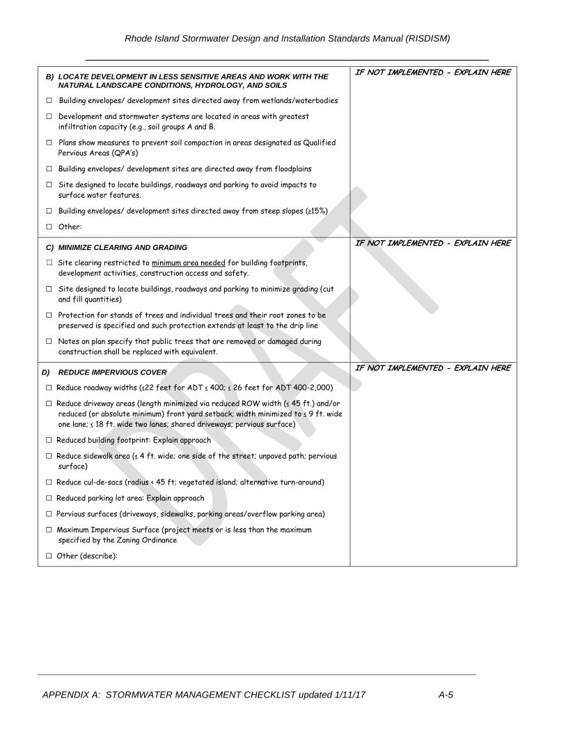
B) LOCATE DEVELOPMENT IN LESS SENSITIVE AREAS AND WORK WITH THE NATURAL LANDSCAPE CONDITIONS, HYDROLOGY, AND SOILS
☐ Building envelopes/ development sites directed away from wetlands/waterbodies
☐ Development and stormwater systems are located in areas with greatest
infiltration capacity (e.g., soil groups A and B.
☐ Plans show measures to prevent soil compaction in areas designated as Qualified
Pervious Areas (QPA’s)
☐ Building envelopes/ development sites are directed away from floodplains
☐ Site designed to locate buildings, roadways and parking to avoid impacts to
surface water features.
☐ Building envelopes/ development sites directed away from steep slopes (≥15%)
☐ Other:
IF NOT IMPLEMENTED - EXPLAIN HERE
C) MINIMIZE CLEARING AND GRADING
☐ Site clearing restricted to minimum area needed for building footprints,
development activities, construction access and safety.
☐ Site designed to locate buildings, roadways and parking to minimize grading (cut
and fill quantities)
☐ Protection for stands of trees and individual trees and their root zones to be
preserved is specified and such protection extends at least to the drip line
☐ Notes on plan specify that public trees that are removed or damaged during
construction shall be replaced with equivalent.
IF NOT IMPLEMENTED - EXPLAIN HERE
D) REDUCE IMPERVIOUS COVER
☐ Reduce roadway widths (≤22 feet for ADT ≤ 400; ≤ 26 feet for ADT 400-2,000)
☐ Reduce driveway areas (length minimized via reduced ROW width (≤ 45 ft.) and/or
reduced (or absolute minimum) front yard setback; width minimized to ≤ 9 ft. wide
one lane; ≤ 18 ft. wide two lanes; shared driveways; pervious surface)
☐ Reduced building footprint: Explain approach
☐ Reduce sidewalk area (≤ 4 ft. wide; one side of the street; unpaved path; pervious
surface)
☐ Reduce cul-de-sacs (radius < 45 ft; vegetated island; alternative turn-around)
☐ Reduced parking lot area: Explain approach
☐ Pervious surfaces (driveways, sidewalks, parking areas/overflow parking area)
☐ Maximum Impervious Surface (project meets or is less than the maximum
specified by the Zoning Ordinance
☐ Other (describe):
IF NOT IMPLEMENTED - EXPLAIN HERE
Rhode Island Stormwater Design and Installation Standards Manual (RISDISM)
APPENDIX A: STORMWATER MANAGEMENT CHECKLIST updated 1/11/17 A-6
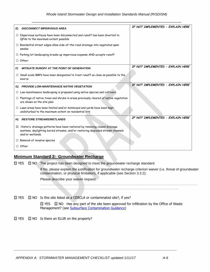
E) DISCONNECT IMPERVIOUS AREA
☐ Impervious surfaces have been disconnected and runoff has been diverted to
QPAs to the maximum extent possible
☐ Residential street edges allow side-of-the-road drainage into vegetated open
swales
☐ Parking lot landscaping breaks up impervious expanse AND accepts runoff
☐ Other:
IF NOT IMPLEMENTED - EXPLAIN HERE
F) MITIGATE RUNOFF AT THE POINT OF GENERATION
☐ Small-scale BMPs have been designated to treat runoff as close as possible to the
source
IF NOT IMPLEMENTED - EXPLAIN HERE
G) PROVIDE LOW-MAINTENANCE NATIVE VEGETATION
☐ Low-maintenance landscaping is proposed using native species and cultivars
☐ Plantings of native trees and shrubs in areas previously cleared of native vegetation
are shown on the site plan
☐ Lawn areas have been limited and/or minimized and yards have been kept
undisturbed to the maximum extent on residential lots
IF NOT IMPLEMENTED - EXPLAIN HERE
H) RESTORE STREAMS/WETLANDS
☐ Historic drainage patterns have been restored by removing closed drainage
systems, daylighting buried streams, and/or restoring degraded stream channels
and/or wetlands.
☐ Removal of invasive species
☐ Other
IF NOT IMPLEMENTED - EXPLAIN HERE
Minimum Standard 2: Groundwater Recharge
YES NO The project has been designed to meet the groundwater recharge standard.
If No, please explain the justification for groundwater recharge criterion waiver (i.e. threat of groundwater contamination, or physical limitation), if applicable (see Section 3.3.2);
Please describe your waiver request
____________________________________________________________________________________
__________________________________________________________________________
YES NO Is this site listed as a CERCLA or contaminated site?, if yes?
YES NO Has any part of the site been approved for infiltration by the Office of Waste
Management? (see Subsurface Contamination Guidance)
YES NO Is there an ELUR on the property?
Rhode Island Stormwater Design and Installation Standards Manual (RISDISM)
APPENDIX A: STORMWATER MANAGEMENT CHECKLIST updated 1/11/17 A-7
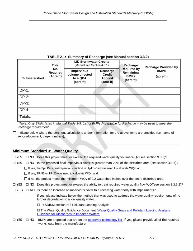
TABLE 2-1: Summary of Recharge (see Manual section 3.3.2)
Subwatershed
Total Rev
Required (Acre-ft)
LID Stormwater Credits (Manual see Section 4.6.1)
Recharge
Required by Remaining
BMPs (acre-ft)
Recharge Provided by BMPs
(acre-ft)
Impervious volume directed
to a QPA (acre-ft)
Recharge Credit
Applied (acre-ft)
DP-1:
DP-2:
DP-3:
DP-4:
Totals:
*Note: Only BMPs listed in Manual Table 3-5, List of BMPs Acceptable for Recharge may be used to meet the recharge requirement.
Indicate below where the pertinent calculations and/or information for the above items are provided (i.e. name of report/document, page numbers);
____________________________________________________________________________
Minimum Standard 3: Water Quality
YES NO Does this project meet or exceed the required water quality volume WQv (see section 3.3.3)?
YES NO Is the proposed final impervious cover is greater than 20% of the disturbed area (see section 3.3.3)?
If yes, the Spit Pervious/Impervious method in Hydro-Cad was used to calculate WQv, or
If yes, TR-55 or TR-20 was used to calculate WQv, and
If no, the project meets the minimum WQv of 0.2 watershed inches over the entire disturbed area.
YES NO Does this project meet or exceed the ability to treat required water quality flow WQf(see section 3.3.3.2)?
YES NO Is there an increase of impervious cover to a receiving water body with impairments?
If yes, please indicate below the method that was used to address the water quality requirements of no further degradation to a low quality water.
RISDISM section H.3 Pollutant Loading Analysis
The Water Quality Guidance Document (Water Quality Goals and Pollutant Loading Analysis Guidance for Discharges to Impaired Waters)
YES NO BMPs are proposed that are on the approved technology list if yes, please provide all of the required
worksheets from the manufacturer.
Rhode Island Stormwater Design and Installation Standards Manual (RISDISM)
APPENDIX A: STORMWATER MANAGEMENT CHECKLIST updated 1/11/17 A-8
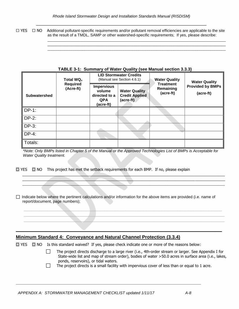
YES NO Additional pollutant-specific requirements and/or pollutant removal efficiencies are applicable to the site as the result of a TMDL, SAMP or other watershed-specific requirements; If yes, please describe: ______________________________________________________________________________________________________________________________________________________________________________________________________________________________________________________
TABLE 3-1: Summary of Water Quality (see Manual section 3.3.3)
Subwatershed
Total WQv Required (Acre-ft)
LID Stormwater Credits (Manual see Section 4.6.1)
Water Quality
Treatment Remaining (acre-ft)
Water Quality Provided by BMPs
(acre-ft)
Impervious volume
directed to a QPA
(acre-ft)
Water Quality Credit Applied (acre-ft)
DP-1:
DP-2:
DP-3:
DP-4:
Totals:
*Note: Only BMPs listed in Chapter 5 of the Manual or the Approved Technologies List of BMPs is Acceptable for Water Quality treatment.
YES NO This project has met the setback requirements for each BMP. If no, please explain
_______________________________________________________________________________________________
______________________________________________________________________________________________________________________________________________________________________________________________
Indicate below where the pertinent calculations and/or information for the above items are provided (i.e. name of report/document, page numbers);
____________________________________________________________________________ __________________________________________________________________________________________________________________________________________________________
_______________________________________________________________________________
Minimum Standard 4: Conveyance and Natural Channel Protection (3.3.4)
YES NO Is this standard waived? If yes, please check indicate one or more of the reasons below:
The project directs discharge to a large river (i.e., 4th-order stream or larger. See Appendix I for State-wide list and map of stream order), bodies of water >50.0 acres in surface area (i.e., lakes,
ponds, reservoirs), or tidal waters. The project directs is a small facility with impervious cover of less than or equal to 1 acre.
Rhode Island Stormwater Design and Installation Standards Manual (RISDISM)
APPENDIX A: STORMWATER MANAGEMENT CHECKLIST updated 1/11/17 A-9
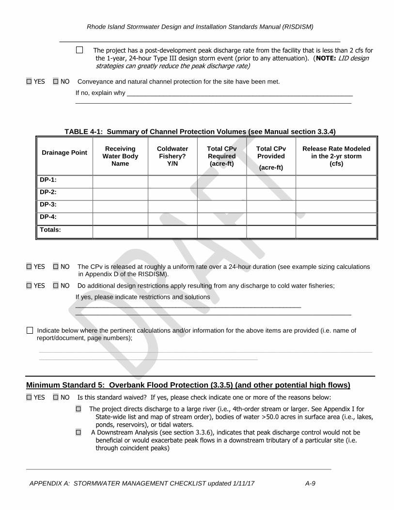
The project has a post-development peak discharge rate from the facility that is less than 2 cfs for
the 1-year, 24-hour Type III design storm event (prior to any attenuation). (NOTE: LID design strategies can greatly reduce the peak discharge rate)
YES NO Conveyance and natural channel protection for the site have been met.
If no, explain why _______________________________________________________________ _____________________________________________________________________________
TABLE 4-1: Summary of Channel Protection Volumes (see Manual section 3.3.4)
Drainage Point
Receiving
Water Body Name
Coldwater Fishery?
Y/N
Total CPv Required (acre-ft)
Total CPv Provided
(acre-ft)
Release Rate Modeled
in the 2-yr storm (cfs)
DP-1:
DP-2:
DP-3:
DP-4:
Totals:
YES NO The CPv is released at roughly a uniform rate over a 24-hour duration (see example sizing calculations in Appendix D of the RISDISM).
YES NO Do additional design restrictions apply resulting from any discharge to cold water fisheries;
If yes, please indicate restrictions and solutions _______________________________________________________________ _____________________________________________________________________________
Indicate below where the pertinent calculations and/or information for the above items are provided (i.e. name of report/document, page numbers);
__________________________________________________________________________________________________________________________________________________________
Minimum Standard 5: Overbank Flood Protection (3.3.5) (and other potential high flows)
YES NO Is this standard waived? If yes, please check indicate one or more of the reasons below:
The project directs discharge to a large river (i.e., 4th-order stream or larger. See Appendix I for
State-wide list and map of stream order), bodies of water >50.0 acres in surface area (i.e., lakes,
ponds, reservoirs), or tidal waters. A Downstream Analysis (see section 3.3.6), indicates that peak discharge control would not be
beneficial or would exacerbate peak flows in a downstream tributary of a particular site (i.e. through coincident peaks)
Rhode Island Stormwater Design and Installation Standards Manual (RISDISM)
APPENDIX A: STORMWATER MANAGEMENT CHECKLIST updated 1/11/17 A-10
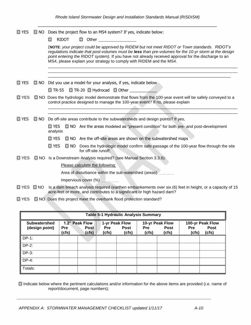
YES NO Does the project flow to an MS4 system? If yes, indicate below:
RIDOT Other _________________
(NOTE: your project could be approved by RIDEM but not meet RIDOT or Town standards. RIDOT’s regulations indicate that post-volumes must be less than pre-volumes for the 10-yr storm at the design point entering the RIDOT system). If you have not already received approval for the discharge to an MS4, please explain your strategy to comply with RIDEM and the MS4. ______________________________________________________________________________________________________________________________________________________________________________________________________________________________________________________
YES NO Did you use a model for your analysis, if yes, indicate below
TR-55 TR-20 Hydrocad Other ____________
YES NO Does the hydrologic model demonstrate that flows from the 100-year event will be safely conveyed to a control practice designed to manage the 100-year event? If no, please explain ______________________________________________________________________________________________________________________________________________________________________
YES NO Do off-site areas contribute to the subwatersheds and design points? If yes,
YES NO Are the areas modeled as “present condition” for both pre- and post-development analysis
YES NO Are the off-site areas are shown on the subwatershed maps
YES NO Does the hydrologic model confirm safe passage of the 100-year flow through the site for off-site runoff;
YES NO Is a Downstream Analysis required? (see Manual Section 3.3.6):
Please calculate the following:
Area of disturbance within the sub-watershed (areas) _______
Impervious cover (%) ________
YES NO Is a dam breach analysis required (earthen embankements over six (6) feet in height, or a capacity of 15 acre-feet or more, and contributes to a significant or high hazard dam?
YES NO Does this project meet the overbank flood protection standard?
Table 5-1 Hydraulic Analysis Summary
Subwatershed (design point)
1.2” Peak Flow Pre Post (cfs) (cfs)
1-yr Peak Flow Pre Post (cfs) (cfs)
10-yr Peak Flow Pre Post
(cfs) (cfs)
100-yr Peak Flow Pre Post
(cfs) (cfs)
DP-1:
DP-2:
DP-3:
DP-4:
Totals:
Indicate below where the pertinent calculations and/or information for the above items are provided (i.e. name of report/document, page numbers);
Rhode Island Stormwater Design and Installation Standards Manual (RISDISM)
APPENDIX A: STORMWATER MANAGEMENT CHECKLIST updated 1/11/17 A-11
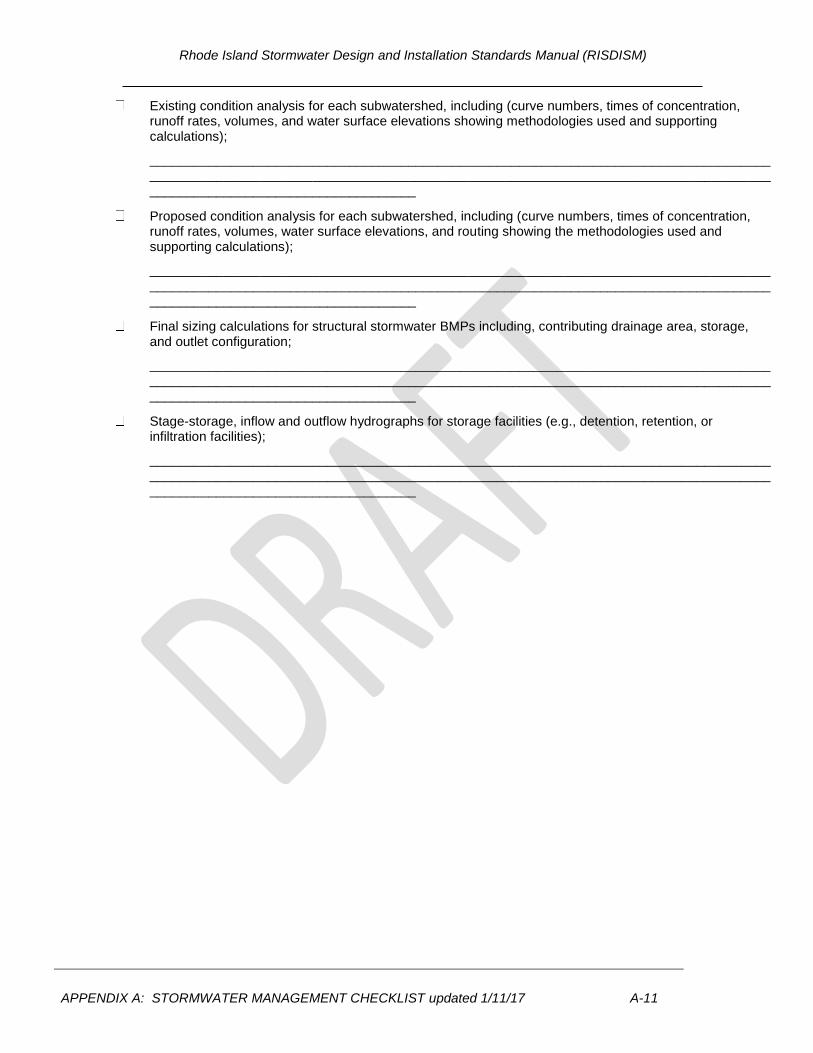
Existing condition analysis for each subwatershed, including (curve numbers, times of concentration, runoff rates, volumes, and water surface elevations showing methodologies used and supporting calculations);
____________________________________________________________________________________________________________________________________________________________________________________________________________
Proposed condition analysis for each subwatershed, including (curve numbers, times of concentration, runoff rates, volumes, water surface elevations, and routing showing the methodologies used and supporting calculations);
____________________________________________________________________________________________________________________________________________________________________________________________________________
Final sizing calculations for structural stormwater BMPs including, contributing drainage area, storage, and outlet configuration;
____________________________________________________________________________________________________________________________________________________________________________________________________________
Stage-storage, inflow and outflow hydrographs for storage facilities (e.g., detention, retention, or infiltration facilities);
____________________________________________________________________________________________________________________________________________________________________________________________________________

Rhode Island Stormwater Design and Installation Standards Manual (RISDISM)
APPENDIX A: STORMWATER MANAGEMENT CHECKLIST updated 1/11/17 A-12
Table 5-2 Summary of Best Management Practices
DP No.
BMP ID.
BMP Type (i.e. bioretention or tree
filter)
BMP Functions
(acre-ft)
Overbank Flood
Reduction
Internal Bypass
Horizontal
Setback Criteria Met
Pre- treatment (volume)
Rev WQv CPv Y/N Y/N Distance (ft) From constraint (i.e. private well or foundation)
TOTAL:
Rhode Island Stormwater Design and Installation Standards Manual (RISDISM)
APPENDIX A: STORMWATER MANAGEMENT CHECKLIST updated 1/11/17 A-13
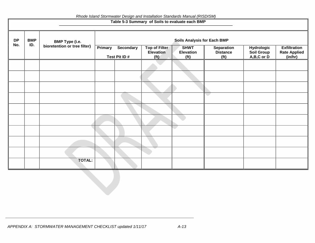
Table 5-3 Summary of Soils to evaluate each BMP
DP No.
BMP ID.
BMP Type (i.e. bioretention or tree filter)
Soils Analysis for Each BMP
Primary Secondary
Test Pit ID #
Top of Filter Elevation
(ft)
SHWT Elevation
(ft)
Separation Distance
(ft)
Hydrologic Soil Group A,B,C or D
Exfiltration Rate Applied
(in/hr)
TOTAL:
Rhode Island Stormwater Design and Installation Standards Manual (RISDISM)
APPENDIX A: STORMWATER MANAGEMENT CHECKLIST updated 1/11/17 A-14
________________________________________________________________________________
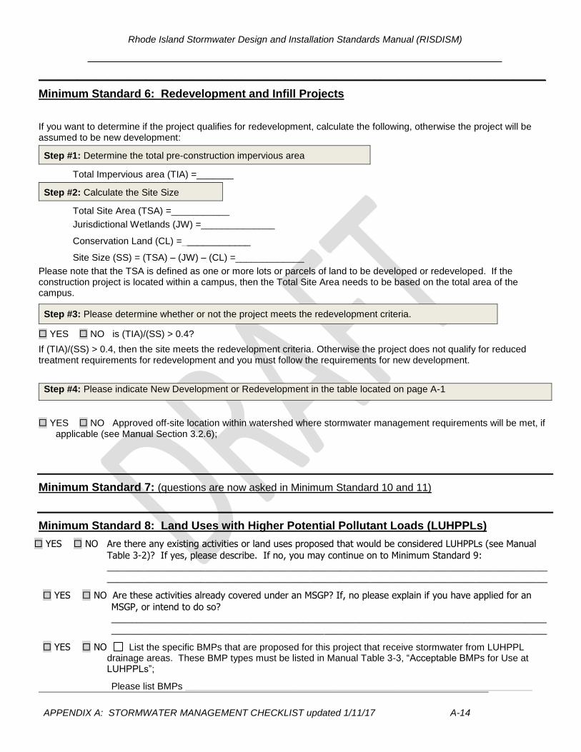
Minimum Standard 6: Redevelopment and Infill Projects
If you want to determine if the project qualifies for redevelopment, calculate the following, otherwise the project will be assumed to be new development:
Step #1: Determine the total pre-construction impervious area
Total Impervious area (TIA) =_______
Step #2: Calculate the Site Size
Total Site Area (TSA) =___________
Jurisdictional Wetlands (JW) =______________
Conservation Land (CL) =_____________
Site Size (SS) = (TSA) – (JW) – (CL) =_____________
Please note that the TSA is defined as one or more lots or parcels of land to be developed or redeveloped. If the construction project is located within a campus, then the Total Site Area needs to be based on the total area of the campus.
Step #3: Please determine whether or not the project meets the redevelopment criteria.
YES NO is (TIA)/(SS) > 0.4?
If (TIA)/(SS) > 0.4, then the site meets the redevelopment criteria. Otherwise the project does not qualify for reduced treatment requirements for redevelopment and you must follow the requirements for new development.
Step #4: Please indicate New Development or Redevelopment in the table located on page A-1
YES NO Approved off-site location within watershed where stormwater management requirements will be met, if applicable (see Manual Section 3.2.6);
Minimum Standard 7: (questions are now asked in Minimum Standard 10 and 11)
Minimum Standard 8: Land Uses with Higher Potential Pollutant Loads (LUHPPLs)
YES NO Are there any existing activities or land uses proposed that would be considered LUHPPLs (see Manual
Table 3-2)? If yes, please describe. If no, you may continue on to Minimum Standard 9: _____________________________________________________________________________________
_____________________________________________________________________________________
YES NO Are these activities already covered under an MSGP? If, no please explain if you have applied for an
MSGP, or intend to do so?
____________________________________________________________________________________
____________________________________________________________________________________
YES NO List the specific BMPs that are proposed for this project that receive stormwater from LUHPPL drainage areas. These BMP types must be listed in Manual Table 3-3, “Acceptable BMPs for Use at LUHPPLs”;
Please list BMPs ___________________________________________________________________
Rhode Island Stormwater Design and Installation Standards Manual (RISDISM)
APPENDIX A: STORMWATER MANAGEMENT CHECKLIST updated 1/11/17 A-15
Additional BMPs, or additional pretreatment BMP’s if any, that meet RIPDES MSGP requirements;
Please list BMPs ___________________________________________________________________
Indicate below where the pertinent calculations and/or information for the above items are provided (i.e. name of report/document, page numbers);____________________________________________________________________________________________________________________________________________________________________________________
Minimum Standard 9: Illicit Discharges
YES NO Have you checked for illicit discharges?
YES NO Have any been found and/or corrected? If yes, please identify
____________________________________________________________________
YES NO Does your report explain preventative measures that keep non-stormwater discharges out of the Waters
of the State (during and after construction)?
Minimum Standard 10 Soil Erosion and Sediment Control
YES NO Have you included a Soil Erosion and Sediment Control Plan Set and/or Complete Construction Plan Set?
YES NO Did you provide a separately bound document based upon the SESC Template? If yes, proceed to Minimum Standard 11 (the following items can be assumed to be addressed). If no, include a document with your submittal that addresses the following:
Elements of a SESC Plan: Soil Erosion and Sediment Control Plan project narrative including a description of how the
fifteen (15) Performance Criteria have been met: Provide Natural Buffers and Maintain Existing Vegetation; Minimize Area of Disturbance; Minimize the Disturbance of Steep Slopes; Preserve Topsoil; Stabilize Soils; Protect Storm Drain Inlets; Protect Storm Drain Outlets; Establish Temporary Controls for the Protection of Post-Construction Stormwater
Control Measures; Establish Perimeter Controls and Sediment Barriers; Divert or Manage Run-On from Up-Gradient Areas; Properly Design Constructed Stormwater Conveyance Channels; Retain Sediment On-Site; Control Temporary Increases in Stormwater Velocity, Volume, and Peak Flows; Apply construction Activity Pollution Prevention Control Measures; Install, Inspect, and Maintain Control Measures and Take Corrective Actions.
Qualified SESC plan preparer’s information and certification; Operator’s information and certification; if not known at the time of application the operator
must certify the SESC Plan upon selection and prior to initiating site activities; Description of control measures such as temporary sediment trapping and conveyance
practices, including design calculations and supporting documentation, as required.
Rhode Island Stormwater Design and Installation Standards Manual (RISDISM)
APPENDIX A: STORMWATER MANAGEMENT CHECKLIST updated 1/11/17 A-16
Minimum Standard 7&11: Stormwater Management System Operation, Maintenance and Pollution Prevention Plan (See section 3.2.11 and Appendices G and E for guidance) YES NO Have you minimized all sources of pollutant contact with stormwater runoff, to the maximum extent
practicable?
YES NO Have you provided a separately bound Operations, Maintenance and Pollution Prevention Manual for the site and for all of the BMPs?
The (O&M and PP Plan Contains): YES NO Contact name, address, and phone number of the responsible party for maintenance; YES NO 8.5” x 11” map indicating the location of all of the proposed stormwater BMPs that will require
maintenance; YES NO Description of routine and non-routine maintenance tasks and their frequency for required elements for
each BMP; YES NO A description and delineation of public safety features; YES NO An estimated operations and maintenance budget; YES NO Minimum vegetative cover requirements; YES NO Access and safety for maintenance?
YES NO Lawn, Garden and Landscape Management meet the requirements of section G.7? If not, why not?
________________________________________________________________________________________________________________________________________________________________________
YES NO Is the property owner or homeowners association is responsible for the stormwater maintenance of all BMP’s?
If no, you must provide a legally binding and enforceable maintenance agreement (see Appendix E-page 26) that identifies the entity that will be responsible for maintenance of the stormwater. Please indicate where this agreement can be found in your report:________________________________________
YES NO Do you anticipate that you will need legal agreements related to the stormwater structures? (e.g. off-site easements, deed restrictions, and covenants). If yes, have you obtained them? Or please explain your plan to obtain them: ________________________________________________________________________________________________________________________________________________________________________
YES NO Is stormwater being directed from public areas to private property? If yes, (NOTE: this is not allowed unless there is a funding mechanism in place to provide the finances for the long-term maintenance of the BMP and drainage unless there is a funding mechanism is demonstrated that can guarantee the long-term maintenance of a stormwater BMP by an individual homeowner) ______________________________________________________________________________________________________________________________________________________________________
Pollution Prevention Section Contains: YES NO Designated snow stockpile locations?
Rhode Island Stormwater Design and Installation Standards Manual (RISDISM)
APPENDIX A: STORMWATER MANAGEMENT CHECKLIST updated 1/11/17 A-17
YES NO Trash racks to prevent floatables, trash and debris from discharging to waters of the state?
YES NO Asphalt only based sealants?
YES NO Pet waste stations? (NOTE: if a receiving water has a bacterial impairment and the project involves housing units, this could be an important part your pollution prevention plan)
YES NO Regular sweeping? Please describe ___________________________________
YES NO Deicing specifications in accordance with Appendix G of the Manual. (NOTE: if the groundwater is GAA or this area contributes to a drinking water supply, this could be an important part of your pollution prevention plan (see Appendix G): __________________________________________________________________________________
YES NO A prohibition of phosphate based fertilizers? (NOTE: if the site discharges to a phosphorus impaired
waterbody, this could be an important part of your pollution prevention plan)?
Existing and Proposed Subwatershed Mapping (REQUIRED)
Existing and proposed drainage area delineations
Locations, cross sections, and profiles of all streams and drainage swales and their method of stabilization;
Drainage flow paths, mapped according to the DEM Guidance for Preparation of Drainage Area Maps (included in Appendix K).
Complete drainage area boundaries; include off-site areas in both mapping and analyses, as applicable;
Logs of borings and/or test pit investigations along with supporting soils/geotechnical report.
Mapped seasonal high water table,
Mapped locations of the site-specific borings and/or test pits and soils information from the test pits at the locations of the BMPs
Mapped locations of the BMPs with the BMPs consistently identified on the Site Construction Plans
Mapping bedrock within 3’ of any BMP
YES NO Soils were logged by a:
DEM-licensed Class IV soil evaluator Name: _____________________
RI-registered PE. Name; _____________________________________
Site Construction Plans (the following applicable specifications are provided)
Existing and proposed plans (scale not greater than 1” = 40’) with North arrow
Existing and proposed site topography (with 1 or 2-foot contours). 10-foot contours accepted for off-site areas
Boundaries of existing predominant vegetation and proposed limits of clearing;
Site Location clarification
Location and field-verified boundaries of resource protection areas such as:
► freshwater and coastal wetlands, lakes, ponds,
Rhode Island Stormwater Design and Installation Standards Manual (RISDISM)
APPENDIX A: STORMWATER MANAGEMENT CHECKLIST updated 1/11/17 A-18
► coastal shoreline features
► Perennial and intermittent streams, in addition to areas subject to storm flowage (ASSFs);
All required setbacks (e.g., buffers, water supply wells, septic systems);
Representative cross-section and profile drawings, notes and details of structural stormwater management practices and conveyances (i.e., storm drains, open channels, swales, etc.), which include:
► Location and size of the stormwater treatment practices (type of practice, depth, area). Stormwater treatment practices (BMPs) must have labels that correspond to table 5-2;
► Design water surface elevations (applicable storms);
► Structural details of outlet structures, embankments, spillways, stilling basins, grade control structures, conveyance channels, etc.;
► Existing and proposed structural elevations (e.g., invert of pipes, manholes, etc.);
► Location of floodplain and, if applicable, floodway limits and relationship of site to upstream and downstream properties or drainage that could be affected by work in the floodplain;
► Planting plans for structural stormwater BMPs, including species, size, planting methods, and maintenance requirements of proposed planting;
► Logs of borings and/or test pit investigations along with supporting soils/geotechnical report and corresponding water tables.
Mapping of any OWM approved activities related to current/former site use areas for any known contamination and/or remedial clean-up efforts.
Location of existing and proposed roads, buildings, and other structures including limits of disturbance;
► Existing and proposed utilities (e.g., water, sewer, gas, electric) and easements;
► Location of existing and proposed conveyance systems such as grass channels, swales, and storm drains, as well as location(s) of final discharge point (wetland, waterbody);
► Cross sections of roadways, with edge details such as curbs and sidewalks;
► Location and dimensions of channel modifications, such as bridge or culvert crossings;
► Locations, cross sections, and profiles of all stream or wetland crossings and their method of stabilization