Embed Size (px)
Citation preview

Appendix A. US 101 / I-280 Alignment Analysis


SAN FRANCISCO TO SAN JOSE SECTION CALIFORNIA HIGH-SPEED TRAIN PROJECT EIR/EIS APPENDIX A– US 101/I-280 ALIGNMENT ANALYSIS
U.S. Department of Transportation Page A-1 Federal Railroad Administration
US 101 / I-280 Alignment Analysis
Introduction
The program-level EIR/EIS documents considered multiple HST alignments between San Francisco and San Jose. These included the I-280, the US 101, and the Caltrain corridors. Detailed maps showing these alignments are presented in this appendix. Two of these alignments (I-280 and US 101) were eliminated from further consideration in the program-level analysis. In response to agency and public comments received during the review of initial alternatives for the project EIR/EIS, the regional team conducted additional analysis of the feasibility of implementing HST along the I-280 and US 101 corridors to determine if there was any new information that would undermine the initial rationale for the exclusion of these corridors from further consideration in the project EIR/EIS.
The I-280 and US101 alternative alignments were reviewed with respect to general project purpose and objectives, practicability constraints, and environmental criteria. General project purpose and objectives considered ridership potential, connectivity and accessibility, compatibility with existing or planned development, and operational constraints. Practicability constraints considered cost, constructability, right-of-way constraints, and other technical issues. Environmental criteria were considered a reason for withdrawal from further consideration when an option had considerably more probable environmental impacts than other practicable options. The following discussion describes the alternatives considered and the reasons they were not carried forward.
I-280 Alternative
Due to the curvature and grade requirements of the HST system, the I-280 alignment would need to be on an exclusive guideway on the I-280 corridor. This guideway would be on a variety of elevated and below grade structures, at-grade, and in tunnels where required to achieve the HST design criteria.
Alignment and Right-of-Way
The terrain along I-280 ranges from flat in the dense urban areas of San Jose, Cupertino, and San Francisco to hilly in the Los Altos Hills, Palo Alto, Woodside, and Hillsborough areas. In the flat areas, the HST would operate on elevated structures, while in the hilly areas in Los Altos Hills and Hillsborough, the alignment would require considerable earthwork or retaining walls. Due to the mountainous terrain and the design intent to protect the natural contours as much as possible, the I-280 freeway was constructed with many curves. These same curves, however, would restrict the design speed and travel times for high-speed train service. Likewise, the vertical alignment would also be incompatible in some areas, both in terms of grades and vertical curvature, and thus would require tall viaducts or deep tunneling. These vertical and horizontal alignment challenges at representative segments along the I-280 alternative are detailed below.
An example of the curves on the I-280 alignment is shown in Figure 1, where there are two small radius horizontal curves adjacent to each other making an “S-curve.” A high-speed train would need to either reduce its speed to accommodate these curves or a new, straighter guideway would need to be constructed.
Figure 1: Horizontal Curve Constraints
View: Compound short radius horizontal curves near Page Mill Road outside Los Altos
View Direction: North
The travel time and power requirements would be greatly affected by vertical grade changes. The HST system maximum vertical curve is 2.5%. There are several locations along the I-280 corridor where grades are over 3%, and sometimes as high as 4%. Where the natural grades would be infeasible for the HST, tunneling or tall viaducts would be required to support the HST guideway between hills and valleys.
An example of a vertical constraint is shown in Figures 2a and 2b where there are troughs in the highway alignment. If the minimum HST horizontal alignment criteria were to be applied, viaducts and tunnels would be required to flatten the grades.

SAN FRANCISCO TO SAN JOSE SECTION CALIFORNIA HIGH-SPEED TRAIN PROJECT EIR/EIS APPENDIX A– US 101/I-280 ALIGNMENT ANALYSIS
U.S. Department of Transportation Page A-2 Federal Railroad Administration
Figure 2a: Vertical Curve Constraints
View: Steeper vertical curve outskirts of Woodside
View Direction: North
Figure 2b: Vertical Curve Constraints
View: Steep vertical curve and approaching highway 92 interchange View Direction: North
An alignment along the I-280 would also encounter additional engineering and design challenges. For example, there are several structures and interchanges that would need to be crossed with an HST alignment following the I-280 corridor. The SR92 interchange shown in Figure 2b would require tall viaducts, possibly necessitating relocation of the existing transmission lines. The series of photos in Figures 3a-3e show typical bridges (including interchange structures such as at SR17/I-880) which would require similar HST alignment solutions like tall viaducts or tunnels to avoid impacting these locations beyond their current footprint.
Figure 3a: Typical Bridge Constraints
View: LRT overpass structure over I‐280 adjacent Southwest Expressway View Direction: South

SAN FRANCISCO TO SAN JOSE SECTION CALIFORNIA HIGH-SPEED TRAIN PROJECT EIR/EIS APPENDIX A– US 101/I-280 ALIGNMENT ANALYSIS
U.S. Department of Transportation Page A-3 Federal Railroad Administration
Figure 3b: Typical Bridge Constraints
View: East and Westbound I‐280 grade separation and pier of Skyline Blvd overpass in San Bruno View Direction: North
Figure 3c: Typical Bridge Constraints
View: East and Westbound I‐280 grade separation and piers of Judson Ave overpass in San Francisco View Direction: North
Figure 3d: Typical Bridge Constraints
View: Highway 85 Interchange View Direction: North
Figure 3e: Typical Bridge Constraints
View: Mary Street Pedestrian Bridge over I‐280 View Direction: Northwest

SAN FRANCISCO TO SAN JOSE SECTION CALIFORNIA HIGH-SPEED TRAIN PROJECT EIR/EIS APPENDIX A– US 101/I-280 ALIGNMENT ANALYSIS
U.S. Department of Transportation Page A-4 Federal Railroad Administration
The I-280 alignment also has existing retaining walls that support the existing freeway infrastructure. These structures could be adversely affected with the addition of an HST alignment. An example of this type of constraint is shown in Figure 4 below, which shows a limited amount of right of way within which to construct and operate HST service without removing or altering the retaining wall.
Figure 4: Retaining Wall/Right-of-Way Constraint
View: Retaining wall in median of I‐280 in San Francisco, looking south View Direction: South
In addition to the constraints listed above, an HST alignment following the I-280 would result in significant impacts to a number of other facilities and structures. These facilities occur throughout corridor and in different combinations. They include, but are not limited to:
Adjacent nature/open space preserves such as near Stanford University Railroad Overcrossing structures including the VTA Light Rail Overpass in San Jose overhead transmission lines Adjacent reservoirs and bodies of water such as the Crystal Springs reservoirs Adjacent commercial development that would result in potential commercial property acquisition or relocation Adjacent residential development that would result in residential property acquisition or relocation
Travel Time
The HST system requires curve radii of approximately 10,500’ to make the 30-minute travel time between San Francisco and San Jose. There are many sections on the I-280 corridor where the curvature does not meet that requirement If HST were to be located in the median of I-280 (shown as the orange line or Alternative #2 in Exhibits 1-4) and stayed within the current right of way, the approximate travel time for the I-280 median configuration would be 40 minutes, which would not achieve the 30-minute travel time goal of the legislation. In order for the HST to meet the desired travel time goal (the blue line in Exhibits 1-4), the HST guideway would have to leave the I-280 right of way and cut across a variety of land uses, including parkland, residences commercial businesses, and school property.
Environmental Effects
Placing HST in the I-280 corridor has the potential to disturb sensitive biological resources and encroach into hazardous areas, all of which can trigger additional mitigation and engineering costs. In particular, the I-280 alignment could encroach into lands that are considered to be “protected areas of open space.” Protected areas encompass watershed lands, parks, and open space trust lands. In order to maintain the design speed and curves along I-280, portions of the I-280 alignment, particularly along Crystal Springs on the west side of I-280, may be affected. These are watershed lands, owned and maintained by the City and County of San Francisco. Using a study area similar to those applied to the Caltrain and US 101 alignments, approximately 60 acres of watershed lands could be disturbed. The total acreage of protected areas possibly affected by the I-280 alignment would be about 70 acres, compared to about 10 acres for US 101, and less than 5 acres for the Caltrain corridor. For the I-280 alignment, the remaining 10 acres of potentially affected protected areas includes parklands within the City of San Jose and watershed lands along the Guadalupe River. Both of these types of protected areas would involve further approvals – specifically, Section 4(f) evaluations would need to be prepared for the parks and possibly a Section 408 consultation with the US Army Corps of Engineers would be required for effects to the flood control improvements along the Guadalupe River.
The I-280 alignment through San Mateo and Santa Clara counties is recognized for its high visual quality, and particularly for the design of the freeway to be complementary and harmonious with the natural terrain and topography. In acknowledgment of the visual character of the corridor and the freeway design, the State has declared I-280 through these counties as a state scenic highway. The introduction of a new guideway to support the HST in this visual landscape would raise concerns regarding its visual impact and would warrant special evaluation and design to ensure that this alignment respects the state’s designation.
Intermodal Connectivity
For the proposed and potential HST stations in the San Francisco to San Jose Section, connectivity to the existing rail and transit infrastructure would be problematic:
San Jose Diridon: It would not be feasible to stop at Diridon Station with the I-280 alignment; instead the area above I-280 freeway between Bird Avenue and Lincoln Avenue would be a possible location for a station. This location would have minimal connectivity with the major transit providers in the area.
Mid-Peninsula station: A mid-Peninsula station would most likely be near an interchange on the I-280 freeway. Transit connections from the existing downtown to the new station would be required. In most cases this type of station area development would be inconsistent with the surrounding area and possibly
SAN FRANCISCO TO SAN JOSE SECTION CALIFORNIA HIGH-SPEED TRAIN PROJECT EIR/EIS APPENDIX A– US 101/I-280 ALIGNMENT ANALYSIS
U.S. Department of Transportation Page A-5 Federal Railroad Administration
current land uses. Additionally, transit oriented development opportunities may be limited in these generally undeveloped areas.
SFO connection: There are two possible options: a stop at the I-380 interchange or bringing the rail alignment down the I-380 corridor and stopping at a location near the airport. In both cases some sort of new shuttle would be required to transfer passengers to the terminals at SFO.
Downtown San Francisco: Depending on the alignment, HST could either join the existing Caltrain corridor near the intersection of I-380 and US 101, or continue along the I-280 alignment to downtown San Francisco.
US 101 Alignment
Similar to the I-280 alignment, the US 101 alternative would be an exclusive guideway in the US 101 freeway corridor between San Francisco and San Jose. Unlike the I-280 alignment where horizontal and vertical curvature are the predominant constraining factors, the US 101 alignment is predominantly constrained by existing bridges that would have to be crossed by the HST alignment and the lack of available or identifiable right of way. This exclusive guideway alignment would have major constructability issues being adjacent to and/or above an active freeway.
Alignment and Right-of-Way
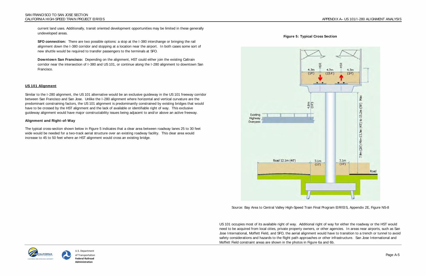
The typical cross-section shown below in Figure 5 indicates that a clear area between roadway lanes 25 to 30 feet wide would be needed for a two-track aerial structure over an existing roadway facility. This clear area would increase to 45 to 50 feet where an HST alignment would cross an existing bridge.
Figure 5: Typical Cross Section
Source: Bay Area to Central Valley High-Speed Train Final Program EIR/EIS, Appendix 2E, Figure NS-8
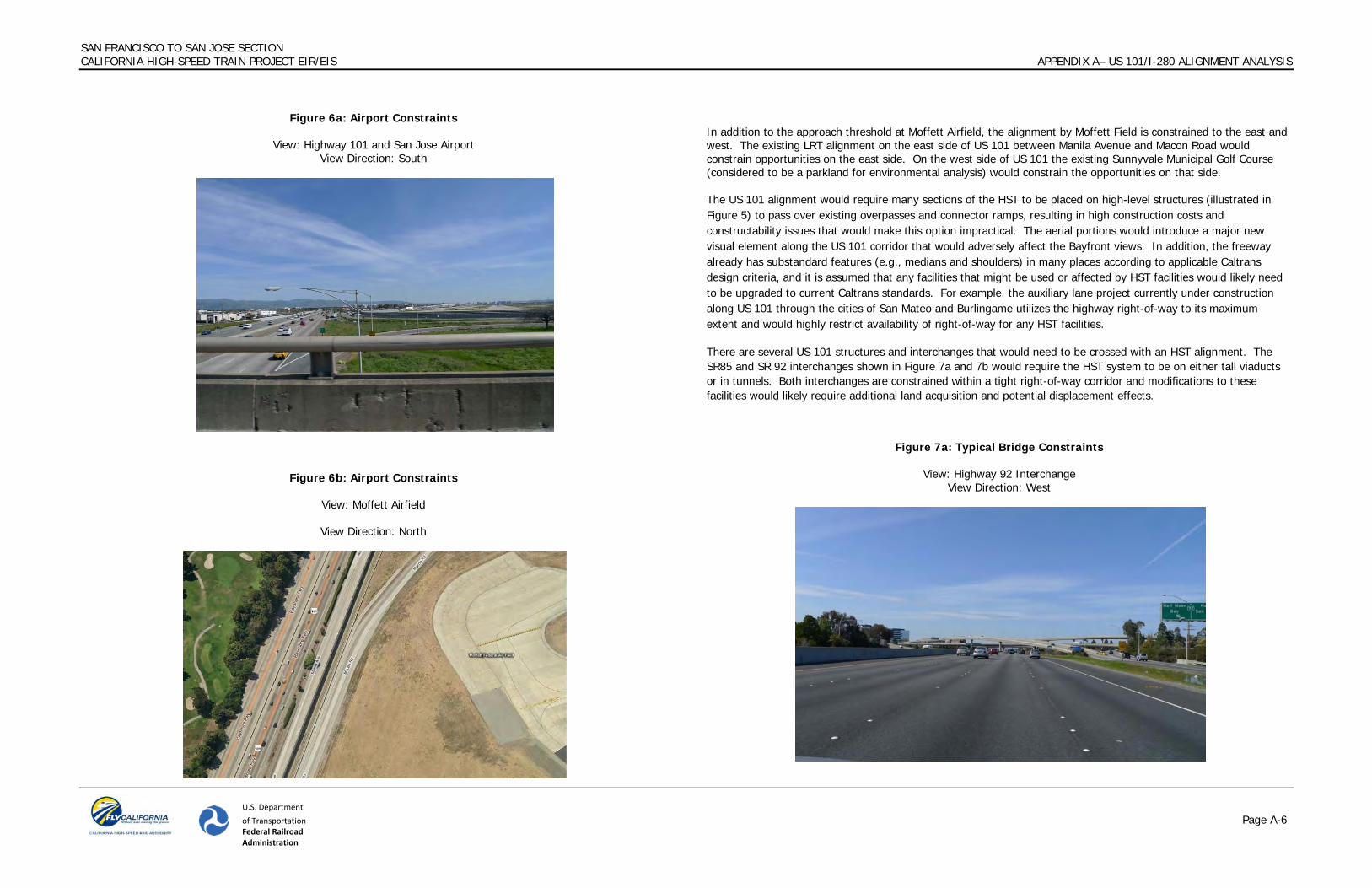
US 101 occupies most of its available right of way. Additional right of way for either the roadway or the HST would need to be acquired from local cities, private property owners, or other agencies. In areas near airports, such as San Jose International, Moffett Field, and SFO, the aerial alignment would have to transition to a trench or tunnel to avoid safety considerations and hazards to the flight path approaches or other infrastructure. San Jose International and Moffett Field constraint areas are shown in the photos in Figure 6a and 6b.
SAN FRANCISCO TO SAN JOSE SECTION CALIFORNIA HIGH-SPEED TRAIN PROJECT EIR/EIS APPENDIX A– US 101/I-280 ALIGNMENT ANALYSIS
U.S. Department of Transportation Page A-6 Federal Railroad Administration
Figure 6a: Airport Constraints
View: Highway 101 and San Jose Airport View Direction: South
Figure 6b: Airport Constraints
View: Moffett Airfield
View Direction: North
In addition to the approach threshold at Moffett Airfield, the alignment by Moffett Field is constrained to the east and west. The existing LRT alignment on the east side of US 101 between Manila Avenue and Macon Road would constrain opportunities on the east side. On the west side of US 101 the existing Sunnyvale Municipal Golf Course (considered to be a parkland for environmental analysis) would constrain the opportunities on that side. The US 101 alignment would require many sections of the HST to be placed on high-level structures (illustrated in Figure 5) to pass over existing overpasses and connector ramps, resulting in high construction costs and constructability issues that would make this option impractical. The aerial portions would introduce a major new visual element along the US 101 corridor that would adversely affect the Bayfront views. In addition, the freeway already has substandard features (e.g., medians and shoulders) in many places according to applicable Caltrans design criteria, and it is assumed that any facilities that might be used or affected by HST facilities would likely need to be upgraded to current Caltrans standards. For example, the auxiliary lane project currently under construction along US 101 through the cities of San Mateo and Burlingame utilizes the highway right-of-way to its maximum extent and would highly restrict availability of right-of-way for any HST facilities.
There are several US 101 structures and interchanges that would need to be crossed with an HST alignment. The SR85 and SR 92 interchanges shown in Figure 7a and 7b would require the HST system to be on either tall viaducts or in tunnels. Both interchanges are constrained within a tight right-of-way corridor and modifications to these facilities would likely require additional land acquisition and potential displacement effects.
Figure 7a: Typical Bridge Constraints
View: Highway 92 Interchange View Direction: West

SAN FRANCISCO TO SAN JOSE SECTION CALIFORNIA HIGH-SPEED TRAIN PROJECT EIR/EIS APPENDIX A– US 101/I-280 ALIGNMENT ANALYSIS
U.S. Department of Transportation Page A-7 Federal Railroad Administration
Figure 7a: Typical Bridge Constraints
View: Highway 85 Interchange View Direction: West
The US 101 corridor is also constrained by extensive development on both sides of the right-of-way. Figure 8 is illustrative of such areas, where widening the freeway to allow for HST infrastructure would encroach into single-family and multi-family neighborhoods as well as commercial and retail development. If the HST San Jose station were to be located at the existing Diridon Station, the rail corridor that currently makes this connection would be used and would require similar encroachments into the adjacent existing commercial and industrial development. The addition of an HST alignment would require widening along the adjacent developments abutting the sound walls on either side of the freeway.
Figure 8a: Right-of-way Constraints
View: Sunnyvale, view of adjacent residential and commercial/industrial neighborhoods on the other side of typical US 101 sound wall
View Direction: Isometric view north
Figure 8b: Right-of-way Constraints
View: San Mateo, view of adjacent business on the other side of typical US 101 sound wall View Direction: North

SAN FRANCISCO TO SAN JOSE SECTION CALIFORNIA HIGH-SPEED TRAIN PROJECT EIR/EIS APPENDIX A– US 101/I-280 ALIGNMENT ANALYSIS
U.S. Department of Transportation Page A-8 Federal Railroad Administration
Figure 8c: Right-of-way Constraints
View: Burlingame Hyatt Hotel adjacent Highway 101 View Direction: South
In addition to the densely developed urban areas along the US 101 corridor, there are portions that directly abut San Francisco Bay and associated wetlands and trails. The widening of US 101 to accommodate an elevated HST alignment would require encroachments into these areas and increase the environmental impact of the project. The existing soil and geology in these areas adjacent the Bay would provide additional complexities to the project that would make it difficult to implement. Examples of these wetland and trail constraints are shown in Figure 9a, 9b, and 9c.
Figure 9a: Wetland and Trail Constraints
View: Wetlands adjacent Highway 101 at Anza Blvd View Direction: South
Figure 9b: Wetland and Trail Constraints
View: Smith Slough adjacent westbound Highway 101 View Direction: South

SAN FRANCISCO TO SAN JOSE SECTION CALIFORNIA HIGH-SPEED TRAIN PROJECT EIR/EIS APPENDIX A– US 101/I-280 ALIGNMENT ANALYSIS
U.S. Department of Transportation Page A-9 Federal Railroad Administration
Figure 9b: Wetland and Trail Constraints View: Palo Alto Baylands (wetland) constraints
View Direction: North
Travel Time
The US 101 alignment that would meet the travel time requirement of 30 minutes (shown as a green line in Exhibits 1-4) would require extensive additional right-of-way through adjacent residential areas to provide curves of sufficient radius to meet the 125 mph design speed. In addition, traversing the major interchanges would require tall aerial HST structures (as shown in Figure 5) or complex reconstruction/reconfiguration of these interchanges. An HST alignment closely following the US 101 corridor (shown as the purple line or Alternative #2 in Exhibits 1-4) would have a travel time of 35 minutes which would not meet the required travel time of 30 minutes. The longer travel time is a result of tighter curves that could only be traveled at lower speeds.
Environmental Effects
Placing HST in the US 101 corridor has the potential to disturb sensitive biological resources and encroach into hazardous areas, all of which can trigger additional mitigation and engineering costs. Based on National Wetland Inventory data, the US 101 alignment would result in the greatest amount of potential wetland disturbance at nearly 10 acres. The I-280 and Caltrain alignments would possibly affect less than 1.5 acres and less than 0.5 acres, respectively. In order to achieve the desired design speeds and design criteria for curves, the US 101 alignment would run to the east of US 101 in two areas that contain sensitive wetland habitat, Sanchez Lagoon in Burlingame and Seal Slough in Redwood City. It is in these two locales that the vast majority of the potentially affected wetlands occur. Potential fill of wetlands is regulated by the US Army Corps of Engineers and the US Environmental Protection Agency, and were this alignment to be advanced, the federal agencies would require evidence that there is no practicable alternative that could avoid these impacts.
The US 101 alignment, for more of its length than either the Caltrain or the I-280 alignments, runs closer to the Bayfront. As such, the US 101 alignment encroaches into a greater amount of land that was once along the historic edge of San Francisco Bay, prior to the extensive fill and reclamation projects that moved the edge of the Bay eastward. The proximity of the US 101 alignment to the bayfront means that it encroaches into more areas that are characterized by Bay Muds and, thus, susceptible to liquefaction – commonly described as transforming the earth to a quicksand-like consistency during an earthquake. In comparing the three alignments, US 101 would pass through about 275 acres of lands of “very high” liquefaction hazard, as defined by the US Geological Survey; the I-280 and Caltrain alignments would each traverse about 45 acres of similar hazardous terrain. The engineering costs to ensure the structural integrity of columns and foundations placed on liquefiable soils is greater than on soils with a low potential for such hazards.
The US 101 alignment, by virtue of running near the Bayfront, is also much more susceptible to flood hazards than the other alignments. Using Digital Flood Insurance Rate Maps from the Federal Emergency Management Agency, the US 101 alignment traverses about 170 acres of lands within the 100-year floodplain. By comparison, the Caltrain alignment encroaches into about 70 acres in the 100-year floodplain and the I-280 alignment may affect about 10 acres. Actual flood risks associated with this encroachment will vary based on the vertical profiles (e.g., an elevated alignment would have much less effect and expose fewer to flood hazards than an at-grade alignment); nevertheless, each of the alignments that pass through flood hazard areas has the potential to reduce floodplain capacity and increase the areal extent of the area subject to flooding. These potentially adverse effects are substantially greater with the US 101 alignment.
Intermodal Connectivity
For the proposed and potential HST stations in the San Francisco to San Jose Section, connectivity to the existing rail and transit infrastructure would be problematic:
San Jose Diridon: The HST San Jose station could remain as planned at the existing San Jose Diridon station
Mid Peninsula station: A mid Peninsula station would most likely be near an interchange on the highway. Transit connections from the downtowns would be required. In most cases this type of land use would at least be new to the surrounding area and possibly inconsistent with the current land uses.
SFO connection: A station could be built along the US 101 alignment near the airport. The HST alignment would need to be either at-grade or tunneled to avoid violation of airspace restrictions around SFO. The station would not have a direct connection to BART or Caltrain as is possible if HST were on the Caltrain corridor.
Downtown San Francisco: HST could join Caltrain near the San Francisco County/San Mateo County Line and continue on the Caltrain corridor to downtown.
Conclusion
For both the US 101 and I-280 corridors, the addition of a railroad facility would be a new and significant impact to the overall environment. The new railroad facility would not be consistent with the current use of these corridors. Use of the existing Caltrain corridor for the HST alignment would improve safety through the construction of grade

SAN FRANCISCO TO SAN JOSE SECTION CALIFORNIA HIGH-SPEED TRAIN PROJECT EIR/EIS APPENDIX A– US 101/I-280 ALIGNMENT ANALYSIS
U.S. Department of Transportation Page A-10 Federal Railroad Administration
separations. The HST alignment would be directly connected to the existing rail and transit infrastructure and would be consistent with the current use of the corridor for rail infrastructure. The connection to SFO would be made at the Millbrae station. Finally, the Caltrain 2025 plan for electrification of the corridor would be compatible with the HST infrastructure.
For both the 101 and I-280 corridors, introduction of a HST would result in new physical and socioeconomic impacts that currently do not exist. The inability to meet the project purpose and need, specifically the desired travel time goal and enhanced connectivity to other transit services, significantly reduces the viability of these alternatives. Moreover, the substantial disruption to existing communities and the added infrastructure (high viaducts and tunneling) to satisfy the HST design criteria are significant constructability and cost factors that further constrain the viability using the 101 or I-280 corridors for HST service. The alignment along the Caltrain corridor represents a viable alternative that could feasibly avoid the new impacts described for the US 101 and I-280 alternatives. In particular, the Caltrain corridor has operating freight and commuter rail service, as well as an existing right-of-way dedicated to rail service. While the Caltrain corridor also faces constraints and will trigger impacts of its own accord, this corridor is consistent with the statewide HST purpose and need and is practical and feasible.
The alignment and right-of-way constraints, potential adverse environmental effects, lack of connectivity to other transit infrastructure, and difficulty in meeting travel time objectives highlight the major challenges that restrict the practicality and feasibility of HST service in the I-280 and US 101 corridors. No information identified undermines the initial rationale for the exclusion of the I-280 and US 101 alignments from further consideration in the project EIR/EIS. The alignments would be impractical and potentially infeasible when other alignment options are available.


![Series 1 240 VAC · OUTPUT SPECIFICATIONS (5) Description 10A 25A 50A 75A 90A 110A 125A Operating Voltage (47-440Hz) [Vrms] (6) 24-280 24-280 24-280 24-280 24-280 24-280 24-280 Transient](https://img.pdfslide.net/doc/110x75/60173c54b92f36193224a030/series-1-240-output-specifications-5-description-10a-25a-50a-75a-90a-110a-125a.jpg)


![José Patrício | 280 Dominoes · 2018-11-01 · 280 Dominoes, 2000 7.840 pieces of domino (resin) 312 x 312 cm/122.8 x 122.8 in 280 dominós [280 dominoes] 280 dominós [280 dominoes]](https://img.pdfslide.net/doc/110x75/5f0dac977e708231d43b85c9/jos-patrcio-280-dominoes-2018-11-01-280-dominoes-2000-7840-pieces-of-domino.jpg)