Embed Size (px)
Citation preview

Appendix B
Report on Permeability Testing (Douglas Partners, May 2016)
Douglas Partners Pty Ltd ABN 75 053 980 117
www.douglaspartners.com.au 36 O'Malley Street
Osborne Park WA 6017 Phone (08) 9204 3511
Fax (08) 9204 3522
Brisbane • Cairns • Canberra • Central Coast • Coffs Harbour • Darwin • Geelong • Gold Coast • Macarthur Melbourne • Newcastle • Perth • Port Macquarie • Sunshine Coast • Sydney • Townsville • Wollongong
Bullsbrook Syndicate Pty Ltd 82291.01.R.001.Rev0 c/- A. Khosravi Engineering Services 9 May 2016 SJ Attention: Mr Addy Khosravi Email: [email protected] Dear Sirs Report on Permeability Testing
Lot 6 Chittering Road, Bullsbrook, WA
1. Introduction
This report presents the results of permeability testing carried out by Douglas Partners Pty Ltd (DP) for a proposed residential development located at Lot 6 Chittering Road in Bullsbrook, WA. This work was commissioned by Mr Richard Sgro of Bullsbrook Syndicate Pty Ltd, on 7 April 2016 and was undertaken in accordance with Douglas Partners’ proposal dated 29 March 2016. It is understood that the proposed development comprises the construction of a residential subdivision. Douglas Partners has previously carried out a preconstruction geotechnical investigation at the abovementioned site and the results are presented in Douglas Partners’ Report 82291.00 dated July 2014. It is understood that 22 additional permeability tests and the installation of seven groundwater monitoring wells, at client nominated locations and depths, within the site, was required. 2. Purpose of the Investigation
The purpose of this investigation is to assess and provide comments on soil permeability and to install seven groundwater monitoring wells at the nominated locations provided to Douglas Partners. 3. Site Description
The site comprises three individual adjoining lots, known as Lots 3, 6 and 7 Chittering Road in Bullsbrook and covers a total area of 163,530 m2. The site is bound by Chittering Road to the west, rural residential properties to the north, by Burley Road to the east and by an adjoining residential subdivision to the south. At the time of the investigation, Lot 3 was occupied by two single-storey dwellings within the central and northern parts. A gravel track connected the single storey dwellings to Burley Road. The balance of the lot was vacant. Vegetation within the lot generally comprised short grass, shrubs and a few trees up to 15 m tall. The western half of the lot was generally open pasture.
Page 2 of 7
Report on Permeability Testing 82291.01.R.001.Rev0 Lot 6 Chittering Road, Bullsbrook, WA May 2016
Lot 6 was occupied by a single-storey dwelling within the northern part. The remainder of the lot was vacant. The vegetation generally comprised short grass and shrubs, and a few trees up to 15 m tall. A few soil stockpiles comprising sand and rubbish (fragments of corrugated iron sheets and iron rods) were observed within the central part of the lot. A gravel track connecting Chittering Road to the dwelling was located on the northern part of the site. Lot 7 was occupied by a single-storey dwelling and two open sheds within the western part of the lot. The remaining parts of the lot were vacant. The vegetation generally comprised short grasses within most of the site with an exception to the north-western part where tall grass and shrubs were encountered. A few fruit trees were observed towards the central, western and eastern parts of the site. The lot was divided by wire fencing and wire gates. Based on an earthworks plan provided by the client, the surface level across the site varies between RL 89 m AHD in the south-western corner of the site and RL 128 m AHD in the north-eastern corner of the site. The Muchea 1:50,000 Environmental Geology sheet indicates that shallow sub surface conditions beneath the site comprise sand, further described as light grey, fine to coarse, angular to sub-rounded, quartz with some feldspar, moderately sorted, loose, of colluvial origin. Published acid sulphate soil risk mapping for the area indicates the site is located within area of “no known risk of acid sulphate soils occurring within 3 m of natural soil surface.” 4. Field Work Methods
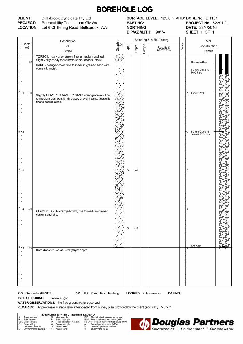
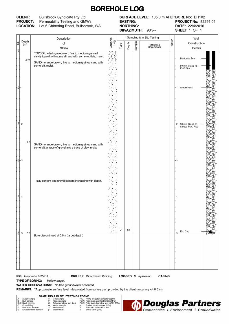
Boreholes BH101 to BH107 were drilled to a depth of 5.0 m using a track mounted Geoprobe 6822DT rig. The boreholes were advanced using hollow auger techniques by Direct Push Probing. A groundwater monitoring well was constructed at each test location. Well construction details are identified in the detailed logs of the ground conditions attached. Boreholes BH108 to BH129 were drilled using a 110 mm hand auger to facilitate permeability testing, with Perth sand penetrometer (PSP) tests or dynamic cone penetrometer tests (DCP) carried out at each test location. Soil samples were recovered from selected boreholes for subsequent laboratory testing to assist with the permeability assessment. The boreholes were logged in general accordance with test procedure AS 1726–1993, by a suitably experienced engineer from Douglas Partners. The PSP tests were carried out in general accordance with AS 1289.6.3.3, adjacent to each borehole location, to assess the in-situ density of the shallow soils. Permeability tests using the falling head method and constant head method were carried out at 22 borehole locations (BH108 to BH129) at depths of between 0.15 m and 1.65 m below existing surface levels.
Page 3 of 7
Report on Permeability Testing 82291.01.R.001.Rev0 Lot 6 Chittering Road, Bullsbrook, WA May 2016
The borehole test locations were determined using a hand held GPS and are shown on the attached drawing. The approximate surface level of each test location was interpolated from a survey plan provided by the client. 5. Field Work Results
5.1 Ground Conditions
Detailed borehole logs of the ground conditions are attached, together with notes defining descriptive terms and classification methods used. A summary of the ground conditions encountered at the test locations is given below:
Topsoil – dark grey-brown, fine to medium grained sandy topsoil with some silt and some roots to a depths of up to 0.3 m below existing surface level at all test locations.
Sand – loose to medium dense, yellow-brown, orange-brown and grey-brown, fine to medium grained sand with a trace to some silt and no clay to some clay, observed at all test locations with the exceptions of BH104 to BH106, BH116, BH123 and BH124. This material was underlying the topsoil and was generally encountered to the base of the boreholes.
Slightly Clayey Sand to Clayey Sand – orange-brown and red-brown, fine to medium grained, generally low to medium plasticity, slightly clayey sand to clayey sand at test locations BH101 and BH105 to BH107. The clay content generally increased with depth within this layer.
Gravelly Sand/Sandy Gravel – generally dense, orange-brown to red-brown, fine to medium grained, fine to coarse sized gravel, slightly gravelly sand to sandy gravel with a trace to some silt and no clay to slightly clayey. This was observed at test locations BH101, BH104, BH105, BH117, BH119, BH123 and BH124.
An exception to the abovementioned soil profile was a layer of:
Silty Sand – medium dense, red-brown, fine to medium grained silty sand with some gravel was encountered underlying the topsoil at test location BH116.
5.2 Groundwater
At the time of the investigation, between 21 and 26 April 2016, no free groundwater was observed within the boreholes to depths up to 5.0 m. Boreholes BH108 to BH129 were immediately backfilled following the investigation, which precluded longer-term monitoring of groundwater levels. It should be noted that groundwater levels are affected by climatic conditions and soil permeability, and will therefore vary with time.
Page 4 of 7
Report on Permeability Testing 82291.01.R.001.Rev0 Lot 6 Chittering Road, Bullsbrook, WA May 2016
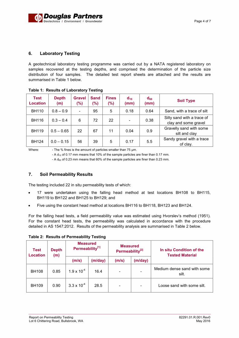
6. Laboratory Testing
A geotechnical laboratory testing programme was carried out by a NATA registered laboratory on samples recovered at the testing depths, and comprised the determination of the particle size distribution of four samples. The detailed test report sheets are attached and the results are summarised in Table 1 below.
Table 1: Results of Laboratory Testing
Test
Location
Depth
(m)
Gravel
(%)
Sand
(%)
Fines
(%)
d10
(mm)
d60
(mm) Soil Type
BH110 0.8 – 0.9 - 95 5 0.18 0.64 Sand, with a trace of silt
BH116 0.3 – 0.4 6 72 22 - 0.38 Silty sand with a trace of clay and some gravel
BH119 0.5 – 0.65 22 67 11 0.04 0.9 Gravelly sand with some silt and clay
BH124 0.0 – 0.15 56 39 5 0.17 5.5 Sandy gravel with a trace of clay.
Where: - The % fines is the amount of particles smaller than 75 μm. - A d10 of 0.17 mm means that 10% of the sample particles are finer than 0.17 mm. - A d60 of 0.23 mm means that 60% of the sample particles are finer than 0.23 mm. 7. Soil Permeability Results
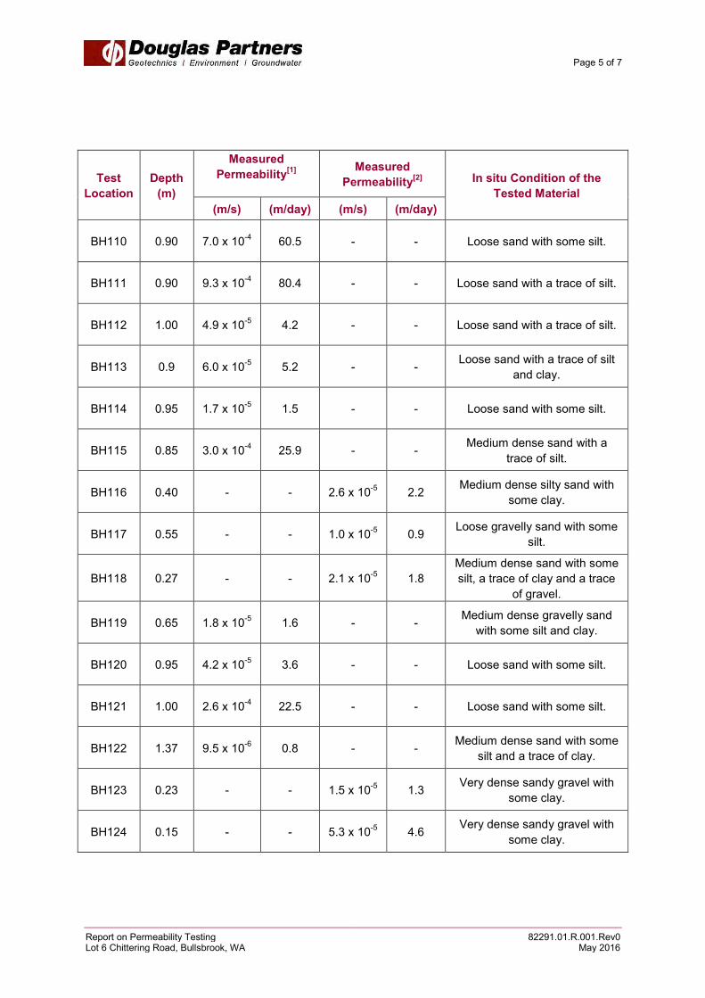
The testing included 22 in situ permeability tests of which:
17 were undertaken using the falling head method at test locations BH108 to BH115, BH119 to BH122 and BH125 to BH129; and
Five using the constant head method at locations BH116 to BH118, BH123 and BH124. For the falling head tests, a field permeability value was estimated using Hvorslev’s method (1951). For the constant head tests, the permeability was calculated in accordance with the procedure detailed in AS 1547:2012. Results of the permeability analysis are summarised in Table 2 below. Table 2: Results of Permeability Testing
Test
Location
Depth
(m)
Measured
Permeability[1]
Measured
Permeability[2]
In situ Condition of the
Tested Material
(m/s) (m/day) (m/s) (m/day)
BH108 0.85 1.9 x 10⁻⁴ 16.4 - - Medium dense sand with some silt.
BH109 0.90 3.3 x 10⁻⁴ 28.5 - - Loose sand with some silt.
Page 5 of 7
Report on Permeability Testing 82291.01.R.001.Rev0 Lot 6 Chittering Road, Bullsbrook, WA May 2016
Test
Location
Depth
(m)
Measured
Permeability[1]
Measured
Permeability[2]
In situ Condition of the
Tested Material
(m/s) (m/day) (m/s) (m/day)
BH110 0.90 7.0 x 10⁻⁴ 60.5 - - Loose sand with some silt.
BH111 0.90 9.3 x 10⁻⁴ 80.4 - - Loose sand with a trace of silt.
BH112 1.00 4.9 x 10⁻⁵ 4.2 - - Loose sand with a trace of silt.
BH113 0.9 6.0 x 10⁻⁵ 5.2 - - Loose sand with a trace of silt and clay.
BH114 0.95 1.7 x 10⁻⁵ 1.5 - - Loose sand with some silt.
BH115 0.85 3.0 x 10⁻⁴ 25.9 - - Medium dense sand with a trace of silt.
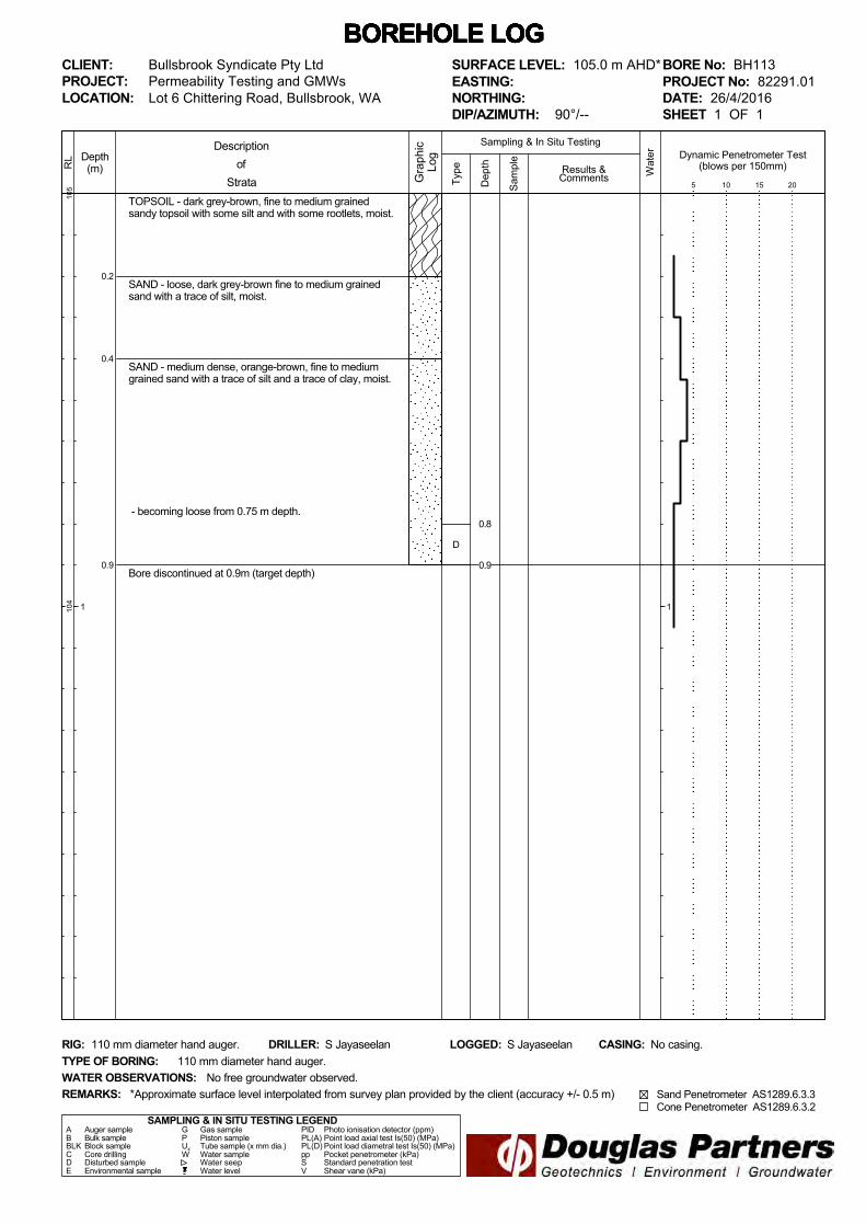
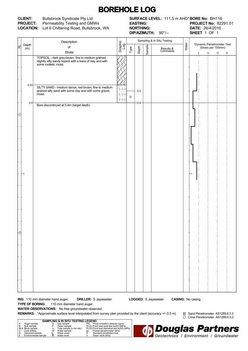
BH116 0.40 - - 2.6 x 10⁻⁵ 2.2 Medium dense silty sand with some clay.
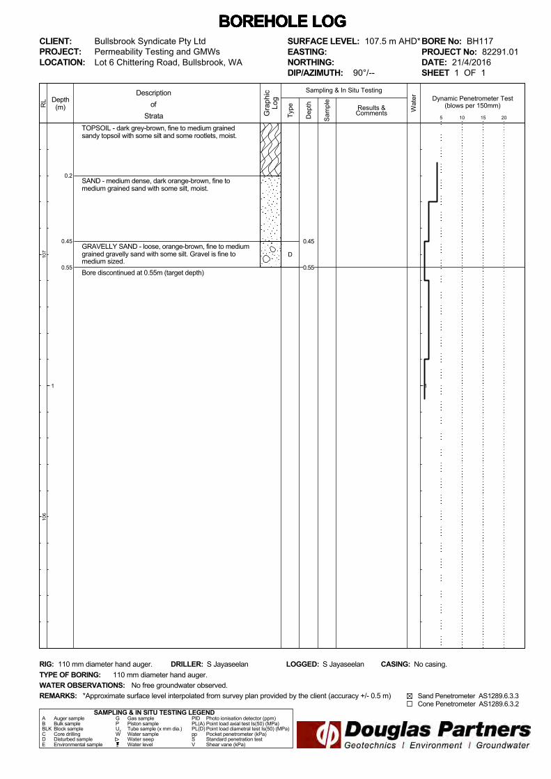
BH117 0.55 - - 1.0 x 10⁻⁵ 0.9 Loose gravelly sand with some silt.
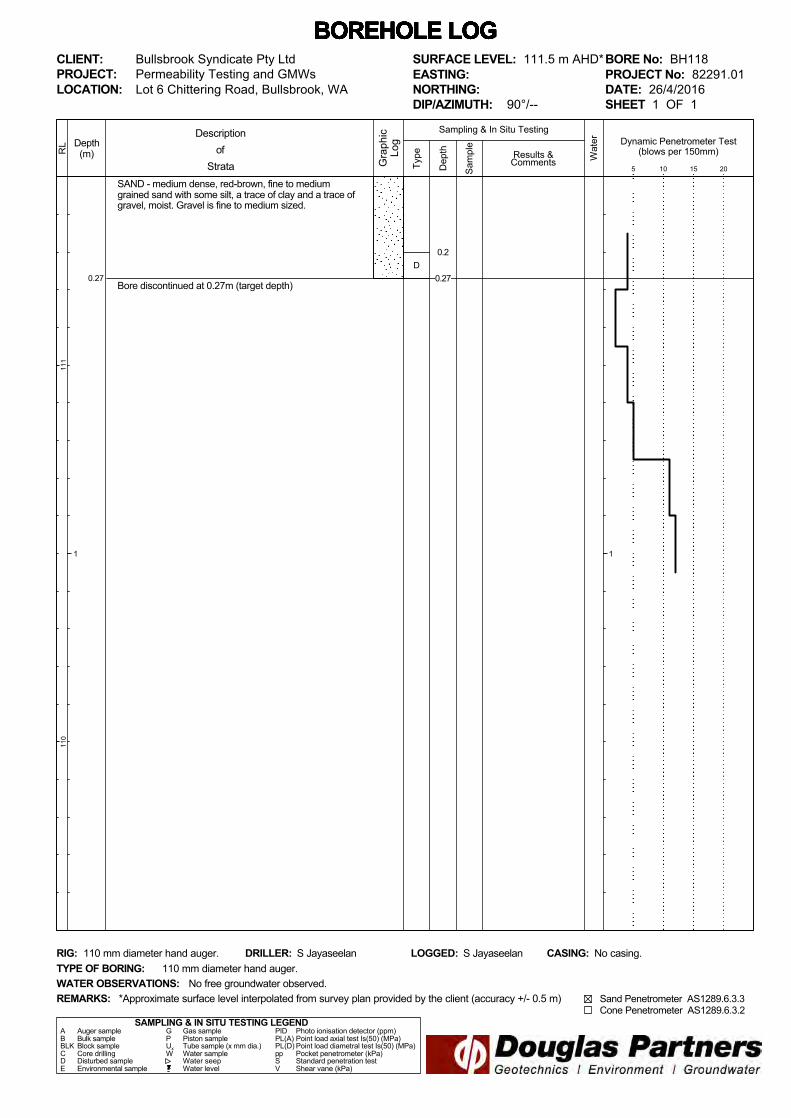
BH118 0.27 - - 2.1 x 10⁻⁵ 1.8 Medium dense sand with some silt, a trace of clay and a trace
of gravel.
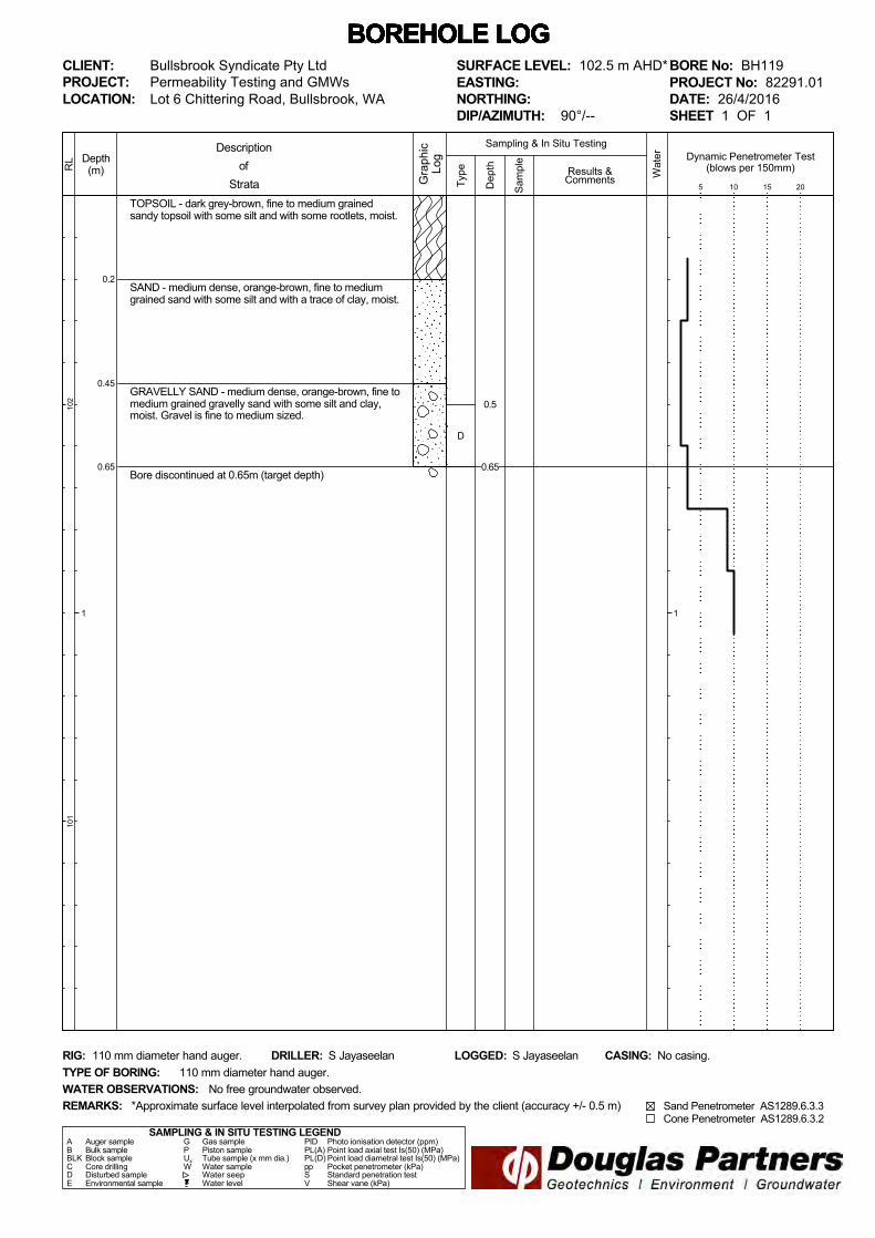
BH119 0.65 1.8 x 10⁻⁵ 1.6 - - Medium dense gravelly sand with some silt and clay.
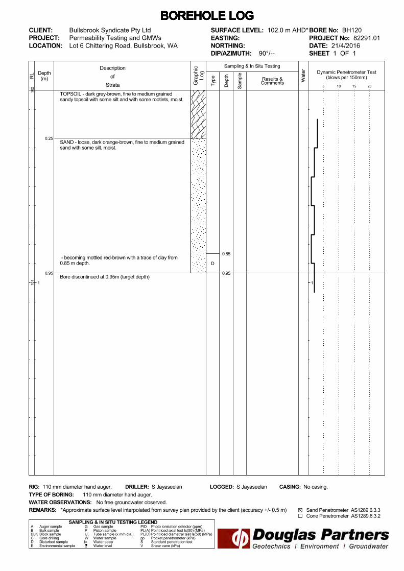
BH120 0.95 4.2 x 10⁻⁵ 3.6 - - Loose sand with some silt.
BH121 1.00 2.6 x 10⁻⁴ 22.5 - - Loose sand with some silt.
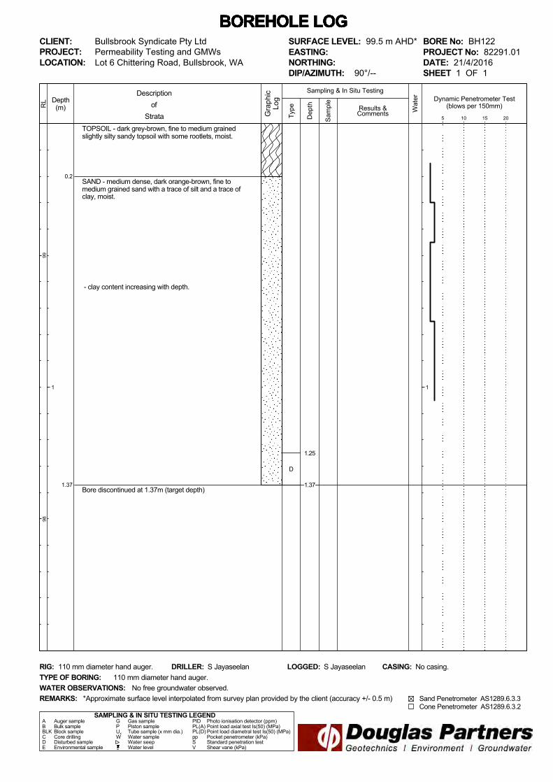
BH122 1.37 9.5 x 10⁻⁶ 0.8 - - Medium dense sand with some silt and a trace of clay.
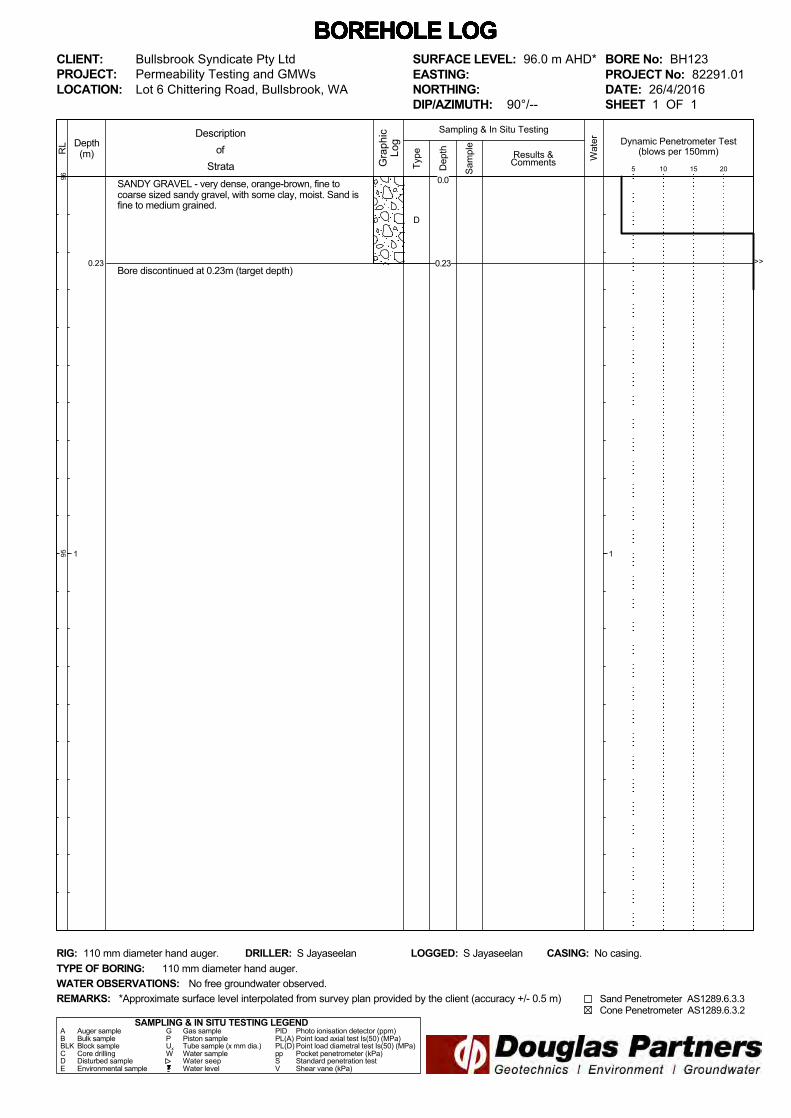
BH123 0.23 - - 1.5 x 10⁻⁵ 1.3 Very dense sandy gravel with some clay.
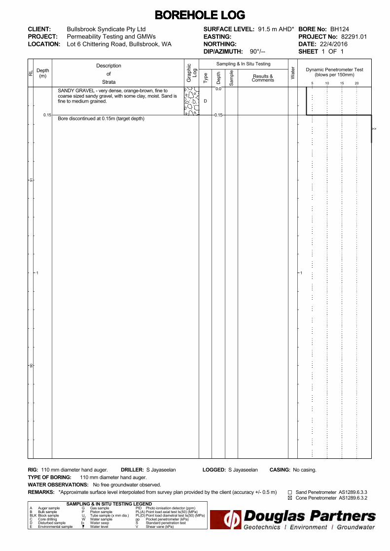
BH124 0.15 - - 5.3 x 10⁻⁵ 4.6 Very dense sandy gravel with some clay.

Page 6 of 7
Report on Permeability Testing 82291.01.R.001.Rev0 Lot 6 Chittering Road, Bullsbrook, WA May 2016
Test
Location
Depth
(m)
Measured
Permeability[1]
Measured
Permeability[2]
In situ Condition of the
Tested Material
(m/s) (m/day) (m/s) (m/day)
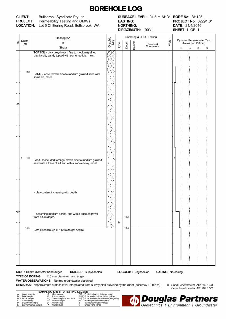
BH125 1.65 3.3 x 10⁻⁵ 2.9 - - Loose sand with some clay and a trace of gravel.
BH126 0.90 9.1 x 10⁻⁴ 78.6 - - Loose sand with some silt.
BH127 0.95 3.1 x 10⁻⁴ 26.8 - - Loose sand with some silt.
BH128 0.85 6.0 x 10⁻⁴ 51.8 - - Loose sand with some silt.
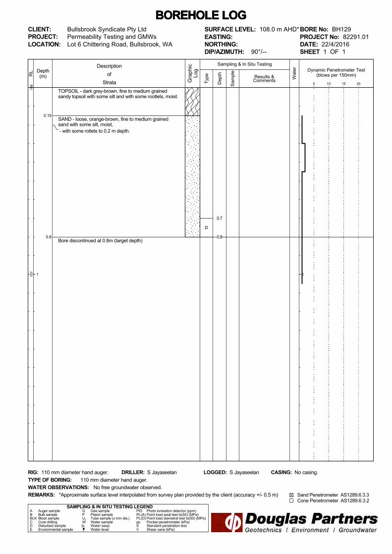
BH129 0.80 5.1 x 10⁻⁴ 44.1 - - Loose sand with some silt.
Notes: [1]: Hvorslev’s method. [2]: AS 1547:2012. It should be noted that the permeability values listed in Table 2 above are representative of the specific test locations, at the specified depths, in the conditions at the time of the field work. Lower permeability rates than those indicated, should be used for a long-term design value which takes into account bio build-up, siltation from surface infiltration, and possible increased density of the soils due to earthworks. 8. Limitations
Douglas Partners Pty Ltd (DP) has prepared this report in accordance with DP’s proposal dated 29 March 2016 and acceptance received from Mr Richard Sgro of Bullsbrook Syndicate Pty Ltd, on 7 April 2016. The work was carried out under DP Conditions of Engagement. This report is provided for the exclusive use of Bullsbrook Syndicate Pty Ltd c/- A Khosravi Engineering Services for this project only and for the purposes described in the report. It should not be used for other projects or by a third party. In preparing this report DP has necessarily relied upon information provided by the client and/or their agents. The results provided in the report are indicative of the sub-surface conditions only at the specific sampling or testing locations, and then only to the depths investigated and at the time the work was carried out. Sub-surface conditions can change abruptly due to variable geological processes and also as a result of anthropogenic influences. Such changes may occur after DP's field testing has been completed. DP's advice is based upon the conditions encountered during this investigation. The accuracy of the advice provided by DP in this report may be limited by undetected variations in ground conditions

Page 7 of 7
Report on Permeability Testing 82291.01.R.001.Rev0 Lot 6 Chittering Road, Bullsbrook, WA May 2016
between sampling locations. The advice may also be limited by budget constraints imposed by others or by site accessibility. This report must be read in conjunction with all of the attached notes and should be kept in its entirety without separation of individual pages or sections. DP cannot be held responsible for interpretations or conclusions made by others unless they are supported by an expressed statement, interpretation, outcome or conclusion given in this report. This report, or sections from this report, should not be used as part of a specification for a project, without review and agreement by DP. This is because this report has been written as advice and opinion rather than instructions for construction. The contents of this report do not constitute formal design components such as are required, by the Health and Safety Legislation and Regulations, to be included in a Safety Report specifying the hazards likely to be encountered during construction and the controls required to mitigate risk. This design process requires risk assessment to be undertaken, with such assessment being dependent upon factors relating to likelihood of occurrence and consequences of damage to property and to life. This, in turn, requires project data and analysis presently beyond the knowledge and project role respectively of DP. DP may be able, however, to assist the client in carrying out a risk assessment of potential hazards contained in the Comments section of this report, as an extension to the current scope of works, if so requested, and provided that suitable additional information is made available to DP. Any such risk assessment would, however, be necessarily restricted to the geotechnical components set out in this report and to their application by the project designers to project design, construction, maintenance and demolition. Please contact either of the undersigned for clarification of the above as necessary. Yours faithfully Douglas Partners Pty Ltd Reviewed by Sanoj Jayaseelan Frederic Verheyde
Geotechnical Engineer Principal Attachments: Notes about this report Site Drawing Borehole logs Laboratory Test Results
July 2010
Introduction These notes have been provided to amplify DP's
report in regard to classification methods, field
procedures and the comments section. Not all are
necessarily relevant to all reports.
DP's reports are based on information gained from
limited subsurface excavations and sampling,
supplemented by knowledge of local geology and
experience. For this reason, they must be
regarded as interpretive rather than factual
documents, limited to some extent by the scope of
information on which they rely.
Copyright This report is the property of Douglas Partners Pty
Ltd. The report may only be used for the purpose
for which it was commissioned and in accordance
with the Conditions of Engagement for the
commission supplied at the time of proposal.
Unauthorised use of this report in any form
whatsoever is prohibited.
Borehole and Test Pit Logs The borehole and test pit logs presented in this
report are an engineering and/or geological
interpretation of the subsurface conditions, and
their reliability will depend to some extent on
frequency of sampling and the method of drilling or
excavation. Ideally, continuous undisturbed
sampling or core drilling will provide the most
reliable assessment, but this is not always
practicable or possible to justify on economic
grounds. In any case the boreholes and test pits
represent only a very small sample of the total
subsurface profile.
Interpretation of the information and its application
to design and construction should therefore take
into account the spacing of boreholes or pits, the
frequency of sampling, and the possibility of other
than 'straight line' variations between the test
locations.
Groundwater Where groundwater levels are measured in
boreholes there are several potential problems,
namely:
• In low permeability soils groundwater may
enter the hole very slowly or perhaps not at all
during the time the hole is left open;
• A localised, perched water table may lead to
an erroneous indication of the true water
table;
• Water table levels will vary from time to time
with seasons or recent weather changes.
They may not be the same at the time of
construction as are indicated in the report;
and
• The use of water or mud as a drilling fluid will
mask any groundwater inflow. Water has to
be blown out of the hole and drilling mud must
first be washed out of the hole if water
measurements are to be made.
More reliable measurements can be made by
installing standpipes which are read at intervals
over several days, or perhaps weeks for low
permeability soils. Piezometers, sealed in a
particular stratum, may be advisable in low
permeability soils or where there may be
interference from a perched water table.
Reports The report has been prepared by qualified
personnel, is based on the information obtained
from field and laboratory testing, and has been
undertaken to current engineering standards of
interpretation and analysis. Where the report has
been prepared for a specific design proposal, the
information and interpretation may not be relevant
if the design proposal is changed. If this happens,
DP will be pleased to review the report and the
sufficiency of the investigation work.
Every care is taken with the report as it relates to
interpretation of subsurface conditions, discussion
of geotechnical and environmental aspects, and
recommendations or suggestions for design and
construction. However, DP cannot always
anticipate or assume responsibility for:
• Unexpected variations in ground conditions.
The potential for this will depend partly on
borehole or pit spacing and sampling
frequency;
• Changes in policy or interpretations of policy
by statutory authorities; or
• The actions of contractors responding to
commercial pressures.
If these occur, DP will be pleased to assist with
investigations or advice to resolve the matter.
July 2010
Site Anomalies In the event that conditions encountered on site
during construction appear to vary from those
which were expected from the information
contained in the report, DP requests that it be
immediately notified. Most problems are much
more readily resolved when conditions are
exposed rather than at some later stage, well after
the event.
Information for Contractual Purposes Where information obtained from this report is
provided for tendering purposes, it is
recommended that all information, including the
written report and discussion, be made available.
In circumstances where the discussion or
comments section is not relevant to the contractual
situation, it may be appropriate to prepare a
specially edited document. DP would be pleased
to assist in this regard and/or to make additional
report copies available for contract purposes at a
nominal charge.
Site Inspection The company will always be pleased to provide
engineering inspection services for geotechnical
and environmental aspects of work to which this
report is related. This could range from a site visit
to confirm that conditions exposed are as
expected, to full time engineering presence on
site.
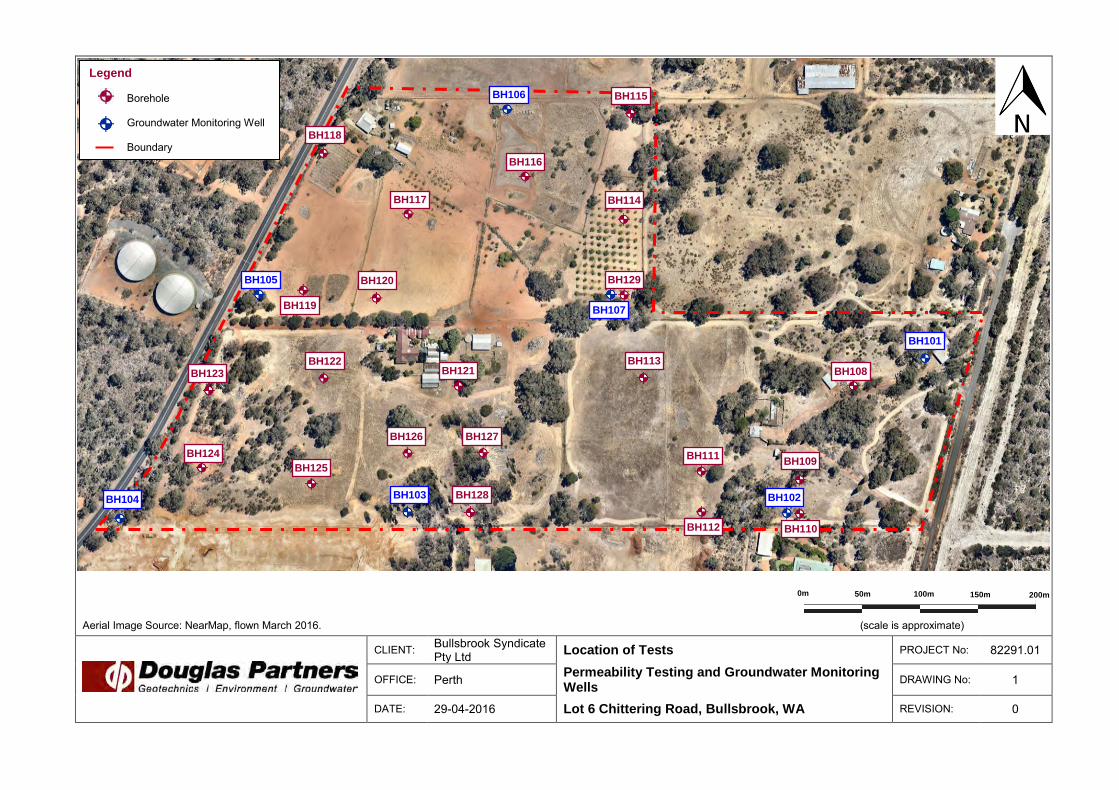
Aerial Image Source: NearMap, flown March 2016. (scale is approximate)
CLIENT: Bullsbrook Syndicate Pty Ltd Location of Tests PROJECT No: 82291.01
OFFICE: Perth Permeability Testing and Groundwater Monitoring Wells
DRAWING No: 1
DATE: 29-04-2016 Lot 6 Chittering Road, Bullsbrook, WA REVISION: 0
150m 100m 50m 0m 200m
Legend
Borehole Groundwater Monitoring Well Boundary
BH101
BH102 BH103 BH104
BH105
BH106
BH107
BH108
BH110
BH109 BH111
BH112
BH113
BH114
BH115
BH116
BH117
BH118
BH119
BH120
BH121 BH122
BH123
BH124
BH125
BH128
BH129
BH126 BH127
0.2
1.0
4.0
5.0
TOPSOIL - dark grey-brown, fine to medium grainedslightly silty sandy topsoil with some rootlets, moist.SAND - orange-brown, fine to medium grained sand withsome silt, moist.
Slightly CLAYEY GRAVELLY SAND - orange-brown, fineto medium grained slightly clayey gravelly sand. Gravel isfine to coarse sized.
CLAYEY SAND - orange-brown, fine to medium grainedclayey sand, dry.
Bore discontinued at 5.0m (target depth)
Bentonite Seal
50 mm Class 18PVC Pipe.
Gravel Pack
50 mm Class 18Slotted PVC Pipe
End Cap
Type
123
122
121
120
119
118
Depth(m)
1
2
3
4
5
RL
Wat
er
Dep
th
Sam
ple
Descriptionof
Strata Gra
phic
Log
Results &Comments
Sampling & In Situ Testing
1
2
3
4
5
BOREHOLE LOG BOREHOLE LOG BOREHOLE LOG BOREHOLE LOG BOREHOLE LOG BOREHOLE LOG BOREHOLE LOG CLIENT:PROJECT:LOCATION: Lot 6 Chittering Road, Bullsbrook, WA
SAMPLING & IN SITU TESTING LEGENDA Auger sample G Gas sample PID Photo ionisation detector (ppm)B Bulk sample P Piston sample PL(A) Point load axial test Is(50) (MPa)BLK Block sample Ux Tube sample (x mm dia.) PL(D) Point load diametral test Is(50) (MPa)C Core drilling W Water sample pp Pocket penetrometer (kPa)D Disturbed sample Water seep S Standard penetration testE Environmental sample Water level V Shear vane (kPa)
BORE No: BH101PROJECT No: 82291.01DATE: 22/4/2016SHEET 1 OF 1
DRILLER: Direct Push Probing LOGGED: S Jayaseelan CASING:
Bullsbrook Syndicate Pty LtdPermeability Testing and GMWs
REMARKS:
RIG: Geoprobe 6822DT.
WATER OBSERVATIONS:TYPE OF BORING:
No free groundwater observed.Hollow auger.
*Approximate surface level interpolated from survey plan provided by the client (accuracy +/- 0.5 m)
SURFACE LEVEL: 123.0 m AHD*EASTING:NORTHING:DIP/AZIMUTH: 90°/--
WellConstruction
Details
D
D
3.0
4.5
0.25
2.5
5.0
TOPSOIL - dark grey-brown, fine to medium grainedsandy topsoil with some silt and with some rootlets, moist.
SAND - orange-brown, fine to medium grained sand withsome silt, moist.
SAND - orange-brown, fine to medium grained sand withsome silt, a trace of gravel and a trace of clay, moist.
- clay content and gravel content increasing with depth.
Bore discontinued at 5.0m (target depth)
Bentonite Seal
50 mm Class 18PVC Pipe.
Gravel Pack
50 mm Class 18Slotted PVC Pipe
End Cap
Type
105
104
103
102
101
100
Depth(m)
1
2
3
4
5
RL
Wat
er
Dep
th
Sam
ple
Descriptionof
Strata Gra
phic
Log
Results &Comments
Sampling & In Situ Testing
1
2
3
4
5
BOREHOLE LOG BOREHOLE LOG BOREHOLE LOG BOREHOLE LOG BOREHOLE LOG BOREHOLE LOG BOREHOLE LOG CLIENT:PROJECT:LOCATION: Lot 6 Chittering Road, Bullsbrook, WA
SAMPLING & IN SITU TESTING LEGENDA Auger sample G Gas sample PID Photo ionisation detector (ppm)B Bulk sample P Piston sample PL(A) Point load axial test Is(50) (MPa)BLK Block sample Ux Tube sample (x mm dia.) PL(D) Point load diametral test Is(50) (MPa)C Core drilling W Water sample pp Pocket penetrometer (kPa)D Disturbed sample Water seep S Standard penetration testE Environmental sample Water level V Shear vane (kPa)
BORE No: BH102PROJECT No: 82291.01DATE: 22/4/2016SHEET 1 OF 1
DRILLER: Direct Push Probing LOGGED: S Jayaseelan CASING:
Bullsbrook Syndicate Pty LtdPermeability Testing and GMWs
REMARKS:
RIG: Geoprobe 6822DT.
WATER OBSERVATIONS:TYPE OF BORING:
No free groundwater observed.Hollow auger.
*Approximate surface level interpolated from survey plan provided by the client (accuracy +/- 0.5 m)
SURFACE LEVEL: 105.0 m AHD*EASTING:NORTHING:DIP/AZIMUTH: 90°/--
WellConstruction
Details
D 4.9
0.2
5.0
TOPSOIL - dark grey-brown, fine to medium grainedsandy topsoil with some silt and with some rootlets, moist.SAND - orange-brown, fine to medium grained sand withsome silt, moist.
- with a trace of clay from 1.5 m depth.
- with some clay from 2.5 m depth.
- becoming slightly clayey from 3.5 m depth.
Bore discontinued at 5.0m (target depth)
Bentonite Seal
50 mm Class 18PVC Pipe.
Gravel Pack
50 mm Class 18Slotted PVC Pipe
End Cap
Type
9594
9392
9190
Depth(m)
1
2
3
4
5
RL
Wat
er
Dep
th
Sam
ple
Descriptionof
Strata Gra
phic
Log
Results &Comments
Sampling & In Situ Testing
1
2
3
4
5
BOREHOLE LOG BOREHOLE LOG BOREHOLE LOG BOREHOLE LOG BOREHOLE LOG BOREHOLE LOG BOREHOLE LOG CLIENT:PROJECT:LOCATION: Lot 6 Chittering Road, Bullsbrook, WA
SAMPLING & IN SITU TESTING LEGENDA Auger sample G Gas sample PID Photo ionisation detector (ppm)B Bulk sample P Piston sample PL(A) Point load axial test Is(50) (MPa)BLK Block sample Ux Tube sample (x mm dia.) PL(D) Point load diametral test Is(50) (MPa)C Core drilling W Water sample pp Pocket penetrometer (kPa)D Disturbed sample Water seep S Standard penetration testE Environmental sample Water level V Shear vane (kPa)
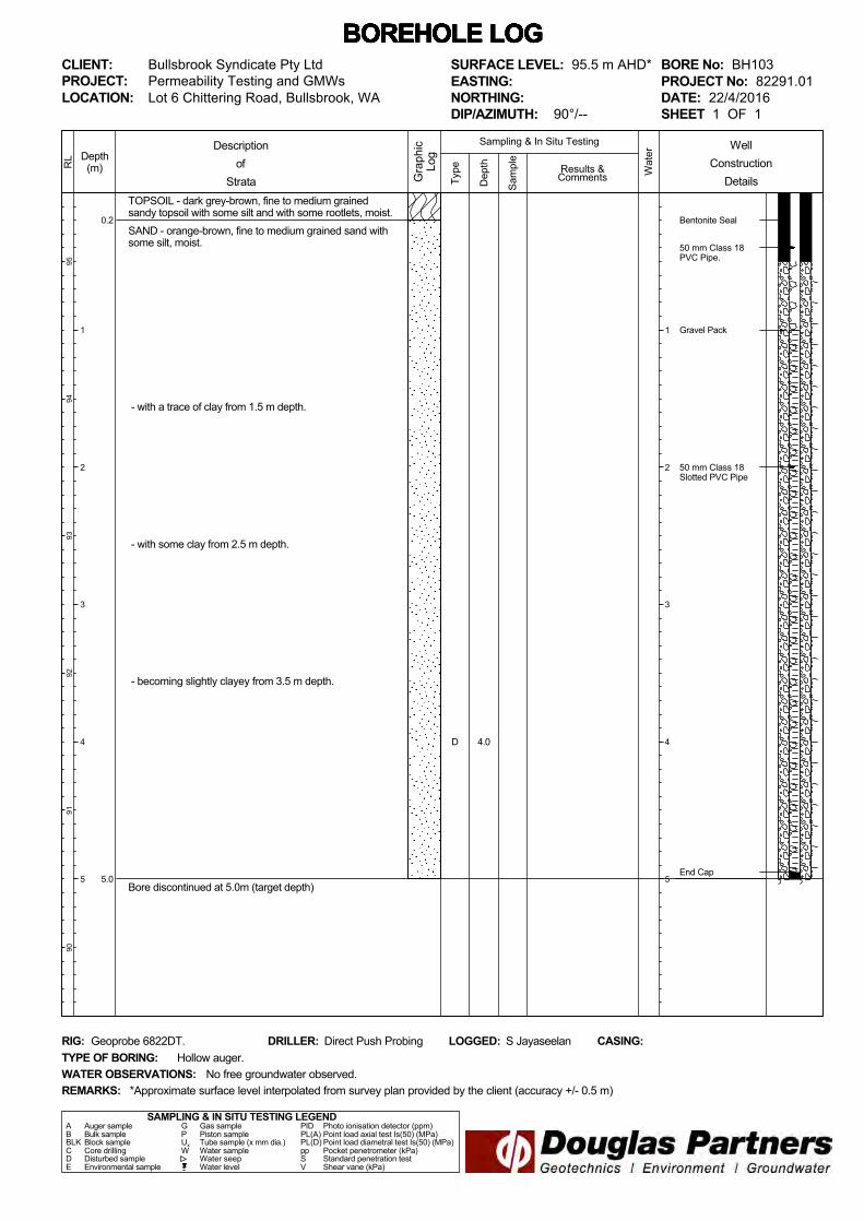
BORE No: BH103PROJECT No: 82291.01DATE: 22/4/2016SHEET 1 OF 1
DRILLER: Direct Push Probing LOGGED: S Jayaseelan CASING:
Bullsbrook Syndicate Pty LtdPermeability Testing and GMWs
REMARKS:
RIG: Geoprobe 6822DT.
WATER OBSERVATIONS:TYPE OF BORING:
No free groundwater observed.Hollow auger.
*Approximate surface level interpolated from survey plan provided by the client (accuracy +/- 0.5 m)
SURFACE LEVEL: 95.5 m AHD*EASTING:NORTHING:DIP/AZIMUTH: 90°/--
WellConstruction
Details
D 4.0
2.5
5.0
Slightly CLAYEY SANDY GRAVEL - red-brown, fine tomedium sized slightly clayey sandy gravel, moist. Sand isfine to medium grained.
Slightly GRAVELLY CLAYEY SAND - orange-brown, fineto medium grained slightly gravelly clayey sand, dry.Gravel is fine to medium sized. Clay is of low plasticity.
- gravel content decreasing with depth.
Bore discontinued at 5.0m (target depth)
Bentonite Seal
50 mm Class 18PVC Pipe.
Gravel Pack
50 mm Class 18Slotted PVC Pipe
End Cap
Type
8988
8786
8584
Depth(m)
1
2
3
4
5
RL
Wat
er
Dep
th
Sam
ple
Descriptionof
Strata Gra
phic
Log
Results &Comments
Sampling & In Situ Testing
1
2
3
4
5
BOREHOLE LOG BOREHOLE LOG BOREHOLE LOG BOREHOLE LOG BOREHOLE LOG BOREHOLE LOG BOREHOLE LOG CLIENT:PROJECT:LOCATION: Lot 6 Chittering Road, Bullsbrook, WA
SAMPLING & IN SITU TESTING LEGENDA Auger sample G Gas sample PID Photo ionisation detector (ppm)B Bulk sample P Piston sample PL(A) Point load axial test Is(50) (MPa)BLK Block sample Ux Tube sample (x mm dia.) PL(D) Point load diametral test Is(50) (MPa)C Core drilling W Water sample pp Pocket penetrometer (kPa)D Disturbed sample Water seep S Standard penetration testE Environmental sample Water level V Shear vane (kPa)
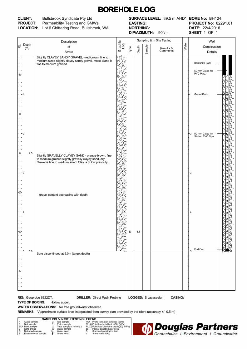
BORE No: BH104PROJECT No: 82291.01DATE: 22/4/2016SHEET 1 OF 1
DRILLER: Direct Push Probing LOGGED: S Jayaseelan CASING:
Bullsbrook Syndicate Pty LtdPermeability Testing and GMWs
REMARKS:
RIG: Geoprobe 6822DT.
WATER OBSERVATIONS:TYPE OF BORING:
No free groundwater observed.Hollow auger.
*Approximate surface level interpolated from survey plan provided by the client (accuracy +/- 0.5 m)
SURFACE LEVEL: 89.5 m AHD*EASTING:NORTHING:DIP/AZIMUTH: 90°/--
WellConstruction
Details
D 4.5
1.0
5.0
Slightly GRAVELLY SAND - orange-brown, fine tomedium grained slightly gravelly sand with some clay,moist.
CLAYEY SAND - orange-brown, fine to medium grainedclayey sand, dry. Clay is of low to medium plasticity.
Bore discontinued at 5.0m (target depth)
Bentonite Seal
50 mm Class 18PVC Pipe.
Gravel Pack
50 mm Class 18Slotted PVC Pipe
End Cap
Type
103
102
101
100
9998
Depth(m)
1
2
3
4
5
RL
Wat
er
Dep
th
Sam
ple
Descriptionof
Strata Gra
phic
Log
Results &Comments
Sampling & In Situ Testing
1
2
3
4
5
BOREHOLE LOG BOREHOLE LOG BOREHOLE LOG BOREHOLE LOG BOREHOLE LOG BOREHOLE LOG BOREHOLE LOG CLIENT:PROJECT:LOCATION: Lot 6 Chittering Road, Bullsbrook, WA
SAMPLING & IN SITU TESTING LEGENDA Auger sample G Gas sample PID Photo ionisation detector (ppm)B Bulk sample P Piston sample PL(A) Point load axial test Is(50) (MPa)BLK Block sample Ux Tube sample (x mm dia.) PL(D) Point load diametral test Is(50) (MPa)C Core drilling W Water sample pp Pocket penetrometer (kPa)D Disturbed sample Water seep S Standard penetration testE Environmental sample Water level V Shear vane (kPa)
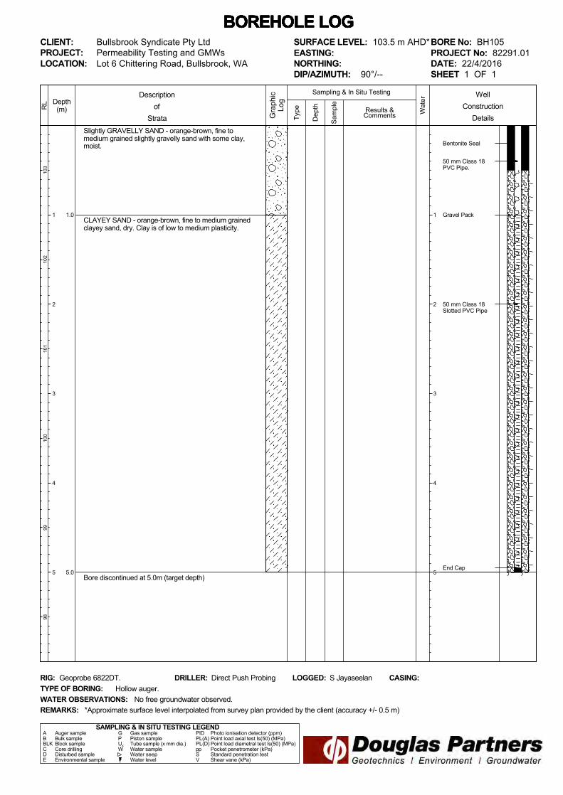
BORE No: BH105PROJECT No: 82291.01DATE: 22/4/2016SHEET 1 OF 1
DRILLER: Direct Push Probing LOGGED: S Jayaseelan CASING:
Bullsbrook Syndicate Pty LtdPermeability Testing and GMWs
REMARKS:
RIG: Geoprobe 6822DT.
WATER OBSERVATIONS:TYPE OF BORING:
No free groundwater observed.Hollow auger.
*Approximate surface level interpolated from survey plan provided by the client (accuracy +/- 0.5 m)
SURFACE LEVEL: 103.5 m AHD*EASTING:NORTHING:DIP/AZIMUTH: 90°/--
WellConstruction
Details
0.2
4.5
5.0
TOPSOIL - dark grey-brown, fine to medium grainedslighlty silty sandy topsoil with some rootlets, moist.CLAYEY SAND - red-brown, fine to medium grainedclayey sand. Clay is medium plasticity.
Slightly CLAYEY SAND - dark brown, fine to mediumgrained slightly clayey sand with some gravel, dry.
Bore discontinued at 5.0m (target depth)
Bentonite Seal
50 mm Class 18PVC Pipe.
Gravel Pack
50 mm Class 18Slotted PVC Pipe
End Cap
Type
115
114
113
112
111
110
Depth(m)
1
2
3
4
5
RL
Wat
er
Dep
th
Sam
ple
Descriptionof
Strata Gra
phic
Log
Results &Comments
Sampling & In Situ Testing
1
2
3
4
5
BOREHOLE LOG BOREHOLE LOG BOREHOLE LOG BOREHOLE LOG BOREHOLE LOG BOREHOLE LOG BOREHOLE LOG CLIENT:PROJECT:LOCATION: Lot 6 Chittering Road, Bullsbrook, WA
SAMPLING & IN SITU TESTING LEGENDA Auger sample G Gas sample PID Photo ionisation detector (ppm)B Bulk sample P Piston sample PL(A) Point load axial test Is(50) (MPa)BLK Block sample Ux Tube sample (x mm dia.) PL(D) Point load diametral test Is(50) (MPa)C Core drilling W Water sample pp Pocket penetrometer (kPa)D Disturbed sample Water seep S Standard penetration testE Environmental sample Water level V Shear vane (kPa)
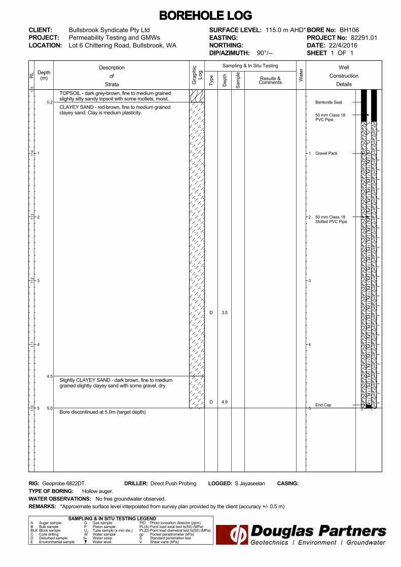
BORE No: BH106PROJECT No: 82291.01DATE: 22/4/2016SHEET 1 OF 1
DRILLER: Direct Push Probing LOGGED: S Jayaseelan CASING:
Bullsbrook Syndicate Pty LtdPermeability Testing and GMWs
REMARKS:
RIG: Geoprobe 6822DT.
WATER OBSERVATIONS:TYPE OF BORING:
No free groundwater observed.Hollow auger.
*Approximate surface level interpolated from survey plan provided by the client (accuracy +/- 0.5 m)
SURFACE LEVEL: 115.0 m AHD*EASTING:NORTHING:DIP/AZIMUTH: 90°/--
WellConstruction
Details
D
D
3.5
4.9
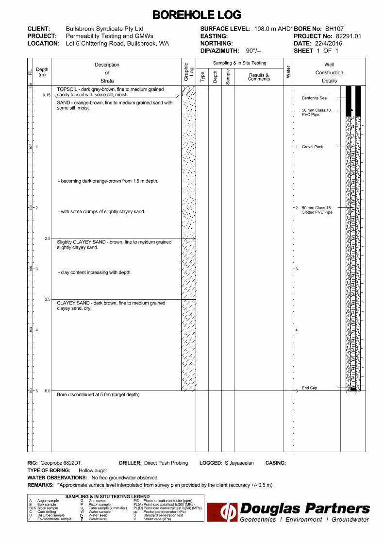
0.15
2.5
3.5
5.0
TOPSOIL - dark grey-brown, fine to medium grainedsandy topsoil with some silt, moist.SAND - orange-brown, fine to medium grained sand withsome silt, moist.
- becoming dark orange-brown from 1.5 m depth.
- with some clumps of slightly clayey sand.
Slightly CLAYEY SAND - brown, fine to meidum grainedslightly clayey sand.
- clay content increasing with depth.
CLAYEY SAND - dark brown, fine to medium grainedclayey sand, dry.
Bore discontinued at 5.0m (target depth)
Bentonite Seal
50 mm Class 18PVC Pipe.
Gravel Pack
50 mm Class 18Slotted PVC Pipe
End Cap
Type
108
107
106
105
104
103
Depth(m)
1
2
3
4
5
RL
Wat
er
Dep
th
Sam
ple
Descriptionof
Strata Gra
phic
Log
Results &Comments
Sampling & In Situ Testing
1
2
3
4
5
BOREHOLE LOG BOREHOLE LOG BOREHOLE LOG BOREHOLE LOG BOREHOLE LOG BOREHOLE LOG BOREHOLE LOG CLIENT:PROJECT:LOCATION: Lot 6 Chittering Road, Bullsbrook, WA
SAMPLING & IN SITU TESTING LEGENDA Auger sample G Gas sample PID Photo ionisation detector (ppm)B Bulk sample P Piston sample PL(A) Point load axial test Is(50) (MPa)BLK Block sample Ux Tube sample (x mm dia.) PL(D) Point load diametral test Is(50) (MPa)C Core drilling W Water sample pp Pocket penetrometer (kPa)D Disturbed sample Water seep S Standard penetration testE Environmental sample Water level V Shear vane (kPa)
BORE No: BH107PROJECT No: 82291.01DATE: 22/4/2016SHEET 1 OF 1
DRILLER: Direct Push Probing LOGGED: S Jayaseelan CASING:
Bullsbrook Syndicate Pty LtdPermeability Testing and GMWs
REMARKS:
RIG: Geoprobe 6822DT.
WATER OBSERVATIONS:TYPE OF BORING:
No free groundwater observed.Hollow auger.
*Approximate surface level interpolated from survey plan provided by the client (accuracy +/- 0.5 m)
SURFACE LEVEL: 108.0 m AHD*EASTING:NORTHING:DIP/AZIMUTH: 90°/--
WellConstruction
Details
0.1
0.85
TOPSOIL - dark grey-brown, fine to medium grainedsandy topsoil with some silt and with some rootlets, moist.
SAND - medium dense, orange-brown, fine to mediumgrained sand with some silt, moist.
Bore discontinued at 0.85m (target depth)
Type
114
113
Depth(m)
1
RL
Wat
er
Dep
th
Sam
ple
Descriptionof
Strata Gra
phic
Log
Results &Comments
Sampling & In Situ Testing
1
BOREHOLE LOG BOREHOLE LOG BOREHOLE LOG BOREHOLE LOG BOREHOLE LOG BOREHOLE LOG BOREHOLE LOG CLIENT:PROJECT:LOCATION: Lot 6 Chittering Road, Bullsbrook, WA
SAMPLING & IN SITU TESTING LEGENDA Auger sample G Gas sample PID Photo ionisation detector (ppm)B Bulk sample P Piston sample PL(A) Point load axial test Is(50) (MPa)BLK Block sample Ux Tube sample (x mm dia.) PL(D) Point load diametral test Is(50) (MPa)C Core drilling W Water sample pp Pocket penetrometer (kPa)D Disturbed sample Water seep S Standard penetration testE Environmental sample Water level V Shear vane (kPa)
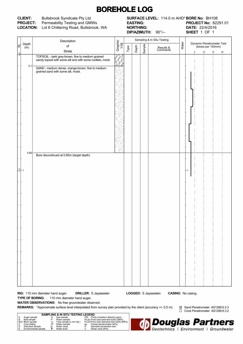
BORE No: BH108PROJECT No: 82291.01DATE: 22/4/2016SHEET 1 OF 1
DRILLER: S Jayaseelan LOGGED: S Jayaseelan CASING: No casing.
Bullsbrook Syndicate Pty LtdPermeability Testing and GMWs
REMARKS:
RIG: 110 mm diameter hand auger.
WATER OBSERVATIONS:TYPE OF BORING:
No free groundwater observed.110 mm diameter hand auger.
*Approximate surface level interpolated from survey plan provided by the client (accuracy +/- 0.5 m)
SURFACE LEVEL: 114.0 m AHD*EASTING:NORTHING:DIP/AZIMUTH: 90°/--
Dynamic Penetrometer Test(blows per 150mm)
5 10 15 20
Sand Penetrometer AS1289.6.3.3 Cone Penetrometer AS1289.6.3.2

0.1
0.9
TOPSOIL - dark grey-brown, fine to medium grainedsandy topsoil with some silt and with some rootlets, moist.
SAND - loose, orange-brown, fine to medium grainedsand with some silt, moist.
Bore discontinued at 0.9m (target depth)
Type
107
106
Depth(m)
1
RL
Wat
er
Dep
th
Sam
ple
Descriptionof
Strata Gra
phic
Log
Results &Comments
Sampling & In Situ Testing
1
BOREHOLE LOG BOREHOLE LOG BOREHOLE LOG BOREHOLE LOG BOREHOLE LOG BOREHOLE LOG BOREHOLE LOG CLIENT:PROJECT:LOCATION: Lot 6 Chittering Road, Bullsbrook, WA
SAMPLING & IN SITU TESTING LEGENDA Auger sample G Gas sample PID Photo ionisation detector (ppm)B Bulk sample P Piston sample PL(A) Point load axial test Is(50) (MPa)BLK Block sample Ux Tube sample (x mm dia.) PL(D) Point load diametral test Is(50) (MPa)C Core drilling W Water sample pp Pocket penetrometer (kPa)D Disturbed sample Water seep S Standard penetration testE Environmental sample Water level V Shear vane (kPa)
BORE No: BH109PROJECT No: 82291.01DATE: 22/4/2016SHEET 1 OF 1
DRILLER: S Jayaseelan LOGGED: S Jayaseelan CASING: No casing.
Bullsbrook Syndicate Pty LtdPermeability Testing and GMWs
REMARKS:
RIG: 110 mm diameter hand auger.
WATER OBSERVATIONS:TYPE OF BORING:
No free groundwater observed.110 mm diameter hand auger.
*Approximate surface level interpolated from survey plan provided by the client (accuracy +/- 0.5 m)
SURFACE LEVEL: 107.0 m AHD*EASTING:NORTHING:DIP/AZIMUTH: 90°/--
Dynamic Penetrometer Test(blows per 150mm)
5 10 15 20
Sand Penetrometer AS1289.6.3.3 Cone Penetrometer AS1289.6.3.2
0.25
0.9
TOPSOIL - dark grey-brown, fine to medium grainedsandy topsoil with some silt and with some rootlets, moist.
SAND - loose, orange-brown, fine to medium grainedsand with some silt, moist.
Bore discontinued at 0.9m (target depth)
Type
104
103
Depth(m)
1
RL
Wat
er
Dep
th
Sam
ple
Descriptionof
Strata Gra
phic
Log
Results &Comments
Sampling & In Situ Testing
1
BOREHOLE LOG BOREHOLE LOG BOREHOLE LOG BOREHOLE LOG BOREHOLE LOG BOREHOLE LOG BOREHOLE LOG CLIENT:PROJECT:LOCATION: Lot 6 Chittering Road, Bullsbrook, WA
SAMPLING & IN SITU TESTING LEGENDA Auger sample G Gas sample PID Photo ionisation detector (ppm)B Bulk sample P Piston sample PL(A) Point load axial test Is(50) (MPa)BLK Block sample Ux Tube sample (x mm dia.) PL(D) Point load diametral test Is(50) (MPa)C Core drilling W Water sample pp Pocket penetrometer (kPa)D Disturbed sample Water seep S Standard penetration testE Environmental sample Water level V Shear vane (kPa)
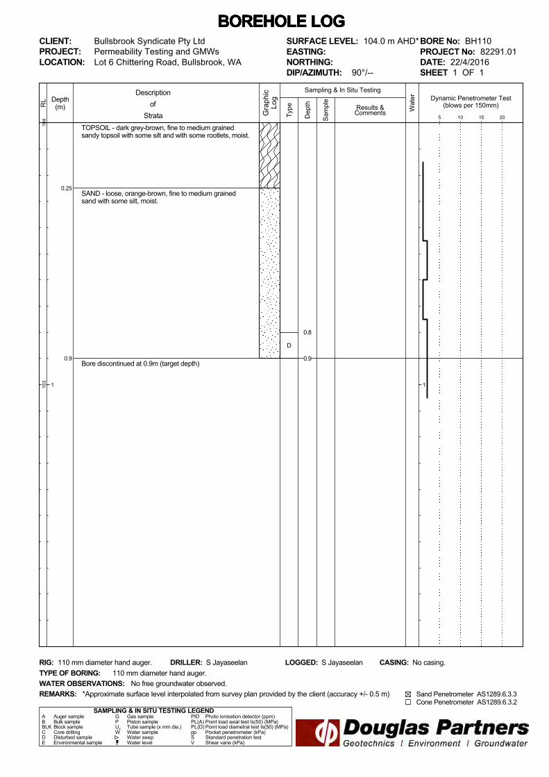
BORE No: BH110PROJECT No: 82291.01DATE: 22/4/2016SHEET 1 OF 1
DRILLER: S Jayaseelan LOGGED: S Jayaseelan CASING: No casing.
Bullsbrook Syndicate Pty LtdPermeability Testing and GMWs
REMARKS:
RIG: 110 mm diameter hand auger.
WATER OBSERVATIONS:TYPE OF BORING:
No free groundwater observed.110 mm diameter hand auger.
*Approximate surface level interpolated from survey plan provided by the client (accuracy +/- 0.5 m)
SURFACE LEVEL: 104.0 m AHD*EASTING:NORTHING:DIP/AZIMUTH: 90°/--
Dynamic Penetrometer Test(blows per 150mm)
5 10 15 20
Sand Penetrometer AS1289.6.3.3 Cone Penetrometer AS1289.6.3.2
D
0.8
0.9

0.2
0.9
TOPSOIL - dark grey-brown, fine to medium grainedsandy topsoil with some silt and with some rootlets, moist.
SAND - loose, orange-brown, fine to medium grainedsand with a trace of silt, moist.
Bore discontinued at 0.9m (target depth)
Type
103
102
Depth(m)
1
RL
Wat
er
Dep
th
Sam
ple
Descriptionof
Strata Gra
phic
Log
Results &Comments
Sampling & In Situ Testing
1
BOREHOLE LOG BOREHOLE LOG BOREHOLE LOG BOREHOLE LOG BOREHOLE LOG BOREHOLE LOG BOREHOLE LOG CLIENT:PROJECT:LOCATION: Lot 6 Chittering Road, Bullsbrook, WA
SAMPLING & IN SITU TESTING LEGENDA Auger sample G Gas sample PID Photo ionisation detector (ppm)B Bulk sample P Piston sample PL(A) Point load axial test Is(50) (MPa)BLK Block sample Ux Tube sample (x mm dia.) PL(D) Point load diametral test Is(50) (MPa)C Core drilling W Water sample pp Pocket penetrometer (kPa)D Disturbed sample Water seep S Standard penetration testE Environmental sample Water level V Shear vane (kPa)
BORE No: BH111PROJECT No: 82291.01DATE: 26/4/2016SHEET 1 OF 1
DRILLER: S Jayaseelan LOGGED: S Jayaseelan CASING: No casing.
Bullsbrook Syndicate Pty LtdPermeability Testing and GMWs
REMARKS:
RIG: 110 mm diameter hand auger.
WATER OBSERVATIONS:TYPE OF BORING:
No free groundwater observed.110 mm diameter hand auger.
*Approximate surface level interpolated from survey plan provided by the client (accuracy +/- 0.5 m)
SURFACE LEVEL: 103.0 m AHD*EASTING:NORTHING:DIP/AZIMUTH: 90°/--
Dynamic Penetrometer Test(blows per 150mm)
5 10 15 20
Sand Penetrometer AS1289.6.3.3 Cone Penetrometer AS1289.6.3.2
D
0.8
0.9
0.2
0.4
1.0
TOPSOIL - dark grey-brown, fine to medium grainedsandy topsoil with some silt and with some rootlets, moist.
SAND - loose, dark grey-brown fine to medium grainedsand with a trace of silt, moist.
SAND - loose, orange-brown, fine to medium grainedsand with a trace of silt, moist.
Bore discontinued at 1.0m (target depth)
Type
100
99
Depth(m)
1
RL
Wat
er
Dep
th
Sam
ple
Descriptionof
Strata Gra
phic
Log
Results &Comments
Sampling & In Situ Testing
1
BOREHOLE LOG BOREHOLE LOG BOREHOLE LOG BOREHOLE LOG BOREHOLE LOG BOREHOLE LOG BOREHOLE LOG CLIENT:PROJECT:LOCATION: Lot 6 Chittering Road, Bullsbrook, WA
SAMPLING & IN SITU TESTING LEGENDA Auger sample G Gas sample PID Photo ionisation detector (ppm)B Bulk sample P Piston sample PL(A) Point load axial test Is(50) (MPa)BLK Block sample Ux Tube sample (x mm dia.) PL(D) Point load diametral test Is(50) (MPa)C Core drilling W Water sample pp Pocket penetrometer (kPa)D Disturbed sample Water seep S Standard penetration testE Environmental sample Water level V Shear vane (kPa)
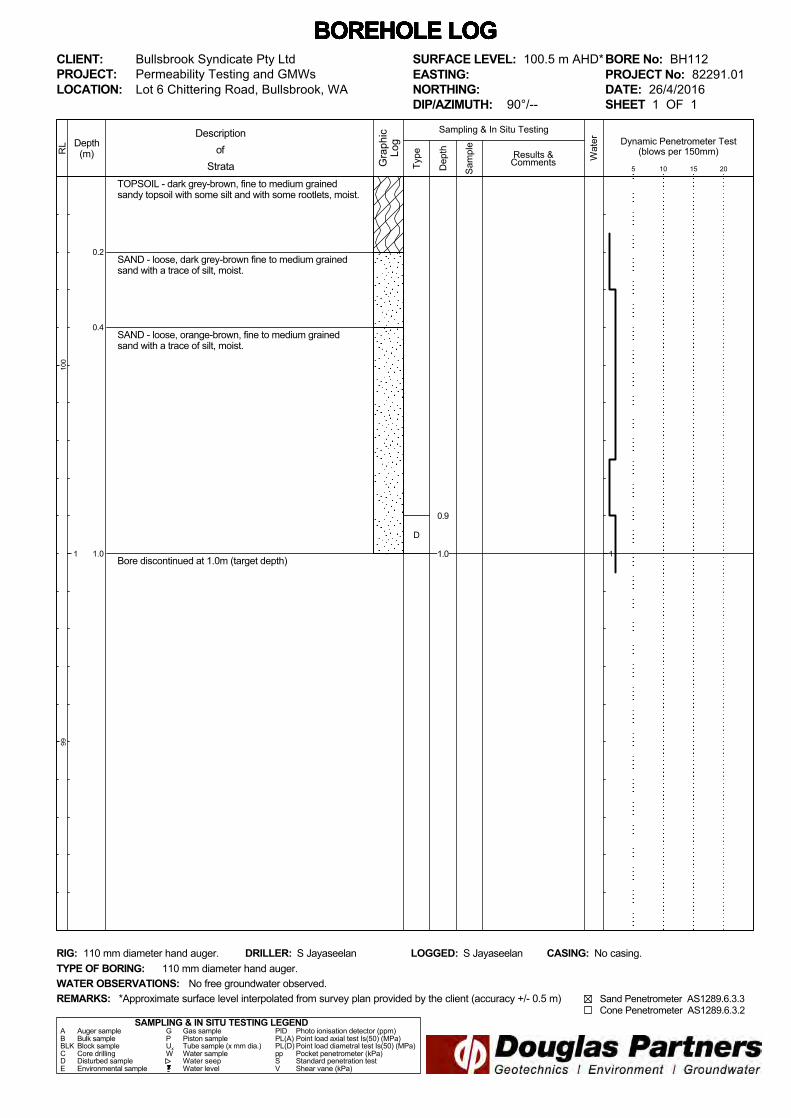
BORE No: BH112PROJECT No: 82291.01DATE: 26/4/2016SHEET 1 OF 1
DRILLER: S Jayaseelan LOGGED: S Jayaseelan CASING: No casing.
Bullsbrook Syndicate Pty LtdPermeability Testing and GMWs
REMARKS:
RIG: 110 mm diameter hand auger.
WATER OBSERVATIONS:TYPE OF BORING:
No free groundwater observed.110 mm diameter hand auger.
*Approximate surface level interpolated from survey plan provided by the client (accuracy +/- 0.5 m)
SURFACE LEVEL: 100.5 m AHD*EASTING:NORTHING:DIP/AZIMUTH: 90°/--
Dynamic Penetrometer Test(blows per 150mm)
5 10 15 20
Sand Penetrometer AS1289.6.3.3 Cone Penetrometer AS1289.6.3.2
D
0.9
1.0
0.2
0.4
0.9
TOPSOIL - dark grey-brown, fine to medium grainedsandy topsoil with some silt and with some rootlets, moist.
SAND - loose, dark grey-brown fine to medium grainedsand with a trace of silt, moist.
SAND - medium dense, orange-brown, fine to mediumgrained sand with a trace of silt and a trace of clay, moist.
- becoming loose from 0.75 m depth.
Bore discontinued at 0.9m (target depth)
Type
105
104
Depth(m)
1
RL
Wat
er
Dep
th
Sam
ple
Descriptionof
Strata Gra
phic
Log
Results &Comments
Sampling & In Situ Testing
1
BOREHOLE LOG BOREHOLE LOG BOREHOLE LOG BOREHOLE LOG BOREHOLE LOG BOREHOLE LOG BOREHOLE LOG CLIENT:PROJECT:LOCATION: Lot 6 Chittering Road, Bullsbrook, WA
SAMPLING & IN SITU TESTING LEGENDA Auger sample G Gas sample PID Photo ionisation detector (ppm)B Bulk sample P Piston sample PL(A) Point load axial test Is(50) (MPa)BLK Block sample Ux Tube sample (x mm dia.) PL(D) Point load diametral test Is(50) (MPa)C Core drilling W Water sample pp Pocket penetrometer (kPa)D Disturbed sample Water seep S Standard penetration testE Environmental sample Water level V Shear vane (kPa)
BORE No: BH113PROJECT No: 82291.01DATE: 26/4/2016SHEET 1 OF 1
DRILLER: S Jayaseelan LOGGED: S Jayaseelan CASING: No casing.
Bullsbrook Syndicate Pty LtdPermeability Testing and GMWs
REMARKS:
RIG: 110 mm diameter hand auger.
WATER OBSERVATIONS:TYPE OF BORING:
No free groundwater observed.110 mm diameter hand auger.
*Approximate surface level interpolated from survey plan provided by the client (accuracy +/- 0.5 m)
SURFACE LEVEL: 105.0 m AHD*EASTING:NORTHING:DIP/AZIMUTH: 90°/--
Dynamic Penetrometer Test(blows per 150mm)
5 10 15 20
Sand Penetrometer AS1289.6.3.3 Cone Penetrometer AS1289.6.3.2
D
0.8
0.9

0.2
0.95
TOPSOIL - dark grey-brown, fine to medium grainedsandy toipsoil with some silt and some rootlets, moist.
SAND - loose, orange-brown, fine to medium grainedsand with some silt, moist.
- with a rootlet at 0.7 m depth.
Bore discontinued at 0.95m (target depth)
Type
111
110
Depth(m)
1
RL
Wat
er
Dep
th
Sam
ple
Descriptionof
Strata Gra
phic
Log
Results &Comments
Sampling & In Situ Testing
1
BOREHOLE LOG BOREHOLE LOG BOREHOLE LOG BOREHOLE LOG BOREHOLE LOG BOREHOLE LOG BOREHOLE LOG CLIENT:PROJECT:LOCATION: Lot 6 Chittering Road, Bullsbrook, WA
SAMPLING & IN SITU TESTING LEGENDA Auger sample G Gas sample PID Photo ionisation detector (ppm)B Bulk sample P Piston sample PL(A) Point load axial test Is(50) (MPa)BLK Block sample Ux Tube sample (x mm dia.) PL(D) Point load diametral test Is(50) (MPa)C Core drilling W Water sample pp Pocket penetrometer (kPa)D Disturbed sample Water seep S Standard penetration testE Environmental sample Water level V Shear vane (kPa)
BORE No: BH114PROJECT No: 82291.01DATE: 22/4/2016SHEET 1 OF 1
DRILLER: S Jayaseelan LOGGED: S Jayaseelan CASING: No casing.
Bullsbrook Syndicate Pty LtdPermeability Testing and GMWs
REMARKS:
RIG: 110 mm diameter hand auger.
WATER OBSERVATIONS:TYPE OF BORING:
No free groundwater observed.110 mm diameter hand auger.
*Approximate surface level interpolated from survey plan provided by the client (accuracy +/- 0.5 m)
SURFACE LEVEL: 111.0 m AHD*EASTING:NORTHING:DIP/AZIMUTH: 90°/--
Dynamic Penetrometer Test(blows per 150mm)
5 10 15 20
Sand Penetrometer AS1289.6.3.3 Cone Penetrometer AS1289.6.3.2
D
0.85
0.95

0.2
0.85
TOPSOIL - dark grey-brown, fine to medium grainedsandy toipsoil with some silt and some rootlets, moist.
SAND - medium dense, orange-brown, fine to mediumgrained sand with a trace of silt, moist.
Bore discontinued at 0.85m (target depth)
Type
115
114
Depth(m)
1
RL
Wat
er
Dep
th
Sam
ple
Descriptionof
Strata Gra
phic
Log
Results &Comments
Sampling & In Situ Testing
1
BOREHOLE LOG BOREHOLE LOG BOREHOLE LOG BOREHOLE LOG BOREHOLE LOG BOREHOLE LOG BOREHOLE LOG CLIENT:PROJECT:LOCATION: Lot 6 Chittering Road, Bullsbrook, WA
SAMPLING & IN SITU TESTING LEGENDA Auger sample G Gas sample PID Photo ionisation detector (ppm)B Bulk sample P Piston sample PL(A) Point load axial test Is(50) (MPa)BLK Block sample Ux Tube sample (x mm dia.) PL(D) Point load diametral test Is(50) (MPa)C Core drilling W Water sample pp Pocket penetrometer (kPa)D Disturbed sample Water seep S Standard penetration testE Environmental sample Water level V Shear vane (kPa)
BORE No: BH115PROJECT No: 82291.01DATE: 26/4/2016SHEET 1 OF 1
DRILLER: S Jayaseelan LOGGED: S Jayaseelan CASING: No casing.
Bullsbrook Syndicate Pty LtdPermeability Testing and GMWs
REMARKS:
RIG: 110 mm diameter hand auger.
WATER OBSERVATIONS:TYPE OF BORING:
No free groundwater observed.110 mm diameter hand auger.
*Approximate surface level interpolated from survey plan provided by the client (accuracy +/- 0.5 m)
SURFACE LEVEL: 115.0 m AHD*EASTING:NORTHING:DIP/AZIMUTH: 90°/--
Dynamic Penetrometer Test(blows per 150mm)
5 10 15 20
Sand Penetrometer AS1289.6.3.3 Cone Penetrometer AS1289.6.3.2
0.25
0.4
TOPSOIL - dark grey-brown, fine to medium grainedslightly silty sandy topsoil with a trace of clay and withsome rootlets, moist.
SILTY SAND - medium dense, red-brown, fine to mediumgrained silty sand with some clay and with some gravel,moist.
Bore discontinued at 0.4m (target depth)
Type
111
110
Depth(m)
1
RL
Wat
er
Dep
th
Sam
ple
Descriptionof
Strata Gra
phic
Log
Results &Comments
Sampling & In Situ Testing
1
BOREHOLE LOG BOREHOLE LOG BOREHOLE LOG BOREHOLE LOG BOREHOLE LOG BOREHOLE LOG BOREHOLE LOG CLIENT:PROJECT:LOCATION: Lot 6 Chittering Road, Bullsbrook, WA
SAMPLING & IN SITU TESTING LEGENDA Auger sample G Gas sample PID Photo ionisation detector (ppm)B Bulk sample P Piston sample PL(A) Point load axial test Is(50) (MPa)BLK Block sample Ux Tube sample (x mm dia.) PL(D) Point load diametral test Is(50) (MPa)C Core drilling W Water sample pp Pocket penetrometer (kPa)D Disturbed sample Water seep S Standard penetration testE Environmental sample Water level V Shear vane (kPa)
BORE No: BH116PROJECT No: 82291.01DATE: 26/4/2016SHEET 1 OF 1
DRILLER: S Jayaseelan LOGGED: S Jayaseelan CASING: No casing.
Bullsbrook Syndicate Pty LtdPermeability Testing and GMWs
REMARKS:
RIG: 110 mm diameter hand auger.
WATER OBSERVATIONS:TYPE OF BORING:
No free groundwater observed.110 mm diameter hand auger.
*Approximate surface level interpolated from survey plan provided by the client (accuracy +/- 0.5 m)
SURFACE LEVEL: 111.5 m AHD*EASTING:NORTHING:DIP/AZIMUTH: 90°/--
Dynamic Penetrometer Test(blows per 150mm)
5 10 15 20
Sand Penetrometer AS1289.6.3.3 Cone Penetrometer AS1289.6.3.2
D
0.3
0.4
0.2
0.45
0.55
TOPSOIL - dark grey-brown, fine to medium grainedsandy topsoil with some silt and some rootlets, moist.
SAND - medium dense, dark orange-brown, fine tomedium grained sand with some silt, moist.
GRAVELLY SAND - loose, orange-brown, fine to mediumgrained gravelly sand with some silt. Gravel is fine tomedium sized.Bore discontinued at 0.55m (target depth)
Type
107
106
Depth(m)
1
RL
Wat
er
Dep
th
Sam
ple
Descriptionof
Strata Gra
phic
Log
Results &Comments
Sampling & In Situ Testing
1
BOREHOLE LOG BOREHOLE LOG BOREHOLE LOG BOREHOLE LOG BOREHOLE LOG BOREHOLE LOG BOREHOLE LOG CLIENT:PROJECT:LOCATION: Lot 6 Chittering Road, Bullsbrook, WA
SAMPLING & IN SITU TESTING LEGENDA Auger sample G Gas sample PID Photo ionisation detector (ppm)B Bulk sample P Piston sample PL(A) Point load axial test Is(50) (MPa)BLK Block sample Ux Tube sample (x mm dia.) PL(D) Point load diametral test Is(50) (MPa)C Core drilling W Water sample pp Pocket penetrometer (kPa)D Disturbed sample Water seep S Standard penetration testE Environmental sample Water level V Shear vane (kPa)
BORE No: BH117PROJECT No: 82291.01DATE: 21/4/2016SHEET 1 OF 1
DRILLER: S Jayaseelan LOGGED: S Jayaseelan CASING: No casing.
Bullsbrook Syndicate Pty LtdPermeability Testing and GMWs
REMARKS:
RIG: 110 mm diameter hand auger.
WATER OBSERVATIONS:TYPE OF BORING:
No free groundwater observed.110 mm diameter hand auger.
*Approximate surface level interpolated from survey plan provided by the client (accuracy +/- 0.5 m)
SURFACE LEVEL: 107.5 m AHD*EASTING:NORTHING:DIP/AZIMUTH: 90°/--
Dynamic Penetrometer Test(blows per 150mm)
5 10 15 20
Sand Penetrometer AS1289.6.3.3 Cone Penetrometer AS1289.6.3.2
D
0.45
0.55
0.27
SAND - medium dense, red-brown, fine to mediumgrained sand with some silt, a trace of clay and a trace ofgravel, moist. Gravel is fine to medium sized.
Bore discontinued at 0.27m (target depth)
Type
111
110
Depth(m)
1
RL
Wat
er
Dep
th
Sam
ple
Descriptionof
Strata Gra
phic
Log
Results &Comments
Sampling & In Situ Testing
1
BOREHOLE LOG BOREHOLE LOG BOREHOLE LOG BOREHOLE LOG BOREHOLE LOG BOREHOLE LOG BOREHOLE LOG CLIENT:PROJECT:LOCATION: Lot 6 Chittering Road, Bullsbrook, WA
SAMPLING & IN SITU TESTING LEGENDA Auger sample G Gas sample PID Photo ionisation detector (ppm)B Bulk sample P Piston sample PL(A) Point load axial test Is(50) (MPa)BLK Block sample Ux Tube sample (x mm dia.) PL(D) Point load diametral test Is(50) (MPa)C Core drilling W Water sample pp Pocket penetrometer (kPa)D Disturbed sample Water seep S Standard penetration testE Environmental sample Water level V Shear vane (kPa)
BORE No: BH118PROJECT No: 82291.01DATE: 26/4/2016SHEET 1 OF 1
DRILLER: S Jayaseelan LOGGED: S Jayaseelan CASING: No casing.
Bullsbrook Syndicate Pty LtdPermeability Testing and GMWs
REMARKS:
RIG: 110 mm diameter hand auger.
WATER OBSERVATIONS:TYPE OF BORING:
No free groundwater observed.110 mm diameter hand auger.
*Approximate surface level interpolated from survey plan provided by the client (accuracy +/- 0.5 m)
SURFACE LEVEL: 111.5 m AHD*EASTING:NORTHING:DIP/AZIMUTH: 90°/--
Dynamic Penetrometer Test(blows per 150mm)
5 10 15 20
Sand Penetrometer AS1289.6.3.3 Cone Penetrometer AS1289.6.3.2
D0.2
0.27
0.2
0.45
0.65
TOPSOIL - dark grey-brown, fine to medium grainedsandy topsoil with some silt and with some rootlets, moist.
SAND - medium dense, orange-brown, fine to mediumgrained sand with some silt and with a trace of clay, moist.
GRAVELLY SAND - medium dense, orange-brown, fine tomedium grained gravelly sand with some silt and clay,moist. Gravel is fine to medium sized.
Bore discontinued at 0.65m (target depth)Ty
pe
102
101
Depth(m)
1
RL
Wat
er
Dep
th
Sam
ple
Descriptionof
Strata Gra
phic
Log
Results &Comments
Sampling & In Situ Testing
1
BOREHOLE LOG BOREHOLE LOG BOREHOLE LOG BOREHOLE LOG BOREHOLE LOG BOREHOLE LOG BOREHOLE LOG CLIENT:PROJECT:LOCATION: Lot 6 Chittering Road, Bullsbrook, WA
SAMPLING & IN SITU TESTING LEGENDA Auger sample G Gas sample PID Photo ionisation detector (ppm)B Bulk sample P Piston sample PL(A) Point load axial test Is(50) (MPa)BLK Block sample Ux Tube sample (x mm dia.) PL(D) Point load diametral test Is(50) (MPa)C Core drilling W Water sample pp Pocket penetrometer (kPa)D Disturbed sample Water seep S Standard penetration testE Environmental sample Water level V Shear vane (kPa)
BORE No: BH119PROJECT No: 82291.01DATE: 26/4/2016SHEET 1 OF 1
DRILLER: S Jayaseelan LOGGED: S Jayaseelan CASING: No casing.
Bullsbrook Syndicate Pty LtdPermeability Testing and GMWs
REMARKS:
RIG: 110 mm diameter hand auger.
WATER OBSERVATIONS:TYPE OF BORING:
No free groundwater observed.110 mm diameter hand auger.
*Approximate surface level interpolated from survey plan provided by the client (accuracy +/- 0.5 m)
SURFACE LEVEL: 102.5 m AHD*EASTING:NORTHING:DIP/AZIMUTH: 90°/--
Dynamic Penetrometer Test(blows per 150mm)
5 10 15 20
Sand Penetrometer AS1289.6.3.3 Cone Penetrometer AS1289.6.3.2
D
0.5
0.65
0.25
0.95
TOPSOIL - dark grey-brown, fine to medium grainedsandy topsoil with some silt and with some rootlets, moist.
SAND - loose, dark orange-brown, fine to medium grainedsand with some silt, moist.
- becoming mottled red-brown with a trace of clay from0.85 m depth.
Bore discontinued at 0.95m (target depth)
Type
102
101
Depth(m)
1
RL
Wat
er
Dep
th
Sam
ple
Descriptionof
Strata Gra
phic
Log
Results &Comments
Sampling & In Situ Testing
1
BOREHOLE LOG BOREHOLE LOG BOREHOLE LOG BOREHOLE LOG BOREHOLE LOG BOREHOLE LOG BOREHOLE LOG CLIENT:PROJECT:LOCATION: Lot 6 Chittering Road, Bullsbrook, WA
SAMPLING & IN SITU TESTING LEGENDA Auger sample G Gas sample PID Photo ionisation detector (ppm)B Bulk sample P Piston sample PL(A) Point load axial test Is(50) (MPa)BLK Block sample Ux Tube sample (x mm dia.) PL(D) Point load diametral test Is(50) (MPa)C Core drilling W Water sample pp Pocket penetrometer (kPa)D Disturbed sample Water seep S Standard penetration testE Environmental sample Water level V Shear vane (kPa)
BORE No: BH120PROJECT No: 82291.01DATE: 21/4/2016SHEET 1 OF 1
DRILLER: S Jayaseelan LOGGED: S Jayaseelan CASING: No casing.
Bullsbrook Syndicate Pty LtdPermeability Testing and GMWs
REMARKS:
RIG: 110 mm diameter hand auger.
WATER OBSERVATIONS:TYPE OF BORING:
No free groundwater observed.110 mm diameter hand auger.
*Approximate surface level interpolated from survey plan provided by the client (accuracy +/- 0.5 m)
SURFACE LEVEL: 102.0 m AHD*EASTING:NORTHING:DIP/AZIMUTH: 90°/--
Dynamic Penetrometer Test(blows per 150mm)
5 10 15 20
Sand Penetrometer AS1289.6.3.3 Cone Penetrometer AS1289.6.3.2
D
0.85
0.95

0.2
1.0
TOPSOIL - dark grey-brown, fine to medium grainedsandy topsoil with some silt and with some roots androotlets, moist.
SAND - loose, dark orange-brown, fine to medium grainedsand with some silt, moist.
- with a trace of clay from 0.8 m depth.
Bore discontinued at 1.0m (target depth)
Type
102
101
Depth(m)
1
RL
Wat
er
Dep
th
Sam
ple
Descriptionof
Strata Gra
phic
Log
Results &Comments
Sampling & In Situ Testing
1
BOREHOLE LOG BOREHOLE LOG BOREHOLE LOG BOREHOLE LOG BOREHOLE LOG BOREHOLE LOG BOREHOLE LOG CLIENT:PROJECT:LOCATION: Lot 6 Chittering Road, Bullsbrook, WA
SAMPLING & IN SITU TESTING LEGENDA Auger sample G Gas sample PID Photo ionisation detector (ppm)B Bulk sample P Piston sample PL(A) Point load axial test Is(50) (MPa)BLK Block sample Ux Tube sample (x mm dia.) PL(D) Point load diametral test Is(50) (MPa)C Core drilling W Water sample pp Pocket penetrometer (kPa)D Disturbed sample Water seep S Standard penetration testE Environmental sample Water level V Shear vane (kPa)
BORE No: BH121PROJECT No: 82291.01DATE: 21/4/2016SHEET 1 OF 1
DRILLER: S Jayaseelan LOGGED: S Jayaseelan CASING: No casing.
Bullsbrook Syndicate Pty LtdPermeability Testing and GMWs
REMARKS:
RIG: 110 mm diameter hand auger.
WATER OBSERVATIONS:TYPE OF BORING:
No free groundwater observed.110 mm diameter hand auger.
*Approximate surface level interpolated from survey plan provided by the client (accuracy +/- 0.5 m)
SURFACE LEVEL: 102.0 m AHD*EASTING:NORTHING:DIP/AZIMUTH: 90°/--
Dynamic Penetrometer Test(blows per 150mm)
5 10 15 20
Sand Penetrometer AS1289.6.3.3 Cone Penetrometer AS1289.6.3.2
0.2
1.37
TOPSOIL - dark grey-brown, fine to medium grainedslightly silty sandy topsoil with some rootlets, moist.
SAND - medium dense, dark orange-brown, fine tomedium grained sand with a trace of silt and a trace ofclay, moist.
- clay content increasing with depth.
Bore discontinued at 1.37m (target depth)
Type
9998
Depth(m)
1
RL
Wat
er
Dep
th
Sam
ple
Descriptionof
Strata Gra
phic
Log
Results &Comments
Sampling & In Situ Testing
1
BOREHOLE LOG BOREHOLE LOG BOREHOLE LOG BOREHOLE LOG BOREHOLE LOG BOREHOLE LOG BOREHOLE LOG CLIENT:PROJECT:LOCATION: Lot 6 Chittering Road, Bullsbrook, WA
SAMPLING & IN SITU TESTING LEGENDA Auger sample G Gas sample PID Photo ionisation detector (ppm)B Bulk sample P Piston sample PL(A) Point load axial test Is(50) (MPa)BLK Block sample Ux Tube sample (x mm dia.) PL(D) Point load diametral test Is(50) (MPa)C Core drilling W Water sample pp Pocket penetrometer (kPa)D Disturbed sample Water seep S Standard penetration testE Environmental sample Water level V Shear vane (kPa)
BORE No: BH122PROJECT No: 82291.01DATE: 21/4/2016SHEET 1 OF 1
DRILLER: S Jayaseelan LOGGED: S Jayaseelan CASING: No casing.
Bullsbrook Syndicate Pty LtdPermeability Testing and GMWs
REMARKS:
RIG: 110 mm diameter hand auger.
WATER OBSERVATIONS:TYPE OF BORING:
No free groundwater observed.110 mm diameter hand auger.
*Approximate surface level interpolated from survey plan provided by the client (accuracy +/- 0.5 m)
SURFACE LEVEL: 99.5 m AHD*EASTING:NORTHING:DIP/AZIMUTH: 90°/--
Dynamic Penetrometer Test(blows per 150mm)
5 10 15 20
Sand Penetrometer AS1289.6.3.3 Cone Penetrometer AS1289.6.3.2
D
1.25
1.37
0.23
SANDY GRAVEL - very dense, orange-brown, fine tocoarse sized sandy gravel, with some clay, moist. Sand isfine to medium grained.
Bore discontinued at 0.23m (target depth)>>
Type
9695
Depth(m)
1
RL
Wat
er
Dep
th
Sam
ple
Descriptionof
Strata Gra
phic
Log
Results &Comments
Sampling & In Situ Testing
1
BOREHOLE LOG BOREHOLE LOG BOREHOLE LOG BOREHOLE LOG BOREHOLE LOG BOREHOLE LOG BOREHOLE LOG CLIENT:PROJECT:LOCATION: Lot 6 Chittering Road, Bullsbrook, WA
SAMPLING & IN SITU TESTING LEGENDA Auger sample G Gas sample PID Photo ionisation detector (ppm)B Bulk sample P Piston sample PL(A) Point load axial test Is(50) (MPa)BLK Block sample Ux Tube sample (x mm dia.) PL(D) Point load diametral test Is(50) (MPa)C Core drilling W Water sample pp Pocket penetrometer (kPa)D Disturbed sample Water seep S Standard penetration testE Environmental sample Water level V Shear vane (kPa)
BORE No: BH123PROJECT No: 82291.01DATE: 26/4/2016SHEET 1 OF 1
DRILLER: S Jayaseelan LOGGED: S Jayaseelan CASING: No casing.
Bullsbrook Syndicate Pty LtdPermeability Testing and GMWs
REMARKS:
RIG: 110 mm diameter hand auger.
WATER OBSERVATIONS:TYPE OF BORING:
No free groundwater observed.110 mm diameter hand auger.
*Approximate surface level interpolated from survey plan provided by the client (accuracy +/- 0.5 m)
SURFACE LEVEL: 96.0 m AHD*EASTING:NORTHING:DIP/AZIMUTH: 90°/--
Dynamic Penetrometer Test(blows per 150mm)
5 10 15 20
Sand Penetrometer AS1289.6.3.3 Cone Penetrometer AS1289.6.3.2
D
0.0
0.23
0.15
SANDY GRAVEL - very dense, orange-brown, fine tocoarse sized sandy gravel, with some clay, moist. Sand isfine to medium grained.
Bore discontinued at 0.15m (target depth)
>>
Type
9190
Depth(m)
1
RL
Wat
er
Dep
th
Sam
ple
Descriptionof
Strata Gra
phic
Log
Results &Comments
Sampling & In Situ Testing
1
BOREHOLE LOG BOREHOLE LOG BOREHOLE LOG BOREHOLE LOG BOREHOLE LOG BOREHOLE LOG BOREHOLE LOG CLIENT:PROJECT:LOCATION: Lot 6 Chittering Road, Bullsbrook, WA
SAMPLING & IN SITU TESTING LEGENDA Auger sample G Gas sample PID Photo ionisation detector (ppm)B Bulk sample P Piston sample PL(A) Point load axial test Is(50) (MPa)BLK Block sample Ux Tube sample (x mm dia.) PL(D) Point load diametral test Is(50) (MPa)C Core drilling W Water sample pp Pocket penetrometer (kPa)D Disturbed sample Water seep S Standard penetration testE Environmental sample Water level V Shear vane (kPa)
BORE No: BH124PROJECT No: 82291.01DATE: 22/4/2016SHEET 1 OF 1
DRILLER: S Jayaseelan LOGGED: S Jayaseelan CASING: No casing.
Bullsbrook Syndicate Pty LtdPermeability Testing and GMWs
REMARKS:
RIG: 110 mm diameter hand auger.
WATER OBSERVATIONS:TYPE OF BORING:
No free groundwater observed.110 mm diameter hand auger.
*Approximate surface level interpolated from survey plan provided by the client (accuracy +/- 0.5 m)
SURFACE LEVEL: 91.5 m AHD*EASTING:NORTHING:DIP/AZIMUTH: 90°/--
Dynamic Penetrometer Test(blows per 150mm)
5 10 15 20
Sand Penetrometer AS1289.6.3.3 Cone Penetrometer AS1289.6.3.2
D
0.0
0.15
0.2
1.0
1.65
TOPSOIL - dark grey-brown, fine to medium grainedslighlty silty sandy topsoil with some rootlets, moist
SAND - loose, brown, fine to medium grained sand withsome silt, moist.
Sand - loose, dark orange-brown, fine to medium grainedsand with a trace of silt and with a trace of clay, moist.
- clay content increasing with depth.
- becoming medium dense, and with a trace of gravelfrom 1.5 m depth.
Bore discontinued at 1.65m (target depth)
Type
9493
Depth(m)
1
RL
Wat
er
Dep
th
Sam
ple
Descriptionof
Strata Gra
phic
Log
Results &Comments
Sampling & In Situ Testing
1
BOREHOLE LOG BOREHOLE LOG BOREHOLE LOG BOREHOLE LOG BOREHOLE LOG BOREHOLE LOG BOREHOLE LOG CLIENT:PROJECT:LOCATION: Lot 6 Chittering Road, Bullsbrook, WA
SAMPLING & IN SITU TESTING LEGENDA Auger sample G Gas sample PID Photo ionisation detector (ppm)B Bulk sample P Piston sample PL(A) Point load axial test Is(50) (MPa)BLK Block sample Ux Tube sample (x mm dia.) PL(D) Point load diametral test Is(50) (MPa)C Core drilling W Water sample pp Pocket penetrometer (kPa)D Disturbed sample Water seep S Standard penetration testE Environmental sample Water level V Shear vane (kPa)
BORE No: BH125PROJECT No: 82291.01DATE: 21/4/2016SHEET 1 OF 1
DRILLER: S Jayaseelan LOGGED: S Jayaseelan CASING: No casing.
Bullsbrook Syndicate Pty LtdPermeability Testing and GMWs
REMARKS:
RIG: 110 mm diameter hand auger.
WATER OBSERVATIONS:TYPE OF BORING:
No free groundwater observed.110 mm diameter hand auger.
*Approximate surface level interpolated from survey plan provided by the client (accuracy +/- 0.5 m)
SURFACE LEVEL: 94.5 m AHD*EASTING:NORTHING:DIP/AZIMUTH: 90°/--
Dynamic Penetrometer Test(blows per 150mm)
5 10 15 20
Sand Penetrometer AS1289.6.3.3 Cone Penetrometer AS1289.6.3.2
D
1.55
1.65
0.2
0.9
TOPSOIL - dark grey-brown, fine to medium grainedsandy topsoil with some silt and with some rootlets, moist.
SAND - loose, orange-brown, fine to medium grainedsand with some silt, moist.
Bore discontinued at 0.9m (target depth)
Type
9897
Depth(m)
1
RL
Wat
er
Dep
th
Sam
ple
Descriptionof
Strata Gra
phic
Log
Results &Comments
Sampling & In Situ Testing
1
BOREHOLE LOG BOREHOLE LOG BOREHOLE LOG BOREHOLE LOG BOREHOLE LOG BOREHOLE LOG BOREHOLE LOG CLIENT:PROJECT:LOCATION: Lot 6 Chittering Road, Bullsbrook, WA
SAMPLING & IN SITU TESTING LEGENDA Auger sample G Gas sample PID Photo ionisation detector (ppm)B Bulk sample P Piston sample PL(A) Point load axial test Is(50) (MPa)BLK Block sample Ux Tube sample (x mm dia.) PL(D) Point load diametral test Is(50) (MPa)C Core drilling W Water sample pp Pocket penetrometer (kPa)D Disturbed sample Water seep S Standard penetration testE Environmental sample Water level V Shear vane (kPa)
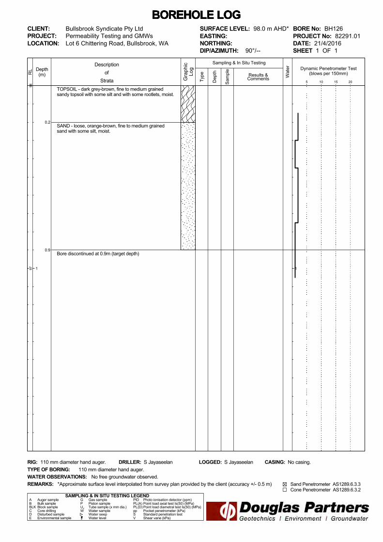
BORE No: BH126PROJECT No: 82291.01DATE: 21/4/2016SHEET 1 OF 1
DRILLER: S Jayaseelan LOGGED: S Jayaseelan CASING: No casing.
Bullsbrook Syndicate Pty LtdPermeability Testing and GMWs
REMARKS:
RIG: 110 mm diameter hand auger.
WATER OBSERVATIONS:TYPE OF BORING:
No free groundwater observed.110 mm diameter hand auger.
*Approximate surface level interpolated from survey plan provided by the client (accuracy +/- 0.5 m)
SURFACE LEVEL: 98.0 m AHD*EASTING:NORTHING:DIP/AZIMUTH: 90°/--
Dynamic Penetrometer Test(blows per 150mm)
5 10 15 20
Sand Penetrometer AS1289.6.3.3 Cone Penetrometer AS1289.6.3.2

0.3
0.95
TOPSOIL - dark grey-brown, fine to medium grainedsandy topsoil with some silt and with some rootlets, moist.
SAND - loose, dark orange-brown, fine to medium grainedsand with some silt, moist,
Bore discontinued at 0.95m (target depth)
Type
9897
Depth(m)
1
RL
Wat
er
Dep
th
Sam
ple
Descriptionof
Strata Gra
phic
Log
Results &Comments
Sampling & In Situ Testing
1
BOREHOLE LOG BOREHOLE LOG BOREHOLE LOG BOREHOLE LOG BOREHOLE LOG BOREHOLE LOG BOREHOLE LOG CLIENT:PROJECT:LOCATION: Lot 6 Chittering Road, Bullsbrook, WA
SAMPLING & IN SITU TESTING LEGENDA Auger sample G Gas sample PID Photo ionisation detector (ppm)B Bulk sample P Piston sample PL(A) Point load axial test Is(50) (MPa)BLK Block sample Ux Tube sample (x mm dia.) PL(D) Point load diametral test Is(50) (MPa)C Core drilling W Water sample pp Pocket penetrometer (kPa)D Disturbed sample Water seep S Standard penetration testE Environmental sample Water level V Shear vane (kPa)
BORE No: BH127PROJECT No: 82291.01DATE: 21/4/2016SHEET 1 OF 1
DRILLER: S Jayaseelan LOGGED: S Jayaseelan CASING: No casing.
Bullsbrook Syndicate Pty LtdPermeability Testing and GMWs
REMARKS:
RIG: 110 mm diameter hand auger.
WATER OBSERVATIONS:TYPE OF BORING:
No free groundwater observed.110 mm diameter hand auger.
*Approximate surface level interpolated from survey plan provided by the client (accuracy +/- 0.5 m)
SURFACE LEVEL: 98.5 m AHD*EASTING:NORTHING:DIP/AZIMUTH: 90°/--
Dynamic Penetrometer Test(blows per 150mm)
5 10 15 20
Sand Penetrometer AS1289.6.3.3 Cone Penetrometer AS1289.6.3.2
D
0.85
0.95

0.1
0.85
TOPSOIL - dark grey-brown, fine to medium grainedsandy topsoil with some silt and with some rootlets, moist.
SAND - loose, orange-brown, fine to medium grainedsand with some silt, moist,
- fines content increasing with depth.
Bore discontinued at 0.85m (target depth)
Type
9594
Depth(m)
1
RL
Wat
er
Dep
th
Sam
ple
Descriptionof
Strata Gra
phic
Log
Results &Comments
Sampling & In Situ Testing
1
BOREHOLE LOG BOREHOLE LOG BOREHOLE LOG BOREHOLE LOG BOREHOLE LOG BOREHOLE LOG BOREHOLE LOG CLIENT:PROJECT:LOCATION: Lot 6 Chittering Road, Bullsbrook, WA
SAMPLING & IN SITU TESTING LEGENDA Auger sample G Gas sample PID Photo ionisation detector (ppm)B Bulk sample P Piston sample PL(A) Point load axial test Is(50) (MPa)BLK Block sample Ux Tube sample (x mm dia.) PL(D) Point load diametral test Is(50) (MPa)C Core drilling W Water sample pp Pocket penetrometer (kPa)D Disturbed sample Water seep S Standard penetration testE Environmental sample Water level V Shear vane (kPa)
BORE No: BH128PROJECT No: 82291.01DATE: 22/4/2016SHEET 1 OF 1
DRILLER: S Jayaseelan LOGGED: S Jayaseelan CASING: No casing.
Bullsbrook Syndicate Pty LtdPermeability Testing and GMWs
REMARKS:
RIG: 110 mm diameter hand auger.
WATER OBSERVATIONS:TYPE OF BORING:
No free groundwater observed.110 mm diameter hand auger.
*Approximate surface level interpolated from survey plan provided by the client (accuracy +/- 0.5 m)
SURFACE LEVEL: 95.0 m AHD*EASTING:NORTHING:DIP/AZIMUTH: 90°/--
Dynamic Penetrometer Test(blows per 150mm)
5 10 15 20
Sand Penetrometer AS1289.6.3.3 Cone Penetrometer AS1289.6.3.2
0.15
0.8
TOPSOIL - dark grey-brown, fine to medium grainedsandy topsoil with some silt and with some rootlets, moist.
SAND - loose, orange-brown, fine to medium grainedsand with some silt, moist,- with some rotlets to 0.2 m depth.
Bore discontinued at 0.8m (target depth)
Type
108
107
Depth(m)
1
RL
Wat
er
Dep
th
Sam
ple
Descriptionof
Strata Gra
phic
Log
Results &Comments
Sampling & In Situ Testing
1
BOREHOLE LOG BOREHOLE LOG BOREHOLE LOG BOREHOLE LOG BOREHOLE LOG BOREHOLE LOG BOREHOLE LOG CLIENT:PROJECT:LOCATION: Lot 6 Chittering Road, Bullsbrook, WA
SAMPLING & IN SITU TESTING LEGENDA Auger sample G Gas sample PID Photo ionisation detector (ppm)B Bulk sample P Piston sample PL(A) Point load axial test Is(50) (MPa)BLK Block sample Ux Tube sample (x mm dia.) PL(D) Point load diametral test Is(50) (MPa)C Core drilling W Water sample pp Pocket penetrometer (kPa)D Disturbed sample Water seep S Standard penetration testE Environmental sample Water level V Shear vane (kPa)
BORE No: BH129PROJECT No: 82291.01DATE: 22/4/2016SHEET 1 OF 1
DRILLER: S Jayaseelan LOGGED: S Jayaseelan CASING: No casing.
Bullsbrook Syndicate Pty LtdPermeability Testing and GMWs
REMARKS:
RIG: 110 mm diameter hand auger.
WATER OBSERVATIONS:TYPE OF BORING:
No free groundwater observed.110 mm diameter hand auger.
*Approximate surface level interpolated from survey plan provided by the client (accuracy +/- 0.5 m)
SURFACE LEVEL: 108.0 m AHD*EASTING:NORTHING:DIP/AZIMUTH: 90°/--
Dynamic Penetrometer Test(blows per 150mm)
5 10 15 20
Sand Penetrometer AS1289.6.3.3 Cone Penetrometer AS1289.6.3.2
D
0.7
0.8

Particle Size Distribution
Mining & CivilGeotest Pty Ltd
Job No:
Unit1/1 Pusey Road, Jandakot, WA 6164 Report No:Ph (08) 9414 8022 Fax (08) 9414 8011 Sample No:Email:[email protected] Issue Date:Client: Bullsbrook Syndicate Pty Ltd Sample Details
Project: Permeability Testing and GMW's Sample Depth (m)
Location: Lot 6 Chittering Road, Bullsbrook WA
SIEVE ANALYSIS WA 115.1Sieve Size (mm) % Passing
75.0 #N/A37.5 #N/A19.0 #N/A9.5 #N/A
4.75 1002.36 1001.18 97
0.600 540.425 290.300 150.150 80.075 5
0.0135 3
Client Address: 36 O'Malley Street, Osborne Park Western Australia 6017 Sampling Procedure: Tested as receivedNotes:
Approved signatureKevin Jones
60017-P16/1270
Sheet No: 1 of 1
60017
P16/1270
04-May-16BH1100.8m - 0.9m
0
10
20
30
40
50
60
70
80
90
100
0.001 0.01 0.1 1 10 100
% P
assin
g
Particle Size (mm)
Accreditation for compliance with ISO/IEC 17025.This document may not be reproduced except in full.Accreditation No 15545.

Particle Size Distribution
Mining & CivilGeotest Pty Ltd
Job No:
Unit1/1 Pusey Road, Jandakot, WA 6164 Report No:Ph (08) 9414 8022 Fax (08) 9414 8011 Sample No:Email:[email protected] Issue Date:Client: Bullsbrook Syndicate Pty Ltd Sample Details
Project: Permeability Testing and GMW's Sample Depth (m)
Location: Lot 6 Chittering Road, Bullsbrook WA
SIEVE ANALYSIS WA 115.1Sieve Size (mm) % Passing
75.0 #N/A37.5 #N/A19.0 #N/A9.5 100
4.75 1002.36 941.18 90
0.600 780.425 660.300 480.150 290.075 22
0.0135 17
Client Address: 36 O'Malley Street, Osborne Park Western Australia 6017 Sampling Procedure: Tested as receivedNotes:
Approved signatureKevin Jones
60017-P16/1271
Sheet No: 1 of 1
60017
P16/1271
04-May-16BH1160.3m - 0.4m
0
10
20
30
40
50
60
70
80
90
100
0.001 0.01 0.1 1 10 100
% P
assin
g
Particle Size (mm)
Accreditation for compliance with ISO/IEC 17025.This document may not be reproduced except in full.Accreditation No 15545.
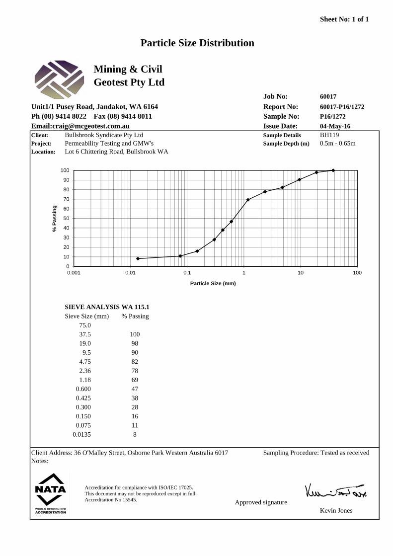
Particle Size Distribution
Mining & CivilGeotest Pty Ltd
Job No:
Unit1/1 Pusey Road, Jandakot, WA 6164 Report No:Ph (08) 9414 8022 Fax (08) 9414 8011 Sample No:Email:[email protected] Issue Date:Client: Bullsbrook Syndicate Pty Ltd Sample Details
Project: Permeability Testing and GMW's Sample Depth (m)
Location: Lot 6 Chittering Road, Bullsbrook WA
SIEVE ANALYSIS WA 115.1Sieve Size (mm) % Passing
75.0 #N/A37.5 10019.0 989.5 90
4.75 822.36 781.18 69
0.600 470.425 380.300 280.150 160.075 11
0.0135 8
Client Address: 36 O'Malley Street, Osborne Park Western Australia 6017 Sampling Procedure: Tested as receivedNotes:
Approved signatureKevin Jones
60017-P16/1272
Sheet No: 1 of 1
60017
P16/1272
04-May-16BH1190.5m - 0.65m
0
10
20
30
40
50
60
70
80
90
100
0.001 0.01 0.1 1 10 100
% P
assin
g
Particle Size (mm)
Accreditation for compliance with ISO/IEC 17025.This document may not be reproduced except in full.Accreditation No 15545.
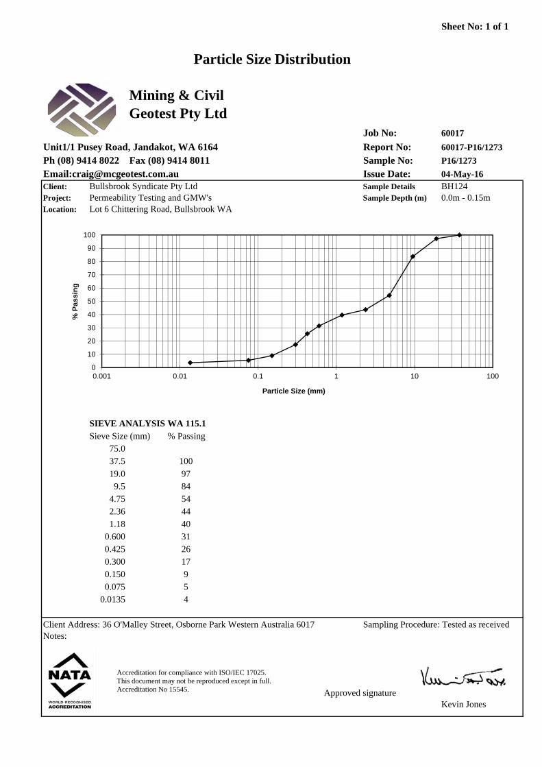
Particle Size Distribution
Mining & CivilGeotest Pty Ltd
Job No:
Unit1/1 Pusey Road, Jandakot, WA 6164 Report No:Ph (08) 9414 8022 Fax (08) 9414 8011 Sample No:Email:[email protected] Issue Date:Client: Bullsbrook Syndicate Pty Ltd Sample Details
Project: Permeability Testing and GMW's Sample Depth (m)
Location: Lot 6 Chittering Road, Bullsbrook WA
SIEVE ANALYSIS WA 115.1Sieve Size (mm) % Passing
75.0 #N/A37.5 10019.0 979.5 84
4.75 542.36 441.18 40
0.600 310.425 260.300 170.150 90.075 5
0.0135 4
Client Address: 36 O'Malley Street, Osborne Park Western Australia 6017 Sampling Procedure: Tested as receivedNotes:
Approved signatureKevin Jones
60017-P16/1273
Sheet No: 1 of 1
60017
P16/1273
04-May-16BH1240.0m - 0.15m
0
10
20
30
40
50
60
70
80
90
100
0.001 0.01 0.1 1 10 100
% P
assin
g
Particle Size (mm)
Accreditation for compliance with ISO/IEC 17025.This document may not be reproduced except in full.Accreditation No 15545.