Embed Size (px)
Citation preview

London Borough of Tower Hamlets Strategic Flood Risk Assessment
70 AECOM
Appendix B - SuDS Guidance
.

London Borough of Tower Hamlets Strategic Flood Risk Assessment – Appendix B
AECOM
SuDS Design
Amenity
• Maximise multi-functionality
• Enhance visual character
• Deliver safe surface water management
• Support site resilience and adaptability
• Maximise legibility
• Support community environmental learning
Biodiversity
• Support and protect natural local habitats and
species
• Contribute to the delivery of local biodiversity
objectives
• Contribute to local habitat connectivity
• Create diverse, self-sustaining and resilient
ecosystems
Water Quantity
• Use surface water runoff as a resource
• Support the management of flood risk in
receiving surface waters
• Preserve natural hydrological systems
• Design system flexibility and adaptability
• Drain the site effectively
• Manage on-site flood risk
Water Quality
• Support the management of water quality in
the receiving surface waters and groundwater
• Design system resilience to cope with future
change
Guidance for SuDS in Tower Hamlets
Introduction
Sustainable Drainage Systems (SuDS) are designed to maximise the opportunities and benefits of surface water management. This is particularly important in
increasingly urban areas where there is less permeable ground available for natural infiltration and evapotranspiration, leading to increased rainfall runoff from
impermeable surfaces and contributing to flooding, pollution and erosion. SuDS can counteract these impacts on the water cycle and additionally enhance urban spaces
by making them more vibrant, attractive, sustainable and resilient, with improved air and water quality, microclimate and amenity.
There are four main categories of benefits which can be achieved through high quality SuDS design, as summarised below:
The installation of high quality and multi-functional SuDS is most likely to be achieved through early and multi-disciplinary consideration of surface water management.
Ideally this should be integrated within the overall site planning and design, including early consultation with relevant stakeholders and consideration of ongoing
operational and maintenance responsibilities.

London Borough of Tower Hamlets Strategic Flood Risk Assessment – Appendix B
AECOM
SuDS design should be based around the general principles of:
Harnessing surface water runoff as a resource;
Managing rainfall close to where it falls;
Managing runoff on the surface;
Promoting infiltration of rainwater into the ground;
Encouraging evapotranspiration;
Attenuating runoff to mimic natural flow characteristics;
Reducing contamination of runoff through pollution prevention and controlling the runoff at source; and
Treating runoff to reduce the risk of urban contaminants causing environmental pollution.
The following sections provide an overview of common types of SuDS measures, which may be suitable for installation within the Borough. Generally, SuDS should not
be thought of as isolated features, but delivered as an interconnected sequential train of surface water management and treatment.
Developers within Tower Hamlets should make reference to the Tower Hamlets SuDS Guidance, which provides local advice regarding SuDS installation and
summarises the local approval process.
Further information on the philosophy of SuDS and detailed guidance on design, installation and maintenance, is provided in the CIRIA SuDS Manual (2015) and other
sources described at the end of this document.

London Borough of Tower Hamlets Strategic Flood Risk Assessment – Appendix B
AECOM
Swale
Swales are vegetated shallow depressions designed to convey and filter water. These can be ‘wet’ where water gathers above the surface, or ‘dry’ where
water gathers in a gravel layer beneath the ground level. They have the ability to remove pollutants and can be used to channel surface water to the next
stage of a treatment train. Check dams can be constructed along their route to control flow velocities, and promote infiltration and sediment deposition.
Advantages Disadvantages
Encourages evapotranspiration
and infiltration of runoff
Provides attenuation to reduce
peak run-off rates
Relatively simple to incorporate
into landscaping
Effective removal of urban
pollutants
Minimal maintenance
requirements
Aesthetically pleasing
Good community acceptability
Careful consideration of location
and design is required to reduce
potential health and safety
hazards
May limit opportunities to use
trees in landscaping
Blockages can occur in
connecting pipe work
Retrofitting opportunities are
limited
Effective Locations Ineffective Locations
Residential and commercial areas
Contaminated sites
Sites above vulnerable
groundwater
Alongside roadways
Linear street garden areas
Field boundaries
High density areas
Steeply sloping areas
Performance Criteria Rating
Ecological Advantages Medium
Peak Flow Reduction Medium
Amenity Potential Medium
Water Quality Treatment Potential High
Surface Water Volume Reduction Medium
In the Community Design Example
Swales can be used to replace conventional drainage systems and
are particularly effective when installed adjacent roadsides or
transport links, to capture and re-route surface water. They are also
suitable for residential and commercial areas and may be integrated
with areas of open space and landscaping, or used to create informal
barriers.

London Borough of Tower Hamlets Strategic Flood Risk Assessment – Appendix B
AECOM
Filter Strip or Drain
Filter strips and drains can be used to manage runoff from impermeable areas, providing conveyance and filtration. Filter Strips allow water to flow across
grass or dense vegetation; whereas filter drains are hardscape systems where runoff is temporarily stored in a shallow trench filled with stone or gravel.
Advantages Disadvantages
Simple to design and can be
incorporated into site landscaping
for aesthetic benefit
Minimal public safety risks
Encourages evaporation and
infiltration
Important hydraulic and water
quality benefits can be achieved
Can be retrofitted into a site with
ease
Low construction cost
Vegetation must be light and can
get damaged
Loose gravel can be removed
Drains relatively small
catchments
High cost to replace filter
materials
Effective Locations Ineffective Location
Residential and commercial areas
Between hard standing surfaces
and grassland
High density areas
Contaminated sites
Sites above vulnerable ground
water
Steeply sloping areas
Performance Criteria Rating
Ecological Advantages Low
Peak Flow Reduction Medium
Amenity Potential Low
Water Quality Treatment Potential High
Surface Water Volume Reduction Low
In the Community Design Example
Filter strips or filter drains are a suitable retrofitting option for heavily
trafficked or spatially constrained areas as they cause no safety
hazards and can be implemented into small spaces with ease. They
can be simply implemented along the edges of pathways or
pavements or integrated within site landscaping.

London Borough of Tower Hamlets Strategic Flood Risk Assessment – Appendix B
AECOM
Bio-Retention Areas or Rain Gardens
Bio-retention areas or rain gardens are vegetated depressions with gravel and sand layers below, designed to collect, channel, filter and cleanse water
vertically. Water can infiltrate into the ground or enter a piped drainage system. These systems can be integrated with site landscaping, including tree pits,
planter areas or gardens. Treatment performance can be improved through engineered soils and enhanced vegetation.
Advantages Disadvantages
Provides initial water treatment
Aesthetically pleasing
Provides ecological benefits
Capability to be retrofitted in
heavily paved areas or existing
vegetation
Effective pollutant removal
Minimal ground take with
spatially flexible layout
May be susceptible to clogging
or blockage due to surrounding
landscape
Regular inspection and
maintenance is required to
maintain effectiveness
Effective Locations Ineffective Locations
Residential and Commercial areas
Contaminated sites
Sites above vulnerable
groundwater
Seating areas
Impermeable areas
High density areas
Steeply sloping areas
Performance Criteria Rating
Ecological Advantages Medium
Peak Flow Reduction Medium
Amenity Potential Good
Water Quality Treatment Potential High
Surface Water Volume Reduction Medium
In the Community Design Example
Rain gardens and bio-retention systems can be planned as
aesthetically pleasing landscaped features, providing critical green
space within the urban areas. These measures can be retro-fitted
around existing street infrastructure, such as seating areas, and
incorporated within both paved and vegetated areas.

London Borough of Tower Hamlets Strategic Flood Risk Assessment – Appendix B
AECOM
Rainwater Harvesting
Rainwater harvesting involves capturing rainwater and reusing it for purposes such as irrigation or toilet flushing. Rainwater is collected from building rooftops or
other paved surfaces and stored in tanks for treatment and reuse locally.
Advantages Disadvantages
Water can be used for variety of
non-potable uses, such as toilet
flushing and irrigation
Reduces potable water demand
Provides source control of storm-
water run-off
Rooftop or underground tanks can
minimise land take and visual
impact
Can be retrofitted to existing
buildings
Potentially complex installation
and high capital cost, particularly
for retrofit
Ongoing energy requirement for
pumping, if below ground storage
is used
Careful management required to
manage any health risks
associated with water reuse
Above ground storage can be
visually intrusive
Regular maintenance is required
Effective Locations Ineffective Locations
Residential and Commercial areas
High density areas
Contaminated sites
Sites above vulnerable
groundwater
Fields or large open space
Performance Criteria Rating
Ecological Advantages Low
Peak Flow Reduction High
Amenity Potential Low
Water Quality Treatment Potential Low
Surface Water Volume Reduction High
In the Community Design Example
Rain-water harvesting can be implemented on a variety of scales;
however, is particularly suitable for implementation in buildings with
large rooftop areas, significant water consumption and defined
ownership and maintenance responsibilities. Installation is generally
easier when integrated into the design of new buildings; however,
water butts can provide a simple means of retrofit.

London Borough of Tower Hamlets Strategic Flood Risk Assessment – Appendix B
AECOM
Ponds and Basins
Ponds or Basins can be used to store and to treat water. ‘Wet’ (retention) ponds have a constant body of water and run-off water is additional to this, whilst ‘dry’
(detention) ponds are empty during periods without rainfall. Ponds can be designed to allow infiltration through its base to ground or to store water for a period of
time, before it is discharged via a soakaway to ground. They can support emergent and submerged vegetation, enhancing both treatment and biodiversity.
Advantages Disadvantages
Pollutant removal through
sedimentation and biological
treatment mechanisms
Effective accommodate of large
storm events
Good community acceptability
Potential for biodiversity
improvement
Relatively simple construction
Has the potential for supply of
irrigation to other amenities
Aesthetically pleasing
Potential recreational benefit
Requires infiltration to achieve
significant reduction in surface
water runoff volumes
Significant spatial requirements
Requires control measures to
prevent migration of invasive
species
Consideration of public safety
may require control measures in
certain settings
Careful design is required to
manage undesirable impacts
associated with eutrophication
and fluctuating water levels
Effective Locations Ineffective Locations
Residential and Commercial areas
Fields
Parks or areas of open space
Areas with feature requirements
High density areas
Locations with vulnerable
people
Performance Criteria Rating
Ecological Advantages High
Peak Flow Reduction High
Amenity Potential High
Water Quality Treatment Potential High
Surface Water Volume Reduction Low
In the Community Design Example
Ponds can be aesthetically pleasing, and can be used to support
urban amenity, recreation and ecology. They can provide central
features within areas of community space. However, careful design
consideration is required to ensure they do not pose a health and
safety risk to the public.

London Borough of Tower Hamlets Strategic Flood Risk Assessment – Appendix B
AECOM
Soakaway
Soakaways and other infiltration systems collect and store runoff, allowing it to rapidly soak into permeable layers of soil. Constructed like a dry well, an
underground pit is dug and then filled with gravel and rubble, or specially designed structures. Surface water can be directed into a soakaway using a number of
above or below ground methods, with overlying vegetation and underlying soils providing treatment benefits.
Advantages Disadvantages
Minimal land take
Provides recharge of natural
ground water levels
Good storm volume reduction and
peak flow attenuation
Simple operation and
maintenance
Relatively simple to construct
Effective retrofitting solution
Good community acceptability
Not always practicable near to
structural foundations
Long term performance is
uncertain and difficult to
guarantee if property owner is
responsible for maintenance
Requires good subsurface
drainage
Infiltration rates need to be
investigated
Effective Locations Ineffective Locations
Residential and commercial areas
High density areas
Fields
Small grassed/planted areas
Contaminated sites
Sites above vulnerable
groundwater
Sites with shallow
groundwater
Sites underlain by
impermeable ground
Performance Criteria Rating
Ecological Advantages Low
Peak Flow Reduction High
Amenity Potential Low
Water Quality Treatment Potential Medium
Surface Water Volume Reduction High
In the Community Design Example
Soakaways are effective in areas with good infiltration potential and
where the water table is relatively low. Soakaways can be covered
over by suitable permeable materials and be used for a variety of
purposes at ground level. Caution should be taken when implementing
these techniques in tightly constrained areas as they should not be
built within a close proximity to structural foundations.

London Borough of Tower Hamlets Strategic Flood Risk Assessment – Appendix B
AECOM
Living Roofs
A planted soil layer is constructed on the roof of a building to create a living medium. Following rainfall, water is stored in the soil layer and absorbed by planted
vegetation. They may be designed to be accessible and landscaped to provide biodiversity and amenity benefit. Blue roofs can also be used to store water,
without the use of vegetation.
Advantages Disadvantages
High potential to reduce surface
run off
Suitable for high density
development
Can deliver building insulation
and sound proofing
Inaccessible to general public
Can provide biodiversity benefits
to the local area
Improved air quality
Assists in amelioration of the
urban heat island effect
Can be retrofitted
Additional structural loading to
roof (compared with most
traditional rooftops)
Irrigation may be required during
drought
Replacement and maintenance of
plants is required on a regular
basis
Effective Locations Ineffective Locations
Residential and Commercial areas
High density areas
Contaminated sites
Sports centres
Roofs with inadequate access
Steep pitched roofs
Rooftops with inadequate
structural support
Performance Criteria Rating
Ecological Advantages High
Peak Flow Reduction Medium
Amenity Potential High
Water Quality Treatment Potential High
Surface Water Volume Reduction Medium
In the Community Design Example
Living roofs provide an opportunity to attenuate and store rainwater in
spatially constrained areas, while providing potential benefits for local
biodiversity, air quality, microclimate and amenity. They have
controlled access, which means the associated risk of misuse or
vandalism is low.

London Borough of Tower Hamlets Strategic Flood Risk Assessment – Appendix B
AECOM
Permeable / Porous Paving
This is paving which allows water to soak into the underlying ground. It can be in the form of paving blocks with gaps in between or porous mediums where water
filters through the paving itself. Water can be stored in the sub-base beneath or be allowed to infiltrate into the ground below.
Advantages Disadvantages
Good potential for water quality
treatment
High potential for surface water
run off
Very efficient
Good community acceptability
Requires minimal maintenance
Effectively requires no space, as it
allows for a dual usage
It can remove the need for
manholes or gully pots
Requires closure of surfaced
areas whilst SuDS are
constructed
Cannot be used where high
sediment loads are likely to be
washed across the surface
Requires vegetation maintenance
Regular inspection of the surfaces
required to ensure effectiveness
Can deflect if subject to heavy
vehicular loads
Effective Locations Ineffective Locations
Residential and Commercial areas
Car Parks
Low speed roads (below 30 mph)
Pathways
Residential pavements
Hard courts
High speed roads
Performance Criteria Rating
Ecological Advantages Low
Peak Flow Reduction High
Amenity Potential Low
Water Quality Treatment Potential High
Surface Water Volume Reduction High
In the Community Design Example
Permeable surfaces offer effective drainage solutions that integrate
within residential environments. Porous paving is effective at
managing runoff from paved surfaces, and this low maintenance
method is particularly useful in built up environments, including city
centres. Replacing hard standing with permeable surfaces could
improve drainage across a site whilst creating more aesthetically
pleasing environments.

London Borough of Tower Hamlets Strategic Flood Risk Assessment – Appendix B
AECOM
References For detailed information on the design and delivery of SuDS, reference should be made to the CIRIA SuDS Manual (2015), which is freely available online at
www.ciria.org.
A range of further resources on SuDS, including case studies, videos, presentations, fact sheets and links to research can be found on the Susdrain website at
http://www.susdrain.org.
Additional supporting information is available from DEFRA (www.defra.gov.uk) and the Environment Agency (www.environment-agency.gov.uk).
Developers within Tower Hamlets should also refer to the London Borough of Tower Hamlets publication SuDS Guidance, for detailed guidance on drainage
strategies submitted with planning submissions.
London Borough of Tower Hamlets Strategic Flood Risk Assessment – Appendix C
AECOM
Mapping and Dataset Summary A series of maps, and a geodatabase have been produced to accompany this study and assist the
assessment of sites by London Borough of Tower Hamlets as part of their decision making process. A GIS
based mapping system using the software package ‘ArcGIS’ was implemented to enable this. A summary of
the figures created and the GIS layers used for each of the maps is included in the Table C1 below.
Table C1 - Summary of Maps Created
Map Number Figure Title Layers Used
Map 001 River Network
Ordnance Survey Base-mapping (25k)*
Borough Boundary*
Main River*
Ordinary Watercourse*
Culvert*
Docks
Reservoirs
Quays
Map 002 Topography Lidar (Elevation Data)
Map 003A Superficial Geology Drift Geology
Map 003B Bedrock Geology Solid Geology
Map 004 Flooding History
Historical Groundwater Flooding
Recorded Surface Water Flooding Incidents
Recorded Flood Outlines
Properties Flooded From Overloaded Sewers
Map 005 Flood Risk From Rivers And Sea
Flood Zone 2
Flood Zone 3a
Flood Zone 3b
Map 006 Flood Map for Surface Water
Flood Map for Surface Water 30 year extent
Flood Map for Surface Water 100 year extent
Flood Map for Surface Water 1000 year extent
Critical Drainage Areas
Map 007 Areas at Risk of Flooding from
Groundwater Areas Susceptible To Groundwater Flooding
Map 008 Flood Risk From Reservoirs Flood Risk From Reservoirs
Map 009 Flood Risk Management Infrastructure Areas Benefiting From Defences
Flood Defences
Map 010 Flood Warning Areas Flood Alert Area
Flood Warning Area

London Borough of Tower Hamlets Strategic Flood Risk Assessment – Appendix C
AECOM
Map 011 SuDS Infiltration Suitability SuDS Summary Map
Map 012A Breach Assessment - Maximum
Predicted Flood Extents
Maximum Flood Extent - MLWL2015
Maximum Flood Extent - MLWL2065
Maximum Flood Extent - MLWL2100
Breach Locations
Map 012B Breach Assessment – Year 2100
Maximum Predicted Flood Depth
Year 2100 Maximum Predicted Flood Depth
Breach Locations
Map 012C Breach Assessment – Year 2100
Maximum Predicted Flood Velocity
Year 2100 Maximum Predicted Flood Velocity
Breach Locations
Map 012D Breach Assessment – Year 2100
Maximum Predicted Flood Hazard
Year 2100 Maximum Predicted Flood Hazard
Breach Locations
Map 013 Fluvial Flood Outlines
2% AEP Flood Extent
1% AEP Flood Extent
1% AEP plus Climate Change Flood Extent
0.5% AEP Flood Extent
0.1% AEP Flood Extent
Map 014 Sites Allocated for Planning Proposed Site Allocations
Note:
*Included in all maps
ArcGIS uses multiple datasets with associated attribution to present geo-located features from multiple
sources. An overview of the information provided for mapping purposes by the various key stakeholders is
shown below.

London Borough of Tower Hamlets Strategic Flood Risk Assessment – Appendix C
AECOM
Table C2 - Description of GIS Layers used to inform the assessment
Dataset Source Format Layer Description
Flu
via
l an
d T
idal
Detailed River Network Environment Agency GIS shapefile Identification of the river network including main
rivers and ordinary Watercourses
Flood Map for Planning (Rivers and Sea)
Flood Zones 2 and 3 Environment Agency GIS shapefile
Shows areas at varying risk of flooding from rivers
and the sea
Historic Flood Map Environment Agency GIS shapefile Single GIS layer showing the extent of fluvial
historic flood events
Asset Information
Management System
(AIMS)
Environment Agency GIS shapefile
Shows where there are existing defences,
structures, heights, type and design standard.
However many fields contain default values
Areas Benefitting from Defences Environment Agency GIS shapefile Indicates the areas within the Borough that are
under the protection of flood defences
Flood Alert Area Environment Agency Geostore GIS shapefile Shows areas benefitting from flood alert schemes
in the Borough
Flood Defences Environment Agency GIS shapefile Location of flood defences within the Borough
Flood Warning Area Environment Agency Geostore GIS shapefile Shows areas benefitting from fluvial flood warning
schemes in the Borough
Thames Tidal Breach Modelling Study Environment Agency
GIS asci and
shapefiles and
Reports and GIS outputs summarising the breach
modelling of the TTD, completed in 2014

London Borough of Tower Hamlets Strategic Flood Risk Assessment – Appendix C
AECOM
Dataset Source Format Layer Description P
luvia
l
Updated Flood Map for Surface Water Environment Agency Geostore GIS shapefile
Provides an indication of the broad areas likely to
be at risk of surface water flooding during a 1 in
30 year, 1 in 100 year and 1 in 100 year return
period event
Critical Drainage Areas London Borough of Tower
Hamlets GIS shapefile
Location of designated critical drainage areas
within the Borough
Gro
un
dw
ate
r
Geology London Borough of Tower
Hamlets GIS shapefile
Illustrates bedrock and superficial geology across
the Borough
Aquifer Designation Map Environment Agency GIS shapefile Broadly shows extents of aquifers in the Borough
Infiltration SuDS Summary Map British Geological Society GIS shapefile
Dataset produced by BGS illustrating the likely
suitability of the utilisation of infiltration SuDS
techniques across the Borough
Areas Susceptible to Groundwater Flooding Environment Agency GIS shapefile
Broad scale assessment of areas likely to be
susceptible to groundwater flooding, within a 1 km
grid
Source Protection Zones Environment Agency GIS shapefile Shows areas which are Groundwater Source
Protection Zones
Susceptibility to Groundwater Flooding British Geological Society GIS shapefile
Dataset produced by BGS illustrating the likely
suitability to groundwater flooding, based on
geological indicators.

London Borough of Tower Hamlets Strategic Flood Risk Assessment – Appendix C
AECOM
Dataset Source Format Layer Description R
ese
rvo
ir
Area Deemed at of Risk of Flooding from
Reservoirs Environment Agency GIS shapefile
Identifies areas which are at risk of flooding in the
event of a reservoir breach
Sew
er
Sewer Network Thames Water GIS shapefile Details of the combined sewer assets across the
Borough
DG5 Register of sewer flooding incidents, by
post code area Thames Water MS Word
Indicates post code areas that may be prone to
flooding as have experienced flooding in the last
10 years
Gen
era
l
Post Code Boundaries London Borough of Tower
Hamlets GIS shapefile
Delineates Post Code Boundaries for the
Borough, enabling mapping of Thames Water
datasets
National Receptor Database Environment Agency GIS shapefile
A comprehensive register of land uses across the
Borough, used to identify vulnerable sites and
water management infrastructure
Ordnance Survey 25k Background London Borough of Tower
Hamlets Raster file (.tiff)
Provides background mapping and indicates
important features and street names in detail
LiDAR Data Environment Agency Raster file (.tiff)
Provides a useful basis for understanding local
topography and the surface water flood risk in the
area
Proposed Site Allocations London Borough of Tower
Hamlets GIS shapefile
Indicates location of upcoming development sites
across the Borough

London Borough of Tower Hamlets Strategic Flood Risk Assessment – Appendix D
AECOM
SFRA Management Guide NPPF highlights the importance of maintaining Strategic Flood Risk Assessments current to ensure the decision making process by the Local Planning Authorities
is based on the most up to date information and understanding of flood risk within the Borough. A summary of the key aspects to be considered to ensure that the
SFRA is kept up-to-date and maintained is provided in the table below.
Table D1 - Summary of main aspects to be considered during maintenance of the SFRA
Area Covered Source of
Information Provider Comments Next Review
Climate Change
Scenarios
Environment Agency
Guidance and
Modelling
EA
The hydraulic modelling results considered as a part of this SFRA
were based on the latest available modelling of the River Lee and
River Thames. However, modelling of the River Lee was undertaken
using a 20% allowance for climate change, which is no longer in line
with current allowances. Updating of this modelling is understood to
be currently in progress and it is strongly recommended that this
revised modelling be incorporated within the SFRA upon completion.
When updated
hydraulic modelling
becomes available,
and during the next
general review of the
SFRA
Flood Zones
Hydraulic modelling of
main rivers and the
sea (Tidal Thames)
EA Should new Flood Zone information become available, the data
should be digitised and georeferenced within the GIS system
When further modelling
is carried out and/or
outlines reviewed by
EA
Critical Drainage Areas Tower Hamlets SWMP LBTH
The CDAs presented in this SFRA are based on ongoing hydraulic
modelling, currently being undertaken to refine the understanding of
flood risk across the Borough. It is recommended that these CDAs
are updated within the SFRA, as required upon completion of this
study.
When updated surface
water modelling is
completed and refined
CDAs are available.
Surface Water Flood
Outlines EA Dataset EA
It is understood that the EA surface water flood maps are due to be
updated during 2016 to take account of site specific modelling
undertaken by local Boroughs
When new relevant
information becomes
available

London Borough of Tower Hamlets Strategic Flood Risk Assessment – Appendix D
AECOM
Area Covered Source of
Information Provider Comments Next Review
Flood Defences, Critical
Water Management
Structures and Areas
Benefiting
EA Database and
Tower Hamlets SWMP
EA,
LBTH
If any new local flood defences or management structures are
installed within Tower Hamlets these should be added as a new point
to the relevant GIS layer, including metadata. EA datasets should be
updated in their entirety to replace superseded layers
When new relevant
information becomes
available
Flooding History Stakeholders records EA,
LBTH
When new flooding incidents are reported, these should be added as
a new point to the relevant GIS layer, including metadata
Next general review of
SFRA
Local Plan
Information
Tower Hamlets Local
Plan LBTH
The new Tower Hamlets Local Plan in formulation at the time of
publishing this SFRA. It is intended that detailed assessment of the
proposed allocated development sites is undertaken as a further
phase of this SFRA, once this plan and proposed development sites,
are finalised
Finalisation of Local
Plan and allocated
development sites
Groundwater Flood Risk
Geology and
Groundwater
Vulnerability
EA
The groundwater flood risk dataset used for this SFRA is understood
to provide the best available representation of groundwater flood risk.
Understanding of groundwater flood risk is still emerging and
therefore it is recommended that this is updated when further or
update becomes available.
Next general review of
SFRA
Sewer Flood Risk Thames Water TW
Very limited information on areas at risk of sewer flooding was
provided during this study. Should greater information on sewer flood
risk and network capacity become available, it is recommended that
this is incorporated within the SFRA.
When information is
available
OS Background Mapping Ordinance Survey LBTH
The SFRA has made use of OS 1:25,000 digital mapping. Periodically
these maps are updated. Updated maps are unlikely to alter the
findings of the SFRA but should be reviewed as part of the SFRA
maintenance
Next General review of
SFRA
London Borough of Tower Hamlets Strategic Flood Risk Assessment – Appendix D
AECOM
Area Covered Source of
Information Provider Comments Next Review
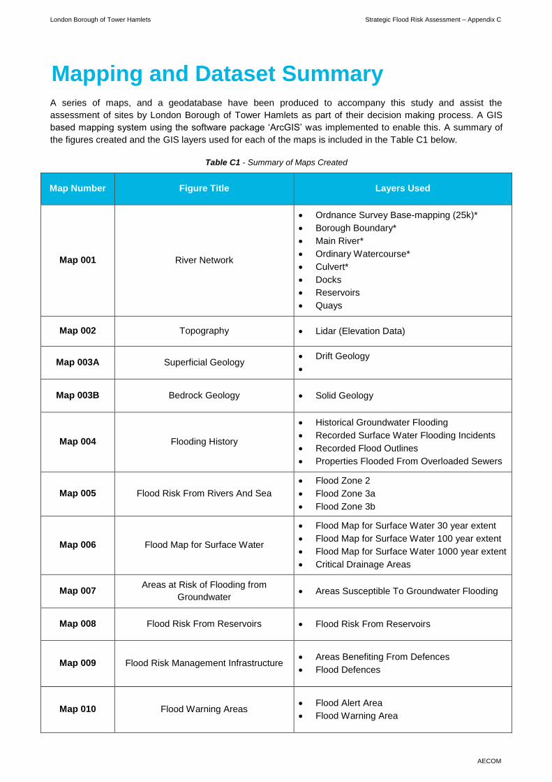
Flood Risk Policy NPPF and NPPG
This SFRA was created using guidance that was current in June
2016, principally the NPPF and the accompanying Technical
Guidance. Should new flooding policy be adopted nationally,
regionally or locally, the SFRA should be checked to ensure it is still
relevant and updates made if necessary
When changes to
relevant planning
policy are adopted
It should be noted that, prior to any data being updated within the SFRA, it is important that the licensing information is also updated to ensure that the data used is
not in breach of copyright. The principal licensing bodies relevant to the SFRA at the time of publishing were the Environment Agency (Thames Region), Ordnance
Survey and Thames Water. Updated or new data may be based on datasets from other licensing authorities and may require additional licenses. Generally, when
updating the GIS information associated with this SFRA, it is important that the meta-data is updated in the process. This is the additional information that lies
behind the GIS polygons, lines and points.
It is recommended that an interim review of the SFRA is undertaken on an annual basis, in liaison with the Environment Agency, to assess any maintenance or
update work required. In particular, this would include incorporation of any major changes in terms of flood management infrastructure and any recorded flooding
incidents. An overall general review of the SFRA is recommended every 3 years, to re-evaluate flood risk and planning policies according to latest legislation.
Should LBTH decide any significant changes are necessary; the SFRA should be updated and re-issued. It is essential that any reviews and updates of the SFRA
are recorded in a structured manner. To facilitate this task, the following register has been created:

London Borough of Tower Hamlets Strategic Flood Risk Assessment – Appendix D
AECOM
STRATEGIC FLOOD RISK ASSESSMENT REVIEW
Type of Review Scheduled ☐ Interim ☐ Date of Review:
Reviewer Name: Organisation:
Area Reviewed Source of Information Provider Maps Modified Comments

London Borough of Tower Hamlets Strategic Flood Risk Assessment – Appendix E
AECOM
Historic Flooding Records
Date
Attributed
Source of
Flooding
Location Description and Comments Reference
January 1928
Tidal flooding
associated with
the River Thames
Docklands and
Thames Frontage
Severe flooding affected central London in 1928 when high tides overtopped the
River Thames Defences.
EA Recorded
Flood Outlines
1953 Tidal Docklands
A storm surge impacted the east coast of the UK, causing high tidal levels to breach
flood defences and resulting in extensive flooding across London and the Thames
Estuary. Within Tower Hamlets, the event predominantly impacted the confluence of
the River Lee and River Thames, causing flooding in the Docklands area.
2012 SFRA
March 1947 Fluvial
East India Docks
Basin, South Bromley
and Canning Town
A combination of rainfall and snowmelt caused a rise in water levels within the River
Lee and its tributaries resulting in overtopping and inundation of surrounding areas. 2012 SFRA
21st December
2004 Groundwater Mile End No Details
EA Groundwater
Flooding Dataset
Summer 2014 Pluvial
Junction of Tredegar
Road and Parnell
Road, Bow
Flooding of 4 gullies, carriageway and footway with approximate depth of 300 mm. LBTH Flood
Register
Summer 2014 Pluvial Coate Street Blocked gully with flooding of carriageway to estimated depth 30 mm. LBTH Flood
Register
September
1995 Pluvial / Sewer
Manchester Road, Isle
of Dogs
Flood record identified through discussions with Tower Hamlets and Thames Water
during Tier 3 surface water modelling study.
Surface water
modelling report
1994 Pluvial / Sewer Harbinger Road, Isle
of Dogs
Flood record identified through discussions with Tower Hamlets and Thames Water
during Tier 3 surface water modelling study.
Surface water
modelling report

London Borough of Tower Hamlets Strategic Flood Risk Assessment
AECOM
Appendix C - Mapping andDataset Summary

London Borough of Tower Hamlets Strategic Flood Risk Assessment – Appendix C
AECOM
Mapping and Dataset Summary A series of maps, and a geodatabase have been produced to accompany this study and assist the
assessment of sites by London Borough of Tower Hamlets as part of their decision making process. A GIS
based mapping system using the software package ‘ArcGIS’ was implemented to enable this. A summary of
the figures created and the GIS layers used for each of the maps is included in the Table C1 below.
Table C1 - Summary of Maps Created
Map Number Figure Title Layers Used
Map 001 River Network
Ordnance Survey Base-mapping (25k)*
Borough Boundary*
Main River*
Ordinary Watercourse*
Culvert*
Docks
Reservoirs
Quays
Map 002 Topography Lidar (Elevation Data)
Map 003A Superficial Geology Drift Geology
Map 003B Bedrock Geology Solid Geology
Map 004 Flooding History
Historical Groundwater Flooding
Recorded Surface Water Flooding Incidents
Recorded Flood Outlines
Properties Flooded From Overloaded Sewers
Map 005 Flood Risk From Rivers And Sea
Flood Zone 2
Flood Zone 3a
Flood Zone 3b
Map 006 Flood Map for Surface Water
Flood Map for Surface Water 30 year extent
Flood Map for Surface Water 100 year extent
Flood Map for Surface Water 1000 year extent
Critical Drainage Areas
Map 007 Areas at Risk of Flooding from
Groundwater Areas Susceptible To Groundwater Flooding
Map 008 Flood Risk From Reservoirs Flood Risk From Reservoirs
Map 009 Flood Risk Management Infrastructure Areas Benefiting From Defences
Flood Defences
Map 010 Flood Warning Areas Flood Alert Area
Flood Warning Area

London Borough of Tower Hamlets Strategic Flood Risk Assessment – Appendix C
AECOM
Map 011 SuDS Infiltration Suitability SuDS Summary Map
Map 012A Breach Assessment - Maximum
Predicted Flood Extents
Maximum Flood Extent - MLWL2015
Maximum Flood Extent - MLWL2065
Maximum Flood Extent - MLWL2100
Breach Locations
Map 012B Breach Assessment – Year 2100
Maximum Predicted Flood Depth
Year 2100 Maximum Predicted Flood Depth
Breach Locations
Map 012C Breach Assessment – Year 2100
Maximum Predicted Flood Velocity
Year 2100 Maximum Predicted Flood Velocity
Breach Locations
Map 012D Breach Assessment – Year 2100
Maximum Predicted Flood Hazard
Year 2100 Maximum Predicted Flood Hazard
Breach Locations
Map 013 Fluvial Flood Outlines
2% AEP Flood Extent
1% AEP Flood Extent
1% AEP plus Climate Change Flood Extent
0.5% AEP Flood Extent
0.1% AEP Flood Extent
Map 014 Sites Allocated for Planning Proposed Site Allocations
Note:
*Included in all maps
ArcGIS uses multiple datasets with associated attribution to present geo-located features from multiple
sources. An overview of the information provided for mapping purposes by the various key stakeholders is
shown below.

London Borough of Tower Hamlets Strategic Flood Risk Assessment – Appendix C
AECOM
Table C2 - Description of GIS Layers used to inform the assessment
Dataset Source Format Layer Description
Flu
via
l an
d T
idal
Detailed River Network Environment Agency GIS shapefile Identification of the river network including main
rivers and ordinary Watercourses
Flood Map for Planning (Rivers and Sea)
Flood Zones 2 and 3 Environment Agency GIS shapefile
Shows areas at varying risk of flooding from rivers
and the sea
Historic Flood Map Environment Agency GIS shapefile Single GIS layer showing the extent of fluvial
historic flood events
Asset Information
Management System
(AIMS)
Environment Agency GIS shapefile
Shows where there are existing defences,
structures, heights, type and design standard.
However many fields contain default values
Areas Benefitting from Defences Environment Agency GIS shapefile Indicates the areas within the Borough that are
under the protection of flood defences
Flood Alert Area Environment Agency Geostore GIS shapefile Shows areas benefitting from flood alert schemes
in the Borough
Flood Defences Environment Agency GIS shapefile Location of flood defences within the Borough
Flood Warning Area Environment Agency Geostore GIS shapefile Shows areas benefitting from fluvial flood warning
schemes in the Borough
Thames Tidal Breach Modelling Study Environment Agency
GIS asci and
shapefiles and
Reports and GIS outputs summarising the breach
modelling of the TTD, completed in 2014

London Borough of Tower Hamlets Strategic Flood Risk Assessment – Appendix C
AECOM
Dataset Source Format Layer Description P
luvia
l
Updated Flood Map for Surface Water Environment Agency Geostore GIS shapefile
Provides an indication of the broad areas likely to
be at risk of surface water flooding during a 1 in
30 year, 1 in 100 year and 1 in 100 year return
period event
Critical Drainage Areas London Borough of Tower
Hamlets GIS shapefile
Location of designated critical drainage areas
within the Borough
Gro
un
dw
ate
r
Geology London Borough of Tower
Hamlets GIS shapefile
Illustrates bedrock and superficial geology across
the Borough
Aquifer Designation Map Environment Agency GIS shapefile Broadly shows extents of aquifers in the Borough
Infiltration SuDS Summary Map British Geological Society GIS shapefile
Dataset produced by BGS illustrating the likely
suitability of the utilisation of infiltration SuDS
techniques across the Borough
Areas Susceptible to Groundwater Flooding Environment Agency GIS shapefile
Broad scale assessment of areas likely to be
susceptible to groundwater flooding, within a 1 km
grid
Source Protection Zones Environment Agency GIS shapefile Shows areas which are Groundwater Source
Protection Zones
Susceptibility to Groundwater Flooding British Geological Society GIS shapefile
Dataset produced by BGS illustrating the likely
suitability to groundwater flooding, based on
geological indicators.

London Borough of Tower Hamlets Strategic Flood Risk Assessment – Appendix C
AECOM
Dataset Source Format Layer Description R
ese
rvo
ir
Area Deemed at of Risk of Flooding from
Reservoirs Environment Agency GIS shapefile
Identifies areas which are at risk of flooding in the
event of a reservoir breach
Sew
er
Sewer Network Thames Water GIS shapefile Details of the combined sewer assets across the
Borough
DG5 Register of sewer flooding incidents, by
post code area Thames Water MS Word
Indicates post code areas that may be prone to
flooding as have experienced flooding in the last
10 years
Gen
era
l
Post Code Boundaries London Borough of Tower
Hamlets GIS shapefile
Delineates Post Code Boundaries for the
Borough, enabling mapping of Thames Water
datasets
National Receptor Database Environment Agency GIS shapefile
A comprehensive register of land uses across the
Borough, used to identify vulnerable sites and
water management infrastructure
Ordnance Survey 25k Background London Borough of Tower
Hamlets Raster file (.tiff)
Provides background mapping and indicates
important features and street names in detail
LiDAR Data Environment Agency Raster file (.tiff)
Provides a useful basis for understanding local
topography and the surface water flood risk in the
area
Proposed Site Allocations London Borough of Tower
Hamlets GIS shapefile
Indicates location of upcoming development sites
across the Borough

London Borough of Tower Hamlets Strategic Flood Risk Assessment
72 AECOM
Appendix D - SFRA Management Guide

London Borough of Tower Hamlets Strategic Flood Risk Assessment – Appendix D
AECOM
SFRA Management Guide NPPF highlights the importance of maintaining Strategic Flood Risk Assessments current to ensure the decision making process by the Local Planning Authorities
is based on the most up to date information and understanding of flood risk within the Borough. A summary of the key aspects to be considered to ensure that the
SFRA is kept up-to-date and maintained is provided in the table below.
Table D1 - Summary of main aspects to be considered during maintenance of the SFRA
Area Covered Source of
Information Provider Comments Next Review
Climate Change
Scenarios
Environment Agency
Guidance and
Modelling
EA
The hydraulic modelling results considered as a part of this SFRA
were based on the latest available modelling of the River Lee and
River Thames. However, modelling of the River Lee was undertaken
using a 20% allowance for climate change, which is no longer in line
with current allowances. Updating of this modelling is understood to
be currently in progress and it is strongly recommended that this
revised modelling be incorporated within the SFRA upon completion.
When updated
hydraulic modelling
becomes available,
and during the next
general review of the
SFRA
Flood Zones
Hydraulic modelling of
main rivers and the
sea (Tidal Thames)
EA Should new Flood Zone information become available, the data
should be digitised and georeferenced within the GIS system
When further modelling
is carried out and/or
outlines reviewed by
EA
Critical Drainage Areas Tower Hamlets SWMP LBTH
The CDAs presented in this SFRA are based on ongoing hydraulic
modelling, currently being undertaken to refine the understanding of
flood risk across the Borough. It is recommended that these CDAs
are updated within the SFRA, as required upon completion of this
study.
When updated surface
water modelling is
completed and refined
CDAs are available.
Surface Water Flood
Outlines EA Dataset EA
It is understood that the EA surface water flood maps are due to be
updated during 2016 to take account of site specific modelling
undertaken by local Boroughs
When new relevant
information becomes
available

London Borough of Tower Hamlets Strategic Flood Risk Assessment – Appendix D
AECOM
Area Covered Source of
Information Provider Comments Next Review
Flood Defences, Critical
Water Management
Structures and Areas
Benefiting
EA Database and
Tower Hamlets SWMP
EA,
LBTH
If any new local flood defences or management structures are
installed within Tower Hamlets these should be added as a new point
to the relevant GIS layer, including metadata. EA datasets should be
updated in their entirety to replace superseded layers
When new relevant
information becomes
available
Flooding History Stakeholders records EA,
LBTH
When new flooding incidents are reported, these should be added as
a new point to the relevant GIS layer, including metadata
Next general review of
SFRA
Local Plan
Information
Tower Hamlets Local
Plan LBTH
The new Tower Hamlets Local Plan in formulation at the time of
publishing this SFRA. It is intended that detailed assessment of the
proposed allocated development sites is undertaken as a further
phase of this SFRA, once this plan and proposed development sites,
are finalised
Finalisation of Local
Plan and allocated
development sites
Groundwater Flood Risk
Geology and
Groundwater
Vulnerability
EA
The groundwater flood risk dataset used for this SFRA is understood
to provide the best available representation of groundwater flood risk.
Understanding of groundwater flood risk is still emerging and
therefore it is recommended that this is updated when further or
update becomes available.
Next general review of
SFRA
Sewer Flood Risk Thames Water TW
Very limited information on areas at risk of sewer flooding was
provided during this study. Should greater information on sewer flood
risk and network capacity become available, it is recommended that
this is incorporated within the SFRA.
When information is
available
OS Background Mapping Ordinance Survey LBTH
The SFRA has made use of OS 1:25,000 digital mapping. Periodically
these maps are updated. Updated maps are unlikely to alter the
findings of the SFRA but should be reviewed as part of the SFRA
maintenance
Next General review of
SFRA

London Borough of Tower Hamlets Strategic Flood Risk Assessment – Appendix D
AECOM
Area Covered Source of
Information Provider Comments Next Review
Flood Risk Policy NPPF and NPPG
This SFRA was created using guidance that was current in June
2016, principally the NPPF and the accompanying Technical
Guidance. Should new flooding policy be adopted nationally,
regionally or locally, the SFRA should be checked to ensure it is still
relevant and updates made if necessary
When changes to
relevant planning
policy are adopted
It should be noted that, prior to any data being updated within the SFRA, it is important that the licensing information is also updated to ensure that the data used is
not in breach of copyright. The principal licensing bodies relevant to the SFRA at the time of publishing were the Environment Agency (Thames Region), Ordnance
Survey and Thames Water. Updated or new data may be based on datasets from other licensing authorities and may require additional licenses. Generally, when
updating the GIS information associated with this SFRA, it is important that the meta-data is updated in the process. This is the additional information that lies
behind the GIS polygons, lines and points.
It is recommended that an interim review of the SFRA is undertaken on an annual basis, in liaison with the Environment Agency, to assess any maintenance or
update work required. In particular, this would include incorporation of any major changes in terms of flood management infrastructure and any recorded flooding
incidents. An overall general review of the SFRA is recommended every 3 years, to re-evaluate flood risk and planning policies according to latest legislation.
Should LBTH decide any significant changes are necessary; the SFRA should be updated and re-issued. It is essential that any reviews and updates of the SFRA
are recorded in a structured manner. To facilitate this task, the following register has been created:

London Borough of Tower Hamlets Strategic Flood Risk Assessment – Appendix D
AECOM
STRATEGIC FLOOD RISK ASSESSMENT REVIEW
Type of Review Scheduled ☐ Interim ☐ Date of Review:
Reviewer Name: Organisation:
Area Reviewed Source of Information Provider Maps Modified Comments

London Borough of Tower Hamlets Strategic Flood Risk Assessment
AECOM
Appendix E - Flood History Register

London Borough of Tower Hamlets Strategic Flood Risk Assessment – Appendix E
AECOM
Historic Flooding Records
Date
Attributed
Source of
Flooding
Location Description and Comments Reference
January 1928
Tidal flooding
associated with
the River Thames
Docklands and
Thames Frontage
Severe flooding affected central London in 1928 when high tides overtopped the
River Thames Defences.
EA Recorded
Flood Outlines
1953 Tidal Docklands
A storm surge impacted the east coast of the UK, causing high tidal levels to breach
flood defences and resulting in extensive flooding across London and the Thames
Estuary. Within Tower Hamlets, the event predominantly impacted the confluence of
the River Lee and River Thames, causing flooding in the Docklands area.
2012 SFRA
March 1947 Fluvial
East India Docks
Basin, South Bromley
and Canning Town
A combination of rainfall and snowmelt caused a rise in water levels within the River
Lee and its tributaries resulting in overtopping and inundation of surrounding areas. 2012 SFRA
21st December
2004 Groundwater Mile End No Details
EA Groundwater
Flooding Dataset
Summer 2014 Pluvial
Junction of Tredegar
Road and Parnell
Road, Bow
Flooding of 4 gullies, carriageway and footway with approximate depth of 300 mm. LBTH Flood
Register
Summer 2014 Pluvial Coate Street Blocked gully with flooding of carriageway to estimated depth 30 mm. LBTH Flood
Register
September
1995 Pluvial / Sewer
Manchester Road, Isle
of Dogs
Flood record identified through discussions with Tower Hamlets and Thames Water
during Tier 3 surface water modelling study.
Surface water
modelling report
1994 Pluvial / Sewer Harbinger Road, Isle
of Dogs
Flood record identified through discussions with Tower Hamlets and Thames Water
during Tier 3 surface water modelling study.
Surface water
modelling report