Embed Size (px)
Citation preview

APPENDIX D: COORDINATION LETTERS
United States Department of the Interior
FISH AND WILDLIFE SERVICE
200 Dulles Drive Lafayette, Louisiana 70506
March 24, 2020
Colonel Stephen Murphy
District Commander
U.S. Army Corps of Engineers
7400 Leake Avenue
New Orleans, LA 701118-3651
Dear Colonel Murphy,
The U.S. Army Corps of Engineers (USACE), New Orleans District has proposed a Louisiana Coastal
Area (LCA) Beneficial Use of Dredged Material Program (BUDMAT) project at Mississippi River
Outlets at Venice, under the authority of Title VII of the Water Resources Development Act of 2007, to
beneficially use dredged material removed from the Tiger Pass federal navigation channel located
within Plaquemines Parish in the vicinity of Venice, Louisiana.
The proposed action would be implemented as part of the Louisiana Coastal Area Beneficial Use of
Dredged Material (BUDMAT) program involving the placement and beneficial use of dredged material
removed from maintenance dredging of the Tiger Pass federal navigation project in Plaquemines
Parish, Louisiana. Dredged material will be removed along Tiger Pass and placed beneficially in
shallow open water for marsh creation.
This draft report does not constitute the 2(b) report of the Fish and Wildlife Service (Service). This
draft report has been provided to the National Marine Fisheries Service (NMFS), and the Louisiana
Department of Wildlife and Fisheries (LDWF) for comment. Their comments will be incorporated into
our final report.
INTRODUCTION
This draft report has been prepared by the Fish and Wildlife Service (Service) under the authority of
the Fish and Wildlife Coordination Act (FWCA) (48 Stat. 401, as amended; 16 U.S.C. 661 et seq.).
This draft report addresses project-associated impacts that would result from the implementation of the
proposed marsh creation project and provides recommendations to minimize adverse effects on fish
and wildlife resources.
The Louisiana Coastal Area (LCA) Beneficial Use of Dredged Material (BUDMAT) program was
created to help fund the beneficial use of dredged material from federally-maintained waterways in
coastal Louisiana. The program is only utilized for ecosystem restoration projects that are beyond the
scope of disposal activities covered under the USACE’s Operations and Maintenance (O&M) dredging
program Federal Standard.
The objective of this project is to create marsh habitat within proposed marsh creation sites through
deposition of dredge material obtained from the lower portion of Tiger Pass (Miles 7.3 to 14.0) through
long distance transport of dredged material.
STUDY AREA
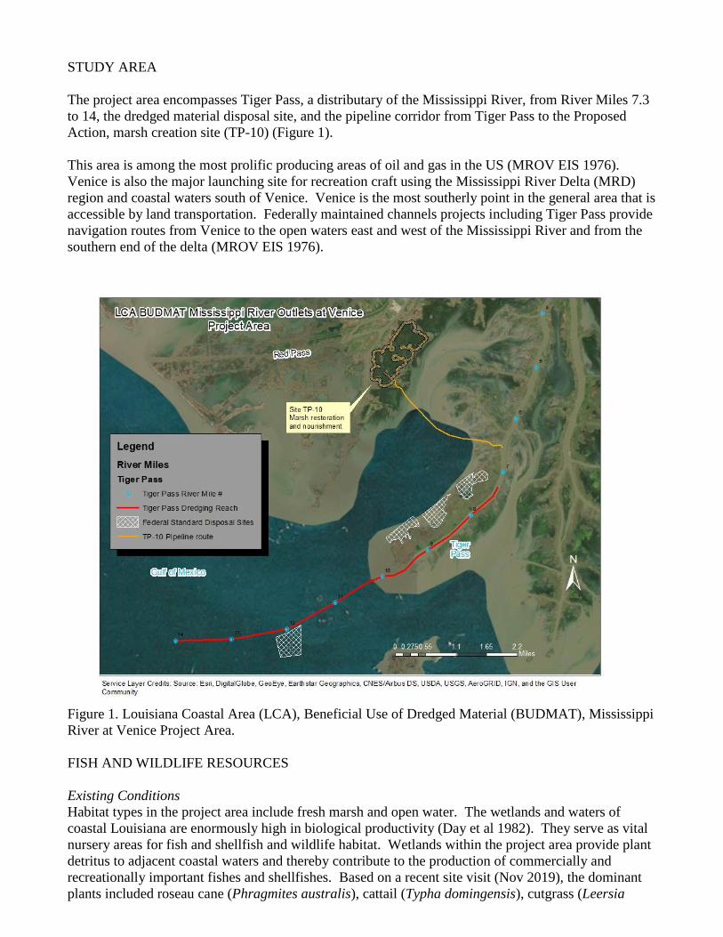
The project area encompasses Tiger Pass, a distributary of the Mississippi River, from River Miles 7.3
to 14, the dredged material disposal site, and the pipeline corridor from Tiger Pass to the Proposed
Action, marsh creation site (TP-10) (Figure 1).
This area is among the most prolific producing areas of oil and gas in the US (MROV EIS 1976).
Venice is also the major launching site for recreation craft using the Mississippi River Delta (MRD)
region and coastal waters south of Venice. Venice is the most southerly point in the general area that is
accessible by land transportation. Federally maintained channels projects including Tiger Pass provide
navigation routes from Venice to the open waters east and west of the Mississippi River and from the
southern end of the delta (MROV EIS 1976).
Figure 1. Louisiana Coastal Area (LCA), Beneficial Use of Dredged Material (BUDMAT), Mississippi
River at Venice Project Area.
FISH AND WILDLIFE RESOURCES
Existing Conditions
Habitat types in the project area include fresh marsh and open water. The wetlands and waters of
coastal Louisiana are enormously high in biological productivity (Day et al 1982). They serve as vital
nursery areas for fish and shellfish and wildlife habitat. Wetlands within the project area provide plant
detritus to adjacent coastal waters and thereby contribute to the production of commercially and
recreationally important fishes and shellfishes. Based on a recent site visit (Nov 2019), the dominant
plants included roseau cane (Phragmites australis), cattail (Typha domingensis), cutgrass (Leersia
oryzoides), coontail (Ceratophyllum demersum), salvinia (Salvinia molesta and Salvinia minima) and
some sites included bald cypress.
Future Conditions
Although Louisiana coastal marshes in general are experiencing high rates of land loss due to sediment
deprivation, subsidence, sea-level rise, erosion, and herbivory, interior portions of the MRD are
receiving sufficient amounts of suspended sediment inputs and are relatively stable. Other areas have
experienced localized marsh loss due to canal impacts, daily wave action and periodic storm events.
Fortifying the MRD marshes with dredged material can help to recreate deteriorated marshes and
maintain existing marsh. The project-related increase in marsh acreage would result in more foraging,
protection, nesting, etc., habitat for fish and wildlife.
ENDANGERED AND THREATENED SPECIES
The federally-listed threatened West Indian manatee (Trichechus manatus), could be encountered in
the project area. The USACE should consult with the NMFS regarding sea turtles.
West Indian manatee The endangered West Indian manatee is known to regularly occur in Lakes Pontchartrain and
Maurepas and their associated coastal waters and streams. It also can be found less regularly in other
Louisiana coastal areas, most likely while the average water temperature is warm. Based on data
maintained by the Louisiana Natural Heritage Program (LNHP), over 80 percent of reported manatee
sightings (1999-2011) in Louisiana have occurred from the months of June through December.
Manatee occurrences in Louisiana are increasing, and they have been regularly reported in the Amite,
Blind, Tchefuncte, and Tickfaw Rivers, and in canals and bayous within the adjacent coastal marshes
of southeastern Louisiana including bayou Lafouche. Manatees may also infrequently be observed in
the Mississippi River and coastal areas of southwestern Louisiana. Threats to this species include
collisions with boats and barges, entrapment in flood control structures, poaching, habitat loss, and
pollution. Cold weather and outbreaks of red tide may also adversely affect these animals. Should the
proposed project involve activity in the aquatic environment in those areas during summer months,
further consultation with this office will be necessary.
The following are conditions that should be implemented to avoid impacts to manatee. All contract
personnel associated with the project should be informed of the potential presence of manatees and the
need to avoid collisions with manatees, which are protected under the Marine Mammal Protection Act
of 1972 and the Endangered Species Act of 1973. All construction personnel are responsible for
observing water-related activities for the presence of manatee(s). Temporary signs should be posted
prior to and during all construction/dredging activities to remind personnel to be observant for
manatees during active construction/dredging operations or within vessel movement zones (i.e., work
area), and at least one sign should be placed where it is visible to the vessel operator. Siltation barriers,
if used, should be made of material in which manatees could not become entangled, and should be
properly secured and monitored. If a manatee is sighted within 100 yards of the active work zone,
special operating conditions should be implemented, including: no operation of moving equipment
within 50 feet of a manatee; all vessels should operate at no wake/idle speeds within 100 yards of the
work area; and siltation barriers, if used, should be re-secured and monitored. Once the manatee has
left the 100-yard buffer zone around the work area on its own accord, special operating conditions are
no longer necessary, but careful observations would be resumed. Any manatee sighting should be
immediately reported to the U.S. Fish and Wildlife Service (337/291-3100) and the Louisiana
Department of Wildlife and Fisheries, Natural Heritage Program (225/765-2821).
The Service and LDFW provide additional information and guidance on best management practices
(BMPs) for construction of the project, for more details refer to the appendices for additional
information. (See Appendix A LDWF Recommendations and Appendix B Service Recommendations)
ESSENTIAL FISH HABITAT
The 1996 amendments to the Magnuson-Stevens Fishery Conservation and Management Act
(Magnuson-Stevens Act; P.L. 104-297) set forth a new mandate for National Oceanic Atmospheric
Administration’s National Marine Fisheries Service (NMFS), regional fishery management councils
(FMC), and other federal agencies to identify and protect important marine and anadromous fish
habitat. The Essential Fish Habitats (EFH) provisions of the Magnuson-Stevens Act support one of the
nation’s overall marine resource management goals of maintaining sustainable fisheries. Essential to
achieving this goal is the maintenance of suitable marine fishery habitat quality and quantity. Detailed
information on Federally-managed fisheries and their EFH is provided in the 1999 generic amendment
of the Fishery Management Plans (FMP) for the Gulf of Mexico prepared by the Gulf of Mexico FMC
(GMFMC). The generic FMP subsequently was updated and revised in 2005 and became effective in
January 2006 (70 FR 76216). NMFS administers EFH regulations. Categories of EFH in the project
area include the estuarine waters, estuarine emergent wetlands and estuarine water bottoms. The
proposed project is in areas designated as EFH for various life stages of federally managed species,
including red drum, brown shrimp, and white shrimp. Coastal wetlands also provide nursery and
foraging habitat that supports economically important marine fishery species such as spotted seatrout
(Cynoscion Nebulosus), sand seatrout (Cynoscion Arenarius), southern flounder(Paralichthys
lethostigma), Atlantic croaker (Micropogonias undulatus), spot (Leiostomus xanthurus), Gulf
menhaden (Brevoortia patronus), striped mullet(Mugil cephalus) , and blue crab (Callinectes sapidus).
Some of these species serve as prey for other fish species managed under the Magnuson-Stevens Act
by the GMFMC (e.g., mackerels, snappers, and groupers) and highly migratory species managed by
NMFS (e.g., billfishes and sharks). Portions of the study area have been designated as EFH. Under
future without project conditions there would be no change to EFH. Where tidally-influenced waters
designated as EFH are converted to a non-tidal elevation, loss of EFH would result. Should EFH be
impacted, those losses should be quantified and presented in the USACE’s report. Close coordination
with the NMFS is recommended because mitigation for those impacts is necessary.
MIGRATORY BIRDS
The Migratory Bird Treaty Act (MBTA) (40 Stat. 755, as amended; 16 U.S.C. 703 et seq.) and the Bald
and Golden Eagle Protection Act (BGEPA) (54 Stat. 250, as amended, 16 U.S.C. 668a-d) offer
protection to many bird species within the project area including colonial nesting birds. We continue to
recommend that a qualified biologist inspect proposed work sites for the presence of undocumented
colonial nesting during their respective nesting season (e.g. February through September depending on
the species). If colonies exist, work should not be conducted within 1,000 feet of the colony during the
nesting season.
Colonial nesting birds The proposed project would be located in an area where colonial nesting waterbirds may be present.
Colonies may be present that are not currently listed in the database maintained by the Louisiana
Department of Wildlife and Fisheries. That database is updated primarily by monitoring the colony
sites that were previously surveyed during the 1980s. Until a new, comprehensive coast-wide survey is
conducted to determine the location of newly-established nesting colonies, we recommend that a
qualified biologist inspect the proposed work site for the presence of undocumented nesting colonies
during the nesting season. To minimize disturbance to colonial containing nesting wading birds (i.e.,
herons, egrets, night-herons, ibis, and roseate spoonbills), anhingas, and/or cormorants, all activity
occurring within 1,000 feet of a rookery should be restricted to the non-nesting period (i.e., September
1 through February 15, exact dates may vary within this window depending on species present). In
addition, we recommend that on-site contract personnel be informed of the need to identify colonial
nesting birds and their nests, and should avoid affecting them during the breeding season.
Additional information and guidance on best management practices (BMPs) for construction of the
project can be found in Appendix A.
AT RISK SPECIES
The saltwater topminnow (Fundulus jenkinsi) is a species at risk for federal listing as threatened or
endangered. At risk species are those taxa for which the Service has defined as at-risk and have either
been proposed for listing, are candidates for listing, or have been petitioned for listing. The saltwater
topminnow is a small, approximately 2 inch coastal fish within the Funduludae family. It is considered
a resident species of coastal marsh and closely related to other killifish species such as the Gulf killifish
(Fundulus grandis).
Typically found in coastal marsh habitats characterized by smooth cordgrass (Spartina alterniflora),
big cordgrass (Spartina cynosuroides), and black rush (Juncus roemerianus). The topminnow also
occurs in the Atchafalaya River Delta and records exist of its presence in the Mississippi River Delta.
The saltwater topminnow is a species of concern that could use the study area’s fresh wetland habitats
and potentially benefit from the proposed project, especially if tidal creeks are constructed.
Information gathered by the Service indicates high usage of tidal creeks.
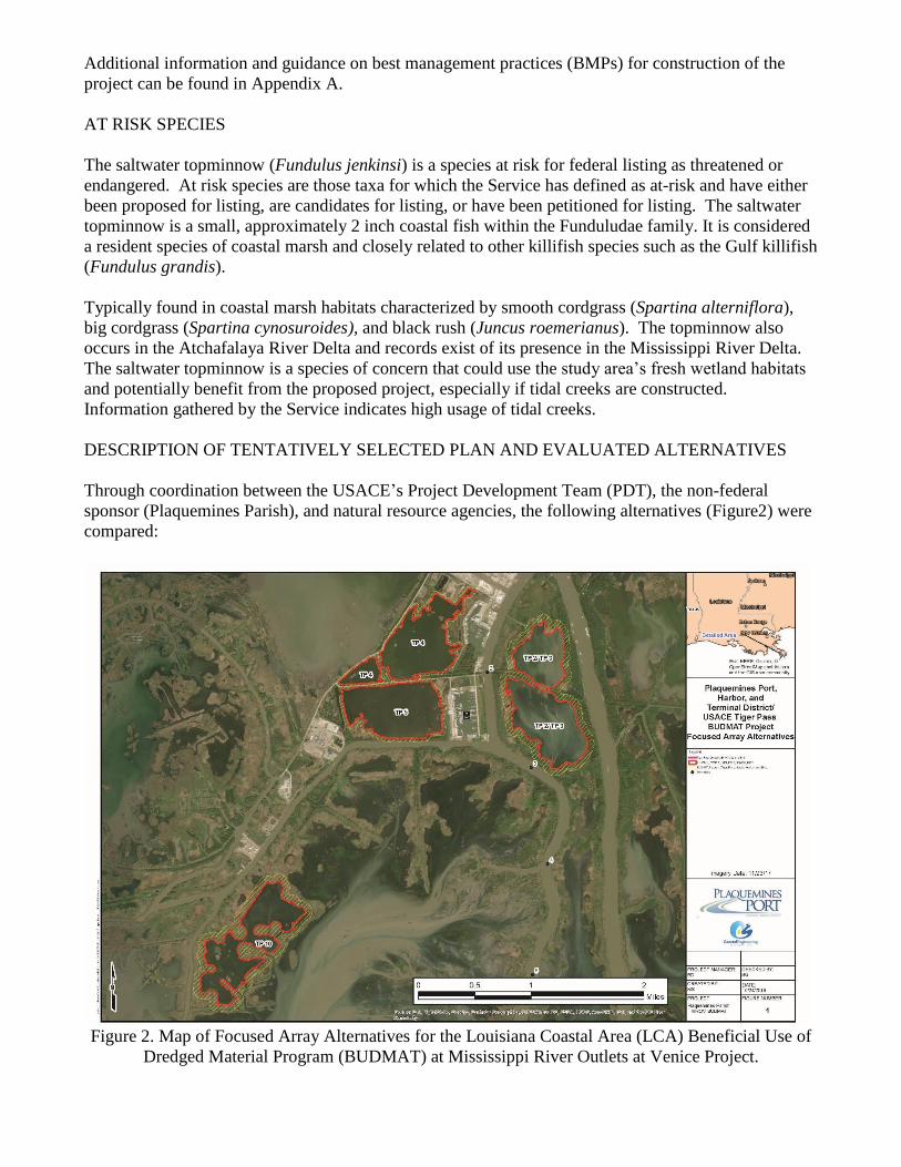
DESCRIPTION OF TENTATIVELY SELECTED PLAN AND EVALUATED ALTERNATIVES
Through coordination between the USACE’s Project Development Team (PDT), the non-federal
sponsor (Plaquemines Parish), and natural resource agencies, the following alternatives (Figure2) were
compared:
Figure 2. Map of Focused Array Alternatives for the Louisiana Coastal Area (LCA) Beneficial Use of
Dredged Material Program (BUDMAT) at Mississippi River Outlets at Venice Project.
*NOTE: For the purpose of this project, nourished marsh is defined as areas of existing marsh adjacent
to the marsh creation area but where containment is absent and were excess sediment is allowed to
overflow.
1) Tiger pass - Alternatives TP-2 and TP-3
The LCA BUDMAT – Tiger Pass, Venice Ponds Marsh Creation project alternative, originally
proposed as the "Coastal Wetlands Planning, Protection and Restoration Act (CWPPRA) (MR-15) -
Venice Ponds Marsh Creation” project, calls for the creation of marsh within 2 proposed sites
designated as TP-2 and TP-3, are located southeast of the community of Venice, LA, beginning at the
fork of Tiger Pass and Grand Pass in Plaquemines Parish. Creation sites TP-2 and TP-3 would be
approximately 104 and 91 acres in size with an additional 28 acres of nourished open water.
An earthen retention dike would be built along the limits of the existing marsh in TP-2 and TP-3 using
borrow from within the sites. The perimeter retention dikes would be constructed to an elevation of
+5.0’ NAVD88 with 1 on 5 side slopes and a 5’ crown width. Approximately 8,940 linear feet of
retention dikes would be required and approximately 190,000 cubic yards of adjacent borrow would be
needed in TP-2 and 6,130 linear feet of retention dike and 131,000 cubic yards of adjacent borrow
would be needed in TP-3. Each site would require a combined total of approximately 1,575 linear feet
of silt curtain long the banks of the Spectra Energy pipeline canal that divides TP-2 and TP-3. The silt
curtains would prevent dredged material from entering into either Tiger Pass or Grand Pass, as well as
the pipeline canal that separates the two sites but allow water to drain. An earthen weir would be
constructed along the southern limits of TP-3. The weir would be approximately 3,080 linear feet and
constructed to an elevation of +3.0’ NAVD88 with 1 on 5 side slope and a 5’ crown width.
Approximately 32,000 cubic yards of adjacent borrow would be needed to construct the weir.
The dredge discharge pipeline equipment would access the sites through a natural opening in the west
bank of Tiger Pass and from there follow existing shallow water bodies to the restoration sites in order
to prevent damage to existing wetlands. For determining the required cubic yards that would be
needed to fill these restoration sites, an average existing elevation of -1.3’ NAVD88 was used along
with a design fill elevation after pumping of +2.50' NAVD88 in TP-2 and +3.00’ NAVD88 in TP-3.
Based off of the information in the geotech design report and plans and specifications for the CWPPRA
Venice Ponds project (MR-15), approximately 1,091,000 cubic yards would be required to construct
TP-2 and 956,000 cubic yards would be required to construct TP-3 with a total of 2,170,500 cubic
yards required to be dredge from Tiger Pass to construct both sites which includes borrow used for
constructing the retention features. After a 10-year settlement period, the elevation within TP-2 would
be approximately +1.09’ NAVD88 and +1.13’ NAVD88 within TP-3.
2) Tiger Pass – Alternative TP-4
Alternative TP-4 consists of an open-water cell marsh creation site totaling approximately 160 acres
with an additional 33 acres of surrounding marsh and open water nourishment north of the weir and
spill box. The site is located south of Venice, LA on the north side of Venice Boat Harbor Drive in
Plaquemines Parish. A combination of hay bales, retention dikes, and earthen weirs would be used to
contain the dredge material. Approximately 9,180 linear feet of hay bales would be placed along the
western and southern limits of the site along existing marsh. A 3,525 linear foot retention dike would
be built along the eastern limit of the proposed site using borrow from within the site. The dike would
be constructed to an elevation of +6.75’ NAVD88 with 1 on 5 slopes and a 5’ crown width.
Approximately 168,000 cubic yards of adjacent borrow would be required to construct the dike. Along
the northern limit of the proposed site, a 1,755 linear foot earthen weir would be constructed using
existing borrow from within the site. The weir would be constructed to an elevation of +4.75 NAVD88
with a 1 on 5 side slope and a 5’ wide crown width. Approximately 54,000 cubic yards would be
required to construct the weir. A spill box would be installed in the southwest corner of the site to
allow slurry to flow into and nourish existing wetlands outside of the cell limits.
Dredged material would be pumped through a pipeline placed along Tiger Pass and then Sugar Lake
Bayou to a canal along the southeast side of the site. For determining the required cubic yards that
would be needed to fill this proposed site, an average existing elevation of -2.9’ NAVD88 was used
along with a design fill elevation after pumping of +2.75' NAVD88. Based off of the information in
the geotech design report and plans and specifications for the CWPPRA Venice Ponds project (MR-
15), approximately 2,170,500 cubic yards would be dredged from Tiger Pass to construct this site
which includes borrow used for constructing the retention features. After a 10-year settlement period,
the elevation within TP-4 would be approximately +1.13’ NAVD88.
3) Tiger Pass – Alternative TP-5
Alternative TP-5 consists of a marsh creation site totaling 187 acres and with an additional 57 acres of
surrounding marsh and open water nourishment north of the weir and spill box. The site is located
south of site TP-4 along Venice Boat Harbor Drive and west of Tiger Pass Channel Mile 2 and 3. The
eastern boundary runs along Sports Marina Road in Plaquemines Parish. Dredged material would be
pumped through a pipeline placed from Tiger Pass to Sugar Lake Bayou, with the pipe entering the
southern limit of the site.
The site perimeter totals 14,750 linear feet and dredged material would be contained there with a
combination of hay bales, retention dikes, and an earthen weir. Approximately 1,330 linear feet of hay
bales would be placed along the western limit as well as 5,730 linear feet along the eastern and
southern limits of the site along existing marsh. A 3,310 linear foot retention dike would be built along
the southwestern limit of the proposed site using borrow from within the site. The dike would be
constructed to an elevation of +5.0’ NAVD88 with 1 on 5 slopes and a 5’ crown width. Approximately
95,000 cubic yards of adjacent borrow would be required to construct the dike. Along the northern
limit of the proposed site, a 4,385 linear foot earthen weir would be constructed using existing borrow
from within the site. The weir would be constructed to an elevation of +3.0’ NAVD88 with a 1 on 5
side slope and a 5’ wide crown width. Approximately 70,000 cubic yards would be required to
construct the weir. A spill box would be installed in the southwest corner of the site within the
retention dike to allow slurry to flow into and nourish existing wetlands outside of the cell limits. A
silt curtain will be installed at the northwest corner of the site to prevent material from entering the
canal that runs north/south along the western limit of the area.
For determining the cubic yards that would be needed to fill this proposed site, an average existing
elevation of -2.4’ NAVD88 was used along with a design fill elevation after pumping of +2.75'
NAVD88. Based off of the information in the geotech design report and plans and specifications for
the CWPPRA Venice Ponds project (MR-15), approximately 2,170,500 cubic yards would be dredged
from Tiger Pass to construct this site which includes borrow used for constructing the retention
features. After a 10-year settlement period, the elevation within TP-5 would be approximately +0.88’
NAVD88.
4) Tentatively Selected Plan (TSP): Tiger Pass – Alternative TP-10
Alternative TP-10, consists of a marsh creation site totaling 226 acres and an estimated 165 acres of
nourishment to wetlands outside of the containment cell. The site is located west of Tiger Pass
Channel Mile 4 and 5, southeast of site TP-5, and along Tante Phine Pass in Plaquemines Parish.
The site perimeter totals approximately 30,065 linear feet. Rather than construction retention dikes, it
is assumed that the existing marsh boundaries will retain the dredge material. The pipeline would be
laid in Tiger Pass and then placed in one of three canals west of Tiger Pass that lead to open water on
the eastern end of the disposal site.
For determining the required cubic yards that would be needed to fill this proposed site, an average
existing elevation of -1.1’ NAVD88 was used along with a design fill elevation after pumping of +2.00'
NAVD88. Based on information in the geotech design report and plans and specifications for the
CWPPRA Venice Ponds project (MR-15), approximately 1,800,750 cubic yards would need to be
excavated from Tiger Pass to construct this site. After a 10-year settlement period, the elevation within
TP-10 would be approximately +0.65’ NAVD88.
EVALUATION METHODS FOR SELECTED PLAN AND ALTERNATIVES
Wetland Value Assessment (WVA)
Evaluations of the alternatives on fish and wildlife resources were conducted using the WVA
methodology. Implementation of the WVA requires that habitat quality and quantity (acreage) are
measured for baseline conditions, and predicted for future without-project and future with-project
conditions. Each WVA model utilizes an assemblage of variables considered important to the
suitability of that habitat type to support a diversity of fish and wildlife species. The WVA provides a
quantitative estimate of project-related impacts to fish and wildlife resources. Although, the WVA
may not include every environmental or behavioral variable that could limit populations below their
habitat potential, it is widely acknowledged to provide a cost-effective means of assessing restoration
measures in coastal wetland communities.
The WVA models operate under the assumption that optimal conditions for fish and wildlife habitat
within a given coastal wetland type can be characterized, and that existing or predicted conditions can
be compared to that optimum to provide an index of habitat quality. Habitat quality is estimated and
expressed through the use of a mathematical model developed specifically for each wetland type. Each
model consists of: (1) a list of variables that are considered important in characterizing community-
level fish and wildlife habitat values; (2) a Suitability Index graph for each variable, which defines the
assumed relationship between habitat quality (Suitability Index) and different variable values; and, (3)
a mathematical formula that combines the Suitability Indices for each variable into a single value for
wetland habitat quality, termed the Habitat Suitability Index (HSI).
The product of an HSI value and the acreage of available habitat for a given target year is known as the
Habitat Unit (HU) and is the basic unit for measuring project effects on fish and wildlife habitat. HUs
are annualized over the project life to determine the Average Annual Habitat Units (AAHUs) available
for each habitat type. The change (increase or decrease) in AAHUs for each future with-project
scenario, compared to future without-project conditions, provides a measure of anticipated impacts. A
net gain in AAHUs indicates that the project is beneficial to the fish and wildlife community within
that habitat type; a net loss of AAHUs indicates that the project would adversely impact fish and
wildlife resources.
The USACE-certified Coastal Marsh (Fresh-Intermediate) WVA Model (version 2.0) was used for the
marsh creation analysis. Target Years (TY) were set as follow: 0, 1, 5, 20, 40 and 50. TY 40 was
added to account for expected variable changes due to SLR based on a review of other projects (ERDC
2016 and Messina, et al. 2019) in the project area. Assumption for target years and the WVA analysis
is presented in Appendix C.
Any proposed change in impacts or plans should be coordinated in advance with the Service and
NMFS.
IMPACTS OF SELECTED PLAN AND ALTERNATIVES
The placement of dredged material in shallow water bottoms, will impact benthic and slower moving
aquatic organisms; however, shallow water bottom habitat area is increasing relative to emergent marsh
in most of coastal Louisiana. Overall impacts will be minor in comparison with the habitat gained by
the proposed marsh creation project. Sediment flowing out of the containment cell may deposit on
nearby marshes helping to maintain healthy marsh elevations and contribute to the long-term resilience
of those marshes.
The gain of marsh acreage would result in more foraging, protection, nesting habitats for fish and
wildlife.
The created emergent marsh habitat offers greater refugia and forage benefits than open water bottoms
and would increase the overall net habitat value of the area. At risk species such as the saltmarsh
topminnow would benefit from the proposed marsh creation site. Studies have found that the species
prefer low-salinity habitat and primarily inhabit the edges of interconnected and naturally functioning
intertidal creek systems within the larger salt, brackish, or fresh marsh environments.
Submerged aquatic vegetation (SAV) in the project area will unavoidably be affected. The Service
recognizes the value of SAV habitat to fish and wildlife and recommends, when possible, areas with
dense SAV vegetation should be avoided. The net value of marsh created and nourished by the TSP
will increase overall habitat value and improve productivity. Existing SAV seed banks are expected to
provide expedited regrowth and recovery to the site.
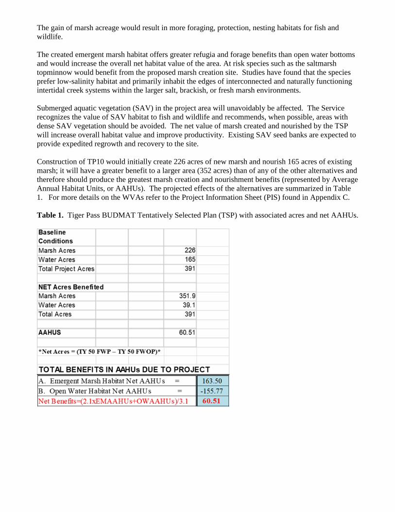
Construction of TP10 would initially create 226 acres of new marsh and nourish 165 acres of existing
marsh; it will have a greater benefit to a larger area (352 acres) than of any of the other alternatives and
therefore should produce the greatest marsh creation and nourishment benefits (represented by Average
Annual Habitat Units, or AAHUs). The projected effects of the alternatives are summarized in Table
1. For more details on the WVAs refer to the Project Information Sheet (PIS) found in Appendix C.
Table 1. Tiger Pass BUDMAT Tentatively Selected Plan (TSP) with associated acres and net AAHUs.
SERVICE POSITION AND RECOMMENDATIONS
The Service’s analysis of project alternatives has shown the potential for beneficial effects on fish and
wildlife resources. Construction of the TSP (Tiger Pass Marsh Creation-TP- 10) would result in the net
(at the end of 50 years) creation and nourishment of 352 acres of fresh marsh (Table 1). The Service
supports this habitat creation project provided the following fish and wildlife conservation measures
are implemented concurrently with project implementation to help ensure that fish and wildlife
conservation is maximized:
1. Avoid adverse impacts to water bird colonies through careful design of project features and
timing of construction. We recommend that a qualified biologist inspect the proposed work site
for the presence of undocumented nesting colonies during the nesting season. For areas
containing nesting wading birds (i.e., herons, egrets, night-herons, ibis, and roseate spoonbills),
anhingas, and/or cormorants, all activity occurring within 1,000 feet of a nesting colony should
be restricted to the non-nesting period. For nesting brown pelicans, activity should be avoided
within 2,000 feet of the colony. Activity is restricted within 650 feet of black skimmers, gulls,
and terns (See Appendix A).
2. The impacts to Essential Fishery Habitat should be discussed with the NMFS to determine if
the project complies with the Magnuson-Stevens Fishery Conservation and Management Act
(MSFCMA), Magnuson-Stevens Act; P.L. 104-297, as amended) and its implementing
regulations.
3. West Indian manatees occasionally enter Louisiana coastal waters and streams during the
summer months (i.e., June through September). During in-water work in areas that potentially
support manatees all personnel associated with the project should be instructed about the
potential presence of manatees, manatee speed zones, and the need to avoid collisions with and
injury to manatees. All personnel should be advised that there are civil and criminal penalties
for harming, harassing, or killing manatees which are protected under the Marine Mammal
Protection Act of 1972 and the Endangered Species Act of 1973. Additionally, personnel
should be instructed not to attempt to feed or otherwise interact with the animal, although
passively taking pictures or video would be acceptable. For more detail on avoiding contact
with manatee refer to Appendices A and B and contact this office. Should a proposed action
directly or indirectly affect the West Indian manatee, further consultation with this office will
be necessary.
4. Maintain existing tidal creeks as project features within the TP-10 site design and/or the
addition of new tidal creeks to maintain hydrologic exchange given the low land loss rate and
extended settlement period. An explanation of work should be added to the TP-10 Alternative.
5. Refine Alternative TP-10 target construction (+2.0' NAVD88) and target settled elevations
(+0.65' NAVD88) to avoid and/or minimize temporal losses of fisheries functions, given the
existing marsh elevation is +0.42' NAVD88, a 10-year settlement period, and the low land loss
rate (+0.10% per year for the period 1985-2016).
6. Geotechnical analysis should be performed to inform fill and settlement rates for the TP-10 site
and a settlement curve should be provided with water levels adjusted for sea level rise over a
20-year period.
7. To ensure that dredged material is placed to each particular habitat’s specified elevations, we
recommend that the USACE use an updated NAVD88 datum (i.e., current geoid) consistent
with the NAVD88 datum that is referenced for the elevations of existing marsh and water level
in the project area.
8. Pipeline access into the TP-10 site should avoid and minimize impacts to fresh-intermediate
marsh and/or shallow water during pipeline placement. Unavoidable impacted wetlands should
be restored to a substrate elevation similar to the surrounding marsh. Flotation access channels
in open water should be backfilled upon project completion. Post-construction surveys (e.g.,
centerline surveys) should be taken to ensure access channels have been adequately backfilled.
That information should be provided to the natural resource agencies for review. Any
unavoidable temporal or permanent impacts would require mitigation.
9. If containment dikes are constructed, they should be breached or degraded to the settled
elevations of the disposal area. Such breaches should be undertaken after consolidation of the
dredged sediments and vegetative colonization of the exposed soil surface, or a maximum of 3
years after construction.
10. Further detailed planning of project features (e.g., Design Documentation Report, Engineering
Documentation Report, Plans and Specifications, Water Control Plans, or other similar
documents) should be coordinated with the Service, NMFS, and LDWF, other relevant resource
agencies. The Service shall be provided an opportunity to review and submit recommendations
on all work addressed in those reports.
11. Any proposed change in project features or plans should be coordinated in advance with the
Service, NMFS and other resource agencies.
12. The LCA BUDMAT Program specifies that monitoring and adaptive management plans are
required for beneficial use habitat creation projects. The USACE should coordinate with the
Service, LDWF and NMFS during development of those plans.
13. The Service recommends that the USACE contact the Service for additional consultation if: 1)
the scope or location of the proposed project is changed significantly, 2) new information
reveals that the action may affect listed species or designated critical habitat; 3) the action is
modified in a manner that causes effects to listed species or designated critical habitat; or 4) a
new species is listed or critical habitat designated. Additional consultation as a result of any of
the above conditions or for changes not covered in your consultation should occur before
changes are made and or finalized.
We will continue to work closely with your staff to ensure that fish and wildlife resources are
conserved. If you require further assistance in this matter, please contact Hannah Sprinkle (337-291-
3121) of this office.
Sincerely,
Joseph A. Ranson
Field Supervisor Louisiana Ecological
Services Office
cc: NMFS, Baton Rouge, LA
USACE, NOD, New Orleans, LA
LDWF, Baton Rouge, LA
Literature Cited
Coastal Protection and Restoration Authority (CPRA). 2020. Coastwide Reference Monitoring
System-Wetlands Monitoring Data. Retrieved from CRMS Spatial Viewer.
https://www.lacoast.gov/crms_viewer/Map/CRMSViewer. Accessed Feb 2020
Day, J.W., Jr., C.S. Hopkinson, and W.H. Conner. 1982. An analysis of environmental factors
regulating community metabolism and fisheries production in a Louisiana estuary. In:
Kennedy, V.S., ed. Estuarine Comparisons. Academic Press, New York. 120-136.
Louisiana Office of Coastal Protection and Restoration. 2019. Coastwide Reference Monitoring
System-Wetlands Monitoring Data. Retrieved from Coastal Information Management System
(CIMS) database. http://cims.coastal.louisiana.gov. Accessed January 2019.
Messina, F., Bregman, M., Jung, H., Yuill, B., Baustian, M. M., & Roberts, H. R. (2019). TO48: Mid-
Barataria Sediment Diversion Engineering Modeling Support: Production Runs with the Basin
Wide model Version 3. Baton Rouge, LA: The Water Institute of the Gulf. Funded by the
Coastal Protection and Restoration Authority under Task Orders 48.
US Army Corps of Engineers (USACE), Mississippi Valley Division, New Orleans District,
1976. 1976, Final Environmental Statement titled "Mississippi River Outlets, Vicinity of
Venice, Louisiana" with a signed ROD dated 10 September 1976.
US Army Corps of Engineers (USACE), Mississippi Valley Division, New Orleans District, 1988. EA
#77 titled "Marsh Creation, Mississippi River Outlets, Louisiana" with FONSI signed on 12
September 1988.
Appendix A
March 20, 2020
Mr. Joseph A. Ranson, Field Supervisor U.S. Fish and Wildlife Service, Ecological Services Office
200 Dulles Drive
Lafayette, LA 70506
RE: Tiger Pass Beneficial Use of Dredged Material draft FWCAR
Dear Mr. Ranson,
The professional staff of the Louisiana Department of Wildlife and Fisheries (LDWF) has reviewed the
above referenced draft Fish and Wildlife Coordination Act Report (FWCAR) regarding proposed Louisiana
Coastal Area (LCA) Beneficial Use of Dredged Material Program (BUDMAT) project at Mississippi River
Outlets at Venice to beneficially use dredged material removed from the Tiger Pass federal navigation
channel located within Plaquemines Parish in the vicinity of Venice, Louisiana. Based upon this review,
the following has been determined:
General Comments:
We concur with the U.S. Fish and Wildlife Service’s position and recommendations enumerated
within the above referenced draft FWCAR.
Wildlife Diversity Program:
Manatee Manatee (Trichechus manatus) may occur in the surrounding water bodies of your site location.
Manatees are large mammals inhabiting both fresh and salt water. Although most manatees are year
round residents of Florida or Central America, they have been known to migrate to areas along the
Atlantic and Gulf coast during the summer months. Manatee is a threatened species protected under
the Endangered Species Act of 1973 and the Federal Marine Mammal Protection Act of 1972. In
Louisiana, taking or harassment of a manatee is in violation of state and federal law. Critical habitat
for manatee includes marine submergent vascular vegetation (sea-grass beds). Areas with sea-grass
beds should be avoided during project activities if possible. Report all manatee sightings to the
LDWF at 337-735-8676 or 1-800-442-2511.
Bird Nesting Colonies Our database indicates the presence of bird nesting colonies within one mile of this proposed
project. Please be aware that entry into or disturbance of active breeding colonies is prohibited
by LDWF. In addition, LDWF prohibits work within a certain radius of an active nesting
colony.
Nesting colonies can move from year to year and no current information is available on the status
of these colonies. If work for the proposed project will commence during the nesting season,
Page 2
Tiger Pass FWCAR
conduct a field visit to the worksite to look for evidence of nesting colonies. This field visit should
take place no more than two weeks before the project begins. If no nesting colonies are found within
1000 feet (2000 feet for Brown Pelicans) of the proposed project, no further consultation with
LDWF will be necessary. If active nesting colonies are found within the previously stated distances
of the proposed project, further consultation with LDWF will be required. In addition, colonies
should be surveyed by a qualified biologist to document species present and the extent of colonies.
Provide LDWF with a survey report which is to include the following information:
1. qualifications of survey personnel;
2. survey methodology including dates, site characteristics, and size of survey area;3. species of birds present, activity, estimates of number of nests present, and general vegetation
type including digital photographs representing the site; and
4. topographic maps and ArcView shapefiles projected in UTM NAD83 Zone 15 to illustrate
the location and extent of the colony.
Please mail survey reports on CD to: Wildlife Diversity Program
La. Dept. of Wildlife & Fisheries
P.O. Box 98000
Baton Rouge, LA 70898-9000
To minimize disturbance to colonial nesting birds, the following restrictions on activity should be
observed:
- For colonies containing nesting wading birds (i.e., herons, egrets, night-herons, ibis, Roseate
Spoonbills, Anhingas, or cormorants), all project activity occurring within 1000 feet of an active
nesting colony should be restricted to the non-nesting period (i.e., September 1 through February
15).
- For colonies containing nesting gulls, terns, or Black Skimmers, all project activity occurring
within 650 feet (2000 feet for Brown Pelicans) of an active nesting colony should be restricted to
the non-nesting period (i.e., September 16 through April 1).
No other impacts to rare, threatened or endangered species or critical habitats are anticipated from
the proposed project. No state or federal parks, wildlife refuges, wildlife management areas or
scenic rivers are known at the specified site or within ¼ mile of the proposed project.
The Wildlife Diversity Program (WDP) reports summarize the existing information known at the
time of the request regarding the location in question. WDP reports should not be considered final
statements on the biological elements or areas being considered, nor should they be substituted for
on-site surveys required for environmental assessments. If at any time WDP tracked species are
encountered within the project area, please contact our biologist at 225-765-2643.
The Louisiana Department of Wildlife and Fisheries appreciates the opportunity to review and provide
recommendations to you regarding this proposed activity. Please do not hesitate to contact Habitat Section
biologist Matthew Weigel at 985-543-4931 should you need further assistance.
Sincerely,
/S/ Kyle F. Balkum
Kyle Balkum
Biologist Director
Appendix B
The threatened West Indian manatee (Trichechus manatus) is known to regularly occur in Lakes
Pontchartrain and Maurepas and their associated coastal waters and streams. It also can be found
less regularly in other Louisiana coastal areas, most likely while the average water temperature is
warm. Based on data maintained by the Louisiana Natural Heritage Program (LNHP), over 80
percent of reported manatee sightings (1999-2011) in Louisiana have occurred from the months of
June through December. Manatee occurrences in Louisiana appear to be increasing and they have
been regularly reported in the Amite, Blind, Tchefuncte, and Tickfaw Rivers, and in canals within
the adjacent coastal marshes of southeastern Louisiana. Manatees may also infrequently be
observed in the Mississippi River and coastal areas of southwestern Louisiana. Cold weather and
outbreaks of red tide may adversely affect these animals. However, human activity is the primary
cause for declines in species number due to collisions with boats and barges, entrapment in flood
control structures, poaching, habitat loss, and pollution.
During in-water work in areas that potentially support manatees all personnel associated with the
project should be instructed about the potential presence of manatees, manatee speed zones, and
the need to avoid collisions with and injury to manatees. All personnel should be advised that
there are civil and criminal penalties for harming, harassing, or killing manatees, which are
protected under the Marine Mammal Protection Act of 1972 and the Endangered Species Act of
1973. Additionally, personnel should be instructed not to attempt to feed or otherwise interact
with the animal, although passively taking pictures or video would be acceptable.
All on-site personnel are responsible for observing water-related activities for the presence of
manatee(s). We recommend the following to minimize potential impacts to manatees in areas of
their potential presence:
All work, equipment, and vessel operation should cease if a manatee is spotted within a 50-foot
radius (buffer zone) of the active work area. Once the manatee has left the buffer zone on its own
accord (manatees must not be herded or harassed into leaving), or after 30 minutes have passed
without additional sightings of manatee(s) in the buffer zone, in-water work can resume under
careful observation for manatee(s).
If a manatee(s) is sighted in or near the project area, all vessels associated with the project should
operate at “no wake/idle” speeds within the construction area and at all times while in waters
where the draft of the vessel provides less than a four-foot clearance from the bottom. Vessels
should follow routes of deep water whenever possible.
If used, siltation or turbidity barriers should be properly secured, made of material in which
manatees cannot become entangled, and be monitored to avoid manatee entrapment or impeding
their movement.
Temporary signs concerning manatees should be posted prior to and during all in-water project
activities and removed upon completion. Each vessel involved in construction activities should
display at the vessel control station or in a prominent location, visible to all employees operating
the vessel, a temporary sign at least 8½ " X 11" reading language similar to the following:
“CAUTION BOATERS: MANATEE AREA/ IDLE SPEED IS REQUIRED IN CONSRUCTION
AREA AND WHERE THERE IS LESS THAN FOUR FOOT BOTTOM CLEARANCE WHEN
16
MANATEE IS PRESENT”. A second temporary sign measuring 8½ " X 11” should be posted at
a location prominently visible to all personnel engaged in water-related activities and should read
language similar to the following: “CAUTION: MANATEE AREA/ EQUIPMENT MUST BE
SHUTDOWN IMMEDIATELY IF A MANATEE COMES WITHIN 50 FEET OF
OPERATION”.
Collisions with, injury to, or sightings of manatees should be immediately reported to the
Service’s Louisiana Ecological Services Office (337-291-3100) and the Louisiana Department of
Wildlife and Fisheries, Natural Heritage Program (225-765-2821). Please provide the nature of
the call (i.e., report of an incident, manatee sighting, etc.); time of incident/sighting; and the
approximate location, including the latitude and longitude coordinates, if possible.
To ensure manatees are not trapped due to construction of containment or water control structures,
we recommend that the project area be surveyed prior to commencement of work
activities. Should a manatee be observed within those areas, the contractor should immediately
contact the Service’s Louisiana Ecological Services Office (337-291-3100) and the Louisiana
Department of Wildlife and Fisheries, Natural Heritage Program (225-765-2821).
Should a proposed action directly or indirectly affect the West Indian manatee, further
consultation with this office will be necessary.
17
Appendix C
U.S. Fish and Wildlife Service, Ecological Services
200 Dulles Drive, Lafayette, LA 70506
(337) 291-3100, FAX (337) 291-3139
MEMORANDUM
DATE: February 3, 2020
TO: U.S. Army Corps of Engineers (NOD)
FROM: U.S. Fish and Wildlife Service (Service)
SUBJECT: Project Information Sheet for the Wetland Value Assessment (WVA) for the
proposed Tiger Pass MROV BUDMAT Marsh Habitat Creation site.
The U.S. Army Corps of Engineers (USACE), New Orleans District has proposed, under the
authority of Title VII of the Water Resources Development Act of 2007, to beneficially use
dredged material removed from the Tiger Pass Federal navigation channel located within
Plaquemines Parish Louisiana in vicinity from the Port of Venice. The USACE-certified Coastal
Marsh (Fresh-Intermediate) WVA Model (version 2.0) was used for the marsh creation analysis.
Target Years (TY) were set as follow: 0, 1, 5, 20, 40 and 50. TY 40 was added to account for
expected variable changes due to SLR based on a review of other projects (ERDC 2016 and
CPRA 2017 (reference Delft Modeling) in the project area).
The objective of this project would create marsh habitat within proposed marsh creation sites
through deposition of dredge material obtained from the lower portion of Tiger Pass (Miles 0.0 to
13.8) through long distance transport of dredged material that would be obtained during USACE
Operations & Maintenance dredging of the lower portion of Tiger Pass.
Habitat Assessment Method
The WVA operates under the assumption that optimal conditions for general fish and wildlife
habitat within a given coastal wetland type can be characterized, and that existing or predicted
conditions can be compared to that optimum to provide an index of habitat quality. Habitat
quality is estimated or expressed through the use of a mathematical model developed specifically
for each wetland type. Each model consists of 1) a list of variables that are considered important
in characterizing fish and wildlife habitat, 2) a Suitability Index graph for each variable, which
defines the assumed relationship between habitat quality (Suitability Index) and different variable
values, and 3) a mathematical formula that combines Suitability Index (SI) for each variable into a
single value for wetland habitat quality; that single value is referred to as the Habitat Suitability
Index, or HSI.
18
_________________________________________________________________________
Land Loss/ Sea Level Rise Effects
Land loss rates estimated by the Service were adjusted by the projected effects of the medium
relative sea level rise (RSLR) scenario for these analyses. The land loss rate for the Mississippi
River Delta-West Bay region was used (0.10% per year for the period 1985-2016) based on USGS
data for the extended project boundary (West Bay, total 113,966 acres). The loss rate of the
created marsh is assumed to be 50% of the background loss rate until the year that 10 inches of
accretion occurs post construction. After that the loss rate used in our calculations reverts back to
the actual background rate. An average accretion rate of 26.1 mm/year was used for this site (26.1
mm/yr from Coastwide Reference Monitoring System [CRMS] Station 163 long-term data, CRMS
2019).
An estimated subsidence rate of 21.3 mm/yr was used in the Mississippi River Delta (gage 01480).
The eustatic sea level rise was assumed to be 1.7 mm/yr. The estimations were calculated using
the USACE’s Sea-Level Calculator. The Mississippi River at Venice (01480) was the closest
long-term gage station to proposed sites.
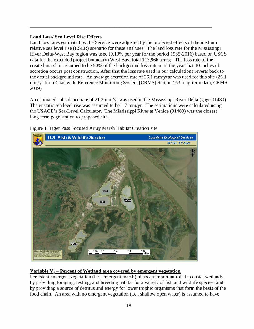
Figure 1. Tiger Pass Focused Array Marsh Habitat Creation site
Variable V1 – Percent of Wetland area covered by emergent vegetation
Persistent emergent vegetation (i.e., emergent marsh) plays an important role in coastal wetlands
by providing foraging, resting, and breeding habitat for a variety of fish and wildlife species; and
by providing a source of detritus and energy for lower trophic organisms that form the basis of the
food chain. An area with no emergent vegetation (i.e., shallow open water) is assumed to have
19
minimal habitat suitability in terms of this variable, and is assigned an SI of 0.1. Optimal
vegetative coverage (i.e., percent marsh) is assumed to occur at 60-80 percent (SI=1.0).
Created marsh platforms have limited marsh function until material settlement, wetland plant
growth, flooding and channel development. Based on the standard assumption guidelines (0%,
25%, 50%, 75% and 100% for TY years 1, 3, 5, and 6, respectively) calculations were made using
the MIMS 3.9 marsh model.
FWOP – a predetermined land loss rate of 0.10% was applied to the existing marsh acreage for
lifespan of the project. In each coastal marsh model, this variable is weighted the highest and thus
influences project benefits the most.
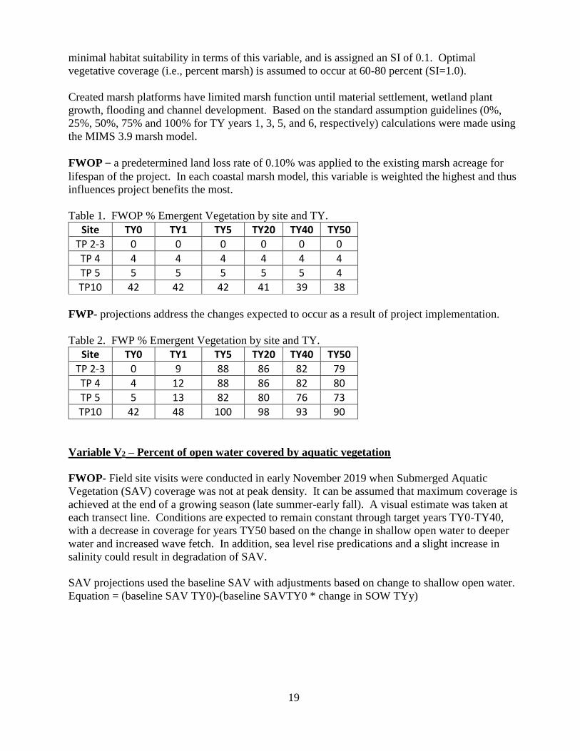
Table 1. FWOP % Emergent Vegetation by site and TY.
Site TY0 TY1 TY5 TY20 TY40 TY50
TP 2-3 0 0 0 0 0 0
TP 4 4 4 4 4 4 4
TP 5 5 5 5 5 5 4
TP10 42 42 42 41 39 38
FWP- projections address the changes expected to occur as a result of project implementation.
Table 2. FWP % Emergent Vegetation by site and TY.
Site TY0 TY1 TY5 TY20 TY40 TY50
TP 2-3 0 9 88 86 82 79
TP 4 4 12 88 86 82 80
TP 5 5 13 82 80 76 73
TP10 42 48 100 98 93 90
Variable V2 – Percent of open water covered by aquatic vegetation
FWOP- Field site visits were conducted in early November 2019 when Submerged Aquatic
Vegetation (SAV) coverage was not at peak density. It can be assumed that maximum coverage is
achieved at the end of a growing season (late summer-early fall). A visual estimate was taken at
each transect line. Conditions are expected to remain constant through target years TY0-TY40,
with a decrease in coverage for years TY50 based on the change in shallow open water to deeper
water and increased wave fetch. In addition, sea level rise predications and a slight increase in
salinity could result in degradation of SAV.
SAV projections used the baseline SAV with adjustments based on change to shallow open water.
Equation = (baseline SAV TY0)-(baseline SAVTY0 * change in SOW TYy)
20
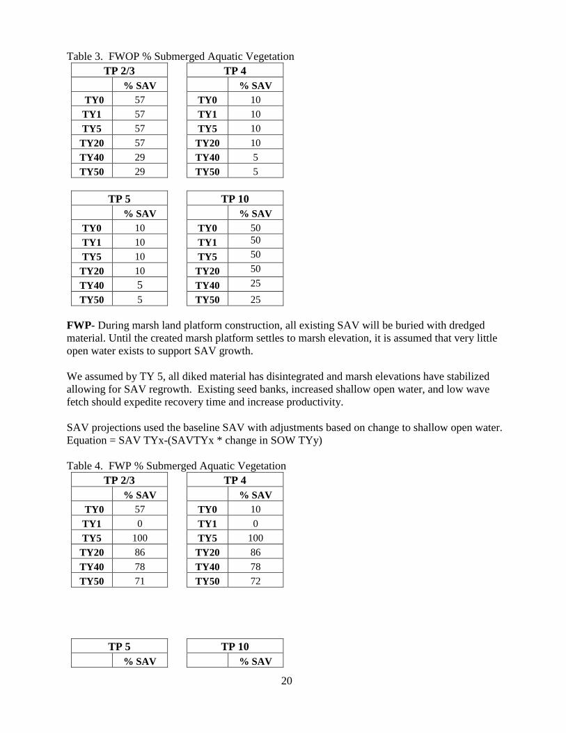
Table 3. FWOP % Submerged Aquatic Vegetation
TP 2/3 TP 4
% SAV % SAV
TY0 57 TY0 10
TY1 57 TY1 10
TY5 57 TY5 10
TY20 57 TY20 10
TY40 29 TY40 5
TY50 29 TY50 5
TP 5 TP 10
% SAV % SAV
TY0 10 TY0 50
TY1 10 TY1 50
TY5 10 TY5 50
TY20 10 TY20 50
TY40 5 TY40 25
TY50 5 TY50 25
FWP- During marsh land platform construction, all existing SAV will be buried with dredged
material. Until the created marsh platform settles to marsh elevation, it is assumed that very little
open water exists to support SAV growth.
We assumed by TY 5, all diked material has disintegrated and marsh elevations have stabilized
allowing for SAV regrowth. Existing seed banks, increased shallow open water, and low wave
fetch should expedite recovery time and increase productivity.
SAV projections used the baseline SAV with adjustments based on change to shallow open water.
Equation = SAV TYx-(SAVTYx * change in SOW TYy)
Table 4. FWP % Submerged Aquatic Vegetation
TP 2/3 TP 4
% SAV % SAV
TY0 57 TY0 10
TY1 0 TY1 0
TY5 100 TY5 100
TY20 86 TY20 86
TY40 78 TY40 78
TY50 71 TY50 72
TP 5 TP 10
% SAV % SAV
21
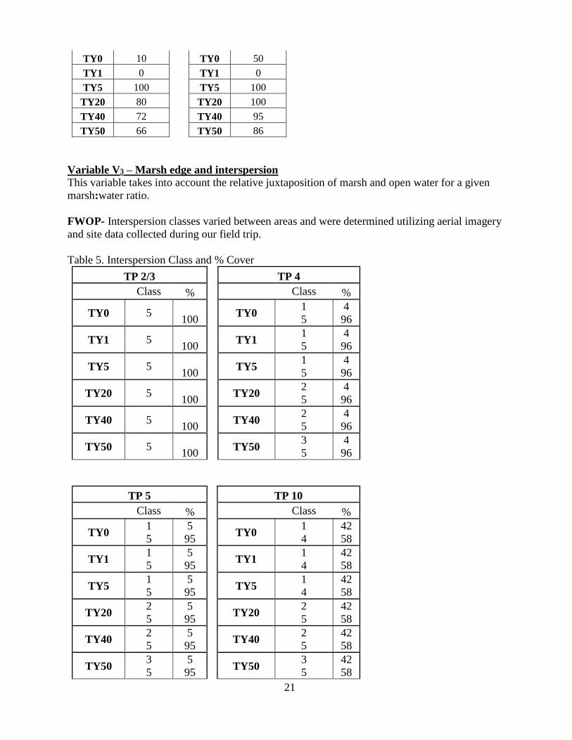
TY0 10 TY0 50
TY1 0 TY1 0
TY5 100 TY5 100
TY20 80 TY20 100
TY40 72 TY40 95
TY50 66 TY50 86
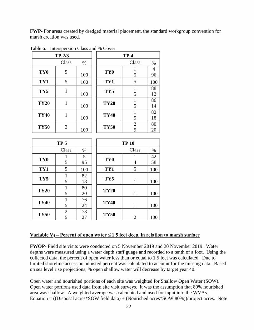
Variable V3 – Marsh edge and interspersion
This variable takes into account the relative juxtaposition of marsh and open water for a given
marsh:water ratio.
FWOP- Interspersion classes varied between areas and were determined utilizing aerial imagery
and site data collected during our field trip.
Table 5. Interspersion Class and % Cover
TP 2/3 TP 4
Class % Class %
TY0 5 100
TY0 1
5
4
96
TY1 5 100
TY1 1
5
4
96
TY5 5 100
TY5 1
5
4
96
TY20 5 100
TY20 2
5
4
96
TY40 5 100
TY40 2
5
4
96
TY50 5 100
TY50 3
5
4
96
TP 5 TP 10
Class % Class %
TY0 1
5
5
95 TY0
1
4
42
58
TY1 1
5
5
95 TY1
1
4
42
58
TY5 1
5
5
95 TY5
1
4
42
58
TY20 2
5
5
95 TY20
2
5
42
58
TY40 2
5
5
95 TY40
2
5
42
58
TY50 3
5
5
95 TY50
3
5
42
58
22
FWP- For areas created by dredged material placement, the standard workgroup convention for
marsh creation was used.
Table 6. Interspersion Class and % Cover
TP 2/3 TP 4
Class % Class %
TY0 5 100
TY0 1
5
4
96
TY1 5 100 TY1 5 100
TY5 1 100
TY5 1
5
88
12
TY20 1 100
TY20 1
5
86
14
TY40 1 100
TY40 1
5
82
18
TY50 2 100
TY50 2
5
80
20
TP 5 TP 10
Class % Class %
TY0 1
5
5
95 TY0
1
4
42
58
TY1 5 100 TY1 5 100
TY5 1
5
82
18 TY5
1 100
TY20 1
5
80
20 TY20
1 100
TY40 1
5
76
24 TY40
1 100
TY50 2
5
73
27 TY50
2 100
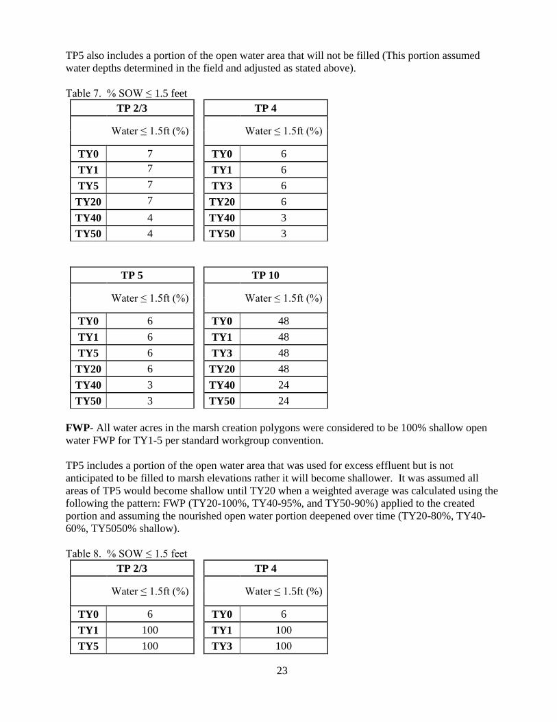
Variable V4 – Percent of open water ≤ 1.5 feet deep, in relation to marsh surface
FWOP- Field site visits were conducted on 5 November 2019 and 20 November 2019. Water
depths were measured using a water depth staff guage and recorded to a tenth of a foot. Using the
collected data, the percent of open water less than or equal to 1.5 feet was calculated. Due to
limited shoreline access an adjusted percent was calculated to account for the missing data. Based
on sea level rise projections, % open shallow water will decrease by target year 40.
Open water and nourished portions of each site was weighted for Shallow Open Water (SOW).
Open water portions used data from site visit surveys. It was the assumption that 80% nourished
area was shallow. A weighted average was calculated and used for input into the WVAs.
Equation = ((Disposal acres*SOW field data) + (Nourished acres*SOW 80%))/project acres. Note
23
TP5 also includes a portion of the open water area that will not be filled (This portion assumed
water depths determined in the field and adjusted as stated above).
Table 7. % SOW ≤ 1.5 feet
TP 2/3 TP 4
Water ≤ 1.5ft (%)
Water ≤ 1.5ft (%)
TY0 7 TY0 6
TY1 7 TY1 6
TY5 7 TY3 6
TY20 7 TY20 6
TY40 4 TY40 3
TY50 4 TY50 3
TP 5 TP 10
Water ≤ 1.5ft (%)
Water ≤ 1.5ft (%)
TY0 6 TY0 48
TY1 6 TY1 48
TY5 6 TY3 48
TY20 6 TY20 48
TY40 3 TY40 24
TY50 3 TY50 24
FWP- All water acres in the marsh creation polygons were considered to be 100% shallow open
water FWP for TY1-5 per standard workgroup convention.
TP5 includes a portion of the open water area that was used for excess effluent but is not
anticipated to be filled to marsh elevations rather it will become shallower. It was assumed all
areas of TP5 would become shallow until TY20 when a weighted average was calculated using the
following the pattern: FWP (TY20-100%, TY40-95%, and TY50-90%) applied to the created
portion and assuming the nourished open water portion deepened over time (TY20-80%, TY40-
60%, TY5050% shallow).
Table 8. % SOW ≤ 1.5 feet
TP 2/3 TP 4
Water ≤ 1.5ft (%)
Water ≤ 1.5ft (%)
TY0 6 TY0 6
TY1 100 TY1 100
TY5 100 TY3 100
24
TY20 86 TY20 86
TY40 78 TY40 78
TY50 71 TY50 72
TP 5 TP 10
Water ≤ 1.5ft (%)
Water ≤ 1.5ft (%) 57
TY0 6 TY0 48
TY1 100 TY1 100
TY5 100 TY3 100
TY20 80 TY20 100
TY40 72 TY40 95
TY50 66 TY50 90
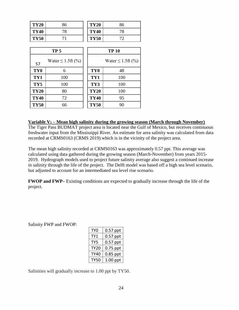
Variable V5 – Mean high salinity during the growing season (March through November)
The Tiger Pass BUDMAT project area is located near the Gulf of Mexico, but receives continuous
freshwater input from the Mississippi River. An estimate for area salinity was calculated from data
recorded at CRMS0163 (CRMS 2019) which is in the vicinity of the project area.
The mean high salinity recorded at CRMS0163 was approximately 0.57 ppt. This average was
calculated using data gathered during the growing season (March-November) from years 2015-
2019. Hydrograph models used to project future salinity average also suggest a continued increase
in salinity through the life of the project. The Delft model was based off a high sea level scenario,
but adjusted to account for an intermediated sea level rise scenario.
FWOP and FWP– Existing conditions are expected to gradually increase through the life of the
project.
Salinity FWP and FWOP:
TY0 0.57 ppt
TY1 0.57 ppt
TY5 0.57 ppt
TY20 0.75 ppt
TY40 0.85 ppt
TY50 1.00 ppt
Salinities will gradually increase to 1.00 ppt by TY50.
25
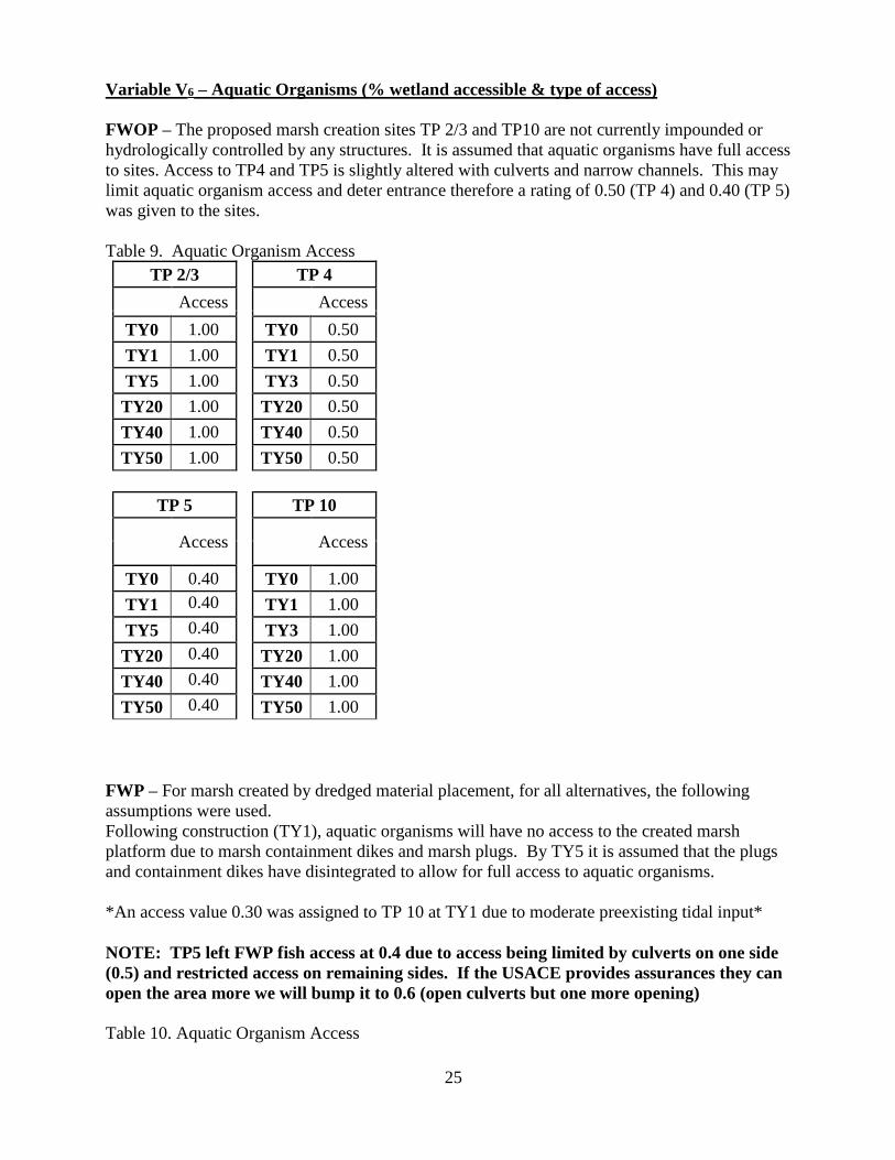
Variable V6 – Aquatic Organisms (% wetland accessible & type of access)
FWOP – The proposed marsh creation sites TP 2/3 and TP10 are not currently impounded or
hydrologically controlled by any structures. It is assumed that aquatic organisms have full access
to sites. Access to TP4 and TP5 is slightly altered with culverts and narrow channels. This may
limit aquatic organism access and deter entrance therefore a rating of 0.50 (TP 4) and 0.40 (TP 5)
was given to the sites.
Table 9. Aquatic Organism Access
TP 2/3 TP 4
Access
Access TY0 1.00 TY0 0.50
TY1 1.00 TY1 0.50
TY5 1.00 TY3 0.50
TY20 1.00 TY20 0.50
TY40 1.00 TY40 0.50
TY50 1.00 TY50 0.50
TP 5 TP 10
Access
Access
TY0 0.40 TY0 1.00
TY1 0.40 TY1 1.00
TY5 0.40 TY3 1.00
TY20 0.40 TY20 1.00
TY40 0.40 TY40 1.00
TY50 0.40 TY50 1.00
FWP – For marsh created by dredged material placement, for all alternatives, the following
assumptions were used.
Following construction (TY1), aquatic organisms will have no access to the created marsh
platform due to marsh containment dikes and marsh plugs. By TY5 it is assumed that the plugs
and containment dikes have disintegrated to allow for full access to aquatic organisms.
*An access value 0.30 was assigned to TP 10 at TY1 due to moderate preexisting tidal input*
NOTE: TP5 left FWP fish access at 0.4 due to access being limited by culverts on one side
(0.5) and restricted access on remaining sides. If the USACE provides assurances they can
open the area more we will bump it to 0.6 (open culverts but one more opening)
Table 10. Aquatic Organism Access
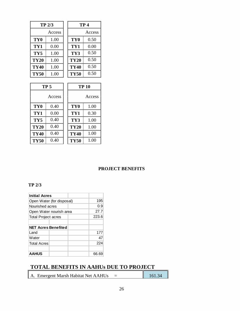
26
TP 2/3 TP 4
Access
Access TY0 1.00 TY0 0.50
TY1 0.00 TY1 0.00
TY5 1.00 TY3 0.50
TY20 1.00 TY20 0.50
TY40 1.00 TY40 0.50
TY50 1.00 TY50 0.50
TP 5 TP 10
Access
Access
TY0 0.40 TY0 1.00
TY1 0.00 TY1 0.30
TY5 0.40 TY3 1.00
TY20 0.40 TY20 1.00
TY40 0.40 TY40 1.00
TY50 0.40 TY50 1.00
PROJECT BENEFITS
TP 2/3
TOTAL BENEFITS IN AAHUs DUE TO PROJECT
A. Emergent Marsh Habitat Net AAHUs = 161.34
Initial Acres
Open Water (for disposal) 195
Nourished acres 0.9
Open Water nourish area 27.7
Total Project acres 223.6
NET Acres Benefited
Land 177
Water 47
Total Acres 224
AAHUS 66.69
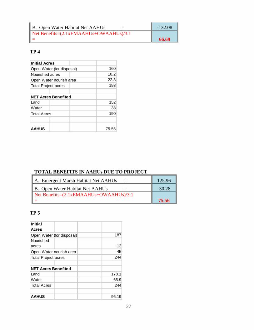
27
B. Open Water Habitat Net AAHUs = -132.08
Net Benefits=(2.1xEMAAHUs+OWAAHUs)/3.1
= 66.69
TP 4
TOTAL BENEFITS IN AAHUs DUE TO PROJECT
A. Emergent Marsh Habitat Net AAHUs = 125.96
B. Open Water Habitat Net AAHUs = -30.28
Net Benefits=(2.1xEMAAHUs+OWAAHUs)/3.1
= 75.56
TP 5
Initial Acres
Open Water (for disposal) 160
Nourished acres 10.2
Open Water nourish area 22.8
Total Project acres 193
NET Acres Benefited
Land 152
Water 38
Total Acres 190
AAHUS 75.56
Initial
Acres
Open Water (for disposal) 187
Nourished
acres 12
Open Water nourish area 45
Total Project acres 244
NET Acres Benefited
Land 178.1
Water 65.9
Total Acres 244
AAHUS 96.19
28
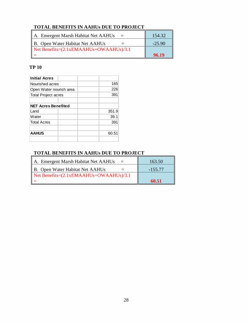
TOTAL BENEFITS IN AAHUs DUE TO PROJECT
A. Emergent Marsh Habitat Net AAHUs = 154.32
B. Open Water Habitat Net AAHUs = -25.90
Net Benefits=(2.1xEMAAHUs+OWAAHUs)/3.1
= 96.19
TP 10
TOTAL BENEFITS IN AAHUs DUE TO PROJECT
A. Emergent Marsh Habitat Net AAHUs = 163.50
B. Open Water Habitat Net AAHUs = -155.77
Net Benefits=(2.1xEMAAHUs+OWAAHUs)/3.1
= 60.51
Initial Acres
Nourished acres 165
Open Water nourish area 226
Total Project acres 391
NET Acres Benefited
Land 351.9
Water 39.1
Total Acres 391
AAHUS 60.51
29
Conclusion
The WVA operates under the assumption that a value can be assigned to a given habitat, which
can then be quantified through the use of community driven modeling to produce a single value
referred to as the Habitat Suitability Index, or HSI. However, limitations do exist and not all types
of future benefits are captured through the use of this type of modeling.
Knowing TP10 would initially create 226 acres of new marsh and nourish165 acres of existing
marsh we know the project will have a greater benefit to a larger area (352 acres) than of any of
the alternatives and therefore should produce the greatest marsh creation and nourishment benefits
(represented by Average Annual Habitat Units, or AAHUs). However, application of the WVA
model results in the lowest AAHU score of all the sites evaluated. Similarly, TP 2/3 would create
195 acres and nourish 28.6 and results in the second lowest AAHU score. While counter intuitive,
the low land loss rate of the larger study areas (0.10% per year for the period 1985-2016) and
relatively high areas of nourishment, coupled with an abundance of preexisting SAV and shallow
open water, drives the modeled numbers down. Because the loss rates in the project area are so
low, the water is already shallow, and SAVs already exists, the difference shown between the
future with project compared to future without project are not as great as the other alternatives. TP
4 and TP 5 result in a greater difference between the two futures for these variables since they are
in poorer condition, are deeper, have less surrounding marsh, and have less SAVs.
In the case of TP 2/3 and TP10, the HET and PDT should take into account impacts that go
beyond the standard WVA variables. In this instance, we know if TP10 is left unchecked the area
would worsen with time and become more expensive to restore in the future. This area is the most
natural and healthy of all the sites because it maintains tidal inlets, water movement, ingress and
egress, while some of the other alternatives are enclosed with restricted access and minimal water
flow (even stagnate). Therefore, fortifying this more natural area would result in a more desirable
and healthy habitat compared to some of the other alternatives which would create marsh that may
not function as fully as marsh in a natural system.
TP10 has the highest amount of existing shallow open water and SAV and still maintains a degree
of broken marsh. It lies adjacent to a larger bay open to the Gulf of Mexico. This site’s
surrounding marsh is the only remaining protection from daily wave action and periodic storm
events that would cause breaching between the site and the adjacent open bay. A breach would
exacerbate loss rates, increase wave fetch and impacts from storms, increase deeper open water,
and decrease SAV growth.
Comparably TP 2/3 is also a productive and healthy site, with a relatively high degree of
connectivity and tidal exchange. It is a mostly self-contained site with shallow open water and
SAV. Existing marsh boundaries help insulate the site from the degrading effects of wave action
which can intensify loss rates. Located between Tiger Pass and Grand Pass, its proximity to
Plaquemines Parish could protect critical infrastructure and reduce impacts from storm surge.
Historic loss rates of the larger study area are some of the lowest in Louisiana’s coast, the WVA
maintains most of the existing marsh and does not capture the localized potential losses to TP 2/3
and TP 10 marsh, shallow open water, and SAVs. While both TP 2/3 and TP 10 would enhance
current conditions, we know the new and created marsh of these alternative will be more resilient
(built to a higher elevation and having better soil conditions), the initial loss of SAV would

30
rebound rapidly, shallow open water would be increased, and by creating and nourishing this
wetland, the marsh will maintain a stronger more healthy habitat that will withstand wave action
and storm events for longer.
While the WVA model is considered a trusted tool when assessing wetland benefits, best
professional judgment should still be applied. The above mentioned issues (the driving forces of
the lower AAHUs, the natural habitat of TP 2/3 and TP 10, and the impacts of the localized area
losses), should be considered along with the WVA outputs.
31
Literature Cited
Coastal Protection and Restoration Authority of Louisiana. 2017. Louisiana’s Comprehensive
Master Plan for a Sustainable Coast. Coastal Protection and Restoration Authority of
Louisiana. Baton Rouge, LA.
Louisiana Office of Coastal Protection and Restoration. 2019. Coastwide Reference Monitoring
System-Wetlands Monitoring Data. Retrieved from Coastal Information Management
System (CIMS) database. http://cims.coastal.louisiana.gov. Accessed January 2019.
U.S. Army Engineer Research and Development Center (ERDC) ran the AdH hydraulic model for
the Louisiana Coastal Area Mississippi River Delta Management Study. 2016. Developed
and run by Gary Brown (ERDC)
1
Sprinkle, Hannah H
From: Meden, Daniel C CIV USARMY CEMVN (USA) <[email protected]>Sent: Tuesday, July 7, 2020 10:09 AMTo: Sprinkle, Hannah HCc: Gilmore, Tammy F CIV USARMY CEMVN (USA); Breaux, Catherine; january murray -
NOAA Federal ([email protected]); Michael Tucker - NOAA FederalSubject: [EXTERNAL] Concurrence with T&E for MROV BUDMAT project (UNCLASSIFIED)Attachments: MROV Section 4 - T&E .docx
This email has been received from outside of DOI - Use caution before clicking on links, opening attachments, or responding.
CLASSIFICATION: UNCLASSIFIED
Hey Hannah,
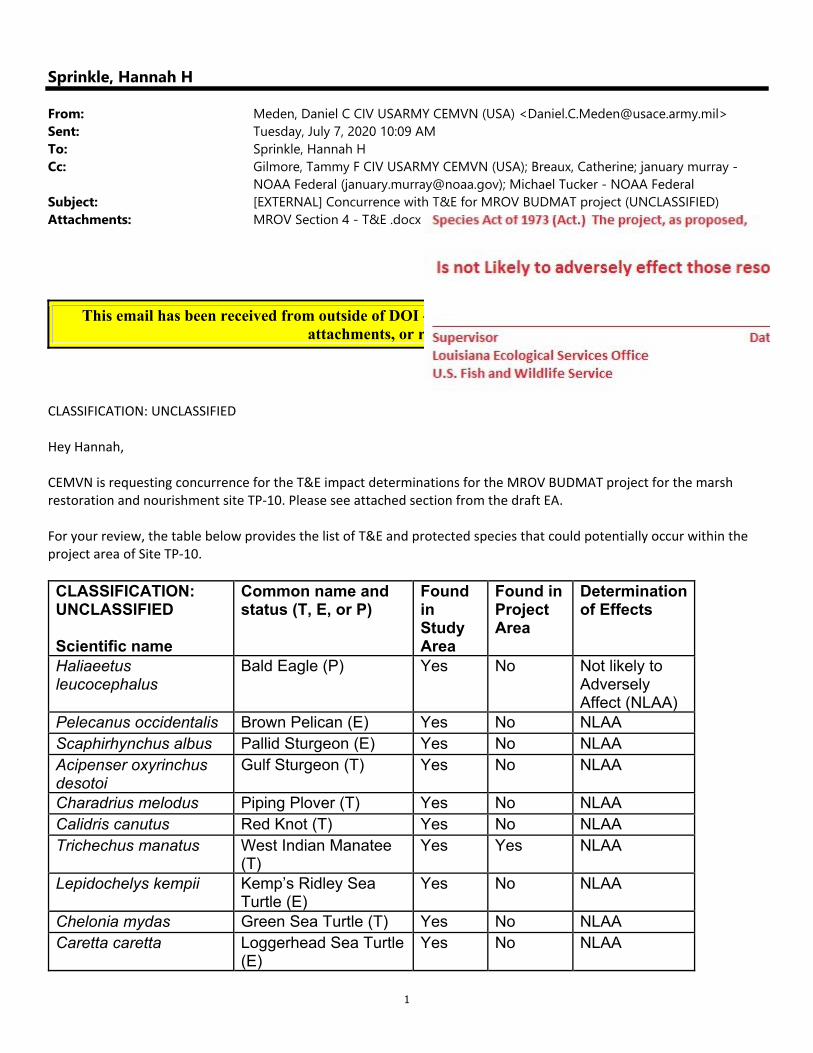
CEMVN is requesting concurrence for the T&E impact determinations for the MROV BUDMAT project for the marsh restoration and nourishment site TP‐10. Please see attached section from the draft EA.
For your review, the table below provides the list of T&E and protected species that could potentially occur within the project area of Site TP‐10.
CLASSIFICATION: UNCLASSIFIED
Scientific name
Common name and status (T, E, or P)
Found in Study Area
Found in Project Area
Determination of Effects
Haliaeetus leucocephalus
Bald Eagle (P) Yes No Not likely to Adversely Affect (NLAA)
Pelecanus occidentalis Brown Pelican (E) Yes No NLAA Scaphirhynchus albus Pallid Sturgeon (E) Yes No NLAA Acipenser oxyrinchus desotoi
Gulf Sturgeon (T) Yes No NLAA
Charadrius melodus Piping Plover (T) Yes No NLAA Calidris canutus Red Knot (T) Yes No NLAA Trichechus manatus West Indian Manatee
(T) Yes Yes NLAA
Lepidochelys kempii Kemp’s Ridley Sea Turtle (E)
Yes No NLAA
Chelonia mydas Green Sea Turtle (T) Yes No NLAA Caretta caretta Loggerhead Sea Turtle
(E) Yes No NLAA

2
Thank you! Daniel Meden Biologist, Coastal Environmental Planning RPEDS, New Orleans District Office: 504‐862‐1014 CLASSIFICATION: UNCLASSIFIED
1
Sprinkle, Hannah H
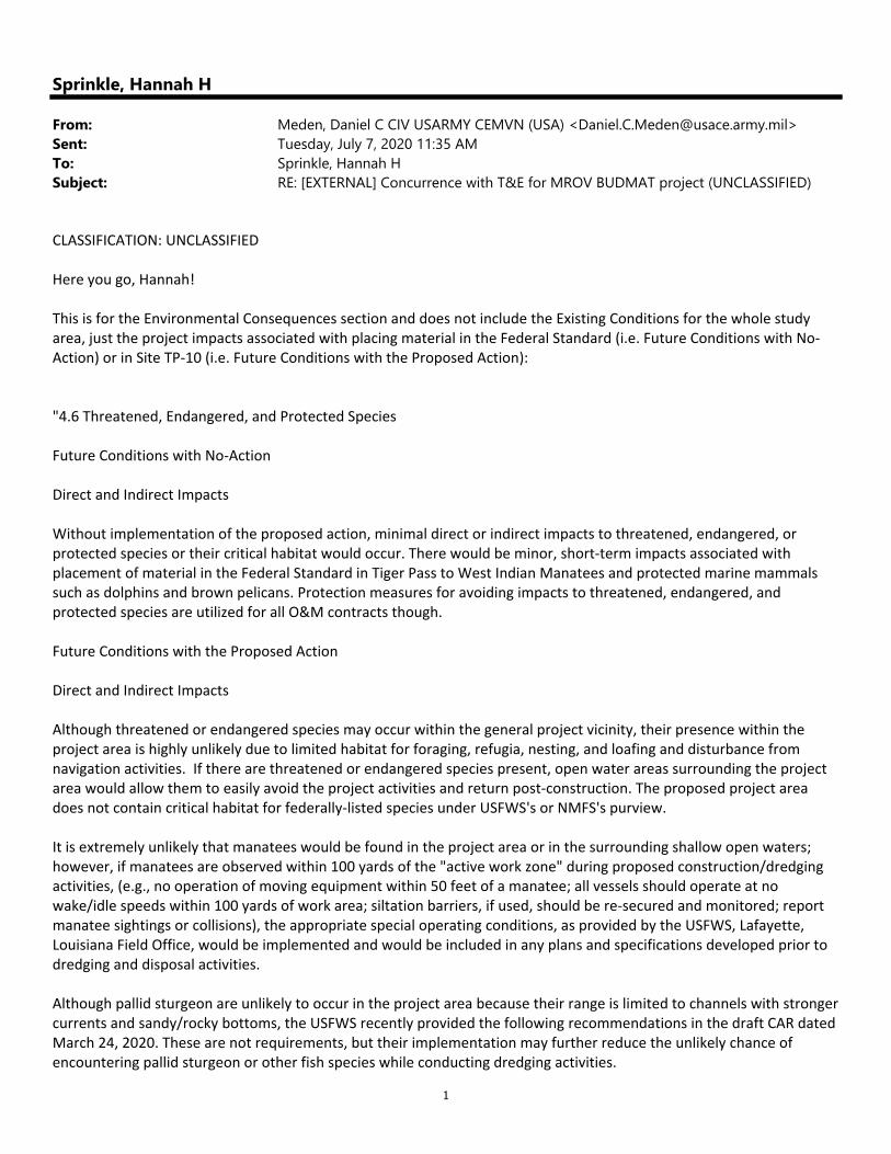
From: Meden, Daniel C CIV USARMY CEMVN (USA) <[email protected]>Sent: Tuesday, July 7, 2020 11:35 AMTo: Sprinkle, Hannah HSubject: RE: [EXTERNAL] Concurrence with T&E for MROV BUDMAT project (UNCLASSIFIED)
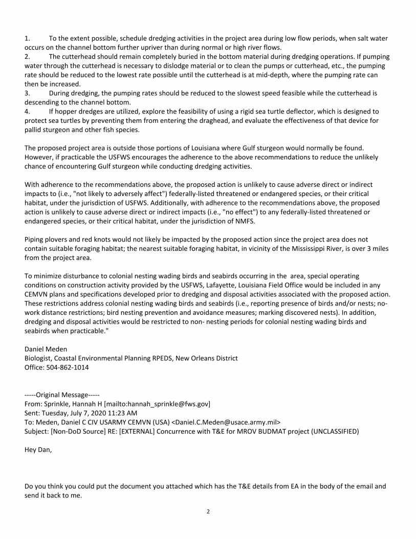
CLASSIFICATION: UNCLASSIFIED Here you go, Hannah! This is for the Environmental Consequences section and does not include the Existing Conditions for the whole study area, just the project impacts associated with placing material in the Federal Standard (i.e. Future Conditions with No‐Action) or in Site TP‐10 (i.e. Future Conditions with the Proposed Action): "4.6 Threatened, Endangered, and Protected Species Future Conditions with No‐Action Direct and Indirect Impacts Without implementation of the proposed action, minimal direct or indirect impacts to threatened, endangered, or protected species or their critical habitat would occur. There would be minor, short‐term impacts associated with placement of material in the Federal Standard in Tiger Pass to West Indian Manatees and protected marine mammals such as dolphins and brown pelicans. Protection measures for avoiding impacts to threatened, endangered, and protected species are utilized for all O&M contracts though. Future Conditions with the Proposed Action Direct and Indirect Impacts Although threatened or endangered species may occur within the general project vicinity, their presence within the project area is highly unlikely due to limited habitat for foraging, refugia, nesting, and loafing and disturbance from navigation activities. If there are threatened or endangered species present, open water areas surrounding the project area would allow them to easily avoid the project activities and return post‐construction. The proposed project area does not contain critical habitat for federally‐listed species under USFWS's or NMFS's purview. It is extremely unlikely that manatees would be found in the project area or in the surrounding shallow open waters; however, if manatees are observed within 100 yards of the "active work zone" during proposed construction/dredging activities, (e.g., no operation of moving equipment within 50 feet of a manatee; all vessels should operate at no wake/idle speeds within 100 yards of work area; siltation barriers, if used, should be re‐secured and monitored; report manatee sightings or collisions), the appropriate special operating conditions, as provided by the USFWS, Lafayette, Louisiana Field Office, would be implemented and would be included in any plans and specifications developed prior to dredging and disposal activities. Although pallid sturgeon are unlikely to occur in the project area because their range is limited to channels with stronger currents and sandy/rocky bottoms, the USFWS recently provided the following recommendations in the draft CAR dated March 24, 2020. These are not requirements, but their implementation may further reduce the unlikely chance of encountering pallid sturgeon or other fish species while conducting dredging activities.
2
1. To the extent possible, schedule dredging activities in the project area during low flow periods, when salt water occurs on the channel bottom further upriver than during normal or high river flows. 2. The cutterhead should remain completely buried in the bottom material during dredging operations. If pumping water through the cutterhead is necessary to dislodge material or to clean the pumps or cutterhead, etc., the pumping rate should be reduced to the lowest rate possible until the cutterhead is at mid‐depth, where the pumping rate can then be increased. 3. During dredging, the pumping rates should be reduced to the slowest speed feasible while the cutterhead is descending to the channel bottom. 4. If hopper dredges are utilized, explore the feasibility of using a rigid sea turtle deflector, which is designed to protect sea turtles by preventing them from entering the draghead, and evaluate the effectiveness of that device for pallid sturgeon and other fish species. The proposed project area is outside those portions of Louisiana where Gulf sturgeon would normally be found. However, if practicable the USFWS encourages the adherence to the above recommendations to reduce the unlikely chance of encountering Gulf sturgeon while conducting dredging activities. With adherence to the recommendations above, the proposed action is unlikely to cause adverse direct or indirect impacts to (i.e., "not likely to adversely affect") federally‐listed threatened or endangered species, or their critical habitat, under the jurisdiction of USFWS. Additionally, with adherence to the recommendations above, the proposed action is unlikely to cause adverse direct or indirect impacts (i.e., "no effect") to any federally‐listed threatened or endangered species, or their critical habitat, under the jurisdiction of NMFS. Piping plovers and red knots would not likely be impacted by the proposed action since the project area does not contain suitable foraging habitat; the nearest suitable foraging habitat, in vicinity of the Mississippi River, is over 3 miles from the project area. To minimize disturbance to colonial nesting wading birds and seabirds occurring in the area, special operating conditions on construction activity provided by the USFWS, Lafayette, Louisiana Field Office would be included in any CEMVN plans and specifications developed prior to dredging and disposal activities associated with the proposed action. These restrictions address colonial nesting wading birds and seabirds (i.e., reporting presence of birds and/or nests; no‐work distance restrictions; bird nesting prevention and avoidance measures; marking discovered nests). In addition, dredging and disposal activities would be restricted to non‐ nesting periods for colonial nesting wading birds and seabirds when practicable." Daniel Meden Biologist, Coastal Environmental Planning RPEDS, New Orleans District Office: 504‐862‐1014 ‐‐‐‐‐Original Message‐‐‐‐‐ From: Sprinkle, Hannah H [mailto:[email protected]] Sent: Tuesday, July 7, 2020 11:23 AM To: Meden, Daniel C CIV USARMY CEMVN (USA) <[email protected]> Subject: [Non‐DoD Source] RE: [EXTERNAL] Concurrence with T&E for MROV BUDMAT project (UNCLASSIFIED) Hey Dan, Do you think you could put the document you attached which has the T&E details from EA in the body of the email and send it back to me.
3
Hannah From: Meden, Daniel C CIV USARMY CEMVN (USA) <[email protected]> Sent: Tuesday, July 7, 2020 10:09 AM To: Sprinkle, Hannah H <[email protected]> Cc: Gilmore, Tammy F CIV USARMY CEMVN (USA) <[email protected]>; Breaux, Catherine <[email protected]>; january murray ‐ NOAA Federal ([email protected]) <[email protected]>; Michael Tucker ‐ NOAA Federal <[email protected]> Subject: [EXTERNAL] Concurrence with T&E for MROV BUDMAT project (UNCLASSIFIED) This email has been received from outside of DOI ‐ Use caution before clicking on links, opening attachments, or responding. CLASSIFICATION: UNCLASSIFIED Hey Hannah, CEMVN is requesting concurrence for the T&E impact determinations for the MROV BUDMAT project for the marsh restoration and nourishment site TP‐10. Please see attached section from the draft EA. For your review, the table below provides the list of T&E and protected species that could potentially occur within the project area of Site TP‐10. CLASSIFICATION: UNCLASSIFIED Scientific name Common name and status (T, E, or P) Found in Study Area
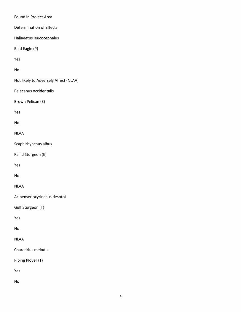
4
Found in Project Area Determination of Effects Haliaeetus leucocephalus Bald Eagle (P) Yes No Not likely to Adversely Affect (NLAA) Pelecanus occidentalis Brown Pelican (E) Yes No NLAA Scaphirhynchus albus Pallid Sturgeon (E) Yes No NLAA Acipenser oxyrinchus desotoi Gulf Sturgeon (T) Yes No NLAA Charadrius melodus Piping Plover (T) Yes No
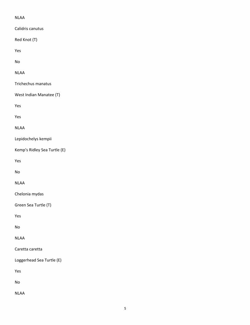
5
NLAA Calidris canutus Red Knot (T) Yes No NLAA Trichechus manatus West Indian Manatee (T) Yes Yes NLAA Lepidochelys kempii Kemp's Ridley Sea Turtle (E) Yes No NLAA Chelonia mydas Green Sea Turtle (T) Yes No NLAA Caretta caretta Loggerhead Sea Turtle (E) Yes No NLAA
6
Thank you! Daniel Meden Biologist, Coastal Environmental Planning RPEDS, New Orleans District Office: 504‐862‐1014 CLASSIFICATION: UNCLASSIFIED CLASSIFICATION: UNCLASSIFIED
March 20, 2020
Charles Reulet, Administrator
Louisiana Department of Natural Resources
Office of Coastal Management
P.O. Box 44487
Baton Rouge, LA 70804-4487
RE: Application Number: C20200033
Applicant: U.S. Army Corps of Engineers-New Orleans District
Notice Date: March 13, 2020
Dear Mr. Reulet:
The professional staff of the Louisiana Department of Wildlife and Fisheries (LDWF) has reviewed the proposed
Louisiana Coastal Area (LCA) Beneficial Use of Dredged Material Program (BUDMAT) project at Mississippi
River Outlets at Venice to beneficially use dredged material removed from the Tiger Pass federal navigation
channel located within Plaquemines Parish in the vicinity of Venice, Louisiana. Based upon this review, the
following has been determined:
General Comments
LDWF strongly supports the beneficial use of dredged material from Tiger Pass maintenance and other
navigational dredging projects and believe that fortifying the Mississippi River Delta marshes will help
reestablish deteriorated marshes and nourish existing marsh within the project area.
Wildlife Diversity Program:
Manatee
Manatee (Trichechus manatus) may occur in the surrounding water bodies of your site location.
Manatees are large mammals inhabiting both fresh and salt water. Although most manatees are year round
residents of Florida or Central America, they have been known to migrate to areas along the Atlantic and
Gulf coast during the summer months. Manatee is a threatened species protected under the Endangered
Species Act of 1973 and the Federal Marine Mammal Protection Act of 1972. In Louisiana, taking or
harassment of a manatee is in violation of state and federal law. Critical habitat for manatee includes
marine submergent vascular vegetation (sea-grass beds). Areas with sea-grass beds should be avoided
during project activities if possible. Report all manatee sightings to the LDWF at 337-735-8676 or 1-800-
442-2511.
Bird Nesting Colonies
Our database indicates the presence of bird nesting colonies within one mile of this proposed project.
Please be aware that entry into or disturbance of active breeding colonies is prohibited by LDWF.
In addition, LDWF prohibits work within a certain radius of an active nesting colony.
Nesting colonies can move from year to year and no current information is available on the status of these
colonies. If work for the proposed project will commence during the nesting season, conduct a field visit
Page 2
Application Number: C20200033
March 20, 2020
to the worksite to look for evidence of nesting colonies. This field visit should take place no more than
two weeks before the project begins. If no nesting colonies are found within 1000 feet (2000 feet for
Brown Pelicans) of the proposed project, no further consultation with LDWF will be necessary. If active
nesting colonies are found within the previously stated distances of the proposed project, further
consultation with LDWF will be required. In addition, colonies should be surveyed by a qualified
biologist to document species present and the extent of colonies. Provide LDWF with a survey report
which is to include the following information:
1. qualifications of survey personnel;
2. survey methodology including dates, site characteristics, and size of survey area;
3. species of birds present, activity, estimates of number of nests present, and general vegetation type
including digital photographs representing the site; and
4. topographic maps and ArcView shapefiles projected in UTM NAD83 Zone 15 to illustrate the
location and extent of the colony.
Please mail survey reports on CD to: Wildlife Diversity Program
La. Dept. of Wildlife & Fisheries
P.O. Box 98000
Baton Rouge, LA 70898-9000
To minimize disturbance to colonial nesting birds, the following restrictions on activity should be
observed:
- For colonies containing nesting wading birds (i.e., herons, egrets, night-herons, ibis, Roseate Spoonbills,
Anhingas, or cormorants), all project activity occurring within 1000 feet of an active nesting colony
should be restricted to the non-nesting period (i.e., September 1 through February 15).
- For colonies containing nesting gulls, terns, or Black Skimmers, all project activity occurring within 650
feet (2000 feet for Brown Pelicans) of an active nesting colony should be restricted to the non-nesting
period (i.e., September 16 through April 1).
No other impacts to rare, threatened or endangered species or critical habitats are anticipated from the
proposed project. No state or federal parks, wildlife refuges, wildlife management areas or scenic rivers
are known at the specified site or within ¼ mile of the proposed project.
The Wildlife Diversity Program (WDP) reports summarize the existing information known at the time of
the request regarding the location in question. WDP reports should not be considered final statements on
the biological elements or areas being considered, nor should they be substituted for on-site surveys
required for environmental assessments. If at any time WDP tracked species are encountered within the
project area, please contact our biologist at 225-765-2643.
The Louisiana Department of Wildlife and Fisheries appreciates the opportunity to review and provide
recommendations to you regarding this proposed activity. Please do not hesitate to contact LDWF Permits
Coordinator Dave Butler at 225-763-3595 should you need further assistance.
Sincerely,
/S/ Kyle F. Balkum
Kyle F. Balkum
Biologist Director
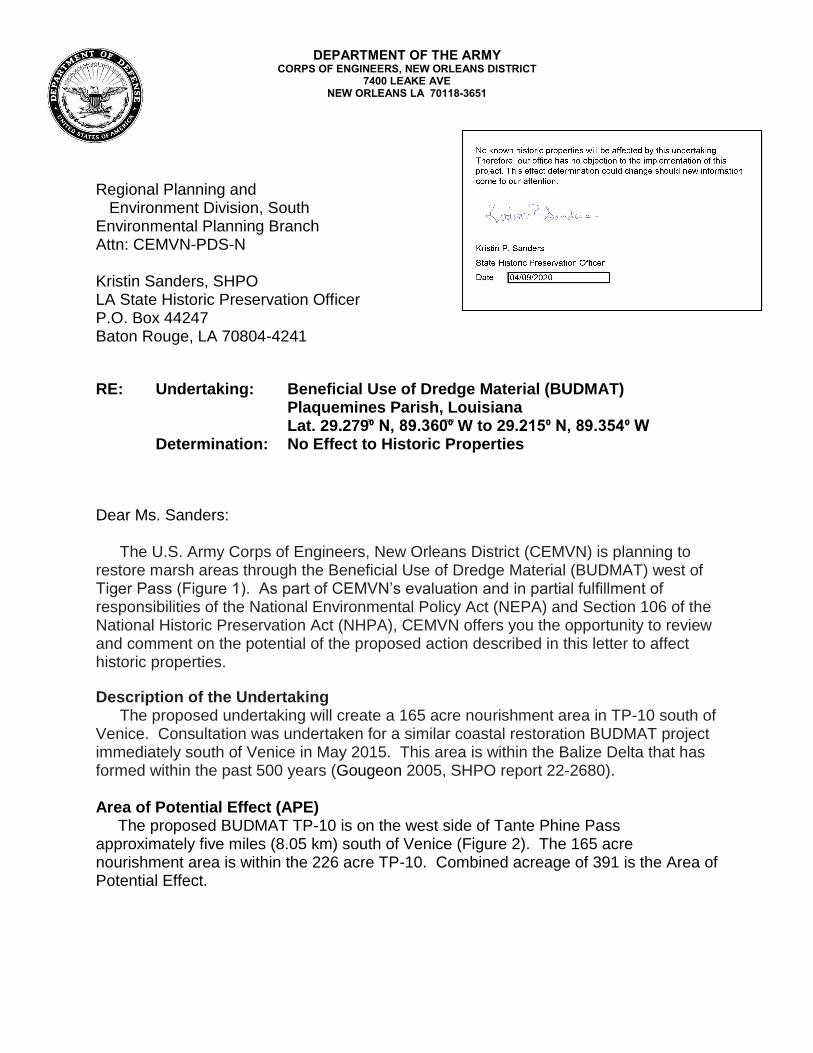
DEPARTMENT OF THE ARMY CORPS OF ENGINEERS, NEW ORLEANS DISTRICT
7400 LEAKE AVE NEW ORLEANS LA 70118-3651
Regional Planning and Environment Division, South Environmental Planning Branch Attn: CEMVN-PDS-N
Kristin Sanders, SHPO LA State Historic Preservation Officer P.O. Box 44247 Baton Rouge, LA 70804-4241
RE: Undertaking: Beneficial Use of Dredge Material (BUDMAT) Plaquemines Parish, Louisiana Lat. 29.279֩⁰ N, 89.360⁰ ֩ ֠ ֩ W to 29.215⁰ N, 89.354⁰ W
Determination: No Effect to Historic Properties
Dear Ms. Sanders:
The U.S. Army Corps of Engineers, New Orleans District (CEMVN) is planning to restore marsh areas through the Beneficial Use of Dredge Material (BUDMAT) west of Tiger Pass (Figure 1). As part of CEMVN’s evaluation and in partial fulfillment of responsibilities of the National Environmental Policy Act (NEPA) and Section 106 of the National Historic Preservation Act (NHPA), CEMVN offers you the opportunity to review and comment on the potential of the proposed action described in this letter to affect historic properties.
Description of the Undertaking The proposed undertaking will create a 165 acre nourishment area in TP-10 south of
Venice. Consultation was undertaken for a similar coastal restoration BUDMAT project immediately south of Venice in May 2015. This area is within the Balize Delta that has formed within the past 500 years (Gougeon 2005, SHPO report 22-2680).
Area of Potential Effect (APE) The proposed BUDMAT TP-10 is on the west side of Tante Phine Pass approximately five miles (8.05 km) south of Venice (Figure 2). The 165 acre nourishment area is within the 226 acre TP-10. Combined acreage of 391 is the Area of Potential Effect.
-2-
Identification and Evaluation A series of document and archival resources (SHPO reports 22-0073, and 22-
0918) and archaeological surveys (SHPO reports 22-0560, 22-2358, 22-4120) have been conducted for this reach of the Mississippi River in Plaquemines Parish. There two reported archaeological sites in the vicinity of TP-10. The Jump site (16PL48) is included in the literature search by the National Park Service (SHPO 22-0918). The site record states that 16PL48 is on Grand Pass “immediately below Venice.” Jump is a fishing village depicted on an 1884 map that had been destroyed by petroleum operations prior to a 1978 archaeological survey (SHPO report 22-0328). Campbell’s Derrick (16PL60) is in open water 5.8 miles (9.34 km) south if Venice. The site, which was reported in 1978 as a possible oil derrick could not be relocated in June 2010. Site 16PL60 is or was approximately 1,200 meters east of TP-10. No other historic properties are within 1,200 meters if TP-10 and there are no NRHP eligible properties in the APE. Assessment of Effects
Based on the information presented in this letter, CEMVN has determined that there are no historic properties in the APE. Therefore CEMVN is making a determination of No Effect to Historic Properties for this undertaking and is submitting it to you for your review and comment. This project will be subject to the standard change of scope of work, inadvertent discovery, and unmarked human burial sites act provisions. CEMVN requests your comments within 30 days.
We look forward to your concurrence with this determination. Should you have any questions or need additional information, please contact J. T. Penman, Archaeologist at (504) 862-1373, [email protected], U.S. Army Corps of Engineers, New Orleans District.
Sincerely, MARSHALL K. HARPER Chief, Environmental Planning Branch
CC: File
LA SHPO An electronic copy of this letter with enclosures will be provided to the Section 106 Inbox, [email protected].
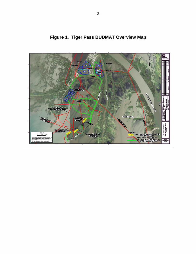
-3-
Figure 1. Tiger Pass BUDMAT Overview Map
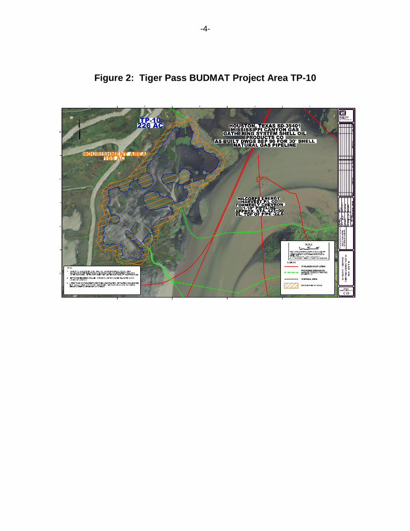
-4-
Figure 2: Tiger Pass BUDMAT Project Area TP-10
-5-
Reference
Davis, Dave D., John D. Hartley, and Ruth Wiens Henderson 1981 Cultural Resources Survey, New Orleans to Venice Hurricane Protection Levee:
East Bank Barrier Levee Program. Department of Anthropology, Tulane University. SHPO report 22-0560.
Gagliano, Sherwood M., Katherine L. Brooks, and Ben A. Small 1978 Cultural Resource Survey of Grand and Tiger Passes and Baptiste Collette
Bayou, Plaquemines Parish, Louisiana. Coastal Environments, Inc. Baton Rouge. SHPO report 22-0328.
Gougeon, Ramie A. 2005 A Phase I Cultural-Resource Survey of the Freeport-McMoRan Main Pass
Energy Hub (MPEH) Pipeline, Plaquemines Parish, Louisiana. Panamerican Consultants, Inc. Tuscaloosa, Alabama. SHPO report 22-2680.
Montgomery, John L., Keith Landreth, Joan Exnicios, Kathleen Bowman, and James Bowman
1988 Final Report of Cultural Resource Investigations within the U.S. Army Corps of Engineers New Orleans to Venice Hurricane Protection Project. Agency for Conservation Archaeology. SHPO report 22-1274.
National Park Service 1984 Mississippi River Cultural Resources Survey: A Comprehensive Study. Denver
Service Center, National Park Service. U.S. Department of the Interior. SHPO report 22-0918.
Neuman, Robert W. 1975 Archaeological Survey of the Mississippi River Outlets, Venice Vicinity,
Louisiana. Curator of Anthropology, Louisiana State University. Baton Rouge. SHPO report 22-0073.
Pearson, Charles E. and Joanne Ryan 2012 Negative Findings: Phase I Cultural Resources Survey for the Proposed
Vegetated Ridge Project, Plaquemines Parish, Louisiana. Coastal Environments, Inc. Baton Rouge. SHPO report 22-4120.
Shenkel, J. Richard 1977 Cultural Resources Survey of the Nashville Avenue to Napoleon Avenue
Floodwall, Mississippi River Levees, Item M-100-L, Orleans Levee District, Orleans Parish, Louisiana. Submitted to U.S. Army Corps of Engineers. New Orleans. SHPO report 22-53.
White, Andrea P. 2012 The Greater New Orleans Archaeological GIS Project: End of Grant Report.
Office of Equal Opportunity. Washington, DC. SHPO report 22-4166.
JOHN BEL EDWARDS THOMAS F. HARRIS
GOVERNOR SECRETARY
State of Louisiana DEPARTMENT OF NATURAL RESOURCES
OFFICE OF COASTAL MANAGEMENT
Post Office Box 44487 • Baton Rouge, Louisiana 70804-4487
617 North Third Street • 10th Floor • Suite 1078 • Baton Rouge, Louisiana 70802
(225) 342-7591 • Fax (225) 342-9439 • http://www.dnr.louisiana.gov
An Equal Opportunity Employer
April 8, 2020
Marshall K. Harper
Chief, Environmental Planning Branch
Corps of Engineers- New Orleans District
7400 Leake Avenue
New Orleans, LA 70118
Via email: [email protected]
RE: C20200033, Coastal Zone Consistency
New Orleans District, Corps of Engineers (COE)
Direct Federal Action
LCA BUDMAT Tiger Pass Project
Plaquemines Parish, Louisiana
Dear Mr. Harper:
The above referenced project has been reviewed for consistency with the Louisiana Coastal
Resources Program in accordance with Section 307 (c) of the Coastal Zone Management Act of
1972, as amended. The project, as proposed in this application, is consistent with the LCRP.
If you have any questions concerning this determination please contact Jim Bondy of the
Consistency Section at (225) 342-3870 or [email protected].
Sincerely,
/S/ Charles Reulet
Administrator
Interagency Affairs/Field Services Division
CR/MH/jab
cc: Daniel Meden, COE
Dave Butler, LDWF
Frank Cole, OCM FI
Robert Spears, Plaquemines Parish