Embed Size (px)
Citation preview

STORMWATER MANAGEMENT REPORT
PROPOSED BRISTOL SOLAR ONE, LLC
SOLAR PROJECT
399 HILL STREET BRISTOL, CONNECTICUT
HARTFORD COUNTY
Prepared for:
Bristol Solar One, LLC 150 Trumbull Street, 4th Floor
Hartford, CT
Prepared by: All-Points Technology Corporation, P.C.
567 Vauxhall Street Extension, Suite 311 Waterford, CT 06385
May 2020
Table of Contents INTRODUCTION ............................................................................................................................. 1 EXISTING SITE CONDITIONS ............................................................................................................ 1 DEVELOPED SITE CONDITIONS ......................................................................................................... 1 STORMWATER MANAGEMENT ........................................................................................................... 2 CONCLUSION ................................................................................................................................ 4
Tables TABLE 1-1 PRE-DEVELOPED PEAK STORM RUNOFF (Q), CUBIC FEET PER SECOND (CFS) ............................. 3 TABLE 1-2 POST-DEVELOPED PEAK STORM RUNOFF (Q), CUBIC FEET PER SECOND (CFS) ........................... 4
Appendices APPENDIX A: NRCS SOIL SURVEY APPENDIX B: EXISTING DRAINAGE AREA MAP (EDA-1) & HYDROLOGIC COMPUTATION (HYDROCAD) APPENDIX C: PROPOSED DRAINAGE AREA MAP (PDA-1) & HYDROLOGIC COMPUTATION (HYDROCAD) APPENDIX D: NOAA ATLAS 14 PRECIPITATION FREQUENCY TABLE APPENDIX E: WATER QUALITY VOLUME CALCULATIONS

Stormwater Management Report 1 Bristol Solar One, LLC, Bristol, CT May 2020 Introduction At the request of Bristol Solar One, LLC, All-Points Technology Corporation, P.C. (“APT”) has undertaken analysis of and design to address stormwater impacts resulting from development of a proposed 3.25 MW direct current (DC) solar electric generating facility in North Canaan, Connecticut (the “Project”). The Project, known as the Bristol Solar One, LLC project, involves the installation of solar panels and associated equipment at 399 Hill Street in Bristol, Connecticut (“Site”). The purpose of this report is to provide an analysis of the potential stormwater drainage impacts associated with the Project, as well as a description of the design to mitigate such potential stormwater drainage impacts. The design is intended to be in full compliance with the State and Town regulations while taking prevailing site conditions and practical factors into account. Existing Site Conditions The Site is a privately-owned irregular shaped parcel located at 399 Hill Street in Bristol, Connecticut, that consists of approximately 26.90± acres of undeveloped land. The property has an existing gravel drive off of Sand Road and is partially cleared. The Site’s existing topography generally slopes downward from west to east. Within the project area, the topography includes slopes that range from approximately 0 to 35 percent throughout. Elevations within the Site range from approximately 809 feet AMSL near the middle portion of the site to approximately 673 feet AMSL along the western side and 726 feet AMSL at the southeastern corner. Developed Site Conditions The Project will be constructed in the western area of the Site, just west of an existing stream and wetland system. Access to the Site will be provided via a proposed gravel access road extension on the existing Minor Street gravel road, near the northeastern corner. The Project includes the installation of 11,492 solar panels (9,620 Trina TSM-DE15MC.20(II) 390W modules and 1,872 Risen RSM144-6-380BMDG 380W modules) and associated fencing, access road, utility and stormwater management features, within 18.90± acres of the Site. Of the 18.90± acres, 0.68± acre within existing woods will require clearing and grubbing for the Project. The remaining 18.22± acres within the Project limits of disturbance is in existing brush/fields and will require minimal clearing. The proposed solar panels will be installed on a post driven ground mounted racking system, with minimal changes to the existing grades. As a result, the post-development site conditions will mimic the pre-developed site conditions. Areas of clearing and grubbing and any existing ground cover that is disturbed during construction will be reseeded with a low growth seed mix. In order to account for the change in ground cover and time of concentration, grass-lined stormwater management basins are proposed along the western, eastern, and southern sides of the proposed Project area.

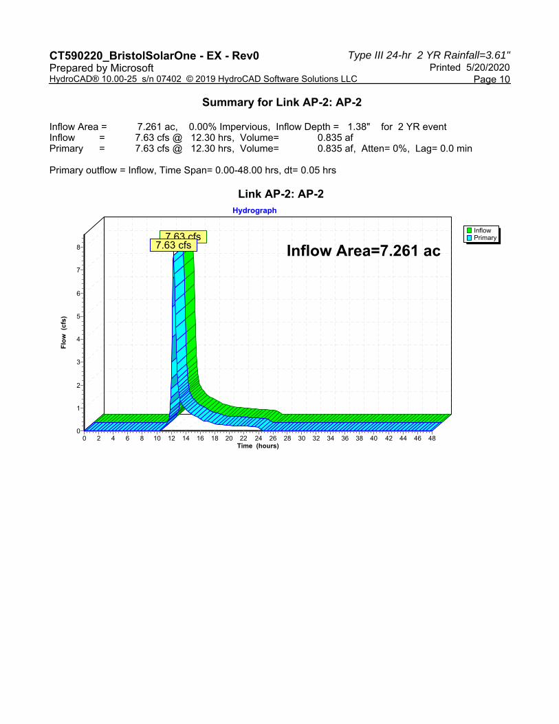
Stormwater Management Report 2 Bristol Solar One, LLC, Bristol, CT May 2020 Stormwater Management Analysis Methodology The hydrologic analysis was performed using the HydroCAD stormwater modeling system computer program developed by HydroCAD Software Solutions, LLC. Hydrographs for each watershed were developed using the SCS Synthetic Unit Hydrograph Method with a Type III rainfall distribution. Hydrographs were developed for the NOAA Atlas 14, Volume 10, Version 2 Precipitation 2-, 25-, 50-, and 100-year storm event with rainfall depths of 3.61, 7.13, 8.12, and 9.21 inches respectively. The existing and proposed drainage areas used in the calculations are illustrated on the Existing and Proposed Drainage Area Plans (EDA-1 & PDA-1). These maps and the corresponding HydroCAD output are attached. Utilizing Appendix I, Stormwater Management at Solar Array Construction Projects, provided by Connecticut Department of Energy & Environmental Projection (“CT DEEP”), this hydrologic analysis will reflect a reduction of the Hydrologic Soil Group (“HSG”) present on-site by one (1) step (e.g. soils of HSG B shall be considered HSG C). This reduction, as indicated by CT DEEP, is intended to account for the compaction of soils that results from extensive machinery traffic during construction of the array. The Water Quality Volume (“WQV”) for the site will be calculated assuming that the solar panels, roadways, gravel surfaces, and transformer pads are effectively impervious cover. See Appendix F. Existing Drainage Patterns The proposed Project area drains from the west to the east, ultimately into Sand Road and an existing pond located east of the property. The Site was modeled at three (3) Analysis Points (“AP-1”, “AP-2”, and “AP-3”). AP-1 is along the existing wetlands to the west. AP-2 follows the existing drainage patterns to the wetland located in the southern middle of the Site, which eventually drains offsite to the south. AP-3 follows the drainage of the existing wetland/stream system along the eastern portion of the Site and drains southeast off the property. Peak discharges have been computed at the points of study for the 2-, 25-, 50-, and 100-year storm events. The project site soils identified by the United States Department of Agriculture (USDA) Natural Resources Conservation Service consist of Map Unit Symbol 4, named “Leicester fine sandy loam”, 45B, named “Woodbridge fine sandy loam, 3 to 8 percent slopes”, 84B, named Paxton and Montauk fine sandy loams, 3 to 8 percent slopes”, 84C, named Paxton and Montauk fine sandy loams, 8 to 15 percent slopes”, and 3, named “Ridgebury, Leicester and Whitman soils, 0 to 8 percent slopes, extremely stony”. Map Unit Symbol 4 is classified in the HSG rating of “B”, 45B, 84B, and 84C are classified in the HSG rating of “C”, and 3 is classified in the HSG rating of “D”.

Stormwater Management Report 3 Bristol Solar One, LLC, Bristol, CT May 2020 The pre-developed discharges at the Analysis Point are tabulated in Table 1-1. Table 1-1
AnalysisPointPre-developed Peak Storm Runoff (Q), cubic feet per
second (cfs) 2-year 25-year 50-year 100-year
AP-1 4.27 15.34 18.76 22.59 AP-2 7.63 24.31 29.36 34.92 AP-3 5.31 16.90 20.36 24.20
Proposed Drainage Patterns The Project will require clearing and grubbing, although minimal, in the immediate area for the proposed solar installation, including the necessary utilities, access road, and stormwater management features, resulting in approximately 18.90± acres of disturbance. Overall, hydrologically, through the addition of catchment areas associated with the individual drainage areas of each proposed basin, the post-developed condition is designed to mimic the pre-developed condition. To manage the increase in post-development runoff due to the change in cover type associated with converting woods to meadow and the reductions in one full HSG within the proposed limit of disturbance, four (4) grass-lined stormwater management basins are proposed throughout the project area; two (2) located east and just upstream of the wetland to the west, one (1) located northwest and upstream of the wetland to the couth, and one (1) located west of the wetland to the east. Additionally, four (4) grass swales are proposed to facilitate flow to the proposed basins. Using an outlet control structure with a low flow orifice and grate top in each basin, as needed, the basins are designed to provide the necessary water quality treatment volume for the additional impervious area, as recommended by CT DEEP Appendix I. See calculations attached. The proposed basins bottom elevations along the western side of the project (B-1A and B-1B) are anticipated to be below the groundwater table. Basin B-1A is designed with an outlet culvert with an invert at the bottom of the basin that will allow for any groundwater that seeps into the basin to directly discharge into the plunge pool. Basins B-1B, B-2, and B-3 are designed with an outlet control device that will maintain approximately 1.4 feet, 0.85 feet, and 1.05 feet of standing water, respectively, within the basin from potential groundwater seepage. The basins are designed with an outlet control structure (except for B-1A), rip-rap overflow weir, and plunge pool level spreader. Since the proposed development mimics the existing conditions, the post-development condition was modeled using the same Analysis Points. Peak discharges have been computed at the point of study for the 2-year, 25-year, 50-year, and 100-year storm events. The post-development discharges at each point of study are tabulated in Table 1-2.

Stormwater Management Report 4 Bristol Solar One, LLC, Bristol, CT May 2020 Table 1-2
AnalysisPointPost-developed Peak Storm Runoff (Q), cubic feet per
second (cfs) 2-year 25-year 50-year 100-year
AP-1 4.09 14.12 17.94 22.51 AP-2 2.97 23.80 29.18 34.81 AP-3 3.77 16.38 19.72 23.40
Conclusion The stormwater management for the proposed site has been designed such that the post-development peak discharges to the waters of the State of Connecticut for the 2-, 25-, 50-, and 100- year storm events are less than the pre-development peak discharges. As a result, the proposed solar array will not result in any adverse conditions to the surrounding areas and properties.

APPENDIX A: NRCS SOIL SURVEY

Hydrologic Soil Group—State of Connecticut
Natural ResourcesConservation Service
Web Soil SurveyNational Cooperative Soil Survey
5/30/2019Page 1 of 4
4617
100
4617
200
4617
300
4617
400
4617
500
4617
600
4617
700
4617
100
4617
200
4617
300
4617
400
4617
500
4617
600
4617
700
4617
800
667600 667700 667800 667900 668000 668100 668200 668300 668400 668500 668600 668700
667600 667700 667800 667900 668000 668100 668200 668300 668400 668500 668600 668700
41° 41' 39'' N72
° 5
9' 1
2'' W
41° 41' 39'' N
72° 5
8' 2
0'' W
41° 41' 14'' N
72° 5
9' 1
2'' W
41° 41' 14'' N
72° 5
8' 2
0'' W
N
Map projection: Web Mercator Corner coordinates: WGS84 Edge tics: UTM Zone 18N WGS840 250 500 1000 1500
Feet0 50 100 200 300
MetersMap Scale: 1:5,470 if printed on A landscape (11" x 8.5") sheet.
Soil Map may not be valid at this scale.

MAP LEGEND MAP INFORMATION
Area of Interest (AOI)Area of Interest (AOI)
SoilsSoil Rating Polygons
A
A/D
B
B/D
C
C/D
D
Not rated or not available
Soil Rating LinesA
A/D
B
B/D
C
C/D
D
Not rated or not available
Soil Rating PointsA
A/D
B
B/D
C
C/D
D
Not rated or not available
Water FeaturesStreams and Canals
TransportationRails
Interstate Highways
US Routes
Major Roads
Local Roads
BackgroundAerial Photography
The soil surveys that comprise your AOI were mapped at 1:12,000.
Warning: Soil Map may not be valid at this scale.
Enlargement of maps beyond the scale of mapping can cause misunderstanding of the detail of mapping and accuracy of soil line placement. The maps do not show the small areas of contrasting soils that could have been shown at a more detailed scale.
Please rely on the bar scale on each map sheet for map measurements.
Source of Map: Natural Resources Conservation ServiceWeb Soil Survey URL: Coordinate System: Web Mercator (EPSG:3857)
Maps from the Web Soil Survey are based on the Web Mercator projection, which preserves direction and shape but distorts distance and area. A projection that preserves area, such as the Albers equal-area conic projection, should be used if more accurate calculations of distance or area are required.
This product is generated from the USDA-NRCS certified data as of the version date(s) listed below.
Soil Survey Area: State of ConnecticutSurvey Area Data: Version 18, Dec 6, 2018
Soil map units are labeled (as space allows) for map scales 1:50,000 or larger.
Date(s) aerial images were photographed: Aug 27, 2016—Oct 30, 2017
The orthophoto or other base map on which the soil lines were compiled and digitized probably differs from the background imagery displayed on these maps. As a result, some minor shifting of map unit boundaries may be evident.
Hydrologic Soil Group—State of Connecticut
Natural ResourcesConservation Service
Web Soil SurveyNational Cooperative Soil Survey
5/30/2019Page 2 of 4

Hydrologic Soil Group
Map unit symbol Map unit name Rating Acres in AOI Percent of AOI
3 Ridgebury, Leicester, and Whitman soils, 0 to 8 percent slopes, extremely stony
D 3.0 2.9%
4 Leicester fine sandy loam
B/D 12.3 11.9%
12 Raypol silt loam C/D 0.1 0.1%
45B Woodbridge fine sandy loam, 3 to 8 percent slopes
C/D 34.6 33.6%
47C Woodbridge fine sandy loam, 3 to 15 percent slopes, extremely stony
C/D 3.7 3.6%
84B Paxton and Montauk fine sandy loams, 3 to 8 percent slopes
C 9.3 9.1%
84C Paxton and Montauk fine sandy loams, 8 to 15 percent slopes
C 17.5 17.0%
84D Paxton and Montauk fine sandy loams, 15 to 25 percent slopes
C 4.2 4.1%
284B Paxton-Urban land complex, 3 to 8 percent slopes
C 5.7 5.5%
307 Urban land D 12.5 12.2%
Totals for Area of Interest 102.9 100.0%
Hydrologic Soil Group—State of Connecticut
Natural ResourcesConservation Service
Web Soil SurveyNational Cooperative Soil Survey
5/30/2019Page 3 of 4

Description
Hydrologic soil groups are based on estimates of runoff potential. Soils are assigned to one of four groups according to the rate of water infiltration when the soils are not protected by vegetation, are thoroughly wet, and receive precipitation from long-duration storms.
The soils in the United States are assigned to four groups (A, B, C, and D) and three dual classes (A/D, B/D, and C/D). The groups are defined as follows:
Group A. Soils having a high infiltration rate (low runoff potential) when thoroughly wet. These consist mainly of deep, well drained to excessively drained sands or gravelly sands. These soils have a high rate of water transmission.
Group B. Soils having a moderate infiltration rate when thoroughly wet. These consist chiefly of moderately deep or deep, moderately well drained or well drained soils that have moderately fine texture to moderately coarse texture. These soils have a moderate rate of water transmission.
Group C. Soils having a slow infiltration rate when thoroughly wet. These consist chiefly of soils having a layer that impedes the downward movement of water or soils of moderately fine texture or fine texture. These soils have a slow rate of water transmission.
Group D. Soils having a very slow infiltration rate (high runoff potential) when thoroughly wet. These consist chiefly of clays that have a high shrink-swell potential, soils that have a high water table, soils that have a claypan or clay layer at or near the surface, and soils that are shallow over nearly impervious material. These soils have a very slow rate of water transmission.
If a soil is assigned to a dual hydrologic group (A/D, B/D, or C/D), the first letter is for drained areas and the second is for undrained areas. Only the soils that in their natural condition are in group D are assigned to dual classes.
Rating Options
Aggregation Method: Dominant Condition
Component Percent Cutoff: None Specified
Tie-break Rule: Higher
Hydrologic Soil Group—State of Connecticut
Natural ResourcesConservation Service
Web Soil SurveyNational Cooperative Soil Survey
5/30/2019Page 4 of 4

APPENDIX B: EXISTING DRAINAGE AREA MAP (EDA-1) & HYDROLOGIC COMPUTATION (HYDROCAD)

>
>
>
> >
>
>
>
>
>
>
>
>
>
>
>
>
>
>
>
>
>
>
>
>
>>
>
>
>
>
>
>
>
>
>
>
>
>
>
>
>
>
>
>
>
>
>
>
>
>
>
>
>
>
>
>
>
>
>
>
>
>
>
>
84CHSG = C
4HSG = B
45BHSG = C
84BHSG = C
284BHSG = C
92CHSG = B
3HSG = D
84DHSG = C
45BHSG = C
84CHSG = C
84BHSG = C
EXISTING DRAINAGE AREA MAPSCALE : 1" = 80'-0" N 1
EDA-1 1 inch = 80 ft.( IN FEET )
SOIL BOUNDARY (TYP.)
EXISTING DRAINAGEAREA MAP
EDA-1
DATE:
APT FILING NUMBER:
BRISTOL SOLAR ONE, LLC
399 HILL STREETBRISTOL, CT
SITEADDRESS:
SHEET TITLE:
DRAWN BY:
CHECKED BY:
SHEET NUMBER:
OWNER:
ADDRESS:
DESIGN PROFESSIONAL OF RECORD
DATENO REVISION
05/20/20
CT590220
0123456
MARK E., ANN L. & PAUL C.MINOR399 HILL STREETBRISTOL, CT
PROF: BRADLEY J. PARSONS P.E.COMP: ALL-POINTS TECHNOLOGY
CORPORATIONADD: 567 VAUXHAUL STREET
EXTENSION - SUITE 311WATERFORD, CT 06385
JT
BJP
TECHNOLOGY CORPORATIONALL- POINTS
05/20/20 FOR REVIEW: BJP
PERMIT SET
567 VAUXHAUL STREET EXTENSION - SUITE 311WATERFORD, CT 06385 PHONE: (860)-663-1697WWW.ALLPOINTSTECH.COM FAX: (860)-663-0935
150 TRUMBULL STREET4TH FLOOR
HARTFORD, CT, 06103
NOT FOR CONSTRUCTION
BRISTOL SOLAR ONE, LLCEXISTING DRAINAGE AREAS
EDA-1
EDA-2
EDA-3
TOTAL AREA (ACRES) COMPOSITE CN TC (MINS.)
6.449±
7.261±
4.456±
71
75
75
34.4
20.1
14.7
A
EDA-16.449± ACRES
CN = 71TC = 34.4
AP-1
EDA-27.261± ACRES
CN = 75TC = 20.1
AP-2
AP-3
EDA-34.456± ACRES
CN = 75TC = 14.7
A
B
C
EXIST. DRAINAGE AREA BOUNDARY
EXIST. TIME OF CONCENTRATIONSHEET FLOW (TYP.)
EXIST. TIME OF CONCENTRATIONSHALLOW CONCENTRATED FLOW (TYP.)
B
DC
A
B
C

EDA-1
EDA-1
EDA-2
EDA-2
EDA-3
EDA-3
AP-1
AP-1
AP-2
AP-2
AP-3
AP-3
Routing Diagram for CT590220_BristolSolarOne - EX - Rev0Prepared by Microsoft, Printed 5/20/2020
HydroCAD® 10.00-25 s/n 07402 © 2019 HydroCAD Software Solutions LLC
Subcat Reach Pond Link

CT590220_BristolSolarOne - EX - Rev0 Printed 5/20/2020Prepared by Microsoft
Page 2HydroCAD® 10.00-25 s/n 07402 © 2019 HydroCAD Software Solutions LLC
Area Listing (all nodes)
Area(acres)
CN Description(subcatchment-numbers)
0.166 56 Brush, Fair, HSG B (EDA-1)6.495 70 Brush, Fair, HSG C (EDA-1, EDA-2)1.815 77 Brush, Fair, HSG D (EDA-1, EDA-2, EDA-3)5.841 74 Pasture/grassland/range, Good, HSG C (EDA-2, EDA-3)3.273 80 Pasture/grassland/range, Good, HSG D (EDA-2, EDA-3)0.156 55 Woods, Good, HSG B (EDA-1)0.323 70 Woods, Good, HSG C (EDA-1)0.097 77 Woods, Good, HSG D (EDA-1)
18.166 74 TOTAL AREA

CT590220_BristolSolarOne - EX - Rev0 Printed 5/20/2020Prepared by Microsoft
Page 3HydroCAD® 10.00-25 s/n 07402 © 2019 HydroCAD Software Solutions LLC
Soil Listing (all nodes)
Area(acres)
SoilGroup
SubcatchmentNumbers
0.000 HSG A0.322 HSG B EDA-1
12.659 HSG C EDA-1, EDA-2, EDA-35.185 HSG D EDA-1, EDA-2, EDA-30.000 Other
18.166 TOTAL AREA

CT590220_BristolSolarOne - EX - Rev0 Printed 5/20/2020Prepared by Microsoft
Page 4HydroCAD® 10.00-25 s/n 07402 © 2019 HydroCAD Software Solutions LLC
Ground Covers (all nodes)
HSG-A(acres)
HSG-B(acres)
HSG-C(acres)
HSG-D(acres)
Other(acres)
Total(acres)
GroundCover
SubcatchmentNumbers
0.000 0.166 6.495 1.815 0.000 8.476 Brush, Fair EDA-1, EDA-2, EDA-3
0.000 0.000 5.841 3.273 0.000 9.114 Pasture/grassland/range, Good EDA-2, EDA-3
0.000 0.156 0.323 0.097 0.000 0.576 Woods, Good EDA-1
0.000 0.322 12.659 5.185 0.000 18.166 TOTAL AREA

Type III 24-hr 2 YR Rainfall=3.61"CT590220_BristolSolarOne - EX - Rev0 Printed 5/20/2020Prepared by Microsoft
Page 5HydroCAD® 10.00-25 s/n 07402 © 2019 HydroCAD Software Solutions LLC
Time span=0.00-48.00 hrs, dt=0.05 hrs, 961 pointsRunoff by SCS TR-20 method, UH=SCS, Weighted-CN
Reach routing by Dyn-Stor-Ind method - Pond routing by Dyn-Stor-Ind method
Runoff Area=6.449 ac 0.00% Impervious Runoff Depth=1.13"Subcatchment EDA-1: EDA-1 Flow Length=417' Tc=34.4 min CN=71 Runoff=4.27 cfs 0.610 af
Runoff Area=7.261 ac 0.00% Impervious Runoff Depth=1.38"Subcatchment EDA-2: EDA-2 Flow Length=388' Tc=20.1 min CN=75 Runoff=7.63 cfs 0.835 af
Runoff Area=4.456 ac 0.00% Impervious Runoff Depth=1.38"Subcatchment EDA-3: EDA-3 Flow Length=667' Tc=14.7 min CN=75 Runoff=5.31 cfs 0.513 af
Inflow=4.27 cfs 0.610 afLink AP-1: AP-1 Primary=4.27 cfs 0.610 af
Inflow=7.63 cfs 0.835 afLink AP-2: AP-2 Primary=7.63 cfs 0.835 af
Inflow=5.31 cfs 0.513 afLink AP-3: AP-3 Primary=5.31 cfs 0.513 af
Total Runoff Area = 18.166 ac Runoff Volume = 1.957 af Average Runoff Depth = 1.29"100.00% Pervious = 18.166 ac 0.00% Impervious = 0.000 ac

Type III 24-hr 2 YR Rainfall=3.61"CT590220_BristolSolarOne - EX - Rev0 Printed 5/20/2020Prepared by Microsoft
Page 6HydroCAD® 10.00-25 s/n 07402 © 2019 HydroCAD Software Solutions LLC
Summary for Subcatchment EDA-1: EDA-1
Runoff = 4.27 cfs @ 12.52 hrs, Volume= 0.610 af, Depth= 1.13"
Runoff by SCS TR-20 method, UH=SCS, Weighted-CN, Time Span= 0.00-48.00 hrs, dt= 0.05 hrsType III 24-hr 2 YR Rainfall=3.61"
Area (ac) CN Description0.156 55 Woods, Good, HSG B0.166 56 Brush, Fair, HSG B0.323 70 Woods, Good, HSG C4.514 70 Brush, Fair, HSG C0.097 77 Woods, Good, HSG D1.193 77 Brush, Fair, HSG D6.449 71 Weighted Average6.449 100.00% Pervious Area
Tc Length Slope Velocity Capacity Description(min) (feet) (ft/ft) (ft/sec) (cfs)30.8 100 0.0070 0.05 Sheet Flow, A-B
Woods: Light underbrush n= 0.400 P2= 3.61"3.0 245 0.0744 1.36 Shallow Concentrated Flow, B-C
Woodland Kv= 5.0 fps0.6 72 0.1573 1.98 Shallow Concentrated Flow, C-D
Woodland Kv= 5.0 fps34.4 417 Total
Subcatchment EDA-1: EDA-1
Runoff
Hydrograph
Time (hours)484644424038363432302826242220181614121086420
Flo
w (
cfs)
4
3
2
1
0
Type III 24-hr2 YR Rainfall=3.61"
Runoff Area=6.449 acRunoff Volume=0.610 af
Runoff Depth=1.13"Flow Length=417'
Tc=34.4 minCN=71
4.27 cfs

Type III 24-hr 2 YR Rainfall=3.61"CT590220_BristolSolarOne - EX - Rev0 Printed 5/20/2020Prepared by Microsoft
Page 7HydroCAD® 10.00-25 s/n 07402 © 2019 HydroCAD Software Solutions LLC
Summary for Subcatchment EDA-2: EDA-2
Runoff = 7.63 cfs @ 12.30 hrs, Volume= 0.835 af, Depth= 1.38"
Runoff by SCS TR-20 method, UH=SCS, Weighted-CN, Time Span= 0.00-48.00 hrs, dt= 0.05 hrsType III 24-hr 2 YR Rainfall=3.61"
Area (ac) CN Description1.981 70 Brush, Fair, HSG C2.215 74 Pasture/grassland/range, Good, HSG C0.621 77 Brush, Fair, HSG D2.444 80 Pasture/grassland/range, Good, HSG D7.261 75 Weighted Average7.261 100.00% Pervious Area
Tc Length Slope Velocity Capacity Description(min) (feet) (ft/ft) (ft/sec) (cfs)16.6 100 0.0118 0.10 Sheet Flow, A-B
Grass: Dense n= 0.240 P2= 3.61"3.5 288 0.0387 1.38 Shallow Concentrated Flow, B-C
Short Grass Pasture Kv= 7.0 fps20.1 388 Total
Subcatchment EDA-2: EDA-2
Runoff
Hydrograph
Time (hours)484644424038363432302826242220181614121086420
Flo
w (
cfs)
8
7
6
5
4
3
2
1
0
Type III 24-hr2 YR Rainfall=3.61"
Runoff Area=7.261 acRunoff Volume=0.835 af
Runoff Depth=1.38"Flow Length=388'
Tc=20.1 minCN=75
7.63 cfs

Type III 24-hr 2 YR Rainfall=3.61"CT590220_BristolSolarOne - EX - Rev0 Printed 5/20/2020Prepared by Microsoft
Page 8HydroCAD® 10.00-25 s/n 07402 © 2019 HydroCAD Software Solutions LLC
Summary for Subcatchment EDA-3: EDA-3
Runoff = 5.31 cfs @ 12.21 hrs, Volume= 0.513 af, Depth= 1.38"
Runoff by SCS TR-20 method, UH=SCS, Weighted-CN, Time Span= 0.00-48.00 hrs, dt= 0.05 hrsType III 24-hr 2 YR Rainfall=3.61"
Area (ac) CN Description3.626 74 Pasture/grassland/range, Good, HSG C0.001 77 Brush, Fair, HSG D0.829 80 Pasture/grassland/range, Good, HSG D4.456 75 Weighted Average4.456 100.00% Pervious Area
Tc Length Slope Velocity Capacity Description(min) (feet) (ft/ft) (ft/sec) (cfs)
9.3 100 0.0503 0.18 Sheet Flow, A-BGrass: Dense n= 0.240 P2= 3.61"
5.4 567 0.0628 1.75 Shallow Concentrated Flow, B-CShort Grass Pasture Kv= 7.0 fps
14.7 667 Total
Subcatchment EDA-3: EDA-3
Runoff
Hydrograph
Time (hours)484644424038363432302826242220181614121086420
Flo
w (
cfs)
5
4
3
2
1
0
Type III 24-hr2 YR Rainfall=3.61"
Runoff Area=4.456 acRunoff Volume=0.513 af
Runoff Depth=1.38"Flow Length=667'
Tc=14.7 minCN=75
5.31 cfs

Type III 24-hr 2 YR Rainfall=3.61"CT590220_BristolSolarOne - EX - Rev0 Printed 5/20/2020Prepared by Microsoft
Page 9HydroCAD® 10.00-25 s/n 07402 © 2019 HydroCAD Software Solutions LLC
Summary for Link AP-1: AP-1
Inflow Area = 6.449 ac, 0.00% Impervious, Inflow Depth = 1.13" for 2 YR eventInflow = 4.27 cfs @ 12.52 hrs, Volume= 0.610 afPrimary = 4.27 cfs @ 12.52 hrs, Volume= 0.610 af, Atten= 0%, Lag= 0.0 min
Primary outflow = Inflow, Time Span= 0.00-48.00 hrs, dt= 0.05 hrs
Link AP-1: AP-1
InflowPrimary
Hydrograph
Time (hours)484644424038363432302826242220181614121086420
Flo
w (
cfs)
4
3
2
1
0
Inflow Area=6.449 ac4.27 cfs
4.27 cfs
Type III 24-hr 2 YR Rainfall=3.61"CT590220_BristolSolarOne - EX - Rev0 Printed 5/20/2020Prepared by Microsoft
Page 10HydroCAD® 10.00-25 s/n 07402 © 2019 HydroCAD Software Solutions LLC
Summary for Link AP-2: AP-2
Inflow Area = 7.261 ac, 0.00% Impervious, Inflow Depth = 1.38" for 2 YR eventInflow = 7.63 cfs @ 12.30 hrs, Volume= 0.835 afPrimary = 7.63 cfs @ 12.30 hrs, Volume= 0.835 af, Atten= 0%, Lag= 0.0 min
Primary outflow = Inflow, Time Span= 0.00-48.00 hrs, dt= 0.05 hrs
Link AP-2: AP-2
InflowPrimary
Hydrograph
Time (hours)484644424038363432302826242220181614121086420
Flo
w (
cfs)
8
7
6
5
4
3
2
1
0
Inflow Area=7.261 ac7.63 cfs
7.63 cfs

Type III 24-hr 2 YR Rainfall=3.61"CT590220_BristolSolarOne - EX - Rev0 Printed 5/20/2020Prepared by Microsoft
Page 11HydroCAD® 10.00-25 s/n 07402 © 2019 HydroCAD Software Solutions LLC
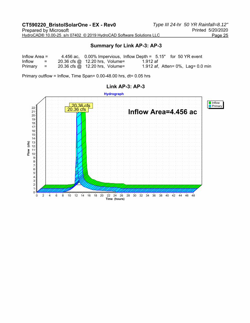
Summary for Link AP-3: AP-3
Inflow Area = 4.456 ac, 0.00% Impervious, Inflow Depth = 1.38" for 2 YR eventInflow = 5.31 cfs @ 12.21 hrs, Volume= 0.513 afPrimary = 5.31 cfs @ 12.21 hrs, Volume= 0.513 af, Atten= 0%, Lag= 0.0 min
Primary outflow = Inflow, Time Span= 0.00-48.00 hrs, dt= 0.05 hrs
Link AP-3: AP-3
InflowPrimary
Hydrograph
Time (hours)484644424038363432302826242220181614121086420
Flo
w (
cfs)
5
4
3
2
1
0
Inflow Area=4.456 ac5.31 cfs
5.31 cfs
Type III 24-hr 25 YR Rainfall=7.13"CT590220_BristolSolarOne - EX - Rev0 Printed 5/20/2020Prepared by Microsoft
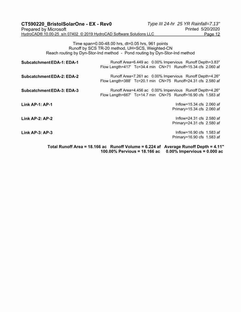
Page 12HydroCAD® 10.00-25 s/n 07402 © 2019 HydroCAD Software Solutions LLC
Time span=0.00-48.00 hrs, dt=0.05 hrs, 961 pointsRunoff by SCS TR-20 method, UH=SCS, Weighted-CN
Reach routing by Dyn-Stor-Ind method - Pond routing by Dyn-Stor-Ind method
Runoff Area=6.449 ac 0.00% Impervious Runoff Depth=3.83"Subcatchment EDA-1: EDA-1 Flow Length=417' Tc=34.4 min CN=71 Runoff=15.34 cfs 2.060 af
Runoff Area=7.261 ac 0.00% Impervious Runoff Depth=4.26"Subcatchment EDA-2: EDA-2 Flow Length=388' Tc=20.1 min CN=75 Runoff=24.31 cfs 2.580 af
Runoff Area=4.456 ac 0.00% Impervious Runoff Depth=4.26"Subcatchment EDA-3: EDA-3 Flow Length=667' Tc=14.7 min CN=75 Runoff=16.90 cfs 1.583 af
Inflow=15.34 cfs 2.060 afLink AP-1: AP-1 Primary=15.34 cfs 2.060 af
Inflow=24.31 cfs 2.580 afLink AP-2: AP-2 Primary=24.31 cfs 2.580 af
Inflow=16.90 cfs 1.583 afLink AP-3: AP-3 Primary=16.90 cfs 1.583 af
Total Runoff Area = 18.166 ac Runoff Volume = 6.224 af Average Runoff Depth = 4.11"100.00% Pervious = 18.166 ac 0.00% Impervious = 0.000 ac

Type III 24-hr 25 YR Rainfall=7.13"CT590220_BristolSolarOne - EX - Rev0 Printed 5/20/2020Prepared by Microsoft
Page 13HydroCAD® 10.00-25 s/n 07402 © 2019 HydroCAD Software Solutions LLC
Summary for Subcatchment EDA-1: EDA-1
Runoff = 15.34 cfs @ 12.48 hrs, Volume= 2.060 af, Depth= 3.83"
Runoff by SCS TR-20 method, UH=SCS, Weighted-CN, Time Span= 0.00-48.00 hrs, dt= 0.05 hrsType III 24-hr 25 YR Rainfall=7.13"
Area (ac) CN Description0.156 55 Woods, Good, HSG B0.166 56 Brush, Fair, HSG B0.323 70 Woods, Good, HSG C4.514 70 Brush, Fair, HSG C0.097 77 Woods, Good, HSG D1.193 77 Brush, Fair, HSG D6.449 71 Weighted Average6.449 100.00% Pervious Area
Tc Length Slope Velocity Capacity Description(min) (feet) (ft/ft) (ft/sec) (cfs)30.8 100 0.0070 0.05 Sheet Flow, A-B
Woods: Light underbrush n= 0.400 P2= 3.61"3.0 245 0.0744 1.36 Shallow Concentrated Flow, B-C
Woodland Kv= 5.0 fps0.6 72 0.1573 1.98 Shallow Concentrated Flow, C-D
Woodland Kv= 5.0 fps34.4 417 Total
Subcatchment EDA-1: EDA-1
Runoff
Hydrograph
Time (hours)484644424038363432302826242220181614121086420
Flo
w (
cfs)
17
16
15
14
13
12
11
10
9
8
7
6
5
4
3
2
1
0
Type III 24-hr25 YR Rainfall=7.13"
Runoff Area=6.449 acRunoff Volume=2.060 af
Runoff Depth=3.83"Flow Length=417'
Tc=34.4 minCN=71
15.34 cfs

Type III 24-hr 25 YR Rainfall=7.13"CT590220_BristolSolarOne - EX - Rev0 Printed 5/20/2020Prepared by Microsoft
Page 14HydroCAD® 10.00-25 s/n 07402 © 2019 HydroCAD Software Solutions LLC
Summary for Subcatchment EDA-2: EDA-2
Runoff = 24.31 cfs @ 12.28 hrs, Volume= 2.580 af, Depth= 4.26"
Runoff by SCS TR-20 method, UH=SCS, Weighted-CN, Time Span= 0.00-48.00 hrs, dt= 0.05 hrsType III 24-hr 25 YR Rainfall=7.13"
Area (ac) CN Description1.981 70 Brush, Fair, HSG C2.215 74 Pasture/grassland/range, Good, HSG C0.621 77 Brush, Fair, HSG D2.444 80 Pasture/grassland/range, Good, HSG D7.261 75 Weighted Average7.261 100.00% Pervious Area
Tc Length Slope Velocity Capacity Description(min) (feet) (ft/ft) (ft/sec) (cfs)16.6 100 0.0118 0.10 Sheet Flow, A-B
Grass: Dense n= 0.240 P2= 3.61"3.5 288 0.0387 1.38 Shallow Concentrated Flow, B-C
Short Grass Pasture Kv= 7.0 fps20.1 388 Total
Subcatchment EDA-2: EDA-2
Runoff
Hydrograph
Time (hours)484644424038363432302826242220181614121086420
Flo
w (
cfs)
26
24
22
20
18
16
14
12
10
8
6
4
2
0
Type III 24-hr25 YR Rainfall=7.13"
Runoff Area=7.261 acRunoff Volume=2.580 af
Runoff Depth=4.26"Flow Length=388'
Tc=20.1 minCN=75
24.31 cfs

Type III 24-hr 25 YR Rainfall=7.13"CT590220_BristolSolarOne - EX - Rev0 Printed 5/20/2020Prepared by Microsoft
Page 15HydroCAD® 10.00-25 s/n 07402 © 2019 HydroCAD Software Solutions LLC
Summary for Subcatchment EDA-3: EDA-3
Runoff = 16.90 cfs @ 12.20 hrs, Volume= 1.583 af, Depth= 4.26"
Runoff by SCS TR-20 method, UH=SCS, Weighted-CN, Time Span= 0.00-48.00 hrs, dt= 0.05 hrsType III 24-hr 25 YR Rainfall=7.13"
Area (ac) CN Description3.626 74 Pasture/grassland/range, Good, HSG C0.001 77 Brush, Fair, HSG D0.829 80 Pasture/grassland/range, Good, HSG D4.456 75 Weighted Average4.456 100.00% Pervious Area
Tc Length Slope Velocity Capacity Description(min) (feet) (ft/ft) (ft/sec) (cfs)
9.3 100 0.0503 0.18 Sheet Flow, A-BGrass: Dense n= 0.240 P2= 3.61"
5.4 567 0.0628 1.75 Shallow Concentrated Flow, B-CShort Grass Pasture Kv= 7.0 fps
14.7 667 Total
Subcatchment EDA-3: EDA-3
Runoff
Hydrograph
Time (hours)484644424038363432302826242220181614121086420
Flo
w (
cfs)
18
17
16
15
14
13
12
11
10
9
8
7
6
5
4
3
2
1
0
Type III 24-hr25 YR Rainfall=7.13"
Runoff Area=4.456 acRunoff Volume=1.583 af
Runoff Depth=4.26"Flow Length=667'
Tc=14.7 minCN=75
16.90 cfs

Type III 24-hr 25 YR Rainfall=7.13"CT590220_BristolSolarOne - EX - Rev0 Printed 5/20/2020Prepared by Microsoft
Page 16HydroCAD® 10.00-25 s/n 07402 © 2019 HydroCAD Software Solutions LLC
Summary for Link AP-1: AP-1
Inflow Area = 6.449 ac, 0.00% Impervious, Inflow Depth = 3.83" for 25 YR eventInflow = 15.34 cfs @ 12.48 hrs, Volume= 2.060 afPrimary = 15.34 cfs @ 12.48 hrs, Volume= 2.060 af, Atten= 0%, Lag= 0.0 min
Primary outflow = Inflow, Time Span= 0.00-48.00 hrs, dt= 0.05 hrs
Link AP-1: AP-1
InflowPrimary
Hydrograph
Time (hours)484644424038363432302826242220181614121086420
Flo
w (
cfs)
17
16
15
14
13
12
11
10
9
8
7
6
5
4
3
2
1
0
Inflow Area=6.449 ac15.34 cfs
15.34 cfs

Type III 24-hr 25 YR Rainfall=7.13"CT590220_BristolSolarOne - EX - Rev0 Printed 5/20/2020Prepared by Microsoft
Page 17HydroCAD® 10.00-25 s/n 07402 © 2019 HydroCAD Software Solutions LLC
Summary for Link AP-2: AP-2
Inflow Area = 7.261 ac, 0.00% Impervious, Inflow Depth = 4.26" for 25 YR eventInflow = 24.31 cfs @ 12.28 hrs, Volume= 2.580 afPrimary = 24.31 cfs @ 12.28 hrs, Volume= 2.580 af, Atten= 0%, Lag= 0.0 min
Primary outflow = Inflow, Time Span= 0.00-48.00 hrs, dt= 0.05 hrs
Link AP-2: AP-2
InflowPrimary
Hydrograph
Time (hours)484644424038363432302826242220181614121086420
Flo
w (
cfs)
26
24
22
20
18
16
14
12
10
8
6
4
2
0
Inflow Area=7.261 ac24.31 cfs
24.31 cfs

Type III 24-hr 25 YR Rainfall=7.13"CT590220_BristolSolarOne - EX - Rev0 Printed 5/20/2020Prepared by Microsoft
Page 18HydroCAD® 10.00-25 s/n 07402 © 2019 HydroCAD Software Solutions LLC
Summary for Link AP-3: AP-3
Inflow Area = 4.456 ac, 0.00% Impervious, Inflow Depth = 4.26" for 25 YR eventInflow = 16.90 cfs @ 12.20 hrs, Volume= 1.583 afPrimary = 16.90 cfs @ 12.20 hrs, Volume= 1.583 af, Atten= 0%, Lag= 0.0 min
Primary outflow = Inflow, Time Span= 0.00-48.00 hrs, dt= 0.05 hrs
Link AP-3: AP-3
InflowPrimary
Hydrograph
Time (hours)484644424038363432302826242220181614121086420
Flo
w (
cfs)
18
17
16
15
14
13
12
11
10
9
8
7
6
5
4
3
2
1
0
Inflow Area=4.456 ac16.90 cfs
16.90 cfs
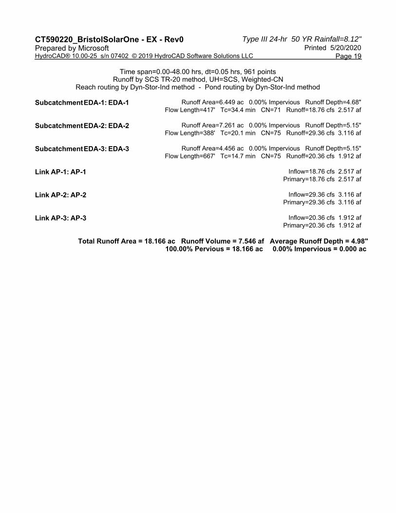
Type III 24-hr 50 YR Rainfall=8.12"CT590220_BristolSolarOne - EX - Rev0 Printed 5/20/2020Prepared by Microsoft
Page 19HydroCAD® 10.00-25 s/n 07402 © 2019 HydroCAD Software Solutions LLC
Time span=0.00-48.00 hrs, dt=0.05 hrs, 961 pointsRunoff by SCS TR-20 method, UH=SCS, Weighted-CN
Reach routing by Dyn-Stor-Ind method - Pond routing by Dyn-Stor-Ind method
Runoff Area=6.449 ac 0.00% Impervious Runoff Depth=4.68"Subcatchment EDA-1: EDA-1 Flow Length=417' Tc=34.4 min CN=71 Runoff=18.76 cfs 2.517 af
Runoff Area=7.261 ac 0.00% Impervious Runoff Depth=5.15"Subcatchment EDA-2: EDA-2 Flow Length=388' Tc=20.1 min CN=75 Runoff=29.36 cfs 3.116 af
Runoff Area=4.456 ac 0.00% Impervious Runoff Depth=5.15"Subcatchment EDA-3: EDA-3 Flow Length=667' Tc=14.7 min CN=75 Runoff=20.36 cfs 1.912 af
Inflow=18.76 cfs 2.517 afLink AP-1: AP-1 Primary=18.76 cfs 2.517 af
Inflow=29.36 cfs 3.116 afLink AP-2: AP-2 Primary=29.36 cfs 3.116 af
Inflow=20.36 cfs 1.912 afLink AP-3: AP-3 Primary=20.36 cfs 1.912 af
Total Runoff Area = 18.166 ac Runoff Volume = 7.546 af Average Runoff Depth = 4.98"100.00% Pervious = 18.166 ac 0.00% Impervious = 0.000 ac
Type III 24-hr 50 YR Rainfall=8.12"CT590220_BristolSolarOne - EX - Rev0 Printed 5/20/2020Prepared by Microsoft
Page 20HydroCAD® 10.00-25 s/n 07402 © 2019 HydroCAD Software Solutions LLC
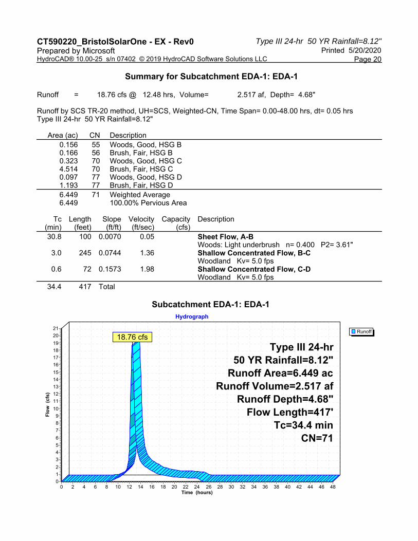
Summary for Subcatchment EDA-1: EDA-1
Runoff = 18.76 cfs @ 12.48 hrs, Volume= 2.517 af, Depth= 4.68"
Runoff by SCS TR-20 method, UH=SCS, Weighted-CN, Time Span= 0.00-48.00 hrs, dt= 0.05 hrsType III 24-hr 50 YR Rainfall=8.12"
Area (ac) CN Description0.156 55 Woods, Good, HSG B0.166 56 Brush, Fair, HSG B0.323 70 Woods, Good, HSG C4.514 70 Brush, Fair, HSG C0.097 77 Woods, Good, HSG D1.193 77 Brush, Fair, HSG D6.449 71 Weighted Average6.449 100.00% Pervious Area
Tc Length Slope Velocity Capacity Description(min) (feet) (ft/ft) (ft/sec) (cfs)30.8 100 0.0070 0.05 Sheet Flow, A-B
Woods: Light underbrush n= 0.400 P2= 3.61"3.0 245 0.0744 1.36 Shallow Concentrated Flow, B-C
Woodland Kv= 5.0 fps0.6 72 0.1573 1.98 Shallow Concentrated Flow, C-D
Woodland Kv= 5.0 fps34.4 417 Total
Subcatchment EDA-1: EDA-1
Runoff
Hydrograph
Time (hours)484644424038363432302826242220181614121086420
Flo
w (
cfs)
21
20
19
18
17
16
15
14
13
12
11
10
9
8
7
6
5
4
3
2
1
0
Type III 24-hr50 YR Rainfall=8.12"
Runoff Area=6.449 acRunoff Volume=2.517 af
Runoff Depth=4.68"Flow Length=417'
Tc=34.4 minCN=71
18.76 cfs

Type III 24-hr 50 YR Rainfall=8.12"CT590220_BristolSolarOne - EX - Rev0 Printed 5/20/2020Prepared by Microsoft
Page 21HydroCAD® 10.00-25 s/n 07402 © 2019 HydroCAD Software Solutions LLC
Summary for Subcatchment EDA-2: EDA-2
Runoff = 29.36 cfs @ 12.27 hrs, Volume= 3.116 af, Depth= 5.15"
Runoff by SCS TR-20 method, UH=SCS, Weighted-CN, Time Span= 0.00-48.00 hrs, dt= 0.05 hrsType III 24-hr 50 YR Rainfall=8.12"
Area (ac) CN Description1.981 70 Brush, Fair, HSG C2.215 74 Pasture/grassland/range, Good, HSG C0.621 77 Brush, Fair, HSG D2.444 80 Pasture/grassland/range, Good, HSG D7.261 75 Weighted Average7.261 100.00% Pervious Area
Tc Length Slope Velocity Capacity Description(min) (feet) (ft/ft) (ft/sec) (cfs)16.6 100 0.0118 0.10 Sheet Flow, A-B
Grass: Dense n= 0.240 P2= 3.61"3.5 288 0.0387 1.38 Shallow Concentrated Flow, B-C
Short Grass Pasture Kv= 7.0 fps20.1 388 Total
Subcatchment EDA-2: EDA-2
Runoff
Hydrograph
Time (hours)484644424038363432302826242220181614121086420
Flo
w (
cfs)
32
30
28
26
24
22
20
18
16
14
12
10
8
6
4
2
0
Type III 24-hr50 YR Rainfall=8.12"
Runoff Area=7.261 acRunoff Volume=3.116 af
Runoff Depth=5.15"Flow Length=388'
Tc=20.1 minCN=75
29.36 cfs

Type III 24-hr 50 YR Rainfall=8.12"CT590220_BristolSolarOne - EX - Rev0 Printed 5/20/2020Prepared by Microsoft
Page 22HydroCAD® 10.00-25 s/n 07402 © 2019 HydroCAD Software Solutions LLC
Summary for Subcatchment EDA-3: EDA-3
Runoff = 20.36 cfs @ 12.20 hrs, Volume= 1.912 af, Depth= 5.15"
Runoff by SCS TR-20 method, UH=SCS, Weighted-CN, Time Span= 0.00-48.00 hrs, dt= 0.05 hrsType III 24-hr 50 YR Rainfall=8.12"
Area (ac) CN Description3.626 74 Pasture/grassland/range, Good, HSG C0.001 77 Brush, Fair, HSG D0.829 80 Pasture/grassland/range, Good, HSG D4.456 75 Weighted Average4.456 100.00% Pervious Area
Tc Length Slope Velocity Capacity Description(min) (feet) (ft/ft) (ft/sec) (cfs)
9.3 100 0.0503 0.18 Sheet Flow, A-BGrass: Dense n= 0.240 P2= 3.61"
5.4 567 0.0628 1.75 Shallow Concentrated Flow, B-CShort Grass Pasture Kv= 7.0 fps
14.7 667 Total
Subcatchment EDA-3: EDA-3
Runoff
Hydrograph
Time (hours)484644424038363432302826242220181614121086420
Flo
w (
cfs)
22212019181716151413121110
9876543210
Type III 24-hr50 YR Rainfall=8.12"
Runoff Area=4.456 acRunoff Volume=1.912 af
Runoff Depth=5.15"Flow Length=667'
Tc=14.7 minCN=75
20.36 cfs
Type III 24-hr 50 YR Rainfall=8.12"CT590220_BristolSolarOne - EX - Rev0 Printed 5/20/2020Prepared by Microsoft
Page 23HydroCAD® 10.00-25 s/n 07402 © 2019 HydroCAD Software Solutions LLC
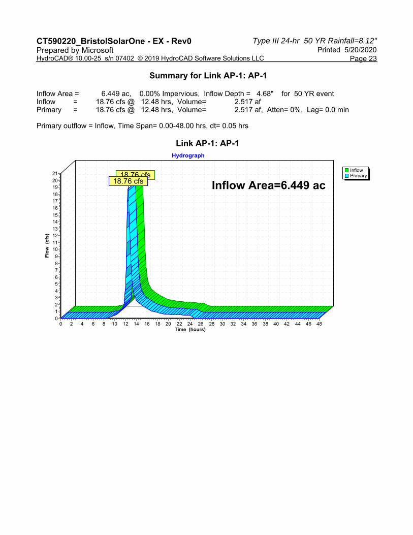
Summary for Link AP-1: AP-1
Inflow Area = 6.449 ac, 0.00% Impervious, Inflow Depth = 4.68" for 50 YR eventInflow = 18.76 cfs @ 12.48 hrs, Volume= 2.517 afPrimary = 18.76 cfs @ 12.48 hrs, Volume= 2.517 af, Atten= 0%, Lag= 0.0 min
Primary outflow = Inflow, Time Span= 0.00-48.00 hrs, dt= 0.05 hrs
Link AP-1: AP-1
InflowPrimary
Hydrograph
Time (hours)484644424038363432302826242220181614121086420
Flo
w (
cfs)
21
2019
1817
16
1514
1312
1110
9
87
65
43
21
0
Inflow Area=6.449 ac18.76 cfs
18.76 cfs

Type III 24-hr 50 YR Rainfall=8.12"CT590220_BristolSolarOne - EX - Rev0 Printed 5/20/2020Prepared by Microsoft
Page 24HydroCAD® 10.00-25 s/n 07402 © 2019 HydroCAD Software Solutions LLC
Summary for Link AP-2: AP-2
Inflow Area = 7.261 ac, 0.00% Impervious, Inflow Depth = 5.15" for 50 YR eventInflow = 29.36 cfs @ 12.27 hrs, Volume= 3.116 afPrimary = 29.36 cfs @ 12.27 hrs, Volume= 3.116 af, Atten= 0%, Lag= 0.0 min
Primary outflow = Inflow, Time Span= 0.00-48.00 hrs, dt= 0.05 hrs
Link AP-2: AP-2
InflowPrimary
Hydrograph
Time (hours)484644424038363432302826242220181614121086420
Flo
w (
cfs)
32
30
28
26
24
22
20
18
16
14
12
10
8
6
4
2
0
Inflow Area=7.261 ac29.36 cfs
29.36 cfs
Type III 24-hr 50 YR Rainfall=8.12"CT590220_BristolSolarOne - EX - Rev0 Printed 5/20/2020Prepared by Microsoft
Page 25HydroCAD® 10.00-25 s/n 07402 © 2019 HydroCAD Software Solutions LLC
Summary for Link AP-3: AP-3
Inflow Area = 4.456 ac, 0.00% Impervious, Inflow Depth = 5.15" for 50 YR eventInflow = 20.36 cfs @ 12.20 hrs, Volume= 1.912 afPrimary = 20.36 cfs @ 12.20 hrs, Volume= 1.912 af, Atten= 0%, Lag= 0.0 min
Primary outflow = Inflow, Time Span= 0.00-48.00 hrs, dt= 0.05 hrs
Link AP-3: AP-3
InflowPrimary
Hydrograph
Time (hours)484644424038363432302826242220181614121086420
Flo
w (
cfs)
22212019181716151413121110
9876543210
Inflow Area=4.456 ac20.36 cfs
20.36 cfs

Type III 24-hr 100 YR Rainfall=9.21"CT590220_BristolSolarOne - EX - Rev0 Printed 5/20/2020Prepared by Microsoft
Page 26HydroCAD® 10.00-25 s/n 07402 © 2019 HydroCAD Software Solutions LLC
Time span=0.00-48.00 hrs, dt=0.05 hrs, 961 pointsRunoff by SCS TR-20 method, UH=SCS, Weighted-CN
Reach routing by Dyn-Stor-Ind method - Pond routing by Dyn-Stor-Ind method
Runoff Area=6.449 ac 0.00% Impervious Runoff Depth=5.65"Subcatchment EDA-1: EDA-1 Flow Length=417' Tc=34.4 min CN=71 Runoff=22.59 cfs 3.034 af
Runoff Area=7.261 ac 0.00% Impervious Runoff Depth=6.15"Subcatchment EDA-2: EDA-2 Flow Length=388' Tc=20.1 min CN=75 Runoff=34.92 cfs 3.719 af
Runoff Area=4.456 ac 0.00% Impervious Runoff Depth=6.15"Subcatchment EDA-3: EDA-3 Flow Length=667' Tc=14.7 min CN=75 Runoff=24.20 cfs 2.282 af
Inflow=22.59 cfs 3.034 afLink AP-1: AP-1 Primary=22.59 cfs 3.034 af
Inflow=34.92 cfs 3.719 afLink AP-2: AP-2 Primary=34.92 cfs 3.719 af
Inflow=24.20 cfs 2.282 afLink AP-3: AP-3 Primary=24.20 cfs 2.282 af
Total Runoff Area = 18.166 ac Runoff Volume = 9.035 af Average Runoff Depth = 5.97"100.00% Pervious = 18.166 ac 0.00% Impervious = 0.000 ac

Type III 24-hr 100 YR Rainfall=9.21"CT590220_BristolSolarOne - EX - Rev0 Printed 5/20/2020Prepared by Microsoft
Page 27HydroCAD® 10.00-25 s/n 07402 © 2019 HydroCAD Software Solutions LLC
Summary for Subcatchment EDA-1: EDA-1
Runoff = 22.59 cfs @ 12.48 hrs, Volume= 3.034 af, Depth= 5.65"
Runoff by SCS TR-20 method, UH=SCS, Weighted-CN, Time Span= 0.00-48.00 hrs, dt= 0.05 hrsType III 24-hr 100 YR Rainfall=9.21"
Area (ac) CN Description0.156 55 Woods, Good, HSG B0.166 56 Brush, Fair, HSG B0.323 70 Woods, Good, HSG C4.514 70 Brush, Fair, HSG C0.097 77 Woods, Good, HSG D1.193 77 Brush, Fair, HSG D6.449 71 Weighted Average6.449 100.00% Pervious Area
Tc Length Slope Velocity Capacity Description(min) (feet) (ft/ft) (ft/sec) (cfs)30.8 100 0.0070 0.05 Sheet Flow, A-B
Woods: Light underbrush n= 0.400 P2= 3.61"3.0 245 0.0744 1.36 Shallow Concentrated Flow, B-C
Woodland Kv= 5.0 fps0.6 72 0.1573 1.98 Shallow Concentrated Flow, C-D
Woodland Kv= 5.0 fps34.4 417 Total
Subcatchment EDA-1: EDA-1
Runoff
Hydrograph
Time (hours)484644424038363432302826242220181614121086420
Flo
w (
cfs)
25242322212019181716151413121110
9876543210
Type III 24-hr100 YR Rainfall=9.21"Runoff Area=6.449 ac
Runoff Volume=3.034 afRunoff Depth=5.65"
Flow Length=417'Tc=34.4 min
CN=71
22.59 cfs

Type III 24-hr 100 YR Rainfall=9.21"CT590220_BristolSolarOne - EX - Rev0 Printed 5/20/2020Prepared by Microsoft
Page 28HydroCAD® 10.00-25 s/n 07402 © 2019 HydroCAD Software Solutions LLC
Summary for Subcatchment EDA-2: EDA-2
Runoff = 34.92 cfs @ 12.27 hrs, Volume= 3.719 af, Depth= 6.15"
Runoff by SCS TR-20 method, UH=SCS, Weighted-CN, Time Span= 0.00-48.00 hrs, dt= 0.05 hrsType III 24-hr 100 YR Rainfall=9.21"
Area (ac) CN Description1.981 70 Brush, Fair, HSG C2.215 74 Pasture/grassland/range, Good, HSG C0.621 77 Brush, Fair, HSG D2.444 80 Pasture/grassland/range, Good, HSG D7.261 75 Weighted Average7.261 100.00% Pervious Area
Tc Length Slope Velocity Capacity Description(min) (feet) (ft/ft) (ft/sec) (cfs)16.6 100 0.0118 0.10 Sheet Flow, A-B
Grass: Dense n= 0.240 P2= 3.61"3.5 288 0.0387 1.38 Shallow Concentrated Flow, B-C
Short Grass Pasture Kv= 7.0 fps20.1 388 Total
Subcatchment EDA-2: EDA-2
Runoff
Hydrograph
Time (hours)484644424038363432302826242220181614121086420
Flo
w (
cfs)
38
36
34
32
30
28
26
24
22
20
18
16
14
12
10
8
6
4
2
0
Type III 24-hr100 YR Rainfall=9.21"Runoff Area=7.261 ac
Runoff Volume=3.719 afRunoff Depth=6.15"
Flow Length=388'Tc=20.1 min
CN=75
34.92 cfs

Type III 24-hr 100 YR Rainfall=9.21"CT590220_BristolSolarOne - EX - Rev0 Printed 5/20/2020Prepared by Microsoft
Page 29HydroCAD® 10.00-25 s/n 07402 © 2019 HydroCAD Software Solutions LLC
Summary for Subcatchment EDA-3: EDA-3
Runoff = 24.20 cfs @ 12.20 hrs, Volume= 2.282 af, Depth= 6.15"
Runoff by SCS TR-20 method, UH=SCS, Weighted-CN, Time Span= 0.00-48.00 hrs, dt= 0.05 hrsType III 24-hr 100 YR Rainfall=9.21"
Area (ac) CN Description3.626 74 Pasture/grassland/range, Good, HSG C0.001 77 Brush, Fair, HSG D0.829 80 Pasture/grassland/range, Good, HSG D4.456 75 Weighted Average4.456 100.00% Pervious Area
Tc Length Slope Velocity Capacity Description(min) (feet) (ft/ft) (ft/sec) (cfs)
9.3 100 0.0503 0.18 Sheet Flow, A-BGrass: Dense n= 0.240 P2= 3.61"
5.4 567 0.0628 1.75 Shallow Concentrated Flow, B-CShort Grass Pasture Kv= 7.0 fps
14.7 667 Total
Subcatchment EDA-3: EDA-3
Runoff
Hydrograph
Time (hours)484644424038363432302826242220181614121086420
Flo
w (
cfs)
26
24
22
20
18
16
14
12
10
8
6
4
2
0
Type III 24-hr100 YR Rainfall=9.21"Runoff Area=4.456 ac
Runoff Volume=2.282 afRunoff Depth=6.15"
Flow Length=667'Tc=14.7 min
CN=75
24.20 cfs

Type III 24-hr 100 YR Rainfall=9.21"CT590220_BristolSolarOne - EX - Rev0 Printed 5/20/2020Prepared by Microsoft
Page 30HydroCAD® 10.00-25 s/n 07402 © 2019 HydroCAD Software Solutions LLC
Summary for Link AP-1: AP-1
Inflow Area = 6.449 ac, 0.00% Impervious, Inflow Depth = 5.65" for 100 YR eventInflow = 22.59 cfs @ 12.48 hrs, Volume= 3.034 afPrimary = 22.59 cfs @ 12.48 hrs, Volume= 3.034 af, Atten= 0%, Lag= 0.0 min
Primary outflow = Inflow, Time Span= 0.00-48.00 hrs, dt= 0.05 hrs
Link AP-1: AP-1
InflowPrimary
Hydrograph
Time (hours)484644424038363432302826242220181614121086420
Flo
w (
cfs)
25242322212019181716151413121110
9876543210
Inflow Area=6.449 ac22.59 cfs
22.59 cfs

Type III 24-hr 100 YR Rainfall=9.21"CT590220_BristolSolarOne - EX - Rev0 Printed 5/20/2020Prepared by Microsoft
Page 31HydroCAD® 10.00-25 s/n 07402 © 2019 HydroCAD Software Solutions LLC
Summary for Link AP-2: AP-2
Inflow Area = 7.261 ac, 0.00% Impervious, Inflow Depth = 6.15" for 100 YR eventInflow = 34.92 cfs @ 12.27 hrs, Volume= 3.719 afPrimary = 34.92 cfs @ 12.27 hrs, Volume= 3.719 af, Atten= 0%, Lag= 0.0 min
Primary outflow = Inflow, Time Span= 0.00-48.00 hrs, dt= 0.05 hrs
Link AP-2: AP-2
InflowPrimary
Hydrograph
Time (hours)484644424038363432302826242220181614121086420
Flo
w (
cfs)
38
36
34
32
30
28
26
24
22
20
18
16
14
12
10
8
6
4
2
0
Inflow Area=7.261 ac34.92 cfs
34.92 cfs

Type III 24-hr 100 YR Rainfall=9.21"CT590220_BristolSolarOne - EX - Rev0 Printed 5/20/2020Prepared by Microsoft
Page 32HydroCAD® 10.00-25 s/n 07402 © 2019 HydroCAD Software Solutions LLC
Summary for Link AP-3: AP-3
Inflow Area = 4.456 ac, 0.00% Impervious, Inflow Depth = 6.15" for 100 YR eventInflow = 24.20 cfs @ 12.20 hrs, Volume= 2.282 afPrimary = 24.20 cfs @ 12.20 hrs, Volume= 2.282 af, Atten= 0%, Lag= 0.0 min
Primary outflow = Inflow, Time Span= 0.00-48.00 hrs, dt= 0.05 hrs
Link AP-3: AP-3
InflowPrimary
Hydrograph
Time (hours)484644424038363432302826242220181614121086420
Flo
w (
cfs)
26
24
22
20
18
16
14
12
10
8
6
4
2
0
Inflow Area=4.456 ac24.20 cfs
24.20 cfs

APPENDIX C: PROPOSED DRAINAGE AREA MAP (PDA-1) & HYDROLOGIC COMPUTATION (HYDROCAD)

>
>
>
> >
>
>
>
>
>
>
>
>
>
>
>
>
>
>
>
>
>
>
>
>
>>
>
>
>
>
>
>
>
>
>
>
>
>
>
>
>
>
>
>
>
>
>
>>
>>
>
>
>
>
>>
>
E
E
E
E
E
E
>>
>>
> > >
((((((((((
((((((((
((
((
(((((((
(
(
((
(((((((((((((
(((((((((
((((((((((((
(((
(((((
(
((( ( ( (
(
((
(
E
E
E
E
E
E
X
X
X
X
X
X
X
X
X X X X X
X
X X X X X X X X X X X X X X X X X X X X X X X
X X
X
X
X
X
X
X
X
X
X X X X X X X X X X X X X X X X X X X
X X X X X X X X X X X X
X
X
X
X
X
X
X
X
X X X X X
X
X X X X X X X X X X X X X X X
LOD LOD
LOD
LOD
LOD
LO
D
LO
D
LO
D
LO
D
LOD
LOD LOD
LOD LOD LOD
LOD
LOD
LOD
LOD
LOD LOD
LO
D
LOD LOD
LOD LOD
LOD LOD
LOD LOD
LOD
LOD
LOD
LOD
LO
D
LO
D
LOD
LO
D
LOD LOD
LOD LOD
LOD
LOD LOD
LO
D
LOD
LOD
LOD
LOD
LOD LOD
LOD LOD
>
>>
>>
>
>
>
>
>
>
>
>
>
>
>
>>
>
>
>>
>>
>
>
>
>
>
>
>
>>
84CHSG = C
4HSG = B
45BHSG = C
84BHSG = C
284BHSG = C
92CHSG = B
3HSG = D
84DHSG = C
45BHSG = C
84CHSG = C
84BHSG = C
PROPOSED DRAINAGE AREA MAPSCALE : 1" = 80'-0" N 1
PDA-1 1 inch = 80 ft.( IN FEET )
PROPOSED DRAINAGEAREA MAP
PDA-1
DATE:
APT FILING NUMBER:
BRISTOL SOLAR ONE, LLC
399 HILL STREETBRISTOL, CT
SITEADDRESS:
SHEET TITLE:
DRAWN BY:
CHECKED BY:
SHEET NUMBER:
OWNER:
ADDRESS:
DESIGN PROFESSIONAL OF RECORD
DATENO REVISION
05/20/20
CT590220
0123456
MARK E., ANN L. & PAUL C.MINOR399 HILL STREETBRISTOL, CT
PROF: BRADLEY J. PARSONS P.E.COMP: ALL-POINTS TECHNOLOGY
CORPORATIONADD: 567 VAUXHAUL STREET
EXTENSION - SUITE 311WATERFORD, CT 06385
JT
BJP
TECHNOLOGY CORPORATIONALL- POINTS
05/20/20 FOR REVIEW: BJP
PERMIT SET
567 VAUXHAUL STREET EXTENSION - SUITE 311WATERFORD, CT 06385 PHONE: (860)-663-1697WWW.ALLPOINTSTECH.COM FAX: (860)-663-0935
150 TRUMBULL STREET4TH FLOOR
HARTFORD, CT, 06103
NOT FOR CONSTRUCTION
BRISTOL SOLAR ONE, LLCPROPOSED DRAINAGE AREAS
PDA-1A
PDA-1B
PDA-2A
TOTAL AREA (ACRES) COMPOSITE CN TC (MINS.)
0.255±
2.472±
4.026±
77
79
79
22.5
21.4
18.6
SOIL BOUNDARY (TYP.)
A
AP-1
AP-2
AP-3
PDA-34.269± ACRES
CN = 79TC = 12.8
A
B
C
PROP. DRAINAGE AREA BOUNDARY
PROP. TIME OF CONCENTRATIONSHEET FLOW (TYP.)
PROP. TIME OF CONCENTRATIONSHALLOW CONCENTRATED FLOW (TYP.)
B
D
C
A
B
C
PROP. TIME OF CONCENTRATIONCHANNEL FLOW (TYP.)
PDA-1A3.636± ACRES
CN = 77TC = 22.5
E
C
B
EC
D
A
B
C
D
C
PDA-1B2.472± ACRES
CN = 79TC = 21.4
PDA-2A4.026± ACRES
CN = 79TC = 18.6
PDA-2B2.796± ACRES
CN = 79TC = 12.0
PDA-2B
PDA-3
2.796±
4.269±
79
79
12.0
12.8
B-1A
B-1B
B-2
B-3SW-2
SW-3A
SW-3B
SW-1B
SW-1A
PDA-1C 0.374± 71 6.0
PDA-1C0.374± ACRES
CN = 71TC = 6.0
PDA-2C 0.594± 76 6.0
PDA-2C0.594± ACRES
CN = 76TC = 6.0

PDA-1A
PDA-1A
PDA-1B
PDA-1B
PDA-1C
PDA-1CPDA-2A
PDA-2A
PDA-2B
PDA-2BPDA-2C
PDA-2C
PDA-3
PDA-3
SW-2
SW-2
B-1A
B-1A
B-1B
B-1B
B-2
B-2
B-3
B-3
AP-1
AP-1
AP-2
AP-2
AP-3
AP-3
Routing Diagram for CT590220_BristolSolarOne - PR - Rev0Prepared by Microsoft, Printed 5/20/2020
HydroCAD® 10.00-25 s/n 07402 © 2019 HydroCAD Software Solutions LLC
Subcat Reach Pond Link

CT590220_BristolSolarOne - PR - Rev0 Printed 5/20/2020Prepared by Microsoft
Page 2HydroCAD® 10.00-25 s/n 07402 © 2019 HydroCAD Software Solutions LLC
Area Listing (all nodes)
Area(acres)
CN Description(subcatchment-numbers)
0.164 96 Gravel surface, HSG D (PDA-2A, PDA-2B)0.852 71 Meadow, non-grazed, HSG C (PDA-1A, PDA-1B, PDA-1C, PDA-2C)
16.563 78 Meadow, non-grazed, HSG D (PDA-1A, PDA-1B, PDA-2A, PDA-2B, PDA-2C, PDA-3)
0.588 98 Water Surface, HSG D (PDA-1B, PDA-2A, PDA-3)
18.167 78 TOTAL AREA

CT590220_BristolSolarOne - PR - Rev0 Printed 5/20/2020Prepared by Microsoft
Page 3HydroCAD® 10.00-25 s/n 07402 © 2019 HydroCAD Software Solutions LLC
Soil Listing (all nodes)
Area(acres)
SoilGroup
SubcatchmentNumbers
0.000 HSG A0.000 HSG B0.852 HSG C PDA-1A, PDA-1B, PDA-1C, PDA-2C
17.315 HSG D PDA-1A, PDA-1B, PDA-2A, PDA-2B, PDA-2C, PDA-30.000 Other
18.167 TOTAL AREA

CT590220_BristolSolarOne - PR - Rev0 Printed 5/20/2020Prepared by Microsoft
Page 4HydroCAD® 10.00-25 s/n 07402 © 2019 HydroCAD Software Solutions LLC
Ground Covers (all nodes)
HSG-A(acres)
HSG-B(acres)
HSG-C(acres)
HSG-D(acres)
Other(acres)
Total(acres)
GroundCover
SubcatchmentNumbers
0.000 0.000 0.000 0.164 0.000 0.164 Gravel surface PDA-2A, PDA-2B
0.000 0.000 0.852 16.563 0.000 17.415 Meadow, non-grazed PDA-1A, PDA-1B, PDA-1C, PDA-2A, PDA-2B, PDA-2C, PDA-3
0.000 0.000 0.000 0.588 0.000 0.588 Water Surface PDA-1B, PDA-2A, PDA-3
0.000 0.000 0.852 17.315 0.000 18.167 TOTAL AREA

CT590220_BristolSolarOne - PR - Rev0 Printed 5/20/2020Prepared by Microsoft
Page 5HydroCAD® 10.00-25 s/n 07402 © 2019 HydroCAD Software Solutions LLC
Pipe Listing (all nodes)
Line# NodeNumber
In-Invert(feet)
Out-Invert(feet)
Length(feet)
Slope(ft/ft)
n Diam/Width(inches)
Height(inches)
Inside-Fill(inches)
1 B-1A 697.00 696.00 31.0 0.0323 0.013 15.0 0.0 0.02 B-1B 698.00 697.00 30.0 0.0333 0.013 15.0 0.0 0.03 B-2 720.50 720.00 34.0 0.0147 0.013 12.0 0.0 0.04 B-3 735.50 735.00 28.0 0.0179 0.013 12.0 0.0 0.0

Type III 24-hr 2 YR Rainfall=3.61"CT590220_BristolSolarOne - PR - Rev0 Printed 5/20/2020Prepared by Microsoft
Page 6HydroCAD® 10.00-25 s/n 07402 © 2019 HydroCAD Software Solutions LLC
Time span=0.00-48.00 hrs, dt=0.05 hrs, 961 pointsRunoff by SCS TR-20 method, UH=SCS, Weighted-CN
Reach routing by Dyn-Stor-Ind method - Pond routing by Dyn-Stor-Ind method
Runoff Area=3.636 ac 0.00% Impervious Runoff Depth=1.51"Subcatchment PDA-1A: PDA-1A Flow Length=552' Tc=22.5 min CN=77 Runoff=4.05 cfs 0.458 af
Runoff Area=2.472 ac 6.88% Impervious Runoff Depth=1.65"Subcatchment PDA-1B: PDA-1B Flow Length=357' Tc=21.4 min CN=79 Runoff=3.10 cfs 0.340 af
Runoff Area=0.374 ac 0.00% Impervious Runoff Depth=1.13"Subcatchment PDA-1C: PDA-1C Tc=6.0 min CN=71 Runoff=0.46 cfs 0.035 af
Runoff Area=4.026 ac 7.03% Impervious Runoff Depth=1.65"Subcatchment PDA-2A: PDA-2A Flow Length=278' Tc=18.6 min CN=79 Runoff=5.35 cfs 0.554 af
Runoff Area=2.796 ac 0.00% Impervious Runoff Depth=1.65"Subcatchment PDA-2B: PDA-2B Flow Length=491' Tc=12.0 min CN=79 Runoff=4.38 cfs 0.385 af
Runoff Area=0.594 ac 0.00% Impervious Runoff Depth=1.45"Subcatchment PDA-2C: PDA-2C Tc=6.0 min CN=76 Runoff=0.97 cfs 0.072 af
Runoff Area=4.269 ac 3.16% Impervious Runoff Depth=1.65"Subcatchment PDA-3: PDA-3 Flow Length=473' Tc=12.8 min CN=79 Runoff=6.50 cfs 0.588 af
Avg. Flow Depth=0.27' Max Vel=4.22 fps Inflow=4.38 cfs 0.385 afReach SW-2: SW-2n=0.030 L=518.8' S=0.0558 '/' Capacity=122.75 cfs Outflow=4.29 cfs 0.385 af
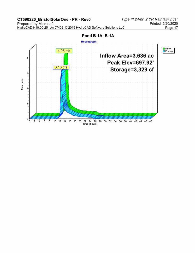
Peak Elev=697.92' Storage=3,329 cf Inflow=4.05 cfs 0.458 afPond B-1A: B-1A Outflow=3.16 cfs 0.458 af
Peak Elev=700.06' Storage=13,979 cf Inflow=3.10 cfs 0.340 afPond B-1B: B-1B Outflow=1.05 cfs 0.340 af
Peak Elev=723.06' Storage=25,974 cf Inflow=9.38 cfs 0.939 afPond B-2: B-2 Outflow=2.83 cfs 0.938 af
Peak Elev=737.00' Storage=11,686 cf Inflow=6.50 cfs 0.588 afPond B-3: B-3 Outflow=3.77 cfs 0.587 af
Inflow=4.09 cfs 0.833 afLink AP-1: AP-1 Primary=4.09 cfs 0.833 af
Inflow=2.97 cfs 1.009 afLink AP-2: AP-2 Primary=2.97 cfs 1.009 af
Inflow=3.77 cfs 0.587 afLink AP-3: AP-3 Primary=3.77 cfs 0.587 af
Total Runoff Area = 18.167 ac Runoff Volume = 2.432 af Average Runoff Depth = 1.61"96.76% Pervious = 17.579 ac 3.24% Impervious = 0.588 ac

Type III 24-hr 2 YR Rainfall=3.61"CT590220_BristolSolarOne - PR - Rev0 Printed 5/20/2020Prepared by Microsoft
Page 7HydroCAD® 10.00-25 s/n 07402 © 2019 HydroCAD Software Solutions LLC
Summary for Subcatchment PDA-1A: PDA-1A
Runoff = 4.05 cfs @ 12.33 hrs, Volume= 0.458 af, Depth= 1.51"
Runoff by SCS TR-20 method, UH=SCS, Weighted-CN, Time Span= 0.00-48.00 hrs, dt= 0.05 hrsType III 24-hr 2 YR Rainfall=3.61"
Area (ac) CN Description0.308 71 Meadow, non-grazed, HSG C3.328 78 Meadow, non-grazed, HSG D3.636 77 Weighted Average3.636 100.00% Pervious Area
Tc Length Slope Velocity Capacity Description(min) (feet) (ft/ft) (ft/sec) (cfs)17.5 100 0.0104 0.10 Sheet Flow, A-B
Grass: Dense n= 0.240 P2= 3.61"3.1 203 0.0238 1.08 Shallow Concentrated Flow, B-C
Short Grass Pasture Kv= 7.0 fps1.6 181 0.0761 1.93 Shallow Concentrated Flow, C-D
Short Grass Pasture Kv= 7.0 fps0.3 68 0.3333 4.04 Shallow Concentrated Flow, D-E
Short Grass Pasture Kv= 7.0 fps22.5 552 Total
Subcatchment PDA-1A: PDA-1A
Runoff
Hydrograph
Time (hours)484644424038363432302826242220181614121086420
Flo
w (
cfs)
4
3
2
1
0
Type III 24-hr2 YR Rainfall=3.61"
Runoff Area=3.636 acRunoff Volume=0.458 af
Runoff Depth=1.51"Flow Length=552'
Tc=22.5 minCN=77
4.05 cfs

Type III 24-hr 2 YR Rainfall=3.61"CT590220_BristolSolarOne - PR - Rev0 Printed 5/20/2020Prepared by Microsoft
Page 8HydroCAD® 10.00-25 s/n 07402 © 2019 HydroCAD Software Solutions LLC
Summary for Subcatchment PDA-1B: PDA-1B
Runoff = 3.10 cfs @ 12.31 hrs, Volume= 0.340 af, Depth= 1.65"
Runoff by SCS TR-20 method, UH=SCS, Weighted-CN, Time Span= 0.00-48.00 hrs, dt= 0.05 hrsType III 24-hr 2 YR Rainfall=3.61"
Area (ac) CN Description0.014 71 Meadow, non-grazed, HSG C2.288 78 Meadow, non-grazed, HSG D0.170 98 Water Surface, HSG D2.472 79 Weighted Average2.302 93.12% Pervious Area0.170 6.88% Impervious Area
Tc Length Slope Velocity Capacity Description(min) (feet) (ft/ft) (ft/sec) (cfs)20.4 100 0.0070 0.08 Sheet Flow, A-B
Grass: Dense n= 0.240 P2= 3.61"0.5 36 0.0338 1.29 Shallow Concentrated Flow, B-C
Short Grass Pasture Kv= 7.0 fps0.3 162 0.0500 10.58 118.47 Channel Flow, D-E
Area= 11.2 sf Perim= 12.0' r= 0.93'n= 0.030 Earth, grassed & winding
0.2 59 0.3333 4.04 Shallow Concentrated Flow, E-FShort Grass Pasture Kv= 7.0 fps
21.4 357 Total

Type III 24-hr 2 YR Rainfall=3.61"CT590220_BristolSolarOne - PR - Rev0 Printed 5/20/2020Prepared by Microsoft
Page 9HydroCAD® 10.00-25 s/n 07402 © 2019 HydroCAD Software Solutions LLC
Subcatchment PDA-1B: PDA-1B
Runoff
Hydrograph
Time (hours)484644424038363432302826242220181614121086420
Flo
w (
cfs)
3
2
1
0
Type III 24-hr2 YR Rainfall=3.61"
Runoff Area=2.472 acRunoff Volume=0.340 af
Runoff Depth=1.65"Flow Length=357'
Tc=21.4 minCN=79
3.10 cfs

Type III 24-hr 2 YR Rainfall=3.61"CT590220_BristolSolarOne - PR - Rev0 Printed 5/20/2020Prepared by Microsoft
Page 10HydroCAD® 10.00-25 s/n 07402 © 2019 HydroCAD Software Solutions LLC
Summary for Subcatchment PDA-1C: PDA-1C
Runoff = 0.46 cfs @ 12.10 hrs, Volume= 0.035 af, Depth= 1.13"
Runoff by SCS TR-20 method, UH=SCS, Weighted-CN, Time Span= 0.00-48.00 hrs, dt= 0.05 hrsType III 24-hr 2 YR Rainfall=3.61"
Area (ac) CN Description0.374 71 Meadow, non-grazed, HSG C0.374 100.00% Pervious Area
Tc Length Slope Velocity Capacity Description(min) (feet) (ft/ft) (ft/sec) (cfs)
6.0 Direct Entry,
Subcatchment PDA-1C: PDA-1C
Runoff
Hydrograph
Time (hours)484644424038363432302826242220181614121086420
Flo
w (
cfs)
0.50.480.460.440.42
0.40.380.360.340.32
0.30.280.260.240.22
0.20.180.160.140.12
0.10.080.060.040.02
0
Type III 24-hr2 YR Rainfall=3.61"
Runoff Area=0.374 acRunoff Volume=0.035 af
Runoff Depth=1.13"Tc=6.0 min
CN=71
0.46 cfs
Type III 24-hr 2 YR Rainfall=3.61"CT590220_BristolSolarOne - PR - Rev0 Printed 5/20/2020Prepared by Microsoft
Page 11HydroCAD® 10.00-25 s/n 07402 © 2019 HydroCAD Software Solutions LLC
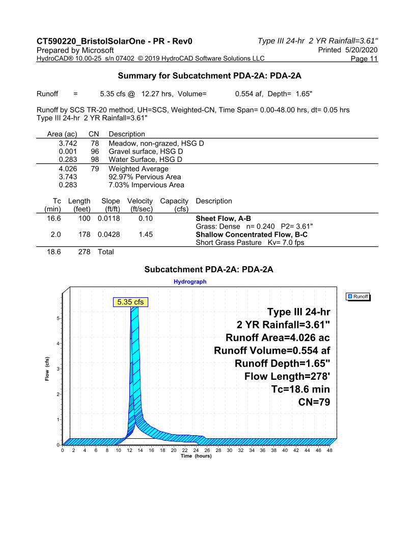
Summary for Subcatchment PDA-2A: PDA-2A
Runoff = 5.35 cfs @ 12.27 hrs, Volume= 0.554 af, Depth= 1.65"
Runoff by SCS TR-20 method, UH=SCS, Weighted-CN, Time Span= 0.00-48.00 hrs, dt= 0.05 hrsType III 24-hr 2 YR Rainfall=3.61"
Area (ac) CN Description3.742 78 Meadow, non-grazed, HSG D0.001 96 Gravel surface, HSG D0.283 98 Water Surface, HSG D4.026 79 Weighted Average3.743 92.97% Pervious Area0.283 7.03% Impervious Area
Tc Length Slope Velocity Capacity Description(min) (feet) (ft/ft) (ft/sec) (cfs)16.6 100 0.0118 0.10 Sheet Flow, A-B
Grass: Dense n= 0.240 P2= 3.61"2.0 178 0.0428 1.45 Shallow Concentrated Flow, B-C
Short Grass Pasture Kv= 7.0 fps18.6 278 Total
Subcatchment PDA-2A: PDA-2A
Runoff
Hydrograph
Time (hours)484644424038363432302826242220181614121086420
Flo
w (
cfs)
5
4
3
2
1
0
Type III 24-hr2 YR Rainfall=3.61"
Runoff Area=4.026 acRunoff Volume=0.554 af
Runoff Depth=1.65"Flow Length=278'
Tc=18.6 minCN=79
5.35 cfs

Type III 24-hr 2 YR Rainfall=3.61"CT590220_BristolSolarOne - PR - Rev0 Printed 5/20/2020Prepared by Microsoft
Page 12HydroCAD® 10.00-25 s/n 07402 © 2019 HydroCAD Software Solutions LLC
Summary for Subcatchment PDA-2B: PDA-2B
Runoff = 4.38 cfs @ 12.17 hrs, Volume= 0.385 af, Depth= 1.65"
Runoff by SCS TR-20 method, UH=SCS, Weighted-CN, Time Span= 0.00-48.00 hrs, dt= 0.05 hrsType III 24-hr 2 YR Rainfall=3.61"
Area (ac) CN Description2.633 78 Meadow, non-grazed, HSG D0.163 96 Gravel surface, HSG D2.796 79 Weighted Average2.796 100.00% Pervious Area
Tc Length Slope Velocity Capacity Description(min) (feet) (ft/ft) (ft/sec) (cfs)
8.7 100 0.0590 0.19 Sheet Flow, A-BGrass: Dense n= 0.240 P2= 3.61"
3.2 376 0.0774 1.95 Shallow Concentrated Flow, B-CShort Grass Pasture Kv= 7.0 fps
0.1 15 0.2800 3.70 Shallow Concentrated Flow, C-DShort Grass Pasture Kv= 7.0 fps
12.0 491 Total
Subcatchment PDA-2B: PDA-2B
Runoff
Hydrograph
Time (hours)484644424038363432302826242220181614121086420
Flo
w (
cfs)
4
3
2
1
0
Type III 24-hr2 YR Rainfall=3.61"
Runoff Area=2.796 acRunoff Volume=0.385 af
Runoff Depth=1.65"Flow Length=491'
Tc=12.0 minCN=79
4.38 cfs

Type III 24-hr 2 YR Rainfall=3.61"CT590220_BristolSolarOne - PR - Rev0 Printed 5/20/2020Prepared by Microsoft
Page 13HydroCAD® 10.00-25 s/n 07402 © 2019 HydroCAD Software Solutions LLC
Summary for Subcatchment PDA-2C: PDA-2C
Runoff = 0.97 cfs @ 12.10 hrs, Volume= 0.072 af, Depth= 1.45"
Runoff by SCS TR-20 method, UH=SCS, Weighted-CN, Time Span= 0.00-48.00 hrs, dt= 0.05 hrsType III 24-hr 2 YR Rainfall=3.61"
Area (ac) CN Description0.156 71 Meadow, non-grazed, HSG C0.438 78 Meadow, non-grazed, HSG D0.594 76 Weighted Average0.594 100.00% Pervious Area
Tc Length Slope Velocity Capacity Description(min) (feet) (ft/ft) (ft/sec) (cfs)
6.0 Direct Entry,
Subcatchment PDA-2C: PDA-2C
Runoff
Hydrograph
Time (hours)484644424038363432302826242220181614121086420
Flo
w (
cfs)
1
0
Type III 24-hr2 YR Rainfall=3.61"
Runoff Area=0.594 acRunoff Volume=0.072 af
Runoff Depth=1.45"Tc=6.0 min
CN=76
0.97 cfs

Type III 24-hr 2 YR Rainfall=3.61"CT590220_BristolSolarOne - PR - Rev0 Printed 5/20/2020Prepared by Microsoft
Page 14HydroCAD® 10.00-25 s/n 07402 © 2019 HydroCAD Software Solutions LLC
Summary for Subcatchment PDA-3: PDA-3
Runoff = 6.50 cfs @ 12.18 hrs, Volume= 0.588 af, Depth= 1.65"
Runoff by SCS TR-20 method, UH=SCS, Weighted-CN, Time Span= 0.00-48.00 hrs, dt= 0.05 hrsType III 24-hr 2 YR Rainfall=3.61"
Area (ac) CN Description4.134 78 Meadow, non-grazed, HSG D0.135 98 Water Surface, HSG D4.269 79 Weighted Average4.134 96.84% Pervious Area0.135 3.16% Impervious Area
Tc Length Slope Velocity Capacity Description(min) (feet) (ft/ft) (ft/sec) (cfs)
9.3 100 0.0503 0.18 Sheet Flow, A-BGrass: Dense n= 0.240 P2= 3.61"
3.5 373 0.0628 1.75 Shallow Concentrated Flow, B-CShort Grass Pasture Kv= 7.0 fps
12.8 473 Total
Subcatchment PDA-3: PDA-3
Runoff
Hydrograph
Time (hours)484644424038363432302826242220181614121086420
Flo
w (
cfs)
7
6
5
4
3
2
1
0
Type III 24-hr2 YR Rainfall=3.61"
Runoff Area=4.269 acRunoff Volume=0.588 af
Runoff Depth=1.65"Flow Length=473'
Tc=12.8 minCN=79
6.50 cfs

Type III 24-hr 2 YR Rainfall=3.61"CT590220_BristolSolarOne - PR - Rev0 Printed 5/20/2020Prepared by Microsoft
Page 15HydroCAD® 10.00-25 s/n 07402 © 2019 HydroCAD Software Solutions LLC
Summary for Reach SW-2: SW-2
Inflow Area = 2.796 ac, 0.00% Impervious, Inflow Depth = 1.65" for 2 YR eventInflow = 4.38 cfs @ 12.17 hrs, Volume= 0.385 afOutflow = 4.29 cfs @ 12.20 hrs, Volume= 0.385 af, Atten= 2%, Lag= 1.8 min
Routing by Dyn-Stor-Ind method, Time Span= 0.00-48.00 hrs, dt= 0.05 hrsMax. Velocity= 4.22 fps, Min. Travel Time= 2.0 minAvg. Velocity = 1.36 fps, Avg. Travel Time= 6.4 min
Peak Storage= 528 cf @ 12.20 hrsAverage Depth at Peak Storage= 0.27'Bank-Full Depth= 1.50' Flow Area= 11.3 sf, Capacity= 122.75 cfs
3.00' x 1.50' deep channel, n= 0.030 Earth, grassed & windingSide Slope Z-value= 3.0 '/' Top Width= 12.00'Length= 518.8' Slope= 0.0558 '/'Inlet Invert= 753.93', Outlet Invert= 725.00'
‡
Reach SW-2: SW-2
InflowOutflow
Hydrograph
Time (hours)484644424038363432302826242220181614121086420
Flo
w (
cfs)
4
3
2
1
0
Inflow Area=2.796 acAvg. Flow Depth=0.27'
Max Vel=4.22 fpsn=0.030L=518.8'
S=0.0558 '/'Capacity=122.75 cfs
4.38 cfs4.29 cfs

Type III 24-hr 2 YR Rainfall=3.61"CT590220_BristolSolarOne - PR - Rev0 Printed 5/20/2020Prepared by Microsoft
Page 16HydroCAD® 10.00-25 s/n 07402 © 2019 HydroCAD Software Solutions LLC
Summary for Pond B-1A: B-1A
Inflow Area = 3.636 ac, 0.00% Impervious, Inflow Depth = 1.51" for 2 YR eventInflow = 4.05 cfs @ 12.33 hrs, Volume= 0.458 afOutflow = 3.16 cfs @ 12.52 hrs, Volume= 0.458 af, Atten= 22%, Lag= 11.6 minPrimary = 3.16 cfs @ 12.52 hrs, Volume= 0.458 af
Routing by Dyn-Stor-Ind method, Time Span= 0.00-48.00 hrs, dt= 0.05 hrsPeak Elev= 697.92' @ 12.52 hrs Surf.Area= 3,976 sf Storage= 3,329 cf
Plug-Flow detention time= 38.9 min calculated for 0.458 af (100% of inflow)Center-of-Mass det. time= 38.1 min ( 899.2 - 861.1 )
Volume Invert Avail.Storage Storage Description#1 697.00' 19,586 cf Custom Stage Data (Irregular) Listed below (Recalc)
Elevation Surf.Area Perim. Inc.Store Cum.Store Wet.Area(feet) (sq-ft) (feet) (cubic-feet) (cubic-feet) (sq-ft)
697.00 3,276 245.1 0 0 3,276698.00 4,040 264.0 3,651 3,651 4,083699.00 4,860 282.8 4,444 8,095 4,945700.00 5,737 301.7 5,292 13,387 5,872701.00 6,671 320.5 6,198 19,586 6,853
Device Routing Invert Outlet Devices#1 Primary 697.00' 15.0" Round Culvert
L= 31.0' CPP, square edge headwall, Ke= 0.500 Inlet / Outlet Invert= 697.00' / 696.00' S= 0.0323 '/' Cc= 0.900 n= 0.013 Corrugated PE, smooth interior, Flow Area= 1.23 sf
#2 Primary 699.50' 7.5' long x 12.0' breadth Broad-Crested Rectangular Weir Head (feet) 0.20 0.40 0.60 0.80 1.00 1.20 1.40 1.60 Coef. (English) 2.57 2.62 2.70 2.67 2.66 2.67 2.66 2.64
Primary OutFlow Max=3.15 cfs @ 12.52 hrs HW=697.92' TW=0.00' (Dynamic Tailwater)1=Culvert (Inlet Controls 3.15 cfs @ 3.26 fps)2=Broad-Crested Rectangular Weir ( Controls 0.00 cfs)
Type III 24-hr 2 YR Rainfall=3.61"CT590220_BristolSolarOne - PR - Rev0 Printed 5/20/2020Prepared by Microsoft
Page 17HydroCAD® 10.00-25 s/n 07402 © 2019 HydroCAD Software Solutions LLC
Pond B-1A: B-1A
InflowPrimary
Hydrograph
Time (hours)484644424038363432302826242220181614121086420
Flo
w (
cfs)
4
3
2
1
0
Inflow Area=3.636 acPeak Elev=697.92'
Storage=3,329 cf
4.05 cfs
3.16 cfs

Type III 24-hr 2 YR Rainfall=3.61"CT590220_BristolSolarOne - PR - Rev0 Printed 5/20/2020Prepared by Microsoft
Page 18HydroCAD® 10.00-25 s/n 07402 © 2019 HydroCAD Software Solutions LLC
Summary for Pond B-1B: B-1B
Inflow Area = 2.472 ac, 6.88% Impervious, Inflow Depth = 1.65" for 2 YR eventInflow = 3.10 cfs @ 12.31 hrs, Volume= 0.340 afOutflow = 1.05 cfs @ 12.81 hrs, Volume= 0.340 af, Atten= 66%, Lag= 30.4 minPrimary = 1.05 cfs @ 12.81 hrs, Volume= 0.340 af
Routing by Dyn-Stor-Ind method, Time Span= 0.00-48.00 hrs, dt= 0.05 hrsStarting Elev= 699.40' Surf.Area= 7,385 sf Storage= 8,704 cfPeak Elev= 700.06' @ 12.81 hrs Surf.Area= 8,682 sf Storage= 13,979 cf (5,275 cf above start)
Plug-Flow detention time= 422.9 min calculated for 0.140 af (41% of inflow)Center-of-Mass det. time= 97.5 min ( 951.5 - 854.0 )
Volume Invert Avail.Storage Storage Description#1 698.00' 34,674 cf Custom Stage Data (Irregular) Listed below (Recalc)
Elevation Surf.Area Perim. Inc.Store Cum.Store Wet.Area(feet) (sq-ft) (feet) (cubic-feet) (cubic-feet) (sq-ft)
698.00 5,187 405.1 0 0 5,187699.00 6,643 578.3 5,900 5,900 18,750700.00 8,572 665.1 7,587 13,487 27,361701.00 10,596 684.0 9,566 23,053 29,499702.00 12,676 702.8 11,620 34,674 31,687
Device Routing Invert Outlet Devices#1 Primary 698.00' 15.0" Round Culvert
L= 30.0' CPP, square edge headwall, Ke= 0.500 Inlet / Outlet Invert= 698.00' / 697.00' S= 0.0333 '/' Cc= 0.900 n= 0.013 Corrugated PE, smooth interior, Flow Area= 1.23 sf
#2 Device 1 699.40' 12.0" W x 3.0" H Vert. Orifice/Grate C= 0.600 #3 Device 1 700.00' 15.0" Horiz. Orifice/Grate C= 0.600
Limited to weir flow at low heads #4 Primary 700.90' 3.0' long x 15.0' breadth Broad-Crested Rectangular Weir
Head (feet) 0.20 0.40 0.60 0.80 1.00 1.20 1.40 1.60 Coef. (English) 2.68 2.70 2.70 2.64 2.63 2.64 2.64 2.63
Primary OutFlow Max=1.05 cfs @ 12.81 hrs HW=700.06' TW=0.00' (Dynamic Tailwater)1=Culvert (Passes 1.05 cfs of 7.07 cfs potential flow)
2=Orifice/Grate (Orifice Controls 0.88 cfs @ 3.50 fps)3=Orifice/Grate (Weir Controls 0.17 cfs @ 0.78 fps)
4=Broad-Crested Rectangular Weir ( Controls 0.00 cfs)

Type III 24-hr 2 YR Rainfall=3.61"CT590220_BristolSolarOne - PR - Rev0 Printed 5/20/2020Prepared by Microsoft
Page 19HydroCAD® 10.00-25 s/n 07402 © 2019 HydroCAD Software Solutions LLC
Pond B-1B: B-1B
InflowPrimary
Hydrograph
Time (hours)484644424038363432302826242220181614121086420
Flo
w (
cfs)
3
2
1
0
Inflow Area=2.472 acPeak Elev=700.06'Storage=13,979 cf
3.10 cfs
1.05 cfs

Type III 24-hr 2 YR Rainfall=3.61"CT590220_BristolSolarOne - PR - Rev0 Printed 5/20/2020Prepared by Microsoft
Page 20HydroCAD® 10.00-25 s/n 07402 © 2019 HydroCAD Software Solutions LLC
Summary for Pond B-2: B-2
Inflow Area = 6.822 ac, 4.15% Impervious, Inflow Depth = 1.65" for 2 YR eventInflow = 9.38 cfs @ 12.23 hrs, Volume= 0.939 afOutflow = 2.83 cfs @ 12.74 hrs, Volume= 0.938 af, Atten= 70%, Lag= 30.4 minPrimary = 2.83 cfs @ 12.74 hrs, Volume= 0.938 af
Routing by Dyn-Stor-Ind method, Time Span= 0.00-48.00 hrs, dt= 0.05 hrsStarting Elev= 721.85' Surf.Area= 12,337 sf Storage= 9,974 cfPeak Elev= 723.06' @ 12.74 hrs Surf.Area= 14,117 sf Storage= 25,974 cf (16,000 cf above start)
Plug-Flow detention time= 302.6 min calculated for 0.708 af (75% of inflow)Center-of-Mass det. time= 140.3 min ( 991.0 - 850.7 )
Volume Invert Avail.Storage Storage Description#1 721.00' 56,252 cf Custom Stage Data (Irregular) Listed below (Recalc)
Elevation Surf.Area Perim. Inc.Store Cum.Store Wet.Area(feet) (sq-ft) (feet) (cubic-feet) (cubic-feet) (sq-ft)
721.00 11,140 462.4 0 0 11,140722.00 12,555 481.2 11,840 11,840 12,628723.00 14,027 500.1 13,284 25,125 14,184724.00 15,556 518.9 14,785 39,910 15,791725.00 17,141 537.8 16,342 56,252 17,466
Device Routing Invert Outlet Devices#1 Primary 720.50' 12.0" Round Culvert
L= 34.0' CPP, square edge headwall, Ke= 0.500 Inlet / Outlet Invert= 720.50' / 720.00' S= 0.0147 '/' Cc= 0.900 n= 0.013 Corrugated PE, smooth interior, Flow Area= 0.79 sf
#2 Device 1 721.85' 12.0" W x 3.0" H Vert. Orifice/Grate C= 0.600 #3 Device 1 722.50' 12.0" Vert. Orifice/Grate C= 0.600 #4 Primary 723.00' 11.0' long x 12.0' breadth Broad-Crested Rectangular Weir
Head (feet) 0.20 0.40 0.60 0.80 1.00 1.20 1.40 1.60 Coef. (English) 2.57 2.62 2.70 2.67 2.66 2.67 2.66 2.64
Primary OutFlow Max=2.82 cfs @ 12.74 hrs HW=723.06' TW=0.00' (Dynamic Tailwater)1=Culvert (Passes 2.41 cfs of 5.43 cfs potential flow)
2=Orifice/Grate (Orifice Controls 1.25 cfs @ 5.01 fps)3=Orifice/Grate (Orifice Controls 1.15 cfs @ 2.55 fps)
4=Broad-Crested Rectangular Weir (Weir Controls 0.41 cfs @ 0.63 fps)
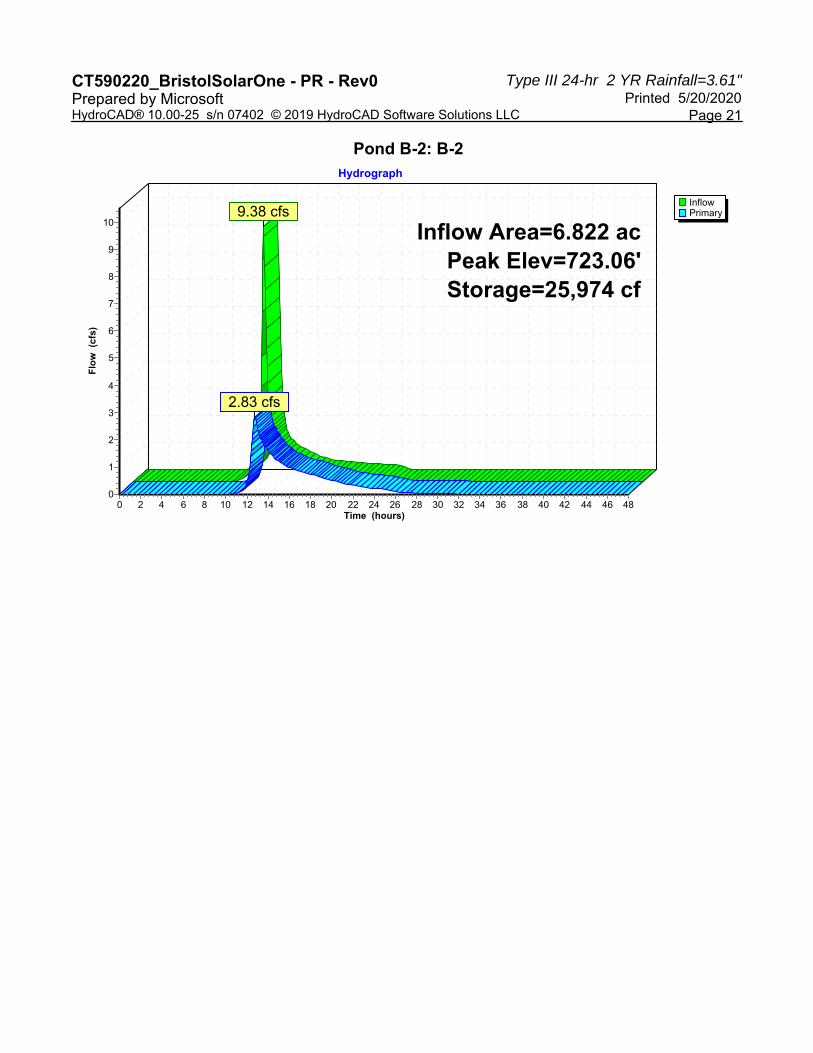
Type III 24-hr 2 YR Rainfall=3.61"CT590220_BristolSolarOne - PR - Rev0 Printed 5/20/2020Prepared by Microsoft
Page 21HydroCAD® 10.00-25 s/n 07402 © 2019 HydroCAD Software Solutions LLC
Pond B-2: B-2
InflowPrimary
Hydrograph
Time (hours)484644424038363432302826242220181614121086420
Flo
w (
cfs)
10
9
8
7
6
5
4
3
2
1
0
Inflow Area=6.822 acPeak Elev=723.06'Storage=25,974 cf
9.38 cfs
2.83 cfs

Type III 24-hr 2 YR Rainfall=3.61"CT590220_BristolSolarOne - PR - Rev0 Printed 5/20/2020Prepared by Microsoft
Page 22HydroCAD® 10.00-25 s/n 07402 © 2019 HydroCAD Software Solutions LLC
Summary for Pond B-3: B-3
Inflow Area = 4.269 ac, 3.16% Impervious, Inflow Depth = 1.65" for 2 YR eventInflow = 6.50 cfs @ 12.18 hrs, Volume= 0.588 afOutflow = 3.77 cfs @ 12.42 hrs, Volume= 0.587 af, Atten= 42%, Lag= 14.0 minPrimary = 3.77 cfs @ 12.42 hrs, Volume= 0.587 af
Routing by Dyn-Stor-Ind method, Time Span= 0.00-48.00 hrs, dt= 0.05 hrsStarting Elev= 736.05' Surf.Area= 5,881 sf Storage= 5,653 cfPeak Elev= 737.00' @ 12.42 hrs Surf.Area= 6,823 sf Storage= 11,686 cf (6,034 cf above start)
Plug-Flow detention time= 187.3 min calculated for 0.458 af (78% of inflow)Center-of-Mass det. time= 54.7 min ( 900.8 - 846.1 )
Volume Invert Avail.Storage Storage Description#1 735.00' 27,433 cf Custom Stage Data (Irregular) Listed below (Recalc)
Elevation Surf.Area Perim. Inc.Store Cum.Store Wet.Area(feet) (sq-ft) (feet) (cubic-feet) (cubic-feet) (sq-ft)
735.00 4,900 301.5 0 0 4,900736.00 5,833 320.3 5,360 5,360 5,881737.00 6,822 339.2 6,321 11,681 6,926738.00 7,868 358.0 7,339 19,020 8,026739.00 8,971 376.9 8,413 27,433 9,191
Device Routing Invert Outlet Devices#1 Primary 735.50' 12.0" Round Culvert
L= 28.0' CPP, square edge headwall, Ke= 0.500 Inlet / Outlet Invert= 735.50' / 735.00' S= 0.0179 '/' Cc= 0.900 n= 0.013 Corrugated PE, smooth interior, Flow Area= 0.79 sf
#2 Primary 736.05' 12.0" W x 3.0" H Vert. Orifice/Grate C= 0.600 #3 Device 1 736.50' 12.0" Horiz. Orifice/Grate C= 0.600
Limited to weir flow at low heads #4 Primary 737.00' 8.0' long x 12.0' breadth Broad-Crested Rectangular Weir
Head (feet) 0.20 0.40 0.60 0.80 1.00 1.20 1.40 1.60 Coef. (English) 2.57 2.62 2.70 2.67 2.66 2.67 2.66 2.64
Primary OutFlow Max=3.76 cfs @ 12.42 hrs HW=737.00' TW=0.00' (Dynamic Tailwater)1=Culvert (Passes 2.67 cfs of 3.78 cfs potential flow)
3=Orifice/Grate (Orifice Controls 2.67 cfs @ 3.40 fps)2=Orifice/Grate (Orifice Controls 1.09 cfs @ 4.37 fps)4=Broad-Crested Rectangular Weir ( Controls 0.00 cfs)

Type III 24-hr 2 YR Rainfall=3.61"CT590220_BristolSolarOne - PR - Rev0 Printed 5/20/2020Prepared by Microsoft
Page 23HydroCAD® 10.00-25 s/n 07402 © 2019 HydroCAD Software Solutions LLC
Pond B-3: B-3
InflowPrimary
Hydrograph
Time (hours)484644424038363432302826242220181614121086420
Flo
w (
cfs)
7
6
5
4
3
2
1
0
Inflow Area=4.269 acPeak Elev=737.00'Storage=11,686 cf
6.50 cfs
3.77 cfs
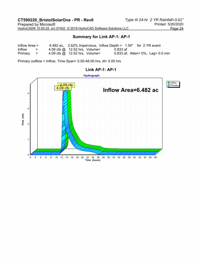
Type III 24-hr 2 YR Rainfall=3.61"CT590220_BristolSolarOne - PR - Rev0 Printed 5/20/2020Prepared by Microsoft
Page 24HydroCAD® 10.00-25 s/n 07402 © 2019 HydroCAD Software Solutions LLC
Summary for Link AP-1: AP-1
Inflow Area = 6.482 ac, 2.62% Impervious, Inflow Depth > 1.54" for 2 YR eventInflow = 4.09 cfs @ 12.52 hrs, Volume= 0.833 afPrimary = 4.09 cfs @ 12.52 hrs, Volume= 0.833 af, Atten= 0%, Lag= 0.0 min
Primary outflow = Inflow, Time Span= 0.00-48.00 hrs, dt= 0.05 hrs
Link AP-1: AP-1
InflowPrimary
Hydrograph
Time (hours)484644424038363432302826242220181614121086420
Flo
w (
cfs)
4
3
2
1
0
Inflow Area=6.482 ac4.09 cfs
4.09 cfs

Type III 24-hr 2 YR Rainfall=3.61"CT590220_BristolSolarOne - PR - Rev0 Printed 5/20/2020Prepared by Microsoft
Page 25HydroCAD® 10.00-25 s/n 07402 © 2019 HydroCAD Software Solutions LLC
Summary for Link AP-2: AP-2
Inflow Area = 7.416 ac, 3.82% Impervious, Inflow Depth > 1.63" for 2 YR eventInflow = 2.97 cfs @ 12.73 hrs, Volume= 1.009 afPrimary = 2.97 cfs @ 12.73 hrs, Volume= 1.009 af, Atten= 0%, Lag= 0.0 min
Primary outflow = Inflow, Time Span= 0.00-48.00 hrs, dt= 0.05 hrs
Link AP-2: AP-2
InflowPrimary
Hydrograph
Time (hours)484644424038363432302826242220181614121086420
Flo
w (
cfs)
3
2
1
0
Inflow Area=7.416 ac2.97 cfs
2.97 cfs

Type III 24-hr 2 YR Rainfall=3.61"CT590220_BristolSolarOne - PR - Rev0 Printed 5/20/2020Prepared by Microsoft
Page 26HydroCAD® 10.00-25 s/n 07402 © 2019 HydroCAD Software Solutions LLC
Summary for Link AP-3: AP-3
Inflow Area = 4.269 ac, 3.16% Impervious, Inflow Depth = 1.65" for 2 YR eventInflow = 3.77 cfs @ 12.42 hrs, Volume= 0.587 afPrimary = 3.77 cfs @ 12.42 hrs, Volume= 0.587 af, Atten= 0%, Lag= 0.0 min
Primary outflow = Inflow, Time Span= 0.00-48.00 hrs, dt= 0.05 hrs
Link AP-3: AP-3
InflowPrimary
Hydrograph
Time (hours)484644424038363432302826242220181614121086420
Flo
w (
cfs)
4
3
2
1
0
Inflow Area=4.269 ac3.77 cfs
3.77 cfs

Type III 24-hr 25 YR Rainfall=7.13"CT590220_BristolSolarOne - PR - Rev0 Printed 5/20/2020Prepared by Microsoft
Page 27HydroCAD® 10.00-25 s/n 07402 © 2019 HydroCAD Software Solutions LLC
Time span=0.00-48.00 hrs, dt=0.05 hrs, 961 pointsRunoff by SCS TR-20 method, UH=SCS, Weighted-CN
Reach routing by Dyn-Stor-Ind method - Pond routing by Dyn-Stor-Ind method
Runoff Area=3.636 ac 0.00% Impervious Runoff Depth=4.48"Subcatchment PDA-1A: PDA-1A Flow Length=552' Tc=22.5 min CN=77 Runoff=12.22 cfs 1.358 af
Runoff Area=2.472 ac 6.88% Impervious Runoff Depth=4.70"Subcatchment PDA-1B: PDA-1B Flow Length=357' Tc=21.4 min CN=79 Runoff=8.86 cfs 0.969 af
Runoff Area=0.374 ac 0.00% Impervious Runoff Depth=3.83"Subcatchment PDA-1C: PDA-1C Tc=6.0 min CN=71 Runoff=1.65 cfs 0.119 af
Runoff Area=4.026 ac 7.03% Impervious Runoff Depth=4.70"Subcatchment PDA-2A: PDA-2A Flow Length=278' Tc=18.6 min CN=79 Runoff=15.30 cfs 1.578 af
Runoff Area=2.796 ac 0.00% Impervious Runoff Depth=4.70"Subcatchment PDA-2B: PDA-2B Flow Length=491' Tc=12.0 min CN=79 Runoff=12.51 cfs 1.096 af
Runoff Area=0.594 ac 0.00% Impervious Runoff Depth=4.37"Subcatchment PDA-2C: PDA-2C Tc=6.0 min CN=76 Runoff=2.98 cfs 0.216 af
Runoff Area=4.269 ac 3.16% Impervious Runoff Depth=4.70"Subcatchment PDA-3: PDA-3 Flow Length=473' Tc=12.8 min CN=79 Runoff=18.67 cfs 1.673 af
Avg. Flow Depth=0.48' Max Vel=5.82 fps Inflow=12.51 cfs 1.096 afReach SW-2: SW-2n=0.030 L=518.8' S=0.0558 '/' Capacity=122.75 cfs Outflow=12.32 cfs 1.096 af
Peak Elev=699.42' Storage=10,198 cf Inflow=12.22 cfs 1.358 afPond B-1A: B-1A Outflow=7.91 cfs 1.358 af
Peak Elev=700.61' Storage=19,090 cf Inflow=8.86 cfs 0.969 afPond B-1B: B-1B Outflow=5.87 cfs 0.969 af
Peak Elev=723.71' Storage=35,527 cf Inflow=26.99 cfs 2.674 afPond B-2: B-2 Outflow=22.59 cfs 2.672 af
Peak Elev=737.63' Storage=16,216 cf Inflow=18.67 cfs 1.673 afPond B-3: B-3 Outflow=16.38 cfs 1.673 af
Inflow=14.12 cfs 2.446 afLink AP-1: AP-1 Primary=14.12 cfs 2.446 af
Inflow=23.80 cfs 2.889 afLink AP-2: AP-2 Primary=23.80 cfs 2.889 af
Inflow=16.38 cfs 1.673 afLink AP-3: AP-3 Primary=16.38 cfs 1.673 af
Total Runoff Area = 18.167 ac Runoff Volume = 7.010 af Average Runoff Depth = 4.63"96.76% Pervious = 17.579 ac 3.24% Impervious = 0.588 ac

Type III 24-hr 25 YR Rainfall=7.13"CT590220_BristolSolarOne - PR - Rev0 Printed 5/20/2020Prepared by Microsoft
Page 28HydroCAD® 10.00-25 s/n 07402 © 2019 HydroCAD Software Solutions LLC
Summary for Subcatchment PDA-1A: PDA-1A
Runoff = 12.22 cfs @ 12.31 hrs, Volume= 1.358 af, Depth= 4.48"
Runoff by SCS TR-20 method, UH=SCS, Weighted-CN, Time Span= 0.00-48.00 hrs, dt= 0.05 hrsType III 24-hr 25 YR Rainfall=7.13"
Area (ac) CN Description0.308 71 Meadow, non-grazed, HSG C3.328 78 Meadow, non-grazed, HSG D3.636 77 Weighted Average3.636 100.00% Pervious Area
Tc Length Slope Velocity Capacity Description(min) (feet) (ft/ft) (ft/sec) (cfs)17.5 100 0.0104 0.10 Sheet Flow, A-B
Grass: Dense n= 0.240 P2= 3.61"3.1 203 0.0238 1.08 Shallow Concentrated Flow, B-C
Short Grass Pasture Kv= 7.0 fps1.6 181 0.0761 1.93 Shallow Concentrated Flow, C-D
Short Grass Pasture Kv= 7.0 fps0.3 68 0.3333 4.04 Shallow Concentrated Flow, D-E
Short Grass Pasture Kv= 7.0 fps22.5 552 Total
Subcatchment PDA-1A: PDA-1A
Runoff
Hydrograph
Time (hours)484644424038363432302826242220181614121086420
Flo
w (
cfs)
13
12
11
10
9
8
7
6
5
4
3
2
1
0
Type III 24-hr25 YR Rainfall=7.13"
Runoff Area=3.636 acRunoff Volume=1.358 af
Runoff Depth=4.48"Flow Length=552'
Tc=22.5 minCN=77
12.22 cfs

Type III 24-hr 25 YR Rainfall=7.13"CT590220_BristolSolarOne - PR - Rev0 Printed 5/20/2020Prepared by Microsoft
Page 29HydroCAD® 10.00-25 s/n 07402 © 2019 HydroCAD Software Solutions LLC
Summary for Subcatchment PDA-1B: PDA-1B
Runoff = 8.86 cfs @ 12.29 hrs, Volume= 0.969 af, Depth= 4.70"
Runoff by SCS TR-20 method, UH=SCS, Weighted-CN, Time Span= 0.00-48.00 hrs, dt= 0.05 hrsType III 24-hr 25 YR Rainfall=7.13"
Area (ac) CN Description0.014 71 Meadow, non-grazed, HSG C2.288 78 Meadow, non-grazed, HSG D0.170 98 Water Surface, HSG D2.472 79 Weighted Average2.302 93.12% Pervious Area0.170 6.88% Impervious Area
Tc Length Slope Velocity Capacity Description(min) (feet) (ft/ft) (ft/sec) (cfs)20.4 100 0.0070 0.08 Sheet Flow, A-B
Grass: Dense n= 0.240 P2= 3.61"0.5 36 0.0338 1.29 Shallow Concentrated Flow, B-C
Short Grass Pasture Kv= 7.0 fps0.3 162 0.0500 10.58 118.47 Channel Flow, D-E
Area= 11.2 sf Perim= 12.0' r= 0.93'n= 0.030 Earth, grassed & winding
0.2 59 0.3333 4.04 Shallow Concentrated Flow, E-FShort Grass Pasture Kv= 7.0 fps
21.4 357 Total

Type III 24-hr 25 YR Rainfall=7.13"CT590220_BristolSolarOne - PR - Rev0 Printed 5/20/2020Prepared by Microsoft
Page 30HydroCAD® 10.00-25 s/n 07402 © 2019 HydroCAD Software Solutions LLC
Subcatchment PDA-1B: PDA-1B
Runoff
Hydrograph
Time (hours)484644424038363432302826242220181614121086420
Flo
w (
cfs)
9
8
7
6
5
4
3
2
1
0
Type III 24-hr25 YR Rainfall=7.13"
Runoff Area=2.472 acRunoff Volume=0.969 af
Runoff Depth=4.70"Flow Length=357'
Tc=21.4 minCN=79
8.86 cfs

Type III 24-hr 25 YR Rainfall=7.13"CT590220_BristolSolarOne - PR - Rev0 Printed 5/20/2020Prepared by Microsoft
Page 31HydroCAD® 10.00-25 s/n 07402 © 2019 HydroCAD Software Solutions LLC
Summary for Subcatchment PDA-1C: PDA-1C
Runoff = 1.65 cfs @ 12.09 hrs, Volume= 0.119 af, Depth= 3.83"
Runoff by SCS TR-20 method, UH=SCS, Weighted-CN, Time Span= 0.00-48.00 hrs, dt= 0.05 hrsType III 24-hr 25 YR Rainfall=7.13"
Area (ac) CN Description0.374 71 Meadow, non-grazed, HSG C0.374 100.00% Pervious Area
Tc Length Slope Velocity Capacity Description(min) (feet) (ft/ft) (ft/sec) (cfs)
6.0 Direct Entry,
Subcatchment PDA-1C: PDA-1C
Runoff
Hydrograph
Time (hours)484644424038363432302826242220181614121086420
Flo
w (
cfs)
1
0
Type III 24-hr25 YR Rainfall=7.13"
Runoff Area=0.374 acRunoff Volume=0.119 af
Runoff Depth=3.83"Tc=6.0 min
CN=71
1.65 cfs

Type III 24-hr 25 YR Rainfall=7.13"CT590220_BristolSolarOne - PR - Rev0 Printed 5/20/2020Prepared by Microsoft
Page 32HydroCAD® 10.00-25 s/n 07402 © 2019 HydroCAD Software Solutions LLC
Summary for Subcatchment PDA-2A: PDA-2A
Runoff = 15.30 cfs @ 12.25 hrs, Volume= 1.578 af, Depth= 4.70"
Runoff by SCS TR-20 method, UH=SCS, Weighted-CN, Time Span= 0.00-48.00 hrs, dt= 0.05 hrsType III 24-hr 25 YR Rainfall=7.13"
Area (ac) CN Description3.742 78 Meadow, non-grazed, HSG D0.001 96 Gravel surface, HSG D0.283 98 Water Surface, HSG D4.026 79 Weighted Average3.743 92.97% Pervious Area0.283 7.03% Impervious Area
Tc Length Slope Velocity Capacity Description(min) (feet) (ft/ft) (ft/sec) (cfs)16.6 100 0.0118 0.10 Sheet Flow, A-B
Grass: Dense n= 0.240 P2= 3.61"2.0 178 0.0428 1.45 Shallow Concentrated Flow, B-C
Short Grass Pasture Kv= 7.0 fps18.6 278 Total
Subcatchment PDA-2A: PDA-2A
Runoff
Hydrograph
Time (hours)484644424038363432302826242220181614121086420
Flo
w (
cfs)
17
16
15
14
13
12
11
10
9
8
7
6
5
4
3
2
1
0
Type III 24-hr25 YR Rainfall=7.13"
Runoff Area=4.026 acRunoff Volume=1.578 af
Runoff Depth=4.70"Flow Length=278'
Tc=18.6 minCN=79
15.30 cfs

Type III 24-hr 25 YR Rainfall=7.13"CT590220_BristolSolarOne - PR - Rev0 Printed 5/20/2020Prepared by Microsoft
Page 33HydroCAD® 10.00-25 s/n 07402 © 2019 HydroCAD Software Solutions LLC
Summary for Subcatchment PDA-2B: PDA-2B
Runoff = 12.51 cfs @ 12.17 hrs, Volume= 1.096 af, Depth= 4.70"
Runoff by SCS TR-20 method, UH=SCS, Weighted-CN, Time Span= 0.00-48.00 hrs, dt= 0.05 hrsType III 24-hr 25 YR Rainfall=7.13"
Area (ac) CN Description2.633 78 Meadow, non-grazed, HSG D0.163 96 Gravel surface, HSG D2.796 79 Weighted Average2.796 100.00% Pervious Area
Tc Length Slope Velocity Capacity Description(min) (feet) (ft/ft) (ft/sec) (cfs)
8.7 100 0.0590 0.19 Sheet Flow, A-BGrass: Dense n= 0.240 P2= 3.61"
3.2 376 0.0774 1.95 Shallow Concentrated Flow, B-CShort Grass Pasture Kv= 7.0 fps
0.1 15 0.2800 3.70 Shallow Concentrated Flow, C-DShort Grass Pasture Kv= 7.0 fps
12.0 491 Total
Subcatchment PDA-2B: PDA-2B
Runoff
Hydrograph
Time (hours)484644424038363432302826242220181614121086420
Flo
w (
cfs)
14
13
12
11
10
9
8
7
6
5
4
3
2
1
0
Type III 24-hr25 YR Rainfall=7.13"
Runoff Area=2.796 acRunoff Volume=1.096 af
Runoff Depth=4.70"Flow Length=491'
Tc=12.0 minCN=79
12.51 cfs

Type III 24-hr 25 YR Rainfall=7.13"CT590220_BristolSolarOne - PR - Rev0 Printed 5/20/2020Prepared by Microsoft
Page 34HydroCAD® 10.00-25 s/n 07402 © 2019 HydroCAD Software Solutions LLC
Summary for Subcatchment PDA-2C: PDA-2C
Runoff = 2.98 cfs @ 12.09 hrs, Volume= 0.216 af, Depth= 4.37"
Runoff by SCS TR-20 method, UH=SCS, Weighted-CN, Time Span= 0.00-48.00 hrs, dt= 0.05 hrsType III 24-hr 25 YR Rainfall=7.13"
Area (ac) CN Description0.156 71 Meadow, non-grazed, HSG C0.438 78 Meadow, non-grazed, HSG D0.594 76 Weighted Average0.594 100.00% Pervious Area
Tc Length Slope Velocity Capacity Description(min) (feet) (ft/ft) (ft/sec) (cfs)
6.0 Direct Entry,
Subcatchment PDA-2C: PDA-2C
Runoff
Hydrograph
Time (hours)484644424038363432302826242220181614121086420
Flo
w (
cfs)
3
2
1
0
Type III 24-hr25 YR Rainfall=7.13"
Runoff Area=0.594 acRunoff Volume=0.216 af
Runoff Depth=4.37"Tc=6.0 min
CN=76
2.98 cfs

Type III 24-hr 25 YR Rainfall=7.13"CT590220_BristolSolarOne - PR - Rev0 Printed 5/20/2020Prepared by Microsoft
Page 35HydroCAD® 10.00-25 s/n 07402 © 2019 HydroCAD Software Solutions LLC
Summary for Subcatchment PDA-3: PDA-3
Runoff = 18.67 cfs @ 12.17 hrs, Volume= 1.673 af, Depth= 4.70"
Runoff by SCS TR-20 method, UH=SCS, Weighted-CN, Time Span= 0.00-48.00 hrs, dt= 0.05 hrsType III 24-hr 25 YR Rainfall=7.13"
Area (ac) CN Description4.134 78 Meadow, non-grazed, HSG D0.135 98 Water Surface, HSG D4.269 79 Weighted Average4.134 96.84% Pervious Area0.135 3.16% Impervious Area
Tc Length Slope Velocity Capacity Description(min) (feet) (ft/ft) (ft/sec) (cfs)
9.3 100 0.0503 0.18 Sheet Flow, A-BGrass: Dense n= 0.240 P2= 3.61"
3.5 373 0.0628 1.75 Shallow Concentrated Flow, B-CShort Grass Pasture Kv= 7.0 fps
12.8 473 Total
Subcatchment PDA-3: PDA-3
Runoff
Hydrograph
Time (hours)484644424038363432302826242220181614121086420
Flo
w (
cfs)
20
19
18
17
16
15
14
13
12
11
10
9
8
7
6
5
4
3
2
1
0
Type III 24-hr25 YR Rainfall=7.13"
Runoff Area=4.269 acRunoff Volume=1.673 af
Runoff Depth=4.70"Flow Length=473'
Tc=12.8 minCN=79
18.67 cfs

Type III 24-hr 25 YR Rainfall=7.13"CT590220_BristolSolarOne - PR - Rev0 Printed 5/20/2020Prepared by Microsoft
Page 36HydroCAD® 10.00-25 s/n 07402 © 2019 HydroCAD Software Solutions LLC
Summary for Reach SW-2: SW-2
Inflow Area = 2.796 ac, 0.00% Impervious, Inflow Depth = 4.70" for 25 YR eventInflow = 12.51 cfs @ 12.17 hrs, Volume= 1.096 afOutflow = 12.32 cfs @ 12.19 hrs, Volume= 1.096 af, Atten= 2%, Lag= 1.3 min
Routing by Dyn-Stor-Ind method, Time Span= 0.00-48.00 hrs, dt= 0.05 hrsMax. Velocity= 5.82 fps, Min. Travel Time= 1.5 minAvg. Velocity = 1.80 fps, Avg. Travel Time= 4.8 min
Peak Storage= 1,097 cf @ 12.19 hrsAverage Depth at Peak Storage= 0.48'Bank-Full Depth= 1.50' Flow Area= 11.3 sf, Capacity= 122.75 cfs
3.00' x 1.50' deep channel, n= 0.030 Earth, grassed & windingSide Slope Z-value= 3.0 '/' Top Width= 12.00'Length= 518.8' Slope= 0.0558 '/'Inlet Invert= 753.93', Outlet Invert= 725.00'
‡
Reach SW-2: SW-2
InflowOutflow
Hydrograph
Time (hours)484644424038363432302826242220181614121086420
Flo
w (
cfs)
14
13
12
11
10
9
8
7
6
5
4
3
2
1
0
Inflow Area=2.796 acAvg. Flow Depth=0.48'
Max Vel=5.82 fpsn=0.030L=518.8'
S=0.0558 '/'Capacity=122.75 cfs
12.51 cfs12.32 cfs

Type III 24-hr 25 YR Rainfall=7.13"CT590220_BristolSolarOne - PR - Rev0 Printed 5/20/2020Prepared by Microsoft
Page 37HydroCAD® 10.00-25 s/n 07402 © 2019 HydroCAD Software Solutions LLC
Summary for Pond B-1A: B-1A
Inflow Area = 3.636 ac, 0.00% Impervious, Inflow Depth = 4.48" for 25 YR eventInflow = 12.22 cfs @ 12.31 hrs, Volume= 1.358 afOutflow = 7.91 cfs @ 12.57 hrs, Volume= 1.358 af, Atten= 35%, Lag= 15.7 minPrimary = 7.91 cfs @ 12.57 hrs, Volume= 1.358 af
Routing by Dyn-Stor-Ind method, Time Span= 0.00-48.00 hrs, dt= 0.05 hrsPeak Elev= 699.42' @ 12.57 hrs Surf.Area= 5,217 sf Storage= 10,198 cf
Plug-Flow detention time= 27.6 min calculated for 1.358 af (100% of inflow)Center-of-Mass det. time= 27.2 min ( 856.8 - 829.7 )
Volume Invert Avail.Storage Storage Description#1 697.00' 19,586 cf Custom Stage Data (Irregular) Listed below (Recalc)
Elevation Surf.Area Perim. Inc.Store Cum.Store Wet.Area(feet) (sq-ft) (feet) (cubic-feet) (cubic-feet) (sq-ft)
697.00 3,276 245.1 0 0 3,276698.00 4,040 264.0 3,651 3,651 4,083699.00 4,860 282.8 4,444 8,095 4,945700.00 5,737 301.7 5,292 13,387 5,872701.00 6,671 320.5 6,198 19,586 6,853
Device Routing Invert Outlet Devices#1 Primary 697.00' 15.0" Round Culvert
L= 31.0' CPP, square edge headwall, Ke= 0.500 Inlet / Outlet Invert= 697.00' / 696.00' S= 0.0323 '/' Cc= 0.900 n= 0.013 Corrugated PE, smooth interior, Flow Area= 1.23 sf
#2 Primary 699.50' 7.5' long x 12.0' breadth Broad-Crested Rectangular Weir Head (feet) 0.20 0.40 0.60 0.80 1.00 1.20 1.40 1.60 Coef. (English) 2.57 2.62 2.70 2.67 2.66 2.67 2.66 2.64
Primary OutFlow Max=7.90 cfs @ 12.57 hrs HW=699.41' TW=0.00' (Dynamic Tailwater)1=Culvert (Inlet Controls 7.90 cfs @ 6.44 fps)2=Broad-Crested Rectangular Weir ( Controls 0.00 cfs)

Type III 24-hr 25 YR Rainfall=7.13"CT590220_BristolSolarOne - PR - Rev0 Printed 5/20/2020Prepared by Microsoft
Page 38HydroCAD® 10.00-25 s/n 07402 © 2019 HydroCAD Software Solutions LLC
Pond B-1A: B-1A
InflowPrimary
Hydrograph
Time (hours)484644424038363432302826242220181614121086420
Flo
w (
cfs)
13
12
11
10
9
8
7
6
5
4
3
2
1
0
Inflow Area=3.636 acPeak Elev=699.42'Storage=10,198 cf
12.22 cfs
7.91 cfs

Type III 24-hr 25 YR Rainfall=7.13"CT590220_BristolSolarOne - PR - Rev0 Printed 5/20/2020Prepared by Microsoft
Page 39HydroCAD® 10.00-25 s/n 07402 © 2019 HydroCAD Software Solutions LLC
Summary for Pond B-1B: B-1B
Inflow Area = 2.472 ac, 6.88% Impervious, Inflow Depth = 4.70" for 25 YR eventInflow = 8.86 cfs @ 12.29 hrs, Volume= 0.969 afOutflow = 5.87 cfs @ 12.53 hrs, Volume= 0.969 af, Atten= 34%, Lag= 14.5 minPrimary = 5.87 cfs @ 12.53 hrs, Volume= 0.969 af
Routing by Dyn-Stor-Ind method, Time Span= 0.00-48.00 hrs, dt= 0.05 hrsStarting Elev= 699.40' Surf.Area= 7,385 sf Storage= 8,704 cfPeak Elev= 700.61' @ 12.53 hrs Surf.Area= 9,783 sf Storage= 19,090 cf (10,386 cf above start)
Plug-Flow detention time= 188.2 min calculated for 0.768 af (79% of inflow)Center-of-Mass det. time= 65.4 min ( 889.3 - 824.0 )
Volume Invert Avail.Storage Storage Description#1 698.00' 34,674 cf Custom Stage Data (Irregular) Listed below (Recalc)
Elevation Surf.Area Perim. Inc.Store Cum.Store Wet.Area(feet) (sq-ft) (feet) (cubic-feet) (cubic-feet) (sq-ft)
698.00 5,187 405.1 0 0 5,187699.00 6,643 578.3 5,900 5,900 18,750700.00 8,572 665.1 7,587 13,487 27,361701.00 10,596 684.0 9,566 23,053 29,499702.00 12,676 702.8 11,620 34,674 31,687
Device Routing Invert Outlet Devices#1 Primary 698.00' 15.0" Round Culvert
L= 30.0' CPP, square edge headwall, Ke= 0.500 Inlet / Outlet Invert= 698.00' / 697.00' S= 0.0333 '/' Cc= 0.900 n= 0.013 Corrugated PE, smooth interior, Flow Area= 1.23 sf
#2 Device 1 699.40' 12.0" W x 3.0" H Vert. Orifice/Grate C= 0.600 #3 Device 1 700.00' 15.0" Horiz. Orifice/Grate C= 0.600
Limited to weir flow at low heads #4 Primary 700.90' 3.0' long x 15.0' breadth Broad-Crested Rectangular Weir
Head (feet) 0.20 0.40 0.60 0.80 1.00 1.20 1.40 1.60 Coef. (English) 2.68 2.70 2.70 2.64 2.63 2.64 2.64 2.63
Primary OutFlow Max=5.87 cfs @ 12.53 hrs HW=700.61' TW=0.00' (Dynamic Tailwater)1=Culvert (Passes 5.87 cfs of 8.32 cfs potential flow)
2=Orifice/Grate (Orifice Controls 1.25 cfs @ 5.01 fps)3=Orifice/Grate (Orifice Controls 4.61 cfs @ 3.76 fps)
4=Broad-Crested Rectangular Weir ( Controls 0.00 cfs)
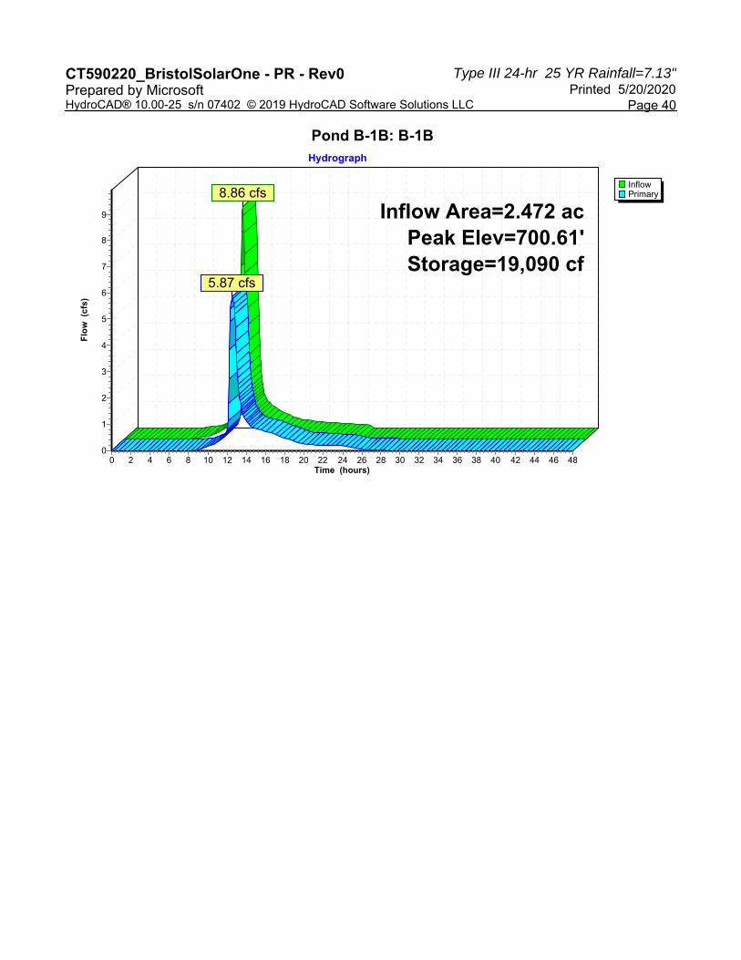
Type III 24-hr 25 YR Rainfall=7.13"CT590220_BristolSolarOne - PR - Rev0 Printed 5/20/2020Prepared by Microsoft
Page 40HydroCAD® 10.00-25 s/n 07402 © 2019 HydroCAD Software Solutions LLC
Pond B-1B: B-1B
InflowPrimary
Hydrograph
Time (hours)484644424038363432302826242220181614121086420
Flo
w (
cfs)
9
8
7
6
5
4
3
2
1
0
Inflow Area=2.472 acPeak Elev=700.61'Storage=19,090 cf
8.86 cfs
5.87 cfs
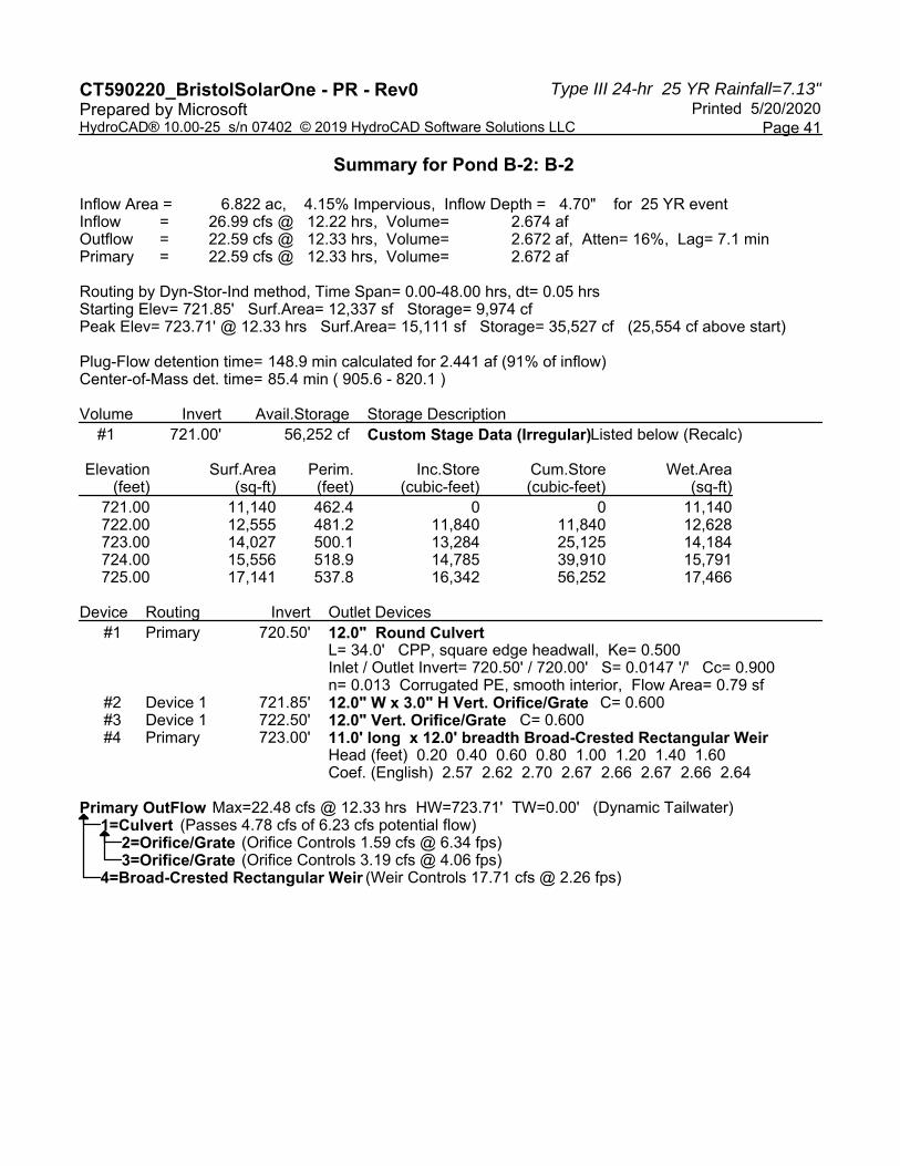
Type III 24-hr 25 YR Rainfall=7.13"CT590220_BristolSolarOne - PR - Rev0 Printed 5/20/2020Prepared by Microsoft
Page 41HydroCAD® 10.00-25 s/n 07402 © 2019 HydroCAD Software Solutions LLC
Summary for Pond B-2: B-2
Inflow Area = 6.822 ac, 4.15% Impervious, Inflow Depth = 4.70" for 25 YR eventInflow = 26.99 cfs @ 12.22 hrs, Volume= 2.674 afOutflow = 22.59 cfs @ 12.33 hrs, Volume= 2.672 af, Atten= 16%, Lag= 7.1 minPrimary = 22.59 cfs @ 12.33 hrs, Volume= 2.672 af
Routing by Dyn-Stor-Ind method, Time Span= 0.00-48.00 hrs, dt= 0.05 hrsStarting Elev= 721.85' Surf.Area= 12,337 sf Storage= 9,974 cfPeak Elev= 723.71' @ 12.33 hrs Surf.Area= 15,111 sf Storage= 35,527 cf (25,554 cf above start)
Plug-Flow detention time= 148.9 min calculated for 2.441 af (91% of inflow)Center-of-Mass det. time= 85.4 min ( 905.6 - 820.1 )
Volume Invert Avail.Storage Storage Description#1 721.00' 56,252 cf Custom Stage Data (Irregular) Listed below (Recalc)
Elevation Surf.Area Perim. Inc.Store Cum.Store Wet.Area(feet) (sq-ft) (feet) (cubic-feet) (cubic-feet) (sq-ft)
721.00 11,140 462.4 0 0 11,140722.00 12,555 481.2 11,840 11,840 12,628723.00 14,027 500.1 13,284 25,125 14,184724.00 15,556 518.9 14,785 39,910 15,791725.00 17,141 537.8 16,342 56,252 17,466
Device Routing Invert Outlet Devices#1 Primary 720.50' 12.0" Round Culvert
L= 34.0' CPP, square edge headwall, Ke= 0.500 Inlet / Outlet Invert= 720.50' / 720.00' S= 0.0147 '/' Cc= 0.900 n= 0.013 Corrugated PE, smooth interior, Flow Area= 0.79 sf
#2 Device 1 721.85' 12.0" W x 3.0" H Vert. Orifice/Grate C= 0.600 #3 Device 1 722.50' 12.0" Vert. Orifice/Grate C= 0.600 #4 Primary 723.00' 11.0' long x 12.0' breadth Broad-Crested Rectangular Weir
Head (feet) 0.20 0.40 0.60 0.80 1.00 1.20 1.40 1.60 Coef. (English) 2.57 2.62 2.70 2.67 2.66 2.67 2.66 2.64
Primary OutFlow Max=22.48 cfs @ 12.33 hrs HW=723.71' TW=0.00' (Dynamic Tailwater)1=Culvert (Passes 4.78 cfs of 6.23 cfs potential flow)
2=Orifice/Grate (Orifice Controls 1.59 cfs @ 6.34 fps)3=Orifice/Grate (Orifice Controls 3.19 cfs @ 4.06 fps)
4=Broad-Crested Rectangular Weir (Weir Controls 17.71 cfs @ 2.26 fps)

Type III 24-hr 25 YR Rainfall=7.13"CT590220_BristolSolarOne - PR - Rev0 Printed 5/20/2020Prepared by Microsoft
Page 42HydroCAD® 10.00-25 s/n 07402 © 2019 HydroCAD Software Solutions LLC
Pond B-2: B-2
InflowPrimary
Hydrograph
Time (hours)484644424038363432302826242220181614121086420
Flo
w (
cfs)
30
28
26
24
22
20
18
16
14
12
10
8
6
4
2
0
Inflow Area=6.822 acPeak Elev=723.71'Storage=35,527 cf
26.99 cfs
22.59 cfs

Type III 24-hr 25 YR Rainfall=7.13"CT590220_BristolSolarOne - PR - Rev0 Printed 5/20/2020Prepared by Microsoft
Page 43HydroCAD® 10.00-25 s/n 07402 © 2019 HydroCAD Software Solutions LLC
Summary for Pond B-3: B-3
Inflow Area = 4.269 ac, 3.16% Impervious, Inflow Depth = 4.70" for 25 YR eventInflow = 18.67 cfs @ 12.17 hrs, Volume= 1.673 afOutflow = 16.38 cfs @ 12.25 hrs, Volume= 1.673 af, Atten= 12%, Lag= 4.7 minPrimary = 16.38 cfs @ 12.25 hrs, Volume= 1.673 af
Routing by Dyn-Stor-Ind method, Time Span= 0.00-48.00 hrs, dt= 0.05 hrsStarting Elev= 736.05' Surf.Area= 5,881 sf Storage= 5,653 cfPeak Elev= 737.63' @ 12.25 hrs Surf.Area= 7,477 sf Storage= 16,216 cf (10,564 cf above start)
Plug-Flow detention time= 94.3 min calculated for 1.543 af (92% of inflow)Center-of-Mass det. time= 36.2 min ( 852.1 - 816.0 )
Volume Invert Avail.Storage Storage Description#1 735.00' 27,433 cf Custom Stage Data (Irregular) Listed below (Recalc)
Elevation Surf.Area Perim. Inc.Store Cum.Store Wet.Area(feet) (sq-ft) (feet) (cubic-feet) (cubic-feet) (sq-ft)
735.00 4,900 301.5 0 0 4,900736.00 5,833 320.3 5,360 5,360 5,881737.00 6,822 339.2 6,321 11,681 6,926738.00 7,868 358.0 7,339 19,020 8,026739.00 8,971 376.9 8,413 27,433 9,191
Device Routing Invert Outlet Devices#1 Primary 735.50' 12.0" Round Culvert
L= 28.0' CPP, square edge headwall, Ke= 0.500 Inlet / Outlet Invert= 735.50' / 735.00' S= 0.0179 '/' Cc= 0.900 n= 0.013 Corrugated PE, smooth interior, Flow Area= 0.79 sf
#2 Primary 736.05' 12.0" W x 3.0" H Vert. Orifice/Grate C= 0.600 #3 Device 1 736.50' 12.0" Horiz. Orifice/Grate C= 0.600
Limited to weir flow at low heads #4 Primary 737.00' 8.0' long x 12.0' breadth Broad-Crested Rectangular Weir
Head (feet) 0.20 0.40 0.60 0.80 1.00 1.20 1.40 1.60 Coef. (English) 2.57 2.62 2.70 2.67 2.66 2.67 2.66 2.64
Primary OutFlow Max=16.33 cfs @ 12.25 hrs HW=737.63' TW=0.00' (Dynamic Tailwater)1=Culvert (Passes 4.02 cfs of 4.83 cfs potential flow)
3=Orifice/Grate (Orifice Controls 4.02 cfs @ 5.12 fps)2=Orifice/Grate (Orifice Controls 1.45 cfs @ 5.81 fps)4=Broad-Crested Rectangular Weir (Weir Controls 10.85 cfs @ 2.14 fps)

Type III 24-hr 25 YR Rainfall=7.13"CT590220_BristolSolarOne - PR - Rev0 Printed 5/20/2020Prepared by Microsoft
Page 44HydroCAD® 10.00-25 s/n 07402 © 2019 HydroCAD Software Solutions LLC
Pond B-3: B-3
InflowPrimary
Hydrograph
Time (hours)484644424038363432302826242220181614121086420
Flo
w (
cfs)
20
19
1817
1615
14
1312
11
109
8
76
54
3
21
0
Inflow Area=4.269 acPeak Elev=737.63'Storage=16,216 cf
18.67 cfs
16.38 cfs

Type III 24-hr 25 YR Rainfall=7.13"CT590220_BristolSolarOne - PR - Rev0 Printed 5/20/2020Prepared by Microsoft
Page 45HydroCAD® 10.00-25 s/n 07402 © 2019 HydroCAD Software Solutions LLC
Summary for Link AP-1: AP-1
Inflow Area = 6.482 ac, 2.62% Impervious, Inflow Depth = 4.53" for 25 YR eventInflow = 14.12 cfs @ 12.52 hrs, Volume= 2.446 afPrimary = 14.12 cfs @ 12.52 hrs, Volume= 2.446 af, Atten= 0%, Lag= 0.0 min
Primary outflow = Inflow, Time Span= 0.00-48.00 hrs, dt= 0.05 hrs
Link AP-1: AP-1
InflowPrimary
Hydrograph
Time (hours)484644424038363432302826242220181614121086420
Flo
w (
cfs)
15
14
13
12
11
10
9
8
7
6
5
4
3
2
1
0
Inflow Area=6.482 ac14.12 cfs
14.12 cfs

Type III 24-hr 25 YR Rainfall=7.13"CT590220_BristolSolarOne - PR - Rev0 Printed 5/20/2020Prepared by Microsoft
Page 46HydroCAD® 10.00-25 s/n 07402 © 2019 HydroCAD Software Solutions LLC
Summary for Link AP-2: AP-2
Inflow Area = 7.416 ac, 3.82% Impervious, Inflow Depth = 4.67" for 25 YR eventInflow = 23.80 cfs @ 12.33 hrs, Volume= 2.889 afPrimary = 23.80 cfs @ 12.33 hrs, Volume= 2.889 af, Atten= 0%, Lag= 0.0 min
Primary outflow = Inflow, Time Span= 0.00-48.00 hrs, dt= 0.05 hrs
Link AP-2: AP-2
InflowPrimary
Hydrograph
Time (hours)484644424038363432302826242220181614121086420
Flo
w (
cfs)
26
24
22
20
18
16
14
12
10
8
6
4
2
0
Inflow Area=7.416 ac23.80 cfs
23.80 cfs

Type III 24-hr 25 YR Rainfall=7.13"CT590220_BristolSolarOne - PR - Rev0 Printed 5/20/2020Prepared by Microsoft
Page 47HydroCAD® 10.00-25 s/n 07402 © 2019 HydroCAD Software Solutions LLC
Summary for Link AP-3: AP-3
Inflow Area = 4.269 ac, 3.16% Impervious, Inflow Depth = 4.70" for 25 YR eventInflow = 16.38 cfs @ 12.25 hrs, Volume= 1.673 afPrimary = 16.38 cfs @ 12.25 hrs, Volume= 1.673 af, Atten= 0%, Lag= 0.0 min
Primary outflow = Inflow, Time Span= 0.00-48.00 hrs, dt= 0.05 hrs
Link AP-3: AP-3
InflowPrimary
Hydrograph
Time (hours)484644424038363432302826242220181614121086420
Flo
w (
cfs)
18
17
16
15
14
13
12
11
10
9
8
7
6
5
4
3
2
1
0
Inflow Area=4.269 ac16.38 cfs
16.38 cfs

Type III 24-hr 50 YR Rainfall=8.12"CT590220_BristolSolarOne - PR - Rev0 Printed 5/20/2020Prepared by Microsoft
Page 48HydroCAD® 10.00-25 s/n 07402 © 2019 HydroCAD Software Solutions LLC
Time span=0.00-48.00 hrs, dt=0.05 hrs, 961 pointsRunoff by SCS TR-20 method, UH=SCS, Weighted-CN
Reach routing by Dyn-Stor-Ind method - Pond routing by Dyn-Stor-Ind method
Runoff Area=3.636 ac 0.00% Impervious Runoff Depth=5.38"Subcatchment PDA-1A: PDA-1A Flow Length=552' Tc=22.5 min CN=77 Runoff=14.62 cfs 1.632 af
Runoff Area=2.472 ac 6.88% Impervious Runoff Depth=5.62"Subcatchment PDA-1B: PDA-1B Flow Length=357' Tc=21.4 min CN=79 Runoff=10.54 cfs 1.158 af
Runoff Area=0.374 ac 0.00% Impervious Runoff Depth=4.68"Subcatchment PDA-1C: PDA-1C Tc=6.0 min CN=71 Runoff=2.01 cfs 0.146 af
Runoff Area=4.026 ac 7.03% Impervious Runoff Depth=5.62"Subcatchment PDA-2A: PDA-2A Flow Length=278' Tc=18.6 min CN=79 Runoff=18.19 cfs 1.885 af
Runoff Area=2.796 ac 0.00% Impervious Runoff Depth=5.62"Subcatchment PDA-2B: PDA-2B Flow Length=491' Tc=12.0 min CN=79 Runoff=14.87 cfs 1.309 af
Runoff Area=0.594 ac 0.00% Impervious Runoff Depth=5.27"Subcatchment PDA-2C: PDA-2C Tc=6.0 min CN=76 Runoff=3.57 cfs 0.261 af
Runoff Area=4.269 ac 3.16% Impervious Runoff Depth=5.62"Subcatchment PDA-3: PDA-3 Flow Length=473' Tc=12.8 min CN=79 Runoff=22.20 cfs 1.999 af
Avg. Flow Depth=0.52' Max Vel=6.12 fps Inflow=14.87 cfs 1.309 afReach SW-2: SW-2n=0.030 L=518.8' S=0.0558 '/' Capacity=122.75 cfs Outflow=14.66 cfs 1.309 af
Peak Elev=699.74' Storage=11,927 cf Inflow=14.62 cfs 1.632 afPond B-1A: B-1A Outflow=10.87 cfs 1.631 af
Peak Elev=700.80' Storage=20,945 cf Inflow=10.54 cfs 1.158 afPond B-1B: B-1B Outflow=6.63 cfs 1.157 af
Peak Elev=723.84' Storage=37,440 cf Inflow=32.09 cfs 3.195 afPond B-2: B-2 Outflow=27.70 cfs 3.193 af
Peak Elev=737.75' Storage=17,105 cf Inflow=22.20 cfs 1.999 afPond B-3: B-3 Outflow=19.72 cfs 1.999 af
Inflow=17.94 cfs 2.934 afLink AP-1: AP-1 Primary=17.94 cfs 2.934 af
Inflow=29.18 cfs 3.454 afLink AP-2: AP-2 Primary=29.18 cfs 3.454 af
Inflow=19.72 cfs 1.999 afLink AP-3: AP-3 Primary=19.72 cfs 1.999 af
Total Runoff Area = 18.167 ac Runoff Volume = 8.390 af Average Runoff Depth = 5.54"96.76% Pervious = 17.579 ac 3.24% Impervious = 0.588 ac

Type III 24-hr 50 YR Rainfall=8.12"CT590220_BristolSolarOne - PR - Rev0 Printed 5/20/2020Prepared by Microsoft
Page 49HydroCAD® 10.00-25 s/n 07402 © 2019 HydroCAD Software Solutions LLC
Summary for Subcatchment PDA-1A: PDA-1A
Runoff = 14.62 cfs @ 12.31 hrs, Volume= 1.632 af, Depth= 5.38"
Runoff by SCS TR-20 method, UH=SCS, Weighted-CN, Time Span= 0.00-48.00 hrs, dt= 0.05 hrsType III 24-hr 50 YR Rainfall=8.12"
Area (ac) CN Description0.308 71 Meadow, non-grazed, HSG C3.328 78 Meadow, non-grazed, HSG D3.636 77 Weighted Average3.636 100.00% Pervious Area
Tc Length Slope Velocity Capacity Description(min) (feet) (ft/ft) (ft/sec) (cfs)17.5 100 0.0104 0.10 Sheet Flow, A-B
Grass: Dense n= 0.240 P2= 3.61"3.1 203 0.0238 1.08 Shallow Concentrated Flow, B-C
Short Grass Pasture Kv= 7.0 fps1.6 181 0.0761 1.93 Shallow Concentrated Flow, C-D
Short Grass Pasture Kv= 7.0 fps0.3 68 0.3333 4.04 Shallow Concentrated Flow, D-E
Short Grass Pasture Kv= 7.0 fps22.5 552 Total
Subcatchment PDA-1A: PDA-1A
Runoff
Hydrograph
Time (hours)484644424038363432302826242220181614121086420
Flo
w (
cfs)
16
15
14
13
12
11
10
9
8
7
6
5
4
3
2
1
0
Type III 24-hr50 YR Rainfall=8.12"
Runoff Area=3.636 acRunoff Volume=1.632 af
Runoff Depth=5.38"Flow Length=552'
Tc=22.5 minCN=77
14.62 cfs

Type III 24-hr 50 YR Rainfall=8.12"CT590220_BristolSolarOne - PR - Rev0 Printed 5/20/2020Prepared by Microsoft
Page 50HydroCAD® 10.00-25 s/n 07402 © 2019 HydroCAD Software Solutions LLC
Summary for Subcatchment PDA-1B: PDA-1B
Runoff = 10.54 cfs @ 12.29 hrs, Volume= 1.158 af, Depth= 5.62"
Runoff by SCS TR-20 method, UH=SCS, Weighted-CN, Time Span= 0.00-48.00 hrs, dt= 0.05 hrsType III 24-hr 50 YR Rainfall=8.12"
Area (ac) CN Description0.014 71 Meadow, non-grazed, HSG C2.288 78 Meadow, non-grazed, HSG D0.170 98 Water Surface, HSG D2.472 79 Weighted Average2.302 93.12% Pervious Area0.170 6.88% Impervious Area
Tc Length Slope Velocity Capacity Description(min) (feet) (ft/ft) (ft/sec) (cfs)20.4 100 0.0070 0.08 Sheet Flow, A-B
Grass: Dense n= 0.240 P2= 3.61"0.5 36 0.0338 1.29 Shallow Concentrated Flow, B-C
Short Grass Pasture Kv= 7.0 fps0.3 162 0.0500 10.58 118.47 Channel Flow, D-E
Area= 11.2 sf Perim= 12.0' r= 0.93'n= 0.030 Earth, grassed & winding
0.2 59 0.3333 4.04 Shallow Concentrated Flow, E-FShort Grass Pasture Kv= 7.0 fps
21.4 357 Total

Type III 24-hr 50 YR Rainfall=8.12"CT590220_BristolSolarOne - PR - Rev0 Printed 5/20/2020Prepared by Microsoft
Page 51HydroCAD® 10.00-25 s/n 07402 © 2019 HydroCAD Software Solutions LLC
Subcatchment PDA-1B: PDA-1B
Runoff
Hydrograph
Time (hours)484644424038363432302826242220181614121086420
Flo
w (
cfs)
11
10
9
8
7
6
5
4
3
2
1
0
Type III 24-hr50 YR Rainfall=8.12"
Runoff Area=2.472 acRunoff Volume=1.158 af
Runoff Depth=5.62"Flow Length=357'
Tc=21.4 minCN=79
10.54 cfs

Type III 24-hr 50 YR Rainfall=8.12"CT590220_BristolSolarOne - PR - Rev0 Printed 5/20/2020Prepared by Microsoft
Page 52HydroCAD® 10.00-25 s/n 07402 © 2019 HydroCAD Software Solutions LLC
Summary for Subcatchment PDA-1C: PDA-1C
Runoff = 2.01 cfs @ 12.09 hrs, Volume= 0.146 af, Depth= 4.68"
Runoff by SCS TR-20 method, UH=SCS, Weighted-CN, Time Span= 0.00-48.00 hrs, dt= 0.05 hrsType III 24-hr 50 YR Rainfall=8.12"
Area (ac) CN Description0.374 71 Meadow, non-grazed, HSG C0.374 100.00% Pervious Area
Tc Length Slope Velocity Capacity Description(min) (feet) (ft/ft) (ft/sec) (cfs)
6.0 Direct Entry,
Subcatchment PDA-1C: PDA-1C
Runoff
Hydrograph
Time (hours)484644424038363432302826242220181614121086420
Flo
w (
cfs)
2
1
0
Type III 24-hr50 YR Rainfall=8.12"
Runoff Area=0.374 acRunoff Volume=0.146 af
Runoff Depth=4.68"Tc=6.0 min
CN=71
2.01 cfs

Type III 24-hr 50 YR Rainfall=8.12"CT590220_BristolSolarOne - PR - Rev0 Printed 5/20/2020Prepared by Microsoft
Page 53HydroCAD® 10.00-25 s/n 07402 © 2019 HydroCAD Software Solutions LLC
Summary for Subcatchment PDA-2A: PDA-2A
Runoff = 18.19 cfs @ 12.25 hrs, Volume= 1.885 af, Depth= 5.62"
Runoff by SCS TR-20 method, UH=SCS, Weighted-CN, Time Span= 0.00-48.00 hrs, dt= 0.05 hrsType III 24-hr 50 YR Rainfall=8.12"
Area (ac) CN Description3.742 78 Meadow, non-grazed, HSG D0.001 96 Gravel surface, HSG D0.283 98 Water Surface, HSG D4.026 79 Weighted Average3.743 92.97% Pervious Area0.283 7.03% Impervious Area
Tc Length Slope Velocity Capacity Description(min) (feet) (ft/ft) (ft/sec) (cfs)16.6 100 0.0118 0.10 Sheet Flow, A-B
Grass: Dense n= 0.240 P2= 3.61"2.0 178 0.0428 1.45 Shallow Concentrated Flow, B-C
Short Grass Pasture Kv= 7.0 fps18.6 278 Total
Subcatchment PDA-2A: PDA-2A
Runoff
Hydrograph
Time (hours)484644424038363432302826242220181614121086420
Flo
w (
cfs)
20
19
18
17
16
15
14
13
12
11
10
9
8
7
6
5
4
3
2
1
0
Type III 24-hr50 YR Rainfall=8.12"
Runoff Area=4.026 acRunoff Volume=1.885 af
Runoff Depth=5.62"Flow Length=278'
Tc=18.6 minCN=79
18.19 cfs

Type III 24-hr 50 YR Rainfall=8.12"CT590220_BristolSolarOne - PR - Rev0 Printed 5/20/2020Prepared by Microsoft
Page 54HydroCAD® 10.00-25 s/n 07402 © 2019 HydroCAD Software Solutions LLC
Summary for Subcatchment PDA-2B: PDA-2B
Runoff = 14.87 cfs @ 12.16 hrs, Volume= 1.309 af, Depth= 5.62"
Runoff by SCS TR-20 method, UH=SCS, Weighted-CN, Time Span= 0.00-48.00 hrs, dt= 0.05 hrsType III 24-hr 50 YR Rainfall=8.12"
Area (ac) CN Description2.633 78 Meadow, non-grazed, HSG D0.163 96 Gravel surface, HSG D2.796 79 Weighted Average2.796 100.00% Pervious Area
Tc Length Slope Velocity Capacity Description(min) (feet) (ft/ft) (ft/sec) (cfs)
8.7 100 0.0590 0.19 Sheet Flow, A-BGrass: Dense n= 0.240 P2= 3.61"
3.2 376 0.0774 1.95 Shallow Concentrated Flow, B-CShort Grass Pasture Kv= 7.0 fps
0.1 15 0.2800 3.70 Shallow Concentrated Flow, C-DShort Grass Pasture Kv= 7.0 fps
12.0 491 Total
Subcatchment PDA-2B: PDA-2B
Runoff
Hydrograph
Time (hours)484644424038363432302826242220181614121086420
Flo
w (
cfs)
16
15
14
13
12
11
10
9
8
7
6
5
4
3
2
1
0
Type III 24-hr50 YR Rainfall=8.12"
Runoff Area=2.796 acRunoff Volume=1.309 af
Runoff Depth=5.62"Flow Length=491'
Tc=12.0 minCN=79
14.87 cfs

Type III 24-hr 50 YR Rainfall=8.12"CT590220_BristolSolarOne - PR - Rev0 Printed 5/20/2020Prepared by Microsoft
Page 55HydroCAD® 10.00-25 s/n 07402 © 2019 HydroCAD Software Solutions LLC
Summary for Subcatchment PDA-2C: PDA-2C
Runoff = 3.57 cfs @ 12.09 hrs, Volume= 0.261 af, Depth= 5.27"
Runoff by SCS TR-20 method, UH=SCS, Weighted-CN, Time Span= 0.00-48.00 hrs, dt= 0.05 hrsType III 24-hr 50 YR Rainfall=8.12"
Area (ac) CN Description0.156 71 Meadow, non-grazed, HSG C0.438 78 Meadow, non-grazed, HSG D0.594 76 Weighted Average0.594 100.00% Pervious Area
Tc Length Slope Velocity Capacity Description(min) (feet) (ft/ft) (ft/sec) (cfs)
6.0 Direct Entry,
Subcatchment PDA-2C: PDA-2C
Runoff
Hydrograph
Time (hours)484644424038363432302826242220181614121086420
Flo
w (
cfs)
3
2
1
0
Type III 24-hr50 YR Rainfall=8.12"
Runoff Area=0.594 acRunoff Volume=0.261 af
Runoff Depth=5.27"Tc=6.0 min
CN=76
3.57 cfs
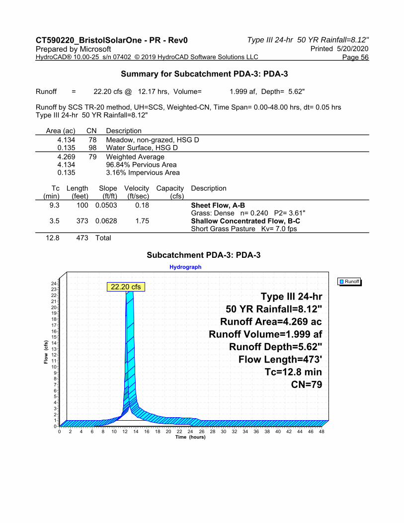
Type III 24-hr 50 YR Rainfall=8.12"CT590220_BristolSolarOne - PR - Rev0 Printed 5/20/2020Prepared by Microsoft
Page 56HydroCAD® 10.00-25 s/n 07402 © 2019 HydroCAD Software Solutions LLC
Summary for Subcatchment PDA-3: PDA-3
Runoff = 22.20 cfs @ 12.17 hrs, Volume= 1.999 af, Depth= 5.62"
Runoff by SCS TR-20 method, UH=SCS, Weighted-CN, Time Span= 0.00-48.00 hrs, dt= 0.05 hrsType III 24-hr 50 YR Rainfall=8.12"
Area (ac) CN Description4.134 78 Meadow, non-grazed, HSG D0.135 98 Water Surface, HSG D4.269 79 Weighted Average4.134 96.84% Pervious Area0.135 3.16% Impervious Area
Tc Length Slope Velocity Capacity Description(min) (feet) (ft/ft) (ft/sec) (cfs)
9.3 100 0.0503 0.18 Sheet Flow, A-BGrass: Dense n= 0.240 P2= 3.61"
3.5 373 0.0628 1.75 Shallow Concentrated Flow, B-CShort Grass Pasture Kv= 7.0 fps
12.8 473 Total
Subcatchment PDA-3: PDA-3
Runoff
Hydrograph
Time (hours)484644424038363432302826242220181614121086420
Flo
w (
cfs)
242322212019181716151413121110
9876543210
Type III 24-hr50 YR Rainfall=8.12"
Runoff Area=4.269 acRunoff Volume=1.999 af
Runoff Depth=5.62"Flow Length=473'
Tc=12.8 minCN=79
22.20 cfs

Type III 24-hr 50 YR Rainfall=8.12"CT590220_BristolSolarOne - PR - Rev0 Printed 5/20/2020Prepared by Microsoft
Page 57HydroCAD® 10.00-25 s/n 07402 © 2019 HydroCAD Software Solutions LLC
Summary for Reach SW-2: SW-2
Inflow Area = 2.796 ac, 0.00% Impervious, Inflow Depth = 5.62" for 50 YR eventInflow = 14.87 cfs @ 12.16 hrs, Volume= 1.309 afOutflow = 14.66 cfs @ 12.18 hrs, Volume= 1.309 af, Atten= 1%, Lag= 1.2 min
Routing by Dyn-Stor-Ind method, Time Span= 0.00-48.00 hrs, dt= 0.05 hrsMax. Velocity= 6.12 fps, Min. Travel Time= 1.4 minAvg. Velocity = 1.89 fps, Avg. Travel Time= 4.6 min
Peak Storage= 1,241 cf @ 12.18 hrsAverage Depth at Peak Storage= 0.52'Bank-Full Depth= 1.50' Flow Area= 11.3 sf, Capacity= 122.75 cfs
3.00' x 1.50' deep channel, n= 0.030 Earth, grassed & windingSide Slope Z-value= 3.0 '/' Top Width= 12.00'Length= 518.8' Slope= 0.0558 '/'Inlet Invert= 753.93', Outlet Invert= 725.00'
‡
Reach SW-2: SW-2
InflowOutflow
Hydrograph
Time (hours)484644424038363432302826242220181614121086420
Flo
w (
cfs)
16
15
14
13
12
11
10
9
8
7
6
5
4
3
2
1
0
Inflow Area=2.796 acAvg. Flow Depth=0.52'
Max Vel=6.12 fpsn=0.030L=518.8'
S=0.0558 '/'Capacity=122.75 cfs
14.87 cfs14.66 cfs

Type III 24-hr 50 YR Rainfall=8.12"CT590220_BristolSolarOne - PR - Rev0 Printed 5/20/2020Prepared by Microsoft
Page 58HydroCAD® 10.00-25 s/n 07402 © 2019 HydroCAD Software Solutions LLC
Summary for Pond B-1A: B-1A
Inflow Area = 3.636 ac, 0.00% Impervious, Inflow Depth = 5.38" for 50 YR eventInflow = 14.62 cfs @ 12.31 hrs, Volume= 1.632 afOutflow = 10.87 cfs @ 12.51 hrs, Volume= 1.631 af, Atten= 26%, Lag= 12.3 minPrimary = 10.87 cfs @ 12.51 hrs, Volume= 1.631 af
Routing by Dyn-Stor-Ind method, Time Span= 0.00-48.00 hrs, dt= 0.05 hrsPeak Elev= 699.74' @ 12.51 hrs Surf.Area= 5,502 sf Storage= 11,927 cf
Plug-Flow detention time= 25.5 min calculated for 1.629 af (100% of inflow)Center-of-Mass det. time= 25.9 min ( 850.4 - 824.4 )
Volume Invert Avail.Storage Storage Description#1 697.00' 19,586 cf Custom Stage Data (Irregular) Listed below (Recalc)
Elevation Surf.Area Perim. Inc.Store Cum.Store Wet.Area(feet) (sq-ft) (feet) (cubic-feet) (cubic-feet) (sq-ft)
697.00 3,276 245.1 0 0 3,276698.00 4,040 264.0 3,651 3,651 4,083699.00 4,860 282.8 4,444 8,095 4,945700.00 5,737 301.7 5,292 13,387 5,872701.00 6,671 320.5 6,198 19,586 6,853
Device Routing Invert Outlet Devices#1 Primary 697.00' 15.0" Round Culvert
L= 31.0' CPP, square edge headwall, Ke= 0.500 Inlet / Outlet Invert= 697.00' / 696.00' S= 0.0323 '/' Cc= 0.900 n= 0.013 Corrugated PE, smooth interior, Flow Area= 1.23 sf
#2 Primary 699.50' 7.5' long x 12.0' breadth Broad-Crested Rectangular Weir Head (feet) 0.20 0.40 0.60 0.80 1.00 1.20 1.40 1.60 Coef. (English) 2.57 2.62 2.70 2.67 2.66 2.67 2.66 2.64
Primary OutFlow Max=10.81 cfs @ 12.51 hrs HW=699.74' TW=0.00' (Dynamic Tailwater)1=Culvert (Inlet Controls 8.59 cfs @ 7.00 fps)2=Broad-Crested Rectangular Weir (Weir Controls 2.22 cfs @ 1.25 fps)

Type III 24-hr 50 YR Rainfall=8.12"CT590220_BristolSolarOne - PR - Rev0 Printed 5/20/2020Prepared by Microsoft
Page 59HydroCAD® 10.00-25 s/n 07402 © 2019 HydroCAD Software Solutions LLC
Pond B-1A: B-1A
InflowPrimary
Hydrograph
Time (hours)484644424038363432302826242220181614121086420
Flo
w (
cfs)
16
15
14
13
12
11
10
9
8
7
6
5
4
3
2
1
0
Inflow Area=3.636 acPeak Elev=699.74'Storage=11,927 cf
14.62 cfs
10.87 cfs

Type III 24-hr 50 YR Rainfall=8.12"CT590220_BristolSolarOne - PR - Rev0 Printed 5/20/2020Prepared by Microsoft
Page 60HydroCAD® 10.00-25 s/n 07402 © 2019 HydroCAD Software Solutions LLC
Summary for Pond B-1B: B-1B
Inflow Area = 2.472 ac, 6.88% Impervious, Inflow Depth = 5.62" for 50 YR eventInflow = 10.54 cfs @ 12.29 hrs, Volume= 1.158 afOutflow = 6.63 cfs @ 12.55 hrs, Volume= 1.157 af, Atten= 37%, Lag= 15.7 minPrimary = 6.63 cfs @ 12.55 hrs, Volume= 1.157 af
Routing by Dyn-Stor-Ind method, Time Span= 0.00-48.00 hrs, dt= 0.05 hrsStarting Elev= 699.40' Surf.Area= 7,385 sf Storage= 8,704 cfPeak Elev= 700.80' @ 12.55 hrs Surf.Area= 10,168 sf Storage= 20,945 cf (12,240 cf above start)
Plug-Flow detention time= 171.0 min calculated for 0.957 af (83% of inflow)Center-of-Mass det. time= 62.0 min ( 880.9 - 818.9 )
Volume Invert Avail.Storage Storage Description#1 698.00' 34,674 cf Custom Stage Data (Irregular) Listed below (Recalc)
Elevation Surf.Area Perim. Inc.Store Cum.Store Wet.Area(feet) (sq-ft) (feet) (cubic-feet) (cubic-feet) (sq-ft)
698.00 5,187 405.1 0 0 5,187699.00 6,643 578.3 5,900 5,900 18,750700.00 8,572 665.1 7,587 13,487 27,361701.00 10,596 684.0 9,566 23,053 29,499702.00 12,676 702.8 11,620 34,674 31,687
Device Routing Invert Outlet Devices#1 Primary 698.00' 15.0" Round Culvert
L= 30.0' CPP, square edge headwall, Ke= 0.500 Inlet / Outlet Invert= 698.00' / 697.00' S= 0.0333 '/' Cc= 0.900 n= 0.013 Corrugated PE, smooth interior, Flow Area= 1.23 sf
#2 Device 1 699.40' 12.0" W x 3.0" H Vert. Orifice/Grate C= 0.600 #3 Device 1 700.00' 15.0" Horiz. Orifice/Grate C= 0.600
Limited to weir flow at low heads #4 Primary 700.90' 3.0' long x 15.0' breadth Broad-Crested Rectangular Weir
Head (feet) 0.20 0.40 0.60 0.80 1.00 1.20 1.40 1.60 Coef. (English) 2.68 2.70 2.70 2.64 2.63 2.64 2.64 2.63
Primary OutFlow Max=6.63 cfs @ 12.55 hrs HW=700.80' TW=0.00' (Dynamic Tailwater)1=Culvert (Passes 6.63 cfs of 8.71 cfs potential flow)
2=Orifice/Grate (Orifice Controls 1.36 cfs @ 5.43 fps)3=Orifice/Grate (Orifice Controls 5.27 cfs @ 4.30 fps)
4=Broad-Crested Rectangular Weir ( Controls 0.00 cfs)

Type III 24-hr 50 YR Rainfall=8.12"CT590220_BristolSolarOne - PR - Rev0 Printed 5/20/2020Prepared by Microsoft
Page 61HydroCAD® 10.00-25 s/n 07402 © 2019 HydroCAD Software Solutions LLC
Pond B-1B: B-1B
InflowPrimary
Hydrograph
Time (hours)484644424038363432302826242220181614121086420
Flo
w (
cfs)
11
10
9
8
7
6
5
4
3
2
1
0
Inflow Area=2.472 acPeak Elev=700.80'Storage=20,945 cf
10.54 cfs
6.63 cfs

Type III 24-hr 50 YR Rainfall=8.12"CT590220_BristolSolarOne - PR - Rev0 Printed 5/20/2020Prepared by Microsoft
Page 62HydroCAD® 10.00-25 s/n 07402 © 2019 HydroCAD Software Solutions LLC
Summary for Pond B-2: B-2
Inflow Area = 6.822 ac, 4.15% Impervious, Inflow Depth = 5.62" for 50 YR eventInflow = 32.09 cfs @ 12.21 hrs, Volume= 3.195 afOutflow = 27.70 cfs @ 12.32 hrs, Volume= 3.193 af, Atten= 14%, Lag= 6.3 minPrimary = 27.70 cfs @ 12.32 hrs, Volume= 3.193 af
Routing by Dyn-Stor-Ind method, Time Span= 0.00-48.00 hrs, dt= 0.05 hrsStarting Elev= 721.85' Surf.Area= 12,337 sf Storage= 9,974 cfPeak Elev= 723.84' @ 12.32 hrs Surf.Area= 15,306 sf Storage= 37,440 cf (27,466 cf above start)
Plug-Flow detention time= 135.3 min calculated for 2.964 af (93% of inflow)Center-of-Mass det. time= 79.0 min ( 894.0 - 815.0 )
Volume Invert Avail.Storage Storage Description#1 721.00' 56,252 cf Custom Stage Data (Irregular) Listed below (Recalc)
Elevation Surf.Area Perim. Inc.Store Cum.Store Wet.Area(feet) (sq-ft) (feet) (cubic-feet) (cubic-feet) (sq-ft)
721.00 11,140 462.4 0 0 11,140722.00 12,555 481.2 11,840 11,840 12,628723.00 14,027 500.1 13,284 25,125 14,184724.00 15,556 518.9 14,785 39,910 15,791725.00 17,141 537.8 16,342 56,252 17,466
Device Routing Invert Outlet Devices#1 Primary 720.50' 12.0" Round Culvert
L= 34.0' CPP, square edge headwall, Ke= 0.500 Inlet / Outlet Invert= 720.50' / 720.00' S= 0.0147 '/' Cc= 0.900 n= 0.013 Corrugated PE, smooth interior, Flow Area= 0.79 sf
#2 Device 1 721.85' 12.0" W x 3.0" H Vert. Orifice/Grate C= 0.600 #3 Device 1 722.50' 12.0" Vert. Orifice/Grate C= 0.600 #4 Primary 723.00' 11.0' long x 12.0' breadth Broad-Crested Rectangular Weir
Head (feet) 0.20 0.40 0.60 0.80 1.00 1.20 1.40 1.60 Coef. (English) 2.57 2.62 2.70 2.67 2.66 2.67 2.66 2.64
Primary OutFlow Max=27.50 cfs @ 12.32 hrs HW=723.84' TW=0.00' (Dynamic Tailwater)1=Culvert (Passes 5.10 cfs of 6.37 cfs potential flow)
2=Orifice/Grate (Orifice Controls 1.64 cfs @ 6.57 fps)3=Orifice/Grate (Orifice Controls 3.46 cfs @ 4.40 fps)
4=Broad-Crested Rectangular Weir (Weir Controls 22.40 cfs @ 2.44 fps)

Type III 24-hr 50 YR Rainfall=8.12"CT590220_BristolSolarOne - PR - Rev0 Printed 5/20/2020Prepared by Microsoft
Page 63HydroCAD® 10.00-25 s/n 07402 © 2019 HydroCAD Software Solutions LLC
Pond B-2: B-2
InflowPrimary
Hydrograph
Time (hours)484644424038363432302826242220181614121086420
Flo
w (
cfs)
34
32
30
28
26
24
22
20
18
16
14
12
10
8
6
4
2
0
Inflow Area=6.822 acPeak Elev=723.84'Storage=37,440 cf
32.09 cfs
27.70 cfs

Type III 24-hr 50 YR Rainfall=8.12"CT590220_BristolSolarOne - PR - Rev0 Printed 5/20/2020Prepared by Microsoft
Page 64HydroCAD® 10.00-25 s/n 07402 © 2019 HydroCAD Software Solutions LLC
Summary for Pond B-3: B-3
Inflow Area = 4.269 ac, 3.16% Impervious, Inflow Depth = 5.62" for 50 YR eventInflow = 22.20 cfs @ 12.17 hrs, Volume= 1.999 afOutflow = 19.72 cfs @ 12.25 hrs, Volume= 1.999 af, Atten= 11%, Lag= 4.4 minPrimary = 19.72 cfs @ 12.25 hrs, Volume= 1.999 af
Routing by Dyn-Stor-Ind method, Time Span= 0.00-48.00 hrs, dt= 0.05 hrsStarting Elev= 736.05' Surf.Area= 5,881 sf Storage= 5,653 cfPeak Elev= 737.75' @ 12.25 hrs Surf.Area= 7,602 sf Storage= 17,105 cf (11,452 cf above start)
Plug-Flow detention time= 84.9 min calculated for 1.869 af (93% of inflow)Center-of-Mass det. time= 33.7 min ( 844.7 - 810.9 )
Volume Invert Avail.Storage Storage Description#1 735.00' 27,433 cf Custom Stage Data (Irregular) Listed below (Recalc)
Elevation Surf.Area Perim. Inc.Store Cum.Store Wet.Area(feet) (sq-ft) (feet) (cubic-feet) (cubic-feet) (sq-ft)
735.00 4,900 301.5 0 0 4,900736.00 5,833 320.3 5,360 5,360 5,881737.00 6,822 339.2 6,321 11,681 6,926738.00 7,868 358.0 7,339 19,020 8,026739.00 8,971 376.9 8,413 27,433 9,191
Device Routing Invert Outlet Devices#1 Primary 735.50' 12.0" Round Culvert
L= 28.0' CPP, square edge headwall, Ke= 0.500 Inlet / Outlet Invert= 735.50' / 735.00' S= 0.0179 '/' Cc= 0.900 n= 0.013 Corrugated PE, smooth interior, Flow Area= 0.79 sf
#2 Primary 736.05' 12.0" W x 3.0" H Vert. Orifice/Grate C= 0.600 #3 Device 1 736.50' 12.0" Horiz. Orifice/Grate C= 0.600
Limited to weir flow at low heads #4 Primary 737.00' 8.0' long x 12.0' breadth Broad-Crested Rectangular Weir
Head (feet) 0.20 0.40 0.60 0.80 1.00 1.20 1.40 1.60 Coef. (English) 2.57 2.62 2.70 2.67 2.66 2.67 2.66 2.64
Primary OutFlow Max=19.68 cfs @ 12.25 hrs HW=737.75' TW=0.00' (Dynamic Tailwater)1=Culvert (Passes 4.23 cfs of 5.00 cfs potential flow)
3=Orifice/Grate (Orifice Controls 4.23 cfs @ 5.39 fps)2=Orifice/Grate (Orifice Controls 1.51 cfs @ 6.04 fps)4=Broad-Crested Rectangular Weir (Weir Controls 13.94 cfs @ 2.32 fps)

Type III 24-hr 50 YR Rainfall=8.12"CT590220_BristolSolarOne - PR - Rev0 Printed 5/20/2020Prepared by Microsoft
Page 65HydroCAD® 10.00-25 s/n 07402 © 2019 HydroCAD Software Solutions LLC
Pond B-3: B-3
InflowPrimary
Hydrograph
Time (hours)484644424038363432302826242220181614121086420
Flo
w (
cfs)
242322212019181716151413121110
9876543210
Inflow Area=4.269 acPeak Elev=737.75'Storage=17,105 cf
22.20 cfs
19.72 cfs

Type III 24-hr 50 YR Rainfall=8.12"CT590220_BristolSolarOne - PR - Rev0 Printed 5/20/2020Prepared by Microsoft
Page 66HydroCAD® 10.00-25 s/n 07402 © 2019 HydroCAD Software Solutions LLC
Summary for Link AP-1: AP-1
Inflow Area = 6.482 ac, 2.62% Impervious, Inflow Depth = 5.43" for 50 YR eventInflow = 17.94 cfs @ 12.51 hrs, Volume= 2.934 afPrimary = 17.94 cfs @ 12.51 hrs, Volume= 2.934 af, Atten= 0%, Lag= 0.0 min
Primary outflow = Inflow, Time Span= 0.00-48.00 hrs, dt= 0.05 hrs
Link AP-1: AP-1
InflowPrimary
Hydrograph
Time (hours)484644424038363432302826242220181614121086420
Flo
w (
cfs)
20
19
18
17
16
15
14
13
12
11
10
9
8
7
6
5
4
3
2
1
0
Inflow Area=6.482 ac17.94 cfs
17.94 cfs

Type III 24-hr 50 YR Rainfall=8.12"CT590220_BristolSolarOne - PR - Rev0 Printed 5/20/2020Prepared by Microsoft
Page 67HydroCAD® 10.00-25 s/n 07402 © 2019 HydroCAD Software Solutions LLC
Summary for Link AP-2: AP-2
Inflow Area = 7.416 ac, 3.82% Impervious, Inflow Depth = 5.59" for 50 YR eventInflow = 29.18 cfs @ 12.31 hrs, Volume= 3.454 afPrimary = 29.18 cfs @ 12.31 hrs, Volume= 3.454 af, Atten= 0%, Lag= 0.0 min
Primary outflow = Inflow, Time Span= 0.00-48.00 hrs, dt= 0.05 hrs
Link AP-2: AP-2
InflowPrimary
Hydrograph
Time (hours)484644424038363432302826242220181614121086420
Flo
w (
cfs)
32
30
28
26
24
22
20
18
16
14
12
10
8
6
4
2
0
Inflow Area=7.416 ac29.18 cfs
29.18 cfs

Type III 24-hr 50 YR Rainfall=8.12"CT590220_BristolSolarOne - PR - Rev0 Printed 5/20/2020Prepared by Microsoft
Page 68HydroCAD® 10.00-25 s/n 07402 © 2019 HydroCAD Software Solutions LLC
Summary for Link AP-3: AP-3
Inflow Area = 4.269 ac, 3.16% Impervious, Inflow Depth = 5.62" for 50 YR eventInflow = 19.72 cfs @ 12.25 hrs, Volume= 1.999 afPrimary = 19.72 cfs @ 12.25 hrs, Volume= 1.999 af, Atten= 0%, Lag= 0.0 min
Primary outflow = Inflow, Time Span= 0.00-48.00 hrs, dt= 0.05 hrs
Link AP-3: AP-3
InflowPrimary
Hydrograph
Time (hours)484644424038363432302826242220181614121086420
Flo
w (
cfs)
22212019181716151413121110
9876543210
Inflow Area=4.269 ac19.72 cfs
19.72 cfs

Type III 24-hr 100 YR Rainfall=9.21"CT590220_BristolSolarOne - PR - Rev0 Printed 5/20/2020Prepared by Microsoft
Page 69HydroCAD® 10.00-25 s/n 07402 © 2019 HydroCAD Software Solutions LLC
Time span=0.00-48.00 hrs, dt=0.05 hrs, 961 pointsRunoff by SCS TR-20 method, UH=SCS, Weighted-CN
Reach routing by Dyn-Stor-Ind method - Pond routing by Dyn-Stor-Ind method
Runoff Area=3.636 ac 0.00% Impervious Runoff Depth=6.39"Subcatchment PDA-1A: PDA-1A Flow Length=552' Tc=22.5 min CN=77 Runoff=17.28 cfs 1.938 af
Runoff Area=2.472 ac 6.88% Impervious Runoff Depth=6.64"Subcatchment PDA-1B: PDA-1B Flow Length=357' Tc=21.4 min CN=79 Runoff=12.39 cfs 1.369 af
Runoff Area=0.374 ac 0.00% Impervious Runoff Depth=5.65"Subcatchment PDA-1C: PDA-1C Tc=6.0 min CN=71 Runoff=2.42 cfs 0.176 af
Runoff Area=4.026 ac 7.03% Impervious Runoff Depth=6.64"Subcatchment PDA-2A: PDA-2A Flow Length=278' Tc=18.6 min CN=79 Runoff=21.38 cfs 2.229 af
Runoff Area=2.796 ac 0.00% Impervious Runoff Depth=6.64"Subcatchment PDA-2B: PDA-2B Flow Length=491' Tc=12.0 min CN=79 Runoff=17.48 cfs 1.548 af
Runoff Area=0.594 ac 0.00% Impervious Runoff Depth=6.27"Subcatchment PDA-2C: PDA-2C Tc=6.0 min CN=76 Runoff=4.22 cfs 0.310 af
Runoff Area=4.269 ac 3.16% Impervious Runoff Depth=6.64"Subcatchment PDA-3: PDA-3 Flow Length=473' Tc=12.8 min CN=79 Runoff=26.08 cfs 2.363 af
Avg. Flow Depth=0.57' Max Vel=6.40 fps Inflow=17.48 cfs 1.548 afReach SW-2: SW-2n=0.030 L=518.8' S=0.0558 '/' Capacity=122.75 cfs Outflow=17.23 cfs 1.548 af
Peak Elev=699.93' Storage=12,968 cf Inflow=17.28 cfs 1.938 afPond B-1A: B-1A Outflow=14.46 cfs 1.937 af
Peak Elev=701.00' Storage=23,066 cf Inflow=12.39 cfs 1.369 afPond B-1B: B-1B Outflow=7.63 cfs 1.368 af
Peak Elev=723.96' Storage=39,323 cf Inflow=37.71 cfs 3.777 afPond B-2: B-2 Outflow=33.04 cfs 3.775 af
Peak Elev=737.87' Storage=18,030 cf Inflow=26.08 cfs 2.363 afPond B-3: B-3 Outflow=23.40 cfs 2.363 af
Inflow=22.51 cfs 3.481 afLink AP-1: AP-1 Primary=22.51 cfs 3.481 af
Inflow=34.81 cfs 4.085 afLink AP-2: AP-2 Primary=34.81 cfs 4.085 af
Inflow=23.40 cfs 2.363 afLink AP-3: AP-3 Primary=23.40 cfs 2.363 af
Total Runoff Area = 18.167 ac Runoff Volume = 9.933 af Average Runoff Depth = 6.56"96.76% Pervious = 17.579 ac 3.24% Impervious = 0.588 ac

Type III 24-hr 100 YR Rainfall=9.21"CT590220_BristolSolarOne - PR - Rev0 Printed 5/20/2020Prepared by Microsoft
Page 70HydroCAD® 10.00-25 s/n 07402 © 2019 HydroCAD Software Solutions LLC
Summary for Subcatchment PDA-1A: PDA-1A
Runoff = 17.28 cfs @ 12.31 hrs, Volume= 1.938 af, Depth= 6.39"
Runoff by SCS TR-20 method, UH=SCS, Weighted-CN, Time Span= 0.00-48.00 hrs, dt= 0.05 hrsType III 24-hr 100 YR Rainfall=9.21"
Area (ac) CN Description0.308 71 Meadow, non-grazed, HSG C3.328 78 Meadow, non-grazed, HSG D3.636 77 Weighted Average3.636 100.00% Pervious Area
Tc Length Slope Velocity Capacity Description(min) (feet) (ft/ft) (ft/sec) (cfs)17.5 100 0.0104 0.10 Sheet Flow, A-B
Grass: Dense n= 0.240 P2= 3.61"3.1 203 0.0238 1.08 Shallow Concentrated Flow, B-C
Short Grass Pasture Kv= 7.0 fps1.6 181 0.0761 1.93 Shallow Concentrated Flow, C-D
Short Grass Pasture Kv= 7.0 fps0.3 68 0.3333 4.04 Shallow Concentrated Flow, D-E
Short Grass Pasture Kv= 7.0 fps22.5 552 Total
Subcatchment PDA-1A: PDA-1A
Runoff
Hydrograph
Time (hours)484644424038363432302826242220181614121086420
Flo
w (
cfs)
19
18
17
16
15
14
13
12
11
10
9
8
7
6
5
4
3
2
1
0
Type III 24-hr100 YR Rainfall=9.21"Runoff Area=3.636 ac
Runoff Volume=1.938 afRunoff Depth=6.39"
Flow Length=552'Tc=22.5 min
CN=77
17.28 cfs

Type III 24-hr 100 YR Rainfall=9.21"CT590220_BristolSolarOne - PR - Rev0 Printed 5/20/2020Prepared by Microsoft
Page 71HydroCAD® 10.00-25 s/n 07402 © 2019 HydroCAD Software Solutions LLC
Summary for Subcatchment PDA-1B: PDA-1B
Runoff = 12.39 cfs @ 12.29 hrs, Volume= 1.369 af, Depth= 6.64"
Runoff by SCS TR-20 method, UH=SCS, Weighted-CN, Time Span= 0.00-48.00 hrs, dt= 0.05 hrsType III 24-hr 100 YR Rainfall=9.21"
Area (ac) CN Description0.014 71 Meadow, non-grazed, HSG C2.288 78 Meadow, non-grazed, HSG D0.170 98 Water Surface, HSG D2.472 79 Weighted Average2.302 93.12% Pervious Area0.170 6.88% Impervious Area
Tc Length Slope Velocity Capacity Description(min) (feet) (ft/ft) (ft/sec) (cfs)20.4 100 0.0070 0.08 Sheet Flow, A-B
Grass: Dense n= 0.240 P2= 3.61"0.5 36 0.0338 1.29 Shallow Concentrated Flow, B-C
Short Grass Pasture Kv= 7.0 fps0.3 162 0.0500 10.58 118.47 Channel Flow, D-E
Area= 11.2 sf Perim= 12.0' r= 0.93'n= 0.030 Earth, grassed & winding
0.2 59 0.3333 4.04 Shallow Concentrated Flow, E-FShort Grass Pasture Kv= 7.0 fps
21.4 357 Total
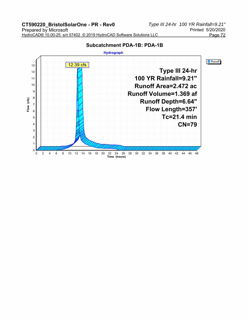
Type III 24-hr 100 YR Rainfall=9.21"CT590220_BristolSolarOne - PR - Rev0 Printed 5/20/2020Prepared by Microsoft
Page 72HydroCAD® 10.00-25 s/n 07402 © 2019 HydroCAD Software Solutions LLC
Subcatchment PDA-1B: PDA-1B
Runoff
Hydrograph
Time (hours)484644424038363432302826242220181614121086420
Flo
w (
cfs)
13
12
11
10
9
8
7
6
5
4
3
2
1
0
Type III 24-hr100 YR Rainfall=9.21"Runoff Area=2.472 ac
Runoff Volume=1.369 afRunoff Depth=6.64"
Flow Length=357'Tc=21.4 min
CN=79
12.39 cfs

Type III 24-hr 100 YR Rainfall=9.21"CT590220_BristolSolarOne - PR - Rev0 Printed 5/20/2020Prepared by Microsoft
Page 73HydroCAD® 10.00-25 s/n 07402 © 2019 HydroCAD Software Solutions LLC
Summary for Subcatchment PDA-1C: PDA-1C
Runoff = 2.42 cfs @ 12.09 hrs, Volume= 0.176 af, Depth= 5.65"
Runoff by SCS TR-20 method, UH=SCS, Weighted-CN, Time Span= 0.00-48.00 hrs, dt= 0.05 hrsType III 24-hr 100 YR Rainfall=9.21"
Area (ac) CN Description0.374 71 Meadow, non-grazed, HSG C0.374 100.00% Pervious Area
Tc Length Slope Velocity Capacity Description(min) (feet) (ft/ft) (ft/sec) (cfs)
6.0 Direct Entry,
Subcatchment PDA-1C: PDA-1C
Runoff
Hydrograph
Time (hours)484644424038363432302826242220181614121086420
Flo
w (
cfs)
2
1
0
Type III 24-hr100 YR Rainfall=9.21"Runoff Area=0.374 ac
Runoff Volume=0.176 afRunoff Depth=5.65"
Tc=6.0 minCN=71
2.42 cfs

Type III 24-hr 100 YR Rainfall=9.21"CT590220_BristolSolarOne - PR - Rev0 Printed 5/20/2020Prepared by Microsoft
Page 74HydroCAD® 10.00-25 s/n 07402 © 2019 HydroCAD Software Solutions LLC
Summary for Subcatchment PDA-2A: PDA-2A
Runoff = 21.38 cfs @ 12.25 hrs, Volume= 2.229 af, Depth= 6.64"
Runoff by SCS TR-20 method, UH=SCS, Weighted-CN, Time Span= 0.00-48.00 hrs, dt= 0.05 hrsType III 24-hr 100 YR Rainfall=9.21"
Area (ac) CN Description3.742 78 Meadow, non-grazed, HSG D0.001 96 Gravel surface, HSG D0.283 98 Water Surface, HSG D4.026 79 Weighted Average3.743 92.97% Pervious Area0.283 7.03% Impervious Area
Tc Length Slope Velocity Capacity Description(min) (feet) (ft/ft) (ft/sec) (cfs)16.6 100 0.0118 0.10 Sheet Flow, A-B
Grass: Dense n= 0.240 P2= 3.61"2.0 178 0.0428 1.45 Shallow Concentrated Flow, B-C
Short Grass Pasture Kv= 7.0 fps18.6 278 Total
Subcatchment PDA-2A: PDA-2A
Runoff
Hydrograph
Time (hours)484644424038363432302826242220181614121086420
Flo
w (
cfs)
2322212019181716151413121110
9876543210
Type III 24-hr100 YR Rainfall=9.21"Runoff Area=4.026 ac
Runoff Volume=2.229 afRunoff Depth=6.64"
Flow Length=278'Tc=18.6 min
CN=79
21.38 cfs

Type III 24-hr 100 YR Rainfall=9.21"CT590220_BristolSolarOne - PR - Rev0 Printed 5/20/2020Prepared by Microsoft
Page 75HydroCAD® 10.00-25 s/n 07402 © 2019 HydroCAD Software Solutions LLC
Summary for Subcatchment PDA-2B: PDA-2B
Runoff = 17.48 cfs @ 12.16 hrs, Volume= 1.548 af, Depth= 6.64"
Runoff by SCS TR-20 method, UH=SCS, Weighted-CN, Time Span= 0.00-48.00 hrs, dt= 0.05 hrsType III 24-hr 100 YR Rainfall=9.21"
Area (ac) CN Description2.633 78 Meadow, non-grazed, HSG D0.163 96 Gravel surface, HSG D2.796 79 Weighted Average2.796 100.00% Pervious Area
Tc Length Slope Velocity Capacity Description(min) (feet) (ft/ft) (ft/sec) (cfs)
8.7 100 0.0590 0.19 Sheet Flow, A-BGrass: Dense n= 0.240 P2= 3.61"
3.2 376 0.0774 1.95 Shallow Concentrated Flow, B-CShort Grass Pasture Kv= 7.0 fps
0.1 15 0.2800 3.70 Shallow Concentrated Flow, C-DShort Grass Pasture Kv= 7.0 fps
12.0 491 Total
Subcatchment PDA-2B: PDA-2B
Runoff
Hydrograph
Time (hours)484644424038363432302826242220181614121086420
Flo
w (
cfs)
19
18
17
16
15
14
13
12
11
10
9
8
7
6
5
4
3
2
1
0
Type III 24-hr100 YR Rainfall=9.21"Runoff Area=2.796 ac
Runoff Volume=1.548 afRunoff Depth=6.64"
Flow Length=491'Tc=12.0 min
CN=79
17.48 cfs

Type III 24-hr 100 YR Rainfall=9.21"CT590220_BristolSolarOne - PR - Rev0 Printed 5/20/2020Prepared by Microsoft
Page 76HydroCAD® 10.00-25 s/n 07402 © 2019 HydroCAD Software Solutions LLC
Summary for Subcatchment PDA-2C: PDA-2C
Runoff = 4.22 cfs @ 12.09 hrs, Volume= 0.310 af, Depth= 6.27"
Runoff by SCS TR-20 method, UH=SCS, Weighted-CN, Time Span= 0.00-48.00 hrs, dt= 0.05 hrsType III 24-hr 100 YR Rainfall=9.21"
Area (ac) CN Description0.156 71 Meadow, non-grazed, HSG C0.438 78 Meadow, non-grazed, HSG D0.594 76 Weighted Average0.594 100.00% Pervious Area
Tc Length Slope Velocity Capacity Description(min) (feet) (ft/ft) (ft/sec) (cfs)
6.0 Direct Entry,
Subcatchment PDA-2C: PDA-2C
Runoff
Hydrograph
Time (hours)484644424038363432302826242220181614121086420
Flo
w (
cfs)
4
3
2
1
0
Type III 24-hr100 YR Rainfall=9.21"Runoff Area=0.594 ac
Runoff Volume=0.310 afRunoff Depth=6.27"
Tc=6.0 minCN=76
4.22 cfs

Type III 24-hr 100 YR Rainfall=9.21"CT590220_BristolSolarOne - PR - Rev0 Printed 5/20/2020Prepared by Microsoft
Page 77HydroCAD® 10.00-25 s/n 07402 © 2019 HydroCAD Software Solutions LLC
Summary for Subcatchment PDA-3: PDA-3
Runoff = 26.08 cfs @ 12.17 hrs, Volume= 2.363 af, Depth= 6.64"
Runoff by SCS TR-20 method, UH=SCS, Weighted-CN, Time Span= 0.00-48.00 hrs, dt= 0.05 hrsType III 24-hr 100 YR Rainfall=9.21"
Area (ac) CN Description4.134 78 Meadow, non-grazed, HSG D0.135 98 Water Surface, HSG D4.269 79 Weighted Average4.134 96.84% Pervious Area0.135 3.16% Impervious Area
Tc Length Slope Velocity Capacity Description(min) (feet) (ft/ft) (ft/sec) (cfs)
9.3 100 0.0503 0.18 Sheet Flow, A-BGrass: Dense n= 0.240 P2= 3.61"
3.5 373 0.0628 1.75 Shallow Concentrated Flow, B-CShort Grass Pasture Kv= 7.0 fps
12.8 473 Total
Subcatchment PDA-3: PDA-3
Runoff
Hydrograph
Time (hours)484644424038363432302826242220181614121086420
Flo
w (
cfs)
28
26
24
22
20
18
16
14
12
10
8
6
4
2
0
Type III 24-hr100 YR Rainfall=9.21"Runoff Area=4.269 ac
Runoff Volume=2.363 afRunoff Depth=6.64"
Flow Length=473'Tc=12.8 min
CN=79
26.08 cfs
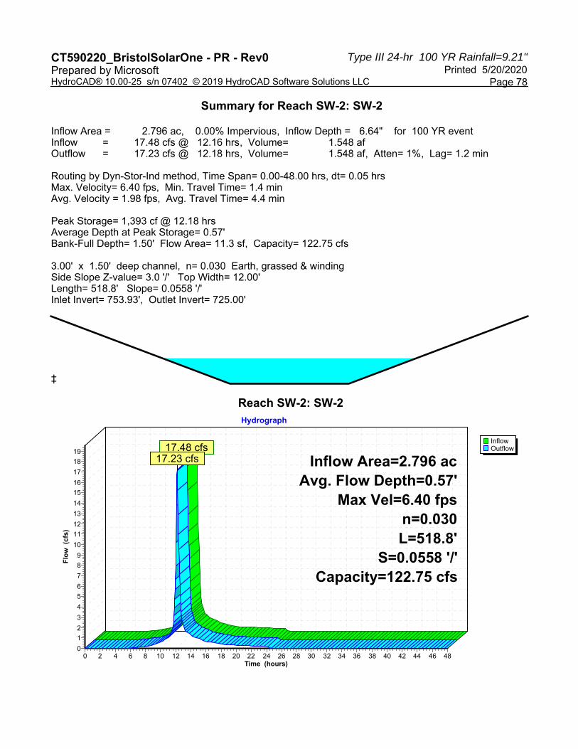
Type III 24-hr 100 YR Rainfall=9.21"CT590220_BristolSolarOne - PR - Rev0 Printed 5/20/2020Prepared by Microsoft
Page 78HydroCAD® 10.00-25 s/n 07402 © 2019 HydroCAD Software Solutions LLC
Summary for Reach SW-2: SW-2
Inflow Area = 2.796 ac, 0.00% Impervious, Inflow Depth = 6.64" for 100 YR eventInflow = 17.48 cfs @ 12.16 hrs, Volume= 1.548 afOutflow = 17.23 cfs @ 12.18 hrs, Volume= 1.548 af, Atten= 1%, Lag= 1.2 min
Routing by Dyn-Stor-Ind method, Time Span= 0.00-48.00 hrs, dt= 0.05 hrsMax. Velocity= 6.40 fps, Min. Travel Time= 1.4 minAvg. Velocity = 1.98 fps, Avg. Travel Time= 4.4 min
Peak Storage= 1,393 cf @ 12.18 hrsAverage Depth at Peak Storage= 0.57'Bank-Full Depth= 1.50' Flow Area= 11.3 sf, Capacity= 122.75 cfs
3.00' x 1.50' deep channel, n= 0.030 Earth, grassed & windingSide Slope Z-value= 3.0 '/' Top Width= 12.00'Length= 518.8' Slope= 0.0558 '/'Inlet Invert= 753.93', Outlet Invert= 725.00'
‡
Reach SW-2: SW-2
InflowOutflow
Hydrograph
Time (hours)484644424038363432302826242220181614121086420
Flo
w (
cfs)
19
18
17
16
15
14
13
12
11
10
9
8
7
6
5
4
3
2
1
0
Inflow Area=2.796 acAvg. Flow Depth=0.57'
Max Vel=6.40 fpsn=0.030L=518.8'
S=0.0558 '/'Capacity=122.75 cfs
17.48 cfs17.23 cfs

Type III 24-hr 100 YR Rainfall=9.21"CT590220_BristolSolarOne - PR - Rev0 Printed 5/20/2020Prepared by Microsoft
Page 79HydroCAD® 10.00-25 s/n 07402 © 2019 HydroCAD Software Solutions LLC
Summary for Pond B-1A: B-1A
Inflow Area = 3.636 ac, 0.00% Impervious, Inflow Depth = 6.39" for 100 YR eventInflow = 17.28 cfs @ 12.31 hrs, Volume= 1.938 afOutflow = 14.46 cfs @ 12.46 hrs, Volume= 1.937 af, Atten= 16%, Lag= 9.0 minPrimary = 14.46 cfs @ 12.46 hrs, Volume= 1.937 af
Routing by Dyn-Stor-Ind method, Time Span= 0.00-48.00 hrs, dt= 0.05 hrsPeak Elev= 699.93' @ 12.46 hrs Surf.Area= 5,670 sf Storage= 12,968 cf
Plug-Flow detention time= 24.8 min calculated for 1.937 af (100% of inflow)Center-of-Mass det. time= 24.4 min ( 844.0 - 819.6 )
Volume Invert Avail.Storage Storage Description#1 697.00' 19,586 cf Custom Stage Data (Irregular) Listed below (Recalc)
Elevation Surf.Area Perim. Inc.Store Cum.Store Wet.Area(feet) (sq-ft) (feet) (cubic-feet) (cubic-feet) (sq-ft)
697.00 3,276 245.1 0 0 3,276698.00 4,040 264.0 3,651 3,651 4,083699.00 4,860 282.8 4,444 8,095 4,945700.00 5,737 301.7 5,292 13,387 5,872701.00 6,671 320.5 6,198 19,586 6,853
Device Routing Invert Outlet Devices#1 Primary 697.00' 15.0" Round Culvert
L= 31.0' CPP, square edge headwall, Ke= 0.500 Inlet / Outlet Invert= 697.00' / 696.00' S= 0.0323 '/' Cc= 0.900 n= 0.013 Corrugated PE, smooth interior, Flow Area= 1.23 sf
#2 Primary 699.50' 7.5' long x 12.0' breadth Broad-Crested Rectangular Weir Head (feet) 0.20 0.40 0.60 0.80 1.00 1.20 1.40 1.60 Coef. (English) 2.57 2.62 2.70 2.67 2.66 2.67 2.66 2.64
Primary OutFlow Max=14.41 cfs @ 12.46 hrs HW=699.92' TW=0.00' (Dynamic Tailwater)1=Culvert (Inlet Controls 8.96 cfs @ 7.30 fps)2=Broad-Crested Rectangular Weir (Weir Controls 5.45 cfs @ 1.71 fps)

Type III 24-hr 100 YR Rainfall=9.21"CT590220_BristolSolarOne - PR - Rev0 Printed 5/20/2020Prepared by Microsoft
Page 80HydroCAD® 10.00-25 s/n 07402 © 2019 HydroCAD Software Solutions LLC
Pond B-1A: B-1A
InflowPrimary
Hydrograph
Time (hours)484644424038363432302826242220181614121086420
Flo
w (
cfs)
19
18
17
16
15
14
13
12
11
10
9
8
7
6
5
4
3
2
1
0
Inflow Area=3.636 acPeak Elev=699.93'Storage=12,968 cf
17.28 cfs
14.46 cfs

Type III 24-hr 100 YR Rainfall=9.21"CT590220_BristolSolarOne - PR - Rev0 Printed 5/20/2020Prepared by Microsoft
Page 81HydroCAD® 10.00-25 s/n 07402 © 2019 HydroCAD Software Solutions LLC
Summary for Pond B-1B: B-1B
Inflow Area = 2.472 ac, 6.88% Impervious, Inflow Depth = 6.64" for 100 YR eventInflow = 12.39 cfs @ 12.29 hrs, Volume= 1.369 afOutflow = 7.63 cfs @ 12.56 hrs, Volume= 1.368 af, Atten= 38%, Lag= 16.2 minPrimary = 7.63 cfs @ 12.56 hrs, Volume= 1.368 af
Routing by Dyn-Stor-Ind method, Time Span= 0.00-48.00 hrs, dt= 0.05 hrsStarting Elev= 699.40' Surf.Area= 7,385 sf Storage= 8,704 cfPeak Elev= 701.00' @ 12.56 hrs Surf.Area= 10,598 sf Storage= 23,066 cf (14,362 cf above start)
Plug-Flow detention time= 154.8 min calculated for 1.167 af (85% of inflow)Center-of-Mass det. time= 59.3 min ( 873.5 - 814.2 )
Volume Invert Avail.Storage Storage Description#1 698.00' 34,674 cf Custom Stage Data (Irregular) Listed below (Recalc)
Elevation Surf.Area Perim. Inc.Store Cum.Store Wet.Area(feet) (sq-ft) (feet) (cubic-feet) (cubic-feet) (sq-ft)
698.00 5,187 405.1 0 0 5,187699.00 6,643 578.3 5,900 5,900 18,750700.00 8,572 665.1 7,587 13,487 27,361701.00 10,596 684.0 9,566 23,053 29,499702.00 12,676 702.8 11,620 34,674 31,687
Device Routing Invert Outlet Devices#1 Primary 698.00' 15.0" Round Culvert
L= 30.0' CPP, square edge headwall, Ke= 0.500 Inlet / Outlet Invert= 698.00' / 697.00' S= 0.0333 '/' Cc= 0.900 n= 0.013 Corrugated PE, smooth interior, Flow Area= 1.23 sf
#2 Device 1 699.40' 12.0" W x 3.0" H Vert. Orifice/Grate C= 0.600 #3 Device 1 700.00' 15.0" Horiz. Orifice/Grate C= 0.600
Limited to weir flow at low heads #4 Primary 700.90' 3.0' long x 15.0' breadth Broad-Crested Rectangular Weir
Head (feet) 0.20 0.40 0.60 0.80 1.00 1.20 1.40 1.60 Coef. (English) 2.68 2.70 2.70 2.64 2.63 2.64 2.64 2.63
Primary OutFlow Max=7.63 cfs @ 12.56 hrs HW=701.00' TW=0.00' (Dynamic Tailwater)1=Culvert (Passes 7.37 cfs of 9.11 cfs potential flow)
2=Orifice/Grate (Orifice Controls 1.46 cfs @ 5.85 fps)3=Orifice/Grate (Orifice Controls 5.91 cfs @ 4.82 fps)
4=Broad-Crested Rectangular Weir (Weir Controls 0.25 cfs @ 0.85 fps)
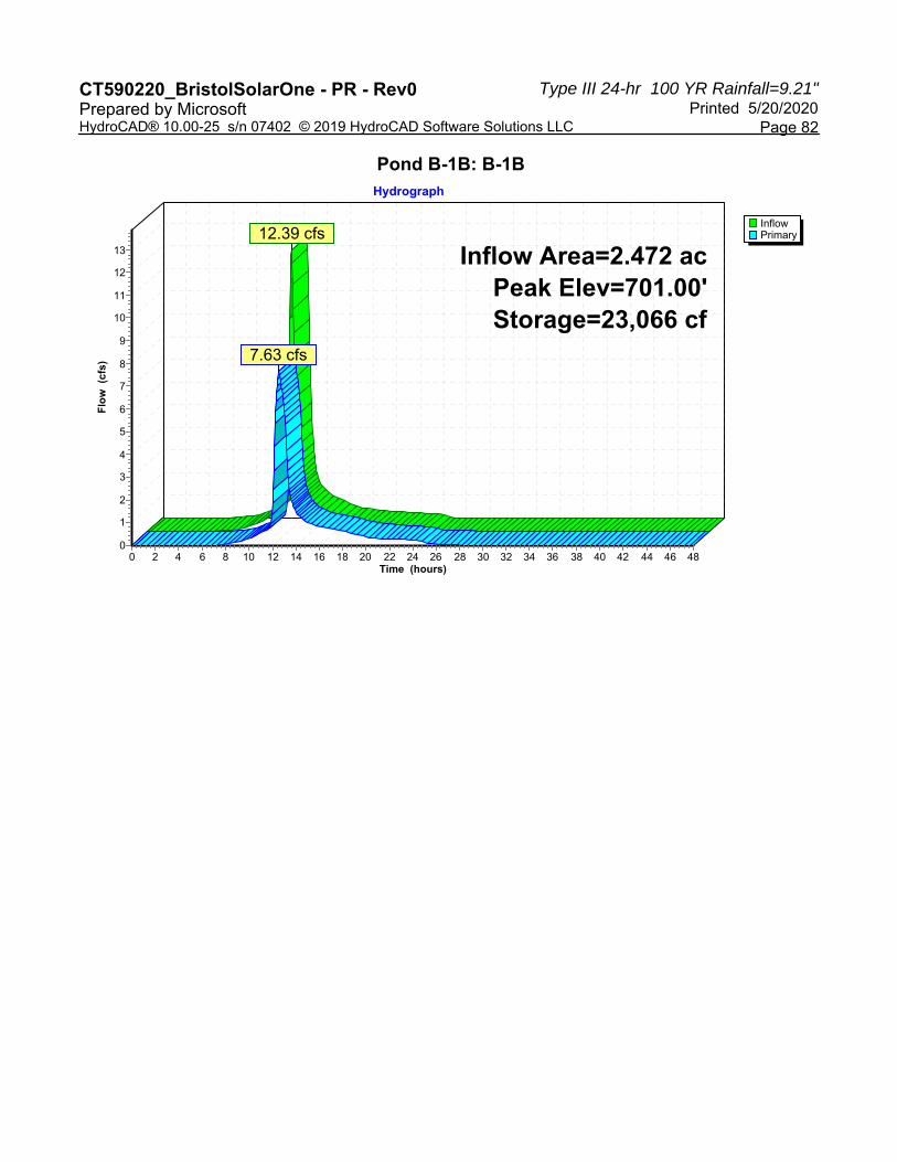
Type III 24-hr 100 YR Rainfall=9.21"CT590220_BristolSolarOne - PR - Rev0 Printed 5/20/2020Prepared by Microsoft
Page 82HydroCAD® 10.00-25 s/n 07402 © 2019 HydroCAD Software Solutions LLC
Pond B-1B: B-1B
InflowPrimary
Hydrograph
Time (hours)484644424038363432302826242220181614121086420
Flo
w (
cfs)
13
12
11
10
9
8
7
6
5
4
3
2
1
0
Inflow Area=2.472 acPeak Elev=701.00'Storage=23,066 cf
12.39 cfs
7.63 cfs

Type III 24-hr 100 YR Rainfall=9.21"CT590220_BristolSolarOne - PR - Rev0 Printed 5/20/2020Prepared by Microsoft
Page 83HydroCAD® 10.00-25 s/n 07402 © 2019 HydroCAD Software Solutions LLC
Summary for Pond B-2: B-2
Inflow Area = 6.822 ac, 4.15% Impervious, Inflow Depth = 6.64" for 100 YR eventInflow = 37.71 cfs @ 12.21 hrs, Volume= 3.777 afOutflow = 33.04 cfs @ 12.31 hrs, Volume= 3.775 af, Atten= 12%, Lag= 5.9 minPrimary = 33.04 cfs @ 12.31 hrs, Volume= 3.775 af
Routing by Dyn-Stor-Ind method, Time Span= 0.00-48.00 hrs, dt= 0.05 hrsStarting Elev= 721.85' Surf.Area= 12,337 sf Storage= 9,974 cfPeak Elev= 723.96' @ 12.31 hrs Surf.Area= 15,497 sf Storage= 39,323 cf (29,349 cf above start)
Plug-Flow detention time= 121.7 min calculated for 3.542 af (94% of inflow)Center-of-Mass det. time= 73.3 min ( 883.6 - 810.3 )
Volume Invert Avail.Storage Storage Description#1 721.00' 56,252 cf Custom Stage Data (Irregular) Listed below (Recalc)
Elevation Surf.Area Perim. Inc.Store Cum.Store Wet.Area(feet) (sq-ft) (feet) (cubic-feet) (cubic-feet) (sq-ft)
721.00 11,140 462.4 0 0 11,140722.00 12,555 481.2 11,840 11,840 12,628723.00 14,027 500.1 13,284 25,125 14,184724.00 15,556 518.9 14,785 39,910 15,791725.00 17,141 537.8 16,342 56,252 17,466
Device Routing Invert Outlet Devices#1 Primary 720.50' 12.0" Round Culvert
L= 34.0' CPP, square edge headwall, Ke= 0.500 Inlet / Outlet Invert= 720.50' / 720.00' S= 0.0147 '/' Cc= 0.900 n= 0.013 Corrugated PE, smooth interior, Flow Area= 0.79 sf
#2 Device 1 721.85' 12.0" W x 3.0" H Vert. Orifice/Grate C= 0.600 #3 Device 1 722.50' 12.0" Vert. Orifice/Grate C= 0.600 #4 Primary 723.00' 11.0' long x 12.0' breadth Broad-Crested Rectangular Weir
Head (feet) 0.20 0.40 0.60 0.80 1.00 1.20 1.40 1.60 Coef. (English) 2.57 2.62 2.70 2.67 2.66 2.67 2.66 2.64
Primary OutFlow Max=32.88 cfs @ 12.31 hrs HW=723.96' TW=0.00' (Dynamic Tailwater)1=Culvert (Passes 5.40 cfs of 6.50 cfs potential flow)
2=Orifice/Grate (Orifice Controls 1.70 cfs @ 6.78 fps)3=Orifice/Grate (Orifice Controls 3.70 cfs @ 4.71 fps)
4=Broad-Crested Rectangular Weir (Weir Controls 27.48 cfs @ 2.61 fps)
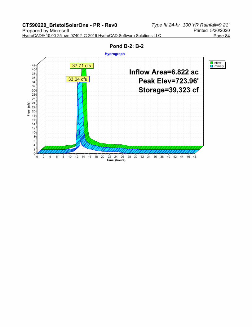
Type III 24-hr 100 YR Rainfall=9.21"CT590220_BristolSolarOne - PR - Rev0 Printed 5/20/2020Prepared by Microsoft
Page 84HydroCAD® 10.00-25 s/n 07402 © 2019 HydroCAD Software Solutions LLC
Pond B-2: B-2
InflowPrimary
Hydrograph
Time (hours)484644424038363432302826242220181614121086420
Flo
w (
cfs)
4240
3836
3432
3028
2624
2220
1816
1412
108
64
20
Inflow Area=6.822 acPeak Elev=723.96'Storage=39,323 cf
37.71 cfs
33.04 cfs

Type III 24-hr 100 YR Rainfall=9.21"CT590220_BristolSolarOne - PR - Rev0 Printed 5/20/2020Prepared by Microsoft
Page 85HydroCAD® 10.00-25 s/n 07402 © 2019 HydroCAD Software Solutions LLC
Summary for Pond B-3: B-3
Inflow Area = 4.269 ac, 3.16% Impervious, Inflow Depth = 6.64" for 100 YR eventInflow = 26.08 cfs @ 12.17 hrs, Volume= 2.363 afOutflow = 23.40 cfs @ 12.24 hrs, Volume= 2.363 af, Atten= 10%, Lag= 4.2 minPrimary = 23.40 cfs @ 12.24 hrs, Volume= 2.363 af
Routing by Dyn-Stor-Ind method, Time Span= 0.00-48.00 hrs, dt= 0.05 hrsStarting Elev= 736.05' Surf.Area= 5,881 sf Storage= 5,653 cfPeak Elev= 737.87' @ 12.24 hrs Surf.Area= 7,731 sf Storage= 18,030 cf (12,377 cf above start)
Plug-Flow detention time= 77.1 min calculated for 2.233 af (95% of inflow)Center-of-Mass det. time= 31.6 min ( 837.9 - 806.3 )
Volume Invert Avail.Storage Storage Description#1 735.00' 27,433 cf Custom Stage Data (Irregular) Listed below (Recalc)
Elevation Surf.Area Perim. Inc.Store Cum.Store Wet.Area(feet) (sq-ft) (feet) (cubic-feet) (cubic-feet) (sq-ft)
735.00 4,900 301.5 0 0 4,900736.00 5,833 320.3 5,360 5,360 5,881737.00 6,822 339.2 6,321 11,681 6,926738.00 7,868 358.0 7,339 19,020 8,026739.00 8,971 376.9 8,413 27,433 9,191
Device Routing Invert Outlet Devices#1 Primary 735.50' 12.0" Round Culvert
L= 28.0' CPP, square edge headwall, Ke= 0.500 Inlet / Outlet Invert= 735.50' / 735.00' S= 0.0179 '/' Cc= 0.900 n= 0.013 Corrugated PE, smooth interior, Flow Area= 0.79 sf
#2 Primary 736.05' 12.0" W x 3.0" H Vert. Orifice/Grate C= 0.600 #3 Device 1 736.50' 12.0" Horiz. Orifice/Grate C= 0.600
Limited to weir flow at low heads #4 Primary 737.00' 8.0' long x 12.0' breadth Broad-Crested Rectangular Weir
Head (feet) 0.20 0.40 0.60 0.80 1.00 1.20 1.40 1.60 Coef. (English) 2.57 2.62 2.70 2.67 2.66 2.67 2.66 2.64
Primary OutFlow Max=23.27 cfs @ 12.24 hrs HW=737.87' TW=0.00' (Dynamic Tailwater)1=Culvert (Passes 4.42 cfs of 5.17 cfs potential flow)
3=Orifice/Grate (Orifice Controls 4.42 cfs @ 5.63 fps)2=Orifice/Grate (Orifice Controls 1.57 cfs @ 6.27 fps)4=Broad-Crested Rectangular Weir (Weir Controls 17.28 cfs @ 2.49 fps)
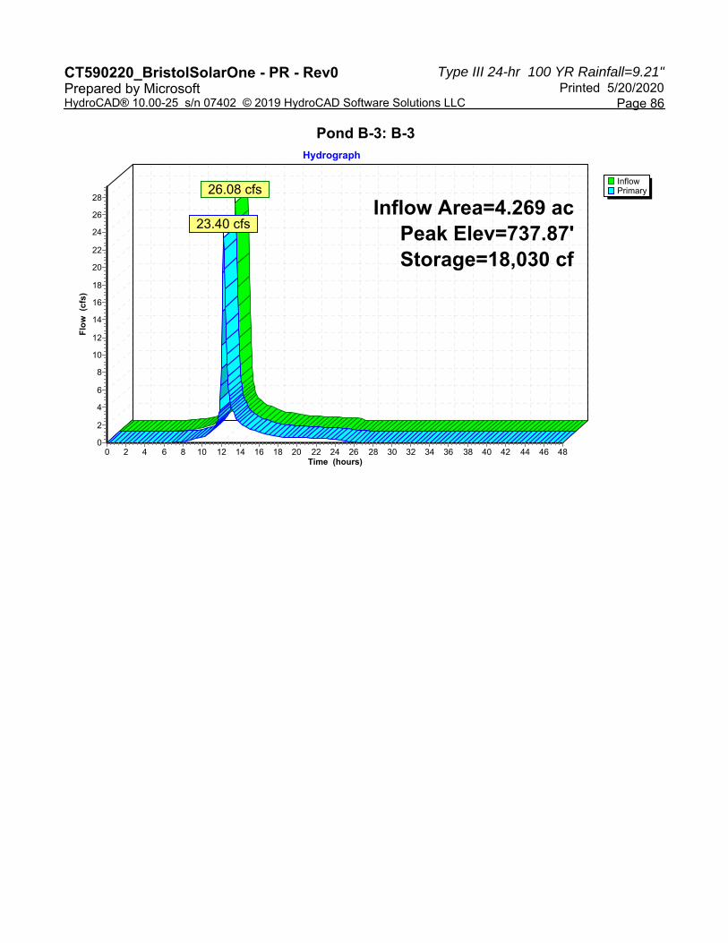
Type III 24-hr 100 YR Rainfall=9.21"CT590220_BristolSolarOne - PR - Rev0 Printed 5/20/2020Prepared by Microsoft
Page 86HydroCAD® 10.00-25 s/n 07402 © 2019 HydroCAD Software Solutions LLC
Pond B-3: B-3
InflowPrimary
Hydrograph
Time (hours)484644424038363432302826242220181614121086420
Flo
w (
cfs)
28
26
24
22
20
18
16
14
12
10
8
6
4
2
0
Inflow Area=4.269 acPeak Elev=737.87'Storage=18,030 cf
26.08 cfs
23.40 cfs

Type III 24-hr 100 YR Rainfall=9.21"CT590220_BristolSolarOne - PR - Rev0 Printed 5/20/2020Prepared by Microsoft
Page 87HydroCAD® 10.00-25 s/n 07402 © 2019 HydroCAD Software Solutions LLC
Summary for Link AP-1: AP-1
Inflow Area = 6.482 ac, 2.62% Impervious, Inflow Depth = 6.44" for 100 YR eventInflow = 22.51 cfs @ 12.46 hrs, Volume= 3.481 afPrimary = 22.51 cfs @ 12.46 hrs, Volume= 3.481 af, Atten= 0%, Lag= 0.0 min
Primary outflow = Inflow, Time Span= 0.00-48.00 hrs, dt= 0.05 hrs
Link AP-1: AP-1
InflowPrimary
Hydrograph
Time (hours)484644424038363432302826242220181614121086420
Flo
w (
cfs)
25242322212019181716151413121110
9876543210
Inflow Area=6.482 ac22.51 cfs
22.51 cfs

Type III 24-hr 100 YR Rainfall=9.21"CT590220_BristolSolarOne - PR - Rev0 Printed 5/20/2020Prepared by Microsoft
Page 88HydroCAD® 10.00-25 s/n 07402 © 2019 HydroCAD Software Solutions LLC
Summary for Link AP-2: AP-2
Inflow Area = 7.416 ac, 3.82% Impervious, Inflow Depth = 6.61" for 100 YR eventInflow = 34.81 cfs @ 12.30 hrs, Volume= 4.085 afPrimary = 34.81 cfs @ 12.30 hrs, Volume= 4.085 af, Atten= 0%, Lag= 0.0 min
Primary outflow = Inflow, Time Span= 0.00-48.00 hrs, dt= 0.05 hrs
Link AP-2: AP-2
InflowPrimary
Hydrograph
Time (hours)484644424038363432302826242220181614121086420
Flo
w (
cfs)
38
36
34
32
30
28
26
24
22
20
18
16
14
12
10
8
6
4
2
0
Inflow Area=7.416 ac34.81 cfs
34.81 cfs

Type III 24-hr 100 YR Rainfall=9.21"CT590220_BristolSolarOne - PR - Rev0 Printed 5/20/2020Prepared by Microsoft
Page 89HydroCAD® 10.00-25 s/n 07402 © 2019 HydroCAD Software Solutions LLC
Summary for Link AP-3: AP-3
Inflow Area = 4.269 ac, 3.16% Impervious, Inflow Depth = 6.64" for 100 YR eventInflow = 23.40 cfs @ 12.24 hrs, Volume= 2.363 afPrimary = 23.40 cfs @ 12.24 hrs, Volume= 2.363 af, Atten= 0%, Lag= 0.0 min
Primary outflow = Inflow, Time Span= 0.00-48.00 hrs, dt= 0.05 hrs
Link AP-3: AP-3
InflowPrimary
Hydrograph
Time (hours)484644424038363432302826242220181614121086420
Flo
w (
cfs)
26
24
22
20
18
16
14
12
10
8
6
4
2
0
Inflow Area=4.269 ac23.40 cfs
23.40 cfs

APPENDIX D: NOAA ATLAS 14 PRECIPITATION FREQUENCY TABLE

��������� ��� ����������������������
��� ������������������ �������� !��� !��" ��� � ���#$%$��&'��(���)$��&*+���+,�)����&� ��)�����&� $���)���& �� ��'
-.//�/0123�456�7819:;�4<6�7;=3>8?�@�A8B20>8?�?2:;C�D=>30816�E8??;B0>B906�FG/H�A20>09I;C�54JKL4M6�A8?N>09I;C�OPQJLPR@M�S1;T20>8?C�PUPJPU�V0HHW�������X�YZ�[� ��WW�������\�]�._- �aSE__/ _.-�baScFS-Ed�SG _e/ SG���f������g����������$����g�[����$�����h����g�i�$�j� �$�kg���$�\���g�l$���m�$���nloog�n������$�m��������g���$��� �� g�[��$�����"��p�$��q���" � ����$�q�[� �")"���$�b�02r912=sGOr23;I�t8>?0�t=;B>t>020>8?�V=;u9;?Bv�;30>:20;3�w>0x�L<y�B8?V>I;?B;�>?0;=T213�z>?�>?Bx;3{4s9=20>8? /T;=2N;�=;B9==;?B;�>?0;=T21�zv;2=3{4 Q U 4< QU U< 4<< Q<< U<< 4<<<UO:>? <J@KK|���+,}��',�~ <J5@K|�����}���+'~ <JUU<|��'�(}��+�(~ <JK5U|��',(}��,�(~ <JPPU|���(+}���+~ <JRP5|��(�+}����~ <JLPK|��(,�}��'�~ 4J<L|��+�(}��(�~ 4JQ@|��+�,}����~ 4J@U|��,��}����~4<O:>? <JU4L|����'}��(,�~ <JK4R|��'(�}��,��~ <JPR<|�����}����~ <JL45|��(,,}����~ 4J4<|��,��}����~ 4JQ5|��,,,}��+'~ 4J@R|���((}����~ 4JU5|����}����~ 4JPU|����}��+�~ 4JLQ|����}����~4UO:>? <JK4<|��'('}��,��~ <JPQP|�����}����(~ <JL4P|��(�'}����~ 4J<R|��,��}��'�~ 4JQL|���'�}��+,~ 4J5K|����}����~ 4JK@|���'}���+~ 4JR4|����}��+�~ QJ<K|����}���,~ QJQU|��'�}����~@<O:>? <JRQK|��(�+}����~ <JLR@|��+'(}����~ 4JQ5|����,}��('~ 4J5U|����}����~ 4JPU|���,}��'�~ 4JLP|��'�}��+,~ QJQ<|���'}����~ QJ5U|��('}��((~ QJPL|��,�}'���~ @J<U|����}'�,�~K<O:>? 4J<5|��+��}���+~ 4JQ5|���'�}��(�~ 4JUP|���,}���+~ 4JR@|���,}��'�~ QJQ4|��(�}���'~ QJ5L|��+�}����~ QJPR|���'}'��'~ @J<L|���+}'�(�~ @JU4|���+}��'�~ @JRU|��''}(��+~QOx= 4J@P|���'}��+�~ 4JK4|����}����~ QJ<Q|����}��(�~ QJ@U|��+,}����~ QJR4|���(}��,(~ @J4K|���+}'�'�~ @JU4|��'(}����~ @JL<|��(�}��,�~ 5J5Q|��,+}(�,�~ 5JR5|���+}+�(�~@Ox= 4JUL|����}���+~ 4JRR|��'�}��''~ QJ@5|��+�}���+~ QJP@|���+}����~ @JQP|��'�}'�'+~ @JKP|��(�}����~ 5J<L|��,,}����~ 5JU5|���(}(�+�~ UJ4R|���+}+��(~ UJKL|��(�},���~KOx= QJ<4|����}��(�~ QJ5<|��,'}����~ @J<5|����}���(~ @JUP|��+�}'�(,~ 5J@<|����}��,�~ 5JRU|����}(�+,~ UJ5@|��,�}+�,,~ KJ<L|'���}����~ PJ<U|'�(�}���,~ PJRU|����}����~4QOx= QJ5R|����}����~ @J<Q|����}����~ @JLQ|����}���+~ 5JKK|���(}(��(~ UJKR|'���}+�+(~ KJ5@|'�+�}����~ PJQU|����}���(~ RJQU|���+}����~ LJPP|(��,}�'��~ 44J4|+��,}�+��~Q5Ox= QJRL|���'}��+�~ @JK4|��+�}'�(�~ 5JR<|��+�}(��+~ UJPR|'�'�}+�'+~ PJ4@|����}��+'~ RJ4Q|(���}���'~ LJQ4|(�+�}����~ 4<JK|+���}���(~ 4QJR|,�'�}���(~ 45JR|����}����~QOI2v @JQ@|����}'���~ 5J4Q|����}����~ UJUP|'���}+���~ KJPR|����},�+�~ RJ55|(��+}����~ LJK5|+���}����~ 44J<|,���}�(��~ 4QJR|,�(�}�,�,~ 4UJR|���'}�'��~ 4RJU|����}�,�(~@OI2v @JU4|��+'}'�'�~ 5J5L|����}��+�~ KJ<L|'�+�}+�++~ PJ5Q|��+�}����~ LJQU|+���}���(~ 4<JK|+���}�'�,~ 4QJ4|,���}�+�,~ 45J4|���,}���(~ 4PJU|����}�(��~ Q<JU|����}���(~5OI2v @JPP|���'}'�++~ 5JR4|��+(}(���~ KJUQ|���+},���~ PJL5|(��'}����~ LJRL|+���}����~ 44J@|,�'+}���,~ 4QJL|����}����~ 4UJ4|����}����~ 4RJP|����}�,��~ Q4JL|�'��}���,~POI2v 5JU<|����}��((~ UJKP|'�''}+���~ PJUL|����}��(�~ LJ4R|+���}���+~ 44J5|,�(�}���'~ 4@J<|��+�}�,��~ 45JR|����}���(~ 4PJ4|���+}����~ Q4J4|����}���,~ Q5JK|����}�+�,~4<OI2v UJQ@|'���}(��+~ KJ5P|���+},���~ RJ5L|(�('}���+~ 4<JQ|+���}����~ 4QJU|��'�}�(�,~ 45J4|���(}���(~ 4KJ<|���,}����~ 4RJU|���+}�(��~ QQJU|�'��}����~ QKJ4|�(��}'���~Q<OI2v PJUU|���(}��'�~ RJR@|(��(}����~ 4<JL|,��,}���+~ 4QJP|��,�}�(��~ 4UJ<|����}����~ 4KJR|���(}����~ 4RJP|���,}�(�,~ Q4JQ|�'�(}���(~ Q5JL|�(�(}�+�'~ QRJ@|�,�'}'���~@<OI2v LJ5R|+���}���,~ 4<JR|,���}���'~ 4QJL|����}�(��~ 45JK|����}�,�'~ 4PJ<|����}����~ 4RJR|�'��}���'~ Q<JP|����}����~ Q@J<|����}����~ QKJU|�+�(}���(~ QLJ5|����}'���~5UOI2v 44JR|���,}�'�+~ 4@JQ|���'}�(��~ 4UJ@|����}����~ 4PJ4|���'}���'~ 4LJU|�'��}���(~ Q4J5|�(��}�,�(~ Q@J@|�(��}���'~ QUJ5|�+�(}�(��~ QRJ5|����}'���~ @<JR|����}'+��~K<OI2v 4@JR|����}�+��~ 4UJ4|����}�,�+~ 4PJ5|���+}���(~ 4LJQ|����}�'��~ Q4JP|�(�(}�,��~ Q@JP|�+�+}����~ QUJK|�,��}����~ QPJK|����}���'~ @<J4|����}''�,~ @QJ<|����}',�,~����� ��������!������|��~����#��������������p$���p�������!���������$������!� ����$�������������|���~�n�#p����� ����������������#�������$�������� �p�������!�����������!����������$��j�� �p�p�$��������� �� ��������!��������#����|!���� ������������������� �����������$~���$$�p� ������������ �p�����|��$�����������$���p����~��������X���#������� �p���������������k��� ������ �p�p$�#���#�#� �� ��������|�[�~����#��������#���p��� �����������$����$����[����$����$���!����nloo�o�$����'�����#���!��#����!�#������ ���k����j�

��������� ��� ����������������������
��� ������������������ �������� !��� !��" ��� � ���#$%$��&'��(���)$��&*+���+,�)����&� ��)�����&� $���)���& �� ��'
-.�/01234516
7��8����9� :12;�<�1=0416;>?166�;516=�@=0014A

��������� ��� ����������������������
��� ������������������ �������� !��� !��" ��� � ���#$%$��&'��(���)$��&*+���+,�)����&� ��)�����&� $���)���& �� ��'
-./01�23.41�51//.67
-./01�23.41�8.9
-./01�23.41�.1/6.4
:;<=8>86:;?@@=8A@86:;?@@=8A@86

��������� ��� ����������������������
��� ������������������ �������� !��� !��" ��� � ���#$%$��&'��(���)$��&*+���+,�)����&� ��)�����&� $���)���& �� '�'
�-��.����/� ���0��� ��#����!�1�##��2������$�3����������4�#�� ����4�#�����������2������$�5���������2������$�5���1��������6����5���7� �������$��� �� 8�9��������:�������%��7��1�:�������;����� ��������$��#�
<=>??@AB?AC

APPENDIX E: WATER QUALITY VOLUME CALCULATIONS

Area (ac) Pervious (ac) Imperv. (ac) I R WQV (ac‐ft) P (in) Ab (ac) V (ac‐ft) Total V Req. (cf) V Provided (cf)Overall Site 17.20 12.02 5.18 30% 0.32 0.46 n/a n/a n/a 20,056.31 ‐ Basin 1‐A 3.64 2.44 1.20 33% 0.35 0.11 1 0.266531 0.13 5,547.58 ‐ Basin 1‐B 2.47 2.00 0.47 19% 0.22 0.05 1 0.266531 0.07 2,948.62 8,704.00 Basin 2 6.82 4.50 2.32 34% 0.36 0.20 1 0.266531 0.22 9,782.10 9,974.00 Basin 3 4.27 3.07 1.20 28% 0.30 0.11 1 0.266531 0.13 5,648.04 5,653.00 Overall Basins 17.20 12.02 5.18 30% 0.32 0.46 1 0.266531 0.48 21,023.82 ‐
21,023.82 cf24,331.00 cf
Overal Total V Required =Overal Total V Provided =
WATER QUALITY VOLUME CALCULATIONSFOR
BRISTOL SOLAR ONE, LLC311 HILL STREET, BRISTOL, CT

Type III 24-hr 100 YR Rainfall=9.21"CT590220_BristolSolarOne - PR - Rev0 - ALT Printed 4/24/2020Prepared by Microsoft
HydroCAD® 10.00-25 s/n 07402 © 2019 HydroCAD Software Solutions LLC
Stage-Area-Storage for Pond B-1A: B-1A
Elevation(feet)
Surface(sq-ft)
Storage(cubic-feet)
697.00 3,276 0697.05 3,312 165697.10 3,349 331697.15 3,385 500697.20 3,422 670697.25 3,459 842697.30 3,497 1,016697.35 3,534 1,192697.40 3,572 1,369697.45 3,610 1,549697.50 3,648 1,730697.55 3,686 1,914697.60 3,725 2,099697.65 3,763 2,286697.70 3,802 2,475697.75 3,841 2,666697.80 3,881 2,859697.85 3,920 3,054697.90 3,960 3,251697.95 4,000 3,450698.00 4,040 3,651698.05 4,079 3,854698.10 4,119 4,059698.15 4,158 4,266698.20 4,198 4,475698.25 4,238 4,686698.30 4,278 4,899698.35 4,318 5,114698.40 4,359 5,331698.45 4,400 5,550698.50 4,441 5,771698.55 4,482 5,994698.60 4,523 6,219698.65 4,564 6,446698.70 4,606 6,675698.75 4,648 6,907698.80 4,690 7,140698.85 4,732 7,376698.90 4,775 7,613698.95 4,817 7,853699.00 4,860 8,095699.05 4,902 8,339699.10 4,944 8,585699.15 4,987 8,834699.20 5,030 9,084699.25 5,072 9,336699.30 5,115 9,591699.35 5,159 9,848699.40 5,202 10,107699.45 5,246 10,368699.50 5,289 10,632699.55 5,333 10,897699.60 5,377 11,165
Elevation(feet)
Surface(sq-ft)
Storage(cubic-feet)
699.65 5,422 11,435699.70 5,466 11,707699.75 5,511 11,982699.80 5,556 12,258699.85 5,601 12,537699.90 5,646 12,818699.95 5,691 13,102700.00 5,737 13,387700.05 5,782 13,675700.10 5,827 13,966700.15 5,873 14,258700.20 5,918 14,553700.25 5,964 14,850700.30 6,010 15,149700.35 6,056 15,451700.40 6,102 15,755700.45 6,149 16,061700.50 6,195 16,370700.55 6,242 16,681700.60 6,289 16,994700.65 6,336 17,310700.70 6,383 17,628700.75 6,431 17,948700.80 6,479 18,271700.85 6,526 18,596700.90 6,574 18,923700.95 6,623 19,253701.00 6,671 19,586

Type III 24-hr 100 YR Rainfall=9.21"CT590220_BristolSolarOne - PR - Rev0 - ALT Printed 4/24/2020Prepared by Microsoft
HydroCAD® 10.00-25 s/n 07402 © 2019 HydroCAD Software Solutions LLC
Stage-Area-Storage for Pond B-1B: B-1B
Elevation(feet)
Surface(sq-ft)
Storage(cubic-feet)
698.00 5,187 0698.05 5,256 261698.10 5,325 526698.15 5,394 794698.20 5,464 1,065698.25 5,534 1,340698.30 5,605 1,618698.35 5,676 1,900698.40 5,748 2,186698.45 5,820 2,475698.50 5,893 2,768698.55 5,966 3,064698.60 6,039 3,365698.65 6,113 3,668698.70 6,187 3,976698.75 6,262 4,287698.80 6,337 4,602698.85 6,413 4,921698.90 6,489 5,243698.95 6,566 5,570699.00 6,643 5,900699.05 6,734 6,234699.10 6,825 6,573699.15 6,917 6,917699.20 7,009 7,265699.25 7,102 7,618699.30 7,196 7,975699.35 7,290 8,337699.40 7,385 8,704699.45 7,481 9,076699.50 7,577 9,452699.55 7,674 9,834699.60 7,771 10,220699.65 7,869 10,611699.70 7,968 11,007699.75 8,067 11,408699.80 8,167 11,813699.85 8,267 12,224699.90 8,368 12,640699.95 8,470 13,061700.00 8,572 13,487700.05 8,668 13,918700.10 8,765 14,354700.15 8,862 14,795700.20 8,960 15,240700.25 9,058 15,691700.30 9,157 16,146700.35 9,256 16,606700.40 9,356 17,071700.45 9,456 17,542700.50 9,557 18,017700.55 9,659 18,498700.60 9,761 18,983
Elevation(feet)
Surface(sq-ft)
Storage(cubic-feet)
700.65 9,863 19,474700.70 9,966 19,969700.75 10,070 20,470700.80 10,174 20,976700.85 10,279 21,488700.90 10,384 22,004700.95 10,490 22,526701.00 10,596 23,053701.05 10,696 23,585701.10 10,796 24,123701.15 10,896 24,665701.20 10,997 25,212701.25 11,099 25,765701.30 11,200 26,322701.35 11,303 26,885701.40 11,406 27,453701.45 11,509 28,025701.50 11,613 28,603701.55 11,717 29,187701.60 11,822 29,775701.65 11,927 30,369701.70 12,032 30,968701.75 12,139 31,572701.80 12,245 32,182701.85 12,352 32,797701.90 12,460 33,417701.95 12,568 34,043702.00 12,676 34,674

Type III 24-hr 100 YR Rainfall=9.21"CT590220_BristolSolarOne - PR - Rev0 - ALT Printed 4/24/2020Prepared by Microsoft
HydroCAD® 10.00-25 s/n 07402 © 2019 HydroCAD Software Solutions LLC
Stage-Area-Storage for Pond B-2: B-2
Elevation(feet)
Surface(sq-ft)
Storage(cubic-feet)
721.00 11,140 0721.05 11,209 559721.10 11,278 1,121721.15 11,347 1,686721.20 11,416 2,256721.25 11,486 2,828721.30 11,556 3,404721.35 11,626 3,984721.40 11,696 4,567721.45 11,766 5,153721.50 11,837 5,743721.55 11,908 6,337721.60 11,979 6,934721.65 12,050 7,535721.70 12,122 8,139721.75 12,193 8,747721.80 12,265 9,358721.85 12,337 9,974721.90 12,410 10,592721.95 12,482 11,215722.00 12,555 11,840722.05 12,627 12,470722.10 12,699 13,103722.15 12,771 13,740722.20 12,843 14,380722.25 12,915 15,024722.30 12,988 15,672722.35 13,061 16,323722.40 13,134 16,978722.45 13,207 17,636722.50 13,281 18,299722.55 13,355 18,964722.60 13,428 19,634722.65 13,503 20,307722.70 13,577 20,984722.75 13,651 21,665722.80 13,726 22,349722.85 13,801 23,038722.90 13,876 23,730722.95 13,951 24,425723.00 14,027 25,125723.05 14,102 25,828723.10 14,176 26,535723.15 14,251 27,246723.20 14,326 27,960723.25 14,402 28,678723.30 14,477 29,400723.35 14,553 30,126723.40 14,629 30,855723.45 14,705 31,589723.50 14,782 32,326723.55 14,858 33,067723.60 14,935 33,812
Elevation(feet)
Surface(sq-ft)
Storage(cubic-feet)
723.65 15,012 34,560723.70 15,089 35,313723.75 15,166 36,069723.80 15,244 36,830723.85 15,322 37,594723.90 15,400 38,362723.95 15,478 39,134724.00 15,556 39,910724.05 15,633 40,689724.10 15,711 41,473724.15 15,789 42,260724.20 15,867 43,052724.25 15,945 43,847724.30 16,023 44,646724.35 16,102 45,449724.40 16,181 46,257724.45 16,260 47,068724.50 16,339 47,882724.55 16,418 48,701724.60 16,498 49,524724.65 16,578 50,351724.70 16,657 51,182724.75 16,738 52,017724.80 16,818 52,856724.85 16,898 53,699724.90 16,979 54,546724.95 17,060 55,397725.00 17,141 56,252

Type III 24-hr 100 YR Rainfall=9.21"CT590220_BristolSolarOne - PR - Rev0 - ALT Printed 4/24/2020Prepared by Microsoft
HydroCAD® 10.00-25 s/n 07402 © 2019 HydroCAD Software Solutions LLC
Stage-Area-Storage for Pond B-3: B-3
Elevation(feet)
Surface(sq-ft)
Storage(cubic-feet)
735.00 4,900 0735.05 4,945 246735.10 4,990 494735.15 5,035 745735.20 5,080 998735.25 5,126 1,253735.30 5,171 1,511735.35 5,217 1,770735.40 5,263 2,032735.45 5,310 2,297735.50 5,356 2,563735.55 5,403 2,832735.60 5,450 3,104735.65 5,497 3,377735.70 5,545 3,653735.75 5,592 3,932735.80 5,640 4,212735.85 5,688 4,496735.90 5,736 4,781735.95 5,784 5,069736.00 5,833 5,360736.05 5,881 5,653736.10 5,928 5,948736.15 5,976 6,245736.20 6,025 6,545736.25 6,073 6,848736.30 6,122 7,153736.35 6,170 7,460736.40 6,219 7,770736.45 6,268 8,082736.50 6,318 8,397736.55 6,367 8,714736.60 6,417 9,033736.65 6,467 9,355736.70 6,517 9,680736.75 6,567 10,007736.80 6,618 10,337736.85 6,669 10,669736.90 6,720 11,004736.95 6,771 11,341737.00 6,822 11,681737.05 6,873 12,023737.10 6,923 12,368737.15 6,974 12,715737.20 7,025 13,065737.25 7,077 13,418737.30 7,128 13,773737.35 7,180 14,131737.40 7,231 14,491737.45 7,283 14,854737.50 7,336 15,219737.55 7,388 15,588737.60 7,441 15,958
Elevation(feet)
Surface(sq-ft)
Storage(cubic-feet)
737.65 7,493 16,332737.70 7,546 16,708737.75 7,600 17,086737.80 7,653 17,468737.85 7,706 17,852737.90 7,760 18,238737.95 7,814 18,628738.00 7,868 19,020738.05 7,921 19,414738.10 7,975 19,812738.15 8,029 20,212738.20 8,083 20,615738.25 8,137 21,020738.30 8,191 21,428738.35 8,246 21,839738.40 8,301 22,253738.45 8,355 22,669738.50 8,410 23,088738.55 8,466 23,510738.60 8,521 23,935738.65 8,577 24,362738.70 8,633 24,793738.75 8,688 25,226738.80 8,745 25,662738.85 8,801 26,100738.90 8,857 26,542738.95 8,914 26,986739.00 8,971 27,433