Embed Size (px)
Citation preview

NATURAL RESOURCES TECHNICAL REPORT
Final – May 2020
APPENDIX E: DELINEATED FEATURES TABLE
Wetland and Waterway Features Table
FEATURE IDPREVIOUS
FEATURE #
CLASSIFICATIO
NDESCRIPTION DOMINANT VEGETATION
CHANNEL (Approximate
widths/depths)
COVER TYPE
(Left & Right Banks)
USACE
JURISDICTION
MDE
JURISDICTION
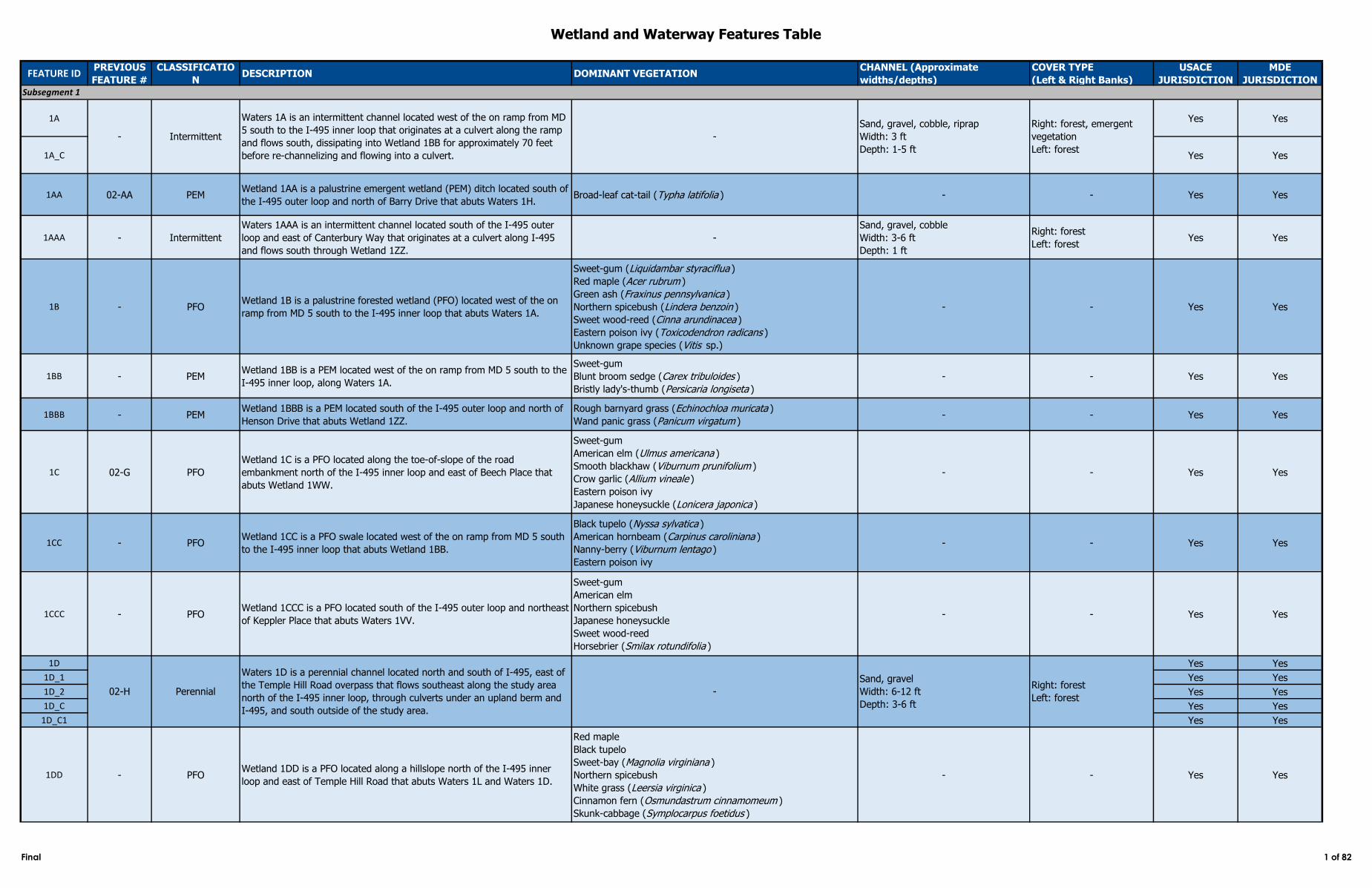
1A Yes Yes
1A_C Yes Yes
1AA 02-AA PEMWetland 1AA is a palustrine emergent wetland (PEM) ditch located south of
the I‑495 outer loop and north of Barry Drive that abuts Waters 1H.Broad-leaf cat-tail (Typha latifolia ) - - Yes Yes
1AAA - Intermittent
Waters 1AAA is an intermittent channel located south of the I‑495 outer
loop and east of Canterbury Way that originates at a culvert along I‑495
and flows south through Wetland 1ZZ.
-
Sand, gravel, cobble
Width: 3-6 ft
Depth: 1 ft
Right: forest
Left: forestYes Yes
1B - PFOWetland 1B is a palustrine forested wetland (PFO) located west of the on
ramp from MD 5 south to the I‑495 inner loop that abuts Waters 1A.
Sweet-gum (Liquidambar styraciflua )
Red maple (Acer rubrum )
Green ash (Fraxinus pennsylvanica )
Northern spicebush (Lindera benzoin )
Sweet wood-reed (Cinna arundinacea )
Eastern poison ivy (Toxicodendron radicans )
Unknown grape species (Vitis sp.)
- - Yes Yes
1BB - PEMWetland 1BB is a PEM located west of the on ramp from MD 5 south to the
I‑495 inner loop, along Waters 1A.
Sweet-gum
Blunt broom sedge (Carex tribuloides )
Bristly lady's-thumb (Persicaria longiseta )
- - Yes Yes
1BBB - PEMWetland 1BBB is a PEM located south of the I-495 outer loop and north of
Henson Drive that abuts Wetland 1ZZ.
Rough barnyard grass (Echinochloa muricata )
Wand panic grass (Panicum virgatum )- - Yes Yes
1C 02-G PFO
Wetland 1C is a PFO located along the toe-of-slope of the road
embankment north of the I-495 inner loop and east of Beech Place that
abuts Wetland 1WW.
Sweet-gum
American elm (Ulmus americana )
Smooth blackhaw (Viburnum prunifolium )
Crow garlic (Allium vineale )
Eastern poison ivy
Japanese honeysuckle (Lonicera japonica )
- - Yes Yes
1CC - PFOWetland 1CC is a PFO swale located west of the on ramp from MD 5 south
to the I‑495 inner loop that abuts Wetland 1BB.
Black tupelo (Nyssa sylvatica )
American hornbeam (Carpinus caroliniana )
Nanny-berry (Viburnum lentago )
Eastern poison ivy
- - Yes Yes
1CCC - PFOWetland 1CCC is a PFO located south of the I-495 outer loop and northeast
of Keppler Place that abuts Waters 1VV.
Sweet-gum
American elm
Northern spicebush
Japanese honeysuckle
Sweet wood-reed
Horsebrier (Smilax rotundifolia )
- - Yes Yes
1D Yes Yes
1D_1 Yes Yes
1D_2 Yes Yes
1D_C Yes Yes
1D_C1 Yes Yes
1DD - PFOWetland 1DD is a PFO located along a hillslope north of the I‑495 inner
loop and east of Temple Hill Road that abuts Waters 1L and Waters 1D.
Red maple
Black tupelo
Sweet-bay (Magnolia virginiana )
Northern spicebush
White grass (Leersia virginica )
Cinnamon fern (Osmundastrum cinnamomeum )
Skunk-cabbage (Symplocarpus foetidus )
- - Yes Yes
Waters 1A is an intermittent channel located west of the on ramp from MD
5 south to the I-495 inner loop that originates at a culvert along the ramp
and flows south, dissipating into Wetland 1BB for approximately 70 feet
before re-channelizing and flowing into a culvert.
Waters 1D is a perennial channel located north and south of I-495, east of
the Temple Hill Road overpass that flows southeast along the study area
north of the I‑495 inner loop, through culverts under an upland berm and
I‑495, and south outside of the study area.
Intermittent
Perennial
Subsegment 1
Sand, gravel, cobble, riprap
Width: 3 ft
Depth: 1-5 ft
Right: forest, emergent
vegetation
Left: forest
Sand, gravel
Width: 6-12 ft
Depth: 3-6 ft
Right: forest
Left: forest-
--
02-H
Final 1 of 82
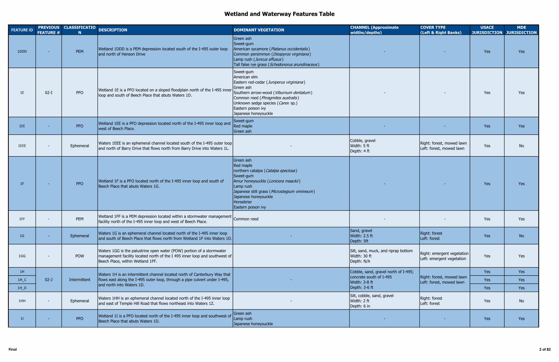
Wetland and Waterway Features Table
FEATURE IDPREVIOUS
FEATURE #
CLASSIFICATIO
NDESCRIPTION DOMINANT VEGETATION
CHANNEL (Approximate
widths/depths)
COVER TYPE
(Left & Right Banks)
USACE
JURISDICTION
MDE
JURISDICTION
1DDD - PEMWetland 1DDD is a PEM depression located south of the I-495 outer loop
and north of Henson Drive
Green ash
Sweet-gum
American sycamore (Platanus occidentalis )
Common persimmon (Diospyros virginiana )
Lamp rush (Juncus effusus )
Tall false rye grass (Schedonorus arundinaceus )
- - Yes Yes
1E 02-I PFOWetland 1E is a PFO located on a sloped floodplain north of the I‑495 inner
loop and south of Beech Place that abuts Waters 1D.
Sweet-gum
American elm
Eastern red-cedar (Juniperus virginiana )
Green ash
Southern arrow-wood (Viburnum dentatum )
Common reed (Phragmites australis )
Unknown sedge species (Carex sp.)
Eastern poison ivy
Japanese honeysuckle
- - Yes Yes
1EE - PFOWetland 1EE is a PFO depression located north of the I‑495 inner loop and
west of Beech Place.
Sweet-gum
Red maple
Green ash
- - Yes Yes
1EEE - EphemeralWaters 1EEE is an ephemeral channel located south of the I‑495 outer loop
and north of Barry Drive that flows north from Barry Drive into Waters 1L.-
Cobble, gravel
Width: 5 ft
Depth: 4 ft
Right: forest, mowed lawn
Left: forest, mowed lawnYes No
1F - PFOWetland 1F is a PFO located north of the I‑495 inner loop and south of
Beech Place that abuts Waters 1G.
Green ash
Red maple
northern catalpa (Catalpa speciosa )
Sweet-gum
Amur honeysuckle (Lonicera maackii )
Lamp rush
Japanese stilt grass (Microstegium vimineum )
Japanese honeysuckle
Horsebrier
Eastern poison ivy
- - Yes Yes
1FF - PEMWetland 1FF is a PEM depression located within a stormwater management
facility north of the I‑495 inner loop and west of Beech Place.Common reed - - Yes Yes
1G - EphemeralWaters 1G is an ephemeral channel located north of the I‑495 inner loop
and south of Beech Place that flows north from Wetland 1F into Waters 1D.-
Sand, gravel
Width: 2.5 ft
Depth: 5ft
Right: forest
Left: forestYes No
1GG - POW
Waters 1GG is the palustrine open water (POW) portion of a stormwater
management facility located north of the I 495 inner loop and southwest of
Beech Place, within Wetland 1FF.
Silt, sand, muck, and riprap bottom
Width: 30 ft
Depth: N/A
Right: emergent vegetation
Left: emergent vegetation Yes Yes
1H Yes Yes
1H_C Yes Yes
1H_D Yes Yes
1HH - EphemeralWaters 1HH is an ephemeral channel located north of the I‑495 inner loop
and east of Temple Hill Road that flows northeast into Waters 1Z.-
Silt, cobble, sand, gravel
Width: 2 ft
Depth: 6 in
Right: forest
Left: forestYes No
1I - PFOWetland 1I is a PFO located north of the I‑495 inner loop and southwest of
Beech Place that abuts Waters 1D.
Green ash
Lamp rush
Japanese honeysuckle
- - Yes Yes
02-J Intermittent
Waters 1H is an intermittent channel located north of Canterbury Way that
flows east along the I‑495 outer loop, through a pipe culvert under I‑495,
and north into Waters 1D.
-
Cobble, sand, gravel north of I-495;
concrete south of I-495
Width: 3-8 ft
Depth: 3-6 ft
Right: forest, mowed lawn
Left: forest, mowed lawn
Final 2 of 82
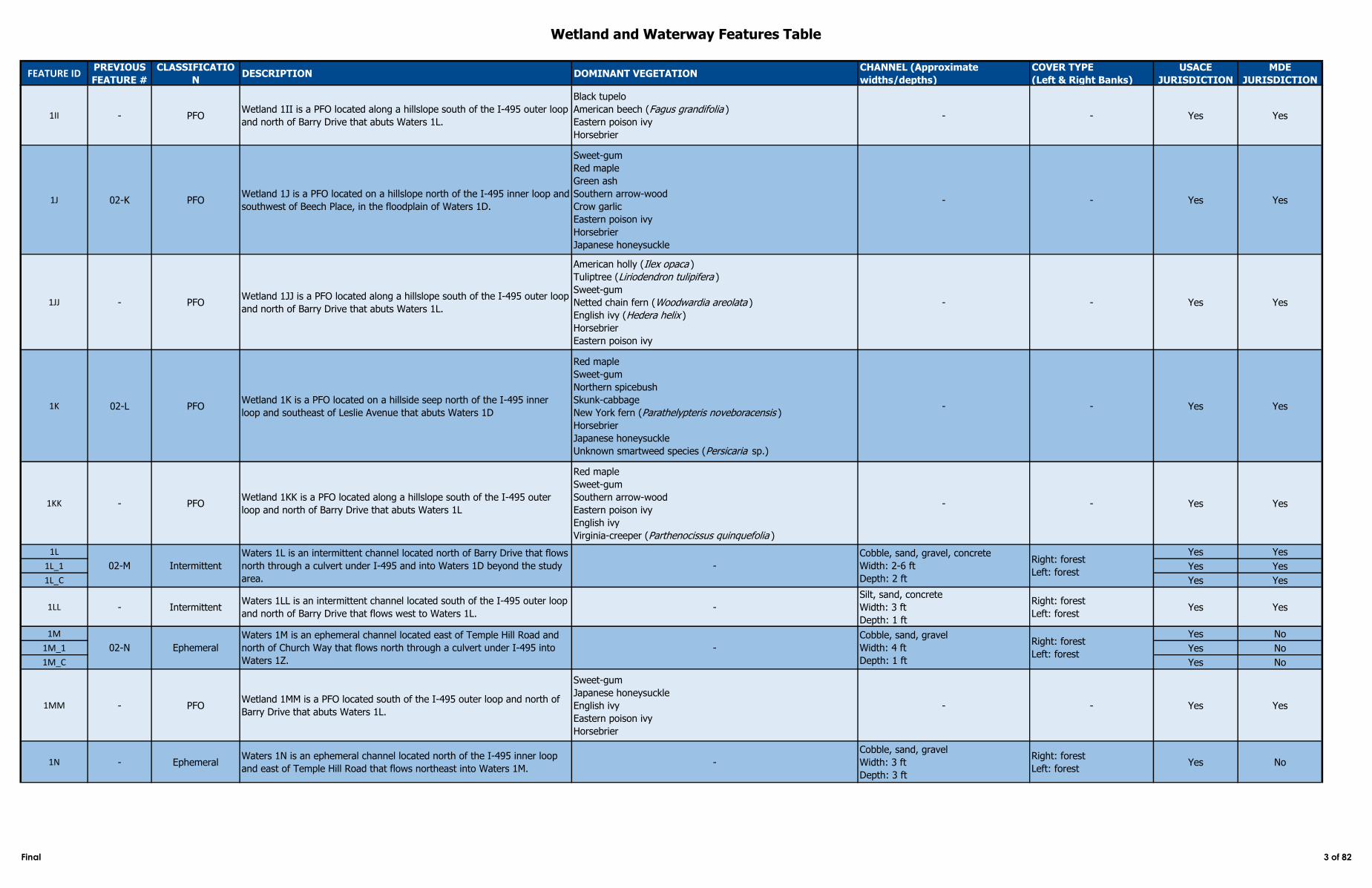
Wetland and Waterway Features Table
FEATURE IDPREVIOUS
FEATURE #
CLASSIFICATIO
NDESCRIPTION DOMINANT VEGETATION
CHANNEL (Approximate
widths/depths)
COVER TYPE
(Left & Right Banks)
USACE
JURISDICTION
MDE
JURISDICTION
1II - PFOWetland 1II is a PFO located along a hillslope south of the I‑495 outer loop
and north of Barry Drive that abuts Waters 1L.
Black tupelo
American beech (Fagus grandifolia )
Eastern poison ivy
Horsebrier
- - Yes Yes
1J 02-K PFOWetland 1J is a PFO located on a hillslope north of the I‑495 inner loop and
southwest of Beech Place, in the floodplain of Waters 1D.
Sweet-gum
Red maple
Green ash
Southern arrow-wood
Crow garlic
Eastern poison ivy
Horsebrier
Japanese honeysuckle
- - Yes Yes
1JJ - PFOWetland 1JJ is a PFO located along a hillslope south of the I‑495 outer loop
and north of Barry Drive that abuts Waters 1L.
American holly (Ilex opaca )
Tuliptree (Liriodendron tulipifera )
Sweet-gum
Netted chain fern (Woodwardia areolata )
English ivy (Hedera helix )
Horsebrier
Eastern poison ivy
- - Yes Yes
1K 02-L PFOWetland 1K is a PFO located on a hillside seep north of the I‑495 inner
loop and southeast of Leslie Avenue that abuts Waters 1D
Red maple
Sweet-gum
Northern spicebush
Skunk-cabbage
New York fern (Parathelypteris noveboracensis )
Horsebrier
Japanese honeysuckle
Unknown smartweed species (Persicaria sp.)
- - Yes Yes
1KK - PFOWetland 1KK is a PFO located along a hillslope south of the I‑495 outer
loop and north of Barry Drive that abuts Waters 1L
Red maple
Sweet-gum
Southern arrow-wood
Eastern poison ivy
English ivy
Virginia-creeper (Parthenocissus quinquefolia )
- - Yes Yes
1L Yes Yes
1L_1 Yes Yes
1L_C Yes Yes
1LL - IntermittentWaters 1LL is an intermittent channel located south of the I‑495 outer loop
and north of Barry Drive that flows west to Waters 1L.-
Silt, sand, concrete
Width: 3 ft
Depth: 1 ft
Right: forest
Left: forestYes Yes
1M Yes No
1M_1 Yes No
1M_C Yes No
1MM - PFOWetland 1MM is a PFO located south of the I‑495 outer loop and north of
Barry Drive that abuts Waters 1L.
Sweet-gum
Japanese honeysuckle
English ivy
Eastern poison ivy
Horsebrier
- - Yes Yes
1N - EphemeralWaters 1N is an ephemeral channel located north of the I‑495 inner loop
and east of Temple Hill Road that flows northeast into Waters 1M.-
Cobble, sand, gravel
Width: 3 ft
Depth: 3 ft
Right: forest
Left: forestYes No
Right: forest
Left: forest
02-M Intermittent
Waters 1L is an intermittent channel located north of Barry Drive that flows
north through a culvert under I‑495 and into Waters 1D beyond the study
area.
-
Cobble, sand, gravel, concrete
Width: 2-6 ft
Depth: 2 ft
Right: forest
Left: forest
02-N Ephemeral
Waters 1M is an ephemeral channel located east of Temple Hill Road and
north of Church Way that flows north through a culvert under I-495 into
Waters 1Z.
-
Cobble, sand, gravel
Width: 4 ft
Depth: 1 ft
Final 3 of 82
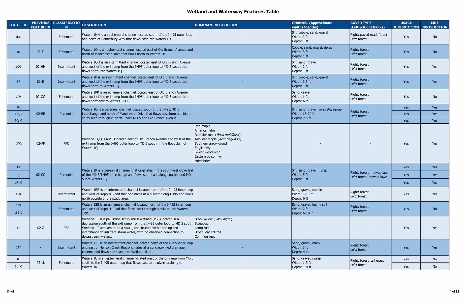
Wetland and Waterway Features Table
FEATURE IDPREVIOUS
FEATURE #
CLASSIFICATIO
NDESCRIPTION DOMINANT VEGETATION
CHANNEL (Approximate
widths/depths)
COVER TYPE
(Left & Right Banks)
USACE
JURISDICTION
MDE
JURISDICTION
1NN - EphemeralWaters 1NN is an ephemeral channel located south of the I‑495 outer loop
and north of Canterbury Way that flows east into Waters 1D.-
Silt, cobble, sand, gravel
Width: 3 ft
Depth: 1 ft
Right: paved road, forest
Left: forestYes No
1O 02-JJ EphemeralWaters 1O is an ephemeral channel located east of Old Branch Avenue and
north of Manchester Drive that flows north to Waters 1P.-
Cobble, sand, gravel, riprap
Width: 3 ft
Depth: 1 ft
Right: forest
Left: forestYes No
1OO 02-HH Intermittent
Waters 1OO is an intermittent channel located east of Old Branch Avenue
and west of the exit ramp from the I‑495 outer loop to MD 5 south that
flows north into Waters 1Q.
-
Silt, sand, gravel
Width: 2 ft
Depth: 1 ft
Right: forest
Left: forestYes Yes
1P 02-II Intermittent
Waters 1P is an intermittent channel located east of Old Branch Avenue
and west of the exit ramp from the I‑495 outer loop to MD 5 south that
flows north to Waters 1Q.
-
Silt, cobble, sand, gravel
Width: 3.5 ft
Depth: 1 ft
Right: forest
Left: forestYes Yes
1PP 02-GG Ephemeral
Waters 1PP is an ephemeral channel located east of Old Branch Avenue
and west of the exit ramp from the I‑495 outer loop to MD 5 south that
flows northeast to Waters 1OO.
-
Sand, gravel
Width: 1 ft
Depth: 6 in
Right: forest
Left: forestYes No
1Q Yes Yes
1Q_1 Yes Yes
1Q_C Yes Yes
1QQ 02-FF PFO
Wetland 1QQ is a PFO located east of Old Branch Avenue and west of the
exit ramp from the I‑495 outer loop to MD 5 south, in the floodplain of
Waters 1Q.
Red maple
American elm
Rambler rose (Rosa multiflora )
Ash-leaf maple (Acer negundo )
Southern arrow-wood
English ivy
Sweet wood-reed
Eastern poison ivy
Horsebrier
- - Yes Yes
1R Yes Yes
1R_1 Yes Yes
1R_C Yes Yes
1RR - Intermittent
Waters 1RR is an intermittent channel located north of the I‑495 inner loop
and west of Keppler Road that originates at a culvert along I‑495 and flows
north outside of the study area.
-
Sand, gravel, cobble
Width: 5-10 ft
Depth: 6 ft
Right: forest
Left: forestYes Yes
1SS
1SS_C
1T 02-Z PSS
Wetland 1T is a palustrine scrub-shrub wetland (PSS) located in a
depression south of the exit ramp from the I‑495 outer loop to MD 5 south.
Wetland 1T appears to be a swale, constructed within the upland
interchange to infiltrate storm water, with no observed connection to
downstream waters.
Black willow (Salix nigra )
Sweet-gum
Lamp rush
Broad-leaf cat-tail
Common reed
- - Yes Yes
1TT - Intermittent
Waters 1TT is an intermittent channel located north of the I‑495 inner loop
and east of Henson Creek that originates at a concrete-lined drainage
channel and flows northeast into Wetland 1UU.
-
Sand, gravel, muck
Width: 3 ft
Depth: 4 in
Right: forest
Left: forestYes Yes
1U Yes No
1U_C Yes No
- Ephemeral
Waters 1SS is an ephemeral channel located north of the I‑495 inner loop
and west of Keppler Road that flows west through a culvert into Waters
1RR.
-
Sand, gravel, loamy soil
Width: 2 ft
Depth: 6-10 in
Right: forest
Left: forestYes No
Right: forest, mowed lawn
Left: forest, mowed lawn02-CC Perennial
02-LL Ephemeral
02-EE Perennial
Waters 1Q is a perennial channel located south of the I‑495/MD 5
interchange and north of Manchester Drive that flows east from outside the
study area through culverts under MD 5 and Old Branch Avenue.
-
Silt, sand, gravel, concrete, riprap
Width: 15-20 ft
Depth: 2.5 ft
Right: forest
Left: forest
Waters 1R is a perennial channel that originates in the southwest cloverleaf
of the MD 5/I‑495 interchange and flows southeast along southbound MD
5 into Waters 1Q.
-
Silt, sand, gravel, riprap
Width: 5 ft
Depth: 1 ft
Waters 1U is an ephemeral channel located west of the on ramp from MD 5
south to the I‑495 outer loop that flows east to a culvert draining to
Waters 1R.
-
Sand, gravel, riprap
Width: 1-3 ft
Depth: 1-4 ft
Right: forest, tall grass
Left: forest
Final 4 of 82
Wetland and Waterway Features Table
FEATURE IDPREVIOUS
FEATURE #
CLASSIFICATIO
NDESCRIPTION DOMINANT VEGETATION
CHANNEL (Approximate
widths/depths)
COVER TYPE
(Left & Right Banks)
USACE
JURISDICTION
MDE
JURISDICTION
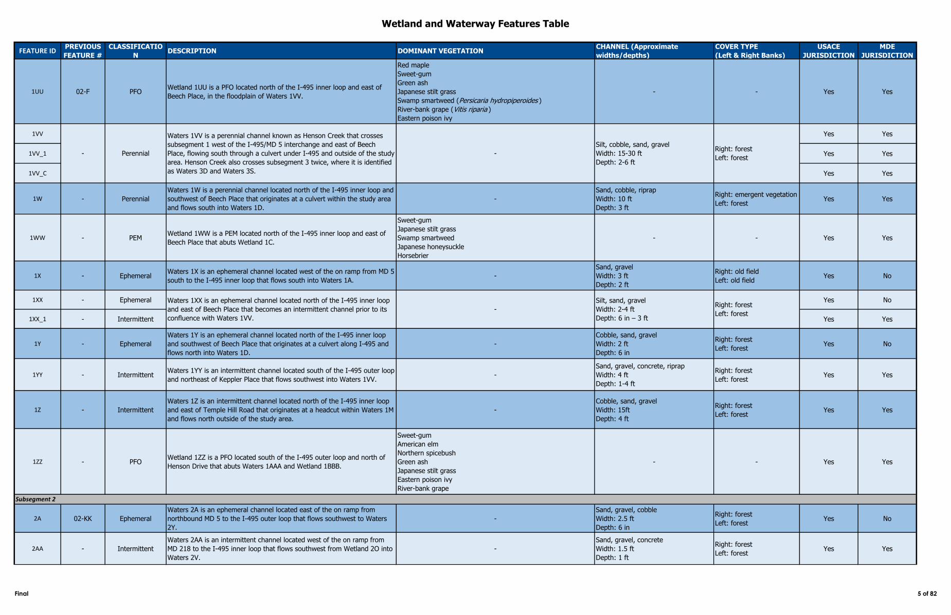
1UU 02-F PFOWetland 1UU is a PFO located north of the I‑495 inner loop and east of
Beech Place, in the floodplain of Waters 1VV.
Red maple
Sweet-gum
Green ash
Japanese stilt grass
Swamp smartweed (Persicaria hydropiperoides )
River-bank grape (Vitis riparia )
Eastern poison ivy
- - Yes Yes
1VV Yes Yes
1VV_1 Yes Yes
1VV_C Yes Yes
1W - Perennial
Waters 1W is a perennial channel located north of the I‑495 inner loop and
southwest of Beech Place that originates at a culvert within the study area
and flows south into Waters 1D.
-
Sand, cobble, riprap
Width: 10 ft
Depth: 3 ft
Right: emergent vegetation
Left: forestYes Yes
1WW - PEMWetland 1WW is a PEM located north of the I‑495 inner loop and east of
Beech Place that abuts Wetland 1C.
Sweet-gum
Japanese stilt grass
Swamp smartweed
Japanese honeysuckle
Horsebrier
- - Yes Yes
1X - EphemeralWaters 1X is an ephemeral channel located west of the on ramp from MD 5
south to the I‑495 inner loop that flows south into Waters 1A.-
Sand, gravel
Width: 3 ft
Depth: 2 ft
Right: old field
Left: old fieldYes No
1XX - Ephemeral Yes No
1XX_1 - Intermittent Yes Yes
1Y - Ephemeral
Waters 1Y is an ephemeral channel located north of the I‑495 inner loop
and southwest of Beech Place that originates at a culvert along I‑495 and
flows north into Waters 1D.
-
Cobble, sand, gravel
Width: 2 ft
Depth: 6 in
Right: forest
Left: forestYes No
1YY - IntermittentWaters 1YY is an intermittent channel located south of the I‑495 outer loop
and northeast of Keppler Place that flows southwest into Waters 1VV.-
Sand, gravel, concrete, riprap
Width: 4 ft
Depth: 1-4 ft
Right: forest
Left: forestYes Yes
1Z - Intermittent
Waters 1Z is an intermittent channel located north of the I‑495 inner loop
and east of Temple Hill Road that originates at a headcut within Waters 1M
and flows north outside of the study area.
-
Cobble, sand, gravel
Width: 15ft
Depth: 4 ft
Right: forest
Left: forestYes Yes
1ZZ - PFOWetland 1ZZ is a PFO located south of the I‑495 outer loop and north of
Henson Drive that abuts Waters 1AAA and Wetland 1BBB.
Sweet-gum
American elm
Northern spicebush
Green ash
Japanese stilt grass
Eastern poison ivy
River-bank grape
- - Yes Yes
2A 02-KK Ephemeral
Waters 2A is an ephemeral channel located east of the on ramp from
northbound MD 5 to the I‑495 outer loop that flows southwest to Waters
2Y.
-
Sand, gravel, cobble
Width: 2.5 ft
Depth: 6 in
Right: forest
Left: forestYes No
2AA - Intermittent
Waters 2AA is an intermittent channel located west of the on ramp from
MD 218 to the I‑495 inner loop that flows southwest from Wetland 2O into
Waters 2V.
-
Sand, gravel, concrete
Width: 1.5 ft
Depth: 1 ft
Right: forest
Left: forestYes Yes
-
Waters 1XX is an ephemeral channel located north of the I‑495 inner loop
and east of Beech Place that becomes an intermittent channel prior to its
confluence with Waters 1VV.
Silt, sand, gravel
Width: 2-4 ft
Depth: 6 in – 3 ft
Right: forest
Left: forest
Subsegment 2
- Perennial
Waters 1VV is a perennial channel known as Henson Creek that crosses
subsegment 1 west of the I‑495/MD 5 interchange and east of Beech
Place, flowing south through a culvert under I‑495 and outside of the study
area. Henson Creek also crosses subsegment 3 twice, where it is identified
as Waters 3D and Waters 3S.
-
Silt, cobble, sand, gravel
Width: 15-30 ft
Depth: 2-6 ft
Right: forest
Left: forest
Final 5 of 82
Wetland and Waterway Features Table
FEATURE IDPREVIOUS
FEATURE #
CLASSIFICATIO
NDESCRIPTION DOMINANT VEGETATION
CHANNEL (Approximate
widths/depths)
COVER TYPE
(Left & Right Banks)
USACE
JURISDICTION
MDE
JURISDICTION
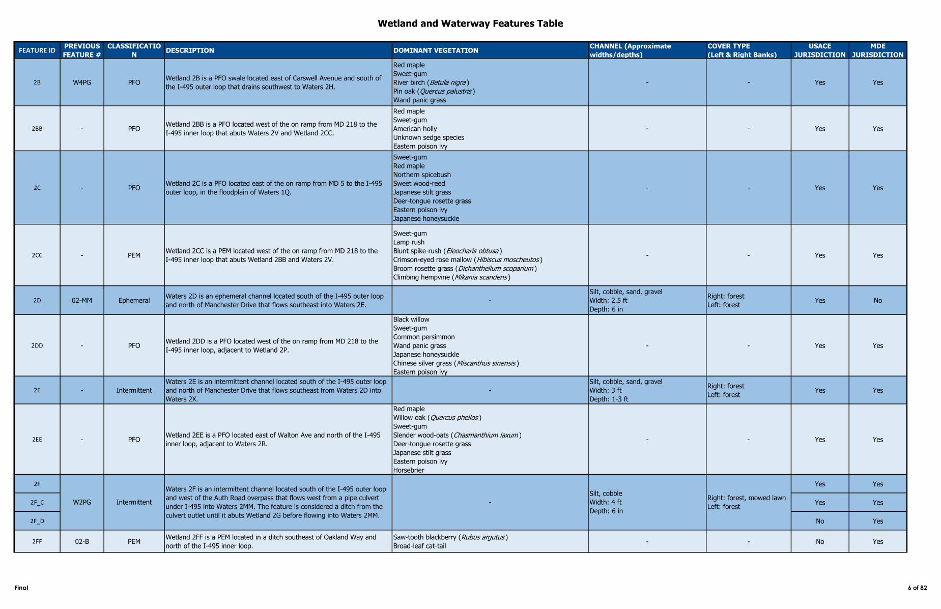
2B W4PG PFOWetland 2B is a PFO swale located east of Carswell Avenue and south of
the I‑495 outer loop that drains southwest to Waters 2H.
Red maple
Sweet-gum
River birch (Betula nigra )
Pin oak (Quercus palustris )
Wand panic grass
- - Yes Yes
2BB - PFOWetland 2BB is a PFO located west of the on ramp from MD 218 to the
I‑495 inner loop that abuts Waters 2V and Wetland 2CC.
Red maple
Sweet-gum
American holly
Unknown sedge species
Eastern poison ivy
- - Yes Yes
2C - PFOWetland 2C is a PFO located east of the on ramp from MD 5 to the I‑495
outer loop, in the floodplain of Waters 1Q.
Sweet-gum
Red maple
Northern spicebush
Sweet wood-reed
Japanese stilt grass
Deer-tongue rosette grass
Eastern poison ivy
Japanese honeysuckle
- - Yes Yes
2CC - PEMWetland 2CC is a PEM located west of the on ramp from MD 218 to the
I‑495 inner loop that abuts Wetland 2BB and Waters 2V.
Sweet-gum
Lamp rush
Blunt spike-rush (Eleocharis obtusa )
Crimson-eyed rose mallow (Hibiscus moscheutos )
Broom rosette grass (Dichanthelium scoparium )
Climbing hempvine (Mikania scandens )
- - Yes Yes
2D 02-MM EphemeralWaters 2D is an ephemeral channel located south of the I‑495 outer loop
and north of Manchester Drive that flows southeast into Waters 2E.-
Silt, cobble, sand, gravel
Width: 2.5 ft
Depth: 6 in
Right: forest
Left: forestYes No
2DD - PFOWetland 2DD is a PFO located west of the on ramp from MD 218 to the
I‑495 inner loop, adjacent to Wetland 2P.
Black willow
Sweet-gum
Common persimmon
Wand panic grass
Japanese honeysuckle
Chinese silver grass (Miscanthus sinensis )
Eastern poison ivy
- - Yes Yes
2E - Intermittent
Waters 2E is an intermittent channel located south of the I‑495 outer loop
and north of Manchester Drive that flows southeast from Waters 2D into
Waters 2X.
-
Silt, cobble, sand, gravel
Width: 3 ft
Depth: 1-3 ft
Right: forest
Left: forestYes Yes
2EE - PFOWetland 2EE is a PFO located east of Walton Ave and north of the I‑495
inner loop, adjacent to Waters 2R.
Red maple
Willow oak (Quercus phellos )
Sweet-gum
Slender wood-oats (Chasmanthium laxum )
Deer-tongue rosette grass
Japanese stilt grass
Eastern poison ivy
Horsebrier
- - Yes Yes
2F Yes Yes
2F_C Yes Yes
2F_D No Yes
2FF 02-B PEMWetland 2FF is a PEM located in a ditch southeast of Oakland Way and
north of the I‑495 inner loop.
Saw-tooth blackberry (Rubus argutus )
Broad-leaf cat-tail- - No Yes
W2PG Intermittent
Waters 2F is an intermittent channel located south of the I‑495 outer loop
and west of the Auth Road overpass that flows west from a pipe culvert
under I‑495 into Waters 2MM. The feature is considered a ditch from the
culvert outlet until it abuts Wetland 2G before flowing into Waters 2MM.
-
Silt, cobble
Width: 4 ft
Depth: 6 in
Right: forest, mowed lawn
Left: forest
Final 6 of 82
Wetland and Waterway Features Table
FEATURE IDPREVIOUS
FEATURE #
CLASSIFICATIO
NDESCRIPTION DOMINANT VEGETATION
CHANNEL (Approximate
widths/depths)
COVER TYPE
(Left & Right Banks)
USACE
JURISDICTION
MDE
JURISDICTION
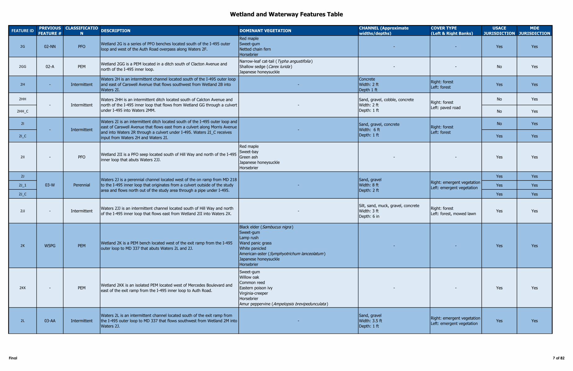
2G 02-NN PFOWetland 2G is a series of PFO benches located south of the I‑495 outer
loop and west of the Auth Road overpass along Waters 2F.
Red maple
Sweet-gum
Netted chain fern
Horsebrier
- - Yes Yes
2GG 02-A PEMWetland 2GG is a PEM located in a ditch south of Clacton Avenue and
north of the I‑495 inner loop.
Narrow-leaf cat-tail (Typha angustifolia )
Shallow sedge (Carex lurida )
Japanese honeysuckle
- - No Yes
2H - Intermittent
Waters 2H is an intermittent channel located south of the I‑495 outer loop
and east of Carswell Avenue that flows southwest from Wetland 2B into
Waters 2I.
-
Concrete
Width: 2 ft
Depth 1 ft
Right: forest
Left: forestYes Yes
2HH No Yes
2HH_C No Yes
2I No Yes
2I_C Yes Yes
2II - PFOWetland 2II is a PFO seep located south of Hill Way and north of the I‑495
inner loop that abuts Waters 2JJ.
Red maple
Sweet‑bay
Green ash
Japanese honeysuckle
Horsebrier
- - Yes Yes
2J Yes Yes
2J_1 Yes Yes
2J_C Yes Yes
2JJ - IntermittentWaters 2JJ is an intermittent channel located south of Hill Way and north
of the I‑495 inner loop that flows east from Wetland 2II into Waters 2X.-
Silt, sand, muck, gravel, concrete
Width: 3 ft
Depth: 6 in
Right: forest
Left: forest, mowed lawnYes Yes
2K W5PG PEMWetland 2K is a PEM bench located west of the exit ramp from the I‑495
outer loop to MD 337 that abuts Waters 2L and 2J.
Black elder (Sambucus nigra )
Sweet-gum
Lamp rush
Wand panic grass
White panicled
American-aster (Symphyotrichum lanceolatum )
Japanese honeysuckle
Horsebrier
- - Yes Yes
2KK - PEMWetland 2KK is an isolated PEM located west of Mercedes Boulevard and
east of the exit ramp from the I‑495 inner loop to Auth Road.
Sweet-gum
Willow oak
Common reed
Eastern poison ivy
Virginia-creeper
Horsebrier
Amur peppervine (Ampelopsis brevipedunculata )
- - Yes Yes
2L 03-AA Intermittent
Waters 2L is an intermittent channel located south of the exit ramp from
the I‑495 outer loop to MD 337 that flows southwest from Wetland 2M into
Waters 2J.
-
Sand, gravel
Width: 3.5 ft
Depth: 1 ft
Right: emergent vegetation
Left: emergent vegetationYes Yes
Intermittent
Waters 2HH is an intermittent ditch located south of Calcton Avenue and
north of the I-495 inner loop that flows from Wetland GG through a culvert
under I-495 into Waters 2MM.
-
Sand, gravel, cobble, concrete
Width: 2 ft
Depth: 1 ft
Right: forest
Left: paved road
-
-
Intermittent
Waters 2I is an intermittent ditch located south of the I‑495 outer loop and
east of Carswell Avenue that flows east from a culvert along Morris Avenue
and into Waters 2R through a culvert under I‑495. Waters 2I_C receives
input from Waters 2H and Waters 2I.
-
Sand, gravel, concrete
Width: 6 ft
Depth: 1 ft
Right: forest
Left: forest
03-W Perennial
Waters 2J is a perennial channel located west of the on ramp from MD 218
to the I‑495 inner loop that originates from a culvert outside of the study
area and flows north out of the study area through a pipe under I‑495.
-
Sand, gravel
Width: 8 ft
Depth: 2 ft
Right: emergent vegetation
Left: emergent vegetation
Final 7 of 82
Wetland and Waterway Features Table
FEATURE IDPREVIOUS
FEATURE #
CLASSIFICATIO
NDESCRIPTION DOMINANT VEGETATION
CHANNEL (Approximate
widths/depths)
COVER TYPE
(Left & Right Banks)
USACE
JURISDICTION
MDE
JURISDICTION
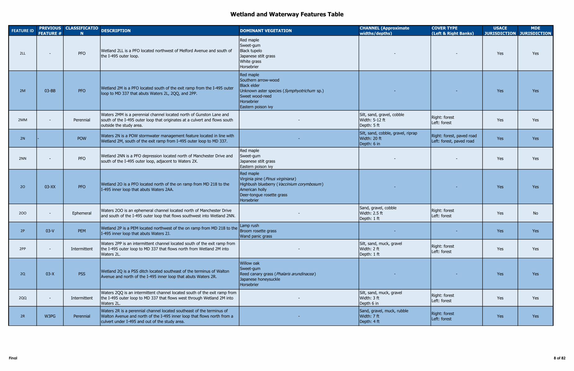
2LL - PFOWetland 2LL is a PFO located northwest of Melford Avenue and south of
the I‑495 outer loop.
Red maple
Sweet-gum
Black tupelo
Japanese stilt grass
White grass
Horsebrier
- - Yes Yes
2M 03-BB PFOWetland 2M is a PFO located south of the exit ramp from the I‑495 outer
loop to MD 337 that abuts Waters 2L, 2QQ, and 2PP.
Red maple
Southern arrow-wood
Black elder
Unknown aster species (Symphyotrichum sp.)
Sweet wood-reed
Horsebrier
Eastern poison ivy
- - Yes Yes
2MM - Perennial
Waters 2MM is a perennial channel located north of Gunston Lane and
south of the I‑495 outer loop that originates at a culvert and flows south
outside the study area.
-
Silt, sand, gravel, cobble
Width: 5-12 ft
Depth: 5 ft
Right: forest
Left: forestYes Yes
2N - POWWaters 2N is a POW stormwater management feature located in line with
Wetland 2M, south of the exit ramp from I-495 outer loop to MD 337. -
Silt, sand, cobble, gravel, riprap
Width: 20 ft
Depth: 6 in
Right: forest, paved road
Left: forest, paved roadYes Yes
2NN - PFOWetland 2NN is a PFO depression located north of Manchester Drive and
south of the I‑495 outer loop, adjacent to Waters 2X.
Red maple
Sweet-gum
Japanese stilt grass
Eastern poison ivy
- - Yes Yes
2O 03-XX PFOWetland 2O is a PFO located north of the on ramp from MD 218 to the
I‑495 inner loop that abuts Waters 2AA.
Red maple
Virginia pine (Pinus virginiana )
Highbush blueberry (Vaccinium corymbosum )
American holly
Deer-tongue rosette grass
Horsebrier
- - Yes Yes
2OO - EphemeralWaters 2OO is an ephemeral channel located north of Manchester Drive
and south of the I‑495 outer loop that flows southwest into Wetland 2NN.-
Sand, gravel, cobble
Width: 2.5 ft
Depth: 1 ft
Right: forest
Left: forestYes No
2P 03-V PEMWetland 2P is a PEM located northwest of the on ramp from MD 218 to the
I‑495 inner loop that abuts Waters 2J.
Lamp rush
Broom rosette grass
Wand panic grass
- - Yes Yes
2PP - Intermittent
Waters 2PP is an intermittent channel located south of the exit ramp from
the I‑495 outer loop to MD 337 that flows north from Wetland 2M into
Waters 2L.
-
Silt, sand, muck, gravel
Width: 2 ft
Depth: 1 ft
Right: forest
Left: forestYes Yes
2Q 03-X PSSWetland 2Q is a PSS ditch located southeast of the terminus of Walton
Avenue and north of the I‑495 inner loop that abuts Waters 2R.
Willow oak
Sweet-gum
Reed canary grass (Phalaris arundinacea )
Japanese honeysuckle
Horsebrier
- - Yes Yes
2QQ - Intermittent
Waters 2QQ is an intermittent channel located south of the exit ramp from
the I‑495 outer loop to MD 337 that flows west through Wetland 2M into
Waters 2L.
-
Silt, sand, muck, gravel
Width: 3 ft
Depth 6 in
Right: forest
Left: forestYes Yes
2R W3PG Perennial
Waters 2R is a perennial channel located southeast of the terminus of
Walton Avenue and north of the I‑495 inner loop that flows north from a
culvert under I‑495 and out of the study area.
-
Sand, gravel, muck, rubble
Width: 7 ft
Depth: 4 ft
Right: forest
Left: forestYes Yes
Final 8 of 82
Wetland and Waterway Features Table
FEATURE IDPREVIOUS
FEATURE #
CLASSIFICATIO
NDESCRIPTION DOMINANT VEGETATION
CHANNEL (Approximate
widths/depths)
COVER TYPE
(Left & Right Banks)
USACE
JURISDICTION
MDE
JURISDICTION
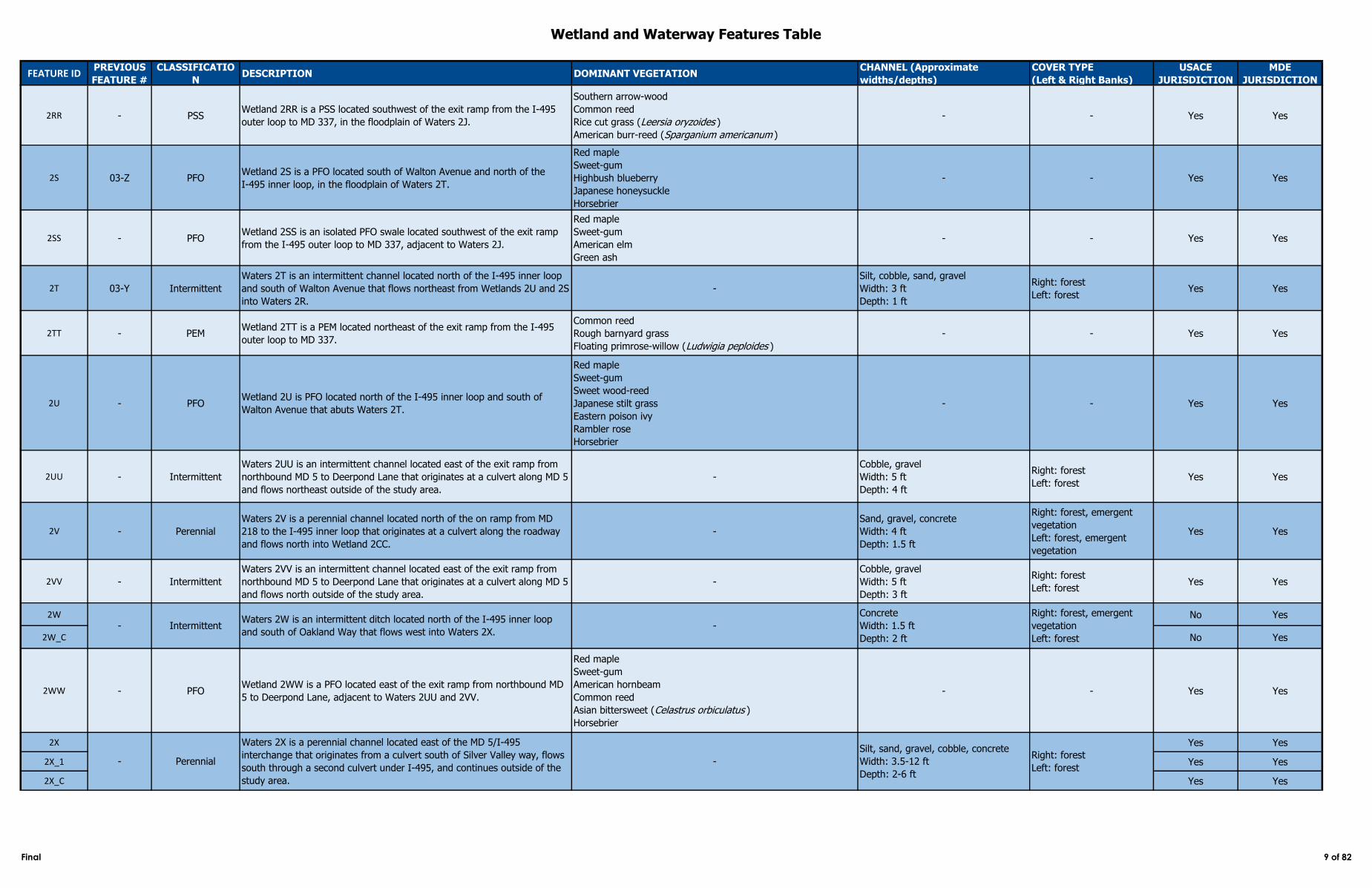
2RR - PSSWetland 2RR is a PSS located southwest of the exit ramp from the I‑495
outer loop to MD 337, in the floodplain of Waters 2J.
Southern arrow-wood
Common reed
Rice cut grass (Leersia oryzoides )
American burr-reed (Sparganium americanum )
- - Yes Yes
2S 03-Z PFOWetland 2S is a PFO located south of Walton Avenue and north of the
I‑495 inner loop, in the floodplain of Waters 2T.
Red maple
Sweet-gum
Highbush blueberry
Japanese honeysuckle
Horsebrier
- - Yes Yes
2SS - PFOWetland 2SS is an isolated PFO swale located southwest of the exit ramp
from the I‑495 outer loop to MD 337, adjacent to Waters 2J.
Red maple
Sweet-gum
American elm
Green ash
- - Yes Yes
2T 03-Y Intermittent
Waters 2T is an intermittent channel located north of the I‑495 inner loop
and south of Walton Avenue that flows northeast from Wetlands 2U and 2S
into Waters 2R.
-
Silt, cobble, sand, gravel
Width: 3 ft
Depth: 1 ft
Right: forest
Left: forestYes Yes
2TT - PEMWetland 2TT is a PEM located northeast of the exit ramp from the I‑495
outer loop to MD 337.
Common reed
Rough barnyard grass
Floating primrose-willow (Ludwigia peploides )
- - Yes Yes
2U - PFOWetland 2U is PFO located north of the I‑495 inner loop and south of
Walton Avenue that abuts Waters 2T.
Red maple
Sweet-gum
Sweet wood-reed
Japanese stilt grass
Eastern poison ivy
Rambler rose
Horsebrier
- - Yes Yes
2UU - Intermittent
Waters 2UU is an intermittent channel located east of the exit ramp from
northbound MD 5 to Deerpond Lane that originates at a culvert along MD 5
and flows northeast outside of the study area.
-
Cobble, gravel
Width: 5 ft
Depth: 4 ft
Right: forest
Left: forestYes Yes
2V - Perennial
Waters 2V is a perennial channel located north of the on ramp from MD
218 to the I‑495 inner loop that originates at a culvert along the roadway
and flows north into Wetland 2CC.
-
Sand, gravel, concrete
Width: 4 ft
Depth: 1.5 ft
Right: forest, emergent
vegetation
Left: forest, emergent
vegetation
Yes Yes
2VV - Intermittent
Waters 2VV is an intermittent channel located east of the exit ramp from
northbound MD 5 to Deerpond Lane that originates at a culvert along MD 5
and flows north outside of the study area.
-
Cobble, gravel
Width: 5 ft
Depth: 3 ft
Right: forest
Left: forestYes Yes
2W No Yes
2W_C No Yes
2WW - PFOWetland 2WW is a PFO located east of the exit ramp from northbound MD
5 to Deerpond Lane, adjacent to Waters 2UU and 2VV.
Red maple
Sweet-gum
American hornbeam
Common reed
Asian bittersweet (Celastrus orbiculatus )
Horsebrier
- - Yes Yes
2X Yes Yes
2X_1 Yes Yes
2X_C Yes Yes
Concrete
Width: 1.5 ft
Depth: 2 ft
Waters 2W is an intermittent ditch located north of the I‑495 inner loop
and south of Oakland Way that flows west into Waters 2X.- Intermittent -
Right: forest, emergent
vegetation
Left: forest
- Perennial
Waters 2X is a perennial channel located east of the MD 5/I‑495
interchange that originates from a culvert south of Silver Valley way, flows
south through a second culvert under I‑495, and continues outside of the
study area.
-
Silt, sand, gravel, cobble, concrete
Width: 3.5-12 ft
Depth: 2-6 ft
Right: forest
Left: forest
Final 9 of 82
Wetland and Waterway Features Table
FEATURE IDPREVIOUS
FEATURE #
CLASSIFICATIO
NDESCRIPTION DOMINANT VEGETATION
CHANNEL (Approximate
widths/depths)
COVER TYPE
(Left & Right Banks)
USACE
JURISDICTION
MDE
JURISDICTION
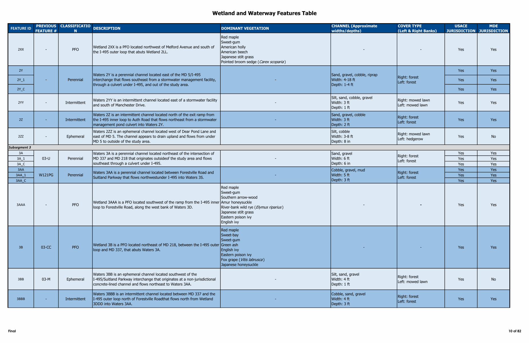
2XX - PFOWetland 2XX is a PFO located northwest of Melford Avenue and south of
the I-495 outer loop that abuts Wetland 2LL.
Red maple
Sweet-gum
American holly
American beech
Japanese stilt grass
Pointed broom sedge (Carex scoparia )
- - Yes Yes
2Y Yes Yes
2Y_1 Yes Yes
2Y_C Yes Yes
2YY - IntermittentWaters 2YY is an intermittent channel located east of a stormwater facility
and south of Manchester Drive.-
Silt, sand, cobble, gravel
Width: 3 ft
Depth: 1 ft
Right: mowed lawn
Left: mowed lawnYes Yes
2Z - Intermittent
Waters 2Z is an intermittent channel located north of the exit ramp from
the I‑495 inner loop to Auth Road that flows northeast from a stormwater
management pond culvert into Waters 2Y.
-
Sand, gravel, cobble
Width: 3 ft
Depth: 2 ft
Right: forest
Left: forestYes Yes
2ZZ - Ephemeral
Waters 2ZZ is an ephemeral channel located west of Dear Pond Lane and
east of MD 5. The channel appears to drain upland and flows from under
MD 5 to outside of the study area.
Silt, cobble
Width: 3-8 ft
Depth: 8 in
Right: mowed lawn
Left: hedgerowYes No
3A Yes Yes
3A_1 Yes Yes
3A_C Yes Yes
3AA Yes Yes
3AA_1 Yes Yes
3AA_C Yes Yes
3AAA - PFOWetland 3AAA is a PFO located southwest of the ramp from the I‑495 inner
loop to Forestville Road, along the west bank of Waters 3D.
Red maple
Sweet-gum
Southern arrow-wood
Amur honeysuckle
River-bank wild rye (Elymus riparius )
Japanese stilt grass
Eastern poison ivy
English ivy
- - Yes Yes
3B 03-CC PFOWetland 3B is a PFO located northeast of MD 218, between the I‑495 outer
loop and MD 337, that abuts Waters 3A.
Red maple
Sweet-bay
Sweet-gum
Green ash
English ivy
Eastern poison ivy
Fox grape (Vitis labrusca )
Japanese honeysuckle
- - Yes Yes
3BB 03-M Ephemeral
Waters 3BB is an ephemeral channel located southwest of the
I‑495/Suitland Parkway interchange that originates at a non-jurisdictional
concrete-lined channel and flows northeast to Waters 3AA.
-
Silt, sand, gravel
Width: 4 ft
Depth: 1 ft
Right: forest
Left: mowed lawnYes No
3BBB - Intermittent
Waters 3BBB is an intermittent channel located between MD 337 and the
I‑495 outer loop north of Forestville Roadthat flows north from Wetland
3DDD into Waters 3AA.
-
Cobble, sand, gravel
Width: 4 ft
Depth: 3 ft
Right: forest
Left: forestYes Yes
-
Sand, gravel, cobble, riprap
Width: 4-18 ft
Depth: 1-4 ft
Right: forest
Left: forest
Subsegment 3
03-U Perennial
- Perennial
Waters 2Y is a perennial channel located east of the MD 5/I‑495
interchange that flows southeast from a stormwater management facility,
through a culvert under I‑495, and out of the study area.
-
Waters 3A is a perennial channel located northeast of the intersection of
MD 337 and MD 218 that originates outsideof the study area and flows
southeast through a culvert under I‑495.
Sand, gravel
Width: 6 ft
Depth: 6 in
Right: forest
Left: forest
W121PG PerennialWaters 3AA is a perennial channel located between Forestville Road and
Suitland Parkway that flows northwestunder I‑495 into Waters 3S.-
Cobble, gravel, mud
Width: 5 ft
Depth: 3 ft
Right: forest
Left: forest
Final 10 of 82
Wetland and Waterway Features Table
FEATURE IDPREVIOUS
FEATURE #
CLASSIFICATIO
NDESCRIPTION DOMINANT VEGETATION
CHANNEL (Approximate
widths/depths)
COVER TYPE
(Left & Right Banks)
USACE
JURISDICTION
MDE
JURISDICTION
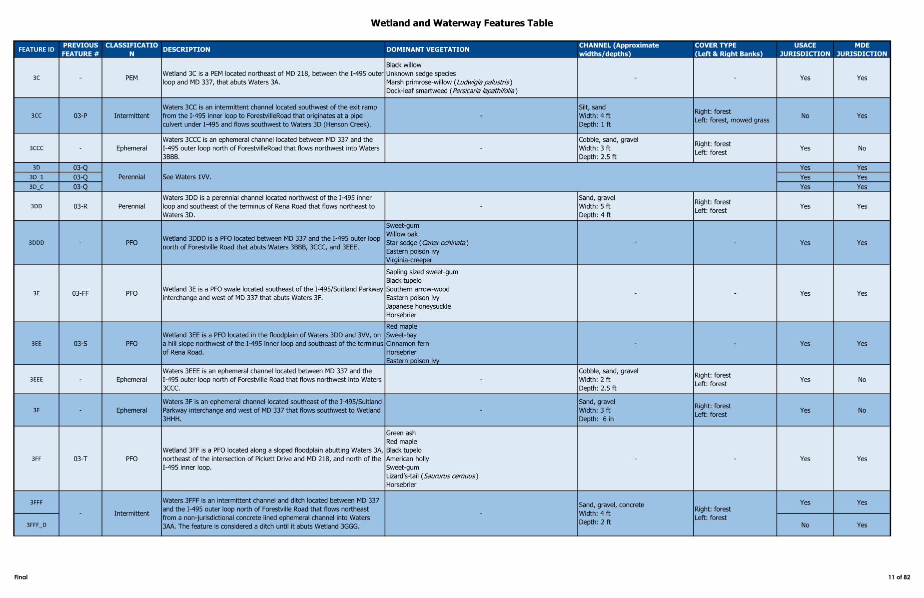
3C - PEMWetland 3C is a PEM located northeast of MD 218, between the I‑495 outer
loop and MD 337, that abuts Waters 3A.
Black willow
Unknown sedge species
Marsh primrose-willow (Ludwigia palustris )
Dock-leaf smartweed (Persicaria lapathifolia )
- - Yes Yes
3CC 03-P Intermittent
Waters 3CC is an intermittent channel located southwest of the exit ramp
from the I‑495 inner loop to ForestvilleRoad that originates at a pipe
culvert under I‑495 and flows southwest to Waters 3D (Henson Creek).
-
Silt, sand
Width: 4 ft
Depth: 1 ft
Right: forest
Left: forest, mowed grassNo Yes
3CCC - Ephemeral
Waters 3CCC is an ephemeral channel located between MD 337 and the
I‑495 outer loop north of ForestvilleRoad that flows northwest into Waters
3BBB.
-
Cobble, sand, gravel
Width: 3 ft
Depth: 2.5 ft
Right: forest
Left: forestYes No
3D 03-Q Yes Yes
3D_1 03-Q Yes Yes
3D_C 03-Q Yes Yes
3DD 03-R Perennial
Waters 3DD is a perennial channel located northwest of the I‑495 inner
loop and southeast of the terminus of Rena Road that flows northeast to
Waters 3D.
-
Sand, gravel
Width: 5 ft
Depth: 4 ft
Right: forest
Left: forestYes Yes
3DDD - PFOWetland 3DDD is a PFO located between MD 337 and the I‑495 outer loop
north of Forestville Road that abuts Waters 3BBB, 3CCC, and 3EEE.
Sweet-gum
Willow oak
Star sedge (Carex echinata )
Eastern poison ivy
Virginia-creeper
- - Yes Yes
3E 03-FF PFOWetland 3E is a PFO swale located southeast of the I‑495/Suitland Parkway
interchange and west of MD 337 that abuts Waters 3F.
Sapling sized sweet-gum
Black tupelo
Southern arrow-wood
Eastern poison ivy
Japanese honeysuckle
Horsebrier
- - Yes Yes
3EE 03-S PFO
Wetland 3EE is a PFO located in the floodplain of Waters 3DD and 3VV, on
a hill slope northwest of the I‑495 inner loop and southeast of the terminus
of Rena Road.
Red maple
Sweet-bay
Cinnamon fern
Horsebrier
Eastern poison ivy
- - Yes Yes
3EEE - Ephemeral
Waters 3EEE is an ephemeral channel located between MD 337 and the
I‑495 outer loop north of Forestville Road that flows northwest into Waters
3CCC.
-
Cobble, sand, gravel
Width: 2 ft
Depth: 2.5 ft
Right: forest
Left: forestYes No
3F - Ephemeral
Waters 3F is an ephemeral channel located southeast of the I‑495/Suitland
Parkway interchange and west of MD 337 that flows southwest to Wetland
3HHH.
-
Sand, gravel
Width: 3 ft
Depth: 6 in
Right: forest
Left: forestYes No
3FF 03-T PFO
Wetland 3FF is a PFO located along a sloped floodplain abutting Waters 3A,
northeast of the intersection of Pickett Drive and MD 218, and north of the
I‑495 inner loop.
Green ash
Red maple
Black tupelo
American holly
Sweet-gum
Lizard’s-tail (Saururus cernuus )
Horsebrier
- - Yes Yes
3FFF Yes Yes
3FFF_D No Yes
Intermittent
Waters 3FFF is an intermittent channel and ditch located between MD 337
and the I‑495 outer loop north of Forestville Road that flows northeast
from a non-jurisdictional concrete lined ephemeral channel into Waters
3AA. The feature is considered a ditch until it abuts Wetland 3GGG.
-
Sand, gravel, concrete
Width: 4 ft
Depth: 2 ft
Right: forest
Left: forest
Perennial See Waters 1VV.
-
Final 11 of 82
Wetland and Waterway Features Table
FEATURE IDPREVIOUS
FEATURE #
CLASSIFICATIO
NDESCRIPTION DOMINANT VEGETATION
CHANNEL (Approximate
widths/depths)
COVER TYPE
(Left & Right Banks)
USACE
JURISDICTION
MDE
JURISDICTION
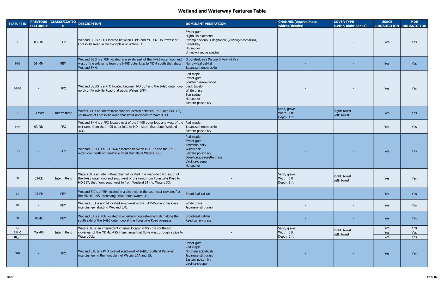
3G 03-DD PFOWetland 3G is a PFO located between I‑495 and MD 337, southwest of
Forestville Road in the floodplain of Waters 3D.
Sweet-gum
Highbush blueberry
Swamp deciduous-doghobble (Eubotrys racemosa )
Sweet-bay
Horsebrier
Unknown sedge species
- - Yes Yes
3GG 03-MM PEM
Wetland 3GG is a PEM located in a swale east of the I‑495 outer loop and
west of the exit ramp from the I‑495 outer loop to MD 4 south that abuts
Wetland 3HH.
Groundseltree (Baccharis halimifolia )
Narrow-leaf cat-tail
Japanese honeysuckle
- - Yes Yes
3GGG - PFOWetland 3GGG is a PFO located between MD 337 and the I‑495 outer loop
north of Forestville Road that abuts Waters 3FFF.
Red maple
Sweet-gum
Southern arrow-wood
Black tupelo
White grass
Star sedge
Horsebrier
Eastern poison ivy
- - Yes Yes
3H 03-WW IntermittentWaters 3H is an intermittent channel located between I‑495 and MD 337,
southwest of Forestville Road that flows northeast to Waters 3D.-
Sand, gravel
Width: 4 ft
Depth: 1 ft
Right: forest
Left: forestYes Yes
3HH 03-NN PFO
Wetland 3HH is a PFO located east of the I‑495 outer loop and west of the
exit ramp from the I‑495 outer loop to MD 4 south that abuts Wetland
3GG.
Red maple
Japanese honeysuckle
Eastern poison ivy
- - Yes Yes
3HHH - PFOWetland 3HHH is a PFO swale located between MD 337 and the I‑495
outer loop north of Forestville Road that abuts Waters 3BBB.
Red maple
Sweet-gum
American holly
Willow oak
Eastern poison ivy
Deer-tongue rosette grass
Virginia-creeper
Horsebrier
- - Yes Yes
3I 03-EE Intermittent
Waters 3I is an intermittent channel located in a roadside ditch south of
the I‑495 outer loop and southwest of the ramp from Forestville Road to
MD 337, that flows southwest to from Wetland 3J into Waters 3D.
-
Sand, gravel
Width: 3 ft
Depth: 1 ft
Right: forest
Left: forestYes Yes
3II 03-PP PEMWetland 3II is a PEM located in a ditch within the southeast cloverleaf of
the MD 4/I‑495 interchange that abuts Waters 3JJ.Broad-leaf cat-tail - - Yes Yes
3III - PEMWetland 3III is a PEM located southwest of the I-495/Suitland Parkway
interchange, abutting Wetland 3JJJ.
White grass
Japanese stilt grass- - Yes Yes
3J 03-II PEMWetland 3J is a PEM located in a partially concrete-lined ditch along the
south side of the I‑495 outer loop at the Forestville Road overpass.
Broad-leaf cat-tail
Reed canary grass - - Yes Yes
3JJ Yes Yes
3JJ_C Yes Yes
3JJ_C1 Yes Yes
3JJJ - PFOWetland 3JJJ is a PFO located southwest of I-495/ Suitland Parkway
interchange, in the floodplain of Waters 3AA and 3S.
Sweet-gum
Red maple
Northern spicebush
Japanese stilt grass
Eastern poison ivy
Virginia-creeper
- - Yes Yes
Mar-00 Intermittent
Waters 3JJ is an intermittent channel located within the southeast
cloverleaf of the MD 4/I‑495 interchange that flows west through a pipe to
Waters 3LL.
-
Sand, gravel
Width: 5 ft
Depth: 2 ft
Right: forest
Left: forest
Final 12 of 82
Wetland and Waterway Features Table
FEATURE IDPREVIOUS
FEATURE #
CLASSIFICATIO
NDESCRIPTION DOMINANT VEGETATION
CHANNEL (Approximate
widths/depths)
COVER TYPE
(Left & Right Banks)
USACE
JURISDICTION
MDE
JURISDICTION
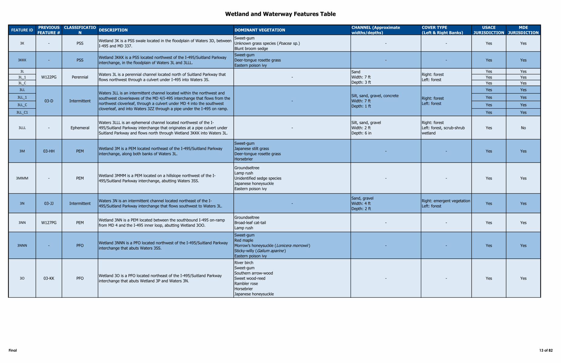
3K - PSSWetland 3K is a PSS swale located in the floodplain of Waters 3D, between
I‑495 and MD 337.
Sweet-gum
Unknown grass species (Poacea sp.)
Blunt broom sedge
- - Yes Yes
3KKK - PSSWetland 3KKK is a PSS located northwest of the I-495/Suitland Parkway
interchange, in the floodplain of Waters 3L and 3LLL.
Sweet-gum
Deer-tongue rosette grass
Eastern poison ivy
- - Yes Yes
3L Yes Yes
3L_1 Yes Yes
3L_C Yes Yes
3LL Yes Yes
3LL_1 Yes Yes
3LL_C Yes Yes
3LL_C1 Yes Yes
3LLL - Ephemeral
Waters 3LLL is an ephemeral channel located northwest of the I-
495/Suitland Parkway interchange that originates at a pipe culvert under
Suitland Parkway and flows north through Wetland 3KKK into Waters 3L.
-
Silt, sand, gravel
Width: 2 ft
Depth: 6 in
Right: forest
Left: forest, scrub-shrub
wetland
Yes No
3M 03-HH PEMWetland 3M is a PEM located northeast of the I-495/Suitland Parkway
interchange, along both banks of Waters 3L.
Sweet-gum
Japanese stilt grass
Deer-tongue rosette grass
Horsebrier
- - Yes Yes
3MMM - PEMWetland 3MMM is a PEM located on a hillslope northwest of the I-
495/Suitland Parkway interchange, abutting Waters 3SS.
Groundseltree
Lamp rush
Unidentified sedge species
Japanese honeysuckle
Eastern poison ivy
- - Yes Yes
3N 03-JJ IntermittentWaters 3N is an intermittent channel located northeast of the I-
495/Suitland Parkway interchange that flows southwest to Waters 3L.-
Sand, gravel
Width: 4 ft
Depth: 2 ft
Right: emergent vegetation
Left: forestYes Yes
3NN W127PG PEMWetland 3NN is a PEM located between the southbound I‑495 on-ramp
from MD 4 and the I‑495 inner loop, abutting Wetland 3OO.
Groundseltree
Broad-leaf cat-tail
Lamp rush
- - Yes Yes
3NNN - PFOWetland 3NNN is a PFO located northwest of the I-495/Suitland Parkway
interchange that abuts Waters 3SS.
Sweet-gum
Red maple
Morrow’s honeysuckle (Lonicera morrowii )
Sticky-willy (Galium aparine )
Eastern poison ivy
- - Yes Yes
3O 03-KK PFOWetland 3O is a PFO located northeast of the I-495/Suitland Parkway
interchange that abuts Wetland 3P and Waters 3N.
River birch
Sweet-gum
Southern arrow-wood
Sweet wood-reed
Rambler rose
Horsebrier
Japanese honeysuckle
- - Yes Yes
W122PG PerennialWaters 3L is a perennial channel located north of Suitland Parkway that
flows northwest through a culvert under I‑495 into Waters 3S.-
Sand
Width: 7 ft
Depth: 3 ft
Right: forest
Left: forest
-
Silt, sand, gravel, concrete
Width: 7 ft
Depth: 1 ft
Right: forest
Left: forest03-D Intermittent
Waters 3LL is an intermittent channel located within the northwest and
southwest cloverleaves of the MD 4/I‑495 interchange that flows from the
northwest cloverleaf, through a culvert under MD 4 into the southwest
cloverleaf, and into Waters 3ZZ through a pipe under the I‑495 on ramp.
Final 13 of 82
Wetland and Waterway Features Table
FEATURE IDPREVIOUS
FEATURE #
CLASSIFICATIO
NDESCRIPTION DOMINANT VEGETATION
CHANNEL (Approximate
widths/depths)
COVER TYPE
(Left & Right Banks)
USACE
JURISDICTION
MDE
JURISDICTION
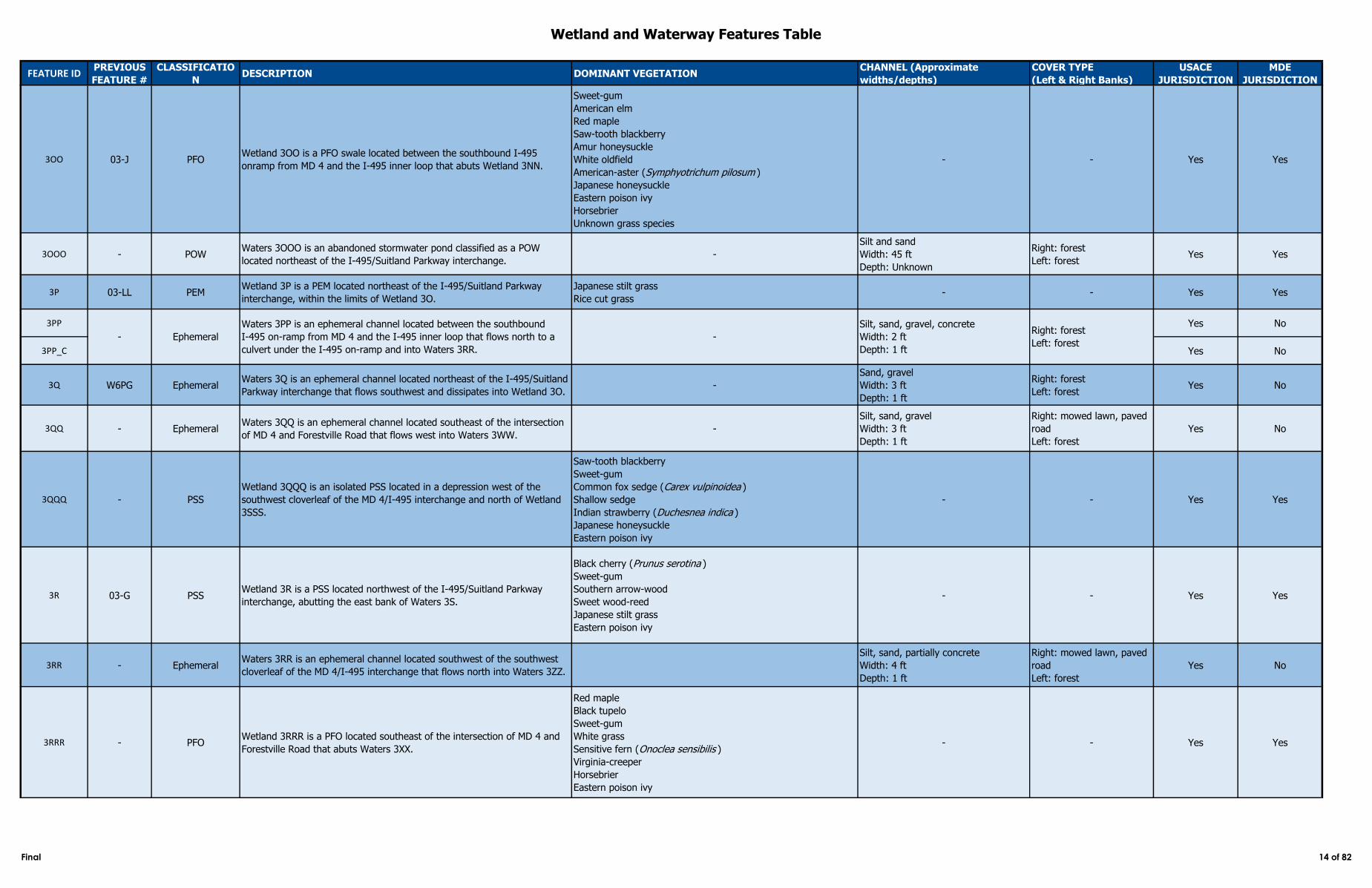
3OO 03-J PFOWetland 3OO is a PFO swale located between the southbound I‑495
onramp from MD 4 and the I‑495 inner loop that abuts Wetland 3NN.
Sweet-gum
American elm
Red maple
Saw-tooth blackberry
Amur honeysuckle
White oldfield
American-aster (Symphyotrichum pilosum )
Japanese honeysuckle
Eastern poison ivy
Horsebrier
Unknown grass species
- - Yes Yes
3OOO - POWWaters 3OOO is an abandoned stormwater pond classified as a POW
located northeast of the I-495/Suitland Parkway interchange. -
Silt and sand
Width: 45 ft
Depth: Unknown
Right: forest
Left: forestYes Yes
3P 03-LL PEMWetland 3P is a PEM located northeast of the I-495/Suitland Parkway
interchange, within the limits of Wetland 3O.
Japanese stilt grass
Rice cut grass- - Yes Yes
3PP Yes No
3PP_C Yes No
3Q W6PG EphemeralWaters 3Q is an ephemeral channel located northeast of the I-495/Suitland
Parkway interchange that flows southwest and dissipates into Wetland 3O.-
Sand, gravel
Width: 3 ft
Depth: 1 ft
Right: forest
Left: forestYes No
3QQ - EphemeralWaters 3QQ is an ephemeral channel located southeast of the intersection
of MD 4 and Forestville Road that flows west into Waters 3WW.-
Silt, sand, gravel
Width: 3 ft
Depth: 1 ft
Right: mowed lawn, paved
road
Left: forest
Yes No
3QQQ - PSS
Wetland 3QQQ is an isolated PSS located in a depression west of the
southwest cloverleaf of the MD 4/I‑495 interchange and north of Wetland
3SSS.
Saw-tooth blackberry
Sweet-gum
Common fox sedge (Carex vulpinoidea )
Shallow sedge
Indian strawberry (Duchesnea indica )
Japanese honeysuckle
Eastern poison ivy
- - Yes Yes
3R 03-G PSSWetland 3R is a PSS located northwest of the I-495/Suitland Parkway
interchange, abutting the east bank of Waters 3S.
Black cherry (Prunus serotina )
Sweet-gum
Southern arrow-wood
Sweet wood-reed
Japanese stilt grass
Eastern poison ivy
- - Yes Yes
3RR - EphemeralWaters 3RR is an ephemeral channel located southwest of the southwest
cloverleaf of the MD 4/I‑495 interchange that flows north into Waters 3ZZ.
Silt, sand, partially concrete
Width: 4 ft
Depth: 1 ft
Right: mowed lawn, paved
road
Left: forest
Yes No
3RRR - PFOWetland 3RRR is a PFO located southeast of the intersection of MD 4 and
Forestville Road that abuts Waters 3XX.
Red maple
Black tupelo
Sweet-gum
White grass
Sensitive fern (Onoclea sensibilis )
Virginia-creeper
Horsebrier
Eastern poison ivy
- - Yes Yes
- Ephemeral
Waters 3PP is an ephemeral channel located between the southbound
I‑495 on-ramp from MD 4 and the I‑495 inner loop that flows north to a
culvert under the I‑495 on-ramp and into Waters 3RR.
-
Silt, sand, gravel, concrete
Width: 2 ft
Depth: 1 ft
Right: forest
Left: forest
Final 14 of 82
Wetland and Waterway Features Table
FEATURE IDPREVIOUS
FEATURE #
CLASSIFICATIO
NDESCRIPTION DOMINANT VEGETATION
CHANNEL (Approximate
widths/depths)
COVER TYPE
(Left & Right Banks)
USACE
JURISDICTION
MDE
JURISDICTION
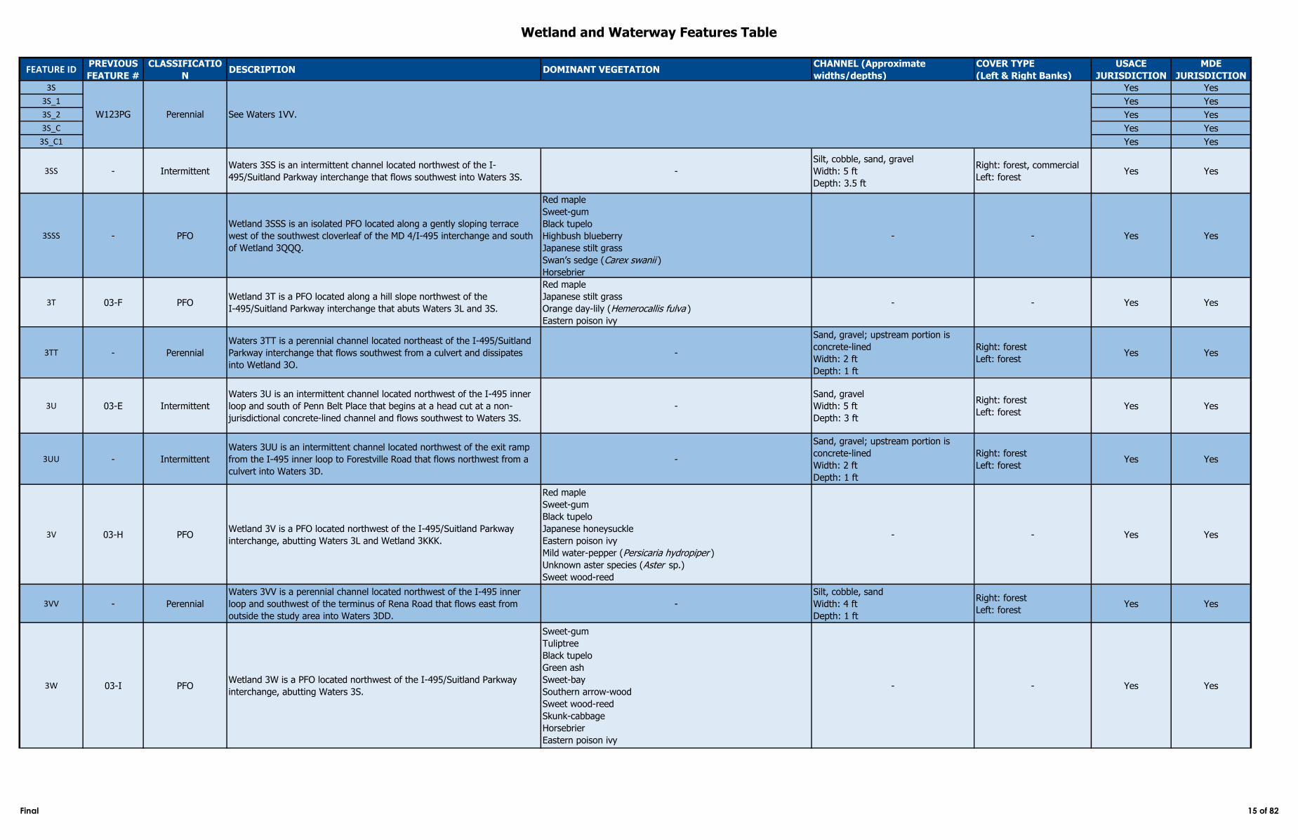
3S Yes Yes
3S_1 Yes Yes
3S_2 Yes Yes
3S_C Yes Yes
3S_C1 Yes Yes
3SS - IntermittentWaters 3SS is an intermittent channel located northwest of the I-
495/Suitland Parkway interchange that flows southwest into Waters 3S.-
Silt, cobble, sand, gravel
Width: 5 ft
Depth: 3.5 ft
Right: forest, commercial
Left: forestYes Yes
3SSS - PFO
Wetland 3SSS is an isolated PFO located along a gently sloping terrace
west of the southwest cloverleaf of the MD 4/I‑495 interchange and south
of Wetland 3QQQ.
Red maple
Sweet-gum
Black tupelo
Highbush blueberry
Japanese stilt grass
Swan’s sedge (Carex swanii )
Horsebrier
- - Yes Yes
3T 03-F PFOWetland 3T is a PFO located along a hill slope northwest of the
I‑495/Suitland Parkway interchange that abuts Waters 3L and 3S.
Red maple
Japanese stilt grass
Orange day-lily (Hemerocallis fulva )
Eastern poison ivy
- - Yes Yes
3TT - Perennial
Waters 3TT is a perennial channel located northeast of the I-495/Suitland
Parkway interchange that flows southwest from a culvert and dissipates
into Wetland 3O.
-
Sand, gravel; upstream portion is
concrete-lined
Width: 2 ft
Depth: 1 ft
Right: forest
Left: forestYes Yes
3U 03-E Intermittent
Waters 3U is an intermittent channel located northwest of the I‑495 inner
loop and south of Penn Belt Place that begins at a head cut at a non-
jurisdictional concrete-lined channel and flows southwest to Waters 3S.
-
Sand, gravel
Width: 5 ft
Depth: 3 ft
Right: forest
Left: forestYes Yes
3UU - Intermittent
Waters 3UU is an intermittent channel located northwest of the exit ramp
from the I‑495 inner loop to Forestville Road that flows northwest from a
culvert into Waters 3D.
-
Sand, gravel; upstream portion is
concrete-lined
Width: 2 ft
Depth: 1 ft
Right: forest
Left: forestYes Yes
3V 03-H PFOWetland 3V is a PFO located northwest of the I‑495/Suitland Parkway
interchange, abutting Waters 3L and Wetland 3KKK.
Red maple
Sweet-gum
Black tupelo
Japanese honeysuckle
Eastern poison ivy
Mild water-pepper (Persicaria hydropiper )
Unknown aster species (Aster sp.)
Sweet wood-reed
- - Yes Yes
3VV - Perennial
Waters 3VV is a perennial channel located northwest of the I‑495 inner
loop and southwest of the terminus of Rena Road that flows east from
outside the study area into Waters 3DD.
-
Silt, cobble, sand
Width: 4 ft
Depth: 1 ft
Right: forest
Left: forestYes Yes
3W 03-I PFOWetland 3W is a PFO located northwest of the I-495/Suitland Parkway
interchange, abutting Waters 3S.
Sweet-gum
Tuliptree
Black tupelo
Green ash
Sweet-bay
Southern arrow-wood
Sweet wood-reed
Skunk-cabbage
Horsebrier
Eastern poison ivy
- - Yes Yes
W123PG Perennial See Waters 1VV.
Final 15 of 82
Wetland and Waterway Features Table
FEATURE IDPREVIOUS
FEATURE #
CLASSIFICATIO
NDESCRIPTION DOMINANT VEGETATION
CHANNEL (Approximate
widths/depths)
COVER TYPE
(Left & Right Banks)
USACE
JURISDICTION
MDE
JURISDICTION
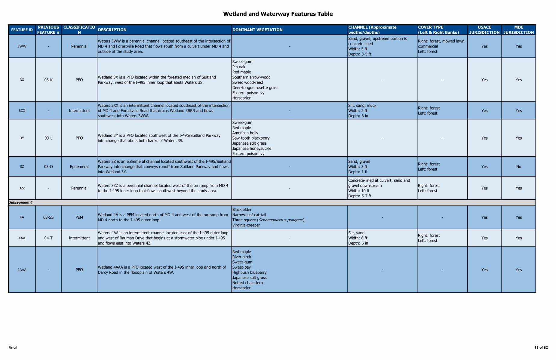
3WW - Perennial
Waters 3WW is a perennial channel located southeast of the intersection of
MD 4 and Forestville Road that flows south from a culvert under MD 4 and
outside of the study area.
-
Sand, gravel; upstream portion is
concrete lined
Width: 5 ft
Depth: 3-5 ft
Right: forest, mowed lawn,
commercial
Left: forest
Yes Yes
3X 03-K PFOWetland 3X is a PFO located within the forested median of Suitland
Parkway, west of the I‑495 inner loop that abuts Waters 3S.
Sweet-gum
Pin oak
Red maple
Southern arrow-wood
Sweet wood-reed
Deer-tongue rosette grass
Eastern poison ivy
Horsebrier
- - Yes Yes
3XX - Intermittent
Waters 3XX is an intermittent channel located southeast of the intersection
of MD 4 and Forestville Road that drains Wetland 3RRR and flows
southwest into Waters 3WW.
-
Silt, sand, muck
Width: 2 ft
Depth: 6 in
Right: forest
Left: forestYes Yes
3Y 03-L PFOWetland 3Y is a PFO located southwest of the I-495/Suitland Parkway
interchange that abuts both banks of Waters 3S.
Sweet-gum
Red maple
American holly
Saw-tooth blackberry
Japanese stilt grass
Japanese honeysuckle
Eastern poison ivy
- - Yes Yes
3Z 03-O Ephemeral
Waters 3Z is an ephemeral channel located southwest of the I‑495/Suitland
Parkway interchange that conveys runoff from Suitland Parkway and flows
into Wetland 3Y.
-
Sand, gravel
Width: 3 ft
Depth: 1 ft
Right: forest
Left: forestYes No
3ZZ - PerennialWaters 3ZZ is a perennial channel located west of the on ramp from MD 4
to the I‑495 inner loop that flows southwest beyond the study area.-
Concrete-lined at culvert; sand and
gravel downstream
Width: 10 ft
Depth: 5-7 ft
Right: forest
Left: forestYes Yes
4A 03-SS PEMWetland 4A is a PEM located north of MD 4 and west of the on-ramp from
MD 4 north to the I‑495 outer loop.
Black elder
Narrow-leaf cat-tail
Three-square (Schoenoplectus pungens )
Virginia-creeper
- - Yes Yes
4AA 04-T Intermittent
Waters 4AA is an intermittent channel located east of the I‑495 outer loop
and west of Bauman Drive that begins at a stormwater pipe under I‑495
and flows east into Waters 4Z.
-
Silt, sand
Width: 6 ft
Depth: 6 in
Right: forest
Left: forestYes Yes
4AAA - PFOWetland 4AAA is a PFO located west of the I‑495 inner loop and north of
Darcy Road in the floodplain of Waters 4W.
Red maple
River birch
Sweet-gum
Sweet-bay
Highbush blueberry
Japanese stilt grass
Netted chain fern
Horsebrier
- - Yes Yes
Subsegment 4
Final 16 of 82
Wetland and Waterway Features Table
FEATURE IDPREVIOUS
FEATURE #
CLASSIFICATIO
NDESCRIPTION DOMINANT VEGETATION
CHANNEL (Approximate
widths/depths)
COVER TYPE
(Left & Right Banks)
USACE
JURISDICTION
MDE
JURISDICTION
4AAAA 03-A PFO
Wetland 4AAAA is a PFO depression located south of the intersection of
Cryden Way and Kaverton Road and west of the I‑495 inner loop that
abuts Waters 4GGGG.
Red maple
Sweet-gum
Highbush blueberry
Crow garlic
Dark-green sedge (Carex venusta )
Eastern poison ivy
Horsebrier
Fox grape
- - Yes Yes
4AAAAA - PEMWetland 4AAAAA is a PEM located east of the I 495 outer loop and west of
West Grove, adjacent to 4BBBBB and 4CCCCC, and drains into 4ZZZZ.
Black willow
Broad-leaf-cat-tail
Woolgrass (Scirpus cyperinus )
- - Yes Yes
4B Yes Yes
4B_C Yes Yes
4BB 04-CC PFOWetland 4BB is a PFO located east of the I‑495 outer loop and west of
Bauman Drive that abuts Waters 4AA and Waters 4Z.
Pin oak
Sweet-gum
Reed canary grass
Eastern poison ivy
Virginia-creeper
- - Yes Yes
4BBB Yes Yes
4BBB_1 Yes Yes
4BBB_C Yes Yes
4BBBB 03-B Ephemeral
Waters 4BBBB is an ephemeral channel located south of the intersection of
Cryden Way and Kaverton Road and west of the I‑495 inner loop that flows
north into Wetland 4AAAA.
-
Sand, gravel
Width: 2 ft
Depth: 1 ft
Right: forest
Left: forestYes No
4BBBBB - POWWaters 4BBBBB is a POW located located east of the I 495 outer loop and
west of West Grove, adjacent to 4AAAAA and 4CCCCC.-
Silt, sand, gravel
Width: 30 ft
Length: 50 ft
Right: Old field
Left: Old fieldYes Yes
4C - EphemeralWaters 4C is an ephemeral channel located east of the I‑495 outer loop
and southwest of Darcy Road that flows southwest into Waters 4B. -
Silt, cobble, sand, gravel
Width: 3 ft
Depth: 1 ft
Right: forest
Left: forestYes No
4CC 04-FF PEMWetland 4CC is a PEM swale located east of the I‑495 outer loop and west
of Bauman Drive.
Red maple
Sweet-gum
Narrow-leaf cat-tail
Rice cut grass
- - Yes Yes
4CCC - PEMWetland 4CCC is a PEM located west of the I‑495 inner loop and north of
Darcy Road within the floodplain of Waters 4BBB.
Highbush blueberry
Black willow
Rambler rose
Sweet-gum
American sycamore
Lamp rush
Rice cut grass
Meadow false rye grass (Schedonorus pratensis )
- - Yes Yes
4CCCC 03-C PFOWetland 4CCCC is a PFO swale located northeast of the terminus of
Marlboro Pike and west of the I‑495 inner loop, abutting Waters 4DDDD.
American sycamore
American elm
Sweet-gum
Saw-tooth blackberry
English ivy
Eastern poison ivy
- - Yes Yes
Perennial04-C
04-Z Intermittent
Waters 4B is an intermittent channel located east of the I‑495 outer loop
and southwest of Darcy Road that flows northwest to a culvert under I‑495
and into Waters 4TTT.
-
Silt, sand, cobble, gravel
Width: 5 ft
Depth: 1 ft
Right: forest
Left: forest
Waters 4BBB is a perennial channel located west of the I‑495 inner loop
and north of Darcy Road that flows northwest from a stormwater pipe
under I‑495 into Wetland 4DDD.
-
Sand, gravel, riprap
Width: 2-6 ft
Depth: 2.5 ft
Right: forest, emergent
vegetation
Left: forest, emergent
vegetation
Final 17 of 82
Wetland and Waterway Features Table
FEATURE IDPREVIOUS
FEATURE #
CLASSIFICATIO
NDESCRIPTION DOMINANT VEGETATION
CHANNEL (Approximate
widths/depths)
COVER TYPE
(Left & Right Banks)
USACE
JURISDICTION
MDE
JURISDICTION
4CCCCC - POWWaters 4CCCCC is a POW located located east of the I 495 outer loop and
west of West Grove, adjacent to 4AAAAA and 4BBBBB.-
Silt, sand, gravel
Width: 40 ft
Length: 50 ft
Right: Old field
Left: Old fieldYes Yes
4D - PFOWetland 4D is a PFO swale located east of the I‑495 outer loop and
southwest of Darcy Road that abuts Waters 4B.
Red maple
Brookside alder (Alnus serrulata )
Highbush blueberry
Unknown sedge species
Deer-tongue rosette grass
Spreading bent (Agrostis stolonifera )
Japanese honeysuckle
Horsebrier
- - Yes Yes
4DD - PEMWetland 4DD is a PEM depression located west of the I‑495 inner loop and
north of Darcy Road that abuts Waters 4EE.
Broad-leaf-cat-tail
Tall false rye grass- - Yes Yes
4DDD - PFOWetland 4DDD is a PFO located west of the I‑495 inner loop and north of
Darcy Road that abuts Waters 4HHH and 4BBB.
American sycamore
Sweet-gum
American beech
Common pawpaw (Asimina triloba )
Small-spike false nettle (Boehmeria cylindrica )
Rice cut grass
- - Yes Yes
4DDDD Yes Yes
4DDDD_1 Yes Yes
4DDDD_C Yes Yes
4E Yes Yes
4E_C Yes Yes
4EE - PerennialWaters 4EE is a perennial channel located west of the I‑495 inner loop and
north of Darcy Road that flows southwest into Waters 4W.-
Cobble, gravel, silt, sand
Width: 3 ft
Depth: 1.5 ft
Right/Left: tall grass, scrub-
shrub vegetationYes Yes
4EEE - PEMWetland 4EEE is a PEM located west of the I‑495 inner loop and north of
Darcy Road that abuts Wetland 4DDD and 4HHH.
Sweet-gum
American sycamore
Rice cut grass
Shallow sedge
- - Yes Yes
4EEEE - PFOWetland 4EEEE is a PFO located in the floodplain of Waters 4DDDD, west
of the I‑495 inner loop and northeast of the terminus of Marlboro Pike.
Red maple
Virginia-creeper
Fowl manna grass (Glyceria striata )
Horsebrier
- - Yes Yes
4F - PFOWetland 4F is a PFO swale located east of the I‑495 outer loop and
southwest of Darcy Road that abuts Waters 4E.
Red maple
Southern arrow-wood
American elm
Black elder
Unknown grass species (Poa sp.)
Deer-tongue rosette grass
Japanese honeysuckle
Horsebrier
- - Yes Yes
4FF 04-GG EphemeralWaters 4FF is an ephemeral channel located south of the exit ramp from
I‑495 northbound to Ritchie Marlboro Road that flows west into Waters 4Z.-
Cobble, silt, sand
Width: 2-3 ft
Depth: 3 in
Right: scrub-shrub
Left: forestYes No
W92PG Intermittent
Waters 4DDDD is an intermittent channel located west of the I‑495 inner
loop and northeast of the terminus of Marlboro Pike that flows northwest
from a pipe culvert under I‑495 and outside the study area.
-
Sand, gravel
Width: 5 ft
Depth: 1.5 ft
Right: forest
Left: forest
04-Y Intermittent
Waters 4E is an intermittent channel located east of the I‑495 outer loop
and southwest of Darcy Road that flows northwest through a culvert under
I‑495 into Waters 4JJJJ.
-
Silt, sand
Width: 3 ft
Depth: 6 in
Right: forest
Left: forest
Final 18 of 82
Wetland and Waterway Features Table
FEATURE IDPREVIOUS
FEATURE #
CLASSIFICATIO
NDESCRIPTION DOMINANT VEGETATION
CHANNEL (Approximate
widths/depths)
COVER TYPE
(Left & Right Banks)
USACE
JURISDICTION
MDE
JURISDICTION
4FFF - PFOWetland 4FFF is a PFO located west of the I‑495 inner loop and north of
Darcy Road that abuts Waters 4W.
American sycamore
Sweet-gum
Japanese stilt grass
Virginia-creeper
White grass
- - Yes Yes
4FFFF - PFOWetland 4FFFF is a PFO depression located west of the I‑495 inner loop
and northeast of the terminus of Marlboro Pike.
Red maple
Sweet-gum
Rice cut grass
Common reed
- - Yes Yes
4GG No Yes
4GG_C Yes Yes
4GGG - EphemeralWaters 4GGG is an ephemeral channel located west of the I‑495 inner loop
and north of Darcy Road that flows north into Wetland 4FFF. -
Sand, gravel
Width: 2 ft
Depth: 1 ft
Right: forest
Left: forestYes No
4GGGG - Perennial
Waters 4GGGG is a perennial channel located south of the intersection of
Cryden Way and Kaverton Road and west of the I‑495 inner loop that flows
northwest along Wetland 4AAAA and beyond the study area.
-
Sand, gravel
Width: 2 ft
Depth: 1 ft
Right: forest
Left: forestYes Yes
4H Yes No
4H_C Yes No
4HH - PFOWetland 4HH is a PFO located east of the I‑495 outer loop and north of
Pennsylvania Avenue.
American elm
Callery pear (Pyrus calleryana )
Green ash
Eastern poison ivy
Common reed
- - Yes Yes
4HHH Yes Yes
4HHH_1 Yes Yes
4HHH_C Yes Yes
4HHHH - PFOWetland 4HHHH is a PFO swale located west of the I‑495 inner loop and
approximately 70 feet south of Darcy Road that abuts Waters 4TTT.
Red maple
Tuliptree
Sweet-gum
Cinnamon fern
White grass
Broad-leaf cat-tail
- - Yes Yes
4I 03-VV PEMWetland 4I is a PEM ditch located within the northeast cloverleaf of the
MD 4/I‑495 interchange. Narrow-leaf cat-tail - - Yes Yes
4II - PFOWetland 4II is a PFO located east of the I‑495 outer loop and northwest of
the terminus of Flowers Road that abuts Waters 4M.
Black willow
Sweet-gum
Green ash
Virginia-creeper
Fowl manna grass
- - Yes Yes
4III - PEMWetland 4III is a PEM located west of the I‑495 inner loop and east of
Darcy Road, between Waters 4HHH and 4BBB.
Black willow
Lamp rush
Broad-leaf cat-tail
- - Yes Yes
- Ephemeral
Waters 4H is an ephemeral channel located within the northeast cloverleaf
of the MD 4/I 495 interchange that flows northwest through a culvert
under I 495 into Waters 3LL.
-
Silt, cobble, gravel
Width: 2 ft
Depth: 6 in
Right: forest, tall grass
Left: paved road
- Intermittent
Waters 4GG is an intermittent ditch and culvert located east of the I‑495
outer loop and north of Pennsylvania Avenue that flows north along the
roadway and through a pipe culvert under I‑495 into Waters 4DDDD.
Waters 4GG_C receives input from Waters 4GG and Waters 4J.
Intermittent
Waters 4HHH is an intermittent channel located west of the I‑495 inner
loop and north of Darcy Road that flows northwest from a pipe culvert
under I‑495 into Wetland 4DDD.
-
Cobble, sand, gravel, riprap
Width: 3 ft
Depth: 1 ft
Right: emergent vegetation
Left: emergent vegetation
-
Concrete
Width: 4 ft
Depth: 2 ft
Right: forest, emergent
vegetation
Left: forest, emergent
vegetation
-
Final 19 of 82
Wetland and Waterway Features Table
FEATURE IDPREVIOUS
FEATURE #
CLASSIFICATIO
NDESCRIPTION DOMINANT VEGETATION
CHANNEL (Approximate
widths/depths)
COVER TYPE
(Left & Right Banks)
USACE
JURISDICTION
MDE
JURISDICTION
4IIII - PFO
Wetland 4IIII is a PFO located west of the I‑495 inner loop and southwest
of the terminus of Hampton Park Boulevard, in the floodplain of Waters
4JJJJ.
Sweet-gum
American beech
Sweet-bay
Cinnamon fern
Horsebrier
- - Yes Yes
4J - EphemeralWaters 4J is an ephemeral channel located east of the on ramp from MD 4
north to the I‑495 outer loop that flows south into Waters 4GG. -
Silt, cobble, sand, gravel
Width: 2 ft
Depth: 1 ft
Right: forest, paved road
Left: forestYes No
4JJJ - PFOWetland 4JJJ is an isolated PFO swale located west of the I‑495 inner loop
and east of Darcy Road, north of Wetland 4III.
Sweet-gum
White grass
Deer-tongue rosette grass
Horsebrier
- - Yes Yes
4JJJJ 04-I Perennial
Waters 4JJJJ is a perennial channel located west of the I‑495 inner loop
and south of Darcy Road that flows from a culvert under I‑495 and
continues northwest beyond the study area.
-
Silt, sand, gravel
Width: 6 ft
Depth: 2-20 ft
Right: forest
Left: forestYes Yes
4K - Intermittent
Waters 4K is an intermittent channel located east of the I‑495 outer loop
and west of Flowers Road that flows northeast and dissipates into Wetland
4KK.
-
Silt, sand, gravel
Width: 3 ft
Depth: 1 ft
Right: forest
Left: forest, paved roadYes Yes
4KK - PFOWetland 4KK is a PFO located east of the I‑495 outer loop and southwest
of the terminus of Flowers Road, in the floodplain of Waters 4M and 4LL.
Black tupelo
Red maple
Tuliptree
Sweet-gum
Virginia-creeper
Cinnamon fern
Sensitive fern
- - Yes Yes
4KKK - PFOWetland 4KKK is a PFO located in the floodplain of Waters 4Z, south of the
exit ramp from the I‑495 outer loop to Ritchie Marlboro Road.
Sweet-gum
Silky dogwood (Cornus amomum )
Sweet wood-reed
Eastern poison ivy
Horsebrier
Virginia-creeper
- - Yes Yes
4KKKK 04-J PFOWetland 4KKKK is a PFO located west of the I‑495 inner loop and south of
Darcy Road that abuts Waters 4JJJJ.
Sweet-gum
Sweet-bay
Southern arrow-wood
Netted chain fern
Cinnamon fern
- - Yes Yes
4L 04-L Intermittent
Waters 4L is an intermittent channel located east of the I‑495 outer loop
and west of Flowers Road that flows east from a pipe under I‑495 into
Waters 4M.
-
Silt, sand, gravel
Width: 8 ft
Depth: 5 ft
Right: forest
Left: forestYes Yes
4LL - Perennial
Waters 4LL is perennial channel located east of the I‑495 outer loop and
southwest of the terminus of Flowers Road that abuts Wetland 4KK and
flows northeast from outside the study area into Waters 4M.
-
Sand, gravel
Width: 2 ft
Depth: 1 ft
Right: forest
Left: forestYes Yes
4LLL - PFOWetland 4LLL is a PFO located in the floodplain of Waters 4Z, east of the
I‑495 outer loop and west of Bauman Drive.
Red maple
Sweet-gum
Northern spicebush
Rambler rose
American holly
Virginia-creeper
northern lady fern (Athyrium angustum )
Horsebrier
- - Yes Yes
Final 20 of 82
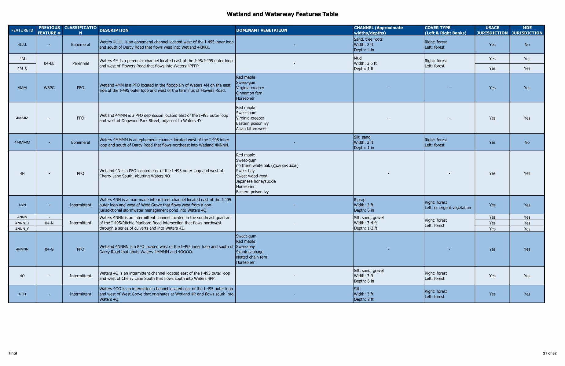
Wetland and Waterway Features Table
FEATURE IDPREVIOUS
FEATURE #
CLASSIFICATIO
NDESCRIPTION DOMINANT VEGETATION
CHANNEL (Approximate
widths/depths)
COVER TYPE
(Left & Right Banks)
USACE
JURISDICTION
MDE
JURISDICTION
4LLLL - EphemeralWaters 4LLLL is an ephemeral channel located west of the I‑495 inner loop
and south of Darcy Road that flows west into Wetland 4KKKK.-
Sand, tree roots
Width: 2 ft
Depth: 4 in
Right: forest
Left: forestYes No
4M Yes Yes
4M_C Yes Yes
4MM W8PG PFOWetland 4MM is a PFO located in the floodplain of Waters 4M on the east
side of the I‑495 outer loop and west of the terminus of Flowers Road.
Red maple
Sweet-gum
Virginia-creeper
Cinnamon fern
Horsebrier
- - Yes Yes
4MMM - PFOWetland 4MMM is a PFO depression located east of the I‑495 outer loop
and west of Dogwood Park Street, adjacent to Waters 4Y.
Red maple
Sweet-gum
Virginia-creeper
Eastern poison ivy
Asian bittersweet
- - Yes Yes
4MMMM - EphemeralWaters 4MMMM is an ephemeral channel located west of the I‑495 inner
loop and south of Darcy Road that flows northeast into Wetland 4NNNN. -
Silt, sand
Width: 3 ft
Depth: 1 in
Right: forest
Left: forestYes No
4N - PFOWetland 4N is a PFO located east of the I‑495 outer loop and west of
Cherry Lane South, abutting Waters 4O.
Red maple
Sweet-gum
northern white oak (Quercus alba )
Sweet bay
Sweet wood-reed
Japanese honeysuckle
Horsebrier
Eastern poison ivy
- - Yes Yes
4NN - Intermittent
Waters 4NN is a man-made intermittent channel located east of the I‑495
outer loop and west of West Grove that flows west from a non-
jurisdictional stormwater management pond into Waters 4Q.
-
Riprap
Width: 2 ft
Depth: 6 in
Right: forest
Left: emergent vegetationYes Yes
4NNN - Yes Yes
4NNN_1 04-N Yes Yes
4NNN_C - Yes Yes
4NNNN 04-G PFOWetland 4NNNN is a PFO located west of the I‑495 inner loop and south of
Darcy Road that abuts Waters 4MMMM and 4OOOO.
Sweet-gum
Red maple
Sweet-bay
Skunk-cabbage
Netted chain fern
Horsebrier
- - Yes Yes
4O - IntermittentWaters 4O is an intermittent channel located east of the I‑495 outer loop
and west of Cherry Lane South that flows south into Waters 4PP.-
Silt, sand, gravel
Width: 3 ft
Depth: 6 in
Right: forest
Left: forestYes Yes
4OO - Intermittent
Waters 4OO is an intermittent channel located east of the I‑495 outer loop
and west of West Grove that originates at Wetland 4R and flows south into
Waters 4Q.
-
Silt
Width: 3 ft
Depth: 2 ft
Right: forest
Left: forestYes Yes
-
Silt, sand, gravel
Width: 3-4 ft
Depth: 1-3 ft
Right: forest
Left: forest
04-EE PerennialWaters 4M is a perennial channel located east of the I-95/I-495 outer loop
and west of Flowers Road that flows into Waters 4PPPP. -
Mud
Width: 3.5 ft
Depth: 1 ft
Right: forest
Left: forest
Intermittent
Waters 4NNN is an intermittent channel located in the southeast quadrant
of the I‑495/Ritchie Marlboro Road intersection that flows northwest
through a series of culverts and into Waters 4Z.
Final 21 of 82
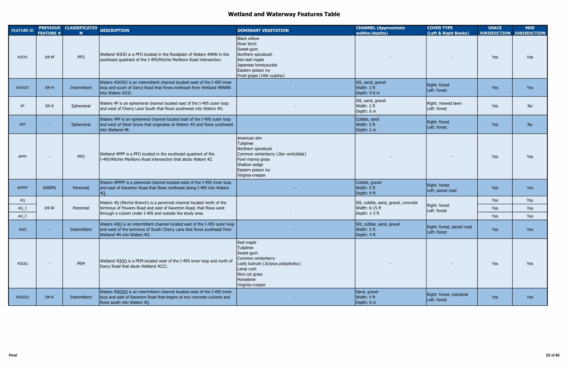
Wetland and Waterway Features Table
FEATURE IDPREVIOUS
FEATURE #
CLASSIFICATIO
NDESCRIPTION DOMINANT VEGETATION
CHANNEL (Approximate
widths/depths)
COVER TYPE
(Left & Right Banks)
USACE
JURISDICTION
MDE
JURISDICTION
4OOO 04-M PFOWetland 4OOO is a PFO located in the floodplain of Waters 4NNN in the
southeast quadrant of the I‑495/Ritchie Marlboro Road intersection.
Black willow
River birch
Sweet-gum
Northern spicebush
Ash-leaf maple
Japanese honeysuckle
Eastern poison ivy
Frost grape (Vitis vulpina )
- - Yes Yes
4OOOO 04-H Intermittent
Waters 4OOOO is an intermittent channel located west of the I‑495 inner
loop and south of Darcy Road that flows northeast from Wetland 4NNNN
into Waters 4JJJJ.
-
Silt, sand, gravel
Width: 3 ft
Depth: 4-6 in
Right: forest
Left: forestYes Yes
4P 04-X EphemeralWaters 4P is an ephemeral channel located east of the I‑495 outer loop
and west of Cherry Lane South that flows southwest into Waters 4O. -
Silt, sand, gravel
Width: 2 ft
Depth: 6 in
Right: mowed lawn
Left: forestYes No
4PP - Ephemeral
Waters 4PP is an ephemeral channel located east of the I‑495 outer loop
and west of West Grove that originates at Waters 4O and flows southwest
into Wetland 4R.
-
Cobble, sand
Width: 3 ft
Depth: 2 in
Right: forest
Left: forestYes No
4PPP - PFOWetland 4PPP is a PFO located in the southeast quadrant of the
I‑495/Ritchie Marlboro Road intersection that abuts Waters 4Z.
American elm
Tuliptree
Northern spicebush
Common winterberry (Ilex verticillata )
Fowl manna grass
Shallow sedge
Eastern poison ivy
Virginia-creeper
- - Yes Yes
4PPPP W90PG Perennial
Waters 4PPPP is a perennial channel located west of the I‑495 inner loop
and east of Kaverton Road that flows northeast along I‑495 into Waters
4Q.
-
Cobble, gravel
Width: 5 ft
Depth: 4 ft
Right: forest
Left: paved roadYes Yes
4Q Yes Yes
4Q_1 Yes Yes
4Q_C Yes Yes
4QQ - Intermittent
Waters 4QQ is an intermittent channel located east of the I‑495 outer loop
and west of the terminus of South Cherry Lane that flows southeast from
Wetland 4N into Waters 4O.
-
Silt, cobble, sand, gravel
Width: 3 ft
Depth: 4 ft
Right: forest, paved road
Left: forestYes Yes
4QQQ - PEMWetland 4QQQ is a PEM located west of the I‑495 inner loop and north of
Darcy Road that abuts Wetland 4CCC.
Red maple
Tuliptree
Sweet-gum
Common winterberry
Leafy bulrush (Scirpus polyphyllus )
Lamp rush
Rice cut grass
Horsebrier
Virginia-creeper
- - Yes Yes
4QQQQ 04-K Intermittent
Waters 4QQQQ is an intermittent channel located west of the I‑495 inner
loop and east of Kaverton Road that begins at two concrete culverts and
flows south into Waters 4Q.
-
Sand, gravel
Width: 4 ft
Depth: 6 in
Right: forest, industrial
Left: forestYes Yes
04-W Perennial
Waters 4Q (Ritchie Branch) is a perennial channel located north of the
terminus of Flowers Road and east of Kaverton Road, that flows west
through a culvert under I‑495 and outside the study area.
-
Silt, cobble, sand, gravel, concrete
Width: 6-15 ft
Depth: 1-3 ft
Right: forest
Left: forest
Final 22 of 82
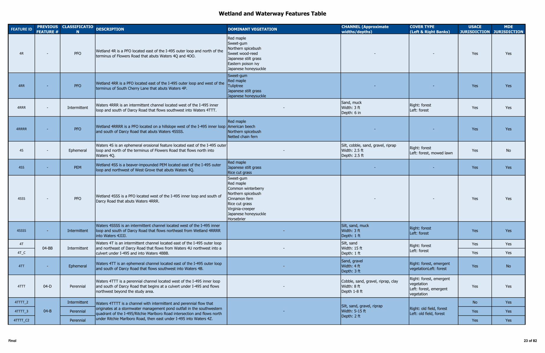
Wetland and Waterway Features Table
FEATURE IDPREVIOUS
FEATURE #
CLASSIFICATIO
NDESCRIPTION DOMINANT VEGETATION
CHANNEL (Approximate
widths/depths)
COVER TYPE
(Left & Right Banks)
USACE
JURISDICTION
MDE
JURISDICTION
4R - PFOWetland 4R is a PFO located east of the I‑495 outer loop and north of the
terminus of Flowers Road that abuts Waters 4Q and 4OO.
Red maple
Sweet-gum
Northern spicebush
Sweet wood-reed
Japanese stilt grass
Eastern poison ivy
Japanese honeysuckle
- - Yes Yes
4RR - PFOWetland 4RR is a PFO located east of the I‑495 outer loop and west of the
terminus of South Cherry Lane that abuts Waters 4P.
Sweet-gum
Red maple
Tuliptree
Japanese stilt grass
Japanese honeysuckle
- - Yes Yes
4RRR - IntermittentWaters 4RRR is an intermittent channel located west of the I‑495 inner
loop and south of Darcy Road that flows southwest into Waters 4TTT.-
Sand, muck
Width: 3 ft
Depth: 6 in
Right: forest
Left: forestYes Yes
4RRRR - PFOWetland 4RRRR is a PFO located on a hillslope west of the I‑495 inner loop
and south of Darcy Road that abuts Waters 4SSSS.
Red maple
American beech
Northern spicebush
Netted chain fern
- - Yes Yes
4S - Ephemeral
Waters 4S is an ephemeral erosional feature located east of the I‑495 outer
loop and north of the terminus of Flowers Road that flows north into
Waters 4Q.
-
Silt, cobble, sand, gravel, riprap
Width: 2.5 ft
Depth: 2.5 ft
Right: forest
Left: forest, mowed lawnYes No
4SS - PEMWetland 4SS is a beaver-impounded PEM located east of the I‑495 outer
loop and northwest of West Grove that abuts Waters 4Q.
Red maple
Japanese stilt grass
Rice cut grass
- - Yes Yes
4SSS - PFOWetland 4SSS is a PFO located west of the I‑495 inner loop and south of
Darcy Road that abuts Waters 4RRR.
Sweet-gum
Red maple
Common winterberry
Northern spicebush
Cinnamon fern
Rice cut grass
Virginia-creeper
Japanese honeysuckle
Horsebrier
- - Yes Yes
4SSSS - Intermittent
Waters 4SSSS is an intermittent channel located west of the I‑495 inner
loop and south of Darcy Road that flows northeast from Wetland 4RRRR
into Waters 4JJJJ.
-
Silt, sand, muck
Width: 3 ft
Depth: 1 ft
Right: forest
Left: forestYes Yes
4T Yes Yes
4T_C Yes Yes
4TT - EphemeralWaters 4TT is an ephemeral channel located east of the I‑495 outer loop
and south of Darcy Road that flows southwest into Waters 4B. -
Sand, gravel
Width: 4 ft
Depth: 3 ft
Right: forest, emergent
vegetationLeft: forestYes No
4TTT 04-D Perennial
Waters 4TTT is a perennial channel located west of the I‑495 inner loop
and south of Darcy Road that begins at a culvert under I‑495 and flows
northwest beyond the study area.
-
Cobble, sand, gravel, riprap, clay
Width: 8 ft
Depth 1-8 ft
Right: forest, emergent
vegetation
Left: forest, emergent
vegetation
Yes Yes
4TTTT_2 Intermittent No Yes
4TTTT_3 Perennial Yes Yes
4TTTT_C2 Perennial Yes Yes
-
Silt, sand, gravel, riprap
Width: 5-15 ft
Depth: 2 ft
Right: old field, forest
Left: old field, forest
Intermittent
04-B
Waters 4T is an intermittent channel located east of the I‑495 outer loop
and northeast of Darcy Road that flows from Waters 4U northwest into a
culvert under I‑495 and into Waters 4BBB.
-
Silt, sand
Width: 15 ft
Depth: 1 ft
Right: forest
Left: forest
Waters 4TTTT is a channel with intermittent and perennial flow that
originates at a stormwater management pond outfall in the southwestern
quadrant of the I‑495/Ritchie Marlboro Road intersection and flows north
under Ritchie Marlboro Road, then east under I‑495 into Waters 4Z.
04-BB
Final 23 of 82
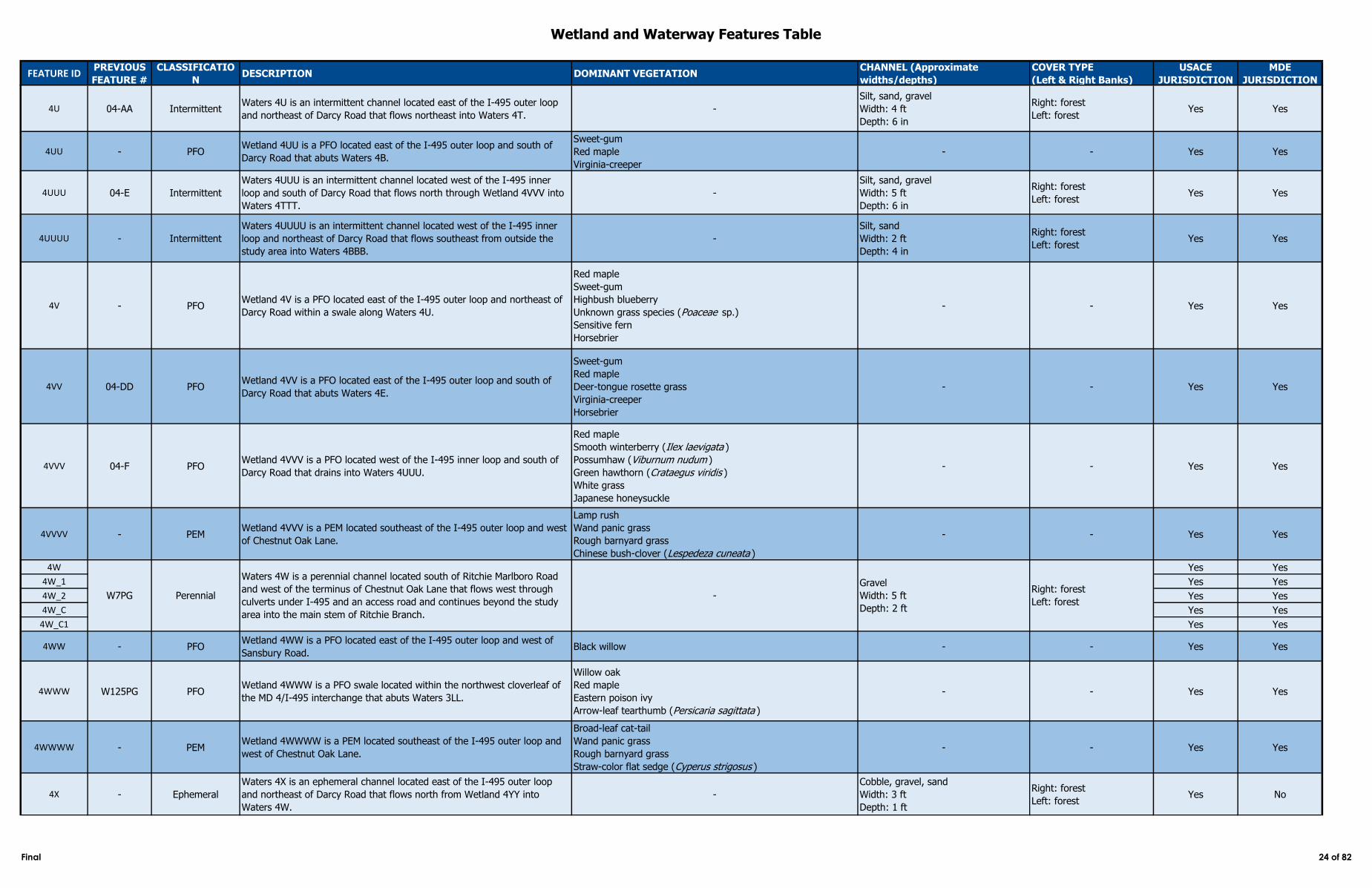
Wetland and Waterway Features Table
FEATURE IDPREVIOUS
FEATURE #
CLASSIFICATIO
NDESCRIPTION DOMINANT VEGETATION
CHANNEL (Approximate
widths/depths)
COVER TYPE
(Left & Right Banks)
USACE
JURISDICTION
MDE
JURISDICTION
4U 04-AA IntermittentWaters 4U is an intermittent channel located east of the I‑495 outer loop
and northeast of Darcy Road that flows northeast into Waters 4T.-
Silt, sand, gravel
Width: 4 ft
Depth: 6 in
Right: forest
Left: forestYes Yes
4UU - PFOWetland 4UU is a PFO located east of the I‑495 outer loop and south of
Darcy Road that abuts Waters 4B.
Sweet-gum
Red maple
Virginia-creeper
- - Yes Yes
4UUU 04-E Intermittent
Waters 4UUU is an intermittent channel located west of the I‑495 inner
loop and south of Darcy Road that flows north through Wetland 4VVV into
Waters 4TTT.
-
Silt, sand, gravel
Width: 5 ft
Depth: 6 in
Right: forest
Left: forestYes Yes
4UUUU - Intermittent
Waters 4UUUU is an intermittent channel located west of the I‑495 inner
loop and northeast of Darcy Road that flows southeast from outside the
study area into Waters 4BBB.
-
Silt, sand
Width: 2 ft
Depth: 4 in
Right: forest
Left: forestYes Yes
4V - PFOWetland 4V is a PFO located east of the I‑495 outer loop and northeast of
Darcy Road within a swale along Waters 4U.
Red maple
Sweet-gum
Highbush blueberry
Unknown grass species (Poaceae sp.)
Sensitive fern
Horsebrier
- - Yes Yes
4VV 04-DD PFOWetland 4VV is a PFO located east of the I‑495 outer loop and south of
Darcy Road that abuts Waters 4E.
Sweet-gum
Red maple
Deer-tongue rosette grass
Virginia-creeper
Horsebrier
- - Yes Yes
4VVV 04-F PFOWetland 4VVV is a PFO located west of the I‑495 inner loop and south of
Darcy Road that drains into Waters 4UUU.
Red maple
Smooth winterberry (Ilex laevigata )
Possumhaw (Viburnum nudum )
Green hawthorn (Crataegus viridis )
White grass
Japanese honeysuckle
- - Yes Yes
4VVVV - PEMWetland 4VVV is a PEM located southeast of the I‑495 outer loop and west
of Chestnut Oak Lane.
Lamp rush
Wand panic grass
Rough barnyard grass
Chinese bush-clover (Lespedeza cuneata )
- - Yes Yes
4W Yes Yes
4W_1 Yes Yes
4W_2 Yes Yes
4W_C Yes Yes
4W_C1 Yes Yes
4WW - PFOWetland 4WW is a PFO located east of the I‑495 outer loop and west of
Sansbury Road. Black willow - - Yes Yes
4WWW W125PG PFOWetland 4WWW is a PFO swale located within the northwest cloverleaf of
the MD 4/I‑495 interchange that abuts Waters 3LL.
Willow oak
Red maple
Eastern poison ivy
Arrow-leaf tearthumb (Persicaria sagittata )
- - Yes Yes
4WWWW - PEMWetland 4WWWW is a PEM located southeast of the I‑495 outer loop and
west of Chestnut Oak Lane.
Broad-leaf cat-tail
Wand panic grass
Rough barnyard grass
Straw-color flat sedge (Cyperus strigosus )
- - Yes Yes
4X - Ephemeral
Waters 4X is an ephemeral channel located east of the I‑495 outer loop
and northeast of Darcy Road that flows north from Wetland 4YY into
Waters 4W.
-
Cobble, gravel, sand
Width: 3 ft
Depth: 1 ft
Right: forest
Left: forestYes No
Gravel
Width: 5 ft
Depth: 2 ft
Waters 4W is a perennial channel located south of Ritchie Marlboro Road
and west of the terminus of Chestnut Oak Lane that flows west through
culverts under I‑495 and an access road and continues beyond the study
area into the main stem of Ritchie Branch.
-W7PG PerennialRight: forest
Left: forest
Final 24 of 82
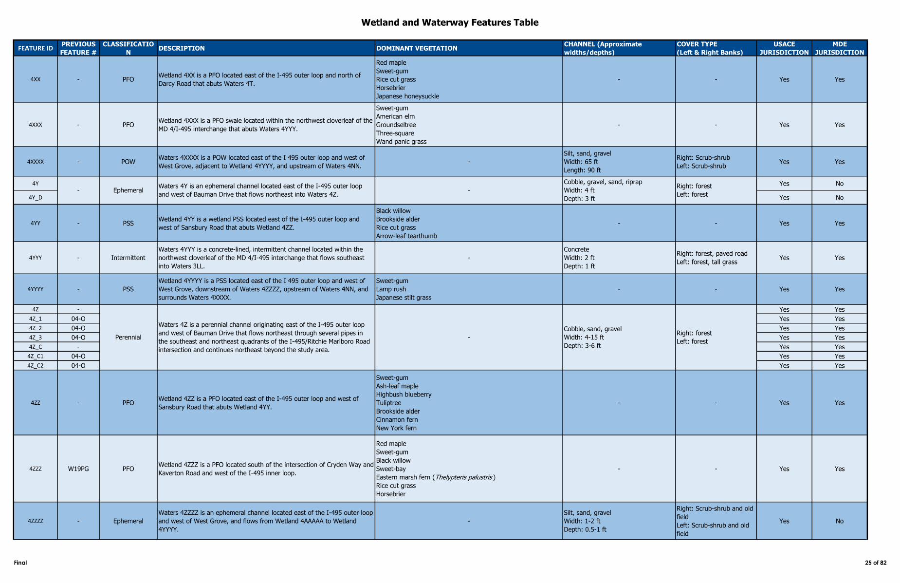
Wetland and Waterway Features Table
FEATURE IDPREVIOUS
FEATURE #
CLASSIFICATIO
NDESCRIPTION DOMINANT VEGETATION
CHANNEL (Approximate
widths/depths)
COVER TYPE
(Left & Right Banks)
USACE
JURISDICTION
MDE
JURISDICTION
4XX - PFOWetland 4XX is a PFO located east of the I‑495 outer loop and north of
Darcy Road that abuts Waters 4T.
Red maple
Sweet-gum
Rice cut grass
Horsebrier
Japanese honeysuckle
- - Yes Yes
4XXX - PFOWetland 4XXX is a PFO swale located within the northwest cloverleaf of the
MD 4/I‑495 interchange that abuts Waters 4YYY.
Sweet-gum
American elm
Groundseltree
Three-square
Wand panic grass
- - Yes Yes
4XXXX - POWWaters 4XXXX is a POW located east of the I 495 outer loop and west of
West Grove, adjacent to Wetland 4YYYY, and upstream of Waters 4NN.-
Silt, sand, gravel
Width: 65 ft
Length: 90 ft
Right: Scrub-shrub
Left: Scrub-shrubYes Yes
4Y Yes No
4Y_D Yes No
4YY - PSSWetland 4YY is a wetland PSS located east of the I‑495 outer loop and
west of Sansbury Road that abuts Wetland 4ZZ.
Black willow
Brookside alder
Rice cut grass
Arrow-leaf tearthumb
- - Yes Yes
4YYY - Intermittent
Waters 4YYY is a concrete-lined, intermittent channel located within the
northwest cloverleaf of the MD 4/I‑495 interchange that flows southeast
into Waters 3LL.
-
Concrete
Width: 2 ft
Depth: 1 ft
Right: forest, paved road
Left: forest, tall grassYes Yes
4YYYY - PSS
Wetland 4YYYY is a PSS located east of the I 495 outer loop and west of
West Grove, downstream of Waters 4ZZZZ, upstream of Waters 4NN, and
surrounds Waters 4XXXX.
Sweet-gum
Lamp rush
Japanese stilt grass
- - Yes Yes
4Z - Yes Yes
4Z_1 04-O Yes Yes
4Z_2 04-O Yes Yes
4Z_3 04-O Yes Yes
4Z_C - Yes Yes
4Z_C1 04-O Yes Yes
4Z_C2 04-O Yes Yes
4ZZ - PFOWetland 4ZZ is a PFO located east of the I‑495 outer loop and west of
Sansbury Road that abuts Wetland 4YY.
Sweet-gum
Ash-leaf maple
Highbush blueberry
Tuliptree
Brookside alder
Cinnamon fern
New York fern
- - Yes Yes
4ZZZ W19PG PFOWetland 4ZZZ is a PFO located south of the intersection of Cryden Way and
Kaverton Road and west of the I‑495 inner loop.
Red maple
Sweet-gum
Black willow
Sweet-bay
Eastern marsh fern (Thelypteris palustris )
Rice cut grass
Horsebrier
- - Yes Yes
4ZZZZ - Ephemeral
Waters 4ZZZZ is an ephemeral channel located east of the I-495 outer loop
and west of West Grove, and flows from Wetland 4AAAAA to Wetland
4YYYY.
-
Silt, sand, gravel
Width: 1-2 ft
Depth: 0.5-1 ft
Right: Scrub-shrub and old
field
Left: Scrub-shrub and old
field
Yes No
- EphemeralWaters 4Y is an ephemeral channel located east of the I‑495 outer loop
and west of Bauman Drive that flows northeast into Waters 4Z.-
Cobble, gravel, sand, riprap
Width: 4 ft
Depth: 3 ft
Right: forest
Left: forest
Perennial
Waters 4Z is a perennial channel originating east of the I‑495 outer loop
and west of Bauman Drive that flows northeast through several pipes in
the southeast and northeast quadrants of the I‑495/Ritchie Marlboro Road
intersection and continues northeast beyond the study area.
-
Cobble, sand, gravel
Width: 4-15 ft
Depth: 3-6 ft
Right: forest
Left: forest
Final 25 of 82

Wetland and Waterway Features Table
FEATURE IDPREVIOUS
FEATURE #
CLASSIFICATIO
NDESCRIPTION DOMINANT VEGETATION
CHANNEL (Approximate
widths/depths)
COVER TYPE
(Left & Right Banks)
USACE
JURISDICTION
MDE
JURISDICTION
5A 04-P PFOWetland 5A is a PFO swale located in the northeast quadrant of the
I‑495/Ritchie Marlboro Road intersection that abuts Waters 4Z.
Sweet-gum
Bitter-nut hickory (Carya cordiformis )
Leafy bulrush
Japanese stilt grass
Asiatic tearthumb (Persicaria perfoliata )
- - Yes Yes
5AA - PSSWetland 5AA is a PSS located in the southwest quadrant of the I‑495/MD
214 intersection that abuts Wetland 5Z.
Sweet-gum
Groundseltree
Shallow sedge
Purple loosestrife (Lythrum salicaria )
- - Yes Yes
5B 04-S Intermittent Yes Yes
5B_1 - Ephemeral Yes No
5BB - Intermittent
Waters 5BB is an intermittent channel located in the southwest quadrant of
the I‑495/MD 214 intersection that originates at a culvert draining a
bioswale along I‑495 and flows south into Wetland 5Z.
-
Silt, sand, gravel
Width: 4 ft
Depth: 6 in
Right: forest
Left: forestYes Yes
5C 04-R PFOWetland 5C is a PFO located in the northeast quadrant of the I‑495/Ritchie
Marlboro Road intersection that abuts Waters 5B.
Red maple
American elm
Green ash
Sweet-gum
White grass
River-bank grape
Eastern poison ivy
Horsebrier
- - Yes Yes
5CC - PFOWetland 5CC is a PFO located west of the I‑495 inner loop and southeast
of Edgeworth Drive that abuts Wetland 5DD.
Sweet-gum
American sycamore
Common pawpaw
Red maple
Eastern poison ivy
- - Yes Yes
5DD - PEMWetland 5DD is a PEM located west of the I‑495 inner loop and southeast
of Edgeworth Drive that abuts Wetland 5CC.
Common persimmon
Pennsylvania blackberry (Rubus pensilvanicus )
Shallow sedge
Lamp rush
Tall goldenrod (Solidago altissima )
White snakeroot (Ageratina altissima )
- - Yes Yes
5E 04-A PSSWetland 5E is a PSS located in the northwest quadrant of the I‑495/Ritchie
Marlboro Road intersection.
Black willow
Sensitive fern- - Yes Yes
5EE POWWaters 5EE is a POW stormwater management pond located west of I-495
inner loop and southeast of Edgeworth Drive. -
Silt, sand, and muck
Width: 80 ft
Length: 500 ft
Right: forest
Left: ForestYes Yes
5F Yes Yes
5F_1 Yes Yes
5F_C Yes Yes
5F_C1 Yes Yes
5FF Yes Yes
5FF_C Yes Yes
5G - PSS
Wetland 5G is a PSS located west of the exit ramp from the I‑495 inner
loop to Ritchie Marlboro Road and east of Alaking Court, in the floodplain
of Waters 5F.
Black willow
Rice cut grass
Amur peppervine
- - Yes Yes
Subsegment 5
Silt, sand, riprap
Width: 3-5 ft
Depth: 4-12 in
Right: forest, mowed lawn
Left: forest, mowed lawn04-U Perennial
Waters 5F is a perennial channel located east and west of I‑495 between
Castlewood Drive and Alaking Court that flows east through a culvert under
I‑495.
-
- Intermittent
Waters 5FF is an intermittent channel located west of the I‑495 inner loop
and southeast of Edgeworth Drive that flows east to a culvert under I‑495
into Waters 5P.
-
Silt, sand, concrete
Width: 4 ft
Depth: 6 in
Right: forest
Left: forest
Waters 5B is an intermittent and ephemeral channel with an abutting
wetland located in the northeast quadrant of the I‑495/ Ritchie Marlboro
Road intersection. Waters 5B becomes an intermittent channel prior to its
confluence with Waters 4Z.
-
Silt, sand
Width: 2-5 ft
Depth: 1-4 ft
Right: forest
Left: forest
Final 26 of 82
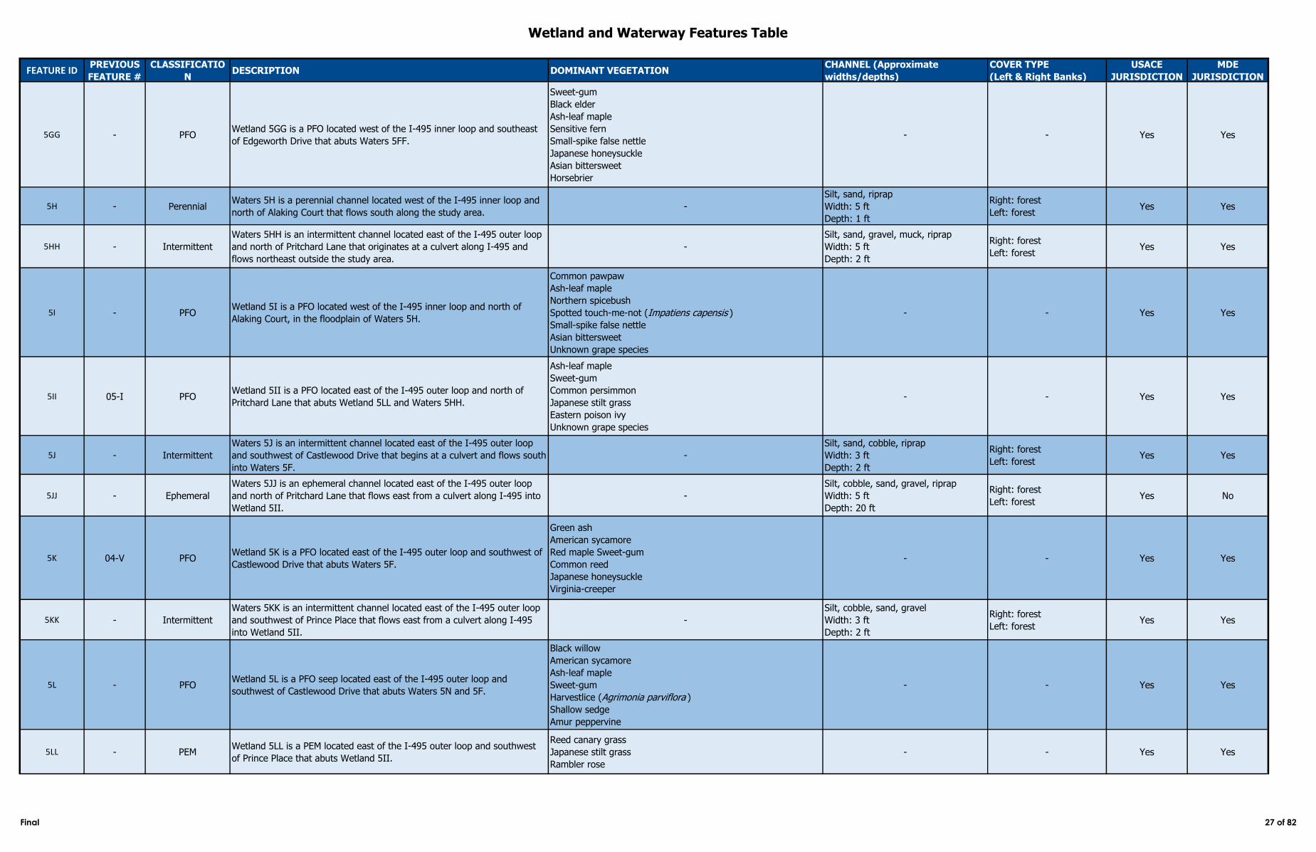
Wetland and Waterway Features Table
FEATURE IDPREVIOUS
FEATURE #
CLASSIFICATIO
NDESCRIPTION DOMINANT VEGETATION
CHANNEL (Approximate
widths/depths)
COVER TYPE
(Left & Right Banks)
USACE
JURISDICTION
MDE
JURISDICTION
5GG - PFOWetland 5GG is a PFO located west of the I‑495 inner loop and southeast
of Edgeworth Drive that abuts Waters 5FF.
Sweet-gum
Black elder
Ash-leaf maple
Sensitive fern
Small-spike false nettle
Japanese honeysuckle
Asian bittersweet
Horsebrier
- - Yes Yes
5H - PerennialWaters 5H is a perennial channel located west of the I‑495 inner loop and
north of Alaking Court that flows south along the study area.-
Silt, sand, riprap
Width: 5 ft
Depth: 1 ft
Right: forest
Left: forestYes Yes
5HH - Intermittent
Waters 5HH is an intermittent channel located east of the I‑495 outer loop
and north of Pritchard Lane that originates at a culvert along I‑495 and
flows northeast outside the study area.
-
Silt, sand, gravel, muck, riprap
Width: 5 ft
Depth: 2 ft
Right: forest
Left: forestYes Yes
5I - PFOWetland 5I is a PFO located west of the I‑495 inner loop and north of
Alaking Court, in the floodplain of Waters 5H.
Common pawpaw
Ash-leaf maple
Northern spicebush
Spotted touch-me-not (Impatiens capensis )
Small-spike false nettle
Asian bittersweet
Unknown grape species
- - Yes Yes
5II 05-I PFOWetland 5II is a PFO located east of the I‑495 outer loop and north of
Pritchard Lane that abuts Wetland 5LL and Waters 5HH.
Ash-leaf maple
Sweet-gum
Common persimmon
Japanese stilt grass
Eastern poison ivy
Unknown grape species
- - Yes Yes
5J - Intermittent
Waters 5J is an intermittent channel located east of the I‑495 outer loop
and southwest of Castlewood Drive that begins at a culvert and flows south
into Waters 5F.
-
Silt, sand, cobble, riprap
Width: 3 ft
Depth: 2 ft
Right: forest
Left: forestYes Yes
5JJ - Ephemeral
Waters 5JJ is an ephemeral channel located east of the I‑495 outer loop
and north of Pritchard Lane that flows east from a culvert along I‑495 into
Wetland 5II.
-
Silt, cobble, sand, gravel, riprap
Width: 5 ft
Depth: 20 ft
Right: forest
Left: forestYes No
5K 04-V PFOWetland 5K is a PFO located east of the I‑495 outer loop and southwest of
Castlewood Drive that abuts Waters 5F.
Green ash
American sycamore
Red maple Sweet-gum
Common reed
Japanese honeysuckle
Virginia-creeper
- - Yes Yes
5KK - Intermittent
Waters 5KK is an intermittent channel located east of the I‑495 outer loop
and southwest of Prince Place that flows east from a culvert along I‑495
into Wetland 5II.
-
Silt, cobble, sand, gravel
Width: 3 ft
Depth: 2 ft
Right: forest
Left: forestYes Yes
5L - PFOWetland 5L is a PFO seep located east of the I‑495 outer loop and
southwest of Castlewood Drive that abuts Waters 5N and 5F.
Black willow
American sycamore
Ash-leaf maple
Sweet-gum
Harvestlice (Agrimonia parviflora )
Shallow sedge
Amur peppervine
- - Yes Yes
5LL - PEMWetland 5LL is a PEM located east of the I‑495 outer loop and southwest
of Prince Place that abuts Wetland 5II.
Reed canary grass
Japanese stilt grass
Rambler rose
- - Yes Yes
Final 27 of 82
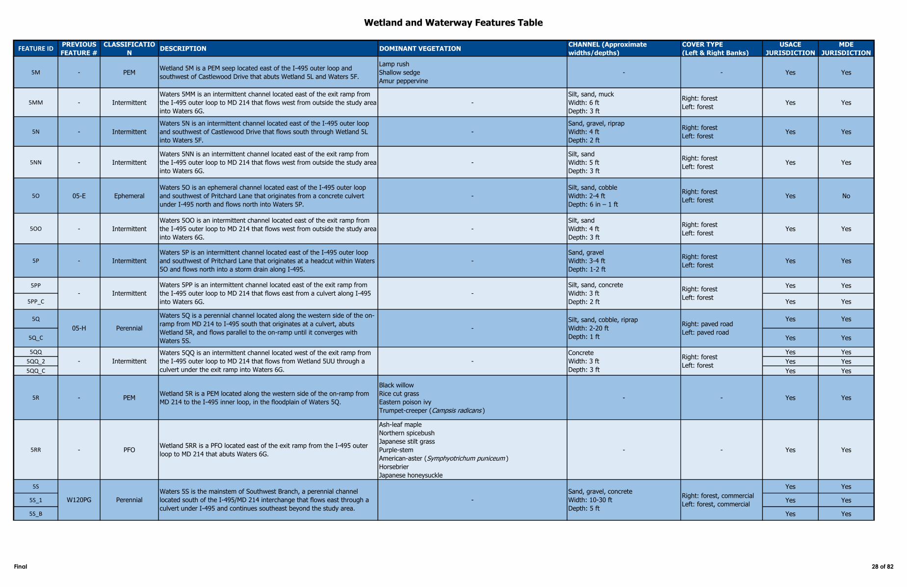
Wetland and Waterway Features Table
FEATURE IDPREVIOUS
FEATURE #
CLASSIFICATIO
NDESCRIPTION DOMINANT VEGETATION
CHANNEL (Approximate
widths/depths)
COVER TYPE
(Left & Right Banks)
USACE
JURISDICTION
MDE
JURISDICTION
5M - PEMWetland 5M is a PEM seep located east of the I‑495 outer loop and
southwest of Castlewood Drive that abuts Wetland 5L and Waters 5F.
Lamp rush
Shallow sedge
Amur peppervine
- - Yes Yes
5MM - Intermittent
Waters 5MM is an intermittent channel located east of the exit ramp from
the I‑495 outer loop to MD 214 that flows west from outside the study area
into Waters 6G.
-
Silt, sand, muck
Width: 6 ft
Depth: 3 ft
Right: forest
Left: forestYes Yes
5N - Intermittent
Waters 5N is an intermittent channel located east of the I‑495 outer loop
and southwest of Castlewood Drive that flows south through Wetland 5L
into Waters 5F.
-
Sand, gravel, riprap
Width: 4 ft
Depth: 2 ft
Right: forest
Left: forestYes Yes
5NN - Intermittent
Waters 5NN is an intermittent channel located east of the exit ramp from
the I‑495 outer loop to MD 214 that flows west from outside the study area
into Waters 6G.
-
Silt, sand
Width: 5 ft
Depth: 3 ft
Right: forest
Left: forestYes Yes
5O 05-E Ephemeral
Waters 5O is an ephemeral channel located east of the I-495 outer loop
and southwest of Pritchard Lane that originates from a concrete culvert
under I-495 north and flows north into Waters 5P.
-
Silt, sand, cobble
Width: 2-4 ft
Depth: 6 in – 1 ft
Right: forest
Left: forestYes No
5OO - Intermittent
Waters 5OO is an intermittent channel located east of the exit ramp from
the I‑495 outer loop to MD 214 that flows west from outside the study area
into Waters 6G.
-
Silt, sand
Width: 4 ft
Depth: 3 ft
Right: forest
Left: forestYes Yes
5P - Intermittent
Waters 5P is an intermittent channel located east of the I‑495 outer loop
and southwest of Pritchard Lane that originates at a headcut within Waters
5O and flows north into a storm drain along I‑495.
-
Sand, gravel
Width: 3-4 ft
Depth: 1-2 ft
Right: forest
Left: forestYes Yes
5PP Yes Yes
5PP_C Yes Yes
5Q Yes Yes
5Q_C Yes Yes
5QQ Yes Yes
5QQ_2 Yes Yes
5QQ_C Yes Yes
5R - PEMWetland 5R is a PEM located along the western side of the on-ramp from
MD 214 to the I‑495 inner loop, in the floodplain of Waters 5Q.
Black willow
Rice cut grass
Eastern poison ivy
Trumpet-creeper (Campsis radicans )
- - Yes Yes
5RR - PFOWetland 5RR is a PFO located east of the exit ramp from the I‑495 outer
loop to MD 214 that abuts Waters 6G.
Ash-leaf maple
Northern spicebush
Japanese stilt grass
Purple-stem
American-aster (Symphyotrichum puniceum )
Horsebrier
Japanese honeysuckle
- - Yes Yes
5S Yes Yes
5S_1 Yes Yes
5S_B Yes Yes
05-H Perennial
Waters 5Q is a perennial channel located along the western side of the on-
ramp from MD 214 to I‑495 south that originates at a culvert, abuts
Wetland 5R, and flows parallel to the on-ramp until it converges with
Waters 5S.
-
Silt, sand, cobble, riprap
Width: 2-20 ft
Depth: 1 ft
Right: paved road
Left: paved road
Silt, sand, concrete
Width: 3 ft
Depth: 2 ft
Right: forest
Left: forest
W120PG Perennial
Waters 5S is the mainstem of Southwest Branch, a perennial channel
located south of the I‑495/MD 214 interchange that flows east through a
culvert under I‑495 and continues southeast beyond the study area.
-
Sand, gravel, concrete
Width: 10-30 ft
Depth: 5 ft
Right: forest, commercial
Left: forest, commercial
Intermittent
Waters 5QQ is an intermittent channel located west of the exit ramp from
the I‑495 outer loop to MD 214 that flows from Wetland 5UU through a
culvert under the exit ramp into Waters 6G.
-
Concrete
Width: 3 ft
Depth: 3 ft
Right: forest
Left: forest-
- Intermittent
Waters 5PP is an intermittent channel located east of the exit ramp from
the I‑495 outer loop to MD 214 that flows east from a culvert along I‑495
into Waters 6G.
-
Final 28 of 82
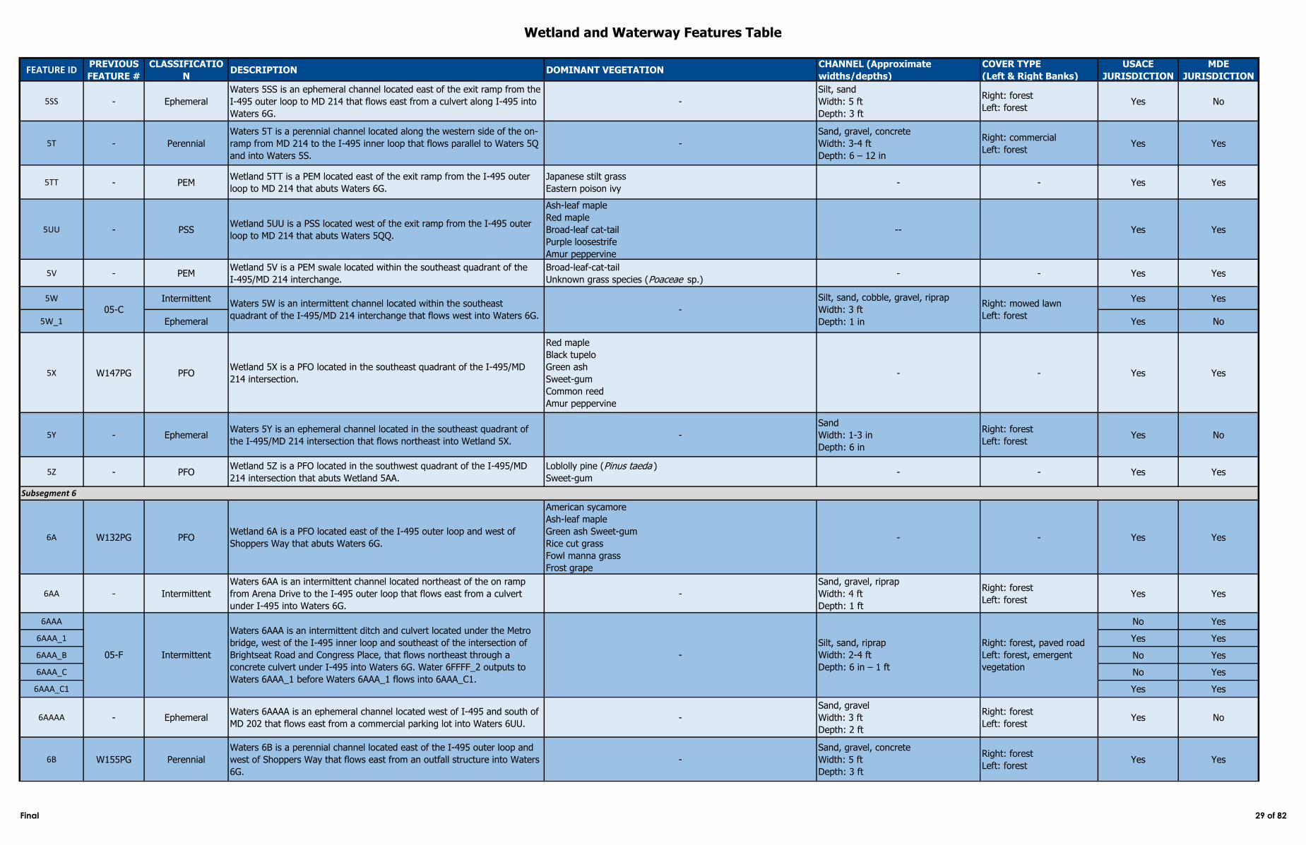
Wetland and Waterway Features Table
FEATURE IDPREVIOUS
FEATURE #
CLASSIFICATIO
NDESCRIPTION DOMINANT VEGETATION
CHANNEL (Approximate
widths/depths)
COVER TYPE
(Left & Right Banks)
USACE
JURISDICTION
MDE
JURISDICTION
5SS - Ephemeral
Waters 5SS is an ephemeral channel located east of the exit ramp from the
I‑495 outer loop to MD 214 that flows east from a culvert along I‑495 into
Waters 6G.
-
Silt, sand
Width: 5 ft
Depth: 3 ft
Right: forest
Left: forestYes No
5T - Perennial
Waters 5T is a perennial channel located along the western side of the on-
ramp from MD 214 to the I‑495 inner loop that flows parallel to Waters 5Q
and into Waters 5S.
-
Sand, gravel, concrete
Width: 3-4 ft
Depth: 6 – 12 in
Right: commercial
Left: forestYes Yes
5TT - PEMWetland 5TT is a PEM located east of the exit ramp from the I‑495 outer
loop to MD 214 that abuts Waters 6G.
Japanese stilt grass
Eastern poison ivy- - Yes Yes
5UU - PSSWetland 5UU is a PSS located west of the exit ramp from the I‑495 outer
loop to MD 214 that abuts Waters 5QQ.
Ash-leaf maple
Red maple
Broad-leaf cat-tail
Purple loosestrife
Amur peppervine
-- Yes Yes
5V - PEMWetland 5V is a PEM swale located within the southeast quadrant of the
I‑495/MD 214 interchange.
Broad-leaf-cat-tail
Unknown grass species (Poaceae sp.)- - Yes Yes
5W Intermittent Yes Yes
5W_1 Ephemeral Yes No
5X W147PG PFOWetland 5X is a PFO located in the southeast quadrant of the I‑495/MD
214 intersection.
Red maple
Black tupelo
Green ash
Sweet-gum
Common reed
Amur peppervine
- - Yes Yes
5Y - EphemeralWaters 5Y is an ephemeral channel located in the southeast quadrant of
the I‑495/MD 214 intersection that flows northeast into Wetland 5X. -
Sand
Width: 1-3 in
Depth: 6 in
Right: forest
Left: forestYes No
5Z - PFOWetland 5Z is a PFO located in the southwest quadrant of the I‑495/MD
214 intersection that abuts Wetland 5AA.
Loblolly pine (Pinus taeda )
Sweet-gum- - Yes Yes
6A W132PG PFOWetland 6A is a PFO located east of the I‑495 outer loop and west of
Shoppers Way that abuts Waters 6G.
American sycamore
Ash-leaf maple
Green ash Sweet-gum
Rice cut grass
Fowl manna grass
Frost grape
- - Yes Yes
6AA - Intermittent
Waters 6AA is an intermittent channel located northeast of the on ramp
from Arena Drive to the I‑495 outer loop that flows east from a culvert
under I‑495 into Waters 6G.
-
Sand, gravel, riprap
Width: 4 ft
Depth: 1 ft
Right: forest
Left: forestYes Yes
6AAA No Yes
6AAA_1 Yes Yes
6AAA_B No Yes
6AAA_C No Yes
6AAA_C1 Yes Yes
6AAAA - EphemeralWaters 6AAAA is an ephemeral channel located west of I‑495 and south of
MD 202 that flows east from a commercial parking lot into Waters 6UU.-
Sand, gravel
Width: 3 ft
Depth: 2 ft
Right: forest
Left: forestYes No
6B W155PG Perennial
Waters 6B is a perennial channel located east of the I‑495 outer loop and
west of Shoppers Way that flows east from an outfall structure into Waters
6G.
-
Sand, gravel, concrete
Width: 5 ft
Depth: 3 ft
Right: forest
Left: forestYes Yes
05-CWaters 5W is an intermittent channel located within the southeast
quadrant of the I‑495/MD 214 interchange that flows west into Waters 6G. -
Silt, sand, cobble, gravel, riprap
Width: 3 ft
Depth: 1 in
Right: mowed lawn
Left: forest
Subsegment 6
05-F Intermittent
Waters 6AAA is an intermittent ditch and culvert located under the Metro
bridge, west of the I‑495 inner loop and southeast of the intersection of
Brightseat Road and Congress Place, that flows northeast through a
concrete culvert under I‑495 into Waters 6G. Water 6FFFF_2 outputs to
Waters 6AAA_1 before Waters 6AAA_1 flows into 6AAA_C1.
-
Silt, sand, riprap
Width: 2-4 ft
Depth: 6 in – 1 ft
Right: forest, paved road
Left: forest, emergent
vegetation
Final 29 of 82
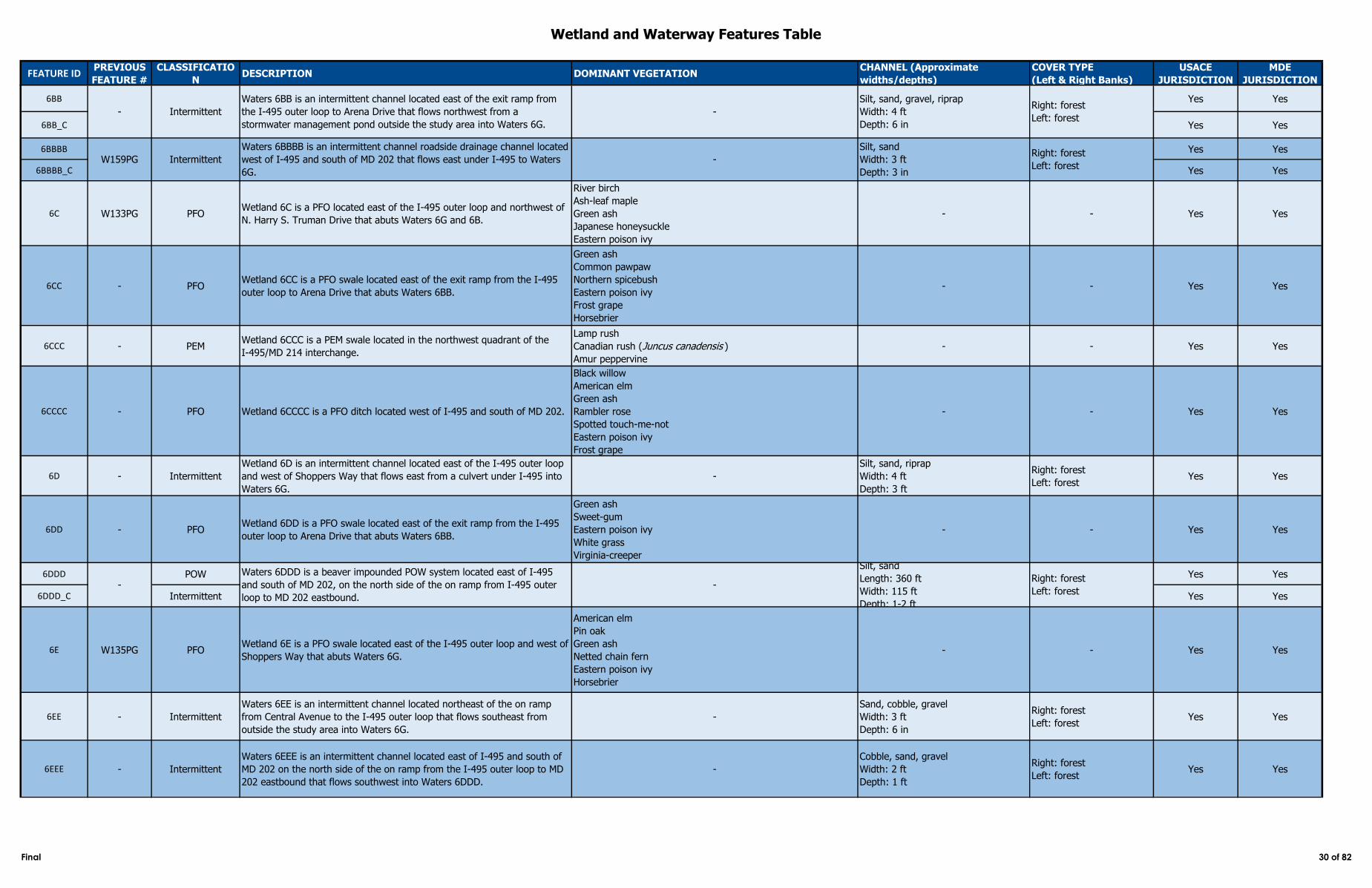
Wetland and Waterway Features Table
FEATURE IDPREVIOUS
FEATURE #
CLASSIFICATIO
NDESCRIPTION DOMINANT VEGETATION
CHANNEL (Approximate
widths/depths)
COVER TYPE
(Left & Right Banks)
USACE
JURISDICTION
MDE
JURISDICTION
6BB Yes Yes
6BB_C Yes Yes
6BBBB Yes Yes
6BBBB_C Yes Yes
6C W133PG PFOWetland 6C is a PFO located east of the I‑495 outer loop and northwest of
N. Harry S. Truman Drive that abuts Waters 6G and 6B.
River birch
Ash-leaf maple
Green ash
Japanese honeysuckle
Eastern poison ivy
- - Yes Yes
6CC - PFOWetland 6CC is a PFO swale located east of the exit ramp from the I‑495
outer loop to Arena Drive that abuts Waters 6BB.
Green ash
Common pawpaw
Northern spicebush
Eastern poison ivy
Frost grape
Horsebrier
- - Yes Yes
6CCC - PEMWetland 6CCC is a PEM swale located in the northwest quadrant of the
I‑495/MD 214 interchange.
Lamp rush
Canadian rush (Juncus canadensis )
Amur peppervine
- - Yes Yes
6CCCC - PFO Wetland 6CCCC is a PFO ditch located west of I‑495 and south of MD 202.
Black willow
American elm
Green ash
Rambler rose
Spotted touch-me-not
Eastern poison ivy
Frost grape
- - Yes Yes
6D - Intermittent
Wetland 6D is an intermittent channel located east of the I‑495 outer loop
and west of Shoppers Way that flows east from a culvert under I‑495 into
Waters 6G.
-
Silt, sand, riprap
Width: 4 ft
Depth: 3 ft
Right: forest
Left: forestYes Yes
6DD - PFOWetland 6DD is a PFO swale located east of the exit ramp from the I‑495
outer loop to Arena Drive that abuts Waters 6BB.
Green ash
Sweet-gum
Eastern poison ivy
White grass
Virginia-creeper
- - Yes Yes
6DDD POW Yes Yes
6DDD_C Intermittent Yes Yes
6E W135PG PFOWetland 6E is a PFO swale located east of the I‑495 outer loop and west of
Shoppers Way that abuts Waters 6G.
American elm
Pin oak
Green ash
Netted chain fern
Eastern poison ivy
Horsebrier
- - Yes Yes
6EE - Intermittent
Waters 6EE is an intermittent channel located northeast of the on ramp
from Central Avenue to the I‑495 outer loop that flows southeast from
outside the study area into Waters 6G.
-
Sand, cobble, gravel
Width: 3 ft
Depth: 6 in
Right: forest
Left: forestYes Yes
6EEE - Intermittent
Waters 6EEE is an intermittent channel located east of I‑495 and south of
MD 202 on the north side of the on ramp from the I‑495 outer loop to MD
202 eastbound that flows southwest into Waters 6DDD.
-
Cobble, sand, gravel
Width: 2 ft
Depth: 1 ft
Right: forest
Left: forestYes Yes
Silt, sand, gravel, riprap
Width: 4 ft
Depth: 6 in
Right: forest
Left: forest
W159PG Intermittent
Waters 6BBBB is an intermittent channel roadside drainage channel located
west of I‑495 and south of MD 202 that flows east under I‑495 to Waters
6G.
-
Silt, sand
Width: 3 ft
Depth: 3 in
Right: forest
Left: forest
- Intermittent
Waters 6BB is an intermittent channel located east of the exit ramp from
the I‑495 outer loop to Arena Drive that flows northwest from a
stormwater management pond outside the study area into Waters 6G.
-
Waters 6DDD is a beaver impounded POW system located east of I-495
and south of MD 202, on the north side of the on ramp from I-495 outer
loop to MD 202 eastbound.
-
Silt, sand
Length: 360 ft
Width: 115 ft
Depth: 1-2 ft
Right: forest
Left: forest
-
Final 30 of 82
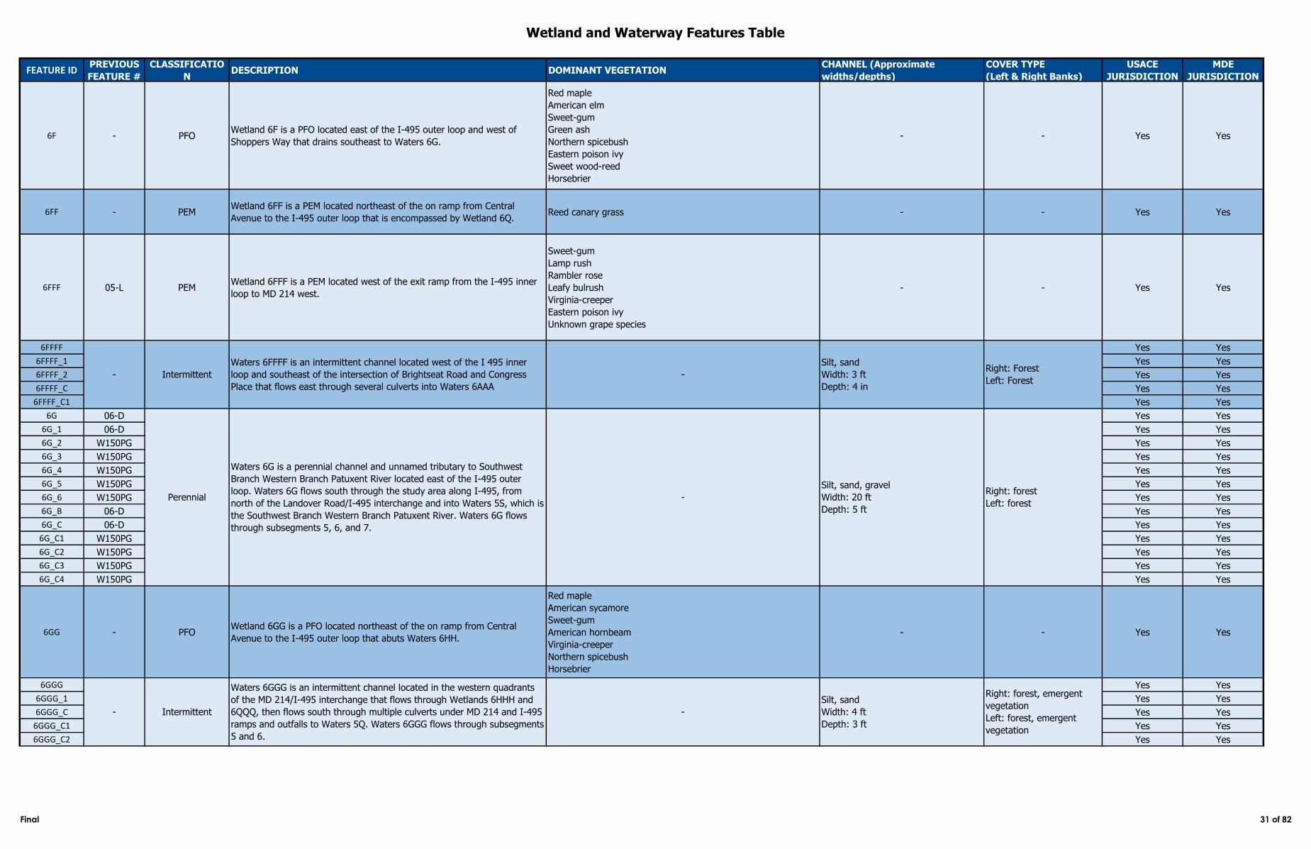
Wetland and Waterway Features Table
FEATURE IDPREVIOUS
FEATURE #
CLASSIFICATIO
NDESCRIPTION DOMINANT VEGETATION
CHANNEL (Approximate
widths/depths)
COVER TYPE
(Left & Right Banks)
USACE
JURISDICTION
MDE
JURISDICTION
6F - PFOWetland 6F is a PFO located east of the I‑495 outer loop and west of
Shoppers Way that drains southeast to Waters 6G.
Red maple
American elm
Sweet-gum
Green ash
Northern spicebush
Eastern poison ivy
Sweet wood-reed
Horsebrier
- - Yes Yes
6FF - PEMWetland 6FF is a PEM located northeast of the on ramp from Central
Avenue to the I‑495 outer loop that is encompassed by Wetland 6Q. Reed canary grass - - Yes Yes
6FFF 05-L PEMWetland 6FFF is a PEM located west of the exit ramp from the I‑495 inner
loop to MD 214 west.
Sweet-gum
Lamp rush
Rambler rose
Leafy bulrush
Virginia-creeper
Eastern poison ivy
Unknown grape species
- - Yes Yes
6FFFF Yes Yes
6FFFF_1 Yes Yes
6FFFF_2 Yes Yes
6FFFF_C Yes Yes
6FFFF_C1 Yes Yes
6G 06-D Yes Yes
6G_1 06-D Yes Yes
6G_2 W150PG Yes Yes
6G_3 W150PG Yes Yes
6G_4 W150PG Yes Yes
6G_5 W150PG Yes Yes
6G_6 W150PG Yes Yes
6G_B 06-D Yes Yes
6G_C 06-D Yes Yes
6G_C1 W150PG Yes Yes
6G_C2 W150PG Yes Yes
6G_C3 W150PG Yes Yes
6G_C4 W150PG Yes Yes
6GG - PFOWetland 6GG is a PFO located northeast of the on ramp from Central
Avenue to the I‑495 outer loop that abuts Waters 6HH.
Red maple
American sycamore
Sweet-gum
American hornbeam
Virginia-creeper
Northern spicebush
Horsebrier
- - Yes Yes
6GGG Yes Yes
6GGG_1 Yes Yes
6GGG_C Yes Yes
6GGG_C1 Yes Yes
6GGG_C2 Yes Yes
Right: forest, emergent
vegetation
Left: forest, emergent
vegetation
- Intermittent
Waters 6GGG is an intermittent channel located in the western quadrants
of the MD 214/I‑495 interchange that flows through Wetlands 6HHH and
6QQQ, then flows south through multiple culverts under MD 214 and I‑495
ramps and outfalls to Waters 5Q. Waters 6GGG flows through subsegments
5 and 6.
-
Silt, sand
Width: 4 ft
Depth: 3 ft
- Intermittent
Waters 6FFFF is an intermittent channel located west of the I 495 inner
loop and southeast of the intersection of Brightseat Road and Congress
Place that flows east through several culverts into Waters 6AAA
-
Silt, sand
Width: 3 ft
Depth: 4 in
Right: Forest
Left: Forest
Perennial
Waters 6G is a perennial channel and unnamed tributary to Southwest
Branch Western Branch Patuxent River located east of the I‑495 outer
loop. Waters 6G flows south through the study area along I‑495, from
north of the Landover Road/I‑495 interchange and into Waters 5S, which is
the Southwest Branch Western Branch Patuxent River. Waters 6G flows
through subsegments 5, 6, and 7.
-
Silt, sand, gravel
Width: 20 ft
Depth: 5 ft
Right: forest
Left: forest
Final 31 of 82
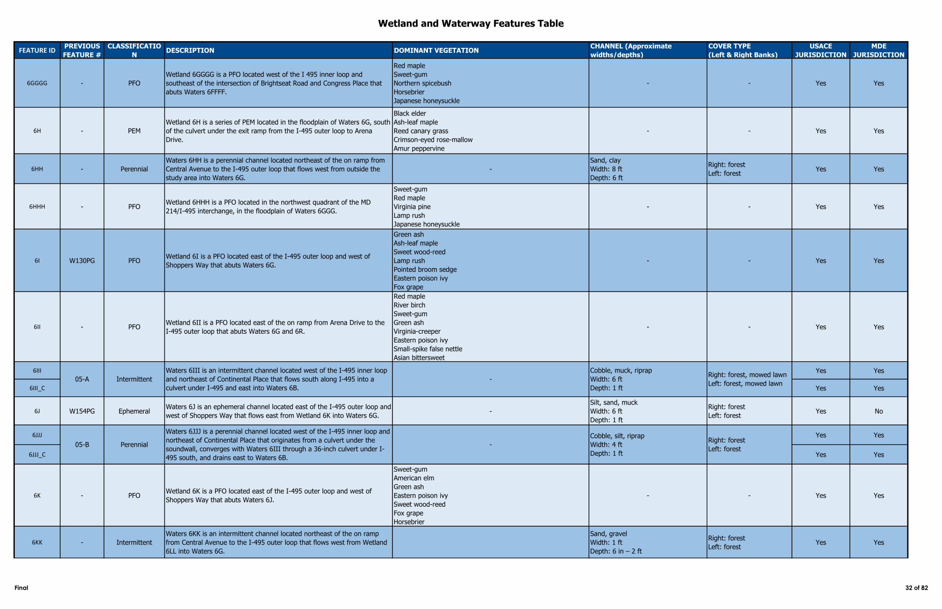
Wetland and Waterway Features Table
FEATURE IDPREVIOUS
FEATURE #
CLASSIFICATIO
NDESCRIPTION DOMINANT VEGETATION
CHANNEL (Approximate
widths/depths)
COVER TYPE
(Left & Right Banks)
USACE
JURISDICTION
MDE
JURISDICTION
6GGGG - PFO
Wetland 6GGGG is a PFO located west of the I 495 inner loop and
southeast of the intersection of Brightseat Road and Congress Place that
abuts Waters 6FFFF.
Red maple
Sweet-gum
Northern spicebush
Horsebrier
Japanese honeysuckle
- - Yes Yes
6H - PEM
Wetland 6H is a series of PEM located in the floodplain of Waters 6G, south
of the culvert under the exit ramp from the I‑495 outer loop to Arena
Drive.
Black elder
Ash-leaf maple
Reed canary grass
Crimson-eyed rose-mallow
Amur peppervine
- - Yes Yes
6HH - Perennial
Waters 6HH is a perennial channel located northeast of the on ramp from
Central Avenue to the I‑495 outer loop that flows west from outside the
study area into Waters 6G.
-
Sand, clay
Width: 8 ft
Depth: 6 ft
Right: forest
Left: forestYes Yes
6HHH - PFOWetland 6HHH is a PFO located in the northwest quadrant of the MD
214/I‑495 interchange, in the floodplain of Waters 6GGG.
Sweet-gum
Red maple
Virginia pine
Lamp rush
Japanese honeysuckle
- - Yes Yes
6I W130PG PFOWetland 6I is a PFO located east of the I‑495 outer loop and west of
Shoppers Way that abuts Waters 6G.
Green ash
Ash-leaf maple
Sweet wood-reed
Lamp rush
Pointed broom sedge
Eastern poison ivy
Fox grape
- - Yes Yes
6II - PFOWetland 6II is a PFO located east of the on ramp from Arena Drive to the
I‑495 outer loop that abuts Waters 6G and 6R.
Red maple
River birch
Sweet-gum
Green ash
Virginia-creeper
Eastern poison ivy
Small-spike false nettle
Asian bittersweet
- - Yes Yes
6III Yes Yes
6III_C Yes Yes
6J W154PG EphemeralWaters 6J is an ephemeral channel located east of the I‑495 outer loop and
west of Shoppers Way that flows east from Wetland 6K into Waters 6G. -
Silt, sand, muck
Width: 6 ft
Depth: 1 ft
Right: forest
Left: forestYes No
6JJJ Yes Yes
6JJJ_C Yes Yes
6K - PFOWetland 6K is a PFO located east of the I‑495 outer loop and west of
Shoppers Way that abuts Waters 6J.
Sweet-gum
American elm
Green ash
Eastern poison ivy
Sweet wood-reed
Fox grape
Horsebrier
- - Yes Yes
6KK - Intermittent
Waters 6KK is an intermittent channel located northeast of the on ramp
from Central Avenue to the I‑495 outer loop that flows west from Wetland
6LL into Waters 6G.
Sand, gravel
Width: 1 ft
Depth: 6 in – 2 ft
Right: forest
Left: forestYes Yes
05-A Intermittent
05-B Perennial
Waters 6III is an intermittent channel located west of the I‑495 inner loop
and northeast of Continental Place that flows south along I‑495 into a
culvert under I‑495 and east into Waters 6B.
-
Cobble, muck, riprap
Width: 6 ft
Depth: 1 ft
Right: forest, mowed lawn
Left: forest, mowed lawn
Waters 6JJJ is a perennial channel located west of the I‑495 inner loop and
northeast of Continental Place that originates from a culvert under the
soundwall, converges with Waters 6III through a 36-inch culvert under I-
495 south, and drains east to Waters 6B.
-
Cobble, silt, riprap
Width: 4 ft
Depth: 1 ft
Right: forest
Left: forest
Final 32 of 82
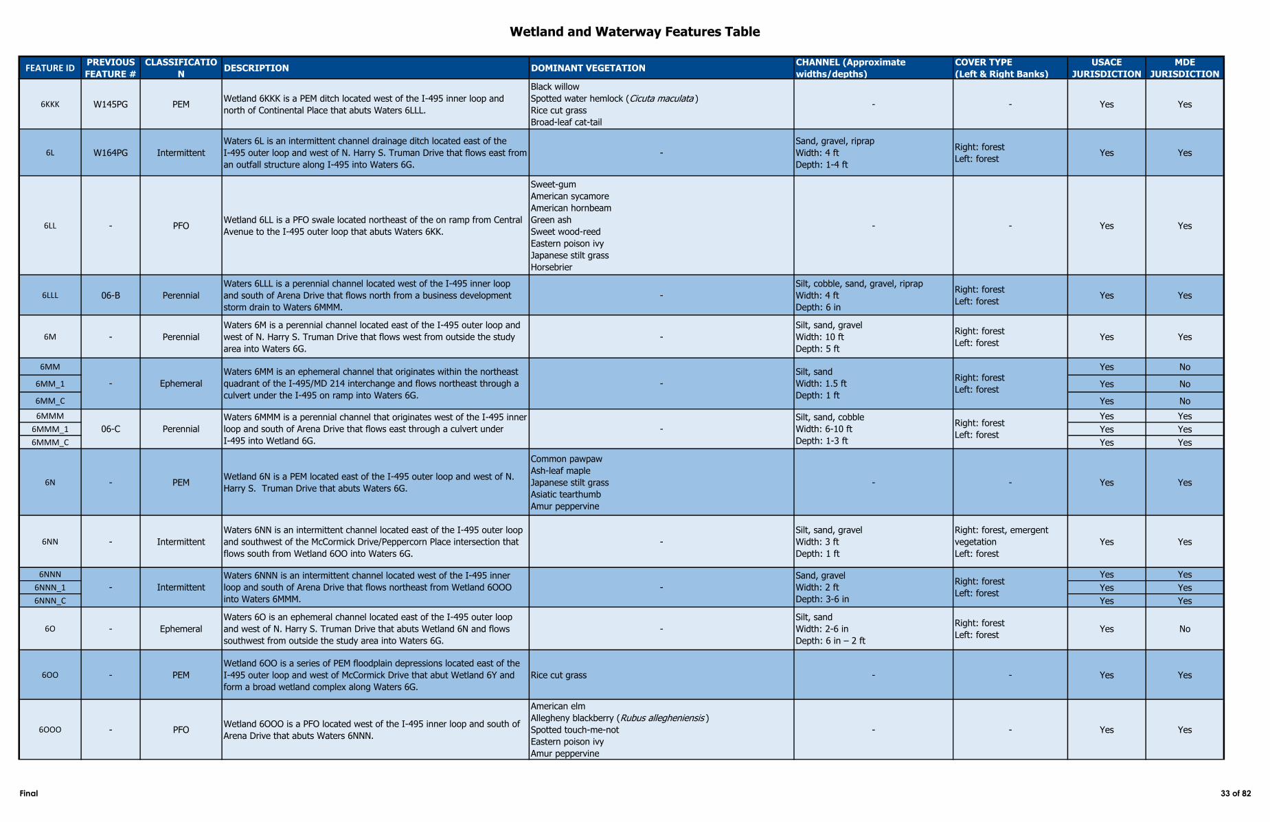
Wetland and Waterway Features Table
FEATURE IDPREVIOUS
FEATURE #
CLASSIFICATIO
NDESCRIPTION DOMINANT VEGETATION
CHANNEL (Approximate
widths/depths)
COVER TYPE
(Left & Right Banks)
USACE
JURISDICTION
MDE
JURISDICTION
6KKK W145PG PEMWetland 6KKK is a PEM ditch located west of the I‑495 inner loop and
north of Continental Place that abuts Waters 6LLL.
Black willow
Spotted water hemlock (Cicuta maculata )
Rice cut grass
Broad-leaf cat-tail
- - Yes Yes
6L W164PG Intermittent
Waters 6L is an intermittent channel drainage ditch located east of the
I‑495 outer loop and west of N. Harry S. Truman Drive that flows east from
an outfall structure along I‑495 into Waters 6G.
-
Sand, gravel, riprap
Width: 4 ft
Depth: 1-4 ft
Right: forest
Left: forestYes Yes
6LL - PFOWetland 6LL is a PFO swale located northeast of the on ramp from Central
Avenue to the I‑495 outer loop that abuts Waters 6KK.
Sweet-gum
American sycamore
American hornbeam
Green ash
Sweet wood-reed
Eastern poison ivy
Japanese stilt grass
Horsebrier
- - Yes Yes
6LLL 06-B Perennial
Waters 6LLL is a perennial channel located west of the I‑495 inner loop
and south of Arena Drive that flows north from a business development
storm drain to Waters 6MMM.
-
Silt, cobble, sand, gravel, riprap
Width: 4 ft
Depth: 6 in
Right: forest
Left: forestYes Yes
6M - Perennial
Waters 6M is a perennial channel located east of the I‑495 outer loop and
west of N. Harry S. Truman Drive that flows west from outside the study
area into Waters 6G.
-
Silt, sand, gravel
Width: 10 ft
Depth: 5 ft
Right: forest
Left: forestYes Yes
6MM Yes No
6MM_1 Yes No
6MM_C Yes No
6MMM Yes Yes
6MMM_1 Yes Yes
6MMM_C Yes Yes
6N - PEMWetland 6N is a PEM located east of the I‑495 outer loop and west of N.
Harry S. Truman Drive that abuts Waters 6G.
Common pawpaw
Ash-leaf maple
Japanese stilt grass
Asiatic tearthumb
Amur peppervine
- - Yes Yes
6NN - Intermittent
Waters 6NN is an intermittent channel located east of the I‑495 outer loop
and southwest of the McCormick Drive/Peppercorn Place intersection that
flows south from Wetland 6OO into Waters 6G.
-
Silt, sand, gravel
Width: 3 ft
Depth: 1 ft
Right: forest, emergent
vegetation
Left: forest
Yes Yes
6NNN Yes Yes
6NNN_1 Yes Yes
6NNN_C Yes Yes
6O - Ephemeral
Waters 6O is an ephemeral channel located east of the I‑495 outer loop
and west of N. Harry S. Truman Drive that abuts Wetland 6N and flows
southwest from outside the study area into Waters 6G.
-
Silt, sand
Width: 2-6 in
Depth: 6 in – 2 ft
Right: forest
Left: forestYes No
6OO - PEM
Wetland 6OO is a series of PEM floodplain depressions located east of the
I‑495 outer loop and west of McCormick Drive that abut Wetland 6Y and
form a broad wetland complex along Waters 6G.
Rice cut grass - - Yes Yes
6OOO - PFOWetland 6OOO is a PFO located west of the I‑495 inner loop and south of
Arena Drive that abuts Waters 6NNN.
American elm
Allegheny blackberry (Rubus allegheniensis )
Spotted touch-me-not
Eastern poison ivy
Amur peppervine
- - Yes Yes
Waters 6MMM is a perennial channel that originates west of the I‑495 inner
loop and south of Arena Drive that flows east through a culvert under
I‑495 into Wetland 6G.
-
Silt, sand, cobble
Width: 6-10 ft
Depth: 1-3 ft
- Ephemeral
Waters 6MM is an ephemeral channel that originates within the northeast
quadrant of the I‑495/MD 214 interchange and flows northeast through a
culvert under the I‑495 on ramp into Waters 6G.
-
Silt, sand
Width: 1.5 ft
Depth: 1 ft
Right: forest
Left: forest
Right: forest
Left: forest
- Intermittent
Waters 6NNN is an intermittent channel located west of the I‑495 inner
loop and south of Arena Drive that flows northeast from Wetland 6OOO
into Waters 6MMM.
-
Sand, gravel
Width: 2 ft
Depth: 3-6 in
Right: forest
Left: forest
06-C Perennial
Final 33 of 82
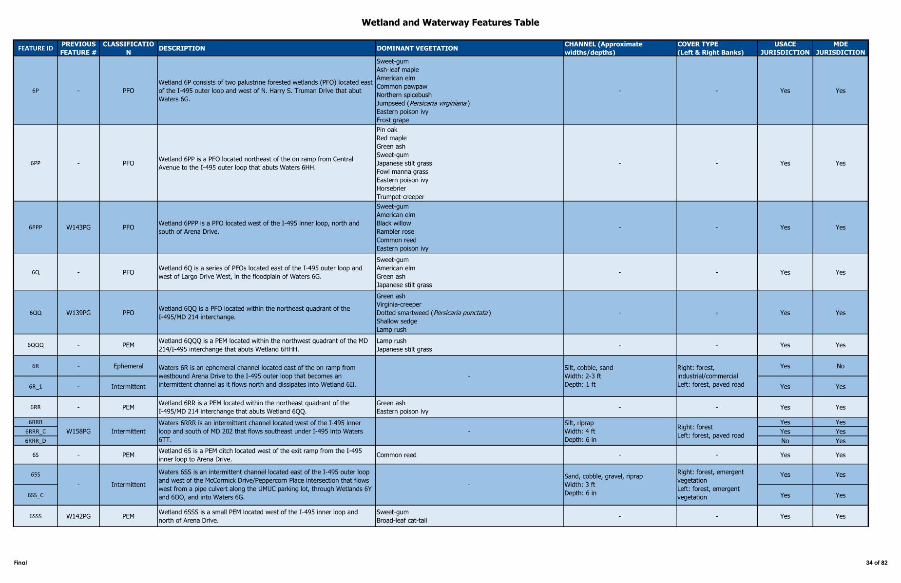
Wetland and Waterway Features Table
FEATURE IDPREVIOUS
FEATURE #
CLASSIFICATIO
NDESCRIPTION DOMINANT VEGETATION
CHANNEL (Approximate
widths/depths)
COVER TYPE
(Left & Right Banks)
USACE
JURISDICTION
MDE
JURISDICTION
6P - PFO
Wetland 6P consists of two palustrine forested wetlands (PFO) located east
of the I‑495 outer loop and west of N. Harry S. Truman Drive that abut
Waters 6G.
Sweet-gum
Ash-leaf maple
American elm
Common pawpaw
Northern spicebush
Jumpseed (Persicaria virginiana )
Eastern poison ivy
Frost grape
- - Yes Yes
6PP - PFOWetland 6PP is a PFO located northeast of the on ramp from Central
Avenue to the I‑495 outer loop that abuts Waters 6HH.
Pin oak
Red maple
Green ash
Sweet-gum
Japanese stilt grass
Fowl manna grass
Eastern poison ivy
Horsebrier
Trumpet-creeper
- - Yes Yes
6PPP W143PG PFOWetland 6PPP is a PFO located west of the I‑495 inner loop, north and
south of Arena Drive.
Sweet-gum
American elm
Black willow
Rambler rose
Common reed
Eastern poison ivy
- - Yes Yes
6Q - PFOWetland 6Q is a series of PFOs located east of the I‑495 outer loop and
west of Largo Drive West, in the floodplain of Waters 6G.
Sweet-gum
American elm
Green ash
Japanese stilt grass
- - Yes Yes
6QQ W139PG PFOWetland 6QQ is a PFO located within the northeast quadrant of the
I‑495/MD 214 interchange.
Green ash
Virginia-creeper
Dotted smartweed (Persicaria punctata )
Shallow sedge
Lamp rush
- - Yes Yes
6QQQ - PEMWetland 6QQQ is a PEM located within the northwest quadrant of the MD
214/I‑495 interchange that abuts Wetland 6HHH.
Lamp rush
Japanese stilt grass- - Yes Yes
6R - Ephemeral Yes No
6R_1 - Intermittent Yes Yes
6RR - PEMWetland 6RR is a PEM located within the northeast quadrant of the
I‑495/MD 214 interchange that abuts Wetland 6QQ.
Green ash
Eastern poison ivy- - Yes Yes
6RRR Yes Yes
6RRR_C Yes Yes
6RRR_D No Yes
6S - PEMWetland 6S is a PEM ditch located west of the exit ramp from the I‑495
inner loop to Arena Drive.Common reed - - Yes Yes
6SS Yes Yes
6SS_C Yes Yes
6SSS W142PG PEMWetland 6SSS is a small PEM located west of the I‑495 inner loop and
north of Arena Drive.
Sweet-gum
Broad-leaf cat-tail- - Yes Yes
- Intermittent
Waters 6SS is an intermittent channel located east of the I‑495 outer loop
and west of the McCormick Drive/Peppercorn Place intersection that flows
west from a pipe culvert along the UMUC parking lot, through Wetlands 6Y
and 6OO, and into Waters 6G.
Waters 6R is an ephemeral channel located east of the on ramp from
westbound Arena Drive to the I‑495 outer loop that becomes an
intermittent channel as it flows north and dissipates into Wetland 6II.
-
Silt, cobble, sand
Width: 2-3 ft
Depth: 1 ft
Right: forest,
industrial/commercial
Left: forest, paved road
W158PG Intermittent
Waters 6RRR is an intermittent channel located west of the I‑495 inner
loop and south of MD 202 that flows southeast under I‑495 into Waters
6TT.
-
Silt, riprap
Width: 4 ft
Depth: 6 in
Right: forest
Left: forest, paved road
-
Sand, cobble, gravel, riprap
Width: 3 ft
Depth: 6 in
Right: forest, emergent
vegetation
Left: forest, emergent
vegetation
Final 34 of 82
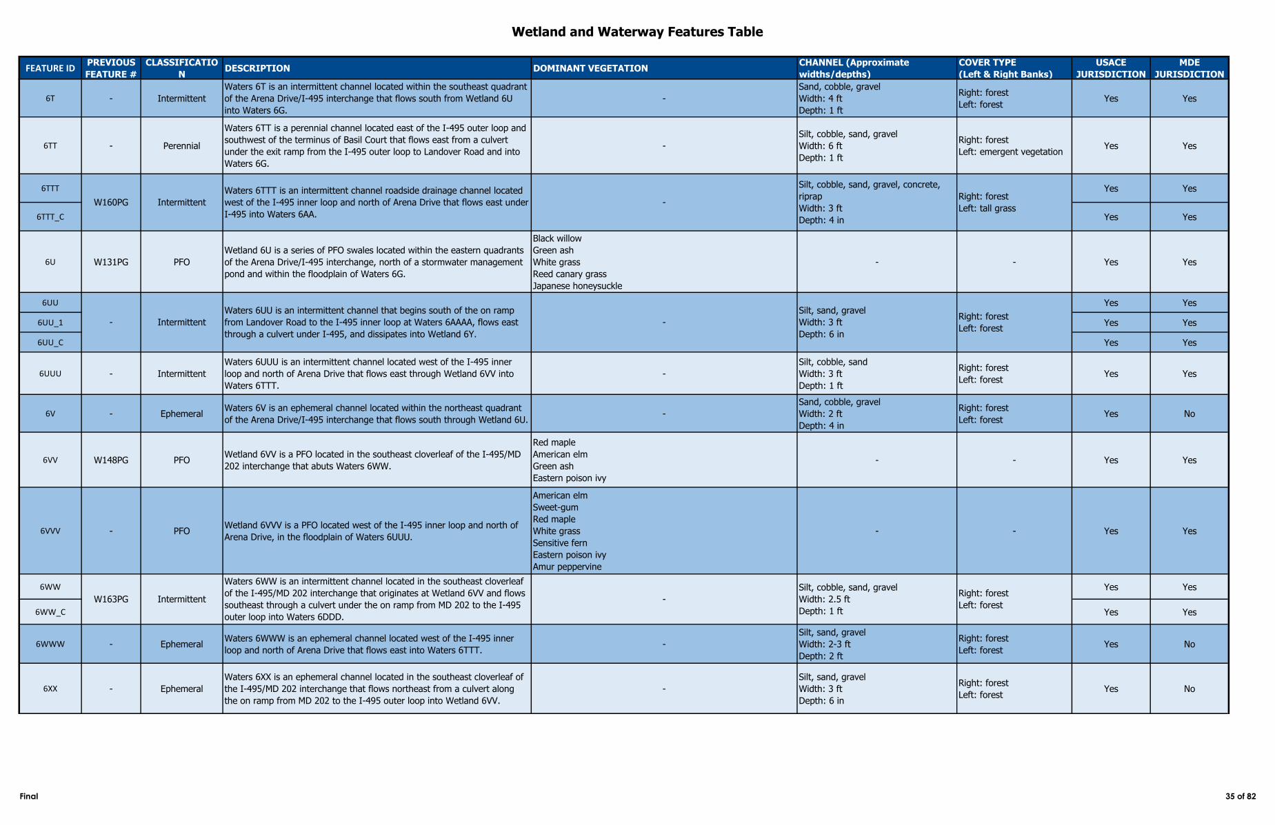
Wetland and Waterway Features Table
FEATURE IDPREVIOUS
FEATURE #
CLASSIFICATIO
NDESCRIPTION DOMINANT VEGETATION
CHANNEL (Approximate
widths/depths)
COVER TYPE
(Left & Right Banks)
USACE
JURISDICTION
MDE
JURISDICTION
6T - Intermittent
Waters 6T is an intermittent channel located within the southeast quadrant
of the Arena Drive/I‑495 interchange that flows south from Wetland 6U
into Waters 6G.
-
Sand, cobble, gravel
Width: 4 ft
Depth: 1 ft
Right: forest
Left: forestYes Yes
6TT - Perennial
Waters 6TT is a perennial channel located east of the I‑495 outer loop and
southwest of the terminus of Basil Court that flows east from a culvert
under the exit ramp from the I‑495 outer loop to Landover Road and into
Waters 6G.
-
Silt, cobble, sand, gravel
Width: 6 ft
Depth: 1 ft
Right: forest
Left: emergent vegetationYes Yes
6TTT Yes Yes
6TTT_C Yes Yes
6U W131PG PFO
Wetland 6U is a series of PFO swales located within the eastern quadrants
of the Arena Drive/I‑495 interchange, north of a stormwater management
pond and within the floodplain of Waters 6G.
Black willow
Green ash
White grass
Reed canary grass
Japanese honeysuckle
- - Yes Yes
6UU Yes Yes
6UU_1 Yes Yes
6UU_C Yes Yes
6UUU - Intermittent
Waters 6UUU is an intermittent channel located west of the I‑495 inner
loop and north of Arena Drive that flows east through Wetland 6VV into
Waters 6TTT.
-
Silt, cobble, sand
Width: 3 ft
Depth: 1 ft
Right: forest
Left: forestYes Yes
6V - EphemeralWaters 6V is an ephemeral channel located within the northeast quadrant
of the Arena Drive/I‑495 interchange that flows south through Wetland 6U. -
Sand, cobble, gravel
Width: 2 ft
Depth: 4 in
Right: forest
Left: forestYes No
6VV W148PG PFOWetland 6VV is a PFO located in the southeast cloverleaf of the I‑495/MD
202 interchange that abuts Waters 6WW.
Red maple
American elm
Green ash
Eastern poison ivy
- - Yes Yes
6VVV - PFOWetland 6VVV is a PFO located west of the I‑495 inner loop and north of
Arena Drive, in the floodplain of Waters 6UUU.
American elm
Sweet-gum
Red maple
White grass
Sensitive fern
Eastern poison ivy
Amur peppervine
- - Yes Yes
6WW Yes Yes
6WW_C Yes Yes
6WWW - EphemeralWaters 6WWW is an ephemeral channel located west of the I‑495 inner
loop and north of Arena Drive that flows east into Waters 6TTT.-
Silt, sand, gravel
Width: 2-3 ft
Depth: 2 ft
Right: forest
Left: forestYes No
6XX - Ephemeral
Waters 6XX is an ephemeral channel located in the southeast cloverleaf of
the I‑495/MD 202 interchange that flows northeast from a culvert along
the on ramp from MD 202 to the I‑495 outer loop into Wetland 6VV.
-
Silt, sand, gravel
Width: 3 ft
Depth: 6 in
Right: forest
Left: forestYes No
Waters 6TTT is an intermittent channel roadside drainage channel located
west of the I‑495 inner loop and north of Arena Drive that flows east under
I‑495 into Waters 6AA.
-
Silt, cobble, sand, gravel, concrete,
riprap
Width: 3 ft
Depth: 4 in
Right: forest
Left: forest
W160PG
Intermittent
Waters 6WW is an intermittent channel located in the southeast cloverleaf
of the I‑495/MD 202 interchange that originates at Wetland 6VV and flows
southeast through a culvert under the on ramp from MD 202 to the I‑495
outer loop into Waters 6DDD.
-
Silt, cobble, sand, gravel
Width: 2.5 ft
Depth: 1 ft
Right: forest
Left: forest
Intermittent
- Intermittent
Waters 6UU is an intermittent channel that begins south of the on ramp
from Landover Road to the I‑495 inner loop at Waters 6AAAA, flows east
through a culvert under I‑495, and dissipates into Wetland 6Y.
Right: forest
Left: tall grass
-
Silt, sand, gravel
Width: 3 ft
Depth: 6 in
W163PG
Final 35 of 82
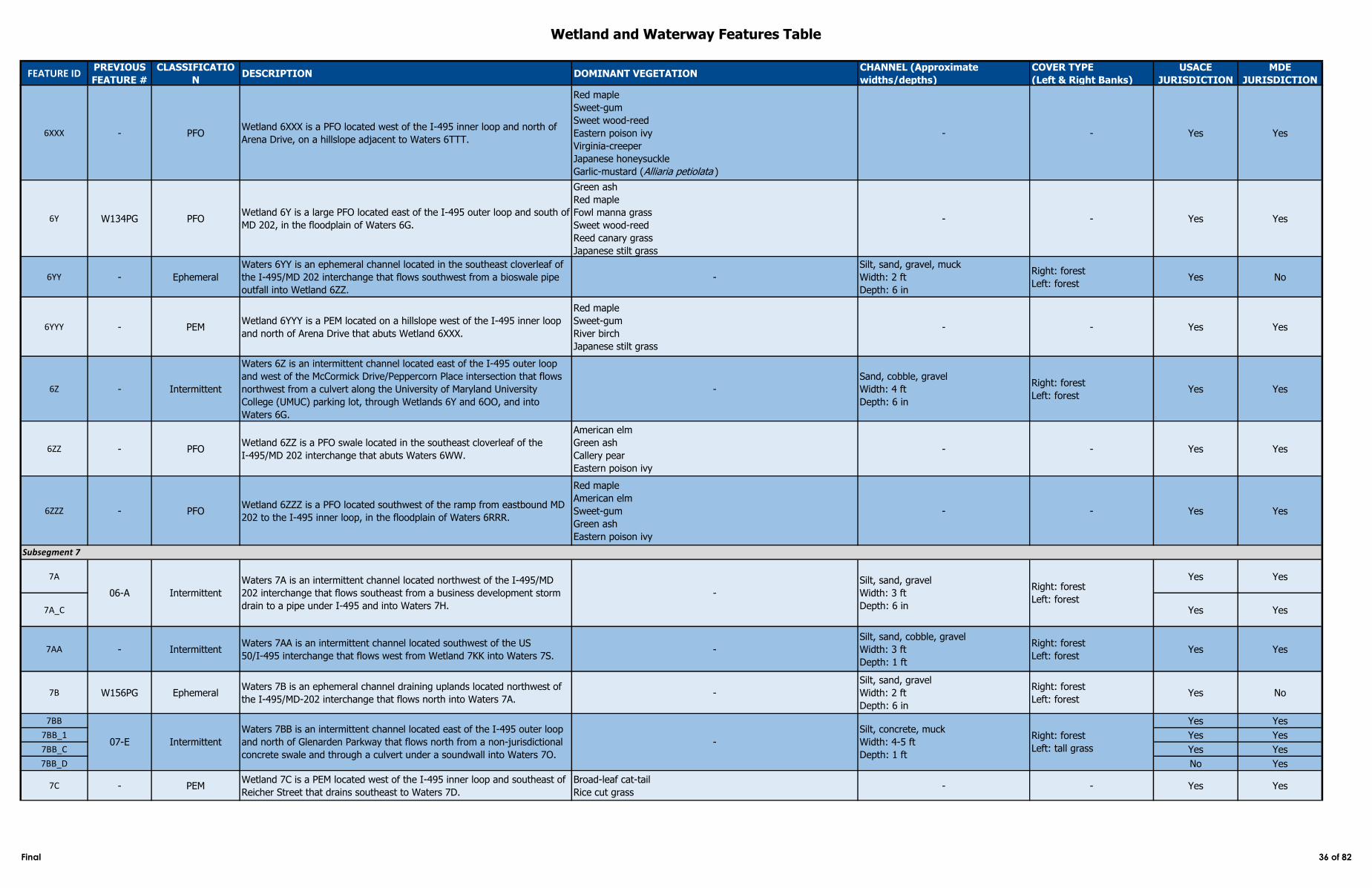
Wetland and Waterway Features Table
FEATURE IDPREVIOUS
FEATURE #
CLASSIFICATIO
NDESCRIPTION DOMINANT VEGETATION
CHANNEL (Approximate
widths/depths)
COVER TYPE
(Left & Right Banks)
USACE
JURISDICTION
MDE
JURISDICTION
6XXX - PFOWetland 6XXX is a PFO located west of the I‑495 inner loop and north of
Arena Drive, on a hillslope adjacent to Waters 6TTT.
Red maple
Sweet-gum
Sweet wood-reed
Eastern poison ivy
Virginia-creeper
Japanese honeysuckle
Garlic-mustard (Alliaria petiolata )
- - Yes Yes
6Y W134PG PFOWetland 6Y is a large PFO located east of the I‑495 outer loop and south of
MD 202, in the floodplain of Waters 6G.
Green ash
Red maple
Fowl manna grass
Sweet wood-reed
Reed canary grass
Japanese stilt grass
- - Yes Yes
6YY - Ephemeral
Waters 6YY is an ephemeral channel located in the southeast cloverleaf of
the I‑495/MD 202 interchange that flows southwest from a bioswale pipe
outfall into Wetland 6ZZ.
-
Silt, sand, gravel, muck
Width: 2 ft
Depth: 6 in
Right: forest
Left: forestYes No
6YYY - PEMWetland 6YYY is a PEM located on a hillslope west of the I‑495 inner loop
and north of Arena Drive that abuts Wetland 6XXX.
Red maple
Sweet-gum
River birch
Japanese stilt grass
- - Yes Yes
6Z - Intermittent
Waters 6Z is an intermittent channel located east of the I‑495 outer loop
and west of the McCormick Drive/Peppercorn Place intersection that flows
northwest from a culvert along the University of Maryland University
College (UMUC) parking lot, through Wetlands 6Y and 6OO, and into
Waters 6G.
-
Sand, cobble, gravel
Width: 4 ft
Depth: 6 in
Right: forest
Left: forestYes Yes
6ZZ - PFOWetland 6ZZ is a PFO swale located in the southeast cloverleaf of the
I‑495/MD 202 interchange that abuts Waters 6WW.
American elm
Green ash
Callery pear
Eastern poison ivy
- - Yes Yes
6ZZZ - PFOWetland 6ZZZ is a PFO located southwest of the ramp from eastbound MD
202 to the I‑495 inner loop, in the floodplain of Waters 6RRR.
Red maple
American elm
Sweet-gum
Green ash
Eastern poison ivy
- - Yes Yes
7A Yes Yes
7A_C Yes Yes
7AA - IntermittentWaters 7AA is an intermittent channel located southwest of the US
50/I‑495 interchange that flows west from Wetland 7KK into Waters 7S. -
Silt, sand, cobble, gravel
Width: 3 ft
Depth: 1 ft
Right: forest
Left: forestYes Yes
7B W156PG EphemeralWaters 7B is an ephemeral channel draining uplands located northwest of
the I‑495/MD-202 interchange that flows north into Waters 7A. -
Silt, sand, gravel
Width: 2 ft
Depth: 6 in
Right: forest
Left: forestYes No
7BB Yes Yes
7BB_1 Yes Yes
7BB_C Yes Yes
7BB_D No Yes
7C - PEMWetland 7C is a PEM located west of the I‑495 inner loop and southeast of
Reicher Street that drains southeast to Waters 7D.
Broad-leaf cat-tail
Rice cut grass- - Yes Yes
Intermittent
Waters 7A is an intermittent channel located northwest of the I‑495/MD
202 interchange that flows southeast from a business development storm
drain to a pipe under I‑495 and into Waters 7H.
-
Silt, sand, gravel
Width: 3 ft
Depth: 6 in
Right: forest
Left: forest06-A
Subsegment 7
07-E Intermittent
Waters 7BB is an intermittent channel located east of the I‑495 outer loop
and north of Glenarden Parkway that flows north from a non-jurisdictional
concrete swale and through a culvert under a soundwall into Waters 7O.
-
Silt, concrete, muck
Width: 4-5 ft
Depth: 1 ft
Right: forest
Left: tall grass
Final 36 of 82
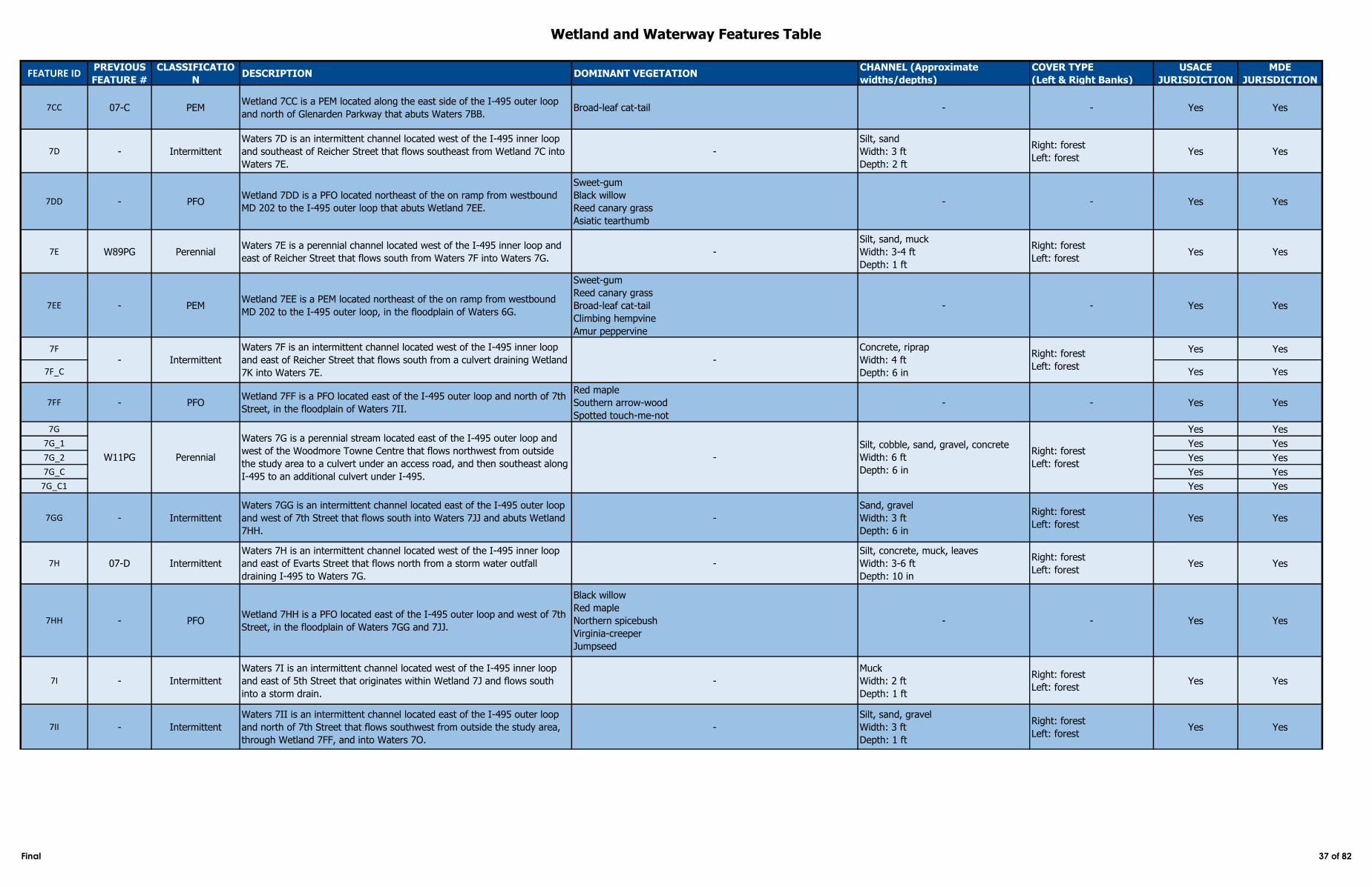
Wetland and Waterway Features Table
FEATURE IDPREVIOUS
FEATURE #
CLASSIFICATIO
NDESCRIPTION DOMINANT VEGETATION
CHANNEL (Approximate
widths/depths)
COVER TYPE
(Left & Right Banks)
USACE
JURISDICTION
MDE
JURISDICTION
7CC 07-C PEMWetland 7CC is a PEM located along the east side of the I‑495 outer loop
and north of Glenarden Parkway that abuts Waters 7BB. Broad-leaf cat-tail - - Yes Yes
7D - Intermittent
Waters 7D is an intermittent channel located west of the I‑495 inner loop
and southeast of Reicher Street that flows southeast from Wetland 7C into
Waters 7E.
-
Silt, sand
Width: 3 ft
Depth: 2 ft
Right: forest
Left: forestYes Yes
7DD - PFOWetland 7DD is a PFO located northeast of the on ramp from westbound
MD 202 to the I‑495 outer loop that abuts Wetland 7EE.
Sweet-gum
Black willow
Reed canary grass
Asiatic tearthumb
- - Yes Yes
7E W89PG PerennialWaters 7E is a perennial channel located west of the I‑495 inner loop and
east of Reicher Street that flows south from Waters 7F into Waters 7G. -
Silt, sand, muck
Width: 3-4 ft
Depth: 1 ft
Right: forest
Left: forestYes Yes
7EE - PEMWetland 7EE is a PEM located northeast of the on ramp from westbound
MD 202 to the I‑495 outer loop, in the floodplain of Waters 6G.
Sweet-gum
Reed canary grass
Broad-leaf cat-tail
Climbing hempvine
Amur peppervine
- - Yes Yes
7F Yes Yes
7F_C Yes Yes
7FF - PFOWetland 7FF is a PFO located east of the I‑495 outer loop and north of 7th
Street, in the floodplain of Waters 7II.
Red maple
Southern arrow-wood
Spotted touch-me-not
- - Yes Yes
7G Yes Yes
7G_1 Yes Yes
7G_2 Yes Yes
7G_C Yes Yes
7G_C1 Yes Yes
7GG - Intermittent
Waters 7GG is an intermittent channel located east of the I‑495 outer loop
and west of 7th Street that flows south into Waters 7JJ and abuts Wetland
7HH.
-
Sand, gravel
Width: 3 ft
Depth: 6 in
Right: forest
Left: forestYes Yes
7H 07-D Intermittent
Waters 7H is an intermittent channel located west of the I‑495 inner loop
and east of Evarts Street that flows north from a storm water outfall
draining I‑495 to Waters 7G.
-
Silt, concrete, muck, leaves
Width: 3-6 ft
Depth: 10 in
Right: forest
Left: forestYes Yes
7HH - PFOWetland 7HH is a PFO located east of the I‑495 outer loop and west of 7th
Street, in the floodplain of Waters 7GG and 7JJ.
Black willow
Red maple
Northern spicebush
Virginia-creeper
Jumpseed
- - Yes Yes
7I - Intermittent
Waters 7I is an intermittent channel located west of the I‑495 inner loop
and east of 5th Street that originates within Wetland 7J and flows south
into a storm drain.
-
Muck
Width: 2 ft
Depth: 1 ft
Right: forest
Left: forestYes Yes
7II - Intermittent
Waters 7II is an intermittent channel located east of the I‑495 outer loop
and north of 7th Street that flows southwest from outside the study area,
through Wetland 7FF, and into Waters 7O.
-
Silt, sand, gravel
Width: 3 ft
Depth: 1 ft
Right: forest
Left: forestYes Yes
-
Concrete, riprap
Width: 4 ft
Depth: 6 in
Right: forest
Left: forest
W11PG Perennial
Waters 7G is a perennial stream located east of the I-495 outer loop and
west of the Woodmore Towne Centre that flows northwest from outside
the study area to a culvert under an access road, and then southeast along
I‑495 to an additional culvert under I‑495.
-
Silt, cobble, sand, gravel, concrete
Width: 6 ft
Depth: 6 in
Right: forest
Left: forest
- Intermittent
Waters 7F is an intermittent channel located west of the I‑495 inner loop
and east of Reicher Street that flows south from a culvert draining Wetland
7K into Waters 7E.
Final 37 of 82
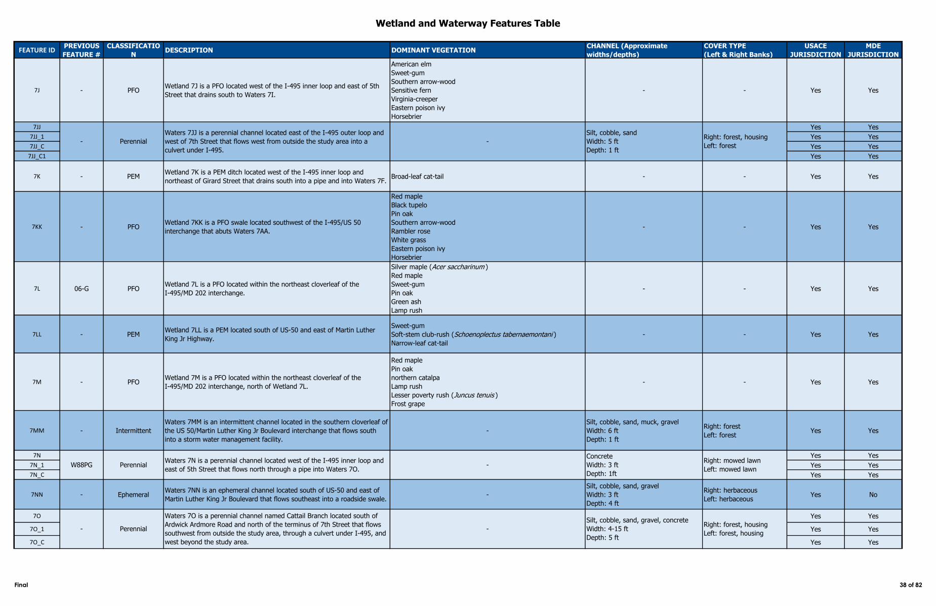
Wetland and Waterway Features Table
FEATURE IDPREVIOUS
FEATURE #
CLASSIFICATIO
NDESCRIPTION DOMINANT VEGETATION
CHANNEL (Approximate
widths/depths)
COVER TYPE
(Left & Right Banks)
USACE
JURISDICTION
MDE
JURISDICTION
7J - PFOWetland 7J is a PFO located west of the I‑495 inner loop and east of 5th
Street that drains south to Waters 7I.
American elm
Sweet-gum
Southern arrow-wood
Sensitive fern
Virginia-creeper
Eastern poison ivy
Horsebrier
- - Yes Yes
7JJ Yes Yes
7JJ_1 Yes Yes
7JJ_C Yes Yes
7JJ_C1 Yes Yes
7K - PEMWetland 7K is a PEM ditch located west of the I‑495 inner loop and
northeast of Girard Street that drains south into a pipe and into Waters 7F. Broad-leaf cat-tail - - Yes Yes
7KK - PFOWetland 7KK is a PFO swale located southwest of the I‑495/US 50
interchange that abuts Waters 7AA.
Red maple
Black tupelo
Pin oak
Southern arrow-wood
Rambler rose
White grass
Eastern poison ivy
Horsebrier
- - Yes Yes
7L 06-G PFOWetland 7L is a PFO located within the northeast cloverleaf of the
I‑495/MD 202 interchange.
Silver maple (Acer saccharinum )
Red maple
Sweet-gum
Pin oak
Green ash
Lamp rush
- - Yes Yes
7LL - PEMWetland 7LL is a PEM located south of US-50 and east of Martin Luther
King Jr Highway.
Sweet-gum
Soft-stem club-rush (Schoenoplectus tabernaemontani )
Narrow-leaf cat-tail
- - Yes Yes
7M - PFOWetland 7M is a PFO located within the northeast cloverleaf of the
I‑495/MD 202 interchange, north of Wetland 7L.
Red maple
Pin oak
northern catalpa
Lamp rush
Lesser poverty rush (Juncus tenuis )
Frost grape
- - Yes Yes
7MM - Intermittent
Waters 7MM is an intermittent channel located in the southern cloverleaf of
the US 50/Martin Luther King Jr Boulevard interchange that flows south
into a storm water management facility.
-
Silt, cobble, sand, muck, gravel
Width: 6 ft
Depth: 1 ft
Right: forest
Left: forestYes Yes
7N Yes Yes
7N_1 Yes Yes
7N_C Yes Yes
7NN - EphemeralWaters 7NN is an ephemeral channel located south of US-50 and east of
Martin Luther King Jr Boulevard that flows southeast into a roadside swale. -
Silt, cobble, sand, gravel
Width: 3 ft
Depth: 4 ft
Right: herbaceous
Left: herbaceousYes No
7O Yes Yes
7O_1 Yes Yes
7O_C Yes Yes
Waters 7O is a perennial channel named Cattail Branch located south of
Ardwick Ardmore Road and north of the terminus of 7th Street that flows
southwest from outside the study area, through a culvert under I‑495, and
west beyond the study area.
-
Silt, cobble, sand, gravel, concrete
Width: 4-15 ft
Depth: 5 ft
Right: forest, housing
Left: forest, housingPerennial-
Right: mowed lawn
Left: mowed lawnW88PG Perennial
Waters 7N is a perennial channel located west of the I‑495 inner loop and
east of 5th Street that flows north through a pipe into Waters 7O. -
Concrete
Width: 3 ft
Depth: 1ft
- Perennial
Waters 7JJ is a perennial channel located east of the I‑495 outer loop and
west of 7th Street that flows west from outside the study area into a
culvert under I‑495.
-
Silt, cobble, sand
Width: 5 ft
Depth: 1 ft
Right: forest, housing
Left: forest
Final 38 of 82
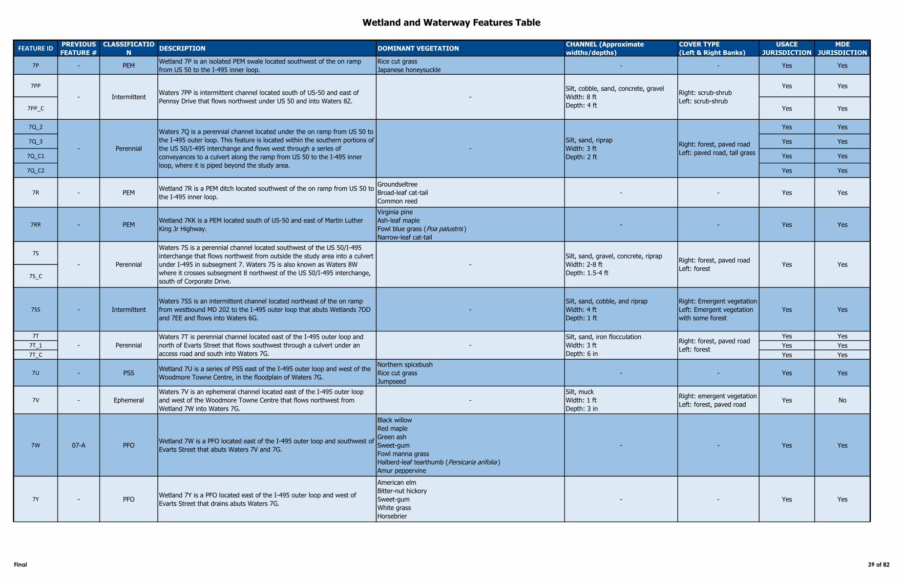
Wetland and Waterway Features Table
FEATURE IDPREVIOUS
FEATURE #
CLASSIFICATIO
NDESCRIPTION DOMINANT VEGETATION
CHANNEL (Approximate
widths/depths)
COVER TYPE
(Left & Right Banks)
USACE
JURISDICTION
MDE
JURISDICTION
7P - PEMWetland 7P is an isolated PEM swale located southwest of the on ramp
from US 50 to the I‑495 inner loop.
Rice cut grass
Japanese honeysuckle- - Yes Yes
7PP Yes Yes
7PP_C Yes Yes
7Q_2 Yes Yes
7Q_3 Yes Yes
7Q_C1 Yes Yes
7Q_C2 Yes Yes
7R - PEMWetland 7R is a PEM ditch located southwest of the on ramp from US 50 to
the I‑495 inner loop.
Groundseltree
Broad-leaf cat-tail
Common reed
- - Yes Yes
7RR - PEMWetland 7KK is a PEM located south of US-50 and east of Martin Luther
King Jr Highway.
Virginia pine
Ash-leaf maple
Fowl blue grass (Poa palustris )
Narrow-leaf cat-tail
- - Yes Yes
7S
7S_C
7SS - Intermittent
Waters 7SS is an intermittent channel located northeast of the on ramp
from westbound MD 202 to the I-495 outer loop that abuts Wetlands 7DD
and 7EE and flows into Waters 6G.
-
Silt, sand, cobble, and riprap
Width: 4 ft
Depth: 1 ft
Right: Emergent vegetation
Left: Emergent vegetation
with some forest
Yes Yes
7T Yes Yes
7T_1 Yes Yes
7T_C Yes Yes
7U - PSSWetland 7U is a series of PSS east of the I‑495 outer loop and west of the
Woodmore Towne Centre, in the floodplain of Waters 7G.
Northern spicebush
Rice cut grass
Jumpseed
- - Yes Yes
7V - Ephemeral
Waters 7V is an ephemeral channel located east of the I‑495 outer loop
and west of the Woodmore Towne Centre that flows northwest from
Wetland 7W into Waters 7G.
-
Silt, muck
Width: 1 ft
Depth: 3 in
Right: emergent vegetation
Left: forest, paved roadYes No
7W 07-A PFOWetland 7W is a PFO located east of the I‑495 outer loop and southwest of
Evarts Street that abuts Waters 7V and 7G.
Black willow
Red maple
Green ash
Sweet-gum
Fowl manna grass
Halberd-leaf tearthumb (Persicaria arifolia )
Amur peppervine
- - Yes Yes
7Y - PFOWetland 7Y is a PFO located east of the I‑495 outer loop and west of
Evarts Street that drains abuts Waters 7G.
American elm
Bitter-nut hickory
Sweet-gum
White grass
Horsebrier
- - Yes Yes
- Perennial
Waters 7S is a perennial channel located southwest of the US 50/I‑495
interchange that flows northwest from outside the study area into a culvert
under I‑495 in subsegment 7. Waters 7S is also known as Waters 8W
where it crosses subsegment 8 northwest of the US 50/I-495 interchange,
south of Corporate Drive.
-
Silt, sand, gravel, concrete, riprap
Width: 2-8 ft
Depth: 1.5-4 ft
Right: forest, paved road
Left: forestYes Yes
- IntermittentWaters 7PP is intermittent channel located south of US-50 and east of
Pennsy Drive that flows northwest under US 50 and into Waters 8Z. -
Silt, cobble, sand, concrete, gravel
Width: 8 ft
Depth: 4 ft
Right: scrub-shrub
Left: scrub-shrub
- Perennial
Waters 7T is perennial channel located east of the I‑495 outer loop and
north of Evarts Street that flows southwest through a culvert under an
access road and south into Waters 7G.
-
Silt, sand, iron flocculation
Width: 3 ft
Depth: 6 in
Right: forest, paved road
Left: forest
- Perennial
Waters 7Q is a perennial channel located under the on ramp from US 50 to
the I‑495 outer loop. This feature is located within the southern portions of
the US 50/I‑495 interchange and flows west through a series of
conveyances to a culvert along the ramp from US 50 to the I‑495 inner
loop, where it is piped beyond the study area.
-
Silt, sand, riprap
Width: 3 ft
Depth: 2 ft
Right: forest, paved road
Left: paved road, tall grass
Final 39 of 82
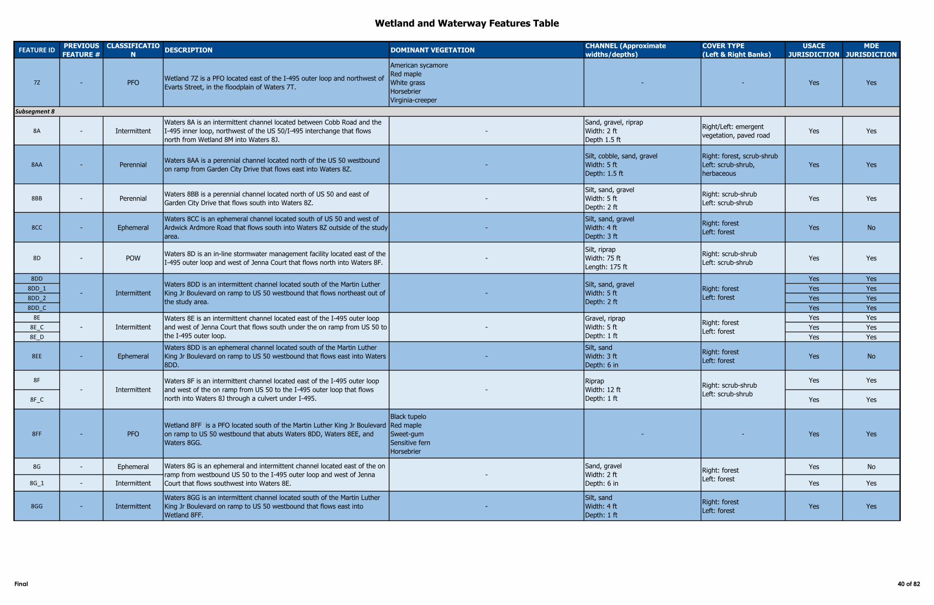
Wetland and Waterway Features Table
FEATURE IDPREVIOUS
FEATURE #
CLASSIFICATIO
NDESCRIPTION DOMINANT VEGETATION
CHANNEL (Approximate
widths/depths)
COVER TYPE
(Left & Right Banks)
USACE
JURISDICTION
MDE
JURISDICTION
7Z - PFOWetland 7Z is a PFO located east of the I‑495 outer loop and northwest of
Evarts Street, in the floodplain of Waters 7T.
American sycamore
Red maple
White grass
Horsebrier
Virginia-creeper
- - Yes Yes
8A - Intermittent
Waters 8A is an intermittent channel located between Cobb Road and the
I‑495 inner loop, northwest of the US 50/I-495 interchange that flows
north from Wetland 8M into Waters 8J.
-
Sand, gravel, riprap
Width: 2 ft
Depth 1.5 ft
Right/Left: emergent
vegetation, paved roadYes Yes
8AA - PerennialWaters 8AA is a perennial channel located north of the US 50 westbound
on ramp from Garden City Drive that flows east into Waters 8Z. -
Silt, cobble, sand, gravel
Width: 5 ft
Depth: 1.5 ft
Right: forest, scrub-shrub
Left: scrub-shrub,
herbaceous
Yes Yes
8BB - PerennialWaters 8BB is a perennial channel located north of US 50 and east of
Garden City Drive that flows south into Waters 8Z. -
Silt, sand, gravel
Width: 5 ft
Depth: 2 ft
Right: scrub-shrub
Left: scrub-shrubYes Yes
8CC - Ephemeral
Waters 8CC is an ephemeral channel located south of US 50 and west of
Ardwick Ardmore Road that flows south into Waters 8Z outside of the study
area.
-
Silt, sand, gravel
Width: 4 ft
Depth: 3 ft
Right: forest
Left: forestYes No
8D - POWWaters 8D is an in-line stormwater management facility located east of the
I-495 outer loop and west of Jenna Court that flows north into Waters 8F.-
Silt, riprap
Width: 75 ft
Length: 175 ft
Right: scrub-shrub
Left: scrub-shrubYes Yes
8DD Yes Yes
8DD_1 Yes Yes
8DD_2 Yes Yes
8DD_C Yes Yes
8E Yes Yes
8E_C Yes Yes
8E_D Yes Yes
8EE - Ephemeral
Waters 8DD is an ephemeral channel located south of the Martin Luther
King Jr Boulevard on ramp to US 50 westbound that flows east into Waters
8DD.
-
Silt, sand
Width: 3 ft
Depth: 6 in
Right: forest
Left: forestYes No
8F Yes Yes
8F_C Yes Yes
8FF - PFO
Wetland 8FF is a PFO located south of the Martin Luther King Jr Boulevard
on ramp to US 50 westbound that abuts Waters 8DD, Waters 8EE, and
Waters 8GG.
Black tupelo
Red maple
Sweet-gum
Sensitive fern
Horsebrier
- - Yes Yes
8G - Ephemeral Yes No
8G_1 - Intermittent Yes Yes
8GG - Intermittent
Waters 8GG is an intermittent channel located south of the Martin Luther
King Jr Boulevard on ramp to US 50 westbound that flows east into
Wetland 8FF.
-
Silt, sand
Width: 4 ft
Depth: 1 ft
Right: forest
Left: forestYes Yes
Gravel, riprap
Width: 5 ft
Depth: 1 ft
Right: forest
Left: forest
- Intermittent
Waters 8F is an intermittent channel located east of the I‑495 outer loop
and west of the on ramp from US 50 to the I‑495 outer loop that flows
north into Waters 8J through a culvert under I‑495.
-
Riprap
Width: 12 ft
Depth: 1 ft
Right: scrub-shrub
Left: scrub-shrub
Waters 8G is an ephemeral and intermittent channel located east of the on
ramp from westbound US 50 to the I‑495 outer loop and west of Jenna
Court that flows southwest into Waters 8E.
-
Sand, gravel
Width: 2 ft
Depth: 6 in
Right: forest
Left: forest
Subsegment 8
- Intermittent
Waters 8DD is an intermittent channel located south of the Martin Luther
King Jr Boulevard on ramp to US 50 westbound that flows northeast out of
the study area.
-
Silt, sand, gravel
Width: 5 ft
Depth: 2 ft
Right: forest
Left: forest
- Intermittent
Waters 8E is an intermittent channel located east of the I‑495 outer loop
and west of Jenna Court that flows south under the on ramp from US 50 to
the I‑495 outer loop.
-
Final 40 of 82
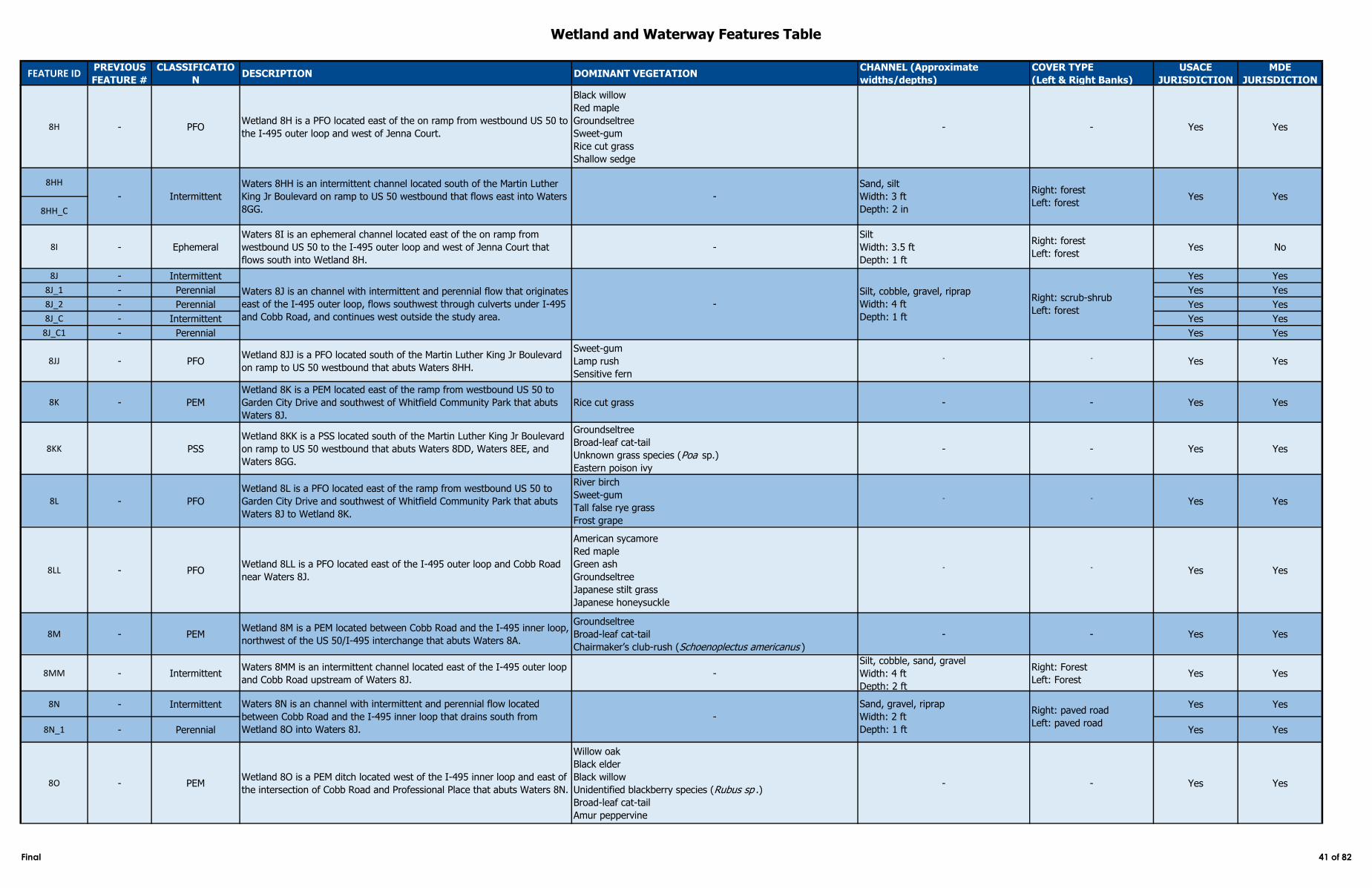
Wetland and Waterway Features Table
FEATURE IDPREVIOUS
FEATURE #
CLASSIFICATIO
NDESCRIPTION DOMINANT VEGETATION
CHANNEL (Approximate
widths/depths)
COVER TYPE
(Left & Right Banks)
USACE
JURISDICTION
MDE
JURISDICTION
8H - PFOWetland 8H is a PFO located east of the on ramp from westbound US 50 to
the I‑495 outer loop and west of Jenna Court.
Black willow
Red maple
Groundseltree
Sweet-gum
Rice cut grass
Shallow sedge
- - Yes Yes
8HH
8HH_C
8I - Ephemeral
Waters 8I is an ephemeral channel located east of the on ramp from
westbound US 50 to the I‑495 outer loop and west of Jenna Court that
flows south into Wetland 8H.
-
Silt
Width: 3.5 ft
Depth: 1 ft
Right: forest
Left: forestYes No
8J - Intermittent Yes Yes
8J_1 - Perennial Yes Yes
8J_2 - Perennial Yes Yes
8J_C - Intermittent Yes Yes
8J_C1 - Perennial Yes Yes
8JJ - PFOWetland 8JJ is a PFO located south of the Martin Luther King Jr Boulevard
on ramp to US 50 westbound that abuts Waters 8HH.
Sweet-gum
Lamp rush
Sensitive fern
- - Yes Yes
8K - PEM
Wetland 8K is a PEM located east of the ramp from westbound US 50 to
Garden City Drive and southwest of Whitfield Community Park that abuts
Waters 8J.
Rice cut grass - - Yes Yes
8KK PSS
Wetland 8KK is a PSS located south of the Martin Luther King Jr Boulevard
on ramp to US 50 westbound that abuts Waters 8DD, Waters 8EE, and
Waters 8GG.
Groundseltree
Broad-leaf cat-tail
Unknown grass species (Poa sp.)
Eastern poison ivy
- - Yes Yes
8L - PFO
Wetland 8L is a PFO located east of the ramp from westbound US 50 to
Garden City Drive and southwest of Whitfield Community Park that abuts
Waters 8J to Wetland 8K.
River birch
Sweet-gum
Tall false rye grass
Frost grape
- - Yes Yes
8LL - PFOWetland 8LL is a PFO located east of the I-495 outer loop and Cobb Road
near Waters 8J.
American sycamore
Red maple
Green ash
Groundseltree
Japanese stilt grass
Japanese honeysuckle
- - Yes Yes
8M - PEMWetland 8M is a PEM located between Cobb Road and the I‑495 inner loop,
northwest of the US 50/I-495 interchange that abuts Waters 8A.
Groundseltree
Broad-leaf cat-tail
Chairmaker’s club-rush (Schoenoplectus americanus )
- - Yes Yes
8MM - IntermittentWaters 8MM is an intermittent channel located east of the I-495 outer loop
and Cobb Road upstream of Waters 8J.-
Silt, cobble, sand, gravel
Width: 4 ft
Depth: 2 ft
Right: Forest
Left: ForestYes Yes
8N - Intermittent Yes Yes
8N_1 - Perennial Yes Yes
8O - PEMWetland 8O is a PEM ditch located west of the I‑495 inner loop and east of
the intersection of Cobb Road and Professional Place that abuts Waters 8N.
Willow oak
Black elder
Black willow
Unidentified blackberry species (Rubus sp .)
Broad-leaf cat-tail
Amur peppervine
- - Yes Yes
- Intermittent
Waters 8HH is an intermittent channel located south of the Martin Luther
King Jr Boulevard on ramp to US 50 westbound that flows east into Waters
8GG.
-
Sand, silt
Width: 3 ft
Depth: 2 in
Right: forest
Left: forestYes Yes
-
Silt, cobble, gravel, riprap
Width: 4 ft
Depth: 1 ft
Right: scrub-shrub
Left: forest
-
Sand, gravel, riprap
Width: 2 ft
Depth: 1 ft
Waters 8J is an channel with intermittent and perennial flow that originates
east of the I‑495 outer loop, flows southwest through culverts under I‑495
and Cobb Road, and continues west outside the study area.
Waters 8N is an channel with intermittent and perennial flow located
between Cobb Road and the I‑495 inner loop that drains south from
Wetland 8O into Waters 8J.
Right: paved road
Left: paved road
Final 41 of 82
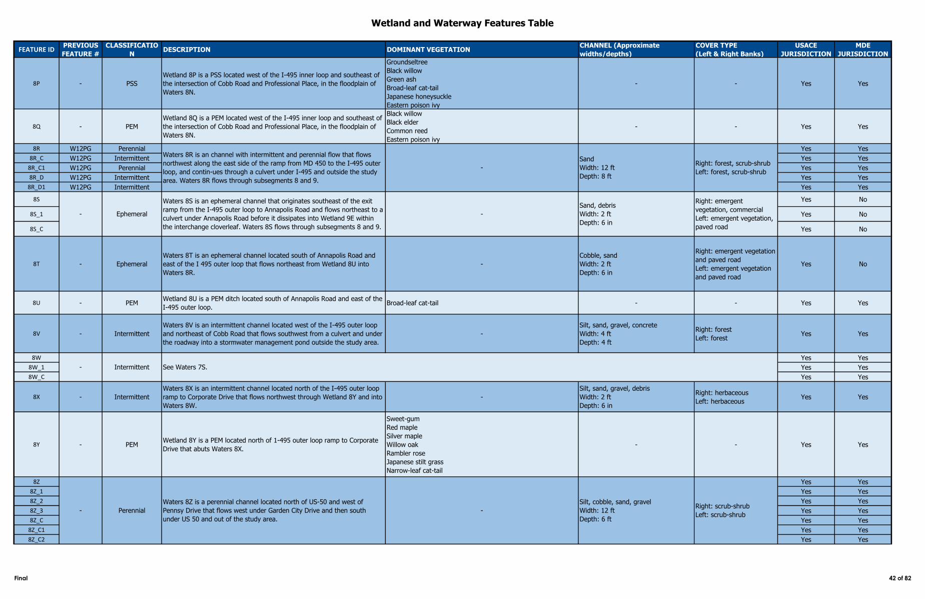
Wetland and Waterway Features Table
FEATURE IDPREVIOUS
FEATURE #
CLASSIFICATIO
NDESCRIPTION DOMINANT VEGETATION
CHANNEL (Approximate
widths/depths)
COVER TYPE
(Left & Right Banks)
USACE
JURISDICTION
MDE
JURISDICTION
8P - PSS
Wetland 8P is a PSS located west of the I‑495 inner loop and southeast of
the intersection of Cobb Road and Professional Place, in the floodplain of
Waters 8N.
Groundseltree
Black willow
Green ash
Broad-leaf cat-tail
Japanese honeysuckle
Eastern poison ivy
- - Yes Yes
8Q - PEM
Wetland 8Q is a PEM located west of the I‑495 inner loop and southeast of
the intersection of Cobb Road and Professional Place, in the floodplain of
Waters 8N.
Black willow
Black elder
Common reed
Eastern poison ivy
- - Yes Yes
8R W12PG Perennial Yes Yes
8R_C W12PG Intermittent Yes Yes
8R_C1 W12PG Perennial Yes Yes
8R_D W12PG Intermittent Yes Yes
8R_D1 W12PG Intermittent Yes Yes
8S Yes No
8S_1 Yes No
8S_C Yes No
8T - Ephemeral
Waters 8T is an ephemeral channel located south of Annapolis Road and
east of the I 495 outer loop that flows northeast from Wetland 8U into
Waters 8R.
-
Cobble, sand
Width: 2 ft
Depth: 6 in
Right: emergent vegetation
and paved road
Left: emergent vegetation
and paved road
Yes No
8U - PEMWetland 8U is a PEM ditch located south of Annapolis Road and east of the
I‑495 outer loop. Broad-leaf cat-tail - - Yes Yes
8V - Intermittent
Waters 8V is an intermittent channel located west of the I‑495 outer loop
and northeast of Cobb Road that flows southwest from a culvert and under
the roadway into a stormwater management pond outside the study area.
-
Silt, sand, gravel, concrete
Width: 4 ft
Depth: 4 ft
Right: forest
Left: forestYes Yes
8W Yes Yes
8W_1 Yes Yes
8W_C Yes Yes
8X - Intermittent
Waters 8X is an intermittent channel located north of the I-495 outer loop
ramp to Corporate Drive that flows northwest through Wetland 8Y and into
Waters 8W.
-
Silt, sand, gravel, debris
Width: 2 ft
Depth: 6 in
Right: herbaceous
Left: herbaceousYes Yes
8Y - PEMWetland 8Y is a PEM located north of 1-495 outer loop ramp to Corporate
Drive that abuts Waters 8X.
Sweet-gum
Red maple
Silver maple
Willow oak
Rambler rose
Japanese stilt grass
Narrow-leaf cat-tail
- - Yes Yes
8Z Yes Yes
8Z_1 Yes Yes
8Z_2 Yes Yes
8Z_3 Yes Yes
8Z_C Yes Yes
8Z_C1 Yes Yes
8Z_C2 Yes Yes
Waters 8R is an channel with intermittent and perennial flow that flows
northwest along the east side of the ramp from MD 450 to the I‑495 outer
loop, and contin-ues through a culvert under I‑495 and outside the study
area. Waters 8R flows through subsegments 8 and 9.
Sand, debris
Width: 2 ft
Depth: 6 in
Right: emergent
vegetation, commercial
Left: emergent vegetation,
paved road
- Intermittent See Waters 7S.
- Perennial
Waters 8Z is a perennial channel located north of US-50 and west of
Pennsy Drive that flows west under Garden City Drive and then south
under US 50 and out of the study area.
-
Silt, cobble, sand, gravel
Width: 12 ft
Depth: 6 ft
Right: scrub-shrub
Left: scrub-shrub
-
Sand
Width: 12 ft
Depth: 8 ft
Right: forest, scrub-shrub
Left: forest, scrub-shrub
-- Ephemeral
Waters 8S is an ephemeral channel that originates southeast of the exit
ramp from the I‑495 outer loop to Annapolis Road and flows northeast to a
culvert under Annapolis Road before it dissipates into Wetland 9E within
the interchange cloverleaf. Waters 8S flows through subsegments 8 and 9.
Final 42 of 82
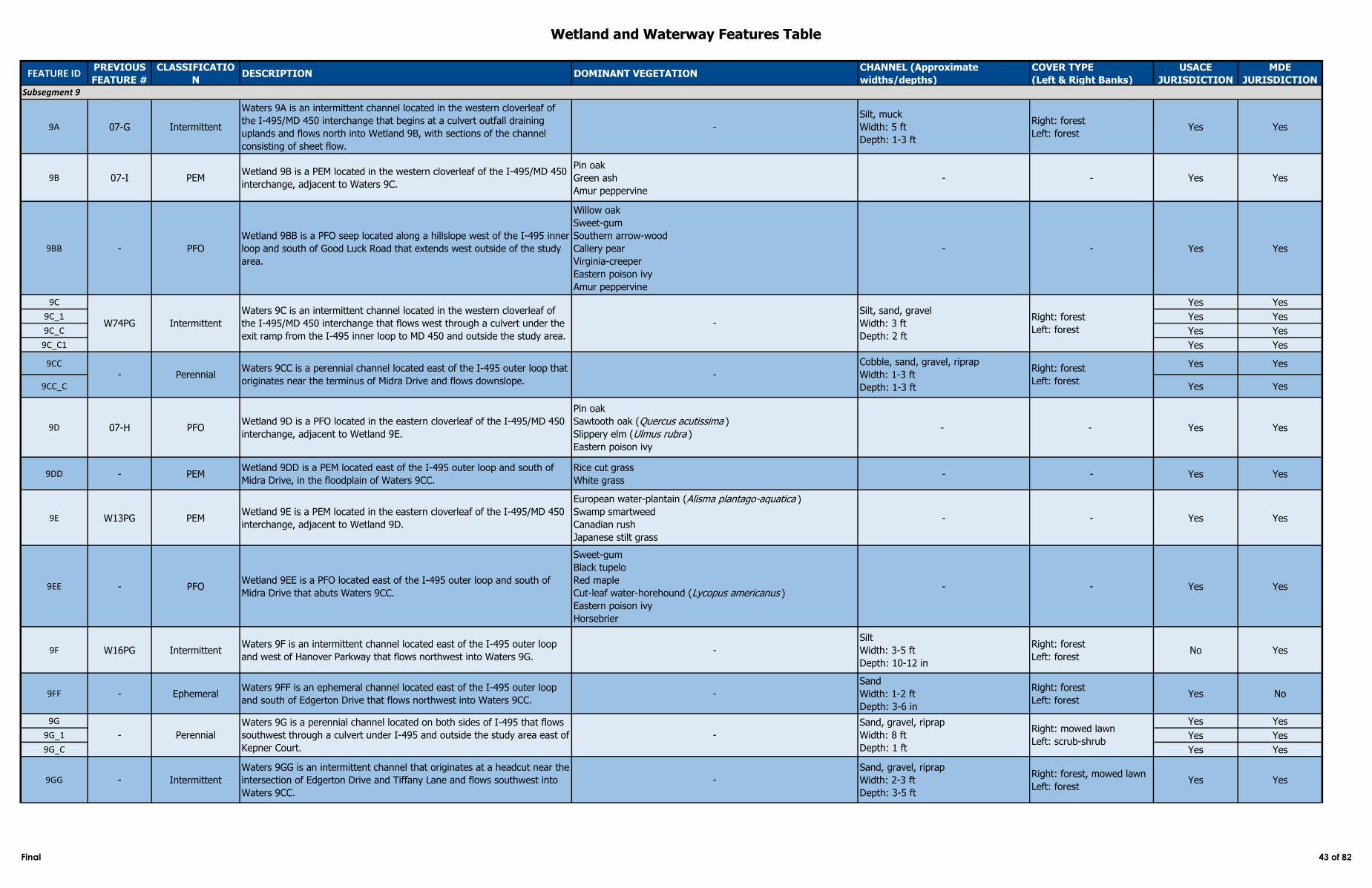
Wetland and Waterway Features Table
FEATURE IDPREVIOUS
FEATURE #
CLASSIFICATIO
NDESCRIPTION DOMINANT VEGETATION
CHANNEL (Approximate
widths/depths)
COVER TYPE
(Left & Right Banks)
USACE
JURISDICTION
MDE
JURISDICTION
9A 07-G Intermittent
Waters 9A is an intermittent channel located in the western cloverleaf of
the I‑495/MD 450 interchange that begins at a culvert outfall draining
uplands and flows north into Wetland 9B, with sections of the channel
consisting of sheet flow.
-
Silt, muck
Width: 5 ft
Depth: 1-3 ft
Right: forest
Left: forestYes Yes
9B 07-I PEMWetland 9B is a PEM located in the western cloverleaf of the I‑495/MD 450
interchange, adjacent to Waters 9C.
Pin oak
Green ash
Amur peppervine
- - Yes Yes
9BB - PFO
Wetland 9BB is a PFO seep located along a hillslope west of the I‑495 inner
loop and south of Good Luck Road that extends west outside of the study
area.
Willow oak
Sweet-gum
Southern arrow-wood
Callery pear
Virginia-creeper
Eastern poison ivy
Amur peppervine
- - Yes Yes
9C Yes Yes
9C_1 Yes Yes
9C_C Yes Yes
9C_C1 Yes Yes
9CC Yes Yes
9CC_C Yes Yes
9D 07-H PFOWetland 9D is a PFO located in the eastern cloverleaf of the I‑495/MD 450
interchange, adjacent to Wetland 9E.
Pin oak
Sawtooth oak (Quercus acutissima )
Slippery elm (Ulmus rubra )
Eastern poison ivy
- - Yes Yes
9DD - PEMWetland 9DD is a PEM located east of the I‑495 outer loop and south of
Midra Drive, in the floodplain of Waters 9CC.
Rice cut grass
White grass- - Yes Yes
9E W13PG PEMWetland 9E is a PEM located in the eastern cloverleaf of the I‑495/MD 450
interchange, adjacent to Wetland 9D.
European water-plantain (Alisma plantago-aquatica )
Swamp smartweed
Canadian rush
Japanese stilt grass
- - Yes Yes
9EE - PFOWetland 9EE is a PFO located east of the I‑495 outer loop and south of
Midra Drive that abuts Waters 9CC.
Sweet-gum
Black tupelo
Red maple
Cut-leaf water-horehound (Lycopus americanus )
Eastern poison ivy
Horsebrier
- - Yes Yes
9F W16PG IntermittentWaters 9F is an intermittent channel located east of the I‑495 outer loop
and west of Hanover Parkway that flows northwest into Waters 9G. -
Silt
Width: 3-5 ft
Depth: 10-12 in
Right: forest
Left: forestNo Yes
9FF - EphemeralWaters 9FF is an ephemeral channel located east of the I‑495 outer loop
and south of Edgerton Drive that flows northwest into Waters 9CC.-
Sand
Width: 1-2 ft
Depth: 3-6 in
Right: forest
Left: forestYes No
9G Yes Yes
9G_1 Yes Yes
9G_C Yes Yes
9GG - Intermittent
Waters 9GG is an intermittent channel that originates at a headcut near the
intersection of Edgerton Drive and Tiffany Lane and flows southwest into
Waters 9CC.
-
Sand, gravel, riprap
Width: 2-3 ft
Depth: 3-5 ft
Right: forest, mowed lawn
Left: forestYes Yes
Subsegment 9
W74PG Intermittent
Waters 9C is an intermittent channel located in the western cloverleaf of
the I‑495/MD 450 interchange that flows west through a culvert under the
exit ramp from the I‑495 inner loop to MD 450 and outside the study area.
-
Silt, sand, gravel
Width: 3 ft
Depth: 2 ft
Right: forest
Left: forest
- Perennial
Waters 9G is a perennial channel located on both sides of I‑495 that flows
southwest through a culvert under I‑495 and outside the study area east of
Kepner Court.
Cobble, sand, gravel, riprap
Width: 1-3 ft
Depth: 1-3 ft
Right: forest
Left: forest
-
Sand, gravel, riprap
Width: 8 ft
Depth: 1 ft
Right: mowed lawn
Left: scrub-shrub
- PerennialWaters 9CC is a perennial channel located east of the I‑495 outer loop that
originates near the terminus of Midra Drive and flows downslope. -
Final 43 of 82
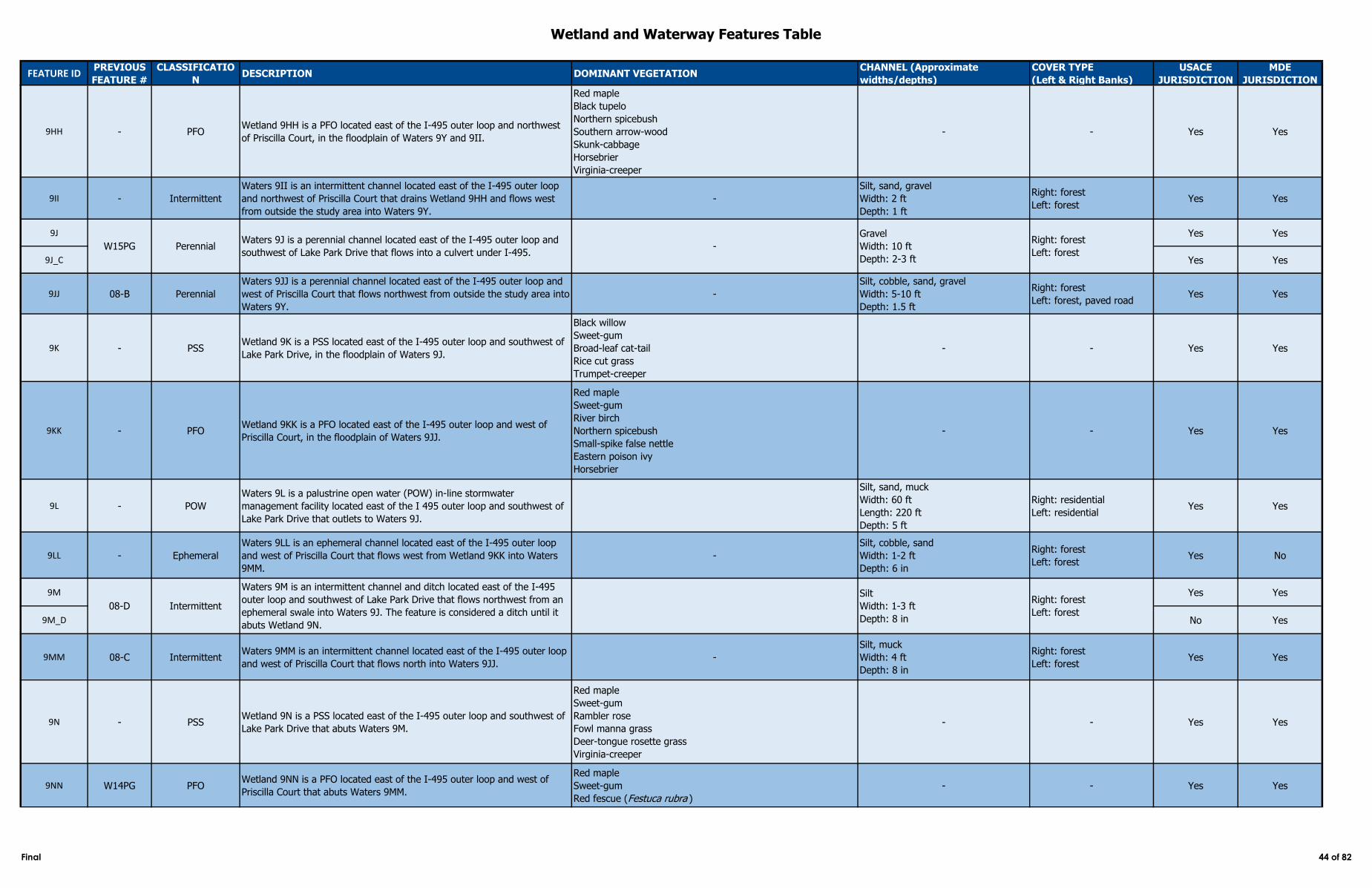
Wetland and Waterway Features Table
FEATURE IDPREVIOUS
FEATURE #
CLASSIFICATIO
NDESCRIPTION DOMINANT VEGETATION
CHANNEL (Approximate
widths/depths)
COVER TYPE
(Left & Right Banks)
USACE
JURISDICTION
MDE
JURISDICTION
9HH - PFOWetland 9HH is a PFO located east of the I‑495 outer loop and northwest
of Priscilla Court, in the floodplain of Waters 9Y and 9II.
Red maple
Black tupelo
Northern spicebush
Southern arrow-wood
Skunk-cabbage
Horsebrier
Virginia-creeper
- - Yes Yes
9II - Intermittent
Waters 9II is an intermittent channel located east of the I‑495 outer loop
and northwest of Priscilla Court that drains Wetland 9HH and flows west
from outside the study area into Waters 9Y.
-
Silt, sand, gravel
Width: 2 ft
Depth: 1 ft
Right: forest
Left: forestYes Yes
9J Yes Yes
9J_C Yes Yes
9JJ 08-B Perennial
Waters 9JJ is a perennial channel located east of the I‑495 outer loop and
west of Priscilla Court that flows northwest from outside the study area into
Waters 9Y.
-
Silt, cobble, sand, gravel
Width: 5-10 ft
Depth: 1.5 ft
Right: forest
Left: forest, paved roadYes Yes
9K - PSSWetland 9K is a PSS located east of the I‑495 outer loop and southwest of
Lake Park Drive, in the floodplain of Waters 9J.
Black willow
Sweet-gum
Broad-leaf cat-tail
Rice cut grass
Trumpet-creeper
- - Yes Yes
9KK - PFOWetland 9KK is a PFO located east of the I‑495 outer loop and west of
Priscilla Court, in the floodplain of Waters 9JJ.
Red maple
Sweet-gum
River birch
Northern spicebush
Small-spike false nettle
Eastern poison ivy
Horsebrier
- - Yes Yes
9L - POW
Waters 9L is a palustrine open water (POW) in-line stormwater
management facility located east of the I 495 outer loop and southwest of
Lake Park Drive that outlets to Waters 9J.
Silt, sand, muck
Width: 60 ft
Length: 220 ft
Depth: 5 ft
Right: residential
Left: residentialYes Yes
9LL - Ephemeral
Waters 9LL is an ephemeral channel located east of the I‑495 outer loop
and west of Priscilla Court that flows west from Wetland 9KK into Waters
9MM.
-
Silt, cobble, sand
Width: 1-2 ft
Depth: 6 in
Right: forest
Left: forestYes No
9M Yes Yes
9M_D No Yes
9MM 08-C IntermittentWaters 9MM is an intermittent channel located east of the I‑495 outer loop
and west of Priscilla Court that flows north into Waters 9JJ. -
Silt, muck
Width: 4 ft
Depth: 8 in
Right: forest
Left: forestYes Yes
9N - PSSWetland 9N is a PSS located east of the I‑495 outer loop and southwest of
Lake Park Drive that abuts Waters 9M.
Red maple
Sweet-gum
Rambler rose
Fowl manna grass
Deer-tongue rosette grass
Virginia-creeper
- - Yes Yes
9NN W14PG PFOWetland 9NN is a PFO located east of the I‑495 outer loop and west of
Priscilla Court that abuts Waters 9MM.
Red maple
Sweet-gum
Red fescue (Festuca rubra )
- - Yes Yes
Intermittent
Waters 9M is an intermittent channel and ditch located east of the I‑495
outer loop and southwest of Lake Park Drive that flows northwest from an
ephemeral swale into Waters 9J. The feature is considered a ditch until it
abuts Wetland 9N.
Silt
Width: 1-3 ft
Depth: 8 in
Right: forest
Left: forest08-D
Waters 9J is a perennial channel located east of the I‑495 outer loop and
southwest of Lake Park Drive that flows into a culvert under I‑495. -
Gravel
Width: 10 ft
Depth: 2-3 ft
Right: forest
Left: forestPerennialW15PG
Final 44 of 82
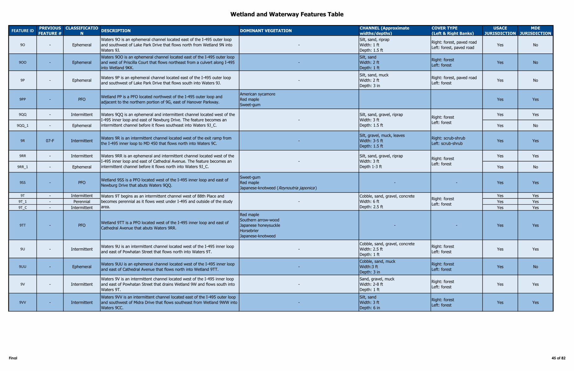
Wetland and Waterway Features Table
FEATURE IDPREVIOUS
FEATURE #
CLASSIFICATIO
NDESCRIPTION DOMINANT VEGETATION
CHANNEL (Approximate
widths/depths)
COVER TYPE
(Left & Right Banks)
USACE
JURISDICTION
MDE
JURISDICTION
9O - Ephemeral
Waters 9O is an ephemeral channel located east of the I‑495 outer loop
and southwest of Lake Park Drive that flows north from Wetland 9N into
Waters 9J.
-
Silt, sand, riprap
Width: 1 ft
Depth: 1.5 ft
Right: forest, paved road
Left: forest, paved roadYes No
9OO - Ephemeral
Waters 9OO is an ephemeral channel located east of the I‑495 outer loop
and west of Priscilla Court that flows northeast from a culvert along I‑495
into Wetland 9KK.
-
Silt, sand
Width: 2 ft
Depth: 1 ft
Right: forest
Left: forestYes No
9P - EphemeralWaters 9P is an ephemeral channel located east of the I‑495 outer loop
and southwest of Lake Park Drive that flows south into Waters 9J. -
Silt, sand, muck
Width: 2 ft
Depth: 3 in
Right: forest, paved road
Left: forestYes No
9PP - PFOWetland PP is a PFO located northwest of the I-495 outer loop and
adjacent to the northern portion of 9G, east of Hanover Parkway.
American sycamore
Red maple
Sweet-gum
Yes Yes
9QQ - Intermittent Yes Yes
9QQ_1 - Ephemeral Yes No
9R 07-F IntermittentWaters 9R is an intermittent channel located west of the exit ramp from
the I‑495 inner loop to MD 450 that flows north into Waters 9C. -
Silt, gravel, muck, leaves
Width: 3-5 ft
Depth: 1.5 ft
Right: scrub-shrub
Left: scrub-shrubYes Yes
9RR - Intermittent Yes Yes
9RR_1 - Ephemeral Yes No
9SS - PFOWetland 9SS is a PFO located west of the I‑495 inner loop and east of
Newburg Drive that abuts Waters 9QQ.
Sweet-gum
Red maple
Japanese-knotweed (Reynoutria japonica )
- - Yes Yes
9T - Intermittent Yes Yes
9T_1 - Perennial Yes Yes
9T_C - Intermittent Yes Yes
9TT - PFOWetland 9TT is a PFO located west of the I‑495 inner loop and east of
Cathedral Avenue that abuts Waters 9RR.
Red maple
Southern arrow-wood
Japanese honeysuckle
Horsebrier
Japanese-knotweed
- - Yes Yes
9U - IntermittentWaters 9U is an intermittent channel located west of the I‑495 inner loop
and east of Powhatan Street that flows north into Waters 9T. -
Cobble, sand, gravel, concrete
Width: 2.5 ft
Depth: 1 ft
Right: forest
Left: forestYes Yes
9UU - EphemeralWaters 9UU is an ephemeral channel located west of the I‑495 inner loop
and east of Cathedral Avenue that flows north into Wetland 9TT. -
Cobble, sand, muck
Width:3 ft
Depth: 3 in
Right: forest
Left: forestYes No
9V - Intermittent
Waters 9V is an intermittent channel located west of the I‑495 inner loop
and east of Powhatan Street that drains Wetland 9W and flows south into
Waters 9T.
-
Sand, gravel, muck
Width: 2-8 ft
Depth: 1 ft
Right: forest
Left: forestYes Yes
9VV - Intermittent
Waters 9VV is an intermittent channel located east of the I‑495 outer loop
and southwest of Midra Drive that flows southeast from Wetland 9WW into
Waters 9CC.
-
Silt, sand
Width: 3 ft
Depth: 6 in
Right: forest
Left: forestYes Yes
Waters 9T begins as an intermittent channel west of 88th Place and
becomes perennial as it flows west under I‑495 and outside of the study
area.
-
Cobble, sand, gravel, concrete
Width: 6 ft
Depth: 2.5 ft
Right: forest
Left: forest
Waters 9QQ is an ephemeral and intermittent channel located west of the
I‑495 inner loop and east of Newburg Drive. The feature becomes an
intermittent channel before it flows southeast into Waters 9J_C.
-
Silt, sand, gravel, riprap
Width: 3 ft
Depth: 1.5 ft
Right: forest
Left: forest
Waters 9RR is an ephemeral and intermittent channel located west of the
I‑495 inner loop and east of Cathedral Avenue. The feature becomes an
intermittent channel before it flows north into Waters 9J_C.
-
Silt, sand, gravel, riprap
Width: 3 ft
Depth 1-3 ft
Right: forest
Left: forest
Final 45 of 82
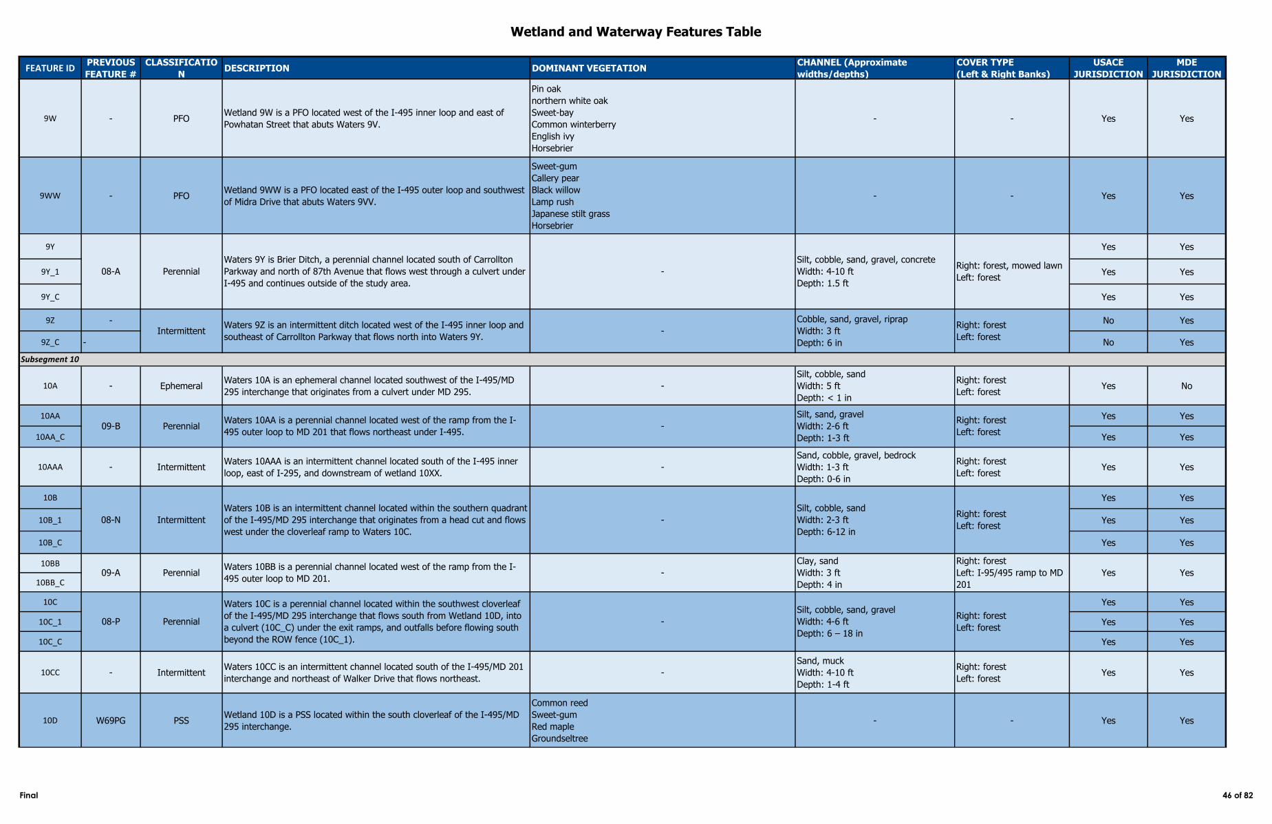
Wetland and Waterway Features Table
FEATURE IDPREVIOUS
FEATURE #
CLASSIFICATIO
NDESCRIPTION DOMINANT VEGETATION
CHANNEL (Approximate
widths/depths)
COVER TYPE
(Left & Right Banks)
USACE
JURISDICTION
MDE
JURISDICTION
9W - PFOWetland 9W is a PFO located west of the I‑495 inner loop and east of
Powhatan Street that abuts Waters 9V.
Pin oak
northern white oak
Sweet-bay
Common winterberry
English ivy
Horsebrier
- - Yes Yes
9WW - PFOWetland 9WW is a PFO located east of the I-495 outer loop and southwest
of Midra Drive that abuts Waters 9VV.
Sweet-gum
Callery pear
Black willow
Lamp rush
Japanese stilt grass
Horsebrier
- - Yes Yes
9Y Yes Yes
9Y_1 Yes Yes
9Y_C Yes Yes
9Z - No Yes
9Z_C - No Yes
10A - EphemeralWaters 10A is an ephemeral channel located southwest of the I-495/MD
295 interchange that originates from a culvert under MD 295. -
Silt, cobble, sand
Width: 5 ft
Depth: < 1 in
Right: forest
Left: forestYes No
10AA Yes Yes
10AA_C Yes Yes
10AAA - IntermittentWaters 10AAA is an intermittent channel located south of the I-495 inner
loop, east of I-295, and downstream of wetland 10XX.-
Sand, cobble, gravel, bedrock
Width: 1-3 ft
Depth: 0-6 in
Right: forest
Left: forestYes Yes
10B Yes Yes
10B_1 Yes Yes
10B_C Yes Yes
10BB
10BB_C
10C Yes Yes
10C_1 Yes Yes
10C_C Yes Yes
10CC - IntermittentWaters 10CC is an intermittent channel located south of the I-495/MD 201
interchange and northeast of Walker Drive that flows northeast. -
Sand, muck
Width: 4-10 ft
Depth: 1-4 ft
Right: forest
Left: forestYes Yes
10D W69PG PSSWetland 10D is a PSS located within the south cloverleaf of the I-495/MD
295 interchange.
Common reed
Sweet-gum
Red maple
Groundseltree
- - Yes Yes
09-A PerennialWaters 10BB is a perennial channel located west of the ramp from the I-
495 outer loop to MD 201.-
Clay, sand
Width: 3 ft
Depth: 4 in
Right: forest
Left: I-95/495 ramp to MD
201
Yes Yes
08-A Perennial
Waters 9Y is Brier Ditch, a perennial channel located south of Carrollton
Parkway and north of 87th Avenue that flows west through a culvert under
I‑495 and continues outside of the study area.
IntermittentWaters 9Z is an intermittent ditch located west of the I‑495 inner loop and
southeast of Carrollton Parkway that flows north into Waters 9Y.
Subsegment 10
09-B PerennialWaters 10AA is a perennial channel located west of the ramp from the I-
495 outer loop to MD 201 that flows northeast under I-495. -
-
Cobble, sand, gravel, riprap
Width: 3 ft
Depth: 6 in
Right: forest
Left: forest
Right: forest
Left: forest
08-P
Silt, sand, gravel
Width: 2-6 ft
Depth: 1-3 ft
-
Silt, cobble, sand, gravel, concrete
Width: 4-10 ft
Depth: 1.5 ft
Right: forest, mowed lawn
Left: forest
Intermittent
Waters 10B is an intermittent channel located within the southern quadrant
of the I-495/MD 295 interchange that originates from a head cut and flows
west under the cloverleaf ramp to Waters 10C.
-
Silt, cobble, sand
Width: 2-3 ft
Depth: 6-12 in
Right: forest
Left: forest
Silt, cobble, sand, gravel
Width: 4-6 ft
Depth: 6 – 18 in
Right: forest
Left: forest-Perennial
Waters 10C is a perennial channel located within the southwest cloverleaf
of the I-495/MD 295 interchange that flows south from Wetland 10D, into
a culvert (10C_C) under the exit ramps, and outfalls before flowing south
beyond the ROW fence (10C_1).
08-N
Final 46 of 82
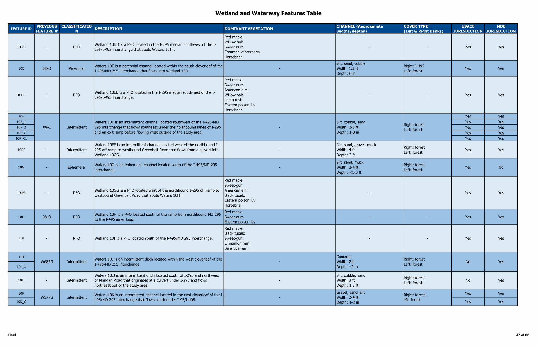
Wetland and Waterway Features Table
FEATURE IDPREVIOUS
FEATURE #
CLASSIFICATIO
NDESCRIPTION DOMINANT VEGETATION
CHANNEL (Approximate
widths/depths)
COVER TYPE
(Left & Right Banks)
USACE
JURISDICTION
MDE
JURISDICTION
10DD - PFOWetland 10DD is a PFO located in the I-295 median southwest of the I-
295/I-495 interchange that abuts Waters 10TT.
Red maple
Willow oak
Sweet-gum
Common winterberry
Horsebrier
- - Yes Yes
10E 08-O PerennialWaters 10E is a perennial channel located within the south cloverleaf of the
I-495/MD 295 interchange that flows into Wetland 10D. -
Silt, sand, cobble
Width: 1.5 ft
Depth: 6 in
Right: I-495
Left: forestYes Yes
10EE - PFOWetland 10EE is a PFO located in the I-295 median southwest of the I-
295/I-495 interchange.
Red maple
Sweet-gum
American elm
Willow oak
Lamp rush
Eastern poison ivy
Horsebrier
- - Yes Yes
10F Yes Yes
10F_1 Yes Yes
10F_2 Yes Yes
10F_C Yes Yes
10F_C1 Yes Yes
10FF - Intermittent
Waters 10FF is an intermittent channel located west of the northbound I-
295 off ramp to westbound Greenbelt Road that flows from a culvert into
Wetland 10GG.
-
Silt, sand, gravel, muck
Width: 4 ft
Depth: 3 ft
Right: forest
Left: forestYes Yes
10G - EphemeralWaters 10G is an ephemeral channel located south of the I-495/MD 295
interchange.-
Silt, sand, muck
Width: 2-4 ft
Depth: <1-3 ft
Right: forest
Left: forestYes No
10GG - PFOWetland 10GG is a PFO located west of the northbound I-295 off ramp to
westbound Greenbelt Road that abuts Waters 10FF.
Red maple
Sweet-gum
American elm
Black tupelo
Eastern poison ivy
Horsebrier
-- Yes Yes
10H 08-Q PFOWetland 10H is a PFO located south of the ramp from northbound MD 295
to the I-495 inner loop.
Red maple
Sweet-gum
Eastern poison ivy
- - Yes Yes
10I - PFO Wetland 10I is a PFO located south of the I-495/MD 295 interchange.
Red maple
Black tupelo
Sweet-gum
Cinnamon fern
Sensitive fern
- - Yes Yes
10J
10J_C
10JJ - Intermittent
Waters 10JJ is an intermittent ditch located south of I-295 and northwest
of Mandan Road that originates at a culvert under I-295 and flows
northeast out of the study area.
-
Silt, cobble, sand
Width: 3 ft
Depth: 1.5 ft
Right: forest
Left: forest No Yes
10K Yes Yes
10K_C Yes Yes
W68PG IntermittentWaters 10J is an intermittent ditch located within the west cloverleaf of the
I-495/MD 295 interchange.-
Concrete
Width: 2 ft
Depth 1-2 in
Right: forest
Left: forestNo Yes
Gravel, sand, silt
Width: 2-4 ft
Depth: 1-2 in
W17PG IntermittentWaters 10K is an intermittent channel located in the east cloverleaf of the I-
495/MD 295 interchange that flows south under I-95/I-495. -
Right: forestL
eft: forest
08-L Intermittent
Waters 10F is an intermittent channel located southwest of the I-495/MD
295 interchange that flows southeast under the northbound lanes of I-295
and an exit ramp before flowing west outside of the study area.
-
Silt, cobble, sand
Width: 2-8 ft
Depth: 1-8 in
Right: forest
Left: forest
Final 47 of 82
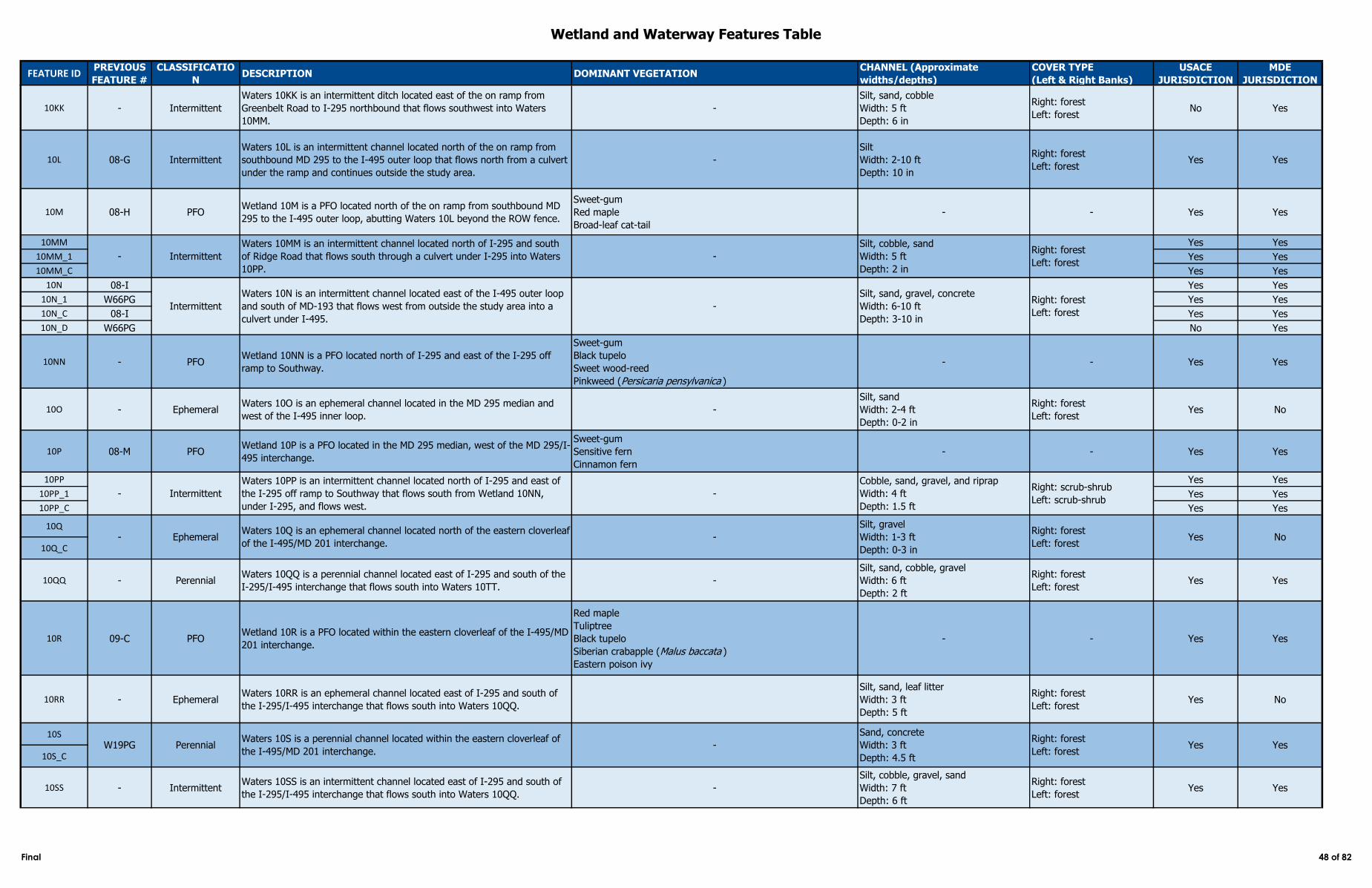
Wetland and Waterway Features Table
FEATURE IDPREVIOUS
FEATURE #
CLASSIFICATIO
NDESCRIPTION DOMINANT VEGETATION
CHANNEL (Approximate
widths/depths)
COVER TYPE
(Left & Right Banks)
USACE
JURISDICTION
MDE
JURISDICTION
10KK - Intermittent
Waters 10KK is an intermittent ditch located east of the on ramp from
Greenbelt Road to I-295 northbound that flows southwest into Waters
10MM.
-
Silt, sand, cobble
Width: 5 ft
Depth: 6 in
Right: forest
Left: forestNo Yes
10L 08-G Intermittent
Waters 10L is an intermittent channel located north of the on ramp from
southbound MD 295 to the I-495 outer loop that flows north from a culvert
under the ramp and continues outside the study area.
-
Silt
Width: 2-10 ft
Depth: 10 in
Right: forest
Left: forestYes Yes
10M 08-H PFOWetland 10M is a PFO located north of the on ramp from southbound MD
295 to the I-495 outer loop, abutting Waters 10L beyond the ROW fence.
Sweet-gum
Red maple
Broad-leaf cat-tail
- - Yes Yes
10MM Yes Yes
10MM_1 Yes Yes
10MM_C Yes Yes
10N 08-I Yes Yes
10N_1 W66PG Yes Yes
10N_C 08-I Yes Yes
10N_D W66PG No Yes
10NN - PFOWetland 10NN is a PFO located north of I-295 and east of the I-295 off
ramp to Southway.
Sweet-gum
Black tupelo
Sweet wood-reed
Pinkweed (Persicaria pensylvanica )
- - Yes Yes
10O - EphemeralWaters 10O is an ephemeral channel located in the MD 295 median and
west of the I-495 inner loop. -
Silt, sand
Width: 2-4 ft
Depth: 0-2 in
Right: forest
Left: forestYes No
10P 08-M PFOWetland 10P is a PFO located in the MD 295 median, west of the MD 295/I-
495 interchange.
Sweet-gum
Sensitive fern
Cinnamon fern
- - Yes Yes
10PP Yes Yes
10PP_1 Yes Yes
10PP_C Yes Yes
10Q
10Q_C
10QQ - PerennialWaters 10QQ is a perennial channel located east of I-295 and south of the
I-295/I-495 interchange that flows south into Waters 10TT. -
Silt, sand, cobble, gravel
Width: 6 ft
Depth: 2 ft
Right: forest
Left: forestYes Yes
10R 09-C PFOWetland 10R is a PFO located within the eastern cloverleaf of the I-495/MD
201 interchange.
Red maple
Tuliptree
Black tupelo
Siberian crabapple (Malus baccata )
Eastern poison ivy
- - Yes Yes
10RR - EphemeralWaters 10RR is an ephemeral channel located east of I-295 and south of
the I-295/I-495 interchange that flows south into Waters 10QQ.
Silt, sand, leaf litter
Width: 3 ft
Depth: 5 ft
Right: forest
Left: forestYes No
10S
10S_C
10SS - IntermittentWaters 10SS is an intermittent channel located east of I-295 and south of
the I-295/I-495 interchange that flows south into Waters 10QQ. -
Silt, cobble, gravel, sand
Width: 7 ft
Depth: 6 ft
Right: forest
Left: forestYes Yes
W19PG PerennialWaters 10S is a perennial channel located within the eastern cloverleaf of
the I-495/MD 201 interchange. -
Sand, concrete
Width: 3 ft
Depth: 4.5 ft
Right: forest
Left: forestYes Yes
- EphemeralWaters 10Q is an ephemeral channel located north of the eastern cloverleaf
of the I-495/MD 201 interchange. -
Silt, gravel
Width: 1-3 ft
Depth: 0-3 in
Right: forest
Left: forestYes No
- Intermittent
Waters 10MM is an intermittent channel located north of I-295 and south
of Ridge Road that flows south through a culvert under I-295 into Waters
10PP.
-
Silt, cobble, sand
Width: 5 ft
Depth: 2 in
Right: forest
Left: forest
Waters 10N is an intermittent channel located east of the I-495 outer loop
and south of MD-193 that flows west from outside the study area into a
culvert under I-495.
-
Silt, sand, gravel, concrete
Width: 6-10 ft
Depth: 3-10 in
Right: forest
Left: forest
- Intermittent
Waters 10PP is an intermittent channel located north of I-295 and east of
the I-295 off ramp to Southway that flows south from Wetland 10NN,
under I-295, and flows west.
-
Cobble, sand, gravel, and riprap
Width: 4 ft
Depth: 1.5 ft
Right: scrub-shrub
Left: scrub-shrub
Intermittent
Final 48 of 82
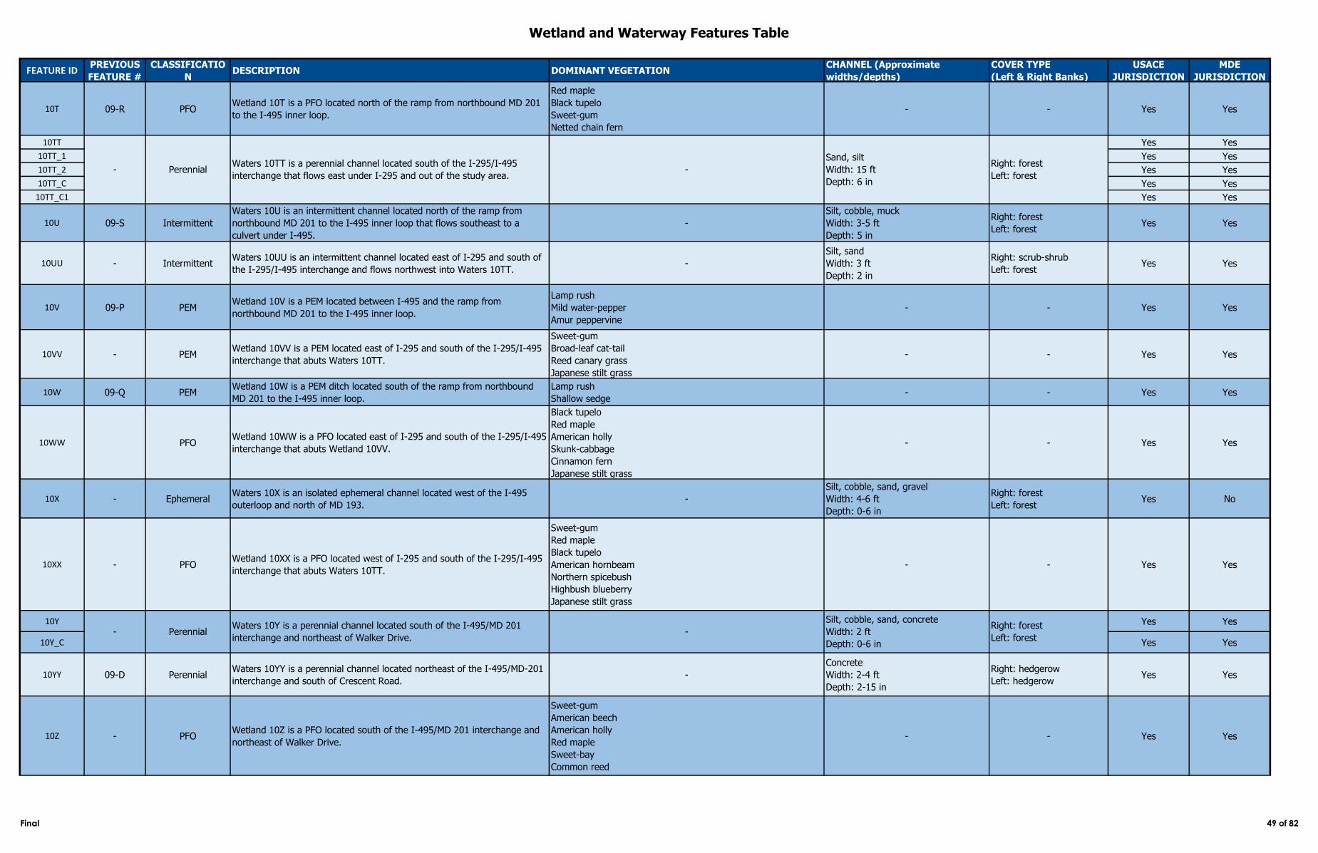
Wetland and Waterway Features Table
FEATURE IDPREVIOUS
FEATURE #
CLASSIFICATIO
NDESCRIPTION DOMINANT VEGETATION
CHANNEL (Approximate
widths/depths)
COVER TYPE
(Left & Right Banks)
USACE
JURISDICTION
MDE
JURISDICTION
10T 09-R PFOWetland 10T is a PFO located north of the ramp from northbound MD 201
to the I-495 inner loop.
Red maple
Black tupelo
Sweet-gum
Netted chain fern
- - Yes Yes
10TT Yes Yes
10TT_1 Yes Yes
10TT_2 Yes Yes
10TT_C Yes Yes
10TT_C1 Yes Yes
10U 09-S Intermittent
Waters 10U is an intermittent channel located north of the ramp from
northbound MD 201 to the I-495 inner loop that flows southeast to a
culvert under I-495.
-
Silt, cobble, muck
Width: 3-5 ft
Depth: 5 in
Right: forest
Left: forestYes Yes
10UU - IntermittentWaters 10UU is an intermittent channel located east of I-295 and south of
the I-295/I-495 interchange and flows northwest into Waters 10TT.-
Silt, sand
Width: 3 ft
Depth: 2 in
Right: scrub-shrub
Left: forestYes Yes
10V 09-P PEMWetland 10V is a PEM located between I-495 and the ramp from
northbound MD 201 to the I-495 inner loop.
Lamp rush
Mild water-pepper
Amur peppervine
- - Yes Yes
10VV - PEMWetland 10VV is a PEM located east of I-295 and south of the I-295/I-495
interchange that abuts Waters 10TT.
Sweet-gum
Broad-leaf cat-tail
Reed canary grass
Japanese stilt grass
- - Yes Yes
10W 09-Q PEMWetland 10W is a PEM ditch located south of the ramp from northbound
MD 201 to the I-495 inner loop.
Lamp rush
Shallow sedge- - Yes Yes
10WW PFOWetland 10WW is a PFO located east of I-295 and south of the I-295/I-495
interchange that abuts Wetland 10VV.
Black tupelo
Red maple
American holly
Skunk-cabbage
Cinnamon fern
Japanese stilt grass
- - Yes Yes
10X - EphemeralWaters 10X is an isolated ephemeral channel located west of the I-495
outerloop and north of MD 193. -
Silt, cobble, sand, gravel
Width: 4-6 ft
Depth: 0-6 in
Right: forest
Left: forestYes No
10XX - PFOWetland 10XX is a PFO located west of I-295 and south of the I-295/I-495
interchange that abuts Waters 10TT.
Sweet-gum
Red maple
Black tupelo
American hornbeam
Northern spicebush
Highbush blueberry
Japanese stilt grass
- - Yes Yes
10Y Yes Yes
10Y_C Yes Yes
10YY 09-D PerennialWaters 10YY is a perennial channel located northeast of the I-495/MD-201
interchange and south of Crescent Road. -
Concrete
Width: 2-4 ft
Depth: 2-15 in
Right: hedgerow
Left: hedgerowYes Yes
10Z - PFOWetland 10Z is a PFO located south of the I-495/MD 201 interchange and
northeast of Walker Drive.
Sweet-gum
American beech
American holly
Red maple
Sweet-bay
Common reed
- - Yes Yes
-
Silt, cobble, sand, concrete
Width: 2 ft
Depth: 0-6 in
Right: forest
Left: forest- Perennial
Waters 10Y is a perennial channel located south of the I-495/MD 201
interchange and northeast of Walker Drive.
- PerennialWaters 10TT is a perennial channel located south of the I-295/I-495
interchange that flows east under I-295 and out of the study area. -
Sand, silt
Width: 15 ft
Depth: 6 in
Right: forest
Left: forest
Final 49 of 82
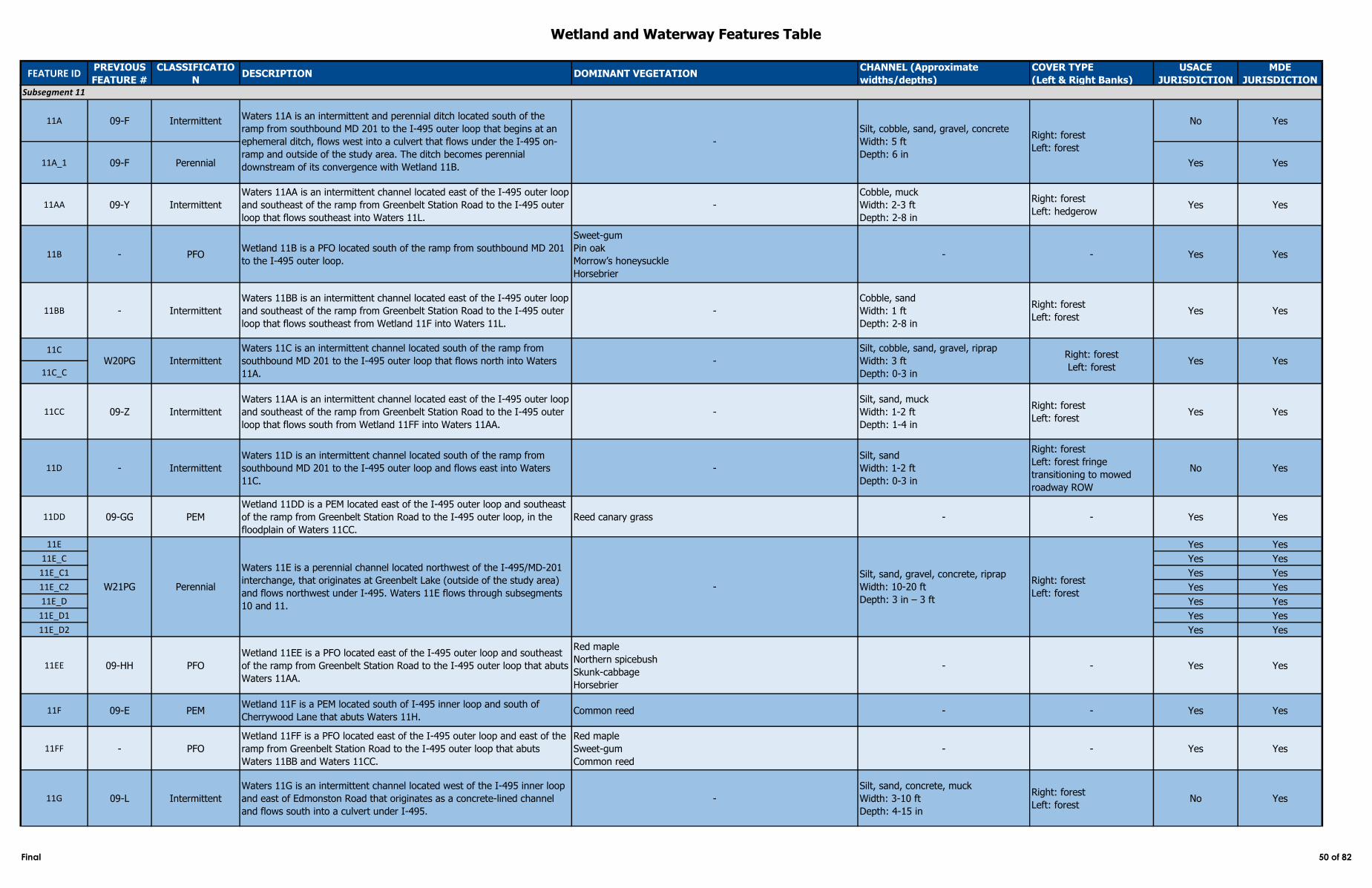
Wetland and Waterway Features Table
FEATURE IDPREVIOUS
FEATURE #
CLASSIFICATIO
NDESCRIPTION DOMINANT VEGETATION
CHANNEL (Approximate
widths/depths)
COVER TYPE
(Left & Right Banks)
USACE
JURISDICTION
MDE
JURISDICTION
11A 09-F Intermittent No Yes
11A_1 09-F Perennial Yes Yes
11AA 09-Y Intermittent
Waters 11AA is an intermittent channel located east of the I-495 outer loop
and southeast of the ramp from Greenbelt Station Road to the I-495 outer
loop that flows southeast into Waters 11L.
-
Cobble, muck
Width: 2-3 ft
Depth: 2-8 in
Right: forest
Left: hedgerowYes Yes
11B - PFOWetland 11B is a PFO located south of the ramp from southbound MD 201
to the I-495 outer loop.
Sweet-gum
Pin oak
Morrow’s honeysuckle
Horsebrier
- - Yes Yes
11BB - Intermittent
Waters 11BB is an intermittent channel located east of the I-495 outer loop
and southeast of the ramp from Greenbelt Station Road to the I-495 outer
loop that flows southeast from Wetland 11F into Waters 11L.
-
Cobble, sand
Width: 1 ft
Depth: 2-8 in
Right: forest
Left: forestYes Yes
11C
11C_C
11CC 09-Z Intermittent
Waters 11AA is an intermittent channel located east of the I-495 outer loop
and southeast of the ramp from Greenbelt Station Road to the I-495 outer
loop that flows south from Wetland 11FF into Waters 11AA.
-
Silt, sand, muck
Width: 1-2 ft
Depth: 1-4 in
Right: forest
Left: forestYes Yes
11D - Intermittent
Waters 11D is an intermittent channel located south of the ramp from
southbound MD 201 to the I-495 outer loop and flows east into Waters
11C.
-
Silt, sand
Width: 1-2 ft
Depth: 0-3 in
Right: forest
Left: forest fringe
transitioning to mowed
roadway ROW
No Yes
11DD 09-GG PEM
Wetland 11DD is a PEM located east of the I-495 outer loop and southeast
of the ramp from Greenbelt Station Road to the I-495 outer loop, in the
floodplain of Waters 11CC.
Reed canary grass - - Yes Yes
11E Yes Yes
11E_C Yes Yes
11E_C1 Yes Yes
11E_C2 Yes Yes
11E_D Yes Yes
11E_D1 Yes Yes
11E_D2 Yes Yes
11EE 09-HH PFO
Wetland 11EE is a PFO located east of the I-495 outer loop and southeast
of the ramp from Greenbelt Station Road to the I-495 outer loop that abuts
Waters 11AA.
Red maple
Northern spicebush
Skunk-cabbage
Horsebrier
- - Yes Yes
11F 09-E PEMWetland 11F is a PEM located south of I-495 inner loop and south of
Cherrywood Lane that abuts Waters 11H. Common reed - - Yes Yes
11FF - PFO
Wetland 11FF is a PFO located east of the I-495 outer loop and east of the
ramp from Greenbelt Station Road to the I-495 outer loop that abuts
Waters 11BB and Waters 11CC.
Red maple
Sweet-gum
Common reed
- - Yes Yes
11G 09-L Intermittent
Waters 11G is an intermittent channel located west of the I-495 inner loop
and east of Edmonston Road that originates as a concrete-lined channel
and flows south into a culvert under I-495.
-
Silt, sand, concrete, muck
Width: 3-10 ft
Depth: 4-15 in
Right: forest
Left: forestNo Yes
W20PG Intermittent
Waters 11C is an intermittent channel located south of the ramp from
southbound MD 201 to the I-495 outer loop that flows north into Waters
11A.
-
Silt, cobble, sand, gravel, riprap
Width: 3 ft
Depth: 0-3 in
Right: forest
Left: forestYes Yes
Subsegment 11
Waters 11A is an intermittent and perennial ditch located south of the
ramp from southbound MD 201 to the I-495 outer loop that begins at an
ephemeral ditch, flows west into a culvert that flows under the I-495 on-
ramp and outside of the study area. The ditch becomes perennial
downstream of its convergence with Wetland 11B.
-
Silt, cobble, sand, gravel, concrete
Width: 5 ft
Depth: 6 in
Right: forest
Left: forest
W21PG Perennial
Waters 11E is a perennial channel located northwest of the I-495/MD-201
interchange, that originates at Greenbelt Lake (outside of the study area)
and flows northwest under I-495. Waters 11E flows through subsegments
10 and 11.
-
Silt, sand, gravel, concrete, riprap
Width: 10-20 ft
Depth: 3 in – 3 ft
Right: forest
Left: forest
Final 50 of 82
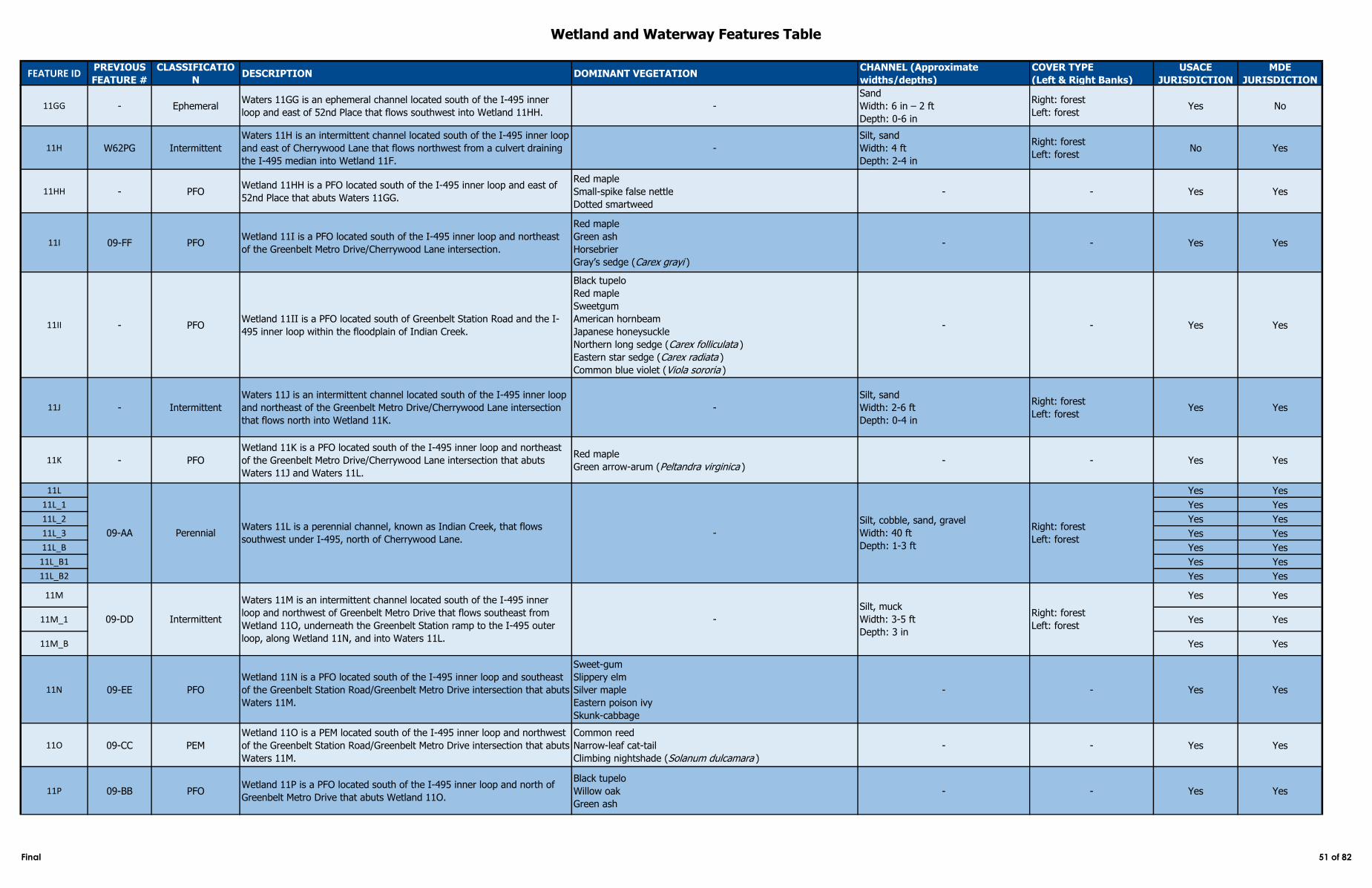
Wetland and Waterway Features Table
FEATURE IDPREVIOUS
FEATURE #
CLASSIFICATIO
NDESCRIPTION DOMINANT VEGETATION
CHANNEL (Approximate
widths/depths)
COVER TYPE
(Left & Right Banks)
USACE
JURISDICTION
MDE
JURISDICTION
11GG - EphemeralWaters 11GG is an ephemeral channel located south of the I-495 inner
loop and east of 52nd Place that flows southwest into Wetland 11HH.-
Sand
Width: 6 in – 2 ft
Depth: 0-6 in
Right: forest
Left: forestYes No
11H W62PG Intermittent
Waters 11H is an intermittent channel located south of the I-495 inner loop
and east of Cherrywood Lane that flows northwest from a culvert draining
the I-495 median into Wetland 11F.
-
Silt, sand
Width: 4 ft
Depth: 2-4 in
Right: forest
Left: forestNo Yes
11HH - PFOWetland 11HH is a PFO located south of the I-495 inner loop and east of
52nd Place that abuts Waters 11GG.
Red maple
Small-spike false nettle
Dotted smartweed
- - Yes Yes
11I 09-FF PFOWetland 11I is a PFO located south of the I-495 inner loop and northeast
of the Greenbelt Metro Drive/Cherrywood Lane intersection.
Red maple
Green ash
Horsebrier
Gray’s sedge (Carex grayi )
- - Yes Yes
11II - PFOWetland 11II is a PFO located south of Greenbelt Station Road and the I-
495 inner loop within the floodplain of Indian Creek.
Black tupelo
Red maple
Sweetgum
American hornbeam
Japanese honeysuckle
Northern long sedge (Carex folliculata )
Eastern star sedge (Carex radiata )
Common blue violet (Viola sororia )
- - Yes Yes
11J - Intermittent
Waters 11J is an intermittent channel located south of the I-495 inner loop
and northeast of the Greenbelt Metro Drive/Cherrywood Lane intersection
that flows north into Wetland 11K.
-
Silt, sand
Width: 2-6 ft
Depth: 0-4 in
Right: forest
Left: forestYes Yes
11K - PFO
Wetland 11K is a PFO located south of the I-495 inner loop and northeast
of the Greenbelt Metro Drive/Cherrywood Lane intersection that abuts
Waters 11J and Waters 11L.
Red maple
Green arrow-arum (Peltandra virginica )- - Yes Yes
11L Yes Yes
11L_1 Yes Yes
11L_2 Yes Yes
11L_3 Yes Yes
11L_B Yes Yes
11L_B1 Yes Yes
11L_B2 Yes Yes
11M Yes Yes
11M_1 Yes Yes
11M_B Yes Yes
11N 09-EE PFO
Wetland 11N is a PFO located south of the I-495 inner loop and southeast
of the Greenbelt Station Road/Greenbelt Metro Drive intersection that abuts
Waters 11M.
Sweet-gum
Slippery elm
Silver maple
Eastern poison ivy
Skunk-cabbage
- - Yes Yes
11O 09-CC PEM
Wetland 11O is a PEM located south of the I-495 inner loop and northwest
of the Greenbelt Station Road/Greenbelt Metro Drive intersection that abuts
Waters 11M.
Common reed
Narrow-leaf cat-tail
Climbing nightshade (Solanum dulcamara )
- - Yes Yes
11P 09-BB PFOWetland 11P is a PFO located south of the I-495 inner loop and north of
Greenbelt Metro Drive that abuts Wetland 11O.
Black tupelo
Willow oak
Green ash
- - Yes Yes
09-AA PerennialWaters 11L is a perennial channel, known as Indian Creek, that flows
southwest under I-495, north of Cherrywood Lane. -
Silt, cobble, sand, gravel
Width: 40 ft
Depth: 1-3 ft
Right: forest
Left: forest
Waters 11M is an intermittent channel located south of the I-495 inner
loop and northwest of Greenbelt Metro Drive that flows southeast from
Wetland 11O, underneath the Greenbelt Station ramp to the I-495 outer
loop, along Wetland 11N, and into Waters 11L.
-
Silt, muck
Width: 3-5 ft
Depth: 3 in
Right: forest
Left: forest09-DD Intermittent
Final 51 of 82
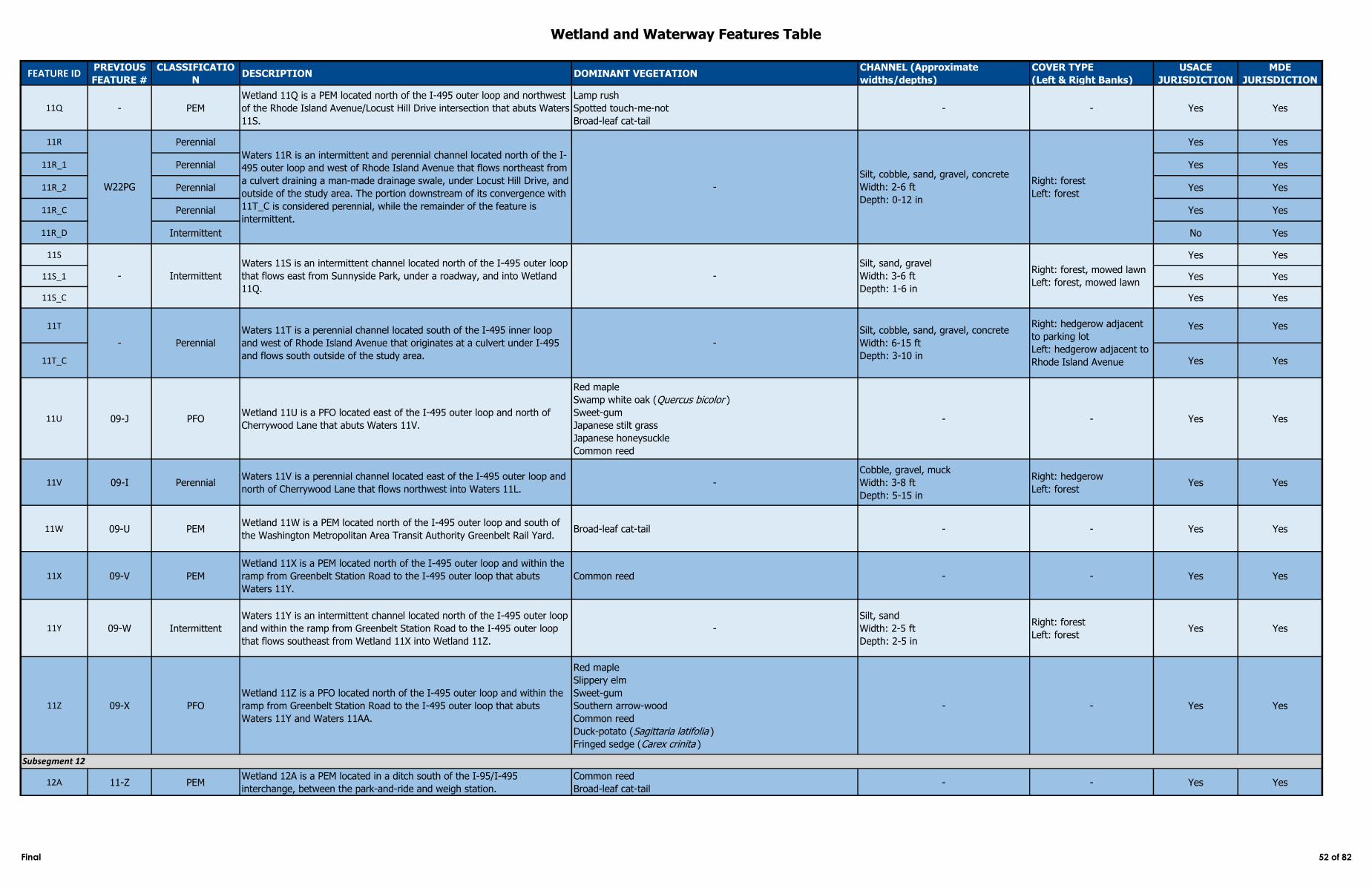
Wetland and Waterway Features Table
FEATURE IDPREVIOUS
FEATURE #
CLASSIFICATIO
NDESCRIPTION DOMINANT VEGETATION
CHANNEL (Approximate
widths/depths)
COVER TYPE
(Left & Right Banks)
USACE
JURISDICTION
MDE
JURISDICTION
11Q - PEM
Wetland 11Q is a PEM located north of the I-495 outer loop and northwest
of the Rhode Island Avenue/Locust Hill Drive intersection that abuts Waters
11S.
Lamp rush
Spotted touch-me-not
Broad-leaf cat-tail
- - Yes Yes
11R Perennial Yes Yes
11R_1 Perennial Yes Yes
11R_2 Perennial Yes Yes
11R_C Perennial Yes Yes
11R_D Intermittent No Yes
11S Yes Yes
11S_1 Yes Yes
11S_C Yes Yes
11T Yes Yes
11T_C Yes Yes
11U 09-J PFOWetland 11U is a PFO located east of the I-495 outer loop and north of
Cherrywood Lane that abuts Waters 11V.
Red maple
Swamp white oak (Quercus bicolor )
Sweet-gum
Japanese stilt grass
Japanese honeysuckle
Common reed
- - Yes Yes
11V 09-I PerennialWaters 11V is a perennial channel located east of the I-495 outer loop and
north of Cherrywood Lane that flows northwest into Waters 11L. -
Cobble, gravel, muck
Width: 3-8 ft
Depth: 5-15 in
Right: hedgerow
Left: forestYes Yes
11W 09-U PEMWetland 11W is a PEM located north of the I-495 outer loop and south of
the Washington Metropolitan Area Transit Authority Greenbelt Rail Yard. Broad-leaf cat-tail - - Yes Yes
11X 09-V PEM
Wetland 11X is a PEM located north of the I-495 outer loop and within the
ramp from Greenbelt Station Road to the I-495 outer loop that abuts
Waters 11Y.
Common reed - - Yes Yes
11Y 09-W Intermittent
Waters 11Y is an intermittent channel located north of the I-495 outer loop
and within the ramp from Greenbelt Station Road to the I-495 outer loop
that flows southeast from Wetland 11X into Wetland 11Z.
-
Silt, sand
Width: 2-5 ft
Depth: 2-5 in
Right: forest
Left: forestYes Yes
11Z 09-X PFO
Wetland 11Z is a PFO located north of the I-495 outer loop and within the
ramp from Greenbelt Station Road to the I-495 outer loop that abuts
Waters 11Y and Waters 11AA.
Red maple
Slippery elm
Sweet-gum
Southern arrow-wood
Common reed
Duck-potato (Sagittaria latifolia )
Fringed sedge (Carex crinita )
- - Yes Yes
12A 11-Z PEMWetland 12A is a PEM located in a ditch south of the I-95/I-495
interchange, between the park-and-ride and weigh station.
Common reed
Broad-leaf cat-tail- - Yes Yes
W22PG
Waters 11R is an intermittent and perennial channel located north of the I-
495 outer loop and west of Rhode Island Avenue that flows northeast from
a culvert draining a man-made drainage swale, under Locust Hill Drive, and
outside of the study area. The portion downstream of its convergence with
11T_C is considered perennial, while the remainder of the feature is
intermittent.
-
Silt, cobble, sand, gravel, concrete
Width: 2-6 ft
Depth: 0-12 in
Right: forest
Left: forest
- Intermittent
Waters 11S is an intermittent channel located north of the I-495 outer loop
that flows east from Sunnyside Park, under a roadway, and into Wetland
11Q.
-
Silt, sand, gravel
Width: 3-6 ft
Depth: 1-6 in
Right: forest, mowed lawn
Left: forest, mowed lawn
- Perennial
Waters 11T is a perennial channel located south of the I-495 inner loop
and west of Rhode Island Avenue that originates at a culvert under I-495
and flows south outside of the study area.
-
Silt, cobble, sand, gravel, concrete
Width: 6-15 ft
Depth: 3-10 in
Right: hedgerow adjacent
to parking lot
Left: hedgerow adjacent to
Rhode Island Avenue
Subsegment 12
Final 52 of 82
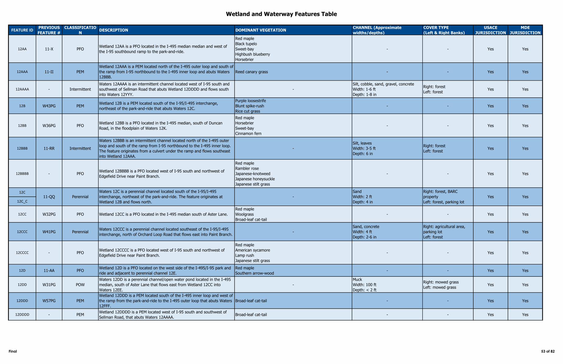
Wetland and Waterway Features Table
FEATURE IDPREVIOUS
FEATURE #
CLASSIFICATIO
NDESCRIPTION DOMINANT VEGETATION
CHANNEL (Approximate
widths/depths)
COVER TYPE
(Left & Right Banks)
USACE
JURISDICTION
MDE
JURISDICTION
12AA 11-X PFOWetland 12AA is a PFO located in the I-495 median median and west of
the I-95 southbound ramp to the park-and-ride.
Red maple
Black tupelo
Sweet-bay
Highbush blueberry
Horsebrier
- - Yes Yes
12AAA 11-II PEM
Wetland 12AAA is a PEM located north of the I-495 outer loop and south of
the ramp from I-95 northbound to the I-495 inner loop and abuts Waters
12BBB.
Reed canary grass - - Yes Yes
12AAAA - Intermittent
Waters 12AAAA is an intermittent channel located west of I-95 south and
southwest of Sellman Road that abuts Wetland 12DDDD and flows south
into Waters 12YYY.
-
Silt, cobble, sand, gravel, concrete
Width: 1-6 ft
Depth: 1-8 in
Right: forest
Left: forestYes Yes
12B W43PG PEMWetland 12B is a PEM located south of the I-95/I-495 interchange,
northeast of the park-and-ride that abuts Waters 12C.
Purple loosestrife
Blunt spike-rush
Rice cut grass
- - Yes Yes
12BB W36PG PFOWetland 12BB is a PFO located in the I-495 median, south of Duncan
Road, in the floodplain of Waters 12K.
Red maple
Horsebrier
Sweet-bay
Cinnamon fern
- - Yes Yes
12BBB 11-RR Intermittent
Waters 12BBB is an intermittent channel located north of the I-495 outer
loop and south of the ramp from I-95 northbound to the I-495 inner loop.
The feature originates from a culvert under the ramp and flows southeast
into Wetland 12AAA.
-
Silt, leaves
Width: 3-5 ft
Depth: 6 in
Right: forest
Left: forestYes Yes
12BBBB - PFOWetland 12BBBB is a PFO located west of I-95 south and northwest of
Edgefield Drive near Paint Branch.
Red maple
Rambler rose
Japanese-knotweed
Japanese honeysuckle
Japanese stilt grass
- - Yes Yes
12C
12C_C
12CC W32PG PFO Wetland 12CC is a PFO located in the I-495 median south of Aster Lane.
Red maple
Woolgrass
Broad-leaf cat-tail
- - Yes Yes
12CCC W41PG PerennialWaters 12CCC is a perennial channel located southeast of the I-95/I-495
interchange, north of Orchard Loop Road that flows east into Paint Branch. -
Sand, concrete
Width: 4 ft
Depth: 2-6 in
Right: agricultural area,
parking lot
Left: forest
Yes Yes
12CCCC - PFOWetland 12CCCC is a PFO located west of I-95 south and northwest of
Edgefield Drive near Paint Branch.
Red maple
American sycamore
Lamp rush
Japanese stilt grass
- - Yes Yes
12D 11-AA PFOWetland 12D is a PFO located on the west side of the I-495/I-95 park and
ride and adjacent to perennial channel 12E.
Red maple
Southern arrow-wood - - Yes Yes
12DD W31PG POW
Waters 12DD is a perennial channel/open water pond located in the I-495
median, south of Aster Lane that flows east from Wetland 12CC into
Waters 12EE.
-
Muck
Width: 100 ft
Depth: < 2 ft
Right: mowed grass
Left: mowed grass Yes Yes
12DDD W57PG PEM
Wetland 12DDD is a PEM located south of the I-495 inner loop and west of
the ramp from the park-and-ride to the I-495 outer loop that abuts Waters
12FFF.
Broad-leaf cat-tail - - Yes Yes
12DDDD - PEMWetland 12DDDD is a PEM located west of I-95 south and southwest of
Sellman Road, that abuts Waters 12AAAA. Broad-leaf cat-tail - - Yes Yes
11-QQ Perennial
Waters 12C is a perennial channel located south of the I-95/I-495
interchange, northeast of the park-and-ride. The feature originates at
Wetland 12B and flows north.
-
Sand
Width: 2 ft
Depth: 4 in
Right: forest, BARC
property
Left: forest, parking lot
Yes Yes
Final 53 of 82
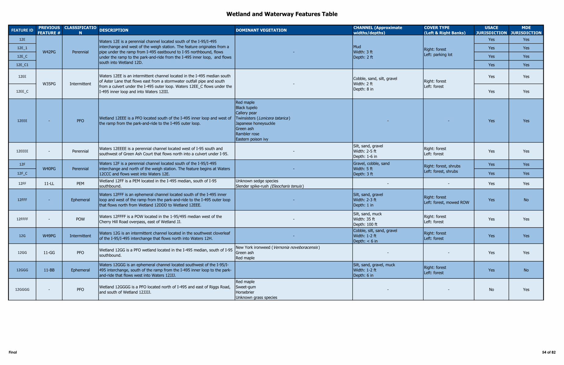
Wetland and Waterway Features Table
FEATURE IDPREVIOUS
FEATURE #
CLASSIFICATIO
NDESCRIPTION DOMINANT VEGETATION
CHANNEL (Approximate
widths/depths)
COVER TYPE
(Left & Right Banks)
USACE
JURISDICTION
MDE
JURISDICTION
12E Yes Yes
12E_1 Yes Yes
12E_C Yes Yes
12E_C1 Yes Yes
12EE Yes Yes
12EE_C Yes Yes
12EEE - PFOWetland 12EEE is a PFO located south of the I-495 inner loop and west of
the ramp from the park-and-ride to the I-495 outer loop.
Red maple
Black tupelo
Callery pear
Twinsisters (Lonicera tatarica )
Japanese honeysuckle
Green ash
Rambler rose
Eastern poison ivy
- - Yes Yes
12EEEE - PerennialWaters 12EEEE is a perennial channel located west of I-95 south and
southwest of Green Ash Court that flows north into a culvert under I-95. -
Silt, sand, gravel
Width: 2-5 ft
Depth: 1-6 in
Right: forest
Left: forestYes Yes
12F Yes Yes
12F_C Yes Yes
12FF 11-LL PEMWetland 12FF is a PEM located in the I-495 median, south of I-95
southbound.
Unknown sedge species
Slender spike-rush (Eleocharis tenuis )- - Yes Yes
12FFF - Ephemeral
Waters 12FFF is an ephemeral channel located south of the I-495 inner
loop and west of the ramp from the park-and-ride to the I-495 outer loop
that flows north from Wetland 12DDD to Wetland 12EEE.
-
Silt, sand, gravel
Width: 2-3 ft
Depth: 1 in
Right: forest
Left: forest, mowed ROWYes No
12FFFF - POWWaters 12FFFF is a POW located in the 1-95/495 median west of the
Cherry Hill Road overpass, east of Wetland JJ. -
Silt, sand, muck
Width: 35 ft
Depth: 100 ft
Right: forest
Left: forest Yes Yes
12G W49PG IntermittentWaters 12G is an intermittent channel located in the southwest cloverleaf
of the I-95/I-495 interchange that flows north into Waters 12H. -
Cobble, silt, sand, gravel
Width: 1-2 ft
Depth: < 6 in
Right: forest
Left: forestYes Yes
12GG 11-GG PFOWetland 12GG is a PFO wetland located in the I-495 median, south of I-95
southbound.
New York ironweed (Vernonia noveboracensis )
Green ash
Red maple
- - Yes Yes
12GGG 11-BB Ephemeral
Waters 12GGG is an ephemeral channel located southwest of the I-95/I-
495 interchange, south of the ramp from the I-495 inner loop to the park-
and-ride that flows west into Waters 12JJJ.
Silt, sand, gravel, muck
Width: 1-2 ft
Depth: 6 in
Right: forest
Left: forest Yes No
12GGGG - PFOWetland 12GGGG is a PFO located north of I-495 and east of Riggs Road,
and south of Wetland 12JJJJ.
Red maple
Sweet-gum
Horsebrier
Unknown grass species
- - No Yes
W40PG Perennial -
Gravel, cobble, sand
Width: 5 ft
Depth: 3 ft
Right: forest, shrubs
Left: forest, shrubs
W42PG Perennial
Waters 12E is a perennial channel located south of the I-95/I-495
interchange and west of the weigh station. The feature originates from a
pipe under the ramp from I-495 eastbound to I-95 northbound, flows
under the ramp to the park-and-ride from the I-495 inner loop, and flows
south into Wetland 12D.
-
Mud
Width: 3 ft
Depth: 2 ft
Right: forest
Left: parking lot
Intermittent
Waters 12EE is an intermittent channel located in the I-495 median south
of Aster Lane that flows east from a stormwater outfall pipe and south
from a culvert under the I-495 outer loop. Waters 12EE_C flows under the
I-495 inner loop and into Waters 12III.
-
Cobble, sand, silt, gravel
Width: 2 ft
Depth: 8 in
Right: forest
Left: forest
Waters 12F is a perennial channel located south of the I-95/I-495
interchange and north of the weigh station. The feature begins at Waters
12CCC and flows west into Waters 12E.
W35PG
Final 54 of 82
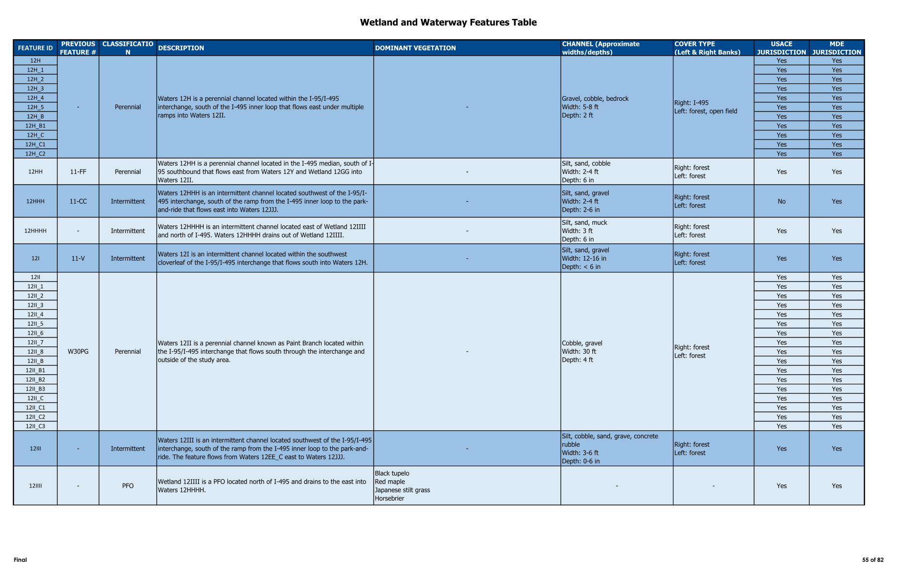
Wetland and Waterway Features Table
FEATURE IDPREVIOUS
FEATURE #
CLASSIFICATIO
NDESCRIPTION DOMINANT VEGETATION
CHANNEL (Approximate
widths/depths)
COVER TYPE
(Left & Right Banks)
USACE
JURISDICTION
MDE
JURISDICTION
12H Yes Yes
12H_1 Yes Yes
12H_2 Yes Yes
12H_3 Yes Yes
12H_4 Yes Yes
12H_5 Yes Yes
12H_B Yes Yes
12H_B1 Yes Yes
12H_C Yes Yes
12H_C1 Yes Yes
12H_C2 Yes Yes
12HH 11-FF Perennial
Waters 12HH is a perennial channel located in the I-495 median, south of I-
95 southbound that flows east from Waters 12Y and Wetland 12GG into
Waters 12II.
-
Silt, sand, cobble
Width: 2-4 ft
Depth: 6 in
Right: forest
Left: forestYes Yes
12HHH 11-CC Intermittent
Waters 12HHH is an intermittent channel located southwest of the I-95/I-
495 interchange, south of the ramp from the I-495 inner loop to the park-
and-ride that flows east into Waters 12JJJ.
-
Silt, sand, gravel
Width: 2-4 ft
Depth: 2-6 in
Right: forest
Left: forestNo Yes
12HHHH - IntermittentWaters 12HHHH is an intermittent channel located east of Wetland 12IIII
and north of I-495. Waters 12HHHH drains out of Wetland 12IIII.-
Silt, sand, muck
Width: 3 ft
Depth: 6 in
Right: forest
Left: forestYes Yes
12I 11-V IntermittentWaters 12I is an intermittent channel located within the southwest
cloverleaf of the I-95/I-495 interchange that flows south into Waters 12H.-
Silt, sand, gravel
Width: 12-16 in
Depth: < 6 in
Right: forest
Left: forestYes Yes
12II Yes Yes
12II_1 Yes Yes
12II_2 Yes Yes
12II_3 Yes Yes
12II_4 Yes Yes
12II_5 Yes Yes
12II_6 Yes Yes
12II_7 Yes Yes
12II_8 Yes Yes
12II_B Yes Yes
12II_B1 Yes Yes
12II_B2 Yes Yes
12II_B3 Yes Yes
12II_C Yes Yes
12II_C1 Yes Yes
12II_C2 Yes Yes
12II_C3 Yes Yes
12III - Intermittent
Waters 12III is an intermittent channel located southwest of the I-95/I-495
interchange, south of the ramp from the I-495 inner loop to the park-and-
ride. The feature flows from Waters 12EE_C east to Waters 12JJJ.
-
Silt, cobble, sand, grave, concrete
rubble
Width: 3-6 ft
Depth: 0-6 in
Right: forest
Left: forestYes Yes
12IIII - PFOWetland 12IIII is a PFO located north of I-495 and drains to the east into
Waters 12HHHH.
Black tupelo
Red maple
Japanese stilt grass
Horsebrier
- - Yes Yes
- Perennial
Waters 12H is a perennial channel located within the I-95/I-495
interchange, south of the I-495 inner loop that flows east under multiple
ramps into Waters 12II.
-
Gravel, cobble, bedrock
Width: 5-8 ft
Depth: 2 ft
Right: I-495
Left: forest, open field
W30PG Perennial
Waters 12II is a perennial channel known as Paint Branch located within
the I-95/I-495 interchange that flows south through the interchange and
outside of the study area.
-
Cobble, gravel
Width: 30 ft
Depth: 4 ft
Right: forest
Left: forest
Final 55 of 82
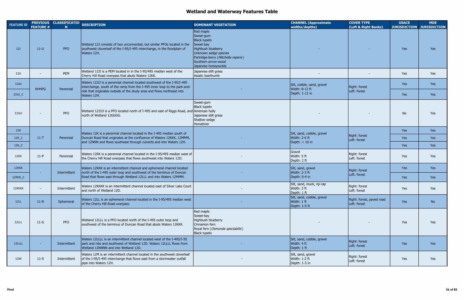
Wetland and Waterway Features Table
FEATURE IDPREVIOUS
FEATURE #
CLASSIFICATIO
NDESCRIPTION DOMINANT VEGETATION
CHANNEL (Approximate
widths/depths)
COVER TYPE
(Left & Right Banks)
USACE
JURISDICTION
MDE
JURISDICTION
12J 11-U PFO
Wetland 12J consists of two unconnected, but similar PFOs located in the
southwest cloverleaf of the I-95/I-495 interchange, in the floodplain of
Waters 12H.
Red maple
Sweet-gum
Black tupelo
Sweet-bay
Highbush blueberry
Unknown sedge species
Partridge-berry (Mitchella repens )
Southern arrow-wood
Japanese honeysuckle
- - Yes Yes
12JJ - PEMWetland 12JJ is a PEM located in in the I-95/495 median west of the
Cherry Hill Road overpass that abuts Waters 12KK.
Japanese stilt grass
Asiatic tearthumb- - Yes Yes
12JJJ Yes Yes
12JJJ_C Yes Yes
12JJJJ - PFOWetland 12JJJJ is a PFO located north of I-495 and east of Riggs Road, and
north of Wetland 12GGGG.
Sweet-gum
Black tupelo
American holly
Japanese stilt grass
Shallow sedge
Horsebrier
- - No Yes
12K Yes Yes
12K_1 Yes Yes
12K_C Yes Yes
12KK 11-P PerennialWaters 12KK is a perennial channel located in the I-95/495 median west of
the Cherry Hill Road overpass that flows southwest into Waters 12II. -
Gravel
Width: 5 ft
Depth: 2 ft
Right: forest
Left: forestYes Yes
12KKK Yes Yes
12KKK_C Yes Yes
12KKKK - IntermittentWaters 12KKKK is an intermittent channel located east of Silver Lake Court
and north of Wetland 12D.-
Silt, sand, muck, rip-rap
Width: 3 ft
Depth: 1 ft
Right: forest
Left: forestYes Yes
12LL 11-R EphemeralWaters 12LL is an ephemeral channel located in the I-95/495 median west
of the Cherry Hill Road overpass.-
Silt, sand, cobble, gravel
Width: 1 ft
Depth: 1-5 ft
Right: forest, paved road
Left: forestYes No
12LLL 11-G PFOWetland 12LLL is a PFO located north of the I-495 outer loop and
southwest of the terminus of Duncan Road that abuts Waters 12KKK.
Red maple
Sweet-bay
Highbush blueberry
Cinnamon fern
Royal fern (Osmunda spectabilis )
Black tupelo
- - Yes Yes
12LLLL - Intermittent
Waters 12LLLL is an intermittent channel located west of the I-495/I-95
park and ride and southwest of Wetland 12D. Waters 12LLLL flows from
Wetland 12NNNN and into Wetland 12D.
-
Silt, sand, cobble, gravel
Width: 4 ft
Depth: 1 ft
Right: forest
Left: forestYes Yes
12M 11-S Intermittent
Waters 12M is an intermittent channel located in the southwest cloverleaf
of the I-95/I-495 interchange that flows east from a stormwater outfall
pipe into Waters 12H.
-
Silt, sand, gravel
Width: 1-2 ft
Depth: 1-3 in
Right: forest
Left: forestYes Yes
W44PG Perennial
Waters 12JJJ is a perennial channel located southwest of the I-95/I-495
interchange, south of the ramp from the I-495 inner loop to the park-and-
ride that originates outside of the study area and flows northeast into
Waters 12H.
-
Perennial
Waters 12K is a perennial channel located in the I-495 median south of
Duncan Road that originates at the confluence of Waters 12KKK, 12MMM,
and 12NNN and flows southeast through culverts and into Waters 12H.
-
Silt, sand, cobble, gravel
Width: 2-6 ft
Depth: < 10 in
Right: forest
Left: forest
- Intermittent
Waters 12KKK is an intermittent channel and ephemeral channel located
north of the I-495 outer loop and southwest of the terminus of Duncan
Road that flows east through Wetland 12LLL and into Waters 12MMM.
-
Silt, sand, gravel
Width: 2-3 ft
Depth: 0-4 in
Right: forest
Left: forest
Silt, cobble, sand, gravel
Width: 8-12 ft
Depth: 1-12 in
Right: forest
Left: forest
11-T
Final 56 of 82
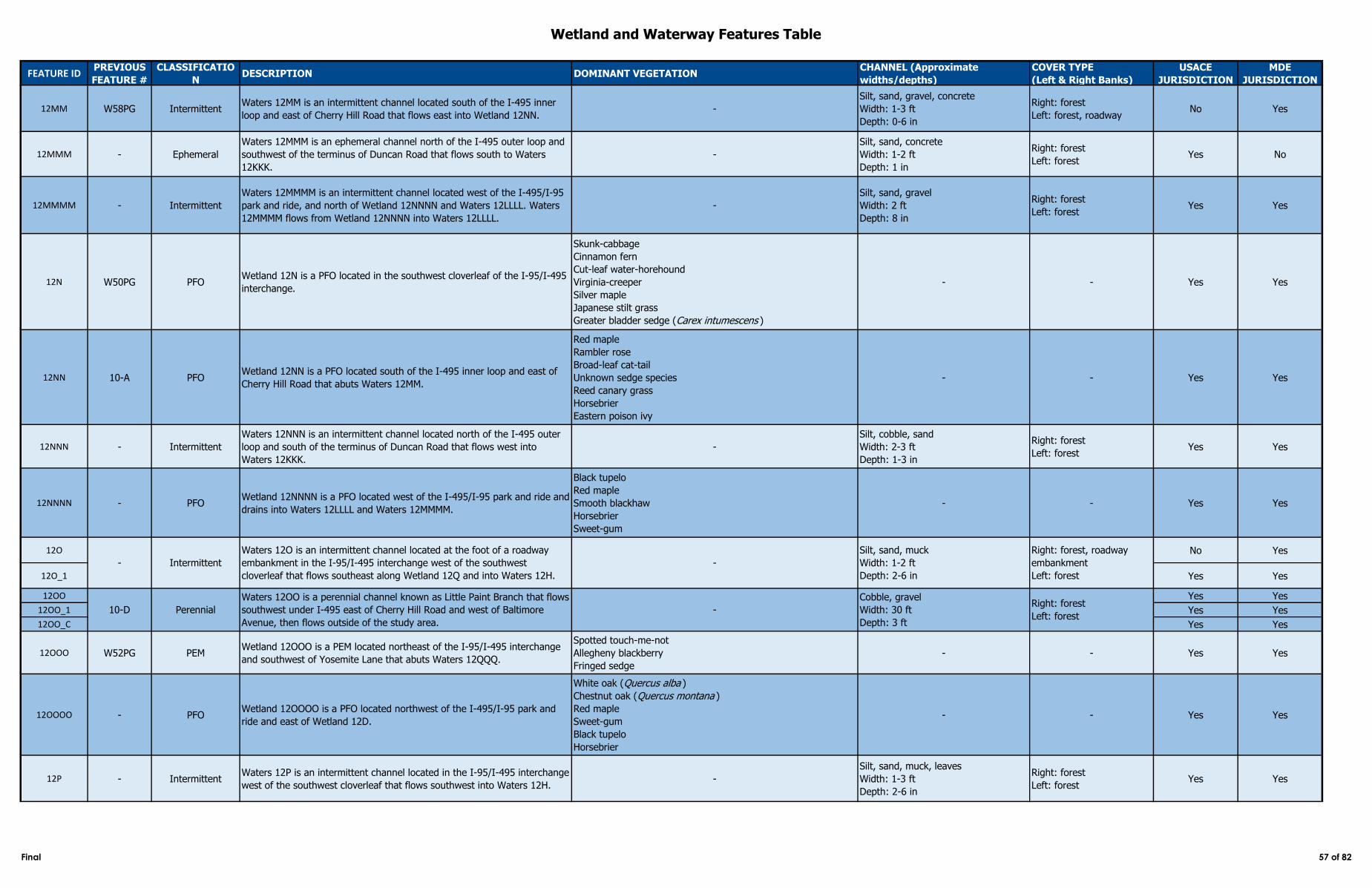
Wetland and Waterway Features Table
FEATURE IDPREVIOUS
FEATURE #
CLASSIFICATIO
NDESCRIPTION DOMINANT VEGETATION
CHANNEL (Approximate
widths/depths)
COVER TYPE
(Left & Right Banks)
USACE
JURISDICTION
MDE
JURISDICTION
12MM W58PG IntermittentWaters 12MM is an intermittent channel located south of the I-495 inner
loop and east of Cherry Hill Road that flows east into Wetland 12NN. -
Silt, sand, gravel, concrete
Width: 1-3 ft
Depth: 0-6 in
Right: forest
Left: forest, roadwayNo Yes
12MMM - Ephemeral
Waters 12MMM is an ephemeral channel north of the I-495 outer loop and
southwest of the terminus of Duncan Road that flows south to Waters
12KKK.
-
Silt, sand, concrete
Width: 1-2 ft
Depth: 1 in
Right: forest
Left: forestYes No
12MMMM - Intermittent
Waters 12MMMM is an intermittent channel located west of the I-495/I-95
park and ride, and north of Wetland 12NNNN and Waters 12LLLL. Waters
12MMMM flows from Wetland 12NNNN into Waters 12LLLL.
-
Silt, sand, gravel
Width: 2 ft
Depth: 8 in
Right: forest
Left: forestYes Yes
12N W50PG PFOWetland 12N is a PFO located in the southwest cloverleaf of the I-95/I-495
interchange.
Skunk-cabbage
Cinnamon fern
Cut-leaf water-horehound
Virginia-creeper
Silver maple
Japanese stilt grass
Greater bladder sedge (Carex intumescens )
- - Yes Yes
12NN 10-A PFOWetland 12NN is a PFO located south of the I-495 inner loop and east of
Cherry Hill Road that abuts Waters 12MM.
Red maple
Rambler rose
Broad-leaf cat-tail
Unknown sedge species
Reed canary grass
Horsebrier
Eastern poison ivy
- - Yes Yes
12NNN - Intermittent
Waters 12NNN is an intermittent channel located north of the I-495 outer
loop and south of the terminus of Duncan Road that flows west into
Waters 12KKK.
-
Silt, cobble, sand
Width: 2-3 ft
Depth: 1-3 in
Right: forest
Left: forestYes Yes
12NNNN - PFOWetland 12NNNN is a PFO located west of the I-495/I-95 park and ride and
drains into Waters 12LLLL and Waters 12MMMM.
Black tupelo
Red maple
Smooth blackhaw
Horsebrier
Sweet-gum
- - Yes Yes
12O No Yes
12O_1 Yes Yes
12OO Yes Yes
12OO_1 Yes Yes
12OO_C Yes Yes
12OOO W52PG PEMWetland 12OOO is a PEM located northeast of the I-95/I-495 interchange
and southwest of Yosemite Lane that abuts Waters 12QQQ.
Spotted touch-me-not
Allegheny blackberry
Fringed sedge
- - Yes Yes
12OOOO - PFOWetland 12OOOO is a PFO located northwest of the I-495/I-95 park and
ride and east of Wetland 12D.
White oak (Quercus alba )
Chestnut oak (Quercus montana )
Red maple
Sweet-gum
Black tupelo
Horsebrier
- - Yes Yes
12P - IntermittentWaters 12P is an intermittent channel located in the I-95/I-495 interchange
west of the southwest cloverleaf that flows southwest into Waters 12H. -
Silt, sand, muck, leaves
Width: 1-3 ft
Depth: 2-6 in
Right: forest
Left: forestYes Yes
10-D Perennial
Waters 12OO is a perennial channel known as Little Paint Branch that flows
southwest under I-495 east of Cherry Hill Road and west of Baltimore
Avenue, then flows outside of the study area.
-
Cobble, gravel
Width: 30 ft
Depth: 3 ft
Right: forest
Left: forest
- Intermittent
Waters 12O is an intermittent channel located at the foot of a roadway
embankment in the I-95/I-495 interchange west of the southwest
cloverleaf that flows southeast along Wetland 12Q and into Waters 12H.
-
Silt, sand, muck
Width: 1-2 ft
Depth: 2-6 in
Right: forest, roadway
embankment
Left: forest
Final 57 of 82
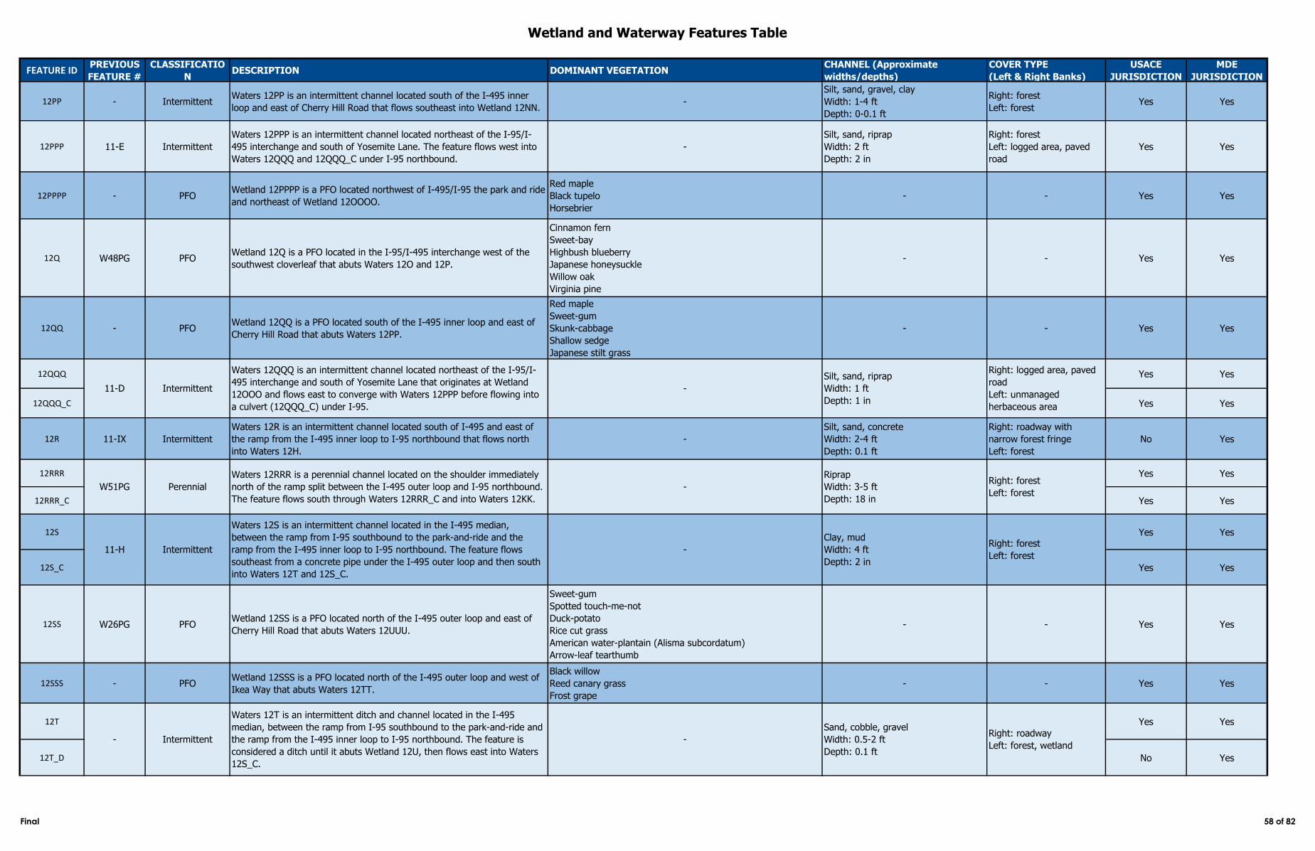
Wetland and Waterway Features Table
FEATURE IDPREVIOUS
FEATURE #
CLASSIFICATIO
NDESCRIPTION DOMINANT VEGETATION
CHANNEL (Approximate
widths/depths)
COVER TYPE
(Left & Right Banks)
USACE
JURISDICTION
MDE
JURISDICTION
12PP - IntermittentWaters 12PP is an intermittent channel located south of the I-495 inner
loop and east of Cherry Hill Road that flows southeast into Wetland 12NN. -
Silt, sand, gravel, clay
Width: 1-4 ft
Depth: 0-0.1 ft
Right: forest
Left: forestYes Yes
12PPP 11-E Intermittent
Waters 12PPP is an intermittent channel located northeast of the I-95/I-
495 interchange and south of Yosemite Lane. The feature flows west into
Waters 12QQQ and 12QQQ_C under I-95 northbound.
-
Silt, sand, riprap
Width: 2 ft
Depth: 2 in
Right: forest
Left: logged area, paved
road
Yes Yes
12PPPP - PFOWetland 12PPPP is a PFO located northwest of I-495/I-95 the park and ride
and northeast of Wetland 12OOOO.
Red maple
Black tupelo
Horsebrier
- - Yes Yes
12Q W48PG PFOWetland 12Q is a PFO located in the I-95/I-495 interchange west of the
southwest cloverleaf that abuts Waters 12O and 12P.
Cinnamon fern
Sweet-bay
Highbush blueberry
Japanese honeysuckle
Willow oak
Virginia pine
- - Yes Yes
12QQ - PFOWetland 12QQ is a PFO located south of the I-495 inner loop and east of
Cherry Hill Road that abuts Waters 12PP.
Red maple
Sweet-gum
Skunk-cabbage
Shallow sedge
Japanese stilt grass
- - Yes Yes
12QQQ Yes Yes
12QQQ_C Yes Yes
12R 11-IX Intermittent
Waters 12R is an intermittent channel located south of I-495 and east of
the ramp from the I-495 inner loop to I-95 northbound that flows north
into Waters 12H.
-
Silt, sand, concrete
Width: 2-4 ft
Depth: 0.1 ft
Right: roadway with
narrow forest fringe
Left: forest
No Yes
12RRR Yes Yes
12RRR_C Yes Yes
12S Yes Yes
12S_C Yes Yes
12SS W26PG PFOWetland 12SS is a PFO located north of the I-495 outer loop and east of
Cherry Hill Road that abuts Waters 12UUU.
Sweet-gum
Spotted touch-me-not
Duck-potato
Rice cut grass
American water-plantain (Alisma subcordatum)
Arrow-leaf tearthumb
- - Yes Yes
12SSS - PFOWetland 12SSS is a PFO located north of the I-495 outer loop and west of
Ikea Way that abuts Waters 12TT.
Black willow
Reed canary grass
Frost grape
- - Yes Yes
12T Yes Yes
12T_D No Yes
11-D Intermittent
Waters 12QQQ is an intermittent channel located northeast of the I-95/I-
495 interchange and south of Yosemite Lane that originates at Wetland
12OOO and flows east to converge with Waters 12PPP before flowing into
a culvert (12QQQ_C) under I-95.
-
Silt, sand, riprap
Width: 1 ft
Depth: 1 in
Right: logged area, paved
road
Left: unmanaged
herbaceous area
W51PG Perennial
Waters 12RRR is a perennial channel located on the shoulder immediately
north of the ramp split between the I-495 outer loop and I-95 northbound.
The feature flows south through Waters 12RRR_C and into Waters 12KK.
-
Riprap
Width: 3-5 ft
Depth: 18 in
Right: forest
Left: forest
- Intermittent
Waters 12T is an intermittent ditch and channel located in the I-495
median, between the ramp from I-95 southbound to the park-and-ride and
the ramp from the I-495 inner loop to I-95 northbound. The feature is
considered a ditch until it abuts Wetland 12U, then flows east into Waters
12S_C.
-
Sand, cobble, gravel
Width: 0.5-2 ft
Depth: 0.1 ft
Right: roadway
Left: forest, wetland
11-H Intermittent
Waters 12S is an intermittent channel located in the I-495 median,
between the ramp from I-95 southbound to the park-and-ride and the
ramp from the I-495 inner loop to I-95 northbound. The feature flows
southeast from a concrete pipe under the I-495 outer loop and then south
into Waters 12T and 12S_C.
-
Clay, mud
Width: 4 ft
Depth: 2 in
Right: forest
Left: forest
Final 58 of 82
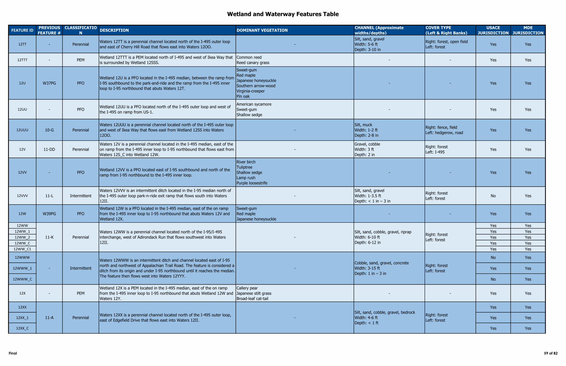
Wetland and Waterway Features Table
FEATURE IDPREVIOUS
FEATURE #
CLASSIFICATIO
NDESCRIPTION DOMINANT VEGETATION
CHANNEL (Approximate
widths/depths)
COVER TYPE
(Left & Right Banks)
USACE
JURISDICTION
MDE
JURISDICTION
12TT - PerennialWaters 12TT is a perennial channel located north of the I-495 outer loop
and east of Cherry Hill Road that flows east into Waters 12OO. -
Silt, sand, gravel
Width: 5-6 ft
Depth: 3-10 in
Right: forest, open field
Left: forestYes Yes
12TTT - PEMWetland 12TTT is a PEM located north of I-495 and west of Ikea Way that
is surrounded by Wetland 12SSS.
Common reed
Reed canary grass- - Yes Yes
12U W37PG PFO
Wetland 12U is a PFO located in the I-495 median, between the ramp from
I-95 southbound to the park-and-ride and the ramp from the I-495 inner
loop to I-95 northbound that abuts Waters 12T.
Sweet-gum
Red maple
Japanese honeysuckle
Southern arrow-wood
Virginia-creeper
Pin oak
- - Yes Yes
12UU - PFOWetland 12UU is a PFO located north of the I-495 outer loop and west of
the I-495 on ramp from US-1.
American sycamore
Sweet-gum
Shallow sedge
- - Yes Yes
12UUU 10-G Perennial
Waters 12UUU is a perennial channel located north of the I-495 outer loop
and west of Ikea Way that flows east from Wetland 12SS into Waters
12OO.
-
Silt, muck
Width: 1-2 ft
Depth: 2-8 in
Right: fence, field
Left: hedgerow, roadYes Yes
12V 11-DD Perennial
Waters 12V is a perennial channel located in the I-495 median, east of the
on ramp from the I-495 inner loop to I-95 northbound that flows east from
Waters 12S_C into Wetland 12W.
-
Gravel, cobble
Width: 3 ft
Depth: 2 in
Right: forest
Left: I-495Yes Yes
12VV - PFOWetland 12VV is a PFO located east of I-95 southbound and north of the
ramp from I-95 northbound to the I-495 inner loop.
River birch
Tuliptree
Shallow sedge
Lamp rush
Purple loosestrife
- - Yes Yes
12VVV 11-L Intermittent
Waters 12VVV is an intermittent ditch located in the I-95 median north of
the I-495 outer loop park-n-ride exit ramp that flows south into Waters
12II.
-
Silt, sand, gravel
Width: 1-3.5 ft
Depth: < 1 in – 3 in
Right: forest
Left: forestNo Yes
12W W39PG PFO
Wetland 12W is a PFO located in the I-495 median, east of the on ramp
from the I-495 inner loop to I-95 northbound that abuts Waters 12V and
Wetland 12X.
Sweet-gum
Red maple
Japanese honeysuckle
- - Yes Yes
12WW Yes Yes
12WW_1 Yes Yes
12WW_2 Yes Yes
12WW_C Yes Yes
12WW_C1 Yes Yes
12WWW No Yes
12WWW_1 Yes Yes
12WWW_C No Yes
12X - PEM
Wetland 12X is a PEM located in the I-495 median, east of the on ramp
from the I-495 inner loop to I-95 northbound that abuts Wetland 12W and
Waters 12Y.
Callery pear
Japanese stilt grass
Broad-leaf cat-tail
- - Yes Yes
12XX Yes Yes
12XX_1 Yes Yes
12XX_C Yes Yes
Waters 12WW is a perennial channel located north of the I-95/I-495
interchange, west of Adirondack Run that flows southwest into Waters
12II.
-
Silt, sand, cobble, gravel, riprap
Width: 6-10 ft
Depth: 6-12 in
Right: forest
Left: forest
- Intermittent
Waters 12WWW is an intermittent ditch and channel located east of I-95
north and northwest of Appalachian Trail Road. The feature is considered a
ditch from its origin and under I-95 northbound until it reaches the median.
The feature then flows west into Waters 12YYY.
-
Cobble, sand, gravel, concrete
Width: 3-15 ft
Depth: 1 in – 3 in
Right: forest
Left: forest
11-K Perennial
PerennialWaters 12XX is a perennial channel located north of the I-495 outer loop,
east of Edgefield Drive that flows east into Waters 12II. -11-A
Silt, sand, cobble, gravel, bedrock
Width: 4-6 ft
Depth: < 1 ft
Right: forest
Left: forest
Final 59 of 82
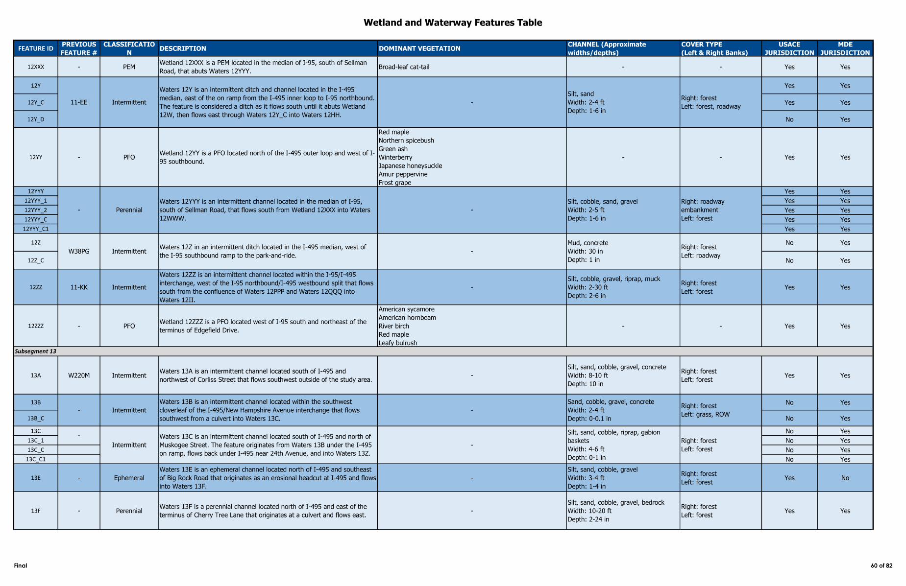
Wetland and Waterway Features Table
FEATURE IDPREVIOUS
FEATURE #
CLASSIFICATIO
NDESCRIPTION DOMINANT VEGETATION
CHANNEL (Approximate
widths/depths)
COVER TYPE
(Left & Right Banks)
USACE
JURISDICTION
MDE
JURISDICTION
12XXX - PEMWetland 12XXX is a PEM located in the median of I-95, south of Sellman
Road, that abuts Waters 12YYY. Broad-leaf cat-tail - - Yes Yes
12Y Yes Yes
12Y_C Yes Yes
12Y_D No Yes
12YY - PFOWetland 12YY is a PFO located north of the I-495 outer loop and west of I-
95 southbound.
Red maple
Northern spicebush
Green ash
Winterberry
Japanese honeysuckle
Amur peppervine
Frost grape
- - Yes Yes
12YYY Yes Yes
12YYY_1 Yes Yes
12YYY_2 Yes Yes
12YYY_C Yes Yes
12YYY_C1 Yes Yes
12Z No Yes
12Z_C No Yes
12ZZ 11-KK Intermittent
Waters 12ZZ is an intermittent channel located within the I-95/I-495
interchange, west of the I-95 northbound/I-495 westbound split that flows
south from the confluence of Waters 12PPP and Waters 12QQQ into
Waters 12II.
-
Silt, cobble, gravel, riprap, muck
Width: 2-30 ft
Depth: 2-6 in
Right: forest
Left: forestYes Yes
12ZZZ - PFOWetland 12ZZZ is a PFO located west of I-95 south and northeast of the
terminus of Edgefield Drive.
American sycamore
American hornbeam
River birch
Red maple
Leafy bulrush
- - Yes Yes
13A W220M IntermittentWaters 13A is an intermittent channel located south of I-495 and
northwest of Corliss Street that flows southwest outside of the study area. -
Silt, sand, cobble, gravel, concrete
Width: 8-10 ft
Depth: 10 in
Right: forest
Left: forestYes Yes
13B No Yes
13B_C No Yes
13C No Yes
13C_1 No Yes
13C_C No Yes
13C_C1 No Yes
13E - Ephemeral
Waters 13E is an ephemeral channel located north of I-495 and southeast
of Big Rock Road that originates as an erosional headcut at I-495 and flows
into Waters 13F.
-
Silt, sand, cobble, gravel
Width: 3-4 ft
Depth: 1-4 in
Right: forest
Left: forestYes No
13F - PerennialWaters 13F is a perennial channel located north of I-495 and east of the
terminus of Cherry Tree Lane that originates at a culvert and flows east. -
Silt, sand, cobble, gravel, bedrock
Width: 10-20 ft
Depth: 2-24 in
Right: forest
Left: forestYes Yes
-
Sand, cobble, gravel, concrete
Width: 2-4 ft
Depth: 0-0.1 in
Right: forest
Left: grass, ROW
-
11-EE Intermittent
Waters 12Y is an intermittent ditch and channel located in the I-495
median, east of the on ramp from the I-495 inner loop to I-95 northbound.
The feature is considered a ditch as it flows south until it abuts Wetland
12W, then flows east through Waters 12Y_C into Waters 12HH.
-
Silt, sand
Width: 2-4 ft
Depth: 1-6 in
Right: forest
Left: forest, roadway
- Perennial
Waters 12YYY is an intermittent channel located in the median of I-95,
south of Sellman Road, that flows south from Wetland 12XXX into Waters
12WWW.
-
Silt, cobble, sand, gravel
Width: 2-5 ft
Depth: 1-6 in
Right: roadway
embankment
Left: forest
Subsegment 13
- Intermittent
Waters 13B is an intermittent channel located within the southwest
cloverleaf of the I-495/New Hampshire Avenue interchange that flows
southwest from a culvert into Waters 13C.
IntermittentWaters 12Z in an intermittent ditch located in the I-495 median, west of
the I-95 southbound ramp to the park-and-ride.-
Mud, concrete
Width: 30 in
Depth: 1 in
Right: forest
Left: roadwayW38PG
Intermittent
Waters 13C is an intermittent channel located south of I-495 and north of
Muskogee Street. The feature originates from Waters 13B under the I-495
on ramp, flows back under I-495 near 24th Avenue, and into Waters 13Z.
-
Silt, sand, cobble, riprap, gabion
baskets
Width: 4-6 ft
Depth: 0-1 in
Right: forest
Left: forest
Final 60 of 82
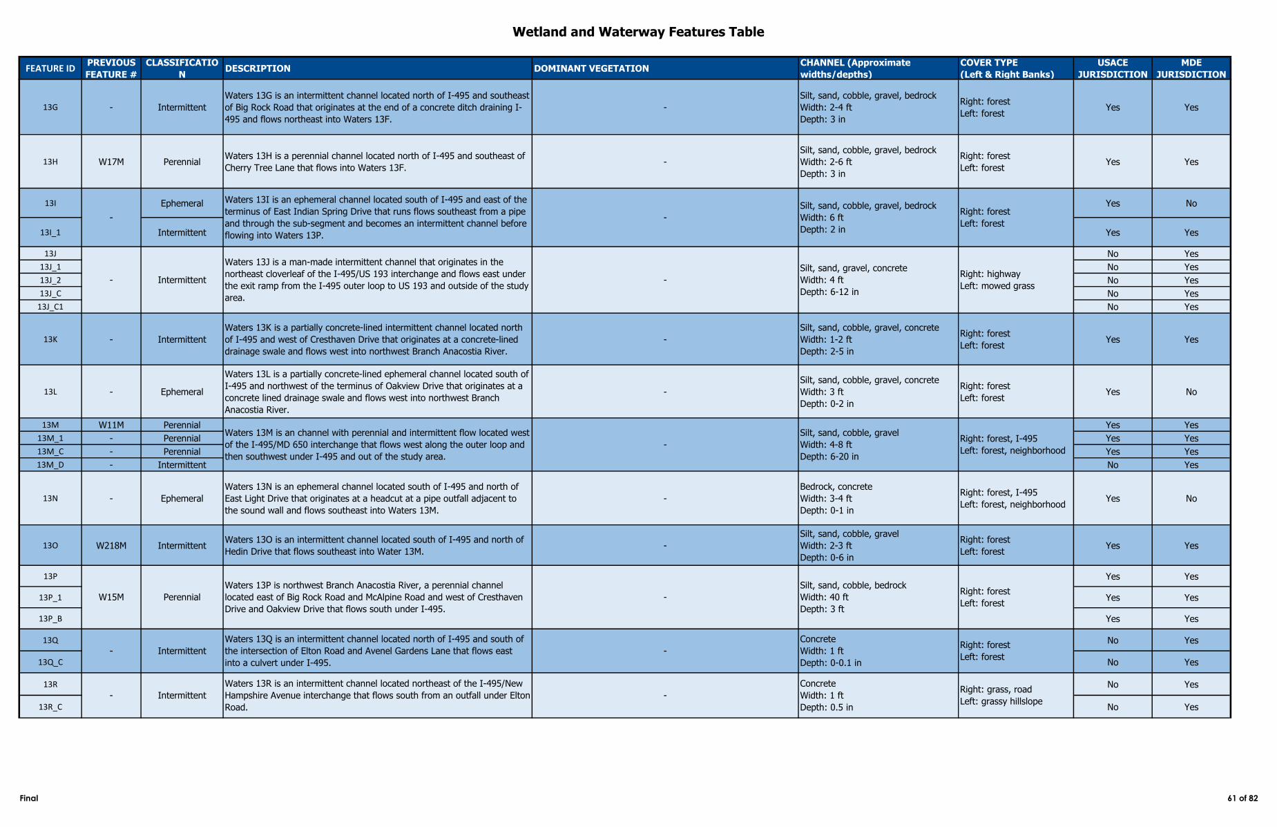
Wetland and Waterway Features Table
FEATURE IDPREVIOUS
FEATURE #
CLASSIFICATIO
NDESCRIPTION DOMINANT VEGETATION
CHANNEL (Approximate
widths/depths)
COVER TYPE
(Left & Right Banks)
USACE
JURISDICTION
MDE
JURISDICTION
13G - Intermittent
Waters 13G is an intermittent channel located north of I-495 and southeast
of Big Rock Road that originates at the end of a concrete ditch draining I-
495 and flows northeast into Waters 13F.
-
Silt, sand, cobble, gravel, bedrock
Width: 2-4 ft
Depth: 3 in
Right: forest
Left: forestYes Yes
13H W17M PerennialWaters 13H is a perennial channel located north of I-495 and southeast of
Cherry Tree Lane that flows into Waters 13F. -
Silt, sand, cobble, gravel, bedrock
Width: 2-6 ft
Depth: 3 in
Right: forest
Left: forestYes Yes
13I Ephemeral Yes No
13I_1 Intermittent Yes Yes
13J No Yes
13J_1 No Yes
13J_2 No Yes
13J_C No Yes
13J_C1 No Yes
13K - Intermittent
Waters 13K is a partially concrete-lined intermittent channel located north
of I-495 and west of Cresthaven Drive that originates at a concrete-lined
drainage swale and flows west into northwest Branch Anacostia River.
-
Silt, sand, cobble, gravel, concrete
Width: 1-2 ft
Depth: 2-5 in
Right: forest
Left: forestYes Yes
13L - Ephemeral
Waters 13L is a partially concrete-lined ephemeral channel located south of
I-495 and northwest of the terminus of Oakview Drive that originates at a
concrete lined drainage swale and flows west into northwest Branch
Anacostia River.
-
Silt, sand, cobble, gravel, concrete
Width: 3 ft
Depth: 0-2 in
Right: forest
Left: forestYes No
13M W11M Perennial Yes Yes
13M_1 - Perennial Yes Yes
13M_C - Perennial Yes Yes
13M_D - Intermittent No Yes
13N - Ephemeral
Waters 13N is an ephemeral channel located south of I-495 and north of
East Light Drive that originates at a headcut at a pipe outfall adjacent to
the sound wall and flows southeast into Waters 13M.
-
Bedrock, concrete
Width: 3-4 ft
Depth: 0-1 in
Right: forest, I-495
Left: forest, neighborhoodYes No
13O W218M IntermittentWaters 13O is an intermittent channel located south of I-495 and north of
Hedin Drive that flows southeast into Water 13M. -
Silt, sand, cobble, gravel
Width: 2-3 ft
Depth: 0-6 in
Right: forest
Left: forestYes Yes
13P Yes Yes
13P_1 Yes Yes
13P_B Yes Yes
13Q No Yes
13Q_C No Yes
13R No Yes
13R_C No Yes
-
Waters 13I is an ephemeral channel located south of I-495 and east of the
terminus of East Indian Spring Drive that runs flows southeast from a pipe
and through the sub-segment and becomes an intermittent channel before
flowing into Waters 13P.
-
Silt, sand, cobble, gravel, bedrock
Width: 6 ft
Depth: 2 in
Right: forest
Left: forest
- Intermittent
Waters 13J is a man-made intermittent channel that originates in the
northeast cloverleaf of the I-495/US 193 interchange and flows east under
the exit ramp from the I-495 outer loop to US 193 and outside of the study
area.
-
Silt, sand, gravel, concrete
Width: 4 ft
Depth: 6-12 in
Right: highway
Left: mowed grass
- Intermittent
W15M Perennial -
Silt, sand, cobble, bedrock
Width: 40 ft
Depth: 3 ft
Right: forest
Left: forest
-
Concrete
Width: 1 ft
Depth: 0-0.1 in
Right: forest
Left: forest
Waters 13Q is an intermittent channel located north of I-495 and south of
the intersection of Elton Road and Avenel Gardens Lane that flows east
into a culvert under I-495.
Waters 13M is an channel with perennial and intermittent flow located west
of the I-495/MD 650 interchange that flows west along the outer loop and
then southwest under I-495 and out of the study area.
-
Silt, sand, cobble, gravel
Width: 4-8 ft
Depth: 6-20 in
Right: forest, I-495
Left: forest, neighborhood
Waters 13P is northwest Branch Anacostia River, a perennial channel
located east of Big Rock Road and McAlpine Road and west of Cresthaven
Drive and Oakview Drive that flows south under I-495.
- Intermittent
Waters 13R is an intermittent channel located northeast of the I-495/New
Hampshire Avenue interchange that flows south from an outfall under Elton
Road.
-
Concrete
Width: 1 ft
Depth: 0.5 in
Right: grass, road
Left: grassy hillslope
Final 61 of 82
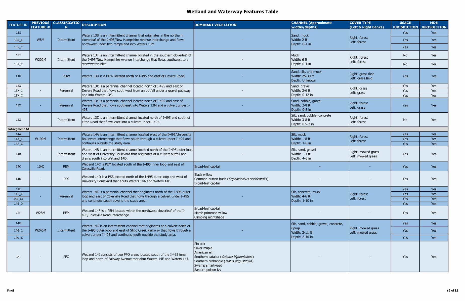
Wetland and Waterway Features Table
FEATURE IDPREVIOUS
FEATURE #
CLASSIFICATIO
NDESCRIPTION DOMINANT VEGETATION
CHANNEL (Approximate
widths/depths)
COVER TYPE
(Left & Right Banks)
USACE
JURISDICTION
MDE
JURISDICTION
13S Yes Yes
13S_1 Yes Yes
13S_C Yes Yes
13T No Yes
13T_C No Yes
13U POW Waters 13U is a POW located north of I-495 and east of Devere Road. -
Sand, silt, and muck
Width: 25-30 ft
Depth: Unknown
Right: grass field
Left: grass field Yes Yes
13X Yes Yes
13X_1 Yes Yes
13X_C Yes Yes
13Y - Perennial
Waters 13Y is a perennial channel located north of I-495 and east of
Devere Road that flows southeast into Waters 13M and a culvert under I-
495.
-
Sand, cobble, gravel
Width: 2-8 ft
Depth: 0-5 in
Right: forest
Left: grassYes Yes
13Z - IntermittentWaters 13Z is an intermittent channel located north of I-495 and south of
Elton Road that flows east into a culvert under I-495. -
Silt, sand, cobble, concrete
Width: 3-8 ft
Depth: 0.5-2 in
Right: forest
Left: forestNo Yes
14A Yes Yes
14A_1 Yes Yes
14A_C Yes Yes
14B - Intermittent
Waters 14B is an intermittent channel located north of the I-495 outer loop
and west of University Boulevard that originates at a culvert outfall and
drains south into Wetland 14D.
-
Silt, sand, gravel
Width: 1-3 ft
Depth: 4-6 in
Right: mowed grass
Left: mowed grassYes Yes
14C 10-C PEMWetland 14C is PEM located south of the I-495 inner loop and east of
Colesville Road. Broad-leaf cat-tail - - Yes Yes
14D - PSSWetland 14D is a PSS located north of the I-495 outer loop and west of
University Boulevard that abuts Waters 14A and Waters 14B.
Black willow
Common button bush (Cephalanthus occidentalis )
Broad-leaf cat-tail
- - Yes Yes
14E Yes Yes
14E_C Yes Yes
14E_C1 Yes Yes
14E_D Yes Yes
14F W28M PEMWetland 14F is a PEM located within the northwest cloverleaf of the I-
495/Colesville Road interchange.
Broad-leaf cat-tail
Marsh primrose-willow
Climbing nightshade
- - Yes Yes
14G Yes Yes
14G_1 Yes Yes
14G_C Yes Yes
14I - PFOWetland 14I consists of two PFO areas located south of the I-495 inner
loop and north of Fairway Avenue that abut Waters 14E and Waters 14J.
Pin oak
Silver maple
American elm
Southern catalpa (Catalpa bignonioides )
Southern crabapple (Malus angustifolia )
Swamp smartweed
Eastern poison ivy
- - Yes Yes
Waters 14G is an intermittent channel that originates at a culvert north of
the I-495 outer loop and east of Sligo Creek Parkway that flows through a
culvert under I-495 and continues south outside the study area.
-
Silt, sand, cobble, gravel, concrete,
riprap
Width: 2-11 ft
Depth: 2-10 in
Right: mowed grass
Left: mowed grassW246M Intermittent
Right: forest
Left: forest
- Perennial
Waters 13X is a perennial channel located north of I-495 and east of
Devere Road that flows southwest from an outfall under a gravel pathway
and into Waters 13Y.
-
Sand, gravel
Width: 2-6 ft
Depth: 0-12 in
Right: grass
Left: grass
W8M Intermittent
Waters 13S is an intermittent channel that originates in the northern
cloverleaf of the I-495/New Hampshire Avenue interchange and flows
northwest under two ramps and into Waters 13M.
-
Sand, muck
Width: 2 ft
Depth: 0-4 in
Intermittent
Waters 13T is an intermittent channel located in the southern cloverleaf of
the I-495/New Hampshire Avenue interchange that flows southwest to a
stormwater inlet.
-
Muck
Width: 6 ft
Depth: 0-1 in
W199M Intermittent
Right: forest
Left: forest
Subsegment 14
Waters 14A is an intermittent channel located west of the I-495/University
Boulevard interchange that flows south through a culvert under I-495 and
continues outside the study area.
-
Silt, muck
Width: 1-8 ft
Depth: 1-6 in
Right: forest
Left: forest
- Perennial
Waters 14E is a perennial channel that originates north of the I-495 outer
loop and east of Colesville Road that flows through a culvert under I-495
and continues south beyond the study area.
-
Silt, concrete, muck
Width: 4-6 ft
Depth: 1-10 in
Right: forest
Left: forest
W202M
Final 62 of 82
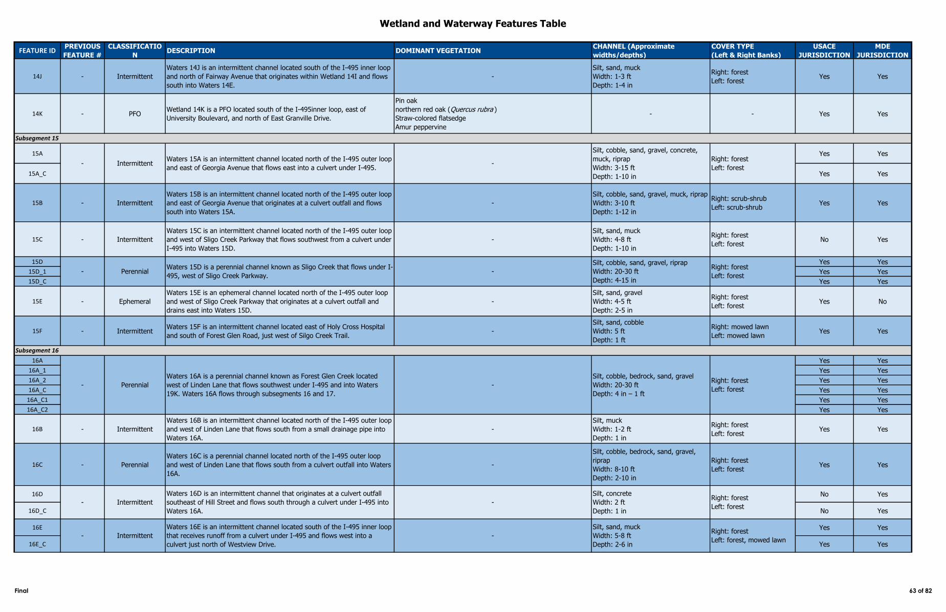
Wetland and Waterway Features Table
FEATURE IDPREVIOUS
FEATURE #
CLASSIFICATIO
NDESCRIPTION DOMINANT VEGETATION
CHANNEL (Approximate
widths/depths)
COVER TYPE
(Left & Right Banks)
USACE
JURISDICTION
MDE
JURISDICTION
14J - Intermittent
Waters 14J is an intermittent channel located south of the I-495 inner loop
and north of Fairway Avenue that originates within Wetland 14I and flows
south into Waters 14E.
-
Silt, sand, muck
Width: 1-3 ft
Depth: 1-4 in
Right: forest
Left: forestYes Yes
14K - PFOWetland 14K is a PFO located south of the I-495inner loop, east of
University Boulevard, and north of East Granville Drive.
Pin oak
northern red oak (Quercus rubra )
Straw-colored flatsedge
Amur peppervine
- - Yes Yes
15A Yes Yes
15A_C Yes Yes
15B - Intermittent
Waters 15B is an intermittent channel located north of the I-495 outer loop
and east of Georgia Avenue that originates at a culvert outfall and flows
south into Waters 15A.
-
Silt, cobble, sand, gravel, muck, riprap
Width: 3-10 ft
Depth: 1-12 in
Right: scrub-shrub
Left: scrub-shrubYes Yes
15C - Intermittent
Waters 15C is an intermittent channel located north of the I-495 outer loop
and west of Sligo Creek Parkway that flows southwest from a culvert under
I-495 into Waters 15D.
-
Silt, sand, muck
Width: 4-8 ft
Depth: 1-10 in
Right: forest
Left: forestNo Yes
15D Yes Yes
15D_1 Yes Yes
15D_C Yes Yes
15E - Ephemeral
Waters 15E is an ephemeral channel located north of the I-495 outer loop
and west of Sligo Creek Parkway that originates at a culvert outfall and
drains east into Waters 15D.
-
Silt, sand, gravel
Width: 4-5 ft
Depth: 2-5 in
Right: forest
Left: forestYes No
15F - IntermittentWaters 15F is an intermittent channel located east of Holy Cross Hospital
and south of Forest Glen Road, just west of Silgo Creek Trail.-
Silt, sand, cobble
Width: 5 ft
Depth: 1 ft
Right: mowed lawn
Left: mowed lawnYes Yes
16A Yes Yes
16A_1 Yes Yes
16A_2 Yes Yes
16A_C Yes Yes
16A_C1 Yes Yes
16A_C2 Yes Yes
16B - Intermittent
Waters 16B is an intermittent channel located north of the I-495 outer loop
and west of Linden Lane that flows south from a small drainage pipe into
Waters 16A.
-
Silt, muck
Width: 1-2 ft
Depth: 1 in
Right: forest
Left: forestYes Yes
16C - Perennial
Waters 16C is a perennial channel located north of the I-495 outer loop
and west of Linden Lane that flows south from a culvert outfall into Waters
16A.
-
Silt, cobble, bedrock, sand, gravel,
riprap
Width: 8-10 ft
Depth: 2-10 in
Right: forest
Left: forestYes Yes
16D No Yes
16D_C No Yes
16E Yes Yes
16E_C Yes Yes
- Intermittent
Waters 16E is an intermittent channel located south of the I-495 inner loop
that receives runoff from a culvert under I-495 and flows west into a
culvert just north of Westview Drive.
-
Silt, sand, muck
Width: 5-8 ft
Depth: 2-6 in
Right: forest
Left: forest, mowed lawn
- Intermittent
Waters 16D is an intermittent channel that originates at a culvert outfall
southeast of Hill Street and flows south through a culvert under I-495 into
Waters 16A.
-
Silt, concrete
Width: 2 ft
Depth: 1 in
Right: forest
Left: forest
Subsegment 15
- IntermittentWaters 15A is an intermittent channel located north of the I-495 outer loop
and east of Georgia Avenue that flows east into a culvert under I-495. -
Silt, cobble, sand, gravel, concrete,
muck, riprap
Width: 3-15 ft
Depth: 1-10 in
Right: forest
Left: forest
- PerennialWaters 15D is a perennial channel known as Sligo Creek that flows under I-
495, west of Sligo Creek Parkway.
- Perennial
Waters 16A is a perennial channel known as Forest Glen Creek located
west of Linden Lane that flows southwest under I-495 and into Waters
19K. Waters 16A flows through subsegments 16 and 17.
-
Silt, cobble, bedrock, sand, gravel
Width: 20-30 ft
Depth: 4 in – 1 ft
Right: forest
Left: forest
-
Silt, cobble, sand, gravel, riprap
Width: 20-30 ft
Depth: 4-15 in
Right: forest
Left: forest
Subsegment 16
Final 63 of 82
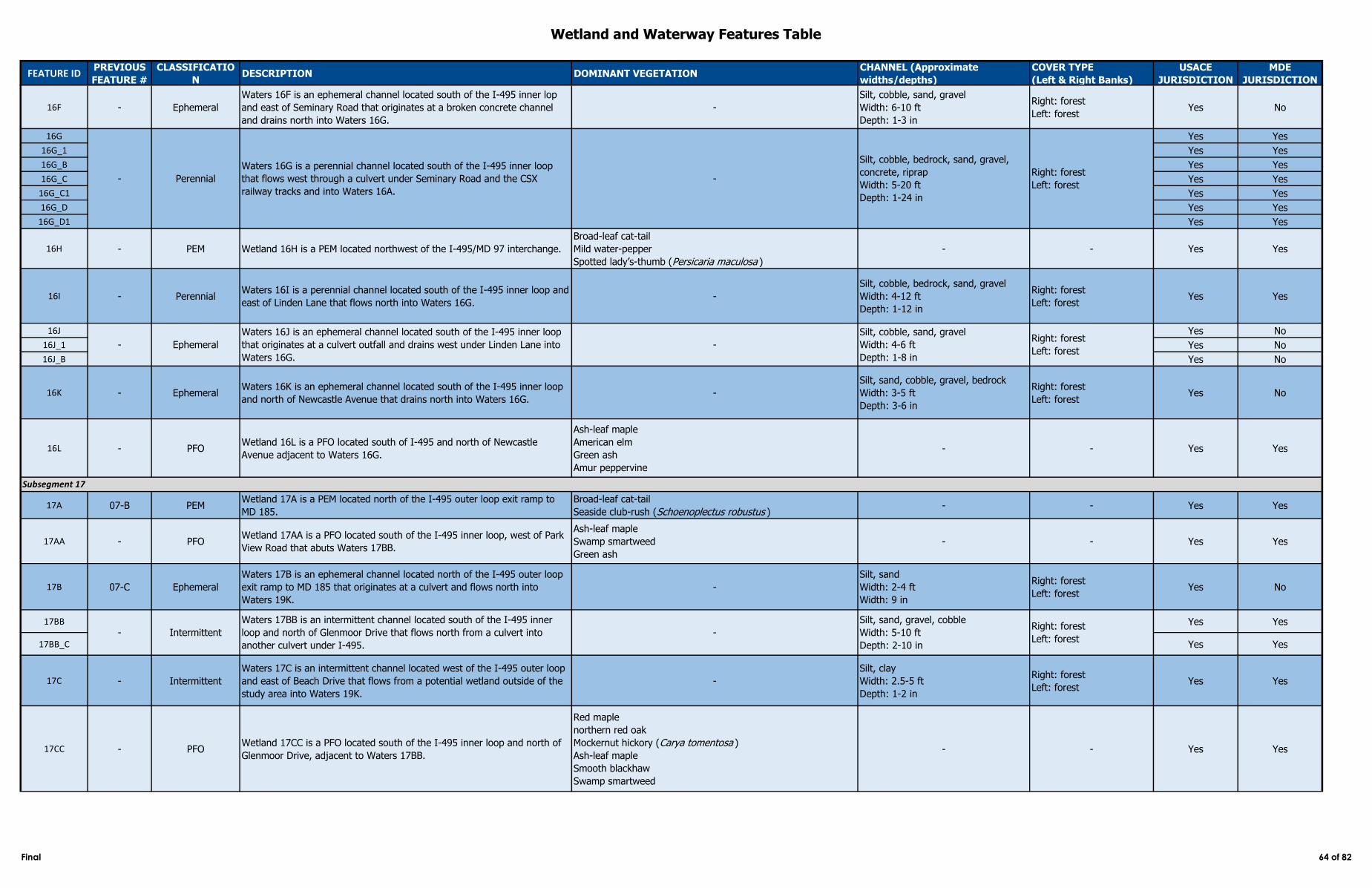
Wetland and Waterway Features Table
FEATURE IDPREVIOUS
FEATURE #
CLASSIFICATIO
NDESCRIPTION DOMINANT VEGETATION
CHANNEL (Approximate
widths/depths)
COVER TYPE
(Left & Right Banks)
USACE
JURISDICTION
MDE
JURISDICTION
16F - Ephemeral
Waters 16F is an ephemeral channel located south of the I-495 inner lop
and east of Seminary Road that originates at a broken concrete channel
and drains north into Waters 16G.
-
Silt, cobble, sand, gravel
Width: 6-10 ft
Depth: 1-3 in
Right: forest
Left: forestYes No
16G Yes Yes
16G_1 Yes Yes
16G_B Yes Yes
16G_C Yes Yes
16G_C1 Yes Yes
16G_D Yes Yes
16G_D1 Yes Yes
16H - PEM Wetland 16H is a PEM located northwest of the I-495/MD 97 interchange.
Broad-leaf cat-tail
Mild water-pepper
Spotted lady’s-thumb (Persicaria maculosa )
- - Yes Yes
16I - PerennialWaters 16I is a perennial channel located south of the I-495 inner loop and
east of Linden Lane that flows north into Waters 16G. -
Silt, cobble, bedrock, sand, gravel
Width: 4-12 ft
Depth: 1-12 in
Right: forest
Left: forestYes Yes
16J Yes No
16J_1 Yes No
16J_B Yes No
16K - EphemeralWaters 16K is an ephemeral channel located south of the I-495 inner loop
and north of Newcastle Avenue that drains north into Waters 16G. -
Silt, sand, cobble, gravel, bedrock
Width: 3-5 ft
Depth: 3-6 in
Right: forest
Left: forestYes No
16L - PFOWetland 16L is a PFO located south of I-495 and north of Newcastle
Avenue adjacent to Waters 16G.
Ash-leaf maple
American elm
Green ash
Amur peppervine
- - Yes Yes
17A 07-B PEMWetland 17A is a PEM located north of the I-495 outer loop exit ramp to
MD 185.
Broad-leaf cat-tail
Seaside club-rush (Schoenoplectus robustus )- - Yes Yes
17AA - PFOWetland 17AA is a PFO located south of the I-495 inner loop, west of Park
View Road that abuts Waters 17BB.
Ash-leaf maple
Swamp smartweed
Green ash
- - Yes Yes
17B 07-C Ephemeral
Waters 17B is an ephemeral channel located north of the I-495 outer loop
exit ramp to MD 185 that originates at a culvert and flows north into
Waters 19K.
-
Silt, sand
Width: 2-4 ft
Width: 9 in
Right: forest
Left: forestYes No
17BB Yes Yes
17BB_C Yes Yes
17C - Intermittent
Waters 17C is an intermittent channel located west of the I-495 outer loop
and east of Beach Drive that flows from a potential wetland outside of the
study area into Waters 19K.
-
Silt, clay
Width: 2.5-5 ft
Depth: 1-2 in
Right: forest
Left: forestYes Yes
17CC - PFOWetland 17CC is a PFO located south of the I-495 inner loop and north of
Glenmoor Drive, adjacent to Waters 17BB.
Red maple
northern red oak
Mockernut hickory (Carya tomentosa )
Ash-leaf maple
Smooth blackhaw
Swamp smartweed
- - Yes Yes
- Ephemeral
Waters 16J is an ephemeral channel located south of the I-495 inner loop
that originates at a culvert outfall and drains west under Linden Lane into
Waters 16G.
-
Silt, cobble, sand, gravel
Width: 4-6 ft
Depth: 1-8 in
Right: forest
Left: forest
Subsegment 17
- Intermittent
Waters 17BB is an intermittent channel located south of the I-495 inner
loop and north of Glenmoor Drive that flows north from a culvert into
another culvert under I-495.
-
Silt, sand, gravel, cobble
Width: 5-10 ft
Depth: 2-10 in
Right: forest
Left: forest
- Perennial
Waters 16G is a perennial channel located south of the I-495 inner loop
that flows west through a culvert under Seminary Road and the CSX
railway tracks and into Waters 16A.
-
Silt, cobble, bedrock, sand, gravel,
concrete, riprap
Width: 5-20 ft
Depth: 1-24 in
Right: forest
Left: forest
Final 64 of 82
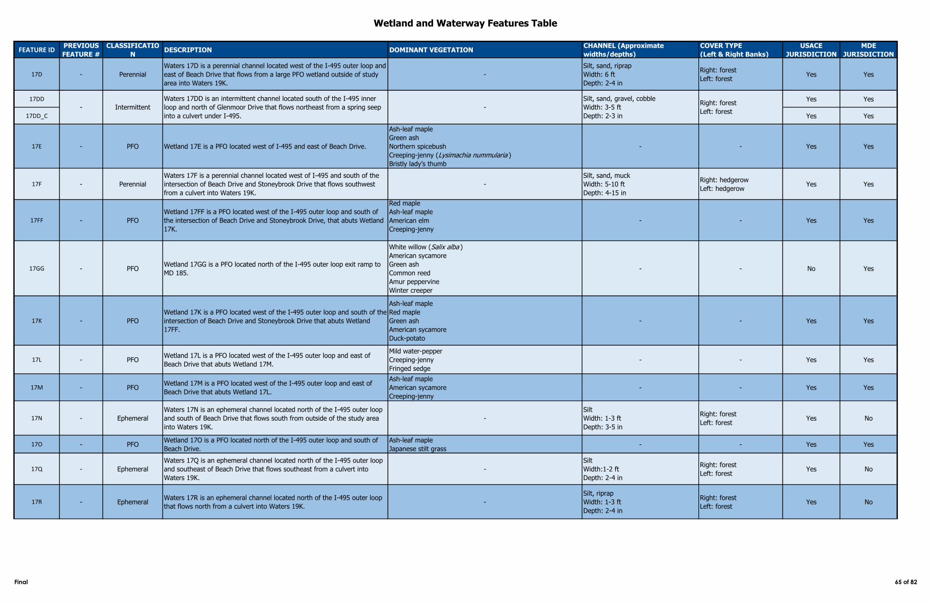
Wetland and Waterway Features Table
FEATURE IDPREVIOUS
FEATURE #
CLASSIFICATIO
NDESCRIPTION DOMINANT VEGETATION
CHANNEL (Approximate
widths/depths)
COVER TYPE
(Left & Right Banks)
USACE
JURISDICTION
MDE
JURISDICTION
17D - Perennial
Waters 17D is a perennial channel located west of the I-495 outer loop and
east of Beach Drive that flows from a large PFO wetland outside of study
area into Waters 19K.
-
Silt, sand, riprap
Width: 6 ft
Depth: 2-4 in
Right: forest
Left: forestYes Yes
17DD Yes Yes
17DD_C Yes Yes
17E - PFO Wetland 17E is a PFO located west of I-495 and east of Beach Drive.
Ash-leaf maple
Green ash
Northern spicebush
Creeping-jenny (Lysimachia nummularia )
Bristly lady’s thumb
- - Yes Yes
17F - Perennial
Waters 17F is a perennial channel located west of I-495 and south of the
intersection of Beach Drive and Stoneybrook Drive that flows southwest
from a culvert into Waters 19K.
-
Silt, sand, muck
Width: 5-10 ft
Depth: 4-15 in
Right: hedgerow
Left: hedgerowYes Yes
17FF - PFO
Wetland 17FF is a PFO located west of the I-495 outer loop and south of
the intersection of Beach Drive and Stoneybrook Drive, that abuts Wetland
17K.
Red maple
Ash-leaf maple
American elm
Creeping-jenny
- - Yes Yes
17GG - PFOWetland 17GG is a PFO located north of the I-495 outer loop exit ramp to
MD 185.
White willow (Salix alba )
American sycamore
Green ash
Common reed
Amur peppervine
Winter creeper
- - No Yes
17K - PFO
Wetland 17K is a PFO located west of the I-495 outer loop and south of the
intersection of Beach Drive and Stoneybrook Drive that abuts Wetland
17FF.
Ash-leaf maple
Red maple
Green ash
American sycamore
Duck-potato
- - Yes Yes
17L - PFOWetland 17L is a PFO located west of the I-495 outer loop and east of
Beach Drive that abuts Wetland 17M.
Mild water-pepper
Creeping-jenny
Fringed sedge
- - Yes Yes
17M - PFOWetland 17M is a PFO located west of the I-495 outer loop and east of
Beach Drive that abuts Wetland 17L.
Ash-leaf maple
American sycamore
Creeping-jenny
- - Yes Yes
17N - Ephemeral
Waters 17N is an ephemeral channel located north of the I-495 outer loop
and south of Beach Drive that flows south from outside of the study area
into Waters 19K.
-
Silt
Width: 1-3 ft
Depth: 3-5 in
Right: forest
Left: forestYes No
17O - PFOWetland 17O is a PFO located north of the I-495 outer loop and south of
Beach Drive.
Ash-leaf maple
Japanese stilt grass- - Yes Yes
17Q - Ephemeral
Waters 17Q is an ephemeral channel located north of the I-495 outer loop
and southeast of Beach Drive that flows southeast from a culvert into
Waters 19K.
-
Silt
Width:1-2 ft
Depth: 2-4 in
Right: forest
Left: forestYes No
17R - EphemeralWaters 17R is an ephemeral channel located north of the I-495 outer loop
that flows north from a culvert into Waters 19K. -
Silt, riprap
Width: 1-3 ft
Depth: 2-4 in
Right: forest
Left: forestYes No
- Intermittent
Waters 17DD is an intermittent channel located south of the I-495 inner
loop and north of Glenmoor Drive that flows northeast from a spring seep
into a culvert under I-495.
-
Silt, sand, gravel, cobble
Width: 3-5 ft
Depth: 2-3 in
Right: forest
Left: forest
Final 65 of 82
Wetland and Waterway Features Table
FEATURE IDPREVIOUS
FEATURE #
CLASSIFICATIO
NDESCRIPTION DOMINANT VEGETATION
CHANNEL (Approximate
widths/depths)
COVER TYPE
(Left & Right Banks)
USACE
JURISDICTION
MDE
JURISDICTION
17S W57M PFOWetland 17S is a PFO wetland located northwest of the I-495 outer loop
and south of Beach Drive in the floodplain of Waters 19K.
Ash-leaf maple
Sensitive fern
Rambler rose
Northern spicebush
Creeping-jenny
Japanese stilt grass
American hornbeam
Small-spike false nettle
Eastern poison ivy
Mild water-pepper
- - Yes Yes
17T - PEMWetland 17T is a PEM located east of the I-495 inner loop and west of
Jones Mill Road, adjacent to Waters 16A and Waters 19K.
Japanese stilt grass
Small carp grass (Arthraxon hispidus )- - Yes Yes
17U W61M PFOWetland 17U is a PFO located northeast of the I-495 outer loop exit ramp
to MD 185.
Skunk-cabbage
Northern spicebush
Red maple
Canadian clearweed (Pilea pumila )
Royal fern
Unknown willow species (Salix sp.)
Small-spike false nettle
American sycamore
Ash-leaf maple
Green arrow-arum
Halberd-leaf tearthumb
Rice cut grass
- - Yes Yes
17V - PFOWetland 17V is a PFO located south of the I-495 inner loop and west of
Jones Mill Road that abuts Waters 17W and Waters 17Z.
Ash-leaf maple
Common duckweed (Lemna minor )- - Yes Yes
17W - Ephemeral
Waters 17W is an ephemeral channel located east of the I-495 inner loop
and west of Jones Mill Road that flows northeast from Wetland 17V into
Waters 19K.
-
Silt
Width: 1 ft
Depth: 2-3 in
Right: forest
Left: forestYes No
17X - PFOWetland 17X is a PFO located north of the I-495 outer loop and east of
Kensington Parkway.
Red maple
Green arrow-arum
Japanese stilt grass
Amur peppervine
- - Yes Yes
17Y - Intermittent
Waters 17Y is an intermittent channel located north of the I-495 outer loop
exit ramp to MD 185 that flows north from a culvert under I-495 into
Waters 19K.
-
Silt, sand, gravel, cobble
Width: 6-8 ft
Depth: 2-6 in
Right: forest
Left: forestYes Yes
17Z - Ephemeral
Waters 17Z is an ephemeral channel located south of the I-495 inner loop
and north of Park View Road that flows northeast from a culvert under I-
495 into Wetland 17V.
-
Silt, sand, cobble, riprap
Width: 3-10 ft
Depth: 2-5 in
Right: forest
Left: forestYes No
18A W67M Intermittent
Waters 18A is an intermittent channel located northwest of the I-495/MD
185 interchange that originates at a culvert under I-495 and flows north
into Waters 19K.
-
Silt, cobble, sand, gravel
Width: 4-8 ft
Depth: 1-6 in
Right: forest
Left: forestYes Yes
18B Yes No
18B_C Yes No
18C Yes Yes
18C_1 Yes Yes
18C_C Yes Yes
- Perennial
Waters 18C is a perennial channel located west of Connecticut Avenue that
flows northeast from outside of the study area, under I-495, and into
Waters 19K.
-
Silt, cobble, sand, gravel, riprap
Width: 10-30 ft
Depth: 1-2 ft
Right: forest
Left: forest
Subsegment 18
W167M Ephemeral
Waters 18B is an ephemeral channel located southwest of the I-495/MD
185 interchange that flows north through a culvert under I-495 and into
Waters 18A.
-
Silt, cobble, gravel, muck
Width: 4 ft
Depth: 2-4 in
Right: forest
Left: forest
Final 66 of 82
Wetland and Waterway Features Table
FEATURE IDPREVIOUS
FEATURE #
CLASSIFICATIO
NDESCRIPTION DOMINANT VEGETATION
CHANNEL (Approximate
widths/depths)
COVER TYPE
(Left & Right Banks)
USACE
JURISDICTION
MDE
JURISDICTION
18D Yes Yes
18D_1 Yes Yes
18D_2 Yes Yes
18D_C Yes Yes
18D_C1 Yes Yes
18F 07-D PFOWetland 18F is a PFO located northwest of the I-495/Connecticut Avenue
interchange.
Ash-leaf maple
Green ash
Morrow’s honeysuckle
Northern spicebush
Small-spike false nettle
Asian bittersweet
- - Yes Yes
18G Yes Yes
18G_C Yes Yes
18G_D Yes Yes
18H - PFOWetland 18H is a PFO located north of the I-495 outer loop and west of
Connecticut Avenue.
Ash-leaf maple
American sycamore
Small-spike false nettle
Green ash
Northern spicebush
Eastern poison ivy
- - Yes Yes
18I W65M Perennial
Waters 18I is a perennial channel located northeast of the I-495 outer loop
and east of Cedar Lane that flows northeast from a culvert under I-495 into
Waters 19K outside of the study area.
-
Silt, sand, gravel
Width: 8-10 ft
Depth: 0 in – 1 ft
Right: forest
Left: forestYes Yes
18J - Ephemeral
Waters 18J is an ephemeral channel located northeast of the I-495 outer
loop and east of Cedar Lane that flows southeast from Wetland 18K into
Waters 18I.
-
Silt, sand, muck
Width: 2-4 ft
Depth: 0 in
Right: forest
Left: forestYes No
18K - PFOWetland 18K is a PFO located northeast of the I-495 outer loop and east of
Cedar Lane that abuts Waters 18J.
Ash-leaf maple
American sycamore
Small-spike false nettle
Japanese stilt grass
White grass
- - Yes Yes
18L - PFOWetland 18L is a PFO located northeast of the I-495 outer loop, south of
Beach Drive, and west of Connecticut Avenue.
Ash-leaf maple
Northern spicebush
Amur peppervine
- - Yes Yes
18M - PFOWetland 18M is a PFO located northeast of the I-495 outer loop and east of
Cedar Lane.
Ash-leaf maple
Morrow’s honeysuckle
Eastern cottonwood (Populus deltoides )
Green ash
Dotted smartweed
Rambler rose
Eastern poison ivy
Lamp rush
Canadian clearweed
Unknown grape species
Scarlet beebalm (Monarda didyma )
Asparagus (Asparagus officinalis )
nodding burr-marigold (Bidens cernua )
Silver maple
- - Yes Yes
- Intermittent
Waters 18G is an intermittent channel located southwest of the I-
495/Connecticut Avenue interchange that originates at a culvert outside of
the study area and flows north into a culvert under I-495 and into Waters
19K.
-
Silt, cobble, sand, gravel, riprap
Width: 5-12 ft
Depth: 3-12 in
Right: meadow, forest
Left: meadow, forest
- Perennial
Waters 18D is a perennial channel located north of the I-495 outer loop
and east of Cedar Lane that flows south under Beach Drive into Waters
19K.
-
Silt, cobble, sand, gravel, concrete
rubble
Width: 5-8 ft
Depth: 2 in
Right: hedgerow, mowed
grass
Left: forest
Final 67 of 82
Wetland and Waterway Features Table
FEATURE IDPREVIOUS
FEATURE #
CLASSIFICATIO
NDESCRIPTION DOMINANT VEGETATION
CHANNEL (Approximate
widths/depths)
COVER TYPE
(Left & Right Banks)
USACE
JURISDICTION
MDE
JURISDICTION
18X - PerennialWaters 18X is a perennial channel located northeast of the I-495 outer loop
and east of Cedar Lane that flows northeast into Waters 19K. -
Silt, sand, muck
Width: 3-4 ft
Depth: 1 in – 1 ft
Right: forest
Left: forestYes Yes
19A - No Yes
19A_C - No Yes
19B Yes Yes
19B_C Yes Yes
19C Yes Yes
19C_C Yes Yes
19D W80M PFOWetland 19D is a PFO located west of the I-495/I-270 interchange,
adjacent to Waters 19C.
Tuliptree
Red maple
Northern spicebush
- - Yes Yes
19E - IntermittentWaters 19E is an intermittent channel located within the I-495 median,
west of Rockville Pike that flows northeast into Waters 19F. -
Concrete
Width: 3 ft
Depth: 2 in
Right: hedgerow
Left: hedgerowNo Yes
19F W162M Yes Yes
19F_1 W162M Yes Yes
19F_2 W162M Yes Yes
19F_3 - Yes Yes
19F_4 - Yes Yes
19F_C W162M Yes Yes
19F_C1 W162M Yes Yes
19F_C2 - Yes Yes
19G - Intermittent
Waters 19G is an intermittent channel located within the I-495 median,
west of Rockville Pike that flows south from a culvert under the I-495 outer
loop into Waters 19F.
-
Silt, cobble, sand, gravel
Width: 3 ft
Depth: 3 in
Right: hedgerow
Left: hedgerowYes Yes
19J Yes Yes
19J_1 Yes Yes
19J_2 Yes Yes
19J_C Yes Yes
19J_C1 Yes Yes
19K Yes Yes
19K_1 Yes Yes
19K_2 Yes Yes
19K_3 Yes Yes
19K_4 Yes Yes
19K_5 Yes Yes
19K_6 Yes Yes
19K_7 Yes Yes
19K_8 Yes Yes
19K_B Yes Yes
19K_B1 Yes Yes
19K_B2 Yes Yes
19M - PFOWetland 19M is a PFO located north of the I-495 outer loop, west of Cedar
Lane in the floodplain of Waters 19K.
Ash-leaf maple
Silver maple
Small-spike false nettle
Amur peppervine
- - Yes Yes
Perennial
Waters 19F is a perennial channel located west of the I-495/I-270
interchange that originates at a culvert in the I-495 median and flows
southeast through another culvert under the I-495 inner loop and out of
the study area.
-
Sand, cobble, gravel
Width: 2-3 ft
Depth: 0.5-2 ft
Right: forest
Left: forest
W157M Perennial
Waters 19J is a perennial channel located east of the I-495/MD 187
interchange that flows northeast into a culvert under I-495 and out of the
study area.
-
Silt, sand, gravel, muck
Width: 3-15 ft
Depth: 2-12 in
Right: forest, shrubs
Left: forest, dense bamboo
- PerennialWaters 19K is a perennial channel known as Rock Creek located north of
and parallel to the I-495 outer loop that flows into the Potomac River. -
Silt, sand, cobble, gravel, muck,
concrete
Width: 20-40 ft
Depth: 0.5-6 ft
Right: forest
Left: forest
Subsegment 19
W81M Intermittent
Waters 19B is an intermittent channel located west of the I-495/I-270
interchange that flows south from outside of the study area, through a 24-
inch diameter culvert under the I-495 outer loop, and into Waters 19F.
-
Silt, sand, gravel, muck
Width: 2-3 ft
Depth: 5-8 in
Right: forest
Left: forest
W78M Perennial
Waters 19C is a perennial channel located west of the I-495/I-270
interchange that flows southeast from outside the study area, through a
culvert under the I-495 outer loop, and into Waters 19F.
-
Silt, sand, cobble, gravel
Width: 15 ft
Depth: 1-2 ft
Right: forest
Left: forest
Intermittent
Waters 19A is an intermittent channel located west of the ramp from
Rockville Pike to I-270 northbound that flows south into a 36-inch concrete
pipe.
-
Silt, sand
Width: 3-5 ft
Depth: 2 in
Right: hedgerow
Left: hedgerow
Final 68 of 82
Wetland and Waterway Features Table
FEATURE IDPREVIOUS
FEATURE #
CLASSIFICATIO
NDESCRIPTION DOMINANT VEGETATION
CHANNEL (Approximate
widths/depths)
COVER TYPE
(Left & Right Banks)
USACE
JURISDICTION
MDE
JURISDICTION
19N - PerennialWaters 19N is a perennial channel located east of Rockville Pike that flows
southeast under Beach Drive into Waters 19K. -
Silt, cobble, sand, gravel
Width: 15 ft
Depth: 6-12 in
Right: mowed grass,
shrubs
Left: forest
Yes Yes
19O - PFOWetland 19O is a PFO located east of the Rockville Pike exit ramp to
Grosvenor Lane that abuts Waters 19X.
Ash-leaf maple
Japanese stilt grass
Sweet wood-reed
- - Yes Yes
19Q - PFOWetland 19Q is PFO located east of the Rockville Pike on-ramp from the I-
495 outer loop.
Red maple
American elm
Small-spike false nettle
Japanese stilt grass
Sweet wood-reed
- - Yes Yes
19R Yes Yes
19R_1 Yes Yes
19S W75M PFOWetland 19S is a PFO located east of the I-495/Rockville Pike interchange
that abuts Waters 19R.
American elm
Pin oak
Green ash
Rambler rose
Japanese stilt grass
Rice cut grass
Japanese honeysuckle
- - Yes Yes
19T Yes Yes
19T_1 Yes Yes
19T_C Yes Yes
19U - PFOWetland 19U is a PFO located east of the I-495 outer loop, northwest of
Cedar Lane.
Ash-leaf maple
American sycamore
Northern spicebush
Green ash
- - Yes Yes
19V Yes Yes
19V_C Yes Yes
19W - PFOWetland 19W is a PFO located south of the I-495 inner loop, east of the
onramp from Rockville Pike.
River birch
Green ash
Unknown elm species (Ulmus sp.)
Japanese stilt grass
- - Yes Yes
19X - EphemeralWaters 19X is an ephemeral channel located east of the Rockville Pike
northbound exit ramp to Grosvenor Lane that flows east into Wetland 19O. -
Silt, sand, gravel
Width: 3 ft
Depth: 0-1 in
Right: forest
Left: forestYes No
19Y - PEMWetland 19Y is a PEM that is in line with Waters 19R located east of the I-
95/Rockville Pike interchange and abuts Wetland S.
Pickerelweed (Pontederia cordata )
Shallow sedge- - Yes Yes
20B - Intermittent
Waters 20B is an intermittent channel located south of the I-495 inner loop
that originates at a 2-foot culvert under I-495 and flows southwest out of
the study area through another 2-foot pipe.
-
Silt, cobble, gravel, riprap
Width: 5 ft
Depth: 3 in
Right: hedgerow
Left: hedgerowYes Yes
20C - Perennial
Waters 20C is a perennial channel located south of the I-495 inner loop
and east of Greentree Road that flows south through a 4-foot culvert and
converges with Waters 20D.
-
Silt, cobble, sand, gravel
Width: 1-3 ft
Depth: 6 in
Right: Scrub-shrub
Left: Scrub-shrubYes Yes
20D Yes Yes
20D_C Yes Yes
- Intermittent
Waters 19R is an intermittent channel located north of the Rockville Pike
on-ramp from the I-495 outer loop that flows southeast from Wetland 19Q
into Waters 19K.
-
Silt, sand, muck
Width: 2-15 ft
Depth: 1 in – 2 ft
Right: forest
Left: forest
Waters 19T is a perennial channel located east of Bellevue Drive that flows
northeast under I-495 and into Waters 19K. -
Silt, sand, gravel, muck, riprap
Width: 12 ft
Depth: 1 ft
Right: forest
Left: forest
- PerennialWaters 19V is a perennial channel located south of the I-495 inner loop,
west of Cedar Lane that flows northeast into Rock Creek. -
Sand, cobble, gravel, concrete
Width: 10-16 ft
Depth: 0.1-2 ft
Right: forest
Left: forest
Subsegment 20
- Perennial
Waters 20D is a perennial channel located south of I-495 and east of
Greentree Road that flows north from outside of the study area and
converges with Waters 20C at a 4-foot culvert.
-
Silt, sand, gravel, concrete
Width: 5 ft
Depth: 6 in
Right: hedgerow
Left: hedgerow
- Perennial
Final 69 of 82
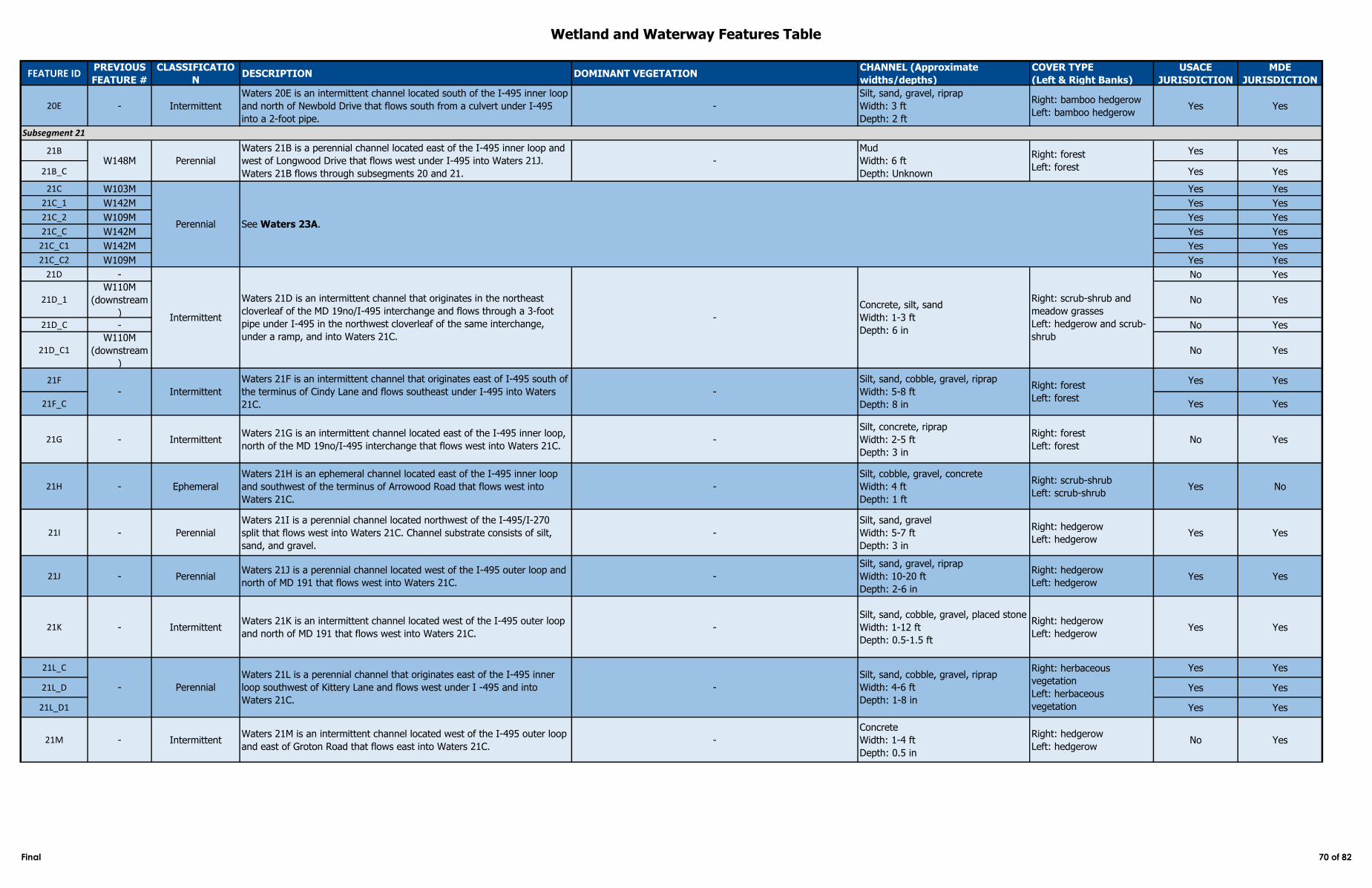
Wetland and Waterway Features Table
FEATURE IDPREVIOUS
FEATURE #
CLASSIFICATIO
NDESCRIPTION DOMINANT VEGETATION
CHANNEL (Approximate
widths/depths)
COVER TYPE
(Left & Right Banks)
USACE
JURISDICTION
MDE
JURISDICTION
20E - Intermittent
Waters 20E is an intermittent channel located south of the I-495 inner loop
and north of Newbold Drive that flows south from a culvert under I-495
into a 2-foot pipe.
-
Silt, sand, gravel, riprap
Width: 3 ft
Depth: 2 ft
Right: bamboo hedgerow
Left: bamboo hedgerowYes Yes
21B Yes Yes
21B_C Yes Yes
21C W103M Yes Yes
21C_1 W142M Yes Yes
21C_2 W109M Yes Yes
21C_C W142M Yes Yes
21C_C1 W142M Yes Yes
21C_C2 W109M Yes Yes
21D - No Yes
21D_1W110M
(downstream
)
No Yes
21D_C - No Yes
21D_C1W110M
(downstream
)
No Yes
21F Yes Yes
21F_C Yes Yes
21G - IntermittentWaters 21G is an intermittent channel located east of the I-495 inner loop,
north of the MD 19no/I-495 interchange that flows west into Waters 21C. -
Silt, concrete, riprap
Width: 2-5 ft
Depth: 3 in
Right: forest
Left: forestNo Yes
21H - Ephemeral
Waters 21H is an ephemeral channel located east of the I-495 inner loop
and southwest of the terminus of Arrowood Road that flows west into
Waters 21C.
-
Silt, cobble, gravel, concrete
Width: 4 ft
Depth: 1 ft
Right: scrub-shrub
Left: scrub-shrubYes No
21I - Perennial
Waters 21I is a perennial channel located northwest of the I-495/I-270
split that flows west into Waters 21C. Channel substrate consists of silt,
sand, and gravel.
-
Silt, sand, gravel
Width: 5-7 ft
Depth: 3 in
Right: hedgerow
Left: hedgerowYes Yes
21J - PerennialWaters 21J is a perennial channel located west of the I-495 outer loop and
north of MD 191 that flows west into Waters 21C.-
Silt, sand, gravel, riprap
Width: 10-20 ft
Depth: 2-6 in
Right: hedgerow
Left: hedgerowYes Yes
21K - IntermittentWaters 21K is an intermittent channel located west of the I-495 outer loop
and north of MD 191 that flows west into Waters 21C. -
Silt, sand, cobble, gravel, placed stone
Width: 1-12 ft
Depth: 0.5-1.5 ft
Right: hedgerow
Left: hedgerowYes Yes
21L_C Yes Yes
21L_D Yes Yes
21L_D1 Yes Yes
21M - IntermittentWaters 21M is an intermittent channel located west of the I-495 outer loop
and east of Groton Road that flows east into Waters 21C.-
Concrete
Width: 1-4 ft
Depth: 0.5 in
Right: hedgerow
Left: hedgerowNo Yes
Subsegment 21
W148M Perennial
Waters 21B is a perennial channel located east of the I-495 inner loop and
west of Longwood Drive that flows west under I-495 into Waters 21J.
Waters 21B flows through subsegments 20 and 21.
-
Mud
Width: 6 ft
Depth: Unknown
Right: forest
Left: forest
Perennial See Waters 23A.
- Perennial
Waters 21L is a perennial channel that originates east of the I-495 inner
loop southwest of Kittery Lane and flows west under I -495 and into
Waters 21C.
-
Silt, sand, cobble, gravel, riprap
Width: 4-6 ft
Depth: 1-8 in
Right: herbaceous
vegetation
Left: herbaceous
vegetation
- Intermittent
Waters 21F is an intermittent channel that originates east of I-495 south of
the terminus of Cindy Lane and flows southeast under I-495 into Waters
21C.
Right: forest
Left: forest
Intermittent
Waters 21D is an intermittent channel that originates in the northeast
cloverleaf of the MD 19no/I-495 interchange and flows through a 3-foot
pipe under I-495 in the northwest cloverleaf of the same interchange,
under a ramp, and into Waters 21C.
-
Concrete, silt, sand
Width: 1-3 ft
Depth: 6 in
Right: scrub-shrub and
meadow grasses
Left: hedgerow and scrub-
shrub
-
Silt, sand, cobble, gravel, riprap
Width: 5-8 ft
Depth: 8 in
Final 70 of 82
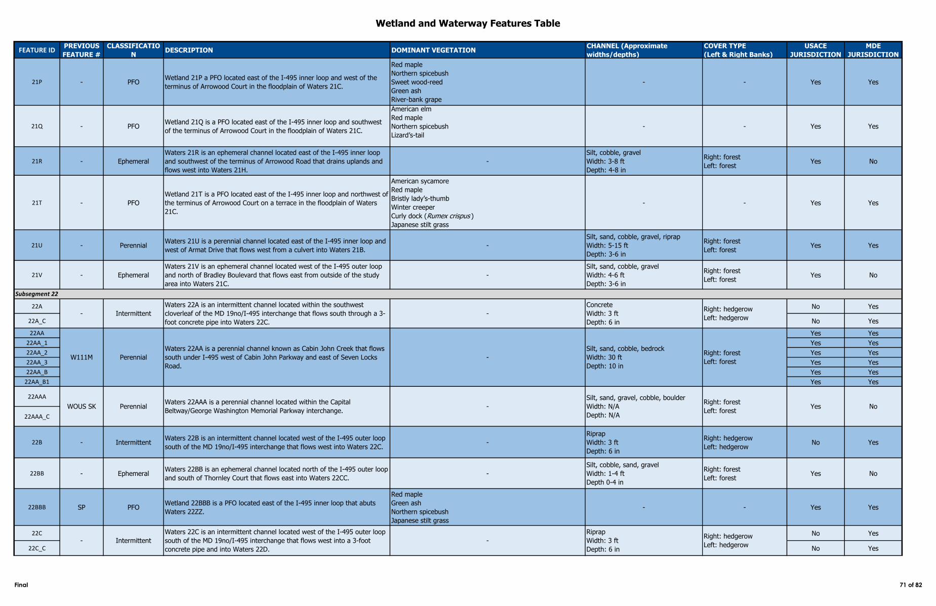
Wetland and Waterway Features Table
FEATURE IDPREVIOUS
FEATURE #
CLASSIFICATIO
NDESCRIPTION DOMINANT VEGETATION
CHANNEL (Approximate
widths/depths)
COVER TYPE
(Left & Right Banks)
USACE
JURISDICTION
MDE
JURISDICTION
21P - PFOWetland 21P a PFO located east of the I-495 inner loop and west of the
terminus of Arrowood Court in the floodplain of Waters 21C.
Red maple
Northern spicebush
Sweet wood-reed
Green ash
River-bank grape
- - Yes Yes
21Q - PFOWetland 21Q is a PFO located east of the I-495 inner loop and southwest
of the terminus of Arrowood Court in the floodplain of Waters 21C.
American elm
Red maple
Northern spicebush
Lizard’s-tail
- - Yes Yes
21R - Ephemeral
Waters 21R is an ephemeral channel located east of the I-495 inner loop
and southwest of the terminus of Arrowood Road that drains uplands and
flows west into Waters 21H.
-
Silt, cobble, gravel
Width: 3-8 ft
Depth: 4-8 in
Right: forest
Left: forestYes No
21T - PFO
Wetland 21T is a PFO located east of the I-495 inner loop and northwest of
the terminus of Arrowood Court on a terrace in the floodplain of Waters
21C.
American sycamore
Red maple
Bristly lady’s-thumb
Winter creeper
Curly dock (Rumex crispus )
Japanese stilt grass
- - Yes Yes
21U - PerennialWaters 21U is a perennial channel located east of the I-495 inner loop and
west of Armat Drive that flows west from a culvert into Waters 21B. -
Silt, sand, cobble, gravel, riprap
Width: 5-15 ft
Depth: 3-6 in
Right: forest
Left: forestYes Yes
21V - Ephemeral
Waters 21V is an ephemeral channel located west of the I-495 outer loop
and north of Bradley Boulevard that flows east from outside of the study
area into Waters 21C.
-
Silt, sand, cobble, gravel
Width: 4-6 ft
Depth: 3-6 in
Right: forest
Left: forestYes No
22A No Yes
22A_C No Yes
22AA Yes Yes
22AA_1 Yes Yes
22AA_2 Yes Yes
22AA_3 Yes Yes
22AA_B Yes Yes
22AA_B1 Yes Yes
22AAA
22AAA_C
22B - IntermittentWaters 22B is an intermittent channel located west of the I-495 outer loop
south of the MD 19no/I-495 interchange that flows west into Waters 22C. -
Riprap
Width: 3 ft
Depth: 6 in
Right: hedgerow
Left: hedgerowNo Yes
22BB - EphemeralWaters 22BB is an ephemeral channel located north of the I-495 outer loop
and south of Thornley Court that flows east into Waters 22CC. -
Silt, cobble, sand, gravel
Width: 1-4 ft
Depth 0-4 in
Right: forest
Left: forestYes No
22BBB SP PFOWetland 22BBB is a PFO located east of the I-495 inner loop that abuts
Waters 22ZZ.
Red maple
Green ash
Northern spicebush
Japanese stilt grass
- - Yes Yes
22C No Yes
22C_C No Yes
WOUS SK PerennialWaters 22AAA is a perennial channel located within the Capital
Beltway/George Washington Memorial Parkway interchange. -
Silt, sand, gravel, cobble, boulder
Width: N/A
Depth: N/A
Right: forest
Left: forestYes No
Silt, sand, cobble, bedrock
Width: 30 ft
Depth: 10 in
Right: forest
Left: forest
- Intermittent
Waters 22A is an intermittent channel located within the southwest
cloverleaf of the MD 19no/I-495 interchange that flows south through a 3-
foot concrete pipe into Waters 22C.
-
- Intermittent
Waters 22C is an intermittent channel located west of the I-495 outer loop
south of the MD 19no/I-495 interchange that flows west into a 3-foot
concrete pipe and into Waters 22D.
Subsegment 22
-
Riprap
Width: 3 ft
Depth: 6 in
Right: hedgerow
Left: hedgerow
Right: hedgerow
Left: hedgerow
W111M
Waters 22AA is a perennial channel known as Cabin John Creek that flows
south under I-495 west of Cabin John Parkway and east of Seven Locks
Road.
-Perennial
Concrete
Width: 3 ft
Depth: 6 in
Final 71 of 82
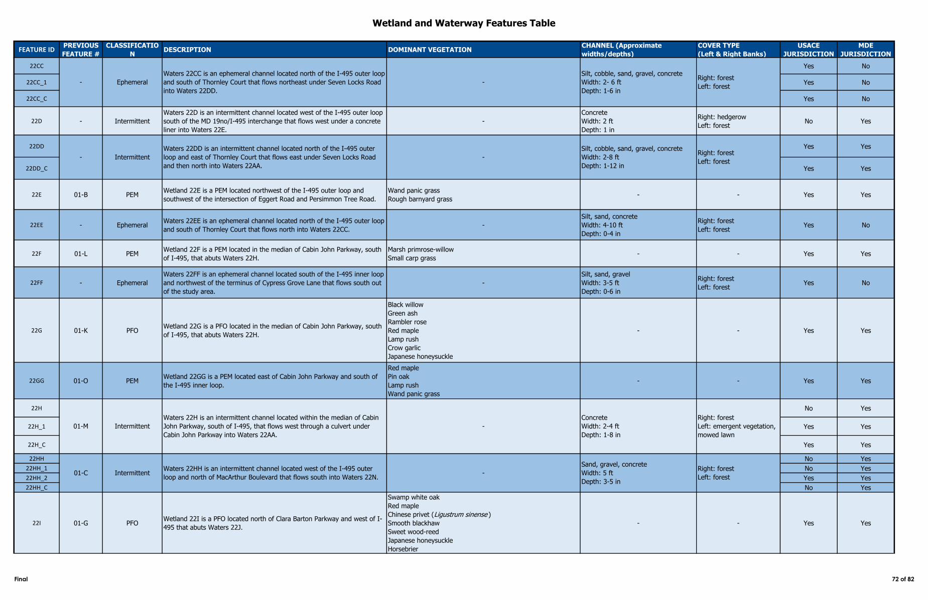
Wetland and Waterway Features Table
FEATURE IDPREVIOUS
FEATURE #
CLASSIFICATIO
NDESCRIPTION DOMINANT VEGETATION
CHANNEL (Approximate
widths/depths)
COVER TYPE
(Left & Right Banks)
USACE
JURISDICTION
MDE
JURISDICTION
22CC Yes No
22CC_1 Yes No
22CC_C Yes No
22D - Intermittent
Waters 22D is an intermittent channel located west of the I-495 outer loop
south of the MD 19no/I-495 interchange that flows west under a concrete
liner into Waters 22E.
-
Concrete
Width: 2 ft
Depth: 1 in
Right: hedgerow
Left: forestNo Yes
22DD Yes Yes
22DD_C Yes Yes
22E 01-B PEMWetland 22E is a PEM located northwest of the I-495 outer loop and
southwest of the intersection of Eggert Road and Persimmon Tree Road.
Wand panic grass
Rough barnyard grass - - Yes Yes
22EE - EphemeralWaters 22EE is an ephemeral channel located north of the I-495 outer loop
and south of Thornley Court that flows north into Waters 22CC. -
Silt, sand, concrete
Width: 4-10 ft
Depth: 0-4 in
Right: forest
Left: forestYes No
22F 01-L PEMWetland 22F is a PEM located in the median of Cabin John Parkway, south
of I-495, that abuts Waters 22H.
Marsh primrose-willow
Small carp grass- - Yes Yes
22FF - Ephemeral
Waters 22FF is an ephemeral channel located south of the I-495 inner loop
and northwest of the terminus of Cypress Grove Lane that flows south out
of the study area.
-
Silt, sand, gravel
Width: 3-5 ft
Depth: 0-6 in
Right: forest
Left: forestYes No
22G 01-K PFOWetland 22G is a PFO located in the median of Cabin John Parkway, south
of I-495, that abuts Waters 22H.
Black willow
Green ash
Rambler rose
Red maple
Lamp rush
Crow garlic
Japanese honeysuckle
- - Yes Yes
22GG 01-O PEMWetland 22GG is a PEM located east of Cabin John Parkway and south of
the I-495 inner loop.
Red maple
Pin oak
Lamp rush
Wand panic grass
- - Yes Yes
22H No Yes
22H_1 Yes Yes
22H_C Yes Yes
22HH No Yes
22HH_1 No Yes
22HH_2 Yes Yes
22HH_C No Yes
22I 01-G PFOWetland 22I is a PFO located north of Clara Barton Parkway and west of I-
495 that abuts Waters 22J.
Swamp white oak
Red maple
Chinese privet (Ligustrum sinense )
Smooth blackhaw
Sweet wood-reed
Japanese honeysuckle
Horsebrier
- - Yes Yes
Waters 22DD is an intermittent channel located north of the I-495 outer
loop and east of Thornley Court that flows east under Seven Locks Road
and then north into Waters 22AA.
-
Silt, cobble, sand, gravel, concrete
Width: 2-8 ft
Depth: 1-12 in
Right: forest
Left: forest
01-M Intermittent
Waters 22H is an intermittent channel located within the median of Cabin
John Parkway, south of I-495, that flows west through a culvert under
Cabin John Parkway into Waters 22AA.
-
Concrete
Width: 2-4 ft
Depth: 1-8 in
Right: forest
Left: emergent vegetation,
mowed lawn
01-C IntermittentWaters 22HH is an intermittent channel located west of the I-495 outer
loop and north of MacArthur Boulevard that flows south into Waters 22N. -
Sand, gravel, concrete
Width: 5 ft
Depth: 3-5 in
Right: forest
Left: forest
- Ephemeral
Waters 22CC is an ephemeral channel located north of the I-495 outer loop
and south of Thornley Court that flows northeast under Seven Locks Road
into Waters 22DD.
-
Silt, cobble, sand, gravel, concrete
Width: 2- 6 ft
Depth: 1-6 in
Right: forest
Left: forest
- Intermittent
Final 72 of 82
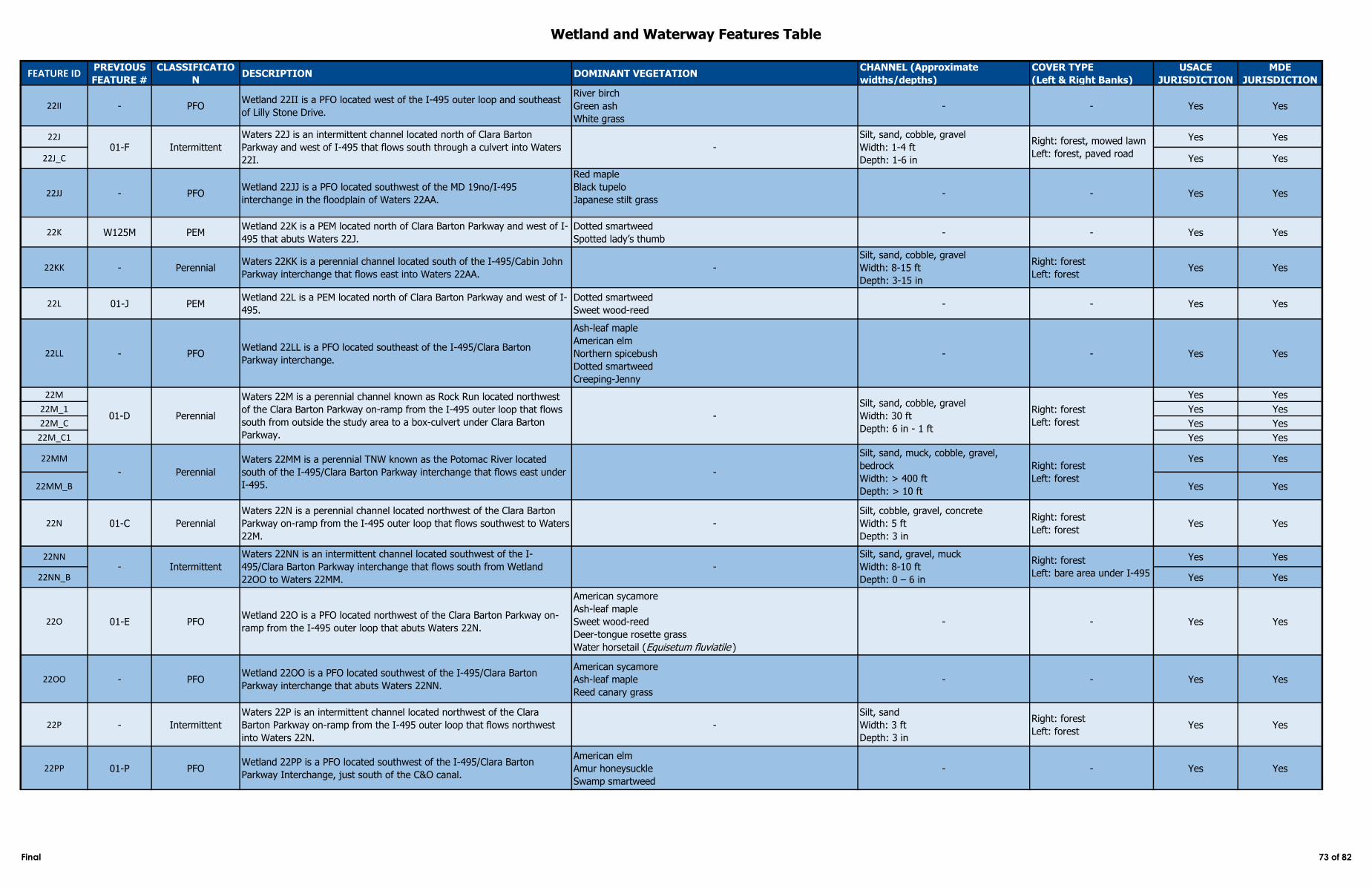
Wetland and Waterway Features Table
FEATURE IDPREVIOUS
FEATURE #
CLASSIFICATIO
NDESCRIPTION DOMINANT VEGETATION
CHANNEL (Approximate
widths/depths)
COVER TYPE
(Left & Right Banks)
USACE
JURISDICTION
MDE
JURISDICTION
22II - PFOWetland 22II is a PFO located west of the I-495 outer loop and southeast
of Lilly Stone Drive.
River birch
Green ash
White grass
- - Yes Yes
22J Yes Yes
22J_C Yes Yes
22JJ - PFOWetland 22JJ is a PFO located southwest of the MD 19no/I-495
interchange in the floodplain of Waters 22AA.
Red maple
Black tupelo
Japanese stilt grass - - Yes Yes
22K W125M PEMWetland 22K is a PEM located north of Clara Barton Parkway and west of I-
495 that abuts Waters 22J.
Dotted smartweed
Spotted lady’s thumb- - Yes Yes
22KK - PerennialWaters 22KK is a perennial channel located south of the I-495/Cabin John
Parkway interchange that flows east into Waters 22AA.-
Silt, sand, cobble, gravel
Width: 8-15 ft
Depth: 3-15 in
Right: forest
Left: forestYes Yes
22L 01-J PEMWetland 22L is a PEM located north of Clara Barton Parkway and west of I-
495.
Dotted smartweed
Sweet wood-reed- - Yes Yes
22LL - PFOWetland 22LL is a PFO located southeast of the I-495/Clara Barton
Parkway interchange.
Ash-leaf maple
American elm
Northern spicebush
Dotted smartweed
Creeping-Jenny
- - Yes Yes
22M Yes Yes
22M_1 Yes Yes
22M_C Yes Yes
22M_C1 Yes Yes
22MM Yes Yes
22MM_B Yes Yes
22N 01-C Perennial
Waters 22N is a perennial channel located northwest of the Clara Barton
Parkway on-ramp from the I-495 outer loop that flows southwest to Waters
22M.
-
Silt, cobble, gravel, concrete
Width: 5 ft
Depth: 3 in
Right: forest
Left: forestYes Yes
22NN Yes Yes
22NN_B Yes Yes
22O 01-E PFOWetland 22O is a PFO located northwest of the Clara Barton Parkway on-
ramp from the I-495 outer loop that abuts Waters 22N.
American sycamore
Ash-leaf maple
Sweet wood-reed
Deer-tongue rosette grass
Water horsetail (Equisetum fluviatile )
- - Yes Yes
22OO - PFOWetland 22OO is a PFO located southwest of the I-495/Clara Barton
Parkway interchange that abuts Waters 22NN.
American sycamore
Ash-leaf maple
Reed canary grass
- - Yes Yes
22P - Intermittent
Waters 22P is an intermittent channel located northwest of the Clara
Barton Parkway on-ramp from the I-495 outer loop that flows northwest
into Waters 22N.
-
Silt, sand
Width: 3 ft
Depth: 3 in
Right: forest
Left: forestYes Yes
22PP 01-P PFOWetland 22PP is a PFO located southwest of the I-495/Clara Barton
Parkway Interchange, just south of the C&O canal.
American elm
Amur honeysuckle
Swamp smartweed
- - Yes Yes
01-F Intermittent
Waters 22J is an intermittent channel located north of Clara Barton
Parkway and west of I-495 that flows south through a culvert into Waters
22I.
-
Silt, sand, cobble, gravel
Width: 1-4 ft
Depth: 1-6 in
Right: forest, mowed lawn
Left: forest, paved road
Perennial
Waters 22M is a perennial channel known as Rock Run located northwest
of the Clara Barton Parkway on-ramp from the I-495 outer loop that flows
south from outside the study area to a box-culvert under Clara Barton
Parkway.
-
Silt, sand, cobble, gravel
Width: 30 ft
Depth: 6 in - 1 ft
Right: forest
Left: forest
- Perennial
Waters 22MM is a perennial TNW known as the Potomac River located
south of the I-495/Clara Barton Parkway interchange that flows east under
I-495.
-
01-D
Silt, sand, muck, cobble, gravel,
bedrock
Width: > 400 ft
Depth: > 10 ft
Right: forest
Left: forest
- Intermittent
Waters 22NN is an intermittent channel located southwest of the I-
495/Clara Barton Parkway interchange that flows south from Wetland
22OO to Waters 22MM.
-
Silt, sand, gravel, muck
Width: 8-10 ft
Depth: 0 – 6 in
Right: forest
Left: bare area under I-495
Final 73 of 82
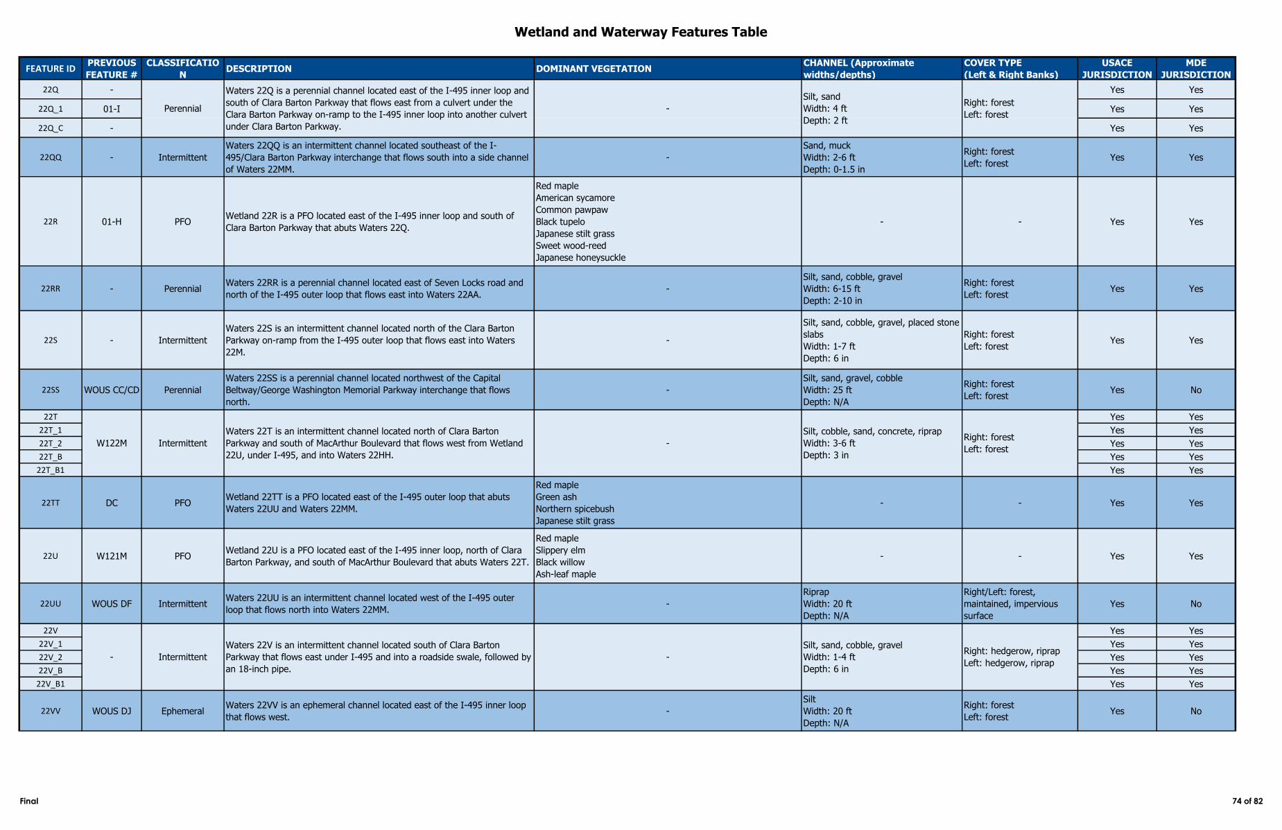
Wetland and Waterway Features Table
FEATURE IDPREVIOUS
FEATURE #
CLASSIFICATIO
NDESCRIPTION DOMINANT VEGETATION
CHANNEL (Approximate
widths/depths)
COVER TYPE
(Left & Right Banks)
USACE
JURISDICTION
MDE
JURISDICTION
22Q - Yes Yes
22Q_1 01-I Yes Yes
22Q_C - Yes Yes
22QQ - Intermittent
Waters 22QQ is an intermittent channel located southeast of the I-
495/Clara Barton Parkway interchange that flows south into a side channel
of Waters 22MM.
-
Sand, muck
Width: 2-6 ft
Depth: 0-1.5 in
Right: forest
Left: forestYes Yes
22R 01-H PFOWetland 22R is a PFO located east of the I-495 inner loop and south of
Clara Barton Parkway that abuts Waters 22Q.
Red maple
American sycamore
Common pawpaw
Black tupelo
Japanese stilt grass
Sweet wood-reed
Japanese honeysuckle
- - Yes Yes
22RR - PerennialWaters 22RR is a perennial channel located east of Seven Locks road and
north of the I-495 outer loop that flows east into Waters 22AA. -
Silt, sand, cobble, gravel
Width: 6-15 ft
Depth: 2-10 in
Right: forest
Left: forestYes Yes
22S - Intermittent
Waters 22S is an intermittent channel located north of the Clara Barton
Parkway on-ramp from the I-495 outer loop that flows east into Waters
22M.
-
Silt, sand, cobble, gravel, placed stone
slabs
Width: 1-7 ft
Depth: 6 in
Right: forest
Left: forestYes Yes
22SS WOUS CC/CD Perennial
Waters 22SS is a perennial channel located northwest of the Capital
Beltway/George Washington Memorial Parkway interchange that flows
north.
-
Silt, sand, gravel, cobble
Width: 25 ft
Depth: N/A
Right: forest
Left: forestYes No
22T Yes Yes
22T_1 Yes Yes
22T_2 Yes Yes
22T_B Yes Yes
22T_B1 Yes Yes
22TT DC PFOWetland 22TT is a PFO located east of the I-495 outer loop that abuts
Waters 22UU and Waters 22MM.
Red maple
Green ash
Northern spicebush
Japanese stilt grass
- - Yes Yes
22U W121M PFOWetland 22U is a PFO located east of the I-495 inner loop, north of Clara
Barton Parkway, and south of MacArthur Boulevard that abuts Waters 22T.
Red maple
Slippery elm
Black willow
Ash-leaf maple
- - Yes Yes
22UU WOUS DF IntermittentWaters 22UU is an intermittent channel located west of the I-495 outer
loop that flows north into Waters 22MM.-
Riprap
Width: 20 ft
Depth: N/A
Right/Left: forest,
maintained, impervious
surface
Yes No
22V Yes Yes
22V_1 Yes Yes
22V_2 Yes Yes
22V_B Yes Yes
22V_B1 Yes Yes
22VV WOUS DJ EphemeralWaters 22VV is an ephemeral channel located east of the I-495 inner loop
that flows west. -
Silt
Width: 20 ft
Depth: N/A
Right: forest
Left: forestYes No
W122M Intermittent
Waters 22T is an intermittent channel located north of Clara Barton
Parkway and south of MacArthur Boulevard that flows west from Wetland
22U, under I-495, and into Waters 22HH.
-
Silt, cobble, sand, concrete, riprap
Width: 3-6 ft
Depth: 3 in
Right: forest
Left: forest
- Intermittent
Waters 22V is an intermittent channel located south of Clara Barton
Parkway that flows east under I-495 and into a roadside swale, followed by
an 18-inch pipe.
-
Silt, sand, cobble, gravel
Width: 1-4 ft
Depth: 6 in
Right: hedgerow, riprap
Left: hedgerow, riprap
Perennial
Waters 22Q is a perennial channel located east of the I-495 inner loop and
south of Clara Barton Parkway that flows east from a culvert under the
Clara Barton Parkway on-ramp to the I-495 inner loop into another culvert
under Clara Barton Parkway.
-
Silt, sand
Width: 4 ft
Depth: 2 ft
Right: forest
Left: forest
Final 74 of 82
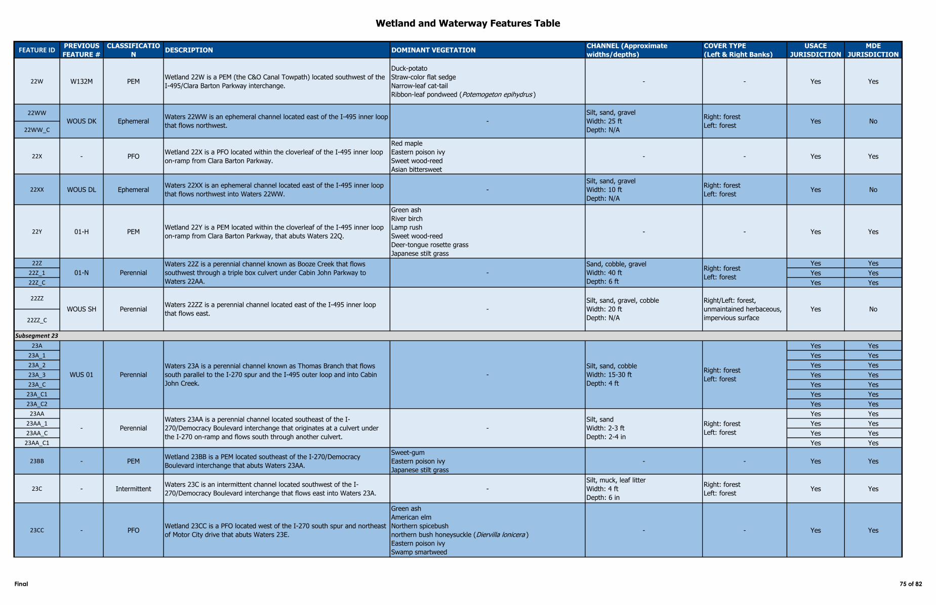
Wetland and Waterway Features Table
FEATURE IDPREVIOUS
FEATURE #
CLASSIFICATIO
NDESCRIPTION DOMINANT VEGETATION
CHANNEL (Approximate
widths/depths)
COVER TYPE
(Left & Right Banks)
USACE
JURISDICTION
MDE
JURISDICTION
22W W132M PEMWetland 22W is a PEM (the C&O Canal Towpath) located southwest of the
I-495/Clara Barton Parkway interchange.
Duck-potato
Straw-color flat sedge
Narrow-leaf cat-tail
Ribbon-leaf pondweed (Potemogeton epihydrus )
- - Yes Yes
22WW
22WW_C
22X - PFOWetland 22X is a PFO located within the cloverleaf of the I-495 inner loop
on-ramp from Clara Barton Parkway.
Red maple
Eastern poison ivy
Sweet wood-reed
Asian bittersweet
- - Yes Yes
22XX WOUS DL EphemeralWaters 22XX is an ephemeral channel located east of the I-495 inner loop
that flows northwest into Waters 22WW. -
Silt, sand, gravel
Width: 10 ft
Depth: N/A
Right: forest
Left: forestYes No
22Y 01-H PEMWetland 22Y is a PEM located within the cloverleaf of the I-495 inner loop
on-ramp from Clara Barton Parkway, that abuts Waters 22Q.
Green ash
River birch
Lamp rush
Sweet wood-reed
Deer-tongue rosette grass
Japanese stilt grass
- - Yes Yes
22Z Yes Yes
22Z_1 Yes Yes
22Z_C Yes Yes
22ZZ
22ZZ_C
23A Yes Yes
23A_1 Yes Yes
23A_2 Yes Yes
23A_3 Yes Yes
23A_C Yes Yes
23A_C1 Yes Yes
23A_C2 Yes Yes
23AA Yes Yes
23AA_1 Yes Yes
23AA_C Yes Yes
23AA_C1 Yes Yes
23BB - PEMWetland 23BB is a PEM located southeast of the I-270/Democracy
Boulevard interchange that abuts Waters 23AA.
Sweet-gum
Eastern poison ivy
Japanese stilt grass
- - Yes Yes
23C - IntermittentWaters 23C is an intermittent channel located southwest of the I-
270/Democracy Boulevard interchange that flows east into Waters 23A. -
Silt, muck, leaf litter
Width: 4 ft
Depth: 6 in
Right: forest
Left: forestYes Yes
23CC - PFOWetland 23CC is a PFO located west of the I-270 south spur and northeast
of Motor City drive that abuts Waters 23E.
Green ash
American elm
Northern spicebush
northern bush honeysuckle (Diervilla lonicera )
Eastern poison ivy
Swamp smartweed
- - Yes Yes
WOUS SH PerennialWaters 22ZZ is a perennial channel located east of the I-495 inner loop
that flows east. -
Silt, sand, gravel, cobble
Width: 20 ft
Depth: N/A
Right/Left: forest,
unmaintained herbaceous,
impervious surface
Yes No
WOUS DK EphemeralWaters 22WW is an ephemeral channel located east of the I-495 inner loop
that flows northwest. -
Silt, sand, gravel
Width: 25 ft
Depth: N/A
Right: forest
Left: forestYes No
Subsegment 23
WUS 01 Perennial
Waters 23A is a perennial channel known as Thomas Branch that flows
south parallel to the I-270 spur and the I-495 outer loop and into Cabin
John Creek.
-
Silt, sand, cobble
Width: 15-30 ft
Depth: 4 ft
Right: forest
Left: forest
01-N Perennial
Waters 22Z is a perennial channel known as Booze Creek that flows
southwest through a triple box culvert under Cabin John Parkway to
Waters 22AA.
-
Sand, cobble, gravel
Width: 40 ft
Depth: 6 ft
Right: forest
Left: forest
- Perennial
Waters 23AA is a perennial channel located southeast of the I-
270/Democracy Boulevard interchange that originates at a culvert under
the I-270 on-ramp and flows south through another culvert.
-
Silt, sand
Width: 2-3 ft
Depth: 2-4 in
Right: forest
Left: forest
Final 75 of 82
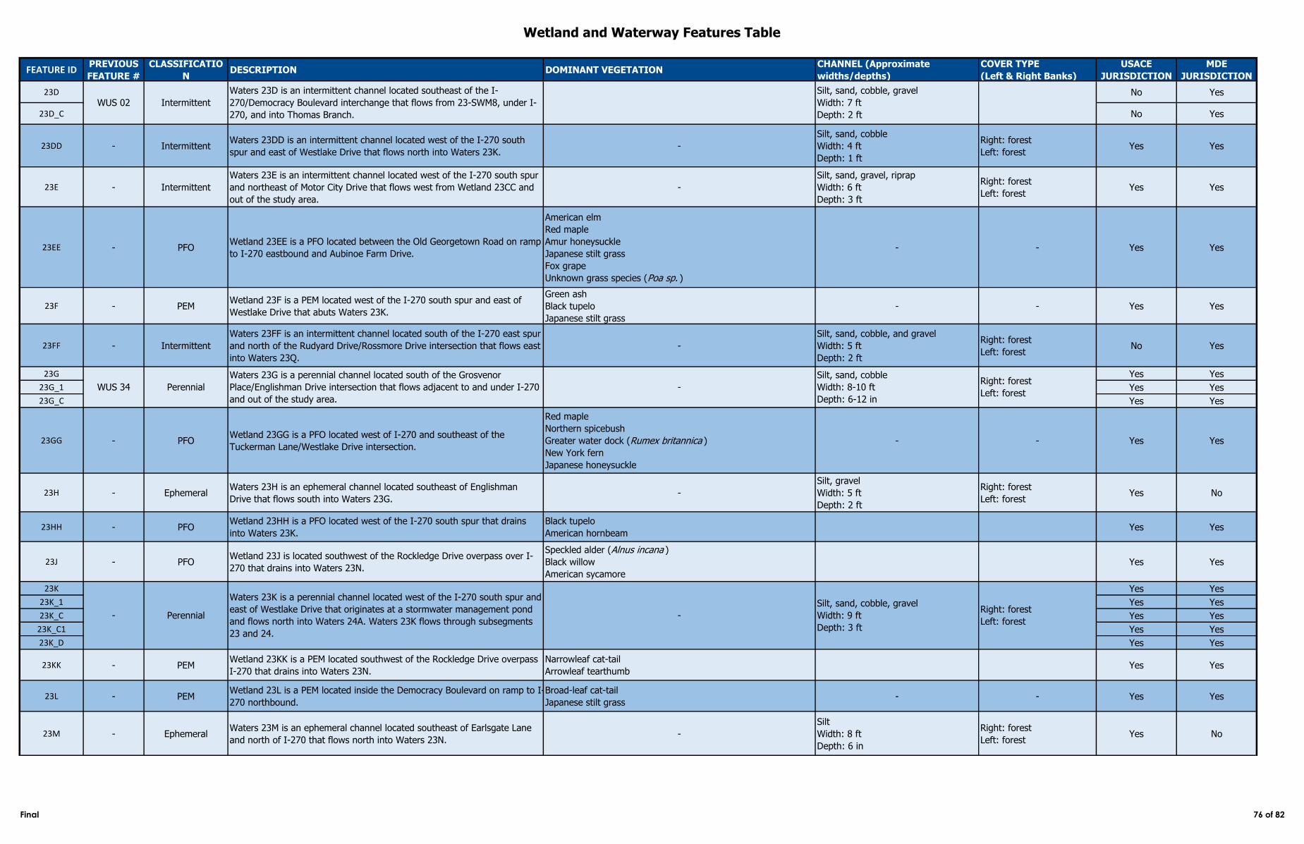
Wetland and Waterway Features Table
FEATURE IDPREVIOUS
FEATURE #
CLASSIFICATIO
NDESCRIPTION DOMINANT VEGETATION
CHANNEL (Approximate
widths/depths)
COVER TYPE
(Left & Right Banks)
USACE
JURISDICTION
MDE
JURISDICTION
23D No Yes
23D_C No Yes
23DD - IntermittentWaters 23DD is an intermittent channel located west of the I-270 south
spur and east of Westlake Drive that flows north into Waters 23K. -
Silt, sand, cobble
Width: 4 ft
Depth: 1 ft
Right: forest
Left: forestYes Yes
23E - Intermittent
Waters 23E is an intermittent channel located west of the I-270 south spur
and northeast of Motor City Drive that flows west from Wetland 23CC and
out of the study area.
-
Silt, sand, gravel, riprap
Width: 6 ft
Depth: 3 ft
Right: forest
Left: forestYes Yes
23EE - PFOWetland 23EE is a PFO located between the Old Georgetown Road on ramp
to I-270 eastbound and Aubinoe Farm Drive.
American elm
Red maple
Amur honeysuckle
Japanese stilt grass
Fox grape
Unknown grass species (Poa sp. )
- - Yes Yes
23F - PEMWetland 23F is a PEM located west of the I-270 south spur and east of
Westlake Drive that abuts Waters 23K.
Green ash
Black tupelo
Japanese stilt grass
- - Yes Yes
23FF - Intermittent
Waters 23FF is an intermittent channel located south of the I-270 east spur
and north of the Rudyard Drive/Rossmore Drive intersection that flows east
into Waters 23Q.
-
Silt, sand, cobble, and gravel
Width: 5 ft
Depth: 2 ft
Right: forest
Left: forestNo Yes
23G Yes Yes
23G_1 Yes Yes
23G_C Yes Yes
23GG - PFOWetland 23GG is a PFO located west of I-270 and southeast of the
Tuckerman Lane/Westlake Drive intersection.
Red maple
Northern spicebush
Greater water dock (Rumex britannica )
New York fern
Japanese honeysuckle
- - Yes Yes
23H - EphemeralWaters 23H is an ephemeral channel located southeast of Englishman
Drive that flows south into Waters 23G. -
Silt, gravel
Width: 5 ft
Depth: 2 ft
Right: forest
Left: forestYes No
23HH - PFOWetland 23HH is a PFO located west of the I-270 south spur that drains
into Waters 23K.
Black tupelo
American hornbeamYes Yes
23J - PFOWetland 23J is located southwest of the Rockledge Drive overpass over I-
270 that drains into Waters 23N.
Speckled alder (Alnus incana )
Black willow
American sycamore
Yes Yes
23K Yes Yes
23K_1 Yes Yes
23K_C Yes Yes
23K_C1 Yes Yes
23K_D Yes Yes
23KK - PEMWetland 23KK is a PEM located southwest of the Rockledge Drive overpass
I-270 that drains into Waters 23N.
Narrowleaf cat-tail
Arrowleaf tearthumbYes Yes
23L - PEMWetland 23L is a PEM located inside the Democracy Boulevard on ramp to I-
270 northbound.
Broad-leaf cat-tail
Japanese stilt grass- - Yes Yes
23M - EphemeralWaters 23M is an ephemeral channel located southeast of Earlsgate Lane
and north of I-270 that flows north into Waters 23N. -
Silt
Width: 8 ft
Depth: 6 in
Right: forest
Left: forestYes No
- Perennial
Waters 23K is a perennial channel located west of the I-270 south spur and
east of Westlake Drive that originates at a stormwater management pond
and flows north into Waters 24A. Waters 23K flows through subsegments
23 and 24.
-
Silt, sand, cobble, gravel
Width: 9 ft
Depth: 3 ft
Right: forest
Left: forest
WUS 34
WUS 02 Intermittent
Waters 23D is an intermittent channel located southeast of the I-
270/Democracy Boulevard interchange that flows from 23-SWM8, under I-
270, and into Thomas Branch.
Silt, sand, cobble, gravel
Width: 7 ft
Depth: 2 ft
Perennial
Waters 23G is a perennial channel located south of the Grosvenor
Place/Englishman Drive intersection that flows adjacent to and under I-270
and out of the study area.
-
Silt, sand, cobble
Width: 8-10 ft
Depth: 6-12 in
Right: forest
Left: forest
Final 76 of 82
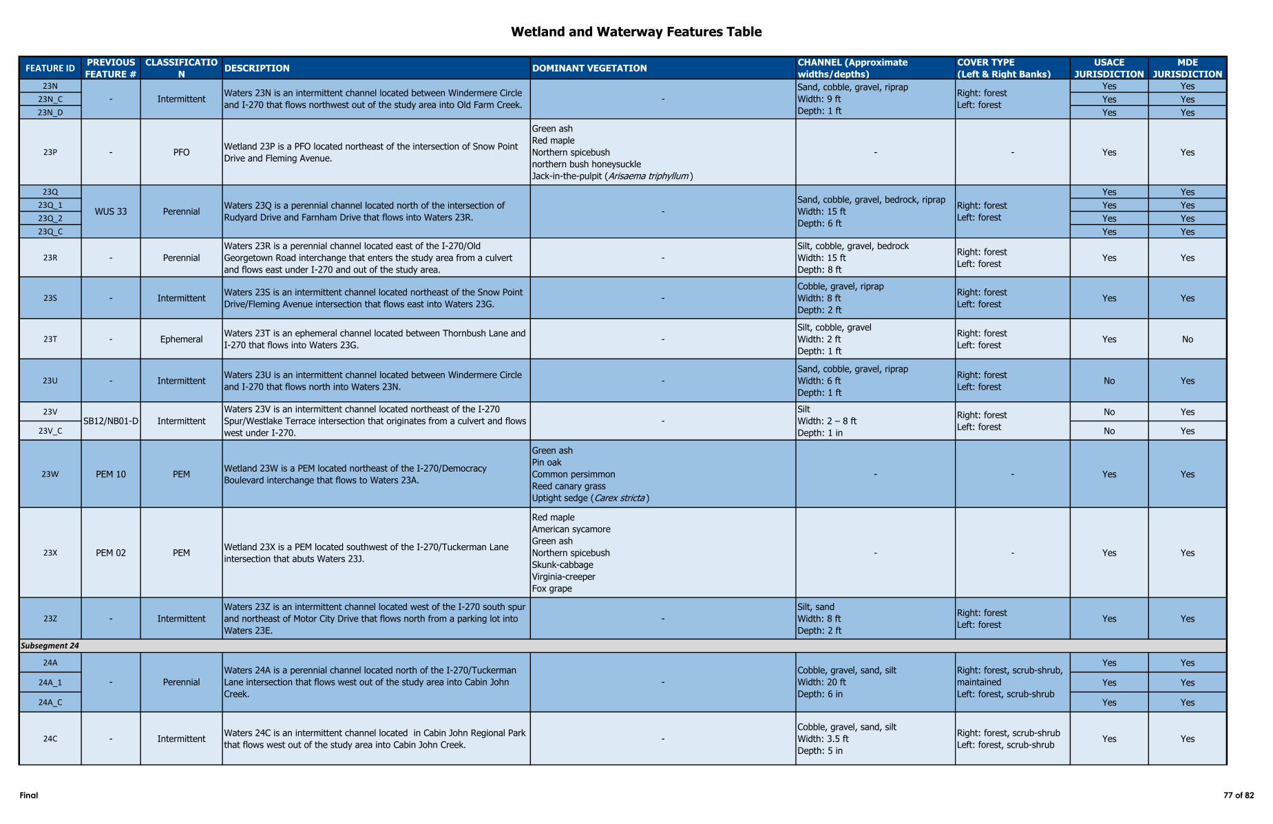
Wetland and Waterway Features Table
FEATURE IDPREVIOUS
FEATURE #
CLASSIFICATIO
NDESCRIPTION DOMINANT VEGETATION
CHANNEL (Approximate
widths/depths)
COVER TYPE
(Left & Right Banks)
USACE
JURISDICTION
MDE
JURISDICTION
23N Yes Yes
23N_C Yes Yes
23N_D Yes Yes
23P - PFOWetland 23P is a PFO located northeast of the intersection of Snow Point
Drive and Fleming Avenue.
Green ash
Red maple
Northern spicebush
northern bush honeysuckle
Jack-in-the-pulpit (Arisaema triphyllum )
- - Yes Yes
23Q Yes Yes
23Q_1 Yes Yes
23Q_2 Yes Yes
23Q_C Yes Yes
23R - Perennial
Waters 23R is a perennial channel located east of the I-270/Old
Georgetown Road interchange that enters the study area from a culvert
and flows east under I-270 and out of the study area.
-
Silt, cobble, gravel, bedrock
Width: 15 ft
Depth: 8 ft
Right: forest
Left: forestYes Yes
23S - IntermittentWaters 23S is an intermittent channel located northeast of the Snow Point
Drive/Fleming Avenue intersection that flows east into Waters 23G. -
Cobble, gravel, riprap
Width: 8 ft
Depth: 2 ft
Right: forest
Left: forestYes Yes
23T - EphemeralWaters 23T is an ephemeral channel located between Thornbush Lane and
I-270 that flows into Waters 23G.-
Silt, cobble, gravel
Width: 2 ft
Depth: 1 ft
Right: forest
Left: forestYes No
23U - IntermittentWaters 23U is an intermittent channel located between Windermere Circle
and I-270 that flows north into Waters 23N. -
Sand, cobble, gravel, riprap
Width: 6 ft
Depth: 1 ft
Right: forest
Left: forestNo Yes
23V No Yes
23V_C No Yes
23W PEM 10 PEMWetland 23W is a PEM located northeast of the I-270/Democracy
Boulevard interchange that flows to Waters 23A.
Green ash
Pin oak
Common persimmon
Reed canary grass
Uptight sedge (Carex stricta )
- - Yes Yes
23X PEM 02 PEMWetland 23X is a PEM located southwest of the I-270/Tuckerman Lane
intersection that abuts Waters 23J.
Red maple
American sycamore
Green ash
Northern spicebush
Skunk-cabbage
Virginia-creeper
Fox grape
- - Yes Yes
23Z - Intermittent
Waters 23Z is an intermittent channel located west of the I-270 south spur
and northeast of Motor City Drive that flows north from a parking lot into
Waters 23E.
-
Silt, sand
Width: 8 ft
Depth: 2 ft
Right: forest
Left: forestYes Yes
24A Yes Yes
24A_1 Yes Yes
24A_C Yes Yes
24C - IntermittentWaters 24C is an intermittent channel located in Cabin John Regional Park
that flows west out of the study area into Cabin John Creek. -
Cobble, gravel, sand, silt
Width: 3.5 ft
Depth: 5 in
Right: forest, scrub-shrub
Left: forest, scrub-shrubYes Yes
Subsegment 24
- Perennial
Waters 24A is a perennial channel located north of the I-270/Tuckerman
Lane intersection that flows west out of the study area into Cabin John
Creek.
-
Cobble, gravel, sand, silt
Width: 20 ft
Depth: 6 in
Right: forest, scrub-shrub,
maintained
Left: forest, scrub-shrub
- IntermittentWaters 23N is an intermittent channel located between Windermere Circle
and I-270 that flows northwest out of the study area into Old Farm Creek.-
Sand, cobble, gravel, riprap
Width: 9 ft
Depth: 1 ft
Right: forest
Left: forest
WUS 33 PerennialWaters 23Q is a perennial channel located north of the intersection of
Rudyard Drive and Farnham Drive that flows into Waters 23R.-
Sand, cobble, gravel, bedrock, riprap
Width: 15 ft
Depth: 6 ft
Right: forest
Left: forest
Intermittent
Waters 23V is an intermittent channel located northeast of the I-270
Spur/Westlake Terrace intersection that originates from a culvert and flows
west under I-270.
-
Silt
Width: 2 – 8 ft
Depth: 1 in
Right: forest
Left: forest SB12/NB01-D
Final 77 of 82
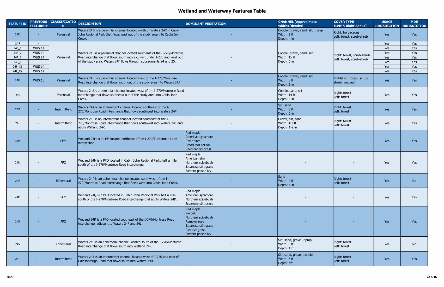
Wetland and Waterway Features Table
FEATURE IDPREVIOUS
FEATURE #
CLASSIFICATIO
NDESCRIPTION DOMINANT VEGETATION
CHANNEL (Approximate
widths/depths)
COVER TYPE
(Left & Right Banks)
USACE
JURISDICTION
MDE
JURISDICTION
24D - Perennial
Waters 24D is a perennial channel located north of Waters 24C in Cabin
John Regional Park that flows west out of the study area into Cabin John
Creek.
-
Cobble, gravel, sand, silt, riprap
Width: 3 ft
Depth: 4 in
Right: herbaceous
Left: forest, scrub-shrubYes Yes
24F - Yes Yes
24F_1 WUS 14 Yes Yes
24F_2 WUS 14 Yes Yes
24F_3 WUS 14 Yes Yes
24F_C - Yes Yes
24F_C1 WUS 14 Yes Yes
24F_C2 WUS 14 Yes Yes
24H WUS 15 PerennialWaters 24H is a perennial channel located west of the I-270/Montrose
Road interchange that flows south out of the study area into Waters 24J.-
Cobble, gravel, sand, silt
Width: 5 ft
Depth: 1 in
Right/Left: forest, scrub-
shrub, wetlandYes Yes
24J - Perennial
Waters 24J is a perennial channel located west of the I-270/Montrose Road
interchange that flows southeast out of the study area into Cabin John
Creek.
-
Cobble, sand, silt
Width: 14 ft
Depth: 6 in
Right: forest
Left: forestYes Yes
24K - IntermittentWaters 24K is an intermittent channel located southeast of the I-
270/Montrose Road interchange that flows southwest into Waters 24F. -
Silt, sand
Width: 3 ft
Depth: 6 in
Right: forest
Left: forestYes Yes
24L - Intermittent
Waters 24L is an intermittent channel located southeast of the I-
270/Montrose Road interchange that flows southwest into Waters 24F and
abuts Wetland 24R.
-
Gravel, silt, sand
Width: 1-2 ft
Depth: 1-2 in
Right: forest
Left: forestYes Yes
24M - PEMWetland 24M is a PEM located northeast of the I-270/Tuckerman Lane
intersection.
Red maple
American sycamore
River birch
Broad-leaf cat-tail
Reed canary grass
- - Yes Yes
24N - PFOWetland 24N is a PFO located in Cabin John Regional Park, half a mile
south of the I-270/Montrose Road interchange.
Red maple
American elm
Northern spicebush
Japanese stilt grass
Eastern poison ivy
- - Yes Yes
24P - EphemeralWaters 24P is an ephemeral channel located southwest of the I-
270/Montrose Road interchange that flows west into Cabin John Creek. -
Sand
Width: 4 ft
Depth: 6 in
Right: forest
Left: forestYes No
24Q - PFOWetland 24Q is a PFO located in Cabin John Regional Park half a mile
south of the I-270/Montrose Road interchange that abuts Waters 24D.
Red maple
American sycamore
Northern spicebush
Japanese stilt grass
- - Yes Yes
24R - PFOWetland 24R is a PFO located southeast of the I-270/Montrose Road
interchange, adjacent to Waters 24F and 24L.
Red maple
Pin oak
Northern spicebush
Rambler rose
Japanese stilt grass
Rice cut grass
Eastern poison ivy
- - Yes Yes
24S - EphemeralWaters 24S is an ephemeral channel located south of the I-270/Montrose
Road interchange that flows south into Wetland 24R. -
Silt, sand, gravel, riprap
Width: 6 ft
Depth: 4 ft
Right: forest
Left: forestYes No
24T - IntermittentWaters 24T is an intermittent channel located west of I-270 and east of
Gainsborough Road that flows south into Waters 24U. -
Silt, sand, gravel, cobble
Width: 6 ft
Depth: 4ft
Right: forest
Left: forestYes Yes
Perennial
Waters 24F is a perennial channel located southeast of the I-270/Montrose
Road interchange that flows south into a culvert under I-270 and west out
of the study area. Waters 24F flows through subsegments 24 and 25.
-
Cobble, gravel, sand, silt
Width: 15 ft
Depth: 6 in
Right: forest, scrub-shrub
Left: forest, scrub-shrub
Final 78 of 82
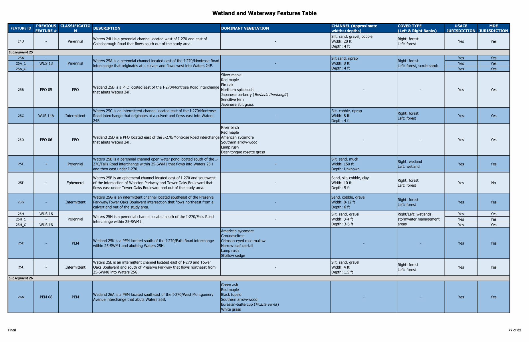
Wetland and Waterway Features Table
FEATURE IDPREVIOUS
FEATURE #
CLASSIFICATIO
NDESCRIPTION DOMINANT VEGETATION
CHANNEL (Approximate
widths/depths)
COVER TYPE
(Left & Right Banks)
USACE
JURISDICTION
MDE
JURISDICTION
24U - PerennialWaters 24U is a perennial channel located west of I-270 and east of
Gainsborough Road that flows south out of the study area. -
Silt, sand, gravel, cobble
Width: 20 ft
Depth: 4 ft
Right: forest
Left: forestYes Yes
25A - Yes Yes
25A_1 WUS 13 Yes Yes
25A_C - Yes Yes
25B PFO 05 PFOWetland 25B is a PFO located east of the I-270/Montrose Road interchange
that abuts Waters 24F.
Silver maple
Red maple
Pin oak
Northern spicebush
Japanese barberry (Berberis thunbergii )
Sensitive fern
Japanese stilt grass
- - Yes Yes
25C WUS 14A Intermittent
Waters 25C is an intermittent channel located east of the I-270/Montrose
Road interchange that originates at a culvert and flows east into Waters
24F.
-
Silt, cobble, riprap
Width: 8 ft
Depth: 4 ft
Right: forest
Left: forestYes Yes
25D PFO 06 PFOWetland 25D is a PFO located east of the I-270/Montrose Road interchange
that abuts Waters 24F.
River birch
Red maple
American sycamore
Southern arrow-wood
Lamp rush
Deer-tongue rosette grass
- - Yes Yes
25E - Perennial
Waters 25E is a perennial channel open water pond located south of the I-
270/Falls Road interchange within 25-SWM1 that flows into Waters 25H
and then east under I-270.
-
Silt, sand, muck
Width: 150 ft
Depth: Unknown
Right: wetland
Left: wetlandYes Yes
25F - Ephemeral
Waters 25F is an ephemeral channel located east of I-270 and southwest
of the intersection of Wootton Parkway and Tower Oaks Boulevard that
flows east under Tower Oaks Boulevard and out of the study area.
-
Sand, silt, cobble, clay
Width: 10 ft
Depth: 5 ft
Right: forest
Left: forestYes No
25G - Intermittent
Waters 25G is an intermittent channel located southeast of the Preserve
Parkway/Tower Oaks Boulevard intersection that flows northeast from a
culvert and out of the study area.
-
Sand, cobble, gravel
Width: 8-12 ft
Depth: 6 ft
Right: forest
Left: forestYes Yes
25H WUS 16 Yes Yes
25H_1 - Yes Yes
25H_C WUS 16 Yes Yes
25K - PEMWetland 25K is a PEM located south of the I-270/Falls Road interchange
within 25-SWM1 and abutting Waters 25H.
American sycamore
Groundseltree
Crimson-eyed rose-mallow
Narrow-leaf cat-tail
Lamp rush
Shallow sedge
- - Yes Yes
25L - Intermittent
Waters 25L is an intermittent channel located east of I-270 and Tower
Oaks Boulevard and south of Preserve Parkway that flows northeast from
25-SWM8 into Waters 25G.
-
Silt, sand, gravel
Width: 4 ft
Depth: 1.5 ft
Right: forest
Left: forestYes Yes
26A PEM 08 PEMWetland 26A is a PEM located southeast of the I-270/West Montgomery
Avenue interchange that abuts Waters 26B.
Green ash
Red maple
Black tupelo
Southern arrow-wood
Eurasian-buttercup (Ficaria verna )
White grass
- - Yes Yes
Subsegment 25
PerennialWaters 25A is a perennial channel located east of the I-270/Montrose Road
interchange that originates at a culvert and flows west into Waters 24F. -
Silt sand, riprap
Width: 8 ft
Depth: 4 ft
Right: forest
Left: forest, scrub-shrub
PerennialWaters 25H is a perennial channel located south of the I-270/Falls Road
interchange within 25-SWM1. -
Silt, sand, gravel
Width: 3-4 ft
Depth: 3-6 ft
Right/Left: wetlands,
stormwater management
areas
Subsegment 26
Final 79 of 82
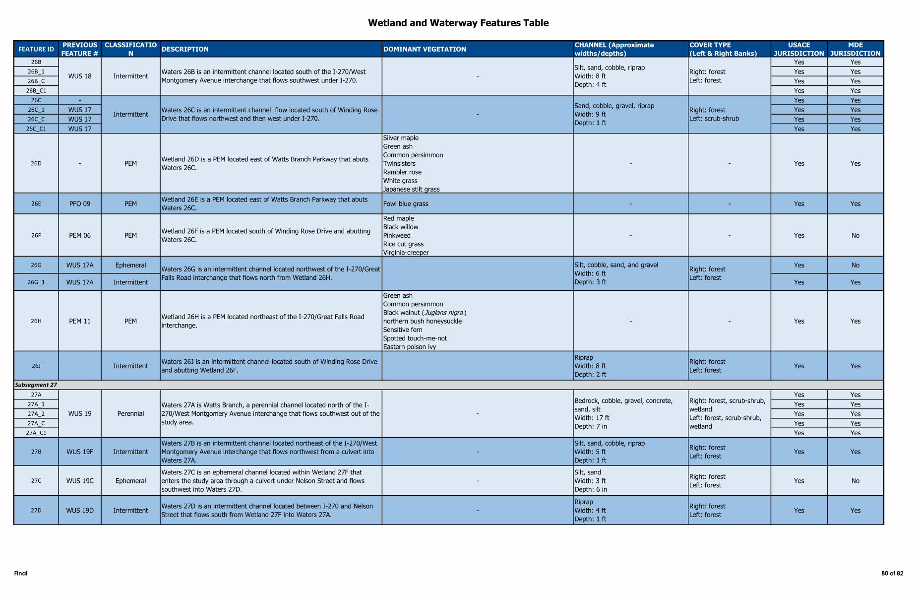
Wetland and Waterway Features Table
FEATURE IDPREVIOUS
FEATURE #
CLASSIFICATIO
NDESCRIPTION DOMINANT VEGETATION
CHANNEL (Approximate
widths/depths)
COVER TYPE
(Left & Right Banks)
USACE
JURISDICTION
MDE
JURISDICTION
26B Yes Yes
26B_1 Yes Yes
26B_C Yes Yes
26B_C1 Yes Yes
26C - Yes Yes
26C_1 WUS 17 Yes Yes
26C_C WUS 17 Yes Yes
26C_C1 WUS 17 Yes Yes
26D - PEMWetland 26D is a PEM located east of Watts Branch Parkway that abuts
Waters 26C.
Silver maple
Green ash
Common persimmon
Twinsisters
Rambler rose
White grass
Japanese stilt grass
- - Yes Yes
26E PFO 09 PEMWetland 26E is a PEM located east of Watts Branch Parkway that abuts
Waters 26C. Fowl blue grass - - Yes Yes
26F PEM 06 PEMWetland 26F is a PEM located south of Winding Rose Drive and abutting
Waters 26C.
Red maple
Black willow
Pinkweed
Rice cut grass
Virginia-creeper
- - Yes No
26G WUS 17A Ephemeral Yes No
26G_1 WUS 17A Intermittent Yes Yes
26H PEM 11 PEMWetland 26H is a PEM located northeast of the I-270/Great Falls Road
interchange.
Green ash
Common persimmon
Black walnut (Juglans nigra )
northern bush honeysuckle
Sensitive fern
Spotted touch-me-not
Eastern poison ivy
- - Yes Yes
26J IntermittentWaters 26J is an intermittent channel located south of Winding Rose Drive
and abutting Wetland 26F.
Riprap
Width: 8 ft
Depth: 2 ft
Right: forest
Left: forest Yes Yes
27A Yes Yes
27A_1 Yes Yes
27A_2 Yes Yes
27A_C Yes Yes
27A_C1 Yes Yes
27B WUS 19F Intermittent
Waters 27B is an intermittent channel located northeast of the I-270/West
Montgomery Avenue interchange that flows northwest from a culvert into
Waters 27A.
-
Silt, sand, cobble, riprap
Width: 5 ft
Depth: 1 ft
Right: forest
Left: forestYes Yes
27C WUS 19C Ephemeral
Waters 27C is an ephemeral channel located within Wetland 27F that
enters the study area through a culvert under Nelson Street and flows
southwest into Waters 27D.
-
Silt, sand
Width: 3 ft
Depth: 6 in
Right: forest
Left: forestYes No
27D WUS 19D IntermittentWaters 27D is an intermittent channel located between I-270 and Nelson
Street that flows south from Wetland 27F into Waters 27A. -
Riprap
Width: 4 ft
Depth: 1 ft
Right: forest
Left: forestYes Yes
WUS 18 IntermittentWaters 26B is an intermittent channel located south of the I-270/West
Montgomery Avenue interchange that flows southwest under I-270. -
Silt, sand, cobble, riprap
Width: 8 ft
Depth: 4 ft
Right: forest
Left: forest
Subsegment 27
WUS 19 Perennial
Waters 27A is Watts Branch, a perennial channel located north of the I-
270/West Montgomery Avenue interchange that flows southwest out of the
study area.
-
Bedrock, cobble, gravel, concrete,
sand, silt
Width: 17 ft
Depth: 7 in
Right: forest, scrub-shrub,
wetland
Left: forest, scrub-shrub,
wetland
Waters 26G is an intermittent channel located northwest of the I-270/Great
Falls Road interchange that flows north from Wetland 26H.
Silt, cobble, sand, and gravel
Width: 6 ft
Depth: 3 ft
Right: forest
Left: forest
Right: forest
Left: scrub-shrubIntermittent
Waters 26C is an intermittent channel flow located south of Winding Rose
Drive that flows northwest and then west under I-270. -
Sand, cobble, gravel, riprap
Width: 9 ft
Depth: 1 ft
Final 80 of 82
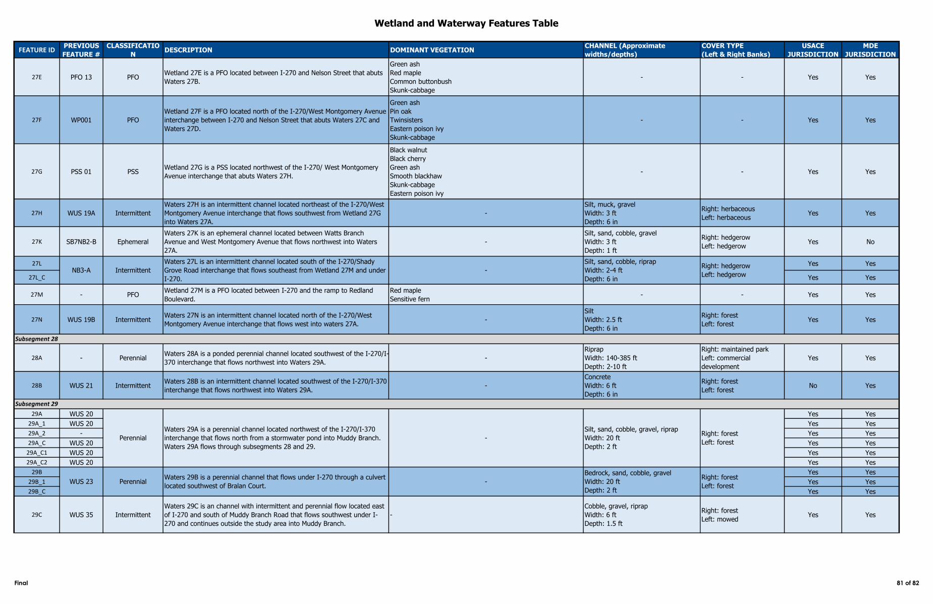
Wetland and Waterway Features Table
FEATURE IDPREVIOUS
FEATURE #
CLASSIFICATIO
NDESCRIPTION DOMINANT VEGETATION
CHANNEL (Approximate
widths/depths)
COVER TYPE
(Left & Right Banks)
USACE
JURISDICTION
MDE
JURISDICTION
27E PFO 13 PFOWetland 27E is a PFO located between I-270 and Nelson Street that abuts
Waters 27B.
Green ash
Red maple
Common buttonbush
Skunk-cabbage
- - Yes Yes
27F WP001 PFO
Wetland 27F is a PFO located north of the I-270/West Montgomery Avenue
interchange between I-270 and Nelson Street that abuts Waters 27C and
Waters 27D.
Green ash
Pin oak
Twinsisters
Eastern poison ivy
Skunk-cabbage
- - Yes Yes
27G PSS 01 PSSWetland 27G is a PSS located northwest of the I-270/ West Montgomery
Avenue interchange that abuts Waters 27H.
Black walnut
Black cherry
Green ash
Smooth blackhaw
Skunk-cabbage
Eastern poison ivy
- - Yes Yes
27H WUS 19A Intermittent
Waters 27H is an intermittent channel located northeast of the I-270/West
Montgomery Avenue interchange that flows southwest from Wetland 27G
into Waters 27A.
-
Silt, muck, gravel
Width: 3 ft
Depth: 6 in
Right: herbaceous
Left: herbaceousYes Yes
27K SB7NB2-B Ephemeral
Waters 27K is an ephemeral channel located between Watts Branch
Avenue and West Montgomery Avenue that flows northwest into Waters
27A.
-
Silt, sand, cobble, gravel
Width: 3 ft
Depth: 1 ft
Right: hedgerow
Left: hedgerowYes No
27L Yes Yes
27L_C Yes Yes
27M - PFOWetland 27M is a PFO located between I-270 and the ramp to Redland
Boulevard.
Red maple
Sensitive fern- - Yes Yes
27N WUS 19B IntermittentWaters 27N is an intermittent channel located north of the I-270/West
Montgomery Avenue interchange that flows west into waters 27A. -
Silt
Width: 2.5 ft
Depth: 6 in
Right: forest
Left: forestYes Yes
28A - PerennialWaters 28A is a ponded perennial channel located southwest of the I-270/I-
370 interchange that flows northwest into Waters 29A. -
Riprap
Width: 140-385 ft
Depth: 2-10 ft
Right: maintained park
Left: commercial
development
Yes Yes
28B WUS 21 IntermittentWaters 28B is an intermittent channel located southwest of the I-270/I-370
interchange that flows northwest into Waters 29A. -
Concrete
Width: 6 ft
Depth: 6 in
Right: forest
Left: forest No Yes
29A WUS 20 Yes Yes
29A_1 WUS 20 Yes Yes
29A_2 - Yes Yes
29A_C WUS 20 Yes Yes
29A_C1 WUS 20 Yes Yes
29A_C2 WUS 20 Yes Yes
29B Yes Yes
29B_1 Yes Yes
29B_C Yes Yes
29C WUS 35 Intermittent
Waters 29C is an channel with intermittent and perennial flow located east
of I-270 and south of Muddy Branch Road that flows southwest under I-
270 and continues outside the study area into Muddy Branch.
-
Cobble, gravel, riprap
Width: 6 ft
Depth: 1.5 ft
Right: forest
Left: mowedYes Yes
Subsegment 28
Subsegment 29
Perennial
Waters 29A is a perennial channel located northwest of the I-270/I-370
interchange that flows north from a stormwater pond into Muddy Branch.
Waters 29A flows through subsegments 28 and 29.
-
Silt, sand, cobble, gravel, riprap
Width: 20 ft
Depth: 2 ft
Right: forest
Left: forest
WUS 23 PerennialWaters 29B is a perennial channel that flows under I-270 through a culvert
located southwest of Bralan Court.-
Bedrock, sand, cobble, gravel
Width: 20 ft
Depth: 2 ft
Right: forest
Left: forest
NB3-A -
Silt, sand, cobble, riprap
Width: 2-4 ft
Depth: 6 in
Intermittent
Waters 27L is an intermittent channel located south of the I-270/Shady
Grove Road interchange that flows southeast from Wetland 27M and under
I-270.
Right: hedgerow
Left: hedgerow
Final 81 of 82
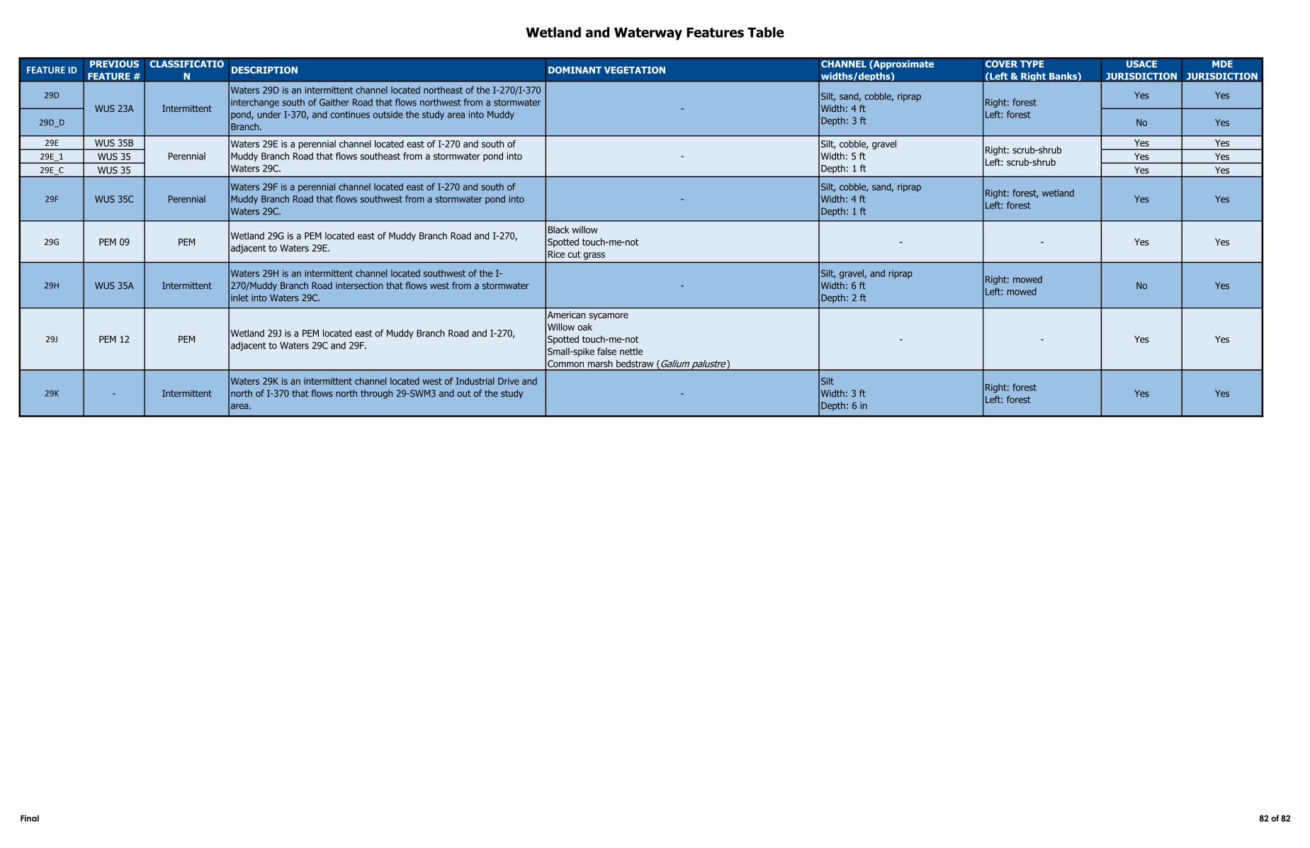
Wetland and Waterway Features Table
FEATURE IDPREVIOUS
FEATURE #
CLASSIFICATIO
NDESCRIPTION DOMINANT VEGETATION
CHANNEL (Approximate
widths/depths)
COVER TYPE
(Left & Right Banks)
USACE
JURISDICTION
MDE
JURISDICTION
29D Yes Yes
29D_D No Yes
29E WUS 35B Yes Yes
29E_1 WUS 35 Yes Yes
29E_C WUS 35 Yes Yes
29F WUS 35C Perennial
Waters 29F is a perennial channel located east of I-270 and south of
Muddy Branch Road that flows southwest from a stormwater pond into
Waters 29C.
-
Silt, cobble, sand, riprap
Width: 4 ft
Depth: 1 ft
Right: forest, wetland
Left: forestYes Yes
29G PEM 09 PEMWetland 29G is a PEM located east of Muddy Branch Road and I-270,
adjacent to Waters 29E.
Black willow
Spotted touch-me-not
Rice cut grass
- - Yes Yes
29H WUS 35A Intermittent
Waters 29H is an intermittent channel located southwest of the I-
270/Muddy Branch Road intersection that flows west from a stormwater
inlet into Waters 29C.
-
Silt, gravel, and riprap
Width: 6 ft
Depth: 2 ft
Right: mowed
Left: mowed No Yes
29J PEM 12 PEMWetland 29J is a PEM located east of Muddy Branch Road and I-270,
adjacent to Waters 29C and 29F.
American sycamore
Willow oak
Spotted touch-me-not
Small-spike false nettle
Common marsh bedstraw (Galium palustre )
- - Yes Yes
29K - Intermittent
Waters 29K is an intermittent channel located west of Industrial Drive and
north of I-370 that flows north through 29-SWM3 and out of the study
area.
-
Silt
Width: 3 ft
Depth: 6 in
Right: forest
Left: forestYes Yes
Perennial
Waters 29E is a perennial channel located east of I-270 and south of
Muddy Branch Road that flows southeast from a stormwater pond into
Waters 29C.
-
Silt, cobble, gravel
Width: 5 ft
Depth: 1 ft
Right: scrub-shrub
Left: scrub-shrub
Intermittent
Waters 29D is an intermittent channel located northeast of the I-270/I-370
interchange south of Gaither Road that flows northwest from a stormwater
pond, under I-370, and continues outside the study area into Muddy
Branch.
-
Silt, sand, cobble, riprap
Width: 4 ft
Depth: 3 ft
Right: forest
Left: forestWUS 23A
Final 82 of 82