Embed Size (px)
Citation preview
Appendix E
Ecology, Water Quality & Fisheries Report
R407 SALLINS BYPASS
ECOLOGY, WATER QUALITY & FISHERIES ROUTE SELECTION REPORT
Prepared for
Kildare County Council Áras Chill Dara
Devoy Park Naas
Co. Kildare
Prepared by
Fehily Timoney Gifford Ltd. Mill House
Ashtown Gate Navan Road
Dublin 15
October 2007
R407 Sallins Bypass Kildare County Council Ecology, Water Quality & Fisheries Report
R407 SALLINS BYPASS
ECOLOGY, WATER QUALITY & FISHERIES ROUTE SELECTION REPORT
User is Responsible for Checking The Revision Status of this Document
Rev. Nr Description of Changes Prepared by: Checked by: Approved by: Date 0 Working Draft, Issued for
Comment DR/KK GF 03/10/07
1 Final Draft DR/KK GF AD 20/11/07 Client: Kildare County Council Keywords: Kildare, Sallins, Route Selection Abstract: Fehily Timoney Gifford (FTG) has been retained by Kildare County Council
to carry out the constraints study, route selection and environmental impact assessment for the R407 Sallins Bypass. This report describes and assesses the impacts on the various route corridor options being considered from a ecology, water quality & fisheries point of view.
R407 Sallins Bypass Kildare County Council Ecology, Water Quality & Fisheries Report
Page i of ii October 2007 (KK/DR/GF) \\Ftcd05\dublin-jobs\2006\114\02\Post Tender\Reports\Appendices to Route Selection Report\KIL_DD_RPT003 - Appendix E - Ecology, Water Quality & Fisheries.doc
TABLE OF CONTENTS
PAGE 1. Introduction ......................................................................................................... 1 2. Methodology ....................................................................................................... 2
2.1. DESKTOP STUDY ............................................................................................. 2 2.2. GIS MAPPING ................................................................................................. 3 2.3. FIELD STUDIES ................................................................................................ 3 2.4. SITE EVALUATION & IMPACT ASSESSMENT ....................................................... 4 2.5. LIMITATIONS OF THIS STUDY ............................................................................ 5
3. The Existing Environment .................................................................................. 6 3.1. CONSERVATION SITES ..................................................................................... 6 3.2. ENVIRONMENTAL CHARACTERISTICS ................................................................ 6 3.3. SITE EVALUATION & ASSESSMENT ................................................................... 7
4. Results ............................................................................................................... 8 4.1. HABITAT & BOTANICAL .................................................................................... 8 4.2. FISH POPULATIONS ......................................................................................... 9 4.3. BIRDS ........................................................................................................... 10 4.4. MAMMALS ..................................................................................................... 11 4.5. BAT SURVEY ................................................................................................. 12 4.6. OTHER TAXA ................................................................................................. 13
5. Impact Assessment .......................................................................................... 24 5.1. SITE EVALUATION & IMPACT ASSESSMENT ..................................................... 24 5.2. CORRIDOR IMPACT ASSESSMENT .................................................................. 24 5.3. OVERALL CORRIDOR EVALUATION ................................................................. 25
6. Conclusion ........................................................................................................ 29 7. Bibliography ...................................................................................................... 30
LIST OF APPENDICES Appendix 1 NPWS Site Synopsis of Designated Sites within 10km of the Study Area Appendix 2 NRA (2006) recommended site evaluation scheme. Appendix 3 NRA (2006) recommended criteria for assessing impact significance,
where site rating is based on the NRA recommended site evaluation scheme outlined in Appendix 2.
Appendix 4 List of protected species recorded within 10km of the proposed development site since 1845.
R407 Sallins Bypass Kildare County Council Ecology, Water Quality & Fisheries Report
Page ii of ii October 2007 (KK/DR/GF) \\Ftcd05\dublin-jobs\2006\114\02\Post Tender\Reports\Appendices to Route Selection Report\KIL_DD_RPT003 - Appendix E - Ecology, Water Quality & Fisheries.doc
LIST OF TABLES
PAGE TABLE 4.1 SUMMARY OF DESIGNATED CONSERVATION SITES IN THE STUDY AREA. ........... 14 TABLE 4.2 CHARACTERISTICS OF THE EXISTING ENVIRONMENT AND PROPOSED
CONFIGURATION OF EACH ROUTE CORRIDOR OPTION ........................................ 16 TABLE 4.3 HABITATS IDENTIFIED ALONG EACH OF THE ROUTE CORRIDORS (AS PER FOSSITT,
2000). ............................................................................................................ 17 TABLE 4.4 BOTANICAL SPECIES RECORDED DURING SITE VISITS IN AUGUST 2007. .............. 18 TABLE 4.5 BIRDS RECORDED DURING FIELD SURVEYS OF THE GENERAL STUDY AREA. ......... 19 TABLE 4.6 SPECIES OF BAT FOUND ALONG ROUTE CORRIDORS ........................................... 20 TABLE 4.7 OTHER TAXA FOUND ALONG ROUTE CORRIDORS ................................................ 20 TABLE 5.1 ECOLOGICAL SITE EVALUATIONS AND ASSESSMENT OF IMPACT SIGNIFICANCE FOR
EACH ROUTE CORRIDOR. ................................................................................. 27 TABLE 5.2 OVERALL ASSESSMENT OF ALL ROUTE CORRIDORS ON ECOLOGY. ORDER OF
PREFERENCE 1 = BEST, 11 = WORST. .............................................................. 28
LIST OF FIGURES
PAGE FIGURE 4.1 DESIGNATED CONSERVATION SITES WITHIN THE STUDY AREA ........................... 21 FIGURE 4.2 CORINE LAND USE .......................................................................................... 22 FIGURE 4.3 MAJOR WATERWAYS CROSSED BY THE VARIOUS ROUTE CORRIDOR OPTIONS ... 23
Page 1 of 31 October 2007 (KK/DR/GF) \\Ftcd05\dublin-jobs\2006\114\02\Post Tender\Reports\Appendices to Route Selection Report\KIL_DD_RPT003 - Appendix E - Ecology, Water Quality & Fisheries.doc
1. INTRODUCTION This study evaluates the ecological issues associated with the proposed route corridors of the Sallins Bypass scheme. This assessment was completed in accordance to guidelines set out by the National Roads Authority (NRA) (2006a) for such studies. A total of nine route corridors were considered in this study. These study corridors were 300 metres wide and were identified by a colour. Three of these corridors have two possible end-point alignments. These are the Red, Cyan/Red and Purple corridors. The alternative end-points are termed ‘Option A’, i.e. Red Route Option A (as distinct from Red Route) and are treated as separate corridors, with their own ecological evaluations in this report. Hence eleven route corridors are assessed here. The study area is dominated by improved agriculture with some recreational parkland (Golf Courses), broad-leaved woodland and urban fabric. A desktop study was carried out to evaluate the main ecological aspects of the study area that will influence the selection of the preferred corridor for the Sallins Bypass. Field based surveys on sections of the various proposed route options were also carried out as part of this route corridor evaluation study. All of the route corridors are designed to link ‘Point A’ on the R407 just north of Sallins with either the M7 Motorway or the R407 south of Sallins. All corridors involve the bridging of the Grand Canal, a proposed National Heritage Area (pNHA 2104) and four of the proposed routes (Green, Cyan, Cyan/Red and Cyan/Red Option A routes) also bridge the River Liffey. A total of seven of the proposed routes pass to the west of Sallins and four are located to the east. The routes are outlined in section 2.4 with the geology described in section 3.5. Further descriptions of the engineering environmental design are given for each route in sections Chapter 5 and 6 respectively.
Page 2 of 31 October 2007 (KK/DR/GF) \\Ftcd05\dublin-jobs\2006\114\02\Post Tender\Reports\Appendices to Route Selection Report\KIL_DD_RPT003 - Appendix E - Ecology, Water Quality & Fisheries.doc
2. METHODOLOGY A comprehensive desktop study of available data on the local flora and fauna was conducted. These data were collated and augmented by a variety of field based surveys and consultations with wildlife groups. 2.1. Desktop Study Background information on the flora and fauna of the study area was collected from all available sources. Ecological data previously recorded for the general area were reviewed. This part of the assessment helped to investigate the possible occurrence of important species and/or sites within the study area that are not already part of specially designated conservation sites. This desktop review drew on a wide variety of sources including:
• NPWS website (www.npws.ie) • National Biodiversity Network (NBN) (http://www.nbn.org.uk/) • BirdWatch Ireland’s (BWI) data from the Irish Wetland Bird Survey (I-WeBS)
(BirdWatch Ireland 2005) • Millennium Atlas of Butterflies in Britain & Ireland • Atlas of Breeding Birds of Britain & Ireland (Gibbons et al., 1993) • Atlas of Wintering Birds in Britain & Ireland (Lack, 1986) • Flora Britannica • Atlas of Vascular Plants of Britain & Ireland • Atlas of the Irish Landscape • Irish Red Data Books • The Badger and Habitat Survey of Ireland (Smal, 1995) • Seabirds of Britain & Ireland • Central Fisheries Board (www.cfb.ie) • Numerous published papers and distribution records (see Bibliography)
This process yielded considerable baseline information on the local ecology. Many of the species records were not of a sufficiently precise nature as to be of much value in interpreting the flora and fauna found along a particular route corridor. However these records did serve to describe the nature of the wider plant and animal community in the entire study area. The assessment of fisheries and aquatic habitats was particularly aided by consultation with the SWRFB and the literature review. Apart from the River Liffey and Grand canal other smaller water courses such as the Morell River were also studied.
Page 3 of 31 October 2007 (KK/DR/GF) \\Ftcd05\dublin-jobs\2006\114\02\Post Tender\Reports\Appendices to Route Selection Report\KIL_DD_RPT003 - Appendix E - Ecology, Water Quality & Fisheries.doc
2.2. GIS Mapping Where possible, ecological data collected were mapped on a 1:50,000 Discovery Series Ordnance Survey (OS) maps using MapInfo Professional (version 8.5) GIS application. High resolution Aerial Orthophotographs of the study area were used to help identify ecological sites of interest along the route corridor options, e.g. areas of woodland. Designated (including proposed) conservation sites in the vicinity of the routes were identified from the GIS data website of the DOEHLG (see www.heritagedata.ie). These areas include Special Areas of Conservation (SAC), Special Protection Areas (SPA) and Natural Heritage Areas (NHA). Site synopsis information for these conservation sites was obtained from the website (www.npws.ie) or Site Designations & Plans Unit of the NPWS. Another important resource which was used to describe land use within the study area was the Corine dataset. Corine Land Cover 2000 (CLC2000) is produced by the European Environment Agency (EEA) and its member countries in the European environment information and observation network (Eionet). Corine Land Cover 2000 (CLC2000) is an update for the reference year 2000 of the first Corine Land Cover database which was finalised in the early 1990s and it provides consistent information on land cover and land cover changes during the past decade across Europe. CLC2000 is based on the photo-interpretation of satellite images by the national teams of the participating countries. The resulting national land cover inventories are further integrated into a seamless land cover map of Europe. In parallel to the desktop review, consultation and mapping process, a baseline field survey was conducted. 2.3. Field Studies A series of baseline field studies were undertaken within the study area, with particular emphasis on the area encompassed by each route corridor. These field studies comprised of baseline habitat, botanical, bird and mammal surveys conducted in July, and August of 2007. Field surveys were carried out according to NRA Guidelines for the Assessment of Ecological Impacts of National Roads Schemes (2006). Survey work was carried out in appropriate weather conditions and using standard ecological survey techniques. Botanical studies focussed on describing habitats along the route corridors according to Fossitt (2000) classification method. In addition, botanical species were recorded for each route corridor.
Page 4 of 31 October 2007 (KK/DR/GF) \\Ftcd05\dublin-jobs\2006\114\02\Post Tender\Reports\Appendices to Route Selection Report\KIL_DD_RPT003 - Appendix E - Ecology, Water Quality & Fisheries.doc
Birds were surveyed using standard transect methodology (Bibby et al., 1992) and mammal tracks and signs were recorded where encountered during the field walkover survey. Regard was taken of the areas in which the diversity of species was greatest and where birds of elevated conservation importance were found to occur (e.g. Newton et al., 1999; Birds Directive 79/409/EEC). Bat activity was assessed in August 2007. Accessible, safe sampling locations such as road and canal crossings were chosen along each of the route corridors. River crossings could not be sampled due to the difficulty of accessing these sites at night. Bat detection was aided by use of heterodyne bat detectors (BatBox Duet, Pettersson D200) and Time Expansion Detector (Petersson D240X). Recordings were made using EDIROL R-09 Digital WAV Recorder and subsequently analysed using BatScan and BatSound software. 2.4. Site Evaluation & Impact Assessment The NRA Guidelines for the Assessment of Ecological Impacts of National Roads Schemes (NRA, 2006) has detailed a method for evaluating the ecological impacts on the route corridors under review. The Route Corridor Selection Report according to NRA Guidelines should contain:
• Details of Designated Conservation Areas nearby • A discussion of surface and ground water features and fisheries in the study area • Details of rare or protected species in the vicinity of the corridors • A list of non-designated but potentially important sites in the study area or sites
with other relevant conservation designations or programmes • Details of other features of particular conservation or ecological importance in the
study area The NRA Guidelines also set forth a method of evaluating the importance of the sites identified and in turn of evaluating the significance of impacts thereupon. Appendix 2 illustrates the site evaluation scheme and Appendix 3 outlines the criteria employed for assessing impact significance.
Page 5 of 31 October 2007 (KK/DR/GF) \\Ftcd05\dublin-jobs\2006\114\02\Post Tender\Reports\Appendices to Route Selection Report\KIL_DD_RPT003 - Appendix E - Ecology, Water Quality & Fisheries.doc
2.5. Limitations of this Study
• At the time of this study not all route corridors were equally accessible. This was mainly due to the difficulty of terrain of some areas for survey purposes and in obtaining permission to access lands from all landowners within the study area.
• There is a general paucity of detailed distribution data of Irish flora and fauna.
Much of the available information is not collected at a scale comparable to the 300 metre bands used in the route corridor selection process. For instance, many distribution atlases present their results at the 10 km2 scale and others merely present Presence or Absence data rather than some measure of abundance.
• Field surveys at the route selection stage are, by their definition, not as in depth
as dedicated Ecological Site Assessments or Environmental Impact Assessments. This route selection considered 11 potential route corridors.
• Field surveys conducted in a short period give a ‘snapshot’ of the local flora and
fauna at the time of the study but may miss more subtle seasonal or cyclical variations in the local ecology.
Page 6 of 31 October 2007 (KK/DR/GF) \\Ftcd05\dublin-jobs\2006\114\02\Post Tender\Reports\Appendices to Route Selection Report\KIL_DD_RPT003 - Appendix E - Ecology, Water Quality & Fisheries.doc
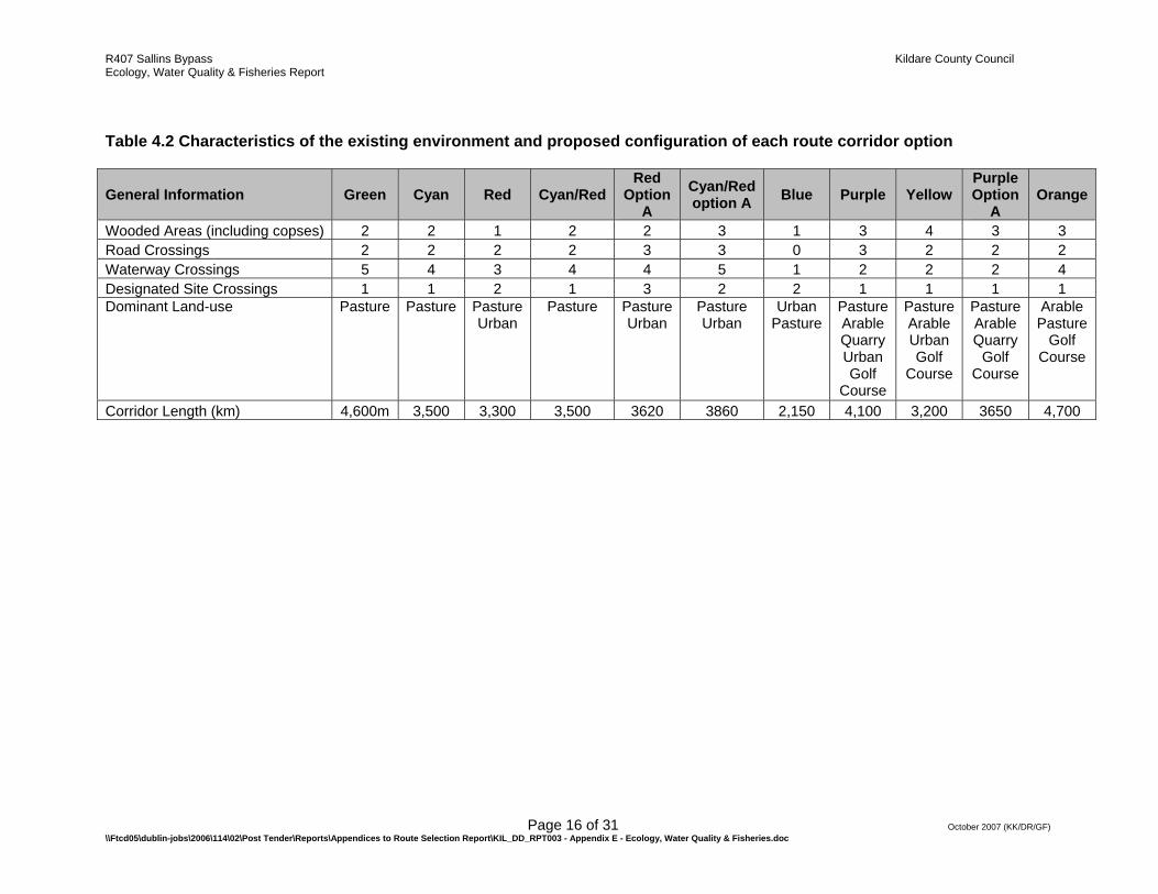
3. THE EXISTING ENVIRONMENT The area of the proposed Sallins Bypass is characterised by rolling pastures and lowland depositing waterways. Land use is dominated by agriculture and there is an abundance of improved agricultural habitats along each of the route corridors. The southeastern portion of the study area comprises a number of golf courses with numerous artificial lakes and wooded copses. The Liffey and Morell Rivers and their tributaries drain the area and the Grand Canal runs through the site in a west-east direction. The banks of the River Liffey are characterised by patches of riparian vegetation including small areas of mature deciduous woodland and scrub. Similarly the banks of the Grand Canal east of Sallins town are well vegetated. The existing environment was studied by a combination of desktop and field study methods. For instance an examination of aerial photography and GIS mapping of the Corine dataset was used in conjunction with the habitat and botanical field survey reports to describe general landuse patterns along each route corridor. 3.1. Conservation Sites Designated conservation sites are outlined in Table 4.1 and Figure 4.1. Detailed site synopses are available in Appendix 1. A total of four designated Special Area’s of Conservation (SAC), one Special Protection Area (SPA) and seven Natural Heritage Areas (or proposed NHA’s) occur within 10km of the route corridor options. However only one of these designated sites, The Grand Canal pNHA (2104), occurs within the study area. All of the proposed route corridors cross this designated site. The Blue route, Red route and Cyan/Red Option A route all cross the pNHA on two occasions while the Red Option A route crosses the pNHA on three occasions. (Figure 4.1) 3.2. Environmental characteristics Table 4.2 details the characteristics of the existing environment along each route corridor. It collates information from the GIS and aerial photo analysis, describing such features as:
• The number of discrete wooded areas, including copses traversed by each route corridor
• The number of road crossings on each corridor • The number of waterway crossings, including all rivers and canals on each
corridor • Designated site crossings on each corridor • The dominant land-use along each of the route options • The approximate length of each corridor
Page 7 of 31 October 2007 (KK/DR/GF) \\Ftcd05\dublin-jobs\2006\114\02\Post Tender\Reports\Appendices to Route Selection Report\KIL_DD_RPT003 - Appendix E - Ecology, Water Quality & Fisheries.doc
The Orange route corridor is the longest corridor, followed closely by the Green corridor while the Blue route corridor is less than half the length of these corridors. The dominant land-use along each route was pasture, which was the most common habitat on all route corridors. Arable fields and Golf Courses were also present along many of the routes which pass through the eastern portion of the study site, i.e. Purple, Purple Option A, Orange and Yellow. Many of the sites pass through urban areas, most notably the Blue route. The Purple route and Purple Option A route both pass through an active Quarry. All route corridors cross the Grand Canal pNHA and four route corridors (Green, Cyan, Cyan/Red and Cyan/Red Option A route) cross the River Liffey. Only one route corridor crosses the River Morell (The Orange route). The Blue route, Red route and Red/Cyan route Corridors cross the Grand Canal pNHA on two occasions while the Red Option A route crosses on three occasions. The route corridors which cross the least number of waterways are the Blue, Purple, Purple Option A and Yellow route corridors – all crossing two or less waterways. All route corridors (apart from the Blue Corridor) cross two to three roads and their associated hedgerows. 3.3. Site Evaluation & Assessment Site evaluation and assessment was carried out using the NRA Guidelines on site evaluation and criteria for assessing impact significance (NRA, 2006). These guidelines set out the means of identifying and rating the importance of ecological sites in a study area. In turn the guidelines specify a means of quantifying the significance of the impact on each site, dependent on the importance of the individual site and the predicted level of impact the proposed development would have on each site. Appendix 3 details the method for site evaluation and Appendix 4 specifies the criteria used for assessing impact significance as per the NRA Guidelines (NRA, 2006). The following section 6.4.5 outlines the results of the desktop review, consultations and field studies and the species, habitats and ecological sites which were identified during this process.
R407 Sallins Bypass Kildare County Council Ecology, Water Quality & Fisheries Report
Page 8 of 31 October 2007 (KK/DR/GF) \\Ftcd05\dublin-jobs\2006\114\02\Post Tender\Reports\Appendices to Route Selection Report\KIL_DD_RPT003 - Appendix E - Ecology, Water Quality & Fisheries.doc
4. RESULTS This section details the results of the desktop review, consultation process and field-walkovers. The data presented provide baseline ecological information on the flora and fauna within the study area and where possible along each of the route corridors. This information was used to identify sites of importance for evaluation and impact assessment using the NRA Guidelines (NRA, 2006). 4.1. Habitat & Botanical Mapping of Corine data using MapInfo Professional GIS application for the study area gives an impression of the land use in the general study area. Figure 4.2 illustrates the land use with the route corridors overlaid in the study area. There were seven Corine land-use categories identified from along the route corridors:
• Pasture • Non-irrigated arable land • Road and rail networks and associated land • Discontinuous Urban fabric • Dump • Broad-leaved woodland • Sport and Leisure Facilities
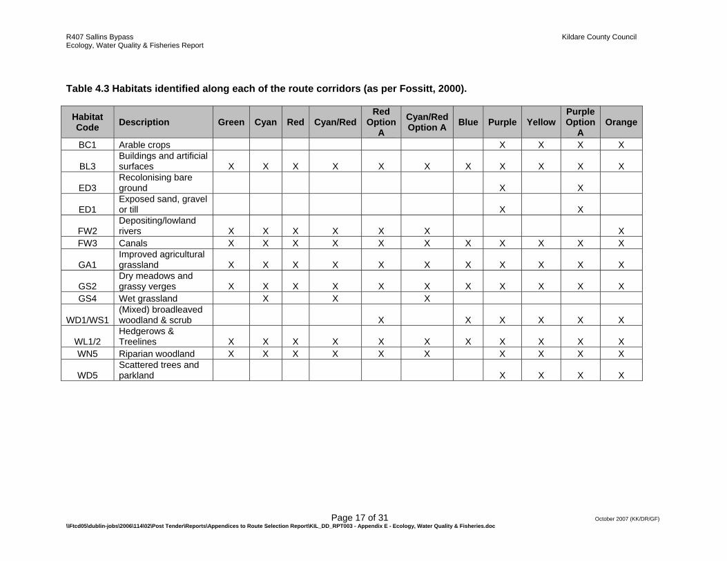
In addition, a small area of mineral extraction (Quarry) was identified in the east of the site, adjacent to the Landfill site along the Purple route corridors. This quarry is a recent development and does not appear on the Corine dataset. Pasture was found to be the dominant land use on all of the corridors and was the only land use on the Green, Cyan and Cyan/Red route corridors. Large areas of non-irrigated arable land are present in the east of the site and make up a proportion of the Orange, Yellow, Purple and Purple Option A route corridors. Much of the southeast of the site is dominated by sport and leisure facilities (golf courses) which contain areas of broad leaved woodland. The Orange, Yellow, Purple and Purple Option A route corridors all pass through these areas. The Blue corridor impacts on a large area of discontinuous urban fabric, while many of the route corridors contain small areas of urban fabric where they merge with Sallins town or Johnstown. The field walkover study identified habitats that occurred along each of the route corridors according to the Fossitt classification method (2000). Table 4.3 shows the habitats recorded along each corridor. The Purple and Purple Option A Corridors had the greatest diversity of habitat types with a total of 12 discrete habitats recorded. This was followed closely by the Orange and Yellow corridors which held 10 habitat types. These route corridors were all located in the east of the site where golf courses, a quarry and arable land create high habitat heterogeneity. In contrast only six habitat types were recorded on the Blue route
R407 Sallins Bypass Kildare County Council Ecology, Water Quality & Fisheries Report
Page 9 of 31 October 2007 (KK/DR/GF) \\Ftcd05\dublin-jobs\2006\114\02\Post Tender\Reports\Appendices to Route Selection Report\KIL_DD_RPT003 - Appendix E - Ecology, Water Quality & Fisheries.doc
Corridor which is dominated by buildings and artificial surfaces (BL3). Two areas of wet grassland (GS4) were recorded during site walkovers and the desktop survey. One occurred near the River Liffey crossing of the Cyan and Cyan/Red Corridors and the other was recorded just east of Sallins town on the Yellow and Purple route corridors. Recolonising bare ground (ED3) and Exposed sand, gravel or till (ED1) were only recorded along the Purple and Purple Option A routes and both habitat types were associated with the active quarry works. Sites of potential ecological interest such as river, canal, road and railway crossings were visited to assess the botanical species present and their ecological value. Due to the relatively close proximity of many of the route corridors and the similarity of the habitats they traverse, there was a high degree of overlap in botanical species found across the 11 Corridors. Therefore data from all route corridors visited were pooled. Table 4.4 shows the dominant plant species recorded during these site visits, grouped by habitat crossing type. In total 57 taxa were recorded representing a broad range of plant species, many typical of agricultural land and their field-boundaries as well as riparian vegetation. None of the species identified are included in the Floral Protection Order 1999 and the vast majority of species encountered are locally and nationally common. Appendix 4 lists all rare or protected flora recorded in the surrounding area from the NPWS database (10km squares N81, N91, N92). Certain habitats typically support a greater biodiversity than other habitat types. Undoubtedly treelines, woodland and habitats associated with a riparian corridor are more species rich than grassland or arable areas. Dense riparian vegetation of moderate ecological value was found along many of the River Liffey crossings, as well as the canal crossings east of Sallins town. Treelines containing mature native trees were found at a selection of road, railway and canal crossings on many of the routes. 4.2. Fish Populations In terms of fisheries within the study area, the River Liffey is the most significant watercourse and is of national importance (i.e. NRA, B rating). It has populations of Atlantic Salmon, Salmo salar, which is listed under Annex II and V of the EU Habitats Directive, Sea Trout, Salmo trutta, and Brown Trout, Salmo trutta. In addition, the River Liffey is known to have Brook Lamprey, Lampetra planeri, another species listed under Annex II of the EU Habitats Directive, although it is not clear at this stage if the species is present in the section of the River Liffey that runs through the study area. Furthermore the River Liffey and many of its tributaries of are known to support White-clawed Crayfish, Austropotamobius pallipes, which is listed under Annex II and V of the EU Habitats Directive. The latest Environmental Protection Agency (EPA) data for water quality of the River Liffey indicates that it is unpolluted upstream and slightly polluted downstream of study area. The River Liffey is primarily located within the western section of the study area, flowing in a north-easterly direction (Figure 4.3). The River Morrell is a tributary of the River Liffey and is known to support significant populations of Brown Trout as well as providing good spawning habitat for salmonids. This river runs through the southeastern section of the study area, and is locally important (NRA, C-rating) (Figure 4.3). Latest (2005) biological water quality data from

R407 Sallins Bypass Kildare County Council Ecology, Water Quality & Fisheries Report
Page 10 of 31 October 2007 (KK/DR/GF) \\Ftcd05\dublin-jobs\2006\114\02\Post Tender\Reports\Appendices to Route Selection Report\KIL_DD_RPT003 - Appendix E - Ecology, Water Quality & Fisheries.doc
the EPA show that the River Morell is slightly polluted (Q3-4) in the vicinity of the study area. Even though the Grand Canal is not regarded as an important fisheries watercourse, it is still an important ecological watercourse of national importance (NRA B-rating) and supports significant populations of coarse fish. Otter, Lutra lutra, which is listed in Annex II of the EU Habitats Directive, is known to occur along the Grand Canal and it is very likely that this mammal also occurs along many other watercourses in the area, especially the River Liffey. All of the route corridors cross the Grand Canal, with the Blue route, Red route and Cyan Red route Option A crossing the Grand Canal pNHA on two occasions and the Red Option A route crossing on three occasions. Four corridors cross the River Liffey in two locations (the Green, Cyan, Cyan/Red and Cyan/Red Option A Corridors). Only one corridor (Orange) crosses the River Morell. Several of the corridors make a number of minor stream crossings that would probably involve culverts or small overbridges. Bridges would be unlikely to impact negatively on the fish populations of these rivers providing that suitable mitigation measures are applied. Culverts too can be designed to minimise potential negative impacts although longer and steeper culverts may have some negative impacts on the affected watercourses. Stream diversions and any in-stream works are also potentially damaging to local fish stocks and require careful mitigation. Further consultations with the Central Fisheries Board will be carried out to determine the preferred route corridors from a fisheries protection point of view. 4.3. Birds In total, 26 bird species were recorded in the general study area during the selected site walkovers (Table 4.5). The conservation status of the species found is also indicated in Table 4.5 (Newton et al., 1999). The avian species recorded in this survey are typical of the mixture of agricultural and riparian habitats. The majority such as Robin, Erithacus rubecula, Wren, Troglodytes troglodytes and Blackbird, Turdus merula, are common and widespread resident species. Birds of conservation concern observed within the site have been assessed with respect to:
• Birds of Conservation Concern in Ireland (Newton et al., 1999).
• Council Directive 79/409/EEC on the conservation of wild birds.
• BirdWatch Ireland and the RSPB (Northern Ireland) priority bird species for conservation action in the whole of Ireland.
R407 Sallins Bypass Kildare County Council Ecology, Water Quality & Fisheries Report
Page 11 of 31 October 2007 (KK/DR/GF) \\Ftcd05\dublin-jobs\2006\114\02\Post Tender\Reports\Appendices to Route Selection Report\KIL_DD_RPT003 - Appendix E - Ecology, Water Quality & Fisheries.doc
BirdWatch Ireland and the RSPB (Northern Ireland) have agreed a list of priority bird species for conservation action in the whole of Ireland. These Birds of Conservation Concern in Ireland are published in a list known as the BoCCI List. In this BoCCI List, birds are classified into three separate lists (Red, Amber and Green), based on the conservation status of the bird and hence conservation priority. These conservation designations take into account the dangers faced by bird species that occur in Ireland. Red-listed species are of highest conservation concern and Amber-listed species are of medium conservation concern; 18 species are currently Red-listed, while a further 77 are considered Amber-listed. During site walkovers, no Red-listed species were recorded and three species of medium conservation concern, Amber-listed, were recorded. These were, Cormorant, Phalocrocorax carbo, Sand Martin, Riparia riparia and Swallow, Hirundo rustica. One Cormorant was recorded flying over the River Liffey near the Cyan/Red route crossing and Sand Martin burrows were recorded exclusively in exposed sands in the Quarry along the Purple routes. Swallows were common and widespread throughout the study area (all route corridors). Due to the presence of riparian habitat, as well as woodland and wet grassland, it is likely that a number of other bird species not recorded in field surveys are present in the study area, at least for part of the year. These would include the Kingfisher, Alcedo atthis and Barn Owl, Tytp alba both of which are Red-listed species and are listed in Annex I of the EU Birds Directive. The Red-listed Yellowhammer, Emberiza citrinella is also likely to occur in areas of arable agriculture. Several other Amber-listed species such as Snipe, Gallinago gallinago and Stonechat, Saxicola torquata are also likely to be present in the area. The similarity of habitats traversed by the route corridors would indicate that these species could potentially occur on all route corridors. 4.4. Mammals Mammal observations (excluding Bats, see section 4.5) recorded during field surveys of the route corridors during July and August are presented here, as well as results of the literature review. Appendix 4 lists all rare or protected fauna recorded in the surrounding area from NPWS records (10km squares N81, 91 & 92). Several mammal species were widespread and common throughout the survey area. Rabbit’s, Oryctolagus cuniculus, were sighted on many of the route corridors and are undoubtedly present throughout the study site. Similarly signs of Brown Rat, Rattus norvegicus, were noted, particularly along waterways. Otter, Lutra lutra, tracks were observed on the banks of the River Liffey at the Cyan and Cyan/Red route corridor crossing points. It is considered likely that Otters are present on most of the major watercourses within the general study area (Appendix 4). This species is listed in Annex II and Annex IV of the EU Habitats Directive. Fox, Vulpes vulpes droppings were found in the quarry on the Purple route and this species is likely to be common and widespread across all the route options.
R407 Sallins Bypass Kildare County Council Ecology, Water Quality & Fisheries Report
Page 12 of 31 October 2007 (KK/DR/GF) \\Ftcd05\dublin-jobs\2006\114\02\Post Tender\Reports\Appendices to Route Selection Report\KIL_DD_RPT003 - Appendix E - Ecology, Water Quality & Fisheries.doc
Although there was no evidence of Badger, Meles meles, activity during site visits, this species is likely to be widespread in the general area, particularly in areas of woodland and improved grassland. Small mammal trapping was not carried out as during field visits and this no doubt led to under recording of species such as Pygmy Shrew, Sorex minutus and possibly Bank Vole, Clethrionmys glareolus. Other species known to be relatively common but difficult to observe in this type of broad-scale survey include Hedgehog, Erinaceus europaeus, Stoat, Mustela erminea hibernica and Mink, Mustela vison. Although not recorded during field surveys the Red Deer, Cervus elaphus and Sika Deer, Cervus Nippon are known to occur in the general area from previous surveys carried out by the NPWS (Appendix 4). Both species are protected under the Wildlife Act (1976). Given the similarities in the habitats traversed by the route corridors it is probable that very similar mammal taxa are to be found along all of the potential route corridors. The areas of highest mammal diversity are likely to be the riparian and woodland habitats which occur to some degree on all route corridors. 4.5. Bat Survey Bat activity was sampled at a selection of locations on all route corridors in August 2007. A total of five Bat species were recorded during these surveys, which were carried out at accessible road and canal crossings. Bat activity was recorded on six of the 13 sampling locations, with highest activity recorded in areas of tree cover such as treelines along roads or canal crossings. Common Pipistrelle, Pipistrellus pipistrellus and Soprano Pipistrelle, Pipistrellus pygmaeus were the most widespread and abundant species recorded, occurring at five and three of the sampling locations respectively. Soprano Pipistrelle’s were particularly abundant along the Green and Blue route canal crossings. Daubenton’s Bat, Myotis daubentonii, was recorded at the Green route canal crossing with a further unconfirmed record at a road crossing (with small stream) on the Orange route. This species commonly roost under bridges or close to flowing water. Leisler’s Bat, Nyctalus leisleri, was recorded at two locations in the southwest of the survey area. These sampling locations were road crossings on the Green and Red routes which were characterised by mature deciduous treelines. Natterer’s Bat, Myotis nattereri, was recorded at two sampling locations on the Green route in the west of the study area. These road and canal crossings were characterised by mature deciduous treelines. Table 4.6 summarises the results of the Bat surveys. In general bat activity was highest at sampling locations on the Green route, where five Bat species were recorded, and lowest on the Purple and Yellow routes, where no Bats
R407 Sallins Bypass Kildare County Council Ecology, Water Quality & Fisheries Report
Page 13 of 31 October 2007 (KK/DR/GF) \\Ftcd05\dublin-jobs\2006\114\02\Post Tender\Reports\Appendices to Route Selection Report\KIL_DD_RPT003 - Appendix E - Ecology, Water Quality & Fisheries.doc
were recorded. It should be noted however that only a small portion of each route was sampled and it is highly likely that these mobile Bat species utilise areas within all of the route corridors. Furthermore, the presence of several waterways, treelines and wooded copses makes this area very attractive for bats and it would be expected that many more Irish Bat species occur locally Many of the bat species recorded in this survey roost at both natural and man-made sites, some showing a preference for disused buildings or farm buildings. Others such as Daubenton’s Bat commonly roost under bridges or close to flowing water. It is possible that many of the Bat species recorded in this survey roost in the general area, due to the presence of suitable roosting sites, i.e. mature woody vegetation, bridges and old buildings. 4.6. Other taxa The Common Frog, Rana temporaria was widespread along the banks of the eastern section of the Grand Canal, particularly along the Orange route corridor. This species is also likely to be present in areas of wet grassland in the study area. A number of macro-invertebrate (including Lepidoptera and Odonata) species were observed during field surveys, with the majority of sightings occurring along the Grand Canal and Liffey waterways. Three species of Butterfly were sighted and these records are detailed in Table 4.7. A Common Blue Damselfly, Enallagma cythigerum and Brown Hawker, Aeshna grandis, were also recorded along the banks of the Grand Canal. Desktop studies revealed no further records of protected Amphibians or macro-invertebrates in the general study area. In general waterways, woodland and areas of wet grassland are considered to be the most important habitats for Amphibians and macro-invertebrates in this study area. All of the route options cross at least one important waterway and it is likely that the species assemblage is similar across these route corridors.
R407 Sallins Bypass Kildare County Council Ecology, Water Quality & Fisheries Report
Page 14 of 31 October 2007 (KK/DR/GF) \\Ftcd05\dublin-jobs\2006\114\02\Post Tender\Reports\Appendices to Route Selection Report\KIL_DD_RPT003 - Appendix E - Ecology, Water Quality & Fisheries.doc
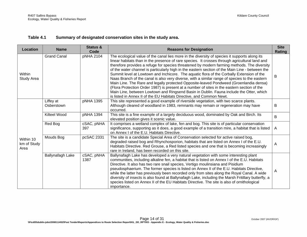
Table 4.1 Summary of designated conservation sites in the study area.
Location Name Status & Code Reasons for Designation Site
Rating
Within Study Area
Grand Canal pNHA 2104 The ecological value of the canal lies more in the diversity of species it supports along its linear habitats than in the presence of rare species. It crosses through agricultural land and therefore provides a refuge for species threatened by modern farming methods. The diversity of the water channel is particularly high in the eastern section of the Main Line - between the Summit level at Lowtown and Inchicore. The aquatic flora of the Corbally Extension of the Naas Branch of the canal is also very diverse, with a similar range of species to the eastern Main Line. The Rare and legally protected Opposite-leaved Pondweed (Groenlandia densa) (Flora Protection Order 1987) is present at a number of sites in the eastern section of the Main Line, between Lowtown and Ringsend Basin in Dublin. Fauna include the Otter, which is listed in Annex II of the EU Habitats Directive, and Common Newt.
B
Within 10 km of Study Area
Liffey at Osberstown
pNHA 1395 This site represented a good example of riverside vegetation, with two scarce plants. Although cleared of woodland in 1983, remnants may remain or regeneration may have occurred.
B
Kilteel Wood pNHA 1394 This site is a fine example of a largely deciduous wood, dominated by Oak and Birch. Its elevated position gives it scenic value. B
Red Bog cSAC, pNHA 397
It comprises a wetland complex of lake, fen and bog. This site is of particular conservation significance, supporting as it does, a good example of a transition mire, a habitat that is listed on Annex I of the E.U. Habitats Directive.
A
Mouds Bog pcSAC 2331 The site is a candidate Special Area of Conservation selected for active raised bog, degraded raised bog and Rhynchosporion, habitats that are listed on Annex I of the E.U. Habitats Directive. Red Grouse, a Red listed species and one that is becoming increasingly rare in Ireland, has been recorded on this site.
A
Ballynafagh Lake cSAC, pNHA 1387
Ballynafagh Lake has developed a very natural vegetation with some interesting plant communities, including alkaline fen, a habitat that is listed on Annex I of the E.U. Habitats Directive. It also has two rare snail species, Vertigo moulinsiana and Pisidium pseudosphaerium. The former species is listed on Annex II of the E.U. Habitats Directive, while the latter has previously been recorded only from sites along the Royal Canal. A wide diversity of insects is also found at Ballynafagh Lake, including the Marsh Fritillary butterfly, a species listed on Annex II of the EU Habitats Directive. The site is also of ornithological importance.
A
R407 Sallins Bypass Kildare County Council Ecology, Water Quality & Fisheries Report
Page 15 of 31 October 2007 (KK/DR/GF) \\Ftcd05\dublin-jobs\2006\114\02\Post Tender\Reports\Appendices to Route Selection Report\KIL_DD_RPT003 - Appendix E - Ecology, Water Quality & Fisheries.doc
Ballynafagh Bog cSAC 391 This site is a raised bog which is listed on Annex I of the E.U. Habitats Directive. The site is within the territory of a breeding pair of Merlin, a species listed on Annex I of the EU Birds Directive. Raised bogs are a rare habitat in Europe, and in Ireland continue to be under threat. Ballynafagh Bog, although damaged, is of added interest as the most easterly site with a high proportion of intact raised bog habitat remaining in Ireland.
A
Hodgestown Bog NHA 1393 The site comprises a raised bog that includes both areas of high bog and cutover bog. Raised bog is a rare habitat in the E.U. and one that is becoming increasingly scarce and under threat in Ireland. This site supports a good diversity of raised bog microhabitats, including hummocks.
B
Slade of Saggart & Crooksling Glen
pNHA 211 The site includes a good example of a wooded river valley and a small wetland system. The presence of a Rare plant (Littorella uniflora), a Rare invertebrate (Halticoptera patellana) and a variety of wildfowl species adds to the interest of the site.
B
Ballina Bog pNHA 390 Despite the presence of many drains, the condition of the vegetation and surface makes this bog of considerable scientific importance. It is one of the most easterly raised bogs which is relatively intact.
Donadea Wood pNHA 1391 The site is notable for the presence of two rare species of Myxomycete fungus, namely Diderma chondrioderma and Licea testudinacea, the latter in one of only two known Irish sites. This site is of scientific interest as, although highly managed, it has a significant proportion of deciduous trees and parts of the site have been wooded for a long period.
Poulaphouca Reservoir
pNHA 731 SPA 4063
Poulaphouca Reservoir is of international importance for its Greylag Goose population, which is one of the largest in the country. The site provides the main roost for the birds, with feeding occurring mostly on improved grassland outside of the site. An average peak of 1,058 individuals occurred during the five seasons 1995/96 to 1999/00. A range of other waterfowl species occur in relatively low numbers including Whooper Swan, a species that is listed on Annex I of the E.U. Birds Directive. The site is also notable as a winter roost for gulls, especially Lesser Black-backed Gull. Breeding birds at the site include Great Crested Grebe (several pairs), which is localised in its distribution in eastern Ireland, as well as Snipe and Lapwing.
A
R407 Sallins Bypass Kildare County Council Ecology, Water Quality & Fisheries Report
Page 16 of 31 October 2007 (KK/DR/GF) \\Ftcd05\dublin-jobs\2006\114\02\Post Tender\Reports\Appendices to Route Selection Report\KIL_DD_RPT003 - Appendix E - Ecology, Water Quality & Fisheries.doc
Table 4.2 Characteristics of the existing environment and proposed configuration of each route corridor option
General Information Green Cyan Red Cyan/RedRed
Option A
Cyan/Red option A Blue Purple Yellow
Purple Option
A Orange
Wooded Areas (including copses) 2 2 1 2 2 3 1 3 4 3 3 Road Crossings 2 2 2 2 3 3 0 3 2 2 2 Waterway Crossings 5 4 3 4 4 5 1 2 2 2 4 Designated Site Crossings 1 1 2 1 3 2 2 1 1 1 1 Dominant Land-use Pasture Pasture Pasture
Urban Pasture Pasture
Urban Pasture Urban
Urban Pasture
Pasture Arable Quarry Urban Golf
Course
Pasture Arable Urban Golf
Course
Pasture Arable Quarry
Golf Course
Arable Pasture
Golf Course
Corridor Length (km) 4,600m 3,500 3,300 3,500 3620 3860 2,150 4,100 3,200 3650 4,700
R407 Sallins Bypass Kildare County Council Ecology, Water Quality & Fisheries Report
Page 17 of 31 October 2007 (KK/DR/GF) \\Ftcd05\dublin-jobs\2006\114\02\Post Tender\Reports\Appendices to Route Selection Report\KIL_DD_RPT003 - Appendix E - Ecology, Water Quality & Fisheries.doc
Table 4.3 Habitats identified along each of the route corridors (as per Fossitt, 2000).
Habitat Code Description Green Cyan Red Cyan/Red
Red Option
A Cyan/Red Option A Blue Purple Yellow
Purple Option
A Orange
BC1 Arable crops X X X X
BL3 Buildings and artificial surfaces X X X X X X X X X X X
ED3 Recolonising bare ground X X
ED1 Exposed sand, gravel or till X X
FW2 Depositing/lowland rivers X X X X X X X
FW3 Canals X X X X X X X X X X X
GA1 Improved agricultural grassland X X X X X X X X X X X
GS2 Dry meadows and grassy verges X X X X X X X X X X X
GS4 Wet grassland X X X
WD1/WS1 (Mixed) broadleaved woodland & scrub X X X X X X
WL1/2 Hedgerows & Treelines X X X X X X X X X X X
WN5 Riparian woodland X X X X X X X X X X
WD5 Scattered trees and parkland X X X X
R407 Sallins Bypass Kildare County Council Ecology, Water Quality & Fisheries Report
Page 18 of 31 October 2007 (KK/DR/GF) \\Ftcd05\dublin-jobs\2006\114\02\Post Tender\Reports\Appendices to Route Selection Report\KIL_DD_RPT003 - Appendix E - Ecology, Water Quality & Fisheries.doc
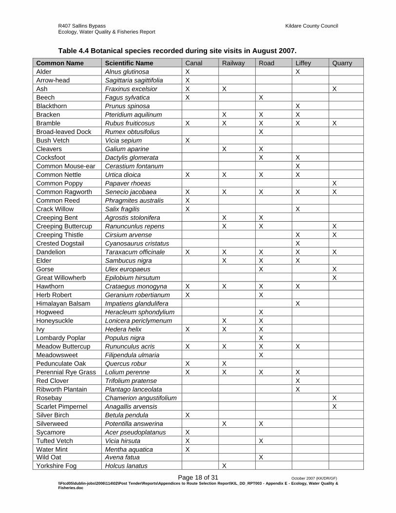
Table 4.4 Botanical species recorded during site visits in August 2007. Common Name Scientific Name Canal Railway Road Liffey Quarry Alder Alnus glutinosa X X Arrow-head Sagittaria sagittifolia X Ash Fraxinus excelsior X X X Beech Fagus sylvatica X X Blackthorn Prunus spinosa X Bracken Pteridium aquilinum X X X Bramble Rubus fruiticosus X X X X X Broad-leaved Dock Rumex obtusifolius X Bush Vetch Vicia sepium X Cleavers Galium aparine X X Cocksfoot Dactylis glomerata X X Common Mouse-ear Cerastium fontanum X Common Nettle Urtica dioica X X X X Common Poppy Papaver rhoeas X Common Ragworth Senecio jacobaea X X X X X Common Reed Phragmites australis X Crack Willow Salix fragilis X X Creeping Bent Agrostis stolonifera X X Creeping Buttercup Ranuncunlus repens X X X Creeping Thistle Cirsium arvense X X Crested Dogstail Cyanosaurus cristatus X Dandelion Taraxacum officinale X X X X X Elder Sambucus nigra X X X Gorse Ulex europaeus X X Great Willowherb Epilobium hirsutum X Hawthorn Crataegus monogyna X X X X Herb Robert Geranium robertianum X X Himalayan Balsam Impatiens glandulifera X Hogweed Heracleum sphondylium X Honeysuckle Lonicera periclymenum X X Ivy Hedera helix X X X Lombardy Poplar Populus nigra X Meadow Buttercup Rununculus acris X X X X Meadowsweet Filipendula ulmaria X Pedunculate Oak Quercus robur X X Perennial Rye Grass Lolium perenne X X X X Red Clover Trifolium pratense X Ribworth Plantain Plantago lanceolata X Rosebay Chamerion angustifolium X Scarlet Pimpernel Anagallis arvensis X Silver Birch Betula pendula X Silverweed Potentilla answerina X X Sycamore Acer pseudoplatanus X Tufted Vetch Vicia hirsuta X X Water Mint Mentha aquatica X Wild Oat Avena fatua X Yorkshire Fog Holcus lanatus X
R407 Sallins Bypass Kildare County Council Ecology, Water Quality & Fisheries Report
Page 19 of 31 October 2007 (KK/DR/GF) \\Ftcd05\dublin-jobs\2006\114\02\Post Tender\Reports\Appendices to Route Selection Report\KIL_DD_RPT003 - Appendix E - Ecology, Water Quality & Fisheries.doc
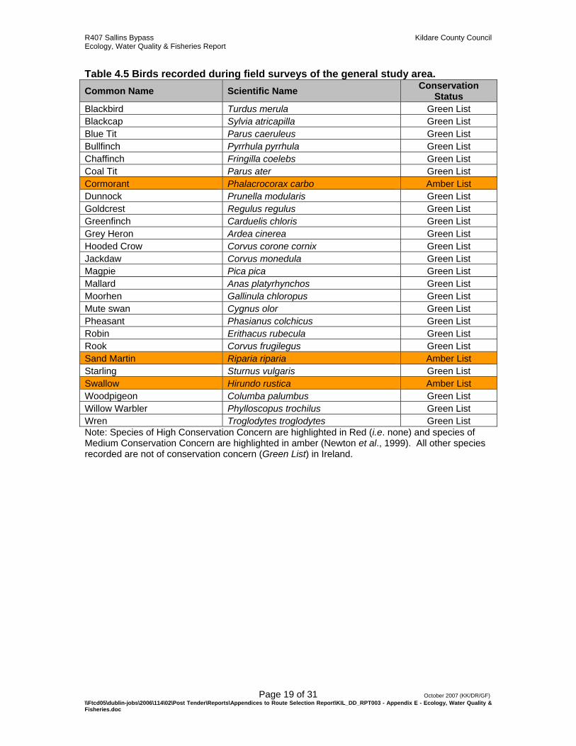
Table 4.5 Birds recorded during field surveys of the general study area. Common Name Scientific Name Conservation
Status Blackbird Turdus merula Green List Blackcap Sylvia atricapilla Green List Blue Tit Parus caeruleus Green List Bullfinch Pyrrhula pyrrhula Green List Chaffinch Fringilla coelebs Green List Coal Tit Parus ater Green List Cormorant Phalacrocorax carbo Amber List Dunnock Prunella modularis Green List Goldcrest Regulus regulus Green List Greenfinch Carduelis chloris Green List Grey Heron Ardea cinerea Green List Hooded Crow Corvus corone cornix Green List Jackdaw Corvus monedula Green List Magpie Pica pica Green List Mallard Anas platyrhynchos Green List Moorhen Gallinula chloropus Green List Mute swan Cygnus olor Green List Pheasant Phasianus colchicus Green List Robin Erithacus rubecula Green List Rook Corvus frugilegus Green List Sand Martin Riparia riparia Amber List Starling Sturnus vulgaris Green List Swallow Hirundo rustica Amber List Woodpigeon Columba palumbus Green List Willow Warbler Phylloscopus trochilus Green List Wren Troglodytes troglodytes Green List Note: Species of High Conservation Concern are highlighted in Red (i.e. none) and species of Medium Conservation Concern are highlighted in amber (Newton et al., 1999). All other species recorded are not of conservation concern (Green List) in Ireland.
R407 Sallins Bypass Kildare County Council Ecology, Water Quality & Fisheries Report
Page 20 of 31 October 2007 (KK/DR/GF) \\Ftcd05\dublin-jobs\2006\114\02\Post Tender\Reports\Appendices to Route Selection Report\KIL_DD_RPT003 - Appendix E - Ecology, Water Quality & Fisheries.doc
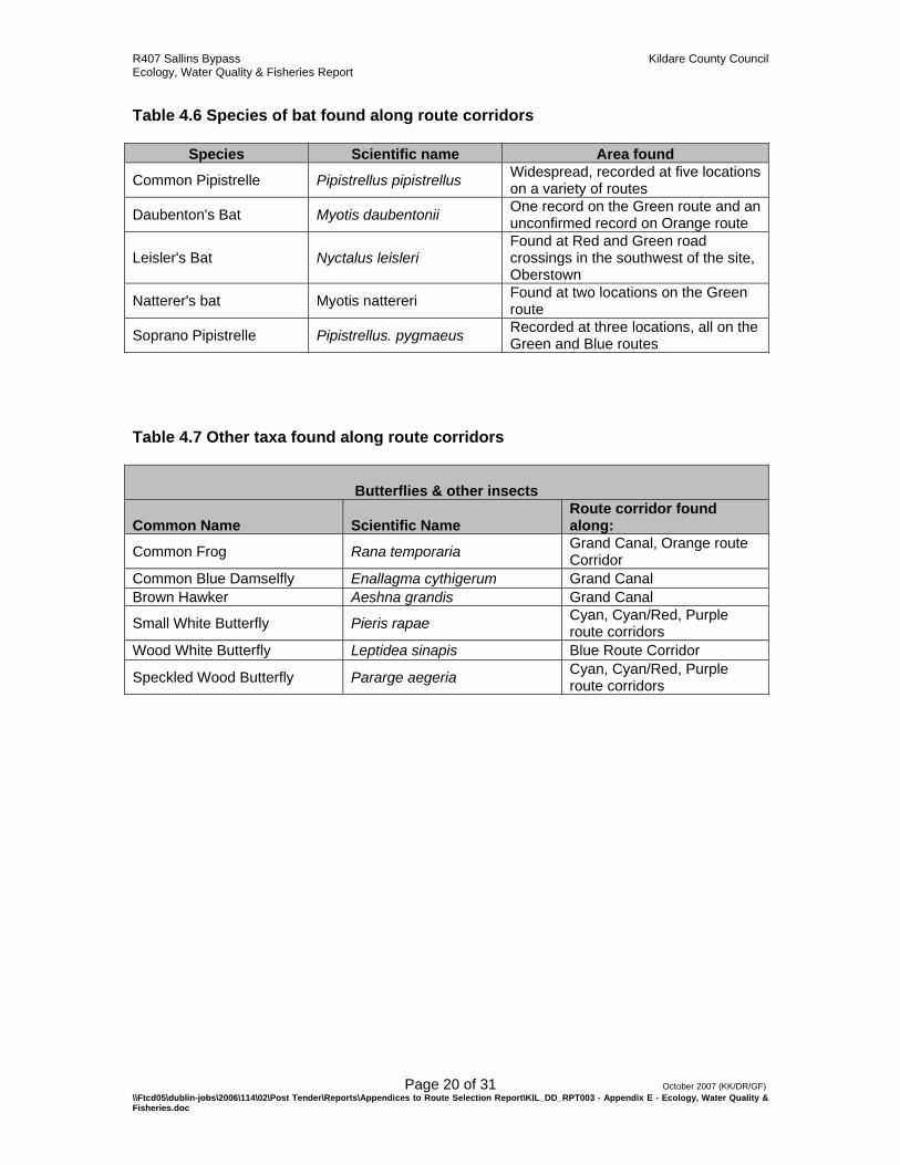
Table 4.6 Species of bat found along route corridors
Species Scientific name Area found
Common Pipistrelle Pipistrellus pipistrellus Widespread, recorded at five locations on a variety of routes
Daubenton's Bat Myotis daubentonii One record on the Green route and an unconfirmed record on Orange route
Leisler's Bat Nyctalus leisleri Found at Red and Green road crossings in the southwest of the site, Oberstown
Natterer's bat Myotis nattereri Found at two locations on the Green route
Soprano Pipistrelle Pipistrellus. pygmaeus Recorded at three locations, all on the Green and Blue routes
Table 4.7 Other taxa found along route corridors
Butterflies & other insects
Common Name Scientific Name Route corridor found along:
Common Frog Rana temporaria Grand Canal, Orange route Corridor
Common Blue Damselfly Enallagma cythigerum Grand Canal Brown Hawker Aeshna grandis Grand Canal
Small White Butterfly Pieris rapae Cyan, Cyan/Red, Purple route corridors
Wood White Butterfly Leptidea sinapis Blue Route Corridor
Speckled Wood Butterfly Pararge aegeria Cyan, Cyan/Red, Purple route corridors

(
8
SallinsSallinsSallinsSallinsSallinsSallinsSallinsSallinsSallinsSallinsSallinsSallinsSallinsSallinsSallinsSallinsSallinsSallinsSallinsSallinsSallinsSallinsSallinsSallinsSallinsSallinsSallinsSallinsSallinsSallinsSallinsSallinsSallinsSallinsSallinsSallinsSallinsSallinsSallinsSallinsSallinsSallinsSallinsSallinsSallinsSallinsSallinsSallinsSallins
2
kilometres0 1
[002104][002104][002104][002104][002104][002104][002104][002104][002104][002104][002104][002104][002104][002104][002104][002104][002104][002104][002104][002104][002104][002104][002104][002104][002104][002104][002104][002104][002104][002104][002104][002104][002104][002104][002104][002104][002104][002104][002104][002104][002104][002104][002104][002104][002104][002104][002104][002104][002104]Grand Canal - NHAGrand Canal - NHAGrand Canal - NHAGrand Canal - NHAGrand Canal - NHAGrand Canal - NHAGrand Canal - NHAGrand Canal - NHAGrand Canal - NHAGrand Canal - NHAGrand Canal - NHAGrand Canal - NHAGrand Canal - NHAGrand Canal - NHAGrand Canal - NHAGrand Canal - NHAGrand Canal - NHAGrand Canal - NHAGrand Canal - NHAGrand Canal - NHAGrand Canal - NHAGrand Canal - NHAGrand Canal - NHAGrand Canal - NHAGrand Canal - NHAGrand Canal - NHAGrand Canal - NHAGrand Canal - NHAGrand Canal - NHAGrand Canal - NHAGrand Canal - NHAGrand Canal - NHAGrand Canal - NHAGrand Canal - NHAGrand Canal - NHAGrand Canal - NHAGrand Canal - NHAGrand Canal - NHAGrand Canal - NHAGrand Canal - NHAGrand Canal - NHAGrand Canal - NHAGrand Canal - NHAGrand Canal - NHAGrand Canal - NHAGrand Canal - NHAGrand Canal - NHAGrand Canal - NHAGrand Canal - NHA
R407
R407
R407
R407
R407
R407
R407
R407
R407
R407
R407
R407
R407
R407
R407
R407
R407
R407
R407
R407
R407
R407
R407
R407
R407
R407
R407
R407
R407
R407
R407
R407
R407
R407
R407
R407
R407
R407
R407
R407
R407
R407
R407
R407
R407
R407
R407
R407
R407
Train
line
Train
line
Train
line
Train
line
Train
line
Train
line
Train
line
Train
line
Train
line
Train
line
Train
line
Train
line
Train
line
Train
line
Train
line
Train
line
Train
line
Train
line
Train
line
Train
line
Train
line
Train
line
Train
line
Train
line
Train
line
Train
line
Train
line
Train
line
Train
line
Train
line
Train
line
Train
line
Train
line
Train
line
Train
line
Train
line
Train
line
Train
line
Train
line
Train
line
Train
line
Train
line
Train
line
Train
line
Train
line
Train
line
Train
line
Train
line
Train
line
002104
Date 26/09/07 SW/DR R:\Map Production\2006\114\02\Workspace\KIL-DD_Figure 6.4.1_Designated Conservation Sites within Study Area_Rev A
Designated Conservation Sites within Study AreaFehily Timoney & Company Figure 6.4.1
Key MapKey MapKey MapKey MapKey MapKey MapKey MapKey MapKey MapKey MapKey MapKey MapKey MapKey MapKey MapKey MapKey MapKey MapKey MapKey MapKey MapKey MapKey MapKey MapKey MapKey MapKey MapKey MapKey MapKey MapKey MapKey MapKey MapKey MapKey MapKey MapKey MapKey MapKey MapKey MapKey MapKey MapKey MapKey MapKey MapKey MapKey MapKey MapKey Map
Mapping Reproduced Under Licence from the Ordnance Survey IrelandLicence No. EN 0001207 © Government of Ireland
Co. KildareCo. KildareCo. KildareCo. KildareCo. KildareCo. KildareCo. KildareCo. KildareCo. KildareCo. KildareCo. KildareCo. KildareCo. KildareCo. KildareCo. KildareCo. KildareCo. KildareCo. KildareCo. KildareCo. KildareCo. KildareCo. KildareCo. KildareCo. KildareCo. KildareCo. KildareCo. KildareCo. KildareCo. KildareCo. KildareCo. KildareCo. KildareCo. KildareCo. KildareCo. KildareCo. KildareCo. KildareCo. KildareCo. KildareCo. KildareCo. KildareCo. KildareCo. KildareCo. KildareCo. KildareCo. KildareCo. KildareCo. KildareCo. Kildare
’
Map Legend
Natural Heritage Area
Study Area Boundary
Data Source - Department of Environment, Heritage and Local Government

(
8
SallinsSallinsSallinsSallinsSallinsSallinsSallinsSallinsSallinsSallinsSallinsSallinsSallinsSallinsSallinsSallinsSallinsSallinsSallinsSallinsSallinsSallinsSallinsSallinsSallinsSallinsSallinsSallinsSallinsSallinsSallinsSallinsSallinsSallinsSallinsSallinsSallinsSallinsSallinsSallinsSallinsSallinsSallinsSallinsSallinsSallinsSallinsSallinsSallins
2
kilometres0 1
R407
R407
R407
R407
R407
R407
R407
R407
R407
R407
R407
R407
R407
R407
R407
R407
R407
R407
R407
R407
R407
R407
R407
R407
R407
R407
R407
R407
R407
R407
R407
R407
R407
R407
R407
R407
R407
R407
R407
R407
R407
R407
R407
R407
R407
R407
R407
R407
R407
Train
line
Train
line
Train
line
Train
line
Train
line
Train
line
Train
line
Train
line
Train
line
Train
line
Train
line
Train
line
Train
line
Train
line
Train
line
Train
line
Train
line
Train
line
Train
line
Train
line
Train
line
Train
line
Train
line
Train
line
Train
line
Train
line
Train
line
Train
line
Train
line
Train
line
Train
line
Train
line
Train
line
Train
line
Train
line
Train
line
Train
line
Train
line
Train
line
Train
line
Train
line
Train
line
Train
line
Train
line
Train
line
Train
line
Train
line
Train
line
Train
line
Date 26/09/07 SW/DR R:\Map Production\2006\114\02\Workspace\KIL-DD_Figure 6.4.2_CORINE Land Use within Study Area_Rev A
CORINE Land Use within Study AreaFehily Timoney & Company Figure 6.4.2
Key MapKey MapKey MapKey MapKey MapKey MapKey MapKey MapKey MapKey MapKey MapKey MapKey MapKey MapKey MapKey MapKey MapKey MapKey MapKey MapKey MapKey MapKey MapKey MapKey MapKey MapKey MapKey MapKey MapKey MapKey MapKey MapKey MapKey MapKey MapKey MapKey MapKey MapKey MapKey MapKey MapKey MapKey MapKey MapKey MapKey MapKey MapKey MapKey Map
Mapping Reproduced Under Licence from the Ordnance Survey IrelandLicence No. EN 0001207 © Government of Ireland
Co. KildareCo. KildareCo. KildareCo. KildareCo. KildareCo. KildareCo. KildareCo. KildareCo. KildareCo. KildareCo. KildareCo. KildareCo. KildareCo. KildareCo. KildareCo. KildareCo. KildareCo. KildareCo. KildareCo. KildareCo. KildareCo. KildareCo. KildareCo. KildareCo. KildareCo. KildareCo. KildareCo. KildareCo. KildareCo. KildareCo. KildareCo. KildareCo. KildareCo. KildareCo. KildareCo. KildareCo. KildareCo. KildareCo. KildareCo. KildareCo. KildareCo. KildareCo. KildareCo. KildareCo. KildareCo. KildareCo. KildareCo. KildareCo. Kildare
’
Broad Leaved Forest
Discontinuous Urban Fabric
Waste Management Facility
Non-irrigated Arable Land
Pastures
Road and Rail Networks and Associated Land
Sport and Leisure Facilities
Map LegendStudy Area Boundary
Data Source - Environmental Protection Agency, Ireland

SallinsSallinsSallinsSallinsSallinsSallinsSallinsSallinsSallinsSallinsSallinsSallinsSallinsSallinsSallinsSallinsSallinsSallinsSallinsSallinsSallinsSallinsSallinsSallinsSallinsSallinsSallinsSallinsSallinsSallinsSallinsSallinsSallinsSallinsSallinsSallinsSallinsSallinsSallinsSallinsSallinsSallinsSallinsSallinsSallinsSallinsSallinsSallinsSallins
2
kilometres0 1
River L
iffey
River L
iffey
River L
iffey
River L
iffey
River L
iffey
River L
iffey
River L
iffey
River L
iffey
River L
iffey
River L
iffey
River L
iffey
River L
iffey
River L
iffey
River L
iffey
River L
iffey
River L
iffey
River L
iffey
River L
iffey
River L
iffey
River L
iffey
River L
iffey
River L
iffey
River L
iffey
River L
iffey
River L
iffey
River L
iffey
River L
iffey
River L
iffey
River L
iffey
River L
iffey
River L
iffey
River L
iffey
River L
iffey
River L
iffey
River L
iffey
River L
iffey
River L
iffey
River L
iffey
River L
iffey
River L
iffey
River L
iffey
River L
iffey
River L
iffey
River L
iffey
River L
iffey
River L
iffey
River L
iffey
River L
iffey
River L
iffey
Mor
ell R
iver
Mor
ell R
iver
Mor
ell R
iver
Mor
ell R
iver
Mor
ell R
iver
Mor
ell R
iver
Mor
ell R
iver
Mor
ell R
iver
Mor
ell R
iver
Mor
ell R
iver
Mor
ell R
iver
Mor
ell R
iver
Mor
ell R
iver
Mor
ell R
iver
Mor
ell R
iver
Mor
ell R
iver
Mor
ell R
iver
Mor
ell R
iver
Mor
ell R
iver
Mor
ell R
iver
Mor
ell R
iver
Mor
ell R
iver
Mor
ell R
iver
Mor
ell R
iver
Mor
ell R
iver
Mor
ell R
iver
Mor
ell R
iver
Mor
ell R
iver
Mor
ell R
iver
Mor
ell R
iver
Mor
ell R
iver
Mor
ell R
iver
Mor
ell R
iver
Mor
ell R
iver
Mor
ell R
iver
Mor
ell R
iver
Mor
ell R
iver
Mor
ell R
iver
Mor
ell R
iver
Mor
ell R
iver
Mor
ell R
iver
Mor
ell R
iver
Mor
ell R
iver
Mor
ell R
iver
Mor
ell R
iver
Mor
ell R
iver
Mor
ell R
iver
Mor
ell R
iver
Mor
ell R
iver
Date 27/09/07 SW/DR R:\Map Production\2006\114\02\Workspace\KIL-DD_Figure 6.4.3_Major Waterways Crossed by Routes_Rev A
Major Waterways Crossed by RoutesFehily Timoney & Company Figure 6.4.3
Key MapKey MapKey MapKey MapKey MapKey MapKey MapKey MapKey MapKey MapKey MapKey MapKey MapKey MapKey MapKey MapKey MapKey MapKey MapKey MapKey MapKey MapKey MapKey MapKey MapKey MapKey MapKey MapKey MapKey MapKey MapKey MapKey MapKey MapKey MapKey MapKey MapKey MapKey MapKey MapKey MapKey MapKey MapKey MapKey MapKey MapKey MapKey MapKey Map
Mapping Reproduced Under Licence from the Ordnance Survey IrelandLicence No. EN 0001207 © Government of Ireland
Co. KildareCo. KildareCo. KildareCo. KildareCo. KildareCo. KildareCo. KildareCo. KildareCo. KildareCo. KildareCo. KildareCo. KildareCo. KildareCo. KildareCo. KildareCo. KildareCo. KildareCo. KildareCo. KildareCo. KildareCo. KildareCo. KildareCo. KildareCo. KildareCo. KildareCo. KildareCo. KildareCo. KildareCo. KildareCo. KildareCo. KildareCo. KildareCo. KildareCo. KildareCo. KildareCo. KildareCo. KildareCo. KildareCo. KildareCo. KildareCo. KildareCo. KildareCo. KildareCo. KildareCo. KildareCo. KildareCo. KildareCo. KildareCo. Kildare
’
Map Legend
River
Grand Canal
Study Area Boundary
R407 Sallins Bypass Kildare County Council Ecology, Water Quality & Fisheries Report
Page 24 of 31 October 2007 (KK/DR/GF) \\Ftcd05\dublin-jobs\2006\114\02\Post Tender\Reports\Appendices to Route Selection Report\KIL_DD_RPT003 - Appendix E - Ecology, Water Quality & Fisheries.doc
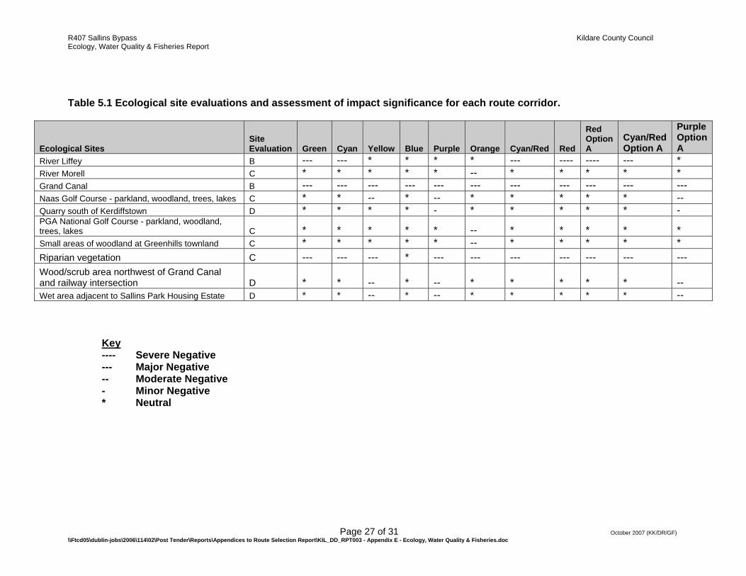
5. IMPACT ASSESSMENT 5.1. Site evaluation & impact Assessment Following a detailed literature review, consultation process and field walkover a number of sites of particular Ecological Importance were recorded along the potential route corridors for the Sallins Bypass. Table 5.1 illustrates the sites identified along each of the route corridor options. It also adopts the NRA (2006) method for evaluating the significance of the potential impact of each corridor on these ecologically sensitive sites. In total 10 sites were identified as areas of particular ecological importance and were rated using the NRA site evaluation scheme (Appendix 2). No internationally important (A - rated) sites were identified. However, two sites were classified as ‘Nationally Important’ (B - rating). These were the River Liffey and the Grand Canal. The Grand Canal has been designated as a proposed National Heritage Area (pNHA) and as such is protected under Irish law as an area of national importance. The River Liffey is an important Salmonid (particularly Trout) river, which also contains other protected fauna such as Lamprey species. A further five sites were identified as being of ‘High Value or Locally Important’ (C-Rating). These sites include rivers, patches of woodland and riparian vegetation. These are sites with high biodiversity in a local context. The remaining three sites were classified as being of ‘Moderate Value, Locally Important’ (D-Rating) and include Kerdiffstown Quarry (where the protected Sand Martin species is thought to nest) as well as some small areas of scrub/wood and wet grassland. 5.2. Corridor Impact Assessment The evaluation of the potential impact significance of each of the route corridors on the sites of ecological importance is also shown in Table 5.1. Appendix 4 details the criteria used for assessing the impact significance of the routes on these selected sites. Examination of the data in more detail allows an insight into the type and extent of the impacts that are predicted for each corridor. It is predicted that all route corridors will have a Major Negative impact on the Grand Canal, and all apart from the Blue route will have a Major Negative impact on Riparian vegetation. The Red route and Red Option A route are the only two routes predicted to have a Severe Negative impact on any of the selected sites. The number of sites impacted (to any extent) by each route varied from three to six per route, with the Blue route impacting on the least number of sites (i.e. the Grand Canal only).
R407 Sallins Bypass Kildare County Council Ecology, Water Quality & Fisheries Report
Page 25 of 31 October 2007 (KK/DR/GF) \\Ftcd05\dublin-jobs\2006\114\02\Post Tender\Reports\Appendices to Route Selection Report\KIL_DD_RPT003 - Appendix E - Ecology, Water Quality & Fisheries.doc
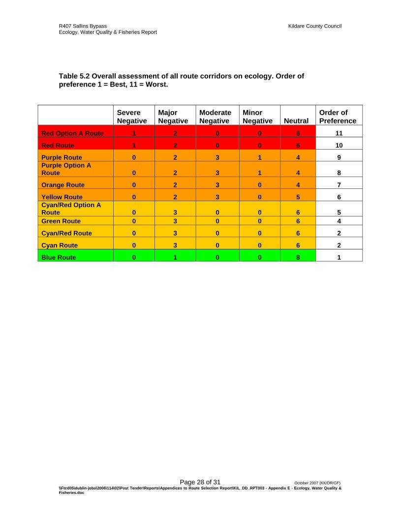
The Green, Cyan, Cyan/Red and Cyan/Red Option A route corridors are predicted to have no Severe Negative impact on any of the sites identified. However, it is predicted that these routes would have a Major Negative impact on three sites, the River Liffey, the Grand Canal and Riparian vegetation. A further 7 sites would not be directly impacted by these routes. The Yellow and Orange route corridors are predicted to have a Major Negative impact on two of the selected sites and a Moderate Negative impact on three sites. The Orange route corridor is the only corridor predicted to impact upon the River Morell, the PGA National Golf Course and the areas of woodland south of Greenhills townland (all C-Rated Sites). The Yellow route corridor (together with the Purple route corridors) is predicted to have a Moderate Negative impact on Naas Golf Course, the wet area adjacent to Sallins Park housing estate and an area of wood/scrub northwest of the Canal/Railway intersection. A further five sites will not be directly impacted by the Yellow and Orange route corridors. The Blue route corridor is predicted to have a Major Negative impact on the Grand Canal but will not directly impact any of the other sites selected. The Purple and Purple Option A route corridors are predicted to have similar impacts on the selected sites. These corridors are predicted to have Major Negative impacts on the Grand Canal and Riparian Vegetation and Moderate Negative impacts on three other sites. These routes are predicted to have a Minor Negative impact on the Quarry south of Kerdiffstown. Four of the selected sites will not be directly impacted by these route corridors. The Red route and Red Option A route are the only corridors predicted to have a Severe Negative impact on any of the sites selected (i.e. the River Liffey). Unlike other routes which cross the river at discrete points, this route runs parallel to the river at a close proximity to it for a significant stretch and is therefore expected to impact on a relatively large portion of the site. These routes are also predicted to have a Major Negative impact on the Grand Canal and Riparian Vegetation. Seven of the selected sites will not be directly impacted by these routes. Taking into account the impact of each route corridor on the sites of ecological importance, and what was learned from desktop and field reviews, routes were ranked in order of preference from 1 (Most Preferred) to 11 (Least Preferred). These rankings are presented in Table 5.2. There is an amount of subjectivity inherent in these gross classifications but in essence there are clear and considerable differences between ‘Best’ and ‘Worst’ Corridor options in terms of the likely ecological impacts. 5.3. Overall Corridor Evaluation Table 5.2 shows that the preferred route in terms of likely ecological impacts is the Blue route corridor. The next most preferred routes are (in order of preference) the Cyan and Cyan/Red Routes which were ranked joint 2nd. The Green route and the Cyan/Red Option A route were the next most preferred routes. Sites which had similar predicted impacts were further differentiated from each other in the rankings using additional

R407 Sallins Bypass Kildare County Council Ecology, Water Quality & Fisheries Report
Page 26 of 31 October 2007 (KK/DR/GF) \\Ftcd05\dublin-jobs\2006\114\02\Post Tender\Reports\Appendices to Route Selection Report\KIL_DD_RPT003 - Appendix E - Ecology, Water Quality & Fisheries.doc
criteria such as route length, number of road and waterway crossings and habitat heterogeneity. The Yellow and Orange route Corridors were ranked 6th and 7th respectively and were followed by the two Purple route options. The least preferred routes from a ecological standpoint are the Red Option A route (worst) and the Red route. These were the only two routes predicted to have a Severe Negative impact on any of the selected sites.
R407 Sallins Bypass Kildare County Council Ecology, Water Quality & Fisheries Report
Page 27 of 31 October 2007 (KK/DR/GF) \\Ftcd05\dublin-jobs\2006\114\02\Post Tender\Reports\Appendices to Route Selection Report\KIL_DD_RPT003 - Appendix E - Ecology, Water Quality & Fisheries.doc
Table 5.1 Ecological site evaluations and assessment of impact significance for each route corridor.
Ecological Sites Site Evaluation Green Cyan Yellow Blue Purple Orange Cyan/Red Red
Red Option A
Cyan/Red Option A
Purple Option A
River Liffey B --- --- * * * * --- ---- ---- --- * River Morell C * * * * * -- * * * * * Grand Canal B --- --- --- --- --- --- --- --- --- --- --- Naas Golf Course - parkland, woodland, trees, lakes C * * -- * -- * * * * * -- Quarry south of Kerdiffstown D * * * * - * * * * * - PGA National Golf Course - parkland, woodland, trees, lakes C * * * * * -- * * * * * Small areas of woodland at Greenhills townland C * * * * * -- * * * * * Riparian vegetation C --- --- --- * --- --- --- --- --- --- --- Wood/scrub area northwest of Grand Canal and railway intersection D * * -- * -- * * * * * -- Wet area adjacent to Sallins Park Housing Estate D * * -- * -- * * * * * --
Key ---- Severe Negative --- Major Negative -- Moderate Negative - Minor Negative * Neutral
R407 Sallins Bypass Kildare County Council Ecology, Water Quality & Fisheries Report
Page 28 of 31 October 2007 (KK/DR/GF) \\Ftcd05\dublin-jobs\2006\114\02\Post Tender\Reports\Appendices to Route Selection Report\KIL_DD_RPT003 - Appendix E - Ecology, Water Quality & Fisheries.doc
Table 5.2 Overall assessment of all route corridors on ecology. Order of preference 1 = Best, 11 = Worst.
Severe Negative
Major Negative
Moderate Negative
Minor Negative Neutral
Order of Preference
Red Option A Route 1 2 0 0 6 11
Red Route 1 2 0 0 6 10
Purple Route 0 2 3 1 4 9 Purple Option A Route 0 2 3 1 4 8
Orange Route 0 2 3 0 4 7
Yellow Route 0 2 3 0 5 6 Cyan/Red Option A Route 0 3 0 0 6 5 Green Route 0 3 0 0 6 4
Cyan/Red Route 0 3 0 0 6 2
Cyan Route 0 3 0 0 6 2
Blue Route 0 1 0 0 8 1
R407 Sallins Bypass Kildare County Council Ecology, Water Quality & Fisheries Report
Page 29 of 31 October 2007 (KK/DR/GF) \\Ftcd05\dublin-jobs\2006\114\02\Post Tender\Reports\Appendices to Route Selection Report\KIL_DD_RPT003 - Appendix E - Ecology, Water Quality & Fisheries.doc
6. CONCLUSION The ecological assessment study has reviewed available data sources, consulted with wildlife authorities, and completed a comprehensive field walkover in order to:
• Describe the flora and fauna present in the general area • Identify species of elevated conservation importance • Describe habitats and sites of special ecological sensitivity or biodiversity • Evaluate sites and to establish the predicted level of impact on these sites by
each route corridor. The methodology followed that of the NRA Guidelines for Route Selection (NRA, 2006). The desktop and field studies reported in this chapter highlight the strong influence of agricultural land and riparian habitats on the landscape. The plant and animal communities described are typical of these habitats and are broadly similar across the study area. Some of the route corridors impinge more directly on the sites of greatest ecological importance in the area and are for this reason less preferred. The final analysis has identified the Blue Route as the preferred route corridor in terms of likely ecological impacts. It should be noted however that the construction of this route would necessitate the destruction of large areas of residential housing. In light of this fact, the next most preferred routes are the Cyan and Cyan/Red routes, which are ranked joint 2nd in our order of preference.
R407 Sallins Bypass Kildare County Council Ecology, Water Quality & Fisheries Report
Page 30 of 31 October 2007 (KK/DR/GF) \\Ftcd05\dublin-jobs\2006\114\02\Post Tender\Reports\Appendices to Route Selection Report\KIL_DD_RPT003 - Appendix E - Ecology, Water Quality & Fisheries.doc
7. BIBLIOGRAPHY Aalen, F.H.A., Whelan, K., Stout, M. 1997. Atlas of the Irish Rural landscape. Cork University Press. Asher, J., Warren, M., Fox, R., Harding, P., Jeffcoate, G., Jeffcoate, S. 2001. Millennium Atlas of Butterflies in Britain and Ireland. Aquatic Services Unit (UCC ASU). University College Cork. C.D. Preston, D.A. Pearman, T.D. Dines. 2002 New Atlas of the British and Irish Flora: An Atlas of the Vascular Plants of Britain, Ireland, The Isle of Man and the Channel Islands. Oxford University press. Bibby, C.J., Burgess, N.D, and Hill, D.A. 1992. Bird census techniques. Academic Press, London. Birdwatch Ireland – Protecting Wild Birds and Habitats 2005. Birds of Conservation Concern (BoCCI list). 1993–4 Cork bird report. 1992, 1993. Cork. I.W.C. Corine Land Cover. 1995. Commission of the European Communities. Coombes et al.,2002. Birdwatch Ireland Countryside Bird Survey Report. Crowe O. 2005. Ireland’s Wetlands and their Waterbirds: Status and Distribution. BirdWatch Ireland, Newcastle, Co. Wicklow. Cramp, S., Bourne, W.R.P., Saunders, D. 1975. Seabirds of Britain and Ireland Demers A., Lucey J., McGarrigle M.L. & Reynolds J.D. 2005. The Distribution of the White-clawed Crayfish, Austropotamobius pallipes, in Ireland. Biology & Environment: Proceedings of the Royal Irish Academy, 105B, 65 – 69. Department of Environment, Heritage and Local Development Applications Unit. 2007. European Environmental Agency (EEA). www.eea.europa.eu/ European Environment information and observation network (Eionet). EPA. 2005. Reports on the biological survey of River Quality: Results of the 2005 investigations. As available on website: http://www.epa.ie/OurEnvironment/Water/Rivers/RiverWaterQualityReports/2005Report/ Floral Protection Order 1999. Habitats Directive. Fossitt J.A. 2000. A Guide to habitats in Ireland. Heritage Council, Kilkenny.
R407 Sallins Bypass Kildare County Council Ecology, Water Quality & Fisheries Report
Page 31 of 31 October 2007 (KK/DR/GF) \\Ftcd05\dublin-jobs\2006\114\02\Post Tender\Reports\Appendices to Route Selection Report\KIL_DD_RPT003 - Appendix E - Ecology, Water Quality & Fisheries.doc
Gibbons, D. W., J. B. Reid, and R. A. Chapman. 1993. The New Atlas of Breeding Birds in Britain and Ireland: 1988-1991. T & AD Poyser, London. I-WebS Irish Wetland Bird Survey. Kelly F. & King J.J. 2001. A review of the Ecology and Distribution of Three Lamprey species, Lampetra fluviatilis (L.), Lampetra planeri (Bloch) and Petromyzon marinus (L.): a Context for Conservation and Biodiversity Considerations in Ireland. Biology & Environment: Proceedings of the Royal Irish Academy, 101B, 165 – 185. Kildare County Council. 2001. Sallins Local Area Plan2001. Kildare County Council, Kildare. Lack, P.C. 1986. The Atlas of Wintering Birds in Britain & Ireland. Poyser. Mabey, R. 1996 Flora Britannica: The Definitive New Guide to Britain's Wild Flowers, Plants and Trees. Sinclair-Stevenson Ltd Moorkens E.A. 1999. Conservation Management of the Freshwater Pearl Mussel Margaritifera margaritifera. Part 1: Biology of the Species and its Present Situation in Ireland. Irish Wildlife Manuals, No. 8. Duchas, the Heritage Service, Dublin. Newton et al 1999. Birds Directive 79/409/EEC. Birds of Conservation Concern in Ireland. National Roads Authority. 2006. Environmental Assessment and Construction Guidelines. National Parks and Wildlife Service. www.npws.ie National Biodiversity Network. www.nbn.org.uk/ Reynolds J.D. 1998. Conservation Management of the White-clawed Crayfish, Austropotamobius pallipes. Part 1. Irish Wildlife Manuals, No. 1. Duchas, the Heritage Service, Dublin South Western Regional Fisheries Board (SWRFB), www.swrfb.ie. Smal 1995. Badger and Habitat Survey of Ireland. Stationery Office. T.G.F.Curtis & H.N. McGough. 1988. Irish Red Data Book Irish Raptor Study group The Royal Society for the Protection of Birds (RSPB) 2007.

Appendix 1
NPWS Site Synopsis of Designated Sites within 10km of the Study Area
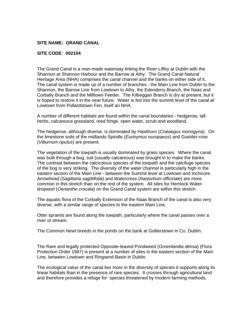
SITE NAME: GRAND CANAL SITE CODE: 002104 The Grand Canal is a man-made waterway linking the River Liffey at Dublin with the Shannon at Shannon Harbour and the Barrow at Athy. The Grand Canal Natural Heritage Area (NHA) comprises the canal channel and the banks on either side of it. The canal system is made up of a number of branches - the Main Line from Dublin to the Shannon, the Barrow Line from Lowtown to Athy, the Edenderry Branch, the Naas and Corbally Branch and the Milltown Feeder. The Kilbeggan Branch is dry at present, but it is hoped to restore it in the near future. Water is fed into the summit level of the canal at Lowtown from Pollardstown Fen, itself an NHA. A number of different habitats are found within the canal boundaries - hedgerow, tall herbs, calcareous grassland, reed fringe, open water, scrub and woodland. The hedgerow, although diverse, is dominated by Hawthorn (Crataegus monogyna). On the limestone soils of the midlands Spindle (Euonymus europaeus) and Guelder-rose (Viburnum opulus) are present. The vegetation of the towpath is usually dominated by grass species. Where the canal was built through a bog, soil (usually calcareous) was brought in to make the banks. The contrast between the calcicolous species of the towpath and the calcifuge species of the bog is very striking. The diversity of the water channel is particularly high in the eastern section of the Main Line - between the Summit level at Lowtown and Inchicore. Arrowhead (Sagittaria sagittifolia) and Watercress (Nasturtium officinale) are more common in this stretch than on the rest of the system. All sites for Hemlock Water-dropwort (Oenanthe crocata) on the Grand Canal system are within this stretch. The aquatic flora of the Corbally Extension of the Naas Branch of the canal is also very diverse, with a similar range of species to the eastern Main Line. Otter spraints are found along the towpath, particularly where the canal passes over a river or stream. The Common Newt breeds in the ponds on the bank at Gollierstown in Co. Dublin. The Rare and legally protected Opposite-leaved Pondweed (Groenlandia densa) (Flora Protection Order 1987) is present at a number of sites in the eastern section of the Main Line, between Lowtown and Ringsend Basin in Dublin. The ecological value of the canal lies more in the diversity of species it supports along its linear habitats than in the presence of rare species. It crosses through agricultural land and therefore provides a refuge for species threatened by modern farming methods.
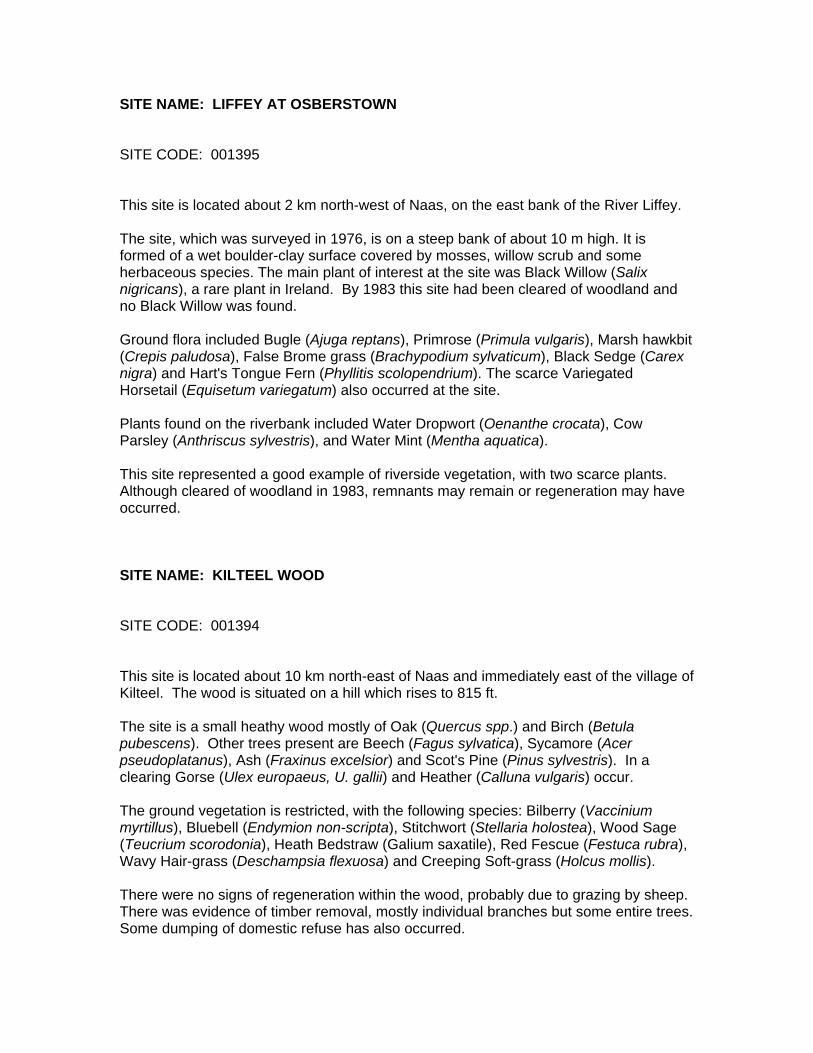
SITE NAME: LIFFEY AT OSBERSTOWN SITE CODE: 001395 This site is located about 2 km north-west of Naas, on the east bank of the River Liffey. The site, which was surveyed in 1976, is on a steep bank of about 10 m high. It is formed of a wet boulder-clay surface covered by mosses, willow scrub and some herbaceous species. The main plant of interest at the site was Black Willow (Salix nigricans), a rare plant in Ireland. By 1983 this site had been cleared of woodland and no Black Willow was found. Ground flora included Bugle (Ajuga reptans), Primrose (Primula vulgaris), Marsh hawkbit (Crepis paludosa), False Brome grass (Brachypodium sylvaticum), Black Sedge (Carex nigra) and Hart's Tongue Fern (Phyllitis scolopendrium). The scarce Variegated Horsetail (Equisetum variegatum) also occurred at the site. Plants found on the riverbank included Water Dropwort (Oenanthe crocata), Cow Parsley (Anthriscus sylvestris), and Water Mint (Mentha aquatica). This site represented a good example of riverside vegetation, with two scarce plants. Although cleared of woodland in 1983, remnants may remain or regeneration may have occurred. � SITE NAME: KILTEEL WOOD SITE CODE: 001394 This site is located about 10 km north-east of Naas and immediately east of the village of Kilteel. The wood is situated on a hill which rises to 815 ft. The site is a small heathy wood mostly of Oak (Quercus spp.) and Birch (Betula pubescens). Other trees present are Beech (Fagus sylvatica), Sycamore (Acer pseudoplatanus), Ash (Fraxinus excelsior) and Scot's Pine (Pinus sylvestris). In a clearing Gorse (Ulex europaeus, U. gallii) and Heather (Calluna vulgaris) occur. The ground vegetation is restricted, with the following species: Bilberry (Vaccinium myrtillus), Bluebell (Endymion non-scripta), Stitchwort (Stellaria holostea), Wood Sage (Teucrium scorodonia), Heath Bedstraw (Galium saxatile), Red Fescue (Festuca rubra), Wavy Hair-grass (Deschampsia flexuosa) and Creeping Soft-grass (Holcus mollis). There were no signs of regeneration within the wood, probably due to grazing by sheep. There was evidence of timber removal, mostly individual branches but some entire trees. Some dumping of domestic refuse has also occurred.
This site is a fine example of a largely deciduous wood. Its elevated position gives it scenic value. SITE NAME: SLADE OF SAGGART AND CROOKSLING GLEN SITE CODE: 000211 This site is located in the south-west of the county and stretches from Brittas northwards to approximately 2 km south of Saggart. The northern half of the site comprises a river valley with steep tree-covered sides, while the southern side is flatter and contains two small lakes, the Brittas Ponds. The trees are mostly of planted origin with fine specimens of Beech (Fagus sylvatica), Ash (Fraxinus excelsior), Oak (Quercus spp.) and Birch (Betula spp.) occurring. The ground flora is well developed with Common Dog-violet (Viola riviniana), Wood Sanicle (Sanicula europaea), Wood Sorrel (Oxalis acetosella), Bluebell (Hyacinthoides non-scripta) and Three-nerved Sandwort (Moehringia trinervia). The marshy edges of the stream have Brooklime (Veronica beccabunga) and Marsh Speedwell (Veronica scutellata). Marsh Orchid (Dactylorhiza incarnata) occurs in one place. Higher up the valley, in Crooksling Glen the vegetation becomes more natural and shrubs and trees such as Guelder Rose (Viburnum opulus), Whitebeam (Sorbus hibernica) and Goat Willow (Salix caprea) appear. The herbaceous layer includes Red Campion (Silene dioica), Wood Speedwell (Veronica montana) and Lady's Mantle (Alchemilla glabra and A. filicaulis subsp. vestita). Yellow Archangel (Lamiastrum galeobdolon), a Red Data Book species, has been recorded from this site. The chalcid Halticoptera patellana (Hymenoptera) was recorded from the site in 1981, the only Irish record for this species up to at least 1989. South of Crooksling Glen are Brittas Ponds, a Wildfowl Sanctuary, that supports a variety of wildfowl, including Teal, Mallard, Pochard and Tufted Duck. The ponds themselves are of interest for the aquatic plants they support (including Shoreweed (Littorella uniflora), a rare plant in Dublin) and the marginal areas of freshwater marsh and wet grassland vegetation found. The site includes a good example of a wooded river valley and a small wetland system. The presence of a Rare plant, a Rare invertebrate and a variety of wildfowl species adds to the interest of the site. SITE NAME: POULAPHOUCA RESERVOIR SITE CODE: 000731 Poulaphouca Reservoir is located south-east of Blessington, and extends into eastern Kildare - it lies at an altitude just below 190 m. The reservoir was created in 1944 by
damming the river Liffey for the purpose of generating electricity from hydropower. The reservoir covers an area of approximately 20 square kilometres and is the largest inland water body in south-east Ireland. The reservoir receives water from two main sources, the river Liffey which flows into the northern end, and the Kings river which enters at the southern end, near Lockstown. Underlying the reservoir are sands and gravels deposited during the last glaciation. The shores of the lake are mostly sandy, otherwise the water washes against grassy banks which are generally less than 1 m high. In a few places there are steep sand and clay cliffs, up to 15 m high - these are remnants of the old river Liffey channel. In many places the banks are actively eroding, and a strip of conifers has been planted around much of the perimeter of the reservoir in an attempt to stabilize the banks and to reduce pollution. Wet grassland areas occur in sheltered bays around the lake but especially in the northern part. Reed Canary-grass (Phalaris arundinacea) is the main grass, but other grasses, sedges and herbaceous plants characteristic of wet grasslands occur. These include Creeping Bent (Agrostis stolonifera), Meadowsweet (Filipendula ulmaria), Common Valerian (Valeriana officinalis), Yellow Iris (Iris pseudacorus) and Water Mint (Mentha aquatica). Sedges (Carex spp.) are locally common, as is Tufted Hair-grass (Deschampsia caespitosa) in the slightly drier areas. The mosses Climacium dendroides and Fontinalis antipyretica occur in areas subject to some inundation, while Willow scrub (Salix atrocinerea) is often found associated with the wet grassland. Because it is a reservoir water levels fluctuate more strongly than in natural lakes. When the water level recedes, extensive areas of the reservoir floor are exposed and during the summer months these muddy areas become colonised by annual plants. Many parts of the reservoir are bordered by dry grassy banks. The grasses present include Creeping Bent (Agrostis spp.), Cock's Foot (Dactylis glomerata) and Sweet-vernal Grass (Anthoxanthum odoratum). Other herbaceous plants are typically Common Sorrel (Rumex acetosa), Ribwort Plantain (Plantago lanceolata), Common Ragwort (Senecio jacobaea) and Common Knapweed (Centaurea nigra). In places there is a good moss cover dominated by Rhytidiadelphus squarrosus. South of Poulaphouca dam is a dramatic steep-sided gorge, Poulaphouca Gorge, which now has a much reduced river flowing through it. The slopes of the gorge are covered with mixed woodland. Oak (Quercus petraea) is the main tree species, but Beech (Fagus sylvatica) and Ash (Fraxinus excelsior) are also found. A shrub layer is fairly well developed near the bridge and consists mainly of Holly (Ilex aquilinum) and Hazel (Corylus avellana). On the ground, Wood Rush (Luzula sylvatica) is abundant. There is a good cover of ferns, which include Soft Shield Fern (Polystichum setiferum), Hart's Tongue (Phyllitis scolopendrium) and Broad Buckler Fern (Dryopteris dilatata), while among the mosses, Thuidium and Polytrichum species have a luxuriant growth. The site extends southwards to include a stretch of the Kings River, a fine example of an acid mountain river strewn with granite boulders. The sandy river banks are known for the occurrence of the Mountain Pansy (Viola lutea), which only occurs in the south-east of Ireland and counties Clare and Cork.
The Winter Wetlands Survey in 1984/85 - 1986/87 showed Poulaphouca to be a nationally important site for Greylag Geese (average peak 308) and Mallard (average peak 869). Average peak counts for other species in the same period were Whooper Swan 55, Wigeon 407, Teal 353, Pochard 173, Tufted Duck 142, Lapwing 207 and Curlew 173. Since then, Greylag Geese numbers have increased, with a maximum count of about 750 in January 1994. Up to seven pairs of Great Crested Grebe breed annually, as well as Snipe and Lapwing. Although this lake is of artificial origin, extensive areas of semi-natural habitats, especially wet grassland and scrub, have developed around parts of its margins. The site is an important inland waterfowl site, particularly for Greylag Geese. In addition to providing Dublin with a water supply, it is an important amenity resource. Care must be taken to ensure that the amenity activities are compatible with the important ecological value of the area. SITE NAME: HODGESTOWN BOG NHA SITE CODE: 001393 Hodgestown Bog NHA is located 4 km north-west of Prosperous, mostly in the townlands of Hodgestown, Coolearagh East and Garvoge in Co. Kildare. The site comprises a raised bog that includes both areas of high bog and cutover bog. This raised bog was originally part of a much larger area of bog that has now been cutover and reclaimed for forestry and agriculture. Hodgestown Bog is separated by a mineral ridge from Ballynafagh SAC (391) and together these are two of the bogs at the eastern extreme of the range of raised bogs in Ireland. Although Hodgestown bog has no pools there are hummocks throughout the high bog and there is also a small hummock/hollow complex. Cutover is found all around the high bog. Much of the high bog has vegetation typical of a Midland Raised Bog, consisting of Ling Heather (Calluna vulgaris), White Beak-sedge (Rhynchospora alba), Cranberry (Vaccinium oxycoccos) and Bog-rosemary (Andromeda polifolia). The bog moss Sphagnum tenellum is common on the bog as is White Beak-sedge. Hummocks of the bog moss Sphagnum capillifolium are also common but only one hummock of S. imbricatum was recorded. The bog moss S. magellanicum is also frequently seen on the bog, in hollows with S. tenellum or with S. cuspidatum in in-filling old drains. In areas of the bog where there are signs of disturbance and bare peat patches are found the moss Campylopus introflexus, Deergrass (Scirpus cespitosus), Bog Asphodel (Narthecium ossifragum), Ling Heather and Cross-leaved Heath (Erica tetralix) tend to dominate. Much of the site was burnt in the 1970s but a subsequent survey reported that the bog was recovering well with active Sphagnum regeneration. There was a swallow hole in the east of the bog, with an associated soak area where the bog mosses S. palustre and S. recurvum were recorded, but this area has now been cutover. The high bog is surrounded by cutover much of which has been planted with coniferous forestry, especially in the south and east of the site.

Current landuses on the site include peat-cutting and forestry. Active peat-cutting is taking place all around the margins of the high bog. Coniferous forestry has been planted on much of the cutover, except in the north of the site. However, except for a small area on the west of the site most of the forestry has been felled. Damaging activities associated with these landuses include drainage throughout the site and burning of the high bog. All these activities have resulted in the loss of habitat, damage to the hydrological status of the site, and pose a continuing threat to its viability. Hodgestown Bog NHA is a site Ireland has a high proportion of the total E.U. resource of raised bog (over 50%) and so has a special responsibility for its conservation at an international level.

Appendix 2:
NRA (2006) recommended site evaluation scheme.
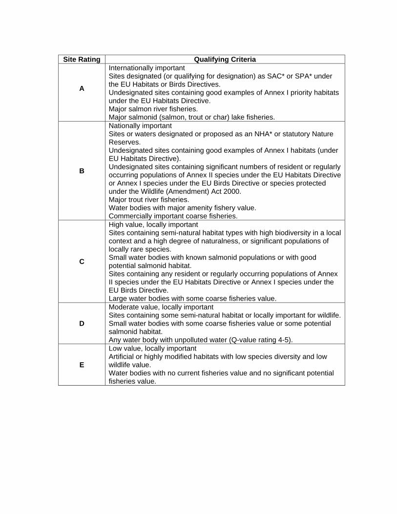
Site Rating Qualifying Criteria
A
Internationally important Sites designated (or qualifying for designation) as SAC* or SPA* under the EU Habitats or Birds Directives. Undesignated sites containing good examples of Annex I priority habitats under the EU Habitats Directive. Major salmon river fisheries. Major salmonid (salmon, trout or char) lake fisheries.
B
Nationally important Sites or waters designated or proposed as an NHA* or statutory Nature Reserves. Undesignated sites containing good examples of Annex I habitats (under EU Habitats Directive). Undesignated sites containing significant numbers of resident or regularly occurring populations of Annex II species under the EU Habitats Directive or Annex I species under the EU Birds Directive or species protected under the Wildlife (Amendment) Act 2000. Major trout river fisheries. Water bodies with major amenity fishery value. Commercially important coarse fisheries.
C
High value, locally important Sites containing semi-natural habitat types with high biodiversity in a local context and a high degree of naturalness, or significant populations of locally rare species. Small water bodies with known salmonid populations or with good potential salmonid habitat. Sites containing any resident or regularly occurring populations of Annex II species under the EU Habitats Directive or Annex I species under the EU Birds Directive. Large water bodies with some coarse fisheries value.
D
Moderate value, locally important Sites containing some semi-natural habitat or locally important for wildlife. Small water bodies with some coarse fisheries value or some potential salmonid habitat. Any water body with unpolluted water (Q-value rating 4-5).
E
Low value, locally important Artificial or highly modified habitats with low species diversity and low wildlife value. Water bodies with no current fisheries value and no significant potential fisheries value.

Appendix 3:
NRA (2006) recommended criteria for assessing impact significance, where site rating is based on the NRA recommended site evaluation scheme outlined in
Appendix 2.
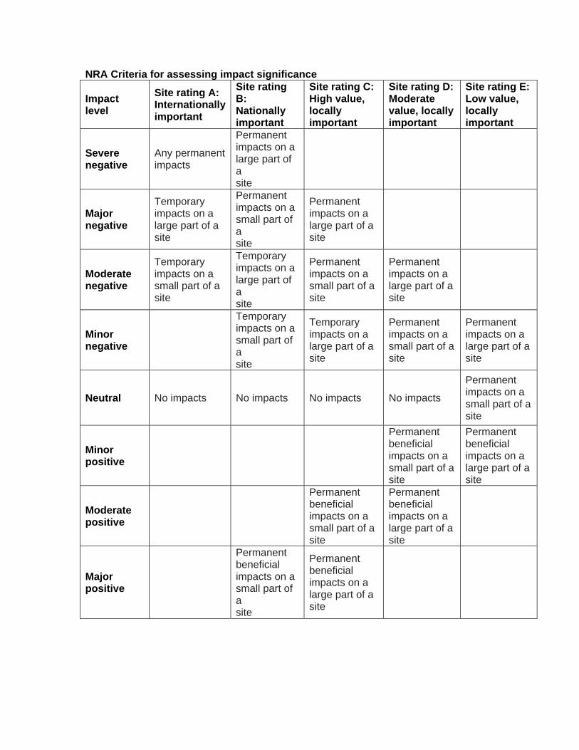
NRA Criteria for assessing impact significance
Impact level
Site rating A: Internationally important
Site rating B: Nationally important
Site rating C: High value, locally important
Site rating D: Moderate value, locally important
Site rating E: Low value, locally important
Severe negative
Any permanent impacts
Permanent impacts on a large part of a site
Major negative
Temporary impacts on a large part of a site
Permanent impacts on a small part of a site
Permanent impacts on a large part of a site
Moderate negative
Temporary impacts on a small part of a site
Temporary impacts on a large part of a site
Permanent impacts on a small part of a site
Permanent impacts on a large part of a site
Minor negative
Temporary impacts on a small part of a site
Temporary impacts on a large part of a site
Permanent impacts on a small part of a site
Permanent impacts on a large part of a site
Neutral No impacts No impacts No impacts No impacts
Permanent impacts on a small part of a site
Minor positive
Permanent beneficial impacts on a small part of a site
Permanent beneficial impacts on a large part of a site
Moderate positive
Permanent beneficial impacts on a small part of a site
Permanent beneficial impacts on a large part of a site
Major positive
Permanent beneficial impacts on a small part of a site
Permanent beneficial impacts on a large part of a site

Appendix 4 List of protected species recorded within 10km of the proposed development site
since 1845.
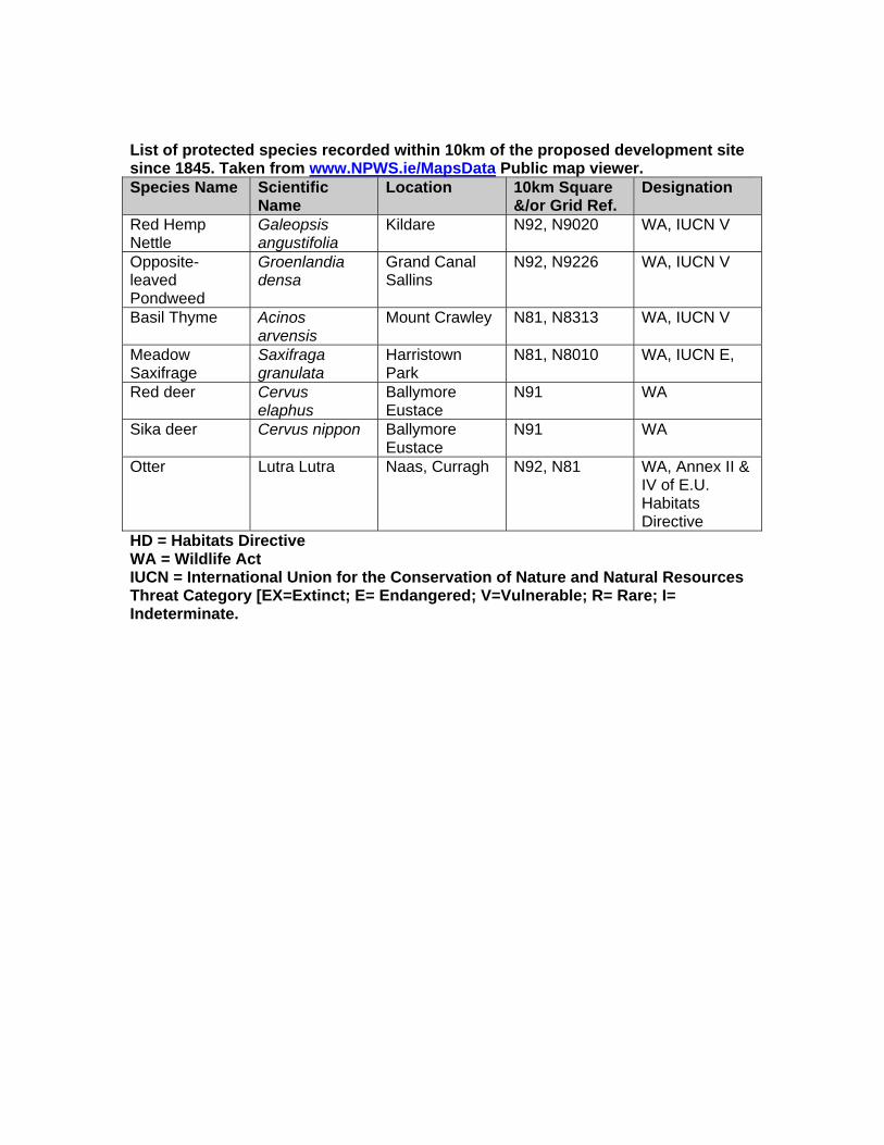
List of protected species recorded within 10km of the proposed development site since 1845. Taken from www.NPWS.ie/MapsData Public map viewer. Species Name Scientific
Name Location 10km Square
&/or Grid Ref. Designation
Red Hemp Nettle
Galeopsis angustifolia
Kildare N92, N9020 WA, IUCN V
Opposite-leaved Pondweed
Groenlandia densa
Grand Canal Sallins
N92, N9226 WA, IUCN V
Basil Thyme Acinos arvensis
Mount Crawley N81, N8313 WA, IUCN V
Meadow Saxifrage
Saxifraga granulata
Harristown Park
N81, N8010 WA, IUCN E,
Red deer Cervus elaphus
Ballymore Eustace
N91 WA
Sika deer Cervus nippon Ballymore Eustace
N91 WA
Otter Lutra Lutra Naas, Curragh N92, N81 WA, Annex II & IV of E.U. Habitats Directive
HD = Habitats Directive WA = Wildlife Act IUCN = International Union for the Conservation of Nature and Natural Resources Threat Category [EX=Extinct; E= Endangered; V=Vulnerable; R= Rare; I= Indeterminate.
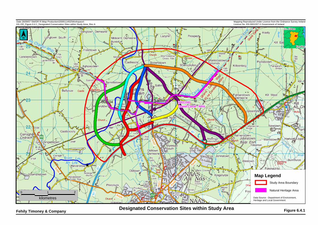
(
8
SallinsSallinsSallinsSallinsSallinsSallinsSallinsSallinsSallinsSallinsSallinsSallinsSallinsSallinsSallinsSallinsSallinsSallinsSallinsSallinsSallinsSallinsSallinsSallinsSallinsSallinsSallinsSallinsSallinsSallinsSallinsSallinsSallinsSallinsSallinsSallinsSallinsSallinsSallinsSallinsSallinsSallinsSallinsSallinsSallinsSallinsSallinsSallinsSallins
2
kilometres0 1
[002104][002104][002104][002104][002104][002104][002104][002104][002104][002104][002104][002104][002104][002104][002104][002104][002104][002104][002104][002104][002104][002104][002104][002104][002104][002104][002104][002104][002104][002104][002104][002104][002104][002104][002104][002104][002104][002104][002104][002104][002104][002104][002104][002104][002104][002104][002104][002104][002104]Grand Canal - NHAGrand Canal - NHAGrand Canal - NHAGrand Canal - NHAGrand Canal - NHAGrand Canal - NHAGrand Canal - NHAGrand Canal - NHAGrand Canal - NHAGrand Canal - NHAGrand Canal - NHAGrand Canal - NHAGrand Canal - NHAGrand Canal - NHAGrand Canal - NHAGrand Canal - NHAGrand Canal - NHAGrand Canal - NHAGrand Canal - NHAGrand Canal - NHAGrand Canal - NHAGrand Canal - NHAGrand Canal - NHAGrand Canal - NHAGrand Canal - NHAGrand Canal - NHAGrand Canal - NHAGrand Canal - NHAGrand Canal - NHAGrand Canal - NHAGrand Canal - NHAGrand Canal - NHAGrand Canal - NHAGrand Canal - NHAGrand Canal - NHAGrand Canal - NHAGrand Canal - NHAGrand Canal - NHAGrand Canal - NHAGrand Canal - NHAGrand Canal - NHAGrand Canal - NHAGrand Canal - NHAGrand Canal - NHAGrand Canal - NHAGrand Canal - NHAGrand Canal - NHAGrand Canal - NHAGrand Canal - NHA
R407
R407
R407
R407
R407
R407
R407
R407
R407
R407
R407
R407
R407
R407
R407
R407
R407
R407
R407
R407
R407
R407
R407
R407
R407
R407
R407
R407
R407
R407
R407
R407
R407
R407
R407
R407
R407
R407
R407
R407
R407
R407
R407
R407
R407
R407
R407
R407
R407
Train
line
Train
line
Train
line
Train
line
Train
line
Train
line
Train
line
Train
line
Train
line
Train
line
Train
line
Train
line
Train
line
Train
line
Train
line
Train
line
Train
line
Train
line
Train
line
Train
line
Train
line
Train
line
Train
line
Train
line
Train
line
Train
line
Train
line
Train
line
Train
line
Train
line
Train
line
Train
line
Train
line
Train
line
Train
line
Train
line
Train
line
Train
line
Train
line
Train
line
Train
line
Train
line
Train
line
Train
line
Train
line
Train
line
Train
line
Train
line
Train
line
002104
Date 26/09/07 SW/DR R:\Map Production\2006\114\02\Workspace\KIL-DD_Figure 6.4.1_Designated Conservation Sites within Study Area_Rev A
Designated Conservation Sites within Study AreaFehily Timoney & Company Figure 6.4.1
Key MapKey MapKey MapKey MapKey MapKey MapKey MapKey MapKey MapKey MapKey MapKey MapKey MapKey MapKey MapKey MapKey MapKey MapKey MapKey MapKey MapKey MapKey MapKey MapKey MapKey MapKey MapKey MapKey MapKey MapKey MapKey MapKey MapKey MapKey MapKey MapKey MapKey MapKey MapKey MapKey MapKey MapKey MapKey MapKey MapKey MapKey MapKey MapKey Map
Mapping Reproduced Under Licence from the Ordnance Survey IrelandLicence No. EN 0001207 © Government of Ireland
Co. KildareCo. KildareCo. KildareCo. KildareCo. KildareCo. KildareCo. KildareCo. KildareCo. KildareCo. KildareCo. KildareCo. KildareCo. KildareCo. KildareCo. KildareCo. KildareCo. KildareCo. KildareCo. KildareCo. KildareCo. KildareCo. KildareCo. KildareCo. KildareCo. KildareCo. KildareCo. KildareCo. KildareCo. KildareCo. KildareCo. KildareCo. KildareCo. KildareCo. KildareCo. KildareCo. KildareCo. KildareCo. KildareCo. KildareCo. KildareCo. KildareCo. KildareCo. KildareCo. KildareCo. KildareCo. KildareCo. KildareCo. KildareCo. Kildare
’
Map Legend
Natural Heritage Area
Study Area Boundary
Data Source - Department of Environment, Heritage and Local Government
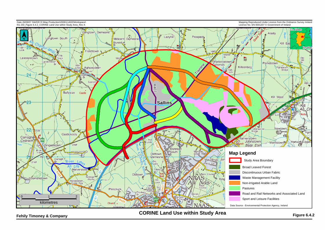
(
8
SallinsSallinsSallinsSallinsSallinsSallinsSallinsSallinsSallinsSallinsSallinsSallinsSallinsSallinsSallinsSallinsSallinsSallinsSallinsSallinsSallinsSallinsSallinsSallinsSallinsSallinsSallinsSallinsSallinsSallinsSallinsSallinsSallinsSallinsSallinsSallinsSallinsSallinsSallinsSallinsSallinsSallinsSallinsSallinsSallinsSallinsSallinsSallinsSallins
2
kilometres0 1
R407
R407
R407
R407
R407
R407
R407
R407
R407
R407
R407
R407
R407
R407
R407
R407
R407
R407
R407
R407
R407
R407
R407
R407
R407
R407
R407
R407
R407
R407
R407
R407
R407
R407
R407
R407
R407
R407
R407
R407
R407
R407
R407
R407
R407
R407
R407
R407
R407
Train
line
Train
line
Train
line
Train
line
Train
line
Train
line
Train
line
Train
line
Train
line
Train
line
Train
line
Train
line
Train
line
Train
line
Train
line
Train
line
Train
line
Train
line
Train
line
Train
line
Train
line
Train
line
Train
line
Train
line
Train
line
Train
line
Train
line
Train
line
Train
line
Train
line
Train
line
Train
line
Train
line
Train
line
Train
line
Train
line
Train
line
Train
line
Train
line
Train
line
Train
line
Train
line
Train
line
Train
line
Train
line
Train
line
Train
line
Train
line
Train
line
Date 26/09/07 SW/DR R:\Map Production\2006\114\02\Workspace\KIL-DD_Figure 6.4.2_CORINE Land Use within Study Area_Rev A
CORINE Land Use within Study AreaFehily Timoney & Company Figure 6.4.2
Key MapKey MapKey MapKey MapKey MapKey MapKey MapKey MapKey MapKey MapKey MapKey MapKey MapKey MapKey MapKey MapKey MapKey MapKey MapKey MapKey MapKey MapKey MapKey MapKey MapKey MapKey MapKey MapKey MapKey MapKey MapKey MapKey MapKey MapKey MapKey MapKey MapKey MapKey MapKey MapKey MapKey MapKey MapKey MapKey MapKey MapKey MapKey MapKey Map
Mapping Reproduced Under Licence from the Ordnance Survey IrelandLicence No. EN 0001207 © Government of Ireland
Co. KildareCo. KildareCo. KildareCo. KildareCo. KildareCo. KildareCo. KildareCo. KildareCo. KildareCo. KildareCo. KildareCo. KildareCo. KildareCo. KildareCo. KildareCo. KildareCo. KildareCo. KildareCo. KildareCo. KildareCo. KildareCo. KildareCo. KildareCo. KildareCo. KildareCo. KildareCo. KildareCo. KildareCo. KildareCo. KildareCo. KildareCo. KildareCo. KildareCo. KildareCo. KildareCo. KildareCo. KildareCo. KildareCo. KildareCo. KildareCo. KildareCo. KildareCo. KildareCo. KildareCo. KildareCo. KildareCo. KildareCo. KildareCo. Kildare
’
Broad Leaved Forest
Discontinuous Urban Fabric
Waste Management Facility
Non-irrigated Arable Land
Pastures
Road and Rail Networks and Associated Land
Sport and Leisure Facilities
Map LegendStudy Area Boundary
Data Source - Environmental Protection Agency, Ireland
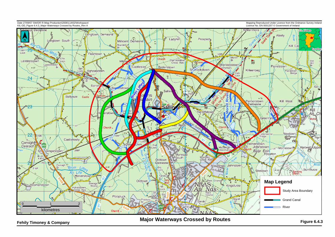
SallinsSallinsSallinsSallinsSallinsSallinsSallinsSallinsSallinsSallinsSallinsSallinsSallinsSallinsSallinsSallinsSallinsSallinsSallinsSallinsSallinsSallinsSallinsSallinsSallinsSallinsSallinsSallinsSallinsSallinsSallinsSallinsSallinsSallinsSallinsSallinsSallinsSallinsSallinsSallinsSallinsSallinsSallinsSallinsSallinsSallinsSallinsSallinsSallins
2
kilometres0 1
River L
iffey
River L
iffey
River L
iffey
River L
iffey
River L
iffey
River L
iffey
River L
iffey
River L
iffey
River L
iffey
River L
iffey
River L
iffey
River L
iffey
River L
iffey
River L
iffey
River L
iffey
River L
iffey
River L
iffey
River L
iffey
River L
iffey
River L
iffey
River L
iffey
River L
iffey
River L
iffey
River L
iffey
River L
iffey
River L
iffey
River L
iffey
River L
iffey
River L
iffey
River L
iffey
River L
iffey
River L
iffey
River L
iffey
River L
iffey
River L
iffey
River L
iffey
River L
iffey
River L
iffey
River L
iffey
River L
iffey
River L
iffey
River L
iffey
River L
iffey
River L
iffey
River L
iffey
River L
iffey
River L
iffey
River L
iffey
River L
iffey
Mor
ell R
iver
Mor
ell R
iver
Mor
ell R
iver
Mor
ell R
iver
Mor
ell R
iver
Mor
ell R
iver
Mor
ell R
iver
Mor
ell R
iver
Mor
ell R
iver
Mor
ell R
iver
Mor
ell R
iver
Mor
ell R
iver
Mor
ell R
iver
Mor
ell R
iver
Mor
ell R
iver
Mor
ell R
iver
Mor
ell R
iver
Mor
ell R
iver
Mor
ell R
iver
Mor
ell R
iver
Mor
ell R
iver
Mor
ell R
iver
Mor
ell R
iver
Mor
ell R
iver
Mor
ell R
iver
Mor
ell R
iver
Mor
ell R
iver
Mor
ell R
iver
Mor
ell R
iver
Mor
ell R
iver
Mor
ell R
iver
Mor
ell R
iver
Mor
ell R
iver
Mor
ell R
iver
Mor
ell R
iver
Mor
ell R
iver
Mor
ell R
iver
Mor
ell R
iver
Mor
ell R
iver
Mor
ell R
iver
Mor
ell R
iver
Mor
ell R
iver
Mor
ell R
iver
Mor
ell R
iver
Mor
ell R
iver
Mor
ell R
iver
Mor
ell R
iver
Mor
ell R
iver
Mor
ell R
iver
Date 27/09/07 SW/DR R:\Map Production\2006\114\02\Workspace\KIL-DD_Figure 6.4.3_Major Waterways Crossed by Routes_Rev A
Major Waterways Crossed by RoutesFehily Timoney & Company Figure 6.4.3
Key MapKey MapKey MapKey MapKey MapKey MapKey MapKey MapKey MapKey MapKey MapKey MapKey MapKey MapKey MapKey MapKey MapKey MapKey MapKey MapKey MapKey MapKey MapKey MapKey MapKey MapKey MapKey MapKey MapKey MapKey MapKey MapKey MapKey MapKey MapKey MapKey MapKey MapKey MapKey MapKey MapKey MapKey MapKey MapKey MapKey MapKey MapKey MapKey Map
Mapping Reproduced Under Licence from the Ordnance Survey IrelandLicence No. EN 0001207 © Government of Ireland
Co. KildareCo. KildareCo. KildareCo. KildareCo. KildareCo. KildareCo. KildareCo. KildareCo. KildareCo. KildareCo. KildareCo. KildareCo. KildareCo. KildareCo. KildareCo. KildareCo. KildareCo. KildareCo. KildareCo. KildareCo. KildareCo. KildareCo. KildareCo. KildareCo. KildareCo. KildareCo. KildareCo. KildareCo. KildareCo. KildareCo. KildareCo. KildareCo. KildareCo. KildareCo. KildareCo. KildareCo. KildareCo. KildareCo. KildareCo. KildareCo. KildareCo. KildareCo. KildareCo. KildareCo. KildareCo. KildareCo. KildareCo. KildareCo. Kildare
’
Map Legend
River
Grand Canal
Study Area Boundary