Embed Size (px)
Citation preview
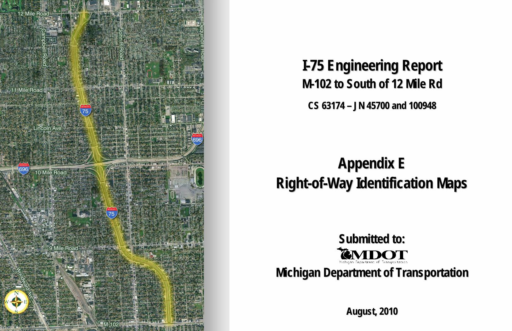
II--7755 EEnnggiinneeeerriinngg RReeppoorrtt MM--110022 ttoo SSoouutthh ooff 1122 MMiillee RRdd
CCSS 6633117744 –– JJNN 4455770000 aanndd 110000994488
AAppppeennddiixx EE RRiigghhtt--ooff--WWaayy IIddeennttiiffiiccaattiioonn MMaappss
SSuubbmmiitttteedd ttoo::
MMiicchhiiggaann DDeeppaarrttmmeenntt ooff TTrraannssppoorrttaattiioonn
AAuugguusstt,, 22001100

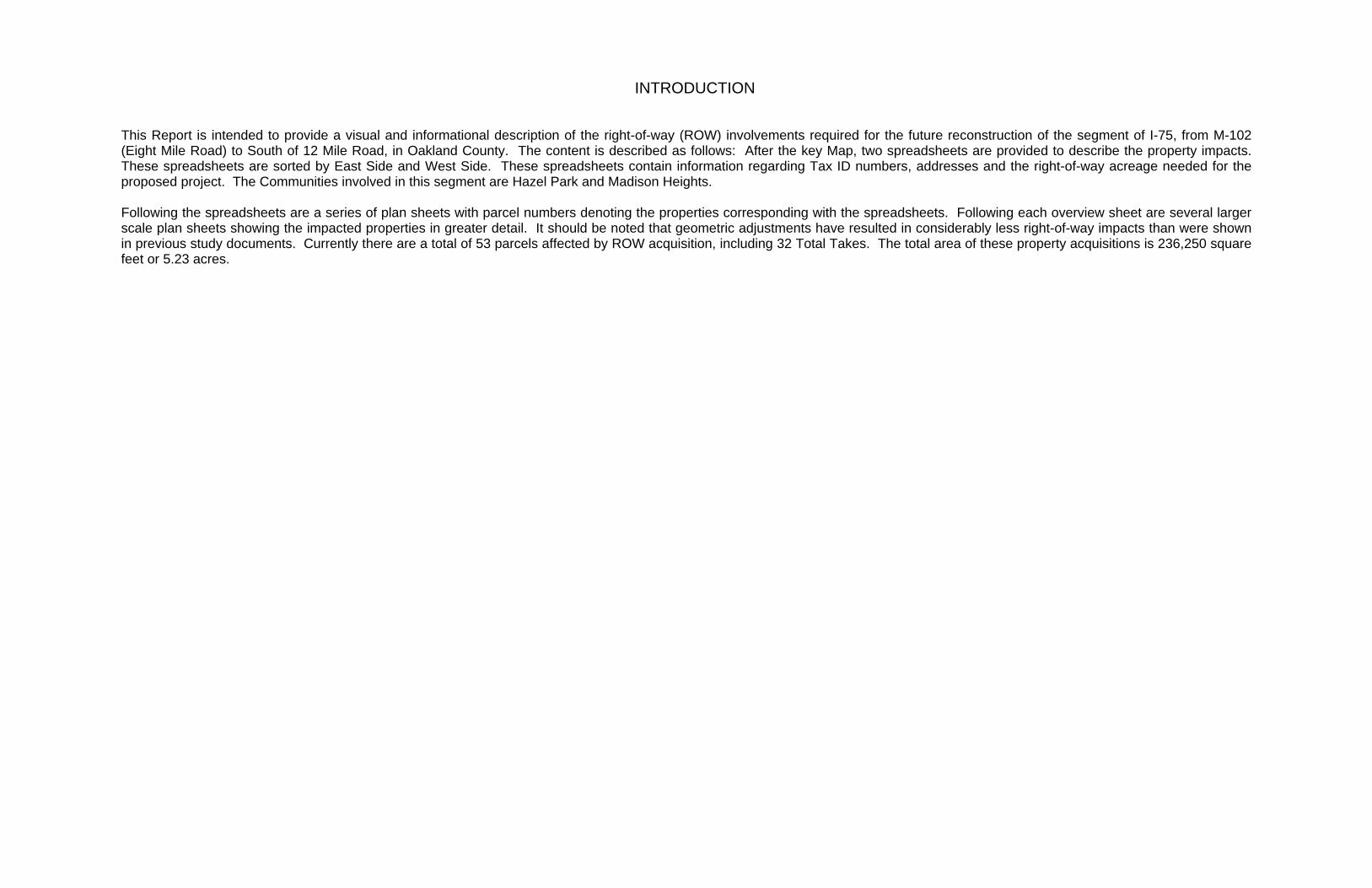
INTRODUCTION
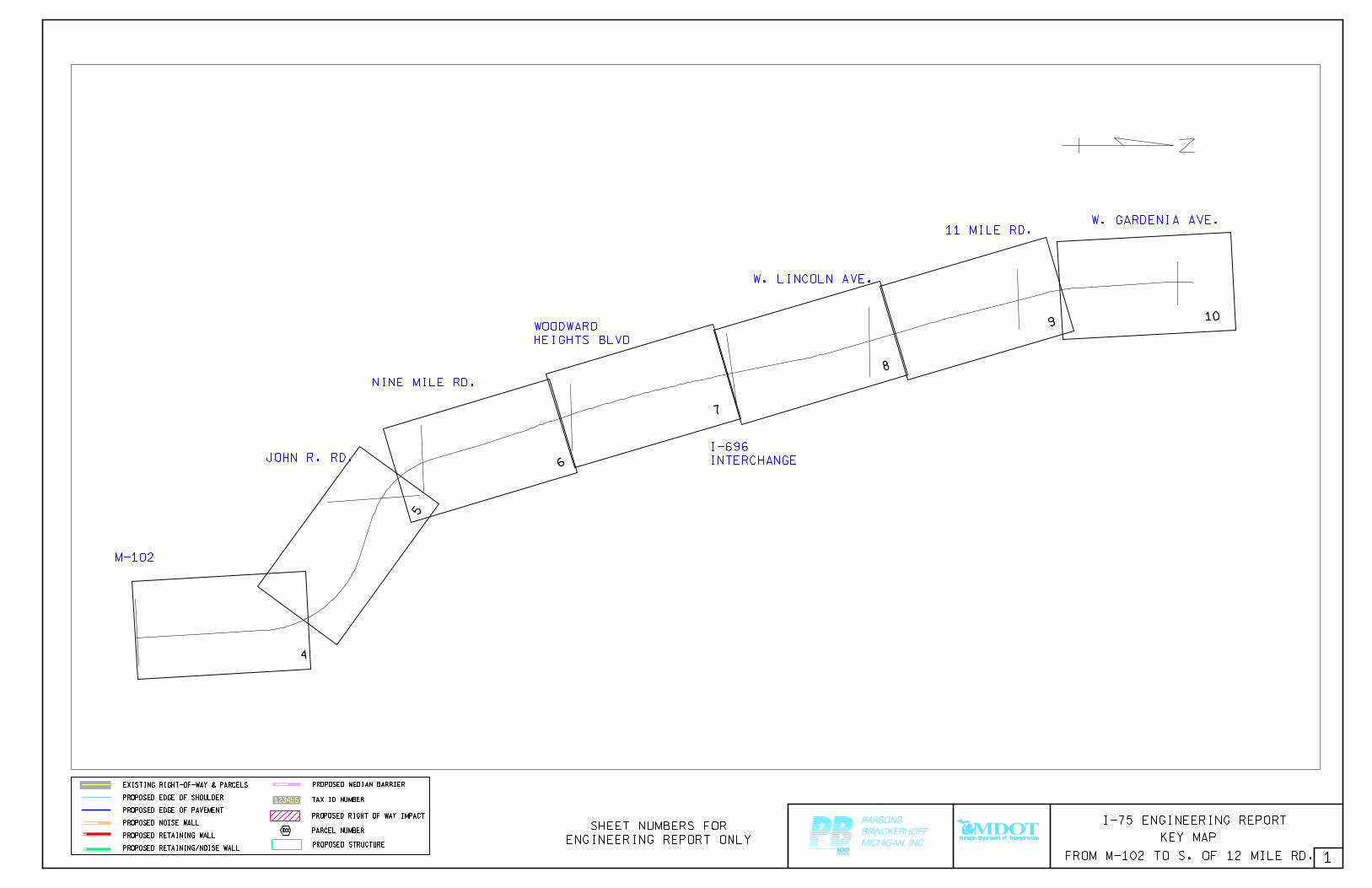
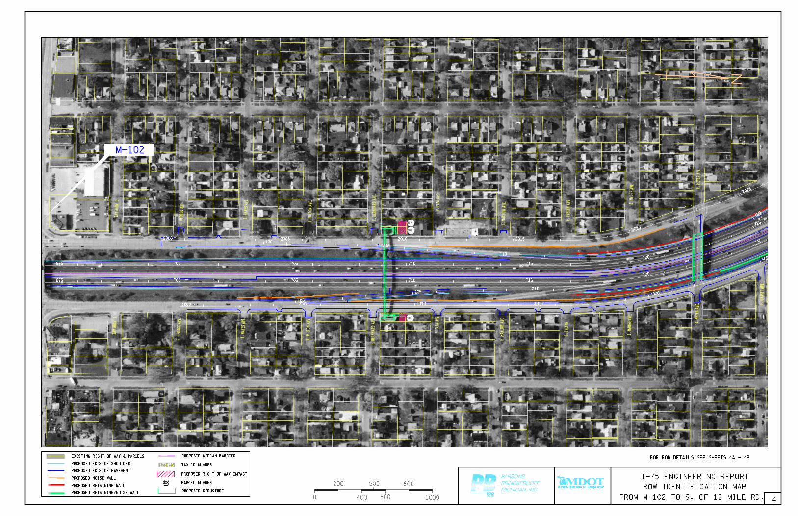
This Report is intended to provide a visual and informational description of the right-of-way (ROW) involvements required for the future reconstruction of the segment of I-75, from M-102 (Eight Mile Road) to South of 12 Mile Road, in Oakland County. The content is described as follows: After the key Map, two spreadsheets are provided to describe the property impacts. These spreadsheets are sorted by East Side and West Side. These spreadsheets contain information regarding Tax ID numbers, addresses and the right-of-way acreage needed for the proposed project. The Communities involved in this segment are Hazel Park and Madison Heights. Following the spreadsheets are a series of plan sheets with parcel numbers denoting the properties corresponding with the spreadsheets. Following each overview sheet are several larger scale plan sheets showing the impacted properties in greater detail. It should be noted that geometric adjustments have resulted in considerably less right-of-way impacts than were shown in previous study documents. Currently there are a total of 53 parcels affected by ROW acquisition, including 32 Total Takes. The total area of these property acquisitions is 236,250 square feet or 5.23 acres.

PLAN PARCEL
NO.
PLAN SHEET
DETAIL NUMBER ADDRESS OR LOT NUMBER TAX ID
NUMBER LOCATION DESCRIPTION Sq.Ft. ACRE TOTAL TAKE DESCRIPTION OF ROW IMPACT JURISDICTION
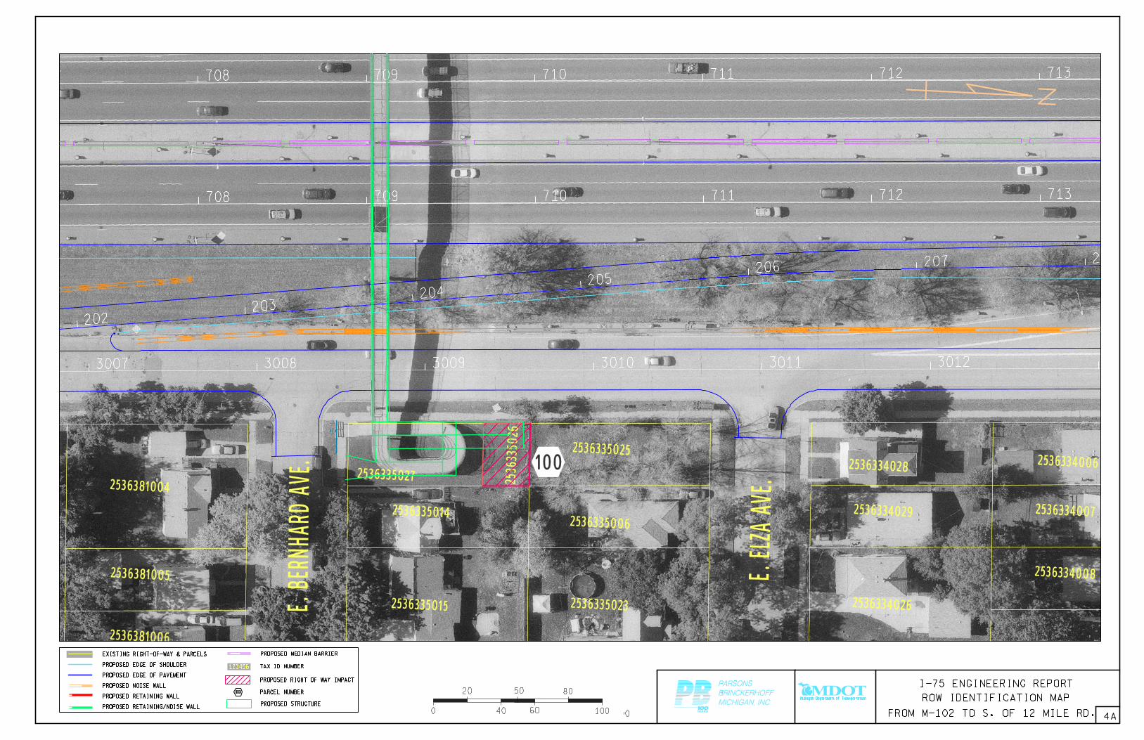
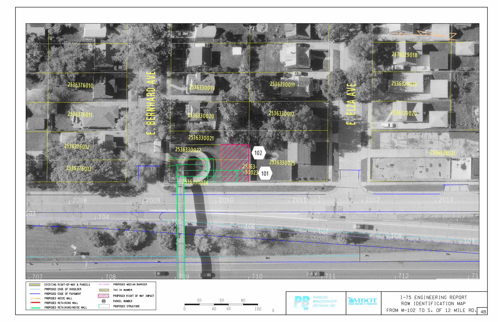
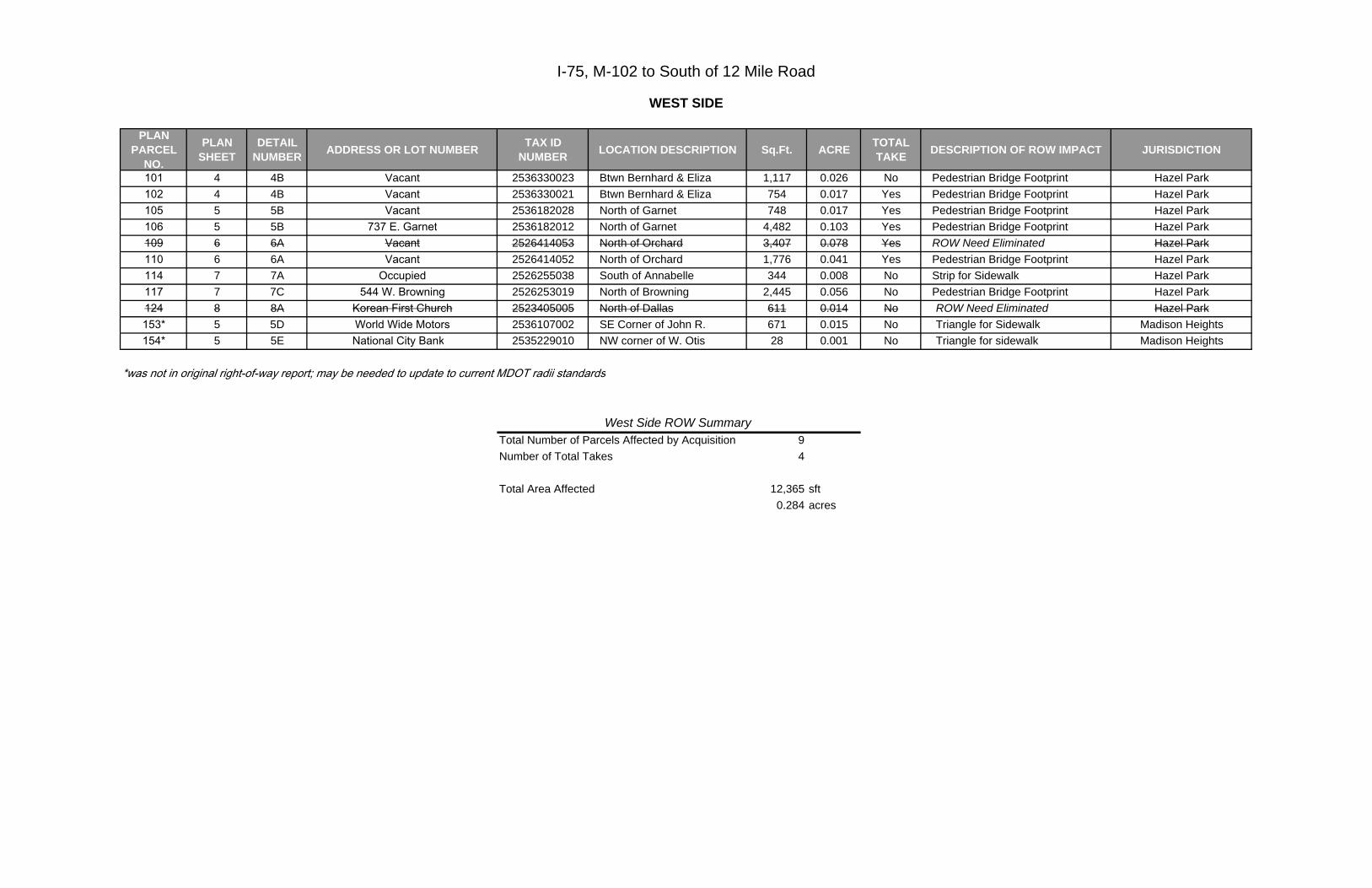
101 4 4B Vacant 2536330023 Btwn Bernhard & Eliza 1,117 0.026 No Pedestrian Bridge Footprint Hazel Park102 4 4B Vacant 2536330021 Btwn Bernhard & Eliza 754 0.017 Yes Pedestrian Bridge Footprint Hazel Park105 5 5B Vacant 2536182028 North of Garnet 748 0.017 Yes Pedestrian Bridge Footprint Hazel Park106 5 5B 737 E. Garnet 2536182012 North of Garnet 4,482 0.103 Yes Pedestrian Bridge Footprint Hazel Park109 6 6A Vacant 2526414053 North of Orchard 3,407 0.078 Yes ROW Need Eliminated Hazel Park110 6 6A Vacant 2526414052 North of Orchard 1,776 0.041 Yes Pedestrian Bridge Footprint Hazel Park114 7 7A Occupied 2526255038 South of Annabelle 344 0.008 No Strip for Sidewalk Hazel Park117 7 7C 544 W. Browning 2526253019 North of Browning 2,445 0.056 No Pedestrian Bridge Footprint Hazel Park124 8 8A Korean First Church 2523405005 North of Dallas 611 0.014 No ROW Need Eliminated Hazel Park153* 5 5D World Wide Motors 2536107002 SE Corner of John R. 671 0.015 No Triangle for Sidewalk Madison Heights154* 5 5E National City Bank 2535229010 NW corner of W. Otis 28 0.001 No Triangle for sidewalk Madison Heights
Total Number of Parcels Affected by Acquisition 9Number of Total Takes 4
Total Area Affected 12,365 sft0.284 acres
WEST SIDE
*was not in original right-of-way report; may be needed to update to current MDOT radii standards
I-75, M-102 to South of 12 Mile Road
West Side ROW Summary
PLAN PARCEL
NO.
PLAN SHEET
DETAIL NUMBER ADDRESS OR LOT NUMBER TAX ID
NUMBER LOCATION DESCRIPTION Sq.Ft. ACRE TOTAL TAKE DESCRIPTION OF ROW IMPACT JURISDICTION
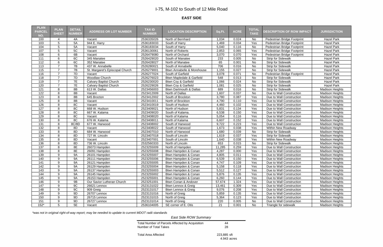
100 4 4A Vacant 2536335026 North of Bernhard 1,034 0.024 No Pedestrian Bridge Footprint Hazel Park103 5 5A 944 E. Harry 2536183033 South of Harry 1,469 0.034 Yes Pedestrian Bridge Footprint Hazel Park104 5 5A Vacant 2536183034 South of Harry 5,040 0.116 No Pedestrian Bridge Footprint Hazel Park107 5 5C Vacant 2536130061 North of Roberts 2,853 0.065 Yes Pedestrian Bridge Footprint Hazel Park108 6 6B Vacant 2526479080 North of Orchard 3,070 0.070 Yes Pedestrian Bridge Footprint Hazel Park111 6 6C 345 Manatee 2526429020 South of Manatee 233 0.005 No Strip for Sidewalk Hazel Park112 6 6C 352 Manatee 2526428027 North of Manatee 65 0.001 No Strip for Sidewalk Hazel Park113 7 7B 437 W. Annabelle 2526280021 South of Annabelle 706 0.016 No Strip for Sidewalk Hazel Park115 7 7B St. Margaret's Episcopal Church 2526279001 Btwn Annabelle & Morehouse 1,155 0.027 No Strip for Sidewalk Hazel Park116 7 7D Vacant 2526277024 South of Garfield 3,078 0.071 No Pedestrian Bridge Footprint Hazel Park118 7 7D Woodlaw Church 2526276023 Btwn Mapledale & Garfield 548 0.013 No Strip for Sidewalk Hazel Park119 7 7E Calvary Baptist Church 2526230020 Btwn Coy & Garfield 1,066 0.024 No Strip for Sidewalk Hazel Park120 7 7E Calvary Baptist Church 2526229026 Btwn Coy & Garfield 1,081 0.025 No Strip for Sidewalk Hazel Park121 8 8B 613 W. Dallas 2523456003 Btwn Dartmouth & Dallas 689 0.016 No Strip for Sidewalk Madison Heights122 8 8B Vacant 2523412009 North of Dallas 1,607 0.037 No Due to Wall Construction Madison Heights123 8 8B 645 Brocton 2523412002 South of Brockton 3,780 0.087 Yes Due to Wall Construction Madison Heights125 8 8B Vacant 2523410011 North of Brockton 4,790 0.110 Yes Due to Wall Construction Madison Heights126 8 8C Vacant 2523410019 South of Hudson 4,460 0.102 Yes Due to Wall Construction Madison Heights127 8 8C 668 W. Hudson 2523409021 North of Hudson 5,831 0.134 Yes Due to Wall Construction Madison Heights128 8 8C 667 W. Kalama 2523409020 South of Kalama. 6,538 0.150 Yes Due to Wall Construction Madison Heights129 8 8C Vacant 2523408020 North of Kalama 5,054 0.116 Yes Due to Wall Construction Madison Heights130 8 8C 676 W. Kalama 2523408011 North of Kalama 6,607 0.152 Yes Due to Wall Construction Madison Heights131 8 8C/8D 677 W. Harwood 2523408002 South of Harwood 9,722 0.223 Yes Due to Wall Construction Madison Heights132 8 8D Vacant 2523408022 South of Harwood 1,673 0.038 Yes Within New Roadway Madison Heights133 8 8D 684 W. Harwood 2523407010 North of Harwood 1,680 0.039 No Strip for Sidewalk Madison Heights134 8 8D 727 W. Lincoln 2523407018 South of Lincoln 1,619 0.037 Yes Strip for Sidewalk Madison Heights135 8 8D Vacant 2523407001 South of Lincoln 1,640 0.038 Yes Within New Roadway Madison Heights136 8 8D 736 W. Lincoln 2532560333 North of Lincoln 653 0.015 No Strip for Sidewalk Madison Heights137 8 8E 26073 Hampden 2523255009 North of Hampden 11,285 0.259 Yes Due to Wall Construction Madison Heights138 8 8E 26091 Hampden 2523255008 Btwn Hampden & Conan 4,287 0.000 Yes Due to Wall Construction Madison Heights139 9 9A 26101 Hampden 2523255007 Btwn Hampden & Conan 4,805 0.011 Yes Due to Wall Construction Madison Heights140 9 9A 26111 Hampden 2523255006 Btwn Hampden & Conan 6,539 0.150 Yes Due to Wall Construction Madison Heights141 9 9A 26121 Hampden 2523255005 Btwn Hampden & Conan 4,747 0.109 Yes Due to Wall Construction Madison Heights142 9 9A 26129 Hampden 2523255004 Btwn Hampden & Conan 5,158 0.118 Yes Due to Wall Construction Madison Heights143 9 9A 26137 Hampden 2523255003 Btwn Hampden & Conan 5,512 0.127 Yes Due to Wall Construction Madison Heights144 9 9A 26145 Hampden 2523255002 Btwn Hampden & Conan 5,876 0.135 Yes Due to Wall Construction Madison Heights145 9 9A 26153 Hampden 2523255001 Btwn Hampden & Conan 6,260 0.144 Yes Due to Wall Construction Madison Heights146 9 9B Our Savior Lutheran Church 2523251001 Btwn Conan & Andover 57,674 1.324 Yes Due to Wall Construction Madison Heights147 9 9C 26621 Lennox 2523131022 Btwn Lennox & Greig 13,461 0.309 Yes Due to Wall Construction Madison Heights148 9 9C 909 Greig 2523131017 Btwn Lennox & Greig 9,076 0.208 Yes Due to Wall Construction Madison Heights149 9 9D 26707 Lennox 2523131016 North of Greig 5,859 0.135 Yes Due to Wall Construction Madison Heights150 9 9D 26715 Lennox 2523131015 North of Greig 5,364 0.123 Yes Due to Wall Construction Madison Heights151 9 9D 26727 Lennox 2523131014 North of Greig 220 0.005 No Due to Wall Construction Madison Heights152* 5 5E Vacant 2536104005 SE corner of E. Otis 21 0.001 No Triangle for sidewalk Madison Heights
Total Number of Parcels Affected by Acquisition 44Number of Total Takes 28
Total Area Affected 223,885 sft4.943 acres
EAST SIDE
*was not in original right-of-way report; may be needed to update to current MDOT radii standards
I-75, M-102 to South of 12 Mile Road
East Side ROW Summary