Embed Size (px)
Citation preview

APPENDIX F
Cultural Resources Assessment


LOOKOUT PASS SKI AND RECREATION AREA CULTURAL RESOURCES ASSESSMENT
Prepared for
Idaho Panhandle National Forests 3815 Scribner Way Coeur d’Alene, Idaho 83815
Prepared by
January 2016


LOOKOUT PASS SKI AND RECREATION AREA CULTURAL RESOURCES ASSESSMENT
Prepared for and submitted to
Idaho Panhandle National Forests 3815 Scribner Way
Coeur d’Alene, Idaho 83815
Prepared by
Ross Smith, Brandy Rinck, and Lorelea Hudson
Project Manager: Sue Wilmot
SWCA Environmental Consultants 221 First Avenue West, Suite 205
Seattle, Washington 98119 (206) 781-1909 www.swca.com
January 27, 2016

Lookout Pass Ski and Recreation Area Cultural Resources Assessment
i
CONTENTS
Introduction ................................................................................................................................................. 1
Location .................................................................................................................................................... 1
Area of Potential Effects ........................................................................................................................... 1
Project Description .................................................................................................................................... 1 Proposed Action (Alternative 2) ........................................................................................................... 1
Ski Trails and Terrain ....................................................................................................................... 4 Lifts ................................................................................................................................................... 6 Power Line ........................................................................................................................................ 7 Parking .............................................................................................................................................. 8 Maintenance Facilities ...................................................................................................................... 8 Guest Service Facilities (ski patrol service building and restroom).................................................. 8 Roads and Access ............................................................................................................................. 8
Alternative 3 ......................................................................................................................................... 9
Setting ........................................................................................................................................................ 10
Natural Setting ........................................................................................................................................ 10 Geology and Soils ............................................................................................................................... 10 Climate, Vegetation, and Wildlife ...................................................................................................... 11
Cultural Setting ....................................................................................................................................... 11 Pre-Contact Period .............................................................................................................................. 11 Ethnohistory ........................................................................................................................................ 13 Historic Period .................................................................................................................................... 14
Exploration and Development of the Mullan Road ........................................................................ 14 Mining ............................................................................................................................................. 15 Transportation ................................................................................................................................. 15 Recreation (Ski Area Development) ............................................................................................... 17
Previous Cultural Resources Investigations ........................................................................................ 17 Idaho ............................................................................................................................................... 17 Montana .......................................................................................................................................... 19 Summary ......................................................................................................................................... 20
Methods ...................................................................................................................................................... 21
Idaho (Idaho Panhandle National Forests) .............................................................................................. 21
Montana (Lolo National Forest) ............................................................................................................. 24
Common Field Survey Methods ............................................................................................................. 24
Site Evaluation ........................................................................................................................................ 25
Assessment of Effects ............................................................................................................................. 25
Results ........................................................................................................................................................ 26
Idaho ....................................................................................................................................................... 26 LP-01/24MN372 (St. Regis Pass Historic Debris Scatter) ................................................................. 26
Current Investigations ..................................................................................................................... 26 Site Description ............................................................................................................................... 33 Evaluation of Significance .............................................................................................................. 35 Potential Effects .............................................................................................................................. 35
10SE888 (Northern Pacific Railroad Bed) ......................................................................................... 35
Lookout Pass Ski and Recreation Area Cultural Resources Assessment
ii
Current Investigations ..................................................................................................................... 35 Site Description ............................................................................................................................... 37 Evaluation of Significance .............................................................................................................. 37 Potential Effects .............................................................................................................................. 37
10SE1189 (the Mullan Road) ............................................................................................................. 37 Current Investigations ..................................................................................................................... 37 Site Description ............................................................................................................................... 42 Evaluation of Significance .............................................................................................................. 42 Potential Effects .............................................................................................................................. 43
Montana .................................................................................................................................................. 43 LP-01/24MN372 (St. Regis Pass Historic Debris Scatter) ................................................................. 43
Current Investigations ..................................................................................................................... 43 Site Description ............................................................................................................................... 43 Evaluation of Significance .............................................................................................................. 45 Potential Effects .............................................................................................................................. 47
24MN120 (Northern Pacific Railroad Segment) ................................................................................ 48 Current Investigations ..................................................................................................................... 48 Site Description ............................................................................................................................... 48 Evaluation of Significance .............................................................................................................. 48 Potential Effects .............................................................................................................................. 48
24MN133-G (the Mullan Road, St. Regis [Sohon] Pass to St. Regis River segment) ....................... 50 Current Investigations ..................................................................................................................... 50 Site Description ............................................................................................................................... 50 Evaluation of Significance .............................................................................................................. 50
Isolated Artifacts ................................................................................................................................. 52 IO-01 (Lithic Debitage) .................................................................................................................. 52
Resources Noted but Not Recorded ........................................................................................................ 52 State Line Survey Boundary Markers ................................................................................................. 52 Mining Prospect Pits and Claim Markers ........................................................................................... 52
Assessment of Effects ................................................................................................................................ 54
Idaho ....................................................................................................................................................... 54
Montana .................................................................................................................................................. 54
Mitigation ................................................................................................................................................ 55
References Cited ........................................................................................................................................ 56
ATTACHMENTS
Some attachments redacted from public version.
Attachment A. Archaeological Resources Protection Act Permit
Attachment B. Shovel Probe Summary
Attachment C. Idaho Archaeological Site Forms
Attachment D. Montana Archaeological Site and Isolate Forms
Attachment E. Noted but Not Recorded Mining features
Lookout Pass Ski and Recreation Area Cultural Resources Assessment
iii
FIGURES
Some figures redacted from public version.
Figure 1. Project location map. .................................................................................................................... 2 Figure 2. The Lookout Pass Ski and Recreation Area APE. ........................................................................ 3 Figure 3. Major components of the Lookout Pass Ski and Recreation Area project. .................................. 5 Figure 4. Map illustrating the route of the Mullan Road over St. Regis (Sohon) Pass, 1904. ................... 16 Figure 5. High, medium/moderate, and low site probability identified areas in the proposed
disturbance areas in the APE. .................................................................................................. 23 Figure 6. Archaeological survey and shovel testing areas in the APE ....................................................... 27 Figure 7. Shovel Probe Area 1 (see Figure 6). ........................................................................................... 28 Figure 8. Shovel Probe Area 2 (see Figure 6). ........................................................................................... 29 Figure 9. Shovel Probe Area 3 (see Figure 6). ........................................................................................... 30 Figure 10. Archaeological and historical resources identified within the APE ......................................... 31 Figure 11. LP-01/24MN372 site map. ....................................................................................................... 32 Figure 12. Maker’s marks identified on bottle bases recorded in LP-01/24MN372. ................................. 34 Figure 13. Site map for 10SE888. .............................................................................................................. 36 Figure 14. The Mullan Road (10SE1189) site area overview. ................................................................... 38 Figure 15. The Mullan Road (10SE1189) site area (map 1 of 3). .............................................................. 39 Figure 16. The Mullan Road (24MN133) site area (map 2 of 3). .............................................................. 40 Figure 17. The Mullan Road in Montana (24MN133) site area (map 3 of 3). ........................................... 41 Figure 18. Overview of the Mullan Road tread at Cross Section 1, view to the northwest. ...................... 42 Figure 19. LP-01/24MN372 site map. ....................................................................................................... 44 Figure 20. Maker’s marks identified on bottle bases recorded in LP-01/24MN372. ................................. 46 Figure 21. Open hole left by the excavation and removal of a sapling root mass, view to north. ............. 47 Figure 22. Northern Pacific Railroad Segment (24MN120) site map. ....................................................... 49 Figure 23. The Mullan Road (24MN133-G) site area overview. ............................................................... 51 Figure 24. Location of IO-01 and adjacent shovel test probes. .................................................................. 53
TABLES
Table 1. Proposed Road Actions for the Lookout Pass Ski Area Expansion Draft Environmental
Impact Statement ....................................................................................................................... 9 Table 2. Previous Cultural Resources Investigations Completed in Idaho within 1 Mile of the Area
of Potential Effects .................................................................................................................. 17 Table 3. Cultural Resources Recorded in Idaho within 1 Mile of the Area of Potential Effects ............... 18 Table 4. Previous Cultural Resources Investigations Completed in Montana within 1 Mile of the
Area of Potential Effects ......................................................................................................... 19 Table 5. Cultural Resources Recorded in Montana within 1 Mile of the Area of Potential Effects .......... 19 Table 6. Summary of Previously Identified Resources in the Area of Potential Effects ........................... 20 Table 7. Survey Coverage by Probability Ranking .................................................................................... 26 Table 8. Bottle Maker’s Marks and Associated Production Dates from LP-01/24MN372........................ 33 Table 9. Bottle Maker’s Marks and Associated Production Dates from LP-01/24MN372........................ 45 Table 10. Idaho NRHP Eligibility Summary ............................................................................................. 54 Table 11. Montana NRHP Eligibility Summary ........................................................................................ 54

Lookout Pass Ski and Recreation Area Cultural Resources Assessment
iv
This page intentionally blank

Lookout Pass Ski and Recreation Area Cultural Resources Assessment
1
INTRODUCTION
Lookout Pass Ski and Recreation Area proposes to expand its ski area south and west of the current
special-use permit boundary onto additional National Forest System (NFS) lands in the Idaho Panhandle
National Forests (IPNFs) and Lolo National Forest (LNF). This expanded boundary would encompass an
additional 654 acres of NFS lands and permit development of additional ski lifts, traditional terrain and
gladed terrain ski trails, expanded parking, access roads, and other facilities.
The proposed project requires a special-use permit from the IPNFs and is therefore subject to the National
Historic Preservation Act of 1966, as amended. Section 106 of the act requires agencies to take into
consideration the effects such undertakings may have on historic properties. As part of the environmental
impact statement (EIS) process, SWCA Environmental Consultants was retained by the IPNFs to conduct
a cultural resources assessment in compliance with Section 106.
Location
Lookout Pass Ski and Recreation Area is approximately 12 miles east of Wallace, Idaho, south of
Interstate 90 (I-90) on the Idaho-Montana border (Figure 1). Administration of the ski area is split
between the IPNFs in Shoshone County, Idaho, and LNF in Mineral County, Montana. Approximately 55
percent (359 acres) of the 654 additional acres of NFS lands are in the IPNFs and 45 percent (295 acres)
are in the LNF. The legal locations of Lookout Pass Ski and Recreation Area, per state, are as follows:
Idaho: Sections 4, 5, 6, and 7, Township 47 North, Range 6 East and Sections 32 and 33,
Township 48 North, Range 6 East, Boise Meridian.
Montana: Section 6, Township 19 North, Range 32 West, Section 1, Township 19 North, Range 33
West, Section 31, Township 20 North, Range 32 West, and Section 36, Township 20 North, Range
33 West, Principal Meridian.
Area of Potential Effects
An area of potential effects (APE) for a project is identified based on the geographical extent of a project
and on the activities that may affect cultural, historic, or archaeological resources. The APE for this
project comprises the existing 538-acre Lookout Pass Ski and Recreation Area and the 655-acre proposed
expansion area (Figure 2). Of these, 606 acres are in the IPNFs and 587 are in the LNF.
Project Description
Proposed Action (Alternative 2)
The Proposed Action would consist of the following major project components:
Fifteen new ski trails, totaling approximately 91 acres of new terrain for traditional downhill
skiing. Trees would be removed within the ski trail corridor.
Nine acres of gladed terrain where individual beetle-infested trees would be removed.
Two new fixed-grip lifts (for two to four passengers per chair on Lift 5 and two passengers per
chair on Lift 6) to provide access to the new ski trails.

Lookout Pass Ski and Recreation Area Cultural Resources Assessment
2
Fig
ure
1. P
roje
ct lo
ca
tio
n m
ap
.

Lookout Pass Ski and Recreation Area Cultural Resources Assessment
3
Fig
ure
2. T
he
Lo
oko
ut P
ass S
ki a
nd
Re
cre
atio
n A
rea
AP
E.

Lookout Pass Ski and Recreation Area Cultural Resources Assessment
4
An upgrade of existing Lift 1 from a two-passenger lift to a fixed-grip or detachable four-
passenger lift.
A buried power line from the bottom of existing Lift 1 to the bottom drive terminals of proposed
Lifts 5 and 6 (approximately 12,000 feet of cable).
Approximately 130 new parking spaces (7 acres) in two locations: near the main lodge and along
Lookout Pass Ski and Recreation Area’s access road.
A 7,000-square-foot (120 × 60–foot) maintenance shop and adjacent 864-square-foot (36 × 24–
foot) concrete pad with fuel storage tanks near the main lodge. A new, permanent 0.01-mile road
would provide access to these facilities.
A 24 × 20–foot ski patrol service building located at the top of proposed Lifts 5 and 6.
A 13 × 10–foot restroom structure near the proposed Lift 5 bottom terminal.
1.4 miles of temporary roads for timber harvest and lift construction.
2.8 miles of new or reconstructed permanent roads for timber harvest, lift construction, and long-
term operation and maintenance.
2.3 miles of road decommissioning (NFS Undetermined Roads 37315 and 37315-1).
These components are described in detail below are shown on Figure 3.
SKI TRAILS AND TERRAIN
Fourteen of the 15 new ski trails would measure 120 feet wide, and one would measure 150 feet wide. All
would be located below tree line and provide a total of 91 new acres of traditional terrain.1 Of this total,
approximately 23 acres would be new novice to low intermediate terrain through the creation of the
Windsong ski trail and three new connector ski trails: Tamarack, Dizzy Lizzy, and R2C2. Tamarack ski
trail (off the existing Rainbow Ridge ski trail) would provide skier and snowboarder access to the bottom
of proposed Lift 5. The two other new connector ski trails would allow skiers and snowboarders to
proceed from the bottom of proposed Lift 5 to the bottom of existing Lift 2 for access back to existing ski
terrain. The remaining acreage (68 acres) would provide new intermediate to advanced intermediate
terrain.
Construction of traditional terrain ski trails would require the removal of all trees within the ski trail
corridor. Timber harvest during ski trail construction would be conducted via ground-based yarding using
wheeled and tracked equipment (including forwarders). Trees would be cut at ground level, and stumps
and roots would be left intact unless they present safety issues that necessitate removal by harvest
equipment. Slash, including limbs and large woody debris, would be either removed or burned. Shrubs on
ski trails would be trimmed periodically during summer operations to ensure safe downhill skiing
conditions in winter. Ski trail edges and leave islands would also be treated (such as through selective
“feathering” or thinning), as necessary, to maintain edge integrity while minimizing the potential for wind
damage and the spread of disease or insects.
1 Cleared terrain associated with the middle segment of the Lift 5 corridor is not considered a planned run and is therefore not
included in this calculation, although skiers would be permitted to ski down the corridor as desired.

Lookout Pass Ski and Recreation Area Cultural Resources Assessment
5
Fig
ure
3. M
ajo
r com
pon
en
ts o
f th
e L
ooko
ut P
ass S
ki a
nd
Re
cre
atio
n A
rea
pro
ject.

Lookout Pass Ski and Recreation Area Cultural Resources Assessment
6
Up to 11 acres of the new ski trails would be graded to minimize side slopes and provide easier skier
transitions across proposed and existing permanent road edges. Grading would consist of removing all
vegetation, stockpiling topsoil and incorporated plant materials, adjusting topography to meet site-specific
needs, re-spreading topsoil, and revegetating with native and desirable non-native plants.
Low-impact yarding methods would be used for tree removal in wetlands or other sensitive areas. Trees
would be directionally felled away from sensitive areas to minimize impact. Trees would also be felled
towards designated temporary roads to minimize the ground-based yarding distance. Low–pressure,
rubber-tired skidders, or tracked mechanized yarding equipment, would be used for yarding to minimize
rutting or other soil disturbance, and the leading end of logs would be suspended during yarding with
either a grapple or bull-line and arch. Winching of logs from the stump to the skidder with a bull-line
would be minimized. When possible, a debris mat formed from logging slash would be used in sensitive
terrain to minimize soil impact.
Proposed Lifts 5 and 6 would also provide visitors with access to 9 acres of new gladed terrain. Trees
with beetle infestation damage within this area would be removed, and wood waste would be chipped and
used for erosion control, cut for firewood, or piled and burned according to Forest Service standards and
air quality controls.
Two permanent culverts would be placed in a perennial stream approximately 400 feet east of the base of
Lift 6. The stream crossing is located on mild terrain (25% or less slopes) upslope of a wetland and a few
hundred feet above a steeply incised stream channel. The crossing would consist of a main channel and a
secondary fork that experiences flows during larger storm events. Culverts would be placed in both
channels to facilitate natural hydraulic conditions of the downstream wetland. Fill height at the crossing
would be kept to the minimum possible. All culverts would be designed to meet the 100-year flow. The
specific design would be determined before construction. However, upon further assessment, the crossing
would meet the intent of the water quality standards of the State of Montana and the IPNFs and LNF
Forest Plans.
Lookout Pass Ski and Recreation Area would establish an operational downhill skiing boundary along the
outermost ski trails. This boundary establishes the legal limits where skiers are allowed to ski and would
be clearly marked by signs posted on trees to alert skiers when they approach out-of-bounds ski areas; no
ground disturbance would occur during sign installation.
LIFTS
Lift 1 would be upgraded from a two-passenger lift to a four-passenger lift to increase the number of
skiers the lift can accommodate. A new drive terminal, a return terminal, and 14 line towers would be
installed to support this upgrade. Existing terminals would be removed, line towers would be cut at
ground level, and tower footings would be left in place. Less than 0.1 acre of terrain disturbance would
occur during installation of the new top and bottom terminals and line towers. New line tower footings
paralleling the existing route, each measuring approximately 4 × 4 feet and placed at a depth of 8 feet,
would support the upgraded lift. Terminal specifications would depend on the manufacturer’s design.
However, for the purposes of analysis, an average drive terminal size of 18 × 12 feet and an average
return terminal size of 8 × 4 feet are assumed. Existing access roads would be used for construction and
maintenance of upgraded Lift 1; no new road construction would be required.
Two new lifts—Lifts 5 and 6—would be constructed in the proposed special-use permit expansion area to
provide skier access to new traditional and gladed terrain. Lift construction would occur within tree-
cleared corridors measuring 100–120 feet wide. Lift 5 would be approximately 5,200 feet long with a
vertical rise of approximately 1,300 feet. It would serve six trails and provide access to the Lift 6 ski
trails. Lift 5 would be installed as a fixed-grip lift for two, three, or four passengers. Depending on final

Lookout Pass Ski and Recreation Area Cultural Resources Assessment
7
engineering design for the lift, approximately 24 towers would be needed. Approximately 0.1 acre of
ground disturbance would occur during installation of the top and bottom terminals and line towers. The
disturbance acreage does not include proposed temporary and permanent road construction, which is
addressed in the Roads and Access section.
Lift 6 would serve six trails and would provide access back to the Lift 5 trails. The lift would be
approximately 2,800 feet long with a vertical rise of approximately 800 feet, and would be installed as a
fixed-grip, two-passenger lift. As with Lift 5, approximately 0.1 acre of ground disturbance would occur
during installation of the top and bottom terminals and an estimated 12 towers (depending on final
design).
Lift terminal locations were determined based on the site’s ability to provide access to proposed ski trails
and to ensure adequate space for lift lines, unloading areas, and general congregation areas.
Lifts 5 and 6 would be constructed as bottom drive lifts. Power to the lifts would be supplied through a
new underground power line, as well as via backup diesel or gasoline generators. The new lifts would
incorporate components recycled from the Lift 1 upgrade as well as used components purchased from
other ski areas to promote resource conservation and to reduce costs. Lift terminals and towers would be
transported to each site using logging equipment (forwarders, tractors, or skidders). Some tower
foundations would be poured using concrete pump trucks while others could require concrete buckets
flown by helicopter.
POWER LINE
Proposed Lifts 5 and 6 would be powered via an underground power cable installed by Avista Power
Company. Per Avista Power Company (Edholm 2013e), there is sufficient capacity (13,000 volts) to
serve the new loads that would be needed for the proposed project on a single three-phase circuit within
an existing transformer located at the base of existing Lift 1. One additional power pole would be
installed near the base of Lift 1 to provide a power source. Depending on the route, Avista Power
Company could also need to install a buried line from the top of Lifts 5 and 6 to the bottom of Lift 2 for
an emergency loop feed (Avista Power Company 2014). For the purposes of analysis, construction of the
emergency loop feed is assumed to occur within existing and proposed lift corridors, roads, or ski trails;
no additional ground disturbance would be required.
From the bottom of existing Lift 1, the underground power cable would be routed to the bottom drive
terminals of proposed Lifts 5 and 6 within a 75-foot construction easement. The approximately 12,000
feet of buried cable would be installed up the Montana Face trail and then down the Rainbow Ridge trail
to one of the new connector trails. From there, the cable would be routed along proposed temporary roads
and ski trails to the bottom terminals of Lifts 5 and 6. Avista Power Company would construct a 20 × 20–
foot transformer at the power line terminus.
The power line would cross one unnamed spring-fed creek near the base of Lift 6. The cable would be
either directionally drilled under the creek or installed using an open-cut method. The creek would be
restored to pre-construction or better condition, and erosion and sediment control measures would be
installed to reduce streambank and upland erosion and sediment transport into the waterbody.
This power line corridor would also serve as an escape ski trail for skiers to reach existing Lift 2 and
proposed Lift 5 if proposed Lift 6 should become inoperable. Lift maintenance and operations staff would
also be able to use this corridor to access proposed Lift 6. A 10-foot permanent power line easement
would be maintained by Avista Power Company for maintenance purposes.

Lookout Pass Ski and Recreation Area Cultural Resources Assessment
8
PARKING
The Proposed Action would add 6.6 acres of parking in two areas to accommodate an additional 130
vehicles and buses, based on a 90-degree parking angle and 19 × 10–foot spaces.
Parking would be extended to the north of the overflow parking lot to permit parking on both sides of the
railroad grade while maintaining a 20-foot-wide roadbed for ingress and egress for other users such as
snowmobilers accessing the Northern Pacific Railroad Trail. Approximately 5.2 acres are available in this
area for parking; however, because of the steepness of the surrounding terrain, parking would not be
possible in some locations. Lookout Pass Ski and Recreation Area estimates that the area would support
50 parking spaces, as well as provide room for a turn-around to handle vehicles with trailers and
recreational vehicles.
South of the existing paved parking area, 400 feet of new parking would be added on the west side of the
access road and on the west side of the existing railroad grade, which, due to less-steep topography,
would provide an additional 80 parking spaces within 1.4 acres. The area along the railroad bed would be
used for employee parking and would have at least 20 feet for ingress and egress for other users.
Parking areas would be graded to near level and covered with gravel or crushed rock to minimize erosion.
Drainage from the parking areas would be routed to upland vegetated areas. Parking lot snow removal
and storage would be planned to provide for vehicle and snowmobile ingress and egress. No snowmobile
off-loading or trailer parking would be designated or permitted within the special-use permit area
boundary. Traffic signs would be posted in parking areas to control vehicle speed.
MAINTENANCE FACILITIES
A new 7,000-square-foot (120 × 60–foot) maintenance shop and adjacent 864-square-foot (36 × 24–foot)
concrete fuel tank pad would be constructed just south of the existing fueling pad station to support ski
operations. A 0.01-mile new permanent gravel road would be constructed to provide access between the
maintenance facilities and the lodge.
GUEST SERVICE FACILITIES (SKI PATROL SERVICE BUILDING AND RESTROOM)
A 480-square-foot ski patrol service building and warming hut would be constructed at the top of
proposed Lifts 5 and 6. The log structure would be similar to the existing ski patrol service building and
would be powered by propane or fuel cell technology to provide heat and light.
The Proposed Action would also include construction of an approximately 160-square-foot, two-stall
Romtec restroom structure near the proposed Lift 5 bottom terminal, just off existing NFS Road 18591
along a proposed new permanent road. These roads would be constructed or reconstructed to permit pump
truck access for vault pumping during summer months. For winter pumping, Lookout Pass Ski and
Recreation Area would equip a snowcat with a tank and pump to access the vaults.
Guest service facility upgrades would not require a change to Lookout Pass Ski and Recreation Area’s
existing water system. No snowmaking would occur under the Proposed Action.
ROADS AND ACCESS
Approximately 4.2 miles of permanent and temporary roads would be constructed or reconstructed to
Forest Service standards by Lookout Pass Ski and Recreation Area to facilitate timber harvest and ski area
maintenance and operations, as summarized in Table 1. Temporary logging roads and Lookout Pass Ski
Lookout Pass Ski and Recreation Area Cultural Resources Assessment
9
and Recreation Area’s permanent access road would be closed to public travel; all motorized use within
the special-use permit boundary would be prohibited upon completion of expansion activities, except as
authorized in the permit. However, all existing surrounding Forest Service roads and trails currently open
to motorized or non-motorized public use would remain open under all alternatives.
Entry to the project area during the timber harvest and construction phases would occur via existing NFS
Roads 9132, 4208, 18591, and 3026A. Based on current road planning, approximately 0.5 mile of NFS
Road 18591 would require grading and reconstruction to accommodate logging trucks and construction
vehicles and to facilitate tree removal and transport from adjacent ski trails. Grading would begin
approximately 800 feet from the junction of NFS 4208 and would involve reshaping the subgrade by
excavating material on the outer, or downslope, portion of the road prism and placing it along the inner,
or upslope, portion of the road prism to provide an out-sloped road. Clearing 10–15 feet on both sides of
the existing road prism would be necessary along most of the road segment to accommodate road re-
grading activities and to meet Forest Service construction standards. At one low-water stream crossing,
roughly 1,700 feet from the junction with NFS 4208, clearing of vegetation on the downstream side
would be confined to the grading limits of the new drainage structure and any trees deemed hazard trees
per the Occupational Safety and Health Administration (OSHA). Additionally, one pipe arch (squash
pipe) would be installed at the low-water crossing. As previously noted, this culvert would be designed to
meet the 100-year flow. The specific design would be determined before construction. However, upon
further assessment, the crossing would meet the intent of the water quality standards of the State of
Montana and the IPNFs and LNF Forest Plans. With the exception of potential, temporary road closures
during reconstruction, NFS Road 18591 would remain open to all motorized and non-motorized use as
permitted by Forest Service travel management plans.
Table 1. Proposed Road Actions for the Lookout Pass Ski Area Expansion Draft Environmental Impact Statement
Road Action Operational Maintenance Level Miles
Existing permanent road reconstruction
NFS Road 18591 2 0.5
New road construction
Temporary logging routes Not applicable 1.4
Permanent roads 2 2.3
Total road construction and reconstruction 4.2
Alternative 3
Alternative 3 was developed in response to comments received during public scoping. Some commenters
expressed concern the Proposed Action would lead to unacceptable impacts on water quality, wildlife
species and habitat, and forest vegetation. To respond to these concerns, the Forest Service developed a
new action alternative, Alternative 3, which sought to avoid or reduce potential environmental impacts by
eliminating all temporary road construction by using skid trails;
eliminating three ski trails to expand the size of some inter-trail leave islands; and
increasing the size of the gladed area to remove more insect-damaged trees.
For the purposes of this cultural resources report, all project-related potential effects to cultural resources
for Alternative 3 would be captured by the Proposed Action (Alternative 2). Therefore, this alternative is
not further discussed.
Lookout Pass Ski and Recreation Area Cultural Resources Assessment
10
SETTING
Natural Setting
The APE is located in the Bitterroot Mountains at St. Regis Pass (originally known as Sohon Pass) in the
Coeur d'Alene Mountains of the Bitterroot Range of the Rocky Mountains, along the ridge separating the
St. Regis River drainage from the South Fork Coeur d’Alene River (Alt and Hyndman 1989). The APE
covers the east and south flanks of Runt Mountain to the east and the east side of an unnamed peak to the
west of St. Regis Pass at elevations between approximately 4,200 and 6,160 feet.
Geology and Soils
Lookout Pass is at a 4,710-foot elevation pass at the east edge of the Silver Valley on the border between
Shoshone County, Idaho, and Mineral County, Montana. I-90, on the north and east sides of the APE,
follows the South Fork of the Coeur d'Alene River along the Osborn Fault, then crosses the Coeur
d’Alene Mountains over Lookout Pass to the east of St. Regis Pass. To the east of Lookout Pass, the St.
Regis River follows the same fault lineament (Wallace and Hosterman 1956). The area west of the pass is
generally well known as part of the Coeur d'Alene mining district, and one of the deepest mines in the
world is 5 miles west of Lookout Pass in Mullan, Idaho.
The Idaho panhandle is primarily composed of Precambrian sedimentary rocks, such as those of the Belt
Formation. Belt Formation rocks can be more than a billion years old and are divided into six formations
(Alt and Hyndman 1989). From oldest to youngest they are the Prichard, Burke, Revett, St. Regis,
Wallace, and Striped Peak Formations. All but the youngest Striped Peak Formation contain ore veins due
to their position in the Lewis and Clark Fault Zone (LCFZ).
The LCFZ formed between 70 and 90 million years ago as a result of complex folding and faulting of
Belt Formation bedrock during the uplift of the Rocky Mountains (Chamberlain et al. 1989; Lonn and
McFaddan 1999). Uplift on the LCFZ slowed down 25 million years ago, leaving behind large faults,
such as the Placer Creek and Osburn Faults, and the Camel's Hump Structure (Harrison et al. 1974; Sears
1983; White 1993; Winston 1986). Volcanic material from the Earth’s mantle intruded into the
metasedimentary bedrock during folding and faulting to form dikes and seams. All of the heat and
pressure caused by the tectonic activity allowed for hydrothermal alteration and mineralization to occur in
and around the intrusions, creating gold (as a placer within quartz), silver (tetrahedrite), lead (galena),
copper (chalcopyrite), zinc (sphalerite), and various iron mineral veins (Bennet et al. 1989).
This hydrothermal alteration, known to miners as "bleaching," was historically used in the Coeur d'Alene
mining district to search for ore veins, based on the belief that a change in rock color from dark to light
was related to the solutions that introduced ore minerals into metasedimentary rocks (Mitcham 1952;
Wallace and Hosterman 1956). Many mining prospect pits are scattered across the APE because of the
geologic setting.
Most of the APE is bedrock with a thin covering of soil. Unconsolidated sediments, which include
alluvial fan deposits, mass wasting colluvium from landslides and debris flows, river and creek alluvium,
and glacial deposits from Pleistocene alpine glaciers, are generally limited to valley floors and walls in
the mountainous vicinity (Harrison et al. 1986). Naturally deposited unconsolidated deposits are not
expected in the APE, with the exception of peat that may be present at one wetland that crosses the
Mullan Road.

Lookout Pass Ski and Recreation Area Cultural Resources Assessment
11
Soils data available for portions of the St. Joe National Forest in the project vicinity indicate that soils of
the Honeyjones silt loam and Latour gravelly silt loam varieties are in the APE. These soils are usually
less than 40 inches thick because they form in volcanic ash overlying colluvium and talus derived from
metasedimentary argillite, quartzite, and phyllite rock on mountain slopes (Weisel 2002).
Climate, Vegetation, and Wildlife
Paleoclimatic conditions in the region have been inferred from past pollen studies that provide evidence
of a much cooler and moister climate ca. 11,000 years ago following final retreat of the Pleistocene
glaciers (Clague 1980, 1981; Porter 1978; Porter and Denton 1967). The cool ice age conditions affected
unglaciated areas south of the ice margin by causing soil to waste off the high ridge crests and downslope
during summers, a process called solifluction. After ice retreat, the region warmed and more moderate
temperatures ensued by ca. 8,000 years ago. The temperate trend was followed by another episode of
climatic cooling from 4,000 years ago to the present (Mattson et al. 1983).
Douglas-fir dominated the montane forest of the APE throughout the Holocene. Associated trees include
ponderosa pine, lodgepole pine, subalpine fir, and spruce in dry areas and western larch, white fir,
quaking aspen, western birch, and Rocky Mountain maple in wetter areas. Dominant understory in moist
areas is snowberry and Oregon boxwood. Sedges, pinegrass, Idaho fescue, big sagebrush, beargrass,
mountain Heather, huckleberry, and northern sage are found in wetter areas. The transition to a woodland
environment is lower in elevation than the APE. The woodlands surrounding the APE include open
ponderosa pine, lodgepole pine, and Douglas-fir forests with an understory of snowberry, bitterbrush, big
sagebrush, Idaho fescue, blue wildrye, and bluebunch wheatgrass. Edible plants that may have been
attractive to native inhabitants in the area include camas, bitterroot, balsamroot, yellowbells, wild onion,
and whitebark pine (Munger 1994).
Mammals currently or formerly in the APE include mountain lion, lynx, bobcat, black bear, grizzly bear,
raccoon, river otter, weasel, skunk, gray wolf, coyote, wolverine, red fox, badger, and other rodents. Elk,
mule deer, moose, mountain sheep, hares, rabbits, marmot, squirrel, muskrat, and beaver were also
historically present and were likely hunted (Munger 1994). Migratory waterfowl historically found along
the rivers and on nearby lakes and resident species might have included blue and ruffed grouse. A variety
of resident fishes occur in the streams, rivers and lakes, as well (Chatters 1998). Bison, pronghorn, and
white-tailed deer were historically available at lower elevations, especially east of the Continental Divide.
Cultural Setting
Pre-Contact Period
The prehistory of the Lookout Pass area is characterized by roughly 10,000 years of hunter-gatherer land
use resulting in temporary occupation sites, lithic scatters, rock cairns, vision quest sites, burials, and
culturally modified trees. These sites are the result of seasonal subsistence activities and other forms of
land use including lithic procurement and spiritual endeavors. Major occupation sites are usually limited
to the nearby Coeur d’Alene, Clark Fork, and St. Regis River drainages, but hunter-gatherers frequented
higher elevation mountainous areas during the summer months to hunt and to collect and process roots,
seeds, and berries. Expectations for cultural materials that may be present in the APE depend on the age
of the site.
The APE is at a crossroads of cultures. As a result, the culture histories of both the Columbia Plateau
(Leonhardy and Rice 1970) and the Northern Plains (Frison 1978; Greiser 1984; Reeves 1974) apply to
the area (Munger 1993, 1994). These culture histories are combined by McLeod and Melton (1986) to
Lookout Pass Ski and Recreation Area Cultural Resources Assessment
12
include Early Prehistoric (12,000–7,500 years ago), Middle Prehistoric (7,500–1,500 years ago), and Late
Prehistoric (1,500– ca. 300 years ago) periods with regional variants and phases within these larger
traditions. Each phase represents changes in artifact assemblage, land use, and settlement patterns as the
inhabitants of the region responded to climate shifts, new technologies, and the arrival of new people
(Mattson et al. 1983).
The Early Prehistoric period refers to a time when broad spectrum foragers dispersed through most
topographic zones. The earliest known inhabitants of the region, often referred to as Paleoindians, were
highly mobile hunter-gatherers that organized in extended families or multi-family bands to exploit large
and small game and plant resources (Frison 1978). The Early Prehistoric period includes the Windust and
early Cascade phases in what is now Idaho, and the Clovis, Folsom, Llano, Plano, Hell Gap, and Cody
complexes in what is now Montana (Leonhardy and Rice 1970; McLeod and Melton 1986; Munger
1994). The earliest archaeological sites in the region are typically on high terrace landforms along rivers
and include cryptocrystalline silicate (CCS) and basalt projectile points, large oval knives, numerous
modified flakes, end scrapers, and a variety of cobble tools (Sappington 1994; Sims 1971). Hafting
technologies and changes in projectile point shape from fluted to lanceolate are noted when comparing
sites dating to the beginning and end of the Early Prehistoric period (Frison 1978). Slight adaptations are
observed between open country sites where bison were hunted and mountain sites where more broad-
based hunting and gathering occurred (Knight 1989).
The climate warmed in the middle Holocene, and related changes in subsistence practices and technology
mark the transition to the Middle Prehistoric period (Knight 1989; Roll and Hackenberger 1998). The
Middle Prehistoric period is characterized by population aggregation, with an intensification of the use of
root crops and riverine resources, and hunting of a wider variety of animals, such as pronghorn, bison,
and mule deer (Frison et al. 1996; Greiser et al. 1985; Knight 1989). The Middle Prehistoric period
includes the late Cascade, Tucannon, and early Harder phases in Idaho and the Archaic Mummy Cave,
Oxbow, McKean, Hanna, and Pelican Lake complexes in Montana (Leonhardy and Rice 1970; Munger
1994). Large side-notched projectile points found at Middle Prehistoric period sites represent a shift away
from throwing spears to the use of atlatls. Lanceolate, indented base, and stemmed indented base
projectile points, small basalt scrapers, modified cobble spalls, pounding stones, sinkers, mortars and
pestles, digging sticks, and bone tools have also been identified at Middle Prehistoric period
archaeological sites (Frison et al. 1996; Kennedy 1976; Knight 1989). This period marks initiation of the
ethnographic pattern of winter villages that often included several semi-subterranean pit houses in Idaho,
while villages to the east hosted a wider variety of dwelling types, such as hide-covered pointed pole
lodges.
The Late Prehistoric period is characterized by an expansion in the number of villages that coincided with
the shift from hunting with atlatls to the use of bows and arrows. The Late Prehistoric period includes the
late Harder and Piqunin phases in Idaho, and the Keaster II, Besant, Avonlea, Prairie Side Notched, and
Plains Side Notched complexes, and the Old Women’s phase in Montana (Greiser 1994; Reeves 1969;
Sappington 1988). Sites dating to the Late Prehistoric period were often on floodplain terraces and usually
include small CCS end scrapers, knives, and net sinkers in addition to the distinctive small side-notched
concave-base arrow points (Greiser 1984; Knight 1989). Notching styles at the youngest Late Prehistoric
period sites are highly variable, and there are many local variant styles (Greiser 1984). Pottery and carved
stone vessels are occasionally identified at eastern sites dating to the Late Prehistoric period due to
influence of the neighboring Shoshone (Ferguson 2000; Frison 1991; Mulloy 1958). Late Prehistoric
period bison jump and kill sites and associated rock alignments are more common in Montana, whereas
deer were the focus of hunters in the mountains west of Lookout Pass (Frison et al. 1996; Greiser 1984).
Archaeological data from Late Prehistoric period sites in the region suggest indigenous population peaked
between 800 and 700 years ago.

Lookout Pass Ski and Recreation Area Cultural Resources Assessment
13
Archaeological sites dating to between 300 and 200 years ago often contain Euro-American trade goods
mixed with traditional artifacts. In Idaho, these sites belong to the Numipu phase, and in western
Montana, contact-era sites are referred to as Protohistoric period sites (McLeod and Melton 1986;
Sappington 1994). Whether called Numipu or Protohistoric, these sites are marked by the introduction of
the horse. This period ends with sustained contact with Euro-Americans.
Ethnohistory
The Coeur d’Alene Valley has drawn human residents and visitors for thousands of years because it is a
natural travel corridor that is rich with resources. Lookout Pass is at the east margin of the traditional
territory of the Coeur d’Alene people, an Interior Salish-speaking group who occupied at least 4,000,000
acres centered on Lake Coeur d’Alene and the Coeur d’Alene, St. Joe, St. Maries, and Spokane Rivers
(Teit 1930). The largest Coeur d’Alene village was reportedly at the outlet of Lake Coeur d’Alene, where
a fish trap spanned the Spokane River (Palmer 1998; Palmer et al. 1987; Ray 1936). Neighbors of the
Coeur d’Alene included the Kalispell, Kutenai, Flathead, Nez Perce, Pend d’Orielle, Colville, Spokane,
Northern Paiute, Shoshone-Bannock, and other tribes (Walker 1978). Assemblages from Coeur d’Alene
archaeological sites indicate ties to groups from the Columbia Plateau, British Columbia, and the northern
Rockies in Montana.
Ethnographic evidence suggests the Coeur d’Alene people, as well as their neighbors, lived in mat-, bark-,
or skin-covered lodges, but the presence of housepits at archaeological sites in the St. Joe River Valley
signals that pit houses may have also been used. Groups wintered in permanent villages on the lakes and
rivers (Palmer et al. 1987; Teit 1930). Villages broke into smaller bands in the spring to trap and catch
fish. In late summer, roots, berries, and other plants were gathered. In early fall, the smaller bands
traveled to salmon fishing sites, whereas white fish, trout, squawfish, mussels, and snails were locally
available (Peltier 1975). Small groups also left in the fall and traveled east for buffalo hunts on the Great
Plains (Teit 1930). People who remained in the area converged on their winter villages and had large
hunts for deer and elk.
The closest known named places are west of Lookout Pass (Palmer 1987). Hntsegwish, meaning “where it
imitates,” may refer to the Little Coeur d’Alene River before its confluence with the Coeur d’Alene River.
Downstream, the Coeur d’Alene River was called Hnq’wtutumshkwe’. Little Plummer Peak on Cataldo
Mountain was called Ałq’uq’wt’ut by the Coeur d’Alene. The Old Cataldo Mission was built at the village
site of Sq’wt’u. A place near Wallace may have been called Niłaq’qn, which means “wide forehead” or
“wide surface under the hair,” likely referring to the wide mountain range that includes Lookout Pass. The
headwaters of the St. Joe River south of Lookout Pass are known as Amotqn, or “one who presides at the
head,” and they relate to a mythological story (Palmer 1987).
Lookout Pass is on a native trail route through the Rocky Mountains between the Great Plains and the
lower Columbia River basin. In addition to being an important point along a travel corridor, the Lookout
Pass area also provided Native Americans with areas for hunting and resource gathering. The trail
allowed for exchanges of ideas and materials between Columbia Plateau and Great Plains groups.
Introduction of the horse changed the organization and interaction of these groups. Horses permitted
larger gatherings, created wealth differences, allowed for expanded knowledge of the region, permitted
the spread of disease, and increased warfare (Walker and Sprague 1998). For example, Shoshone groups
moved into what is now western Montana in the late 1700s (McLeod and Melton 1986).
During the 1850s, rumors of a military road being constructed following this trail spread into the Coeur
d’Alene region. Reports of increasing Euro-American settlement from the west and pressures of outside
tribes from the east created great apprehension among the Coeur d’Alene. Certain bands decided to fight
the Euro-Americans rather than yield to settlement. Battles between the United States military and Native

Lookout Pass Ski and Recreation Area Cultural Resources Assessment
14
Americans in the Spokane Valley in the mid-1850s ended with the destruction of Indian-owned crops,
cattle, and horse herds (Seltice 1990). Because of their involvement in the wars, a harsh settlement was
planned for the Coeur d’Alene Tribe. Jesuit priests at Cataldo Mission interceded on behalf of the Coeur
d’Alene and the tribe was assigned a reservation around Lake Coeur d’Alene, but their new lands
encompassed only a fraction of their traditional territory (Adams 1999; Dahlgren and Carbonneau-
Kincaid 1996; Palmer 1998). The Coeur d’Alene Reservation was established in 1873 near the southwest
border of their former territory. The reservation was reduced in size two times, once in 1885 and again in
the early 1890s. In 1906, tribal members were allotted land and the reservation was opened to non-tribal
settlement in 1909 (Palmer 1998).
The rumored military road, called the Mullan Road, became a reality in the late 1850s, creating a
relatively easy route for miners, settlers, and military personnel passing through the Coeur d’Alene region
(Mullan 1863); the road is further discussed in the following section. Despite the influx of outsiders,
pioneers who traveled along the Mullan Road noted that local Native Americans, including the Coeur
d’Alene, continued to use the route to travel across St. Regis Pass after the road was completed (Rumley
1862).
Historic Period
EXPLORATION AND DEVELOPMENT OF THE MULLAN ROAD
Between 1853 and 1855, Washington Territorial Governor Isaac I. Stevens led the survey efforts to
identify a railroad route along the northern tier of the United States. Stevens assigned U.S. Army
Lieutenant John Mullan to survey the Continental Divide segment for a “practical route” (Krueger 1964).
After learning of a way through the Bitterroot Mountains from local Indians and missionaries, Mullan
identified a route through the Coeur d’Alene and St. Regis Borgia Valleys. In May 1858, following the
Yakama War and the Mormon War, Mullan was subsequently ordered to begin construction of a military
wagon road to connect Fort Benton on the Missouri with Fort Walla Walla in the Washington Territory,
near the Columbia River (Mullan 1863; Rice Brown 1994). Mullan began the project at the western end,
at Fort Walla Walla; however, road construction through this region required intensive surveying,
clearing, and cut and fill work, and only a few miles were completed before the Indian War of 1858 broke
out (Bemis 1923). Mullan suspended his work for 4 months; road building resumed in 1859 after the end
of fighting. By the end of the 1859 field season, the construction party had reached the St. Regis River
Valley, crossing the Bitterroot Mountains at Sohon Pass (now called St. Regis Pass) (Mullan 1863;
Strachan 1861), After spending the winter in the valley, Mullan’s crew continued eastward, and in the
spring of 1860, completed the road to Fort Benton (Winther 1945:26). That summer, soldiers began using
the road to move to forts in the Oregon and Washington territories (Bemis 1923:204). However, by the
winter of 1860, Mullan concluded that marshy conditions, seasonal flooding, and a wide river crossing
could render sections of the route impassable, and he began to plan the road’s reroute and repair. In 1861,
he led construction of a new section of road north of Lake Coeur d’Alene and repaired and improved
existing stretches of the road that suffered from poor drainage. Road construction was completed along
the route in 1862.
Although the road was initially planned for the military, it became one of the primary routes used by
miners and businesses to provision the mining camps and towns that sprang up following the discovery of
gold in the area that would become southwestern Montana.

Lookout Pass Ski and Recreation Area Cultural Resources Assessment
15
MINING
Gold was discovered in Montana in the early 1850s, and the completion of the Mullan Road in 1860
provided a route for prospectors from the Pacific Northwest to begin to move into the region. In addition
to the prospectors who traveled the route, teams of pack mules and wagons were regularly employed to
transport goods over the Mullan Road to supply the growing population of miners in Montana (Winther
1945). By the mid- to late 1860s the flow of people and goods over the Mullan Road into Montana had
slowed in the response to increasing competition from shippers based out of Missouri, and the completion
of the first transcontinental railroad in 1869; however, the presence of the Mullan Road continued to spur
development along its route (Winther 1945). Miners began prospecting along the Mullan Road in the
Coeur d’Alene and St. Regis River drainages, and in 1865, the first gold claim was filed along the St.
Regis River (Mineral County Historical Society 2004:3). Prospectors working in the South Fork Coeur
d’Alene River Valley began staking gold claims in the early 1880s, and by the early 1890s, miners had
branched out into extracting silver, lead, and zinc from hard rock mines along the valley (Dahlgren and
Carbonneau-Kincaid 1996; Miller 1884; Smith 1932; Teske et al. 1961; Wood 1983). The establishment
of claims along the valley bottoms pushed later prospectors higher into the mountains and passes during
the late 1890s and early 1900s.
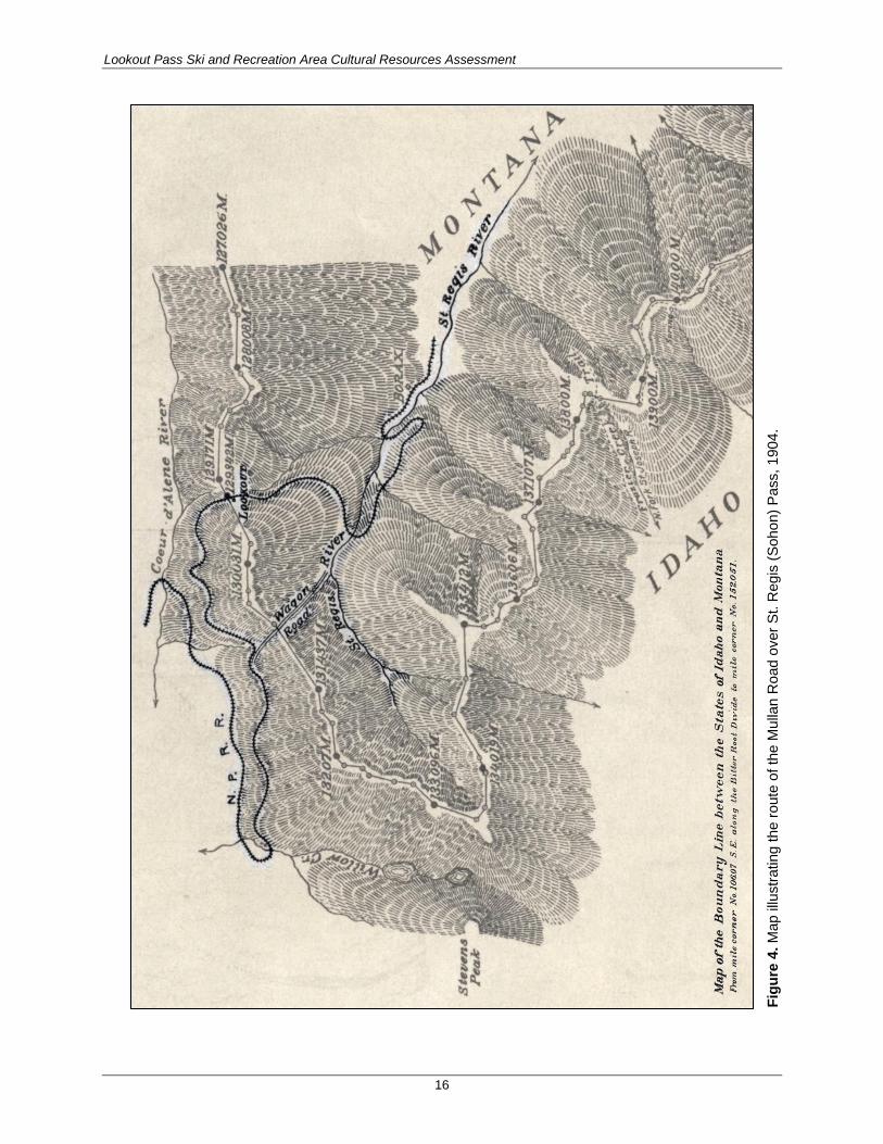
According to the U.S. Geological Survey (USGS), the Mullan Road was still occasionally used in the
early 1900s (Ransome and Calkins 1908). The Mullan Road was also a prominent feature recorded on
maps and surveyor’s notes from the period. In July 1904, a land surveyor contracted by the General Land
Office to survey Idaho-Montana boundary line reported crossing the Mullan Road (Krueger 1964:5-7).
The 1904 map illustrating the Idaho-Montana boundary survey markers also depicts the route of the
Mullan Road route over St. Regis Pass (Figure 4). General Land Office maps and field notes from 1911,
1914, 1916; the Coeur d’Alene National Forest Map (1911); and some USGS maps up through 1939
continue to illustrate a route through St. Regis Pass, which corresponds to the location of the Mullan Road
(Krueger 1964:8-10), although there is no evidence to suggest that the Mullan Road was still used after
the early 1900s.
In the summer of 1910, over 1,700 fires burned through western Montana, northern Idaho, and into
eastern Washington. Fire reached Lookout Pass in late August and burned through the South Fork Coeur
d’Alene and St. Regis River Valleys, destroying most of the local communities and infrastructure
(Mineral County Historical Society 2004:3).
TRANSPORTATION
The Northern Pacific Railroad completed their Coeur d’Alene branch line to Wallace, Idaho, by 1890, and
the line was extended east in the early 1900s to service the mines that lined the South Fork Coeur d’Alene
and St. Regis River Valleys. The line from Mullan, Idaho, to St. Regis, Montana, was abandoned in 1980.
All of the rails and ties were removed, and the Forest Service currently maintains an access road along the
grade north and south of the APE. The highway that eventually became I-90 was constructed through the
Lookout Pass area in 1922, allowing people from Idaho and Montana to more easily visit the area (Cohen
2007:201).
Lookout Pass Ski and Recreation Area Cultural Resources Assessment
16
Fig
ure
4. M
ap
illu
str
ating
th
e r
ou
te o
f th
e M
ulla
n R
oad
over
St. R
eg
is (
Soh
on)
Pa
ss,
19
04
.

Lookout Pass Ski and Recreation Area Cultural Resources Assessment
17
RECREATION (SKI AREA DEVELOPMENT)
In the 1930s, local skiing enthusiasts built a number of small facilities at Lookout Pass to encourage
recreational downhill skiing at the pass. In May 1941, the Forest Service assigned a Civilian Conservation
Corps (CCC) crew to build a permanent ski lodge at Lookout Pass. The Lookout Pass ski lodge was
completed and opened in December 1941 and was managed by the Idaho Ski Club (Cohen 2007:201).
Following the end of World War II, the ski club installed additional facilities, including rope tows to the
top of Runt Mountain, and the first lift was installed in 1956. The ski club expanded the lodge in 1961
and continued adding and improving the lifts. In 1992, the ski club sold the facilities to a private
corporation, and the Lookout Associates, LLC acquired the facility in 1999 (Cohen 2007:205).
Previous Cultural Resources Investigations
Fifteen cultural resources investigations have been conducted within 1 mile of the APE. Seventeen
historical cultural resources were identified as a result of these investigations. Only four of these
resources are in the APE; they are summarized at the end of this chapter.
IDAHO
Nine cultural resources investigations have been previously conducted within 1 mile of the Idaho portion
of the APE. Most were completed by or on the IPNFs. These projects included construction or upgrades
to facilities and utilities, as well as timber sales and safety improvements. Table 2 summarizes these
projects.
Table 2. Previous Cultural Resources Investigations Completed in Idaho within 1 Mile of the Area of Potential Effects
Date Author Title Relationship to the APE
Results Identified within 1 Mile of the APE
1986 Holstine Eleven Fly Yards and Three Gravel Quarry Sites on BPA’s Taft-Bell 500 KV Transmission Line, BPA
0.50 mile north None.
1987a Sims Wallace Ranger District Facilities 0.70 mile north 10SE749 (Shoshone Park Historic Structures).
1987b Sims Sale of Lookout Ski Lodge In the APE 10SE790 (Lookout Pass Ski Lodge).
1988 Boreson BPA’s Taft-Bell Transmission Line Project – Western Montana to Northeastern Washington
0.50 mile north 10SE888 (NP railroad bed).
1992 Ritchie Snowstorm Daisy Timber Sale Adjacent 10SE1002 to 10SE1005, 10SE1007, 10SE1008, 10SE888 (NP Railroad Bed), and 10SE1189 (the Mullan Road).
1996a Sims Clearwater Realty-Upper Priest Lake Land Exchange
1 mile northwest 10SE1154 (mining claim).
2002 Greiser Addendum: Touch America/AT&T Fiber Optic Cable Route Along I-90
In and adjacent 10SE888 (NP Railroad Bed).
2005 Ray et al. Avista Transmission Line 0.75 mile north None.
2009 Matz Shoshone Cabin Well 0.75 mile north Revisited 10SE749 (Shoshone Park Structures), 10SE1002 (cabin remnants), and 10SE1007 (mining camp/ditch).

Lookout Pass Ski and Recreation Area Cultural Resources Assessment
18
From these previous investigations, 11 cultural resources have been recorded within 1 mile of the APE in
Idaho (Table 3). An additional resource, St. Regis Pass (79-1232), was noted on the Idaho State Historic
Preservation Office’s (SHPO’s) early historical sites input data sheets, the precursor to Idaho’s site
inventory forms, because it was the “Summit of the Mullan road [sic] through the Bitterroot Range”
(Idaho SHPO ca. 1975). For the purposes of this project, it is part of the Mullan Road. All of the
previously recorded sites are historical, and most are related to the mining industry. Other recorded sites
are related to development of the area by the CCC and transportation.
Table 3. Cultural Resources Recorded in Idaho within 1 Mile of the Area of Potential Effects
Site Recorder/Date Description Relationship to APE
79-1232 Idaho SHPO (ca. 1975) St. Regis Pass, summit of the Mullan Road in Bitterroots.
In the APE
10SE749 Sims (1987c); Bolton and Hubber (1990)
Cabin, garage, and two picnic shelters (Shoshone Park).
0.7 mile north
10SE790 Sims (1986) Lookout Pass Ski Lodge. In the APE
10SE888 Ritchie (1991a); Greiser and Hagen (2000)
Northern Pacific Railroad Bed (79-18063). In the APE
10SE1002 Ritchie (1991b) Historic cabin remnants. 0.5 mile northwest
10SE1003 Ritchie (1991c) Historic habitation remnants. 0.5 mile northwest
10SE1004 Ritchie (1991d) Historic cabin remnants. 0.5 mile northwest
10SE1005 Ritchie (1991e) Historic mining adit (collapsed). 0.75 mile west
10SE1007 Ritchie (1991f) Historic mining camp/placer ditch (Remnants) with two cabins, a ditch, and artifacts dating 1900–1905.
0.5 mile northwest
10SE1008 Ritchie (1991g) Historic timber extraction area with chutes and skid trails.
0.25 mile west
10SE1154 Sims (1996b) Mining claim. 1 mile northwest
10SE1189 Ritchie (1991h) Historic wagon road (Mullan’s Military Road). In the APE
Sims (1996b) recorded a mining claim as 10SE1154 on land homesteaded by Louis Theodore Nystromin
northwest of Lookout Pass in 1926. The claim consists of a pit containing collapsed timbers, a board pile,
and the outline of a structure and a discovery trench. Sims (1987c) also recorded Shoshone Park Picnic
Area (10SE749) northwest of the APE. Shoshone Park contains an historical cabin, garage, and two
picnic shelters constructed in rustic style in 1936 by the CCC, which are eligible for the National Register
of Historic Places (NRHP). The site was nominated because of its association with planned development
of the recreational potential of federal forested land (Bolton and Hubber 1990). Sims (1986) also recorded
the Lookout Pass Ski Lodge as 10SE790 in the APE. The ski lodge was built in 1941 by the CCC. The
lodge has been remodeled at least twice in 1960 and 1985. Still, this ski lodge is significant because of its
rustic architecture and its association with the CCC.
A segment of the old Northern Pacific Railroad (now Burlington Northern) line from St. Regis, Montana,
to Mullan, Idaho, was recorded as 10SE888 (Ritchie 1991a). This segment was abandoned in 1980, and
the rails and ties were removed. This segment is part of a larger system that was determined eligible for
the NRHP, but this particular segment lacks architectural and functional integrity because the rails and
ties were removed. Today, the old grade functions as NFS Road 3026.
IPNFs Archaeologist Carl Ritchie also recorded several historical archaeological sites northwest of the
APE along the south edge of the South Fork Clark River Valley. These include 10SE1002 (historic cabin
remnants) (Ritchie 1991b), 10SE1003 (historic habitation remnants) (Ritchie 1991c), 10SE1004 (historic

Lookout Pass Ski and Recreation Area Cultural Resources Assessment
19
cabin remnants) (Ritchie 1991d), 10SE1005 (collapsed historic mining adit) (Ritchie 1991e), 10SE1007
(historic mining camp/placer ditch remnants) (Ritchie 1991f), 10SE1008 (a historic timber extraction
area) (Ritchie 1991g), and 10SE1189 (historic wagon road, Mullan’s Military Road) (Ritchie 1991h). The
Mullan Road dates to the 1860s, whereas the mining sites are probably younger, dating to ca. 1900 or
1910. A few of the mining sites, such as 10SE1005, also have artifacts dating to the 1890s that are
associated with the railroad.
MONTANA
Six cultural resources investigations have been previously conducted within 1 mile of the Montana
portion of the APE. Most of these projects were associated with Forest Service undertakings, including
trails, tree removal, parking areas, and mining related activities. Other projects were related to installation
of fiber optic lines and utility transmission lines.
Table 4. Previous Cultural Resources Investigations Completed in Montana within 1 Mile of the Area of Potential Effects
Date Author Title Relationship to APE Results
1983a Matthew and McLeod
St. Regis Basin Small Sale Proposed Cross Country Ski Route
0.25 mile south 24MN133 (Mullan Road) and 24MN137 (Sildex Mine).
1984b Matthew and McLeod
St. Regis Basin Drill Tests
1 mile south None.
1984a Matthew and McLeod
Copper Gulch Mining Exploration
1 mile south 24MN150 (Leslie Adit), 24MN151 (Copper Lake Crib Dam), and 24MN152 (mining cabin).
1985 McLeod Ski Area Salvage Timber Sale Area
Adjacent to southern boundary
Revisit 24MN133 (Mullan Road) and record 24MN120 (Northern Pacific Railroad segment).
2000 Greiser et al. Touch America/AT&T Fiber Optic Cable Route between Billings and Lookout Pass in Montana
Adjacent to the APE, along I-90
Large regional inventory of hundreds of sites; addressed 24MN133 (Mullan Road) and 24MN120 (Northern Pacific Railroad segment).
2010 Reininghaus et al.
Summer Trails Environmental Assessment
1 mile south Revisit of East Coeur d'Alene Mine (24MN38), Gold Chrome Mill (24MN97), Wabash Mine (24MN125), Meadow Mountain Mine (24MN132), Sildex Mine (24MN137), Dominion Peak Lookout (24MN139), Leslie Adit (24MN150), 24MN151, 24MN152, 24MN162, and 24MN215.
From the previous investigations, six cultural resources were identified within 1 mile of the APE in
Montana (Table 5). All of the resources are historical and associated with transportation or mining.
Table 5. Cultural Resources Recorded in Montana within 1 Mile of the Area of Potential Effects
Site Recorder/Date Description Relationship to APE
24MN120 Matthew (1985) Northern Pacific Railroad Bed (Lookout Pass to Sildex Mine).
In the APE to 0.5 mile south
24MN133 Munger (1985) Mullan Road segment (Sohon Pass to Sildex Mine).
In the APE
24MN137 Matthew and McLeod (1983b) Sildex Mine. 1 mile south
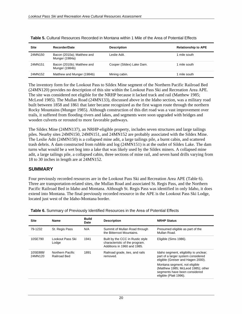
Lookout Pass Ski and Recreation Area Cultural Resources Assessment
20
Table 5. Cultural Resources Recorded in Montana within 1 Mile of the Area of Potential Effects
Site Recorder/Date Description Relationship to APE
24MN150 Bacon (2010a); Matthew and Munger (1984a)
Leslie Adit. 1 mile south
24MN151 Bacon (2010b); Matthew and Munger (1984b)
Cooper (Sildex) Lake Dam. 1 mile south
24MN152 Matthew and Munger (1984b) Mining cabin. 1 mile south
The inventory form for the Lookout Pass to Sildex Mine segment of the Northern Pacific Railroad Bed
(24MN120) provides no description of this site within the Lookout Pass Ski and Recreation Area APE.
The site was considered not eligible for the NRHP because it lacked track and rail (Matthew 1985;
McLeod 1985). The Mullan Road (24MN133), discussed above in the Idaho section, was a military road
built between 1858 and 1861 that later became recognized as the first wagon route through the northern
Rocky Mountains (Munger 1985). Although construction of this dirt road was a vast improvement over
trails, it suffered from flooding rivers and lakes, and segments were soon upgraded with bridges and
wooden culverts or rerouted to more favorable pathways.
The Sildex Mine (24MN137), an NRHP-eligible property, includes seven structures and large tailings
piles. Nearby sites 24MN150, 24MN151, and 24MN152 are probably associated with the Sildex Mine.
The Leslie Adit (24MN150) is a collapsed mine adit, a large tailings pile, a burnt cabin, and scattered
trash debris. A dam constructed from rubble and log (24MN151) is at the outlet of Sildex Lake. The dam
turns what would be a wet bog into a lake that was likely used by the Sildex miners. A collapsed mine
adit, a large tailings pile, a collapsed cabin, three sections of mine rail, and seven hand drills varying from
18 to 30 inches in length are at 24MN152.
SUMMARY
Four previously recorded resources are in the Lookout Pass Ski and Recreation Area APE (Table 6).
Three are transportation-related sites, the Mullan Road and associated St. Regis Pass, and the Northern
Pacific Railroad Bed in Idaho and Montana. Although St. Regis Pass was identified in only Idaho, it does
extend into Montana. The final previously recorded resource in the APE is the Lookout Pass Ski Lodge,
located just west of the Idaho-Montana border.
Table 6. Summary of Previously Identified Resources in the Area of Potential Effects
Site Name Build Date
Description NRHP Status
79-1232 St. Regis Pass N/A Summit of Mullan Road through the Bitterroot Mountains.
Presumed eligible as part of the Mullan Road.
10SE790 Lookout Pass Ski Lodge
1941 Built by the CCC in Rustic style characteristic of the program. Additions in 1960 and 1985.
Eligible (Sims 1986).
10SE888/ 24MN120
Northern Pacific Railroad Bed
1891 Railroad grade, ties, and rails removed.
Idaho segment, eligibility is unclear; part of a larger system considered eligible (Greiser and Hagen 2000).
Montana segment, not eligible (Matthew 1985; McLeod 1985); other segments have been considered eligible (Platt 1996).
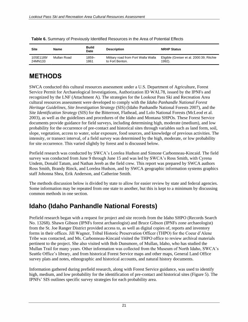
Lookout Pass Ski and Recreation Area Cultural Resources Assessment
21
Table 6. Summary of Previously Identified Resources in the Area of Potential Effects
Site Name Build Date
Description NRHP Status
10SE1189/ 24MN133
Mullan Road 1859–1861
Military road from Fort Walla Walla to Fort Benton.
Eligible (Greiser et al. 2000:39; Ritchie 1992).
METHODS
SWCA conducted this cultural resources assessment under a U.S. Department of Agriculture, Forest
Service Permit for Archaeological Investigations, Authorization ID WAL78, issued by the IPNFs and
recognized by the LNF (Attachment A). The strategies for the Lookout Pass Ski and Recreation Area
cultural resources assessment were developed to comply with the Idaho Panhandle National Forest
Heritage Guidelines, Site Investigation Strategy (SIS) (Idaho Panhandle National Forests 2007), and the
Site Identification Strategy (SIS) for the Bitterroot, Flathead, and Lolo National Forests (McLeod et al.
2003), as well as the guidelines and procedures of the Idaho and Montana SHPOs. These Forest Service
documents provide guidance for field surveys, including determining high, moderate (medium), and low
probability for the occurrence of pre-contact and historical sites through variables such as land form, soil,
slope, vegetation, access to water, solar exposure, food sources, and knowledge of previous activities. The
intensity, or transect interval, of a field survey was determined by the high, moderate, or low probability
for site occurrence. This varied slightly by forest and is discussed below.
Prefield research was conducted by SWCA’s Lorelea Hudson and Simone Carbonneau-Kincaid. The field
survey was conducted from June 9 through June 15 and was led by SWCA’s Ross Smith, with Cyrena
Undem, Donald Tatum, and Nathan Jereb as the field crew. This report was prepared by SWCA authors
Ross Smith, Brandy Rinck, and Lorelea Hudson, and by SWCA geographic information systems graphics
staff Johonna Shea, Erik Anderson, and Catherine Smith.
The methods discussion below is divided by state to allow for easier review by state and federal agencies.
Some information may be repeated from one state to another, but this is kept to a minimum by discussing
common methods in one section.
Idaho (Idaho Panhandle National Forests) Prefield research began with a request for project and site records from the Idaho SHPO (Records Search
No. 13268). Shawn Gibson (IPNFs forest archaeologist) and Bruce Gibson (IPNFs zone archaeologist)
from the St. Joe Ranger District provided access to, as well as digital copies of, reports and inventory
forms in their offices. Jill Wagner, Tribal Historic Preservation Officer (THPO) for the Coeur d’Alene
Tribe was contacted, and Ms. Carbonneau-Kincaid visited the THPO office to review archival materials
pertinent to the project. She also visited with Bob Dunsmore, of Mullan, Idaho, who has studied the
Mullan Trail for many years. Other information was collected from the Museum of North Idaho, SWCA’s
Seattle Office’s library, and from historical Forest Service maps and other maps, General Land Office
survey plats and notes, ethnographic and historical accounts, and natural history documents.
Information gathered during prefield research, along with Forest Service guidance, was used to identify
high, medium, and low probability for the identification of pre-contact and historical sites (Figure 5). The
IPNFs’ SIS outlines specific survey strategies for each probability area.

Lookout Pass Ski and Recreation Area Cultural Resources Assessment
22
The pedestrian field survey used transects spaced no more than 30 meters (m) apart, depending on the
probability for cultural resources. Survey coverage focused on areas where ground disturbance was
anticipated and was intended to be 100 percent in the APE where possible; however, slopes so steep that
surveyor safety could not be assured were excluded. The survey was documented with photographs, field
notes, maps, and a handheld Trimble GeoXT6000 global positioning system (GPS). No cultural materials
were collected.

Lookout Pass Ski and Recreation Area Cultural Resources Assessment
23
Redacted from public version.
Figure 5. High, medium/moderate, and low site probability identified areas in the proposed disturbance areas in the APE.
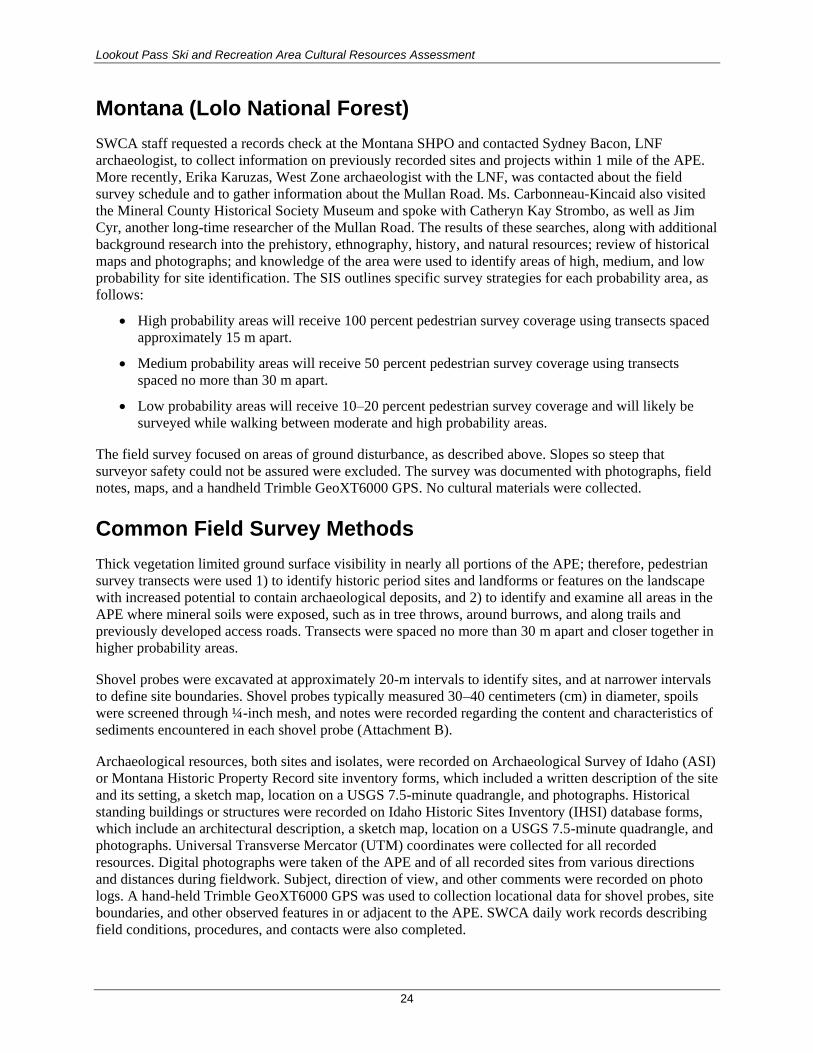
Lookout Pass Ski and Recreation Area Cultural Resources Assessment
24
Montana (Lolo National Forest)
SWCA staff requested a records check at the Montana SHPO and contacted Sydney Bacon, LNF
archaeologist, to collect information on previously recorded sites and projects within 1 mile of the APE.
More recently, Erika Karuzas, West Zone archaeologist with the LNF, was contacted about the field
survey schedule and to gather information about the Mullan Road. Ms. Carbonneau-Kincaid also visited
the Mineral County Historical Society Museum and spoke with Catheryn Kay Strombo, as well as Jim
Cyr, another long-time researcher of the Mullan Road. The results of these searches, along with additional
background research into the prehistory, ethnography, history, and natural resources; review of historical
maps and photographs; and knowledge of the area were used to identify areas of high, medium, and low
probability for site identification. The SIS outlines specific survey strategies for each probability area, as
follows:
High probability areas will receive 100 percent pedestrian survey coverage using transects spaced
approximately 15 m apart.
Medium probability areas will receive 50 percent pedestrian survey coverage using transects
spaced no more than 30 m apart.
Low probability areas will receive 10–20 percent pedestrian survey coverage and will likely be
surveyed while walking between moderate and high probability areas.
The field survey focused on areas of ground disturbance, as described above. Slopes so steep that
surveyor safety could not be assured were excluded. The survey was documented with photographs, field
notes, maps, and a handheld Trimble GeoXT6000 GPS. No cultural materials were collected.
Common Field Survey Methods
Thick vegetation limited ground surface visibility in nearly all portions of the APE; therefore, pedestrian
survey transects were used 1) to identify historic period sites and landforms or features on the landscape
with increased potential to contain archaeological deposits, and 2) to identify and examine all areas in the
APE where mineral soils were exposed, such as in tree throws, around burrows, and along trails and
previously developed access roads. Transects were spaced no more than 30 m apart and closer together in
higher probability areas.
Shovel probes were excavated at approximately 20-m intervals to identify sites, and at narrower intervals
to define site boundaries. Shovel probes typically measured 30–40 centimeters (cm) in diameter, spoils
were screened through ¼-inch mesh, and notes were recorded regarding the content and characteristics of
sediments encountered in each shovel probe (Attachment B).
Archaeological resources, both sites and isolates, were recorded on Archaeological Survey of Idaho (ASI)
or Montana Historic Property Record site inventory forms, which included a written description of the site
and its setting, a sketch map, location on a USGS 7.5-minute quadrangle, and photographs. Historical
standing buildings or structures were recorded on Idaho Historic Sites Inventory (IHSI) database forms,
which include an architectural description, a sketch map, location on a USGS 7.5-minute quadrangle, and
photographs. Universal Transverse Mercator (UTM) coordinates were collected for all recorded
resources. Digital photographs were taken of the APE and of all recorded sites from various directions
and distances during fieldwork. Subject, direction of view, and other comments were recorded on photo
logs. A hand-held Trimble GeoXT6000 GPS was used to collection locational data for shovel probes, site
boundaries, and other observed features in or adjacent to the APE. SWCA daily work records describing
field conditions, procedures, and contacts were also completed.
Lookout Pass Ski and Recreation Area Cultural Resources Assessment
25
The Forest Service previously identified and recorded segments of the historic Mullan Road
(10SE1189/24MN133) in the APE. Identified segments of the road in the APE were documented with
photographs, GPS, and field notes, describing the road width, road depth, and vegetation on and adjacent
to the road.
Site Evaluation
The significance of identified resources was evaluated using the NRHP criteria for significance and
integrity. Properties qualify for the NRHP if they are least 50 years old, and meet at least one of four
criteria of eligibility (36 CFR 60.4):
(A) Association with events that have made significant contributions to the broad patterns of our
history.
(B) Association with the lives of persons significant in our past.
(C) Embodiment of the distinctive characteristics of a type, period, or method of construction; or
representation of the work of a master; or possession of high artistic value; or representation of a
significant and distinguishable entity whose components may lack individual distinction.
(D) Has yielded or may be likely to yield important information about the past.
NRHP-eligible properties must also possess characteristics of integrity, including location, design, setting,
materials, workmanship, feeling, and association.
Assessment of Effects
The project would have an effect on historic properties if it changes the characteristics that qualify a
historic property for the NRHP. The effect is adverse if it diminishes the integrity of such characteristics.
For the Lookout Pass Ski and Recreation Area expansion project, pre-contact, ethnohistoric, and historical
archaeological resources could be directly affected by ground disturbance from project construction,
including constructing tower foundations, moving heavy equipment to a construction location to erect a
tower or pull cable, trenching for buried utilities, clearing activities (including tree falling and skidding
and brushing), and construction related to habitat restoration and access improvements. To determine the
effects on archaeological and cultural resources, construction locations and methods were evaluated in
context with known or potential archaeological sites.

Lookout Pass Ski and Recreation Area Cultural Resources Assessment
26
RESULTS
All of the proposed ski runs, lift tower laydown areas, access roads, utility corridors, new building
footprints, and proposed parking expansion areas identified before June 2015 were assessed.
The proposed disturbance area defined before the June 2015 fieldwork encompassed an area measuring
approximately 127 acres. In all, approximately 119 acres were surveyed in the proposed disturbance areas
identified in the APE (Table 7). The surveyed area included 100 percent of the high and medium ranked
landforms and 91 percent of the low ranked landforms (Figure 6). Ground surface visibility was generally
very poor (less than 10 percent) in the surveyed areas of the APE and lacked evidence of prior disturbance
(i.e., tree throws, animal burrows, bladed road beds, and prospect pits). Shovel probes were excavated
within three high probability areas, where ground-disturbing activities are proposed (Figures 7–9).
Table 7. Survey Coverage by Probability Ranking
Forest Unit
Probability Ranking Total Acres Surveyed
High (0%–10%) Medium (10%–30%) Low (> 30%)
IPNFs 3.36 24.83 29.06 57.25
LNF 3.48 40.02 18.32 61.82
Total Acres 6.84 64.85 47.38 119.07
Note: This probability ranking was derived from the slope of the landform; low slope areas (0%–10%) are assigned the highest probability ranking, whereas high slope areas (> 30%) receive the lowest probability ranking.
SWCA archaeologists identified one previously unrecorded archaeological resource (LP-01/24MN372)
and two previously recorded resources (10SE888 and 10SE1189) in the APE in Idaho (Attachment C),
and one previously unrecorded archaeological resource (LP-01/24MN372) and two previously recorded
resources (24MN120 and 24MN133) in the APE in Montana (Attachment D) (Figure 10). A historic
debris scatter (LP-01/24MN372) was identified at the crest of St. Regis Pass on both sides of the state
boundary and has been recorded with the respective Idaho and Montana SHPOs. One isolated lithic
artifact (IO-01) was identified in a shovel probe excavated at the crest of the ridge in Montana (see Figure
6). Noted but not recorded (NNR) resources identified in the APE include four blazed trees (representing
mining claim markers or survey markers), five prospect pits or shafts with associated claim markers, and
70 prospect pits and trenches (Attachment E). These findings are discussed in more detail, below.
Idaho
LP-01/24MN372 (St. Regis Pass Historic Debris Scatter)
CURRENT INVESTIGATIONS
The historic debris scatter (LP-01/24MN372) was identified during the pedestrian survey and shovel
testing along the proposed route of the buried power line corridor across the crest of St. Regis Pass on
June 10, 2015 (Figure 11).

Lookout Pass Ski and Recreation Area Cultural Resources Assessment
27
Redacted from public version.
Figure 6. Archaeological survey and shovel testing areas in the APE

Lookout Pass Ski and Recreation Area Cultural Resources Assessment
28
Redacted from public version.
Figure 7. Shovel Probe Area 1 (see Figure 6).

Lookout Pass Ski and Recreation Area Cultural Resources Assessment
29
Redacted from public version.
Figure 8. Shovel Probe Area 2 (see Figure 6).

Lookout Pass Ski and Recreation Area Cultural Resources Assessment
30
Redacted from public version.
Figure 9. Shovel Probe Area 3 (see Figure 6).

Lookout Pass Ski and Recreation Area Cultural Resources Assessment
31
Redacted from public version.
Figure 10. Archaeological and historical resources identified within the APE

Lookout Pass Ski and Recreation Area Cultural Resources Assessment
32
Redacted from public version.
Figure 11. LP-01/24MN372 site map.

Lookout Pass Ski and Recreation Area Cultural Resources Assessment
33
SITE DESCRIPTION
Site LP-01/24MN372 is a historic artifact debris scatter, including glass bottle fragments and metal can
and wire fragments. The site was identified on the Idaho-Montana state line at the crest of St. Regis Pass
adjacent to the previously identified and recorded segments of the historic Mullan Road
(10SE1189/24MN133). St. Regis Pass is noted in the Idaho SHPO inventory as 79-1232, as a location
along the Mullan Road. The temporally diagnostic artifacts were primarily found in three concentrations
north of an existing ATV/Jeep trail, and a dispersed scatter of small glass and metal fragments was
exposed in the road bed surface. Clear glass fragments similar to those noted in the trail bed in the
northern portion of the site was recovered just below the surface in a shovel probe (SP 4) in the southern
corner of the site (see Figure 8), and no evidence of historic debris was observed in the open holes
mapped in the disturbance area southeast of the site.
Thick, brown glass bottle body fragments, bases, and finishes, representing at least 11 different individual
bottles, were identified in two discrete concentrations north of an existing ATV/Jeep trail near SP 3, and
similar thick, brown bottle glass fragments were distributed across the surface of the road bed
immediately south of these concentrations and downslope to the northwest. A metal ring and square nail
were also identified on the road surface, and a flat, rectangular metal can was partially exposed on the
surface south of the road bed. A short section of nine-gauge wire was also noted in the ATV/Jeep road
bed in the northeast corner of the site area. A third glass scatter, this time containing thin, clear glass
bottle fragments, was exposed within the narrow trail bed north of the road, and three pieces of thin, clear
bottle glass, similar to those recorded within the trail bed, were identified between 0 and 7 cm below
surface (cmbs) in SP 4, south of the ATV/Jeep trail.
Temporally diagnostic historic artifacts recorded during the pedestrian survey in LP-01/24MN372 include
maker’s marks on the bases of four bottles (Figure 12). Some of these bottles may have been produced as
early as the late 1860s or 1870s; however, most of these marks suggest they were likely produced and
used from the 1880s through early 1900s (Table 8). These bottles were likely discarded in this area
between the 1880s and 1905, when the Mullan Road was used as a travel and supply route between Idaho
and Montana and as a route for local miners prospecting in the mountains and local river valleys.
Table 8. Bottle Maker’s Marks and Associated Production Dates from LP-01/24MN372
Maker’s Mark Company Production Dates
Contents Reference
F. H. G. W. Frederick Hampton Glass Works, England ca. 1880–1900 Beer Toulouse (1971):202–203
R & CO* Roth & Videane
Roth & Luy
Roth & Co.
Unknown
1868–1876
1876–1879
1879–1888
1880–1900
Whiskey, liquor, or beer
Toulouse (1971):438–439
S.B. & G. CO. Streator Bottle & Glass Co., Illinois 1881–1905 Unknown Toulouse (1971): 461–463
WIS GLASS Co Wisconsin Glass Co., Wisconsin 1882–1886 Unknown Toulouse (1971):541–542
* This production mark was used by at least three different companies in the San Francisco area from 1868 through 1900. Roth & Co. marketed a popular brand of whiskeys and liquors in the 1880s; however, the mark was also placed on export beer bottles produced between 1880 and 1900. Because the original bottle shape (and contents) could not be specifically determined, the companies and their associated dates are listed in chronological order of production dates (Toulouse 1971:438–439).

Lookout Pass Ski and Recreation Area Cultural Resources Assessment
34
Figure 12. Maker’s marks identified on bottle bases recorded in LP-01/24MN372.
Lookout Pass Ski and Recreation Area Cultural Resources Assessment
35
EVALUATION OF SIGNIFICANCE
Integrity
Evidence of disturbance within the boundaries of the historic debris scatter includes road construction,
natural processes of slope wash, recreational use, and possibly the selective removal of the small trees for
transplanting. The distribution of thick, dark brown bottle glass fragments, similar to those observed in
the bottle fragment concentrations north of the ATV/Jeep road bed, suggests that construction of the road
through this area previously disturbed the debris scatter. The distribution of the thick, dark brown bottle
glass along the road surface also suggests that surface wash from melting snow or heavy rains is moving
glass and possibly other artifacts downslope along the roadway to the northwest. In addition, evidence of
modern use, including camping and the selective digging of young trees for transplanting, was noted
during the survey in and adjacent to the defined site area. Recent fire rings, partially burned logs, fire-
modified sediments, and modern trash (including plastic and metal fragments, and melted glass) were
observed in the ATV/Jeep road bed.
The area south of the ATV/Jeep road contains numerous small coniferous trees, each less than 4–5 feet
high, and at least 12 rounded holes, each measuring from approximately 50 to 75 cm in diameter and 20–
30 cm deep, were recorded south of the site (see Figure 11). The vegetation on either side of the holes is
intact, and there was no evidence of adjacent spoil piles, suggesting that the sediments were removed
along with the root mass of the young trees. No evidence of historic debris associated with LP-
01/24MN372 was noted in or adjacent to the holes; however, the thick surface vegetation covering most
of the site area north and south of the road bed likely obscures additional historic debris on or
immediately below the ground surface. The presence of discrete artifact clusters and evidence of
subsurface artifacts suggest that this site retains integrity of location and materials.
NRHP Eligibility
This property is recommended eligible for the NRHP under Criteria A and D because it is associated with
significant events in history (operation of the Mullan Road during the late 1800s and early 1900s), and is
likely to yield important new or additional information about the history and use of the area. The site,
however, is not associated with the lives of persons significant in our past and does not embody a
distinctive architectural style (Criteria B and C).
POTENTIAL EFFECTS
It is unlikely that the installation of a buried power cable within the existing ATV/Jeep road will affect the
historic debris scatter at LP-01/24MN372.
10SE888 (Northern Pacific Railroad Bed)
The segment of the Northern Pacific Railroad Bed in the APE was previously recorded in Idaho and
assigned the Smithsonian Trinomial 10SE888 and IHSI number 79-18063. Other segments of the site
were recorded as 10SE1157, 10KA358, and 10BW146 (Grieser and Hagen 2000).
CURRENT INVESTIGATIONS
On June 12, 2015, SWCA archaeologists conducted a pedestrian survey and recorded a segment of the
Northern Pacific Railroad Bed (10SE888) within the APE in Idaho, north of Lookout Pass (Figure 13).
Cross-section profiles were drawn at three locations to characterize the current condition of the grade bed
and of cut and fill slopes in the proposed disturbance area.

Lookout Pass Ski and Recreation Area Cultural Resources Assessment
36
Redacted from public version.
Figure 13. Site map for 10SE888.

Lookout Pass Ski and Recreation Area Cultural Resources Assessment
37
SITE DESCRIPTION
The Northern Pacific Railroad Bed is identifiable for over 700 feet in the APE, and the road bed ranges
from 13 to 21 feet wide. Artifacts identified along the shoulder of the grade in the site area include several
pieces of clear glass bottle fragments, a piece of milled timber, a rail bracket and tie spikes, a short section
of iron pipe, a metal barrel lid, and a concave metal disc. This section of the rail line was built between
1890 and 1891 (Holstine 1982), and deconstructed and abandoned in 1980. No temporally diagnostic
artifacts were identified in association with the section of the grade recorded in the APE in Idaho.
Following its abandonment, the railroad bed was graded and widened to support car and truck use.
Historic artifacts and other materials identified along the shoulders of the current railroad bed do not
exhibit temporally diagnostic features or maker’s marks and do not provide any additional information
regarding the use of the rail line in this area.
EVALUATION OF SIGNIFICANCE
Integrity
The railroad bed has been significantly altered by the removal of the rails and ties and by its conversion
to, and use as, a dirt access road and parking area for the Lookout Pass Ski and Recreation Area. The
Northern Pacific Railroad Bed does not retain integrity of materials, workmanship, feeling, and
association.
NRHP Eligibility
Although this property is associated with significant events in history (specifically the western expansion
of the railroad system), it is not associated with the lives of persons significant in our past, does not
embody a distinctive architectural style, and is unlikely to yield new or additional information pertaining
to the history of the area. This segment of the site does not contribute to the eligibility of the larger
eligible site, nor is it recommended individually eligible for the NRHP under Criteria A, B, C and D.
POTENTIAL EFFECTS
No effects are expected from proposed expansion of the existing parking area.
10SE1189 (the Mullan Road)
The Mullan Road at St. Regis Pass was previously recorded in Idaho and assigned the Smithsonian
Trinomial 10SE1189 (Ritchie 1991h) and the ISHI number 79-001232. Three segments of the Mullan
Road (the Heyburn State Park Segment, Alder Creek/Cedar Creek Segment, and Fourth of July Pass
Segment) were nominated for the NRHP (Sims 1989), and the property was entered in the NRHP in 1990.
CURRENT INVESTIGATIONS
On June 15, 2015, SWCA archaeologists conducted a pedestrian survey of the Mullan Road, recorded the
route using the high-precision GPS, and documented the characteristics of the wagon road bed in and
adjacent to the proposed ground disturbance areas in the APE between St. Regis Pass and the St. Regis
River (Figures 14–17). Cross-section profiles were drawn at seven locations along the route to
characterize the current condition of the road bed at proposed ground disturbance areas identified on
project maps available during fieldwork. All mineral soil exposures (i.e., cleared ATV/Jeep road beds,
tree throws, and other natural vegetation clearings) within 15 m on the east and west sides of the road bed
were inspected.

Lookout Pass Ski and Recreation Area Cultural Resources Assessment
38
Redacted from public version.
Figure 14. The Mullan Road (10SE1189) site area overview.

Lookout Pass Ski and Recreation Area Cultural Resources Assessment
39
Redacted from public version.
Figure 15. The Mullan Road (10SE1189) site area (map 1 of 3).

Lookout Pass Ski and Recreation Area Cultural Resources Assessment
40
Redacted from public version.
Figure 16. The Mullan Road (24MN133) site area (map 2 of 3).

Lookout Pass Ski and Recreation Area Cultural Resources Assessment
41
Redacted from public version.
Figure 17. The Mullan Road in Montana (24MN133) site area (map 3 of 3).

Lookout Pass Ski and Recreation Area Cultural Resources Assessment
42
SITE DESCRIPTION
The tread of the Mullan Road ranges in width from 5 to 8 feet, and the tread surface is typically
approximately 6 inches below the surrounding grade (Figure 18). Parallel wagon treads are visible in
some portions of the road (see Figure 14, Cross Section 4), and low berms, typically less than 4–6 inches
high and up to 4 feet wide were noted intermittently on both sides of the main tread. From the crest of St.
Regis (Sohon) Pass, where it is crossed by an ATV/Jeep trail, the Mullan Road parallels the course of
another ATV/Jeep trail for over 980 feet before the route descends into the South Fork Coeur d’Alene
River Valley. With the exception of those recorded at LP-01/24MN372 (historic debris scatter), no
artifacts were identified in or adjacent to the Mullan Road bed.
The Mullan Road was built over St. Regis Pass in the fall of 1859. The Mullan Road was in use during
the period following its completion in 1860 through the early 1900s. The numerous seeps and springs
located along the north side of the pass and the flanks of Runt Mountain washed out sections of the road
along the sloping grade and may have necessitated improvements (i.e., rerouting and ditching) during the
1861 and 1862 construction seasons to divert water off of the road bed (James Cyr, personal
communication, 2015).
Figure 18. Overview of the Mullan Road tread at Cross Section 1, view to the northwest.
EVALUATION OF SIGNIFICANCE
Integrity
The segments of the Mullan Road recorded in and adjacent to the location of proposed ground-disturbing
activities are some of the longest and most intact segments of the historic route. Although the Mullan
Road has already been crossed in three locations in the APE on the Montana side of St. Regis Pass, the

Lookout Pass Ski and Recreation Area Cultural Resources Assessment
43
remaining, intact segments of the Mullan Road bed are similar in length and character to the segments
that are already NRHP-listed. These segments of the Mullan Road retain integrity of materials,
workmanship, feeling, and association.
NRHP Eligibility
This property is recommended eligible for the NRHP under Criteria A and B, because it is associated with
Captain John Mullan who played an important role in the development of transportation in Idaho,
Montana, and Washington as a surveyor for the first transcontinental railroad across these states and as
the leader for construction of the Mullan Road. At this time, this segment of the Mullan Road does not,
however, embody a distinctive architectural style (Criterion C), nor does it contain intact archaeological
deposits that are likely to add important information about local or regional history (Criterion D).
POTENTIAL EFFECTS
No adverse effects to this site are anticipated from the proposed project within Idaho. The proposed
trenching and installation of a buried power line within the existing ATV/Jeep trail bed that crosses the
Mullan Road at St. Regis Pass are unlikely to affect the Mullan Road segments on the Idaho or Montana
sides of the border.
Montana
LP-01/24MN372 (St. Regis Pass Historic Debris Scatter)
CURRENT INVESTIGATIONS
The historic debris scatter (LP-01/24MN372) was identified during the pedestrian survey and shovel
testing along the proposed route of the buried power line corridor across the crest of St. Regis Pass on
June 10, 2015 (Figure 19). This is the same site described under the Idaho header, but is re-described
below for ease of review by different state agencies.
SITE DESCRIPTION
Site LP-01/24MN372 is a historic artifact debris scatter, including glass bottle fragments and metal can
and wire fragments. The site is on the Idaho-Montana state line at the crest of St. Regis Pass adjacent to
the previously identified and recorded segments of the historic Mullan Road (10SE1189/24MN133). The
temporally diagnostic artifacts were primarily found in three concentrations north of an existing
ATV/Jeep trail, and a dispersed scatter of small glass and metal fragments was exposed in the road bed
surface. Clear glass fragments similar to those noted in the trail bed in the northern portion of the site
were recovered just below the surface in a shovel probe (SP 4) in the southern corner of the site (see
Figure 19), and no evidence of historic debris was observed in the open holes mapped in the disturbance
area southeast of the site.

Lookout Pass Ski and Recreation Area Cultural Resources Assessment
44
Redacted from public version.
Figure 19. LP-01/24MN372 site map.

Lookout Pass Ski and Recreation Area Cultural Resources Assessment
45
Thick, brown glass bottle body fragments, bases, and finishes, representing at least 11 different individual
bottles, were located in two discrete concentrations north of an existing ATV/Jeep trail near SP 3, and
similar thick, brown bottle glass fragments were distributed across the surface of the road bed
immediately south of these concentrations and downslope to the northwest. A metal ring and square nail
were also identified on the road surface, and a flat, rectangular metal can was partially exposed on the
surface south of the road bed. A short section of nine-gauge wire was also noted in the ATV/Jeep road
bed in the northeast corner of the site area. A third glass scatter, this time containing thin, clear glass
bottle fragments, was exposed within the narrow trail bed north of the road, and three pieces of thin, clear
bottle glass, similar to those recorded within the trail bed, were identified between 0 and 7 cmbs in SP 4,
south of the ATV/Jeep trail
Temporally diagnostic historic artifacts recorded during the pedestrian survey in LP-01/24MN372 include
maker’s marks on the bases of four bottles (Figure 20). Some of these bottles may have been produced as
early as the late 1860s or 1870s; however, most of the marks suggest they were most likely produced and
used in the 1880s through early 1900s (Table 9). These bottles were likely discarded in this area between
the 1880s and 1905, when the Mullan Road was used as a travel and supply route between Idaho and
Montana and as a route for local miners prospecting in the mountains and local river valleys.
Table 9. Bottle Maker’s Marks and Associated Production Dates from LP-01/24MN372
Maker’s Mark Company Production Dates Contents Reference
F. H. G. W. Frederick Hampton Glass Works, England
ca. 1880–1900 Beer Toulouse (1971):202–203
R & CO* Roth & Videane
Roth & Luy
Roth & Co.
Unknown
1868–1876
1876–1879
1879–1888
1880–1900
Whiskey, liquor or beer
Toulouse (1971):438–439
S.B. & G. CO. Streator Bottle & Glass Co., Illinois
1881–1905 – Toulouse (1971): 461–463
WIS GLASS Co Wisconsin Glass Co., Wisconsin
1882–1886 – Toulouse (1971):541–542
* This production mark was used by at least three different companies in the San Francisco area from 1868 through 1900. Roth & Co. marketed a popular brand of whiskeys and liquors in the 1880s; however, the mark was also placed on export beer bottles produced between 1880 and 1900. Because the original bottle shape (and contents) could not be specifically determined, the companies and their associated dates are listed in chronological order of production dates (Toulouse 1971:438–439).
EVALUATION OF SIGNIFICANCE
Integrity
Evidence of disturbance within the boundaries of the historic debris scatter include road construction,
natural processes of slope wash, recreational use, and the selective removal of the small trees for
transplanting. The distribution of thick, dark brown bottle glass fragments, similar to those observed in
the concentrations north of the ATV/Jeep road bed, suggests that construction of the road through this
area previously disturbed the debris scatter. The distribution of thick, dark brown bottle glass along the
road surface also suggests that surface wash from melting snow or heavy rains is moving glass and
possibly other artifacts downslope along the roadway to the northwest. In addition, evidence of modern
use, including camping and the selective digging of young trees for transplanting, was noted during the
survey in and adjacent to the defined site area. Recent fire rings, partially burned logs, fire-modified
sediments, and modern trash (including plastic and metal fragments, and melted glass) were observed in
the ATV/Jeep road bed.
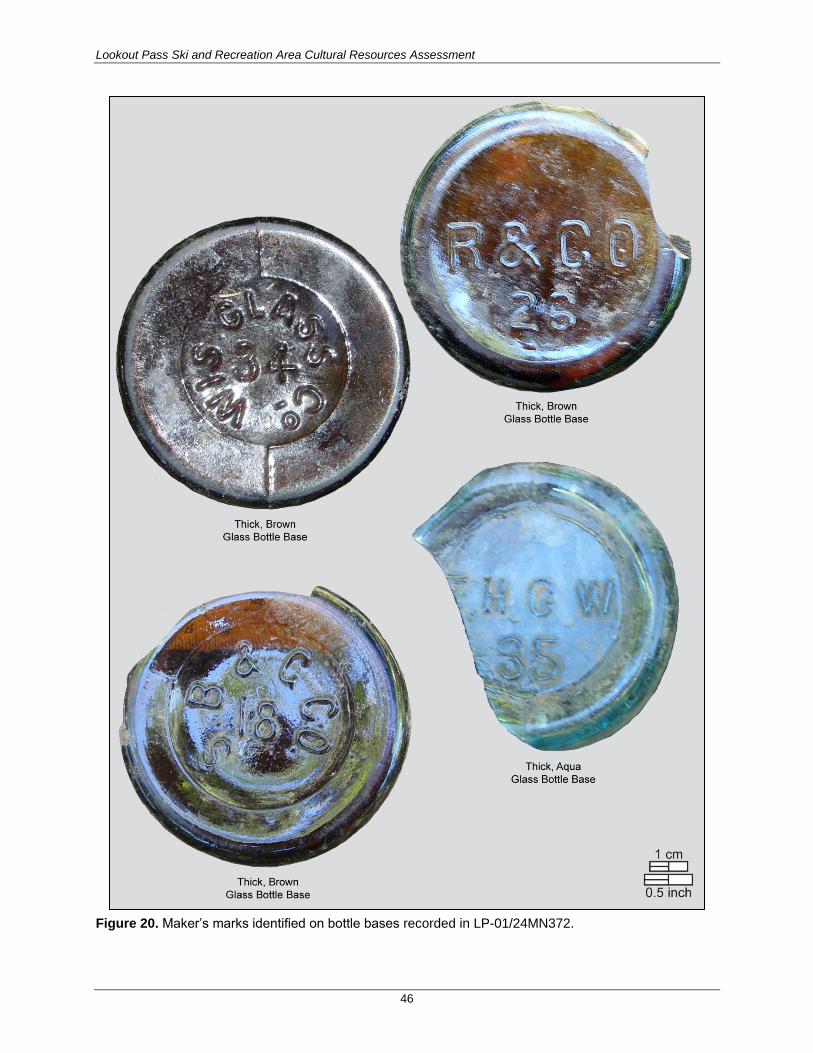
Lookout Pass Ski and Recreation Area Cultural Resources Assessment
46
Figure 20. Maker’s marks identified on bottle bases recorded in LP-01/24MN372.

Lookout Pass Ski and Recreation Area Cultural Resources Assessment
47
The area south of the ATV/Jeep road contains numerous small coniferous trees, each less than 4–5 feet
high, and at least 12 rounded holes, each measuring from approximately 50 to 75 cm in diameter and 20–
30 cm deep, were recorded south of the site (Figure 21). The vegetation on either side of the holes is
intact, and there was no evidence of adjacent spoil piles, suggesting that the sediments were removed
along with the root mass of the young trees. No evidence of historic debris associated with LP-
01/24MN372 was noted in or adjacent to the holes; however, the thick surface vegetation covering most
of the site area north and south of the road bed likely obscures additional historic debris on or
immediately below the ground surface. The presence of discrete artifact clusters and evidence of
subsurface artifacts suggest that this site retains integrity of location and materials.
NRHP Eligibility
This property is recommended eligible for the NRHP under Criteria A and D, because it is associated with
significant events in history (operation of the Mullan Road during the late 1800s and early 1900s), and is
likely to yield important new or additional information about the history and use of the area. The site,
however, is not associated with the lives of persons significant in our past and does not embody a
distinctive architectural style (Criteria B and C).
POTENTIAL EFFECTS
It is unlikely that the installation of a buried power cable within the existing ATV/Jeep road will affect the
historic debris scatter at LP-01/24MN372.
Figure 21. Open hole left by the excavation and removal of a sapling root mass, view to north.

Lookout Pass Ski and Recreation Area Cultural Resources Assessment
48
24MN120 (Northern Pacific Railroad Segment)
The segment of the Northern Pacific Railroad Bed located in the APE was previously recorded by the
LNF and found not eligible for the NRHP (Matthew 1985; McLeod 1985). Other segments of the same
rail line in Montana are considered eligible. This site was assigned Smithsonian Trinomial 24MN120
(Lindeman et al. 1984).
CURRENT INVESTIGATIONS
On June 12, 2015, SWCA archaeologists conducted a pedestrian survey and recorded the portion of the
Northern Pacific Railroad Bed (24MN120) located in the APE in Montana, south of Lookout Pass (Figure
22). Cross-section profiles were drawn at three locations to characterize the current condition of the grade
bed and of the cut and fill slopes in the proposed area of ground disturbance.
SITE DESCRIPTION
The Northern Pacific Railroad Bed is identifiable for over 550 feet in the APE, and the road bed ranges
from 15.0 to 16.5 feet wide. Artifacts identified along the edges of the grade in the site area include a rail
bracket and tie spikes, a utility pole with a green glass insulator (marked with the date: OCT 8 1907), a
ceramic insulator fragment, and a possible rail section that is partially buried in the downslope fill (see
Figure 22).
This section of the rail line was built between 1890 and 1891 and deconstructed and abandoned in 1980.
Following abandonment, the railroad bed was graded and widened to support car and truck use. Aside
from the green glass insulator, the historic artifacts and other materials identified along the shoulders of
the current road bed do not exhibit temporally diagnostic features or maker’s marks and do not provide
any additional information regarding the use of the rail line in this area.
EVALUATION OF SIGNIFICANCE
Integrity
The railroad bed has been significantly altered by the removal of the rails and ties and by its conversion
to, and use as, a dirt access road. The Northern Pacific Railroad Bed does not retain integrity of materials,
workmanship, feeling, and association.
NRHP Eligibility
Although this property is associated with significant events in history (specifically the western expansion
of the railroad system), it is not associated with the lives of persons significant in our past, does not
embody a distinctive architectural style, and is unlikely to yield new or additional information pertaining
to the history of the area. This segment of the rail line does not contribute to the NRHP eligibility of the
larger eligible site, nor is it recommended individually eligible for the NRHP under Criteria A, B, C and
D.
POTENTIAL EFFECTS
No adverse effect to this site is expected from proposed expansion of the existing road bed through
grading to expand the existing parking area to the south.

Lookout Pass Ski and Recreation Area Cultural Resources Assessment
49
Redacted from public version.
Figure 22. Northern Pacific Railroad Segment (24MN120) site map.

Lookout Pass Ski and Recreation Area Cultural Resources Assessment
50
24MN133-G (the Mullan Road, St. Regis [Sohon] Pass to St. Regis River segment)
The segment of the Mullan Road in the APE is the first of six segments most recently recorded and
described by Ben Munger (1985).
CURRENT INVESTIGATIONS
On June 15, 2015, SWCA archaeologists conducted a pedestrian survey of the Mullan Road, recorded the
route using the high-precision GPS, and documented the characteristics of the wagon road bed in and
adjacent to the proposed ground disturbance areas in the APE between St. Regis Pass and the St. Regis
River (Figure 23). Cross-section profiles were drawn at seven locations along the route to characterize the
current condition of the road bed at proposed ground disturbance areas identified on project maps
available during fieldwork. All mineral soil exposures (i.e., cleared ATV/Jeep road beds, tree throws, and
other natural vegetation clearings) within 15 m on the east and west sides of the road bed were inspected.
SITE DESCRIPTION
The Mullan Road was built over St. Regis (Sohon) Pass in the fall of 1859. The Mullan Road was in use
during the period following its completion in 1860 through the early 1900s. The tread of the Mullan Road
ranges in width from 5 to 8 feet, and the tread surface is typically approximately 6 inches below the
surrounding grade. Parallel wagon treads are visible in some portions of the road (see Figure 23, Cross
Section 4), and low berms, typically less than 4–6 inches high and up to 4 feet wide were noted
intermittently on both sides of the main tread. Volunteer foresters visited the project during the 2015
survey and collected tree ring cores from multiple large, mature standing trees along the Mullan Road on
either side of St. Regis Pass. These foresters identified one very large tree along the Mullan Road route
between the locations of Cross Sections 3 and 4 that was older than 200 years (see Figure 23). This tree
was present during the construction and use of the Mullan Road, and it survived the 1910 fire that killed
most of the other large, mature trees in this region. With the exception of those recorded at LP-
01/24MN372, no artifacts were identified in or adjacent to the Mullan Road bed.
From the crest of St. Regis Pass, where it is crossed by an ATV/Jeep trail, the tread of the Mullan Road is
visible on the ground surface for nearly 3,000 feet before it intersects the St. Regis River. Along its
length, this portion of the Mullan Road is crossed by ATV/Jeep trails at three locations; the first is
approximately 600 feet southwest of the Idaho-Montana border at St. Regis Pass, the second is
approximately 830 feet from the border, and the third is approximately 2,900 feet from southeast of the
pass where it is crossed by the ATV/Jeep trail that parallels the southern boundary of the APE.
EVALUATION OF SIGNIFICANCE
Integrity
The segments of the Mullan Road recorded in and adjacent to the location of proposed ground-disturbing
activities are some of the longest and most intact segments of the historic route. Although the Mullan
Road has already been crossed in three locations in the APE on the Montana side of St. Regis Pass, the
remaining, intact segments of the roadbed are similar in length and character to the segments that are
already NRHP-listed. These segments of the Mullan Road retain integrity of materials, workmanship,
feeling, and association.

Lookout Pass Ski and Recreation Area Cultural Resources Assessment
51
Redacted from public version.
Figure 23. The Mullan Road (24MN133-G) site area overview.

Lookout Pass Ski and Recreation Area Cultural Resources Assessment
52
NRHP Eligibility
This property is recommended eligible for the NRHP under Criteria A and B, because it is associated with
Captain John Mullan who played an important role in the development of transportation in Idaho,
Montana, and Washington as a surveyor for the first transcontinental railroad across these states and as
the leader for construction of the Mullan Road. At this time, this segment of the Mullan Road does not,
however, embody a distinctive architectural style (Criterion C), nor does it contain intact archaeological
deposits that are likely to add important information about local or regional history (Criterion D).
Potential Effects
Clearing of trees from the Mullan Road route and from areas visible from the road would adversely affect
the feeling, workmanship, and character of the road. Ground disturbance produced by falling or skidding
trees across the road, widening of existing ATV/Jeep trails, and new road construction would pose a
direct adverse effect to the characteristics and integrity of the Mullan Road.
Isolated Artifacts
IO-01 (LITHIC DEBITAGE)
A fine-grain volcanic secondary flake was recovered approximately 20 cmbs in SP 24, excavated in a
level area near the crest of a ridge west of St. Regis Pass (Figure 24). No additional pieces of lithic
debitage were identified in shovel probes placed at 5- and 10-m intervals around SP 24. The artifact was
not collected, but was placed in a plastic bag and buried during the backfilling of the excavated shovel
probe.
Resources Noted but Not Recorded
State Line Survey Boundary Markers
Three types of state line survey boundary markers were observed during the survey: 1) modern, stamped
capped-pipe survey datum markers were observed at two locations in the western portion of the property;
2) a rock cairn and pipe datum were located adjacent to a more modern stamped-cap datum; and 3) two
blazed trees were observed on the flanks of Runt Mountain east of St. Regis Pass. The positions of these
markers were documented in the field using GPS. The markers were photographed but not formally
recorded with the Idaho or Montana SHPOs. During the Idaho-Montana Boundary Survey (1904–1905),
the survey used brass caps with raised letters with MONT on the east side and IDA on the west with a
raised X in the center (Krueger 1964:5–7). In his notes, the surveyor also describes excavating pits in
cardinal directions around his markers and building a mound of earth to further highlight the position. The
rock cairn and pipe datum may represent the earliest of these boundary survey markers.
Mining Prospect Pits and Claim Markers
In all, four blazed trees, five prospect pits with associated claim trees (i.e., marked with one or more
blazes and a tobacco can), 64 prospect pits, and six trenches were observed in or immediately adjacent to
the proposed disturbance area (see Attachment E).

Lookout Pass Ski and Recreation Area Cultural Resources Assessment
53
Redacted from public version.
Figure 24. Location of IO-01 and adjacent shovel test probes.
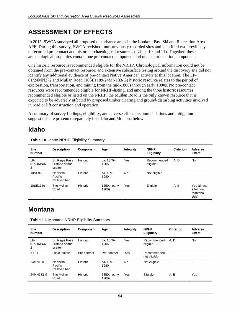
Lookout Pass Ski and Recreation Area Cultural Resources Assessment
54
ASSESSMENT OF EFFECTS
In 2015, SWCA surveyed all proposed disturbance areas in the Lookout Pass Ski and Recreation Area
APE. During this survey, SWCA revisited four previously recorded sites and identified two previously
unrecorded pre-contact and historic archaeological resources (Tables 10 and 11). Together, these
archaeological properties contain one pre-contact component and one historic period component.
One historic resource is recommended eligible for the NRHP. Chronological information could not be
obtained from the pre-contact resource, and extensive subsurface testing around the discovery site did not
identify any additional evidence of pre-contact Native American activity at this location. The LP-
01/24MN372 and Mullan Road (10SE1189/24MN133-G) historic resource relates to the period of
exploration, transportation, and mining from the mid-1800s through early 1900s. No pre-contact
resources were recommended eligible for NRHP-listing, and among the three historic resources
recommended eligible or listed on the NRHP, the Mullan Road is the only known resource that is
expected to be adversely affected by proposed timber clearing and ground-disturbing activities involved
in road or lift construction and operation.
A summary of survey findings, eligibility, and adverse effects recommendations and mitigation
suggestions are presented separately for Idaho and Montana below.
Idaho
Table 10. Idaho NRHP Eligibility Summary
Site Number
Description Component Age Integrity NRHP Eligibility
Criterion Adverse Effect
LP-01/24MN372
St. Regis Pass Historic debris scatter
Historic ca. 1870–1905
Yes Recommended eligible
A, D No
10SE888 Northern Pacific Railroad bed
Historic ca. 1891–1980
No Not eligible – –
10SE1189 The Mullan Road
Historic 1850s–early 1900s
Yes Eligible A, B Yes (direct effect on Montana side)
Montana
Table 11. Montana NRHP Eligibility Summary
Site Number
Description Component Age Integrity NRHP Eligibility
Criterion Adverse Effect
LP-01/24MN372
St. Regis Pass Historic debris scatter
Historic ca. 1870–1905
Yes Recommended eligible
A, D No
IO-01 Lithic Isolate Pre-contact Pre-contact Yes Recommended not eligible
– –
24MN120 Northern Pacific Railroad bed
Historic ca. 1891–1980
No Not eligible – –
24MN133-G The Mullan Road
Historic 1850s–early 1900s
Yes Eligible A, B Yes

Lookout Pass Ski and Recreation Area Cultural Resources Assessment
55
Mitigation
The Forest Service is currently developing a Memorandum of Agreement with the Montana SHPO which
will include mitigation measures to address adverse effects to the Mullan Road. These mitigation
measures, when finalized, will be implemented in addition to prior minimization efforts that involved re-
routing a proposed ski trail and temporary access roads to reduce the amount of direct impact to the
Mullan Road.

Lookout Pass Ski and Recreation Area Cultural Resources Assessment
56
REFERENCES CITED
Adams, Glen (editor)
1999 The Coeur d’Alene Indian Reservation. Ye Galleon Press, Fairfield, Washington.
Alt, David D., and Donald W. Hyndman
1989 Roadside Geology of Idaho. Mountain Press Publishing Company, Missoula, Montana.
Avista Power Company
2014 Redundant loop for emergency power feed. E-mail correspondence between Robin
Bekkedahl, Senior Environmental/Cultural Scientist for Avista, and Susan Wilmot, SWCA
Environmental Consultants, June 4, 2014.
Bacon, Sydney
2010a Cultural Site Record Update, 45MN150, Leslie Adit. On file with the Montana State
Historic Preservation Officer, Helena, Montana.
2010b Cultural Site Record, 45MN151, Cooper (Sildex) Lake Dam. On file with the Montana State
Historic Preservation Officer, Helena, Montana.
Bemis, Samuel F.
1923 Captain John Mullan and the Engineers’ Frontier. The Washington Historical Quarterly
14(3):201–205.
Bennett, Earl H., Peter L. Siems, and James T. Constantopoulos
1989 The Geology and History of the Coeur d’Alene Mining District, Idaho. In Guidebook to the
Geology of Northern and Western Idaho and Surrounding Area, edited by V.E.
Chamberlain, R.M. Breckenridge, and B. Bonnichsen, pp. 137–156. Idaho Geological
Survey Bulletin No. 29. University of Idaho, Moscow, Idaho.
Bolton, Joy, and Ann Hubber
1990 National Register of Historic Places Registration Form, Shoshone Park Picnic Area,
10SE749. On file with the Idaho State Historic Preservation Officer, Boise, Idaho.
Boreson, Keo
1988 A CRS of the Bonneville Power Administration’s Taft-Bell Transmission Line Project,
Western Montana to Northeastern Washington. Report prepared for BPA by Archaeological
and Historical Services, Cheney, Washington.
Chamberlain, V.E., Roy M. Breckenridge, and Bill Bonnichsen
1989 Guidebook to the Geology of Northern and Western Idaho and Surrounding Areas. Idaho
Geological Survey Bulletin No. 29. University of Idaho, Moscow, Idaho.
Chatters, James C.
1998 Environment. In Handbook of North American Indians Volume 12: Plateau, edited by D.
Walker, pp. 29–48. Smithsonian Institution, Washington, D.C.

Lookout Pass Ski and Recreation Area Cultural Resources Assessment
57
2000 Archaeological and Historical Survey Report for the American Tower Corporation Wireless
Facility Larson #43407, Shoshone County, Idaho. Report prepared for American Tower
Corporation, Seattle, Washington.
Clague, J.J.
1980 Late Quaternary Geology and Geochronology of British Columbia—Part 1, Radiocarbon
Dates. Geological Survey of Canada Paper 80-13.
1981 Late Quaternary Geology and Geochronology of British Columbia—Part 2, Summary and
Discussion of Radiocarbon-dated Quaternary History. Geological Survey of Canada Paper
80-35.
Cohen, Stan
2007 Downhill in Montana. Pictorial Histories Publishing Company, Inc., Missoula, Montana.
Dahlgren, Dorothy, and Simone Carbonneau-Kincaid
1996 In All the West No Place Like This: A Pictorial History of the Coeur d’Alene Region.
Museum of North Idaho, Coeur d’Alene, Idaho.
Edholm, Phil
2013 Personal communication with Scott Weber of Avista Power Company regarding power line
capacity and location.
Ferguson, David
2000 Archaeological Investigations at the Janssen Site (24PR1599), Power River County,
Montana. Prepared for the Montana Department of Transportation, Helena, Montana, by
GCM Services, Inc.
Frison, George C.
1978 Prehistoric Hunters of the High Plains. Academic Press, New York.
1991 Prehistoric Hunters of the High Plains, 2nd ed. Academic Press, New York.
Frison, George C., David Schwab, L. Adrien Hannus, Peter Winham, David Walter, and Robert C.
Mainfort
1996 Archaeology of the Northwestern Plains. In Central and Northern Plains Archaeological
Overview Series - Archaeological and Bioarchaeological Resources of the Northern Plains,
edited by G.C. Frison and R.C. Mainfort, pp. 8–40. Arkansas Archaeological Survey
Research Series No. 47. U.S. Department of Defense and U.S. Army Corps of Engineers.
Greenough, W. Earl
1947 First 100 Years: Coeur d’Alene Mining Region, 1846-1946. W. Earl Greenough, Mullan,
Idaho.
Greiser, Sally T.
1984 Projectile Point Chronologies of Southwestern Montana. Archaeology in Montana 25(1):35–
51.
1994 Late Prehistoric Cultures on the Montana Plains. In Plains Indians, A. D. 500-1500: The
Archaeological Past of Historic Groups, edited by K.H. Schlesia, pp. 34–55. University of
Oklahoma Press, Norman, Oklahoma.

Lookout Pass Ski and Recreation Area Cultural Resources Assessment
58
Greiser, Sally T., T. Weber Greiser, and Susan M. Vetter
1985 Middle Prehistoric Period Adaptations and Paleoenvironment in the Northwestern Plains:
The Sun Rive Site. American Antiquity 50(4):849–877.
Greiser, T.W.
2002 Addendum to: Results of a CRI for the Touch America/AT&T Fiber Optic Cable Route along
Interstate 90 in Idaho. Prepared for Power Engineers, Inc., Hailey, Idaho, by Historical
Research Associates, Inc., Missoula, Montana.
Greiser, T.W., and D. Hagen
2000 Results of a Cultural Resources Inventory for the Touch America/AT&T Fiber Optic Cable
Route along Interstate-90 in Idaho. Prepared for Power Engineers, Hailey, Idaho, by HRA,
Missoula, Montana.
Greiser, T.W., Matt Thomas, Delia Hagen, and Derek Beery
2000 Results of a Cultural Resources Inventory for the Touch America/AT&T Fiber Optic Cable
Route between Billings and Lookout Pass in Montana. Prepared for Power Engineers, Inc.
Hailey, Idaho, by HRA, Missoula, Montana.
Harrison, J.E., A.B. Griggs, A.B., and J.D. Wells
1974 Tectonic Features of the Precambrian Belt Basin and Their Influence on Post Belt
Structures. U.S. Geological Survey Professional Paper 86. U.S. Government Printing Office,
Washington, D.C.
1986 Geologic and Structure Maps of the Wallace 1° x 2° Quadrangle, Montana and Idaho. Atlas
4-A. Scale 1:250,000. Montana Bureau of Mines and Geology, Butte, Montana.
Hill, M.
2005 Central Zone Physical Safety Hazard Removal. Idaho Panhandle National Forest, Coeur
d’Alene, Idaho.
Holstine, Craig
1982 Cultural Site Record, 24MN120, Northern Pacific Railroad Grade at Taft. On file with the
Montana State Historic Preservation Officer, Helena, Montana.
1986 CRS of Eleven Fly Yards and Three Gravel Quarry Sites on the Bonneville Power
Administration’s Taft-Bell 500 KV Transmission Line Project, North Idaho. Report prepared
for Bonneville Power Administration by Archaeological and Historical Services, Eastern
Washington University, Cheney, Washington.
Idaho Panhandle National Forests
2007 Idaho Panhandle National Forest Heritage Guidelines, Site Investigation Strategy. U.S.
Department of Agriculture Forest Service, Idaho Panhandle National Forest’s Supervisors
Office, Coeur d’Alene, Idaho.
Jones, Bill
1986 CRI of the Hecla Mining Company Exchange, Wallace Ranger District, Idaho Panhandle
National Forest. Report No. 86-IP-I-27. Report prepared by Idaho Panhandle National
Forest, Coeur d’Alene, Idaho.

Lookout Pass Ski and Recreation Area Cultural Resources Assessment
59
Kennedy, Hal Kirk
1976 An Examination of the Tucannon Phase as a Concept: Step One. Unpublished Master’s
Thesis. University of Idaho, Moscow, Idaho.
Knight, George C.
1989 Overview: Ecological and Cultural Prehistory of the Helena and Deerlodge National
Forests, Montana. U.S. Department of Agriculture Forest Service, Helena National Forest,
Helena, Montana.
Krueger, Carl. G.
1964 Route of the Mullan Road over the Bitterroot Divide. Coeur d’Alene National Forest, Coeur
d’Alene, Idaho.
Leonhardy, Frank C., and David G. Rice
1970 Proposed Culture Typology for the Lower Snake River Region, Southeast Washington.
Northwest Anthropological Research Notes 4(1):1–65.
Lindeman, Glen W., Craig Holstine, Ruth Anne Masten, and Glenn D. Hartmann
1984 A Cultural Resources Survey of the Bonneville Power Administration’s Garrison-Taft 500-
kV Transmission Line Project. Archaeological and Historical Services, Eastern Washington
University, Cheney, Washington.
Lonn, Jeffrey D. and Mark D. McFaddan
1999 Geologic Map of the Montana Part of the Wallace 30’ x 60’ Quadrangle. Open File Report
MBMG 388. Partial support by STATEMAP, National Cooperative Geologic Mapping
Program, U.S. Geological Survey. Montana Bureau of Mines and Geology, Butte, Montana.
Mattson, Daniel M., Ruthann Knudson, Robert Lee Sappington, and Michael A. Pfeiffer
1983 Cultural Resources Investigations of the Dworshak Reservoir Project, North Fork
Clearwater River, Northern Idaho. University of Idaho Anthropological Research
Manuscript Series No. 74. University of Idaho, Moscow, Idaho.
Matthew, Kirby
1985 Addendum to 45MN120 Coeur d’Alene Branch of the Northern Pacific – Copper Gulch
(Sildex Mine) to Montana-Idaho State Line at Lookout Pass. On file with the Montana State
Historic Preservation Officer, Helena, Montana.
Matthew, Kirby, and C. Milo McLeod
1983a St. Regis Basin Small Sale Proposed Cross Country Ski Route. Lolo National Forest,
Superior Ranger District.
1983b Cultural Site Record, 45MN137, Sildex Mine. On file with the Montana State Historic
Preservation Officer, Helena, Montana.
1984a Copper Gulch Mining Exploration. Lolo National Forest, Superior Ranger District.
1984b St. Regis Basin Drill Tests. Lolo National Forest, Superior Ranger District.
Lookout Pass Ski and Recreation Area Cultural Resources Assessment
60
Matthew, K., and B. Munger
1984a Cultural Site Record, 45MN150, Leslie Adit. On file with the Montana State Historic
Preservation Officer, Helena, Montana.
1984b Cultural Site Record, 45MN151, Cooper (Sildex) Lake Dam. On file with the Montana State
Historic Preservation Officer. Helena, Montana.
Mattson, Daniel M., Ruthann Knudson, Robert Lee Sappington, and Michael A. Pfeiffer
1983 Cultural Resources Investigations of the Dworshak Reservoir Project, North Fork
Clearwater River, Northern Idaho. University of Idaho Anthropological Research
Manuscript Series No. 74. University of Idaho, Moscow, Idaho.
Matz, S.
2009 Shoshone Cabin Well. Idaho Panhandle National Forest, Coeur d’Alene, Idaho.
McLeod, C. Milo
1985 Ski Area Salvage Timber Sale Area. Lolo National Forest, Superior Ranger District.
McLeod, C. Milo, and Douglas Melton
1986 The Prehistory of the Lolo and Bitterroot National Forests: An Overview. Lolo and
Bitterroot National Forests, U.S. Department of Agriculture Forest Service, Northern
Region, Missoula.
McLeod, Milo C., Timothy Light and Mary Horstman Williams
2003 Site Identification Strategy Prepared for Bitterroot, Flathead, and Lolo National Forests.
U.S. Department of Agriculture Forest Service, Northern Region, Montana and Idaho.
Mitcham, T.W.
1952 Indicator Minerals, Coeur d’Alene Silver Belt. Economic Geology 47(4):415–450.
Miller, F.L.
1884 Map of the Coeur d’Alene Mines and Vicinity, Idaho Territory. Miller and Williams,
Portland, Oregon.
Mineral County Historical Society
2004 Mineral County History. Mineral County Historical Society, Superior, Montana.
Mullan, John
1863 Report on the Construction of a Military Road from Fort Walla Walla to Fort Benton.
Government Printing Office, Washington, D. C. Reprinted in 1994 with an Introduction by
Kimberly Rice Brown and Biography of John Mullan by Glen Adams.
Mulloy, William T.
1958 A Preliminary Historical Outline for the Northwestern Plains. University of Wyoming
Publications 22(1):1–235.
Munger, Ben
1985 Cultural Site Record, 24MN133, Mullan Road Segment (Sohon Pass to Sildex Mine). On
file with the Montana State Historic Preservation Officer, Helena, Montana.

Lookout Pass Ski and Recreation Area Cultural Resources Assessment
61
1993 Whitebark Pine: A Prehistoric Food Source at Timberline in the Bitterroot Mountains of
Montana. Thesis, Masters of Arts, Anthropology. University of California, Santa Barbara,
California.
1994 High-Country Archaeology in the Bitterroot Mountains. Report prepared for the Beaverhead
National Forest, Montana.
Palmer, Gary B.
1998 Coeur d’Alene. In Handbook of North American Indians Volume 12: Plateau, edited by D.E.
Walker, Jr., pp. 313–326. Smithsonian Institution, Washington, D.C.
Palmer, Gary B., Lawrence Nicodemus, and Lavinia Felsman
1987 Khwi' Khwe Hntmikhw'lumkhw “This is my Land:” A Workbook in Coeur d’Alene Indian
Geography. Coeur d’Alene Tribe, Plummer, Idaho, and Department of Anthropology and
Ethnic Studies, University of Nevada, Las Vegas, Nevada.
Peltier, Jerome
1975 Manners and Customs of the Coeur d’Alene Indians. Peltier Publications, Spokane,
Washington.
Porter, S.C.
1978 Glacier Peak Tephra in the North Cascade Range, Washington: Stratigraphy, Distribution,
and Relationship to Late Glacial Events. Quaternary Research 10:30–41.
Porter, S.C., and G.H. Denton
1967 Chronology of Neoglaciation in the North American Cordillera. American Journal of
Science 267:177–210.
Ransome, Frederick L., and Frank C. Calkins
1908 The Geology and Ore Deposits of the Coeur d’Alene District, Idaho. U.S. Geological Survey
Professional Paper 62. Government Printing Office, Washington, D.C.
Ray, J., Aubrey Morrison, Lorelea Hudson, and Christian Miss
2005 Avista Transmission Line. Report prepared for Avista Corp., Spokane, Washington, by
NWAA, Seattle, Washington.
Ray, Verne
1936 Native Villages and Groupings of the Columbia Basin. The Pacific Northwest Quarterly
XXVII: 99–152.
Reininghaus, Lee, Sydney Bacon, and Ed DeCleva
2010 Summer Trails Environmental Assessment Heritage Program Cultural Resources Analysis.
Lolo National Forest, Superior Ranger District.
Lookout Pass Ski and Recreation Area Cultural Resources Assessment
62
Reeves, Brian O.K.
1969 The Southern Alberta Paleo-Cultural - Paleo-Environmental Sequence. In Post-Pleistocene
Man and His Environment on the Northern Plains, edited by R.G. Forbis, L.B. Davis, O.A.
Christensen, and G. Fedirchuk, pp. 6–46. Proceedings of the First Annual Paleo-
Environmental Workshop of the University of Calgary Archaeological Association. The
Student’s Press, Calgary, Canada.
1974 Crowsnest Pass Archaeological Project 1973 Salvage Excavations and Survey. Natural
Museum of Man Mercury Series No. 24. Ottawa, Canada.
Rice Brown, Kimberly
1994 Introduction. In Report on the Construction of a Military Road from For Walla-Walla to Fort
Benton (reprint). Originally published by John Mullan in 1863.
Ritchie, Carl
1991a Cultural Site Record, 10SE888, Railroad Bed. On file with the Idaho State Historic
Preservation Officer, Boise, Idaho.
1991b Cultural Site Record, 10SE1002, Historic Cabin Remnants. On file with the Idaho State
Historic Preservation Officer, Boise, Idaho.
1991c Cultural Site Record, 10SE1003, Historic Habitation Remnants. On file with the Idaho State
Historic Preservation Officer, Boise, Idaho.
1991d Cultural Site Record, 10SE1004, Historic Cabin Remnants. On file with the Idaho State
Historic Preservation Officer, Boise, Idaho.
1991e Cultural Site Record, 10SE1005, Historic Mining Adit (Collapsed). On file with the Idaho
State Historic Preservation Officer, Boise, Idaho.
1991f Cultural Site Record, 10SE1007, Historic Mining Camp/Placer Ditch (Remnants). On file
with the Idaho State Historic Preservation Officer, Boise, Idaho.
1991g Cultural Site Record, 10SE1008, Historic Timber Extraction Area. On file with the Idaho
State Historic Preservation Officer, Boise, Idaho.
1991h Cultural Site Record, 10SE1189, Historic Wagon Road (Mullan’s Military Road). On file
with the Idaho State Historic Preservation Officer, Boise, Idaho.
1992 Snowstorm Daisy Timber Sale. Idaho Panhandle National Forest, Coeur d’Alene, Idaho.
Roll, Tom E., and Steven Hackenberger
1998 Prehistory of the Eastern Plateau. In, Handbook of North American Indians Volume 12:
Plateau, edited D.W. Walker, Jr., pp. 120–137. Smithsonian Institution, Washington, D. C.
Rumley, Charles
1862 Diary of Charles Rumley from St. Louis to Portland, 1862. Edited by Helen Addison
Howard. Manuscript on file at the Mineral County Historical Museum, Superior, Montana.
Sappington, Robert Lee
1988 Archaeological Test Excavation and Evaluation of the Proposed Clearwater Fish Hatchery
Site (10-CW-4), on the North Fork of the Clearwater River, North Central Idaho.
Contributions by B. Cochran and T.L. Ozbun. University of Idaho Anthropological Reports
No. 88. Alfred W. Bowers Laboratory of Anthropology, University of Idaho, Moscow,
Idaho.
Lookout Pass Ski and Recreation Area Cultural Resources Assessment
63
1994 The Prehistory of the Clearwater River Region, North Central Idaho. University of Idaho
Anthropological Reports No. 95. Alfred W. Bowers Laboratory of Anthropology, University
of Idaho, Moscow, Idaho.
Sears, Jim
1983 A Continental Ramp Margin in the Cordilleran Thrust Belt along the Montana Lineament.
Geological Society of America Abstracts with Program (15):682.
Seltice, Joseph
1990 Saga of the Coeur d’Alene Indians: An Account of Chief Joseph Seltice. Edited by E.J.
Kowrach, and T.E. Connolly. Ye Galleon Press, Fairfield, Washington.
Sims, Cort
1971 Edged Cobbles in the Pacific Northwest. Tebiwa 14(2):21–38.
1981 Hecla Land Exchange (423). Idaho Panhandle National Forest, Coeur d’Alene, Idaho.
1986 Cultural Site Record, 10SE790, Lookout Pass Ski Lodge. On file with the Idaho State
Historic Preservation Officer, Boise, Idaho.
1987a Wallace Ranger District Facilities. Idaho Panhandle National Forest, Coeur d’Alene, Idaho.
1987c Cultural Site Record, 10SE749, Cabin, Garage, and Two Picnic Shelters (Shoshone Park).
On file with the Idaho State Historic Preservation Officer, Boise, Idaho.
1987b Sale of Lookout Ski Lodge. Idaho Panhandle National Forest, Coeur d’Alene, Idaho.
1989 National Register of Historic Places Registration Form, Mullan Road (Cedar Creek/Alder
Creek Segment, Fourth of July Pass Segment, Heyburn State Park Segment). On file with
the Idaho State Historic Preservation Officer, Boise, Idaho.
1996a Clearwater Realty-Upper Priest Lake Land Exchange. Idaho Panhandle National Forest,
Coeur d’Alene, Idaho.
1996b Cultural Site Record, 10SE1154, Mining Claim. On file with the Idaho State Historic
Preservation Officer, Boise, Idaho.
Smith, Robert Wayne
1932 History of Placer and Quartz Gold Mining in the Coeur d’Alene District. Master’s thesis,
University of Idaho, Moscow, Idaho.
Strachan, John
1861 Blazing the Mullan Road. Reprinted from the Rockford Register, April 1860–April 1861.
Housed at the University of Idaho Library, Moscow, Idaho.
Teit, James
1930 The Salishan Tribes of the Western Plateaus. In Forty-fifth Annual Report of the Bureau of
American Ethnology, edited by F. Boas. Reprinted in 1985 by Ye Galleon Press, Fairfield,
Washington.
Teske, A.J., Charles W. Sweetwood, Merle W. Wells, Rolland R. Reid, J.M. Whiting, Joseph Newton,
and E.F. Cook
1961 Idaho’s Mineral Industry…the First Hundred Years. Bulletin No. 18. Idaho Bureau of Mines and
Geology, Moscow, Idaho.

Lookout Pass Ski and Recreation Area Cultural Resources Assessment
64
Toulouse, J.H.
1971 Bottle Makers and Their Marks. Blackburn Press, Caldwell, New Jersey.
Walker, Deward E., Jr.
1978 Indians of Idaho. Gem Book. University of Idaho Press, Moscow, Idaho.
Walker, Deward E., Jr., and Roderick Sprague
1998 History until 1846. In Handbook of North American Indians Volume 12: Plateau, edited by
D. Walker, Jr., pp. 138–148. Smithsonian Institution Press, Washington. D.C.
Wallace, Robert E., and John W. Hosterman
1956 Reconnaissance Geology of Western Mineral County Montana: A Contribution to Economic
Geology. Geological Survey Bulletin 1027-M. U.S. Government Printing Office,
Washington, D.C.
Weisel, Charles
2002 Soil Survey of St. Joe Area, Parts of Benewah and Shoshone Counties, Idaho. U.S.
Department of Agriculture, National Resources Conservation in cooperation with the United
States Department of the Interior Bureau of Land Management, the University of Idaho
College of Agriculture, and the Idaho Conservation Commission. Available:
http://websoilsurvey.nrcs.usda.gov/app/. Accessed: September 18, 2015.
White, B.G.
1993 Diverse Tectonism in the Coeur d’Alene Mining District, Idaho. In Belt Symposium III,
edited by R.B. Berg, pp. 254–265. Montana Bureau of Mines and Geology Special
Publication 112. Butte, Montana.
Wilson, S.
2009 HECLA Special Use Permit. Idaho Panhandle National Forest, Coeur d’Alene, Idaho.
Winston, D.W.
1986 Middle Proterozoic Tectonics of the Belt Basin, Western Montana and Northern Idaho. In
Belt Supergroup: A Guide to Proterozoic Rocks of Western Montana and Adjacent Areas,
edited by S.M. Roberts, pp. 237–244. Montana Bureau of Mines and Geology Special
Publication 94. Butte, Montana.
Winther, Oscar O.
1945 Early Commercial Importance of the Mullan Road. Oregon Historical Quarterly 46:21–35.
Wood, John V.
1983 Railroads through the Coeur d’Alenes. The Caxton Printers, Ltd., Caldwell, Idaho.

Attachment A
Archaeological Resources Protection Act Permit


Attachment B–E
Redacted from public version.