Embed Size (px)
Citation preview

Project Name Downpatrick Eastern Distributor Road
Document Title Feasibility Study
Doc. Ref.: CO401425/Rep-01 Rev 07 Issued: March 2018
APPENDIX F: ENVIRONMENTAL CONSTRAINTS
REPORT
Environmental Report Downpatrick Eastern Distributor Road Feasibility Study CO401425-Rep-01 Revision 0
September 2017
Project Name Downpatrick Eastern Distributor Road
Document Title Environmental Feasibility Study Report
Document Control Sheet
Project Name: Downpatrick Eastern Distributor Road – Environmental Report
Project Number: CO401425
Report Title: Environmental Feasibility Study Report
Report Number: Rep-01
Issue Status/Amendment
Prepared Reviewed Approved
Revision 0
Name: Ruaidhri McKernan
Name: Helen Craig
Name: Helen Craig
Signature:
Date: 16/07/2017
Signature:
Date: 16/07/2017
Signature:
Date: 16/07/2017
Name:
Name:
Name:
Signature: Date:
Signature: Date:
Signature: Date:
Name:
Name:
Name:
Signature: Date:
Signature: Date:
Signature: Date:
Name:
Name:
Name:
Signature: Date:
Signature: Date:
Signature: Date:
Project Name Downpatrick Eastern Distributor Road
Document Title Environmental Feasibility Study Report
Doc. Ref.: CO401425/TP-REP-001/Rev 0 Issued: August 2017
TABLE OF CONTENTS
1 Introduction ............................................................................................... 2
1.1 Background ............................................................................................... 2
1.2 Project Brief .............................................................................................. 2
1.3 Methodology ............................................................................................. 2
2 Environmental Assessment ........................................................................ 4
2.1 Air Quality ................................................................................................. 4
2.2 Cultural Heritage ....................................................................................... 4
2.3 Landscape and Visual ................................................................................ 5
2.4 Nature Conservation .................................................................................. 6
2.5 Noise and Vibration ................................................................................... 7
2.6 Geology, Soils and Contaminated Land ........................................................ 7
2.7 Materials ................................................................................................... 8
2.8 People and Communities ............................................................................ 8
2.9 Road Drainage and the Water Environment ................................................. 9
3 Conclusions .............................................................................................. 10
3.1 Air Quality ............................................................................................... 10
3.2 Cultural Heritage ..................................................................................... 10
3.3 Landscape and Visual Impacts .................................................................. 10
3.4 Nature Conservation ................................................................................ 10
3.5 Noise and Vibration ................................................................................. 11
3.6 Geology and Soils .................................................................................... 11
3.7 Materials ................................................................................................. 11
3.8 People and Communities .......................................................................... 11
3.9 Road Drainage and Water Environment ..................................................... 11
4 References ............................................................................................... 12
Project Name Downpatrick Eastern Distributor Road
Document Title Environmental Feasibility Study Report
Doc. Ref.: CO401425/TP-REP-001/Rev 0 Issued: August 2017
1 Introduction
1.1 Background
1.1.1 In November 2016, TransportNI (now Department for Infrastructure-Roads (DfI-Roads)
appointed Amey to undertake a high-level feasibility study of an Eastern Distributor Road
in Downpatrick. The key objective of this study is to provide information to assist DfI-
Roads in discussions with key stakeholders on the possibility of providing this road in the
future.
1.2 Project Brief
1.2.1 The project brief from DfI-Roads requested the completion of a high-level examination
into the feasibility of an Eastern Distributor Road in Downpatrick. The aims of this study
are to gather existing traffic conditions, establish who would use the proposed distributor
road if constructed, and determine what relief it would provide to the town centre. It was
also requested that the assessment should provide a high-level engineering constraints
review of a preliminary route with the aim to provide a cost estimate that would assist DfI-
Roads in future discussions with key stakeholders.
1.3 Methodology
1.3.1 This report will identify environmental constraints within 50m of the proposed route. This
study area was chosen as representative of the proposed route and any minor alignment
changes that may result during the design process. Environmental constraints were
identified through a desk top review of following sources:
• Department of Agriculture, Environment and Rural Affairs Air Quality Management
Areas (AQMAs) (Ref. 1.1)
• Google Interactive Map Viewer (Ref. 1.2)
• Department for Communities Historic Environment Map Viewer (Ref. 1.3)
• Department of Agriculture, Environment and Rural Affairs Regional Landscape
Character Areas Map Viewer (Ref. 1.4)
• Department of Agriculture, Environment and Rural Affairs Protected Areas Web
Viewer (Ref. 1.5)
• Department of Agriculture, Environment and Rural Affairs Noise Map (Ref. 1.6)
Project Name Downpatrick Eastern Distributor Road
Document Title Environmental Feasibility Study Report
Doc. Ref.: CO401425/TP-REP-001/Rev 0 Issued: August 2017
• Geological Survey Northern Ireland Map Viewer (Ref. 1.7)
• Walk NI Website (Ref. 1.8)
• Sustrans Website (Ref. 1.9)
• Ards and Down Area Plan (ADAP) 2009 (Ref. 1.10)
• Department of Agriculture, Environment and Rural Affairs River Basin Viewer (Ref.
1.11)
• Department of Infrastructure Flood Maps (Ref. 1.12)
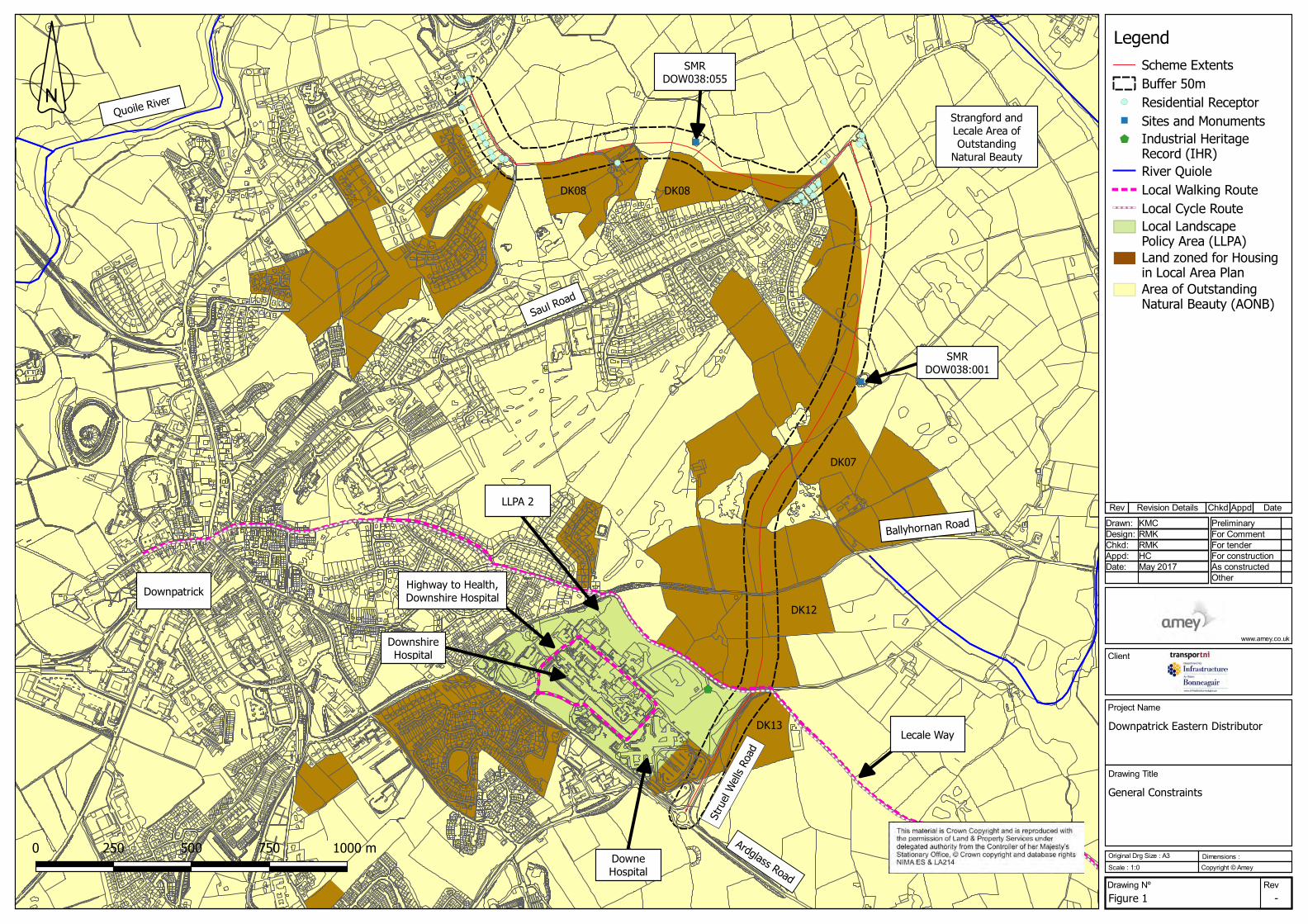
1.3.2 Figure 1.1 illustrates the key environmental constraints located within close proximity to
the proposed route.

Project Name Downpatrick Eastern Distributor Road
Document Title Environmental Feasibility Study Report
Doc. Ref.: CO401425/TP-REP-001/Rev 0 Issued: August 2017
2 Environmental Assessment
2.1 Air Quality
2.1.1 The scheme does not lie within or close to an Air Quality Management Area.
2.1.2 The scheme is situated in a rural area dominated by agricultural fields and small wooded
areas beyond the suburbs of Downpatrick. Sensitive receptors include 24 residential
receptors along Rathkeltair Road, Saul Road and Ballyhornan Road. Downe Hospital is
located approximately 20m west of the scheme, at Struell Wells Road.
The main source of air pollution is from traffic on neighbouring roads and junctions,
particularly the B1 Ardglass Road, Ballyhornan Road, Saul Road and A25 Strangford Road.
Table 2.1 outlines traffic flow data collected by Amey between 6-19th March 2017, including
the Annual Average Weekday Traffic (AAWT), along nearby link roads.
Table 2.1: Traffic Data for proximate link roads
Link Name Direction 18 Hr AAWT % HGV
24 Hr Average
Speed
(kmph)
Ardglass Road
(B1)
Northbound 1913 0.86 41.0
Southbound 1882 0.96 41.0
Ballyhornan
Road
Eastbound 1475 0.68 44.8
Westbound 1572 0.73 46.4
Saul Road Northbound 1026 0.29 31.4
Southbound 1054 0.24 32.7
Strangford
Road (A25)
Northbound 1485 0.64 36.0
Southbound 1423 0.84 38.4
2.2 Cultural Heritage
2.2.1 There are no scheduled monuments or listed buildings located within 50m of the proposed
alignment.
Project Name Downpatrick Eastern Distributor Road
Document Title Environmental Feasibility Study Report
Doc. Ref.: CO401425/TP-REP-001/Rev 0 Issued: August 2017
2.2.2 The closest site and monument record to the scheme is located approximately 10m north
of the scheme and is described as ‘Two Mounds’ (SMR DOW038:055). There is another
‘Mound’ site located 50m east of the scheme (SMR DOW038:001). These are shown on
Figure 1.1.
2.2.3 There are no Industrial Heritage Records within 50m of the scheme. The closest Industrial
Heritage Record to the scheme is the remnants of a gasworks building which is located
100m west of the scheme.
2.2.4 There are no registered battlefields or parks within a 50m radius of the scheme.
2.3 Landscape and Visual
2.3.1 The scheme is located within Strangford and Lecale Area of Outstanding Natural Beauty
(AONB). This coastal area follows the shores of a nearly landlocked inland sea and extends
inland up the Quoile River, dominated by the historic town of Downpatrick, and south
along the outward-facing shore of the Irish Sea. The lowland landforms consist of drumlin
hilltops poking out from the sea to form hundreds of islets within the Strangford Lough.
The landscape comprises a strong contrast between the expansive open lough and sea
and the surrounding hill slopes, and at a smaller scale between the marshy hollows and
river valleys and the 'basket of eggs' hills that contain them. The character of the shores
varies too, from the Lough’s extensive mudflats to rocky bays, sweeping sandy strands
and soft low cliffs on coast fringing the Irish Sea.
2.3.2 The scheme is located within the Strangford, Ards and Lecale Landscape Character Area
(LCA). The scheme is located in a rural area to the east of Downpatrick. The surrounding
landscape consists of scattered houses of varying sizes and styles, with farms on drumlin
tops. White finished buildings stand out in the landscape. Settlements are small scale and
clustered, larger settlements are on lower ground at river crossing points or coastal bays.
This area is rich in archaeology with a strong sense of history. Slieve Patrick forms a
prominent historic landmark within the area.
2.3.3 The land between the Ballyhornan Road and the Ardglass Road is designated as a Local
Landscape Policy Area (LLPA2) by the Ards and Down Area Plan 2015, as shown on Figure
2.2. This area contains the Downe Hospital and its attractive gardens and landscaped
grounds which provide an attractive entrance to Downpatrick.
Project Name Downpatrick Eastern Distributor Road
Document Title Environmental Feasibility Study Report
Doc. Ref.: CO401425/TP-REP-001/Rev 0 Issued: August 2017
2.3.4 Elsewhere the local area is comprised of large agricultural fields which extend over the
surrounding rolling hills. The field boundaries are formed by hedgerows and stone walls
which in conjunction with the rolling hills, forms short horizons. The local roads are lined
by hedgerows and occasional residential property accesses.
2.3.5 Visual receptors include local residents along the Strangford Road, Rathkeltair Road, Saul
Road, Ballyhornan Road and Ballysallagh Road.
2.4 Nature Conservation
2.4.1 The study area for nature conservation was extended to identify any Natura 2000 or other
designated sites where there may be a potential effect pathway with the scheme. Such
effect pathways (source-receptor link) include a watercourse crossing, flight path between
bird populations roosting and foraging habitat or offshore foraging habitat for marine
mammals.
2.4.2 Following a review of the DAERA Protected Areas Map Viewer, the following Natura 2000
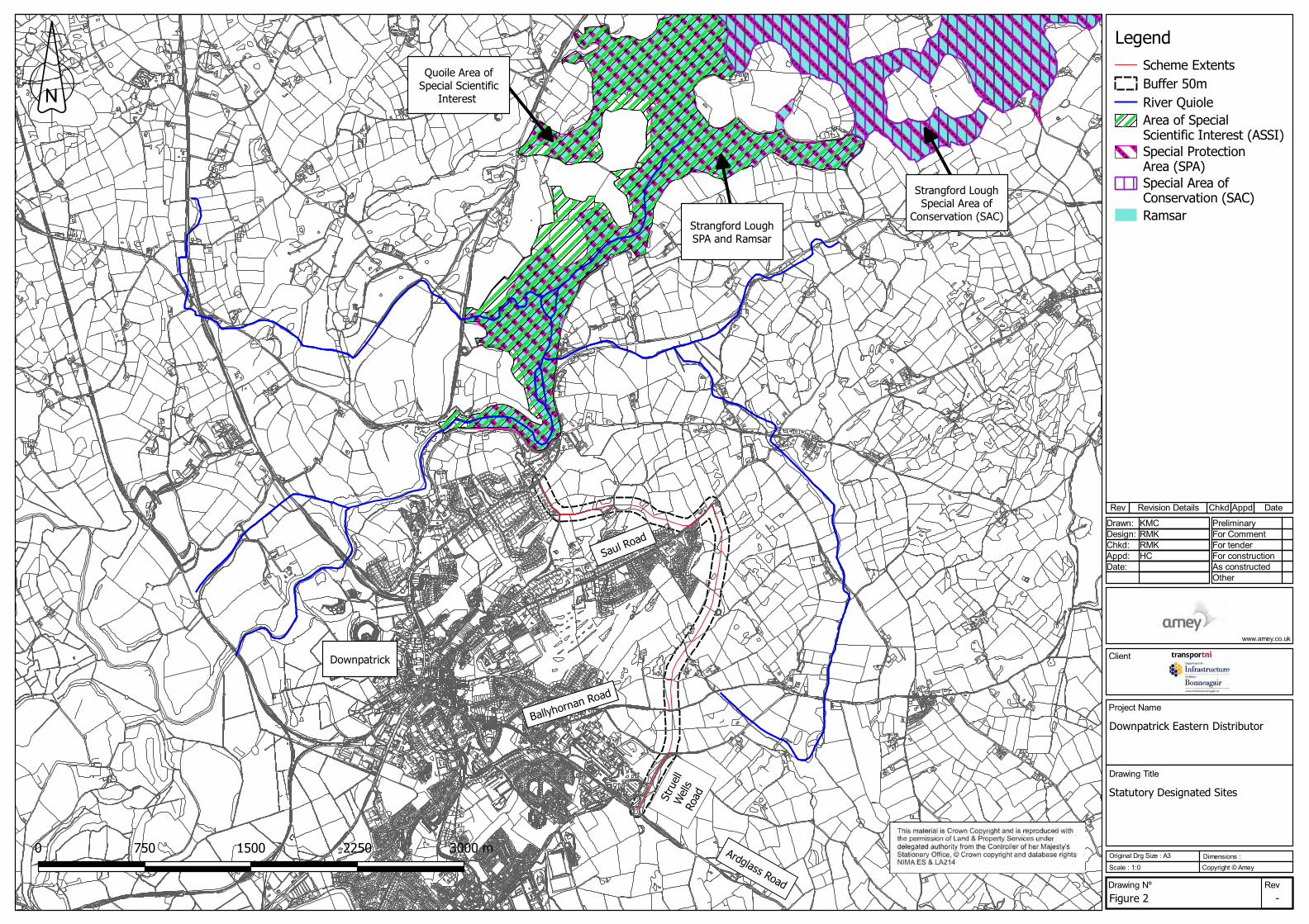
and other designated sites were identified. These are shown on Figure 2.1:
• Strangford Lough Special Area of Conservation (SAC) – is located approximately 3km
north of the scheme. It contains a number of species of interest and a diverse range
of marine flora and fauna which can be attributed to the immense tidal flow through
the Narrows and the resulting physiographical features. The shoreline habitat
incorporates large areas of mudflats that are used by internationally important
numbers of waders and wintering waterfowl. The site was designated as a SAC due
to the presence of the following habitats: mudflats and sandflats not covered by
seawater at low tide; coastal lagoons; large shallow inlets and bays; reefs; annual
vegetation of drift lines; perennial vegetation of stony banks and saltmarsh. The
lough is also important for harbour seal.
• Strangford Lough Special Protection Area (SPA) - is located approximately 0.2km
north of the scheme. The SPA is designated for its populations of European
important breeding bird species (sandwich tern, common tern and Arctic tern) and
wintering bird species (knot, light bellied brent goose and redshank) and its
internationally important assemblage of waterfowl.
• Strangford Lough Ramsar – is located approximately 0.2km north of the scheme.
Strangford Lough has been designated due to the presence of important wetland
features (freshwater habitats and extensive saltmarshes), assemblage of vulnerable

Project Name Downpatrick Eastern Distributor Road
Document Title Environmental Feasibility Study Report
Doc. Ref.: CO401425/TP-REP-001/Rev 0 Issued: August 2017
and endangered wetland plants and animal species (including marine sponges,
marine hydroids, marine mollusc and sea urchins) and assemblages of international
importance and its populations of European important bird species (sandwich tern,
common tern, red knot, light bellied brent goose, common redshank and common
shelduck).
• Quoile Area of Special Scientific Interest (ASSI) – is located approximately 0.2km
north of the scheme. It is designated for the quality and diversity of the vegetation
and its associated wildlife within the area.
2.4.3 The Ards and Down Area Plan 2015 has identified two Sites of Local Nature Conservation
Importance near Downpatrick, including Downpatrick Marshes (approximately 1.5km from
the scheme) and Portulla Wood (0.87km from the scheme). However, given their distance
from the scheme, it is considered unlikely that the scheme would result in any significant
impacts on them.
2.4.4 The River Quoile is a designated salmonid river and known for being a migratory route for
salmon, trout and eel.
2.4.5 The agricultural fields, hedgerows and wooded areas in the study area provide habitat for
a variety of terrestrial species.
2.5 Noise and Vibration
2.5.1 The scheme is located to the east of Downpatrick. The main source of noise is from traffic,
particularly on the Ballyhornan Road, B1 Ardglass Road and A25 Strangford Road.
2.5.2 A review of the NI Noise Mapping showed that the daytime noise levels along the existing
routes adjoining the proposed scheme are less than 50dB.
2.5.3 Sensitive receptors include 24 residential receptors along Rathkeltair Road, Saul Road and
Ballyhornan Road and community receptors at the Downe Hospital located approximately
20m west of the scheme.
2.5.4 The main source of noise pollution is from traffic on neighbouring roads and junctions,
particularly the B1 Ardglass Road, Ballyhornan Road, Saul Road and A25 Strangford Road.
Table x.1 outlines the traffic flows along the proximate link roads.
2.6 Geology, Soils and Contaminated Land
2.6.1 There are no designated geological sites within 50m of the proposed scheme.
Project Name Downpatrick Eastern Distributor Road
Document Title Environmental Feasibility Study Report
Doc. Ref.: CO401425/TP-REP-001/Rev 0 Issued: August 2017
2.6.2 The bedrock geology underlying the study area is a combination of Hawick Group
Sandstone and Gala Group Sandstone, while superficial geology is composed of till
(diamicton).
2.6.3 The UKSO soils map viewer indicates the presence of cambisol soils in the study area.
Cambisol soils are considered relatively fertile and are generally used for arable farming
and as grazing land.
2.6.4 There are no active quarries in close proximity to the scheme.
2.6.5 Aerial imagery and street maps do not indicate any potentially contaminative land uses.
Historic OS maps indicate that the only potentially contaminative land use within 50m of
the proposed scheme includes agricultural farming practices. However, there are remnants
of a gas works located 100m west of the scheme along the Struell Wells Road.
2.7 Materials
2.7.1 Existing material resources within the study area include railings, kerbs, signs and street
lights along the existing road infrastructure (Rathkeltair Road, Saul Road, Ballyhornan
Road, Struell Wells Road and Ardglass Road).
2.7.2 The scheme may result in the loss of virgin soil materials and the utilisation of finite
materials such as aggregates, bitmac and new kerbs.
2.7.3 Waste generated by the scheme is likely to include organic matter, road planings, kerbs
and excavated spoil.
2.8 People and Communities
2.8.1 There are public walkways located in close proximity to the scheme (including the Lecale
Way and a pathway at the Downshire Hospital). The scheme has the potential to sever
these pedestrian routes.
2.8.2 There are pedestrian pathways along the Ardglass Road, the Struell Wells Road and along
parts of the Saul Road. The pathways along the Ardglass Road and the Struell Wells Road
connect to the wider footpath network into Downpatrick town centre. Pedestrian facilities
include numerous crossing points on main roads.
2.8.3 Although there are no national cycle routes within the study area, it is possible that the
scheme could affect local cycle ways along the Ballyhornan Road / Struell Wells Road.
Project Name Downpatrick Eastern Distributor Road
Document Title Environmental Feasibility Study Report
Doc. Ref.: CO401425/TP-REP-001/Rev 0 Issued: August 2017
2.8.4 There are residential properties located adjacent to the proposed scheme along Rathkeltair
Road, Ardfern Road, Saul Road and Ballyhornan Road.
2.8.5 The extant development plan for the area is the Ards and Down Area Plan (ADAP) 2015.
According to the area plan, two areas of land have been zoned for phase 1 housing (DK
07 - 51.63 Hectares between Saul Road and Ballyhornan Road (1290 houses) and DK08 –
10.66 north off Ardenlee Gardens and Saul Road (266 houses)) and two areas of land
have been zoned for phase 2 housing (DK12 - 13.03 Hectares between Ballyhornan Road
and Struell Wells Road (325 houses) and DK13 – 6.21 hectares south east of Struell Wells
Road (124 houses)). These development areas are shown on Figure 1.1.
2.8.6 Community receptors in the vicinity include the Downe Hospital located 20m west of the
scheme, at the Struell Wells Road.
2.9 Road Drainage and the Water Environment
2.9.1 The Quoile River is located 220m north of the scheme and flows in a northerly direction
into Strangford Lough. Under the Water Framework Directive, the Quoile River
(Waterbody ID UKGBNI1NE050505115) has been classified as having a Poor overall WFD
status.
2.9.2 The Quoile Pondage is located downstream of the Quoile River. The Quoile Pondage is a
transitional waterbody and is designated as having Moderate Ecological Potential.
2.9.3 The groundwater underlying the scheme is the Downpatrick groundwater body and is
classed as having poor water quality.
2.9.4 The bedrock geology underlying the scheme area is a combination of Hawick Group
Sandstone and Gala Group Sandstone, while superficial geology is composed of till
(diamicton). There are no superficial aquifers. The bedrock aquifer is classed as Bl (f) – an
aquifer with limited productivity and fracture flow.
2.9.5 According to the Rivers Agency, the area is not affected by present day or future predicted
(climate change) river or sea flooding. The area is affected by small areas of present day
surface water flooding. Future climate change predictions reveal that surface water flood
risks will not be exacerbated.
2.9.6 Existing road drainage is in the form of pipes and gullies. Land drainage within the
greenfield areas is likely to comprise drainage channels along field boundaries. There are
numerous ponds located within the study area.

Project Name Downpatrick Eastern Distributor Road
Document Title Environmental Feasibility Study Report
Doc. Ref.: CO401425/TP-REP-001/Rev 0 Issued: August 2017
3 Conclusions
3.1 Air Quality
3.1.1 Due to the close proximity of highly sensitive residential receptors, a dust risk assessment
should be conducted for the construction phase and the appropriate level of mitigation
adhered to.
3.1.2 Given that the proposed route has the potential to re-distribute traffic flows within
Downpatrick; it is recommended that a simple assessment of air quality assessment is
undertaken in accordance with DMRB HA207/07. This will require air quality modelling
using predicted traffic flows.
3.2 Cultural Heritage
3.2.1 Given the close proximity of sites and monuments to the scheme, it is recommended that
a site visit is undertaken and that a simple assessment in undertaken in accordance with
DMRB HA208/07. As part of the assessment, it is recommended that consultation with the
Department for Communities Historic Environment Division is undertaken.
3.3 Landscape and Visual Impacts
3.3.1 Given the scale of this scheme and the greenfield nature of the scheme location, it is
recommended that a Landscape and Visual Impact Assessment is undertaken in
accordance with DMRB Volume 11 Section 3 Part 5 to explore the impacts on the landscape
and visual receptors.
3.4 Nature Conservation
3.4.1 There is a high potential for the study area to include protected habitats and species, thus
further ecological assessment will be required. This will include a phase 1 habitat survey
to identify habitats and also areas where there is potential for protected species. Targeted
surveys will be undertaken for protected species following the results of the phase 1
habitat survey.
3.4.2 Under the Habitats Regulations, a screening assessment will need to be undertaken to
assess the potential impacts on Strangford Lough SAC/SPA/Ramsar.
Project Name Downpatrick Eastern Distributor Road
Document Title Environmental Feasibility Study Report
Doc. Ref.: CO401425/TP-REP-001/Rev 0 Issued: August 2017
3.5 Noise and Vibration
3.5.1 During construction of the scheme, there is potential for noise disturbance to residents.
Consultation with the Newry, Mourne and Down District Council Environmental Health
Department is recommended to agree working times and noise limits.
3.5.2 Given that the proposed route has the potential to re-distribute traffic flows within
Downpatrick it is recommended that a simple noise assessment is undertaken in
accordance with DMRB 213/11 to determine short term and long term impacts. This will
involve making comparisons between ‘Do-Minimum’ and ‘Do-Something’ scenarios in the
baseline year and the future assessment year.
3.6 Geology and Soils
3.6.1 In light of the potential contaminated land risks and the potential loss of high fertility soils
within the study area, it is recommended that a simple assessment is undertaken in
accordance with DMRB Volume 11 Section 3 Part 11.
3.7 Materials
3.7.1 Given the potential volume of materials to be imported and the amount of waste materials
to be created by the scheme, it is recommended that simple assessment of material
resources is undertaken in accordance with DMRB Interim Advice Note (IAN) 153/11.
3.8 People and Communities
3.8.1 Given the possibility of community severance and the loss of development / agricultural
land within the community, it is recommended that a simple assessment is undertaken in
accordance with DMRB IAN 125/15.
3.9 Road Drainage and Water Environment
3.9.1 Given potential impacts on surface water and groundwater features within the study area,
it is recommended that a simple assessment is undertaken in accordance with DMRB
HD45/09.
Project Name Downpatrick Eastern Distributor Road
Document Title Environmental Feasibility Study Report
Doc. Ref.: CO401425/TP-REP-001/Rev 0 Issued: August 2017
4 References
1.1 Department of Agriculture, Environment and Rural Affairs (2017) Air Quality Management
Areas (AQMAs). Available at: http://www.airqualityni.co.uk/laqm/aqma [Last accessed
19/05/2017]
1.2 Google (2017) Interactive Map Viewer. Available at:
https://www.google.co.uk/maps/place/Downpatrick/@54.3338177,-
5.6643276,13z/data=!4m5!3m4!1s0x48611146ce055201:0x30e64d9caaf1becf!8m2!3d54
.3287514!4d-5.7156922 [Last accessed 19/05/2017]
1.3 Department for Communities (2017) Historic Environment Map Viewer. Available at:
http://doeni.maps.arcgis.com/apps/webappviewer/index.html?id=f30dc61c86e44bb5bc1
9b5cacfe43cdc [Last accessed 22/05/2017]
1.4 Department of Agriculture, Environment and Rural Affairs (2017) Regional Landscape
Character Areas Map Viewer. Available at:
http://doeni.maps.arcgis.com/apps/MapJournal/index.html?appid=dee491ff43c0415fbb9
86f74c92f39a9 [Last accessed 23/05/2017]
1.5 Department of Agriculture, Environment and Rural Affairs (2017) Protected Areas Web
Viewer. Available at:
https://www.arcgis.com/apps/webappviewer/index.html?id=d818e8358abc46aa907aa2d
169d2fb30 [Last accessed 22/05/2017]
1.6 Department of Environment (2017) Noise Map Viewer. Available at:
http://doeni.maps.arcgis.com/apps/webappviewer/index.html?id=95ccf56c00334296872
954dbfa27cac0 [Last accessed 22/05/2017]
1.7 Geological Survey Northern Ireland (2017) GeoIndex. Available at:
http://mapapps2.bgs.ac.uk/GSNI_Geoindex/home.html [Last accessed 18/05/2017]
1.8 Walk NI Website (2017) Walks. Available at: http://www.walkni.com/walks/?c=4 [Last
accessed 22/05/2017]
1.9 Sustrans Website (2017) Route Map Viewer. Available at:
http://www.sustrans.org.uk/ncn/map?lat=54.616616921679416&lng=-
7.272949656250036&zoom=8&route-type=all-routes®ion=Northern%20Ireland [Last
accessed 22/05/2017]

Project Name Downpatrick Eastern Distributor Road
Document Title Environmental Feasibility Study Report
Doc. Ref.: CO401425/TP-REP-001/Rev 0 Issued: August 2017
1.10 Department of the Environment (2009) Ards and Down Area Plan 2015. Available at:
https://www.planningni.gov.uk/index/policy/dev_plans/devplans_az/ardsdown_2015.htm
[Last accessed 23/05/2017]
1.11 Department of Agriculture, Environment and Rural Affairs (2017) River Basin Viewer.
Available at: http://appsd.daera-ni.gov.uk/RiverBasinViewer/ [Last accessed 23/05/2017]
1.12 Department of Infrastructure (2017) Flood Maps. Available at:
http://riversagency.maps.arcgis.com/apps/webappviewer/index.html?id=fd6c0a01b0784
0269a50a2f596b3daf6 [Last accessed 23/05/2017]

Project Name Downpatrick Eastern Distributor Road
Document Title Environmental Feasibility Study Report
Doc. Ref.: CO401425/TP-REP-001/Rev 0 Issued: August 2017
Figure 1.1
Client
Project Name
Downpatrick Eastern Distributor
Drawing Title
Drawn:
General Constraints
Original Drg Size : A3
Drawing Nº
Dimensions :Scale : 1:0
Design:
Figure 1Rev
Copyright © Amey
Chkd:
-
www.amey.co.uk
Preliminary
Appd:
For Comment
Date:
For tenderRMK
For construction
KMC
RMKHCMay 2017
Rev
As constructed
Revision Details Chkd
Other
Appd Date
0 250 500 750 1000 m
Scheme ExtentsBuffer 50mResidential ReceptorSites and MonumentsIndustrial Heritage Record (IHR)River QuioleLocal Walking RouteLocal Cycle RouteLocal Landscape Policy Area (LLPA)Land zoned for Housing in Local Area PlanArea of Outstanding Natural Beauty (AONB)
Legend
LLPA 2
DowneHospital
Saul Road
Quoile River
Ardglass Road
Strangford andLecale Area ofOutstanding
Natural Beauty
Downpatrick
Ballyhornan Road
Stru
el W
ells
Road
DK07
SMRDOW038:001
SMRDOW038:055
DK08
Lecale Way
DK08
DK12
DownshireHospital
DK13
Highway to Health,Downshire Hospital
Project Name Downpatrick Eastern Distributor Road
Document Title Environmental Feasibility Study Report
Doc. Ref.: CO401425/TP-REP-001/Rev 0 Issued: August 2017
Figure 1.2
Client
Project Name
Downpatrick Eastern Distributor
Drawing Title
Drawn:
Statutory Designated Sites
Original Drg Size : A3
Drawing Nº
Dimensions :Scale : 1:0
Design:
Figure 2Rev
Copyright © Amey
Chkd:
-
www.amey.co.uk
Preliminary
Appd:
For Comment
Date:
For tenderRMK
For construction
KMC
RMKHC
Rev
As constructed
Revision Details Chkd
Other
Appd Date
Scheme ExtentsBuffer 50mRiver QuioleArea of Special Scientific Interest (ASSI)Special Protection Area (SPA)Special Area of Conservation (SAC)Ramsar
Legend
Downpatrick
Strangford LoughSPA and Ramsar
Quoile Area ofSpecial Scientific
Interest
Strangford LoughSpecial Area of
Conservation (SAC)
0 750 1500 2250 3000 m
Saul Road
Ardglass Road
Ballyhornan Road
Stru
ell
Wel
ls Ro
ad