Embed Size (px)
Citation preview
APPENDIX G2
RIVER MAINTENANCE MANAGEMENT PLAN

FRESHWATER ASSESSMENT FOR THE MAINTENANCE MANAGEMENT
PLAN ASSOCIATED WITH THE PROPOSED REDEVELOPMENT OF FARM
STRUCTURES AND TOURIST FACILITIES ON UITSIG FARM, CONSTANTIA
MAY 2017
Prepared By:
Toni Belcher
PO Box 455, Somerset Mall, 7137
Tel: (021)851 0555
Cell: 082 883 8055
Email: [email protected]. za
TABLE OF CONTENTS
DEFINITIONS OF TERMS AND ACRONYMS ........................................................................................................ 1
1. INTRODUCTION ........................................................................................................................................ 2
2. BACKGROUND .......................................................................................................................................... 3
3. RELEVANT LEGISLATION AND POLICIES .................................................................................................... 4
4. PROJECT SITE LOCATION AND DESCRIPTION ............................................................................................ 4
4.1. GENERAL DESCRIPTION ................................................................................................................................. 4
4.2. AQUATIC FEATURES...................................................................................................................................... 5
4.3. BIODIVERSITY AND CONSERVATION VALUE ........................................................................................................ 9
4.4. FLOOD RELATED INFORMATION .................................................................................................................... 11
5. OBJECTIVE AND TERMS OF REFERENCE .................................................................................................. 11
6. DESCRIPTION OF MAINTENANCE ACTIVITIES .......................................................................................... 11
6.1. PROPOSED TASKS ...................................................................................................................................... 11
6.2. IMPACTS RELATED TO TASKS ........................................................................................................................ 12
6.3. DEADP GUIDING PRINCIPLES FOR MAINTENANCE WORK IN WATERCOURSES ....................................................... 12
7. ROLES AND RESPONSIBILITIES ................................................................................................................ 13
8. ENVIRONMENTAL EDUCATION ............................................................................................................... 14
8.1. GENERAL HEALTH, SAFETY AND EMERGENCY PLANS ......................................................................................... 14
8.2. ENVIRONMENTAL AWARENESS PLAN ............................................................................................................. 14
9. GENERAL CONTROL ................................................................................................................................ 15
10. REHABILITATION SPECIFICATIONS AND SITE CLEAN-UP FOLLOWING MAINTENANCE ACTIVITIES ....... 16
11. ENVIRONMENTAL MONITORING AND REPORTING ............................................................................. 17
ANNEXURE 1: METHOD STATEMENTS THAT DESCRIBE PROPOSED TASKS...................................................... 18
ANNEXURE 2: MAPS ...................................................................................................................................... 25
ANNEXURE 3: PRESENT ECOLOGICAL STATUS AND ECOLOGICAL IMPORTANCE AND ECOLOGICAL SENSITIVITY
CATEGORIES FOR THE KEYSERS RIVER NEAR THE STUDY AREA (DWS, 2012) .................................................. 27
ANNEXURE 4: MANAGEMENT TREATMENTS SUMMARY GUIDE PROVIDED BY WORKING FOR WATER FOR
THE MAIN INVASIVE SPECIES WITHIN THE SITE: ............................................................................................. 28

P a g e | 1
DEFINITIONS OF TERMS AND ACRONYMS
CBA Critical Biodiversity Areas
CESA Critical Ecological Support Areas
DEA&DP Department of Environmental Affairs and Development Planning
DWA Department of Water Affairs
DWS Department of Water and Sanitation
ECO Environmental Compliance Officer
EIA Environmental Impact Assessment
EMP Environmental Management Plan
FEPA Freshwater Ecosystem Priority Areas
HSE Health, Safety and Environmental
MMP Maintenance Management Plan
NEMA National Environmental Management Act, (Act No. 107 of 1998), as amended
NEMBA National Environmental Management: Biodiversity Act, Act 10 of 2004, as amended.
NWA National Water Act, Act 36 of 1998, as amended
Pr. Sci. Nat Professional Natural Scientist
P a g e | 2
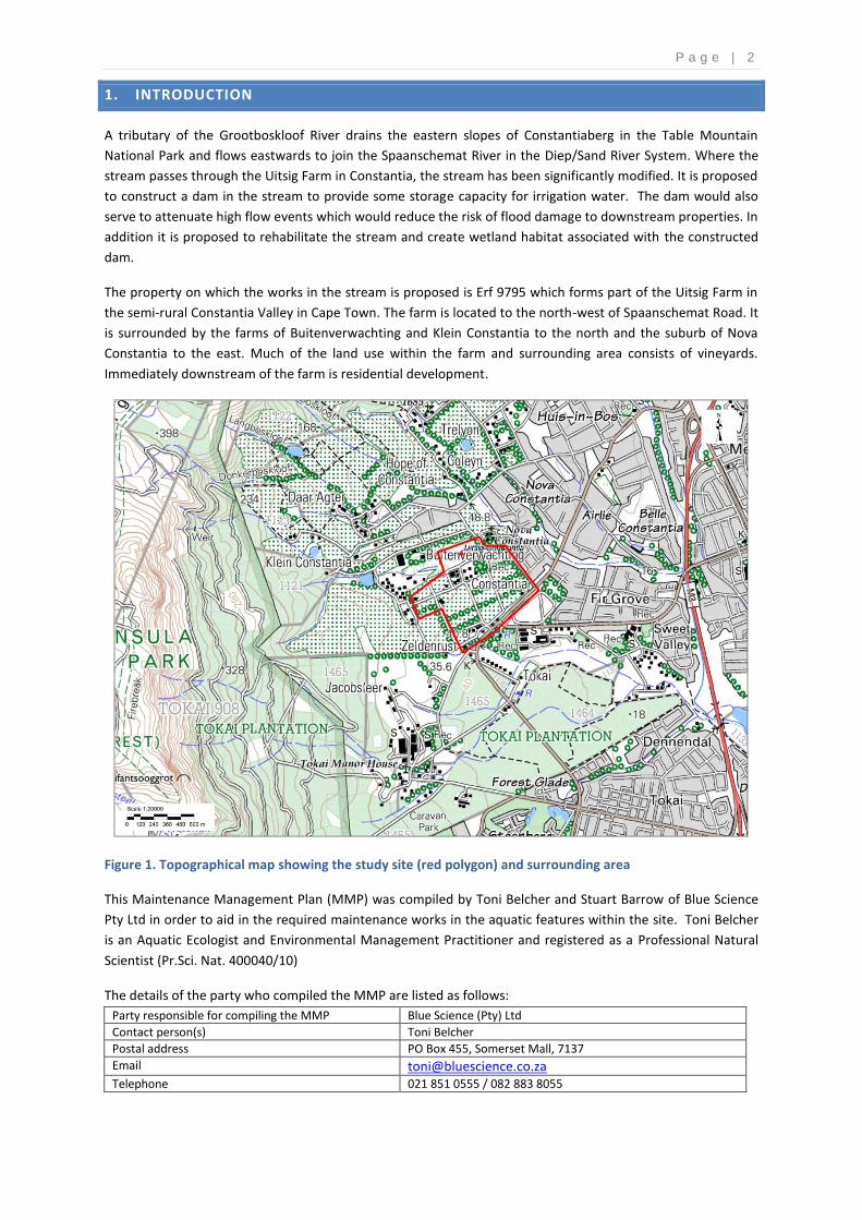
1. INTRODUCTION
A tributary of the Grootboskloof River drains the eastern slopes of Constantiaberg in the Table Mountain
National Park and flows eastwards to join the Spaanschemat River in the Diep/Sand River System. Where the
stream passes through the Uitsig Farm in Constantia, the stream has been significantly modified. It is proposed
to construct a dam in the stream to provide some storage capacity for irrigation water. The dam would also
serve to attenuate high flow events which would reduce the risk of flood damage to downstream properties. In
addition it is proposed to rehabilitate the stream and create wetland habitat associated with the constructed
dam.
The property on which the works in the stream is proposed is Erf 9795 which forms part of the Uitsig Farm in
the semi-rural Constantia Valley in Cape Town. The farm is located to the north-west of Spaanschemat Road. It
is surrounded by the farms of Buitenverwachting and Klein Constantia to the north and the suburb of Nova
Constantia to the east. Much of the land use within the farm and surrounding area consists of vineyards.
Immediately downstream of the farm is residential development.
Figure 1. Topographical map showing the study site (red polygon) and surrounding area
This Maintenance Management Plan (MMP) was compiled by Toni Belcher and Stuart Barrow of Blue Science
Pty Ltd in order to aid in the required maintenance works in the aquatic features within the site. Toni Belcher
is an Aquatic Ecologist and Environmental Management Practitioner and registered as a Professional Natural
Scientist (Pr.Sci. Nat. 400040/10)
The details of the party who compiled the MMP are listed as follows:
Party responsible for compiling the MMP Blue Science (Pty) Ltd
Contact person(s) Toni Belcher
Postal address PO Box 455, Somerset Mall, 7137
Email [email protected]
Telephone 021 851 0555 / 082 883 8055
P a g e | 3
2. BACKGROUND
The study area is located on the edge of the suburb of Constantia in the City of Cape Town. Uitsig Farm is at
the base of the eastern facing slopes of the Constantiaberg Mountains. Aquatic features on site include a
tributary and associated wetland area of the Grootboskloof River within the Diep/Sand River System that drain
from west to east through the site.
The stream and surrounding landscape have been extensively transformed by past agricultural activities.
Within the immediate area of the stream, horse paddocks have been created and the area has been planted
with invasive alien kikuyu grass. Small ponds have also been excavated immediately adjacent to the stream
and the stream has been diverted. Much of the surrounding area has been modified by cultivated areas with
the urban development within Constantia to the east and the Tokai Plantation to the south. Many of the
streams within the catchment have been largely modified by the surrounding land use with the stream
channels having been channelised and the indigenous riparian vegetation replaced with exotic plants.
Associated with the less modified streams are some wetland areas that are also in a modified condition as a
result of manipulation of surface water runoff and developed areas adjacent to the wetlands.
It is proposed to raise an existing instream dam within the tributary of the Grootboskloof River that flows
along the northern boundary of the Uitsig Farm. The dam will be an earthfill dam with a clay-core dam wall.
The dam will be sealed with a 500 mm layer of in-situ clay which will tie in with the clay core to limit seepage.
The dam will have an open channel spillway with a concrete sill and erosion protection such as gabions and
reno mattresses. The detail and diagram for the proposed dam is provided in Table 1 and Figure 2.
Table 1. Detail for proposed Dam
Capacity (m3) 120 000
Wall height (m) 12.5
Crest Level (m) 47
Length of Crest (m) 172
Width of Crest (m) 3-4
Full Supply Level (m) 45.5
Surface Area (m2) 34 000 (3.4 ha)
Spillway Type and Channel Excavated open channel with erosion protection and a concrete sill
Spillway width (m) 17.5
Outlet works A 315 mm uPVC pressure conduits under the embankment, cast in reinforced concrete and founded on a firm foundation

P a g e | 4
Figure 2. Drawing for Proposed Dam (Ingerop, 2017)
3. RELEVANT LEGISLATION AND POLICIES
This MMP has been prepared with consideration given to the following legislation:
The National Environmental Management Act, Act 107 of 1998, as amended (“NEMA”) with particular
reference to Section 2 and Section 28 (1);
The NEMA Environmental Impact Assessment (EIA) Regulations (2014);
National Environmental Management: Biodiversity Act (NEMBA), Act 10 of 2004, as amended; and
National Water Act (NWA), Act 36 of 1998, as amended.
4. PROJECT SITE LOCATION AND DESCRIPTION
4.1. GENERAL DESCRIPTION
The gradient in the area slopes gently from the Constantiaberg towards the Spaanschemat River in the east.
The stream within the site flows within a 100m wide channel that has banks of approximately 10m high (Figure
3). The gradient of the stream at the site is about 2% and drops from a height of approximately 54m down to
35m over a distance of 550m. The banks of the stream are covered with invasive alien kikuyu grass while the
stream channel is overgrown with invasive plants and the instream channel is dominated by exotic and alien
invasive plants.

P a g e | 5
Table 2: Summary of key information related to the water resources which may be impacted by the
proposed activities
Descriptor Name / Details Notes
Water Management Area Berg
Catchment Area Grootboskloof/Spaanschemat River A tributary of the Diep/Sand River Catchment
Quaternary Catchment G22D
Present Ecological state Spaanschemat/Keyser River: D category (largely modified)
DWA 2012
Ecological Importance and Ecological Sensitivity
Spaanschemat/Keyser River: Moderate and High
DWA 2012
Latitude 34° 02'28.3"S Centre of wall
Longitude 18°25'26.8"E
Environmental authorisation processes
The following report is for input into the environmental authorisation process
SLR Consulting (Cape Town) Unit 39, Roeland Square Cnr Roeland Street and Drury Lane, 8001 [email protected] Tel:+27 21 461 1118 Fax: +27 21 461 1120
Figure 3. View of the stream channel where the works is proposed, looking north-westwards towards Klein
Constantia
4.2. AQUATIC FEATURES
The study site is located within the G22D quaternary catchment. A small stream, a tributary of the
Spaanschemat River, crosses the northern portion of the site and there are a number of small artificial (dams
or ponds) and natural (hillslope seeps and valley bottom) wetland habitats associated with it. The wetland
areas have been captured by the City of Cape Town’s Biodiversity Network wetland mapping (see section 4.3)
and comprise of two dams within the channel, some hillslope seeps and the riverine area.
The earliest aerial photography for the area, taken in 1944, shows that the area has been subject to
modification for more than 70 years, with the area at that time being mostly under agricultural use (Figure 4).
The area where the stream channel and wetland areas currently occur was largely cultivated at the time of the
image. The darker areas within the wide stream channel likely indicate that there were previously wetland
areas within the stream channel but that these areas have been modified by cultivation. These darker areas
also indicate the original stream channel upstream of the farm that had already been diverted prior to 1944.
The seep area north of the stream is the only wetland area that appears to not have been significantly
modified by the cultivation as a result of the steep bank on which it is located.
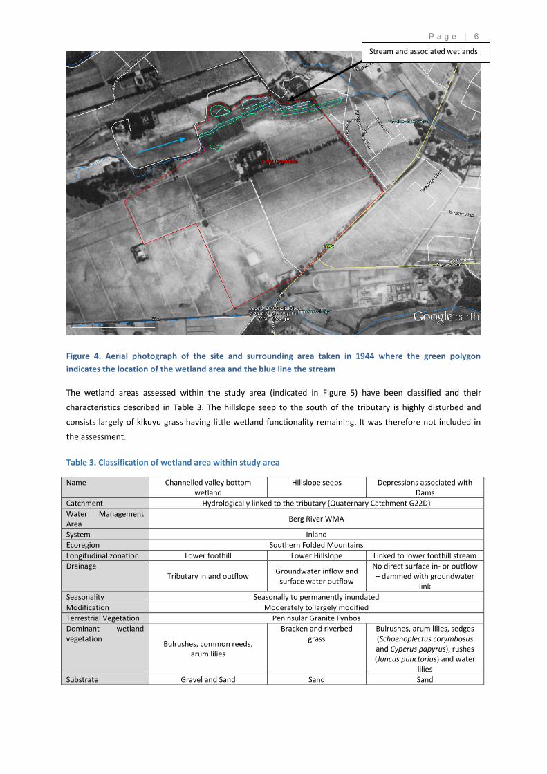
P a g e | 6
Figure 4. Aerial photograph of the site and surrounding area taken in 1944 where the green polygon
indicates the location of the wetland area and the blue line the stream
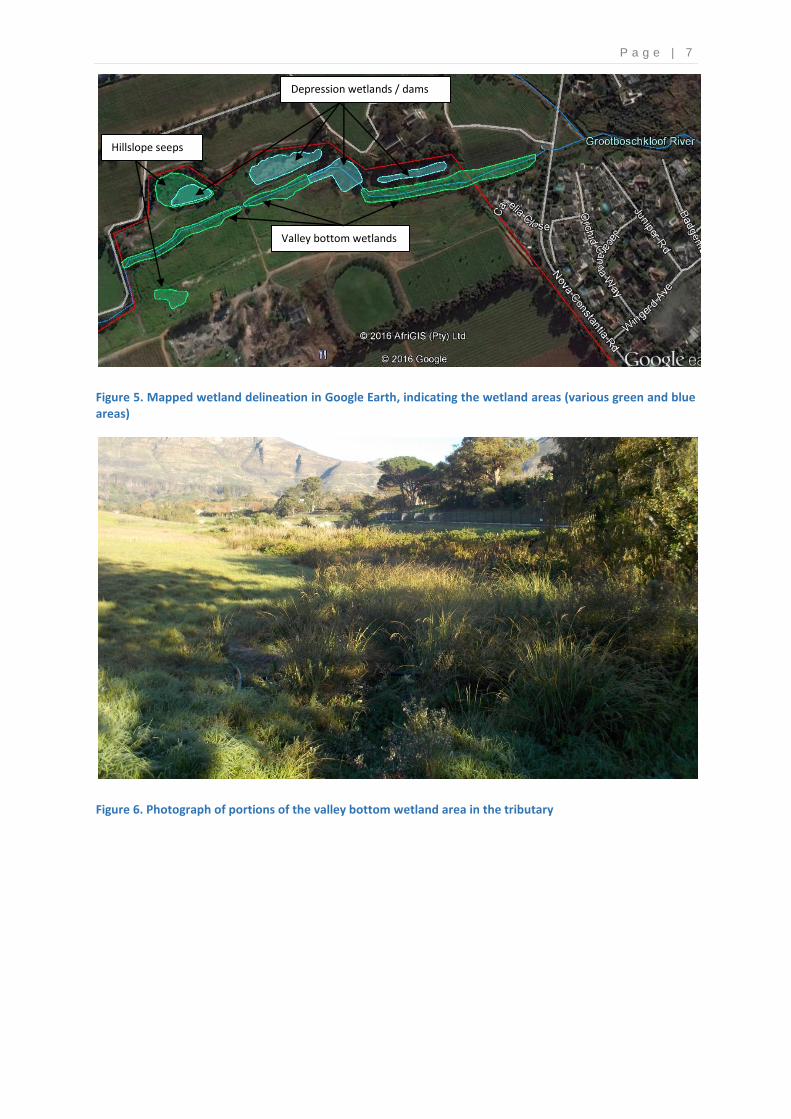
The wetland areas assessed within the study area (indicated in Figure 5) have been classified and their
characteristics described in Table 3. The hillslope seep to the south of the tributary is highly disturbed and
consists largely of kikuyu grass having little wetland functionality remaining. It was therefore not included in
the assessment.
Table 3. Classification of wetland area within study area
Name Channelled valley bottom wetland
Hillslope seeps Depressions associated with Dams
Catchment Hydrologically linked to the tributary (Quaternary Catchment G22D)
Water Management Area
Berg River WMA
System Inland
Ecoregion Southern Folded Mountains
Longitudinal zonation Lower foothill Lower Hillslope Linked to lower foothill stream
Drainage Tributary in and outflow
Groundwater inflow and surface water outflow
No direct surface in- or outflow – dammed with groundwater
link
Seasonality Seasonally to permanently inundated
Modification Moderately to largely modified
Terrestrial Vegetation Peninsular Granite Fynbos
Dominant wetland vegetation
Bulrushes, common reeds, arum lilies
Bracken and riverbed grass
Bulrushes, arum lilies, sedges (Schoenoplectus corymbosus and Cyperus papyrus), rushes (Juncus punctorius) and water
lilies
Substrate Gravel and Sand Sand Sand
Stream and associated wetlands
P a g e | 7
Figure 5. Mapped wetland delineation in Google Earth, indicating the wetland areas (various green and blue areas)
Figure 6. Photograph of portions of the valley bottom wetland area in the tributary
Hillslope seeps
Depression wetlands / dams
Valley bottom wetlands
P a g e | 8
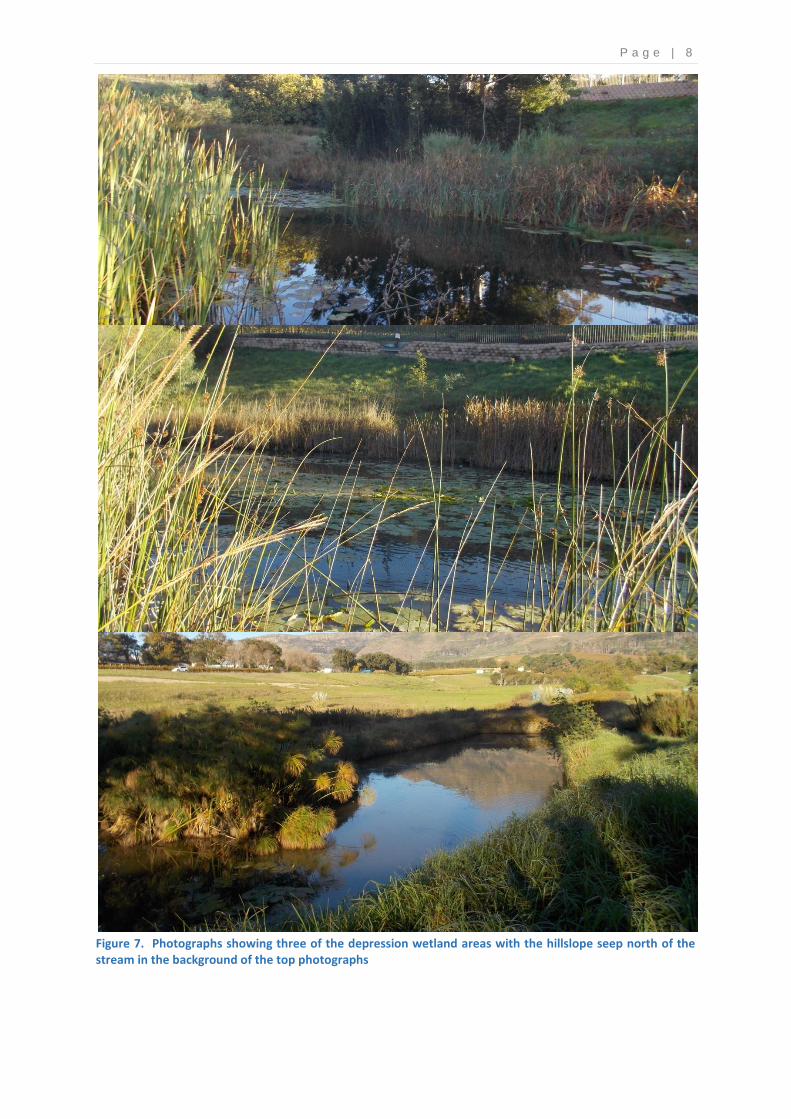
Figure 7. Photographs showing three of the depression wetland areas with the hillslope seep north of the stream in the background of the top photographs

P a g e | 9
4.3. BIODIVERSITY AND CONSERVATION VALUE
There are two mapping initiatives which are relevant to this study in terms of demarcating important
biodiversity conservation areas. The City of Cape Town Metropolitan Municipality has produced the
Biodiversity Network map at a local authority level to guide sustainable development by bringing together
biodiversity information for decision makers so that they can ensure appropriate land use, accommodate
important biodiversity features in their planning and promote integrated management of natural resources.
Critical Biodiversity Areas (CBA) and Ecological Support Areas (ESA) and Critical ESAs (CESA) are considered
priority areas which should be maintained in a natural to near natural state. The mapping of the Biodiversity
Network also included the identification of wetlands and freshwater features which are of ecological
importance. There are no terrestrial CBAs within the study area. Transformed sites of significance that should
be maintained/restored to natural ecosystems in open spaces (transparent pink areas in Figure 11) are located
to the west and south of the farm. The small tributary’s valley bottom wetland and the associated semi-natural
seep wetland areas are mapped as a wetland CESA (green areas in Figure 8). Two artificial wetland areas
(dams) in the area are mapped as Other Ecological Support Areas (Purple areas in Figure 8).
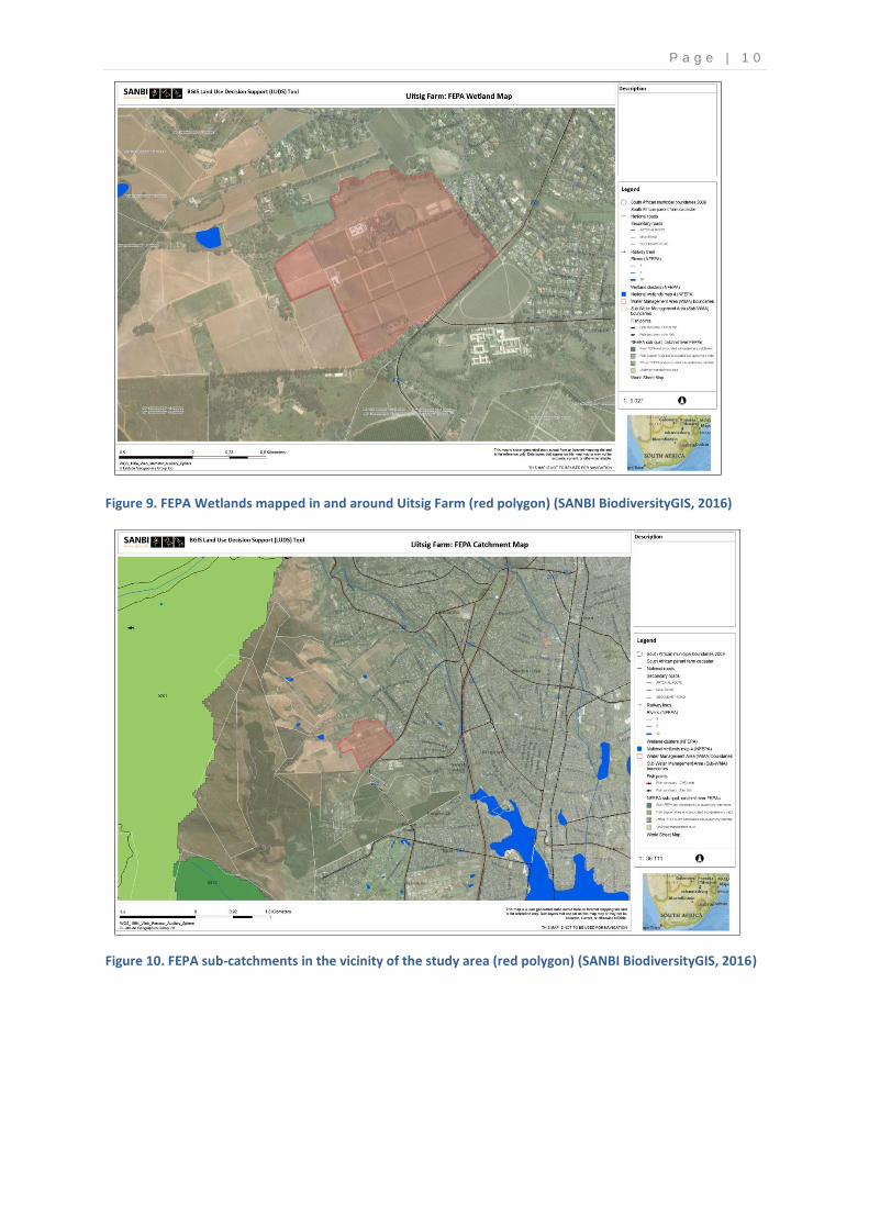
The national Freshwater Ecosystem Priority Areas (FEPA) mapping provides strategic spatial priorities for
conserving freshwater ecosystems in South Africa and supporting sustainable use of water resources. The
mapping has thus taken place on two levels. Specific features mapped as FEPA wetlands, rivers or estuaries
features have been identified and classified. Certain river sub-catchments have also been identified as priority
areas due to the importance of the river/freshwater features within the sub-catchment. No FEPA wetlands
were identified within the Uitsig Farm (Figure 9). Sub-catchments classified as River FEPAs are required to be
maintained in a largely natural ecological state. Sub–catchments that are mapped as Fish Support Areas are to
be managed in such a way that no activity causes the current ecological condition to degrade. The study area is
not within an FEPA sub-catchment (Figure 10).
Figure 8. The City of Cape Town’s Biodiversity Network at Uitsig Farm (red polygon) and the surrounding area (SANBI Biodiversity GIS, 2016)
P a g e | 1 0
Figure 9. FEPA Wetlands mapped in and around Uitsig Farm (red polygon) (SANBI BiodiversityGIS, 2016)
Figure 10. FEPA sub-catchments in the vicinity of the study area (red polygon) (SANBI BiodiversityGIS, 2016)
P a g e | 1 1
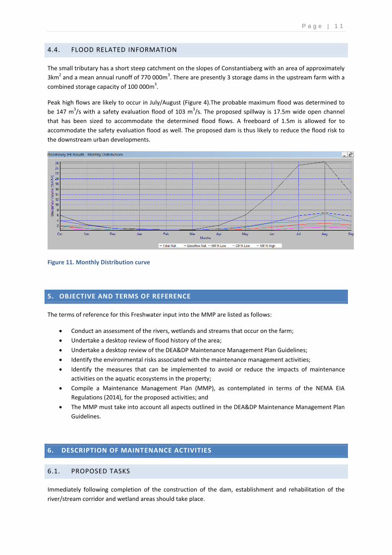
4.4. FLOOD RELATED INFORMATION
The small tributary has a short steep catchment on the slopes of Constantiaberg with an area of approximately
3km2 and a mean annual runoff of 770 000m
3. There are presently 3 storage dams in the upstream farm with a
combined storage capacity of 100 000m3.
Peak high flows are likely to occur in July/August (Figure 4).The probable maximum flood was determined to
be 147 m3/s with a safety evaluation flood of 103 m
3/s. The proposed spillway is 17.5m wide open channel
that has been sized to accommodate the determined flood flows. A freeboard of 1.5m is allowed for to
accommodate the safety evaluation flood as well. The proposed dam is thus likely to reduce the flood risk to
the downstream urban developments.
Figure 11. Monthly Distribution curve
5. OBJECTIVE AND TERMS OF REFERENCE
The terms of reference for this Freshwater input into the MMP are listed as follows:
Conduct an assessment of the rivers, wetlands and streams that occur on the farm;
Undertake a desktop review of flood history of the area;
Undertake a desktop review of the DEA&DP Maintenance Management Plan Guidelines;
Identify the environmental risks associated with the maintenance management activities;
Identify the measures that can be implemented to avoid or reduce the impacts of maintenance
activities on the aquatic ecosystems in the property;
Compile a Maintenance Management Plan (MMP), as contemplated in terms of the NEMA EIA
Regulations (2014), for the proposed activities; and
The MMP must take into account all aspects outlined in the DEA&DP Maintenance Management Plan
Guidelines.
6. DESCRIPTION OF MAINTENANCE ACTIVITIES
6.1. PROPOSED TASKS
Immediately following completion of the construction of the dam, establishment and rehabilitation of the
river/stream corridor and wetland areas should take place.

P a g e | 1 2
Future maintenance of the proposed project includes the regular monitoring and maintenance of the stream
channel and banks and wetland areas within the property as well as the dam and associated infrastructure
within the watercourse. The following maintenance tasks are proposed:
Rehabilitation of the riparian and wetland areas;
Clearing and control of alien vegetation;
Clearing the nuisance growth of reeds and bulrushes;
Minor repairs to infrastructure including the boardwalk and viewing decks;
Removal of sediment for flood conveyance;
Erosion repair activities; and
Operation, maintenance and management activities directly associated with the dam (these are described
in the Operational Rules for the dam).
6.2. IMPACTS RELATED TO TASKS
Please refer to the method statement tables under Annexure 1 where all impacts and mitigation measures are
described in context with the different tasks. These tasks and impacts have been taken into account for the
freshwater assessment conducted for the project which provides input into this Maintenance Management
Plan.
6.3. DEADP GUIDING PRINCIPLES FOR MAINTENANCE WORK IN WATERCOURSES
The DEADP MMP guidelines (DEADP 2013) provide the following set of guiding principles for maintenance
work in water courses that are of relevance to this site:
• Minimise the spatial extent of disturbance and maximise physical diversity.
• Minimise the frequency of, or requirement for, maintenance activities.
• Minimise upstream/downstream impacts on the reach in which the maintenance site is located.
• Do not impede the movement of aquatic and riparian biota.
• Minimise alterations to flow- and sediment-capacity.
• Rehabilitate and re-vegetate after construction.
• Clear alien plant species.
• Minimise impact on the structural integrity of the water course and maintain a minimum base flow at
all times.
• Maintenance activities are best done during the dry season.
• Manual labour is preferred to the use of mechanical equipment in order to minimise physical
disturbance around the activity location.
• Whenever possible only one river/stream bank should be worked at a time.
• All reasonable measures should be undertaken to ensure that river/stream maintenance activities
minimise erosion.
• Whenever possible existing access routes should be used. If there are none, one should be created
one by:
P a g e | 1 3
i. Selecting a single route through the most degraded area.
ii. Considering the potential for erosion while maintaining aesthetics.
iii. Limiting disturbance to the river/stream bank and bed.
iv. Restoring the footprint around the access route upon completion.
• All potential pollutants should be kept away from the river/stream.
• Spoil material should be removed to approved dumping sites.
• After construction, any areas within the maintenance footprint that have been degraded from their
condition prior to construction and as a result of the construction activities must be restored to their
former condition.
• Valuable biophysical or aesthetic areas, including meanders, and in-channel and floodplain habitat,
should be retained.
• Cleared woody material must be removed from the riparian area to prevent it being washed into the
river/stream channel during the wet season.
7. ROLES AND RESPONSIBILITIES
Roles and responsibilities are listed as follows:
1. The Applicant/Client – the client is responsible for employing the Principal Agent and Contractor for the
duration of the maintenance work. They in turn will employ the Environmental Control Officer (ECO). The
client will also ensure, as a signatory to the MMP, that the Principal Agent and Contractor fulfil their
obligations in terms of this MMP.
2. Principal Agent – the Principal Agent is appointed by the client and is responsible to the client for ensuring
that the maintenance work is carried out to completion on time, in budget and that the Contractor fulfils
their obligations in terms of the MMP. The Principal Agent and ECO are expected to develop a close
working relationship and to communicate frequently. The Principal Agent must be recognized as the
senior authority on site and all communications and instructions between the ECO and the Contractor
must occur via the Principal Agent. The Principal Agent is also responsible for deducting environmental
penalties from the Contractor. The Principal Agent must ensure that the Contractor has a copy of this
MMP and all approved Method Statements and that the Contractor is familiar with the relevant
documentation.
3. ECO– an independent, appropriately qualified environmental professional must be appointed prior to
commencement of any maintenance activities. The ECO will advise the Principal Agent and Contractor of
any environmentally related issues during the maintenance phase of the activities.
The responsibilities of the ECO will include monitoring of compliance with the MMP by the
Contractor.
The ECO has the authority to recommend the cessation of works or any portion of the maintenance
activity to the Principal Agent. This will be triggered if in his/her opinion the activity has caused or will
imminently cause significant damage and/or harm to the environment or is in contravention of the
relevant environmental legislation/permits/authorizations applicable to the site and/or activity/ies.
If the Contractor fails to show adequate consideration to the MMP or the recommendations of the
ECO, then the ECO may recommend that the Contractor’s representative or any employee/s
responsible for not showing adequate consideration to the MMP are removed from the site.
Alternatively, the ECO may recommend that all maintenance work on site be suspended until the
matter is remedied. All costs will be carried by the Contractor.
Should modifications to this document be required, these must be agreed to by all parties concerned.
4. The Contractor – the Contractor will adhere to the conditions of this MMP and ensure that all of its sub-
Contractors, employees, suppliers, agents and so forth, for whom the Contractor is fully responsible for

P a g e | 1 4
their actions on site, are fully aware of this MMP, its requirements and the consequences of any breach of
the requirements of this MMP. The Contractor is fully responsible for implementing the MMP. The
Contractor will ensure that works on site are conducted in an environmentally responsible manner and in
accordance with the requirements of this MMP.
5. Problematic Issues – should problematic issues arise, as identified by the ECO, the ECO has the authority
to call a special meeting with the Principal Agent to address and rectify the matter.
8. ENVIRONMENTAL EDUCATION
8.1. GENERAL HEALTH, SAFETY AND EMERGENCY PLANS
Procedures for handling emergency situations will be developed and detailed by the contractor. This includes,
but is not limited to, handling of fires, hazardous substance spillages, floods and other accidents.
8.2. ENVIRONMENTAL AWARENESS PLAN
As part of continual improvement in environmental management performance, health, safety and
environmental (HSE) awareness training should be provided to all employees in order to promote the effective
implementation of the Environmental Management Plan (EMP) and MMP actions.
An environmental awareness programme should be presented to all prospective employees prior to the
undertaking of maintenance activities. The presentation shall be conducted, as far as is possible, in the
employees’ language of choice.
An ECO should be appointed prior to the commencement of any maintenance activities
The ECO should train the Principal Agent and Contractors on site in to order to ensure that the all
parties involved are familiar with the potential impacts and environmental risks of the maintenance
or monitoring activities as well as the mitigation measures to reduce or avoid these impacts and
potential pollution or degradation of the site and surrounding environment.
Prior to the commencement of the maintenance or monitoring activities, all adjacent land owners are
to be notified and a written record of this notification is to be kept with the MMP.
As a minimum, the following should be included in the awareness programme:
• Explanation of the importance of complying with this MMP;
• Discussion of the potential environmental impacts of maintenance activities;
• Explanation of the management structure of individuals responsible for matters pertaining to this
MMP;
• Employees’ roles and responsibilities, including emergency preparedness;
• Explanation of the mitigation measures that must be implemented when carrying out maintenance
activities; and
• Explanation of the Environmental Do’s and Don’ts.
Attention should be focussed on the following areas of sensitivity:
• Removal/disturbance of riparian vegetation;
• Aquatic habitat disturbance;
• Soil erosion and sedimentation; and
• Water quality degradation due to siltation and debris.

P a g e | 1 5
The awareness training for the maintenance activities should aim to prevent, and where prevention is not
possible, mitigate detrimental HSE impacts. In particular, it should promote awareness of environmental risks
and management thereof
9. GENERAL CONTROL
The following additional general management activities and mitigation measures have been identified and
should be implemented where required during the maintenance management activities:
Description of the Activity & Associated Impacts
Site Boundaries and No-Go Areas
Measures to be implemented during maintenance activities
The Contractor must demarcate the boundaries of the site or area scheduled for maintenance during maintenance management activities as required. The minimum area required for the maintenance activities should be demarcated. Sensitive areas must be demarcated in conjunction with the ECO prior to any maintenance work starting on site.
Description of the Activity & Associated Impacts
Use of Materials Potential environmental impact and damage as a result of the use and misuse of inappropriate materials.
Measures to be implemented during maintenance activities
The principle of “re-use and recycle” (i.e. try to use recycled materials) should be implemented as far as possible on site for all maintenance related activities. The Contractor shall at all times carefully consider the requirements of the NEMA Principles and take appropriate measures to implement such as far as practicably possible.
Description of the Activity & Associated Impacts
Occupational Health and Safety Potential health and safety impacts associated with the maintenance activities on site
Measures to be implemented during maintenance activities
All people working on site are responsible for their own safety on site. Contractors and Principal Agent/s shall at all times comply with the relevant statutory requirements including the Occupational Health and Safety Act, Act 85 of 1993. A comprehensive site specific first aid kit must be available on site at all times. At least one person trained in safety and first aid and familiar with the first aid equipment on site must be present on the site at all times. Emergency procedures must also be established prior to the start of maintenance operations on site.
Description of the Activity & Associated Impacts
Waste Management Possible pollution of or damage to the environment in the general area of the site, as a result of incorrect or poor waste management.
Liquid Waste: (if machinery is to be used) Liquid dispensing receptacles (e.g. lubricants, diesel, shutter oil etc.) must have drip trays beneath them/beneath the nozzle fixtures. Material safety data sheets (MSDS) must be available on site (if required) where products are stored, so that in the event of an incident, the correct action can be taken. Depending on the types of materials stored on site during the maintenance activities, suitable product recovery materials (such as Spillsorb or Drizit products) must be readily available. Vehicles should ideally be washed at their storage yard as opposed to on site. The Contractor shall ensure that any wastewater generated during maintenance activities feeds to a suitable containment area such as a container or lined sedimentation pond prior to disposal. This pond or ponds must be allowed to dry out on a regular basis to allow for solid material removal. The wastewater must be disposed of in a suitable manner (possibly to the sewer system following local authority approval) and must not be directed to a storm water drain, wetland or the streams. Storm water must be managed in such a way that no overland flow is possible onto any area of the site which could contain potential contaminants (such as concrete mixing areas, material and hazardous storage areas from any adjacent area). Solid Waste: Waste must be categorized by the Contractor and disposed of in a suitable manner into separate waste streams (this includes general, hazardous and recyclable waste) only at authorised waste disposal facilities.
P a g e | 1 6
The Contractor must provide an adequate number of waste receptacles for the duration of the maintenance management activities for general waste at points around the site as well as for hazardous and recyclable waste. Waste is to be disposed of at a licensed waste disposal site. The frequency of collections/emptying of waste receptacles will be of such a frequency that waste receptacles do not overflow. Particular care shall be taken with the disposal of materials that could be wind-borne or waterborne to ensure that the release of these materials is minimised (the latter is a requirement for hazardous waste). The use of netting covers or similar sealed containers must be implemented as and when required by the ECO. Areas demarcated for specific activities including food consumption must have suitable waste receptacles provided. Wherever possible recycling must be carried out. No dumping within the surrounding area is to be permitted. No burning of solid waste is allowed. All material used by the Contractor during the maintenance management activities shall be managed in such a way that it does not cause pollution, or that it minimises pollution. In the event of a spillage, the Contractor should have suitably trained personnel who can correctly clean up any spillage in an efficient and environmentally sound manner.
Description of the Activity & Associated Impacts
Erosion Control Erosion of soil and material resulting along the streams within the property.
Measures to be implemented during maintenance activities
Soil erosion on site must be prevented at all times Maintenance activities should preferably be undertaken in the low rainfall months when the potential for erosion impacts from the maintenance activities can be contained.
Description of the Activity & Associated Impacts
Fire Safety Potential fire risks associated with the maintenance activities on site
Measures to be implemented during maintenance activities
Fires and burning of waste on site should not be allowed. Open fires will not be permitted anywhere on the site during the maintenance activities.
10. REHABILITATION SPECIFICATIONS AND SITE CLEAN-UP FOLLOWING MAINTENANCE
ACTIVITIES
The following measures have been identified to ensure the restoration and rehabilitation of the environment
affected by the maintenance activity following the completion of these activities:
1. The Contractor shall be responsible for rehabilitating (vegetation planting etc. where applicable) all areas
disturbed during the maintenance activities to the satisfaction of the ECO.
2. Vegetation to be replanted shall be indigenous species that are endemic to that region only. Any invasive
alien plants within the disturbed area should be removed according to the guidelines provided by the
Working for Water Programme ((http://www.dwaf.gov.za/wfw/Control/).
3. Any soil and vegetation cover removed during the maintenance activities should be replaced at the same
level as the existing level.
4. The implementing agent shall clear and clean the site and ensure that everything not forming part of the
permanent works is removed from site.
5. Any rubble or waste associated with the maintenance activities should be removed to an approved
disposal site after the maintenance activity is complete. Burying or burning rubble or waste on the site is
prohibited. All surfaces are to be checked for waste products from maintenance activities and cleared in a
manner approved by the ECO.

P a g e | 1 7
11. ENVIRONMENTAL MONITORING AND REPORTING
The monitoring programme must detect changes that will inform intervention or remedial measures for good environmental performance. The data collection, management and
reporting must be documented and be made available for inspection.
Table for monitoring of actions
Part of the watercourse that is monitored
Frequency of Monitoring
Monitoring Procedure How results are analyzed and presented Comments
Up and downstream of the site where the new dam is proposed.
Immediately prior to commencement of activities and after activities are complete. Also daily during the maintenance activities
The ECO will visit the site during the maintenance management activities and ensure conformance with the MMP. Guidance will be given to the implementing agent as required with regards to implementing the MMP. Photographs of the maintenance management activity will be taken as a record of the correct undertaking of the specific maintenance management activity.
The record of the site visit undertaken during the maintenance management activities will include the following: Report which will illustrate what activity was undertaken at the site; Correct implementation as well as non-conformance of the MMP will be outlined; Recommendations to ensure conformance with the MMP in future maintenance management activities if required. Photographs of all maintenance management activities undertaken at the site.
The following in particular should be monitored: Frequent monitoring of the wetlands will need to be undertaken after construction, to detect any erosion, the spread of Typha reeds. Monitoring and clearing of alien invasive plants along the banks and within the watercourse will need to be undertaken on an ongoing basis according to the applicable recognised methods for clearing of alien invasive plant growth. Records should be kept in a file that must include the measured results, together with reporting of maintenance activities, any corrective action, recommendations and photographs
Weekly for maintenance activities
In situ water quality monitoring should be taken upstream and downstream of the maintenance activities on a weekly basis when there is sufficient flow in the watercourse
The following should be monitored using a hand-held meter and secci disc for: pH, electrical conductivity, turbidity and dissolved oxygen.
Ongoing monitoring for the operation of the storm water infrastructure (monthly)
Monitoring for signs of erosion, problematic sediment build up and growth of alien invasive species or of unwanted reeds. Monitoring of water entering the dam, water abstracted from the dam and dam levels as well as the environmental flow release from the dam
Monitoring of erosion, sediment deposition and growth of alien invasive species and unwanted reeds should inform corrective measures in this regard. Monitoring of water use is to inform the management of water in the dam and implementation of the environmental flow requirement from the dam
Record should be kept of erosion control measures, sediment removal and alien species or reed control.

P a g e | 1 8
ANNEXURE 1: METHOD STATEMENTS THAT DESCRIBE PROPOSED TASKS
The following maintenance and implementation management activities, associated impacts and mitigation measures have been identified as follows:
Description of maintenance activity
Site Inspections and Maintenance Surface inspection of the river/stream corridor
Actions The following aspects should be included in the site inspections to ensure that maintenance activities are undertaken timeously:
The proper establishment of indigenous vegetation within the stream channel and wetland areas;
Erosion of the channel and wetland areas, especially where infrastructure exists;
Blockage of the channel and wetland areas with sediment or debris that may result in damage during flood events;
Growth of weeds, alien plant species and dominance of undesirable species such as Typha within aquatic habitat that reduce the diversity of aquatic ecosystems and also block the stream channel; and
Condition of infrastructure (including the boardwalk and viewing decks) within the aquatic habitats that may need to be repaired.
Impacts of actions The following impacts are anticipated as a result of undertaking the inspection activity: A negligible disturbance to the local vegetation as the inspection process can be accessed via existing gravel access roads.
Severity of impacts Minor disturbance to the local vegetation
If all mitigation measures are implemented the severity of the impact will be Very Low/Insignificant.
Measures to mitigate the severity of the impact
Minor disturbance to the local vegetation
The maintenance activities should be limited as far as possible within wetland areas and the disturbed area should be rehabilitated immediately afterwards (if required). The minimum area for the maintenance activity to be adequately undertaken should be demarcated and the aquatic habitat outside of the maintenance activity area treated as a no-go area.
Remedial measures if mitigation measures are not implemented adequately on site.
There are no additional remedial mitigation measures other than those listed above. As such, all mitigation measures as outlined above should be implemented in full.
Method of Access to the site
Existing access roads and pathways within the site should be utilised as far as possible.
Time period of maintenance management activity
The maintenance management activity should not last for more than 2 hours.

P a g e | 1 9
Rehabilitation of Riparian area - The riparian zones of the river/stream channel within the property should be rehabilitated as far as possible, specifically to landscape the area,
remove any invasive alien plants and re-vegetate the areas with suitable vegetation. This activity should take place just after construction works are completed and should take no
longer than 10 days but should also be an ongoing task until the new vegetation within the corridor is established:
Description of maintenance activity Rehabilitation of River/stream Corridor Rehabilitation and landscaping of riparian and wetland area during and following construction of the dam
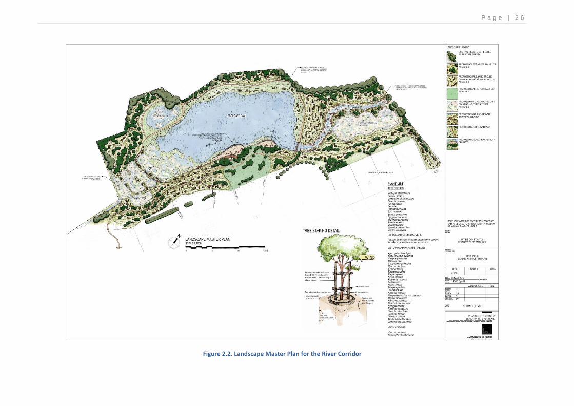
Actions The following actions are anticipated to be undertaken in order to carry out the rehabilitation process: Identify areas with suitable indigenous vegetation that could be set aside for use in the rehabilitated corridor; Establish two wetland offset areas, one at the headwaters of the proposed dam and a second one immediately downstream of the dam; Remove all invasive and alien vegetation from the river/stream corridor; Reshape/landscape and revegetate area according to approved Landscape Masterplan (Annexure 2) and recommended wetland offset measures described in the Freshwater Assessment Report for the project; Ensure all newly planted vegetation is established.
Impacts of actions The following impacts are anticipated as a result of undertaking the maintenance activity: Disturbance to the local vegetation and aquatic habitat as a result of the rehabilitation process; and Revegetation of the area with suitable vegetation, improved habitat integrity and subsequent improvement in the ecological health of the stream
Severity of impacts Minor disturbance of local vegetation If all mitigation measures are implemented the severity of the impact will be Low.
Alien vegetation clearance N/A this impact is a POSITIVE
Measures to mitigate the severity of the impact
The wetland offset should comprise of the creation of approximately 10 000m2 of wetland habitat within the two wetland areas in the existing stream
corridor of approximately 120 m to 150 m wide as shown in the Landscape Masterplan. Both wetland areas should be linked with the stream and be designed to enhance the valley bottom wetland along the stream as well as links to the hillslope seeps upstream of the dam. The stream channel should be realigned and reshaped to flow through and be more integrated with the newly established wetland areas; The level and shaping of the wetland areas needs to be such that they allow for an even flow distribution to avoid the ‘short-circuiting’ of flow and stagnation in areas, while allowing for a diversity of habitats within the area. This could be achieved through the realigning of the stream channel as recommended and by creating some ponded areas that would be more permanently wet as well as shallow seasonally wet areas. Suggested wetland plants for each zone are as follows:
Adjacent to the hillslope seep area, bracken (Pteridium aquaticum) and riverbed grass (Pennisetum macrourum); cobra lilies (Chasmanthe aethiopica) and bloodroot (Wachendorfia thyrsiflora);
Margins and banks of stream and more permanently wet pond areas: fountain bush (Psoralea pinnata), broom restio (Calopsis paniculata), sedges (Carex clavata, Cyperus textilis, Ficinia nodosa, Bolboschoenus maritimus and Isolepsis prolifera), and rushes (Juncus kraussii);
Deeper water ponds: Cape pond weed (Aponogeton distachyos) and Cape blue water lily (Nymphaea nouchali var. caerulea);
Seasonally wet areas: Senecio halimnifolius, wetland gonna (Passerina paludosa), riverbed grass (Pennisetum macrourum), arum lilies (Zanthedeschia aethiopica) and bloodroot (Wachendorfia thyrsiflora); and
The drier embankments adjacent to the stream corridor could be planted with a mix of indigenous grasses such as Cynodon dactylon, Ehrharta calycina, Eragrostis capensis, Themeda triandra and Tribolium uniolae together with indigenous terrestrial fynbos vegetation.
Invasive alien grasses such as Pennisetum clandestinum should not be planted in this area and any growth of the grass should be removed. A botanist, wetland specialist or horticulturalist must be appointed to plan and facilitate the rehabilitation and revegetation process. Suitable indigenous vegetation as is listed in the Landscape Masterplan is to be used within the revegetation of the wider river/stream corridor.
Remedial measures if mitigation not implemented adequately
Ongoing invasive plant control will be required as well as the possible replanting of areas if plants do not establish. Irrigation will be required for at least the first year for the drier established areas.
Method of Access to the site Existing access roads and pathways within the site should be utilised as far as possible.
Time for maintenance activity The activity should take place just after construction works are completed and will need a couple of years to properly establish
P a g e | 2 0
Description of maintenance activity Alien vegetation removal
Actions The following actions are anticipated to be undertaken in order to carry out alien vegetation removal:
Ongoing removal of the declared invasive alien plants (NEMBA list of declared invasive species) within the wetlands and channel should be according to the guidelines provided by the Working for Water Programme; and
Rehabilitation and revegetation of disturbed and cleared areas if necessary.
Impacts of actions The following impacts are anticipated as a result of undertaking the maintenance activity:
Minor disturbance to the local indigenous vegetation.
Clearance of alien vegetation from the area and subsequent improvement in the ecological health of the section of the river channel within the property.
Severity of impacts Minor disturbance to the local vegetation
If all mitigation measures are implemented the severity of the impact will be Low.
Alien vegetation clearance N/A this impact is a POSITIVE
Measures to mitigate the severity of the impact
All invasive alien vegetation must be correctly identified prior to removal. A specialist must be appointed to ensure this. Removal of the invasive alien plants should be according to the guidelines provided by the Working for Water Programme (https://www.dwaf.gov.za/wfw/Control/).
Management treatments summary guide provided by Working for Water for the main invasive species within the site are attached in the Appendices.
Kikuyu in particular is very hard to remove because if any runners are left behind they will start growing again. It is best to poison Kikuyu with a foliar herbicide (e.g. Agil) during the summer growing season (before end March). When using herbicides, it is essential to apply the correct herbicide, in the right dose, at the right time, using the correct application method. Use only registered herbicides, follow manufacturer’s instructions on the label, and wear the appropriate protective clothing during handling. All registered herbicides are labelled with important information to assist in selecting the correct product and give the recommended application methods and dose. Labels also provide safety and poisoning information and recommended disposal methods. Follow-up with the removal of dead material.
Follow-up alien vegetation control measures will need to be ongoing and for several years at least, depending on the site conditions, and rate and success of regeneration or revegetation. Progressively less follow-up weeding should be required once indigenous plants are regenerating well and at a rate faster than the invasive plants can become re-established. The cultivation of plant material to be planted within an area that requires replanting should only be done with species that are selected and that are suitable for the area and the type of habitat in which it would have the most optimal chance of survival.
Remedial measures if mitigation measures are not implemented adequately on site.
There are no additional remedial mitigation measures other than those listed above.
Method of Access to the site Existing access roads within the site should be utilised as far as possible.
Time period of maintenance management activity
The maintenance management activity will need to be ongoing.

P a g e | 2 1
Description of maintenance activity Clearing of nuisance growth of reeds
Actions The following actions are anticipated to be undertaken in order to carry out removal of nuisance growth of reeds: The periodic control of the reeds/bulrushes may be required when they start to block the watercourse or dominate the wetland areas.
Impacts of actions The following impacts are anticipated as a result of undertaking the maintenance activity: Minor disturbance to aquatic habitat during clearing activities.
Severity of impacts Minor disturbance to the local vegetation
If all mitigation measures are implemented the severity of the impact will be Low.
Removal of unwanted reeds N/A this impact is a POSITIVE as the reeds become weedy and reduce plant diversity
Measures to mitigate the severity of the impact
Phragmites Reeds Phragmites can be controlled using an initial herbicide treatment followed by mechanical removal (e.g., cutting, mowing) and annual maintenance. Hand cutting can remove individual plant stems or very small stands of Phragmites; however, a brush cutter is more effective for large, dense stands. The cutting blade should be set to a mowing height greater than 12 cm to help minimize impacts to small animals and indigenous plants. Removal of Phragmites through digging and hand pulling is ineffective due to the extensive root system created by this plant. Disturbing the soil through mechanized disking or raking may also contribute to rapid expansion of Phragmites as well as cause turbidity in the water column and is not recommended.
Foliar spray of herbicide must be done in autumn (April), as plants move nutrients from the leaves to the roots before growth ceases in winter. The start of this process is indicated on the plant by a split leaf-tip and continues with drying/browning of the leaves;
Cut paths through dense stands of reed in order to gain access to the stand;
Cut areas will resprout vigorously and must be sprayed the following year;
Apply a herbicide, mixed according to the instructions (300ml/10 litres of Glycophosphate 360/MAMBA with 0.1% wetting agent and dye or as advised by Working for Water agent or other suitably qualified person), to the leaves only;
Applications should be by means of a low pressure, fine droplet spray from a narrow cone nozzle;
The herbicide travels to the roots killing them and reduces the growth of new shoots while the dye shows that an adult plant has been treated;
DO NOT cut the stems of sprayed plants as this stimulates the growth of new stems that are more dense and greater in height; and
Plants must be left to rot until dead and can be removed the following season. Typha Bulrushes Controlling excessive Typha growth is extremely difficult and can be quite costly, particularly in natural systems. Herbicides (those used for Phragmites reeds) can be effective when applied while the plant is flowering. The decaying plant material that results however accumulates and causes hypertrophic conditions, while providing a good substrate for regrowth of Typha. Manual removal works best on small seedlings when they can be easily pulled out of the damp soil. Controlling Typha through fire and physical cutting in conjunction with flooding has been indicated as the most successful method for control. Mechanical and hand cutting (twice about a week or two apart) and/or burning should take place at the end of the growing season and when water levels are low and then the cut area must be submerged in at least 8 to 10 cm of water when water levels rise again.
Remedial measures if mitigation measures are not implemented adequately on site.
There are no additional remedial mitigation measures other than those listed above.
Method of Access to the site Existing access roads within the site should be utilised as far as possible.
Time period of maintenance management activity
The maintenance management activity should be undertaken in sections (and not the whole at one time) only as required and should not take more than 1-2 days at a time.
P a g e | 2 2
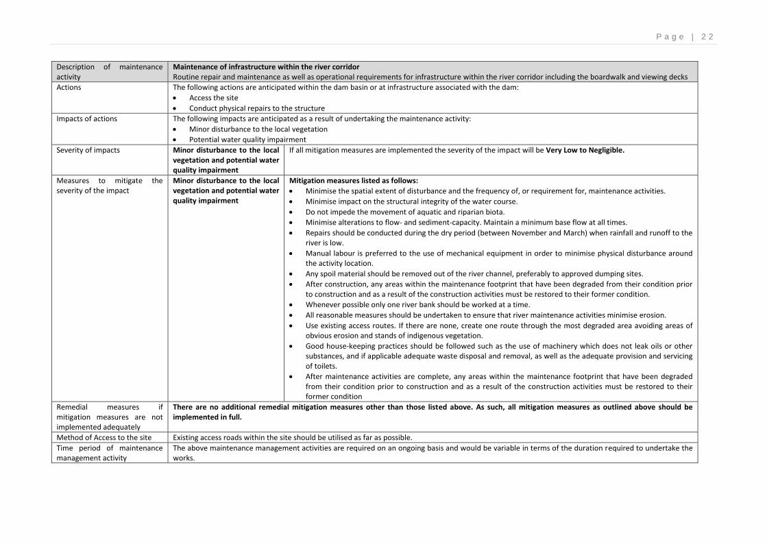
Description of maintenance activity
Maintenance of infrastructure within the river corridor Routine repair and maintenance as well as operational requirements for infrastructure within the river corridor including the boardwalk and viewing decks
Actions The following actions are anticipated within the dam basin or at infrastructure associated with the dam:
Access the site
Conduct physical repairs to the structure
Impacts of actions The following impacts are anticipated as a result of undertaking the maintenance activity:
Minor disturbance to the local vegetation
Potential water quality impairment
Severity of impacts Minor disturbance to the local vegetation and potential water quality impairment
If all mitigation measures are implemented the severity of the impact will be Very Low to Negligible.
Measures to mitigate the severity of the impact
Minor disturbance to the local vegetation and potential water quality impairment
Mitigation measures listed as follows:
Minimise the spatial extent of disturbance and the frequency of, or requirement for, maintenance activities.
Minimise impact on the structural integrity of the water course.
Do not impede the movement of aquatic and riparian biota.
Minimise alterations to flow- and sediment-capacity. Maintain a minimum base flow at all times.
Repairs should be conducted during the dry period (between November and March) when rainfall and runoff to the river is low.
Manual labour is preferred to the use of mechanical equipment in order to minimise physical disturbance around the activity location.
Any spoil material should be removed out of the river channel, preferably to approved dumping sites.
After construction, any areas within the maintenance footprint that have been degraded from their condition prior to construction and as a result of the construction activities must be restored to their former condition.
Whenever possible only one river bank should be worked at a time.
All reasonable measures should be undertaken to ensure that river maintenance activities minimise erosion.
Use existing access routes. If there are none, create one route through the most degraded area avoiding areas of obvious erosion and stands of indigenous vegetation.
Good house-keeping practices should be followed such as the use of machinery which does not leak oils or other substances, and if applicable adequate waste disposal and removal, as well as the adequate provision and servicing of toilets.
After maintenance activities are complete, any areas within the maintenance footprint that have been degraded from their condition prior to construction and as a result of the construction activities must be restored to their former condition
Remedial measures if mitigation measures are not implemented adequately
There are no additional remedial mitigation measures other than those listed above. As such, all mitigation measures as outlined above should be implemented in full.
Method of Access to the site Existing access roads within the site should be utilised as far as possible.
Time period of maintenance management activity
The above maintenance management activities are required on an ongoing basis and would be variable in terms of the duration required to undertake the works.

P a g e | 2 3
Description of maintenance activity Sediment removal from the channel for flood conveyance / channelization
Actions The following actions are anticipated to be undertaken in order to repair eroded areas within freshwater features:
Access the site with team or machinery
Remove sediment from the channel
Remove to a suitable stockpile location outside the riparian zone
Revegetate any riparian areas disturbed by the activities
Impacts of actions The following impacts are anticipated as a result of undertaking the inspection activity:
Disturbance of aquatic habitat and vegetation
Severity of impacts Disturbance of aquatic habitat and vegetation
If all mitigation measures are implemented the severity of the impact will be Low
Measures to mitigate the severity of the impact
Disturbance of aquatic habitat and vegetation
Mitigations measures listed as follows:
The disturbed area around the infrastructure should be kept to a minimum and where possible existing access points to the infrastructure used.
Minimise upstream/downstream impacts
Minimise impact on the structural integrity of the wetland and avoid channelization or canalization of the wetland rather maximise physical diversity. Valuable biophysical or aesthetic areas, including meanders, and in-channel and floodplain habitat, should be retained
The activities should be undertaken in the dry season.
Material removal should start at the downstream most point and work systematically upstream. Sand removal should not take place in the river where there are eroded banks.
Manual labour should be used where possible and the use of machinery within the river channel should be minimised and should follow the same access point.
Where possible existing access points to the river channel should be used and any indigenous marginal vegetation that is established along the edges of the channel should preferably remain intact as it provides cover, habitat and food for the aquatic biota.
The overall topography of the wetland, on completion of the maintenance activity, should be similar to that prior to the sedimentation event.
Disturbed areas should be kept clear of alien vegetation.
Remedial measures if mitigation measures are not implemented adequately on site.
There are no additional remedial mitigation measures other than those listed above. As such, all mitigation measures as outlined above should be implemented in full.
Method of Access to the site Existing access road within the farm should be utilised as far as possible.
Time period of maintenance management activity
The time period of the maintenance management activity should take place within one day.

P a g e | 2 4
Description of maintenance activity Repair to eroded areas within the river channel or wetlands areas This Method statement only encompasses ‘softer engineering’ repair works to freshwater features. Hard engineering structures will require approvals from the various authorities concerned (DEADP and DWS)
Actions The following actions are anticipated to be undertaken in order to repair eroded areas within freshwater features
Sourcing of material for erosion repair works
Rehabilitation of channel or banks
Impacts of actions The following impacts are anticipated as a result of undertaking the maintenance activity:
Minor disturbance to the local indigenous vegetation within the river channel and wetland areas as a result of repair works.
Severity of impacts Minor disturbance to the local vegetation
If all mitigation measures are implemented the severity of the impact will be Very Low to Negligible.
Measures to mitigate the severity of the impact
Minor disturbance to the local vegetation
Mitigation measures listed as follows:
Care should be taken that the minimum disturbance is caused whilst the area is repaired, and the works should be done preferably by hand, with access from the existing roads.
No heavy machinery should be allowed within the wetland areas. Use manual labor where possible.
Care should be taken to minimize the sedimentation that would be caused in the channels downstream of the works.
Activities associated with the maintenance work should be undertaken during the low flow period before the onset of the winter high flows.
Excess sediment should preferably be used to fill eroded areas within the river channel or nearby. Should soil need to be sourced from outside of the site, care should be taken that it does not contain alien invasive plant seed.
On completion, the topography of the disturbed areas (both the area where the soil has been removed and the erosion repair site) must be similar to the surrounding landscape or pre-damage condition.
Revegetate disturbed areas with local indigenous vegetation on the advice of a botanist or aquatic ecologist. Additional stabilization measures may also be required at the site such as the use of stakes or larger boulders or biodegradable products and geotextiles to stablise the area until such time as the vegetation growth in the area is established.
Remedial measures if mitigation measures are not implemented adequately
There are no additional remedial mitigation measures other than those listed above. As such, all mitigation measures as outlined above should be implemented in full.
Method of Access to the site Existing access roads within the site should be utilised as far as possible.
Time period of maintenance management activity
The maintenance management activity will commence after the rehabilitation works are completed. The maintenance management activity will last for approximately 1-2 days.
* Impacts described here are direct impacts only. Cumulative impacts have not been assessed. ** High: Disturbance of area with important conservation value; destruction of rare or endangered species. No possible mitigation or mitigation is difficult, expensive, time-consuming. Medium: Disturbance of area with potential conservation value or of use as a resource; complete change in species occurrence or variety. Low: Disturbance of degraded area with little conservation value; minor change in species occurrence or variety. Mitigation easily achieved or little require.
P a g e | 2 5
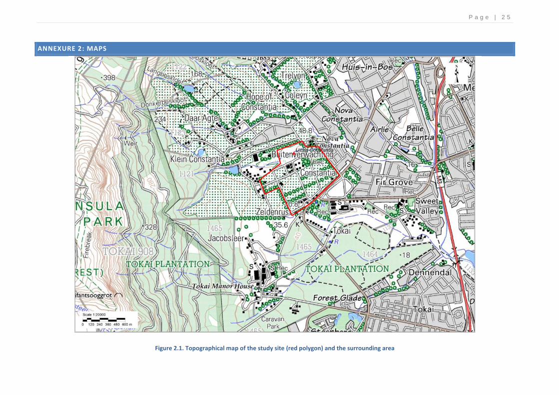
ANNEXURE 2: MAPS
Figure 2.1. Topographical map of the study site (red polygon) and the surrounding area
P a g e | 2 6
Figure 2.2. Landscape Master Plan for the River Corridor
P a g e | 2 7
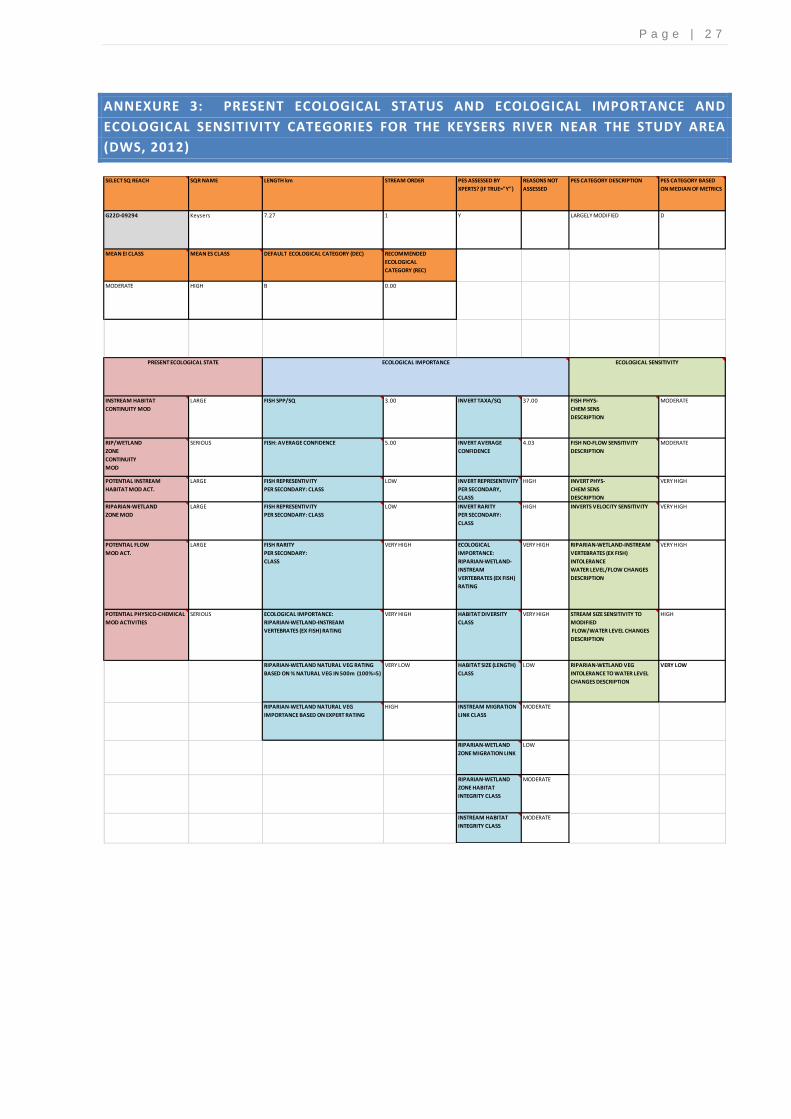
ANNEXURE 3: PRESENT ECOLOGICAL STATUS AND ECOLOGICAL IMPORTANCE AND
ECOLOGICAL SENSITIVITY CATEGORIES FOR THE KEYSERS RIVER NEAR THE STUDY AREA
(DWS, 2012)
SELECT SQ REACH SQR NAME LENGTH km STREAM ORDER PES ASSESSED BY
XPERTS? (IF TRUE="Y")
REASONS NOT
ASSESSED
PES CATEGORY DESCRIPTION PES CATEGORY BASED
ON MEDIAN OF METRICS
G22D-09294 Keysers 7.27 1 Y LARGELY MODIFIED D
MEAN EI CLASS MEAN ES CLASS DEFAULT ECOLOGICAL CATEGORY (DEC) RECOMMENDED
ECOLOGICAL
CATEGORY (REC)
MODERATE HIGH B 0.00
INSTREAM HABITAT
CONTINUITY MOD
LARGE FISH SPP/SQ 3.00 INVERT TAXA/SQ 37.00 FISH PHYS-
CHEM SENS
DESCRIPTION
MODERATE
RIP/WETLAND
ZONE
CONTINUITY
MOD
SERIOUS FISH: AVERAGE CONFIDENCE 5.00 INVERT AVERAGE
CONFIDENCE
4.03 FISH NO-FLOW SENSITIVITY
DESCRIPTION
MODERATE
POTENTIAL INSTREAM
HABITAT MOD ACT.
LARGE FISH REPRESENTIVITY
PER SECONDARY: CLASS
LOW INVERT REPRESENTIVITY
PER SECONDARY,
CLASS
HIGH INVERT PHYS-
CHEM SENS
DESCRIPTION
VERY HIGH
RIPARIAN-WETLAND
ZONE MOD
LARGE FISH REPRESENTIVITY
PER SECONDARY: CLASS
LOW INVERT RARITY
PER SECONDARY:
CLASS
HIGH INVERTS VELOCITY SENSITIVITY VERY HIGH
POTENTIAL FLOW
MOD ACT.
LARGE FISH RARITY
PER SECONDARY:
CLASS
VERY HIGH ECOLOGICAL
IMPORTANCE:
RIPARIAN-WETLAND-
INSTREAM
VERTEBRATES (EX FISH)
RATING
VERY HIGH RIPARIAN-WETLAND-INSTREAM
VERTEBRATES (EX FISH)
INTOLERANCE
WATER LEVEL/FLOW CHANGES
DESCRIPTION
VERY HIGH
POTENTIAL PHYSICO-CHEMICAL
MOD ACTIVITIES
SERIOUS ECOLOGICAL IMPORTANCE:
RIPARIAN-WETLAND-INSTREAM
VERTEBRATES (EX FISH) RATING
VERY HIGH HABITAT DIVERSITY
CLASS
VERY HIGH STREAM SIZE SENSITIVITY TO
MODIFIED
FLOW/WATER LEVEL CHANGES
DESCRIPTION
HIGH
RIPARIAN-WETLAND NATURAL VEG RATING
BASED ON % NATURAL VEG IN 500m (100%=5)
VERY LOW HABITAT SIZE (LENGTH)
CLASS
LOW RIPARIAN-WETLAND VEG
INTOLERANCE TO WATER LEVEL
CHANGES DESCRIPTION
VERY LOW
RIPARIAN-WETLAND NATURAL VEG
IMPORTANCE BASED ON EXPERT RATING
HIGH INSTREAM MIGRATION
LINK CLASS
MODERATE
RIPARIAN-WETLAND
ZONE MIGRATION LINK
LOW
RIPARIAN-WETLAND
ZONE HABITAT
INTEGRITY CLASS
MODERATE
INSTREAM HABITAT
INTEGRITY CLASS
MODERATE
ECOLOGICAL IMPORTANCE PRESENT ECOLOGICAL STATE ECOLOGICAL SENSITIVITY

P a g e | 2 8
ANNEXURE 4: MANAGEMENT TREATMENTS SUMMARY GUIDE PROVIDED BY WORKING
FOR WATER FOR THE MAIN INVASIVE SPECIES WITHIN THE SITE:
SPECIES Cortaderia selloana Paraserianthes lophantha
COMMON NAME Pampas grass Stink bean
Triclopyr 270g/L + Clopyralid
90g/L L 7314
Confront 360 SL
FA
Glyphosate ( as isopropylamine
salt) 360 g
L 4756
Glyphosate 360 SL FA
L 4817
Mamba 360 SL FA
L407
Roundup 360 SL FA
L 6729
Springbok 360 SL FA
L 4774
Ciplasate 360 SL FA
L 4767
Enviro Glyphosate
360 SL FA
Glyphosate (as potassium salt)
480g/L L 7166
Roundup Turbo SL
FA
Glyphosate (as potassium salt) 500g/L
L 7305
Touchdown Forte
Hitech 500 SL FA
Glyphosate (as sodium salt) 500
g/kg L 7431
Kilo 500 WSG
FA
FA = Foliar application