Embed Size (px)
Citation preview

Cool Creek Watershed Management Plan Hamilton County, Town of Westfield, City of Carmel
December 2005 Clark Dietz, Inc.
APPENDIX H
ADDITIONAL 319 UPDATE INFORMATION

Cool Creek Watershed Management Plan Hamilton County, Town of Westfield, City of Carmel
December 2005 Clark Dietz, Inc.
APPENDIX H.1
PUBLIC MEETING EXHIBITS

Cool Creek Watershed Management Plan Hamilton County, Town of Westfield, City of Carmel
December 2005 Clark Dietz, Inc.
PUBLIC MEETING 1
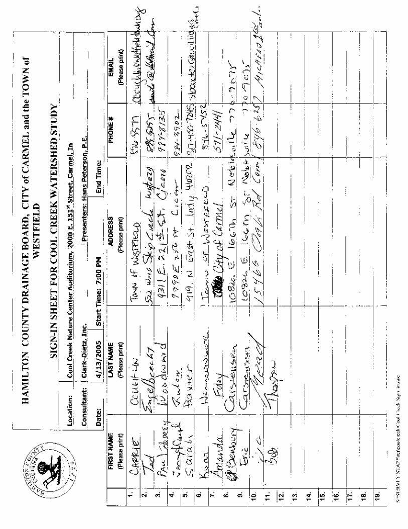

PUBLIC MEETING SUMMARY Project: Cool Creek Watershed Management Plan Date: April 13, 2005 Time: 7:00 p.m. Location: Cool Creek Nature Center Auditorium
2000 E. 151st Street, Carmel, In Staff Attendees: Bob Thompson – Hamilton County
Hans Peterson – Clark Dietz Sam Robertson – Clark Dietz
A public information meeting was held to introduce the update of the Cool Creek Watershed Management Plan. Approximately 13 people attended the meeting. A list of attendees who signed in is attached to this meeting summary. The following is a summary of the meeting and follow up question and answer period. Bob Thompson kicked off the meeting by introducing the project and the consultant preparing the management plan, Clark Dietz. Hans Peterson gave a presentation covering the Cool Creek Watershed Study including summary of the findings, alternatives, and recommended solutions. Following the presentation the floor was opened to questions and/or comments from the public. The following were the general questions and answers: • Is Cool Creek an impaired Stream?
Yes, it is on the latest IDEM 303(d) list of impaired streams, with E. coli being the parameter of concern.
• What contaminants were found during sampling?
Somewhat high levels of nutrients (nitrogen and phosphorus) were found for the spring storm that was sampled. Potential sources include residential and/or agricultural fertilizers. Higher levels were found in the upper watershed sampling location, which may point to agricultural sources. E. coli was also found to be above full body contact limits (235 cfu/100 ml).
• Are the contaminants due to Golf Courses? How many golf courses are there in
the watershed? High levels of containments were found upstream of the only golf course in the watershed.
• Is there funding set aside to clean up damage along the stream due to ice storms?
Currently there is no funding set aside for this type of damage, unless the damage was in a stream reach that is on a regulated drain maintenance fund.
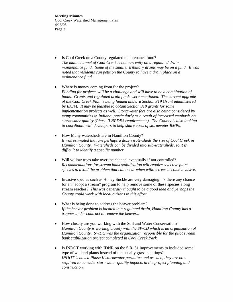
Meeting Minutes Cool Creek Watershed Management Plan 4/13/05 Page 2
• Is Cool Creek on a County regulated maintenance fund? The main channel of Cool Creek is not currently on a regulated drain maintenance fund. Some of the smaller tributary drains may be on a fund. It was noted that residents can petition the County to have a drain place on a maintenance fund.
• Where is money coming from for the project? Funding for projects will be a challenge and will have to be a combination of funds. Grants and regulated drain funds were mentioned. The current upgrade of the Cool Creek Plan is being funded under a Section 319 Grant administered by IDEM. It may be feasible to obtain Section 319 grants for some implementation projects as well. Stormwater fees are also being considered by many communities in Indiana, particularly as a result of increased emphasis on stormwater quality (Phase II NPDES requirements). The County is also looking to coordinate with developers to help share costs of stormwater BMPs.
• How Many watersheds are in Hamilton County?
It was estimated that are perhaps a dozen watersheds the size of Cool Creek in Hamilton County. Watersheds can be divided into sub-watersheds, so it is difficult to identify a specific number.
• Will willow trees take over the channel eventually if not controlled?
Recommendations for stream bank stabilization will require selective plant species to avoid the problem that can occur when willow trees become invasive.
• Invasive species such as Honey Suckle are very damaging. Is there any chance
for an “adopt a stream” program to help remove some of these species along stream reaches? This was generally thought to be a good idea and perhaps the County could work with local citizens in this effort.
• What is being done to address the beaver problem?
If the beaver problem is located in a regulated drain, Hamilton County has a trapper under contract to remove the beavers.
• How closely are you working with the Soil and Water Conservation?
Hamilton County is working closely with the SWCD which is an organization of Hamilton County. SWDC was the organization responsible for the pilot stream bank stabilization project completed in Cool Creek Park.
• Is INDOT working with IDNR on the S.R. 31 improvements to included some
type of wetland plants instead of the usually grass plantings? INDOT is now a Phase II stormwater permittee and as such, they are now required to consider stormwater quality impacts in the project planning and construction.

Meeting Minutes Cool Creek Watershed Management Plan 4/13/05 Page 3
• Is there a way wetlands can be used as retention?
Yes the county is currently looking at regional dentition ponds that act as retention and have wetland incorporated.
• Do lakes such as Morris Reservoir improve water quality and has there been
testing upstream and downstream of reservoirs to determine this? In general lakes improve water quality by providing quiescent settling conditions. The Morse Reservoir may have been recently sampled because it is a reservoir used to supply source water for drinking water. It was mentioned that Dr. Tedesco of IUPUI Center for Earth and Environmental Science is involved in a water quality research partnership with US Filter Indianapolis Water to evaluate nutrients in three reservoirs (including Morse Reservoir).
• Are there old wetland areas that have been drained for agricultural use that can be
turned back into wetlands? Recently several farm field drains (in the northern part of the County) have failed and the fields have reverted into wetlands.
Two stations with watershed maps were setup and occupied by project personnel to discuss individual problems, concerns, or questions. Several individual concerns were recorded. Of particular note was a suggestion by a citizen (Ted Engelbrecht) identifying a the southeast corner of 161st Street and Westfield Boulevard (north of Cool Creek Park). This site is apparently owned by the Town of Westfield and could be a good location for a constructed wetland. He also mentioned it may be possible to locate BMPs at the Washington Elementary School west of Grassy Branch Road. P:\H21013\Meetings\Public Meeting 04-13-05.doc

Cool Creek Watershed

S. R. 32
146th STREET
WHITE RIVER
U. S. 31
U. S. 31 S. R. 431
HAMILTON CO.
WESTFIELD
HAMILTON CO.
CARMEL
COOL CREEK WATERSHED

NOT TO SCALE
CHANNEL FLOODING OR MAINTAINENCE PROBLEM
MINOR CHANNEL EROSION AREA
COOL CREEK WATERSHED BOUNDARY MODERATE TO SEVERE CHANNEL EROSION AREA
NEIGHBORHOOD PROBLEM AREA

1
Public MeetingCool Creek Watershed Management Plan –Section 319 Update: April 13, 2005
Cool Creek WatershedManagement Plan
City of Carmel
Town of Westfield
Hamilton County
Public MeetingSection 319 GrantApril 13, 2005
Agenda• Cool Creek Watershed Overview
• Previous Cool Creek Planning Efforts
• Public Input
- Questions
- Specific Problem Areas
- Overall Watershed Concerns
- Priorities
• Closing / Follow Up
What is a Watershed?A watershed is the area of land that drains
to a particular point along a stream
Center for Watershed Protection
Water QualityQuality of Life
Environment
Agriculture
Agriculture
Recreation
Industry Development
Agriculture
Cool Creek Watershed Overview
• Drainage Area ~ 23.7 mi.2
• From 199th Street to White River, near 116th Street
• Large Portions of Westfield and Carmel and parts of unincorporated Hamilton County
• Lower watershed mostly developed, upper watershed experiencing rapid growth
CARMEL
WESTFIELD
HAMILTON CO.
HAMILTON CO.
S. R. 32
146th STREET
WHITE RIVER
U. S. 31
U. S. 31 S. R. 431
HAMILTON CO.
WESTFIELD
HAMILTON CO.
CARMEL
Cool Creek Watershed Overview
• Approximately 15 miles of watercourse
• Approximately 50 to 60 percent urbanized
• Impervious area estimate:- Urbanized Areas
40 – 50 %- Overall watershed
20 – 30 %
2
Public MeetingCool Creek Watershed Management Plan –Section 319 Update: April 13, 2005
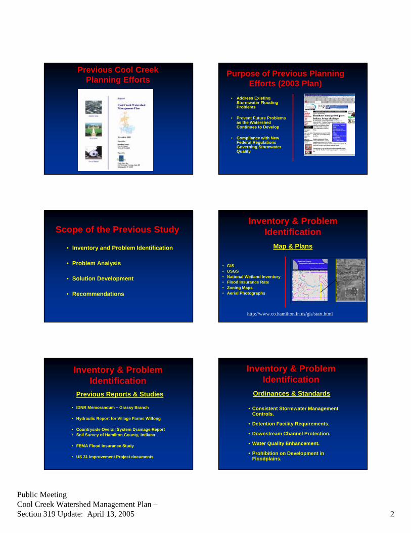
Previous Cool Creek Planning Efforts
Purpose of Previous Planning Efforts (2003 Plan)
• Address Existing Stormwater Flooding Problems
• Prevent Future Problems as the Watershed Continues to Develop
• Compliance with New Federal Regulations Governing Stormwater Quality
Scope of the Previous Study
• Inventory and Problem Identification
• Problem Analysis
• Solution Development
• Recommendations
Inventory & Problem Identification
Map & Plans
• GIS • USGS • National Wetland Inventory• Flood Insurance Rate• Zoning Maps• Aerial Photographs
790790790790790
800800800800800
800800800800800810810810810810
810810810810810
810810810810810
810810810810810
810810810810810
820820820820820
820820820820820
820820820820820
820820820820820
830830830830830
830830830830830
830830830830830
840840840840840
830830830830830830830830830830830830830830830
780780780780780
780780780780780790790790790790
800800800800800
800800800800800
810810810810810
810810810810810
820820820820820840840840840840
770770770770770
780780780780780
780780780780780
780780780780780780780780780780
780780780780780 780780780780780
780780780780780
790790790790790
790790790790790
790790790790790
790790790790790
790790790790790
790790790790790
790790790790790
790790790790790
800800800800800
800800800800800
800800800800800
800800800800800
800800800800800
800800800800800
800800800800800
800800800800800
810810810810810
810810810810810
810810810810810810810810810810
810810810810810
810810810810810
820820820820820
820820820820820820820820820820
820820820820820820820820820820
820820820820820
820820820820820
790790790790790
800800800800800
800800800800800800800800800800
800800800800800 810810810810810
810810810810810
810810810810810
810810810810810
810810810810810
810810810810810
810810810810810
770770770770770
770770770770770
770770770770770
780780780780780
790790790790790
790790790790790
800800800800800
800800800800800
800800800800800
8080808080
800800800800800
810810810810810810810810810810
810810810810810
810810810810810
OYC
E C
T MO
HA
WK
CT
LAWRENCE R
D
COOL CREEK DR
FAIRBANKS CT
ERBUR
RO
YCE
CT
CA
RME
L D
R
EN W
OO
DS
PL
LAWRENCE RD
COOL CREEK DR
RIDGE RD
ILLCREST DR
CENTENNIAL CT
SO
ANDOVER DR
BRO
OKS
HIR
EPK
PEPP
ERM
ILL
CT LECREST DR
CO
OL
CR
EE
HAW
T HO
RN
RED
OAK
http://www.co.hamilton.in.us/gis/start.html
Inventory & Problem Identification
Previous Reports & Studies
• IDNR Memorandum – Grassy Branch
• Hydraulic Report for Village Farms Wilfong
• Countryside Overall System Drainage Report • Soil Survey of Hamilton County, Indiana
• FEMA Flood Insurance Study
• US 31 Improvement Project documents
Inventory & Problem Identification
Ordinances & Standards
• Consistent Stormwater Management Controls.
• Detention Facility Requirements.
• Downstream Channel Protection.
• Water Quality Enhancement.
• Prohibition on Development in Floodplains.

3
Public MeetingCool Creek Watershed Management Plan –Section 319 Update: April 13, 2005
Inventory & Problem Identification
Public Input• Public Meetings
• Developer Input
• Interviews with:• Local Staff• Citizens
Inventory & Problem IdentificationProblem Area Map
See Map
Problem Analysis
• Water Quantity Evaluation• Hydrologic/hydraulic modeling• Impacts of future development
• Water Quality Evaluation• Sampling• Existing conditions• Policies impacting future
conditions
Problem Analysis
Hydrologic/Hydraulic Analysis
• Assess the volume and rate of runoff for various storm events
• Evaluate existing stormwater conveyance and storage facilities
• Evaluate stormwater runoff impacts from future development
• Determine appropriate control measures
-60 -40 -20 0 20 40 60829
830
831
832
833
834
835
836
Mary Wilson Drain Plan: Plan 01 Copied Cross Section #18 Upstream of 3' CMP Structure #8
Station (ft)
Ele
vatio
n (ft
)
Legend
EG 100Yr
WS 100Yr
EG 50Yr
WS 50Yr
EG 25Yr
WS 25Yr
EG 10Yr
WS 10Yr
Ground
Bank Sta
.04 .035 .04
Problem Analysis
Effects of Urbanization
• Higher peak flows as a result of urbanization
• County detention policy is effective in controlling peak flows
• Longer flow durations • More frequent “bank-full”
conditions tend to exacerbate erosion
Cool Creek Upstream of 116th Street in Golf Course
Cool Creek Upstream of White River confluence
Problem AnalysisEffects of Urbanization
Flows remain higher for a longer period of time
The “Peak Flow” is Effectively Controlled

4
Public MeetingCool Creek Watershed Management Plan –Section 319 Update: April 13, 2005
Problem Analysis
Hydraulic Evaluation
Conveyance Problems in the Upper Reaches of Cool Creek and its Immediate Tributaries
Examples
Inadequate bridge –171st St. over Cool
Creek
Culverts filled with sediment - Walter
Street and Walter Court
Inadequate culverts –Carmel Drive over Hot
Lick Creek
Problem Analysis
Stream Channel Evaluation
Severe erosion along lower reach of Cool Creek
Floodplain encroachments constrict flow and increases downstream erosion
Stream Information Compiled on Inventory Maps
Problem Analysis
Water Quality Evaluation
Entailed:
• Review of the Riparian Corridor
• Assessment of Floodplain Development
• Water Quality Sampling
Problem Analysis
Riparian Corridor
Protects Water Quality and Preserves Stream’s Natural Characteristics
Forested Riparian Buffer along Cool Creek East of S. R. 431
No Riparian Buffer – Cool Creek South of 191st Street
Problem AnalysisFloodplain Development
Prohibit development in floodplain to help preserve existing buffers and
natural flood storage
Problem Analysis
Water Quality Sampling Locations
• 186th Street
• 146th Street
• 116th Street
7
Public MeetingCool Creek Watershed Management Plan –Section 319 Update: April 13, 2005
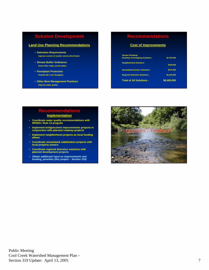
Solution Development
Land Use Planning Recommendations
• Detention RequirementsImprove control of smaller storms (first flush)
• Stream Buffer OrdinanceGrass filter strips, preservation
• Floodplain ProtectionProhibit fill in the floodplain
• Other Best Management PracticesImprove water quality
Recommendations
Cost of Improvements
Stream Flooding/Roadway Overtopping Solutions - $2,720,000
Neighborhood Solutions -$100,000
Streambank Erosion Solutions - $570,000
Regional Detention Solutions - $5,100,000
Total of All Solutions - $8,490,000
RecommendationsImplementation
• Coordinate water quality recommendations with NPDES / Rule 13 program
• Implement bridge/culvert improvements projects in conjunction with planned roadway projects
• Implement neighborhood projects as local funding allows
• Coordinate streambank stabilization projects with local property owners
• Coordinate regional detention solutions with planned development projects
• Obtain additional input on improvements and funding, priorities (this project – Section 319)
Questions / Feedback?Questions / Feedback?

5
Public MeetingCool Creek Watershed Management Plan –Section 319 Update: April 13, 2005
Problem Analysis
Water Quality Sampling Conclusions• Pollutant constituents and concentrations
in Cool Creek – generally comparable to other urban streams across country
• Nutrients levels somewhat high, possibly from excess fertilizer
• Bacteria levels exceed standards for recreational contact during wet weather (problem is common to nearly all urban watersheds)
• Stormwater Best Management Practices will help improve water quality
Solution Development
• Stream Flooding/Road Overtopping Solutions
• Neighborhood Problem Solutions
• Stream Bank Erosion Solutions
• Regional Stormwater Detention
• Future Land Use & Planning Recommendations
Solution DevelopmentStreambank Flooding/Road Topping Solutions
• Replace 171st Street Bridge and Regrade Roadway
• Regrade Roadway at 151st Street bridge
• Replace Gurley Street bridge (Anna Kendall Drain)
• Replace Cherry Street bridge (Anna Kendall Drain)
Solution DevelopmentStreambank Flooding/Road Topping Solutions
•• Replace SR 32 Culvert (J.M. Thompson Drain)
• Replace Culvert Downstream of US 31 (Highway Run)
• Add Culvert to US 31 (Highway Run) • Replace Walter Street and Walter Court
Culverts (Highway Run) • Replace Private Drive Culvert between
Walter Street and Walter Court (Highway Run)
• Replace Thornberry Drive Culvert (Highway Run)
Solution DevelopmentNeighborhood Problem Solutions
• Replace Carmel Drive Culvert (Hot Lick Creek)
Solution DevelopmentStreambank Erosion Solutions
Restoration Projects at:
• Highway Run –• Downstream of Stonehedge
Drive
• H.G. Kenyon Drain –• Downstream of Rolling Court
• Cool Creek –• Upstream of confluence with
the White River, • Downstream of Gray Road (at
bend),• Upstream and downstream of
Hot Lick Creek• Upstream of 131st Street (Main
Street) and• Upstream of Keystone Avenue

6
Public MeetingCool Creek Watershed Management Plan –Section 319 Update: April 13, 2005
Streambank Stabilization Techniques
Riprap and Live Stakes (Joint Plantings)Source: Federal Interagency Stream Restoration Working Group, 1998
Brushmattress Technique (Source: USDA-NRCS 1996)
Source: Chattanooga Public Works Department
Streambank Stabilization Techniques
Riprap and Live Stakes (Joint Plantings)Source: Federal Interagency Stream Restoration Working Group, 1998
Brushmattress Technique (Source: USDA-NRCS 1996)
Source: Chattanooga Public Works Department
Cool Creek Demonstration Project(Hamilton County SWCD)
Cool Creek Demonstration Project(Hamilton County SWCD)
Solution Development
Regional Stormwater Detention
• Two (2) off-line Regional Detention Basins to Control the Magnitude of Stormwater Flows and Reduce downstream channel erosion• Immediately Downstream of 171st Street
• West of Grassy Branch Road
• Retrofit existing regional on-line detention provided by RR embankment on Anna Kendall Drain
Solution Development
Regional Stormwater Detention


Cool Creek Watershed Management Plan Hamilton County, Town of Westfield, City of Carmel
December 2005 Clark Dietz, Inc.
PUBLIC MEETING 2


PUBLIC MEETING SUMMARY Project: Cool Creek Watershed Management Plan Date: December 14th, 2005 Time: 7:00 a.m. Location: Cool Creek Nature Center Attendees: Bob Thompson – Hamilton County Surveyor’s Office
Hans Peterson – Clark Dietz Sam Robertson – Clark Dietz Sky Schelle – IDEM Amanda Foley – City of Carmel Amanda Smith – Hamilton County Parks & Recreation Dept. Carrie Cason – Town of Westfield
On December 14th, 2005, a public meeting was held at the Cool Creek Park Nature Center to present to the public the final Cool Creek Watershed Management Plan. A list of the attendees is attached to this summary. Attendees included project stakeholders only. No public participants came to the meeting and the presentation was not given since the project stakeholders had previously seen the presentation materials. Mr. Thompson would have the presentation put on the County’s website and also see if Carmel and Westfield could do the same. P:\H21013\Public Meetings\Public Meeting Summary 12-14-05.doc

1
Cool Creek Watershed Management Plan
Public Meeting
Cool Creek Nature Center
December 14, 2005
Public MeetingCool Creek Watershed Management Plan UpdateDecember 14, 2005
Agenda
Cool Creek Watershed Overview
IDEM Section 319 Grant Requirements
Recent Watershed Activities
Section 319 Updates to the Cool Creek Plan
Summary, What’s Next
Input/Feedback/Questions
Public MeetingCool Creek Watershed Management Plan UpdateDecember 14, 2005
Project Overview
Section 319 GrantSection 319(h) of Clean Water Act provides funding for projects that reduce nonpoint source water pollutionCool Creek 319 Grant - January 1, 2005 to December 31, 2005
Grant Contract TasksProduce a Watershed Management Plan (Update to November 2003 Plan)Stakeholder Committee Meetings (4)Interviews (Hamilton County, Westfield, Carmel)Public Meetings (2)Newspaper Articles (4)
Public MeetingCool Creek Watershed Management Plan UpdateDecember 14, 2005
Cool Creek Watershed
Cool Creek Watershed
(Base map source – Upper White River Watershed Alliance)
Public MeetingCool Creek Watershed Management Plan UpdateDecember 14, 2005
CARMEL
WESTFIELD
HAMILTON CO.
HAMILTON CO.
S. R. 32
146th STREET
WHITE RIVER
U. S. 31
U. S. 31 S. R. 431
HAMILTON CO.
WESTFIELD
HAMILTON CO.
CARMEL
Cool Creek Watershed
Drainage Area ~ 23.7 mi.2
From 199th Street to White River, near 116th Street
Large Portions of Westfield and Carmel and parts of unincorporated Hamilton County
Lower watershed mostly developed, upper watershed experiencing rapid growth
Public MeetingCool Creek Watershed Management Plan UpdateDecember 14, 2005
Cool Creek Watershed
Approximately 15 miles of watercourse
Approximately 50 to 60 percent urbanized
Impervious area estimate:Urbanized Areas 40 – 50 %
Overall watershed 20 – 30 %

2
Public MeetingCool Creek Watershed Management Plan UpdateDecember 14, 2005
Recent Watershed Activities
April 2005 September 2005
Streambank Restoration – Cool Creek Park by Hamilton County SWCD
Public MeetingCool Creek Watershed Management Plan UpdateDecember 14, 2005
Recent Watershed Activities
April 2005 September 2005
Streambank Restoration – Cool Creek Park by Hamilton County SWCD
Public MeetingCool Creek Watershed Management Plan UpdateDecember 14, 2005
Recent Watershed Activities
April 2005 September 2005
Streambank Restoration – Cool Creek Park by Hamilton County SWCD
Public MeetingCool Creek Watershed Management Plan UpdateDecember 14, 2005
Recent Watershed Activities
April 2005 September 2005
Streambank Restoration – Cool Creek Park by Hamilton County SWCD
Public MeetingCool Creek Watershed Management Plan UpdateDecember 14, 2005
Recent Watershed Activities
Removal of Invasive Species in Cool Creek Park - Brush Honeysuckle- Garlic Mustard Plant
On-Going Program by Hamilton County Parks and Recreation Department
Public MeetingCool Creek Watershed Management Plan UpdateDecember 14, 2005
Recent Watershed Activities

3
Public MeetingCool Creek Watershed Management Plan UpdateDecember 14, 2005
Recent Watershed Activities
Public MeetingCool Creek Watershed Management Plan UpdateDecember 14, 2005
Cool Creek Watershed Management Plan Updates
Adding New Chapter 9.0 to address Section 319 requirements
Keeps the integrity/history of the original 2003 document
Final report will be available on Hamilton County Surveyor’s website (hard copies will also be available)
Public MeetingCool Creek Watershed Management Plan UpdateDecember 14, 2005
Chapter 9.0 Contents
9.1 Project Introduction
9.2 Watershed Description
9.3 Water Quality Evaluation and Benchmarks9.4 Problem Statements and Goals9.5 Critical Area Identification
9.6 Implementation Measures9.6 Evaluating, Monitoring, and Adapting the Plan
Public MeetingCool Creek Watershed Management Plan UpdateDecember 14, 2005
Water Quality Benchmarks
Utilized sampling data from 2003 Cool Creek Plan
2002
IDEM Assessment Branch Data1992, 1996, and 2001
Volunteer Monitoring (Hoosier River Watch)2001, 2002, 2004, 2005
Public MeetingCool Creek Watershed Management Plan UpdateDecember 14, 2005
Water Quality Benchmarks(2003 Cool Creek Plan)
06/21/02 09/09/02 03/25/02 08/19/02 06/21/02 09/09/02 03/25/02 08/19/02 06/21/02 09/09/02 03/25/02 08/19/02
BOD mg/L 12 (1) <5 <5 5.1 5.5 <5 <5 5 6.9 <5 <5 5 5.4
COD mg/L 91 (1) <10 <10 10 59 <10 9.8 10 81 <10 11 10 32
Nitrogen, Kjelhdahl mg/L 2.35 (1)0.56 0.3 2.3 3.0 0.84 0.54 2.1 3.6 0.73 0.69 1.1 2.1
Nitrogen, Nitrate mg/L 0.96 (1)0.65 0.47 0.9 0.69 0.85 0.16 1.2 0.81 1.8 0.65 2.2 1.2
Nitrogen, Ammonia mg/L 0.26 - 1.1 (2)<0.10 <0.10 0.88 0.14 <0.10 <0.10 5.1 0.16 <0.10 <0.10 4.3 0.29
Nitrogen, Total mg/L 3.31 (1) 1.2 0.77 3.2 3.7 1.7 0.7 3.3 4.4 2.5 1.3 3.3 3.3
Nitrogen, Organic mg/L 1.25 (3) 0.56 0.3 1.4 2.9 0.84 0.49 <0.10 3.4 0.73 0.66 <0.10 1.8
Phosphorus, Dissolved mg/L 0.16 (1)<0.05 <0.05 <0.05 0.15 <0.05 <0.05 <0.05 0.21 0.067 0.07 <0.05 0.28
Suspended Solids mg/L 100 (4)<5 <5 120 490 <5 <5 61 580 <5 10 11 160
Dissolved Solids mg/L N/R 440 530 280 120 390 430 290 210 360 490 390 140
E coli /100 mL 11,000 (5) 170 >1600 900 1600 220 >1600 300 1600 170 >1600 900 >1600
Fecal Streptococcus /100 mL 35,000 (5) 13 3 120 920 12 <1 240 960 5 4 <10 1700
Chromium, Hex mg/L 0.007 (6) 0.01 <0.01 <0.01 0.015 <0.01 <0.01 <0.01 <0.01 <0.01 <0.01 <0.01 0.012
Phenol mg/L 0.008 - 0.115 (6) 0.012 0.022 <0.01 0.025 <0.01 <0.01 <0.01 0.017 <0.01 <0.01 <0.01 0.018
Copper mg/L 0.047 (1) <0.02 <0.02 <0.02 0.033 <0.02 <0.02 <0.02 0.025 <0.02 <0.02 <0.02 <0.02
Nickel mg/L 0.012 (6) <0.01 <0.01 <0.01 0.018 <0.01 <0.01 <0.01 <0.01 <0.01 <0.01 <0.01 <0.01
Zinc mg/L 0.176 (1) <0.05 <0.05 <0.05 0.095 <0.05 <0.05 <0.05 <0.05 <0.05 <0.05 <0.05 <0.05
Typical Wet Weather Values
Reported in Literature
116th Street Crossing
Parameter
146th Street Crossing 186th Street Crossing
Dry Weather Wet Weather Dry Weather Wet Weather Dry Weather Wet Weather
Public MeetingCool Creek Watershed Management Plan UpdateDecember 14, 2005
Water Quality Benchmarks(IDEM Assessment Branch Data)
Bacteria Sampling Results
2419.2
137.6
488.4686.7
1119.85900
1704011030
1600 1600
0
500
1000
1500
2000
2500
3000
1994 1996 1997 1998 2000 2001 2002
E. C
oli (
CFU
/100
mL
IDEM Data Cool Creek WMP
235 CFU/100mL Full Contact Standard
Unsafe levels of bacteria result in Cool Creek being placed on IDEM’s 303(d) List of
Impaired Streams

4
Public MeetingCool Creek Watershed Management Plan UpdateDecember 14, 2005
Water Quality Benchmarks (IDEM Assessment Branch Data)
Total Kjelhdahl Nitrogen Sampling Results
1.2
0.65
2.3
0.30.56
0.280.22
0.350.31
3
0
0.5
1
1.5
2
2.5
3
3.5
1994 1996 1997 1998 2000 2001 2002
Nitr
ogen
, Kje
lhda
hl (m
g/L
IDEM Data Cool Creek WMP
Above 2 mg/LLevel of Concern
Public MeetingCool Creek Watershed Management Plan UpdateDecember 14, 2005
Water Quality Benchmarks (IDEM Assessment Branch Data)
Benthic aquatic macroinvertebrate Index of Biotic Integrity (mIBI)Biological survey designed to quantify the quality of benthic aquatic macroinvertebrate communities
Sampling conducted in 1992Cool Creek at 116th Street
InterpretationFully Supporting: mIBI ≥ 4Partially Supporting: mIBI < 4 and ≥ 2Not Supporting: mIBI < 2
Cool Creek Score: 4 (Fully Supporting)
Public MeetingCool Creek Watershed Management Plan UpdateDecember 14, 2005
Water Quality Benchmarks (Volunteer Monitoring – Habitat Data)
Scoring Criteria>64 Fully Supporting51-64 Partially Supporting<51 Not Supporting
Qualitative Habitat Evaluation Index (QHEI) Scores
50
60
70
80
90
100
1999 2000 2001 2002 2003 2004 2005 2006
QH
EI
136th Street
146th Street*
* Lower score at 146th Street due to substrate score
Scoring Factors• Substrate• In-stream cover• Channel morphology• Riparian zone & bank
erosion• Pool/glide and riffle/run• Stream gradient
Public MeetingCool Creek Watershed Management Plan UpdateDecember 14, 2005
Water Quality Benchmarks(Volunteer Monitoring – Biological Data)
0
10
20
30
40
1999 2000 2001 2002 2003 2004 2005 2006
Pollu
tion
Tol
eran
ce
Pollution Tolerance Score
136th Street 146th Street
Public MeetingCool Creek Watershed Management Plan UpdateDecember 14, 2005
Problem Statements and Goals
Key ProblemsStreambank ErosionSedimentationElevated nutrients in wet weather runoffBacteria (now listed as non-supportive for primary contact on 305(b) report, on 303(d) list for E.Coli)Flooding problemsLoss of Ecological Diversity in Riparian Areas
Public MeetingCool Creek Watershed Management Plan UpdateDecember 14, 2005
Goals and Implementation Measures
1. Develop comprehensive erosion and sediment control program in Carmel and Westfield (ordinance, plan review, inspection, enforcement)
All three entities (Hamilton Co., Carmel, Westfield) currently developing programs, will be responsible on January 1, 2006
2. Implement the Regional Stormwater Quality Facilities identified in the plan to reduce downstream channel erosion and reduce non-point source pollutant levels (bacteria, sediment, nutrients, metals)
Two sites currently under designOak Manor
161st Street and Westfield Blvd.

5
Public MeetingCool Creek Watershed Management Plan UpdateDecember 14, 2005
Goals and Implementation Measures3. Provide public education and outreach to residents and business in
Cool Creek Watershed to promote good watershed behavior (disposal of pet waste, proper lawn chemical use, illicit discharges, etc.)
All three entities are already doing as part of Rule 13 http://www.co.hamilton.in.us/services.asp?id=3921&entity=2200
http://www.ci.carmel.in.us/government/deptcommunityrelations3.html
http://www.westfield.in.gov/egov/apps/directory/list.exe?path=divs&action=47&fDD=8-47
4. Repair/restore severe channel erosion in the lower reaches of Cool Creek to improve aquatic habitat, reduce sedimentation, and protect public and private facilities
Demonstration project in Cool Creek Park, target additional high priority areas, promote SWCD cost share programs
Public MeetingCool Creek Watershed Management Plan UpdateDecember 14, 2005
Goals and Implementation Measures5. Reduce impact of urbanization by modifying stormwater
detention policy to control smaller storms and treat the first flush of runoff
New design standards required January 1, 2006
6. Continue Hamilton County Parks and Recreation Department water quality and ecological enhancement programs
Service learning projects, invasive species removal, water quality sampling, stream clean ups, etc.
7. Provide sanitary sewer service to the limited neighborhood areas in Westfield still on septic systems
Five neighborhoods in Westfield, have plans to sewer areas as funds allow
Public MeetingCool Creek Watershed Management Plan UpdateDecember 14, 2005
Goals and Implementation Measures8. Implement consistent floodplain development restrictions by
adopting necessary legal authorityCounty has restrictive floodplain ordinance, Carmel and Westfield considering restrictions
9. Construct the bridge and culvert conveyance improvement projects to reduce flood hazards
As local funds allow, complete in conjunction with roadway projects
10. Improve riparian habitat in upper watershed by establishing stream buffers as areas are developed adjacent to Cool Creek
Work with developers in planning stages to incorporate stream buffers into site development plans
Public MeetingCool Creek Watershed Management Plan UpdateDecember 14, 2005
Regional Water Quality Facilities
CARMEL
WESTFIELD
HAMILTON CO.
HAMILTON CO.
146th STREET
US 31
US 31 SR 431
Grassy Branch
161st Street Site
Anna Kendall/Cool Creek Site
171st Street (Oak Manor) Site
Public MeetingCool Creek Watershed Management Plan UpdateDecember 14, 2005
Regional Water Quality Facilities
Oak Manor Stormwater Quality
Facility
171st St.
Oak
Rd.
Public MeetingCool Creek Watershed Management Plan UpdateDecember 14, 2005
Regional Water Quality Facilities

6
Public MeetingCool Creek Watershed Management Plan UpdateDecember 14, 2005
High Priority Streambank Erosion Areas
Cool Creek upstream of confluence with White River
Cool Creek upstream and downstream Hot Lick Creek
Cool Creekdownstream of Gray Road
Cool Creek upstream of Keystone Avenue
H.G. Kenyon Drain downstream of Rolling Court
Cool Creek upstream of 131st Street
Public MeetingCool Creek Watershed Management Plan UpdateDecember 14, 2005
What’s Next?Begin Implementing Goals and Action Plans
On-Going Stakeholder Involvement
Explore Funding Opportunities
Continue Sampling and Field Observations
Monitor Effectiveness of Proposed Measures
Re-visit, Update Plan as Needed
Mission Statement
Preserve and improve the overall health of the Cool Creek watershed by addressing existing stormwater quantity and quality concerns and by proactively guiding future stormwater management practices and decisions.
Summary
Public MeetingCool Creek Watershed Management Plan UpdateDecember 14, 2005
Contact Information Robert Thompson, RLA, CLARB
Program Manager, Phase II StormwaterSurveyor's Office
One Hamilton Co. SquareSuite 188
Noblesville, IN 46060Ph: 317-770-8833Fax: 317-776-9628
E-mail: [email protected]
Amanda FoleyStormwater Administrator
Department of EngineeringCarmel City Hall, first floor
One Civic SquarePh: 317-571-2441Fax: 317-571-2439
E-mail: [email protected]
Hamilton County
City of CarmelKurt Wanninger
Operations ManagerDepartment of Public Works
Town of Westfield130 Penn Street
Ph: 317-571-2441Fax: 317-571-2439
E-mail: [email protected]
Town of Westfield
Public MeetingCool Creek Watershed Management Plan UpdateDecember 14, 2005
Input, Feedback, Questions?


![DCB Bank Update on 150+ additional branches roll out plan [Company Update]](https://img.pdfslide.net/doc/110x75/577ca7cd1a28abea748c90f5/dcb-bank-update-on-150-additional-branches-roll-out-plan-company-update.jpg)


![3g - Additional Form Atp (Hti) Rbs Optical Template Rev1 Update [ Email ]](https://img.pdfslide.net/doc/110x75/5695d2681a28ab9b029a4cd5/3g-additional-form-atp-hti-rbs-optical-template-rev1-update-email-.jpg)