Embed Size (px)
Citation preview
APPENDIX I
Built Heritage Assessment

Registered to ISO 9001:2000
ISO 14001:2004
FINAL REPORT
BUILT HERITAGE ASSESSMENT,
PROPOSED WATERDOWN ROAD
CORRIDOR OPTION, CITY OF
HAMILTON, ONTARIO
Submitted to: The City of Hamilton
November 18, 2008
PROJECT NO. 1037892

Registered to ISO 9001:2000
ISO 14001:2004
PROJECT NO. 1037892 REPORT TO City of Hamilton
Capital Planning & Implementation Public Works Department 77 James St. N., Suite 320
Hamilton, ON L8R 2K3
REGARDING Built Heritage Assessment, Proposed Waterdown Road Corridor Option, City of Hamilton, Ontario
November 18, 2008
Jacques Whitford
Suite 200, 2781 Lancaster Road
Ottawa, ON K1B 1A7
Phone: 613-738-0708
Fax: 613-738-0721
www.jacqueswhitford.com

FINAL REPORT
© 2008 PROJECT 1037029 November 18, 2008 i
EXECUTIVE SUMMARY
A Built Heritage Assessment was completed for land along Waterdown Road, in the City of Hamilton.
The assessment included a review of archival material and a windshield survey. A total of fifteen built
heritage resources, including four designated buildings, were documented for the project area and
confirmed through a visual reconnaissance of the project route. Six built heritage resources are located
within 25 m of the proposed project, but all are avoidable through project design.
FINAL REPORT
© 2008 PROJECT 1037029 November 18, 2008 ii
Table of Contents
EXECUTIVE SUMMARY ............................................................................................................ i
1.0 INTRODUCTION ..................................................................................................................... 1 1.1 PROJECT METHODOLOGY ........................................................................................... 1
2.0 PROJECT AREA .................................................................................................................... 1
3.0 HISTORICAL BACKGROUND ............................................................................................... 4 3.1 TOWNSHIP SURVEY AND EARLY SETTLEMENT ......................................................... 4
3.2 AGRICULTURE ............................................................................................................... 4
3.3 EDUCATIONAL, RELIGIOUS AND PUBLIC BUILDINGS ................................................ 5
3.4 INDUSTRY....................................................................................................................... 5
3.4.1 Mills and Factories ................................................................................................. 6 3.4.2 Electric Power ........................................................................................................ 6
3.5 TRANSPORTATION ........................................................................................................ 6 3.5.1 Water ..................................................................................................................... 7
3.5.2 Roads .................................................................................................................... 7
3.5.3 Bridges................................................................................................................... 7
3.5.4 Rail ........................................................................................................................ 8
4.0 BUILT HERITAGE RESOURCES ........................................................................................... 8
4.1 METHODOLOGY ............................................................................................................. 8
4.2 EXISTING HERITAGE DESIGNATIONS, EASEMENTS AND CONSERVATION DISTRICTS ............................................................................................................................. 9
4.3 DOMESTIC/RESIDENTIAL BUILT HERITAGE RESOURCES ....................................... 11 4.3.1 Survey Patterns ................................................................................................... 16
4.4 EDUCATIONAL, RELIGIOUS AND PUBLIC BUILDINGS .............................................. 16 4.5 INDUSTRIAL BUILT HERITAGE .................................................................................... 16
4.5.1 Mills and Factories ............................................................................................... 16
4.5.2 Electric Power ...................................................................................................... 17 4.6 TRANSPORTATION BUILT HERITAGE RESOURCES ................................................. 17
4.6.1 Water ................................................................................................................... 17
4.6.2 Roads .................................................................................................................. 17
4.6.3 Bridges................................................................................................................. 19
4.6.4 Rail ...................................................................................................................... 19
5.0 STUDY RESULTS AND RECOMMENDATIONS .................................................................. 20
6.0 CLOSURE ............................................................................................................................. 23
7.0 REFERENCES ...................................................................................................................... 24
List of Figures Figure 1.1 - Location of Project Area ................................................................................................ 2 Figure 2.1 - Project Area, Current Conditions ................................................................................... 3 Figure 5.1 - Built Heritage Resources in the Project Area .............................................................. 22
FINAL REPORT
© 2008 PROJECT 1037029 November 18, 2008 iii
List of Plates Plate 1 - Former Waterdown Post Office. ......................................................................................... 9 Plate 2 - Former East Flamborough Town Hall................................................................................. 9 Plate 3 - The Pearson Home (Avonsyde) ....................................................................................... 10 Plate 4 - Woodhill, 120 Mountain Brow Road/ 440 Mountain Brow Road ...................................... 10 Plate 5 - 38 Mountain Brow Road, Evergreen ................................................................................ 11 Plate 6 - 352 Mountain Brow Road in 1997 ................................................................................... 11 Plate 7 - 1917 Waterdown Road .................................................................................................... 12 Plate 8 - 59 Horning Road .............................................................................................................. 13 Plate 9 - 48 Flatt Rd. .............................................................................................................. 13 Plate 10 - 1350 Waterdown Road .................................................................................................. 14 Plate 11 - 1340 Waterdown Road .................................................................................................. 14 Plate 12 - 1308 Waterdown Road .................................................................................................. 15 Plate 13 - 1258 Waterdown Rd ...................................................................................................... 16 Plate 14 - View of Grindstone Creek, ............................................................................................. 17 Plate 15 - View of Waterdown Road ............................................................................................... 18 Plate 16 - The CPR Line Bridge over Mill Street ............................................................................. 18 Plate 17 - The Dundas Street Bridge .............................................................................................. 19 Plate 18 - The CPR Line, as seen from Dundas Street .................................................................. 20
List of Tables Table 5. 1 - Identified Built Heritage Resources In or Near the Project Area .................................. 21
FINAL REPORT
© 2008 PROJECT 1037029 November 18, 2008 1
1.0 INTRODUCTION
The City of Hamilton (the City) has proposed to make improvements, including widening, to Waterdown
Road and Mountain Brow Road, in the City of Hamilton and the City of Burlington, Ontario (Figure 1.1).
As part of the Environmental Assessment process the City has requested a Built Cultural Heritage
Assessment of the proposed project area which includes land along both sides of the existing roadway.
Under the existing Consultant Services Roster agreement, the City retained Jacques Whitford Limited
(Jacques Whitford) to complete a Built Cultural Heritage Assessment of the project area.
1.1 PROJECT METHODOLOGY
The Built Heritage assessment study was composed of a program of archival research and visual
assessment of built heritage along the proposed project route. To familiarise the study team with the
project area local historical societies were consulted, archival documents were reviewed and a
summary historical background of the local area was prepared. Listings of provincially Designated built
heritage sites and easements and buildings of architectural or historical interest for each municipality
were reviewed in order to compile a catalogue of existing identified heritage resources. A visual
(windshield) survey was conducted along the length of the roadways along the proposed project route
to confirm the presence of the listed properties and to identify any unlisted potential built heritage
resources.
2.0 PROJECT AREA
The project area is composed of land along both sides of Waterdown Road between Highway 403 and
Dundas Street in the former Village of Waterdown, as well as land to the east of Waterdown Road
between Mountain Brow Road and Dundas Street (Figure 2.1). The property encompasses parts of
Lots 6 and 7 in Concessions 1, 2 and 3 of East Flamborough Township. At present, the project area is
a mix of residential and agricultural usage.
Grindstone Creek intersects the project area, from the north, about 100 m east of Waterdown Road
(Mill Street South) where the Creek intersects Dundas Street. Grindstone Creek meets Spring Creek
before crossing under Waterdown Road at which point it flows over Grindstone Falls at the edge of the
Niagara Escarpment and then runs south of the project area before emptying into Lake Ontario
(Figures 1.1 and 2.1). What remains of Grierson Creek runs almost parallel to the project area
approximately 350 m west of Waterdown Road (Figures 1.1 and 2.1).

Figure 1.1 - Project Area Location
1000 m
Project Area
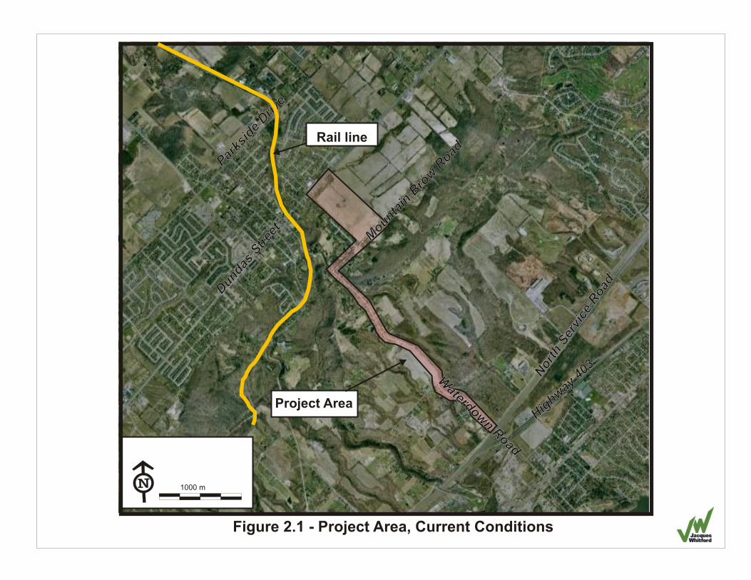
Figure 2.1 - Project Area, Current Conditions
3
Highw
ay 4
03
Highw
ay 4
0
uda
s Str
eet
Dnuda
s Str
eet
Dn
P
iDriv
e
arks
de
P
iDriv
e
arks
de
1000 m
Rail line
Project Area
v
Nor
thSe
ice
Roa
d
rv
Nor
thSe
ice
Roa
d
r
Mun
ai
r R
oad
o
tn B
ow
Mun
ai
r R
oad
o
tn B
ow
Waterdow
Road
n
Waterdow
Road
n
FINAL REPORT
© 2008 PROJECT 1037029 November 18, 2008 4
3.0 HISTORICAL BACKGROUND
3.1 TOWNSHIP SURVEY AND EARLY SETTLEMENT
Survey of the land in the project area was first undertaken in 1793 by Augustus Jones in association
with the clearing of land for the construction of the Dundas Road. The road, planned by Lieutenant
John Graves Governor Simcoe, was intended as a military route connecting York and Dundas. The
strategic importance of the route led Simcoe to immediately begin granting land along the road to those
soldiers who had cleared the land and to other Loyalist soldiers even before the survey was officially
completed (Woods et al., 1967).
Prior to the 1793 Jones survey, the land on the lower shelf of the escarpment had been surveyed and
mapped (Figure 3.1). Notes by Augustus Jones indicate that the map was a copy of a map by John
Fredrick Holland. Interestingly, the lots and concessions are almost square, being laid out in a 7 by 5
grid. At the completion of Jones’ survey in 1793, East Flamborough was laid out with 13 concessions,
each with 13 lots. The western boundary of East Flamborough runs 70˚ west from Cootes Paradise.
The lots are each composed of 200 acres running roughly northwest from the shore of Lake Ontario.
Figure 3.2 shows the lots and concessions as they were laid out in 1797 as well as crown land, clergy
reserves and the names of the original settlers to whom the land was granted.
The project area, being Lots 6 and 7 of Concessions 1, 2 and 3, lies along either side of Waterdown
Road, was an important route in the development of East Flamborough. The road lies on one of the
few locations along the escarpment where the slope is gentle enough to cross from Burlington Bay to
Dundas Street. The construction of the Dundas Road at the end of the 18th century, coupled with the
potential power of Grindstone Creek, spurred both commercial and industrial growth in the project area.
3.2 AGRICULTURE
During the settlement of the Waterdown area, land north of the falls was being developed for industrial
and commercial use. However, land to the south of the falls was being developed for agricultural use.
Lots 6 and 7 of Concessions 1, 2 and 3 were among the first outlying lots to be occupied, given their
location along the route between the growing centres of Waterdown and Aldershot. For the first half of
the nineteenth century, large parcels of land were often owned by single landowners. These
landowners were generally former United Empire Loyalist soldiers who had either been granted the
land by the crown or who, like Alexander Brown owner of the first mill along Grindstone Creek, had
amassed large landholdings by acquiring lots from other former soldiers who chose not to take up their
grants.
Farmland in the project area was established early, due to its convenient location. The 1851 Census
indicates that 80% of the land designated for agricultural use and been cleared and was under
cultivation or pasture (LAC, 1851). Considering the presence of undesirable geographical features
such as the deep ravines found in the project area, 80% usage indicates a long history of agricultural
development south of the falls.
According to the 1851 Census, in 1851 Lot 6, Concession 1 was farmed by Alex White (55 acres) and
by J. Applegarth, who owned a total of 619 acres in Lots 6, 7, 8, and 9 of Concessions 1, 2 and 3. Lot
6, Concession 2 was partially owned by William Wilson (35 acres). Lot 7, Concession 2 was partially
FINAL REPORT
© 2008 PROJECT 1037029 November 18, 2008 5
owned by Thomas Hamond (100 acres). There are 5 entries in the census for land owners in Lots 6
and 7, Concession 3 (William Greirson, Jonathan Graham, Read Baker, Captain F. Fields and Henry F.
Graham). It is unlikely that the farmland in Concession 3 was within the project area as the farm was
likely located to the east and west of the commercial centre of Waterdown.
Between the 1851 census and the 1859 map by Surtees very little physical change took place in the
project area. It seems that a number of the aging United Empire Loyalist Soldiers passed away early in
the second half of the nineteenth century and the 1859 map indicates that a large portion of the
agricultural land in the project area was designated to the heirs or estate of the former land owners
(Figure 3.3). The 1859 map does not indicate any structures in the project area below Grindstone
Falls.
In the years following 1859, a number of changes took place in the project area. Large parcels of land
once controlled by single owners were sold in smaller sections. While the Surtees map indicated no
structures, the 1875 historical atlas does show landowner residences, public buildings and commercial
and industrial establishments (Figures 3.4).
The atlas indicates four buildings within the project area. In Lot 6, Concession 2, a home owned by H.
Carson is shown below the escarpment in a similar location to 1917 Waterdown Road. There is a
house owned by William Homing Senior in Lot 7, Concession 2 (Figure 3.4). A home owned by L.
Rose is shown in Lot 6, south of Concession 3, along the edge of the escarpment. In Lot 5,
Concession 3, there is one building, likely an agricultural outbuilding, and an orchard in land owned by
Alexander Brown (Figure 3.4). There are no buildings below Concession 2 on the map.
3.3 EDUCATIONAL, RELIGIOUS AND PUBLIC BUILDINGS
There are no schools known to have existed within the project area. A log building used as a school
was built somewhere on Alexander Brown’s property around 1815 (Woods et al., 1967). The exact
location of the school is disputed as there are no visible remains. A second log school existed west of
the project area as early as 1827 on the land owned by William Grierson at the present-day intersection
of Dundas Street and Flamborough Street (Woods et al., 1967). A stone-built school was constructed in
1867, west of the project area in what is today Sealey Park.
At present, there are 5 churches and 2 former churches within 1 km of the project area. There were
also, at one time, two churches north of Dundas Street and east of Mill Street– one Presbyterian, one
Methodist Episcopal – is the Waterdown Union Cemetery which lies to the northeast of the project area
(City of Hamilton, 2005).
3.4 INDUSTRY
Industry was a significant factor in the development of Waterdown. Alexander Brown is generally
credited with erecting a mill north of the Great Falls in 1805, the same year he purchased Lots 6 and 7
from Alexander McDonnell. A stone quarry was also located in the southwest corner of Lot 7 (outside
of the project area), which is believed to have been in operation as early as 1815 (Donkin, 1969).
Waterdown Road itself acted as an important route for transporting finished goods from the mills of
Waterdown south to Burlington Bay (Green et al., 1997).
FINAL REPORT
© 2008 PROJECT 1037029 November 18, 2008 6
3.4.1 Mills and Factories
When Alexander Brown purchased Lots 6 and 7, Concession 3 from Alexander McDonnell in 1805 he
constructed the first mill in what was to become Waterdown. His sawmill is reputed to have been built
just north of the Great Falls (Grindstone Falls). Attracted by the potential power of Grindstone Creek,
Ebenezer Griffin and his brother Absalom began purchasing land from Brown in 1823. By 1827 Griffin
had not only built his own sawmill and carding mill, but he had also begun selling off small lots within
his land (Donkin, 1969). In 1831 Griffin drew up plans, known as Griffin's Survey, for the Village of
Waterdown. Along with commercial and residential lots, Griffin's Survey included lots with water
privileges intended for industrial purposes. At its height in the late 19th century, industry in Waterdown
included more than 15 mills. Griffin closely controlled the mill industry in Waterdown through access to
water, in most cases including limitations in land contracts as to how much water the occupant received
and how often. In fact, Griffin’s 1848 purchase agreement with John Cummings included restrictions on
the height of dams that could be built on his property. Likewise, Levi Hawke agreed to similar
restrictions that included that water could pass through his tanning mill raceway only on Monday,
Wednesday and Friday (Donkin, 1969).
Smokey Hollow, located near Grindstone Falls was once the centre of industry in Waterdown. Today,
however, little remains of the dams, raceways and mills that once surrounded the creek. Towards the
end of the 19th century, mills began to lose their importance in industry and their redundancy along with
a series of fires and a decline in the water levels of Grindstone Creek, led to the destruction of the
majority of industry related built heritage in the project area. Within the boundaries of the project area
several mills and factories were known to have existed. Figure 3.5 shows the general locations of mills
and factories as they were indicated on the 1875 map of Waterdown over a modern air-photo. The
majority of industrial structures were located outside the boundaries of the project area.
A tannery owned by Henry Graham is known to have existed east of the project area, along Grindstone
Creek. Having purchased Village Lot 12 from Griffin in 1837, he built a modest home with a small
tannery at the east end of his property. Access to the tannery was provided by Leather Street, which
now functions as the driveway for 63 Mill Street (Green et al., 1997). The tannery was sold to Andrew
Davis in 1854. The restrictions imposed by Griffin’s original property agreements meant that most of
the time water was accessible only to Read Baker’s Rake and Cradle Factory. Davis quickly
abandoned the tannery.
Reid (Read) Baker's Rake Factory, located north of Mountain Brow Road, operated until 1885 when it
was destroyed by fire (Woods et al., 1967).
3.4.2 Electric Power
In 1906 the Toronto Power Generating Station was constructed in Niagara Falls. A transmission
corridor passing through Concession 2 was constructed in 1919 (ASI, 2004).
3.5 TRANSPORTATION
The project area and surrounding landscape have traditionally been vital to transportation. Unlike the
majority of the Niagara Escarpment, the project area is situated in a position that provides a gentle
slope up and down the escarpment by way of the Grindstone Creek valley and the nearby valley that
present-day Snake Road follows. The area was also of great strategic importance for military routes in
the 18th and 19th centuries, the Dundas Road being the most famous example.
FINAL REPORT
© 2008 PROJECT 1037029 November 18, 2008 7
3.5.1 Water
There are several small waterways within the project area and vicinity. There is evidence to suggest
that post-contact native groups used present-day Snake Road, west of Grindstone Creek as a pass to
traverse the escarpment (Woods et al., 1967). While it’s likely that watercourses north of the Great
Falls (Grindstone Falls) would have been used by prehistoric peoples for transportation, historic period
settlers are not known to have used the watercourses in and around the project area for transportation.
3.5.2 Roads
Roadways played a central role in the development of the project area. The evolution of roadways in
the project area and vicinity can be traced back to the creation of the Dundas Road in 1793.
As discussed above, Lt. Gov. Simcoe strongly believed that the Dundas Road was strategically
important in defense against the recently liberated Americans. Clearing of the section of the Dundas
Road in which the project area is located was completed within a month. The road, however, was far
from completed. While brush had been cleared to make a corridor, many tree stumps and large groups
of trees remained in situ (Wray and Green, 1994). The survival of the Dundas Road and subsequent
roadways in the area was dependent upon the Loyalist soldiers and others who chose to take up their
grants of land along the road.
An 1815 map by Nesfield (Figure 3.6) indicates Dundas Street and two other roads running between
Dundas Street across the escarpment, possibly present day Highway 6 and Waterdown Road (Mill
Street). While not shown on the map, it is likely that some of the concession allowance roads in and
around the project area had been at least partially forced through.
In 1839 Philip John Bainbrigge, a Royal Engineer, travelled through Southern Ontario, passing through
Waterdown. In his diary, he sketched the roads he took and the surrounding landscape features. His
notes also included details about the condition of the Dundas Road as well as billeting capacities
(Figure 3.7). His notes about Waterdown indicated that along the top of the Niagara Escarpment, the
Dundas Road was “well cleared” and “thickly inhabited by a superior class of settlers”. He further
indicates that while the road was good, it was intersected by two deep ravines (Bainbrigge, 1839).
The 1850 de Rottenburg map shows very little detail in the project area with the exception of roads
(Figure 3.8). The Dundas Road is illustrated as well as present day Centre Road. The map also
indicates that concession roads north of Dundas and west of Centre Road were cleared. This includes
Parkside Drive (Concession Road 4). Present-day Kerns Road, along the boundary between East
Flamborough and Burlington is also indicated on the map running from Dundas, south towards the lake.
There is no indication of Mountain Brow Road on the map however, there was most likely an
established road along Concession 3 (present-day Mountain Brow Road) given that at least one home
along the road was known to have existed as early as 1833 (Green et al.,1997).
On the 1859 Surtees map, Mountain Brow Road is indicated as a darker line just north of the
escarpment (Figure 3.3).
3.5.3 Bridges
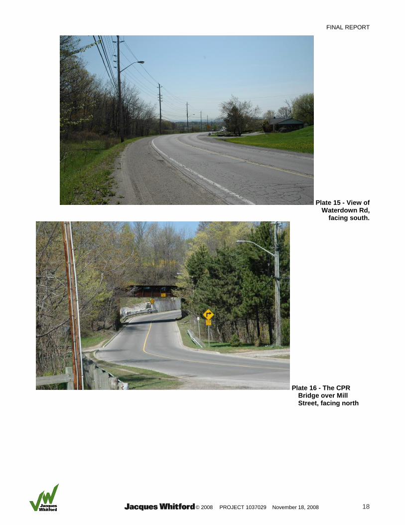
There are two bridges of note near the project area; the Canadian Pacific Rail line bridge over Mill
Street (Plate 16) and the Dundas Bridge (Plate 17). The bridge over Mill Street is located north of the
current project area and dates to 1911, when the rail line was constructed. The Dundas Bridge is
located along Dundas Street, east of Mill Street (Waterdown Road). Originally built to cross over

FINAL REPORT
© 2008 PROJECT 1037029 November 18, 2008 8
Grindstone Creek, the bridge has been altered a number of times and now consists of four lanes of
traffic, passing over the Canadian Pacific Rail Line.
3.5.4 Rail
Although the Grand Trunk Railway existed south of the project area, passing through Aldershot; there
was no railway passing through Waterdown until 1912. Beginning in 1910, the CPR constructed a line
linking Guelph and Hamilton. Given the relatively gentle slope of Grindstone Creek Valley, Waterdown
remains one of the few places where the escarpment can be traversed by rail. The construction of the
line through Waterdown was a massive undertaking involving the relocation of Grindstone Creek. The
rail line follows Grindstone Creek from north of the project area passing under the pre-existing Dundas
Bridge. The line crosses over Grindstone Creek just north of Spring Creek and then passes over
Waterdown Road and continues southward, west of the project area (Figure 2.1). Until 1950, when it
discontinued passenger service, the line served as an important component to transportation in and
around the project area. It now transports only freight (Wray and Green, 1994).
4.0 BUILT HERITAGE RESOURCES
4.1 METHODOLOGY
Built heritage resources in the project area were assessed based on Ontario Provincial Policy
guidelines. Significant built heritage resources are protected under the Provincial Policy Statement,
2005 (PPS, 2005) policy 2.6.1. Built heritage resources involve "one or more significant buildings,
structures, monuments, installations or remains associated with architectural, cultural, social, political,
economic or military history and identified as being important to a community. These resources may be
identified through designation or heritage conservation easement under the Ontario Heritage Act, or
listed by local, provincial or federal jurisdictions." Using the PPS, 2005 as a guideline, the project area
was assessed for built heritage resources.
Once built heritage resources were identified, their significance was evaluated based on the PPS,
2005's definition of significant. A built heritage resource is considered significant if it is "valued for the
important contribution [it] make[s] to our understanding of the history of a place, an event, or a people."
Built Heritage Assessment Criteria considered for the purposes of this assessment included:
Historical Associations - Potential resources were evaluated based on their age and/or
relationship to historical themes, events, persons and/or groups;
Architecture and Design - Building styles, materials and architect were evaluated where
possible;
Integrity - A windshield survey was performed to assess buildings of architectural and/or
heritage interest in the inventories of both the City of Hamilton and the City of Burlington. A
photographic record of identified buildings and their surrounding environment was created.
Other buildings not listed by either City were also observed and evaluated. Buildings not
visible from the street were not included in the photographic record;
Environmental Context - Identified resources were evaluated for their contribution to the
character of their surrounding landscape, or for the integrity of their original environmental
setting;
FINAL REPORT
© 2008 PROJECT 1037029 November 18, 2008 9
Social Value - For the purposes of this assessment, buildings included in local inventories
were considered to have social value.
4.2 EXISTING HERITAGE DESIGNATIONS, EASEMENTS AND CONSERVATION DISTRICTS
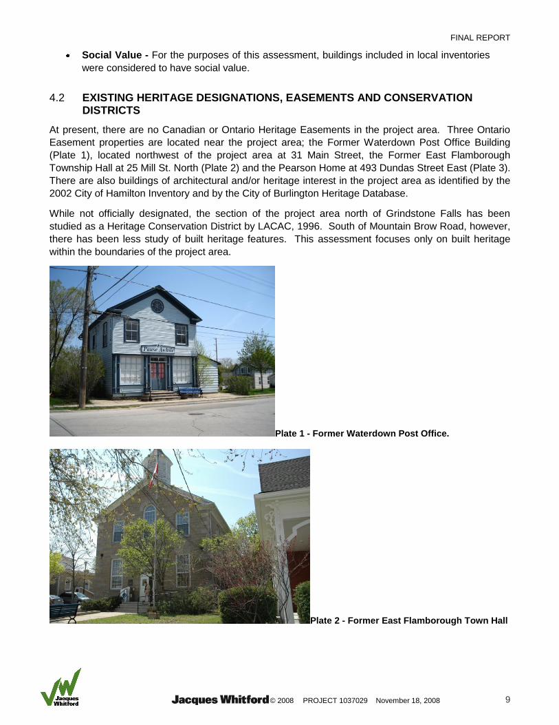
At present, there are no Canadian or Ontario Heritage Easements in the project area. Three Ontario
Easement properties are located near the project area; the Former Waterdown Post Office Building
(Plate 1), located northwest of the project area at 31 Main Street, the Former East Flamborough
Township Hall at 25 Mill St. North (Plate 2) and the Pearson Home at 493 Dundas Street East (Plate 3).
There are also buildings of architectural and/or heritage interest in the project area as identified by the
2002 City of Hamilton Inventory and by the City of Burlington Heritage Database.
While not officially designated, the section of the project area north of Grindstone Falls has been
studied as a Heritage Conservation District by LACAC, 1996. South of Mountain Brow Road, however,
there has been less study of built heritage features. This assessment focuses only on built heritage
within the boundaries of the project area.
Plate 1 - Former Waterdown Post Office.
Plate 2 - Former East Flamborough Town Hall

FINAL REPORT
© 2008 PROJECT 1037029 November 18, 2008 10
Plate 3 - The Pearson Home (Avonsyde Dairy)
Plate 4 - Woodhill, 120 Mountain Brow Road/ 440 Mountain Brow Road (source: Green et al., 1997)
120 Mountain Brow Road/440 Mountain Brow Road, Woodhill
In January 2008 Burlington City Council voted in favour of designating Woodhill (120 Mountain Brow
Road) (Plate 4) for an Ontario Heritage Easement (BHS, 2008). The house at 120 Mountain Brow (also
440) is far removed from the roadway by a long driveway and was not visible during the windshield
survey. According to prior assessments of the house, it was originally built in the Regency style.
Based on photographs, it appears altered, but not greatly. The house was designed by Charles Allen
for Adam Ferguson and included a chapel. Although the house is considered by this assessment to be
a significant built heritage resource, it is unlikely to be impacted by the proposed construction activity
given its distance from the roadway, approximately 500 m.
FINAL REPORT
© 2008 PROJECT 1037029 November 18, 2008 11
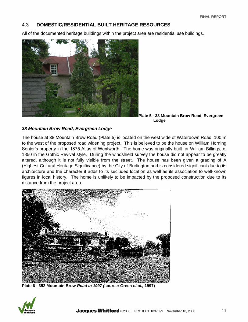
4.3 DOMESTIC/RESIDENTIAL BUILT HERITAGE RESOURCES
All of the documented heritage buildings within the project area are residential use buildings.
Plate 5 - 38 Mountain Brow Road, Evergreen Lodge
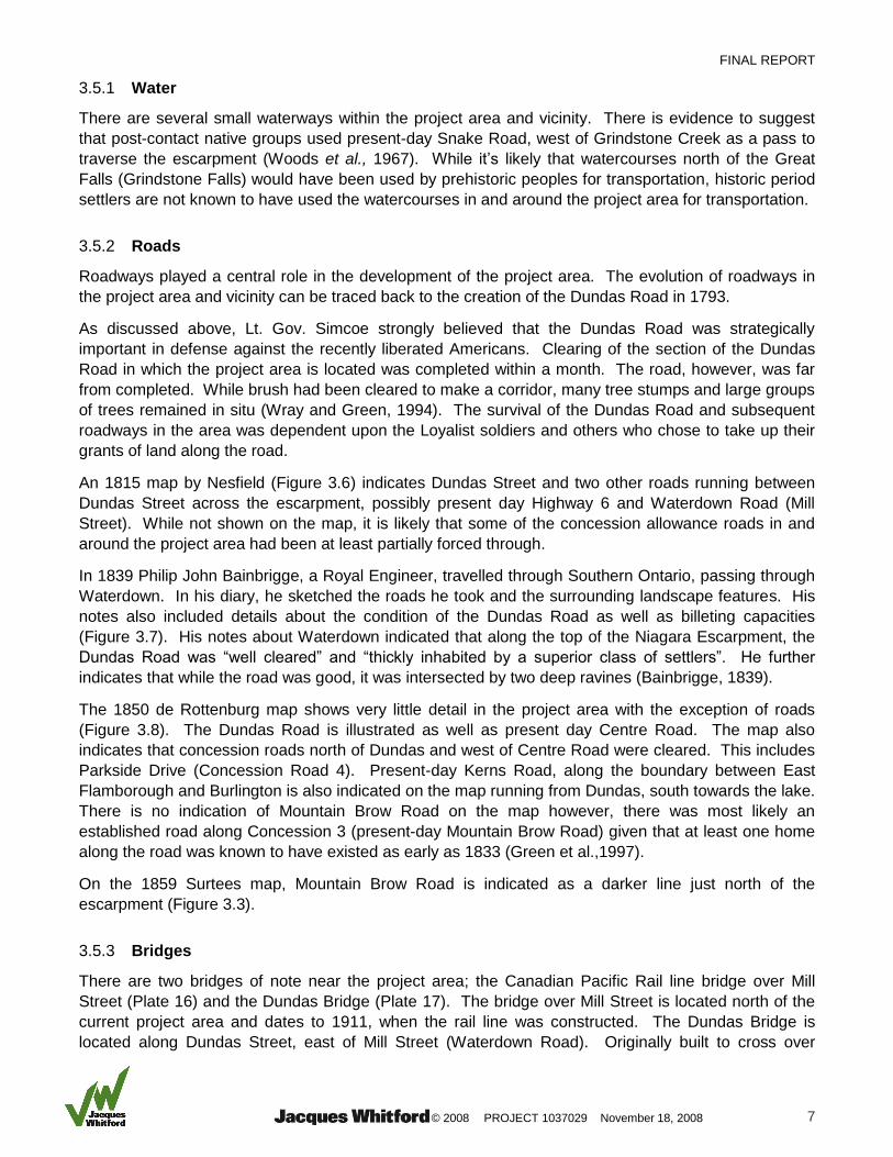
38 Mountain Brow Road, Evergreen Lodge
The house at 38 Mountain Brow Road (Plate 5) is located on the west wide of Waterdown Road, 100 m
to the west of the proposed road widening project. This is believed to be the house on William Horning
Senior’s property in the 1875 Atlas of Wentworth. The home was originally built for William Billings, c.
1850 in the Gothic Revival style. During the windshield survey the house did not appear to be greatly
altered, although it is not fully visible from the street. The house has been given a grading of A
(Highest Cultural Heritage Significance) by the City of Burlington and is considered significant due to its
architecture and the character it adds to its secluded location as well as its association to well-known
figures in local history. The home is unlikely to be impacted by the proposed construction due to its
distance from the project area.
Plate 6 - 352 Mountain Brow Road in 1997 (source: Green et al., 1997)
FINAL REPORT
© 2008 PROJECT 1037029 November 18, 2008 12
352 Mountain Brow Road
The original building at 352 Mountain Brow Road (Plate 6) was constructed around 1846 after John
Cummer purchased land for a family home overlooking Grindstone Falls where he operated a mill. The
home was built in the Georgian style out of local stone. After John Cummer’s death in 1868, his home
was purchased by William Pearce Howland, a member of the Legislative Assembly of Canada and
Minister of Finance. W.P. Howland is well known in Waterdown as the operator of the mill his home
overlooked, and he is also considered one of the Fathers of Confederation (Green et al.,1997). The
home is not visible from the street, but a photograph from 1997 indicated that there had been several
additions to the building. Despite additions and alterations, 352 Mountain Brow Road is considered to
be a significant built heritage resource. The original stone-built Georgian home is still discernable
despite significant alteration. The house is consistent with its environmental context, being removed
from the road and secluded by trees in a residential area. Based on criteria used to evaluate built
heritage in the City of Burlington this house is rated as having high cultural heritage value based on its
age and on historical associations.
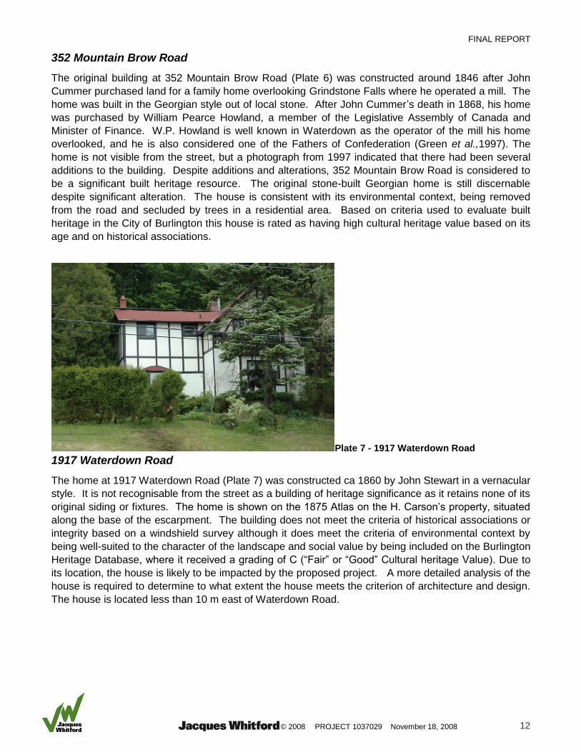
Plate 7 - 1917 Waterdown Road
1917 Waterdown Road
The home at 1917 Waterdown Road (Plate 7) was constructed ca 1860 by John Stewart in a vernacular
style. It is not recognisable from the street as a building of heritage significance as it retains none of its
original siding or fixtures. The home is shown on the 1875 Atlas on the H. Carson’s property, situated
along the base of the escarpment. The building does not meet the criteria of historical associations or
integrity based on a windshield survey although it does meet the criteria of environmental context by
being well-suited to the character of the landscape and social value by being included on the Burlington
Heritage Database, where it received a grading of C (“Fair” or “Good” Cultural heritage Value). Due to
its location, the house is likely to be impacted by the proposed project. A more detailed analysis of the
house is required to determine to what extent the house meets the criterion of architecture and design.
The house is located less than 10 m east of Waterdown Road.
FINAL REPORT
© 2008 PROJECT 1037029 November 18, 2008 13
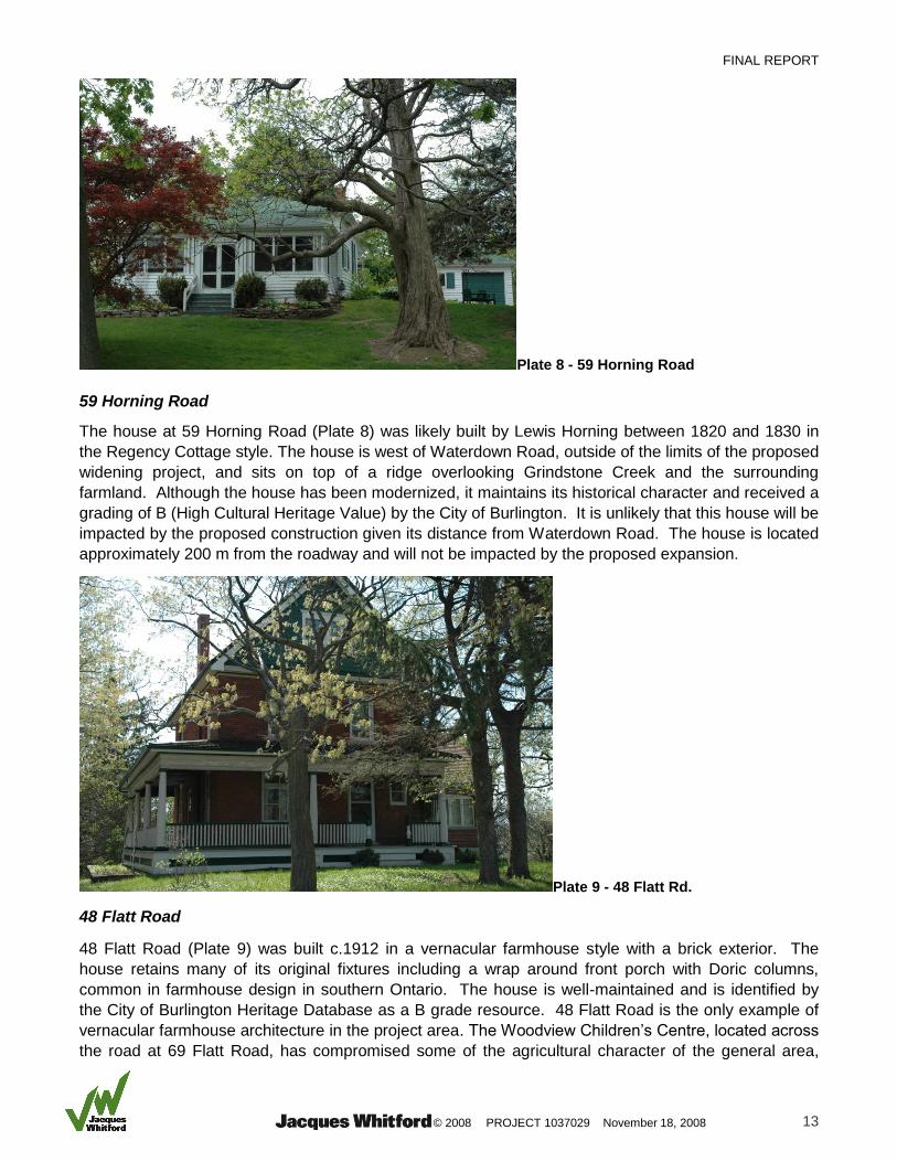
Plate 8 - 59 Horning Road 59 Horning Road
The house at 59 Horning Road (Plate 8) was likely built by Lewis Horning between 1820 and 1830 in
the Regency Cottage style. The house is west of Waterdown Road, outside of the limits of the proposed
widening project, and sits on top of a ridge overlooking Grindstone Creek and the surrounding
farmland. Although the house has been modernized, it maintains its historical character and received a
grading of B (High Cultural Heritage Value) by the City of Burlington. It is unlikely that this house will be
impacted by the proposed construction given its distance from Waterdown Road. The house is located
approximately 200 m from the roadway and will not be impacted by the proposed expansion.
Plate 9 - 48 Flatt Rd.
48 Flatt Road
48 Flatt Road (Plate 9) was built c.1912 in a vernacular farmhouse style with a brick exterior. The
house retains many of its original fixtures including a wrap around front porch with Doric columns,
common in farmhouse design in southern Ontario. The house is well-maintained and is identified by
the City of Burlington Heritage Database as a B grade resource. 48 Flatt Road is the only example of
vernacular farmhouse architecture in the project area. The Woodview Children’s Centre, located across
the road at 69 Flatt Road, has compromised some of the agricultural character of the general area,
FINAL REPORT
© 2008 PROJECT 1037029 November 18, 2008 14
however, overall the house is consistent with the character of the surrounding agricultural landscape
thereby satisfying the environmental context criterion.
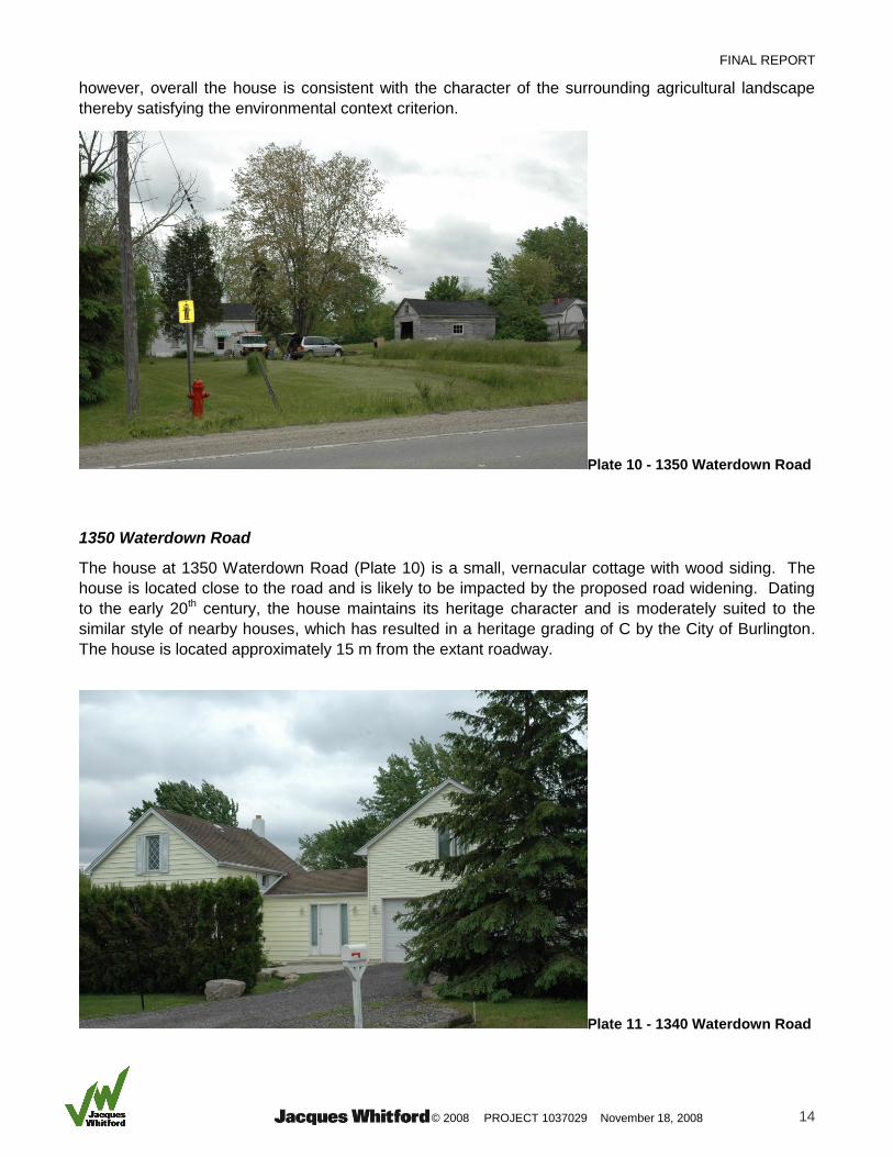
Plate 10 - 1350 Waterdown Road 1350 Waterdown Road
The house at 1350 Waterdown Road (Plate 10) is a small, vernacular cottage with wood siding. The
house is located close to the road and is likely to be impacted by the proposed road widening. Dating
to the early 20th century, the house maintains its heritage character and is moderately suited to the
similar style of nearby houses, which has resulted in a heritage grading of C by the City of Burlington.
The house is located approximately 15 m from the extant roadway.
Plate 11 - 1340 Waterdown Road
FINAL REPORT
© 2008 PROJECT 1037029 November 18, 2008 15
1340 Waterdown Road
The original building at 1340 Waterdown Road (Plate 11) likely consisted only of the southernmost
section of the present structure. The house dates to the early 20th century and was built in a vernacular
style. The house has lost its heritage character due to additions and alterations to the exterior,
resulting in a heritage grading of C by the City of Burlington.
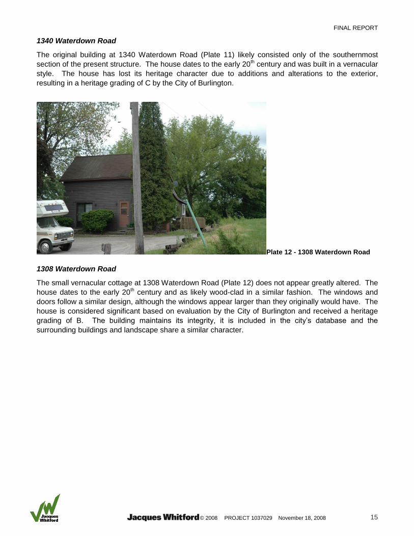
Plate 12 - 1308 Waterdown Road 1308 Waterdown Road
The small vernacular cottage at 1308 Waterdown Road (Plate 12) does not appear greatly altered. The
house dates to the early 20th century and as likely wood-clad in a similar fashion. The windows and
doors follow a similar design, although the windows appear larger than they originally would have. The
house is considered significant based on evaluation by the City of Burlington and received a heritage
grading of B. The building maintains its integrity, it is included in the city’s database and the
surrounding buildings and landscape share a similar character.

FINAL REPORT
© 2008 PROJECT 1037029 November 18, 2008 16
Plate 13 - 1258 Waterdown Rd
1258 Waterdown Road
The home at 1258 Waterdown Road (Plate 13) was built c. 1910 in a vernacular cottage style. It is a
one and a half storey building with a stuccoed exterior. The size and dimensions of 1258 Waterdown
is echoed by nearby post-war houses in the vicinity, suggesting that the home is a good representation
of the character of the south end of the project area during the early 20th century. The house received
a heritage grading of B from the City of Burlington. Although it lacks historical association, it meets the
other four criteria. The house is located less than 20 m from the current roadway. To avoid impact,
widening on the east side of Waterdown road is recommended.
4.3.1 Survey Patterns
Present-day lots follow the same general configuration as the original Jones survey. As farms and
homesteads developed in the project area, tree-lines and fences were erected to delineate property
lines. Tree-lines are still visible in agricultural fields throughout the project area.
4.4 EDUCATIONAL, RELIGIOUS AND PUBLIC BUILDINGS
There are no educational, religious or public buildings within the project area limits.
4.5 INDUSTRIAL BUILT HERITAGE
4.5.1 Mills and Factories
While the remains of some mill related stone foundations, possibly dams or raceways, exist at the top
of Grindstone Falls (Plate 14), no other built heritage related to industry are located within the project
area. The stone foundations are located approximately 250 m north of Mountain Brow Road and will
not be impacted by the proposed widening.

FINAL REPORT
© 2008 PROJECT 1037029 November 18, 2008 17
Plate 14 - View of Grindstone Creek, above the falls. Stone foundations are visible on both sides of the creek.
4.5.2 Electric Power
There are no significant built heritage resources related to electric power within the project area.
4.6 TRANSPORTATION BUILT HERITAGE RESOURCES
4.6.1 Water
There are no built heritage resources associated with water within the project area.
4.6.2 Roads
Dundas Street has been greatly altered by over 200 years as a major route of transportation and at
present presents low heritage integrity. Mountain Brow Road and Waterdown Road (Plate 15), on the
other hand, both retain their historic period form. Although both roads have been paved and widened
to two lanes, they both follow the original paths laid out in the early 19th century due to the
physiographic limitations of the area. While the road can be considered a cultural landscape heritage
resource, it is not considered by this assessment to be a built heritage resource. The historical
importance of the road and its contribution to the cultural landscape of the project area should be taken
into consideration during the planning of the proposed widening. In order to preserve the integrity of
the road as a cultural heritage landscape, steps should be taken to follow the same route.
FINAL REPORT
© 2008 PROJECT 1037029 November 18, 2008 18
Plate 15 - View of Waterdown Rd,
facing south.
Plate 16 - The CPR Bridge over Mill Street, facing north

FINAL REPORT
© 2008 PROJECT 1037029 November 18, 2008 19
Plate 17 - The Dundas Street Bridge, facing east
4.6.3 Bridges
Both the Canadian Pacific Rail line over Mill Street (Plate 16) and the Dundas Street Bridge over Grindstone Creek and the Canadian Pacific Rail line (Plate 17) are included in the Hamilton Heritage Bridge Inventory (City of Hamilton, 2006). The Hamilton Heritage Bridge Guideline and Heritage Bridge Conservation methodology rates bridges based on age, material, design, integrity, aesthetics and environment and historical association. The box beam construction Canadian Pacific Rail Bridge over Mill Street (Plate 17) is considered by the City of Hamilton to be a B grade resource, of high heritage value (City of Hamilton, 2006). Given that the Mill Street bridge has undergone very little alteration since its construction in 1911 and reflects the aesthetic of its location along with its inclusion in the local heritage bridge inventory as a resource of high heritage value, the Mill Street bridge is considered by this study to be of cultural heritage significance and the current project plan should avoid impacting its structure and aesthetic. The Dundas Street Bridge is rated by the City of Hamilton to be a C grade resource, of moderate heritage value. The Dundas Bridge (Plate 17) is not considered by this study to have high built heritage integrity. Major reconstructions of the bridge are known to have taken place in 1910-1912, 1922-1925 and in 1965 and although included in the local heritage bridge inventory, it received a score at the very low end of moderate heritage value. The current project is unlikely to impact either of the bridges, which are located north of the project area.
4.6.4 Rail
The Canadian Pacific Rail line (CPR) (Plate 18) still operates along the western edge of the project
area towards the north following the same path as it did in 1912. The CPR arrived in Waterdown as the
mill industry was coming to a close. The line is characteristic of the paradigm shift that occurred in
Waterdown at the beginning of the 20th century from industrial to residential land-use and fits the
aesthetics of the surrounding landscape. Furthermore, the CPR line has remained relatively
unchanged since its construction, 1910-1912 and is considered to be of high integrity. The rail line is
considered by this study to be of high heritage value. It is unlikely to be impacted by the proposed
project route.

FINAL REPORT
© 2008 PROJECT 1037029 November 18, 2008 20
Plate 18 - The CPR Line, as seen from Dundas Bridge
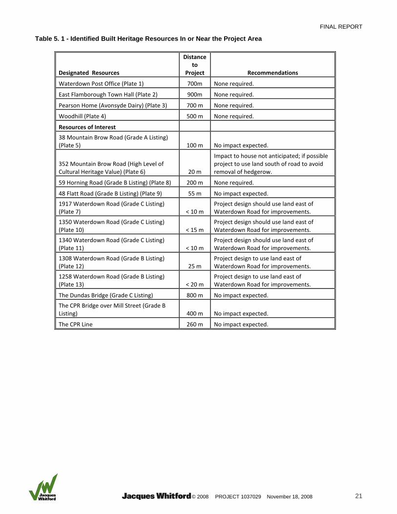
5.0 STUDY RESULTS AND RECOMMENDATIONS
A total of four designated built heritage properties and eleven built heritage resources of interest
previously identified by the City of Hamilton and the City of Burlington were documented for the project
(Table 5.1). A visual survey of the proposed project route did not identify any other potential built
heritage resources of potential significance within the boundaries of the proposed project.
All of the designated built heritage resources are located well outside of the project area and no
impacts associated form construction of the proposed project will occur (Table 5.1). Of the eleven built
heritage resources of interest, five are located sufficiently far from the proposed project that no impacts
should be anticipated (Table 5.1).
The remaining six built heritage resources are located within 25 m of the proposed project area, but all
should be avoidable through project design (Table 5.1). The house at 352 Mountain Brow Road (Plate
6) is 20 m from the north edge of the existing roadway, and expansion of the road is not likely to have
any effect on the house itself. However, there is a hedgerow associated with the house along the edge
of the roadway that, if removed, could impact on the overall environmental character and setting of the
house. Project design should incorporate the south side of Mountain Brow Road, if possible, to avoid
removing the hedgerow. The remaining five houses are all located on the west side of Waterdown
Road, at the south end of the project area. All of these resources can be avoided through designing
the proposed road expansion to use land on the east side of Waterdown Road. The land on the east
side of the road is currently undeveloped and use of this land is highly recommended.
FINAL REPORT
© 2008 PROJECT 1037029 November 18, 2008 21
Table 5. 1 - Identified Built Heritage Resources In or Near the Project Area
Designated Resources
Distance to
Project Recommendations
Waterdown Post Office (Plate 1) 700m None required.
East Flamborough Town Hall (Plate 2) 900m None required.
Pearson Home (Avonsyde Dairy) (Plate 3) 700 m None required.
Woodhill (Plate 4) 500 m None required.
Resources of Interest
38 Mountain Brow Road (Grade A Listing) (Plate 5) 100 m No impact expected.
352 Mountain Brow Road (High Level of Cultural Heritage Value) (Plate 6) 20 m
Impact to house not anticipated; if possible project to use land south of road to avoid removal of hedgerow.
59 Horning Road (Grade B Listing) (Plate 8) 200 m None required.
48 Flatt Road (Grade B Listing) (Plate 9) 55 m No impact expected.
1917 Waterdown Road (Grade C Listing) (Plate 7) < 10 m
Project design should use land east of Waterdown Road for improvements.
1350 Waterdown Road (Grade C Listing) (Plate 10) < 15 m
Project design should use land east of Waterdown Road for improvements.
1340 Waterdown Road (Grade C Listing) (Plate 11) < 10 m
Project design should use land east of Waterdown Road for improvements.
1308 Waterdown Road (Grade B Listing) (Plate 12) 25 m
Project design to use land east of Waterdown Road for improvements.
1258 Waterdown Road (Grade B Listing) (Plate 13) < 20 m
Project design to use land east of Waterdown Road for improvements.
The Dundas Bridge (Grade C Listing) 800 m No impact expected.
The CPR Bridge over Mill Street (Grade B Listing) 400 m No impact expected.
The CPR Line 260 m No impact expected.

Figure 5.1- Built Heritage Resources in the Project Area
Dundas StreetDundas Street
i r oaMounta n B ow R d
Wa
erd
o
at
ow
nR
dW
ae
rd
oa
to
wn
Rd
500 m
lat S reetF t tlat S reetF t t
Legendi H ritag , id cBu lt e e Res en e
North S vice oader R
North S vice oader R
19171917
13501350
13401340
13081308
12581258
Built Heritage, Bridge
FINAL REPORT
© 2008 PROJECT 1037029 November 18, 2008 23
6.0 CLOSURE
This report has been prepared for the benefit of the City of Hamilton, the City of Burlington and the
Regional Municipality of Halton, and may not be used by any third party without the express written
consent of Jacques Whitford Limited, the City of Hamilton or their partners. Any use which a third party
makes of this report is the responsibility of such third party. This report has been filed with the Ontario
Ministry of Culture for their review.
The recommendations made in this report are in accordance with our understanding of the project as it
was presented at the time of our report. In the event that changes or alterations are made to the
project, we reserve the right to review our recommendations with respect to any such changes.
We trust this report meets your current requirements. Please do not hesitate to contact us should you
require further information or have additional questions about any facet of this project.
Yours truly,
JACQUES WHITFORD LIMITED
Christie Uchiyama, B.A. Colin Varley, M.A., R.P.A. Assistant Archaeologist Senior Archaeologist and Heritage Planning Consultant
FINAL REPORT
© 2008 PROJECT 1037029 November 18, 2008 24
7.0 REFERENCES
ASI (Archaeological Services Inc), Growth Related Integrated Development Study (GRIDS):
Hamilton Cultural Heritage Landscape Study. Report on file, the City of Hamilton.
Archives of Ontario.
1843. Plan of East Flamborough, July 1843, C277.
1791. Plan of East Flamborough by Augustus Jones, October 1791, RG 1-470.
1797. Plan of East Flamborough, 1797, RG 1-470.
Bainbrigge, Philip John, 1839. Toronto to Hamilton via Dundas Street January 6th 1839 in ‘Roads
along the frontiers in Upper Canada.’ P.J. Bainbrigge Royal Engineers Chatham Upper Canada.
Ontario’s History in Maps, 1984.
BHS (Burlington Historical Society), 2008. Gazette: Newsletter of the Burlington Historical Society.
Volume 3:3.
City of Burlington. Directory of Heritage Properties in Burlington. http://www.burlington.ca/heritage/
accessed May, 2008.
City of Hamilton, 2002. Hamilton’s Heritage, Volume 2: Inventory of Buildings of Architectural
and/or Historical Interest. Hamilton: City of Hamilton Planning and Economic Development
Department.
---, 2003. Hamilton’s Heritage, Volume 3: Canadian Inventory of Historic Building. Hamilton: City
of Hamilton Planning and Economic Development Department.
---, 2005. Hamilton’s Heritage, Volume 6: Inventory of Cemeteries and Burial Grounds. Hamilton:
City of Hamilton Planning and Economic Development Department.
---, 2006. Hamilton Heritage Bridge Guideline and Heritage Bridge Conservation. Hamilton: City
of Hamilton Planning and Economic Development Department.
---, 2007. Hamilton’s Heritage, Volume 1: List of Designated Properties and Heritage
Conservation Easements under the Ontario Heritage Act, Second Edition. Hamilton: City of
Hamilton Planning and Economic Development Department.
---, 2008. iMapper interactive web mapping site.
http://map.hamilton.ca/maphamilton/Interactive/iMapper.aspx#.
Cox, Steven L., 1989. Report on the Phase 1 Archaeological Survey of the Bangor Hydro-Electric
Second 345 KV Tie Line Project Route. Report on file, Maine State Museum, Bangor, Maine.
Donkin, Margaret Kathleen, 1969. An Analysis of the Changing Land-Use Morphology of
Waterdown 1795-1960. Unpublished thesis, McMaster University.
Flamborough Archives and Heritage Society
1903. Extract from the Imperial Atlas of Wentworth County, Map of the Village of Waterdown, East
Flamboro.
FINAL REPORT
© 2008 PROJECT 1037029 November 18, 2008 25
Gentilcore, Louis R. and C. Grant Head, 1984. Ontario’s History in Maps. Toronto: University of
Toronto Press.
Green, Patricia and Maurice and Sylvia and Robert Wray, 1997. … and they came to East
Flamborough. The Waterdown-East Flamborough Heritage Society.
Jacques Whitford, 2008. Stage 1 Archaeological Impact Assessment - Interconnecting and Third
Party Pipelines. Report prepared for Shell Canada Products, Sarnia, ON.
Jacques Whitford, 2008. Stage 1 Archaeological Assessment – Proposed Improvements, Joe
Sams Park. Report prepared for the City of Hamilton, ON.
LAC (Library and Archives Canada)
1851. Census of Canada East, Canada West, New Brunswick and Nova Scotia, 1851, Microfilm C-11758.
1871. Federal Census of 1871 (Ontario Index), Microfilm C-9924.
MoC (Ministry of Culture), 2008. Archaeological Sites Database. Records on file at the Heritage Unit,
Toronto, Ontario.
Nesfield, W.A. Owen, 1815. Map of the Niagara District in Upper Canada by Lieutenant N.A.
Nesfield drawn partly from Survey & from documents obtained from the Q. Mr. Genl's
Department. National Map Collection, H2/407/[1815).
OHF (Ontario Heritage Foundation), 2008. Registered Heritage Properties Database.
http://www.culture.gov.on.ca/english/culdiv/heritage/hpd.htm.
Page and Smith, 1875. Illustrated Historical Atlas of the County of Wentworth, Ontario. Toronto:
Page and Smith, Publishers.
Presant, E.W., R.E. Wicklund, and B.C. Matthews, 1965. The Soil of Wentworth County. Report No.
32 of the Ontario Soils Survey. Canada Department of Agriculture, Ottawa and Ontario Department of
Agriculture, Toronto.
Rottenburg, Major George F. Baron de, 1850. Map of the principal communications in Canada
West. Compiled from the most authentic sources, actual surveys, district maps, etc. etc.
National Map Collection, H1/400/[1850].
Surtees, Robert, 1859. Map of the County of Wentworth, Canada West. Compiled from authentic
surveys by Robert Surtees, Civil Engineer and published by Hardy Gregory Lithographers & Engraver,
Hamilton, 1859.
Unterman McPhail Cuming Associates, 1996. Waterdown Heritage Conservation District Study.
Report on file at the Flamborough Archives.