Embed Size (px)
Citation preview

GHD | Report for Centennial Newstan Pty Ltd - Newstan Mine Extension Project, 2220261
Appendix I – Hydrogeotechnical impact assessment
CENTENNIAL COAL COMPANY LIMITED Newstan Mine Extension Project: EIS Assessment of Interaction with Eraring Ash Dam NST4976
REPORT TO
Jason Boersma Operations Projects Engineer Centennial Coal Company Limited 100 Miller Road FASSIFERN NSW 2283
TITLE
Newstan Mine Extension Project: Assessment of Interaction with
Eraring Ash Dam
REPORT NO
NST4976
PREPARED BY
Ken Mills
REVIEWED BY
Stephen Wilson
DATE 19 September 2019
Ken Mills Principal Geotechnical Engineer
Report No Version Date NST4976 Final 19 September 2019
Newstan Mine Extension Project: EIS Assessment of Interaction with Eraring Ash Dam
SCT Operations Pty Ltd – NST4976 – 19 September 2019 i
SUMMARY Centennial Newstan Pty Ltd (CNPL) owns and operates Newstan Colliery on the western side of Lake Macquarie some 20-25km southwest of Newcastle. CNPL is preparing an Environmental Impact Statement (EIS) for its Newstan Mine Extension Project (Newstan MEP). CNPL commissioned SCT Operations Pty Ltd (SCT) to review the proposed mine design in the context of potential interactions with fly ash emplaced in the Eraring Ash Dam. This report presents the results of our review. Our review indicates that there is an existing interaction between the workings of Awaba Colliery and the Eraring Ash Dam. A pathway and hydraulic gradient exist for water from the ash dam into the workings of Awaba Colliery and then potentially into nearby watercourses once pumping at 10 South ceases. Origin Energy plans to augment the storage of the Eraring Ash Dam by constructing an earth embankment. Consulting the Dams Safety Committee (DSC) and conducting a risk assessment with input from the DSC are recommended to ensure any subsidence impacts associated with the proposed mining in the Newstan MEP are suitably controlled and managed. The planned augmentation is expected to cause an increase in the area of potential interaction between the ash dam and Awaba Colliery workings when the ash level in the dam rises to cover a larger area above Awaba Colliery. SCT understands Origin Energy is preparing to fill the voids in Awaba Colliery to limit the potential for collapse of the small pillars below the earth embankment and to limit inflows to Awaba Colliery from the ash dam. This void filling is expected to be effective to control the potential for collapse of small pillars. We recommend that the effectiveness of this barrier to reduce the hydraulic conductivity between the ash dam and Awaba Colliery is confirmed prior to and after completion of adjacent mining activity by ensuring a differential water pressure can be maintained across the barrier. Ground movements caused by proposed Newstan MEP mining in the West Borehole Seam have potential to compromise the effectiveness of this barrier. Post-mining filling of the subsidence fractures to restore the integrity of the barrier is likely to require significant effort and ingenuity particularly in areas directly below the ash dam once ash has been emplaced. Full extraction of the FCT panels creates a fracture network directly above each FCT panel. This fracture network is expected to provide an enhanced flow pathway into Newstan Colliery from the ash dam and from the flooded workings of Awaba Colliery as well as directly between the ash dam and Awaba Colliery once Newstan Colliery eventually floods. During the period of mining, the hydraulic gradients are downward into Newstan Colliery. Hydraulic connection between workings in the Newstan MEP and the ash dam and Awaba Colliery is likely to cause an increase of water requiring treatment at the Newstan Colliery discharge point. Accurately determining flow rates requires further work beyond the scope of this review.
Newstan Mine Extension Project: EIS Assessment of Interaction with Eraring Ash Dam
SCT Operations Pty Ltd – NST4976 – 19 September 2019 ii
The fracture network created above each full width FCT panel is expected to become more significant once Newstan Colliery eventually fills with water. The fracture network then provides a flow pathway between the ash dam and the Awaba Colliery workings that effectively bypasses any barrier able to be created by the proposed void filling in Awaba Colliery. Newstan and Awaba Collieries then become hydraulically connected to each other and to the ash dam through mining induced fracture networks. The groundwater discharges from both collieries would report to either the artesian outflow in the southwest of Awaba Colliery or the discharge overflow point at Newstan Colliery depending on the relative levels of these two points and the rates of rainfall inflow, particularly to Awaba Colliery. An assessment of the potential for mining subsidence to cause liquefaction of the fly ash requires specialist investigation. The method of emplacing material in the Eraring Ash Dam has potential to generate a “soil” mass that would be capable of liquefaction. Subsidence movements associated with mining the flexible conveyor train (FCT) panels would be expected to occur slowly enough for excess pore pressures generated by the displacement to dissipate without causing liquefaction. We recommend suitably qualified soil mechanics specialists are engaged as part of the EIS to confirm that the material properties of the fly ash and the fill geometries being considered are capable of dissipating pore pressure in the timeframe of subsidence. The magnitude of micro-seismic events generated by ground movements caused by mining in the Newstan MEP are expected to be less than the magnitude of naturally occurring seismic events with a one year return period. Mining subsidence is therefore not expected to create a liquefaction hazard at the Eraring Ash Dam greater than the risk from naturally occurring seismic events. A program of monitoring the micro-seismicity of early panels in the Newstan MEP is recommended to confirm the magnitude of micro-seismic events caused by mining these panels is as low as expected.
Newstan Mine Extension Project: EIS Assessment of Interaction with Eraring Ash Dam
SCT Operations Pty Ltd – NST4976 – 19 September 2019 iii
TABLE OF CONTENTS
PAGE NO
SUMMARY ........................................................................................... I
TABLE OF CONTENTS ............................................................................. III
1. INTRODUCTION ................................................................................ 1
2. CONCLUSIONS AND RECOMMENDATIONS ............................................... 1
2.1 Pre-existing interactions ...................................................... 1
2.2 Interactions relating to the ash dam augmentation project ...... 2
2.3 Interactions relating to mining the Newstan MEP ................... 2
2.4 Recommendations ................................................................ 5
3. SITE DESCRIPTION ........................................................................... 6
3.1 Newstan MEP in West Borehole Seam ................................... 6
3.2 Awaba Colliery in the Great Northern Seam .......................... 10
3.3 Eraring Ash Dam ................................................................ 11
3.4 Overview of Sub-Surface Impacts from Extractive Mining ....... 12
3.4.1 Ground Disturbance .................................................. 12
3.4.2 Mining Related Groundwater Disturbance ................... 14
3.4.3 Inflow Rate ............................................................... 15
4. CONSIDERATION OF PRE-NEWSTAN MEP INTERACTION EFFECTS................ 15
4.1 Awaba Colliery Ash Dam Interaction: Existing Effects ............ 17
4.2 Awaba Colliery Ash Dam Interaction: Following Augmentation . 18
5. ASH DAM INTERACTIONS FOLLOWING NEWSTAN MEP ............................ 20
5.1 Surface Subsidence Estimates for Newstan MEP ................. 21
5.2 Eraring Ash Dam Earth Embankment ................................... 21
5.3 Void Fill Flow Barrier in Awaba Colliery .................................. 22
5.4 Flow Through Overburden to West Borehole Seam ................ 22
5.5 Flow Pathways: Short and Long-Term .................................. 24
5.6 Earthquake Interactions with Earth Embankment .................. 26
5.7 Potential for Subsidence to Cause Liquefaction of Retained Fly Ash .............................................................................. 27
6. REFERENCES ............................................................................... 29
Newstan Mine Extension Project: EIS Assessment of Interaction with Eraring Ash Dam
SCT Operations Pty Ltd – NST4976 – 19 September 2019 1
1. INTRODUCTION Centennial Newstan Pty Ltd (CNPL) owns and operates Newstan Colliery on the western side of Lake Macquarie some 20-25km southwest of Newcastle. CNPL is preparing an Environmental Impact Statement (EIS) for its Newstan Mine Extension Project (Newstan MEP). CNPL commissioned SCT Operations Pty Ltd (SCT) to review the proposed mine design in the context of potential interactions with fly ash emplaced in the Eraring Ash Dam associated with the Eraring Power Station. This report presents the results of our review. The report focuses on impacts of mining the Newstan MEP layout as provided to SCT by email on 27 March 2019. The review focuses on the potential for:
• subsidence related ground movements associated with this layout to impact void filling works being undertaken by Origin Energy to manage groundwater inflows from the ash dam
• groundwater interactions between the surface, the Newstan MEP and flooded workings of Awaba Colliery in the vicinity of the ash dam
• earthquake events to influence the stability of the mine workings
• subsidence events to contribute to liquefaction of the ash fill.
The report is structured as follows:
• Section 2 presents a summary of conclusions and recommendations.
• Section 3 presents a brief site description and an overview of the subsidence surface impacts of mining.
• Section 4 presents a discussion of the interactions between Awaba
Colliery and the Eraring Ash Dam that currently exist prior to mining the Newstan MEP.
• Section 5 presents a discussion of future interactions that may occur
as a result of the Newstan MEP. 2. CONCLUSIONS AND RECOMMENDATIONS This section presents the conclusions of the review undertaken and the recommendations for further work. 2.1 Pre-existing interactions Standing pillars and fully extracted panels in Awaba Colliery exist directly below the western edge of Eraring Ash Dam at depths of 20-30m. Interaction between these workings and the ash dam is currently evident in the area of overlap as subsidence cracks, steps and sinkholes. Flow of groundwater from the unlined ash dam into Awaba Colliery workings is likely to be occurring prior to any further mining or other works being undertaken at the site.
Newstan Mine Extension Project: EIS Assessment of Interaction with Eraring Ash Dam
SCT Operations Pty Ltd – NST4976 – 19 September 2019 2
Groundwater from the Awaba Colliery workings has been emerging as artesian flow into nearby watercourses since 2013 following closure of the mine in 2012 (Centennial Coal 2018). Pumping from a borehole located above 10 South Panel is likely to be intercepting most of the water originating from the ash dam at present. Eventual cessation of pumping is expected to open a pathway for surface run-off and groundwater to flow from the ash dam into local watercourses. 2.2 Interactions relating to the ash dam augmentation project Origin Energy plans to augment the capacity of Eraring Ash Dam by building an earth embankment to raise the level to which ash can be emplaced to RL40mAHD. The creation of the earth embankment is likely to impact where full extraction and/or partial mining in the Newstan MEP will be approved. The earth embankment proposed to be constructed by Origin Energy as part of the augmentation project is currently outside the Dams Safety Committee (DSC) Notification Area for the wall of the existing Eraring Ash Dam but is nevertheless likely to fall within the purview of the DSC once it has been constructed. The DSC guidelines for protection of the earth embankment may require a minimum standoff to mining of several hundred metres from the earth embankment to provide protection from subsidence impacts. SCT recommends consultation with the DSC recognising that the Newstan MEP layout may need to be redesigned in the vicinity of the earth embankment to be consistent with the expectations of the DSC. The ash dam augmentation proposed increases the footprint of the ash dam. The area of interaction with Awaba Colliery increases by approximately five times as a result. SCT understands that Origin Energy plans to fill the Awaba Colliery voids below the ash dam as part of the augmentation project to stabilise small pillars and reduce groundwater flows from the ash dam. The effectiveness of the measures proposed for groundwater control is uncertain and needs to be confirmed by field measurement once the works are complete. SCT recommends that CNPL together with Origin Energy conduct a program of field measurements during and after void filling to confirm the effectiveness of void filling as a barrier to flow from the ash dam into Awaba Colliery. The most convincing confirmation would be the ability to maintain a differential water head across the barrier between the ash dam and the flooded workings in Awaba Colliery. 2.3 Interactions relating to mining the Newstan MEP Mining of FCT panels as proposed in the Newstan MEP is expected to increase the pathways for flow from the unlined ash dam into Awaba Colliery by:
• causing ground movements that may crack void filling materials placed by Origin Energy
• creating an alternative flow path for flow through the fractured ground above FCT panels that interact with the ash dam and Awaba Colliery.
Newstan Mine Extension Project: EIS Assessment of Interaction with Eraring Ash Dam
SCT Operations Pty Ltd – NST4976 – 19 September 2019 3
Accurate determination of the rate of ash contaminated flow from the ash dam and the potential for any flow to be diluted by other inflows sufficiently to be acceptable are beyond the scope of this review. The intent of this review is to identify potential pathways for flow and the general order of the flow that would be expected. Cracks in void fill material are likely if FCT panels are fully extracted below the areas where the voids are filled. The significance or otherwise of these mining induced subsidence cracks would depend on the effectiveness of the void filling conducted by Origin Energy. If Origin Energy can fill 100% of the voids, flows could theoretically be reduced to 0.001-0.1Ml/day. Additional cracks from Newstan MEP mining subsidence would likely provide a further pathway for flow from the surface into Awaba Colliery but the flow rate would depend on the extent and effectiveness of filling the mining voids at Awaba Colliery. If the voids are less than completely filled, significant flow pathways are likely to remain following filling. In this case, additional cracks from mining induced subsidence may not significantly change the direct flow path between the ash dam and the workings. Finding and filling any mining induced subsidence cracks that form under the ash dam would be possible but would require engineering ingenuity and a significant effort, particularly where the ash dam is filled with fly ash. Impacts of the Newstan MEP on the ash dam can be divided into short-term and long-term impacts. In the short-term during the period of active mining in the West Borehole Seam, hydraulic gradients including those from Awaba Colliery are likely to be in a direction that flows toward the West Borehole Seam and away from the artesian overflow point in the southwest of Awaba Colliery. The pathway for rainfall runoff to flow from the ash dam into underground workings is likely to be predominantly via the West Borehole Seam and the dewatering system for that section of the mine. During the period of active mining, the Newstan MEP, water pumped out of the West Borehole Seam, including any runoff from the ash dam, is likely to able to be suitably treated before being released into surrounding watercourses. Flow of potentially contaminated runoff water from the ash dam into the West Borehole Seam panels is expected to be in the range 0.03-3Ml/day based on the geometries involved and general experience at other sites. These flow rates are not significant in terms of flow volume from a mining perspective and indeed may be barely perceptible in the normal sequence of mining but they are potentially significant in the context of environmental flows.
Newstan Mine Extension Project: EIS Assessment of Interaction with Eraring Ash Dam
SCT Operations Pty Ltd – NST4976 – 19 September 2019 4
Once the FCT panels in the Newstan MEP mine under Awaba Colliery workings, most of the water currently stored in the Awaba Colliery workings and runoff that finds its way into these workings following rainfall events would be expected to also flow into the West Borehole Seam panels and would then need to be pumped out from there. Flow from the artesian overflow point is likely to be reduced during the period of active mining in the Newstan MEP but may be restored during periods of high rainfall. In the long-term once the Newstan MEP is finished and there is no pump out flow from the West Borehole Seam, these workings would fill with water to the level of the lowest overflow point. The hydraulic gradient to the West Borehole workings reduces as the water level in the workings rises. Inflow rates from the ash dam into the West Borehole Seam are expected to be in the range 0.006-0.6Ml/day when the workings are fully flooded. Once the West Borehole Seam workings are fully flooded, a pathway for flow would develop from the ash dam through fractured rock above those FCT panels located under the ash dam and also under Awaba Colliery, through Awaba Colliery workings and out into surrounding watercourses. This flow path would not necessarily involve the workings in the West Borehole Seam, only the fracture network above these workings. The length of this pathway could be as short as a few hundred metres and would be additional to any flow that occurred through the barrier that Origin Energy may have created by filling the voids in Awaba Colliery. The estimated flow rate would be expected to continue at a rate in the range 0.006-0.6Ml/day under the action of the ongoing hydraulic head that exists between the surface and the lowest overflow point at Awaba Colliery or Newstan Colliery, whichever is the lowest. In the long-term, the pathway for flow from the ash dam to the current artesian overflow into Dora Creek watercourses from Awaba Colliery would depend on the relative levels of the overflow points at Awaba Colliery and Newstan Colliery. If the overflow point at Newstan Colliery is lower than RL16mAHD, the flow pathway from the ash dam and from most of the artesian overflow in the southwest of Awaba Colliery is likely to be substantially diverted to the Newstan overflow point. It is also possible that inflows into Awaba Colliery from high intensity rainfall events may temporarily raise the water level in Awaba Colliery so that artesian overflow is restored for a period until the water level drops again. The overflow point at Newstan Colliery is lower than the artesian overflow to Dora Creek. The existing inflows to Awaba Colliery that flow out as artesian overflow would tend to be reduced by any long-term flows that occur into Newstan Colliery through the fracture network below Awaba Colliery.
Newstan Mine Extension Project: EIS Assessment of Interaction with Eraring Ash Dam
SCT Operations Pty Ltd – NST4976 – 19 September 2019 5
Filling of the mine voids below the earth embankment is likely to be a DSC pre-requisite for the augmentation project. This void filling is expected to obviate any potential for pillar instability. SCT is not aware of any experience indicating that earthquakes cause pillar instability in panels of small pillars. The small pillars formed in the 5 South Panel in the overlap zone between Awaba Colliery and the ash dam are only lightly loaded and would not be expected to be destabilised by earthquake activity. These pillars were formed after the 1989 Newcastle Earthquake. An assessment of the potential for mining subsidence to cause liquefaction of the fly ash requires further investigation. The method of filling the Eraring Ash Dam has potential to generate a “soil” mass that would be capable of liquefaction. Subsidence movements associated with mining the FCT panels would be expected to occur slowly enough to dissipate excess pore pressures and prevent liquefaction, but this possibility should be confirmed through consideration of the material properties of the fly ash and the fill geometries being considered. The magnitudes of micro-seismic events generated by ground movements caused by mining in the Newstan MEP are expected to be less than the magnitude of annual average background seismic events that occur naturally. Mining subsidence is therefore not expected to create a liquefaction hazard at the Eraring Ash Dam greater than the risk from naturally occurring seismic events. A program of monitoring is recommended to confirm the magnitude of micro-seismic events associated with mining early panels in the Newstan MEP. 2.4 Recommendations This section summarises the recommendations made in this report. SCT recommends that CNPL:
• Undertake consult with and undertake a risk assessment with the DSC to confirm that the earth embankment planned to be constructed by Origin Energy as part of their ash dam augmentation project is protected from mining subsidence impacts consistent with the expectations of the DSC.
• Conduct a more rigorous assessment of inflow rates and dilution potential for flow from the ash dam into Awaba and Newstan Collieries.
• Conduct a risk assessment of the Newstan MEP below the Eraring Ash Dam to avoid the potential and/or perception for any possible unacceptable long term interaction with the ash dam.
• Conduct a program of field measurements with Origin Energy during and after the void filling program to confirm the effectiveness of void filling as a barrier to flow from the ash dam into Awaba Colliery and provide a base line against which to assess further impacts from the Newstan MEP.

Newstan Mine Extension Project: EIS Assessment of Interaction with Eraring Ash Dam
SCT Operations Pty Ltd – NST4976 – 19 September 2019 6
• Monitor the height of depressurisation above an extracted panel to confirm consistency with estimates made using the formulation developed by Tammetta (2012).
• Monitor inflow rates on a panel by panel basis during extraction of initial panels at the Newstan MEP to better estimate the likely inflow rates below the ash dam.
• Determine the likely outflow points for Newstan Colliery to determine its elevation relative to the artesian outflow at Awaba Colliery at RL16mAHD.
• Develop an effective water treatment management plan for mine closure that accommodates potential interactions between Awaba Colliery, Newstan Colliery and the Eraring Ash Dam.
• Engage a specialist familiar with the fly ash properties at Eraring Ash Dam to assess the potential impacts for mining subsidence to generate excess pore pressures within the fly ash.
• Undertake program of monitoring seismic energy released during subsidence above early FCT panels at the Newstan MEP to confirm mine induced seismicity is less than natural background levels.
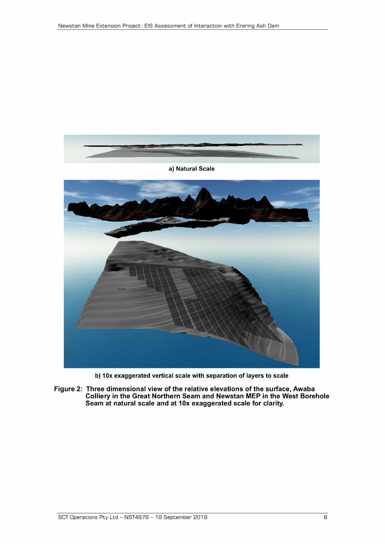
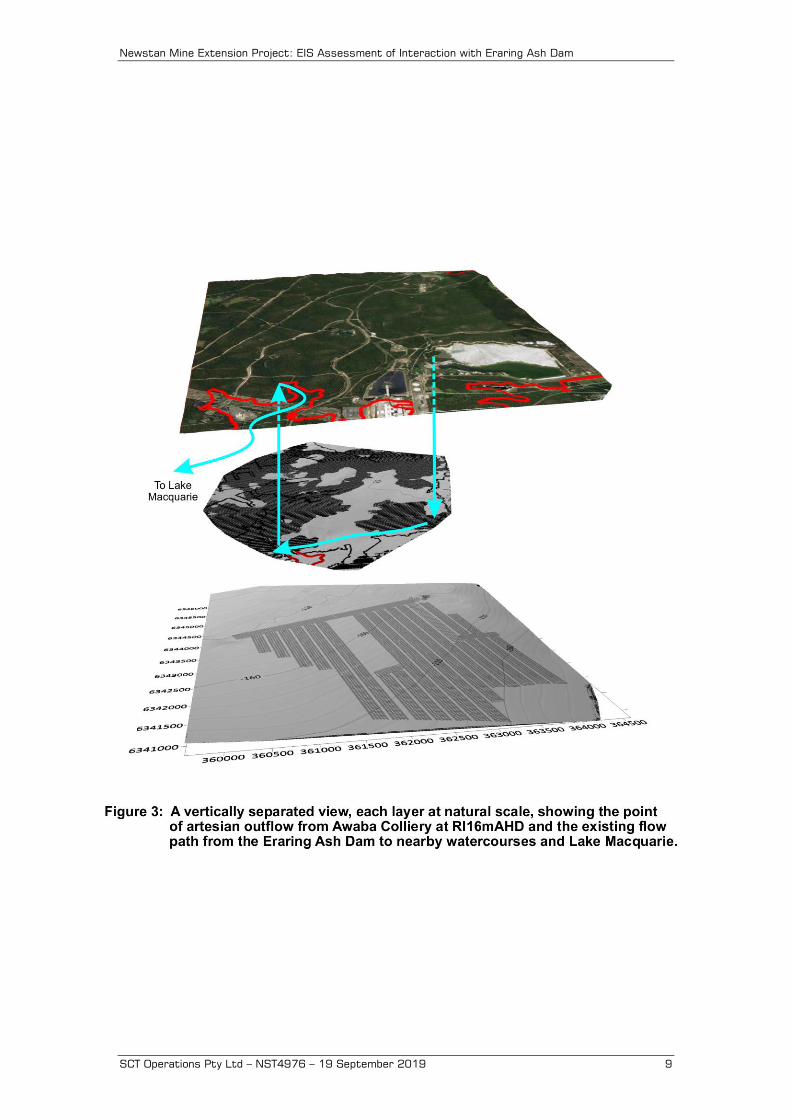
3. SITE DESCRIPTION Figure 1 shows a plan of the area where the Newstan MEP is located in the West Borehole Seam together with the proposed layout of the panels and the surface features. Figure 2 shows a three-dimensional cut-away view of the surface, Awaba Colliery workings and proposed Newstan MEP layout in the West Borehole Seam, all at natural scale (i.e. without vertical exaggeration). The Great Northern Seam mined at Awaba Colliery is close to the surface and well above the West Borehole Seam mining horizon. Figure 3 shows the same view as Figure 2, but with a ten times vertical exaggeration to better show the seam separation and relative elevations. 3.1 Newstan MEP in West Borehole Seam The proposed mining system is based on a five heading layout developed in a herringbone pattern and subsequently extracted on retreat using a flexible conveyor train (FCT) mining system. With this system, surface subsidence and the groundwater interactions can be controlled by modifying the secondary extraction width on retreat as follows:
• First workings only: leaving all four pillars on retreat causes imperceptibly low subsidence on the surface and low, but not zero, interaction with groundwater.

Newstan Mine Extension Project: EIS Assessment of Interaction with Eraring Ash Dam
SCT Operations Pty Ltd – NST4976 – 19 September 2019 7
• Partial extraction: extracting one pillar on one side of the panel and two pillars on the other side as well as some of the barrier between adjacent panels. This configuration creates voids that are 52m wide and 87m wide with a 29m wide central pillar between them and a 45m wide barrier between adjacent panels.
• Full extraction: extracting all four pillars and some of the barrier pillar between panels. The voids formed are 167m wide separated by 45m barrier pillars.
Newstan Mine Extension Project: EIS Assessment of Interaction with Eraring Ash Dam
SCT Operations Pty Ltd – NST4976 – 19 September 2019 8
Newstan Mine Extension Project: EIS Assessment of Interaction with Eraring Ash Dam
SCT Operations Pty Ltd – NST4976 – 19 September 2019 9
Newstan Mine Extension Project: EIS Assessment of Interaction with Eraring Ash Dam
SCT Operations Pty Ltd – NST4976 – 19 September 2019 10
Nineteen panels referred to as SWP1-19 are proposed to be mined using the FCT system. The extent of extraction is planned to be varied to manage the impacts on surface features. Within the Newstan MEP area, the West Borehole Seam dips to the southeast at approximately 3%. The overburden depth to the West Borehole Seam ranges from approximately 140m in the northwest of the proposed mining area to approximately 330m in the southeast. The mining height varies depending on the seam section mined with a maximum extraction height of 3.6m. 3.2 Awaba Colliery in the Great Northern Seam Awaba Colliery mined the Great Northern Seam at overburden depths of 10m to 100m and was abandoned in 2012. The abandoned workings cover approximately 61% of the area of the proposed Newstan MEP panels and associated main headings. The abandoned mine geometry includes large areas of small standing pillars formed by splitting and quartering larger pillars, areas of extracted coal that caved or subsided at the time of mining including as a result of pillar creep events and areas where the overlying conglomerate is thought to be bridging across extracted panels between larger pillars so that surface subsidence and caving is limited to low levels. There is potential for further subsidence to occur within the Awaba Colliery mining horizon where there are standing pillars or bridging strata that become destabilised as a result of ground movements caused by extraction of the West Borehole Seam in the Newstan MEP. Watson (2018) indicates that the mining height at Awaba varies between 2.5m and 3.2m. The mining height below the edge of the Eraring Ash Dam is likely to be approximately 3m. Roadways are likely to have been mined at between 5.5m and 6.5m wide. The elevation of the Great Northern Seam in the area of overlap with the ash dam ranges from approximately RL0mAHD to RL8mAHD. Overburden depth ranges from 10m to 100m primarily as a result of topography and is typically in the range 20-30m around the perimeter and 30-50m elsewhere except below localised topographic high points. The separation between the Great Northern Seam and the West Borehole Seam varies from approximately 100m in the northwest to 215m along the south-eastern edge of the Awaba Colliery workings at the western edge of the Eraring Ash Dam. Awaba Colliery is now flooded to a level ranging from RL16-19mAHD. This level is controlled by pumping from boreholes and artesian overflow into a watercourse in the southwest. The water level in Awaba Colliery responds to rainfall events. The location of the overflow point in the southwest is located where the 16m surface contour overlaps with the Awaba Colliery workings as shown in Figure 3.
Newstan Mine Extension Project: EIS Assessment of Interaction with Eraring Ash Dam
SCT Operations Pty Ltd – NST4976 – 19 September 2019 11
3.3 Eraring Ash Dam Eraring Ash Dam provides an emplacement area for fly ash from Eraring Power Station. The surface of the ash dam is indicated from plans provided by CNPL as being up to RL38mAHD in the northern part of the dam where the discharge appears to be located and approximately RL25mAHD in the southern part against the dam wall. SCT understands that Origin Energy, the owners of Eraring Power Station and the ash dam, are planning to augment the capacity of this emplacement by increasing the height of the earth embankments that retain the fly ash. This augmentation would significantly increase the area of the fly ash emplacement located directly about Awaba Colliery and therefore increase the potential for interaction. Several panels in the south-eastern section of Awaba Colliery, 5 South and 101, 102 and 103 Panels, extend under the edge of the Eraring Ash Dam at a depth below the surface of approximately 20m. These workings are completely flooded. The mine plan shows three types of mining in the south-eastern part of Awaba Colliery:
1. First workings: on development, the system of mining involved driving roadways to form generally square pillars at nominally 36m centres. Where the overburden depth is very low, no further mining was conducted.
2. Partial extraction: in 6 South, the larger square pillars were split and
quartered to form smaller square pillars, nominally 11.5-12.5m wide (measured rib to rib). The roof of these split pillars are typically not reinforced with roof bolts.
3. Full extraction: in 101, 102, and 103 Panels, the larger square pillars
formed on development were subsequently fully extracted. Pillar extraction typically allows up to about 85% of the coal to be safely recovered. Large subsidence cracks, a step and at least one sinkhole are apparent at the surface above the edge of the extracted panels.
SCT understands that part of the augmentation work includes:
• filling an area of the Awaba workings with cement stabilised fly ash or similar material below the earth embankment to eliminate the potential for any future pillar instability to cause subsidence or sinkhole development that may destabilise the embankment
• filling a larger area of Awaba workings along the edge of the ash dam with cemented stabilised fly ash or similar material to limit contaminated groundwater flows from the ash dam into the Awaba workings and thence out into surrounding watercourses.
Newstan Mine Extension Project: EIS Assessment of Interaction with Eraring Ash Dam
SCT Operations Pty Ltd – NST4976 – 19 September 2019 12
3.4 Overview of Sub-Surface Impacts from Extractive Mining
SCT’s current understanding of ground behaviour due to extractive mining is presented in this section as context for subsequent discussion of impacts. Differences in terminology between disciplines are also clarified.
The impacts of extractive mining on overburden caving and groundwater have been the focus of numerous field studies conducted in NSW over recent decades. The nature and extent of impacts are becoming better understood as the results of these field monitoring programs become available. More thorough description of the various zones referred to in this report are provided in Mills (2012), Tammetta (2012) and Gale (2010).
3.4.1 Ground Disturbance
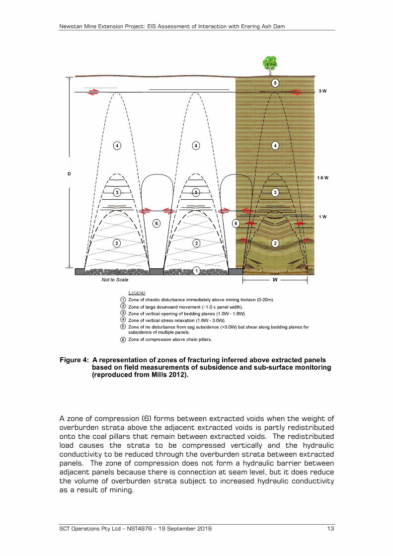
The term subsidence or surface subsidence is used to refer to vertical and horizontal ground movements observed on the surface. The terms sub-surface ground movements and caving behaviour are used to refer to all ground movements caused by subsidence. These movements include the vertical movements that are predominantly stretching directly above each extracted void and predominantly compressive above standing pillars and solid barriers at seam level and the horizontal movements that tend to be stretching close to and outside the goaf edge and compressive in the central area above each extracted void. Figure 4 reproduced from Mills (2012) provides a visual representation of these zones.
Directly above each extraction void, the stretching zones can be further characterised as:
• A caving zone (1) directly above the extraction void where sub-surface ground movements cause a significant rearrangement of the rock strata. This zone usually extends a few tens of metres above the mining horizon.
• An arch-shaped zone of large downward movement (2) typically observed to extend to a height above an extracted panel equal to the width of extraction. Within this zone, the hydraulic conductivity is usually significantly increased. This zone corresponds to the central section of full subsidence in super-critical width subsidence behaviour.
• An arch-shaped zone of bedding plane separation (3) located between 1.0 and 1.6 times panel width above the mining horizon where bedding planes are observed to separate to cause a significant increase in horizontal hydraulic conductivity and a lesser increase in vertical hydraulic conductivity. This zone is represented in surface subsidence as the section between panel width to depth ratios of 0.7 to 1.0 where maximum subsidence increases rapidly with void width.
• An arch-shaped zone of elastic relaxation (4) that extends to a height above the mining horizon equal to three times the width of the extracted void. This zone is represented in surface subsidence behaviour as the section between panel width to depth ratios of 0.3 to 0.7 when low levels of subsidence become apparent but where bridging is still maintained.
Newstan Mine Extension Project: EIS Assessment of Interaction with Eraring Ash Dam
SCT Operations Pty Ltd – NST4976 – 19 September 2019 13
A zone of compression (6) forms between extracted voids when the weight of overburden strata above the adjacent extracted voids is partly redistributed onto the coal pillars that remain between extracted voids. The redistributed load causes the strata to be compressed vertically and the hydraulic conductivity to be reduced through the overburden strata between extracted panels. The zone of compression does not form a hydraulic barrier between adjacent panels because there is connection at seam level, but it does reduce the volume of overburden strata subject to increased hydraulic conductivity as a result of mining.
Newstan Mine Extension Project: EIS Assessment of Interaction with Eraring Ash Dam
SCT Operations Pty Ltd – NST4976 – 19 September 2019 14
3.4.2 Mining Related Groundwater Disturbance Mining related groundwater disturbance is predominantly associated with two related phenomena. The first is the creation of a positive hydraulic gradient toward the mining horizon. The second is a change, typically an increase, in hydraulic conductivity that occurs in the overburden strata directly above the extracted void. The creation of a hydraulic gradient toward the mining horizon is an inevitable consequence of mining and may be substantially reversable over time after mining is complete and the mine floods if boundary conditions allow the water level in the mine to return to a level approaching the pre-mining water level. In many cases, including at Awaba Colliery, the water level in the mine is controlled by an outflow point that is lower than the surface where recharge occurs from rainfall. In these cases, a permanent hydraulic gradient is created and flow from the point of outflow continues indefinitely once the mine fills with water enough to reach the level of the outflow point. The increase in hydraulic conductivity of the overburden strata affects the rate at which groundwater can flow into the mine. The increase in hydraulic conductivity is typically greatest close to the mining horizon and decreases with height above the mining horizon. This reduction in hydraulic conductivity leads to the formation of a zone above each mining void within which the groundwater pressure is zero and downward flow occurs under the action of gravity alone without the need for additional pressure. This zone is most accurately referred to as the height of complete groundwater depressurisation. Other terms are commonly used as shorthand for the height of complete groundwater depressurisation, but these can be misleading. The height of depressurisation is commonly used to refer to this zone. This term is misleading to the extent that it implies the groundwater pressure is fully restored directly above this height. Piezometer measurements indicate that groundwater is typically depressurised to well above the zone of complete depressurisation and often for some kilometres laterally. The height of complete groundwater drainage is also commonly used to refer to the height of complete groundwater depressurisation. Complete groundwater drainage is also somewhat misleading because there is strong evidence from monitoring groundwater geochemistry to suggest that the depressurised overburden strata stores significant volumes of groundwater that is interchanged with recharge water only gradually over many decades. Other terms such as height of fracturing and height of caving are completely misleading because fracturing and caving are not hydrological phenomena and any correlation with depressurisation is coincidental. The term height of depressurisation is used in this report to describe the height of complete depressurisation. This height is the height of the highest point above an extracted void where there is still zero pore pressure.
Newstan Mine Extension Project: EIS Assessment of Interaction with Eraring Ash Dam
SCT Operations Pty Ltd – NST4976 – 19 September 2019 15
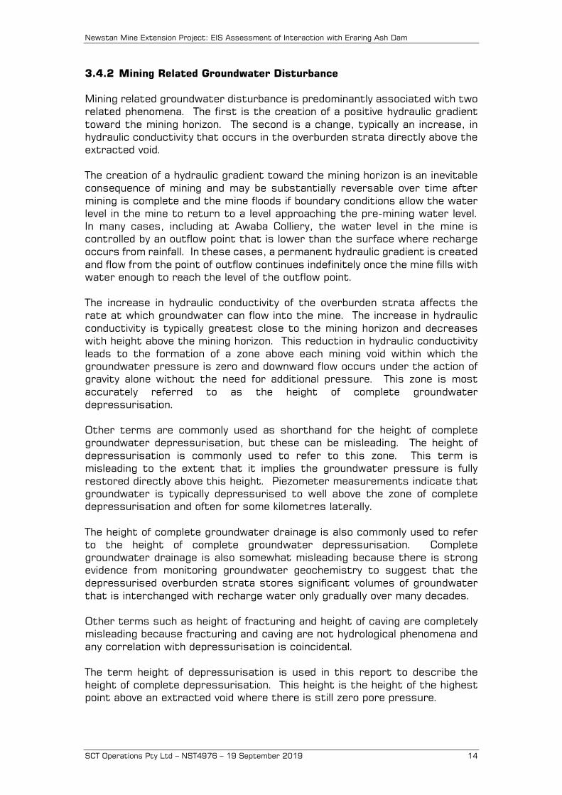
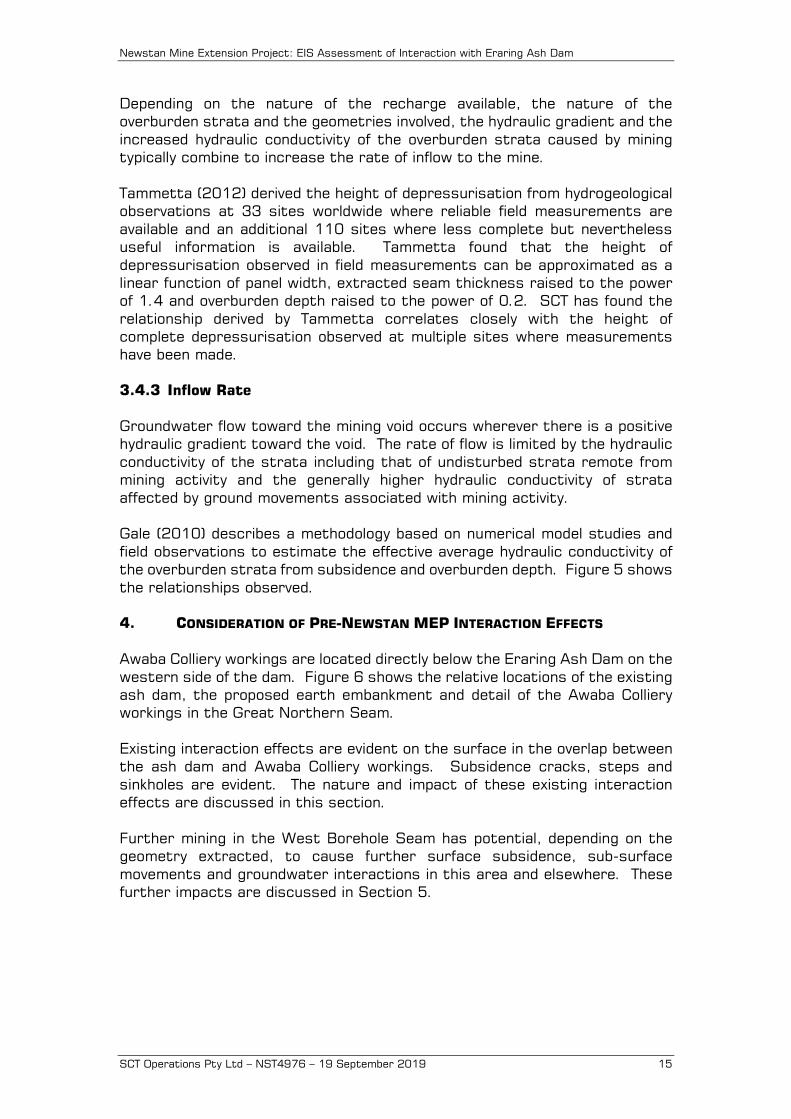
Depending on the nature of the recharge available, the nature of the overburden strata and the geometries involved, the hydraulic gradient and the increased hydraulic conductivity of the overburden strata caused by mining typically combine to increase the rate of inflow to the mine. Tammetta (2012) derived the height of depressurisation from hydrogeological observations at 33 sites worldwide where reliable field measurements are available and an additional 110 sites where less complete but nevertheless useful information is available. Tammetta found that the height of depressurisation observed in field measurements can be approximated as a linear function of panel width, extracted seam thickness raised to the power of 1.4 and overburden depth raised to the power of 0.2. SCT has found the relationship derived by Tammetta correlates closely with the height of complete depressurisation observed at multiple sites where measurements have been made. 3.4.3 Inflow Rate Groundwater flow toward the mining void occurs wherever there is a positive hydraulic gradient toward the void. The rate of flow is limited by the hydraulic conductivity of the strata including that of undisturbed strata remote from mining activity and the generally higher hydraulic conductivity of strata affected by ground movements associated with mining activity. Gale (2010) describes a methodology based on numerical model studies and field observations to estimate the effective average hydraulic conductivity of the overburden strata from subsidence and overburden depth. Figure 5 shows the relationships observed. 4. CONSIDERATION OF PRE-NEWSTAN MEP INTERACTION EFFECTS Awaba Colliery workings are located directly below the Eraring Ash Dam on the western side of the dam. Figure 6 shows the relative locations of the existing ash dam, the proposed earth embankment and detail of the Awaba Colliery workings in the Great Northern Seam. Existing interaction effects are evident on the surface in the overlap between the ash dam and Awaba Colliery workings. Subsidence cracks, steps and sinkholes are evident. The nature and impact of these existing interaction effects are discussed in this section. Further mining in the West Borehole Seam has potential, depending on the geometry extracted, to cause further surface subsidence, sub-surface movements and groundwater interactions in this area and elsewhere. These further impacts are discussed in Section 5.
Newstan Mine Extension Project: EIS Assessment of Interaction with Eraring Ash Dam
SCT Operations Pty Ltd – NST4976 – 19 September 2019 16
Newstan Mine Extension Project: EIS Assessment of Interaction with Eraring Ash Dam
SCT Operations Pty Ltd – NST4976 – 19 September 2019 17
4.1 Awaba Colliery Ash Dam Interaction: Existing Effects Awaba Colliery formed pillars below the western edge of the ash dam at overburden depths of 20-30m. The development pillars and smaller pillars formed by splitting and quartering these larger pillars are likely to be only lightly loaded (<2MPa) relative to their nominal strength of 11MPa. Nevertheless, the split and quartered pillars have a nominal width to height ratio of only four and are, therefore, unlikely to be sufficiently large to prevent any pillar failure event propagating, should one commence. Watson (2018) confirmed this potential advising that a panel of similar sized pillars elsewhere in the mine failed within a few minutes sometime after mining was complete. Underground roadways, and particularly the intersections of roadways, which may be up to 10m wide diagonally, are likely to be susceptible to collapse over time. At shallow depths where natural weathering of the immediate roof material is likely, failure of the roof strata would have potential to break through to the surface as a sink hole. These features are commonly observed in the Newcastle area at shallow overburden depths ranging up to 30m and occasionally at overburden depths up to 50m. Along the edge of areas of pillar extraction, failure of the overburden strata through to the surface is inevitable at shallow depths. During full extraction, downward movement of up to 3m occurs in the immediate roof of the extracted void when the coal is extracted. With bulking of the falling overburden material, the ground displacements reduce gradually with height above the mining horizon. At shallow depths of less than 30m, there are likely to be large open voids that provide a direct pathway for water flow between the surface and underground. This type of failure is typically expressed on the surface as a sinkhole or as a step change on the surface, depending on the near surface soil composition. Both are evident along the edge of the existing Eraring Ash Dam and are expected to provide a direct flow path between the ash dam and the Awaba Colliery workings. A positive hydraulic gradient exists between the ash dam and the underground workings of Awaba Colliery. The artesian overflow at RL16mAHD ensures that this gradient will continue to exist. With rainfall recharge reporting to the surface of the ash dam at RL25-38mAHD and the surface more generally at RL40-120mAHD, there is an ongoing flow path from the ash dam to the artesian overflow point as well as from the surface directly above Awaba Colliery. The primary limit on the rate of flow is the hydraulic conductivity of the strata between the ash dam and the workings of Awaba Colliery. This hydraulic conductivity is high enough that there is effectively an open flow pathway in the overlap zone between the ash dam and Awaba Colliery because of the large ground movements associated with mining at shallow depth.
Newstan Mine Extension Project: EIS Assessment of Interaction with Eraring Ash Dam
SCT Operations Pty Ltd – NST4976 – 19 September 2019 18
The surface above Awaba Colliery is above the standing water level in Awaba Colliery except locally at the outflow point in south-western part of the mine where they are the same. There is therefore a positive head differential between the surface and underground workings leading to a permanent downward flow gradient from the surface to underground. An average flow rate into the Awaba Mine of 3.6Ml/day is estimated by considering the surface area of the mine, the proportion of the mine where caving has occurred, the annual rainfall rate and an estimate of the proportion of rainfall that infiltrates the overburden strata above extracted coal mines. The total area of Awaba Colliery is approximately 12km2 with some sections remaining as first workings. The average annual rainfall is approximately 1,200mm. Experience at numerous sites indicates that approximately 25% of the annual rainfall flows into the mine through the fractured overburden strata above coal seams where there has been full extraction and significant surface subsidence. The average inflow rate to the mine is therefore expected to be up to about 3.6Ml/day, depending on the proportion of the mine area where full extraction or pillar collapse has occurred relative to the total mine area. The cumulative outflow rates from the pumping at 10 South water bore (0.7Ml/day), pumping at the switchyard (1.0Ml/day) and measured overflow into the creek of (1ML/day) are equivalent to 2.7Ml/day of average outflow. The average observed flow rate of 2.7Ml/day is consistent with expected inflow from the surface assuming caving has occurred over 75% of the mine area. The presence of a flow pathway through subsidence cracks means that there is also an ongoing flow regime of surface water from the ash dam flowing down into Awaba Colliery, through the workings and out to surface watercourses as artesian flow at locations in the southwest of the colliery where the reduced level at the surface is less than about RL16mAHD. The rate of any inflow from the ash dam depends strongly on local drainage conditions in the area where the ash dam overlaps the mine workings. If a drain or pond capturing rainfall or other run-off from the ash dam is able to access the fracture network of subsidence cracks above Awaba Colliery, inflows of water contaminated by the fly ash may be much higher than the tributary area directly above the mine. 4.2 Awaba Colliery Ash Dam Interaction: Following Augmentation Origin Energy plans to augment the capacity of Eraring Ash Dam by building an earth embankment to raise the level to which ash can be emplaced. This construction increases the footprint of the ash dam and area of interaction with Awaba Colliery by approximately five times. The creation of the earth embankment may also increase the size of the DSC Notification Area for the existing ash dam to include an area around the proposed earth embankment. The DSC may then decide to limit the extent of full extraction and/or partial mining in the Newstan MEP near the earth embankment.
Newstan Mine Extension Project: EIS Assessment of Interaction with Eraring Ash Dam
SCT Operations Pty Ltd – NST4976 – 19 September 2019 19
SCT understands that Origin Energy is planning to fill the mine voids in Awaba Colliery with cement stabilised fly ash to:
• eliminate the potential for pillar collapse below the earth embankment including in the area where this embankment is to be extended and increased in height
• reduce the flow from the ash dam into Awaba Colliery to a low level.
The detail of this filling work is not known. It is envisaged that filling in the vicinity of the earth embankment would be effective as a control to prevent the collapse of split and quartered pillars and as a control to prevent sinkhole formation. Both these mechanisms have potential to compromise the stability of the earth embankment. The effectiveness of the mine filling to reduce flow from the ash dam into Awaba Colliery is likely to depend on the detail of the filling and the level of testing conducted. This detail is not known and would likely need to be confirmed by field testing conducted during the filling process. The proposed void filling by Origin Energy has potential to reduce the hydraulic conductivity of the strata between the surface and the Awaba Colliery workings and within the workings themselves so that although the hydraulic gradient will remain, the flow rate could be reduced to a tolerably low level. The reduction in hydraulic conductivity able to be achieved is likely to be sensitive to the effectiveness of the void filling strategy. If the filling process is assumed to be able to return the hydraulic conductivity of the rock strata to its pre-mining state, a lower limit on inflow from the ash dam post augmentation can be estimated using Darcy’s Law:
Q = KAI where Q is the flow rate, K is the hydraulic conductivity, A is the cross-sectional area and I is the hydraulic gradient. The hydraulic conductivity between the surface and Awaba Colliery workings can be estimated based on general experience of field measurements of hydraulic conductivity presented in Gale (2010). This experience indicates that the hydraulic conductivity of rock strata at depths between 20m and 50m is likely to range between 1x10⁻⁶m/s and 1x10⁻⁸m/s. The overlap zone between the ash dam and Awaba Colliery is approximately 900m long and approximately 30m thick (depth to the coal seam) giving the cross-sectional area through which lateral flow can occur in the order of 27,000m2. The hydraulic head available between the surface at RL25-40mAHD and the flood workings underground at RL16mAHD ranges 9-24m. A value of 20m is assumed for initial flow estimation purposes. The pathway length is unknown because it depends on how much void filling is undertaken, but assuming the voids are filled to 50m beyond the edge of ash dam, the hydraulic gradient is 0.4.
Newstan Mine Extension Project: EIS Assessment of Interaction with Eraring Ash Dam
SCT Operations Pty Ltd – NST4976 – 19 September 2019 20
Based on these estimates, the minimum inflow from the ash dam to the Awaba Colliery workings achievable following the void filling is likely to in the range 0.001-0.1Ml/day. If the void filling is completely ineffective, the relationship presented in Gale (2010) and reproduced in Figure 5 indicate that the maximum hydraulic conductivity for 2m of subsidence, the estimated subsidence from mining a 3m high seam at Awaba Colliery at 20m deep, is in the range 0.1-1m/s. The area of overlap between total extraction area at Awaba Colliery and the ash dam when the ash dam is filled to 40m is approximately 74,000m2. The hydraulic gradient would be 1. Darcy’s Law indicates that for these parameters an inflow rate that would be effectively unrestricted flow limited only by the supply available. These inflow estimates confirm that the effectiveness of the void filling is critical as a control on the rate of flow of ash contaminated water from the ash dam into the Awaba Colliery workings. 5. ASH DAM INTERACTIONS FOLLOWING NEWSTAN MEP The potential for interactions between the Newstan MEP, Awaba Colliery and the Eraring Ash Dam discussed in this section indicate a review of the layout of the Newstan MEP in the vicinity of the Eraring Ash Dam should be conducted once measurements of groundwater interactions with the proposed mining system and the results of numerical modelling studies become available. The existing dam is declared by the DSC as a prescribed dam and adjacent mining activity is managed. The earth embankment proposed by Origin Energy as part of the ash dam augmentation project may also be sensitive to mining subsidence effects depending on the detail of its construction. Consulting with and undertaking a risk assessment with the DSC is recommended to determine the nature of any protection from mining subsidence impacts that may be necessary. The issues considered in this section with potential to impact the layout include:
1) Stability of the DSC prescribed earth embankment in the southwest corner of the ash dam; both inside and outside the footprint of Awaba Colliery.
2) Potential for subsidence to impact the hydraulic integrity of the mine void filling; this issue may or may not be significant depending on the hydraulic integrity of the mine void fill prior to the Newstan MEP.
3) Potential for contaminated surface water to flow from the Ash Dam through subsided ground into the extracted FCT panels and thence up through similar fractures into the Awaba Colliery workings and out into adjacent creeks through the existing artesian overflow point. This issue is a medium to long-term issue.
Newstan Mine Extension Project: EIS Assessment of Interaction with Eraring Ash Dam
SCT Operations Pty Ltd – NST4976 – 19 September 2019 21
4) Potential for liquefaction to occur within the retained ash as a result of subsidence movements, particularly any sudden movements. Further work is recommended to provide a basis to assess this potential.
Other issues not related to the Newstan MEP include:
5) Potential for earthquake activity to trigger pillar instability leading to subsidence in Awaba Colliery workings causing impact to the ash dam.
These issues are discussed in this section. Most of the issues above are a direct function of the surface subsidence movements likely to occur as a result of the Newstan MEP. 5.1 Surface Subsidence Estimates for Newstan MEP MSEC (2019) provides a comprehensive assessment of the subsidence likely to be experienced on the surface above the Newstan MEP. MSEC estimates maximum subsidence in the vicinity of the ash dam to be 800-1000mm for full extraction outside the Awaba Colliery footprint and 1600-2000mm for full extraction within the Awaba Colliery footprint. This maximum subsidence is likely to be mainly limited to within the FCT panel footprint and decrease to less than 20mm within 100m of the goaf edge. Subsidence at the goaf edge in the Newstan MEP mining area is expected to be generally less than 100mm outside the Awaba Colliery footprint. Goaf edge subsidence within the Awaba Colliery footprint is likely to be sensitive to pillar geometries and whether these geometries remain stable after subsidence associated with the Newstan MEP. It is conceivable that pillar instability in the Great Northern Seam workings at Awaba Colliery could cause subsidence of more than 1000mm outside the FCT panel footprint but experience at other sites indicates such instability would not extend more than a few pillars. Increased subsidence within the Awaba Colliery footprint is due to standing pillars and overburden strata that may be bridging across extracted panels being destabilised by subsidence movements. This remobilisation would not be expected in areas where the Awaba Colliery workings have been stabilised with cement stabilised fly ash back fill but would be possible in areas where the pillars are still standing and there has been no stabilisation works. In areas where the Awaba Colliery workings have been fully backfilled, subsidence is expected to be similar to the subsidence that would be expected in areas where the Great Northern Seam has not been mined. 5.2 Eraring Ash Dam Earth Embankment As part of the Ash Dam Augmentation Project, Origin Energy propose to construct an earth embankment as shown in Figure 6 and fill the voids below this embankment to create a barrier to flow. SCT understands that this structure is intended to allow ash to be retained up to a nominal elevation of RL40mAHD.
Newstan Mine Extension Project: EIS Assessment of Interaction with Eraring Ash Dam
SCT Operations Pty Ltd – NST4976 – 19 September 2019 22
Filling of the Awaba Colliery voids with cement stabilised fly ash is expected to be completely effective in terms of removing the threat of sudden pillar collapse below the earth embankment. The filling does not have to be complete in order to achieve a high level of protection against pillar instability. Any filling that limits hydraulic flow from the ash dam to Awaba Colliery is expected to be completely effective to control the stability of small pillars. Subsidence predicted in areas where the voids between standing pillars in Awaba Colliery have been completely filled is expected to be similar to subsidence that would be expected if no mining had occurred in the Great Northern Seam i.e. maximum subsidence for full extraction would be expected to be in the range 800-1000mm based on the subsidence estimates provided in MSEC (2019). If the voids had not been completely filled, maximum subsidence is likely to range between the MSEC (2019) estimates of 1000mm to 2000mm depending on the degree of back filling achieved. 5.3 Void Fill Flow Barrier in Awaba Colliery The effect of Newstan MEP subsidence on the flow barrier planned to be formed between the ash dam and the broader Awaba Colliery workings by filling the voids in the colliery and overburden strata close to the edge of the ash dam is likely to depend significantly on the effectiveness of the void filling conducted by Origin Energy. Subsidence of 1000mm expected for full extraction of 167m wide panels currently planned in the Newstan MEP is estimated to cause maximum tensile strains of 4-6mm/m. These strains are large enough to cause cracks to develop within the overburden strata and backfill, potentially leading to an increase in the hydraulic conductivity of the barrier. A void fill strategy similar to the augmentation void filling is likely to be effective in filling any cracks that form provided the surface remains accessible. Sub-horizontal holes drilled from outside the ash dam are likely to intersect multiple subsidence fractures and may be more effective than the vertical holes used for the void filling planned by Origin Energy. If the Origin Energy void filling is not effective as a hydraulic barrier to flow from the ash dam to Awaba Colliery, additional cracks formed by subsidence from Newstan MEP are unlikely to be of significant consequence. The flow path would already exist and any additional cracks would be unlikely to be significant. 5.4 Flow Through Overburden to West Borehole Seam The FCT Panels proposed for the Newstan MEP are expected to depressurise the overburden strata to heights above the West Borehole Seam mining horizon as shown in Table 1.
Newstan Mine Extension Project: EIS Assessment of Interaction with Eraring Ash Dam
SCT Operations Pty Ltd – NST4976 – 19 September 2019 23
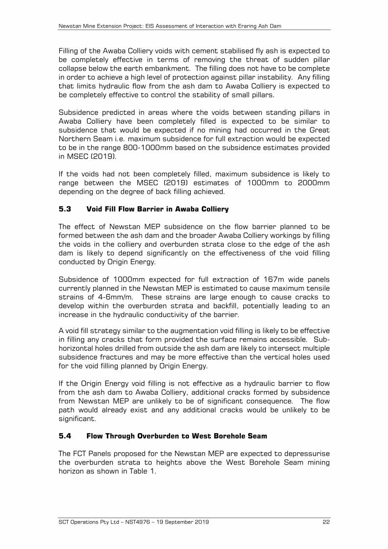
Table 1: Height of Complete Depressurisation for Proposed Extraction Voids
Void Width (m)
Height of Depressurisation
(m)
Reduced Level of Top of Depressurisation below
Ash Dam (mAHD)
Depth Below Surface of Top of Depressurisation
at Ash Dam (m) 167 180±40 -40 to -100 ±40 60-120 ±40 87 95±40 -125 to -185 ±40 145-205 ±40 52 58±40 -160 to -220 ±40 180-240 ±40
The height of depressurisation does not extend through to the surface for any of the mining geometries. As discussed in Section 3.4.2, the height of depressurisation represents the top of the zone where downward flow can occur under the action of gravity without requiring additional pore pressure. Downward flow is inevitable when there is a positive hydraulic gradient, but the rate is a function of the hydraulic conductivity of the overburden strata disturbed by mining. The inflow rate for full extraction can be estimated using the data presented by Gale (2010) and consideration of the geometries involved. The post-mining vertical hydraulic conductivity of the overburden strata at 40-100m below the base of the ash dam for 1000mm of subsidence at 220m depth of mining is estimated from Gale (2010) as likely to be in the range 1x10⁻⁵m/s to 1x10⁻⁷m/s. The area of the ash dam mined under by the Newstan MEP is approximately 1.3km2. Assuming half this area in plan has increased vertical hydraulic conductivity, with the other half located over chain pillars where the hydraulic conductivity is likely to be significantly reduced, the area available for flow into the mine is 650,000m2. The hydraulic gradient is estimated from piezometer profiles at other sites to be approximately 5 assuming a head drop of 100m over a distance of 20m vertically. Monitoring of the piezometric pressures directly above an extracted panel at Newstan is recommended to provide a better estimate of this gradient. Using these values for hydraulic conductivity, area and gradient, the inflow rate from the ash dam into the FCT panels below the ash dam is estimated as likely to be in the range 0.03-3Ml/day. Once the Newstan MEP is flooded, the hydraulic gradient will be reduced to 1 and the inflow rate reduced to 0.006-0.6Ml/day. Better estimates of these inflow rates will be able to be confirmed during mining. The flow rates indicated by these calculations are not significant in terms of flow volume from a mining perspective and indeed may be barely perceptible in the normal sequence of mining. However, the flows are likely to be contaminated by contact with fly ash and may present a disproportionate load on treatment facilities prior to discharge depending on available dilution.

Newstan Mine Extension Project: EIS Assessment of Interaction with Eraring Ash Dam
SCT Operations Pty Ltd – NST4976 – 19 September 2019 24
For 167m wide panels, the zone of large downward movement is expected to extend above the West Borehole Seam mining horizon to approximately one panel width or about 150-170m. The zone of bedding plane separation is expected to extend approximately 1.4-1.6 times panel width or 230-270m above the mining horizon. The floor of the ash dam is between 1.4 and 1.8 times panel width above the mining horizon. Only the very top of the zone of bedding plane separation would be likely to interact with the ash dam but there would nevertheless be some interaction between the surface and the zone of bedding plane separation that would need to be quantified. 5.5 Flow Pathways: Short and Long-Term Figure 7 summarises the flow pathways that appear likely to develop during mining in the Newstan MEP and long-term once the Newstan Colliery workings flood. In the short-term during the period of active mining in the West Borehole Seam, all hydraulic gradients including those from Awaba Colliery are in a direction that flows toward the West Borehole Seam and away from the artesian outflow point in the southwest of Awaba Colliery. The pathway for flow from the ash dam into surrounding watercourses is therefore likely to be predominantly via the West Borehole Seam and the associated pump out and mine water treatment system. When the FCT panels extract under Awaba Colliery at interburden depths of less than about 180±40m, the stored water in Awaba Colliery are expected to be able to flow downward into the West Borehole Seam under the action of gravity alone. The rate of inflow is unlikely to present an inrush hazard but may represent a significant flow depending on which panels are extracted first and whether Awaba Colliery workings have been pre-drained. Where the interburden is greater than 180±40m, inflow is still expected, but the inflow rate is likely to be lower and limited by the hydraulic conductivity of the interburden strata above 180m. During the period of mining in the Newstan MEP, the pumping and treatment systems at Newstan Colliery would need to be capable of handling the inflows from Awaba Colliery (2.7Ml/day) including those from the ash dam and the water that is currently stored in the Awaba Colliery workings (estimated to be in the range 5-10Gl). In the long-term once mining is completed and the Newstan workings flood, the pathway for flow from the ash dam out into surrounding watercourses would not need to involve flow down to the level of the West Borehole Seam. The flow pathway from the ash dam into Awaba Colliery would instead be through fractured rock above those FCT panels that have mined under the ash dam and under Awaba Colliery. The length of this pathway could be as short as a few hundred metres. The estimated rate would still be in the range 0.006-0.6Ml/day under the action of the ongoing hydraulic head that exists between the surface and the overflow point at Awaba or Newstan Colliery, whichever is the lowest.
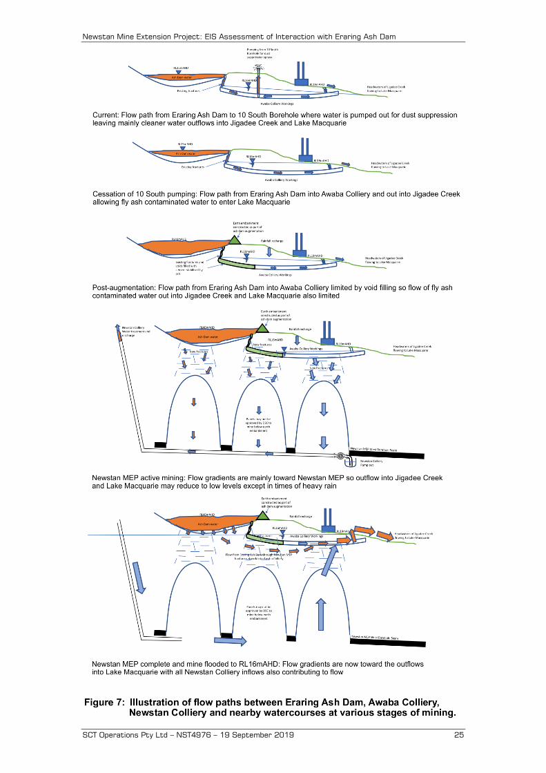
Newstan Mine Extension Project: EIS Assessment of Interaction with Eraring Ash Dam
SCT Operations Pty Ltd – NST4976 – 19 September 2019 25
Newstan Mine Extension Project: EIS Assessment of Interaction with Eraring Ash Dam
SCT Operations Pty Ltd – NST4976 – 19 September 2019 26
In effect, the West Borehole Seam mining would create a pathway through fractured ground above the FCT panels that, in the long-term, would bypass the barrier being created by Origin Energy between the ash dam and Awaba Colliery. The significance or otherwise of this bypass would depend on whether the Origin Energy barrier was initially effective when constructed. If this barrier were not effective, the addition of a bypass pathway would be of little significance. The pathway for flow from the ash dam to the current artesian overflow into Jigadee and Dora Creek watercourses from Awaba Colliery would depend on the reduced level of the overflow point from Newstan Colliery. The overflow point while the portal is open is understood to be at approximately RL14mAHD, but if the portal is sealed at mine closure, the overflow point may be higher than RL16mAHD. If the overflow point at Newstan Colliery is lower than RL16mAHD, the flow pathway from the ash dam and from all inflows that currently flow out through the artesian overflow in the southwest of Awaba Colliery is likely to be substantially diverted to the Newstan overflow point. Inflows into Awaba Colliery from high intensity rainfall events can raise the water level in the workings by several metres causing outflows at other locations. If the flowrate from Awaba Colliery to Newstan Colliery is restricted sufficiently, high intensity rainfall events over Awaba Colliery could raise the level in the Awaba workings high enough for outflow at the artesian overflow point in the southwest to resume. If the overflow point at Newstan Colliery is higher than RL16mAHD, the long-term outflow at the artesian outflow in the southwest of Awaba Colliery and possible other outflow pints is likely to increase. The existing inflows to Awaba Colliery that flow out through the artesian outflow would be increased to include all long-term inflows that currently flow out from or are pumped out from Newstan Colliery as well. 5.6 Earthquake Interactions with Earth Embankment An assessment of the potential for earthquake movements to directly impact the stability of the earth embankment retaining the Eraring Ash Dam is beyond the scope of this study. However, there is potential for earthquake movements to impact the stability of small pillars that exist in Awaba Colliery directly below a section of the earth embankment and the potential for this impact is assessed in this section. If Origin Energy fills the voids in the zone of small pillars located below the earth embankment being constructed as part of the ash dam augmentation project, the potential for pillar instability below the earth embankment is eliminated and there is no potential for mining in the West Borehole Seam to impact the stability of these pillars directly or indirectly. There would still be potential for subsidence of up to 1000mm from uncontrolled mining in the West Borehole Seam to impact the earth embankment directly, but the DSC is likely to restrict mining in the vicinity of the earth embankment to control such impacts.
Newstan Mine Extension Project: EIS Assessment of Interaction with Eraring Ash Dam
SCT Operations Pty Ltd – NST4976 – 19 September 2019 27
If the voids are not filled and the split and quartered pillars in Awaba Colliery are destabilised, subsidence of 1,000-1,500mm would be expected directly below the earth embankment. This level of ground movement would be expected to have potential to impact the stability of the earth embankment. Assuming these pillars have a nominal height of 3.2m and a nominal width of 11m, their width to height ratio of 3.4 renders them vulnerable to collapse if any one of the similar sized pillars becomes overloaded. At 20-40m deep, the weight of overburden strata ranges 0.5-1MPa prior to mining and increases to 1.1-2.3MPa following splitting and quartering. With a nominal strength of 11MPa, these split and quartered pillars are only lightly loaded relative to their nominal strength. Earthquake energy is dispersed from the source through compression waves (P-waves) and shear waves (S-waves). These interact with the surface to create other waves known as Love and Rayleigh waves. The combination of shear waves and surface waves are typically responsible for damage to surface features. Shear waves typically have a wavelength of several hundred metres, so impacts to small structures such as small coal pillars are likely to be limited because the whole structure can move as one without incurring differential shear movements that have potential to cause instability. Nevertheless, geological fault structures or other similar features can potentially concentrate movements that then lead to localised load concentrations. At shallow depth, the Awaba pillars would be within the influence of surface shear waves. The 1989 Newcastle earthquake generated significant ground movements in an around Newcastle. SCT is not aware of any instability of small pillars at shallow depth in the Newcastle area that occurred concurrently or as a result of the earthquake. The pillars formed in 5 South at Awaba Colliery were developed between 1984 and 1986 as 35m square pillars. These large pillars were split and quartered between 1994 and 1996 to form small pillars. The small pillars had not been formed at the time of the Newcastle Earthquake. 5.7 Potential for Subsidence to Cause Liquefaction of Retained Fly Ash SCT is not aware of the results of any testing undertaken on the fly ash retained in the Eraring Ash Dam to determine its potential for liquefaction or sensitivity to volume changes under shear so the discussion presented in this section is general in nature and should be confirmed by a combination of laboratory and field testing to determine these characteristics. Discharging fly ash water mix onto previously deposited fly ash and allowing the water to run off is expected to create a “soil” structure that is fully saturated, at least initially, and susceptible to a reduction in volume when disturbed by vibration or structural disturbance. This reduction in volume causes shear stresses that are supported by the solid component of the soil structure to be transferred to the pore water within the pore spaces of the soil. The pore water has zero shear strength and so when the soil volume reduces, the soil fluidises and behaves as a liquid until the excess pore pressures have dissipated. This process is referred to as liquefaction.
Newstan Mine Extension Project: EIS Assessment of Interaction with Eraring Ash Dam
SCT Operations Pty Ltd – NST4976 – 19 September 2019 28
SCT understands that the process of emplacement of fly ash at Eraring involves the creation of elevated areas of fly ash with a face that slopes down to a water filled pond. Liquefaction of the emplaced fly ash would have potential to cause slope failure and mass movement of fly ash in a down slope direction. The scale of this movement would depend on a range of parameters that are beyond the scope of this report to assess. Mining related processes that have potential to cause ground movements under the ash dam are:
1) Collapse of the split and quartered pillars in Awaba Colliery causing 1,000-1,500mm of subsidence to occur suddenly below an accumulation of fly ash that is up to approximately 15m thick.
2) Ground movements associated with regular subsidence of 800-1,000mm caused by mining FCT panels in the Newstan MEP below an accumulation of fly ash up to 20-25m thick.
3) Micro-seismic movements associated with caving of overburden strata above the West Borehole Seam.
The risk of split and quartered pillars in Awaba Colliery collapsing is expected to be eliminated by back filling the voids between these pillars with cement stabilised fly ash. SCT understands that Origin Energy is undertaking a program of void backfilling to protect the earth embankment created as part of the augmentation project. This back filling would be expected to eliminate the potential for collapse. Subsidence movements caused by full extraction of the FCT panels are expected to cause ground movements of 800-1,000mm (MSEC 2019). These ground movements are expected to occur gradually over a few days to a few weeks depending on the rate of retreat of the panels. It is anticipated that pore pressure dissipation would be able to occur gradually over the period of subsidence without potential for liquefaction, but this expectation should be confirmed by consultation with specialists in liquefaction supported by laboratory and field measurements. Micro-seismic events are expected to be associated with caving above the extracted FCT panels in the Newstan MEP. These are likely to have a magnitude on the Richter Scale of less than 1.0 based on experience at other sites. A program of monitoring seismic energy released during subsidence above early FCT panels at the Newstan MEP is recommended. Gibson and Dimas (undated) present data indicating that on average there is one natural earthquake in the Newcastle Lake Macquarie area each year with a Richter magnitude of 2 (i.e. ten times as much energy released as that expected from mining subsidence). On this basis, it appears unlikely that mining induced seismicity would have any potential to create a significantly higher risk of liquefaction compared to the natural background risk.
Newstan Mine Extension Project: EIS Assessment of Interaction with Eraring Ash Dam
SCT Operations Pty Ltd – NST4976 – 19 September 2019 29
6. REFERENCES Centennial Coal 2018 “Mining Operations Plan Centennial Newstan Complex
MOP March 2018-July 2020”. DSC 2010 “Mining near prescribed dams: mining application” Section 4.0 of
Dams Safety Committee Advisory DSC4B dated June 2010. Gale W.J. 2010 “Review and estimation of the hydraulic conductivity of the
overburden above longwall panels. Experience from Australia” Proceedings of the 29th International Conference on Ground Control in Mining, Morgantown West Virgina pp340-347.
Gibson G. and Dimas V.A. undated “Earthquake hazard at Newcastle”
downloaded from http://aees.org.au/wp-content/uploads/2013/11/ Gibson-Dimas.pdf on 7 May 2019.
Mine Subsidence Engineering Consultants 2019 “Newstan Colliery- Review of
setbacks and preliminary predictions and assessments of potential impacts for the proposed SW FCT panels in the West Borehole Seam” Letter report to Jason Boersma dated 20 March 2019.
Mills K.W. 2012 “Observations of ground movements within the overburden
strata above longwall panels and implications for groundwater impacts” Proceedings of 38th Symposium on the Advances in the Study of the Sydney Basin. Hunter Valley NSW May10-11 2012.
Tammetta P. 2012 “Estimation of the height of complete groundwater
drainage above mined longwall panels” Groundwater NGWA.org pp1-16. Watson G. 2018 Personal communication.