Embed Size (px)
Citation preview
Plaistow Commuter Rail Extension Study
Alternatives Analysis Report – March 2015
APPENDIX K. NATURAL RESOURCE ASSESSMENT
K1. Summary of Preliminary Field Review for Wetlands, Streams and Vernal PoolsK2. Natural Resources Preliminary Impact Analysis
Memorandum Tuesday, March 10, 2015 TO: Plaistow Community Rail Extension Study File FROM: William McCloy, Wetland Scientist SUBJECT: Summary of Preliminary Field Review for Wetlands, Streams and Vernal Pools Normandeau Associates, Inc. (Normandeau) wetland scientists reviewed the four site alternatives associated with the NH Department of Transportation (NHDOT) Plaistow Community Rail Extension Study Project (Project) for the presence of wetlands, streams and potential vernal pools on June 30 and July 1, 2014. The purpose of the investigation was to identify the approximate locations of regulated water resources to inform the siting process for the initial stages of the Project. Formal delineations were not completed by Normandeau on any of the site alternatives, and the approximate location of the water resources were recorded using a combination of sketch maps and global positioning system (GPS) points collected in the field. A general review of the methodology and the findings at each site is included below, along with representative photos (Attachment 1) and sketch maps (Attachment 2). Geographic Information System (GIS) shapefiles of the approximate water resource locations for all sites, which correspond with the sketch maps, will be transmitted under separate cover.
METHODOLOGY
William McCloy and Daniel Coons of Normandeau, both NH Certified Wetland Scientists (NHCWS), reviewed the sites over a two day period beginning on June 30 and ending on July 1, 2014. Aerial photography, National Wetlands Inventory (NWI) wetlands mapping, Natural Resources Conservation Service (NRCS) soils mapping, state-wide stream and water body mapping, and Town of Plaistow
water resources mapping were reviewed prior to the site visits and during the site walks. A wander-search was performed across the accessible portions of each site to confirm the location of previously mapped water resources (e.g. NWI and hydric soils areas) and to assess the general habitat and natural communities present. Rare, threatened and endangered (RTE) plants and wildlife were not specifically addressed and none were observed. A subsequent search of the NH Natural Heritage Bureau (NH NHB) database (NHB File ID: NHB15-0252) indicated that although there was a NHB record present in the vicinity of the Plaistow, NH sites, it is not expected to be impacted by the Project (Attachment 3). A similar review of Massachusetts Natural Heritage and Endangered Species Program (NHESP) layers on MassGIS’s online mapping tool did not indicate the presence of any known NHESP Priority Habitats of Rare Species, NHESP Natural Communities, NHESP Estimated Habitats of Rare Wildlife of NHESP Certified Vernal Pools in the vicinity of the site in Haverhill, MA. Field observations and photos, along with GPS points were then used to draft approximate sketch maps of the location of regulated water resources on the sites (see Attachment 1).
SITE ALTERNATIVE DESCRIPTIONS
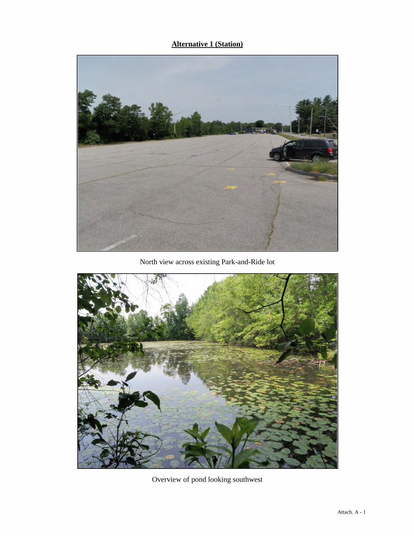
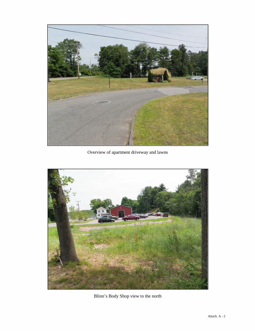
Alternative I (Station) Alternative I (Station) is located along Westville Road and is mostly developed. The site includes dual railroad tracks along the west edge of the site, a large paved park-and-ride facility, a tire business, apartments and associated parking and lawn areas, and a body shop (Blinn’s Auto Body, 38 Westville Road). The body shop appears to have been recently constructed and includes parking, a large shop building, and a stormwater treatment area in what appears on the sketch map background photo as a forested area. More recent aerial photos from Google Maps show the current extent of the body shop1. One large pond wetland (PUBH) and associated ditch area, identified on NWI and Plaistow mapping, is located west of the park-and-ride and east of the existing railroad tracks. Inlets or outlets to the pond were not observed. This pond has permanent hydrology, a shrubby fringe with some herbaceous species
1 https://goo.gl/maps/ZDbbl
Page | 2
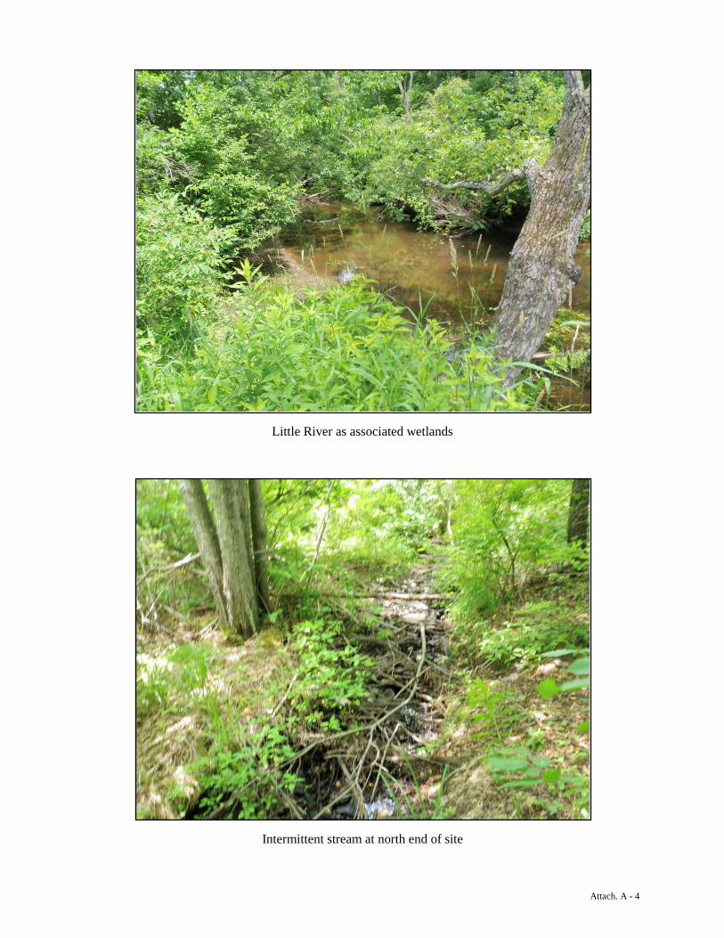
and many water lilies and other aquatic plants throughout. The remainder of the site is dry or developed. Alternative I (Layover) Alternative I (Layover) is located in Haverhill, MA south of Atkinson Depot Road (Route 121). The site is primarily forested, with some open meadow to the north, some of which is wet meadow. Existing railroad tracks run along the western side of the site and the Little River meanders along the eastern edge of the property. An underground gas line, indicated by gas pipeline marker posts observed in the field, cuts through the southern end of the property from east to west as well. Soils mapped within the parcel include fine sandy loams and silt loams, with hydric soils mapped along the Little River. In general, the site slopes from west to east, with the lowest areas located along the Little River, a larger, slow flowing river with numerous meanders. The river ranges in width from 15-30 feet, has a predominantly sandy/silty bottom, and large forested and scrub-shrub floodplain wetlands along the majority of area within the subject parcel. Several wetland swales extend upslope within depressions from east to west; however, the majority of the western portions of the site are upland. An intermittent stream flows from a culvert outlet associated with the railroad tracks downslope to the east towards the Little River in the north end of the site, and the other swales associated with smaller intermittent or ephemeral drainages are located in the central/southern portion of the site. Upland forested areas included oaks (Quercus sp.), white pine (Pinus strobus), maples (Acer sp.), gray and paper birch (Betula populifolia and B. papyrifera), black cherry (Prunus serotina) and similar shrub and understory species. Patches of dense shrubs were noted, primarily honeysuckles (Lonicera sp.), dogwoods (Cornus sp.), and species such as the invasive multi-flora rose and Japanese barberry (Rosa multiflora and Berberis sp.). Forested and scrub-shrub wetland areas included red maple (Acer rubrum), speckled alder (Alnus incana), dogwoods, and elm (Ulmus americana). Open areas included reed canary grass (Phalris arundinacea), hydrophytic ferns (Onoclea sp. and Osmunda sp.), and other herbaceous species such as sedges (Carex sp.) and rushes (Juncus sp.). Several potential vernal pools were noted within the floodplain wetlands associated with the Little River on the eastern side of the
Page | 3
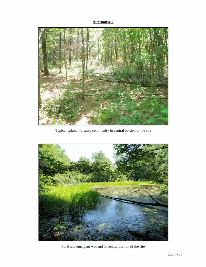
site. The Massachusetts NHESP has mapped one potential vernal pool within the floodplain of the Little River immediately adjacent to the site near the southern end of the parcel. Alternative II (Joanne Drive Site) Alternative II is located north of Joanne Drive in Plaistow, NH and south of Alternative III. Existing railroad tracks and a small transmission/distribution line (Unitil, Corp.) runs along the eastern side of the site, and Plaistow Road, and associated businesses, are located to the west. The Little River defines the northern boundary of the site, along with the southern edge of Alternative III (see below). The majority of the site is forested, with some residential and commercial properties located to the south and west. Three mapped (NWI and Plaistow data) ponds are also present on the site along with several mapped and unmapped wetland areas. Additionally, one campsite and at least three deer hunting tree stands are located within the site. In general, the site includes two tiers defined by a change in elevation from west to east. The upper tier is predominantly forested uplands with fine sandy soils that are well drained compared with the remainder of the site. Soils on this tier are mapped as Deerfield fine sandy loam. The site steps sharply down to the north and east near a mapped pond and associated wetland areas along the Little River. This half of the site is significantly wetter, with signs of historical disturbances including larger pits and mounds and linear ridges. This area is mapped as “pits, sand and gravel” which supports the observations. Upland areas were forested with white pine, maples, oaks, cherry and some eastern hemlock (Tsuga canadensis) along a bluff near the Little River. Dense thickets of shrubbery and vines, including honeysuckles, barberry, multi-flora rose and American bittersweet (Celastrus scandens) vines are common on the lower, eastern tier of the site. Wetland areas include three ponds, large forested wetlands, and also scrub-shrub wetlands. Flagging from two prior formal wetland delineations were present across the site. The two ponds located at the southern end of the site have been historically dredged and are fairly well defined and likely controlled mostly via groundwater. Forested wetlands extend north from these ponds and generally correspond with the mapped hydric soil in this area (Raynham silt
Page | 4
loam and Greenwood mucky peat). A larger forested wetland is associated with the mapped pond in the central portion of the site. This area included indications of ephemeral ponding (including water stained leaves and water marks on vegetation) and was dominated by American elm, red maple, dogwoods, ferns and sedges. The pond is densely vegetated with cattails (Typha sp.), sedges, floating aquatic species such as water lilies (Nymphaea sp.) and arrowhead (Sagittaria sp.), and other emergent species. Frogs and turtles appeared to be abundant and were frequently observed. A few areas appeared suitable for supporting vernal pool species in the spring, and should be reviewed at the appropriate time of year. Alternative III Alternative III is located north of Alternative II and is accessed via a driveway off Route 121A in Plaistow, NH. Existing railroad tracks run along the eastern side of the site, and the Little River defines the southern and western boundaries of the site. The majority of the site is developed with a commercial/industrial complex and associated buildings, stockpiles and storage areas. Two mapped ponds are located within the site. The majority of the site is mapped as either “urban land” or “pits, sand and gravel” by the NRCS with hydric silt loam, mucky peat, and sandy soil polygons mapped to the perimeter of the developed area. Monitoring wells were observed across the southern end of the site, with concentrations of wells near the railroad tracks and around the pond. Upland areas are predominantly industrial/commercial and disturbed. Red pine (Pinus resinosa) and other shrubby areas are common amongst stockpiled material and scrap. A rectangular leach field or other disposal area with vents and an open concrete vault is located in the southwest corner of the site. Wetlands surround the southern and western edges of the site, and include forested and scrub-shrub areas along with smaller patches of emergent vegetation. Old flagging from a prior, formal delineation were observed across the site, as was also seen at the adjacent Alternative II site. These areas are generally associated with the Little River and its associated floodplains and small tributaries. Wetland communities were similar to those found on Alternative II, including red maple, elm, alder and dogwoods, along with some areas of buckthorn (Rhamnus sp.) and common reed (Phragmites australis), both of which are invasive. To the north of the facility, there are three small wetland pockets
Page | 5
and a ditch that loops to the east and is culverted under the facilities’ driveway. The culvert outlet was not identified.
Page | 6

Attachment 1 Photographs
Attach. A - 1
Alternative 1 (Station)
North view across existing Park-and-Ride lot
Overview of pond looking southwest
Attach. A - 2
Overview of apartment driveway and lawns
Blinn’s Body Shop view to the north

Attach. A - 3
Alternative 1 (Layover)
View of open area at north end of site (upland and wet meadow)
Typical upland, forested cover in central portion of the site
Attach. A - 4
Little River as associated wetlands
Intermittent stream at north end of site
Attach. A - 5
Alternative 2
Typical upland, forested community in central portion of the site
Pond and emergent wetland in central portion of the site
Attach. A - 6
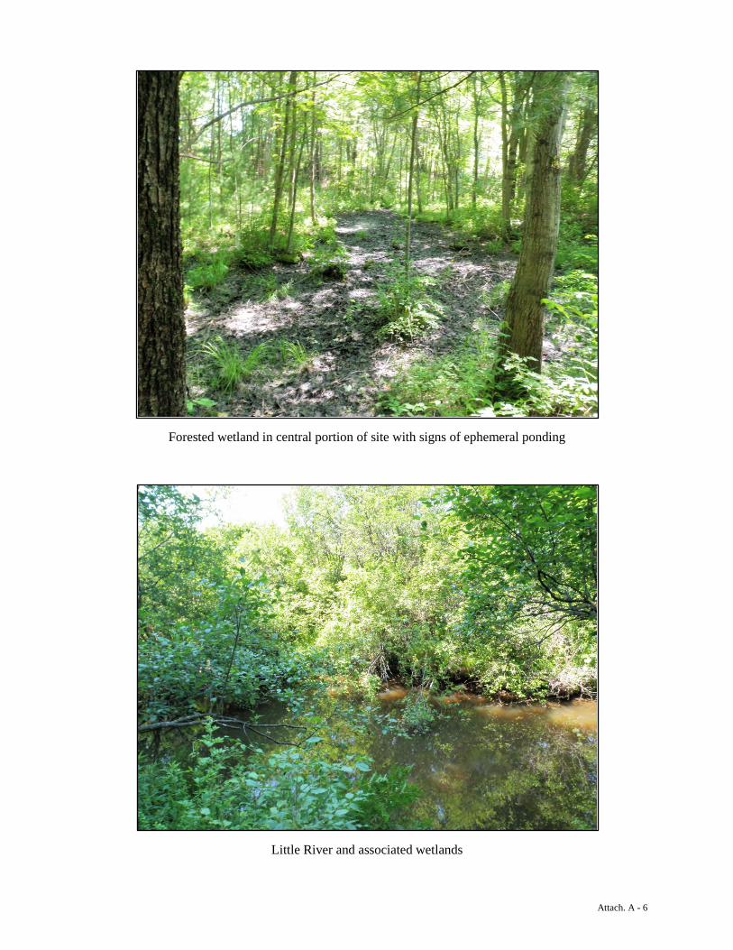
Forested wetland in central portion of site with signs of ephemeral ponding
Little River and associated wetlands
Attach. A - 7
Alternative 3
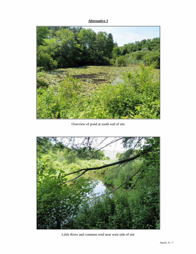
Overview of pond at south end of site
Little River and common reed near west side of site
Attach. A - 8
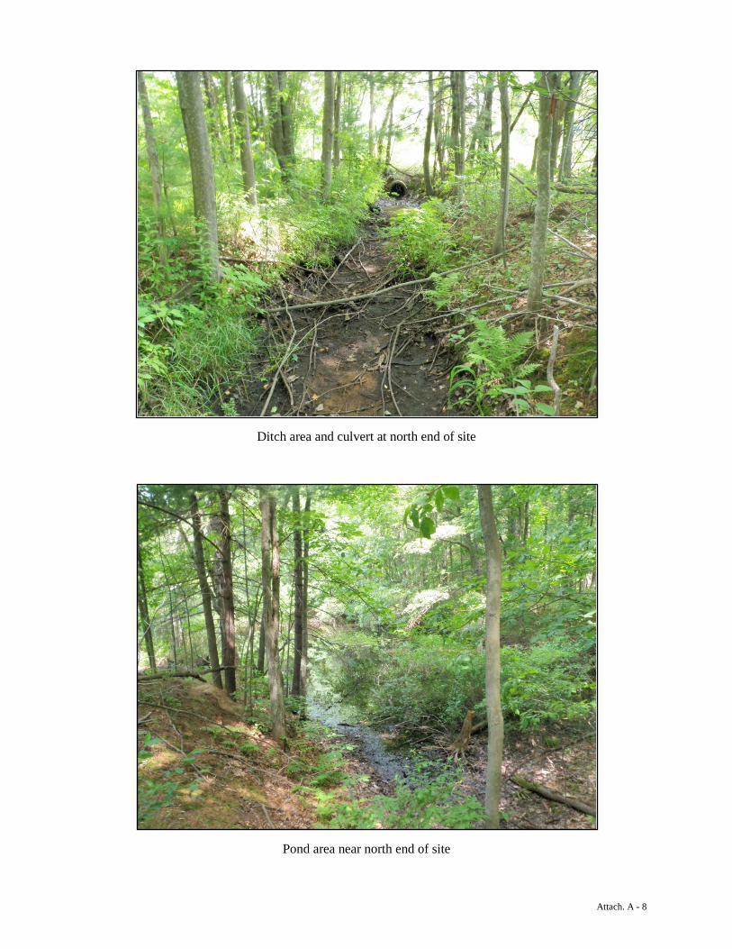
Ditch area and culvert at north end of site
Pond area near north end of site
Attachment 2 Sketch Maps
r
r
rr
r
Alternative 1 Layover
A1L-W1PFO1/SS1/EM1E
Atkinson Depot Rd
A1L-S2
A1L-S1
A1L-S3
A1L-S4
Path: J:\Projects\PlaistowCommuterRail\MXD\PCR_FieldMap.mxd
Prelim. Water Resources MapPlaistow Rail Study
Project No: 22797.000Drawn By: wmccloyDate : 7/14/2014
Merrimack ValleyPlaistow and Atkinson, NH/Haverhill, MA
0 250 500125Feet
±Site Boundary (HDR)
r Potential VP (Approx)Stream (Approx)Wetland (Approx)
Rail (Plaistow)Parcel (Plaistow)Roads (DOT)NWI Wetland (USFWS)
25 Nashua Road Bedford, NH 03110(603) 472-5191 www.normandeau.com
Service Layer Credits: NWI data provided by Mass GIS.

r
r
r
Alternative 344.390751
Alternative 1 Station
Alternative 2
A2-W4PSS1E
A2-W3PFO1/PUBH/SS1/EM1E
A3-W1PUBH/SS1E
A2-W2PSS1/FO1E
A3-W2PFO1/SS1/EM1E
A2-W1PFO14/PUBH
A1S-W1PUBH
Plaistow Rd
Westville Rd
Joann
e Dr
East Rd
Blossom Rd
Laure
l Ave
NoNa
me
Kelle
her A
ve
No Name
No Name
A2/3-S1
A2-S
1
A3-S
3
Path: J:\Projects\PlaistowCommuterRail\MXD\PCR_FieldMap.mxd
Prelim. Water Resources MapPlaistow Rail Study
Project No: 22797.000Drawn By: wmccloyDate : 7/14/2014
Merrimack ValleyPlaistow and Atkinson, NH/Haverhill, MA
0 250 500125Feet
±Site Boundary (HDR)
r Potential VP (Approx)Stream (Approx)Wetland (Approx)
Rail (Plaistow)Parcel (Plaistow)Roads (DOT)NWI Wetland (USFWS)
25 Nashua Road Bedford, NH 03110(603) 472-5191 www.normandeau.com
Service Layer Credits: NWI data provided by Mass GIS.
r
r
r
Alternative 344.390751
Alternative 2
A2-W4PSS1E
A2-W3PFO1/PUBH/SS1/EM1E
A3-W1PUBH/SS1E
A2-W2PSS1/FO1E
A3-W2PFO1/SS1/EM1E
A2-W1PFO14/PUBH
A3-W2PFO1/SS1/EM1E
A3-W3PSS1E
A3-W4PSS1E
A3-W5PSS1E
A3-SW1Stormwater Pond
Main St
Westville Rd
Dusto
n AveKim
ball A
ve
Pineview Ave
Plaistow Rd
A2/3-S1
A3-S1
A3-D1A2
-S1
A3-S
3
A3-S2
Path: J:\Projects\PlaistowCommuterRail\MXD\PCR_FieldMap.mxd
Prelim. Water Resources MapPlaistow Rail Study
Project No: 22797.000Drawn By: wmccloyDate : 7/14/2014
Merrimack ValleyPlaistow and Atkinson, NH/Haverhill, MA
0 250 500125Feet
±Site Boundary (HDR)
r Potential VP (Approx)Stream (Approx)Wetland (Approx)
Rail (Plaistow)Parcel (Plaistow)Roads (DOT)NWI Wetland (USFWS)
25 Nashua Road Bedford, NH 03110(603) 472-5191 www.normandeau.com
Service Layer Credits: NWI data provided by Mass GIS.
Attachment 3
NH NHB Datacheck Results
New Hampshire Natural Heritage Bureau
NHB DataCheck Results Letter
Department of Resources and Economic Development DRED/NHB Division of Forests and Lands PO Box 1856 (603) 271-2214 fax: 271-6488 Concord NH 03302-1856
To: William McCloy, Normandeau Associates P.O. Box 249 Rutland, VT 05701
From: NH Natural Heritage Bureau
Date: 1/21/2015 (valid for one year from this date)
Re: Review by NH Natural Heritage Bureau of request submitted 1/15/2015
NHB File ID: NHB15-0252 Applicant: NH DOT
Location: Plaistow Multiple
Project Description:
Project involves the review of multiple alternatives for a new passenger rail facility adjacent to existing rail lines.
The NH Natural Heritage database has been checked by staff of the NH Natural Heritage Bureau and/or the NH Nongame and Endangered Species Program for records of rare species and exemplary natural communities near the area mapped below. The species considered include those listed as Threatened or Endangered by either the state of New Hampshire or the federal government. It was determined that, although there was a NHB record (e.g., rare wildlife, plant, and/or natural community) present in the vicinity, we do not expect that it will be impacted by the proposed project. This determination was made based on the project information submitted via the NHB Datacheck Tool on 1/15/2015, and cannot be used for any other project.

New Hampshire Natural Heritage Bureau
NHB DataCheck Results Letter
Department of Resources and Economic Development DRED/NHB Division of Forests and Lands PO Box 1856 (603) 271-2214 fax: 271-6488 Concord NH 03302-1856
MAP OF PROJECT BOUNDARIES FOR: NHB15-0252
Plaistow Commuter Rail Extension Preliminary Alternatives Analysis
Natural Resources Preliminary Impact Analysis
Prepared For: HDR, Inc.
695 Atlantic Avenue FL2 Boston, MA 02111
Submitted On:
March 9, 2015
Prepared By:
Normandeau Associates, Inc. 25 Nashua Road
Bedford, NH 03110
www.normandeau.com
NORMANDEAU ASSOCIATES INC.
Contents
1.0 INTRODUCTION ............................................................................................................... 1
Preliminary Water Resource Impact Assessment Methodology and Results .................. 2
2.0 DISCUSSION OF ESTIMATED IMPACTS ASSOCIATED WITH ALTERNATIVES ......................... 3
Alternative 1 (Station) ...................................................................................................... 3 Alternative 1 (Layover) ..................................................................................................... 3 Alternative 2 ..................................................................................................................... 4 Alternative 3 ..................................................................................................................... 4
3.0 REGULATORY CONSIDERATIONS ...................................................................................... 5
Wetlands and Vernal Pools .............................................................................................. 5 Shoreland (New Hampshire only) .................................................................................... 6
4.0 IMPACT AVOIDANCE, MINIMIZATION, AND MITIGATION .................................................. 6
ATTACHMENT A PRELIMINARY NATURAL RESOURCE IMPACT ASSESSMENT MAPS ..................................... 9
Plaistow Commuter Rail Extension Alternatives Analysis – Preliminary Natural Resources Impact Assessment
ii
NORMANDEAU ASSOCIATES INC.
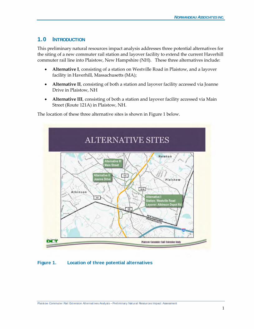
1.0 INTRODUCTION This preliminary natural resources impact analysis addresses three potential alternatives for the siting of a new commuter rail station and layover facility to extend the current Haverhill commuter rail line into Plaistow, New Hampshire (NH). These three alternatives include:
• Alternative I, consisting of a station on Westville Road in Plaistow, and a layover facility in Haverhill, Massachusetts (MA);
• Alternative II, consisting of both a station and layover facility accessed via Joanne Drive in Plaistow, NH
• Alternative III, consisting of both a station and layover facility accessed via Main Street (Route 121A) in Plaistow, NH.
The location of these three alternative sites is shown in Figure 1 below.
Figure 1. Location of three potential alternatives
Plaistow Commuter Rail Extension Alternatives Analysis – Preliminary Natural Resources Impact Assessment
1
NORMANDEAU ASSOCIATES INC.
Preliminary Water Resource Impact Assessment Methodology and Results
The three alternatives (involving four separate sites) were reviewed for the presence of wetlands, streams and potential vernal pools in June and July, 2014. Observations and sketch maps were provided to HDR in a Memorandum Re: Summary of Preliminary Field Review for Wetlands, Streams and Vernal Pools, dated July 17, 2014 and revised on March 9, 2015. The purpose of the investigation was to identify the approximate locations of regulated water resources to inform the siting process for the initial stages of the project. Formal delineations were not completed by Normandeau on any of the site alternatives, and the approximate location of the water resources were recorded using a combination of sketch maps and Global Positioning System (GPS) points collected in the field. Aerial photography, National Wetlands Inventory (NWI) wetlands mapping, Natural Resources Conservation Service (NRCS) soils mapping, state-wide stream and water body mapping, and Town of Plaistow water resources mapping were reviewed prior to the site visits and during the site walks. Preliminary impact area maps (see Attachment A) were developed using Geographic Information Systems (GIS) software by overlaying preliminary project footprint areas, (provided by HDR), on the estimated locations and extent of resource areas identified by Normandeau. Federal Emergency Management Agency (FEMA) mapping of flood zones was also added to the impact area maps. Notably, the project footprints (provided in 2015) extend beyond the limits of the 2014 field investigation associated within the Alternative I (Layover) and Alternative II (see annotations on figures contained in Attachment A). As such, any wetlands within these areas are not represented nor calculated in this impact assessment. It is critical to note that formal delineations were not completed on any of the site alternatives, as this level of effort was not considered necessary at this stage of project development. As such, impacts and mitigation considerations discussed in this report are preliminary. Formal wetland delineations will be required to formally document the extent, nature and functional significance of any identified wetland resources associated with whichever site is determined to be the Preferred Alternative. Vernal pool surveys must be completed on the selected site during the spring when vernal pool-dependent wildlife species are breeding and utilizing these areas to determine whether the potential vernal pools identified by Normandeau do in fact support vernal pool species. There were no mapped Certified Vernal Pools (CVPs) as recorded by the Massachusetts Natural Heritage and Endangered Species Program and mapped by MassGIS in the project vicinity located in Massachusetts. New Hampshire does not maintain GIS data as to the location of vernal pools, and requires a site-specific field survey to verify the presence or absence of such resources, which ideally should be undertaken during the spring season. Table 1 provides a summary of estimated impacts to vernal pools and their 100- and 750-foot buffers (as regulated by the US Army Corps of Engineers)(USACE), wetlands, streams, and flood zone assuming filling of such resources within the direct footprint of proposed
Plaistow Commuter Rail Extension Alternatives Analysis – Preliminary Natural Resources Impact Assessment
2
NORMANDEAU ASSOCIATES INC.
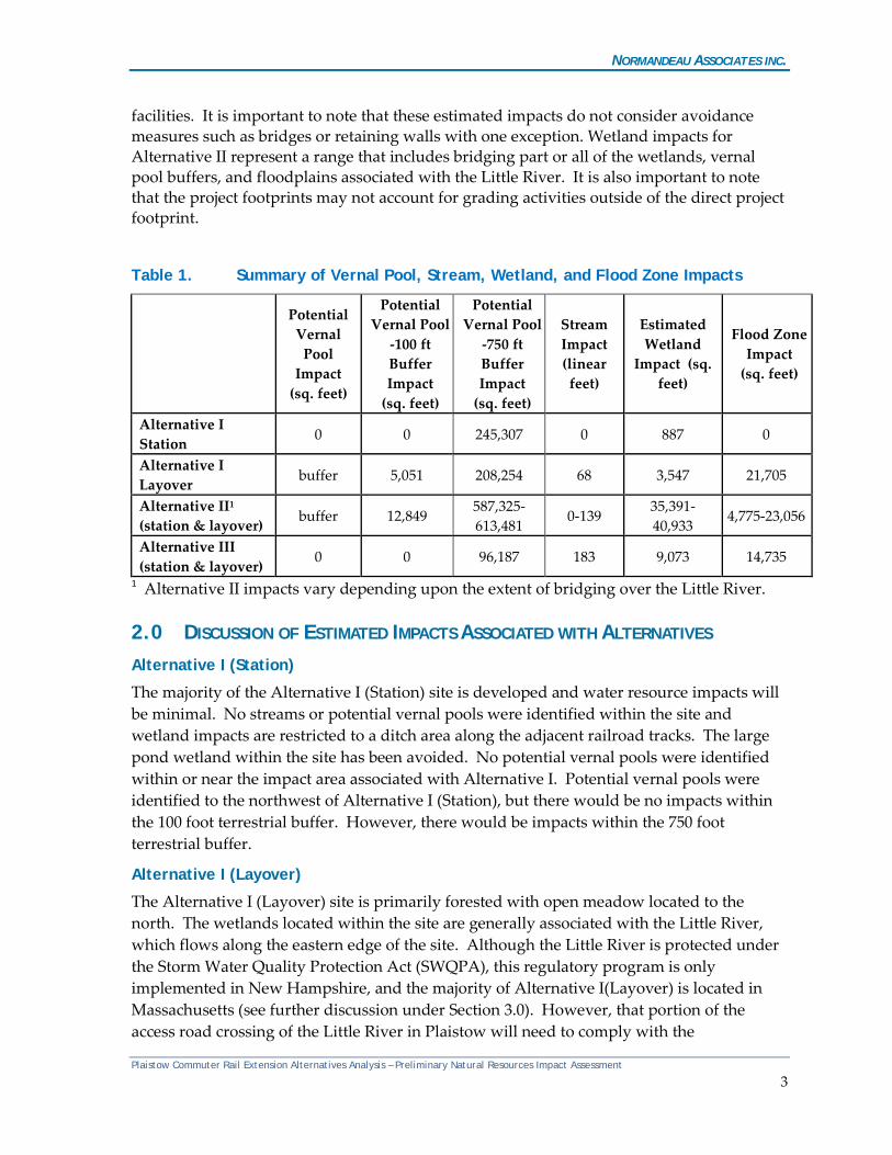
facilities. It is important to note that these estimated impacts do not consider avoidance measures such as bridges or retaining walls with one exception. Wetland impacts for Alternative II represent a range that includes bridging part or all of the wetlands, vernal pool buffers, and floodplains associated with the Little River. It is also important to note that the project footprints may not account for grading activities outside of the direct project footprint.
Table 1. Summary of Vernal Pool, Stream, Wetland, and Flood Zone Impacts
Potential Vernal
Pool Impact
(sq. feet)
Potential Vernal Pool
-100 ft Buffer Impact
(sq. feet)
Potential Vernal Pool
-750 ft Buffer Impact
(sq. feet)
Stream Impact (linear feet)
Estimated Wetland
Impact (sq. feet)
Flood Zone Impact
(sq. feet)
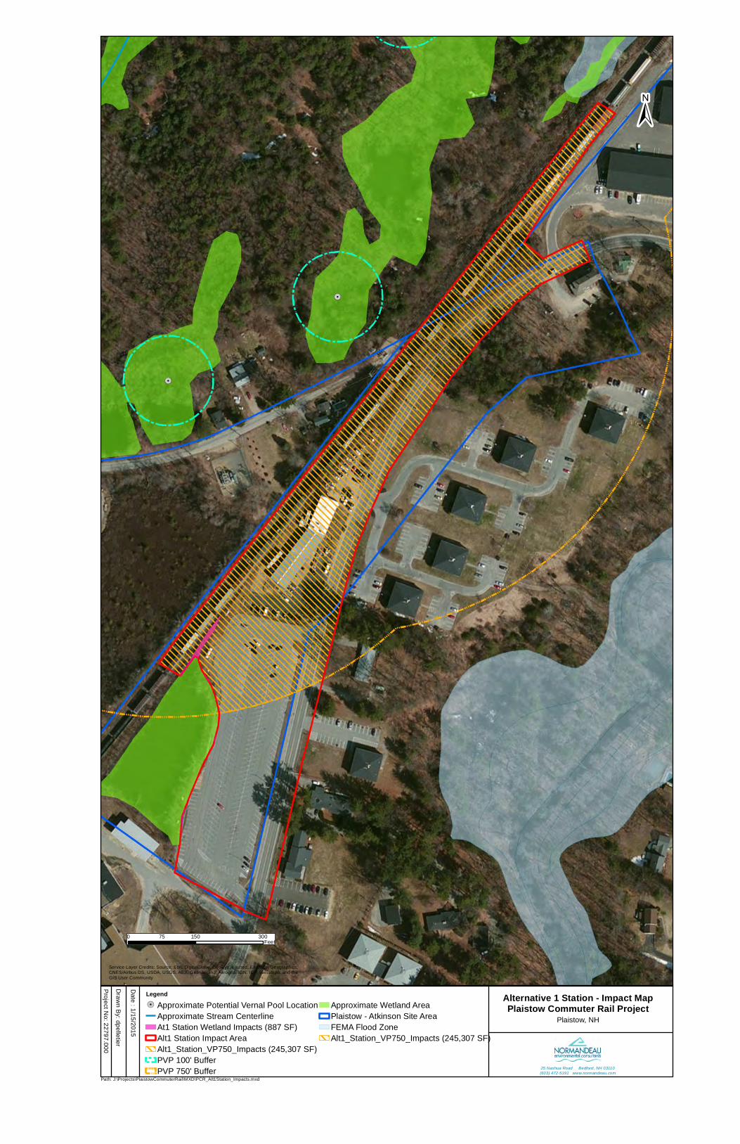
Alternative I Station 0 0 245,307 0 887 0
Alternative I Layover buffer 5,051 208,254 68 3,547 21,705
Alternative II1 (station & layover) buffer 12,849
587,325-613,481
0-139 35,391-40,933
4,775-23,056
Alternative III (station & layover)
0 0 96,187 183 9,073 14,735
1 Alternative II impacts vary depending upon the extent of bridging over the Little River.
2.0 DISCUSSION OF ESTIMATED IMPACTS ASSOCIATED WITH ALTERNATIVES Alternative I (Station)
The majority of the Alternative I (Station) site is developed and water resource impacts will be minimal. No streams or potential vernal pools were identified within the site and wetland impacts are restricted to a ditch area along the adjacent railroad tracks. The large pond wetland within the site has been avoided. No potential vernal pools were identified within or near the impact area associated with Alternative I. Potential vernal pools were identified to the northwest of Alternative I (Station), but there would be no impacts within the 100 foot terrestrial buffer. However, there would be impacts within the 750 foot terrestrial buffer.
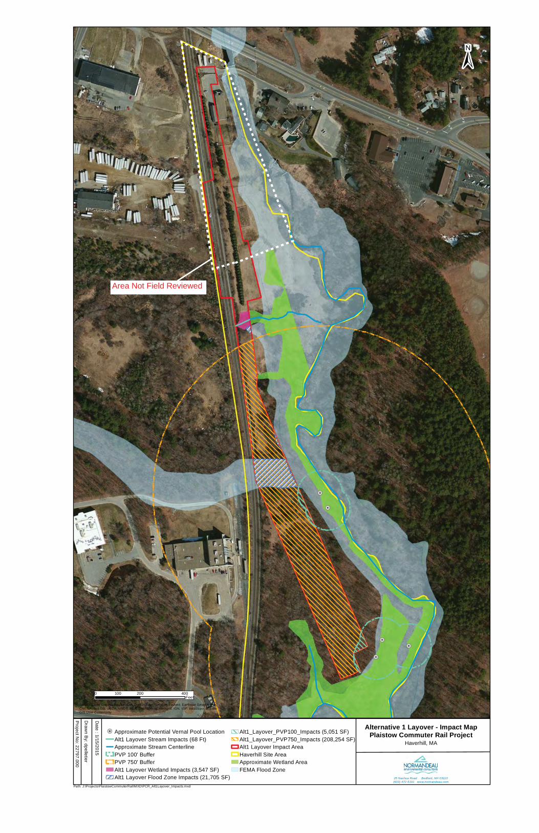
Alternative I (Layover)
The Alternative I (Layover) site is primarily forested with open meadow located to the north. The wetlands located within the site are generally associated with the Little River, which flows along the eastern edge of the site. Although the Little River is protected under the Storm Water Quality Protection Act (SWQPA), this regulatory program is only implemented in New Hampshire, and the majority of Alternative I(Layover) is located in Massachusetts (see further discussion under Section 3.0). However, that portion of the access road crossing of the Little River in Plaistow will need to comply with the
Plaistow Commuter Rail Extension Alternatives Analysis – Preliminary Natural Resources Impact Assessment
3
NORMANDEAU ASSOCIATES INC.
requirements of the SWQPA regulations. Based on the preliminary layover impact area, one intermittent stream would need to be crossed along with a wetland fringe; however, the majority of the other area within the layover facility impact area is upland. The FEMA floodplains are generally confined to the lower elevations along the Little River. The floodplain area mapped across the central portion of the site may be erroneous based on field observations, as it is not associated with any other streams; more detailed analysis of topography and calculations as to flooding are recommended. Potential vernal pools are located in the floodplain areas along the Little River and need to be reviewed during the spring amphibian breeding season to confirm whether they are vernal pools or not. If vernal pool species are present, the current design would impact substantial portions of the 100- and 750- foot pool envelope and terrestrial habitat buffers associated with the pools, impacts to which are reviewed by the USACE, as well as by the and Haverhill Conservation Commission under both the Massachusetts Wetlands Protection Act and the Haverhill Wetland and Aquifer Protection Ordinance (see further discussion in Section 3.0).
Alternative II
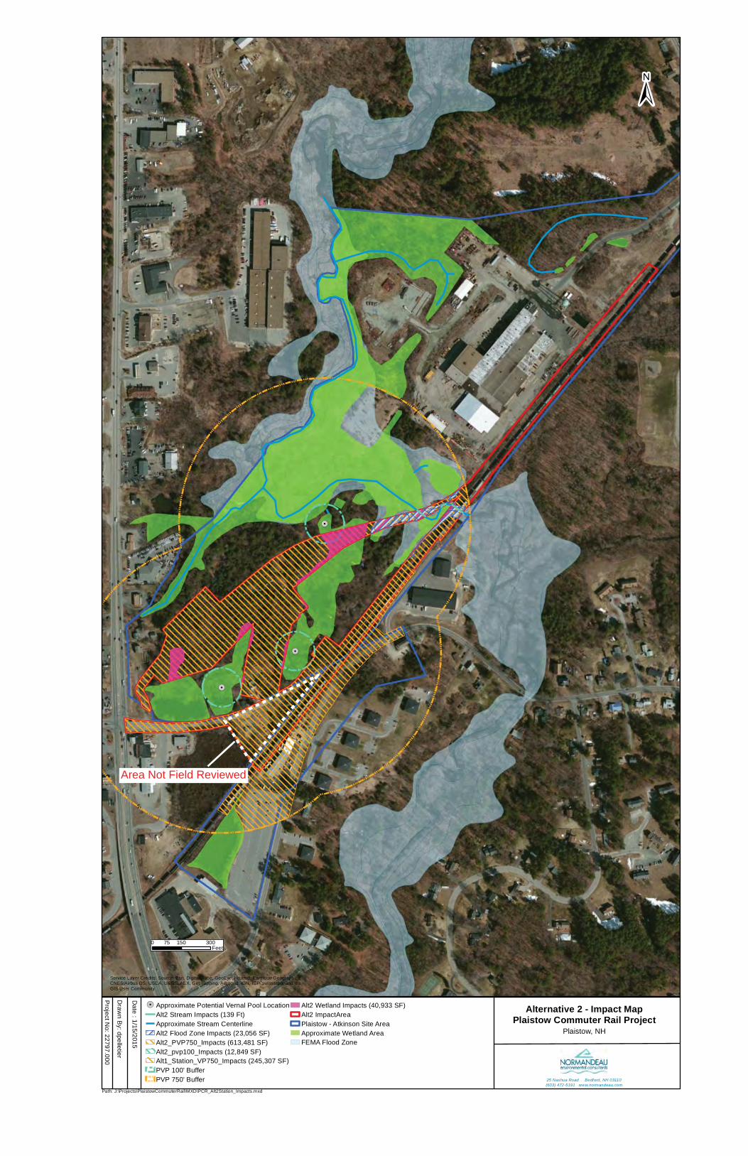
The Alternative II site is primarily forested, with several large wetland areas in the vicinity, some of which extend into the site. The wetlands located within the site are generally forested with a scrub-shrub understory. Three ponded wetlands including one in the central portion of the site and two others in the southwest corner are also present, all three of which have forested fringes. The most significant drainage is the Little River, which flows through the site and under the existing railroad corridor. As noted above, this river is protected under the SWQPA. Preliminary impact areas associated with the proposed station and layover facility will impact between approximately 35,000-41,000 sq. ft. of wetland along with several floodplain areas associated with the Little River. The Little River also passes through the impact area, with a worst case of approximately 140 linear feet of stream impact. The amount of wetland, stream and floodplain impact will depend on the extent of bridging, if any. Three potential vernal pools are located within the site, all of which have been avoided; however, portions of the 100-foot and 750-foot buffers associated with the pools would be impacted in each instance. The pond in the central portion of the site will be avoided. Bridging the Little River near where it passes under the existing rail line would substantially reduce the potential impacts to the channel and associated floodplain areas.
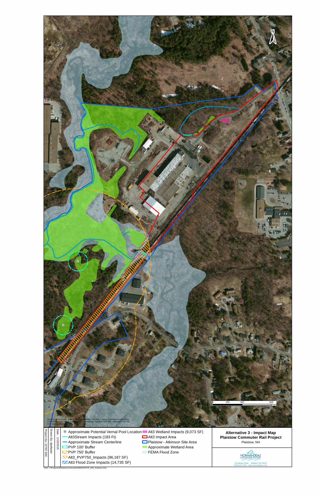
Alternative III
The Alternative III site is mostly developed with a large commercial/industrial facility. Wetlands located within the site are associated with a pond and the Little River, which flows along the southern portion of the site. Preliminary impact areas associated with the station and layover facility would result in wetland impacts along and adjacent to the wetland and floodplain areas adjacent to the Little River. Wetland impacts would total approximately 9,000 sq. ft. Bridging the Little River at this location would likely reduce these impacts. No potential vernal pools were identified within or near the impact area associated with Alternative III.
Plaistow Commuter Rail Extension Alternatives Analysis – Preliminary Natural Resources Impact Assessment
4
NORMANDEAU ASSOCIATES INC.
3.0 REGULATORY CONSIDERATIONS Wetlands and Vernal Pools
The USACE has regulatory jurisdiction over “waters of the United States”, including rivers, lakes, wetlands, streams and vernal pools under Section 404 of the Clean Water Act. In New Hampshire, projects with nontidal wetland impacts less than 3,000 sq. ft. are considered minimum impact projects by the USACE. Wetland impacts between 3,000 sq. ft. and < 3 acres (130,680 SF) in New Hampshire fall under the classification of minor and major projects. All projects with less than 3 acres of impact can be permitted under the USACE Programmatic General Permit (PGP) program within New Hampshire. Wetland impacts exceeding 3 acres in New Hampshire would require an Individual Permit by the USACE. The USACE PGP program in Massachusetts recognizes different levels of impacts; projects involving fewer than 5,000 sq. ft. of nontidal wetland impacts generally fall under Category 1 (there are some exceptions that are beyond the scope of this report); projects involving greater than 5,000 sq. ft. of nontidal wetland impacts generally fall under Category 2, while projects greater than 1 acre fall under an Individual Permit (Category 3). In addition to the regulation of wetlands at the federal level, New Hampshire and Massachusetts have their own programs designed to protect wetlands. The New Hampshire Department of Environmental Services (NHDES) Wetlands Bureau and Massachusetts Department of Environmental Protection (MADEP) have regulatory jurisdiction over wetlands, including rivers, stream, lakes, ponds and vernal pools. In New Hampshire, NHDES regulates jurisdictional resources under RSA 482-A and New Hampshire Code of Administrative Rules (Env-Wt.100-900). The NHDES Wetlands Bureau permitting process considers impacts to regulated wetlands and associated plants, wildlife and fish. New Hampshire Prime Wetlands are high value wetlands due to their unspoiled character and ability to sustain populations of rare, threatened or endangered plant and animal species. Individual towns submit candidate wetlands to the state for the Prime Wetland designation (RSA 482-A:15). Plaistow does not have any wetlands designated as prime. Projects in NH with freshwater wetland impacts less than 3,000 SF are considered minimal impact. For inland wetland fill projects, the NHDES Wetlands Bureau thresholds are 3,000 to <20,000 SF (Minor Impact Project) and ≥20,000 SF (Major Impact Project). In Massachusetts, wetlands are protected under the Massachusetts Wetlands Protection Act (MWPA) (MGL Ch. 131 s.40) and its implementing regulations (310 CMR 10.00.) Most projects are reviewed by local Conservation Commissions; in limited instances (which do not appear to be applicable given the estimated extent of impacts on the Alternative I (Layover) site, project review is undertaken by the Massachusetts Department of Environmental Protection.
Plaistow Commuter Rail Extension Alternatives Analysis – Preliminary Natural Resources Impact Assessment
5
NORMANDEAU ASSOCIATES INC.
Potential vernal pools were identified during the preliminary review. Vernal pools are defined by New Hampshire under Env-Wt 101.99 and are temporary bodies of water that provide essential habitat for a variety of species which require vernal pools as habitat for breeding. Activities around identified vernal pools within the state seasonal 100-foot “vernal pool” envelope and a federally regulated 750-foot buffer are regulated as jurisdictional wetlands. Massachusetts defines vernal pools similarly under the MWPA; however, they are only protected under the MWPA if they occur within another jurisdictional wetland resource area or their buffer zones. Isolated vernal pools located in upland areas are not protected at the state level; however, many municipalities have local wetlands bylaws that close this gap. The City of Haverhill has adopted a Wetland and Aquifer Protection Ordinance that partially closes the gap by also regulating activities that have the potential to impact vernal pools.
Shoreland (New Hampshire only)
Any proposed work along fourth-order or higher streams, larger water bodies and Designated Rivers triggers a shoreland permit under the SWQPA. The SWQPA is concerned with maintaining water quality in the state’s waters. The state protected shoreland is the land area within 250 feet of the reference line of a regulated shoreline. The reference line is the ordinary high water mark for rivers and for lakes and ponds it is the surface elevation listed on the Consolidated List of Waterbodies published by the state of New Hampshire. The protected shoreland is divided into 2 buffer areas: 1) the waterfront buffer which extends 50 feet from the reference line; and 2) the natural woodland buffer which extends 150 feet from the reference line. As noted previously, the Little River in Plaistow is protected under SWQPA.
4.0 IMPACT AVOIDANCE, MINIMIZATION, AND MITIGATION Federal and state regulations mandate that discharges of dredged or fill material into waters of the U.S. and any secondary impacts to such waters shall be avoided and minimized to the maximum extent practicable. An assessment of project alternatives is required in order to demonstrate that the Least Environmentally Damaging Practicable Alternative has been selected. Factors such as cost, engineering, and logistics can be considered in determining whether an alternative is “practicable”. Wetland impacts for the Preferred Alternative (Alternative II) can been minimized to a great extent by bridging wetlands or reducing encroachment by constructing retaining walls, but still are the highest of the three alternatives. Successful acquisition of the requisite permits will require a clear demonstration that the Preferred Alternative (Alternative II) is the only alternative that meets the project purpose and need, or that in terms of engineering, logistics, or cost, it is the only practicable alternative. Mitigation will be required for any unavoidable wetland impacts in NH exceeding 10,000 sq. ft., stream work greater than 200 linear ft, and other circumstances (see Env-Wt 302 and
Plaistow Commuter Rail Extension Alternatives Analysis – Preliminary Natural Resources Impact Assessment
6
NORMANDEAU ASSOCIATES INC.
800). Mitigation for wetland impacts in MA (i.e., if the Alternative I (Layover) site is developed) would be required for any amount of direct wetland impacts. Bridging wetlands along the Little River could further reduce the wetland impacts associated with Alternative II, but the reduction would not be sufficient to avoid the mitigation requirement. To compensate for unavoidable impacts to wetlands and water bodies, the state of New Hampshire has established regulations and guidance to aid permit applicants through the development of mitigation packages. At the present time, state required mitigation is not necessarily a direct substitute for federally required mitigation. The USACE has additional mitigation guidelines that are negotiated in conjunction with state required mitigation; however, these are only imposed on projects that require an Individual Permit (in NH, projects involving >3 acres of wetland impacts). Assuming the project can be designed to impact fewer than 3 acres of wetlands, it is likely that the USACE will concur with a mitigation package that is acceptable to the NHDES.
Acceptable mitigation packages are developed in conjunction with a complete functions and values assessment of the wetlands resources to be impacted. The purpose of the functions and values assessment is to enable the permitting agency, in this case the NHDES Wetlands Bureau, to evaluate the mitigation package and ensure that lost functions and values are replaced. Mitigation can include one or any combination of the following components:
• Land Preservation; • Wetland Restoration; • Wetland Creation; and • Participation in the Aquatic Resource Mitigation (ARM) fund.
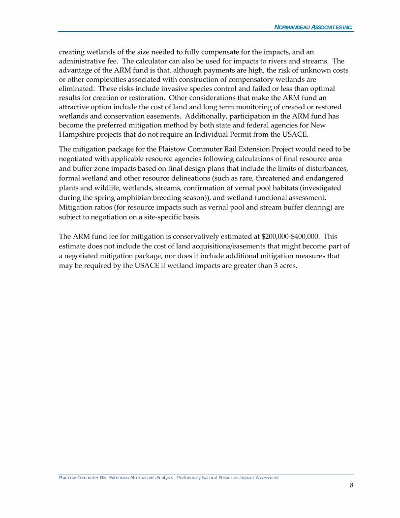
Land Preservation is the permanent protection of predominantly upland areas through the establishment of a conservation easement. Wetland restoration reestablishes degraded wetlands while wetland creation transforms uplands to wetlands. Depending on the types of wetlands impacted, the NH ARM fund establishes ratios for mitigation (Table 2). Note that these ratios differ from those established by the USACE for projects involving greater than 3 acres of wetland impacts in New Hampshire.
Table 2. NH ARM Fund Mitigation Ratios
Resource Type Creation Ratio
Restoration Ratio
Preservation Ratio
Bog N/A 2:1 15:1 Forested Wetlands 1.5:1 1.5:1 10:1 All other Jurisdictional Areas 1.5:1 1:1 10:1
The ARM fund receives payments in lieu of restoration/creation/preservation and the fund is used to support projects within the same watershed that represent the lost functions and values of the wetlands impacted within the watershed. ARM fund calculations are based on the value of the land area in the town where impacts are proposed, the estimated cost of Plaistow Commuter Rail Extension Alternatives Analysis – Preliminary Natural Resources Impact Assessment
7
NORMANDEAU ASSOCIATES INC.
creating wetlands of the size needed to fully compensate for the impacts, and an administrative fee. The calculator can also be used for impacts to rivers and streams. The advantage of the ARM fund is that, although payments are high, the risk of unknown costs or other complexities associated with construction of compensatory wetlands are eliminated. These risks include invasive species control and failed or less than optimal results for creation or restoration. Other considerations that make the ARM fund an attractive option include the cost of land and long term monitoring of created or restored wetlands and conservation easements. Additionally, participation in the ARM fund has become the preferred mitigation method by both state and federal agencies for New Hampshire projects that do not require an Individual Permit from the USACE.
The mitigation package for the Plaistow Commuter Rail Extension Project would need to be negotiated with applicable resource agencies following calculations of final resource area and buffer zone impacts based on final design plans that include the limits of disturbances, formal wetland and other resource delineations (such as rare, threatened and endangered plants and wildlife, wetlands, streams, confirmation of vernal pool habitats (investigated during the spring amphibian breeding season)), and wetland functional assessment. Mitigation ratios (for resource impacts such as vernal pool and stream buffer clearing) are subject to negotiation on a site-specific basis. The ARM fund fee for mitigation is conservatively estimated at $200,000-$400,000. This estimate does not include the cost of land acquisitions/easements that might become part of a negotiated mitigation package, nor does it include additional mitigation measures that may be required by the USACE if wetland impacts are greater than 3 acres.
Plaistow Commuter Rail Extension Alternatives Analysis – Preliminary Natural Resources Impact Assessment
8
NORMANDEAU ASSOCIATES INC.
Attachment A PRELIMINARY NATURAL RESOURCE IMPACT ASSESSMENT MAPS
Plaistow Commuter Rail Extension Alternatives Analysis – Preliminary Natural Resources Impact Assessment
9
!.
!.
Path: J:\Projects\PlaistowCommuterRail\MXD\PCR_Alt1Station_Impacts.mxd
Alternative 1 Station - Impact MapPlaistow Commuter Rail Project
Project No: 22797.000Drawn By: dpelletierDate : 1/15/2015
Plaistow, NH
0 150 30075Feet
±
Legend!. Approximate Potential Vernal Pool Location
Approximate Stream CenterlineAt1 Station Wetland Impacts (887 SF)Alt1 Station Impact AreaAlt1_Station_VP750_Impacts (245,307 SF)PVP 100' BufferPVP 750' Buffer
Approximate Wetland AreaPlaistow - Atkinson Site AreaFEMA Flood ZoneAlt1_Station_VP750_Impacts (245,307 SF)
25 Nashua Road Bedford, NH 03110(603) 472-5191 www.normandeau.com
Service Layer Credits: Source: Esri, DigitalGlobe, GeoEye, i-cubed, Earthstar Geographics,CNES/Airbus DS, USDA, USGS, AEX, Getmapping, Aerogrid, IGN, IGP, swisstopo, and theGIS User Community
!.
!.
!.!.
!.
Path: J:\Projects\PlaistowCommuterRail\MXD\PCR_Alt1Layover_Impacts.mxd
Alternative 1 Layover - Impact MapPlaistow Commuter Rail Project
Project No: 22797.000Drawn By: dpelletierDate : 1/15/2015
Haverhill, MA
0 200 400100Feet
±
!. Approximate Potential Vernal Pool LocationAlt1 Layover Stream Impacts (68 Ft)Approximate Stream CenterlinePVP 100' BufferPVP 750' BufferAlt1 Layover Wetland Impacts (3,547 SF)Alt1 Layover Flood Zone Impacts (21,705 SF)
Alt1_Layover_PVP100_Impacts (5,051 SF)Alt1_Layover_PVP750_Impacts (208,254 SF)Alt1 Layover Impact AreaHaverhill Site AreaApproximate Wetland AreaFEMA Flood Zone
25 Nashua Road Bedford, NH 03110(603) 472-5191 www.normandeau.com
Service Layer Credits: Source: Esri, DigitalGlobe, GeoEye, i-cubed, Earthstar Geographics,CNES/Airbus DS, USDA, USGS, AEX, Getmapping, Aerogrid, IGN, IGP, swisstopo, and theGIS User Community
Area Not Field Reviewed
!.
!.
!.
Path: J:\Projects\PlaistowCommuterRail\MXD\PCR_Alt2Station_Impacts.mxd
Alternative 2 - Impact MapPlaistow Commuter Rail Project
Project No: 22797.000Drawn By: dpelletierDate : 1/15/2015
Plaistow, NH
0 150 30075Feet
±
!. Approximate Potential Vernal Pool LocationAlt2 Stream Impacts (139 Ft)Approximate Stream CenterlineAlt2 Flood Zone Impacts (23,056 SF)Alt2_PVP750_Impacts (613,481 SF)Alt2_pvp100_Impacts (12,849 SF)Alt1_Station_VP750_Impacts (245,307 SF)PVP 100' BufferPVP 750' Buffer
Alt2 Wetland Impacts (40,933 SF)Alt2 ImpactAreaPlaistow - Atkinson Site AreaApproximate Wetland AreaFEMA Flood Zone
25 Nashua Road Bedford, NH 03110(603) 472-5191 www.normandeau.com
Service Layer Credits: Source: Esri, DigitalGlobe, GeoEye, i-cubed, Earthstar Geographics,CNES/Airbus DS, USDA, USGS, AEX, Getmapping, Aerogrid, IGN, IGP, swisstopo, and theGIS User Community
Area Not Field Reviewed
!.
!.
Path: J:\Projects\PlaistowCommuterRail\MXD\PCR_Alt3_Impacts.mxd
Alternative 3 - Impact MapPlaistow Commuter Rail Project
Project No: 22797.000Drawn By: dpelletierDate : 1/15/2015
Plaistow, NH
0 300 600150Feet
±
!. Approximate Potential Vernal Pool LocationAlt3Stream Impacts (183 Ft)Approximate Stream CenterlinePVP 100' BufferPVP 750' BufferAlt3_PVP750_Impacts (96,187 SF)Alt3 Flood Zone Impacts (14,735 SF)
Alt3 Wetland Impacts (9,073 SF)Alt3 Impact AreaPlaistow - Atkinson Site AreaApproximate Wetland AreaFEMA Flood Zone
25 Nashua Road Bedford, NH 03110(603) 472-5191 www.normandeau.com
Service Layer Credits: Source: Esri, DigitalGlobe, GeoEye, i-cubed, Earthstar Geographics,CNES/Airbus DS, USDA, USGS, AEX, Getmapping, Aerogrid, IGN, IGP, swisstopo, and theGIS User Community