Embed Size (px)
Citation preview
The Junipers ProjectEnvironmental Impact Report
SCH No. 2018041032 - Project No. 586670
Appendix LPaleontological Records Search
February 2020
17 July 2018
Ms. Tammy Ching
HELIX Environmental Planning, Inc.
7578 El Cajon Boulevard
La Mesa, CA 91942
RE: Paleontological Records Search – The Junipers
Dear Ms. Ching:
This letter presents the results of a paleontological records search conducted for The Junipers
Project (Project), located in the northern portion of the Rancho Peñasquitos Neighborhood and Rancho
Peñasquitos Community Plan Area of the City of San Diego, San Diego County, CA. The Project site is
bordered to the east by Interstate 15 (I-15), to the south by Carmel Mountain Road, and to the north
and west by existing residential and commercial development.
A review of published geological maps covering the Project site and surrounding area was
conducted to determine the specific geologic units underlying the Project. Each geologic unit was
subsequently assigned a paleontological resource sensitivity following City of San Diego and County of
San Diego guidelines (City of San Diego, 2011; Deméré and Walsh, 1993; Stephenson et al., 2009).
Published geological reports covering the Project area (e.g., Kennedy and Peterson, 1975; Kennedy and
Tan, 2008) indicate that the proposed Project has the potential to impact late Pleistocene- to Holocene-
age young alluvial flood plain deposits, the middle Eocene-age Mission Valley Formation, and Mesozoic-
age metasedimentary and metavolcanic rocks. However, deposits mapped as the Mission Valley
Formation that lie north of State Route 52 were referred to the upper tongue of the Friars Formation by
Walsh (1996) and Walsh et al. (1996). Therefore, the upper tongue of the Friars Formation is assumed to
underlie the Project site in areas mapped as the Mission Valley Formation. In addition, the prior
development of the site suggests that there may be significant volumes of unmapped artificial fill
underlying the area. Each of these geologic units (artificial fill, young alluvial flood plain deposits, the
Friars Formation, and undivided metasedimentary and metavolcanic rocks) and their paleontological
sensitivity are summarized in detail in the following section.
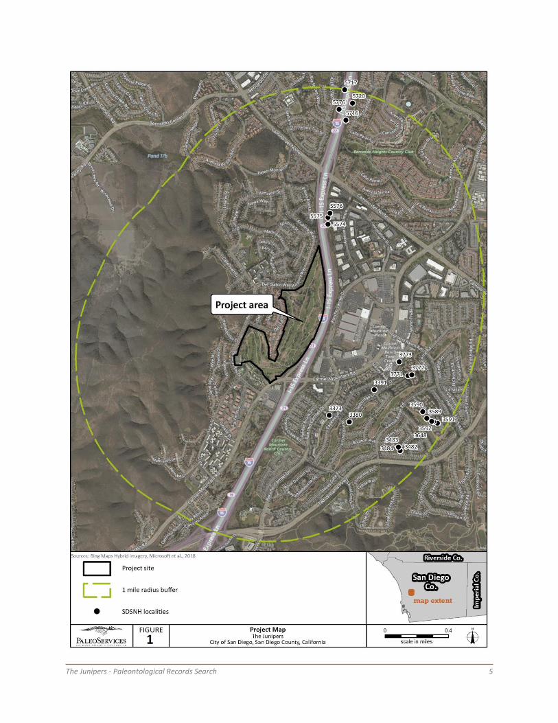
A search of the paleontological collection records housed at the San Diego Natural History
Museum (SDNHM) was conducted in order to determine if any documented fossil collection localities
occur at the Project site or within the immediate surrounding area (Figure 1). The SDNHM has 21
recorded fossil collection localities within one mile of the Project site. All of these localities are from the
upper tongue of the Friars Formation (residing in deposits mapped as the Mission Valley Formation by
Kennedy and Tan, 2008, but reassigned to the Friars Formation as mentioned above), and are described
in greater detail below.
Geologic Rock Units Underlying the Project Area
Artificial fill – Undocumented artificial fill likely was emplaced within the Project site during
prior development of the site as a golf course. The SDNHM does not have any fossil localities from
deposits of artificial fill within a 1-mile radius of the Project site. Because artificial fill has been previously
The Junipers - Paleontological Records Search 2
disturbed and may have been imported to a Project site, any contained fossil remains have lost their
original stratigraphic contextual data and are thus of little scientific value. For these reasons, artificial fill
is assigned no paleontological sensitivity.
Young alluvial flood plain deposits – Late Pleistocene- to Holocene-age alluvial flood plain
deposits (mapped by Kennedy and Tan, 2008, as Qya) occur in modern drainages, and underlie the
eastern portion of the Project site in the vicinity of I-15. The SDNHM does not have any fossil collection
localities from Holocene alluvial flood plain deposits within a 1-mile radius of the Project site. These
deposits are generally considered to be less than 10,000 years old and are assigned a low
paleontological sensitivity based on their young geologic age and the lack of known fossil localities.
However, these surficial deposits likely overlie strata of the Friars Formation (see below), which could be
impacted where the contact between these two units is relatively shallow.
Friars Formation – The fluvial deposits of the middle Eocene-age (approximately 47 to 46
million years old) Friars Formation, upper tongue, underlie the majority of the Project site at the surface,
and likely underlie shallow surficial deposits in other portions of the Project site. The SDNHM has 21
fossil collection localities from the upper tongue of the Friars Formation within a 1-mile radius of the
Project site. These localities produced trace fossils (e.g., coprolites), fossilized impressions of plants (e.g.,
ferns, myrtle, willows, and horsetails), and bones and teeth of terrestrial or freshwater vertebrates (e.g.,
bony fish, turtles, crocodiles, lizards, snakes, and assorted mammals, including marsupials, apatotheres,
leptictids, pantolestids, dermopterans, insectivores, bats, primates, carnivores, rodents, condylarths,
artiodactyls, and perissodactyls such as brontotheres). All three units of the Friars Formation are rich in
vertebrate fossils, especially terrestrial mammals (Walsh, 1996), and the deposits underlying the Project
site are therefore assigned a high paleontological sensitivity.
Mesozoic metasedimentary and metavolcanic rocks, undivided – Crystalline basement
rocks of late Jurassic to early Cretaceous age (approximately 140 to 125 million years old), mapped as
Mesozoic metasedimentary and metavolcanic rocks, undivided, by Kennedy and Tan (2008) and as the
Santiago Peak Volcanics by Todd (2004), underlie the easternmost portion of the Project site along I-15,
and the western portion of the Project site in the vicinity of Peñasquitos Drive. The SDNHM does not
have any fossil localities from this undivided unit within a 1-mile radius of the Project site. The
metavolcanic portions of this unit rarely preserve fossils due to the high temperatures associated with
their formation; some of the volcanic breccias, however, have produced petrified wood, and are
assigned a marginal sensitivity (Deméré and Walsh, 1993). The metasedimentary portions have the
potential to yield fossils, including siliceous microfossils (e.g., radiolarians) and marine
macroinvertebrates (e.g., clams and belemnites), and are assigned a moderate paleontological
sensitivity. Since the rock units exposed within the Project site are mapped as "undivided," specific
paleontological sensitivity determinations should be made by a qualified paleontologist during
monitoring of the areas mentioned above.
Summary and Recommendations
The high paleontological sensitivity of the Friars Formation and marginal to moderate
paleontological sensitivity of metasedimentary and metavolcanic rocks, undivided (Santiago Peak
Volcanics) in San Diego County (Deméré and Walsh, 1993; Stephenson et al., 2009), as well as the
presence of fossil localities in the vicinity of the Project site, suggest the potential for construction of the

The Junipers - Paleontological Records Search 3
Project to result in impacts to paleontological resources. Any proposed excavation activities that extend
deep enough to encounter previously undisturbed deposits of the Friars Formation or metasedimentary
rocks have the potential to impact the paleontological resources preserved therein. Within the Project
site, the extent of previous grading is unknown, as is the depth of any emplaced undocumented artificial
fill. It is therefore unclear at this point if construction will take place entirely within artificial fill, or if
excavations could impact the underlying Friars Formation or metasedimentary rocks.
None of the recorded fossil collection localities discussed above lie within the Project site, nor
within 100 feet of any planned earthwork within the Project site. Existing documented localities are,
therefore, unlikely to be impacted by construction of the Project.
The fossil collection locality information contained within this paleontological records search
should be considered private and is the sole property of the San Diego Natural History Museum. Any use
or reprocessing of information contained within this document beyond the scope of The Junipers Project
is prohibited.
If you have any questions concerning these findings please feel free to contact me at 619-255-
0321 or [email protected].
Sincerely,
Katie McComas
Paleontology Collections Assistant
San Diego Natural History Museum
Enc: Figure 1: Project map
Appendix: List of SDNHM fossil localities in the vicinity of the Project
Literature Cited
City of San Diego. 2011. California Environmental Quality Act, Significance Determination Thresholds.
Development Services Department, 84 p.
Deméré, T.A., and Walsh, S.L. 1993. Paleontological Resources, County of San Diego. Prepared for the
San Diego Planning Commission: 1–68.
Kennedy, M.P., and Peterson, G.L. 1975. Geology of the San Diego metropolitan area, California. Section
B - Eastern San Diego metropolitan area. California Division of Mines and Geology, Bulletin 200:
43–56.
Kennedy, M.P., and Tan, S.S. 2008. Geologic Map of the San Diego 30' x 60' Quadrangle, California.
California Geological Survey, Regional Geologic Map Series 1:100,000 scale, map no. 3.
The Junipers - Paleontological Records Search 4
Stephenson, B., and seven others. 2009. County of San Diego Guidelines for determining significance,
paleontological resources. Land Use and Environment Group, Department of Planning and Land
Use, Department of Public Works, 46 p.
Todd, V.R. 2004. Preliminary Geologic Map of the El Cajon 30' x 60' Quadrangle, Southern California. U.S.
Geological Survey, Open-File Report 2004-1361.
Walsh, S.L. 1996. Middle Eocene mammal faunas of San Diego County, California, Pp. 75–119. In, D.R.
Prothero and R.J. Emry (eds.). The Terrestrial Eocene-Oligocene Transition in North America.
Cambridge University Press.
Walsh, S.L., Prothero, D.R., and Lundquist, D.J. 1996. Stratigraphy and paleomagnetism of the middle
Eocene Friars Formation and Poway Group, southwestern San Diego County, California, Pp. 120–
154. In, D.R. Prothero and R.J. Emry (eds.). The Terrestrial Eocene-Oligocene Transition in North
America. Cambridge University Press.
The Junipers - Paleontological Records Search 5
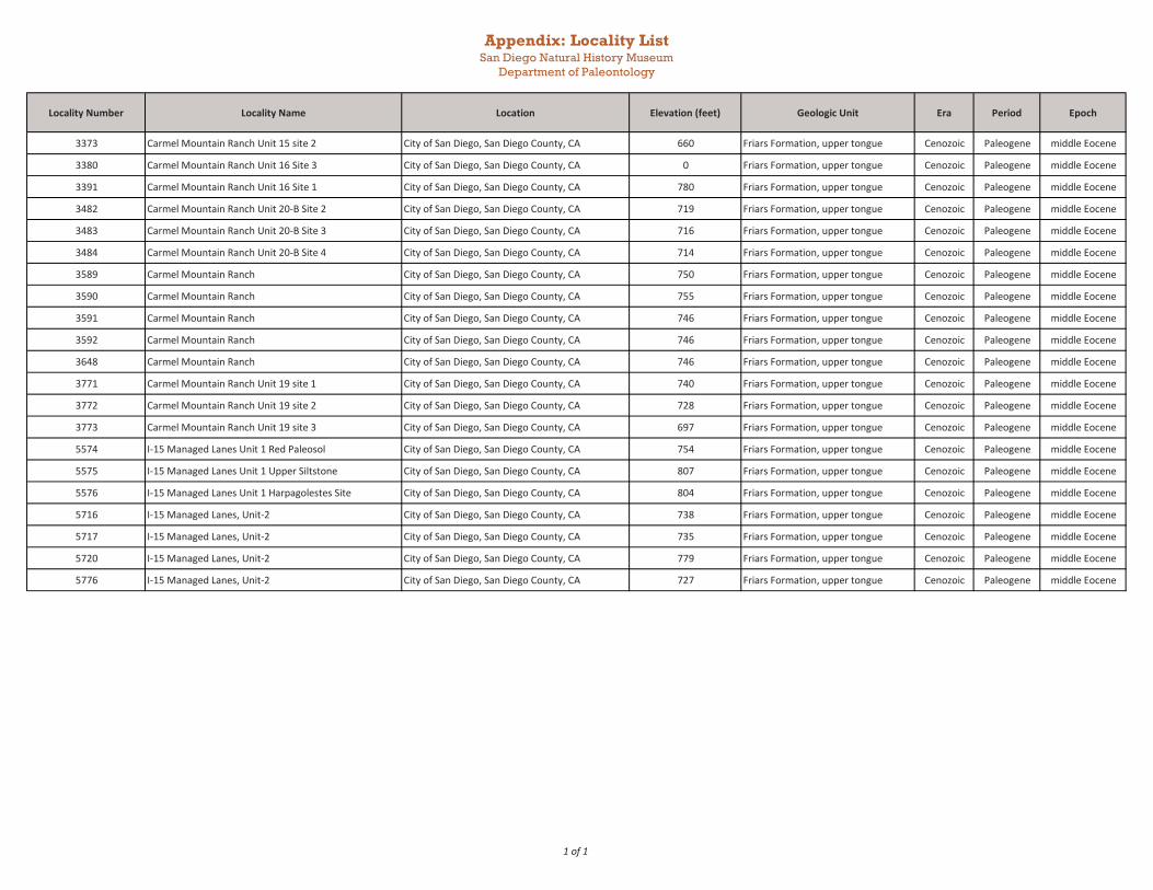
Appendix: Locality ListSan Diego Natural History Museum
Department of Paleontology
Locality Number Locality Name Location Elevation (feet) Geologic Unit Era Period Epoch
3373 Carmel Mountain Ranch Unit 15 site 2 City of San Diego, San Diego County, CA 660 Friars Formation, upper tongue Cenozoic Paleogene middle Eocene
3380 Carmel Mountain Ranch Unit 16 Site 3 City of San Diego, San Diego County, CA 0 Friars Formation, upper tongue Cenozoic Paleogene middle Eocene
3391 Carmel Mountain Ranch Unit 16 Site 1 City of San Diego, San Diego County, CA 780 Friars Formation, upper tongue Cenozoic Paleogene middle Eocene
3482 Carmel Mountain Ranch Unit 20-B Site 2 City of San Diego, San Diego County, CA 719 Friars Formation, upper tongue Cenozoic Paleogene middle Eocene
3483 Carmel Mountain Ranch Unit 20-B Site 3 City of San Diego, San Diego County, CA 716 Friars Formation, upper tongue Cenozoic Paleogene middle Eocene
3484 Carmel Mountain Ranch Unit 20-B Site 4 City of San Diego, San Diego County, CA 714 Friars Formation, upper tongue Cenozoic Paleogene middle Eocene
3589 Carmel Mountain Ranch City of San Diego, San Diego County, CA 750 Friars Formation, upper tongue Cenozoic Paleogene middle Eocene
3590 Carmel Mountain Ranch City of San Diego, San Diego County, CA 755 Friars Formation, upper tongue Cenozoic Paleogene middle Eocene
3591 Carmel Mountain Ranch City of San Diego, San Diego County, CA 746 Friars Formation, upper tongue Cenozoic Paleogene middle Eocene
3592 Carmel Mountain Ranch City of San Diego, San Diego County, CA 746 Friars Formation, upper tongue Cenozoic Paleogene middle Eocene
3648 Carmel Mountain Ranch City of San Diego, San Diego County, CA 746 Friars Formation, upper tongue Cenozoic Paleogene middle Eocene
3771 Carmel Mountain Ranch Unit 19 site 1 City of San Diego, San Diego County, CA 740 Friars Formation, upper tongue Cenozoic Paleogene middle Eocene
3772 Carmel Mountain Ranch Unit 19 site 2 City of San Diego, San Diego County, CA 728 Friars Formation, upper tongue Cenozoic Paleogene middle Eocene
3773 Carmel Mountain Ranch Unit 19 site 3 City of San Diego, San Diego County, CA 697 Friars Formation, upper tongue Cenozoic Paleogene middle Eocene
5574 I-15 Managed Lanes Unit 1 Red Paleosol City of San Diego, San Diego County, CA 754 Friars Formation, upper tongue Cenozoic Paleogene middle Eocene
5575 I-15 Managed Lanes Unit 1 Upper Siltstone City of San Diego, San Diego County, CA 807 Friars Formation, upper tongue Cenozoic Paleogene middle Eocene
5576 I-15 Managed Lanes Unit 1 Harpagolestes Site City of San Diego, San Diego County, CA 804 Friars Formation, upper tongue Cenozoic Paleogene middle Eocene
5716 I-15 Managed Lanes, Unit-2 City of San Diego, San Diego County, CA 738 Friars Formation, upper tongue Cenozoic Paleogene middle Eocene
5717 I-15 Managed Lanes, Unit-2 City of San Diego, San Diego County, CA 735 Friars Formation, upper tongue Cenozoic Paleogene middle Eocene
5720 I-15 Managed Lanes, Unit-2 City of San Diego, San Diego County, CA 779 Friars Formation, upper tongue Cenozoic Paleogene middle Eocene
5776 I-15 Managed Lanes, Unit-2 City of San Diego, San Diego County, CA 727 Friars Formation, upper tongue Cenozoic Paleogene middle Eocene
1 of 1


![Geology and Petrology of Metavolcanic Rocks in the Neoarchean Mundo Novo Greenstone ... · 2019. 10. 29. · age between 2.20 and 2.06 Ga [38] Figure 2. To the north and northwest,](https://img.pdfslide.net/doc/110x75/5ff13d7e74d2bf43c02b8ba2/geology-and-petrology-of-metavolcanic-rocks-in-the-neoarchean-mundo-novo-greenstone.jpg)