Embed Size (px)
Citation preview
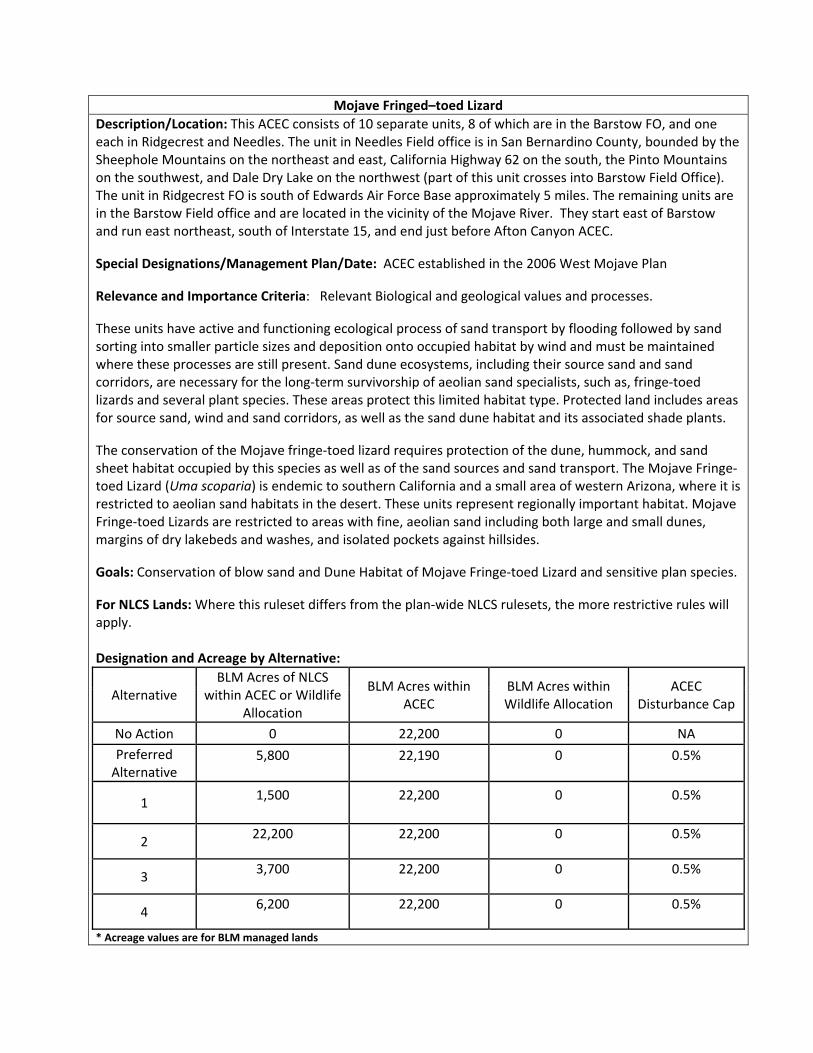
Mojave Fringed–toed Lizard
Description/Location: This ACEC consists of 10 separate units, 8 of which are in the Barstow FO, and one each in Ridgecrest and Needles. The unit in Needles Field office is in San Bernardino County, bounded by the Sheephole Mountains on the northeast and east, California Highway 62 on the south, the Pinto Mountains on the southwest, and Dale Dry Lake on the northwest (part of this unit crosses into Barstow Field Office). The unit in Ridgecrest FO is south of Edwards Air Force Base approximately 5 miles. The remaining units are in the Barstow Field office and are located in the vicinity of the Mojave River. They start east of Barstow and run east northeast, south of Interstate 15, and end just before Afton Canyon ACEC.
Special Designations/Management Plan/Date: ACEC established in the 2006 West Mojave Plan
Relevance and Importance Criteria: Relevant Biological and geological values and processes.
These units have active and functioning ecological process of sand transport by flooding followed by sand sorting into smaller particle sizes and deposition onto occupied habitat by wind and must be maintained where these processes are still present. Sand dune ecosystems, including their source sand and sand corridors, are necessary for the long‐term survivorship of aeolian sand specialists, such as, fringe‐toed lizards and several plant species. These areas protect this limited habitat type. Protected land includes areas for source sand, wind and sand corridors, as well as the sand dune habitat and its associated shade plants.
The conservation of the Mojave fringe‐toed lizard requires protection of the dune, hummock, and sand sheet habitat occupied by this species as well as of the sand sources and sand transport. The Mojave Fringe‐toed Lizard (Uma scoparia) is endemic to southern California and a small area of western Arizona, where it is restricted to aeolian sand habitats in the desert. These units represent regionally important habitat. Mojave Fringe‐toed Lizards are restricted to areas with fine, aeolian sand including both large and small dunes, margins of dry lakebeds and washes, and isolated pockets against hillsides.
Goals: Conservation of blow sand and Dune Habitat of Mojave Fringe‐toed Lizard and sensitive plan species.
For NLCS Lands: Where this ruleset differs from the plan‐wide NLCS rulesets, the more restrictive rules will apply. Designation and Acreage by Alternative:
Alternative BLM Acres of NLCS
within ACEC or Wildlife Allocation
BLM Acres within ACEC
BLM Acres within Wildlife Allocation
ACEC Disturbance Cap
No Action 0 22,200 0 NA
Preferred Alternative
5,800 22,190 0 0.5%
1 1,500 22,200 0 0.5%
2 22,200 22,200 0 0.5%
3 3,700 22,200 0 0.5%
4 6,200 22,200 0 0.5%
* Acreage values are for BLM managed lands
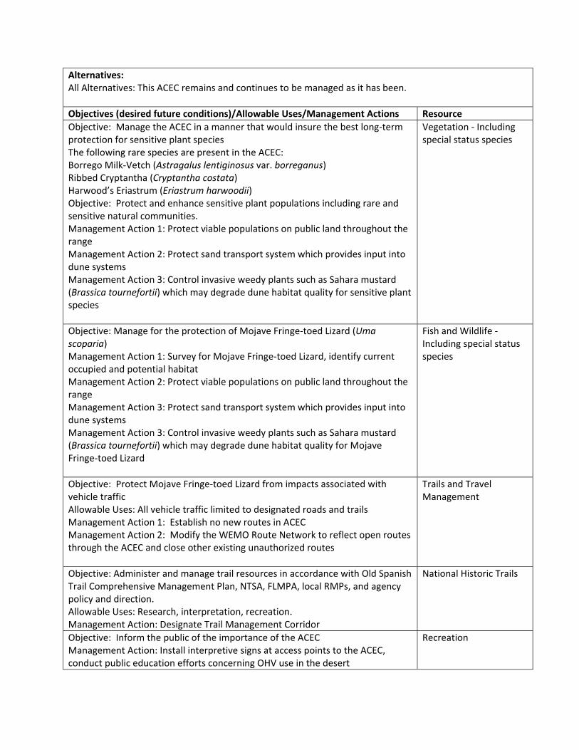
Alternatives: All Alternatives: This ACEC remains and continues to be managed as it has been.
Objectives (desired future conditions)/Allowable Uses/Management Actions Resource
Objective: Manage the ACEC in a manner that would insure the best long‐term protection for sensitive plant species The following rare species are present in the ACEC: Borrego Milk‐Vetch (Astragalus lentiginosus var. borreganus) Ribbed Cryptantha (Cryptantha costata) Harwood’s Eriastrum (Eriastrum harwoodii) Objective: Protect and enhance sensitive plant populations including rare and sensitive natural communities. Management Action 1: Protect viable populations on public land throughout the range Management Action 2: Protect sand transport system which provides input into dune systems Management Action 3: Control invasive weedy plants such as Sahara mustard (Brassica tournefortii) which may degrade dune habitat quality for sensitive plant species
Vegetation ‐ Including special status species
Objective: Manage for the protection of Mojave Fringe‐toed Lizard (Uma scoparia) Management Action 1: Survey for Mojave Fringe‐toed Lizard, identify current occupied and potential habitat Management Action 2: Protect viable populations on public land throughout the range Management Action 3: Protect sand transport system which provides input into dune systems Management Action 3: Control invasive weedy plants such as Sahara mustard (Brassica tournefortii) which may degrade dune habitat quality for Mojave Fringe‐toed Lizard
Fish and Wildlife ‐ Including special status species
Objective: Protect Mojave Fringe‐toed Lizard from impacts associated with vehicle traffic Allowable Uses: All vehicle traffic limited to designated roads and trails Management Action 1: Establish no new routes in ACEC Management Action 2: Modify the WEMO Route Network to reflect open routes through the ACEC and close other existing unauthorized routes
Trails and Travel Management
Objective: Administer and manage trail resources in accordance with Old Spanish Trail Comprehensive Management Plan, NTSA, FLMPA, local RMPs, and agency policy and direction. Allowable Uses: Research, interpretation, recreation. Management Action: Designate Trail Management Corridor
National Historic Trails
Objective: Inform the public of the importance of the ACEC Management Action: Install interpretive signs at access points to the ACEC, conduct public education efforts concerning OHV use in the desert
Recreation
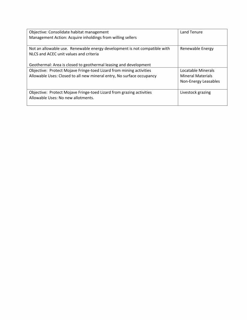
Objective: Consolidate habitat management Management Action: Acquire inholdings from willing sellers
Land Tenure
Not an allowable use. Renewable energy development is not compatible with NLCS and ACEC unit values and criteria Geothermal: Area is closed to geothermal leasing and development
Renewable Energy
Objective: Protect Mojave Fringe‐toed Lizard from mining activities Allowable Uses: Closed to all new mineral entry, No surface occupancy
Locatable Minerals Mineral Materials Non‐Energy Leasables
Objective: Protect Mojave Fringe‐toed Lizard from grazing activities Allowable Uses: No new allotments.
Livestock grazing

ChemehueviExpansion
MarbleMountainFossil Bed
ÆN
Preferred Alternative ACECsDate Printed: 5/29/2013
Prepared by BLM California State Office
0.25Miles
0.35Kilometers
Marble Mountain Fossil Bed
GTLFInterstateUS HwyCA HwyCounty HwyBLM Field Office
CDCA BoundaryDRECP Boundary
CitiesOHV Areas
ACEC Layers
Proposed NLCSProposed ACECExisting ACEC
Legislatively andLegally ProtectedDesign Focus Areas
State
PrivateMilitary
Land Status
Other Federal
Bureau of LandManagement

MarbleMountainFossil Bed
ÆN
Alternative 1 ACECsDate Printed: 5/29/2013
Prepared by BLM California State Office
0.25Miles
0.35Kilometers
Marble Mountain Fossil Bed
GTLFInterstateUS HwyCA HwyCounty HwyBLM Field Office
CDCA BoundaryDRECP Boundary
CitiesOHV Areas
ACEC Layers
Proposed NLCSProposed ACECExisting ACEC
Legislatively andLegally ProtectedDesign Focus Areas
State
PrivateMilitary
Land Status
Other Federal
Bureau of LandManagement

MarbleMountainFossil Bed
ÆN
Alternative 2 ACECsDate Printed: 5/29/2013
Prepared by BLM California State Office
0.25Miles
0.35Kilometers
Marble Mountain Fossil Bed
GTLFInterstateUS HwyCA HwyCounty HwyBLM Field Office
CDCA BoundaryDRECP Boundary
CitiesOHV Areas
ACEC Layers
Proposed NLCSProposed ACECExisting ACEC
Legislatively andLegally ProtectedDesign Focus Areas
State
PrivateMilitary
Land Status
Other Federal
Bureau of LandManagement

MarbleMountainFossil Bed
ÆN
Alternative 3 ACECsDate Printed: 5/29/2013
Prepared by BLM California State Office
0.25Miles
0.35Kilometers
Marble Mountain Fossil Bed
GTLFInterstateUS HwyCA HwyCounty HwyBLM Field Office
CDCA BoundaryDRECP Boundary
CitiesOHV Areas
ACEC Layers
Proposed NLCSProposed ACECExisting ACEC
Legislatively andLegally ProtectedDesign Focus Areas
State
PrivateMilitary
Land Status
Other Federal
Bureau of LandManagement
MarbleMountainFossil Bed
ÆN
Alternative 4 ACECsDate Printed: 5/29/2013
Prepared by BLM California State Office
0.25Miles
0.35Kilometers
Marble Mountain Fossil Bed
GTLFInterstateUS HwyCA HwyCounty HwyBLM Field Office
CDCA BoundaryDRECP Boundary
CitiesOHV Areas
ACEC Layers
Proposed NLCSProposed ACECExisting ACEC
Legislatively andLegally ProtectedDesign Focus Areas
State
PrivateMilitary
Land Status
Other Federal
Bureau of LandManagement

MarbleMountainFossil Bed
ÆN Date Printed: 5/29/2013
Prepared by BLM California State Office
0.25Miles
0.35Kilometers
Marble Mountain Fossil Bed
GTLFInterstateUS HwyCA HwyCounty Hwy
State
PrivateMilitary
Land Status
Other Federal
Bureau of LandManagement
ACEC LayersExisting ACEC
Legislatively andLegally Protected BLM Field Office
CDCA BoundaryDRECP Boundary
Cities
OHV Areas