Embed Size (px)
Citation preview

San Bernardino County Areawide Stormwater Program Watershed Action Plan
November 5, 2014
Appendix L: San Bernardino County (Santa Ana Watershed Region) Subwatershed Fact Sheets


San Bernardino County Areawide Stormwater Program Watershed Action Plan
November 5, 2014
Subwatershed Fact Sheets
A series of Subwatershed Fact Sheets have been developed to provide the planner, environmental consultant, project proponent and other interested stakeholders a starting point for overall subwatershed particulars. These fact sheets should be used in conjunction with the geodatabase when analysis watershed needs. The watershed key map is Figure 1 in this document.
These Fact Sheets, as found in this appendix, should be used for preliminary data and initial guidance and should be printed out for use as a handout or for reference by planning staff, CEQA analysts and other stakeholder. The listing of the Fact Sheets as they presented is as follows:
Big Bear Lake Watershed Fact Sheet
Cucamonga Creek Watershed Fact Sheet
Cypress Channel Watershed Fact Sheet
Day Creek Watershed Fact Sheet
Lytle Cajon Creek Watershed Fact Sheet
Mill Creek Watershed Fact Sheet
Rialto Channel Watershed Fact Sheet
San Antonio Creek Watershed Fact Sheet
San Sevaine Watershed Fact Sheet
San Timoteo Watershed Fact Sheet
Santa Ana (East) Watershed Fact Sheet
Santa Ana (West) Watershed Fact Sheet
Warm Channel Watershed Fact Sheet


San Bernardino County Areawide Stormwater Program Watershed Action Plan
November 5, 2014
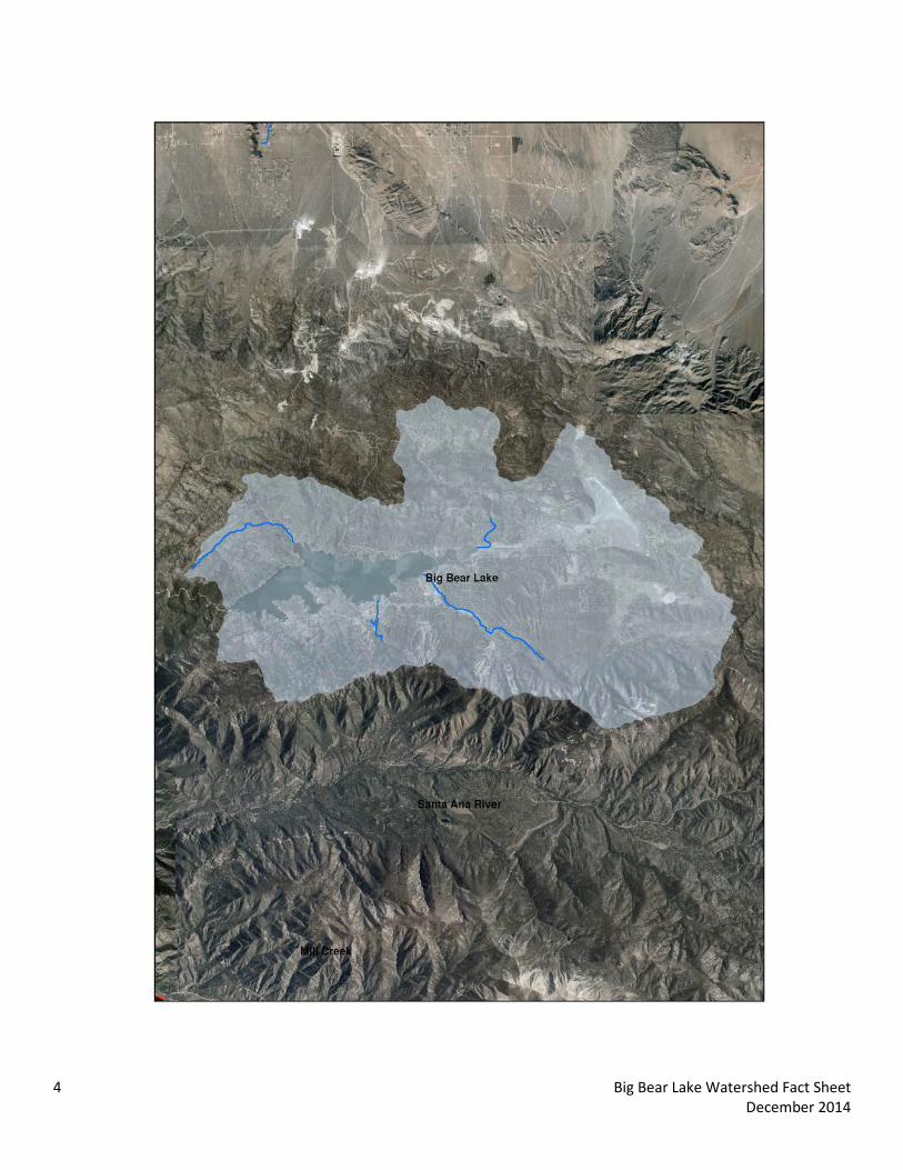
Big Bear Lake Watershed Fact Sheet


The following data summary provides general watershed information. Site specific information must be researched on the Stormwater Facility Mapping Tool (Watershed Geodatabase) found at:
http://sbcounty.permitrack.com/WAP/
Big Bear Lake Watershed
Big Bear Lake Watershed is located in the mountainous region of San Bernardino County and includes the county of San Bernardino and the cities of Big Bear Lake and Big Bear. Federal jurisdictions include the Angeles Forest (USFS) and Big Bear Lake (USACOE).
Waterbodies: Grout Creek, North Creek, Rathbone Creek, Sand Canyon Creek, Knickerbocker Creek, Metcalf Creek, Big Bear Lake Source Waters: 1) Headwater locations should be checked for spring sources 2) Effluent dominated sources include: Big Bear Waste Water Treatment Plant Wetlands/Riparian Areas:
• Riparian/Wetland areas are identified on the geodatabase • During the CEQA process, the jurisdictional delineations for riparian and wetland areas are delineated and
included into the CEQA analysis per USACOE (Section 404), Calif. Dept. of Fish and Wildlife (Section 1600) and Calif. Water Resources Control Board (Section 401) permitting requirements.
• Biological Sensitive Areas: Mill Creek Watershed contains known mapped plant and animal sensitive areas. It is typically required to analyze sites with respect to biological criteria.
o Expected Habitat: Southern Rubber Boa – throughout forest areas San Bernardino Bluegrass – throughout forest areas Mountain Bladderpod –throughout forest areas Bald Eagle – throughout watershed
o No Fish, Rodents, Tortoise, Insects, Snakes Groundwater Basins: Depth to Groundwater is presented on the Geodatabase and is available from the following water purveyors:
http://www.bbmwd.com/Home.html Flood Control Measures/ Plans:
• Watershed is located within San Bernardino County Flood Control District Zone 3 and 6 (SBCFCD) and must be in compliance with current operating procedures and requirements. Please contact SBCFCD for site specific information (909-387-8104).
Drainage channels: This watershed has both non -Engineered Hardened Maintained (non-EHM) and EHM channels. Projects not draining to an EHM must meet requirements in the WQMP Manual. (http://www.sbcounty.gov/dpw/land/npdes.asp) Hydrologic Conditions of Concern (HCOC): Watershed must meet the HCOC criteria in the WQMP Manual. Recharge information: Most of the watershed does not meet recharge geohydrology criteria due to soil and bedrock. Beneficial Uses:
• North Creek: MUN, GWR, REC1, REC2, COLD, WILD, SPWN
1 Big Bear Lake Watershed Fact Sheet December 2014
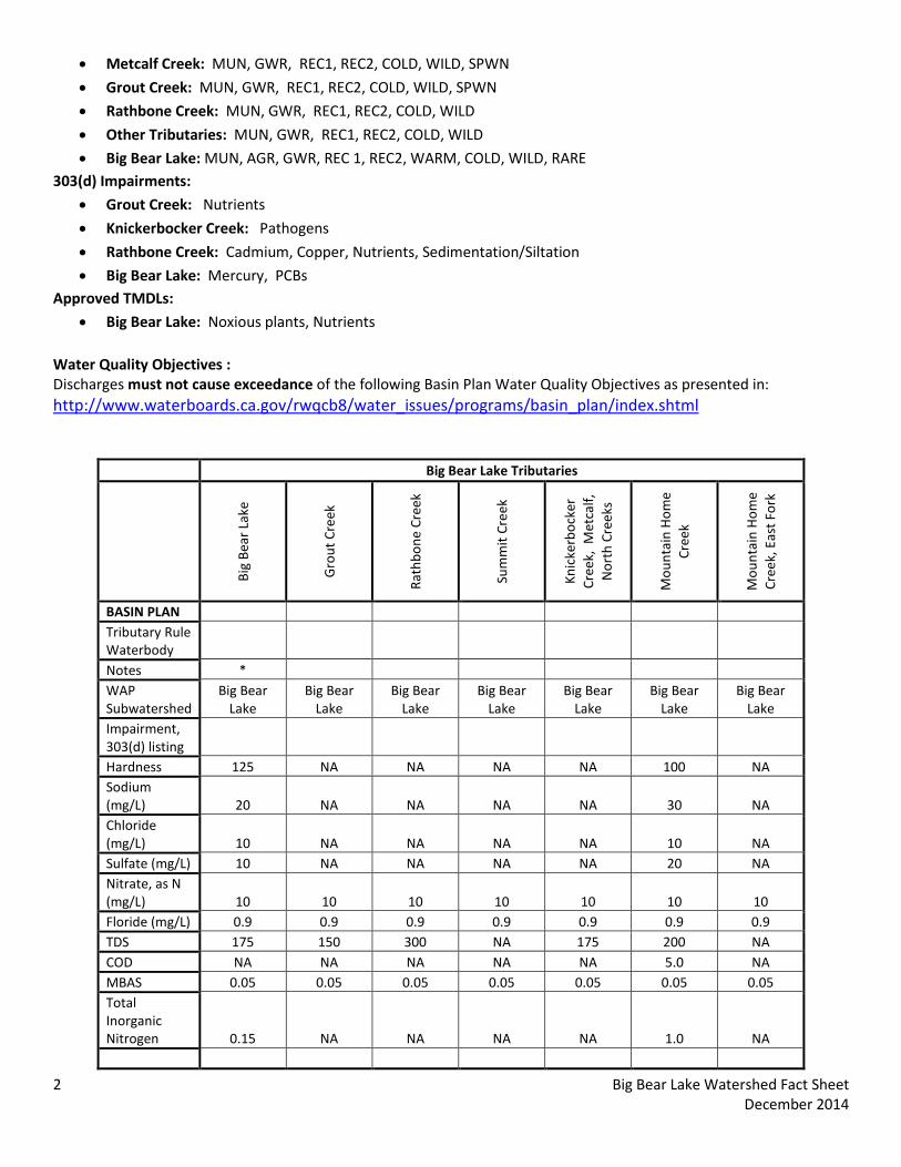
• Metcalf Creek: MUN, GWR, REC1, REC2, COLD, WILD, SPWN
• Grout Creek: MUN, GWR, REC1, REC2, COLD, WILD, SPWN
• Rathbone Creek: MUN, GWR, REC1, REC2, COLD, WILD
• Other Tributaries: MUN, GWR, REC1, REC2, COLD, WILD
• Big Bear Lake: MUN, AGR, GWR, REC 1, REC2, WARM, COLD, WILD, RARE 303(d) Impairments:
• Grout Creek: Nutrients
• Knickerbocker Creek: Pathogens
• Rathbone Creek: Cadmium, Copper, Nutrients, Sedimentation/Siltation
• Big Bear Lake: Mercury, PCBs Approved TMDLs:
• Big Bear Lake: Noxious plants, Nutrients Water Quality Objectives : Discharges must not cause exceedance of the following Basin Plan Water Quality Objectives as presented in: http://www.waterboards.ca.gov/rwqcb8/water_issues/programs/basin_plan/index.shtml
Big Bear Lake Tributaries
Big
Bear
Lak
e
Gro
ut C
reek
Rath
bone
Cre
ek
Sum
mit
Cree
k
Knic
kerb
ocke
r Cr
eek,
Met
calf,
N
orth
Cre
eks
Mou
ntai
n H
ome
Cree
k
Mou
ntai
n H
ome
Cree
k, E
ast F
ork
BASIN PLAN Tributary Rule Waterbody Notes * WAP Subwatershed
Big Bear Lake
Big Bear Lake
Big Bear Lake
Big Bear Lake
Big Bear Lake
Big Bear Lake
Big Bear Lake
Impairment, 303(d) listing Hardness 125 NA NA NA NA 100 NA Sodium (mg/L) 20 NA NA NA NA 30 NA Chloride (mg/L) 10 NA NA NA NA 10 NA Sulfate (mg/L) 10 NA NA NA NA 20 NA Nitrate, as N (mg/L) 10 10 10 10 10 10 10 Floride (mg/L) 0.9 0.9 0.9 0.9 0.9 0.9 0.9 TDS 175 150 300 NA 175 200 NA COD NA NA NA NA NA 5.0 NA MBAS 0.05 0.05 0.05 0.05 0.05 0.05 0.05 Total Inorganic Nitrogen 0.15 NA NA NA NA 1.0 NA
2 Big Bear Lake Watershed Fact Sheet December 2014

Big Bear Lake Tributaries
Big
Bear
Lak
e
Gro
ut C
reek
Rath
bone
Cre
ek
Sum
mit
Cree
k
Knic
kerb
ocke
r Cr
eek,
Met
calf,
N
orth
Cre
eks
Mou
ntai
n H
ome
Cree
k
Mou
ntai
n H
ome
Cree
k, E
ast F
ork
As (CTR) (ug/L) 150 340 340 340 340 340 340 Cd (SSO) (ug/L) Calc Calc Calc Calc Calc Calc Calc Cr (CTR) (ug/L) Calc Calc Calc Calc Calc Calc Calc Cu SSO (ug/L) Calc Calc Calc Calc Calc Calc Calc Pb SSO (ug/L) Calc Calc Calc Calc Calc Calc Calc Hg (ug/L) NA NA NA NA NA NA NA Ni (CTR) (ug/L) Calc Calc Calc Calc Calc Calc Calc Se (CTR) (ug/L) 5 5 5 5 5 5 5 Ag (CTR) (ug/L) Calc Calc Calc Calc Calc Calc Calc Zn (CTR) (ug/L) Calc Calc Calc Calc Calc Calc Calc Total Coliform (Org/100mL) 100 100 100 100 100 100 100 Fecal Coliform (Org/100mL) 400 400 400 400 400 400 400 E.Coli (MPN/100mL) 126 126 126 126 126 126 126 pH 6.5-8.5 6.5-8.5 6.5-8.5 6.5-8.5 6.5-8.5 6.5-8.5 6.5-8.5 DO (mg/L) 6 6 6 6 6 6 6 Boron (mg/L) 30 30 30 30 30 30 30
*additional objective: 0.035 mg/l Phosphorus
Land Use Information: • Percent Approximate Land Use by Category: Open – 83% (Forest Service), Agriculture – 0%,
Commercial/Industrial – 2%, Residential – 15%. • Regional Imperviousness Approximate Percentage: 17% impervious; 83% pervious • Project-Specific Imperviousness Percentage: Project specific impervious is to be provided by the project civil
engineer • Land Use: Allowable land use criteria is provided as part of the planning process through zoning and
jurisdictional General or Specific Plans. • Soils: Watershed is located within the mountains and is underlain by both alluvial and granitic bedrock. See the
geodatabase soil information.
Items of Note: None
3 Big Bear Lake Watershed Fact Sheet December 2014
BIG BEAR LAKE
4 Big Bear Lake Watershed Fact Sheet December 2014

San Bernardino County Areawide Stormwater Program Watershed Action Plan
November 5, 2014
Cucamonga Creek Watershed Fact Sheet


The following data summary provides general watershed information. Site specific information can also be researched on the Stormwater Facility Mapping Tool (Watershed Geodatabase) found at:
http://sbcounty.permitrack.com/WAP/
Cucamonga Creek Watershed
Cucamonga Creek Watershed is located within the western portion of San Bernardino County and includes portions of San Bernardino and Riverside counties and portions of the cities of Chino, Upland, Ontario, and Rancho Cucamonga. Federal jurisdictions include the United States Forest Service (Angeles Forest) and United States Army Corp of Engineers (Prado Basin).
Waterbodies Primary Tributaries Santa Ana Reach 3 (Prado Basin) Demens Creek Deer Creek Cucamonga Creek West Cucamonga Lower Deer Creek Source Waters:
• Headwater locations should be checked for spring sources (i.e. mountain locations)
• Effluent dominated sources include: IEUA RP-1 (Cucamonga Creek) Wetlands/Riparian Areas:
• Riparian/Wetland areas are identified on the geodatabase • During the CEQA process, the jurisdictional delineations for riparian and wetland areas are delineated and
included into the CEQA analysis per USACOE (Section 404), Calif. Dept. of Fish and Wildlife (Section 1600) and Calif. Water Resources Control Board (Section 401) permitting requirements.
• Biological Sensitive Areas: Cucamonga Creek Watershed contains known mapped plant and animal sensitive areas. It is typically required to analyze sites with respect to biological criteria.
o Expected Habitat: Delhi Sands –southern third of subwatershed Least Bell Vireo – southern end of subwatershed
o Potential Habitat: Grassland/Remnant RAFSS – mid portion, east side of subwatershed Riparian/Wetland – southern end of subwatershed Riversidean Alluvial Fan Sage Scrub – locations along north end, along foothills
o No Fish, Frog, Rodents, Tortoise, Insects, Snakes Groundwater Basins:
• Depth to Groundwater is presented on the following CBWM map: http://www.cbwm.org/docs/engdocs/maps
• Per the obligations codified in the 2004 Basin Plan amendment it is regionally required to eliminate groundwater outflow to the Santa Ana River. This is the Hydraulic Control Monitoring Program and is managed through the Chino Basin Desalter Authority, the Chino Basin Watermaster and Inland Empire Utilities Agency. All areas south of the 60 Freeway must review this information.
1 Cucamonga Creek Watershed Fact Sheet December 2014

Flood Control Measures/ Plans:
• Watershed is located within San Bernardino County Flood Control District Zone 1 (SBCFCD) and must be in compliance with current operating procedures and requirements. Please contact SBCFCD for site specific information (909-387-8104).
Drainage channels:
• All but the headwater and southern portion of the drainages are Engineered Hardened Maintained (EHM) Channels. Projects not draining to a EHM must meet requirements in the WQMP Manual (http://www.sbcounty.gov/dpw/land/npdes.asp
Hydrologic Conditions of Concern (HCOC):
• The northern two-thirds of the watershed is Hydrologic Conditions of Concern (HCOC) Exempt. Remaining portions of watershed must meet the HCOC criteria in the WQMP Manual (the headwaters and the southern one-third within City of Ontario).
Recharge information: The watershed is highly managed with strict recharge criteria. Recharge management information is found at the following websites. Recharge activities within this adjudicated watershed must meet existing hydrogeologic modeling criteria and groundwater management plans. Contact information and watershed specific information is found at:
http://www.ieua.org/sustain/gw/recharge.html http://www.cbwm.org/rep_engineering.htm
http://www.cbwcd.org/129/Percolation-Basins Beneficial Uses: Discharges must not impair these beneficial uses:
• Cucamonga Creek: MUN, AGR, IND, PROC, GWR, POW, REC1, REC2, COLD, WILD
• Deer Creek: (all intermittent/,mountain reach) MUN, GWR, REC1, REC2, COLD, WILD
• Santa Ana River Reach 3: AGR, GWR, REC 1, REC2, WARM, WILD, RARE http://www.waterboards.ca.gov/rwqcb8/water_issues/programs/basin_plan/index.shtml
303(d) Impairments:
• Cucamonga: Cadmium , Copper , Lead , Zinc, pH
• Reach 3: Lead Approved TMDLs:
• Cucamonga: Coliform Bacteria,
• Reach 3: Copper (Wet season only)
2 Cucamonga Creek Watershed Fact Sheet December 2014
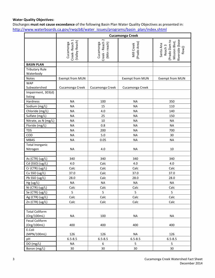
Water Quality Objectives: Discharges must not cause exceedance of the following Basin Plan Water Quality Objectives as presented in: http://www.waterboards.ca.gov/rwqcb8/water_issues/programs/basin_plan/index.shtml
Cucamonga Creek
Cuca
mon
ga
Cree
k- R
each
1
(Val
ley
Reac
h)
Cuca
mon
ga
Cree
k - R
each
2
(Mtn
rea
ch)
Mill
Cre
ek
(Pra
do A
rea)
Sant
a A
na
Reac
h 3
(P
rado
Dam
to
Mis
sion
Blv
d,
Rive
rsid
e (b
ase
flow
))
BASIN PLAN Tributary Rule Waterbody Notes Exempt from MUN Exempt from MUN Exempt from MUN WAP Subwatershed Cucamonga Creek Cucamonga Creek Cucamonga Creek Impairment, 303(d) listing Hardness NA 100 NA 350 Sodium (mg/L) NA 15 NA 110 Chloride (mg/L) NA 4.0 NA 140 Sulfate (mg/L) NA 25 NA 150 Nitrate, as N (mg/L) NA 10 NA NA Floride (mg/L) NA 0.8 NA NA TDS NA 200 NA 700 COD NA 5.0 NA 30 MBAS NA 0.05 NA NA Total Inorganic Nitrogen NA 4.0 NA 10 As (CTR) (ug/L) 340 340 340 340 Cd (SSO) (ug/L) 4.0 Calc 4.0 4.0 Cr (CTR) (ug/L) Calc Calc Calc Calc Cu SSO (ug/L) 37.0 Calc 37.0 37.0 Pb SSO (ug/L) 28.0 Calc 28.0 28.0 Hg (ug/L) NA NA NA NA Ni (CTR) (ug/L) Calc Calc Calc Calc Se (CTR) (ug/L) 5 5 5 5 Ag (CTR) (ug/L) Calc Calc Calc Calc Zn (CTR) (ug/L) Calc Calc Calc Calc Total Coliform (Org/100mL) NA 100 NA NA Fecal Coliform (Org/100mL) 400 400 400 400 E.Coli (MPN/100mL) 126 126 NA 126 pH 6.5-8.5 6.5-8.5 6.5-8.5 6.5-8.5 DO (mg/L) NA 6 5 5 Boron (mg/L) 30 30 30 30
3 Cucamonga Creek Watershed Fact Sheet December 2014
Land Use Information:
• Percent Approximate Land Use by Category: Open – 22%, Agriculture – 15%, Commercial/Industrial – 17%, Residential – 45%.
• Regional Imperviousness Approximate Percentage: 63% impervious; 37% pervious • Project – Specific Imperviousness Percentage: Project specific impervious is to be provided by the project civil
engineer • Land Use: Allowable land use criteria is provided as part of the planning process through zoning and
jurisdictional General or Specific Plans. • Soils: Watershed is located within an alluvial fan. Soil types are typically coarse-grained Sands upslope near the
mountains, with fine grained Silts and silty Sands located downslope, closer to Prado Basin. See the geodatabase soil information.
Items of Note:
• CBRP compliance: This watershed is within the CBRP compliance area. Stormwater runoff and urban discharges to the waterbodies are being investigated as part of the County of San Bernardino Areawide Stormwater CBRP program (http://www.sawpa.org/collaboration/projects/tmdl-taskforce/)
• Infeasibility Possible infiltration infeasibility constraints include:
o Soil type (per project specific geotechnical report) o Locations within the Hydrologic Control Plan area o Perched groundwater or artisan groundwater conditions
4 Cucamonga Creek Watershed Fact Sheet December 2014

Cucamonga Creek Watershed
5 Cucamonga Creek Watershed Fact Sheet December 2014


San Bernardino County Areawide Stormwater Program Watershed Action Plan
November 5, 2014
Cypress Channel Watershed Fact Sheet

The following data summary provides general watershed information. Site specific information can also be researched on the Stormwater Facility Mapping Tool (Watershed Geodatabase) found at:
http://sbcounty.permitrack.com/WAP/
Cypress Channel Watershed
Cypress Channel Watershed is located within the western portion of San Bernardino County and includes portions of the City of Chino.
Waterbodies: Cypress Creek Santa Ana Reach 3 (Prado Basin)
Source Waters:
• There are no spring sources
• Effluent dominated sources include: IEUA Chino Desalter 1, and IEUA RP-5 (Cypress Channel) Wetlands/Riparian Areas:
• Riparian/Wetland areas are identified on the geodatabase • During the CEQA process, the jurisdictional delineations for riparian and wetland areas are delineated and
included into the CEQA analysis per USACOE (Section 404), Calif. Dept. of Fish and Wildlife (Section 1600) and Calif. Water Resources Control Board (Section 401) permitting requirements.
• Biological Sensitive Areas: Cypress Channel Watershed contains known mapped plant and animal sensitive areas. It is typically required to analyze sites with respect to biological criteria.
o Expected Habitat: Delhi Sands – eastern border Least Bell Vireo – southern end of subwatershed
o Potential Habitat: Riparian/Wetland – southern half of watershed
o No Tortoise, Fish, Frogs, Insects, Snakes Groundwater Basins:
• Depth to Groundwater is presented on the following CBWM map http://www.cbwm.org/docs/engdocs/maps
• Per the obligations codified in the 2004 Basin Plan amendment it is regionally required to eliminate groundwater outflow to the Santa Ana River. This is the Hydraulic Control Monitoring Program and is managed through the Chino Basin Desalter Authority, the Chino Basin Watermaster and Inland Empire Utilities Agency. All areas south of the 60 Freeway must review this information.
Flood Control Measures/ Plans:
• Watershed is located within San Bernardino County Flood Control District Zone 1 (SBCFCD) and must be in compliance with current operating procedures and requirements. Please contact SBCFCD for site specific information (909-387-8104).
Drainage channels:
• The majority of the watershed has been classified as Engineered Hardened Maintained (EHM) Channel with the exception of one channel portion south of the Chino Institution for Men and the channel portion within the El Prado Golf Course. Projects not draining to a EHM must meet requirements in the WQMP Manual (http://www.sbcounty.gov/dpw/land/npdes.asp)
1 Cypress Channel Watershed Fact Sheet December 2014

Hydrologic Conditions of Concern (HCOC):
• Northern portion of the watershed is Hydrologic Conditions of Concern (HCOC) Exempt. Remaining portions of watershed must meet the HCOC criteria in the WQMP Manual.
Recharge information: The watershed is highly managed with strict recharge criteria. Recharge management information is found at the following websites. Recharge activities within this adjudicated watershed must meet existing hydrogeologic modeling criteria and groundwater management plans. Contact information and watershed specific information is found at:
http://www.ieua.org/sustain/gw/recharge.html http://www.cbwm.org/rep_engineering.htm
http://www.cbwcd.org/129/Percolation-Basins Beneficial Uses: Dischargers must not impair these beneficial uses:
• Santa Ana River Reach 3: AGR, GWR, REC 1, REC2, WARM, WILD, RARE 303(d) Impairments:
• Santa Ana River Reach 3: Lead
• Santa Ana River Reach 3: Copper (Wet season only) Water Quality Objectives: Discharges must not cause exceedance of the following Basin Plan Water Quality Objectives as presented in: http://www.waterboards.ca.gov/rwqcb8/water_issues/programs/basin_plan/index.shtml
Cypress Channel
Cypr
ess
Chan
nel
Sant
a A
na
Reac
h 3
(P
rado
Dam
to
Mis
sion
Blv
d,
Rive
rsid
e (b
ase
flow
))
BASIN PLAN Tributary Rule Waterbody
SAR Reach 3
Notes
Exempt from MUN
WAP Subwatershed
Cypress Channel
Impairment, 303(d) listing Hardness 350 350 Sodium (mg/L) 110 110 Chloride (mg/L) 140 140 Sulfate (mg/L) 150 150 Nitrate, as N (mg/L) NA NA Floride (mg/L) NA NA TDS 700 700 COD 30 30 MBAS NA NA Total Inorganic Nitrogen 10 10
2 Cypress Channel Watershed Fact Sheet December 2014

Cypress Channel
Cypr
ess
Chan
nel
Sant
a A
na
Reac
h 3
(P
rado
Dam
to
Mis
sion
Blv
d,
Rive
rsid
e (b
ase
flow
))
As (CTR) (ug/L) 340 340 Cd (SSO) (ug/L) Calc 4.0 Cr (CTR) (ug/L) Calc Calc Cu SSO (ug/L) Calc 37.0 Pb SSO (ug/L) Calc 28.0 Hg (ug/L) NA NA Ni (CTR) (ug/L) Calc Calc Se (CTR) (ug/L) 5 5 Ag (CTR) (ug/L) Calc Calc Zn (CTR) (ug/L) Calc Calc Total Coliform (Org/100mL) NA NA Fecal Coliform (Org/100mL) 400 400 E.Coli (MPN/100mL) 126 126 pH 6.5-8.5 6.5-8.5 DO (mg/L) 5 5 Boron (mg/L) 30 30
Land Use Information:
• Percent Approximate Land Use by Category: Open – 9%, Agriculture – 11%, Commercial/Industrial – 17%, Residential – 62%.
• Regional Imperviousness Approximate Percentage: 80% impervious; 20% pervious • Project- Specific Imperviousness Percentage: Project specific impervious is to be provided by the project civil
engineer • Land Use: Allowable land use criteria is provided as part of the planning process through zoning and
jurisdictional General or Specific Plans. • Soils: Watershed is located within an alluvial fan. Soil types are typically coarse-grained Sands upslope near the
mountains, with fine grained Silts and silty Sands located downslope, closer to Prado Basin. See the geodatabase soil information.
Items of Note:
• CBRP compliance: This watershed is within the CBRP compliance area. Stormwater runoff and urban discharges to the waterbodies are being investigated as part of the County of San Bernardino Areawide Stormwater CBRP program (http://www.sawpa.org/collaboration/projects/tmdl-taskforce/)
• Infeasibility Possible infiltration infeasibility constraints include:
o Soil type (per project specific geotechnical report) o Locations within the Hydrologic Control Plan area o Perched groundwater or artisan groundwater conditions
3 Cypress Channel Watershed Fact Sheet December 2014

Cypress Channel Watershed
4 Cypress Channel Watershed Fact Sheet December 2014

San Bernardino County Areawide Stormwater Program Watershed Action Plan
November 5, 2014
Day Creek Watershed Fact Sheet

The following data summary provides general watershed information. Site specific information must be researched on the Stormwater Facility Mapping Tool (Watershed Geodatabase) found at:
http://sbcounty.permitrack.com/WAP/
Day Creek Watershed
Day Creek Watershed is located in the midsection of the San Bernardino County valley and includes the counties of San Bernardino and Riverside and portions of the cities of Rancho Cucamonga, Ontario, and Fontana. Federal jurisdictions include the Angeles Forest (USFS).
Waterbodies: Day Creek, Lower Etiwanda, Santa Ana Reach 3 (Prado Basin) Source Waters: 1) Headwater locations should be checked for spring sources (i.e. mountain locations); 2) Effluent dominated sources include: IEUA RP-4 Wetlands/Riparian Areas:
• Riparian/Wetland areas are identified on the geodatabase • During the CEQA process, the jurisdictional delineations for riparian and wetland areas are delineated and
included into the CEQA analysis per USACOE (Section 404), Calif. Dept. of Fish and Wildlife (Section 1600) and Calif. Water Resources Control Board (Section 401) permitting requirements.
• Biological Sensitive Areas: Day Creek Watershed contains known mapped plant and animal sensitive areas. It is typically required to analyze sites with respect to biological criteria.
o Expected Habitat: Delhi Sands – southeast portion of subwatershed Mountain Yellow Legged Frog – northern portion at foothills Merriam K Rat – northern portion at foothills
o Potential Habitat: Riversidean Alluvial Fan Sage Scrub – northern portion at foothills Grassland/Remnant RAFSS – southern portion of subwatershed
o No Bird, Tortoise, Insects, Snakes Groundwater Basins:
• Depth to Groundwater is presented on the following CBWM map: http://www.cbwm.org/docs/engdocs/maps Flood Control Measures/ Plans:
• Watershed is located within San Bernardino County Flood Control District Zone 1 (SBCFCD) and must be in compliance with current operating procedures and requirements. Please contact SBCFCD for site specific information (909-387-8104).
Drainage channels: All drainages are Engineered Hardened Maintained (EHM) Channels Hydrologic Conditions of Concern (HCOC): Watershed is entirely within the Hydrologic Conditions of Concern (HCOC) exempt area. Recharge information: The watershed is highly managed with strict recharge criteria. Recharge management information is found at the following websites. Recharge activities within this adjudicated watershed must meet existing hydrogeologic modeling criteria and groundwater management plans. Recharge management information is found at the following websites and in the Stormwater Facility Mapping Tool 1 Day Creek Watershed Fact Sheet
December 2014
http://www.ieua.org/sustain/gw/recharge.html http://www.cbwm.org/rep_engineering.htm
http://www.cvwdwater.com Beneficial Uses:
• Day Creek Channel: MUN, PROC, GWR, REC1, REC2, COLD, WILD
• East Etiwanda Creek MUN, PROC, GWR, REC1, REC2, COLD, WILD, RARE
• Santa Ana River Reach 3: AGR, GWR, REC 1, REC2, WARM, WILD, RARE 303(d)/TMDLs:
• Reach 3: Lead Approved TMDL:
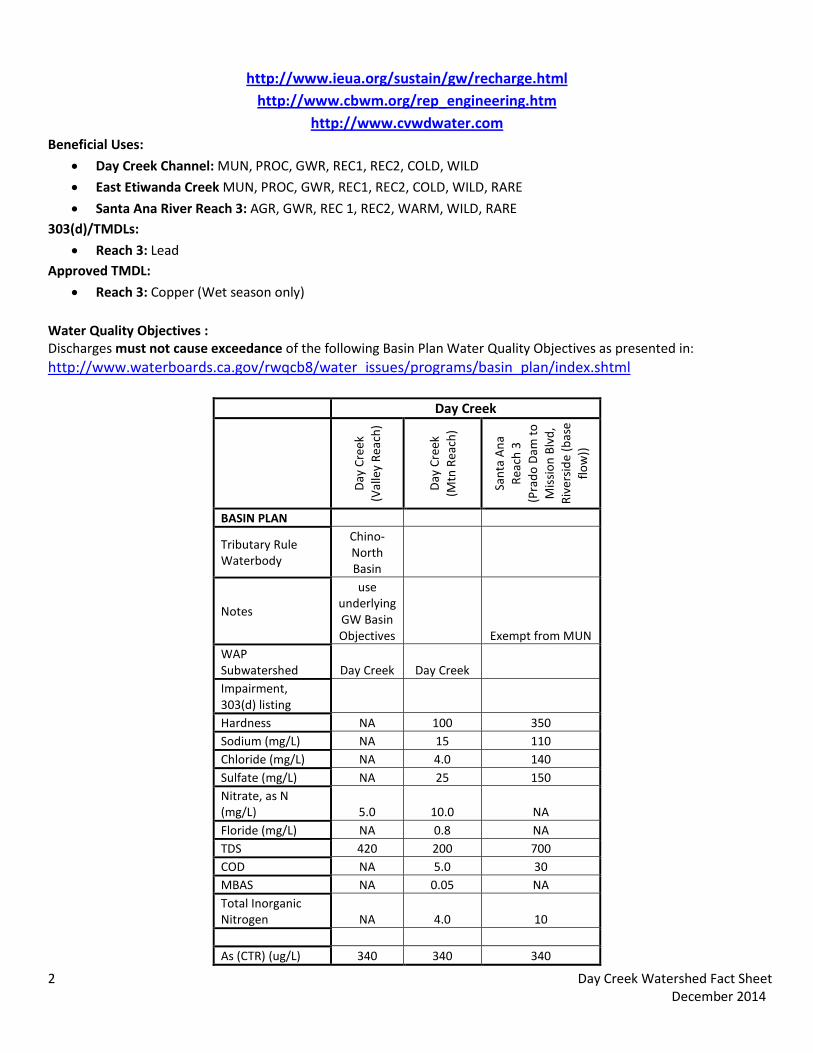
• Reach 3: Copper (Wet season only) Water Quality Objectives : Discharges must not cause exceedance of the following Basin Plan Water Quality Objectives as presented in: http://www.waterboards.ca.gov/rwqcb8/water_issues/programs/basin_plan/index.shtml
Day Creek
Day
Cre
ek
(Val
ley
Reac
h)
Day
Cre
ek
(M
tn R
each
)
Sant
a A
na
Reac
h 3
(P
rado
Dam
to
Mis
sion
Blv
d,
Rive
rsid
e (b
ase
flow
))
BASIN PLAN
Tributary Rule Waterbody
Chino-North Basin
Notes
use underlying GW Basin Objectives Exempt from MUN
WAP Subwatershed Day Creek Day Creek Impairment, 303(d) listing Hardness NA 100 350 Sodium (mg/L) NA 15 110 Chloride (mg/L) NA 4.0 140 Sulfate (mg/L) NA 25 150 Nitrate, as N (mg/L) 5.0 10.0 NA Floride (mg/L) NA 0.8 NA TDS 420 200 700 COD NA 5.0 30 MBAS NA 0.05 NA Total Inorganic Nitrogen NA 4.0 10 As (CTR) (ug/L) 340 340 340
2 Day Creek Watershed Fact Sheet December 2014
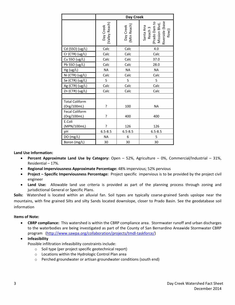
Day Creek
Day
Cre
ek
(Val
ley
Reac
h)
Day
Cre
ek
(M
tn R
each
)
Sant
a A
na
Reac
h 3
(P
rado
Dam
to
Mis
sion
Blv
d,
Rive
rsid
e (b
ase
flow
))
Cd (SSO) (ug/L) Calc Calc 4.0 Cr (CTR) (ug/L) Calc Calc Calc Cu SSO (ug/L) Calc Calc 37.0 Pb SSO (ug/L) Calc Calc 28.0 Hg (ug/L) NA NA NA Ni (CTR) (ug/L) Calc Calc Calc Se (CTR) (ug/L) 5 5 5 Ag (CTR) (ug/L) Calc Calc Calc Zn (CTR) (ug/L) Calc Calc Calc Total Coliform (Org/100mL) ? 100 NA Fecal Coliform (Org/100mL) ? 400 400 E.Coli (MPN/100mL) ? 126 126 pH 6.5-8.5 6.5-8.5 6.5-8.5 DO (mg/L) NA 6 5 Boron (mg/L) 30 30 30
Land Use Information:
• Percent Approximate Land Use by Category: Open – 52%, Agriculture – 0%, Commercial/Industrial – 31%, Residential – 17%.
• Regional Imperviousness Approximate Percentage: 48% impervious; 52% pervious • Project – Specific Imperviousness Percentage: Project specific impervious is to be provided by the project civil
engineer • Land Use: Allowable land use criteria is provided as part of the planning process through zoning and
jurisdictional General or Specific Plans. Soils: Watershed is located within an alluvial fan. Soil types are typically coarse-grained Sands upslope near the mountains, with fine grained Silts and silty Sands located downslope, closer to Prado Basin. See the geodatabase soil information
Items of Note:
• CBRP compliance: This watershed is within the CBRP compliance area. Stormwater runoff and urban discharges to the waterbodies are being investigated as part of the County of San Bernardino Areawide Stormwater CBRP program (http://www.sawpa.org/collaboration/projects/tmdl-taskforce/)
• Infeasibility Possible infiltration infeasibility constraints include:
o Soil type (per project specific geotechnical report) o Locations within the Hydrologic Control Plan area o Perched groundwater or artisan groundwater conditions (south end)
3 Day Creek Watershed Fact Sheet December 2014
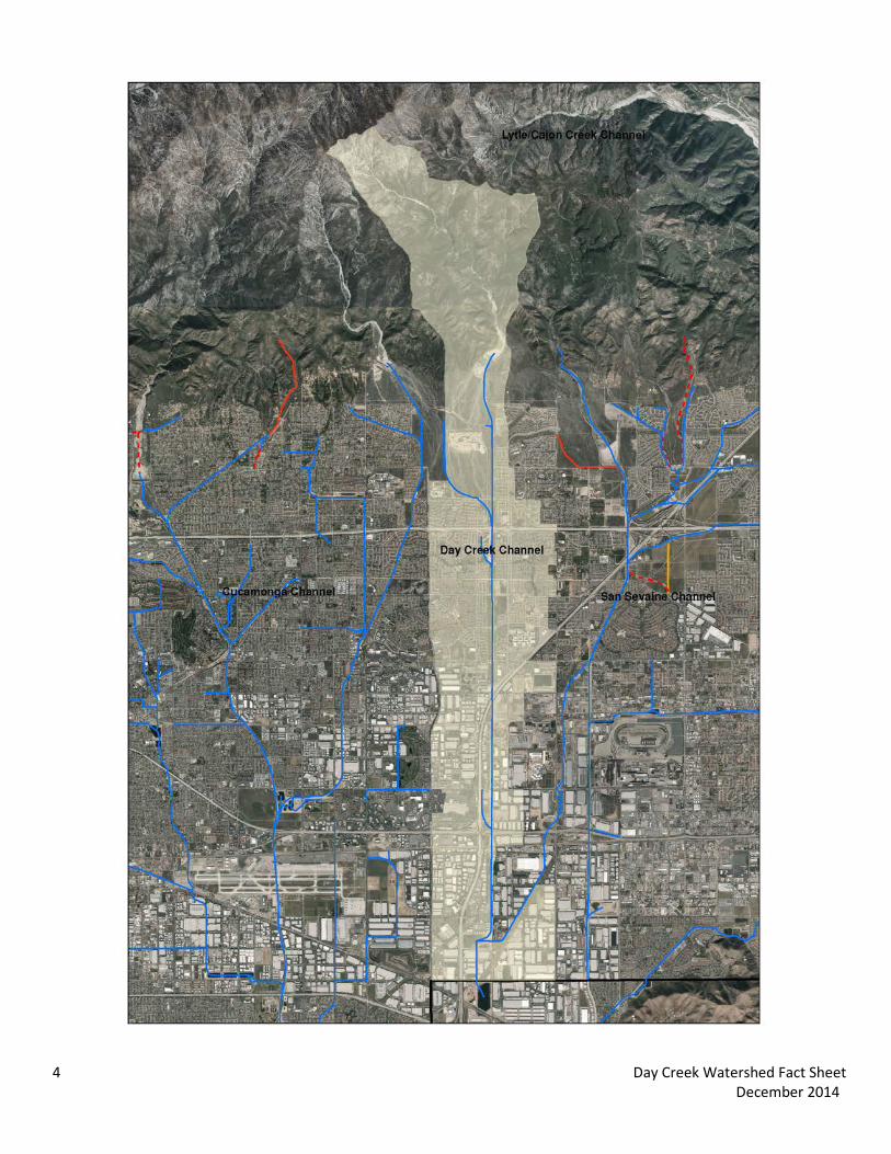
Day Creek Channel Watershed
4 Day Creek Watershed Fact Sheet December 2014

San Bernardino County Areawide Stormwater Program Watershed Action Plan
November 5, 2014
Lytle/Cajon Creek Watershed Fact Sheet

The following data summary provides general watershed information. Site specific information must be researched on the Stormwater Facility Mapping Tool (Watershed Geodatabase) found at:
http://sbcounty.permitrack.com/WAP/
Lytle and Cajon Creek Watershed
Lytle and Cajon Creek Watershed is located within the midsection of the San Bernardino County valley and includes the county of San Bernardino and portions of the cities of Colton, Fontana, Rialto and San Bernardino. Federal jurisdiction includes the Angeles Forest (USFS).
Waterbodies: Lytle Creek, Cajon Creek, Devil Canyon Creek, Macy Storm Drain, Cable Creek, Muscoy Storm Drain, Santa Ana Reach 3 and 4 Source Waters: 1) Headwater locations should be checked for spring sources (i.e. mountain locations); 2) Effluent dominated sources include: none Wetlands/Riparian Areas:
• Sensitive Riparian/Wetland areas are generally identified on the geodatabase. Due to the detailed documentation necessary, project level analysis is also required.
• During the CEQA process, the jurisdictional delineations for riparian and wetland areas are delineated and included into the CEQA analysis per USACOE (Section 404), Calif. Dept. of Fish and Wildlife (Section 1600) and Calif. Water Resources Control Board (Section 401) permitting requirements.
• Biological Sensitive Areas: Lytle and Cajon Creek Watersheds contains known mapped plant and animal sensitive areas. It is typically required to analyze sites with respect to biological criteria.
o Expected Habitat: Merriam K Rat – throughout subwatershed
o Potential Habitat: Riversidean Alluvial Fan Sage Scrub – throughout subwatershed
o No Fish, Bird, Frogs, Snakes, Insects or Tortoise Groundwater Basins: Depth to Groundwater is presented on the Geodatabase and is available from the following water purveyors:
http://www.sbvmwd.com/ http://www.cbwm.org/docs/engdocs/maps
Flood Control Measures/ Plans: • Watershed is located within San Bernardino County Flood Control District Zones 2 (SBCFCD) and must be in
compliance with current operating procedures and requirements. Please contact SBCFCD for site specific information (909-387-8104).
Drainage channels: This watershed is both Engineered Hardened Maintained (EHM) and non -Engineered Hardened Maintained (non-EHM) Channels. Projects not draining to an EHM must meet requirements in the WQMP Manual (http://www.sbcounty.gov/dpw/land/npdes.asp) Hydrologic Conditions of Concern (HCOC): Watershed must meet the HCOC criteria in the WQMP Manual. Recharge information: The watershed is highly managed with strict recharge criteria. Recharge management information is found at the following websites. Recharge activities within this adjudicated watershed must meet existing
1 Lytle/Cajon Creek Watershed Fact Sheet December 2014
hydrogeologic modeling criteria and groundwater management plans. Recharge management information is found at the following websites and in the Stormwater Facility Mapping Tool.
http://www.sbvmwd.com/
http://www.ieua.org/sustain/gw/recharge.html http://www.cbwm.org/rep_engineering.htm
Beneficial Uses:
• Cajon Creek: MUN, GWR, REC 1, REC2, COLD, WILD, RARE (mountain reach only)
• Devil Canyon Creek: MUN, GWR, REC 1, REC2, COLD, WILD (mountain reach only)
• Lytle Creek: MUN, AGR, IND, PROC, GWR, POW, REC 1, REC2, COLD, WILD, RARE (South, Middle and North Forks)
• Santa Ana River Reach 3: AGR, GWR, REC 1, REC2, WARM, WILD, RARE 303(d) Impairments:
• Cajon Creek: Pathogens
• Santa Ana River Reach 3: Lead Approved TMDLs:
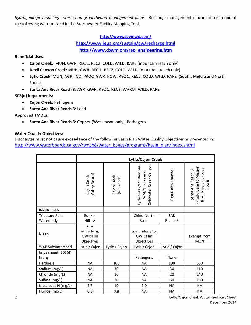
• Santa Ana River Reach 3: Copper (Wet season only), Pathogens Water Quality Objectives: Discharges must not cause exceedance of the following Basin Plan Water Quality Objectives as presented in: http://www.waterboards.ca.gov/rwqcb8/water_issues/programs/basin_plan/index.shtml
Lytle/Cajon Creek
Cajo
n Cr
eek
(V
alle
y Re
ach)
Cajo
n Cr
eek
(M
t. r
each
)
Lytle
Cre
ek/M
t Rea
ches
: S/
M/N
For
ks a
nd
Cold
wat
er C
reek
Can
yon
East
Ria
lto C
hann
el
Sant
a A
na R
each
3
(Pra
do D
am to
Mis
sion
Bl
vd, R
iver
side
(bas
e flo
w))
BASIN PLAN Tributary Rule Waterbody
Bunker Hill - A
Chino-North Basin
SAR Reach 5
Notes
use underlying GW Basin Objectives
use underlying GW Basin Objectives
Exempt from MUN
WAP Subwatershed Lytle / Cajon Lytle / Cajon Lytle / Cajon Lytle / Cajon Impairment, 303(d) listing Pathogens None Hardness NA 100 NA 190 350 Sodium (mg/L) NA 30 NA 30 110 Chloride (mg/L) NA 10 NA 20 140 Sulfate (mg/L) NA 20 NA 60 150 Nitrate, as N (mg/L) 2.7 10 5.0 NA NA Floride (mg/L) 0.8 0.8 NA NA NA
2 Lytle/Cajon Creek Watershed Fact Sheet December 2014
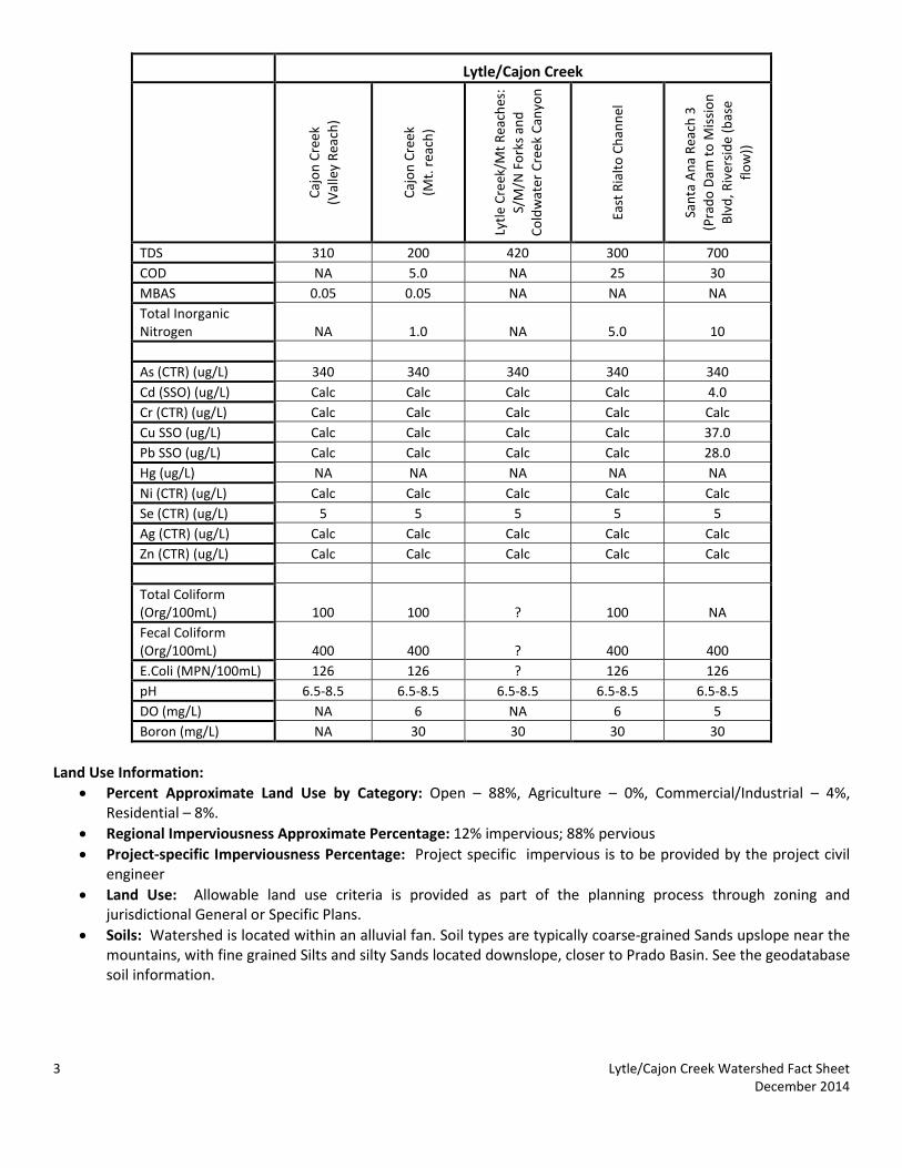
Lytle/Cajon Creek
Cajo
n Cr
eek
(V
alle
y Re
ach)
Cajo
n Cr
eek
(M
t. r
each
)
Lytle
Cre
ek/M
t Rea
ches
: S/
M/N
For
ks a
nd
Cold
wat
er C
reek
Can
yon
East
Ria
lto C
hann
el
Sant
a A
na R
each
3
(Pra
do D
am to
Mis
sion
Bl
vd, R
iver
side
(bas
e flo
w))
TDS 310 200 420 300 700 COD NA 5.0 NA 25 30 MBAS 0.05 0.05 NA NA NA Total Inorganic Nitrogen NA 1.0 NA 5.0 10 As (CTR) (ug/L) 340 340 340 340 340 Cd (SSO) (ug/L) Calc Calc Calc Calc 4.0 Cr (CTR) (ug/L) Calc Calc Calc Calc Calc Cu SSO (ug/L) Calc Calc Calc Calc 37.0 Pb SSO (ug/L) Calc Calc Calc Calc 28.0 Hg (ug/L) NA NA NA NA NA Ni (CTR) (ug/L) Calc Calc Calc Calc Calc Se (CTR) (ug/L) 5 5 5 5 5 Ag (CTR) (ug/L) Calc Calc Calc Calc Calc Zn (CTR) (ug/L) Calc Calc Calc Calc Calc Total Coliform (Org/100mL) 100 100 ? 100 NA Fecal Coliform (Org/100mL) 400 400 ? 400 400 E.Coli (MPN/100mL) 126 126 ? 126 126 pH 6.5-8.5 6.5-8.5 6.5-8.5 6.5-8.5 6.5-8.5 DO (mg/L) NA 6 NA 6 5 Boron (mg/L) NA 30 30 30 30
Land Use Information:
• Percent Approximate Land Use by Category: Open – 88%, Agriculture – 0%, Commercial/Industrial – 4%, Residential – 8%.
• Regional Imperviousness Approximate Percentage: 12% impervious; 88% pervious • Project-specific Imperviousness Percentage: Project specific impervious is to be provided by the project civil
engineer • Land Use: Allowable land use criteria is provided as part of the planning process through zoning and
jurisdictional General or Specific Plans. • Soils: Watershed is located within an alluvial fan. Soil types are typically coarse-grained Sands upslope near the
mountains, with fine grained Silts and silty Sands located downslope, closer to Prado Basin. See the geodatabase soil information.
3 Lytle/Cajon Creek Watershed Fact Sheet December 2014
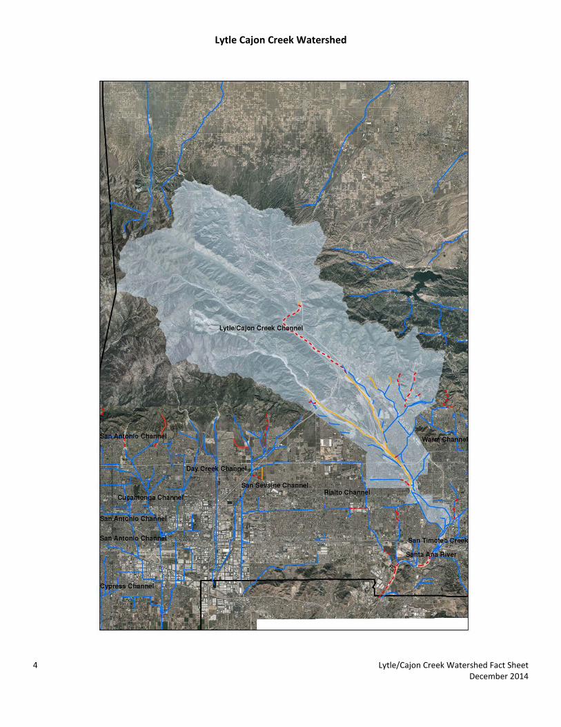
Lytle Cajon Creek Watershed
4 Lytle/Cajon Creek Watershed Fact Sheet December 2014

San Bernardino County Areawide Stormwater Program Watershed Action Plan
November 5, 2014
Mill Creek Watershed Fact Sheet

The following data summary provides general watershed information. Site specific information must be researched on the Stormwater Facility Mapping Tool (Watershed Geodatabase) found at:
http://sbcounty.permitrack.com/WAP/
Mill Creek Watershed
Mill Creek Watershed is located at the eastern boundary of San Bernardino County valley and includes the county of San Bernardino and portions of the cities of Highland and Redlands. Federal jurisdictions include the Angeles Forest (USFS).
Waterbodies: Mill Creek, Santa Ana Reach 4 Source Waters: 1) Headwater locations should be checked for spring sources (i.e. mountain locations); 2) Effluent dominated sources include: Redlands Waste Water Treatment Plant Wetlands/Riparian Areas:
• Riparian/Wetland areas are identified on the geodatabase • During the CEQA process, the jurisdictional delineations for riparian and wetland areas are delineated and
included into the CEQA analysis per USACOE (Section 404), Calif. Dept. of Fish and Wildlife (Section 1600) and Calif. Water Resources Control Board (Section 401) permitting requirements.
• Biological Sensitive Areas: Mill Creek Watershed contains known mapped plant and animal sensitive areas. It is typically required to analyze sites with respect to biological criteria.
o Expected Habitat: Delhi Sands – Rialto/Colton area, southwest end of subwatershed Mountain Yellow Legged Frog – northern end of City Creek California Gnatcatcher – southwest end of subwatershed, Southwest Willow Flycatcher – along Santa Ana River Santa Ana Sucker Fish – in Santa Ana River Merriam K Rat – Throughout length of Santa Ana River within Valley
o Potential Habitat: Coastal Sage Scrub – Southwest border and within Santa Ana River Riparian/Wetland – throughout length of Santa Ana River
o No Tortoise, Insects, Snakes Groundwater Basins: Depth to Groundwater is presented on the Geodatabase and is available from the following water purveyors:
http://www.sbvmwd.com/ http://www.cbwm.org/docs/engdocs/maps
Flood Control Measures/ Plans:
• Watershed is located within San Bernardino County Flood Control District Zone 3 (SBCFCD) and must be in compliance with current operating procedures and requirements. Please contact SBCFCD for site specific information (909-387-8104).
Drainage channels: This watershed is primarily non -Engineered Hardened Maintained (non-EHM) Channels. Projects not draining to a EHM must meet requirements in the WQMP Manual (http://www.sbcounty.gov/dpw/land/npdes.asp)
1 Mill Creek Watershed Fact Sheet December 2014
Hydrologic Conditions of Concern (HCOC): Watershed must meet the HCOC criteria in the WQMP Manual. Recharge information: The watershed is highly managed with strict recharge criteria. Recharge management information is found at the following websites. Recharge activities within this adjudicated watershed must meet existing hydrogeologic modeling criteria and groundwater management plans. Recharge management information is found at the following websites and in the Stormwater Facility Mapping Tool.
http://www.sbvmwd.com/
http://www.ieua.org/sustain/gw/recharge.html http://www.cbwm.org/rep_engineering.htm
Beneficial Uses:
• Mill Creek: MUN, AGR, GWR, POW, REC1, REC2, COLD, WILD, RARE (intermittent)
• Santa Ana River Reach 4: MUN, GWR, REC 1, REC2, WARM, WILD, RARE 303(d):
• Mill Creek: Pathogens
• Santa Ana Reach 4: Pathogens Approved TMDLs:
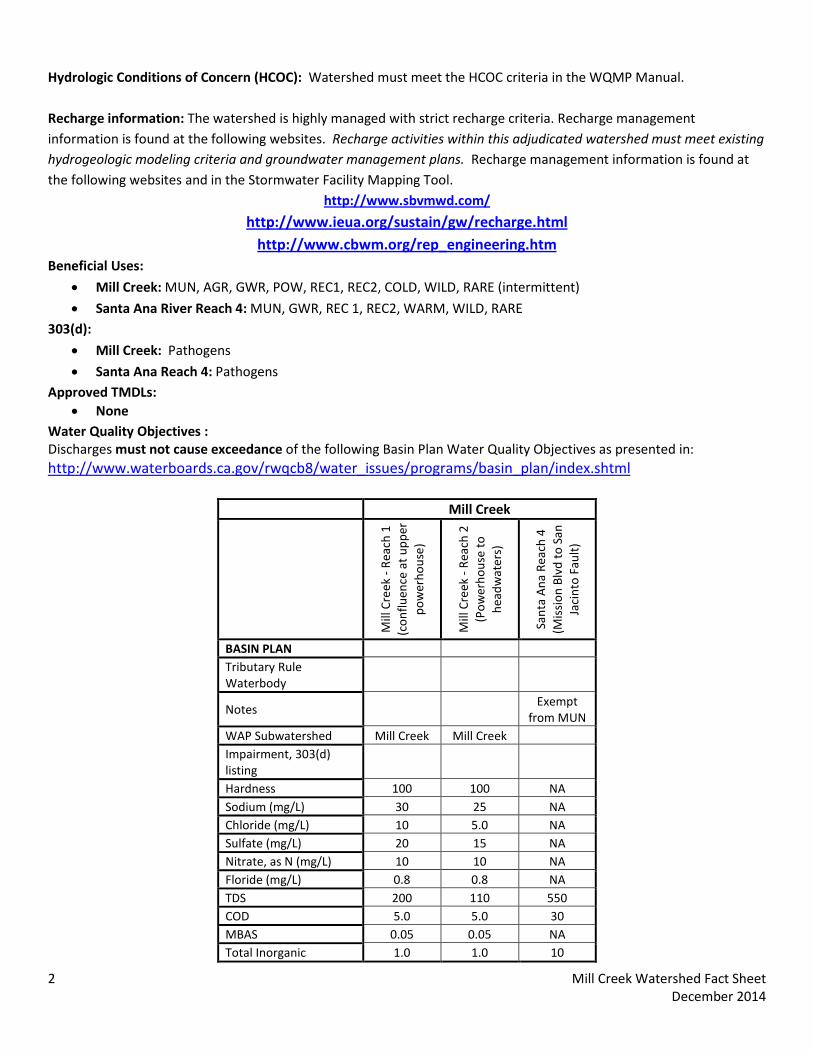
• None Water Quality Objectives : Discharges must not cause exceedance of the following Basin Plan Water Quality Objectives as presented in: http://www.waterboards.ca.gov/rwqcb8/water_issues/programs/basin_plan/index.shtml
Mill Creek
Mill
Cre
ek -
Reac
h 1
(c
onflu
ence
at u
pper
po
wer
hous
e)
Mill
Cre
ek -
Reac
h 2
(P
ower
hous
e to
he
adw
ater
s)
Sant
a A
na R
each
4
(Mis
sion
Blv
d to
San
Ja
cint
o Fa
ult)
BASIN PLAN Tributary Rule Waterbody
Notes
Exempt from MUN
WAP Subwatershed Mill Creek Mill Creek Impairment, 303(d) listing Hardness 100 100 NA Sodium (mg/L) 30 25 NA Chloride (mg/L) 10 5.0 NA Sulfate (mg/L) 20 15 NA Nitrate, as N (mg/L) 10 10 NA Floride (mg/L) 0.8 0.8 NA TDS 200 110 550 COD 5.0 5.0 30 MBAS 0.05 0.05 NA Total Inorganic 1.0 1.0 10
2 Mill Creek Watershed Fact Sheet December 2014

Mill Creek
Mill
Cre
ek -
Reac
h 1
(c
onflu
ence
at u
pper
po
wer
hous
e)
Mill
Cre
ek -
Reac
h 2
(P
ower
hous
e to
he
adw
ater
s)
Sant
a A
na R
each
4
(Mis
sion
Blv
d to
San
Ja
cint
o Fa
ult)
Nitrogen As (CTR) (ug/L) 340 340 340 Cd (SSO) (ug/L) Calc Calc 4.0 Cr (CTR) (ug/L) Calc Calc Calc Cu SSO (ug/L) Calc Calc 37.0 Pb SSO (ug/L) Calc Calc 28.0 Hg (ug/L) NA NA NA Ni (CTR) (ug/L) Calc Calc Calc Se (CTR) (ug/L) 5 5 5 Ag (CTR) (ug/L) Calc Calc Calc Zn (CTR) (ug/L) Calc Calc Calc Total Coliform (Org/100mL) 100 100 NA Fecal Coliform (Org/100mL) 400 400 400 E.Coli (MPN/100mL) 126 126 126 pH 6.5-8.5 6.5-8.5 6.5-8.5 DO (mg/L) 6 6 5 Boron (mg/L) 30 30 30
Land Use Information:
• Percent Approximate Land Use by Category: Open – 98%, Agriculture – 1%, Commercial/Industrial – 0%, Residential – 1%.
• Regional Imperviousness Approximate Percentage: 1% impervious; 99% pervious • Project – Specific Imperviousness Percentage: Project specific impervious is to be provided by the project civil
engineer • Land Use: Allowable land use criteria is provided as part of the planning process through zoning and
jurisdictional General or Specific Plans. • Soils: Watershed is located within an alluvial fan. Soil types are typically coarse-grained Sands upslope near the
mountains, with fine grained Silts and silty Sands located downslope, closer to Prado Basin. See the geodatabase soil information.
Items of Note:
None
3 Mill Creek Watershed Fact Sheet December 2014
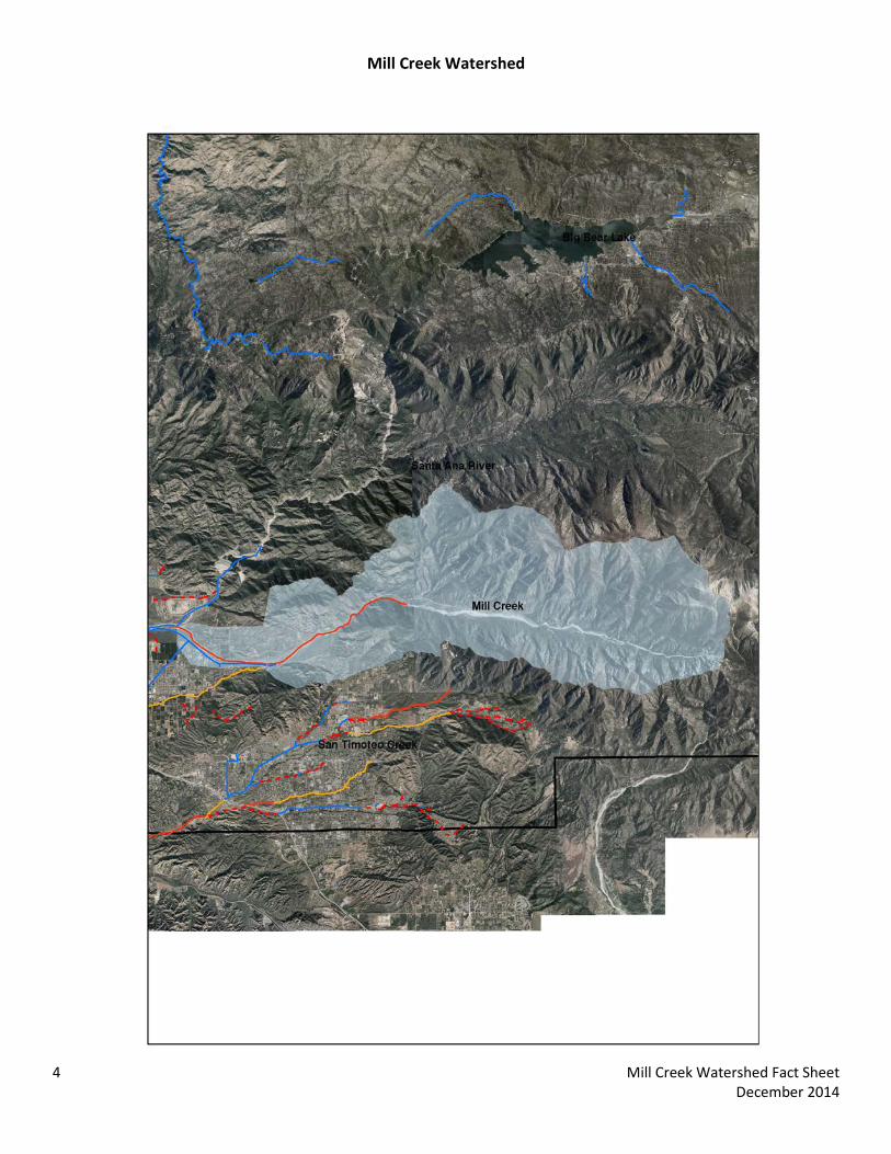
Mill Creek Watershed
4 Mill Creek Watershed Fact Sheet December 2014

San Bernardino County Areawide Stormwater Program Watershed Action Plan
November 5, 2014
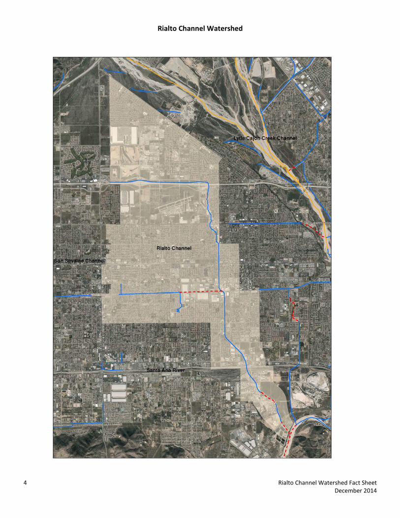
Rialto Channel Watershed Fact Sheet


The following data summary provides general watershed information. Site specific information must be researched on the Stormwater Facility Mapping Tool (Watershed Geodatabase) found at:
http://sbcounty.permitrack.com/WAP/
Rialto Channel Watershed
Rialto Channel Watershed is located in the midsection of the San Bernardino County valley and includes the county of San Bernardino and portions of the cities of Colton, Fontana and Rialto.
Waterbodies: Cactus Channel, Rialto Channel, East Fontana Storm Drain, Santa Ana Reach 3 (Prado Basin) Source Waters: 1) Headwater locations should be checked for spring sources (i.e. mountain locations); 2) Effluent dominated sources include: Rialto Waste Water Treatment Plant and the RIX Facility Wetlands/Riparian Areas:
• Riparian/Wetland areas are identified on the geodatabase • During the CEQA process, the jurisdictional delineations for riparian and wetland areas are delineated and
included into the CEQA analysis per USACOE (Section 404), Calif. Dept. of Fish and Wildlife (Section 1600) and Calif. Water Resources Control Board (Section 401) permitting requirements.
• Biological Sensitive Areas : Rialto Channel Watershed contains known mapped plant and animal sensitive areas. It is typically required to analyze sites with respect to biological criteria.
o Expected Habitat: Delhi Sand – Southeast border Merriam K Rat – Northwest corner
o Potential Habitat: Riversidean Alluvial Fan Sage Scrub – northwest corner
o No Fish, Birds, Frogs, Snakes, Insects or Tortoise Groundwater Basins:
• Depth to Groundwater is presented on the following CBWM map http://www.cbwm.org/docs/engdocs/maps Drainage channels: The main Rialto Channel drainage has been designated as Engineered Hardened Maintained (EHM), however East Fontana Storm Drain has been designated as Non-EHM. Refer to the Watershed Geodatabase for site specific data. Hydrologic Conditions of Concern (HCOC): While most of the watershed is Hydrologic Conditions of Concern (HCOC) Exempt there are remaining portions of watershed must meet the HCOC criteria in the WQMP Manual. Refer to the Watershed Geodatabase for site specific data. Recharge information: The watershed is highly managed with strict recharge criteria. Recharge management information is found at the following websites. Recharge activities within this adjudicated watershed must meet existing hydrogeologic modeling criteria and groundwater management plans. Recharge management information is found at the following websites and in the Stormwater Facility Mapping Tool.
1 Rialto Channel Watershed Fact Sheet December 2014

http://www.ieua.org/sustain/gw/recharge.html http://www.cbwm.org/rep_engineering.htm
Beneficial Uses:
• Santa Ana River Reach 3: AGR, GWR, REC 1, REC2, WARM, WILD, RARE 303(d) Impairments:
• Lead Approved TMDLs:
• Reach 3: Copper (Wet season only) Water Quality Objectives : Discharges must not cause exceedance of the following Basin Plan Water Quality Objectives as presented in: http://www.waterboards.ca.gov/rwqcb8/water_issues/programs/basin_plan/index.shtml
Rialto Channel
Rial
to C
hann
el
Sant
a A
na
Reac
h 3
(P
rado
Dam
to
Mis
sion
Blv
d,
Rive
rsid
e (b
ase
flow
))
BASIN PLAN
Tributary Rule Waterbody SAR Reach
4
Notes
Exempt from MUN
WAP Subwatershed Rialto
Channel Impairment, 303(d) listing None Hardness NA 350 Sodium (mg/L) NA 110 Chloride (mg/L) NA 140 Sulfate (mg/L) NA 150 Nitrate, as N (mg/L) NA NA Floride (mg/L) NA NA TDS 550 700 COD 30 30 MBAS NA NA Total Inorganic Nitrogen 10 10 As (CTR) (ug/L) 340 340 Cd (SSO) (ug/L) Calc 4.0 Cr (CTR) (ug/L) Calc Calc Cu SSO (ug/L) Calc 37.0 Pb SSO (ug/L) Calc 28.0 Hg (ug/L) NA NA Ni (CTR) (ug/L) Calc Calc Se (CTR) (ug/L) 5 5 Ag (CTR) (ug/L) Calc Calc
2 Rialto Channel Watershed Fact Sheet December 2014
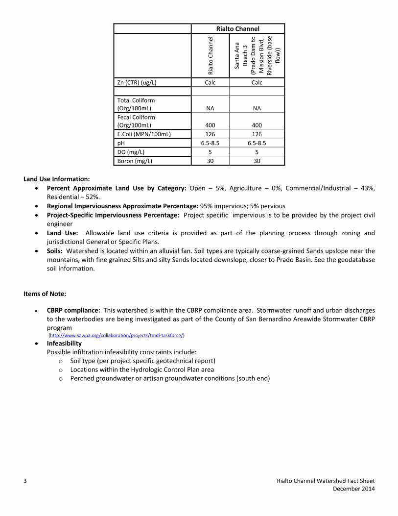
Rialto Channel
Rial
to C
hann
el
Sant
a A
na
Reac
h 3
(P
rado
Dam
to
Mis
sion
Blv
d,
Rive
rsid
e (b
ase
flow
))
Zn (CTR) (ug/L) Calc Calc Total Coliform (Org/100mL) NA NA Fecal Coliform (Org/100mL) 400 400 E.Coli (MPN/100mL) 126 126 pH 6.5-8.5 6.5-8.5 DO (mg/L) 5 5 Boron (mg/L) 30 30
Land Use Information:
• Percent Approximate Land Use by Category: Open – 5%, Agriculture – 0%, Commercial/Industrial – 43%, Residential – 52%.
• Regional Imperviousness Approximate Percentage: 95% impervious; 5% pervious • Project-Specific Imperviousness Percentage: Project specific impervious is to be provided by the project civil
engineer • Land Use: Allowable land use criteria is provided as part of the planning process through zoning and
jurisdictional General or Specific Plans. • Soils: Watershed is located within an alluvial fan. Soil types are typically coarse-grained Sands upslope near the
mountains, with fine grained Silts and silty Sands located downslope, closer to Prado Basin. See the geodatabase soil information.
Items of Note:
• CBRP compliance: This watershed is within the CBRP compliance area. Stormwater runoff and urban discharges to the waterbodies are being investigated as part of the County of San Bernardino Areawide Stormwater CBRP program (http://www.sawpa.org/collaboration/projects/tmdl-taskforce/)
• Infeasibility Possible infiltration infeasibility constraints include:
o Soil type (per project specific geotechnical report) o Locations within the Hydrologic Control Plan area o Perched groundwater or artisan groundwater conditions (south end)
3 Rialto Channel Watershed Fact Sheet December 2014
Rialto Channel Watershed
4 Rialto Channel Watershed Fact Sheet December 2014

San Bernardino County Areawide Stormwater Program Watershed Action Plan
November 5, 2014
San Antonio Creek Watershed Fact Sheet

The following data summary provides general watershed information. Site specific information can also be researched on the Stormwater Facility Mapping Tool (Watershed Geodatabase) found at:
http://sbcounty.permitrack.com/WAP/
San Antonio Channel Watershed San Antonio Channel Watershed is located at the western boundary of San Bernardino County and includes portions of the counties of San Bernardino, Los Angeles, and Riverside, all of the City of Montclair and portions of the cities of Pomona, Claremont, Upland, Ontario, Chino and Chino Hills. Federal jurisdictions include the United States Forest Service (Angeles Forest) and United States Army Corp of Engineers (Prado Basin).
Waterbodies : Primary Tributaries:San Antonio Channel Chino Creek Santa Ana Reach 3 (Prado Basin)
Little Chino Creek English Canyon Carbon Canyon Creek
Los Serranos Channel Chino Storm Drain
Source Waters:
• Headwater locations should be checked for spring sources (i.e. Chino Hills and mountain locations) • Effluent dominated sources include: IEUA Carbon Canyon Water Reclamation Facility (San Antonio Channel ),
IEUA RP-2 (Chino Creek) Wetlands/Riparian Areas:
• Riparian/Wetland areas are identified on the geodatabase • During the CEQA process, the jurisdictional delineations for riparian and wetland areas are delineated and
included into the CEQA analysis per USACOE (Section 404), Calif. Dept. of Fish and Wildlife (Section 1600) and Calif. Water Resources Control Board (Section 401) permitting requirements.
• Biological Sensitive Areas: San Antonio Creek Watershed is contains known mapped plant and animal sensitive areas. It is typically required to analyze sites with respect to biological criteria.
o Expected Habitat: Delhi Sands – Eastern portion, near Chino Storm Drain Least Bell Vireo – South end of subwatersehd
o Potential Habitat: Coastal Sage Scrub – southern end Riparian/Wetlands – southern end
o No Fish, Frogs, Snakes, Insects or Tortoise Groundwater Basins:
• Depth to Groundwater is presented on the following CBWM map: http://www.cbwm.org/docs/engdocs/maps
• Per the obligations codified in the 2004 Basin Plan amendment it is regionally required to eliminate groundwater outflow to the Santa Ana River. This is the Hydraulic Control Monitoring Program and is managed through the Chino Basin Desalter Authority, the Chino Basin Watermaster and Inland Empire Utilities Agency. All areas south of the 60 Freeway must review this information.
Flood Control Measures/ Plans:
• Watershed is located within San Bernardino County Flood Control District Zone 1 (SBCFCD) and must be in compliance with current operating procedures and requirements. Please contact SBCFCD for site specific information (909-387-8104).
1 San Antonio Channel Watershed Fact Sheet December 2014
Drainage channels:
• All but nine drainage courses are Engineered Hardened Maintained (EHM) Channels. Projects not draining to a EHM must meet requirements in the WQMP Manual (http://www.sbcounty.gov/dpw/land/npdes.asp)
Hydrologic Conditions of Concern (HCOC)
• Northeast portion of the watershed is Hydrologic Conditions of Concern (HCOC) Exempt
• Remaining watershed portions must meet the HCOC requirements in the WQMP Manual Stormwater Recharge information: The watershed is highly managed with strict recharge criteria. Recharge management information is found at the following websites. Recharge activities within this adjudicated watershed must meet existing hydrogeologic modeling criteria and groundwater management plans. Contact information and watershed specific information is found at:
http://www.ieua.org/sustain/gw/recharge.html http://www.cbwm.org/rep_engineering.htm
http://www.cbwcd.org/129/Percolation-Basins Beneficial Uses: Discharges must not impair these beneficial uses:
• San Antonio Creek: MUN, AGR, IND, PROC, GWR, POW, REC1, REC2, COLD, WILD
• Chino Creek: MUN, GWR, REC1, REC2, WARM, LWARM, WILD, RARE
• Santa Ana River Reach 3: AGR, GWR, REC 1, REC2, WARM, WILD, RARE 303(d) Impairments
• San Antonio Creek: pH
• Chino Creek: Chemical oxygen demand (COD), pH
• Santa Ana River Reach 3: Lead Approved TMDLs:
• Chino Creek: Pathogens, Nutrients, Coliform, Bacteria
• Santa Ana River Reach 3: Copper (Wet season only)
Water Quality Objectives : Discharges must not cause exceedance of the following Basin Plan Water Quality Objectives as presented in: http://www.waterboards.ca.gov/rwqcb8/water_issues/programs/basin_plan/index.shtml
San Antonio Channel
Chin
o Cr
eek
1 -
1A
Chin
o Cr
eek
1 -
1B
Prad
o Pa
rk
(wet
land
s)
San
Ant
onio
Cr
eek
(Val
ley
Reac
h)
San
Ant
onio
Cr
eek
(Mtn
Re
ach)
Sant
a A
na
Reac
h 3
(P
rado
Dam
to
Mis
sion
Blv
d,
Rive
rsid
e (b
ase
flow
))
BASIN PLAN
Tributary Rule Waterbody
Chino-North Basin
Notes Exempt
from MUN
Exempt from MUN
Exempt from MUN
use underlying GW Basin Objectives Exempt from MUN
WAP Subwatershed San
Antonio Channel
San Antonio Channel
San Antonio Channel
San Antonio Channel
San Antonio Channel
2 San Antonio Channel Watershed Fact Sheet December 2014
San Antonio Channel
Chin
o Cr
eek
1 -
1A
Chin
o Cr
eek
1 -
1B
Prad
o Pa
rk
(wet
land
s)
San
Ant
onio
Cr
eek
(Val
ley
Reac
h)
San
Ant
onio
Cr
eek
(Mtn
Re
ach)
Sant
a A
na
Reac
h 3
(P
rado
Dam
to
Mis
sion
Blv
d,
Rive
rsid
e (b
ase
flow
))
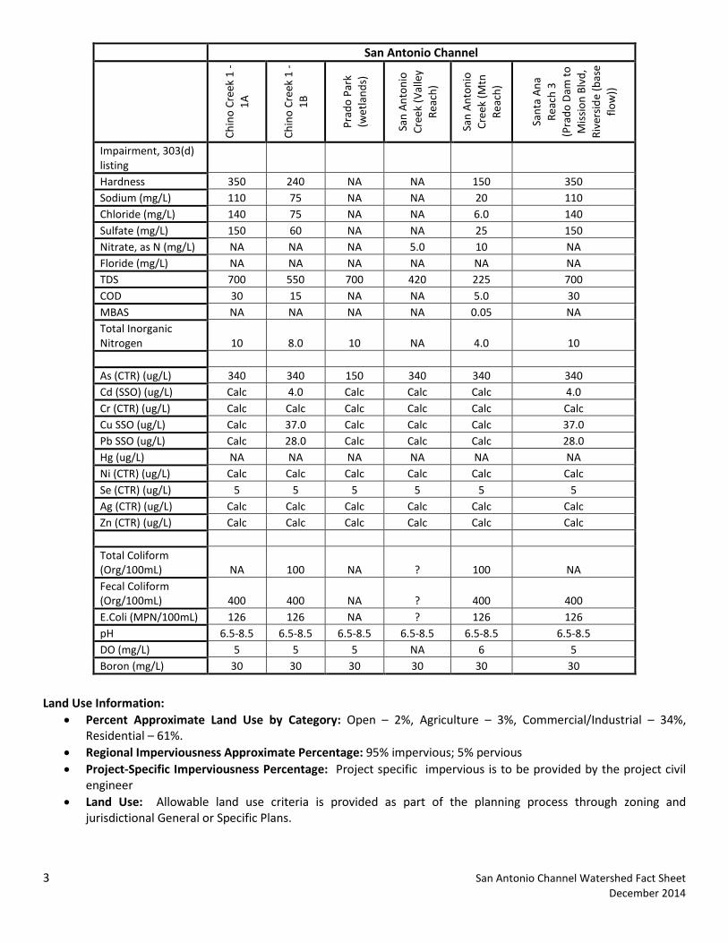
Impairment, 303(d) listing Hardness 350 240 NA NA 150 350 Sodium (mg/L) 110 75 NA NA 20 110 Chloride (mg/L) 140 75 NA NA 6.0 140 Sulfate (mg/L) 150 60 NA NA 25 150 Nitrate, as N (mg/L) NA NA NA 5.0 10 NA Floride (mg/L) NA NA NA NA NA NA TDS 700 550 700 420 225 700 COD 30 15 NA NA 5.0 30 MBAS NA NA NA NA 0.05 NA Total Inorganic Nitrogen 10 8.0 10 NA 4.0 10 As (CTR) (ug/L) 340 340 150 340 340 340 Cd (SSO) (ug/L) Calc 4.0 Calc Calc Calc 4.0 Cr (CTR) (ug/L) Calc Calc Calc Calc Calc Calc Cu SSO (ug/L) Calc 37.0 Calc Calc Calc 37.0 Pb SSO (ug/L) Calc 28.0 Calc Calc Calc 28.0 Hg (ug/L) NA NA NA NA NA NA Ni (CTR) (ug/L) Calc Calc Calc Calc Calc Calc Se (CTR) (ug/L) 5 5 5 5 5 5 Ag (CTR) (ug/L) Calc Calc Calc Calc Calc Calc Zn (CTR) (ug/L) Calc Calc Calc Calc Calc Calc Total Coliform (Org/100mL) NA 100 NA ? 100 NA Fecal Coliform (Org/100mL) 400 400 NA ? 400 400 E.Coli (MPN/100mL) 126 126 NA ? 126 126 pH 6.5-8.5 6.5-8.5 6.5-8.5 6.5-8.5 6.5-8.5 6.5-8.5 DO (mg/L) 5 5 5 NA 6 5 Boron (mg/L) 30 30 30 30 30 30
Land Use Information:
• Percent Approximate Land Use by Category: Open – 2%, Agriculture – 3%, Commercial/Industrial – 34%, Residential – 61%.
• Regional Imperviousness Approximate Percentage: 95% impervious; 5% pervious • Project-Specific Imperviousness Percentage: Project specific impervious is to be provided by the project civil
engineer • Land Use: Allowable land use criteria is provided as part of the planning process through zoning and
jurisdictional General or Specific Plans.
3 San Antonio Channel Watershed Fact Sheet December 2014
• Soils: Watershed is located within an alluvial fan. Soil types are typically coarse-grained Sands upslope near the mountains, with fine grained Silts and silty Sands located downslope, closer to Prado Basin. See the geodatabase soil information.
Items of Note: • CBRP compliance: This watershed is within the CBRP compliance area. Stormwater runoff and urban discharges
to the waterbodies are being investigated as part of the County of San Bernardino Areawide Stormwater CBRP program (http://www.sawpa.org/collaboration/projects/tmdl-taskforce/)
• Infeasibility Possible infiltration infeasibility constraints include:
o Soil type (per project specific geotechnical report) o Locations within the Hydrologic Control Plan area o Perched groundwater or artisan groundwater conditions
4 San Antonio Channel Watershed Fact Sheet December 2014

San Antonio Channel Watershed
5 San Antonio Channel Watershed Fact Sheet December 2014

San Bernardino County Areawide Stormwater Program Watershed Action Plan
November 5, 2014
San Sevaine Watershed Fact Sheet

The following data summary provides general watershed information. Site specific information must be researched on the Stormwater Facility Mapping Tool (Watershed Geodatabase) found at:
http://sbcounty.permitrack.com/WAP/
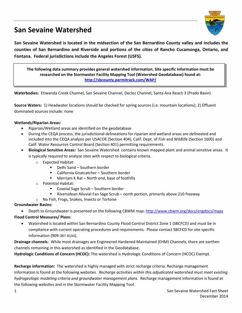
San Sevaine Watershed
San Sevaine Watershed is located in the midsection of the San Bernardino County valley and includes the counties of San Bernardino and Riverside and portions of the cities of Rancho Cucamonga, Ontario, and Fontana. Federal jurisdictions include the Angeles Forest (USFS).
Waterbodies: Etiwanda Creek Channel, San Sevaine Channel, Declez Channel, Santa Ana Reach 3 (Prado Basin) Source Waters: 1) Headwater locations should be checked for spring sources (i.e. mountain locations); 2) Effluent dominated sources include: none Wetlands/Riparian Areas:
• Riparian/Wetland areas are identified on the geodatabase • During the CEQA process, the jurisdictional delineations for riparian and wetland areas are delineated and
included into the CEQA analysis per USACOE (Section 404), Calif. Dept. of Fish and Wildlife (Section 1600) and Calif. Water Resources Control Board (Section 401) permitting requirements.
• Biological Sensitive Areas: San Sevaine Watershed contains known mapped plant and animal sensitive areas. It is typically required to analyze sites with respect to biological criteria.
o Expected Habitat: Delhi Sand – Southern border California Gnatcatcher – Southern border Merriam K Rat – North end, base of foothills
o Potential Habitat: Coastal Sage Scrub – Southern border Riversidean Alluvial Fan Sage Scrub – north portion, primarily above 210 freeway
o No Fish, Frogs, Snakes, Insects or Tortoise Groundwater Basins:
• Depth to Groundwater is presented on the following CBWM map: http://www.cbwm.org/docs/engdocs/maps Flood Control Measures/ Plans:
• Watershed is located within San Bernardino County Flood Control District Zone 1 (SBCFCD) and must be in compliance with current operating procedures and requirements. Please contact SBCFCD for site specific information (909-387-8104).
Drainage channels: While most drainages are Engineered Hardened Maintained (EHM) Channels, there are earthen channels remaining in this watershed as identified in the Geodatabase. Hydrologic Conditions of Concern (HCOC): The watershed is Hydrologic Conditions of Concern (HCOC) Exempt. Recharge information: The watershed is highly managed with strict recharge criteria. Recharge management information is found at the following websites. Recharge activities within this adjudicated watershed must meet existing hydrogeologic modeling criteria and groundwater management plans. Recharge management information is found at the following websites and in the Stormwater Facility Mapping Tool.
1 San Sevaine Watershed Fact Sheet December 2014
http://www.ieua.org/sustain/gw/recharge.html http://www.cbwm.org/rep_engineering.htm
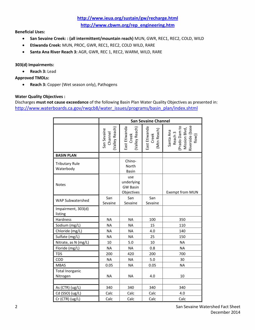
Beneficial Uses:
• San Sevaine Creek: : (all intermittent/mountain reach) MUN, GWR, REC1, REC2, COLD, WILD
• Etiwanda Creek: MUN, PROC, GWR, REC1, REC2, COLD WILD, RARE
• Santa Ana River Reach 3: AGR, GWR, REC 1, REC2, WARM, WILD, RARE 303(d) Impairments:
• Reach 3: Lead Approved TMDLs:
• Reach 3: Copper (Wet season only), Pathogens Water Quality Objectives : Discharges must not cause exceedance of the following Basin Plan Water Quality Objectives as presented in: http://www.waterboards.ca.gov/rwqcb8/water_issues/programs/basin_plan/index.shtml
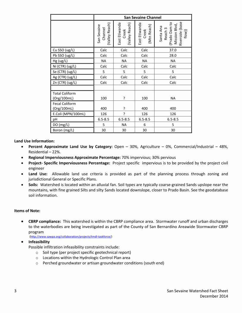
San Sevaine Channel
San
Seva
ine
Chan
nel
(Val
ley
Reac
h)
East
Etiw
anda
Cr
eek
(Val
ley
Reac
h)
East
Etiw
anda
Cr
eek
(Mtn
Rea
ch)
Sant
a A
na
Reac
h 3
(P
rado
Dam
to
Mis
sion
Blv
d,
Rive
rsid
e (b
ase
flow
))
BASIN PLAN
Tributary Rule Waterbody
Chino-North Basin
Notes
use underlying GW Basin Objectives Exempt from MUN
WAP Subwatershed San
Sevaine San
Sevaine San
Sevaine Impairment, 303(d) listing Hardness NA NA 100 350 Sodium (mg/L) NA NA 15 110 Chloride (mg/L) NA NA 4.0 140 Sulfate (mg/L) NA NA 25 150 Nitrate, as N (mg/L) 10 5.0 10 NA Floride (mg/L) NA NA 0.8 NA TDS 200 420 200 700 COD NA NA 5.0 30 MBAS 0.05 NA 0.05 NA Total Inorganic Nitrogen NA NA 4.0 10 As (CTR) (ug/L) 340 340 340 340 Cd (SSO) (ug/L) Calc Calc Calc 4.0 Cr (CTR) (ug/L) Calc Calc Calc Calc
2 San Sevaine Watershed Fact Sheet December 2014
San Sevaine Channel
San
Seva
ine
Chan
nel
(Val
ley
Reac
h)
East
Etiw
anda
Cr
eek
(Val
ley
Reac
h)
East
Etiw
anda
Cr
eek
(Mtn
Rea
ch)
Sant
a A
na
Reac
h 3
(P
rado
Dam
to
Mis
sion
Blv
d,
Rive
rsid
e (b
ase
flow
))
Cu SSO (ug/L) Calc Calc Calc 37.0 Pb SSO (ug/L) Calc Calc Calc 28.0 Hg (ug/L) NA NA NA NA Ni (CTR) (ug/L) Calc Calc Calc Calc Se (CTR) (ug/L) 5 5 5 5 Ag (CTR) (ug/L) Calc Calc Calc Calc Zn (CTR) (ug/L) Calc Calc Calc Calc Total Coliform (Org/100mL) 100 ? 100 NA Fecal Coliform (Org/100mL) 400 ? 400 400 E.Coli (MPN/100mL) 126 ? 126 126 pH 6.5-8.5 6.5-8.5 6.5-8.5 6.5-8.5 DO (mg/L) 5 NA 6 5 Boron (mg/L) 30 30 30 30
Land Use Information:
• Percent Approximate Land Use by Category: Open – 30%, Agriculture – 0%, Commercial/Industrial – 48%, Residential – 22%.
• Regional Imperviousness Approximate Percentage: 70% impervious; 30% pervious • Project- Specific Imperviousness Percentage: Project specific impervious is to be provided by the project civil
engineer • Land Use: Allowable land use criteria is provided as part of the planning process through zoning and
jurisdictional General or Specific Plans. • Soils: Watershed is located within an alluvial fan. Soil types are typically coarse-grained Sands upslope near the
mountains, with fine grained Silts and silty Sands located downslope, closer to Prado Basin. See the geodatabase soil information.
Items of Note:
• CBRP compliance: This watershed is within the CBRP compliance area. Stormwater runoff and urban discharges to the waterbodies are being investigated as part of the County of San Bernardino Areawide Stormwater CBRP program (http://www.sawpa.org/collaboration/projects/tmdl-taskforce/)
• Infeasibility Possible infiltration infeasibility constraints include:
o Soil type (per project specific geotechnical report) o Locations within the Hydrologic Control Plan area o Perched groundwater or artisan groundwater conditions (south end)
3 San Sevaine Watershed Fact Sheet December 2014
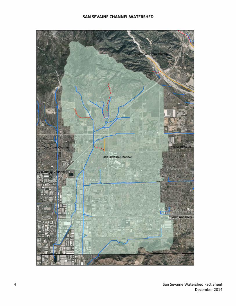
SAN SEVAINE CHANNEL WATERSHED
4 San Sevaine Watershed Fact Sheet December 2014

San Bernardino County Areawide Stormwater Program Watershed Action Plan
November 5, 2014
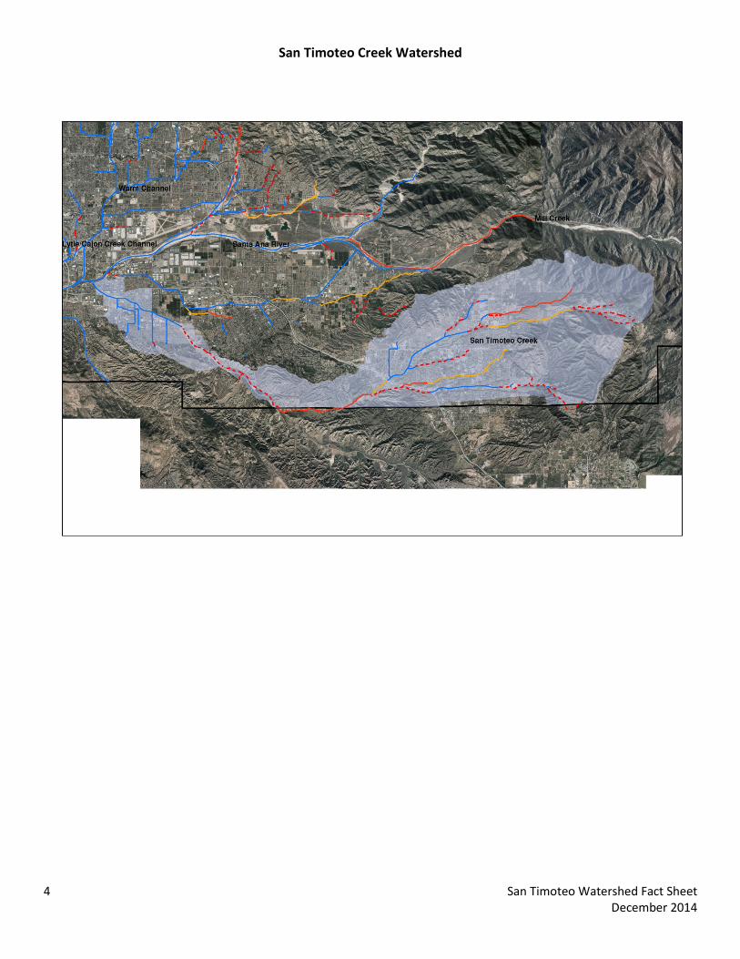
San Timoteo Creek Watershed Fact Sheet

The following data summary provides general watershed information. Site specific information must be researched on the Stormwater Facility Mapping Tool (Watershed Geodatabase) found at:
http://sbcounty.permitrack.com/WAP/
San Timoteo Creek Watershed
San Timoteo Watershed is located at the eastern boundary of San Bernardino County valley and includes the counties of San Bernardino and Riverside and portions of the cities of Loma Linda, Redlands, and Yucaipa. Federal jurisdictions include the Angeles Forest (USFS).
Waterbodies: Live Oak Creek, Wildwood Creek, Wilson Creek, Oak Glen Creek, San Timoteo Creek, Santa Ana Reach 4 Source Waters: 1) Headwater locations should be checked for spring sources (i.e. mountain locations); 2) Effluent dominated sources include: none Wetlands/Riparian Areas:
• Riparian/Wetland areas are identified on the geodatabase • During the CEQA process, the jurisdictional delineations for riparian and wetland areas are delineated and
included into the CEQA analysis per USACOE (Section 404), Calif. Dept. of Fish and Wildlife (Section 1600) and Calif. Water Resources Control Board (Section 401) permitting requirements.
• Biological Sensitive Areas: San Timoeto Creek Watershed contains known mapped plant and animal sensitive areas. It is typically required to analyze sites with respect to biological criteria.
o Expected Habitat: Merriam K Rat – where subwatershed meets Santa Ana River
o Potential Habitat: Coastal Sage Scrub – eastern end, northern portion above Wilson Creek and large area north of
Live Oak Creek Riparian/Wetlands – Along Live Oak Creek and where subwatershed meets Santa Ana River
o No Fish, Frogs, Snakes, Insects or Tortoise Groundwater Basins: Depth to Groundwater is presented on the Geodatabase and is available from the following water purveyors:
http://www.sbvmwd.com http://www.yvwd.dst.ca.us
Flood Control Measures/ Plans:
• Watershed is located within San Bernardino County Flood Control District Zone 3 (SBCFCD) and must be in compliance with current operating procedures and requirements. Please contact SBCFCD for site specific information (909-387-8104).
Drainage channels: This watershed has both non -Engineered Hardened Maintained (non-EHM) and EHM channels. Projects not draining to an EHM must meet requirements in the WQMP Manual. (http://www.sbcounty.gov/dpw/land/npdes.asp) Hydrologic Conditions of Concern (HCOC): Watershed must meet the HCOC criteria in the WQMP Manual.
1 San Timoteo Watershed Fact Sheet December 2014
Recharge information: The watershed is highly managed with strict recharge criteria. Recharge management information is found at the following websites. Recharge activities within this adjudicated watershed must meet existing hydrogeologic modeling criteria and groundwater management plans. Recharge management information is found at the following websites and in the Stormwater Facility Mapping Tool.
http://www.sbvmwd.com http://www.yvwd.dst.ca.us
Beneficial Uses:
• San Timoteo Creek: MUN, AGR, GWR, REC1, REC2, WARM, WILD (need to analyze on a site specific basis using Basin Plan)
• Tributary Creeks to San Timoteo: MUN, GWR, REC1, REC2, WARM, WILD, SPWN (need to analyze on a site specific basis using Basin Plan)
• Santa Ana River Reach 4: MUN, GWR, REC 1, REC2, WARM, WILD, RARE 303(d) Impairments
• Santa Ana Reach 4: Pathogens Approved TMDLs:
• None Water Quality Objectives: Discharges must not cause exceedance of the following Basin Plan Water Quality Objectives as presented in: http://www.waterboards.ca.gov/rwqcb8/water_issues/programs/basin_plan/index.shtml
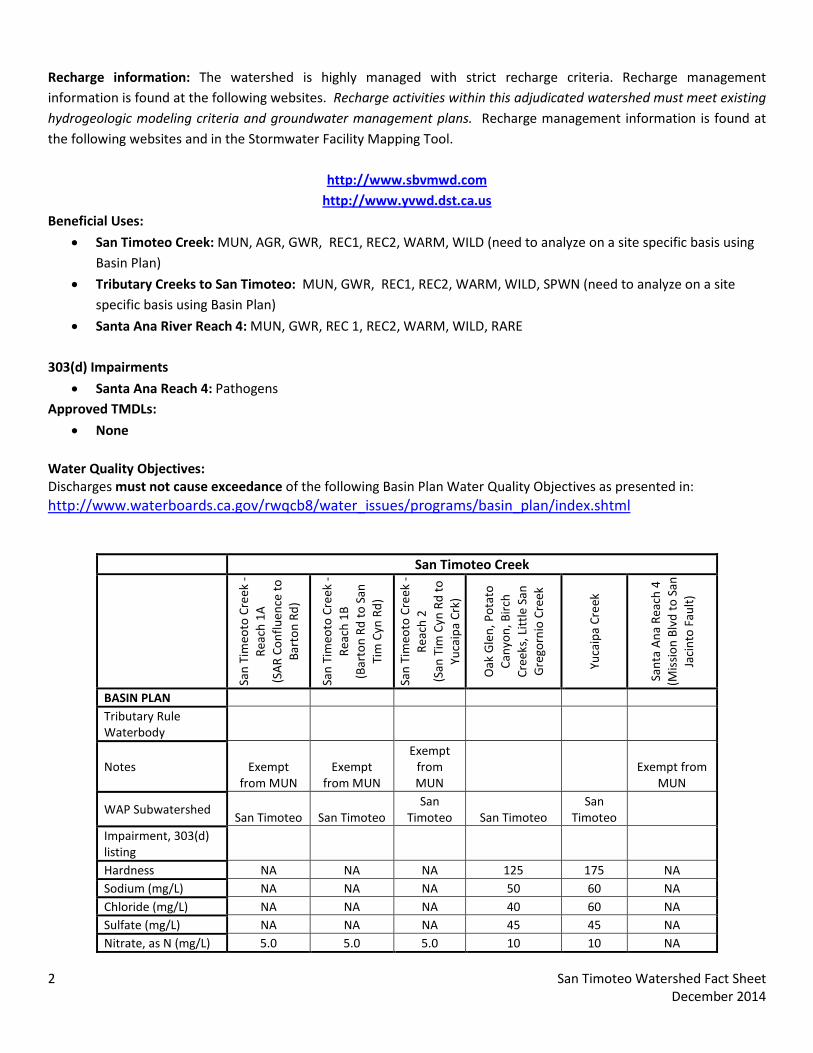
San Timoteo Creek
San
Tim
eoto
Cre
ek -
Reac
h 1A
(S
AR
Conf
luen
ce to
Ba
rton
Rd)
San
Tim
eoto
Cre
ek -
Reac
h 1B
(B
arto
n Rd
to S
an
Tim
Cyn
Rd)
San
Tim
eoto
Cre
ek -
Reac
h 2
(San
Tim
Cyn
Rd
to
Yuca
ipa
Crk)
Oak
Gle
n, P
otat
o Ca
nyon
, Bir
ch
Cree
ks, L
ittle
San
G
rego
rnio
Cre
ek
Yuca
ipa
Cree
k
Sant
a A
na R
each
4
(Mis
sion
Blv
d to
San
Ja
cint
o Fa
ult)
BASIN PLAN Tributary Rule Waterbody
Notes Exempt from MUN
Exempt from MUN
Exempt from MUN
Exempt from MUN
WAP Subwatershed San Timoteo San Timoteo
San Timoteo San Timoteo
San Timoteo
Impairment, 303(d) listing Hardness NA NA NA 125 175 NA Sodium (mg/L) NA NA NA 50 60 NA Chloride (mg/L) NA NA NA 40 60 NA Sulfate (mg/L) NA NA NA 45 45 NA Nitrate, as N (mg/L) 5.0 5.0 5.0 10 10 NA
2 San Timoteo Watershed Fact Sheet December 2014

San Timoteo Creek
San
Tim
eoto
Cre
ek -
Reac
h 1A
(S
AR
Conf
luen
ce to
Ba
rton
Rd)
San
Tim
eoto
Cre
ek -
Reac
h 1B
(B
arto
n Rd
to S
an
Tim
Cyn
Rd)
San
Tim
eoto
Cre
ek -
Reac
h 2
(San
Tim
Cyn
Rd
to
Yuca
ipa
Crk)
Oak
Gle
n, P
otat
o Ca
nyon
, Bir
ch
Cree
ks, L
ittle
San
G
rego
rnio
Cre
ek
Yuca
ipa
Cree
k
Sant
a A
na R
each
4
(Mis
sion
Blv
d to
San
Ja
cint
o Fa
ult)
Floride (mg/L) NA NA NA 0.8 0.8 NA TDS 400 400 400 230 290 550 COD NA NA NA 5.0 15 30 MBAS NA NA NA 0.05 0.05 NA Total Inorganic Nitrogen NA NA NA 3.0 6.0 10 As (CTR) (ug/L) 340 340 340 340 340 340 Cd (SSO) (ug/L) Calc Calc Calc Calc Calc 4.0 Cr (CTR) (ug/L) Calc Calc Calc Calc Calc Calc Cu SSO (ug/L) Calc Calc Calc Calc Calc 37.0 Pb SSO (ug/L) Calc Calc Calc Calc Calc 28.0 Hg (ug/L) NA NA NA NA NA NA Ni (CTR) (ug/L) Calc Calc Calc Calc Calc Calc Se (CTR) (ug/L) 5 5 5 5 5 5 Ag (CTR) (ug/L) Calc Calc Calc Calc Calc Calc Zn (CTR) (ug/L) Calc Calc Calc Calc Calc Calc Total Coliform (Org/100mL) 100 100 100 100 100 NA Fecal Coliform (Org/100mL) 400 400 400 400 400 400 E.Coli (MPN/100mL) 126 126 126 126 126 126 pH 6.5-8.5 6.5-8.5 6.5-8.5 6.5-8.5 6.5-8.5 6.5-8.5 DO (mg/L) NA NA NA 5 5 5 Boron (mg/L) NA NA NA 30 15 30
Land Use Information:
• Percent Approximate Land Use by Category: Open – 55%, Agriculture – 3%, Commercial/Industrial – 6%, Residential – 39%.
• Regional Imperviousness Approximate Percentage: 48% impervious; 52% pervious • Project-Specific Imperviousness Percentage: Project specific impervious is to be provided by the project civil
engineer • Land Use: Allowable land use criteria is provided as part of the planning process through zoning and
jurisdictional General or Specific Plans. • Soils: Watershed is located within an alluvial fan. Soil types are typically coarse-grained Sands upslope near the
mountains, with fine grained Silts and silty Sands located downslope, closer to Prado Basin. See the geodatabase soil information.
Items of Note:
None
3 San Timoteo Watershed Fact Sheet December 2014
San Timoteo Creek Watershed
4 San Timoteo Watershed Fact Sheet December 2014

San Bernardino County Areawide Stormwater Program Watershed Action Plan
November 5, 2014
Santa Ana (East) Watershed Fact Sheet

The following data summary provides general watershed information. Site specific information must be researched on the Stormwater Facility Mapping Tool (Watershed Geodatabase) found at:
http://sbcounty.permitrack.com/WAP/
Santa Ana River (East) Watershed
Santa Ana River (East) Watershed is located at the eastern boundary of San Bernardino County valley and includes the county of San Bernardino and portions of the cities of Rialto, Colton, San Bernardino, Loma Linda, Highland and Redlands. Federal jurisdiction includes the Angeles Forest (USFS).
Waterbodies: Plunge Creek, Oak Creek, Zanja (Mission) Creek, Santa Ana Reach 3 and 4 Source Waters: 1) Headwater locations should be checked for spring sources (i.e. mountain locations); 2) Effluent dominated sources include: Colton Waste Water Treatment Plant and San Bernardino Waste Water Treatment Plant Wetlands/Riparian Areas:
• Riparian/Wetland areas are identified on the geodatabase • During the CEQA process, the jurisdictional delineations for riparian and wetland areas are delineated and
included into the CEQA analysis per USACOE (Section 404), Calif. Dept. of Fish and Wildlife (Section 1600) and Calif. Water Resources Control Board (Section 401) permitting requirements.
• Biological Sensitive Areas: Santa Ana River Watershed contains known mapped plant and animal sensitive areas. It is typically required to analyze sites with respect to biological criteria.
o Expected Habitat: Delhi Sands – Rialto/Colton area, southwest end of subwatershed Mountain Yellow Legged Frog – northern end of City Creek California Gnatcatcher – southwest end of subwatershed, Southwest Willow Flycatcher – along Santa Ana River Santa Ana Sucker Fish – in Santa Ana River Merriam K Rat – Throughout length of Santa Ana River within Valley
o Potential Habitat: Coastal Sage Scrub – Southwest border and within Santa Ana River Riparian/Wetland – throughout length of Santa Ana River
o No Tortoise, Insects, Snakes Groundwater Basins: Depth to Groundwater is presented on the Geodatabase and is available from the following water purveyors:
http://www.sbvmwd.com/ http://www.cbwm.org/docs/engdocs/maps
Flood Control Measures/ Plans: Watershed is located within San Bernardino County Flood Control District Zones 2 and 3 (SBCFCD) and must be in compliance with current operating procedures and requirements. Please contact SBCFCD for site specific information (909-387-8104).
1 Santa Ana (East) Watershed Fact Sheet December 2014
Drainage channels: This watershed is both Engineered Hardened Maintained (EHM) and non -Engineered Hardened Maintained (non-EHM) Channels. Projects not draining to an EHM must meet requirements in the WQMP Manual (http://www.sbcounty.gov/dpw/land/npdes.asp) Hydrologic Conditions of Concern (HCOC): Watershed must meet the HCOC criteria in the WQMP Manual. Recharge information: The watershed is highly managed with strict recharge criteria. Recharge management information is found at the following websites. Recharge activities within this adjudicated watershed must meet existing hydrogeologic modeling criteria and groundwater management plans. Recharge management information is found at the following websites and in the Stormwater Facility Mapping Tool.
http://www.sbvmwd.com/
http://www.ieua.org/sustain/gw/recharge.html http://www.cbwm.org/rep_engineering.htm
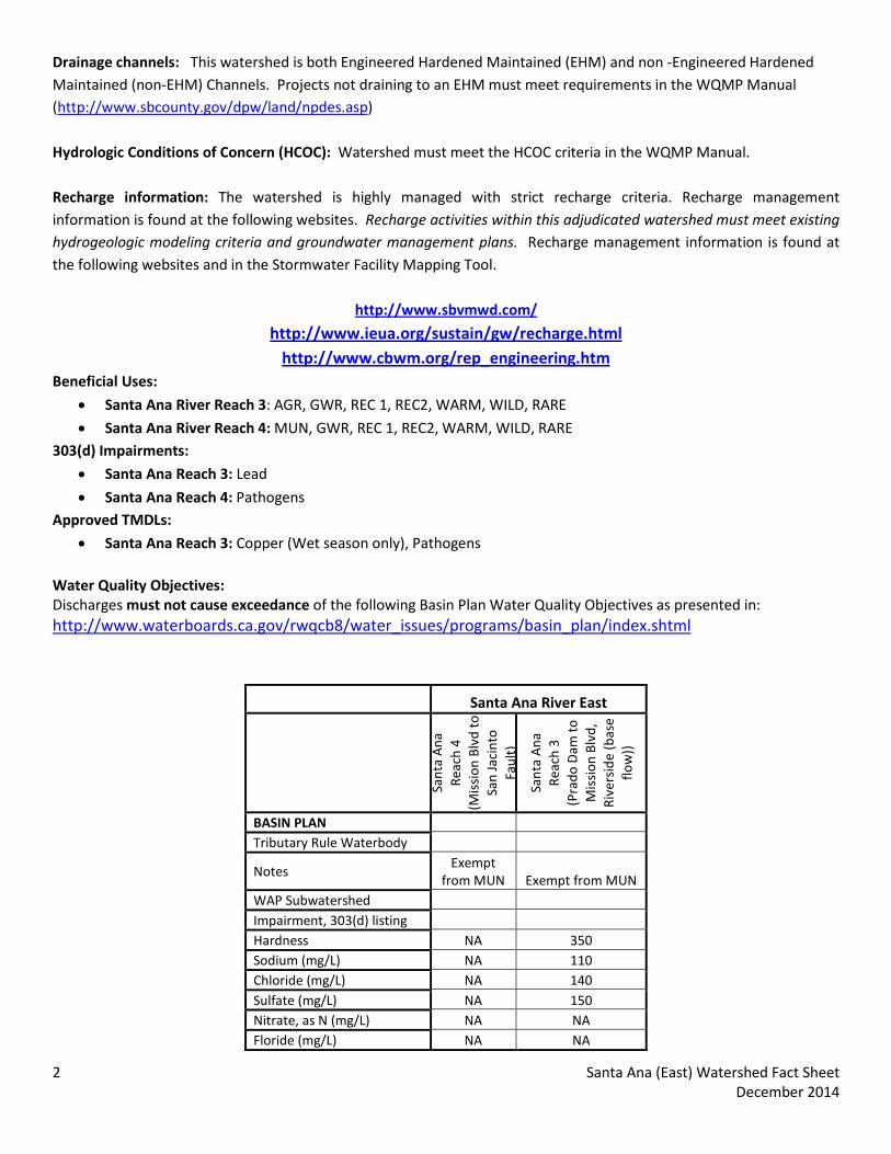
Beneficial Uses:
• Santa Ana River Reach 3: AGR, GWR, REC 1, REC2, WARM, WILD, RARE
• Santa Ana River Reach 4: MUN, GWR, REC 1, REC2, WARM, WILD, RARE 303(d) Impairments:
• Santa Ana Reach 3: Lead
• Santa Ana Reach 4: Pathogens Approved TMDLs:
• Santa Ana Reach 3: Copper (Wet season only), Pathogens Water Quality Objectives: Discharges must not cause exceedance of the following Basin Plan Water Quality Objectives as presented in: http://www.waterboards.ca.gov/rwqcb8/water_issues/programs/basin_plan/index.shtml
Santa Ana River East
Sant
a A
na
Reac
h 4
(M
issi
on B
lvd
to
San
Jaci
nto
Faul
t)
Sant
a A
na
Reac
h 3
(P
rado
Dam
to
Mis
sion
Blv
d,
Rive
rsid
e (b
ase
flow
))
BASIN PLAN Tributary Rule Waterbody
Notes Exempt
from MUN Exempt from MUN WAP Subwatershed Impairment, 303(d) listing Hardness NA 350 Sodium (mg/L) NA 110 Chloride (mg/L) NA 140 Sulfate (mg/L) NA 150 Nitrate, as N (mg/L) NA NA Floride (mg/L) NA NA
2 Santa Ana (East) Watershed Fact Sheet December 2014
Santa Ana River East
Sant
a A
na
Reac
h 4
(M
issi
on B
lvd
to
San
Jaci
nto
Faul
t)
Sant
a A
na
Reac
h 3
(P
rado
Dam
to
Mis
sion
Blv
d,
Rive
rsid
e (b
ase
flow
))
TDS 550 700 COD 30 30 MBAS NA NA Total Inorganic Nitrogen 10 10 As (CTR) (ug/L) 340 340 Cd (SSO) (ug/L) 4.0 4.0 Cr (CTR) (ug/L) Calc Calc Cu SSO (ug/L) 37.0 37.0 Pb SSO (ug/L) 28.0 28.0 Hg (ug/L) NA NA Ni (CTR) (ug/L) Calc Calc Se (CTR) (ug/L) 5 5 Ag (CTR) (ug/L) Calc Calc Zn (CTR) (ug/L) Calc Calc Total Coliform (Org/100mL) NA NA Fecal Coliform (Org/100mL) 400 400 E.Coli (MPN/100mL) 126 126 pH 6.5-8.5 6.5-8.5 DO (mg/L) 5 5 Boron (mg/L) 30 30
Land Use Information:
• Percent Approximate Land Use by Category: Open – 79%, Agriculture – 1%, Commercial/Industrial – 6%, Residential – 14%.
• Regional Imperviousness Approximate Percentage: 20% impervious; 80% pervious • Imperviousness Percentage: Project specific impervious is to be provided by the project civil engineer • Land Use: Allowable land use criteria is provided as part of the planning process through zoning and
jurisdictional General or Specific Plans. • Soils: Watershed is located within an alluvial fan. Soil types are typically coarse-grained Sands upslope near the
mountains, with fine grained Silts and silty Sands located downslope, closer to Prado Basin. See the geodatabase soil information.
Items of Note:
None
3 Santa Ana (East) Watershed Fact Sheet December 2014
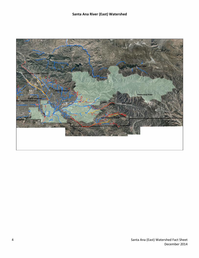
Santa Ana River (East) Watershed
4 Santa Ana (East) Watershed Fact Sheet December 2014
San Bernardino County Areawide Stormwater Program Watershed Action Plan
November 5, 2014
Santa Ana (West) Watershed Fact Sheet

The following data summary provides general watershed information. Site specific information can also be researched on the Stormwater Facility Mapping Tool (Watershed Geodatabase) found at:
http://sbcounty.permitrack.com/WAP/
Santa Ana River (West) Watershed
The Santa Ana River Sub-Watershed is located within the western edge of San Bernardino County and includes a portion of Riverside and Orange Counties, and City of Chino Hills. Chino Hills State Park is the primary watershed use.
Waterbodies Primary Tributaries Santa Ana Reach 3 (Prado Basin) Aliso Canyon Bane Canyon
Water Canyon Slaughter Canyon Abacherly Canyon
Source Waters: • Headwater locations should be checked for spring sources • There are no effluent dominated sources
Wetlands/Riparian Areas:
• There are no Riparian/Wetland areas are identified within this Watershed. • During the CEQA process, the jurisdictional delineations for riparian and wetland areas are delineated and
included into the CEQA analysis per USACOE (Section 404), Calif. Dept. of Fish and Wildlife (Section 1600) and Calif. Water Resources Control Board (Section 401) permitting requirements.
• Biological Sensitive Areas: Santa Ana River (West) Watershed contains known mapped plant and animal sensitive areas. It is typically required to analyze sites with respect to biological criteria.
o Expected Habitat: California Gnatcatcher – southwest border of subwatershed Least Bell Vireo – southeast border of subwatershed
o Potential Habitat: Coastal Sage Scrub – throughout subwatershed Riparian/Wetland – eastern border of subwatershed
o No Fish, Bird, Rodents, Expected Plants, Frogs, Snakes, Insects or Tortoise Groundwater Basins:
• Depth to Groundwater is presented on the following CBWM map http://www.cbwm.org/docs/engdocs/maps
• Per the obligations codified in the 2004 Basin Plan amendment it is regionally required to eliminate groundwater outflow to the Santa Ana River. This is the Hydraulic Control Monitoring Program and is managed through the Chino Basin Desalter Authority, the Chino Basin Watermaster and Inland Empire Utilities Agency. Areas south of the 60 Freeway must review this information.
Flood Control Measures/ Plans:
• Watershed is located within San Bernardino County Flood Control District Zone 1 (SBCFCD) and must be in compliance with current operating procedures and requirements. Please contact SBCFCD for site specific information (909-387-8104).
Drainage channels: • There are no Engineered Hardened Maintained (EHM) Channels within this watershed.
1 Santa Ana River (West) Watershed Fact Sheet December 2014
Hydrologic Conditions of Concern (HCOC):
• All development within the watershed must meet the HCOC criteria in the WQMP Manual. Recharge information: The watershed is highly managed with strict recharge criteria. Recharge management information is found at the following websites. Recharge activities within this adjudicated watershed must meet existing hydrogeologic modeling criteria and groundwater management plans. Contact information and watershed specific information is found at:
http://www.ieua.org/sustain/gw/recharge.html http://www.cbwm.org/rep_engineering.htm
http://www.cbwcd.org/129/Percolation-Basins Beneficial Uses: Dischargers must not impair these beneficial uses:
• Santa Ana River Reach 3: AGR, GWR, REC 1, REC2, WARM, WILD, RARE 303(d) Impairments:
• Santa Ana River Reach 3: Lead Approved TMDLs:
• Santa Ana River Reach 3: Copper (wet season only), Pathogen Water Quality Objectives : Discharges must not cause exceedance of the following Basin Plan Water Quality Objectives as presented in: http://www.waterboards.ca.gov/rwqcb8/water_issues/programs/basin_plan/index.shtml
Santa Ana River West
Sant
a A
na
Reac
h 3
(P
rado
Dam
to
Mis
sion
Blv
d,
Rive
rsid
e (b
ase
flow
))
BASIN PLAN Tributary Rule Waterbody Notes Exempt from MUN WAP Subwatershed Impairment, 303(d) listing Hardness 350 Sodium (mg/L) 110 Chloride (mg/L) 140 Sulfate (mg/L) 150 Nitrate, as N (mg/L) NA Floride (mg/L) NA TDS 700 COD 30 MBAS NA Total Inorganic Nitrogen 10 As (CTR) (ug/L) 340 Cd (SSO) (ug/L) 4.0
2 Santa Ana River (West) Watershed Fact Sheet December 2014
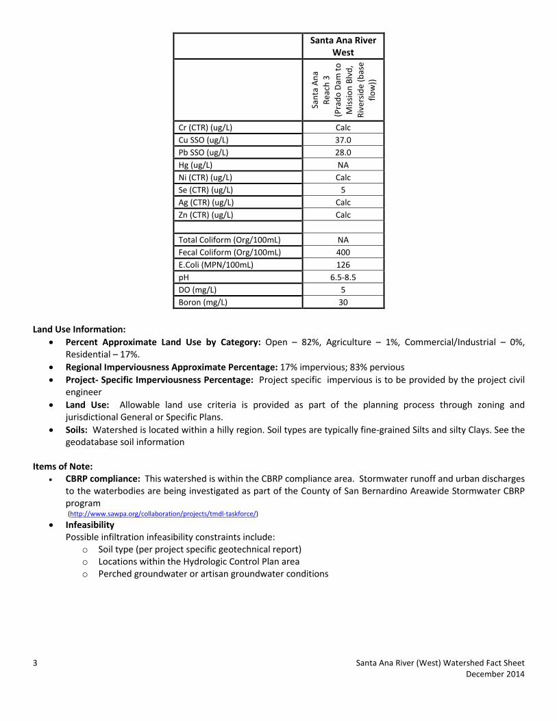
Santa Ana River West
Sant
a A
na
Reac
h 3
(P
rado
Dam
to
Mis
sion
Blv
d,
Rive
rsid
e (b
ase
flow
))
Cr (CTR) (ug/L) Calc Cu SSO (ug/L) 37.0 Pb SSO (ug/L) 28.0 Hg (ug/L) NA Ni (CTR) (ug/L) Calc Se (CTR) (ug/L) 5 Ag (CTR) (ug/L) Calc Zn (CTR) (ug/L) Calc Total Coliform (Org/100mL) NA Fecal Coliform (Org/100mL) 400 E.Coli (MPN/100mL) 126 pH 6.5-8.5 DO (mg/L) 5 Boron (mg/L) 30
Land Use Information:
• Percent Approximate Land Use by Category: Open – 82%, Agriculture – 1%, Commercial/Industrial – 0%, Residential – 17%.
• Regional Imperviousness Approximate Percentage: 17% impervious; 83% pervious • Project- Specific Imperviousness Percentage: Project specific impervious is to be provided by the project civil
engineer • Land Use: Allowable land use criteria is provided as part of the planning process through zoning and
jurisdictional General or Specific Plans. • Soils: Watershed is located within a hilly region. Soil types are typically fine-grained Silts and silty Clays. See the
geodatabase soil information Items of Note:
• CBRP compliance: This watershed is within the CBRP compliance area. Stormwater runoff and urban discharges to the waterbodies are being investigated as part of the County of San Bernardino Areawide Stormwater CBRP program (http://www.sawpa.org/collaboration/projects/tmdl-taskforce/)
• Infeasibility Possible infiltration infeasibility constraints include:
o Soil type (per project specific geotechnical report) o Locations within the Hydrologic Control Plan area o Perched groundwater or artisan groundwater conditions
3 Santa Ana River (West) Watershed Fact Sheet December 2014

Santa Ana River West Watershed
4 Santa Ana River (West) Watershed Fact Sheet December 2014

San Bernardino County Areawide Stormwater Program Watershed Action Plan
November 5, 2014
Warm Channel Watershed Fact Sheet

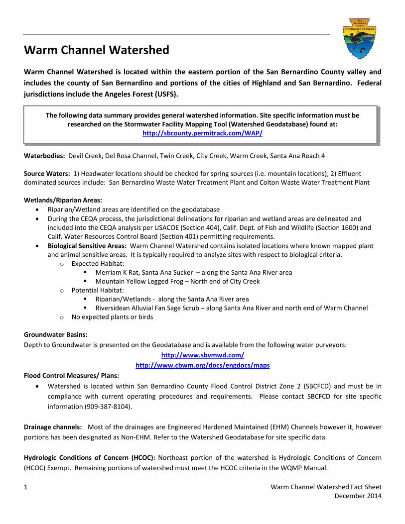
The following data summary provides general watershed information. Site specific information must be researched on the Stormwater Facility Mapping Tool (Watershed Geodatabase) found at:
http://sbcounty.permitrack.com/WAP/
Warm Channel Watershed
Warm Channel Watershed is located within the eastern portion of the San Bernardino County valley and includes the county of San Bernardino and portions of the cities of Highland and San Bernardino. Federal jurisdictions include the Angeles Forest (USFS).
Waterbodies: Devil Creek, Del Rosa Channel, Twin Creek, City Creek, Warm Creek, Santa Ana Reach 4 Source Waters: 1) Headwater locations should be checked for spring sources (i.e. mountain locations); 2) Effluent dominated sources include: San Bernardino Waste Water Treatment Plant and Colton Waste Water Treatment Plant Wetlands/Riparian Areas:
• Riparian/Wetland areas are identified on the geodatabase • During the CEQA process, the jurisdictional delineations for riparian and wetland areas are delineated and
included into the CEQA analysis per USACOE (Section 404), Calif. Dept. of Fish and Wildlife (Section 1600) and Calif. Water Resources Control Board (Section 401) permitting requirements.
• Biological Sensitive Areas: Warm Channel Watershed contains isolated locations where known mapped plant and animal sensitive areas. It is typically required to analyze sites with respect to biological criteria.
o Expected Habitat: Merriam K Rat, Santa Ana Sucker – along the Santa Ana River area Mountain Yellow Legged Frog – North end of City Creek
o Potential Habitat: Riparian/Wetlands - along the Santa Ana River area Riversidean Alluvial Fan Sage Scrub – along Santa Ana River and north end of Warm Channel
o No expected plants or birds
Groundwater Basins: Depth to Groundwater is presented on the Geodatabase and is available from the following water purveyors:
http://www.sbvmwd.com/ http://www.cbwm.org/docs/engdocs/maps
Flood Control Measures/ Plans:
• Watershed is located within San Bernardino County Flood Control District Zone 2 (SBCFCD) and must be in compliance with current operating procedures and requirements. Please contact SBCFCD for site specific information (909-387-8104).
Drainage channels: Most of the drainages are Engineered Hardened Maintained (EHM) Channels however it, however portions has been designated as Non-EHM. Refer to the Watershed Geodatabase for site specific data. Hydrologic Conditions of Concern (HCOC): Northeast portion of the watershed is Hydrologic Conditions of Concern (HCOC) Exempt. Remaining portions of watershed must meet the HCOC criteria in the WQMP Manual.
1 Warm Channel Watershed Fact Sheet December 2014
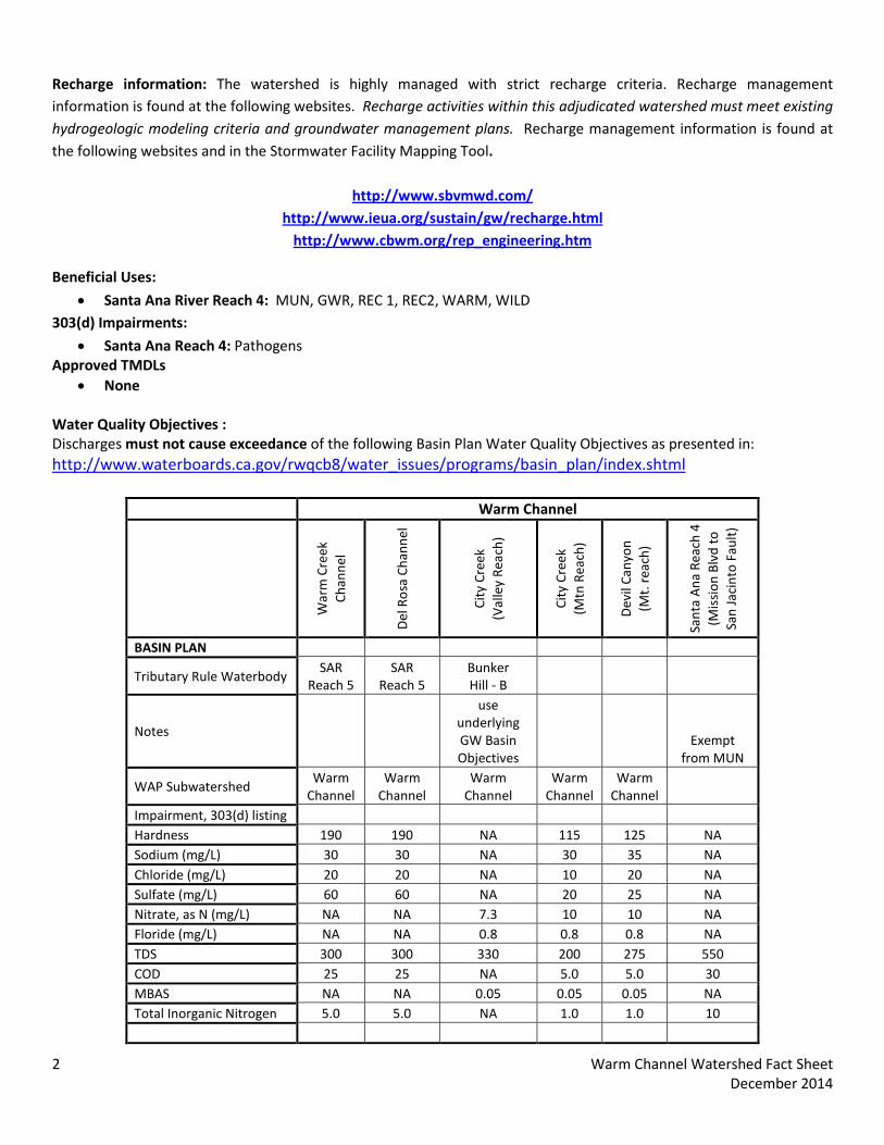
Recharge information: The watershed is highly managed with strict recharge criteria. Recharge management information is found at the following websites. Recharge activities within this adjudicated watershed must meet existing hydrogeologic modeling criteria and groundwater management plans. Recharge management information is found at the following websites and in the Stormwater Facility Mapping Tool.
http://www.sbvmwd.com/ http://www.ieua.org/sustain/gw/recharge.html
http://www.cbwm.org/rep_engineering.htm
Beneficial Uses:
• Santa Ana River Reach 4: MUN, GWR, REC 1, REC2, WARM, WILD 303(d) Impairments:
• Santa Ana Reach 4: Pathogens Approved TMDLs
• None Water Quality Objectives : Discharges must not cause exceedance of the following Basin Plan Water Quality Objectives as presented in: http://www.waterboards.ca.gov/rwqcb8/water_issues/programs/basin_plan/index.shtml
Warm Channel
War
m C
reek
Ch
anne
l
Del
Ros
a Ch
anne
l
City
Cre
ek
(Val
ley
Reac
h)
City
Cre
ek
(Mtn
Rea
ch)
Dev
il Ca
nyon
(Mt.
rea
ch)
Sant
a A
na R
each
4
(Mis
sion
Blv
d to
Sa
n Ja
cint
o Fa
ult)
BASIN PLAN
Tributary Rule Waterbody SAR
Reach 5 SAR
Reach 5 Bunker Hill - B
Notes
use underlying GW Basin Objectives
Exempt from MUN
WAP Subwatershed Warm
Channel Warm
Channel Warm
Channel Warm
Channel Warm
Channel Impairment, 303(d) listing Hardness 190 190 NA 115 125 NA Sodium (mg/L) 30 30 NA 30 35 NA Chloride (mg/L) 20 20 NA 10 20 NA Sulfate (mg/L) 60 60 NA 20 25 NA Nitrate, as N (mg/L) NA NA 7.3 10 10 NA Floride (mg/L) NA NA 0.8 0.8 0.8 NA TDS 300 300 330 200 275 550 COD 25 25 NA 5.0 5.0 30 MBAS NA NA 0.05 0.05 0.05 NA Total Inorganic Nitrogen 5.0 5.0 NA 1.0 1.0 10
2 Warm Channel Watershed Fact Sheet December 2014
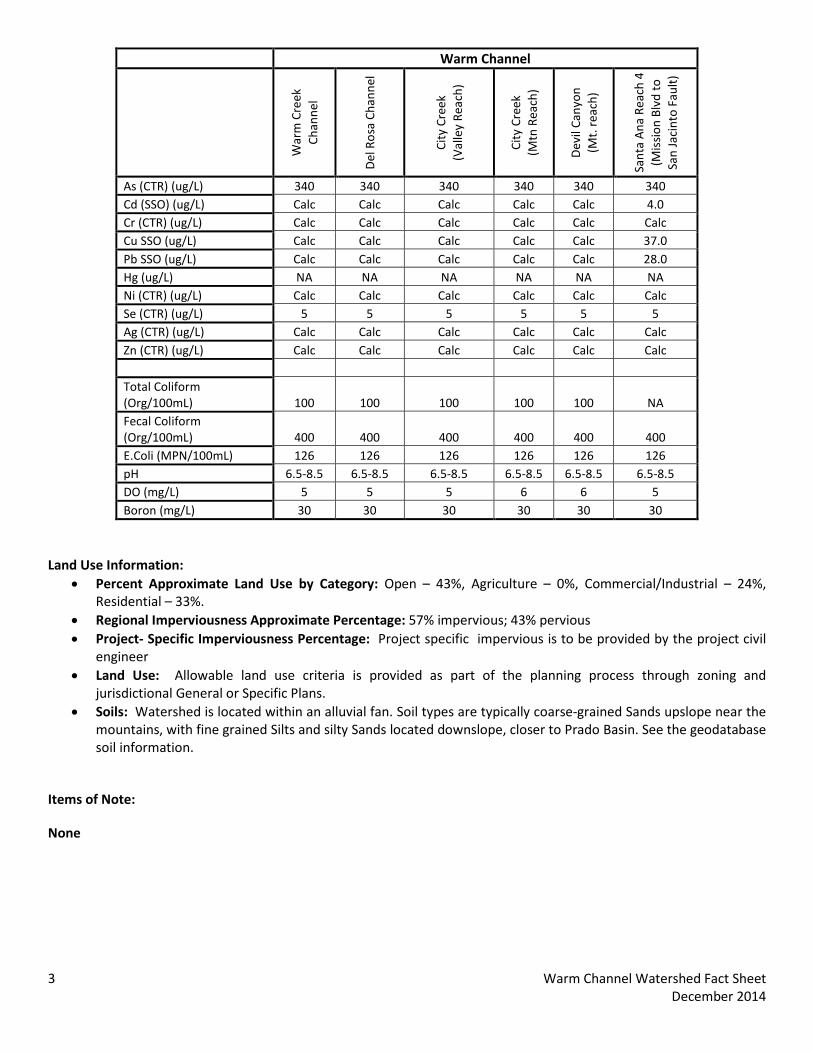
Warm Channel
War
m C
reek
Ch
anne
l
Del
Ros
a Ch
anne
l
City
Cre
ek
(Val
ley
Reac
h)
City
Cre
ek
(Mtn
Rea
ch)
Dev
il Ca
nyon
(Mt.
rea
ch)
Sant
a A
na R
each
4
(Mis
sion
Blv
d to
Sa
n Ja
cint
o Fa
ult)
As (CTR) (ug/L) 340 340 340 340 340 340 Cd (SSO) (ug/L) Calc Calc Calc Calc Calc 4.0 Cr (CTR) (ug/L) Calc Calc Calc Calc Calc Calc Cu SSO (ug/L) Calc Calc Calc Calc Calc 37.0 Pb SSO (ug/L) Calc Calc Calc Calc Calc 28.0 Hg (ug/L) NA NA NA NA NA NA Ni (CTR) (ug/L) Calc Calc Calc Calc Calc Calc Se (CTR) (ug/L) 5 5 5 5 5 5 Ag (CTR) (ug/L) Calc Calc Calc Calc Calc Calc Zn (CTR) (ug/L) Calc Calc Calc Calc Calc Calc Total Coliform (Org/100mL) 100 100 100 100 100 NA Fecal Coliform (Org/100mL) 400 400 400 400 400 400 E.Coli (MPN/100mL) 126 126 126 126 126 126 pH 6.5-8.5 6.5-8.5 6.5-8.5 6.5-8.5 6.5-8.5 6.5-8.5 DO (mg/L) 5 5 5 6 6 5 Boron (mg/L) 30 30 30 30 30 30
Land Use Information:
• Percent Approximate Land Use by Category: Open – 43%, Agriculture – 0%, Commercial/Industrial – 24%, Residential – 33%.
• Regional Imperviousness Approximate Percentage: 57% impervious; 43% pervious • Project- Specific Imperviousness Percentage: Project specific impervious is to be provided by the project civil
engineer • Land Use: Allowable land use criteria is provided as part of the planning process through zoning and
jurisdictional General or Specific Plans. • Soils: Watershed is located within an alluvial fan. Soil types are typically coarse-grained Sands upslope near the
mountains, with fine grained Silts and silty Sands located downslope, closer to Prado Basin. See the geodatabase soil information.
Items of Note:
None
3 Warm Channel Watershed Fact Sheet December 2014
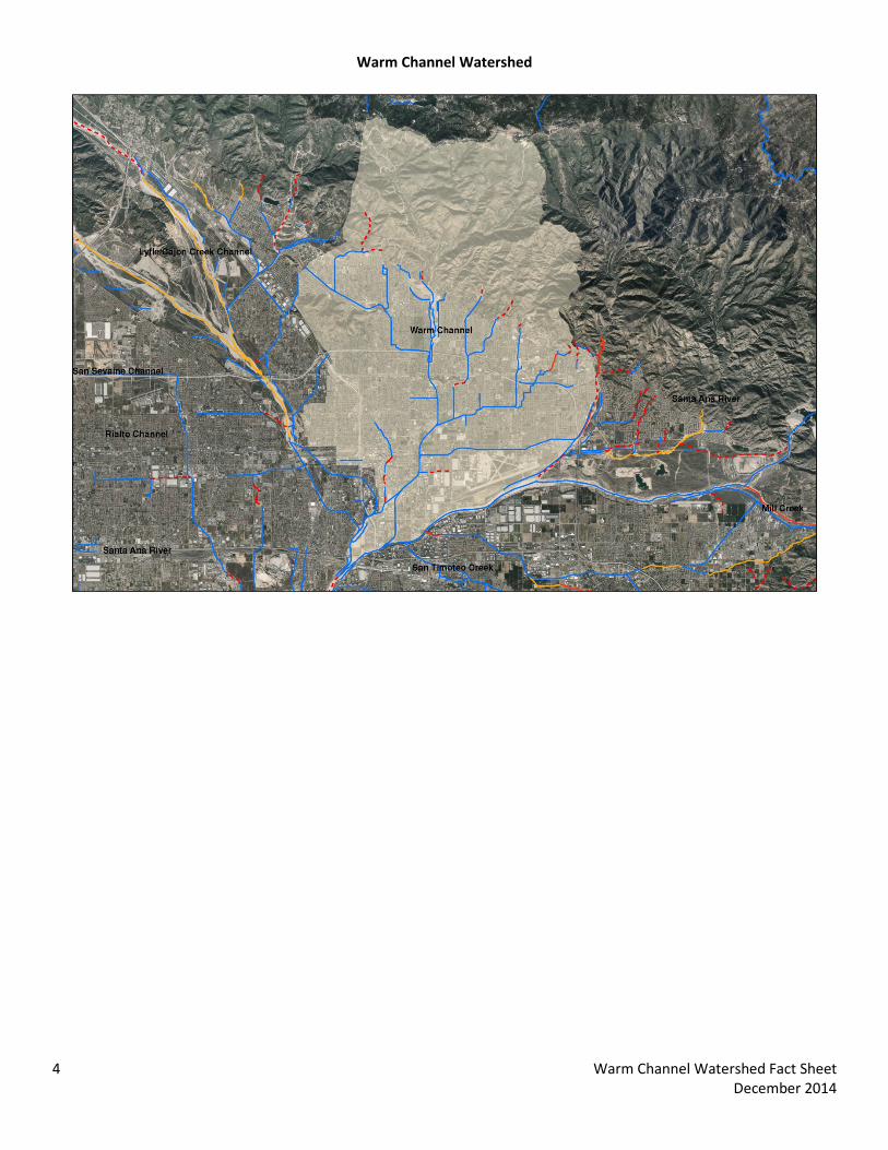
Warm Channel Watershed
4 Warm Channel Watershed Fact Sheet December 2014