Embed Size (px)
Citation preview
I-710 Corridor Project EIR/EIS
Page P-1
Appendix P CH AN G ES I N AC CE S S
I-710 Corridor Project EIR/EIS
Page P-2
This page intentionally left blank
I-710 Corridor Project EIR/EIS
Page P-3
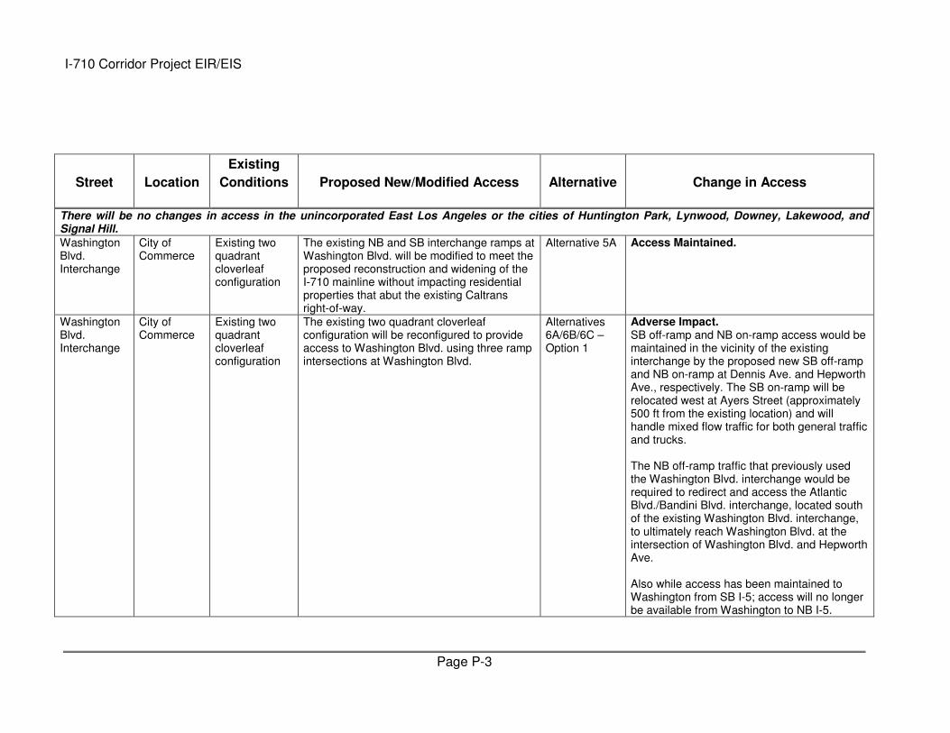
Street Location
Existing
Conditions Proposed New/Modified Access Alternative Change in Access
There will be no changes in access in the unincorporated East Los Angeles or the cities of Huntington Park, Lynwood, Downey, Lakewood, and Signal Hill.
Washington Blvd. Interchange
City of Commerce
Existing two quadrant cloverleaf configuration
The existing NB and SB interchange ramps at Washington Blvd. will be modified to meet the proposed reconstruction and widening of the I-710 mainline without impacting residential properties that abut the existing Caltrans right-of-way.
Alternative 5A Access Maintained.
Washington Blvd. Interchange
City of Commerce
Existing two quadrant cloverleaf configuration
The existing two quadrant cloverleaf configuration will be reconfigured to provide access to Washington Blvd. using three ramp intersections at Washington Blvd.
Alternatives 6A/6B/6C – Option 1
Adverse Impact. SB off-ramp and NB on-ramp access would be maintained in the vicinity of the existing interchange by the proposed new SB off-ramp and NB on-ramp at Dennis Ave. and Hepworth Ave., respectively. The SB on-ramp will be relocated west at Ayers Street (approximately 500 ft from the existing location) and will handle mixed flow traffic for both general traffic and trucks. The NB off-ramp traffic that previously used the Washington Blvd. interchange would be required to redirect and access the Atlantic Blvd./Bandini Blvd. interchange, located south of the existing Washington Blvd. interchange, to ultimately reach Washington Blvd. at the intersection of Washington Blvd. and Hepworth Ave. Also while access has been maintained to Washington from SB I-5; access will no longer be available from Washington to NB I-5.
I-710 Corridor Project EIR/EIS
Page P-4
Street Location
Existing
Conditions Proposed New/Modified Access Alternative Change in Access
Washington Blvd. Interchange
City of Commerce
Existing two quadrant cloverleaf configuration
The existing two quadrant cloverleaf configuration will be reconfigured to provide access to Washington Blvd using two ramp intersections at Washington Blvd.
Alternatives 6A/6B/6C – Option 2
Adverse Impact. SB off-ramp and NB on-ramp access would be maintained in the vicinity of the existing interchange by the proposed new SB off-ramp and NB on-ramp at Dennis Ave. and Hepworth Ave., respectively. The SB on-ramp and NB off-ramp traffic that previously used the Washington Blvd. interchange would be required to redirect. The NB off-ramp will be required to access the Atlantic Blvd./Bandini Blvd. interchange, located south of the existing Washington Blvd. interchange, to ultimately reach Washington Blvd. at the intersection of Washington Blvd. and Hepworth Ave. The SB on-ramp traffic will utilize the freight corridor entrance located [ ] of the existing SB on-ramp, will merge with SB off-ramp traffic for the Atlantic-Bandini interchange before merging onto the I-710. Also while access has been maintained to Washington from SB I-5; access will no longer be available from Washington to NB I-5.
Washington Blvd. Interchange
City of Commerce
Existing two quadrant cloverleaf configuration
The Washington Blvd. NB and SB ramps will be removed to accommodate the freight corridor/mixed-flow ramps connecting I-710 to Indiana St.
Alternative 6B – Option 3
Adverse Impact. SB off-ramp and NB on-ramp access would be maintained in the vicinity of the existing interchange by the proposed new SB off-ramp and NB on-ramp at Oak St. and Indiana St. These two ramps are proposed as mixed-flow ramps (freight connector ramps that would also allow automobile traffic). The SB on-ramp and NB off-ramp traffic that previously used the Washington Blvd. interchange would be
I-710 Corridor Project EIR/EIS
Page P-5
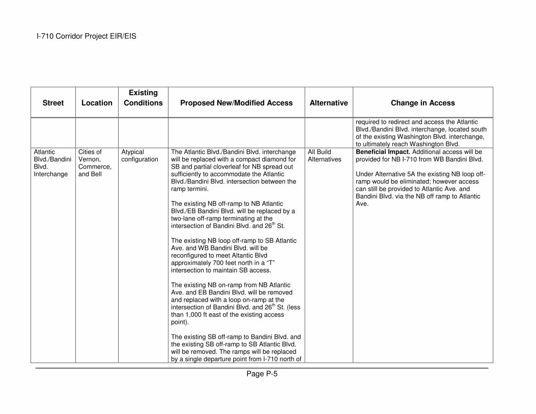
Street Location
Existing
Conditions Proposed New/Modified Access Alternative Change in Access
required to redirect and access the Atlantic Blvd./Bandini Blvd. interchange, located south of the existing Washington Blvd. interchange, to ultimately reach Washington Blvd.
Atlantic Blvd./Bandini Blvd. Interchange
Cities of Vernon, Commerce, and Bell
Atypical configuration
The Atlantic Blvd./Bandini Blvd. interchange will be replaced with a compact diamond for SB and partial cloverleaf for NB spread out sufficiently to accommodate the Atlantic Blvd./Bandini Blvd. intersection between the ramp termini. The existing NB off-ramp to NB Atlantic Blvd./EB Bandini Blvd. will be replaced by a two-lane off-ramp terminating at the intersection of Bandini Blvd. and 26
th St.
The existing NB loop off-ramp to SB Atlantic Ave. and WB Bandini Blvd. will be reconfigured to meet Altantic Blvd approximately 700 feet north in a “T” intersection to maintain SB access. The existing NB on-ramp from NB Atlantic Ave. and EB Bandini Blvd. will be removed and replaced with a loop on-ramp at the intersection of Bandini Blvd. and 26
th St. (less
than 1,000 ft east of the existing access point). The existing SB off-ramp to Bandini Blvd. and the existing SB off-ramp to SB Atlantic Blvd. will be removed. The ramps will be replaced by a single departure point from I-710 north of
All Build Alternatives
Beneficial Impact. Additional access will be provided for NB I-710 from WB Bandini Blvd. Under Alternative 5A the existing NB loop off-ramp would be eliminated; however access can still be provided to Atlantic Ave. and Bandini Blvd. via the NB off ramp to Atlantic Ave.
I-710 Corridor Project EIR/EIS
Page P-6
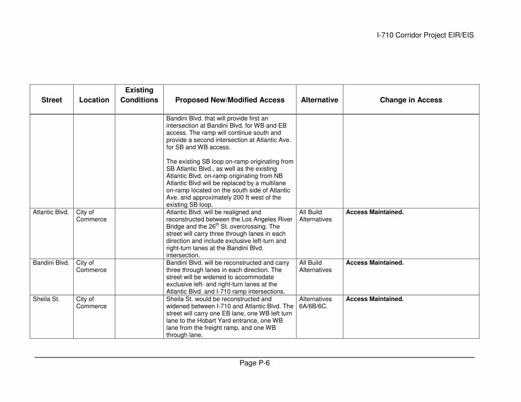
Street Location
Existing
Conditions Proposed New/Modified Access Alternative Change in Access
Bandini Blvd. that will provide first an intersection at Bandini Blvd. for WB and EB access. The ramp will continue south and provide a second intersection at Atlantic Ave. for SB and WB access. The existing SB loop on-ramp originating from SB Atlantic Blvd., as well as the existing Atlantic Blvd. on-ramp originating from NB Atlantic Blvd will be replaced by a multilane on-ramp located on the south side of Atlantic Ave. and approximately 200 ft west of the existing SB loop.
Atlantic Blvd. City of Commerce
Atlantic Blvd. will be realigned and reconstructed between the Los Angeles River Bridge and the 26
th St. overcrossing. The
street will carry three through lanes in each direction and include exclusive left-turn and right-turn lanes at the Bandini Blvd. intersection.
All Build Alternatives
Access Maintained.
Bandini Blvd. City of Commerce
Bandini Blvd. will be reconstructed and carry three through lanes in each direction. The street will be widened to accommodate exclusive left- and right-turn lanes at the Atlantic Blvd. and I-710 ramp intersections.
All Build Alternatives
Access Maintained.
Sheila St. City of Commerce
Sheila St. would be reconstructed and widened between I-710 and Atlantic Blvd. The street will carry one EB lane, one WB left turn lane to the Hobart Yard entrance, one WB lane from the freight ramp, and one WB through lane.
Alternatives 6A/6B/6C.
Access Maintained.
I-710 Corridor Project EIR/EIS
Page P-7
Street Location
Existing
Conditions Proposed New/Modified Access Alternative Change in Access
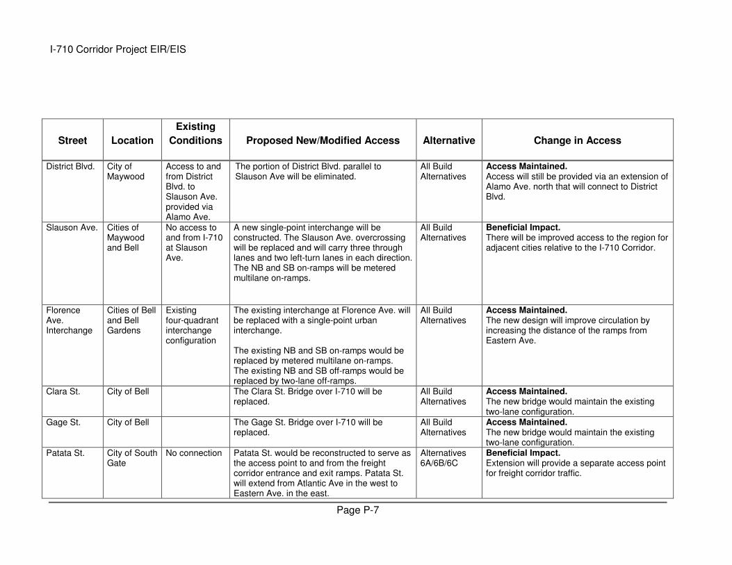
District Blvd. City of Maywood
Access to and from District Blvd. to Slauson Ave. provided via Alamo Ave.
The portion of District Blvd. parallel to Slauson Ave will be eliminated.
All Build Alternatives
Access Maintained. Access will still be provided via an extension of Alamo Ave. north that will connect to District Blvd.
Slauson Ave. Cities of Maywood and Bell
No access to and from I-710 at Slauson Ave.
A new single-point interchange will be constructed. The Slauson Ave. overcrossing will be replaced and will carry three through lanes and two left-turn lanes in each direction. The NB and SB on-ramps will be metered multilane on-ramps.
All Build Alternatives
Beneficial Impact. There will be improved access to the region for adjacent cities relative to the I-710 Corridor.
Florence Ave. Interchange
Cities of Bell and Bell Gardens
Existing four-quadrant interchange configuration
The existing interchange at Florence Ave. will be replaced with a single-point urban interchange. The existing NB and SB on-ramps would be replaced by metered multilane on-ramps. The existing NB and SB off-ramps would be replaced by two-lane off-ramps.
All Build Alternatives
Access Maintained. The new design will improve circulation by increasing the distance of the ramps from Eastern Ave.
Clara St. City of Bell The Clara St. Bridge over I-710 will be replaced.
All Build Alternatives
Access Maintained. The new bridge would maintain the existing two-lane configuration.
Gage St. City of Bell The Gage St. Bridge over I-710 will be replaced.
All Build Alternatives
Access Maintained. The new bridge would maintain the existing two-lane configuration.
Patata St. City of South Gate
No connection Patata St. would be reconstructed to serve as the access point to and from the freight corridor entrance and exit ramps. Patata St. will extend from Atlantic Ave in the west to Eastern Ave. in the east.
Alternatives 6A/6B/6C
Beneficial Impact. Extension will provide a separate access point for freight corridor traffic.

I-710 Corridor Project EIR/EIS
Page P-8
Street Location
Existing
Conditions Proposed New/Modified Access Alternative Change in Access
Existing Patata St., north of the rail right-of-way will remain for local access; however access will be restricted to only a right-turn from Atlantic Ave, to Patata St. and a right turn from Patata St. to Atlantic Ave.
Access Maintained. While direct SB access to Atlantic Ave. from Patata St. and direct EB access to Patata St. from SB Atlantic Ave. will be eliminated, traffic can use Cecilia St. and Wilcox Ave., located one block north of Patata St. and one block east of Atlantic Ave., respectively.
Firestone Blvd. Interchange
City of South Gate
Existing partial cloverleaf configuration
The existing partial cloverleaf configuration will be retained. Due to the mainline shift and widening, the interchange will be entirely reconstructed with a new overcrossing and new ramps.
All Build Alternatives
Access Maintained.
East Frontage Rd.
City of South Gate
Two-lane roadway connecting Miller Wy. and Southern Ave.
East Frontage Rd. would be realigned but would remain a two-way street with one lane in each direction. At Southern Ave., the two directions of travel will split to tie into the one-way couplet that connects to Southern Ave. Access will include:
1. WB Southern Ave. to SB East Frontage Rd.; and
2. NB East Frontage Rd. to EB Southern Ave.
All Build Alternatives
Access Maintained.
Southern Ave.
City of South Gate
No connection The new overcrossing will span the I-710 mainline, the Los Angeles River, and the frontage roads from Garfield Ave. to the east to the UPRR at-grade rail crossing to the west. Southern Ave. will carry two lanes in each direction from the overcrossing to Garfield
All Build Alternatives
Beneficial Impact. Southern Ave. will be extended, resulting in a continuous east-west roadway in the City of South Gate. Existing traffic flows between Southern Ave. and East Frontage Rd. will be maintained.
I-710 Corridor Project EIR/EIS
Page P-9
Street Location
Existing
Conditions Proposed New/Modified Access Alternative Change in Access
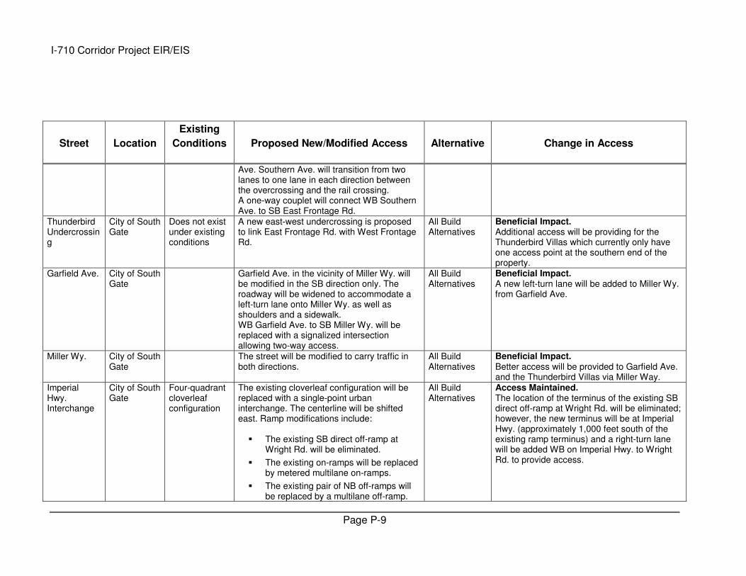
Ave. Southern Ave. will transition from two lanes to one lane in each direction between the overcrossing and the rail crossing. A one-way couplet will connect WB Southern Ave. to SB East Frontage Rd.
Thunderbird Undercrossing
City of South Gate
Does not exist under existing conditions
A new east-west undercrossing is proposed to link East Frontage Rd. with West Frontage Rd.
All Build Alternatives
Beneficial Impact. Additional access will be providing for the Thunderbird Villas which currently only have one access point at the southern end of the property.
Garfield Ave. City of South Gate
Garfield Ave. in the vicinity of Miller Wy. will be modified in the SB direction only. The roadway will be widened to accommodate a left-turn lane onto Miller Wy. as well as shoulders and a sidewalk. WB Garfield Ave. to SB Miller Wy. will be replaced with a signalized intersection allowing two-way access.
All Build Alternatives
Beneficial Impact. A new left-turn lane will be added to Miller Wy. from Garfield Ave.
Miller Wy. City of South Gate
The street will be modified to carry traffic in both directions.
All Build Alternatives
Beneficial Impact. Better access will be provided to Garfield Ave. and the Thunderbird Villas via Miller Way.
Imperial Hwy. Interchange
City of South Gate
Four-quadrant cloverleaf configuration
The existing cloverleaf configuration will be replaced with a single-point urban interchange. The centerline will be shifted east. Ramp modifications include:
� The existing SB direct off-ramp at Wright Rd. will be eliminated.
� The existing on-ramps will be replaced by metered multilane on-ramps.
� The existing pair of NB off-ramps will be replaced by a multilane off-ramp.
All Build Alternatives
Access Maintained. The location of the terminus of the existing SB direct off-ramp at Wright Rd. will be eliminated; however, the new terminus will be at Imperial Hwy. (approximately 1,000 feet south of the existing ramp terminus) and a right-turn lane will be added WB on Imperial Hwy. to Wright Rd. to provide access.
I-710 Corridor Project EIR/EIS
Page P-10
Street Location
Existing
Conditions Proposed New/Modified Access Alternative Change in Access
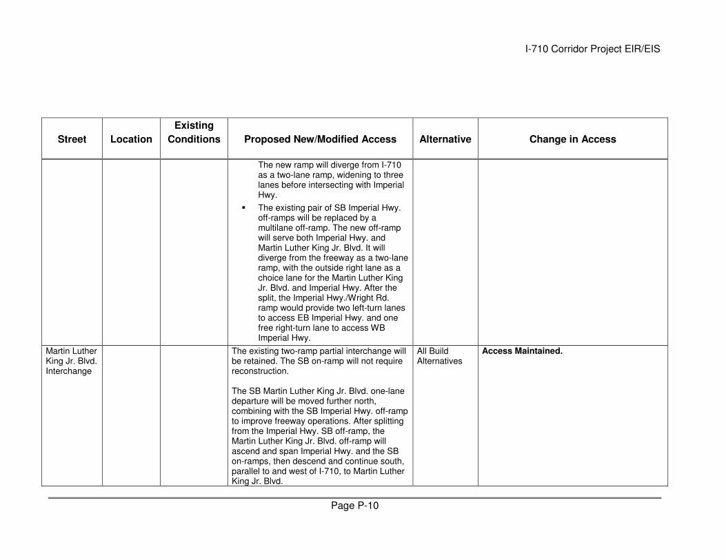
The new ramp will diverge from I-710 as a two-lane ramp, widening to three lanes before intersecting with Imperial Hwy.
� The existing pair of SB Imperial Hwy. off-ramps will be replaced by a multilane off-ramp. The new off-ramp will serve both Imperial Hwy. and Martin Luther King Jr. Blvd. It will diverge from the freeway as a two-lane ramp, with the outside right lane as a choice lane for the Martin Luther King Jr. Blvd. and Imperial Hwy. After the split, the Imperial Hwy./Wright Rd. ramp would provide two left-turn lanes to access EB Imperial Hwy. and one free right-turn lane to access WB Imperial Hwy.
Martin Luther King Jr. Blvd. Interchange
The existing two-ramp partial interchange will be retained. The SB on-ramp will not require reconstruction. The SB Martin Luther King Jr. Blvd. one-lane departure will be moved further north, combining with the SB Imperial Hwy. off-ramp to improve freeway operations. After splitting from the Imperial Hwy. SB off-ramp, the Martin Luther King Jr. Blvd. off-ramp will ascend and span Imperial Hwy. and the SB on-ramps, then descend and continue south, parallel to and west of I-710, to Martin Luther King Jr. Blvd.
All Build Alternatives
Access Maintained.
I-710 Corridor Project EIR/EIS
Page P-11
Street Location
Existing
Conditions Proposed New/Modified Access Alternative Change in Access
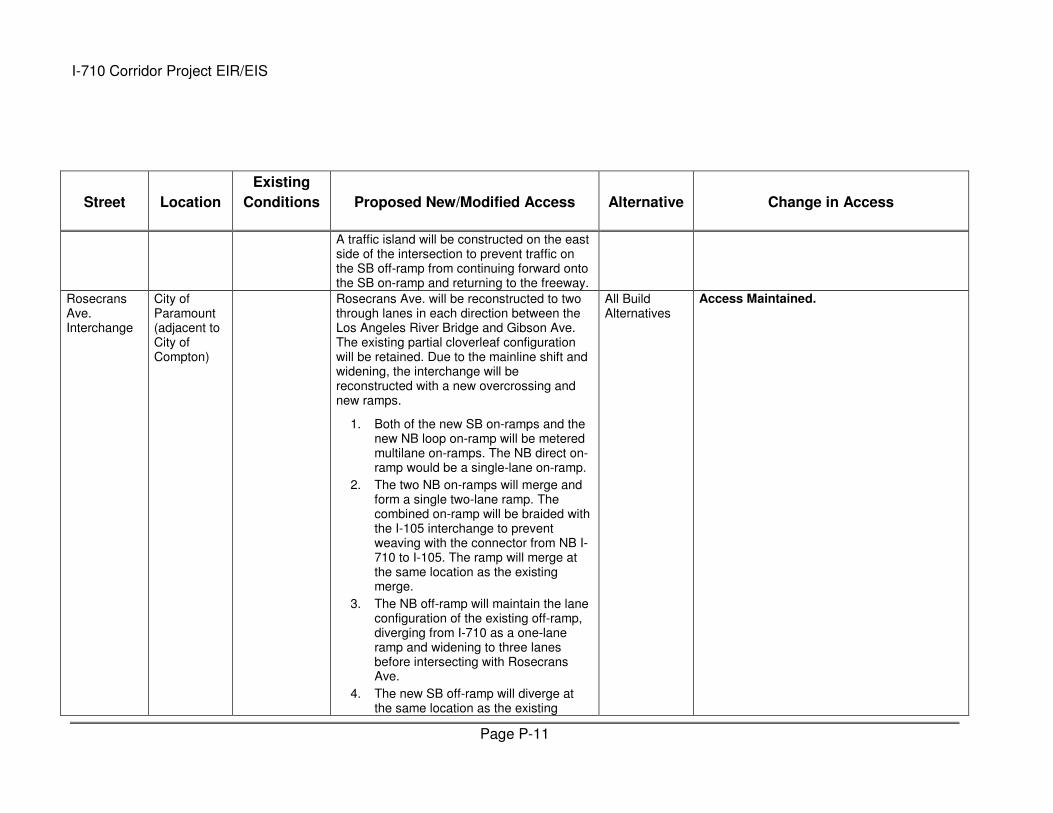
A traffic island will be constructed on the east side of the intersection to prevent traffic on the SB off-ramp from continuing forward onto the SB on-ramp and returning to the freeway.
Rosecrans Ave. Interchange
City of Paramount (adjacent to City of Compton)
Rosecrans Ave. will be reconstructed to two through lanes in each direction between the Los Angeles River Bridge and Gibson Ave. The existing partial cloverleaf configuration will be retained. Due to the mainline shift and widening, the interchange will be reconstructed with a new overcrossing and new ramps.
1. Both of the new SB on-ramps and the new NB loop on-ramp will be metered multilane on-ramps. The NB direct on-ramp would be a single-lane on-ramp.
2. The two NB on-ramps will merge and form a single two-lane ramp. The combined on-ramp will be braided with the I-105 interchange to prevent weaving with the connector from NB I-710 to I-105. The ramp will merge at the same location as the existing merge.
3. The NB off-ramp will maintain the lane configuration of the existing off-ramp, diverging from I-710 as a one-lane ramp and widening to three lanes before intersecting with Rosecrans Ave.
4. The new SB off-ramp will diverge at the same location as the existing
All Build Alternatives
Access Maintained.

I-710 Corridor Project EIR/EIS
Page P-12
Street Location
Existing
Conditions Proposed New/Modified Access Alternative Change in Access
ramp. The existing two-lane CD road alignment shared by the Martin Luther King Jr. Blvd. on-ramp will be maintained. The Rosecrans Ave. off-ramp will split off the CD road and pass below the entrance connector from I-105. The off-ramp will open to three lanes approaching the arterial/ramp.
Gibson Ave. City of Compton
A cul-de-sac roadway will be created. All Build Alternatives
Access Maintained. Direct access to Linsley St. will be eliminated. Also, the use of long driveways may continue to offer access to most of the properties along this block; however, the southernmost residences along Gibson Ave. will be either directly impacted by the ramp or will be inaccessible after construction (see relocation impact discussion for additional detail). Williams Ave. and Myrth St. could be used to connect Gibson Ave. and Linsley St. Williams Ave. is one block west of Gibson Ave. and Myrth is one block north of Linsley St..
Linsley St. City of Compton
A cul-de-sac roadway will be created. All Build Alternatives
Access Maintained. Direct access to Gibson St. will be eliminated however Williams Ave. and Myrth St. could be used to connect Gibson Ave. and Linsley St. Williams Ave. is one block west of Gibson Ave. and Myrth is one block north of Linsley St..
I-710 Corridor Project EIR/EIS
Page P-13
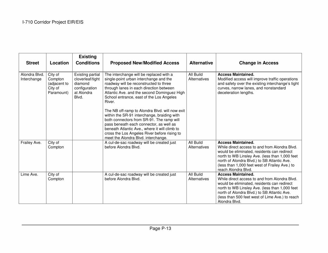
Street Location
Existing
Conditions Proposed New/Modified Access Alternative Change in Access
Alondra Blvd. Interchange
City of Compton (adjacent to City of Paramount)
Existing partial cloverleaf/tight diamond configuration at Alondra Blvd.
The interchange will be replaced with a single-point urban interchange and the roadway will be reconstructed to three through lanes in each direction between Atlantic Ave. and the second Dominguez High School entrance, east of the Los Angeles River. The NB off-ramp to Alondra Blvd. will now exit within the SR-91 interchange, braiding with both connectors from SR-91. The ramp will pass beneath each connector, as well as beneath Atlantic Ave., where it will climb to cross the Los Angeles River before rising to meet the Alondra Blvd. interchange.
All Build Alternatives
Access Maintained. Modified access will improve traffic operations and safety over the existing interchange’s tight curves, narrow lanes, and nonstandard deceleration lengths.
Frailey Ave. City of Compton
A cul-de-sac roadway will be created just before Alondra Blvd.
All Build Alternatives
Access Maintained. While direct access to and from Alondra Blvd. would be eliminated, residents can redirect north to WB Linsley Ave. (less than 1,000 feet north of Alondra Blvd.) to SB Atlantic Ave. (less than 1,000 feet west of Frailey Ave.) to reach Alondra Blvd.
Lime Ave. City of Compton
A cul-de-sac roadway will be created just before Alondra Blvd.
All Build Alternatives
Access Maintained. While direct access to and from Alondra Blvd. would be eliminated, residents can redirect north to WB Linsley Ave. (less than 1,000 feet north of Alondra Blvd.) to SB Atlantic Ave. (less than 500 feet west of Lime Ave.) to reach Alondra Blvd.
I-710 Corridor Project EIR/EIS
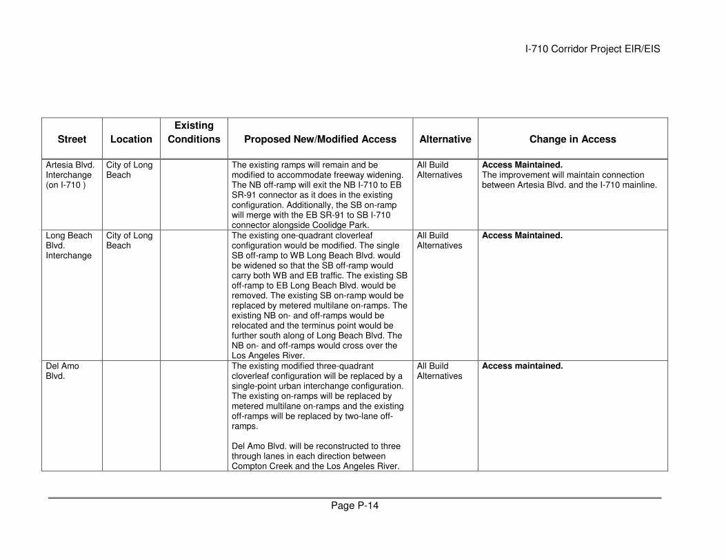
Page P-14
Street Location
Existing
Conditions Proposed New/Modified Access Alternative Change in Access
Artesia Blvd. Interchange (on I-710 )
City of Long Beach
The existing ramps will remain and be modified to accommodate freeway widening. The NB off-ramp will exit the NB I-710 to EB SR-91 connector as it does in the existing configuration. Additionally, the SB on-ramp will merge with the EB SR-91 to SB I-710 connector alongside Coolidge Park.
All Build Alternatives
Access Maintained. The improvement will maintain connection between Artesia Blvd. and the I-710 mainline.
Long Beach Blvd. Interchange
City of Long Beach
The existing one-quadrant cloverleaf configuration would be modified. The single SB off-ramp to WB Long Beach Blvd. would be widened so that the SB off-ramp would carry both WB and EB traffic. The existing SB off-ramp to EB Long Beach Blvd. would be removed. The existing SB on-ramp would be replaced by metered multilane on-ramps. The existing NB on- and off-ramps would be relocated and the terminus point would be further south along of Long Beach Blvd. The NB on- and off-ramps would cross over the Los Angeles River.
All Build Alternatives
Access Maintained.
Del Amo Blvd.
The existing modified three-quadrant cloverleaf configuration will be replaced by a single-point urban interchange configuration. The existing on-ramps will be replaced by metered multilane on-ramps and the existing off-ramps will be replaced by two-lane off-ramps. Del Amo Blvd. will be reconstructed to three through lanes in each direction between Compton Creek and the Los Angeles River.
All Build Alternatives
Access maintained.
I-710 Corridor Project EIR/EIS
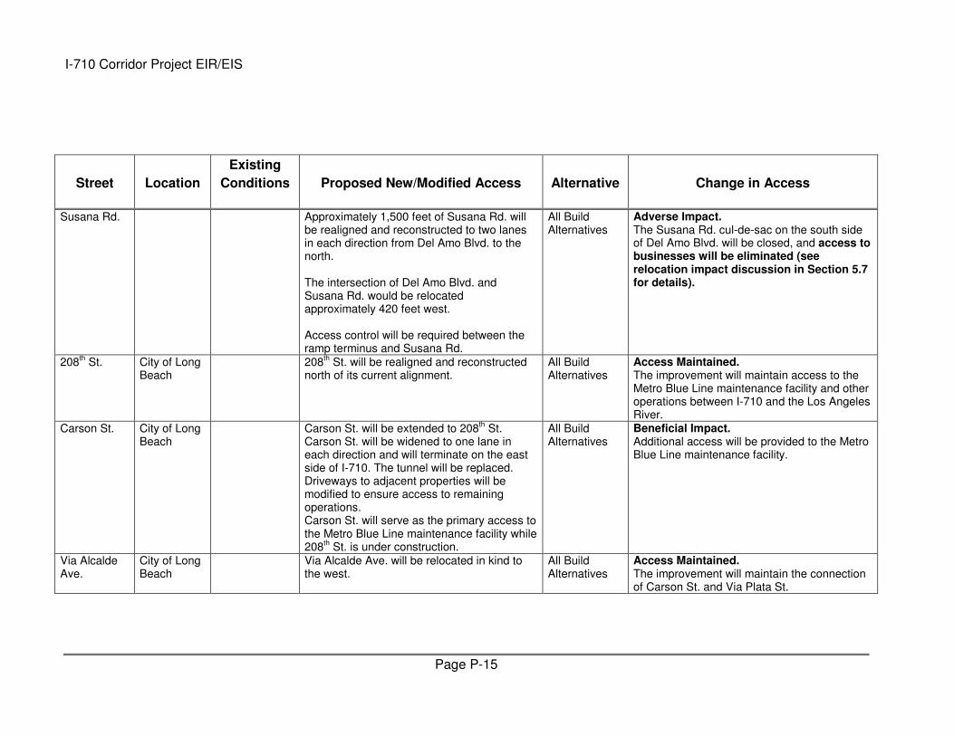
Page P-15
Street Location
Existing
Conditions Proposed New/Modified Access Alternative Change in Access
Susana Rd. Approximately 1,500 feet of Susana Rd. will be realigned and reconstructed to two lanes in each direction from Del Amo Blvd. to the north. The intersection of Del Amo Blvd. and Susana Rd. would be relocated approximately 420 feet west. Access control will be required between the ramp terminus and Susana Rd.
All Build Alternatives
Adverse Impact. The Susana Rd. cul-de-sac on the south side of Del Amo Blvd. will be closed, and access to businesses will be eliminated (see relocation impact discussion in Section 5.7 for details).
208th St. City of Long
Beach 208
th St. will be realigned and reconstructed
north of its current alignment. All Build Alternatives
Access Maintained. The improvement will maintain access to the Metro Blue Line maintenance facility and other operations between I-710 and the Los Angeles River.
Carson St. City of Long Beach
Carson St. will be extended to 208th St.
Carson St. will be widened to one lane in each direction and will terminate on the east side of I-710. The tunnel will be replaced. Driveways to adjacent properties will be modified to ensure access to remaining operations. Carson St. will serve as the primary access to the Metro Blue Line maintenance facility while 208
th St. is under construction.
All Build Alternatives
Beneficial Impact. Additional access will be provided to the Metro Blue Line maintenance facility.
Via Alcalde Ave.
City of Long Beach
Via Alcalde Ave. will be relocated in kind to the west.
All Build Alternatives
Access Maintained. The improvement will maintain the connection of Carson St. and Via Plata St.
I-710 Corridor Project EIR/EIS
Page P-16
Street Location
Existing
Conditions Proposed New/Modified Access Alternative Change in Access
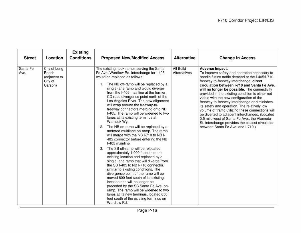
Santa Fe Ave.
City of Long Beach (adjacent to City of Carson)
The existing hook ramps serving the Santa Fe Ave./Wardlow Rd. interchange for I-405 would be replaced as follows:
1. The NB off-ramp will be replaced by a single-lane ramp and would diverge from the I-405 mainline at the former CD road divergence point north of the Los Angeles River. The new alignment will wrap around the freeway-to-freeway connectors merging onto NB I-405. The ramp will be widened to two lanes at its existing terminus at Warnock Wy.
2. The NB on-ramp will be replaced by a metered multilane on-ramp. The ramp will merge with the NB I-710 to NB I-405 connector before entering the NB I-405 mainline.
3. The SB off-ramp will be relocated approximately 1,000 ft south of the existing location and replaced by a single-lane ramp that will diverge from the SB I-405 to NB I-710 connector, similar to existing conditions. The divergence point of the ramp will be moved 600 feet south of its existing location and will no longer be preceded by the SB Santa Fe Ave. on-ramp. The ramp will be widened to two lanes at its new terminus, located 650 feet south of the existing terminus on Wardlow Rd.
All Build Alternatives
Adverse Impact. To improve safety and operation necessary to handle future traffic demand at the I-405/I-710 freeway-to-freeway interchange, direct circulation between I-710 and Santa Fe Ave. will no longer be possible. The connectivity provided in the existing condition is either not viable with the new configuration of the freeway-to-freeway interchange or diminishes its safety and operation. The relatively low volume of traffic utilizing these connections will be diverted to adjacent interchanges. (Located 0.5 mile west of Santa Fe Ave., the Alameda St. interchange provides the closest circulation between Santa Fe Ave. and I-710.)
I-710 Corridor Project EIR/EIS
Page P-17
Street Location
Existing
Conditions Proposed New/Modified Access Alternative Change in Access
4. The SB on-ramp will be relocated and replaced by a multilane metered on-ramp. The ramp will share the same terminus as the SB off-ramp. The alignment will tie into the existing alignment north of the I-710 mainline.
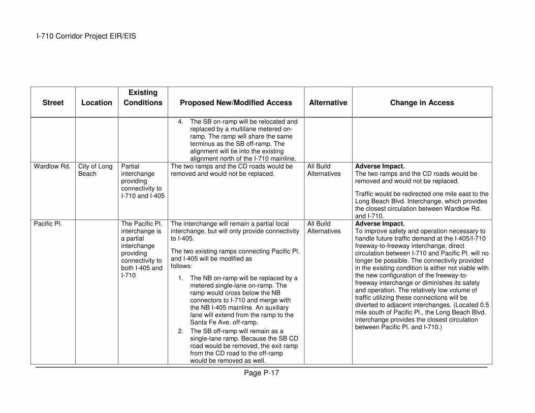
Wardlow Rd. City of Long Beach
Partial interchange providing connectivity to I-710 and I-405
The two ramps and the CD roads would be removed and would not be replaced.
All Build Alternatives
Adverse Impact. The two ramps and the CD roads would be removed and would not be replaced.
Traffic would be redirected one mile east to the Long Beach Blvd. Interchange, which provides the closest circulation between Wardlow Rd. and I-710.
Pacific Pl. The Pacific Pl. interchange is a partial interchange providing connectivity to both I-405 and I-710
The interchange will remain a partial local interchange, but will only provide connectivity to I-405.
The two existing ramps connecting Pacific Pl. and I-405 will be modified as follows:
1. The NB on-ramp will be replaced by a metered single-lane on-ramp. The ramp would cross below the NB connectors to I-710 and merge with the NB I-405 mainline. An auxiliary lane will extend from the ramp to the Santa Fe Ave. off-ramp.
2. The SB off-ramp will remain as a single-lane ramp. Because the SB CD road would be removed, the exit ramp from the CD road to the off-ramp would be removed as well.
All Build Alternatives
Adverse Impact. To improve safety and operation necessary to handle future traffic demand at the I-405/I-710 freeway-to-freeway interchange, direct circulation between I-710 and Pacific Pl. will no longer be possible. The connectivity provided in the existing condition is either not viable with the new configuration of the freeway-to-freeway interchange or diminishes its safety and operation. The relatively low volume of traffic utilizing these connections will be diverted to adjacent interchanges. (Located 0.5 mile south of Pacific Pl., the Long Beach Blvd. interchange provides the closest circulation between Pacific Pl. and I-710.)
I-710 Corridor Project EIR/EIS
Page P-18
Street Location
Existing
Conditions Proposed New/Modified Access Alternative Change in Access
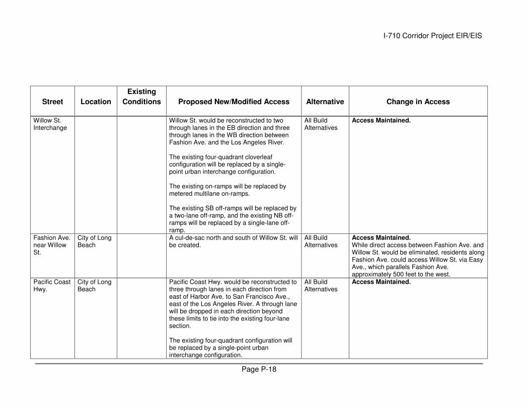
Willow St. Interchange
Willow St. would be reconstructed to two through lanes in the EB direction and three through lanes in the WB direction between Fashion Ave. and the Los Angeles River. The existing four-quadrant cloverleaf configuration will be replaced by a single-point urban interchange configuration. The existing on-ramps will be replaced by metered multilane on-ramps. The existing SB off-ramps will be replaced by a two-lane off-ramp, and the existing NB off-ramps will be replaced by a single-lane off-ramp.
All Build Alternatives
Access Maintained.
Fashion Ave. near Willow St.
City of Long Beach
A cul-de-sac north and south of Willow St. will be created.
All Build Alternatives
Access Maintained. While direct access between Fashion Ave. and Willow St. would be eliminated, residents along Fashion Ave. could access Willow St. via Easy Ave., which parallels Fashion Ave. approximately 500 feet to the west.
Pacific Coast Hwy.
City of Long Beach
Pacific Coast Hwy. would be reconstructed to three through lanes in each direction from east of Harbor Ave. to San Francisco Ave., east of the Los Angeles River. A through lane will be dropped in each direction beyond these limits to tie into the existing four-lane section. The existing four-quadrant configuration will be replaced by a single-point urban interchange configuration.
All Build Alternatives
Access Maintained.
I-710 Corridor Project EIR/EIS
Page P-19
Street Location
Existing
Conditions Proposed New/Modified Access Alternative Change in Access
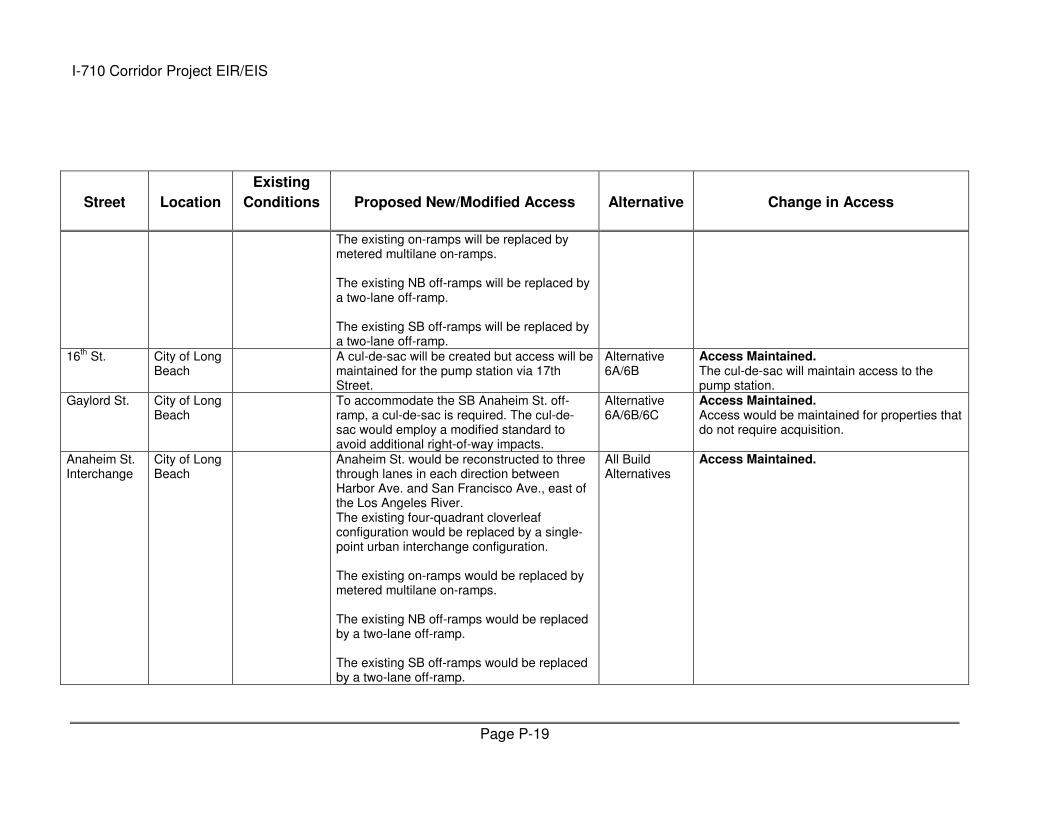
The existing on-ramps will be replaced by metered multilane on-ramps. The existing NB off-ramps will be replaced by a two-lane off-ramp. The existing SB off-ramps will be replaced by a two-lane off-ramp.
16th St. City of Long
Beach A cul-de-sac will be created but access will be
maintained for the pump station via 17th Street.
Alternative 6A/6B
Access Maintained. The cul-de-sac will maintain access to the pump station.
Gaylord St. City of Long Beach
To accommodate the SB Anaheim St. off-ramp, a cul-de-sac is required. The cul-de-sac would employ a modified standard to avoid additional right-of-way impacts.
Alternative 6A/6B/6C
Access Maintained. Access would be maintained for properties that do not require acquisition.
Anaheim St. Interchange
City of Long Beach
Anaheim St. would be reconstructed to three through lanes in each direction between Harbor Ave. and San Francisco Ave., east of the Los Angeles River. The existing four-quadrant cloverleaf configuration would be replaced by a single-point urban interchange configuration. The existing on-ramps would be replaced by metered multilane on-ramps. The existing NB off-ramps would be replaced by a two-lane off-ramp. The existing SB off-ramps would be replaced by a two-lane off-ramp.
All Build Alternatives
Access Maintained.
I-710 Corridor Project EIR/EIS
Page P-20
Street Location
Existing
Conditions Proposed New/Modified Access Alternative Change in Access
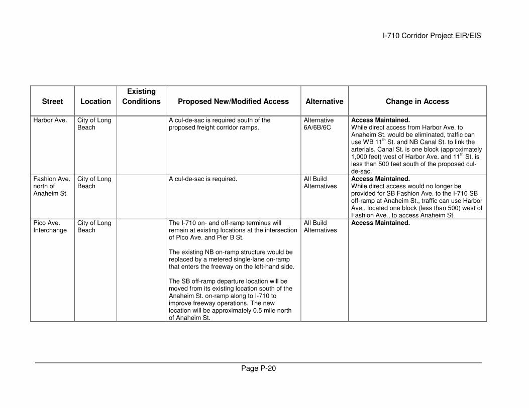
Harbor Ave. City of Long Beach
A cul-de-sac is required south of the proposed freight corridor ramps.
Alternative 6A/6B/6C
Access Maintained. While direct access from Harbor Ave. to Anaheim St. would be eliminated, traffic can use WB 11
th St. and NB Canal St. to link the
arterials. Canal St. is one block (approximately 1,000 feet) west of Harbor Ave. and 11
th St. is
less than 500 feet south of the proposed cul-de-sac.
Fashion Ave. north of Anaheim St.
City of Long Beach
A cul-de-sac is required. All Build Alternatives
Access Maintained. While direct access would no longer be provided for SB Fashion Ave. to the I-710 SB off-ramp at Anaheim St., traffic can use Harbor Ave., located one block (less than 500) west of Fashion Ave., to access Anaheim St.
Pico Ave. Interchange
City of Long Beach
The I-710 on- and off-ramp terminus will remain at existing locations at the intersection of Pico Ave. and Pier B St. The existing NB on-ramp structure would be replaced by a metered single-lane on-ramp that enters the freeway on the left-hand side. The SB off-ramp departure location will be moved from its existing location south of the Anaheim St. on-ramp along to I-710 to improve freeway operations. The new location will be approximately 0.5 mile north of Anaheim St.
All Build Alternatives
Access Maintained.
I-710 Corridor Project EIR/EIS
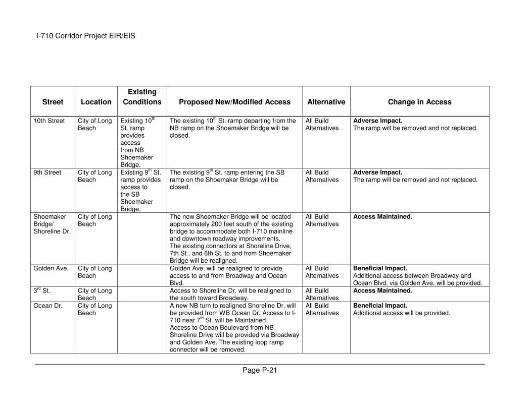
Page P-21
Street Location
Existing
Conditions Proposed New/Modified Access Alternative Change in Access
10th Street City of Long Beach
Existing 10th
St. ramp provides access from NB Shoemaker Bridge.
The existing 10th St. ramp departing from the
NB ramp on the Shoemaker Bridge will be closed.
All Build Alternatives
Adverse Impact. The ramp will be removed and not replaced.
9th Street City of Long Beach
Existing 9th St.
ramp provides access to the SB Shoemaker Bridge.
The existing 9th St. ramp entering the SB
ramp on the Shoemaker Bridge will be closed.
All Build Alternatives
Adverse Impact. The ramp will be removed and not replaced.
Shoemaker Bridge/Shoreline Dr.
City of Long Beach
The new Shoemaker Bridge will be located approximately 200 feet south of the existing bridge to accommodate both I-710 mainline and downtown roadway improvements. The existing connectors at Shoreline Drive, 7th St., and 6th St. to and from Shoemaker Bridge will be realigned.
All Build Alternatives
Access Maintained.
Golden Ave. City of Long Beach
Golden Ave. will be realigned to provide access to and from Broadway and Ocean Blvd.
All Build Alternatives
Beneficial Impact. Additional access between Broadway and Ocean Blvd. via Golden Ave. will be provided.
3rd
St. City of Long Beach
Access to Shoreline Dr. will be realigned to the south toward Broadway.
All Build Alternatives
Access Maintained.
Ocean Dr. City of Long Beach
A new NB turn to realigned Shoreline Dr. will be provided from WB Ocean Dr. Access to I-710 near 7
th St. will be Maintained.
Access to Ocean Boulevard from NB Shoreline Drive will be provided via Broadway and Golden Ave. The existing loop ramp connector will be removed.
All Build Alternatives
Beneficial Impact. Additional access will be provided.
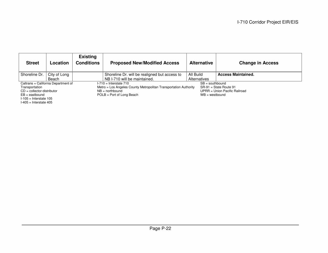
I-710 Corridor Project EIR/EIS
Page P-22
Street Location
Existing
Conditions Proposed New/Modified Access Alternative Change in Access
Shoreline Dr. City of Long Beach
Shoreline Dr. will be realigned but access to NB I-710 will be maintained.
All Build Alternatives
Access Maintained.
Caltrans = California Department of Transportation CD = collector-distributor EB = eastbound I-105 = Interstate 105 I-405 = Interstate 405
I-710 = Interstate 710 Metro = Los Angeles County Metropolitan Transportation Authority NB = northbound POLB = Port of Long Beach
SB = southbound SR-91 = State Route 91 UPRR = Union Pacific Railroad WB = westbound