Embed Size (px)
Citation preview

Appendix T2Health impact assessment


Health Impact Assessment Prepared for: Santos
December 2016

Health Impact Assessment Ref: GS/14/NCPCR001-REV. 1
Limitations
Environmental Risk Sciences has prepared this report for the use Santos in accordance with the usual care and thoroughness of the consulting profession. It is based on generally accepted practices and standards at the time it was prepared. No other warranty, expressed or implied, is made as to the professional advice included in this report.
It is prepared in accordance with the scope of work and for the purpose outlined in the Section 1 of this report.
The methodology adopted and sources of information used are outlined in this report. Environmental Risk Sciences has made no independent verification of this information beyond the agreed scope of works and assumes no responsibility for any inaccuracies or omissions. No indications were found that information contained in the reports provided by Santos and its consultants for use in this assessment was false.
This report was prepared from October 2014 to December 2016 and is based on the information provided and reviewed at that time. Environmental Risk Sciences disclaims responsibility for any changes that may have occurred after this time.
This report should be read in full. No responsibility is accepted for use of any part of this report in any other context or for any other purpose or by third parties. This report does not purport to give legal advice. Legal advice can only be given by qualified legal practitioners.

Health Impact Assessment Ref: GS/14/NCPCR001-REV. 1
Table of Contents Executive Summary ................................................................................................................... i
Section 1. Introduction .............................................................................................................. 1
1.1 General ............................................................................................................................... 1 1.2 Overview ............................................................................................................................ 1 1.3 Planning framework ............................................................................................................ 3
Section 2. Methodology ............................................................................................................. 5
2.1 General ............................................................................................................................... 5 2.2 Methodology and legislative context ................................................................................... 5 2.3 Purpose and scope of the HIA ............................................................................................ 5 2.4 Specialist/Technical reports ................................................................................................ 8 2.5 Limitations .......................................................................................................................... 8
Section 3. Project Overview ...................................................................................................... 9
3.1 General ............................................................................................................................... 9 3.2 Project location ................................................................................................................... 9 3.3 Geology and hydrology of project area ............................................................................. 12 3.4 Description of the project .................................................................................................. 16 3.5 Key Project Activities ........................................................................................................ 19 3.6 Environmental management ............................................................................................. 25
Section 4. Community Profile ................................................................................................. 26
4.1 General ............................................................................................................................. 26 4.2 Local area of interest ........................................................................................................ 26 4.3 Location of sensitive populations ...................................................................................... 28 4.4 Existing health of the community ...................................................................................... 30 4.5 Community concerns ........................................................................................................ 30
Section 5. Assessment of Potential Health Impacts - Air ..................................................... 32
5.1 Overview .......................................................................................................................... 32 5.2 Overview of specialist study .............................................................................................. 33 5.3 Potential for impacts to community health – General air quality ........................................ 34 5.4 Outcomes and Recommendations .................................................................................... 35
Section 6. Assessment of Potential Health Impacts - Water................................................. 36
6.1 General ............................................................................................................................. 36 6.2 Overview of specialist studies ........................................................................................... 37 6.3 Activities that have the potential to impact water quality ................................................... 38 6.4 Potential for drilling and well installation to impact water quality ....................................... 39 6.5 Potential for coal seam depressurisation to affect water quality ........................................ 40 6.6 Potential impacts from the use of drilling fluids ................................................................. 40

Health Impact Assessment Ref: GS/14/NCPCR001-REV. 1
6.7 Produced water ................................................................................................................ 44 6.8 Overview and recommendations....................................................................................... 49
Section 7. Assessment of Potential Health Impacts - Contamination .................................. 50
7.1 General ............................................................................................................................. 50 7.2 Overview of specialist study .............................................................................................. 51 7.3 Potential for impacts to community health ......................................................................... 51 7.4 Overview and recommendations....................................................................................... 52
Section 8. Assessment of Potential Health Impacts - Noise ................................................. 53
8.1 General ............................................................................................................................. 53 8.2 Overview of specialist study .............................................................................................. 53 8.3 Health effects of noise ...................................................................................................... 54 8.4 Potential for impacts to community health ......................................................................... 55 8.5 Outcomes and Recommendations .................................................................................... 56
Section 9. Assessment of Potential Health Impacts - Hazards ............................................. 57
9.1 General ............................................................................................................................. 57 9.2 Overview of specialist study .............................................................................................. 57 9.3 Potential for impacts on community health ........................................................................ 58 9.4 Outcomes and Recommendations .................................................................................... 58
Section 10. Assessment of Potential Health Impacts – Social and Community Cohesion... 61
Section 11. Overview and Conclusions ................................................................................... 64
Section 12. References ............................................................................................................. 66

Health Impact Assessment Ref: GS/14/NCPCR001-REV. 1
Glossary of Terms DoPI NSW Department of Planning and Infrastructure (also referenced as NSW Planning,
now NSW Department of Planning and Environment)
DTIRIS NSW Department of Trade and Investment, Regional Infrastructure and Services
EMP Environmental Management Plan
EPBC Act Environment Protection and Biodiversity Conservation Act
GAB Great Artesian Basin
GDE Groundwater dependent ecosystem
LGA Local Government Area
MBD Murray Darling Basin
NOW NSW Office of Water, now the Department of Primary Industries - Water
NSW EPA NSW Environment Protection Authority
NSW OEH NSW Office of Environment and Heritage
NGP Narrabri Gas Project
PAL Petroleum Assessment Lease
PEL Petroleum Exploration Lease
PPL Petroleum Production Lease
TEC Threatened Ecological Community
WSP Water Sharing Plan

Health Impact Assessment ES-i | P a g e Ref: GS/14/NCPCR001-REV. 1
Executive Summary The Proponent is proposing to develop natural gas from the Gunnedah Basin in New South Wales (NSW), southwest of Narrabri (refer to Figure 1-1).
The Narrabri Gas Project (the project) seeks to develop and operate a gas production field, requiring the installation of gas wells, gas and water gathering systems, and supporting infrastructure. The natural gas produced would be treated at a central gas processing facility on a local rural property (Leewood), approximately 25 kilometres south-west of Narrabri. The gas would then be piped via a high-pressure gas transmission pipeline to market. This pipeline would be part of a separate approvals process and is, therefore, not part of this development proposal.
The Secretary’s Environmental Assessment Requirements for this project do not specifically include the requirement for a health impact assessment but do include requirements to assess:
likely impacts of the development on the environment (i.e. the human environment). likely impacts of the development on surface and groundwater and water users. likely air quality impacts for the development. likely operational noise impacts of the development. likely risks to public safety.
This Technical Paper has been prepared by Environmental Risk Sciences Pty Ltd (enRiskS) to address the potential/likely impacts to health from the project in the form of a health impact assessment. The scope of this health impact assessment has been limited to discussion of the potential effects on health due to only those matters covered/introduced in the specialist studies.
Assessment Approach
The overall objective of a HIA is to provide a structured assessment of potential impacts associated with the project on the health of the surrounding community. This HIA has been conducted as a desk-top exercise in accordance with national guidelines available from the Centre for Health Equity Training, Research and Evaluation (CHETRE) and enHealth (Harris, 2007, enHealth, 2001) on the basis of the information provided in the specialist studies commissioned for the EIS and published population and health data available for the local area.
It is noted that the assessment being undertaken in this report addresses a project that is at the development phase (covering a wide range of activities – both exploration and production), and many of the positive aspects of the project are not fully known or understood. Hence this assessment has been undertaken as a screening level HIA addressing only the key issues that relate to impacts on community health identified in the specialist studies.
Outcomes of the HIA
Where the controls and environmental management measures outlined in the EIS are implemented, the assessment has not identified project related impacts that may adversely affect the health of the community. Also no additional management measures have been identified as part of this health impact assessment to further mitigate impacts from the project other than those already specified in the specialist studies.
The outcomes of the HIA are summarised in Figure ES-1.

Health Impact Assessment Ref: GS/14/NCPCR001-REV. 1
Figure ES-1 Outcomes of HIA

Health Impact Assessment 1 | P a g e Ref: GS/14/NCPCR001-REV. 1
Section 1. Introduction 1.1 General
Environmental Risk Sciences Pty Ltd (enRiskS) has been commissioned by Santos NSW (Eastern) Pty Ltd (Santos) to undertake a screening level health impact assessment (HIA) in relation to the Narrabri Gas Project (NGP) (referred to in this report as the “project”). This report details the methods and findings of the assessment.
1.2 Overview
The Proponent is proposing to develop natural gas from seams in the Gunnedah Basin in New South Wales (NSW), southwest of Narrabri (refer to Figure 1-1).
The Narrabri Gas Project (the project) seeks to develop and operate a gas production field, requiring the installation of gas wells, gas and water gathering systems, and supporting infrastructure. The natural gas produced would be treated at a central gas processing facility on a local rural property (Leewood), approximately 25 kilometres south-west of Narrabri. The gas would then be piped via a high-pressure gas transmission pipeline to market. This pipeline would be part of a separate approvals process and is therefore not part of this development proposal.
The primary objective of the project is to commercialise natural gas to be made available to the NSW gas market and to support the energy security needs of NSW. Production of natural gas under the project area would deliver material economic, environmental and social benefits to the Narrabri region and the broader NSW community. The key benefits of the project can be summarised as follows:
Development of a new source of gas supply into NSW would lead to an improvement in energy security and independence to the State. This would give NSW gas markets greater choice when entering into gas purchase arrangements. Potential would also exist for improved competition on price. Improved competition on price would have flow on benefits for NSW’s economic efficiency, productivity and prosperity.
The provision of a reduced greenhouse gas emission fuel source for power generation in NSW as compared to traditional coal-fired power generation.
Increased local production and regional economic development through employment and provision of services and infrastructure to the project.
The establishment of a regional community benefit fund equivalent to five per cent of the royalty payment made to the NSW Government within the future production licence area. If matched by the NSW Government, the fund could reach $120 million over the next two decades.


Health Impact Assessment 3 | P a g e Ref: GS/14/NCPCR001-REV. 1
1.3 Planning framework
The project is permissible with development consent under the State Environmental Planning Policy (Mining, Petroleum and Extractive Industries) 2007, and is identified as ‘State significant development’ under section 89C(2) of the Environmental Planning and Assessment Act 1979 (EP&A Act) and the State Environmental Planning Policy (State and Regional Development) 2011.
The project is subject to the assessment and approval provisions of Division 4.1 of Part 4 of the EP&A Act. The Minister for Planning is the consent authority, who is able to delegate the consent authority function to the Planning Assessment Commission, the Secretary of the Department of Planning and Environment or to any other public authority.
The project is also a controlled action under the Commonwealth Environment Protection and Biodiversity Conservation Act 1999. The project was declared to be a controlled action on 5 December 2014, to be assessed under the bilateral agreement between the Commonwealth and NSW Governments, and triggering the following controlling provisions:
listed threatened species and ecological communities a water resource, in relation to coal seam gas development and large coal mining
development Commonwealth land.
This health impact assessment (HIA) identifies the potential health issues associated with construction and operation of the project and addresses various aspects of the Secretary’s environmental assessment requirements (SEARs) for the project. The SEARs did not specifically require that a health impact assessment be prepared. Elements of a health impact assessment were, however, required as part of other key requirements list in the SEARs including:
General
an assessment of the likely impacts of the development on the environment1, focussing on the specific issues identified below, including:
− a description of the existing environment likely to be affected by the development, using sufficient baseline data;
− an assessment of the likely impacts of all stages of the development, including any cumulative impacts, taking into consideration any relevant laws, environmental planning instruments, guidelines, policies, plans and industry codes of practice;
− a description of the measures that would be implemented to mitigate and/or offset the likely impacts of the development, and an assessment of: whether these measures are consistent with industry best practice, and
represent the full range of reasonable and feasible mitigation measures that could be implemented;
the likely effectiveness of these measures; and whether contingency plans would be necessary to manage any residual risks;
1 The definition of environment in the Environmental Planning and Assessment Act (1979) is “includes all aspects of the
surroundings of humans, whether affecting any human as an individual or in his or her social groupings”.

Health Impact Assessment 4 | P a g e Ref: GS/14/NCPCR001-REV. 1
a description of the measures that would be implemented to monitor and report on the environmental performance of the development if it is approved.
Water an assessment of the likely impacts of the development on the quantity and quality of the
region’s surface and groundwater resources, having regard to the EPA’s and (then) NSW Trade and Investment’s requirements.
an assessment of the likely impacts of the development on aquifers, watercourses, riparian land, water-related infrastructure, and other water users.
Land an assessment of the likely impacts of the development on the soils and land capability of
the site and surrounds, including likely erosion and salinity impacts, having regard to (than) NSW Trade and Investment’s requirements.
Air Quality an assessment of the likely air quality impacts of the development in accordance with the
Approved Methods for the Modelling and Assessment of Air Pollutants in NSW. Noise an assessment of the likely operational noise impacts of the development (including
construction noise) under the NSW Industrial Noise Policy, paying particular attention to the obligations in chapters 8 and 9 of the policy.
Hazards including an assessment of the likely risks to public safety, paying particular attention to
potential bushfire risks and the transport, handling and use of any dangerous goods.
This assessment summarises the findings of the EIS in each of these areas.

Health Impact Assessment 5 | P a g e Ref: GS/14/NCPCR001-REV. 1
Section 2. Methodology 2.1 General
The assessment presented in this report has considered potential for adverse health effects in the community associated with environmental impacts that may be associated with the project.
The assessment conducted has drawn on impacts identified in the specialist/technical studies completed for the EIS that have the potential to adversely affect community health.
2.2 Methodology and legislative context The HIA has been generally undertaken with consideration of the following guidance (and associated references as relevant):
enHealth – Health Impact Assessment Guidelines (enHealth, 2001). enHealth - Environmental Health Risk Assessment, Guidelines for Assessing Human Health
Risks from Environmental Hazards (enHealth, 2012b, enHealth, 2012a). Harris, P., Harris-Roxas, B., Harris, E. & Kemp, L., Health Impact Assessment: A Practical
Guide, Centre for Health Equity Training, Research and Evaluation (CHETRE). Part of the UNSW Research Centre for Primary Health Care and Equity. University of New South Wales, Sydney (Harris, 2007).
National Water Quality Management Strategy (ANZECC/ARMCANZ, 2000). NEPM - Schedule B4, Guideline on Health Risk Assessment Methodology and NEPM
Schedule B5, Guideline on Ecological Risk Assessment (NEPC, 1999 amended 2013a, NEPC, 1999 amended 2013b).
These guidance documents have been endorsed by the NSW Environment Protection Authority (EPA) for the conduct of health impact assessments in NSW.
2.3 Purpose and scope of the HIA
2.3.1 General
The overall objective of the HIA is to provide a structured assessment of potential impacts associated with the project on the health of the surrounding community. A detailed HIA, conducted in accordance with the guidelines outlined in Section 2.2, is intended to identify the positive and negative impacts on community health associated with a particular project. The purpose of such a broad HIA is to provide a detailed summary in one document of all aspects of the project that have the potential to impact community health as an approach to inform all relevant stakeholders.
It is noted that the assessment being undertaken in this report addresses a project that is at the development phase (covering a wide range of activities that include both exploration and production), where many of the positive aspects of the project are not fully known or understood. Hence this assessment has been undertaken as a screening level HIA addressing only the key issues that relate to impacts on community health identified in the specialist studies.

Health Impact Assessment 6 | P a g e Ref: GS/14/NCPCR001-REV. 1
2.3.2 Definitions
Health:
The World Health Organisation defines health as “a (dynamic) state of complete physical, mental and social wellbeing and not merely the absence of disease or infirmity”.
Hence the assessment of health should include both the traditional/medical definition that focuses on illness and disease as well as the broader social definition that includes the general health and wellbeing of a population.
Health hazard:
These are aspects of the project, or specific activities that present a hazard or source of negative risk to the health or well-being.
These hazards may be associated with specific aspects of the project including:
proposed development/construction activities; operational activities; incidents; or other circumstances that have the potential to directly affect health.
In addition, some activities may have a flow-on effect that results in some impact on health. Hence health hazards may be identified on the basis of the potential for both direct and indirect effects on health.
Health impacts or outcomes:
These are the actual effects of the activity on health. These impacts or outcomes can be negative (such as injury, disease or disadvantage), or positive (such as good quality of life, physical and mental wellbeing, reduction in injury, diseases or disadvantage).
The potential for a specific activity to result in a health impact or outcome depends on:
the stressor (being the presence of a contaminant or an activity that results in a physical or social change);
whether there is the potential for the community to be exposed to the stressor; and the concentration or significance of the stressor in the community at the point of exposure.
Where these aspects cannot occur (for example there is no potential for exposure, or the concentration is well below a level associated with adverse health effects) there is no potential for adverse health impacts or outcomes to occur (i.e. no risk to health).
It is noted that where specific health impacts are considered these are also associated with a time or duration with some effects being experienced for a short period of time (acute) and other for a long period of time (chronic). The terminology relevant to acute and chronic effects is most often applied to the assessment of negative/adverse effects as these are typically the focus of technical evaluations of various aspects of the project.

Health Impact Assessment 7 | P a g e Ref: GS/14/NCPCR001-REV. 1
2.3.3 Assessment approach
The preparation of the HIA has involved the following:
Provide a summary of the key aspects of the project that are relevant to establishing if and where the community may be exposed to stressors associated with the project. This includes describing proposed controls and management measures to prevent or minimise community exposure occurring. This information is included to provide some context in relation to the potential for community exposures to occur during the various phases of the project (presented in Section 3).
Collate available information to develop a community profile of areas potentially impacted by the project. The profile includes the local community as well as the local environment. Community consultation occurred as part of the EIS process (presented in Section 4).
Review the available specialist/technical reports developed as part of the EIS relevant to the key issues identified (as listed in Section 2.4). The review presented provides an overview of the key aspects of the specialist studies that specifically relate to the potential for the project to adversely affect community health. Where mitigation measures are required to ensure that community health is protected, these measures have been summarised / provided. It is important that the mitigation measures proposed are reviewed to ensure that they adequately address the health impacts identified (presented in Sections 5 to 10).
The HIA assessment presented in this report is largely qualitative, with some aspects addressed in a quantitative manner where required.
Where required, worst case assumptions are included in the estimates of exposure. Once an estimate of exposure has been developed, it was compared to appropriate National or International health protective guidelines to determine if the project poses a risk with regard to each of the hazards. If the exposure from the project is less than the guideline, then there is no unacceptable risk. If the exposure from the project may be larger than the guideline there is potential for unacceptable risk which can be addressed by refining the worst case assumptions or by recommending additional control/management measures be included in the project (i.e. measures that are in addition to those recommended in the various technical studies to minimise exposure).
For the purpose of the HIA, the study area is defined as the communities within or in the vicinity of the project area. This includes communities within the Narrabri Local Government Area, as well as the communities within the wider region that are expected to service the project. Consistent with the economic and social impact studies, these wider regions comprise Gunnedah, Liverpool Plains, Tamworth, Uralla, Armidale Dumaresq, Glen Innes, Severn, Inverell, Gwydir, Moree Plains, Walgett, Coonamble, Gilgandra, Warrumbungle and Dubbo.

Health Impact Assessment 8 | P a g e Ref: GS/14/NCPCR001-REV. 1
2.4 Specialist/Technical reports
Table 2-1 presents a summary of the technical reports/specialist studies that formed an input into the HIA, and the technical areas of the HIA to which each study is relevant.
Table 2-1 Summary of available specialist/technical reports
Report Title Technical Areas Addressed in Report
GHD (2016a). Narrabri Gas Project – Environmental Impact Statement – Hazard and Risk Assessment
Acute hazards
GHD (2015). Narrabri Gas Project – Environmental Impact Statement – Noise and Vibration
Noise and Vibration
Air Environment Consulting (2015). Santos Narrabri Gas Project, Environmental Impact Statement, Air Quality Impact Assessment.
Air Quality
Ecological Australia (2016). Narrabri Gas Project – Managed Release Study (Bohena Creek) GHD (2016b). Narrabri Gas Project – Environmental Impact Statement – Gas field, Hydrology and Geomorphology CDM Smith (2016). Narrabri Gas Project – Groundwater Impact Assessment
Surface waters
CDM Smith (2016). Narrabri Gas Project – Groundwater Impact Assessment GHD (2016b). Narrabri Gas Project – Environmental Impact Statement – Gas field, Hydrology and Geomorphology
Groundwater
CDM Smith (2016a). Water Baseline Report GHD (2016c). Narrabri Gas Project – Environmental Impact Statement – Chapter 7 - Produced Water Management Ecological Australia (2016). Narrabri Gas Project – Managed Release Study (Bohena Creek) BeneTerra (2015). Irrigation General Concept Design, Narrabri Gas Project CDM Smith (2016). Water Monitoring Plan
Water management
EHS Support (2016). Chemical Risk Assessment Report Drilling Fluids
GHD (2016d). Narrabri Gas Project, Social Impact Assessment Santos (2016). Narrabri Gas Project Stakeholder and Community Consultation Report
Social impacts
GHD (2016e). Narrabri Gas Project – Environmental Impact Statement – Contaminated Land Assessment
Contaminated Land
GHD (2016f). Narrabri Gas Project EIS Decommissioning Report Ecological Australia (2015). Narrabri Gas Project Rehabilitation Strategy
Decommissioning and rehabilitation
2.5 Limitations The scope of this health impact assessment has been limited to discussion of the potential effects on health due to only those matters covered/introduced in the specialist studies listed in Table 2-1.
Health Impact Assessment 9 | P a g e Ref: GS/14/NCPCR001-REV. 1
Section 3. Project Overview 3.1 General This section provides a summary of the key aspects of the project that are provided in the EIS that relate to the proposed activities and locations, relevant to establishing if and where the community may be exposed to stressors associated with the project. This includes proposed controls and management measures to prevent or minimise community exposure occurring.
3.2 Project location The project is located approximately 15 kilometres (km) southwest of the township of Narrabri and approximately 56 km northwest of Gunnedah in NSW (see Figure 1-1).
The project area covers about 950 square kilometres (95,000 hectares), and the project footprint would directly impact about one per cent of that area.
The project area contains a portion of the region known as ‘the Pilliga’; which is an agglomeration of forested area covering more than 500,000 hectares in north-western NSW around Coonabarabran, Baradine and Narrabri. Nearly half of the Pilliga is allocated to conservation, managed under the NSW National Parks and Wildlife Act 1974. The Pilliga has spiritual meaning and cultural significance for the Aboriginal people of the region.
Other parts of the Pilliga were dedicated as State forest, and set aside for the purpose of ‘forestry, recreation and mineral extraction, with a strategic aim to “provide for exploration, mining, petroleum production and extractive industry” under the Brigalow and Nandewar Community Conservation Area Act 2005. The parts of the project area on state land are located within this section of the Pilliga.
The semi-arid climate of the region and general unsuitability of the soils for agriculture have combined to protect the Pilliga from widespread clearing. Commercial timber harvesting activities in the Pilliga were preceded by unsuccessful attempts in the mid-1800s to establish a wool production industry. Resource exploration has been occurring in the area since the 1960s; initially for oil, but more recently for coal and gas.
The ecology of the Pilliga has been fragmented and otherwise impacted by commercial timber harvesting and related activities over the last century through:
the establishment of more than 5,000 kilometres of roads, tracks and trails the introduction of pest species the occurrence of drought and wildfire.
The project area avoids the Pilliga National Park, Pilliga State Conservation Area, Pilliga Nature Reserve and Brigalow Park Nature Reserve. Brigalow State Conservation Area is within the project area but would be protected by a 50 metre surface exclusion zone.
Agriculture is a major land use within the Narrabri LGA; about half of the LGA is used for agriculture, split between cropping and grazing. Although the majority of the project area would be within State forests, much of the remaining area is situated on agricultural land that supports dry-land cropping and livestock. No agricultural land in the project area is mapped by the NSW Government to be biophysical strategic agricultural land (BSAL) and detailed soil analysis has established the absence

Health Impact Assessment 10 | P a g e Ref: GS/14/NCPCR001-REV. 1
of BSAL. This has been confirmed by the issue of a BSAL Certificate for the project area by the NSW Government.
Around 70 per cent of the project area is occupied by State Forests including the Pilliga East State Forest, Bibblewindi State Forest and the Jacks Creek State Forest.
State forests and conservation areas in the project area are administered under the Brigalow and Nandewar Community Conservation Area Act 2005, which designates the area as a Community Conservation Area. The purpose of the area is to reserve land for conservation, sustainable forestry and mining and other appropriate uses, while protecting areas of natural and cultural heritage significance to Aboriginal people.
Within the Community Conservation Area, there are four dedicated management zones that have defined purposes and uses. State forests in the project area (Pilliga East State Forest, Bibblewindi State Forest and Jacks Creek State Forest) are designated as Zone 4 – Forestry, recreation and mineral extraction. The Brigalow and Nandewar Community Conservation Area Agreement (NSW Environment Protection Agency 2013) states the following strategic aims for Zone 4:
Provide and encourage the use of timber, products and materials in accordance with the NSW Forestry Act 2012 and the Integrated Forestry Operations Approval for the Brigalow and Nandewar regions and, where relevant, the NSW Plantations and Reafforestation Act 1999
Conserve, promote the growth of and utilise timber in the zone to the best advantage of the State
Provide for exploration, mining, petroleum production and extractive industry in accordance with the Mining Act 1992 and the Petroleum (Onshore) Act 1991 and associated Regulations and guidelines.
The land use of the remaining portion (predominantly in the northern portion of the project area) comprises rural residential properties with associated agricultural land: irrigated agriculture - primarily cotton, intensive animal husbandry, extractive industries, dry-land cropping and pastoral – livestock.
The current land uses in the vicinity of the project area is shown in Figure 3-1.


Health Impact Assessment 12 | P a g e Ref: GS/14/NCPCR001-REV. 1
3.3 Geology and hydrology of project area The project is located within the sedimentary deposits of both the Gunnedah Basin (Permo-Triassic) which is overlain by the Surat Basin (Jurassic-Cretaceous). The Gunnedah Basin covers an area of over 15,000 square kilometres and forms the central part of the Sydney-Gunnedah-Bowen Basin system. Overlying the Gunnedah Basin is the alternating sandstone and siltstone formations of the Surat Basin, which itself forms the western province of the Great Artesian Basin (GAB).
The project will target gas from coal seam reserves including:
Bohena, Parkes, Namoi and Rutley seams within the early-Permian Maules Creek Formation.
Hoskissons seam in the late-Permian Black Jack Group.
The depth and thickness of the seams vary across the project area. Generally, the target seams are located between 500 and 1,200 metres below ground level in the project area; however, in some areas, the Hoskissons seam rises to around 300 metres below ground level. Production wells would be installed to the target seam depth.
There are a number of layers in the geological profile classified as probable negligibly transmissive units and negligibly transmissive units. These are rock layers which limit the amount of water that can move vertically.
The Surat and Gunnedah Basins consist of complex multi-layered systems of water bearing sandstones separated by predominantly shale and mudstone confining beds. Figure 3-2 presents a schematic of the project area, illustrating the stratigraphy, depths of the target coal seam and overlying aquifers, including the confining layers, and the applicable water sharing plans.
The principal groundwater sources within the project area are:
Quaternary alluvial aquifers associated with the major rivers and their tributaries, in particular:
o The Bohena Creek Alluvium, along the Bohena Creek and corresponding tributaries; o The Namoi Alluvium, including the Narrabri and Gunnedah Formations; and o Colluvium comprising locally weathered deposits that are present as perched,
disconnected groundwater resources. There are some lenses that are used for stock watering, however, they do not generally form a significant resource.
Great Artesian Basin Formations, particularly the Pilliga Sandstone.
Data on groundwater quality in these aquifers has been investigated as part of the Water Baseline Report by CDM Smith (2016a). This investigation has found that:
Groundwater within the alluvium is generally fresh (<500 milligrams per litre total dissolved solids (TDS)) to brackish
Groundwater within the primary coal bearing formations is saline (3,000 to 35,000 milligrams per litre TDS).

Health Impact Assessment 13 | P a g e Ref: GS/14/NCPCR001-REV. 1
The project is located within an area covered by a number of Water Sharing Plans (WSP). The relevant plans include:
NSW Murray-Darling Basin Porous Rock Groundwater Sources WSP NSW Murray-Darling Basin Fractured Rock Groundwater Sources WSP NSW Great Artesian Basin Groundwater Sources WSP Upper and Lower Namoi Groundwater Sources WSP WSP for Upper Namoi and Lower Namoi Regulated River Water Sources.
Beneficial uses of groundwater
Groundwater sources in the project area recognised in the NSW Water Sharing Plans include:
shallow alluvial groundwater overlaying the Great Artesian Basin (Upper and Lower Namoi Groundwater Sources)
shallow groundwater within the Pilliga Sandstone of the Great Artesian Basin (Southern Recharge Groundwater Source)
deeper groundwater within porous rocks of the Gunnedah-Oxley Basin, including the Permian and Triassic strata in the Bohena Trough (Gunnedah-Oxley Basin Groundwater Source).
Shallow groundwater sources are generally of good quality and used for a diverse range of activities. Deeper groundwater in the Gunnedah-Oxley Basin is less used due to its depth and inferior water quality, and is less accessible due to lack of transmissive strata.
Figure 3-3 shows the locations of registered groundwater wells in the project area.
The most highly accessed water bearing zones in the project area have been identified as being between 16 and 20 metres below ground level (m bgl) in sandstone, poorly cemented fine grained sand and between 29-34 m bgl in sandstone, coarse grained sand with gravelly clay.
The analysis of groundwater use in the project area was based on the PINNEENA groundwater database. The intended uses and water sources were reviewed for bores located within 30 kilometres of the project area.
All lines of evidence indicate that all registered water bores within the project area draw from the Pilliga Sandstone or overlying / shallower / younger strata.
The coal seams being targeted in this project are not beneficial aquifers, but they do contain water. The quality of the water within the coal seams is considered poor and is generally brackish to slightly salty. There is no evidence that water in the coal seams is used as a water supply source.
Between the Pilliga Sandstone and the coal seams lie multiple confining layers (aquitards) that act as barriers to the flow of water either upwards or downwards out of the Pilliga sandstone. The presence of these confining layers is confirmed by the existing differences in water quality found in the stratigraphic layers.
In relation to the potential for community exposures to stressors derived from the project, this would only occur in the event that the groundwater in the alluvial aquifers or the Pilliga sandstone were impacted in some way by chemicals (naturally occurring or involved in the process) derived from the proposed activities. The potential for this to occur is managed by the methods used to construct the wells, measures used to manage the use of fluids inside the wells and the measures used to manage chemicals and water at the ground surface (refer to Section 6.3).

Health Impact Assessment 14 | P a g e Ref: GS/14/NCPCR001-REV. 1
Figure 3-2 Schematic model that represents the stratigraphy and relevant water sharing plans within the project area (CDM Smith 2016)


Health Impact Assessment 16 | P a g e Ref: GS/14/NCPCR001-REV. 1
3.4 Description of the project
3.4.1 General
The project would involve the construction and operation of a range of exploration and production activities and infrastructure including the continued use of some existing infrastructure. The key components of the project are listed in Table 3-1.
Table 3-1 Project infrastructure components
Location Infrastructure element
Fixed locations
Leewood a central gas processing facility for the compression, dehydration and treatment of gas
a central water management facility including storage and treatment of produced water and brine
optional power generation for the project
a safety flare
treated water management infrastructure to facilitate the transfer of treated water for irrigation, dust suppression, construction and drilling activities
other supporting infrastructure including storage and utility buildings, staff amenities, equipment shelters, car parking, and diesel and chemical storage
continued use of existing facilities such as the brine and produced water ponds
operation of the facility
Bibblewindi in-field compression facility
safety flare
supporting infrastructure including storage and utility areas, treated water holding tank, and a communications tower
upgrades and expansion to the staff amenities and car parking
produced water, brine and construction water storage, including refurbishment and recommissioning of two existing ponds
continued use of existing facilities such as the 5 ML water balance tank
operation of the expanded facility
Bibblewindi to Leewood infrastructure corridor
widening of the existing corridor to allow for construction and operation of an additional buried medium pressure gas pipeline, a water pipeline, underground power (up to 132 kV), and buried communications transmission lines
Leewood to Wilga Park underground power line
installation and operation of an underground power line (up to 132 kV) within the existing gas pipeline corridor
Gas field
Gas exploration, appraisal and production infrastructure
seismic geophysical survey
installation of up to 850 new wells on a maximum of 425 well pads
– new well types would include exploration, appraisal and production wells
– includes well pad surface infrastructure
installation of water and gas gathering lines and supporting infrastructure
construction of new access tracks where required
water balance tanks
communications towers
conversion or upgrade of existing exploration and appraisal wells to production in addition to the 850 new wells

Health Impact Assessment 17 | P a g e Ref: GS/14/NCPCR001-REV. 1
Location Infrastructure element
Ancillary upgrades to intersections on the Newell Highway
expansion of worker accommodation at Westport
a treated water pipeline and diffuser from Leewood to Bohena Creek
treated water irrigation infrastructure including:
– pipeline(s) from Leewood to the irrigation area(s)
– treated water storage pond(s) offsite from Leewood
operation of the irrigation scheme
The project is expected to generate approximately 1,300 jobs during the construction phase and sustain around 200 jobs during the operational phase; the latter excluding an ongoing drilling workforce comprising approximately 100 jobs.
Subject to obtaining the required regulatory approvals, and a financial investment decision, construction of the project is expected to commence in early 2018, with first gas scheduled for 2019/2020. Progressive construction of the gas processing and water management facilities would take around three years and would be undertaken between approximately early/mid-2018 and early/mid-2021. The gas wells would be progressively drilled during the first 20 or so years of the project. For the purpose of impact assessment, a 25-year construction and operational period has been adopted.
The project activities needed to facilitate this project can be generally divided into the following:
Exploration and appraisal activities: These activities are required to help inform final well locations and could include seismic surveys, chip holes, core holes and pilot wells, associated temporary supporting infrastructure and the installation of monitoring equipment.;
Construction: Drilling and establishment of wells, gas gathering and water lines, and construction of access roads and supporting infrastructure;
Operation and Maintenance: Operation of wells, treatment of gas and water and associated maintenance activities including well workovers; and
Closure and Final Rehabilitation: Decommissioning of the project in accordance with statutory requirements and industry best practice.
The location of key infrastructure is shown on Figure 3-4.


Health Impact Assessment 19 | P a g e Ref: GS/14/NCPCR001-REV. 1
3.4.2 Locating gas wells and other gas field infrastructure
The location and siting of well pads and other gas field infrastructure would be undertaken in accordance with the project’s Field Development Protocol, which has been developed using the output of the environmental impact assessment process. The Field Development Protocol provides a framework that ensures the development of the project takes place in accordance with:
The project commitments; Relevant State and Commonwealth legislation; The environmental impacts identified in the relevant impact assessment reports that
accompany the EIS; Environmental constraints/limits identified in the impact assessment reports; Environmental management plans or procedures; and Proposed conditions of approval.
The Field Development Protocol includes the following siting constraints:
Maximum ecological disturbance limits by vegetation type and for individual threatened flora Cultural heritage including Aboriginal cultural heritage and non-indigenous heritage Watercourses and buffer width as determined by Strahler stream order Flooding and geomorphology Noise Identified sites (e.g. Yarrie Lake).
The Protocol is relevant for establishing the criteria which determine where gas field infrastructure will be located, particularly in relation to the proximity of the infrastructure to a point at which the local community may be exposed to a stressor.
It is noted that it is a legal requirement in NSW that wells be placed at least 200 m from occupied residences.
3.5 Key Project Activities
3.5.1 Extraction of natural gas from coal seams
Natural gas is present in coal seams. If left undisturbed, the gas remains in the underground coal seams attached to the surface of the coal. The coal seams are often saturated with water, and it is the pressure of the water in the coal cleats and fractures within the seams that keep the gas attached to the coal through adsorption. The reduction of pressure in the coal resulting from the extraction of water from within coal seams allows the natural gas to flow to the surface via the gas well.
The project proposes to extract gas from the coal seams by depressurisation. This is done through the extraction of water from within the seam via a gas well. The water generated from the gas field in order to extract the gas is known as produced water. Managing produced water, which is a key component of developing a gas field, is discussed further in Section 6.
How gas wells are drilled Table 3-2 provides a brief overview of the key stages involved when drilling and constructing a gas well to ensure that its integrity is maintained to protect the environment in which is it located.

Health Impact Assessment 20 | P a g e Ref: GS/14/NCPCR001-REV. 1
Table 3-2 Summary of the key steps involved when drilling a typical vertical gas well
Step 1 Step 2 Step 3 Step 4
Surface drilling occurs to allow a 14-inch steel pipe, called the conductor, to be cemented into the ground, generally to 10 to 20 metres below the surface – refer to schematic below.
This isolates loose or unconsolidated rock near the surface.
The base of the conductor is drilled out and drilling continues through the permeable strata until a suitable geological rock layer, through which substances like water and gas cannot easily pass, is encountered.
A second steel pipe, generally referred to as surface casing, typically with a diameter of 9 5/8", is set into the bottom of the hole, into the impermeable rock layer and cemented in place from top to bottom forming an additional barrier to protect the Pilliga Sandstone – refer to schematic below.
The surface casing is then pressure tested to ensure well integrity.
The base of the surface casing is drilled through by a few metres and a pressure test is undertaken again to ensure the cement is bonded to the rock and steel.
A third narrower diameter hole is drilled down to and through the target coal seams and into the rock below – refer to schematic below.
Finally, production casing, typically with a 7" diameter, is run into the base of the hole and cemented in place from bottom to surface. This forms another barrier to isolate the gas well from the shallow aquifers and other permeable formations – refer to schematic below.
The well head is installed on top of the well to allow production of natural gas and water and also allows for the safe suspension of the production during maintenance operations.
Shallow beneficial use aquifers (i.e. the Pilliga Sandstone and Namoi Alluvium aquifers) are protected by up to four barriers within the well construction: two steel and two cement barriers, as well as being protected by the relatively impermeable geology that lies between the coal seam and the beneficial use aquifers.
During well construction, water and drilling fluids are used (the potential health impacts of drilling fluids are assessed in Section 6.3). Drilling fluid is displaced and captured from the well during the

Health Impact Assessment 21 | P a g e Ref: GS/14/NCPCR001-REV. 1
pressure cementing operation. The drilling fluid is recycled until it is no longer rheologically suitable for use, where after it is disposed at an approved licensed facility.
The storage area for the components of the drilling fluids will be bunded or they will be stored on an elevated trailer. All well pads will have erosion and sediment control measures in accordance with NSW Government guidance – Managing Urban Stormwater: Soils and Construction (Landcom, 2004).
The NSW Code of Practice for Coal Seam Gas – Well Integrity, was issued by the NSW Government in September 2012. The Code of Practice establishes a best practice framework for the design, construction and maintenance of gas wells, and has undergone peer review co-ordinated by the NSW Chief Scientist and Engineer. Santos would comply with the Code of Practice should the project be approved.
Application of The Code of Practice for the project would mean that wells must be designed to ensure the safe and environmentally sound production of gas by:
preventing interconnection between hydrocarbon-bearing formations and aquifers ensuring that gas is contained within the well and associated pipework and equipment
without leakage ensuring zonal isolation between different aquifers and water bearing zones is achieved not introducing substances that may cause environmental harm.
3.5.2 Gas and water gathering system
The separate gas and water gathering lines, also known as flowlines, would consist of a network of low pressure underground high density polyethylene pipes. They link the gas wells to the field water balance tanks and in-field gas compression facility at Bibblewindi, or the central gas processing facility and the central water management facility at Leewood prior to the water being treated for beneficial reuse.
The specific location of the gathering lines will depend on the location of each gas well; themselves located using the Field Development Protocol (Appendix C of the EIS), the subsurface geology, and land access agreements. Where possible, the gas and water gathering lines will be co-located proximal to, and parallel with, existing access roads, tracks or other existing linear features such as fence lines to minimise the need for additional clearing.
3.5.3 Water management
Produced water would be treated and subsequently managed as depicted in the schematic Figure 3-5. A summary of the water management infrastructure is provided in Table 3-3.
Water management infrastructure, predominantly located at Leewood, includes produced water and brine ponds, a water treatment plant, brine treatment plant and salt crystalliser. All produced water and brine ponds would be double lined with high density polyethylene geomembrane liners and would have embankments designed to ensure adequate storage capacity and freeboard to minimise risk of overflow during heavy rain. Treated water would be amended as necessary and managed through beneficial reuse (dust suppression, stock watering, construction and irrigation) or managed release to Bohena Creek under flow conditions of at least 100 megalitres per day (as measured at the Newell Highway gauging station).

Health Impact Assessment 22 | P a g e Ref: GS/14/NCPCR001-REV. 1
Table 3-3 Proposed water management infrastructure
Water infrastructure requirements
Proposed additions/changes to current infrastructure
Three produced water / brine ponds totalling 900 ML capacity
The existing two ponds of approximately 300 ML storage capacity each would be supplemented by the construction of a third pond of the same size. Each of the three ponds would have two cells, each of approximately 150 ML capacity.
Water treatment plant
The water and brine treatment plant for the exploration and appraisal program would largely be removed and a new plant constructed. The 5 ML treated water storage tank would be retained and used in the project.
The new treatment plant would be designed to have capacity to treat up to 14 ML per day, and would likely be downsized as produced water volumes decrease over time.
Brine treatment plant / concentrator This would be a new plant with indicative capacity of up to approximately 4 ML per day.
Salt crystalliser This would be a new plant with indicative capacity of up to approximately 2 ML per day.
Beneficial reuse - irrigation
The existing supporting infrastructure such as flanges and piping at Leewood would be used in the project.
A new irrigation system for beneficial reuse of treated water would require treated water storage / balance dam(s) with a capacity of at least 200 ML on third party properties, and pipeline infrastructure to transfer the treated water from Leewood to the irrigation area or areas.
Beneficial reuse – dust suppression, drilling, construction and fire fighting
Treated water would be transferred to Bibblewindi through one of the proposed new water pipelines for beneficial reuse.
Treated water would be beneficially reused for stock watering, dust suppression, drilling, and construction in the project area and / or for firefighting.
Managed release to surface waters (Bohena Creek)
Managed release of treated water would be via a pipeline from Leewood to Bohena Creek and a diffuser in Bohena Creek at the release point.

Health Impact Assessment 23 | P a g e Ref: GS/14/NCPCR001-REV. 1
Figure 3-5 Produced water treatment and management schematic
3.5.4 Closure and rehabilitation
A Decommissioning Report (GHD 2016f) and Rehabilitation Strategy (Ecological Australia 2015) have been developed for the project.
The objectives of decommissioning and rehabilitation are:
Undertake decommissioning of assets and rehabilitation in a manner that complies with legislative requirement and approvals
Undertake decommissioning activities and rehabilitation in a manner that meets stakeholder expectations
Leave a landform that is safe, stable and non-polluting and compatible with the intended post closure land use to enable effective transfer to third parties

Health Impact Assessment 24 | P a g e Ref: GS/14/NCPCR001-REV. 1
Provide for the retention and beneficial reuse of infrastructure constructed by Santos to third parties (i.e. landholders and local authorities), where there is an appropriate agreement in place and regulatory authorities are satisfied.
To ensure topsoil and subsoil is managed to conserve the seed bank, nutrients and to encourage the establishment of vegetation.
Disturbed areas are to be rehabilitated to their pre-production condition. Forested land will be rehabilitated to its former vegetation community and agricultural land will be rehabilitated to meet the former agricultural capability class.
Establishment of a set of indicators and a rehabilitation monitoring program to ensure successful rehabilitation.
Once the wells have reached the end of their functional lives, they will be decommissioned and rehabilitated in accordance with the NSW Code of Practice for Coal Seam Gas – Well Integrity (NSW Trade & Investment, 2012) and final rehabilitation will take place. This will include removing the well head, surface infrastructure and fencing, capping the well at a minimum depth of 1.5 metres below ground level, revegetation of the lease site, and weed control.
3.5.5 Control systems
A range of operational safety mechanisms will be in place to assist with the monitoring of the project. These automated triggers would occur at different stages throughout the project life cycle and would include:
remote telemetry that monitors operating parameters and well pressure at the well head equipment and the gas and water separator
instrumentation and associated safety gauges and differential critical alarms on water storage infrastructure
pressure readings at different stages of the gas processing facility safety flares where gas treatment and compression occurs.
In addition, there would be a gas leak detection and repair program implemented plus visual observation and repair of pipelines. Isolation valves may be incorporated at certain sections throughout the pipelines to enable sections of the pipeline network to be isolated.
This risk of accidental spills of fuels or other chemicals would be managed by standard operating procedures, protocols and inductions. Bunding in accordance with Australian Standards would be installed at hydrocarbon and chemical storage facilities to contain potential spills. Refuelling would not occur within 40 metres of a watercourse, and with suitable containment when volumes greater than 50 litres are involved. The distance between major infrastructure and watercourses would also reduce the health risk of spills, with Bibblewindi approximately two kilometres distant and Leewood approximately 400 metres distant from their nearest watercourse respectively.
Emergency response and incident management plans would be developed for the project to manage health, safety and environmental incidents and emergencies. The proponent has a four-tiered response team structure for managing emergencies and incidents. Responsibilities and procedures for managing emergencies would be detailed in the Operations Emergency Response Plan. Internal management and governance standards would also be used for HSE emergency response preparedness.

Health Impact Assessment 25 | P a g e Ref: GS/14/NCPCR001-REV. 1
A Pollution Incident Response Management Plan has been developed for the current exploration and appraisal activities in the project area to manage potential environmental emergencies or incidents in accordance with the requirements of the Protection of the Environment Operations Act 1997.
The Pollution Incident Response Management Plan details responsibilities for site staff managing environmental incidents, regulatory and community notification requirements and provides details of potential pollutants and safety equipment. The Plan would be reviewed and updated to apply to the project. The proponent’s internal management and governance standards would also be used for environmental incident emergency response preparedness.
3.6 Environmental management The proponent has adopted an environment, health and safety management system that provides a structured framework for effective environmental, and health and safety practices across its activities and operations. Environmental management plans would be prepared and implemented to guide the approach to environmental management during both construction and operation, as summarised below:
A project wide environmental management plan, comprising a number of sub-plans to be used throughout the planning and design, construction, operation and decommissioning and rehabilitation stages of the project will be prepared. The sub-plans include:
o Erosion and sediment control o Soil management o Air quality o Noise and vibration o Cultural heritage o Biodiversity management o Pest, plant and animal control o Historic heritage management o Traffic management o Waste management o Bushfire management o Produced water management o Water monitoring plan o Decommissioning management o Rehabilitation strategy and plans.
Further details on individual plans/sub-plans and their proposed content is provided in Chapter 30 of the EIS.

Health Impact Assessment 26 | P a g e Ref: GS/14/NCPCR001-REV. 1
Section 4. Community Profile 4.1 General This section provides an overview of the local community who could be affected by the project and for which the HIA is being conducted. This is specifically relevant to understanding the location, age distribution and underlying health of the community.
4.2 Local area of interest As noted above, the project area is approximately 95,000 hectares, of which approximately 65,000 hectares (68 per cent of the total area) is located in state forest and reserve land, approximately 27,000 hectares (28 per cent of the total area) is agricultural land and the remaining 3,000 hectares (four per cent of the total area) is urban land, transport usage, etc. The project will use approximately one per cent of the project area.
The communities in the immediate vicinity of the project area which would provide workforce, essential social infrastructure and services, resources and networks for the project are located within the Narrabri Local Government Area (LGA). However, it is envisaged that the project will be serviced by the wider region from a point of view of supply of workforce, goods and services. Therefore, consistent with the economic and social impact studies included in the Narrabri Gas Project EIS, the following LGAs have also been considered:
Gunnedah; Liverpool Plains; Tamworth; Uralla; Armidale Dumaresq; Glen Innes Severn; Inverell; Gwydir; Moree Plains; Walgett; Coonamble; Gilgandra; Warrumbungle; and Dubbo.
The Narrabri LGA covers approximately 13,000 km2 with major activity centres at Narrabri and Wee Waa which act as service centres for the surrounding agricultural region. The LGA also consists of the town of Boggabri and the villages of Baan Baa, Bellata, Edgeroi, Gwabegar and Pilliga. The Shire is renowned for the production of some of the world’s highest quality cotton, wheat, lamb and beef. The strategic location of the Narrabri LGA has driven the development of its agriculture industries and, recently, growth in coal mining and gas exploration activity.
The town of Narrabri is the largest in the Narrabri Shire with 7,392 persons at the time of the 2011 ABS Census. The town is surrounded by agricultural land and has the Namoi River flowing through its centre.
Narrabri is the centre for business, shopping, sports and entertainment. Narrabri Hospital is the main medical service centre for Narrabri Shire (LGA) as well as the wider area. The town also has

Health Impact Assessment 27 | P a g e Ref: GS/14/NCPCR001-REV. 1
three primary schools, one secondary school, a TAFE and Narrabri Community College, a variety of shops, a library, a swimming pool, a large number of ovals, sporting fields and recreational parks, a theatre and a skate park. Narrabri is also the transport hub for the Shire as it is situated at the junction of the Newell and Kamilaroi Highways, has freight and rail services to major cities, an inland port and an airport.
The estimated resident population of Narrabri LGA in 2011 was 12,925 persons, which was a decrease of 194 persons since 2006 and 875 persons since 2001. The NSW population has experienced steady increases across the period.
The population distribution in of the Narrabri LGA, compared with NSW (based on 2011 Census Data available from the Australian Bureau of Statistics), is summarised in Figure 4-1.
Source: ABS Census 2011
Figure 4-1 Population by age group and gender – Narrabri LGA and NSW, 2011
6.9
6.6
6.6
6.7
6.7
6.9
6.8
7.0
6.9
6.9
6.8
6.0
5.7
4.4
3.4
2.5
1.9
1.4
6.4
6.0
6.1
6.1
6.3
6.8
6.8
7.1
7.1
7.0
6.8
6.1
5.6
4.4
3.5
2.8
2.5
2.6
7.7
6.9
8.0
6.3
5.2
4.9
6.0
5.8
6.8
6.9
7.3
6.7
6.4
5.5
3.7
2.7
1.6
1.4
7.8
7.2
6.7
6.5
5.0
5.4
5.8
6.6
6.3
7.2
7.2
6.1
5.7
4.7
4.2
3.0
2.5
2.2
10 5 0 5 10
0‐4 years
5‐9 years
10‐14 years
15‐19 years
20‐24 years
25‐29 years
30‐34 years
35‐39 years
40‐44 years
45‐49 years
50‐54 years
55‐59 years
60‐64 years
65‐69 years
70‐74 years
75‐79 years
80‐84 years
85 years and over
Percentage
Age Narrabri LGA Female
Narrabri LGA Male
New South WalesFemale
New South WalesMale

Health Impact Assessment 28 | P a g e Ref: GS/14/NCPCR001-REV. 1
Based on the above, the population distribution in the Narrabri LGA shows a high proportion of working age groups with 24.3 per cent in the age group of 25-44 years and 26.1 per cent in the age group of 45-64 years. The median age for Narrabri town was noted to be lower than the overall LGA at 39 years. The Narrabri LGA also has a higher proportion of Indigenous population when compared to NSW. At the time of the 2011 Census, 10.3 per cent of the Narrabri LGA population identified themselves as being of Aboriginal and/or Torres Strait Islander (Indigenous) origin or both, compared with 9.0 per cent at the time of the 2006 Census and 7.5 per cent at the time of the 2001 Census. The indigenous population was reported to be 2.4 per cent for NSW as a whole in 2011.
4.3 Location of sensitive populations The project area includes a total of 255 land titles (not all of which have dwellings) registered to 330 individuals. Sensitive receptors in the vicinity of the project area are shown on Figure 4-2, with most being rural dwellings.
In addition to the above, the Pilliga is known for its recreational features and land uses, including:
bird watching wildflower appreciation bushwalking hunting bike riding camping picnicking.
With the exception of Yarrie Lake, all other key visitor attractions fall outside the project area. The landscape elements of Yarrie Lake are highly valued by the local community and as such it has been considered a passive recreational area from a noise perspective for the project. There is a proposed ‘no go zone’ of 200 m surrounding Yarrie Lake for construction and operational activities.
Other sensitive land uses could include passive recreational areas when they are in use; however, it is noted that state forests directly surrounding activities associated with the project would not be considered sensitive as users of the state forest would be restricted for safety reasons and could also undertake passive recreation activities such as bush walking, reading and meditation at other locations within the state forest. Note that no specific tourist landmarks or places of interest have been identified within the project area.

BRIGALOW PARKNATURE RESERVE
PILLIGA EASTSTATE CONSERVATION AREA
BRIGALOWSTATE
CONSERVATIONAREA
BRIGALOW STATECONSERVATION AREA
JACKS CREEKSTATE FOREST
PILLIGA EASTSTATE FOREST
BIBBLEWINDISTATEFOREST
PILLIGA EASTSTATE FOREST
JACKS CREEKSTATE FOREST
JACKS CREEKSTATE FOREST
Westport workers' accommodation
WILLALAABORIGINALAREA
N:\AU\Sydney\Projects\21\22463\GIS\Maps\21_22463_KBM29_.mxd [KBM: 207]
LEGEND
0 3.5 71.75
Kilometers
Map Projection: Transverse MercatorHorizontal Datum: GDA 1994Grid: GDA 1994 MGA Zone 55
© 2016. Whilst every care has been taken to prepare this map, GHD, Santos and NSW LPMA make no representations or warranties about its accuracy, reliability, completeness or suitability for any particular purpose and cannot accept liability and responsibility of any kind(whether in contract, tort or otherwise) for any expenses, losses, damages and/or costs (including indirect or consequential damage) which are or may be incurred by any party as a result of the map being inaccurate, incomplete or unsuitable in any way and for any reason.
Narrabri Gas ProjectEIS Technical Appendix Health Impact Assessment
Sensitive receivers withinFigure 4-2
Job NumberRevision A
21-22463
12 Dec 2016
three kilometres of the project area
Date
Data source: NSW Department of Lands: DTDB and DCDB - 2012-13. Santos: Operational and Base Data - 2013. Created by: afoddy
Level 15, 133 Castlereagh Street Sydney NSW 2000 T 61 2 9239 7100 F 61 2 9239 7199 E [email protected] W www.ghd.com.au
Project areaLeewoodBibblewindiParks and reservesState forestAboriginal areas
Lakes and damsWatercoursesRoadsTrain lineSensitive receivers
Leewood to Wilga Park infrastructure corridorBibblewindi to Leewood infrastructure corridor
Health Impact Assessment 30 | P a g e Ref: GS/14/NCPCR001-REV. 1
4.4 Existing health of the community The health of the community is influenced by a complex range of interacting factors including age, socio-economic status, social capital, behaviours, beliefs and lifestyle, life experiences, country of origin, genetic predisposition and access to health and social care. The health impacts considered in this assessment relate to a wide range of these factors.
In relation to the existing health of the population, there is limited data available that specifically addresses the local region of Narrabri. The available health statistics provided by NSW Health for the Narrabri Local Government Area (LGA) have been reviewed, with comparison against statistics for the whole of NSW. This data indicates that the population in the Narrabri LGA has a higher rate of alcohol attributable hospitalisations, body mass attributable hospitalisations, diabetes attributable hospitalisations, cardiovascular disease deaths and death rate (all causes) when compared with the population of NSW as a whole.
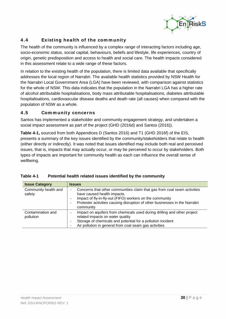
4.5 Community concerns Santos has implemented a stakeholder and community engagement strategy, and undertaken a social impact assessment as part of the project (GHD (2016d) and Santos (2016)).
Table 4-1, sourced from both Appendices D (Santos 2016) and T1 (GHD 2016f) of the EIS, presents a summary of the key issues identified by the community/stakeholders that relate to health (either directly or indirectly). It was noted that issues identified may include both real and perceived issues, that is, impacts that may actually occur, or may be perceived to occur by stakeholders. Both types of impacts are important for community health as each can influence the overall sense of wellbeing.
Table 4-1 Potential health related issues identified by the community
Issue Category Issues
Community health and safety
- Concerns that other communities claim that gas from coal seam activities have caused health impacts.
- Impact of fly-in-fly-out (FIFO) workers on the community - Protester activities causing disruption of other businesses in the Narrabri
community
Contamination and pollution
- Impact on aquifers from chemicals used during drilling and other project related impacts on water quality
- Storage of chemicals and potential for a pollution incident - Air pollution in general from coal seam gas activities

Health Impact Assessment 31 | P a g e Ref: GS/14/NCPCR001-REV. 1
Issue Category Issues
Property and livelihood - Issues related to location of project infrastructure on the property – sites and places within the local study area important to landholders and their families, issues associated with clearing of agricultural land, crops or native vegetation and issues associated with the disruption to property infrastructure such as internal property roads, tracks, creek crossings, fences and water supplies (including reticulation systems for livestock water)
- Impeded access/severance - permanent or temporary changes to existing land use, such as changes to access to some parts of the property due to construction and location of project infrastructure
- Loss of agricultural productivity and, therefore, livelihood - Potential competition for local labour required for the Narrabri Gas Project
and other industries in the region and potential increase in the cost of labour impacting on viability of agricultural activities
- Potential spread of weeds and weed seeds (by vehicles and workers) into landholder properties during construction and operation (maintenance) which may affect grazing pastures and stock
- Impact on property values - Financial gain from compensation agreements
Lifestyle, amenity and wellbeing
- Potential demand on time of the stakeholders and landholders to participate in project consultation activities (land access and acquisition activities, as well as the environmental approvals process);
- Loss of privacy due to presence of project workforce during construction and occasionally during operation;
- Safety issues due to changes to traffic conditions on internal property roads and damage to internal roads or fences during construction;
- Emotional stress and anxiety associated with certainty and timeframes of the project development;
- Changes to quiet rural lifestyle; and - Changes to visual amenity, noise levels and air quality affecting residents
and their businesses.
A number of the concerns above may result in direct and indirect impacts on community health. Specific aspects that have been addressed in the specialist’s reports are considered further in the following sections.

Health Impact Assessment 32 | P a g e Ref: GS/14/NCPCR001-REV. 1
Section 5. Assessment of Potential Health Impacts - Air
5.1 Overview This section presents a review of the activities associated with the project that have the potential to result in changes in local and regional air quality which may have impacts on community health. Poor air quality contributes to impacts on people’s health.
The scope of this assessment is limited to only those matters covered in the air quality impact assessment undertaken by Air Environmental Consulting (AEC 2015), included as Appendix L to the EIS. The review presented in this HIA provides an overview of the key aspects of the study that specifically relate to understanding the potential for the project to adversely affect community health. Where mitigation measures are required to ensure that community health is protected, these measures have been summarised/provided.
The assessment undertaken has considered the potential sources of emissions to air from the project, how these emissions may migrate from the source to the community where inhalation exposures may occur, and if the inhalation exposure pathway has the potential to be of concern. Figure 5-1 presents a summary of the exposure and health impact assessment undertaken and presented in this section.
Source Transport Mechanism
Exposure Pathway
Assessment of Potential Impact on Community Health
Emissions to air during construction: - Dust - Diesel emissions
Atmospheric dispersion
Inhalation
Air concentrations at the point of exposure in the community (sensitive receivers) are well below health based guidelines, refer to Section 5.3
Emissions to air during operations:
- Dust - Diesel Emissions - Emissions from
flares - Emissions from
generators - Emissions from
boiler and power generation at Leewood
Atmospheric dispersion
Inhalation
Air concentrations at the point of exposure in the community (sensitive receivers) are well below health based guidelines, refer to Section 5.3
Figure 5-1 Summary of potential exposure and health impacts: Air quality
Control measures (Section 3.5.5)
Management Plans (Section 3.6)

Health Impact Assessment 33 | P a g e Ref: GS/14/NCPCR001-REV. 1
5.2 Overview of specialist study The air quality impact assessment was based on a dispersion modelling study that combined the site-specific details of the project with various assumptions and estimation techniques to predict the dispersion and impact of air pollutants in the local area. This approach used air emission rates, source characteristics, local meteorology, land use, terrain and the location of sensitive receptors to assess the potential for future air quality to comply with the impact assessment criteria promulgated in the Approved Methods for the Modelling and Assessment of Air Pollutants in NSW (DEC, 2005).
Regional air quality was reviewed as part of the air quality impact assessment, based on data reported from suitable OEH air monitoring stations. The assessment found that regional air quality within the project area is mainly influenced by mining, exploration activities related to extracting gas from coal seams, and agriculture. This was supported by some site specific data collected between 10 April and 5 August 2014.
The activities that would be undertaken as part of the project have the potential to lead to a number of impacts on air quality. These potential impacts have been assessed by AEC. The main pollutants of potential concern are nitrogen oxides and particulates, both of which derive from combustion in diesel engines located at the wells, until gas becomes available to power well head generators. Particulates also arise from earthworks. These pollutants have many other sources not related to the project including petrol engines, bushfires, and other earthworks (AEC 2015).
During construction, emission sources evaluated in the Air Quality Impact Assessment include:
Combustion emissions from mobile industrial equipment and vehicles (specifically emissions from diesel engines); and
Dust generation from earthworks during construction of wells, gas gathering lines and access roads.
The key air pollutant assessed for the project construction phase was dust as total suspended particulate, PM10, PM2.5, and deposited dust.
During operations, the emission sources evaluated in the Air Quality Impact Assessment include:
Combustion emissions from diesel or dual (gas/diesel) engines in mobile equipment (such as drill rigs, generators and pumps) and vehicles;
Flares – up to six pilot well flares (as required) and one safety flare at both Bibblewindi and Leewood;
Operation of boiler and (optional) power generation facility at Leewood; and Dust generation from unsealed roads.
The key air pollutants assessed for the project operations phase were nitrogen dioxide from gas and diesel fuel combustion emissions associated with power generation, gas flaring and well head pumps. Other minor contaminants include fine particles and volatile organic compounds.
The assessment conducted noted that a wide range of best practice control measures are proposed for the minimisation of emissions to air from the project.
Ground-level pollutant concentrations associated with the project were predicted throughout the project area, where the community may be exposed via inhalation. Section 5.3.1 provides further detail on the potential for health impacts from these emissions.

Health Impact Assessment 34 | P a g e Ref: GS/14/NCPCR001-REV. 1
5.3 Potential for impacts to community health – General air quality Australia has a National Environment Protection Measure (NEPC, 2003, NEPC, 2004) for ambient air quality which includes a series of goals for various pollutants for the protection of human health. The criteria listed in the NSW EPA guidance are based on achieving the goals outlined in the National Environment Protection Measure. A project is considered to not have significant air quality impacts if the emissions from the development contribute concentrations of these pollutants which are only a small fraction of the goals for regional air quality and/or local air quality remains in compliance with the National Goals.
Construction
During construction the air quality impact assessment focused on the generation of dust, in particular PM10. The assessment determined distances from construction sites at which the relevant air quality criteria would be met.
The assessment found that ground level concentrations of dust associated with the Leewood and Bibblewindi sites are predicted to be below the relevant assessment criteria at all relevant sensitive receivers with the exception of one receiver near Leewood who could be impacted by dust under some atypical weather conditions. The wind would need to be north-westerly which is relatively infrequent. The modelling has assumed that there is limited vegetation between Leewood and the receiver which is not the case so the modelling will be an overestimate of likely dust levels. Additional mitigation and management measures (like more frequent dust suppression) can be used if required.
Distances were calculated at which emissions would be within air quality criteria. A distance of 30 metres would be sufficient for construction of access tracks and trenching, while 60 metres would be sufficient for construction of well pads. Where access track construction requires cut and fill earthworks, emissions may disperse further but were predicted to be within air quality criteria at around 140 metres from construction activities. These distances could be reduced through implementation of additional mitigation and management measures.
In most cases, the distance between sensitive receivers and construction sites would be sufficient to achieve compliance with the relevant air quality criteria. Where necessary, further mitigation measures could be implemented to ensure the relevant air quality criteria are met. All reasonable and feasible measures would be implemented to ensure that project emissions would not exceed the relevant air quality criteria at occupied residences on private land.
Operation
During the operational phase of the project, the assessment focused on emissions of nitrogen dioxide, carbon monoxide, particulate matter (PM10/PM2.5), ozone as well as acrolein, formaldehyde and acetaldehyde (volatile organic compounds) and polycyclic aromatic hydrocarbons (PAHs) associated with the operation of the Leewood gas processing and power generation facility. The assessment was undertaken in accordance with NSW guidance (DEC, 2005). The assessment found that the facility was predicted to meet all relevant impact assessment criteria outside the boundary as required.

Health Impact Assessment 35 | P a g e Ref: GS/14/NCPCR001-REV. 1
The operation of generators (gas and/or diesel powered) at well pads has also been evaluated, with focus on the assessment of emissions of nitrogen dioxide. The predicted ground level concentrations were well below the air quality impact assessment criterion and hence no additional separation beyond the boundary of the well pad was identified as being required to ensure compliance.
The operation of a safety flare at both Leewood and Bibblewindi, and up to six pilot flares at appraisal well pads was also assessed, with the assessment considering impacts of nitrogen dioxide, carbon monoxide, acetylene, ethane, propane and propylene. The impacts predicted from the operation of flares at these locations was well below the ambient air quality impact assessment criteria adopted and were considered to be negligible.
5.4 Outcomes and Recommendations The potential for impacts on community health from the project associated with changes in air quality, as evaluated in the air impact assessment, in the project area are estimated to be negligible.
All emissions associated with the project’s construction and operational phases are predicted to be well below the air quality impact assessment criteria for the protection of human health at sensitive receiver locations including during all non-routine flaring operations.
All reasonable and feasible measures would be implemented to ensure that project emissions would not exceed the relevant air quality criteria at occupied residences on private land. The following best practice control measures, as outlined in the EIS, should be implemented during construction and operation of the project to ensure this remains the case:
Implement appropriate measures for dust prevention and suppression; Implement a leak detection and repair system for all relevant components of plant and
equipment; Selection of well pad generator engines that meet NSW emission standards; and Operate plant and equipment in accordance with relevant NSW emission standards.
An air quality management plan would be implemented during construction and operation of the project to achieve these outcomes. The plan would include an air quality monitoring program and a suite of measures that could be implemented to avoid, mitigate and manage potential air impacts.
No additional management measures have been identified as being required in relation to air quality.

Health Impact Assessment 36 | P a g e Ref: GS/14/NCPCR001-REV. 1
Section 6. Assessment of Potential Health Impacts - Water
6.1 General This section presents a review of the activities associated with the project that have the potential to result in impacts on water quality, specifically groundwater and surface water. The section discusses whether these impacts have the potential to occur and if they did whether they would be associated with adverse community health outcomes and whether mitigation measures are required.
The scope of this assessment is limited to only those matters covered in the following specialist studies which were undertaken to address the Secretary’s environmental assessment requirements for the project in relation to groundwater, surface water and water management, as listed in Table 2-1.
The assessment undertaken has considered the potential sources of impacts to water quality from the project, how these impacts may migrate to a point where the community may be exposed, what, if any, exposure pathways may be relevant, and whether these exposures have the potential to be of concern. Figure 6-1 presents a summary of the exposure and health impact assessment undertaken and presented in this section.

Health Impact Assessment 37 | P a g e Ref: GS/14/NCPCR001-REV. 1
Source/Activity Transport Mechanism
Exposure Pathway
Assessment of Potential Impact on Community Health
Well installation Depressurisation of coal seam
Interconnection of groundwater sources.
No exposure pathways as no impacts to beneficial use aquifers, refer to Section 6.4 and 6.5
Drilling fluids (used in drilling activities)
Surface spill and runoff to water body and/or infiltration to shallow groundwater
No exposure pathways no impacts to surface water or groundwater quality, refer to Section 6.6.3
Loss to formation during drilling and migration in groundwater
Extraction for beneficial use - Ingestion - Dermal contact
Impacts contained within immediate vicinity of well. No impacts exceeding health based guidelines would be present in bores/watercourses, refer to Section 6.6.4
Leaks of produced water from pipelines, tanks and ponds
Runoff to surface water and/or infiltration to shallow groundwater
Use of surface water body or extraction of groundwater for beneficial use - Ingestion - Dermal contact
Conducted conservative assessment of produced water quality. No concentrations exceed health based guidelines regardless of exposure, refer to Section 6.7
Accidental spills of fuels or other chemicals
Runoff to surface water and/or infiltration to shallow groundwater
Very unlikely to result in impacts to human health given control measures detailed in Section 3.5.5
6.2 Overview of specialist studies The groundwater impact assessment details the existing groundwater systems (including water quality) and presents a conceptual hydrogeological model of the area. A numerical groundwater flow model was also developed to assess the potential impacts of the project on groundwater resources including whether the project might cause a possible lowering of the water table and, if that was possible, what impact that might have on surface water ecosystems due to the potential loss of groundwater contribution to the surface water systems.
Information on groundwater quality, surface water quality, produced water quality and issues associated with construction and flooding (on surface water quality) and the proposed discharge of treated water to Bohena Creek have been addressed in other relevant specialist studies.
Control measures (Section 3.5.5)
Management Plans (Section 3.6)
Figure 6-1 Summary of potential exposure and health impacts: Water quality

Health Impact Assessment 38 | P a g e Ref: GS/14/NCPCR001-REV. 1
It is noted that there are a number of localised activities associated with construction and operation that have the potential to result in impacts to surface water if they are not properly managed. These activities and potential impacts are the same as would occur on all construction projects where heavy vehicles are used and there are some earthworks being undertaken close to surface water bodies. Such activities and potential impacts can be effectively managed through the implementation of mitigation measures as outlined in the management plans (refer to Section 3.6).
6.3 Activities that have the potential to impact water quality For activities undertaken as part of the project to adversely affect the quality of water such that it may adversely affect community health, the activities must be able to impact the quality of shallow groundwater (that is extracted and used for a range of purposes that include drinking water, irrigation and stock watering) or surface water (in areas where the community may access and potentially use the water).
Based on the information available about the proposed activities and the geology and hydrology of the project area, shallow groundwater and surface water may only be impacted where the following occurs:
Interconnection of groundwater sources during the installation of gas wells (further discussed in Section 6.4);
Depressurisation of target coal seams resulting in the migration of groundwater between formations leading to potential associated changes to surface water systems (via changes in quality and volume of groundwater discharges to surface water) (further discussed in Section 6.5);
Impact of drilling fluids on groundwater quality and surface water (in the event of an uncontrolled discharge at the surface) (further discussed in Section 6.6);
Drilling fluids lost to the formation during drilling activities (further discussed in Section 6.6); Leaks of produced water or brine from pipelines, water balance tanks or ponds which may
impact surface water (where runoff occurs to these water bodies) or groundwater (following infiltration) (further discussed in Section 6.7); and
Migration of salts deposited in the irrigation area. Impacts to human health are very unlikely given the quality of the water to be used in irrigation, site selection, adherence to an irrigation management plan and ongoing monitoring typical of irrigation schemes.
The potential for health impacts to occur depends on:
Whether the contaminants can escape containment and migrate to groundwater, surface water, air or soil where the community may be exposed (i.e. reach water, air or soil to which the community may come into contact);
The concentration of contaminants at the point where exposure may occur; and That exposure to the community actually occurs.

Health Impact Assessment 39 | P a g e Ref: GS/14/NCPCR001-REV. 1
6.4 Potential for drilling and well installation to impact water quality
All registered groundwater extraction bores in the project area target the Pilliga Sandstone or overlying aquifers. These aquifers are separated from the target coal seams by a considerable thickness of geological layers with typically low values of permeability - aquitards. As noted in Section 3.3, the coal seams targeted as part of the project generally lie between 500 and 1,200 metres below ground surface, with the Hoskissons Seam being around 300 metres below ground surface in limited areas.
All CSG wells in NSW must be drilled in accordance with the NSW Code of Practice for Coal Seam Gas Well Integrity (NSW Trade & Investment, 2012). The code of practice sets out a number of requirements to ensure that there is no mixing (cross connections) of aquifers during the drilling process, as outlined in Section 3.5.
The process of drilling CSG wells involves the use of a specialised drilling process to facilitate the installation and placement of casings. The primary design principle for oil and gas wells is to provide zonal isolation by installing multiple well casings, which are cemented into place against the various formations.
These casings:
Ensure the long-term stability and integrity of the well; Prevent interconnection between target formations and aquifers; Ensure that production fluids (gas and water) are contained within the well; and Ensure that potential surface activities and fluids used in well development and operations
cannot migrate into the subsurface and enter non-target units.
During the drilling process, drilling fluids temporarily come into contact with the shallow part of the formation until the initial casing is established and cemented. Subsequent drilling (to greater depths) is conducted within the cemented casing(s) so that shallower formations are isolated from the drilling fluids as the borehole is advanced. The installation of casings is a sequential process involving excavation of a shallow hole and installation of the conductor casing, the drilling of a shallow bore through shallow aquifers and installation of the surface casing and drilling at a smaller diameter through the production zone and installation of the production casing. In some circumstances an intermediate casing will be installed after the surface casing is set and before drilling into the production zone (as discussed/illustrated in Section 3.5). The general principles of groundwater protection through zonal isolation are maintained using this process.
The integrity of the well cement and casings in addition to the naturally occurring hydraulic separation of the shallow beneficial aquifers from coal measures by the confining layers in between them, prevents potential migration of the groundwater from the target coal seams to beneficial aquifers, wells, bores and watercourses.
On this basis there is no mechanism by which the target coal seam water bearing zones and the shallow beneficial use aquifers can be interconnected during drilling or well construction. Past experience (within existing Santos natural gas from coal seam operations at other locations) has also shown that the standard procedures (which comply with the Codes of Practice established by NSW Government) used for the construction of gas wells mitigate the potential for negative impacts.

Health Impact Assessment 40 | P a g e Ref: GS/14/NCPCR001-REV. 1
Further details regarding the installation of wells and how isolation of aquifers is achieved are available in:
NSW Code of Practice for Coal Seam Gas Well Integrity (NSW Trade & Investment, 2012) Chemical Risk Assessment Report, Appendix T3 of the EIS.
6.5 Potential for coal seam depressurisation to affect water quality A detailed assessment of the potential for coal seam depressurisation (as a result of the extraction of methane and water from the coal seam formations) to result in impacts on shallow groundwater or surface water has been presented in the groundwater impact assessment (CDM Smith 2016). The assessment concluded that for significant impacts to occur to shallow groundwater and surface water environments (where the community may be exposed) from sub-surface activities, inter-formational leakage from coal seam depressurisation would have to propagate through a thick stratigraphic sequence above the target coal seams, which contains confining layers with very low permeability (i.e. shale/siltstone). This means that the leakage would have to move up through numerous very impermeable layers. This is considered to be highly unlikely.
The lateral (horizontal) movement of water from formations immediately surrounding the depressurised coal seams was also considered unlikely to occur as such movement will be impeded by the geological structure of the Bohena Trough. The groundwater impact assessment predicted that there would be less than 0.5 metres drawdown within the shallow aquifers within the project area over 90 years, which is within the range of existing seasonal variations in the water levels of these aquifers. The groundwater impact assessment also identified that there is a trend of decreasing groundwater levels in the alluvial deposits and Pilliga Sandstone as a consequence of intense abstraction for agricultural purposes (i.e. not associated with CSG).
Drawdown in existing groundwater bores (screened below the Pilliga Sandstone aquifer) would be monitored in the Water Monitoring Plan, which provides for the implementation of mitigation measures if supply from an existing bore is materially affected by depressurisation from the project.
The assessment undertaken determined that the potential impacts to shallow groundwater and surface water systems from potential leakage as the coal seams are depressurised are expected to be low.
6.6 Potential impacts from the use of drilling fluids
6.6.1 General
A Chemical Risk Assessment Report (CRA) has been undertaken by EHS Support (2016) for the drilling fluids, as well as other chemicals proposed for use in produced water and brine treatment processes at the Leewood Water Management Facility.
Typically, water based drilling fluids will be used. Drilling fluids are used in the drilling process to lubricate the drill bit, maintain the stability of the hole during drilling and facilitate the removal of cuttings and return fluids from the borehole and suppress dust at the ground surface. Drill cuttings are the pulverised sediments that are generated during the drilling process.
6.6.2 Composition of drilling fluids
The drilling fluids that would be employed by the proponent comprise low toxicity and generally inert substances that are widely utilised throughout the petroleum and gas industry. The proponent would use Water Based Mud Systems (WBMS) which are predominantly water, cellulose and salts.

Health Impact Assessment 41 | P a g e Ref: GS/14/NCPCR001-REV. 1
Common WBMS use either bentonite clay or starch and cellulose as the gel agents with common additives (primarily salts) added to the WBMS to control viscosity and ensure stability. Additional additives may be included for a range of more minor purposes. The major component of the fluid is water (generally 70-80 per cent), followed by weighting agents (10-20 per cent) and other chemicals.
In line with the requirements of NSW Government Policy (http://www.trade.nsw.gov.au/policies/items/ban-on-use-of-btex-compounds-in-csg-activities ), no drilling additives containing benzene, toluene, ethylbenzene, and xylenes (BTEX) as ingredients will be used in the process.
When a drilling fluid is mixed, it generally includes a:
Base fluid (water); Oxygen scavenger or defoamer; Viscosifier; pH controller; Weighting material; Inhibitor; and Biocide.
Table 6-1 provides a list of the typical components of drilling fluids, with potential products identified for use in both primary and secondary (as required) drilling fluids. Similar products may be substituted for those listed based on the suppliers, market availability and product improvement at the time of drilling. All drilling additives would be tested by a NATA-certified laboratory and demonstrated to meet the Australian Drinking Water Guidelines for benzene, toluene, ethyl benzene or xylene (BTEX) compounds.
Table 6-1 Typical Components of Drilling Fluids
Product use Chemical name Alternative product usePrimary drilling fluids Base fluid Water NA Inhibitor Reduces reactivity and swelling of shales and clays from water based drilling fluids
Copolymer of acrylamide and sodium acrylate Potassium chloride Polyalkylene Silicic acid, potassium salt
Absorbent (e.g. baby nappies) Medical and pharmaceutical uses Additives used in cleaning solutions Salt substitute Silica gel moisture absorption
Fluid loss stabiliser Prevents formation water from entering the well by blocking pores in the permeable / fractured rock
Glyoxal Starch Sodium carboxymethyl cellulose
Coating in textile and paper industries. Thickening agent and stabilizer used in food industry
Biocide / Antimicrobial Prevents bacteria forming within water and / or corrosion occurring
Pentanedial / Glutaraldehyde Methanol Dazomet
Steriliser for medical equipment Cosmetic and pharmaceutical industries Soil fumigant in agricultural industry.
pH stabiliser Used to optimise the pH value of the drilling fluid
Sodium hydroxide Sodium carbonate
Slaked lime Water softener
Viscosifier Xanthum gum Thickening agent and stabiliser used in food and cosmetics industries

Health Impact Assessment 42 | P a g e Ref: GS/14/NCPCR001-REV. 1
Product use Chemical name Alternative product useAssist in cooling and lubricating the drill bit and lifting cuttings from the well Defoamer Removes trapped air and / or gas from drilling fluids
Ethylene oxide/propylene oxide copolymer Polypropylene glycol
Steriliser for medical equipment Antifreeze used by food and pharmaceutical industry
Weight additive Maintains well stability
Sodium chloride Salt Sterile solution used in medicine
Secondary drilling fluids Inhibitor Reduces reactivity and swelling of shales and clays from water based drilling fluids
Copolymer of acrylamide and potassium acrylate
Water gel crystals used in horticulture
Fluid loss stabiliser Prevents formation water from entering the well by blocking pores in the permeable / fractured rock
Almond hulls Walnut hulls Cellophane Wood fibre Calcined petroleum coke
Fibre source used in agricultural industry Cosmetic industry Food packaging industry Paper industry Aluminium and steel production
pH stabiliser Used to optimise the pH value of the drilling fluid
Calcium carbonate Antacid pharmaceutical
Weight additive Maintains well stability
Bentonite Crystalline silica, cristobalite Crystalline silica, quartz Crystalline silica, tridymite
Absorbent (kitty litter) Glass manufacturing
6.6.3 Assessment of drilling fluids
The CRA evaluated the:
Potential for the community and the environment to be exposed to drilling fluids, based on the proposed use and management of these fluids (including transport, storage, handling, use, recovery, separation and recycling of cuttings, drilling fluids and completion fluids, storage of recovered fluids, disposal and beneficial reuse);
Chemicals present in these products and the characteristics of each of the chemicals (including their persistence, bioaccumulation potential and toxicity (PBT));
Maximum concentrations that may be present in drilling fluids; Potential for these chemicals to be mobile (i.e. move in soil or groundwater); and Potential human health and environmental impacts.
A key pathway of exposure for livestock, plants and potentially landholders to come into contact with drilling fluids is via contact with localised groundwater immediately surrounding the well prior to casing placement. The opportunity for such an exposure to occur is considered unlikely as the viscosity of the drilling fluids limits their movement into the surrounding groundwater and the potential mobility of the chemicals within the drilling fluid is also limited. In addition, the controls in place for managing the drilling fluids at the surface (such as storing new and recycled drilling fluids and cuttings in tanks or lined pits) limit the potential for major releases to the environment at the surface. The Field Development Protocol also prohibits the location of project infrastructure within 200m of an occupied residence, where potable water bores are more likely to be located.
Health Impact Assessment 43 | P a g e Ref: GS/14/NCPCR001-REV. 1
Based on the assessment of all potential chemicals contained within typical drilling fluids none of the chemicals exceeded the threshold criteria to be characterised as persistent (present in the environment for long periods of time), bioaccumulative (accumulates in food chains) or toxic (PBT).
All of the chemical compounds are expected to:
Degrade in the subsurface to non-toxic compounds; React with other materials to yield non-toxic compounds; or Exist in non-toxic forms (for instance salt).
Based on the chemical properties of organic compounds and metals complexes, it is anticipated that these chemicals will not persist in groundwater or be present in production water extracted from the well. Where these compounds are present in drilling fluid returns, produced water or as drilling fluids retained in the subsurface, they will readily degrade or dissociate in the environment and will not bio-accumulate in terrestrial or aquatic species.
The CRA provided a more detailed assessment of a range of exposures that may occur as a result of the storage of drilling fluids, cuttings and recovered fluids, which concluded the following:
The potential for a release of chemicals associated with drilling fluids to impact the water quality of landholder bores is considered unlikely in the event of a release from storage tanks of mud pits on the pad. This is due to the limited potential for the chemicals to migrate from the drilling site, and the proposes operational controls;
In the event of a release the potential for chemicals to migrate to and affect surface water resources (and aquatic and terrestrial receptors) was not significant due to operational controls in the Field Development Protocol and the fate of drilling chemicals in the environment; and
Potential exposures of workers, agricultural workers and trespassers to drilling chemicals that may remain in the drill cuttings or mud pits only identified potential risks to trespassers in the event that they accessed the well pad area and came into direct contact with these materials. This is unlikely to occur due to the use of fencing, operational monitoring and protocols in place for the location of well pads away from residential areas.
It is noted that the Field Development Protocol (that outlines protocols for the design and siting of well pads, and water and gas gathering and transfer pipelines) as well as a range of management and monitoring plans have been developed to minimise the potential for access to well pads as well as the potential for spills and releases. These procedures/plans address and mitigate the risks identified in the CRA.
6.6.4 Further assessment of potential impacts to water from drilling fluids
The potential for drilling fluid constituents to impact the upper (shallow) aquifer systems during the drilling and establishment of surface casings has been assessed even though the potential for such impacts is very low. It should be noted that, based on the viscosity of the drilling fluids, the potential for the drilling fluid to move from the well into the surrounding soil/rock is limited; however, dissolution of chemicals within the drilling fluid could enable migration into groundwater to occur. For the purposes of the assessment undertaken, it has been assumed that the following potential exposure scenarios may occur:
Migration of chemical constituents into groundwater from a drilling site and impacts on a nearby landholder bore used for irrigation, stock-watering or potable purposes; and

Health Impact Assessment 44 | P a g e Ref: GS/14/NCPCR001-REV. 1
Migration of chemical constituents into shallow groundwater which then may discharge into surface water.
An assessment of these scenarios has been undertaken in the CRA for the chemicals of potential concern identified in the conservative assessment – sodium, potassium, MITC, methanol, glyoxal and glutaraldehyde.
The rest of the chemicals/additives that make up the drilling fluids have already been shown to be below drinking water guidelines in new drilling fluids so don’t need further assessment. Further support for their low potential to cause adverse effects comes from the fact that they will be significantly degraded and or diluted in the subsurface in line with their chemical and physical properties.
In order to better understand the potential impact of these chemicals, conservative fate and transport modelling was conducted in the CRA. The modelling indicated that these chemicals would be contained to the immediate vicinity (less than 67 metres) of the well given the characteristics of each of these chemicals, the characteristics of the drilling fluids and the shallow groundwater.
In summary, using highly conservative parameters (assuming major fluid losses to the formation and no degradation) and conservative fate and transport modelling, no impacts are expected to occur that could affect other groundwater users or result in adverse community health outcomes.
6.7 Produced water
6.7.1 General
Produced water (water that is pumped out of the coal seam to depressurise the seam) will be pumped from the well locations and transferred to Leewood for treatment via a series of low pressure water gathering lines, water balance tanks (up to 5 across the project area) and ponds at Bibblewindi and Leewood. During operations, no produced water will be stored at the well pads.
Produced water will be held within ponds at Leewood or Bibblewindi prior to treatment at the Leewood central water treatment plant (WTP), for beneficial re-use. Water will be treated to meet the water quality requirements for the relevant beneficial use.
The CRA evaluated potential exposures to produced and treated water, and found the following in relation to potential impacts to groundwater:
The potential for releases to groundwater associated with the storage and conveyance of produced water (as well as brine and treated water) is considered negligible due to the limited mass of these chemicals in the production water, the mass loss mechanisms (biotic and abiotic decay), and the design, engineering and monitoring of operations in pipelines and ponds; and
Beneficial uses of treated water has a limited potential to contain chemicals of concern and are unlikely to lead to infiltration to groundwater due to the short-term nature of the activity (dust suppression and construction water) and application methods which are designed to limited leaching into the deeper soil profile.
On the basis of the above no impacts to human health are expected in relation to the proposed beneficial uses of treated water (as the treatment will ensure the water meets national guidelines to protect human health and the environment).

Health Impact Assessment 45 | P a g e Ref: GS/14/NCPCR001-REV. 1
The focus of this section relates to produced water quality if a spill were to occur. The only scenarios that may result in exposure of the local community due to a spill of produced water are:
Failure of a produced water gathering line or water balance tank and leakage of produced water where it may flow into a nearby creek, or seep into the ground and migrate to a beneficial aquifer; and/or
Failure of a produced water pond resulting in leakage of produced water to ground where it may flow into a nearby creek, or seep into the ground and migrate to a beneficial use aquifer; the risk of which was assessed by GHD (2016a) to be very low.
Water flowlines used in the project are low pressure lines. This means that if a leak were to occur the water would flow slowly from the break. Three incidents have occurred in the past related to CSG activities in the area and these relate to spills and leaks from ponds used to contain produced water. These ponds were constructed to an older standard and have all been decommissioned or emptied so pond lining integrity checks could be undertaken.
As part of this project a range of control measures are proposed for implementation (refer to Section 3.5.5) to prevent the reoccurrence of such incidents. These control measures include automatic leak detection systems on all the water storage infrastructure. All produced water ponds will have double lined membranes with leakage detection and collection systems and monitoring where appropriate. Hence the likelihood that a significant leak could occur that would not be detected and promptly repaired is considered to be very low. Regardless of this likelihood, the potential impacts on human health should a leak or spill of produced water occur has been evaluated.
6.7.2 Assessment of potential impacts of produced water
Potential impacts to human health associated with spills and leaks of produced water have been evaluated by first screening the data related to produced water quality to determine which chemicals have the potential to be of concern to human health if released to the environment.
Produced water quality varies across the project area depending on the seam targeted and the location. Also, produced water from wells will mix within the flowlines, balance tanks and ponds. As a result, the assessment has considered indicative information regarding the average concentrations found in produced water from the project area.
The Field Development Protocol sets the basis for locating wells and limits how close to surface waters such equipment can be located. This limits the potential for spills or leaks from the well to reach surface waters that are used by people for drinking or recreation. Most of the watercourses in the project area are ephemeral so don’t often contain water which will also limit the potential for interaction of spills and leaks with surface waters.
The Protocol also addresses the location of water gathering lines, however, it is possible that such lines may need to cross surface water bodies. In such situations, it is recommended that the procedures for constructing water gathering lines include explicit consideration of the location of surface waters when determining the location of the water gathering lines and include requirements for testing the welds on joins in such lines in these locations.

Health Impact Assessment 46 | P a g e Ref: GS/14/NCPCR001-REV. 1
Review of Produced Water Quality
Regardless of the very low likelihood of the above exposure scenarios occurring, a screening level assessment has been undertaken using the typical quality of produced water.
Guidelines adopted for use in this screening assessment are based on the recreational water guidelines (NHMRC, 2008). The recreational water guidelines are designed to be protective of health for water used for swimming, boating or other recreational activities. The guideline document (NHMRC, 2008) outlines that these recreational guidelines can be based on the value listed in the Australian Drinking Water Guidelines for a chemical multiplied by 10 to adjust the presumed water ingestion rate from 2 L per day to 0.2 L/day (more relevant to recreational exposures). This approach is considered conservative based on the following:
The recreational water guidelines (NHMRC, 2008) assume consumption of this smaller volume of water every single day for a lifetime. This remains conservative for the assessment of incidental exposures to a spill or leak of produced water in a creek or stream (assumed to be undiluted), which will not occur every day; and
Migration of spilled produced water at ground surface, or leakage from a pond, will attenuate and mix with underlying groundwater. In addition, further mixing will occur in groundwater as chemicals would need to move from where the spill or leak occurred to a groundwater well used to extract and use water from the shallow aquifer. During such movement many of the chemicals that might be present in produced water would be expected to attenuate through a combination of biodegradation (for organic constituents), sorption, complexation, dilution and dispersion.
The drinking water guidelines used to develop the recreational water guidelines used in this assessment have been derived from the Australian Drinking Water Guidelines (NHMRC, 2011 Updated 2014).
Where no guidelines are available from this document for a particular chemical, drinking water guidelines have been sourced from the following:
WHO Guidelines for Drinking Water Quality (WHO, 2011); USEPA Regional Screening Levels (RSLs) for residential tap water (USEPA, 2015); and USEPA Lifetime Health Advisory Goals (2012, considered for chemicals where no drinking
water guideline has been established) (USEPA, 2012).
The drinking water guidelines have then been adjusted by a 10-fold factor to provide the screening level guidelines used in this assessment (as shown in Table 6-2). It is noted that no 10-fold adjustment has been made to aesthetic guidelines as these do not specifically relate to an exposure time, rather they relate to taste, smell or corrosive effects.

Health Impact Assessment 47 | P a g e Ref: GS/14/NCPCR001-REV. 1
Table 6-2 Preliminary review of indicative produced water quality
Analyte grouping/ Analyte
Units Average Concentration in Produced
Water**
Screening Level Guideline Comments
Health Based# - Recreational Aesthetic Reference
pH pH units
7.9 - 8.2 -- 6.5-8.5 N -
Electrical Conductivity (lab)
S/cm 14,134 - 14,158
-- 2,500 N Australian drinking water guideline based on total dissolved solids and palatability. A value for electrical conductivity is listed in the Australian Drinking Water Guidelines sourced from the European Commission. Using the conversion factor of 0.67 results in a screening level of 895 S/cm.
Aluminium mg/L 0.24 – 0.43 200 0.2 U, N NHMRC guideline relevant to aesthetics only
Sodium mg/L 4,147 - 4,485 No health based
guideline available
180 N Present in all waters. Present in seawater at around 10,000 mg/L. Aesthetic guideline is a taste threshold.
Potassium mg/L 51 - 107 No health based
guideline available
-- -- Present in all waters. Present in seawater at around 400 mg/L.
Magnesium mg/L 5.6 – 10.2 -- 200 N Guideline is associated with hardness of water and is based on concentration of calcium and magnesium salts in water to prevent unacceptable accumulation of scale in pipes and appliances
Calcium mg/L 5.9 – 18.4
Chromium (III + VI)
mg/L 0.003 - 0.005 0.5 -- N Guideline based on chromium VI
Manganese mg/L 0.027 – 0.071 5 0.1 N Aesthetic guideline based on preventing brown spots on washing
Iron mg/L 1.53 - 2.1 140 0.3 U, N NHMRC guideline relevant to aesthetics only (prevention of brown spots on washing)
Boron mg/L 0.22 - 0.34 40 -- N -
Cobalt mg/L 0.002 0.06 -- U -
Nickel mg/L 0.004 – 0.009 0.2 -- N -
Copper mg/L 0.008 – 0.014 20 1 N -
Zinc mg/L 0.04 – 0.105 60 3 U, N NHMRC guideline relevant to aesthetics only
Silver mg/L 0.008 1 -- N -
Strontium mg/L 1.88 - 4.15 120 -- U -
Tin mg/L 0.002 – 0.004 120 -- U NHMRC indicates no guideline necessary as it is one of the least toxic metals
Molybdenum mg/L 0.003 - 0.004 0.5 -- N -
Cadmium mg/L 0.0003 - 0.0004 0.02 -- N -
Barium mg/L 6.5 – 10.7 20 -- N -
Lead mg/L 0.0037 - 0.006 0.1 -- N -
Lithium mg/L 1.16 – 2.98 0.4 to 4 -- UX Lithium is commonly present in saline water and some studies suggests low levels of exposure may be beneficial
Uranium mg/L <0.1 0.17 -- N Not detected in samples collected
Alkalinity (total as CaCO3)
mg/L 8,624 - 10,101 No health based
guideline available
200 N Guideline based on minimising scale build-up in water pipes.

Health Impact Assessment 48 | P a g e Ref: GS/14/NCPCR001-REV. 1
Analyte grouping/ Analyte
Units Average Concentration in Produced
Water**
Screening Level Guideline Comments
Health Based# - Recreational Aesthetic Reference
Ammonia as N mg/L 6.06 300 0.5 U*, N Health based value is a lifetime health advisory derived by the US EPA (2012), NHMRC only presents a guideline based on aesthetics (taste and odour)
Nitrate as N mg/L 5 - 6.2 500 -- N -
Total N mg/L 6.9 -- 0.5 A Relevant for the potential for algal growth
Chloride mg/L 729 – 1,401 -- 250 N Common in groundwater and certain catchments (from natural mineral salts)
Sulfate mg/L 10.3 – 68.9 -- 250 N Common in groundwater and certain catchments (from natural mineral salts)
Fluoride mg/L 2.7 – 5.7 15 -- N -
Total Phosphorus
mg/L 0.17 -- 0.025 R Relevant for the potential for algal growth
** Produced water quality considered to be represented by the range of average concentrations from groundwater quality data from the Black Jack Group and Maules Creek Formation (as reported by CDM Smith 2016) # Adjusted by 10-fold to be more relevant to potential exposures associated recreational water use in areas where leaks and spills of produced water might occur N = Guideline derived from NHMRC Drinking Water Guidelines (NHMRC, 2011 Updated 2014) R = Guideline derived from NHMRC Guidelines for Risks in Managing Recreational Water (NHMRC, 2008) U = USEPA Regional Screening Levels for Residential Tap Water (USEPA, 2015) U* = USEPA Drinking Water Standards and Health Advisories (USEPA, 2012) UX = Range based on the range of provisional oral toxicity values available from the USEPA. The basis for the provisional toxicity
value has remained the same, however in 2009 the USEPA included an additional uncertainty factor of 10 to address database deficiencies. The relevance of including the factor is a matter of professional judgement, rather than providing a sound basis for developing a lower guideline. Hence a range of values have been presented to reflect these changes in opinion.
A =ANZECC/ARMCANZ Guidelines for Fresh and Marine Water Quality (ANZECC/ARMCANZ, 2000)
Based on the screening level assessment presented, the potential for risk to human health is low. The average concentrations of most components found in groundwater considered representative of produced water are in compliance with guidelines protective of human health if the water was to be used for recreational purposes (swimming, wading or boating) on a regular basis throughout a person’s lifetime. The most likely scenario, however, where people may be exposed to produced water during this project is in the event of a spill or leak of produced water (regardless of where and when this occurred) where people may be exposed to small quantities of produced water for a short timer period. The components which were found to exceed the recreational water quality guidelines were salinity and alkalinity (which are related). The guidelines for these two components are based on managing taste, palatability and maintenance of infrastructure like pipes rather than health effects.
The salinity of produced water is above that normally found in freshwaters but is not as high as the salinity of the ocean. The drinking water guideline for salinity is an aesthetic guideline based on taste and issues related to washing clothes and showering.
It is noted that it is highly likely that concentrations at a point of exposure due to a spill or leakage of produced water would be lower than evaluated in this assessment (due to degradation, dilution and dispersion); hence the assessment presented is considered to be worst-case (conservative).

Health Impact Assessment 49 | P a g e Ref: GS/14/NCPCR001-REV. 1
6.8 Overview and recommendations Based on the assessment presented, it is not likely that project related activities will result in impacts to beneficial use aquifers or surface waters where the community may be exposed. This is due to the nature of the underlying geology and hydrology as well as the control measures proposed to be implemented. However, in the event that the control measures failed, an assessment of potential impacts on water quality has been undertaken for spills and leaks of drilling fluids and produced water at the ground surface. The assessment presented has not identified impacts that would be of concern in relation to health where groundwater or surface water was accessed and used by the community (for a range of purposes) in the event of a spill or leak of produced water or the extraction of groundwater close to where drilling fluids have been used.
A range of mitigation measures are identified within the EIS in relation to preventing or minimising impacts to groundwater or surface water during construction and operations which have been included in the statement of commitments for the project. In addition, water quality monitoring and management of produced water infrastructure is proposed. It is expected that these measures will be implemented to further minimise the potential for the project to adversely affect water quality.
It is recommended that the procedures for constructing water gathering lines include explicit consideration of the location of surface waters when determining the location of the water gathering lines and include requirements for testing the welds on joins in such lines in these locations.
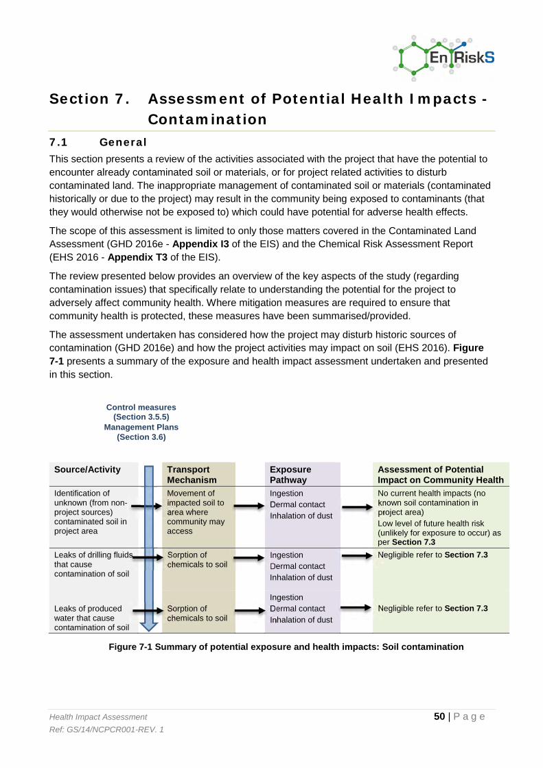
Health Impact Assessment 50 | P a g e Ref: GS/14/NCPCR001-REV. 1
Section 7. Assessment of Potential Health Impacts - Contamination
7.1 General This section presents a review of the activities associated with the project that have the potential to encounter already contaminated soil or materials, or for project related activities to disturb contaminated land. The inappropriate management of contaminated soil or materials (contaminated historically or due to the project) may result in the community being exposed to contaminants (that they would otherwise not be exposed to) which could have potential for adverse health effects.
The scope of this assessment is limited to only those matters covered in the Contaminated Land Assessment (GHD 2016e - Appendix I3 of the EIS) and the Chemical Risk Assessment Report (EHS 2016 - Appendix T3 of the EIS).
The review presented below provides an overview of the key aspects of the study (regarding contamination issues) that specifically relate to understanding the potential for the project to adversely affect community health. Where mitigation measures are required to ensure that community health is protected, these measures have been summarised/provided.
The assessment undertaken has considered how the project may disturb historic sources of contamination (GHD 2016e) and how the project activities may impact on soil (EHS 2016). Figure 7-1 presents a summary of the exposure and health impact assessment undertaken and presented in this section.
Source/Activity Transport Mechanism
Exposure Pathway
Assessment of Potential Impact on Community Health
Identification of unknown (from non-project sources) contaminated soil in project area
Movement of impacted soil to area where community may access
Ingestion Dermal contact Inhalation of dust
No current health impacts (no known soil contamination in project area) Low level of future health risk (unlikely for exposure to occur) as per Section 7.3
Leaks of drilling fluids that cause contamination of soil
Sorption of chemicals to soil
Ingestion Dermal contact Inhalation of dust
Negligible refer to Section 7.3
Leaks of produced water that cause contamination of soil
Sorption of chemicals to soil
Ingestion Dermal contact Inhalation of dust
Negligible refer to Section 7.3
Figure 7-1 Summary of potential exposure and health impacts: Soil contamination
Control measures (Section 3.5.5)
Management Plans (Section 3.6)

Health Impact Assessment 51 | P a g e Ref: GS/14/NCPCR001-REV. 1
7.2 Overview of specialist study The contaminated land assessment (GHD 2016e) includes a review of existing background information relevant to the project area (including a review of relevant existing reports and documentation, historical aerial photographs, NSW EPA Contaminated Sites Register – record of notices, NSW EPA Protection of the Environment Operations Licence register, media releases and EPA reports, NSW Department of Water and Energy water information and hydrogeological, geological and topographical maps depicting the project area). The review of existing background information was supported by a field assessment of readily accessible parts of the project area (i.e. ground-truthing) to observe current activities (including current land uses involving the potential for contaminating activities) and visual and olfactory indications of contamination.
In addition, the assessment also provided an overview of pollution incidents within the project footprint that have occurred in the project area. These incidents related to:
Release of untreated water from the Bibblewindi Water Treatment Plant in 2011 (relevant to operations previously owned and operated by Eastern Star Gas);
Impacts to groundwater detected in 2013 beneath the Bibblewindi produced water treatment ponds; and
Impacts to groundwater detected in 2013 beneath the Tintsfield ponds facility.
Other than vegetation dieback from the release of produced water from the Bibblewindi ponds in 2011 (where the die back was associated with the high level of salts in the water, and are being remediated) risks to human health or the environment associated with these incidents were evaluated to be low.
Assessment of the impact of project related activities on soil was conducted in the CRA (EHS 2016), where exposures to workers and first responders (in the event of an incident), agricultural workers and residents, recreational users and trespassers was undertaken. The assessment considered exposures to soil that may be impacted by a spill or leak of drilling fluids, produced and treated water (including permeate) during transport, treatment and use (including re-use).
7.3 Potential for impacts to community health The assessments summarised above evaluated the potential impact of the operations on existing land contamination as well as the potential for activities/existing facilities in the project area to result in the contamination of land.
If mobilised or unearthed during project activities, land contamination could cause adverse health effects to the community if the concentration of contaminants were sufficiently high and/or people were exposed for long enough. The community would need to be exposed to the contaminated land for potential adverse effects to occur. People may be exposed via direct contact with contaminated soil, inhalation of vapours sourced from contaminated land or inhalation and/or direct contact with contaminated dust.
Overall, the findings of the review conducted by GHD (2016e) concluded a low level of risk associated with potential areas of contamination or potentially contaminating activities across the project area. Potentially contaminating activities identified within the project area can be readily avoided and/or managed as part of the infrastructure development. Flexibility in the location of gas field infrastructure in particular would enable the avoidance of existing land contamination or sources of potential land contamination.

Health Impact Assessment 52 | P a g e Ref: GS/14/NCPCR001-REV. 1
In relation to the assessment of impacts to soil associated with project activities, the CRA Report (EHS 2016) considered the following:
Potential source of the contamination; Mechanism of release, retention, or transport of a chemical in a medium (including soil); The nature of the chemicals present in the leak or spill (i.e. consideration of whether these
chemicals are persistent or bioaccumulative); If there is the potential to human exposure and how that exposure may occur (pathways of
exposure); The magnitude of the contamination (i.e. the concentration that may be present and the
extent of the contamination); and The toxicity of the potential contaminants.
The assessment did not identify significant risks associated with potential exposures by the community, specifically workers, agricultural workers, residents and recreational users to soil impacts that may occur as a result of the use, leak or spill of drilling fluids, produced or treated water (including permeate).
It is noted that spills would be responded to quickly with impacts assessed and mitigated in accordance with the project management and emergency response plans (refer to Section 3.9). The potential for community exposure to soil that may have been impacted during a spill is considered negligible.
7.4 Overview and recommendations Overall, the findings of the assessments undertaken indicate the following:
A low level of risk associated with potential areas of contamination across the project area. Based on the findings of the assessment, an unexpected finds protocol should be prepared as part of the Environmental Management Plan for the Narrabri Gas Project. If previously unidentified land contamination or sources of potential land contamination are encountered the landholder would be notified and the contamination would be avoided as far as practicable; and
A negligible risk to health associated with project related activities resulting in the contamination of soil.
No additional management measures have been identified as part of this assessment.

Health Impact Assessment 53 | P a g e Ref: GS/14/NCPCR001-REV. 1
Section 8. Assessment of Potential Health Impacts - Noise
8.1 General This section presents a review of the activities associated with the project that have the potential to result in noise levels that may result in adverse health outcomes in the community.
The scope of this assessment is limited to only those matters covered in the Noise and Vibration Assessment (GHD 2015 - Appendix M of the EIS).
There are a wide range of activities proposed in the project that have the potential to generate noise. These include the following:
Construction of the following: o Leewood and Bibblewindi facilities (during normal working hours) including the
potential for blasting to occur on rare occasions as required o Support infrastructure (gas and water gathering system, Westport workers’
accommodation, Newell Highway intersection upgrades, treated water managed release pipeline) (where work within and outside of normal working hours was considered)
Drilling operations (expected to occur for 24 hours per day); Operation of the facilities at Leewood and Bibblewindi (including operation of the safety flare
at each location); Operation of production and pilot wells; and Road traffic noise (for project related traffic changes).
The review presented provides an overview of the key aspects of the study that specifically relate to understanding the potential noise arising from the project to adversely affect community health. Where mitigation measures are required to ensure that community health is protected, these measures have been summarised/provided.
8.2 Overview of specialist study The assessment of noise impacts associated with construction and operations was conducted in line with regulatory guidance including the NSW Industrial Noise Policy and the Interim Construction Noise Guideline. These guidelines require evaluation of the potential sources of noise, the duration and time of day at which noise occurs and the level of background noise in the project area. This information is then used to model (predict) noise impacts from the project under a range of meteorological conditions and times of the day. Meteorological conditions which influence noise propagation include temperature, humidity, wind speed and direction and the presence of temperature inversions. The predicted noise levels, calculated under the worst-case meteorological conditions, are then compared with relevant noise goals.
Noise goals for the project were developed in line with the regulatory guidance and these goals differ for different types of noise generated by the project (i.e. road noise, construction noise and operational noise). The noise goals were developed in accordance with the guidance:
The NSW Industrial Noise Policy (INP); The NSW Construction Noise Policy (CNP); and The Road Noise Policy (RNP).

Health Impact Assessment 54 | P a g e Ref: GS/14/NCPCR001-REV. 1
In addition, the NSW Environmental Noise Control Manual was used to assess the potential for sleep disturbance from project related activities.
An assessment of site specific noise impacts was undertaken for Leewood, Bibblewindi, the Bibblewindi to Leewood infrastructure corridor and the workers’ accommodation and road upgrade locations.
For the location of the gas field infrastructure, buffer distance predictions were developed to inform the Field Development Protocol and to ensure compliance with the noise criteria. These buffer distance predictions ignore attenuation provided by shielding structures, topography or foliage and are therefore conservative. The nature of the predicted noise impacts will be used to assist in siting project infrastructure and the requirement for mitigation measures.
8.3 Health effects of noise Elevated noise has the potential to cause health effects in the local community if the noise from a development does not comply with regulatory guidance.
Guidance that outlines the potential health effects from excess noise include:
World Health Organisation- Guidelines on Community Noise – Health effects of noise (WHO, 1999); and
Environmental Health Council of Australia - The health effects of environmental noise – other than hearing loss (enHealth, 2004).
These reviews are the major source of guidance on the relationship between health and noise. The criteria developed in the Noise and Vibration Assessment are based on the policy documents developed by the NSW Government including the NSW Industrial Noise Policy, the NSW Interim Construction Noise Policy and the NSW Environmental Noise Control Manual. All of these policies consider the health effects of noise and use the WHO and enHealth reviews as the basis for setting relevant noise criteria.
WHO (1999) recognises that there is sufficient evidence that noise causes impacts on health. Adverse effects for which the evidence of health impacts is strong/sufficient include:
Sleep disturbance; Annoyance; Children’s school performance (through effects on memory and concentration); and Cardiovascular health.
Other effects for which evidence of health impacts exists, but for which the evidence is weaker, include:
Increasing difficulty in understanding what others are saying; Effects on mental health (usually in the form of exacerbation of issues for vulnerable
populations rather than direct effects); and Some evidence of indirect effects such as impacts on the immune system.
While the impacts of noise in a community can be subjective (variable depending on individual sensitivity and tolerance for noise) the available noise guidelines for construction, operational and road noise are designed to be protective of the above health effects in the community.

Health Impact Assessment 55 | P a g e Ref: GS/14/NCPCR001-REV. 1
8.4 Potential for impacts to community health The available noise guidelines for construction, operational and road noise are designed to be protective of health effects in the community. Hence where the worst-case noise levels predicted in for the project activities meet the relevant guidance there are no issues of concern in relation to the health of the community. However, where the noise guidelines cannot be met, measures need to be implemented in the project design to mitigate noise (from the source or by placing noise attenuation barriers between the source and the community).
Most noise impacts were predicted to comply with the relevant noise guidelines for construction activities including:
Proposed construction activities associated with facilities at Leewood, Bibblewindi, the Leewood to Bibblewindi Infrastructure Corridor, the Wilga Park to Leewood Infrastructure Corridor and Westport Workers’ Accommodation;
Newell Highway intersection upgrading; Road traffic noise; Construction of the treated water discharge pipeline; and Construction of the workers’ accommodation.
Some exceedances of the noise guidelines were identified for some sensitive receivers, particularly where works occurred outside of normal operating hours. Where receivers are impacted by construction noise, noise mitigation measures would be provided where these are feasible and reasonable.
Noise mitigations would be incorporated into the detailed design of Leewood to ensure that operational noise levels comply with the noise management levels for the project at sensitive receivers unless an agreement is in place with the land holder.
Noise levels from the operation of the two safety flares at Leewood and Bibblewindi were found to exceed the intrusive noise criteria when operated at maximum flow. The safety flare would only operate at maximum flow in the event it was required to safely manage excess gas during commissioning, maintenance activities and unforeseen circumstances. Where sensitive receivers are predicted to be impacted by planned non-routine use of the flare, they would be informed of potential short-duration noise impacts during such works.
During construction of gas field well infrastructure and works along infrastructure and road corridors, a buffer distance was determined as 1,875 m under adverse meteorological conditions during the night with the potential for sleep disturbance predicted up to 1,300 m from the drilling rig. During construction of the gas and water gathering lines, typical construction equipment will be used. The modelling has found that buffer distances vary from 1,370 m (vegetation clearing) to 2,021 m (trenching) during this work. Noise level exceedances of the construction noise management levels at sensitive receivers would be very short-term as the construction work front proceeds along the corridor. All reasonable and feasible mitigation measures would be implemented if exceedances of the noise management levels were predicted at occupied sensitive receivers.
During production modelling predicts that a maximum distance of 218 m is required to meet noise management levels for multiple production wells operating simultaneously under a worst case 750 m spacing configuration and under adverse meteorological conditions. No sleep disturbance issues were identified for well operations given the nature of the noise.

Health Impact Assessment 56 | P a g e Ref: GS/14/NCPCR001-REV. 1
In relation to recreational use of Yarrie Lake, no noise impacts in exceedance of the guidelines are predicted for operation of production wells (as no wells are permitted within 200 m of the lake as outlined in Section 3.4.1), however pilot wells operated with a flare may exceed the guideline.
These buffer distances have been incorporated into the Field Development Protocol (refer to Section 3.4.1 (and Appendix C of the EIS)). The location of individual wells and well sets would be developed considering the Field Development Protocol for noise impacts on sensitive receivers.
8.5 Outcomes and Recommendations The project would meet the noise criteria at all occupied sensitive receivers unless a private negotiated agreement is entered into. To achieve this, the proponent would implement all feasible and reasonable mitigation measures in accordance with the NSW Interim Construction Noise Guideline. Given the relatively small number of individuals that may be affected, private negotiated agreements may be entered into. As described in the NSW Industrial Noise Policy, these agreements would be made to the satisfaction of potentially affected landholders and the proponent, and could include reduction of noise during noise-sensitive times, mitigation at residences or temporary relocations of residents.
The noise assessment included recommendations for a number of mitigation measures to reduce noise from the project to acceptable levels that will be protective of community health during both the construction and operational phases where these are required to be implemented. Further details regarding these measures will be outlined in the relevant management plans for construction and operation (refer to Section 3.6) and be incorporated into the Field Development Protocol.
In addition to the above, potentially impacted residents would be notified of the nature of the works, expected noise levels, duration of works and a method of contact to raise noise complaints.
Once the locations of wells and well sets are determined in accordance with the Field Development Protocol, additional noise monitoring/modelling may be undertaken to fine-tune the potential for noise impacts and confirm management and mitigation as required.
No additional management measures have been identified as part of this assessment.

Health Impact Assessment 57 | P a g e Ref: GS/14/NCPCR001-REV. 1
Section 9. Assessment of Potential Health Impacts - Hazards
9.1 General This section presents a review of the activities associated with the project that have the potential to result in public safety risks in the community.
The scope of this assessment is limited to only those matters covered in the Hazard and Risk Assessment (GHD 2016a - Appendix S of the EIS).
The review presented provides an overview of the key aspects of the study that specifically relates to understanding the potential for the project to adversely affect community (rather than workplace) health and safety. Where mitigation measures are required to ensure that community health is protected, these measures have been summarised/provided.
9.2 Overview of specialist study NSW Planning provides guidance – SEPP 33 (Hazardous and Offensive Development) and associated guidelines – to define when a proposed industrial facility poses a major hazard to the community. A preliminary risk screening, preliminary hazard analysis and bushfire risk assessment were undertaken as part of the assessment process in line with the analysis required by NSW Planning for hazardous facilities.
A preliminary risk screening was undertaken comprising an analysis of the quantity of dangerous goods or other chemicals proposed to be stored at the well pads, Bibblewindi, Leewood and during transportation.
The preliminary hazard analysis was undertaken according to the methods outlined in regulatory guidance from NSW Planning and considered the pathways that could result in a threat to community safety including a loss of containment of gas leading to fire or explosion, a loss of containment of liquid chemicals or Dangerous Goods (in particular, the biocide to be used at Leewood Water Treatment Plant) and a loss of containment of significant quantities of water (including dam burst) (produced or treated).
The potential for risks from the loss of containment of biocide (used for water treatment) has been assessed by assuming that a storage tank might fail with liquid spilled contained inside the bund as per the requirements of the Australian Dangerous Goods Code. While the biocide is standing in the bund, it has been assumed that the chemical may evaporate from the water surface and the vapour may then be blown off-site to sensitive receivers. Semi-quantitative assessment of this scenario has been undertaken.
The bushfire risk assessment was based on guidelines including the Planning for Bushfire Protection (NSW Rural Fire Service, 2006) and AS3959:2009 Construction of buildings in bushfire prone areas (AS, 2009) (and amendments published in 2011) and identified actions to mitigate impacts on the community from a bushfire.

Health Impact Assessment 58 | P a g e Ref: GS/14/NCPCR001-REV. 1
9.3 Potential for impacts on community health Hazardous industry are sites where one or more chemicals that are classified as Dangerous Goods are stored in sufficient quantity that if an accident were to occur or if some of the control measures were to fail, it would create a situation that could cause concern to the community or have the potential to cause significant injury.
For example, should a fire or explosion occur, the potential off-site impacts could include damage to buildings due to fire or overpressure, or injury to people. A loss of containment of dangerous goods, chemicals (in significant quantities) could also cause injury to people and damage to buildings or other infrastructure.
The preliminary risk screening for this project found it met the requirements for a ‘potentially hazardous industry’. The preliminary hazard analysis (in Appendix S) found:
All uncontrolled loss of containment of flammable gas (methane) scenarios were assessed as having a low or very low residual risk with regards to offsite consequences. These scenarios include a loss of containment from the wellheads, gas gathering lines, Bibblewindi in-field compression facility, Bibblewindi to Leewood gas line and Leewood central gas processing facility and power generation facility. In addition, the assessment of fires and explosions from such a leak did not identify risks (exceeding HIPAP 4 risk criteria) within the community (sensitive receivers);
All uncontrolled loss of containment scenarios for liquid chemicals or dangerous goods have been assessed qualitatively as having low or very low residual risk with regards to offsite consequences; and
The risk of a pond bursting or overtopping resulting in an offsite safety consequence was assessed qualitatively as very low on the basis that the ponds are designed to Australian Standards and in accordance with guidelines set by the Australian National Committee on Large Dams (ANCOLD) and NSW Dam Safety Committee procedures and guidelines that would be followed.
The assessment concluded that a large scale high intensity bushfire is may occur over the life of the project and that such a fire may have significant direct and indirect effects on health with or without the presence of this project. The potential for a fire to start as a result of project related activities, where fire prevention and mitigation measures are adopted, is considered to be remote.
9.4 Outcomes and Recommendations Residual risks associated with a loss of containment of gas leading to a fire or explosion were assessed as being low or very low. The preliminary hazard analysis of the loss of containment of gas (Class 2.1 Flammable Gases - methane) assessed the risk of fires and explosions using a semi-quantitative approach. It was determined the risk of 4.7 kW/m2 heat radiation exposure and the risks of 7 kPa explosion overpressure meet the HIPAP 4 risk criteria and should not exceed 50 chances in a million per year at sensitive receptors.

Health Impact Assessment 59 | P a g e Ref: GS/14/NCPCR001-REV. 1
All risks associated with a loss of containment of liquid chemicals or dangerous goods were assessed qualitatively as having a low risk with regards to off-site consequences. The preliminary hazard analysis of the loss of containment of Class 6.1 Toxic Substances (biocide) assessed the risk of exposure to toxic chemicals from the biocide in further detail using a semi-quantitative approach. It was determined the risk of injury and irritation meet the HIPAP 4 risk criteria.
The assessment of a loss of containment of Class 8 Corrosive Substances considered the risk of exposure to toxic gases resulting from the heating or chemical reaction of the chemicals and determined that the risk of injury and irritation at sensitive receivers meets the HIPAP 4 risk criteria.
The above conclusions regarding loss of containment and the assessment of the off-site risk associated with those releases are based on the assumption of mitigation measures that are planned to be incorporated into the design and operation of the facilities.
These mitigation measures have been identified throughout Appendix S, however a summary of high level mitigation controls to be implemented through the project include:
Appropriate signage would be installed in accordance with Australian standards to alert landholders to underground infrastructure;
All facilities would be designed and operated under the applicable Australian safety standards and protocols;
Safety in design would be incorporated into the design and construction of all facilities and infrastructure;
All dangerous goods to be stored and transported in accordance with the Australian Dangerous Goods Code; and
All Class 3 Packing Group III Flammable Liquids would be stored 10 m from the facility boundary at Leewood facility boundary and 15 metres from the Bibblewindi facility based on anticipated quantities.
Based on the assessment undertaken in Appendix S, a large scale high intensity bushfire may occur over the life of the project. The proponent is able to apply fire prevention and mitigation measures to reduce the potential for fires to start as a result of project related activities. These existing fire prevention and mitigation measures reduce the likelihood of the project potentially starting a fire to ‘remote’, which is the lowest likelihood.
Additional mitigation measures are proposed to further reduce the risks (as low as reasonably practicable to apply). This includes the development of effective strategies and enhancement of existing procedures to mitigate bushfire risk during the construction and operation of the project. The proponent would prepare a Bushfire Management Plan, informed by the proponent’s participation in the Resource Industry Fire Management Group and consultation with relevant stakeholders including the Rural Fire Service, Forestry Corporation of NSW and landholders. The Plan, and related digital data, would be provided to these stakeholders once produced, and thereafter reviewed annually in consultation with those same stakeholders.

Health Impact Assessment 60 | P a g e Ref: GS/14/NCPCR001-REV. 1
Loss of containment of significant quantities of water has been assessed as having a very low residual risk with regards to off-site safety consequences. The likelihood of a pond bursting or overtopping is very low as the design of dams and holding ponds will be in accordance with Australian Standards and with guidelines set by the Australian Committee on Large Dams (ANCOLD). NSW Dam Safety Committee procedures and guidelines would be followed. In addition, water level monitoring systems and pond inspections will be in place to identify potential failures early. All of the new produced water ponds at the Leewood site will be double lined, have leak detection with collection pumps between the primary and secondary liners as well as a second set of depressurisation pumps under the secondary liner. This means that the likelihood of significant leakage to the environment is remote. As these dams are located within facility boundaries, work activities such as excavations will be controlled by a work permit system which assesses risks related to the work activity.
No additional management measures have been identified as part of this assessment.

Health Impact Assessment 61 | P a g e Ref: GS/14/NCPCR001-REV. 1
Section 10. Assessment of Potential Health Impacts – Social and Community Cohesion
There are a range of aspects of the project that are associated with social issues, including property access/land use, lifestyle and amenity and changes to the social/community structure of the local area (due to the changes in workforce and demands on services).
The scope of this assessment of potential impacts associated with social issues related to the project is limited to only those matters covered in the Social Impact Assessment (Appendix T1 of the EIS).
The Social Impact Assessment assessed the potential social impacts of the project in the local area (project footprint), in the region (Narrabri township and Narrabri LGA) and in the wider area (surrounding LGAs).
The key social benefits are anticipated to be:
An additional income stream in the form of compensation provided by Santos to landholders who agree to host gas field infrastructure;
Regional economic benefits created through increased employment and business development opportunities in the form of increased real economic output;
Increased real income for the region and the state; Direct employment of approximately 1,300 workers during peak construction and
approximately 200 workers for the ongoing operation of the project; Increased business opportunities in the local area - The project, in both the construction and
operations phases, will purchase goods and services from Narrabri, Narrabri surrounds and the wider NSW economies. This increased demand for production will provide a stimulus to businesses throughout the region and state. Job opportunities created by the project may also contribute to the retention of younger generation in the towns;
A Gas Community Benefit Fund would be established which would receive an estimated $120 million through the life of the project. The fund would be contributed by industry and the Government up to a cap of 10% of the royalty payments, where Government would match industry payments dollar for dollar via re-directing the royalty payments it receives and
Increases in local population – The project workforce, especially during the long term operations phase will contribute to the resident population in Narrabri, potentially increasing the town’s population by 1.7 per cent.
The key social impacts of the project that could occur if mitigations are not implemented:
Impacts on landholders – location of gas field infrastructure may impact land use, access, productivity, loss of privacy, impacts on lifestyle (noise, light, dust) – the extent of such impacts can only be assessed on a case by case basis as such impacts are dependent on the mix of issues at a particular sensitive receptor. A land access agreement would be negotiated with each land holder that would take into account the range of property specific issues;
Economic impacts – potential for competition for labour, labour shortfalls or increasing cost for labour;
Impacts on recreational assets and activities – temporary impacts on amenity at Yarrie Lake during construction;

Health Impact Assessment 62 | P a g e Ref: GS/14/NCPCR001-REV. 1
Social infrastructure – increase in demand on health and medical services as well as emergency services;
Housing – potential impacts on housing availability and affordability during construction; and Traffic safety – traffic management during works may increase waiting times at some
intersections along with some increases in traffic.
Somerville (2013) has undertaken a review of health impacts of CSG and perceptions held by the communities. They found that the rapid changes in rural communities can lead to complex social, psychological and environmental stresses which can impact on community health. The health impacts discussed in (Somerville, 2013) relate to a range of specific issues which have been evaluated in the social impact assessment for this project, as well as to broader issues of local community perception and trust. Stress reactions differ in different people and may result in short-term “fight or flight” responses to more chronic effects such as sleep disturbance, anxiety and depression. The resources sector has long been involved in rural change in Australia and managing such changes well is important to minimise health impacts on the community (Williams and Walton, 2014).
There is limited data available on the level of stress and anxiety in communities associated with CSG projects. The Queensland Department of Health undertook an assessment of reported health effects in the Tara area in Queensland (QLD Dept of Health, 2013). Their report did not find a clear link between the health complaints of some residents and impacts of CSG operations on air, water or soil. The report did identify that the distress produced in some people by environmental change in their home environment/community may be a cause for some of the health complaints.
Coote (2013) undertook a survey of farmers in the Condamine area in Queensland. The study specifically looked at levels of stress from a range of sources (including common stressors in rural areas such as droughts, floods, financial (including commodity price fluctuations) as well as the CSG industry) evaluating factors such as trust, resilience and coping. While the results of the study have not yet been published, the study indicates that while farmers have concerns about the CSG impacts there is a level of tolerance and resilience in the community and no clear evidence that the levels of stress are dividing existing communities (Coote, 2013). Another study has been undertaken in the Chinchilla area (Walton et al., 2013) to determine measures that can be adopted to enhance community resilience to the changes associated with CSG operations.
A range of policies, strategies and initiatives would be implemented to minimising negative social impacts, while maximise opportunities and benefits. These policies, strategies and initiatives include:
A procurement policy directed at local businesses, suppliers and labour to enable them to participate in the project;
Workforce management strategies to promote the health, safety and wellbeing of the project workforce, and their integration with the Narrabri community;
Housing and accommodation strategies to monitor conditions and adapt as needed; An Aboriginal engagement policy to maximise employment; Adherence to the Agreed Principles of Land Access to minimise landholder impacts; and Fair and reasonable compensation to landholders for work undertaken on their properties,
where agreed.

Health Impact Assessment 63 | P a g e Ref: GS/14/NCPCR001-REV. 1
The implementation of mitigation and management measures, and the design of the project, would be effective in preventing and minimising the potential adverse social impacts of the project. Some limited direct impacts on land use, lifestyle and amenity, and the increase in the non-resident population of Narrabri, would persist during the project construction and operation although the potential adverse social impacts of this increase would be managed. The proponent would monitor social impacts throughout the construction and operation of the project, and would implement the mitigation and management measures described above in a manner that is adaptive to changed conditions or emergent social impacts.
Further details on mitigation measures are provided in Appendix T1 of the EIS.

Health Impact Assessment 64 | P a g e Ref: GS/14/NCPCR001-REV. 1
Section 11. Overview and Conclusions The health impact assessment presented in this report has considered the information available in the specialist studies undertaken in relation to the proposed project, particularly in relation to the potential for these activities to adversely affect the health of the community. The assessment has considered a wide range of stressors (addressed in the specialist studies) including chemical contamination of air, water or soil; safety hazards within the community; and other community stressors that can impact on health including noise, social and community cohesion.
Where the controls and environmental management measures outlined in the EIS are implemented, the assessment has not identified project related impacts that may adversely affect the health of the community. Also no additional management measures have been identified as part of this health impact assessment to further mitigate impacts from the project than those already specified in the specialist studies. Figure 11-1 provides an overview of the assessment presented in this report.
The assessment undertaken for the project relates to the activities outlined in the EIS, specifically relevant to the geology and hydrogeology of the project area.

Health Impact Assessment 65 | P a g e Ref: GS/14/NCPCR001-REV. 1
Figure 11-1 Outcomes of HIA

Health Impact Assessment 66 | P a g e Ref: GS/14/NCPCR001-REV. 1
Section 12. References Environmental Impact Statement Specialist/Technical Papers – As listed in Table 2-1
Other References
ANZECC/ARMCANZ 2000. Australian and New Zealand Guidelines for Fresh and Marine Water Quality. Australian and New Zealand Environment and Conservation Council and Agriculture and Resource Management Council of Australia and New Zealand.
AS 2009. AS/NZS 3959:2009 Construction of buildings in bushfire prone areas Standards Australia.
COOTE, G. 2013. Researcher soon to release findings on CSG mental health impacts [Online]. The Source. Available: http://thesourcenews.com/2013/08/29/researcher-soon-to-release-findings-on-csg-mental-health-impacts/.
DEC 2005. Approved Methods for the Modelling and Assessment of Air Pollutants in New South Wales. NSW Government Gazette of 26 August 2005 ed.: Department of Environment and Conservation NSW (DEC).
ENHEALTH 2001. Health Impact Assessment Guidelines. Commonwealth Department of Health and Aged Care.
ENHEALTH 2004. The health effects of environmental noise – other than hearing loss. enHealth Council, Department of Health and Ageing.
ENHEALTH 2012a. Australian Exposure Factors Guide. Canberra: Commonwealth of Australia.
ENHEALTH 2012b. Environmental Health Risk Assessment, Guidelines for assessing human health risks from environmental hazards. Canberra: Commonwealth of Australia.
HARRIS, P., HARRIS-ROXAS, B., HARRIS, E. & KEMP, L. 2007. Health Impact Assessment: A Practical Guide. Centre for Health Equity Training, Research and Evaluation (CHETRE). Part of the UNSW Research Centre for Primary Health Care and Equity. University of New South Wales.
LANDCOM 2004. Managing Urban Stormwater: Soils and Construction 4th Edition. New South Wales Government.
MCKENZIE, L. M., GUO, R., WITTER, R. Z., SAVITZ, D. A., NEWMAN, L. S. & ADGATE, J. L. 2014. Birth outcomes and maternal residential proximity to natural gas development in rural Colorado. Environ Health Perspect, 122, 412-7.
MCKENZIE, L. M., WITTER, R. Z., NEWMAN, L. S. & ADGATE, J. L. 2012. Human health risk assessment of air emissions from development of unconventional natural gas resources. Science of The Total Environment, 424, 79-87.
NEPC 1999 amended 2013a. Schedule B4, Guideline on Health Risk Assessment Methodology, National Environment Protection (Assessment of Site Contamination) Measure. National Environment Protection (Assessment of Site Contamination) Measure (NEPM). National Environment Protection Council.
NEPC 1999 amended 2013b. Schedule B5 Guideline of Ecological Risk Assessment, National Environment Protection (Assessment of Site Contamination) Measure. National Environment Protection (Assessment of Site Contamination) Measure. National Environment Protection Council.
NEPC 2003. National Environment Protection (Ambient Air Quality) Measure. National Environment Protection Council.
NEPC 2004. National Environment Protection (Air Toxics) Measure. National Environmental Protection Council.
NHMRC 2008. Guidelines for Managing Risks in Recreational Water. Canberra: National Health and Medical Research Council.
Health Impact Assessment 67 | P a g e Ref: GS/14/NCPCR001-REV. 1
NHMRC 2011 Updated 2014. Australian Drinking Water Guidelines, National Water Quality Management Strategy. Canberra: National Health and Medical Research Council and Natural Resource Management Ministerial Council, Commonwealth of Australia.
NSW RURAL FIRE SERVICE 2006. Planning for bush fire protection. A guide for Councils, Planners, Fire Authorities and Developers. NSW Rural Fire Service.
NSW TRADE & INVESTMENT 2012. NSW Code of Practice for Coal Seam Gas, Well Integrity. New South Wales through Department of Trade and Investment, Regional Infrastructure and Services (NSW Trade & Investment).
QLD DEPT OF HEALTH 2013. Coal Seam Gas in the Tara Region: Summary risk assessment of health complaints and environmental monitoring data. State of Queensland (Queensland Health).
SOMERVILLE, W. 2013. CSG and Your Health: Understand the Risks, Protect Your Family, A Report on the Health Impacts of CSG and Shale Gas Mining & CSG Health Checklists.
USEPA 2012. 2012 Edition of the Drinking Water Standards and Health Advisories. Office of Water, US Environmental Protection Agency.
USEPA 2015. Regional Screening Levels for Chemical Contaminants at Superfund Sites. January 2015 ed.
WALTON, A., MCCREA, R., LEONARD, R. & WILLIAMS, R. 2013. Resilience in a Changing Community Landscape of Coal Seam Gas: Chinchilla in Southern Queensland. Journal of Economic and Soical Policy, 15, Article 2.
WERNER, A. K., VINK, S., WATT, K. & JAGALS, P. 2015. Environmental health impacts of unconventional natural gas development: A review of the current strength of evidence. Sci Total Environ, 505C, 1127-1141.
WHO 1999. Guidelines for Community Noise. In: BERGLUND, B., LINDVALL, T. & SCHWELA, D. H. (eds.). Geneva: World Health Organisation.
WHO 2011. Guidelines for Drinking-water Quality, Fourth Edition. International Program on Chemical Safety, World Health Organisation.
WILLIAMS, R. & WALTON, A. 2014. Community Expectations and Coal Seam Gas Development: A report to the Gas Industry Social and Environmental Research Alliance (GISERA). CSIRO, Australia.