Embed Size (px)
Citation preview

APPENDIXD Geotechnical Memo

Memorandum
Date: May 6, 2013
To: Sundeep Amin
From: Derek Rector
Subject: Geotechnical Survey Results for El Cuervo del Sur and El Cuervo al Oeste Mitigation Sites
URS performed subsurface explorations in support of the Los Peñasquitos Wetland Habitat Mitigation and Monitoring Plan. The explorations were performed between April 15th and April 16th 2013 in the areas known as El Cuervo del Sur and El Cuervo al Oeste within the Los Peñasquitos Canyon Preserve, California. The subsurface explorations were performed in the near margin of the main channel of Los Peñasquitos Creek within the 100 year flood plain. The work areas were accessed by foot and all equipment was hand carried to each location. The locations were chosen in the field to avoid any native shrubs and to limit the surface disturbance created from the work activities. The explorations are designated as B-01, B-02, and B-03 within the El Cuervo del Sur area and B-04, B-05, and B-06 within the El Cuervo al Oeste area. The explorations were performed by a URS engineering geologist using a 3-inch diameter hand auger. The hand auger was manually advanced into the subsurface in approximately 6-inch intervals. After each advance of the hand auger the soils encountered were removed and placed on a clean geofabric on the surface near the exploration. The soils were then characterized and logged using the Unified Soils Classification System (USCS). Drafted logs of the explorations are attached to this report. Soil samples were collected in sealed baggies at approximately one foot intervals below the ground surface or where there was a distinct change in material. The collected samples were subsequently archived in the URS moisture room for future analysis. Upon completion the collected soils on the geofabric were used to backfill the hole and return the work area to match the pre-existing surface grade (Photos 1 and 2 attached). Each exploration was advanced beyond the depth of the water table. Once the final depth was reached, a nominal time was allowed for the ground water to stabilize within the exploration. The depth to groundwater from the ground surface was measured in each exploration using a steel tape with divisions of 100th of a foot. The depth to water ranged from 2.10’ to 3.50’ below the ground surface. The depth to water at each location is noted on the attached drafted logs. Alluvium was encountered in each of the explorations and less than a foot of topsoil/colluvium was encountered at the surface of B-01 and B-03. The alluvium ranged from yellowish brown to grayish brown silty to clayey, fine to medium grained sands, to gray to yellowish brown clays. In general the materials became finer (silts and clays) below the measured groundwater level.

Page 2 of 2
Photograph #01
Date: 04/16/13
Comments: Work area during work activities. Location B-5 within the El Cuervo al Oeste area of Los Penasquitos Canyon Preserve, California.
Photograph #02
Date: 04/16/13
Comments: Work area after work activities. Location B-5 within the El Cuervo al Oeste area of Los Penasquitos Canyon Preserve, California.

5
Description of material encountered;may include relative density/consistency, moisture, color,particle size; texture, weathering, and strength of formationmaterial.
7
8
Graphic depiction of subsurface materialencountered; typical symbols are explained below.
10
Elevation in feet referenced to mean sea level(MSL) or site datum.
Comments and observationsregarding drilling or sampling made by driller or field personnel.
Water Content:
2
6
Dry Unit Weight:
Remarks and Other Tests:
3
Depth in feet below the ground surface.
1
Sample Number:
3
1
Elevation:
Type of soil sample collected at depth intervalshown; sampler symbols are explained below.
4
Water content of soil sample measured inlaboratory, expressed as percentage of dry weight of specimen.
Blows per foot:
9
10
7
Depth:
Sample Type:
Dry unit weight of soil sample measured inlaboratory, in pounds per cubic foot.
1. Soil classifications are based on the Unified Soil Classification System. Descriptions and stratum lines areinterpretive; actual lithologic changes may be gradual. Field descriptions may have been modified to reflect results oflab tests.
2. Descriptions on these logs apply only at the specific boring locations and at the time the borings were advanced.They are not warranted to be representative of subsurface conditions at other locations or times.
Number of blows required to advance drivensampler 12 inches beyond first 6-inch interval, or distance noted,using a 140-lb hammer with a 30-inch drop.
Graphic Log:
5
6
8
GENERAL NOTES
COLUMN DESCRIPTIONS
92 4
Material Description:
Sample identification number.Unnumbered sample indicates no sample recovery.
Grab sample
TYPICAL SAMPLER GRAPHIC SYMBOLS
First water encountered at time of drilling andsampling (ATD)
Static water level measured in boring or well atspecified time after drilling
Inferred contact between strata or gradational changein lithology
Change in material properties within a lithologicstratum
OTHER GRAPHIC SYMBOLS
Porrly graded SAND withsilt (SP-SM)
Sandy CLAY (CL) toclayey SAND (SC)Clayey SAND (SC)
TYPICAL MATERIAL GRAPHIC SYMBOLS
Fat CLAY (CH)CLAY (CL)
Silty SAND (SM)
Rep
ort:
GE
O_1
0_S
NA
_KE
Y;
File
: 276
7995
4.G
PJ;
4/
29/2
013
ke
y
Project Location: Los Peñasquitos Canyon Preserve, California
Project Number: 27679954.08300
Key to LogsSheet 1 of 1
Project: Los Peñasquitos Conceptual Wetland Habitat Mitigation and Monitoring Plan
Dep
th,
feet
SAMPLEST
ype
MATERIAL DESCRIPTIONB
low
s pe
rfo
ot
Gra
phi
c Lo
g
Wat
erC
onte
nt, % REMARKS AND
OTHER TESTS
Ele
vatio
n,fe
et
Num
ber
Dry
Uni
tW
eigh
t, p
cf

1
2
3
4
5
6
7
8
9
TOPSOIL/COLLUVIUMMoist, brown, sandy CLAY (CL) with fine rootletsALLUVIUMMoist, brown, clayey fine to medium-grained SAND (SC)
Moist, brown to light brown, silty medium to coarse-grained SAND (SM) with clay
Moist, grayish brown, fine sandy CLAY (CL) with trace fine mica Becomes wet
Wet, grayish brown, CLAY (CL) with fine sand and trace fine mica
Wet, brown to light brown, sandy fat CLAY (CH) to clayey medium-grained SAND(SC) with trace fine mica
Wet, light brown, clayey medium-grained SAND (SC) with trace fine mica
Becomes light yellowish brown
Wet, brown, fine sandy CLAY (CL)
Bottom of boring at 8 feet
MATERIAL DESCRIPTION
Gra
phi
c Lo
g
Dep
th,
feet
Typ
e
Num
ber
Ele
vatio
n,fe
et
Dry
Uni
tW
eigh
t, p
cf
Blo
ws
per
foot
Wat
erC
onte
nt, % REMARKS AND
OTHER TESTS
SAMPLES
LoggedBy
Total Depthof Borehole
Water LevelDepth
Drill BitSize/Type 3-inch
NAHammerDataGrab
04/15/13
2.3 feet
DrillingContractor
Soil cuttings
DrillingMethod
NA
D. Rector
ApproximateSurface Elevation
CheckedBy
Hand Auger
Date(s)Drilled
Location
SamplingMethod(s)
NA
BoreholeCompletion
8.0 feet
N32.90955°, W117.20647° (Datum WGS 84)
Drill RigType
0
1
2
3
4
5
6
7
8
9
10
Project: Los Peñasquitos Conceptual Wetland Habitat Mitigation and Monitoring Plan
Project Number: 27679954.08300
Project Location: Los Peñasquitos Canyon Preserve, CaliforniaLog of Boring B01
Sheet 1 of 1
Rep
ort:
GE
O_1
0_S
NA
; F
ile: 2
767
995
4.G
PJ;
4/
29/2
013
B
01

1
2
3
4
5
6
7
ALLUVIUMMoist, brown, clayey fine to medium-grained SAND (SC)
Moist, grayish brown, sandy CLAY (CL) with trace fine mica
Becomes wet
Becomes brown to grayish brown
Bottom of boring at 6.5 feet
MATERIAL DESCRIPTION
Gra
phi
c Lo
g
Dep
th,
feet
Typ
e
Num
ber
Ele
vatio
n,fe
et
Dry
Uni
tW
eigh
t, p
cf
Blo
ws
per
foot
Wat
erC
onte
nt, % REMARKS AND
OTHER TESTS
SAMPLES
LoggedBy
Total Depthof Borehole
Water LevelDepth
Drill BitSize/Type 3-inch
NAHammerDataGrab
04/15/13
2.25 feet
DrillingContractor
Soil cuttings
DrillingMethod
NA
D. Rector
ApproximateSurface Elevation
CheckedBy
Hand Auger
Date(s)Drilled
Location
SamplingMethod(s)
NA
BoreholeCompletion
6.5 feet
N32.90978°, W117.20586° (Datum WGS 84)
Drill RigType
0
1
2
3
4
5
6
7
8
9
10
Project: Los Peñasquitos Conceptual Wetland Habitat Mitigation and Monitoring Plan
Project Number: 27679954.08300
Project Location: Los Peñasquitos Canyon Preserve, CaliforniaLog of Boring B02
Sheet 1 of 1
Rep
ort:
GE
O_1
0_S
NA
; F
ile: 2
767
995
4.G
PJ;
4/
29/2
013
B
02
1
2
3
4
5
6
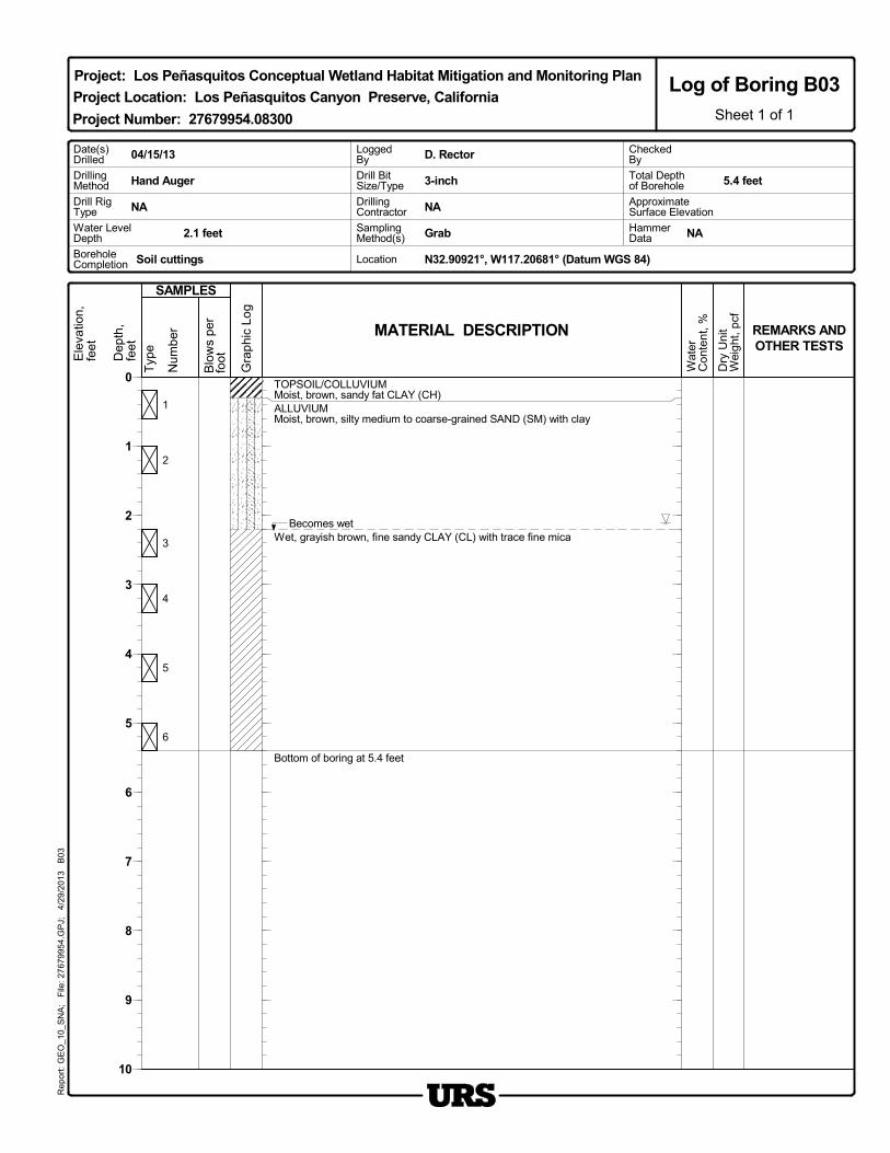
TOPSOIL/COLLUVIUMMoist, brown, sandy fat CLAY (CH)ALLUVIUMMoist, brown, silty medium to coarse-grained SAND (SM) with clay
Becomes wetWet, grayish brown, fine sandy CLAY (CL) with trace fine mica
Bottom of boring at 5.4 feet
MATERIAL DESCRIPTION
Gra
phi
c Lo
g
Dep
th,
feet
Typ
e
Num
ber
Ele
vatio
n,fe
et
Dry
Uni
tW
eigh
t, p
cf
Blo
ws
per
foot
Wat
erC
onte
nt, % REMARKS AND
OTHER TESTS
SAMPLES
LoggedBy
Total Depthof Borehole
Water LevelDepth
Drill BitSize/Type 3-inch
NAHammerDataGrab
04/15/13
2.1 feet
DrillingContractor
Soil cuttings
DrillingMethod
NA
D. Rector
ApproximateSurface Elevation
CheckedBy
Hand Auger
Date(s)Drilled
Location
SamplingMethod(s)
NA
BoreholeCompletion
5.4 feet
N32.90921°, W117.20681° (Datum WGS 84)
Drill RigType
0
1
2
3
4
5
6
7
8
9
10
Project: Los Peñasquitos Conceptual Wetland Habitat Mitigation and Monitoring Plan
Project Number: 27679954.08300
Project Location: Los Peñasquitos Canyon Preserve, CaliforniaLog of Boring B03
Sheet 1 of 1
Rep
ort:
GE
O_1
0_S
NA
; F
ile: 2
767
995
4.G
PJ;
4/
29/2
013
B
03

1
2
3
4
5
6
ALLUVIUMMoist, brown, clayey SAND (SC) with silt
Moist, yellowish brown, silty medium-grained SAND (SM) with clay
Increase in moisture content
Moist, grayish brown, clayey medium-grained SAND (SC)
Wet, grayish brown, sandy CLAY to clayey SAND (CL-SC) with trace fine mica
Wet, grayish brown, clayey medium grained SAND (SC) with trace fine mica
Bottom of boring at 6.5 feet
MATERIAL DESCRIPTION
Gra
phi
c Lo
g
Dep
th,
feet
Typ
e
Num
ber
Ele
vatio
n,fe
et
Dry
Uni
tW
eigh
t, p
cf
Blo
ws
per
foot
Wat
erC
onte
nt, % REMARKS AND
OTHER TESTS
SAMPLES
LoggedBy
Total Depthof Borehole
Water LevelDepth
Drill BitSize/Type 3-inch
NAHammerDataGrab
04/16/13
3.5 feet
DrillingContractor
Soil cuttings
DrillingMethod
NA
D. Rector
ApproximateSurface Elevation
CheckedBy
Hand Auger
Date(s)Drilled
Location
SamplingMethod(s)
NA
BoreholeCompletion
6.5 feet
N32.90667°, W117.21436° (Datum WGS 84)
Drill RigType
0
1
2
3
4
5
6
7
8
9
10
Project: Los Peñasquitos Conceptual Wetland Habitat Mitigation and Monitoring Plan
Project Number: 27679954.08300
Project Location: Los Peñasquitos Canyon Preserve, CaliforniaLog of Boring B04
Sheet 1 of 1
Rep
ort:
GE
O_1
0_S
NA
; F
ile: 2
767
995
4.G
PJ;
4/
29/2
013
B
04

1
2
3
4
5
6
ALLUVIUMMoist, brown, clayey SAND (SC) with silt
Moist, yellowish brown, silty medium-grained SAND (SM) with clay
Increase in moisture contentMoist, grayish brown, clayey SAND (SC) with trace fine mica
Wet, yellowish brown, poorly graded medium to coarse-grained SAND with silt(SP-SM)
Wet, gray to grayish brown, sandy CLAY(CL) with trace fine mica
Bottom of boring at 5.5 feet
MATERIAL DESCRIPTION
Gra
phi
c Lo
g
Dep
th,
feet
Typ
e
Num
ber
Ele
vatio
n,fe
et
Dry
Uni
tW
eigh
t, p
cf
Blo
ws
per
foot
Wat
erC
onte
nt, % REMARKS AND
OTHER TESTS
SAMPLES
LoggedBy
Total Depthof Borehole
Water LevelDepth
Drill BitSize/Type 3-inch
NAHammerDataGrab
04/16/13
3.3 feet
DrillingContractor
Soil cuttings
DrillingMethod
NA
D. Rector
ApproximateSurface Elevation
CheckedBy
Hand Auger
Date(s)Drilled
Location
SamplingMethod(s)
NA
BoreholeCompletion
5.5 feet
N32.90634°, W117.20478° (Datum WGS 84)
Drill RigType
0
1
2
3
4
5
6
7
8
9
10
Project: Los Peñasquitos Conceptual Wetland Habitat Mitigation and Monitoring Plan
Project Number: 27679954.08300
Project Location: Los Peñasquitos Canyon Preserve, CaliforniaLog of Boring B05
Sheet 1 of 1
Rep
ort:
GE
O_1
0_S
NA
; F
ile: 2
767
995
4.G
PJ;
4/
29/2
013
B
05

1
2
3
4
5
ALLUVIUMMoist, yellowish brown, fine sandy CLAY (CL)
Becomes moist to wet
With fine rounded gravels
Bottom of boring at 5.8 feet
MATERIAL DESCRIPTION
Gra
phi
c Lo
g
Dep
th,
feet
Typ
e
Num
ber
Ele
vatio
n,fe
et
Dry
Uni
tW
eigh
t, p
cf
Blo
ws
per
foot
Wat
erC
onte
nt, % REMARKS AND
OTHER TESTS
SAMPLES
LoggedBy
Total Depthof Borehole
Water LevelDepth
Drill BitSize/Type 3-inch
NAHammerDataGrab
04/16/13
3.0 feet
DrillingContractor
Soil cuttings
DrillingMethod
NA
D. Rector
ApproximateSurface Elevation
CheckedBy
Hand Auger
Date(s)Drilled
Location
SamplingMethod(s)
NA
BoreholeCompletion
5.8 feet
N32.90612°, W117.21599° (Datum WGS 84)
Drill RigType
0
1
2
3
4
5
6
7
8
9
10
Project: Los Peñasquitos Conceptual Wetland Habitat Mitigation and Monitoring Plan
Project Number: 27679954.08300
Project Location: Los Peñasquitos Canyon Preserve, CaliforniaLog of Boring B06
Sheet 1 of 1
Rep
ort:
GE
O_1
0_S
NA
; F
ile: 2
767
995
4.G
PJ;
4/
29/2
013
B
06

APPENDIXE Cultural Survey Memo
Memorandum
J:\27679000_SD Stormwater\TO-54 SW OM Support\FY 2013\014 Work in Progress\Cultural Sorrento\Bio Mit survey\Historical Memorandum - Los Cuervos-agh dzcCLEAN-MTedits.docx\8-May-13\SDG
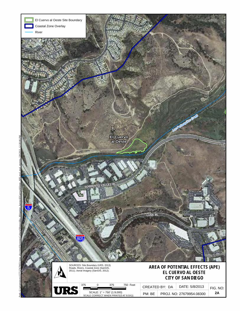
Date: May 8, 2013 To: Mark Tucker, Senior Biologist, URS, San Diego, CA. From: Dimitra Zalarvis-Chase, Senior Archaeologist, URS, San Diego, CA. Subject: El Cuervo al Oeste & El Cuervo del Sur Conceptual Wetland Mitigation and Monitoring Plan for the Sorrento-Flintkote-Soledad-Los Penasquitos Channel Stormwater Maintenance. The City of San Diego (City) has developed the Master Storm Water System Maintenance Program (MMP; Master Maintenance Program) to optimize its business processes and environmental protection practices related to channel operation and maintenance activities. The Master Maintenance Program is intended to integrate operation and maintenance planning, implementation and assessment activities with its water quality protection programs. A full Individual Historical Assessment has been prepared for the Sorrento-Flintkote-Soledad-Los Penasquitos Channel Stormwater Maintenance in compliance with the MMP’s Programmatic Environmental Impact Report (PEIR). This memorandum provides a summary of the cultural resource concerns for two proposed biological mitigation areas associated with this channel maintenance, both of which are considered Areas of Potential Effect (APE) with regard to historical resources. Project Location and Description The proposed biological mitigation project is located in San Diego County in the Los Penasquitos Canyon Preserve. The project area within the Preserve is adjacent to Sorrento Valley and bordered by Carmel Mountain and Lopez Ridge (Figure 1). The project consists of two potential biological mitigation components; El Cuervo al Oeste and El Cuervo del Sur. El Cuervo al Oeste This project component is situated at the western edge of Los Peñasquitos Canyon Preserve, northwest of Sorrento Valley Boulevard and east of Vista Sorrento Parkway and Interstate 5 (Figure 2a). The El Cuervo al Oeste project component is approximately 3.0 acres and is specifically located adjacent to the northern bank of Los Peñasquitos Creek. El Cuervo al Oeste is bordered by Los Peñasquitos Creek’s riparian vegetation to the south, a patch of herbaceous wetland to the west, an area of mixed herbaceous wetland and non-native grassland vegetation to the east, and non-native grassland to the north. More hydrophytic species occur along the border of the adjacent El Cuervo Wetland Revegetation Mitigation site. El Cuervo al Oeste has been identified as a potential wetland mitigation site within the coastal zone portions of the Peñasquitos Hydrologic Unit (HU). The mitigation efforts will include wetland creation and restoration which will include grading with heavy track equipment to a depth of 3-feet. Site access would be from the north via an established and maintained unpaved utility access road.

Page 2 of 5
El Cuervo del Sur This project component is located in the western portion of Los Peñasquitos Canyon, just east of El Cuervo al Oeste, north of Sorrento Valley Boulevard and east of Vista Sorrento Parkway and Interstate 5. The El Cuervo del Sur project component is approximately 3.71 acres and is specifically located south of Los Peñasquitos Creek, just east of the confluence of Lopez Creek with Los Peñasquitos Creek (Figure 2b). El Cuervo del Sur is not immediately proximate to, but is within the floodplain of, Los Peñasquitos Creek and occurs on the perimeter of the confluence and flood prone area of Lopez Creek. It is bordered by Los Peñasquitos Creek’s riparian vegetation to the south, a patch of herbaceous wetland to the west, an area of mixed herbaceous wetland and non-native grassland vegetation to the east, and non-native grassland to the north. The site itself is primarily non-native grassland with some native herbs and creek side edge species indicative of moister conditions. Soil series maps show Tujunga sand in this area (Bowman 1973). Past disturbance is primarily grazing and ranch related activities. El Cuervo del Sur has been identified as a potential wetland mitigation site within the coastal zone portions of the Peñasquitos HU. The mitigation efforts will include wetland creation and restoration by recontouring the floodplain through grading with heavy track equipment to a depth of one and one-half feet. Site access would be from the south via an established and maintained unpaved utility access road. METHODS The following sections describe the methods that were used for the historical records search intensive pedestrian survey of the APE. Record Search URS conducted archival research and reviewed Project related documents prior to survey in the APE. The document review included the Master Storm Water System Maintenance Program, archaeological site records, reports and historical maps.
URS requested a records search from the SCIC on March 26, 2013 and on April 19, 2012 for a quarter-mile buffer around the project APE, as well as an additional half-mile buffer in order to identify previously recorded cultural resources and cultural resource investigations pertinent to the current study. The resulting information was used to determine the historical context and sensitivity for the proposed mitigation areas.
For a complete discussion of the results, please refer to the Individual Historical Assessment for the Sorrento-Flintkote-Soledad Channel Maintenance Project (Attachment 2, and Confidential Attachment 3). Survey Methods Following the initial archival research, an intensive pedestrian survey was completed within the Project APE. The goal of the survey was systematic coverage of the Project APE using linear transects, with surveyors spaced 10 to 15 meters apart (10-meter spacing with vegetation, 15-meter spacing with no vegetation). These thresholds provide complete coverage of the Project APE unless circumstances such as vegetation, steep slopes, or existing buildings obstruct ground surface visibility. On April 26, 2013, the intensive pedestrian survey of the Project APE was conducted by URS. The survey was conducted by Dimitra Zalarvis-Chase, a Registered Professional Archaeologist from URS, and Native American

Page 3 of 5
Monitor, Justin Linton, from Red Tail Monitoring and Research, Inc. Coverage was completed using transects, spaced at 15-meter wide intervals over the accessible survey areas. Ground visibility ranged from 0-10% in the mitigation areas, and 100% on the access roads. A portion of El Cuervo al Oeste was occupied by Los Penasquitos Creek with areas of both moving and standing water. Survey was performed up to the banks of the creek and the backwaters within the survey area. The survey team was equipped with a Trimble XH global positioning unit, which was used to capture the geographic UTM coordinates and to record any new observations of cultural materials. An Archaeological Survey Coverage Map is included in Figure 3. RESULTS Record Search Results The project occurs in an area of high historical resources sensitivity. The topography and location were conducive to prehistoric settlement and resource exploitation, as evidenced by the high number and close proximity of prehistoric sites within the ½ mile search buffer, some of which contain significant midden deposits. The area also has well-documented historic settlement and agricultural use areas. Prior to designation as a preserve, cultural sites within this valley had been impacted through the construction of roads, trails, utilities, and both commercial and residential development. Despite these impacts, significant resources are still present and intact within the valley.
For a detailed discussion of the record search and archival results, please refer to the Sorrento-Flintkote-Soledad Channel Maintenance Individual Historical Assessment (IHA). Survey Results No new sites or isolates were discovered as a result of the intensive pedestrian survey (Attachment 4) and ground visibility was extremely poor, hindering efforts to observe artifacts that may be present. However, this does not preclude that additional resources are not present outside of known site boundaries. Therefore, archaeological and Native American monitoring of specific project areas is recommended where ground disturbance is scheduled to occur. Two previously recorded resources are present within the APE, but were unable to be relocated due to heavy vegetation and prior surface collection. Updated Department of Parks and Recreation (DPR 523) forms for these resources are included in Confidential Attachment 3 Native American Tribes As per the Master Storm Water System Maintenance Program Appendix C, Mitigation Monitoring and Reporting Program, consultation with the Native American Heritage Commission and the local Native American community for input regarding possible impacts to historical resources within the Project APE, particularly as they relate to traditional cultural properties and areas of Native American sensitivity, was not required. However, Native American Monitor, Justin Linton, from Red Tail Monitoring and Research, Inc. participated in the pedestrian survey of the Project APE and expressed no concerns regarding historical resources. RECOMMENDATIONS The visual absence of previously recorded historical resources does not preclude their existence within and nearby to the Project APE. Therefore in compliance with the MMP, Appendix C, Section 4.3.2.2, Environmentally

Page 4 of 5
Sensitive Area’s (ESA’s, Figure 4) have been designed for the project. Environmentally Sensitive Areas (ESA’s), as shown on Figure 4, will be protected from project impacts.
If the project is modified to introduce any new project areas not identified in Figure 3, or identified as having greater potential for the presence of obscured or buried cultural deposits, additional archaeological survey and/or mitigation measures will be implemented. These areas should be monitored by a qualified archaeologist and Native American monitor during project-related ground disturbance. This is consistent with PEIR mitigation measure 4.4.3.2 and 4.4.3.3. MITIGATION Environmental Mitigation Requirements: Historical Mitigation Conditions (HIST-#) apply to this biological mitigation project and specify additional protective measures to be used in conjunction with the ESA’s established in Figure 4.
HIST-1: ESA’s will be fenced or flagged prior to the initiation of maintenance activities through the use of non-impact, high visibility materials that can be seen by both pedestrians and machine operators.
HIST-2: There will be no mechanical disturbance within an ESA. HIST-3: Environmental rehabilitation and enhancement may occur within an ESA using hand-
methods; archaeological and Native American monitoring will be required. HIST -4: If ground-disturbance activities are necessary to improve the El Cuervo del Sur access
road, archaeological and Native American monitoring will be required. HIST -5: If ground-disturbance activities are necessary to improve the El Cuervo al Oeste
access road, archaeological and Native American monitoring will be required. HIST -6: If installation of any Best Measure Practices (BMP’s) is to occur within or on the
boundary of an ESA, archaeological and Native American monitoring will be required. HIST -7: At the close of project activities, the ESA’s will be removed to maintain the integrity of
the areas visual quality.
Additional Applicable PEIR Measures: In the unlikely event that cultural resources are exposed during wetland restoration, activities shall temporarily halt activities in the immediate vicinity of the discovery while it is evaluated for significance by a City approved and Secretary of the Interior Qualified Archaeologist. The archaeologist shall follow the process outlined in the MMP (Appendix C), and the PEIR for the Sorrento-Flintkote-Soledad Stormwater Maintenance Project to determine the correct course of action regarding historical resources within the APE. Through implementation
Page 5 of 5
of these mitigation measures, the project is expected not to have an adverse effect to any historical resources in or near the APE.
Memorandum Attachments:
Attachment 1: Project Maps Figure 1 – Project Vicinity
Figure 2a – El Cuervo al Oeste Area of Potential Effect (APE) Figure 2b – El Cuervo del Sur Area of Potential Effect (APE) Figure 3 – Intensive Survey Coverage Figure 4 – Archaeological Monitoring Exhibit (AME)
Attachment 2: PEIR Mitigation Measures Attachment 3: CONFIDENTIAL DPR Updates
REFERENCES: Bowman, Roy H.
1973 Soil Survey, San Diego Area. Volume 1. United States, Soil Conservation Service. City of San Diego
2001 San Diego Municipal Code, Land Development Code, Historical Resources Guidelines. Adopted September 28, 1999, Amended June 6, 2000 by Resolution No. R-293254-3 and Amended April 30, 2001 by City Manager Document No. C-10912.
2011 a Master Storm Water Maintenance Program. San Diego, California: October 2011
2011 b Final Recirculated Master Storm Water System Maintenance Program PEIR. San Diego, California: October 2011.
Zalarvis-Chase, Dimitra 2013 Individual Historical Assessment for the Sorrento-Flintkote-Soledad-Los Penasquitos
Channel Stormwater Maintenance. URS Corporation, San Diego, California. May 2013.

ATTACHMENT 1
Historical Resources Memorandum El Cuervo al Oeste and El Cuervo del Sur Conceptual Wetland Habitat Mitigation and Monitoring Plan

%&s(
!"a$
!"_$
!"̂$%&s(
!"a$
?n
Ag
?t
Carroll Canyon Creek
Carmel Valley
Rose Canyon
San Clemente Canyon
TecoloteC
reek
Murphy
Canyon
Creek
P A C I F I CO C E A N
_̂Project Site
_̂
_̂
Sorrento Valley Channel Maintenance Area
Mission Bay High SchoolChannel Maintenance Area
Tecolote HU
Miramar HU
Scripps HU
MiramarReservoir HU
Los Penasquitos
Creek
Soledad
Canyon
San Diego River
Los Penasquitos
San Dieguito Creek
SOURCES: City of SD (SANDAG,2008). Coastal Zone, Hydrologic Unit Freeways, Rivers, (SanGIS, 2011). USGS Topo (NGS, 2011).
PROJECT VICINITYMASTER STORM WATER MAINTENANCE PROGRAM
CITY OF SAN DIEGO
CREATED BY: DA
PM: BE PROJ. NO: 27679954.08300FIG. NO:
1SCALE: 1" = 1.5 miles (1:95,040)
0.75 0 0.75 1.5 Miles
OSCALE CORRECT WHEN PRINTED AT 8.5X11Pa
th:G
:\gis\
proj
ects\
1577
\276
7905
1\m
ap_d
ocs\
mxd
\Sor
rent
o\Cu
ltura
l\Rep
ort\B
io_M
itiga
tion_
Surv
ey\R
egio
nal_
Map
.mxd
,pau
l_m
oren
o,5/
8/20
13,1
2:18
:52
PM
DATE: 5/8/2013
City of San Diego
Penasquitos Hydrologic Unit by Subunit
Coastal Zone Overlay
River
Freeway
%&s(
!"̂$
El Cuervoal Oeste
SORRENTO VALLEY RD
ROSELLE ST
SORRENTO VALLEY BL
LUSK BL
TANSY ST
VISTA SORRENTO PY
Los Peñasquitos Creek
AREA OF POTENTIAL EFFECTS (APE)EL CUERVO AL OESTE
CITY OF SAN DIEGO
CREATED BY: DA
PM: BE PROJ. NO: 27679954.08300FIG. NO:
2ASCALE: 1" = 750' (1:9,000)
375 0 375 750 Feet
OSCALE CORRECT WHEN PRINTED AT 8.5X11Pa
th:G
:\gis\
proj
ects\
1577
\276
7905
1\m
ap_d
ocs\
mxd
\Sor
rent
o\Cu
ltura
l\Rep
ort\B
io_M
itiga
tion_
Surv
ey\E
lCue
rvoA
lOes
te_A
PE.m
xd,p
aul_
mor
eno,
5/8/
2013
,12:
30:0
6PM
DATE: 5/8/2013
El Cuervo al Oeste Site Boundary
Coastal Zone Overlay
River
SOURCES: Site Boundary (URS, 2013).Roads, Rivers, Coastal Zone (SanGIS, 2011). Aerial Imagery (SanGIS, 2012).

%&s(
!"̂$
El Cuervodel Sur
Los Peñasquitos C
reek
SORRENTO VALLEY RD
ROSELLE ST
SORRENTO VALLEY BL
LUSK BL
TELESIS CT
VISTA SORRENTO PY
AREA OF POTENTIAL EFFECTS (APE)EL CUERVO DEL SURCITY OF SAN DIEGO
CREATED BY: DA
PM: BE PROJ. NO: 27679954.08300FIG. NO:
2BSCALE: 1" = 1,000' (1:12,000)
500 0 500 1000 Feet
OSCALE CORRECT WHEN PRINTED AT 8.5X11Pa
th:G
:\gis\
proj
ects\
1577
\276
7905
1\m
ap_d
ocs\
mxd
\Sor
rent
o\Cu
ltura
l\Rep
ort\B
io_M
itiga
tion_
Surv
ey\E
lCue
rvoD
elSu
r_AP
E.m
xd,p
aul_
mor
eno,
5/8/
2013
,12:
30:0
1PM
DATE: 5/8/2013
El Cuervo del Sur Site Boundary
Coastal Zone Overlay
River
SOURCES: Site Boundary (URS, 2013).Roads, Rivers, Coastal Zone (SanGIS, 2011). Aerial Imagery (SanGIS, 2012).

SORRENTO VALLEY BL
Path
:G:\g
is\pr
ojec
ts\1
577\
2767
9051
\map
_doc
s\mxd
\Sor
rent
o\C
ultu
ral\R
epor
t\Bio
_Miti
gatio
n_Su
rvey
\Sur
vey_
Cov
erag
e.m
xd,p
aul_
mor
eno,
5/8/
2013
,12:
33:4
3PM
SOURCES:Roads, Aerial (SanGIS, 2012). PROPOSED SORRENTO BIOLOGY MITIGATION AREAS
CULTURAL SURVEY COVERAGE
CREATED BY: CM
PM: DZC PROJ. NO: 27679954.11300
FIG. NO:3SCALE: 1" = 300' (1:3,600)
150 0 150 300 Feet
OSCALE CORRECT WHEN PRINTED AT 11X17
DATE: 5/8/2013
LegendSurvey Coverage
Intensive Survey Coverage
Survey Prohibited - Under Water
Paved
Extent of Survey

SORRENTO VALLEY BL
VISTASORRENTO
PY
EAST OCEAN AIR DR
ESA-2ESA-1
ESA-3
Path
:G:\g
is\pr
ojec
ts\1
577\
2767
9051
\map
_doc
s\mxd
\Sor
rent
o\C
ultu
ral\R
epor
t\Bio
_Miti
gatio
n_Su
rvey
\ESA
.mxd
,pau
l_m
oren
o,5/
8/20
13,3
:56:
30PM
SOURCES:Roads, Aerial (SanGIS, 2012). PROPOSED SORRENTO BIOLOGY MITIGATION AREAS
ENVIRONMENTALLY SENSITIVE AREAS (ESA)
CREATED BY: CM
PM: DZC PROJ. NO: 27679954.11300
FIG. NO:4SCALE: 1" = 400' (1:4,800)
200 0 200 400 Feet
OSCALE CORRECT WHEN PRINTED AT 11X17
DATE: 5/8/2013
LegendProject Boundary
(ESA) Environmentally Sensitive Areas

ATTACHMENT 2
Individual Historical Assessment Report - Sorrento Creek-Flintkote-Soledad-Los Penasquitos Channel

Attachment 2, Page 1 of 8
Attachment 4
Applicable PEIR Mitigation Measures
GENERAL
General Mitigation 1: Prior to commencement of work, the Assistant Deputy Director (ADD) Environmental Designee of the Entitlements Division shall verify that mitigation measures for impacts to biological resources (Mitigation Measures 4.3.1 through 4.3.20), historical resources (Mitigation Measures 4.4.1 and 4.4.2), land use policy (Mitigation Measures 4.1.1 through 4.1.13), paleontological resources (Mitigation Measure 4.7.1), and water quality (Mitigation Measures 4.8.1 through 4.8.3) have been included in entirety on the submitted maintenance documents and contract specifications, and included under the heading, "Environmental Mitigation Requirements." In addition, the requirements for a Pre-maintenance Meeting shall be noted on all maintenance documents.
General Mitigation 2: Prior to the commencement of work, a Pre-maintenance Meeting shall be conducted and include, as appropriate, the MMC, SWD Project Manager, Biological Monitor, Historical Monitor, Paleontological Monitor, Water Quality Specialist, and Maintenance Contractor, and other parties of interest.
General Mitigation 3: Prior to the commencement of work, evidence of compliance with other permitting authorities is required, if applicable. Evidence shall include either copies of permits issued, letters of resolution issued by the Responsible Agency documenting compliance, or other evidence documenting compliance and deemed acceptable by the ADD Environmental Designee.
HISTORICAL RESOURCES
Mitigation Measure 4.4.3: Prior to initiating any maintenance activity where the IHA identifies a moderate to high potential for the occurrence of significant historical resources within the APE, the following actions shall be taken:
4.4.3.1 Prior to Permit Issuance or Bid Opening/Bid Award
A. Entitlements Plan Check
1. Prior to permit issuance or Bid Opening/Bid Award, whichever is applicable, the Assistant Deputy Director (ADD) Environmental designee shall verify that the requirements for Archaeological Monitoring and Native American monitoring have been noted on the applicable maintenance documents through the plan check process.
B. Letters of Qualification have been submitted to ADD 1. Prior to Bid Award, the applicant shall submit a letter of verification to Mitigation Monitoring Coordination (MMC) identifying the Principal Investigator (PI) for the project and the names of all persons involved in the archaeological monitoring program, as defined in the City of San Diego Historical Resources Guidelines
1. (HRG). If applicable, individuals involved in the archaeological monitoring program must have completed the 40-hour HAZWOPER training with certification documentation.

Attachment 2, Page 2 of 8
2. MMC will provide a letter to the applicant confirming the qualifications of the PI and all persons involved in the archaeological monitoring of the project meet the qualifications established in the HRG.
3. Prior to the start of work, the applicant must obtain written approval from MMC for any personnel changes associated with the monitoring program.
4.4.3.2 Prior to Start of Maintenance
A. Verification of Records Search
1. The PI shall provide verification to MMC that a site specific records search (1/4 mile radius) has been completed. Verification includes, but is not limited to a copy of a confirmation letter from South Coastal Information Center, or, if the search was in-house, a letter of verification from the PI stating that the search was completed.
2. The letter shall introduce any pertinent information concerning expectations and probabilities of discovery during trenching and/or grading activities.
3. The PI may submit a detailed letter to MMC requesting a reduction to the ¼ mile radius.
B. PI Shall Attend Pre-maintenance Meetings
1. Prior to beginning any work that requires monitoring; the Applicant shall arrange a Pre-maintenance Meeting that shall include the PI, Native American consultant/monitor (where Native American resources may be impacted), Maintenance Manager (MM) and/or Grading Contractor, Resident Engineer (RE), Building Inspector (BI), if appropriate, and MMC. The qualified Archaeologist and Native American Monitor shall attend any grading/excavation related Premaintenance Meetings to make comments and/or suggestions concerning the Archaeological Monitoring program with the Maintenance Manager and/or Grading Contractor.
a. If the PI is unable to attend the Pre-maintenance Meeting, the Applicant shall schedule a focused Pre-maintenance Meeting with MMC, the PI, RE, MM or BI, if appropriate, prior to the start of any work that requires monitoring.
2. Acknowledgement of Responsibility for Curation (CIP or Other Public Projects)
The applicant shall submit a letter to MMC acknowledging their responsibility for the cost of curation associated with all phases of the archaeological monitoring program.
3. Identify Areas to be Monitored
Prior to the start of any work that requires monitoring, the PI shall submit an Archaeological Monitoring Exhibit (AME) (with verification that the AME has been reviewed and approved by the Native American consultant/monitor when Native American resources may be impacted) based on the appropriate maintenance documents (reduced to 11x17) to MMC identifying the areas to be monitored including the delineation of grading/excavation limits.
The AME shall be based on the results of a site specific records search as well as information regarding the age of existing pipelines, laterals and associated appurtenances and/or any known soil conditions (native or formation). MMC shall notify the PI that the AME has been approved.
4. When Monitoring Will Occur
a. Prior to the start of any work, the PI shall also submit a maintenance schedule to MMC through

Attachment 2, Page 3 of 8
the RE indicating when and where monitoring will occur.
b. The PI may submit a detailed letter to MMC prior to the start of work or during maintenance requesting a modification to the monitoring program.
This request shall be based on relevant information such as review of final maintenance documents which indicate conditions such as age of existing pipe to be replaced, depth of excavation and/or site graded to bedrock, etc., which may reduce or increase the potential for resources to be present.
5. Approval of AME and Maintenance Schedule
After approval of the AME by MMC, the PI shall submit to MMC written authorization of the AME and Maintenance Schedule from the MM.
4.4.3.3 During Maintenance
A. Monitor Shall be Present During Grading/Excavation/Trenching
1. The Archaeological Monitor shall be present full-time during all soil disturbing and grading/excavation/trenching activities which could result in impacts to archaeological resources as identified on the AME. The Maintenance Manager is responsible for notifying the RE, PI, and MMC of changes to any maintenance activities such as in the case of a potential safety concern within the area being monitored. In certain circumstances OSHA safety requirements may necessitate modification of the AME.
2. The Native American consultant/monitor shall determine the extent of their presence during soil disturbing and grading/excavation/trenching activities based on the AME and provide that information to the PI and MMC. If prehistoric resources are encountered during the Native American consultant/monitor’s absence, work shall stop and the Discovery Notification Process detailed in Sections 4.4.3.3.B-C and 4.4.3.4-A-D shall commence.
3. The PI may submit a detailed letter to MMC during maintenance requesting a modification to the monitoring program when a field condition such as modern disturbance post-dating the previous grading/trenching activities, presence of fossil formations, or when native soils are encountered that may reduce or increase the potential for resources to be present.
4. The archaeological and Native American consultant/monitor shall document field activity via the Consultant Site Visit Record (CSVR). The CSVR’s shall be faxed by the MM to the RE the first day of monitoring, the last day of monitoring, monthly (Notification of Monitoring Completion), and in the case of ANY discoveries. The RE shall forward copies to MMC.
B. Discovery Notification Process
1. In the event of a discovery, the Archaeological Monitor shall direct the contractor to temporarily divert all soil disturbing activities, including but not limited to digging, trenching, excavating or grading activities in the area of discovery and in the area reasonably suspected to overlay adjacent resources and immediately notify the RE or BI, as appropriate.
2. The Monitor shall immediately notify the PI (unless Monitor is the PI) of the discovery.
3. The PI shall immediately notify MMC by phone of the discovery, and shall also submit written documentation to MMC within 24 hours by fax or email with photos of the resource in context, if possible.

Attachment 2, Page 4 of 8
4. No soil shall be exported off-site until a determination can be made regarding the significance of the resource specifically if Native American resources are encountered.
C. Determination of Significance
1. The PI and Native American consultant/monitor, where Native American resources are discovered shall evaluate the significance of the resource. If Human Remains are involved, follow protocol in Section 4.4.3.4 below.
a. The PI shall immediately notify MMC by phone to discuss significance determination and shall also submit a letter to MMC indicating whether additional mitigation is required.
b. If the resource is significant, the PI shall submit an Archaeological Data Recovery Program (ADRP) and obtain written approval of the program from MMC, MM and RE. ADRP and any mitigation must be approved by MMC, RE and/or MM before ground disturbing activities in the area of discovery will be allowed to resume. Note: If a unique archaeological site is also an historical resource as defined in CEQA Section 15064.5, then the limits on the amount(s) that a project applicant may be required to pay to cover mitigation costs as indicated in CEQA Section 21083.2 shall not apply.
(1). Note: For pipeline trenching and other linear projects in the public Right-of-Way, the PI shall implement the Discovery Process for Pipeline Trenching projects identified below under “D.”
c. If the resource is not significant, the PI shall submit a letter to MMC indicating that artifacts will be collected, curated, and documented in the Final Monitoring Report. The letter shall also indicate that that no further work is required.
(1). Note: For Pipeline Trenching and other linear projects in the public Right-of-Way, if the deposit is limited in size, both in length and depth; the information value is limited and is not associated with any other resource; and there are no unique features/artifacts associated with the deposit, the discovery should be considered not significant.
(2). Note, for Pipeline Trenching and other linear projects in the public Right-of-Way, if significance cannot be determined, the Final Monitoring Report and Site Record (DPR Form 523A/B) shall identify the discovery as Potentially Significant.
D. Discovery Process for Significant Resources - Pipeline Trenching and other Linear Projects in the Public Right-of-Way The following procedure constitutes adequate mitigation of a significant discovery encountered during pipeline trenching activities or for other linear project types within the Public Right-of-Way including but not limited to excavation for jacking pits, receiving pits, laterals, and manholes to reduce impacts to below a level of significance:
1. Procedures for documentation, curation and reporting
a. One hundred percent of the artifacts within the trench alignment and width shall be documented in-situ, to include photographic records, plan view of the trench and profiles of side walls, recovered, photographed after cleaning and analyzed and curated. The remainder of the deposit within the limits of excavation (trench walls) shall be left intact.
b. The PI shall prepare a Draft Monitoring Report and submit to MMC via the RE as indicated in Section 4.4.3.6-A.
c. The PI shall be responsible for recording (on the appropriate State of California Department of Park and Recreation forms-DPR 523 A/B) the resource(s) encountered during the Archaeological

Attachment 2, Page 5 of 8
Monitoring Program in accordance with the City’s Historical Resources Guidelines. The DPR forms shall be submitted to the South Coastal Information Center for either a Primary Record or SDI Number and included in the Final Monitoring Report.
d. The Final Monitoring Report shall include a recommendation for monitoring of any future work in the vicinity of the resource.
4.4.3.4 Discovery of Human Remains
If human remains are discovered, work shall halt in that area and no soil shall be exported off-site until a determination can be made regarding the provenance of the human remains; and the following procedures as set forth in CEQA Section 15064.5(e), the California Public Resources Code (Sec. 5097.98) and State Health and Safety Code (Sec. 7050.5) shall be undertaken:
A. Notification
1. Archaeological Monitor shall notify the RE or BI as appropriate, MMC, and the PI, if the Monitor is not qualified as a PI. MMC will notify the appropriate Senior Planner in the Environmental Analysis Section (EAS) of the Development Services Department to assist with the discovery notification process.
2. The PI shall notify the Medical Examiner after consultation with the RE, either in person or via telephone.
B. Isolate discovery site
1. Work shall be directed away from the location of the discovery and any nearby area reasonably suspected to overlay adjacent human remains until a determination can be made by the Medical Examiner in consultation with the PI concerning the provenience of the remains.
2. The Medical Examiner, in consultation with the PI, will determine the need for a field examination to determine the provenience.
3. If a field examination is not warranted, the Medical Examiner will determine with input from the PI, if the remains are or are most likely to be of Native American origin.
C. If Human Remains ARE determined to be Native American
1. The Medical Examiner will notify the Native American Heritage Commission (NAHC) within 24 hours. By law, ONLY the Medical Examiner can make this call.
2. NAHC will immediately identify the person or persons determined to be the Most
Likely Descendent (MLD) and provide contact information.
3. The MLD will contact the PI within 24 hours or sooner after the Medical Examiner has completed coordination, to begin the consultation process in accordance with CEQA Section 15064.5(e), the California Public Resources and Health & Safety Codes.
4. The MLD will have 48 hours to make recommendations to the property owner or representative, for the treatment or disposition with proper dignity, of the human remains and associated grave goods.
5. Disposition of Native American Human Remains will be determined between the MLD and the PI, and, if:

Attachment 2, Page 6 of 8
a. The NAHC is unable to identify the MLD, OR the MLD failed to make a recommendation within 48 hours after being notified by the Commission, OR;
b. The landowner or authorized representative rejects the recommendation of the MLD and mediation in accordance with PRC 5097.94 (k) by the NAHC fails to provide measures acceptable to the landowner, THEN
c. To protect these sites, the landowner shall do one or more of the following:
(1) Record the site with the NAHC;
(2) Record an open space or conservation easement; or
(3) Record a document with the County.
d. Upon the discovery of multiple Native American human remains during a ground disturbing land development activity, the landowner may agree that additional conferral with descendants is necessary to consider culturally appropriate treatment of multiple Native American human remains. Culturally appropriate treatment of such a discovery may be ascertained from review of the site utilizing cultural and archaeological standards. Where the parties are unable to agree on the appropriate treatment measures the human remains and buried with Native American human remains shall be reinterred with appropriate dignity, pursuant to Section 4.4.3.5.c., above.
D. If Human Remains are NOT Native American
1. The PI shall contact the Medical Examiner and notify them of the historic era context of the burial.
2. The Medical Examiner will determine the appropriate course of action with the PI and City staff (PRC 5097.98).
3. If the remains are of historic origin, they shall be appropriately removed and conveyed to the San Diego Museum of Man for analysis. The decision for internment of the human remains shall be made in consultation with MMC, EAS, the applicant/landowner, any known descendant group, and the San Diego Museum of Man.
4.4.3.5 Night and/or Weekend Work
A. If night and/or weekend work is included in the contract
1. When night and/or weekend work is included in the contract package, the extent and timing shall be presented and discussed at the Pre-maintenance meeting.
2. The following procedures shall be followed.
a. No Discoveries
In the event that no discoveries were encountered during night and/or weekend work, the PI shall record the information on the CSVR and submit to MMC via fax by 8AM of the next business day.
b. Discoveries
All discoveries shall be processed and documented using the existing procedures detailed in Sections 4.4.3.3 - During Maintenance, and 4.4.3.4 – Discovery of Human Remains. Discovery of human remains shall always be treated as a significant discovery.
Attachment 2, Page 7 of 8
c. Potentially Significant Discoveries
If the PI determines that a potentially significant discovery has been made, the procedures detailed under Sections 4.4.3.3 During Maintenance and 4.4.3.4-Discovery of Human Remains shall be followed.
d. The PI shall immediately contact the RE and MMC, or by 8AM of the next business day to report and discuss the findings as indicated in Section 4.4.3.3-B, unless other specific arrangements have been made.
B. If night and/or weekend work becomes necessary during the course of maintenance
1. The Maintenance Manager shall notify the RE, or BI, as appropriate, a minimum of 24 hours before the work is to begin.
2. The RE, or BI, as appropriate, shall notify MMC immediately.
C. All other procedures described above shall apply, as appropriate.
4.4.3.6 Post Maintenance
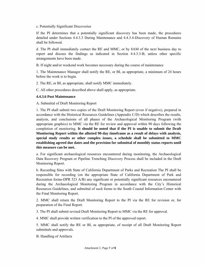
A. Submittal of Draft Monitoring Report
1. The PI shall submit two copies of the Draft Monitoring Report (even if negative), prepared in accordance with the Historical Resources Guidelines (Appendix C/D) which describes the results, analysis, and conclusions of all phases of the Archaeological Monitoring Program (with appropriate graphics) to MMC via the RE for review and approval within 90 days following the completion of monitoring. It should be noted that if the PI is unable to submit the Draft Monitoring Report within the allotted 90-day timeframe as a result of delays with analysis, special study results or other complex issues, a schedule shall be submitted to MMC establishing agreed due dates and the provision for submittal of monthly status reports until this measure can be met.
a. For significant archaeological resources encountered during monitoring, the Archaeological Data Recovery Program or Pipeline Trenching Discovery Process shall be included in the Draft Monitoring Report.
b. Recording Sites with State of California Department of Parks and Recreation The PI shall be responsible for recording (on the appropriate State of California Department of Park and Recreation forms-DPR 523 A/B) any significant or potentially significant resources encountered during the Archaeological Monitoring Program in accordance with the City’s Historical Resources Guidelines, and submittal of such forms to the South Coastal Information Center with the Final Monitoring Report.
2. MMC shall return the Draft Monitoring Report to the PI via the RE for revision or, for preparation of the Final Report.
3. The PI shall submit revised Draft Monitoring Report to MMC via the RE for approval.
4. MMC shall provide written verification to the PI of the approved report.
5. MMC shall notify the RE or BI, as appropriate, of receipt of all Draft Monitoring Report submittals and approvals.
B. Handling of Artifacts

Attachment 2, Page 8 of 8
1. The PI shall be responsible for ensuring that all cultural remains collected are cleaned and catalogued.
2. The PI shall be responsible for ensuring that all artifacts are analyzed to identify function and chronology as they relate to the history of the area; that faunal material is identified as to species; and that specialty studies are completed, as appropriate.
C. Curation of artifacts: Accession Agreement and Acceptance Verification
1. The PI shall be responsible for ensuring that all artifacts associated with the survey, testing and/or data recovery for this project are permanently curated with an appropriate institution. This shall be completed in consultation with MMC and the Native American representative, as applicable.
2. When applicable to the situation, the PI shall include written verification from the Native American consultant/monitor indicating that Native American resources were treated in accordance with state law and/or applicable agreements. If the resources were reinterred, verification shall be provided to show what protective measures were taken to ensure no further disturbance occurs in accordance with Section 4.4.3.4 – Discovery of Human Remains, Subsection C.
3. The PI shall submit the Accession Agreement and catalogue record(s) to the RE or BI, as appropriate for donor signature with a copy submitted to MMC.
4. The RE or BI, as appropriate shall obtain signature on the Accession Agreement and shall return to PI with copy submitted to MMC.
5. The PI shall include the Acceptance Verification from the curation institution in the Final Monitoring Report submitted to the RE or BI and MMC.
D. Final Monitoring Report(s)
1. The PI shall submit one copy of the approved Final Monitoring Report to the RE or BI as appropriate, and one copy to MMC (even if negative), within 90 days after notification from MMC of the approved report.
2. The RE shall, in no case, issue the Notice of Completion until receiving a copy of the approved Final Monitoring Report from MMC which includes the Acceptance Verification from the curation institution.

CONFIDENTIAL - ATTACHMENT 3
Historical Resources Memorandum El Cuervo al Oeste and El Cuervo del Sur Conceptual Wetland Habitat Mitigation and Monitoring Plan

State of California The Resources Agency Primary # DEPARTMENT OF PARKS AND RECREATION HRI#
CONTINUATION SHEET Trinomial CA-SDI-1087 Page 1 of 2 *Resource Name or # (Assigned by recorder)
*Recorded by: Dimitra Zalarvis-Chase, RPA, URS San Diego, CA. *Date: May 8, 2013 Update
View East: Looking up to previous location of CA-SDi-1087 from the access road below. The original site extent included the location of the current housing development up on the ridge.
View West: Looking across CA-SDI-1087 (foreground) from inside the sites’ eastern boundary, towards the access road.
DPR 523L (1/95) *Required information
DPR Form 523C, Archaeological Site Record; Section A14. Remarks (Update): On April 26, 2013, an archaeological survey was conducted in support of the City of San Diego Sorrento-Flintkote-Soledad Stormwater Channel Maintenance Project. Survey occurred specifically in two areas proposed for biological mitigation activities within the Los Penasquitos Preserve. For this project, an effort was made to relocate CA-SDI-1087 as its boundary intersected with the buffer of a proposed mitigation area. The intensive pedestrian survey was conducted by Dimitra Zalarvis-Chase, a Registered Professional Archaeologist from URS, and Native American Monitor, Justin Linton, from Red Tail Monitoring and Research, Inc. CA-SDI-1087 is described as a temporary campsite exhibiting shell midden, groundstone, and a lithic scatter and had been previously surveyed and documented by Carrico & Rhodes (1980, NADB 1120425); Fink (1983, NADB 1128535); Schaefer & Elling (1987, NADB 1121794); and The City of San Diego (1992, NADB 1124715). Carrico and Rhoades (1980) noted that the site exhibited subsurface disturbance, and collected surface artifacts at that time. However Fink (1983) describes the site as still exhibiting manos, metates, scrapers, and four tools. Fink states that no midden was observed, but was suspected to exist. Disturbances included a road cut and cattle grazing. Schaefer & Elling (1987) describe the site as a large shell midden with stone tools, groundstone, and debitage at the surface. They also note that the site was tested by S. Hector in 1987 which resulted in the discovery of additional fish and mammal bone, charcoal, and bone tools. Additional disturbances at that time included rodents and cattle. The City of San Diego (1992) noted the site in its review of resources in the Los Penasquitos Canyon. The April 2013 survey found no trace of CA-SD1-1087 within the project boundary. Visibility was 0% as knee-high grasses covered the entire site location. Although the site appears to have been surface collected and tested, the portion of the site that intersects with the project boundary buffer will be protected from

State of California The Resources Agency Primary # DEPARTMENT OF PARKS AND RECREATION HRI#
CONTINUATION SHEET Trinomial CA-SDI-1087 Page 2 of 2 *Resource Name or # (Assigned by recorder)
*Recorded by: Dimitra Zalarvis-Chase, RPA, URS San Diego, CA. *Date: May 8, 2013 2013 Update
DPR Form 523C, Archaeological Site Record; Section A14. Remarks (Update, continued): project effects through designation as an Environmentally Sensitive Area (ESA). As an ESA, there will a prohibition on mechanical disturbance within the area and it will be fenced off from project activities. Project work by hand methods is not expected to occur within the ESA. REFERENCES: Bowman, Roy H.
1973 Soil Survey, San Diego Area. Volume 1. United States, Soil Conservation Service. City of San Diego
2001 San Diego Municipal Code, Land Development Code, Historical Resources Guidelines. Adopted September 28, 1999, Amended June 6, 2000 by Resolution No. R-293254-3 and Amended April 30, 2001 by City Manager Document No. C-10912.
2011 a Master Storm Water Maintenance Program. San Diego, California: October 2011 2011 b Final Recirculated Master Storm Water System Maintenance Program PEIR. San Diego, California: October 2011.
Carrico, Richard L. and Keith D. Rhodes 1980 Archaeological Survey of the Ridge. WESTEC Services, Inc. Submitted to Penasquitos
Properties. Unpublished Report on file at SCIC, SAN DIEGO STATE UNIVERSITY, SAN DIEGO, CA 92182. NADB #: 1120425
City of San Diego 1992 APPENDICES TO THE DRAFT ENVIRONMENTAL IMPACT REPORT FOR THE LOS
PENASQUITOS CANYON PRESERVE MASTER PLAN. CITY OF SAN DIEGO. Submitted to CITY OF SAN DIEGO. Unpublished Report on file at SOUTH COASTAL INFORMATION CENTER, SAN DIEGO STATE UNIVERSITY. NADB #: 1124715
Fink, Gary 1983 THE CULTURAL RESOURCES OF LOS PENASQUITOS REGIONAL PARK, SAN DIEGO,
CALIFORNIA. COUNTY OF SAN DIEGO DEPT. OF PUBLIC WORKS. Submitted to PARK DEVELOPMENT DIVISION. Unpublished Report on file at South Coastal Information Center, San Diego State University. NADB #: 1128535
Schaefer, Jerry and Michael C. Elling 1987 An Assessment of Cultural Resources in Los Penasquitos Canyon Reserve San Diego,
California. Consulting Archaeologists. Submitted to County of San Diego Department of Parks and Recreation. Unpublished Report on file at SCIC, SAN DIEGO STATE UNIVERSITY, SAN DIEGO, CA 92182. NADB #: 1121794
Zalarvis-Chase, Dimitra 2013 Individual Historical Assessment for the Sorrento-Flintkote-Soledad-Los Penasquitos Channel Stormwater Maintenance. URS Corporation, San Diego, California. May 2013.

State of California The Resources Agency Primary # DEPARTMENT OF PARKS AND RECREATION HRI#
CONTINUATION SHEET Trinomial CA-SDI-5201H Page 1 of 2 *Resource Name or # (Assigned by recorder)
*Recorded by: Dimitra Zalarvis-Chase, RPA, URS San Diego, CA. *Date: May 8, 2013 Update DPR 523L (1/95) *Required information
View NE: The Ruiz-Alvarado Adobe with a perimeter fence and protective roofing.
View South: Looking across the El Cuervo del Oeste work area, to the potentially alternate location of CA-SDI-5201H.
DPR Form 523C, Archaeological Site Record; Section A14. Remarks (Update): On April 26, 2013, an archaeological survey was conducted in support of the City of San Diego Sorrento-Flintkote-Soledad Stormwater Channel Maintenance Project. Survey occurred specifically in two areas proposed for biological mitigation activities within the Los Penasquitos Preserve. For this project, an effort was made to relocate CA-SDI-5201H as its boundary intersected with the buffer of a proposed mitigation area. The intensive pedestrian survey was conducted by Dimitra Zalarvis-Chase, a Registered Professional Archaeologist from URS, and Native American Monitor, Justin Linton, from Red Tail Monitoring and Research, Inc. The Ruiz-Alvarado/El Cuervo Adobe (CA-SDI-05201H) is located in the project buffer and is NRHP Listed as an Individual Property (1S). It has been previously documented by Fink (1983, NADB 1128535); Schaefer & Elling (1987, NADB 1121794); and The City of San Diego (1992, NADB 1124715). Fink (1983) cites that the site was first recorded in 1977 by L. McCoy, in a state of advanced decay, and having a few ceramic, glass, and metal artifacts associated with the crumbling adobe. Schaefer & Elling (1987) described the site as a Mexican-American Period adobe that has incurred direct and indirect impacts. The City of San Diego (1992) noted the site in its review of resources in the Los Penasquitos Canyon. The initial record search recorded this adobe in two different locations; one location up on a terrace out of the floodplain, the other down in the meadow within a work area. Both locations were intensively surveyed for the described resources. Visibility was 0% in the floodplain location as knee-high grasses covered the entire site location. Visibility was 40% up on the terrace due to sparser grasses and pedestrian use. It was determined that the terrace location was the correct location on record for the described resource. However, the other location will be treated as having the potential for buried resources for management

State of California The Resources Agency Primary # DEPARTMENT OF PARKS AND RECREATION HRI#
CONTINUATION SHEET Trinomial CA-SDI-5201H Page 2 of 2 *Resource Name or # (Assigned by recorder)
*Recorded by: Dimitra Zalarvis-Chase, RPA, URS San Diego, CA. *Date: May 8, 2013 2013 Update
DPR Form 523C, Archaeological Site Record; Section A14. Remarks (Update, continued): purposes and will be included in an Environmentally Sensitive Area (ESA) and protected from project effects. As an ESA, there will a prohibition on mechanical disturbance within the area and it will be fenced off from project activities. Project work by hand methods is not expected to occur within the ESA. REFERENCES: Bowman, Roy H.
1973 Soil Survey, San Diego Area. Volume 1. United States, Soil Conservation Service. City of San Diego
2001 San Diego Municipal Code, Land Development Code, Historical Resources Guidelines. Adopted September 28, 1999, Amended June 6, 2000 by Resolution No. R-293254-3 and Amended April 30, 2001 by City Manager Document No. C-10912.
2011 a Master Storm Water Maintenance Program. San Diego, California: October 2011 2011 b Final Recirculated Master Storm Water System Maintenance Program PEIR. San Diego, California: October 2011.
City of San Diego 1992 APPENDICES TO THE DRAFT ENVIRONMENTAL IMPACT REPORT FOR THE LOS
PENASQUITOS CANYON PRESERVE MASTER PLAN. CITY OF SAN DIEGO. Submitted to CITY OF SAN DIEGO. Unpublished Report on file at SOUTH COASTAL INFORMATION CENTER, SAN DIEGO STATE UNIVERSITY. NADB #: 1124715
Fink, Gary 1983 THE CULTURAL RESOURCES OF LOS PENASQUITOS REGIONAL PARK, SAN DIEGO,
CALIFORNIA. COUNTY OF SAN DIEGO DEPT. OF PUBLIC WORKS. Submitted to PARK DEVELOPMENT DIVISION. Unpublished Report on file at South Coastal Information Center, San Diego State University. NADB #: 1128535
Schaefer, Jerry and Michael C. Elling 1987 An Assessment of Cultural Resources in Los Penasquitos Canyon Reserve San Diego,
California. Consulting Archaeologists. Submitted to County of San Diego Department of Parks and Recreation. Unpublished Report on file at SCIC, SAN DIEGO STATE UNIVERSITY, SAN DIEGO, CA 92182. NADB #: 1121794
Zalarvis-Chase, Dimitra 2013 Individual Historical Assessment for the Sorrento-Flintkote-Soledad-Los Penasquitos Channel Stormwater Maintenance. URS Corporation, San Diego, California. May 2013.

APPENDIXF Least Bell’s Vireo Survey Results Memo

Memorandum
Date: August 2, 2013 To: Stephanie Bracci CC: Mark Tucker, Sundeep Amin From: Ryan Randall Subject: Least Bell’s Vireo Final Survey Results for Study Area within
Los Peñasquitos Canyon Preserve This memo documents the methods and results of the Least Bell’s Vireo (Vireo bellii pusillus) surveys conducted within the Study Area of Los Peñasquitos Canyon Preserve between April 30 and July 24, 2013 (Table 1, Figure 1). The results presented in this memo constitute final survey results. The current U.S. Fish and Wildlife Service (USFWS) protocol recommends that the presence or absence of Least Bell’s Vireos be determined by surveying all potential habitats a minimum of eight times. URS has conducted eight survey rounds as of July 24, 2013. The results of the entire survey effort will be submitted to the USFWS by September 7, 2013. Methods URS biologists conducted eight Least Bell’s Vireo surveys within the Los Peñasquitos Canyon Preserve (Table 1). Survey methodology followed the USFWS Least Bell’s Vireo Survey Guidelines (USFWS 2001). Surveys were conducted by qualified biologists familiar with behaviors and vocalizations of the target species as well as similar species with overlapping ranges. Surveys were conducted between dawn and 11:00 a.m. and not during inclement weather conditions such as extreme heat or cold, rain, or wind. URS biologists utilized different survey routes and directions during each successive survey effort in order to increase the probability of Least Bell’s Vireo detections. URS biologists spent more time actively listening and watching for vireos in the most suitable habitat along the survey routes. URS biologists recorded and mapped the numbers and locations of Least Bell’s Vireos as well as any leg bands detected on individual birds. The presence, number, and sex of Brown-headed Cowbirds (Molothrus ater) were also recorded. URS biologists recorded occurrences of other special status bird species when detected. Results URS biologists detected Least Bell’s Vireos on four occasions (Figure 1). URS biologists also consistently detected Brown-headed Cowbirds within the study area during the course of the eight survey rounds. The numbers of Least Bell’s Vireo and Brown-headed Cowbird individuals detected during each survey round are shown below in Table 1. Note that a portion of the Least Bell’s Vireos and Brown-headed Cowbirds may be repeat detections of the same individuals. Table 1 also documents weather conditions and survey personnel for each date. Specific information regarding the detections is presented below.

Page 2 of 4
Table 1. Dates, observers, weather conditions, and Least Bell’s Vireo and Brown-headed Cowbird detections by survey round
URS biologists Julie Stout and Ryan Randall observed one unbanded Least Bell’s Vireo during the first survey round on April 30 approximately 315 meters west of the proposed El Cuervo al Oeste mitigation site (Figure 1). This individual was observed in a dense willow thicket moving from perch to perch to sing. No Least Bell’s Vireos were found in this area during subsequent survey rounds. Fifteen Brown-headed Cowbirds were detected during the first survey round. URS biologist Sundeep Amin detected two unbanded Least Bell’s Vireos during the third survey round on May 24 (Figure 1). The two vireos were in the same general location at the time of detection, approximately 375 meters northeast of the proposed El Cuervo al Oeste mitigation site and 320 meters west of the proposed El Cuervo del Sur mitigation site (Figure 1). One bird was observed singing while the other bird was moving in the vegetation directly below. Based on the observed proximity and behaviors the two birds were considered to be a pair. Twelve Brown-headed Cowbirds were detected during the third survey round. No vireos were detected during the second, fourth, and fifth survey rounds, however, eight, ten, and five Brown-headed Cowbirds were detected during those rounds, respectively. URS biologist Sundeep Amin detected two Least Bell’s Vireos counter-singing during the sixth survey round. The new territorial male was detected approximately 120 meters east of the previously detected pair from May 24. This new vireo territory was located approximately 210 meters west of the proposed El Cuervo del Sur mitigation site (Figure 1). The final Least Bell’s Vireo detection occurred during the seventh survey round on July 12, 2013. One individual was observed approximately 110 meters west of the pair detected on May 24 and approximately 430 meters west of the proposed El Cuervo del Sur mitigation site (Figure 1). Six, five, and four Brown-headed Cowbirds were observed during the sixth, seventh, and eighth survey rounds, respectively. A complete list of bird species detected during the four surveys rounds is presented in Table 2. Sensitive species detected during the survey include Allen’s Hummingbird (Selasphorus sasin; USFWS:BCC1), Coastal California
1 USFWS: U.S. Fish and Wildlife Service; BCC: Birds of Conservation Concern
SurveyRound
Date ObserversStart Time
End Time
Starting Temp (F)
Ending Temp (F)
Starting Wind Speed (mph)
Ending Wind Speed (mph)
Starting Cloud
Cover %
Ending Cloud
Cover %
Least Bell's Vireos
Detected
Brown-headed
Cowbirds Detected
1 April 30, 2013 RR, JS 0620 1030 60.4 65 1-3 1-3 100 100 1 152 May 14, 2013 SA 0645 1105 65 75 0-1 0-3 100 0 0 83 May 24, 2013 SA 0630 1105 67 69 0-2 1-3 40 10 2 124 June 6, 2013 SA, PH 0630 1110 65 69 3-5 3-5 100 100 0 105 June 17, 2013 SA 0639 1100 67 75 1-3 2-5 100 0 0 56 June, 27, 2013 SA 0630 1030 65.3 85 0-2 0-3 100 0 2 67 July 12, 2013 SA 0615 1100 66.7 78 0-2 1-3 80 50 1 58 July 24, 2013 SA, RR 0620 1030 68 71 0-2 0-2 100 100 0 4
JS = Julie Stout, PH = Phillip Howard, RR = Ryan Randall, SA = Sundeep Amin

Page 3 of 4
Gnatcatcher (Polioptila californica californica; ESA:T2, CDFW:SSC3 ), Grasshopper Sparrow (Ammodramus savannarum; CDFW:SSC), Least Bell’s Vireo (Vireo bellii pusillus; ESA/CESA:E4), Northern Harrier (Circus cyaneus; CDFW:SSC), Nuttall’s Woodpecker (Picoides nuttallii; USFWS:BCC), White-tailed Kite (Elanus leucurus; CDFW:FP5), Yellow Warbler (Setophaga petechia; CDFW:SSC, USFWS:BCC), and Yellow-breasted Chat (Icteria virens; CDFW:SSC).
Table 2. Bird species observed during survey from April 30, 2013 to July 24, 2013
Common Name Scientific Name
Acorn Woodpecker Melanerpes formicivorus Allen's Hummingbird Selasphorus sasin American Crow Corvus brachyrhynchos American Goldfinch Spinus tristis American Kestrel Falco sparverius Anna's Hummingbird Calypte anna Ash-throated Flycatcher Myiarchus cinerascens Black Phoebe Sayornis nigricans Black-chinned Hummingbird Archilochus alexandri Black-headed Grosbeak Pheucticus melanocephalus Blue Grosbeak Passerina caerulea Brown-headed Cowbird Molothrus ater Bushtit Psaltriparus minimus California Quail Callipepla californica California Thrasher Toxostoma redivivum California Towhee Melozone crissalis Cassin's Kingbird Tyrannus vociferans Cliff Swallow Petrochelidon pyrrhonota Coastal California Gnatcatcher Polioptila californica Common Raven Corvus corax Common Yellowthroat Geothlypis trichas Downy Woodpecker Picoides pubescens European Starling Sturnus vulgaris Grasshopper Sparrow Ammodramus savannarum Green Heron Butorides virescens Hooded Oriole Icterus cucullatus House Finch Haemorhous mexicanus House Wren Troglodytes aedon Killdeer Charadrius vociferus Least Bell's Vireo Vireo b. pusillus
2 ESA: Endangered Species Act; T: Threatened 3 CDFW: California Department of Fish and Wildlife; SSC: Species of Special Concern 4 CESA: California Endangered Species Act; E: Endangered 5 FP: Fully Protected

Page 4 of 4
Lesser Goldfinch Spinus psaltria MacGillivray's Warbler Geothlypis tolmiei Mallard Anas platyrhynchos Mourning Dove Zenaida macroura Northern Harrier Circus cyaneus Northern Mockingbird Mimus polyglottos Northern Rough-winged Swallow Stelgidopteryx serripennis Nuttall's Woodpecker Picoides nuttallii Orange-crowned Warbler Oreothlypis celata Osprey Pandion haliaetus Pacific-slope Flycatcher Empidonax difficilis Red-shouldered Hawk Buteo lineatus Red-tailed Hawk Buteo jamaicensis Red-winged Blackbird Agelaius phoeniceus Ruby-crowned Kinglet Regulus calendula Say's Phoebe Sayornis saya Song Sparrow Melospiza melodia Spotted Towhee Pipilo maculatus Tree Swallow Tachycineta bicolor Warbling Vireo Vireo gilvus Western Kingbird Tyrannus verticalis Western Scrub-Jay Aphelocoma californica White-tailed Kite Elanus leucurus White-throated Swift Aeronautes saxatalis Wrentit Chamaea fasciata Yellow Warbler Setophaga petechia Yellow-breasted Chat Icteria virens

!.
!.
!.
!.
%&s(
Least Bell's Vireo Individual (1)Survey 1; April 30, 2013
Least Bell's Vireo Individual (1)Survey 6; June 27, 2013
Least Bell's Vireo Individual (1)Survey 6; June 27, 2013
Least Bell's Vireo Individual (1)Survey 7; July 12, 2013
Least Bell's Vireo Individuals (2)Survey 3; May 24, 2013
El Cuervoal Oeste
El Cuervodel Sur
Path
:G:\g
is\pr
ojec
ts\1
577\
2767
9051
\map
_doc
s\mxd
\PQ
_Can
yon_
Miti
gatio
n\W
ildlif
e_Su
rvey
\LBV
I.mxd
,col
in_m
attis
on,8
/2/2
013,
2:01
:27
PM
SOURCES: GPS Points (URS, 2013). Open Space, City of SD Utilities Mitigation, Coastal Zone (SanGIS, 2010).Mitigation Boundaries (URS, 2012). LEAST BELL’S VIREO FINAL SURVEY RESULTS FOR
STUDY AREA WITHIN LOS PEÑASQUITOS CANYON PRESERVE
CREATED BY: CM
PM: MT PROJ. NO: 27679954.02000
FIGURE1SCALE: 1" = 500' (1:6,000)
250 0 250 500 Feet
OSCALE CORRECT WHEN PRINTED AT 11X17
DATE: 8/2/2013
Los Peñasquitos Canyon Least Bell’s Vireo Survey Results
Study Area
*Note: Brown-headed Cowbirds (Molothrus ater) observedthroughout Study Area
Survey DateLeast Bell's
Vireos Detected
Brown-headed Cowbirds Detected*
1 April 30, 2013 1 152 May 14, 2013 0 83 May 24, 2013 2 124 June 6, 2013 0 105 June 17, 2013 0 56 June 27, 2013 2 67 July 12, 2013 1 58 July 24, 2013 0 4
!. Least Bell's Vireo (Vireo bellii pusillus) Approximate Location