Embed Size (px)
Citation preview

Application for an Individual Incidental Take Permit under the Endangered Species Act of 1973
September 6, 2012
Updated: January 18, 2013
Updated: June 13, 2013
Dr. Louis B. Daniel, III
In His Capacity as Director of
North Carolina Division of Marine Fisheries
Applicant/Permit Holder
3441 ARENDELL STREET PO BOX 769
MOREHEAD CITY
NORTH CAROLINA 28557
252-726-7021
FAX: 252-726-0254
Atlantic Sea Turtle Populations of:
Loggerhead, Caretta caretta Green, Chelonia mydas
Kemp’s ridley, Lepidochelys kempii
Leatherback, Dermochelys coriacea Hawksbill, Eretmochelys imbricata

ii
TABLE OF CONTENTS
LIST OF TABLES............................................................................................................................... IV
LIST OF FIGURES ............................................................................................................................. VI
INTRODUCTION ................................................................................................................................. 8
SPECIES OF CONCERN .................................................................................................................... 8
Estuarine GILL-NET FISHERIES ..................................................................................................... 10
LANDINGS AND VALUES ............................................................................................................. 13
SEA TURTLE INTERACTION TRENDS ........................................................................................ 14
MANAGEMENT HISTORY ............................................................................................................. 15
PSGNRA Management .................................................................................................................. 16
Current Management ..................................................................................................................... 18
MANAGEMENT MEASURES ......................................................................................................... 20
Settlement Agreement .................................................................................................................... 20
Large Mesh Gill Nets ..................................................................................................................... 21
Small Mesh Gill Nets ..................................................................................................................... 23
Gear Testing .................................................................................................................................. 24
Outreach .............................................................................................................................................. 24
CONSERVATION PLAN ................................................................................................................... 26
ANTICIPATED IMPACT: SEA TURTLES ..................................................................................... 27
Requested Takes ............................................................................................................................ 27
ANTICIPATED IMPACTS: POPULATION LEVELS ..................................................................... 34
Population Assessments ................................................................................................................. 34
ANTICIPATED IMPACT: HABITAT ............................................................................................. 36
MONITOR, MINIMIZE, AND MITIGATE IMPACTS ..................................................................... 37
Monitor Impacts ............................................................................................................................ 37
Minimize Impacts .......................................................................................................................... 42
Mitigate Impacts ............................................................................................................................ 42

iii
Funding ......................................................................................................................................... 45
ALTERNATIVES CONSIDERED .................................................................................................... 46
Alternative 1: No-Action Alternative ............................................................................................ 46
Alternative 2. ................................................................................................................................. 47
Alternative 3. ................................................................................................................................. 48
Alternative 4. ................................................................................................................................. 48
Alternative 5. ................................................................................................................................. 49
APPLICATION ................................................................................................................................. 49
REFERENCES CITED ....................................................................................................................... 51
TABLES .............................................................................................................................................. 56
FIGURES............................................................................................................................................. 72
APPENDIX A. DATA LOGS ............................................................................................................. 89
PROGRAM 466 DATA LOGS: ONBOARD OBSERVATIONS ...................................................... 89
PROGRAM 467 DATA LOGS: ALTERNATIVE PLATFORM OBSERVATIONS .......................... 94
SEA TURTLE INCIDENTAL CAPTURE REPORT ....................................................................... 100
STURGEON INCIDENTAL CAPTURE REPORT ......................................................................... 101
APPENDIX B. SETTLEMENT AGREEMENT .............................................................................. 102
APPENDIX C. LARGE MESH GILL-NET PROCLAMATIONS ................................................. 108
APPENDIX D. NMFS INFORMATION REQUEST AND UPDATE ............................................ 126
NMFS COMMENTS ....................................................................................................................... 126
NCDMF RESPONSE (BOLD – TAKEN DIRECTLY FROM ITP APPLICATION) ....................... 126
ESTIMATION OF OPTIMAL OBSERVER COVERAGE LEVELS IN NORTH CAROLINA’S
ESTUARINE GILL-NET FISHERY ............................................................................................... 134
INTRODUCTION ....................................................................................................................... 134
METHODS ................................................................................................................................. 134
RESULTS ................................................................................................................................... 134
LITERATURE CITED ................................................................................................................ 135

iv
ANNUAL CUMULATIVE REQUESTED TAKES ......................................................................... 138
APPENDIX E: FINAL ITP APPLICATION REVISION JUNE 12, 2013 ..................................... 139
APRIL 24, 2013 .............................................................................................................................. 140
JUNE 4, 2013 .................................................................................................................................. 150
JUNE 12, 2013 – AMENDMENT TO THE SETTLEMENT AGREEMENT ................................... 152
LIST OF TABLES
Table 1. Sea turtle strandings in North Carolina by species and year from 2001 through 2011 from the
North Carolina Wildlife Resources Commission (NCWRC). ................................................... 56
Table 2. Observed and estimated sea turtles takes by species and disposition (alive/dead) per year
throughout the Pamlico Sound Gill Net Restricted Area (PSGNRA) from 2005 through 2011. . 57
Table 3. Observed sea turtle interactions by species and disposition (alive/dead) from the National
Marine Fisheries Service (NMFS) Alternative Platform (AP) Gill Net Observer Program in Core
Sound, NC during June through November 2009. .................................................................... 57
Table 4. Summary of significant sea turtle gill-net restrictions and exemptions implemented by the North
Carolina Division of Marine Fisheries (NCDMF) through proclamation from May 2010 through
May 2012. ............................................................................................................................... 58
Table 5. Large (≥4 in) and small (<4 in) mesh gill-net trips from 2009 through 2011 by season and
Management Unit. ................................................................................................................... 59
Table 6. Large (≥4 in) and small (<4 in) mesh gill-net yardage from 2009 through 2011 by season and
Management Unit. ................................................................................................................... 60
Table 7. Southern flounder landings data from 2005 through 2010 for the lower Cape Fear River. ........ 60
Table 8. Number of turtles observed in North Carolina’s large mesh (≥4 in) estuarine gill-net fishery by
the North Carolina Division of Marine Fisheries (NCDMF) Sea Turtle Bycatch Monitoring
Program (Program 466) by year, season, and Management Unit from 2007 through 2011. ....... 61
Table 9. Number of turtles observed in the North Carolina Division of Marine Fisheries (NCDMF)
Alternative Platform (AP) Observer Program (Program 467) by mesh size, year, season, and
Management Unit from 2010 through 2011. ............................................................................ 62
Table 10. Estimated coefficients of predictors and their standard errors for the Poisson GLM fit to the
green turtle data. ...................................................................................................................... 63
Table 11. Results of the model selection for the Poisson GLM fit to the green turtle data. ...................... 63

v
Table 12. Estimated coefficients of predictors and their standard errors for the ZIP GLM fit to the green
turtle data. ............................................................................................................................... 63
Table 13. Performance statistics of Poisson and ZIP GLM models fit to the green turtle data. ................ 64
Table 14. Estimated coefficients of predictors and their standard errors for the Poisson GLM fit to the
Kemp’s ridley turtle data. ........................................................................................................ 64
Table 15. Results of the model selection for the Poisson GLM fit to the Kemp’s ridley turtle data. ......... 64
Table 16. Estimated coefficients of predictors and their standard errors for the negative binomial GLM fit
to the Kemp’s ridley turtle data. ............................................................................................... 64
Table 17. Results of the model selection for the negative binomial GLM fit to the Kemp’s ridley turtle
data. ........................................................................................................................................ 65
Table 18. Performance statistics of Poisson and negative binomial GLM models fit to the Kemp’s ridley
turtle data. ............................................................................................................................... 65
Table 19. Estimated number of annual green turtle takes (n = 539) for North Carolina’s large mesh (≥4 in)
estuarine gill-net fishery based on the Poisson GLM and assuming effort levels equal to those
observed in 2010, by season and Management Unit. ................................................................ 65
Table 20. Estimated number of annual Kemp’s ridley turtle takes (n = 205) for North Carolina’s large
mesh (≥4 in) estuarine gill-net fishery based on the negative binomial GLM and assuming effort
levels equal to those observed in 2010, by mesh size, season, and Management Unit. .............. 65
Table 21. Estimated number of annual green and Kemp's ridley sea turtle takes for North Carolina's large
mesh (≥4 in) estuarine gill-net fishery for 2007 through 2010 based on effort levels from each
year. ........................................................................................................................................ 66
Table 22. Annual requested takes (n = 684) for the large mesh (≥4 in) estuarine gill-net fisheries for
Management Units B, D1, D2, and E by season, species, and disposition (alive/dead). ............. 67
Table 23. Annual requested takes (n = 74) for the small mesh (<4 in) estuarine gill-net fisheries for
Management Units B, D1, D2, and E by season, species, and disposition (alive/dead). ............. 68
Table 24. Annual requested takes (n = 16) for the small (<4 in) and large (≥4 in) mesh estuarine gill-net
fisheries for Management Units A and C by season and disposition. ........................................ 69
Table 25. Observed large mesh (≥4 in) gill-net trips from Programs 466 (onboard) and 467 (Alternative
Platform) from 2010 through 2011 by Management Unit. ........................................................ 69
Table 26. Observed large mesh (≥4 in) gill-net trips from Programs 466 (onboard) and 467 (Alternative
Platform) compared to total large mesh gill-net trips from 2010 through 2011 by season and
Management Unit. ................................................................................................................... 70

vi
Table 27. Total number of small mesh (<4 in) gill-net trips and sea turtle interactions by Management
Unit through onboard and alternative platform observations throughout the estuarine waters of
North Carolina from July 2010 through December 2011. ......................................................... 71
LIST OF FIGURES
Figure 1. Map of estuarine waters in North Carolina. ............................................................................ 72
Figure 2. Length-frequency (curved carapace length) from notch to tip of observed incidental captures of
green sea turtles (n = 136) from the North Carolina Division of Marine Fisheries (NCDMF)
Observer Program from onboard and alternative platform observations from 1999 through
2011. ..................................................................................................................................... 73
Figure 3. Length-frequency (curved carapace length) of observed incidental captures of Kemp's ridley
sea turtles (n = 59) from the North Carolina Division of Marine Fisheries (NCDMF) Observer
Program from onboard and alternative platform observations from 1999 through 2011. .......... 74
Figure 4. Length-frequency (curved carapace length) of observed incidental captures of loggerhead sea
turtles (n = 26) from the North Carolina Division of Marine Fisheries (NCDMF) Observer
Program from onboard and alternative platform observations from 1999 through 2011. .......... 75
Figure 5. Observed incidental captures of sea turtles (n = 85) by species, Management Unit, and
disposition [(Figure A; n = 70) (Figure B; n = 15 dead)] from the North Carolina Division of
Marine Fisheries (NCDMF) Observer Program (onboard and alternative platform observations)
from 2010 through 2011. ....................................................................................................... 76
Figure 6. Observed sea turtle interactions (n = 85) by species, disposition (alive/dead), gear, and
Management Unit from the North Carolina Division of Marine Fisheries (NCDMF) Observer
Program (onboard and alternative platform observations) from 2010 through 2011. ............... 77
Figure 7. Observed sea turtle interactions (n = 37) by species, disposition (alive/dead), and gear for
Management Unit D1 from the North Carolina Division of Marine Fisheries (NCDMF)
Observer Program (onboard and alternative platform observations) from 2010 through 2011.. 78
Figure 8. Map of the Pamlico Sound Gill Net Restricted Area (PSGNRA) and the National Marine
Fisheries Service (NMFS) closed area for large mesh (≥5 in) gill nets; S1-S4=Shallow Water
Gill Net Restricted Areas 1-4, MGNRA=Mainland Gill Net Restricted Area, OC=Ocracoke
Corridor, OIC=Ocracoke Inlet Corridor, HC=Hatteras Inlet Corridor. .................................... 79
Figure 9. The North Carolina Division of Marine Fisheries (NCDMF) proposed (but not enacted) large
mesh (≥4 in) gill-net closure for 2010 in North Carolina estuarine waters. .............................. 80

vii
Figure 10. Map of Management Units, exempted areas, federal closure, and the Pamlico Sound Gill Net
Restricted Area (PSGNRA) for North Carolina's estuarine waters. ......................................... 81
Figure 11. Map of the small mesh (<5 in) attendance requirements throughout North Carolina waters
http://portal.ncdenr.org/web/mf/attended-gill-net-areas .......................................................... 82
Figure 12. Locations of observed gill-net trips from the North Carolina Division of Marine Fisheries
(NCDMF) Observer Program from 2000 through 2011. ......................................................... 83
Figure 13. Cleveland dotplot for counts of green turtles observed in the North Carolina Division of
Marine Fisheries (NCDMF) Observer Program (onboard and alternative platform) during 2007
through 2011. ........................................................................................................................ 84
Figure 14. Cook’s distance values of the Poisson GLM fit to the green turtle data. ................................. 84
Figure 15. Comparison of observed frequencies to frequencies predicted by the Poisson GLM fit to the
green turtle data. .................................................................................................................... 85
Figure 16. Index plot of Pearson residuals for the Poisson GLM fit to the green turtle data. .................... 85
Figure 17. Pearson residuals by year and management unit for the Poisson GLM fit to the green turtle
data........................................................................................................................................ 86
Figure 18. Cleveland dotplot for counts of Kemp’s ridley turtles observed in the North Carolina Division
of Marine Fisheries (NCDMF) Sea Turtle Bycatch Monitoring Program and the Alternative
Platform Observation Program during 2007 through 2011. ..................................................... 86
Figure 19. Cook’s distance values of the Poisson GLM fit to the Kemp’s ridley turtle data..................... 87
Figure 20. Comparison of observed frequencies to frequencies predicted by the negative binomial GLM
fit to the Kemp’s ridley turtle data. ......................................................................................... 87
Figure 21. Index plot of Pearson residuals for the negative binomial GLM fit to the Kemp’s ridley turtle
data........................................................................................................................................ 88
Figure 22. Pearson residuals by season and management unit for the negative binomial GLM fit to the
Kemp’s ridley turtle data. ....................................................................................................... 88

8
INTRODUCTION
The North Carolina Division of Marine Fisheries (NCDMF) requests an Incidental Take Permit
(ITP) under Section 10 of the Endangered Species Act of 1973 (Public Law 93-205) (ESA). The
requested ITP will authorize the implementation of management measures to protect threatened and
endangered sea turtles and other ESA listed species, while allowing estuarine gill-net fisheries for
southern flounder, Paralichthys lethostigma and other species prosecuted by commercial license holders
to fish in the internal coastal (estuarine) waters of North Carolina. This request is prompted by
notification from the National Marine Fisheries Service (NMFS) - Southeast Regional Office (SERO) in
July and November 2009 indicating the need for the state of North Carolina to address unauthorized takes
of sea turtles occurring in inshore gill-net fisheries. The NCDMF desires to receive this ITP by April
2013 to implement a monitoring program and management measures that will ensure authorized sea turtle
takes are not exceeded, while allowing North Carolina inshore gill-net fisheries to operate.
SPECIES OF CONCERN
loggerhead turtle, Caretta caretta
green turtle, Chelonia mydas
leatherback turtle, Dermochelys coriacea
hawksbill turtle, Eretmochelys imbricata
Kemp’s ridley turtle, Lepidochelys kempii
On June 2, 1970, leatherback and hawksbill sea turtles were listed as endangered under the ESA
throughout their ranges. Kemp’s ridley sea turtles were listed as endangered on December 2, 1970.
Green sea turtles were listed as threatened on July 28, 1978, except for the breeding populations of
Florida and the Pacific coast of Mexico, which were listed as endangered. On July 28, 1978, loggerhead
sea turtles were listed as threatened wherever they occur. The NMFS determined that the loggerhead sea
turtle is composed of nine distinct population segments (DPSs) that constitute ‘‘species’’ that may be
listed as threatened or endangered under the ESA. In the final ruling on September 22, 2011, NMFS
listed four DPSs as threatened and five as endangered under the ESA. The Northwest Atlantic Ocean
DPS is listed as threatened.
The geographic distribution of loggerhead sea turtles includes the subtropical and tropical waters
and continental shelves and estuaries along the margins of the Atlantic, Pacific, and Indian oceans.
Loggerhead sea turtles are rare or absent far from mainland shores. In the Western Hemisphere, their

9
range extends as far north as Newfoundland and as far south as Argentina. Green sea turtles have a global
distribution in tropical and subtropical waters. In U.S. Atlantic waters, green sea turtles occur around the
Virgin Islands and Puerto Rico and from Texas to Massachusetts. Leatherback sea turtles occupy the
open seas, although they are occasionally seen in coastal waters. Leatherbacks prefer warmer waters;
however, they frequently appear in New England waters north to Newfoundland during the summer
months. Hawksbill sea turtles are typically a tropical species found throughout the Caribbean. They are
commonly observed in the Florida Keys, Bahamas, and southwestern Gulf of Mexico. Hawksbill
stragglers have been reported as far north as Massachusetts and as far south as northern Argentina. This
species is infrequently found in shallow coastal estuarine systems. Kemp’s ridley sea turtles occur most
frequently in the Gulf of Mexico, but they also occur along the Atlantic coast as far north as Long Island,
NY and Martha’s Vineyard, MA.
As water temperatures begin to rise during the spring months, sea turtles migrate northward along
the coast and into estuarine waters (Shoop and Kenney 1992; Thompson and Huang 1993; Musick et al.
1994; Witzell and Azarovitz 1996; Braun-McNeill and Epperly 2004; Mansfield et al. 2009). When
waters begin cooling during the fall, many sea turtles migrate southward out of the temperate latitudes to
warmer waters. Others move offshore to warm waters in or near the Gulf Stream (McClellan and Read
2007; Mansfield et al. 2009). In 1988, researchers with the NMFS Laboratory in Beaufort, NC began
monitoring the distribution of sea turtles in North Carolina estuarine and near-shore waters, employing
three complementary methods to assess turtle distributions: aerial surveys, public sightings, and mark-
recapture studies (Epperly et al. 1995a, 1995b). This research identified a distinct seasonal pattern of sea
turtle distribution in the estuarine and near-shore ocean waters of North Carolina. In April, as coastal
waters begin to warm, sea turtles enter North Carolina’s estuaries. During summer months, sea turtles
may be found from the Croatan and Roanoke sounds to the Cape Fear River and as far west as the lower
reaches of the Neuse River estuary. The greatest densities of sea turtles occur in Core Sound and along
the eastern shore of Pamlico Sound. In the fall, sea turtles leave the estuaries as water temperatures cool
and are rarely seen inside the barrier islands from January to March. Sea turtles are observed in offshore
ocean waters throughout the year.
Females of all five species of sea turtles lay clutches of eggs in nests on coastal beaches. The
adults aggregate off the nesting beaches during the spring to mate. After mating, females move onshore
to lay eggs. Up to seven clutches may be laid during a single nesting season. After an incubation period
of two months, the hatchlings dig to the surface and move toward the ocean. The young swim offshore
and spend their early life in offshore waters. After several years at sea, most species enter the coastal
waters and move into bays, river mouths, and estuaries where they spend their juvenile life.
10
Reported sea turtle strandings in North Carolina increased from 1995 to 2000. Prior to 1995,
annual stranding totals averaged < 200. Strandings increased considerably in 2000 with 831 reported
statewide. North Carolina strandings from 2001 through 2011 averaged 479 per year with 2011 (n = 848)
being the highest year for the time period (Table 1; North Carolina Wildlife Resources Commission Sea
Turtle Stranding Network Database Sea Turtle Stranding and Salvage Network - NCSSTN). From 2001
to 2011, strandings were made up of 49.3% loggerhead, 31.1% green sea turtles, and 14.7% Kemp’s
ridley (Table 1).
ESTUARINE GILL-NET FISHERIES
North Carolina has a unique estuary system. The inshore estuarine system is created by a chain
of barrier islands along nearly the entire coast and is defined as the internal coastal waters of North
Carolina. Inlets within these barrier islands allow saline ocean water to mix with fresh water which is
provided by a network of river systems to the west (Figure 1). This brackish water coastal sound
ecosystem is the third largest estuary in the world. This estuary provides prime habitat for numerous
finfish species that are harvested by residents and visitors to North Carolina in both the recreational and
commercial fisheries.
Analyses of NCDMF commercial harvest trip ticket data, observer data, fish house sampling
programs, and input from the fishing industry enables North Carolina fisheries to be characterized by gear
type both spatially and temporally (NCDMF 2008). Commercial landings are monitored through the
North Carolina Trip Ticket Program (NTTP) which began in 1994. Under this program, all individuals or
businesses that buy seafood from licensed commercial fishermen in the state must have a NC seafood
dealer’s license. These dealers are required to complete a trip ticket every time a commercial fisherman
lands fish. Trip tickets capture data on gears used to harvest fish, area fished, species harvested, and total
weight by species.
The NCDMF initiated a statewide fishery-dependent sampling program covering the dominant
commercial finfish fisheries in 1982 (NCDMF 2008). The objective was to obtain biological and
fisheries data on economically important finfish for use in reaching management decisions. The NCDMF
field biologists and technicians collect data dockside as fish are landed. Commercial fishermen are also
interviewed dockside whenever possible. Data collected include information on location, effort, and gear
characteristics, as well as information used to determine the size and age distribution of species landed.
The following descriptions of ongoing North Carolina estuarine gill-net fisheries characterizes the
types of gear used, areas and seasonality of the fisheries, target species for each fishery, dockside value,
and participation levels. The diversity and scale of the North Carolina fishing industry is illustrated, and

11
the descriptions provide a basis for understanding how sea turtle interactions may occur in the various
estuarine gill-net fisheries.
Along the Atlantic coast, gill nets are a legal gear and used for commercial and recreational
purposes in all states, to some degree, with the exception of Pennsylvania and Florida. Commercial and
recreational fishermen deploy gill nets in North Carolina’s estuarine and ocean waters (Figure 1). Gill
nets are highly regulated through the fisheries rules adopted by the North Carolina Marine Fisheries
Commission (NCMFC) and by the NCDMF through proclamations issued by the director (Appendix C).
Regulations include mandatory attendance, yardage limits, soak-time restrictions, net shot limits, tie down
requirements, closed areas (primary nursery areas, Pamlico Sound Gill Net Restricted Area - PSGNRA),
mesh size restrictions, minimum distance between fishing operations, marking requirements, permit
mandates (PSGNRA), and observer requirements (PSGNRA, Core Sound 2009, Beasley Settlement
Agreement).
Gill-net fisheries and related restrictions differ throughout the state depending on season, target
species, location, and physical characteristics of water body being fished. In general, there are three
primary set techniques: anchored set nets, floating drift nets, and strike or runaround nets. Anchored gill
nets are passive sets deployed with an anchor or stake at one or both ends of the net shots or operation.
Typically, these nets fish from the bottom upward into the water column. Drift nets are floated with the
tides, are not anchored, and are typically used in deeper water areas such as near ocean inlets. With strike
or runaround gill-net fisheries, the gear is set and quickly retrieved after surrounding a school of fish.
Anchored gill nets are the primary concern for sea turtle interactions. The drift and runaround
gill-net fisheries are executed quickly enough that sea turtle interactions, if any, are minimal. Fishermen
typically survey an area before gear is deployed and therefore can determine if sea turtles are present
before gear deployment. This ITP application will concentrate on the anchored gill-net fisheries.
Gill nets may be used to target specific size ranges of fish due to the selectivity of different mesh
sizes. Consequently, fishermen use gill nets of different mesh sizes to target different species.
Commonly used mesh sizes in NC estuarine waters range from 2 ½ inch stretch mesh (ISM) to 6 ½ ISM.
Mesh size limitations are frequently established by fisheries rules or by NCDMF proclamation(s).
Gill nets have been subject to increased monitoring over the past decade. In addition to the
monitoring efforts throughout the fall PSGNRA from 2001 through 2011, commercial estuarine gill-net
observer coverage has been expanded throughout the state since 2004. Information gathered during
observer trips includes data on effort and mesh sizes used, as well as data on the size and disposition of
captured species (NCDMF 2008; Price 2007a, 2009a, 2010b; Boyd 2012).
Information is gathered by NCDMF in a variety of ways. The NCDMF uses data from its NTTP
and fish house samples in addition to observations of commercial trips to characterize North Carolina’s

12
estuarine gill-net fishery. Many commercially valuable species are targeted by gill nets throughout the
year with no single size gill-net (i.e., mesh size) being ideal for all species. Resulting information
confirm that gill-net fishermen utilize specific mesh size nets depending on the target species. While
multiple species are most often landed for a single trip, a target species often comprises the majority of
the catch.
By conducting these analyses and combining this information with direct commercial
observations, distinct target species for small mesh and large mesh gill-net fisheries may be identified
spatially and temporally for NC estuarine waters. Large mesh fisheries consist primarily of five target
species including southern flounder, striped bass Morone saxatilis, American shad Alosa sapidissima,
hickory shad Alosa mediocris, and catfishes Ictalurus sp. Large mesh gill-net fisheries for southern
flounder traditionally operate throughout the majority of the sounds and lower estuarine river systems
with a peak in effort in the fall months (September through November). Estuarine fisheries for striped
bass, which are managed in most areas as bycatch fisheries by the NCDMF, are more limited in time and
space due to the anadromous migration pattern of this species. Striped bass gill-net fisheries are
permitted subject to regulation from late October through late April with a closed season from May
through September. All gill-net fisheries are not allowed to possess striped bass. The majority of striped
bass harvest occurs in the Albemarle Sound with additional early spring effort occurring in the Pamlico
Sound and the Pamlico and Neuse river systems. American and hickory shad fishing operations occur
almost exclusively from January 1 through April 14 due to their anadromous migration patterns and
distribution (season established by Fisheries Rule 15A NCAC O3M .0519). Catfish are harvested with
large mesh gill nets in the rivers and western Albemarle Sound with the majority of catches occurring
during the winter to spring months. The most common mesh size for all large mesh gill-net fisheries is 5
½ ISM.
Small mesh (<4 ISM) gill-net operations target a more diverse array of species relative to large
mesh gill-net fisheries. Mesh sizes used in small mesh gill-net operations vary more than those used in
large mesh fisheries. However, the most commonly used small mesh sizes generally fall between 3 and 3
¾ ISM. Small mesh gill-net fisheries primarily target spot Leiostomus xanthurus, striped mullet Mugil
cephalus, bluefish Pomatomus saltatrix, spotted seatrout Cynoscion nebulosus, weakfish Cynoscion
regalis, Atlantic menhaden Brevoortia tyrannus, Spanish mackerel Scomberomorus maculatus, white
perch Morone americana, and kingfishes Menticirrhus sp. Peaks in spot landings occur in the spring and
summer (April through June) and fall (October through November) months and are landed throughout the
estuarine waters and river systems. Striped mullet are landed year round, but peaks occur in the fall
(October through November). Bluefish are also landed year round throughout the estuarine and river
systems with most landings occurring in the spring during April and May. Spotted seatrout and weakfish

13
are targeted by small mesh gill-net operations primarily in the fall and winter (September through
January) months. Weakfish landings may also peak in the spring during April and May. Atlantic
menhaden are mostly targeted during the spring (February through May) with another peak in landings
occurring in October. Spanish mackerel are primarily targeted during the spring, summer, and fall
months. White perch are almost exclusively targeted during the winter and spring months (December
through April). Kingfishes are targeted primarily in the spring and the fall.
LANDINGS AND VALUES
As fishermen spend their earnings in community stores, shipyards, offices, and other businesses,
additional economic impacts are generated. An analysis using the IMPLAN software package estimates
that each $1 spent generates $1.50 in economic impact before leaving the state’s borders (IMPLAN
version 3.0.5.2 2010). Estuarine gill-net landed species contribute to the businesses of primary dealers
and processors which are estimated to have an annual economic impact of 255 million dollars to the state
economy (Hadley and Crosson 2010). These estimates do not include further “downstream” impacts of
locally caught seafood that support owners and workers of most secondary dealers and processors,
restaurants, shipping companies, refrigeration companies, and a multitude of other businesses.
The socioeconomic characteristic of commercial fishing varies by county and region along the
coast of North Carolina. By comparing the data gathered from the NCTTP and those from the NC
Employment Security Commission, Bianchi (2003) was able to show that the commercial fishing industry
was a significant economic factor for some of the more prominent coastal fishing counties including Dare,
Carteret, Pamlico, Hyde, and Tyrrell counties. In these counties, close to 4% (greater than 8% in Hyde
County) of the workforce participated in commercial fishing. Also in these counties, the average income
of commercial fishermen was greater than the average annual wage per employee. Therefore, in
considering the economic impacts of restrictions in one fishery, it is important to understand that North
Carolina fishermen rely upon having diverse fishing opportunities to make their living.
Ex-vessel value is a measure of payment a fisherman receives from a fish dealer for landed
product and provides an indicator of the value of a fishery. Total landings (all finfish and shellfish)
throughout North Carolina were valued (ex-vessel) at 70 million dollars in 2011. Estuarine landings
accounted for 64% of the total and were valued at 44 million dollars in 2011. From 1994 to 2011, the
mean value of commercial fishing operations in North Carolina estuarine waters was 58 million dollars.
Estuarine gill nets were responsible for landings valued at 5.1 million dollars in 2011 and averaged 6.1
million dollars per year in value from 1994 to 2011.
The top ten valued species in 2011 from NC estuarine gill nets were southern flounder, striped
mullet, Spanish mackerel, striped bass, spot, bluefish, white perch, American shad, red drum Sciaenops

14
ocellatus, and kingfishes. These species made up 92% of the total ex-vessel value for estuarine gill nets
in NC for 2011. Gill-net landings are responsible for 50% of the total NC estuarine landings for all of the
top ten species in 2011. In addition, for six of the top ten species landed from gill nets in estuarine waters
in 2011, gill nets were responsible for more than 80% of the total NC estuarine landings for each species.
Large mesh (≥5 ISM) gill-net fisheries (e.g., southern flounder, red drum, striped bass, American shad)
account for 48% of the total estuarine gill-net value and 55% of the total estuarine gill-net number of trips
for 2011.
From 1994 to 2011, the total number of commercial fishing trips for all gears in state waters
averaged more than 210,000 per year. The average number of annual commercial fishing trips for all
gears in estuarine waters was 191,000 between 1994 and 2011. Beginning in 2002, a decreasing trend in
the total number of estuarine trips for all gears was noted with 125,000 trips in 2011. By comparison, the
average number of trips for all gears from 2002 to 2010 was 153,000 per year.
The number of annual estuarine gill-net trips averaged 39,000 from 1994 through 2011. The
declining trend in total estuarine commercial fishing trips is also reflected in the number of estuarine gill-
net trips. Estuarine gill-net trips declined from a high of 51,000 in 1997 to 25,000 trips in 2011.
SEA TURTLE INTERACTION TRENDS
Since 2006, observed and estimated sea turtle interactions in commercial large mesh gill-net
fisheries in the PSGNRA have increased (Price 2010a; Boyd 2011; Table 2). Interactions have also been
observed outside of the PSGNRA through commercial gill-net observations by the NCDMF and the 2009
NMFS alternative platform (AP) observer work in Core Sound (Price 2007b, 2009b; Boyd 2012; NMFS
unpublished data). From 1999 through 2011, a total of 226 sea turtles have been observed by NCDMF in
the estuarine gill-net fisheries throughout North Carolina. Of the 226 sea turtles observed, measurements
have been recorded (n = 207) for the majority (92%) of them. Green sea turtles (n = 139; 62%) ranged
from 115 mm to 457 mm (curved carapace length [CCL] from notch to tip; Figure 2). Kemp’s ridley sea
turtles (n = 61; 27%) ranged from 110 mm to 559 mm CCL (Figure 3). Loggerhead sea turtles (n = 23;
10%) ranged from 300 mm to 1,067 mm CCL (Figure 4). There have only been two hawksbill sea turtle
interactions (250 mm and 330 mm CCL) during the eleven year period and one unidentified sea turtle
with no measurement.
From 2005 to 2011, 103 sea turtle interactions were observed in the PSGNRA. Of these, 80%
were green sea turtles, 8.7% were loggerhead sea turtles, and 9.7% were Kemp's ridley sea turtles (Table
2). Also, one hawksbill sea turtle interaction was observed in the PSGNRA in 2009 (Price 2010a; Table
2). The majority (69%) of observed sea turtle interactions in the PSGNRA were live individuals that were
subsequently tagged and released.

15
A total of eleven sea turtle interactions were observed outside of the PSGNRA from January 2004
through December 2009 in large mesh gill-net operations in NC estuarine waters. The interactions were
comprised of green turtles (n = 6; 3 alive, 3 dead), loggerhead turtles (n =1; alive), and Kemp's ridley
turtles (n = 4; 2 alive, 2 dead).
In the summer and fall of 2009, the NMFS AP observations in Core Sound indicated similar sea
turtle mortality trends (NMFS unpublished data). The majority (55%) of observed interactions involved
green sea turtles (n = 12) with Kemp’s ridley (23%; n = 5) and loggerhead (23%; n =5) also being
observed. Of the total interactions for all species combined (n = 22), 73% involved live individuals
(Table 3).
In 2010, NCDMF began a dedicated statewide observer program to characterize sea turtle
interactions throughout the estuarine gill-net fisheries in North Carolina. From 2010 through 2011, a total
of 85 observed sea turtle observations occurred (Figure 5). Interactions (n = 85) occurred throughout
North Carolina estuarine waters with all but one occurring in Management Units B, C, D1, D2, and E
(Figure 6, Figure 7). One interaction occurred on the border of Management Unit A and B in the
Roanoke Sound (Figure 6). The mortality rate was 18% for all observed interactions from 2010 through
2011 (Figure 5).
MANAGEMENT HISTORY
The NCDMF has addressed protected sea turtle issues in the coastal waters since the 1970s. This
has been accomplished by cooperative agreements with the North Carolina Wildlife Resources
Commission (NCWRC), establishment of a sea turtle sanctuary, proclamation authority delegated to the
Director of NCDMF, additional queries on recreational surveys, management of the PSGNRA, formation
of the NC Sea Turtle Advisory Committee (STAC), implementation of a large mesh gill-net observer
program, commercial bycatch reduction gear testing projects, outreach to the fishing industries, and
collaboration with the NMFS. The STAC reviewed and made recommendations to NCDMF in 2006 and
was re-formed in 2010 to help address issues concerning sea turtles in North Carolina (STAC 2006).
An agreement was established in 1979 with the NCWRC to exercise regulatory jurisdiction over
all species of sea turtles and their eggs and nests, consistent with designation of such species as
endangered or threatened by the United States Fish and Wildlife Service (USFWS). In 1980, the NCMFC
established a Sea Turtle Sanctuary off the coast of North Carolina to protect nesting beaches through
NCMFC Rules (Fisheries Rule 15A NCAC 03R. 0101). In 1983, the NCMFC delegated proclamation
authority to the NCDMF Director to close areas to protect endangered and threatened species (Fisheries
Rule15A NCAC 03I. 0107). In 1989, an addition was made to the Marine Recreational Fisheries

16
Statistics Survey (MRFSS) program to include a sea turtle sightings query on the survey form. The
NCDMF has applied for and received ITPs for several fisheries in the past:
ITP 1008 - incidental takes of sea turtles in the shrimp trawl fishery in the area off the
North Carolina coastal ocean waters from Brown’s Inlet to Rich’s Inlet, 1996–2000
ITP 1325 - incidental takes of sea turtles in the shrimp trawl fishery in the area off the
North Carolina coastal ocean waters from Brown’s Inlet to Rich’s Inlet, 2001–2006
Application (file number 1603), not issued
ITP 1259 - implementation of gill-net management measures to protect threatened and
endangered sea turtles in the southeastern Pamlico Sound (PSGNRA), 2000
ITP 1348 - implementation of gill-net management measures to protect threatened and
endangered sea turtles in the southeastern Pamlico Sound (PSGNRA), 2001
ITP 1398 - implementation of gill-net management measures to protect threatened and
endangered sea turtles in the southeastern Pamlico Sound (PSGNRA), 2002–2004
ITP 1528 - incidental takes of sea turtles along the Outer Banks fall flounder fishery, 2005–2010
ITP 1528 (extension) - incidental takes of sea turtles during the Outer Banks fall flounder
fishery, 2011
Application (file number 16230) - incidental takes of sea turtles in the North Carolina
Estuarine Gill-Net Fishery, August 11, 2011
PSGNRA Management
During the fall of 1999, increased sea turtle strandings were noted by the NCSSTN in the
southeastern portion of Pamlico Sound. Following the stranding reports, immediate investigation of the
fisheries activities in this area were conducted by the NCDMF and the NMFS. Observations revealed
three gill-net fisheries that were being prosecuted in NC estuarine waters: a shallow water large mesh
fishery along the Outer Banks, a deep water large mesh fishery further from shore, and a shallow water
small mesh fishery operating throughout Pamlico Sound. The large mesh fisheries targeted southern
flounder. The deep water fishery operated in depths ranging from 10 to 20 feet from September through
December. The shallow water large mesh fishery generally operated in depths ranging from 3 to 10 feet
in areas next to the barrier islands. The small mesh fisheries were composed of runaround and set net
fisheries. These fisheries generally target spotted seatrout, weakfish, and bluefish (Gearhart 2003).
Initial monitoring of these fisheries in 1999 identified the large mesh gill-net fishery as the
probable source of sea turtle interactions in Pamlico Sound during the fall months. With this information,
the NMFS initially issued an emergency rule closing the area to large mesh gill-net fishing operations to

17
protect threatened and endangered sea turtles (NMFS 1999). To maintain this economically vital flounder
fishery, the NCDMF applied for and received an ITP (#1259) in 2000 (Gearhart 2001). The ITP
contained a comprehensive conservation plan designed to reduce sea turtle interactions by establishing
authorized sea turtle take levels and intensive monitoring, while allowing traditional gill-net fisheries to
be prosecuted at reduced levels. Observations in 2000 under the ITP identified a deep water gill-net
fishery along the reef and a shallow water gill-net fishery inside of the reef along the inshore waters of
Pamlico Sound. The deep water region of Pamlico Sound was indicated as the primary source for sea
turtle interactions and associated mortality.
NMFS established a permanent rule closing all potential fishing grounds utilized by the deep
water large mesh gill-net fisheries. In 2001, the NCDMF consulted with the NMFS and submitted an
application for, and received, ITP # 1348. This ITP mandated further restrictions for the 2001 fishing
season by establishing prohibited fishing corridors and restricted areas in portions of the Pamlico Sound
while fishermen were allowed to continue to prosecute the flounder fishery as stipulated in the ITP
(Gearhart 2002). After the NCDMF designated the PSGNRA, the NMFS closed the remainder of
Pamlico Sound to gill-net gear larger than 4 ¼ ISM size effective September 27, 2001 (66 FR 42,845,
August 15, 200; Figure 8).
After considering 2001 monitoring data and consulting with the NMFS, the NCDMF applied for
and received a three-year ITP (#1398) in 2002. This ITP contained a Habitat Conservation Plan (HCP),
which required intensive sea turtle monitoring and a characterization program throughout the PSGNRA
from September through December. From 2002 through 2004, the shape, size, and location of restricted
areas throughout the PSGNRA did not change. These areas were monitored on an annual basis from
September through December. Observed levels of sea turtle interactions in gill-net fisheries were below
the levels established by the ITP in 2002, 2003, and 2004 (Gearhart 2003; Price 2004, 2005).
In 2005, the NCDMF consulted with the NMFS and applied for and received a six-year permit
(ITP # 1528) in which management measures, restricted and prohibited areas, and monitoring efforts were
similar to past management actions (Figure 8). There were several changes in the PSGNRA in 2005
including: establishment of a state closure in addition to the federal closure in order to provide state
jurisdiction and enforcement authority, modification in observer program procedures to better direct
resources to times and areas of higher potential for sea turtle interactions, and elimination of the permit
requirements along the mainland side of Pamlico Sound due to the small number of interactions in this
area (ITP # 1528; Price 2006).
Management of the PSGNRA from 2005 through 2011 was consistent and provided continued
protection of sea turtles while allowing a shallow water gill-net fishery to operate along the Outer Banks
and mainland side of Pamlico Sound. However, beginning in 2006, observed and estimated sea turtle

18
interactions increased (Table 2). Five sea turtle interactions were observed in 2005 and 15 interactions
were observed in 2006 (Table 2). In 2007, observed interactions increased to 20; take estimates based on
these 20 interactions were estimated at 186 sea turtle interactions during fishing operations within the
PSGNRA (all species combined). Due to the estimated interactions of live green sea turtles surpassing
authorized levels, the 2007 PSGNRA season was closed two weeks early (Price 2007a, Price 2007b). In
2008, observed and estimated interactions increased relative to years prior to 2007, but estimated sea
turtle takes remained below authorized levels and the fishery operated from September 1 through
November 30 (Price 2008, 2009a). In 2009, another increase in observed sea turtle interactions (n = 34)
occurred (Table 2). The increase in interactions resulted in a closure of the 2009 PSGNRA on October
22 due to estimated live green sea turtle captures exceeding authorized levels of ITP # 1528 (Price
2010a).
As a result of reports of increased sightings of sea turtles in previous years, the NCDMF
considered delaying the opening of the 2010 PSGNRA until mid-September. Instead, the area was
opened on September 1 for 17 days and the large mesh gill-net fishery was closely monitored for sea
turtle interactions. Interactions were observed (n = 12) below allowable levels and the PSGNRA was
subsequently opened from September 20 until November 30 (Table 2; NCDMF 2010). Collectively,
these measures allowed the fishery to operate longer and ensure continued protection of endangered and
threatened sea turtles.
Due to the PSGNRA having to be closed early in previous years the start date of September 19
was elected by NCDMF for 2011 to hopefully enable continued fishing through the end of the PSGNRA
season. The season ended on November 30, 2011 as planned with no interactions observed or reported
(Table 2; Boyd 2011). For this statewide ITP, the PSGNRA will be subject to the same management
measures implemented throughout the rest of the state.
Current Management
In June 2009, the NMFS began an AP observer program in Core Sound, NC. The NMFS
observers documented sea turtle interactions in large mesh gill nets in this area beginning in late-June and
notified the NCDMF of their concern for these unauthorized takes. The NCDMF consulted with the
NMFS-SERO via conference calls and correspondence to discuss short- and long-term actions to address
sea turtle takes in gill nets in Core Sound and throughout the state. In the short term, the agencies agreed
for the NCDMF to implement gear restrictions (yardage limits, mesh depth reduction, and net shot
reductions) and increased observer coverage in Core Sound and adjacent water bodies (NCDMF
Proclamation M-16-2009; Appendix C). For the long-term, the NCDMF continued consultations with the
NMFS-SERO (July 2009 to present) concerning the preparation of an ITP application for internal coastal
19
waters while compiling sea turtle interaction data from gill-net surveys, research projects, and direct
observations.
The NCDMF delayed the opening of the 2009 PSGNRA until September 5 as a result of
continued sea turtle interactions in Core Sound throughout the summer months and anecdotal reports
from fishermen of increased sea turtle sightings along the Outer Banks in Pamlico Sound. Monitoring
efforts in the PSGNRA continued through October 22 when authorized levels of live green sea turtles
were reached and the NCDMF closed the PSGNRA for the remainder of the season. On October 20,
2009, the day that authorized sea turtle takes were reached in the 2009 PSGNRA, a 60-day Notice of
Intent (NOI) to sue the NCDMF and the NCMFC was received from the Duke Environmental Law and
Policy Clinic on behalf of the Karen Beasley Sea Turtle Rescue and Rehabilitation Center Foundation
(Beasley Center). The NOI stated that the NCDMF and the NCMFC violated Section 9 of the ESA by
allowing gear that had unauthorized takes of threatened or endangered sea turtles.
The NCDMF consulted with the NMFS-SERO concerning this NOI while continuing to work
toward the preparation of an application for a statewide ITP for gill-net fisheries in internal coastal
waters. In November 2009, the NCDMF received further correspondence from the NMFS-SERO
reiterating the need to “satisfy the requirements of the ESA” relative to Core Sound sea turtle interactions.
The NCDMF continued to collect sea turtle interaction data while developing an interim plan to address
sea turtle interactions in gill-net gear. As a result of discussions and correspondence with the NMFS-
SERO, the NCDMF submitted an interim plan in January 2010 to address sea turtle interactions in gill-net
fisheries prosecuted in internal coastal waters. The plan proposed to close large mesh gill-net fisheries
throughout the majority of the estuarine waters of North Carolina from May to December 2010 (Figure
9).
On February 18, 2010 the NCDMF presented the interim proposal to the NCMFC and the public
at an emergency NCMFC meeting in New Bern, NC. During the meeting, numerous commercial fishery
representatives expressed concern with the proposed closure on the basis of the economic devastation that
would result from such a closure. Representatives from the Coastal Conservation Association (CCA-NC)
did not support the interim closure stating the plan was too limited in scope. After thoroughly debating
the issue, the NCMFC voted to direct the NCDMF to implement alternative measures that included
reductions in the number of days per week that large mesh gill nets were allowed to be fished, restricted
soak times, reductions in the length of individual nets (shots), and reductions in total yardage.
On February 23, 2010, the Duke Environmental Law and Policy Clinic filed suit against the
NCDMF and the NCMFC on behalf of the Beasley Center. Negotiations between the parties occurred
between late February and March 23, 2010, when the NCMFC met again. During the meeting, the
NCMFC directed the fisheries director to issue a gill-net proclamation effective May 15, 2010 restricting

20
the number of days during the week that large mesh gill nets would be allowed, limiting soak time,
establishing a maximum yardage limit, mandating maximum mesh depth, requiring net shot lengths,
establishing spacing between net shots, and eliminating the use of tie-downs and floats or corks along
float lines. The NCDMF Director did not issue the proclamation because, as detailed below, ongoing
negotiations with the Beasley Center and the Duke Environmental Law and Policy Clinic produced a
settlement agreement which preempted this particular action.
The NCMFC met May 12 through 14, 2010 and discussed the parameters of the final Settlement
Agreement between the Beasley Center (plaintiff) and the NCDMF and the NCMFC (Appendix B). At
that meeting, the NCMFC reached an agreement concerning restrictions that would be implemented in the
large mesh gill-net fishery in NC estuarine waters. As a result of the NCMFC action, the NCDMF issued
Proclamation M-8-2010 effective May 15, 2010 implementing the provisions of the Settlement
Agreement (Appendix C).
Gill-net restrictions implemented by the proclamation included: a stretch mesh size range of 4
ISM to, and including, 6 ½ ISM for large mesh gill nets; soak times limited to overnight soaks an hour
before sunset to an hour after sunrise, Monday evenings through Friday mornings; large mesh gill nets
were restricted to a height of no more than 15 meshes, constructed with a lead core or leaded bottom line
and without corks or floats other than needed for identification; a maximum of 2,000 yards of large mesh
gill nets allowed to be used per vessel; and maximum individual net (shot) length of 100 yards with a 25-
yard break between shots. Fishermen in the southern portion of the state were allowed to use floats on
nets but were restricted to the use of a maximum of 1,000 yards of large mesh gill-net per fishing
operation.
Although gill nets are identified as small (<5 ISM) and large (≥5 ISM) in the NTTP, the
Settlement Agreement includes gill nets from 4 ISM to 5 ISM in the large mesh category because of
observed sea turtle takes in 4 ISM and 4 ½ ISM gill nets in the NCDMF Independent Gill Net Survey.
The measures were modified slightly several times during 2010, with the concurrence of the Beasley
Center, to improve gear efficiency or adjust fishing area boundaries without compromising the sea turtle
conservation provisions of the Settlement Agreement.
MANAGEMENT MEASURES
Settlement Agreement
Section 5(a) of the Settlement Agreement specifies: “The restrictions as listed in Paragraph 1,
2(e) and 2(i) are minimum requirements for the 2010 statewide ITP application.” Paragraph 1 specifies
the restrictions on large mesh gill nets, Section 2(e) pertains to different restrictions in the southern

21
portion of the state as described above, and Section 2(i) specifies that the restrictions apply to standard
commercial fishing license holders and recreational commercial gear license holders.
However, Section 5(d) of the Settlement Agreement states “The restrictions as listed in
Paragraphs 1, 2(e) and 2(i) are deemed solely interim measures and will be in effect within internal
coastal waters, not otherwise exempt, until the NMFS issues the NCDMF an ITP for the affected areas.
Furthermore, this Agreement shall not foreclose more lenient or more restrictive provisions in future ITP
applications if warranted by biological data collected through reliable sources including, but not limited to
the NMFS and the NCDMF.”
Section 2(b) of the Settlement Agreement makes note of the fact that the PSGNRA expired
December 31, 2010 and specifies that that area of the Pamlico Sound will be subject to the Agreement. It
is the intent of the NCDMF that management measures formerly implemented in the PSGNRA will be
replaced by the terms and restrictions in this application. This application’s management measures will,
upon the issuance of this permit, apply to the shallow water portions of Management Unit B in the fall
season (September through November) which was formerly designated as the PSGNRA.
Large Mesh Gill Nets
Large mesh gill-net (≥4 ISM) restrictions were implemented in internal coastal waters by
NCDMF Proclamation M-8-2010 effective May 15, 2010 (Appendix C; Table 4). Restrictions limit soak
times for unattended gill nets ≥4 ISM from one hour before sunset to one hour after sunrise to remove
unattended gill nets from the water when sea turtles are more active (NCDMF 2011). Large mesh gill
nets are not allowed at any other time. Seminoff and Jones (2006) found that green sea turtles moved
during the day and night but covered more distance during daylight hours. Ogden et al. (1983) reported
feeding events by green sea turtles occurred most often during the day; however, activity patterns of other
turtles are not as well documented. Anecdotal evidence offered to the STAC by Jean Beasley indicated
that, in her Turtle Rescue and Rehabilitation Center, she observes turtles with low activity at night and
more active in the day. At a minimum, this regulation reduces the chance for a sea turtle to interact with
an unattended gill-net owing to the reduced time unattended gill nets are in the water. Information was
requested by NMFS after the last revision of the application and is provided in Appendix D and E.
The Settlement Agreement via Proclamation M-27-2011 reduced the maximum yardage limit for
gill nets ≥4 ISM to 2,000 yards per fishing operation from Croatan and Roanoke sounds at the Highway
64/264 bridges to Bogue Sound at the Highway 58 Bridge (Management Units A, B, D1, and D2; Figure
10); the maximum yardage limit from the Highway 58 Bridge (Management Unit D2 southern boundary)
to the South Carolina state line (Management Unit E) is 1,000 yards per fishing operation (Figure 10;
Appendix C). Net shot lengths are restricted to a maximum of 100 yards with a 25-yard separation

22
required between each net shot. This management measure, which limits the length of any individual gill
net to 100 yards and establishes a minimum distance (25 yards) between gill-net sets, could decrease
interactions with sea turtles by reducing the amount of gill net set in any given area. Large mesh gill nets
cannot exceed 15 meshes in depth and tie-downs are prohibited. Floats or corks are not allowed along the
floatline of nets north of the NC Hwy 58 Bridge. Information was requested by NMFS after the last
revision of the application and is provided in Appendix D and E.
With an additional year of observer documentations, the Pamlico, Pungo, Bay, and Neuse rivers
(Management Unit C) were exempted from provisions of the Settlement Agreement by Proclamation M-
27-2011 on September 12, 2011 due to very few (n = 1) sea turtle interactions (Appendix C; Figure 10).
Albemarle Sound and its tributaries as well as Croatan and Roanoke sounds north of the Highway 64/264
bridges (Management Unit A) were also exempt from the provisions of the Settlement Agreement due to
no documented sea turtle interactions (Figure 10). Additionally, the NCDMF Observer Program was
expanded to achieve a minimum of seven per-cent observer coverage of large mesh gill-net trips as
required by the Settlement Agreement, with the exception of exempted areas. In May 2012, the NCMFC
voted to decrease the maximum yardage limit from 2,000 to 1,000 yards per fishing operation in
Management Unit D2 (Figure 10). In August 2012, the NCMFC voted to consider Management Unit D1
a hotspot and close the area to large mesh gill nets from May 8 through October 14 annually (Figure 7).
Information was requested by NMFS after the last revision of the application and is provided in
Appendix D and E.
After the implementation of Proclamation M-8-2010 large mesh gill-net effort decreased
considerably based on gill-net effort comparisons from 2009 (pre-settlement agreement) through 2011
(post-settlement agreement). Data from the NTTP, fish house sampling, and Observer Program were
used to estimate commercial gill-net fleet effort. The large mesh gill-net restrictions led to a reduction (n
= 5,104) in large mesh trips from 2009 to 2010 and continued to decrease (n = 4,640) from 2010 to 2011
for an overall reduction of 40% (Table 5). Similar trends occurred with the amount of gill net being
fished with a 36% reduction of large mesh gill nets from 2009 to 2010 and 31% from 2010 to 2011 for a
total reduction of 56% over the three-year period (Table 6).
The NCDMF required attendance of large mesh gill nets from June 20 to August 31 in 2005, in
response to a high abundance of sea turtles in the lower Cape Fear River and associated takes in gill-net
gear. The time period for required attendance has increased since 2005. In 2009, attendance of all gill
nets in this region was required from May 23 to November 11. Since 2005, seasonal attendance has
proven to be an effective method of reducing interactions with turtles, avoiding or reducing mortality
when interactions occur, and managing the gill-net fishery in the lower portions of the Cape Fear River.
Southern flounder landings have decreased from 2007 through 2010 owing in part to a large reduction in

23
effort (Table 7). Discussions with NCDMF staff indicate that the attendance requirement allowed for
timely detection and release of sea turtles from gill-net gear and also resulted in reduced effort and
participation due to the seasonal attendance requirement.
Small Mesh Gill Nets
Although the estuarine gill-net fishery is extensively managed, there is no maximum yardage
limit for small mesh gill nets (<4 ISM) for most of North Carolina’s estuarine waters with the exception
of unattended small mesh gill nets in the Albemarle Sound Management Area (ASMA - Albemarle,
Currituck, Croatan, Roanoke sounds and its tributaries), which are limited to 800 yards per operation and
allowable mesh size of <4 ISM. Amendment 1 to the Red Drum FMP analyzed small mesh gill-net
yardage used in the commercial fishery for a variety of target species (NCDMF 2008). From 2001 to
2006, average gill-net yardage fished ranged from approximately 700 yards per trip in the white perch
fishery to over 1,300 yards per trip for the weakfish fishery. Small mesh gill-net yardage fished per trips
ranged from 100 yards per trip to 4,000 yards per trip. From 2009 to 2011, there has been a reduction
(8%) of small mesh gill-net trips and yardage used in estuarine waters with the number of trips averaging
8,464 per year (Table 5, Table 6).
Required attendance of small mesh (<4 ISM) gill nets in North Carolina’s estuarine waters is a
management measure designed to minimize bycatch of undersized finfish (Figure 11). Small mesh gill-
net attendance is required from mid-May through mid-November in the ASMA, and small mesh gill nets
in the upper reaches of Pamlico, Pungo, Neuse, and Trent rivers are required to have year round
attendance to minimize bycatch of undersized striped bass (NCDMF 2004). The North Carolina Red
Drum FMP implemented attendance requirements for small mesh gill nets from May 1 through October
31 in areas known to be critical for juvenile red drum. These critical areas were defined as all primary
and secondary nursery areas, areas within 200 yards of any shoreline, and the extensive shallow grass
flats located behind the Outer Banks. An exemption to this rule lifts the attendance requirement for the
region from Core Sound to the South Carolina state line in October to allow for the fall spot fishery
(NCDMF 2008). Detailed maps of attendance rules for each waterbody can be found at
http://portal.ncdenr.org/web/mf/attended-gill-net-areas.
Amendment 1 to the North Carolina Red Drum FMP expanded on the small mesh gill-net
attendance requirements. Specifically, it extended the year round attendance within 200 yards of shore to
include the area of the lower Neuse out to the mouth of the river and extended the seasonal attendance
requirements to include the period of May 1 through November 30 in the following areas: all primary and
permanent secondary nursery areas and all modified no-trawl areas (shallow grass beds in eastern Pamlico
and Core sounds); within 200 yards of any shoreline for the areas of Pamlico, Pungo, Neuse, and Bay

24
rivers; and within 50 yards of any shoreline in areas of Pamlico and Core sounds and in all coastal waters
south to the South Carolina state line (NCDMF 2008). However, the area from Core Sound to South
Carolina state line was excluded from the shoreline attendance requirement during October and
November.
Small mesh gill-net attendance requirements, originally designed to minimize undersized red
drum bycatch, also occur in areas and times where sea turtles are most commonly found. Few sea turtle
interactions have been documented in small mesh gill nets. The attendance requirements may be the
reason for the low number of interactions or it could be the result of reduced effort stemming from the
attendance requirements.
Gear Testing
Following the increased number of sea turtle strandings along the sound side of the Outer Banks
in 1999 and the establishment of the PSGNRA, the NCDMF began testing modified gill nets for the
purpose of developing gear that could reduce sea turtle bycatch and maintain acceptable catch levels of
target species in gill-net fisheries throughout the deep water portion of Pamlico Sound (Gearhart and
Price 2003; Brown and Price 2005; Price and Salisbury 2007). These studies identified a low-profile gill-
net design that had potential for use in the deep water portion of Pamlico Sound to mitigate the bycatch of
sea turtles. In addition, the 2006 study indicated the potential for application of this technology in other
gill-net fisheries where similar conditions and sea turtle bycatch issues existed (Price and Salisbury 2007;
Gilman et al. 2010).
OUTREACH
Communicating management concerns and actions, including protected species interactions
issues, has always been an integral part of effective and adaptive fisheries management in North Carolina.
The implementation of the PSGNRA has necessitated industry involvement and compliance since 2000.
Informing and educating the industry about the ESA, the protection of species listed as either threatened
or endangered, and how this applies to the commercial fishing industry has been a major focus of the
NCDMF outreach. Outreach efforts include public meetings, workshops, presentations, mail outs of
summary information, public involvement (through advisory committees), and direct communications.
As a result of the NCDMF outreach efforts, the NC commercial fishing industry has become
increasingly aware of the requirements of the ESA and the need for protected species conservation
measures. The NCDMF will continue its efforts to conduct outreach to the industry concerning protected
species interactions. The NCDMF will benefit from the incorporation of the knowledge of fishermen

25
concerning seasonal, annual, spatial, and temporal variations in activities and distribution and abundance
of protected species. Input from individuals who depend upon estuarine resources for a living and who
observe the environment on a daily basis is a critical component of the NCDMF efforts to achieving
sustainable fisheries resources. Outreach provisions included in this permit application will involve the
relay of information between state and federal managers and fishing communities in addition to
increasing public awareness of ESA mandates for protection of threatened or endangered species.
In the course of its management and conservation actions taken to address sea turtle interactions
with commercial fishing operations in North Carolina, the NCDMF has continuous outreach to the
commercial and recreational fishing industry and is readily expanding the information to include Atlantic
sturgeon, Acipenser oxyrinchus oxyrinchus. This outreach occurs in print form at least annually as part of
the NCDMF management strategy and continuously through various forms including web-based
announcements, press releases, public meetings, mail-out flyers, and direct communications.
Over the last ten years, NCDMF has circulated 30 news releases pertaining to protected species
such as sea turtles. The news releases are distributed to 1,691 media outlets and individuals including
tackle shops, fish houses, and other prominent places that commercial and recreational fishermen have
full access. NCDMF informs the public on changes to management measures that affect protected species
through proclamations. Proclamations are automatically sent to anyone holding a standard commercial
fishing license or a recreational commercial fishing license via mail and e-mail. Tackle shops, fish
dealers, and other individuals are also on the distribution list. In 2008, NCDMF began distributing
educational materials to fishermen who obtained a PSGNRA Permit which has annually averaged 160
fishermen since its inception. The materials include a NMFS guide for sea turtle handling and
resuscitation to decrease the chance of mortalities. Fishermen are provided with a guide titled “Best
Fishing Practices” which goes into detail on how to avoid sea turtle interactions when fishing. Public
comment was sought on all materials. For commercial fishermen, NCDMF created a pamphlet describing
the proper procedures on what to do if you capture a sea turtle and ways to avoid interactions with sea
turtles. These pamphlets are being distributed to every individual who obtains any license or permit
where commercial gear is used, totaling 11,426 people. With NMFS’s input, NCDMF plans to develop
more detailed information for fishermen related to sturgeon interactions. NCDMF will use the already
established modes of communication to make certain that the fishing communities have up to date
information on how to avoid, minimize, and mitigate sturgeon interactions.
Outreach continues to be conducted to educate the fishing community and the public on the
parameters of the ESA and Marine Mammal Protection Act (MMPA). Additionally, the NCDMF will
rely on outreach to solicit ideas and suggestions concerning reducing Atlantic sturgeon interactions with
commercial fishing gear. Communication with the fishing industry is a critical component in successful

26
management of fisheries and achieving sustainable resources while minimizing bycatch of finfish and
protected species (Zollet et al. 2011).
CONSERVATION PLAN
The objective of this ITP is to provide a multifaceted management framework in the Conservation
Plan (CP) with coverage of interconnected fisheries and a flexible adaptive management approach that
holds promise as a model for future fisheries ITP management. The ESA mandates that CPs be based on
the best scientific and commercial data available and detail the anticipated impact (i.e., amount, extent,
and type of anticipated takes) of the proposed activity, outline steps that will be taken to monitor,
mitigate, and minimize the impacts; the funding available to implement such measures; and describe
alternative measures considered, including why those alternatives are not being used. Agency rules or
policies describe how each of these elements is to be determined. The most difficult aspect is the
consideration of cumulative and aggregate affects of multiple fisheries on five species of sea turtles.
The proposed statewide coverage for estuarine gill-net fisheries will allow NCDMF and NMFS to
better evaluate and control the impacts of these fisheries. Additionally, by including an adaptive
management scheme, the ITP CP will allow NCDMF to respond to new information about populations of
protected resources, changes in knowledge about sea turtle life history characteristics, and enhancements
to targeted fishery gear types in a way that protects sea turtles and other endangered or threatened species
as well as preserving a fishing industry that relies on access to North Carolina’s estuarine waters. This
statewide approach offers the potential to capture the benefits of regional planning, which includes
increased flexibility, reduced regulatory burden on the state, allowance for long-term planning, and more
coordinated decision making. A statewide approach enables NMFS and NCDMF to consider cumulative
impacts on a wide scale, as required by the ESA, by examining overlapping fisheries.
The NCDMF has monitored gill-net fisheries throughout Pamlico Sound since 2000 and has
conducted numerous observations outside of this area since 2004 (Figure 12). The information gathered
from these direct observations allows NCDMF to generate requested estimated take numbers for observed
fisheries and build a functional conservation plan. It is important to recognize that this CP maintains
flexibility in design and management adaptations necessary to address potential changing finfish and sea
turtle populations and distributions, varying fishing practices, and data collections while providing for a
better understanding of fishery bycatch issues and to more efficiently direct human resources.
The detailed CP for this ITP application provides mitigation measures that will provide protection
for sea turtles and other endangered species such as Atlantic sturgeon. NCDMF submitted a Section 10
ITP application for Atlantic sturgeon on April 5, 2012. For most of the state, the provisions adopted from
the Settlement Agreement and various FMPs will concurrently protect sea turtles and Atlantic sturgeon in

27
the same fisheries. The areas of most concern for Atlantic sturgeon have very few sea turtle interactions
(n = 1) and are assessed thoroughly in the Atlantic sturgeon ITP application currently under review by
NMFS.
ANTICIPATED IMPACT: SEA TURTLES
North Carolina estuarine gill-net fisheries are highly regulated with many measures already in
place to decrease sea turtle interactions. The most common impact gill-net fisheries have on sea turtles is
capturing. Interactions typically occur when sea turtles are entangled in large mesh (≥4 ISM) gill nets.
Since 2005, the majority (78.2%) of all observed sea turtle species incidentally captured in estuarine gill
nets have been released alive.
Requested Takes
Commercial Fishery Observer Data
The NCDMF Sea Turtle Bycatch Monitoring Program (Program 466) and Alternative Platform
Observation Program (Program 467) are the primary programs by which the NCDMF collects
information on bycatch from the state’s commercial gill-net fisheries.
Data collected from the commercial fishery observer programs were used to develop models for
estimating sea turtle interactions. These programs collect a number of gear and environmental variables,
but only variables that were also available from the NTTP were considered because the same data from
the commercial fisheries are required to estimate the total number of interactions. Only trips in which
passive gears (i.e., anchored sink gill nets and anchored floating gill nets) were observed were included in
the analyses.
Commercial Fishery Effort
An estimate of total effort for North Carolina’s estuarine gill-net fisheries was needed to predict the
number of interactions for the entire fishery. Total effort was estimated by combining information from
three NCDMF monitoring programs: Sea Turtle Bycatch Monitoring Program (see above), NTTP, and
Commercial Fish House Sampling Program (Program 461). Effort was measured as soak time (days)
multiplied by net length (yards).
Commercial fisheries statistics in North Carolina are collected under a mandatory reporting
program, the NTTP (Lupton and Phalen 1996). Data on individual fishing trips are recorded on trip ticket
forms used by state-licensed fish dealers to document all transfers of fish sold from the fishermen to the
dealer. Information reported on these forms includes transaction date, area fished, gear used, landed
28
species, and total weights of each individual species, as well as fisherman and dealer information. The
NTTP is considered a census of all North Carolina landings and fishing trips.
Commercial catches and effort are directly characterized through the fishery-dependent Commercial
Fish House Sampling Program. Commercial fishermen are interviewed and the catch is sampled. Data
collected include information on location, effort, and gear characteristics, as well as information used to
determine the size and age distribution of species landed.
Information gathered from these three programs was used to characterize North Carolina’s estuarine
gill-net fisheries and to determine total effort of gill net (passive gears only) used by year, mesh size,
management unit, and season. Data from Program 461 and Program 466 were used to determine the
average gill-net effort (yards fished and soak time) for both small (<4 ISM) and large (≥4 ISM) gill-net
fisheries. These data were then applied to the data from the NTTP to determine trip-level effort for all trips
taken.
Analyses
Model Development
A generalized linear model (GLM) framework was used to predict sea turtle interactions in North
Carolina’s estuarine gill-net fisheries based on data collected from 2007 through 2011. Only those
variables available in all data sources could be considered as potential covariates in the model. Available
variables included mesh size, year, season, and Management Unit. Mesh sizes were categorized as large
(≥4 ISM) or small (<4 ISM). Seasons were designated as: winter (December–February); spring (March–
May); summer (June–August); and fall (September–November). Throughout this section (estimation of
incidental takes), the term “year” is based on the season designation such that a year includes the month
of December from the previous calendar year and the months January through November from the current
calendar year. Management Units are defined elsewhere in the ITP (A, B, C, D1, D2, and E; Figure 10).
Interactions were modeled independent of turtle disposition (i.e., alive or dead).
The Poisson distribution is commonly used for modeling count data; however, the Poisson
distribution assumes equidispersion (the variance is equal to the mean). Count data are more often
characterized by a variance larger than the mean, known as overdispersion. Some causes of
overdispersion include missing covariates, missing interactions, outliers, modeling non-linear effects as
linear, ignoring hierarchical data structure, ignoring temporal or spatial correlation, excessive number of
zeros, and noisy data (Zuur et al. 2009, 2012). A less common situation is underdispersion in which the
variance is less than the mean. Underdispersion may be due to the model fitting several outliers too well
or inclusion of too many covariates or interactions (Zuur et al. 2009).

29
Data for each species were fit with a standard Poisson GLM and the degree of dispersion was
evaluated. If over- or underdispersion was detected, an attempt was made to identify and eliminate the
cause of the over- or underdispersion (to the extent allowed by the data) before considering alternative
models, as suggested by Zuur et al. (2012). In the case of overdispersion, a negative binomial distribution
can be used as it allows for overdispersion relative to the Poisson distribution. Alternatively, one can use
a quasi-GLM model to correct the standard errors for overdispersion. If the overdispersion results from
an excessive number of zeros (more than expected for a Poisson or negative binomial), then a model
designed to account for these excess zeros can be applied. There are two types of models that are
commonly used for count data that contain excess zeros. Those models are zero-altered (two-part or
hurdle models) and zero-inflated (mixture) models (see Minami et al. 2007 and Zuur et al. 2009 for
detailed information regarding the differences of these models). Minami et al. (2007) suggests that zero-
inflated models may be more appropriate for catches of rarely encountered species; therefore, zero-
inflated models were considered here when appropriate.
Models were developed independently for each turtle species for which there were a sufficient
number of observed interactions to support a model (green and Kemp’s ridley). A minimum of 5 to 10
positive events (interactions) are required to reduce bias and risk of overfitting (Harrell et al. 1984; Stokes
et al. 2009; Peduzzi et al. 1996). The numbers of interactions were modeled by a set of explanatory
variables and an offset term for effort. The offset term was included in the model to account for
differences in fishing effort among observations (Crawley 2007; Zuur et al. 2009, 2012). Using effort as
an offset term in the model assumes that the number of turtle interactions is proportional to fishing effort
(A. Zuur, Highland Statistics Ltd., pers. comm.).
The variables investigated included year, mesh size, season, and Management Unit, all of which
were treated as categorical variables. All available covariates were included in the initial models and
assessed for significance using the appropriate statistical test. Non-significant covariates were removed
using backwards selection to find the best-fitting predictive model for each species.
Where multiple models were fit to the same data, the predictive ability of each model was
compared using techniques described in Potts and Elith (2006) and Zuur et al. (2009). A linear regression
was fit to the observed versus predicted values to assess bias and prediction consistency (Potts and Elith
2006). The value of the intercept provides an indication of the bias and the slope provides a measure of
the spread of the predictions relative to the spread of the observed values. A perfect fit is indicated by an
intercept equal to zero and a slope equal to one. Other measures used to compare observed and fitted
values among the models included the root mean square error (RMSE), mean absolute error (MAE), and
Akaike Information Criterion (AIC). Models were further compared using statistical tests such as the log-
likelihood ratio test for nested models and Vuong’s (1989) test for comparing a zero-inflated distribution

30
model to its standard distribution counterpart. The model chi-square statistic was calculated for the best-
fitting model for each species to determine if the overall model is statistically significant. The predictive
ability of the best-fitting model was also assessed by counting the number of residuals within [-1,1]; a
large number of residuals falling within this range is indicative of a good predictive model for the data
(Ngatchou-Wandji and Paris 2011).
Estimation of Interactions
Estimated numbers of total annual interactions were computed using the best-fitting GLM for
each species and assuming effort levels equivalent to those observed in 2010. The GLM coefficients
were applied to the corresponding predictor variables from the NTTP data to predict interaction numbers
for each management unit by season and mesh size.
Results
The observed numbers of interactions for hawksbill (1), loggerhead (10), and leatherback (0)
turtles during the 2007 to 2011 time period were too low to support modeling (Table 8, Table 9). The
results of the model development and estimation of interactions for green and Kemp’s ridley turtles are
discussed below. Information was requested by NMFS after the last revision of the application and is
provided in Appendix D and E.
Predictive Models
Green Turtles
All trips that occurred during spring and winter, all small mesh trips, and all trips in Management
Units A, C, and D2 were removed from all datasets for the analyses of green turtle data because no green
turtles were observed in any of these strata during 2007 to 2011 (Table 8, Table 9). In the remaining
1,226 trips, a total of 96 green turtles were observed during the time period. The number of green turtles
observed on any one trip ranged from zero to five individuals (Figure 13).
The green turtle data were first fit with a standard Poisson GLM that included year, season, and
Management Unit as covariates; green turtles were only observed in large mesh so mesh size was not
considered as a potential covariate. Season was not significant (likelihood ratio test, LRT = 0.025, p-
value = 0.8738) and so was removed from the model. The best-fitting Poisson GLM (Table 10) included
year and Management Unit as covariates, which were found to be significant (Table 11). The final
Poisson model was nearly equidispersed—the estimated dispersion value was 1.004.
A Cook’s distance plot suggests there were no outliers with a high impact on the regression
parameters estimated by the Poisson GLM (i.e., no observations where Cook’s distance > 1; Figure 14).
The frequency distribution of green turtle interactions predicted by the Poisson GLM was similar to the

31
observed frequency distribution (Figure 15). A total of 1,154 out of 1,226 (94.13%) residuals were within
[-1,1], lending support that the model is a good predictable model for the data (Figure 16). There were no
obvious patterns in the plots of model residuals (Figure 16, Figure 17). The model was found to provide
an overall significant fit to the data (2 = 62.48, df = 6, p < 0.0001).
Despite there being no indication of overdispersion, a zero-inflated Poisson (ZIP) GLM was
developed for the green turtle data for exploratory purposes. The best-fitting ZIP GLM is summarized in
Table 12. The dispersion of the ZIP GLM was 0.7605, indicating an underdispersed model. This is a
sign that the model may be overfitting the data. Vuong’s (1989) test suggested the ZIP GLM provided a
marginally better fit than the standard Poisson GLM at = 0.05 (test statistic = -1.708, p = 0.04386).
While the AIC values also suggest the ZIP provided a better fit, the RMSE and MAE favor the standard
Poisson GLM (Table 13). Additionally, the slopes and intercepts of the regressions fit between the
observed and predicted values of both models indicated the standard Poisson GLM is less biased and
more consistent than the ZIP GLM. Overall, the standard Poisson GLM was considered the best-fitting
model for the green turtle data.
Kemp’s Ridley Turtles
All trips that occurred during winter, all trips in Management Unit C and all trips that occurred
during 2007 were removed from all datasets for the analyses of Kemp’s ridley turtle data because none
were observed in any of these strata during 2007 to 2011 (Table 8, Table 9). Though one Kemp’s ridley
turtle was observed in Management Unit A, all trips that occurred in Management Unit A were also
removed; inclusion of these trips resulted in overfitting of the model, which led to unrealistic estimates of
incidental takes (Table 9). In the remaining 1,454 trips, a total of 41 Kemp’s ridley turtles were observed
during the time period. The number of Kemp’s ridley turtles observed on any one trip ranged from 0 to 4
individuals (Figure 18).
The Kemp’s ridley turtle data were first fit with a standard Poisson GLM that included year,
mesh, season, and Management Unit as covariates. Year (LRT = 3.749, p = 0.2899) and mesh (LRT =
0.024, p = 0.8777) were not significant and so were removed from the model. The best-fitting Poisson
GLM (Table 14) included season and Management Unit as covariates, which were found to be significant
(Table 15). The dispersion value of the final Poisson model was 1.257, suggesting the model was slightly
overdispersed. An examination of the Cook’s distance plot suggested no problems with outliers in the
model fitting process (Figure 19). In order to address the possible overdispersion, alternative models
were considered.
The frequency distribution of the observed data (Figure 18) suggested an excess number of zeros
could be causing the overdispersion. Models assuming the zero-inflated Poisson and the zero-inflated

32
negative binomial distribution were considered, but a viable zero-inflated model could not be developed.
A standard negative binomial GLM that included season and Management Unit as covariates was fit to
the Kemp’s ridley turtle data and the model fit is summarized in Table 16. Both covariates were found to
be significant (Table 17). The estimated dispersion value for the final negative binomial GLM was 1.161.
The negative binomial GLM was found to provide a statistically significantly better fit than the Poisson
GLM (2 = 10.09, p = 0.0007442). This was generally supported by the performance statistics (Table 18).
A visual comparison of the observed and predicted frequency distribution indicated a good fit by the
negative binomial GLM (Figure 20). A total of 1,431 out of 1,454 (98.4%) residuals were within [-1,1],
lending support that the negative binomial GLM is a good predictable model for the Kemp’s ridley turtle
data (Figure 21). There were no obvious patterns in the plots of model residuals (Figure 21, Figure 22).
The negative binomial model provided an overall significant fit to the data (2 = 68.06, df = 5, p <
0.0001).
Annual Estimated Takes
Green Turtles
The best-fitting Poisson GLM for the green turtle data was applied to the 2010 effort data to
estimate the total number of annual green turtle interactions (Table 10). These estimates only apply to the
large mesh (≥4 ISM) estuarine gill-net fishery; no green turtles were observed in the small mesh (<4 ISM)
component so it was not possible to make predictions for small mesh. Assuming effort levels are equal to
those observed in 2010, a total of 539 green turtle interactions are estimated to occur annually (Table 19).
Information was requested by NMFS after the last revision of the application and is provided in
Appendix D and E.
Kemp’s Ridley Turtles
The best-fitting negative binomial GLM for the Kemp’s ridley data was used to estimate the
annual number of Kemp’s ridley turtle interactions (Table 18). These estimates only apply to the large
mesh (≥4 ISM) estuarine gill-net fishery; only 2 Kemp’s ridley sea turtle was observed in the small mesh
(<4 ISM) component which is not an adequate sample size to make predictions for small mesh. A total of
205 Kemp’s ridley turtles are estimated to occur annually assuming effort levels equal to those observed
in 2010 (Table 20). Information was requested by NMFS after the last revision of the application and
is provided in Appendix D and E.

33
Estimating Takes in the Conservation Plan
Of the 226 sea turtle observed interactions recorded in the estuarine gill-net fisheries from 1999
through 2011, disposition (alive/dead) was recorded (n = 218) with 151 alive and 67 dead for all species
producing a mortality rate of 30%. The ratio of alive to dead sea turtles is 2.3:1 for all sea turtles. Post
interaction mortality data for North Carolina were not available, nor used within this initial model, though
adjustments could be made to the model in the future to incorporate post interaction data for North
Carolina, if available. A ratio of 2:1 was applied to the relative percent species composition of known
interactions for computation of final species counts and mortalities taking into consideration available
mortality data and the lack of post-mortality data.
The closure of Management Unit D1 as a hotspot from May 8 through October 14 annually was
incorporated into the estimated takes post-modeling (Figure 7). Information was requested by NMFS
after the last revision of the application and is provided in Appendix D and E.
Annual Requested Takes Summary
Effort is a key component for estimating annual sea turtle takes. To compare how effort levels
and other mitigation measures enacted in 2010 affected the take levels, annual takes were estimated for
green and Kemp’s ridley sea turtles for 2007 through 2010 based on effort levels from each year (Table
21). Estimated sea turtle takes averaged 2,819 from 2007 through 2009 with an 83% decrease from 2009
to 2010 (Table 21). This decrease in the amount of estimated takes was in large part due to the drastic
reduction in effort coupled with other mitigation measures implemented by the Settlement Agreement
(i.e., reduced soak time, yardage limit) Pre-Settlement Agreement effort will never be achieved again
owing to regulations in place to protect threatened and endangered species such as sea turtles limiting the
effort in the large mesh gill-net fisheries throughout North Carolina’s estuarine waters.
Requested sea turtle takes for the large and small mesh estuarine gill-net fisheries were broken
down by Management Unit, season, and disposition for each species. Estimated takes were used where
interaction levels allowed modeling. The estimated takes were based upon observer coverage for the
Management Unit and season (i.e., total number estimated by disposition multiplied by percent observer
coverage). For all other species, Management Unit, and/or seasons where estimated take numbers were
not available, an observed take number was calculated. The requested takes in this application reflect
annual estimated and observed takes in large and small mesh estuarine gill-net fisheries for the duration of
the ITP.
Requested takes for the large (n = 684) and small (n = 74) mesh estuarine gill-net fisheries
combine all species for Management Units B, D1, D2, and E (Table 22, Table 23). Management Units A

34
and C are currently exempt from the Settlement Agreement due to the very low (n = 2) observed
interactions; however, for each of these Management Units two interactions are requested per season for
both the large and small mesh gill-net fisheries (n = 16) to account for environmental or population
fluctuations (Table 24).
ANTICIPATED IMPACTS: POPULATION LEVELS
The provisions proposed in this ITP application and the expanded NCDMF Observer Program
will provide data that can be used to characterize interaction trends by gear, season, and area and allow
for implementation of management measures to reduce takes. The resulting data may lead to
management measures, fishing practices, and gear modifications that will ultimately conserve more sea
turtles than the preliminary analysis used for estimating a range of takes in this application. The NCDMF
believes that the gill-net restrictions implemented May 15, 2010 and subsequently modified, with the
concurrence of the Duke Environmental Law and Policy Clinic and the Beasley Center, will be effective
in reducing sea turtle interactions with gill-net gear. Reports from onboard and AP observations will
allow sea turtle gill-net interactions to be closely monitored and provide for the timely implementation of
additional mitigation measures should estimated observed sea turtle takes approach the allowed levels.
Population Assessments
According to the NOAA Technical Memorandum NMFS-SEFSC-455 Stock Assessments of
Loggerhead and Leatherback Sea Turtles and an Assessment of the Impact of the Pelagic Longline
Fishery on the Loggerhead and Leatherback Sea Turtles of the Western North Atlantic, “It is very
difficult to identify the impact of a fishery on sea turtle populations as the response of the populations is
based on the cumulative impacts from all sources. An important consideration in assessing fishery
impacts on sea turtle populations is whether or not interactions result in mortality and subsequent loss to
the population. Also, there is not serious injury criteria upon which an animal may be assessed for
likelihood of survival and therefore we are assuming that 50% of all animals interacting with the pelagic
longlines subsequently die as a result of that interaction, regardless of where hooked, amount of line
remaining on the animal, or the species” (NMFS-SEFSC 2001).
“The most commonly available metric for monitoring sea turtle abundance and trends is the
number of nesting females (or their nesting activities; e.g., tracks or nests). This segment represents a
very small portion of a sea turtle population, so quantifying population- level impacts of fisheries bycatch,
which affects juveniles and adult males as well as adult females, is extremely challenging” (NRC 2010).
The National Research Council (NRC) continues with, “Abundance assessment is essential, but

35
abundance information alone is insufficient to understand the causes underlying trends in sea-turtle
populations or to predict future trends. In addition to reliable abundance estimates, it is necessary to
understand key demographics. To date, sufficiently complete demographic information has not been used
in population assessments of sea turtles in the United States” (NRC 2010). Listed below are a few of the
recommendations put forth from the NRC (2010) for the problem of inadequate information which is
available for population assessments because the data have not been collected, or if they have been
collected, they have not been analyzed or made accessible in a manner that allows them to be useful:
NMFS and USFWS should develop plans for the collection and analysis of data to address data
gaps. This development should include outside experts who collect, analyze, and use the data.
NMFS and USFWS should present a comprehensive assessment plan and a data plan to sea-turtle
biologists to facilitate effective data collection for this integrated approach and to obtain input
from them on improvement of the plans.
NMFS and USFWS, with other government agencies and funding sources, should support the
collection and analysis of these data.
NMFS and USFWS should partner with other government agencies, universities, and non-
governmental organizations to improve coordination among data holders. Incentives should be
developed to encourage data sharing.
NMFS reviews each sea turtle population’s status on a five-year period. The uncertainties in
many aspects of the population such as the structure, non-breeding segments, and trends in productivity
were highlighted in the five-year status report for each species that occur in North Carolina waters in
2007 (NMFS and USFWS 2007a–e). Data needed for accurate assessments for most populations are not
available (NRC 2010). Specifically, the green turtle five-year status review states, “The paucity of
information regarding these aspects continues to inhibit effective modeling of populations and prevents a
full understanding of which nesting concentrations are most at risk” (NMFS and USFWS 2007a).
Research needs to be expanded to the marine environment to gain a better understanding of the biology of
all the life phases of sea turtles to accurately assess the populations (NMFS and USFWS 2007a). The
green turtle five-year status review continues stating, “There is a major need for additional demographic
information, which will require rigorous tagging programs coupled with studies using molecular tools
such as genetics and stable isotopes” (NMFS and USFWS 2007a).
Due to the uncertainty of population estimates for each sea turtle species found in North
Carolina’s waters, it is not possible to know with precision the full impact the gill-net fisheries have on
each population; however, the decrease in fishing effort and number of sea turtle interactions compared to
previous effort suggest bycatch of sea turtles in the gill-net fisheries is minimally affecting the
populations. Effort has decreased over the last three years (40%) and will never achieve levels that have

36
been seen in the past due to fishery regulations which prohibit the amount of gear and soak times allowed
in North Carolina’s estuarine waters.
ANTICIPATED IMPACT: HABITAT
This proposed activity will have no impact on the habitat of sea turtles. The NCDMF and the
NCMFC are key partners in North Carolina’s Coastal Habitat Protection Plan (CHPP; Deaton et al. 2010).
The CHPP identifies goals and priorities including protections for and improvements of habitats for
marine species such as sea turtles. North Carolina’s Coastal Habitat Protection Plan was written and
developed to:
1. Document the ecological role and function of aquatic habitats for coastal fisheries.
2. Provide status and trends information on the quality and quantity of coastal fish habitat.
3. Describe and document threats to coastal fish habitat, including threats from both human
activities and natural events.
4. Describe the current rules concerning each habitat.
5. Identify management needs.
6. Develop options for management action using the above information.
As part of the CHPP, NCDMF has participated in identifying goals which are consistent with
improvement of sea turtle habitat such as:
Goal 3 Enhance Habitat and Protect it from Physical Impact
This goal provides for expanding habitat restoration, including: creation of subtidal oyster reef
no-take sanctuaries, re-establishment of riparian wetlands and stream hydrology, and preparation and
implementation of a comprehensive beach and inlet management plan that addresses ecologically based
guidelines, socio-economic concerns, and fish habitat; protection of Submerged Aquatic Vegetation
(SAV), shell bottom, and hard bottom areas from fishing gear effects through improved enforcement,
establishment of protective buffers around habitats, and further restriction of mechanical shellfish
harvesting; and protection of habitat by revising estuarine and public trust shoreline stabilization rules
using best available information, considering estuarine erosion rates, and the development and promotion
of incentives for use of alternatives to vertical shoreline stabilization measures.

37
MONITOR, MINIMIZE, AND MITIGATE IMPACTS
Monitor Impacts
NCDMF Observer Program
The NCDMF has obtained commercial gill-net fishery observations throughout the Pamlico
Sound and outside of the PSGNRA, both spatially and temporally, since 2000 (Brown and Price 2005;
Price 2004, 2005, 2006, 2007a–b, 2008, 2009a–b, 2010a–b; Boyd 2012; Figure 12). The purpose of these
observations is to characterize effort, catch, and finfish bycatch by area and season. Additionally, these
programs were established to monitor fisheries for protected species interactions. The NCDMF has also
conducted both inshore and near-shore shrimp trawl observations (Brown 2009) and obtained a limited
number of pound net observations (Price 2007b). In 2010, in addition to continued estuarine gill-net
observations, the NCDMF expanded the observer program to obtain observations in the recreational
hook-and-line fishery. In 2011, the observer program was expanded to include the channel net fishery
and the long haul seine fishery. The latter two monitoring programs were funded through an ESA Section
6 grant award to the states of NC, SC, and GA with the NCDMF functioning as a cooperator.
Traditionally, the NCDMF has collected data from commercial gill-net fisheries through an
onboard observer program (Program 466; Price 2007b, 2009b, 2010a). This program has allowed for the
collection of data that are used for fishery management and monitoring protected species bycatch issues,
the latter focused primarily on the PSGNRA. The traditional observer program is complemented by an
AP program (Program 467) where operations are monitored at close proximity from state owned vessels.
Both programs are critical for NCDMF monitoring and management of gill-net fisheries, conservation of
protected species, and for providing outreach opportunity to the fishing industry. Information gathered
from these programs is utilized when making management decisions, in stock assessments, in the
development of Fishery Management Plans (FMP), and for identifying bycatch (finfish, protected species)
problem areas. All non-confidential observer program data are available, by request, from the NCDMF
(Appendix A). Information was requested by NMFS after the last revision of the application and is
provided in Appendix D and E.
The NCDMF monitored estuarine gill-net and recreational hook-and-line fisheries using
alternative platforms in 2010 and 2011. Program 467 was added to the NCDMF Biological Database to
house AP data and the program is structured with flexibility to incorporate multiple fishery operations
(e.g., gill-net, haul seine, pound nets, trawls, and channel net fisheries). The data collected through the
AP program are modeled after data collected in the NMFS AP study conducted in the Core Sound gill-net
fishery during 2009. The NCDMF received copies of the NMFS AP field forms and data sheets and staff

38
incorporated elements of the forms in the NCDMF program to ensure transferability from state to state
and state to federal programs.
The NCDMF AP program utilizes vessels that may vary in model but will range in size from
approximately 19' to 25'. The NCDMF has procured various vessels suitable for use in the AP program
for use by observer program personnel. All boats are equipped and maintained in accordance with US
Coast Guard safety regulations and NCDMF safety policies.
The onboard observer program requires the observer to ride onboard the commercial fishermen’s
vessel. Protected species interactions, gear parameters, as well as detailed gill-net catch and discard
information for other species are recorded. The AP program requires two observers in a state owned
vessel to monitor commercial fishermen hauling their gill nets. The AP observers document protected
species interactions and also provide catch and discard estimates for information for other species that are
observed. The data logs for the AP program differ slightly from the traditional observer program due to a
reduction of the quantity of catch and bycatch species data collected. Observers are trained by NCDMF
staff on all data collection protocols. All observers are trained to handle, transport, identify, resuscitate,
tag, and release sea turtles in accordance with the NMFS standards by NCDMF staff or personnel with the
NMFS Laboratory in Beaufort, NC. Marine Patrol officers are regularly trained by staff on all data
collection protocols and provided field and final data sheets for weekly observations. Marine Patrol
officers also participate in sea turtle identification, resuscitation, handling, and tagging training with the
NMFS-Beaufort Lab. Information was requested by NMFS after the last revision of the application
and is provided in Appendix D and E.
Data collections from observer trips include: date, location, unit, time, season, gill-net description
(net length, number of net shots, mesh size, presence/absence of tie downs, vertical mesh height, and hang
ratio), soak time, and water depth. Environmental parameter data (wind, tide stage, and water quality) are
collected when feasible. Total catches of target species are estimated and final disposition (kept or
discarded) is recorded. Sea turtle interaction information includes species, condition, tag numbers, and
final disposition. Sea turtle interactions are photo documented when possible. Gill-net interactions
involving other protected species are also documented. All observers are required to adhere to these data
collection parameters. Observers are debriefed by phone daily and submit weekly debrief reports. At the
end of each day, observers contact the observer coordinator and provide the following trip information:
the fishermen’s name, area fished, all protected species interactions, quantity and species of fish caught,
fishing effort in the area, other vessels in the area, as well as any other information which will assist in the
determination of ongoing observer effort required at that location. Information was requested by NMFS
after the last revision of the application and is provided in Appendix D and E.
39
NCDMF has not used volunteer observers to date primarily due to a lack of expressed interest on
the part of the public and logistics of observers having to contact fishermen in the evening to arrange trips
for the next day and predawn rendezvous for trips with fishermen at docks or boat ramps. Additionally,
NCDMF is concerned about possible liability issues, limited availability of NCDMF required safety
equipment (US Coast Guard approved cold weather survival gear, personal Emergency Position-
Indicating Radio Beacon or EPRBs), and limited staff to train and supervise volunteers.
Observer data are coded into the NCDMF Biological Database Program 466 and 467 following
the completion of an observed trip. The NCWRC STSSN is contacted within 24 hrs of an observed
interaction and standard interaction reports are submitted within 48 hrs. Summary reports are provided
monthly to the NMFS-Office of Protected Resources (OPR), the NMFS-SERO, and the STAC with
estimates of total sea turtle takes by Management Unit, season, species, and disposition (alive/dead). If
observed takes exceed allowable levels, the NCDMF will issue a proclamation closing the remaining
portion of the season for the responsible gill-net gear in the Management Unit(s) where levels were met.
The NCDMF staff created field data forms for Marine Patrol officers to use for observed trips;
these forms are in the AP data format. The forms are specific to gill-net observations and include
location, effort, activity, violations, and protected species information. The Marine Patrol observer trip
data will be similar to other NCDMF observer staff data collections, downloaded into the NCDMF
biological database, and used to improve fisheries observations by area and season and to provide prompt
responses to protected species interactions.
In order to accomplish CP objectives and to provide optimal coverage throughout the state, the
Observer Program created Management Units to maintain proper coverage of the fisheries. Management
Units were delineated on the basis of three primary factors: similarity of fisheries and management;
extent of known protected species interactions in commercial gill-net fisheries; unit size; and the ability of
the NCDMF to monitor fishing effort (Figure 10).
Management Unit A will encompass all estuarine waters north of 35° 46.30’N to the North
Carolina/Virginia state line. This includes all of Albemarle, Currituck, Croatan, and Roanoke sounds as
well as the contributing river systems in this area. Most of this area is currently defined as the Albemarle
Sound Management Area (ASMA).
Management Unit B will encompass all estuarine waters south of 35° 46.30’N, east of 76° 30.00’W, and
north of 34° 48.27’N. This Management Unit will include all of Pamlico Sound and the Northern portion
of Core Sound.
Management Unit C will include the Pamlico, Pungo, and Neuse river drainages west of 76° 30.00’W.
Management Unit D is divided into two areas, D-1 and D-2, to allow the NCDMF to effectively address
areas of high sea turtle abundance or “hot spots”.

40
Management Unit D-1 will encompass all estuarine waters south of 34° 48.27’N and east of a
line running from 34° 40.70’N – 76° 22.50’W to 34° 42.48’N – 76° 36.70”W. Management Unit
D-1 includes Southern Core Sound, Back Sound, and North River.
Management Unit D-2 will encompass all estuarine waters west of a line running from 34°
40.70’N – 76° 22.50’W to 34° 42.48’N – 76° 36.70”W to the Hwy 58 bridge. Management Unit
D-2 includes Newport River and Bogue Sound.
Management Unit E will encompass all estuarine waters south and west of the Hwy 58 bridge to the
North Carolina/South Carolina state line. This includes the Atlantic Intracoastal Waterway (ICW) and
adjacent sounds and the New, Cape Fear, Lockwood Folly, White Oak, and Shallotte rivers.
The observer program will maintain statewide gill-net fishery coverage in all Management Units
while gill-net fishing efforts are occurring. Weekly observer coverage will be estimated for each
Management Unit based upon fisheries effort data (i.e., trips), sea turtle abundance, open Management
Units, and in areas where protected species have been reported. With coverage based upon fisheries
efforts, observer coverage will be relative to the fisheries efforts for that Management Unit, unless
protected species reports indicate that an increase in coverage is needed within a Management Unit.
Reports of increased numbers of protected species in an area will allow the NCDMF to increase observer
coverage in areas where high concentrations of protected species populations may potentially interact
with fishing gear. The Observer Program does not have allocated sea days associated with Management
Units. Under the requested ITP, the NCDMF will implement management measures in estuarine gill-net
fisheries in accordance with the CP. A comprehensive monitoring program will be established through
the CP to ensure the functionality of management measures and allow timely adaptations to address sea
turtle and other protected species conservation issues. If estimated takes achieve allowable levels in a
Management Unit or sub-unit, the NCDMF will respond by issuing a proclamation closing the season for
the responsible gill-net gear in the applicable area. Proclamations involving gill-net restrictions must be
issued a minimum of 48 hours prior to the effective date and time. Information was requested by NMFS
after the last revision of the application and is provided in Appendix D.
Since 2010, NCDMF staff conducted onboard and AP observations (n = 1,496) in large mesh gill-
net fisheries in the five areas described under Management Units (Table 25). Since May 15, 2010
Management Units have been observed on a seasonal basis (Table 26). Beginning in 2010, small mesh
gill-net observations (n = 278) were conducted with only one interaction (Table 27). Observations in the
past have been concentrated in areas and during times of known or suspected sea turtle concentrations and
anticipated trips have been based on prior year’s gill-net effort by area and season. The NTTP data from
the previous year are used to estimate the number of large mesh gill-net trips by Management Unit,
month, and season when weighting coverage (Table 26). In addition, NCDMF observations from

41
onboard gill-net observations (2000 to 2011) and independent gill-net sampling programs (1990 through
2011) are used to direct coverage to known areas of increased sea turtle interactions.
Due to the decrease in large mesh trips (40%) and yards fished (56%) since 2009 and the
fluctuations in the fisheries, NCDMF uses the previous year’s data to estimate coverage and predict the
amount of trips needed for observation. The goal of NCDMF is to provide 10% statewide, estuarine large
mesh gill-net trip coverage weekly with a minimum of 7% as dictated by the Settlement Agreement. The
number of trips needed to maintain the 7–10% coverage statewide will vary depending on fishing effort in
each Management Unit. To estimate real-time observer coverage, observer data (observed trips) are
divided by NTTP data (actual trips) for each Management Unit weekly, monthly, and seasonally (Table
26). For 2012, the number of trips to be observed for 7% observer coverage is based upon NTTP data
from 2011, which indicate that approximately 14,422 large mesh gill-net trips were made in 2011;
therefore, NCDMF needs 1,010 to 1,442 observed trips to maintain 7–10% statewide coverage.
Information was requested by NMFS after the last revision of the application and is provided in
Appendix D.
Small mesh gill-net attendance requirements designed to minimize undersized red drum bycatch
also occur in areas and times where sea turtles are most commonly found. Few sea turtle interactions (n =
2) have been documented in small mesh gill nets with only one occurring (Kemp’s ridley; alive) from
2010 through 2011 (Table 27). From July 2010 through December 2011, there were a total of 12,268
small mesh gill-net trips made in NC with observers on 278 trips for coverage of 2.3% (Table 6, Table
27). Coverage for small mesh gill nets in North Carolina’s waters will vary but remain within 1–2% for
the duration of the ITP.
Between 2000 and 2011, a number of changes were made in the PSGNRA such as: adjustments
to allowable fishing areas, restrictions modified (e.g., state closure, net length restriction), and allowable
take levels reduced (Gearhart 2003; Price 2010a). These adaptations were made feasible as a result of the
extensive monitoring program conducted by the NCDMF in the PSGNRA. In the future, data from the
expanded observer program may allow the NCDMF to request adjustments to the take levels proposed in
this ITP application.
The NCDMF Marine Patrol is responsible for enforcing Fisheries Rules and NCDMF
proclamations. Enforcement of management measures will be a key component of the CP. Marine Patrol
officers are stationed within three coastal districts or in the vicinity of the NCDMF offices in Elizabeth
City, Manteo, Washington, Morehead City, and Wilmington. Weekly responsibilities for Marine Patrol
officers include fish house inspections, aerial surveys, on the water fishing gear and license checks,
fishermen interviews, enforcement of regulations, and monitoring fishing activities. Marine Patrol
officers are also responsible for obtaining AP observed gill-net trips weekly to expand upon the existing

42
observer coverage statewide. Information was requested by NMFS after the last revision of the
application and is provided in Appendix D and E.
Minimize Impacts
Fishery Reduction
After the implementation of Proclamation M-8-2010, large mesh gill-net effort decreased
considerably based on gill-net effort comparisons from 2009 (pre-settlement agreement) through 2011
(post-settlement agreement). The NTTP data for NC estuarine waters from 2009 through 2011indicate
the amount of large mesh gill-net trips were reduced by 40% during this period (Table 5). Similar trends
occurred with the amount of gill-net being fished with a 36% reduction of large mesh gill nets from 2009
to 2010 and 31% from 2010 to 2011 for a total reduction of 56% over the three-year period (Table 6).
The NCDMF is confident that the management measures described herein will be adequate for
conservation of sea turtles in North Carolina’s internal coastal waters.
The provisions proposed in this ITP application and the expanded NCDMF Observer Program
will provide data that can be used to characterize interaction trends by gear, season, disposition, and
Management Unit and allow for implementation of management measures to reduce takes. The NCDMF
believes that the gill-net restrictions implemented May 15, 2010 and subsequently modified, with the
concurrence of the Duke Environmental Law and Policy Clinic and the Beasley Center, have been
effective in reducing sea turtle interactions with large mesh gill nets.
Mitigate Impacts
Adaptive Management
The NCDMF will use proclamation authority to implement management measures necessary to
reduce sea turtle takes in estuarine gill-net fisheries in North Carolina. This flexibility is a necessary
component of an ITP as increased knowledge will be acquired through extensive monitoring, outreach,
and data collections. Proclamation authority allows the NCDMF to implement timely responses that may
provide increased protection of sea turtles. The need for additional management measures or better
direction of resources will be determined by the NCDMF in consultation with the NMFS-OPR and the
NMFS-SERO throughout the ITP process.
Appropriate restrictions may include gear or area restrictions, attendance requirements,
modifications in observer coverage, increased enforcement, or a combination of these and other
restrictions. The NCDMF will consult regularly with the NMFS-SERO and the NMFS-OPR to ensure
that monitoring and management programs maintain the flexibility for the NCDMF to monitor, anticipate,

43
respond, and implement needed action. This flexibility was a vital component of the NCDMF
management of the PSGNRA and will apply to our monitoring and management strategy for gill-net
fisheries prosecuted in internal coastal waters of the state. A long-term adaptive approach will provide
for the protection and conservation of sea turtles and other protected species.
Mitigation Measures
Mitigation measures in the CP and continued monitoring of the fishery will provide managers
with the tools necessary to modify fisheries practices in a timely fashion. North Carolina Marine
Fisheries Commission Rule 15A NCAC 03I .0107(b) Endangered or Threatened Species states, in part,
“The Fisheries Director may close or restrict by proclamation any coastal waters with respect to taking or
attempting to take any or all kinds of marine resources when the method (equipment) used is a serious
threat to an endangered or threatened species listed pursuant to 16 USC 1533(c)”. Such actions may
include time/area closures, attendance requirements, gear restrictions, and increased monitoring efforts.
However, if information collected by the NCDMF Observer Program indicates that no interactions have
been observed or estimated takes are well below authorized levels, relaxation of restrictions during some
seasons or in some areas may be in order. The CP and subsequent monitoring will provide management
flexibility and protection of ESA listed species and the most efficient use of management resources.
Mitigation measures will be implemented by the NCDMF to minimize and reduce sea turtle and
other protected species interactions in gill-net fisheries. These measures may include extensive outreach,
timely response to hotspots, an adaptive observer program, and implementation of further restrictions
through Fisheries Rules or NCDMF proclamations. These measures will potentially minimize sea turtle
interactions, reduce sea turtle mortality, and offer protection to other threatened and/or endangered
species.
For the ten year life of the requested ITP, the NCDMF will issue proclamations implementing
additional restrictions if necessary to provide increased protection of sea turtles and other ESA listed
species or liberalizing gill-net or area restrictions if supported by NCDMF or NMFS biological data.
Restrictions may include additional measures to reduce fishing effort, reduced yardage, attendance
requirements, or other gear limitations.
Outreach, extensive monitoring, and identification of areas of concern will allow the NCDMF
Observer Program to efficiently direct resources on a seasonal and area basis. Variations in finfish
distribution and abundance, changes in commercial fishing behavior, and variable protected species
distribution and migration will direct monitoring efforts in gill-net fisheries. Since these factors do not
remain static, it will be paramount for the NCDMF Observer Program to be adaptable and flexible to
respond to changing conditions in fisheries and distributions of protected species. Adaptive responses

44
and flexibility in this program are necessary for increased understanding of protected species behavior
patterns and to have the ability to respond to the changes associated with protected species conservation.
Hotspots
A key component of an adaptive monitoring program is the identification of areas of high
potential for bycatch of protected species in gill-net fisheries through observed interactions and on the
water sightings of sea turtles by the NCDMF observers, biological staff, Marine Mammal Stranding
Program, Marine Patrol, reports from commercial and recreational fishermen, and the general public.
These areas will be referred to as hotspots and will provide managers the opportunity to address bycatch
concerns through timely implementation of conservation measures such as increased observer and Marine
Patrol coverage, additional gear restrictions, and temporary and/or seasonal closures. A hotspot will be
defined as any area where sea turtle observations and/or sightings are above the previous two-year
average for the season and Management Unit and has the potential for increased interactions. In the
PSGNRA, identification of hotspots helped characterize bycatch and facilitated the implementation of
effective conservation measures (e.g., delineation of restricted areas, prohibited areas, direction of
resources) necessary to minimize sea turtle takes and reduce mortality.
Hotspot areas will be identified and handled proactively and reactively. For any given
Management Unit during a season that shows high sea turtle abundance, NCDMF may close the
Management Unit for the duration of the defined season. Proactive measures have been implemented for
areas where NCDMF has data showing increased abundance over long periods of time such as
Management Unit D1 (Figure 7). From 2010 through 2011, 44% of all observed sea turtle interactions (n
= 85) occurred in Management Unit D1 and was therefore designated a hotspot by NCDMF (Figure 7).
This determination was presented to the NCMFC which then closed Management Unit D1 to large mesh
gill nets from May 8 through October 14 annually to reduce the number of sea turtle interactions
occurring in North Carolina waters.
Seasonal and Area Closures
A seasonal closure is a management measure designed to limit effort, and in the case of sea
turtles, designed to reduce interactions. The Settlement Agreement included a partial season closure
limiting fishing with unattended gill nets ≥4 ISM to 4 days per week from Croatan and Roanoke sounds at
the Highway 64/264 bridges to Beaufort Inlet and 5 days per week from Beaufort Inlet to the South
Carolina state line. Unattended gill nets ≥4 ISM can be fished 7 days per week in areas exempted by the
Settlement Agreement. If estimated takes are approached for any species and disposition (alive/dead) in a
Management Unit for any given season, the Management Unit will be closed for the duration of the
season (i.e., for the summer —June through August —in Management Unit B, NCDMF approaches the

45
estimated allowable takes for alive, green sea turtles, Management Unit B will close to all large mesh gill
nets until the fall—September through November—and reopen the following season). This will allow
NCDMF to close certain areas with high sea turtle abundance for the given season. Information was
requested by NMFS after the last revision of the application and is provided in Appendix D and E.
Area closures are a way to address hotspots or locations with high incidences of protected species
interactions as compared with other locations confirmed by observations or fishery-independent surveys.
Gill nets >4 ¼ ISM are prohibited in the deep water portions of Pamlico Sound and areas around Oregon,
Hatteras, and Ocracoke inlets from September 1 through December 15 to minimize sea turtle interactions
(NCDMF 2011). The shallow water portions of Pamlico Sound are open during this time as a result of a
Section 10 ITP for the PSGNRA; these waters would also be closed without the ITP. Area D1 is
currently closed from May 8 through October 14 annually to unattended large mesh gill nets ≥4 ISM
due to high sea turtle interactions (Figure 7).
Other hotspots for sea turtles may exist in estuarine waters, but additional observer coverage is
needed to document them. Identifying these hotspots and managing them proactively provides the best
chance to minimize interactions and to avoid early season closures in the Management Units where these
hotspots occur.
Area closures tend to result in fishermen shifting their fishing effort to open areas if it is feasible.
If the effort shifts to an area where sea turtles are not commonly found, then the area closure will reduce
interactions with protected species. Shifting fishing effort in other areas could lead to increased protected
species interactions, which could result in more area and season closures. If any shift in effort occurs, the
NCDMF Observer Program will also shift effort to continue coverage of the fishery.
These management measures can be implemented individually or in conjunction with one another
and can be applied statewide or to specific areas. A combination of management measures may be an
effective way to minimize sea turtle interactions. The potential management options provide the
necessary flexibility to implement management measures that are most effective in terms of minimizing
protected species interactions and still providing fishing opportunities for the commercial estuarine gill-
net fishery for a particular area.
Funding
The NCDMF Observer Program has received funding from several sources including: state
appropriations, the Atlantic Coastal Fisheries Cooperative Management Act (ACFCMA), the USFWS,
the Atlantic Coast Cooperative Statistics Program (ACCSP), and the National Fish and Wildlife
Foundation (NFWF). The NCDMF will continue to receive state appropriated monies and seek additional
funding for the continuation of these vital fisheries monitoring programs. Currently, NCDMF employs
46
14 observers statewide to cover all estuarine waters. If funding becomes unavailable to comply with the
ITP, then NCDMF will close Management Units to gill nets where observer coverage cannot be obtained.
If this continues, NCDMF will close the estuarine gill-net fisheries to comply with the ITP.
The CP adaptive approach recognizes the need to allow fishing to continue if adequate safeguards
for protected resources exist, balanced by the legitimate interests of state fisheries which are an important
part of the economy (and history and culture) of eastern North Carolina. In conjunction with a reliable
level of observer coverage, this will allow NCDMF to target specific problem fisheries by adding further
gear or effort restrictions or by closing certain areas to fishing altogether. Where conditions and
observation indicate that interactions are not likely, the fishing restrictions can be relaxed and this
adaptive approach will result in more efficient use of resources and a high level of protection for
protected resources.
ALTERNATIVES CONSIDERED
Alternative 1: No-Action Alternative
Implications of No Action to the State:
If NCDMF did not apply for a permit, it believes that it would be immune to suit pursuant to its
sovereign immunity. By applying for this permit, the state does not waive and explicitly preserves that
immunity. However, if NCDMF does not apply for a permit, it would be more difficult to gather
important data about sea turtles from the fishermen who actively fish North Carolina waters. These data
will, in turn, be used to develop and inform management measures for the enhancement of sea turtles, as
well as for the balanced development of the fisheries as a whole. For this reason, NCDMF believes that
permit application is in the best interests of the state and rejects the no action alternative.
Implications of a No Action Alternative on the Fisheries:
If NCDMF did not apply for a permit, the fishermen conducting fishing operations and having
interactions with sea turtles could be subject to suit under the ESA. Those fishermen could be sued under
civil and criminal provisions by the federal agencies charged with administering the ESA or by
individuals under the civil provisions allowing citizen suit actions under the ESA. This would impose a
litigation risk on the fishermen, already struggling in a time of economic downturn. Fishermen do have
the option to apply individually for an ITP. NCDMF sees that process as one imposing huge burdens on
fishermen. Fishermen do not have the staff to do data collection and analysis and can only do
management on an ad hoc basis. This piecemeal approach to management would not be practical nor
offer the same level of protection to sea turtles and other protected species that could be achieved through
comprehensive management by NCDMF.

47
The No Action Alternative was rejected.
Alternative 2.
Alternative 2 is to not apply for an ITP and to close state waters to all commercial gear except
those that do not have incidental takes. This approach would not allow for collection of long-term
comprehensive data that could assist in the eventual recovery of the species. A full closure of fisheries in
North Carolina would have a severe and unprecedented economic impact on participating fishermen, as
well as on the local and regional economy. Closing these waters would be directly contradictory to the
NCDMF’s mission of: “Ensuring sustainable marine and estuarine fisheries and habitats for the benefit of
the people of North Carolina.”
Closure of the fisheries would also shift demand to other fisheries to provide food for the markets
currently served by North Carolina fishermen. This increased demand could drive prices up quickly,
placing seafood out of reach economically for many consumers. In addition, this would push North
Carolina consumers away from their fresh, locally caught sources of seafood and towards imported
seafood with associated pressures on costly refrigerated transportation and fuel consumption.
Recovery of sea turtles could be hampered through the closure of the commercial fishery due to
loss of available data. Much of what is known about protected species and their biology has come from
samples collected through commercial gears. Many commercial fishermen provide tag return data to the
USFWS, and observers have the potential to collect genetic samples. Essentially, loss of these fisheries
could result in limited data sets that would no longer provide information to the NMFS or states for use to
effectively monitor the populations of protected species.
Finally, closure of the fisheries would shutter an important chapter in North Carolina history.
NCDMF surveys asked fishermen for their opinion as to how historically important they think
commercial fishing is to their community. On a scale of one to ten, with one being not at all important to
ten being extremely important, the average rating across all 175 persons interviewed was 9.7, indicating
almost universal agreement that fishing has been historically important to their community.
Because fishery closure would not guarantee recovery of the species, would deprive North
Carolina of information that it can use to manage the species, and because of the tremendous economic,
social, and historic importance of the fishery, this measure has been determined to be impracticable and
NCDMF has rejected the option to close the fishery.

48
Alternative 3.
Large mesh gill-net effort could be reduced further throughout the state by reducing yardage,
limiting soak time, and requiring attendance. Such actions could possibly reduce sea turtle interactions.
After the implementation of Proclamation M-8-2010, gill-net effort decreased considerably based on gill-
net effort comparisons from 2009 (pre-settlement agreement) through 2011 (post-settlement agreement).
The large mesh gill-net restrictions led to a large reduction in large mesh trips from 2009 to 2010 (n =
5,104 reduction) and continued to decrease from 2010 to 2011 (n = 4,640 reduction) for an overall effort
reduction of 40% (Table 5). Similar trends occurred with the amount of gill-net being fished with a 36%
reduction of large mesh gill nets from 2009 to 2010 and 31% from 2010 to 2011 creating a total reduction
of 56% over the three year period (Table 6).
Requiring large mesh gill-net attendance in estuarine waters would likely reduce mortalities of
sea turtles by minimizing the time the animals are entangled. Additional reductions of interactions and
mortalities would likely result from reduced effort in terms of both number of trips made and yards of
gill-net fished and from fishermen choosing not to fish.
NCDMF believes that the mitigation measures put into place by the Settlement Agreement for
large mesh gill nets, which reduced gill-net effort statewide, have proven to be an optimal management
option to continue the fisheries and reduce sea turtle interactions. The soak times limited to nighttime
hours only is believed to have reduced the number of interactions and mortalities in the large mesh
fisheries. While the fisheries may fluctuate periodically, the effort will never increase above the levels
prior to 2010 due to the stringent management measures. NCDMF does not recommend further
mitigation measures to reduce large mesh gill-net effort at this time and therefore rejects Alternative 3.
Alternative 4.
Currently, all areas that are exempt from the Settlement Agreement (Management Unit A and C)
do not have weekly closures. Expanding the 3-day weekly closures to the rest of the state to reduce effort
from unattended gill nets ≥4 ISM could reduce sea turtle interactions. This is dependent on effort not
appreciably increasing during days when fishing is allowed. A seasonal closure that occurs when sea
turtles are present in North Carolina’s estuarine waters would provide the most protection. Another
possibility would be to limit season closures to areas where sea turtles are more common or during
months of high water temperatures when discard mortality is higher.
NCDMF believes the mitigation measures detailed in the CP including hotspot closures, gear
modifications, and effort reductions provide adequate protection for sea turtles in estuarine waters of NC.

49
There has only been one sea turtle interaction in exempt Management Unit A for the duration of the
Observer Program and that interaction occurred on the southern border where Management Unit B begins
(Figure 6). Exempt Management Unit C has also only had one sea turtle interaction (Figure 6). Due to
this very low sea turtle interaction occurrence, expanding the 3-day weekly closures is not warranted for
Management Units A and C. Further area and seasonal closures are not justified at this time and therefore
Alternative 4 was rejected.
Alternative 5.
Small mesh gill-net effort could be reduced throughout the state by reducing yardage, limiting
soak time, and requiring attendance—possibly reducing sea turtle interactions. From 2009 to 2011, there
has been a reduction (8%) of small mesh gill-net yardage and trips in estuarine waters with the number of
trips averaging 8,464 and a total of 6,763,626 yards of net deployed for the three-year period (Table 5,
Table 6). Attendance is already required in most areas of North Carolina from May through November
during peak sea turtle abundance (Figure 11). There are only two documented sea turtle interactions in
small mesh gill nets within North Carolina’s waters (Jacob Boyd, NCDMF, personal communication).
Implementing a maximum yardage limit for small mesh gill nets could provide additional protection to
sea turtles by reducing the yardage of small mesh gill nets in the water at any given time, assuming that
fishing effort does not increase. Any reduction in the maximum yardage limit will need to ensure that it
will appreciably reduce yardage for a particular water body, which means a uniform yardage limit for gill
nets less than 4 ISM in all water bodies might not be appropriate. Because of the low number of
interactions and May through November attendance requirements, NCDMF does not believe further
restrictions to small mesh gill nets are necessary at this time and therefore rejects Alternative 5.
APPLICATION
The NCDMF acknowledges the requested estimated take numbers represent a worst-case
scenario. It is highly unlikely that the total authorized take level will be approached in a season or a year
because the NCDMF will close a Management Unit for the remainder of that season if takes approach the
authorized level for one of the five species for either disposition (alive/dead), not the authorized level for
all species. The NCDMF believes that the gear restrictions, adaptive management, extensive monitoring,
delineation of Management Units, and frequency of take analysis (estimate of takes monthly in each of
the five Management Units) will ensure continued protection for endangered or threatened sea turtle

50
populations and other protected species. Information was requested by NMFS after the last revision of
the application and is provided in Appendix D and E.
North Carolina fishermen and communities depend greatly upon the fisheries resources of this
state. The industry remains committed to working with managers to address bycatch problems in gill-net
fisheries. The NCDMF will continue to address protected species bycatch issues through timely
management actions, development of bycatch reducing gears, and outreach to the fishing industry.
The requested ten-year ITP will allow for the establishment of a comprehensive CP with a
monitoring infrastructure to provide for management measures to be implemented for protection of sea
turtles and other protected species in North Carolina’s estuarine waters. The monitoring program will
allow for characterization of the gill-net fisheries and sea turtle distributions and interactions in these
waters. This information will provide managers with the tools to address concerns in the short-term and
the information needed to plan and manage resources in the long-term both for the conservation of
protected species and the opportunity for various user groups to access North Carolina fisheries resources.
This program will remain adaptive and flexible throughout its course as the NCDMF will continue to
work with the NMFS to address protected species issues in North Carolina fisheries.
The NCDMF, PO Box 769, Morehead City, NC 28557, (Phone 252-726-7021) makes application
for an Individual ITP under Section 10(a)(1)(B) of the ESA authorizing implementation of management
measures for protection of threatened and endangered sea turtles and other ESA listed species while
allowing gill-net fisheries to be prosecuted in the estuarine waters of North Carolina. This request is
being made to cover activities described herein from the date of authorization not to exceed ten years.
51
REFERENCES CITED
Boyd, J. 2011. Sea turtle bycatch monitoring of the 2011 fall flounder gill-net fishery of southeastern Pamlico Sound, North Carolina. Completion report for ITP 1528. North Carolina Dep. of
Environment and Natural Resources, Division of Marine Fisheries.
Boyd, J. 2012. North Carolina Fishery Observer Response Team. Final Report to the NOAA National Marine Fisheries Service and Atlantic Coastal Cooperative Statistics Program. Grant Award
#NA10NMF4740073. North Carolina Department of Environment and Natural Resources, North
Carolina Division of Marine Fisheries.
Braun-McNeill, J., and S.P. Epperly. 2004. Spatial and temporal distribution of sea turtles in the western
North Atlantic and the U.S. Gulf of Mexico from Marine Recreational Fishery Statistics Survey (MRFSS). Mar. Fish. Review. 64(4):50–56.
Brown, K.B., and B. Price. 2005. Evaluation of Low Profile Flounder Gill-net in Southeastern Pamlico
Sound, North Carolina. Completion Report for NOAA Award No. NA 04 NMF 4740180 Segment 1. 24 p.
Brown, K. 2009. Characterization of the near-shore commercial shrimp trawl fishery from Carteret County to Brunswick County, North Carolina. Completion report for NOAA Award No.
NA05NMF4741003, Study II. 29 p.
Conant, T.A., P.H. Dutton, T. Eguchi, S.P. Epperly, C.C. Fahy, M.H. Godfrey, S.L. MacPherson, E.E.
Possardt, B.A. Schroeder, J.A. Seminoff, M.L. Snover, C.M. Upite, and B.E. Witherington. 2009.
Loggerhead sea turtle (Caretta caretta) 2009 status review under the U.S. Endangered Species
Act. Report of the Loggerhead Biological Review Team to the National Marine Fisheries Service, August 2009. 222 p.
Crawley, M.J. 2007. The R book. John Wiley & Sons, Chischester, UK. 942 p.
Deaton, A.S., W.S. Chappell, K. Hart, J. O‘Neal, B. Boutin. 2010. North Carolina Coastal Habitat
Protection Plan. North Carolina Department of Environment and Natural Resources. Division of
Marine Fisheries, NC. 639 p.
Epperly, S.P., J. Braun, and A.J. Chester. 1995a. Aerial surveys of sea turtles in North Carolina inshore
waters. Fishery Bulletin 93:254–261.
Epperly, S.P., J. Braun, and A. Veishlow. 1995b. Sea turtles in North Carolina waters. Conservation
Biology 9:384–394.
Gearhart, J. 2001. Sea turtle bycatch monitoring of the 2000 fall flounder gill-net fishery of southeastern
Pamlico Sound, North Carolina. Completion Report for ITP 1259. North Carolina Department
of Environment and Natural Resources, Division of Marine Fisheries. 26 p.
Gearhart, J. 2002. Sea turtle bycatch monitoring of the 2001 fall flounder gill-net fishery of southeastern
Pamlico Sound, North Carolina. Completion Report for ITP 1348. North Carolina Department of Environment and Natural Resources, Division of Marine Fisheries. 44 p.

52
Gearhart, J. 2003. Sea turtle bycatch monitoring of the 2002 fall flounder gill-net fishery of southeastern
Pamlico Sound, North Carolina. Completion Report for ITP 1398. North Carolina Department of Environment and Natural Resources, Division of Marine Fisheries. 39 p.
Gearhart, J. and B. Price. 2003. Evaluation of modified flounder gill-nets in southeastern Pamlico
Sound, NC. Completion report for NOAA Award No, 16FG1220 Segment 1. North Carolina Department of Environment and Natural Resources, Division of Marine Fisheries, USA. 20 p.
Gilman, E., J. Gearhart, B. Price, S. Eckert, H. Milliken, J. Wang, Y. Swimmer, D. Shiode, O. Abe, M. Chaloupka, M. Hall, J. Mangel, J. Alfaro-Shigueto, P. Dalzell, and A. Ishizaki. 2010. Mitigating
sea turtle by-catch in coastal gill-net and pound net fisheries. Fish and Fisheries 11(1):57–88.
Hadley, J., and S. Crosson 2010. A Business and Economic Profile of Seafood Dealers in North Carolina.
Completion report for NOAA Award # NA05NMF4741003 North Carolina Department of
Environment and Natural Resources. Division of Marine Fisheries. 23 p.
Harrell, F.E. Jr., K.L. Lee, R.M. Califf, D.B. Pryor, and R.A. Rosati. 1984. Regression modelling
strategies for improved prognostic prediction. Statistics in Medicine 3(2):143–152.
IMPLAN. 2010. Impact Analysis for Planning. IMPLAN Pro version 3.0.5.2 (2010) Stillwater, MN:
Minnesota IMPLAN Group.
Lupton, B.Y., and P.S. Phalen. 1996. Designing and Implementing a Trip Ticket Program. North Carolina
Department of Environment and Natural Resources, Division of Marine Fisheries, Morehead
City. 32 p. + appendices.
Mansfield, K.L., V.S. Saba, J.A. Keinath, and J.A. Musick. 2009. Satellite tracking reveals a dichotomy
in migration strategies among juvenile loggerhead turtles in the Northwest Atlantic. Marine
Biology 156:2555–2570.
McClellan, C.M., and A.J. Read. 2007. Complexity and variation in loggerhead sea turtle life history.
Biology Letters 3(6):592–594. Available (August 2012):
http://www.ncbi.nlm.nih.gov/pmc/articles/PMC2391213/
Minami, M., C.E. Lennert-Cody, W. Gao, and M. Román-Verdesoto. 2007. Modeling shark bycatch: the
zero-inflated negative binomial regression model with smoothing. Fisheries Research 84(2):210–221.
Musick, J.A., D.E. Barnard, and J.A. Keinath. 1994. Aerial estimates of seasonal distribution and abundance of sea turtles near the Cape Hatteras faunal barrier. Pages 121–123 In: B.A. Schroeder
and B. E. Witherington (eds.), Proceedings of the Thirteenth Annual Symposium on Sea Turtle
Biology and Conservation. NOAA Tech. Memo. NMFS-SEFSC-341. National Marine Fisheries
Service, Miami, Florida.
NCDMF (North Carolina Division of Marine Fisheries). 2008. North Carolina red drum fishery
management plan amendment 1. North Carolina Department of Environment and Natural Resources, Division of Marine Fisheries. 260 p.
NMFS (National Marine Fisheries Service). 1999. Southeast Fishery Bulletin, NR99-071, December 10, 1999.

53
NMFS-SEFSC (National Marine Fisheries Service Southeast Fisheries Center. 2001. Stock assessments
of loggerhead and leatherback sea turtles and an assessment of the impact of the pelagic longline fishery on the loggerhead and leatherback sea turtles of the Western North Atlantic. U.S.
Department of Commerce NOAA Technical Memorandum NMFS-SEFSC-455, 343 p.
NMFS and USFWS (U.S. Fish and Wildlife Service). 2007a. Green Sea Turtle (Chelonia mydas) 5-Year
Review: Summary and Evaluation. U.S. Department of Commerce and U.S. Department of the Interior, Washington, DC.
NMFS and USFWS. 2007b. Loggerhead Sea Turtle (Caretta caretta) 5-Year Review: Summary and Evaluation. U.S. Department of Commerce and U.S. Department of the Interior, Washington, DC.
NMFS and USFWS. 2007c. Leatherback Sea Turtle (Dermochelys coriacea) 5-Year Review: Summary and Evaluation. U.S. Department of Commerce and U.S. Department of the Interior, Washington,
DC.
NMFS and USFWS. 2007d. Hawksbill Sea Turtle (Eretmochelys imbricata) 5-Year Review: Summary and Evaluation. U.S. Department of Commerce and U.S. Department of the Interior, Washington,
DC.
NMFS and USFWS. 2007e. Kemp’s Ridley Sea Turtle (Lepidochelys kempii) 5-Year Review: Summary
and Evaluation. U.S. Department of Commerce and U.S. Department of the Interior, Washington,
DC.
NRC (National Research Council). 2010. Sea Turtle Status and Trends: Integrating Demography and
Abundance. National Academies Press, Washington, DC.
Ngatchou-Wandji and Paris. 2011. On the zero-inflated count models with application to modeling
annual trends in incidences of some occupational allergic diseases in france. Journal of Data
Science 9:639–659.
Ogden, J.C., L. Robinson, K. Whitlock, H. Daganhardt, and R. Cebula. 1983. Diel foraging patterns in
juvenile green turtles (Chelonia mydas L.) in St. Croix United States Virgin Islands. Journal of
Experimental Marine Biology and Ecology 66(3):199-205.
Peduzzi, P., J. Concato, E. Kemper, T.R. Holford, and A.R. Feinstein. 1996. A simulation study of the
number of events per variable in logistic regression analysis. Journal of Clinical Epidemiology
49(12):1373–1379.
Potts, J.M., and J. Elith. 2006. Comparing species abundance models. Ecological Modelling 199(2):153–
163.
Price, B. 2004. Sea turtle bycatch monitoring of the 2003 fall flounder gill-net fishery of southeastern
Pamlico Sound, North Carolina. Completion Report for ITP 1398. North Carolina Department
of Environment and Natural Resources, Division of Marine Fisheries. 26 p.
Price, B. 2005. In Press. Sea turtle bycatch monitoring of the 2004 fall gill-net fisheries of southeastern
Pamlico Sound, North Carolina. Completion Report for ITP 1398. North Carolina Department of Environment and Natural Resources, Division of Marine Fisheries.
54
Price, B. 2006. Sea turtle bycatch monitoring of the 2005 fall flounder gill-net fishery of southeastern
Pamlico Sound, North Carolina. Completion report for ITP 1528. North Carolina Dep. of Environment and Natural Resources, Division of Marine Fisheries. 31 p.
Price, B. 2007a. Sea turtle bycatch monitoring of the 2006 fall flounder gill-net fishery of southeastern
Pamlico Sound, North Carolina. Completion report for ITP 1528. North Carolina Dep. of Environment and Natural Resources, Division of Marine Fisheries. 21 p.
Price, B. 2007b. Estuarine Observer Program in North Carolina. Report to the United States Fish and Wildlife Service. Grant No. F-83-R. 44 p.
Price, B. 2008. Sea turtle bycatch monitoring of the 2007 fall flounder gill-net fishery of southeastern Pamlico Sound, North Carolina. Completion report for ITP 1528. North Carolina Dep. of
Environment and Natural Resources, Division of Marine Fisheries. 25 p.
Price, B. 2009a. Sea turtle bycatch monitoring of the 2008 fall flounder gill-net fishery of southeastern Pamlico Sound, North Carolina. Completion report for ITP 1528. North Carolina Dep. of
Environment and Natural Resources, Division of Marine Fisheries. 22 p.
Price, B. 2009b. Estuarine Bycatch Assessment in NC Commercial Fisheries. NOAA Award Grant
#NA07NMF4740061, under the Atlantic Coastal Cooperative Statistics Program. 19 p.
Price, B. 2010a. Sea turtle bycatch monitoring of the 2009 fall flounder gill-net fishery of southeastern
Pamlico Sound, North Carolina. Completion report for ITP 1528. North Carolina Dep. of
Environment and Natural Resources, Division of Marine Fisheries.
Price, B. 2010b. North Carolina Estuarine Gill-net Biological and Bycatch Assessment. Report to
NOAA/NMFS and ACCSP under grant award NA05NMF4741032. North Carolina Dep. of
Environment and Natural Resources, Division of Marine Fisheries. 24 p.
Price, A.B., and C. Van Salisbury 2007. Low-Profile Gill-net Testing in the Deep Water Region of
Pamlico Sound, NC. Completion Report for Fishery Resource Grant # 06-FEG-02. Operations
Conducted under Endangered Species Act Research Permit # 1563. 19 p.
Seminoff, J.A., and T.T. Jones. 2006. Diel movements and activity ranges of green turtles (Chelonia
mydas) at a temperate foraging area in the Gulf of California, Mexico. Herpetological Conservation and Biology 1(2):81–86.
STAC (Sea Turtle Advisory Committee). 2006. Sea Turtle Interactions with North Carolina Fisheries. STAC Review and Recommendations to the North Carolina Marine Fisheries Commission. 72 p.
Stokes, M.E., C.S. Davis, and G.G. Koch. 2009. Categorical data analysis using the SAS System, 2nd
edition. SAS Institute, Cary, NC. 648 p.
Shoop, C.R., and R.D. Kenney. 1992. Seasonal distributions and abundances of loggerhead and
leatherback sea turtles in waters of the northeastern United States. Herpetological Monographs 6:43–67.
Thompson, N.B., and H. Huang. 1993. Leatherback turtles in southeast U.S. waters. NOAA Tech. Memo. NMFS-SEFSC-318. National Marine Fisheries Service, Miami, Florida.
55
Witzell, W.N., and T. Azarovitz. 1996. Relative abundance and thermal and geographic distribution of
sea turtles off the U.S. Atlantic Coast based on aerial surveys (1963–1969). NOAA Tech. Memo. NMFS-SEFSC-381. National Marine Fisheries Service, Miami, Florida.
Vuong, Q. 1989. Likelihood ratio tests for model selection and non-nested hypotheses. Econometrica
57(2):307–333.
Zuur, A.F., E.N. Ieno, N.J. Walker, A.A. Saveliev, and G.M. Smith. 2009. Mixed effects models and
extensions in ecology with R. Springer-Verlag, New York. 574 p.
Zuur, A.F., A.A. Saveliev, and E.N. Ieno. 2012. Zero inflated models and generalized linear mixed
models with R. Highland Statistics Ltd, United Kingdom. 324 p.

56
TABLES
Table 1. Sea turtle strandings in North Carolina by species and year from 2001 through 2011 from the North Carolina Wildlife Resources
Commission (NCWRC).
Species
Total
Year Loggerhead Green Leatherback Hawksbill Kemp's Ridley Unknown
Number Year (%)
2001 216 53 12 1 58 19
359 6.8
2002 286 94 28 0 43 18
469 8.9
2003 364 43 15 2 45 7
476 9.0
2004 266 88 12 0 59 24
449 8.5
2005 249 66 9 4 30 20
378 7.2
2006 202 49 7 1 41 21
321 6.1
2007 156 140 4 0 29 11
340 6.5
2008 176 299 3 0 58 11
547 10.4
2009 213 299 3 1 113 9
638 12.1
2010 295 377 0 0 171 5
848 16.1
2011 171 132 6 0 126 5 440 8.4
Total (Species) 2,594 1,640 99 9 773 150 5,265
Total (Species %) 49.3 31.1 1.9 0.2 14.7 2.8

57
Table 2. Observed and estimated sea turtles takes by species and disposition (alive/dead) per year
throughout the Pamlico Sound Gill Net Restricted Area (PSGNRA) from 2005 through 2011.
Year
Takes
Species/Disposition 2005 2006 2007 2008 2009 2010 *2011 Total Species Total (%) Annual Estimate
Green
Alive 2 4 14 8 21 11
60 72.3 120
Dead
3 5 7 7
22 26.5 48
Unknown 1 1 1.2
Total 3 7 19 15 28 11 83 80.6 168
Hawksbill
Alive
0 0.0 **2
Dead
1
1 100.0 **2
Unknown 0 0.0
Total 1 1 1.0 **2
Kemp's Ridley
Alive 1 2
1
4 40.0 27
Dead
2
1 3
6 60.0 14
Unknown 0 0.0
Total 1 4 1 4 10 9.7 41
Loggerhead
Alive
3 1 1 1 1
7 77.8 38
Dead 1 1
2 22.2 3
Unknown 0 0.0
Total 1 4 1 1 1 1 9 8.7 41
Total Year 5 15 20 17 34 12 103 250
*No sea turtles were observed or reported in 2011
**Annual estimate for hawksbill and leatherback sea turtles are 2 lethal or live due to rareness
Table 3. Observed sea turtle interactions by species and disposition (alive/dead) from the National Marine
Fisheries Service (NMFS) Alternative Platform (AP) Gill Net Observer Program in Core Sound, NC during June through November 2009.
Disposition
Species Alive Dead Total
Green 8 4
12
Loggerhead 4 1
5
Kemp's Ridley 4 1 5
Total 16 6 22

58
Table 4. Summary of significant sea turtle gill-net restrictions and exemptions implemented by the North
Carolina Division of Marine Fisheries (NCDMF) through proclamation from May 2010 through May 2012.
M-8-2010 May 15, 2010
With the exception of western Albemarle and Currituck
sounds and the PSGNRA from September through November:
Large mesh gill-nets (4-6.5 in.) must be fifteen (15) meshes
deep with lead lines, floats prohibited north of Hwy. 58
bridge, allowed south of it. Maximum 2,000 yds. North of
Hwy. 58 bridge, 1,000 yds South. No more than 100 yds set
in a continuous line and 25 yds. between sets with four nights fishing (Tuesday – Friday)
M-2-2011 January 20, 2011
In order to have a shad harvest season, Albemarle Sound
Management Area(ASMA), Pamlico Sound and its tributaries
(including Pamlico, Pungo, Bay and Neuse rivers) and the
Cape Fear River were exempted from the four day fishing
week, the mesh height, lead line and float requirements, and
the 100 yard continuous length limit. These exemptions were
in place until March 28, 2011.
M-27-2011 September 12, 2011
Large mesh gill-net restrictions were no longer required in
Albemarle, Croatan and Roanoke sounds north and west of
Hwy 64/264 bridges as well as Pamlico, Bay and Neuse rivers.
M-30-2011 September 18, 2011
An extra day (Monday) was allowed for setting large mesh gill-nets south of Beaufort Inlet.
M-6-2012 February 2, 2012
In order to have a shad harvest season, the ASMA, Pamlico
Sound and its tributaries (including Pamlico, Pungo, Bay and Neuse rivers), upper New River and the Cape Fear River were
exempted from the four day fishing week, the mesh height,
lead line and float requirements, and the 100 yard continuous
length limit. These exemptions were in place until March 28,
2012.
M-23-2012 May 20, 2012
Southern Core Sound (D1) was closed to large mesh gill-nets and 2,000 yd. maximum length restriction is reduced to 1,000
yds. from Beaufort to the Hwy. 58 bridge.

59
Table 5. Large (≥4 in) and small (<4 in) mesh gill-net trips from 2009 through 2011 by season and
Management Unit.
Large Mesh
Small Mesh
Season Management Unit 2009 2010 2011 2009 2010 2011
Winter A 527 1,364 956
1,089 927 1,037
B 209 227 172
397 347 136
C 172 89 142
216 198 39
D1 1 8 5
2 5 1
D2 1 0 0
30 36 30
E 48 65 61 124 221 65
Spring A 2,396 3,685 2,303
1,044 790 580
B 1,172 1,265 790
1,046 1,191 1,516
C 1,363 1,020 843
465 203 88
D1 119 61 59
15 20 19
D2 115 59 68
20 10 36
E 401 276 302 195 145 174
Summer A 2,461 1,030 538
467 413 329
B 2,947 1,585 2,219
900 1,285 1,126
C 1,216 392 591
321 155 138
D1 250 123 134
4 2 5
D2 252 74 175
16 24 45
E 829 287 409 211 198 135
Fall A 4,789 2,938 928
524 339 405
B 2,520 3,129 2,275
717 779 994
C 1,058 577 654
272 155 92
D1 139 109 92
54 49 84
D2 312 212 277
67 90 302
E 869 487 429 777 477 985
Total 24,166 19,062 14,422 8,973 8,059 8,360

60
Table 6. Large (≥4 in) and small (<4 in) mesh gill-net yardage from 2009 through 2011 by season and
Management Unit.
Large Mesh (yd)
Small Mesh (yd)
Season Management Unit 2009 2010 2011 2009 2010 2011
Winter A 464,110 1,401,066 631,600
621,167 618,471 695,760
B 220,183 231,685 186,413
518,451 354,786 132,822
C 159,246 72,367 91,818
172,830 135,914 12,019
D1 189 7,965 6,044
918 2,497 356
D2 2,054 0 0
12,500 22,667 24,000
E 23,013 31,490 47,742 87,614 163,764 19,661
Spring A 3,253,460 3,954,793 1,832,505
1,014,521 666,994 334,139
B 2,438,626 1,918,251 1,106,442
1,088,407 1,146,738 1,293,947
C 1,174,977 816,019 449,891
428,506 171,083 46,378
D1 308,149 111,665 93,223
16,035 18,357 12,781
D2 157,650 71,408 68,588
8,333 3,933 10,800
E 457,526 229,141 206,421 192,391 47,781 37,751
Summer A 4,309,898 1,372,350 716,880
294,912 330,400 263,200
B 5,618,804 2,170,202 3,139,355
807,177 1,359,577 1,208,472
C 1,372,477 454,055 726,293
187,081 85,417 77,200
D1 572,208 209,878 228,708
2,770 978 2,668
D2 292,368 60,063 140,642
6,667 11,084 20,783
E 981,551 239,549 339,789 67,500 69,850 48,650
Fall A 7,956,341 4,003,029 1,130,833
448,048 273,800 301,825
B 3,526,907 4,352,324 3,252,756
622,974 734,925 876,369
C 1,224,431 676,270 767,273
157,109 91,200 53,300
D1 258,756 189,576 162,429
27,527 26,843 47,688
D2 317,033 219,514 285,111
32,367 34,997 96,223
E 1,029,165 379,986 329,963 217,426 407,150 861,650
Total 36,119,122 23,172,644 15,940,719 7,033,232 6,779,205 6,478,442
Table 7. Southern flounder landings data from 2005 through 2010 for the lower Cape Fear River.
Year Species Waterbody Pounds
2005 Southern Flounder Cape Fear River 13,636
2006 Southern Flounder Cape Fear River 16,463
2007 Southern Flounder Cape Fear River 9,374
2008 Southern Flounder Cape Fear River 8,405
2009 Southern Flounder Cape Fear River 11,132
2010 Southern Flounder Cape Fear River 3,090
Total
62,100

61
Table 8. Number of turtles observed in North Carolina’s large mesh (≥4 in) estuarine gill-net fishery by the North Carolina Division of Marine
Fisheries (NCDMF) Sea Turtle Bycatch Monitoring Program (Program 466) by year, season, and Management Unit from 2007 through 2011.
Year Season Management Unit
Species
Green Hawksbill Kemp's Ridley Leatherback Loggerhead *Unknown Total
2007 Fall B 19 0 0 0 1 0 20
2008 Spring B 0 0 1 0 0 0 1
2008 Summer B 1 0 0 0 0 0 1
2008 Fall B 15 0 1 0 1 0 17
2009 Summer B 2 0 2 0 0 0 4
2009 Fall B 28 1 4 0 1 0 34
2010 Fall B 7 0 0 0 1 0 8
2011 Summer B 0 0 0 0 0 1 1
2011 Summer D1 0 0 4 0 0 0 4
2011 Summer E 1 0 0 0 1 0 2
2011 Fall D2 0 0 1 0 0 0 1
2011 Fall E 1 0 0 0 1 0 2
Total
74 1 13 0 6 1 95
*Includes sea turtles that could not be identified to the species level

62
Table 9. Number of turtles observed in the North Carolina Division of Marine Fisheries (NCDMF) Alternative Platform (AP) Observer Program
(Program 467) by mesh size, year, season, and Management Unit from 2010 through 2011.
Mesh Year Season
Species
Management Unit Green Hawksbill Kemp's Ridley Leatherback Loggerhead Total
Large 2010 Fall D1 5 0 1 0 1 7
2010 Fall E 3 0 1 0 0 4
2010 Spring E 0 0 1 0 0 1
2010 Summer B 2 0 0 0 0 2
2010 Summer D1 6 0 15 0 1 22
2010 Summer E 3 0 0 0 0 3
2011 Spring D1 0 0 3 0 1 4
2011 Summer A 0 0 1 0 0 1
2011 Summer B 0 0 1 0 0 1
2011 Summer D1 3 0 4 0 0 7
2011 Summer D2 0 0 0 0 1 1
2011 Summer E 0 0 1 0 0 1
Small 2011 Fall D2 0 0 1 0 0 1
Total
22 0 29 0 4 55

63
Table 10. Estimated coefficients of predictors and their standard errors for the Poisson GLM fit to the
green turtle data.
Covariate Coefficient Std. Error
Intercept -9.05081 0.23069
Year - 2008 -0.50782 0.34014
Year - 2009 -0.05673 0.29415
Year - 2010 -0.49834 0.32311
Year - 2011 -2.52339 0.52067
Unit - D1 1.45672 0.31489
Unit - E 1.89865 0.39851
Table 11. Results of the model selection for the Poisson GLM fit to the green turtle data.
Dropped
Term df Deviance AIC LRT Pr(>2)
None 461.19 635.09
Year 4 507.67 673.56 46.472 1.964e-09
Unit 2 489.76 659.65 28.565 6.270e-07
Table 12. Estimated coefficients of predictors and their standard errors for the ZIP GLM fit to the green
turtle data.
Count Part (Poisson with log link) Zero-Inflation Part (binomial with logit link)
Covariate Coefficient Std. Error Covariate Coefficient Std. Error
Intercept -7.5731 0.3399 Intercept 0.9850 0.2707
Year - 2008 -0.7768 0.3981 Season - Summer -0.4087 0.4368
Year - 2009 -0.2208 0.3591
Year - 2010 -0.9781 0.4291
Year - 2011 -2.9880 0.5921
Unit - D1 1.5833 0.4474
Unit - E 2.2320 0.5185

64
Table 13. Performance statistics of Poisson and ZIP GLM models fit to the green turtle data.
Model Intercept Slope RMSE MAE AIC LL df
Poisson 0.01808 0.7691 0.3601 0.1388 635.1 -310.5 7
ZIP 0.04094 0.4564 0.3680 0.1416 607.9 -294.9 9
Table 14. Estimated coefficients of predictors and their standard errors for the Poisson GLM fit to the
Kemp’s ridley turtle data.
Covariate Coefficient Std. Error
Intercept -11.9838 0.3840
Season - Spring 1.1506 0.5759
Season - Summer 1.4615 0.4257
Unit - D1 2.9286 0.4257
Unit - D2 1.4000 0.7924
Unit - E 1.4484 0.6831
Table 15. Results of the model selection for the Poisson GLM fit to the Kemp’s ridley turtle data.
Dropped
Term df Deviance AIC LRT Pr(>2)
None 219.69 298.78
Season 2 233.60 308.69 13.905 0.0009565
Unit 3 278.26 351.35 58.569 1.188e-12
Table 16. Estimated coefficients of predictors and their standard errors for the negative binomial GLM fit
to the Kemp’s ridley turtle data.
Covariate Coefficient Std. Error
Intercept -11.9474 0.3901
Season - Spring 0.9626 0.6556
Season - Summer 1.3613 0.4564
Unit - D1 2.9065 0.4652
Unit - D2 1.4969 0.8079
Unit - E 1.5330 0.7025

65
Table 17. Results of the model selection for the negative binomial GLM fit to the Kemp’s ridley turtle
data.
Dropped
Term df Deviance AIC LRT Pr(>2)
None 158.28 288.69
Season 2 167.49 293.90 9.207 0.01002
Unit 3 203.77 328.18 45.487 7.292e-10
Table 18. Performance statistics of Poisson and negative binomial GLM models fit to the Kemp’s ridley
turtle data.
Model Intercept Slope RMSE MAE AIC LL df
Poisson -0.007375 1.262 0.2032 0.04890 298.8 -143.4 6
Neg. Bin. -0.008450 1.371 0.2040 0.04810 290.7 -138.3 7
Table 19. Estimated number of annual green turtle takes (n = 539) for North Carolina’s large mesh (≥4 in)
estuarine gill-net fishery based on the Poisson GLM and assuming effort levels equal to those observed in 2010, by season and Management Unit.
Management Unit
Season B D1 E Total
Summer 78 31 55 164
Fall 259 27 89 375
Total 337 58 144 539
Table 20. Estimated number of annual Kemp’s ridley turtle takes (n = 205) for North Carolina’s large mesh (≥4 in) estuarine gill-net fishery based on the negative binomial GLM and assuming effort levels
equal to those observed in 2010, by mesh size, season, and Management Unit.
Management Unit
Season B D1 D2 E Total
Spring 27 22 3 17 69
Summer 28 47 3 14 92
Fall 24 11 3 6 44
Total 79 80 9 37 205

66
Table 21. Estimated number of annual green and Kemp's ridley sea turtle takes for North Carolina's large
mesh (≥4 in) estuarine gill-net fishery for 2007 through 2010 based on effort levels from each year.
Year
Species 2007 2008 2009 2010
Green
2,264 1,561 2,498 520
Kemp's Ridley 624 817 693 158
Total 2,888 2,378 3,191 678
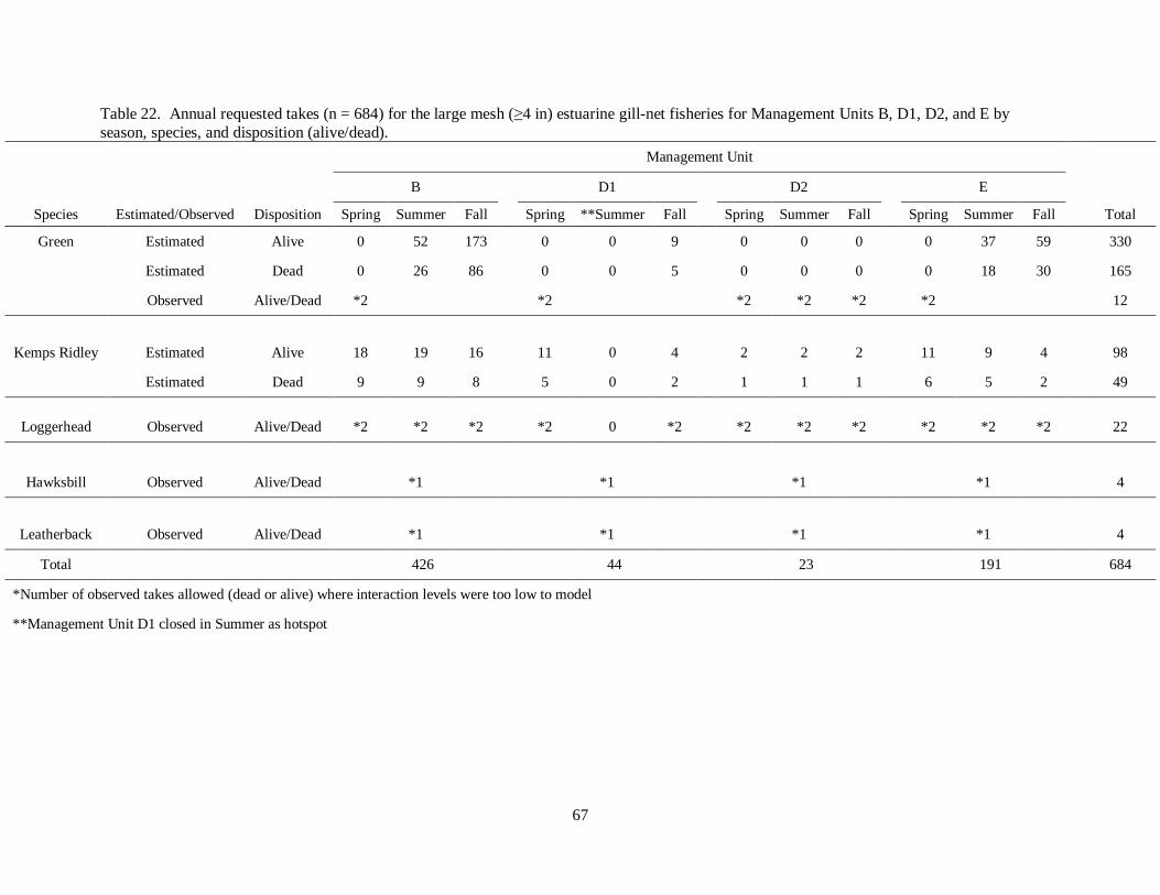
67
Table 22. Annual requested takes (n = 684) for the large mesh (≥4 in) estuarine gill-net fisheries for Management Units B, D1, D2, and E by
season, species, and disposition (alive/dead).
Management Unit
B
D1
D2
E
Species Estimated/Observed Disposition Spring Summer Fall Spring **Summer Fall Spring Summer Fall Spring Summer Fall Total
Green Estimated Alive 0 52 173
0 0 9
0 0 0
0 37 59
330
Estimated Dead 0 26 86
0 0 5
0 0 0
0 18 30
165
Observed Alive/Dead *2 *2 *2 *2 *2 *2 12
Kemps Ridley Estimated Alive 18 19 16
11 0 4
2 2 2
11 9 4
98
Estimated Dead 9 9 8 5 0 2 1 1 1 6 5 2 49
Loggerhead Observed Alive/Dead *2 *2 *2 *2 0 *2 *2 *2 *2 *2 *2 *2 22
Hawksbill Observed Alive/Dead *1 *1 *1 *1 4
Leatherback Observed Alive/Dead *1 *1 *1 *1 4
Total 426 44 23 191 684
*Number of observed takes allowed (dead or alive) where interaction levels were too low to model
**Management Unit D1 closed in Summer as hotspot

68
Table 23. Annual requested takes (n = 74) for the small mesh (<4 in) estuarine gill-net fisheries for Management Units B, D1, D2, and E by
season, species, and disposition (alive/dead).
Management Units
B
D1
D2
E
Species Estimated/Observed Disposition Spring Summer Fall Spring **Summer Fall Spring Summer Fall Spring Summer Fall Total
Kemps Ridley Observed Alive *2 *2 *2 *2 *2 *2 *2 *2 *2 *2 *2 *2 24
Green Observed Alive/Dead *2 *2 *2 *2 *2 *2 *2 *2 *2 *2 *2 *2 24
Loggerhead Observed Alive/Dead *2 *2 *2 *2 *2 *2 *2 *2 *2 *2 *2 *2 24
Hawksbill Observed Alive/Dead *1 *1 *1 *1 4
Leatherback Observed Alive/Dead *1 *1 *1 *1 4
Total 20 20 20 20 80
*Number of observed takes allowed (dead or alive) where interaction levels were too low to model
**Management Unit D1 closed in Summer as hotspot

69
Table 24. Annual requested takes (n = 16) for the small (<4 in) and large (≥4 in) mesh estuarine gill-net fisheries for Management Units A and C
by season and disposition.
Management Units
A
C
Species Estimated/Observed Disposition Spring Summer Fall Winter Spring Summer Fall Winter Total
All Observed Alive/Dead *2 *2 *2 *2 *2 *2 *2 *2 16
*Number of observed takes allowed (dead or alive) where interaction levels were too low to model
Table 25. Observed large mesh (≥4 in) gill-net trips from Programs 466 (onboard) and 467 (Alternative Platform) from 2010 through 2011 by Management Unit.
Year
Program
2010 Management Unit 466 467 Total
A
0 13
13
B
174 58
232
C
33 92
125
D1
0 56
56
D2
0 112
112
E 5 115 120
Total 212 446 658
2011 Management Unit 466 467 Total
A
0 14
14
B
264 60
324
C
38 50
88
D1
19 31
50
D2
12 116
128
E 65 169 234
Total 398 440 838
Total 1,496

70
Table 26. Observed large mesh (≥4 in) gill-net trips from Programs 466 (onboard) and 467 (Alternative
Platform) compared to total large mesh gill-net trips from 2010 through 2011 by season and Management Unit.
Actual Effort
Observed Trips
Coverage (%)
Season Management Unit 2010 2011 2010 2011 2010 2011
Winter A 1,364 956
0 0
0.00 0.00
B 227 172
1 0
0.44 0.00
C 89 142
11 24
12.36 16.90
D1 8 5
0 0
0.00 0.00
D2 0 0
0 0
n/a n/a
E 65 61 5 3 7.69 4.92
Spring A 3,685 2,303
0 5
0.00 0.22
B 1,265 790
7 16
0.55 2.02
C 1,020 843
18 22
1.76 2.61
D1 61 59
2 12
3.29 20.41
D2 59 68
11 17
18.64 25.00
E 276 302 9 45 3.26 14.90
Summer A 1,030 538
4 2
0.39 0.37
B 1,585 2,219
35 124
2.21 5.59
C 392 591
60 20
15.31 3.38
D1 123 134
41 31
33.43 23.19
D2 74 175
39 61
52.70 34.86
E 287 409 53 91 18.47 22.25
Fall A 2,938 928
9 7
0.31 0.75
B 3,129 2,275
189 184
6.04 8.09
C 577 654
36 12
6.24 1.83
D1 109 92
13 17
11.97 18.57
D2 212 277
62 50
29.25 18.05
E 487 429 53 95 10.88 22.14
Total 19,062 14,422 658 838 3.45 5.81

71
Table 27. Total number of small mesh (<4 in) gill-net trips and sea turtle interactions
by Management Unit through onboard and alternative platform observations throughout the estuarine waters of North Carolina from July 2010 through December
2011.
Management
Unit Observed Small Mesh Trips Interactions
A 7 0
B 86 0
C 54 0
D1 18 0
D2 90 1
E 23 1
Total 278 2

72
FIGURES
Figure 1. Map of estuarine waters in North Carolina.

73
Figure 2. Length-frequency (curved carapace length) from notch to tip of observed incidental captures of
green sea turtles (n = 136) from the North Carolina Division of Marine Fisheries (NCDMF) Observer Program from onboard and alternative platform observations from 1999 through 2011.
n=136

74
Figure 3. Length-frequency (curved carapace length) of observed incidental captures of Kemp's ridley
sea turtles (n = 59) from the North Carolina Division of Marine Fisheries (NCDMF) Observer Program from onboard and alternative platform observations from 1999 through 2011.
n=59

75
Figure 4. Length-frequency (curved carapace length) of observed incidental captures of loggerhead sea
turtles (n = 26) from the North Carolina Division of Marine Fisheries (NCDMF) Observer Program from
onboard and alternative platform observations from 1999 through 2011.
n=26

76
Figure 5. Observed incidental captures of sea turtles (n = 85) by species, Management Unit, and disposition [(Figure A; n = 70) (Figure B; n = 15 dead)] from the North Carolina Division of Marine
Fisheries (NCDMF) Observer Program (onboard and alternative platform observations) from 2010
through 2011.
14
5
3
9
20
1 1 1 1
7
5
2 1
0
5
10
15
20
25
Green Kemp's Ridley Loggerhead Unknown
Inci
den
tal T
ak
es
Species (Observed Alive)
A)
B (n=22)
D1 (n=30)
D2 (n=3)
E (n=15)
n=70
1 1
2
1
0
4
3
1 1 1
0
1
2
3
4
5
Green Kemp's Ridley Loggerhead Unknown
Inci
den
tal T
ak
es
Species (Observed Dead)
B)
A (n=1)
B (n=3)
C (n=1)
D1 (n=7)
D2 (n=1)
E (n=2)
n=15

77
Figure 6. Observed sea turtle interactions (n = 85) by species, disposition (alive/dead), gear, and
Management Unit from the North Carolina Division of Marine Fisheries (NCDMF) Observer Program
(onboard and alternative platform observations) from 2010 through 2011.

78
Figure 7. Observed sea turtle interactions (n = 37) by species, disposition (alive/dead), and gear for Management Unit D1 from the North Carolina Division of Marine Fisheries (NCDMF) Observer Program
(onboard and alternative platform observations) from 2010 through 2011.

79
Figure 8. Map of the Pamlico Sound Gill Net Restricted Area (PSGNRA) and the National Marine
Fisheries Service (NMFS) closed area for large mesh (≥5 in) gill nets; S1-S4=Shallow Water Gill Net Restricted Areas 1-4, MGNRA=Mainland Gill Net Restricted Area, OC=Ocracoke Corridor,
OIC=Ocracoke Inlet Corridor, HC=Hatteras Inlet Corridor.

80
Figure 9. The North Carolina Division of Marine Fisheries (NCDMF) proposed (but not enacted) large mesh (≥4 in) gill-net closure for 2010 in North Carolina estuarine waters.

81
Figure 10. Map of Management Units, exempted areas, federal closure, and the Pamlico Sound Gill Net
Restricted Area (PSGNRA) for North Carolina's estuarine waters.

82
Figure 11. Map of the small mesh (<5 in) attendance requirements throughout North Carolina waters
http://portal.ncdenr.org/web/mf/attended-gill-net-areas
~Gil NM AIMS (AGAA) (rule 10 • ls.A. NCAC 03R .0112)
IIIDII -· P.mlco, Pungo, . Tteftl Ri¥lnl
.. Out.r Barb--
ACanded Gl Nee A<.(1M NCAC 03R .0112)
~-: A&.fllotlly G . .S. 11 J. I 34; 11 J. I 73< 11J.fiJ2; f1J.22f. f; 14J&.ZIIlU2;
Elf. Augwt 1. 2004; ~Elf Aptf f. 2011, Aptl ' · 20011.
118631113 • 0 • 18 2< ICioo-.
-0 t 11 1tlolioo
.... WRC Wildlife RMOUI'Qt eornn-
.... ~WATERSONL.Y, wfiiiWRCiebel (1\Ae 10 • 1M NCAC 03Q .0202)
nn 11mZ1tA MiWf Oinllet Zor-. ....S R~ AIMS UlJ (rule 10 • 1M NCAC 03R .0102)
DLPNA~ "'(;:Y.=~03R .OI03)
0 Ptnnlnlnt ~ NurwyAI.(1\Ae 10 • 1M NCAC 03R .010C)
17ljnn>) T~ Nttl ~. -~ • 2. ' · 5, 7,8, I::::J 10,11,12 (rulti0 •1MNCAC03R .0106)
~ap package created I_ for color printing.
na rr~~p,.. proctJc:ed ~~y the Geograpic: tnformlllon 5yo1ema (GIS)~ lnlonnaiJcnll dala used lo ..-~~~~a mop_,. cdec:led !rom leclonl, -· counly ....s ~ ~ na 1111p 1s a genn~ guide"'..-. u.e pul)k 1nc1 1s for~ pur1)0MI Otty WNJe *-'~ e11ot1 II maclt 10 lcalp !hit map ~. * Is not "'*"*' 10 ~ ttry Olfdlltouroa. U1Cier no ~-the- cl Nor1ll c.rclna t. ._for tl'l'f «::Iana taken or cminlona mea. !rom ,..,.. en ttry lnformebon-- lrom --..,.,....--!he Sllle be '"ble lor ttry-~from tl'l'f IOJCh reliance.
Attended Gill Net Areas for
Gill Nets Less Than Slnches Mesh Length
(Index Map) MapA
+ Map o.u.n: ,..,., Amel1ooc:en o.un 1883
(NA083) Map Plojodlon: ,..,., c.roro. SIIQ Plene
(NC SIIQ PlaN) J.tap 0.: Mardl2011

83
Figure 12. Locations of observed gill-net trips from the North Carolina Division of Marine Fisheries
(NCDMF) Observer Program from 2000 through 2011.

84
Figure 13. Cleveland dotplot for counts of green turtles observed in the North Carolina Division of
Marine Fisheries (NCDMF) Observer Program (onboard and alternative platform) during 2007 through
2011.
Figure 14. Cook’s distance values of the Poisson GLM fit to the green turtle data.

85
Figure 15. Comparison of observed frequencies to frequencies predicted by the Poisson GLM fit to the
green turtle data.
Figure 16. Index plot of Pearson residuals for the Poisson GLM fit to the green turtle data.

86
Figure 17. Pearson residuals by year and management unit for the Poisson GLM fit to the green turtle
data.
Figure 18. Cleveland dotplot for counts of Kemp’s ridley turtles observed in the North Carolina Division
of Marine Fisheries (NCDMF) Sea Turtle Bycatch Monitoring Program and the Alternative Platform Observation Program during 2007 through 2011.

87
Figure 19. Cook’s distance values of the Poisson GLM fit to the Kemp’s ridley turtle data.
Figure 20. Comparison of observed frequencies to frequencies predicted by the negative binomial GLM fit to the Kemp’s ridley turtle data.

88
Figure 21. Index plot of Pearson residuals for the negative binomial GLM fit to the Kemp’s ridley turtle data.
Figure 22. Pearson residuals by season and management unit for the negative binomial GLM fit to the Kemp’s ridley turtle data.

89
AP
PE
ND
IX A
. D
AT
A L
OG
S
PR
OG
RA
M 4
66
DA
TA
LO
GS
: O
NB
OA
RD
OB
SE
RV
AT
ION
S
• I f1" T ' • • • • • • , ,- o-rl""r TT" I "rrT 'T 1:C I HI( l I 7. I • • • • • T'MT' . ,..,... , ·r-rrhr+""ll'i. it T i'i r.
' ' ' ' I "T"T"'T" 'T'T i'7. if!'T l;;rl 7.
'"t-r" -r •, "'T • ~ ~ "t"i.it l' ,,ut: '-r T r .. -r" T ..- ' t ' '" [ - -- ~ - ,- ~ "T""rl TT""r ' tTfTTT-1 ...... 1- ~ _, T' ""r
''' ' ' 1 ' 1 ' IIIII ~117.
I ' I 11)11 LHr. • ""T" .,... .. ...... , ... r ,- ·r· ·r Trr-T ''" •' ·rT r Tr-r- --rr, m T"r t 'T" T·r ' i""T" t "'T"r·t--·•-t"'"..,. •'uu r O'or.
.,- -n • "l""T I ' l 1 oTT I' r 'J l ""l' TT ' I ' T' I .,.Tr '1•J-r- f'UIJ 1 ~TI)r,
''t .,. . . ...... '" t .- '1" •r -,-,- , I I I I I'T t "T'T"T r r-, · M't "l' l ' l ' ' I "T" • ""T"r-T'" . , .. ~ {nu I ITjlr:
• .,... " ' "" "T" -r· · 1 r 1 1 ' 1 1 1 1 tl , , , , , , TTl -rr t '"f' l ' t ' •r•r·, ·r-r-r --r t 1ru u r iTn,
• II I ll o JIJ 11 ' 1 ' ' ' ' '' J J 1111( T.ll7.
.. "T" --r-.... t-r f J" t I I t f o' t .. '" "'TT i I I I -r rt l T"""r" •r• r'" ' ' l ' l '"t' "'r""T" V r·rr- ' f "" t t'n H f i'fl i " • " • · • • ' -..- II>U Ul>r.
... - - - I 4.,! _~·~0 '""'~!~~ _.., --· ·--~~ -·-•·•~- _,._,_, ...... ,, _..,.,,.__, - ·1-Ho..-o • • ..0:!...,:: :. •• ~
r r I
...... -·· ·--~
[ I I I I ..,..:. ! I I I 1-!fXPIII I .L.f. ,..( 'W ........ , ....... !)\IIIOU~OI\ II.)J.\,).\11 :nJJIJU Y.i' · •r~ 1\VII:>OII•I
·• . ;.1 1 l Ll I I Ll'l
--.... ,a.:. ..... , ....

90
,, .e !i I' .e ..
i ~u
h j:
!_:; '
~ .. j' ~
j!~
hl .. ' •t r t ·
i t i ~~!
!!I -! • {
! < I ~
i • I l E
!
i !
i l
). j • . ) !!' i· .. , ir
: -
-
.
:
-
.
- -c "' .. "' ... -- -"' "'
:
.
:
:
.
.
- - - - - -"' Q c "' " => = "' " " "' "' .. .. ~ "' "' c - - - - - "' N .. .. .. .. "'
-
-
: . -: -- -
: . : -
. :
. . : - -
:
- - - - - - - - - - - - -"' 0 " c 0 " c 0 c => c 0 0
"' "' "' "' "' "' "' "' "' "' "' :: 0:
- "" ,., - .. "' ·- "" "' "' - N .., "' "" N "' "' "' "' N N " " M ... "' "' N .. "' "' "' "' .. " " "' "

91
"-OMI-..... 1•
.......... ~.
I ' J'"' ' ... .. ....
I ' ·"""-.. ' I
'·"~"5'
.. :---- .. -~ ' . ... ~ .. - .. ·--' . -......... ~
I '- ""
' I. . '
·-·-= --· "-"
~ ... -.. -
'- ...
'I'" ...
--- --· .J~'". _J.,,
- ·-
I I ' ~ ·; -1 I ' ' I .
.... ....- .. I I I I I -- .... -- ...
-.#OO;.;,o
~ -· ·-·-...
~-
'r . ~ w
... *' .. , I' ..• I I ' I i ,... .. ,_ ... ~·-.. -..
I I I a , ....-.... ---' . ___ .... ------.... ;;-.. ~ .- -·-- .,,
I ! t ~'~"""I I I I 1" .. ""' , .. .~. • ·-... -.. ' ... _, .. .,_ .... _ ..
' -- -~- .. ~~--~ -· ·~·--- '" I I
'I"' . I ~ '~ -, I I I r·~
I I ' ' --· -- - .. -.. .. -. .... -
I u .... ._
I I I I I I
... -... u~··-
u ...
. .... Ot~l6
.... •
·- ~-1. ~-
'r . ~ I I ""~, ' r · ,·-·-,· , ......... ..... _., _ ... , ..
- .. -.. -·-
... I .1 'I' . - .. ,
I I I I ..... -... I 1 I I
.. . r -· ;·- .. -- .. _.,
-·-
I 0 .. ;" ........ .
··- -~ ..
I

92
-r rrr TTTTrl
1 ., I T r T T T
I I I t T T r r r r r
I I ' It .• f I! ,
t I
'nN.t."""~
~1"(1
~.,., ..... !l'JI
.,., ..... , .. \'.IVO ' IV.)I!)()' JOHI ti:•ll,)l:l.l~
Oint '•I »~'tc'lklo.IQ ··'"11
I I • • •
• , . • I • I
• I
r I I
'l I i [{[ I i I ,; i I 1
..... ·~r: .. ... h - ..,j .. .--··
J ·· L~J!l
..... _, __ tl lbS n1•~t

93
Rev. -20.2007
SPECIES BIOLOCICAL DA1A
P~·~--~41~----------
~,~-----------------
i

94
PROGRAM 467 DATA LOGS: ALTERNATIVE PLATFORM OBSERVATIONS
Form SS160
v ... ,
8 I I Vi ow
L"':~~ Q","1 Ty,>e TyJ>e Sed
Gu.r#'l
G ea.r#3
ENVIRONMENTAL AND STATION DATA
Scqucuce Nuonh<~r
14 ;··~···~ 7 I 011.te (YYM'-100)
I ......... .
v ... ul # Var5
I I I I Cr<lw I ....... St!<:chl{c m ) ... , DeplhEnd
Wina 1.,&h Depth webbl n & >'1'" CIPI GIPI
I u • • , """" . ,
OIP$
Bottom Rlaht Orld Lu-Lon a GSP/·3
Dl• uuu:e to Sh o re GtS<Hk
Soak T ime
Rev. September 7, 2010
Su.tlon
I I " ........ I I o ... ,l
I I I I I I I
""· u v
Bonom 00
I I I I I 'T'"T' I I I I I I I I I I I I f'voj I I I I I I

95
Form 88161 ( 55 160 continued) Rev. September 8, 2010
ENVIRONMENTAL AND STATION DATA Continued

96
Form SS162 Rev. September 15, 2010
31 ""'. 0 11---=:--------SJ>f'<"if'l
SPECIES BIOLOGICAL DATA
I Progran._ _____ 467 _ _____ _
Locatio•'---------------
Date ____________ _
I I I Sequence No. ______________ _
D'""''"' Rf!cord
Quality
.... ::;~1-+--'=;f;:;-'!l!:.,~ .... :t---i Type i-...J....-1-.1-....L-L-..J
Numbu •&&a.d
H R'"'ord 10 nunohuo ••• l ·ul' 1•• • ~oi l••" Inn ~OT repllco.t e
,----,.-.,..i:r-n-------==r---------,,-------===-- ' -'o_._•_"•_•_••_o_._•'.., S••Tlo.s Sutu• Eu•c"' Ph Tax
1 H 11 ·r L··r:· 1 .... r .. :· II Record 10 nurnl.ocu llrf I•UJ> IH:I' tOll~tlon !'lOT re p lh:au
H Record 10 numbetl are l-u1> ,,.,, coll«tlm• ~'JOT utpllcao.,
r--rr--;r;;r----,r--------;:;:;;;;;::;:--------,,-------..,==-'A::._/::._O•...CAC:."...C~...Co::._• 0::._•::._"":., S1aT"I Stattu Eur•• Pit Til&
I H II ·r ···r: I ca .. ,r:· H ll,..;(ln\ 10 '"""'"'''one I·U I> 1•er collertlon NOT ro1>licauo
97
Form SS163 (SS I6 1 cont inued) Rev. September 8, 2010
ENVIRONMENTAL AND STATION DATA Continued

98
Form SS!68 (Continuation of 162} Rev. May 3, 2010
SPECfES BIOLOGICAL DATA
Progrmn__ ___ 467 ___ _ Date.___ _______ _
Location ________ _
I I I I I I I I I I I I I I
I I I I I I I I I I I I I I
I I I I I I I I I I I I I I I I
I I I I I I I I I I I I I I
I I I I I I I I I I I I I I I I I I I

99
Observer Trip Information
Date. _____ _ Fishermens Name Port. _____ _ Vessel# -:-N:-:c=-.--------
Observer Name _______ _ Permit # _________ _
Haul# Net#
Soak Time (hrs) ___ _
Haul (Start/End)- Lat. ---------Long _________ __
Area {circle) Mainland Sl S2 S3 S4 OI HC OC CS, etc
Turtles Caught(#) __ Comments:
Haul # Net#
Soak Time (hrs) ___ _
Kept
Haul (Start/End) - Lat. -----------Long _ ______ _ _ __
Discard
Area (circle) Mainland Sl S2 S3 S4 OI HC OC CS, etc
Turtles Caught(#) __ Comments:
Haul # Net#
Soak Time (hrs) ___ _
Kept
Haul (Start/End)- Lat. - ---------Long _________ _
Discard
Area (circle) Mainland SJ S2 S3 S4 OI HC OC CS, etc
Turtles Caught(#) _ _ Comments:
Kept Discard
Stretched Mesh Sizes ___ _ Meshes Deep _ __ _
Twine Size ___ _ Total Yards _ _ _ _
Tie-Downs ___ _
Water Depth Distance from shore: _ __ _
Reg. Discard
Stretched Mesh Sizes ___ _ Meshes Deep ___ _
Twine Size ___ _ Total Yards ___ _
Tie-Downs ___ _ Water Depth
Distance from shore: _ __ _ Reg. Discard
Stretched Mesh Sizes ___ _ Meshes Deep ___ _
Twine Size ___ _ Total Yards ___ _
Tie-Downs ___ _ Water Depth
Distance from shore: ___ _ Reg. Discard

100
SEA TURTLE INCIDENTAL CAPTURE REPORT
SEA TURTLE INCIDENTAL CAPTURE REPORT
OBSERVER'S NAME
AFFILIATION/ADDRESS
_________________ AREA CODE/PHONE NUMBER
GEAR _______________ SOAK/TOW TIJIAE
GEARPARANlliTERSINCLUDINGJIAESHSIZE __________________________ _
LOCATION (include county, body of water; any nearby nautical landmarks such as channel markers, inlets, etc.)
LATITUDE _____________ LONGITUDE ________________ ___
REMARKS
FLIPPER CURVED CURVED TURTLE SPECIES COND DISP LNGTH \:V1DTH
NO (use code) (use code) with tags)* (use codes) [mmJ (mm)
I
TABLE DEFINITIONS AND CODES
TURTLE No =number assigned to each turtle captured at this intersection location in the order it was encountered by the observer (1, 2. 3 ... )
SPECIES: CC = Loggerhead CM ~Green DC~ Leatherback EL ~ Hawksbill LK ~Kemp's ridley UN~ Unidentified
COND (condition of turtle): 0 ~Alive
1 ~Fresh Dead
2 = Moderately decomposed 3 ~ Severely decomposed 4 =Dried carcass 5 ~ Skeleton, bones only
Carapace measurements:
DISP (final disposition of turtle): 1 ~Painted and left an a beach or dnne 2 ~Buried
3 ~ Salvaged carcass all or part 5 ~Unpainted, left on a beach or dune 6 ~Alive, released 7 ~Alive, taken to a holding facility
CURVED LNGTH -curved carapace length taken ""th metric tape measure only CURVED WIDTH -curved carapace width taken with mettic tape measure only

101
STURGEON INCIDENTAL CAPTURE REPORT

102
APPENDIX B. SETTLEMENT AGREEMENT
SEITLEMENT AGREEMENT
THIS SETTLEMENT AGREEMENT (hereinafter, "Agreement") is made and entered into on the last day executed below, among the Karen Beasley Sea Turtle Rescue and Rehabilitation Center ("Plaintiff') and the North Carolina Division of Marine Fisheries; Dr. Louis Daniel III, in his official capacity as Director of the North Carolina Division of Marine Fisheries; and the North Carolina Marine Fisheries Commission ("hereinafter, collectively, "Defendants").
WITNESSETH
WHEREAS, on February 23, 20 I 0, Plaintiff filed a complaint against the Defendants in the United States District Court for the Eastern District of North Carolina, Southern Division, file no. 7:10-CV-32-BO ("Complaint").
WHEREAS, in the Complaint, Plaintiff contends that Defendants are in violation of the Endangered Species Act ("ESA"), 16 U.S.C. §§ 1531 et seq. by authorizing gill nets to operate and to "take" protected sea turtles in state waters not covered by Incidental Take Permit ("ITP") No. 1528 issued to the North Carolina Division of Marine Fisheries ("DMF") by the National Marine Fisheries Service (''NMFS"), and not complying with the JTP requirements for observer coverage and enforcement.
WHEREAS, Defendants contend that the Court lacks jurisdiction over them on various grounds including sovereign immunity, lack of subject matter jurisdiction and personal jurisdiction, and further contend that they are not in violation of the ESA.
WHEREAS, the DMF is in the process of preparing an application for a statewide ITP from NMFS under Section I 0 of the ESA to cover incidental takes of protected sea turtles by gill nets within the internal coastal waters of North Carolina.
WHEREAS, the Plaintiff and Defendants each acknowledge the efforts of the other to amicably resolve the controversy over the protection of sea turtles listed under the ESA while also maintaining a viable commercial gill net fishery.
NOW THEREFORE, in order to avoid further controversy and expense, without in any way waiving the Defendants' claims regarding sovereign immunity, the parties to this Agreement have agreed upon the following terms and conditions:
I . Restrictions on Large Mesh Gill Nets.
(a) For the purpose of this Agreement, large mesh gill nets are defined as 4-inch stretched mesh to 6 y,. inch stretched mesh, inclusive.
(b) Until such time that a statewide ITP is issued to DMF by NMFS, the following interim restrictions on large mesh gill nets apply within the internal coastal waters of North Carolina, as defined in 15A N.C.A.C. 3I.OI01(1)(c):
(i) Soak times shall be limited to approximately 12 hours, from sunset to sunrise, Monday through Friday. More specifically, the start and end times

103
for each soak period is as follows: sunset on Monday to sunrise on Tuesday; sunset on Tuesday to sunrise on Wednesday; sunset on Wednesday to sunrise on Thursday; sunset on Thursday to sunrise on Friday. Large mesh gill nets may be set no sooner than I hour before sunset and must be retrieved no later than I hour after sunrise. Any nets deployed earlier than this specified time or nets that remain deployed after the specified time will be subject to enforcement action by the N.C. Marine Patrol in accordance with state law and marine fisheries rules and regulations.
(ii) Large mesh gill nets shall be low-profile configured as follows:
(I ) a net height of no more than 15 meshes. (2) a lead core or leaded bottom line. (3) no corks, floats or other buoys unless needed for identification requirements, except as provided in Paragraph 2(e) of this Agreement.
(iii) A maximum of 2,000 yards of large mesh gill net may be used per vessel, except as provided in Paragraph 2(e) of this Agreement.
(iv) Large mesh gill nets must be set in individual I 00-yard shots with at least a 25 yard break between individual shots.
(v) Gill nets shall not choke coastal creeks in violation of !SA N.C.A.C. 3J .0101. There must be passage for sea turtles and other non-targeted species.
(vi) No gill nets over 6 112- inch stretched mesh will be allowed in internal coastal waters.
2. Applicability of Restrictions.
(a) Upon execution of this Agreement, the Restrictions as listed in the above Paragraph I and below Paragraphs 2(e) and 2(i) ("restrictions") will be implemented by proclamation to go into effect beginning May 15, 20 I 0, effective year-round as interim measures until the DMF is issued a statewide ITP from NMFS pursuant to section I 0 of the ESA, except that DMF may implement more restrictive measures if required by NMFS.
(b) The Pamlico Sound Gillnet Restricted Area (PSGNRA) covered by ITP No. 1528 is not subject to this Agreement, while the permit is in effect. ITP No. 1528 will remain in effect from September I , 20 I 0 to December 31, 20 I 0, after which time the PSGNRA will be subject to this Agreement.
(c) The Currituck Sound, for the purpose of this Agreement, is defined as the area north of the Currituck Sound Bridge, which is located between the following coordinates: 36° 04.828'N, 75° 47.405'W (western end) and 36° 05.577'N, 75° 44.585'W (eastern end). The Currituck Sound is not subject to the provisions of this Agreement.
2

104
(d) The Albemarle Sound, for the purpose of this Agreement, is defined as the area west of a line running from coordinates 36° 09.928 ' N, 75° 54.695' W (northern end) and 35° 57.559' N, 75° 56.820' W (southern end). The Albemarle Sound is not subject to the provisions in this Agreement except for the observer coverage provisions as specified in Paragraph 3(d) of this Agreement.
(e) For the area south of the NC Highway 58 bridge, which is located between coordinates 77° 4.02738 W, 34° 40.78489 N (northern end) and 77° 3.7438 W, 34° 39.86202 N (southern end), floats are allowed to be used on nets and a maximum of 1000 yards of gill net may be used per vessel. All other restrictions specified in this Agreement shall apply to this area.
(f) The restrictions set forth in this Agreement shall apply only to set large mesh gill nets. They shall not apply to strike nets, runaround nets, drop nets or any other gear that is immediately retrieved.
(g) ln recognition that low profile nets have not been tested at scale, adaptive management and monitoring measures will need to be implemented to assess their feasibility. Therefore, the restrictions in this Agreement shall not apply to scientific research or collection pursuant to N.C. Gen. Stat.§ 113-200 (Fisheries Resource Grants), ISA N.C.A.C. 30.0503(g) (Scientific or Educational Collection Permits), or conducted by the DMF or its employees or agents in efforts to assess, manage and monitor the large mesh gill net fishery in North Carolina, including but not limited to testing of low profile nets and alternative harvest methods.
(h) No provision of this Agreement shall be interpreted to supersede any existing DMF proclamation that is more restrictive.
(i) The restrictions shall apply to standard commercial fishing license ("SCFL") holders and recreational commercial gear license ("RCGL") holders.
3. Observer Program.
(a) The DMF shall provide observer coverage of large mesh gill net fishing beginning on May 15, 20 I 0 on various platforms. Observers will consist of DMF staff, the N.C. Marine Patrol, and volunteer observers certified by DMF's observer training program. The observer coverage will not be static and may adapt according to season, sea turtle behavior and location, and other environmental and biological conditions.
(b) The DMF shall deploy resources sufficient to provide observer coverage with a target of 10% coverage and a minimum of7% coverage per week of the total large mesh gill net fishing effort within internal coastal waters, except for areas exempted pursuant to this Agreement. For each fishing year, DMF will calculate observer coverage by using the previous year's effort data from the North Carolina trip ticket program.
(c) If the DMF is unable to provide minimum coverage due to financial, budget or staffing constraints, then the large mesh gill net fishery will be closed by proclamation until such time that the minimum coverage can be resumed.
3

105
(d) This subsection (d) applies only to Albemarle Sound as an interim measure until the DMF obtains a statewide ITP from NMFS. In the Albemarle Sound, as defined above in Paragraph 2(d), each N.C. Marine Patrol officer assigned to that area within the Northern District will be responsible for conducting one observed trip per week. Should reliable reports of sea turtle presence be submitted, additional observer coverage in such area will be required.
4. The Sea Turtle Advisory Committee (ST A C).
(a) The Sea Turtle Advisory Committee shall be established as an advisory committee of the MFC.
(b) The STAC will consist of 12 members appointed by the MFC Chairman and the Karen Beasley Sea Turtle Rescue and Rehabilitation Center. The Karen Beasley Sea Turtle Rescue and Rehabilitation Center may appoint six of the twelve members of the STAC. The STAC may be dissolved by mutual agreement of the parties at any time.
(c) The duties of the ST AC include but are not limited to the following: reviewing observer reports, devising means for fishermen to report turtle interactions, assisting with fishermen education, determining measures to reduce the incidental take of sea turtles, monitoring observer program issues, and reviewing all future ITP provisions and take calculations prior to formal application to NMFS.
5. ITP Development.
(a) The restrictions as listed in Paragraphs I, 2(e) and 2(i) are minimum requirements for the 2010 statewide ITP application.
(b) The STAC will advise in the development of the new ITP applications and the overall take calculations.
(c) Effective for the 2012 license year (May 15, 201 1), the dealer report required by the DMF will be expanded to include effort data recorded in terms of the number of I 00-yard shots set by fishermen.
(d) The restrictions as listed in Paragraphs I, 2(e) and 2(i) are deemed solely interim measures and will be in effect within internal coastal waters, not otherwise exempt, until NMFS issues the DMF an ITP for the affected areas. Furthermore, this Agreement shall not foreclose more lenient or more restrictive provisions in future ITP applications if warranted by biological data collected through reliable sources including but not limited to NMFS and the DMF.
6. Dismissal with Prejudice. Plaintiff shall dismiss its Complaint against Defendants with Prejudice within I 0 calendar days of the execution of this Agreement by all the parties.
7. Release of Claims. The Plaintiff hereby releases and waives all claims and causes of action that it has against the Defendants, the State of North Carolina, and all other departments, agencies, divisions, and other components of the State of North Carolina and all past and present agents, employees, officials, and representatives of the State of North
4

106
Carolina on account of and/or in any way growing out of the actions or omissions arising from the use of gill nets in North Carolina' s internal coastal waters alleged or which could have been alleged in Plaintiff's Complaint. This release and waiver of claims and causes of action continues in effect until a new Section 10 Permit under the ESA is issued by NMFS for North Carolina's internal coastal waters. Once the Section 10 Permit is issued, there will be no further need for the proclamation provided for in Paragraph 2(a) to remain in effect.
8. Cost. Each party shall bear its own costs, including attorney fees.
9. No Admission of Liability. The undersigned agree that this Agreement is a full and complete compromise settlement of disputed claims and causes of action set forth in Plaintiff's Complaint and is intended merely to terminate any and all claims or causes of action relating to the allegations therein. There is no admission of fault, wrongdoing, or liability by any party. Defendants do not waive their claim of sovereign immunity by entering into this Agreement.
I 0. Full Cooperation. The parties agree to cooperate fully, to execute any and all supplementary documents necessary to effectuate this Agreement, and to take all additional actions that may be necessary to give full force and effect to the terms of this Agreement.
11. Enforceability. In the event of breach of this Agreement, the parties have an action at law in any court having jurisdiction over the matter. The Agreement is not enforceable by third parties.
12. Entire Agreement. This Agreement contains the entire agreement between the parties and there are no understandings or agreements, verbal or otherwise, regarding this settlement except as expressly set forth herein.
13. Reading of Agreement. The parties hereby acknowledge that the individual executing the Agreement on his/her behalf is authorized to execute this Agreement on his/her behalf and to bind the respective entities to the terms contained herein and that he or she has read this Agreement, conferred with his or her attorney, fully understands its contents, consents to the settlement of the claims on the terms set forth herein, and does so in reliance upon his or her own judgment and advice of his or her attorney and not in reliance on any other representations or promises of Defendants or their representatives or attorneys.
IN WITNESS WHEREOF, this Agreement is executed in counterparts effective on the last date of execution indicated on the subsequent signature pages. This Agreement shall become effective upon the execution by all named parties. [SIGNATURES APPEAR ON THE FOLLOWING PAGE]
5

107
PLAI BY: 4d~~~~~~::;#~;;::=. dated /5 ~ Jean Beasley, Director ~ Karen Beasley Sea Turtle Rescue and Rehabilitation Center
Dr. 1rector ftcial capacity as Director of the
North Carolina Division ofMarine Fisheries
6
'2010
'2010

108
APPENDIX C. LARGE MESH GILL-NET PROCLAMATIONS
M-8-2010
PROCLAMATION
RE: LARGE MESH GILL NETS: INTERNAL COASTAL WATERS
Dr. Louis B. Daniel III, Director, Division of Marine Fisheries, hereby announces that effective at 6:00
P.M., Saturday, May 15, 2010, the following provisions shall apply to the use of large mesh gill nets:
I. SUSPENSION OF PORTION OF MARINE FISHERIES RULE 15A NCAC 03J .0103
The following portion of Marine Fisheries Rules for Coastal Waters 15A NCAC 03J .0103 is suspended:
Section (i) (1), which reads: (i)For gill nets with a mesh length five inches or greater, it is unlawful:
(1) To use more than 3,000 yards of gill net per vessel in internal waters regardless of the
number of individuals involved.
II. AREAS AND EXEMPTIONS
A. This proclamation applies to all internal coastal waters except for Albemarle and Currituck sounds and
their tributaries described as follows: 1. In Albemarle Sound, the restrictions do not apply west of a line beginning at a point 35º 57.5590’N -
75º 56.8200’ W; running northerly to a point 36º 09.9280’N - 75º 54.6950’W.
2. In Currituck Sound, the restrictions do not apply north of the Highway 158 Wright Memorial Bridge
beginning at a point on the western shore at 36º 04.8280’N - 75º 47.4050’W; running easterly along the
south side of the bridge to a point on the east shore at 36º 05.5770’N - 75º 44.5850’W.
B. Run-around or strike nets and drop nets that are used to surround a school of fish and then are
immediately retrieved are exempted from the restrictions in this proclamation.
C. The Pamlico Sound Gill Net Restricted Area (PSGNRA) will operate under Incidental Take Permit
(ITP) No. 1528 and is exempt from the restrictions in this proclamation during the September through
December 2010 period. Restrictions in this proclamation apply to the PSGNRA outside of that time
period.
III. GILL NET RESTRICTIONS
It is unlawful to use large mesh gill nets (defined as 4 inches to 6½ inches stretched mesh, inclusive)
unless they comply with the following provisions:
A. It is unlawful to set and retrieve large mesh gill nets except during the following times:
1. No sooner than one hour before sunset on Monday and no later than one hour after sunrise on Tuesday.
2. No sooner than one hour before sunset on Tuesday and no later than one hour after sunrise on
Wednesday.
3. No sooner than one hour before sunset on Wednesday and no later than one hour after sunrise on Thursday.

109
4. No sooner than one hour before sunset on Thursday and no later than one hour after sunrise on
Friday.
B. It is unlawful to use large mesh gill nets of more than 15 meshes in height and without a lead core or leaded bottomline. It is unlawful to use cork, floats, or other buoys except those required for identification
except that south of the Highway 58 bridge, beginning at a point on the north shore at 34° 40.7848’N -
77° 04.0273’W; running southerly to a point on the south shore at 34° 39.8620’N – 77° 03.7438’W, floats
are allowed.
C. It is unlawful to use more than 2,000 yards of large mesh gill net per vessel north of the Highway 58 bridge (coordinates above) and it is unlawful to use more than 1,000 yards of large mesh gill net per
vessel south of the Highway 58 bridge.
D. It is unlawful to set more than 100 yards of large mesh gill net in a continuous line.
E. It is unlawful to use large mesh gill nets without leaving a space of at least 25 yards between separate
lengths of net.
IV. GENERAL INFORMATION
A. This proclamation is issued under the authority of N.C.G. S. 113-134; 113-170.4; 113-170.5; 113-182;
113-221.1; 143B-289.52 and N.C. Fisheries Rules 15A NCAC 03H .0103 and 03J .0101 and .0103.
B. It is unlawful to violate the provisions of any proclamation issued by the Fisheries Director under his
delegated authority pursuant to N.C. Fisheries Rule 15A NCAC 03H .0103.
C. The intent of this proclamation is to implement gill net restrictions while the Division applies for a
statewide incidental take permit from NMFS under Section 10 of the Endangered Species Act.
D. The restrictions in this proclamation apply to gill nets used by Recreational Commercial Gear License
holders as well as Standard and Retired Commercial Fishing Licenses holders.
E. The small mesh gill net attendance requirements in N.C. Marine Fisheries Rule 15A NCAC 03J .0103
(h), size restrictions in 03J .0103(a)(2), the navigational passage requirements in 03J .0101, as well as all
other existing gill net rules and proclamations remain in effect.
This proclamation supersedes Proclamation M-19-2009, dated August 26, 2009.
May 13, 2010 1:45 P.M.
M-8-2010
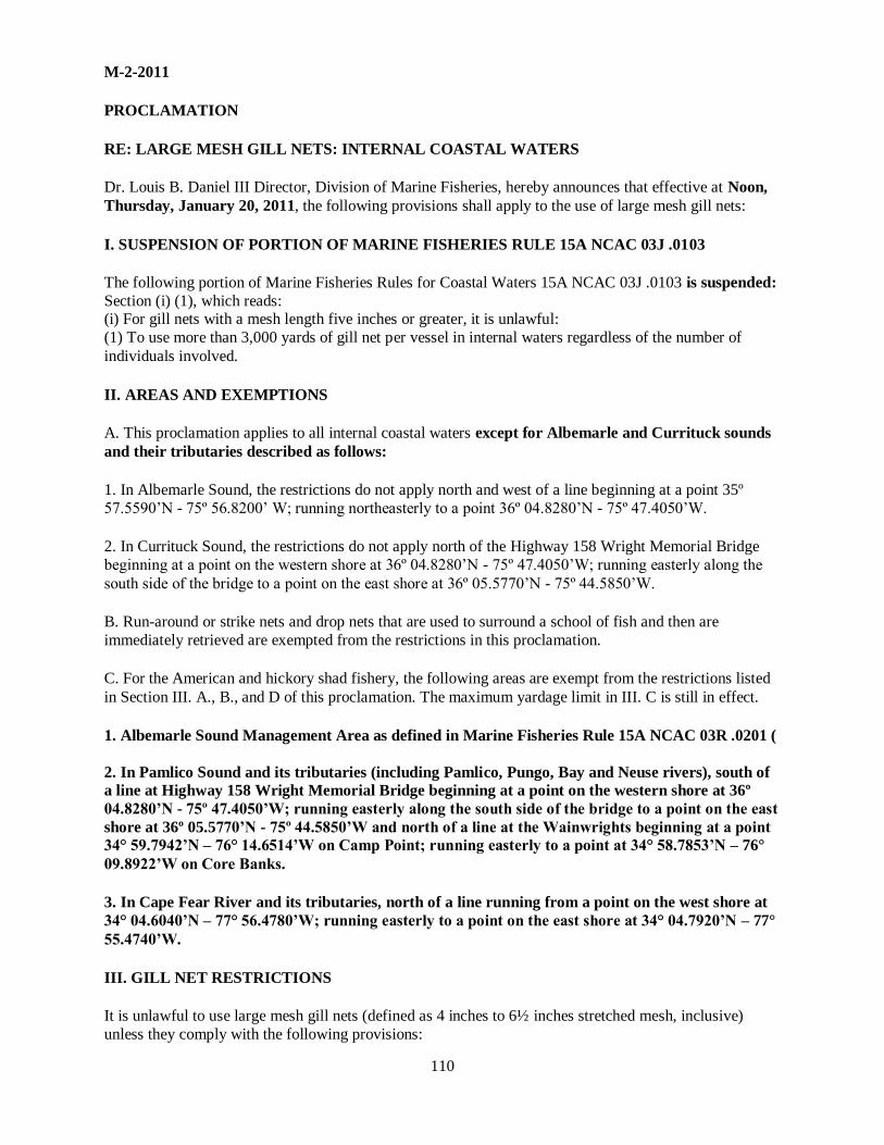
110
M-2-2011
PROCLAMATION
RE: LARGE MESH GILL NETS: INTERNAL COASTAL WATERS
Dr. Louis B. Daniel III Director, Division of Marine Fisheries, hereby announces that effective at Noon,
Thursday, January 20, 2011, the following provisions shall apply to the use of large mesh gill nets:
I. SUSPENSION OF PORTION OF MARINE FISHERIES RULE 15A NCAC 03J .0103
The following portion of Marine Fisheries Rules for Coastal Waters 15A NCAC 03J .0103 is suspended:
Section (i) (1), which reads: (i) For gill nets with a mesh length five inches or greater, it is unlawful:
(1) To use more than 3,000 yards of gill net per vessel in internal waters regardless of the number of
individuals involved.
II. AREAS AND EXEMPTIONS
A. This proclamation applies to all internal coastal waters except for Albemarle and Currituck sounds
and their tributaries described as follows:
1. In Albemarle Sound, the restrictions do not apply north and west of a line beginning at a point 35º
57.5590’N - 75º 56.8200’ W; running northeasterly to a point 36º 04.8280’N - 75º 47.4050’W.
2. In Currituck Sound, the restrictions do not apply north of the Highway 158 Wright Memorial Bridge
beginning at a point on the western shore at 36º 04.8280’N - 75º 47.4050’W; running easterly along the
south side of the bridge to a point on the east shore at 36º 05.5770’N - 75º 44.5850’W.
B. Run-around or strike nets and drop nets that are used to surround a school of fish and then are
immediately retrieved are exempted from the restrictions in this proclamation.
C. For the American and hickory shad fishery, the following areas are exempt from the restrictions listed
in Section III. A., B., and D of this proclamation. The maximum yardage limit in III. C is still in effect.
1. Albemarle Sound Management Area as defined in Marine Fisheries Rule 15A NCAC 03R .0201 (
2. In Pamlico Sound and its tributaries (including Pamlico, Pungo, Bay and Neuse rivers), south of
a line at Highway 158 Wright Memorial Bridge beginning at a point on the western shore at 36º
04.8280’N - 75º 47.4050’W; running easterly along the south side of the bridge to a point on the east
shore at 36º 05.5770’N - 75º 44.5850’W and north of a line at the Wainwrights beginning at a point
34° 59.7942’N – 76° 14.6514’W on Camp Point; running easterly to a point at 34° 58.7853’N – 76°
09.8922’W on Core Banks.
3. In Cape Fear River and its tributaries, north of a line running from a point on the west shore at
34° 04.6040’N – 77° 56.4780’W; running easterly to a point on the east shore at 34° 04.7920’N – 77°
55.4740’W.
III. GILL NET RESTRICTIONS
It is unlawful to use large mesh gill nets (defined as 4 inches to 6½ inches stretched mesh, inclusive)
unless they comply with the following provisions:

111
A. It is unlawful to set and retrieve large mesh gill nets except during the following times:
1. No sooner than one hour before sunset on Monday and no later than one hour after sunrise on Tuesday.
2. No sooner than one hour before sunset on Tuesday and no later than one hour after sunrise on
Wednesday.
3. No sooner than one hour before sunset on Wednesday and no later than one hour after sunrise on
Thursday.
4. No sooner than one hour before sunset on Thursday and no later than one hour after sunrise on Friday.
B. It is unlawful to use large mesh gill nets of more than 15 meshes in height and without a lead core or leaded bottomline. It is unlawful to use cork, floats, or other buoys except those required for identification
except that south of the Highway 58 bridge, beginning at a point on the north shore at 34° 40.7848’N -
77° 04.0273’W; running southerly to a point on the south shore at 34° 39.8620’N – 77° 03.7438’W,
floats are allowed.
C. It is unlawful to use or possess more than 2,000 yards of large mesh gill net per vessel north of the
Highway 58 bridge (coordinates above) and it is unlawful to use or possess more than 1,000 yards of
large mesh gill net per vessel south of the Highway 58 bridge.
D. It is unlawful to set more than 100 yards of large mesh gill net without leaving a space of at least 25
yards between separate lengths of net.
IV. GENERAL INFORMATION
A. This proclamation is issued under the authority of N.C.G. S. 113-134; 113-170.4; 113-170.5; 113-182;
113-221.1; 143B-289.52 and N.C. Fisheries Rules 15A NCAC 03H .0103 and 03J .0101 and .0103.
B. It is unlawful to violate the provisions of any proclamation issued by the Fisheries Director under his
delegated authority pursuant to N.C. Fisheries Rule 15A NCAC 03H .0103.
C. The intent of this proclamation is to implement gill net restrictions while the Division applies for a statewide incidental take permit from NMFS under Section 10 of the Endangered Species Act. The
proclamation also includes and exemption of certain areas from gill net restrictions for the shad fishery.
D. The restrictions in this proclamation apply to gill nets used by Recreational Commercial Gear License
holders as well as Standard and Retired Commercial Fishing Licenses holders.
E. The small mesh gill net attendance requirements in N.C. Marine Fisheries Rule 15A NCAC 03J
.0103 (h), size restrictions in 03J .0103(a)(2), the navigational passage requirements in 03J .0101, as
well as all other existing gill net rules and proclamations remain in effect. This does not allow
flounder nets in the eastern ASMA.
F. This proclamation supersedes Proclamation M-23-2010 Revised, dated November 29, 2010.
January 18, 2011
11:00 A.M. M-2-2011

112
M-27-2011
PROCLAMATION
RE: LARGE MESH GILL NETS: INTERNAL COASTAL WATERS
Dr. Louis B. Daniel III Director, Division of Marine Fisheries, hereby announces that effective at one
hour before sunset on Monday, September 12, 2011, the following provisions shall apply to the use of
large mesh gill nets:
I. SUSPENSION OF PORTION OF MARINE FISHERIES RULE 15A NCAC 03J .0103
The following portion of Marine Fisheries Rules for Coastal Waters 15A NCAC 03J .0103 is suspended:
Section (i) (1), which reads:
(i) For gill nets with a mesh length five inches or greater, it is unlawful
(1) To use more than 3,000 yards of gill net per vessel in internal waters regardless of the number of
individuals involved. The provisions below in this proclamation shall be complied with at all times.
II. AREAS AND EXEMPTIONS
A. This proclamation applies to all internal coastal waters except for portions of Croatan and Roanoke
sounds, Albemarle and Currituck sounds and their tributaries and the Neuse, Bay and Pamlico
rivers described as follows:
1. In Croatan and Roanoke sounds, the restrictions do not apply north and west of the Virginia Dare
Memorial Bridge and the Washington Baum Bridge described below:
A. Croatan Sound - beginning at a point 35º 53.1720’N - 75º 45.6160’ W on the mainland shore; running easterly along the south side of the Virginia Dare Memorial Bridge to a point at 35°
53.1630’N - 75º 40.1640’W on Roanoke Island.
B. Roanoke Sound - beginning at a point 35º 53.6240’N - 75º 38.4170’ W on shore at Roanoke
Island; running easterly along the south side of the Washington Baum Bridge to a point at 35°
54.3820’N - 75º 35.9240’W on the Outer Banks shore .
2. In Pamlico, Bay and Neuse rivers, the restrictions do not apply west of a line in the vicinity of the
mouths of those waterbodies described below:
A. Pamlico River – a line beginning at a point at 35º 24.5920’N - 76º 32.3810’W near Currituck Point;
running southwesterly to a point at 35º 19.6960’N - 76º 36.5360’W near Fulford Point.
B. Bay River – a line beginning at a point 35º 11.0760’N - 76º 31.6200’W near Bay Point; running
southerly to a point at 35º 08.9290’N - 76º 32.2680’W near Maw Point.
C. Neuse River – a line beginning at a point 35º 08.9290’N - 76º 32.2680’W near Maw Point; running southerly to a point at 34° 59.29400’N – 76°59.2940’N – 76° 34.8230’W on the east shore of the
mouth of South River.
III. EXEMPTION FOR RUN-AROUND, STRIKE OR DROP NETS
A run-around, strike or drop net that is used to surround a school of fish and then is immediately retrieved
is exempted from the restrictions in this proclamation.
IV. GILL NET CONSTRUCTION AND USE REQUIREMENTS
It is unlawful to use large mesh gill nets (defined as 4 inches to 6½ inches stretched mesh, inclusive)
unless they comply with the following provisions:

113
A. It is unlawful to use large mesh gill nets of more than 15 meshes in height and without a lead core or leaded bottomline. It is unlawful to use cork, floats, or other buoys except those required for identification
except that floats are allowed south of the Highway 58 (B. Cameron Langston) Bridge, beginning at
a point on the north shore at 34° 40.7848’N - 77° 04.0273’W; running southerly to a point on the south
shore at 34° 39.8620’N – 77° 03.7438’W.
B. It is unlawful to use or possess more than 2,000 yards of large mesh gill net per vessel north of the
Highway 58 Bridge (coordinates above) and it is unlawful to use or possess more than 1,000 yards of large mesh gill net per vessel south of the Highway 58 Bridge.
C. It is unlawful to set more than 100 yards of large mesh gill net without leaving a space of at least 25 yards
between separate lengths of net.
V. GILL NET SETTING TIME REQUIREMENTS It is unlawful to use large mesh gill nets (defined as 4 inches to 61/2 inches stretched mesh inclusive) for
daytime sets other than during the setting and retrieval periods specified below. Only single night
overnight soaks are permitted, and are only lawful if set and retrieved as follows:
A. Nets set for Tuesday retrieval may be set no sooner than one hour before sunset on Monday and
must be retrieved no later than one hour after sunrise on Tuesday.
B. Nets set for Wednesday retrieval may be set no sooner than one hour before sunset on Tuesday
and must be retrieved no later than one hour after sunrise on Wednesday.
C. Nets set for Thursday retrieval may be set no sooner than one hour before sunset on Wednesday
and must be retrieved no later than one hour after sunrise on Thursday.
D. Nets set for Friday retrieval may be set no sooner than one hour before sunset on Thursday and
must be retrieved no later than one hour after sunrise on Friday.
No other overnight sets are permitted, and in no case shall daytime sets occur other than during
setting and retrieval periods as specified above.
VI. GENERAL INFORMATION
A. This proclamation is issued under the authority of N.C.G. S. 113-134; 113-170.4; 113-170.5; 113-182;
113-221.1; 143B-289.52 and N.C. Fisheries Rules 15A NCAC 03H .0103 and 03J .0101 and .0103.
B. It is unlawful to violate the provisions of any proclamation issued by the Fisheries Director under his
delegated authority pursuant to N.C. Fisheries Rule 15A NCAC 03H .0103.
C. The intent of this proclamation is to implement gill net restrictions while the Division applies for a
statewide incidental take permit from NMFS under Section 10 of the Endangered Species Act. It returns
gill net restrictions for use of large mesh gill nets (defined as 4 inches to 6½ inches stretched mesh, inclusive) to those in existence prior to May of 2010 for the areas listed in II. A. 2.
D. The restrictions in this proclamation apply to gill nets used by Recreational Commercial Gear License holders as well as Standard and Retired Commercial Fishing Licenses holders.
E. The small mesh gill net attendance requirements in N.C. Marine Fisheries Rule 15A NCAC 03J
.0103 (h), size restrictions in 03J .0103(a)(2), the navigational passage requirements in 03J .0101,
as well as all other existing gill net rules and proclamations remain in effect.

114
F. Proclamation M-7-2011, dated February 25, 2011 prohibits the use of gill nets with a stretched mesh length more than 6 ½ inches.
G. This proclamation supersedes Proclamation M-18-2011 (Revised) dated July 12, 2011, M-22-2011 and
M-23-2011, dated July 12, 2011. It does not supersede Proclamation M-24-2011, dated July 14, 2011,
which closed southern Core Sound, Back Sound, the Straits and North River to large mesh gill
nets.
September 7, 2011
8:20 A.M.
M-27-2011

115
M-30 -2011
PROCLAMATION
RE: LARGE MESH GILL NETS: INTERNAL COASTAL WATERS
Dr. Louis B. Daniel III Director, Division of Marine Fisheries, hereby announces that effective at one
hour before sunset on Sunday, September 18, 2011, the following provisions shall apply to the use of
large mesh gill nets:
I. SUSPENSION OF PORTION OF MARINE FISHERIES RULE 15A NCAC 03J .0103
The following portion of Marine Fisheries Rules for Coastal Waters 15A NCAC 03J .0103 is suspended:
Section (i) (1), which reads:
(i) For gill nets with a mesh length five inches or greater, it is unlawful:
(1) To use more than 3,000 yards of gill net per vessel in internal waters regardless of the number of
individuals involved. The provisions below in this proclamation shall be complied with at all times.
II. AREAS AND EXEMPTIONS
A. This proclamation applies to all internal coastal waters except for portions of Croatan and Roanoke
sounds, Albemarle and Currituck sounds and their tributaries and the Neuse, Bay and Pamlico
rivers described as follows:
1. In Croatan and Roanoke sounds, the restrictions do not apply north and west of the Virginia Dare
Memorial Bridge and the Washington Baum Bridge described below:
a. Croatan Sound - beginning at a point 35º 53.1720’N - 75º 45.6160’ W on the mainland shore; running easterly along the south side of the Virginia Dare Memorial Bridge to a point at 35°
53.1630’N - 75º 40.1640’W on Roanoke Island.
b. Roanoke Sound - beginning at a point 35º 53.6240’N - 75º 38.4170’ W on shore at Roanoke Island;
running easterly along the south side of the Washington Baum Bridge to a point at 35° 54.3820’N -
75º 35.9240’W on the Outer Banks shore .
2. In Pamlico, Bay and Neuse rivers, the restrictions do not apply west of a line in the vicinity of the
mouths of those waterbodies described below:
a. Pamlico River – a line beginning at a point at 35º 24.5920’N - 76º 32.3810’W near Currituck Point;
running southwesterly to a point at 35º 19.6960’N - 76º 36.5360’W near Fulford Point.
b. Bay River – a line beginning at a point 35º 11.0760’N - 76º 31.6200’W near Bay Point; running
southerly to a point at 35º 08.9290’N - 76º 32.2680’W near Maw Point.
c. Neuse River – a line beginning at a point 35º 08.9290’N - 76º 32.2680’W near Maw Point; running southerly to a point at 34° 59.29400’N – 76°59.2940’N – 76° 34.8230’W on the east shore of the
mouth of South River.
III. EXEMPTION FOR RUN-AROUND, STRIKE OR DROP NETS
A run-around, strike or drop net that is used to surround a school of fish and then is immediately retrieved is exempted from the restrictions in this proclamation.
IV. GILL NET CONSTRUCTION AND USE REQUIREMENTS
It is unlawful to use large mesh gill nets (defined as 4 inches to 6½ inches stretched mesh, inclusive) unless they comply with the following provisions:

116
A. It is unlawful to use large mesh gill nets of more than 15 meshes in height and without a lead core or leaded bottomline. It is unlawful to use cork, floats, or other buoys except those required for identification
except that floats are allowed south of the Highway 58 (B. Cameron Langston) Bridge, beginning at
a point on the north shore at 34° 40.7848’N - 77° 04.0273’W; running southerly to a point on the south
shore at 34° 39.8620’N – 77° 03.7438’W.
B. It is unlawful to use or possess more than 2,000 yards of large mesh gill net per vessel north of the
Highway 58 Bridge (coordinates above) and it is unlawful to use or possess more than 1,000 yards of large mesh gill net per vessel south of the Highway 58 Bridge.
C. It is unlawful to set more than 100 yards of large mesh gill net without leaving a space of at least 25 yards
between separate lengths of net.
V. GILL NET SETTING TIME REQUIREMENTS It is unlawful to use large mesh gill nets (defined as 4 inches to 61/2 inches stretched mesh inclusive) for
daytime sets other than during the setting and retrieval periods specified below. Only single night
overnight soaks are permitted, and are only lawful if set and retrieved as follows:
In all areas subject to the restrictions in this proclamation,
A. Nets set for Tuesday retrieval may be set no sooner than one hour before sunset on Monday and must be retrieved no later than one hour after sunrise on Tuesday.
B. Nets set for Wednesday retrieval may be set no sooner than one hour before sunset on Tuesday and
must be retrieved no later than one hour after sunrise on Wednesday.
C. Nets set for Thursday retrieval may be set no sooner than one hour before sunset on Wednesday and
must be retrieved no later than one hour after sunrise on Thursday.
D. Nets set for Friday retrieval may be set no sooner than one hour before sunset on Thursday and must
be retrieved no later than one hour after sunrise on Friday.
In the area bound in the north by a line at longitude 76° 36.9972’W which runs from a point on
Shackleford Banks northerly to Lennoxville Point, then to the head of Turner Creek, and northerly
up the western side of North River (see map), and bound in the south by the North Carolina-South
Carolina border, an additional overnight soak period is permitted in addition to V. A. through D
above:
A. Nets set for Monday retrieval may be set no sooner than one hour before sunset on Sunday and must
be retrieved no later than one hour after sunrise on Monday.
No other overnight sets are permitted, and in no case shall daytime sets occur other than during
setting and retrieval periods as specified above.
VI. GENERAL INFORMATION
A. This proclamation is issued under the authority of N.C.G. S. 113-134; 113-170.4; 113-170.5; 113-182;
113- 221.1; 143B-289.52 and N.C. Fisheries Rules 15A NCAC 03H .0103 and 03J .0101 and .0103.
B. It is unlawful to violate the provisions of any proclamation issued by the Fisheries Director under his
delegated authority pursuant to N.C. Fisheries Rule 15A NCAC 03H .0103.
C. The intent of this proclamation is to implement gill net restrictions while the Division applies for a
statewide incidental take permit from NMFS under Section 10 of the Endangered Species Act. It returns
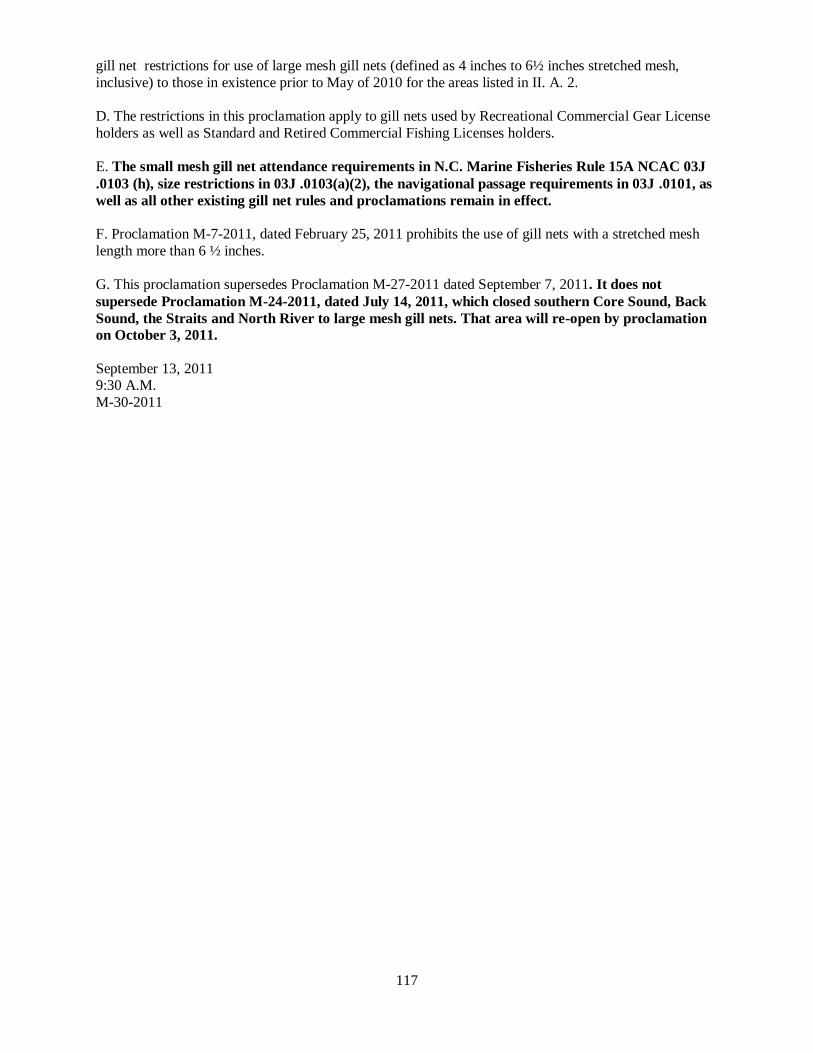
117
gill net restrictions for use of large mesh gill nets (defined as 4 inches to 6½ inches stretched mesh,
inclusive) to those in existence prior to May of 2010 for the areas listed in II. A. 2.
D. The restrictions in this proclamation apply to gill nets used by Recreational Commercial Gear License
holders as well as Standard and Retired Commercial Fishing Licenses holders.
E. The small mesh gill net attendance requirements in N.C. Marine Fisheries Rule 15A NCAC 03J
.0103 (h), size restrictions in 03J .0103(a)(2), the navigational passage requirements in 03J .0101, as
well as all other existing gill net rules and proclamations remain in effect.
F. Proclamation M-7-2011, dated February 25, 2011 prohibits the use of gill nets with a stretched mesh
length more than 6 ½ inches.
G. This proclamation supersedes Proclamation M-27-2011 dated September 7, 2011. It does not
supersede Proclamation M-24-2011, dated July 14, 2011, which closed southern Core Sound, Back
Sound, the Straits and North River to large mesh gill nets. That area will re-open by proclamation
on October 3, 2011.
September 13, 2011 9:30 A.M.
M-30-2011

118
M-6-2012
PROCLAMATION
RE: LARGE MESH GILL NETS: INTERNAL COASTAL WATERS
Dr. Louis B. Daniel III Director, Division of Marine Fisheries, hereby announces that effective at 9:00
A.M. Thursday, February 2, 2012, the following provisions shall apply to the use of large mesh gill
nets:
I. SUSPENSION OF PORTION OF MARINE FISHERIES RULE 15A NCAC 03J .0103
The following portion of Marine Fisheries Rules for Coastal Waters 15A NCAC 03J .0103 is suspended:
Section (i) (1), which reads:
(i) For gill nets with a mesh length five inches or greater, it is unlawful:
(1) To use more than 3,000 yards of gill net per vessel in internal waters regardless of the
number of individuals involved. The provisions below in this proclamation shall be complied with at all times.
II. AREAS AND EXEMPTIONS A. This proclamation applies to all internal coastal waters except the Albemarle Sound Management
Area as described in Marine Fisheries Rule 15A NCAC 03R .0201 (a) and the Neuse, Bay and
Pamlico rivers described as follows:
1. In Pamlico, Bay and Neuse rivers, the restrictions do not apply west of a line in the vicinity of the
mouths of those waterbodies described below:
a. Pamlico River – a line beginning at a point at 35º 24.5920’N - 76º 32.3810’W near Currituck Point;
running southwesterly to a point at 35º 19.6960’N - 76º 36.5360’W near Fulford Point.
b. Bay River – a line beginning at a point 35º 11.0760’N - 76º 31.6200’W near Bay Point; running
southerly to a point at 35º 08.9290’N - 76º 32.2680’W near Maw Point.
c. Neuse River – a line beginning at a point 35º 08.9290’N - 76º 32.2680’W near Maw Point; running southerly to a point at 34° 59.29400’N – 76°59.2940’N – 76° 34.8230’W on the east shore of the
mouth of South River.
B. For the American and hickory shad fishery, the following areas are exempt from the restrictions
listed in Section IV. A., B., and D of this proclamation. The maximum yardage limit in IV. C is still in
effect.
1. Pamlico Sound – south of a line beginning at a point 35° 48.3693’N – 75° 43.7232’W on Roanoke
Marshes Point, running southeasterly to a point 35° 44.1710’N – 75° 31.0520’W on the north
point of Eagle Nest Bay. North of a line at the Wainwrights beginning at a point 34° 59.7942’N –
76° 14.6514’W on Camp Point; running easterly to a point at 34° 58.7853’N – 76° 09.8922’W on
Core Banks.
2. In Cape Fear River and its tributaries, north of a line running from a point on the west shore at
34° 04.6040’N – 77° 56.4780’W; running easterly to a point on the east shore at 34° 04.7920’N –
77° 55.4740’W.
3. In New River north of the Highway 172 Bridge.
III. EXEMPTION FOR RUN-AROUND, STRIKE OR DROP NETS

119
A. A run-around, strike or drop net that is used to surround a school of fish and then is immediately
retrieved is exempted from the restrictions in this proclamation.
IV. GILL NET SETTING REQUIREMENTS
A. It is unlawful to use large mesh gill nets (defined as 4 inches to 61/2 inches stretched mesh inclusive) for daytime sets other than during the setting and retrieval periods specified below. Only single night
overnight soaks are permitted, and are only lawful if set and retrieved as follows:
1. Nets set for Tuesday retrieval may be set no sooner than one hour before sunset on Monday and must
be retrieved no later than one hour after sunrise on Tuesday.
2. Nets set for Wednesday retrieval may be set no sooner than one hour before sunset on Tuesday and
must be retrieved no later than one hour after sunrise on Wednesday.
3. Nets set for Thursday retrieval may be set no sooner than one hour before sunset on Wednesday and must be retrieved no later than one hour after sunrise on Thursday.
4. Nets set for Friday retrieval may be set no sooner than one hour before sunset on Thursday and must be retrieved no later than one hour after sunrise on Friday.
In the area bound in the north by a line at longitude 76° 36.9972’W which runs from a point on
Shackleford Banks northerly to Lennoxville Point, then to the head of Turner Creek, and northerly
up the western side of North River (see map), and bound in the south by the North Carolina-South
Carolina border, an additional overnight soak period is permitted in addition to IV. 1. through 4.
above: Nets set for Monday retrieval may be set no sooner than one hour before sunset on Sunday and must be retrieved no later than one hour after sunrise on Monday.
No other overnight sets are permitted, and in no case shall daytime sets occur other than during
setting and retrieval periods as specified above.
B. It is unlawful to use large mesh gill nets of more than 15 meshes in height and without a lead core or
leaded bottomline. It is unlawful to use cork, floats, or other buoys except those required for identification
except that floats are allowed south of the Highway 58 (B. Cameron Langston) Bridge, beginning at a point on the north shore at 34° 40.7848’N - 77° 04.0273’W; running southerly to a point on the south
shore at 34° 39.8620’N – 77° 03.7438’W.
C. It is unlawful to use or possess more than 2,000 yards of large mesh gill net per vessel north of the
Highway 58 Bridge (coordinates above) and it is unlawful to use or possess more than 1,000 yards of
large mesh gill net per vessel south of the Highway 58 Bridge.
D. It is unlawful to set more than 100 yards of large mesh gill net without leaving a space of at least 25
yards between separate lengths of net.
V. GENERAL INFORMATION
A. This proclamation is issued under the authority of N.C.G. S. 113-134; 113-170.4; 113-170.5; 113-182; 113- 221.1; 143B-289.52 and N.C. Fisheries Rules 15A NCAC 03H .0103 and 03J .0101 and .0103.
B. It is unlawful to violate the provisions of any proclamation issued by the Fisheries Director under his delegated authority pursuant to N.C. Fisheries Rule 15A NCAC 03H .0103.
C. The intent of this proclamation is to implement gill net restrictions while the Division applies for a
statewide incidental take permit from NMFS under Section 10 of the Endangered Species Act. It lists the areas

120
exempted earlier from restrictions for use of large mesh gill nets (defined as 4 inches to 6½ inches
stretched mesh, inclusive) and adds Pamlico Sound, Cape Fear and upper New River to those exempted areas so that the shad fishery can be pursued.
D. Proclamation FF-84-2011, dated December 15, 2011 prohibits the setting of gill nets in the joint
fishing waters of the state from midnight on Friday to midnight on Sunday each week. Portions of Albemarle and Currituck sounds are exempt from that provision.
E. Shad net restrictions for the Albemarle Sound will be effective February 2, 2012. Gill net
restrictions for the entire ASMA are now the same and are found in Proclamation M-5-2012, dated
January 31, 2012.
F. The restrictions in this proclamation apply to gill nets used by Recreational Commercial Gear License
holders as well as Standard and Retired Commercial Fishing Licenses holders.
G. The small mesh gill net attendance requirements in N.C. Marine Fisheries Rule 15A NCAC 03J
.0103 (h), size restrictions in 03J .0103(a)(2), the navigational passage requirements in 03J .0101, as
well as all other existing gill net rules and proclamations remain in effect.
H. Proclamation M-7-2011, dated February 25, 2011 prohibits the use of gill nets with a stretched mesh length more than 6 ½ inches.
I. This proclamation supersedes Proclamation M-2-2012 dated January 11, 2012. No changes have been
made to existing gill-net restrictions. Additional exemptions (the southern portion of the ASMA)
have been made in some areas to allow the American and hickory shad fishery to occur.
January 31, 2012 9:00 A.M.
M-6-2012

121
M-23-2012 (REVISED)
PROCLAMATION
RE: LARGE MESH GILL NETS: INTERNAL COASTAL WATERS
Dr. Louis B. Daniel III Director, Division of Marine Fisheries, hereby announces that effective at 6:21
P.M. on Sunday, June 10, 2012, the following provisions shall apply to the use of large mesh gill nets:
I. SUSPENSION OF PORTION OF MARINE FISHERIES RULE 15A NCAC 03J .0103 The following portion of Marine Fisheries Rules for Coastal Waters 15A NCAC 03J .0103 is suspended:
Section (i) (1), which reads:
(i) For gill nets with a mesh length five inches or greater, it is unlawful:
(1) To use more than 3,000 yards of gill net per vessel in internal waters regardless of the
number of individuals involved.
The provisions below in this proclamation shall be complied with at all times.
II. AREAS AND EXEMPTIONS
A. This proclamation applies to all internal coastal waters except for portions of Croatan and Roanoke
sounds, Albemarle and Currituck sounds and their tributaries and the Neuse, Bay and Pamlico
rivers described as follows:
1. In Croatan and Roanoke sounds, the restrictions do not apply north and west of the Virginia Dare
Memorial Bridge and the Washington Baum Bridge described below:
a. Croatan Sound - beginning at a point 35º 53.1720’N - 75º 45.6160’ W on the mainland shore; running easterly along the south side of the Virginia Dare Memorial Bridge to a point at 35°
53.1630’N - 75º 40.1640’W on Roanoke Island.
b. Roanoke Sound - beginning at a point 35º 53.6240’N - 75º 38.4170’ W on shore at Roanoke Island;
running easterly along the south side of the Washington Baum Bridge to a point at 35° 54.3820’N -
75º 35.9240’W on the Outer Banks shore .
2. In Pamlico, Bay and Neuse rivers, the restrictions do not apply west of a line in the vicinity of the
mouths of those waterbodies described below:
a. Pamlico River – a line beginning at a point at 35º 24.5920’N - 76º 32.3810’W near Currituck Point;
running southwesterly to a point at 35º 19.6960’N - 76º 36.5360’W near Fulford Point.
b. Bay River – a line beginning at a point 35º 11.0760’N - 76º 31.6200’W near Bay Point; running
southerly to a point at 35º 08.9290’N - 76º 32.2680’W near Maw Point.
c. Neuse River – a line beginning at a point 35º 08.9290’N - 76º 32.2680’W near Maw Point; running southerly to a point at 34° 59.29400’N – 76°59.2940’N – 76° 34.8230’W on the east shore of the
mouth of South River.
3. In the areas described in II.A. 1. and 2. above, the maximum large mesh gill net yardage allowed
is 3,000 yards.
B. CLOSED AREA DESCRIPTION
It is unlawful to use large mesh gill nets (defined as 4 inches to 6½ inches stretched mesh,
inclusive) in the area described in II. B. below from April 1 through November 30.
SOUTHERN CORE SOUND, BACK SOUND, THE STRAITS, NORTH RIVER AND TRIBUTARIES –The area bound in the north by a line at latitude 34° 48.2660’ N which runs

122
approximately from the Club House on Core Banks westerly to a point on the shore at Davis near Marker
“1”, bound in the west by a line at longitude 76° 36.9972’ W, which runs northerly from a point on Shackleford Banks to Lennoxville Point, then to the head of Turner Creek, and northerly up the western
side of North River, and bound in the east by the COLREGS demarcation line at Barden Inlet
including southern Core Sound, Back Sound The Straits, North River and all tributaries. (See Map) This
area will not re-open June 4, 2012.
III. EXEMPTION FOR RUN-AROUND, STRIKE OR DROP NETS
A run-around, strike or drop net that is used to surround a school of fish and then is immediately retrieved is exempted from the restrictions in this proclamation.
IV. GILL NET CONSTRUCTION AND USE REQUIREMENTS It is unlawful to use large mesh gill nets (defined as 4 inches to 6½ inches stretched mesh, inclusive)
unless they comply with the following provisions:
A. It is unlawful to use large mesh gill nets of more than 15 meshes in height and without a lead core or leaded bottomline. It is unlawful to use cork, floats, or other buoys except those required for identification
except that floats are allowed south of the Highway 58 (B. Cameron Langston) Bridge, beginning at
a point on the north shore at 34° 40.7848’N - 77° 04.0273’W; running southerly to a point on the south shore at 34° 39.8620’N – 77° 03.7438’W.
B. It is unlawful to use or possess more than 2,000 yards of large mesh gill net per fishing operation regardless of the number of vessels involved in coastal fishing waters north of a line at latitude 34°
48.2660’ N which runs approximately from the Club House on Core Banks westerly to a point on the
shore at Davis near Marker “1”.
C. It is unlawful to use or possess more than 1,000 yards of large mesh gill net per fishing operation
regardless of the number of vessels involved in coastal fishing waters bound in the north by a line at
longitude 76° 36.9972’ W, which runs northerly from a point on Shackleford Banks to Lennoxville Point, then to the head of Turner Creek, and northerly up the western side of North River and bound in the
south by the North Carolina-South Carolina border.
D. It is unlawful to set more than 100 yards of large mesh gill net without leaving a space of at least 25 yards between separate lengths of net.
V. GILL NET SETTING TIME REQUIREMENTS It is unlawful to use large mesh gill nets (defined as 4 inches to 61/2 inches stretched mesh inclusive) for
daytime sets other than during the setting and retrieval periods specified below. Only single night
overnight soaks are permitted, and are only lawful if set and retrieved as follows:
In all areas subject to the restrictions in this proclamation,
A. Nets set for Tuesday retrieval may be set no sooner than one hour before sunset on Monday and must
be retrieved no later than one hour after sunrise on Tuesday.
B. Nets set for Wednesday retrieval may be set no sooner than one hour before sunset on Tuesday and
must be retrieved no later than one hour after sunrise on Wednesday.
C. Nets set for Thursday retrieval may be set no sooner than one hour before sunset on Wednesday and
must be retrieved no later than one hour after sunrise on Thursday.
D. Nets set for Friday retrieval may be set no sooner than one hour before sunset on Thursday and must
be retrieved no later than one hour after sunrise on Friday.
In the area bound in the north by a line at longitude 76° 36.9972’W which runs from a point on

123
Shackleford Banks northerly to Lennoxville Point, then to the head of Turner Creek, and northerly
up the western side of North River, and bound in the south by the North Carolina-South Carolina
border, an additional overnight soak period is permitted in addition to V. A. through D above:
E. Nets set for Monday retrieval may be set no sooner than one hour before sunset on Sunday and must be
retrieved no later than one hour after sunrise on Monday.
No other overnight sets are permitted, and in no case shall daytime sets occur other than during
setting and retrieval periods as specified above.
VI. GENERAL INFORMATION
A. This proclamation is issued under the authority of N.C.G. S. 113-134; 113-170.4; 113-170.5; 113-182; 113- 221.1; 143B-289.52 and N.C. Fisheries Rules 15A NCAC 03H .0103 and 03J .0101 and .0103.
B. It is unlawful to violate the provisions of any proclamation issued by the Fisheries Director under his
delegated authority pursuant to N.C. Fisheries Rule 15A NCAC 03H .0103.
C. The intent of this proclamation is to implement gill net restrictions while the Division applies for a
statewide incidental take permit from NMFS under Section 10 of the Endangered Species Act. It closes southern
Core Sound, Back Sound, the Straits and North River to large mesh gill nets from April through
November. It also reduces the maximum yardage of large mesh gill nets allowed between
Lennoxville Point (near Beaufort) and the North Carolina-South Carolina border from 2,000 yards
to 1,000 yards.
D. The restrictions in this proclamation apply to gill nets used by Recreational Commercial Gear License holders as well as Standard and Retired Commercial Fishing Licenses holders.
E. Marine Fisheries Rule 15A NCAC 03I .0113 specifies that it is unlawful for any licensee under
Chapter 113, Subchapter IV of the General Statutes to refuse to allow the Fisheries Director or his
agents to obtain biological data, harvest information, or other statistical data necessary or useful to
the conservation and management of marine and estuarine resources from fish in the licensee’s
possession. The Division of Marine Fisheries has implemented an observer program as an
inspection procedure to obtain such data.
F. The small mesh gill net attendance requirements in N.C. Marine Fisheries Rule 15A NCAC 03J .0103 (h), size restrictions in 03J .0103(a)(2), the navigational passage requirements in 03J .0101, as well as all
other existing gill net rules and proclamations remain in effect.
G. Proclamation M-7-2012, dated February 23, 2012 prohibits the use of gill nets with a stretched mesh
length more than 6 ½ inches.
H. This proclamation supersedes Proclamation M-23-2012 dated May 16, 2012. It corrects the southern
boundary of the 1,000 yard maximum gill net length requirement in IV. C. and clarifies the yardage
limits in the various areas.
BY:_______________________________
Dr. Louis B. Daniel III, Director
DIVISION OF MARINE FISHERIES
June 8, 2012
11:15 A.M.
M-23-2012(REVISED)

124
M-15-2008
PROCLAMATION
RE: COMMERCIAL GILL NETS - PAMLICO SOUND GILL NET RESTRICTED AREA
(PSGNRA)
Dr. Louis B. Daniel III, Director, Division of Marine Fisheries, hereby announces that effective 12:01
A.M., Monday, September 15, 2008, the following management measures will be implemented for commercial gill net fisheries in Pamlico Sound:
PAMLICO SOUND CLOSURE: It is unlawful to use large mesh gill nets (greater than or equal to 5 ½ inch stretched mesh) from
September 1, 2008 to midnight on November 30, 2008 in the internal waters of Pamlico Sound south and
west of the 35° 46.3000 ‘N latitude line, east of the 76° 30.0000’W longitude line, and north of the 35°
00.0000’N latitude line except as provided in the areas described below as the Pamlico Sound Gill Net Restricted Areas (PSGNRAs).
PSGNRA DESCRIPTIONS: Shallow Water Gill Net Restricted Areas (SGNRA)
1. SGNRA1 The area from Wainwright Island to Ocracoke Inlet bound by the following points: Beginning at a point
on Core Banks at 34° 58.7963’N- 76° 10.0013’W, running northwesterly near Marker # 2CS at the mouth
of Wainwright Channel at 35° 00.2780’N- 76° 12.1682’W, then running northeasterly near Marker “HL”
at 35° 01.5665’N- 76° 11.4277’W, then running northeasterly near Marker #1 at 35° 09.7058’N- 76° 04.7528’W, then running southeasterly to a point at Beacon Island at 35° 05.9352’N- 76° 02.7408’W,
then running south to a point on the northeast corner of Portsmouth Island at 35° 03.7014’N- 76°
02.2595’W, then running southwesterly along the shore of Core Banks to the point of beginning.
2. SGNRA2 The area from Ocracoke Inlet to Hatteras Inlet bound by the following points: Beginning at a point near
Marker #7 at the mouth of Silver Lake at 35° 06.9091’N- 75° 59.3882’W, running north to a point at 35° 08.7925’N- 76° 00.3627’W near Big Foot Slough Entrance, then running easterly to a point at 35°
09.4994’N- 75° 54.2943’W, then running northeasterly to a point at 35° 11.9803’N- 75° 51.6396’W, then
running easterly to a point at 35° 13.4489’N- 75° 47.5534’W, then running southerly to just northwest of the Ocracoke/Hatteras Ferry terminal on the Ocracoke side at 35° 11.5985’N- 75° 47.0768’W, then
southwesterly along the shore to the point of beginning.
3. SGNRA3 The area from Hatteras to Avon Channel bound by the following points: Beginning at a point near Marker
“HR” at 35° 13.3152’N- 75° 41.6694’W, running northwest near Marker “42 RC” at Hatteras Channel at
35° 16.7617’N- 75° 44.2341’W, then running easterly to a point off Marker #2 at Cape Channel at 35° 19.0380’N- 75° 36.2993’W, then running northeasterly near Marker #1 at the Avon Channel Entrance at
35° 22.8212’N- 75° 33.5984’W, then running southeasterly near Marker #6 on Avon Channel at 35°
20.8224’N- 75° 31.5708’W, then running easterly near Marker #8 at 35° 20.9412’N- 75° 30.9058’W, then running to a point on shore at 35° 20.9562’N-75° 30.8472’W, then following the shoreline in a
southerly and westerly direction to the point of beginning.
4. SGNRA4 The area from Avon Channel to Rodanthe bound by the following points: Beginning at a point near
Marker #1 at the Avon Channel Entrance at 35° 22.8212’N- 75° 33.5984’W, then running northerly to a
point on Gull Island at 35° 28.4495’N-75° 31.3247’W, then running north near Marker “ICC” at 35° 35.9891’N- 75° 31.2419’W, then running northwesterly to a point at 35° 41.0000’N- 75° 33.8397’W,

125
then running easterly to a point on shore at 35° 41.0000’N- 75° 29.3271’W, then following the shoreline
in a southerly direction to a point on shore near Avon Harbor at 35° 20.9562’N- 75° 30.8472’W, then running westerly near Marker #8 at 35° 20.9412’N- 75° 30.9058’W, then running westerly near Marker
#6 on Avon Channel at 35° 20.8224’N- 75° 31.5708’W, then running northwesterly to the point of
beginning.
GILL NET RESTRICTIONS:
A. It is unlawful to use more than 200 yards of gill-net in one continuous line.
B. If the 200 yard sections are connected, a single yellow buoy is required to be placed at each end of the
break between sections of net. The buoys must conform to the size and construction requirements in N.C. Fisheries Rule 15A NCAC 3J .0103 (c).
C. It is unlawful to have gill-nets set in SGNRA 2, 3 and 4 from 10:00 a.m. until 6:00 p.m. This
restriction does not apply to SGNRA 1.
GENERAL INFORMATION:
A. This proclamation is issued under the authority of N.C.G. S. 113-134; 113-170.4; 113-170.5; 113-182;
113-221.1; 143B-289.52 and N.C. Fisheries Rules 15A NCAC 3H .0103, 3I .0107, 3I .0113, 3J .0103, 3O
.0506 and 3R .0201.
B. It is unlawful to violate the provisions of any proclamation issued by the Fisheries Director under his
delegated authority pursuant to N.C. Fisheries Rule 15A NCAC 3H .0103.
C. The intent of this proclamation is to implement management measures in the fall gill net fisheries in
Pamlico Sound that are expected to reduce interactions with threatened and endangered sea turtles. These
actions are expected to provide increased levels of protection for threatened and endangered sea turtles in Pamlico Sound gill net fisheries. Sea turtle abundance has increased throughout the PSGNRA and deep
water (>5' deep) gill net sets increase capture and subsequent mortality of turtles.
D. “Attendance” is defined in N.C. Fisheries Rule 15A NCAC 3I .0101 (b) (40).
E. Gill Net Restricted Area Permits are available at no cost from all Division of Marine Fisheries License
Offices.
F. This proclamation supplements, but does not supersede, the small mesh gill net attendance requirement
for areas described in Marine Fisheries Rule 3J .0103 from May 1 through October 31 each year.
G. This proclamation (in Section III.) adds gill net restrictions in SGNRAs 1, 2, 3 and 4 from
Proclamation M-13-2008, dated August 20, 2008. THESE ARE THE ONLY CHANGES. If these
measures do not decrease sea turtle interactions, closures may be necessary.
By: __________________________________
Dr. Louis B. Daniel, Director DIVISION OF MARINE FISHERIES
September 12, 2008
2:00 P.M. M-15-2008

126
APPENDIX D. NMFS INFORMATION REQUEST AND UPDATE
On June 14, 2010, the NCDMF submitted an application for an ITP to address sea turtle
interactions with set gill nets in NC internal coastal waters. A revised ITP application was submitted on
August 17, 2011 based on feedback received from NMFS on May 12, 2011. Feedback on the revised
application from NMFS was provided again on May 2, 2012 after public and peer review comments had
been compiled. In response to requested changes from NMFS, and considering the public and peer
review comments, including the comments made by the STAC, NCDMF made extensive revisions to its
application and resubmitted September 6, 2012. After another round of public and peer review comments
NMFS requested more information and clarification on certain portions of the application. On November
14, 2012 the response to the information request was discussed via teleconference between NMFS and
NCDMF and provided to them beforehand. NMFS recommended that NCDMF update the current ITP
application with an appendix containing all the updated information requested.
NMFS COMMENTS
1. The bycatch estimates based on both 2010 and 2011 effort data
2. A table of predicted Kemp's ridley and green turtle bycatch rates in each management unit and
season
3. CVs and/or CIs for corresponding bycatch estimates
4. Definition of the "worst case scenario" with respect to bycatch estimates
5. A table summarizing all management actions by management unit and season that are currently in
practice or will be taken to reduce sea turtle bycatch
6. Details of the observer program sampling design and observer protocols
o A simulation using existing observer data to determine the level of coverage necessary to
produce accurate and precise bycatch estimates in the inshore gillnet fishery, by
management unit and season, to ensure allowable takes are not exceeded
o Description of methodology used to place observers for alternate platform, Marine patrol,
and traditional onboard observers to avoid sampling bias
7. Cumulative annual requested take tables for Kemp’s ridley, loggerhead, and exempt areas for
consideration
NCDMF RESPONSE (BOLD – TAKEN DIRECTLY FROM ITP APPLICATION)
1. Tables 1 and 2 have bycatch estimates based on both 2010 and 2011 effort data for green and Kemp’s
ridley turtles by season and Management Unit. These tables were expanded from Tables 19 and 20 in

127
the ITP application page 64 which have estimates based on 2010 effort data. It is important to note
that 2011 was an anomalous year with Hurricane Irene hampering efforts (38% decline from 2010) for the
entire fall season. Another anomaly was the absence of sea turtle activity in the fall of 2011 with no
turtles observed or reported during the PSGNRA. Fishing effort may fluctuate, but will never increase
above 2010 levels due to the management measures put in place restricting large mesh gill nets; therefore,
2010 effort levels were considered to be the best representation of the current large mesh fisheries when
estimated sea turtle bycatch.
Table 1. Estimated number of green turtle takes based on 2010 effort (n = 539) and 2011 effort (n = 68)
for North Carolina’s large mesh (≥4 in) estuarine gill-net fishery based on the Poisson GLM by season and Management Unit.
Management Unit
B
D1
E
Total
Season 2010 2011 2010 2011 2010 2011 2010 2011
Summer 78 15
31 5
55 10
164 30
Fall 259 25 27 3 89 10 375 38
Total 337 40 58 8 144 20 539 68
Table 2. Estimated number of Kemp's ridley turtle takes based on 2010 effort (n = 205) and 2011 effort (n = 194) for North Carolina’s large mesh (≥4 in) estuarine gill-net fishery based on the Poisson GLM by
season and Management Unit.
Management Unit
B
D1
D2
E
Total
Season 2010 2011 2010 2011 2010 2011 2010 2011
2010 2011
Spring 27 11
22 13
3 3
17 13
69 40
Summer 28 40
47 52
3 8
14 19
92 119
Fall 24 17 11 9 3 4 6 5 44 35
Total 79 68 80 74 9 15 37 37 205 194
2. Tables 19 and 20 in the ITP application on page 64 have the of predicted Kemp's ridley and green
turtle bycatch rates for each Management Unit and season where data were available to model (Tables 1
and 2 above were modified from Tables 19 and 20 in the ITP to include estimations from 2011 effort
data).

128
For green turtles the ITP application explains, “All trips that occurred during spring and
winter, all small mesh trips, and all trips in Management Units A, C, and D2 were removed from all
datasets for the analyses of green turtle data because no green turtles were observed in any of these
strata during 2007 to 2011 (Table 8, Table 9)”.
For Kemp’s ridley turtles the ITP application explains, “All trips that occurred during winter,
all trips in Management Units C and E, and all trips that occurred during 2007 were removed from
all datasets for the analyses of Kemp’s ridley turtle data because none were observed in any of these
strata during 2007 to 2011 (Table 8, Table 9)”; however, please be aware that Management Unit E
should not be included in this sentence as Kemp’s ridley turtles were observed in that area and estimated
accordingly.
3. Tables 3 and 4 have the upper and lower 95% confidence intervals based on effort data from 2010 and
2011 for green and Kemp’s ridley turtles.
Table 3. Confidence intervals for estimated green turtle takes based on 2010 and 2011 effort
data for North Carolina’s large mesh (≥4 in) estuarine gill-net fishery by Management Unit
and season.
2010
95% Confidence Interval
Season Management Unit Takes Upper Lower
Summer B 78 114 42
D1 31 49 14
E 55 95 15
Fall B 259 380 138
D1 27 43 12
E 89 154 24
2011
Summer B 15 29 1
D1 5 9 0
E 10 21 0
Fall B 25 48 2
D1 3 6 0
E 10 21 0

129
Table 4. Confidence intervals for estimated Kemp's ridley turtle takes based on 2010 and 2011 effort data for North Carolina’s large mesh (≥4 in) estuarine gill-net fishery by Management
Unit and season.
2010
95% Confidence Intervals
Season Management Unit Takes Upper Lower
Spring B 27 61 0
D1 22 47 0
D2 3 8 0
E 17 43 0
Summer B 28 52 3
D1 47 72 22
D2 3 8 0
E 14 30 0
Fall B 24 42 6
D1 11 20 1
D2 3 8 0
E 6 13 0
2011
Spring B 11 25 0
D1 13 28 0
D2 3 7 0
E 13 31 0
Summer B 40 75 5
D1 52 80 24
D2 8 19 0
E 19 42 0
Fall B 17 30 4
D1 9 17 1
D2 4 11 0
E 5 11 0

130
4. Worst case scenario:
ITP application page 49–“The NCDMF acknowledges the requested estimated take
numbers represent a worst-case scenario. It is highly unlikely that the total authorized take level
will be approached or exceeded in a season or a year because the NCDMF will close a Management
Unit for the remainder of that season if takes exceed the authorized level for one of the five species
for either disposition (alive/dead), not the authorized level for all species”.
ITP application page 44–“If estimated takes are reached for any species and disposition
(alive/dead) in a Management Unit for any given season, the Management Unit will be closed for
the duration of the season (i.e., for the summer —June through August —in Management Unit B,
NCDMF reaches the estimated allowable takes for alive, green sea turtles, Management Unit B will
close to all large mesh gill nets until the fall—September through November—and reopen the
following season). This will allow NCDMF to close certain areas with high sea turtle abundance for
the given season”.
The bycatch estimates for each species represents the maximum threshold of allowable takes for
the given species. If the maximum allowed threshold is met for any species the Management Unit will
close for the remainder of the season; therefore, the maximum allowable threshold will not be met for
every species in every Management Unit for every season each year. It would be impossible to foresee
which species would meet their maximum allowed threshold first from year-to-year; therefore, each
species was modeled independently.
5. Table 4 in the ITP application summarizes all significant sea turtle gill-net restrictions and
exemptions implemented by NCDMF from May 2010 through May 2012. Below, Table 5
summarizes the management actions by Management Unit and season:

131
Table 4. Summary of significant sea turtle gill net restrictions and exemptions implemented by
NCDMF through proclamation from May 2010 through May 2012.
M-8-2010 May 15, 2010
With the exception of western Albemarle and Currituck
sounds and the PSGNRA from September through
November: Large mesh gill nets (4-6.5 in.) must be fifteen
(15) meshes deep with lead lines, floats prohibited north of
Hwy. 58 bridge, allowed south of it. Maximum 2,000 yds.
North of Hwy. 58 bridge, 1,000 yds. south. No more than
100 yds. set in a continuous line and 25 yds. between sets
with four nights fishing (Tuesday – Friday)
M-2-2011 January 20, 2011
In order to have a shad harvest season, Albemarle Sound
Management Area(ASMA), Pamlico Sound and its
tributaries (including Pamlico, Pungo, Bay and Neuse
rivers) and the Cape Fear River were exempted from the
four day fishing week, the mesh height, lead line and float
requirements, and the 100 yard continuous length limit.
These exemptions were in place until March 28, 2011.
M-27-2011 September 12, 2011
Large mesh gill net restrictions were no longer required in
Albemarle, Croatan and Roanoke sounds north and west
of Hwy 64/264 bridges as well as Pamlico, Bay and Neuse
rivers.
M-30-2011 September 18, 2011
An extra day (Monday) was allowed for setting large mesh
gill nets south of Beaufort Inlet.
M-6-2012 February 2, 2012
In order to have a shad harvest season, the ASMA,
Pamlico Sound and its tributaries (including Pamlico,
Pungo, Bay and Neuse rivers), upper New River and the
Cape Fear River were exempted from the four day fishing
week, the mesh height, lead line and float requirements,
and the 100 yard continuous length limit. These
exemptions were in place until March 28, 2012.
M-23-2012 May 20, 2012
Southern Core Sound (D1) was closed to large mesh gill
nets and 2,000 yd. maximum length restriction is reduced
to 1,000 yds. from Beaufort to the Hwy. 58 bridge.

132
Table 5. Overview of management actions for large mesh gill nets (≥4 in) by
Management Unit and season taken by the North Carolina Division of Marine Fisheries to reduce sea turtle bycatch in the large mesh gill-net fisheries. Some
restrictions may not fall exactly on start and end dates of seasons.
Season
Management Unit Spring Summer Fall Winter
A * * * *****
B * * * *****
C ***** ***** ***** *****
D1 ** ** ** *****
D2 *** *** *** *****
E **** **** **** *****
*Sea Turtle Restrictions: With the exception of western Albemarle and Currituck
sounds: Large mesh gill nets (4-6.5 in.) must be fifteen (15) meshes deep with lead lines,
floats prohibited, maximum 2,000 yds, no more than 100 yds. set in a continuous line,
and 25 yds. between sets with four nights fishing (Tuesday – Friday). Restrictions apply
when water temperatures average above 55°F.
**Sea Turtle Restrictions: with 1,000 yard limit and closed from May 8 through October
14 as hotspot
***Sea Turtle Restrictions: with 1,000 yard limit
****Sea Turtle Restrictions: with 1,000 yard limit and floats allowed
*****Exempt from Sea Turtle Restrictions
6. Description of Methodology:
ITP application page 39–“The observer program will maintain statewide gill-net fishery
coverage in all Management Units while gill-net fishing efforts are occurring. Weekly observer
coverage will be estimated for each Management Unit based upon fisheries effort data (i.e., trips),
sea turtle abundance, open Management Units, and in areas where protected species have been
reported. With coverage based upon fisheries efforts, observer coverage will be relative to the
fisheries efforts for that Management Unit, unless protected species reports indicate that an
increase in coverage is needed within a Management Unit. Reports of increased numbers of
protected species in an area will allow the NCDMF to increase observer coverage in areas where
high concentrations of protected species populations may potentially interact with fishing gear”.
ITP application page 40–“Observations in the past have been concentrated in areas and
during times of known or suspected sea turtle concentrations and anticipated trips have been based
on prior year’s gill-net effort by area and season. The NTTP data from the previous year are used

133
to estimate the number of large mesh gill-net trips by Management Unit, month, and season when
weighting coverage (Table 26)”.
ITP application page 40–“NCDMF uses the previous year’s data to estimate coverage and
predict the amount of trips needed for observation. The goal of NCDMF is to provide 10%
statewide, estuarine large mesh gill-net trip coverage weekly with a minimum of 7%. The number
of trips needed to maintain the 7–10% coverage statewide will vary depending on fishing effort in
each Management Unit. To estimate real-time observer coverage, observer data (observed trips)
are divided by NTTP data (actual trips) for each Management Unit weekly, monthly, and
seasonally (Table 26). For 2012, the number of trips to be observed for 7% observer coverage is
based upon NTTP data from 2011, which indicate that approximately 14,422 large mesh gill-net
trips were made in 2011; therefore, NCDMF needs 1,010 to 1,442 observed trips to maintain 7–10%
statewide coverage”.
Existing observer data from previous years is used when estimating the amount of trips needed
for the current year in each Management Unit and season (Table 26 ITP application). Also, real time
trip ticket data is used for areas where effort may be increasing. Each year effort can potentially shift
from one Management Unit to another making it important for NCDMF to not base the observer effort
solely on previous years trip ticket data, but also on current effort changes.
The following is the methodology used to place observers for alternative platform, Marine Patrol,
and traditional onboard observation trips:
Traditional, onboard trips are the preferred method of obtaining observer data and are used most
frequently. Each observer attempts three to four trips per working week. Observers are assigned a
Management Unit to work weekly and the amount of observers assigned to a Management Unit depends
upon the season and fishing effort. The Observer Program uses a stratified, random design to allocate
observers for fishing trips. Onboard observer trips are random and stratified by Management Unit,
season, and gear. Fishermen holding a Standard Commercial Fishing License (SCFL) and landing fish in
North Carolina using gill nets in the previous years are pooled by Management Unit. The contact
information is then given to the observer assigned to that area and the observer contacts the fishermen
randomly to set up trips from the list of names given. Real time trip ticket information is also used when
pooling fishermen to contact along with contacting fishermen at fish houses. Alternative platform trips
are utilized for areas that may be hard to get onboard trips in (i.e., fishermen in remote locations that leave
from their residence by boat). Alternative platform trips are also utilized in areas where fishing effort
may increase quickly or sea turtle abundance is high. Alternative platform trips are also random and
stratified by Management Unit, season, and gear. Marine Patrol also conducts alternative platform trips
weekly in all Management Units based on the same methodology as the Observer Program. Coordination
of onboard, alternative platform, and Marine Patrol alternative platform trips is done daily, monthly, and
yearly to avoid sampling bias and to achieve the maximum amount of observer coverage possible.
134
ESTIMATION OF OPTIMAL OBSERVER COVERAGE LEVELS IN NORTH CAROLINA’S
ESTUARINE GILL-NET FISHERY
INTRODUCTION
The purpose of this section is to respond to the request for “a simulation using existing observer
data to determine the level of coverage necessary to produce accurate and precise bycatch estimates in the
inshore gillnet fishery, by management unit and season, to ensure allowable takes are not exceeded”.
METHODS
The number of trips needed to achieve a 20, 30, and 40% coefficient of variation (CV) was
calculated as (Rossman 2007; Murray 2012):
where nproj is the number of trips needed to achieve a given precision level; CVobs is the precision level
around the predicted number of turtle interactions; nobs is the number of of observed trips; and CVproj is
the desired precision level.
The CVobs values were calculated using standard bootstrapping techniques (Efron and Tibshirani
1993) following the method described by Murray (2011). Bootstrap replicates were generated by
sampling observer trips with replacement 1,000 times within strata (mesh/season/management unit); the
best fitting model for the sea turtle species (refer to ITP application) was reparameterized with each
replicate. Each reparameterized model was then applied to the NTTP data to predict the number of
annual interactions. CV statistics were calculated using the bootstrap-estimated interaction numbers.
Calculations were made assuming observer level coverage and fishery effort equal to levels observed in
2010 and 2011.
The number of trips needed to achieve the various precision levels were computed by mesh size,
season, and Management Unit for green and Kemp’s ridley sea turtles; as described in the ITP
application, there were too few observations of hawksbill, loggerhead, and leatherback turtles to support
modeling of interactions so the analysis described here could not be applied to these species. Calculations
could not be made for strata in which no trips were observed.
RESULTS
The projected numbers of trips needed to achieve a 20, 30, or 40% CV vary among seasons and
Management Units for both species when assuming effort levels equal to those in either 2010 (Tables 6,

135
7) or 2011 (Tables 8, 9). Overall, the projected numbers of trips needed to achieve any of the selected
precision levels are generally higher when assuming effort levels equal to those observed in 2011. This is,
in part, due to the higher numbers of interactions observed (refer to ITP application) in and predicted for
2010.
Some strata already have precision levels better than 30 and 40% for green sea turtles and better
than 40% for Kemp’s ridley sea turtles. The more precise estimates for both species tend to occur in
management units B and D1, where observed numbers of these species were highest (refer to ITP
application).
LITERATURE CITED
Efron, B., and R.J. Tibshirani. 1993. An introduction to the bootstrap. Chapman and Hall, New York. 436
p.
Murray, K.T. 2011. Interactions between sea turtles and dredge gear in the U.S. sea scallop (Placopecten
magellanicus) fishery, 2001–2008. Fisheries Research 107(1-3):137–146.
Murray, K.T. 2012. Estimating observer sea day requirements in the mid-Atlantic region to monitor
loggerhead sea turtle (Caretta caretta) interactions. U.S. Department of Commerce, Northeast
Fisheries Science Center Reference Document 12-26. 10 p.
Rossman, M.C. 2007. Allocating observer sea days to bottom trawl and gillnet fisheries in the Northeast
and Mid-Atlantic regions to monitor and estimate incidental bycatch of marine mammals. U.S.
Department of Commerce, Northeast Fisheries Science Center Reference Document 07-19. 17 p.

136
Table 6. Predicted number of interactions of green sea turtles and associated CV (CVobs), number of
observed trips (nobs), and number of trips needed (nproj) to achieve various levels of precision (CVproj) in North Carolina’s large mesh (≥4 in) estuarine gill-net fishery based on 2010 effort by season and
Management Unit.
Season Management Unit Predicted Interactions CVobs nobs
nproj
CVproj =
0.2
CVproj =
0.3
CVproj =
0.4
Summer B 78 0.217 35 41 18 10
D1 31 0.334 41 114 51 29
E 55 0.456 53 276 123 69
Fall B 259 0.215 189 218 97 55
D1 27 0.321 13 34 15 8
E 89 0.449 53 268 119 67
Total
539
384 951 423 238
Table 7. Predicted number of interactions of Kemp's ridley sea turtles and associated CV (CVobs), number
of observed trips (nobs), and number of trips needed (nproj) to achieve various levels of precision (CVproj) in North Carolina’s large mesh (≥4 in) estuarine gill-net fishery based on 2010 effort by season and
Management Unit.
Season Management Unit Predicted Interactions CVobs nobs
nproj
CVproj =
0.2
CVproj =
0.3
CVproj =
0.4
Spring B 27 0.581 7 59 26 15
D1 22 0.454 2 10 5 3
D2 3 0.768 11 162 72 41
E 17 0.699 9 110 49 28
Summer B 28 0.415 35 151 67 38
D1 47 0.268 41 74 33 18
D2 3 0.654 39 417 186 104
E 14 0.607 53 488 217 122
Fall B 24 0.377 189 672 299 168
D1 11 0.376 13 46 20 11
D2 3 0.773 62 927 412 232
E 6 0.691 53 633 281 158
Total
205
514 3,749 1,667 938

137
Table 8. Predicted number of interactions of green sea turtles and associated CV (CVobs), number of
observed trips (nobs), and number of trips needed (nproj) to achieve various levels of precision (CVproj) in
North Carolina’s large mesh (≥4 in) estuarine gill-net fishery based on 2011 effort by season and Management Unit.
Season Management Unit Predicted Interactions CVobs nobs
nproj
CVproj =
0.2
CVproj =
0.3
CVproj =
0.4
Summer B 15 0.431 124 575 256 144
D1 5 0.541 31 227 101 57
E 10 0.556 91 702 312 176
Fall B 25 0.416 184 796 354 199
D1 3 0.523 17 116 52 29
E 10 0.586 95 816 362 204
Total
68
542 3,232 1,437 809
Table 9. Predicted number of interactions of Kemp's ridley sea turtles and associated CV (CVobs),
number of observed trips (nobs), and number of trips needed (nproj) to achieve various levels of precision (CVproj) in North Carolina’s large mesh (≥4 in) estuarine gill-net fishery based on 2011 effort by season
and Management Unit.
Season Management Unit Predicted Interactions CVobs nobs
nproj
CVproj =
0.2
CVproj =
0.3
CVproj =
0.4
Spring B 11 0.566 16 128 57 32
D1 13 0.462 12 64 28 16
D2 3 0.765 17 249 111 62
E 13 0.721 45 585 260 146
Summer B 40 0.407 124 514 228 128
D1 52 0.283 31 62 28 15
D2 8 0.638 61 621 276 155
E 19 0.573 91 748 332 187
Fall B 17 0.384 184 679 302 170
D1 9 0.386 17 63 28 16
D2 4 0.78 50 761 338 190
E 5 0.669 95 1061 472 265
Total
194
743 5,535 2,460 1,382

138
ANNUAL CUMULATIVE REQUESTED TAKES
During the November 14, 2012 teleconference NMFS suggested breaking down the annual
requested takes for Kemp’s ridley and loggerhead sea turtles cumulatively similar to the previous ITP’s
for the PSGNRA (Tables 10, 11). NCDMF also suggested annual cumulative requested takes for all
species of sea turtles for the exempt areas (Table 12).
Table 10. Annual cumulative requested Kemp's ridley takes (n = 147) for the large mesh (≥4 in) estuarine gill-net
fisheries for Management Units B, D1, D2, and E by disposition (alive/dead).
Management Unit
Species Estimated Disposition B D1 D2 E Total
Kemp's ridley Annual Cumulative Alive
53
15
6
25 98
Annual Cumulative Dead 26 7 3 12 49
Total 79 22 9 37 147
Table 11. Annual cumulative requested loggerhead takes (n = 22) for the large mesh (≥4 in) estuarine
gill-net fisheries for Management Units B, D1, D2, and E by disposition (alive/dead).
Management Unit
Species Observed Disposition B D1 D2 E Total
Loggerhead Annual Cumulative Alive/Dead 6 4 6 6 22
Table 12. Annual cumulative requested takes (n = 16) for the large mesh (≥4 in) and small mesh (<4 in) estuarine gill-net fisheries for Management Units A and C
by disposition (alive/dead) for all species.
Management
Units
Species Observed Disposition A C Total
All Annual Cumulative Alive/Dead 8 8 16
139
APPENDIX E: FINAL ITP APPLICATION REVISION JUNE 12, 2013
On April 17, 2013 NMFS set up a teleconference with NCDMF to go over the revised ITP
application that was submitted on January 18, 2013. Information was provided to NMFS to clarify issues
they had with the application. On April 22, 2013 NMFS again asked for further clarification on different
aspects of the ITP application which NCDMF promptly responded to. At that time NCDMF was
informed by NMFS that they hoped to have a draft permit within a month to discuss with NCDMF. On
April 30, 2013 staff was called by NMFS for further explanation on the methodologies of the Observer
Program. Explanations were provided and NMFS did not have any more questions at the time.
After the last phone call between staff of NCDMF and NMFS is was decided that another
teleconference was in order. On May 20, 2013, the NCDMF had a teleconference with NMFS concerning
the ITP application status and to review the Biological Opinion and Environmental Assessment protocols.
At this time NMFS raised concerns on the number of observed takes requested in the ITP application.
During our last teleconference, we agreed to base allowable takes by area on an annual basis instead of a
seasonal basis. As such, we can reduce the number of requested observed takes by taking the seasonal
component out of the equation. NMFS brought up the idea of having an Implementing Agreement for the
Sea Turtle ITP, much like the Implementing Agreement NMFS has suggested for the Sturgeon ITP. We
asked NMFS to provide us a copy of a draft Implementing Agreement, and we would consider it. We
were told that this would provide more flexibility and could reduce the risk of the permit being suspended
due to excessive takes. However, the Implementing Agreement will not allow for additional takes. In
addition, their description of the Implementing Agreement sounded very similar to the ITP Conservation
Plan. NMFS explained that any new information could be provided in another appendix to the existing
application.
During this time, NCDMF has been working on exemptions to the Settlement Agreement to allow
a decrease in observer coverage during times of no sea turtle activity (i.e., winter), allow the shad fishery
in the upper Cape Fear River to be exempt from the inclusions of the Agreement where we have no
observed or reported interactions, and to allow fishermen an extra hour after sunrise due to safety
concerns. During multiple calls with NMFS there was no negative feedback given to NCDMF for any of
these management measures; however, Section 5(a) of the Settlement Agreement specifies: “The
restrictions as listed in Paragraph 1, 2(e) and 2(i) are minimum requirements for the 2010 statewide ITP
application.” Paragraph 1 specifies the restrictions on large mesh gill nets, Section 2(e) pertains to
different restrictions in the southern portion of the state as described above, and Section 2(i) specifies that
the restrictions apply to standard commercial fishing license holders and recreational commercial gear
license holders. Therefore, NCDMF is including these amendments into the ITP application in order to
satisfy the requirements of the Settlement Agreement. These measures do not in any way affect the

140
number of requested sea turtle interactions or change other adaptive management approaches outlined in
the Conservation Plan of the ITP application.
Because NCDMF has been working on an Implementing Agreement (IA) for Atlantic sturgeon
NCDMF volunteered to draft an IA for NMFS review before going out for public comment.
Below is the list of information provided to NMFS. This should serve to supplement the existing
revised ITP application. The information and clarity provided does not increase the number of incidental
takes requested. When NCDMF updated the September 6, 2012 ITP application on January 18, 2013
with the information request by NMFS via Appendix D, in order to decipher text that was original (Sept
6) from updated (Jan 18) staff bolded original text and left updated information alone. Staff did the same
for this update with the new text being underlined, original (Sept 6) bold, and the last update (Jan 18)
regular. Updates are listed in the order they were sent to NMFS:
APRIL 24, 2013
Updated and clarified information pertaining to the Observer Program methodologies and corrections to
tables in the ITP application.
7. Description of Methodology:
ITP application page 39–“The observer program will maintain statewide gill-net fishery
coverage in all Management Units while gill-net fishing efforts are occurring. Weekly observer
coverage will be estimated for each Management Unit based upon fisheries effort data (i.e., trips),
sea turtle abundance, open Management Units, and in areas where protected species have been
reported. With coverage based upon fisheries efforts, observer coverage will be relative to the
fisheries efforts for that Management Unit, unless protected species reports indicate that an
increase in coverage is needed within a Management Unit. Reports of increased numbers of
protected species in an area will allow the NCDMF to increase observer coverage in areas where
high concentrations of protected species populations may potentially interact with fishing gear”.
ITP application page 40–“Observations in the past have been concentrated in areas and
during times of known or suspected sea turtle concentrations and anticipated trips have been based
on prior year’s gill-net effort by area and season. The NTTP data from the previous year are used
to estimate the number of large mesh gill-net trips by Management Unit, month, and season when
weighting coverage (Table 26)”.
ITP application page 40–“NCDMF uses the previous year’s data to estimate coverage and
predict the amount of trips needed for observation. The goal of NCDMF is to provide 10%
statewide, estuarine large mesh gill-net trip coverage weekly with a minimum of 7%. The number
141
of trips needed to maintain the 7–10% coverage statewide will vary depending on fishing effort in
each Management Unit. To estimate real-time observer coverage, observer data (observed trips)
are divided by NTTP data (actual trips) for each Management Unit weekly, monthly, and
seasonally (Table 26). For 2012, the number of trips to be observed for 7% observer coverage is
based upon NTTP data from 2011, which indicate that approximately 14,422 large mesh gill-net
trips were made in 2011; therefore, NCDMF needs 1,010 to 1,442 observed trips to maintain 7–10%
statewide coverage”.
The goal of NCDMF is to provide weekly 7-10% statewide observer coverage of estuarine large
mesh gill-net trips while also providing 7-10% seasonally for each management unit. The amount of
coverage in each management unit to obtain the 7-10% weekly statewide coverage will vary depending
on fishing efforts. Existing observer data from previous years is used when estimating the amount of trips
needed for the current year for each week and in each management unit and season (Table 26 ITP
application; Tables 1 and 2). Also, preliminary trip ticket data and reports from observers and other
staff are used to determine if effort is fluctuating between management units. Each year effort can
potentially shift from one management unit to another making it important for NCDMF to not base the
observer effort solely on previous years trip ticket data, but also on current effort changes. Changes in
effort are monitored on a daily, weekly, and monthly basis to ensure proper observer coverage is being
maintained. Monthly Observer Reports are provided by week and by month and management unit
(Tables 1 and 2).
The monthly report by week has the following data columns (Table 1):
Trips: Estimate – this is the trip ticket data from the previous year showing the amount of large
mesh gill-net trips that occurred for each week. Actual – this is the preliminary trip ticket data
from the current year used to estimate fishing effort for each week. Actual – Area A – this
column subtracts the number of trips made in management unit A from the rest of the
management units combined for each week (this was done to show how much fishing effort was
occurring in the exempt management unit A and what the observer coverage is for the rest of the
state not including management unit A).
Observed Large Mesh: Effort – this represents the amount of attempted trips; meaning, we
(observers or Marine Patrol) went out looking for fishing activities and to get trips but none were
found for each week. Trips – this is the actual amount of large mesh gill-net trips observed for
each week. Yards – this is the total amount of large mesh gill-net yards observed for each week.
Coverage (%): Effort – this is the Observer Large Mesh Trips/Observer Large Mesh Effort.
Estimated – this is the Observer Large Mesh Effort/Trips Estimated. Actual – this is the Observer
Large Mesh Trips/Trips Actual. Actual – Area A – this is the Observer Large Mesh Trips/Trips
Actual – Area A.

142
Observed Takes By Species: this is the number of sea turtles observed by disposition (alive/dead)
for each species for each week.
The monthly report by area has the following data columns (Table 2):
Trips: Estimate – this is the trip ticket data from the previous year showing the amount of large
mesh gill-net trips that occurred in each management unit by month. Actual – this is the
preliminary trip ticket data from the current year used to show estimated fishing effort in each
management unit by month.
Observed Large Mesh: Effort – this represents the amount of attempted trips; meaning, we
(observers or Marine Patrol) went out looking for fishing activities and to get trips but none were
found in each management unit by month. Trips – this is the actual amount of large mesh gill-net
trips observed in each management unit by month. Yards – this is the total amount of large mesh
gill-net yards observed in each management unit by month.
Coverage (%): Effort – this is the Observer Large Mesh Trips/Observer Large Mesh Effort.
Actual – this is the Observer Large Mesh Trips/Trips Actual.
Observed Takes By Species: this is the number of sea turtles observed by disposition (alive/dead)
for each species in each management unit by month.
*To estimate observer coverage by week the Coverage: Actual-Area A calculation is used (Table 1) and
to estimate observer coverage by season and management unit the Coverage: Actual calculation is used
(Table 2).
An example from 2012 data (Tables 1 and 2):
Table 1 represents 2012 observer data broken down by week. For the summer season (June-
August) NCDMF averaged 10.4% observer coverage by week with a minimum of 6.0% (week of
Aug 12) and a maximum of 13.5% (week of Jun 17). Table 2 represents 2012 observer data
broken down by month and management unit. For the summer season (June-August) NCDMF
averaged 7.9% observer coverage in management unit B (where 38.4% of the large mesh fishing
effort occurred), 3.8% in management unit C (10.6% of fishing effort), 22.6% observer coverage
in management unit D2 (3.0% of fishing effort), and 17.4 % observer coverage in management
unit E (14.6% of fishing effort). Management unit A (33.3% of fishing effort) is an exempt area
with minimal coverage for this time frame (summer 2012) and management unit D1 was closed
as a hotspot for the entirety of the summer season. Using these tables, NCDMF can estimate
fishing effort and observer coverage needed weekly and monthly by management unit in order to
provide proper coverage for areas with known sea turtle activity. Tables 1 and 2 represent
finalized observer data for 2012.

143
The following is the methodology used to place observers for alternative platform, Marine Patrol,
and traditional onboard observation trips:
Traditional, onboard trips are the preferred method of obtaining observer data and are used most
frequently. For alternative platform trips, observers and Marine Patrol follow the same protocols. Each
observer attempts three to four trips per working week. Observers are assigned a management unit to
work weekly and the amount of observers assigned to a management unit depends upon the season and
fishing effort. Fishing effort is estimated from the previous year’s trip ticket data by week and by month
and management unit to determine where and how much observer coverage is needed each week and for
each management unit by month/season(Tables 1 and 2). Trends from other previous year’s trip ticket
data are also analyzed to determine if fishing effort is shifting from one management to another. The
Observer Program uses a stratified, random design to allocate observers for fishing trips. Onboard
observer trips are random and stratified by management unit, season, and gear. Fishermen holding a
Standard Commercial Fishing License (SCFL) and landing fish in North Carolina using gill nets in the
previous years are pooled by Management Unit. The contact information is then given to the observer
assigned to that area and the observer contacts the fishermen randomly to set up trips from the list of
names given. Preliminary trip ticket information is also used when pooling fishermen to contact along
with contacting fishermen at fish houses. Observers hand out business cards with their contact
information and brochures explaining the Observer Program and giving the fishermen another outlet to
allow observers on their vessels. In addition to the business cards and brochures the Observer Program
utilizes a website to provide outreach to fishermen to obtain trips. Alternative platform trips are utilized
for areas that may be hard to get onboard trips in (i.e., fishermen in remote locations that leave from their
residence by boat). Alternative platform trips are also utilized in areas where fishing effort may increase
quickly or sea turtle abundance is high. Alternative platform trips are also random and stratified by
management unit, season, and gear. Marine Patrol also conducts alternative platform trips weekly in all
management units based on the same methodology as the Observer Program. The fishing effort data is
analyzed to determine if areas that normally have fishing activity for a given period have fluctuated
(Table 1 and 2). Coordination of onboard, alternative platform, and Marine Patrol alternative platform
trips is done daily, monthly, and yearly to avoid sampling bias and to achieve the maximum amount of
observer coverage possible for each management unit.
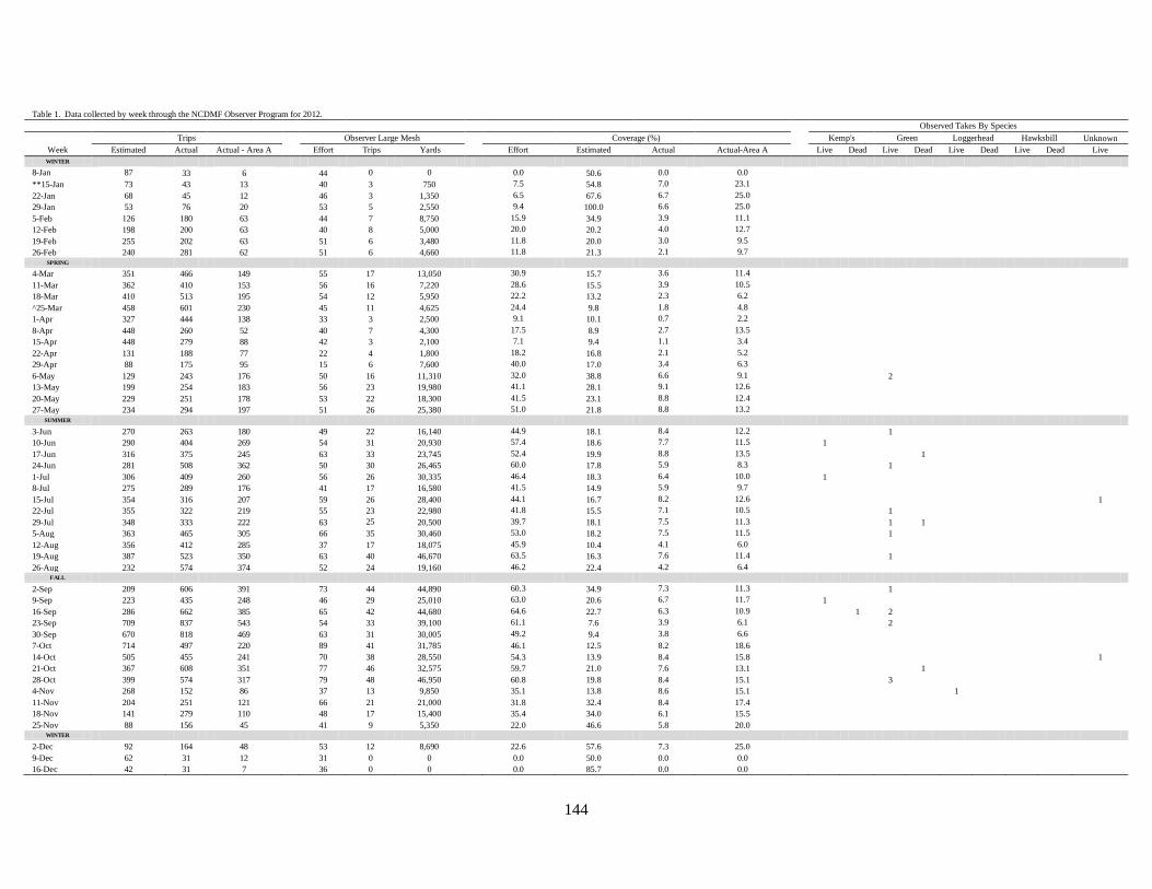
144
Table 1. Data collected by week through the NCDMF Observer Program for 2012.
Observed Takes By Species
Trips
Observer Large Mesh
Coverage (%)
Kemp's Green Loggerhead Hawksbill Unknown
Week Estimated Actual Actual - Area A Effort Trips Yards Effort Estimated Actual Actual-Area A Live Dead Live Dead Live Dead Live Dead Live
WINTER
8-Jan 87 33 6
44 0 0
0.0 50.6 0.0 0.0
**15-Jan 73 43 13
40 3 750
7.5 54.8 7.0 23.1
22-Jan 68 45 12
46 3 1,350
6.5 67.6 6.7 25.0
29-Jan 53 76 20
53 5 2,550
9.4 100.0 6.6 25.0
5-Feb 126 180 63
44 7 8,750
15.9 34.9 3.9 11.1
12-Feb 198 200 63
40 8 5,000
20.0 20.2 4.0 12.7
19-Feb 255 202 63
51 6 3,480
11.8 20.0 3.0 9.5
26-Feb 240 281 62
51 6 4,660
11.8 21.3 2.1 9.7
SPRING
4-Mar 351 466 149
55 17 13,050
30.9 15.7 3.6 11.4
11-Mar 362 410 153
56 16 7,220
28.6 15.5 3.9 10.5
18-Mar 410 513 195
54 12 5,950
22.2 13.2 2.3 6.2
^25-Mar 458 601 230
45 11 4,625
24.4 9.8 1.8 4.8
1-Apr 327 444 138
33 3 2,500
9.1 10.1 0.7 2.2
8-Apr 448 260 52
40 7 4,300
17.5 8.9 2.7 13.5
15-Apr 448 279 88
42 3 2,100
7.1 9.4 1.1 3.4
22-Apr 131 188 77
22 4 1,800
18.2 16.8 2.1 5.2
29-Apr 88 175 95
15 6 7,600
40.0 17.0 3.4 6.3
6-May 129 243 176
50 16 11,310
32.0 38.8 6.6 9.1
2
13-May 199 254 183
56 23 19,980
41.1 28.1 9.1 12.6
20-May 229 251 178
53 22 18,300
41.5 23.1 8.8 12.4
27-May 234 294 197
51 26 25,380
51.0 21.8 8.8 13.2
SUMMER
3-Jun 270 263 180
49 22 16,140
44.9 18.1 8.4 12.2
1
10-Jun 290 404 269
54 31 20,930
57.4 18.6 7.7 11.5
1
17-Jun 316 375 245
63 33 23,745
52.4 19.9 8.8 13.5
1
24-Jun 281 508 362
50 30 26,465
60.0 17.8 5.9 8.3
1
1-Jul 306 409 260
56 26 30,335
46.4 18.3 6.4 10.0
1
8-Jul 275 289 176
41 17 16,580
41.5 14.9 5.9 9.7
15-Jul 354 316 207
59 26 28,400
44.1 16.7 8.2 12.6
1
22-Jul 355 322 219
55 23 22,980
41.8 15.5 7.1 10.5
1
29-Jul 348 333 222
63 25 20,500
39.7 18.1 7.5 11.3
1 1
5-Aug 363 465 305
66 35 30,460
53.0 18.2 7.5 11.5
1
12-Aug 356 412 285
37 17 18,075
45.9 10.4 4.1 6.0
19-Aug 387 523 350
63 40 46,670
63.5 16.3 7.6 11.4
1
26-Aug 232 574 374
52 24 19,160
46.2 22.4 4.2 6.4
FALL
2-Sep 209 606 391
73 44 44,890
60.3 34.9 7.3 11.3
1
9-Sep 223 435 248
46 29 25,010
63.0 20.6 6.7 11.7
1
16-Sep 286 662 385
65 42 44,680
64.6 22.7 6.3 10.9
1 2
23-Sep 709 837 543
54 33 39,100
61.1 7.6 3.9 6.1
2
30-Sep 670 818 469
63 31 30,005
49.2 9.4 3.8 6.6
7-Oct 714 497 220
89 41 31,785
46.1 12.5 8.2 18.6
14-Oct 505 455 241
70 38 28,550
54.3 13.9 8.4 15.8
1
21-Oct 367 608 351
77 46 32,575
59.7 21.0 7.6 13.1
1
28-Oct 399 574 317
79 48 46,950
60.8 19.8 8.4 15.1
3
4-Nov 268 152 86
37 13 9,850
35.1 13.8 8.6 15.1
1
11-Nov 204 251 121
66 21 21,000
31.8 32.4 8.4 17.4
18-Nov 141 279 110
48 17 15,400
35.4 34.0 6.1 15.5
25-Nov 88 156 45
41 9 5,350
22.0 46.6 5.8 20.0
WINTER
2-Dec 92 164 48
53 12 8,690
22.6 57.6 7.3 25.0
9-Dec 62 31 12
31 0 0
0.0 50.0 0.0 0.0 16-Dec 42 31 7
36 0 0
0.0 85.7 0.0 0.0

145
Table 1. Cont.
23-Dec 26 20 4
41 0 0
0.0 157.7 0.0 0.0
30-Dec 15 14 2 28 0 0 0.0 186.7 0.0 0.0
Total 14,067 17,221 9,267 2,646 977 854,930 36.9 18.8 5.7 10.5 3 1 16 3 1 0 0 0 2
Obs Trips/Obs
Effort
Obs Effort/Trips
Estimated
Obs Trips/
Actual Trips
Obs Trips/Actual
Trips - Area A
**Beginning of shad season
^ End of shad season
Table 2. Data collected by area through the NCDMF Observer Program for 2012.
Observed Takes By Species
Trips
Observer Large Mesh
Coverage (%)
Kemp's Green Loggerhead Hawksbill Unknown
Month Area Estimated Actual Effort Trips Yards Effort Actual Live Dead Live Dead Live Dead Live Dead Live
WINTER
January A 270 169
42 0 0
0.0 0.0
B 9 13
23 0 0
0.0 0.0
C 7 45
53 10 6,750
18.9 22.2
D1 0 0
4 0 0
0.0 0.0
D2 0 1
20 0 0
0.0 0.0
E 9 8
55 4 1,300
7.3 50.0
February A 661 737
31 1 50
3.2 0.1
B 28 46
22 3 2,300
13.6 6.5
C 119 198
56 19 22,900
33.9 9.6
D1 0 0
6 0 0
0.0 0.0
D2 0 1
18 0 0
0.0 0.0
E 49 36
63 8 875
12.7 22.2
SPRING
March A 894 1,395
33 4 600
12.1 0.3
B 54 123
24 4 4,000
16.7 3.3
C 678 610
55 23 19,100
41.8 3.8
D1 2 2
6 0 0
0.0 0.0
D2 0 12
22 0 0
0.0 0.0
E 103 67
79 21 2,010
26.6 31.3
April A 1,030 636
31 2 1,900
6.5 0.3
B 93 193
22 5 2,600
22.7 2.6
C 34 35
21 3 2,600
14.3 8.6
D1 4 15
7 3 5,400
42.9 20.0
D2 13 28
14 1 100
7.1 3.6
E 63 59
29 7 3,700
24.1 11.9
May A 27 337
45 6 9,600
13.3 1.8
B 484 516
60 34 47,940
56.7 6.6
C 102 66
29 4 3,400
13.8 6.1
D1 51 27
6 5 4,710
83.3 18.5
2
D2 62 77
11 5 3,500
45.5 6.5
E 138 146
74 40 14,000
54.1 27.4

146
Table 2. Cont.
SUMMER
June A 113 585
46 7 8,450
15.2 1.2
B 709 724
72 50 73,510
69.4 6.9
1
C 196 142
26 5 2,150
19.2 3.5
D1 65 0
0 0 0
0.0 0.0
D2 68 58
22 17 5,800
77.3 29.3
1
E 153 281
83 55 19,025
66.3 19.6
1
1 1
July A 219 486
42 2 500
4.8 0.4
B 802 509
68 48 74,160
70.6 9.4
1
C 180 111
42 5 3,900
11.9 4.5
D1 42 0
0 0 0
0.0 0.0
D2 46 35
13 8 1,400
61.5 22.9
E 131 258
71 36 15,900
50.7 14.0
1 1
1
August A 224 789
30 9 13,390
30.0 1.1
B 757 909
93 66 103,045
71.0 7.3
1
C 220 339
43 11 9,650
25.6 3.2
D1 28 0
0 0 0
0.0 0.0
D2 61 77
19 12 6,800
63.2 15.6
E 135 277
88 52 17,170
59.1 18.8
2
FALL
September A 293 1,152
37 22 32,770
59.5 1.9
1
1
B 807 783
76 52 85,430
68.4 6.6
1 2
C 411 433
36 11 8,020
30.6 2.5
D1 44 0
0 0 0
0.0 0.0
D2 122 139
17 11 3,150
64.7 7.9
E 234 304
65 41 11,225
63.1 13.5
1
October A 335 1,014
39 18 29,030
46.2 1.8
B 1,234 485
90 64 78,910
71.1 13.2
2 1
C 234 288
45 12 4,495
26.7 4.2
D1 38 36
39 23 12,375
59.0 63.9
1
D2 117 107
36 15 6,800
41.7 14.0
E 173 245
78 44 11,250
56.4 18.0
1
November A 297 578
35 13 14,790
37.1 2.2
B 214 138
56 26 29,300
46.4 18.8
C 31 88
35 4 1,400
11.4 4.5
D1 12 27
16 9 5,450
56.3 33.3
1
D2 63 31
14 0 0
0.0 0.0
E 86 92
75 17 6,350
22.7 18.5
WINTER
December A 167 76
35 0 0
0.0 0.0
B 15 24
24 0 0
0.0 0.0
C 1 1
14 0 0
0.0 0.0
D1 0 0
6 0 0
0.0 0.0
D2 5 2
9 0 0
0.0 0.0
E 1 0
50 0 0
0.0 0.0
Total 14,067 17,221 2,646 977 854,930 36.9 5.7 3 1 16 3 1 0 0 0 2
Obs Trips/
Obs Effort
Obs Trips/
Actual Trips

147
Updated Table 8. Number of sea turtles observed in the North Carolina Division of Marine Fisheries (NCDMF) Onboard Observer Program
(Program 466) by mesh size, year, season, management unit, and species from 2007 through 2011.
Year Season Management Unit
Species
Green Hawksbill Kemp's Ridley Leatherback Loggerhead *Unknown Total
Large 2007 Fall B 19 0 0 0 1 0 20
2008 Spring B 0 0 1 0 0 0 1
2008 Summer B 1 0 0 0 0 0 1
2008 Fall B 15 0 1 0 1 0 17
2009 Summer B 2 0 2 0 0 0 4
2009 Fall B 28 1 4 0 1 0 34
2010 Fall B 7 0 0 0 1 0 8
2011 Summer B 0 0 0 0 0 1 1
2011 Summer D1 0 0 4 0 0 0 4
2011 Summer E 1 0 0 0 1 0 2
2011 Fall D2 0 0 1 0 0 0 1
2011 Fall E 1 0 0 0 1 0 2
Small 2011 Fall D2 0 0 1 0 0 0 1
Total 74 1 14 0 6 1 96
*Includes sea turtles that could not be identified to the species level
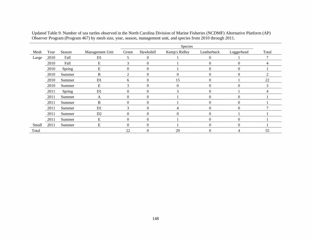
148
Updated Table 9. Number of sea turtles observed in the North Carolina Division of Marine Fisheries (NCDMF) Alternative Platform (AP)
Observer Program (Program 467) by mesh size, year, season, management unit, and species from 2010 through 2011.
Mesh Year Season
Species
Management Unit Green Hawksbill Kemp's Ridley Leatherback Loggerhead Total
Large 2010 Fall D1 5 0 1 0 1 7
2010 Fall E 3 0 1 0 0 4
2010 Spring E 0 0 1 0 0 1
2010 Summer B 2 0 0 0 0 2
2010 Summer D1 6 0 15 0 1 22
2010 Summer E 3 0 0 0 0 3
2011 Spring D1 0 0 3 0 1 4
2011 Summer A 0 0 1 0 0 1
2011 Summer B 0 0 1 0 0 1
2011 Summer D1 3 0 4 0 0 7
2011 Summer D2 0 0 0 0 1 1
2011 Summer E 0 0 1 0 0 1
Small 2011 Summer E 0 0 1 0 0 1
Total 22 0 29 0 4 55

149
Updated Table 27. Total number of small mesh (<4 in) gill-net trips (n = 145) and the number of
sea turtles observed (n = 2) by year, management unit, season, and species through onboard and
alternative platform observations throughout the estuarine waters of North Carolina from 2010-2011.
Year
Species
Season Management Unit 2010 2011 Total Kemp's ridley
Winter A 0 1 1
B 5 0 5
C 5 19 24
D1 1 0 1
D2 0 0 0
E 6 0 6
Fall A 0 0 0
B 1 12 13
C 0 0 0
D1 0 1 1
D2 4 3 7
1
E 4 0 4
Spring A 0 3 3
B 3 32 35
C 1 11 12
D1 0 0 0
D2 0 0 0
E 2 3 5
Summer A 0 0 0
B 0 15 15
C 2 1 3
D1 0 0 0
D2 0 1 1
E 3 6 9 1
Total 37 108 145 2

150
JUNE 4, 2013
As per NMFS request the observed takes reduced for the large and small mesh fisheries including
the exempt areas.
Updated Table 22. Annual requested takes (n = 668) for the large mesh (≥4 in) estuarine gill-net fisheries for
management units B, D1, D2, and E by species and disposition (alive/dead).
Management
Units
Species Estimated/Observed Disposition B D1 D2 E Total
Green Estimated Alive
225 9 0 96
330
Estimated Dead
112 5 0 48
165
*Observed Alive/Dead 0 0 6 0 6
Kemps ridley Estimated Alive
53 15 6 25
98
Estimated Dead 26 7 3 12 49
Loggerhead *Observed Alive/Dead 3 3 3 3 12
Hawksbill *Observed Alive/Dead 1 1 1 1 4
Leatherback *Observed Alive/Dead 1 1 1 1 4
Total 421 41 20 186 668
*Number of observed takes allowed (dead or alive) where interaction levels were too low to model

151
Updated Table 23. Annual requested takes (n = 44) for the small mesh (<4 in) estuarine gill-net fisheries for management
units B, D1, D2, and E by species.
Management Units
Species Estimated/Observed Disposition B D1 D2 E Total
Kemps ridley *Observed Alive/Dead 3 3 3 3 12
Green *Observed Alive/Dead 3 3 3 3 12
Loggerhead *Observed Alive/Dead 3 3 3 3 12
Hawksbill *Observed Alive/Dead 1 1 1 1 4
Leatherback *Observed Alive/Dead 1 1 1 1 4
Total 11 11 11 11 44
*Number of observed takes allowed (dead or alive) where interaction levels were too low to model
Updated Table 24. Annual requested takes (n = 8) for the small (<4 in) and large (≥4 in)
mesh estuarine gill-net fisheries for management units A and C.
Management
Units
Species Estimated/Observed Disposition A C Total
All *Observed Alive/Dead 4 4 8
*Number of observed takes allowed (dead or alive) where interaction levels were too low to
model
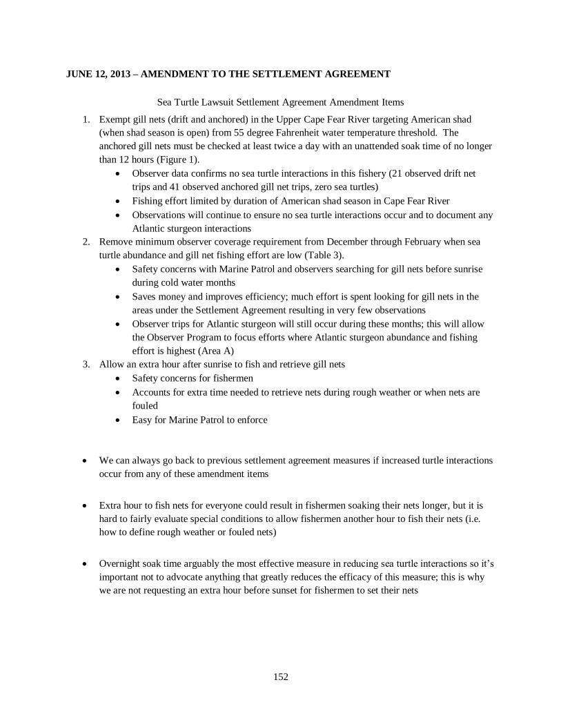
152
JUNE 12, 2013 – AMENDMENT TO THE SETTLEMENT AGREEMENT
Sea Turtle Lawsuit Settlement Agreement Amendment Items
1. Exempt gill nets (drift and anchored) in the Upper Cape Fear River targeting American shad
(when shad season is open) from 55 degree Fahrenheit water temperature threshold. The
anchored gill nets must be checked at least twice a day with an unattended soak time of no longer
than 12 hours (Figure 1).
Observer data confirms no sea turtle interactions in this fishery (21 observed drift net
trips and 41 observed anchored gill net trips, zero sea turtles)
Fishing effort limited by duration of American shad season in Cape Fear River
Observations will continue to ensure no sea turtle interactions occur and to document any
Atlantic sturgeon interactions
2. Remove minimum observer coverage requirement from December through February when sea
turtle abundance and gill net fishing effort are low (Table 3).
Safety concerns with Marine Patrol and observers searching for gill nets before sunrise
during cold water months
Saves money and improves efficiency; much effort is spent looking for gill nets in the
areas under the Settlement Agreement resulting in very few observations
Observer trips for Atlantic sturgeon will still occur during these months; this will allow
the Observer Program to focus efforts where Atlantic sturgeon abundance and fishing
effort is highest (Area A)
3. Allow an extra hour after sunrise to fish and retrieve gill nets
Safety concerns for fishermen
Accounts for extra time needed to retrieve nets during rough weather or when nets are
fouled
Easy for Marine Patrol to enforce
We can always go back to previous settlement agreement measures if increased turtle interactions
occur from any of these amendment items
Extra hour to fish nets for everyone could result in fishermen soaking their nets longer, but it is
hard to fairly evaluate special conditions to allow fishermen another hour to fish their nets (i.e.
how to define rough weather or fouled nets)
Overnight soak time arguably the most effective measure in reducing sea turtle interactions so it’s
important not to advocate anything that greatly reduces the efficacy of this measure; this is why
we are not requesting an extra hour before sunset for fishermen to set their nets

153
Table 3. Fishing effort, observer and Marine Patrol effort, observed trips, percent coverage, and number of unsuccessful large mesh gill-net trips from Programs 466 (onboard) and 467 (Alternative
Platform) from 2011 through 2013 by month and management unit for the winter (December through February) season.
Fishing Effort
**Observer/MP Effort
***Observed Trips
Coverage
Observer/MP Effort - Observed
Trips
Month Management Unit 2011 2012 *2013 2011 2012 2013 2011 2012 2013 2011 2012 2013 2011 2012 2013
December A 56 76 n/a
30 35 n/a
0 0 n/a
0.0 0.0 n/a
30 35 n/a
B 3 24 n/a
22 24 n/a
0 0 n/a
0.0 0.0 n/a
22 24 n/a
C 2 1 n/a
37 14 n/a
2 0 n/a
100.0 0.0 n/a
35 14 n/a
D1 0 0 n/a
9 6 n/a
0 0 n/a
0.0 0.0 n/a
9 6 n/a
D2 0 2 n/a
17 9 n/a
0 0 n/a
0.0 0.0 n/a
17 9 n/a
E 1 0 n/a
52 50 n/a
0 0 n/a
0.0 0.0 n/a
52 50 n/a
January A 183 169 192
59 42 47
0 0 5
0.0 0.0 2.6
59 42 42
B 18 13 23
39 23 30
0 0 0
0.0 0.0 0.0
39 23 30
C 8 45 12
26 53 41
4 10 5
50.0 22.2 41.7
22 43 36
D1 0 0 0
18 4 7
0 0 0
0.0 0.0 0.0
18 4 7
D2 0 1 0
15 20 15
0 0 1
0.0 0.0 0.0
15 20 14
E 11 8 3
52 55 62
1 4 0
9.1 50.0 0.0
51 51 62
February A 717 737 605
34 31 42
4 1 9
0.6 0.1 1.5
30 30 33
B 152 46 37
30 22 19
0 3 1
0.0 6.5 2.7
30 19 18
C 132 198 68
39 56 52
18 19 26
13.6 9.6 38.2
21 37 26
D1 5 0 0
12 6 14
0 0 0
0.0 0.0 0.0
12 6 14
D2 0 1 2
17 18 18
0 0 0
0.0 0.0 0.0
17 18 18
E 49 36 24
49 63 49
2 8 0
4.1 22.2 0.0
47 55 49
Total 1,336 1,357 966 557 531 396 31 45 47 2.3 3.3 4.9 526 486 349
*2013 trip ticket data preliminary
**Observer/MP Effort includes all successful and unsuccessful large mesh gill-net trips
***Observed Trips is only the successful large mesh gill-net trips

154
Figure 1. Map of the exempt areas requested for the upper Cape Fear River during the American shad season.