Embed Size (px)
Citation preview

Using CRAM (California Rapid Assessment Method)
To Assess Wetland Projects As an Element of Regulatory and Management
Programs
Technical Bulletin
Produced by:
CALIFORNIA WETLAND MONITORING WORKGROUP
October 13, 2009
Many individuals representing numerous State and Federal agencies contributed to the preparation of this document. The principle contributors are listed below, although many other people provided technical review and comment.
Mark Adelson Santa Ana Regional Water Quality Control Board Karen Bane State Coastal Conservancy Shirley Birosik Los Angeles Regional Water Quality Control Board Slader Buck U.S. Fish and Wildlife Service Bryant Chesney NOAA National Marine Fisheries Service Chiara Clemente San Diego Regional Water Quality Control Board Josh Collins San Francisco Estuary Institute Cori Farrar U.S. Army Corps of Engineers, Los Angeles District Andree Greenberg San Francisco Regional Water Quality Control Board Megan Johnson State Coastal Conservancy Paul Jones U.S. Environmental Protection Agency Shin‐Roei Lee San Francisco Regional Water Quality Control Board Mariah Mills San Diego Regional Water Quality Control Board Steve Newton‐Reed California Department of Fish and Game LB Nye Los Angeles Regional Water Quality Control Board Bill Orme State Water Resources Control Board Chris Potter State Resources Agency Chris Solek S. Ca. Coastal Water Research Project Eric Stein S. Ca. Coastal Water Research Project Martha Sutula S. Ca. Coastal Water Research Project Daniel Swenson U.S. Army Corps of Engineers, Los Angeles District
Questions on CRAM or the content of this document can be directed toward your local state or federal agency representative or emailed to the CRAM workgroup at [email protected].
Suggested Citation: California Wetlands Monitoring Workgroup (CWMW). 2009. Using CRAM (California Rapid
Assessment Method) to Assess Wetland Projects as an Element of Regulatory and Management Programs. 46 pp.
i

TABLE OF CONTENTS
1. Introduction and Goals ................................................................................................................ 1 A. Interagency Coordination and Policy Considerations ....................................................... …2
2. Background on CRAM .................................................................................................................. 3 3. CRAM Applications ....................................................................................................................... 5 A. Appropriate Wetland Types for CRAM Assessments ......................................................... 5 B. Appropriate Uses of CRAM ................................................................................................. 7 C. Inappropriate Uses of CRAM .............................................................................................. 8 D. Modifying CRAM Methodology .......................................................................................... 9 E. Multiplying CRAM Scores by Size of the Assessment or Project Area ................................ 9 F. Summarizing Multiple CRAM Scores .................................................................................. 9 G. Process to address technical issues with CRAM ............................................................... 11 H. Requirements for Practitioner Expertise and Training ..................................................... 12 I. Submission of CRAM Scores ............................................................................................. 13 J. Interpretation of CRAM scores (What do CRAM scores mean?) ...................................... 14
4. CRAM Quality Assurance ........................................................................................................... 16 A. General Quality Assurance Requirements for CRAM Assessments .................................. 16 B. Precision of CRAM Scores ................................................................................................. 17 C. Accuracy of CRAM Scores ................................................................................................. 17 D. Seasonal Variability of CRAM Assessments ...................................................................... 18 E. Addressing multiple versions of CRAM ............................................................................. 18
5. Specific Guidance for Assessment of Projects ........................................................................... 20 A. Defining a Project Area and Appropriate Assessment Area ............................................. 20 B. Selection of the Appropriate CRAM Wetland Type .......................................................... 24 C. Use of CRAM to Detect Changes in Wetland Condition Over Time ................................. 24 D. Example Scenarios for CRAM Assessment of Projects ..................................................... 25
6. Phased Implementation of CRAM .............................................................................................. 29 References ...................................................................................................................................... 30 Appendix A: Summary of CRAM External Reviews and Peer‐reviewed Documents ..................... 31 Appendix B: Standard Procedures for Photographs ...................................................................... 34 Appendix C: Guidelines for Submitting Maps of the CRAM Assessment Area .............................. 36 Appendix D: Protocol for Level 2 Project Assessment V. 3.0 ......................................................... 38
ii

iii
LIST OF TABLES
Table 1. The CRAM Wetland Typology. Table shows wetland types for which CRAM modules currently exist.. ..................................................................................................................... 5
Table 2: Examples of features that should be used to delineate AA boundaries. ........................ 21 Table 3: Examples of features that should not be used to delineate any AAs. ............................. 21 Table 4. Recommended maximum and minimum AA sizes for each wetland type. ................... 22 Table 5. Example of CRAM evaluation to support assessment of potential impacts associated
with a wetland fill (negative change) and potential gains associated with compensatory mitigation (positive change).. ............................................................................................. 26
Table 6: Example of CRAM evaluation of a compensatory mitigation site showing scores for both current monitoring period and anticipated target scores.. ....................................... 27
LIST OF FIGURES
Figure 1: Example comparison of CRAM scores for a specific site to average CRAM scores for the State. ............................................................................................................................. 11
Figure 2: Example of riverine Assessment Areas color coded based on existing CRAM scores. 26 Figure 3: Cumulative distribution frequency (CDF) plots showing the ambient condition of
estuaries (based on CRAM) in the State of California compared to the ambient condition in four subregions. .............................................................................................................. 28

1. Introduction and Goals
In 2003, a consortium of Federal, State, and local scientists and managers began working to develop a framework and consistent set of tools to support wetland and riparian monitoring and assessment across a variety of agency programs. The overall goal of this effort is to provide tools to inform decisions regarding wetland and riparian resource protection and management and to improve coordination and efficiency of various State and Federal wetland programs. The conceptual approach and collection of existing wetland and riparian assessment tools is modeled after United States Environmental Protection Agency (USEPA) Level 1‐2‐3 framework for monitoring and assessment of wetland resources. The fundamental elements of this framework are:
• Level 1: consists of map‐based inventories of wetlands and related habitats, including rivers, streams, and riparian areas, plus related projects that have a direct effect on the distribution and abundance of wetlands and related habitats. Level 1 maps can serve as the basis for landscape and watershed profiles of wetland systems, and as sample frames for surveys of wetland condition based on Level 2 and Level 3 tools.
• Level 2: consists of rapid, field‐based assessments of the overall condition or functional capacity of wetlands and/or their likely stressors. Level 2 results can be used to cost‐effectively survey the overall condition of wetlands across landscapes, watersheds, and regions.
• Level 3: consists of quantitative measurement of specific wetland functions or stressors. Level 3 results can be used to calibrate and validate results from Level 2 assessments.
Existing tools that support the Level 1‐2‐3 framework include: Level 1 ‐ standardized wetland, riparian, and vegetation mapping methodologies and the Wetland Tracker information system that provides Level 1 maps and Level 2 and Level 3 monitoring data to agencies and the public; Level 2 ‐ tools to assess landscape scale stressors and the California Rapid Assessment Method (CRAM); and Level 3 – traditional assessments such as macroinvertebrate IBI for wadeable riverine ecosystems, draft periphyton IBI, standardized water chemistry and toxicity assessment methods, geomorphic or hydraulic surveys, plant surveys, or bird surveys.
The Level 1, 2, and 3 tools are intended to be used for a variety of applications including restoration planning, ambient or regional monitoring and assessment (such as: the Southern California Wetland Recovery Project’s Integrated Wetlands Regional Assessment Program, the Bay Area Wetlands Regional Monitoring Program, and the State Surface Water Ambient Monitoring Program), project evaluation to inform regulatory decisions (such as, Section 401 and 404 permits), restoration or mitigation site evaluation, and general resource or watershed planning. The selection of a specific assessment tool, its precise application, quality control,
1

and reporting needs for the wetland assessment tools may vary based on the purpose of the assessment and the desired outcome. However, each of these applications provides an important element of our overall understanding of wetland condition and should be considered when making decisions regarding wetland regulation, restoration, or management.
A common set of assessment and data management tools can help coordinate the various programmatic applications. Such coordination will allow ambient/regional assessments to provide context for project specific assessments and, conversely, will facilitate incorporation of project specific data into regional evaluations.
Several resources are available to guide the use and application of the tools, including technical documents and online resources (Collins et al. 2007, Sutula et al. 2006, Stein et al. 2007, Stein et al. 2009; www.cramwetlands.org). General application is also described in the white paper “Improving Monitoring and Assessment of Wetland and Riparian Areas in California through Implementation of a Level 1, 2, 3 Framework” by Stein et al. (2007).
The purpose of this document is to address technical issues related to the use of CRAM for project assessment. The intent is to support consistent and appropriate application of CRAM for regulatory, mitigation, and restoration projects across a variety of state and federal agency programs. This document does not constitute official guidance or policy by any agency, rather it addresses a set of technical issues and considerations. This document cannot anticipate every situation or contingency that may arise in the wetland regulatory or grant‐funded restoration programs. Users are encouraged to consult with agency staff on questions regarding use of CRAM in specific project circumstances.
A. Interagency Coordination and Policy Considerations
As with any assessment method, discussion and debate on some elements of CRAM and its application is ongoing. As a result, it is expected that CRAM will continue to evolve in response to new data and changing needs of the user community. We encourage ongoing dialogue on differing viewpoints and perspectives with a goal of continuing to improve the utility of CRAM for both ambient and project assessment. To facilitate dialogue on technical aspects of CRAM and the policy implications of its use, the California Wetlands Monitoring Workgroup, under guidance from the California Water Quality Monitoring Council will form a Level 2 Assessment Coordinating Committee. Coordination of this committee will be provided by Water Boards staff. This committee will provide a forum for agency staff to discuss policy issues that are beyond the scope of this technical document. The committee will also interact with the CRAM principal investigators to develop priorities for future CRAM refinements, additional module development, QA/QC, ongoing testing, and validation, and reporting. This committee will also provide guidance for the training, testing and auditing of practitioners and trainers.
2

2. Background on CRAM
CRAM is a component of a broader wetland assessment toolkit that has been developed in California based on EPA’s Level 1‐2‐3 Framework for wetland monitoring and assessment. CRAM can be an effective tool for assessing the overall condition of a wetland when used as directed by trained professionals in a comprehensive program of wetlands monitoring that also includes accurate mapping of wetlands and careful quantification of essential wetland functions. CRAM is not intended to be used as a single, independent tool to meet all wetland monitoring and assessment needs.
The USEPA has funded the development of CRAM as part of a broad effort to increase the abilities of California government agencies and Tribes to assess the status and trends in condition of wetlands and riparian areas (Collins et al. 2007). CRAM provides consistent and comparable assessments of wetland condition for all wetlands and regions in California, yet accommodates special characteristics of different regions and types of wetlands. CRAM assesses the overall condition of wetlands; the results of a condition assessment can be used to infer the ability to provide various functions or services to which a wetland is most suited.
CRAM assessments have four attributes: landscape context, hydrology, physical structure, and biotic structure. They also identify key stressors that may be affecting wetland condition. CRAM has been subject to extensive peer review and iterative refinement for all CRAM wetland types. In addition, riverine and estuarine classes have been validated against independent Level 3 measures of condition including benthic invertebrates, riparian birds, and estuarine plant richness and diversity (Stein et al. 2009). This has resulted in refinement of the metrics for these wetland types and provides for a higher level of confidence in the ecological meaning of CRAM scores. Similar validation efforts are planned for other wetland types over the next several years beginning with depressional wetlands.
CRAM metrics and attributes can be related to wetland functions, values and beneficial uses, although they are not measured directly by CRAM. For the purposes of CRAM, condition is defined as the state of a wetland assessment area’s physical and biological structure, the hydrology, and its buffer and landscape context relative to the best achievable states for the same type of wetland. Condition is evaluated based on observations made at the time of the assessment. CRAM does not measure functions, which are rates of characteristic processes or services over time. CRAM condition scores are correlated with some wetland functions and hence one can infer whether certain functions are or are not likely to occur based on a CRAM condition score. The likelihood of occurrence of a specific function is sometimes referred to as functional capacity. An important distinction between CRAM and functional assessment methods is that the condition scores in CRAM reflect aggregations of multiple functions, as
3
opposed to providing insight into the performance of individual rates or processes of specific functions.
The fundamental unit of evaluation for CRAM assessments is termed the Assessment Area (AA). The AA is the portion of the wetland that is assessed using CRAM. For small wetlands, the AA might include the entire wetland, but for most wetlands and streams, the AA will include a portion of the wetland (or a reach of the stream). An AA is typically defined as a portion of the wetland (or stream) that is hydrologically and geomorphically homogenous and can be assessed within four hours (see Section 5). Assessing the overall condition of larger and/or structurally diverse wetlands requires multiple AAs. The CRAM Users Manual provides procedures for defining an AA and recommended minimum and maximum AA sizes for each CRAM wetland type.
Consistent use of CRAM will facilitate comparisons of condition across projects, programs, and agencies and will promote data sharing between various wetland programs. The general procedure for using CRAM consists of eight (8) steps:
Step 1. Assemble background information about the management of the wetland.
Step 2. Classify the wetland using the manual.
Step 3. Verify the appropriate season and other timing aspects of field assessment.
Step 4. Estimate the boundary of the AA (subject to field verification).
Step 5. Conduct the office assessment of stressors and on‐site conditions of the AA.
Step 6. Conduct the field assessment of stressors and on‐site conditions of the AA.
Step 7. Complete CRAM assessment scores and QA/QC Procedures.
Step 8. Upload CRAM results into regional and statewide information systems.
There is a “field to PC” data management tool (eCRAM) to facilitate data quality control and availability. The eCRAM allows uploading of CRAM scores to the statewide database (www.cramwetlands.org). These data will be integrated with Level 1 maps in the Wetland Tracker to facilitate easy viewing and downloading of data on wetland extent and condition.
Like all assessment methods, CRAM will be continuously refined based on user feedback; consequently, the application of CRAM may adapt over time as more experienced is gained. The CRAM Team currently provides annual updates and revisions to the method. Information on CRAM, updates and revisions, and the CRAM statewide database can be found at www.cramwetlands.org/.
4
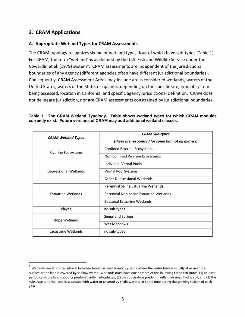
3. CRAM Applications
A. Appropriate Wetland Types for CRAM Assessments
The CRAM typology recognizes six major wetland types, four of which have sub‐types (Table 1). For CRAM, the term “wetland” is as defined by the U.S. Fish and Wildlife Service under the Cowardin et al. (1979) system1. CRAM assessments are independent of the jurisdictional boundaries of any agency (different agencies often have different jurisdictional boundaries). Consequently, CRAM Assessment Areas may include areas considered wetlands, waters of the United States, waters of the State, or uplands, depending on the specific site, type of system being assessed, location in California, and specific agency jurisdictional definition. CRAM does not delineate jurisdiction, nor are CRAM assessments constrained by jurisdictional boundaries.
Table 1. The CRAM Wetland Typology. Table shows wetland types for which CRAM modules currently exist. Future versions of CRAM may add additional wetland classes.
CRAM Wetland Types CRAM Sub‐types
(these are recognized for some but not all metrics)
Riverine Ecosystems Confined Riverine Ecosystems
Non‐confined Riverine Ecosystems
Depressional Wetlands
Individual Vernal Pools
Vernal Pool Systems
Other Depressional Wetlands
Estuarine Wetlands
Perennial Saline Estuarine Wetlands
Perennial Non‐saline Estuarine Wetlands
Seasonal Estuarine Wetlands
Playas no sub‐types
Slope Wetlands Seeps and Springs
Wet Meadows
Lacustrine Wetlands no sub‐types
1 Wetlands are lands transitional between terrestrial and aquatic systems where the water table is usually at or near the surface or the land is covered by shallow water. Wetlands must have one or more of the following three attributes: (1) at least periodically, the land supports predominantly hydrophytes; (2) the substrate is predominantly undrained hydric soil; and (3) the substrate is nonsoil and is saturated with water or covered by shallow water at some time during the growing season of each year.
5
For the purposes of a CRAM assessment, a riverine ecosystem consists of the riverine channel and its active floodplain, plus any portions of the adjacent riparian areas that are likely to be strongly linked to the channel or floodplain through bank stabilization and allochthanous inputs. As stated above, a riverine CRAM Assessment Area will often consist of areas considered wetland and non‐wetland, depending on the location and the specific agency jurisdictional definition.
CRAM was not designed for use in the assessment of subtidal habitats and intertidal areas with less than 5% vegetated cover of emergent marsh. In addition, CRAM is also under refinement for certain subclasses of wetlands, including ephemeral streams and seasonal depressional wetlands. The CRAM biotic metrics are scaled to produce higher scores based on high structural complexity. Seasonal wetlands and headwater streams often have naturally lower complexity. Consequently, the current version of CRAM may inherently produce lower scores for these wetland types. Future refinements of CRAM are planned to address this situation and more appropriately assess these wetland types.
CRAM has undergone extensive technical and peer review. Review has occurred at several levels:
• Technical input in development of the method. A variety of individuals with different expertise and perspectives participated in the development and testing process. Literally hundreds of individuals from all levels of government, academia, and the private sector were involved in various aspects of CRAM development and testing.
• Formal technical review. To date, two peer‐reviewed journal articles have been published on CRAM and the Corps of Engineers Engineering Research and Development Center (ERDC) completed an external technical review. These reviews have focused on the overall structure and technical approach of CRAM and on validation of the riverine and estuarine assessment modules. Although individuals may disagree with the results of these reviews, they are valid endorsements of the technical efficacy of the method.
• Acceptance by application. CRAM is being applied by some practitioners and agencies at staff discretion on a phased and trial basis, as recommended by this document. Increased application of CRAM may be the ultimate form of “peer” review in that it indicates a level of acceptance and confidence in the method. It is too early to judge the general acceptance of CRAM; however, we note that it has already been used in several assessments of program performance, several ambient monitoring efforts, and to support several project‐specific permit evaluations (see Appendix A).
6
The California State Water Resources Control Board has requested an external peer review of CRAM according to the official California EPA peer review process. As of the publication of this document, this review is still in process.
The iterative evaluation process has produced metrics that have been shown to reflect the gradient of condition (and hence disturbance) for all classes listed in Table 1. A summary of external technical reviews of CRAM in terms of direct peer‐review and peer‐reviewed publications is provided in Appendix A.
B. Appropriate Uses of CRAM
CRAM is intended to be a diagnostic tool to provide an assessment of overall wetland condition. In many cases, CRAM will need to be used in conjunction with Level 1 and 3 methods to support the assessment of wetland condition for decision‐making purposes. The particular applications of CRAM for specific projects will ultimately be at the discretion of each agency as part of its permitting or grant programs. Some appropriate uses include:
• Ambient assessment of wetland condition – CRAM may be used alone or with other methods to characterize wetland condition within a landscape, watershed, or region. Such assessments are often conducted based on a probabilistic sampling design where a statistically representative sample of wetlands is assessed and used to make inferences about the overall condition of the larger population of wetlands in the geographic area of interest.
• Monitoring of ecological reserves, mitigation banks, wildlife refuges or similar management units.
• Assess capacity to deliver some Beneficial Uses
• Evaluation of pre‐project conditions at potential impact sites.
• Evaluation of impacts associated with unauthorized (enforcement) actions. This may be accomplished by conducting CRAM assessments on nearby AAs in addition to the site of the unauthorized activity. This would allow generation of an assumed CRAM score based on expected, pre‐disturbance conditions. Such "retrospective" CRAM scores should not be entered into eCRAM.
• Evaluation of pre‐project conditions at potential mitigation or restoration sites.
• Assessment of performance or success of mitigation or restoration sites.
• Assessment of mitigation compliance – CRAM may be incorporated into the performance criteria for compensatory mitigation (along with other measures) in order
7

to meet the recommendations for function/condition based assessment under the new Corps of Engineers/USEPA mitigation rule.
• Comparison of proposed alternatives for regulatory or restoration planning purposes. An anticipated CRAM score can be generated based on one or more project design alternatives. This would involve a series of assumptions about the expected structure and composition following implementation of a proposed project. Such “projected” assessments are intended to aid in the evaluation of the relative condition of several alternatives. Projected CRAM scores should not be entered into eCRAM (see below for more information).
CRAM is not intended to be used as a “cook book” to provide a specific answer to a management question. Rather, CRAM is intended to be used to inform decisions that are made based on numerous considerations and may include other assessments in addition to CRAM.
C. Inappropriate Uses of CRAM
This list provides some examples of inappropriate uses of CRAM; however, it is not exhaustive. The appropriate agency should be consulted prior to any application of CRAM (see below).
o Jurisdictional determinations o Focused species or threatened and endangered species monitoring o Evaluation of specific management questions that call for Level 3 monitoring o Evaluation of compliance with water quality objectives o Assessment of mechanisms or processes of wetland function (diagnostic evaluation of
wetland function) o Assessment of wetland values. o Use of CRAM metric descriptors as stand‐alone project design templates
It has been well documented that wetlands provide a variety of values that are beneficial to people, such as floodflow attenuation, aesthetics, and contaminant sequestration. CRAM is designed to evaluate the ecological condition of a wetland in terms of its ability to support characteristic plants and animals. Human use values cannot be appropriately assessed using CRAM.
In addition, while the narrative descriptions of best attainable conditions for the CRAM metrics can be used as general guidelines for overall project designs, they do not account for site‐specific constraints and opportunities or design objectives. Because CRAM has been calibrated against statewide conditions, it is not appropriate to design a specific project based on the descriptions contained within each metric.
8

D. Modifying CRAM Methodology
All CRAM attributes should be assessed and reported when conducting an assessment. Under no circumstances should a practitioner modify CRAM metrics or attributes. Doing so will invalidate the CRAM assessment. CRAM has been developed through an extensive process of testing, calibration, and validation, and has been subjected to extensive technical and peer review. Ad hoc modification of the method will reduce or eliminate the scientific reliability and defensibility associated with the extensive development and review process of CRAM. Additional Level 2 or 3 assessments may be used to supplement CRAM results and to help evaluate progress toward meeting specific project objectives. However, these methods should not be “hybridized” with CRAM to form a new single assessment method.
E. Multiplying CRAM Scores by Size of the Assessment or Project Area
Multiplying a CRAM score by the area or linear distance of the AA may not represent the true relationship between conditions at different scales and area/linear extents. Use of CRAM scores in deciding mitigation requirements or performance criteria should recognize this limitation. Many of the CRAM metrics are designed to account for the effect of wetland size on condition, and several metrics are explicitly scaled by size. In addition, CRAM scores do not represent functional capacity on a per acre or per unit basis. Multiplying CRAM score by any dimension of size, such as wetland area, length, or perimeter, might distort the scaling of some metrics, weight the values of other metrics in unintended ways, and thus lead to erroneous results. While combining assessments with the spatial dimensions of the areas being assessed might be desirable, there are insufficient data available at this time to evaluate such practices.
It is anticipated that the necessary data will be developed during the early phases of CRAM implementation. Future versions of these guidelines will revisit this issue as additional data become available. Use of CRAM scores in deciding mitigation requirements or project performance criteria should recognize this current limitation of CRAM. Changes in wetland area are more appropriately assessed using a Level 1 tool.
F. Summarizing Multiple CRAM Scores
CRAM is intended to provide insight into the condition of the wetland Assessment Area (AA) being assessed, where the AA is defined and delineated based on the guidance provided in the CRAM manual. When the AA is the same size as the wetland, the CRAM score pertains to the wetland as a whole. If the wetland is larger than the recommended AA and the intent is to
9

assess the entire wetland, then multiple AAs should be independently assessed following the procedure outlined in Section 5 of this guidance document.
The assessment of a large wetland or project using multiple Assessment Areas requires an integrated summary of the results. The following suggests three ways to summarize the results from multiple assessments.
• The multiple scores for each metric can be averaged, and these average metric scores can be used to calculate average attribute scores and an average overall AA score for the area being assessed. However, there are insufficient data available at this time to describe the statistical distribution of the metric scores, of their averages, or of the Attribute scores and overall AA scores calculated from the average metric scores. Therefore, no CRAM scores should be statistically analyzed using parametric procedures. Non‐parametric procedures might be used, although this practice has not yet been fully investigated. Any statistical analysis of average metric scores or other scores derived from them must be fully rationalized in the report of results.
• It is very difficult, if not impossible, to interpret the meaning of average values of several attribute scores or the significance of an average CRAM score for multiple AAs. Multiple combinations of metrics scores will yield the same Attribute score, and multiple combinations of Attribute scores will yield the same overall AA score. Each Attribute score or AA score can only be explained by its particular set of contributing metric scores. When multiple scores for an Attribute are averaged, or when multiple AA scores are averaged, the link to the explanatory metric scores is blurred, if not lost entirely.
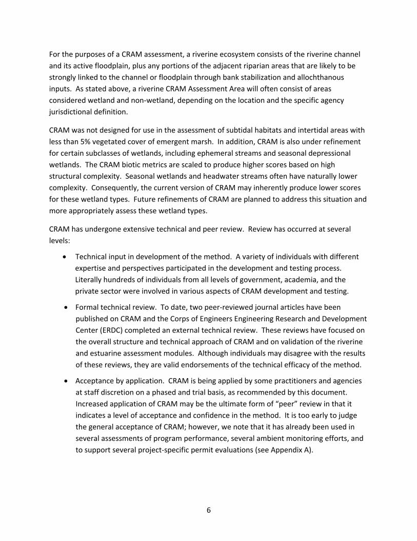
• Each metric score, Attribute score, or AA score can be compared to the distribution of comparable scores from the regional or statewide Level 2 ambient survey for the type of wetland being assessed (see Figure 1). Overall condition for the wetland can therefore be assessed by comparison against a regional distribution of such scores or as the number of scores that fall into each quartile (or other percentile) of the ambient data set. This approach to summarizing multiple CRAM assessments does not involve any averaging and therefore avoids the attending difficulties in interpretation. This approach has the added benefit of linking project assessment to ambient assessment in a way that clearly illustrates their interdependence. More information on interpreting CRAM scores can be found in Section J below.
10
Figure 1: Example comparison of CRAM scores for a specific site to average CRAM scores for the State.
G. Process to address technical issues with CRAM
Like all assessment methods, CRAM will continue to evolve and be refined with application. Comments or suggestions regarding improvement, modification, or adaptation of CRAM for specific applications can be submitted on the CRAM website (www.cramwetlands.org). All submitted comments are reviewed by the CRAM development team and used to inform annual CRAM updates and revisions. In general, suggested modification to CRAM, eCRAM, and Wetland Tracker will be compiled annually in winter, when field work is complete, and any supported modifications will be completed prior to the following field season. Technical changes to CRAM will be done by the CRAM Principal Investigators in consultation with the audit teams. Uncertainties or differences in opinion regarding application of CRAM will be addressed by the California Wetland Monitoring Council.
All individuals who register on the CRAM website will receive email alerts regarding CRAM updates and opportunities to participate in occasional CRAM workshops where proposed updates are discussed.
11
H. Requirements for Practitioner Expertise and Training
CRAM is relatively rapid but it is not necessarily easy to apply. CRAM involves a systematic, detailed examination of wetland structure at various spatial scales. According to the CRAM manual, completion of a CRAM assessment requires expertise comparable to that necessary to conduct a wetland jurisdictional delineation. However, additional expertise in wetland botany and geomorphology is helpful in many cases.
A training program for instructors and practitioners has been developed, but the training to date has been too limited to adequately quantify how much training and practical experience is needed, or how this is affected by previous experience and background. The early indications are that people with abundant experience in some form of field‐based environmental assessment learn CRAM quickly, while less experienced people take longer to achieve the same level of competence; still most people who want to use CRAM can become adequately proficient in a relative short amount of time.
All CRAM practitioners should complete at least one CRAM training course, as described above, prior to conducting a CRAM assessment. Each training course for practitioners will include an overview of CRAM and its applications plus more intensive training in one or more wetland types. The instructor training involves completing multiple classes for practitioners, supervised applications of CRAM, and instructing one or more practitioner classes. Practitioners should only conduct CRAM assessments on the wetland types for which they have been trained. A list of individuals who have successfully completed CRAM training, and the wetland types on which they were trained, is maintained on the CRAM website (www.CRAMwetlands.org).
CRAM assessments should generally be conducted by teams of at least two trained practitioners, preferably with complementary expertise (e.g., botany and geomorphology, hydrology and general ecology). Several CRAM metrics require interpretation of subtle differences in field condition based on indicators that cannot be mastered without supervised practice. Discussion of scoring decisions among members of an assessment team will improve the accuracy and reliability of the CRAM results by helping to bridge gaps in experience and by encouraging close examination of field conditions.
Trained practitioners will be notified via email of CRAM updates and are expected to maintain familiarity with new versions of CRAM. Periodic retraining may be necessary to ensure adequate proficiency of practitioners. When submitting a CRAM assessment, the training date(s) completed by the individuals responsible will be reported and maintained in the eCRAM/Wetland Tracker statewide database.
12

I. Submission of CRAM Scores
It is important that CRAM scores be submitted with a complement of supporting documentation that allows a reasonable review of the results by agency staff.
Once a CRAM assessment is completed it should be submitted online using eCRAM, which can be accessed via the Wetland Tracker (www.wetlandtracker.org) or the CRAM website (www.cramwetlands.org). Separate, additional submittals can be provided in hard copy or, preferably, as digital copies of the assessment score sheets and relevant worksheets to any agency or other interest. However, unless otherwise stipulated by the data author, anyone can view CRAM results via the CRAM website or Wetland Tracker, so separate copies should not usually be required.
When submitting a CRAM assessment it must include at least the following; space for this information is provided in eCRAM.
• Fully completed CRAM data sheet. Note that all submetric, metric, and attribute scores must be provided as well as copies of the CRAM worksheets used to score metrics (where relevant).
• Completed Stressor Checklist.
• Photographs of the site illustrating key aspects of the wetland being assessed. Photographs should be clearly associated with specific locations on the ground and should conform to the Standard Procedures for Stream Assessment provided by the State Water Resources Control Board (http://www.waterboards.ca.gov/water_issues/programs/swamp/cwt_guidance.shtml) and summarized in Appendix B.
• Brief rationale for assignment of each submetric and metric score (if needed).
• A map of the AA that consists of the boundary of the AA on the imagery provided by eCRAM or other imagery of comparable or better resolution and vintage. Wetland Tracker (www.wetlandtracker.org) and eCRAM provide guidelines for submittal of maps with appropriate coordinates. This information has been summarized in Appendix C.
• General site information, including any relevant information such as recent natural or anthropogenic disturbances, known presence of sensitive species, etc.
• The timing of the assessment relative to the Assessment Window for the type of wetland being assessed.
13

• Names and contact information for all individuals who conducted the CRAM assessment. These will be cross‐referenced with the names of trainees from the CRAM training classes.
• It is essential that users register on eCRAM (www.cramwetlands.org) and upload results of CRAM assessments to the statewide database using eCRAM.
J. Interpretation of CRAM scores (What do CRAM scores mean?)
One of the main values of using CRAM is the ability to compare scores from different projects, from the same project over time, or from projects and ambient surveys. This ability to make comparisons based on a common assessment tool provides context for interpretation of scores for specific projects.
Individual CRAM metric scores, attribute scores, and overall AA scores are based on an internal reference standard that represents the best achievable condition statewide for the type of wetland being assessed. Therefore, any two scores for the same type of wetland can be compared to each other because they are based on the same statewide standard. For example, an Assessment Area having an AA score of 50 can be interpreted as having lower ecological condition than another AA of the same wetland type having an AA score of 80. A similar interpretation can be made for Attribute scores.
Based upon the guidance given above, CRAM scores for a specific project can be compared to the scores for other wetlands, such as:
• Pre‐project condition for the project being assessed;
• Other monitoring events for the project being assessed;
• Similar project types within the same watershed, region, or other management unit;
• Wetlands of the same type within the same watershed, region, or other management unit;
• Regional population of wetlands or projects of the same type;
• Ambient condition within a specific location or management unit; and
• Wetlands of the same type from a regional reference network.
14
Such comparisons provide context for evaluating a site relative to other sites or ranges of conditions of interest, and they provide additional depth of information for evaluating project performance and making management decisions.
15

4. CRAM Quality Assurance
A. General Quality Assurance Requirements for CRAM Assessments
As with other assessment methods, program or project‐specific quality assurance plans will need to be developed for specific CRAM applications. For example, a restoration project and a watershed assessment program would each develop a quality assurance plan specific to their goals.
In general, the following quality assurance (QA) measures will be applied to all submitted CRAM assessments. Assessments must meet the following minimum requirements or they will be rejected by the designated Quality Assurance officer(s) and returned to the author for correction:
• Most recent version of CRAM was used;
• All required data fields completed;
• Appropriate explanations, photographs, and supporting materials provided;
• Stressor checklist completed;
• Acceptable map(s) provided;
• At least two trained CRAM practitioners conducted the assessment;
• CRAM practitioners have completed a training course (within the past 5 years) for the wetland class being assessed; and
• Relationship to similar or nearby sites with similar conditions.
It is anticipated that regional audit teams will be established to assist with QA, training, and particularly difficult wetland assessments. The audit teams will consist of trained CRAM instructors, development team members, and staff of responsible agencies. The plan is to have the regional audit teams independently review approximately 10 ‐ 15% of all submitted CRAM assessments annually for each region. Furthermore, high value, high profile, or controversial sites may be reviewed by experienced practitioners or an audit team at the request of an agency. Assessments failing to meet the basic quality standards may be rejected, additional information may be requested, or a reassessment may be requested.
16

B. Precision of CRAM Scores
A repeatability analysis conducted during the CRAM calibration/validation process for riverine systems and estuarine wetlands revealed that Attribute scores and overall AA scores have less than 10% error due to differences in practitioners, with the error rate being less for Attribute scores than overall AA scores. This suggests that the precision of CRAM Attribute scores and AA scores for riverine systems and estuarine wetlands is about 10%, or about 10 CRAM points for the AA score (i.e., 10% of the possible 100 points for an AA), and 3 ‐ 5 points for the Attribute scores. Differences in AA scores of 10 CRAM points or less are within the error of the method and therefore should not be considered to represent differences in overall condition. Similarly, two scores for the same Attribute that differ by less than 3 ‐ 5 CRAM points (depending on the Attribute) should not be regarded as representing differences in condition.
This precision only pertains to riverine systems and estuarine wetlands, and can only be expected if practitioners have been adequately trained. The precision of CRAM will be determined for additional wetland types as CRAM is calibrated and validated for them, continuing with depressional wetlands in 2009.
Precision between independent assessment teams will be improved when the teams inter‐calibrate. Inter‐team calibration should always be conducted among multiple teams that are pooling their independent assessments into a collective survey.
In addition to training and inter‐team calibration, the precision of CRAM may be expected to improve over time with successive refinements of the manual and assessment forms to increase their clarity, and by refining the metrics so they more clearly reflect common field conditions.
C. Accuracy of CRAM Scores
One means of ensuring that practitioners are correctly practicing CRAM is to have them conduct assessments at established reference sites for which CRAM assessments have already been produced by qualified experts. The locations of these reference sites and supporting information are being established by the regional audit teams and will be made available to practitioners via the CRAM website (www.CRAMwetlands.org). The established reference scores will be held by the audit teams like answers to a test. The competency of practitioners can be assessed by comparing their reference site scores to the reference dataset. In general, practitioners should be expected to produce CRAM scores that are equal to the accepted reference site scores, plus or minus the precision of CRAM for the type of wetland being assessed. The precision of CRAM is determined during the calibration and validation steps in CRAM development for each wetland type (see above).
17

D. Seasonal Variability of CRAM Assessments
The Assessment Window is the period of time each year when assessments of wetland condition based on CRAM should be conducted. One Assessment Window exists for all attributes and metrics of each wetland type, but different types of wetlands can have different Assessment Windows. For example, the window is not the same for vernal pools and estuarine wetlands. In general, the CRAM Assessment Window falls within the growing season for the characteristic plant community of the wetland type to be assessed. For wetlands that are not subject to snowfall and that are non‐tidal, the main growing season usually extends from March through September, although it may begin earlier at lower latitudes and altitudes. The growing season tends to start about a month earlier in tidal wetlands, due to the seasonal patterns of tidal inundation. For wetlands subject to snowfall, the start of the growing season is retarded by the spring thaw, which at very high elevations may not happen until late May or early June, depending on the depth of the snow pack. For wetlands that are inundated seasonally (e.g., vernal pools, playas, and some slope wetlands), the growing season will generally be March through July.
The greatest level of certainty and reliability will be achieved when CRAM assessments are conducted within the appropriate Assessment Window. However, some experts can reconstruct conditions for the Assessment Window after it closes based on forensic botany and other field techniques. Attempting assessments too early in the growing season can lead to erroneous results in some wetland types, especially vernal pools. In any case, it should be clearly noted on the CRAM data sheets if an assessment is being done outside the designated Assessment Window.
Many wetlands are subject to periodic disturbances that are a necessary part of the natural successional regime of the wetland (e.g., flood‐scour in riverine systems). Such events may result in temporarily low CRAM scores associated with short‐term loss of physical or biological complexity. CRAM scores should be assigned based on the conditions present at the time of the assessment. The CRAM data sheets provide a location to note if the Assessment Area was recently affected by a natural disturbance. This will allow proper interpretation of the CRAM scores. CRAM scores should not be assigned based on an assumed past or expected future condition.
E. Addressing multiple versions of CRAM
As with many assessment methods, CRAM is continually refined and updated with experience and broader applications. Modifications typically serve to clarify metrics and typically do not involve substantial revisions of the method. Revisions are conducted on an annual basis, so the
18
frequency of updates will not occur at a frequency less than or greater than about a year. The CRAM website should be consulted before conducting a CRAM assessment to ensure that the most recent version is being used. Practitioners may also register on the CRAM website to receive email updates regarding new CRAM versions or modules. The most current versions of CRAM and the corresponding versions of eCRAM can be found at www.cramwetlands.org/install/versions.html#soft
Over the course of a project lifetime, it is possible that different CRAM versions may be used for pre‐ vs. post‐project assessments due to routine CRAM updates. Most often, careful documentation of the project site will allow translation of past CRAM scores into corresponding values for the most recent CRAM versions. If a different version of CRAM was used at different time points of a project, old scores should be updated using the most recent version of CRAM. These changes should be documented and reported when submitting the results of the CRAM assessment. However, the original CRAM scores on eCRAM and Project Tracker should not be revised based on changes in CRAM version. The original data will be archived and stamped with the version of CRAM with which they were originally collected.
19

5. Specific Guidance for Assessment of Projects
A. Defining a Project Area and Appropriate Assessment Area
The CRAM manual provides a process for identifying the boundaries of the Assessment Area (AA), which is the fundamental unit of analysis for CRAM assessments. Each AA should only represent one wetland of one type. Different types of wetlands can be contiguous with each other, or even nested one within the other, but each AA must only represent one type of wetland. The boundaries of the AA should be established based on clear breaks in surface hydrology, sediment supply, or geomorphology, as directed by the CRAM manual.
To the degree possible, the delineation of an AA should first be based on the hydro‐geomorphic considerations presented in Tables 2 and 3, but if these considerations are not applicable, or if the resulting AA is more than about 25% larger than the recommended maximum size AA presented in Table 4, then the AA delineation should rely only on the size guidelines.
At this time, for the purposes of CRAM, a “project” is any human activity that results in a change in extent, form, structure, or condition of a wetland. Such activities often require a permit under Section 404 or 401 of the CWA, a Waste Discharge Requirement (WDR) by the State of California, a Streambed Alteration Agreement (Section 1600 of the Fish and Game Code), or a Federal or State funded or supported wetland restoration project. In the future, other activities, such as locally funded projects and agricultural operations that are not permitted under the 404 or 401/WDR programs but that effect the distribution, abundance, or condition of wetlands or riparian areas can be included in the project definition. Currently, wetland and riparian habitat acquisitions are not included in the definition.
Projects are often at least partly delimited by property lines or other administrative or legal boundaries. Wetland restoration projects, mitigation projects, mitigation banks, and wetlands that are targeted for development (i.e., impacted wetlands) are often delimited by property lines. If property restrictions do not allow a field assessment of the AA according to CRAM manual, assess just the project area and document the inability to access the recommended AA. Note that wildlife reserves, refuges and other such management units can be assessed using the same rules as a project.
20
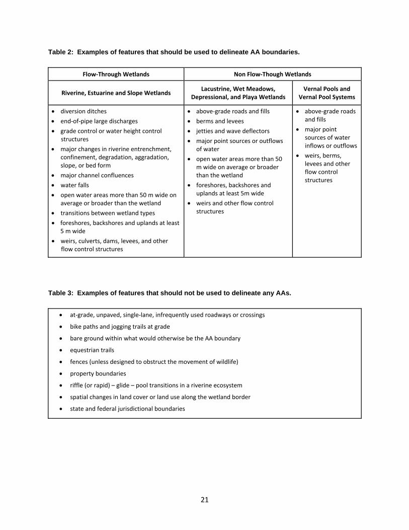
Table 2: Examples of features that should be used to delineate AA boundaries.
Flow‐Through Wetlands Non Flow‐Though Wetlands
Riverine, Estuarine and Slope Wetlands Lacustrine, Wet Meadows, Depressional, and Playa Wetlands
Vernal Pools and Vernal Pool Systems
• diversion ditches • end‐of‐pipe large discharges • grade control or water height control
structures • major changes in riverine entrenchment,
confinement, degradation, aggradation, slope, or bed form
• major channel confluences • water falls • open water areas more than 50 m wide on
average or broader than the wetland • transitions between wetland types • foreshores, backshores and uplands at least
5 m wide • weirs, culverts, dams, levees, and other
flow control structures
• above‐grade roads and fills • berms and levees • jetties and wave deflectors • major point sources or outflows
of water • open water areas more than 50
m wide on average or broader than the wetland
• foreshores, backshores and uplands at least 5m wide
• weirs and other flow control structures
• above‐grade roads and fills
• major point sources of water inflows or outflows
• weirs, berms, levees and other flow control structures
Table 3: Examples of features that should not be used to delineate any AAs.
• at‐grade, unpaved, single‐lane, infrequently used roadways or crossings
• bike paths and jogging trails at grade
• bare ground within what would otherwise be the AA boundary
• equestrian trails
• fences (unless designed to obstruct the movement of wildlife)
• property boundaries
• riffle (or rapid) – glide – pool transitions in a riverine ecosystem
• spatial changes in land cover or land use along the wetland border
• state and federal jurisdictional boundaries
21
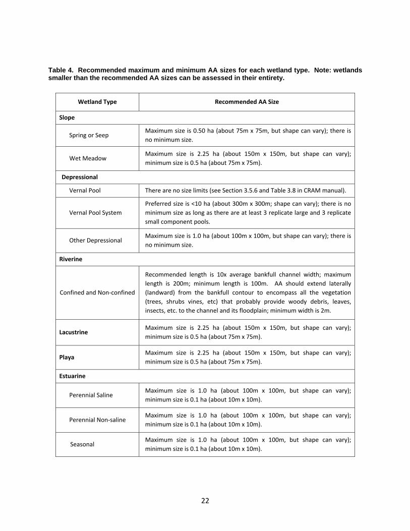
Table 4. Recommended maximum and minimum AA sizes for each wetland type. Note: wetlands smaller than the recommended AA sizes can be assessed in their entirety.
Wetland Type Recommended AA Size
Slope
Spring or Seep Maximum size is 0.50 ha (about 75m x 75m, but shape can vary); there is no minimum size.
Wet Meadow Maximum size is 2.25 ha (about 150m x 150m, but shape can vary); minimum size is 0.5 ha (about 75m x 75m).
Depressional
Vernal Pool There are no size limits (see Section 3.5.6 and Table 3.8 in CRAM manual).
Vernal Pool System Preferred size is <10 ha (about 300m x 300m; shape can vary); there is no minimum size as long as there are at least 3 replicate large and 3 replicate small component pools.
Other Depressional Maximum size is 1.0 ha (about 100m x 100m, but shape can vary); there is no minimum size.
Riverine
Confined and Non‐confined
Recommended length is 10x average bankfull channel width; maximum length is 200m; minimum length is 100m. AA should extend laterally (landward) from the bankfull contour to encompass all the vegetation (trees, shrubs vines, etc) that probably provide woody debris, leaves, insects, etc. to the channel and its floodplain; minimum width is 2m.
Lacustrine Maximum size is 2.25 ha (about 150m x 150m, but shape can vary); minimum size is 0.5 ha (about 75m x 75m).
Playa Maximum size is 2.25 ha (about 150m x 150m, but shape can vary); minimum size is 0.5 ha (about 75m x 75m).
Estuarine
Perennial Saline Maximum size is 1.0 ha (about 100m x 100m, but shape can vary); minimum size is 0.1 ha (about 10m x 10m).
Perennial Non‐saline Maximum size is 1.0 ha (about 100m x 100m, but shape can vary); minimum size is 0.1 ha (about 10m x 10m).
Seasonal Maximum size is 1.0 ha (about 100m x 100m, but shape can vary); minimum size is 0.1 ha (about 10m x 10m).
22
There are several important considerations when using CRAM to assess projects that may require adjustment of the general rules for establishment of an AA.
• Project wetland is larger than the AA: Identify AAs that represent homogenous sections in terms of hydro‐geomorphology within the wetland evaluation area. Use the following CRAM AA delineation language as a guide.
“Each AA must therefore encompass most if not all of the natural spatial variability in the visible form and structure of its Wetland, and the AA should also encompass most of the internal workings of the Wetland that account for its homeostasis – its tendency to maintain a certain overall condition or return to it during or after significant stress or disturbance. For an AA to have this desired level of integrity, it should be bounded by obvious physical changes in topography, hydrology, or infrastructure that significantly control the sources, volumes, rates, or general composition of sediment supplies or water supplies within the AA at the time of the field assessment. In essence, the boundaries of an AA should not extend beyond any features that represent or cause a major spatial change in water source or sediment source. “
In most cases where the project is larger than the AA, multiple CRAM assessments will need to be completed to completely characterize the project. In some cases, the entire project area may be divided up into a series of AAs, each of which is then assessed. In other cases, as statistically representative subset of AAs may be assessed using the procedures outlined in Appendix D.
• Project wetland is smaller than the AA (i.e., recommended AA boundary includes areas beyond “project area”). If the wetland project area is smaller than the suggested minimum AA sizes in Table 3, conduct two CRAM assessments, one on the project area and one on an AA defined according to the rules in the CRAM manual. Both sets of scores should be reported for consideration in agency decision‐making. If property restrictions do not allow a field assessment of the larger AA, assess just the project area and document the inability to access the larger AA.
• A project may be restricted to one side of a wadeable riverine ecosystem, although the recommended AA will include both sides. In this circumstance, two CRAM assessments should be conducted (as described above), one for the project (including the adjoining channel) and one for the AA recommended by the CRAM manual. If property restrictions do not allow a field assessment of the larger AA, assess just the project area and document the inability to access the larger AA.
23

B. Selection of the Appropriate CRAM Wetland Type
A separate CRAM assessment should be done for each wetland type and each wetland should be assessed based on its current typology. If a wetland has been converted from a different wetland type (e.g. a riverine wetland impounded to create a lacustrine wetland), the CRAM module for the current wetland type should be used, regardless of the previous type.
In applying CRAM for impact assessment or restoration or mitigation planning, a wetland may undergo a type‐conversion, e.g. a palustrine depressional wetland may be restored to a coastal lagoon. If CRAM is being used to help evaluate alternative designs or to provide baseline data for a restoration that anticipates changing wetland types, then the CRAM module for the anticipated future wetland class should be used, as well as the CRAM module for the current type. The CRAM module for the existing wetland type should be use for evaluation of potential impacts to the current wetland.
Use of CRAM in a predictive manner should be done with caution and all assumptions should be clearly articulated along with the submitted analysis. Projected or predicted CRAM data should not be entered into eCRAM.
The general rule provided in the CRAM guidebook is to assess a wetland based on its current class, not based on its historical condition. For example, an impounded river would be assessed as a lacustrine wetland (its current class) and not as a riverine wetland (its historic natural condition). However, if a wetland to be restored will undergo a type‐conversion in the process, it is appropriate to assess the wetland with the CRAM module of its restored typology. In this circumstance, it is advisable that two assessments be conducted, one based on the pre‐existing typology and one on the restored typology.
For more immediate changes in wetland type, such as those associated with an unauthorized activity, the CRAM assessment should be based on its most recent stable condition (i.e., prior to the unauthorized activity) provided that sufficient information is available on the conditions prior to the unauthorized activity, the change in wetland type is relatively recent and there have been no subsequent events that would be expected to alter condition (e.g., a large flood). If detailed information on the form and composition of the pre‐existing wetland is not available, then CRAM should only be run based on the current wetland type and condition.
C. Use of CRAM to Detect Changes in Wetland Condition Over Time
CRAM may be used to help assess change in wetland condition over time. As with any assessment method, the ability of CRAM to detect change depends on the size of the change relative to the precision of CRAM. In general, based on the calibration and validation of CRAM
24
for riverine systems and estuarine wetlands, the precision of CRAM is about 5 CRAM points for Attribute scores and about 10 CRAM points for overall AA scores. Therefore, only changes in condition that translate into differences in Attribute scores of at least 5 points or into differences in AA scores of at least 10 points will be detected using CRAM. This suggests that CRAM can be used frequently during the early stages of restoration and mitigation projects, when changes tend to be rapid and large, and less frequently later‐on, when changes are more gradual. However, CRAM might prove to be useful in measuring trends or a “restoration trajectory” over the required monitoring period and comparing those results to Level‐3 data (see also below). Finally, if a wetland is converted from one wetland type to another, the pre vs. post project CRAM scores will not be directly comparable because they are based on different CRAM modules.
D. Example Scenarios for CRAM Assessment of Projects
CRAM may be applied to support a variety of regulatory or grant funded applications. Typically, wetland impact analysis and compensatory mitigation or restoration planning and monitoring will require more information than CRAM will be able to provide. In some cases, appropriate Level 3 protocols already exist; in other cases additional Level 2 or 3 assessment tools may need to be developed to conduct the assessment. CRAM is intended to be used in conjunction with Level 1 and Level 3 tools, not to replace them. CRAM should not be used as the sole basis for making regulatory or project related decisions. Rather, it should be used in conjunction with other information and data to inform regulatory and project decisions. Sample applications of CRAM, with specific caveats are discussed below.
• Using CRAM to assess projected project impacts and/or avoidance: CRAM may be used to evaluate existing condition and compare to expected future condition (i.e., in a forecasting mode; Table 5). Because many of the CRAM metrics require field‐based assessment of site conditions, it may be difficult to accurately apply CRAM to a conceptual, future state. Therefore, users should be cautious when using CRAM to forecast expected future conditions, and should clearly document all assumptions used in generating an anticipated future CRAM condition score. Even though the minimum CRAM score is 25, it is appropriate to assign a CRAM score of zero (0) if a complete wetland fill is anticipated. As previously stated, CRAM should be only one aspect of the assessment of project impacts and mitigation, along with other factors such as area, location, and Level 3 assessments. Forecasted scores should not be uploaded into the statewide CRAM database. In some cases, use of a reference site may be a more appropriate way to predict expected future CRAM scores.
25
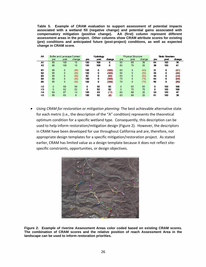
Table 5. Example of CRAM evaluation to support assessment of potential impacts associated with a wetland fill (negative change) and potential gains associated with compensatory mitigation (positive change). AA (first) column represent different assessment areas in the project. Other columns show CRAM attribute scores for existing (pre) conditions and anticipated future (post-project) conditions, as well as expected change in CRAM score.
• Using CRAM for restoration or mitigation planning: The best achievable alternative state for each metric (i.e., the description of the “A” condition) represents the theoretical optimum condition for a specific wetland type. Consequently, this description can be used to help inform restoration/mitigation design (Figure 2). However, the descriptors in CRAM have been developed for use throughout California and are, therefore, not appropriate design templates for a specific mitigation/restoration project. As stated earlier, CRAM has limited value as a design template because it does not reflect site‐specific constraints, opportunities, or design objectives.
Figure 2: Example of riverine Assessment Areas color coded based on existing CRAM scores. The combination of CRAM scores and the relative position of reach Assessment Area in the landscape can be used to inform restoration priorities.
26
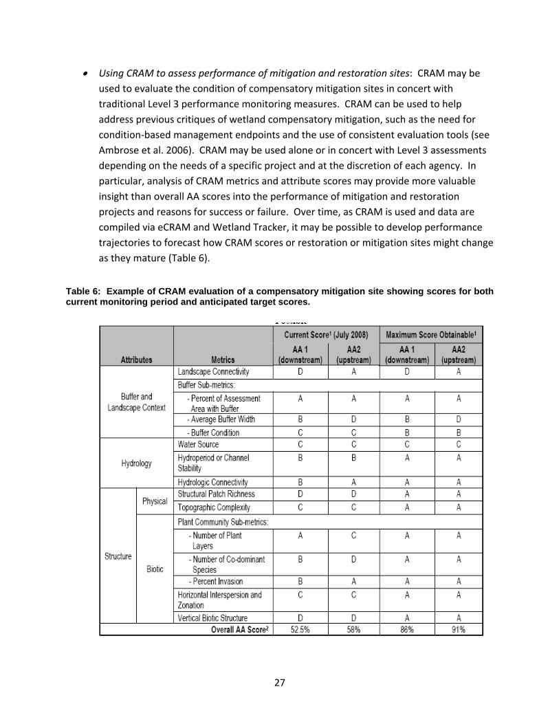
• Using CRAM to assess performance of mitigation and restoration sites: CRAM may be used to evaluate the condition of compensatory mitigation sites in concert with traditional Level 3 performance monitoring measures. CRAM can be used to help address previous critiques of wetland compensatory mitigation, such as the need for condition‐based management endpoints and the use of consistent evaluation tools (see Ambrose et al. 2006). CRAM may be used alone or in concert with Level 3 assessments depending on the needs of a specific project and at the discretion of each agency. In particular, analysis of CRAM metrics and attribute scores may provide more valuable insight than overall AA scores into the performance of mitigation and restoration projects and reasons for success or failure. Over time, as CRAM is used and data are compiled via eCRAM and Wetland Tracker, it may be possible to develop performance trajectories to forecast how CRAM scores or restoration or mitigation sites might change as they mature (Table 6).
Table 6: Example of CRAM evaluation of a compensatory mitigation site showing scores for both current monitoring period and anticipated target scores.
27

• Using CRAM as part of a watershed assessment: Site specific CRAM scores can be compiled for multiple sites within a watershed and analyzed for spatial patterns or trends. Use of CRAM as part of probabilistic survey can provide a profile of the range of conditions in a watershed that can be used as a frame of reference for subsequent project assessments (Figure 3). Although not intended to replace landscape‐scale assessment methods, the spatial orientation of CRAM scores can provide insight into cumulative impacts. Furthermore, the CRAM attributes for “buffer and landscape context” and “hydrology” may be particularly affected by landscape patterns. Analysis of spatial patterns of these two attributes may help understand watershed‐scale disturbances that affect numerous wetlands and/or streams.
Figure 3: Cumulative distribution frequency (CDF) plots showing the ambient condition of estuaries (based on CRAM) in the State of California compared to the ambient condition in four subregions.
28

6. Phased Implementation of CRAM
Phased implementation of CRAM for assessing regulatory, restoration, and management projects can allow practitioners and agency staff to gain comfort and familiarity in a controlled manner. Phased implementation should be re‐initiated with the introduction of new CRAM modules, or significant revisions of existing modules, although resetting to the beginning of Phase 1 may not be necessary in every case. Phased implementation would ease the transition associated with application of any new program or tool. Finally, it will allow experience and data compiled during the early phases of CRAM implementation to inform decisions regarding subsequent applications. For each module, the following sequence is recommended.
First Phase: CRAM assessments should be conducted on a limited number of priority projects in conjunction with other Level 1 or 3 assessments. Agencies may identify priority projects based on size, location, type of project, or other specific management interests. Data collected from these projects should be used to inform and educate staff about potential uses (and misuses) of CRAM, to increase the comfort level of agency staff and practitioners, and to contribute to the regional database of CRAM assessments.
Second Phase: When agency staff is comfortable, use of CRAM may be expanded to a broader set of projects and applications. In some circumstances, for small, simple, relatively less controversial projects, CRAM may be used as the primary assessment tool.
Third Phase: Full implementation of CRAM for the complete set of applications listed earlier in this document, subject to specific agency discretion. Other assessment tools should always be used when deemed necessary by the agency project manager.
Detailed information on challenges and opportunities associated with early implementation should be compiled and submitted by practitioners along with CRAM assessments and all associated Level 3 data (via Wetland Tracker). This information will be used to inform decisions regarding subsequent implementation phases.
29

30
References
Ambrose, R.F., J.C. Calloway, and S.F. Lee, 2006. An Evaluation of Compensatory Mitigation Projects Permitted Under Clean Water Act Section 401 by the California State Water Quality Control Board, 1991‐2002. Report prepared for the California State Water Resources Control Board.
Cowardin, L.M., V. Carter, F.C. Golet, and E.T. LaRoe. 1979. Classification of Wetlands and Deepwater Habitats of the United States. U.S. Fish & Wildlife Service, Washington, D.C. 131 pp.
Collins, J.N., E.D. Stein, M. Sutula, R. Clark, A.E. Fetscher, L. Grenier, C. Grosso, and A. Wiskind. 2007. California Rapid Assessment Method (CRAM) for Wetlands, v. 5.0. 149 pp.
Stein, E.D., M. Sutula, R. Clark, A. Wiskind, and J. Collins. 2007. Improving Monitoring and Assessment of Wetland and Riparian Areas in California through Implementation of a Level 1, 2, 3 Framework. Southern California Coastal Water Research Project Technical Report #555.
Stein, E.D., A.E. Fetscher, R.P. Clark, A.Wiskind, J.L. Grenier, M. Sutula, J.N. Collins, and C. Grosso. 2009. Calibration and Validation of a Wetlands Rapid Assessment Method: Application of EPA’s Level 1‐2‐3 Framework for Method Testing and Refinement. Wetlands 29(2):648–665.
Sutula, M.A., E.D. Stein, J.N. Collins, and A.E. Fetscher. 2006. A Practical Guide for the Development of a Wetland Assessment Method: The California Experience. Journal of the American Water Resources Association 42:157‐175.

Appendix A: Summary of CRAM External Reviews and Peer‐reviewed Documents
Primary Publication with Scientific Peer Review Date Description
A practical guide for the development of a wetland assessment method: the California experience 2006. Sutula, M.A., E.D. Stein, J.N. Collins, A.E. Fetscher, R. Clark. Journal of the American Water Resources Association 42(1):157‐175
2006
CRAM Development
Choices and tradeoffs in accuracy, precision, robustness, ease of use, and cost. Literature review details, wetland classification system, conceptual models, major assumptions; attribute and metric development; method responsiveness; calibration and validation against intensive assessment;
Validation of a Wetland Rapid Assessment Method: Use of EPA's Level 1‐2‐3 Framework for Method Testing and Refinement Stein E.D., A.E. Fetscher, R.P. Clark, A. Wiskind, J.L. Grenier, M. Sutula, J.N. Collins, C. Grosso. Wetlands 29(2):648‐665. 2009
2009
CRAM Validation
Case study of riverine and estuarine modules. Responsiveness of the method to ‘‘good’’ vs. ‘‘poor’’ wetland condition, ability to represent a range of conditions, internal redundancy, alternative combination rules for constituent metrics, and reproducibility of results
Integrating Probabilistic and Targeted Compliance Monitoring for Comprehensive Watershed Assessment. Stein, E.D. and B. Bernstein. Environmental Monitoring and Assessment 144:117‐129 2008
2008
CRAM Application
Demonstration of a multi‐metric assessment of watershed & stream condition using CRAM, a benthic macroinvetebrate index of biotic integrity, water chemistry, and toxicity measurs.
31

Reports of Studies Advised and Reviewed by Study‐specific Technical Advisory Committees
Date Description
California’s Wetland Demonstration Program Pilot. A Final Project Report to the California Resources Agency Sutula, M.A. J.N. Collins, R. Clark, R.C. Roberts, E.D. Stein, C.S. Grosso, A. Wiskind, C. Solek, M. May, K. O’Connor, A.E. Fetscher, J.L. Grenier, S. Pearce, A. Robinson, C. Clark, K. Rey, S. Morrissette, A. Eicher, R. Pasquinelli, K. Ritter.
2008
Ambient Assessment
Statewide assessment of ambient extent and condition of estuarine wetlands, plus ambient assessments of riverine wetlands for three demonstration watersheds.
An evaluation of compensatory mitigation projects permitted under Clean Water Act Section 401 by the California State Water Quality Control Board, 1991–2002. Report to the State Water Resources Control Board. University of California. Los Angeles, CA, USA. December 2004, 253 pages Ambrose, R.F., J.C. Callaway, and S.F. Lee .
2004
Mitigation Project Review
Use of CRAM in the evaluation of mitigation projects in California
Evaluation of Federal Clean Water Act Section 401 Water Quality Certification Wetland and Stream Mitigation Sites in the Santa Margarita Watershed. A report by the California Regional Water Quality Control Board, San Diego Region, San Diego, CA, USA, January 2006, 107 pages Quigley, M., K. Ranke, D. Miller, R. Morris
2006
Mitigation Project Review
Use of CRAM and HGM for the evaluation of mitigation projects in the Santa Margarita watershed, CA
Improving Monitoring and Assessment of Wetland and Riparian Areas in California through Implementation of a Level 1, 2, 3 Framework. Southern California Coastal Water Research Project Technical Report #555. Stein, E.D., M. Sutula, R. Clark, A. Wiskind, and J. Collins
2007
Application of Level a 1, 2, 3 Framework
Discussion of how to apply Level 1, 2, 3 tools (including CRAM) in an integrated manner to support both project and ambient assessment of wetlands and riparian areas
32

33
Formal Agency Review Date Description
California State Water Resources Control Board and California Department of Fish and Game
In Progress
SWRCB Review
Independent science review sponsored by State Water Board to determine efficacy of CRAM for meeting assessment needs of particular State Water Board programs.
US Army Corps of Engineers, C. Klimas, January 2008 2008
USACE ERDC Review
Science review sponsored and conducted by US Army Corps to determine efficacy of CRAM for meeting assessment needs of particular Army Corps programs.

Appendix B: Standard Procedures for Photographs
(adapted from State Water Resourced Control Board Standard Operating Procedure (SOP) 4.2.1.4 ‐ Stream Photo Documentation Procedure ‐ http://www.waterboards.ca.gov/water_issues/programs/swamp/cwt_guidance.shtml)
General Instructions:
From the inception of any photo documentation project until it is completed, always take each photo from the same position (photo point), and at the same bearing and vertical angle at that photo point. Photo point positions should be thoroughly documented, including photographs taken of the photo point. Refer to copies of previous photos when arriving at the photo point. Try to maintain a level (horizontal) camera view unless the terrain is sloped. (If the photo can not be horizontal due to the slope, then record the angle for that photo.) When taking photographs, try to include landscape features that are unlikely to change over several years (buildings, other structures, and landscape features such as peaks, rock outcrops, large trees, etc.) so that repeat photos will be easy to position. Lighting is, of course, a key ingredient so give consideration to the angle of light, cloud cover, background, shadows, and contrasts. Close view photographs taken from the north (i.e., facing south) will minimize shadows. Medium and long view photos are best shot with the sun at the photographer’s back. Some artistic expression is encouraged as some photos may be used on websites and in slide shows (early morning and late evening shots may be useful for this purpose). Seasonal changes can be used to advantage as foliage, stream flow, cloud cover, and site access fluctuate. It is often important to include a ruler, stadia rod, person, farm animal, or automobile in photos to convey the scale of the image. Of particular concern is the angle from which the photo is taken. Oftentimes an overhead or elevated shot from a bridge, cliff, peak, tree, etc. will be instrumental in conveying the full dimensions of the project. Of most importance overall, however, is being aware of the goal(s) of the project and capturing images that clearly demonstrate progress towards achieving those goal(s). Recording Information:
Use a systematic method of recording information about each project, photo point, and photo. The following information should be entered on the photo‐log forms (blank form included in this document) or in a dedicated notebook:
• Project or group name, and contract number (if applicable, e.g., for funded restoration projects)
• General location (stream, beach, city, etc.), and short narrative description of project’s habitat type, goals, etc.
• Photographer and other team members • Photo number • Date • Time (for each photograph) • Photo point information, including:
34

o Name or other unique identifier (abbreviated name and/or ID number) o Narrative description of location including proximity to and direction from notable
landscape features like roads, fence lines, creeks, rock outcrops, large trees, buildings, previous photo points, etc. – sufficient for future photographers who have never visited the project to locate the photo point
o Latitude, longitude, and altitude from map or GPS unit • Magnetic compass bearing from the photo point to the subject • Specific information about the subject of the photo • Optional additional information: a true compass bearing (corrected for declination) from
photo point to subject, time of sunrise and sunset (check newspaper or almanac), and cloud cover
• Archive all photos, along with the associated photo‐log information, in a protected environment
35

Appendix C: Guidelines for Submitting Maps of the CRAM Assessment Area
A map of the Assessment Area (AA) should contain the following:
• The boundary of the AA on the imagery provided by eCRAM or other imagery of comparable or better resolution and vintage. For guidance on how to define the boundary of an AA, consult the CRAM User’s Manual.
• Reference coordinates and datum; if possible, use NAD83 datum. The centroid coordinates and size (in hectares) of the AA polygon are automatically calculated in eCRAM.
• For riverine ecosystems, provide the upstream and downstream coordinates, the approximate length of the AA, and the average bankfull width.
• For vernal pool systems, delineate the vernal pool system and its component large and small pools. There is no fixed size range for either size class. Large pools are simply those pools that are larger than most other pools in the AA.
Table C1. Steps for vernal pool system delineations.
Step Vernal Pool System Delineation
1
On the site imagery, draw the boundary around the system of vernal pools that are probably interconnected by surface or subsurface flow. Do not draw the flow pathways, although they are shown in the figure below. The vernal pool system should not exceed 10 ha in size.
2 Delineate or circle and number all large pools within the pool system from Step 1.
3 Delineate or circle and number all small pools within each pool system from Step 1.
4 The pools delineated or circled in Steps 2 and 3 comprise the AA.
5
Randomly select three small pools and three large pools from the AA. These pools will be assessed individually and their scores will be averaged. If you cannot delineate three small and three large pools, then increase the AA size, even if hydrologically isolated pools have to be included.
36
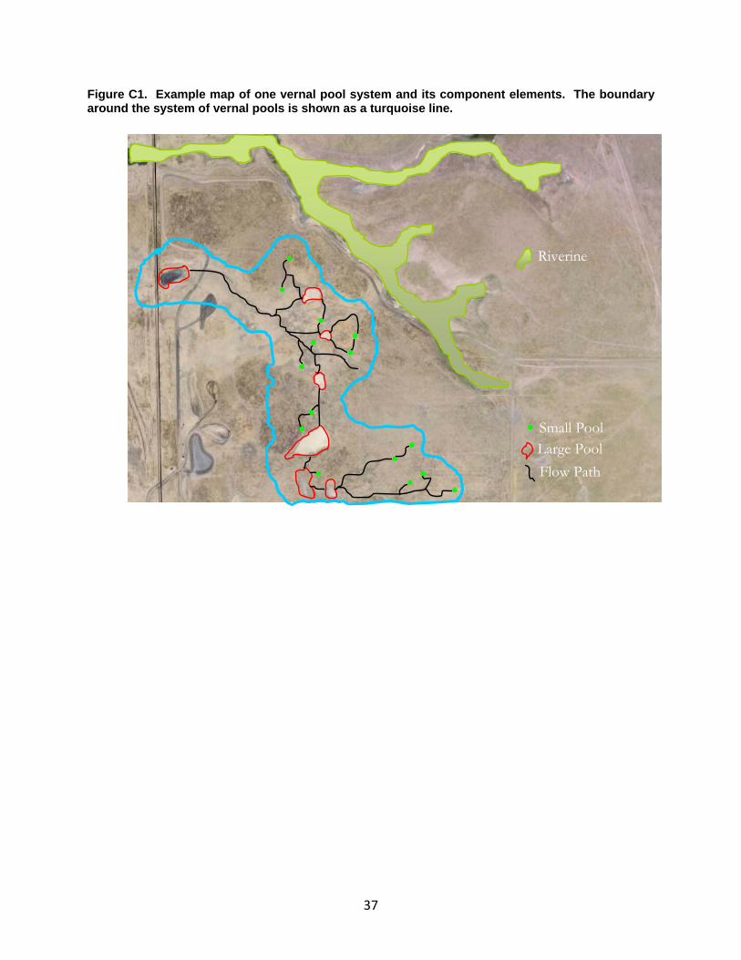
Figure C1. Example map of one vernal pool system and its component elements. The boundary around the system of vernal pools is shown as a turquoise line.
Small Pool• Large PoolFlow Path
Riverine
•• ••
••
•
••
••
• •
••
37

Appendix D: Protocol for Level 2 Project Assessment V. 3.0
California State Wetlands Assessment Toolkit Development Team April, 2008
Introduction There are generally two kinds of CRAM applications: assessments of ambient condition and assessments of project conditions. The approach is essentially the same in each case. The critical concepts common to both are Sample Universe, Sample Frame, and Sample Draw. The Sample Universe is the population of possible CRAM Assessment Areas (AAs) for which an assessment of condition is desired. The Sample Frame is a map of the Sample Universe. The Sample Draw is the sample of AAs that are selected for assessment to represent the Sample Universe.
In the case of an ambient assessment, the Sample Universe consists of all the possible CRAM AAs of a single wetland type within a prescribed area that is larger than a project. For example, an ambient Sample Universe might encompass all of the possible AAs for fringing wetlands of lakes (i.e., lacustrine wetlands) within a watershed, administrative region of an agency, congressional district, etc. A sample of AAs is probabilistically or randomly drawn (i.e., selected) from the Sample Frame, assessed using CRAM, and the results are used to characterize conditions for the Sample Universe. No individual wetland within the universe is assessed unto itself. For more information see the CRAM manual discussion of ambient sample design.
In the case of a project assessment, the Sample Universe is all of the possible AAs for one kind of wetland within the boundaries of one project. The results are used to characterize the project.
Project Definition For the purposes of CRAM, a “project” is any activity authorized under Section 401 and/or Section 404 of the US Clean Water Act, under the State’s 401 Certification/WDR Programs, or under Section 1600 of the State’s Fish and Game Code that directly changes the extent, type, or condition of at least 0.1 ha of non‐riverine wetland, or at least 100 m of riverine wetland length as defined in the CRAM manual. Project Assessment Steps
1. Identify the Project Boundary
The project boundary is usually designated by the project sponsors and could include upland areas and other non‐wetland areas (Figure 1). The project boundary has to be imported into a GIS as an overlay on 1‐m pixel resolution aerial imagery or a wetland
38
inventory of comparable resolution and of recent vintage. Whenever possible, the project should be included in the Wetland Tracker.
If a compensatory mitigation project is part of a larger wetland and is less that 80% of the recommended minimum size for a CRAM Assessment Area than conduct two assessments, one that is confined to the project and one for the larger Assessment Area that includes the project. Go to Step 2.
2. Identify the Sample Universe
Overlay the project boundary on the aerial imagery in the GIS and digitize the boundary of all non‐riverine wetlands at least 0.1 ha in area and all riverine ecosystems at least 100m long (Figure 1). All the wetlands of one type comprise a separate Sample Universe. There will be as many Sample Universes as there are wetland types within the project that meet the minimum polygon size requirements. Go to Step 3.
3. For each Sample Universe, Develop the Sample Frame (Figures 2‐4)
The Sample Frame will be a map of all candidate AAs within the Sample Universe. For non‐riverine ecosystems, the AAs should be circles of the maximum size recommended in the CRAM Manual. For riverine ecosystems, the AAs should be polygons having the maximum recommended width and length.
There are two ways to begin creating a Sample Frame. One way is to overlay the Sample Universe with a grid having a cell size just large enough to encompass one AA. Another way is to use a GIS to generate a map of the maximum number of non‐overlapping AAs. At this stage of Sample Frame development, candidate AAs can overlap the edge of the Sample Universe, although they cannot overlap each other.
Any AAs that do not meet the criteria for an AA as presented in the CRAM manual must be rejected. The following considerations are especially important.
i. Each AA should not cross any obvious, major physical changes in topography, hydrology, or infrastructure that significantly control the sources, volumes, rates, or general composition of sediment supplies or water supplies within the AA at the time of the field assessment.
ii. Each AA can only include one wetland type. No AA can include any portion of more than one type of wetland, as defined by the CRAM manual.
iii. Reject any candidate AA that is more than 50% outside the Sample Universe. The remaining AAs comprise the Sample Frame (Figure 3).
Go to Step 4a, 4b, or 4c, whichever is most applicable.
39

40
4a. If the Sample Universe is not large enough for one minimum‐size AA, assess the entire Sample Universe. If possible, also assess another AA that contains the site and otherwise meets the requirements of a minimum AA. Go to Step 5: report both sets of scores, without averaging them.
4b. For each Sample Universe only large enough for 1‐3 AAs, assesses all the AAs. Go to Step 5: separately report the results for each AA, plus report the average result for overall site, attribute, metric, and sub‐metric based on all the AAs assessed.
4c. For each Sample Universe large enough for 4 or more mutually exclusive AAs, number the AAs in the Sample Frame and randomly select three for assessment. If at least 20% of any selected AA is outside the boundary of the Sample Universe, then re‐shape the AA so that it fits entirely within the Sample Universe (Figure 4).
Calculate the average overall AA score for the first two AAs. This is done by averaging the two scores for each Attribute, and then using these average Attribute scores to calculate the average AA score.
If over the overall AA score for the third selected AA differs by more than 10 CRAM points from the average AA score for the first two selected AAs, randomly select and assess a fourth AA from the Sample Frame. Continue randomly selecting and assessing AAs so long as the overall score from last selected AA differs by more than 10 CRAM points from the average AA score for all of the previous AAs assessed, or until the Sample Frame is depleted of AAs. This means that the number of AAs used to assess a project is a function of the project’s variability in condition. Go to Step 5.
5. Upload all the CRAM assessments for each AA to the CRAM website.

41
Figure D1: Diagrams of Project Boundary (dark green line) and Sample Universe (area shaded light green) showing a grid used to develop the Sample Frame of candidate AAs. A GIS can be used to generate the Sample Frame without using a grid.
Project
Boundary
Sample Universe
Figure D2. Map of the maximum number of candidate AAs generated in a GIS.
Candidate AA
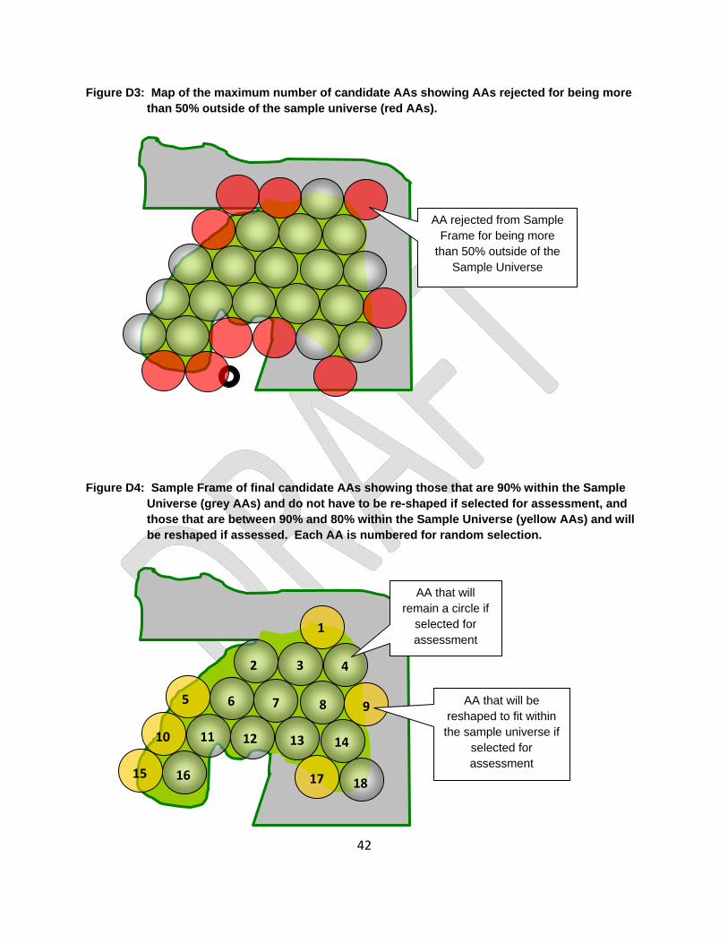
42
Figure D3: Map of the maximum number of candidate AAs showing AAs rejected for being more than 50% outside of the sample universe (red AAs).
Figure D4: Sample Frame of final candidate AAs showing those that are 90% within the Sample Universe (grey AAs) and do not have to be re-shaped if selected for assessment, and those that are between 90% and 80% within the Sample Universe (yellow AAs) and will be reshaped if assessed. Each AA is numbered for random selection.
AA rejected from Sample Frame for being more
than 50% outside of the Sample Universe
1
2 3
5 6 7
4
9
10 11
8
12 13 14
15 16 17 18
AA that will remain a circle if
selected for assessment
AA that will be reshaped to fit within the sample universe if
selected for assessment