Embed Size (px)
Citation preview
Case Study
Application of Ecological Site
Information to Transformative
Changes on Great Basin
Sagebrush Rangelands
By C. Jason Williams, Frederick B. Pierson, Kenneth E. Spaeth, Joel R. Brown,Osama Z. Al-Hamdan, Mark A. Weltz, Mark A. Nearing, Jeffrey E. Herrick, Jan Boll,
Peter R. Robichaud, David C. Goodrich, Philip Heilman, D. Phillip Guertin,
Mariano Hernandez, Haiyan Wei, Viktor O. Polyakov, Gerardo Armendariz,
Sayjro K. Nouwakpo, Stuart P. Hardegree, Patrick E. Clark, Eva K. Strand,
Jonathan D. Bates, Loretta J. Metz, and Mary H. Nichols
On The Ground
• The utility of ecological site descriptions (ESD) inthe management of rangelands hinges on theirability to characterize and predict plant communitychange, the associated ecological consequences,and ecosystem responsiveness to management.
• We demonstrate how enhancement of ESDs with keyecohydrologic information can aid predictions of eco-systemresponseandtargetingofconservationpracticesfor sagebrush rangelands that are strongly regulated byecohydrologic or ecogeomorphic feedbacks.
• The primary point of thiswork is that ESDconcepts areflexible and can be creatively augmented for improvedassessment and management of rangelands.
Keywords: adaptive management, ecological site,erosion, Rangeland Hydrology and Erosion Model,resilience, runoff.
Rangelands 38(6):379—388doi: 10.1016/j.rala.2016.10.004Published by Elsevier Inc. on behalf of TheSociety for Range Management. This is an openaccess article under the CC BY-NC-ND license(http://creativecommons.org/licenses/by-nc-nd/4.0/).
M2016
ajor Land Resource Area 23, the MalheurHigh Plateau, is representative of thenorthern Great Basin (Fig. 1), both interms of the defining biophysical factors
and the management challenges. Land managers across theGreat Basin Region are challenged with addressingbroad-scale existing and looming transformative ecologicalchanges caused by plant community transitions and alteredfire regimes. In particular, the sagebrush (Artemisia spp.)ecosystem occupying much (~40%) of the Great Basin(~380,000 km2) is considered one of the most imperiledecosystems in the United States due to native woody andintroduced annual weeds.1,2 At mid-elevations (300-400mm annual precipitation), grazing practices, climate condi-tions, and associated periods of reduced fire activity havepromoted range expansion of pinyon (Pinus spp.) andjuniper (Juniperus spp.) conifers. Encroachment of sage-brush rangelands by these species has formed extensivewooded shrublands and woodlands throughout much of theGreat Basin. In recent decades, dense woody fuel loading inwooded shrublands has increased the occurrence of highseverity fires. Burned woodland sites are also subject toinvasion by cheatgrass (Bromus tectorum L.) and asubsequent increase in fire frequency. At lower elevations(b300 mm annual precipitation), extensive cheatgrassinvasion has converted sagebrush–bunchgrass communitiesto annual grasslands with a 10-fold increase in fire frequency.Collectively, these plant community transitions and alteredfire regimes reduce biological diversity, wildlife habitat, andlivestock forage; amplify runoff and soil loss; limit potentialecosystem goods and services; and increase the likelihood ofpermanent site degradation.
The utility of ecological site descriptions (ESDs) in themanagement of these systems hinges on their ability to
379

Figure 1. Geographic location of the Great Basin (bold black outline) and Major Land Resource Area 23 (MLRA 23, red outline) Malheur High Plateau,which contains the South Slopes 12-16 PZ (R023XY302OR)11 Ecological Site. MLRA and Great Basin spatial data obtained from SAGEMAP (http://sagemap.wr.usgs.gov). Basemap of United States obtained from National Geographic and ESRI (http://www.arcgis.com/home).
characterize and predict plant community change, theassociated ecohydrologic consequences, and ecosystem re-sponsiveness to management. Plant community transitionscommonly induce changes in vegetation structure that alterhydrology and erosion processes that, in turn, perpetuate anew stable state.3,4 Plant community transitions that increasevegetation and ground cover promote infiltration and soilstability and an increase in soil water recharge and nutrientsthat further enhance vegetation productivity. In contrast,transitions that increase bare ground can facilitate runoff anderosion that further reduce soil water availability, removecritical soil nutrients, and limit vegetation productivity.Encroaching pinyon and juniper on sagebrush rangelands
380
commonly outcompete shrubs and grasses for limited soilwater, resulting in decreased understory vegetation andincreased bare ground, runoff, and soil loss.3,5,6 Increasedfire frequency following cheatgrass invasion may alsoperpetuate a degraded, annual-dominated stable state.Burning increases erosion, and frequent occurrences of burnedconditions may amplify soil loss over time.7,8 Plantcommunity dynamics are generally well documented forGreat Basin sagebrush rangelands following woodlandencroachment, cheatgrass invasion, and various managementpractices.9 Likewise, the general hydrologic trends anderosion effects of these disturbances and management actionsare documented in the literature.8,10
Rangelands

New technologies for quantifying ecohydrologic responsesto disturbances and conservation practices are now availablefor integration of vegetation and hydrology interactions intoESDs.4 This integration potentially increases the applicabilityof ESDs for assessing Great Basin sagebrush rangelands andfor targeting of conservation efforts and expenditures. In thisecosystem, surface hydrology and erosion processes areaffected by vegetation transitions and are important driversof change. This tightly coupled feedback loop suggests that amore thorough understanding of hydrologic and erosionprocesses could be a powerful predictive tool. We employ theRHEM tool to characterize surface hydrology and erosion incontext with community dynamics as a basis for improvingrangeland management decision-making.
i For more on the Rangeland Hydrology and Erosion Model (RHEM)
see http://apps.tucson.ars.ag.gov/rhem/.
Ecological Site Concepts and State andTransition Model
The “South Slopes 12-16 Precipitation Zone (PZ)” (ID:R023XY302OR11) Ecological Site was selected for demon-stration in this study. Conifer encroachment, cheatgrassinvasion, and ecohydrologic feedbacks are primary drivers ofstate transitions on the site. The site is therefore representativeof plant community structural and ecosystem functionaldynamics common to sloping sagebrush rangelands through-out the Great Basin. The site is located in Major LandResource Area (MLRA) 23 –Malheur High Plateau (Fig. 1).A full description of the site biologic and physical attributes isavailable online in the published ESD from the NaturalResource Conservation Service (NRCS).11 A generalizedstate-and-transition model (STM) is shown in Figure 2.
The NRCS-approved ESD11 describes five ecologicalstates for the study site. The Reference State (State 1) containstwo community phases: (1.1) a reference plant communityphase with an understory of bluebunch wheatgrass (Pseudor-[Pursh] Á. Löve ssp. spicata), Idaho fescue (Festuca
idahoensis Elmer), Sandberg bluegrass (Poa secunda J.Presl), Thurber’s needlegrass (Achnatherum thurberianum[Piper] Barkworth), and other perennial grasses and a shrubcomponent of mountain big sagebrush (A. tridentata Nutt.ssp. vaseyana [Rydb.] Beetle), basin big sagebrush (A.tridentata Nutt. ssp. tridentata), and antelope bitterbush(Purshia tridentata [Pursh] DC.); and (1.2) a second phase,promoted by burning, that is dominated by bluebunchwheatgrass, Idaho fescue, Thurber’s needlegrass, and otherperennial grasses and forbs.
Invasion of the Reference State by annual forbs and grassesfacilitates transition to State 2. State 2 includes threecommunity phases: (2.1) one with sagebrush-steppe vegeta-tion and trace cover of cheatgrass and annual weeds; (2.2) asecond phase, facilitated by mismanaged grazing or reducedfire, with increased coverage of sagebrush and Sandbergbluegrass and trace cover of cheatgrass and annual weeds; and(2.3) a fire-limited phase with early-succession westernjuniper (J. occidentalis Hook.) encroachment, sagebrush,Sandberg bluegrass, and trace cover of cheatgrass and annualweeds. Drought, improper grazing, or fire-exclusion in State 2
2016
promotes transition to State 3. As juniper cover increases,sagebrush, grasses, and forbs decline. In State 3, juniperdominates site resources (biotic threshold), sagebrush andother shrubs decline, and extensive bare ground develops inthe intercanopy. Sandberg bluegrass becomes the dominantgrass species in State 3 and other perennial bunchgrasses arereduced in abundance and productivity. Juniper woodlanddevelopment is complete in State 3 and soil erosion increases,ultimately driving the site beyond an abiotic threshold to State4. In State 4, the site is dominated by juniper, soil loss isevident, and all ecological processes have been significantlyaltered. Catastrophic wildfire in State 4 promotes transition toState 5. In State 5, cheatgrass dominates the site, the shrub orperennial bunchgrass component has dropped out, and thehydrologic and nutrient cycles are negatively affected throughchanges in dynamic soil properties and soil loss. Transition toState 5 promotes more frequent burning (grass–fire cycle)than preinvasion, and the grass–fire cycle perpetuatescheatgrass dominance.
We applied the Rangeland Hydrology and Erosion Model(RHEM) tool (Version 2.3i) to estimate annual and eventrunoff and erosion and probability of occurrence of soil loss forecological states of the study site and for dynamic vegetationconditions induced by disturbance and management.4 TheRHEM tool was created specifically for predicting runoff anderosion responses on rangelands and recently was applied tonational rangeland assessments.12,13 The tool was developedbased on a suite of vegetation, hydrology, and erosionexperiments conducted on grasslands, shrublands, andwoodlands across the western United States.13 The modelproduces graphical and tabulated output for annual and eventprecipitation, runoff, and erosion. The RHEM includes anoptional [RHEM] Risk tool component that calculatesprobability of occurrence of soil loss, soil loss risk, for anyyear to fall into Low, Medium, High, or Very High soil losscategories.14 The respective category thresholds are based onthe 50th, 80th, and 95th percentiles for probability ofoccurrence of soil loss for a user-defined baseline condition(e.g., reference condition).
For this study, we formulated RHEM scenarios for onecommunity phase from each state and conditions representingwildfire and tree removal by prescribed fire and cutting. Forbrevity, we did not model each plant community phase in eachstate or all possible management situations. RHEM modelscenarios were configured to represent selected ecological stateconditions using respective state vegetation and ground coverattributes4 and a climate station (Sheaville, Oregon, USA,Station ID: 357769, 1396 m elevation, ~315 mm annualprecipitation [Fig. 3]), loam surface soil texture, 50-mhillslope length, uniform slope topography, and 35% slopegradient representative of the climate, soil, and topographiccharacteristics for the study site.11 The Reference State (State1, Phase 1.1) was selected as the baseline condition forapplication of the RHEM Risk tool. Relative comparisons of
381

T1A - Exotic annual plant invasion
1.1 Reference Plant
Community Phase
perennial grasses and forbs,
sagebrush and other shrubs
1 - REFERENCE STATE, SHRUB-STEPPE
1.2 Perennial
Grass & Forbs Phase
perennial grasses and forbs1.1A - Fire
1.2A - No fire
T2A - Drought, improper grazing, or
no fire
2.2 Sagebrush with
Annuals Phase
sagebrush, reduced perennial
grasses, trace of annuals
2.1 Sagebrush-Steppe
with Annuals Phase
similar to reference state, but
trace of annuals
2 - SHRUB-STEPPE WITH ANNUALS
2.1A - No fire
2.2A - Fire
2.2B - Juniper
encroachment
facilitated by
reduced fire
2.3A - Fire
3 - JUNIPER
DOMINATED
5.1 Cheatgrass Phase
cheatgrass dominated plant
community with limited to no
shrub or perennial grasses,
altered soil and hydrologic
properties with soil erosion
T4A -
Catastrophic fire
4 - JUNIPER DOMINANT
ERODED
3.1 Juniper Dominated
Phase
juniper dominates
resources, significant bare
ground, sagebrush dead or
dying, perennial grass
greatly reduced
5 - CHEATGRASS
T3B - Fire
R3A - Restoration practice -
prescribed fire, tree cutting
4.1 Juniper Eroded
Phase
juniper dominated site, soil
loss evident, erosion active,
ecological processes
significantly altered, abiotic
threshold has been crossed
Bare
ground
threshold;
increased
runoff and
erosion
T3A -
Improper
grazing,
fire
2.3 Juniper Sagebrush
Phase
juniper and sagebrush, trace
of annuals
2.1B - Juniper
encroachment
facilitated by
reduced fire
Figure 2. Generalized STM showing fundamental components for the South Slopes 12-16 PZ (R023XY302OR)11 Ecological Site located in Major LandResource Area 23, Malheur High Plateau. Individual ecological states are delineated by bold black rectangles, each with one or more within-state plantcommunity phases (shaded rectangles). State transitions are indicated by solid black arrows. Within-state community pathways are indicated by dottedblack arrows. Restoration pathways are indicated by dashed black arrows.
RHEM outputs (Figs. 4-6) by ecological state and fordisturbances and management provide a baseline for assessingcurrent ecohydrological function and potential ecosystemresponses to plant community transitions and management.The RHEM results are summarized within Table 1 as anabbreviated site narrative within the context of the siteSTM (Fig. 2).
Implications for Conservation DecisionsRHEM-predicted runoff and erosion are minimal for the
Reference State except for extreme events (≥25-year returninterval; Fig. 4). Dense vegetation and ground cover underReference State conditions dissipate raindrop impact, trap andstore water, increase time available for infiltration, and limitrunoff and erosion.10 Erosion for the reference condition
382
occurs mainly in isolated bare patches, but downslopesediment delivery is limited due to deposition in and aroundplants, plant litter, and other ground cover elements. RHEMresults suggest the Reference State is indicative of good soilretention, with an 80% probability that soil loss will notexceed 0.645 t ha-1 in any given year (Low to Medium risk;Fig. 6A). Annual soil loss in excess of 1.0 t ha-1 is generallyconsidered high for Great Basin rangelands. RHEMpredicted runoff and erosion for State 2 is similar to that forthe Reference State, although both runoff and soil loss slightlyincrease for 5- to 100-year events. State 2 is generallyconsidered less ecologically desirable than the Reference Statedue to trace cover of juniper and/or cheatgrass, but vegetationand ground cover amounts in each phase of State 2 act to limitsoil and water losses. Burning of the Reference State and State2 increases runoff and erosion at the annual and event scales by
Rangelands
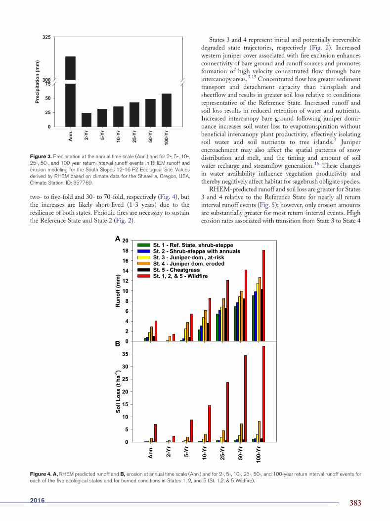
Figure 3. Precipitation at the annual time scale (Ann.) and for 2-, 5-, 10-,25-, 50-, and 100-year return-interval runoff events in RHEM runoff anderosion modeling for the South Slopes 12-16 PZ Ecological Site. Valuesderived by RHEM based on climate data for the Sheaville, Oregon, USA,Climate Station, ID: 357769.
two- to five-fold and 30- to 70-fold, respectively (Fig. 4), butthe increases are likely short-lived (1-3 years) due to theresilience of both states. Periodic fires are necessary to sustainthe Reference State and State 2 (Fig. 2).
Figure 4. A, RHEM predicted runoff and B, erosion at annual time scale (Ann.each of the five ecological states and for burned conditions in States 1, 2, and
2016
States 3 and 4 represent initial and potentially irreversibledegraded state trajectories, respectively (Fig. 2). Increasedwestern juniper cover associated with fire exclusion enhancesconnectivity of bare ground and runoff sources and promotesformation of high velocity concentrated flow through bareintercanopy areas.3,15 Concentrated flow has greater sedimenttransport and detachment capacity than rainsplash andsheetflow and results in greater soil loss relative to conditionsrepresentative of the Reference State. Increased runoff andsoil loss results in reduced retention of water and nutrients.Increased intercanopy bare ground following juniper domi-nance increases soil water loss to evapotranspiration withoutbeneficial intercanopy plant productivity, effectively isolatingsoil water and soil nutrients to tree islands.5 Juniperencroachment may also affect the spatial patterns of snowdistribution and melt, and the timing and amount of soilwater recharge and streamflow generation.16 These changesin water availability influence vegetation productivity andthereby negatively affect habitat for sagebrush obligate species.
RHEM-predicted runoff and soil loss are greater for States3 and 4 relative to the Reference State for nearly all returninterval runoff events (Fig. 5); however, only erosion amountsare substantially greater for most return-interval events. Higherosion rates associated with transition from State 3 to State 4
) and for 2-, 5-, 10-, 25-, 50-, and 100-year return interval runoff events for5 (St. 1,2, & 5 Wildfire).
383

Figure 5. A, RHEM predicted runoff and B, erosion at annual time scale (Ann.) and for 2-, 5-, 10-, 25-, 50-, and 100-year return interval runoff events forState 1 (St. 1 Ref. State), State 3 (St. 3 Juniper-dom. at risk), State 4 (Juniper dom. eroded), and State 3 1 year following prescribed fire (St. 3 1 Yr RxFire),and 10 years following prescribed fire (St. 3 10 Yr RxFire) and tree cutting (St. 3 10 Yr Cut).
demark a likely shift beyond a soil conservation threshold toan irreversible degraded stable state. The likelihood of soil lossto exceed 1.195 t ha-1 (Very High category) is 34% for State 3and more than 50% for State 4 (Fig. 6B) in any given year.Juniper removal by prescribed burning in State 3 may increaserunoff and soil loss (Fig. 5) in the first few years post-fire, butlikely results in reduced soil loss risk as vegetation and groundcover return in the years post-treatment.9,10 RHEMsimulations of State 3 indicate that the likelihood of VeryHigh levels of soil loss decreases from 34% without treatmentto 11% within 10 year after treatment, while the likelihood ofLow toMedium soil loss increases from approximately 40% tonearly 70% after treatment for any given year (Fig. 6B).Similar results can be achieved through tree cutting withoutthe initial erosion risk associated with the immediate post-fireperiod (Fig. 6B). Either treatment in State 3, assumingfavorable vegetation response, dramatically reduces long-termerosion risk relative to State 4 (Fig. 6B). Burning initiallyincreases erosion risk, and sagebrush recovery followingburning may take decades.9,10 Tree cutting without fire willretain the shrub and key perennial bunchgrass components,9
but may increase the severity of a subsequent wildfire due toincreased amounts of downed woody fuels. Vegetation
384
recruitment after tree removal by burning or cutting mayrequire seeding in later stages of State 3. Prescribed burningand tree cutting are not commonly applied in State 4.
Assessing the ecohydrologic ramifications of cheatgrass(transition to State 5) requires consideration of effectsassociated with repeated burning. The effects of cheatgrasson infiltration, runoff, and soils for unburned conditions arenot well known.17 Fire removal of cover for any state increasesthe connectivity of runoff and erosion generating bare ground,and facilitates a temporary shift from rainsplash and sheetflowto concentrated flow as the dominant erosion process acrossthe site.7,8,10 Post-fire vegetation and hydrologic recovery isgenerally more rapid for the Reference State and State 2 dueto the presence of perennial bunchgrasses. Increased firefrequency in the cheatgrass-dominated State 5 increases thefrequency of bare ground exposure to erosion processes andlikely results in long-term loss of nutrient rich surface soilthrough repeated erosion by water and wind.8,17 Theprobability of Very High soil loss (N1.195 t ha-1) is morethan 80% for burned conditions in the Reference State and State 5in any given year (Fig. 6A). This condition will occur more often inState 5 (fire frequency is ~10-fold higher) relative to the ReferenceState, potentially increasing long-term soil loss and pushing the site
Rangelands

Figure 6. RHEM predicted probability (expressed as percent) of occurrence of soil loss for any year for sagebrush and cheatgrass states (A, State 1shrub-steppe, State 5 cheatgrass, and States 1, 2, and 5 after wildfire [Wildfire]); and for juniper-encroached states and tree removal practices (B, State 3juniper-dominated, State 4 juniper dominant eroded, and State 3 1 year following prescribed fire [1 Yr RxFire], and 10 years following prescribed fire [10 YrRxFire] and tree cutting [10 Yr Cut]).
beyond a soil conservation threshold. RHEM predicted erosionfor burned conditions of State 5 exceed that of unburnedconditions in the Reference State by 30- to more than 70-foldacross the annual to 100-year return interval runoff events,ranging from 2 to nearly 40 t ha-1 for the simulated returninterval events, and 7 t ha-1 at the annual time scale (Fig. 4B).
Conclusions and Management Implications
Ecological Site Description concepts are broadly applicableand provide a framework to inform and guide rangelandmanagement decisions. In this paper, we demonstrate how
2016
knowledge and quantification of key vegetation, hydrology, andsoil relationships in the ESD context can improve rangelandassessments and targeting of management practices in GreatBasin sagebrush steppe.
For the example presented here, integration of vegetation andrelative estimates of runoff and erosion into the STM or ESDcontext identifies the ecohydrologic ramifications of each statetransition and allows for more informed understanding of short-and long-term site responses to various management alternatives.We did not consider other factors important to a landmanagement decision process, such as land use designations orgoals, cost and practicality of treatment alternatives, resource
385

Table 1. Ecohydrologic-based narrative for the ecological site dynamics and generalized STM components of
the South Slopes 12-16 PZ (R023XY302OR) Ecological Site
State Community pathways/Transitions and resilience
1. Reference stateshrub-steppe
Plant community phase change is controlled by fire. Ample cover favors infiltration and retention ofwater and soil resources (high resilience). Runoff and erosion are low (except for 50-yr to 100-yrrunoff events) and are biotically regulated by cover amount and structure. Fire promotes shift toPhase 1.2. Burning alters surface susceptibility to runoff and erosion and dramatically increasesannual and event responses (2- to more than 70-fold, see Figure 4). Runoff and erosion ratespost-fire generally return to near pre-fire levels within 1 to 3 years with successful ground coverrecovery (bare b 50%). Cheatgrass invasion promotes transition to State 2.
2. Shrub-steppe withannuals
Phase is promoted by invasion of cheatgrass into State 1. Hydrologic vulnerability is generally low,as with State 1. Burning results in similar community as Phase 1.1, but with cheatgrass. Highseverity fire may favor State 5 transition. As in State 1, burning increases risk of runoff and erosion.Runoff and erosion rates post-fire generally return to near pre-fire levels within 1 to 3 years withground cover recovery (bare b 50%; threshold). Reduced fire with drought or heavy grazingfacilitates increased shrub cover, a shift to Phase 2.2, and slightly increased runoff and erosionrates for the 25- to 100-year runoff events. Western juniper encroachment with reduced fire ispathway to Phase 2.3, increased bare ground connectivity, and amplified runoff and soil loss forthe 10- to 100-year runoff events.
3. Juniper-dominated - atrisk state
Extensive bare intercanopy area (bare N 40%) develops and becomes source of high runoff andsediment detachment by rainsplash and overland flow. Concentrated flow develops during intenserainfall, resulting in increases in runoff and erosion (onset of abiotically controlled soil loss;structural/functional threshold). Severe wildfire creates uniform bare ground, and water repellentsoils under burned trees promote rapid runoff. Post-fire runoff and erosion rates can be 2- to morethan 10-fold higher than for unburned conditions. Severe fire and cheatgrass re-establishmentfoster transition to State 5. Prescribed burning may create a restoration pathway to State 2 bydecreasing understory competition with trees, but restoration may require seeding. Long-termrunoff and erosion are potentially reduced by tree removal where vegetation and ground coverreturn to levels of State 2. Erosion risk is likely elevated immediately after prescribed fire for treeremoval, but is likely reduced to near State 1 levels within 10 years after burning. Tree cutting is analternative treatment to reduce long-term erosion risk without the short-term fire-induced erosionpulse. A lack of fire associated with drought and/or improper grazing promotes woodlandsuccession and extensive intercanopy bare ground. Intercanopy bare ground N 50% to 60% iswarning of likely transition to State 4 and persistence of abiotic-driven soil loss.
4. Juniper dominant eroded Lack of fire sustains juniper dominance, decreased shrub/understory cover, and extensiveintercanopy bare ground, commonly 60+% (structural/functional threshold for persistence ofabiotic control). Concentrated flow is dominant erosion mechanism. Runoff and erosion extensive(can be 2- to more than 10-fold higher than reference state) and potential exists for long-term lossof critical soil resources. RHEM predicted probability of soil loss occurrence in excess of 1.195 tha-1 is more than 50% in any given year. Intercanopy (usually 70% of area) aggregate stability islow and water flow paths and terracettes are often evident. This state is considered very difficult toreverse. Burning with cheatgrass re-establishment advances State 5.
5. Cheatgrass Results from frequent burning (3-15 yr) or drought. Runoff and erosion similar to States 1 and 2 inunburned condition, but may increase by 2- to more than 70-fold relative to reference state inimmediate post-fire years. RHEM predicted probability of soil loss occurrence in excess of 1.195 tha-1 is more than 80% for any given year immediately post-fire. Wind erosion may be a concern onlarge burned expanses. Sustained grass-fire cycle represents an abiotic threshold, as restorationto State 2 is very difficult without adequate seeding and post-treatment precipitation. Long-termloss of critical soil resources is likely with frequent-recurring burning. Transition is difficult toreverse.
availability, and broader area management objectives. However,such information is easily accommodated into an ESD-baseddecision-making framework.
Although we present a single site-specific application, thesame approach can be applied at the landscape scale. RHEMmodel scenarios and ecohydrologic interpretations can be
386
developed for selected states across multiple ecological sites atthe landscape-scale. RHEM is also the hillslope hydrologyand erosion engine for the KINEROS2/AGWA model,which enables simultaneous RHEM simulations across allhillslopes in one or more watersheds.18 Model resultssupplementing current ESD information could be used to
Rangelands

target and optimize conservation efforts across multiple sites formaximum ecological and economic benefit. For example, treeremovalmay bemore effective at locations with vegetation early inthe juniper encroachment gradient and that have highly erodiblesoils. An integrated ESD-RHEM approach across multiple siteswould equip a decision maker to predict potential site responsesand most effectively implement resources across a landscape.
The general approach presentedhere is not limited to sagebrushrangelands or to hydrologic and erosion processes. We demon-strate how enhancement of ESDs with key ecohydrologicinformation can aid predictions of ecosystem response andtargeting of conservation practices for sloping sagebrush rangelandsthat are strongly regulated by ecohydrologic or ecogeomorphicfeedbacks. Similar approaches could be applied to other rangelandecosystems with other self-regulating processes, disturbances, andfactors (e.g., wind erosion and evaporation on bare soils in flatterrain).19 We acknowledge that application of our approach maybe difficult for siteswith limited local knowledge and available data.Building and assessing ecological models and predicting plantcommunity and ecohydrologic responses to disturbances andmanagement are inherently more difficult in cases with limitedinformation.Aprimary point of thiswork is thatESDconcepts areflexible and can be creatively augmented for improved assessmentand management of rangelands.
References
1. DAVIES, K.W., C.S. BOYD, J.L. BECK, J.D. BATES, T.J. SVEJCAR,AND M.A. GREGG. 2011. Saving the sagebrush sea: Anecosystem conservation plan for big sagebrush plant communi-ties. Biological Conservation 144:2573-2584.
2. MILLER, R.F., S.T. KNICK, D.A. PYKE, C.W. MEINKE, S.E.HANSER,M.J.WISDOM, AND A.L. HILD. 2011. Characteristics ofsagebrush habitats and limitations to long-term conservation. In:Knick ST, & Connelly JW, editors. Greater Sage-Grouse:ecology and conservation of a landscape species and its habitats(studies in Avian Biology, Book 83). Berkeley, CA, USA:University of California Press. p. 145-184.
3. WILLIAMS, C.J., F.B. PIERSON, O.Z. AL-HAMDAN, P.R.KORMOS, S.P. HARDEGREE, AND P.E. CLARK. 2014. Canwildfire serve as an ecohydrologic threshold-reversal mechanismon juniper-encroached shrublands? Ecohydrology 7:453-477.
4. WILLIAMS, C.J., F.B. PIERSON, K.E. SPAETH, J.R. BROWN, O.Z.AL-HAMDAN, M.A. WELTZ, M.A. NEARING, J.E. HERRICK, J.BOLL, P.R. ROBICHAUD, D.C. GOODRICH, P. HEILMAN, D.P.GUERTIN, M. HERNANDEZ, H. WEI, S.P. HARDEGREE, E.K.STRAND, J.D. BATES, L.J. METZ, AND M.H. NICHOLS. 2016.Incorporating hydrologic data and ecohydrologic relationshipsinto Ecological Site Descriptions. Rangeland Ecology and Man-agement 69:4-19.
5. MILLER, R.F., J.D. BATES, T.J. SVEJCAR, F.B. PIERSON, AND L.E.EDDLEMAN. 2005. Biology, ecology, and management of westernjuniper. Oregon State University Agricultural Experiment StationTechnical Bulletin 152. Corvallis, OR, USA: Oregon StateUniversity, Agricultural Experiment Station.
6. PIERSON, F.B., C.J. WILLIAMS, P.R. KORMOS, S.P. HARDEGREE,P.E. CLARK, AND B.M. RAU. 2010. Hydrologic vulnerability ofsagebrush steppe following pinyon and juniper encroachment.Rangeland Ecology and Management 63:614-629.
7. PIERSON, F.B., C.J. WILLIAMS, S.P. HARDEGREE, M.A.WELTZ, J.J.STONE, AND P.E. CLARK. 2011. Fire, plant invasions, and erosion
2016
events on western rangelands. Rangeland Ecology andManagement64:439-449.
8. WILLIAMS, C.J., F.B. PIERSON, P.R. ROBICHAUD, AND J. BOLL.2014. Hydrologic and erosion responses to wildfire along therangeland–xeric forest continuum in the western US: a review andmodel of hydrologic vulnerability. International Journal of WildlandFire 23:155-172.
9. MILLER, R.F., J.C. CHAMBERS, D.A. PYKE, F.B. PIERSON, AND C.J.WILLIAMS. 2013. A review of fire effects on vegetation and soils inthe Great Basin Region: Response and ecological site characteristics.Fort Collins, CO, USA: US Department of Agriculture, ForestService, Rocky Mountain Research Station, RMRS-GTR-308.
10. PIERSON, F.B., AND C.J. WILLIAMS. 2016. Ecohydrologic impactsof rangeland fire on runoff and erosion: A literature review. FortCollins, CO, USA: US Department of Agriculture, ForestService, Rocky Mountain Research Station, RMRS-GTR-351.
11. NRCS (NATURAL RESOURCES CONSERVATION SERVICE), 2016.Ecological Site Description: South Slopes 12-16 PZ. Available at:h t tps : / /e s i s . s c . egov .usda .gov/ESDRepor t / f sRepor t .aspx?id=R023XY302OR&rptLevel=general&approved=yes.Accessed September 25, 2016.
12. WELTZ,M.A., L. JOLLEY,M.HERNANDEZ, K.E. SPAETH, C. ROSSI,C. TALBOT, M. NEARING, J. STONE, D. GOODRICH, F. PIERSON, H.WEI, AND C. MORRIS. 2014. Estimating conservation needs forrangelands using USDA National Resources Inventory assess-ments. Transactions of the ASABE 57:1559-1570.
13. NEARING, M.A., H. WEI, J.J. STONE, F.B. PIERSON, K.E. SPAETH,M.A. WELTZ, D.C. FLANAGAN, AND M. HERNANDEZ. 2011. Arangeland hydrology and erosion model. Transactions of the ASABE54:901-908.
14. HERNANDEZ, M., M.A. NEARING, F.B. PIERSON, C.J. WILLIAMS,K.E. SPAETH, AND M.A. WELTZ. 2016. A risk-based vulnerabilityapproach for rangeland management. Proceedings of the 10thInternational Rangeland Congress, The Future Management ofGrazing and Wild Lands in a High Tech World; July 17-22, 2016;Saskatoon, SK, Canada. p. 1014-1015.
15. PIERSON, F.B., J.D. BATES, T.J. SVEJCAR, AND S.P. HARDEGREE.2007. Runoff and erosion after cutting western juniper. RangelandEcology and Management 60:285-292.
16. KORMOS, P.R., D. MARKS, F.B. PIERSON, C.J. WILLIAMS, S.P.HARDEGREE, S. HAVENS, A.HEDRICK, J.D. BATES, ANDT.J. SVEJCAR.2016. Ecosystem water availability in juniper versus sagebrush snow-dominated rangelands. Rangeland Ecology and Management, http://dx.doi.org/10.1016/j.rama.2016.05.003.
17. WILCOX, B.P., L. TURNBULL, M.H. YOUNG, C.J. WILLIAMS, S.RAVI, M.S. SEYFRIED, D.R. BOWLING, R.L. SCOTT, M.J.GERMINO, T.G. CALDWELL, AND J. WAINWRIGHT. 2012. Invasionof shrublands by exotic grasses: Ecohydrological consequences incold versus warm deserts. Ecohydrology 5:160-173.
18. GOODRICH, D.C., D.P. GUERTIN, I.S. BURNS, M.A. NEARING, J.J.STONE, H. WEI, P. HEILMAN, M. HERNANDEZ, K. SPAETH, F.PIERSON, G.B. PAIGE, S.N.MILLER,W.G. KEPNER, G. RUYLE, M.P.MCCLARAN,M.A.WELTZ, AND L. JOLLEY. 2011. AGWA – R: TheAutomated Geospatial Watershed Assessment Tool for rangelands.Rangelands 33:41-47.
19. WEBB, N.P., J.E. HERRICK, AND M.C. DUNIWAY. 2014. Ecologicalsite-based assessments of wind and water erosion: informingaccelerated soil erosion management in rangelands. EcologicalApplications 24:1405-1420.
Authors are Research Hydrologist, Southwest Watershed ResearchCenter, USDA Agricultural Research Service, Tucson, AZ 85719,USA, [email protected] (Williams); Research Leader andSupervisory Research Hydrologist, Northwest Watershed Research
387

Center, USDAAgricultural Research Service, Boise, ID 83712,USA(Pierson); Rangeland Management Specialist, Central NationalTechnology Support Center, USDA Natural Resources ConservationService, Fort Worth, TX 76115, USA (Spaeth); RangelandEcologist, Jornada Experimental Range, USDA Natural ResourcesConservation Service, Las Cruces, NM 88003, USA (Brown);Assistant Professor, Department of Civil and Architectural En-gineering, Texas A&M-Kingsville, Kingsville, TX 78363, USA(Al-Hamdan); Research Leader, Great Basin Rangelands ResearchUnit, USDA Agricultural Research Service, Reno, NV 89512, USA(Weltz); Research Agricultural Engineer, Southwest WatershedResearch Center, USDA Agricultural Research Service, AZ 85719,USA (Nearing); Research Soil Scientist, Jornada ExperimentalRange, USDA Agricultural Research Service, Las Cruces, NM88003, USA (Herrick); Professor, Department of Civil andEnvironmental Engineering, Washington State University, Pull-man, WA 99164, USA (Boll); Research Engineer, Rocky MountainResearch Station, USDA Forest Service, Moscow, ID 83843, USA(Robichaud); Research Hydraulic Engineer, Southwest WatershedResearch Center, USDA Agricultural Research Service, Tucson, AZ85719, USA (Goodrich); Research Leader, Southwest WatershedResearch Center, USDA Agricultural Research Service, Tucson, AZ85719, USA (Heilman); Professor, School of Natural Resources andthe Environment, University of Arizona, Tucson, AZ 85721, USA
388
(Guertin); Hydrologist, Southwest Watershed Research Center,USDA Agricultural Research Service, Tucson, AZ 85719, USA(Hernandez); Research Associate, School of Natural Resources and theEnvironment, University of Arizona, Tucson, AZ 85721, USA(Wei); Soil Scientist, Southwest Watershed Research Center, USDAAgricultural Research Service, Tucson, AZ 85719, USA (Polyakov);Information Technology Specialist, Southwest Watershed ResearchCenter, USDA Agricultural Research Service, Tucson, AZ 85719,USA (Armendariz); Research Assistant Professor, Natural Resourcesand Environmental Science, University of Nevada-Reno, Reno, NV89557, USA (Nouwakpo); Research Plant Physiologist, NorthwestWatershed Research Center, USDA Agricultural Research Service,Boise, ID 83712, USA (Hardegree); Rangeland Scientist, NorthwestWatershed Research Center, USDA Agricultural Research Service,Boise, ID 83712, USA (Clark); Assistant Professor, Department ofForest, Rangeland, and Fire Sciences, University of Idaho, Moscow,ID 83844, USA (Strand); Rangeland Ecologist, Range andMeadow Forage Management Research, USDA AgriculturalResearch Service, Burns, OR 97720, USA (Bates); RangelandManagement Specialist, Blackland Research and Extension Center,USDANaturalResources Conservation Service, Temple, TX76502,USA (Metz); and Research Hydraulic Engineer, SouthwestWatershed Research Center, USDA Agricultural Research Service,Tucson, AZ 85719, USA ( Nichols).
Rangelands